climatology of tornadoes over northwest india and … of tornadoes.pdf · climatology of tornadoes...
TRANSCRIPT

Climatology of Tornadoes over northwest India and Pakistan; and Meteorological Analysis of recent Tornadoes over the Region
75
Climatology of Tornadoes over northwest India and Pakistan; and Meteorological Analysis of recent Tornadoes over the Region
S.C. Bhan*1, Surender Paul2, Kalyan Chakravarthy1, Rahul Saxena1, Kamaljit Ray1 and Neetha K. Gopal1
1India Meteorological Department, Mausam Bhawan, Lodhi Road, New Delhi-1100032Meteorological Centre, Sector-39A, Chandigarh-160038
*Corresponding Author: [email protected]
ABSTRACTOccurrence of tornadoes over northwest India and adjoining parts of Pakistan is not known to be as frequent as that over east India and Bangladesh. This study presents a climatological analysis of all the reported tornadoes in the region collected from diverse sources and analysis of meteorological conditions associated with some recent tornadoes. There have been reports of 15 tornadoes during last 110 years (1903-2012) in the region. Reports of 12 tornadoes in recent 36 years (1975 to 2010) make it one tornado every three years. The frequency of occurrence has been found to be about 1×10⁻⁶/yr/km2, which is one order lower than that reported for Bangladesh. The pre-monsoon season (March – June) has been found to be the most likely period of occurrence of these events over the region as two thirds of the tornadoes have occurred during this season. Half of the events (for which dates were available) have occurred during the month of March. Analysis of meteorological conditions shows that most of the tornadoes in the region were associated with an area of convergence of low level moist winds overlain by an area of upper level divergence provided either by a trough in middle and upper tropospheric westerlies to the west of the low level convergence. Total-Total Index, SWEAT Index and K-Index were found to be good indicators of the possibility of occurrence of severe thunderstorms/tornadoes over the region.
Key Words: Tornado, northwest India, Pakistan, climatology, pre-monsoon season, trough, convergence, westerlies, stability indices.
INTRODUCTION
Tornadoes are rare weather phenomenon involving a violently rotating column of air, which is in contact with both a cumulonimbus cloud base and surface of the earth. Spawned from powerful thunderstorms, tornadoes can cause fatalities and devastate a neighborhood in seconds. Tornadoes occur in many sizes but are typically in the form of a visible condensation funnel, whose narrow end touches the earth and is often encircled by a cloud of debris. Given the infrequent occurrence and damage potential of the phenomenon, tornadoes are categorized as ‘extreme weather events’.
Eastern parts of India, particularly West Bengal and Orissa, are vulnerable to tornadoes during pre-monsoon season (March-May). Several climatological studies of tornadoes for the Indian subcontinent have been carried out. The most comprehensive works were by Petersen and Mehta (1981), which documented 51 possible tornadoes across Bengal, 18 of which killed 10 people or more. Twelve of these occurred from 1838 to 1963 and 24 occurred after 1968. In between 1972 and 1978, 13 tornado events occurred in the area approximately of the size of Bangladesh. This gives a frequency rate of occurrence of about 1×10⁻⁵/yr/km2 (Goliger and Milford, 1998). Goldar et al. (2001) documented 36 possible spring tornadoes for Bengal, 14 of which killed 10 people or more. While some events may not have been tornadic, this study partially
fills the gap from the 1890's to early 1900's. In a detailed study of east India and Bangladesh tornadoes, Finch (http://bangladeshtornadoes.org/climo/btorcli0.htm) observed that 76% of nor'westers and tornadoes occurred during the pre-monsoon period; and 38.3% of them occurred in April. The frequency of occurrences throughout the day was at a maximum during evening hours. In the synoptic chart, a discontinuity line was found along the actual locations of the clouds that spawned tornadoes. On rare occasions, tornadoes have been reported from other parts of the country. Gupta and Ghosh (1978) have reported tornadoes over Travancore (07 June 1978), near Lonavala (18 May 1932), Madras (08 October 1945) and over Allahabad (14 September 1956). Even water spouts have been reported over the Arabian Sea – one at latitude 09O N, longitude 68O40l E on 09 September 1982 (Anonymous, 1982) and the other off Kovalam coast on 10 January 1995 (Chandrasekharan and Gangadharan, 1998). Studies by Saha (1966), Singh (1981) and Mandal and Saha (1983) have also listed a few tornadoes for India.
Spatial And Seasonal Distribution Of Tornadoes Over Northwest India And Pakistan
Spatial Distribution
Northwest India does not normally experience this violent weather phenomenon; but there have been a few cases
J. Ind. Geophys. Union ( January 2016 )v.20, no.1, pp: 75-88
S.C.Bhan, Surender Paul, Kalyan Chakravarthy, Rahul Saxena, Kamaljit Ray and Neetha K. Gopal
76
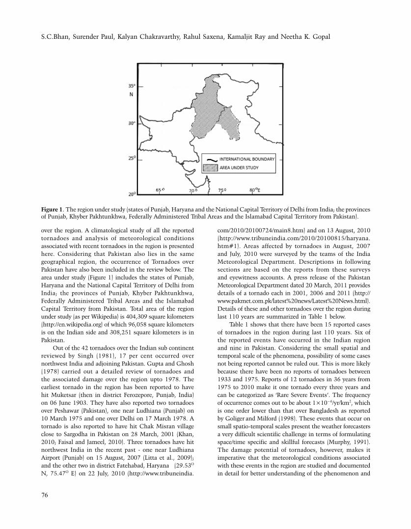
over the region. A climatological study of all the reported tornadoes and analysis of meteorological conditions associated with recent tornadoes in the region is presented here. Considering that Pakistan also lies in the same geographical region, the occurrence of Tornadoes over Pakistan have also been included in the review below. The area under study (Figure 1) includes the states of Punjab, Haryana and the National Capital Territory of Delhi from India; the provinces of Punjab, Khyber Pakhtunkhwa, Federally Administered Tribal Areas and the Islamabad Capital Territory from Pakistan. Total area of the region under study (as per Wikipedia) is 404,309 square kilometers (http://en.wikipedia.org) of which 96,058 square kilometers is on the Indian side and 308,251 square kilometers is in Pakistan.
Out of the 42 tornadoes over the Indian sub continent reviewed by Singh (1981), 17 per cent occurred over northwest India and adjoining Pakistan. Gupta and Ghosh (1978) carried out a detailed review of tornadoes and the associated damage over the region upto 1978. The earliest tornado in the region has been reported to have hit Muketsar (then in district Ferozepore, Punjab, India) on 06 June 1903. They have also reported two tornadoes over Peshawar (Pakistan), one near Ludhiana (Punjab) on 10 March 1975 and one over Delhi on 17 March 1978. A tornado is also reported to have hit Chak Misran village close to Sargodha in Pakistan on 28 March, 2001 (Khan, 2010; Faisal and Jameel, 2010). Three tornadoes have hit northwest India in the recent past - one near Ludhiana Airport (Punjab) on 15 August, 2007 (Litta et al., 2009); and the other two in district Fatehabad, Haryana (29.53O N, 75.47O E) on 22 July, 2010 (http://www.tribuneindia.
com/2010/20100724/main8.htm) and on 13 August, 2010 (http://www.tribuneindia.com/2010/20100815/haryana.htm#1). Areas affected by tornadoes in August, 2007 and July, 2010 were surveyed by the teams of the India Meteorological Department. Descriptions in following sections are based on the reports from these surveys and eyewitness accounts. A press release of the Pakistan Meteorological Department dated 20 March, 2011 provides details of a tornado each in 2001, 2006 and 2011 (http://www.pakmet.com.pk/latest%20news/Latest%20News.html). Details of these and other tornadoes over the region during last 110 years are summarized in Table 1 below.
Table 1 shows that there have been 15 reported cases of tornadoes in the region during last 110 years. Six of the reported events have occurred in the Indian region and nine in Pakistan. Considering the small spatial and temporal scale of the phenomena, possibility of some cases not being reported cannot be ruled out. This is more likely because there have been no reports of tornadoes between 1933 and 1975. Reports of 12 tornadoes in 36 years from 1975 to 2010 make it one tornado every three years and can be categorized as ‘Rare Severe Events’. The frequency of occurrence comes out to be about 1×10⁻⁶/yr/km2, which is one order lower than that over Bangladesh as reported by Goliger and Milford (1998). These events that occur on small spatio-temporal scales present the weather forecasters a very difficult scientific challenge in terms of formulating space/time specific and skillful forecasts (Murphy, 1991). The damage potential of tornadoes, however, makes it imperative that the meteorological conditions associated with these events in the region are studied and documented in detail for better understanding of the phenomenon and
Figure 1. The region under study (states of Punjab, Haryana and the National Capital Territory of Delhi from India; the provinces of Punjab, Khyber Pakhtunkhwa, Federally Administered Tribal Areas and the Islamabad Capital Territory from Pakistan).

Climatology of Tornadoes over northwest India and Pakistan; and Meteorological Analysis of recent Tornadoes over the Region
77
providing broad guidance to operational weather forecasters. The same has been attempted in the following sections for the recent tornadoes.
Seasonal Distribution
Analysis of seasonal distribution of the twelve tornadoes for which dates of occurrence are available shows that 6 of these have occurred during the month of March, 2 in August and one each in April, June, July and October. Considering that monsoon does not set over the region before 06 June when a tornado was reported in the year 1903, the pre-monsoon season (March – June) is the most likely period of occurrence of these events over the region as it has accounted for two third (8 out of 12) of the tornadoes. This seasonal distribution is similar to that over east India and Bangladesh.
Finch observed that 76% of nor'westers and tornadoes over that region also occurred during the pre-monsoon period (http://bangladeshtornadoes.org/climo/btorcli0.htm).
DATA
The meteorological observations and weather charts used for analysis and description of cases have been taken from various offices of the India Meteorological Department. Wind flow patterns and the plots of vertical velocities/relative humidity presented in the Figure have been taken from NCEP/NCAR and NCEP/DOE reanalysis available at http://www.esrl.noaa.gov/psd/data/composites/day/ and http://www.nomad3.ncep.noaa.gov/, respectively. Reports of surveys conducted after the events and reports from newspapers have also been used.
Table 1. Tornadoes reported to have hit northwest India and Pakistan during 1901-2010
S. No
Date Area Reported Damage Source
1 06 June 1903 Muketsar (Punjab, India) Not available Gupta and Ghosh (1978)
2 1907 (date not mentioned)
Peshawar (Pakistan) Not available Gupta and Ghosh (1978)
3 05 April 1933 Peshawar (Pakistan) Not available Gupta and Ghosh (1978)
4 10 March 1975 Ludhiana (Punjab, India) 10 people killed, 150 injured and about houses 800 damaged
Gupta and Ghosh (1978)
5 17 March 1978 New Delhi (India) 28 people killed and 700 others injured
Gupta and Ghosh (1978)
6 10 March 1981 Gujranwala and Sheikhupura districts (Punjab, Pakistan)
56 people killed and 600 others injured
Pakistan Weather Portal
7 10 March 1985 Northern areas of Pakistan 18 people killed Pakistan Weather Portal
8 1995 (Date not mentioned)
Pakistan (Place not mentioned)
100 people killed Pakistan Weather Portal
9 28 March 2001 Chak Misran village, Punjab (Pakistan)
10 people killed, 100 injured. Electric poles/bill boards uprooted
1. Pakistan Weather Portal
2. Faisal and Jameel, 2010
10 12 October, 2006 Rawalpindi, Punjab (Pakistan)
Not available Pakistan Weather Portal
11 Date not mentioned
Narang Mangi, Punjab (Pakistan)
Not available Pakistan Weather Portal
12 15 August, 2007 Sahanewal, near Ludhiana Airport, Punjab (India)
A few trees uprooted, roof of a tube well room blown away and standing crops damaged
Litta et al. (2009)
13 22 July 2010 Ahlisadar, Fatehabad , Haryana (India)
Standing crops damaged The Tribune
14 13 August, 2010 Ahlisadar, Fatehabad , No damage reported The Tribune
15 19 March, 2011 Head Marala near Sialkot (Pakistan)
5 people killed, 40 seriously injured and 51 people received minor injuries. 66 brick houses and nine mud houses completely destroyed while 83 brick houses and seven mud houses partially damaged
Pakistan Meteorological Department

S.C.Bhan, Surender Paul, Kalyan Chakravarthy, Rahul Saxena, Kamaljit Ray and Neetha K. Gopal
78
Case Descriptions
The cases of recent tornadoes (occurring in northwest India) are described in this section. The descriptions are given in two parts – eyewitness accounts and observational aspects. Associated meteorological conditions are described in a separate section below. The eyewitness accounts have been given for two tornadoes (15 Aug 2007 near Sahanewal district Ludhiana, state Punjab, India and 22nd July 2010 near Village Ahlisadar, district Fatehabad, state Haryana, India) based on survey of the affected areas by the India Meteorological Department; and for one (tornado of 13 August, 2010) based on news paper report cited below.
Eyewitness Accounts
The tornado of 15 Aug 2007 touched down at 1630 hrs IST (1100 UTC) in agricultural fields of a village called Sahanewal about 1.5 kms northeast of Ludhiana Airport (Punjab, India- 30.86O N, 75.93O E). A school teacher – Mr. Balvinder Singh of a nearby village - Ucchi Mangli - could make a movie of the tornado with the help of his mobile phone. This tornado thus became the first tornado to be
filmed in India (Figure 4b). All the previously reported tornadoes in the region have occurred during the summer season when the atmospheric settings are generally favorable for severe convective phenomenon. Detailed analysis and simulation of meteorological conditions for this tornado have been reported by Litta et al. (2009). The tornado did not cause much damage to life and property, as it occurred in the open fields. However, the phenomenon was so destructive that a few big trees were uprooted, heavy branches were snapped, tin roof of a tube well room was blown away and a bund maker weighing about 80 kg was reportedly lifted to a height of 60-70 feet and was seen rotating in the debris, paddy crop in the fields was flattened and some buffaloes and calves were thrown away. According to people of the region, an unprecedented sound was heard at about 1630 hrs IST; and a pillar or hosepipe like structure was descending from the sky. Lower part of the structure was narrow and it was occasionally shrinking and expanding. The tornado moved south-southeast wards covering the distance of about 0.75-1 km. Smog type material was seen rotating anticlockwise and rising upwards in the funnel. Though lightening was seen, no thunder could be heard by the people due to roaring sound
Figure 2. Some of the damage caused by the 15 August 2007 tornado

Climatology of Tornadoes over northwest India and Pakistan; and Meteorological Analysis of recent Tornadoes over the Region
79
of the event. After covering a distance of about 0.75-1 km, it turned southwest wards for about 100-200 m and then moved in a zigzag way (Litta et al., 2009). Lower end of the trunk did not constantly remain in touch with the ground. It rose from the ground 4-6 times. Whole of standing water in the paddy field was sucked in and the field was left dry. Paddy and Sorghum crops in the fields were completely flattened. The plants of Sorghum crop were found flattened in west-southwest and northeast direction indicating anti-clockwise rotation in the tornado. The tornado began to weaken by 1645 hrs IST and disappeared completely by 1650 hrs IST. A few photographs of the damage caused by the tornado are given in Figure 2.
The tornado of 22nd July 2010 was reported around 1414 IST in agricultural fields of Village Ahlisadar (district Fatehabad, state Haryana) about 14 Km west-northwest of Fatehabad City ( Lat 29O 31’ N, Long 75O 21’E). The event was reported by a local newspaper - The Tribune on 24 July, 2010. It touched down in paddy fields filled with water and covered about 0.8 Km distance entirely in agricultural fields before finally dissipating around 1435 hrs IST. Overall time duration of tornado was about 15-18 minutes. As per eyewitnesses, dark cloud formed about 800 meters north of a village called Tibi Dhani about 10-15 minute before occurrence of the event. At about 1412 hrs IST, a white colored cloud funnel of about three feet diameter came out of the cloud and descended in paddy field about 600 meter south of the village. The cloud funnel, after descending down in paddy field, started sucking water standing in the paddy field. Afterwards, the spiraling cloud with anticlockwise rotation traversed northeastward for about 500 meter and reached cotton fields where some cotton plants were uprooted. It remained stationery for two to three minutes in cotton field and disappeared for a moment in main cloud but again appeared and moved southwestwards into a paddy field for a distance of about 200 meter before finally dissipating. Color of the funnel was white during the time it was sucking water and finally became black when tornado left the field. It did not produce any significant damages as it remained over the paddy fields. As per eyewitnesses, white coloured funnel with a roar similar to that of a rocket or aircraft came toward the village. Initially, the funnel was small but it increased in diameter later. There was no rain, thunder or strong winds in Dhani at the time of event and it was partly cloudy for sometime after its dissipation. Heavy rain was reported after about half an hour.
Regarding tornado of 13 August, 2010, the newspaper in its report dated 14 August, 2010 entitled “Tornado-like phenomenon baffles scientists” stated that occurrence of another tornado-like phenomenon at Ahlisadar village in Fatehabad within a span of 20 days has baffled climatologists and Meteorological Department officials; and provided the following details about the event.
‘Some teachers and students of Government Senior Secondary School located in the village yesterday noticed a funnel-like vertical cloud descending from the sky and one of the teachers managed to film the last few seconds of the phenomenon on his mobile. “I noticed a pipe-like object coming down from the clouds in the northern direction. It was at a considerable distance, but clearly visible” said Mohinder Saharan, a lecturer in political science in the school. The weather was cloudy and it was raining in and around Fatehabad, towards north of Ahlisadar. The funnel dissipated before it could reach the ground and the whole development lasted over three minutes at about 1 pm yesterday’.
Observational Aspects Of General Weather Over The Area
Tornado of 15 August, 2007
Three hourly synoptic observations of the meteorological observatory situated at Ludhiana Airport, about 1-1.5 km from the site of the tornado, have been used to describe weather over the region (Table 2) in respect of 15 August, 2007 tornado. The sky was mainly sunny in the morning of 15 August 2007 with light southerly winds. A temperature of 290C with 82 % relative humidity was recorded at 0300 UTC (0830 hrs IST). By 0600 UTC, the temperature rose to 320C with 68 % relative humidity and 4 okta low clouds. Cumulus clouds developed in the afternoon and six okta cumulonimbus clouds were observed at the time of the event. No hails were observed either during the tornado or afterwards. General weather phenomenon reported by the observatory during the day were mist and haze from 0345 to 0925 UTC, thunderstorm from 1113 to 1120 UTC and funnel cloud from 1105 to 1120 UTC.
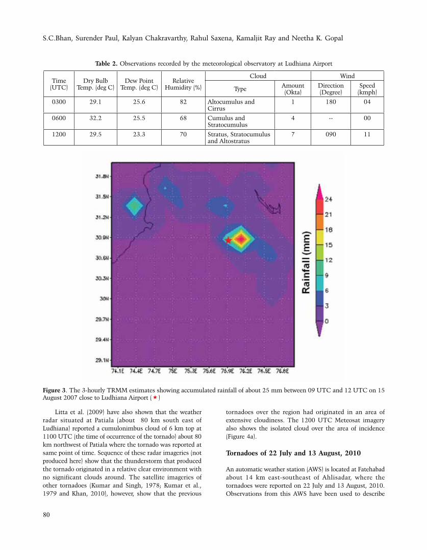
Litta et al. (2009) have reported that the hourly temperature and relative humidity observations from the meteorological reports (METARS) of Ludhiana Airport show a gradual increase in temperature from 0100 to 0900 UTC. There was a sharp decrease in temperature from 1100 to 1200 UTC coinciding with the event of tornado. Relative humidity showed a sharp increase between these two observations. The eyewitness reported a heavy shower just after the tornado, though only 0.3 mm rainfall was recorded in the nearby observatory. The 3-hourly TRMM accumulated rainfall (http://gdata1.sci.gsfc.nasa.gov/daac-bin/G3/gui.cgi?instance_id=TRMM_3-Hourly) from 0900 UTC to 1200 UTC on 15 August 2007 (Figure 3) clearly shows intense rainfall over a very small area close to Ludhiana (30.860 N, 75.930 E) between 0900 UTC and 1200 UTC. This indicates an intense rainfall event of short duration confined to a very small area where the tornado was reported.
S.C.Bhan, Surender Paul, Kalyan Chakravarthy, Rahul Saxena, Kamaljit Ray and Neetha K. Gopal
80
Litta et al. (2009) have also shown that the weather radar situated at Patiala (about 80 km south east of Ludhiana) reported a cumulonimbus cloud of 6 km top at 1100 UTC (the time of occurrence of the tornado) about 80 km northwest of Patiala where the tornado was reported at same point of time. Sequence of these radar imageries (not produced here) show that the thunderstorm that produced the tornado originated in a relative clear environment with no significant clouds around. The satellite imageries of other tornadoes (Kumar and Singh, 1978; Kumar et al., 1979 and Khan, 2010), however, show that the previous
tornadoes over the region had originated in an area of extensive cloudiness. The 1200 UTC Meteosat imagery also shows the isolated cloud over the area of incidence (Figure 4a).
Tornadoes of 22 July and 13 August, 2010
An automatic weather station (AWS) is located at Fatehabad about 14 km east-southeast of Ahlisadar, where the tornadoes were reported on 22 July and 13 August, 2010. Observations from this AWS have been used to describe
Table 2. Observations recorded by the meteorological observatory at Ludhiana Airport
Time (UTC)
Dry Bulb Temp. (deg C)
Dew Point Temp. (deg C)
Relative Humidity (%)
Cloud Wind
Type Amount (Okta)
Direction (Degree)
Speed (kmph)
0300 29.1 25.6 82 Altocumulus and Cirrus
1 180 04
0600 32.2 25.5 68 Cumulus and Stratocumulus
4 -- 00
1200 29.5 23.3 70 Stratus, Stratocumulus and Altostratus
7 090 11
Figure 3. The 3-hourly TRMM estimates showing accumulated rainfall of about 25 mm between 09 UTC and 12 UTC on 15 August 2007 close to Ludhiana Airport (*)

Climatology of Tornadoes over northwest India and Pakistan; and Meteorological Analysis of recent Tornadoes over the Region
81
weather in this section. Hourly observations in Figure 5 and Table 3 show that on 22 July, the temperatures increased steadily till 09 UTC followed by a steep fall of 5.5O C by 10 UTC. RH increased from 69% to 99% during the same hour. Though observations of sky conditions are not available, the observations of sunshine duration and hourly rainfall show 60, 40 and 0 minutes of sunshine; and 00, 06 and 49 mm rainfall recorded from 08-09, 09-10 and 10-11 UTC, respectively (Table 3). This indicates that rainfall and cloudiness at the AWS site were recorded some time after the report of tornado 14 km away. This lag is also corroborated by eye-witness accounts in the preceding section that there was no rain or thunder at the time of event and that heavy rain occurred after about half an hour. A drop of 0.8 hPa in atmospheric pressure was seen from 08 to 09 UTC. Wind speed (3 minutes’ average) was only 0.5 knots at 09 UTC, whereas the highest wind speed reported was of 12 knots at 10 UTC.The reported time of tornado on 13 August, 2010 was around 0730 UTC. AWS observations show that the temperature dropped by 3 degree C between 06 and 07 UTC and by similar magnitude in the following hour. RH increased from 87% to 95%; and pressure fell by 0.5 hPa during 06 UTC and 07 UTC. A total of 22 mm rainfall and 47 minutes of sunshine duration was recorded during the above hour. It was completely overcast in the subsequent hour (07-08 UTC). However, it was sunny after 08 UTC
(Table 3). These observations also support the earlier mentioned newspaper report that it was cloudy at the time of the event. The strongest 3 minutes’ average wind of 6.9 knots was recorded at 07 UTC. Any strong gusts in the intervening periods could not be ascertained in both the cases as observations were available only at full UTC hours. This kind of sudden drop in temperature and increase in relative humidity are normal features associated with occurrences of tornadoes and have been reported for recent tornadoes in India by Litta et al. (2009, 2012).
Analysis and discussion Of Meteorological Conditions
Although only a few tornadoes occur over the study region, they cause damage to property and loss of life. It is, therefore, pertinent to study the meteorological conditions associated with occurrence of tornadoes so as to have a better insight into the conditions that led to these events. The conditions associated with the August, 2007 and July, 2010 tornadoes are discussed in detail in this section. The synoptic features of the earlier tornadoes of the region are also described in the following section for comparison purpose.
The southwest Monsoon had entered into break conditions on 14 August 2007 with western end of the monsoon trough shifting close to the foothills of the
Figure 4. Satellite Imagery 12 UTC of 15 August, 2007 (a) showing isolated clouds close to Ludhiana (http://www.sat.dundee.ac.uk/geobrowse/geobrowse.php) and (b) photograph of the tornado

S.C.Bhan, Surender Paul, Kalyan Chakravarthy, Rahul Saxena, Kamaljit Ray and Neetha K. Gopal
82
Himalayas. This led to the southwesterly flow from the north Arabian Sea penetrating right up to Jammu and Kashmir in the lower troposphere. This in turn led to convergence of moist winds in the lower level close to the foothills of the western Himalayan region and adjoining Punjab. Also, there was a strong velocity convergence in the
lower troposphere with 20 knots southwesterly winds over south Pakistan becoming less than 5 knots over Punjab. The wind flow pattern at 925 hPa level for 00 UTC of 15 August 2007 is shown in Figure 6a. This zone of low level convergence was overlain by a zone of divergence in the middle and upper tropospheric levels due to a trough
Table 3. Weather Parameters at Fatehabad the days of occurrences of tornadoes (22 July and 13 August, 2010).
Time (UTC)
Pressure change since previous hour
(hPa)
Hourly Rain(mm)
Duration of Sunshine during the
hour (minutes)
Wind Direction(degree)
Wind Speed(knots)
22 July, 2010
03 0.6 0 50 151 4.6
04 0.3 0 60 146 3.7
05 0.2 0 60 186 2.4
06 0.1 0 60 194 3.3
07 -0.5 0 60 170 2.6
08 -0.5 0 60 187 2.6
09 -0.8 0 60 220 0.5
10 0.3 6 40 95 12
11 0.2 49 0 119 6.9
12 -0.1 0 0 95 4.2
13 August, 2010
03 0.2 0 60 141 1.7
04 0.1 0 60 107 1
05 0 0 60 102 1.8
06 -0.4 0 60 60 2.2
07 -0.5 0 47 248 6.9
08 -0.2 22 0 290 2.8
09 -1 1 52 213 1.4
10 -0.4 0 60 162 1.6
11 -0.5 0 60 155 0.7
12 -0.2 0 60 44 1.1
Figure 5. Temperature and Relative Humidity at Fatehabad on the days of occurrences of tornadoes (22 July and 13 August, 2010).

Climatology of Tornadoes over northwest India and Pakistan; and Meteorological Analysis of recent Tornadoes over the Region
83
in the westerlies. The contours of 300 hPa at 00 UTC of 15 August (Figure 6b) indicate this trough roughly along longitude 70° E. A cut off low at 850 hPa lay centred at about latitude 30° N and longitude 69° E on 15th August (Figure 7a). Tyagi and Paliwal (1983) have shown that maximum vertical lifting and thunderstorm activity occurs about 5-10° east of such cut off lows. Figure 7b depicting the pressure vertical velocities of 700 hPa (http://nomad1.ncep.noaa.gov/ncep_data/index.html) shows that maximum vertical lifting at 00 UTC on 15th August occurred close to the area, where the tornado was observed in the afternoon.
Due to south westerly winds penetrating into the area from the Arabian Sea, high relative humidity (80-90%) prevailed over the area in lower tropospheric levels (Figure 8a). This area of high humidity was overlain by much lower humidity at higher levels. A tongue of low humidity extended eastwards from central Pakistan and penetrated over the Indian region at 500 hPa (Figure 8b). This combination of high humidity at lower levels and increased dryness in the middle atmosphere provided favourable conditions for severe thunderstorm over the
region later in the day. Contrary to the conditions of 15 August 2007, break
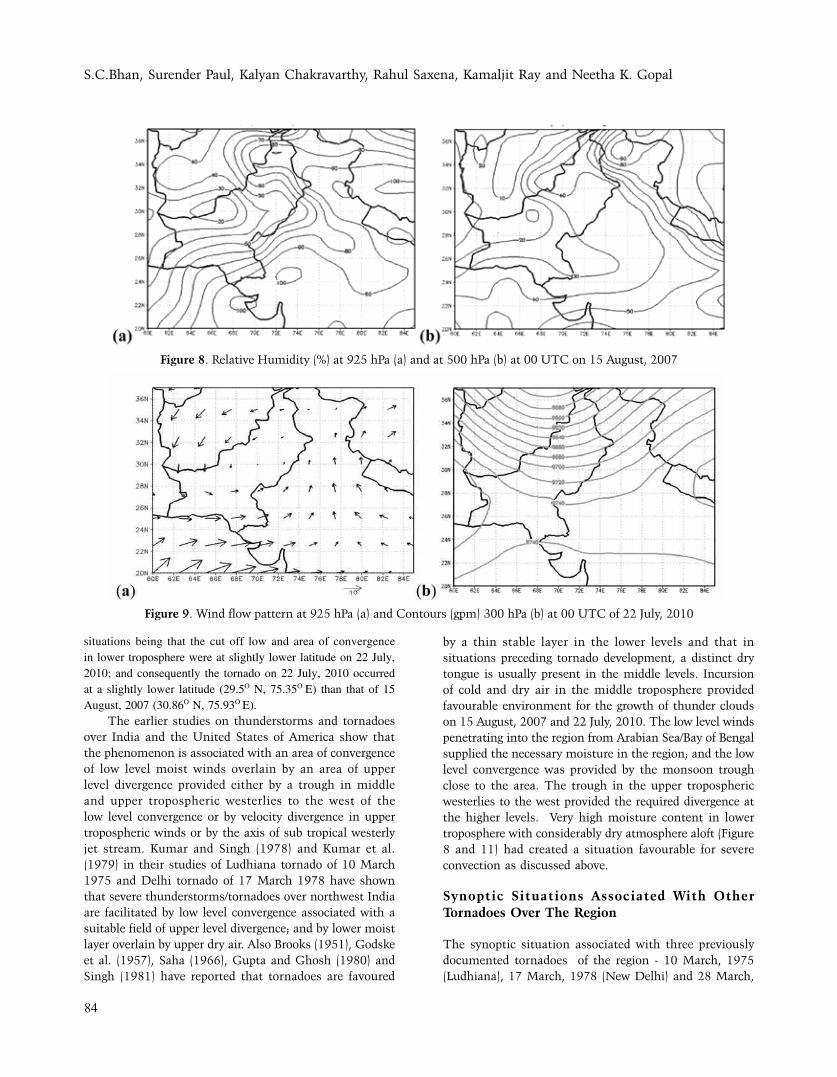
monsoon conditions were not there on 22 July, 2010. Western end of monsoon trough in the lower troposphere (925 hPa) was at about its normal position of around 30O N (Figure 9a) causing southeasterly flow from the Bay of Bengal penetrate and converge over northwest India. This zone of low level convergence was overlain by a zone of divergence ahead of a trough at 300 hPa roughly along longitude 69° E (Figure 9b).
A cut off low at 850 hPa lay centered at about latitude 28° N and longitude 67° E (Figure 10a). Figure 10b depicting the pressure vertical velocities at 700 hPa on 00 UTC of 22 July 2010 (http://nomad1.ncep.noaa.gov/ncep_data/index.html) shows a zone of vertical lifting close to the location of the tornado in the afternoon. The southeasterly winds from Bay of Bengal led to high relative humidity (80-90%) over the area in lower tropospheric levels (Figure 11a), whereas the humidity was much lower at higher levels (Figure 11b). These conditions were similar to those prevailing in the region on 15 August, 2007. The difference between the two
Figure 6. Wind flow pattern at 925 hPa (a) and contours (gpm) at 300 hPa (b) at 00 UTC on 15 August, 2007.
Figure 7. Contours (gpm) at 850 hPa (a) and Vertical velocity (Pa/sec) 700 hPa (b) at 00 UTC on 15 August, 2007
S.C.Bhan, Surender Paul, Kalyan Chakravarthy, Rahul Saxena, Kamaljit Ray and Neetha K. Gopal
84
situations being that the cut off low and area of convergence in lower troposphere were at slightly lower latitude on 22 July, 2010; and consequently the tornado on 22 July, 2010 occurred at a slightly lower latitude (29.5O N, 75.35O E) than that of 15 August, 2007 (30.86O N, 75.93O E).
The earlier studies on thunderstorms and tornadoes over India and the United States of America show that the phenomenon is associated with an area of convergence of low level moist winds overlain by an area of upper level divergence provided either by a trough in middle and upper tropospheric westerlies to the west of the low level convergence or by velocity divergence in upper tropospheric winds or by the axis of sub tropical westerly jet stream. Kumar and Singh (1978) and Kumar et al. (1979) in their studies of Ludhiana tornado of 10 March 1975 and Delhi tornado of 17 March 1978 have shown that severe thunderstorms/tornadoes over northwest India are facilitated by low level convergence associated with a suitable field of upper level divergence; and by lower moist layer overlain by upper dry air. Also Brooks (1951), Godske et al. (1957), Saha (1966), Gupta and Ghosh (1980) and Singh (1981) have reported that tornadoes are favoured
by a thin stable layer in the lower levels and that in situations preceding tornado development, a distinct dry tongue is usually present in the middle levels. Incursion of cold and dry air in the middle troposphere provided favourable environment for the growth of thunder clouds on 15 August, 2007 and 22 July, 2010. The low level winds penetrating into the region from Arabian Sea/Bay of Bengal supplied the necessary moisture in the region; and the low level convergence was provided by the monsoon trough close to the area. The trough in the upper tropospheric westerlies to the west provided the required divergence at the higher levels. Very high moisture content in lower troposphere with considerably dry atmosphere aloft (Figure 8 and 11) had created a situation favourable for severe convection as discussed above.
Synoptic Situations Associated With Other Tornadoes Over The Region
The synoptic situation associated with three previously documented tornadoes of the region - 10 March, 1975 (Ludhiana), 17 March, 1978 (New Delhi) and 28 March,
Figure 8. Relative Humidity (%) at 925 hPa (a) and at 500 hPa (b) at 00 UTC on 15 August, 2007
Figure 9. Wind flow pattern at 925 hPa (a) and Contours (gpm) 300 hPa (b) at 00 UTC of 22 July, 2010

Climatology of Tornadoes over northwest India and Pakistan; and Meteorological Analysis of recent Tornadoes over the Region
85
2001 (Sargodha, Pakistan) is presented in this section for better understanding of the phenomenon over the region, as the ability to anticipate and identify such events is critical to the mission of operational meteorologists. Finch provides details of surface and middle tropospheric features associated with Ludhiana (1975) and Sargodha (2001) tornadoes (http://bangladeshtornadoes.org/climo/btorcli0.htm); and Gupta and Ghosh (1978) of the north Delhi tornado of 1978. The wind flow patterns at 925 and 500 hPa associated with the above tornadoes are given in Figure 12-14. These Figure clearly show cyclonic circulations over northwest India and adjoining Pakistan providing the low level convergence; and strong moisture influx from the Arabian Sea. The necessary upper air divergence in all these cases is provided by a trough at 500 hPa to the west in all these three cases.
Thermodynamic Structure Of The Atmosphere Associated With Tornadoes Over The Region
Different stability indices have been used to study the thermodynamic structure of the atmosphere on the tornado
days over the region and are described in this section. Convective Available Potential Energy (CAPE) represents the amount of buoyant energy available to accelerate a parcel vertically and a CAPE value greater than 1500 Jkg-1 is suggested by Rasmussen and Wilhelmson (1983).Such a high value of CAPE is necessary for supercells to form. Lifted Index (LI) measures the difference between a parcel's temperatures compared with the environmental temperature at 500 hPa, after the parcel has been lifted from the Lifting Condensation Level (Galway, 1956). The LI has proved useful for indicating the likelihood of severe thunderstorms. Miller (1967) introduced Total Totals Index (TTI) for identifying areas of potential thunderstorm development. It accounts for both static stability and the presence of 850 hPa moisture. A TTI of greater than 48 indicates favorable conditions for development of severe thunderstorms; a value of 50 indicates favorable conditions for tornadoes. Some other indices based on thermodynamic structure of the atmosphere have been shown to be useful for predicting thunderstorms such as Showalter Index (SI), K Index (KI) and Sweat Index (SWI), respectively (Showalter-1953, George -1960 and
Figure 10. Contours (gpm) at 850 hPa (a) and vertical velocity (Pa/sec) at 700 hPa (b) at 00 UTC of 22 July, 2010
Figure 11. Relative Humidity (%) at 925 hPa (a) and at 500 hPa (b) at 00 UTC on 22 July, 2010

S.C.Bhan, Surender Paul, Kalyan Chakravarthy, Rahul Saxena, Kamaljit Ray and Neetha K. Gopal
86
Bidner-1970). Duraisamy et al. (2001) in a study of pre-monsoon thunderstorm over Delhi have given the detailed descriptions and methods of calculations of these indices; and hence, the same are not repeated here. They found that SI <2 OC, LI <0 OC, KI >24 OC, TTI >44.5 OC, and SWI >100 are the critical limits for thunderstorms to
occur over Delhi. Tephigrams of stations near to the place of occurrence of tornadoes have been analysed for study of the Indices; and the results are presented below.
The stability indices at 00 UTC (0530 IST) of date of occurrence of tornadoes have been computed using data from the website of Wyoming University (http://
Figure 12. Flow pattern at 925 (a) and 500 hPa (b) at 00 UTC on 10 March, 1975.
Figure 13. Flow pattern at 925 (a) and 500 hPa (b) at 00 UTC on 17 March, 1978.
Figure 14. Flow pattern at 925 (a) and 500 hPa (b) at 00 UTC on 28 March, 2001.

Climatology of Tornadoes over northwest India and Pakistan; and Meteorological Analysis of recent Tornadoes over the Region
87
weather.uwyo.edu/upperair/sounding.html). The same are presented in Table 4 along with critical values of the indices. As upper air soundings at the places of occurrence of tornadoes are not available, data for stations close to the places of occurrence have been used. Examination of the stability indices indicate that over northwest India and adjoining Pakistan, the TTI, SWI and KI exceed the previously identified thresholds for thunderstorms over New Delhi. However, the LI, SI and CAPE were not found to be consistent in indicating possibility of thunderstorms. Ray et al. (2015) have also reported that LI and CAPE are not good indicators of thunderstorms over northwest India. However, these indices in combination with the favourable synoptic situations can help identify areas vulnerable to severe thunderstorm activities (possibly tornadic) over a region. Once these potential areas are identified, the forecasters can have a closer and more precise examination of these areas; and make use of other available information and tools for making the final forecasts.
SUMMARY AND CONCLUSION
A climatological study of all the reported tornadoes and analysis of meteorological conditions associated with recent tornadoes in Northwest India and contiguous areas of northwest Pakistan (which do not normally experiences this violent weather phenomenon as frequently as eastern parts of the country) is presented here. There have been 15 reported cases of tornadoes in the region during last 110 years. Twelve of these tornadoes were reported in 36 years from 1975 to 2010 making it one tornado every three years. The frequency of occurrence comes out to be about 1×10⁻⁶/yr/km2, which is one order lower than that over Bangladesh. Pre-monsoon season (March to
June) has been found to be the most favoured period of occurrence with March alone accounting for half of the events. The meteorological conditions in the region show that events occurred in association with low level moist winds penetrating into the region (in most of the cases from Arabian Sea) supplying necessary moisture. Low level convergence was provided by either a cyclonic circulation or by the monsoon trough close to the area. The trough in the upper tropospheric westerlies west of the region provided the required divergence at the higher levels. High moisture content in the lower troposphere with considerably dry air in the middle troposphere was found to increase the instability in the atmosphere leading to tornadoes. The thermodynamic structure of the atmosphere as depicted by the upper air sounding at 00 UTC of the date of occurrence shows that values of Total-Total Index, SWEAT Index and K-Index were, in most of the cases, were above the previously identified thresholds; and can, in combination with identified favourable synoptic situations, be considered as good indicators of possible occurrence of severe thunderstorms/tornadoes over the region.
ACKNOWLEDGEMENTS
The authors express their sincere gratitude to Director General of Meteorology, India Meteorological Department for his guidance and constant encouragement; and for the permission to publish the paper in The Journal of Indian Geophysical Union. Thanks are also due to Shri Balvinder Singh of Ucchi Mangli village for providing the video film of a tornado. Authors are also grateful to the anonymous referee and the editorial office of JIGU for their invaluable contribution towards improving quality of this paper.
Table 4. Stability Indices at 00 UTC of Tornado Days
Date 10 Mar, 1975
17 Mar, 1978
28 Mar, 2001 15 Aug, 2007
22 Jul,2010
13 Aug, 2010
Place of occurrence Ludhiana New Delhi Chack Mishran, Pakistan
Ludhiana Fatehabad Fatehabad
Place for which data used New Delhi(280)**
New Delhi(10)**
Patiala(388)**
Patiala(80)**
Patiala(124)**
New Delhi(195)**
LI (<0)* 3.45 1.7 -4.93 -2.2 -8 -4.0
TTI (>44.5)* 53.6 51.4 54.6 42.7 50.5 45.0
SI (<2)* -1.6 -0.7 -2.0 -1.5 -5.0 -2.5
SWI (>100)* 415.4 198.0 181.0 288.8 NA 250.2
KI (>24)* 27.5 31.7 35.3 41.1 42.3 40.9
CAPE (>1500)* 00 8.8 395 544 3989 1768
* indicates the critical values of respective instability index; and ** indicate the approximate horizontal distance between the place of occurrence and the place for which data are used.

S.C.Bhan, Surender Paul, Kalyan Chakravarthy, Rahul Saxena, Kamaljit Ray and Neetha K. Gopal
88
REFERENCES
Anonymous, 1982. Water Spout – An observational report by
officers on Board, VayuMandal, v.12, no.3and4, pp: 58.
Bidner, A., 1970. The air force global weather central severe
weather threat (SWEAT) index- a preliminary report. Air
Weather Service Aerospace Review, AWS RP 105-2, v.70,
no.3, pp: 2-5.
Brooks, E.M., 1951. Tornadoes and related phenomena, in
Melone, T.A., ed., Compendium of Meteorology, American
Meteorological Society, pp: 673.
Chandrasekharan, C.K. and Gangadharan, V.K., 1998. Funnel
Cloud/ Water Spout at Kovalam, Vayu Mandal, v.28,
no.3and4, pp: 120-123.
Duraisamy, M., Roy Bhowmik, S. K., and Bandyopadhyay, B. K.,
2011. An objective method for predicting occurrence of
pre-monsoon (March-May) thunderstorm events over Delhi
using stability indices, Mausam, v.62, no.3, pp: 329-338.
Faisal, N. and Jameel, A., 2010. An Outbreak of Tornado on
March 28, 2001: A Case Study, Pak. J. Meteorol., v.6,
no.12, pp: 49-56.
Galway, J.G., 1956. The Lifted Index as a predictor of latent
instability, Bull. Amer. Meteorol. Soc., v.37, pp: 528-529.
George, J.J., 1960. Weather forecasting for Aeronautics, Academic
Press, New York, pp: 673.
Godske, C.L., Bergeron, T., Bjerknes. J. and Bundgaard, R.C., 1957.
Dynamic Meteorology and Weather Forecasting, American
Meteorological Society, pp: 598.
Goldar, R.N., Banerjee, S.K. and Debnath, G.C., 2001. Tornado
in India and its predictability, India Meteorological
Department, Pre-published Scientific Report no.2/2001,
pp: 21.
Goliger, A.M. and Milford, R.V., 1998. A review of worldwide
occurrence of tornadoes, J.Wind Engg. Industrial
Aerodynamics, v.74-76, pp: 111-121.
Gupta, H. N. and Ghosh, S. K., 1978. North Delhi Tornado of
17 March 1978, India Meteorological Department, Pre-
published Scientific Report No. 78/5, pp: 11.
Gupta, H. N. and Ghosh, S. K., 1980. North Delhi Tornado of 17
March 1978, Mausam, v.31, no.1, pp: 93-100.
Khan, A. H., 2010. A Tornado Hits Chak Misran-A Village Of
Valley Soan-Skacer- Pakistan. http://www.angelfire.com/az3/
azt_articles/wtrphenomena/chak_misran.html, Accessed
September, 2012.
Kumar, S. and Singh, M.S., 1978. Satellite study of development
of severe thunderstorms over south Punjab on 10 March
1975, Indian J. Meteorol. Geophys., v.29, no.4, pp:754-756.
Kumar, S., Singh, J. and Raj, H., 1979. Severe weather outbreak
associated with intersection of sub-tropical Jet stream with
squall line, Vayu Mandal, v.9, no.1&2, pp:46-47.
Litta, A.J., Mohanty, U.C., and Bhan, S.C., 2009. Numerical
Simulation of a Tornado over Ludhiana (India) using WRF-
NMM model, Met. Apps, doi: 10.1002/met.162., v.17,
pp:64–75.
Litta, A.J., Mohanty, U.C., Kiran Prasad, S. Mahapatra, M., Tyagi,
A. and Sahu, S.C., 2012. Simulation of tornado over Orissa
(India) on March 31, 2009, using WRF–NMM model,
Nat. Hazards, DOI 10.1007/s11069-011-9979-1., v.61, pp:
1219–1242.
Mandal, G.S. and Saha, S.K., 1983. Characteristics of some recent
north Indian Tornadoes,Vayu Mandal, v.13, no.1&2, pp:
74-80.
Miller, R.C., 1967. Notes on analysis and severe storm forecasting
procedures of the Military Weather Warning Centre, AWS
Tech. Rep. 200, USAF, pp: 170.
Murphy, A.H., 1991. Probabilities, odds and forecasts of rare
events, Wea. Forecasting, v.6, pp: 302-307.
Peterson, R.E. and Mehta, K.C., 1981. Climatology of tornadoes
of India and Bangladesh, Arch. Meteor. Geophys. Bioklimat,
v.29B, pp: 345-356.
Rasmussen, R.M. and Wilhelmson, R.B., 1983. Relationships
between storm characteristics and 1200 GMT hodographs,
low-level shear and stability, Preprints of 13th Conference
on Severe Local Storms. American Meteorological Society.
Tulsa, OK, pp: 55–58.
Ray, Kamaljit, Bandopadhyay, B.K. and Bhan, S.C., 2015.
Thunderstorm activity over different regions of India during
Pre-Monsoon season of 2013 under the SAARC STORM
Project, Mausam (in press)
Saha, K.R., 1966. The Cooch Behar-Assam Tornado of 19 April
1963, Indian J. Meteorol. Geophy., v.17, pp:427-432.
Showalter, A.K., 1953. A stability Index for thunderstorm
forecasting, Bull. Amer. Meteorol. Soc., v.34, pp: 250-252.
Singh, R., 1981. On the occurrence of tornadoes and their
distribution in India, Mausam, v.32, no.3, pp: 307-314.
Tyagi, A. and Paliwal, R.K., 1983. Severe Convective activity over
north India associated with cut-off lows in the westerlies in
winter, Vayu Mandal, v.13, no.1&2, pp: 56-58.