climate change and natural hazards in the alps -...
TRANSCRIPT

Journal of Alpine Research | Revue de Géographie Alpine, 103‐2, DOI : 10.4000/rga.2878 | 2015 1
Climate Change and Natural Hazards in the Alps: Observed and potential impacts on physical and socio‐economic systems
Benjamin Einhorn1*, Nicolas Eckert2, Christophe Chaix3, Ludovic Ravanel4, Philip Deline4, Marie Gardent4,
Vincent Boudières1, Didier Richard2, Jean‐Marc Vengeon1, Gérald Giraud5, Philippe Schoeneich6
1 Pôle Alpin d'études et de recherche pour la prévention des Risques Naturels (PARN), Grenoble 2 UR ETNA, Irstea Grenoble / Université Grenoble Alpes, BP 76, 38 402 Saint Martin d’Hères, France 3 Mission Développement Prospective (MDP) / Observatoire savoyard du Changement Climatique (OsCC), Chambéry 4 Laboratoire EDYTEM, UMR 5204 CNRS / Université Savoie Mont‐Blanc, Le Bourget‐du‐Lac 5 Météo‐France – CNRS, CNRM‐GAME UMR 3589, CEN, Grenoble, France 6 Laboratoire PACTE, UMR 5194 CNRS / Université Joseph Fourier, Grenoble
* Email: benjamin.einhorn@ujf‐grenoble.fr
Abstract
Under the effects of climate change, alpine mountainous regions register fast and well‐perceptible
evolutions that are causing a growing attention of people, scientists and managers. For better coping
with hazards and vulnerabilities specific to these territories, the current national and European public
policies in the alpine countries now prescribe adapting natural hazards prevention to climate change.
This paper proposes a review of recent advances in knowledge on perceived, measured and
projected changes in i) climate patterns, ii) cryosphere, hydrosystems and geomorphological
dynamics on alpine slopes, iii) natural hazards evolution and induced risks at the scale of the French
Alps. We give a brief overview of new results achieved in research, cooperation and capitalization
projects on these thematic fields during the programmatic period 2007‐2013, that are made
available on databases, thematic knowledge platforms and observatories developed by different
scientific and technical operators in the larger framework of the European alpine arc. We illustrate
this renewed synthesis by published examples of hydro‐gravitational hazards activity chronicles,
along with climate patterns identified as “predictors”.
Keywords
Natural hazards, observation, projection, adaptation
Introduction
Mountainous territories are particularly concerned by the effects of climate change. Along with
observed and potential impacts on a variety of natural hazards combine, increased vulnerabilities in
the context of global change occur (Beniston et al., 1996; Boudières et al., 2013).
In recent years, these rapid changes draw attention and heightened concerns from the populations,
scientists and land and natural hazards managers in the Alps. Numerous research and regional
cooperation projects have been dedicated on these topics in European, national and regional
programs (Tabs. 1 and 2).
Author manuscript
Journal of Alpine Research | Revue de Géographie Alpine, 103‐2, DOI : 10.4000/rga.2878 2
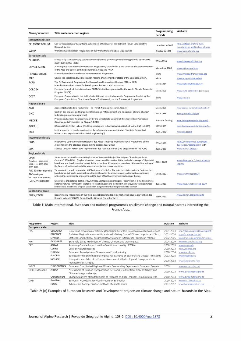
Name/ acronym Title and concerned regions Programming
periods
Website
International scale
BELMONT FORUM Call for Proposals on “Mountains as Sentinels of Change” of the Belmont Forum Collaborative
Research Action Launched in 2015
http://igfagcr.org/cra‐2015‐
mountains‐as‐sentinels‐of‐change
WCRP World Climate Research Programme of the World Meteorological Organization Created in 1980 www.wcrp‐climate.org
European scale
ALCOTRA France‐Italy transboundary cooperation Programme (previous programming periods: 1989–1999 ;
2000–2006 ; 2007–2013) 2014–2020 www.interreg‐alcotra.org
ESPACE ALPIN Alpine space transnational cooperation Programme, launched in 2000, concerns the seven countries
of the Alps and covers both Regions Rhône‐Alpes and PACA Idem since 2000 www.alpine‐space.eu
FRANCE‐SUISSE France‐Switzerland transboundary cooperation Programme Idem www.interreg‐francesuisse.org
MED Covers the coastal and Mediterranean regions of nine member states of the European Union. Idem www.programmemed.eu
PCRD The EU Framework Programme for Research and Innovation (Horizon 2020, or FP8)
Main European instrument for Development Research and Innovation. Since 1984 www.horizon2020.gouv.fr
CORDEX European branch of the international CORDEX initiative, sponsored by the World Climate Research
Program (WRCP) Since 2009 www.euro‐cordex.net (for Europe)
COST European Cooperation in the field of scientific and technical research. Programme funded by the
European Commission, Directorate General for Research, via the Framework Programme Idem www.cost.eu
National scale
ANR Agence Nationale de la Recherche (The French National Research Agency) Since 2005 www.agence‐nationale‐recherche.fr
GICC Gestion des Impacts du Changement Climatique (‘Management and Impacts of Climate Change’
federating research programme) Since 1999 www.gip‐ecofor.org/gicc
MEDDE Projects and actions financed notably by the Directorate General of Risk Prevention (‘Direction
Générale de la Prévention de Risques’, DGPR) Punctual funding www.developpement‐durable.gouv.fr
RGC&U Réseau Génie Civil et Urbain (Civil Engineering and Urban Network, attached to the ANR in 2005) 1999‐2005 www.developpement‐durable.gouv.fr/...
IREX Institut pour la recherche appliquée et l’expérimentation en génie civil (‘Institute for applied
research and experimentation in civil engineering’) 2015‐2020 www.irex.asso.fr
Interregional scale
POIA Programme Opérationnel Interrégional des Alpes (‘Interregional Operational Programme of the
Alps’) (follows the previous programming period: 2007‐2013) 2014‐2020
http://programmes‐europeens‐
2014‐2020.regionpaca.fr (pdf)
SDA Science‐Décision‐Action pour la prévention des risques naturels (sub‐programme of the POIA) 2015‐2020 www.risknat.org/sda
Regional scale
CPER Previous : 1989–1993 ; 1994‐1999 ; 2000–2006 ;
2007–2013
5 themes are proposed to contracting for future ‘Contrats de Projets Etat‐Région’ (‘State‐Region Project
Contracts’, 2014‐2020) : i) higher education, research and innovation; ii) the territorial coverage of high‐speed
broadband and development of uses of digital technology; iii) innovation, promising niches and the factory of
the future; iv) multimodal mobility; v) environmental and energy transition..
2014–2020 www.datar.gouv.fr/contrats‐etat‐
regions
ARC‐Environnement
Rhône‐Alpes (ex Cluster Environnement)
The academic research communities ‘ARC Environment’ in Rhône‐Alpes aims to help the region to "maintain the
basic balance, but fragile, sustainable development based on the area of research and innovation, particularly
active in the environmental engineering and the study of health‐environment relationships themes. Since 2012 www.arc.rhonealpes.fr
LabEx OSUG@2020 Laboratories of Excellence (LabEx), « OSUG@2020, Stratégies innovantes pour l’observation et la modélisation des
systèmes naturels » (‘Innovative strategies for the observation and modeling of natural systems’): project funded
by the Future Investments program launched by the government and implemented by the ANR
2011‐2020 www.osug.fr/labex‐osug‐2020
Subregional scale
PGRN/CG38 Departmental Programme of the ‘Pôle Grenoblois d’études et de recherche pour la prévention des
Risques Naturels’ (PGRN) funded by the General Council of Isere 1989‐2010
www.risknat.org/pgrn‐cg38
Table 1: Main international, European and national programmes on climate change and natural hazards interesting the
French Alps.
Programme Project Title Duration Website
European scale
FP5 GLACIORISK Survey and prevention of extreme glaciological hazards in European mountainous regions 2001‐2003 http://glaciorisk.grenoble.cemagref.fr
PRUDENCE Prediction of Regional scenarios and Uncertainties for Defining EuropeaN Climate change risks and Effects 2001‐2004 http://prudence.dmi.dk/
STARDEX Statistical and Regional dynamical Downscaling of Extremes for European regions 2002‐2005 www.cru.uea.ac.uk/projects/stardex
FP6 ENSEMBLES Ensemble‐based Predictions of Climate Changes and their Impacts 2004‐2009 www.ensembles‐eu.org
FP7 ACQWA Assessing Climate Impacts on the Quantity and quality of WAter 2008‐2013 www.acqwa.ch
ConHaz Costs of Natural Hazards 2010‐2012 http://conhaz.org
EURO4M European Reanalysis And Observations For Monitoring 2010‐2014 www.euro4m.eu
EUROPIAS European Provision Of Regional Impacts Assessments on Seasonal and Decadal Timescales 2012‐2015 www.euporias.eu
SafeLand Living with landslide risk in Europe: Assessment, effects of global change, and risk
management strategies 2009‐2013 www.safeland‐fp7.eu
WRCP EURO‐CCORDEX European Coordinated Regional Climate Downscaling Experiment ‐ European Domain 2009 www.euro‐cordex.net
CIRCLE Mountain ARNICA Assessment of Risks on transportation Networks resulting from slope Instability and
Climate change in the Alps 2010‐2013 www.circlemontagne.fr
Changing RISKS Changing pattern of landslide risks as response to global changes in mountain areas 2010‐2013 www.circlemontagne.fr
COST FloodFreq European Procedures for Flood Frequency Estimation 2010‐2014 www.cost‐floodfreq.eu
HOME Advances in homogenisation methods of climate series 2007‐2012 www.homogenisation.org
Table 2: (A) Examples of European Research and Development projects on climate change and natural hazards in the Alps.
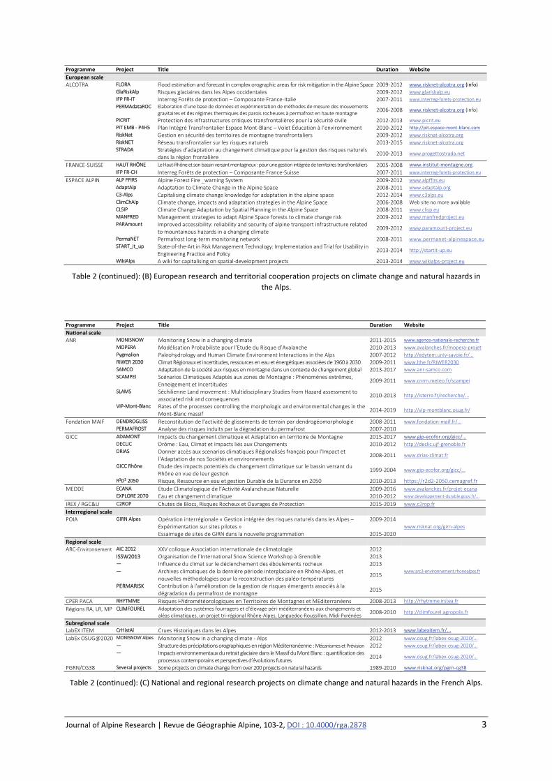
Journal of Alpine Research | Revue de Géographie Alpine, 103‐2, DOI : 10.4000/rga.2878 3
Programme Project Title Duration Website
European scale ALCOTRA FLORA Flood estimation and forecast in complex orographic areas for risk mitigation in the Alpine Space 2009‐2012 www.risknet‐alcotra.org (info)
GlaRiskAlp Risques glaciaires dans les Alpes occidentales 2009‐2012 www.glariskalp.eu
IFP FR‐IT Interreg Forêts de protection – Composante France‐Italie 2007‐2011 www.interreg‐forets‐protection.eu
PERMAdataROC Elaboration d’une base de données et expérimentation de méthodes de mesure des mouvements gravitaires et des régimes thermiques des parois rocheuses à permafrost en haute montagne
2006‐2008 www.risknet‐alcotra.org (info)
PICRIT Protection des infrastructures critiques transfrontalières pour la sécurité civile 2012‐2013 www.picrit.eu
PIT EMB ‐ P4H5 Plan Intégré Transfrontalier Espace Mont‐Blanc – Volet Éducation à l’environnement 2010‐2012 http://pit.espace‐mont‐blanc.com
RiskNat Gestion en sécurité des territoires de montagne transfrontaliers 2009‐2012 www.risknat‐alcotra.org
RiskNET Réseau transfrontalier sur les risques naturels 2013‐2015 www.risknet‐alcotra.org
STRADA Stratégies d’adaptation au changement climatique pour la gestion des risques naturels dans la région frontalière
2010‐2013 www.progettostrada.net
FRANCE‐SUISSE HAUT RHÔNE Le Haut‐Rhône et son bassin versant montagneux : pour une gestion intégrée de territoires transfrontaliers 2005‐2008 www.institut‐montagne.org
IFP FR‐CH Interreg Forêts de protection – Composante France‐Suisse 2007‐2011 www.interreg‐forets‐protection.eu
ESPACE ALPIN ALP FFIRS Alpine Forest Fire _warning System 2009‐2012 www.alpffirs.eu
AdaptAlp Adaptation to Climate Change in the Alpine Space 2008‐2011 www.adaptalp.org
C3‐Alps Capitalising climate change knowledge for adaptation in the alpine space 2012‐2014 www.c3alps.eu
ClimChAlp Climate change, impacts and adaptation strategies in the Alpine Space 2006‐2008 Web site no more available
CLSIP Climate Change Adaptation by Spatial Planning in the Alpine Space 2008‐2011 www.clisp.eu
MANFRED Management strategies to adapt Alpine Space forests to climate change risk 2009‐2012 www.manfredproject.eu
PARAmount Improved accessibility: reliability and security of alpine transport infrastructure related to mountainous hazards in a changing climate
2009‐2012 www.paramount‐project.eu
PermaNET Permafrost long‐term monitoring network 2008‐2011 www.permanet‐alpinespace.eu
START_it_up State‐of‐the‐Art in Risk Management Technology: Implementation and Trial for Usability in Engineering Practice and Policy
2013‐2014 http://startit‐up.eu
WikiAlps A wiki for capitalising on spatial‐development projects 2013‐2014 www.wikialps‐project.eu
Table 2 (continued): (B) European research and territorial cooperation projects on climate change and natural hazards in
the Alps.
Programme Project Title Duration Website
National scale ANR MONISNOW Monitoring Snow in a changing climate 2011‐2015 www.agence‐nationale‐recherche.fr
MOPERA Modélisation Probabiliste pour l’Etude du Risque d’Avalanche 2010‐2013 www.avalanches.fr/mopera‐projet
Pygmalion Paleohydrology and Human Climate Environment Interactions in the Alps 2007‐2012 http://edytem.univ‐savoie.fr/...
RIWER 2030 Climat Régionaux et incertitudes, ressources en eau et énergétiques associées de 1960 à 2030 2009‐2011 www.lthe.fr/RIWER2030
SAMCO Adaptation de la société aux risques en montagne dans un contexte de changement global 2013‐2017 www.anr‐samco.com
SCAMPEI Scénarios Climatiques Adaptés aux zones de Montagne : Phénomènes extrêmes, Enneigement et Incertitudes
2009‐2011 www.cnrm.meteo.fr/scampei
SLAMS Séchilienne Land movement : Multidisciplinary Studies from Hazard assessment to associated risk and consequences
2010‐2013 http://isterre.fr/recherche/...
VIP‐Mont‐Blanc Rates of the processes controlling the morphologic and environmental changes in the Mont‐Blanc massif
2014‐2019 http://vip‐montblanc.osug.fr/
Fondation MAIF DENDROGLISS Reconstitution de l'activité de glissements de terrain par dendrogéomorphologie 2008‐2011 www.fondation‐maif.fr/...
PERMAFROST Analyse des risques induits par la dégradation du permafrost 2007‐2010
GICC ADAMONT Impacts du changement climatique et Adaptation en territoire de Montagne 2015‐2017 www.gip‐ecofor.org/gicc/...
DECLIC Drôme : Eau, Climat et Impacts liés aux Changements 2010‐2012 http://declic.ujf‐grenoble.fr
DRIAS Donner accès aux scenarios climatiques Régionalisés français pour l'Impact et l'Adaptation de nos Sociétés et environnements
2008‐2011 www.drias‐climat.fr
GICC Rhône Etude des impacts potentiels du changement climatique sur le bassin versant du Rhône en vue de leur gestion
1999‐2004 www.gip‐ecofor.org/gicc/...
R²D² 2050 Risque, Ressource en eau et gestion Durable de la Durance en 2050 2010‐2013 https://r2d2‐2050.cemagref.fr
MEDDE ECANA Etude Climatologique de l’Activité Avalancheuse Naturelle 2009‐2016 www.avalanches.fr/projet‐ecana
EXPLORE 2070 Eau et changement climatique 2010‐2012 www.developpement‐durable.gouv.fr/...
IREX / RGC&U C2ROP Chutes de Blocs, Risques Rocheux et Ouvrages de Protection 2015‐2019 www.c2rop.fr
Interregional scale POIA GIRN Alpes Opération interrégionale « Gestion intégrée des risques naturels dans les Alpes –
Expérimentation sur sites pilotes » Essaimage de sites de GIRN dans la nouvelle programmation
2009‐2014 2015‐2020
www.risknat.org/girn‐alpes
Regional scale ARC‐Environnement AIC 2012 XXV colloque Association internationale de climatologie 2012
www.arc3‐environnement.rhonealpes.fr
ISSW2013 Organisation de l’International Snow Science Workshop à Grenoble 2013 ― Influence du climat sur le déclenchement des éboulements rocheux 2013 ― Archives climatiques de la dernière période interglaciaire en Rhône‐Alpes, et
nouvelles méthodologies pour la reconstruction des paléo‐températures 2015
PERMARISK Contribution à l'amélioration de la gestion de risques émergents associés à la dégradation du permafrost de montagne
2015
CPER PACA RHYTMME Risques HYdrométéorologiques en Territoires de Montagnes et MEditerranéens 2008‐2013 http://rhytmme.irstea.fr
Régions RA, LR, MP CLIMFOUREL Adaptation des systèmes fourragers et d'élevage péri‐méditerranéens aux changements et aléas climatiques, un projet tri‐régional Rhône‐Alpes, Languedoc‐Roussillon, Midi‐Pyrénées
2008‐2010 http://climfourel.agropolis.fr
Subregional scale LabEX ITEM CrHistAl Crues Historiques dans les Alpes 2012‐2013 www.labexitem.fr/...
LabEx OSUG@2020 MONISNOW Alpes Monitoring Snow in a changing climate ‐ Alps 2012 www.osug.fr/labex‐osug‐2020/...
― Structure des précipitations orographiques en région Méditerranéenne : Mécanismes et Prévision 2012 www.osug.fr/labex‐osug‐2020/...
― Impacts environnementaux du retrait glaciaire dans le Massif du Mont Blanc : quantification des processus contemporains et perspectives d’évolutions futures
2014 www.osug.fr/labex‐osug‐2020/...
PGRN/CG38 Several projects Some projects on climate change from over 200 projects on natural hazards 1989‐2010 www.risknat.org/pgrn‐cg38
Table 2 (continued): (C) National and regional research projects on climate change and natural hazards in the French Alps.

Journal of Alpine Research | Revue de Géographie Alpine, 103‐2, DOI : 10.4000/rga.2878 4
In continuity with previous syntheses (Prudent‐Richard et al., 2008 ; Richard et al., 2010 ; Einhorn
and Peisser, 2011), this paper presents the main results of recent work on these themes in the
French Alps, bearing on knowledge capitalization portals (Tab. 3). It also presents an overview of
existing observation services (Tab. 4).
Outil de capitalisation des connaissances Site internet
‘Alpes‐Climat‐Risques’ web‐portal from the project ClimChAlp (Prudent‐Richard et al., 2008):
bibliographical knowledge base (350 references) and newsletter on climate change and its effects on
alpine physical systems and natural hazards.
www.risknat.org/alpes‐climat‐risques
‘Base Projets’: database on the results of research projects on alpine natural hazards. www.risknat.org/baseprojets
Database of the RiskNET project on Franco‐Italian‐Swiss Interreg cooperation projects on natural
hazards in the ALCOTRA territory. www.risknet‐alcotra.org
Table 3: Tools giving access to full references (projects, publications) of the results discussed in the text.
Observation services and databases Missions and objects of study Data types Carrying organisms and data producers*
Observations climatiques
Météo‐France http://www.meteofrance.com/
Public service missions of information dissemination on meteorology and climate. Publish in particular annual and seasonal climatic balance assessments.
Observational data (in situ, radar, satellite), climatology, forecast data and models, and climate forecast
Météo‐France
Historical Instrumental Climatological Surface Time Series of the Greater Alpine Region (HISTALP) www.zamg.ac.at/histalp/
Climate parameters long series covering the European Alps
Homogenized monthly temperature, precipitations, atmospheric pressure, sunshine duration and nebulosity data
ZAMG (Autriche)
Alpine environment
Les GLACIers, un Observatoire du CLIMat (GLACIOCLIM) www‐lgge.ujf‐grenoble.fr/ServiceObs/
Environment Research Observatory on the theme ‘Continental Surfaces and Interfaces’ on glaciers and climate studies
Glacier mass balances LGGE, Irstea
Réseau de mesure du permafrost et des processus liés au gel (PermaFRANCE)
Observational and monitoring network on French mountain permafrost, freezing‐related phenomena and associated periglacial processes
See Bodin et al., 2015 (this volume) PACTE, EDYTEM
Natural hazards
Enquête permanente sur les avalanches (EPA) www.avalanches.fr/epa_lobservation‐actuelle
Regular avalanche observation in France providing access to an inventory, as complete as possible, of avalanche events that took place on the sites observed during the winter season (4000 paths to date)
Base de données des événements observés pour chaque site (dates, altitudes, dépôt, caractéristiques, météo 3 jours, précédents, météo 4h, précédentes, causes, victimes, dégâts ou lieux atteints)
Irstea, ONF‐RTM, MEDDE
Observatoire des Risques Naturels en Montagne du service de Restauration des Terrains en Montagne (BD RTM Evénements) http://rtm‐onf.ifn.fr
Database on events of avalanche, flood, debris flow, gullying, rockfall, landslide, subsidence and compaction by withdrawal
Information on more than 30 000 events and more than 19 000 works of protection against natural hazards (grouped into 2,400 protective devices)
ONF‐RTM, IFN, MEDDE, Ministère de l’Agriculture
Observatoire Multidisciplinaire des Instabilités de Versants (OMIV) http://omiv.osug.fr/
Study of landslide dynamics (damage, triggering, and propagation) and the effect of external forcing (climate, earthquakes) on four sites representative of the mechanisms observed in the French Alps (soft rock / dense, slow or fast movements).
Development of a permanent multidisciplinary instrumentation on each site, to characterize: i) the kinematics of movement and deformation (geodesy, inclinometers, extensometers, aerial and satellite imagery), ii) the seismic behavior of the slip (fragile damage via microseisms and responses to regional earthquakes), iii) the hydraulic responses to meteorological forcing.
ISTerre, Géoazur, EMMAH, IPGS‐EOST, Chrono‐Environnement
Surveillance Séchilienne www.versant‐sechilienne.developpement‐durable.gouv.fr/
Operational system for the monitoring of the ‘Ruines de Séchilienne’ unstable slope (Isere)
Teletransmission of monitoring data: extensometry, GPS positioning, movement velocity…
MEDDE, CEREMA
Banque Nationale de Données pour l’Hydrométrie et l’Hydrologie (Banque HYDRO) www.hydro.eaufrance.fr
Hydrological database of state services administered and managed by the ‘Service Central d'Hydrométéorologie et d'Appui à la Prévision des Inondations’ (‘Central Service of Hydrometeorology and Support to Flood Forecasting’)
Water height measurements at various time steps from 3500 measuring stations (including 2 400 in service) located on the French rivers and access to station metadata
MEDDE, (SCHAPI, DREAL, SPC, etc.), EDF, Irstea, compagnies d'aménagement
Service de Prévision des Crues des Alpes du Nord (« Information sur la vigilance crues ») www.vigicrues.gouv.fr
Regulatory mission of monitoring, forecasting and transmission of information on floods
Data measuring stations water heights and discharge of major metropolitan rivers (stored in the ‘Banque HYDRO’ database)
MEDDE, SPC Alpes du Nord (DDT38)
Base de Données sur les Incendies de Forêt en France (BDIFF) http://bdiff.ifn.fr/
Collects all the data related to forest fires in France since 1992
Declarative data complementarily collected by different local services (departmental or regional)
MAAPRAT, MIOMCTI, DGPAAT, IGN
Notes: * Acronyms: see websites
Table 4: Observation and monitoring systems providing data on climate change, physical environment and natural hazards
in the French Alps.
Journal of Alpine Research | Revue de Géographie Alpine, 103‐2, DOI : 10.4000/rga.2878 5
On these bases, the present contribution reviews observed and projected changes in: i) climate
patterns, ii) cryosphere, hydrosystems and slope morphodynamics, iii) natural hazards, and iv)
induced risks on human installations and activities in the French Alps. It is illustrated by chronicles of
hydro‐gravitational processes activity, along with time series of climate pattern identified as their
most significant predictors. In addition to the resources and to the references inventoried, and to
allow deepening this review, other papers of the volume focusing on certain topics handled in this
paper are reported.
1. Climate changes and observed physical impacts
1.1 Measured climate change
The warming of the climate in the Alpine range is well documented (Tab. 5) from varied sources (punctual series, reanalysis, results from simulation of the past, etc.) with different spatial and altitudinal resolution, and covering various periods, whose use requires homogeneous databases. Robust findings focus on the general rise in temperatures and its effects on directly related phenomena, such as snowfall or evapotranspiration.
Results References
(A) According to a regional dendroclimatological reconstitution in the Alps, the last decade of the twentieth century was the warmest period in the last millennium, with more warming and much faster than, for example, the one rebuilt for the warm period medieval.
Corona et al., (2010)
(B) The long series of homogenized temperatures covering the Alps (HISTALP) show a uniform warming of 2 °C between the late nineteenth and early twenty‐first century (Auer et al. 2007), which has accelerated since 1970, including at high altitude. Everywhere, indeed, the end of 1980s marked in significant warming. The average height of the isotherm 0 °C so rose of 400 m with compared with the beginning of 1980s (Böhm et al., 2010).
Auer et al. (2007) (see ref. in Böhm et al., (2010)) ; Böhm et al., (2010)
Table 5: Results from (A) reconstitution and (B) observation of the plurisecular temperature evolution in the Alps. In the French Alps, located at the intersection of several climatic influences, the warming of temperatures after 1980 affects all stations, with slight contrasts between the Northern and Southern part (Fig. 1). The warming of +1.8 and +2.1 °C on annual average in the Northern Alps and in the ‘Prealps’ since 1950 is faster than that observed in the Southern Alps (+1.5 to + 1.7 °C), with intermediate values in transitional areas between these two climatic domains1.
1 Source: analysis of homogenized temperature data of Météo‐France by MDP/OsCC. For Northern Alps, OsCC provides annual and seasonal climate assessments (www.mdp73.fr).

Journal of Alpine Research | Revue de Géographie Alpine, 103‐2, DOI : 10.4000/rga.2878 6
Figure 1: Homogenised annual mean temperature from 1950 to 2014 at Bourg‐Saint‐Maurice (BSM) and Embrun and
normal values over the reference period 1961‐1990. Data: Météo‐France; Processing: MDP‐OsCC/PARN.
Monthly long series in Northern Alps over the period 1885‐2007 (Dumas, 2013) show that warming on an annual scale occurred without much amplification until 1960. Then the rate of warming has increased over the past decades to exceed +4.0 °C/100 years (especially in spring and summer). This value is consistent with the rate of +0.4 °C/decade in the Northern Alps since 1950, higher than in the rest of France, especially for the maximum temperatures (Gibelin et al., 2014). The issue of ‘Mediterraneanisation’ of Northern Alps climate arises, this phenomenon having already occurred along the Rhône Valley and in Midi‐Pyrénées (Climfourel project). SAFRAN reanalysis2 over the 1958‐2002 period (Durand et al., 2009a) show a temperature increase especially marked at medium altitudes (1500‐2000 m, > +0.3 °C/decade) which significantly reduces beyond 3000 m a.s.l.. At very high altitude (> 4000 m a.s.l.), in the Mont Blanc, the air temperature reconstituted by inversion of the ice temperature profiles increased by 0.14 ° C / decade during the twentieth century (Gilbert and Vincent, 2013). Rainfall in the Alps have a much more heterogeneous pattern of change at regional and seasonal scales (Tab. 6).
Results References
(A) At the scale of the Alpine range and during the 20th century, precipitation has increased by 9% in the northwest of the chain, where cloud cover also increased, while falls were even (‐9%) in its southeastern part, in relation with a decrease in cloud cover and a drying trend.
Auer et al. (2007) (voir réf. dans Böhm et al., 2010)
(B) Daily rainfall data of over 5,000 stations covering the Alps on the 1971 to 2008 period were interpolated in a high‐resolution grid (5 km) more finely integrating the complex influence of topography and reducing traditional biases of interpolation. The studied indices emphasize the asymmetry of the frequency distribution of daily precipitation between the regions north of the Alps, where rainy days (> 1mm) are more common, and their southern flank, where they are less frequent but more intense on average.
Isotta et al. (2014)
Table 6: Results of (A) reconstitution (HISTALP) and (B) observation on of the plurisecular evolution of precipitation and nebulosity in the Alpine region.
2 Mesoscale analysis system of near surface atmospheric variables: www.drias‐climat.fr/accompagnement/section/137
Journal of Alpine Research | Revue de Géographie Alpine, 103‐2, DOI : 10.4000/rga.2878 7
In the French Alps, the average annual rainfall observed and simulated by SAFRAN, and Météo‐France homogenized climate series, show no statistically significant trends (Durand et al. 2009a), apart a decrease in winter precipitation in the internal Alps (Haute Maurienne, Queyras), which reached 30% between 1961‐1990 and 1981‐2010 climate periods3. On extreme precipitation, it is difficult to conclude for the Alps. While a tendency to increase, variable by region was reported for Europe, with a median reduction of 21% of the return period of extreme events (van den Besselaar et al., 2013), Météo‐France data do not indicate any increase in extreme rains in the Southeast of France4.
1.2 Observed impacts on alpine cryosphere
Under the effect of climate change, the Alpine environment records fast and obvious changes: less
snow, receding glaciers, permafrost degradation, species rise in altitude and latitude, warming of
lakes and rivers, etc. The impacts reported in the mountains result primarily from the effects of
temperature increase, which largely controls the alternating freeze/thaw, the rain/snow ratio or the
altitudinal position of snow cover and the equilibrium‐line altitude (LEA) of glaciers. These factors
largely control the hydrological regime, vegetation dynamics and, to a lesser extent because of the
complexity of systems, s.l. erosion processes in watersheds.
Snow‐cover at 1800 m in the French Alps showed a strong spatial variability from the late 1950s to
the mid‐1980s, after which it became less variable from one massif to another, with decreased mean
values and a reduced amplitude of extreme values (Durand et al., 2009b). The thickness of snow in
early winter has showed a sharp decline at low and medium altitude from the late 1980s, while it
increased at high altitude (2700 m).
Glaciers are the most visible marker of past warming and its recent acceleration. A multisource
cartographic reconstitution of glacial extent in the French Alps has assessed its diachronic evolution
in recent decades (GlaRiskAlp project; Tab. 2). Their surface in late 2000 (275 km²) fell by nearly 20%
from 1985 to 1986 (340 km²) and by 26% from the years 1967 to 1971 (370 km²; Gardent et al.,
2014), in response to strong warming above‐mentioned (Fig. 2). Yet, the most direct measure of
climate control on glacier dynamics is provided by the mass balance. Data exist only for some
glaciers, especially those monitored by the observatory GLACIOCLIM (Table 4; Vincent, 2002). For
example, seasonal variations in Sarennes glacier since 1949 quantify accurately the evolution of
winter snowfall and summer temperatures at high altitude (Thibert et al., 2013).
3 Cf. Note 1. 4 http://pluiesextremes.meteo.fr/

Journal of Alpine Research | Revue de Géographie Alpine, 103‐2, DOI : 10.4000/rga.2878 8
Figure 2: (A) Annual average temperature anomalies in Bourg‐Saint‐Maurice and Embrun over the period 1967‐2010
compared to the 1961‐1990 normal (see Fig. 1). (B) Estimation of decadal changes in glacial extent in the main massifs of
the French Alps for different periods from 1967/71 to 2006/09, expressed in % per year (Gardent et al., 2014).
Satellite imagery documents changes in a more continuous way spatially. Data on 43 glaciers in the
French Alps show an increase in the average altitude of the equilibrium‐line altitude (ELA) by about
170 m over the period 1984‐2010, a concomitant increase of summer cumulative positive degree
days by about 150 days at 3000 m a.s.l., while winter precipitation remained stable (Rabatel et al.,
2013). These results underline the preponderant influence of temperature increase in the recent
evolution of alpine glaciers, despite the variability due to the local topographical context (Cossart,
2013).
Finally, the establishment of long‐term observation networks (PermaNET project; PermaFRANCE
network) marks an advance in the knowledge and monitoring of the distribution of permafrost, its
thermal evolution and the processes associated with its degradation (see Bodin et al., this volume).
1.3 Observed impacts on natural hazards
Research projects (Tab. 2) and long‐term observation programs (Tab. 4) have delivered significant
results on the evolution of natural hazards activity over recent decades.
Alpine floods
The analyses conducted across homogenous hydro‐climatic regions in the AdaptAlp project5 suggest
that the trends affecting alpine rivers depend on their hydrological regime. Only snowmelt and
glacial regime rivers are experiencing an increase in the intensity and the volume of their floods and
an evolution of their seasonality, with an earlier and longer snowmelt period (Bard et al., 2012).
5 The analyzed data series covering 177 alpine stations are available from the international database of the Global Runoff Data Center (GRDC) www.bafg.de/GRDC

Journal of Alpine Research | Revue de Géographie Alpine, 103‐2, DOI : 10.4000/rga.2878 9
Snow avalanche
Methodological progresses achieved in MOPERA and ECANA projects have improved the knowledge
of fluctuations in avalanche activity and its climate control (Eckert et al., 2010a & b; 2013). A relative
minimum in runout‐altitudes could be identified around 1980, followed by a sharp rise in elevation
(Fig. 3A). The decrease over the period 1960‐1980 corresponds to colder and snowy winters, and the
rise in 1980‐2005 years is the period of increased warming. The influence of the cold, snowy winters
recorded since 1998 is clear (Fig. 3C).
This overall scheme conceals different trends depending on the altitude (Lavigne et al., 2015). At low
altitude (<2000 m), the reduction of activity (number of avalanches) since 1980 has been drastic,
while it has recently increased at high altitude, perhaps in connection with the possible increase in
climate variability during winter.
Torrential flood and debris flow
The statistical analysis of more than 500 events listed since 1970 in the RTM database (Table 4;
ARNICA project) showed the essential role played by climate variables at the regional level in the
probability of debris flow occurrence. In some sectors, the increased frequency of debris flows since
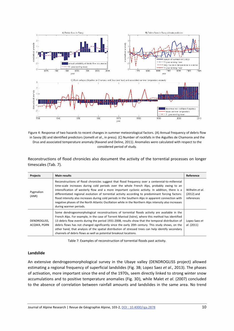
the late 1980s (Fig 4A. Jomelli et al., in press) may be an effect of summer warming, which leads to
more convective effects and therefore more summer thunderstorms (Fig. 4B). In other areas, the
control of the temporality of debris flows by sediment supply seems to outweigh its control by the
climate (Garitte et al., 2007).
Figure 3: Response of two hazards to recent changes in winter snow and weather factors. (A) Decennial runout‐altitude of
snow‐avalanches in the French Alps and (C) identified predictors (Eckert et al., 2013). (B) Annual frequency of landslides in
Ubaye and (D) identified predictors (Lopez Saez et al., 2013). Anomalies were calculated with respect to the considered
period of study.
Journal of Alpine Research | Revue de Géographie Alpine, 103‐2, DOI : 10.4000/rga.2878 10
Figure 4: Response of two hazards to recent changes in summer meteorological factors. (A) Annual frequency of debris flow
in Savoy (B) and identified predictors (Jomelli et al., in press). (C) Number of rockfalls in the Aiguilles de Chamonix and the
Drus and associated temperature anomaly (Ravanel and Deline, 2011). Anomalies were calculated with respect to the
considered period of study.
Reconstructions of flood chronicles also document the activity of the torrential processes on longer
timescales (Tab. 7).
Projects Main results Reference
Pygmalion
(ANR)
Reconstructions of flood chronicles suggest that flood frequency over a centennial‐to‐millennial
time‐scale increases during cold periods over the whole French Alps, probably owing to an
intensification of westerly flow and a more important cyclonic activity. In addition, there is a
differentiated regional evolution of torrential activity according to predominant forcing factors:
flood intensity also increases during cold periods in the Southern Alps in apparent connection with
negative phases of the North Atlantic Oscillation while in the Northern Alps intensity also increases
during warmer periods.
Wilhelm et al.
(2012) and
references
DENDROGLISS,
ACQWA, PGRN
Some dendrogeomorphological reconstructions of torrential floods activity are available in the
French Alps. For example, in the case of Torrent Manival (Isère), where this method has identified
13 debris flow events during the period 1931‐2008, results show that the temporal distribution of
debris flows has not changed significantly since the early 20th century. This study shows, on the
other hand, that analysis of the spatial distribution of stressed trees can help identify secondary
channels of debris flows as well as potential breakout locations.
Lopez Saez et
al. (2011)
Table 7: Examples of reconstruction of torrential floods past activity.
Landslide
An extensive dendrogeomorphological survey in the Ubaye valley (DENDROGLISS project) allowed
estimating a regional frequency of superficial landslides (Fig. 3B; Lopez Saez et al., 2013). The phases
of activation, more important since the end of the 1970s, seem directly linked to strong winter snow
accumulations and to positive temperature anomalies (Fig. 3D), while Malet et al. (2007) concluded
to the absence of correlation between rainfall amounts and landslides in the same area. No trend
Journal of Alpine Research | Revue de Géographie Alpine, 103‐2, DOI : 10.4000/rga.2878 11
was detected for deep landslides (for which the data remain scarce), despite their sensitivity more or
less proved to hydro‐climatic forcing (Tab. 8).
Project Main results Reference
CEREGE (supported
by PACA Region)
For many large landslides in the Alpes Maritimes department, surface exposure dating
using the cosmogenic nuclides method shows synchronous triggering phases about 4000
years ago, possibly related to climate forcing.
Zerathe et al. (2013)
SLAMS (ANR)
In the case of Séchilienne deep‐seated unstable slope, displacement time series measured
by the monitoring system since 1985 show no apparent connection with the evolution of
temperature or precipitation parameters. However, seasonal intra‐annual variations are
synchronous to precipitation. Wavelet analysis showed that the slope destabilization is
rather linked to effective rainfall than to raw precipitation (rainfall + snowfall), involving
then groundwater process. Due to the progressive degradation of its mechanical
properties, this unstable slope become, since a few years, more sensitive and reactive to
short‐term events, while seasonal variations are less pronounced.
Vallet et al. (2013)
Table 8: Examples of reconstruction and observation on large slope instabilities.
Rockfall
Bellow the periglacial belt, no tangible impact on rockfalls is demonstrated to date, despite an
apparent increase in their impact on mountain roads reported in the Isère, Savoie and Haute‐Savoie
departments (Einhorn and Peisser, 2011; Wurtz, personal communication).
Glacial and periglacial hazards
A growing body of research reinforces the empirical link between the rapid changes observed in the
cryosphere and the resurgence of high mountain destabilization phenomena (Ravanel, 2009),
particularly in glacial and periglacial areas (Bodin et al., this volume). Thus, the reconstructions in
permafrost areas in the Mont Blanc massif show a correlation between the decadal frequency of
rockfalls (> 100 m3) and the warming since the early 20th century (Figure 4C;. Ravanel and Deline
2011).
No trend has been firmly established for glacial hazards because, apart from the low volume seracs
falls, they occur relatively rarely. The observed changes in geometry and the thermal regime of
glaciers are nonetheless likely to alter the conditions of formation of this type of hazard. Research is
being conducted to inventory at risk glaciers, including track over time of large seracs evolution and
detection of the presence of interglacial water pockets, whose brutal drain can trigger debris flows of
catastrophic consequences (Gilbert et al. 2012; Vincent et al., 2012). Furthermore one aims at
assessing the risks of instabilities that may arise in recently deglaciated margins (Gardent, 2014):
brutal outburst of juxta‐, supra‐ and pro‐glacial lakes (Vincent et al., 2010), increased stock of
sediments available for torrents, cascading process that can lead to devastating phenomena.
Projects Main results Reference
RiskNat, GlaRiskAlp
and ACQWA
The outburst of glacial water pocket is one of the dangers with the most catastrophic
potential consequences in the Alps (St‐Gervais Disaster in July 1892). The research
initiated following the crisis related to the detection of a water pocket in the Tête
Rousse glacier (Haute‐Savoie) showed the possible influence of the thermal regime of
the glacier on the formation of the water pocket.
Gilbert et al. (2012)
Journal of Alpine Research | Revue de Géographie Alpine, 103‐2, DOI : 10.4000/rga.2878 12
GlaRiskAlp
Inventory of current and former extensions of glaciers at the regional scale of the
Western Alps and geomorphological mapping of deglaciated sectors since the end
of the Little Ice Age.
Development of a typology of glacial hazards.
Development of a methodology for evaluating the susceptibility to hazards of
glaciated and recently deglaciated areas, and test on four pilot sites (inventory of
processes, and their possible combinations, quantification of volumes involved,
characterization of the stability of materials).
On four pilot sites: data acquisition and test of methods on the ice dynamics, serac
falls and the forming conditions of glacial water pockets (Taconnaz, Grandes
Jorasses, Tête Rousse, and Argentière glaciers).
Gardent (2014)
Table 9: Example of recent work on glacial hazards.
Climate change, its impact on the Alpine environment and on natural hazards observed in the French
Alps thus show the existence of climatic control mechanisms exercised by some parameters
(thermal, a minima) on forming conditions for certain types of hazards. Without supporting an
excessive catastrophism, these findings nevertheless invite to a certain degree of vigilance towards
future development of phenomena whose "climate sensitivity" is proven true.
2. Future impacts on physical systems
2.1 The alpine climate in the coming decades
Numerous projects proposed climate projections for the whole Alpine space, then used as inputs for
transverse or targeted impact studies (Tab. 10). For the French Alps, a relative consensus exists on
the extent of future warming: + 1.5 °C in the middle of the 21st century and +2 to + 4 °C at the end of
the century compared to the reference period 1960 ‐1990, with spatial and/or seasonal variations.
Regarding precipitation on the other hand, we note a quasi‐absence of predictable trend in the
cumulative precipitation at various timescales, except a slight deficit precipitation in autumn
(Rousselot et al., on 2012), and maybe in summer (model Aladdin of Météo‐France/CNRM, DRIAS
project) for the end of the century. If an increase in intensity and/or in frequency of extreme
precipitation is projected on a global scale (IPCC, 2012), its magnitude remains uncertain across the
French Alps, in particular concerning convective rainfalls.
According to the results of SCAMPEI and ECANA projects, the reduction of the currently observed
average snowfall will continue in the 21st century in all the French Alps, because of the change in
rain‐snow ratio related to current warming. If the areas located above 1800‐2100m should remain
relatively preserved by 2050 with low decreases varying according to the economic scenario and
slope aspect considered, this critical altitude should then rise to 2400m for the most optimistic
scenario, and even more for other scenarios. These quantitative variations will come along with
qualitative changes, for example with the gradual appearance of a wet snowpack at the hearth of
winter at high altitude (Castebrunet et al. 2014).

Journal of Alpine Research | Revue de Géographie Alpine, 103‐2, DOI : 10.4000/rga.2878 13
Project | Types of models and scenarios used | Main results Website
Europe
ENSEMBLES (FP6) | Multimodel regional climate projections over Europe and the Alps (maximum spatial resolution of 25 km) for the
21st century (2070‐2099) based on the A1B SRES (Special Report on Emission Scenario) scenario for greenhouse gas (GHG) emission
from IPCC. | For the Alpine region, models agree on an increase in the intensity of extreme events in all seasons and in most regions,
with the exception of summer events in the southern regions, the largest increase (up + 30%) being simulated in the autumn and in the
north of the Alpine range (Rajczack et al., 2013).
www.ensembles‐eu.org
EURO‐CORDEX (WRCP) | Multimodel high resolution (12.5 km) regional climate projections over Europe and the Alps, providing better
a representation of physical processes and intense precipitation, based on global climate simulations from CMIP5 and on new scenarios
for GHG concentration established within the fifth IPCC assessment report (Representative Concentration Pathways, RCPs), for three
time periods: 2021–2050 and 2071–2100 vs 1971–2000. | Compared to previous results of the ENSEMBLES project, new simulations
(Jacob et al., 2014) indicate: (i) A warming, with regional differences, in the range of 1–4.5 °C (RCP4.5) and of 2.5–5.5 °C (RCP8.5). (ii) A reduced northwards shift of Mediterranean drying evolution (in the Alps, with a decrease in extended dry spells, but an increasing
number of all dry spells). (iii) A reduction in the frequency of weak‐intensity rainfall (<10 mm/day), but an increase in high intensity
events (> 30 mm/day).
www.euro‐cordex.net
France
Driasles futurs du climat | Fine scale climate projections over France for the 21st century. The DRIAS portal integrates including regionalized
simulations from the SCAMPEI project (see below) and two new ensembles of simulations from the IPSL2014 and CNRM2014
experiences, made from the new RCP scenarios.
www.drias‐climat.fr
Alpine space
ClimChAlp | Regional climate simulations over the Alpine Space with three regional climate models (RegCM, REMO, HIRHAM and
COSMO‐CLM) using different SRES scenarios SRES (A1B, A2, B1 and B2) from IPCC for two temporal horizons (2001‐2100 et 2070‐2100).
| Results show: (i) An increase in the monthly average temperature up to 5 K in August. Even with scenario B2 an increase in summer
temperature up to 3.8 K and an increase to 2 K in winter are calculated. Summer and autumn temperatures are expected to rise more
than winter and spring temperatures. (ii) A decrease in rainfall of up to 30% in summer, but in winter an increase of about 20% (40% in
some areas).
www.climchalp.org
(non maintenu)
EEA, 2009 (European Environment Agency) | Regional climate simulations over the Alpine range for 2071‐2100 time horizon, based on
IPCC A1B SRES scenario. | Compared to the 1970‐2000 reference period, these simulations indicate: (i) A temperature rise of 3.9 °C up
until the end of the 21st century, particularly elevated in the high mountains (> 1 500 m), with a 4.2 °C increase, comparatively low
until 2050 (1.4 °C), then much faster in the second half of the 21st century. (ii) A slight decrease in precipitation up until the end of the
century, ranging between –1 % and –11 % depending on model and region, with the strongest decrease in the south‑western Alps, and
very different trends depending on season. The greatest changes are projected in summer, with a –25 % decrease north‐east of the
Alps and up to –41 % in the south‐western part up to the end of the 21st century, while most regions would experience increased
precipitation in the spring and winter.
www.eea.europa.eu
AdaptAlp | Multimodel regional climate simulations over the Alpine Space for “near future” (2021‐2050) and “distant future” (2071‐2100)
compared to the period 1971‐2000, based on the IPCC SRES A1B scenario. | These projections indicate: (i) An increase in mean annual air
temperature of 1.5 °C to 2.25 °C in the near future (higher in winter than in summer) and 3.5 ° C to 4, 75 ° C in the distant future (on the
contrary higher in summer than in winter). (ii) A slight increase (+ 5%) of annual rainfall in the winter in the northern parts of the Alps and a
slight summer decrease (‐5%) in Mediterranean areas in 2050, while at the end of the century they show an increase of 15% in winter (+25%
in the Central Alps) and a decrease of ‐15% in summer (‐25% in Mediterranean areas). (iii) An increase in meteorological drought disposition
in summer.
www.adaptalp.org
CLISP | Regional climate simulations over the Alpine Space based on IPCC SRES A1B and B1 scenarios for two future 20‐year periods (2011‐
2030 and 2031‐2050) compared to the reference period 1961‐1990. | A warming of average temperatures is projected in all seasons after
2030, stronger in summer (between 1.3 °C and 3 °C by 2050). In continuity with trends observed in the past, the central part of the Alps
would warm faster than piedmont regions. Projected maximum temperature shows almost the same trend like average temperature
(indicating that temperature extremes will become more frequent in the future), as the minimum temperatures. The later, however, have
even stronger trends in winter, which would imply a further reduction in the number of frost days and thus snow cover and glaciers (which
are particularly sensitive to increases in minimum temperatures). Regarding precipitation, the clearest trend can be observed for summer,
where a majority of scenarios shows a trend to a slight decrease of precipitation of up to –55 mm.
www.clisp.eu
ACQWA (FP7) | Regional climate simulations over the Alpine realm. | The main conclusions are: (i) An overall warming of up to 2 °C by 2050,
greater above 1500 m altitude in autumn. (ii) An increase in precipitation in winter but rather a decrease in spring and summer, but
probably a strong spatial variability, with increases north of the Alps in spring, summer and fall, and decreases in the southern and western
parts. (iii) A decrease in snow depth in winter and spring. (iv) Higher frequencies of extreme precipitation event occurrences are projected,
as well as more separate wet periods within events, with shorter durations but higher intensity. | An overview of projected changes for the
twenty‐first century in water cycle and natural hazards in the Alpine range is available in Gobiet et al. (2013).
www.acqwa.ch
Note: See also regional climate simulations across the Alpine Space from MANFED and ALP FFIRS projects (cf. Tab. 2B). www.manfredproject.eu
www.alpffirs.eu
French Alps
SCAMPEI (ANR)|Climate projections for near future (2021‐2050) and distant future (2071‐2100) based on SRES scenarios (A1B, A2 and
B1) from IPCC, combining high‐resolution simulations (12 km) with three regional climate models and statistical adaptation of fine
analyzes (8km) to reflect the best of topographic complexity. | For the French Alps, the results of SCAMPEI simulations are consistent
with regional projections across Europe and the Alps. In particular, an increase in thermal extreme is expected in the Prealps (Rome et
al., 2013).
www.cnrm.meteo.fr/scampei
Table 10: Examples of projects and works proposing climatic and/or impact projections for various study areas including the
French Alps (titles and websites of the projects appear in Tabs. 2A, 2B and 2C).

Journal of Alpine Research | Revue de Géographie Alpine, 103‐2, DOI : 10.4000/rga.2878 14
2.2 Future impacts on alpine environments
The absence of past situation similar to the projected climate makes it even more difficult to predict
the effects on the activity of natural hazards (Schoeneich and de Jong, 2008). We summarize here the
most substantiated results achieved so far on the future dynamics of hydro‐gravitational hazards.
Continuation of the glacial withdrawal and the degradation of the permafrost
The forcing of more or less sophisticated glaciological models with future climate scenarios suggests
the acceleration of glacial retreat in the Alps during the next decades. According to the warming (2‐5
°C in 2100) and the spatial scale considered, the reduction of volume and/or surface would be 20‐35
% compared with 2000, until a quasi‐total disappearance of glaciers (Zemp et al., 2006 ; Salzmann et
al., 2012).
For the French Alps, Le Meur et al. (2007) project the total disappearance of the Saint Sorlin glacier
(Grandes Rousses Massif) to 2070, and Vincent et al. (2014) show that the withdrawal of the Mer de
Glace (Mont‐Blanc Massif) will continue even in the current climate. Some glacial hazards will
disappear because of changes in glacier configuration, while others previously mentioned will
appear. Permafrost degradation should result in an increase in the frequency or volume of rockfalls
and in an acceleration of rock glaciers creep, even their detachment (see Bodin et al., this volume).
Snow avalanche
The expected evolution in snowpack will increase the proportion of wet snow avalanches compared
to dry snow avalanches, which seems to begin to be detected in observational series (Pielmeier et al.,
2013). The induced changes (runout distance, impact pressure) however do not have univocal s
implication in term of risks. Nevertheless, the expected evolution of snow in the French Alps suggests
an overall decline of 20‐30% in avalanche activity for the 21st century, particularly strong at low
altitude. During cold and very snowy even episodes, possible large‐scale avalanches may
nevertheless still occur. At high altitude, there will most probably be no fast decrease in activity as
long as the snowpack will remain substantial; stronger extreme snowfall predicted by certain climate
models and the highest variability already observed in winter temperatures may even lead to a
higher frequency of wet snow avalanches in the middle of winter (Castebrunet et al., 2014).
Torrential flood and debris flow
Weather conditions favourable to the triggering of landslides and debris flows should become more
frequent in the Alps for most of seasons except in July and August, although the frequency of intense
rainfalls (> 30 mm/day) may increase in some regions (ARNICA project). Whatever the climate model
used as input, a significant increase in the occurrence of debris flow probability in the north and the
south of the Alps is expected for 2050 and 2100 (Jomelli et al., 2009), although these approaches do
not take into account sediment transfer in catchments.
Alpine flood
Projections for the future development of Alpine floods in intensity, frequency and seasonality have
to integrate a multitude of complex and multi‐scale effects related to increased temperature, the
change in rainfall patterns, or changes in land cover. Projects have produced impact simulations
using several types of indicators of future flood disposition at different time step (Tab. 11), with
Journal of Alpine Research | Revue de Géographie Alpine, 103‐2, DOI : 10.4000/rga.2878 15
sometimes contradictory results according to the studied areas or to climate models and scenarios
used, e.g. for changes in summer extreme rainfall.
Project / reference* Main results Study area and time horizon
AdaptAlp
Near future: a relative stagnation of the 5‐day precipitation maxima per season
for most of regions or seasons, but possible increase in the northern sectors in
spring and autumn
Distant future: reduced heavy precipitation events during summer in most regions
(up to –30%). For the winter, simulations indicate more intense heavy
precipitation events (up to +20%) in all sectors (Nilson et al., 2012).
Alpine arc
Near future: 2021‐2050
Distant future: 2071‐2100
CLISP
Projections at the scale of the Alpine Space based on a conceptual model linking
change in flood return periods with the extent of the contributing area in Alpine
catchments indicate that centennial flood discharges would increase more in high
altitude basins, and more in the Western Alps than in the Eastern Alps. The most
affected catchments would be in the Swiss and Italian Alps, where more catchments
tend to turn from nival to pluvial regimes (EURAC, 2011 and references therein).
Alpine arc
Agence de l’eau RMC
(2012)
Projections considered strong over the south‐eastern part of France are: a decrease
in summer and autumn river discharges (‐20 to ‐50%), a change in the regime of
snow‐influenced rivers (earlier melting peak one to two months), more severe and
longer low flow, a decrease in the water equivalent of snow at 1200 m a.s.l. from
2030. This projection is more robust for 2080, with a sharp decline in south of the
Alps (near disappearance of the snow in spring at 1200 m), lower summer and
autumn discharges in non‐Mediterranean tributaries of the Rhone (‐20 to ‐50% in
2050) and a sharp decline in summer discharge of the Isere and Durance rivers (up
75% in June‐July 2050).
Projections considered more uncertain are the following: increased discharges in
winter; rather decreased modules but uncertainties depending on seasonal
contrasts; stable or increased winter discharge of the Rhone; decrease in the water
equivalent of snow northeast of the Alps (with considerable uncertainty about the
magnitude of this decline); uncertainties about the water equivalent of snow at high
altitudes (stable or declining in the northern Alps, significantly down south); stable
or increased winter discharges of non‐Mediterranean tributaries of the Rhone;
higher winter discharges of the Isere and the Durance; uncertainties about the
evolution of winter discharges of Mediterranean rivers; uncertain decrease in
groundwater recharge (which could be more pronounced in the Alps and Corsica).
The authors conclude that, in general, despite the projected general decline in
average discharges in the 21st century, high discharge values and flood amplitude
and frequency are not expected to decrease and may even worsen, which would
affect the design of structures, with stronger contrasts to manage.
Rhône‐Mediterranean and
Corsica (RMC) catchments
EXPLORE 2070
The findings of the EXPLORE 2070 project on decadal flood discharges indicate a
possible increase in the intensity of floods in the Cévennes, and, on the contrary, a
possible decrease in decadal flood discharges in high relief areas (Alps, Pyrenees,
Jura) in 2046‐2065 horizon. The authors emphasize that developments on flood
remain highly dependent on the climate downscaling method chosen, and it should
remain cautious about the significance of simulated evolution.
France
Table 11: Examples of future alpine flood projections (projects: cf. Tab. 2). For the Alpine space, see also projections of the
ACQWA project and those published by EEA (2009). In the basin of the Durance, see R²D² and RIWER2030 projects.
3. Socio‐economic impacts
We can consider observed and potential impacts on society by crossing observed and expected
changes in hazards with exposed elements, mainly people, buildings, infrastructure and economic
activities.
It is thus necessary to consider the concomitant evolutions in material, structural and functional
vulnerabilities specific to mountainous territories in the larger context of global change. The latter
understood as all the interactions resulting from the complex interplay between climate‐induced
changes, socio‐economic changes and politico‐institutional changes (Boudières et al., 2013). We shall
consequently consider at the same time the aspects of both social and economic (cost of damage,
Journal of Alpine Research | Revue de Géographie Alpine, 103‐2, DOI : 10.4000/rga.2878 16
disruption of activities, etc.), financial (robustness of insurance and reinsurance systems), regulatory
and legal (responsibility of decision‐makers and the citizens).
With the aim of an assessment of potential risks, for example within the framework of a prospective
approach as that of territorial vulnerability studies in adaptation plans, managers have to find
relevant indicators allowing appreciating the evolutions of the territory in term of “trajectories of
vulnerability” (Magnan et al., 2012).
3.1 Observed impacts
The evolution damage on the built heritage caused by natural hazards in mountain remains poorly
documented, although data exist (insurances), and the possible influence of climate change cannot
be discerned using existing indicators (e.g. arrested natural disaster). However, various sources
mention possible impacts on linear infrastructure.
At high elevation, mountain practitioners and professionals report an increase of the dangerousness
of certain routes linked to the fast withdrawal of glacier and permafrost.
Practitioners and mountain professionals report an increase in the danger of some high altitude
routes, linked to rapid glacier retreat and permafrost degradation, which generate a gradual change
in mountaineers practices to adapt to new conditions, including seasonal (Weiss, 2011; oral
Investigations « Alpinisme et changement climatique »6 ; Debate « Coup de chaud sur l'alpinisme !
»7)). Furthermore, the number and the overall cost of maintenance work on damaged trails in
protected areas such as the Parc des Ecrins increase (Claude Dautrey, personal communication).
Questioning are emerging today as for the known destabilization phenomena of tourist
infrastructures (refuges, equipment of ski lifts, etc.) in high mountain in context of permafrost and
glacial withdrawal (Piccardi, 2014; Duvillard et al., this volume, and references)8.
In more anthropized spaces, at lower elevations, the impacts higher concern problems of mobility
and accessibility in the alpine valleys: risks of cuts of the road and railroad junctures. In particular,
the cross‐border and transnational ways represent critical infrastructures, considered as strategic by
communities mountain dwellers and the regional, national and European authorities (cf. PICRIT
project, Tab. 2B). Access to ski resorts is also a strong economic stake. In several Alpine
‘departments’, services in charge of roads testify to an apparent increase in interventions related to
the rising incidence of hydro‐gravitational hazards and the need for them, in a context of budget
restrictions, to rank the hazards and prioritize safety work. Note that, in all these examples of
impacts on the straight roads and trails, the changing needs of intervention can also be related to an
increased level of user requirements in terms of "permanence" of the service.
If the physical impacts of avalanches on the main roads of the Southern French Alps are also
increasing (Leone et al., 2014), the respective part of climatic and anthropogenic factors is not
established, either. However, the episodes of isolation caused by avalanche cycles seem well and
truly to multiply there, such as in the Clarée or Upper Guil in 2008, 2012 and 2015.
6 Videos available at http://www.pierresquiroulent.fr/) 7 Projection‐debate organized by P. Bourdeau, Grenoble, November 14, 2014. 8 http://www.fondazionemontagnasicura.org/fr/news/la‐gestion‐des‐voies‐dacces‐aux‐refuges‐dhaute‐montagne‐suite‐
aux‐changements‐climatiques‐rencontre‐en‐transfrontalier
Journal of Alpine Research | Revue de Géographie Alpine, 103‐2, DOI : 10.4000/rga.2878 17
3.2 Other potential and/or predictable future impacts
Due to the increased population and infrastructure in Alpine valleys, repetition of extreme historical
events such as the devastating floods in June 1957 or the water pocket outburst of Tête Rousse
glacier in 1892 (Vincent et al., 2012) inevitably would have considerable destructive impacts,
regardless of climate change. However, these risks are not similar, because of changing runoff
conditions by protection works, water projects and catchment changes induced by global warming
and its consequences (e.g. glacial retreat).
Given the existing projections, some yet costly protective structures might be undersized towards
possibly not envisaged or underestimated strong magnitude events. In addition, protection forests
could suffer a potential proliferation of disturbances related to extreme events (IFP and MANFRED
projects; Tab. 2B).
Scenario based approaches seem convenient in a context of uncertainty strengthened by the impacts
of climate change, but also to open the range of possibilities regarding adaptive or alternative
responses for decision‐makers. Some European and national projects are devoted to the
development scenarios of the impact of global, climatic, environmental or societal changes on the
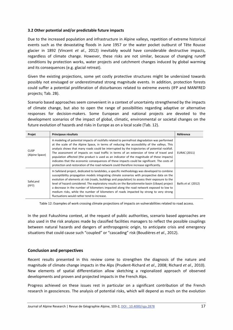
future evolution of hazards and risks in Europe as on a local scale (Tab. 12).
Projet Principaux résultats Référence
CLISP
(Alpine Space)
A modeling of potential impacts of rockfalls related to permafrost degradation was performed
at the scale of the Alpine Space, in terms of reducing the accessibility of the valleys. This
analysis shows that many roads could be interrupted by the trajectories of potential rockfall.
The assessment of impacts on road traffic in terms of an extension of time of travel and
population affected (the product is used as an indicator of the magnitude of these impacts)
indicates that the economic consequences of these impacts could be significant. The costs of
protection and restoration of the road network could therefore increase significantly.
EURAC (2011)
SafeLand
(FP7)
In Safeland project, dedicated to landslides, a specific methodology was developed to combine
susceptibility propagation models integrating climate scenarios with prospective data on the
evolution of elements at risk (roads, buildings and population) to assess their exposure to the
level of hazard considered. The exploratory results on the Barcelonnette basin (Ubaye) project
a decrease in the number of kilometers impacted along the road network exposed to low to
medium risks, while the number of kilometers of roads impacted by strong to very strong
fluctuations would rather tend to increase.
Baills et al. (2012)
Table 12: Examples of work crossing climate projections of impacts on vulnerabilities related to road access.
In the post Fukushima context, at the request of public authorities, scenario based approaches are
also used in the risk analyzes made by classified facilities managers to reflect the possible couplings
between natural hazards and dangers of anthropogenic origin, to anticipate crisis and emergency
situations that could cause such “coupled” or “cascading” risk (Boudières et al., 2012).
Conclusion and perspectives
Recent results presented in this review come to strengthen the diagnosis of the nature and
magnitude of climate change impacts in the Alps (Prudent‐Richard et al., 2008; Richard et al., 2010).
New elements of spatial differentiation allow sketching a regionalized approach of observed
developments and proven and projected impacts in the French Alps.
Progress achieved on these issues rest in particular on a significant contribution of the French
research in geosciences. The analysis of potential risks, which will depend as much on the evolution
Journal of Alpine Research | Revue de Géographie Alpine, 103‐2, DOI : 10.4000/rga.2878 18
of vulnerabilities as on the changes in hazards, requires an increased contribution of human and
social sciences on these questions (geography, economics, sociology, political science, history and
legal approaches of the risk), and especially an increased coupling between the various disciplinary
fields. Despite this progress, many uncertainties remain in the characterization of observed changes
and future changes projection. The society's ability to anticipate and adapt is also uncertain, if not
illusory. It is nevertheless necessary to continue to fund applied and territory‐focused but also more
“fundamental” research for reducing these uncertainties. In this regard, the absolute necessity of
maintaining observatories over the long term must be reaffirmed. In parallel, it seems important to
strive for integrating preventive action and publicly restoring these margins of uncertainty, to
establish more transparent and more accepted management practices.
In the perspective of taking into account mountainous natural hazards in an integrated and
sustainable way, this synthesis also opens a questioning about the capacity of monitoring and
anticipating changes in the adaptation strategies of Alpine territories. These issues lead in turn to
question the responses given by public and private actors facing the challenges offered by these
environmental and societal changes.
Acknowledgments
The PARN thanks the members and partners of its scientific and technical network which contributed
to the preparatory work done before this review, and the Rhône‐Alpes Region for its support to the
Alps‐Climate‐Risks portal initiated in the ClimChAlp project alongside ONERC. The DREAL Rhône‐
Alpes is also acknowledged for its support to the PARN ‘Projects’ database, and to the transboundary
database on Interreg territorial cooperation projects on natural hazards developed within the
partnership of RiskNat and RiskNET Alcotra projects. Finally, we thank the two anonymous reviewers,
whose suggestions have helped improve the manuscript.
References
AGENCE DE L’EAU RHONE‐MEDITERRANEE ET CORSE (2012). – « Impacts du changement climatique dans le domaine de l’eau sur les
bassins Rhône‐Méditerranée et Corse : bilan des connaissances ». Rapport pour le Plan d’adaptation au changement
climatique Bassins Rhône‐Méditerranée et Corse, 67 pp.
BAILLS A., FONTAINE M., HOHMANN A., VANDROMME R., DESRAMAUT N. (2012). – “Methodology for predicting the changes in the
landslide risk during the next 50 years at selected sites in Europe. Changing pattern of landslide risk in hotspot and
evolution trends in Europe according to global change scenarios”. SafeLand Deliverable D3.9, 188 pp.
BARD A., RENARD B., LANG M. (2012). – « Tendances observées sur les régimes hydrologiques de l’arc Alpin. La Houille Blanche,
n° 1, pp 38‐43.
BENISTON M., FOX D.G., ADHIKARY S., ANDRESSEN R., GUISAN A., HOLTEN J., INNES J., MAITIMA J., PRICE M., AND TESSIER L. (1996). – “The
Impacts of Climate Change on Mountain Regions”. In Second Assessment Report of the Intergovernmental Panel on Climate
Change (IPCC), Chapter 5, Cambridge University Press, pp. 191‐213.
BODIN X., DELINE P., SCHOENEICH P., RAVANEL L., MAGNIN F., KRYSIECKI JM., ECHELARD T. (2015). – “Mountain permafrost and
associated geomorphological processes: recent changes in the French Alps”. Journal of Alpine Research | Revue de de
Géographie Alpine, this volume.
BÖHM R., JONES P.D, HIEBL J., FRANK D., BRUNETTI M., MAUGERI M. (2010). – “The early instrumental warm‐bias: a solution for long
central European temperature series 1760–2007”. Climatic Change, Vol. 101, pp. 41‐67.
Journal of Alpine Research | Revue de Géographie Alpine, 103‐2, DOI : 10.4000/rga.2878 19
BOUDIERES V., DELANNOY J.J., EINHORN B., GEORGE‐MARCELPOIL E., PEISSER C., PIAZZA‐MOREL D. (2013). – « Synthèse du Workshop
“Changement global et risques naturels” », PARN et Labex ITEM, 21 & 22 mars 2013, 30 pp.
BOUDIERES V., EINHORN B., PEISSER C., VENGEON J.M., 2012. – « Risques couplés : La prise en compte des couplages entre
phénomènes naturels alpins et activités anthropiques – Etudes de cas ». Rapport PARN avec le soutien de la Région Rhône‐
Alpes, 59 pp.
CASTEBRUNET H., ECKERT N., GIRAUD G., DURAND Y., MORIN S. (2014). – “Projected changes of snow conditions and avalanche
activity in a warming climate: the French Alps over the 2020–2050 and 2070–2100 periods”. The Cryosphere, Vol. 8, pp
1673–1697.
CORONA C., GUIOT J., EDOUARD JL., CHALIÉ F., BÜNTGEN U., NOLA P., URBINATI C. (2010). – “Millennium‐long summer temperature
variations in the European Alps as reconstructed from tree rings”. Climate of the Past, Vol. 6, pp. 379‐400.
Cossart É. (2013). – “Influence of local vs. regional settings on glaciation pattern in the French Alps”. Geografia Fisica e
Dinamica Quaternaria, Vol. 36, pp. 39‐52.
DUMAS, D. (2013). – “Changes in temperature and temperature gradients in the French Northern Alps during the last
century”. Theoretical and Applied Climatology, Vol. 111, pp 223‐233.
DURAND Y., GIRAUD G., LATERNSER M., ETCHEVERS P., MÉRINDOL L., LESAFFRE B. (2009a). – “Reanalysis of 44 Yr of Climate in the
French Alps (1958—2002): Methodology, Model Validation, Climatology, and Trends for Air Temperature and
Precipitation”. Journal of Applied Meteorology and Climatology, Vol. 48, pp. 429‐449.
DURAND, Y., GIRAUD, G., LATERNSER, M., ETCHEVERS, P., MÉRINDOL L., LESAFFRE B. (2009b). – “Reanalysis of 47 Years of Climate in the
French Alps (1958—2005): Climatology and Trends for Snow Cover”. Journal of Applied Meteorology and Climatology, Vol.
48, pp. 2487‐2512.
DUVILLARD PA., RAVANEL L., DELINE P. (2015). – “Risk assessment of infrastructure destabilization due to global warming in the
high elevated French Alps”. Journal of Alpine Research | Revue de de Géographie Alpine, this volume.
ECKERT N., BAYA H., DESCHÂTRES M. (2010b). – “Assessing the response of snow avalanche runout altitudes to climate
fluctuations using hierarchical modeling: application to 61 winters of data in France”. Journal of Climate. 23. pp 3157‐3180.
ECKERT N., PARENT E., KIES R., BAYA H. (2010a). – “A spatio‐temporal modelling framework for assessing the fluctuations of
avalanche occurrence resulting from climate change: application to 60 years of data in the northern French Alps”. Climatic
Change. Vol. 101, N° 3‐4, pp. 515‐553.
ECKERT N., KEYLOCK C.J., CASTEBRUNET H., LAVIGNE A., NAAIM M. (2013). – “Temporal trends in avalanche activity in the French Alps
and subregions: from occurrences and runout altitudes to unsteady return periods”. Journal of Glaciology, Vol. 59, No. 213,
pp. 93‐114.
EINHORN B. et PEISSER C. (2011). – « Actes du séminaire international d'experts “Adaptation de la gestion des risques naturels
face au changement climatique” – Transcription intégrale des présentations et discussions, validée par leurs auteurs »,
Projet ESPACE ALPIN AdaptAlp: “Adaptation to Climate Change in the Alpine Space”, 26 janvier 2011, Domancy, 76 pp.
EURAC (INSTITUTE FOR APPLIED REMOTE SENSING) (2011). – “CLISP ‐ Climate Change Adaptation by Spatial Planning in the Alpine
Space – WP 4 – Vulnerability Assessment”. ALPINE SPACE project CLISP Synthesis Report, 144 pp.
EUROPEAN ENVIRONMENT AGENCY (EEA) (2009). – “Regional climate change and adaptation ‐ The Alps facing the challenge of
changing water resources”. EEA Report 8/2009, (Isoard, S. coord.), Copenhagen, 2009, ISBN 978‐92‐9213‐006‐0, 148 pp.
DOI 10.2800/12552
GARDENT, M. (2014). – “Le retrait glaciaire dans les Alpes occidentales depuis la fin du PAG et ses aléas induits”. Thèse de doctorat de Géographie, Université de Savoie, 250 p.
GARDENT M., RABATEL A., DEDIEU JP. DELINE P. (2014). – “Multitemporal glacier inventory of the French Alps from the late 1960s
to the late 2000s”. Global and Planetary Change, Vol. 120, pp. 24‐37.
GARITTE G., LAHOUSSE P., THENARD L., SALVADOR PG. (2007) – « Evolution contemporaine de l’activité torrentielle sur les cônes de
déjection de la basse vallée de la Clarée (Briançonnais, Alpes du Sud) ». Géomorphologie : relief, processus, environnement,
n° 4, pp. 294‐308.
Journal of Alpine Research | Revue de Géographie Alpine, 103‐2, DOI : 10.4000/rga.2878 20
GIBELIN A.L., DUBUISSON B., CORRE L., DEAUX N., JOURDAIN S., LAVAL. L., PIQUEMAL J.M., MESTRE O., DENNETIERE D., DESMIDT S., TAMBURINI
A. (2014). – « Évolution de la température en France depuis les années 1950. Constitution d’un nouveau jeu de séries
homogénéisées de référence ». La Météorologie, N° 87, pp. 45‐53.
GILBERT A., VINCENT C., WAGNON P., THIBERT E., RABATEL A. (2012). – “The influence of snow cover thickness on the thermal
regime of Tête Rousse Glacier (Mont Blanc range, 3200 m a.s.l.): Consequences for outburst flood hazards and glacier
response to climate change”. Journal of Geophysical Research‐Earth Surface, 117, F04018.
GILBERT A. AND C. VINCENT. (2013). – “Atmospheric temperature changes over the 20th century at very high elevations in the
European Alps from englacial temperatures”. Geophysical Research Letters, 40(10), pp. 2102‐2108.
GOBIET A., KOTLARSKI S., BENISTON M., HEINRICH G., RAJCZAK J., STOFFEL M. (2013). – “21st century climate change in the European
Alps: A Review”. Science of the Total Environment, Vol. 493, pp. 1138‐1151.
IPCC (2012). – “Managing the Risks of Extreme Events and Disasters to Advance Climate Change Adaptation”. A Special
Report of Working Groups I and II of the Intergovernmental Panel on Climate Change [FIELD C.B., BARROS V., STOCKER T.F., QIN
D., DOKKEN D.J., EBI K.L., MASTRANDREA M.D., MACH K.J., PLATTNER G.‐K., ALLEN S.K., TIGNOR M., MIDGLEY P.M. (eds.)]. Cambridge
University Press, Cambridge, UK, and New York, NY, USA, 582 pp.
ISOTTA FA., FREI C., WEILGUNI V., PERČEC TADIĆ M, LASSÈGUES P., RUDOLF B., PAVAN V., CACCIAMANI C., ANTOLINI G., RATTO S.M, MUNARI M.,
MICHELETTI S., BONATI V., LUSSANA C., RONCHI C., PANETTIERI E., MARIGO G., VERTAČNIK G. (2014). – “The climate of daily precipitation
in the Alps: development and analysis of a high‐resolution grid dataset from pan‐Alpine rain‐gauge data”. International
Journal of Climatology, Vol. 34, pp. 1657‐1675.
JACOB D., PETERSEN J., EGGERT B., ALIAS A., CHRISTENSEN O., B.; BOUWER L., BRAUN A., COLETTE A., DÉQUÉ M., GEORGIEVSKI G.,
GEORGOPOULOU E., GOBIET A., MENUT L., NIKULIN G., HAENSLER A., HEMPELMANN N., JONES C., KEULER K., KOVATS S., KRÖNER N., KOTLARSKI
S., KRIEGSMANN A., MARTIN E., MEIJGAARD E., MOSELEY C., PFEIFER S., PREUSCHMANN S., RADERMACHER C., RADTKE K., RECHID D., ROUNSEVELL
M., SAMUELSSON P., SOMOT S., SOUSSANA J.‐F., TEICHMANN C., VALENTINI R., VAUTARD R., WEBER B., YIOU, P. (2014). – “EURO‐CORDEX:
new high‐resolution climate change projections for European impact research”. Regional Environmental Change, Vol. 14, pp
563‐578.
JOMELLI V., BRUNSTEIN D., DÉQUÉ M., VRAC M., GRANCHER D. (2009). – “Impacts of future climatic change (2070–2099) on the
potential occurrence of debris flows: a case study in the Massif des Ecrins (French Alps)”. Climatic Change, Vol. 97, N° 1‐2,
pp. 171‐191.
JOMELLI V. PAVLOVA I., ECKERT N., GRANCHER D., BRUNSTEIN D. (IN PRESS) – “A new hierarchical Bayesian approach to analyse environmental and climatic influences on debris flow occurrence”. Geomorphology.
LAVIGNE A., ECKERT N., BEL L., PARENT E. (2015). – “Adding expert contribution to the spatio‐temporal modeling of avalanche
activity under different climatic influences”. Journal of the Royal Statistical Society C (Applied Statistics), (early view online).
LE MEUR E., GERBAUX M., SCHAFER M., VINCENT C. (2007). – “Disappearance of an Alpine glacier over the 21st Century simulated
from modeling its future surface mass balance”. Earth and Planetary Science Letters, 261(3‐4), pp. 367‐374.
LEONE F., COLAS A., GARCIN Y., ECKERT N., JOMELLI V. ET GHERARDI M. (2014). – « Le risque avalanche sur le réseau routier alpin
français », Journal of Alpine Research | Revue de de Géographie Alpine [En ligne], | 2014, mis en ligne le 30 septembre
2014, consulté le 02 novembre 2014.
LOPEZ SAEZ J., CORONA C., STOFFEL M., BERGER F. (2013). – “Climate change increases frequency of shallow spring landslides in the
French Alps”. Geology, Vol. 41, pp. 619‐622.
LOPEZ SAEZ J., CORONA C., STOFFEL M., GOTTELAND A., BERGER F., LIÉBAULT F. (2011). – “Debris‐flow activity in abandoned channels of
the Manival torrent reconstructed with LiDAR and tree‐ring data”. Natural Hazards and Earth System Sciences, Vol. 11, pp.
1247‐1257.
MAGNAN A., DUVAT V., GARNIER E. (2012). – « Reconstituer les « trajectoires de vulnérabilité » pour penser différemment
l'adaptation au changement climatique », Natures Sciences Sociétés, Vol. 20, pp. 82‐91.
MALET J.‐P., DURAND Y., REMAÎTRE A., MAQUAIRE O., ETCHEVERS P., GUYOMARC’H G., DÉQUÉ M., VAN BEEK L.P.H. (2007). – “Assessing the
influence of climate change on the activity of landslides in the Ubaye Valley”. In: McInnes, R. & Fairbank, H. (Eds):
Proceedings International Conference on Landslides and Climate change – Challenges and Solutions, Wiley, London.

Journal of Alpine Research | Revue de Géographie Alpine, 103‐2, DOI : 10.4000/rga.2878 21
NILSON E., KRAHE P., GÖRGEN K. (2012). – “Climate Projections for the Greater Alpine Region: An evaluation of selected regional
climate simulations with respect to hydrometeorological variations”. Technical report BFG‐1749, Koblenz, 84 pp.
PICCARDI M. (2014). – « Accès à la Haute Montagne et Changements Climatiques, action 2.3 ». In Séance technique
transfrontalière du Groupe Technique et Scientifique (GTS) : « La gestion des voies d’accès aux refuges d’haute montagne
suite aux changements climatiques », Fondation Montagne sûre, Courmayeur (AO), 09 septembre 2014.
PIELMEIER C., TECHEL F., MARTY C., STUCKI T. (2013). – “Wet snow avalanche activity in the Swiss Alps ‐ trend analysis for mid‐
winter season”. Proceedings of the International Snow Science Workshop, Grenoble and Chamonix, pp. 1240‐1246.
PRUDENT‐RICHARD G., GILLET M., VENGEON JM., DESCOTES‐GENON S., EINHORN B., BOURJOT L., DENISET T., BOURCIER B., RICHARD D., VINCENT
C., ETCHEVERS P., GRUBER S., HAEBERLI W., ROER I., ZEMPF M., LOGLISCI N., PELOSINI R., LANG M., OBLED C., REQUILLART P., DUBAND D.,
JONGMANS D., SCHAEDLER B., ECKERT N., FORCHERON P., BENISTON M., PRICE M., GILLET F. (2008). – “Climate change in the Alps:
Impacts and natural hazards”. Technical Report N°1, ONERC (Observatoire National sur les Effets du Réchauffement
Climatique), Pôle Grenoblois d’études et de recherche pour la prévention des Risques Naturels (PGRN), Région Rhône‐
Alpes, 98 pp.
RABATEL A., LETRÉGUILLY A., DEDIEU JP., ECKERT N. (2013). – “Changes in glacier equilibrium‐line altitude in the western Alps from
1984 to 2010: evaluation by remote sensing and modeling of the morpho‐topographic and climate controls”. The
Cryosphere, Vol. 7, pp 1455‐1471.
RAJCZAK J., PALL P., SCHÄR C. (2013). – “Projections of extreme precipitation events in regional climate simulations for Europe
and the Alpine Region”. Journal of Geophysical Research: Atmospheres, Vol. 118, pp. 3610‐3626.
RAVANEL L. (2009). – « Evolution géomorphologique de la haute montagne alpine dans le contexte actuel du réchauffement
climatique ». Collection EDYTEM, Cahiers de Géographie, N° 8, pp. 113‐124.
RAVANEL L., DELINE P. (2011). – “Climate influence on rockfalls in high‐Alpine steep rockwalls: The north side of the Aiguilles de
Chamonix (Mont Blanc massif) since the end of the ‘Little Ice Age’”. The Holocene, Vol. 21, n°2, pp. 357‐365.
RICHARD D., GEORGE‐MARCELPOIL E., BOUDIERES V., 2010. – « Changement climatique et développement des territoires de
montagne : quelles connaissances pour quelles pistes d’action ? », in Revue de Géographie Alpine | Journal of Alpine
Research [En ligne], 98‐4.
ROME S., LI S. ET BIGOT S. (2013). – « Les extrêmes thermiques dans les Préalpes françaises : évolutions présentes (1961‐90) et
futures (de 2021 à 2100) ». Publications de l’Association Internationale de Climatologie, 26, pp. 446‐451.
ROUSSELOT M., DURAND Y., GIRAUD G., MERINDOL L., DOMBROWSKI‐ETCHEVERS I., DEQUE M., CASTEBRUNET H. (2012). – “Statistical
adaptation of ALADIN RCM outputs over the French Alps – application to future climate and snow cover”. The Cryosphere, 6
pp. 785‐805.
SALZMANN N., MACHGUTH H., LINSBAUER A. (2012). – “The Swiss Alpine glaciers’ response to the global “2 °C air temperature
target”. Environmental Research Letters, Vol. 7, 044001.
SCHOENEICH P., DE JONG C. (2008) – « Évolution de l’environnement alpin ». Journal of Alpine Research | Revue de Géographie
Alpine, Vol. 96‐4, pp 53‐64.
THIBERT E., ECKERT N., VINCENT C. (2013). – “Climatic drivers of seasonal glacier mass balances: an analysis of 6 decades at
Glacier de Sarennes (French Alps)”. The Cryosphere, Vol. 7(1). pp 47‐66.
VALLET A., CHARLIER JB., CHANUT MA., BERTRAND C., DUBOIS L., MUDRY J. (2013). – “Seasonal and long term analysis of precipitation‐displacement relationships on a deep seated unstable slope (Séchilienne, French Alps)”. JAG – 3èmes journées Aléas Gravitaires, Sep 2013, Grenoble, France. pp. 1‐6. VAN DEN BESSELAAR EJM., KLEIN TANK AMG, BUISHAND TA. (2013). – “Trends in European precipitation extremes over 1951–2010”. International Journal of Climatology, Vol. 33‐12, pp. 2682‐2689.
VINCENT C. (2002). – “Influence of climate change over the 20th century on four French glacier mass balances”. Journal of
Geophysical Research, 109(D19), 4375.
VINCENT C., DESCLOITRES M., GARAMBOIS S., LEGCHENKO A., GUYARD H., GILBERT. A. (2012). – “Detection of a subglacial lake in Glacier
de Tete Rousse (Mont Blanc area, France)”. Journal of Glaciology, Vol. 58(211), pp. 866‐878.

Journal of Alpine Research | Revue de Géographie Alpine, 103‐2, DOI : 10.4000/rga.2878 22
VINCENT C., AUCLAIR S., LE MEUR. E. (2010). – “Outburst flood hazard for glacier‐dammed Lac de Rochemelon, France”. Journal
of Glaciology, Vol. 56(195), pp. 91‐100.
VINCENT C., HARTER M., GILBERT A., BERTHIER E., SIX. D. (2014). – “Future fluctuations of Mer de Glace, French Alps, assessed using
a parameterized model calibrated with past thickness changes”. Annals of Glaciology, Vol. 55(66), pp. 15‐24.
WEISS J. (2011). – « Le réchauffement climatique implique‐t‐il une évolution des pratiques alpines ? ». In Assises de
l’Alpinisme, pp 49‐52.
WILHELM B., ARNAUD F., GIGUET‐COVEX C., DELANNOY J.J. (2012) – « Changements climatiques et crues torrentielles : quelles
relations ? ». In Actes du 25ème Colloque de l’Association Internationale de Climatologie, Grenoble, sept. 2012, pp. 769‐
774.
ZEMP M., HAEBERLI W., HOELZLE M., PAUL F. (2006). – “Alpine glaciers to disappear within decades?”. Geophysical Research
Letters, 33, L13504.
ZERATHE S., LEBOURG T., BRAUCHER R., BOURLÈS D. (2013). – “Mid‐Holocene cluster of large‐scale landslides revealed in the
Southwestern Alps by 36Cl dating. Insight on an Alpine‐scale landslide activity”. Quaternary Science Review, Vol. 90, 106‐
127.