climate change and land use planning in the · pdf filecoarse filter/fine filter ......
TRANSCRIPT

1
CLIMATE CHANGE AND LAND USE PLANNING IN THE ATLIN – TAKU AREA
Jim Pojar 1995 Upper Viewmount Road
Smithers, B.C. V0J 2N6 [email protected]
January 2009
Report prepared for the Taku River Tlingit First Nation and for the Integrated Land
Management Bureau, British Columbia Ministry of Agriculture and Lands

2
TABLE OF CONTENTS
CLIMATE CHANGE AND LAND USE PLANNING IN THE ATLIN – TAKU AREA 1
INTRODUCTION .................................................................................................................... 3
PURPOSE .............................................................................................................................. 3
CLIMATE CHANGE ............................................................................................................... 3
ECOLOGICAL RESPONSES ..................................................................................................... 7
Terrestrial Ecological Zones and Ecosystems ................................................................ 9
Freshwater Aquatic Ecosystems ................................................................................... 11
CONSERVATION PLANNING ................................................................................................ 11
Coarse Filter/Fine Filter ................................................................................................ 12
Coarse Filter .............................................................................................................. 12
1) Abiotic elements ................................................................................................... 12
2) Communities and ecosystems ............................................................................... 14
3) Species .................................................................................................................. 16
Fine Filter - Special Features .................................................................................... 18
1) Abiotic elements ................................................................................................... 18
2) Communities and ecosystems ............................................................................... 18
3) Species .................................................................................................................. 19
OTHER THEMES ................................................................................................................. 19
Context: The Big Enchiladas ........................................................................................ 19
Landscape Connectivity and Trans-Regional Linkages ............................................... 20
Natural Disturbances ..................................................................................................... 22
Scientific Community ................................................................................................... 23
Thresholds and Cumulative Effects .............................................................................. 24
CONCLUSIONS AND RECOMMENDATIONS ........................................................................... 25
APPENDIX 1. WHAT COULD HAPPEN TO SOME KEY SPECIES? ........................................... 29
Trees .............................................................................................................................. 29
Selected Mammals in Northwestern B.C. .................................................................... 31
APPENDIX 2. THE TROUBLE WITH LISTED SPECIES ............................................................ 34
Jurisdictional rarity ....................................................................................................... 34
Incomplete knowledge .................................................................................................. 34
Conflation of rarity and risk .......................................................................................... 34
Listing and climate change ........................................................................................... 35
Stewardship responsibility ............................................................................................ 35

3
INTRODUCTION Far northwestern British Columbia is one of the few regions in the province without a
land use plan. However, triggered by the 2004 Taku decision by the Supreme Court of
Canada and a March 2008 Framework Agreement between Taku River Tlingit (TRT)
First Nation and the Province of B.C., land use planning for the approximately 3 million
ha Atlin-Taku area is now well underway. So too is climate change.
Under a changing climate, northwestern B.C. can expect major transformations in
biodiversity on land and in water and across all levels (genes, species, ecosystems, and
the interactions among them).
Land use planning in British Columbia has to date not incorporated potential large-scale
environmental change. Any land use or conservation planning that professes to be long
term must address climate change and its implications. Planning should not consider
merely the current environment and contemporary plant and animal communities, but
also and more fundamentally, future environmental scenarios underpinned by the more or
less permanent, physical components of the plan area‘s landscapes and waterscapes—the
different types of bedrock geology, physiography, landforms, lakes and streams.
PURPOSE This report outlines some environmental change-related principles for conservation and
land use planning, for the Atlin-Taku area of northwestern B.C. It attempts to answer the
question, How would you incorporate climate change in a lasting conservation strategy
or land use plan?
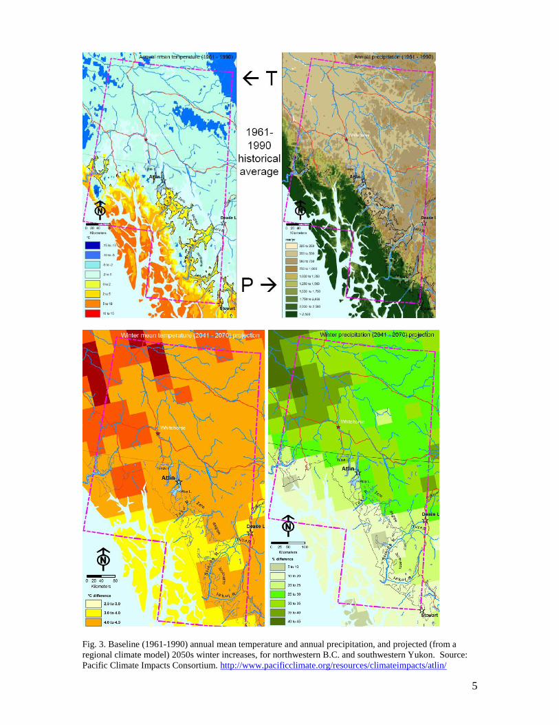
CLIMATE CHANGE Northern B.C. in general and the Atlin-Taku area
1 in particular are very susceptible to
climate change (Figs. 1 & 2). Northwestern B.C.is part of that portion of northern North
America that has experienced the greatest temperature increase globally, over the past 30-
50 years.2 Warming in the plan area is also occurring faster than in most other places in
B.C. Temperature changes historically have been, and are projected to be, largest in the
winter months (Fig. 3). Changes in precipitation regimes and an increased frequency of
extreme temperature and precipitation events will accompany this warming.3
The plan area has, for the most part, a boreal, transitional maritime-continental climate.
The Coast Mountains cast a pronounced rainshadow over much of the area, although
moist maritime air masses dominate windward portions of the Coast Mountains and
penetrate inland along the Taku River valley for some distance. Strong precipitation
gradients prevail, especially in the western half of the area.
1 Murdock, T.Q. and K. Bennett. 2008. Climate Impacts Modeling Tools and Scenarios for Atlin Region.
Pacific Climate Impacts Consortium, University of Victoria, Victoria, B.C. 30 p. 2 Field, C.B., L.D. Mortsch, M. Brklacich, D.L. Forbes, P. Kovacs, J.A. Patz, S.W. Running and M.J. Scott.
2007. North America. Pp. 617-652. In Parry, M.L., Canziani, O.F., Palutikof, J.P., van der Linden, P.J. and
Hanson, C.E., (eds.). Climate Change 2007: Impacts, Adaptation and Vulnerability. Contribution of
Working Group II to the Fourth Assessment Report of the Intergovernmental Panel on Climate Change.
Cambridge University Press UK. 3 Spittlehouse, D. 2008. Climate Change, Impacts and Adaptation Scenarios: Climate change and forest and
range management in British Columbia. Technical Report 45. BC Ministry Forests & Range, Victoria, B.C.

4
Fig. 1. Mean annual temperatures for British Columbia: past ―normals‖ (1961-1990) and projections for
2020s, 2050s, and 2080s, for the middle range A2 scenario from the Canadian Global Climate Model
version 2 (CGCM2). Retrieved from Spittlehouse (2008).4
Fig. 2. Annual precipitation for British Columbia: 1961-1990 baseline & projected percentage changes
from baseline for 2020s, 2050s and 2080s, for A2 scenario of CGCM2. Retrieved from Spittlehouse (2008).
4 Spittlehouse, D. 2008. Climate Change, Impacts and Adaptation Scenarios: Climate change and forest and
range management in British Columbia. Technical Report 45. BC Ministry of Forests and Range, Victoria,
B.C. 38 p.
5
Fig. 3. Baseline (1961-1990) annual mean temperature and annual precipitation, and projected (from a
regional climate model) 2050s winter increases, for northwestern B.C. and southwestern Yukon. Source:
Pacific Climate Impacts Consortium. http://www.pacificclimate.org/resources/climateimpacts/atlin/

6
Key points:
Atlin-Taku has high levels of climate variability (seasonal, year-to-year, and decadal
variation related to the strength, interaction and frequency of atmospheric circulations
such as Aleutian Low, El Niño-Southern Oscillation, Pacific Decadal Oscillation,
Arctic Oscillation) and change (long-term trends).
Need to consider both climate variability and climate change.
Planning for climate change requires information about impacts, or at least thinking
about projected impacts and scenarios.
Climate change5,6
will result in biome shifts;7,8,9
species losses, gains and reassembly in
communities;10,11
changes to snowpack and to stream temperatures, flows and fish
habitat;12
melting of permafrost; increased frequency of extreme events in general, thus
increased damage from storms, floods, erosion including mass movements,13
droughts,
wildfires, and more frequent and extensive outbreaks of pests, like bark beetles, needle
and leaf diseases, defoliating insects.
Climate change scenarios are based on a set of global climate models and levels of
greenhouse gas emissions, and are applied over large areas. Scenarios thus represent a
range of possible future climates rather than narrow predictions. Moreover projections of
climate change and its impacts in British Columbia are inherently dodgy because the
province has such complex topography and climatic processes, and such sharp ecological
gradients. Nonetheless scenarios based on the best information currently available
suggest that northwestern B.C. can expect the following changes.14,15,16,17,18
Keep in
5 Intergovernmental Panel on Climate Change (IPCC). 2007. Climate change 2007: The physical science
basis: Summary for policymakers. Cambridge University Press, New York, NY, USA.
http://www.ipcc.ch/ipccreports/ar4-wg1.htm. 6 Spittlehouse, D. 2008. Climate Change, Impacts and Adaptation Scenarios: Climate change and forest and
range management in British Columbia. Technical Report 45. BC Ministry of Forests and Range, Victoria,
B.C. 38 p. 7 Scott, D., J.R. Malcolm, and C. Lemieux. 2002. Climate change and modelled biome representation in
Canada‘s national park system: implications for system planning and park mandates. Global Ecology and
Biogeography 11: 474-484. 8 Sturm, M., J. Schimel, G. Michelson, J.M. Welker, S.F. Oberbauer, G.E. Liston, J. Fahnestock, and V.E.
Romanovsky. 2005. Winter biological processes could help convert arctic tundra to shrubland. BioScience
55: 17-26 9 Wilson, S.J. and R.J. Hebda. 2008. Mitigating and Adapting to Climate Change through the Conservation
of Nature. The Land Trust Alliance of British Columbia, Saltspring Island, B.C. 58 p. 10
Hamman, A. and T. Wang. 2006. Potential effects of climate change on ecosystem and tree species
distribution in British Columbia. Ecology 87: 2773-2786. 11
Gayton, D.V. 2008. Impacts of climate change on British Columbia‘s biodiversity: A literature review.
FORREX Series 23. FORREX Forest Research Extension Partnership, Kamloops, B.C.
http://www.forrex.org/publications/forrexseries/fs23.pdf 12
von Finster, A. 2001. Possible effects of climate change on the physical characteristics of fish habitats in
the Yukon River Basin in Canada. Discussion paper. Department of Fisheries and Oceans, Whitehorse,
Yukon. http://www.taiga.net/reports/dfo1.html 17 p. 13
Geertsema, M., J.J. Clague, J.W. Schwab, and S.G. Evans. 2006. An overview of large catastrophic
landslides in northern British Columbia. Engineering Geology 83: 120-143. 14
Wilson, S.J. and R.J. Hebda. 2008. Mitigating and Adapting to Climate Change through the Conservation
of Nature. The Land Trust Alliance of British Columbia, Saltspring Island, B.C. 58 p. 15
Austin, M.A., D.A. Buffett, D.J. Nicholson, G.G.E. Scudder, and V. Stevens (eds.). 2008. Taking
Nature‘s Pulse: The Status of Biodiversity in British Columbia. Biodiversity B.C., Victoria, B.C. 268 p.

7
mind that projections of temperature changes have greater certainty than projections of
precipitation changes among the currently available climate models.19
Probable impacts in the coming decades include:
Increasing temperature, especially during winter. Mean annual temperatures
warming by 3 to 5oC by 2050. These are among the largest projected increases for
western North America.
Increasing precipitation; 10% to 30% more by 2050.
Atlin-Taku can expect warmer wetter winters and probably cooler wetter summers, as
this century progresses.
Decreasing snowfall and snowpack eventually (snowfall increased from 1961-
2007)20
; dwindling glaciers.
Changing snowpack; more thaw-freeze events, more icy layers and crusts.
Earlier snowmelt; earlier ice melt and later freezup of rivers and lakes.
Increasing water temperatures of rivers and lakes, although systems with lots of
glacial meltwater will stay cold as long as the glaciers last.
Complex changes to amount and timing of streamflows, depending on type and
location of watershed; more rain-on-snow events.
Melting permafrost; earth slumps and rockslides increasing in frequency.
Increased wildfire (fire severity increases, fire season lengthens) and outbreaks of
forest pests.
Shifting ‗climate envelopes‘ of biogeoclimatic zones and of species.
Wildife populations being forced to change their breeding time, to modify their
movement behaviour.
ECOLOGICAL RESPONSES Climate largely determines the nature and distribution of terrestrial ecosystems, and
through its effects on the water cycle also plays a major role in the nature of rivers, lakes,
and other aquatic ecosystems. Climate change is already driving changes in ecosystem
structure (vegetation, species composition), function (productivity, decomposition, water
and nutrient cycling), processes (disturbance regimes, successional pathways,
hydrological regimes), and distribution.21,22
Responses of northwest B.C. ecosystems
16
Gayton, D.V. 2008. Impacts of climate change on British Columbia‘s biodiversity: A literature review.
FORREX Series 23. FORREX Forest Research Extension Partnership, Kamloops, B.C.
http://www.forrex.org/publications/forrexseries/fs23.pdf 17
Spittlehouse, D. 2008. Climate Change, Impacts and Adaptation Scenarios: Climate change and forest
and range management in British Columbia. Technical Report 45. BC Ministry of Forests and Range,
Victoria, B.C. 18
Murdock, T.Q. and K. Bennett. 2008. Climate Impacts Modeling Tools and Scenarios for Atlin Region.
Pacific Climate Impacts Consortium, University of Victoria, Victoria, B.C. 30 p. 19
Rodenhuis, D.R., K.E. Bennett, A.T. Werner, T.Q. Murdock, and D. Bronaugh. 2007. Climate Overview
2007 Hydro-climatology and future climate impacts in British Columbia. Pacific Climate Impacts
Consortium, University of Victoria, Victoria, B.C.
http://www.pacificclimate.org/docs/publications/PCIC.ClimateOverview.pdf 20
Werner, A.T. and T.Q. Murdock. 2008. Summary Report. Changes in Past Hydro-climatology and
Projected Future Climate – for the City of Whitehorse. Pacific Climate Impacts Consortium, University of
Victoria, Victoria, B.C. 29 p. 21
Walther, G.-R., E. Post, P. Convey, A. Menzel, C. Parmesan, T.J.C. Beebee, J.-M. Fromentin, O. Hoegh-
Guldberg, and F. Bairlein. 2002. Ecological responses to recent climate change. Nature 416: 389-395.

8
will be complex and are difficult to predict because they will reflect the cumulative
effects of changing climate, land- and resource-use activities, and invasive species.
I must emphasize two points before considering some projected ecosystem trends and
impacts.
1. Ecosystems do not migrate, species do. Ecosystems will not move in toto inland or
northward or upward to newly suitable climate envelopes. Ecosystem change will
result from changes at the species level. Existing ecosystems will lose some species,
gain others, and experience changes in abundance and dominance of the species that
persist. Species are responding ―individualistically‖ to environmental change. Some
species will stay put and their populations will either wax or wane depending on
changing circumstances. Other species will move, if they can, to suitable habitats
elsewhere, and will reassemble in most likely different combinations, including some
novel ones. Some species will move in close concert; e.g., hosts and their parasites,
prey and their specialized predators. Some close partners, like flowering plants and
their insect pollinators, or trees and ectomycorrhizal fungi, could become at least
temporarily ―decoupled‖ during long distance migrations. New arrivals will interact
with persisting species, plus exotic immigrants, to create new ecosystems with new
structure and function.23,24
2. Most species cannot move fast enough to keep up with the projected changes.25
The
potential geographic range, or potential niche, of many species will shift markedly or
expand, but species that migrate slowly, like many of our trees, will need many
decades and probably centuries to move accordingly or to realize their niche.26
Long
distance dispersal will play a key role, as it has in the past.27
Species with poor
dispersal capabilities or low vagility, like flightless beetles, could be out of luck at
least locally.
In contrast, species whose potential geographic range shrinks could disappear very
quickly if reproductive individuals die-off en masse (perhaps sent packing by a
pathogen or an extreme disturbance or weather event) and environmental conditions
are no longer suitable for their progeny or younger generations.
22
M.L. Parry, O.F. Canziani, J.P. Palutikof, P.J. van der Linden, and C.E. Hanson (eds.). Climate Change
2007: Impacts, Adaptation and Vulnerability. Contribution of Working Group II to the Fourth Assessment
Report of the Intergovernmental Panel on Climate Change. Cambridge University Press, Cambridge
University Press, Cambridge, UK. 973 p. 23
Gayton, D.V. 2008. Impacts of climate change on British Columbia‘s biodiversity: A literature review.
FORREX Series 23. FORREX Forest Research Extension Partnership, Kamloops, B.C.
http://www.forrex.org/publications/forrexseries/fs23.pdf 24
Wilson, S.J. and R.J. Hebda. 2008. Mitigating and Adapting to Climate Change through the Conservation
of Nature. The Land Trust Alliance of British Columbia, Saltspring Island, B.C. 58 p. 25
Neilson, R.P., L.F. Pitelka, A.M. Solomon, R. Nathan, G.F. Midgley, J.M.V. Fragoso, H. Lischke, and K.
Thompson. 2005. Forecasting regional to global plant migration in response to climate change. BioScience
55: 749-759. 26
Wilson, S.J. and R.J. Hebda. 2008. Mitigating and Adapting to Climate Change through the Conservation
of Nature. The Land Trust Alliance of British Columbia, Saltspring Island, B.C. 58 p. 27
Neilson, R.P., L.F. Pitelka, A.M. Solomon, R. Nathan, G.F. Midgley, J.M.V. Fragoso, H. Lischke, and K.
Thompson. 2005. Forecasting regional to global plant migration in response to climate change. BioScience
55: 749-759.

9
Terrestrial Ecological Zones and Ecosystems
Projected general trends to the end of this century (Fig. 4) include:28
A general shift of the southern pattern of bioclimates to the northern half of B.C.;
Expansion of moist coastal conifer forests (CWH) inland, and upslope at the expense
of subalpine mountain hemlock (MH) forests;
Decline in boreal conifer forests (BWBS);
Expansion of cool temperate subalpine forests (ESSF) northward and upslope;
Shrinking of the northern subalpine/subarctic spruce-willow-birch bioclimate;
Dwindling alpine bioclimate. Alpine tundra (AT) ecosystems will shrink and some
alpine ―islands‖ could disappear as woody ecosystems (subalpine forest and
shrubland) shift up in elevation. Some models project replacement of much of the
province‘s alpine zone by subalpine forest. In northwestern B.C. it is more likely that
subalpine shrublands (―buckbrush‖) will occupy what currently is the lower alpine
zone—as is already happening in the arctic tundra of the north slope of
Alaska/Brooks Range29
—partly because the shrubs have shorter generation times, can
reproduce vegetatively, and can migrate faster than trees.
Boreal grasslands are at high risk of decline in wetter warmer climates. They are
already rare in the landscape and are being invaded by woody vegetation. Low
elevation grasslands likely will persist only on the driest south-facing sites, and
perhaps only if humans augment the woody-plant-eating activities of beaver, moose,
elk, deer with prescribed fire. I am not sure what will happen to the mesic subalpine
grasslands of high wide valleys with double treelines. They too could decline if
shrubs (willows and shrub birch) expand, but it could remain cold enough at high
elevations to maintain the cold air ponding partly responsible for such occurrences.
Wide-ranging changes in wetlands and aquatic ecosystems because of warmer water
and changes in hydrology related to decreased snowpack and shrinking glaciers.
Some glaciers will disappear and others will diminish greatly, leaving behind big
areas of deglaciated terrain as fresh substrate for colonisation and ecological
succession. Succession and community assembly will be a stochastic-deterministic
process. Some of the outcomes will be along the lines of those already
documented30,31
but others will probably be novel and difficult to predict. Beyond the
impacts on biodiversity, the resultant hydrologic effects on river systems will have
substantial consequences for watershed management, fisheries and tourism, as well as
for industrial and community water supply, hydroelectric production, and forest
management.
We can expect more ‗trophic mismatches‘ to develop as plant phenology advances
with a warming climate. Herbivores (including large ungulates) may, based on
daylength, time their reproductive cycles or migrations to coincide with the
28
Wilson, S.J. and R.J. Hebda. 2008. Mitigating and Adapting to Climate Change through the Conservation
of Nature. The Land Trust Alliance of British Columbia, Saltspring Island, B.C. 58 p. 29
Sturm, M., J. Schimel, G. Michelson, J.M. Welker, S.F. Oberbauer, G.E. Liston, J. Fahnestock, and V.E.
Romanovsky. 2005. Winter biological processes could help convert arctic tundra to shrubland. BioScience
55: 17-26. 30
Chapin III, F.S., L.R. Walker, C.L. Fastie, and L.C. Sharman. 1994. Mechanisms of primary succession
following deglaciation at Glacier Bay, Alaska. Ecological Monographs 64: 149-175. 31
Milner, A.M., A.L. Robertson, K.A. Monaghan, A.J. Veal, and E.A. Flory. 2008. Colonization and
development of an Alaska stream community over 28 years. Frontiers in Ecology and Environment 6: 413-
419.

10
emergence of spring vegetation and a brief period free of biting insects, which are
based more on local temperatures. If herbivore timing is off, successful reproduction
will decline—as it evidently has in Arctic caribou.32
I must repeat the cautionary note to these projections. “The ecological and species range
adjustments suggested by models will take many decades if not centuries. … The rates of
migration and spread of the species required for such large expansions over such great
distance prohibit anything like the modern zones to develop in this interval. Transient
ecosystems of undetermined composition must be expected. The character of these will
likely be mediated by pest outbreaks and fire.”33
Such landscape-scale disturbances and
extreme events like summer drought, spring frosts, fierce storms and floods could be the
determining factors.
Figure 4. Potential shifts in distribution by 2025, 2055 and 2085 of the existing climate envelopes of British
Columbia‘s 14 biogeoclimatic zones. Changes projected by modelling the contemporary climate
parameters of the zones in terms of predictions under an average climate change scenario (CGCM1gax).34
32
Post, E. and M.C. Forchhammer. 2008. Climate change reduces reproductive success of an Arctic
herbivore through trophic mismatch. Philosophical Transactions of the Royal Society B. 363: 2369-2375. 33
Wilson, S.J. and R.J. Hebda. 2008. Mitigating and Adapting to Climate Change through the Conservation
of Nature. The Land Trust Alliance of British Columbia, Saltspring Island, B.C. 58 p. 34
Hamman, A. and T. Wang. 2006. Potential effects of climate change on ecosystem and tree species
distribution in British Columbia. Ecology 87: 2773-2786.

11
Freshwater Aquatic Ecosystems
The implications of climate change for freshwater biodiversity are not certain, with
strong variation expected among watersheds—but clearly lake and stream ecosystems
and their dynamics will change.35,36
Habitats and species of concern in aquatic systems
are those susceptible to climate warming, such as:
Cold-water habitats;
Cold-water species: salmon, lake trout, bull trout, whitefish, cisco, mysis—to mention
a few fish only;
High altitude systems;
Small shallow lakes;
Small connecting streams.
Aquatic conditions depend on past glacial history and future climates. Fish species are
still undergoing a post-glacial expansion into northern BC and Yukon. Landforms and
the relationship between land and water created by the glaciers determine current fish
habitat. There are a variety of lakes with different characteristics, including shallow
depositional lakes. With climate change, such shallow lakes will warm to the point that
certain fish species no longer will be able to survive in them.
Beyond the changes in the timing and amount of the spring melt and peak flows,
warming is also expected to accelerate the water cycle (increasing rates at which water
enters the atmosphere and rains or snows down again). The effects of this on hydrology,
fish and invertebrate populations remain to be seen. Freshwater systems are constrained
by topography; freshwater aquatic species have limited migration options because their
habitat is within the lake/stream system.
Glacial recession is ongoing and continues to create new habitats. Receiving waters have
high turbidity (cloudiness due to suspended sediments) and lower productivity. Over
time, the yield of water from non-glacial rivers could increase or decrease, depending on
precipitation trends, whereas the yield from glacial rivers is already increasing and there
is an ongoing contraction of spawning habitat for some species. Some other rivers
become more suitable for spawning as water levels drop. Larger streams will sustain
spawning habitat over such change. Small creeks are most at risk from falling water
levels. Eventually even glacial rivers will have reduced flows as the ice melts away.37
CONSERVATION PLANNING I assume that development of a conservation strategy would follow the widely accepted
coarse filter/fine filter approach, each applied at three levels of ecological organisation.
Coarse Filter
1) Abiotic Elements
2) Communities and Ecosystems
3) Species – focal species
35
Ashmore, P.E. and M. Church. 2001. The impact of climate change on rivers and river processes in
Canada. Geological Survey of Canada Bulletin 555. 58 p. 36
Schindler, D.W. 2001. The cumulative effects of climate warming and other human stresses on Canadian
freshwaters in the new millenium. Canadian Journal of Fisheries and Aquatic Sciences 58: 18-29. 37
von Finster, A. 2001. Possible effects of climate change on the physical characteristics of fish habitats in
the Yukon River Basin in Canada. Discussion paper. Department of Fisheries and Oceans, Whitehorse,
Yukon. 17 p. http://www.taiga.net/reports/dfo1.html

12
Fine Filter – Special Features
1) Abiotic Elements
2) Communities and Ecosystems
3) Species – rare & at-risk species
Coarse Filter/Fine Filter
Conservation biologists propose that by protecting a representative array of ecosystems,
the majority of species (most of which we know little or nothing about) and their genetic
diversity will be protected as well.38,39
This is termed the coarse-filter40
approach to
conserving biodiversity. However, some species and ecosystems will fall through the
pores of the coarse filter, because of specialized requirements, or because they are rare, at
risk, harvested for food, over-exploited, or otherwise of particular interest to managers.
These species and ecosystems will require individual attention and management—the
fine-filter approach. Effective conservation requires a combination of the two
approaches.
More recently, conservation biologists have recommended that planners should consider
three general types of conservation targets: 1) abiotic or physical environment units, 2)
communities and ecosystems, and 3) species.41
I retain the coarse-filter/fine-filter
metaphor and distinction, and address the three types of targets in each approach.
Coarse Filter
A coarse-filter assessment (based on biophysical representation) is required and logically
should be done first. The rationale for a coarse filter includes a) our very incomplete
knowledge of the biota (the myriad species that live in an area) and thus the need for
surrogates of biodiversity, and b) an acknowledgement of the impermanence of the living
component of ecosystems—especially in times of rapid environmental change.
1) Abiotic elements
Digital information on physical variables such as elevation, topography, terrain,
substrate exists for the entire plan area. These data can be overlain and combined into
land systems (areas with recurring patterns of landform, slope/aspect, generalised
vegetation cover, soils, hydrology), which can be used as proxies for ecosystems and
as conservation targets.
Given the incompleteness of biological knowledge and the reality of climate change, I
conclude that we must place more emphasis in conservation planning on the better
known (or at least more readily accessible), less changeable components of
ecosystems: physical landscape, geology, landforms, soils. Particularly germane here
are Stan Rowe‘s thoughts on ‗biogeo-ecosystems‘:
38
Noss, R.F. 1987. From plant communities to landscapes in conservation inventories: A look at the
Nature Conservancy (USA). Biological Conservation 41: 11-37. 39
Franklin, J.F. 1993. Preserving biodiversity: Species, ecosystems or landscapes? Ecological Applications
3: 202-205. 40
Hunter, M.L., Jr. 1992. Coping with ignorance: The coarse-filter strategy for maintaining biodiversity.
Pages 266-281 in K. Kohm, ed. Balancing on the edge of extinction. Island Press, Washington, DC. 315 p. 41
Groves, C.R. 2003. Drafting a conservation blueprint: A practitioner‘s guide to planning for biodiversity.
Island Press, Washington, DC. 455 p.

13
“real live chunks of earth space … volumetric, layered, site-specific objects—such as
a lake, a particular landform-based forest, or a more complex (land-water) tract—
into and out of which mobile organisms come and go.”42
Representation of the physical ‘enduring features’ is especially important in the
context of climate change. If we set aside today 5,000 ha of boreal forest, in 20 or 50
years it will not have the same mix of plant and animal species nor will it support the
same ecosystems as it does now; indeed it may no longer be forested. But the
physical landscape will persist. Topography, bedrock geology, landforms and
drainage systems will not change (barring landscape-scale mass movements);
permafrost and soils are changing relatively slowly. The mountains, rivers and big
lakes will remain, canyons and interior plateaus will persist, morainal blankets and
outwash terraces will stay as they are, even as the biota they support changes, as
species sort themselves out and as biological communities reassemble.
The physical landscape is the template for ecosystems, it is the stage upon which the
drama of climate change is playing out. The physical landscape can most usefully be
characterised in terms of physiographic units,43,44
topography, bedrock geology,
landforms, and hydrologic systems.
The first four of these classes of enduring features are straightforward and well
known, hydrologic systems less so. At this level of analysis and planning, we need a
broad classification of freshwater systems that a) reflects major river drainages, and b)
partitions major watersheds into units that reflect coarse-scale patterns in networks of
streams and lakes, and the ecological processes that link the aquatic ecosystems.
These ‗ecological drainage units‘ could be based on drainage area and elevation;
stream magnitude and gradient; channel morphology; width of valley bottom;
mesoclimate; ecoregions and biogeoclimatic zones; and dominant lake/wetland
features. We don‘t have ecological drainage units for Atlin-Taku, but see section 5,
Freshwater Ecosystems Analysis, of the Muskwa-Kechika CAD for a discussion of the
approach.45
The most appropriate physiographic classification for our purposes is that of
Holland,46
with the addition of the Teslin Basin.
Coast Mountains Boundary Ranges
Stikine Plateau Tahltan Highland
Nahlin Plateau
Taku Plateau
Kawdy Plateau
42
Rowe, J.S. and B.V. Barnes. 1994. Geo-ecosystems and bio-ecosystems. Bulletin of the Ecological
Society of America 75: 40-41. 43
Matthews, W.H. 1986. Physiography of the Canadian Cordillera. Map 1701A, Geological Survey of
Canada. 44
Holland, S.S. 1964. Landforms of British Columbia: A physiographic outline. Bulletin No. 48. British
Columbia Dept. Mines and Petroleum Resources, Victoria, B.C. 138 p. 45
Heinemeyer, K., K. Ciruna, L. Craighead, J. Griggs, C. Houwers, P. Iachetti, T. Lind, T. Olenicki, J.
Pollock, C. Rumsey, D. Sizemore, and R. Tingey. 2004. Conservation area design for the Muskwa-Kechika
Management Area. Nature Conservancy of Canada, Round River Conservation Studies, Round River
Canada, Dovetail Consulting Inc. 46
Holland, S.S. 1964. Landforms of British Columbia: A physiographic outline. Bulletin No. 48. British
Columbia Dept. Mines and Petroleum Resources, Victoria, B.C. 138 p.

14
Yukon Plateau Tagish Highland
Teslin Plateau
Teslin Basin
Surficial geology and landforms is probably the most important class of enduring
features for this type of planning. Unfortunately the plan area is only partially
covered—by terrain mapping attached to the proposed Tulsequah Chief road and to
terrestrial ecosystem map polygons, and by two map sheets in the Atlin area.47
2) Communities and ecosystems
Terrestrial community types or ecosystems are usually defined based on vegetation,
and can be used as conservation targets if a hierarchical classification of vegetation or
ecosystems exists and if units of the classification can be mapped. Such classification
exists for B.C. but terrestrial ecosystem mapping (TEM) has been done for only about
1/3 of the plan area: the proposed Tulsequah Chief road corridor and roughly the
southern half (i.e., south of Fourth of July Creek) of the Ruby Creek SMA. Buttrick
also mapped the alpine plant communities of Teresa Island, in Atlin Provincial Park.48
Anderson described Atlin area vegetation but didn‘t map the vegetation types.49
Vegetation is moreover very sensitive to climate change, thus present-day vegetation
is not a reliable indicator of future ecosystems. Nonetheless forest cover types (which
have been mapped for the forested portion of the study area) or physiognomic
vegetation units can be combined with physical features to come up with landscape
units as surrogates for ecosystems, as done in the TRT Conservation Area Design
(CAD).50
These composite units have some predictive value for future site conditions,
largely because of their physical characteristics not their changing vegetation. For
example, riparian tall shrub thickets will probably continue to be productive
ecosystems/landscape units in a changing or different climate (unless the stream dries
up), but they could become riparian forests or wetlands or grassy meadows.
Two provincial ecological classifications exist and have been mapped at higher levels
of their hierarchies. One can use both the Ecoregion classification (which uses a
combination of physiography and climatic processes) and the Biogeoclimatic
ecosystem classification, to assess broad biophysical attributes and ecological
representation in the Atlin-Taku area. To be sure, features of both of these
classifications are changing as climate changes. But the important point persists: areas
that have diverse local climates, strong climatic gradients, altitudinal and longitudinal
zonation, a variety of zonal vegetation, and a range of ecosystems will continue to
support such diversity and variety in the future, albeit with different climates,
vegetation, and ecosystems. Table 2 summarizes both classifications and the relevant
units. See www.env.gov.bc.ca/ecology/ecoregions and www.for.gov.bc.ca/hre/becweb for details.
47
Levson, V. M. 1992. Quaternary geology of the Atlin area ((104N/11W, 12E)). Geological Fieldwork
1991: 375-390. 48
Buttrick, S.C. 1978. The alpine vegetation ecology and remote sensing of Teresa Island, British
Columbia. Ph.D. thesis, University of British Columbia, Vancouver, B.C. 49
Anderson, J.H. 1970. A geobotanical study in the Atlin region in northwestern British Columbia and
south-central Yukon Territory. Ph.D. thesis, Michigan State University, Ann Arbor, Michigan. 380 p. 50
Heinemeyer, K., T. Lind, and R. Tingey. 2003. A Conservation Area Design for the Territory of the Taku
River Tlingit First Nation: Preliminary Analyses and Results. for Taku River Tlingit First Nation. Round
River Conservation Studies, Salt Lake City, Utah. 96 p. http://www.roundriver.org/pub_main.html

15
Table 2. Ecoregion & biogeoclimatic units in the Atlin-Taku study area
British Columbia Ecosystem Classifications Ecoregion Classification
Northern Boreal Mountains Ecoprovince Ecoregion Ecosection Characteristics Boreal Mountains and Plateaus
Stikine Plateau Rolling variably dissected plateau ranging from lowland to alpine. Relatively dry cold climate with low snow depths.
Teslin Plateau Rolling dissected plateau with rounded summits, wide valleys, and large rivers and lakes.
Tuya Range Widespread rolling alpine landscape. Limited boreal forest due to high elevations.
Southern Yukon Lakes
Teslin Basin Wide valley with large lake; isolated mountains and rolling uplands occur along the margins.
Whitehorse Upland Dissected plateau with rolling hills.
Yukon-Stikine Highlands
Stikine Highland Transitional mountain landscape between rugged coastal mountains to the west and subdued plateaus to the east. Moist coastal air masses penetrate up large valleys.
Tagish Highland Transitional mountain area that faces northeast with all streams draining into the upper Yukon R. system. Barren alplands and snowfields are common.
Tahltan Highland Transitional mountain landscape between coastal mountains to the west and rolling plateaus to the east.
Coast and Mountains Ecoprovince Northern Coastal Mountains
Northern Boundary Ranges
Large block of rugged, ice-capped, granitic mountains rising abruptly from the coast; dissected by a few major river valleys.
Central Boundary Ranges
Small amount in sw corner of plan area.
Biogeoclimatic Ecosystem Classification Zone Subzone Characteristics Boreal White and Black Spruce (BWBS)
Dry cool subzone (BWBSdk)
Montane zone (250 – 1200 m) BWBS dk1: Cordilleran variant (250 – 1000 m). Upland forests are predominantly white spruce, with some component of trembling aspen, lodgepole pine and subalpine fir. Well-developed feathermoss layer.
Spruce-Willow-Birch (SWB)
Moist cool (SWBmk) and Undescribed (SWBun), each with woodland & scrub belts
Subalpine zone ([700]900 – 1500 m). Lies above the BWBS zone. Near the limit of climatic conditions that support forest growth. Zonal sites: well-developed shrub layer of willows and scrub birch; white spruce and subalpine fir the most common trees. Tall deciduous shrubs in upper-elevation, scrub portions of this zone.
Sub-Boreal Spruce (SBS)
Moist undescribed subzone (SBSun)
Montane zone (250-1000 m). Occurs on central interior plateau and between ICH and BWBS in some valleys with moderating coastal influence. Zonal forests dominated by subalpine fir, hybrid spruce and lodgepole pine, often with some paper birch and aspen
Engelmann Spruce-Subalpine Fir (ESSF)
Wet very cold subzone (ESSFwv), with forest & parkland belts
Subalpine zone (900 – 1600 m). Lies above SBS and ICH zones. Zonal forests dominated by subalpine fir, with some hybrid spruce and minor mountain hemlock and western hemlock. Forest grades into parkland with increasing elevation and snowpack.
Coastal Western Hemlock (CWH)
Wet maritime subzone (CWHwm)
Lowland to montane zone. Northern version of coastal temperate rainforest. Zonal forests dominated by western hemlock. Sitka spruce frequent on moist rich sites.
Mountain Hemlock (MH)
Undescribed subzone (Mhun)
Subalpine zone mostly above the CWH zone. Mountain hemlock dominates; subalpine fir fairly frequent.
Boreal Altai Fescue Alpine (BAFA)
Undifferentiated BAFAun
Alpine zone (above 1000-1600 m). Lies above the SWB & ESSF zones. Severe climate; thin windblown snowpack is typical. Tundra plus rocky fellfields and snowfields are characteristic. Zonal ecosystem: dwarf willow-sedge-grass-cryptogam tundra.
Coastal Mountain-heather Alpine (CMA)
Undifferentiated (CMAun)
Coastal alpine zone, above the MH zone. Zonal ecosystem: mountain-heather heathland/tundra.

16
3) Species
Species targets in a coarse-filter strategy should include what have been termed in the
literature flagship, umbrella, keystone, indicator, and focal species. To simplify, we
can call all such targets focal species, which traditionally have been those few
vertebrate species whose direct conservation is most likely to indirectly confer
protection on numerous co-occurring species. 51,52
Such focal species, which ideally
are habitat generalists with large home ranges (like top carnivores), can serve as
surrogates or umbrellas53
for many other animal species that have smaller space or
more specialized habitat requirements. Conservation planners can also select focal
species because they are sensitive to environmental change or industrial impacts, or
are of particular management interest.
Some species are more important ecologically than others, regardless of their
commonness or rarity or abundance. We could include here animal species at higher
trophic levels; i.e., herbivores and carnivores, responsible for top-down regulation of
both terrestrial and aquatic ecosystems. The interplay and feedback among higher
trophic levels (consumers: herbivores and predators) can have a large effect on plant
species composition and ecosystem productivity.54
Examples are wolves and moose
in boreal forest; cougar and deer; lynx and snowhoe hare in northern forests;
overabundant deer and elk. ―Strongly interacting‖ species,55
including top predators56
like wolf, cougar, lake trout,57
falcons; and small mammals that form the prey base,
such as voles and snowshoe hares.58
Keystone species, which exert a
disproportionately large influence on their ecosystems. Ecosystem engineers,59
like
beaver, salmon and forest trees, which create habitat or niche space for many other
species.
The general point is that if climate change has a significant impact on any of these
sorts of species, most of which are not considered conventionally at risk, the cascading
consequences for other species and for ecosystems could be huge.60,61
The overall
51
Miller, B., R. Reading, J. Strittholt, C. Carroll, R. Noss, M.E. Soulé, O. Sanchez, J. Terborgh, D.
Brightsmith, T. Cheeseman, and D. Foreman. 1998/99. Using focal species in the design of nature reserve
networks. Wild Earth 8: 82-92. 52
Caro, T. 2000. Focal species. Conservation Biology 14: 1569-1570. 53
Cluff, D. and P. Paquet. 2003. Large carnivores as umbrellas for reserve design and selection in the
North. In Designing Protected Areas: Wild Places for Wild Life. Proceedings Summary of the Canadian
Council on Ecological Areas (CCEA) and Circumpolar Protected Areas Network (CPAN) Workshop, Sept.
9-10, 2003, Yellowknife, NWT. 54
Schmitz, O.J., E. Post, C.E. Burns, and K.M. Johnston. 2003. Ecosystem responses to global climate
change: moving beyond color mapping. BioScience 53: 1199-1205. 55
Soulé, M., J.A. Estes, B. Miller, and D.L. Honnold. 2005. Strongly interacting species: Conservation
biology, management, and ethics. BioScience 55: 168-176. 56
Williams, T.M., J.A. Estes, D.F. Doak, and A.M. Springer. 2004. Killer appetites: Assessing the role of
predators in ecological communities. Ecology 85: 3373-3384. 57
Trippel, E.A. and F.H.W. Beamish. 1993. Multiple trophic level structuring in Salvelinus Coregonus
assemblages in boreal forest lakes. Canadian Journal of Fisheries and Aquatic Sciences 50: 1442-1455. 58
Krebs, C.J., R. Boonstra, and S.A. Boutin. 2001. Ecosystem dynamics of the boreal forest: the Kluane
project. Oxford University Press, New York, NY. 59
Wright, J.P. and C.G. Jones. 2006. The concept of organisms as ecosystem engineers ten years on:
progress, limitations, and challenges. BioScience 56: 203-209. 60
Terborgh, J. et al. 2001. Ecological meltdown in predator-free forest fragments. Science 294: 1923-1926. 61
Hebblewhite, M., C.A. White, C.G. Nietvelt, J.A. McKenzie, T.E. Hurd, J.M. Fryxell, S.E. Bayley, and
P.C. Paquet. 2005. Human activity mediates a trophic cascade caused by wolves. Ecology 86: 2135-2144.

17
effect on biodiversity and ecosystem services will be much greater than extirpation—
however tragic—of some listed species.
The TRT CAD62
selected five terrestrial focal species: grizzly bear, moose, woodland
caribou, thinhorn sheep and mountain goat, and developed habitat suitability models
for each. For the most part, these models seem reasonable. There has been, however,
some disagreement about the grizzly habitat model, which for example appears to
undervalue the importance of high elevation habitats. Though obviously less
productive of bear food than valley bottom, riverine habitat, some subalpine and
alpine ecosystems are locally productive (of graminoids, forbs, berries, ground
squirrels) and there are lots of them in the expansive mountainous terrain.
Furthermore, some female grizzlies and young probably spend most or all of their
active season up high, in large part to avoid aggressive cannibalistic male grizzlies.63
In addition, six salmonid species were chosen as aquatic focal species: the five
anadromous species (sockeye, chinook, chum, coho, pink) and steelhead. This is an
obvious choice but the rivers and lakes of the plan area also include boreal interior fish
species such as grayling, dolly varden, lake trout, whitefish. With respect to
salmonids, do we know what the stock structures are, the genetically distinct
subpopulations of the various salmon species within the study area (Taku and upper
Yukon watersheds)? We need to know what these ‗conservation units‘ are, if we want
to manage the salmon fishery sustainably, or implement the Wild Salmon Policy of
Fisheries and Oceans Canada. Salmon have evolved a diversity of genotypes,
populations, behaviours and environmental sensitivities in response to considerable
environmental variability and uncertainty. The salmonid evolutionary strategy of
locally adapted populations works well when linked to a dynamic and variable (within
limits) marine environment and to the availability of healthy, complex, and connected
freshwater and terrestrial habitat.
“It is useful to think of salmon landscapes as heterogeneous “filters” of climate. The
environmental conditions experienced by any individual population are produced from
how the overriding climate signal is expressed in their habitat, as influenced by its
geomorphic, hydrologic, and ecological characteristics. … to some extent, the
regional diversity of population responses to climate change appears to derive from
local adaptations of salmon populations to heterogeneity in landform and hydrologic
conditions.” 64
Table 2 suggests a greater range of possible focal species for the study area; others
could be added. Ideally—but not necessarily—they would be ecologically diverse
(interactive) species, such as wolf, grizzly, caribou, gyrfalcon, snowshoe hare,
grayling, salmon, and/or key ecosystem engineers, such as beaver, spruce,
woodpeckers.
62
Heinemeyer, K., T. Lind, and R. Tingey. 2003. A Conservation Area Design for the Territory of the Taku
River Tlingit First Nation: Preliminary Analyses and Results. for Taku River Tlingit First Nation. Round
River Conservation Studies, Salt Lake City, Utah. 96 p. http://www.roundriver.org/pub_main.html 63
D. Wellwood, personal communication, 2008. 64
Schindler, D.E., X. Augerot, E. Fleishman, N.J. Mantua, B. Riddell, M. Ruckelshaus, J. Seeb, and M.
Webster. 2008. Climate change, ecosystem impacts, and management of Pacific salmon. Fisheries 33: 502-
506.

18
Table 2. Some proposed focal species for the Atlin-Taku area.
Woodland Caribou Moose
Arctic Ground Squirrel
Peregrine Falcon Gyrfalcon Golden Eagle Goshawk
Arctic Grayling Dolly Varden Bull Trout
Spruces Lodgepole Pine Trembling Aspen
Thinhorn Sheep Mountain Goat
Collared Pika Voles
Lake Trout Whitefish
Willows (Salix scouleriana, S. pulchra)
Wolf Grizzly Bear Wolverine Lynx
Porcupine Loons Altai Fescue
Beaver Ptarmigans Salmon Ladyslipper Orchids Snowshoe Hare Large-cavity
nesting birds Introduced fish species
Reindeer Lichens Introduced species
One could then compile the relevant biological and management information available
for each focal species, and do some habitat modelling and climate change scenario
development. The thinking is that meeting the conservation needs of these species
will simultaneously take care of many other species in the area. But it is a daunting
and punishingly expensive task to deal with even the 11 original focal species.
Appendix 1 presents additional thoughts and speculations about the fortunes of some
key species in a future Atlin-Taku environment.
Fine Filter - Special Features
1) Abiotic elements
We now have a draft report65
on karst systems, plus a draft report66
on rare/sensitive
communities and ecosystems that also addresses special abiotic or physical elements
including:
bedrock geology features – regionally unusual or rare bedrock, canyons and cliffs
(physiographic edges), big waterfalls, tors, tuyas (subglacial volcanoes), ultrabasic
(serpentine) rock
glacial history features – eskers, kames, pitted outwash, crevasse fillings, kettle lake
complexes and other glaciofluvial + glaciolacustrine landforms; possible
unglaciated landscapes at high elevations67
process features – landslide complexes, slumps in permafrost landscapes, palsas,
rock glaciers, hoodoos
2) Communities and ecosystems
Small-scale ecosystem elements include:
mineral springs, thermal springs
essential or key wildlife habitats, traditionally used and limited in availability –
maternity areas, winter range, mineral licks
lakes with open water all winter or early in spring
concentrated spawning areas (with underwater dunes) in streams
short streams that connect lakes (important aquatic corridors)
65
Cave Management Services/KarstCare. 2008. Atlin-Taku Planning Area: Summary Report on Karst
Resources. Report prepared for Integrated Land Management Bureau, Smithers, B.C. 22 p. 66
De Groot, A. and J. Pojar. 2008. Rare Ecological Communities of the Atlin-Taku Planning Area. Bulkley
Valley Centre for Natural Resources Research & Management, Smithers, B.C. 28 p. 67
Marr, K.L., G.A. Allen, and R.J. Hebda. 2008. Refugia in the Cordilleran ice sheet of western North
America: chloroplast DNA diversity in the Arctic-alpine plant Oxyria digyna. Journal of Biogeography 35:
1323-1334.

19
stream segments with groundwater discharge of quantity and quality to support
aquatic species throughout the winter (persistent winter-open water in streams)
unusual or special wetlands/wetland types (e.g., rich fens, migratory stopovers)
boreal grasslands
Some of the terrestrial special elements are addressed in the rare/sensitive ecosystems
report.68
I assume that ongoing TRTFN work has identifed some of the special aquatic
features.
3) Species
Fine filter species typically are threatened, vulnerable, declining (species at risk) or are
rare or endemic (occur nowhere else in the world) species. Information on at-risk
species is managed by the provincial conservation data centre, NatureServe B.C. Red-
listed species are considered at high to extreme risk of extirpation from the
province/territory because of rarity, very restricted range, very few populations, or
because of some other factor such as very steep population declines. Blue-listed
species are considered vulnerable, at moderate risk of extirpation from the province
due to a combination of the same factors. Note that assessments and rankings are
done within the boundaries of the province. This approach leads to several problems
and reduces the value of NatureServe listings. See Appendix 1 for a discussion of the
drawbacks.
OTHER THEMES
Several other climate-change-related topics or themes have to date not been adequately
addressed by the TRT CAD or by the land use planning process for Atlin-Taku.
Context: nationally & internationally significant ecological assets
Landscape-scale connectivity and trans-regional linkages
Role of natural disturbances
Scientific interest; research legacies and opportunities
Thresholds and Cumulative effects
Context: The Big Enchiladas
Stepping back and taking a broad, continental view, the Atlin-Taku study area has some
nationally and internationally significant ecological attributes.
Big intact wilderness areas encompassing entire mountain ranges and large watersheds
of wild rivers.
Large undeveloped watersheds with pristine water quality and aquatic habitat (intact
freshwater aquatic habitats are one of the rarest class of ecosystems in the world).
Continentally important populations of grizzly bear, thinhorn sheep, mountain goat,
woodland caribou, wolf, wolverine, and lynx.
B.C. has become a globally important refuge for formerly common or widespread
species, like grizzly bear and wolverine, species that require large wild spaces to
survive. Thus B.C. including Atlin-Taku has increased international responsibility for
68
De Groot, A. and J. Pojar. 2008. Rare Ecological Communities of the Atlin-Taku Planning Area. Bulkley
Valley Centre for Natural Resources Research & Management, Smithers, B.C. 28 p.

20
species—including several high profile carnivores and ungulates—once widespread
across North America but whose ranges have collapsed towards the province.69
Species ranges collapse toward northwestern North America
BioScience (2004 ) 54 :123-138
Future predicted
distribution of wolverine
Current predicted
distribution of wolverineWolverine tracks J. Puddifoot
This concept applies beyond species. Atlin-Taku has globally significant biophysical
diversity and landscape complexity, as well as internationally significant, dynamic
systems like the intact large-mammal predator-prey and the wild river-salmon-grizzly
bear-forest systems.
Major North American flyway (Teslin Basin) with important wetland staging and
nesting areas for waterfowl.
Continentally important populations of migratory species, including trumpeter swan,
and many songbirds.
Healthy (reportedly) populations of fish.
Coastal temperate rainforest (a bit).
Landscape Connectivity and Trans-Regional Linkages
Successful conservation requires not only core protected areas but also linkages among
wild landscapes, vital habitats, and formal protected areas.70
Maintaining landscape-level
connectivity is a key theme of contemporary conservation science71,72
and science-based
69
Laliberte, A.S. and W.J. Ripple. 2004. Range contractions of North American carnivores and ungulates.
BioScience 54: 123-138. 70
Groves, C.R. 2003. Drafting a conservation blueprint: A practitioner‘s guide to planning for biodiversity.
The Nature Conservancy & Island Press, Washington, DC. 457 p. 71
Dobson, A., K. Ralls, M. Foster, M.E. Soulé, D. Simberloff, D. Doak, J.A. Estes, L.S. Mills, D. Mattson,
R. Dirzo, H. Arita, S. Ryan, E.A. Norse, R.F. Noss, and D. Johns. 1999. Corridors: reconnecting
fragmented landscapes. Pages 120-170 in M.E. Soulé and J. Terborgh, eds. Continental conservation:

21
strategies such as Yellowstone To Yukon and the Canadian Boreal Initiative. In this
modern approach, the goal is not an archipelago of small insular parks but rather a
network of protected areas with linkages that provide non-industrialised matrix habitat
(often in the form of corridors) for movement and transport of materials, nutrients,
energy, and organisms. To support the maintenance of biological diversity and help as
many species as possible survive or adapt to climate change, a desirable management
regime would (a) secure large landscapes with appropriate ecological linkages (wider
corridors than have typically been included in conservation plans), and (b) maintain the
unprotected matrix as helpful rather than hostile habitat.
The TRT CAD pays particular attention to connectivity but the analyses are largely in
terms of the five terrestrial focal species and do not address sessile organisms, elevational
connectivity, and climate change. Moreover connectivity applies not just within the plan
area, trans-regional linkages and connectivity must be considered. Connectivity issues
and considerations in the Atlin-Taku area include:
latitudinal movements – north from northwestern B.C. to Yukon and Alaska;
longitudinal movements – east from Southeast Alaska to northwest B.C., and across
northern B.C. to Alberta and the northern Great Plains;
coast-interior connectivity along the Taku River drainage (including the Tulsequah
Valley, which eventually will probably become an ice-free corridor);
mountain linkages among the Stikine/Yukon Plateaux-Coastal/St. Elias Mountains
and the Skeena/Omineca-Cassiar-Pelly Mountains;
hydrologic connectivity among rivers, streams, lakes and wetlands;
the primary river corridors and large intact watersheds;
transboundary rivers such as the Taku and Yukon;
possible linkages to existing protected areas, including Stikine country parks, Alsek-
Tatshenshini Park, parks of Southeast Alaska, Yukon protected areas including
Kusawa, Agay Mene, and Kluane; and to potential protected areas (e.g., lower
Stikine, Jennings Lake, Horseranch Range);
scientific foundations of regional reserve networks. The Wildlands Project & Island Press, Washington,
DC. 72
Hilty, J.A., W.Z. Lidicker, and A.M. Merenlender. 2006. Corridor ecology: the science and practice of
linking landscapes for biodiversity conservation. Island Press, Washington, DC. 323 p.

22
Major flyway for migratory birds along Teslin Basin;
Big connected spaces for really wide-ranging mammal species that require large
secure areas to sustain populations;
Elevational connectivity, from valley floor to ridgetop.
Northwestern B.C.‘s biodiversity will increasingly persist in, or go to, the mountains for
sanctuary and survival. In mountainous terrain with steep climate gradients and
extremely active hydrogeomorphological processes, species and ecosystems are highly
sensitive to changes in climate and disturbance regimes. Rapid change presents both
challenges and opportunities in such uncompromising environments, which are one of the
hallmarks of the Atlin-Taku area. Going up 100m is roughly equivalent (ecologically) to
moving north 1 degree of latitude, in North America anyway. Mountain systems provide
the best opportunities for biodiversity conservation—beyond the typical north-south and
east-west opportunities for species migration, mountains also offer up-down altitudinal
and 'contouring around the mountain' avenues for migration.
"The elevational compression of biomes causes mountains to become hot spots of biological diversity. ... This compression of life zones explains why, on a 100 km grid scale, no landscape can beat the biological richness of mountains. Nowhere else is it possible to protect and conserve so much biological diversity within a relatively restricted region, than in mountains...."
73
Natural Disturbances
Natural disturbances are fundamental to ecosystem structure and function.74
But now
climate change is pushing natural disturbance regimes beyond the historical range of
natural variability.75,76
The increased frequency and/or intensity of disturbances will
affect the structure and function of all ecosystems. Many northern ecosystems, such as
lodgepole pine forests, boreal spruce forests, forest streams and riparian systems depend
on periodic fire, insect outbreaks, debris slides, or floods and other disturbances for
renewal and maintenance of ecological integrity. Changing disturbance regimes and
patterns could emerge to be more important agents of change in the coming decades, than
increased levels of temperature and precipitation alone.77
A conservation strategy and a land use plan for the Atlin-Taku area must at least consider
the implications of major, landscape-scale natural disturbances. In particular, given the
forested character of much of the plan area, stand-replacing wildfires and epidemics of
bark beetles should be factored into scenarios of possible future conditions. In particular,
outbreaks of mountain pine beetle (epidemic in central B.C. and moving north) and
spruce beetle (epidemic in southern Alaska and southwestern Yukon) could be on the
Atlin-Taku horizon.
73
C. Korner, C. and E.M. Spehn. 2002. Mountain Biodiversity: A Global Assessment. The Parthenon
Publishing Group, New York. 74
Parminter, J. 1998. Natural disturbance ecology. Pages 3-41 In J. Voller and S. Harrison (eds.).
Conservation biology principles for forested landscapes. UBC Press, Vancouver, B.C. 75
Dale, V.H., L.A. Joyce, S. McNulty, R.P. Neilson, M.P. Ayres, M.D. Flannigan, P.J. Hanson, L.C.
Irland, A.E. Lugo, C.J. Peterson, D. Simberloff, F.J. Swanson, B.J. Stocks, and B.M. Wotton. 2001.
Climate change and forest disturbances. BioScience 51: 723-734. 76
Wong, C., H. Sandmann, and B. Dorner. 2003. Historical variability of natural disturbances in British
Columbia: A literature review. FORREX Series 12, FORREX—Forest Research Extension Partnership,
Kamloops, B.C. 64 p. www.forrex.org/publications/FORREXSeries/FS12.pdf 77
Lemieux, C.J., D.J. Scott, R.G. Davis, and P.A. Gray. 2008. Changing Climate, Challenging Choices:
Ontario Parks and Climate Change. Department of Geography, Univ. of Waterloo, Waterloo, ON. 55 p.

23
Another potential threat is posed by an introduced insect pest, the willow stem borer, a
Eurasian weevil that has spread widely in southern and now central B.C.—especially in
the past 30 years—and is heading north along highways and logging roads. The recent
rapid spread appears to be related to climate warming. The stem borer has been killing
native willows, especially larger willows. Some areas have more than 75% of the
willows attacked.78
Ecosystem consequences are unknown but willows are used by many
different animal species and they play key ecological roles in wetlands, riparian habitats,
and upland forest and shrublands.
Scientific Community
The Atlin-Taku area has a long history of scientific research, the value and significance
of which are not acknowledged in planning documents to date. Many of the studies are
directly or indirectly relevant to climate change. The Glaciological and Arctic Sciences
Institute of North America has its summer headquarters in Atlin, and under the direction
of Dr. M.M. Miller has been putting on field courses and facilitating research for several
dcecades, especially on the icefields between Atlin and Juneau. Here are some examples
of other research carried out in the plan area:
Anderson, J.H. 1970. A geobotanical study in the Atlin region in northwestern British
Columbia and south-central Yukon Territory. Ph.D. thesis, Michigan State
University, Ann Arbor, Michigan. 380 p.
Buttrick, S.C. 1977. The alpine flora of Teresa Island, Atlin Lake, B.C., with notes on
its distribution. Canadian Journal of Botany 55: 1399-1409.
Buttrick, S.C. 1978. The alpine vegetation ecology and remote sensing of Teresa
Island, British Columbia. Ph.D. thesis, Univ. British Columbia, Vancouver, B.C.
Geertsema, M. and J.J. Clague. 2005. Jökulhlaups at Tulsequah Glacier, northwestern
British Columbia, Canada. The Holocene 15: 310-316.
78
Broberg, C.L., J.H. Borden, L.M. Humble. 2002. Distribution and abundance of Cryptorhynchus lapathi
on Salix spp. in British Columbia. Canadian Journal of Forest Research 32: 561-568.

24
Marr, K.L., G.A. Allen, and R.J. Hebda. 2008. Refugia in the Cordilleran ice sheet of
western North America: chloroplast DNA diversity in the Arctic-alpine plant Oxyria
digyna. Journal of Biogeography 35: 1323-1334.
Power, I.M., S.A. Wilson, J.M. Thom, G.M. Dipple, and G. Southam. 2007.
Biologically induced mineralization of dypingite by cyanobacteria from an alkaline
wetland near Atlin, British Columbia, Canada. Geochemical Transactions 8: 13. doi:
10.1186/1467-4866-8-13. http://www.pubmedcentral.nih.gov/articlerender.fcgi?artid=2213640
Seppala, M. 1980. Stratigraphy of a silt-cored palsa, Atlin Region, British Columbia,
Canada. Arctic 33: 357-365.
Tallman, A.M. 1975. The glacial and periglacial geomorphology of the Fourth of July
Creek valley, Atlin region, Cassiar district, northwestern British Columbia. Ph.D.
thesis, Michigan State University.
"Over the past several years, the world scientific community, concerned with the
evidence for and possible consequences of rapid climate change throughout the globe,
has become aware of the key role that the high mountains bordering the Gulf of Alaska
appear to play in shaping and directing continental weather patterns and influencing the
response of the Northern Hemisphere to climate change. At the same time, it has become
apparent that the mountainous regions themselves will often be the areas most affected
by such changes; and that it is precisely those same areas where the resources … are
critically sensitive to environmental changes. This is true of mountainous areas almost
anywhere in the world; but nowhere more so than in the St. Elias and northern Coast
Mountains, where rugged topography, extreme climate gradients, a tremendous variety
of biological life and ecosystems, complex geology and associated minerals, rich and
varied traditional cultures and widely different modern human activities are concentrated
into an area which is, above all, treasured today for its natural environmental beauty.
The concentration of protected areas in Alaska, Yukon, and now British Columbia testify
to these values; and the variety of special scientific studies since the end of the last
century shows its importance to world science."79
Thresholds and Cumulative Effects
The Atlin-Taku Land Use Plan should consider the cumulative environmental effects80,81
of various land uses, and should at least provide a framework for monitoring and
assessing these impacts as the plan is implemented. Perhaps the cumulative effects
assessment tool82
developed for the Tahltan First Nation and the Province could be
adapted for the Atlin-Taku. Monitoring is most effective when it focusses on key
response variables and thresholds of disturbance or biological trends.
79
From letter dated July 30, 1993, from Fred Roots---a geologist who at that time was Science Advisor
Emeritus to the federal Dept. of Environment---to Jake Masselink, Assistant Deputy Minister, BC Ministry
of Environment, Lands & Parks. 80
Johnson, C.J., M.S. Boyce, R.L. Case, H.D. Cluff, R.G. Gau, A. Gunn, and R. Mulders. 2005.
Cumulative effects of human developments on Arctic wildlife. Wildlife Monographs No. 160. 36 p. 81
Nitschke, C.R. 2008. The cumulative effects of resource development on biodiversity and ecological
integrity in the Peace-Moberly region of Northeast British Columbia, Canada. Biodiversity Conservation
(in press). 82
Tahltan-ILMB Joint Planning Information Package for the Tlebāne/Klappan. 2008. Report prepared by
the Tahltan Central Council and Integrated Land Management Bureau.

25
Key response indicators could include:
Density of roads and other linear disturbances
Focal species – population trends
Ecosystem condition and trends: vegetation (e.g., tree overstory; understory; ground
cover); humus structure and dynamics
o >>‖disturbance index‖ via remote sensing
o >>photographic records from permanent sample plots
Aquatic macroinvertebrates
Useful monitoring is:
consistent and continuing;
relevant to management decisions;
part of a feedback system that can modify management.
CONCLUSIONS AND RECOMMENDATIONS Planet Earth is going through profound changes in climate, ecology, economy, culture,
and technology. British Columbia and Atlin-Taku are part of that change. Global
environmental changes challenge our capacity to sustain what we value provincially,
regionally, locally. Why?
a) We cannot preserve Nature in its current state because the factors that control its basic
structure and function (for example, temperature, precipitation, disturbance regimes)
are changing directionally.
b) Because of global biophysical connections (by oceans, atmosphere, animal
migrations) and human linkages (electronic communications, global markets, travel),
many processes that we might want to control or manage at local or regional scales
respond to larger-scale drivers, over which we have little influence.
c) Different segments of human society want to sustain different, sometimes conflicting,
local and regional features or assets in the face of climate change. People have a
variety of value systems and may desire different futures.83
Conservationists acknowledge that we cannot stop climate change and its impacts, but we
can slow the rate of change and we can reduce its environmental impacts. They
emphasise Nature conservation—of biodiversity, natural capital/ecosystem services—
because:
a) Humans can do certain things to maintain some of these natural assets; to reduce or
slow the damage due to climate change; to maintain some form of resilience.
b) These natural legacies are part of our Life Support System, fundamental to ecosystem
health, ecological integrity, and human well-being.
Atlin-Taku is already entrained in rapid climate change, and can expect major
transformations in biodiversity on land and in water and across all levels (genes, species,
ecosystems, and the interactions among them). Climate change adds another crucial
dimension to land use planning. Maintaining as much as possible of the Atlin-Taku plan
area‘s life support system, the resilience and adaptive capacity of species and ecosystems,
must be a management priority. This goal can best be accomplished through planning
and management that minimizes habitat fragmentation, secures core sanctuaries with
buffers, and around the conservation lands and waters provides a supportive, Nature-
83
Chapin III, F.S., S.F. Trainor, O. Huntington, and others. 2008. Increasing wildfire in Alaska‘s boreal
forest: Pathways to potential solutions of a wicked problem. BioScience 58: 531-540.

26
friendly matrix84
with functional migration corridors and connectivity on land and in the
water.
Even if conservation funding was adequate, we cannot save all genotypes, species and
habitats. To optimize the allocation of resources, I recommend a multi-species
conservation approach instead of single species management. I also think it is critical to
share information with, and provide training for, communities on the implications of
climate change for biodiversity and human well-being and on possible management
approaches.
The TRT CAD provides much useful information and a good starting point for
developing a conservation strategy for the Atlin-Taku area. The CAD‘s goal is to
maintain biodiversity and ecological integrity into perpetuity or to ensure long-term
viability and robustness of the ecological systems of TRT traditional territory.
Notwithstanding the CAD‘s long-term aspirations, it is a representation of the area‘s
current environment. The CAD‘s major shortcoming is that it does not address climate
change or its significant implications for the biodiversity and conservation values of the
area. The CAD will always be useful and valuable but—because it is based in large part
on contemporary biotic features and because Atlin-Taku is undergoing rapid
environmental change—in terms of realising a lasting conservation vision the CAD is
more like a snapshot or an artist‘s sketch, than a blueprint or template for a strategy.
Table 3 summarises my evaluation of the quality and utility of existing technical
information about conservation values, or information that should be used in developing
a conservation strategy, for the Atlin-Taku plan area.
Table 3. Assessment of technical information about Atlin-Taku conservation values.
Good or OK (for time being) Incomplete, Flawed, or Lacking
Coarse Filter
1) Abiotic Elements
Topography (elevation, slope,
aspect)
Physiographic units (use Holland
1964)
Bedrock geology (Sec. 4.1 of
Mineral Resources of the Atlin-Taku
or in Background Report of Horn &
Tamblyn)
Surficial geology/landforms o mapped for 1+ million ha or about 1/3 of area
o Quaternary geology of Atlin area (Levson‘s work)
(Soils) – see Soil Landscapes of B.C.
Hydrologic systems >>‖ecological drainage
units‖ (see Muskwa-Kechika CAD)
2) Communities and Ecosystems
Ecoregions & ecosections
Biogeoclimatic zones &
subzones o Both classifications >> broad
biophysical attributes and
representation
Alpine plant communities of
Teresa Island (Buttrick‘s thesis)
Freshwater aquatic ecosystems
Wetlands – what types and where?
Terrestrial ecosystem mapping exists for ca 1
million ha of the 3 million ha planning area (not
being used except for south ½ of Ruby Ck SMA)
84
Franklin, J.F. and D.B. Lindenmayer. 2009. Importance of matrix habitat in maintaining biological
diversity. PNAS 106: 349-350.

27
Forest communities of Atlin
valley (Anderson‘s thesis)
3) Species
Focal species o grizzly bear, moose, woodland
caribou, thinhorn sheep, mountain
goat
o Wildlife Habitat Suitability maps
(+/- include human influence)
o Plus 6 salmonids (sockeye,
chinook, chum, coho & pink
salmon + steelhead)
Focal species o What about other species, like a large predator
active in winter (wolf, wolverine)?
o Some disagreement about grizzly model
o What about non-salmonids? (bull trout, lake trout,
grayling, etc.; oolichan)
o Genetically based ―conservation units‖ – per Wild
Salmon Policy
Fine Filter – Special Features
1) Abiotic Elements
Draft reports on rare/sensitive
ecosystems & on karst (both
done)
2) Communities and Ecosystems
ditto
3) Species
Red- & blue-listed species,
mostly vertebrates & vascular
plants (but should be de-emphasised)
Other taxonomic groups, including non-
salmonid fish
Incomplete knowledge generally (biota of area
not well surveyed)
Other Considerations Related To Climate Change
Context: nationally & internationally significant
ecological assets
Landscape connectivity & trans-regional linkages
Role of natural disturbances
Scientific interest; research opportunities
Thresholds & cumulative effects
Addressing climate change has several major implications for both a conservation
strategy and a land use plan for Atlin-Taku.
1. Apply the coarse filter first; use the fine filter for selected special elements.
2. Focus on physical enduring features in both filters. Information is good for
topography, physiography, and bedrock geology; incomplete for hydrology, surficial
geology and landforms. Some sort of generalised terrain classes will probably have
to be developed for the area. With respect to a conservation strategy; the more of
these elements represented in conservation areas, the better. 3. Biogeographic units (physiographic, hydrologic, ecoregion, and biogeoclimatic)
should be used to stratify the plan area. The more of these units represented in
conservation areas, the better.
4. An emphasis on focal species as individual conservation targets could be misplaced.
If the focal species approach continues to be followed, a broader range of such
species—or a different set of response variables—should be selected. Then we would
need an evaluation of the sensitivity of target organisms, ecosystems and landscapes
to climate (e.g., in terms of resilience), of the degree of synergism with other threats,
and what can be done realistically to maintain the viability of species and integrity of
ecosystems in light of the climate threat. Given the time and money constraints, this

28
won‘t happen for the Land Use Plan. So it would be wise to develop some climate
change scenarios and think about how some of the CAD‘s 11 focal species could
respond or fare in a rapidly changing environment. And reconsider how these focal
species could be indicators of larger systems and processes as well as subjects of
conventional modelling and population studies.
5. De-emphasize special biotic features (especially listed species).
6. Represent biotic targets across the full spectrum of physical environments. This is
one of the best ways to conserve biodiversity during climate change. 85
7. Intact watersheds are the functional ecosystems86,87
with greatest likelihood of
maintaining ecological integrity over time. 88
8. Establish big conservation areas as climate change sanctuaries—outdoor theatres
large enough for the ecological drama to play out, where species could react and
interact as best they can without additional human-caused disturbances and industrial
insults—&/or migration landscapes.
9. Broaden the planning horizons so as to consider the national and international
significance of some of the area‘s ecological features, and landscape connectivity in
the full context of climate change—both within the area and beyond via trans-
regional linkages.
10. Consider the implications of major, landscape-scale natural disturbances. In
particular, stand-replacing wildfires and epidemics of bark beetles (especially spruce
beetle and mountain pine beetle) should be factored into scenarios of possible future
conditions.
Beyond these improvements and recommendations directly related to climate change, the
Atlin-Taku land use plan would benefit from:
a recognition of the scientific significance of the area, the long-standing scientific
interest and the notable research legacies and opportunities;
a discussion of cumulative effects, and a framework for monitoring and assessing
such environmental impacts.
85
Saxon, E.C. 2003. Adapting ecoregional plans to anticipate the impact of climate change. Pages 345-365
in Groves, C.R. 2003. Drafting a conservation blueprint: A practitioner‘s guide to planning for biodiversity.
Island Press, Washington, DC. 86
Pringle, C.M. 2001. Hydrologic connectivity and the management of biological reserves: a global
perspective. Ecological Applications 11: 981-998. 87
Schindler, D.W. 1998. Sustaining aquatic ecosystems in boreal regions. Conservation Ecology [online] 2:
18. 20 http://www.consecol.org/vol12/iss2/art18/ 20 p. 88
Lertzman, K., L. Kremsater, A. Mackinnon, and F. Bunnell. 1993. Are intact watersheds the best units
for conserving forest ecosystems? Unpublished manuscript courtesy of K.L.

29
APPENDIX 1. WHAT COULD HAPPEN TO SOME KEY SPECIES?
Trees
Consider some of our tree species, in the context of potential future climate envelopes
and other climate-change-related factors. Lodgepole pine will probably eventually get
hammered by mountain pine beetle as well as by insects and diseases (such as
Dothistroma needle blight89
) of young stands; white spruce by a combination of spruce
bark beetle and root rot and perhaps spruce budworm. Both species should persist but
likely become less abundant in this century (see Fig. C1190
below for white spruce).
Subalpine fir could increase in abundance generally.
Deciduous trees—aspen, paper birch (fig. C7
91), cottonwood—could expand, perhaps at
the expense of the evergreens after insect epidemics and/or fire or other disturbances, and
in large part because of a pioneering/early successional lifestyle and the ability to
reproduce vegetatively. But the hardwoods too have their own problems with defoliating
89
Woods, A., K.D. Coates, and A. Hamman. 2005. Is an unprecedented Dothistroma needle blight
epidemic related to climate change? BioScience 55: 761-769. 90
Hamman, A. and T. Wang. 2006. Potential effects of climate change on ecosystem and tree species
distribution in British Columbia. Ecology 87: 2773-2786. 91
Hamman, A. and T. Wang. 2006. Potential effects of climate change on ecosystem and tree species
distribution in British Columbia. Ecology 87: 2773-2786.

30
insects and diseases.92
The climate in parts of northwestern B.C. could become suitable for Douglas-fir (Fig.
C1493
), western hemlock, and maybe even western redcedar within 80 years, but who
knows whether or not they‘ll be growing around Atlin unless someone plants them there.
92
Worrall, J.J., L. Egeland, T. Eager, R.A. Mask, E.W. Johnson, P.A. Kemp, and W.D. Shepperd. 2008.
Rapid mortality of Populus tremuloides in southwestern Colorado, USA. Forest Ecology & Management.
255: 686-696. 93
Hamman, A. and T. Wang. 2006. Potential effects of climate change on ecosystem and tree species
distribution in British Columbia. Ecology 87: 2773-2786.
31
Selected Mammals in Northwestern B.C.
A changing snowpack will have multiple effects. With more frequent thaw-freeze and
rain-on-snow events, crusts and ice layers in the snowpack will reduce the availability of
ground lichens and reduce the amount and quality of low-elevation caribou winter range.
Currently the best winter range is mostly in dry open pine stands of low productivity and
marginal timber value. Caribou will shift to tree lichens (especially the long hair-like
species) if they can‘t crater for ground lichens, which means that they would shift to
mature, productive spruce-fir forests that have good lichen loads on the trees. Ultimately
woodland caribou could be forced to behave more like the threatened mountain caribou
of southeastern BC. As their valleybottom winter range degrades the caribou might
spend more time at higher elevations, searching for forests loaded with arboreal lichens,
and on alpine plateaus and ridges sufficiently windblown that caribou can get at the
ground lichens.
All things considered, things don‘t look good for the long-term survival of large herds of
woodland caribou. It appears that they have been dealt a bad hand, which includes:
o a changing snowpack and less availability of ground lichens
o increased harassment at lower elevations by biting insects (moister longer active
season)
o possibly less availability/suitability of lakes as winter escape terrain, if the lakes
increasingly experience delayed freeze-up and more overflow
o increased predation, especially by wolves and perhaps cougars, as an indirect
consequence of increasing populations of moose, deer, and maybe elk if they move
into the area
o in addition to increased mortality (hunting, collisions), stress, and costly avoidance
behaviour because of increased access for humans and their machines.
Other animals that count on soft dry snow and spend much time beneath it will also be
challenged by a denser, crusted snowpack. Small mammals including voles, lemmings,
weasels, marten, pikas,94
ground squirrels, and marmots could all suffer. Those that
are active during the winter will find it more difficult to carry out their activities. Those
that hibernate could face shorter summers to fatten up (because of cool wet springs and
delayed snowmelt), which could reduce pregnancy rate and litter size as well as winter
survival. In general, ground icing in winter can cause big problems for weasel-family
furbearers as well as for the subnivean small mammals and their predators—including
raptors.
If the season during which biting insects are active increases in length, large mammals
will suffer. In particular caribou, which could then have reduced vigour prior to the fall
rut and consequently produce fewer and less vigorous calves in the spring. If conditions
are intolerable, caribou will change their habits, and could spend less time in the forest
and more time at higher elevations.
Moose should do OK, at least for the next several decades. They are a generalist species,
should be able to find plenty to eat and enough suitable habitat, as long as the landscape
continues to be predominantly forested with a mix of successional stages (young, middle-
aged, old), as well as abundant ponds, wetlands, productive riparian zones, and
shrublands with lots of willow, red-osier dogwood, saskatoon, young aspen, etc.
However there are at least two big ifs.
94
Smith, A.T., W. Li, and D.S. Hik. 2004. Pikas as harbingers of global warming. Species 4: 4-5.

32
1. If climate changes so much that today‘s boreal forest is replaced by more coastal or
more southern types, like wetter warmer hemlock – Sitka spruce forests or drier
warmer Douglas-fir forests, then conditions will be less favourable for moose. Most
ungulates don‘t thrive in really wet snowy, coastal or interior wetbelt environments.
Deer and elk and perhaps bison would be favoured more by drier warmer conditions.
2. Ticks could become a big problem for moose. Tick numbers could increase with
earlier spring thaws and green-up because, after dropping off the host animals, more
ticks would land on the ground or duff instead of on the snow, and tick survival
would increase. If the tick population booms and if the moose population is
concentrated at higher densities on tighter winter ranges, then more moose would get
infected. If the moose are also otherwise stressed, their population could decline
because of increased mortality and lower natality. If numbers of elk increase, the
problem could be compounded on shared range because moose and elk are pestered
by the same tick species.
Elk and bison could invade the area if the warming climate is accompanied by an
increase in open, especially grassy habitats. If however the climate also continues to get
wetter, heavy forest cover persists, and winter snowpacks deepen, then elk and bison
numbers would be kept down. The nature of the plant cover will depend to a great extent
on disturbance, especially fire and insect epidemics; on the type, extent, frequency and
severity of such disturbances. Prescribed burning could play a role in maintaining or
increasing open habitats at the expense of forests, but should be evaluated in the larger
context of climate change and the undesirable effects of large numbers of elk and bison
on species like caribou and moose.
Similar comments apply to deer (mostly mule deer but perhaps also whitetails), which
are already increasing in the north and will probably continue to do so. With deer come
cougar, and probable increased predation on secondary prey like caribou, elk, moose,
and sheep.
In the long run, thinhorn sheep will probably decline while mountain goat should hold
their own and could increase and thrive—assuming in both cases that hunting pressure
doesn‘t become excessive and that there aren‘t unusual outbreaks of parasites or diseases.
The reasoning is that sheep are specialized grazers and depend especially on localised
winter ranges with high-quality grassy vegetation and low snowpacks, in association with
suitable escape terrain. In contrast, goats are more generalist feeders, can tolerate deeper
snowpacks, and are probably limited more by the availability of steep rugged escape
terrain. The grassy sheep ranges will decline as woody vegetation encroaches in a
warmer moister climate, whereas escape terrain will persist regardless.
In the short run, both species could increase because cool, overcast, wetter summers
result in the production of more, higher quality forage, and the animals enter the rut in
better shape. This could result in more lambs and kids, and better survival of these
offspring. There is some evidence that sheep populations have increased in past decades
following cool wet summers that periodically have occurred in response to north Pacific
decadal oscillations. However, snowhoe hare populations can also increase with more
forage, and studies in southwest Yukon show that a low lamb crop appears one or two
years after the snowshoe hare population has peaked. Shared predators (lynx, coyote,
golden eagle) switching from hares to lambs are one of the main factors in this

33
relationship.95
Moreover, sheep fortunes are helped if their winter forage is well-cured in
the fall (for which you need fine weather, clear and warm during the day and cold at
night), and hindered by thaw-freeze events and snow crusting and icing during the winter.
Black bears will most likely be OK, again so long as the landscape continues to be
largely forested. Grizzly bears also could thrive; they would be favoured by wetter
warmer conditions, largely because of more/better food supplies. But in BC habitat is
usually not the issue for grizzlies. Their ill fortunes are more a function of hunting
mortality related to increased access (especially linear developments—roads, seismic
lines, mining exploration, pipelines, transmission lines), dangerous bear-human
encounters, and the encroachment of agriculture and ranching into grizzly country and
consequent ―predator control‖.
Lynx track pretty closely the population trends of their main prey, snowshoe hare. I
wouldn‘t expect either of these two species to be much affected by the next several
decades of climate change. But in the long run, as with moose, a shift from boreal forest
to some sort of milder temperate forest could reduce their populations in the north.
95
Wilmshurst, J.F., R. Greer, and J.D. Henry. 2006. Correlated cycles of snowhoe hares and Dall‘s sheep
lambs. Canadian Journal of Zoology 84: 736-743.

34
APPENDIX 2. THE TROUBLE WITH LISTED SPECIES
Jurisdictional rarity
On paper, northwestern B.C. has dozens of listed (mostly blue-listed) species. However,
most of them are provincially rather than globally or biologically rare and/or at risk. In
the Atlin-Taku area, only 1 species of vertebrate (Bull Trout) and several species of
vascular plants are considered ―of global conservation concern‖ by the Committee on the
Status of Endangered Wildlife in Canada (COSEWIC).96
The Cassiar portion of the Skeena-Stikine Forest District, formerly known as the Cassiar
Forest District, includes the Atlin-Taku area and has been identifed as a secondary
hotspot of species of risk.97
NatureServe B.C. currently lists 24 red or blue species of
vertebrates—8 mammals, 10 birds, 6 fish. None of the mammals or birds are considered
seriously at risk globally; grizzly bear, wolverine and woodland caribou are deemed
sensitive or threatened. Dall‘s sheep and collared pika are rare in northwestern-most B.C.
but are common in the Yukon. Among fish, bull trout is the only globally threatened
species. Inconnu, broad whitefish and least cisco are frequent farther north, as in Yukon.
For vascular plants, 24 red-listed species occur in the Cassiar. Only 3 of these could
legitimately be considered globally rare (Draba stenopetala, Montia bostockii, Salix
raupii), and the first 2 of the 3 are more frequent in Yukon and/or Alaska. There are
about 90 blue-listed species of vascular plants in the Cassiar; 6 could be considered
globally uncommon. Most of the 90 are frequent to common in Yukon (e.g., Diapensia
lapponica, Erysimum pallasii, Oxytropis maydelliana) and in B.C. represent range
extensions or outpost occurences of northern species at the southern limit of their range in
northwestern North America.
Incomplete knowledge
The biota of northwestern B.C. is poorly known for most groups of organisms, especially
invertebrates. Mammals and birds are pretty well known. However, even fish and
vascular plants, whose patterns of occurrence and distribution are relatively well
understood, have not been systematically inventoried and collected. Probably many
species now considered rare or uncommon would be de-listed with more widespread and
thorough collecting.
Conflation of rarity and risk
Most officially rare species northwestern B.C. are not conventionally at risk, whereas
some widespread species such as grizzly bear, wolverine, woodland caribou, gyrfalcon
and some fish probably are, in terms of population trends and sensitivity to human use
and industrialization of wild landscapes. Which is why COSEWIC considers the above
three mammals threatened or special concern. The large mammal predator-prey system
is in my opinion a more appropriate level to treat such mammals. In contrast, some truly
rare species like the pale poppy (Papaver alboroseum) are probably not at great risk,
globally or regionally.
96
Cannings, S., M.F.E. Anions, R. Rainer, B.A. Stein. 2005. Our home and native land: Canadian species
of global conservation concern. NatureServe Canada, Ottawa, Ont. 38 p. 97
Moola, F., D. Page, M. Connolly, L. Coulter. 2007. Rich wildlife, poor protection: the urgent need for
protection of British Columbia‘s biodiversity. David Suzuki Foundation, Vancouver, B.C. 38 p.

35
Listing and climate change
Many of the officially listed species in northwestern B.C. are northern boreal-subarctic or
arctic-alpine taxa at the southern limit of their range. These species are unlikely to persist
in outpost localities as climate continues to warm and to push their climatic envelopes
northward and upward. Another group are species with southern affinities that reach
their northern range limit in northwestern B.C.; e.g., wood frog. Perhaps they will spread
north and become more frequent in a warmer moister future Atlin-Taku.
Species of unusual specialised habitats (e.g., archaebacteria and molluscs in thermal
springs, Polystichum kruckebergii on ultrabasic bedrock along Yeth Creek, subterranean
species of caves) are more likely to persist in situ—as long as their special habitats
continue to exist. In any case, the special enduring features (thermal springs, peridotite
talus, karst) will probably continue to support regionally rare or unusual species and
ecosystems indefinitely. Karst terrain in Houdini Canyon and the Nakina Canyonlands,
or spray zones of waterfalls, will continue to support some sort of regionally unusual
biota almost regardless of how much climate changes. It makes more conservation sense
to focus on the special enduring features than on their contemporary species.
More generally, the biodiversity hotspots of today will continue to be hotspots in future
climates, albeit with a different assemblage of species. To the extent that biodiversity
hotspots are a function of physiography, topography, geology, sharp climatic gradients
and complex local climates, as well as to moisture, nutrients and primary productivity,
they will persist.
Stewardship responsibility
I think that conservation efforts in northern B.C. should focus less on regionally rare
species and more on three other categories of species.
1. Species that have the majority or a large portion of their populations within
northwestern B.C.—whether rare or not. For example, Stone‘s sheep, Bull Trout.
2. Endemic species. No species that I know of are confined to the plan area, occurring
nowhere else in the world. There is a small group of species endemic to Alaska,
Yukon and adjacent northwestern B.C. (e.g., collared pika, Montia bostockii,
Douglasia gormanii, Oxytropis huddelsonii).
3. The Beringian biota,98
is especially significant palaeobiologically and
phylogenetically. These are species that evolved in unglaciated—and conjoined by
the Bering land bridge—Alaska-Yukon-eastern Siberia (aka Beringia), survived
glacial periods beyond the ice sheets, and persist today in central and northern Alaska
and adjacent Yukon and sometimes beyond. There are a few Beringian species (e.g.,
Dall‘s sheep, collared pika) in the plan area.
Good progress has been made recently towards developing an approach and scientific
rationale for stewardship responsibility, and applying the concept in B.C.99,100
98
Schweger, C.E. 1997. Late Quaternary palaeoecology of the Yukon: a review. Pages 59-72 in H.V.
Danks and J.A. Downes, editors. Insects of the Yukon. Biological Survey of Canada (Terrestrial
Arthropods), Ottawa, Ontario. 99
Bunnell, F.L., L. Kremsater, and I. Houde. 2006. Applying the concept of stewardship responsibility in
British Columbia. Biodiversity BC, Victoria, B.C. 188 p. 100
Bunnell, F.L., D.F. Fraser, and A.P. Harcombe. 2007. Increasing the effectiveness of conservation
actions in British Columbia—the approach and scientific rationale. Draft report for Species at Risk
Coordination Office & Ecosystems Branch, BC Ministry of Environment, Victoria, British Columbia.