climate change adaptation strategy for the city of rio de ... · 2 climate change adaptation...
TRANSCRIPT
Climate Change Adaptation Strategy for the City
of Rio de Janeiro
December 2016
Climate Change Adaptation Strategy for the City of Rio de Janeiro2
To the technical staff of the City of Rio de Janeiro and Centro Clima/COPPE for their material contribution within the Steering Committee of this project.
To the technical staff of the Municipal Secretariats, Companies, Authorities, and Foundations of the City of Rio de Janeiro, the State Secretariat for the Environment (SEA), the State Company for Water and Sewage of Rio de Janeiro (CEDAE), and the State Institute for the Environment (INEA).
To the public and private companies for the data and information provided for the assessment.
To the National Institute for Space Research (INPE) for providing data to the climate model.
Acknowledgements Mayor of the City of Rio de Janeiro
Eduardo Paes
Municipal Secretary of Environment Carlos Alberto Vieira Muniz
Municipal Under Secretary of Environment Altamirando Fernandes Moraes
General Coordinator Nelson Moreira Franco - Director for Climate Change and Sustainable Development for the City of Rio de Janeiro
Center for Integrated Studies on Climate Change and the Environment - Centro Clima/COPPE/UFRJ
Prof. Emilio Lèbre La Rovere, D.Sc - General Coordinator
Denise da Silva de Sousa, D.Sc - Technical Coordinator
Climate Change Scenarios
Wanderson Luiz Silva – CEPELGiovannini Luigi - Centro Clima/COPPE/UFRJ
Floods
Prof. Marcelo Gomes Miguez - COPPE/UFRJFrancis Miranda - COPPE/UFRJOsvaldo Rezende - COPPE/UFRJAnna Beatriz C. Franco - COPPE/UFRJFlavia Sipres - COPPE/UFRJLilian Yamamoto - COPPE/UFRJDearley Brito Liberato - COPPE/UFRJ
Sea Level Rise / Beaches / Bays / Lagoons
Prof. Cláudio Neves - COPPE/UFRJMaria Clara Albuquerque Moreira - COPPE/UFRJ
Sea Level Rise / Estuarine System of Jacarepaguá
Prof. Paulo Cesar Colona Rosman - COPPE/UFRJMonica Young - COPPE/UFRJLaura Aguilera - COPPE/UFRJ
Health
Diana Marinho - FIOCRUZProfa. Martha Barata - FIOCRUZAndré Périssé - FIOCRUZCristina Costa Neto - FIOCRUZFelipe Vommaro – FIOCRUZLivia Marinho da Silva - FIOCRUZMariana Pinheiro de Carvalho - FIOCRUZ
Environmental Assets
Giovannini Luigi - Centro Clima/COPPE/UFRJGabriela Ushida - Centro Clima/COPPE/UFRJ
Land Use and Land Cover Change Scenario
Prof. Cláudio Egler – Prof. Senior/UFGD - Prof. Collaborator/UFRJ
Heat Island and Heat Waves
Prof. Luiz Claudio Pimentel - Meteorology/UFRJMauricio Soares - Meteorology/UFRJNilton Moraes - Meteorology/UFRJCorbiniano Silva - Meteorology/UFRJAnselmo Pontes - Meteorology/UFRJLeonardo Aragão Ferreira da Silva - Meteorology/UFRJ
Landslides
Prof. Mauricio Ehrlich - COPPE/UFRJThiago Martins - COPPE/UFRJ
Urbanization and Housing
Profa. Angela Maria Gabriella Rossi - PEU/POLI/UFRJBárbara César Barros - PEU/POLI/UFRJFernanda Westin Wills - Centro Clima/COPPE/UFRJ
Urban Mobility
Daniel Fontana Oberling - CentroClima/COPPE/UFRJÉdipo Ázaro - Centro Clima/COPPE/UFRJ
Strategic Infrastructure
Vivien Green Short Baptista - Centro Clima/COPPE/UFRJHeliana Vilela de Oliveira Silva - Centro Clima/COPPE/UFRJ
Methodology of Vulnerability Index
Adriano de Paula Fontainhas Bandeira – IME
Administrative Support
Carmen Brandão Reis
Graphic Design and Layout
Pedro Bürger (with the collaboration of Caio Carneiro and Elza Ramos)
IndexExecutive Summary
Adaptation Is A Must
Our City
Why Adaptation
Our Approach
What Awaits Us
Aging And Deceleration In Population Growth
Expansion Of The Urban Area
Climate Change
Projected Climate Change
What Threatens Us
Rise In Mean Sea Levels And Waves
Landslides
Heat Island And Heat Waves
Floods
Our Exposure And Vulnerability
Planning Area 1
Planning Area 2
Planning Area 3
Planning Area 4
Planning Area 5
Environmental Assets
Our Path
Following Steps
Sources
Appendix 1
Assessing The Exposure Of The Systems Of Interest And Strate-gic Infrastructuress To Climate Change
Index of Susceptibility to Floods of the Physical Environment (ISMFI)
Index of Susceptibility to Landslides
High Temperatures - Heat Island and Heat Wave
Appendix 2
6
8
11
12
13
16
17
18
20
20
22
23
25
27
29
32
33
34
35
36
37
38
41
70
72
74
75
76
78
80
82
Introduction
In 2015, the Centre for Integrated Studies on Cli-mate Change and the Environment (Centro Cli-ma/COPPE/UFRJ), within the partnership estab-lished with the Climate Change and Sustainable Development Office of the Municipal Secretariat for the Environment (SMAC) has launched the ‘Technical Assessment in Support of the Climate Change Adaptation Plan for the City of Rio de Janeiro’ (ETA/PA).
The ETA/PA outlines a roadmap to further de-velop climate risk management along with the generation of new opportunities. The results of the study are summarized in this ‘Climate Change Adaptation Strategy for the City of Rio de Janeiro’, which comprises a number of initia-tives targeted at reducing the potential expo-sure and sensitivity of Rio de Janeiro to climate hazards and strengthening the adaptive capacity of its institutions and population. With regards to public action, the process of adaptation is an evolving one, and the strategy outlined looks into the long term in support of the preparation of the Adaptation Plan.
An essential component for completing the assessment was the participation of city experts including technical staff from municipal secre-tariats, foundations, companies, and authorities, as well as from bodies of the state government. They are knowledgeable on how the city and its public administration function, and their col-laboration provided a better understanding of potential climate threats. Accordingly, a Vul-nerability Index was developed, composed of a Sensitivity Index and an Adaptive Capacity Index for the so-called Systems of Interest: Urbaniza-tion and Housing, Urban Mobility, Health, and Environmental Assets. Furthermore, an assess-ment of the exposure of Strategic Infrastructure to climate change was completed, and initiatives and proposals pertinent to the City’s peculiarity were formulated.
It is also worth mentioning the unprecedent-ed work carried out to advance knowledge on threats. One example is the Flood Susceptibility Index, developed to identify and rank the sec-tors more susceptible to failures of drainage networks. In addition, the interaction between the meteorological attributes of Rio and the phenomena of heat islands and waves was anal-ysed to generate a better understanding of their influence on health and thermal comfort. A study on sea level rise and wave behaviour has revealed an increase in the number of large wave events in past decades. Another study examined future changes in land use and coverage along with projected urban expansion by taking into account scheduled investments in mobility; it will serve as an input to improve urban planning.
In view of the urgent need for responses, it is therefore necessary to strengthen the capacity of institutions and citizens of Rio de Janeiro in coping with impacts associated with climate change so as to advance in the development of a Climate Agenda based on Resilience and Sus-tainable Development.
Within this context, the Adaptation Strategy presents the main steps in building the city’s adaptive capacity with a focus on filling the gaps on basic knowledge through complemen-tary studies targeted primarily at understanding climate threats. Even though there is still a long way ahead before reaching a consistent pan-orama of risks associated with climate change, response actions can be implemented as of now to reduce potential exposure and vulnerability identified in the present work.
Climate Change Adaptation Strategy for the City of Rio de Janeiro6 7Climate Change Adaptation Strategy for the City of Rio de Janeiro
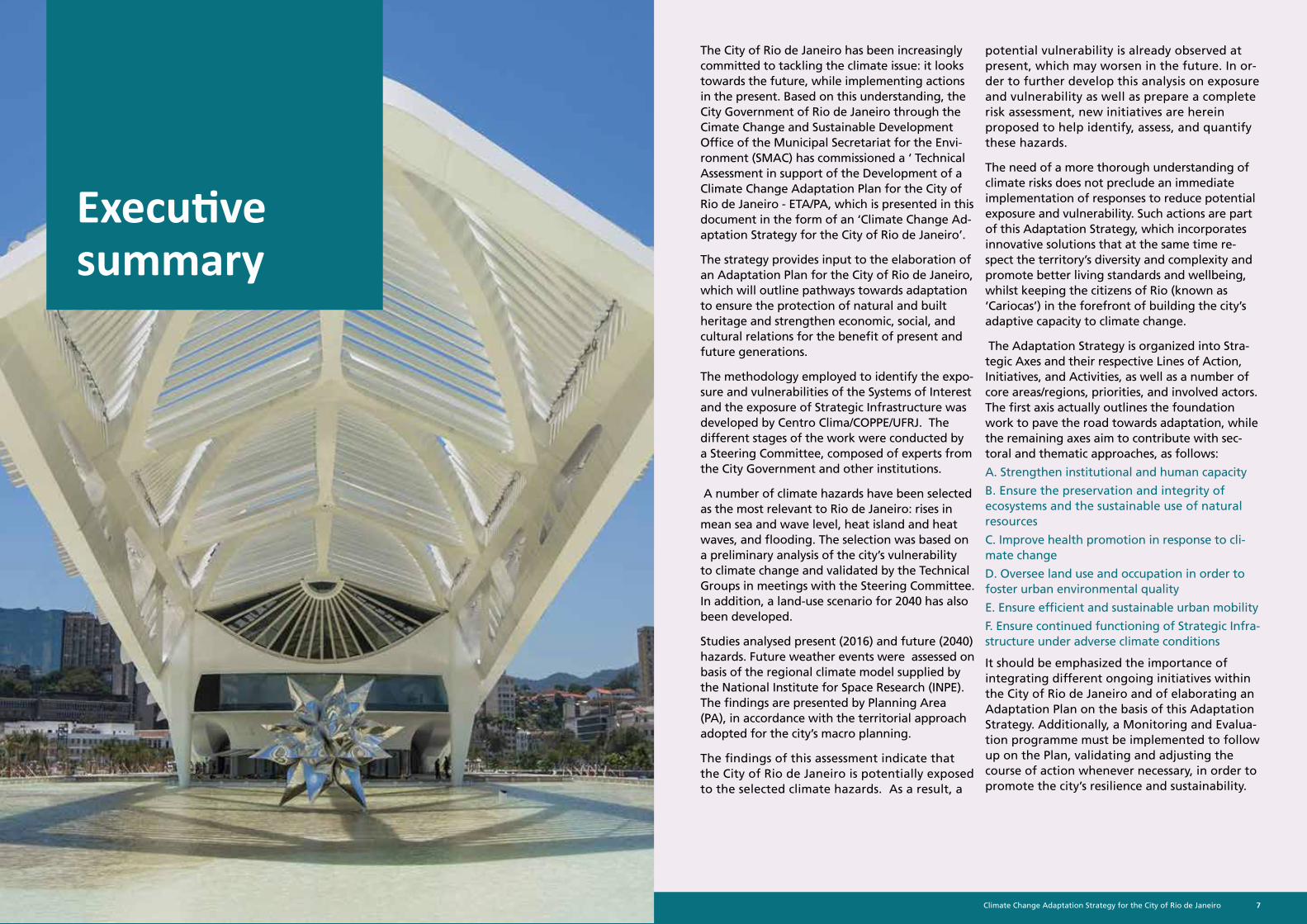
The City of Rio de Janeiro has been increasingly committed to tackling the climate issue: it looks towards the future, while implementing actions in the present. Based on this understanding, the City Government of Rio de Janeiro through the Cimate Change and Sustainable Development Office of the Municipal Secretariat for the Envi-ronment (SMAC) has commissioned a ‘ Technical Assessment in support of the Development of a Climate Change Adaptation Plan for the City of Rio de Janeiro - ETA/PA, which is presented in this document in the form of an ‘Climate Change Ad-aptation Strategy for the City of Rio de Janeiro’.
The strategy provides input to the elaboration of an Adaptation Plan for the City of Rio de Janeiro, which will outline pathways towards adaptation to ensure the protection of natural and built heritage and strengthen economic, social, and cultural relations for the benefit of present and future generations.
The methodology employed to identify the expo-sure and vulnerabilities of the Systems of Interest and the exposure of Strategic Infrastructure was developed by Centro Clima/COPPE/UFRJ. The different stages of the work were conducted by a Steering Committee, composed of experts from the City Government and other institutions.
A number of climate hazards have been selected as the most relevant to Rio de Janeiro: rises in mean sea and wave level, heat island and heat waves, and flooding. The selection was based on a preliminary analysis of the city’s vulnerability to climate change and validated by the Technical Groups in meetings with the Steering Committee. In addition, a land-use scenario for 2040 has also been developed.
Studies analysed present (2016) and future (2040) hazards. Future weather events were assessed on basis of the regional climate model supplied by the National Institute for Space Research (INPE). The findings are presented by Planning Area (PA), in accordance with the territorial approach adopted for the city’s macro planning.
The findings of this assessment indicate that the City of Rio de Janeiro is potentially exposed to the selected climate hazards. As a result, a
potential vulnerability is already observed at present, which may worsen in the future. In or-der to further develop this analysis on exposure and vulnerability as well as prepare a complete risk assessment, new initiatives are herein proposed to help identify, assess, and quantify these hazards.
The need of a more thorough understanding of climate risks does not preclude an immediate implementation of responses to reduce potential exposure and vulnerability. Such actions are part of this Adaptation Strategy, which incorporates innovative solutions that at the same time re-spect the territory’s diversity and complexity and promote better living standards and wellbeing, whilst keeping the citizens of Rio (known as ‘Cariocas’) in the forefront of building the city’s adaptive capacity to climate change.
The Adaptation Strategy is organized into Stra-tegic Axes and their respective Lines of Action, Initiatives, and Activities, as well as a number of core areas/regions, priorities, and involved actors. The first axis actually outlines the foundation work to pave the road towards adaptation, while the remaining axes aim to contribute with sec-toral and thematic approaches, as follows:
A. Strengthen institutional and human capacity
B. Ensure the preservation and integrity of ecosystems and the sustainable use of natural resources
C. Improve health promotion in response to cli-mate change
D. Oversee land use and occupation in order to foster urban environmental quality
E. Ensure efficient and sustainable urban mobility
F. Ensure continued functioning of Strategic Infra-structure under adverse climate conditions
It should be emphasized the importance of integrating different ongoing initiatives within the City of Rio de Janeiro and of elaborating an Adaptation Plan on the basis of this Adaptation Strategy. Additionally, a Monitoring and Evalua-tion programme must be implemented to follow up on the Plan, validating and adjusting the course of action whenever necessary, in order to promote the city’s resilience and sustainability.
Executive summary
Climate Change Adaptation Strategy for the City of Rio de Janeiro8 9Climate Change Adaptation Strategy for the City of Rio de Janeiro
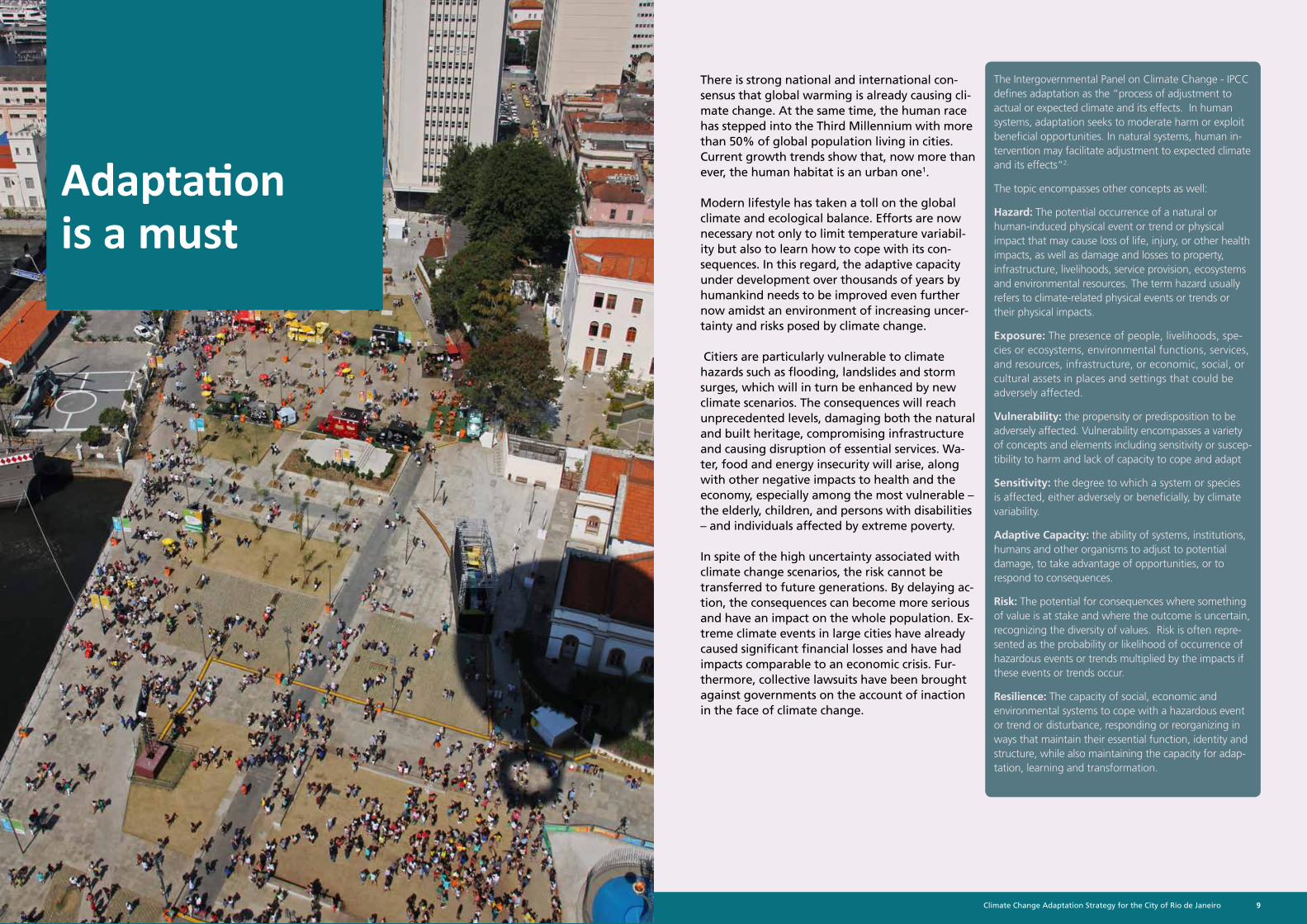
There is strong national and international con-sensus that global warming is already causing cli-mate change. At the same time, the human race has stepped into the Third Millennium with more than 50% of global population living in cities. Current growth trends show that, now more than ever, the human habitat is an urban one1.
Modern lifestyle has taken a toll on the global climate and ecological balance. Efforts are now necessary not only to limit temperature variabil-ity but also to learn how to cope with its con-sequences. In this regard, the adaptive capacity under development over thousands of years by humankind needs to be improved even further now amidst an environment of increasing uncer-tainty and risks posed by climate change.
Citiers are particularly vulnerable to climate hazards such as flooding, landslides and storm surges, which will in turn be enhanced by new climate scenarios. The consequences will reach unprecedented levels, damaging both the natural and built heritage, compromising infrastructure and causing disruption of essential services. Wa-ter, food and energy insecurity will arise, along with other negative impacts to health and the economy, especially among the most vulnerable – the elderly, children, and persons with disabilities – and individuals affected by extreme poverty.
In spite of the high uncertainty associated with climate change scenarios, the risk cannot be transferred to future generations. By delaying ac-tion, the consequences can become more serious and have an impact on the whole population. Ex-treme climate events in large cities have already caused significant financial losses and have had impacts comparable to an economic crisis. Fur-thermore, collective lawsuits have been brought against governments on the account of inaction in the face of climate change.
The Intergovernmental Panel on Climate Change - IPCC defines adaptation as the “process of adjustment to actual or expected climate and its effects. In human systems, adaptation seeks to moderate harm or exploit beneficial opportunities. In natural systems, human in-tervention may facilitate adjustment to expected climate and its effects”2.
The topic encompasses other concepts as well:
Hazard: The potential occurrence of a natural or human-induced physical event or trend or physical impact that may cause loss of life, injury, or other health impacts, as well as damage and losses to property, infrastructure, livelihoods, service provision, ecosystems and environmental resources. The term hazard usually refers to climate-related physical events or trends or their physical impacts.
Exposure: The presence of people, livelihoods, spe-cies or ecosystems, environmental functions, services, and resources, infrastructure, or economic, social, or cultural assets in places and settings that could be adversely affected.
Vulnerability: the propensity or predisposition to be adversely affected. Vulnerability encompasses a variety of concepts and elements including sensitivity or suscep-tibility to harm and lack of capacity to cope and adapt
Sensitivity: the degree to which a system or species is affected, either adversely or beneficially, by climate variability.
Adaptive Capacity: the ability of systems, institutions, humans and other organisms to adjust to potential damage, to take advantage of opportunities, or to respond to consequences.
Risk: The potential for consequences where something of value is at stake and where the outcome is uncertain, recognizing the diversity of values. Risk is often repre-sented as the probability or likelihood of occurrence of hazardous events or trends multiplied by the impacts if these events or trends occur.
Resilience: The capacity of social, economic and environmental systems to cope with a hazardous event or trend or disturbance, responding or reorganizing in ways that maintain their essential function, identity and structure, while also maintaining the capacity for adap-tation, learning and transformation.
Adaptation is a must
Climate Change Adaptation Strategy for the City of Rio de Janeiro10 11Climate Change Adaptation Strategy for the City of Rio de Janeiro
It is therefore imperative to start acting now. However, it is also clear the impossibility of erasing all future risk as there is still insuffi-cient knowledge on the magnitude of climate hazards and their consequences. In such an uncertain environment, adaptation serves as a tool to better cope with risks and make them more manageable for communities, public and private institutions. Moreover, adaptive efforts point out the available routes in reducing the effects of such hazards to the built and natural heritage; they also make the most of opportu-nities to promote the welfare and increase the quality of life of local populations along with the resilience of ecosystems.
In developing countries, the urgent demand for meeting the most basic human needs such as housing, sanitation, mobility, education and health is not regarded as part of adaptation ef-forts, which are often overlooked in the govern-mental agenda. Surely, meeting such demands is the first step in the adaptation process, which also encompasses actions to reduce vulnera-bility and therefore improve the population’s resilience and capacity of coping with adverse climate events.
In this context, the City of Rio de Janeiro has launched the process to plan adaptation with a ‘Technical Assessment in Support of the Develop-ment of an Climate Change Adaptation Plan for the City of Rio de Janeiro’ (ETA/PA), summarized in the Adaptation Strategy here presented. The assessment lays the foundation for the Elabora-tion of a Climate Change Adaptation Plan for the City of Rio de Janeiro. In the adaptation plan, initiatives and goals will be outlined in detail and prioritized; the necessary technical, human and financial resources will be allocated; and a sched-ule will be established for its implementation, along with monitoring and review procedures of all actions in the plan.
Our city
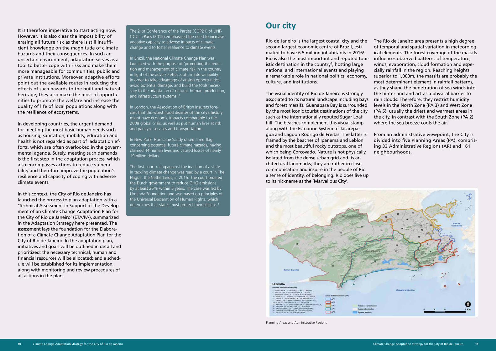
Rio de Janeiro is the largest coastal city and the second largest economic centre of Brazil, esti-mated to have 6.5 million inhabitants in 20165. Rio is also the most important and reputed tour-istic destination in the country6, hosting large national and international events and playing a remarkable role in national politics, economy, culture, and institutions.
The visual identity of Rio de Janeiro is strongly associated to its natural landscape including bays and forest massifs. Guanabara Bay is surrounded by the most iconic tourist destinations of the city such as the internationally reputed Sugar Loaf hill. The beaches complement this visual stamp along with the Estuarine System of Jacarepa-guá and Lagoon Rodrigo de Freitas. The latter is framed by the beaches of Ipanema and Leblon and the most beautiful rocky outcrops, one of which being Corcovado. Nature is not physically isolated from the dense urban grid and its ar-chitectural landmarks; they are rather in close communication and inspire in the people of Rio a sense of identity, of belonging. Rio does live up to its nickname as the ’Marvellous City’.
The Rio de Janeiro area presents a high degree of temporal and spatial variation in meteorolog-ical elements. The forest coverage of the massifs influences observed patterns of temperature, winds, evaporation, cloud formation and espe-cially rainfall in the region. Reaching heights superior to 1,000m, the massifs are probably the most determinant element in rainfall patterns, as they shape the penetration of sea winds into the hinterland and act as a physical barrier to rain clouds. Therefore, they restrict humidity levels in the North Zone (PA 3) and West Zone (PA 5), usually the driest and warmest areas in the city, in contrast with the South Zone (PA 2) where the sea breeze cools the air.
From an administrative viewpoint, the City is divided into five Planning Areas (PA), compris-ing 33 Administrative Regions (AR) and 161 neighbourhoods.
Planning Areas and Administrative Regions
The 21st Conference of the Parties (COP21) of UNF-CCC in Paris (2015) emphasized the need to increase adaptive capacity to adverse impacts of climate change and to foster resilience to climate events.
In Brazil, the National Climate Change Plan was launched with the purpose of ‘promoting the reduc-tion and management of climate risk in the country in light of the adverse effects of climate variability, in order to take advantage of arising opportunities, avoid potential damage, and build the tools neces-sary to the adaptation of natural, human, production, and infrastructure systems’.3
In London, the Association of British Insurers fore-cast that the worst flood disaster of the city’s history might have economic impacts comparable to the 2009 global crisis, as well as put human lives at risk and paralyze services and transportation.
In New York, Hurricane Sandy raised a red flag concerning potential future climate hazards, having claimed 44 human lives and caused losses of nearly 19 billion dollars.
The first court ruling against the inaction of a state in tackling climate change was read by a court in The Hague, the Netherlands, in 2015. The court ordered the Dutch government to reduce GHG emissions by at least 25% within 5 years. The case was led by Urgenda Foundation and was based on principles of the Universal Declaration of Human Rights, which determines that states must protect their citizens.4
Climate Change Adaptation Strategy for the City of Rio de Janeiro12 13Climate Change Adaptation Strategy for the City of Rio de Janeiro
The history of natural disasters in Rio de Janeiro is closely related to the growth pattern of its ur-ban grid. There is a high concentration of peo-ple and buildings squeezed between hills, sea, lagoons and bay, often in areas at risk of floods and landslides or exposed to sea phenomena such as storm surges. Events that cause large scale material and economic losses are not uncommon. The population is therefore exposed to disease outbreaks or, in extreme cases, even death.
The peculiar topography of Rio has directed urban expansion including the road network, which in turn influenced a radial pattern of urban sprawl from the coast into the hinterland. As the urban space developed, land reclamation became a common practice: several hills were wiped out, ditches were dug to drain wetlands, and the coastline was redefined by successive landfills. Urban occupation also spread over the slopes of mountains across the city. As a result, the exposure of persons as well as public and private assets to climate hazards has increased. In this context, with the extensive alteration of natural spaces and the failure in creating green spaces throughout the city, a number of eco-system services have been compromised such as water conservation, slope stability, and the cooling of urban heat.
Social inequality and insufficient housing poli-cies also contribute to Rio de Janeiro’s vulner-ability: the underserved population is prone to occupy areas at risk of floods and landslides and lacking urban services and infrastructure. On the other hand, it needs to be noted that the high-income population has also occupied risk areas such as hillsides, marginal strips of lagoons and coastal areas. The difference between the two social strata resides in their capacity to cope with climate hazards.
Accordingly, strategies to reduce vulnerabili-ties and promote adaptation will also gener-ate opportunities for promoting sustainable urban development with the protection of natural ecosystems.
Why adaptation? Our approach
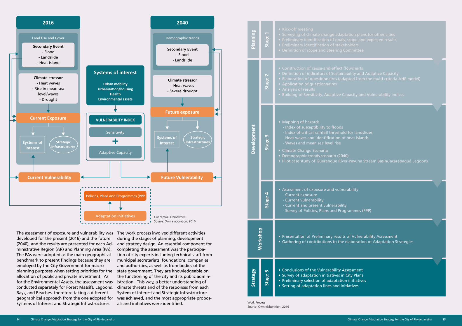
The assessment of exposure and vulnerability focused on four Systems of Interest, namely Urbanization and Housing, Urban Mobility, Health, and Environmen-tal Assets. In addition, the Strategic Infrastructure were assessed but solely in terms of their exposure to climate hazards.
These systems and Infrastructures were selected with basis on previous assessments of Rio’s vulnerability as well as discussions within the Steering Commit-tee, which was implemented to enable and provide guidelines for the work by the technical groups.
The methodology employed to assess the Systems of Interest was based on the identification and mapping of vulnerability to climate change through a Vulner-ability Index, which is composed by the Sensitivity Index and the Adaptive Capacity Index.
The vulnerability assessment aims at pinpointing fac-tors that make natural and human systems exposed to climate hazards and susceptible to their adverse effects. This knowledge enables the identification of the most relevant strategies to reduce factors that sensitize the Systems of Interest. At the same time, it strengthens the capacity of institutions and persons along with the resilience of ecosystems, in conso-nance with city planning and management.
Concerning Strategic Infrastructures, a different methodology was employed. Hazards were mapped and a number of essential urban sectors selected; the potential exposure of these sectors and possible con-sequences of hazardous events were then identified. Because of peculiarities of the structures analysed and the lack of available data, in this case a vulner-ability assessment was not completed. However, based on existing literature, a few conclusions were extrapolated and a preliminary sensitivity analysis was prepared, which will serve as guidelines for the development of strategies to reduce exposure.
In support of the assessment, studies were prepared to build on the knowledge of hazards along with a specific analysis on land use and coverage and the demographic trends for 2040.
Nossos Sistemas de Interesse e Infraestruturas Estratégicas
Strategic Infrastructures
Comprises sectors essential for the daily functioning and crisis response of the city, classified into three cat-egories. Response - institutions en-forcing safety and integrity of the population. Operation - facilities
intrinsically linked to the daily func-tioning of the city. Education - basic
education institutions.
Environmental Assets
Include the forest massifs of Geri-cinó-Mendanha, Pedra Branca and
Tijuca, the Guanabara and Sepetiba bays, Lagoon Rodrigo de Freitas and the Estuarine System of Jacarepaguá,
and 24 oceanic and bay beaches.
Health
Pertains to the population susceptible to diseases that may be direct or indi-rectly impacted by the climate, name-
ly cardiovascular diseases, dengue fever, leptospirosis, cutaneous and
visceral leishmaniosis, and diarrhea in children under five years of age.
Urban Mobility
Involves public transportation services as well as the road network including arterials and collectors, sidewalks and
cycle paths.
Urbanization and Housing
Comprises the two main dimensions of urban environment: the built environ-ment, which includes the social hous-ing system, and the system of open
and green spaces.
Climate Change Adaptation Strategy for the City of Rio de Janeiro14 15Climate Change Adaptation Strategy for the City of Rio de Janeiro
• Kick-off meeting• Surveying of climate change adaptation plans for other cities• Preliminary identification of goals, scope and expected results• Preliminary identification of stakeholders• Definition of scope and Steering Committee
Stag
e 1
Plan
ning
Dev
elop
men
tSt
rate
gyW
orks
hop
Stag
e 2
Stag
e 3
Stag
e 4
Stag
e 5
• Construction of cause-and-effect flowcharts• Definition of indicators of Sustainability and Adaptive Capacity• Elaboration of questionnaires (adapted from the multi-criteria AHP model)• Application of questionnaires• Analysis of results• Building of Sensitivity, Adaptive Capacity and Vulnerability indices
• Mapping of hazards- Index of susceptibility to floods- Index of critical rainfall threshold for landslides- Heat waves and identification of heat islands- Waves and mean sea level rise
• Climate Change Scenario• Demographic trends scenario (2040)• Pilot case study of Guerengue River-Pavuna Stream Basin/Jacarepaguá Lagoons
• Assessment of exposure and vulnerability- Current exposure- Current vulnerability- Current and present vulnerability- Survey of Policies, Plans and Programmes (PPP)
• Presentation of Preliminary results of Vulnerability Assessment• Gathering of contributions to the elaboration of Adaptation Strategies
• Conclusions of the Vulnerability Assessment• Survey of adaptation initiatives in City Plans• Preliminary selection of adaptation initiatives• Setting of adaptation lines and initiatives
Work ProcessSource: Own elaboration, 2016
The assessment of exposure and vulnerability was developed for the present (2016) and the future (2040), and the results are presented for each Ad-ministrative Region (AR) and Planning Area (PA). The PAs were adopted as the main geographical benchmark to present findings because they are employed by the City Government for macro planning purposes when setting priorities for the allocation of public and private investment. As for the Environmental Assets, the assessment was conducted separately for Forest Massifs, Lagoons, Bays, and Beaches, therefore taking a different geographical approach from the one adopted for Systems of Interest and Strategic Infrastructures.
The work process involved different activities during the stages of planning, development and strategy design. An essential component for completing the assessment was the participa-tion of city experts including technical staff from municipal secretariats, foundations, companies and authorities, as well as from bodies of the state government. They are knowledgeable on the functioning of the city and its public admin-istration. This way, a better understanding of climate threats and of the responses from each System of Interest and Strategic Infrastructure was achieved, and the most appropriate propos-als and initiatives were identified.
Systems of Interest
Strategic Infrastructures
Land Use and Cover Demographic trends
Future VulnerabilityCurrent Vulnerability
Policies, Plans and Programmes (PPP
Adaptation Initiatives
2016 2040
Current ExposureFuture exposure
Secondary Event- Flood
- Landslide- Heat island
Secondary Event- Flood
- Landslide
Climate stressor- Heat waves
- Rise in mean sea level/waves- Drought
Climate stressor- Heat waves
- Severe drought
Systems of Interest
Strategic Infrastructures
Systems of interest
Urban mobilityUrbanization/housing
HealthEnvironmental assets
Sensitivity
VULNERABILITY INDEX
Adaptive Capacity
Conceptual Framework.Source: Own elaboration, 2016
Climate Change Adaptation Strategy for the City of Rio de Janeiro16 17Climate Change Adaptation Strategy for the City of Rio de Janeiro
What awaits us
In addition to changes related to climate conditions, other aspects that may affect future expo-sure and vulnerability of the city of Rio de Janeiro were taken in consideration. Demographic trends such as aging and deceleration in population growth as well as the further expansion of urban areas were analysed in this assessment.
Aging and decelaration in popula-tion growth
Expansion of the urban area Climate change
Aging and deceleration in population growth
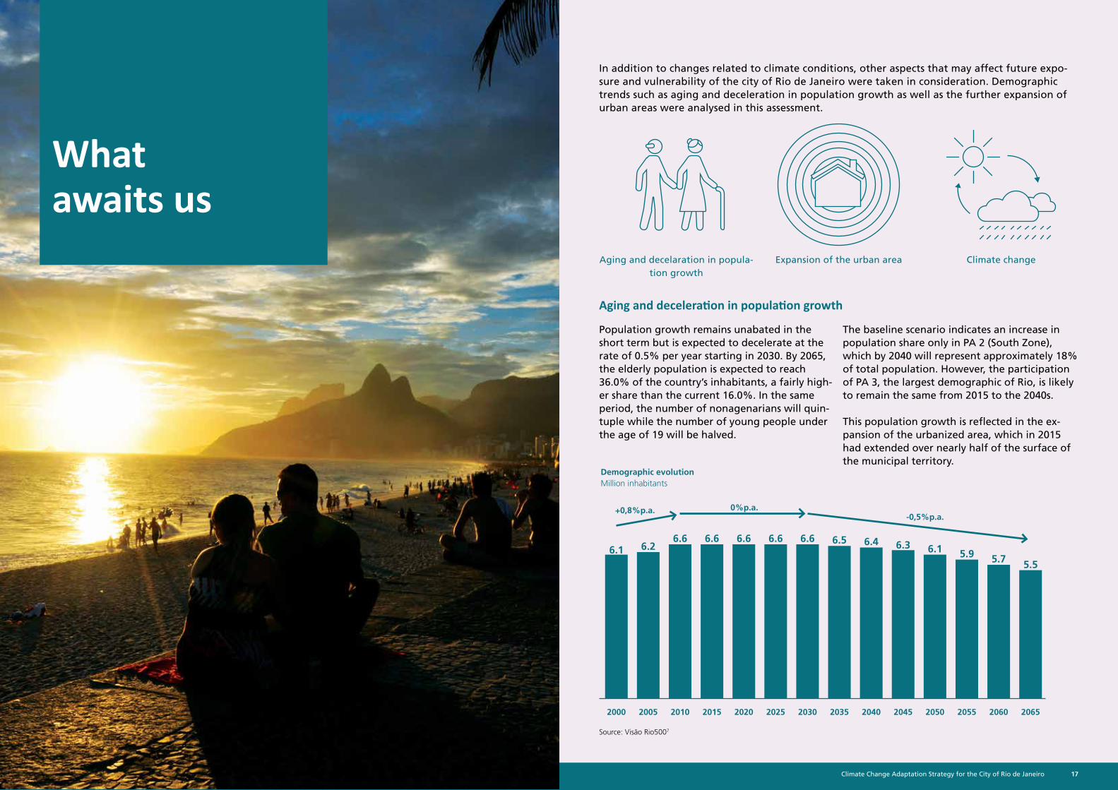
Population growth remains unabated in the short term but is expected to decelerate at the rate of 0.5% per year starting in 2030. By 2065, the elderly population is expected to reach 36.0% of the country’s inhabitants, a fairly high-er share than the current 16.0%. In the same period, the number of nonagenarians will quin-tuple while the number of young people under the age of 19 will be halved.
The baseline scenario indicates an increase in population share only in PA 2 (South Zone), which by 2040 will represent approximately 18% of total population. However, the participation of PA 3, the largest demographic of Rio, is likely to remain the same from 2015 to the 2040s.
This population growth is reflected in the ex-pansion of the urbanized area, which in 2015 had extended over nearly half of the surface of the municipal territory.
Source: Visão Rio5007
Demographic evolutionMillion inhabitants
2000
6.1
+0,8%p.a. 0%p.a.-0,5%p.a.
6.66.66.36.2
6.56.66.1
5.7
6.6 6.46.6
5.95.5
20302015 20452005 20352020 2050 20602010 20402025 2055 2065
Climate Change Adaptation Strategy for the City of Rio de Janeiro18 19Climate Change Adaptation Strategy for the City of Rio de Janeiro
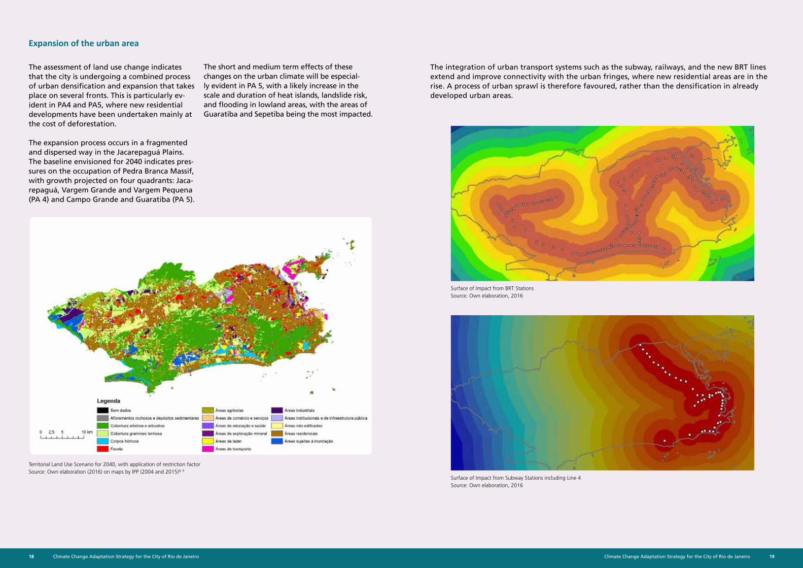
The assessment of land use change indicates that the city is undergoing a combined process of urban densification and expansion that takes place on several fronts. This is particularly ev-ident in PA4 and PA5, where new residential developments have been undertaken mainly at the cost of deforestation.
The expansion process occurs in a fragmented and dispersed way in the Jacarepaguá Plains. The baseline envisioned for 2040 indicates pres-sures on the occupation of Pedra Branca Massif, with growth projected on four quadrants: Jaca-repaguá, Vargem Grande and Vargem Pequena (PA 4) and Campo Grande and Guaratiba (PA 5).
Expansion of the urban area
Territorial Land Use Scenario for 2040, with application of restriction factorSource: Own elaboration (2016) on maps by IPP (2004 and 2015)8; 9
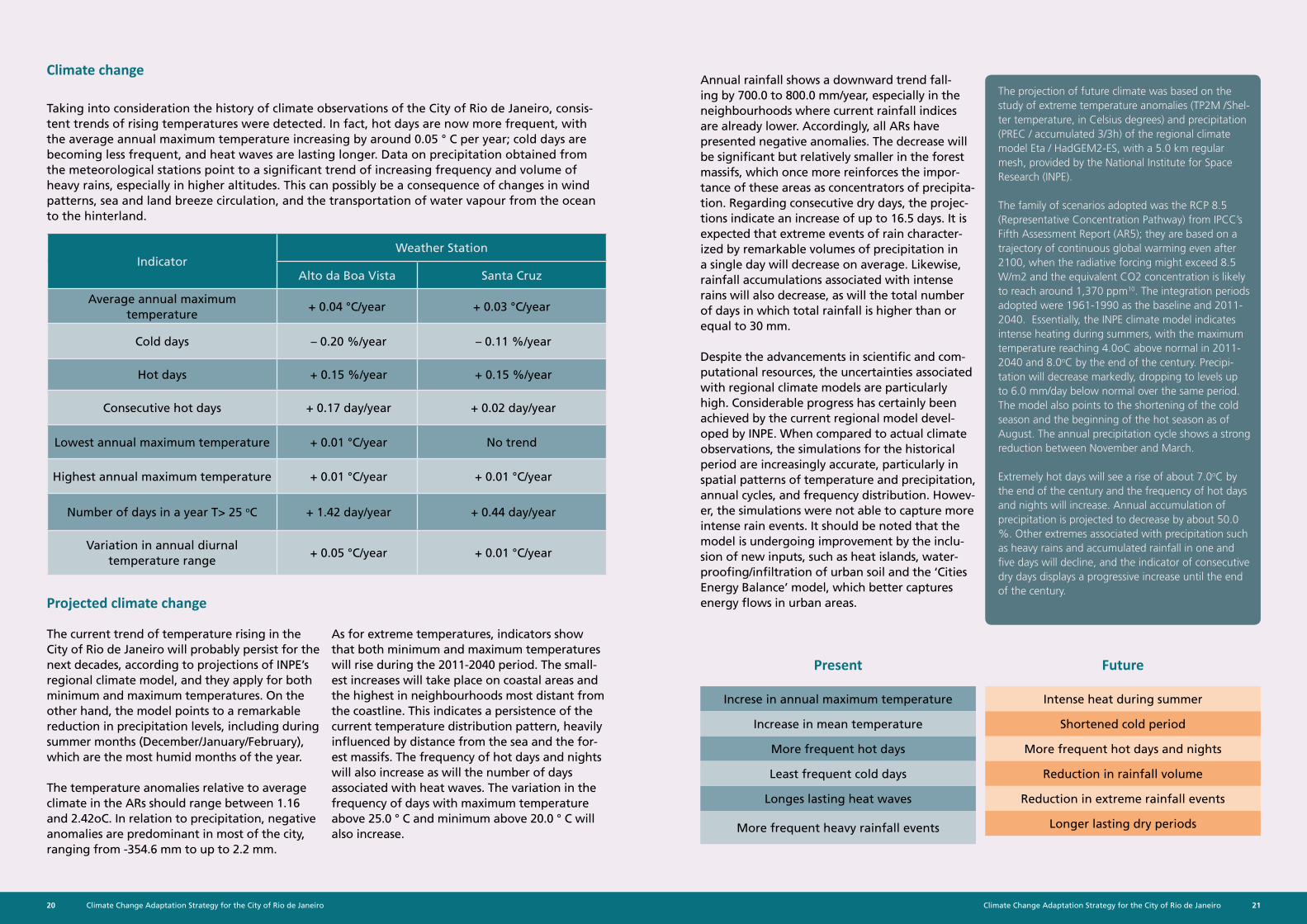
Surface of Impact from BRT Stations Source: Own elaboration, 2016
Surface of Impact from Subway Stations including Line 4 Source: Own elaboration, 2016
The integration of urban transport systems such as the subway, railways, and the new BRT lines extend and improve connectivity with the urban fringes, where new residential areas are in the rise. A process of urban sprawl is therefore favoured, rather than the densification in already developed urban areas.
The short and medium term effects of these changes on the urban climate will be especial-ly evident in PA 5, with a likely increase in the scale and duration of heat islands, landslide risk, and flooding in lowland areas, with the areas of Guaratiba and Sepetiba being the most impacted.
Climate Change Adaptation Strategy for the City of Rio de Janeiro20 21Climate Change Adaptation Strategy for the City of Rio de Janeiro
Taking into consideration the history of climate observations of the City of Rio de Janeiro, consis-tent trends of rising temperatures were detected. In fact, hot days are now more frequent, with the average annual maximum temperature increasing by around 0.05 ° C per year; cold days are becoming less frequent, and heat waves are lasting longer. Data on precipitation obtained from the meteorological stations point to a significant trend of increasing frequency and volume of heavy rains, especially in higher altitudes. This can possibly be a consequence of changes in wind patterns, sea and land breeze circulation, and the transportation of water vapour from the ocean to the hinterland.
Climate change
Projected climate change
Present Future
The current trend of temperature rising in the City of Rio de Janeiro will probably persist for the next decades, according to projections of INPE’s regional climate model, and they apply for both minimum and maximum temperatures. On the other hand, the model points to a remarkable reduction in precipitation levels, including during summer months (December/January/February), which are the most humid months of the year.
The temperature anomalies relative to average climate in the ARs should range between 1.16 and 2.42oC. In relation to precipitation, negative anomalies are predominant in most of the city, ranging from -354.6 mm to up to 2.2 mm.
As for extreme temperatures, indicators show that both minimum and maximum temperatures will rise during the 2011-2040 period. The small-est increases will take place on coastal areas and the highest in neighbourhoods most distant from the coastline. This indicates a persistence of the current temperature distribution pattern, heavily influenced by distance from the sea and the for-est massifs. The frequency of hot days and nights will also increase as will the number of days associated with heat waves. The variation in the frequency of days with maximum temperature above 25.0 ° C and minimum above 20.0 ° C will also increase.
Annual rainfall shows a downward trend fall-ing by 700.0 to 800.0 mm/year, especially in the neighbourhoods where current rainfall indices are already lower. Accordingly, all ARs have presented negative anomalies. The decrease will be significant but relatively smaller in the forest massifs, which once more reinforces the impor-tance of these areas as concentrators of precipita-tion. Regarding consecutive dry days, the projec-tions indicate an increase of up to 16.5 days. It is expected that extreme events of rain character-ized by remarkable volumes of precipitation in a single day will decrease on average. Likewise, rainfall accumulations associated with intense rains will also decrease, as will the total number of days in which total rainfall is higher than or equal to 30 mm.
Despite the advancements in scientific and com-putational resources, the uncertainties associated with regional climate models are particularly high. Considerable progress has certainly been achieved by the current regional model devel-oped by INPE. When compared to actual climate observations, the simulations for the historical period are increasingly accurate, particularly in spatial patterns of temperature and precipitation, annual cycles, and frequency distribution. Howev-er, the simulations were not able to capture more intense rain events. It should be noted that the model is undergoing improvement by the inclu-sion of new inputs, such as heat islands, water-proofing/infiltration of urban soil and the ‘Cities Energy Balance’ model, which better captures energy flows in urban areas.
The projection of future climate was based on the study of extreme temperature anomalies (TP2M /Shel-ter temperature, in Celsius degrees) and precipitation (PREC / accumulated 3/3h) of the regional climate model Eta / HadGEM2-ES, with a 5.0 km regular mesh, provided by the National Institute for Space Research (INPE).
The family of scenarios adopted was the RCP 8.5 (Representative Concentration Pathway) from IPCC’s Fifth Assessment Report (AR5); they are based on a trajectory of continuous global warming even after 2100, when the radiative forcing might exceed 8.5 W/m2 and the equivalent CO2 concentration is likely to reach around 1,370 ppm10. The integration periods adopted were 1961-1990 as the baseline and 2011-2040. Essentially, the INPE climate model indicates intense heating during summers, with the maximum temperature reaching 4.0oC above normal in 2011-2040 and 8.0oC by the end of the century. Precipi-tation will decrease markedly, dropping to levels up to 6.0 mm/day below normal over the same period. The model also points to the shortening of the cold season and the beginning of the hot season as of August. The annual precipitation cycle shows a strong reduction between November and March.
Extremely hot days will see a rise of about 7.0oC by the end of the century and the frequency of hot days and nights will increase. Annual accumulation of precipitation is projected to decrease by about 50.0 %. Other extremes associated with precipitation such as heavy rains and accumulated rainfall in one and five days will decline, and the indicator of consecutive dry days displays a progressive increase until the end of the century.
Increse in annual maximum temperature
Increase in mean temperature
More frequent hot days
Least frequent cold days
Longes lasting heat waves
More frequent heavy rainfall events
Intense heat during summer
Shortened cold period
More frequent hot days and nights
Reduction in rainfall volume
Reduction in extreme rainfall events
Longer lasting dry periods
IndicatorWeather Station
Alto da Boa Vista Santa Cruz
Average annual maximum temperature
+ 0.04 °C/year + 0.03 °C/year
Cold days – 0.20 %/year – 0.11 %/year
Hot days + 0.15 %/year + 0.15 %/year
Consecutive hot days + 0.17 day/year + 0.02 day/year
Lowest annual maximum temperature + 0.01 °C/year No trend
Highest annual maximum temperature + 0.01 °C/year + 0.01 °C/year
Number of days in a year T> 25 oC + 1.42 day/year + 0.44 day/year
Variation in annual diurnal temperature range
+ 0.05 °C/year + 0.01 °C/year
Climate Change Adaptation Strategy for the City of Rio de Janeiro22 23Climate Change Adaptation Strategy for the City of Rio de Janeiro
Rise in mean sea levels and waves
Storm Surge at Arpoador Beach, South Zone, October 2016. Photo: Claudio Neves
Waves invade the canal of Av. Visconde de Albuquerque, Leblon neigh-bourhood, October 2016. Photo: Claudio Neves
What threatens us
Based on international literature and the knowledge produced on the vulnerability to climate change of the City of Rio de Janeiro (CRJ), the following hazards were considered:
In spite of the evident relevance of threats from dry periods and droughts to the city, including a potential vulnerability of the water supply system, this hazard was not included in the assessment. The System of Interest of Environmental Assets has made use of it solely as a benchmark for the vulnerability analysis of potential effects on vegetation cover on massifs and watersheds down-stream from lagoons and bays.
FloodsLandslides Heat waves and heat islands
Drought
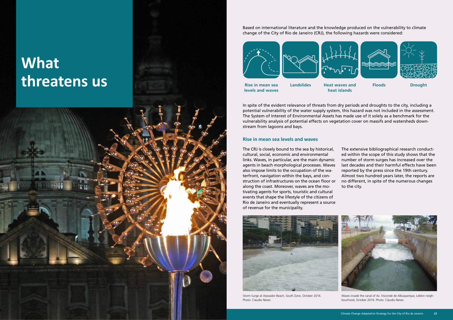
The CRJ is closely bound to the sea by historical, cultural, social, economic and environmental links. Waves, in particular, are the main dynamic agents in beach morphological processes. Waves also impose limits to the occupation of the wa-terfront, navigation within the bays, and con-struction of infrastructures on the ocean floor or along the coast. Moreover, waves are the mo-tivating agents for sports, touristic and cultural events that shape the lifestyle of the citizens of Rio de Janeiro and eventually represent a source of revenue for the municipality.
Rise in mean sea levels and waves
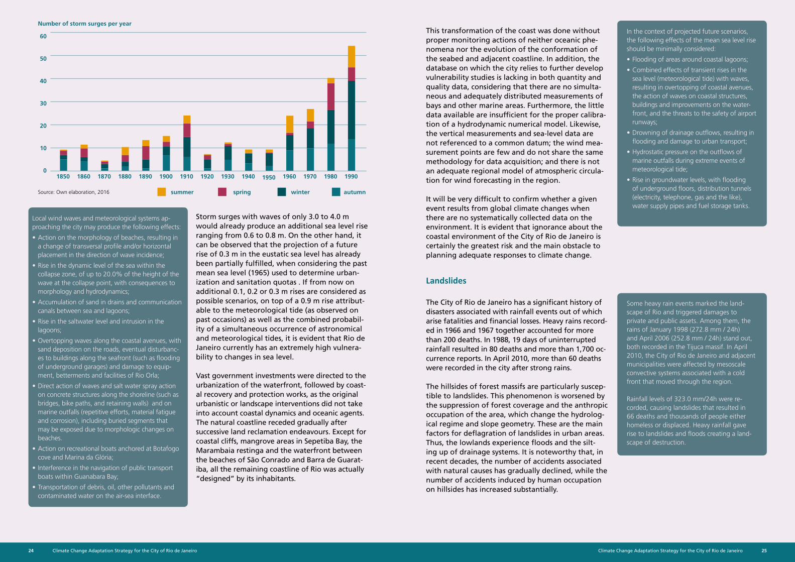
The extensive bibliographical research conduct-ed within the scope of this study shows that the number of storm surges has increased over the last decades and their harmful effects have been reported by the press since the 19th century. Almost two hundred years later, the reports are no different, in spite of the numerous changes to the city.
Climate Change Adaptation Strategy for the City of Rio de Janeiro24 25Climate Change Adaptation Strategy for the City of Rio de Janeiro
Local wind waves and meteorological systems ap-proaching the city may produce the following effects:
• Action on the morphology of beaches, resulting in a change of transversal profile and/or horizontal placement in the direction of wave incidence;
• Rise in the dynamic level of the sea within the collapse zone, of up to 20.0% of the height of the wave at the collapse point, with consequences to morphology and hydrodynamics;
• Accumulation of sand in drains and communication canals between sea and lagoons;
• Rise in the saltwater level and intrusion in the lagoons;
• Overtopping waves along the coastal avenues, with sand deposition on the roads, eventual disturbanc-es to buildings along the seafront (such as flooding of underground garages) and damage to equip-ment, betterments and facilities of Rio Orla;
• Direct action of waves and salt water spray action on concrete structures along the shoreline (such as bridges, bike paths, and retaining walls) and on marine outfalls (repetitive efforts, material fatigue and corrosion), including buried segments that may be exposed due to morphologic changes on beaches.
• Action on recreational boats anchored at Botafogo cove and Marina da Glória;
• Interference in the navigation of public transport boats within Guanabara Bay;
• Transportation of debris, oil, other pollutants and contaminated water on the air-sea interface.
In the context of projected future scenarios, the following effects of the mean sea level rise should be minimally considered:
• Flooding of areas around coastal lagoons;
• Combined effects of transient rises in the sea level (meteorological tide) with waves, resulting in overtopping of coastal avenues, the action of waves on coastal structures, buildings and improvements on the water-front, and the threats to the safety of airport runways;
• Drowning of drainage outflows, resulting in flooding and damage to urban transport;
• Hydrostatic pressure on the outflows of marine outfalls during extreme events of meteorological tide;
• Rise in groundwater levels, with flooding of underground floors, distribution tunnels (electricity, telephone, gas and the like), water supply pipes and fuel storage tanks.
Some heavy rain events marked the land-scape of Rio and triggered damages to private and public assets. Among them, the rains of January 1998 (272.8 mm / 24h) and April 2006 (252.8 mm / 24h) stand out, both recorded in the Tijuca massif. In April 2010, the City of Rio de Janeiro and adjacent municipalities were affected by mesoscale convective systems associated with a cold front that moved through the region.
Rainfall levels of 323.0 mm/24h were re-corded, causing landslides that resulted in 66 deaths and thousands of people either homeless or displaced. Heavy rainfall gave rise to landslides and floods creating a land-scape of destruction.
Storm surges with waves of only 3.0 to 4.0 m would already produce an additional sea level rise ranging from 0.6 to 0.8 m. On the other hand, it can be observed that the projection of a future rise of 0.3 m in the eustatic sea level has already been partially fulfilled, when considering the past mean sea level (1965) used to determine urban-ization and sanitation quotas . If from now on additional 0.1, 0.2 or 0.3 m rises are considered as possible scenarios, on top of a 0.9 m rise attribut-able to the meteorological tide (as observed on past occasions) as well as the combined probabil-ity of a simultaneous occurrence of astronomical and meteorological tides, it is evident that Rio de Janeiro currently has an extremely high vulnera-bility to changes in sea level.
Vast government investments were directed to the urbanization of the waterfront, followed by coast-al recovery and protection works, as the original urbanistic or landscape interventions did not take into account coastal dynamics and oceanic agents. The natural coastline receded gradually after successive land reclamation endeavours. Except for coastal cliffs, mangrove areas in Sepetiba Bay, the Marambaia restinga and the waterfront between the beaches of São Conrado and Barra de Guarat-iba, all the remaining coastline of Rio was actually “designed” by its inhabitants.
This transformation of the coast was done without proper monitoring actions of neither oceanic phe-nomena nor the evolution of the conformation of the seabed and adjacent coastline. In addition, the database on which the city relies to further develop vulnerability studies is lacking in both quantity and quality data, considering that there are no simulta-neous and adequately distributed measurements of bays and other marine areas. Furthermore, the little data available are insufficient for the proper calibra-tion of a hydrodynamic numerical model. Likewise, the vertical measurements and sea-level data are not referenced to a common datum; the wind mea-surement points are few and do not share the same methodology for data acquisition; and there is not an adequate regional model of atmospheric circula-tion for wind forecasting in the region.
It will be very difficult to confirm whether a given event results from global climate changes when there are no systematically collected data on the environment. It is evident that ignorance about the coastal environment of the City of Rio de Janeiro is certainly the greatest risk and the main obstacle to planning adequate responses to climate change.
Landslides
The City of Rio de Janeiro has a significant history of disasters associated with rainfall events out of which arise fatalities and financial losses. Heavy rains record-ed in 1966 and 1967 together accounted for more than 200 deaths. In 1988, 19 days of uninterrupted rainfall resulted in 80 deaths and more than 1,700 oc-currence reports. In April 2010, more than 60 deaths were recorded in the city after strong rains.
The hillsides of forest massifs are particularly suscep-tible to landslides. This phenomenon is worsened by the suppression of forest coverage and the anthropic occupation of the area, which change the hydrolog-ical regime and slope geometry. These are the main factors for deflagration of landslides in urban areas. Thus, the lowlands experience floods and the silt-ing up of drainage systems. It is noteworthy that, in recent decades, the number of accidents associated with natural causes has gradually declined, while the number of accidents induced by human occupation on hillsides has increased substantially.
60
50
40
30
20
10
01850 1930 198018901870 1910 19601860 1940 19901900 19501880 1920 1970
summer spring winter autumnSource: Own elaboration, 2016
Number of storm surges per year
Climate Change Adaptation Strategy for the City of Rio de Janeiro26 27Climate Change Adaptation Strategy for the City of Rio de Janeiro
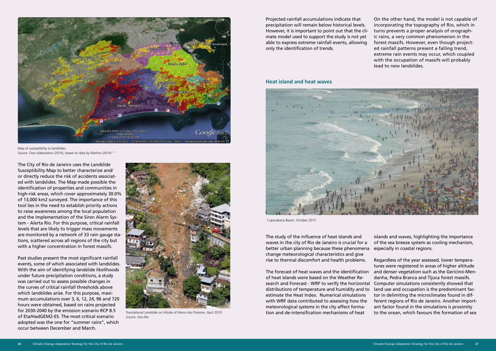
Map of susceptibility to landslides Source: Own elaboration (2016), based on data by Martins (2014) 11
Copacabana Beach, October 2015
Heat island and heat waves
The study of the influence of heat islands and waves in the city of Rio de Janeiro is crucial for a better urban planning because these phenomena change meteorological characteristics and give rise to thermal discomfort and health problems.
The forecast of heat waves and the identification of heat islands were based on the Weather Re-search and Forecast - WRF to verify the horizontal distributions of temperature and humidity and to estimate the Heat Index. Numerical simulations with WRF data contributed to assessing how the meteorological systems in the city affect forma-tion and de-intensification mechanisms of heat
The City of Rio de Janeiro uses the Landslide Susceptibility Map to better characterize and/or directly reduce the risk of accidents associat-ed with landslides. The Map made possible the identification of properties and communities in high-risk areas, which cover approximately 30.0% of 13,000 km2 surveyed. The importance of this tool lies in the need to establish priority actions to raise awareness among the local population and the implementation of the Siren Alarm Sys-tem - Alerta Rio. For this purpose, critical rainfall levels that are likely to trigger mass movements are monitored by a network of 33 rain gauge sta-tions, scattered across all regions of the city but with a higher concentration in forest massifs.
Past studies present the most significant rainfall events, some of which associated with landslides. With the aim of identifying landslide likelihoods under future precipitation conditions, a study was carried out to assess possible changes in the curves of critical rainfall thresholds above which landslides arise. For this purpose, maxi-mum accumulations over 3, 6, 12, 24, 96 and 720 hours were obtained, based on rains projected for 2030-2040 by the emission scenario RCP 8.5 of Eta/HadGEM2-ES. The most critical scenario adopted was the one for “summer rains”, which occur between December and March.
Projected rainfall accumulations indicate that precipitation will remain below historical levels. However, it is important to point out that the cli-mate model used to support the study is not yet able to express extreme rainfall events, allowing only the identification of trends.
Translational Landslide on hillside of Morro dos Prazeres, April 2010. Source: Geo-Rio
islands and waves, highlighting the importance of the sea breeze system as cooling mechanism, especially in coastal regions.
Regardless of the year assessed, lower tempera-tures were registered in areas of higher altitude and denser vegetation such as the Gericinó-Men-danha, Pedra Branca and Tijuca forest massifs. Computer simulations consistently showed that land use and occupation is the predominant fac-tor in delimiting the microclimates found in dif-ferent regions of Rio de Janeiro. Another import-ant factor found in the simulations is proximity to the ocean, which favours the formation of sea
On the other hand, the model is not capable of incorporating the topography of Rio, which in turns prevents a proper analysis of orograph-ic rains, a very common phenomenon in the forest massifs. However, even though project-ed rainfall patterns present a falling trend, extreme rain events may occur, which coupled with the occupation of massifs will probably lead to new landslides.
Climate Change Adaptation Strategy for the City of Rio de Janeiro28 29Climate Change Adaptation Strategy for the City of Rio de Janeiro
breeze, an important cooling system that contrib-utes to the reduction of the temperature range in coastal areas. The pre-frontal situation is partic-ularly prone to meteorological conditions that favour higher temperatures and heat index. PA 3 and PA 5, which concentrate the largest number of areas in need of infrastructure investment, are especially susceptible to higher temperatures and formation of heat islands.
Map of Average Temperature at 3 pm in the Summer of 2012-2013Source: Own elaboration, 2016
he City of Rio de Janeiro, the cumulative total of Maximum Temperature Positive Anomalies (MTPA) was calculated for each month during the period 2003-2015, considering the cases in which the daily maximum temperature was more than 5.0ºC (9.0ºF) above the respective climatological normal (1961-1990) for a period equal to or longer than five days. The highest number of events was found in the months of January (79 cases) and the lowest in the months of November (44 cases).
The highest numbers of MTPA cases were found in 2003 (n=136), 2010 (n=133), 2013 (n=140), and 2014 (n=140), as well as in the periods of 2005–2007 and 2012–2014, with more than 120 cases each.
It is important to mention that in this period persisting excessive temperatures were observed on 38.0% of the days, that is to say, 1,804 of a total of 4,748 days were considered as MTPA. Therefore, there was a large number of days in which the population was exposed to weather conditions that decrease the quality of life in general.
The frequency distribution of MTPA shows a high percentage of cases lasting 5 to 6 days and a very low percentage lasting more than 30 days.
Floods
Rio de Janeiro has grown on and around regions with high natural susceptibility to flooding such as mangroves and swamps, partly attributable to limited river flows into the sea. The land origi-nally dedicated to water capture was very small and neither “offset” mechanisms nor sectors tar-geted for flood control have been implemented. Generally, flood occurrence has always been as-sociated with convective precipitations of short duration and high intensity, especially during the summer months. In these situations, rainfall at the top of steep hillsides quickly exceed the interception capacity of vegetation cover and in-filtration rates of the soil, and runoffs eventually reach the lowlands.
In several areas, anthropic intervention has exceeded acceptable thresholds with respect to a harmonious coexistence with river systems and watershed capacity in supporting ecosystems,
resulting in the current susceptibility situation. Many failures in the drainage system can be observed across the city such as overflows due to insufficient capacity and clandestine sewage connections to the rainwater drainage network.
To identify and rank the sectors most susceptible to failures in the drainage network, the Index of Susceptibility to Floods of the Physical Environ-ment (ISMFI) was built based on the qualitative analysis of conversion of rainfall into flow and subsequent runoff. The focus of the index was to point out propensity to flooding according to characteristics of the physical environment and serve as a proxy for hazard and residual risk, leaving aside the physical phenomenon of rainfall and flood runoff. Index results were grouped by AR and PA to support urban plan-ning and to point out susceptible areas included in the current territorial planning.
100
80
60
40
20
0
case
s
1 2 3 4 5 6 7 8 9 10 11 12
5-6 days 7-10 days 11-18 days 19-30 days >30 days
50%
40%
30%
20%
10%
0%
But further studies are needed to better un-derstand the heat wave phenomenon and its relation to meteorological systems, which can intensify or inhibit its effects on temperature in different locations. More refined land use bas-es should be used, with grade resolutions that are most adequate to long-term simulations. The combination of physical parameters in the model that best represent the processes in the atmospheric boundary layer and the radiation heat transfer should also be defined.
Climate Change Adaptation Strategy for the City of Rio de Janeiro30 31Climate Change Adaptation Strategy for the City of Rio de Janeiro
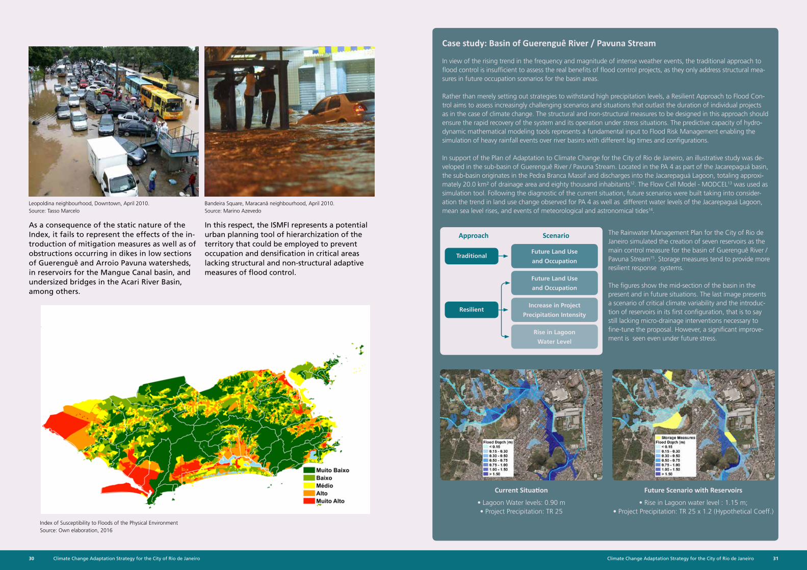
In view of the rising trend in the frequency and magnitude of intense weather events, the traditional approach to flood control is insufficient to assess the real benefits of flood control projects, as they only address structural mea-sures in future occupation scenarios for the basin areas.
Rather than merely setting out strategies to withstand high precipitation levels, a Resilient Approach to Flood Con-trol aims to assess increasingly challenging scenarios and situations that outlast the duration of individual projects as in the case of climate change. The structural and non-structural measures to be designed in this approach should ensure the rapid recovery of the system and its operation under stress situations. The predictive capacity of hydro-dynamic mathematical modeling tools represents a fundamental input to Flood Risk Management enabling the simulation of heavy rainfall events over river basins with different lag times and configurations.
In support of the Plan of Adaptation to Climate Change for the City of Rio de Janeiro, an illustrative study was de-veloped in the sub-basin of Guerenguê River / Pavuna Stream. Located in the PA 4 as part of the Jacarepaguá basin, the sub-basin originates in the Pedra Branca Massif and discharges into the Jacarepaguá Lagoon, totaling approxi-mately 20.0 km² of drainage area and eighty thousand inhabitants12. The Flow Cell Model - MODCEL13 was used as simulation tool. Following the diagnostic of the current situation, future scenarios were built taking into consider-ation the trend in land use change observed for PA 4 as well as different water levels of the Jacarepaguá Lagoon, mean sea level rises, and events of meteorological and astronomical tides14.
The Rainwater Management Plan for the City of Rio de Janeiro simulated the creation of seven reservoirs as the main control measure for the basin of Guerenguê River / Pavuna Stream15. Storage measures tend to provide more resilient response systems.
The figures show the mid-section of the basin in the present and in future situations. The last image presents a scenario of critical climate variability and the introduc-tion of reservoirs in its first configuration, that is to say still lacking micro-drainage interventions necessary to fine-tune the proposal. However, a significant improve-ment is seen even under future stress.
Current Situation Future Scenario with Reservoirs
• Lagoon Water levels: 0.90 m• Project Precipitation: TR 25
• Rise in Lagoon water level : 1.15 m;• Project Precipitation: TR 25 x 1.2 (Hypothetical Coeff.)
Case study: Basin of Guerenguê River / Pavuna Stream
Approach ScenarioAs a consequence of the static nature of the Index, it fails to represent the effects of the in-troduction of mitigation measures as well as of obstructions occurring in dikes in low sections of Guerenguê and Arroio Pavuna watersheds, in reservoirs for the Mangue Canal basin, and undersized bridges in the Acari River Basin, among others.
Leopoldina neighbourhood, Downtown, April 2010. Source: Tasso Marcelo
Bandeira Square, Maracanã neighbourhood, April 2010. Source: Marino Azevedo
In this respect, the ISMFI represents a potential urban planning tool of hierarchization of the territory that could be employed to prevent occupation and densification in critical areas lacking structural and non-structural adaptive measures of flood control.
Index of Susceptibility to Floods of the Physical EnvironmentSource: Own elaboration, 2016
Traditional
Resilient
Future Land Use
and Occupation
Future Land Use
and Occupation
Increase in Project
Precipitation Intensity
Rise in Lagoon
Water Level
Climate Change Adaptation Strategy for the City of Rio de Janeiro32 33Climate Change Adaptation Strategy for the City of Rio de Janeiro
Our exposure and vulnerability
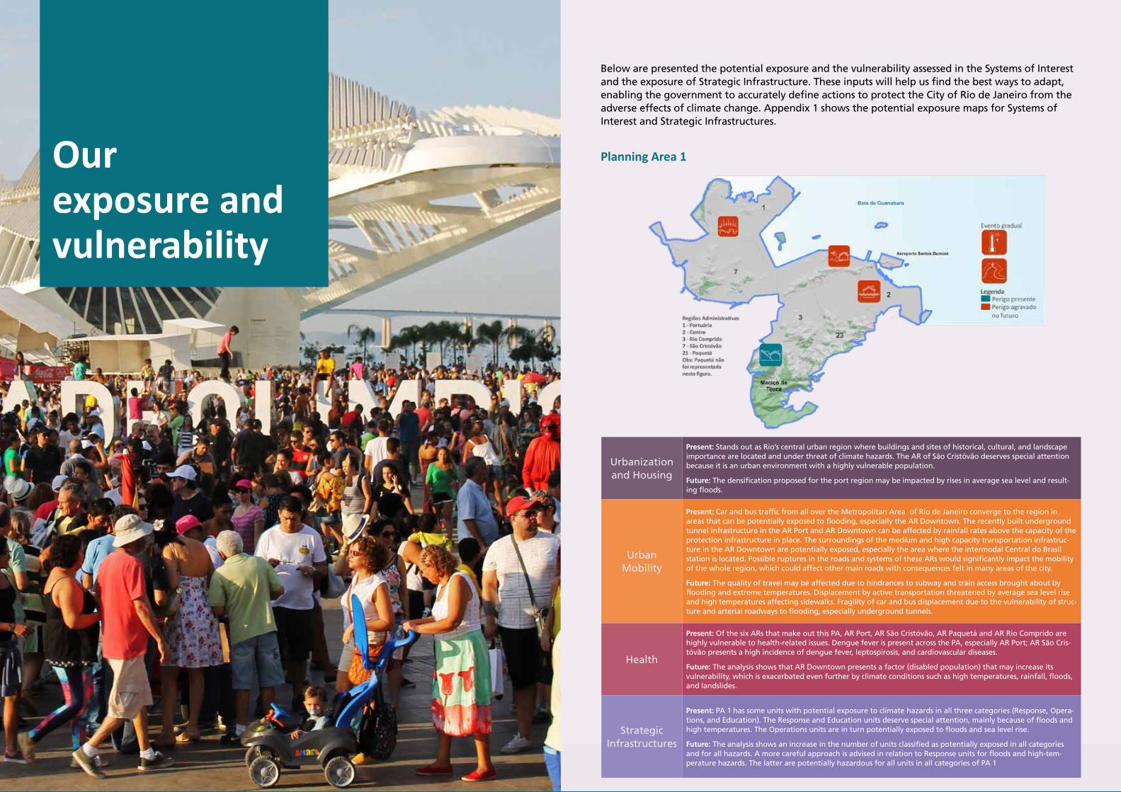
Below are presented the potential exposure and the vulnerability assessed in the Systems of Interest and the exposure of Strategic Infrastructure. These inputs will help us find the best ways to adapt, enabling the government to accurately define actions to protect the City of Rio de Janeiro from the adverse effects of climate change. Appendix 1 shows the potential exposure maps for Systems of Interest and Strategic Infrastructures.
Planning Area 1
Urbanization and Housing
Present: Stands out as Rio’s central urban region where buildings and sites of historical, cultural, and landscape importance are located and under threat of climate hazards. The AR of São Cristóvão deserves special attention because it is an urban environment with a highly vulnerable population.
Future: The densification proposed for the port region may be impacted by rises in average sea level and result-ing floods.
Urban Mobility
Present: Car and bus traffic from all over the Metropolitan Area of Rio de Janeiro converge to the region in areas that can be potentially exposed to flooding, especially the AR Downtown. The recently built underground tunnel infrastructure in the AR Port and AR Downtown can be affected by rainfall rates above the capacity of the protection infrastructure in place. The surroundings of the medium and high capacity transportation infrastruc-ture in the AR Downtown are potentially exposed, especially the area where the intermodal Central do Brasil station is located. Possible ruptures in the roads and systems of these ARs would significantly impact the mobility of the whole region, which could affect other main roads with consequences felt in many areas of the city.
Future: The quality of travel may be affected due to hindrances to subway and train access brought about by flooding and extreme temperatures. Displacement by active transportation threatened by average sea level rise and high temperatures affecting sidewalks. Fragility of car and bus displacement due to the vulnerability of struc-ture and arterial roadways to flooding, especially underground tunnels.
Health
Present: Of the six ARs that make out this PA, AR Port, AR São Cristóvão, AR Paquetá and AR Rio Comprido are highly vulnerable to health-related issues. Dengue fever is present across the PA, especially AR Port; AR São Cris-tóvão presents a high incidence of dengue fever, leptospirosis, and cardiovascular diseases.
Future: The analysis shows that AR Downtown presents a factor (disabled population) that may increase its vulnerability, which is exacerbated even further by climate conditions such as high temperatures, rainfall, floods, and landslides.
Strategic Infrastructures
Present: PA 1 has some units with potential exposure to climate hazards in all three categories (Response, Opera-tions, and Education). The Response and Education units deserve special attention, mainly because of floods and high temperatures. The Operations units are in turn potentially exposed to floods and sea level rise.
Future: The analysis shows an increase in the number of units classified as potentially exposed in all categories and for all hazards. A more careful approach is advised in relation to Response units for floods and high-tem-perature hazards. The latter are potentially hazardous for all units in all categories of PA 1
Climate Change Adaptation Strategy for the City of Rio de Janeiro34 35Climate Change Adaptation Strategy for the City of Rio de Janeiro
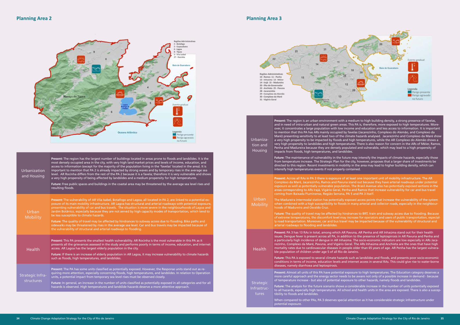
Planning Area 2
Urbanization and Housing
Present: The region has the largest number of buildings located in areas prone to floods and landslides. It is the most densely occupied area in the city, with very high land market prices and levels of income, education, and access to information (except for the majority of the population living in the ‘favelas’ located in the area). It is important to mention that PA 2 is already impacted by strong waves and by temporary rises in the average sea level. AR Rocinha differs from the rest of the PA 2 because it is a favela; therefore it is very vulnerable and shows a very high propensity of being affected by landslides and a medium propensity for high temperatures.
Future: Free public spaces and buildings in the coastal area may be threatened by the average sea level rises and resulting floods.
Urban Mobility
Present: The vulnerability of AR Vila Isabel, Botafogo and Lagoa, all located in PA 2, are linked to a potential ex-posure of its main mobility infrastructure. AR Lagoa has structural and arterial roadways with potential exposure, presenting vulnerability of car and bus travels. The situation is more severe in the neighbourhoods of Lagoa and Jardim Botânico, especially because they are not served by high capacity modes of transportation, which tend to be less susceptible to climate hazards.
Future: The quality of travel may be affected by hindrances to subway access due to flooding. Bike paths and sidewalks may be threatened by rises in the average sea level. Car and bus travels may be impacted because of the vulnerability of structural and arterial roadways to flooding.
Health
Present: This PA presents the smallest health vulnerability. AR Rocinha is the most vulnerable in this PA as it presents all the grievances assessed in the study and performs poorly in terms of income, education, and internet access. AR Lagoa has the largest elderly population in the city.
Future: If there is an increase of elderly population in AR Lagoa, it may increase vulnerability to climate hazards such as floods, high temperatures, and landslides.
Strategic Infra-structures
Present: The PA has some units classified as potentially exposed. However, the Response units stand out as re-quiring more attention, especially concerning floods, high temperatures, and landslides. In relation to Operation units, a potential impact from temporary sea level rises must be observed closely.
Future: In general, an increase in the number of units classified as potentially exposed in all categories and for all hazards is observed. High temperatures and landslide hazards deserve a more attentive approach.
Planning Area 3
Urbaniza-tion and Housing
Present: The region is an urban environment with a medium to high building density, a strong presence of favelas, and in need of intra-urban and natural green areas. This PA is, therefore, more exposed to high temperatures. More-over, it concentrates a large population with low income and education and less access to information. It is important to mention that this PA has ARs mainly occupied by favelas (Jacarezinho, Complexo do Alemão, and Complexo da Maré) presenting sensitivity to at least two of the climate hazards analysed. Jacarezinho and Complexo da Maré show a very high propensity to be impacted by floods and high temperatures, while the AR Complexo do Alemão shows a very high propensity to landslides and high temperatures. There is also reason for concern in the ARs of Méier, Ramos, Penha and Madureira because they are densely populated and vulnerable, which may lead to a high propensity of impacts from floods, high temperatures, and landslides.
Future: The maintenance of vulnerability in the future may intensify the impacts of climate hazards, especially those from temperature increase. The Strategic Plan for the city, however, proposes that a larger share of investments be directed to this region. Recent investments in mobility in the area may lead to higher building density, which can intensify high temperatures events if not properly contained.
Urban Mobility
Present: Across all RAs in PA 3 there is exposure of at least one important unit of mobility infrastructure. The AR Complexo da Maré, Jacarezinho, Ramos and Pavuna stand out because they have arterial roadways under potential exposure as well as potentially vulnerable population. The Brasil Avenue also has potentially exposed sections in the areas corresponding to ARs Irajá, Vigário Geral, Penha and Ramos that increase vulnerability for car and bus travel coming from Baixada Fluminense, Região Serrana, PA 5 and PA 3 itself.
The Madureira intermodal station has potentially exposed access points that increase the vulnerability of the system when combined with a high susceptibility to floods in many arterial and collector roads, especially in the neighbour-hoods of Madureira and Osvaldo Cruz.
Future: The quality of travel may be affected by hindrances to BRT, train and subway access due to flooding. Because of extreme temperatures, the discomfort level may increase for operators and users of public transportation, especial-ly road transportation. Moreover, car and bus travel may be impacted because of the vulnerability of structural and arterial roadways to flooding and landslides.
Health
Present: PA 3 has 13 RAs in total, among which AR Pavuna, AR Penha and AR Inhaúma stand out for their health issues. Dengue fever is present across all PA, in addition to the presence of leptospirosis in AR Pavuna and Penha and a particularly high incidence of dengue in AR Inhaúma. The socio-economic indicators are low especially in ARs Jaca-rezinho, Complexo da Maré, Pavuna, and Vigário Geral. The ARs Inhaúma and Anchieta are the ones that have high mortality rates due to cardiovascular diseases in people older than 65 years of age. AR Penha has the largest vulnera-ble population of children under age 5 of all Rio de Janeiro.
Future: This PA is exposed to several climate hazards such as landslides and floods, and presents poor socio-economic conditions in terms of income, education levels and internet access in several RAs. This could give rise to water-borne diseases, namely diarrhoea and leptospirosis.
Strategic Infrastruc-
tures
Present: Almost all units of this PA have potential exposure to high temperatures. The Education category deserves a more careful approach and the energy sector needs to be aware not only of a possible increase in demand - because of temperature increase - but also of potential exposure to other hazards, namely floods and landslides.
Future: The analysis for the future scenario shows a considerable increase in the number of units potentially exposed to all hazards, especially high temperatures. All school and health units in the area are exposed. There is also a suscep-tibility to floods and landslides.
When compared to other PAs, PA 3 deserves special attention as it has considerable strategic infrastructure under potential exposure.
Climate Change Adaptation Strategy for the City of Rio de Janeiro36 37Climate Change Adaptation Strategy for the City of Rio de Janeiro
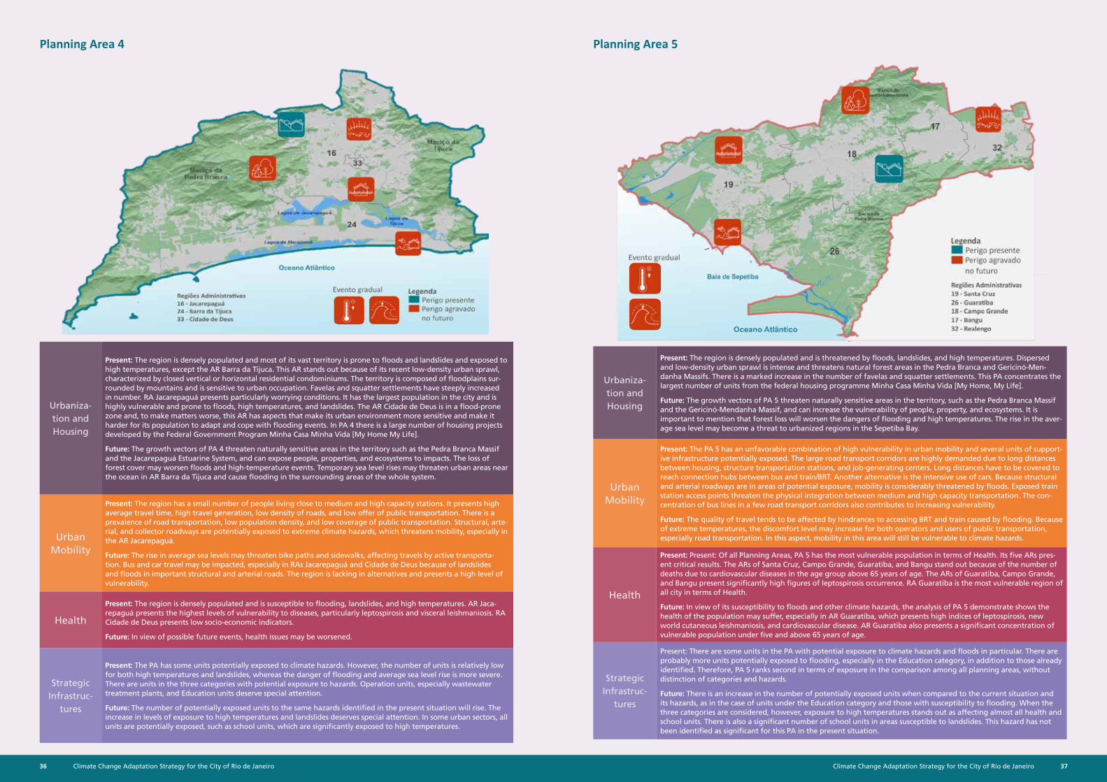
Planning Area 4
Urbaniza-tion and Housing
Present: The region is densely populated and most of its vast territory is prone to floods and landslides and exposed to high temperatures, except the AR Barra da Tijuca. This AR stands out because of its recent low-density urban sprawl, characterized by closed vertical or horizontal residential condominiums. The territory is composed of floodplains sur-rounded by mountains and is sensitive to urban occupation. Favelas and squatter settlements have steeply increased in number. RA Jacarepaguá presents particularly worrying conditions. It has the largest population in the city and is highly vulnerable and prone to floods, high temperatures, and landslides. The AR Cidade de Deus is in a flood-prone zone and, to make matters worse, this AR has aspects that make its urban environment more sensitive and make it harder for its population to adapt and cope with flooding events. In PA 4 there is a large number of housing projects developed by the Federal Government Program Minha Casa Minha Vida [My Home My Life].
Future: The growth vectors of PA 4 threaten naturally sensitive areas in the territory such as the Pedra Branca Massif and the Jacarepaguá Estuarine System, and can expose people, properties, and ecosystems to impacts. The loss of forest cover may worsen floods and high-temperature events. Temporary sea level rises may threaten urban areas near the ocean in AR Barra da Tijuca and cause flooding in the surrounding areas of the whole system.
Urban Mobility
Present: The region has a small number of people living close to medium and high capacity stations. It presents high average travel time, high travel generation, low density of roads, and low offer of public transportation. There is a prevalence of road transportation, low population density, and low coverage of public transportation. Structural, arte-rial, and collector roadways are potentially exposed to extreme climate hazards, which threatens mobility, especially in the AR Jacarepaguá.
Future: The rise in average sea levels may threaten bike paths and sidewalks, affecting travels by active transporta-tion. Bus and car travel may be impacted, especially in RAs Jacarepaguá and Cidade de Deus because of landslides and floods in important structural and arterial roads. The region is lacking in alternatives and presents a high level of vulnerability.
Health
Present: The region is densely populated and is susceptible to flooding, landslides, and high temperatures. AR Jaca-repaguá presents the highest levels of vulnerability to diseases, particularly leptospirosis and visceral leishmaniosis. RA Cidade de Deus presents low socio-economic indicators.
Future: In view of possible future events, health issues may be worsened.
Strategic Infrastruc-
tures
Present: The PA has some units potentially exposed to climate hazards. However, the number of units is relatively low for both high temperatures and landslides, whereas the danger of flooding and average sea level rise is more severe. There are units in the three categories with potential exposure to hazards. Operation units, especially wastewater treatment plants, and Education units deserve special attention.
Future: The number of potentially exposed units to the same hazards identified in the present situation will rise. The increase in levels of exposure to high temperatures and landslides deserves special attention. In some urban sectors, all units are potentially exposed, such as school units, which are significantly exposed to high temperatures.
Planning Area 5
Urbaniza-tion and Housing
Present: The region is densely populated and is threatened by floods, landslides, and high temperatures. Dispersed and low-density urban sprawl is intense and threatens natural forest areas in the Pedra Branca and Gericinó-Men-danha Massifs. There is a marked increase in the number of favelas and squatter settlements. This PA concentrates the largest number of units from the federal housing programme Minha Casa Minha Vida [My Home, My Life].
Future: The growth vectors of PA 5 threaten naturally sensitive areas in the territory, such as the Pedra Branca Massif and the Gericinó-Mendanha Massif, and can increase the vulnerability of people, property, and ecosystems. It is important to mention that forest loss will worsen the dangers of flooding and high temperatures. The rise in the aver-age sea level may become a threat to urbanized regions in the Sepetiba Bay.
Urban Mobility
Present: The PA 5 has an unfavorable combination of high vulnerability in urban mobility and several units of support-ive infrastructure potentially exposed. The large road transport corridors are highly demanded due to long distances between housing, structure transportation stations, and job-generating centers. Long distances have to be covered to reach connection hubs between bus and train/BRT. Another alternative is the intensive use of cars. Because structural and arterial roadways are in areas of potential exposure, mobility is considerably threatened by floods. Exposed train station access points threaten the physical integration between medium and high capacity transportation. The con-centration of bus lines in a few road transport corridors also contributes to increasing vulnerability.
Future: The quality of travel tends to be affected by hindrances to accessing BRT and train caused by flooding. Because of extreme temperatures, the discomfort level may increase for both operators and users of public transportation, especially road transportation. In this aspect, mobility in this area will still be vulnerable to climate hazards.
Health
Present: Present: Of all Planning Areas, PA 5 has the most vulnerable population in terms of Health. Its five ARs pres-ent critical results. The ARs of Santa Cruz, Campo Grande, Guaratiba, and Bangu stand out because of the number of deaths due to cardiovascular diseases in the age group above 65 years of age. The ARs of Guaratiba, Campo Grande, and Bangu present significantly high figures of leptospirosis occurrence. RA Guaratiba is the most vulnerable region of all city in terms of Health.
Future: In view of its susceptibility to floods and other climate hazards, the analysis of PA 5 demonstrate shows the health of the population may suffer, especially in AR Guaratiba, which presents high indices of leptospirosis, new world cutaneous leishmaniosis, and cardiovascular disease. AR Guaratiba also presents a significant concentration of vulnerable population under five and above 65 years of age.
Strategic Infrastruc-
tures
Present: There are some units in the PA with potential exposure to climate hazards and floods in particular. There are probably more units potentially exposed to flooding, especially in the Education category, in addition to those already identified. Therefore, PA 5 ranks second in terms of exposure in the comparison among all planning areas, without distinction of categories and hazards.
Future: There is an increase in the number of potentially exposed units when compared to the current situation and its hazards, as in the case of units under the Education category and those with susceptibility to flooding. When the three categories are considered, however, exposure to high temperatures stands out as affecting almost all health and school units. There is also a significant number of school units in areas susceptible to landslides. This hazard has not been identified as significant for this PA in the present situation.
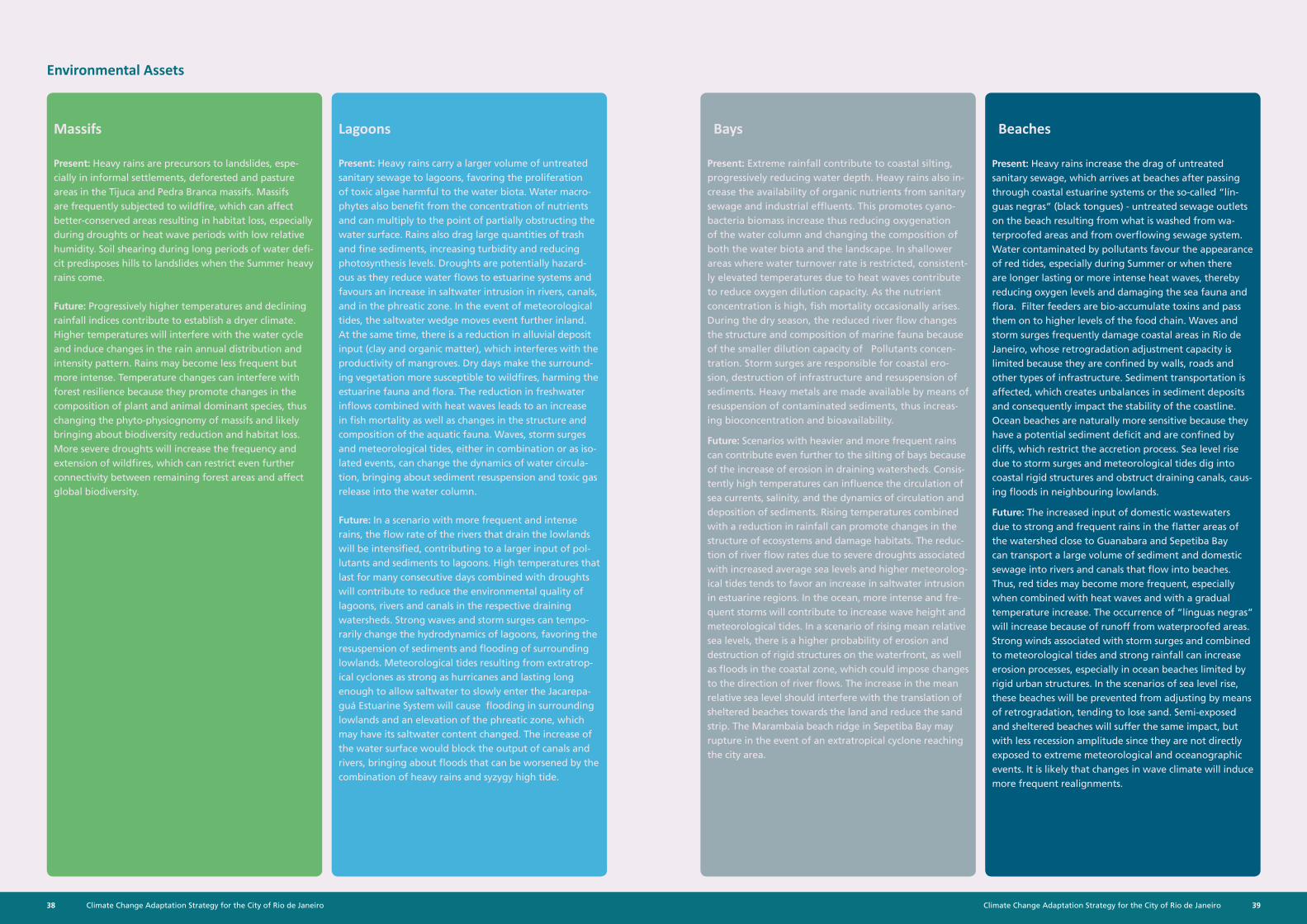
Climate Change Adaptation Strategy for the City of Rio de Janeiro38 39Climate Change Adaptation Strategy for the City of Rio de Janeiro
Environmental Assets
Massifs Lagoons
Present: Heavy rains are precursors to landslides, espe-cially in informal settlements, deforested and pasture areas in the Tijuca and Pedra Branca massifs. Massifs are frequently subjected to wildfire, which can affect better-conserved areas resulting in habitat loss, especially during droughts or heat wave periods with low relative humidity. Soil shearing during long periods of water defi-cit predisposes hills to landslides when the Summer heavy rains come.
Future: Progressively higher temperatures and declining rainfall indices contribute to establish a dryer climate. Higher temperatures will interfere with the water cycle and induce changes in the rain annual distribution and intensity pattern. Rains may become less frequent but more intense. Temperature changes can interfere with forest resilience because they promote changes in the composition of plant and animal dominant species, thus changing the phyto-physiognomy of massifs and likely bringing about biodiversity reduction and habitat loss. More severe droughts will increase the frequency and extension of wildfires, which can restrict even further connectivity between remaining forest areas and affect global biodiversity.
Present: Heavy rains carry a larger volume of untreated sanitary sewage to lagoons, favoring the proliferation of toxic algae harmful to the water biota. Water macro-phytes also benefit from the concentration of nutrients and can multiply to the point of partially obstructing the water surface. Rains also drag large quantities of trash and fine sediments, increasing turbidity and reducing photosynthesis levels. Droughts are potentially hazard-ous as they reduce water flows to estuarine systems and favours an increase in saltwater intrusion in rivers, canals, and in the phreatic zone. In the event of meteorological tides, the saltwater wedge moves event further inland. At the same time, there is a reduction in alluvial deposit input (clay and organic matter), which interferes with the productivity of mangroves. Dry days make the surround-ing vegetation more susceptible to wildfires, harming the estuarine fauna and flora. The reduction in freshwater inflows combined with heat waves leads to an increase in fish mortality as well as changes in the structure and composition of the aquatic fauna. Waves, storm surges and meteorological tides, either in combination or as iso-lated events, can change the dynamics of water circula-tion, bringing about sediment resuspension and toxic gas release into the water column.
Future: In a scenario with more frequent and intense rains, the flow rate of the rivers that drain the lowlands will be intensified, contributing to a larger input of pol-lutants and sediments to lagoons. High temperatures that last for many consecutive days combined with droughts will contribute to reduce the environmental quality of lagoons, rivers and canals in the respective draining watersheds. Strong waves and storm surges can tempo-rarily change the hydrodynamics of lagoons, favoring the resuspension of sediments and flooding of surrounding lowlands. Meteorological tides resulting from extratrop-ical cyclones as strong as hurricanes and lasting long enough to allow saltwater to slowly enter the Jacarepa-guá Estuarine System will cause flooding in surrounding lowlands and an elevation of the phreatic zone, which may have its saltwater content changed. The increase of the water surface would block the output of canals and rivers, bringing about floods that can be worsened by the combination of heavy rains and syzygy high tide.
Bays Beaches
Present: Extreme rainfall contribute to coastal silting, progressively reducing water depth. Heavy rains also in-crease the availability of organic nutrients from sanitary sewage and industrial effluents. This promotes cyano-bacteria biomass increase thus reducing oxygenation of the water column and changing the composition of both the water biota and the landscape. In shallower areas where water turnover rate is restricted, consistent-ly elevated temperatures due to heat waves contribute to reduce oxygen dilution capacity. As the nutrient concentration is high, fish mortality occasionally arises. During the dry season, the reduced river flow changes the structure and composition of marine fauna because of the smaller dilution capacity of Pollutants concen-tration. Storm surges are responsible for coastal ero-sion, destruction of infrastructure and resuspension of sediments. Heavy metals are made available by means of resuspension of contaminated sediments, thus increas-ing bioconcentration and bioavailability.
Future: Scenarios with heavier and more frequent rains can contribute even further to the silting of bays because of the increase of erosion in draining watersheds. Consis-tently high temperatures can influence the circulation of sea currents, salinity, and the dynamics of circulation and deposition of sediments. Rising temperatures combined with a reduction in rainfall can promote changes in the structure of ecosystems and damage habitats. The reduc-tion of river flow rates due to severe droughts associated with increased average sea levels and higher meteorolog-ical tides tends to favor an increase in saltwater intrusion in estuarine regions. In the ocean, more intense and fre-quent storms will contribute to increase wave height and meteorological tides. In a scenario of rising mean relative sea levels, there is a higher probability of erosion and destruction of rigid structures on the waterfront, as well as floods in the coastal zone, which could impose changes to the direction of river flows. The increase in the mean relative sea level should interfere with the translation of sheltered beaches towards the land and reduce the sand strip. The Marambaia beach ridge in Sepetiba Bay may rupture in the event of an extratropical cyclone reaching the city area.
Present: Heavy rains increase the drag of untreated sanitary sewage, which arrives at beaches after passing through coastal estuarine systems or the so-called “lín-guas negras” (black tongues) - untreated sewage outlets on the beach resulting from what is washed from wa-terproofed areas and from overflowing sewage system. Water contaminated by pollutants favour the appearance of red tides, especially during Summer or when there are longer lasting or more intense heat waves, thereby reducing oxygen levels and damaging the sea fauna and flora. Filter feeders are bio-accumulate toxins and pass them on to higher levels of the food chain. Waves and storm surges frequently damage coastal areas in Rio de Janeiro, whose retrogradation adjustment capacity is limited because they are confined by walls, roads and other types of infrastructure. Sediment transportation is affected, which creates unbalances in sediment deposits and consequently impact the stability of the coastline. Ocean beaches are naturally more sensitive because they have a potential sediment deficit and are confined by cliffs, which restrict the accretion process. Sea level rise due to storm surges and meteorological tides dig into coastal rigid structures and obstruct draining canals, caus-ing floods in neighbouring lowlands.
Future: The increased input of domestic wastewaters due to strong and frequent rains in the flatter areas of the watershed close to Guanabara and Sepetiba Bay can transport a large volume of sediment and domestic sewage into rivers and canals that flow into beaches. Thus, red tides may become more frequent, especially when combined with heat waves and with a gradual temperature increase. The occurrence of “línguas negras” will increase because of runoff from waterproofed areas. Strong winds associated with storm surges and combined to meteorological tides and strong rainfall can increase erosion processes, especially in ocean beaches limited by rigid urban structures. In the scenarios of sea level rise, these beaches will be prevented from adjusting by means of retrogradation, tending to lose sand. Semi-exposed and sheltered beaches will suffer the same impact, but with less recession amplitude since they are not directly exposed to extreme meteorological and oceanographic events. It is likely that changes in wave climate will induce more frequent realignments.
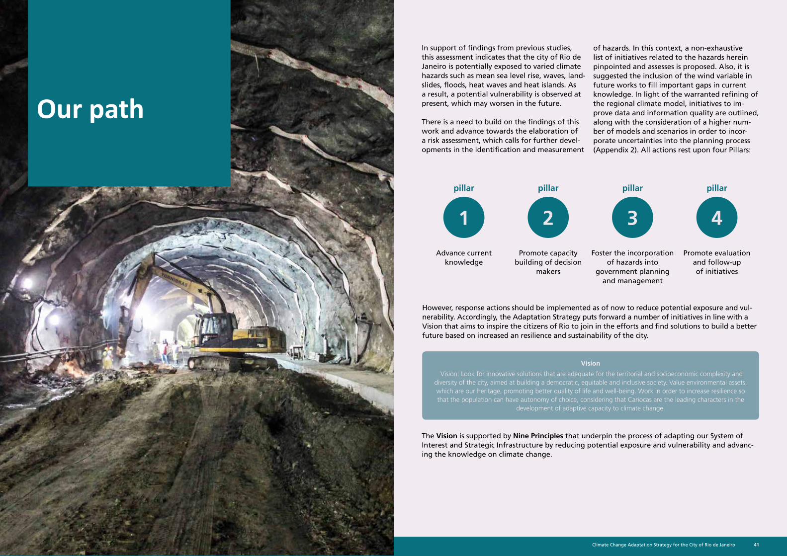
Climate Change Adaptation Strategy for the City of Rio de Janeiro40 41Climate Change Adaptation Strategy for the City of Rio de Janeiro
Our path
In support of findings from previous studies, this assessment indicates that the city of Rio de Janeiro is potentially exposed to varied climate hazards such as mean sea level rise, waves, land-slides, floods, heat waves and heat islands. As a result, a potential vulnerability is observed at present, which may worsen in the future.
There is a need to build on the findings of this work and advance towards the elaboration of a risk assessment, which calls for further devel-opments in the identification and measurement
of hazards. In this context, a non-exhaustive list of initiatives related to the hazards herein pinpointed and assesses is proposed. Also, it is suggested the inclusion of the wind variable in future works to fill important gaps in current knowledge. In light of the warranted refining of the regional climate model, initiatives to im-prove data and information quality are outlined, along with the consideration of a higher num-ber of models and scenarios in order to incor-porate uncertainties into the planning process (Appendix 2). All actions rest upon four Pillars:
Foster the incorporation of hazards into
government planning and management
Promote evaluation and follow-up of initiatives
Promote capacity building of decision
makers
Advance current knowledge
However, response actions should be implemented as of now to reduce potential exposure and vul-nerability. Accordingly, the Adaptation Strategy puts forward a number of initiatives in line with a Vision that aims to inspire the citizens of Rio to join in the efforts and find solutions to build a better future based on increased an resilience and sustainability of the city.
The Vision is supported by Nine Principles that underpin the process of adapting our System of Interest and Strategic Infrastructure by reducing potential exposure and vulnerability and advanc-ing the knowledge on climate change.
Vision
Vision: Look for innovative solutions that are adequate for the territorial and socioeconomic complexity and diversity of the city, aimed at building a democratic, equitable and inclusive society. Value environmental assets, which are our heritage, promoting better quality of life and well-being. Work in order to increase resilience so that the population can have autonomy of choice, considering that Cariocas are the leading characters in the
development of adaptive capacity to climate change.
1
pillar
2
pillar
3
pillar
4
pillar
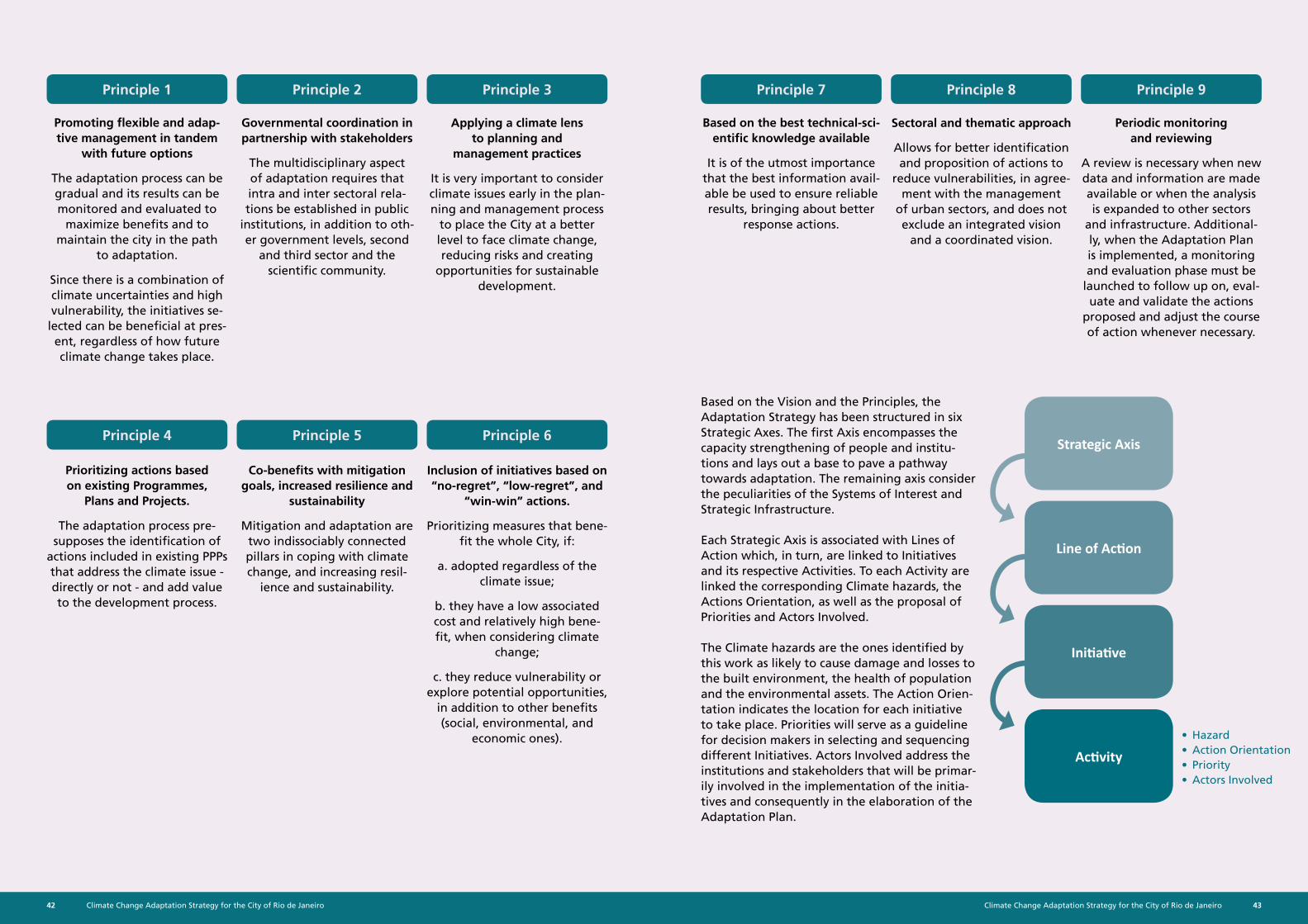
Climate Change Adaptation Strategy for the City of Rio de Janeiro42 43Climate Change Adaptation Strategy for the City of Rio de Janeiro
Promoting flexible and adap-tive management in tandem
with future options
The adaptation process can be gradual and its results can be monitored and evaluated to
maximize benefits and to maintain the city in the path
to adaptation.
Since there is a combination of climate uncertainties and high vulnerability, the initiatives se-
lected can be beneficial at pres-ent, regardless of how future climate change takes place.
Prioritizing actions based on existing Programmes,
Plans and Projects.
The adaptation process pre-supposes the identification of
actions included in existing PPPs that address the climate issue - directly or not - and add value to the development process.
Based on the best technical-sci-entific knowledge available
It is of the utmost importance that the best information avail-able be used to ensure reliable results, bringing about better
response actions.
Governmental coordination in partnership with stakeholders
The multidisciplinary aspect of adaptation requires that intra and inter sectoral rela-tions be established in public
institutions, in addition to oth-er government levels, second
and third sector and the scientific community.
Co-benefits with mitigation goals, increased resilience and
sustainability
Mitigation and adaptation are two indissociably connected pillars in coping with climate change, and increasing resil-
ience and sustainability.
Periodic monitoring and reviewing
A review is necessary when new data and information are made available or when the analysis is expanded to other sectors
and infrastructure. Additional-ly, when the Adaptation Plan is implemented, a monitoring and evaluation phase must be
launched to follow up on, eval-uate and validate the actions
proposed and adjust the course of action whenever necessary.
Applying a climate lens to planning and
management practices
It is very important to consider climate issues early in the plan-ning and management process
to place the City at a better level to face climate change, reducing risks and creating
opportunities for sustainable development.
Inclusion of initiatives based on “no-regret”, “low-regret”, and
“win-win” actions.
Prioritizing measures that bene-fit the whole City, if:
a. adopted regardless of the climate issue;
b. they have a low associated cost and relatively high bene-fit, when considering climate
change;
c. they reduce vulnerability or explore potential opportunities,
in addition to other benefits (social, environmental, and
economic ones).
Sectoral and thematic approach
Allows for better identification and proposition of actions to
reduce vulnerabilities, in agree-ment with the management
of urban sectors, and does not exclude an integrated vision
and a coordinated vision.
Based on the Vision and the Principles, the Adaptation Strategy has been structured in six Strategic Axes. The first Axis encompasses the capacity strengthening of people and institu-tions and lays out a base to pave a pathway towards adaptation. The remaining axis consider the peculiarities of the Systems of Interest and Strategic Infrastructure.
Each Strategic Axis is associated with Lines of Action which, in turn, are linked to Initiatives and its respective Activities. To each Activity are linked the corresponding Climate hazards, the Actions Orientation, as well as the proposal of Priorities and Actors Involved.
The Climate hazards are the ones identified by this work as likely to cause damage and losses to the built environment, the health of population and the environmental assets. The Action Orien-tation indicates the location for each initiative to take place. Priorities will serve as a guideline for decision makers in selecting and sequencing different Initiatives. Actors Involved address the institutions and stakeholders that will be primar-ily involved in the implementation of the initia-tives and consequently in the elaboration of the Adaptation Plan.
• Hazard• Action Orientation• Priority• Actors Involved
Strategic Axis
Line of Action
Initiative
Activity
Principle 1 Principle 7
Principle 4
Principle 2 Principle 8
Principle 5
Principle 3 Principle 9
Principle 6
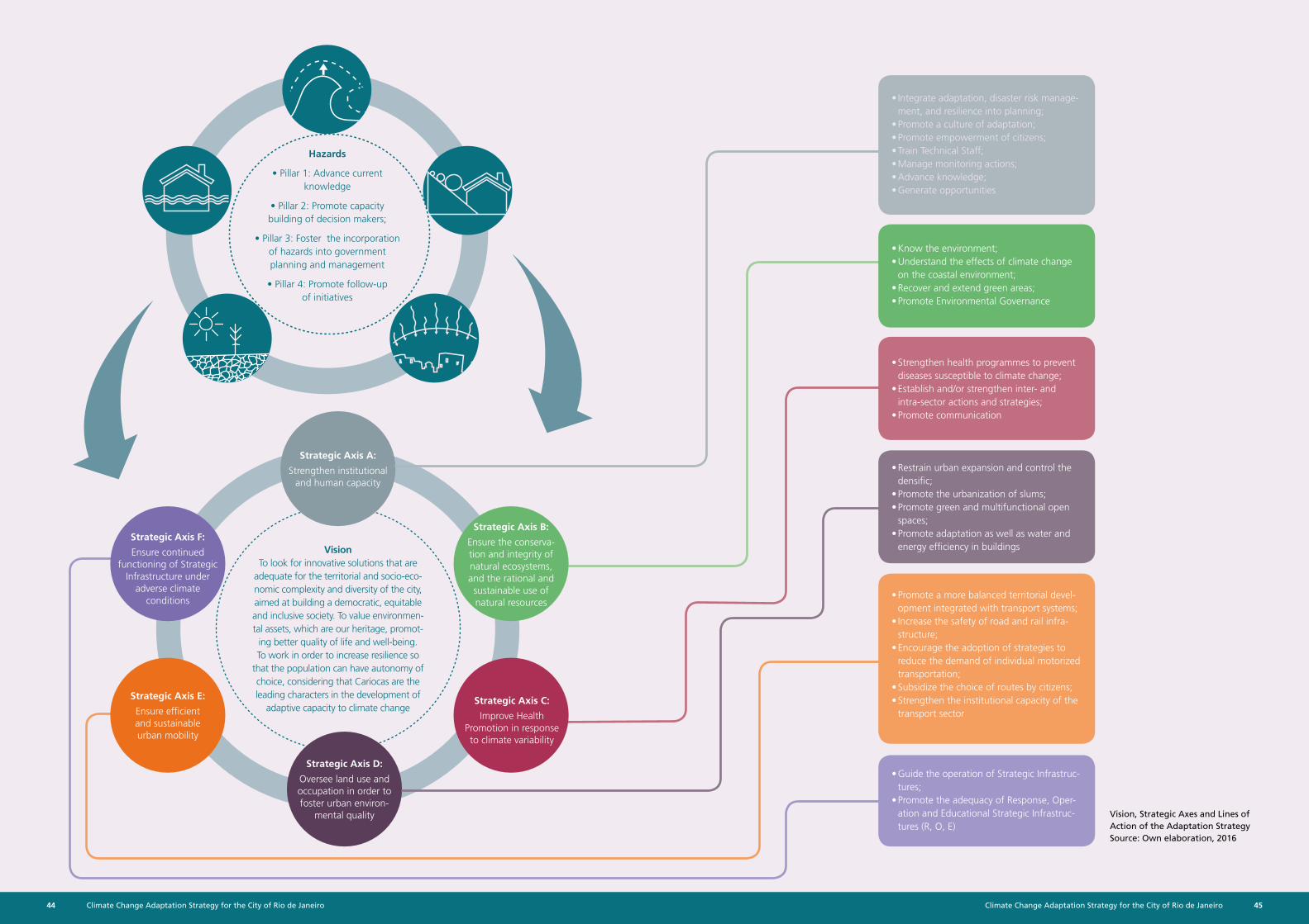
Climate Change Adaptation Strategy for the City of Rio de Janeiro44 45Climate Change Adaptation Strategy for the City of Rio de Janeiro
Vision, Strategic Axes and Lines of Action of the Adaptation StrategySource: Own elaboration, 2016
Hazards
• Pillar 1: Advance current knowledge
• Pillar 2: Promote capacity building of decision makers;
• Pillar 3: Foster the incorporation of hazards into government planning and management
• Pillar 4: Promote follow-up of initiatives
VisionTo look for innovative solutions that are
adequate for the territorial and socio-eco-nomic complexity and diversity of the city, aimed at building a democratic, equitable and inclusive society. To value environmen-tal assets, which are our heritage, promot-
ing better quality of life and well-being. To work in order to increase resilience so
that the population can have autonomy of choice, considering that Cariocas are the leading characters in the development of
adaptive capacity to climate change
Strategic Axis A:
Strengthen institutional and human capacity
Strategic Axis D:
Oversee land use and occupation in order to foster urban environ-
mental quality
Strategic Axis B:
Ensure the conserva-tion and integrity of natural ecosystems, and the rational and sustainable use of natural resources
Strategic Axis F:
Ensure continued functioning of Strategic
Infrastructure under adverse climate
conditions
Strategic Axis C:
Improve Health Promotion in response to climate variability
Strategic Axis E:
Ensure efficient and sustainable urban mobility
• Integrate adaptation, disaster risk manage-ment, and resilience into planning;
• Promote a culture of adaptation;• Promote empowerment of citizens;• Train Technical Staff;• Manage monitoring actions;• Advance knowledge;• Generate opportunities
• Know the environment;• Understand the effects of climate change
on the coastal environment;• Recover and extend green areas;• Promote Environmental Governance
• Strengthen health programmes to prevent diseases susceptible to climate change;
• Establish and/or strengthen inter- and intra-sector actions and strategies;
• Promote communication
• Restrain urban expansion and control the densific;
• Promote the urbanization of slums;• Promote green and multifunctional open
spaces;• Promote adaptation as well as water and
energy efficiency in buildings
• Promote a more balanced territorial devel-opment integrated with transport systems;
• Increase the safety of road and rail infra-structure;
• Encourage the adoption of strategies to reduce the demand of individual motorized transportation;
• Subsidize the choice of routes by citizens;• Strengthen the institutional capacity of the
transport sector
• Guide the operation of Strategic Infrastruc-tures;
• Promote the adequacy of Response, Oper-ation and Educational Strategic Infrastruc-tures (R, O, E)
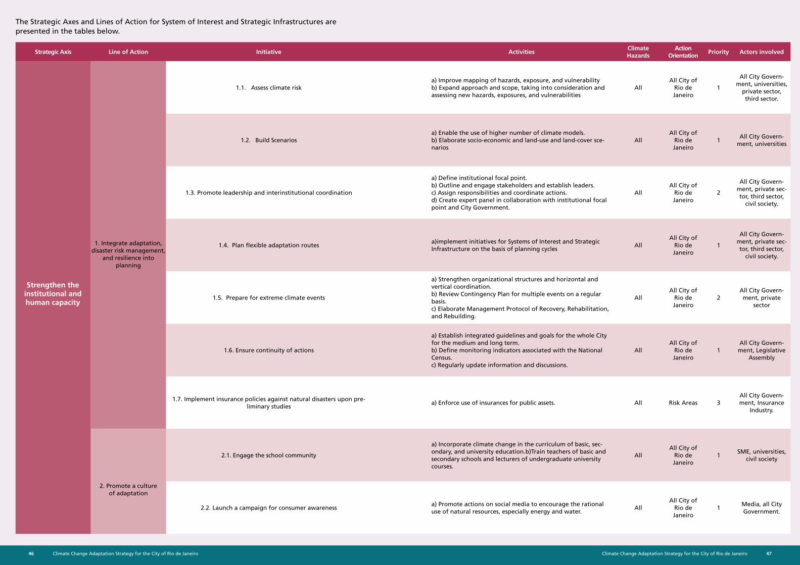
Climate Change Adaptation Strategy for the City of Rio de Janeiro46 47Climate Change Adaptation Strategy for the City of Rio de Janeiro
Strategic Axis Line of Action Initiative ActivitiesClimate Hazards
Action Orientation
Priority Actors involved
1.1. Assess climate riska) Improve mapping of hazards, exposure, and vulnerability b) Expand approach and scope, taking into consideration and assessing new hazards, exposures, and vulnerabilities
AllAll City of
Rio de Janeiro
1
All City Govern-ment, universities,
private sector, third sector.
1.2. Build Scenariosa) Enable the use of higher number of climate models. b) Elaborate socio-economic and land-use and land-cover sce-narios
AllAll City of
Rio de Janeiro
1All City Govern-
ment, universities
1.3. Promote leadership and interinstitutional coordination
a) Define institutional focal point. b) Outline and engage stakeholders and establish leaders. c) Assign responsibilities and coordinate actions. d) Create expert panel in collaboration with institutional focal point and City Government.
AllAll City of
Rio de Janeiro
2
All City Govern-ment, private sec-tor, third sector,
civil society.
1.4. Plan flexible adaptation routesa)implement initiatives for Systems of Interest and Strategic Infrastructure on the basis of planning cycles
AllAll City of
Rio de Janeiro
1
All City Govern-ment, private sec-tor, third sector,
civil society.
1.5. Prepare for extreme climate events
a) Strengthen organizational structures and horizontal and vertical coordination. b) Review Contingency Plan for multiple events on a regular basis. c) Elaborate Management Protocol of Recovery, Rehabilitation, and Rebuilding.
AllAll City of
Rio de Janeiro
2All City Govern-ment, private
sector
1.6. Ensure continuity of actions
a) Establish integrated guidelines and goals for the whole City for the medium and long term. b) Define monitoring indicators associated with the National Census. c) Regularly update information and discussions.
AllAll City of
Rio de Janeiro
1All City Govern-
ment, Legislative Assembly
1.7. Implement insurance policies against natural disasters upon pre-liminary studies
a) Enforce use of insurances for public assets. All Risk Areas 3All City Govern-ment, Insurance
Industry.
2.1. Engage the school community
a) Incorporate climate change in the curriculum of basic, sec-ondary, and university education.b)Train teachers of basic and secondary schools and lecturers of undergraduate university courses.
AllAll City of
Rio de Janeiro
1SME, universities,
civil society
2.2. Launch a campaign for consumer awareness a) Promote actions on social media to encourage the rational use of natural resources, especially energy and water.
AllAll City of
Rio de Janeiro
1Media, all City Government.
1. Integrate adaptation, disaster risk management,
and resilience into planning
2. Promote a culture of adaptation
Strengthen the institutional and human capacity
The Strategic Axes and Lines of Action for System of Interest and Strategic Infrastructures are presented in the tables below.
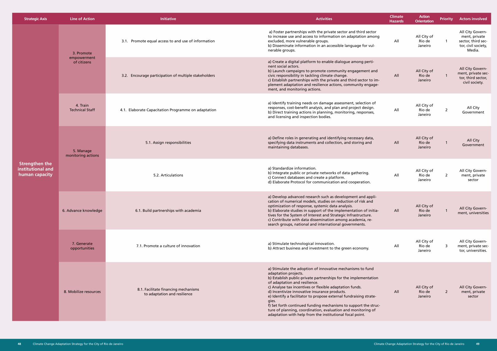
Climate Change Adaptation Strategy for the City of Rio de Janeiro48 49Climate Change Adaptation Strategy for the City of Rio de Janeiro
Strategic Axis Line of Action Initiative ActivitiesClimate Hazards
Action Orientation
Priority Actors involved
3.1. Promote equal access to and use of information
a) Foster partnerships with the private sector and third sector to increase use and access to information on adaptation among excluded, more vulnerable groups. b) Disseminate information in an accessible language for vul-nerable groups.
AllAll City of
Rio de Janeiro
1
All City Govern-ment, private
sector, third sec-tor, civil society,
Media.
3.2. Encourage participation of multiple stakeholders
a) Create a digital platform to enable dialogue among perti-nent social actors. b) Launch campaigns to promote community engagement and civic responsibility in tackling climate change. c) Establish partnerships with the private and third sector to im-plement adaptation and resilience actions, community engage-ment, and monitoring actions.
AllAll City of
Rio de Janeiro
1
All City Govern-ment, private sec-tor, third sector,
civil society.
4.1. Elaborate Capacitation Programme on adaptation
a) Identify training needs on damage assessment, selection of responses, cost-benefit analysis, and plan and project design. b) Direct training actions in planning, monitoring, responses, and licensing and inspection bodies.
AllAll City of
Rio de Janeiro
2All City
Government
5. Manage monitoring actions
5.1. Assign responsibilitiesa) Define roles in generating and identifying necessary data, specifying data instruments and collection, and storing and maintaining databases.
AllAll City of
Rio de Janeiro
1All City
Government
5.2. Articulations
a) Standardize information. b) Integrate public or private networks of data gathering. c) Connect databases and create a platform. d) Elaborate Protocol for communication and cooperation.
AllAll City of
Rio de Janeiro
2All City Govern-ment, private
sector
6. Advance knowledge 6.1. Build partnerships with academia
a) Develop advanced research such as development and appli-cation of numerical models, studies on reduction of risk and optimization of response, systemic data analysis. b) Elaborate studies in support of the implementation of initia-tives for the System of Interest and Strategic Infrastructure. c) Contribute with data dissemination among academia, re-search groups, national and international governments.
AllAll City of
Rio de Janeiro
1All City Govern-
ment, universities
7. Generate opportunities
7.1. Promote a culture of innovationa) Stimulate technological innovation. b) Attract business and investment to the green economy.
AllAll City of
Rio de Janeiro
3All City Govern-
ment, private sec-tor, universities.
8. Mobilize resources8.1. Facilitate financing mechanisms
to adaptation and resilience
a) Stimulate the adoption of innovative mechanisms to fund adaptation projects. b) Establish public-private partnerships for the implementation of adaptation and resilience. c) Analyse tax incentives or flexible adaptation funds. d) Incentivize innovative insurance products. e) Identify a facilitator to propose external fundraising strate-gies. f) Set forth continued funding mechanisms to support the struc-ture of planning, coordination, evaluation and monitoring of adaptation with help from the institutional focal point.
AllAll City of
Rio de Janeiro
2All City Govern-ment, private
sector
Strengthen the institutional and human capacity
3. Promote empowerment
of citizens
4. Train Technical Staff
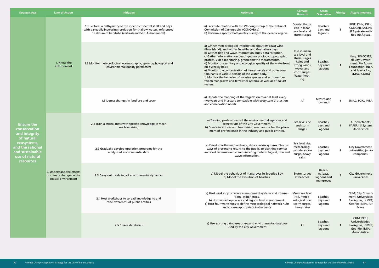
Climate Change Adaptation Strategy for the City of Rio de Janeiro50 51Climate Change Adaptation Strategy for the City of Rio de Janeiro
Strategic Axis Line of Action Initiative ActivitiesClimate Hazards
Action Orientation
Priority Actors involved
1.1 Perform a bathymetry of the inner continental shelf and bays, with a steadily increasing resolution for shallow waters, referenced
to datum of Imbituba (vertical) and SIRGA (horizontal)
a) Facilitate relation with the Working Group of the National Commission of Cartography (CONCAR).b) b) Perform a specific bathymetric survey of the oceanic region.
Coastal floods: rise in mean sea level and storm surges
Beaches, bays and lagoons.
1
IBGE, DHN, INPH, CONCAR, SAE/PR, IPP, private enti-ties, RioÁguas.
1.2 Monitor meteorological, oceanographic, geomorphological and environmental quality parameters
a) Gather meteorological information about off coast wind (Rasa Island), and within Sepetiba and Guanabara bays. b) Gather tide and wave information: buoy data reception. c) Gather information on beach geomorphology: topographic profiles, video monitoring, granulometric characteristics. d) Monitor the sanitary and ecological quality of the waterfront on a weekly basis. e) Monitor the concentration of heavy metals and other con-taminants in various sectors of the water body. f) Monitor the behavior of invasive species and ecotones be-tween mangroves and terrestrial systems, as well as of ballast waters.
Rise in mean sea level and storm surges
Rains and strong winds,
waves and storm surges. Water heat-
ing.
Beaches, bays and lagoons
1
Navy, SIMCOSTA, all City Govern-ment, Rio Águas Foundation, INEA
and Alerta Rio, SMAC, CORIO
1.3 Detect changes in land use and covera) Update the mapping of the vegetation cover at least every two years and in a scale compatible with ecosystem protection and conservation needs.
All Massifs and
lowlands1 SMAC, PCRJ, INEA.
2.1 Train a critical mass with specific knowledge in mean sea level rising
a) Training professionals of the environmental agencies and secretariats of the City Government.
b) Create incentives and fundraising mechanisms for the place-ment of professionals in the industry and public entities.
Sea level rise and storm
surges
Beaches, bays and lagoons
1All Secretariats,
FAPERJ, S System, Universities.
2.2 Gradually develop operation programs for the analysis of environmental data
a) Develop software, hardware, data analysis systems; Choose ways of presenting results to the public, to planning services
and Civil Defense unit, communicating meteorological, tide and wave information.
Sea level rise, meteorologi-cal tide, storm surge, heavy
rains
Beaches, bays and lagoons
2City Government, universities, junior
companies.
2.3 Carry out modeling of environmental dynamicsa) Model the behaviour of mangroves in Sepetiba Bay.
b) Model the evolution of beaches.Storm surges at beaches.
Beach-es, bays,
lagoons and mangroves
3City Government,
universities
2.4 Host workshops to spread knowledge to and raise awareness of public entities
a) Host workshop on wave measurement systems and interna-tional experiences.
b) Host workshop on sea and lagoon level measurement. c) Host four workshops to define meteorological network hubs
and choose appropriate instruments.
Mean sea level rise, meteo-
rological tide, storm surges, heavy rains
Beaches, bays and lagoons
1
CHM; City Govern-ment; Universities; Rio Aguas, INMET, GeoRio, INEA, Air
Force.
2.5 Create databasesa) Use existing databases or expand environmental database
used by the City GovernmentAll
Beaches, bays and lagoons
1
CHM; PCRJ, Universidades,
Rio-Águas, INMET, Geo-Rio, INEA, Aeronáutica.
Ensure the conservation and integrity
of natural ecosystems,
and the rational and sustainable use of natural
resources
1. Know the environment
2. Understand the effects of climate change on the
coastal environment
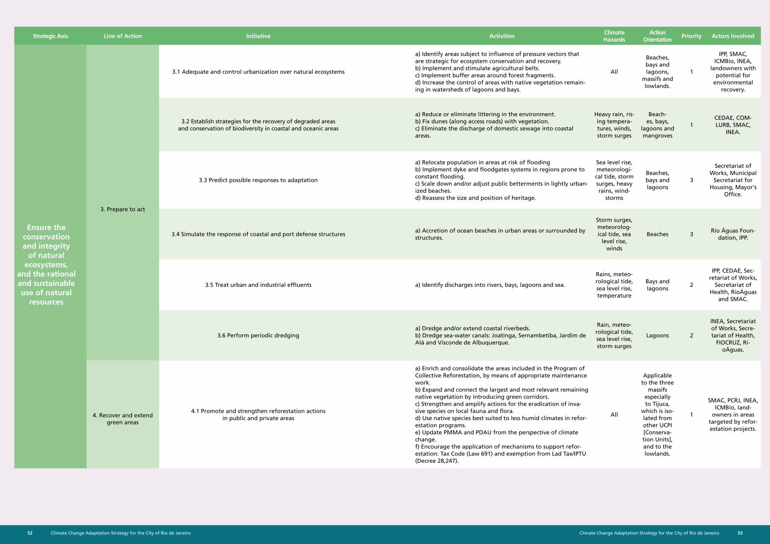
Climate Change Adaptation Strategy for the City of Rio de Janeiro52 53Climate Change Adaptation Strategy for the City of Rio de Janeiro
Strategic Axis Line of Action Initiative ActivitiesClimate Hazards
Action Orientation
Priority Actors involved
3.1 Adequate and control urbanization over natural ecosystems
a) Identify areas subject to influence of pressure vectors that are strategic for ecosystem conservation and recovery. b) Implement and stimulate agricultural belts. c) Implement buffer areas around forest fragments. d) Increase the control of areas with native vegetation remain-ing in watersheds of lagoons and bays.
All
Beaches, bays and lagoons,
massifs and lowlands.
1
IPP, SMAC, ICMBio, INEA,
landowners with potential for
environmental recovery.
3.2 Establish strategies for the recovery of degraded areas and conservation of biodiversity in coastal and oceanic areas
a) Reduce or eliminate littering in the environment. b) Fix dunes (along access roads) with vegetation. c) Eliminate the discharge of domestic sewage into coastal areas.
Heavy rain, ris-ing tempera-tures, winds, storm surges
Beach-es, bays,
lagoons and mangroves
1CEDAE, COM-LURB, SMAC,
INEA.
3.3 Predict possible responses to adaptation
a) Relocate population in areas at risk of flooding b) Implement dyke and floodgates systems in regions prone to constant flooding. c) Scale down and/or adjust public betterments in lightly urban-ized beaches. d) Reassess the size and position of heritage.
Sea level rise, meteorologi-cal tide, storm surges, heavy rains, wind-
storms
Beaches, bays and lagoons
3
Secretariat of Works, Municipal
Secretariat for Housing, Mayor's
Office.
3.4 Simulate the response of coastal and port defense structuresa) Accretion of ocean beaches in urban areas or surrounded by structures.
Storm surges, meteorolog-ical tide, sea
level rise, winds
Beaches 3Rio Águas Foun-
dation, IPP.
3.5 Treat urban and industrial effluents a) Identify discharges into rivers, bays, lagoons and sea.
Rains, meteo-rological tide, sea level rise, temperature
Bays and lagoons
2
IPP, CEDAE, Sec-retariat of Works,
Secretariat of Health, RioÁguas
and SMAC.
3.6 Perform periodic dredginga) Dredge and/or extend coastal riverbeds. b) Dredge sea-water canals: Joatinga, Sernambetiba, Jardim de Alá and Visconde de Albuquerque.
Rain, meteo-rological tide, sea level rise, storm surges
Lagoons 2
INEA, Secretariat of Works, Secre-tariat of Health,
FIOCRUZ, Ri-oÁguas.
4.1 Promote and strengthen reforestation actions in public and private areas
a) Enrich and consolidate the areas included in the Program of Collective Reforestation, by means of appropriate maintenance work. b) Expand and connect the largest and most relevant remaining native vegetation by introducing green corridors. c) Strengthen and amplify actions for the eradication of inva-sive species on local fauna and flora. d) Use native species best suited to less humid climates in refor-estation programs. e) Update PMMA and PDAU from the perspective of climate change. f) Encourage the application of mechanisms to support refor-estation: Tax Code (Law 691) and exemption from Lad Tax/IPTU (Decree 28,247).
All
Applicable to the three
massifs especially to Tijuca,
which is iso-lated from other UCPI [Conserva-tion Units], and to the lowlands.
1
SMAC, PCRJ, INEA, ICMBio, land-
owners in areas targeted by refor-estation projects.
Ensure the conservation and integrity
of natural ecosystems,
and the rational and sustainable use of natural
resources
3. Prepare to act
4. Recover and extend green areas
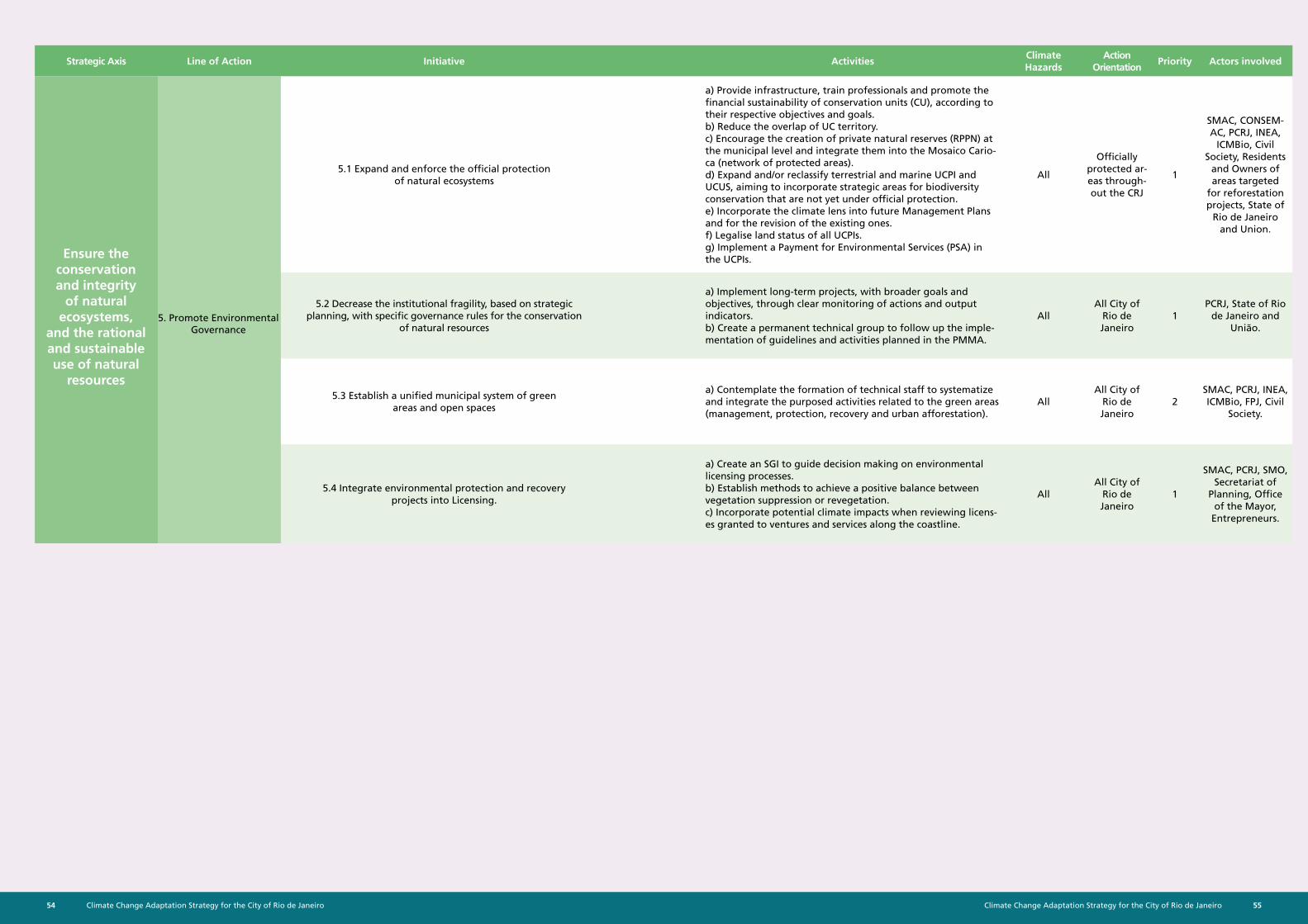
Climate Change Adaptation Strategy for the City of Rio de Janeiro54 55Climate Change Adaptation Strategy for the City of Rio de Janeiro
Strategic Axis Line of Action Initiative ActivitiesClimate Hazards
Action Orientation
Priority Actors involved
5.1 Expand and enforce the official protection of natural ecosystems
a) Provide infrastructure, train professionals and promote the financial sustainability of conservation units (CU), according to their respective objectives and goals. b) Reduce the overlap of UC territory. c) Encourage the creation of private natural reserves (RPPN) at the municipal level and integrate them into the Mosaico Cario-ca (network of protected areas). d) Expand and/or reclassify terrestrial and marine UCPI and UCUS, aiming to incorporate strategic areas for biodiversity conservation that are not yet under official protection. e) Incorporate the climate lens into future Management Plans and for the revision of the existing ones. f) Legalise land status of all UCPIs. g) Implement a Payment for Environmental Services (PSA) in the UCPIs.
All
Officially protected ar-eas through-out the CRJ
1
SMAC, CONSEM-AC, PCRJ, INEA,
ICMBio, Civil Society, Residents
and Owners of areas targeted
for reforestation projects, State of
Rio de Janeiro and Union.
5.2 Decrease the institutional fragility, based on strategic planning, with specific governance rules for the conservation
of natural resources
a) Implement long-term projects, with broader goals and objectives, through clear monitoring of actions and output indicators. b) Create a permanent technical group to follow up the imple-mentation of guidelines and activities planned in the PMMA.
AllAll City of
Rio de Janeiro
1PCRJ, State of Rio
de Janeiro and União.
5.3 Establish a unified municipal system of green areas and open spaces
a) Contemplate the formation of technical staff to systematize and integrate the purposed activities related to the green areas (management, protection, recovery and urban afforestation).
AllAll City of
Rio de Janeiro
2SMAC, PCRJ, INEA, ICMBio, FPJ, Civil
Society.
5.4 Integrate environmental protection and recovery projects into Licensing.
a) Create an SGI to guide decision making on environmental licensing processes. b) Establish methods to achieve a positive balance between vegetation suppression or revegetation. c) Incorporate potential climate impacts when reviewing licens-es granted to ventures and services along the coastline.
AllAll City of
Rio de Janeiro
1
SMAC, PCRJ, SMO, Secretariat of
Planning, Office of the Mayor,
Entrepreneurs.
Ensure the conservation and integrity
of natural ecosystems,
and the rational and sustainable use of natural
resources
5. Promote Environmental Governance
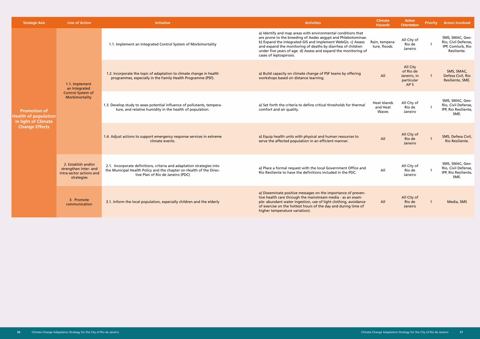
Climate Change Adaptation Strategy for the City of Rio de Janeiro56 57Climate Change Adaptation Strategy for the City of Rio de Janeiro
Strategic Axis Line of Action Initiative ActivitiesClimate Hazards
Action Orientation
Priority Actors involved
1.1. Implement an Integrated Control System of Morbimortality
a) Identify and map areas with environmental conditions that are prone to the breeding of Aedes aegypt and Phlebotominae. b) Expand the integrated GIS and implement WebGis. c) Assess and expand the monitoring of deaths by diarrhea of children under five years of age. d) Assess and expand the monitoring of cases of leptospirosis.
Rain, tempera-ture, floods.
All City of Rio de Janeiro
1
SMS, SMAC, Geo-Rio, Civil Defense, IPP, Comlurb, Rio
Resiliente.
1.2. Incorporate the topic of adaptation to climate change in health programmes, especially in the Family Health Programme (PSF).
a) Build capacity on climate change of PSF teams by offering workshops based on distance learning.
All
All City of Rio de
Janeiro, in particular
AP 5
1SMS, SMAC,
Defesa Civil, Rio Resiliente, SME.
1.3. Develop study to asses potential influence of pollutants, tempera-ture, and relative humidity in the health of population.
a) Set forth the criteria to define critical thresholds for thermal comfort and air quality.
Heat Islands and Heat
Waves
All City of Rio de Janeiro
1
SMS, SMAC, Geo-Rio, Civil Defense, IPP, Rio Resiliente,
SME.
1.4. Adjust actions to support emergency response services in extreme climate events.
a) Equip health units with physical and human resources to serve the affected population in an efficient manner.
AllAll City of
Rio de Janeiro
1SMS, Defesa Civil,
Rio Resiliente.
2.1. Incorporate definitions, criteria and adaptation strategies into the Municipal Health Policy and the chapter on Health of the Direc-
tive Plan of Rio de Janeiro (PDC)
a) Place a formal request with the local Government Office and Rio Resiliente to have the definitions included in the PDC.
AllAll City of
Rio de Janeiro
1
SMS, SMAC, Geo-Rio, Civil Defense, IPP, Rio Resiliente,
SME.
3.1. Inform the local population, especially children and the elderly
a) Disseminate positive messages on the importance of preven-tive health care through the mainstream media - as an exam-ple: abundant water ingestion, use of light clothing, avoidance of exercise on the hottest hours of the day and during time of higher temperature variation).
AllAll City of
Rio de Janeiro
1 Media, SMS
Promotion of Health of population
in light of Climate Change Effects
1.1. Implement an Integrated
Control System of Morbimortality
2. Establish and/or strengthen inter- and
intra-sector actions and strategies
3. Promote communication
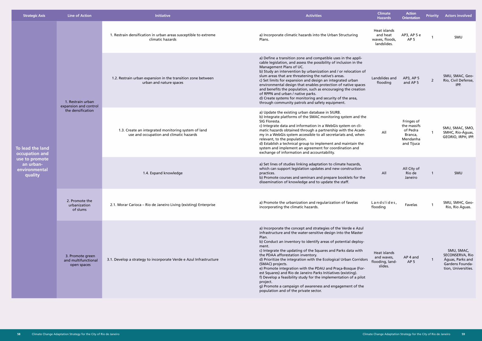
Climate Change Adaptation Strategy for the City of Rio de Janeiro58 59Climate Change Adaptation Strategy for the City of Rio de Janeiro
Strategic Axis Line of Action Initiative ActivitiesClimate Hazards
Action Orientation
Priority Actors involved
1. Restrain densification in urban areas susceptible to extreme climatic hazards
a) Incorporate climatic hazards into the Urban Structuring Plans.
Heat islands and heat
waves, floods, landslides.
AP3, AP 5 e AP 5
1 SMU
1.2. Restrain urban expansion in the transition zone between urban and nature spaces
a) Define a transition zone and compatible uses in the appli-cable legislation, and assess the possibility of inclusion in the Management Plans of UC. b) Study an intervention by urbanization and / or relocation of slum areas that are threatening the native’s areas. c) Set limits for expansion and design an integrated urban environmental design that enables protection of native spaces and benefits the population, such as encouraging the creation of RPPN and urban / native parks. d) Create systems for monitoring and security of the area, through community patrols and safety equipment.
Landslides and flooding
AP3, AP 5 and AP 5
2SMU, SMAC, Geo-Rio, Civil Defense,
IPP.
1.3. Create an integrated monitoring system of land use and occupation and climatic hazards
a) Update the existing urban database in SIURB. b) Integrate platforms of the SMAC monitoring system and the SIG Floresta. c) Integrate data and information in a WebGis system on cli-matic hazards obtained through a partnership with the Acade-my in a WebGis system accessible to all secretariats and, when relevant, to the population. d) Establish a technical group to implement and maintain the system and implement an agreement for coordination and exchange of information and accountability.
All
Fringes of the massifs
of Pedra Branca,
Mendanha and Tijuca
1SMU, SMAC, SMO, SMHC, Rio-Águas, GEORIO, IRPH, IPP.
1.4. Expand knowledge
a) Set lines of studies linking adaptation to climate hazards, which can support legislation updates and new construction practices. b) Promote courses and seminars and prepare booklets for the dissemination of knowledge and to update the staff.
AllAll City of
Rio de Janeiro
1 SMU
2.1. Morar Carioca – Rio de Janeiro Living (existing) Enterprisea) Promote the urbanization and regularization of favelas incorporating the climatic hazards.
L a n d s l i d e s , flooding
Favelas 1SMU, SMHC, Geo-
Rio, Rio Águas.
3.1. Develop a strategy to incorporate Verde e Azul Infrastructure
a) Incorporate the concept and strategies of the Verde e Azul infrastructure and the water-sensitive design into the Master Plan. b) Conduct an inventory to identify areas of potential deploy-ment. c) Integrate the updating of the Squares and Parks data with the PDAA afforestation inventory. d) Prioritize the integration with the Ecological Urban Corridors (SMAC) projects. e) Promote integration with the PDAU and Praça-Bosque (For-est Squares) and Rio de Janeiro Parks Initiatives (existing). f) Develop a feasibility study for the implementation of a pilot project. g) Promote a campaign of awareness and engagement of the population and of the private sector.
Heat islands and waves,
flooding, land-slides.
AP 4 and AP 5
1
SMU, SMAC, SECONSERVA, Rio Águas, Parks and Gardens Founda-tion, Universities.
To lead the land occupation and use to promote
an urban-environmental
quality
3. Promote green and multifunctional
open spaces
2. Promote the urbanization
of slums
1. Restrain urban expansion and control
the densification
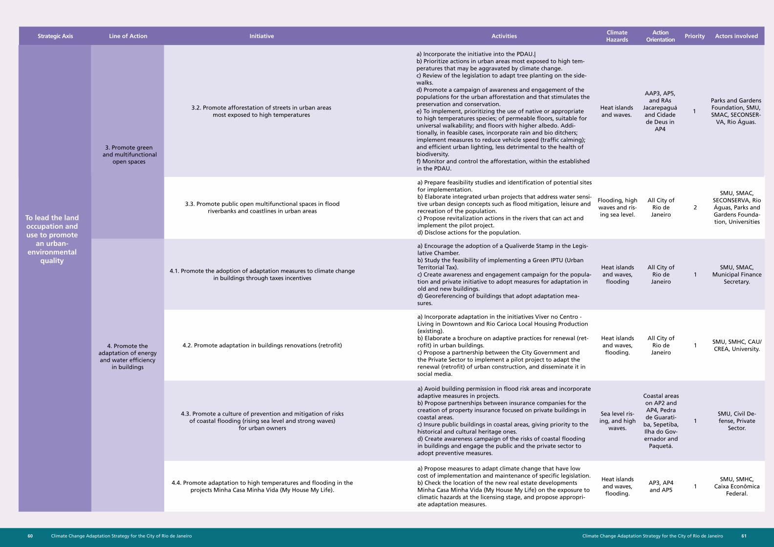
Climate Change Adaptation Strategy for the City of Rio de Janeiro60 61Climate Change Adaptation Strategy for the City of Rio de Janeiro
3.3. Promote public open multifunctional spaces in flood riverbanks and coastlines in urban areas
a) Prepare feasibility studies and identification of potential sites for implementation. b) Elaborate integrated urban projects that address water sensi-tive urban design concepts such as flood mitigation, leisure and recreation of the population. c) Propose revitalization actions in the rivers that can act and implement the pilot project. d) Disclose actions for the population.
Flooding, high waves and ris-ing sea level.
All City of Rio de Janeiro
2
SMU, SMAC, SECONSERVA, Rio Águas, Parks and Gardens Founda-tion, Universities
4.1. Promote the adoption of adaptation measures to climate change in buildings through taxes incentives
a) Encourage the adoption of a Qualiverde Stamp in the Legis-lative Chamber. b) Study the feasibility of implementing a Green IPTU (Urban Territorial Tax). c) Create awareness and engagement campaign for the popula-tion and private initiative to adopt measures for adaptation in old and new buildings. d) Georeferencing of buildings that adopt adaptation mea-sures.
Heat islands and waves,
flooding
All City of Rio de Janeiro
1SMU, SMAC,
Municipal Finance Secretary.
4.2. Promote adaptation in buildings renovations (retrofit)
a) Incorporate adaptation in the initiatives Viver no Centro - Living in Downtown and Rio Carioca Local Housing Production (existing). b) Elaborate a brochure on adaptive practices for renewal (ret-rofit) in urban buildings. c) Propose a partnership between the City Government and the Private Sector to implement a pilot project to adapt the renewal (retrofit) of urban construction, and disseminate it in social media.
Heat islands and waves, flooding.
All City of Rio de Janeiro
1SMU, SMHC, CAU/CREA, University.
4.3. Promote a culture of prevention and mitigation of risks of coastal flooding (rising sea level and strong waves)
for urban owners
a) Avoid building permission in flood risk areas and incorporate adaptive measures in projects. b) Propose partnerships between insurance companies for the creation of property insurance focused on private buildings in coastal areas. c) Insure public buildings in coastal areas, giving priority to the historical and cultural heritage ones. d) Create awareness campaign of the risks of coastal flooding in buildings and engage the public and the private sector to adopt preventive measures.
Sea level ris-ing, and high
waves.
Coastal areas on AP2 and AP4, Pedra de Guarati-
ba, Sepetiba, Ilha do Gov-ernador and
Paquetá.
1SMU, Civil De-fense, Private
Sector.
4.4. Promote adaptation to high temperatures and flooding in the projects Minha Casa Minha Vida (My House My Life).
a) Propose measures to adapt climate change that have low cost of implementation and maintenance of specific legislation. b) Check the location of the new real estate developments Minha Casa Minha Vida (My House My Life) on the exposure to climatic hazards at the licensing stage, and propose appropri-ate adaptation measures.
Heat islands and waves, flooding.
AP3, AP4 and AP5
1SMU, SMHC,
Caixa Econômica Federal.
4. Promote the adaptation of energy and water efficiency
in buildings
3.2. Promote afforestation of streets in urban areas most exposed to high temperatures
a) Incorporate the initiative into the PDAU.| b) Prioritize actions in urban areas most exposed to high tem-peratures that may be aggravated by climate change. c) Review of the legislation to adapt tree planting on the side-walks. d) Promote a campaign of awareness and engagement of the populations for the urban afforestation and that stimulates the preservation and conservation. e) To implement, prioritizing the use of native or appropriate to high temperatures species; of permeable floors, suitable for universal walkability; and floors with higher albedo. Addi-tionally, in feasible cases, incorporate rain and bio ditchers; implement measures to reduce vehicle speed (traffic calming); and efficient urban lighting, less detrimental to the health of biodiversity. f) Monitor and control the afforestation, within the established in the PDAU.
Heat islands and waves.
AAP3, AP5, and RAs
Jacarepaguá and Cidade de Deus in
AP4
1
Parks and Gardens Foundation, SMU, SMAC, SECONSER-
VA, Rio Águas.
3. Promote green and multifunctional
open spaces
To lead the land occupation and use to promote
an urban-environmental
quality
Strategic Axis Line of Action Initiative ActivitiesClimate Hazards
Action Orientation
Priority Actors involved
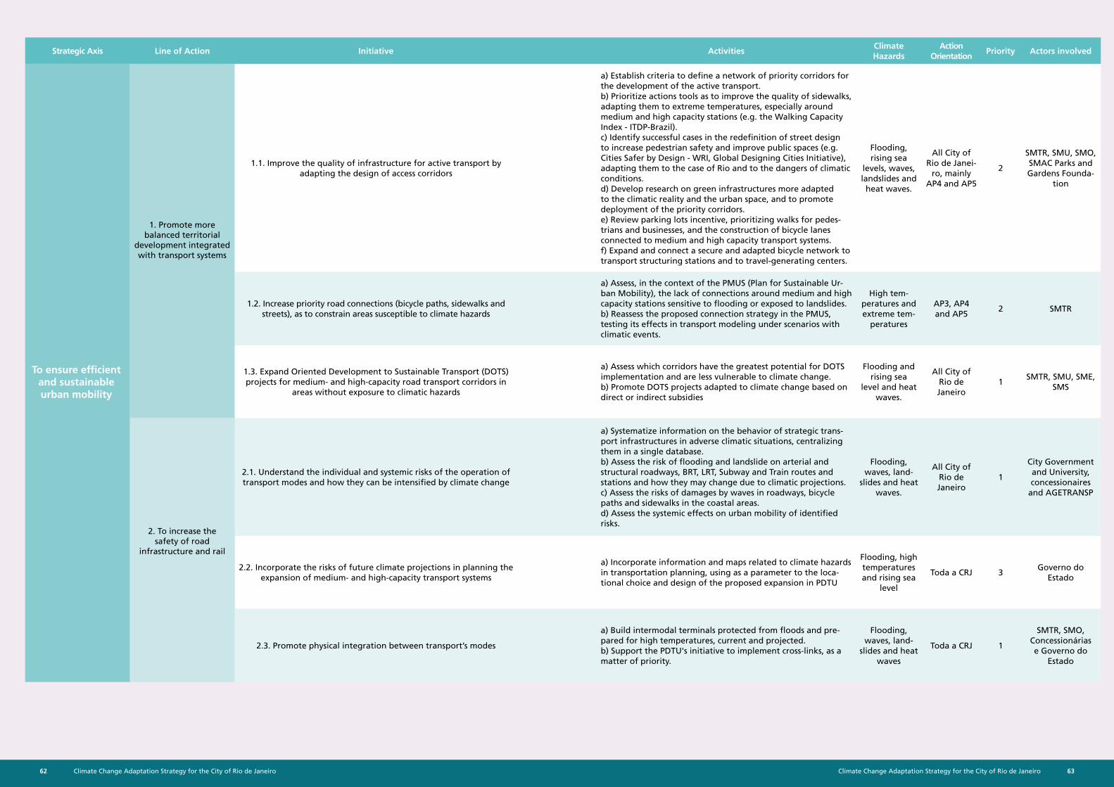
Climate Change Adaptation Strategy for the City of Rio de Janeiro62 63Climate Change Adaptation Strategy for the City of Rio de Janeiro
Strategic Axis Line of Action Initiative ActivitiesClimate Hazards
Action Orientation
Priority Actors involved
1.1. Improve the quality of infrastructure for active transport by adapting the design of access corridors
a) Establish criteria to define a network of priority corridors for the development of the active transport. b) Prioritize actions tools as to improve the quality of sidewalks, adapting them to extreme temperatures, especially around medium and high capacity stations (e.g. the Walking Capacity Index - ITDP-Brazil). c) Identify successful cases in the redefinition of street design to increase pedestrian safety and improve public spaces (e.g. Cities Safer by Design - WRI, Global Designing Cities Initiative), adapting them to the case of Rio and to the dangers of climatic conditions. d) Develop research on green infrastructures more adapted to the climatic reality and the urban space, and to promote deployment of the priority corridors. e) Review parking lots incentive, prioritizing walks for pedes-trians and businesses, and the construction of bicycle lanes connected to medium and high capacity transport systems. f) Expand and connect a secure and adapted bicycle network to transport structuring stations and to travel-generating centers.
Flooding, rising sea
levels, waves, landslides and heat waves.
All City of Rio de Janei-
ro, mainly AP4 and AP5
2
SMTR, SMU, SMO, SMAC Parks and Gardens Founda-
tion
1.2. Increase priority road connections (bicycle paths, sidewalks and streets), as to constrain areas susceptible to climate hazards
a) Assess, in the context of the PMUS (Plan for Sustainable Ur-ban Mobility), the lack of connections around medium and high capacity stations sensitive to flooding or exposed to landslides. b) Reassess the proposed connection strategy in the PMUS, testing its effects in transport modeling under scenarios with climatic events.
High tem-peratures and extreme tem-
peratures
AP3, AP4 and AP5
2 SMTR
1.3. Expand Oriented Development to Sustainable Transport (DOTS) projects for medium- and high-capacity road transport corridors in
areas without exposure to climatic hazards
a) Assess which corridors have the greatest potential for DOTS implementation and are less vulnerable to climate change. b) Promote DOTS projects adapted to climate change based on direct or indirect subsidies
Flooding and rising sea
level and heat waves.
All City of Rio de Janeiro
1SMTR, SMU, SME,
SMS
2.1. Understand the individual and systemic risks of the operation of transport modes and how they can be intensified by climate change
a) Systematize information on the behavior of strategic trans-port infrastructures in adverse climatic situations, centralizing them in a single database. b) Assess the risk of flooding and landslide on arterial and structural roadways, BRT, LRT, Subway and Train routes and stations and how they may change due to climatic projections. c) Assess the risks of damages by waves in roadways, bicycle paths and sidewalks in the coastal areas. d) Assess the systemic effects on urban mobility of identified risks.
Flooding, waves, land-
slides and heat waves.
All City of Rio de Janeiro
1
City Government and University, concessionaires
and AGETRANSP
2.2. Incorporate the risks of future climate projections in planning the expansion of medium- and high-capacity transport systems
a) Incorporate information and maps related to climate hazards in transportation planning, using as a parameter to the loca-tional choice and design of the proposed expansion in PDTU
Flooding, high temperatures and rising sea
level
Toda a CRJ 3Governo do
Estado
2.3. Promote physical integration between transport’s modes
a) Build intermodal terminals protected from floods and pre-pared for high temperatures, current and projected. b) Support the PDTU's initiative to implement cross-links, as a matter of priority.
Flooding, waves, land-
slides and heat waves
Toda a CRJ 1
SMTR, SMO, Concessionárias e Governo do
Estado
1. Promote more balanced territorial
development integrated with transport systems
2. To increase the safety of road
infrastructure and rail
To ensure efficient and sustainable urban mobility
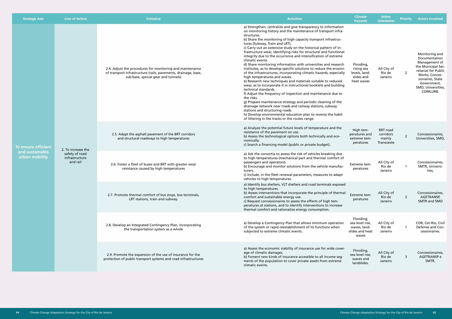
Climate Change Adaptation Strategy for the City of Rio de Janeiro64 65Climate Change Adaptation Strategy for the City of Rio de Janeiro
Strategic Axis Line of Action Initiative ActivitiesClimate Hazards
Action Orientation
Priority Actors involved
2.4. Adjust the procedures for monitoring and maintenance of transport infrastructure (rails, pavements, drainage, base,
sub-base, special gear and tunnels)
a) Strengthen, centralize and give transparency to information on monitoring history and the maintenance of transport infra-structures. b) Share the monitoring of high capacity transport infrastruc-tures (Subway, Train and LRT). c) Carry out an extensive study on the historical pattern of in-frastructure wear, identifying risks for structural and functional integrity due to the occurrence and intensification of extreme climatic events. d) Share monitoring information with universities and research institutes, as to develop specific solutions to reduce the erosion of the infrastructures, incorporating climatic hazards, especially high temperatures and waves. e) Research new techniques and materials suitable to reduced wear, as to incorporate it in instructional booklets and building technical standards. f) Adjust the frequency of inspection and maintenance due to the risks. g) Prepare maintenance strategy and periodic cleaning of the drainage network near roads and railway stations, subway stations and structuring roads. h) Develop environmental education plan to reverse the habit of littering in the tracks or the routes range.
Flooding, rising sea
levels, land-slides and
heat waves
All City of Rio de Janeiro
2
Monitoring and Documentation Management of
the Municipal Sec-retariat for Public
Works, Conces-sionaires, State Government,
SMO, Universities, COMLURB.
2.5. Adapt the asphalt pavement of the BRT corridors and structural roadways to high temperatures
a) Analyze the potential future levels of temperature and the resistance of the pavement on use. b) Assess the technological options both technically and eco-nomically. c) Search a financing model (public or private budget).
High tem-peratures and extreme tem-
peratures
BRT road corridors mainly
Transoeste
2Concessionaires,
Universities, SMO,
2.6. Foster a fleet of buses and BRT with greater wear resistance caused by high temperatures
a) Ask the consortia to assess the risk of vehicles breaking due to high temperatures (mechanical part and thermal comfort of passengers and operators). b) Encourage and monitor solutions from the vehicle manufac-turers. c) Include, in the fleet renewal parameters, measures to adapt vehicles to high temperatures.
Extreme tem-peratures
All City of Rio de Janeiro
1Concessionaires, SMTR, Universi-
ties,
2.7. Promote thermal comfort of bus stops, bus terminals, LRT stations, train and subway.
a) Identify bus shelters, VLT shelters and road terminals exposed to high temperatures. b) Assess interventions that incorporate the principle of thermal comfort and sustainable energy use. c) Request concessionaires to assess the effects of high tem-peratures at stations, and to identify interventions to increase thermal comfort and rationalize energy consumption.
Extreme tem-peratures
All City of Rio de Janeiro
2Concessionaires,
AGETRANSP, SMTR and SMO
2.8. Develop an Integrated Contingency Plan, incorporating the transportation system as a whole
a) Develop a Contingency Plan that allows minimum operation of the system or rapid reestablishment of its functions when subjected to extreme climatic events.
Flooding, sea level rise, waves, land-
slides and heat waves
All City of Rio de Janeiro
1COR, Cet-Rio, Civil Defense and Con-
cessionaires.
2.9. Promote the expansion of the use of insurance for the protection of public transport systems and road infrastructures
a) Assess the economic viability of insurance use for wide cover-age of climatic damages. b) Foment new kinds of insurance accessible to all income seg-ments of the population to cover private assets from extreme climatic events.
Flooding, sea level rise,
waves and landslides.
All City of Rio de Janeiro
3Concessionaires, AGETRANSP e
SMTR.
2. To increase the safety of road infrastructure
and rail
To ensure efficient and sustainable urban mobility
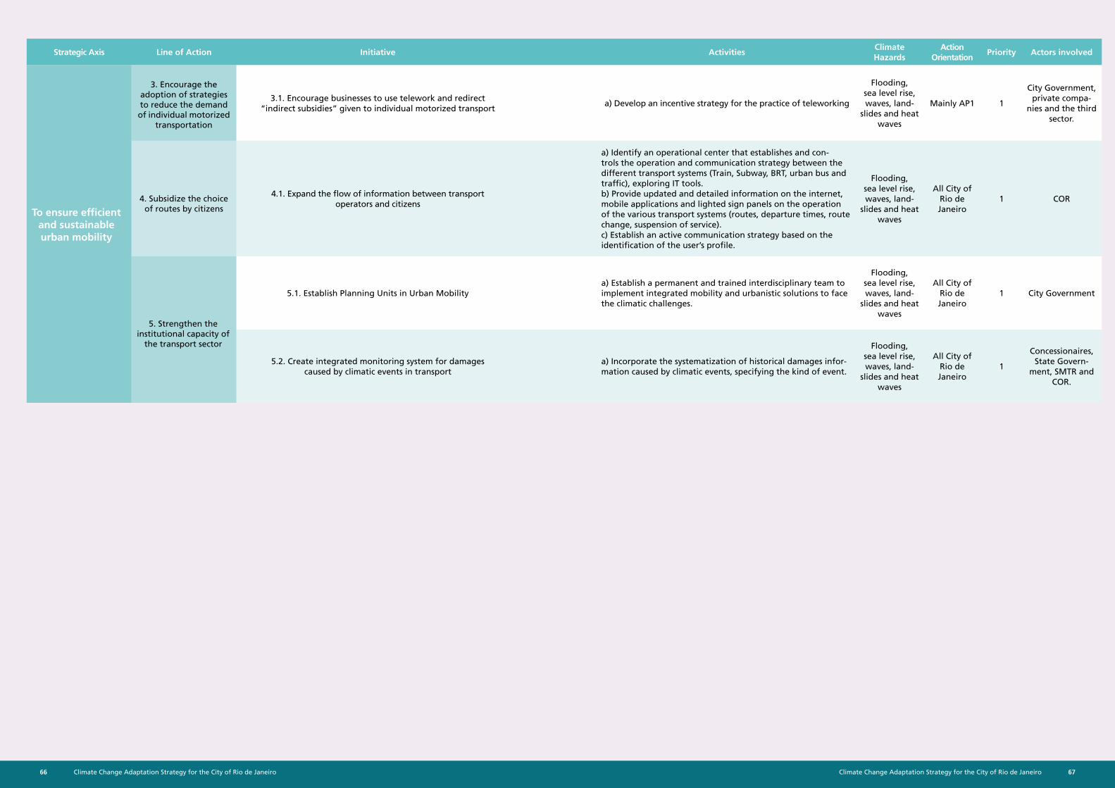
Climate Change Adaptation Strategy for the City of Rio de Janeiro66 67Climate Change Adaptation Strategy for the City of Rio de Janeiro
Strategic Axis Line of Action Initiative ActivitiesClimate Hazards
Action Orientation
Priority Actors involved
3.1. Encourage businesses to use telework and redirect “indirect subsidies” given to individual motorized transport
a) Develop an incentive strategy for the practice of teleworking
Flooding, sea level rise, waves, land-
slides and heat waves
Mainly AP1 1
City Government, private compa-
nies and the third sector.
4.1. Expand the flow of information between transport operators and citizens
a) Identify an operational center that establishes and con-trols the operation and communication strategy between the different transport systems (Train, Subway, BRT, urban bus and traffic), exploring IT tools. b) Provide updated and detailed information on the internet, mobile applications and lighted sign panels on the operation of the various transport systems (routes, departure times, route change, suspension of service). c) Establish an active communication strategy based on the identification of the user’s profile.
Flooding, sea level rise, waves, land-
slides and heat waves
All City of Rio de Janeiro
1 COR
5.1. Establish Planning Units in Urban Mobilitya) Establish a permanent and trained interdisciplinary team to implement integrated mobility and urbanistic solutions to face the climatic challenges.
Flooding, sea level rise, waves, land-
slides and heat waves
All City of Rio de Janeiro
1 City Government
5.2. Create integrated monitoring system for damages caused by climatic events in transport
a) Incorporate the systematization of historical damages infor-mation caused by climatic events, specifying the kind of event.
Flooding, sea level rise, waves, land-
slides and heat waves
All City of Rio de Janeiro
1
Concessionaires, State Govern-
ment, SMTR and COR.
5. Strengthen the institutional capacity of
the transport sector
4. Subsidize the choice of routes by citizens
3. Encourage the adoption of strategies to reduce the demand of individual motorized
transportation
To ensure efficient and sustainable urban mobility
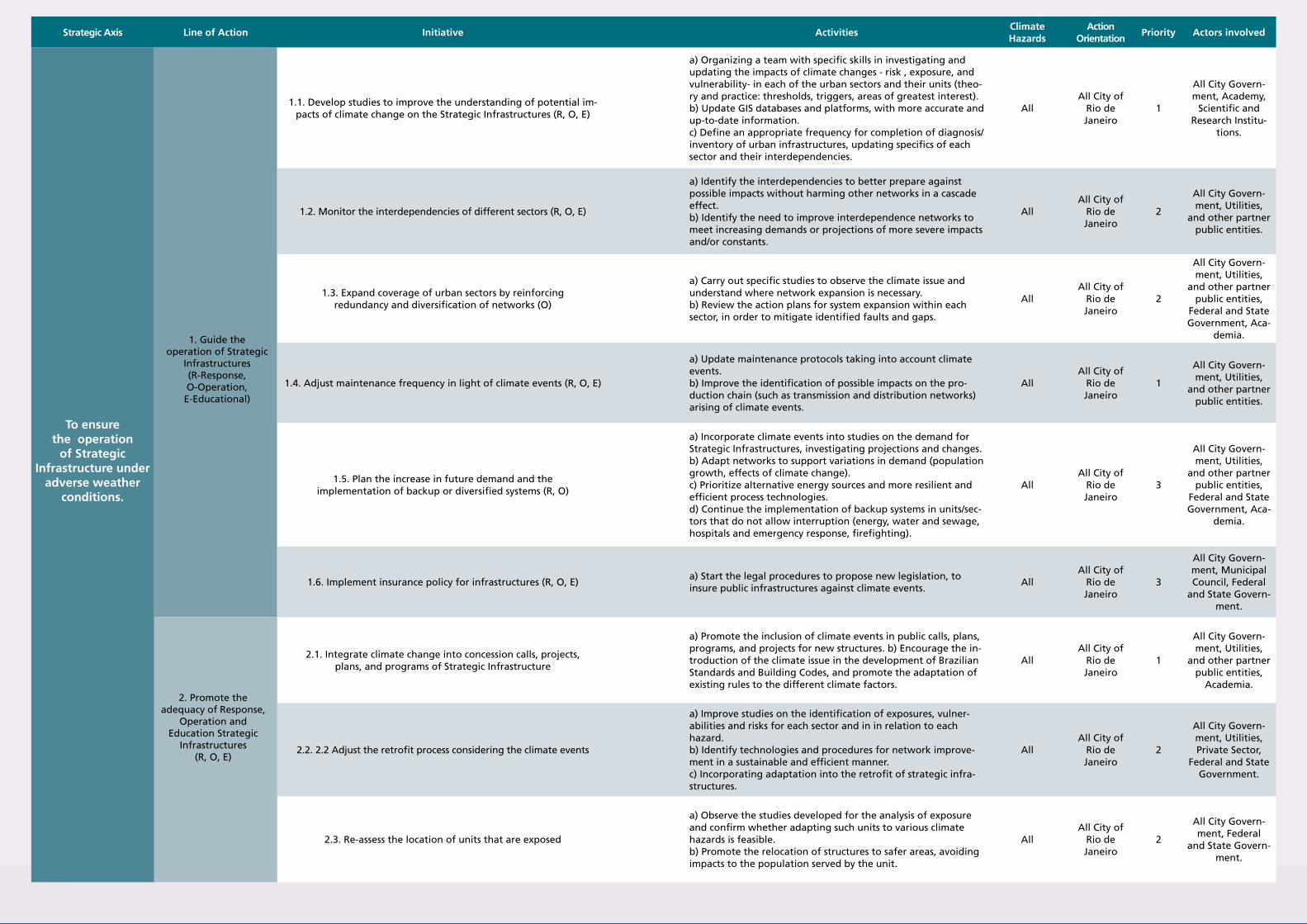
Climate Change Adaptation Strategy for the City of Rio de Janeiro68 69Climate Change Adaptation Strategy for the City of Rio de Janeiro
Strategic Axis Line of Action Initiative ActivitiesClimate Hazards
Action Orientation
Priority Actors involved
1.1. Develop studies to improve the understanding of potential im-pacts of climate change on the Strategic Infrastructures (R, O, E)
a) Organizing a team with specific skills in investigating and updating the impacts of climate changes - risk , exposure, and vulnerability- in each of the urban sectors and their units (theo-ry and practice: thresholds, triggers, areas of greatest interest). b) Update GIS databases and platforms, with more accurate and up-to-date information. c) Define an appropriate frequency for completion of diagnosis/inventory of urban infrastructures, updating specifics of each sector and their interdependencies.
AllAll City of
Rio de Janeiro
1
All City Govern-ment, Academy,
Scientific and Research Institu-
tions.
1.2. Monitor the interdependencies of different sectors (R, O, E)
a) Identify the interdependencies to better prepare against possible impacts without harming other networks in a cascade effect. b) Identify the need to improve interdependence networks to meet increasing demands or projections of more severe impacts and/or constants.
All All City of
Rio de Janeiro
2
All City Govern-ment, Utilities,
and other partner public entities.
1.3. Expand coverage of urban sectors by reinforcing redundancy and diversification of networks (O)
a) Carry out specific studies to observe the climate issue and understand where network expansion is necessary. b) Review the action plans for system expansion within each sector, in order to mitigate identified faults and gaps.
AllAll City of
Rio de Janeiro
2
All City Govern-ment, Utilities,
and other partner public entities,
Federal and State Government, Aca-
demia.
1.4. Adjust maintenance frequency in light of climate events (R, O, E)
a) Update maintenance protocols taking into account climate events. b) Improve the identification of possible impacts on the pro-duction chain (such as transmission and distribution networks) arising of climate events.
AllAll City of
Rio de Janeiro
1
All City Govern-ment, Utilities,
and other partner public entities.
1.5. Plan the increase in future demand and the implementation of backup or diversified systems (R, O)
a) Incorporate climate events into studies on the demand for Strategic Infrastructures, investigating projections and changes. b) Adapt networks to support variations in demand (population growth, effects of climate change). c) Prioritize alternative energy sources and more resilient and efficient process technologies. d) Continue the implementation of backup systems in units/sec-tors that do not allow interruption (energy, water and sewage, hospitals and emergency response, firefighting).
AllAll City of
Rio de Janeiro
3
All City Govern-ment, Utilities,
and other partner public entities,
Federal and State Government, Aca-
demia.
1.6. Implement insurance policy for infrastructures (R, O, E)a) Start the legal procedures to propose new legislation, to insure public infrastructures against climate events.
AllAll City of
Rio de Janeiro
3
All City Govern-ment, Municipal Council, Federal
and State Govern-ment.
2.1. Integrate climate change into concession calls, projects, plans, and programs of Strategic Infrastructure
a) Promote the inclusion of climate events in public calls, plans, programs, and projects for new structures. b) Encourage the in-troduction of the climate issue in the development of Brazilian Standards and Building Codes, and promote the adaptation of existing rules to the different climate factors.
AllAll City of
Rio de Janeiro
1
All City Govern-ment, Utilities,
and other partner public entities,
Academia.
2.2. 2.2 Adjust the retrofit process considering the climate events
a) Improve studies on the identification of exposures, vulner-abilities and risks for each sector and in in relation to each hazard. b) Identify technologies and procedures for network improve-ment in a sustainable and efficient manner. c) Incorporating adaptation into the retrofit of strategic infra-structures.
AllAll City of
Rio de Janeiro
2
All City Govern-ment, Utilities, Private Sector,
Federal and State Government.
2.3. Re-assess the location of units that are exposed
a) Observe the studies developed for the analysis of exposure and confirm whether adapting such units to various climate hazards is feasible. b) Promote the relocation of structures to safer areas, avoiding impacts to the population served by the unit.
AllAll City of
Rio de Janeiro
2
All City Govern-ment, Federal
and State Govern-ment.
To ensure the operation
of Strategic Infrastructure under
adverse weather conditions.
1. Guide the operation of Strategic
Infrastructures (R-Response, O-Operation, E-Educational)
2. Promote the adequacy of Response,
Operation and Education Strategic
Infrastructures (R, O, E)
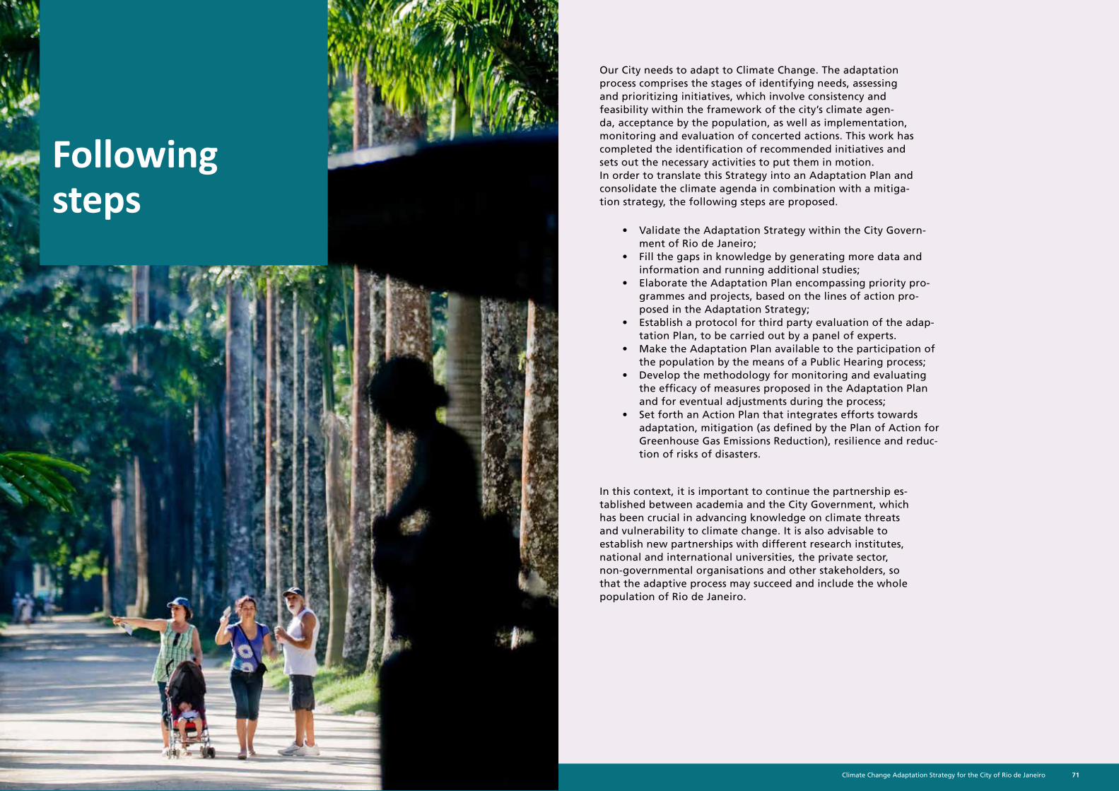
Climate Change Adaptation Strategy for the City of Rio de Janeiro70 71Climate Change Adaptation Strategy for the City of Rio de Janeiro
Following steps
Our City needs to adapt to Climate Change. The adaptation process comprises the stages of identifying needs, assessing and prioritizing initiatives, which involve consistency and feasibility within the framework of the city’s climate agen-da, acceptance by the population, as well as implementation, monitoring and evaluation of concerted actions. This work has completed the identification of recommended initiatives and sets out the necessary activities to put them in motion. In order to translate this Strategy into an Adaptation Plan and consolidate the climate agenda in combination with a mitiga-tion strategy, the following steps are proposed.
• Validate the Adaptation Strategy within the City Govern-ment of Rio de Janeiro;
• Fill the gaps in knowledge by generating more data and information and running additional studies;
• Elaborate the Adaptation Plan encompassing priority pro-grammes and projects, based on the lines of action pro-posed in the Adaptation Strategy;
• Establish a protocol for third party evaluation of the adap-tation Plan, to be carried out by a panel of experts.
• Make the Adaptation Plan available to the participation of the population by the means of a Public Hearing process;
• Develop the methodology for monitoring and evaluating the efficacy of measures proposed in the Adaptation Plan and for eventual adjustments during the process;
• Set forth an Action Plan that integrates efforts towards adaptation, mitigation (as defined by the Plan of Action for Greenhouse Gas Emissions Reduction), resilience and reduc-tion of risks of disasters.
In this context, it is important to continue the partnership es-tablished between academia and the City Government, which has been crucial in advancing knowledge on climate threats and vulnerability to climate change. It is also advisable to establish new partnerships with different research institutes, national and international universities, the private sector, non-governmental organisations and other stakeholders, so that the adaptive process may succeed and include the whole population of Rio de Janeiro.
Climate Change Adaptation Strategy for the City of Rio de Janeiro72 73Climate Change Adaptation Strategy for the City of Rio de Janeiro
Sources
1. The World Bank, 2016. Urban population (% of total). Disponível em: http://data.worldbank.org/indicator/SP.URB.TOTL.IN.ZS
2. IPCC, Intergovernmental Panel on Climate Change, 2014. Annex II: Glossary [Mach, K.J., S. Planton and C. von Stechow (eds.)]. In: Climate Change 2014: Synthesis Report. Contribution of Working Groups I, II and III to the Fifth Assessment Report of the Intergovernmental Panel on Climate Change [Core Writing Team, R.K. Pachauri and L.A. Meyer (eds.)]. IPCC, Geneva, Switzerland, pp. 117-130.
3. Ministério do Meio Ambiente, 2016. Plano Nacional de Adaptação às Mudanças Climáticas.
4. Future of London, 2016. Managing London’s Exposure to Climate Change
5. IBGE, 2016. IBGE Cidades, Rio de Janeiro. Disponível em: http://cidades.ibge.gov.br/xtras/perfil.php?cod-mun=330455 Censo Demográfico
6. Prefeitura do Rio de Janeiro, 2016. O Rio do amanhã – Visão Rio 500 e Planejamento Estratégico 2017-2020. Rio de Janeiro
7. Visão Rio 500, 2016. Desenvolvendo uma Visão Rio 500 anos e o planejamento estratégico da cidade. Apresentação executiva e Análise demográfica Disponível em: http://www.rio.rj.gov.br/dlstatic/10112/5943356/4155547/2016.01.21ApresentacaoExecutivaAnaliseDemografica.pdf
8. IPP, Instituto Pereira Passos, 2007. Carta de Uso do Solo do Município do Rio de Janeiro - 2004.
9. IPP, Instituto Pereiera Passos, 2015. Carta de Uso do Solo do Município do Rio de Janeiro - 2015, 2016.
10. IPCC, Intergovernmental Panel on Climate Change, 2013. Fifth Assessment Report of the Intergovernmental Panel on Climate Change. STOCKER, T. F.; QIN, D.; PLATTNER, G. K.; TIGNOR, M.; ALLEN, S. K.; BOSCHUNG, J.; NAUELS, A.; XIA, Y.; BEX, V. & MIDGLEY, P.M. (eds). 2013. Cambridge University Press, Cambridge, United Kingdom and New York, 1535 p
11. Martins, T.F., 2014. Pluviometria crítica de escorregamentos na cidade do Rio de Janeiro: Comparação entre regiões e períodos. UFRJ. Rio de Janeiro/RJ. 167 p.
12. IBGE, 2010. Censo Demográfico Brasileiro
13. Miguez, M.G., 2001, Modelo Matemático de Células de Escoamento para Bacias Urbanas. Tese de D.Sc., COPPE/UFRJ, Rio de Janeiro, RJ, Brasil.
14. Rosman, P.C.C., 2016. Estudo Técnico de Apoio ao Desenvolvimento do Plano de Adaptação da Cidade do Rio de Janeiro às Mudanças Climáticas – EPA/PA R1 – Modelagens para definição de níveis máximos nas embocaduras fluviais do sistema lagunar de Jacarepaguá, considerando cenários de mudanças climáticas
15. Rio Águas, 2013. Proposição, Análise e Avaliação de Intervenções de Manejo de Águas Pluviais em sub-bacia hidro-gráfica: Área de estudo 1: Rio Guerenguê e Área de estudo 2: Arroio Pavuna. Plano Diretor De Manejo De Águas Pluviais Da Cidade Do Rio De Janeiro.
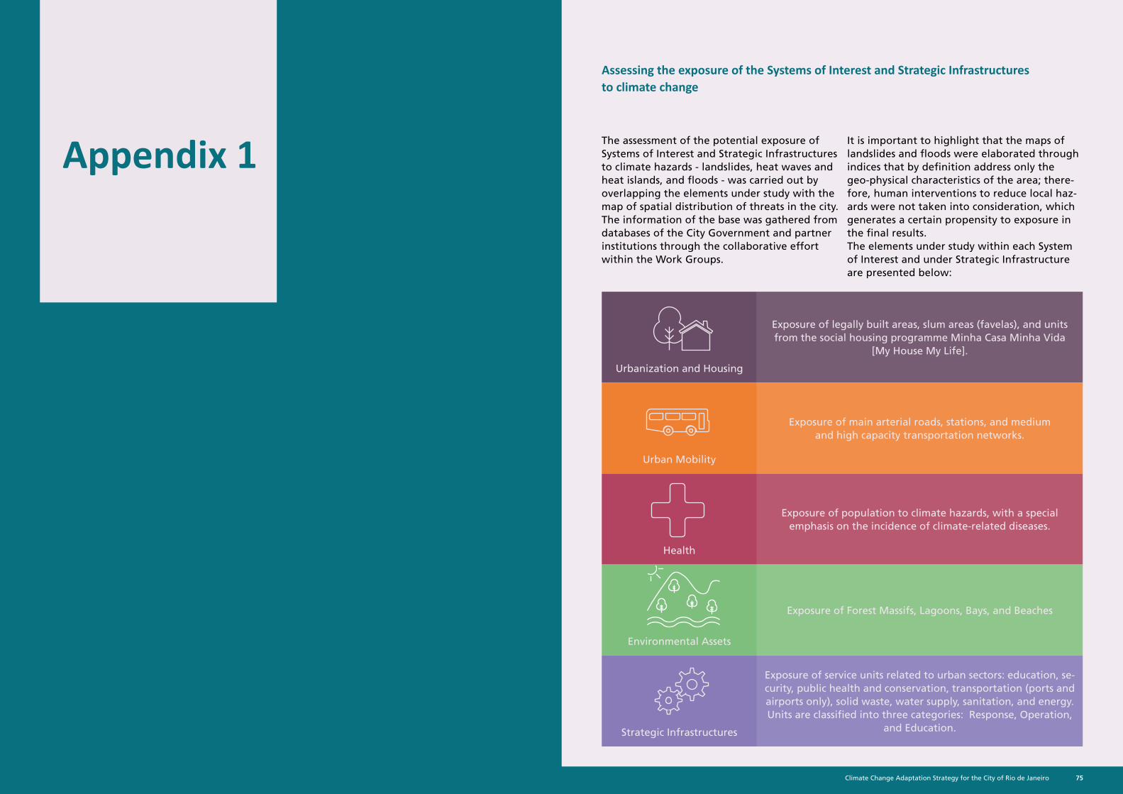
Climate Change Adaptation Strategy for the City of Rio de Janeiro74 75Climate Change Adaptation Strategy for the City of Rio de Janeiro
Appendix 1The assessment of the potential exposure of Systems of Interest and Strategic Infrastructures to climate hazards - landslides, heat waves and heat islands, and floods - was carried out by overlapping the elements under study with the map of spatial distribution of threats in the city. The information of the base was gathered from databases of the City Government and partner institutions through the collaborative effort within the Work Groups.
Assessing the exposure of the Systems of Interest and Strategic Infrastructures to climate change
It is important to highlight that the maps of landslides and floods were elaborated through indices that by definition address only the geo-physical characteristics of the area; there-fore, human interventions to reduce local haz-ards were not taken into consideration, which generates a certain propensity to exposure in the final results.The elements under study within each System of Interest and under Strategic Infrastructure are presented below:
Urbanization and Housing
Exposure of legally built areas, slum areas (favelas), and units from the social housing programme Minha Casa Minha Vida
[My House My Life].
Urban Mobility
Exposure of main arterial roads, stations, and medium and high capacity transportation networks.
Health
Exposure of population to climate hazards, with a special emphasis on the incidence of climate-related diseases.
Environmental Assets
Exposure of Forest Massifs, Lagoons, Bays, and Beaches
Strategic Infrastructures
Exposure of service units related to urban sectors: education, se-curity, public health and conservation, transportation (ports and airports only), solid waste, water supply, sanitation, and energy. Units are classified into three categories: Response, Operation,
and Education.
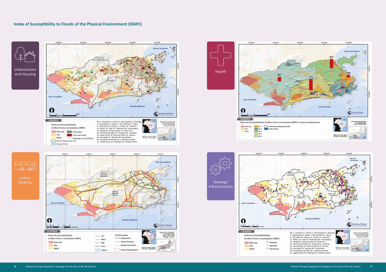
Climate Change Adaptation Strategy for the City of Rio de Janeiro76 77Climate Change Adaptation Strategy for the City of Rio de Janeiro
Index of Susceptibility to Floods of the Physical Environment (ISMFI)
Urbanization and Housing
Health
Strategic Infrastructures
Urban Mobility
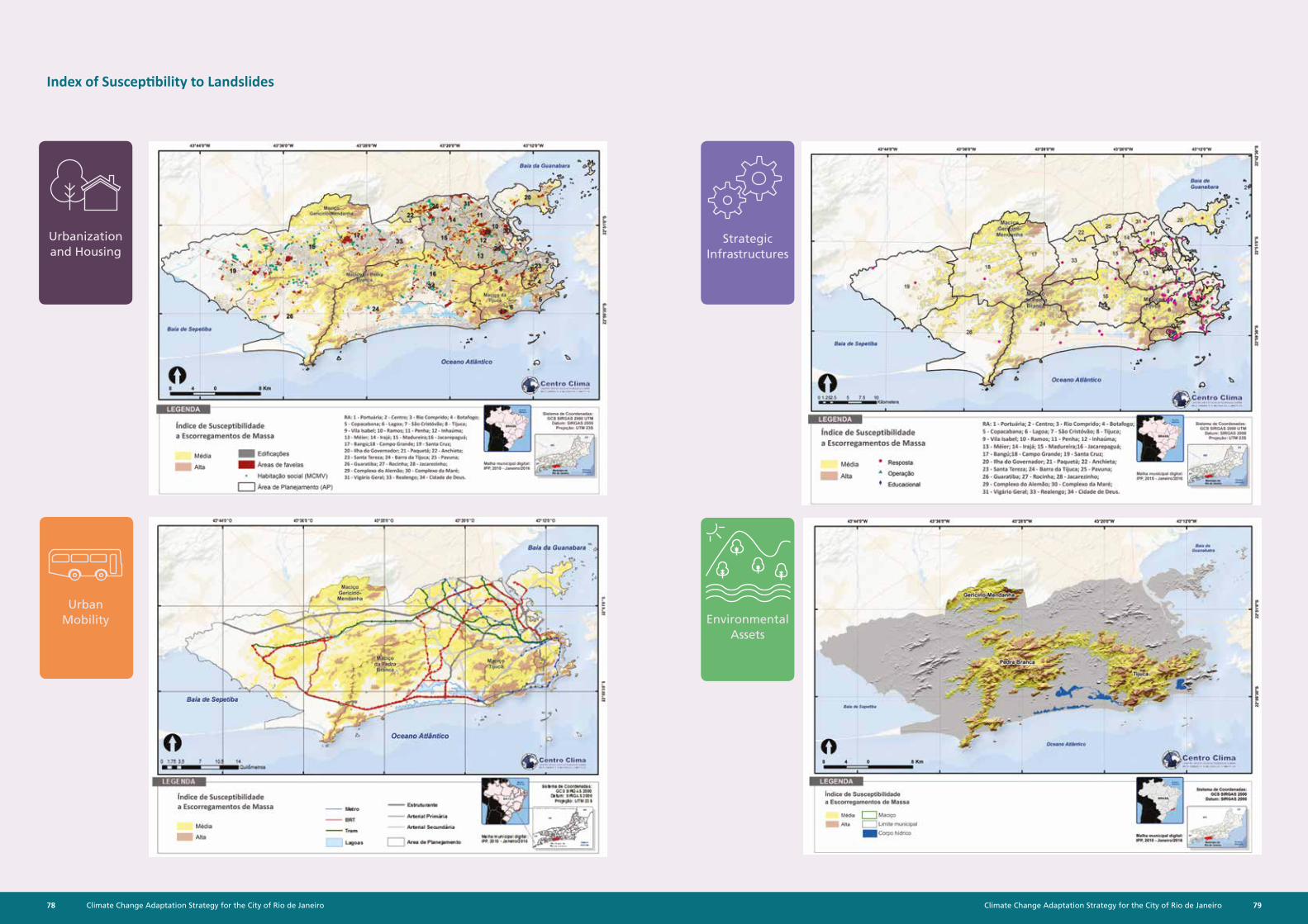
Climate Change Adaptation Strategy for the City of Rio de Janeiro78 79Climate Change Adaptation Strategy for the City of Rio de Janeiro
Index of Susceptibility to Landslides
Strategic Infrastructures
Environmental Assets
Urbanization and Housing
Urban Mobility
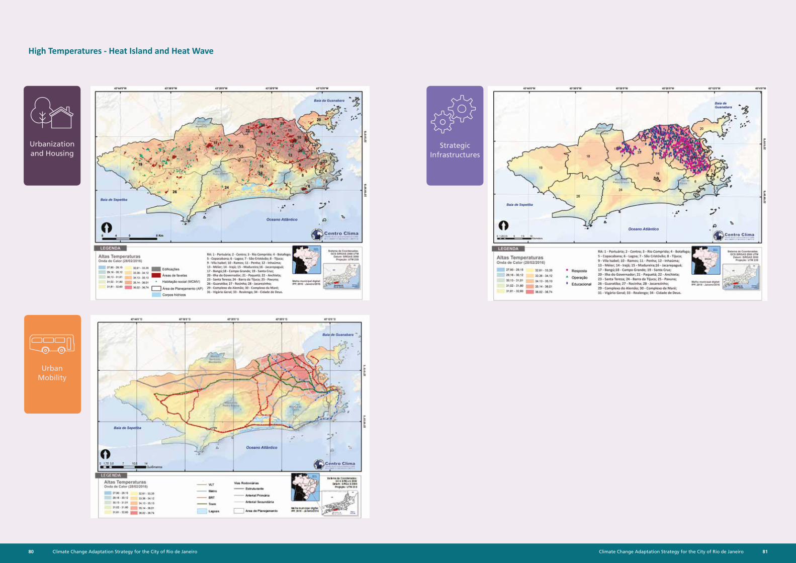
Climate Change Adaptation Strategy for the City of Rio de Janeiro80 81Climate Change Adaptation Strategy for the City of Rio de Janeiro
High Temperatures - Heat Island and Heat Wave
Strategic Infrastructures
Urbanization and Housing
Urban Mobility
Climate Change Adaptation Strategy for the City of Rio de Janeiro82 83Climate Change Adaptation Strategy for the City of Rio de Janeiro
Actors involvedSME, SMAC, Civil Defense, Alerta
Rio, COR
SME, SMAC, Civil Defense, Geo-Rio,
CORSME, SMAC, COR
SME, SMAC, Civil Defense, Alerta
Rio, COSME, SMAC, COR SME, SMAC, COR
P1.2 Expand and integrate monitor-
ing network
Monitor winds, tides, and waves
in bays and ocean.
Expand the use of open source
satellite monitor-ing data on, as an example, precip-itation and soil
humidity to gauge the probability of landslides, in line
with the latest technical-scientific
knowledge
Establish a spatial-ly consistent net-work of meteoro-logical monitoring
(temperature, humidity, wind direction and
intensity) for all the city of Rio de Janeiro, including its use in public health studies.
Expand rainfall and river flow
monitoring net-work, especially in AP 4 and AP 5, making data
available through WebGIS
Establish a spatially consis-tent network of meteorological
monitoring (pres-sure, temperature,
humidity, wind direction and in-tensity, UV factor,
sunshine).
Refine databases and monitoring networks to de-tect medium and long term climate
variations.
Actors involved
SMAC, Alerta Rio, Civil Defense,
DHN, INMET, Geo-Rio
SECT, SMAC, Civil Defense, Geo-Rio
SMAC, SMU, SMS, SECT
SMAC, Alerta Rio, Civil Defense
SMAC, SMU, SECTMunicipal Secre-
tariats
P1.3 Update infor-mation
Gather and sys-tematise infor-
mation on waves, tides (sea level),
and winds.
Oversee urban expansion over Environmental
Protection Areas with the aid of satellite images
Gather and sys-tematise meteo-
rological informa-tion currently
dispersed across different entities.
Update curves of intensity-dura-
tion-frequency of rains for project rains in drainage
works and analysis of the stationarity
of precipitation historical series.
Gather and sys-tematise meteo-
rological informa-tion currently
dispersed across different entities.
Obtain access to a larger number of up-to-date global
and regional climate models, to carry out projec-tions of climate
hazards of interest to the city and
understand their possible conse-
quences
Actors involved
Municipal sec-retariat , DHN,
INMET, airports, COR
SMAC, SMU, Geo-Rio, COR
Municipal sec-retariat , DHN,
INMET, airports, COR
Rio-Águas
Municipal sec-retariat , DHN,
INMET, airports, COR
Municipal Secre-tariats, COR
P1.4 Build models of systems
Characterise wave incidence (refrac-tion-diffraction) on the coastline for all possible
scenarios in high seas and different
sea level condi-tions
Further develop studies on slope stability, taking into consider-ation land use and land-cover
change scenarios under influence of extreme weather events (precipita-
tion, temperature) projected by vari-ous climate mod-els and timeslices
Develop, imple-ment and adjust mesoscale model (such as WRF) to
complete high-res-olution mapping of the spatial and temporal distribu-tion of tempera-ture, wind, and
humidity
Carry out hydro-dynamic model-ling of the main watersheds for different time
lags, as well as the mapping and risk analysis of flood
and heavy rainfall for the present
and future scenar-ios, considering
alternative urban expansion, rainfall
variability, and mean sea level
rise.
Develop, imple-ment and adjust mesoscale model (such as WRF) to
complete high-res-olution mapping of the spatial and temporal distribu-tion of meteoro-
logical parameters
Refine current computer tools or encourage insti-tutional partner-ships to carry out climate modelling
Actors involvedSMAC, SECT, DHN, INPH, Universities,
Rio-Águas, COGeo-Rio, COR
SMAC, COR, SECT, Universities,
Fiocruz
SMAC, SECT, DHN, INPH, Rio-Águas,
COR
SMAC, SECT, Uni-versities, COR
Municipal Secretariats
P1.1 Disseminate knowledge
Elaborate educational material about the influence of meteorological systems and environmental factors in triggering hazardous events, to be disseminated to the population, especially the school community Improve communication channels between the City Government and the population of Rio, enabling real time dissemination of hazardous event warnings (meteorological and ocean events) in particular to strategic groups (surf associations, fishermen, marinas, Lifesavers Corps of the Firefighting Department, neighbourhood association, local business owners, community health agents, heads of educational institutions, people responsible for Support Points, the City Guard, among others)
Elaborate educa-tional material
on climate change, climate modelling, and
weather forecast systems
InitiativeRise in Mean Sea Levels and Wave
HeightLandslides
Heat Island and Heat Waves
FloodsMeteorological Systems (Winds)
Climate Model
`Pillar 1 - Advance current knowledge
Climate Hazards
Appendix 2
Climate Change Adaptation Strategy for the City of Rio de Janeiro84 85Climate Change Adaptation Strategy for the City of Rio de Janeiro
P2.1Disseminate scientific knowl-
edge
Elaborate courses and education-al material on oceanographic and atmospher-ic variables, to
disseminate the climate change
issue
Update courses and educational
material regularly in accordance with the latest
advancements in technical-scientific
knowledge on meteorological events, hillslope
stability, and disas-ter risk manage-
ment
Elaborate courses and education-al material on
the influence of meteorological systems on the city's climate
Elaborate courses and education-al material on sustainable ap-
proaches to urban drainage systems
- Best Mangement Pratices (BMP), Low Impact De-velopment (LID),
Sustainable Urban Drainage Systems
(SUDS), Water Sensitive Urban Design (WSUD), Offsetting Tech-
niques, Waterfont Design and Urban
River Recovery.
Elaborate courses and education-al material in
accordance with the latest tech-nical-scientific
knowledge
Elaborate educa-tional material climate change and modelling
to technical staff and experts of
different Secretar-iats and agencies, foundations, and companies per-
taining to the City Government.
Actors involved SMU, SECT, SMAC Geo-Rio, CORSMAC, IPP, SMS,
Fiocruz, CORSMU, SMAC, IPP
SMAC, CET-Rio, DHN, INMET, Air-
ports, COR
SMAC, IPP, SECT, Geo-Rio, COR
P2.2 Training of multi-disciplinary
teams
Offer course and workshop cycles focused on prevention and preparation against possible events, including monitoring and analysis of socio-economic, geophysical, meteorological, oceanographic, engineering, and biological information
Improve the pro-cess of licensing for works and
developments on the waterfront,
taking into consid-eration standards of sustainability and resilience to climate change
related to the ma-rine environment.
Incorporate the findings of studies on land use and
land-cover change scenarios and
future climate sce-narios in geotech-nical assessments
Disseminate the use of atmospher-ic modelling and mesoscale models
such as WRF.
Introduce an inte-grated vision for urban planning with a focus on flood control
Enable licensing of green infrastruc-ture and sustain-able approaches
to urban drainage systems
Disseminate the use of atmospher-ic modelling and
wind pattern model
Encourage a critical analysis of
climate projec-tions and their consequences,
and incorporate information into planning using tools actually
available
Host a cycle of specialised talks and courses for varied entities and secretariats, with the aim of exchange information and knowledge
Actors involvedSMU, SMAC, Alerta Rio,
Rio-Águas, COR
SMAC, SMU, Geo-Rio
SMAC, CORSMAC, SMU, Rio-Águas
COR, SMAC, SECT
Municipal Secre-tariats COR,
Geo-Rio, Rio- Águas, Alerta Rio
P4.1 Oversee policies, plans and programmes on a
regular basis.
Elaborate annual Reports on storm surge and coastal flooding events (meteorological tide) with valua-tion of damages.
Elaborate annual reports on urban
expansion over ar-eas prone to land-
slides based on satellite imagery, and calculate the value of damages.
Elaborate annual reports on heat wave events and location of heat islands combined with public health information, and disseminate them
in the form of maps.
Elaborate annual reports on flood events and asso-ciates losses, with dissemination of maps outlining
critical areas. Im-plement a control centre and mod-elling of floods, oceanographic
information, and meteorological,
geotechnical, and public health data
georeferenced in a GIS environ-
ment.
Elaborate annual reports on the oc-currence of wind
gusts and associat-ed damage.
-
Actors involved Rio-Águas, Geo-Rio, Alerta Rio, Civil Defense, Civil Society, private sector, INPE, Universities, Fiocruz, SMAC, COR
P3.1 Establish scientific justifica-tion for adapta-tion actions and
policies
Host a cycle of workshops with the councillors of Rio on climate change, uniformisation of terminology, overview of current legislation framework, and proposals under discussion.
Define a baseline for the various hazards to be taken into consideration in policymaking, urban planning, architectural projects and warning systems - such as baseline sea level, lines of erosion control, possible occurrence of cyclones, conceptu-al definition of heat waves, critical thresholds of wind velocity, and potential damage).
Encourage scientific research to serve as input to regulatory updates (including building codes) and to incorporate the agenda of risk management and increased resilience, encompassing preventive and mitigation initiatives, preparation, response and recovery actions for extreme event.
Stimulate solutions that integrate the various urban systems, considering the direct and indirect consequences of hazards and respective interdependencies (flood controls by the use of free spaces, multifunctional landscapes, hillside stabilization works, protection of native vegetation on hillslopes, riverbanks and restingas).
Review policies, plans, and programs such as the Directive Plan in light of potential effects from climate hazards
Actors involvedCOR, Alerta Rio,
SMAC, SMU, SECT, CMRJ, Civil Office
COR, Alerta Rio, SMAC, SMU, SMH, CMRJ, Civil Office
COR, Alerta Rio, SMAC, SMU, Rio-
Águas, CMRJ, Civil Office
COR, Alerta Rio, SMAC, SMU, SMO, Rio Águas, CMRJ,
Civil Office
Alerta Rio, SMAC, SMU, COR CMRJ,
Civil Office
COR, Alerta Rio, SMAC, CMRJ
Pillar 2 - Promote capacity building of decision makers
Pillar 4 - Promote evaluation and follow-up of initiatives
Pillar 3 - Foster the incorporation of hazards into government planning and management
InitiativeRise in Mean Sea Levels and Wave
HeightLandslides
Heat Island and Heat Waves
FloodsMeteorological Systems (Winds)
Climate Model
InitiativeRise in Mean Sea Levels and Wave
HeightLandslides
Heat Island and Heat Waves
FloodsMeteorological Systems (Winds)
Climate Model
InitiativeRise in Mean Sea Levels and Wave
HeightLandslides
Heat Island and Heat Waves
FloodsMeteorological Systems (Winds)
Climate Model
Climate Hazards
Climate Hazards
Climate Hazards

Climate Change Adaptation Strategy for the City of Rio de Janeiro86 87Climate Change Adaptation Strategy for the City of Rio de Janeiro

Climate Change Adaptation Strategy for the City of Rio de Janeiro88