click here to return to usgs publications hydrologic … unit maps united states geological survey...
TRANSCRIPT

Hydrologic Unit Maps
United States Geological Survey Water-Supply Paper 2294
RCN 3
Click here to return to USGS publications
Hydrologic Unit Maps By PAUL R . SEABER, F . PAUL KAPINOS, and GEORGE L . KNAPP
U.S . GEOLOGICAL SURVEY WATER-SUPPLY PAPER 2294
������
U.S. DEPARTMENT OF THE INTERIOR
BRUCE BABBITT, Secretary
U.S . GEOLOGICAL SURVEY GORDON P. EATON, Director
Any use of trade, product, or firm names in this publication is for descriptive purposes only and does not imply endorsement by the U .S . Government
First printing 1987 Second printing 1994
UNITED STATES GOVERNMENT PRINTING OFFICE : 1987
For sale by the Books and Open-File Reports Section, U .S . Geological Survey, Federal Center, Box 25425, Denver, CO 80225
Library of Congress Cataloging in Publication Data
Seaber, Paul R . Hydrologic unit maps .
(U .S . Geological Survey water supply-paper ; 2294) Bibliography: p. Supt. of Docs. no . : 119.13:2294 1 . Watersheds-United States-Maps. 2 . Hydrology-
United States-Maps . I . Kapinos, F. Paul . II . Knapp,George L. III . Title . IV. Series.
GB990.S43 1986 553.7'0973 85-600297
�����������������������
CONTENTS Abstract 1 Introduction 1 History and development 2 Description of the hydrologic units 3
Hydrologic unit codes 3 Hydrologic unit names 5
Description of the Hydrologic Unit Maps 5 Compilation guidelines 6
Basic criteria 7 Technical criteria 8 Additional specifications 8
Coastal boundaries 8 Code identification 10 Digitized units 10 Drainage areas 10
Review and approval 10 Conflicts regarding boundaries 11 Maintenance and updating 11 Uses 11
National Water Data Network 11 Cataloging and coordinating data 12 Other uses of Hydrologic Unit Maps 12
Summary 13 Selected bibliography 13
PLATE
1 . Map of water-resources regions showing accounting units of the National Water Data Network In pocket
FIGURES
1 . Hierarchy of hydrologic units shown on Hydrologic Unit Maps 3 2. Map showing water-resources regions of the United States 4 3 . Map showing a section of a Hydrologic Unit Map 6 4 . Explanation shown on a typical Hydrologic Unit Map 7 5 . Types of subregions and accounting units showing their relationship to the catalog-
ing units 9
TABLE
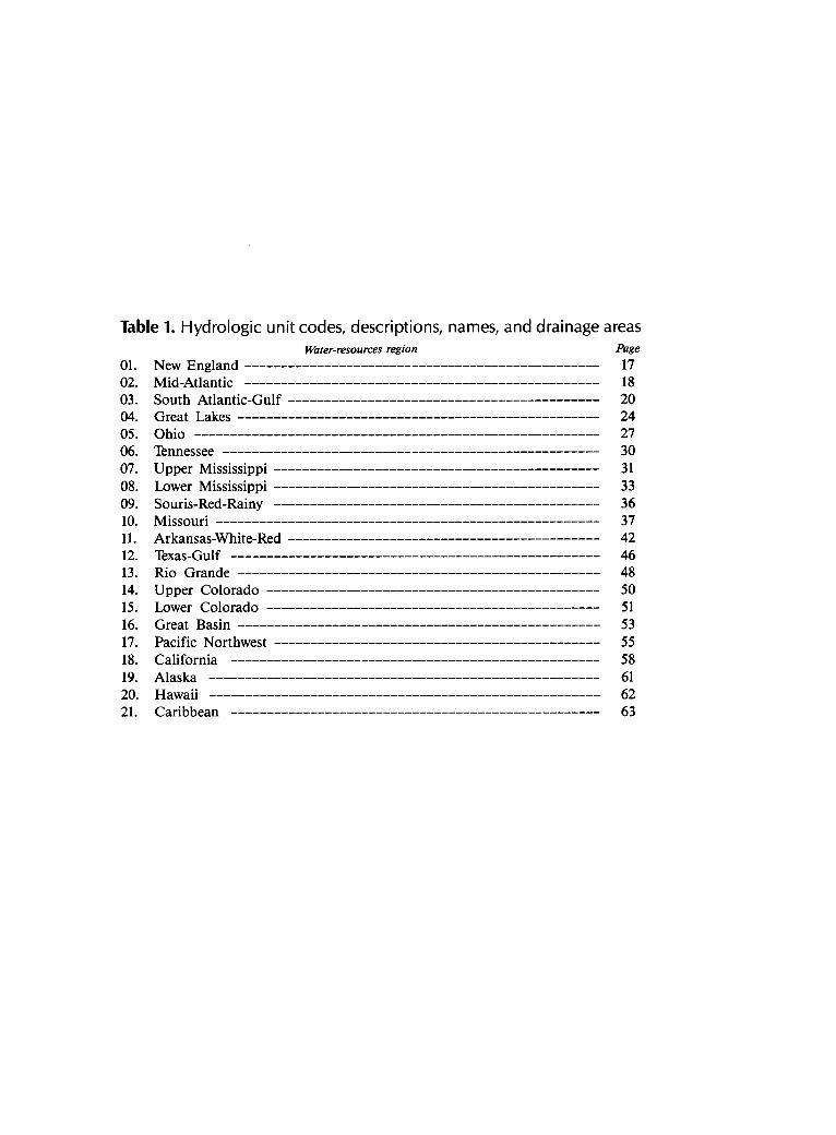
1 . Hydrologic unit codes, descriptions, names, and drainage areas 15
Contents III

Hydrologic Unit Maps By Paul R . Seaber, F. Paul Kapinos, and George L . Knapp
Abstract
A set of maps depicting approved boundaries of, and numerical codes for, river-basin units of the United States has been developed by the U.S . Geological Survey. These "Hydro logic Unit Maps" are four-color maps that present information on drainage, culture, hydrography, and hydrologic boundaries and codes of (1) the 21 major water-resources regions and the 222 subregions designated by the U.S . Water Resources Council, (2) the 352 accounting units of the U.S. Geological Survey's National Water Data Network, and (3) the 2,149 cataloging units of the U.S . Geological Survey's "Catalog of information on Water Data :" The maps are plotted on the Geological Survey State base-map series at a scale of 1 :500,000 and, except for Alaska, depict hydrologic unit boundaries for all drainage basins greater than 700 square miles (1,813 square kilometers) . A complete list of all the hydrologic units, along with their drainage areas, their names, and the names of the States or outlying areas in which they reside, is contained in the report .
These maps and associated codes provide a standardized base for use by water-resources organizations in locating, storing, retrieving, and exchanging hydrologic data, in indexing and inventorying hydrologic data and information, in cataloging water-data acquisition activities, and in a variety of other applications. Because the maps have undergone extensive review by all principal Federal, regional, and State water-resource agencies, they are widely accepted for use in planning and describing water-use and related land-use activities, and in geographically organizing hydrologic data . Examples of these uses are given in the report . The hydrologic unit codes shown on the maps have been approved as a Federal Information Processing Standard for use by the Federal establishment .
INTRODUCTION
This report describes the U.S . Geological Survey's standard map series called "Hydrologic Unit Maps" and presents the codes, names, and boundaries of hydrologic units in the United States and the Caribbean outlying areas . The four-color maps depict a hydrologic system that divides the United States into 21 major regions . These regions are currently (1984) further subdivided into 222 subregions, 352 accounting units, and, finally, into 2,149 cataloging units. These four levels of subdivisions, used for the collection and organization of hydrologic data,
are referred to as "hydrologic units!' The identifying numeric codes associated with these units are "hydrologic unit codes ." Each hydrologic unit has been assigned a name; in most cases, the name corresponds to the principal hydrologic feature within the unit . The Hydrologic Unit Maps show drainage, hydrography, culture, and political and hydrologic unit boundaries and codes, thus providing a standard geographic and hydrologic frame-work for detailed water-resource and related land-resource planning . Also included on the maps are the Federal In-formation Processing Standards State and county codes (US. National Bureau of Standards, 1983) .
In recognition that such maps were needed by almost everyone working in water resources in the United States, this set of maps covers the entire United States and the Caribbean outlying areas . The maps, published in a series beginning in 1974 at a scale of 1:500,000 (1 inch equals nearly 8 miles), present twice the detail of previous river-basin maps using the Geological Survey State Map series as a base. They delineate all river basins having a drainage area of at least 700 square miles except for river basins in the State of Alaska . In special instances, river basins of less than 700 square miles have been delineated .
These maps and associated codes provide a standardized base for use by water-resources organizations in locating, storing, retrieving, and exchanging hydrologic data, in indexing and inventorying hydrologic data and information, in cataloging water-data acquisition activities, and in a variety of other applications .
The Hydrologic Unit Map series was initiated in the fall of 1972 by the U.S. Geological Survey's Office of Water Data Coordination, in cooperation with the U.S . Water Resources Council and supported by the U.S. Geological Survey's Resources and Land Information pro-gram (Seaber and others, 1975) . The need for nationwide standardization by obtaining acceptance of and agreement on the maps by a broad spectrum of water-resource interests was acknowledged from the beginning . Thus, the maps were thoroughly reviewed throughout the country. This paper describes the methods and criteria used to produce the Hydrologic Unit Maps so that the map delineations, coding, and naming system can be understood and used to full advantage. Maintenance, updating, and use
Introduction 1

of the maps can be accomplished effectively only within a framework of the background, history, and development of the maps .
HISTORY AND DEVELOPMENT
Hydrologic maps available before 1972 were unsatisfactory for many purposes because of inadequate bases or scales as well as lack of agreement about hydrologic subdivisions among Federal, State, and local agencies. Federal and State agencies, Congress and its committees, the "Federal Register,' treaties, compacts, adjudications, Presidential Executive orders, river-basin commissions, and others used many incompatible criteria for names, codes, hydrographic boundaries, and river basins (Kammerer, 1969) . After many years of use of unsatisfactory and inadequate hydrologic maps, discussions among representatives of Federal and State agencies, initiated in 1972, led to nearly unanimous agreement on the need for a national project to develop uniform and widely accept-able hydrologic boundaries and to present them on nationally consistent base maps . A need for standardization of hydrologic units was evident throughout the country.
Although this project dates from 1972, the national effort to depict hydrologic units really began more than 60 years earlier :
For the purpose of uniformity in presentation of reports, a general plan has been agreed upon by the U.S . Reclamation Service, the US . Weather Bureau, and the U.S. Geological Survey, according to which the area of the United States has been divided into 12 parts whose boundaries coincide with certain natural drainage areas (US . Geological Survey, 1910, p . 10) .
Several other attempts to produce a set of uniform maps for the Nation were made between 1910 and 1972, although the Geological Survey's 12-part subdivision was generally accepted for publication of water data .
The U.S. Army Corps of Engineers and the U.S . Department of Agriculture have made comprehensive river-basin studies nationwide. The boundaries of these studies are usually as outlined in the 1959-1960 reports of the Senate Select Committee on National Water Resources known as "The Kerr Report" (U.S. Senate, 1959-1960) . General river-basin planning policies were established in 1962 by Senate Document 97 prepared under the direction of the President's ad hoc Water Resources Council . These reports led to Public Law 89-80, the Water Resources Planning Act (US. Congress, 1965) . This act, together with U.S. Bureau of the Budget (1964) Circular A-67 and other events in the mid-1960's and early 1970's provided the impetus for producing the Hydrologic Unit Map series .
The Water Resources Planning Act established the U.S. Water Resources Council and directed it to "main
tain a continuing study and prepare an assessment***of the adequacy of supplies of water necessary to meet the water requirements in each water-resource region in the United States***" as well as to "maintain a continuing study of the relation of regional or river-basin plans and programs to the requirements of larger regions of the Nation"
U.S . Bureau of the Budget Circular A-67 prescribed guidelines for coordinating water-data acquisition activities of the more than 30 Federal agencies that collect or use water data and assigned lead-agency responsibility to the Department of the Interior, which in turn dele-gated these coordinating responsibilities to the Geological Survey.
It was immediately evident that both the Water Resources Council and the U.S. Geological Survey should perform their assigned functions on the basis of precise and systematic definitions of hydrologic areas of appropriate sizes .
The Water Resources Council's program for carrying out its duties was the National Assessment of Water and Related Land Resources . The first national assessment was issued in 1968 (US. Water Resources Council, 1968) . Early in the program, the council found a need for standard geographic and hydrographic bases to maintain continuity in its assessments . One of the initial tasks in preparing for the second assessment was the delineation of geographic areas suitable for analysis. The regions and subregions were originated primarily by the council to meet this need (US. Water Resources Council, 1970).
To discharge its responsibilities as outlined in Circular A-67, the US. Geological Survey established the Office of Water Data Coordination to (1) maintain a catalog of information on water data, (2) undertake a continuing review of water-data requirements, (3) prepare a Federal plan for efficient utilization of water-data activities, and (4) design and operate a national water data network . Accounting units and cataloging units were originated by the Geological Survey as part of these responsibilities. The cataloging units used for the Hydro-logic Unit Maps supplant an earlier set used by the Geological Survey in its "Catalog of Information on Water Data" (1966-1972) .
The current Hydrologic Unit Map boundaries were adapted, in part, from several publications: "Catalog of Information on Water Data" (US. Geological Survey, Of fice of Water Data Coordination, 1973); "Water-Resources Regions and Subregions for the National Assessment of Water and Related Land Resources" (U.S. Water Resources Council, 1970) ; "Atlas of River Basins of the United States" (US. Department of Agriculture, 1963, 1970) ; "River Basin Maps Showing Hydrologic Stations" (Federal Interagency Committee on Water Resources, 1961) ; and State planning maps .
2 Hydrologic Unit Maps
�
The political subdivision code was taken from "Counties and County Equivalents of the States of the United States" presented in Federal Information Process ing Standards Publication 6-2, issued by the U.S . National Bureau of Standards (1973) . The addition of the Federal Information Processing Standards code to the maps allows data to be cataloged politically as well as hydrologically.
DESCRIPTION OF THE HYDROLOGIC UNITS
Hydrologic Unit Codes
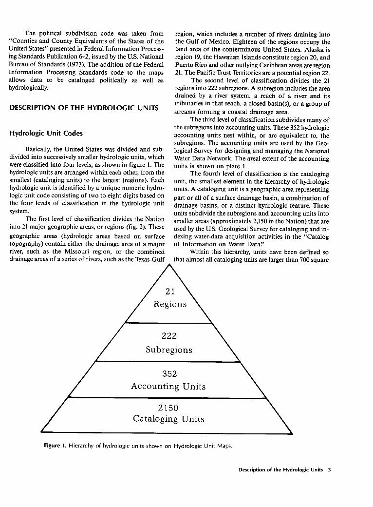
Basically, the United States was divided and sub-divided into successively smaller hydrologic units, which were classified into four levels, as shown in figure 1 . The hydrologic units are arranged within each other, from the smallest (cataloging units) to the largest (regions) . Each hydrologic unit is identified by a unique numeric hydrologic unit code consisting of two to eight digits based on the four levels of classification in the hydrologic unit system .
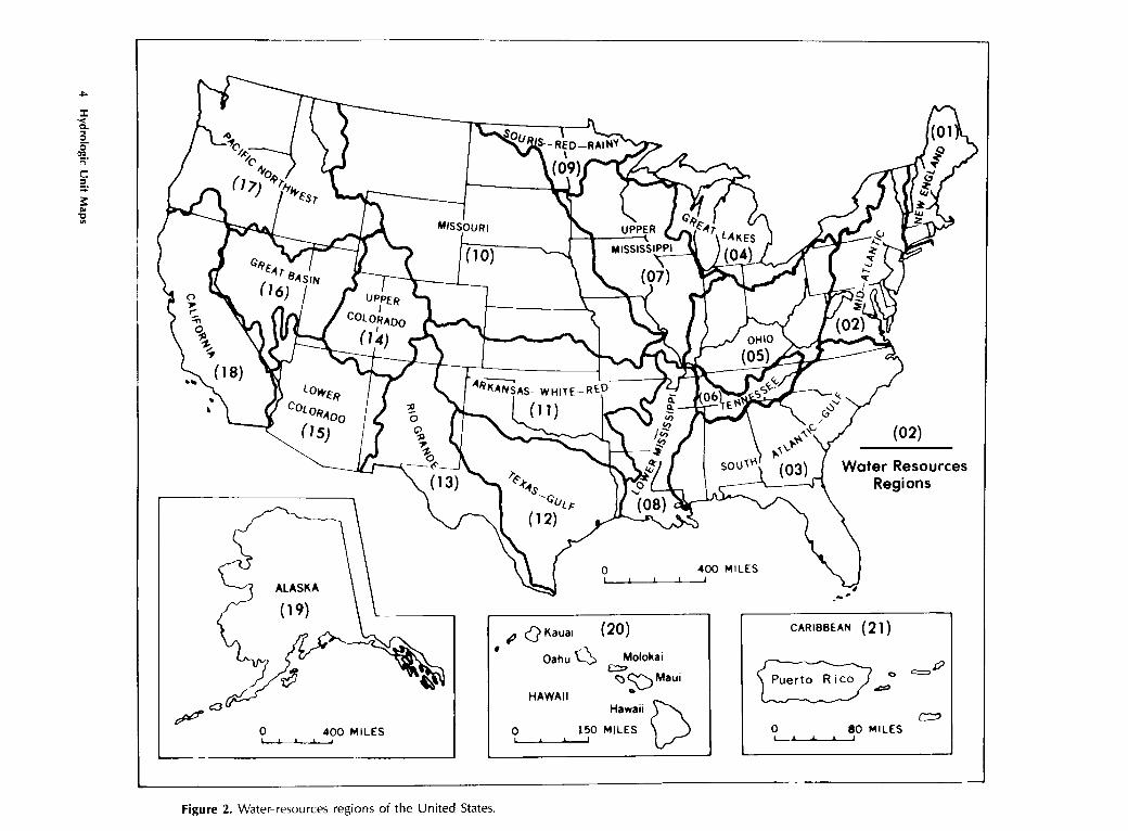
The first level of classification divides the Nation into 21 major geographic areas, or regions (fig . 2) . These geographic areas (hydrologic areas based on surface topography) contain either the drainage area of a major river, such as the Missouri region, or the combined drainage areas of a series of rivers, such as the Texas-Gulf
region, which includes a number of rivers draining into the Gulf of Mexico. Eighteen of the regions occupy the land area of the conterminous United States . Alaska is region 19, the Hawaiian Islands constitute region 20, and Puerto Rico and other outlying Caribbean areas are region21 . The Pacific Trust Territories are a potential region 22 .
The second level of classification divides the 21 regions into 222 subregions. A subregion includes the area drained by a river system, a reach of a river and its tributaries in that reach, a closed basin(s), or a group of streams forming a coastal drainage area .
The third level of classification subdivides many of the subregions into accounting units . These 352 hydrologic accounting units nest within, or are equivalent to, the subregions . The accounting units are used by the Geological Survey for designing and managing the National Water Data Network . The areal extent of the accounting units is shown on plate 1 .
The fourth level of classification is the cataloging unit, the smallest element in the hierarchy of hydrologic units. A cataloging unit is a geographic area representing part or all of a surface drainage basin, a combination of drainage basins, or a distinct hydrologic feature . These units subdivide the subregions and accounting units into smaller areas (approximately 2,150 in the Nation) that are used by the U.S. Geological Survey for cataloging and indexing water-data acquisition activities in the "Catalog of Information on Water Data."
Within this hierarchy, units have been defined so that almost all cataloging units are larger than 700 square
Figure 1. Hierarchy of hydrologic units shown on Hydrologic Unit Maps.
Description of the Hydrologic Units 3
Water-resources of the United States
A
d OOOQ C
m
Figure 2 .
regions
.
�
miles (1,813 square kilometers) in area . In special circumstances, units smaller than 700 square miles are identified on some of the maps .
The boundaries or areal extent of the hydrologic units may be revised at the request of local users, and with the approval of the Geological Survey. Changes are more likely to be made to the cataloging unit boundaries than to boundaries of the regions, subregions, and accounting units.
An eight-digit code uniquely identifies each of the four levels of classification within four two-digit fields . The first two digits identify the water-resources region ; the first four digits identify the subregions ; the first six digits identify the accounting unit ; and the addition of two more digits for the cataloging unit completes the eight-digit code. An example is given below using hydro-logic unit code 01080204:
01-the region 0108-the subregion
010802-the accounting unit 01080204-the cataloging unit
A 00 in the two-digit accounting unit field indicates that the accounting unit and the subregion are the same. Likewise, if the cataloging unit code is 00, it is the same as the accounting unit .
Hydrologic Unit Names
In addition to hydrologic unit codes, each hydrologic unit has been assigned a name corresponding to the principal hydrologic feature(s) within the unit . In the absence of such features, the assigned name may reflect a cultural or political feature within the unit . All regions and subregions are uniquely named ; however, the accounting units are uniquely named only within each region, and the cataloging units are uniquely named only within each accounting unit. Duplication of some names at the cataloging unit level is unavoidable because a large number of streams found throughout the Nation share the same names .
A complete list of all hydrologic unit codes, their names, the names of the States or outlying areas in which they reside, and their drainage areas is given in table 1 (at back of report) .
DESCRIPTION OF THE HYDROLOGIC UNIT MAPS
The Hydrologic Unit Map Series consists of 47 maps on 53 sheets. The maps present 49 States at a scale of 1:500,000, or about 8 miles to the inch (1 centimeter to 5 kilometers) . This scale permits most States to be shown on a single map of convenient size. Texas is shown
on four sheets, and Montana, Michigan, and California are shown on two sheets each . Three groups of States-Massachusetts, Rhode Island, and Connecticut; Maryland, Delaware, and the District of Columbia; and Vermont and New Hampshire-are combined on a single sheet for each group . Alaska, because of its large size and less accurately defined drainage, is shown at a scale of 1:2,500,000, or about 40 miles to the inch (1 centimeter to 25 kilometers). Puerto Rico is shown on the Caribbean region map at a scale of 1:240,000, or about 4 miles to the inch (1 centimeter to 2.4 kilometers) . The other outlying Caribbean areas are shown on this map at scales ranging from 1 :250,000 to 1:1,000,000 .
In preparing the maps, the best available Geological Survey State base materials were obtained and then modified where necessary to allow matching of hydrologic and political boundaries from sheet to sheet. The resulting set of maps thus provides good uniformity and accuracy on a nationwide basis . The State base is appropriate because water-resources planning and management are largely conducted at the State level . However, the maps are also usable at regional or national levels by such entities as river-basin commissions, water-management districts, and Federal agencies . Because of their uniform scale, the maps can be cut and spliced to form a mosaic of any region or area desired.
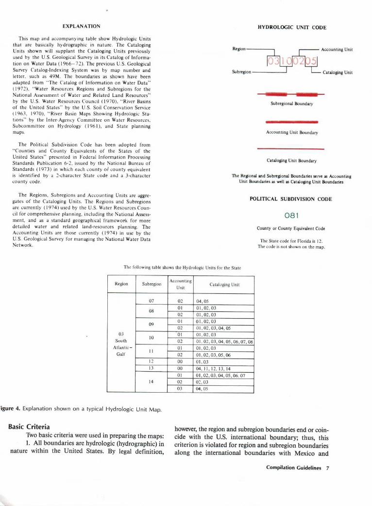
Figure 3, a section of the Hydrologic Unit Map for Wisconsin, shows the components depicted by the series . Hydrographic features (streams, lakes, and bays, and their names) are shown in blue ; cultural features (political boundaries, geographic coordinates, and names of places) are in black ; hydrologic unit boundaries and the eightdigit hydrologic unit codes are in red ; and the county codes are in green.
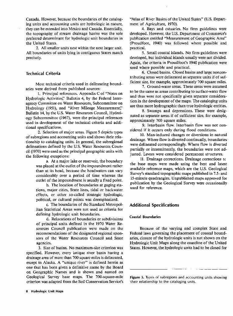
Figure 4 shows the map explanation on a typical Hydrologic Unit Map . It includes the major source references from which the boundaries were adopted, and it illustrates the makeup of the eight-digit hydrologic unit code . A table shows the hydrologic units for the States broken down according to their regions, subregions, accounting units, and cataloging units. The political sub-division code is illustrated with a simple three-digit county code and a two-digit State code .
The Hydrologic Unit Maps have been adopted as "official issue" by the Federal Government . The associated codes and names for identifying hydrologic units in the United States and the Caribbean outlying areas have been adopted as a Geological Survey Data Standard (U.S . Geological Survey, 1982) . This is a part of the Geological Survey program for standardizing data elements and representations used in automated earth-science systems .
The proposed codes and names were published in the December 28, 1982, "Federal Register:' After a public comment period, the Secretary of Commerce approved the codes and names as a Federal Information Processing Standard on October 25, 1983 .
Description of the Hydrologic Unit Maps 5

�
MAP OF HYDROLOGIC UNITS
This new series of U .S . Geological Survey State base maps provide a uniform, nationally consistent set of hydrologic units accurately delineated to show drainage basins down to approximately 700 square miles in area .
County Code
Cataloging Unit Boundary
Regional Boundary
Cente
Figure 3 . Section of a Hydrologic Unit Map (Wisconsin) .
COMPILATION GUIDELINES
The following guidelines were used for preparing and reviewing the Hydrologic Unit Maps. The prepara-
Accounting� Unit� Boundary�
Hydrologic� Unit� Code�
Subregional� Boundary�
tion of draft maps and the initial review process occurred simultaneously because one of the major criteria for producing the maps was local acceptance of the hydrologic units.
6 Hydrologic Unit Maps
��
EXPLANATION
This map and accompanying table show Hydrologic Units that are basically hydrographic in nature . The Cataloging Units shown will supplant the Cataloging Units previously used by the U.S . Geological Survey in its Catalog of Information on Water Data (1966-72). The previous U.S . Geological Survey Catalog-Indexing System was by map number and letter, such as 49M. The boundaries as shown have been adapted from "The Catalog of Information on Water Data" (1972), "Water Resources Regions and Subregions for the National Assessment of Water and Related Land Resources" by the U.S . Water Resources Council (1970), "River Basins of the United States" by the U.S . Soil Conservation Service (1963, 1970), "River Basin Maps Showing Hydrologic Stations" by the Inter-Agency Committee on Water Resources, Subcommittee on Hydrology (1961), and State planning maps .
The Political Subdivision Code has been adopted from "Counties and County Equivalents of the States of the United States" presented in Federal Information Processing Standards Publication 6-2, issued by the National Bureau of Standards (1973) in which each county of county equivalent is identified by a 2-character State code and a 3-character county code .
The Regions, Subregions and Accounting Units are aggregates of the Cataloging Units. The Regions and Subregions are currently (1974) used by the U.S . Water Resources Council for comprehensive planning, including the National Assessment, and as a standard geographical framework for more detailed water and related land-resources planning . The Accounting Units are those currently (1974) in use by the U.S . Geological Survey for managing the National Water Data Network.
HYDROLOGIC UNIT CODE
Region Accounting Unit
Subregion ' I- Cataloging Unit
Subregional Boundary
Accounting Unit Boundary
Cataloging Unit Boundary
The Regional and Subregional Boundaries serve as Accounting Unit Boundaries as well as Cataloging Unit Boundaries
POLITICAL SUBDIVISION CODE
081 County or County Equivalent Code
The State code for Florida is 12 . The code is not shown on the map.
The following table shows the Hydrologic Units for the State
Region Subregion Accounting
Cataloging Unit
07
08
09
03 10 South
Atlantic- 11 Gulf
12 13
14
: igure 4. Explanation shown on a typical Hydrologic Unit Map.
Basic Criteria Two basic criteria were used in preparing the maps : 1 . All boundaries are hydrologic (hydrographic) in
nature within the United States . By legal definition,
Unit
02 O1 02 01 02 01 02 01 02 00 00 01 02 03
04,0501,02,0301,02,030 1 , 02, 0301, 02, 03, 04, 0501,02,0301, 02, 03,04, 05, 06, 07, 0801, 02, 0301, 02, 03, 05, 0601,0304,01, 02, 03, 04, 05, 06, 0702,0304,05
however, the region and subregion boundaries end or coincide with the U.S. international boundary; thus, this criterion is violated for region and subregion boundaries along the international boundaries with Mexico and
Compilation Guidelines 7
�
Canada. However, because the boundaries of the cataloging units and accounting units are hydrologic in nature, they can be extended into Mexico and Canada. Essentially, the topography of stream drainage basins was the sole preferred determinant for hydrologic unit boundaries in the United States .
2 . All smaller units nest within the next larger unit . All boundaries of units lying in contiguous States match precisely.
Technical Criteria
Most technical criteria used in delineating boundaries were derived from published sources :
1 . Principal references . Appendix C of "Notes on Hydrologic Activities," Bulletin 4, by the Federal Interagency Committee on Water Resources, Subcommittee on Hydrology (1951), and "River Mileage Measurement," Bulletin 14, by the U.S . Water Resources Council, Hydrology Subcommittee (1967), were the principal references used in development of the technical criteria and additional specifications.
2 . Selection of major areas . Figure 5 depicts types of subregions and accounting units and shows their relationship to cataloging units . In general, the subregional delineations defined by the U.S . Water Resources Council (1970) were used as the principal geographic units with the following exceptions :
a . At a major lake or reservoir, the boundary was placed at the outlet of the impoundment rather than at its head, because the headwaters can vary considerably over a period of time whereas the outlet of the impoundment is usually a fixed point .
b. The location of boundaries at gaging stations, major cities, State lines, tidal or backwater effects, or other so-called strategic hydrologic, political, or cultural points was deemphasized .
c. The boundaries of the Standard Metropolitan Statistical Areas were not used as criteria for defining hydrologic unit boundaries .
d . Relocations of boundaries or subdivisions of principal units defined in the 1970 Water Re-sources Council publication were made on the recommendations of the designated regional sponsors of the Water Resources Council and State agencies . 3 . Size of basins. No maximum-size criterion was
specified. However, every unique river basin having a drainage area of more than 700 square miles is delineated, except in Alaska . A "unique river" is defined herein as one that has been given a definitive name by the Board on Geographic Names and is shown and named on Geological Survey base maps. The 700-square-mile criterion was adapted from the Soil Conservation Service's
8 Hydrologic Unit Maps
"Atlas of River Basins of the United States" (US. Department of Agriculture, 1970) .
4. Bays and estuaries . No firm guidelines were developed . However, the US. Department of Commerce's publication entitled "Measurement of Geographic Area" (Proudfoot, 1940) was followed where possible and practical .
5 . Small coastal islands . No firm guidelines were developed, but individual islands usually were not divided . Again, the criteria in Proudfoot's 1940 publication were used where possible and practical .
6 . Closed basins. Closed basins and large noncon-tributing areas were delineated as separate units if of sufficient size, for example, approximately 700 square miles .
7 . Ground-water areas. These areas were assumed to be the same as areas contributing to surface-water flow and thus were not specifically given separate considera tion in the development of the maps. The cataloging units are thus more hydrographic than true hydrologic entities .
8 . Swamps and depressions . These were designated as separate areas if of sufficient size, for example, approximately 700 square miles.
9. Interbasin flow. Interbasin flow was not considered if it occurs only during flood conditions .
10. Man-induced changes or diversions in natural drainage . Where flow is diverted continually, boundaries were delineated correspondingly. Where flow is diverted partially or intermittently, the boundaries were not adjusted . Levees were considered permanent structures .
11 . Drainage corrections. Drainage corrections tc the base maps were made using the best and latest available reference maps, which are the U.S . Geological Survey's standard topographic maps published in 7.5- and 15-minute quadrangles. Unpublished maps approved for publication by the Geological Survey were occasionally used for reference.
Additional Specifications
Coastal Boundaries
Because of the varying and complex State and Federal laws governing the placement of coastal boundaries, closure of the hydrologic units is not shown on the Hydrologic Unit Maps along the coastline of the United States . However, the hydrologic units had to be closed for
Figure 5. Types of subregions and accounting units showing their relationship to the cataloging units .

��
A. Single River Basin B . Closed River Basin
Subregion or Cataloging Unit Accounting Unit Boundary Cataloging Unit
Boundary
C . Interior River Basin
D . Multiple River Basin E . Lake or Estuary (along a sea coast)
Compilation Guidelines 9

�
the purpose of digitizing for computing areal totals . Additional problems arose in the delineation of certain shorelines and coastal areas because the areas of the hydrologic units and corresponding areal totals (county, State, and so forth) should conform as closely as possible to the areal statistics published by the U.S . Bureau of the Census . The resolution of this complex problem is described in U.S. Geological Survey Professional Paper 964 by Anderson and others (1976) and in U.S. Geological Survey Open-File Report 77-555 by George L. Loelkes (1977) . Essentially, the U.S. Geological Survey accepted the guidelines for coastal areas developed in "Measurement of Geographic Area" by Malcolm J. Proudfoot (1940) . The procedure is explained more fully in Loelkes (1977, p. 18-21).
Code Identification
The region numbers were those assigned by the U.S. Water Resources Council (1970) . Subregion numbers, originally assigned in the same publication, were changed, if necessary, to reflect a nationally consistent downstream numbering of units. The accounting unit and cataloging unit numbers and boundaries were developed simultaneously with the maps by the two senior authors. Hydrologic unit numbers for the accounting and cataloging units were assigned in downstream order within each subregion . Where no downstream order was feasible, units were numbered north to south .
The political subdivision code was adopted from Federal Information Processing Standards Publication 6-2, issued by the U.S. National Bureau of Standards (1973) . Each county or county equivalent is identified by a two-character State code and a three-character county code. The State code is shown in the map explanation and the three-character county code for each county is shown on the maps .
Digitized Units
The hydrologic unit boundaries were digitized using the scale-stable scribe coat originals of the Hydrologic Unit Maps. The scale of the 1 :500,000 base maps was reduced in the digitization to 1:1,000,000 . Alaska, Hawaii, and the Caribbean received special treatment . Owing to digitizer-size restrictions and base-map divisions, large States were digitized in several parts and then combined to form full State data bases . A computer program was developed to use with the full State data bases to identify the hydrologic unit code associated with the point location (latitude and longitude) of a data site. Subsequently, the State boundaries were deleted and the individual State data bases were combined to form the national data base. Information on these partial and full data bases can be found in U.S . Geological Survey Circular 817, sequence no's . 145, 173, and 191 (U.S . Geological Survey, 1979) .
1 0 Hydrologic Unit Maps
Drainage Areas
One of the purposes of digitizing the hydrologic unit boundaries on the Hydrologic Unit Maps was to provide a national compilation of drainage areas, which is shown in table 1 . The areas originated as routine output from the digitizer are expressed in square inches of digitizer table. All areas were recomputed to square miles . Areas in all regions except Alaska are reported to three significant figures . Areas in Alaska are reported to two significant figures except for the subregions and accounting units, which are rounded to three significant figures.
The areas presented in table 1 have some inherent inaccuracies and should be used with some caution . The inaccuracies include the following : errors in locating the drainage boundaries on original topographic maps; errors in transferring the drainage boundaries to the scalestable base materials ; errors in digitizing the boundaries; errors introduced when partial States or full States were combined into the national data base ; errors in rounding the final numbers ; and, in the case of Alaska, errors due to the variation in map projections .
Through random comparisons with published drainage area values, it is estimated that the areas listed in table 1 are within 5 percent of the true values as deter mined by planimetering the same areas on the best available Geological Survey 7.5-minute topographic maps. The areas of the subregions and accounting units are generally subject to a smaller percentage of error than the cataloging units . The areas are presented herein to allow relative comparisons of drainage basin sizes, but not to establish them as official values . The areas listed for hydrologic units along the coasts or the Great Lakes may include both "inland water" and "water other than inland water" as described in Proudfoot (1940) and the U.S. Bureau of the Census (1970) .
REVIEW AND APPROVAL
The need for nationwide acceptance of and agreement on the Hydrologic Unit Maps by a broad spectrum of water-resource interests was acknowledged from the beginning of the program . Thus, the hydrologic unit boundaries, codes, and names were reviewed extensively by all principal Federal, regional, and State water-resources agencies across the country during a formal review process established for the map series .
The formal review process consisted of a field review by the four regional and 46 district offices of the U.S . Geological Survey's Water Resources Division, in conjunc tion with their principal regional, State, and local cooperators, followed by review and approval by the National Planning and Assessment Committee of the Water Resources Council . Approval by the National Planning and Assessment Committee constituted approval by the
Council of Representatives of the Water Resources Council, which had delegated this authority to the committee . The maps received final Water Resources Council approval between 1974 and 1977 .
CONFLICTS REGARDING BOUNDARIES
The overriding consideration in resolving any conflicts in boundary locations was to recognize boundaries and subdivisions most widely used and accepted by responsible State, regional, and Federal agencies, as long as the two basic criteria were met .
The Geological Survey's Water Resources Division districts were the prime source and authority for correcting hydrologic boundaries . State, regional, and Federal agencies were relied on for preferred ranking of units as well as delineation of unit boundaries and numbering of units . Boundary locations and ranking of units were essentially determined using professional judgment based on principles of hydrology and cartography.
Some boundary conflicts were resolved by the Water Resources Council after identification and documentation by the Geological Survey. Decisions at this level were limited to those for which agreement could not be reached locally or regionally, or those that were entrenched by law or Executive order. The hydrologic units affected by proposed boundary or numbering changes were documented for the Water Resources Council on a single set of State maps, which showed only those boundaries recommended by the Geological Survey after extensive field review.
All proposed changes in boundaries and numbering during the review process were documented and are on file with the Geological Survey's Office of Water Data Coordination in Reston, Va . This documentation describes the basis for the change, identifies the originator of the proposed change, and explains why each change was accepted or rejected . Minor undisputed changes in hydrologic boundaries made on the basis of hydrography or topography were not formally documented but are on file with the Geological Survey. Changes in previous boundary lines were not considered conflicts if all interested parties concurred with the changes, and if the changes were made in accordance with the criteria and specifications listed previously.
MAINTENANCE AND UPDATING
There is currently no plan to revise the Hydrologic Unit Maps except to correct major errors . Boundary, code, or name revisions can be accepted only from a responsi ble water-resources agency, whereas any user may notify the Geological Survey of errors on the maps. All changes in the hydrologic units, as cited in table 1 and in U.S.
Geological Survey Circular 878-A (U.S. Geological Survey, 1982), are subject to approval by the Geological Survey.
Recommendations for changes and questions concerning the list of entities and codes shown in table 1 should be addressed to the Office of Water Data Coordination, which then will process all necessary amendments:
U.S . Geological Survey Water Resources Division
Office of Water Data Coordination 417 National Center Reston, VA 22092
USES
The Hydrologic Unit Maps have been used and applied by many other agencies and are being increasingly adopted by them for official uses . They have lasting value in planning activities relating to land and associated water resources, and in organizing and disseminating data, on both a geographic and hydrologic basis . The maps are suitable for use in conjunction with computer graphics and for automatic plotting of station locations and other areal data .
For data collection, storage, and manipulation, a standard coding system is necessary for efficient use and dissemination . The Geological Survey uses the coding system to document all its water-data collection activities and efforts. The boundaries of the hydrologic units have been digitized for more efficient use with data processing and automatic plotting machines .
Other Federal agencies using the hydrologic units for codifying and displaying the data that were collected locally and nationwide include the Forest Service, U.S. Army Corps of Engineers, Soil Conservation Service, Fish and Wildlife Service, National Park Service, Council on Environmental Quality, and National Weather Service, as well as regional, State, and local agencies .
National Water Data Network
The entire activity involving water-data collection, handling, storage, and dissemination in the United States can be thought of as a national water-data system . This system embraces all Federal and non-Federal water-data activities that contribute to meeting the general need for water information to support planning and operating water-related programs . All organized activities concerned with collecting water data on and beneath the Earth's surface for this national system can be considered as the National Water Data Network . The Hydrologic Unit Maps show boundaries of discrete elements of this surface-water network .
Uses 1 1

�
Cataloging and Coordinating Data
The Hydrologic Unit Maps are used for geographically locating the data sites indexed in the National Water Data Exchange Program and the "Catalog of Informa tion on Water Data" and, therefore, constitute an important part of this data service.
Cataloging and coordinating play major roles in establishing design objectives for the National Water Data Network and provide the necessary basic information for planning, refining, and updating the network .
The "Catalog of Information on Water Data" was established by the Geological Survey in 1966 from information on some 60,000 activities supplied by more than 200 Federal, State, and local agencies and universities in the United States and by the Water Survey of Canada. The catalog is a file of information about water-data activities ; it is not a compilation of the collected water data .
In response to the increasing needs of the water-data user community, the Geological Survey established the National Water Data Exchange in 1976 to enhance the exchange of water data between collector and user. The Master Water Data Index, a computerized file developed and maintained by the National Water Data Exchange, identifies sites for which water data are available, the location of these sites, the organizations collecting the data, the types of data available, and the frequency of measurement of each major type of data . The number of activities identified in the Master Water Data Index has grown to about 400,000, representing more than 400 organizations. For example, the Geological Survey, through the National Water Data Exchange, has incorporated the hydrologic unit codes into its computer system to enable all its members to have rapid access to data holdings that consist of more than a billion water-resource measurements.
Other Uses of Hydrologic Unit Maps
The Hydrologic Unit Maps have been used by both Government agencies and private firms . The following is a partial listing of uses and users .
The Soil Conservation Service has adopted the Hydrologic Unit Maps as a base for collecting data in its natural-resource inventories and surveys . The Soil Con servation Service data are coded so that they can be stored and retrieved on the basis of hydrologic units . The addition of a hyphen and a three-digit Soil Conservation Service watershed code to the eight-digit code (for example, 05120107-014) makes the Hydrologic Unit Map coding system applicable to areas delineated as part of the implementation of Public Law 83-566 . As time and resources permit, the State conservationists of the Soil Conservation Service are putting the three-digit watershed
12 Hydrologic Unit Maps
coding system into effect as a supplement to the national hydrologic unit code.
The Geological Survey's National Mapping Division uses the hydrologic unit boundaries and coding system in its land-use and land-cover mapping program. Under this program, the conterminous States will be covered on the 1:250,000 scale map series over the next several years. All boundaries are again checked on the latest available accurate topographic maps, in order to ensure accuracy at this enlarged scale. The specifications for the land-use and land-cover and associated maps are given in Loelkes (1977) . A further description of these maps is given in Anderson and others (1976) . These Geological Survey land-use maps show (1) land use and cover, (2) Federal land ownership, (3) political units, (4) hydrologic units, (5) census county subdivisions, and (6) State land ownership .
The U.S. Fish and Wildlife Service is using the Hydrologic Unit Maps as bases on which to overprint its Stream Evaluation Map Series . The latter maps, provided to assist Federal and State agencies and water users in assessing the impact of proposed water-development projects on existing fishery resources, are a cooperative effort by the U.S. Department of the Interior, the U.S . Environmental Protection Agency, and the State Fish and Wildlife Departments of Colorado, Idaho, Montana, Nebraska, Nevada, North Dakota, Oklahoma, South Dakota, Texas, Utah, and Wyoming. The Fish and Wildlife Service, in conjunction with the Forest Service, has published another set of nationwide maps entitled "Ecoregion, Land-Surface Form and Hydrologic Unit Maps of the United States" (Bailey and Cushwa, 1982) .
The Environmental Protection Agency is using the coding system in its storage and retrieval system, as well as in its River-Reach File. The River-Reach File is a com puterized catalog of streams of the United States for organizing water-resources statistics and related information . In addition, it contains the digitized traces of streams, lakes, coastlines, and basin boundaries and provides a framework for simulated routing of streamflow and pollutants through the Nation's river systems . Computerized hard-copy displays and interactive graphics displays are available from the Environmental Protection Agency.
The Forest Service is using the maps to manage the resource data available for national forests . It is also using the maps as a base for the ongoing Inventory of Federal Reserved Water Rights . The National Park Service and the Bureau of Land Management are also using the maps for their portion of the Inventory of Federal Reserved Water Rights .
The U.S . Department of Energy has contracted with the Hanford Engineering Development Laboratory for the development of a Water Use Information System to help
plan energy strategy. The system, which came on line in 1979, contains data on electrical generating plants and surface-water resources; additional capabilities will be added later. The system uses the Hydrologic Unit Maps as its base and provides data for each cataloging unit in the United States. These data can, of course, be aggregated into larger units and are also tabulated for each county and State. The water-resources element of the information system will contain four groups of data : area description, surface water, ground water, and oceans and bays .
TheNational Weather Service is using the maps for coding its meteorological data sites, and the U.S . Bureau of Commerce has used the maps as a base for its irriga tion census . The Geological Survey is using the maps for its nationwide water-use program.
Many States use hydrologic subdivisions so small that it was not deemed advisable for nationwide consistency, or possible because of scale, to adopt their smallest recommended units on the Hydrologic Unit Maps . The plates used for the preparation of the maps are available to States and regional agencies, through the Geological Survey, for use in overprinting their ownhydrologic, planning, or water-management units. Agencies in Florida and Minnesota have already printed their own maps with smaller units added to the base map.
Their sales record indicates that the Hydrologic Unit Maps have widespread use for planning water-related activities, as well as in organizing and disseminating data on ahydrologic, geographic, and political basis. Themaps have been accepted by many Federal, State, and regional agencies, and the codes have been a published in the "Federal Register" andwere approved as a Federal Stand-ard in 1983 . Their suitability for computer plotting of station locations and other areal data, and the ability to combine them into any size desired, has increased their value.
SUMMARY
The Hydrologic Unit Maps depict basic hydrologic and political areal planning units of the United States, thus providing a standard, uniform geographical frame work for water-resource and related land-resource planning . Their use has standardized, nationwide, not only the boundaries of planning activities, but also the organization and dissemination of data . Most of the differences among Federal, regional, State, and local water-resource agencies as to location, size, and extent of hydrologic unit boundaries have been resolved as a result of intensive and extensive review. The maps will generally require only minor changes for future editions, mainly for correction of errors or for further subdivision of the cataloging units.
SELECTED BIBLIOGRAPHY
Anderson, J.R ., Hardy, E.E ., Roach, J.T, and Witmer, R.E ., 1976, A land use and land cover classification system for use with remote sensor data : U.S. Geological Survey Professional Paper 964, 28 p.
Bailey, R.G ., and Cushwa, CT, 1982, Ecoregion, land-surface form and hydrologic unit maps of the United States : Biological Services Program, U.S. Fish and Wildlife Service, Publication OBS-82/09, 3 maps .
Federal Interagency Committee on Water Resources, Subcommittee on Hydrology, 1951 [rev. 1963], Notes on hydrologic activities-Interagency coordination of drainage area data: Bulletin 4, 28 p.
1961, Notes on hydrologic activities-River basin maps showing hydrologic stations : Bulletin 11, 79 maps .
Federal Interagency River Basin Committee, Subcommittee on Hydrology, 1947 [rev. 1949], River basin maps showing hydrologic stations: 79 maps .
Kammerer, J.C., 1969, Delineation of major water regions in the conterminous United States, 1908-68: U.S . Geological Survey, Water Resources Review, January 1969, p. 10.
Langford, R.H., and Kapinos, F.P., 1979, The national water data network: A case history: Water Resources Research, v. 15, no. 6, p. 1687-1691.
Loelkes, G.L ., Jr., 1977, Specifications for land use and land cover and associated maps : U.S . Geological Survey Open-File Report 77-555, 115 p.
Piper, A.M., 1965, Has the United States enough water? : U.S. Geological Survey Water-Supply Paper 1797, 27 p. [1966] .
Proudfoot, MA, 1940, Measurement of geographic area : U.S. Department of Commerce, Bureau of the Census, p. 37-51.
Seaber, P.R., Kapinos, F.P., and Shanton, J.A., 1975, U.S . Geological Survey State Hydrologic Unit Maps: Geoscience Information-Proceedings of the Geosciences Information Society, v. 5, p. 41-53.
U.S .� Bureau of the Budget, 1964, Coordination of Federal activities in the acquisition of certain water data : Circular A-67, 4 p.
U.S. Bureau of the Census, 1970, Areas of the United States: US. Department of Commerce, Bureau of the Census, Area Measurement Reports no. 1-52 .
U.S. Congress, 1965, Water Resources Planning Act, Public Law 89-80, 79 Stat . 244, 11 p.
U.S .� Department of Agriculture, 1963, Atlas of river basins of the United States : Soil Conservation Service, 79 maps .
1967, Conservation needs inventory: Soil Conservation Service, 211 p.
1970, Atlas of river basins of the United States : Soil Conservation Service, 82 maps .
1980, Soil, water, and related resources in the United States : Status, conditions, and trends, Parts I-II : 624 p.
U.S . Geological Survey, 1910, Surface-water supply of the United States, 1907-08, Part 1, North Atlantic Coast: U.S . Geological Survey Water-Supply Paper 241, 356 p.
1979, Scientific and technical, spatial, and bibliographic data bases of the U.S. Geological Survey: U.S . Geological Survey Circular 817, 223 entries .
Selected Bibliography 13
�
1982,A US. Geological Survey data standard, Codes for the identification of hydrologic units in the United States and the Caribbean outlying areas: US. Geological Survey Circular 878-A, 115 p.
U.S . Geological Survey, Office of Water Data Coordination, 1973, Catalog of information on water data-1972 edition: Reston, Va . (21 v. by region, 86 maps showing location of water-quality stations, and 86 maps showing location of streamflow and stage stations).
U.S . National Bureau of Standards, 1973, Counties and county equivalents of the States of the United States : US . Department of Commerce, Federal Information Processing Standards (FIPS) Publication 6-2, 35 p.
1983, Codes for the identification of hydrologic units in the United States and the Caribbean outlying areas: Federal Information Processing Standards Publication 103: U.S . Deparment of Commerce.
1 4 Hydrologic Unit Maps
U.S . Senate, Select Committee on National Water Resources, 1959-1960, Water resources activities in the United States (U.S . 86th Congress): Washington, D.C ., U.S . Government Printing Office, 3 v., 31 prints.
U.S. Water Resources Council, 1968, The Nation's water resources, Parts 1-7, The first national assessment of the Water Resources Council: Washington, D.C ., 414 p.
1970, Water resources regions and subregions for the National Assessment of Water and Related Land Resources: Washington, D.C ., 188 p.
1978, The Nation's water resources, Parts 1-5, The second national water assessment by theU.S . Water Resources Council: Washington, D.C . (6 pt ., 3 stat . app.)
U.S. Water Resources Council, Hydrology Subcommittee, 1967 [rev. 1968], River mileage measurement: Bulletin 14, 17 p.
��������������
0102 -------------------------------------------------03 -------------------------------------------0405 --------------------------------------------------------06 ----------------------------------------------------07 ---------------------------------------------08 ---------------------------------------------09 ---------------------------------------------101112 ---------------------------------------------------131415 ----------------------------------------------16 --------------------------------------------------17 ---------------------------------------------18 ---------------------------------------------------19 ------------------------------------------------------20 ------------------------------------------------------21 ---------------------------------------------------
Table 1 . Hydrologic unit codes, descriptions, names, and drainage areas Water-resources region Page
. New England ------------------------------------------------- 17 . Mid-Atlantic 18 . South Atlantic-Gulf 20� . Great Lakes -------------------------------------------------- 24� . Ohio 27� . Tennessee 30� . Upper Mississippi 31� . Lower Mississippi 33� . Souris-Red-Rainy 36� . Missouri ----------------------------------------------------- 37� . Arkansas-White-Red ------------------------------------------- 42 . Texas-Gulf 46� . Rio Grande -------------------------------------------------- 48� . Upper Colorado ---------------------------------------------- 50� . Lower Colorado 51� . Great Basin 53� . Pacific Northwest 55� . California 58 . Alaska 61 . Hawaii 62 . Caribbean 63

������������������������
--REGION 01 NEW ENGLAND REGION - THE DRAINAGE WITHIN THE UNITED STATES REGION 01 : NEW ENGLAND Continued THAT ULTIMATELY DISCHARGES INTO : (A) THE BAY OF FUNDY ; (B) THE ATLANTIC OCEAN WITHIN AND BETWEEN THE STATES OF MAINE AND CONNECTICUT; (C) LANG ISLAND SOUND NORTH OF THE NEW YORK-CONNECTICUT STATE LINE ; AND (D) THE RIVIERE ST . FRANCOIS, A TRIBUTARY OF THE ST . LAWRENCE RIVER. INCLUDES ALL OF MAINE, NEW HAMPSHIRE AND RHODE ISLAND AND PARTS OF CONNECTICUT, MASSACHUSETTS, NEW YORK, AND VERMONT .
SUBREGION OIOI - ST . JOHN : THE ST . JOHN RIVER BASIN WITHIN THE UNITED STATES . MAINE. AREA - 7330 SQ .MI.
ACCOUNTING UNIT 010100 - ST. JOHN . MAINE . AREA - 7330 SQ .MI.
CATALOGING UNITS 01010001 - UPPER ST . JOHN . MAINE. AREA - 2120 SQ .MI .
01010002 - ALIACASH . MAINE. AREA - 1250 SQ .HI .
01010003 - FISH . MAINE . AREA - 908 SQ .MI .
01010004 - AROOSTOOK. MAINE. AREA - 2420 SQ .M1.
01010005 - MDUXNEKEAG . MAINE. AREA - 634 SQ .M1 .
SUBREGION 0102 - PENOBSCOT: THE PENOBSCOT RIVER BASIN. MAINE. AREA - 8610 SQ .MI .
ACCOUNTING UNIT 010200 - PENOBSCOT. MAINE. AREA - 8610 SQ .MI .
SUBREGION 0106 -SACO : THE COASTAL DRAINAGE AND ASSOCIATED WATERS FROM CAPE SMALL, MAINE TO THE MRRIMACK RIVER BASIN BOUNDARY . MAINE, NEW HAMPSHIRE, MASSACHUSETTS. AREA - 4330 SQ.MI.
ACCOUNTING UNIT 010600 - SACO . MAINE, NEW HAMPSHIRE, MASSACHUSETTS. AREA - 4330 SQ .MI .
CATALOGING UNITS 01060001 - PRESUMPSCOT. MAINE. AREA - 1240 SQ .MI.
01060002 - SACO . MAINE, NEW HAMPSHIRE. AREA - 1690 SQ .MI.
01060003 - PISCATAQUA-SALMON FALLS. MAINE, MEW HAMPSHIRE, MASSACHUSETTS . AREA - 1400 SQ .MI.
SUBREGION 0107 - MRRIMACK : THE MRRIMACK RIVER BASIN. MASSACHUSETTS, MEW HAMPSHIRE.
AREA - 4980 SQ .MI.
ACCOUNTING UNIT 010700 - MERRIMACK. MASSACHUSETTS, NEW HAMPSHIRE. AREA - 4960 SQ .MI.
CATALOGING UNITS 01070001
01070002
01070003
01070004
01070005
SUBREGION 0108 - CONNECTICUT:
- PEMIGEWASSET . NEW HAMPSHIRE. AREA - 1000 SQ .MI .
- MPRRIMACK. MASSACHUSETTS, NEW HAMPSHIRE.
AREA - 2300 SQ .MI . - CONTOOCOOK . NEW HAMPSHIRE.
AREA - 757 SQ .MI. - NASHUA . MASSACHUSETTS,
NEW HAMPSHIRE. AREA - 525 SQ .MI.
- CONCORD. MASSACHUSETTS . AREA - 401 SQ .MI.
THE CONNECTICUT RIVER BASIN.
CATALOGING UNITS 01020001 -
01020002 -
01020003 -
01020004 -
01020005 -
WEST BRANCH PENOBSCOT. MAINE. AREA - 2150 SQ .MI.
EAST BRANCH PENOBSCOT. MAINE. AREA - 1130 SQ .MI.
MATTAWAM4IEAG . MAINE. AREA - 1510 SQ .M1.
PISCATAQUIS. MAINE . AREA - 1460 SQ .MI .
IAWER PENOBSCOT. MAINE . AREA - 2360 SQ .MI .
SUBREGION 0103 - KENNEBEC : THE KENNEBEC RIVER BASIN, INCLUDING PART OF MERRYMESTING BAY. MAINE. AREA - 5900 SQ .MI .
ACCOUNTING UNIT 010300 -KENNEBEC . MAINE. AREA - 5900 SQ .MI.
CATALOGING UNITS 01030001 - UPPER KENNEBEC . MAINE. AREA - 1570 SQ .MI.
01030002 - DEAD . MAINE. AREA - 878 SQ .MI.
01030003 - LOWER KHNNBBBC . MAINE. AREA - 3450 SQ .MI .
SUBREGION 0104 - ANDROSCOGGIN: THE ANDROSCOGGIN RIVER BASIN, INCLUDING PART OF MERRYMEETING BAY. MAINE, NEW HAMPSHIRE. AREA - 3530 SQ .MI.
ACCOUNTING UNIT 0104OU - ANDROSCOGGIN . MAINE, NEW HAMPSHIRE . AREA - 3530 SQ.MI.
CATALOGING UNITS 01040001 - UPPER ANDROSCOGGIN . MAINE, NEW HAMPSHIRE. AREA - 1470 SQ .MI .
01040002 - WWER ANDROSCOGGIN . MAINE, NEW HAMPSHIRE.
AREA - 2060 SQ .MI .
SUBREGION 0105 - MAINE COASTAL: THE COASTAL DRAINAGE AND ASSOCIATED WATERS FROM THE MAINE-NEW BRUNSWICK INTERNATIONAL BOUNDARY TO CAPE SMALL, MAINE, INCLUDING THE ST . CROIX RIVER BASIN WITHIN THE UNITED STATES . MAINE. AREA - 7130 SQ .MI .
ACCOUNTING UNIT 010500 - MAINE COASTAL. MAINE. AREA - 7130 SQ .MI .
CATALOGING UNITS 01050001 - ST . CROIX. MAINE. AREA - 999 SQ .MI.
01050002 - MAINE COASTAL. MAINE. AREA - 4880 SQ .MI .
01050003 - ST . GEORGE-SHEEPSCOT . MAINE. AREA - 1250 SQ .MI .
CONNECTICUT, MASSACHUSETTS, NEW HAMPSHIRE, VERMONT.
AREA - 11100 SQ .MI.
ACCOUNTING UNIT 010801 - UPPER CONNECTICUT: THE CONNECTICUT RIVER BASIN ABOVE VERNON DAM. NEW HAMPSHIRE, VERMONT. AREA - 6120 SQ .MI.
CATALOGING UNITS - 01080101 - UPPER CONNECTICUT. NEW HAMPSHIRE VERMONT. AREA - 1990 SQ .MI .
01080102 - PASSUMPSIC . VERMONT. . AREA - 496 SQ .MI .
01080103 - WAITS. VERMONT. AREA - 441 SQ .MI .
01080104 - UPPER CONNECTICUT-MASCOHA. NEW HAMPSHIRE, VERMONT. AREA - 1460 SQ .MI.
01080105 - WHITE. VERMONT. AREA - 703 SQ .MI.
01080106 - BLACK-OTTAUQUECHBB . VERMONT. AREA - 418 SQ .MI .
01080107 - WEST . VERMONT. .AREA - 612 SQKI .
ACCOUNTING UNIT 010802 - WVER CONNECTICUT: THE CONNECTICUT RIVER BASIN BELOW VERNON DAM. CONNECTICUT, MASSACHUSETTS, NEW HAMPSHIRE, VERMONT. AREA - 4960 SQ .MI .
CATALOGING !NITS 01080201 - MIDDLE CONNECTICUT. MASSACHUSETTS, NEW HAMPSHIRE, VERMONT.
AREA - 999 SQ .MI . 01080202 - MILLER . MASSACHUSETTS,
NEW HAMPSHIRB. AREA - 391 SQ .MI .
01080203 - DEERFIELD. MASSACHUSETTS, VERMONT. AREA - 658 SQ .MI .
01080204 - CHICOPEE . MASSACHUSETTS. AREA - 725 SQ .MI.
01080205 - LOWER CONNECTICUT. CONNECTICUT, MASSACHUSETTS.
AREA - 1090 SQ .MI. 01080206 - WESTFIELD. CONNECTICUT,
MASSACHUSETTS. AREA - 505 SQ .MI .
01080207 - FARMINGTON . CONNECTICUT, MASSACHUSETTS . AREA - 590 SQ .MI.
SUBREGION 0109 - MASSACHUSETTS-RHODE ISLAND COASTAL: THE COASTAL DRAINAGE AND ASSOCIATED WATERS FROM THE MRRIMACK RIVER BASIN BOUNDARY TO AND INCLUDING THE PAWCATUCK RIVER BASIN. CONNECTICUT, MASSACHUSETTS, RHODE ISLAND . AREA - 5510 SQ .MI.
Table 1 1 7
�������������������������������������
REGION 01 : NEW ENGLAND - Contloued
ACCOUNTING UNIT 010900 - MASSACHUSETTS-RHODE ISLAND COASTAL. CONNECTICUT, MASSACHUSETTS, RHODE ISLAND .
AREA - 5510 SQ .MI .
CATALOGING UNITS 01090001 - CHARLES . MASSACHUSETTS. AREA - 1130 SQ .MI .
01090002 - CAPE ODD. MASSACHUSETTS, RHODE ISLAND . AREA - 2220 SQ .MI .
01090003 - BLACKSTONE . MASSACHUSETTS, RHODE ISLAND .
AREA - 451 SQ .M1. 01090004 - NARRAGANSETT . MASSACHUSETTS,
RHODE ISLAND . AREA - 1330 SQ .M1.
01090005 - PAWCATUCK-WOOD. CONNECTICUT, RHODE ISLAND . AREA - 383 SQ .MI.
SUBREGION 0110 - CONNECTICUT COASTAL: THE COASTAL DRAINAGE INTO LONG ISLAND SOUND FROM THE PAWCATUCK RLVBR BASIN BOUNDARY TO AND INCLUDING THE BYRAM RIVER BASIN, EXCLUDING THE CONNECTICUT RIVER BASIN, AND INCLUDING LANG ISLAND SOUND NORTH OF THE NEW YORK-CONNECTICUT STATE LINK . CONNECTICUT, MASSACHUSETTS, NEW YORK, RHODE ISLAND . AREA - 5080 SQ .MI .
ACCOUNTING UNIT 011000 -CONNECTICUT COASTAL. CONNECTICUT, MASSACHUSETTS, NEW YORK, RHODE ISLAND . AREA - 5080 SQ .MI .
CATALOGING UNITS 01100001 - QUINEBAUG. CONNECTICUT, MASSACHUSETTS, RHODE ISLAND .
01100002 -
01100003 -
01100004 -
01100005 -
01100006 -
AREA - 729 SQ .MI. SHETUCKET. CONNECTICUT, MASSACHUSETTS. AREA - 517 SQ .MI.
THAMES . CONNECTICUT. AREA - 381 SQ .MI.
QUINNIPIAC . ODNNECTICUT. AREA - $16 SQ .MI .
HOUSATONIC . CONNECTICUT, MASSACHUSETTS, NEW YORK. AREA - 1930 SQ .MI .
SAUGATUCK. CONNECTICUT, NEW YORK . AREA - 436 SQ .MI .
OIIGOQ07 - LONG ISLAND SOUND. CONNECTICUT. AREA 568 SQ .M1 .
SUBREGION 0111 - ST . FRANCOIS : THE RIVIERE ST . FRANCOIS BASIN WITHIN THE UNITED STATES . VERMONT.
AREA - 590 SQ .MI.
ACCOUNTING UNIT 011100 - ST . FRANCOIS . VERMONT. AREA - 590 SQ .MI.
CATALOGING UNIT 01110000 - ST . FRANCOIS . VERMONT. AREA - 590 SQ .MI .
REGION 02 MID ATLANTIC REGION - THE DRAINAGE WITHIN 711E UNITED STATES THAT ULTIMATELY DISCHARGES INTO : (A) WE ATLANTIC OCEAN WITHIN AND BETWEEN 711E STATES Of NEW YORK AND VIRGINIA; (B) LONG ISLAND SOUND SOUTH OF THE NEW YORK-CONNECTICUT STATE LINE ; AND (C) THE RIVIERB RICHELIEU, A TRIBUTARY 0P THE ST . LAWRENCE RIVER. INCLUDES ALL OF DELAWARE AND NEW JERSEY AND THE DISTRICT OF COLUMBIA, AND PARTS Of CONNECTICUT, MARYLAND, MASSACHUSETTS, NEW YORK, PENNSYLVANIA, VERMONT, VIRGINIA, AND WEST VIRGINIA .
SUBREGION 0201 - RICHELIEU: THE RIVIERE RICHELIEU BASIN, INCLUDING LAKE CRAMPLAIN DRAINAGE, WITHIN THE UNITED STATES . NEW YORK, VERMONT. AREA . 7720 SQ .MI .
ACCOUNTING UNIT 020100 - RICHELIEU. NEW YORK, VERMONT. AREA - 7720 SQ .HI.
CATALOGING UNITS 02010001 - LAKE GEORGE . NEW YORK, VERMONT. AREA - 1390 SQ .MI.
02010002 - OTTER. VERMONT. AREA - 1090 SQ .NI.
02010003 - WINOOSKI . VERMONT. AREA - 1220 SQ .MI.
02010004 - AUSABLE. NEW YORK . AREA - 1070 SQ .MI.
02010005 - LAMOILLE . VERMONT. AREA - 1130 SQ .MI.
02010006 - GREAT CWAZY-SARAHAC. NEW YORK . AREA - 1110 SQ .MI.
02010007 - MISSISQUOI . VERMONT. AREA - 707 SQ .M1.
SUBREGION 0202 - UPPER HUDSON : THE HUDSON RIVER BASIN TO AND INCLUDING THE POPOLOPEN BROOK BASIN JUST UPSTREAM FROM BEAR MOUNTAIN BRIDGE . NEW JERSEY, NEW YORK, MASSACHUSETTS, VERMONT.
AREA - 12500 SQ .MI.
ACCOUNTING UNIT 020200 - UPPER HUDSON . NEW JERSEY, NEW YORK, M SSACHUSETTS, VERMONT. Am . 12500 SQ .MI.
CATALOGING UNITS 02020001 - UPPER HUDSON . NEW YORK . AREA - 1630 SQ .MI.
02020002 - SACANDAGA. NEW YORK . AREA - 1050 SQ .MI.
02020003 - HUDSON-HOOSIC. NEW YORK, MASSACHUSETTS, VERMONT.
AREA - 1880 SQ .MI. 02020004 - MOHAWK . NEW YORK .
AREA - 2550 SQ .MI. 02020005 - SCHOHARIE. NEW YORK .
AREA - 927 SQ .MI. 02020006 - MIDDLE HUDSON . MASSACHUSETTS,
NEW YORK. AREA - 2390 SQ .MI.
02020007 - RONDOUT. NEW JERSEY, NEW YORK. AREA - 1190 SQ .MI.
02020008 - HUDSON-WAPPINCER. NEW YORK . AREA - 928 SQ .MI.
SUBREGION 0203 - LOWER HUDSON-LONG ISLAND : THE COASTAL DRAINAGE AND ASSOCIATED WATERS FROM THE BYRAM RIVER BASIN BOUNDARY, TO THE MANASQUAN RIVER BASIN BOUNDARY, INCLUDING THE HUDSON RIVER BASIN DOWNSTREAM FROM THE POPOLOPEN BROOK BASIN BOUNDARY, LONG ISLAND AND BLOCK ISLAND SOUNDS SOUTH OF THE NEW YOKKCONNECTICUT STATE LINE, AND LONG ISLAND . CONNECTICUT, NEW JERSEY, NEW YORK . AREA - 6360 SQ .MI .
ACCOUNTING UNIT 020301 - LOWER HUDSON : THE COASTAL DRAINAGE AND ASSOCIATED WATERS FROM THE BYRAM RIVER BASIN BOUNDARY, TO THE MANASQUAN RIVER BASIN BOUNDARY, INCLUDING THE HUDSON RIVER BASIN DOWNSTREAM FROM THE POPOLOPEN BROOK BASIN BOUNDARY, AND LONG ISLAND SOUND IN WESTCHESTER AND BRONX COUNTIES, NEW YORK, BUT EXCLUDING LONG ISLAND AND BLOCK ISLAND SOUNDS SOUTH OF THE NEW YORK-CONNECTICUT STATE LINE AND LONG ISLAND . CONNECTICUT, NEW JERSEY, NEW YORK .
AREA - 3790 SQ .MI.
CATALOGING UNITS 02030101 -
02030102 -
02030103 -
02030104 -
02030105 -
LOWER HUDSON . CONNECTICUT, NEW JERSEY, NEW YORK . AREA - 720 SQ .NI.
BRONX. NEW YORK . AREA - 190 SQ .MI.
HACKENSACK-PASSAIC . NEW JERSEY, NEW YORK . AREA - 1120 SQ .MI.
SANDY HOOK-STATEN ISLAND . NEW JERSEY, NEW YORK . AREA - 679 SQ .MI.
RARITAN. NEW JERSEY . AREA - 1080 SQ .MI.
1 8 Hydrologic Unit Maps

�����������������������
REGION 02 : MID ATLANTIC - Continued REGION 02 : MID ATLANTIC - Continued
ACCOUNTING UNIT 020302 - LANG ISLAND : LANG ISLAND AND LONG ISLAND AND BLOCK ISLAND SOUNDS SOUTH OF THE NEW
YORK-CONNECTICUT STATE LINE, BUT EXCLUDING LONG ISLAND SOUND IN WESTCHESTER AND BRONX
COUNTIES, NEW YORK . NEW YORK . AREA - 2580 SQ .MI .
CATALOGING UNITS 02030201 - NORTHERN LANG ISLAND. NEW YORK . AREA - 915 SQ .MI .
02030202 - SOUTHERN LONG ISLAND . NEW YORK .
AREA - 1660 SQ .MI .
SUBREGION 0204 - DELAWARE : THE COASTAL DRAINAGE AND ASSOCIATED WATERS
FROM AND INCLUDING THE MANASQUAN RIVER BASIN TO AND INCLUDING THE DELAWARE RIVER BASIN WHICH INCLUDES DELAWARE BAY . DELAWARE, MARYLAND, NEW JERSEY, NEW YORE, PENNSYLVANIA .
AREA - 15500 SQ .MI .
ACCOUNTING UNIT 020401 - UPPER DELAWARE : THE DELAWARE RIVER BASIN
UPSTREAM FROM THE PALL LINE (HIGHEST TIDAL EFFECT OF THE DELAWARE RIVER) AT TRENTON, NEW JERSEY . NEW JERSEY, NEW YORK,
PENNSYLVANIA . AREA - 6800 BQ .MI .
CATALOGING UNITS 02040101 -
02040102 -
02040103 -
02040104 -
02040105 -
02040106 -
UPPER DELAWARE . NEW YORK, PENNSYLVANIA .
AREA - 1180 SQ .MI . PAST BRANCH DELAWARE . NEW YORK.
AREA - 828 SQ .MI . LACKAWAXEM . PENNSYLVANIA. AREA - 587 SQ .MI .
MIDDLE DELAWARE-MONGAUP-BRODMEAD .
NEW JERSEY, NEW YORK, PENNSYLVANIA . AREA - 1520 SQ .MI .
MIDDLE DELAWARE-MRUSOONETCONG. NEW
JERSEY, PENNSYLVANIA . AREA - 1330 SQ .MI .
LEHIGH . PENNSYLVANIA . AREA - 1350 SQ .M1 .
ACCOUNTING UNIT 020402 - LOWER DELAWARE : THE DELAWARE RIVER BASIN DOWNSTREAM FORM THE PALL LINE AT TRENTON, NEW JERSEY, INCLUDING DELAWARE BAY .
DELAWARE, MARYLAND, NEW JERSEY, PENNSYLVANIA .
AREA - 6650 SQ .MI .
CATALOGING UNITS 02040201 - CROSSWICKS-NESHAMINY . NEW JERSEY, PENNSYLVANIA . AREA - 521 SQ .MI .
02040202 - LOWER DELAWARE . NEW JERSEY, PENNSYLVANIA . AREA - 1050 SQ .MI .
02040203 - SCHUYLKILL . PENNSYLVANIA . AREA - 1900 SQ .HI .
02040204 - DELAWARE BAY . NEW JERSEY . AREA - 744 SQ .MI .
02040205 - BRANDYWINE-CLRISTINA . DELAWARE,
MARYLAND, PENNSYLVANIA . AREA - 745 SQ .MI .
02040206 - COHANSEY-MAURICE . NEW JERSEY . AREA - 1060 SQ .MI .
02040207 - BROADKILL-SMYRNA . DELAWARE .
AREA - 628 SQ .MI .
ACCOUNTING UNIT 020403 - NEW JERSEY COASTAL : THE COASTAL DRAINAGE
IN NEW JERSEY FROM AND INCLUDING THE MANASQUAN RIVER BASIN TO THE DELAWARE BAY DRAINAGE BOUNDARY . NEW JERSEY . AREA - 2070 SQ.MI .
CATALOGING UNITS 02040301 - MULLICA-TOILS . NEW JERSEY AREA - 1350 SQ .MI .
02040302 - GREAT EGG HARBOR . NEW JERSEY . AREA - 717 SQ .MI .
SUBREGION 0205 - SUSQUEHANNA : THE SUSQUEHANNA RIVER BASIN. MARYLAND, NEW YORK, PENNSYLVANIA .
AREA - 27200 SQ .MI .
ACCOUNTING UNIT 020501 - UPPER SUSQUEHANNA : THE SUSQUEHANNA RIVER BASIN ABOVE THE CONFLUENCE WITH THE WEST
BRANCH SUSQUNHANNA RIVER BASIN . NEW YORK, PENNSYLVANIA . AREA - 11200 SQ .MI .
CATALOGING UNITS 02050101 - UPPER SUSQUEHANNA . NEW YORK, PENNSYLVANIA. AREA - 2260 SQ .MI .
02050102 - CHENANCO . NEW YORK . AREA - 1580 SQ .MI .
02050103 - OWEGO-WAPPASENING . NEW YORK, PENNSYLVANIA .
AREA - 1040 SQ .MI . 02050104 - TIOGA . NEW YORK, PENNSYLVANIA .
AREA - 1370 SQ .MI .
02050105 - CHEMBUNG . NEW YORK, PENNSYLVANIA .
AREA - 1200 BQ .MI . 02050106 - UPPER SUSQUEHANNA-TUNKNAIfOCK .
PENNSYLVANIA. AREA - 1980 SQ .MI .
02050107 - UPPER SUSQUEHANNA-IACKAWANNA .
PENNSYLVANIA. AREA - 1760 BQ .M1 .
ACCOUNTING UNIT 020502 - WEST BRANCH SUSQUEHANNA : THE WEST BRANCH
SUSQUEHANNA RIVER BASIN . PENNSYLVANIA .
AREA - 6920 SQ .MI .
CATALOGING UNITS 02050201 - UPPER WEST BRANCH SUSQUEHANNA .
PENNSYLVANIA . AREA - 1590 SQ .HI .
02050202 - SINNEMAROMING . PENNSYLVANIA . AREA - 1020 SQ .MI .
02050203 - MIDDLE WEST MUCH SUSQUEHANNA .
PENNSYLVANIA . AREA - 768 SQ .MI .
02050204 - BALD EAGLE . PENNSYLVANIA . ABU . 765 SQ .M1 .
02050205 - FINE . PENNSYLVANIA . AREA - 970 SQ .MI .
02050206 - LOWER WEST BRANCH SUSQUEHANNA .
PENNSYLVANIA .
AREA - 1810 SQ .MI .
ACCOUNTING UNIT 020503 - LOWER SUSQUEHANNA : THE SUSQUEHANNA RIVERTHE BASIN BELOW THE CONFLUENCE WITH WEST
BRANCH SUSQUEHANNA RIVER BASIN. MARYLAND,
PENNSYLVANIA . AREA - 9080 SQ .M1 .
CATALOGING UNITS 02050301 - LOWER SUSQUEHANNA-PSNNS .
PENNSYLVANIA .
ARIA - 1430 SQ .MI . 02050302 - UPPER JUNIATA . PENNSYLVANIA.
AREA - 973 SQ .NI . 02050303 - RAYSTOWN . PENNSYLVANIA .
AREA - 937 SQ .MI .
02050304 - LOWER JUNIATA . PENNSYLVANIA . AREA - 1450 SQ .MI .
02050305 - LOWER SUSQUEHANNA-SWATARA.
PENNSYLVANIA . AREA - 1850 SQ .MI .
02050306 - LOWER SUSQUEHANNA . MARYLAND,
PENNSYLVANIA . AREA - 2440 SQ .MI .
SUBREGION 0206 - UPPER CHESAPEAKE : THE CHESAPEAKE BAY AND ITS
TRIBUTARY DRAINAGE NORTH OF THE MARYLAND-VIRGINIA
STATE LINE INCLUDING THE POCOMOKE RIVER DRAINAGE,
EXCLUDING THE SUSQUEHANNA AND POTOMAC RIVER BASINS ;
AND THE COASTAL DRAINAGE FROM
THE DBIAWARR BAY
DRAINAGE BOUNDARY TO CHINCOTEAGUE INLET ON THE
DEL MARVA PENINSULA . DELAWARE, MARYLAND, VIRGINIA,
AND PENNSYLVANIA .
AREA - 8980 SQ .MI .
ACCOUNTING UNIT 020600 - UPPER CHESAPEAKE . DELAWARE, MARYLAND .
VIRGINIA, AND PENNSYLVANIA .
AREA - 8980 SQ .Ia .
CATALOGING UNITS 02060001 -
02060002 -
02060003 -
02060004 -
02060005 -
02060006 -
02060007 -
02060008 -
02060009 -
02060010 -
UPPER CHESAPEAKE HAY . MARYLAND .
ASIA - 1270 SQ .MI . CRESTER-SASSAFRAS . DELAWARE,
MARYLAND, PENNSYLVANIA .
ABU - 1290 SQ .MI . GUNPOWDER-PATAPSCO . MARYLAND, PENNSYLVANIA .
AREA - 1370 SQ .MI .
SEVERN . MARYLAND . AREA - 325 SQ .MI .
CHOPTANK. DELAWARE, MARYLAND.
ABU - 931 SQ .NI . PATUXENT. MARYLAND .
AREA - 922 SQ .MI .
BLACKWATER-WICOMICO . DELAWARE, MARYLAND.
AREA - 537 SQ .MI . NANTICOKE . DELAWARE, MARYLAND .
AREA - 821 SQ .MI . POOOMKB . DELAWARE, MARYLAND,
VIRGINIA . AREA - 771 SQ .MI .
CHINCOTEAGUE . DELAWARE, MARYLAND, VIRGINIA .
AREA - 742 SQ .MI .
SUBREGION 0207 - POTOMAC : THE POTOMAC RIVER BASIN . DISTRICT OF
COLUMBIA, MARYLAND, PENNSYLVANIA, VIRGINIA, WEST VIRGINIA .
AREA - 14600 SQ .MI .
ACCOUNTING UNIT 020700 - POTOMAC . DISTRICT OF COLUMBIA, MARYLAND,
PENNSYLVANIA, VIRGINIA, WEST VIRGINIA.
AREA - 14600 SQ .MI .
Table 1 19

��������������������������������
REGION 02 : MID ATLANTIC - Contlnuad REGION 03 SOUTH ATLANTIC-GULF REGION-TUB DRAINAGE THAT ULTIMATELY DISCHARGES INTO : (A) THE ATLANTIC OCEAN WITHIN AND BETWEEN THE STATES OF VIRGINIA AND FLORIDA ; (8) THE GULF OF MEXICO
CATALOGING UNITS 02070001 - SOUTH BRANCH POTOMAC . WEST VIRGINIA, WITHIN AND BETWEEN THE STATES OF FLORIDA AND LOUISIANA; AND VIRGINIA . (C) THE ASSOCIATED WATERS . INCLUDES ALL OF FLORIDA AND SOUTH AREA - 1490 SQ .KI . CAROLINA, AND PARTS OF ALABAMA, GEORGIA, LOUISIANA,
02070002 - NORTH BRANCH POTOMAC . MARYLAND, WEST MISSISSIPPI, NORTH CAROLINA, TENNESSEE, AND VIRGINIA .
02070003 -
02070004 -
02070005 -
02070006 -
02070007 -
02070008 -
02070009 -
02070010 -
02070011 -
VIRGINIA, PENNSYLVANIA. AREA - 1360 SQ .M1 .
CACAPON-TOWN . MARYLAND,
PENNSYLVANIA, WEST VIRGINIA. AREA - 1200 SQ .MI .
COMOCOCHEAGUB-OPE000N . MARYLAND, PENNSYLVANIA, VIRGINIA, WEST VIRGINIA .
AREA - 2250 SQ .MI . SOUTH FORK SHENANDOAH. VIRGINIA . AREA - 1660 SQ .MI .
NORTH FORK SHENANDOAH . VIRGINIA, WEST VIRGINIA .
AREA - 1040 SQ .MI . SHENANDOAH . VIRGINIA, WEST VIRGINIA . AREA - 359 SQ .MI .
MIDDLE POTOMAC-CATOCTIN . DISTRICT OF COLUMBIA, VIRGINIA, MARYLAND .
AREA - 1210 SQ .MI . MOMOCACY . MARYLAND, PENNSYLVANIA .
AREA - 962 SQ .MI . MIDDLE POTOMAC-AMACOSTIA-OCCOQUAN .
DISTRICT OF COLUMBIA, MARYLAND, VIRGINIA. AREA - 1280 SQ .MI .
LOWER POTOMAC. MARYLAND, VIRGINIA . AREA - 1800 SQ .M1 .
SUBREGION 0301 - CHOWAN-ROANOKR : THE COASTAL DRAINAGE AND ASSOCIATED WATERS FROM AND INCLUDING MM BACK BAY
DRAINAGE TO OREGON INLET . VIRGINIA, NORTH CAROLINA. AREA - 18300 SQ .KI .
ACCOUNTING UNIT 030101 - ROANOKE : THE ROANOKE RIVER BASIN . NORTH CAROLINA, VIRGINIA . AREA - 9660 SQ .MI .
CATALOGING UNITS 03010101 -
03010102 -
03010103 -
03010104 -
03010105 -
03010106 -
UPPER ROANOKE . VIRGINIA . AREA - 2180 SQ .MI .
MIDDLE ROANOKE . NORTH CAROLINA, VIRGINIA .
AREA - 1750 SQ .MI . UPPER DAN. NORTH CAROLINA, VIRGINIA.
AREA - 2040 SQ .MI . LOWER DAN . NORTH CAROLINA, VIRGINIA .
AREA - 1240 SQ .MI . BANISTER . VIRGINIA . AREA - 590 SQ .MI .
ROANOKE RAPIDS . NORTH CAROLINA, VIRGINIA .
AREA - 590 SQ .MI .
SUBREGION 0208 - LOWER CHESAPEAKE : THE CHESAPEAKE SAY AND ITS TRIBUTARY DRAINAGE SOUTH OF THE MARYLAND-VIRGINIA STATE LIKE EXCLUDING THE POCOMOKE RIVER DRAINAGE; AND THE COASTAL DRAINAGE FROM CHINCOTEAGUE INLET ON THE DELMARVA PENINSULA TO THE BACK BAY DRAINAGE BOUNDARY . VIRGINIA, WEST VIRGINIA . AREA - 18500 SQ .MI .
ACCOUNTING UNIT 020801 - LOWER CHESAPEAKE .--THE CHESAPEAKE BAY AND ITS TRIBUTARY DRAINAGE SOUTH OF THE MARYLAND-VIRGINIA STATE LINE EXCLUDING THE POCOMOKE RIVER DRAINAGE, AND EXCLUDING THE JAMBS RIVER BASIN; AND THE COASTAL DRAINAGE FROM CHINCOTEAGUE INLET ON THE DELMARVA PENINSULA TO THE BACK BAY DRAINAGE BOUNDARY . VIRGINIA .
AREA - 8320 SQ .MI .
CATALOGING UNITS 02080101 - LOWER CHESAPEAKE RAY . VIRGINIA .
AREA - 1390 SQ .MI . 02080102 - GREAT W1COMICO-PIANRATANK. VIRGINIA
AREA - 605 SQ .MI . 02080103 - RAPIDAN-UPPER RAPPAHANNOCK .
VIRGINIA .
02080104 -
02080105 -
02080106 -
02080107 -
02080108 -
02060109 -
02080110 -
AREA - 1530 SQ .MI . LOWER RAPPAHANNOCK . VIRGINIA.
AREA - 1160 SQ .MI . MTTAPON1 . VIRGINIA. AREA - 901 SQ .MI .
PAMUNKEY . VIRGINIA . AREA - 1450 SQ .MI .
YORK . VIRGINIA .
AREA - 275 SQ .MI . LYNNHAVEN-POQUOSON . VIRGINIA . AREA - 213 SQ .MI .
WESTERN LOWER DELMARVA . VIRGINIA. AREA - 338 SQ .MI .
PASTERN LOWER DELMARVA . VIRGINIA.
AREA - 457 SQ .M1 .
ACCOUNTING UNIT 020802 - JAMBS : THE JAMBS RIVER BASIN . VIRGINIA, WEST VIRGINIA . AREA - 10200 SQ .MI .
CATALOGING UNITS 02080201 - UPPER JAMES . VIRGINIA, WEST VIRGINIA .
AREA - 2210 SQ .MI . 02080202 - MAURY . VIRGINIA.
AREA - 818 SQ .MI . 02080203 - MIDDLE JAMBS-BUFFALO . VIRGINIA.
AREA - 1990 SQ .MI . 02080204 - RIVANNA . VIRGINIA .
AREA - 758 SQ .KI . 02080205 - MIDDLE JAMBS-WILLIS . VIRGINIA.
AREA - 948 SQ .MI . 02080206 - LOWER JAMBS . VIRGINIA .
AREA - 1440 SQ .MI . 02080207 - APPOMATTOX . VIRGINIA .
AREA - 1590 SQ .KI . 02080208 - HAMPTON ROADS . VIRGINIA.
AREA - 425 SQ .MI .
20 Hydrologic Unit Maps
03010107 - LOWER ROANOKE . NORTH CAROLINA . AREA - 1290 SQ .MI .
ACCOUNTING UNIT 030102 - ALREMABLE-CHOWAN : TILE COASTAL DRAINAGE AND ASSOCIATED WATERS FROM AND INCLUDING THE BACK BAY DRAINAGE TO OREGON INLET,
EXCLUDING THE ROANOKE RIVER BASIN . NORTH CAROLINA, VIRGINIA . AREA - 8650 SQ .KI .
CATALOGING UNITS 03010201 - NOTTOWAY . NORTH CAROLINA, VIRGINIA. AREA - 1700 SQ .M1 .
03010202 - BLACKWATER . NORTH CAROLINA, VIRGINIA .
AREA - 744 SQ .MI . 03010203 - GHOWAN . NORTH CAROLINA, VIRGINIA .
AREA - 857 SQ .MI . 03010204 - MEMERII. . NORTH CAROLINA,
VIRGINIA . AREA - 1600 SQ .MI .
03010205 - ALBEMARLE . NORTH CAROLINA, VIRGINIA . AREA - 3750 SQ .MI .
SUBREGION 0302 - NEUSB-PAPN.ICO : THE COASTAL DRAINAGE AND ASSOCIATED WATERS FROM OREGON INLET TO BROWNS INLET . NORTH CAROLINA. AREA - 13100 SQ .MI .
ACCOUNTING UNIT 030201 - PAMLICO : THE COASTAL DRAINAGE AND ASSOCIATED MATERS FROM OREGON INLET TO BROWNS INLET, EXCLUDING THE MEUSE RIVER BASIN . NORTH CAROLINA . AREA - 7470 SQ .MI .
CATALOGING ADMITS 03020101 - UPPER TAR . NORTH CAROLINA . AREA - 1280 SQ .MI .
03020102 - FISHING . NORTH CAROLINA AREA - 876 SQ .MI .
03020103 - LOWER TAR . NORTH CAROLINA . AREA - 967 SQ .MI .
03020104 - PAMLICO . NORTH CAROLINA AREA - 1140 SQ .MI .
03020105 - PAMLICO SOUND . NORTH CAROLINA . AREA - 2060 SQ .MI .
03020106 - ROGUE-CORE SOUNDS . NORTH CAROLINA . AREA - 1150 SQ .MI .
ACCOUNTING UNIT 030202 - MEUSE : THE NEUSE RIVER BASIN . NORTH CAROLINA. AREA - 5590 SQ .MI .
CATALOGING UNITS 03020201 - UPPER MEUSE . NORTH CAROLINA. AREA - 2380 SQ .M1 .
03020202 - MIDDLE MEUSE . NORTH CAROLINA . AREA - 1080 SQ .M1 .
03020203 - CONTENTHEA . NORTH CAROLINA. AREA - 1010 SQ .MI .
03020204 - LOWER MEUSE . NORTH CAROLINA. AREA - 1120 SQ .MI .
SUBREGION 0303 - CAPE FEAR : THE COASTAL. DRAINAGE AND ASSOCIATED WATERS FROM BROWNS INLET TO AND INCLUDING THE CAPE YEAR RIVER BASIN . NORTH CAROLINA .
AREA - 9700 SQ .MI .
ACCOUNTING UNIT 030300 - CAPE FEAR. NORTH CAROLINA . AREA - 9700 SQ .MI .