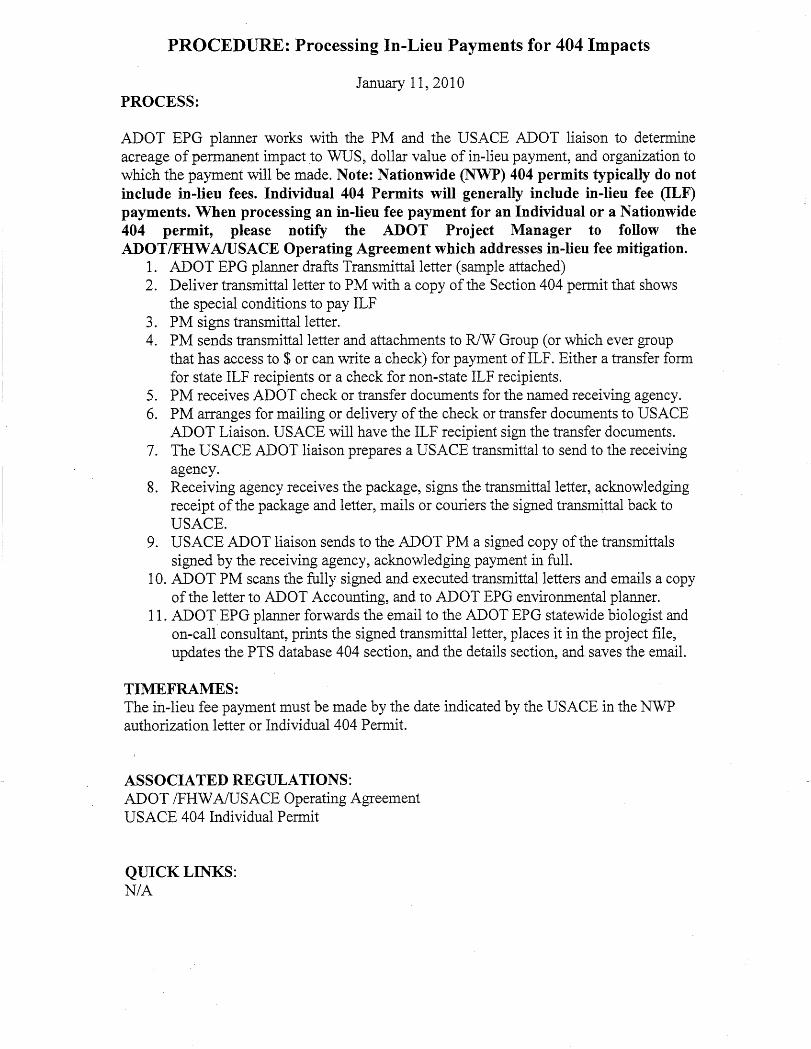
clean water act section 404/401 guidance manual
TRANSCRIPT


Arizona Department of Transportation Clean Water Act 404/401 Guidance Manual
Submitted to:
Arizona Department of Transportation 1611 West Jackson Street
Phoenix, Arizona 85007
Submitted by:
AMEC Environment & Infrastructure, Inc. 4600 East Washington Street, Suite 600
Phoenix, Arizona 85034
June 2013
ADOT Clean Water Act Section 404/401 Guidance Manual
Foreword i
FOREWORD
This manual provides an overview of Sections 404 and 401 of the Clean Water Act, as theyapply to Arizona Department of Transportation activities.
Compliance with Sections 404 and 401 is necessary for Arizona Department of Transportationactivities that involve the discharge of dredged or fill material into waters of the United States.
The manual also provides general guidance on the preparation of jurisdictional delineations,Nationwide Permit Pre-Construction Notification submittals, and Individual Permit applications.The intended audience includes all Arizona Department of Transportationdesign/construction/maintenance and environmental planning staff, consultants, ArizonaDepartment of Transportation Districts, and others as applicable.
Applicable regulations, guidance documents, forms, and checklists are cited and/or included inthis manual, with document dates, print dates, and sources identified in the References sectionas appropriate. Although this manual will be periodically updated by the Arizona Department ofTransportation Office of Environmental Services to address regulatory and guidancemodifications, as well as changes in Arizona Department of Transportation policy, it is theresponsibility of the user to identify and comply with current standards.
ADOT Clean Water Act Section 404/401 Guidance Manual
Foreword ii
THIS PAGE INTENTIONALLY LEFT BLANK

ADOT Clean Water Act Section 404/401 Guidance Manual
Table of Contents iii
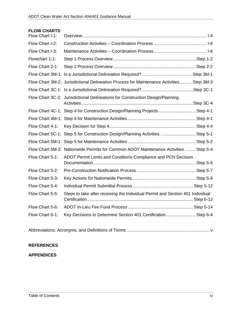
TABLE OF CONTENTS
INTRODUCTION ........................................................................................................................ I-1 A. Manual Content, Format, and Update Process ................................................... I-1 B. Overview of this Manual ...................................................................................... I-1 C. Quick Facts ......................................................................................................... I-4
STEP 1. INITIAL REVIEW OF SURFACE WATERS WITHIN THE BOUNDARIES OF THE ACTIVITY ................................................................................................ Step 1-1 A. Definitions and Examples of Waters of the US .......................................... Step 1-1 B. Initial Review of Activity Area .................................................................... Step 1-2
STEP 2. WILL THE ACTIVITY INVOLVE THE DISCHARGE OF DREDGED OR FILL MATERIAL INTO WATERS OF THE US? ...................................................... Step 2-1 A. Definitions and Examples .......................................................................... Step 2-1 B. Regulated Activities ................................................................................... Step 2-1
STEP 3M (MAINTENANCE ACTIVITIES) - IS A JURISDICTIONAL DELINEATION OF WATERS OF THE US WITHIN THE ACTIVITY AREA NECESSARY? ....... Step 3M-1
STEP 3C (CONSTRUCTION DESIGN/PLANNING) - ARE WATERS OF THE US PRESENT WITHIN THE BOUNDARIES OF THE ACTIVITY? ....................................... Step 3C-1 A. Jurisdictional Delineation ......................................................................... Step 3C-2 B. Jurisdictional Determinations Submittals ................................................. Step 3C-3
STEP 4: WHAT TYPE AND QUANTITY OF IMPACTS ON WATERS OF THE US WILL RESULT FROM THE ACTIVITY AND HOW WILL IMPACTS BE MITIGATED? ............................................................................................. Step 4-1 A. Definitions and Examples .......................................................................... Step 4-2 B. Methodology – Quantifying Impacts .......................................................... Step 4-2 C. Mitigation Measures .................................................................................. Step 4-4
STEP 5 : WHAT TYPE OF SECTION 404 PERMIT IS NECESSARY FOR THE ACTIVITY? .............................................................................................. Step 5-1 A. Nationwide Permits ................................................................................... Step 5-2 B. Individual Permits .................................................................................... Step 5-10 C. In-Lieu Fee Mitigation .............................................................................. Step 5-13
STEP 6: WHAT TYPE OF SECTION 401 CERTIFICATION IS ESSENTIAL FOR THE ACTIVITY? ...................................................................................................... Step 6-1 A. Definitions .................................................................................................. Step 6-1 B. Certification for Activities that Qualify for a Section 404
Nationwide Permit ..................................................................................... Step 6-1 C. Section 401 Certification for Activities that Require a Section 404 Individual
Permit ........................................................................................................ Step 6-2 D. Components of a Section 401 Individual Certification Application ............ Step 6-3
TABLE Table 1. Overview of the Necessary Steps to Complete the Section 401/404 Process .......... I-2
ADOT Clean Water Act Section 404/401 Guidance Manual
Table of Contents iv
FLOW CHARTSFlow Chart I-1: Overview..................................................................................................... I-4
Flow Chart I-2: Construction Activities – Coordination Process ........................................... I-6
Flow Chart I-3: Maintenance Activities – Coordination Process........................................... I-6
Flowchart 1-1: Step 1 Process Overview ................................................................... Step 1-2
Flow Chart 2-1: Step 2 Process Overview ................................................................... Step 2-2
Flow Chart 3M-1: Is a Jurisdictional Delineation Required?......................................... Step 3M-1
Flow Chart 3M-2: Jurisdictional Delineation Process for Maintenance Activities.......... Step 3M-3
Flow Chart 3C-1: Is a Jurisdictional Delineation Required?..........................................Step 3C-1
Flow Chart 3C-2: Jurisdictional Delineations for Construction Design/PlanningActivities...........................................................................................Step 3C-4
Flow Chart 4C-1: Step 4 for Construction Design/Planning Projects .............................. Step 4-1
Flow Chart 4M-1: Step 4 for Maintenance Activities ....................................................... Step 4-1
Flow Chart 4-1: Key Decision for Step 4...................................................................... Step 4-4
Flow Chart 5C-1: Step 5 for Construction Design/Planning Activities. ............................ Step 5-1
Flow Chart 5M-1: Step 5 for Maintenance Activities ....................................................... Step 5-2
Flow Chart 5M-2: Nationwide Permits for Common ADOT Maintenance Activities ......... Step 5-4
Flow Chart 5-1: ADOT Permit Limits and Conditions Compliance and PCN DecisionDocumentation................................................................................... Step 5-6
Flow Chart 5-2: Pre-Construction Notification Process ................................................ Step 5-7
Flow Chart 5-3: Key Actions for Nationwide Permits.................................................... Step 5-9
Flow Chart 5-4: Individual Permit Submittal Process ................................................. Step 5-12
Flow Chart 5-5: Steps to take after receiving the Individual Permit and Section 401 IndividualCertification ...................................................................................... Step 5-12
Flow Chart 5-6: ADOT In-Lieu Fee Fund Process ..................................................... Step 5-14
Flow Chart 6-1: Key Decisions to Determine Section 401 Certification........................ Step 6-4
Abbreviations, Acronyms, and Definitions of Terms ....................................................................v
REFERENCES
APPENDICES

ADOT Clean Water Act Section 404/401 Guidance Manual
Abbreviations, Acronyms, and Definitions of Terms v
ABBREVIATIONS, ACRONYMS, AND DEFINITIONS OF TERMS
ADEQ – Arizona Department of Environmental Quality
ADOT – Arizona Department of Transportation
C&S – Contracts and Specifications Section
CFR – Code of Federal Regulations
Corps – US Army Corps of Engineers
CWA (Clean Water Act) – Establishes the basic structure for regulating discharges of pollutants into the waters of the United States. The objective of the CWA is to restore and maintain the chemical, physical, and biological integrity of the Nation’s waters.
Decision document – Demonstrates compliance with the Section 404(b)(1) guidelines, as well as NEPA and other applicable federal laws and policies. The document is constituted by an environmental assessment, NEPA/404 Memorandum of Agreement compliance, review and compliance determination, alternatives analysis, mitigation plan, statement of findings public interest review, and a finding of no significant impact.
Dredged materials – Material that is excavated or dredged from waters of the United States.
Discharge of dredged material – Any addition of dredged material into the waters of the United States.
Discharge of fill material – The addition of fill material into waters of the United States.
EPA – Environmental Protection Agency
EPG (Environmental Planning Group) - Oversees the preparation of environmental documents for all highway construction projects and maintenance actions. These documents ensure that all relevant environmental factors are appropriately addressed and mitigated, in accordance with state and federal laws, including the National Environmental Policy Act.
FHWA – Federal Highway Administration
Fill materials – Any material used for the primary purpose of replacing an aquatic area with dry land or changing the bottom elevation of a waterbody.
HPT – Historic Preservation Team (of EPG)
Impaired Waters – Surface waters that do not meet surface water quality standards and therefore receive special consideration. Impaired waters are listed in section 303(d) of CWA Section 401, which in Arizona, is maintained by ADEQ.
IP (Individual Permit) – Intended to authorize activities with greater than minimal adverse environmental impacts. Individual permits are needed for an activity that will result in the discharge of dredged of fill material into waters of the United States, but does not qualify for any Nationwide Permit.
ADOT Clean Water Act Section 404/401 Guidance Manual
Abbreviations, Acronyms, and Definitions of Terms vi
JD (Jurisdictional delineation) – The process through which the boundaries and other physical characteristics of a potential water of the United States are evaluated for the activity area.
Jurisdictional determination – Used to describe the resulting report, ultimately submitted by ADOT EPG to the Corps for their consideration and approval.
MOA - Memorandum of Agreement
NEPA – National Environmental Policy Act
NWP (Nationwide permit) – Intended to authorize activities with minimal adverse environmental impacts and are designed to regulate such activities with little, if any, delay or paperwork. The acreage of loss of waters of the United States is a threshold measurement of the impact to jurisdictional waters for determining whether an activity may qualify for a nationwide permit. Waters of the US temporarily filled, flooded, or drained, but restored to pre-construction contours and elevations after construction are not included in the measurement of loss of waters of the United States.
Non-tribal lands – Requires ADEQ to issue 401 certification.
OAW (Outstanding Arizona Waters) – Surface waters in Arizona classified by ADEQ as outstanding due to their exceptional water quality.
OES (Environmental Services) - Oversees the environmental programs within the agency. OES ensures compliance with local, state, and federal environmental laws during the construction and operation of ADOT facilities.
OHWM (Ordinary High Water Mark) – A line on the bank or shore established by the fluctuations of water and indicated by the following physical characteristics: a clear, natural line imposed on the bank; shelving; changes in the character of soil; destruction of terrestrial vegetation; and the presence of litter and debris.
PCN (Pre-Construction Notice) – Notification to the Corps based on specific conditions as identified in each Nationwide permit, General Conditions, and Regional Conditions.
Preliminary JD (Preliminary Jurisdiction Determination) - Preliminary JDs are non-binding, written indications that there may be waters of the United States, including wetlands, on a parcel or indications of the approximate location(s) of waters of the United States or wetlands on a parcel. Preliminary JDs are advisory in nature and may not be appealed.
Permanent losses of waters of the United States – Waters of the US that are permanently adversely affected by filling, flooding, excavation of native soils/vegetation, or drainage because of the regulated activity.
Qualified Professional – Individual performing a initial evaluation of a site for the presence/absence of potential waters of the United States under Section 404 of the CWA. A qualified professional must have the ability to recognize water features on aerial and topographic mapping.
RGL – Regulatory Guidance Letter

ADOT Clean Water Act Section 404/401 Guidance Manual
Abbreviations, Acronyms, and Definitions of Terms vii
Routine Maintenance - Routine maintenance is simply maintenance of a structure to return it toa functioning as-built condition.
River – A large natural stream of water emptying into an ocean, lake, or other body of water andusually fed along its course by converging tributaries.
Section 401 of CWA – Requires that the State provide certification that any activity authorizedunder Section 404 is in compliance with effluent limits, the state’s water quality standards, andany other appropriate requirements of state law. Section 401 is administered by ADEQ inArizona on non-tribal lands. On tribal lands, Section 401 is administered by EPA or the tribe.
Section 404 of CWA – Regulates the discharge of dredged or fill material into waters of theUnited States. Section 404 is regulated by the Army Corps of Engineers.
Special Aquatic Site - Geographic areas, large or small, possessing special ecologicalcharacteristics of productivity, habitat, wildlife protection, or other important and easily disruptedfunctions and values. These areas are generally recognized as significantly influencing orpositively contributing to the general overall environmental health or vitality of the entireecosystem of a region. The following have been identified as special aquatic sites: sanctuariesand refuges, wetlands, mud flats, vegetated shallows, coral reefs, and riffle and pool complexes.
Small wash – Wash that is typically low volume and has infrequent or short duration flow. Smallwashes are generally considered non-jurisdictional under CWA Section 404.
Temporary losses of waters of the United States – Short term losses typically attributes toproject activity discharges that will be mitigated such that preconstruction conditions, includingcontours and elevations, and/or uses are restored.
Tribal lands – Requires EPA to issue a 401 certification except where EPA has delegated 401certification authority.
USGS – United States Geological Survey
Wash – The dry bed of a stream common in the arid western US.
Waters of the US (waters of the United States) – Denotes the Corps’ jurisdictional limitsunder CWA Section 404 as outlined in Title 33 Code of Federal Regulations Chapter II, Part328. Navigable waters, interstate lakes, rivers, streams (including intermittent streams),mudflats, sandflats, wetlands, sloughs, prairie potholes, wet meadows, playa lakes, and naturalponds are considered “Waters of the US.”
Wetlands – Areas that are inundated or saturated by surface or ground water at a frequencyand duration sufficient to support, and that under normal circumstances do support, aprevalence of vegetation typically adapted for life in saturated soil conditions. Wetlandsgenerally include swamps, marshes, bogs, and similar areas.

ADOT Clean Water Act Section 404/401 Guidance Manual
Abbreviations, Acronyms, and Definitions of Terms viii
THIS PAGE INTENTIONALLY LEFT BLANK

ADOT Clean Water Act Section 404/401 Guidance Manual
Introduction I-1
A Section 404 Permitrequires a Section 401Water Certification
Arizona Department of EnvironmentalQuality (ADEQ) issues Section 401certification on non-tribal lands and USEnvironmental Protection Agency(EPA) or the tribe issues Section 401certification on tribal lands.
INTRODUCTION
A. Manual Content, Format, and Update Process
1. Manual ContentThis manual focuses on the Clean Water Act (CWA)Section 404/401 process as it relates to ArizonaDepartment of Transportation (ADOT) activities. Assuch, the manual discusses some documentation components and coordination guidelinesdesired by ADOT, in an effort to implement CWA regulations as they apply to the agency.Therefore, it is essential that ADOT activity proponents follow specific Section 404/401guidelines and related standards established by ADOT.
2. Manual FormatThe manual describes the Section 404 and 401 processes as a series of six consecutive steps.At each step, users are prompted to evaluate their activity to determine regulatory applicabilityand compliance requirements. Many regulatory excerpts, guidance documents, and forms areincluded as Appendices to this manual and also found on ADOT Environmental Services andPlanning website(http://www.azdot.gov/highways/EPG/EPG_Common/Services_Water_Quality.asp).
Online sources for the following documents are identified in this manual. Due to their size, hardcopies of these documents are not included in the manual.
1987 Corps of Engineers Wetlands Delineation Manual Regional Supplement to the Corps of Engineers Wetland Delineation Manual: Arid West
Region (Version 2.0) (Corps 2008a) Regional Supplement to the Corps of Engineers Wetland Delineation Manual: Western
Mountains, Valleys, and Coast Region (Version 2.0) (Corps 2010a) Corps and EPA Final Rule: Compensatory Mitigation for Losses of Aquatic Resources
(Corps 2008b)*Please refer to the references section for the links to these documents.
3. Manual Update ProcessADOT will periodically update this manual to ensure consistency with regulatory and guidancemodifications and ADOT policy changes. However, it is the responsibility of the user to identifyand comply with current standards.
B. Overview of this Manual
The federal CWA requires a permit for all construction and maintenance activities that impactjurisdictional waters of the United States (Waters of the US) through the discharge of dredge orfill materials. The permit is issued by the US Army Corps of Engineers (Corps).
Section 404 of the CWA regulates the discharge of dredged or fillmaterial into waters of the US. Section 404 is regulated by the Corps;the EPA reviews regulated fill activities in conjunction with Corps.
ADOT Clean Water Act Section 404/401 Guidance Manual
Introduction I-2
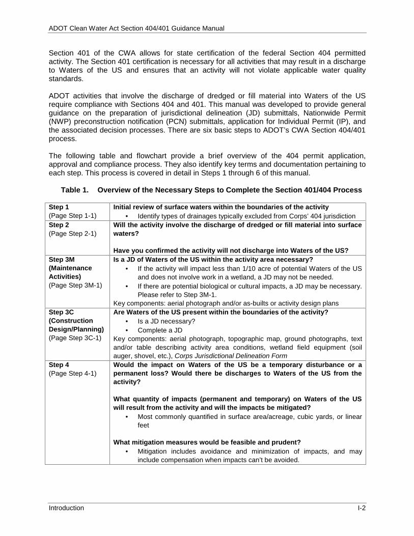
Section 401 of the CWA allows for state certification of the federal Section 404 permittedactivity. The Section 401 certification is necessary for all activities that may result in a dischargeto Waters of the US and ensures that an activity will not violate applicable water qualitystandards.
ADOT activities that involve the discharge of dredged or fill material into Waters of the USrequire compliance with Sections 404 and 401. This manual was developed to provide generalguidance on the preparation of jurisdictional delineation (JD) submittals, Nationwide Permit(NWP) preconstruction notification (PCN) submittals, application for Individual Permit (IP), andthe associated decision processes. There are six basic steps to ADOT’s CWA Section 404/401process.
The following table and flowchart provide a brief overview of the 404 permit application,approval and compliance process. They also identify key terms and documentation pertaining toeach step. This process is covered in detail in Steps 1 through 6 of this manual.
Table 1. Overview of the Necessary Steps to Complete the Section 401/404 Process
Step 1(Page Step 1-1)
Initial review of surface waters within the boundaries of the activity Identify types of drainages typically excluded from Corps’ 404 jurisdiction
Step 2(Page Step 2-1)
Will the activity involve the discharge of dredged or fill material into surfacewaters?
Have you confirmed the activity will not discharge into Waters of the US?Step 3M(MaintenanceActivities)(Page Step 3M-1)
Is a JD of Waters of the US within the activity area necessary? If the activity will impact less than 1/10 acre of potential Waters of the US
and does not involve work in a wetland, a JD may not be needed. If there are potential biological or cultural impacts, a JD may be necessary.
Please refer to Step 3M-1.Key components: aerial photograph and/or as-builts or activity design plans
Step 3C(ConstructionDesign/Planning)(Page Step 3C-1)
Are Waters of the US present within the boundaries of the activity? Is a JD necessary? Complete a JD
Key components: aerial photograph, topographic map, ground photographs, textand/or table describing activity area conditions, wetland field equipment (soilauger, shovel, etc.), Corps Jurisdictional Delineation Form
Step 4(Page Step 4-1)
Would the impact on Waters of the US be a temporary disturbance or apermanent loss? Would there be discharges to Waters of the US from theactivity?
What quantity of impacts (permanent and temporary) on Waters of the USwill result from the activity and will the impacts be mitigated?
Most commonly quantified in surface area/acreage, cubic yards, or linearfeet
What mitigation measures would be feasible and prudent? Mitigation includes avoidance and minimization of impacts, and may
include compensation when impacts can’t be avoided.
ADOT Clean Water Act Section 404/401 Guidance Manual
Introduction I-3
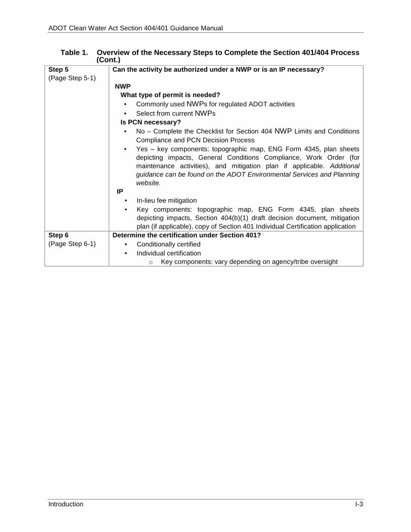
Table 1. Overview of the Necessary Steps to Complete the Section 401/404 Process
Step 5(Page Step 5-1)
Can the activity be authorized under a NWP or is an IP necessary?
NWPWhat type of permit is needed? Commonly used NWPs for regulated ADOT activities Select from current NWPs
Is PCN necessary? No – Complete the Checklist for Section 404 NWP Limits and Conditions
Compliance and PCN Decision Process Yes – key components: topographic map, ENG Form 4345, plan sheets
depicting impacts, General Conditions Compliance, Work Order (formaintenance activities), and mitigation plan if applicable. Additionalguidance can be found on the ADOT Environmental Services and Planningwebsite.
IP In-lieu fee mitigation Key components: topographic map, ENG Form 4345, plan sheets
depicting impacts, Section 404(b)(1) draft decision document, mitigationplan (if applicable), copy of Section 401 Individual Certification application
Step 6(Page Step 6-1)
Determine the certification under Section 401? Conditionally certified Individual certification
o Key components: vary depending on agency/tribe oversight
(Cont.)

ADOT Clean Water Act Section 404/401 Guidance Manual
Introduction I-4
Section 404 of the CWA regulatesthe discharge of fill material intoWaters of the US.
Flow Chart I-1: Overview
Step 1Could
Waters ofthe US beinvolved?
Step 2Will the activity
involve dischargesof dredged or fill
material into Watersof the US?
Step 3C and 3MConstruction Design/Planning
Activities(Step 3C) and MaintenanceActivities (Step 3M)
Determine if JD is needed. This mayrequire preliminary calculation of
impactsConduct JD if required.
Step 4Quantify Impacts& determine type
of 404 Permitneeded
(Nationwide orIndividual)
Step 5Prepare 404 Permit
Application &determine if PCN is
requiredSubmit application
to Corps
Step 6Determine andacquire Section401 certification
Project is awardedand District
coordinates anychanges in scopewith OES/EPG* toensure 404 permitconditions are met!
* EPG – Environmental Planning GroupOES – Office of Environmental Services
C. Quick Facts
1. Regulation and AdministrationThe 1972 Federal Water Pollution Control Act was amended and became commonly known asthe CWA in 1977. The CWA "…established the basic structure for regulating discharges ofpollutants into the waters of the United States" (EPA 2013). The objective of the CWA “…is torestore and maintain the chemical, physical, and biological integrity of the Nation’s waters" (33U.S. Code 1251-1387).
Section 401 allows that the State provide certification thatany activity authorized under Section 404 is in compliancewith effluent limits, the state’s water quality standards, andany other appropriate requirements of state law.
The Corps administers the day-to-day CWA Section 404 program, develops policy andguidance, and enforces Section 404 provisions. The EPA develops and interprets environmentalcriteria used in evaluating Section 404 permit applications, identifies activities that are exempt
Important things to Remember! If determined in Step 1 or 2 that there is no activity in Waters of the US, document this in the
project file and you are done! If unsure about decisions for Steps 3 and 4, consult your EPG Planner or the OES Water Quality
Analyst. After Step 5, the Permit Application is reviewed by OES and the District concurrently. The District
signs the application and EPG sends application to the Corps. EPG gives the complete 404 package to Contracts and Specifications Section (C&S) for inclusion in
Bid Package Special Provisions.

ADOT Cle
Introductio
Commu
Section
start of
from Sec2013). In ArizonADEQ, cactivity. 2. Exam
TransCommonand SecWaters o
Cons C N B R G
Maint C W R
(h 3. ExamWaters include b
W R N W C
4. Roles
GuidCoordinaSection 4must cCommun Close codesign/p
documenimpact in
ean Water Ac
on
nication with t
404 permitting
design.
ction 404 re
na, the CWAcertain feder
mples of Resportation A
n ADOT acction 401 cof the US, inc
struction actiCulvert extenNew bridge cBridge scour Roadway andGeotechnical
tenance actiChannel bankWash realignRemoval of hydrovacuum
mples of Keof the US
but are not limWashes Rivers and stNatural pondsWetlands Certain canal
s and Respelines
ation for al404 permit omply with
nication Polic
oordination blanning act
ntation. Mainnformation, w
ct Section 404
the Corps rega
g should begin
egulation, an
A Section 4rally recogni
egulated ArActivities
ctivities that compliance, clude but are
vities: nsions and inconstruction
countermead utility cross borings
ivities: k protection ment and chsediment b
ming)
y Terms commonlymited to:
treams s
ls
ponsibilities
l ADOT Acand/or Sect
h the ADcy.
between EPtivities, or
ntenance pewith coordina
4/401 Guidanc
rding
n at the
nd assists th
401 water qized tribes,
rizona Depa
require Seif conduct
e not limited
nstallations
asures and bsings
hannelizationuildup from
y found in
s and Coord
ctivities reqtion 401 cer
DOT Enviro
G Planners/between D
mSacimE
ersonnel woation with EP
ce Manual
he Corps in
quality certifor EPA, dep
artment of
ection 404 ted within
d to:
bridge pier co
n culverts
Arizona
dination
quiring a rtification onmental
/ConsultantsDistricts, EP
maintenanceection 401 ccurate. T
mportant actPG for inclu
ork with theirPG through
enforcing S
fication progpending on
onstruction
s and desigPG, and m
activities,calculation
Typically, dtivity scope
usion in the Sr District toa Work Orde
Most commmaterials fr
SanMost commactivities:
Soiand
Section 404
gram is admthe type an
n personnemaintenanceensures S
ns and docdesign pere and impacSection 404 evaluate ac
er process.
mon dredged (erom ADOT activ
nd, soil, and grmon fill materia
il, concrete and steel
provisions
ministered bynd location o
l for construe personne
Section 404 cumentationrsonnel proct informatioand Section
ctivity scopeFor mainten
excavated) vities:
ravel als from ADOT
d asphalt, ripra
I-5
(EPA
y the of the
uction el for
and n are ovide on to n 401 e and nance
ap,
ADOT Clean Water Act Section 404/401 Guidance Manual
Introduction I-6
projects, the District typically prepares Section 404 and Section 401 documentation and sends to EPG for their review; EPG then submits to the Corps. The OES water quality analyst is available to assist the EPG or District with the Section 404 and 401 processes and to provide review of documents prior to submittal to the Corps. Design personnel and District staff must be given the opportunity to review all Section 404 or Section 401 conditions and mitigation measures applicable to an activity in order to identify construction constraints as early as possible. Conditions and mitigation measures are ultimately included in the environmental clearance and project specifications.
Flow Chart I-2: Construction Activities – Coordination Process
Design Staff•Prepare activity Scope
•Identify Impact quantities
Project Team•Use information from design personnel and Districts
•Complete application in coordination with EPG
District Staff•Review conditions and mitigation measures
• Identify constraints and constructability
OES and EPG Staff•Review Section 401 and 404 documentation
•Submit to agencies for approval
Flow Chart I-3: Maintenance Activities – Coordination Process
Throughout this manual, the following color codes apply:
Black color indicates information related to Construction/Design Planning activities.
Blue color indicates information related to Maintenance activities.
Yellow color indicates general information (e.g., ADOT or Corps‐related).
Maintenance Personnel• Identify activity•Estimate impact quantities
District Staff•Review maintenance activity and identify the appropriate permit
•Coordinate with EPG/OES
EPG and OES Staff•Provide guidance to District
• Identify constraints•Coordinate/prepare and submit Section 404 and 401 applications, as needed

ADOT Clean Water Act Section 404/401 Guidance Manual
Introduction I-7
5. Contact Information (As of 2/13)
Internal ADOT communication must comply with the ADOT Environmental CommunicationPolicy and the ADOT Memorandum of Agreement with the Corps. Refer to ADOTEnvironmental Services and Planning website for submittal information.(http://www.azdot.gov/highways/EPG/EPG_Common/Documents_Technical_Section_404_Procedures.asp)

ADOT Clean Water Act Section 404/401 Guidance Manual
Introduction I-8
THIS PAGE INTENTIONALLY LEFT BLANK

ADOT Clean Water Act Section 404/401 Guidance Manual
Preliminary Review of Surface Water Step 1-1
OES and EPG must be contacted forguidance on any projects involving theColorado River.
Categories of Waters of the US: Territorial seas Tidal waters Non-tidal waters
Arizona Waters of the US (tribal, unique andother) include: Washes Rivers and streams Natural ponds Wetlands Certain canals
STEP 1. INITIAL REVIEW OF SURFACE WATERS WITHIN THE BOUNDARIES OF THEACTIVITY
The first step of the Section 404 compliance process is to perform a initial evaluation of the areafor the presence/absence of potential Waters of the US. A qualified professional will perform thisinitial evaluation. EPG, in coordination with OES, is available to review the results of the initialreview to determine follow-up actions.
A. Definitions and Examples of Waters of the US
In general, Waters of the US is a term used to denote theCorps’ jurisdictional limits under CWA Section 404. The fulldefinition of the term is provided in Title 33 Code of FederalRegulations (CFR) Chapter II, Part 328—Definition of Watersof the United States (available online:http://www.wetlands.com/coe/coe328p0.htm).
Waters of the US may be categorized as tribalwaters (occurring on tribal lands), unique waters(a.k.a. Outstanding Arizona Water [OAW][classification designated by ADEQ]), impairedwaters or other waters (all non-tribal and non-uniquewaters). Waters of the US can also include lakes(wet or dry, including playa lakes), special aquaticsites (including wetlands), mud and sandflats,sloughs, and wet meadows. Because wetlands are
typically the special aquatic site potentially impacted by ADOT activities, the term “wetlands” isreferenced throughout this manual.
In Arizona, the Colorado River is a Water of the US and is considered a navigable water.Projects involving navigable waters, such as the Colorado River, are also protected underSection 10 of the Rivers and Harbors Act. Under Section 10, the Corps regulates any work in,over, or under navigable Waters of the US. ADOT OES and EPG must be contacted forguidance on any projects involving the Colorado River.
Features Generally Considered Non-jurisdictional
Surface waters generally considered non-jurisdictional under CWA Section 404 include: Swales and erosional features such as gullies and small washes that typically are low
volume and have infrequent or short duration flow Ditches (including roadside ditches) excavated wholly in and draining only uplands that
do not carry a relatively permanent flow of water
The Corps and EPA have provided additional guidance on how they will identify jurisdictionalWaters of the US protected by Section 404 – Clean Water Act Jurisdiction Following the U.S.Supreme Court’s Decision in Rapanos v. United States & Carabell v. United States, December2008 (EPA and Corps 2008) (available online:http://www.usace.army.mil/Portals/2/docs/civilworks/regulatory/cwa_guide/cwa_juris_2dec08.pdf)
ADOT Clean Water Act Section 404/401 Guidance Manual
Preliminary Review of Surface Water Step 1-2
B. Initial Review of Activity Area
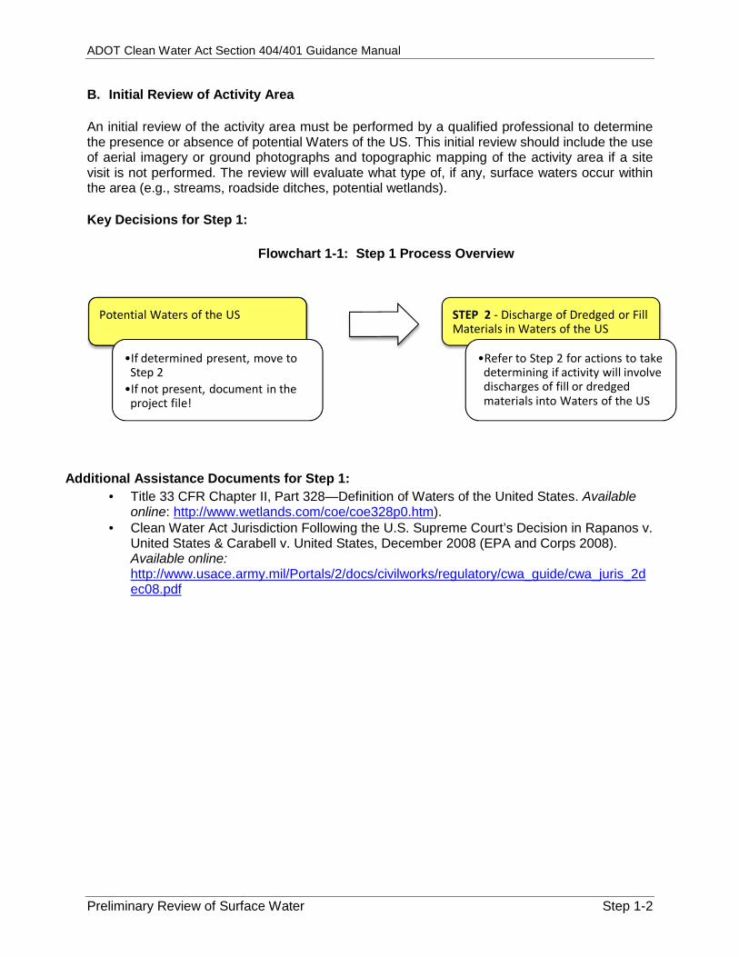
An initial review of the activity area must be performed by a qualified professional to determinethe presence or absence of potential Waters of the US. This initial review should include the useof aerial imagery or ground photographs and topographic mapping of the activity area if a sitevisit is not performed. The review will evaluate what type of, if any, surface waters occur withinthe area (e.g., streams, roadside ditches, potential wetlands).
Key Decisions for Step 1:
Flowchart 1-1: Step 1 Process Overview
Potential Waters of the US
•If determined present, move toStep 2
•If not present, document in theproject file!
STEP 2 - Discharge of Dredged or FillMaterials in Waters of the US
•Refer to Step 2 for actions to takedetermining if activity will involvedischarges of fill or dredgedmaterials into Waters of the US
Additional Assistance Documents for Step 1: Title 33 CFR Chapter II, Part 328—Definition of Waters of the United States. Available
online: http://www.wetlands.com/coe/coe328p0.htm). Clean Water Act Jurisdiction Following the U.S. Supreme Court’s Decision in Rapanos v.
United States & Carabell v. United States, December 2008 (EPA and Corps 2008).Available online:http://www.usace.army.mil/Portals/2/docs/civilworks/regulatory/cwa_guide/cwa_juris_2dec08.pdf
ADOT Cle
Will the A
STEP 2.
The secomaterial of Dredhttp://ww A. Defin As define
Dth
Dw
Fa
DU
B. Regu ADOT acof the US
Coooo
Mooo
It is impaccess roin dischaidentifiedprovides under Seregulatio
Co
Co
ean Water Ac
ctivity Involve
WILL THEMATERIA
ond step is tinto potentia
dged or Fww.ecfr.gov/c
nitions and
ed in 33 CFRDredged mathe United St
Discharge of waters of the
ill material iquatic area
Discharge of United States
ulated Activ
ctivities that S include butConstruction
Culvert ex Bridge sc Roadway Geotechn
Maintenance Channel b Erosion re The remo
material [
portant to noutes, staginarges to Wad during the
additional dection 404, an.
ommon dredge
Sand, s
ommon fill ma
Soil, co
ct Section 404
e the Discharg
E ACTIVITYAL INTO WA
to determineal Waters of
Fill Materialcgi-bin/text-id
Examples
R 323, withinterial is definates” dredged maUnited Stats defined aswith dry landfill material
s”
vities
commonly rt are not limActivities xtensions an
cour countermy and utility cnical borings
Activities bank protectepair
oval of sedimi.e. hydrovac
note that acng areas, anaters of the
design procdescription oas well as ac
ed (excavated)
oil, and gravel
terial discharg
ncrete and pav
4/401 Guidanc
ge of Dredge
Y INVOLVE TATERS OF T
e whether ththe US, as
ls into Wadx?c=ecfr&t
n the contexned as “…m
aterial is defes” s “…any mad or changin is defined
result in the ited to:
nd installatiomeasures
crossings s
tion
ment buildup cuuming])
ctivity compnd stockpile US. These
cess if possof specific acctivities that
) materials resu
ed into Waters
vement, riprap
ce Manual
of Fill Materia
THE DISCHTHE US?
e activity wiaddressed
aters of thtpl=/ecfrbrow
t of Section material that
fined as “…a
aterial used ng the bottomas “…the a
discharge o
ons
from culvert
ponents sucareas may areas shou
ible. 33 CFRctivities regut are exempt
ulting from AD
s of the US fro
p, steel, and gr
al?
HARGE OF D
ll involve thein 33 CFR 3he United
wse/Title33/3
404: is excavate
any addition
for the primm elevation oddition of fil
of dredged a
rts (activity m
ch as result
uld be R 323 ulated t from
DOT activities a
m ADOT activi
ravel
Actaccstoeva
DREDGED O
e discharge 323 – Permi
States (a33cfr323_ma
ed or dredge
n of dredged
mary purposeof…[a] watell material in
nd/or fill ma
must have di
are:
ities include:
tivity componecess routes, staockpile areas shaluated for 404
Ste
OR FILL
of dredged its for Dischaavailable oain_02.tpl).
ed from wate
material int
e of replacinerbody” nto waters o
terial into W
scharge of
ents such as aging areas, anhould be 4 impacts.
ep 2-1
or fill
arges nline:
ers of
to the
ng an
of the
Waters
nd
ADOT Cle
Will the A
Key Dec
Pot
Addition
3U
http
Pleasededicaactivitewith yo
ean Water Ac
ctivity Involve
cisions for S
tential Discha
•Activity haof dredgeWaters of3C depend
•If it is condischargeproject fil
nal Assistan3 CFR 323
United Statesp://www.ecfr
e note that Sated for maines. Please chour project.
ct Section 404
e the Discharg
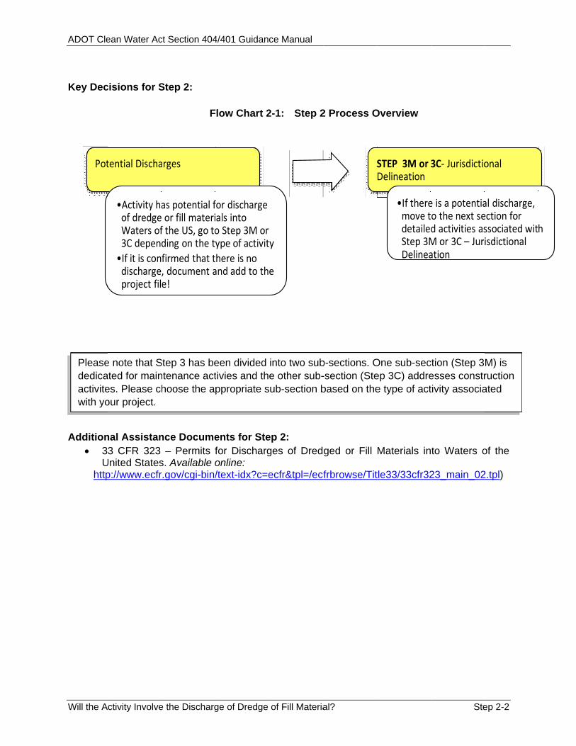
Step 2:
F
arges
as potential f or fill materif the US, go toding on the ty
firmed that t, document ae!
nce Docume– Permits f
s. Available or.gov/cgi-bin/
Step 3 has bentenance acthoose the a
4/401 Guidanc
ge of Dredge
low Chart 2
for discharge als into o Step 3M or ype of activit
here is no and add to th
ents for Stefor Dischargonline: /text-idx?c=e
een divided tivies and theppropriate s
ce Manual
of Fill Materia
2-1: Step 2
y
e
ep 2: ges of Dred
ecfr&tpl=/ecf
into two sube other sub-ub-section b
al?
2 Process O
S
ged or Fill
frbrowse/Tit
b-sections. O-section (Stebased on the
Overview
STEP 3M or 3Delineation
•If theremove tdetailedStep 3MDelinea
Materials in
tle33/33cfr32
One sub-secep 3C) addree type of act
Ste
3C‐ Jurisdictio
e is a potentiao the next sed activities asM or 3C – Juriation
to Waters o
23_main_02
ction (Step 3esses constrtivity associa
ep 2-2
onal
al discharge, ection for ssociated witisdictional
of the
2.tpl)
M) is ruction ated
h

ADOT Clean Water Act Section 404/401 Guidance Manual
Is a Jurisdictional Delineation Required? (Maintenance Activities) Step 3M-1
STEP 3M (MAINTENANCE ACTIVITIES) - IS A JURISDICTIONAL DELINEATION OFWATERS OF THE US WITHIN THE ACTIVITY AREA NECESSARY?
Prior to this step, an initial area review of the project area has been performed and it has beendetermined that a surface water potentially considered jurisdictional under Section 404 occurswithin the activity area (Step 1). In addition, the activity is expected to result in discharges ofdredged or fill materials (Step 2).
Now the activity and anticipated impacts must be evaluated to determine if a JD is necessary.Many ADOT maintenance activities can be performed within the conditions of Section 404NWPs that do not require PCN, in which case jurisdiction is often assumed and a JD may not benecessary. Also, many common ADOT maintenance activities can be performed in a mannersuch that impacts to Waters of the US are within the limits of a NWP.
Flow Chart 3M-1: Is a Jurisdictional Delineation Required?
If an activity impactswetlands AND has the
potential to impactbiological or cultural
resources:
A JD is needed andBiological and
Cultural studies arenecessary
See Step 3C(Construction
Design/Planning)for information onperforming JDs
Work OrderRequest for EPG
assistance
If the activity ismaintenance of an existingstructure AND anticipated
impacts to potential Watersof the US are within NWP
impact limits and PCNthreshold:
Activity must alsooccur outside of a
wetland and noimpacts to biologicalor cultural resources
No JD typicallyneeded
Delineate theordinary high water
mark on aerialimagery, topographicmaps, and as-builts
or activity designplans. Include in
project files
Proceed to Step 5 toreview NWP limitsand conditions to
determine appropriatepermit for your activity
If the activity involves anew structure or new fill
AND anticipated impacts toWaters of the US are
greater than NWP impactlimits and PCN threshold:
A JD is needed
See Step3C(ConstructionDesign/Planning)
for detailedinformation onperforming JDs
Work OrderRequest for
assistance. Refer toFlow Chart 5M-1 for
maintenanceactivities
If you have permanentimpacts to a wetland,you will need an IP.
ADOT Clean Water Act Section 404/401 Guidance Manual
Is a Jurisdictional Delineation Required? (Maintenance Activities) Step 3M-2
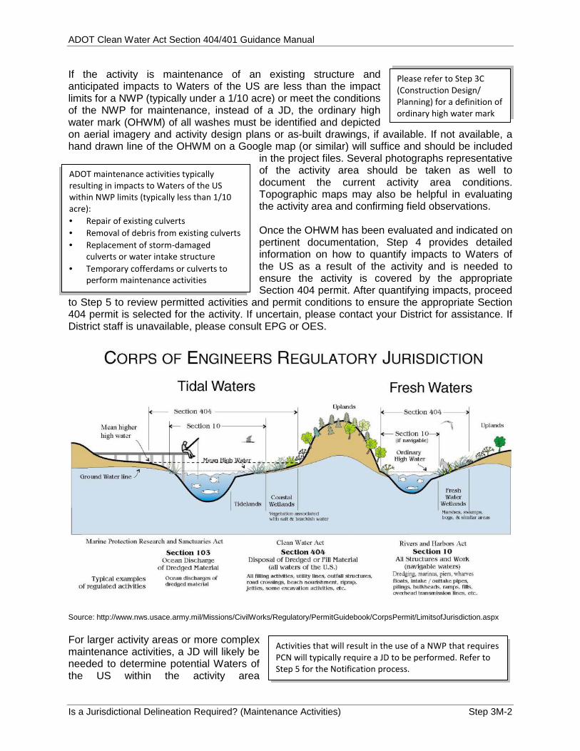
Please refer to Step 3C(Construction Design/Planning) for a definition ofordinary high water mark
ADOT maintenance activities typicallyresulting in impacts to Waters of the USwithin NWP limits (typically less than 1/10acre): Repair of existing culverts Removal of debris from existing culverts Replacement of storm-damaged
culverts or water intake structure Temporary cofferdams or culverts to
perform maintenance activities
If the activity is maintenance of an existing structure andanticipated impacts to Waters of the US are less than the impactlimits for a NWP (typically under a 1/10 acre) or meet the conditionsof the NWP for maintenance, instead of a JD, the ordinary highwater mark (OHWM) of all washes must be identified and depictedon aerial imagery and activity design plans or as-built drawings, if available. If not available, ahand drawn line of the OHWM on a Google map (or similar) will suffice and should be included
in the project files. Several photographs representativeof the activity area should be taken as well todocument the current activity area conditions.Topographic maps may also be helpful in evaluatingthe activity area and confirming field observations.
Once the OHWM has been evaluated and indicated onpertinent documentation, Step 4 provides detailedinformation on how to quantify impacts to Waters ofthe US as a result of the activity and is needed toensure the activity is covered by the appropriateSection 404 permit. After quantifying impacts, proceed
to Step 5 to review permitted activities and permit conditions to ensure the appropriate Section404 permit is selected for the activity. If uncertain, please contact your District for assistance. IfDistrict staff is unavailable, please consult EPG or OES.
Source: http://www.nws.usace.army.mil/Missions/CivilWorks/Regulatory/PermitGuidebook/CorpsPermit/LimitsofJurisdiction.aspx
For larger activity areas or more complexmaintenance activities, a JD will likely beneeded to determine potential Waters ofthe US within the activity area
Activities that will result in the use of a NWP that requiresPCN will typically require a JD to be performed. Refer toStep 5 for the Notification process.

ADOT Clean Water Act Section 404/401 Guidance Manual
Is a Jurisdictional Delineation Required? (Maintenance Activities) Step 3M-3
boundaries. A JD is the process through which the boundaries and other physicalcharacteristics of a potential Water of the US are evaluated for the activity area.
Please refer to Step 3C (Construction Design/Planning) for a complete description of theprocess to perform a JD.
Flow Chart 3M-2: Jurisdictional Delineation Process for Maintenance Activities
District
•See Flow Chart3M-1 todetermine if JDis needed
•Initiates WorkOrder Requestfor EPG toperform a JD
EPG/Consultant
•Contacts the Corpsto determine if a JDhas beenpreviouslyperformed for theproject area and isstill valid
•Performs JD•Submits JD to theCorps
Corps
•Reviews andapproves JD
•May take 2 to 3months forapproval
EPG/Consultant
•Receivesapproval of JDfrom Corps
•Step 4 providesadditionalinformation onquantifyingimpacts toWaters of the US
•Continue to Step5 to reviewactions requiredfor Section 404permitting
Key Documents for Step 3M (Maintenance Activities): 33 CFR 328 – Definitions of Waters of United States. Available online:
http://www.nap.usace.army.mil/Portals/39/docs/regulatory/regs/33cfr328.pdf RGL 05-05 – Ordinary High Water Mark (OHWM) Identification. Available online:
http://www.usace.army.mil/Portals/2/docs/civilworks/RGLS/rgl05-05.pdf
Additional Assistance Documents for Step 3M (Maintenance Activities): Step 3C (Construction Design/Planning).
Aerial imagery and ground photographs must be representative of thecurrent site conditions. Document the reference source and date of allimagery used to evaluate and depict the OHWM and other physicalcharacteristics of the activity area.
ADOT Clean Water Act Section 404/401 Guidance Manual
Is a Jurisdictional Delineation Required? (Maintenance Activities) Step 3M-4
THIS PAGE INTENTIONALLY LEFT BLANK

ADOT Cle
Are Wate
STEP 3C
Prior to tthat a suthe activdredged Now thepresencecompletiothat are discussecoordinaalready band is sti
Steps 1 aComplet
•IW
•Addmpo
ean Water Ac
ers of the US
C (CONSTRWITHIN T
this step, a urface water ity area (Steor fill materi
e activity ae or absencon of a JD.typically co
ed in Step 1.te with EPbeen performill valid.
Flow
and 2 ted
nitial review oWaters of the Activity involvdischarge of dredge or fill materials to potential Wateof the US.
ct Section 404
S present? (
RUCTION DTHE BOUND
initial activitypotentially
ep 1). In adals to surfac
area must ce of Wate. General feonsidered W Before movG to identi
med for the a
w Chart 3C
of USes
ers
4/401 Guidanc
Construction
ESIGN/PLADARIES OF
y area revieconsidered jdition, the ace waters (S
be evaluateers of the Ueatures of w
Waters of theving forwardfy whether activity area
-1: Is a Ju
Step 3 - EJD field wSubmitta
•Erpf
•Ep
•Cpm
•Imtaa
ce Manual
n Design/Pla
ANNING) - ATHE ACTIV
ew has beenjurisdictiona
activity will oStep 2).
ed for the US through waterbodies e US were
d with a JD, a JD has in question
urisdictiona
EPG managework and ls
EPG and OESreview the JDpackage and finalizeEPG submits package to CoCorps approvpackage in 2 monthsf no JD is reqmove to Stepso estimate imand determineappropriate N
anning Activ
ARE WATERVITY?
n performed al under CWor most likel
al Delineatio
es
S
orpses to 3
quired, s 4 & 5
mpacts e the WP
If the activNWP impaand wouldbiological the OHWMCorps. Docproject file
vities)
RS OF THE
and it has WA Section 4
y will result
on Required
Ready fQuantify
•Onis to
vity would resuact limits to Wad not result in ior cultural resM without a JDcument the woe and proceed
Step
US PRESEN
been determ404 occurs w
in discharg
d?
for Step 4 -ying Impacts
nce JD approreceived, movStep 4
ult in less than aters of the USimpacts to ources, delineaD submittal to tork and includeto Step 5.
3C-1
NT
mined within ges of
val ve
S
ate the e in
ADOT Clean Water Act Section 404/401 Guidance Manual
Are Waters of the US present? (Construction Design/Planning Activities) Step 3C-2
A. Jurisdictional Delineation
A jurisdictional delineation is the process through which the boundaries and other physicalcharacteristics of a potential Water of the US are evaluated for the activity area. The termjurisdictional determination is used to describe the resulting report, ultimately submitted byADOT EPG to the Corps for their consideration and approval.
It is important to note that specific regulatory requirements apply to wetlands; therefore,jurisdictional delineations of potential Waters of the US must clearly differentiate between non-wetland water features and wetlands.
1. Non-Wetland Water Features
An ordinary high water mark (OHWM) represents the Corps’ jurisdictional limit in a non-wetlandwater feature. The Corps defines the OHWM at 33 CFR 328.3(e) as a line on the bank or shoreestablished by the fluctuations of water and indicated by the following physical characteristics(refer to Page 3M-2 for illustration of OHWM):
A clear, natural line imposed on the bank Shelving Changes in the character of soil Destruction of terrestrial vegetation The presence of litter and debris
The Corps has developed A Field Guide to the Identification of the Ordinary High Water Mark(OHWM) in the Arid West Region of the Western United States (Corps 2008c) and RGL 05-05 –Ordinary High Water Mark (OHWM) Identification (Corps 2005) to further assist in determiningthe OHWM in the Arid West, including Arizona, and is available online:http://www.spl.usace.army.mil/Portals/17/docs/regulatory/JD/RegionalSupplements/Ordinary_High_Watermark_Manual_Aug_2008.pdf.
The presence or absence of the following features mustalso be evaluated when conducting a jurisdictionaldelineation of a non-wetland water feature:
Sediment deposits Water stains Exposed roots Width and depth (cross-sectional area) of the OHWM
2. WetlandsThe Corps’ jurisdictional limit of a wetland is consideredto be the wetland boundary, defined as “the point on theground at which a shift from wetlands to non-wetlands oraquatic habitats occurs. These boundaries usually followcontours” (Corps 1987). The Corps of EngineersWetlands Delineation Manual (1987) provides guidancein evaluating the jurisdictional limits of wetlands and isavailable online at:http://el.erdc.usace.army.mil/elpubs/pdf/wlman87.pdf.
Wetlands are defined by the Corps as:“areas that are inundated or saturated bysurface or ground water at a frequencyand duration sufficient to support, andthat under normal circumstances dosupport, a prevalence of vegetationtypically adapted for life in saturated soilconditions. Wetlands generally includeswamps, marshes, bogs, and similar areas”(Corps 1987).
Please refer to the JurisdictionalDetermination Forms and ChecklistsAppendix for data forms and checklists.

ADOT Clean Water Act Section 404/401 Guidance Manual
Are Waters of the US present? (Construction Design/Planning Activities) Step 3C-3
JDs of wetlands must be prepared in accordance with the 1987 Corps manual and theappropriate Regional Supplement. If a situation occurs in which guidance in the RegionalSupplement conflicts with that of the 1987 Manual, the 1987 Manual guidance supersedes. TheRegional Supplement is found here:http://www.usace.army.mil/Portals/2/docs/civilworks/regulatory/reg_supp/trel08-28.pdf
The ADOT Environmental Services and Planning website provides a template for jurisdictionaldelineations containing wetlands areas:http://www.azdot.gov/highways/EPG/EPG_Common/Documents_Technical_Section_404_Procedures.asp.
B. Jurisdictional Determinations Submittals
ADOT has developed jurisdictional determinationsubmittal guidance and a submittal checklist forpreliminary and approved jurisdictional determinations inorder to facilitate the Corps Regulatory Division’s review and processing of jurisdictionaldeterminations. These lists were compiled in coordination with the Corps, are provided in the JDForms and Checklists Appendix, and can also be found on the ADOT Environmental Servicesand Planning website for Section 404 Guidance website.
The Corps also provides guidelines for the processing of jurisdictional determinations anddescribes the differences between preliminary and approved jurisdictional determinations inRegulatory Guidance Letter (RGL) 08-02 – Jurisdictional Determinations (Corps 2008d).
It is important to identify the source and date of all documentation and references used toprepare a jurisdictional determination, including aerial photographs, ground photographs, andapplicable mapping. In addition, the Corps and ADOT havedeveloped labels to be used on preliminary and approvedjurisdictional determination aerial photographs for all ADOTactivities and are provided in the JD Forms and ChecklistsAppendix.
Key Documents for Step 3C and Step 3M:
33 CFR 328 – Definitions of Waters of United States. Available online:http://www.nap.usace.army.mil/Portals/39/docs/regulatory/regs/33cfr328.pdf)
RGL 05-05 – Ordinary High Water Mark (OHWM) Identification. Available online:http://www.usace.army.mil/Portals/2/docs/civilworks/RGLS/rgl05-05.pdf)
Jurisdictional Determination Forms and Checklist Appendix Preliminary Jurisdictional Delineation Submittal Guidance (EPG 2013) Approved Jurisdictional Delineation Submittal Guidance (EPG 2013) Checklist for Submitting a Section 404 Jurisdictional Delineation (EPG 2013) Table 1 – Jurisdictional Determination Physical Characteristics & Other Information
(EPG 2013) Corps Preliminary Jurisdictional Determination Form Corps labels for Jurisdictional Determinations
Please refer to the JD Forms andChecklists Appendix for jurisdictionaldetermination submittal guidance andchecklists.
Aerial imagery and groundphotographs must berepresentative of the currentproject area conditions
ADOT Clean Water Act Section 404/401 Guidance Manual
Are Waters of the US present? (Construction Design/Planning Activities) Step 3C-4
Flow Chart 3C-2: Jurisdictional Delineations for Construction Design/PlanningActivities
ConstructionDesign
•ProjectManagerprovidesinformation(i.e., designplans, aerialimagery, sitephotographs),to EPGPlanner/Consultant
EPG/Consultant
•Determine,with Corps, ifa JD has beenpreviouslyperformed andis still valid
•Performs JD•Works withEPG and OESto review JDsubmittal
•Submits JD tothe ADOTCorps liaison
ADOT CorpsLiaison
•Processes JD•May take 2 to3 months forapproval
•Returnsapproved JDto EPG/Consultant
EPG/Consultant
•Receivesapproval of JDfrom ADOTCorps liaison
•Continue toStep 4 todetermine typeand quantity ofimpacts toWaters of theUS as a resultof the projectactivity
Additional Assistance Documents for Step 3C (Construction Design/Planning):
Regulatory Guidance Letter (RGL 08-02) Jurisdictional Determinations (Corps 2008d).Available online: http://www.usace.army.mil/Portals/2/docs/civilworks/RGLS/rgl08-02.pdf
Final Summary Report: Guidelines for Jurisdictional Determinations for Waters of theUnited States in the Arid Southwest (Corps 2001). Available online:http://www.azdot.gov/highways/EPG/EPG_Common/PDF/Technical/Section_404/JD_Guidelines_for_JD_Arid_Southwest.pdf
A Field Guide to the Identification of the Ordinary High Water Mark (OHWM) in the AridWest Region of the Western United States (Corps 2008c). Available online:o http://www.spl.usace.army.mil/Portals/17/docs/regulatory/JD/RegionalSupplements/Ordinary_
High_Watermark_Manual_Aug_2008.pdf 1987 Corps of Engineers Wetlands Delineation Manual. Available online:
o http://el.erdc.usace.army.mil/elpubs/pdf/wlman87.pdf Regional Supplement to the Corps of Engineers Wetland Delineation Manual: Arid West
Region (Version 2.0; Corps 2008a). Available online:o http://www.usace.army.mil/missions/civilworks/regulatoryprogramandpermits/reg_supp.aspx
Regional Supplement to the Corps of Engineers Wetland Delineation Manual: WesternMountains, Valleys, and Coast Region (Version 2.0; Corps 2010a). Available online:o http://www.usace.army.mil/missions/civilworks/regulatoryprogramandpermits/reg_supp.aspx
National Wetlands Plants List. Available online:o http://rsgisias.crrel.usace.army.mil/apex/f?p=703:23:0::NO:::
ADOT Environmental Services and Planning Section 404 Procedures website:o http://www.azdot.gov/highways/EPG/EPG_Common/Documents_Technical_Section_404_Pr
ocedures.asp
ADOT Clean Water Act Section 404/401 Guidance Manual
What are the Quantity of Impacts and How will they be Mitigated? Step 4-1
STEP 4: WHAT TYPE AND QUANTITY OF IMPACTS ON WATERS OF THE US WILL RESULT FROM THE ACTIVITY AND HOW WILL IMPACTS BE MITIGATED?
In the fourth step the activity proponent (e.g. EPG, environmental consultant, design team, District) will identify the anticipated type (permanent or temporary) and quantity of impacts on Waters of the US resulting from the construction/planning or maintenance activity, and evaluate how to avoid or minimize those impacts.
Flow Chart 4M-1: Step 4 for Maintenance Activities
Step 3 Complete
•JD is approved by the Corps, or
• If no JD performed, OHWM is shown on aerial imagery and as-builts/design plans for activity
Step 4 - Calculate Impacts to Waters of the US
•District calculates impacts
•District identifies minimization/avoidance techniques to reduce impacts
•District, in coordination with EPG as needed, approves impact calculations and identifies mitigation measures
Ready for Step 5 -Determining Appropriate Section 404 Permit
• Involves coordination with District (EPG, OES, and the Corps, as needed)
Things to keep in mind: Consult your District and EPG if you feel this activity has previously occurred under a NWP 3a.
Step 4 can often be omitted for common maintenance activities if activity is under the NWP 3a.
Flow Chart 4C-1: Step 4 for Construction Design/Planning Projects
Step 3M or 3C Complete
•JD is approved by the Corps
•If no JD is required, move to Step 5 to determine the appropriate NWP
Step 4 - Calculate Impacts to Waters of the US
•Design Team submits impact information to EPG Planner/Consultant for review and calculation of impact
•Design Team/EPG identifies minimization/avoidance techniques to reduce impacts
•EPG, in coordination with OES, as needed, approves impact calculations and identifies mitigation measures
Ready for Step 5 -Determining Appropriate Section 404 Permit
• Involves coordination with EPG, OES, and the ADOT Corps liaison, if needed
ADOT Clean Water Act Section 404/401 Guidance Manual
What are the Quantity of Impacts and How will they be Mitigated? Step 4-2
Permanent losses of Waters of the US mayresult from: Placement of concrete to extend a
culvert Channelization of a wash to reduce
roadway flooding Placement of pavement to construct
an at-grade roadway crossing Placement of riprap Moving material within a channel (for
example, utilization of a backhoe tomove material within a channel) formaintenance purposes
Placement of bridge piers
A. Definitions and Examples
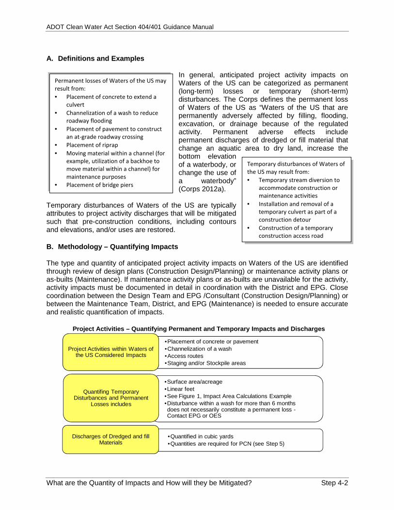
In general, anticipated project activity impacts onWaters of the US can be categorized as permanent(long-term) losses or temporary (short-term)disturbances. The Corps defines the permanent lossof Waters of the US as “Waters of the US that arepermanently adversely affected by filling, flooding,excavation, or drainage because of the regulatedactivity. Permanent adverse effects includepermanent discharges of dredged or fill material thatchange an aquatic area to dry land, increase thebottom elevationof a waterbody, orchange the use ofa waterbody”(Corps 2012a).
Temporary disturbances of Waters of the US are typicallyattributes to project activity discharges that will be mitigatedsuch that pre-construction conditions, including contoursand elevations, and/or uses are restored.
B. Methodology – Quantifying Impacts
The type and quantity of anticipated project activity impacts on Waters of the US are identifiedthrough review of design plans (Construction Design/Planning) or maintenance activity plans oras-builts (Maintenance). If maintenance activity plans or as-builts are unavailable for the activity,activity impacts must be documented in detail in coordination with the District and EPG. Closecoordination between the Design Team and EPG /Consultant (Construction Design/Planning) orbetween the Maintenance Team, District, and EPG (Maintenance) is needed to ensure accurateand realistic quantification of impacts.
Project Activities – Quantifying Permanent and Temporary Impacts and Discharges
•Placement of concrete or pavement•Channelization of a wash•Access routes•Staging and/or Stockpile areas
Project Activities within Waters ofthe US Considered Impacts
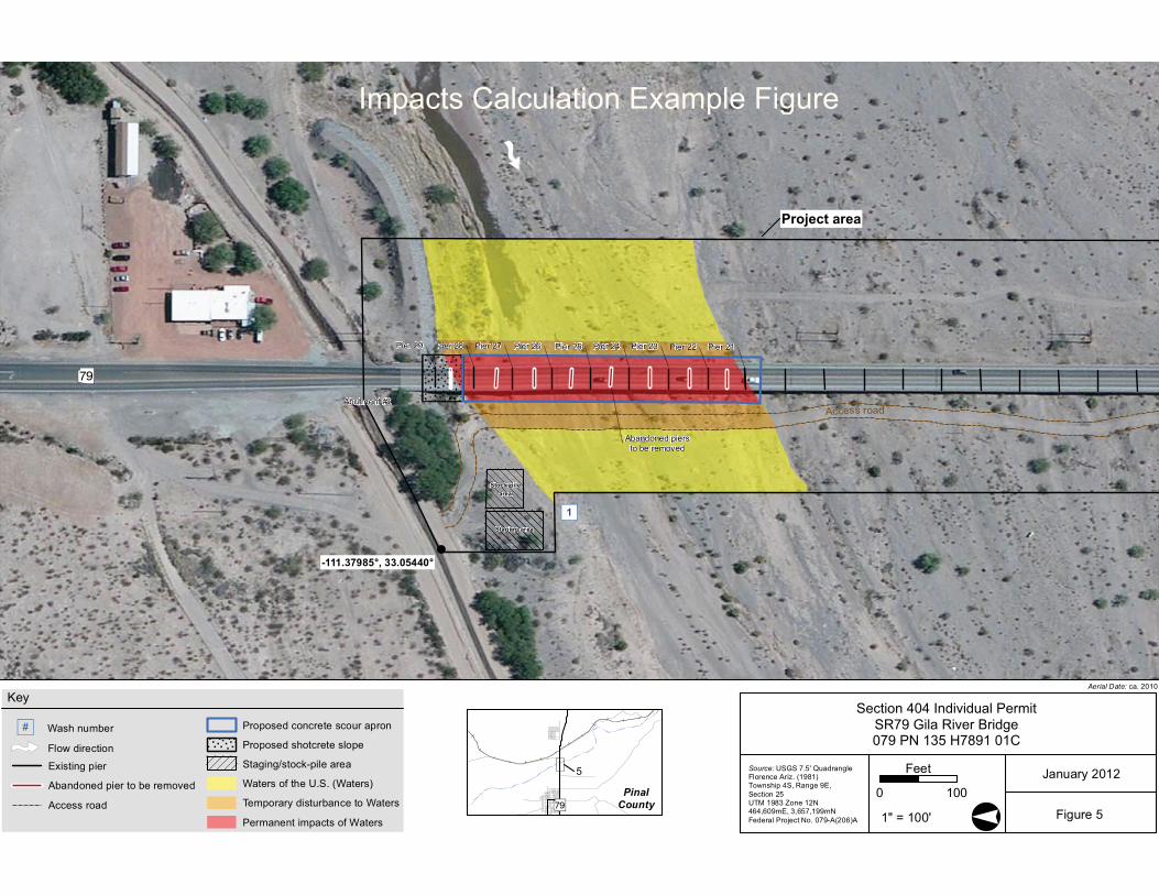
•Surface area/acreage•Linear feet•See Figure 1, Impact Area Calculations Example•Disturbance within a wash for more than 6 monthsdoes not necessarily constitute a permanent loss -Contact EPG or OES
Quantifing TemporaryDisturbances and Permanent
Losses includes
•Quantified in cubic yards•Quantities are required for PCN (see Step 5)
Discharges of Dredged and fillMaterials
Temporary disturbances of Waters ofthe US may result from: Temporary stream diversion to
accommodate construction ormaintenance activities
Installation and removal of atemporary culvert as part of aconstruction detour
Construction of a temporaryconstruction access road
" )
!
?Æ
-111.37985°, 33.05440°
Stock-pilearea
Staging area
Access road
Pier 29
Abutment #2
Pier 28 Pier 27 Pier 26 Pier 25 Pier 24 Pier 23 Pier 22 Pier 21
Abandoned piersto be removed
Project area
1
Aerial Date: ca. 2010
PinalCounty?Æ
5
Section 404 Individual PermitSR79 Gila River Bridge079 PN 135 H7891 01C
January 2012
1" = 100' Figure 5°
Source: USGS 7.5' Quadrangle Florence Ariz. (1981)Township 4S, Range 9E, Section 25UTM 1983 Zone 12N 464,609mE, 3,657,199mNFederal Project No. 079-A(206)A
0 100
Feet
Key
Flow direction
Wash number#)
Existing pier
Abandoned pier to be removed
Access road
Proposed concrete scour apron
Proposed shotcrete slope
Staging/stock-pile area
Waters of the U.S. (Waters)
Temporary disturbance to Waters
Permanent impacts of Waters
Impacts Calculation Example Figure

ADOT Cle
What are
Identifimpact
ConEPGTea
MaworReq
The fo
A
M
Ccu
C. Mitig Mitigationproject aavoided can be construct
Determquantityto Wate
•
••
ean Water Ac
e the Quantit
fying mitigatiots:
nstruction DesG Planner/ Conam.
intenance actrks with EPG tquest.
ollowing are
Avoidance – K
Minimize – Mo
ompensationulvert extens
gation Meas
n measuresactivity effecor minimal implementetion, depend
ine type and y of impacts ers of the US
Temporary disturbances
Permanent loDischarges
ct Section 404
ty of Impacts
on measures a
sign/Planning nsultant work
ivities ‐ Typicathrough a Wor
project speci
eeping roadw
odify slope st
n – Paying $10ion
sures
are intendects to the (Corps 201
ed prior to, ding on the m
Flo
osses
4/401 Guidanc
s and How w
nd quantifying
‐ Typically thes with the Des
ally the Districrk Order
ific examples
way bank stab
abilization m
0,000 in in‐lie
ed to ensureaquatic env2a). Mitigatduring, an
measure.
ow Chart 4-1
Evaluatemeasure
•
••
ce Manual
will they be M
g
e sign
ct
s of mitigatio
bilization and
easures to re
eu fee compe
e that advervironment ation measurd/or followi
1: Key Deci
e mitigation es
•Avoidance
•Minimization•Compensate,appropriate, fimpacts that be avoided
Mitigated?
n measures:
equipment o
educe impacts
nsation for im
rse are res ng
ision for Ste
n, as for can’t
Mitigataken iminimpermadisturb Examp
Avfro
Mth
Copa
out of Waters
s to Waters o
mpacts to wet
ep 4
Ready fSection
tion measuresin sequence toize, or compenent losses orbances of Wat
ple mitigation
void – siting thom Waters of
inimize – redue activity
ompensate – Iayment
Ste
s of the US
of the US
tland from
for Step 5 ‐n 404 Permits
•Refer to thesection for detailed acttake in Step
s are actions o avoid, nsate for r temporary ters of the US.
measures:
he activity awathe US
ucing the size
n‐Lieu fee
ep 4-4
e next
tions to p 5
.
ay
of
ADOT Clean Water Act Section 404/401 Guidance Manual
What are the Quantity of Impacts and How will they be Mitigated? Step 4-5
Key Documents for Step 4: Construction Design/Planning activities:
o Design planso JD approved by the Corps
Maintenance activities:o Maintenance activity plans or as-builtso Delineated ordinary high water mark when jurisdiction is assumedo JD (if one was performed for larger or more complex maintenance activities)
Additional Assistance Documents for Step 4: Pre-Construction Notification – Nationwide/Individual Permit Submittal Guidance (404
Permit and PCN Templates, Checklists, and Instructions Appendix)

ADOT Clean Water Act Section 404/401 Guidance Manual
What are the Quantity of Impacts and How will they be Mitigated? Step 4-6
THIS PAGE INTENTIONALLY LEFT BLANK
ADOT Clean Water Act Section 404/401 Guidance Manual
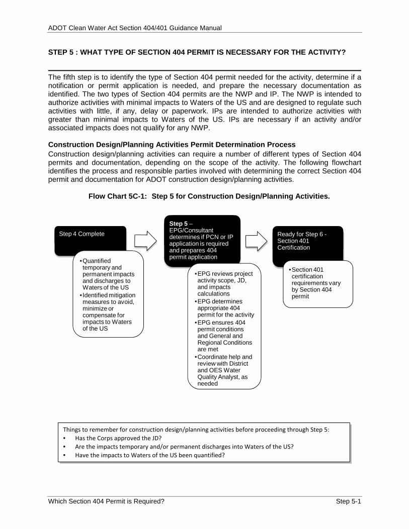
Which Section 404 Permit is Required? Step 5-1
STEP 5 : WHAT TYPE OF SECTION 404 PERMIT IS NECESSARY FOR THE ACTIVITY?
The fifth step is to identify the type of Section 404 permit needed for the activity, determine if anotification or permit application is needed, and prepare the necessary documentation asidentified. The two types of Section 404 permits are the NWP and IP. The NWP is intended toauthorize activities with minimal impacts to Waters of the US and are designed to regulate suchactivities with little, if any, delay or paperwork. IPs are intended to authorize activities withgreater than minimal impacts to Waters of the US. IPs are necessary if an activity and/orassociated impacts does not qualify for any NWP.
Construction Design/Planning Activities Permit Determination ProcessConstruction design/planning activities can require a number of different types of Section 404permits and documentation, depending on the scope of the activity. The following flowchartidentifies the process and responsible parties involved with determining the correct Section 404permit and documentation for ADOT construction design/planning activities.
Flow Chart 5C-1: Step 5 for Construction Design/Planning Activities.
Step 4 Complete
•Quantifiedtemporary andpermanent impactsand discharges toWaters of the US
•Identified mitigationmeasures to avoid,minimize orcompensate forimpacts to Watersof the US
Step 5 –EPG/Consultantdetermines if PCN or IPapplication is requiredand prepares 404permit application
•EPG reviews projectactivity scope, JD,and impactscalculations
•EPG determinesappropriate 404permit for the activity
•EPG ensures 404permit conditionsand General andRegional Conditionsare met
•Coordinate help andreview with Districtand OES WaterQuality Analyst, asneeded
Ready for Step 6 -Section 401Certification
•Section 401certificationrequirements varyby Section 404permit
Things to remember for construction design/planning activities before proceeding through Step 5: Has the Corps approved the JD? Are the impacts temporary and/or permanent discharges into Waters of the US? Have the impacts to Waters of the US been quantified?

ADOT Clean Water Act Section 404/401 Guidance Manual
Which Section 404 Permit is Required? Step 5-2
Maintenance Activities Permit Determination ProcessMaintenance activities typically occur under NWPs 3a and 14, depending on the scope of theactivity. The following flow chart identifies the standard process and responsible parties involvedwith determining the correct Section 404 permit and documentation for ADOT maintenanceactivities.
Flow Chart 5M-1: Step 5 for Maintenance Activities
Step 4 Completed
•Quantifiedtemporary andpermanentimpacts anddischarges toWaters of the US
•Identifiedmitigationmeasures toavoid orminimizeimpacts toWaters of the US
Step 5 – District providesinformation to EPG forpermit documentationand PCN preparation.
•EPG reviews projectactivity scope, Waters ofthe US (assumed ordelineated) , and impactscalculations
•EPG determinesappropriate 404 permitfor the activity
•EPG ensures 404 permitconditions and Generaland Regional Conditionsare met
•EPG sends to OES forreview of 404 Permitapplication
•Use Flow Chart 3M-1 todetermine if PCN isneeded
Ready for Step 6 -Section 401Certification
•Section 401certificationrequirementsvary by Section404 permit
A. Nationwide Permits
The Corps has developed and periodically updates (approximatelyevery five years) a set of NWPs intended to authorize activities withminimal adverse environmental impacts and are designed to regulatesuch activities with little, if any, delay or paperwork. As of March 2012,a total of 50 NWPs are available for use (Corps 2012a). Each NWP isclassified by a permit number and a type of activity within Waters of
Things to Remember for Maintenance Activities: Are the impacts to Waters of the US temporary, permanent and/or discharges? Have the impacts to Waters of the US been quantified? For the majority of ADOT maintenance activities, NWP 3a or 14 is used. A decision chart for commonly used NWPs is provided later in this section. Coordinate with the District, and EPG as needed, to ensure that a given NWP is acceptable.
NWPs are intended toauthorize activities withminimal adverseenvironmental impacts!

ADOT Clean Water Act Section 404/401 Guidance Manual
Which Section 404 Permit is Required? Step 5-3
the US (Corps 2012a and 2012b). An activity may qualify for one or more NWPs. In somecases, as activity can be covered without notifying the Corps, provided the decision is includedin the project files.
1. Nationwide Permit Use Criteria and Impact Limitations
The Corps has established use criteria and impact limitations for each NWP.
“The acreage of loss of Waters of the US is a threshold measurement of the impact tojurisdictional waters for determining whether an activity may qualify for a [NWP];…Waters of the US temporarily filled, flooded, excavated, or drained, but restored to pre-construction contours and elevations after construction are not included in themeasurement of loss of waters of the United States” (Corps 2012a).
Detaileddescriptions ofactivities coveredby the permit
PermitUse
Criteria Threshold limitsfor permanentlosses of Waters ofthe US (e.g., 1/10acre, 300 linearfeet)
Temporarydisturbances toWaters of the USare excluded
PermitImpact
Limitations
It is important to evaluate the activity against all use criteria, impact limitations, permitapplication requirements, and conditions associated with a given NWP to confirm applicability.Temporary disturbances of Waters of the US are provided to the Corps in permit applications (ifa PCN or IP is required), but are not factored into NWP impact limitations.
The Nationwide Permits Appendix includes a table (A Summary of 2012 Nationwide Permits[Corps 2012b]) developed by the Corps listing key use criteria and impact limitations for eachNWP.
Maintenance Activities: Common ADOT maintenance activities in Waters of the US often qualify for either NWP 3 or 14. Please see Flow Chart 5M-2 on the following page for a list of common maintenance activities under each
of these two permits. The District should coordinate with EPG for assistance through a Work Order Request.
Construction Design/Planning Activities: Common activities may be regulated under NWP 14 or may require the use of a different NWP. Coordinate with the EPG / Consultant or OES for help in determining the appropriate permit for the
activity.

ADOT Clean Water Act Section 404/401 Guidance Manual
Which Section 404 Permit is Required? Step 5-4
Flow Chart 5M-2: Nationwide Permits for Common ADOT Maintenance Activities
Maintenance PMcoordinates with District toensure a commonly used
NWP is acceptable.
District reviews project toverify appropriate NWP
selected
Some activities covered by aNWP 3a :
•Repair of existing culverts•Removal of debris fromexisting culverts
•Replacement of storm-damaged culverts or waterintake structure
•Temporary cofferdams orculverts to performmaintenance activities
Some activities covered by aNWP 14 :
•Stream channel modificationor bank stabilization to protectlinear transportation projects
•Culvert extensions or newinstallation
Coordinate with EPG orOES as needed to verify
permit selection
There are 50 NWPs issued by the Corps. Commonlyused NWPs for ADOT Maintenance activities includethe NWP 3a (Maintenance) and NWP 14 (LinearTransportation Projects) Permits.
2. Conditions
Nationwide Permit General ConditionsThe Corps has developed and periodically updates (approximately every five years) a set ofNWP General Conditions, including General Conditions 18, 20, and 21 (refer to chart of pageStep 5-5). As of March 2012, a total of 31 General Conditions are in effect (Corps 2012a).
Nationwide Permit Regional ConditionsLike the NWP general conditions, the Corps periodically reviews and develops a set of NWPRegional Conditions. As of March 2012, six of the regional conditions in effect apply to activitiesin Arizona (Corps 2012a). NWPs 3, 7, 12-15, 17-19, 21, 23, 25, 29, 35, 36, 39-46, or 48-52cannot be used to authorize structures, work, and/or the discharge of dredged or fill materialthat would result in the "loss" of wetlands, mudflats, vegetated shallows or riffle and poolcomplexes as defined at 40 CFR Part 230.40-45.
Section 401 Certification RequirementsAs detailed in Step 6, Section 401 certification requirementsvary by NWP. Each NWP specifies Section 401 certificationstatus (certified, conditional, or individual) based on thetypes of Waters of the US (tribal, unique, impaired, or other)to be impacted by an activity.
When considering a NWP, be aware ofthe acreage thresholds and General andRegional conditions that trigger the needfor a PCN or IP.
For a given NWP, activities must beevaluated for compliance with ALLapplicable NWP General andRegional conditions and Section 401certification requirements.

ADOT Clean Water Act Section 404/401 Guidance Manual
Which Section 404 Permit is Required? Step 5-5
Nationwide Permit General Conditions Requiring Pre-Construction Notification
•The EPG/Consultant, in coordination with the ADOT Project Manager, mustcoordinate with the ADOT Historic Preservation Team.
•Only the ADOT Historic Preservation Team can determine the "potential to affecthistorical properties."
All Section 404 Permits are required to adhere with the General and Regional Conditions.
•Construction Design/Planning Activities: EPG Planner/Consultant must becontacted to provide a review of federally listed species and critical habitat.
•Maintenance Activities: District coordinates with EPG through the Work Orderprocess for a review of federally listed species and critical habitat.
If the activity has the potential to affect federally listed speciesor designated critical habitat (General Condition 18).
If the activity has the potential to affect historical propertieseligible for listing on the National Register of Historic Places(General Conditions 20 and 21).
3. Notification Requirements
All activities resulting in discharge of dredged or fill material into Waters of the US requirecompliance with Section 404 and Section 401 of CWA. However, some activities that qualify fora NWP do not require PCN to the Corps based on the permit conditions.
PCN requirements are indicated by specific conditions asidentified in each NWP, General Conditions, andRegional Conditions.
For example, the specific limits for NWP 14 – LinearTransportation Projects require notification to the Corpsif:
The discharge of dredged or fill material causesthe permanent loss of greater than 1/10 acre of Waters of the US.
The activity would involve the discharge of dredged or fill material in special aquatic site,including wetlands.
The activity would involve the discharge of dredged or fill material into a perennial wash.
Another example would be the permit conditions for “NWP 3a – Maintenance” do not requirenotification to the Corps. However, the activity must be checked for compliance with all Generaland Regional Conditions because some General and Regional Conditions require PCN.
If PCN is required, a NWP PCN submittal is prepared in accordance with General Condition #31 (see Special PublicNotice – Nationwide Permits for Arizona [Corps 2012a]).
In Arizona, Regional Conditions requirenotification for all activities that woulddischarge to a perennial watercourse orwaterbody.
An IP is required for activities that resultin impacts to a special aquatic site (e.g.,wetlands).
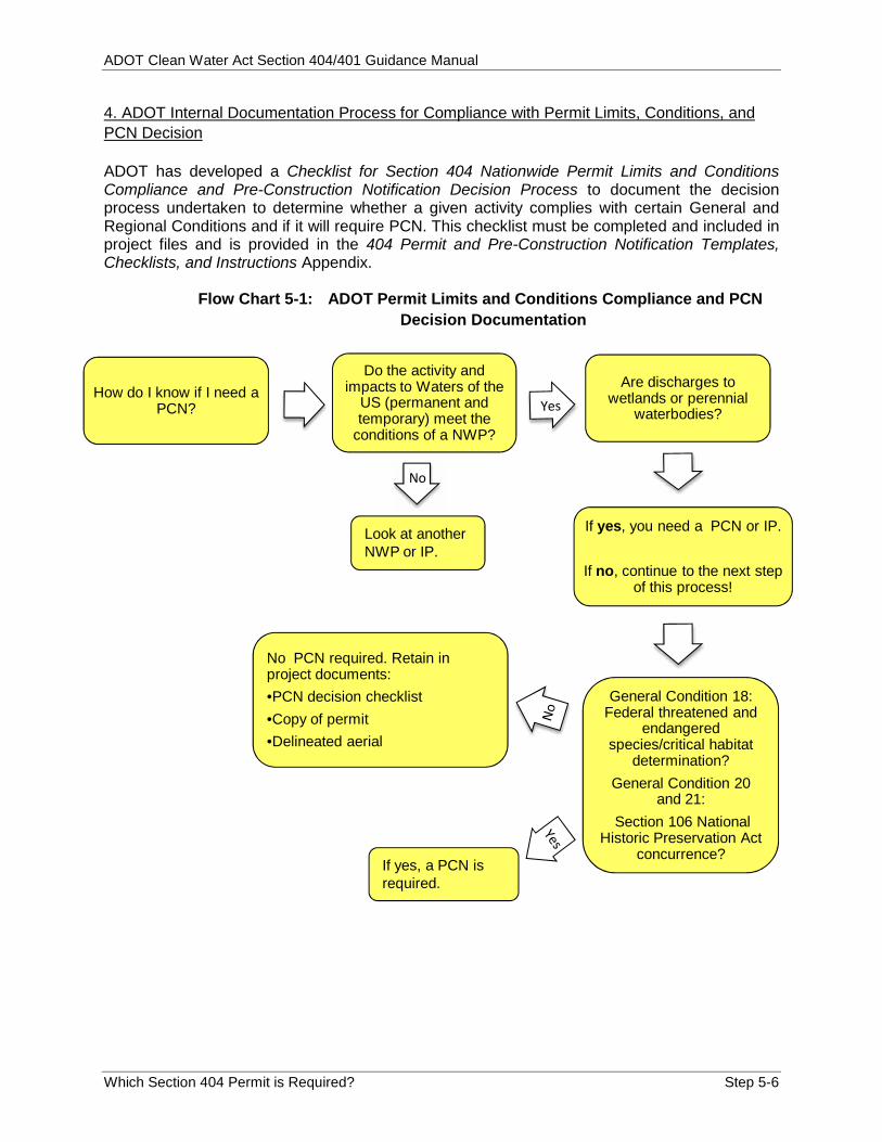
ADOT Clean Water Act Section 404/401 Guidance Manual
Which Section 404 Permit is Required? Step 5-6
4. ADOT Internal Documentation Process for Compliance with Permit Limits, Conditions, andPCN Decision
ADOT has developed a Checklist for Section 404 Nationwide Permit Limits and ConditionsCompliance and Pre-Construction Notification Decision Process to document the decisionprocess undertaken to determine whether a given activity complies with certain General andRegional Conditions and if it will require PCN. This checklist must be completed and included inproject files and is provided in the 404 Permit and Pre-Construction Notification Templates,Checklists, and Instructions Appendix.
Flow Chart 5-1: ADOT Permit Limits and Conditions Compliance and PCNDecision Documentation
How do I know if I need aPCN?
Do the activity andimpacts to Waters of the
US (permanent andtemporary) meet the
conditions of a NWP?
Are discharges towetlands or perennial
waterbodies?
If yes, you need a PCN or IP.
If no, continue to the next stepof this process!
General Condition 18:Federal threatened and
endangeredspecies/critical habitat
determination?General Condition 20
and 21:Section 106 National
Historic Preservation Actconcurrence?
No PCN required. Retain inproject documents:•PCN decision checklist•Copy of permit•Delineated aerial
If yes, a PCN isrequired.
Look at anotherNWP or IP.
No

ADOT Clean Water Act Section 404/401 Guidance Manual
Which Section 404 Permit is Required? Step 5-7
5. Components of a Nationwide Permit Pre-construction Notification Submittal
If an activity requires Corps Notification, a PCN must be submitted to the Corps. EPG hasprovided Pre-Construction Notification – Nationwide Permit/Individual Permit SubmittalGuidance and a Checklist for Submitting a Section 404 Pre-Construction Notification thatprovides a complete list of all components that must be included in PCN submittals for ADOTactivities. These documents were developed in accordance with NWP General Condition 31 andin coordination with the Corps and are provided in the 404 Permit and Pre-ConstructionNotification Templates, Checklists, and Instructions Appendix.
Flow Chart 5-2: Pre-Construction Notification Process
EPG
•ReviewChecklist forSubmitting aSection 404PCN
•Prepares PCNsubmittalpackage
•Sends to OESand District
OES
•Final Reviewof PCNsubmittalpackage
•Returns toEPG
District or theirdesignee
•Receives PCNsubmittalpackage fromEPG
•Reviews andsigns submittalpackage andsends to EPG
•EPG submitssubmittalpackage toCorps
Corps
•Reviews PCNsubmittal packagefor approval
•Corps has 15 daysfor review andnotify EPG ifapproved
•Returns approvedpackage to EPG
•Note:Construction/Developmentprojects arecoordinated andpermitted throughthe ADOT Corpsliaison.Maintenanceprojects are notcoordinatedthrough theliaison.
If the activity does not require a PCN: You must complete a Checklist for Section 404 Nationwide Permit Limits and Conditions Compliance and
Pre-Construction Notification Decision Process and include in project files. You must continue to Step 6 to evaluate for Section 401 certification compliance. Following completion of Step 6, the completed and approved Checklist for Section 404 NWP Notification
Decision Process should be attached to a copy of the selected NWP and final JD (or delineated ordinaryhigh water mark if jurisdiction was assumed).
o This becomes the complete Section 404 Permit Package.If the activity does require a PCN, you must continue reading for the requirements of a Pre-ConstructionNotification submittal.
Things you should know! For detailed procedures and forms (templates) for
submittals, refer to the Environmental Services andPlanning Section 404 website:http://www.azdot.gov/highways/EPG/EPG_Common/Documents_Technical_Section_404_Procedures.asp
The Corps has 60 days to approve a NWP submittaland 120 days to approve a IP submittal

ADOT Clean Water Act Section 404/401 Guidance Manual
Which Section 404 Permit is Required? Step 5-8
As noted on the checklist, key components of a PCN submittal include (Refer to the Checklistfor Submitting a Section 404 Notification in the 404 Permit and Pre-Construction NotificationTemplates, Checklists, and Instructions Appendix for the complete list of all necessary PCNsubmittal components):
Application for Department of the Army Permit (ENG Form 4345 [Corps 2012 c];provided in Nationwide Permits Appendix)
Table 1 – Wash Summary (EPG; provided in Jurisdictional Delineation Forms andChecklists Appendix)
General Conditions compliance
Table 1 – Wash Summary is coded to identify information to be included in NWP PCNsubmittals, IP applications, and information necessary for jurisdictional delineations. The activityproponent should modify Table 1 as appropriate when preparing a PCN submittal.
A completed Checklist for Submitting a Section 404 Pre-Construction Notification must beprovided to EPG with the PCN submittal.
Note: For maintenance activities the District coordinates with EPGthrough the Work Order process!
Step-by-step instructions developed by the Corps for completing ENG Form 4345 (Corps 2012d) are provided inthe 404 Permit and Pre-Construction Notification Templates, Checklists, and Instructions Appendix.
All mitigation measures and conditions (Block 23 of ENG Form 4345) applicable to an activity must be reviewedby Design personnel and District staff and will be included in the environmental clearance and/or projectspecifications, as appropriate.
It is important to note that Block 25 of ENG Form 4345, pertaining to addresses of adjoining property ownersand lessees, is not required for NWP PCN submittals; this information is only required for IP applications. ForNWP PCN submittals, this block should state “not applicable.”

ADOT Clean Water Act Section 404/401 Guidance Manual
Which Section 404 Permit is Required? Step 5-9
Flow Chart 5-3: Key Actions for Nationwide Permits
Determine the appropriate NWP
•For ConstructionDesign/Planningprojects, the projectteam coordinates withEPG
•For Maintenanceprojects, coordinationshould follow theestablished Work Orderprocess
Complete and file the Checklistfor Section 404 NationwidePermit Limits and ConditionsCompliance and Pre-Construction NotificationDecision Process
•May include coordinationwith EPG, EPG Biologist,and HPT fordetermination ofeffect/concurrence
If No PCN required:
Continue to Step 6 toevaluate Section 401
CertificationRequirements
If a PCN is required:
Complete the Checklistfor Submitting a Section
404 Pre-ConstructionNotification
EPG/Consultantprepares the PCN
submittal
Continue to Step 6
Key Documents for Nationwide Permits:Special Public Notice – Nationwide Permits for Arizona (Corps 2012a). Available online:http://www.azdeq.gov/environ/water/permits/download/nwp.pdf
Nationwide Permits Appendix: A Summary of 2012 Nationwide Permits (Corps 2012b)
404 Permit and PCN Templates, Checklists, and Instructions Appendix: Checklist for Section 404 Nationwide Permit Limits and Conditions Compliance and Pre-
Construction Notification Decision Process (EPG) Checklist for Submitting a Section 404 Pre-Construction Notification (PCN) (EPG) Pre-Construction Notification – NWP/IP Submittal Guidance (EPG) Application for Department of the Army Permit ENG Form 4345 (Corps 2012c) Instructions for Preparing a Department of the Army Permit Application (Corps 2012d) Pre-Construction Notification/ Individual Permit Cover Letter Template (EPG)
ADOT Clean Water Act Section 404/401 Guidance Manual
Which Section 404 Permit is Required? Step 5-10
All IPs requirecompletion of apermit application.
B. Individual Permits
If an activity will result in the discharge of dredged or fill material intoWaters of the US, but does not qualify for any NWP (i.e., would notcomply with one or more criteria/limitations or conditions), an IPapplication shall be prepared. IPs are intended to authorize activities withgreater than minimal adverse environmental impacts.
IPs for ADOT activities must also follow tasks and guidelines set forth by the followingMemorandum of Agreement (MOA) and Section 404(b)(1) Guidelines. These tasks andguidelines in part define the components of an IP application for ADOT activities.
1. Federal Highway Administration Funded Transportation Activities
If a transportation activity will use Federal Highway Administration (FHWA) funding (in whole orpart) and requires an IP, the Section 404 of the Clean Water Act (NEPA/404 MOA) must beimplemented (FHWA 2012). The intent of the NEPA/404 MOA is to integrate NEPA and Section404.
The NEPA/404 MOA identifies specific tasks for applicable agencies to ensure integration of thetwo processes. The NEPA/404 MOA also includes a list of jurisdictional delineation componentsand a list of IP application components. These components are also listed in EPG’sJurisdictional Delineation Submittal Guidance (Jurisdictional Delineation Forms and ChecklistsAppendix) and Pre-Construction Notification – Nationwide Permit/Individual Permit SubmittalGuidance (provided in 404 Permit and Pre-Construction Notification Templates, Checklists, andInstructions Appendix). The NEPA/404 MOA also includes a copy of a Notification ofCommencement and Completion of Work form, typically provided to the ADOT activityproponent by EPG.
2. Section 404(b)(1) Guidelines
The Section 404(b)(1) Guidelines for Specification of Disposal Sites for Dredged or Fill Material(40 CFR 230; Corps 2010b) were developed by the Corps and EPA to assist in implementationof the CWA, and state that
“…dredged or fill material should not be discharged into the aquatic ecosystem, unless itcan be demonstrated that such a discharge will not have an unacceptable adverseimpact either individually or in combination with known and/or probably impacts of otheractivities affecting the ecosystems of concern” (40 CFR 230).
The Section 404(b)(1) guidelines (provided in the Regulations Appendix) outline the Corpsreview standards for IP applications, above and beyond NWP review standards.
3. Components of an Individual Permit Application
Components Common to Nationwide Preconstruction Notification Submittals and IndividualPermit Applications:IP applications for ADOT activities must include all pertinent components identified in the EPGPre-Construction Notification – NWP/IP Submittal Guidance. The NWP/IP Submittal Guidance isprovided in the 404 Permit and PCN Templates, Checklists, and Instructions Appendix.
ADOT Clean Water Act Section 404/401 Guidance Manual
Which Section 404 Permit is Required? Step 5-11
Additional Individual Permit Application Components – Draft Decision Document:Before approving an IP application, the Corps must demonstrate that the activity will complywith all provisions of the Section 404(b)(1) guidelines, as well as NEPA and other applicablefederal laws and policies. To demonstrate compliance with the Section 404(b)(1) guidelines, aswell as NEPA and other applicable federal laws and policies, a Decision Document is preparedas part of the IP application. The Decision Document constitutes the following:
Environmental Assessmento Prepared to meet NEPA requirements and
demonstrate compliance with otherapplicable federal regulations.
NEPA/404 MOA Complianceo For federally funded transportation activities,
documentation of compliance with theNEPA/404 MOA must be provided.
Review and Compliance Determinationo Demonstrates compliance with all provisions of the Section 404(b)(1) guidelines.
Alternatives Analysiso Describes the activity sites and designs considered during the planning process, and
explains why the activity area and design is the least environmentally damaging andpracticable means of satisfying the purpose of the activity.
Mitigation Plan (as applicable)o Describes all mitigation measures to avoid or minimize impacts to Waters of the US.
Statement of Findingso Summarizes compliance with other applicable federal regulations and results of
public notice and comment process. Public Interest Review
o Demonstrates that the activity is not contrary to the public interest. It addresses thepublic and private need for the activity, anticipated impacts on public and privateuses of the activity area, etc.
Finding of No Significant Impacto Demonstrates that an Environmental Impact Statement is not necessary for the
activity.
For most ADOT activities, a draft Decision Document isprepared by the ADOT EPG Planner/Consultant using theCorps’ preferred format (IP Section 404(b)(1) Template[EPG], provided in the 404 Permit and Pre-ConstructionNotification Templates, Checklists, and InstructionsAppendix) and encompasses the components listedabove. The document is revised and finalized by theCorps. During review, the Corps will provide input onproposed mitigation measures, which may include compensatory mitigation (in-lieu fees; seeStep 5.C. for additional information on in-lieu fee mitigation).
A completed Checklist for Submitting a Section 404 Pre-Construction Notification must beprovided to EPG with the IP application (see 404 Permit and PCN Templates, Checklists, andInstructions Appendix). EPG staff use the checklist when reviewing IP applications. The IPapplication is ultimately forwarded by EPG to the Corps for their consideration and approval.
All mitigation measures and conditionsapplicable to an activity must bereviewed by Design personnel andDistrict staff and will be included in theenvironmental clearance and/or projectspecifications as appropriate.
The Corps cannot authorize an activity if apracticable alternative would result in lessadverse impacts on the aquaticecosystem, provided that the alternativewould not result in other significantadverse environmental consequences.

ADOT Clean Water Act Section 404/401 Guidance Manual
Which Section 404 Permit is Required? Step 5-12
Flow Chart 5-4: Individual Permit Submittal Process
After you have gone through the Section 404 process, the following actions remain to ensure use of theSection 404 IP in compliance with Corps regulations:
Flow Chart 5-5: Steps to take after receiving the Individual Permit and Section401 Individual Certification
Congratulations! You'vereceived a Section 404 IP
and Section 401Individual Certification
for the activity!
Submit the CorpsChecklist of
EnvironmentalCompliance to EPG
Via email - submit theNotification of
Commencement 1-2weeks before start of
construction
Via email - submit theNotification of
Completion as soon as allwork within Waters of
the US is completed perthe permit terms and
conditions
This completes theSection 404 Individual
Permit process
EPG Planner/Consultant
•Reviews the Checklist forSubmitting a Section 404PreConstruction Notification
•Prepares draft DecisionDocument (see Corps IndividualPermit Section 404(b)(1)Template provided in the 404Permit and Pre-ConstructionNotification Templates,Checklists, and InstructionsAppendix)
•Prepares Mitigation Plan•Sends complete package to OES
and District for review andsubmittal
•Submits package to the Corpsfollowing OES review
Corps
•The Corps reviews andapproves (approximately 2-3months) the permit application
•The Corps determines theappropriate mitigation (ifapplicable) for impacts 2-3months after the application iscomplete. Typically in-lieu fee isthe preferred mitigation (SeeSection 5.C)
• Continue to Step 6
These checklists andnotification forms are partof the permit information inthe project specialprovisions.

ADOT Clean Water Act Section 404/401 Guidance Manual
Which Section 404 Permit is Required? Step 5-13
Key Documents for Individual Permits:404 Permit and PCN Templates, Checklists, and Instructions Appendix
Pre-Construction Notification – NWP/IP Submittal Guidance (EPG 2013). Checklist for Submitting a Section 404 Pre-Construction Notification (EPG 2013) Corps Individual Permit Section 404(b)(1) Template (EPG 2013) Pre-Construction Notification/ Individual Permit Cover Letter Template (EPG 2013)
Additional Assistance Documents for Individual Permits:Section 404(b)(1) Guidelines for Specification of Disposal Sites for Dredged or FillMaterial (40 CFR 230; Corps 2010b). Available online:http://www.wetlands.com/regs/tlpge03g.htm
C. In-Lieu Fee Mitigation
In-lieu fee mitigation is the preferred method for ADOT activities requiring compensatorymitigation. In-lieu fee mitigation is a type of compensatory mitigation in which the permitteeprovides funds to an in-lieu fee sponsor for off-site compensation.
For project activities that will be authorized under Section 404, compensatory mitigation is notconsidered until all appropriate and practicable steps have been taken to first avoid and thenminimize adverse impacts to the aquatic ecosystem (Corps 2008b, EPA 1990). Compensatorymitigation is essential for all activities in which the impacts to the aquatic resources have beenavoided and minimized to the maximum extent practicable, but would still result in unavoidableadverse effects (Corps 2013).
The Corps has developed numerous guidance documents onidentification of applicable and practicable mitigation measures aswell as information on compensatory mitigation process for federalaid highway projects. Online links to these documents are providedat the end of this section.
The Corps has the discretion to approve or reject the mitigation measures identified by anactivity proponent, and can identify additional activity-specific mitigation measures that must beimplemented in order for a permit to be valid. After approval by the Corps, mitigation measuresidentified for the activity are included in the environmental clearance for the projectspecifications.
ADOT has a process by which in-lieu fees are set aside for activities requiring them. Thisprocess was developed to assist the ADOT Project Managers manage budget for in-lieu fees foractivities and to facilitate coordination between the ADOT groups involved in the in-lieu feeprocess.
In-lieu fee mitigation is nottypically used unless an IPis required for an activity.

ADOT Clean Water Act Section 404/401 Guidance Manual
Which Section 404 Permit is Required? Step 5-14
Flow Chart 5-6: ADOT In-Lieu Fee Fund Process
Estimate fundsrequired for in-lieufee
• Corps determinesamount of fundsrequired
•Corps notifies EPGand ProjectManager aboutamount of fundsrequired
•EPG and OESnotify ADOTProject Manager
Set aside funds forin-lieu fee
•ADOT ProjectManagercoordinates withADOT Right ofWay Office
In-lieu fee due date
•EPG/Consultantverifies project biddate with ADOTProject Manager
•Corps sets in-lieufee due date basedon project bid date
Additional Assistance Documents for In-Lieu Fee Mitigation:
Compensatory Mitigation for Losses of Aquatic Resources, Final Rule (Corps 2008b).Available online:o http://water.epa.gov/lawsregs/guidance/wetlands/upload/2008_04_10_wetlands_wetlands_mi
tigation_final_rule_4_10_08.pdf RGL 08-03 Minimum Monitoring Requirements for Compensatory Mitigation Projects
Involving the Restoration, Establishment, and/or Enhancement of Aquatic Resources(Corps 2008e). Available online:o http://www.usace.army.mil/Portals/2/docs/civilworks/RGLS/rgl08_03.pdf
Federal Guidance on the Use of the TEA-21 Preference for Mitigation Banking to fulfillMitigation Requirements under Section 404 of the Clean Water Act (EPA, Corps, andFHWA 2003). Available online:o http://water.epa.gov/lawsregs/guidance/wetlands/upload/2003_07_11_wetlands_TEA-
21Guidance.pdf

ADOT Clean Water Act Section 404/401 Guidance Manual
What Type of Section 401 Certification is Required? Step 6-1
STEP 6: WHAT TYPE OF SECTION 401 CERTIFICATION IS ESSENTIAL FOR THEACTIVITY?
The sixth step is to identify the type of Section 401 water quality certification necessary for theactivity, and prepare a certification application if needed. Section 401 certification requirementsvary by NWP and this information is needed for NWP PCN and IP applications (Step 5). Section404 permits (Nationwide or Individual) will not be issued by the Corps without a Section 401certification.
A. Definitions
Section 401 of CWA states that“Any applicant for a [f]ederal license or permit to conduct any activity including, but notlimited to, the construction or operation of facilities, which may result in any dischargeinto…[Waters of the US], shall provide the licensing or permitting agency a certificationfrom the [s]tate in which the discharge originates or will originate, or, if appropriate, fromthe interstate water pollution control agency having jurisdiction over the…waters [of theUS] at the point where the discharge originates or will originate, that any such dischargewill comply with the applicable provisions of sections 1311, 1312, 1313, 1316, and 1317of this title" (pertaining to effluent standards [33 U.S. Code 1341])
Section 401 jurisdiction is primarily determined by the geographic location of activities: Tribal Lands – EPA is responsible for issuing 401 certification except where EPA has
delegated 401 certification authority1
Non-Tribal Lands – ADEQ is the lead agency responsible for issuing 401 certification onlands that are not part of a federally recognized Indian Reservation
As part of Section 401 certification, discharges to several types of surface waters areconsidered.
303(d)-listed Impaired Waters – surface waters that do not meet surface water qualitystandards and therefore receive special consideration. The current 303(d) list ofImpaired Waters is available on the ADEQ website (ADEQ 2008):(http://www.azdeq.gov/environ/water/assessment/assess.html)
Outstanding Arizona Waters (OAWs) – surface waters classified as outstanding due totheir exceptional water quality. Note: these were formerly referred to as “UniqueWaters.”The current list of OAW is also available on the ADEQ website (ADEQ 2013):(http://www.azdeq.gov/environ/water/permits/download/oaw.pdf)
B. Certification for Activities that Qualify for a Section 404 Nationwide Permit
There are two types of Section 401 certifications: conditional and individual. As discussed inearlier sections, Section 401 certification requirements vary by NWP. Refer to the ADEQ CleanWater Act 401 Certification for Nationwide Permits athttp://www.azdeq.gov/environ/water/permits/cwa401.html
1 To date, the White Mountain Apache, Hopi, Haualapai, and Navajo Indian Reservations are the only Arizona IndianReservations that have been granted authority by EPA over Section 401 compliance for Waters of the US within itsReservation boundaries.
ADOT Clean Water Act Section 404/401 Guidance Manual
What Type of Section 401 Certification is Required? Step 6-2
1. Conditional CertificationConditionally certified projects do not requirenotification or submittal of a Section 401application. Activity impacts may be conditionallycertified under pre-determined limits establishedby CWA Section 404 NWPs.
Continuing with the NWP 14 example, if a lineartransportation activity was located on non-triballand, activities were located in an ephemeral
stream (“other waters”) that was not listed as either a 303(d) Impaired Water or an OAW, andthe activity met all NWP 14 limits, conditions, and applicable General and Regional conditions,the activity would be Conditionally Certified under Section 401. No certification application wouldbe necessary, but the activity proponent would be needed to comply with the 30 Section 401General Conditions (defined and enforced by ADEQ), applicable to the activity scope, in orderfor the Conditional Certification to be valid.
The Section 401 General Conditions are listed in ADEQ Clean Water Act 401 Certification forNationwide Permits (provided in 401 Forms and Guidance Appendix) and at the end of theSpecial Public Notice – Nationwide Permits for Arizona in the Nationwide Permits Appendix.).
2. Individual CertificationIf the Section 401 General Conditions cannot be met, an Individual Certification would benecessary.
Continuing with the example of NWP 14, if the linear transportationactivity was located on a Reservation other than White MountainApache, Hopi, Hualapai, or Navajo Nation, or would impact aSection 303(d) water or Unique Arizona Water, a Section 401Individual Certification would be needed for the activity.
On tribal lands (other than White Mountain Apache, Hopi, Hualapai Reservations, orNavajo Nation) an Individual Certification is obtained through application to EPA(application components defined in later sections) and activity-specific Section 401conditions are defined and enforced by EPA
On non-tribal lands—an Individual Certification is obtained through application to ADEQ(application components defined in later sections) and activity-specific Section 401conditions are defined and enforced by ADEQ
C. Section 401 Certification for Activities that Require a Section 404 Individual Permit
A Section 401 Individual Certification is necessary for all activities that require a Section 404 IPfrom the Corps. As with activities that qualify for NWPs, a Section 401 Individual Certification forSection 404 IP activities on tribal lands (other than those that have been granted authority byEPA over Section 401 compliance) is obtained through application to EPA, and activity-specificconditions are defined and enforced by EPA. A Section 401 Individual Certification for Section404 IP activities on non-tribal lands is obtained through application to ADEQ, and activity-specific conditions are defined and enforced by ADEQ.
An Individual 401Certification is required if anactivity has the potential toimpact any designated OAWor 303(d) Impaired Water.
Certification requirements example: NWP 14,Linear Transportation Projects, carries thefollowing Section 401 certification requirementsin Arizona: 303(d) Impaired Waters — Individual
Certification OAWs — Individual Certification Lakes — Individual Certification Other Waters — Conditional Certification

ADOT Clean Water Act Section 404/401 Guidance Manual
What Type of Section 401 Certification is Required? Step 6-3
For a non-notifying NWP, anIndividual 401 Certification isstill required for projects onTribal land.
D. Components of a Section 401 Individual Certification Application
1. Individual Certification Application to the Environmental Protection AgencyEPA has not developed a standard Individual Certification application format. However, allapplications must include the components identified by EPA (1999; see EPA facsimile listingrequired components of an Individual Certification application to EPA in 401 Forms andGuidance Appendix). Typically, an Individual Certification application to EPA is prepared as astand-alone document paraphrasing and/or attaching the data provided in the NWP PCN orSection 404 IP application.
2. Individual Certification Application to authorized IndianReservationsThe activity proponent must contact the appropriate tribe toconfirm the vital application components. Typically, a Section 401 Individual Certificationapplication to a Tribe is prepared as a stand-alone document paraphrasing and/or attaching thedata provided in the NWP PCN or Section 404 IP application.
3. Individual Certification Application to the Arizona Department of Environmental QualityADEQ requires the following documents to be considered a complete Individual 401Certification application:
ADEQ Application for Certification under CWA Section 401 (ADEQ 2013; provided in401 Forms and Guidance Appendix)
A US Geological Survey (USGS) topographic map or other contour map of activity area A map delineating the ordinary high water mark of Waters of the US to be affected by
the activity to be certified A copy of the application for the federal NWP or IP A description of the measures to be applied to the activities in order to control the
discharge of pollutants into Waters of the US to:o Minimize potential pollution of surface waterso Demonstrate compliance with state surface water quality standards
Typically, the ADEQ Section 401 Application form paraphrases and/or attaches the dataprovided in a Section 404 NWP or IP application and the activity-specific conditions andmitigation measures included in a NWP PCN or Section 404 IP application, as well asspecifications from the ADOT Standard Specifications for Road and Bridge Construction.
Section 401 Individual Certification applications areultimately forwarded by EPG to the EPA, ADEQ, orTribe for their consideration and approval. Approval istypically in the form of an approval letter.
Refer to Flow Chart 6-1 of this section for the keydecisions associated with the Section 401 Certification
A copy of the EPA, ADEQ, or Tribal (asappropriate) Section 401 IndividualCertification approval letter must beforwarded to the Corps. The Corps will notapprove a Section 404 permit until Section401 certification has been received.

ADOT Clean Water Act Section 404/401 Guidance Manual
What Type of Section 401 Certification is Required? Step 6-4
Remember!For an IP, submit Individual 401 Certification application to ADEQ after the 404 permit public notice has posted.
Flow Chart 6-1: Key Decisions to Determine Section 401 Certification
If Tribal Certification is required:Activity proponent prepares Individual Certification applicationSubmit application to EPG for reviewAfter review, District signs and sends to Tribe
If Tribal Certification is NOT required:Verify activity is certified under NWPIf NOT, EPA 401 certification is required and activity proponent must prepare the applicationEPG reviews the application, the District then signs and submits to EPAAfter EPA approval, the 401 certification is sent to the District and EPG is copiedIf applicable, the Corps will include in the approved 404 permit package.
If Tribal waters are NOT involved, go to the next step in this process!
Are lakes, 303 (d), or OAW involved? If YES, ADEQ 401 certification is required and activity proponent must prepare the applicationEPG reviews the application, the District then signs and submits to ADEQAfter ADEQ approval, the 401 certification is sent to the District and EPG is copiedIf applicable, the Corps will include in the approved 404 permit package.
If lakes, 303 (d), or OAW are NOT involved, go to the next step in this process!
Are other waters, including ephemeral, involved and is the activity is conditional certified?If YES, adhere to the Section 401 and 404 general conditionsIf NO, the following must occur:
ADEQ 401 certification is required and activity proponent must prepare the applicationEPG reviews the application, the District then signs and submits to ADEQAfter ADEQ approval, the 401 certification is sent to the District and EPG is copiedIf applicable, the Corps will include in the approved 404 permit package.
Does the project need aSection 404 Permit?
No Section 401 certification isrequired!NO
YES

ADOT Clean Water Act Section 404/401 Guidance Manual
What Type of Section 401 Certification is Required? Step 6-5
Key Documents for Step 6:401 Forms and Guidance Appendix:
ADEQ Application for Certification under the Clean Water Action Section 401 (ADEQ2013)
EPA facsimile listing required components of an Individual Certification application toEPA (reproduced for printing; EPA 1999)
Additional Assistance Documents for Step 6: Certification Requirements under Section 401 of the Clean Water Act (33 U.S. Code
1341; available online: http://www.gpo.gov/fdsys/granule/USCODE-2000-title33/USCODE-2000-title33-chap26-subchapIV-sec1341/content-detail.html)
Section 303(d) Impaired Waters. (ADEQ, 2008); (available online:http://www.azdeq.gov/environ/water/assessment/assess.html)
Outstanding Arizona Waters (OAWs). (ADEQ, 2013); (available online:http://www.azdeq.gov/environ/water/permits/download/oaw.pdf)
ADEQ Clean Water Act 401 Certification for Nationwide Permits (ADEQ 2012) (availableonline: http://www.azdeq.gov/environ/water/permits/cwa401.html

ADOT Clean Water Act Section 404/401 Guidance Manual
What Type of Section 401 Certification is Required? Step 6-6
THIS PAGE INTENTIONALLY LEFT BLANK
ADOT Clean Water Act Section 404/401 Guidance Manual
List of Appendices
REFERENCES
ADEQ. 2008. 2006/2008 303(d) Impaired Waters List (Current EPA Approved List). Available online:http://www.azdeq.gov/environ/water/assessment/assess.html
ADEQ. 2013. Outstanding Arizona Waters (Arizona Administrative Code R18-11-112(G)). Availableonline: http://www.azdeq.gov/environ/water/permits/download/oaw.pdf
US Army Corps of Engineers (Corps). 1987. Corps of Engineers Wetlands Delineation Manual.Available online: http://el.erdc.usace.army.mil/elpubs/pdf/wlman87.pdf
Corps. 2001. Final Summary Report: Guidelines for Jurisdictional Determinations for Waters of theUnited States in the Arid Southwest
Corps. 2005. Regulatory guidance Letter (RGL) 05-05, Ordinary High Water Mark (OHWM)Identification
Corps. 2008a. Regional Supplement to the Corps of Engineers Wetland Delineation Manual: AridWest Region (Version 2.0). September. Available online:http://www.usace.army.mil/missions/civilworks/regulatoryprogramandpermits/reg_supp.aspx
Corps. 2008b. Compensatory Mitigation for Losses of Aquatic Resources; Final Rule. Dated April 10,2008 (Title 33 CFR Part 332).http://water.epa.gov/lawsregs/guidance/wetlands/wetlandsmitigation_index.cfm#guidance
Corps. 2008c. A Field Guide to the Identification of the Ordinary High Water Mark (OHWM) in theArid West Region of the Western United States. Available online:http://www.spl.usace.army.mil/Portals/17/docs/regulatory/JD/RegionalSupplements/Ordinary_High_Watermark_Manual_Aug_2008.pdf
Corps. 2008d. Regulatory Guidance Letter (RGL) 08-02 Jurisdictional Determinations.
Corps. 2008e. Regulatory Guidance Letter (RGL) 08-03. Minimum Monitoring Requirements forCompensatory Mitigation Projects Involving the Restoration, Establishment, and/orEnhancement of Aquatic Resourceshttp://www.usace.army.mil/Portals/2/docs/civilworks/RGLS/rgl08_03.pdf
Corps. 2010a. Regional Supplement to the Corps of Engineers Wetland Delineation Manual:Western Mountains, Valleys, and Coast Region (Version 2.0). May. Available online:http://www.usace.army.mil/missions/civilworks/regulatoryprogramandpermits/reg_supp.aspx
Corps. 2010b. July. Part 230- Section 404(b)(1) Guidelines for Specification of Disposal Sites forDredged or Fill Material. http://www.wetlands.com/epa/epa230ph.htm
Corps. 2012a. Special Public Notice – Nationwide Permits for Arizona. Dated: May 18, 2012.http://www.azdeq.gov/environ/water/permits/download/nwp.pdf Accessed on 02/04/2013.ORhttp://www.spl.usace.army.mil/Portals/17/docs/regulatory/Permit_Process/SPN_AZ_NWP(withAppendix).pdf
Corps. 2012b. A Summary of 2012 Nationwide Permits. Available online:http://www.usace.army.mil/Missions/CivilWorks/RegulatoryProgramandPermits/NationwidePermits.aspx
ADOT Clean Water Act Section 404/401 Guidance Manual
List of Appendices
Corps. 2012c. ENG Form 4345 – Application for Department of the Army Permit.http://www.spl.usace.army.mil/Portals/17/docs/regulatory/Permit_Process/Eng4345_2012OCT.pdf ORhttp://www.usace.army.mil/Missions/CivilWorks/RegulatoryProgramandPermits/ObtainaPermit.aspx ORhttp://www.usace.army.mil/Portals/2/docs/civilworks/regulatory/engform_4345_2012oct.pdf
Corps. 2012d. ENG Form 4345 Instructions:http://www.spl.usace.army.mil/Portals/17/docs/regulatory/Permit_Process/ENG%204345%20Instructions.pdf
Corps. 2013. Mitigation. http://www.spl.usace.army.mil/Missions/Regulatory/Mitigation.aspxAccessed on 02/04/2013.
Environmental Protection Agency (EPA). 1990. Memorandum of Agreement Between theEnvironmental Protection Agency and the Department of the Army Concerning theDetermination of Mitigation Under the Clean Water Act Section 404(b)(1) Guidelines.http://water.epa.gov/lawsregs/guidance/wetlands/mitigate.cfm
EPA. 1999. EPA facsimile listing required components of an Individual Certification application toEPA.
EPA. 2013. Summary of the Clean Water Act. Available online:http://www.epa.gov/lawsregs/laws/cwa.html. Accessed on 2/14/2013.
EPA and Corps. 2008. Clean Water Act Jurisdiction Following the U.S. Supreme Court’s Decision inRapanos v. United States & Carabell v. United States, December 2008. Available online:http://www.usace.army.mil/Portals/2/docs/civilworks/regulatory/cwa_guide/cwa_juris_2dec08.pdf
EPA, Corps, and Federal Highway Administration (FHWA). 2003. Federal Guidance on the Use ofthe TEA-21 Preference for Mitigation Banking to fulfill Mitigation Requirements under Section404 of the Clean Water Act. Available online:http://water.epa.gov/lawsregs/guidance/wetlands/upload/2003_07_11_wetlands_TEA-21Guidance.pdf
FHWA. 2012. Section 404 of the Clean Water Act (NEPA/404 Memorandum of Agreement).Available online:http://www.spl.usace.army.mil/Portals/17/docs/regulatory/WRDA/ADOT_MOA.pdf
ADOT Clean Water Act Section 404/401 Guidance Manual
List of Appendices
LIST OF APPENDICES
A. JD Forms and Checklists:A.1 Preliminary Jurisdictional Delineation Submittal Guidance (includes Tables 1&2) (EPG)A.2 Approved Jurisdictional Delineation Submittal Guidance (includes Tables 1&2) (EPG)A.3 Corps Preliminary Jurisdiction FormA.4 Corps Approved Jurisdiction FormA.5 Corps LabelsA.6 Table 1 - JD Physical CharacteristicsA.7 ADOT Cover LetterA.8 Checklist for Submitting a Section 404 Jurisdictional Delineation (EPG)
B. 404 Permit and PCN Templates, Checklists, and Instructions:B.1 Checklist for Section 404 Nationwide Permit Limits and Conditions Compliance and
Pre-Construction Notification Decision ProcessB.2 Pre-Construction Notification – Nationwide/Individual Permit Submittal GuidanceB.3 Pre-Construction Notification / Individual Permit Cover Letter TemplateB.4 Application for Department of the Army Permit (ENG Form 4345)B.5 Instructions for Preparing Department of the Army Permit (ENG Form 4345)
ApplicationB.6 Corps Individual Permit Section 404(b)(1) TemplateB.7 Pre-Construction Notification / Individual Permit Submittal Checklist
C. Nationwide Permits:C.1 A Summary of 2012 Nationwide Permits (Corps 2012b)C.2 Link to Environmental Planning and Services Website with all Nationwide Permits
relevant to ADOT Activities
D. 401 Forms and Guidance:D.1 ADEQ Application for Certification under the Clean Water Action Section 401 (ADEQ
2013)D.2 EPA facsimile listing required components of an Individual Certification application to
EPA (reproduced for printing; EPA 1999)
E. In-Lieu Fee ProceduresE.1 Procedures for Processing In-Lieu Payments for 404 Impacts
ADOT Clean Water Act Section 404/401 Guidance Manual
THIS PAGE INTENTIONALLY LEFT BLANK

APPENDIX A
JD Forms and Checklists
(Please go to the Environmental Services and Planning website for all fill able versions of the forms:
http://www.azdot.gov/business/environmental‐services‐and‐planning/environmental‐guidance‐documents/section‐404‐401‐procedures

A1
PRELIMINARY JURISDICTIONAL DELINEATION SUBMITTAL GUIDANCE(INCLUDES TABLES 1&2) (EPG)

Preliminary Jurisdictional Delineation Submittal Guidance U.S. Army Corps of Engineers ~ Arizona Branch
To facilitate the Regulatory Division’s review and processing of your requests please observe the following guidelines. Corps guidelines for the processing of JD’s are described in Regulatory Guidance Letter (RGL 08-02). Submit only information which will assist in the evaluation for the JD. Concise and organized information is much easier to review. If your submittal lacks any of the requested information listed below, it may be returned to you for additional information. If deviating from the recommended submittal items please coordinate with the Corps regulator prior to submittal.
Before beginning, please note:
Only one (1) complete electronic document is required for submittal. All Jurisdictional Delineation (JD) requests will be considered to be for a Preliminary JD (PJD), unless
otherwise specifically requested as an Approved “Rapanos” Jurisdictional Delineation. Cultural resource reports or biological reports should not be submitted for the JD submittal. These reports
are required for permits. Submit only one copy of the aerial photograph. Provide a blank aerial photograph upon request from the
Corps. Map figures should follow the requirements from the Corps Final Map and Drawing Standards for the
South Pacific Division Regulatory Program, dated August 6, 2012.
The following items are required for JD processing: 1. Cover letter
Include a short description of the project area and scope of work. Include latitude and longitude in decimal degrees form (i.e. 32.123456N and -110.123456W) of the
midpoint of the project area, the datum should be NAD 83. Include, Township, and Range, Section (1/4 section) if applicable, of project area (e.g. T4N, R3E, Sec. 4, (NE1/4)).
Refer to sample cover letter on the Environmental Services and Planning website 2. State, vicinity, and floodplain maps 3. USGS quadrangle map
Survey area must be outlined in thick black line and clearly labeled. An 8”1/2 x 11” section showing the project area is sufficient. (Do not send the entire quad map). Multiple maps can be used if needed. USGS quadrangle name and date should be referenced.
4. Table 1. JD Physical Characteristics
Must include jurisdictional and non-jurisdictional washes.
2
5. Preliminary JD form
Must contain signature of the EPG planner. Must include electronic excel file of Corps water data sheet for JD with 5 or more washes.
6. OHWM in the Arid West form and documentation, if used
Must include if following the OHWM in the Arid West Field Guide from 2008. 7. Aerial photo
Must have clear resolution. Must be taken within last two years, be no smaller than 1"=200' scale, and be legible (full color images
and 11” x 17” minimum are preferred). If recent aerial photographs are unattainable, please coordinate with the EPG planner to obtain an aerial from ADOT Photogrammetry as early as possible.
Do not make the aerial photo “transparent.” Do not overlay the proposed project on the aerial. Overlay DTM/contours. Submit one aerial set with proposed delineation for the survey area. Provide a title block to include ADOT project info, “N” arrow, scale (bar and text), and date of photo
(date photo taken, not date aerial produced), Name and year of USGS map that corresponds to aerial. If multiple maps, include a Map KEY for the whole project area here or on a separate sheet.
Provide a clear map legend to include wash width, wash name, flow direction arrow, photo point number/direction, and survey area/OHWM/waters (may be placed here if not illustrated on Corps label).
Label features such as roads, trails, etc that appear to be potential waters. If wash meanders in and out of the survey area, illustrate delineation continuously. The survey area should be outlined in black, the OHWM indicated in red, and the waters of the U.S. (dry
washes) in transparent yellow. Use a transparent green for wetlands and transparent blue for open water (e.g. Salt River, Colorado River).
8. Color photographs
Must be high quality and clear. Must be recent and taken at ground level. Clearly key locations into the aerial to indicate location and direction. Do not place any text or graphics
over the delineated portion of the wash except what is described below. Provide sufficient photos (generally 4 photos/wash) to accurately represent the characteristics of the site
features (i.e. whether or not the drainage shows jurisdictional characteristics) . Please use a rod or other items for scale in the photos and note the size of the item.
9. Delineations of wetlands (if applicable)
Consult the EPG planner first before proceeding. Submit a detailed wetland delineation report (use the template available on the Environmental Services
and Planning website) with the most current arid or mountain region delineation sheets. Be sure to include methods of how the boundary was established and transects were selected.
Include location of sample plot for soil and vegetation sampling on the aerial. Verify presence or absence of any other special aquatic sites that may be applicable in AZ (sanctuary or
refuge, vegetated shallows, riffle and pool complexes). 10. Current drainage report or USGS gauge data (if available)
Include project plan view showing 10-year, 5-year and 2-year event surface area.

3
11. Electronic Submittal of the JD
Be sure to separate 8 ½ x 11 and 11 x 17 into two files. Do not submit a combined file. Submittals under 10 MB can be emailed to [email protected] (multiple emails can be
used). Files over 10 MB should be uploaded to the Corps FTP site at https://safe.amrdec.army.mil/safe2/Welcome.aspx
12. A bibliography sheet
Include if referencing other information.

Table 1. J.D. Physical Characteristics & Other InformationProject Name and No.Date
YES/NO
Wash No. orName MP
VegetationDifferenceBetween Wash& Upland
Change in SoilCharacteristics
Waterline Markon Bank Water Stains
Shelving orCut Banks Exposed Roots
SedimentsDeposits
Presence ofLitter or Debris Wash Width (ft)
Wash Depth (ftor in)
Ground PhotoNumbers
ExistingDrainageStructure Type WOUS
wash sample text
YES / NO

Waters_Name Cowadin_Code HGM_Code Measurement_Type Amount Units Waters_Types Latitude Longitude Local_Waterway

A2
APPROVED JURISDICTIONAL DELINEATION SUBMITTAL GUIDANCE (INCLUDESTABLES 1&2) (EPG)

Approved Jurisdictional Delineation Submittal Guidance U.S. Army Corps of Engineers ~ Arizona Branch To facilitate the Regulatory Division’s review and processing of your requests please observe the following guidelines. Corps guidelines for the processing of JD’s are described in Section IV of the U.S. Army Corps of Engineers Jurisdictional Determination Form Instructional Guidebook dated, 5.30.2007. Submit only information which will assist in the evaluation for the JD. Concise and organized information is much easier to review. If your submittal lacks any of the requested information listed below, it may be returned to you for additional information. If deviating from the recommended submittal items please coordinate with the Corps regulator prior to submittal.
Before beginning, please note:
Confirm the Approved JD approach through the EPG planner and the Corps. Only one (1) complete electronic document is required for submittal. All Jurisdictional Delineation (JD) requests will be considered to be for a Preliminary JD (PJD), unless
otherwise specifically requested as an Approved “Rapanos” Jurisdictional Delineation. Cultural resource reports or biological reports should not be submitted for the JD submittal. These reports
are required for permits. Submit only one copy of the aerial photograph. Provide a blank aerial photograph upon request from the
Corps. Map figures should follow the requirements from the Corps Final Map and Drawing Standards for the
South Pacific Division Regulatory Program, dated August 6, 2012.
The following items are required for JD processing: 1. Cover letter
Include a short description of the project area and scope of work. Include latitude and longitude in decimal degrees form (i.e. 32.123456N and -110.123456W) of the
midpoint of the project area, the datum should be NAD 83. Include, Township, and Range, Section (1/4 section) if applicable, of project area (e.g. T4N, R3E, Sec. 4, (NE1/4)).
Refer to sample cover letter on the Environmental Services and Planning website. 2. State, vicinity, and floodplain maps 3. USGS quadrangle map
Survey area must be outlined in thick black line and clearly labeled. An 8”1/2 x 11” section showing the project area is sufficient. (Do not send the entire quad map). Multiple maps can be used if needed. USGS quadrangle name and date should be referenced.

2
4. Table 1. JD Physical Characteristics
Must include jurisdictional and non-jurisdictional washes. 5. Approved JD form
Must include appropriate documentation (consult with EPG planner and the Corps) describing whether a wash has a significant nexus or not.
Include a detailed description in Section C and any backup data such as HEC or USGS gauge data. GRAPHIC: Include a watershed map depicting the watershed of the wash outlined on a topo map. Include
acreage of area. Include an electronic version of the Corps water data sheet if the JD is for 5 or more washes.
6. OHWM in the Arid West form and documentation, if used
Must include if following the OHWM in the Arid Field Guide from 2008. 7. Aerial photo
Must have clear resolution. Must be taken within last two years, be no smaller than 1"=200' scale, and be legible (full color images
and 11” x 17” minimum are preferred). If recent aerial photographs are unattainable, please coordinate with the EPG planner to obtain an aerial from ADOT Photogrammetry as early as possible.
Do not make the aerial photo “transparent.” Do not overlay the proposed project on the aerial. Overlay DTM/contours. Submit one aerial set with proposed delineation for the survey area. Provide a title block to include ADOT project info, “N” arrow, scale (bar and text), and date of photo
(date photo taken, not date aerial produced), Name and year of USGS map that corresponds to aerial. If multiple maps, include a Map KEY for the whole project area here or on a separate sheet.
Provide a clear map legend to include wash width, wash name, flow direction arrow, photo point number/direction, and survey area/OHWM/waters (may be placed here if not illustrated on Corps label).
Label features such as roads, trails, etc. that appear to be potential waters. If wash meanders in and out of the survey area, illustrate delineation continuously. The survey area should be outlined in black, the OHWM indicated in red, and the waters of the U.S. (dry
washes) in transparent yellow. Use a transparent green for wetlands and transparent blue for open water (Salt River, Colorado River).
8. Color photographs
Must be high quality and clear. Must be recent and taken at ground level. Clearly key locations into the aerial to indicate location and direction. Do not place any text or graphics
over the delineated portion of the wash except what is described below. Provide sufficient photos (generally 4 photos/wash) to accurately represent the characteristics of the site
features (i.e. whether or not the drainage shows jurisdictional characteristics). Please use a rod or other items for scale in the photos and note the size of the item.
9. Delineations of wetlands (if applicable)
Consult the EPG planner first before proceeding.
3
Submit a detailed wetland delineation report (use the template available on the Environmental Services and Planning website) with the most current arid or mountain region delineation sheets. Be sure to include methods of how the boundary was established and transects were selected.
Include location of sample plot for soil and vegetation sampling on the aerial. Verify presence or absence of any other special aquatic sites that may be applicable in AZ (sanctuary or
refuge, vegetated shallows, riffle and pool complexes). 10. Current drainage report or USGS gauge data (if available)
Include project plan view showing 10-year, 5-year and 2-year event surface area. 11. Electronic Submittal of the JD
Be sure to separate 8 ½ x 11 and 11 x 17 into two files. Do not submit a combined file. Submittals under 10 MB can be emailed to [email protected] (multiple emails can be
used). Files over 10 MB should be uploaded to the Corps FTP site at https://safe.amrdec.army.mil/safe2/Welcome.aspx
12. A bibliography sheet Include if referencing other information.

Table 1. J.D. Physical Characteristics & Other InformationProject Name and No.Date
YES/NO
Wash No. orName MP
VegetationDifferenceBetween Wash& Upland
Change in SoilCharacteristics
Waterline Markon Bank Water Stains
Shelving orCut Banks Exposed Roots
SedimentsDeposits
Presence ofLitter or Debris Wash Width (ft)
Wash Depth (ftor in)
Ground PhotoNumbers
ExistingDrainageStructure Type WOUS
wash sample text
YES / NO

Waters_Name Cowadin_Code HGM_Code Measurement_Type Amount Units Waters_Types Latitude Longitude Local_Waterway
A3
CORPS PRELIMINARY JURISDICTION FORM
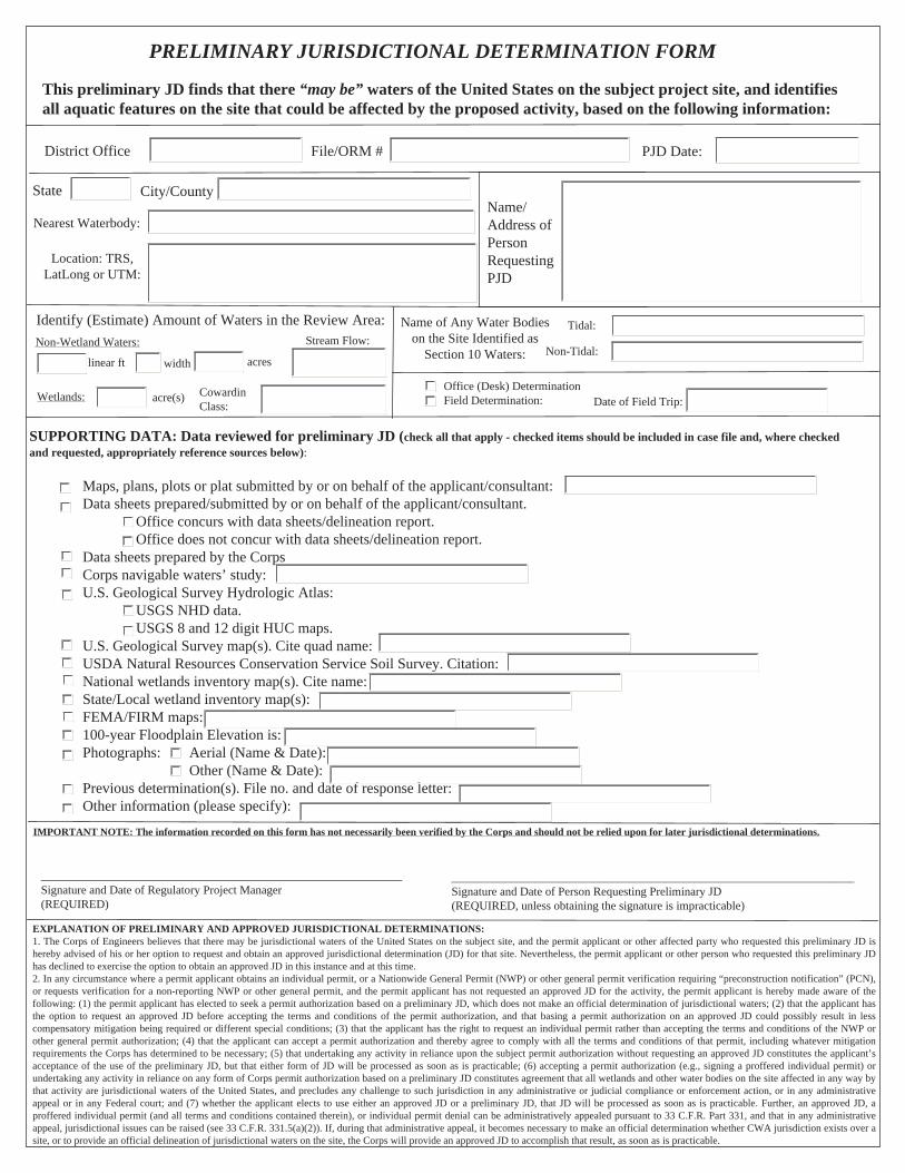
PRELIMINARY JURISDICTIONAL DETERMINATION FORM
This preliminary JD finds that there “may be” waters of the United States on the subject project site, and identifies all aquatic features on the site that could be affected by the proposed activity, based on the following information:
EXPLANATION OF PRELIMINARY AND APPROVED JURISDICTIONAL DETERMINATIONS: 1. The Corps of Engineers believes that there may be jurisdictional waters of the United States on the subject site, and the permit applicant or other affected party who requested this preliminary JD is hereby advised of his or her option to request and obtain an approved jurisdictional determination (JD) for that site. Nevertheless, the permit applicant or other person who requested this preliminary JD has declined to exercise the option to obtain an approved JD in this instance and at this time. 2. In any circumstance where a permit applicant obtains an individual permit, or a Nationwide General Permit (NWP) or other general permit verification requiring “preconstruction notification” (PCN), or requests verification for a non-reporting NWP or other general permit, and the permit applicant has not requested an approved JD for the activity, the permit applicant is hereby made aware of the following: (1) the permit applicant has elected to seek a permit authorization based on a preliminary JD, which does not make an official determination of jurisdictional waters; (2) that the applicant has the option to request an approved JD before accepting the terms and conditions of the permit authorization, and that basing a permit authorization on an approved JD could possibly result in less compensatory mitigation being required or different special conditions; (3) that the applicant has the right to request an individual permit rather than accepting the terms and conditions of the NWP or other general permit authorization; (4) that the applicant can accept a permit authorization and thereby agree to comply with all the terms and conditions of that permit, including whatever mitigation requirements the Corps has determined to be necessary; (5) that undertaking any activity in reliance upon the subject permit authorization without requesting an approved JD constitutes the applicant’s acceptance of the use of the preliminary JD, but that either form of JD will be processed as soon as is practicable; (6) accepting a permit authorization (e.g., signing a proffered individual permit) or undertaking any activity in reliance on any form of Corps permit authorization based on a preliminary JD constitutes agreement that all wetlands and other water bodies on the site affected in any way by that activity are jurisdictional waters of the United States, and precludes any challenge to such jurisdiction in any administrative or judicial compliance or enforcement action, or in any administrative appeal or in any Federal court; and (7) whether the applicant elects to use either an approved JD or a preliminary JD, that JD will be processed as soon as is practicable. Further, an approved JD, a proffered individual permit (and all terms and conditions contained therein), or individual permit denial can be administratively appealed pursuant to 33 C.F.R. Part 331, and that in any administrative appeal, jurisdictional issues can be raised (see 33 C.F.R. 331.5(a)(2)). If, during that administrative appeal, it becomes necessary to make an official determination whether CWA jurisdiction exists over a site, or to provide an official delineation of jurisdictional waters on the site, the Corps will provide an approved JD to accomplish that result, as soon as is practicable.
District Office PJD Date:File/ORM #
State City/CountyName/Address of Person Requesting PJD
Nearest Waterbody:
Office (Desk) Determination Field Determination:
SUPPORTING DATA: Data reviewed for preliminary JD (check all that apply - checked items should be included in case file and, where checked and requested, appropriately reference sources below): Maps, plans, plots or plat submitted by or on behalf of the applicant/consultant: Data sheets prepared/submitted by or on behalf of the applicant/consultant. Office concurs with data sheets/delineation report. Office does not concur with data sheets/delineation report. Data sheets prepared by the Corps Corps navigable waters’ study: U.S. Geological Survey Hydrologic Atlas: USGS NHD data. USGS 8 and 12 digit HUC maps. U.S. Geological Survey map(s). Cite quad name: USDA Natural Resources Conservation Service Soil Survey. Citation: National wetlands inventory map(s). Cite name: State/Local wetland inventory map(s): FEMA/FIRM maps: 100-year Floodplain Elevation is: Photographs: Aerial (Name & Date): Other (Name & Date): Previous determination(s). File no. and date of response letter: Other information (please specify):
Date of Field Trip:
Location: TRS, LatLong or UTM:
IMPORTANT NOTE: The information recorded on this form has not necessarily been verified by the Corps and should not be relied upon for later jurisdictional determinations.
_____________________________________________________________ Signature and Date of Regulatory Project Manager (REQUIRED)
____________________________________________________________________ Signature and Date of Person Requesting Preliminary JD (REQUIRED, unless obtaining the signature is impracticable)
Name of Any Water Bodies on the Site Identified as
Section 10 Waters:
Tidal:
Non-Tidal:
Identify (Estimate) Amount of Waters in the Review Area:Non-Wetland Waters:
Wetlands:
linear ft width acres
acre(s) Cowardin Class:
Stream Flow:
PRELIMINARY JURISDICTIONAL DETERMINATION FORM
This preliminary JD finds that there "may be" waters of the United States on the subject project site, and identifies all aquatic features on the site that could be affected by the proposed activity, based on the following information:
Appendix A - Sites
Est. Amount of Site Aquatic Resource Class of Number Latitude Longitude Cowardin Class in Review Area Aquatic Resource
District Office PJD Date:File/ORM #
Person Requestinq PJD State City/County
Notes:
A4
CORPS APPROVED JURISDICTION FORM

APPROVED JURISDICTIONAL DETERMINATION FORMU.S. Army Corps of Engineers
This form should be completed by following the instructions provided in Section IV of the JD Form Instructional Guidebook.
SECTION I: BACKGROUND INFORMATIONA. REPORT COMPLETION DATE FOR APPROVED JURISDICTIONAL DETERMINATION (JD):
B. DISTRICT OFFICE, FILE NAME, AND NUMBER:
C. PROJECT LOCATION AND BACKGROUND INFORMATION:State: County/parish/borough: City:Center coordinates of site (lat/long in degree decimal format): Lat. ° Pick List, Long. ° Pick List.
Universal Transverse Mercator:Name of nearest waterbody:
Name of nearest Traditional Navigable Water (TNW) into which the aquatic resource flows:Name of watershed or Hydrologic Unit Code (HUC):
Check if map/diagram of review area and/or potential jurisdictional areas is/are available upon request.Check if other sites (e.g., offsite mitigation sites, disposal sites, etc…) are associated with this action and are recorded on adifferent JD form.
D. REVIEW PERFORMED FOR SITE EVALUATION (CHECK ALL THAT APPLY):Office (Desk) Determination. Date:Field Determination. Date(s):
SECTION II: SUMMARY OF FINDINGSA. RHA SECTION 10 DETERMINATION OF JURISDICTION.
There Pick List “navigable waters of the U.S.” within Rivers and Harbors Act (RHA) jurisdiction (as defined by 33 CFR part 329) in thereview area. [Required]
Waters subject to the ebb and flow of the tide.Waters are presently used, or have been used in the past, or may be susceptible for use to transport interstate or foreign commerce.Explain: .
B. CWA SECTION 404 DETERMINATION OF JURISDICTION.
There Pick List “waters of the U.S.” within Clean Water Act (CWA) jurisdiction (as defined by 33 CFR part 328) in the review area. [Required]
1. Waters of the U.S.a. Indicate presence of waters of U.S. in review area (check all that apply): 1
TNWs, including territorial seasWetlands adjacent to TNWsRelatively permanent waters2 (RPWs) that flow directly or indirectly into TNWsNon-RPWs that flow directly or indirectly into TNWsWetlands directly abutting RPWs that flow directly or indirectly into TNWsWetlands adjacent to but not directly abutting RPWs that flow directly or indirectly into TNWsWetlands adjacent to non-RPWs that flow directly or indirectly into TNWsImpoundments of jurisdictional watersIsolated (interstate or intrastate) waters, including isolated wetlands
b. Identify (estimate) size of waters of the U.S. in the review area:Non-wetland waters: linear feet: width (ft) and/or acres.Wetlands: acres.
c. Limits (boundaries) of jurisdiction based on: Pick ListElevation of established OHWM (if known): .
2. Non-regulated waters/wetlands (check if applicable):3
Potentially jurisdictional waters and/or wetlands were assessed within the review area and determined to be not jurisdictional.Explain: .
1 Boxes checked below shall be supported by completing the appropriate sections in Section III below.2 For purposes of this form, an RPW is defined as a tributary that is not a TNW and that typically flows year-round or has continuous flow at least “seasonally”(e.g., typically 3 months).3 Supporting documentation is presented in Section III.F.

SECTION III: CWA ANALYSIS
A. TNWs AND WETLANDS ADJACENT TO TNWs
The agencies will assert jurisdiction over TNWs and wetlands adjacent to TNWs. If the aquatic resource is a TNW, completeSection III.A.1 and Section III.D.1. only; if the aquatic resource is a wetland adjacent to a TNW, complete Sections III.A.1 and 2and Section III.D.1.; otherwise, see Section III.B below.
1. TNWIdentify TNW: .
Summarize rationale supporting determination: .
2. Wetland adjacent to TNWSummarize rationale supporting conclusion that wetland is “adjacent”: .
B. CHARACTERISTICS OF TRIBUTARY (THAT IS NOT A TNW) AND ITS ADJACENT WETLANDS (IF ANY):
This section summarizes information regarding characteristics of the tributary and its adjacent wetlands, if any, and it helpsdetermine whether or not the standards for jurisdiction established under Rapanos have been met.
The agencies will assert jurisdiction over non-navigable tributaries of TNWs where the tributaries are “relatively permanentwaters” (RPWs), i.e. tributaries that typically flow year-round or have continuous flow at least seasonally (e.g., typically 3months). A wetland that directly abuts an RPW is also jurisdictional. If the aquatic resource is not a TNW, but has year-round(perennial) flow, skip to Section III.D.2. If the aquatic resource is a wetland directly abutting a tributary with perennial flow,skip to Section III.D.4.
A wetland that is adjacent to but that does not directly abut an RPW requires a significant nexus evaluation. Corps districts andEPA regions will include in the record any available information that documents the existence of a significant nexus between arelatively permanent tributary that is not perennial (and its adjacent wetlands if any) and a traditional navigable water, eventhough a significant nexus finding is not required as a matter of law.
If the waterbody4 is not an RPW, or a wetland directly abutting an RPW, a JD will require additional data to determine if thewaterbody has a significant nexus with a TNW. If the tributary has adjacent wetlands, the significant nexus evaluation mustconsider the tributary in combination with all of its adjacent wetlands. This significant nexus evaluation that combines, foranalytical purposes, the tributary and all of its adjacent wetlands is used whether the review area identified in the JD request isthe tributary, or its adjacent wetlands, or both. If the JD covers a tributary with adjacent wetlands, complete Section III.B.1 forthe tributary, Section III.B.2 for any onsite wetlands, and Section III.B.3 for all wetlands adjacent to that tributary, both onsiteand offsite. The determination whether a significant nexus exists is determined in Section III.C below.
1. Characteristics of non-TNWs that flow directly or indirectly into TNW
(i) General Area Conditions:Watershed size: Pick ListDrainage area: Pick ListAverage annual rainfall: inchesAverage annual snowfall: inches
(ii) Physical Characteristics:(a) Relationship with TNW:
Tributary flows directly into TNW.Tributary flows through Pick List tributaries before entering TNW.
Project waters are Pick List river miles from TNW.Project waters are Pick List river miles from RPW.Project waters are Pick List aerial (straight) miles from TNW.Project waters are Pick List aerial (straight) miles from RPW.Project waters cross or serve as state boundaries. Explain: .
Identify flow route to TNW5: .Tributary stream order, if known: .
4 Note that the Instructional Guidebook contains additional information regarding swales, ditches, washes, and erosional features generally and in the aridWest.5 Flow route can be described by identifying, e.g., tributary a, which flows through the review area, to flow into tributary b, which then flows into TNW.
(b) General Tributary Characteristics (check all that apply):Tributary is: Natural
Artificial (man-made). Explain: .Manipulated (man-altered). Explain: .
Tributary properties with respect to top of bank (estimate):Average width: feetAverage depth: feetAverage side slopes: Pick List.
Primary tributary substrate composition (check all that apply):Silts Sands ConcreteCobbles Gravel MuckBedrock Vegetation. Type/% cover:Other. Explain: .
Tributary condition/stability [e.g., highly eroding, sloughing banks]. Explain: .Presence of run/riffle/pool complexes. Explain: .Tributary geometry: Pick ListTributary gradient (approximate average slope): %
(c) Flow:Tributary provides for: Pick ListEstimate average number of flow events in review area/year: Pick List
Describe flow regime: .Other information on duration and volume: .
Surface flow is: Pick List. Characteristics: .
Subsurface flow: Pick List. Explain findings: .Dye (or other) test performed: .
Tributary has (check all that apply):Bed and banksOHWM6 (check all indicators that apply):
clear, natural line impressed on the bank the presence of litter and debrischanges in the character of soil destruction of terrestrial vegetationshelving the presence of wrack linevegetation matted down, bent, or absent sediment sortingleaf litter disturbed or washed away scoursediment deposition multiple observed or predicted flow eventswater staining abrupt change in plant communityother (list):
Discontinuous OHWM.7 Explain: .
If factors other than the OHWM were used to determine lateral extent of CWA jurisdiction (check all that apply):High Tide Line indicated by: Mean High Water Mark indicated by:
oil or scum line along shore objects survey to available datum;fine shell or debris deposits (foreshore) physical markings;physical markings/characteristics vegetation lines/changes in vegetation types.tidal gaugesother (list):
(iii) Chemical Characteristics:Characterize tributary (e.g., water color is clear, discolored, oily film; water quality; general watershed characteristics, etc.).
Explain: .Identify specific pollutants, if known: .
6A natural or man-made discontinuity in the OHWM does not necessarily sever jurisdiction (e.g., where the stream temporarily flows underground, or wherethe OHWM has been removed by development or agricultural practices). Where there is a break in the OHWM that is unrelated to the waterbody’s flowregime (e.g., flow over a rock outcrop or through a culvert), the agencies will look for indicators of flow above and below the break.7Ibid.
(iv) Biological Characteristics. Channel supports (check all that apply):Riparian corridor. Characteristics (type, average width): .Wetland fringe. Characteristics: .Habitat for:
Federally Listed species. Explain findings: .Fish/spawn areas. Explain findings: .Other environmentally-sensitive species. Explain findings: .Aquatic/wildlife diversity. Explain findings: .
2. Characteristics of wetlands adjacent to non-TNW that flow directly or indirectly into TNW
(i) Physical Characteristics:(a) General Wetland Characteristics:
Properties:Wetland size: acresWetland type. Explain: .Wetland quality. Explain: .
Project wetlands cross or serve as state boundaries. Explain: .
(b) General Flow Relationship with Non-TNW:Flow is: Pick List. Explain: .
Surface flow is: Pick ListCharacteristics: .
Subsurface flow: Pick List. Explain findings: .Dye (or other) test performed: .
(c) Wetland Adjacency Determination with Non-TNW:Directly abuttingNot directly abutting
Discrete wetland hydrologic connection. Explain: .Ecological connection. Explain: .Separated by berm/barrier. Explain: .
(d) Proximity (Relationship) to TNWProject wetlands are Pick List river miles from TNW.Project waters are Pick List aerial (straight) miles from TNW.Flow is from: Pick List.Estimate approximate location of wetland as within the Pick List floodplain.
(ii) Chemical Characteristics:Characterize wetland system (e.g., water color is clear, brown, oil film on surface; water quality; general watershed
characteristics; etc.). Explain: .Identify specific pollutants, if known: .
(iii) Biological Characteristics. Wetland supports (check all that apply):Riparian buffer. Characteristics (type, average width): .Vegetation type/percent cover. Explain: .Habitat for:
Federally Listed species. Explain findings: .Fish/spawn areas. Explain findings: .Other environmentally-sensitive species. Explain findings: .Aquatic/wildlife diversity. Explain findings: .
3. Characteristics of all wetlands adjacent to the tributary (if any)All wetland(s) being considered in the cumulative analysis: Pick ListApproximately ( ) acres in total are being considered in the cumulative analysis.

For each wetland, specify the following:
Directly abuts? (Y/N) Size (in acres) Directly abuts? (Y/N) Size (in acres)
Summarize overall biological, chemical and physical functions being performed: .
C. SIGNIFICANT NEXUS DETERMINATION
A significant nexus analysis will assess the flow characteristics and functions of the tributary itself and the functions performedby any wetlands adjacent to the tributary to determine if they significantly affect the chemical, physical, and biological integrityof a TNW. For each of the following situations, a significant nexus exists if the tributary, in combination with all of its adjacentwetlands, has more than a speculative or insubstantial effect on the chemical, physical and/or biological integrity of a TNW.Considerations when evaluating significant nexus include, but are not limited to the volume, duration, and frequency of the flowof water in the tributary and its proximity to a TNW, and the functions performed by the tributary and all its adjacentwetlands. It is not appropriate to determine significant nexus based solely on any specific threshold of distance (e.g. between atributary and its adjacent wetland or between a tributary and the TNW). Similarly, the fact an adjacent wetland lies within oroutside of a floodplain is not solely determinative of significant nexus.
Draw connections between the features documented and the effects on the TNW, as identified in the Rapanos Guidance anddiscussed in the Instructional Guidebook. Factors to consider include, for example: Does the tributary, in combination with its adjacent wetlands (if any), have the capacity to carry pollutants or flood waters to
TNWs, or to reduce the amount of pollutants or flood waters reaching a TNW? Does the tributary, in combination with its adjacent wetlands (if any), provide habitat and lifecycle support functions for fish and
other species, such as feeding, nesting, spawning, or rearing young for species that are present in the TNW? Does the tributary, in combination with its adjacent wetlands (if any), have the capacity to transfer nutrients and organic carbon that
support downstream foodwebs? Does the tributary, in combination with its adjacent wetlands (if any), have other relationships to the physical, chemical, or
biological integrity of the TNW?
Note: the above list of considerations is not inclusive and other functions observed or known to occur should be documentedbelow:
1. Significant nexus findings for non-RPW that has no adjacent wetlands and flows directly or indirectly into TNWs. Explainfindings of presence or absence of significant nexus below, based on the tributary itself, then go to Section III.D: .
2. Significant nexus findings for non-RPW and its adjacent wetlands, where the non-RPW flows directly or indirectly intoTNWs. Explain findings of presence or absence of significant nexus below, based on the tributary in combination with all of itsadjacent wetlands, then go to Section III.D: .
3. Significant nexus findings for wetlands adjacent to an RPW but that do not directly abut the RPW. Explain findings ofpresence or absence of significant nexus below, based on the tributary in combination with all of its adjacent wetlands, then go toSection III.D: .
D. DETERMINATIONS OF JURISDICTIONAL FINDINGS. THE SUBJECT WATERS/WETLANDS ARE (CHECK ALLTHAT APPLY):
1. TNWs and Adjacent Wetlands. Check all that apply and provide size estimates in review area:TNWs: linear feet width (ft), Or, acres.Wetlands adjacent to TNWs: acres.
2. RPWs that flow directly or indirectly into TNWs.Tributaries of TNWs where tributaries typically flow year-round are jurisdictional. Provide data and rationale indicating thattributary is perennial: .
Tributaries of TNW where tributaries have continuous flow “seasonally” (e.g., typically three months each year) arejurisdictional. Data supporting this conclusion is provided at Section III.B. Provide rationale indicating that tributary flowsseasonally: .

Provide estimates for jurisdictional waters in the review area (check all that apply):Tributary waters: linear feet width (ft).Other non-wetland waters: acres.Identify type(s) of waters: .
3. Non-RPWs8 that flow directly or indirectly into TNWs.Waterbody that is not a TNW or an RPW, but flows directly or indirectly into a TNW, and it has a significant nexus with aTNW is jurisdictional. Data supporting this conclusion is provided at Section III.C.
Provide estimates for jurisdictional waters within the review area (check all that apply):Tributary waters: linear feet width (ft).Other non-wetland waters: acres.
Identify type(s) of waters: .
4. Wetlands directly abutting an RPW that flow directly or indirectly into TNWs.Wetlands directly abut RPW and thus are jurisdictional as adjacent wetlands.
Wetlands directly abutting an RPW where tributaries typically flow year-round. Provide data and rationaleindicating that tributary is perennial in Section III.D.2, above. Provide rationale indicating that wetland isdirectly abutting an RPW: .
Wetlands directly abutting an RPW where tributaries typically flow “seasonally.” Provide data indicating that tributary isseasonal in Section III.B and rationale in Section III.D.2, above. Provide rationale indicating that wetland is directlyabutting an RPW: .
Provide acreage estimates for jurisdictional wetlands in the review area: acres.
5. Wetlands adjacent to but not directly abutting an RPW that flow directly or indirectly into TNWs.Wetlands that do not directly abut an RPW, but when considered in combination with the tributary to which they are adjacentand with similarly situated adjacent wetlands, have a significant nexus with a TNW are jurisidictional. Data supporting thisconclusion is provided at Section III.C.
Provide acreage estimates for jurisdictional wetlands in the review area: acres.
6. Wetlands adjacent to non-RPWs that flow directly or indirectly into TNWs.Wetlands adjacent to such waters, and have when considered in combination with the tributary to which they are adjacent andwith similarly situated adjacent wetlands, have a significant nexus with a TNW are jurisdictional. Data supporting thisconclusion is provided at Section III.C.
Provide estimates for jurisdictional wetlands in the review area: acres.
7. Impoundments of jurisdictional waters.9
As a general rule, the impoundment of a jurisdictional tributary remains jurisdictional.Demonstrate that impoundment was created from “waters of the U.S.,” orDemonstrate that water meets the criteria for one of the categories presented above (1-6), orDemonstrate that water is isolated with a nexus to commerce (see E below).
E. ISOLATED [INTERSTATE OR INTRA-STATE] WATERS, INCLUDING ISOLATED WETLANDS, THE USE,DEGRADATION OR DESTRUCTION OF WHICH COULD AFFECT INTERSTATE COMMERCE, INCLUDING ANYSUCH WATERS (CHECK ALL THAT APPLY):10
which are or could be used by interstate or foreign travelers for recreational or other purposes.from which fish or shellfish are or could be taken and sold in interstate or foreign commerce.which are or could be used for industrial purposes by industries in interstate commerce.Interstate isolated waters. Explain: .Other factors. Explain: .
Identify water body and summarize rationale supporting determination: .
8See Footnote # 3.9 To complete the analysis refer to the key in Section III.D.6 of the Instructional Guidebook.10 Prior to asserting or declining CWA jurisdiction based solely on this category, Corps Districts will elevate the action to Corps and EPA HQ forreview consistent with the process described in the Corps/EPA Memorandum Regarding CWA Act Jurisdiction Following Rapanos.

Provide estimates for jurisdictional waters in the review area (check all that apply):Tributary waters: linear feet width (ft).Other non-wetland waters: acres.
Identify type(s) of waters: .Wetlands: acres.
F. NON-JURISDICTIONAL WATERS, INCLUDING WETLANDS (CHECK ALL THAT APPLY):If potential wetlands were assessed within the review area, these areas did not meet the criteria in the 1987 Corps of EngineersWetland Delineation Manual and/or appropriate Regional Supplements.Review area included isolated waters with no substantial nexus to interstate (or foreign) commerce.
Prior to the Jan 2001 Supreme Court decision in “SWANCC,” the review area would have been regulated based solely on the“Migratory Bird Rule” (MBR).
Waters do not meet the “Significant Nexus” standard, where such a finding is required for jurisdiction. Explain: .Other: (explain, if not covered above): .
Provide acreage estimates for non-jurisdictional waters in the review area, where the sole potential basis of jurisdiction is the MBRfactors (i.e., presence of migratory birds, presence of endangered species, use of water for irrigated agriculture), using best professionaljudgment (check all that apply):
Non-wetland waters (i.e., rivers, streams): linear feet width (ft).Lakes/ponds: acres.Other non-wetland waters: acres. List type of aquatic resource: .Wetlands: acres.
Provide acreage estimates for non-jurisdictional waters in the review area that do not meet the “Significant Nexus” standard, where sucha finding is required for jurisdiction (check all that apply):
Non-wetland waters (i.e., rivers, streams): linear feet, width (ft).Lakes/ponds: acres.Other non-wetland waters: acres. List type of aquatic resource: .Wetlands: acres.
SECTION IV: DATA SOURCES.
A. SUPPORTING DATA. Data reviewed for JD (check all that apply - checked items shall be included in case file and, where checkedand requested, appropriately reference sources below):
Maps, plans, plots or plat submitted by or on behalf of the applicant/consultant: .Data sheets prepared/submitted by or on behalf of the applicant/consultant.
Office concurs with data sheets/delineation report.Office does not concur with data sheets/delineation report.
Data sheets prepared by the Corps: .Corps navigable waters’ study: .U.S. Geological Survey Hydrologic Atlas: .
USGS NHD data.USGS 8 and 12 digit HUC maps.
U.S. Geological Survey map(s). Cite scale & quad name: .USDA Natural Resources Conservation Service Soil Survey. Citation: .National wetlands inventory map(s). Cite name: .State/Local wetland inventory map(s): .FEMA/FIRM maps: .100-year Floodplain Elevation is: (National Geodectic Vertical Datum of 1929)Photographs: Aerial (Name & Date): .
or Other (Name & Date): .Previous determination(s). File no. and date of response letter: .Applicable/supporting case law: .Applicable/supporting scientific literature: .Other information (please specify): .
B. ADDITIONAL COMMENTS TO SUPPORT JD: .

A5
CORPS LABELS
* * * * P R E L I M I N A R Y (RGL 08-02)* * * *SECTION 404 JURISDICTIONAL DELINEATIONU.S. Army Corps of Engineers, Los Angeles DistrictApplication No. SPL -_______-_________-_________
------Boundary of area surveyed forjurisdictional waters of the United States
------Approximate Ordinary High Water Mark
------Potential Waters of the United States
------Potential Wetlands (If legend is blank nowetlands occur with survey area.)
________Scale _______________Date of Photograph______Site Visit by Corps(Y/N) Date:______________________________Date Delineation issued by Corps_________________________Corps Project ManagerSheet _____ of _____* * * * P R E L I M I N A R Y (RGL 08-02)* * * *
SECTION 404 JURISDICTIONAL DELINEATIONU.S. Army Corps of Engineers, Los Angeles DistrictApplication No. SPL -_______-_________-_________
------Boundary of area surveyed forjurisdictional waters of the United States
------Ordinary High Water Mark
------Waters of the United States
------Wetlands (If legend is blank nowetlands occur with survey area.)
________Scale _______________Date of Photograph______ Site Visit by Corps(Y/N) Date:______________________________Date Delineation issued by Corps_________________________Corps Project ManagerSheet _____ of _____
Approved JD Labels:
Preliminary JD Labels:

A6
TABLE 1 - JD PHYSICAL CHARACTERISTICS

Table 1. J.D. Physical Characteristics & Other InformationProject Name and No.Date
YES/NO
Wash No. orName MP
VegetationDifferenceBetween Wash& Upland
Change in SoilCharacteristics
Waterline Markon Bank Water Stains
Shelving orCut Banks Exposed Roots
SedimentsDeposits
Presence ofLitter or Debris Wash Width (ft)
Wash Depth (ftor in)
Ground PhotoNumbers
ExistingDrainageStructure Type WOUS
wash sample text
YES / NO
A7
ADOT COVER LETTER

(Place letter on current ADOT letterhead)
Ms. Sallie Diebolt, Chief Arizona Section Regulatory Branch US Army Corps of Engineers 3636 North Central Avenue, Suite 900 Phoenix, AZ 85012 Attention: Kathleen Tucker Re: [Purpose of the package, JD, PCN, etc.] Preliminary Jurisdictional Delineation 040 AP 316 H6924 01C Dead River EB Structure No. 565, Scour Repair USACE File No.: if available Dear Ms. Diebolt: Provide brief project description including: type of project (scour protection, drainage improvement, widening, etc.), location such as highway, milepost, geographic reference point, Township, Range, Section, LAT/LONG NAD83, and USGS maps reference. The Arizona Department of Transportation (ADOT) is planning to install concrete scour protection at the Eastbound (EB) Dead River bridge Structure No. 565 on Interstate 40 (I-40) from milepost (MP) 315.87 to MP 316.17 located approximately 30 miles northeast of Holbrook, Apache County, Arizona (Figures 1 and 2). The project occurs within and adjacent to an ADOT easement through undeveloped New Lands under the jurisdiction of the Navajo Nation. The cadastral location for the project area is SE ¼ of Section 32, Township 20N, Range 25E (Gila and Salt River Baseline and Meridian). The Dead River EB bridge crosses the Dead Wash at UTM 618010mE, 3883003mN, NAD 83, Zone 12N. Provide any other pertinent information that is not documented in any attached document A ground survey to identify waters of the US in the project area was completed on October 25, 2007 by consultant name, firm’s name. The aerial photograph used during the ground survey was taken on an unknown date in 2005. Although the aerial photograph is more than 2 years old, it still accurately depicts waters of the US. Within the survey area, approximately 2.42 acres of the Dead Wash is proposed as waters of the US. Provide a list of attachments, if necessary. This letter serves as a request for review and issue of the preliminary jurisdictional delineation. Included for your review are the following items:
State Location (Figure 1) and Project Vicinity (Figure 2) Maps Topographic and Floodplain Map (Figure 3) Drainage Area Map (Figure 4) Proposed Jurisdictional Delineation with Photo Points (Figure 5) Ground Photos JD Tables with Physical Characteristics and Other Information
If you have any questions or require additional information, please feel free to call me at 602.712.8633. Thank you for your assistance. Sincerely, EPG Planner Environmental Planner ADOT Environmental Planning Group
A8
CHECKLIST FOR SUBMITTING A SECTION 404 JURISDICTIONAL DELINEATION(EPG)

Checklist for Submitting a Section 404 Jurisdictional Delineation (JD)
Instructions: The Consultant and the ADOT EPG planner will check the appropriate box to verify that the JD package meets Corps’ requirements. If any of the items are not complete, the EPG planner will return the JD package to the consultant for correction. Refer to ADOT’s Environmental Services and Planning website for guidance and templates.
Consultant EPG Planner QC Checklist Items
Signed cover letter from EPG Planner.
Project location maps, including USGS map and FEMA floodplain map.
Table 1: JD Physical Characteristics and Other Information
Correct JD form with signature of planner (additional graphics per guidance should accompany an approved JD form). Include electronic version of Corps water data sheet if JD is for 5 or more washes.
Delineated aerial photographs (per the Corps drawing standards) of high resolution and medium to high contrast, taken within the last two years, show overlapping adjacent properties, be 11" x 17" minimum size, have a scale of 1”= 100’ or 1” = 200’, and include index map.
Ground photographs that clearly illustrate whether or not a drainageway is jurisdictional.
Electronic copy of all documents (8 ½ x 11 separated from 11 x 17) that are correctly scaled and submitted via email or FTP site
Additional items (if appropriate):
Wetlands documentation per current Corps guidance and template on Environmental Services and Planning website.
Correct form and documentation if following the current OHWM Field Guide from August 2008
Current drainage report and USGS gauge date (if available), Project Plan view showing 10-year, 5-year and 2-year event surface area, one to two foot contour intervals overlaid onto aerial at the same scale.
Documentation that substantiates conditions have not changed for reapproving an expired JD (that was approved by the Corps).
Consultant signature and date
ADOT EPG Planner signature and date

APPENDIX B
404 PERMIT AND PCN TEMPLATES, CHECKLISTS, AND INSTRUCTIONS
(For all fill able versions of the forms, please go to the http://www.azdot.gov/business/environmental-services-and-planning)
B1
CHECKLIST FOR SECTION 404 NATIONWIDE PERMIT LIMITS AND CONDITIONSCOMPLIANCE AND PRE-CONSTRUCTION NOTIFICATION DECISION PROCESS

Checklist for Section 404 Nationwide Permit Limits and Conditions Compliance and Pre-Construction Notification Decision Process
Instructions: The Consultant and the ADOT EPG planner will check the appropriate box and/or provide additional information to document the decision process for determining whether or not a given activity complies with permit, regional, and general conditions or requires Pre-Construction Notification. If any of the items are not complete, the EPG planner will return the Checklist to the consultant for correction. Refer to ADOT’s Section 404 Procedures website for current Section 404 information. Consultant ADOT EP Nationwide Permit Number: Notification Required by Permit Conditions?
Yes / No
Loss of waters of the US limits (e.g., less than ½ acre, 500 linear feet):
Proposed activity impacts Permanent (acres/linear feet)
Wetlands: Waters of the US:
Temporary (acres/linear feet) Wetlands: Waters of the US:
Will discharges to any of the following aquatic resources result from the activity?
Wetlands: Perennial river: Other perennial waterbody (e.g., lake): Federal Threatened and Endangered Species / Critical Habitat
Project-specific species list attached? Yes / No Determination: No effect
Not likely to adversely effect
May effect Comments:
Section 106 National Historic Preservation Act Concurrence
Concurrence granted? Yes. Date: No. Date: Date Concurrence anticipated (month/year): Comments:
Is a Pre-Construction Notification Required? Yes / No
Consultant signature and date:
ADOT EPG signature and date:

B2
PRE-CONSTRUCTION NOTIFICATION – NATIONWIDE/INDIVIDUAL PERMITSUBMITTAL GUIDANCE
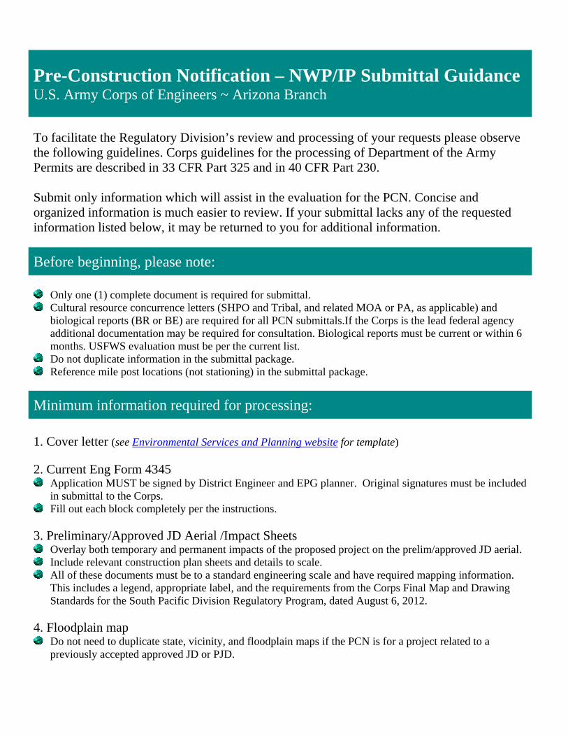
Pre-Construction Notification – NWP/IP Submittal Guidance U.S. Army Corps of Engineers ~ Arizona Branch To facilitate the Regulatory Division’s review and processing of your requests please observe the following guidelines. Corps guidelines for the processing of Department of the Army Permits are described in 33 CFR Part 325 and in 40 CFR Part 230. Submit only information which will assist in the evaluation for the PCN. Concise and organized information is much easier to review. If your submittal lacks any of the requested information listed below, it may be returned to you for additional information.
Before beginning, please note:
Only one (1) complete document is required for submittal. Cultural resource concurrence letters (SHPO and Tribal, and related MOA or PA, as applicable) and
biological reports (BR or BE) are required for all PCN submittals.If the Corps is the lead federal agency additional documentation may be required for consultation. Biological reports must be current or within 6 months. USFWS evaluation must be per the current list.
Do not duplicate information in the submittal package. Reference mile post locations (not stationing) in the submittal package.
Minimum information required for processing: 1. Cover letter (see Environmental Services and Planning website for template) 2. Current Eng Form 4345
Application MUST be signed by District Engineer and EPG planner. Original signatures must be included in submittal to the Corps.
Fill out each block completely per the instructions. 3. Preliminary/Approved JD Aerial /Impact Sheets
Overlay both temporary and permanent impacts of the proposed project on the prelim/approved JD aerial. Include relevant construction plan sheets and details to scale. All of these documents must be to a standard engineering scale and have required mapping information.
This includes a legend, appropriate label, and the requirements from the Corps Final Map and Drawing Standards for the South Pacific Division Regulatory Program, dated August 6, 2012.
4. Floodplain map
Do not need to duplicate state, vicinity, and floodplain maps if the PCN is for a project related to a previously accepted approved JD or PJD.

2
5. General and Regional Conditions
Document describing how the project is in compliance with all 31 General Conditions including Regional Conditions (General Condition 27).
Include all supporting documentation for General Condition 18 and 20. 6. Copy of 401 Individual Certification, if applicable
If applying for an IP and 401certification will be issued by ADEQ, do not submit an Individual 401 Certification application to ADEQ until the 404 Individual Permit Public Notice has posted.
7. Electronic Submittal:
Be sure to separate 8 ½ x 11 and 11 x 17 into two files. Do not submit a combined file. Biology and Cultural documentation should be separate files.
Submittals under 10MB can be emailed to [email protected] (multiple emails can be used). Files over 10MB should be uploaded to the Corps FTP site at https://safe.amrdec.army.mil/safe2/Welcome.aspx
8. A bibliography sheet
Include if referencing other information.
Additional items for IP submittal: 9. 404(b)(1) document
Use the template available on the Environmental Services and Planning website. Include completed applicable sections. Submit electronic Word version.
10. Mitigation Plan 11. Electronic versions of aerials, plans and details for Public Notice 12. Labels for all adjacent landowners (MS Word file in Avery 5164 format is preferred) 13. Any comment(s) the Corps provides on a submittal needs to be addressed within 30 days from receipt

B3
PRE-CONSTRUCTION NOTIFICATION / INDIVIDUAL PERMIT COVER LETTERTEMPLATE

Ms. Sallie Diebolt, Chief Arizona Section Regulatory Branch US Army Corps of Engineers 3636 North Central Avenue, Suite 900 Phoenix, AZ 85012 Attention: Kathleen Tucker Re: [Purpose of the package, JD, PCN, etc.] Preconstruction Notification Nationwide Permit NWP 14 and NWP 33 040 AP 316 H6924 01C Dead River EB Structure No. 565, Scour Repair USACE File No.: if available Dear Ms. Diebolt: Provide brief project description including: type of project (scour protection, drainage improvement, widening, etc.), location such as highway, milepost, geographic reference point, Township, Range, Section, LAT/LONG NAD83, and USGS maps reference. The Arizona Department of Transportation (ADOT) is planning to install concrete scour protection at the Eastbound (EB) Dead River bridge Structure No. 565 on Interstate 40 (I-40) from milepost (MP) 315.87 to MP 316.17 located approximately 30 miles northeast of Holbrook, Apache County, Arizona (Figures 1 and 2). The project occurs within and adjacent to an ADOT easement through undeveloped New Lands under the jurisdiction of the Navajo Nation. The cadastral location for the project area is SE ¼ of Section 32, Township 20N, Range 25E (Gila and Salt River Baseline and Meridian). The Dead River EB bridge crosses the Dead Wash at UTM 618010mE, 3883003mN, NAD 83, Zone 12N. Provide any other pertinent information that is not documented in any attached document and a brief summary of the impacts The Preliminary jurisdictional delineation for this project was approved on July 16, 2008 (Corp File No. if available). The project will result in xx acres of permanent impact to Waters of the US due to the installation of the concrete floor and xx acres of temporary impact due to temporary construction access. This letter serves as a request for review and approval of the PCN package for this project. Included for your review are the following items:
Engineer Form 4345 State Location (Figure 1) and Project Vicinity (Figure 2) Maps Topographic and Floodplain Map (Figure 3) Impacts to Waters of the US (Figure 4) Profile Sheets, and Access Plan Sheets Documentation of Compliance with NWP General and Regional Conditions Biological Evaluation Cultural Concurrence
If you have any questions or require additional information, please feel free to call me at 602.712.8633. Thank you for your assistance. Sincerely, EPG Planner Name Environmental Planner ADOT Environmental Planning Group

B4
APPLICATION FOR DEPARTMENT OF THE ARMY PERMIT (ENG FORM 4345)

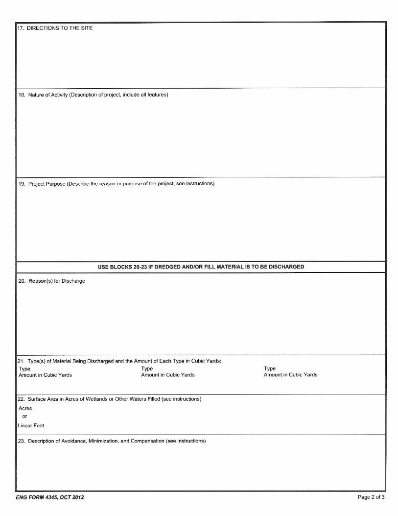


B5
INSTRUCTIONS FOR PREPARING DEPARTMENT OF THE ARMY PERMIT (ENGFORM 4345) APPLICATION

Instructions for Preparing a Department of the Army Permit Application
Blocks 1 through 4. To be completed by Corps of Engineers. Block 5. Applicant’s Name. Enter the name and the E-mail address of the responsible party or parties. If the responsible party is an agency, company, corporation, or other organization, indicate the name of the organization and responsible officer and title. If more than one party is associated with the application, please attach a sheet with the necessary information marked Block 5. Block 6. Address of Applicant. Please provide the full address of the party or parties responsible for the application. If more space is needed, attach an extra sheet of paper marked Block 6. Block 7. Applicant Telephone Number(s). Please provide the number where you can usually be reached during normal business hours. Blocks 8 through 11. To be completed, if you choose to have an agent. Block 8. Authorized Agent’s Name and Title. Indicate name of individual or agency, designated by you, to represent you in this process. An agent can be an attorney, builder, contractor, engineer, or any other person or organization. Note: An agent is not required. Blocks 9 and 10. Agent’s Address and Telephone Number. Please provide the complete mailing address of the agent, along with the telephone number where he / she can be reached during normal business hours. Block 11. Statement of Authorization. To be completed by applicant, if an agent is to be employed. Block 12. Proposed Project Name or Title. Please provide name identifying the proposed project, e.g., Landmark Plaza, Burned Hills Subdivision, or Edsall Commercial Center. Block 13. Name of Waterbody. Please provide the name of any stream, lake, marsh, or other waterway to be directly impacted by the activity. If it is a minor (no name) stream, identify the waterbody the minor stream enters. Block 14. Proposed Project Street Address. If the proposed project is located at a site having a street address (not a box number), please enter it here. Block 15. Location of Proposed Project. Enter the latitude and longitude of where the proposed project is located. If more space is required, please attach a sheet with the necessary information marked Block 15. Block 16. Other Location Descriptions. If available, provide the Tax Parcel Identification number of the site, Section, Township, and Range of the site (if known), and / or local Municipality that the site is located in. Block 17. Directions to the Site. Provide directions to the site from a known location or landmark. Include highway and street numbers as well as names. Also provide distances from known locations and any other information that would assist in locating the site. You may also provide description of the proposed project location, such as lot numbers, tract numbers, or you may choose to locate the proposed project site from a known point (such as the right descending bank of Smith Creek, one mile downstream from the Highway 14 bridge). If a large river or stream, include the river mile of the proposed project site if known Block 18. Nature of Activity. Describe the overall activity or project. Give appropriate dimensions of structures such as wing walls, dikes (identify the materials to be used in construction, as well as the methods by which the work is to be done), or excavations (length, width, and height). Indicate whether discharge of dredged or fill material is involved. Also, identify any structure to be constructed on a fill, piles, or float-supported platforms. The written descriptions and illustrations are an important part of the application. Please describe, in detail, what you wish to do. If more space is needed, attach an extra sheet of paper marked Block 18. Block 19. Proposed Project Purpose. Describe the purpose and need for the proposed project. What will it be used for and why? Also include a brief description of any related activities to be developed as the result of the proposed project. Give the approximate dates you plan to both begin and complete all work.
Block 20. Reasons for Discharge. If the activity involves the discharge of dredged and/or fill material into a wetland or other waterbody, including the temporary placement of material, explain the specific purpose of the placement of the material (such as erosion control). Block 21. Types of Material Being Discharged and the Amount of Each Type in Cubic Yards. Describe the material to be discharged and amount of each material to be discharged within Corps jurisdiction. Please be sure this description will agree with your illustrations. Discharge material includes: rock, sand, clay, concrete, etc. Block 22. Surface Areas of Wetlands or Other Waters Filled. Describe the area to be filled at each location. Specifically identify the surface areas, or part thereof, to be filled. Also include the means by which the discharge is to be done (backhoe, dragline, etc.). If dredged material is to be discharged on an upland site, identify the site and the steps to be taken (if necessary) to prevent runoff from the dredged material back into a waterbody. If more space is needed, attach an extra sheet of paper marked Block 22. Block 23. Description of Avoidance, Minimization, and Compensation. Provide a brief explanation describing how impacts to waters of the United States are being avoided and minimized on the project site. Also provide a brief description of how impacts to waters of the United States will be compensated for, or a brief statement explaining why compensatory mitigation should not be required for those impacts. Block 24. Is Any Portion of the Work Already Complete? Provide any background on any part of the proposed project already completed. Describe the area already developed, structures completed, any dredged or fill material already discharged, the type of material, volume in cubic yards, acres filled, if a wetland or other waterbody (in acres or square feet). If the work was done under an existing Corps permit, identity the authorization, if possible. Block 25. Names and Addresses of Adjoining Property Owners, Lessees, etc., Whose Property Adjoins the Project Site. List complete names and full mailing addresses of the adjacent property owners (public and private) lessees, etc., whose property adjoins the waterbody or aquatic site where the work is being proposed so that they may be notified of the proposed activity (usually by public notice). If more space is needed, attach an extra sheet of paper marked Block 24. Information regarding adjacent landowners is usually available through the office of the tax assessor in the county or counties where the project is to be developed. Block 26. Information about Approvals or Denials by Other Agencies. You may need the approval of other federal, state, or local agencies for your project. Identify any applications you have submitted and the status, if any (approved or denied) of each application. You need not have obtained all other permits before applying for a Corps permit. Block 27. Signature of Applicant or Agent. The application must be signed by the owner or other authorized party (agent). This signature shall be an affirmation that the party applying for the permit possesses the requisite property rights to undertake the activity applied for (including compliance with special conditions, mitigation, etc.).
DRAWINGS AND ILLUSTRATIONS General Information. Three types of illustrations are needed to properly depict the work to be undertaken. These illustrations or drawings are identified as a Vicinity Map, a Plan View or a Typical Cross-Section Map. Identify each illustration with a figure or attachment number. Please submit one original, or good quality copy, of all drawings on 8½ x11 inch plain white paper (electronic media may be substituted). Use the fewest number of sheets necessary for your drawings or illustrations. Each illustration should identify the project, the applicant, and the type of illustration (vicinity map, plan view, or cross-section). While illustrations need not be professional (many small, private project illustrations are prepared by hand), they should be clear, accurate, and contain all necessary information.
B6
CORPS INDIVIDUAL PERMIT SECTION 404(B)(1) TEMPLATE
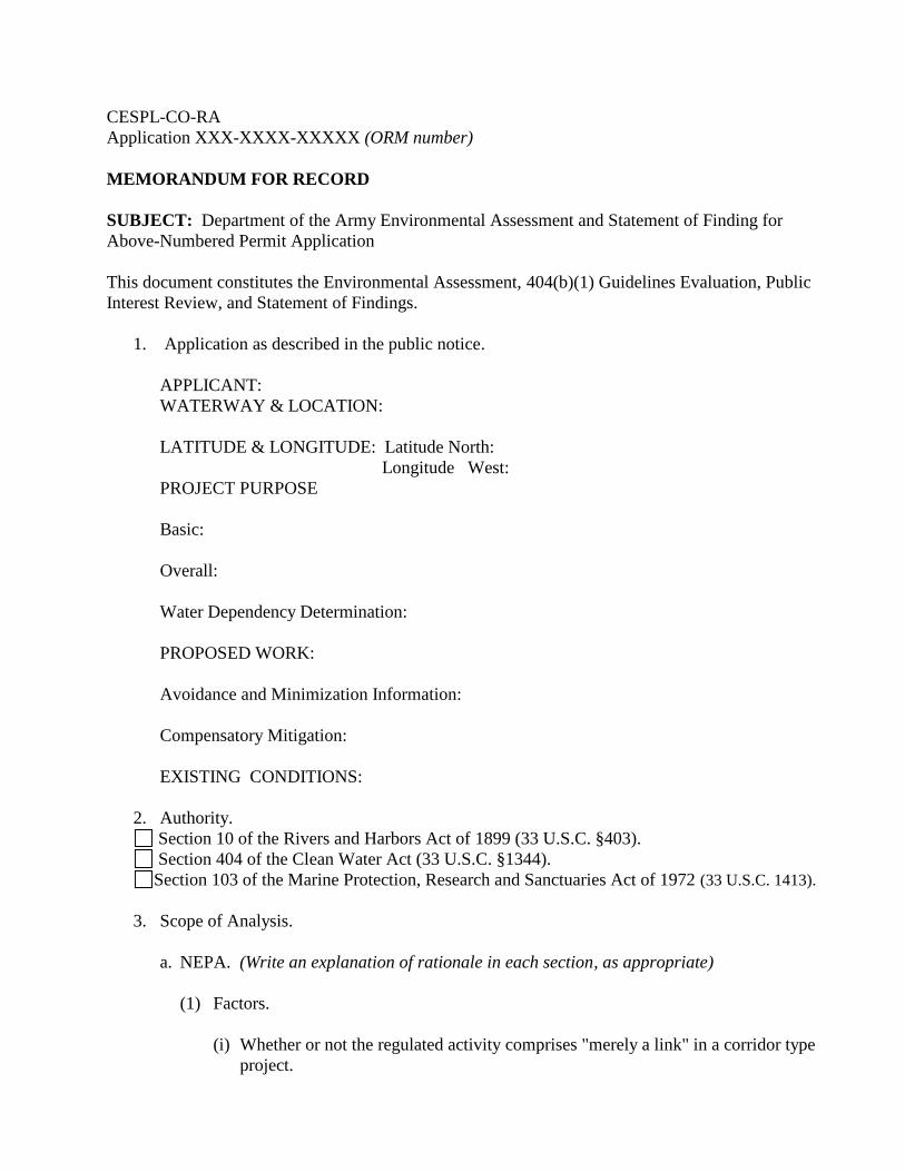
CESPL-CO-RAApplication XXX-XXXX-XXXXX (ORM number)
MEMORANDUM FOR RECORD
SUBJECT: Department of the Army Environmental Assessment and Statement of Finding forAbove-Numbered Permit Application
This document constitutes the Environmental Assessment, 404(b)(1) Guidelines Evaluation, PublicInterest Review, and Statement of Findings.
1. Application as described in the public notice.
APPLICANT:WATERWAY & LOCATION:
LATITUDE & LONGITUDE: Latitude North:Longitude West:
PROJECT PURPOSE
Basic:
Overall:
Water Dependency Determination:
PROPOSED WORK:
Avoidance and Minimization Information:
Compensatory Mitigation:
EXISTING CONDITIONS:
2. Authority.Section 10 of the Rivers and Harbors Act of 1899 (33 U.S.C. §403).Section 404 of the Clean Water Act (33 U.S.C. §1344).
Section 103 of the Marine Protection, Research and Sanctuaries Act of 1972 (33 U.S.C. 1413).
3. Scope of Analysis.
a. NEPA. (Write an explanation of rationale in each section, as appropriate)
(1) Factors.
(i) Whether or not the regulated activity comprises "merely a link" in a corridor typeproject.

CESPL-CO-RA (Application XXX-XXXX-XXXXX (ORM number) )SUBJECT: Department of the Army Environmental Assessment and Statement of Findings for theAbove-Numbered Permit Application
Page 2
(ii) Whether there are aspects of the upland facility in the immediate vicinity of theregulated activity which affect the location and configuration of the regulatedactivity.
(iii) The extent to which the entire project will be within the Corps jurisdiction.
(iv) The extent of cumulative Federal control and responsibility.
(2) Determined scope.Only within the footprint of the regulated activity within the delineated water.Over entire property. Explain.
b. NHPA "Permit Area".
(1) Tests. Activities outside the waters of the United States are/ are not includedbecause all of the following tests are/ are not satisfied: Such activity would/
would not occur but for the authorization of the work or structures within thewaters of the United States; Such activity is/ is not integrally related to the workor structures to be authorized within waters of the United States (or, conversely, thework or structures to be authorized must be essential to the completeness of theoverall project or program); and Such activity is/ is not directly associated(firstorder impact) with the work or structures to be authorized. Explain.
(2) Determined scope. Describe.
c. ESA "Action Area".
(1) Action area means all areas to be affected directly or indirectly by the Federal actionand not merely the immediate area involved in the action.
(2) Determined scope. Describe.
d. Public notice comments. NA
(1) The public also provided comments at public hearing, public meeting, and/orExplain.
(2) Commentors and issued raised.
(3) Site was/ was not visited by the Corps to obtain information in addition todelineating jurisdiction. Include dates and synopsis of information gathered if site wasvisited.
(4) Issues identified by the Corps. Describe.
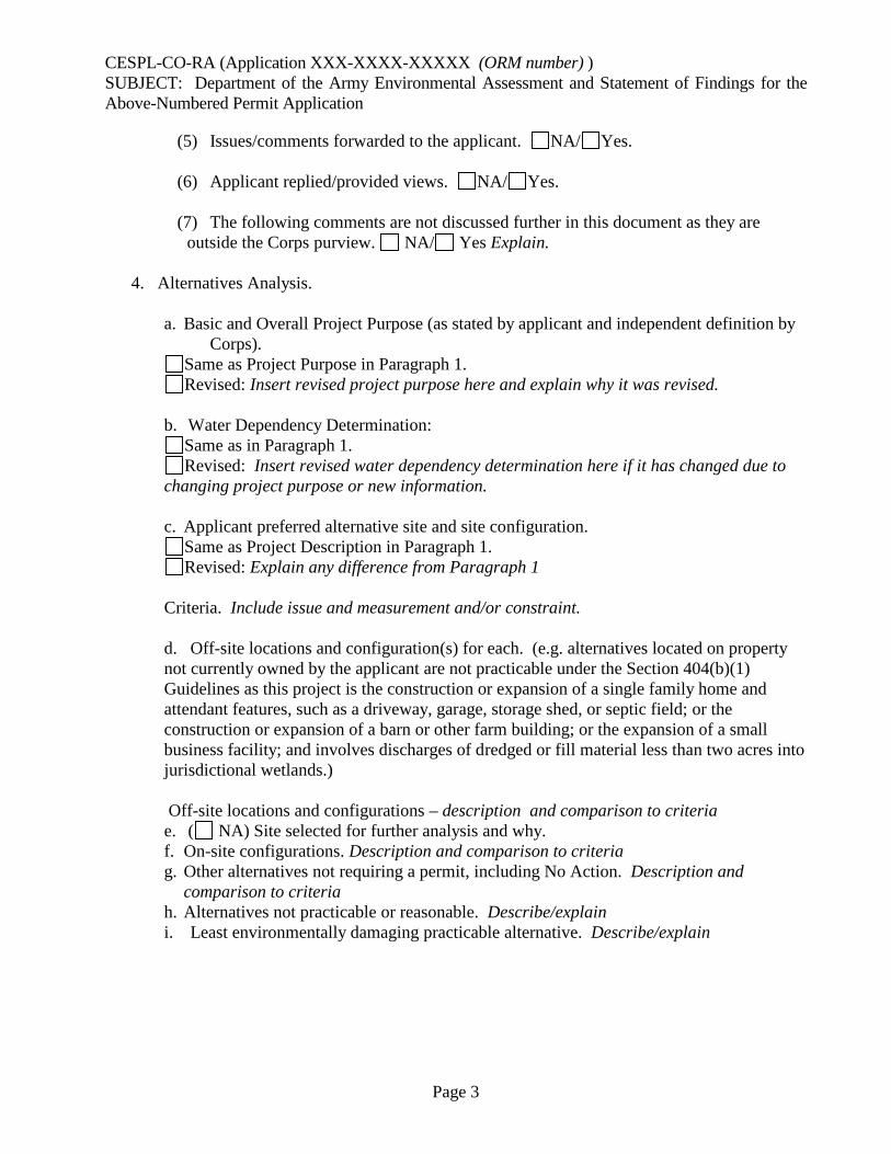
CESPL-CO-RA (Application XXX-XXXX-XXXXX (ORM number) )SUBJECT: Department of the Army Environmental Assessment and Statement of Findings for theAbove-Numbered Permit Application
Page 3
(5) Issues/comments forwarded to the applicant. NA/ Yes.
(6) Applicant replied/provided views. NA/ Yes.
(7) The following comments are not discussed further in this document as they areoutside the Corps purview. NA/ Yes Explain.
4. Alternatives Analysis.
a. Basic and Overall Project Purpose (as stated by applicant and independent definition byCorps).
Same as Project Purpose in Paragraph 1.Revised: Insert revised project purpose here and explain why it was revised.
b. Water Dependency Determination:Same as in Paragraph 1.Revised: Insert revised water dependency determination here if it has changed due to
changing project purpose or new information.
c. Applicant preferred alternative site and site configuration.Same as Project Description in Paragraph 1.Revised: Explain any difference from Paragraph 1
Criteria. Include issue and measurement and/or constraint.
d. Off-site locations and configuration(s) for each. (e.g. alternatives located on propertynot currently owned by the applicant are not practicable under the Section 404(b)(1)Guidelines as this project is the construction or expansion of a single family home andattendant features, such as a driveway, garage, storage shed, or septic field; or theconstruction or expansion of a barn or other farm building; or the expansion of a smallbusiness facility; and involves discharges of dredged or fill material less than two acres intojurisdictional wetlands.)
Off-site locations and configurations – description and comparison to criteriae. ( NA) Site selected for further analysis and why.f. On-site configurations. Description and comparison to criteriag. Other alternatives not requiring a permit, including No Action. Description and
comparison to criteriah. Alternatives not practicable or reasonable. Describe/explaini. Least environmentally damaging practicable alternative. Describe/explain
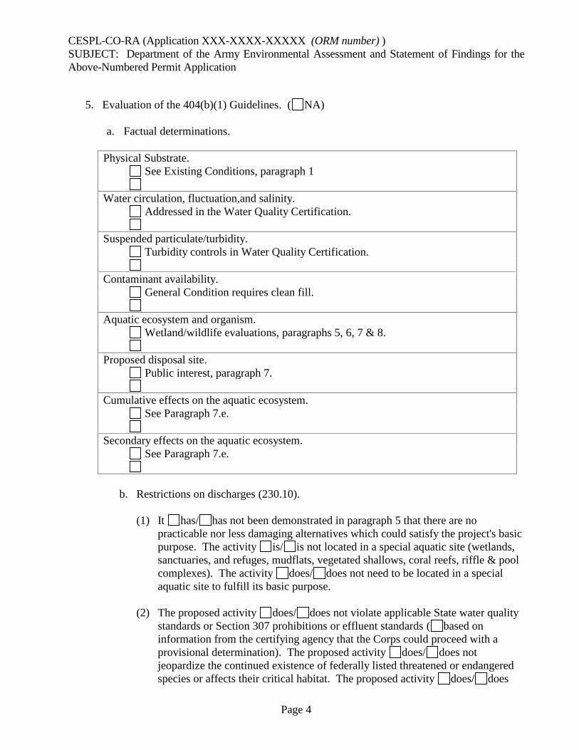
CESPL-CO-RA (Application XXX-XXXX-XXXXX (ORM number) )SUBJECT: Department of the Army Environmental Assessment and Statement of Findings for theAbove-Numbered Permit Application
Page 4
5. Evaluation of the 404(b)(1) Guidelines. ( NA)
a. Factual determinations.
Physical Substrate.See Existing Conditions, paragraph 1
Water circulation, fluctuation,and salinity.Addressed in the Water Quality Certification.
Suspended particulate/turbidity.Turbidity controls in Water Quality Certification.
Contaminant availability.General Condition requires clean fill.
Aquatic ecosystem and organism.Wetland/wildlife evaluations, paragraphs 5, 6, 7 & 8.
Proposed disposal site.Public interest, paragraph 7.
Cumulative effects on the aquatic ecosystem.See Paragraph 7.e.
Secondary effects on the aquatic ecosystem.See Paragraph 7.e.
b. Restrictions on discharges (230.10).
(1) It has/ has not been demonstrated in paragraph 5 that there are nopracticable nor less damaging alternatives which could satisfy the project's basicpurpose. The activity is/ is not located in a special aquatic site (wetlands,sanctuaries, and refuges, mudflats, vegetated shallows, coral reefs, riffle & poolcomplexes). The activity does/ does not need to be located in a specialaquatic site to fulfill its basic purpose.
(2) The proposed activity does/ does not violate applicable State water qualitystandards or Section 307 prohibitions or effluent standards ( based oninformation from the certifying agency that the Corps could proceed with aprovisional determination). The proposed activity does/ does notjeopardize the continued existence of federally listed threatened or endangeredspecies or affects their critical habitat. The proposed activity does/ does
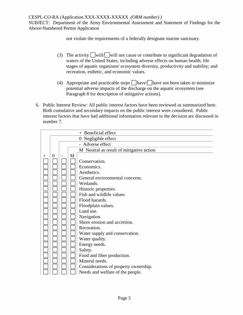
CESPL-CO-RA (Application XXX-XXXX-XXXXX (ORM number) )SUBJECT: Department of the Army Environmental Assessment and Statement of Findings for theAbove-Numbered Permit Application
Page 5
not violate the requirements of a federally designate marine sanctuary.
(3) The activity will/ will not cause or contribute to significant degradation ofwaters of the United States, including adverse effects on human health; lifestages of aquatic organisms' ecosystem diversity, productivity and stability; andrecreation, esthetic, and economic values.
(4) Appropriate and practicable steps have/ have not been taken to minimizepotential adverse impacts of the discharge on the aquatic ecosystem (seeParagraph 8 for description of mitigative actions).
6. Public Interest Review: All public interest factors have been reviewed as summarized here.Both cumulative and secondary impacts on the public interest were considered. Publicinterest factors that have had additional information relevant to the decision are discussed innumber 7.
+ Beneficial effect0 Negligible effect- Adverse effectM Neutral as result of mitigative action
+ 0 - MConservation.Economics.Aesthetics.General environmental concerns.Wetlands.Historic properties.Fish and wildlife valuesFlood hazards.Floodplain values.Land use.Navigation.Shore erosion and accretion.Recreation.Water supply and conservation.Water quality.Energy needs.Safety.Food and fiber production.Mineral needs.Considerations of property ownership.Needs and welfare of the people.

CESPL-CO-RA (Application XXX-XXXX-XXXXX (ORM number) )SUBJECT: Department of the Army Environmental Assessment and Statement of Findings for theAbove-Numbered Permit Application
Page 6
7. Effects, policies and other laws.
a. NA
Public Interest Factors. (add factors that are relevant to specific project that you checked innumber 6 above and add a discussion of that factor)
Factor Discussion
b. Endangered Species Act. NA
The proposed project:
(1) Will not affect these threatened or endangered species:Any/ . Explain.
(2) May affect, but is not likely to adversely affect:Species: . Explain.
(3) Will/ Will not adversely modify designated critical habitat for the .Explain.
(4) Is/ Is not likely to jeopardize the continued existence of the .Explain.
(5) The Services concurred/ provided a Biological Opinion(s). Explain.
c. Historic Properties. The proposed project will/ will not have any affect on anysites listed, or eligible for listing, in the National Register of Historic Places, orotherwise of national, state, or local significance based on letter from SHPO/
. Explain.
d. Cumulative & Secondary Impacts. The geographic area for this assessment is thewatershed.
(1) Baseline. Approximately % of the watershed area is wetland. Thereare also approximately stream miles contained within the watershedcomprised of % perennial, % intermittent, and %ephemeral tributaries. Corps permits for the period has authorized the
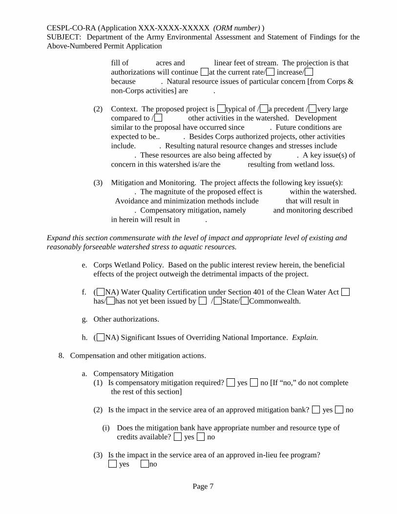
CESPL-CO-RA (Application XXX-XXXX-XXXXX (ORM number) )SUBJECT: Department of the Army Environmental Assessment and Statement of Findings for theAbove-Numbered Permit Application
Page 7
fill of acres and linear feet of stream. The projection is thatauthorizations will continue at the current rate/ increase/because . Natural resource issues of particular concern [from Corps &non-Corps activities] are .
(2) Context. The proposed project is typical of / a precedent / very largecompared to / other activities in the watershed. Developmentsimilar to the proposal have occurred since . Future conditions areexpected to be.. . Besides Corps authorized projects, other activitiesinclude. . Resulting natural resource changes and stresses include
. These resources are also being affected by . A key issue(s) ofconcern in this watershed is/are the resulting from wetland loss.
(3) Mitigation and Monitoring. The project affects the following key issue(s):. The magnitute of the proposed effect is within the watershed.
Avoidance and minimization methods include that will result in. Compensatory mitigation, namely and monitoring described
in herein will result in .
Expand this section commensurate with the level of impact and appropriate level of existing andreasonably forseeable watershed stress to aquatic resources.
e. Corps Wetland Policy. Based on the public interest review herein, the beneficialeffects of the project outweigh the detrimental impacts of the project.
f. ( NA) Water Quality Certification under Section 401 of the Clean Water Acthas/ has not yet been issued by / State/ Commonwealth.
g. Other authorizations.
h. ( NA) Significant Issues of Overriding National Importance. Explain.
8. Compensation and other mitigation actions.
a. Compensatory Mitigation(1) Is compensatory mitigation required? yes no [If “no,” do not complete
the rest of this section]
(2) Is the impact in the service area of an approved mitigation bank? yes no
(i) Does the mitigation bank have appropriate number and resource type ofcredits available? yes no
(3) Is the impact in the service area of an approved in-lieu fee program?yes no

CESPL-CO-RA (Application XXX-XXXX-XXXXX (ORM number) )SUBJECT: Department of the Army Environmental Assessment and Statement of Findings for theAbove-Numbered Permit Application
Page 8
(i) Does the in-lieu fee program have appropriate number and resource type ofcredits available? yes no
(4) Check the selected compensatory mitigation option(s):mitigation bank creditsin-lieu fee program creditspermittee-responsible mitigation under a watershed approachpermittee-responsible mitigation, on-site and in-kindpermittee-responsible mitigation, off-site and out-of-kind
(5) If a selected compensatory mitigation option deviates from the order of theoptions presented in §332.3(b)(2)-(6), explain why the selected compensatorymitigation option is environmentally preferable. Address the criteria provided in§332.3(a)(1) (i.e., the likelihood for ecological success and sustainability, thelocation of the compensation site relative to the impact site and theirsignificance within the watershed, and the costs of the compensatory mitigationproject):
(6) Other Mitigative Actions
9. General evaluation criteria under the public interest review. We considered the followingwithin this document:
a. The relative extent of the public and private need for the proposed structure or work.(e.g. Public benefits include employment opportunities and a potential increase in thelocal tax base. Private benefits include land use and economic return on the property; fortransportation projects benefits include safety, capacity and congestion issues.) Explain.
b. There are no unresolved conflicts as to resource use. ( There are unresolvedconflicts as to resource use. One or more of the alternative locations and methodsdescribed above are reasonable or practicable to accomplish the objectives of theproposed structure or work but are not being accepted by the applicant.) ( There areunresolved conflicts as to resource use however there are no practicable reasonablealternative locations and methods to accomplish the objective of the purposed work.)Check the appropriate box, delete the statements that do not apply and explain.
c. The extent and permanence of the beneficial and/or detrimental effects, which theproposed work is likely to have on the public, and private uses to which the area issuited. Detrimental impacts are expected to be minimal although they would bepermanent in the construction area. The beneficial effects associated with utilization ofthe property would be permanent. Explain.
10. Determinations.a. Public Hearing Request: NA
CESPL-CO-RA (Application XXX-XXXX-XXXXX (ORM number) )SUBJECT: Department of the Army Environmental Assessment and Statement of Findings for theAbove-Numbered Permit Application
Page 9
I have reviewed and evaluated the requests for a public hearing. There is sufficientinformation available to evaluate the proposed project; therefore, the requests for apublic hearing are denied.
b. Section 176(c) of the Clean Air Act General Conformity Rule Review: The proposedpermit action has been analyzed for conformity applicability pursuant to regulationsimplementing Section 176(c) of the Clean Air Act. It has been determined that theactivities proposed under this permit will not exceed de minimis levels of direct orindirect emissions of a criteria pollutant or its precursors and are exempted by 40 CFRPart 93.153. Any later indirect emissions are generally not within the Corps' continuingprogram responsibility and generally cannot be practicably controlled by the Corps. Forthese reasons a conformity determination is not required for this permit action.
c. Relevant Presidential Executive Orders.
(1) EO 13175, Consultation with Indian Tribes, Alaska Natives, and NativeHawaiians. This action has no substantial direct effect on one or moreIndian tribes. Explain, if appropriate.
(2) EO 11988, Floodplain Management. Not in a floodplain. ( Alternatives tolocation within the floodplain, minimization, and compensation of the effectswere considered above.)
(3) EO 12898, Environmental Justice. In accordance with Title III of the CivilRight Act of 1964 and Executive Order 12898, it has been determined that theproject would not directly or through contractual or other arrangements, usecriteria, methods, or practices that discriminate on the basis of race, color, ornational origin nor would it have a disproportionate effect on minority or low-income communities.
(4) EO 13112, Invasive Species.There were no invasive species issues involved.The evaluation above included invasive species concerns in the analysis of
impacts at the project site and associated compensatory mitigation projects.Through special conditions, the permittee will be required to control the
introduction and spread of exotic species.
(5) EO 13212 and 13302, Energy Supply and Availability. The project was notone that will increase the production, transmission, or conservation of energy,or strengthen pipeline safety. ( The review was expedited and/or otheractions were taken to the extent permitted by law and regulation to acceleratecompletion of this energy-related (including pipeline safety) project whilemaintaining safety, public health, and environmental protections.)

CESPL-CO-RA (Application XXX-XXXX-XXXXX (ORM number) )SUBJECT: Department of the Army Environmental Assessment and Statement of Findings for theAbove-Numbered Permit Application
Page 10
b. Finding of No Significant Impact (FONSI). Having reviewed the information providedby the applicant and all interested parties and an assessment of the environmentalimpacts, I find that this permit action will not have a significant impact on the quality ofthe human environment. Therefore, an Environmental Impact Statement will not berequired.
c. Compliance with 404(b)(1) guidelines. NA
Having completed the evaluation in paragraph 5, I have determined that the proposeddischarge complies/ does not comply with the 404(b)(1) guidelines.
d. Public Interest Determination: I find that issuance of a Department of the Army permitis not/ is contrary to the public interest.

CESPL-CO-RA (Application XXX-XXXX-XXXXX (ORM number) ) SUBJECT: Department of the Army Environmental Assessment and Statement of Findings for the Above-Numbered Permit Application
Page 11
PREPARED BY: ________________________ Date: Kathleen Tucker Project Manager REVIEWED BY: ________________________ Date Sallie Diebolt Chief, Arizona Section Regulatory Division

B7
PRE-CONSTRUCTION NOTIFICATION / INDIVIDUAL PERMIT SUBMITTALCHECKLIST
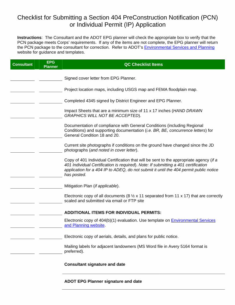
Checklist for Submitting a Section 404 PreConstruction Notification (PCN) or Individual Permit (IP) Application
Instructions: The Consultant and the ADOT EPG planner will check the appropriate box to verify that the PCN package meets Corps’ requirements. If any of the items are not complete, the EPG planner will return the PCN package to the consultant for correction. Refer to ADOT’s Environmental Services and Planning website for guidance and templates.
Consultant EPG Planner QC Checklist Items
Signed cover letter from EPG Planner.
Project location maps, including USGS map and FEMA floodplain map.
Completed 4345 signed by District Engineer and EPG Planner.
Impact Sheets that are a minimum size of 11 x 17 inches (HAND DRAWN GRAPHICS WILL NOT BE ACCEPTED).
Documentation of compliance with General Conditions (including Regional Conditions) and supporting documentation (i.e. BR, BE, concurrence letters) for General Condition 18 and 20.
Current site photographs if conditions on the ground have changed since the JD photographs (and noted in cover letter).
Copy of 401 Individual Certification that will be sent to the appropriate agency (if a 401 Individual Certification is required). Note: If submitting a 401 certification application for a 404 IP to ADEQ, do not submit it until the 404 permit public notice has posted.
Mitigation Plan (if applicable).
Electronic copy of all documents (8 ½ x 11 separated from 11 x 17) that are correctly scaled and submitted via email or FTP site
ADDITIONAL ITEMS FOR INDIVIDUAL PERMITS:
Electronic copy of 404(b)(1) evaluation. Use template on Environmental Services and Planning website.
Electronic copy of aerials, details, and plans for public notice.
Mailing labels for adjacent landowners (MS Word file in Avery 5164 format is preferred).
Consultant signature and date
ADOT EPG Planner signature and date
APPENDIX C
NATIONWIDE PERMITS(Refer to here for a complete list of all the Nationwide Permits)
C1
A SUMMARY OF 2012 NATIONWIDE PERMITS (CORPS 2012B)
Page 1 of 9 February 15, 2012
Summary of the 2012 Nationwide Permits
Nationwide Permit Statutory Authority Limits
Pre-Construction Notification (PCN) Threshold
Changes in 2012 Other Information
NWP 1 – Aids to Navigation 10 None PCN not required None
NWP 2 – Structures in Artificial Canals
10 None PCN not required None
NWP 3 – Maintenance 10/404 Does not authorize: maintenance dredging for the primary purpose of navigation; beach restoration; or new stream channelization or stream relocation projects.
(a) Repair, rehabilitation, or replacement of previously authorized, currently serviceable structures or fills
Authorizes only minor deviations for maintenance
PCN not required Added “requirements of other regulatory agencies” to allow minor deviation changes. Limit stream channel modification to the minimum necessary for the maintenance activity.
(b) Discharges associated with removal of accumulated sediments and debris in the vicinity of existing structures, including intake and outfall structures and associated canals
200 feet from structure; minimum necessary to restore capacity intake or outfall or associated canal
all activities Removed “and within” and “immediate” from removal of accumulated sediments and debris in the vicinity of existing structures. Clarifies that the activity can include the placement of new or additional riprap in order to qualify for the NWP.
(c) Temporary structures, fills, and work necessary to conduct maintenance activity
PCN not required None Temporary fills must be removed in their entirety and the affected areas returned to pre-construction elevations
NWP 4 – Fish and Wildlife Harvesting, Enhancement, and Attraction Devices and Activities
10/404 None PCN not required Added fish aggregating devices to list of examples of authorized structures or activities.
Does not authorize impoundments or artificial reefs. Does not authorize covered oyster trays or clam racks.
NWP 5 – Scientific Measurement Devices
10/404 25 cubic yards for weirs and flumes
PCN not required Added meteorological stations, current gages, and biological observation devices to the list of examples. Added requirement that devices and any associated structures or fills be removed upon completion of the use and restored to pre-construction elevations to maximum extent practicable.
NWP 6 – Survey Activities 10/404 1/10-acre for temporary pads
PCN not required Added language stating the backfilling of exploratory trenches must not drain a water of the U.S. Added sample plots or transects for wetland delineations to list of examples. Replaced the 25 cubic yard limit for temporary work pads with a 1/10-acre limit.
Does not authorize fills for roads. Does not authorize permanent structures. Does not authorize fill associated with recovery of historic properties.
NWP 7 – Outfall Structures and Associated Intake Structures
10/404 None all activities None Activity must comply with National Pollutant Discharge Elimination System Program.
Page 2 of 9 February 15, 2012
Nationwide Permit Statutory Authority Limits
Pre-Construction Notification (PCN) Threshold
Changes in 2012 Other Information
NWP 8 – Oil and Gas Structures on the Outer Continental Shelf
10 None all activities Changed Mineral Management Service to Bureau of Ocean Energy Management
Limited to facilities in areas leased by the Bureau of Ocean Energy Management of the Department of the Interior.
NWP 9 – Structures in Fleeting and Anchorage Areas
10 None PCN not required None Applies to structures, buoys, and other devices placed in anchorage or fleeting areas established by the U.S. Coast Guard.
NWP 10 – Mooring Buoys 10 None PCN not required None Non-commercial, single boat mooring buoys
NWP 11 – Temporary Recreational Structures
10 None PCN not required None Structures must be removed within 30 days after use discontinued.
NWP 12 – Utility Line Activities
10/404 1/2 acre of waters of the U.S. for each single and complete project
PCN required if: A section 10 permit
is required Mechanized land
clearing in forested wetlands for the right-of-way
Discharge results in the loss of >1/10 acre
Clarified locations when copies of PCN would be sent by Corps to NOAA National Ocean Service for charting (coastal United States; Great Lakes, and U.S. territories). For overhead utility lines, added requirement for DE to send PCN and verification letter to Department of Defense Siting Clearinghouse, which will evaluate potential effects on military activities.
Temporary fills must be removed in their entirety and the affected areas returned to pre-construction elevations.
Utility lines PCN required if: utility line exceeds
500 linear feet in waters of the U.S.
utility line runs parallel to a stream bed within jurisdictional area
Must restore area to pre-construction contours.
Utility line substations PCN required if: Discharge results in
the loss of >1/10 acre
Foundations for overhead utility line towers, poles, and anchors
PCN required if: Discharge results in
the loss of >1/10 acre
Separate footings for each tower leg should be used where feasible.
Access roads PCN required if: above-grade
permanent access roads exceeding 500 feet;
permanent access roads constructed with impervious materials
Clarify that access road is included with other utility line activities that comprise a single and complete project, including the 1/2-acre that applies to each single and complete project.
Access roads must be constructed to minimize adverse effects to waters of the U.S.
Page 3 of 9 February 15, 2012
Nationwide Permit Statutory Authority Limits
Pre-Construction Notification (PCN) Threshold
Changes in 2012 Other Information
NWP 13 – Bank Stabilization
10/404 500 feet along the bank (unless waived by DE)
1 cubic yard per running foot (unless waived by DE)
PCN required if: >500 linear feet in
length >1 cubic yard per
running foot along bank below OHWM or HTL
discharges into special aquatic sites
Added language authorizing temporary structures, fills and work necessary to construct the activity. Invasive plant species may not be used for bioengineering or vegetative bank stabilization.
Activity cannot impair surface water flow into or out of waters of the U.S. Temporary fills must be removed in their entirety and the affected areas returned to pre-construction elevations.
NWP 14 – Linear Transportation Projects
10/404 1/2 acre in non-tidal waters of the U.S.
1/3 acre in tidal waters of the U.S.
PCN required if: >1/10 acre discharges into
special aquatic sites
None Temporary fills must be removed in their entirety and the affected areas returned to pre-construction elevations. Does not authorize storage buildings, parking lots, train stations, aircraft hangars, or other non-linear transportation features.
NWP 15 – U.S. Coast Guard Approved Bridges
404 None PCN not required Clarified that the construction of the bridge structure must be authorized by the U.S. Coast Guard under Section 9 of the Rivers and Harbors Act of 1899 and other applicable laws.
Causeways and approach fills for bridges are not authorized by this NWP; those activities require separate section 404 authorization.
NWP 16 – Return Water From Upland Contained Disposal Areas
404 None PCN not required Clarified that disposal site may be in an area that has no waters of the United States.
NWP 17 – Hydropower Projects
404 None all activities None Applies to activities licensed by the Federal Energy Regulatory Commission or activities exempt from licensing requirements.
NWP 18 – Minor Discharges 10/404 25 cubic yards discharged below plane of OHWM/HTL
1/10-acre of waters of the U.S.
PCN required if: >10 cubic yards
discharged below plane of OHWM/HTL
discharges into special aquatic sites
None Does not authorize discharges for stream diversions.
NWP 19 – Minor Dredging 10/404 25 cubic yards below plane of OHWM/ MHWM
PCN not required None Does not authorize dredging or degradation through siltation of coral reefs, submerged aquatic vegetation beds, anadromous fish spawning areas, or wetlands.
NWP 20 – Response Operations for Oil and Hazardous Substances
10/404 None PCN not required Changed title. Also authorizes approved regional or local contingency plans, as well as temporary structures and fills for spill response training exercises.
Authorizes activities subject to the National Oil and Hazardous Substances Pollution Contingency Plan.
NWP 21 – Surface Coal Mining Activities
10/404 1/2 acre of non-tidal waters of U.S.
300 linear feet of stream bed (DE can waive for intermittent and ephemeral streams)
all activities Added 1/2-acre limit and limits losses of stream beds to 300 linear feet unless district engineers waives in writing for intermittent and ephemeral streams. Agency coordination required for proposed waivers of the 300 linear foot limit. Does not authorize valley fills. Added definition of “valley fill.”
Activities that were verified under the 2007 NWP 21 may be reauthorized without the limits, if the permittee submits a written request to the DE for reauthorization by February 1, 2013. Expansions in waters of the U.S. are not eligible for reauthorization. To be reauthorized, the district engineer must issue a written verification.

Page 4 of 9 February 15, 2012
Nationwide Permit Statutory Authority Limits
Pre-Construction Notification (PCN) Threshold
Changes in 2012 Other Information
NWP 22 – Removal of Vessels
10/404 None PCN required if: if vessel listed or
eligible for National Register of Historic Places
activities in special aquatic sites
None Does not authorize maintenance dredging, shoal removal, or river bank snagging. Disposal of removed vessel in waters of the U.S. may require separate authorizations from EPA and Corps
NWP 23 – Approved Categorical Exclusions
10/404 None PCN required for certain activities listed in RGL 05-07
None Categorical exclusions must be approved by the Office of the Chief of Engineers. See RGL 05-07 for list of agencies and their activities that are currently eligible for NWP 23.
NWP 24 – Indian Tribe or State Administered Section 404 Program
10 None PCN not required None Does not authorize activities in navigable waters that require only a section 10 permit.
NWP 25 – Structural Discharges
404 None PCN not required None Structure may require section 10 permit if located in navigable waters of the U.S. Does not authorize structures that support buildings or similar structures.
NWP 27 – Aquatic Habitat Restoration, Establishment, and Enhancement Activities
10/404 None PCN required for most activities, except for those activities that require reporting and a 30-day review period (e.g., activities under a binding agreement between the landowner and an agency)
Added rehabilitation or enhancement of tidal streams and tidal wetlands. Authorize discharges to restore stream channels after removing water control structures or fills. Clarified activities that may be authorized to re-establish wetland or stream hydrology. Authorize the re-establishment of submerged aquatic vegetation and tidal wetlands in areas where those habitats previously existed. Clarified that changes in wetland plant communities that occur after restoring wetland hydrology are not considered conversions. Clarified that compensatory mitigation is not required for NWP 27 activities. Included stream restoration or enhancement in the types of activities authorized, as long as they are included in the agreements. Activities subject to the reporting provision must include information on baseline ecological conditions, such as a delineation of wetlands, streams, and other aquatic habitats. Added U.S. Forest Service to the list of agencies in the notification provision.
Does not authorize stream channelization. Does not authorize relocation or conversion of tidal waters. Does not authorize conversion of natural wetlands or streams, except for relocation activities.
NWP 28 – Modifications of Existing Marinas
10 Previously authorized marina area
PCN not required None Does not authorize dredging, additional slips, dock spaces, or expansion in waters of the U.S.
NWP 29 – Residential Developments
10/404 1/2 acre of non-tidal waters of U.S.
300 linear feet of stream bed (DE can waive for intermittent and ephemeral streams)
all activities Clarified that district engineers must make written determinations of minimal effects when waiving the 300 linear foot limit for losses of intermittent or ephemeral stream bed. Agency coordination required for proposed waivers of the 300 linear foot limit.
For residential subdivisions, the aggregate total loss of waters of the U.S. cannot exceed 1/2-acre.

Page 5 of 9 February 15, 2012
Nationwide Permit Statutory Authority Limits
Pre-Construction Notification (PCN) Threshold
Changes in 2012 Other Information
NWP 30 – Moist Soil Management for Wildlife
404 None PCN not required None Authorizes only on-going activities. Does not authorize construction of new dikes, roads, water control structures, etc. Does not authorize conversion of wetlands to uplands. Does not authorize impoundments. Does not authorize net loss of aquatic functions and services.
NWP 31 – Maintenance of Existing Flood Control Facilities
10/404 Maintenance baseline approved by DE
all activities Added that the NWP authorizes the removal of vegetation from levees associated with a flood control project, in those cases where a Corps permit is required. Clarified that disposal site may be in an area that has no waters of the United States.
PCN must indicate location of dredged material disposal sites and baseline information.
NWP 32 – Completed Enforcement Actions
10/404 5 acres of non-tidal waters
1 acre of tidal waters
also see text of NWP
Notification through non-judicial settlement agreement with Corps, court decision, consent decree, or settlement agreement
None
NWP 33 – Temporary Construction, Access, and Dewatering
10/404 None all activities Clarified that temporary fills must be deposited in an area that has no waters of the United States.
Associated primary activity must be authorized by Corps or U.S. Coast Guard, or be exempt from permit requirements. PCN must include restoration plan.
NWP 34 – Cranberry Production Activities
404 10 acres, and activity cannot result in net loss of wetland acreage
all activities None Does not authorize discharges in waters of the U.S. for attendant features, such as warehouses, processing facilities, or parking areas.
NWP 35 – Maintenance Dredging of Existing Basins
10 Dredging to previously authorized depths or controlling depths, whichever is less
PCN not required None Dredged material must be deposited at upland site.
NWP 36 – Boat Ramps 10/404 50 cubic yards, unless waived by DE
20 foot width, unless waived by DE
PCN required if: >50 cubic yards >20 feet wide
Clarified that district engineers must make written determinations of minimal effects when waiving the limits of 50 cubic yard and/or the 20 feet in width. Clarified that excavated materials must be removed to an area that has no waters of the United States.
Section 10 permit required if dredging navigable water is necessary for access to boat ramp. No material in special aquatic sites.
NWP 37 – Emergency Watershed Protection and Rehabilitation
10/404 None all activities Updated reference to the U.S. Forest Service Burned Area Emergency Rehabilitation Handbook (FSH 2509.13). Also clarified the permittee should wait 45 calendar days before proceeding with the activity if the DE has not yet issued a verification letter.
In general, permittee should wait until District Engineer issues verification, but may proceed immediately if there is an unacceptable hazard to life or significant loss of property or economic hardship will occur.
NWP 38 – Cleanup of Hazardous and Toxic Waste
10/404 None all activities None Does not authorize the establishment of new disposal sites or the expansion of existing disposal sites.
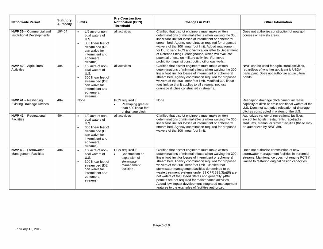
Page 6 of 9 February 15, 2012
Nationwide Permit Statutory Authority Limits
Pre-Construction Notification (PCN) Threshold
Changes in 2012 Other Information
NWP 39 – Commercial and Institutional Developments
10/404 1/2 acre of non-tidal waters of U.S.
300 linear feet of stream bed (DE can waive for intermittent and ephemeral streams)
all activities Clarified that district engineers must make written determinations of minimal effects when waiving the 300 linear foot limit for losses of intermittent or ephemeral stream bed. Agency coordination required for proposed waivers of the 300 linear foot limit. Added requirement for DE to send PCN and verification letter to Department of Defense Siting Clearinghouse, which will evaluate potential effects on military activities. Removed prohibition against constructing oil or gas wells.
Does not authorize construction of new golf courses or new ski areas.
NWP 40 – Agricultural Activities
404 1/2 acre of non-tidal waters of U.S.
300 linear feet of stream bed (DE can waive for intermittent and ephemeral streams)
all activities Clarified that district engineers must make written determinations of minimal effects when waiving the 300 linear foot limit for losses of intermittent or ephemeral stream bed. Agency coordination required for proposed waivers of the 300 linear foot limit. Modified 300 linear foot limit so that it applies to all streams, not just drainage ditches constructed in streams.
NWP can be used for agricultural activities, regardless of whether applicant is USDA participant. Does not authorize aquaculture ponds.
NWP 41 – Reshaping Existing Drainage Ditches
404 None PCN required if: Reshaping greater
than 500 linear feet of drainage ditch
None Reshaping drainage ditch cannot increase capacity of ditch or drain additional waters of the U.S. Does not authorize relocation of drainage ditches constructed in waters of the U.S.
NWP 42 – Recreational Facilities
404 1/2 acre of non-tidal waters of U.S.
300 linear feet of stream bed (DE can waive for intermittent and ephemeral streams)
all activities Clarified that district engineers must make written determinations of minimal effects when waiving the 300 linear foot limit for losses of intermittent or ephemeral stream bed. Agency coordination required for proposed waivers of the 300 linear foot limit.
Authorizes variety of recreational facilities, except for hotels, restaurants, racetracks, stadiums, arenas, or similar facilities (these may be authorized by NWP 39).
NWP 43 – Stormwater Management Facilities
404 1/2 acre of non-tidal waters of U.S.
300 linear feet of stream bed (DE can waive for intermittent and ephemeral streams)
PCN required if: Construction or
expansion of stormwater management facilities
Clarified that district engineers must make written determinations of minimal effects when waiving the 300 linear foot limit for losses of intermittent or ephemeral stream bed. Agency coordination required for proposed waivers of the 300 linear foot limit. Clarified that stormwater management facilities determined to be waste treatment systems under 33 CFR 328.3(a)(8) are not waters of the United States and generally §404 permits are not required for maintenance activities. Added low impact development integrated management features to the examples of facilities authorized.
Does not authorize construction of new stormwater management facilities in perennial streams. Maintenance does not require PCN if limited to restoring original design capacities.
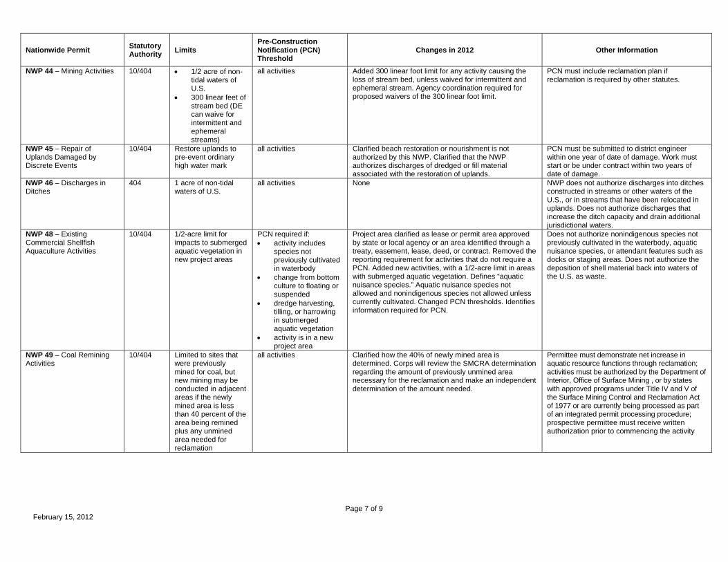
Page 7 of 9 February 15, 2012
Nationwide Permit Statutory Authority Limits
Pre-Construction Notification (PCN) Threshold
Changes in 2012 Other Information
NWP 44 – Mining Activities 10/404 1/2 acre of non-tidal waters of U.S.
300 linear feet of stream bed (DE can waive for intermittent and ephemeral streams)
all activities Added 300 linear foot limit for any activity causing the loss of stream bed, unless waived for intermittent and ephemeral stream. Agency coordination required for proposed waivers of the 300 linear foot limit.
PCN must include reclamation plan if reclamation is required by other statutes.
NWP 45 – Repair of Uplands Damaged by Discrete Events
10/404 Restore uplands to pre-event ordinary high water mark
all activities Clarified beach restoration or nourishment is not authorized by this NWP. Clarified that the NWP authorizes discharges of dredged or fill material associated with the restoration of uplands.
PCN must be submitted to district engineer within one year of date of damage. Work must start or be under contract within two years of date of damage.
NWP 46 – Discharges in Ditches
404 1 acre of non-tidal waters of U.S.
all activities None NWP does not authorize discharges into ditches constructed in streams or other waters of the U.S., or in streams that have been relocated in uplands. Does not authorize discharges that increase the ditch capacity and drain additional jurisdictional waters.
NWP 48 – Existing Commercial Shellfish Aquaculture Activities
10/404 1/2-acre limit for impacts to submerged aquatic vegetation in new project areas
PCN required if: activity includes
species not previously cultivated in waterbody
change from bottom culture to floating or suspended
dredge harvesting, tilling, or harrowing in submerged aquatic vegetation
activity is in a new project area
Project area clarified as lease or permit area approved by state or local agency or an area identified through a treaty, easement, lease, deed, or contract. Removed the reporting requirement for activities that do not require a PCN. Added new activities, with a 1/2-acre limit in areas with submerged aquatic vegetation. Defines “aquatic nuisance species.” Aquatic nuisance species not allowed and nonindigenous species not allowed unless currently cultivated. Changed PCN thresholds. Identifies information required for PCN.
Does not authorize nonindigenous species not previously cultivated in the waterbody, aquatic nuisance species, or attendant features such as docks or staging areas. Does not authorize the deposition of shell material back into waters of the U.S. as waste.
NWP 49 – Coal Remining Activities
10/404 Limited to sites that were previously mined for coal, but new mining may be conducted in adjacent areas if the newly mined area is less than 40 percent of the area being remined plus any unmined area needed for reclamation
all activities Clarified how the 40% of newly mined area is determined. Corps will review the SMCRA determination regarding the amount of previously unmined area necessary for the reclamation and make an independent determination of the amount needed.
Permittee must demonstrate net increase in aquatic resource functions through reclamation; activities must be authorized by the Department of Interior, Office of Surface Mining , or by states with approved programs under Title IV and V of the Surface Mining Control and Reclamation Act of 1977 or are currently being processed as part of an integrated permit processing procedure; prospective permittee must receive written authorization prior to commencing the activity

Page 8 of 9 February 15, 2012
Nationwide Permit Statutory Authority Limits
Pre-Construction Notification (PCN) Threshold
Changes in 2012 Other Information
NWP 50 – Underground Coal Mining Activities
10/404 1/2 acre of non-tidal waters of U.S.
300 linear feet of stream bed (DE can waive for intermittent and ephemeral streams)
all activities Added 1/2-acre limit and a 300 linear foot limit for any activity causing the loss of stream bed. The 300 linear foot limit may be waived for intermittent and ephemeral streams through a written determination made by the DE. Agency coordination required for proposed waivers of the 300 linear foot limit.
Activities must be authorized by the Department of Interior, Office of Surface Mining, or by states with approved programs under Title V of the Surface Mining Control and Reclamation Act of 1977 or are currently being processed as part of an integrated permit processing procedure. If reclamation required, a copy of the plan must be submitted with PCN. Does not authorize coal preparation and processing activities outside of the mine site. Prospective permittee must receive written authorization prior to commencing the activity
NWP 51 – Land-Based Renewable Energy Generation Facilities
10/404 1/2 acre of non-tidal waters of U.S.
300 linear feet of stream bed (DE can waive for intermittent and ephemeral streams)
all activities new NWP Authorizes construction, expansion or modification of land-based renewable energy production facilities, including attendant features. If only activity requiring DA authorization is utility line, then NWP 12 shall be used. Utility lines transferring energy to a distribution system, regional grid, or other facility are generally considered to be separate single and complete linear projects. Requirement for DE to send PCN and verification letter to Department of Defense Siting Clearinghouse, and the Clearinghouse will evaluate potential effects on military activities. Agency coordination required for proposed waivers of the 300 linear foot limit.

Page 9 of 9 February 15, 2012
Nationwide Permit Statutory Authority Limits
Pre-Construction Notification (PCN) Threshold
Changes in 2012 Other Information
NWP 52 – Water-Based Renewable Energy Generation Pilot Projects
10/404 1/2 acre of waters of U.S.
300 linear feet of stream bed (DE can waive for intermittent and ephemeral streams)
No more than 10 generation units
all activities new NWP Authorizes construction, expansion, modification, or removal of water-based wind or hydrokinetic renewable energy generation pilot projects and their attendant features. Limited to “pilot projects.” Placement of a transmission line on bed of a navigable water of U.S. from generation unit to land-based collection facility is considered a structure under Section 10 and is not considered a loss of waters of the U.S. Prohibits activities in coral reefs. Structures in anchorage areas must comply with U.S. Coast Guard requirements. Does not authorize structures in established danger zones, restricted areas, etc. Upon completion of pilot project, associated structures and/or fills must be removed unless authorized by separate DA permit. Utility lines transferring energy to a distribution system, regional grid, or other facility are generally considered to be separate single and complete linear projects. Requirement for DE to send PCN and verification letter to Department of Defense Siting Clearinghouse, and the Clearinghouse will evaluate potential effects on military activities. An activity located on existing maintained Corps project requires separate approval under 33 USC 408. Agency coordination required for proposed waivers of the 300 linear foot limit.

REGULATORY GUIDANCE LETTER
No. 05-07 Date: 8 December 2005
SUBJECT: Approved NEPA Categorical Exclusions for Nationwide Permit 23 1. Purpose and Applicability
a. Purpose. To issue guidance regarding the Categorical Exclusions of other Federal agencies approved for inclusion under Nationwide Permit 23 (NWP23). This guidance consolidates expired Regulatory Guidance Letters 86-02, 87-10 and 96-01.
b. Applicability. This applies to activities that may qualify for authorization under NWP23. 2. General Considerations
a. Background. Nationwide Permit 23 (NWP23) was first issued in 1982 to authorize certain actions by other federal agencies that are categorically excluded under NEPA, in accordance with 40 CFR Parts 1500 to 1508. After receiving a request from an agency to include its Categorical Exclusions (CEs) under NWP23, the Headquarters of the Army Corps of Engineers (HQUSACE) may approve CEs for use with NWP23 after conducting a public interest review. A Regulatory Guidance Letter (RGL) is issued to the field with the approved list of agency CEs.
To date, HQUSACE has concurred with the CEs of three federal agencies for inclusion under NWP23. CEs were approved for the Bureau of Reclamation (BOR) in RGL 86-02 dated January 17, 1986, the Federal Highway Administration (FHWA) in RGL 87-10 dated December 9, 1987, and the U.S. Coast Guard (USCG) in RGL 96-01 dated November 5, 1996.
b. Practice. While RGLs 86-02, 87-10 and 96-01 have expired, HQUSACE has instructed districts that the guidance provided therein remains generally valid since the RGLs have not been superseded by regulations or other RGLs. Districts currently use these expired RGLs in determining whether activities qualifying for approved categorical exclusions may be authorized under NWP23. 3. Guidance.
a. The CE actions approved by HQUSACE for BOR, FHWA, and USCG for inclusion under NWP23 (see Attachments 1 though 3) continue to be in effect. Please note the lists include many actions that do not require Department of the Army authorization. However, to be
consistent with past RGLs and reduce confusion when referencing the CE number, we have included all agency CEs.
b. Notification to the district engineer is required for some CE activities to be authorized under NWP23. In such cases, the prospective permittee must contact the appropriate district, so that the district can review the project proposal and ensure the activity would have only minimal individual and cumulative impacts on the aquatic environment. Notification is required for the following:
• BOR: CE activities that involve more than a small amount of fill, activities with the potential to cause more than minor water quality impacts, and activities involving the use of explosives near waters with significant fisheries resources;
• FHWA: CE activities occurring under paragraphs (c)(3), (c)(7), (c)(9) and (c)(12), and all activities under paragraph (d); and
• USCG: CE activities under number (6) for projects where wetland impacts are proposed, and number (8) to address potential impacts/encroachment on Federal navigation projects.
Districts will review each notification and verify whether the activity meets the terms and conditions of NWP23. Special conditions may be added to the NWP verification to ensure that the individual and cumulative adverse effects on the aquatic environment are minimal. If the district believes that concerns for the aquatic environment or any public interest factor warrant further review, discretionary authority may be exercised on a case-by-case basis to require an individual permit.
c. Districts will provide a response to the prospective permittee, verifying whether the activity meets the terms and conditions of NWP23 within the designated response period for the most recently issued nationwide permits (as provided in the “Notification” general condition for the nationwide permits) or the appropriate regional condition. If the district does not respond within the designated time, the activity qualifies for NWP23 authorization.
d. Unless a district or division has regional conditions that require notification for additional CE activities, all other CE activities do not require pre-construction notification to the district. BOR, FHWA, and USCG may however voluntarily seek written verification from districts for CE actions that do not require notification.
e. This guidance rescinds and replaces RGLs 86-02, 87-10 and 96-01.
4. Duration. This guidance remains in effect unless revised or rescinded.
2

ATTACHMENT 1 RGL 05-07
Bureau of Reclamation Approved Categorical Exclusions for NWP23
The following BOR Categorical Exclusions were approved for inclusion under NWP23 on January 17, 1986.
A. General Activities.
(2) Training activities of enrollees assigned to the various youth programs. Such training may include minor construction activities for other entities. (3) Research activities, such as nondestructive data collection and analysis, monitoring, modeling, laboratory testing, calibration, and testing of instruments or procedures and nonmanipulative field studies. B. Planning Activities. (3) Data collection studies that involve test excavations for cultural resources investigations or test pitting, drilling, or seismic investigations for geologic exploration purposes where the impacts will be localized. C. Project Implementation Activities. (3) Minor construction activities associated with authorized projects which correct unsatisfactory environmental conditions or which merely augment or supplement, or are enclosed within existing facilities. (4) Approval of land management plans where implementation will only result in minor construction activities and resultant increased operation and maintenance activities. D. Operation and Maintenance Activities. (1) Maintenance, rehabilitation, and replacement of existing facilities which may involve a minor change in size, location, and/or operation. (9) Issuance of permits for removal of gravel or sand by an established process from existing quarries. (11) Implementation of improved appearance and soil and moisture conservation programs where the impacts are localized. (12) Conduct of programs of demonstration, educational, and technical assistance to water user organizations for improvement of project and on-farm irrigation water use and management. (17) Minor safety of dams construction activities where the work is confined to the dam, abutment areas, or appurtenant features, and where no major change in reservoir or downstream operation is anticipated as a result of the construction activities. E. Grant and Loan Activities. (1) Rehabilitation and Betterment Act loans and contracts which involve repair, replacement, or modification of equipment in existing structures or minor repairs to existing dams, canals, laterals, drains, pipelines, and similar facilities. (2) Small Reclamation Projects Act grants and loans where the work to be done is confined to areas already impacted by farming or development activities, work is considered minor, and where the impacts are expected to be localized. (3) Distribution System Loans Act loans where the work to be done is confined to areas already impacted by farming or developing activities, work is considered minor, and where the impacts are expected to be localized.
3
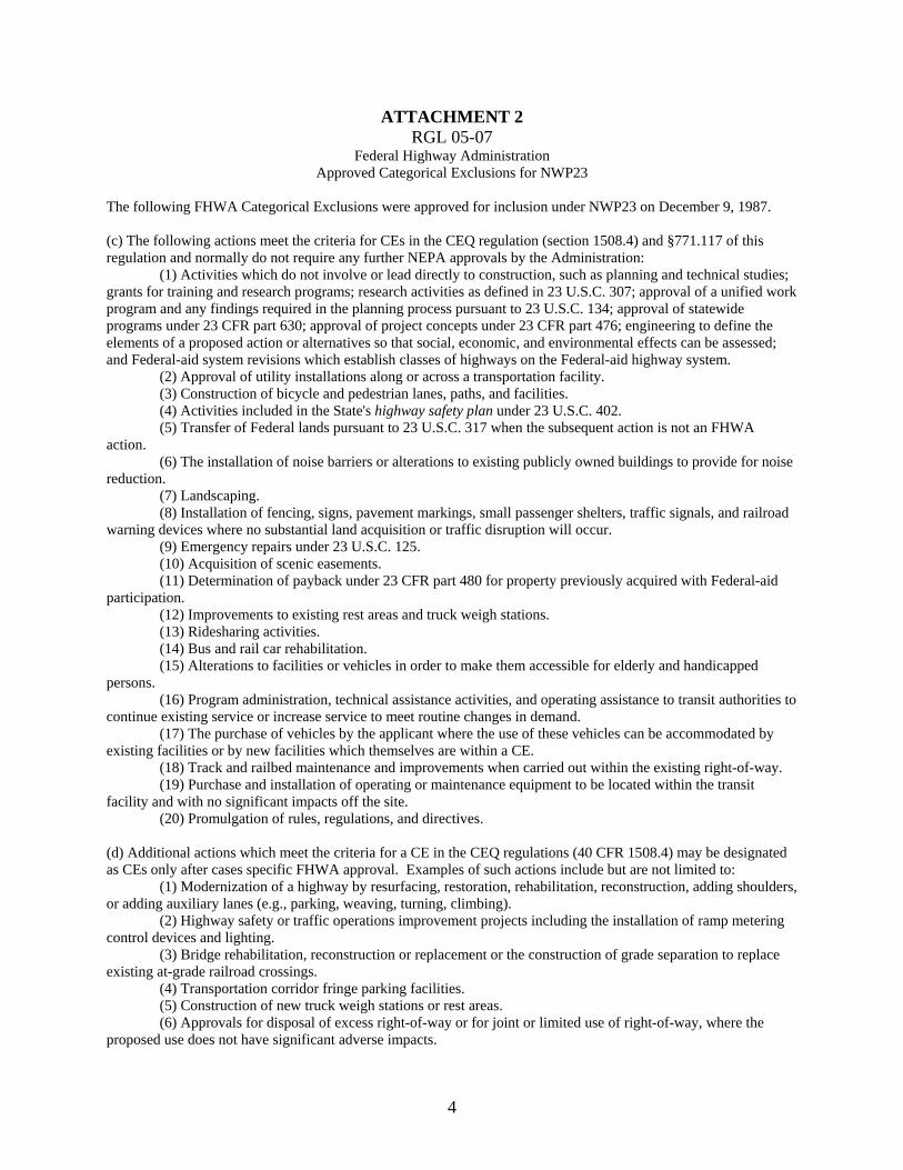
ATTACHMENT 2 RGL 05-07
Federal Highway Administration Approved Categorical Exclusions for NWP23
The following FHWA Categorical Exclusions were approved for inclusion under NWP23 on December 9, 1987. (c) The following actions meet the criteria for CEs in the CEQ regulation (section 1508.4) and §771.117 of this regulation and normally do not require any further NEPA approvals by the Administration:
(1) Activities which do not involve or lead directly to construction, such as planning and technical studies; grants for training and research programs; research activities as defined in 23 U.S.C. 307; approval of a unified work program and any findings required in the planning process pursuant to 23 U.S.C. 134; approval of statewide programs under 23 CFR part 630; approval of project concepts under 23 CFR part 476; engineering to define the elements of a proposed action or alternatives so that social, economic, and environmental effects can be assessed; and Federal-aid system revisions which establish classes of highways on the Federal-aid highway system.
(2) Approval of utility installations along or across a transportation facility. (3) Construction of bicycle and pedestrian lanes, paths, and facilities. (4) Activities included in the State's highway safety plan under 23 U.S.C. 402. (5) Transfer of Federal lands pursuant to 23 U.S.C. 317 when the subsequent action is not an FHWA
action. (6) The installation of noise barriers or alterations to existing publicly owned buildings to provide for noise
reduction. (7) Landscaping. (8) Installation of fencing, signs, pavement markings, small passenger shelters, traffic signals, and railroad
warning devices where no substantial land acquisition or traffic disruption will occur. (9) Emergency repairs under 23 U.S.C. 125. (10) Acquisition of scenic easements. (11) Determination of payback under 23 CFR part 480 for property previously acquired with Federal-aid
participation. (12) Improvements to existing rest areas and truck weigh stations. (13) Ridesharing activities. (14) Bus and rail car rehabilitation. (15) Alterations to facilities or vehicles in order to make them accessible for elderly and handicapped
persons. (16) Program administration, technical assistance activities, and operating assistance to transit authorities to
continue existing service or increase service to meet routine changes in demand. (17) The purchase of vehicles by the applicant where the use of these vehicles can be accommodated by
existing facilities or by new facilities which themselves are within a CE. (18) Track and railbed maintenance and improvements when carried out within the existing right-of-way. (19) Purchase and installation of operating or maintenance equipment to be located within the transit
facility and with no significant impacts off the site. (20) Promulgation of rules, regulations, and directives.
(d) Additional actions which meet the criteria for a CE in the CEQ regulations (40 CFR 1508.4) may be designated as CEs only after cases specific FHWA approval. Examples of such actions include but are not limited to:
(1) Modernization of a highway by resurfacing, restoration, rehabilitation, reconstruction, adding shoulders, or adding auxiliary lanes (e.g., parking, weaving, turning, climbing).
(2) Highway safety or traffic operations improvement projects including the installation of ramp metering control devices and lighting.
(3) Bridge rehabilitation, reconstruction or replacement or the construction of grade separation to replace existing at-grade railroad crossings.
(4) Transportation corridor fringe parking facilities. (5) Construction of new truck weigh stations or rest areas. (6) Approvals for disposal of excess right-of-way or for joint or limited use of right-of-way, where the
proposed use does not have significant adverse impacts.
4

(7) Approvals for changes in access control. (8) Construction of new bus storage and maintenance facilities in areas used predominantly for industrial or
transportation purposes where such construction is not inconsistent with existing zoning and located on or near a street with adequate capacity to handle anticipated bus and support vehicle traffic.
(9) Rehabilitation or reconstruction of existing rail and bus buildings and ancillary facilities where only minor amounts of additional land are required and there is not a substantial increase in the number of users.
(10) Construction of bus transfer facilities (an open area consisting of passenger shelters, boarding areas, kiosks and related street improvements) when located in a commercial area or other high activity center in which there is adequate street capacity for projected bus traffic.
(11) Construction of rail storage and maintenance facilities in areas used predominantly for industrial or transportation purposes where such construction is not inconsistent with existing zoning and where there is no significant noise impact on the surrounding community.
(12) Acquisition of land for hardship or protective purposes; advance land acquisition loans under section 3(b) of the UMT Act.
5

ATTACHMENT 3 RGL 05-07
U.S. Coast Guard Approved Categorical Exclusions for NWP23
The following USCG Categorical Exclusions were approved for inclusion under NWP23 on November 5, 1996.
1. Routine personnel, fiscal, and administrative activities, actions, procedures, and policies which clearly do not have any environmental impacts, such as military and civilian personnel recruiting, processing, paying, and record keeping.
2. Routine procurement activities and actions for goods and services, including office supplies, equipment, mobile assets, and utility services for routine administration, operation, and maintenance.
3. Maintenance dredging and debris disposal where no new depths are required, applicable permits are secured, and disposal will be at an existing approved disposal site.
4. Routine repair, renovation, and maintenance actions on aircraft and vessels. 5. Routine repair and maintenance of buildings, roads, airfields, grounds, equipment, and other facilities
which do not result in a change in functional use, or an impact on a historically significant element or settings. 6. Minor renovations and additions to buildings, roads, airfields, grounds, equipment, and other facilities
which do not result in a change in functional use, a historically significant element, or historically significant setting. 7. Routine repair and maintenance to waterfront facilities, including mooring piles, fixed floating piers,
existing piers, and unburied power cables. 8. Minor renovations and additions to waterfront facilities, including mooring piles, fixed floating piers,
existing piers, and unburied power cables, which do not require special, site-specific regulatory permits. 9. Routine grounds maintenance and activities at units and facilities. Examples include localized pest
management actions and actions to maintain improved grounds (such as landscaping, lawn care, and minor erosion control measures) that are conducted in accordance with applicable Federal, State, and local directives.
10. Installation of devices to protect human or animal life, such as raptor electrocution prevention devices, fencing to restrict wildlife movement on to airfields, and fencing and grating to prevent accidental entry to hazardous areas.
11. New construction on heavily developed portions of Coast Guard property, when construction, use, and operation will comply with regulatory requirements and constraints.
12. Decisions to decommission equipment or temporarily discontinue use of facilities or equipment. This does not preclude the need to review decommissioning under Section 106 of the National Historic Preservation Act.
13. Demolition or disposal actions that involve buildings or structures when conducted in accordance with regulations applying to removal of asbestos, PCB's, and other hazardous materials, or disposal actions mandated by Congress. In addition, if the building or structure is listed, or eligible for listing, in the National Register of Historic Places, then compliance with Section 106 of the National Historic Preservation Act is required.
14. Outleasing of historic lighthouse properties as outlined in the Programmatic Memorandum of Agreement between the Coast Guard, Advisory Council on Historic Preservation, and the National Conference of State Historic Preservation Officers.
15. Transfer of real property from the Coast Guard to the General Services Administration, Department of the Interior, and other Federal departments and agencies, or as mandated by Congress; and the granting of leases, permits, and easements where there is no substantial change in use of the property.
16. Renewals and minor amendments of existing real estate licenses or grants for use of government-owned real property where prior environmental review has determined that no significant environmental effects would occur.
17. New grants or renewal of existing grants of license, easements, or similar arrangements for the use of existing rights-of-way or incidental easements complementing the use of existing rights-of-way for use by vehicles; for such existing rights-of-way as electrical, telephone, and other transmission and communication lines; water, wastewater, stormwater, and irrigation pipelines, pumping stations, and irrigation facilities; and for similar utility and transportation uses.
18. Defense preparedness training and exercises conducted on other than Coast Guard property, where the lead agency or department is not Coast Guard or Department of Transportation and the lead agency or department has completed its NEPA analysis and documentation requirements.
6

19. Defense preparedness training and exercise conducted on Coast Guard property that do not involve undeveloped property or increase noise levels over adjacent property and that involve a limited number of personnel, such as exercises involving primarily electric simulation or command post personnel.
20. Simulated exercises, including tactical and logistical exercises that involve small numbers of personnel. 21. Training of an administrative or classroom nature. 22. Operations to carry out maritime safety, maritime law enforcement, search and rescue, domestic ice
breaking, and oil or hazardous substance removal programs. 23. Actions performed as a part of Coast Guard operations and the Aids to Navigation Program to carry out
statutory authority in the area of establishment of floating and minor fixed aids to navigation, except electronic sound signals.
24. Routine movement of personnel and equipment, and the routine movement, handling, and distribution of nonhazardous materials and wastes in accordance with applicable regulations.
25. Coast Guard participation in disaster relief efforts under the guidance or leadership of another Federal agency that has taken responsibility for NEPA compliance.
26. Data gathering, information gathering, and studies that involve no physical change to the environment. Examples include topographic surveys, bird counts, wetland mapping, and other inventories.
27. Natural and cultural resource management and research activities that are in accordance with interagency agreements and which are designed to improve or upgrade the Coast Guard's ability to manage those resources.
28. Contracts for activities conducted at established laboratories and facilities, to include contractor-operated laboratories and facilities, on Coast Guard-owned property where all airborne emissions, waterborne effluents, external radiation levels, outdoor noise, and solid and bulk waste disposal practices are in compliance with existing applicable Federal, State, and local laws and regulations.
29. Approval of recreational activities (such as Coast Guard unit picnic) which do not involve significant physical alteration of the environment, increase disturbance by humans of sensitive natural habitats, or disturbance of historic properties, and which do not occur in, or adjacent to, areas inhabited by threatened or endangered species.
30. Review of documents, such as studies, reports, and analyses, prepared for legislative proposals that did not originate in DOT and that relate to matters that are not the primary responsibility of the Coast Guard.
31. Planning and technical studies which do not contain recommendations for authorization or funding for future construction, but may recommend further study. This includes engineering efforts or environmental studies undertaken to define the elements of a proposal or alternatives sufficiently so that the environmental effects may be assessed and does not exclude consideration of environmental matters in the studies.
32. Bridge Administration Program actions which can be described as one of the following: (a) Modification or replacement of an existing bridge on essentially the same alignment or location. Excluded are bridges with historic significance or bridges providing access to undeveloped barrier islands and beaches. (b) Construction of pipeline bridges for transporting potable water. (c) Construction of pedestrian, bicycle, or equestrian bridges and stream gauging cableways used to transport people. (d) Temporary replacement of a bridge immediately after a natural disaster or a catastrophic failure for reasons of public safety, health, or welfare. (e) Promulgation of operating regulations or procedures for drawbridges. (f) Identification of advance approval waterways under 33 CFR 115.70. (g) Any Bridge Program action which is classified as a CE by another Department of Transportation agency acting as lead agency for such action.
33. (blank) 34. Preparation of guidance documents that implement, without substantive change, the applicable
Commandant Instruction or other Federal agency regulations, procedures, manuals, and other guidance documents. (a) Regulations which are editorial or procedural, such as those updating addresses or establishing application procedures. (b) Regulations concerning internal agency functions or organization or personnel administration, such as funding, establishing Captain of the Port boundaries, or delegating authority. (c) Regulations concerning the training, qualifying, licensing, and disciplining of maritime personnel. (d) Regulations concerning manning, documentation, admeasurement, inspection, and equipping of vessels. (e) Regulations concerning equipment approval and carriage requirements. (f) Regulations establishing, disestablishing, or changing the size of Special Anchorage Areas or anchorage grounds. (g) Regulations establishing, disestablishing, or changing Regulated Navigation Areas and security or safety zones. (h) Special local regulations issued in conjunction with a regatta or marine parade; provided that, if a permit is required, the environmental analysis conducted for the permit included an analysis of the impact of the regulations. (i) Regulations in aid of navigation, such as those concerning rules of the road, International Regulations for the Prevention of Collisions at Sea (COLREGS), bridge-to-bridge communication, vessel traffic services, and marking of navigation systems.
7

8
35. Approvals of regatta and marine event permits for the following events: (a) Events that are not located in, proximate to, or above an area designated as environmentally sensitive by an environmental agency of the Federal, State, or local government. For example, environmentally sensitive areas may include such areas as critical habitats or migration routes for endangered or threatened species or important fish or shellfish nursery areas. (b) Events that are located in, proximate to, or above an area designated as environmentally sensitive by an environmental agency of the Federal, State, or local government and for which the Coast Guard determines, based on consultation with the Government agency, that the event will not significantly affect the environmentally sensitive area.
C2
Please go to the Environmental Services and Planning website for all applicable Nationwide Permits:
http://www.azdot.gov/business/environmental-services-and-planning/environmental-guidance-documents/section-404-401-procedures

APPENDIX D
401 FORMS AND GUIDANCE
D1
ADEQ APPLICATION FOR CERTIFICATION UNDER THE CLEAN WATER ACTIONSECTION 401 (ADEQ 2013)
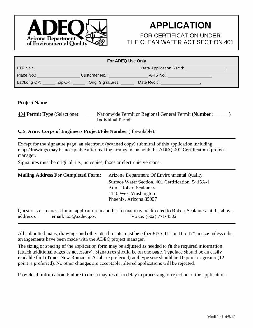
APPLICATION
FOR CERTIFICATION UNDER THE CLEAN WATER ACT SECTION 401
For ADEQ Use Only
LTF No.: Date Application Rec’d: .
Place No.: Customer No.: AFIS No.: .
Lat/Long OK: Zip OK: Orig. Signatures: Date Rec’d: .
Project Name: 404 Permit Type (Select one): ____ Nationwide Permit or Regional General Permit (Number: ______) ____ Individual Permit U.S. Army Corps of Engineers Project/File Number (if available):
Except for the signature page, an electronic (scanned copy) submittal of this application including maps/drawings may be acceptable after making arrangements with the ADEQ 401 Certifications project manager. Signatures must be original; i.e., no copies, faxes or electronic versions.
Mailing Address For Completed Form: Arizona Department Of Environmental Quality
Surface Water Section, 401 Certification, 5415A-1 Attn.: Robert Scalamera 1110 West Washington Phoenix, Arizona 85007
Questions or requests for an application in another format may be directed to Robert Scalamera at the above address or: email: [email protected] Voice: (602) 771-4502
All submitted maps, drawings and other attachments must be either 8½ x 11” or 11 x 17” in size unless other arrangements have been made with the ADEQ project manager. The sizing or spacing of the application form may be adjusted as needed to fit the required information (attach additional pages as necessary). Signatures should be on one page. Typeface should be an easily readable font (Times New Roman or Arial are preferred) and type size should be 10 point or greater (12 point is preferred). No other changes are acceptable; altered applications will be rejected. Provide all information. Failure to do so may result in delay in processing or rejection of the application.
Modified: 4/5/12

Project Name: Notes:
Waters of the U.S. (WUS) as defined by the Corps of Engineers and U.S. Environmental Protection Agency under the Clean Water Act. This certification applies only to activities in any potentially impacted WUS.
303[d]-listed Impaired Waters are surface waters that are identified pursuant to Clean Water Act (CWA) Section 303[d] as impaired (e.g., not meeting surface water quality standards) and as a result merit special consideration. The current 303[d] list of Impaired Waters is available on the ADEQ website via: http://www.azdeq.gov/index.html
Outstanding Arizona Waters (OAW) are surface waters classified as an outstanding state resource water by the ADEQ Director pursuant to the Arizona Administrative Code (A.A.C.) R18-11-112. These waters are of exceptional quality and therefore merit special consideration. The current list of OAW is available on the ADEQ website via: http://www.azdeq.gov/index.html
Temporary means not longer than the time required to complete the subject activities.
Native material/fill is defined as pollutant-free soil, sand, gravel, etc. that constitutes the streambed or adjacent banks in the immediate area of the permitted work.
Project Site Location Information Street Address (If available. For projects encompassing multiple addresses, either “n/a” or on-site office address acceptable.): City/town (indicate if near rather than within municipal boundaries): County: Site Zip code: Site telephone (if available): Approximate Center of Project (In degrees, minutes, seconds): Latitude: ' " Longitude: ' " Directions to project location (from nearest intersection of major streets/highways). Include maps or drawings displaying location relative to state boundaries and nearby cities, highways, waterbodies, etc.
Impacted and downstream waterbody(ies) (from Water Quality Standards for Surface Waters [18 A.A.C. 11, Article 1], otherwise use “unnamed” or “unnamed tributary to”). Include flow regime (ephemeral, intermittent or perennial), name of downstream waterbody(ies) and name of watershed (from 18 A.A.C. 11, Article 1). Example: Deluge Wash (ephemeral) and several unnamed ephemeral washes, all tributary to the Big Sandy River, in the Bill Williams River Watershed:
Modified: 4/5/12
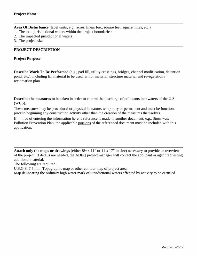
Project Name:
Area Of Disturbance (label units; e.g., acres, linear feet, square feet, square miles, etc.) 1. The total jurisdictional waters within the project boundaries: . 2. The impacted jurisdictional waters: . 3. The project size:
PROJECT DESCRIPTION Project Purpose: Describe Work To Be Performed (e.g., pad fill, utility crossings, bridges, channel modification, detention pond, etc.), including fill material to be used, armor material, structure material and revegetation / reclamation plan. Describe the measures to be taken in order to control the discharge of pollutants into waters of the U.S. (WUS). These measures may be procedural or physical in nature, temporary or permanent and must be functional prior to beginning any construction activity other than the creation of the measures themselves. If, in lieu of entering the information here, a reference is made to another document; e.g., Stormwater Pollution Prevention Plan, the applicable portions of the referenced document must be included with this application.
Attach only the maps or drawings (either 8½ x 11” or 11 x 17” in size) necessary to provide an overview of the project. If details are needed, the ADEQ project manager will contact the applicant or agent requesting additional material. The following are required: U.S.G.S. 7.5 min. Topographic map or other contour map of project area. Map delineating the ordinary high water mark of jurisdictional waters affected by activity to be certified.
Modified: 4/5/12

Modified: 4/5/12
Project Name: APPLICANT INFORMATION (Complete all that apply. Use “N/A” for not applicable) Applicant Name: Title: Company, Agency, etc: Phone Number: email address: Mailing Address: City: State: Zip Code: I have reviewed the Arizona Water Quality Standards for Surface Waters (18 A.A.C. 11, Article 1) (available through www.azdeq.gov). Application is hereby made for Arizona certification under CWA section 401 for the above-named project. I certify that I am familiar with the information contained or referenced in this application and that the information is true, accurate and complete. Applicant’s Signature: Date: . (delete this section if not applicable) I hereby authorize (agent) to act in my behalf in the processing of this application and to furnish any supplemental information in support of this application. I understand that I am bound by the actions of my agent. Applicant’s Signature: Date: . Agent Name: Title: Company, Agency, etc: Phone Number: email address: Mailing Address: City: State: Zip Code: Agent’s Signature: Date: . (delete this section if applicant is property owner) Property Owner Name: Title: Company, Agency, etc: Phone Number: email address: Mailing Address: City: State: Zip Code: Property Owner’s Signature: Date: .

D2
EPA FACSIMILE LISTING REQUIRED COMPONENTS OF AN INDIVIDUALCERTIFICATION APPLICATION TO EPA (REPRODUCED FOR PRINTING; EPA
1999)
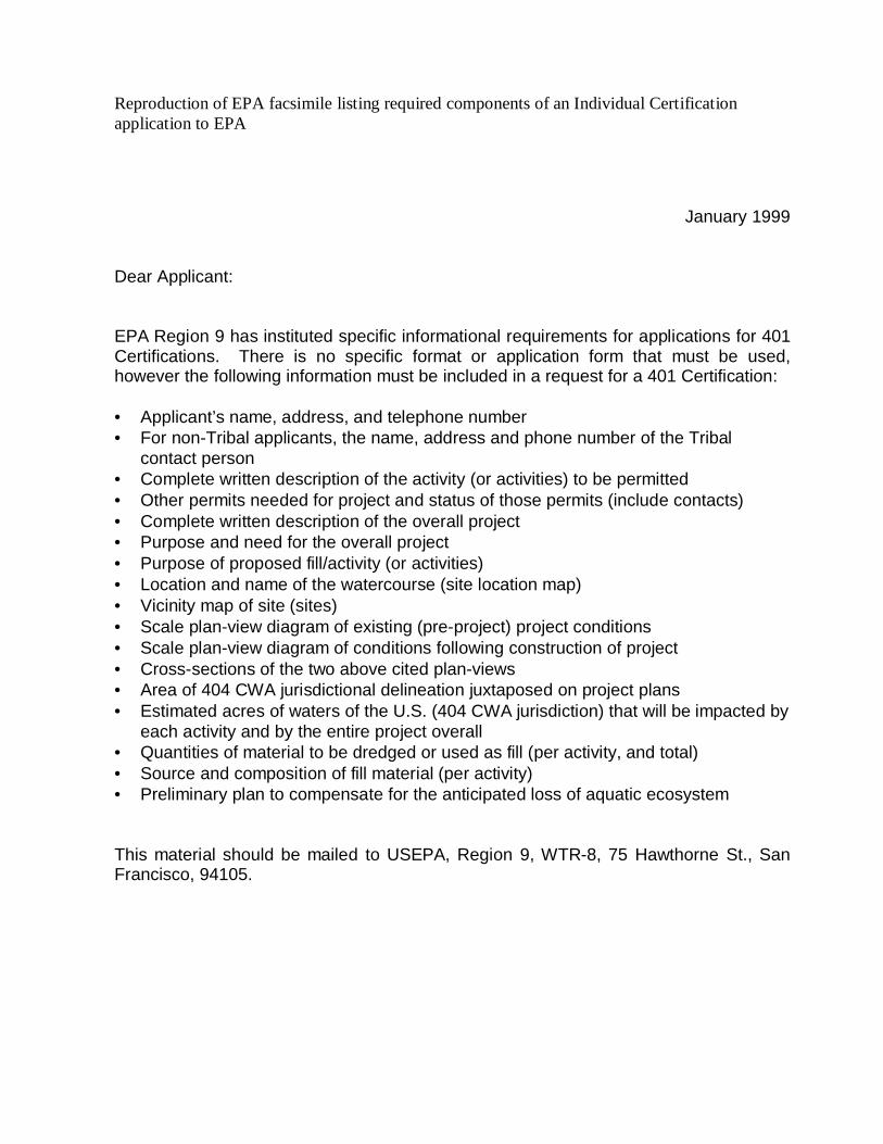
Reproduction of EPA facsimile listing required components of an Individual Certificationapplication to EPA
January 1999
Dear Applicant:
EPA Region 9 has instituted specific informational requirements for applications for 401Certifications. There is no specific format or application form that must be used,however the following information must be included in a request for a 401 Certification:
• Applicant’s name, address, and telephone number• For non-Tribal applicants, the name, address and phone number of the Tribal
contact person• Complete written description of the activity (or activities) to be permitted• Other permits needed for project and status of those permits (include contacts)• Complete written description of the overall project• Purpose and need for the overall project• Purpose of proposed fill/activity (or activities)• Location and name of the watercourse (site location map)• Vicinity map of site (sites)• Scale plan-view diagram of existing (pre-project) project conditions• Scale plan-view diagram of conditions following construction of project• Cross-sections of the two above cited plan-views• Area of 404 CWA jurisdictional delineation juxtaposed on project plans• Estimated acres of waters of the U.S. (404 CWA jurisdiction) that will be impacted by
each activity and by the entire project overall• Quantities of material to be dredged or used as fill (per activity, and total)• Source and composition of fill material (per activity)• Preliminary plan to compensate for the anticipated loss of aquatic ecosystem
This material should be mailed to USEPA, Region 9, WTR-8, 75 Hawthorne St., SanFrancisco, 94105.
APPENDIX E
IN-LIEU FEE PROCEDURES