clause 9 14. 2. 2013 lyttelton/mt herbert community …
TRANSCRIPT
CLAUSE 9 14. 2. 2013
LYTTELTON/MT HERBERT COMMUNITY BOARD
15 NOVEMBER 2012
Report of a meeting of the Lyttelton/Mt Herbert Community Board held on Thursday 15 November 2012 at 1.30pm in the
Boardroom, Lyttelton Service Centre, 15 London Street, Lyttelton
PRESENT: Paula Smith (Chairperson), Jeremy Agar, Ann Jolliffe, Claudia Reid, Adrian Te Patu and Andrew Turner.
APOLOGY: Nil. KARAKIA: Adrian Te Patu gave the opening karakia. A warm welcome and best wishes were extended to Councillor Claudia Reid on her return from sick leave. The Board reports that: PART B - REPORTS FOR INFORMATION 1. DEPUTATIONS BY APPOINTMENT
1.1 CENSUS 2013 – NIKKI HAWKEY, COMMUNITY ENGAGEMENT MANAGER
Nikki Hawkey, Community Engagement Manager briefed the Board on the 2013 Census and what it will mean to local communities.
1.2 JAMES ENSOR AND ROGER ALLEN – NAVAL POINT BREAKWATER
James Ensor addressed the Board regarding the Seaflex breakwater proposal for Naval Point
expressing concern at the ongoing delay to get a suitable and safe all weather, all tides boat launching/retrieval and mooring facility at Lyttelton for recreational boats.
A public meeting has been organised for Monday 26 November 2012 at Naval Point Club to
discuss the matter and Council staff have advised they will be attending.
1.3 JAN TITUS – TIMEBALL STATION
Jan Titus, Manager of the Timeball Station for the Historic Places Trust addressed the Board regarding a proposal to erect a part of the new Timeball station. It is proposed to commence consultation from December 2012 to gauge opinion and feedback on whether the community will support the proposal. A large amount of money has been pledged solely for this project providing there is support in the community.
2. CORRESPONDENCE
Nil.
97
14. 2. 2013
Lyttelton/Mt Herbert Community Board 15. 11. 2012
- 2 -
3. PETITIONS Nil. 4. NOTICES OF MOTION Nil. 5. BRIEFINGS
Nil. 6. COMMUNITY BOARD ADVISER’S UPDATE
The Board received information from the Community Board Adviser on various matters. The meeting adjourned at 2.50pm and resumed at 3.05pm. 7. ELECTED MEMBERS’ INFORMATION EXCHANGE Specific mention was made of the following matters:
Information was received regarding the Saturday morning Lyttelton Farmers’ Market moving to a new location on London Street from 17 November 2012. Part of London Street would be temporarily closed each Saturday for the market to take place there.
The Board decided to request regular briefings at its formal meetings from staff working on the
implementation of the Lyttelton Master Plan. 8. QUESTIONS UNDER STANDING ORDERS Nil. PART C - REPORT ON DELEGATED DECISIONS 9. CONFIRMATION OF MEETING MINUTES
The Board resolved that the minutes of its meeting held on 18 October 2012 be confirmed. 10. APPLICATION TO LYTTELTON/MT HERBERT COMMUNITY BOARD 2012/13 DISCRETIONARY
RESPONSE FUND
The Board considered a report seeking consideration of two funding requests for the Governors Bay Pottery Group for the purchase of a kiln and the Otamahua/Quail Island Ecological Restoration Trust for transport costs for volunteers.
The Board resolved to:
(a) Approve a grant of $3,210 from its 2012/13 Discretionary Response Fund to Governors Bay
Pottery Group for the purchase of a pottery kiln.
98

14. 2. 2013
Lyttelton/Mt Herbert Community Board 15. 11. 2012
- 3 -
10 Cont’d (b) Approve a grant of $4,000 from its 2012/13 Discretionary Response Fund to Otamahua/Quail
Island Ecological Restoration Trust towards transport costs for volunteers. 11. APPLICATION TO LYTTELTON/MT HERBERT COMMUNITY BOARD 2012/13 DISCRETIONARY
RESPONSE FUND – LYTTELTON RESERVES MANAGEMENT COMMITTEE
The Board considered a report seeking funding for the Lyttelton Reserves Management Committee for a memorial.
The Board resolved to approve a grant of $1,500 from its 2012/13 Discretionary Response Fund to the Lyttelton Reserves Management Committee for the Gary Broker Memorial towards purchase and installation of a seat and a plaque.
12. APPLICATION TO LYTTELTON/MT HERBERT COMMUNITY BOARD 2012/13 DISCRETIONARY
RESPONSE FUND – LYTTELTON VOLUNTEER FIRE BRIGADE
The Board considered a report seeking funding for the Lyttelton Volunteer Fire Brigade for a book launch event
The Board resolved to approve a grant of $1,500 from its 2012/13 Discretionary Response Fund to the Lyttelton Volunteer Fire Brigade towards Lyttelton Volunteer Fire Brigade's book launch event and requested that a copy of the book be obtained for display in the Board’s meeting room.
13. LYTTELTON/MT HERBERT COMMUNITY BOARD 2012/13 RECESS COMMITTEE
The Board resolved: (a) That a Lyttelton/Mt Herbert Community Board Recess Committee comprising a minimum of
three members including either the Board Chairperson or Deputy Chairperson, be authorised to exercise the delegated powers of the Lyttelton/Mt Herbert Community Board for the period following its ordinary meeting on 13 December 2012 up until the Board resumes normal business in February 2013.
(b) That the application of any such delegation be reported back to the Board for record purposes. 14. LYTTELTON/MT HERBERT COMMUNITY BOARD 2013 MEETING DATES
The Board resolved to adopt a schedule of ordinary meeting dates up to September 2013 to be held at 1.30pm in the Board Room, Lyttelton Service Centre, 15 London Street, Lyttelton as follows:
Thursday 21 February 2013 Thursday 21 March 2013 Thursday 18 April 2013 Thursday 23 May 2013 Thursday 20 June 2013 Thursday 18 July 2013 Thursday 22 August 2013 Thursday 19 September 2013
99

14. 2. 2013
Lyttelton/Mt Herbert Community Board 15. 11. 2012
- 4 -
15. COMMUNITY BOARD ADVISER’S UPDATE - CONTINUED
15.1 DRAFT WASTEWATER STRATEGY 2012 - SUBMISSION The Board resolved to adopt its submission to the Draft Wastewater Strategy 2012. The meeting closed at 3.47pm. CONFIRMED THIS 13TH DAY OF DECEMBER 2012 PAULA SMITH CHAIRPERSON
100
CLAUSE 10
14. 2. 2013
RICCARTON/WIGRAM COMMUNITY BOARD 27 NOVEMBER 2012
Report of a meeting of the Riccarton/Wigram Community Board
held on Tuesday 27 November at Riccarton House 16 Kahu Road, Riccarton, Christchurch
PRESENT: Mike Mora (Chairperson), Helen Broughton, Natalie Bryden, Jimmy Chen, Judy Kirk and Peter Laloli
APOLOGIES: An apology for absence was received and accepted from Sam Johnson.
An apology for early departure was received and accepted from Helen Broughton who departed at 6.30pm and was absent for Clauses 1-9, and 11-18 inclusive.
The Board reports that: PART B - REPORTS FOR INFORMATION 1. ILAM ROAD UNIVERSITY CROSSINGS
This matter was presented to the 6 December 2012 Council Meeting by way of a Chairperson’s report. (Note: Clause 1 (Part C) (Cont) of these minutes refers to the Board’s decision on the Ilam Road
Signalised Crossing.) 2. DEPUTATIONS BY APPOINTMENT 2.1 NIKKI HAWKEY – CENSUS 2013 Nikki Hawkey, Community Engagement Manager, Census updated the Board on the
2013 Census, providing information on what the census means for local communities, how the community can work together to ensure everyone counts and recruitment opportunities for Census staff from within the ward.
Following questions from members the Chairperson thanked Ms Hawkey for her deputation. 3. PRESENTATION OF PETITIONS Mike Mora presented a petition signed by Wigram residents the prayer of which read: Petition against
boy racers and heavy traffic on Neill Street. It was decided that the petition be referred to staff who will report to report to the Board’s Transport and Greenspace Committee.
4. NOTICES OF MOTION Nil.
101

14. 2. 2013
Riccarton/Wigram Community Board 27. 11. 2012
- 2 -
5. CORRESPONDENCE The Board received correspondence from the following: (a) A letter and petition from the Wigram Residents’ Association regarding boy racers and heavy
traffic on Neill Street. and parking at the Main South Road end of Neill Street. The letter acknowledged the prompt attention given to a recent request by the residents’ association to remove the “staple” from Oakhampton Reserve.
(b) A letter from the Halswell Residents’ Association regarding Muir Park and a recent Council
maintenance programme which has seen the vegetation from the borders removed and no replacement planting done. The residents requested that shrubs be replanted along the fence on the south side of the Park and under the trees to the north to replace the vegetation that was removed. The letter also suggested that the protruding manhole in the reserve to be covered by a seat or some soil and plantings in order to remove the dangerous hazard to users of the Park.
The Board was advised that there will be bulbs planted in place of the vegetation that was
removed from under the trees and a low plant garden will be established around the manhole to camouflage it.
6. BRIEFINGS 6.1 SOUTH WEST SPORTS HUB Kevin Collier, Sports Services Manager, briefed the Board on the proposed South West Sports
Hub. Members expressed disappointment that the Board had not had the opportunity to provide input
into the suggested site for the South West Sports Hub. Following questions from members the Chairperson thanked staff for the briefing. 6.2 STRENGTHENING COMMUNITIES TEAM SOUTHERN - COMMUNITY PROFILES Staff from the Southern Strengthening Communities Team briefed the Board on the
2012 Community Profiles and advised that an expo for all Community Boards and the Community will be held in February 2013.
The Board expressed disappointment at not having been invited to provide input to the project
prior to the documentation going to print and asked that it be given the opportunity in the future. The Chairperson thanked the staff for their presentation. 7. COMMUNITY BOARD ADVISER’S UPDATE 7.1. SOUTH WEST AREA PLAN (SWAP) BUS TRIP Board members were reminded and updated about the arranged bus trip on Friday 30
November to look at current projects being worked on under the South West Area Plan. 7.2. PLAN CHANGE REQUEST – 4 DEANS AVENUE Following the Board’s request for staff advice on how the Community Board could initiate a Plan
Change with the Council it was advised that the developer could initiate a Plan Change himself in order to progress developments. The Board is also able to put a recommendation to the Council to consider a Council Plan Change.
102

14. 2. 2013
Riccarton/Wigram Community Board 27. 11. 2012
- 3 -
7 Cont’d 7.3 NEW ZEALAND COMMUNITY BOARDS’ CONFERENCE 2013 – BEST PRACTICE AWARDS The Board was invited to consider an entry for the Best Practice Awards being run in
conjunction with the 2013 Community Boards Conference to be held in Wanaka in May 2013. 8. ELECTED MEMBERS’ INFORMATION EXCHANGE Mention was made of the following matters:
The Chairperson of the Transport and Greenspace Committee, Peter Laloli, advised the Board that owing to his new position within the New Zealand Police, he would have a conflict being the Chairperson of the Committee but he was able to remain as a Committee member. The Board agreed to replace the Chairperson of the Committee.
The Board were advised that the Council voted not to install temporary walk–in customer
services at Hornby.
Owaka Pit: Board members discussed the ongoing issues with Owaka Pit. The Board requested that a meeting be held with the Council Enforcement Staff, the owner of Owaka Pit to discuss the surrounding residents’ ongoing concerns.
9. QUESTIONS UNDER STANDING ORDERS Nil. PART C - DELEGATED DECISIONS 10. CONFIRMATION OF MEETING MINUTES – 30 OCTOBER 2012 AND 13 NOVEMBER 2012 (a) The Board resolved that the minutes of its 30 October 2012 meeting be approved subject to
Peter Laloli requesting that his vote against the resolution to let the Yaldhurst Village proposed road name lie on the table, be recorded.
(b) The Board resolved that the minutes of its 13 November 2012 meeting, be adopted. 1. (CONT’D) ILAM ROAD UNIVERSITY CROSSINGS
Further to Clause 1 of this report, the Board resolved to approve the parking restrictions and revocations to take effect following completion of construction and the Discretionary Activity Resource Consent, subject to the Council approving the proposed University Crossing Safety Improvement Scheme in Ilam Road, as follows:
(a) Revoke existing parking restrictions as follows: (i) That any existing parking restriction on the east side of Ilam Road commencing at its
intersection with Kirkwood Avenue and extending in a northerly direction to the intersection of Creyke Road be revoked.
103
14. 2. 2013
Riccarton/Wigram Community Board 27. 11. 2012
- 4 -
1 Cont’d (ii) That any existing parking restriction on the west side of Ilam Road commencing at its
intersection with Rountree Street and extending in a northerly direction to the intersection of Maidstone Road be revoked.
(iii) That any existing parking restriction on the west side of Ilam Road commencing at its
intersection with Rountree Street and extending in a southerly direction for a distance of 38 metres be revoked.
(iv) That any existing parking restriction on the south side of Rountree Street commencing at
its intersection with Ilam Road and extending in a westerly direction for a distance of 70 metres be revoked.
(v) That any existing parking restriction on the north side of Rountree Street commencing at
its intersection with Ilam Road and extending in a westerly direction for a distance of 10 metres be revoked.
(vi) That any existing parking restriction on the north side of Kirkwood Avenue commencing at
its intersection with Ilam Road and extending in an easterly direction for a distance of 26 metres be revoked.
(vii) That any existing parking restriction on the north side of Montana Avenue commencing at
its intersection with Ilam Road and extending in an easterly direction for a distance of 16 metres be revoked.
(viii) That any existing parking restriction on the south side of Montana Avenue commencing at
its intersection with Ilam Road and extending in an easterly direction for a distance of 16 metres be revoked.
(b) Revoke existing Give Ways as follows: (i) That the Give Way control currently placed against Montana Avenue at its intersection
with Ilam Road be revoked. (ii) That the Give Way control currently placed against Kirkwood Avenue at its intersection
with Ilam Road be revoked. (iii) That the Give Way control currently placed against Rountree Street at its intersection with
Ilam Road be revoked. (iv) That the Give Way control currently placed against Science Road at its intersection with
Ilam Road be revoked. (v) That the Give Way control currently placed against University Drive at its intersection with
Ilam Road be revoked. (vi) That the Give Way control currently placed against Homestead Lane at its intersection
with Ilam Road be revoked. (c) Revoke existing pedestrian crossing as follows: (i) That the existing pedestrian crossing on Ilam Road, located at a point 37 metres north of
its intersection with Rountree Street be revoked. (d) Install pedestrian crossings as follows: (i) That a pedestrian crossing be duly established and marked in accordance with
Section 8.2 of the Land Transport Rule - Traffic Control Devices: 2004 on Ilam Road, located at a point 122 metres south of its intersection with Montana Avenue.
104

14. 2. 2013
Riccarton/Wigram Community Board 27. 11. 2012
- 5 -
1 Cont’d (ii) That a pedestrian crossing be duly established and marked in accordance with
Section 8.2 of the Land Transport Rule - Traffic Control Devices: 2004 on Ilam Road, located at a point 327 metres south of its intersection with Montana Avenue.
(iii) That a pedestrian crossing be duly established and marked in accordance with Section
8.2 of the Land Transport Rule - Traffic Control Devices: 2004 on Ilam Road, located at a point 37 metres north of its intersection with Rountree Street.
(e) Install parking restrictions as follows: (i) That the stopping of vehicles be prohibited at any time on the north side of Kirkwood
Avenue commencing at its intersection with Ilam Road and extending in an easterly direction for a distance of 27 metres.
(ii) That the stopping of vehicles be prohibited at any time on the east side of Ilam Road
commencing at its intersection with Kirkwood Avenue and extending in a northerly direction for a distance of 13.5 metres.
(iii) That the parking of vehicles be restricted to a maximum period of 30 minutes on the east
side of Ilam Road commencing at a point 13.5 metres north of its intersection with Kirkwood Avenue and extending in a northerly direction for a distance of 17.5 metres.
(iv) That the stopping of vehicles be prohibited at any time on the east side of Ilam Road
commencing at a point 31 metres north of its intersection with Kirkwood Avenue extending in a northerly direction for a distance of 77 metres.
(v) That a school bus stop be created on the east side of Ilam Road commencing at a point
108 metres north of its intersection with Kirkwood Avenue and extending in a northerly direction for a distance of 16 metres.
(vi) That the stopping of vehicles be prohibited at any time on the east side of Ilam Road
commencing at a point 124 metres north of its intersection with Kirkwood Avenue extending in a northerly direction for a distance of 10 metres.
(vii) That the parking of vehicles be restricted to a maximum period of 30 minutes on the east
side of Ilam Road commencing at a point 134 metres north of its intersection with Kirkwood Avenue and extending in a northerly direction for a distance of 49 metres. This restriction is to apply from 9:00am to 2:30pm School Days Only.
(viii) That the parking of vehicles be restricted to a maximum period of three minutes on the
east side of Ilam Road commencing at a point 134 metres north of its intersection with Kirkwood Avenue and extending in a northerly direction for a distance of 49 metres. This restriction is to apply from 8:00am to 9:00am and 2:30pm to 3:30pm, School Days Only.
(ix) That the stopping of vehicles be prohibited at any time on the east side of Ilam Road
commencing at a point 183 metres north of its intersection with Kirkwood Avenue extending in a northerly direction for a distance of 75 metres.
(x) That a bus stop be installed on the east side of Ilam Road commencing at a point
258 metres north of its intersection with Kirkwood Avenue extending in a northerly direction for a distance of 58 metres.
(xi) That the stopping of vehicles be prohibited at any time on the east side of Ilam Road
commencing at a point 316 metres north of its intersection with Kirkwood Avenue extending in a northerly direction for a distance of 370 metres.
(xii) That a bus stop be installed on the east side of Ilam Road commencing at a point
686 metres north of its intersection with Kirkwood Avenue extending in a northerly direction for a distance of 14 metres.
105

14. 2. 2013
Riccarton/Wigram Community Board 27. 11. 2012
- 6 -
1 Cont’d (xiii) That the stopping of vehicles be prohibited at any time on the east side of Ilam Road
commencing at a point 700 metres north of its intersection with Kirkwood Avenue extending in a northerly direction to the intersection of Montana Avenue.
(xv) That the stopping of vehicles be prohibited at any time on the south side of
Montana Avenue commencing at its intersection with Ilam Road and extending in an easterly direction for a distance of 16 metres.
(xvi) That the stopping of vehicles be prohibited at any time on the north side of
Montana Avenue commencing at its intersection with Ilam Road and extending in an easterly direction for a distance of 16 metres.
(xvii) That the stopping of vehicles be prohibited at any time on the east side of Ilam Road
commencing at its intersection with Montana Avenue and extending in a northerly direction to the intersection of Creyke Road.
(xviii) That the stopping of vehicles be prohibited at any time on the west side of Ilam Road
commencing at its intersection with Rountree Street and extending in a southerly direction for a distance of 38 metres.
(xix) That the stopping of vehicles be prohibited at any time on the south side of
Rountree Street commencing at its intersection with Ilam Road and extending in a westerly direction for a distance of 72 metres.
(xx) That the stopping of vehicles be prohibited at any time on the north side of Rountree
Street commencing at its intersection with Ilam Road and extending in a westerly direction for a distance of 10 metres.
(xxi) That the stopping of vehicles be prohibited at any time on the west side of Ilam Road
commencing at its intersection with Rountree Street and extending in a northerly direction for a distance of 11 metres.
(xxii) That the parking of vehicles be restricted to a maximum period of 10 minutes on the west
side of Ilam Road commencing at a point 11 metres north of its intersection with Rountree Street and extending in a northerly direction for a distance of 11 metres.
(xxiii) That the stopping of vehicles be prohibited at any time on the west side of Ilam Road
commencing at a point 22 metres north of its intersection with Rountree Street extending in a northerly direction for a distance of 240 metres.
(xxiv) That a bus stop be installed on the west side of Ilam Road commencing at a point
262 metres north of its intersection with Rountree Street extending in a northerly direction for a distance of 50 metres.
(xxv) That the stopping of vehicles be prohibited at any time on the west side of Ilam Road
commencing at a point 312 metres north of its intersection with Rountree Street extending in a northerly direction for a distance of 76 metres.
(xxvi) That the stopping of vehicles be prohibited at any time on the west side of Ilam Road
commencing at a point 497 metres north of its intersection with Rountree Street extending in a northerly direction for a distance of 21 metres.
(xxvii) That the stopping of vehicles be prohibited at any time on the west side of Ilam Road
commencing at a point 550 metres north of its intersection with Rountree Street extending in a northerly direction for a distance of 17.5 metres.
(xxviii) That the stopping of vehicles be prohibited at any time on the west side of Ilam Road
commencing at a point 586 metres north of its intersection with Rountree Street extending in a northerly direction for a distance of 12 metres.
106

14. 2. 2013
Riccarton/Wigram Community Board 27. 11. 2012
- 7 -
1 Cont’d (xxx) That a bus stop be installed on the west side of Ilam Road commencing at a point
598 metres north of its intersection with Rountree Street extending in a northerly direction for a distance of 28 metres.
(xxxi) That the stopping of vehicles be prohibited at any time on the west side of Ilam Road
commencing at a point 626 metres north of its intersection with Rountree Street extending in a northerly direction to the intersection of Maidstone Road.
(f) Install Give Ways (i) That a Give Way control be placed against Montana Avenue at its intersection with
Ilam Road. (ii) That a Give Way control be placed against Kirkwood Avenue at its intersection with
Ilam Road. (iii) That a Give Way control be placed against Rountree Street at its intersection with
Ilam Road. (iv) That a Give Way control be placed against Science Road at its intersection with
Ilam Road. (v) That a Give Way control be placed against University Drive at its intersection with
Ilam Road. (vi) That a Give Way control be placed against Homestead Lane at its intersection with
Ilam Road. 11. CARBINE PLACE – PROPOSED NO STOPPING The Board considered a report recommending the installation of a No Stopping Restriction on Carbine
Place. The Board resolved to approve: (a) That the stopping of vehicles currently prohibited at any time on the north side of Carbine Place
commencing at its intersection with Epsom Road and extending in a easterly direction for eight metres be revoked.
(b) That the stopping of vehicles be prohibited at any time on the north side of Carbine Place
commencing at its intersection with Epsom Road and extending in a easterly direction for 17 metres.
12. ANNEX ROAD, BIRMINGHAM DRIVE AND WRIGHTS ROAD: PROPOSED BUS STOPS The Board considered a report recommending that it approve the existing bus stops along a bus route
that encompasses Annex Road, Birmingham Drive and Wrights Road.
The Board resolved: Bus Stops A as identified on attached Plan TG123801 and TG123801a: (a) That a bus stop be installed on the northeast side of Annex Road commencing at a point
170 metres southeast of its intersection with Blenheim Road and extending in a south easterly direction for a distance of 14 metres.
107

14. 2. 2013
Riccarton/Wigram Community Board 27. 11. 2012
- 8 -
12 Cont’d (b) That the stopping of vehicles be prohibited at any time on the northeast side of Annex Road
commencing at a point 162 metres southeast of its intersection with Blenheim Road and extending in a south easterly direction for a distance of eight metres.
(c) That a bus stop be installed on the southwest side of Annex Road commencing at a point
146 metres southeast of its intersection with Blenheim Road and extending in a south easterly direction for a distance of 14 metres.
(d) That the stopping of vehicles be prohibited at any time on the southwest side of Annex Road
commencing at a point 160 metres southeast of its intersection with Blenheim Road and extending in a south easterly direction for a distance of 8 metres.
Bus Stop B as identified on attached Plan TG123801 and TG123801b: (e) That a bus stop be installed on the southwest side of Annex Road commencing at a point
159 metres northwest of its intersection with Magdala Place and extending in a north westerly direction for a distance of 14 metres.
(f) That the stopping of vehicles be prohibited at any time on the southwest side of Annex Road
commencing at a point 151 metres northwest of its intersection with Magdala Place and extending in a north westerly direction for a distance of 8 metres.
13. APPLICATION TO THE RICCARTON WIGRAM 2012/13 YOUTH DEVELOPMENT SCHEME –
CONNIE LOUISE DICK The Board considered a report seeking Board approval for funding from its 2012/13 Youth
Development Scheme for Connie Louise Dick. The Board resolved to allocate $250 from its Youth Development Scheme towards travel costs for
Connie Louise Dick to coach at the Great Murray River Basketball Jamboree. 14. APPLICATION TO THE RICCARTON WIGRAM 2012/13 YOUTH DEVELOPMENT SCHEME –
BRAYDEN DRUMMOND
The Board considered a report seeking Board approval for funding from its 2012/13 Youth Development Scheme for Brayden Drummond.
The Board resolved to allocate $280 from its Youth Development Scheme to Brayden Drummond as a contribution towards his trip with the Canterbury Caledonian Pipe Band’s to the Pipe Band World Championships in Glasgow, Scotland.
15. APPLICATION TO THE RICCARTON WIGRAM COMMUNITY BOARD 2012/13 DISCRETIONARY
RESPONSE FUND The Board considered a report seeking Board approval for funding from its 2012/13 Discretionary
Response Fund for the University of Canterbury Athletics Club Incorporated. The Board resolved to allocate $823 to the University of Canterbury Athletics Club Inc. from its
2012/13 Youth Development Scheme for the delivery of costs of the Junior Athletics Club Programme. 16. RICCARTON WIGRAM COMMUNITY BOARD REPORT – RECESS COMMITTEE 2012/13 The Board considered a report seeking Board approval to put in place delegation arrangements for
making of any required decisions (including applications for funding) that would otherwise be dealt with by the Board, covering the period following its final scheduled meeting or the year on 11 December 2012 up until the resumption of its ordinary meetings in January 2013.
108
14. 2. 2013
Riccarton/Wigram Community Board 27. 11. 2012
- 9 -
16 Cont’d The Board resolved: (a) That a Recess Committee, comprising of the Board Chairperson or Deputy Chairperson and
any two Board members, be authorised to exercise the delegated powers of the Riccarton/Wigram Community Board for the period following its ordinary meeting on 13 December 2012 up until the Board resumes normal business in late January 2013.
(b) That the application of any such delegation be reported back to the Board for record purposes. 17. RICCARTON WIGRAM COMMUNITY BOARD – 2013 MEETING SCHEDULE The Board considered a report recommending that it adopt the ordinary meeting dates from February
to September 2013. The Board resolved to adopt the ordinary meeting dates, Transport and Greenspace Committee
meeting dates and a Small Grants Committee Committee meeting as follows: Tuesday 22 January 2013 Tuesday 5 February 2013 Tuesday 19 February 2013 Tuesday 5 March 2013 Tuesday 19 March 2013 Tuesday 2 April 2013 Tuesday 16 April 2013 Tuesday 7 May 2013 Tuesday 21 May 2013 Tuesday 4 June 2013 Tuesday 18 June 2013 Tuesday 2 July 2013 Tuesday 16 July 2013 (Strengthening Communities Funding Decisions) Tuesday 6 August 2013 Tuesday 20 August 2013 Tuesday 3 September 2013 Tuesday 17 September 2013 Meeting schedule of Transport and Greenspace Committee Meetings up to August 2013 to be held at
9.00 am (4.00 pm on Friday 10 May) at the Upper Riccarton Library, 71 Main South Road, Upper Riccarton as follows:
Friday 22 February 2013 Friday 22 March 2013 Friday 19 April 2013 Friday 10 May 2013 (4.00 p.m.) Friday 21 June 2013 Friday 12 July 2013 Friday 23 August 2013 Small Grants Committee Meeting on 21 August at 3.00 p.m. 18. COMMUNITY BOARD ADVISER’S UPDATE CONTINUED 18.1 RICCARTON/WIGRAM YOUTH DEVELOPMENT SCHEME CRITERIA The Board considered the reviewed Youth Development Criteria guidelines that were presented
in the Community Board Adviser’s Update.
109

14. 2. 2013
Riccarton/Wigram Community Board 27. 11. 2012
- 10 -
18 Cont’d The Board resolved to approved the proposed 2013 Youth Development Criteria Guidelines to
be valid from 1 July 2013. The Board Chairperson thanked Board members and staff for their attendance and contributions and declared the meeting closed at 7.36 pm. CONFIRMED THIS 11TH DAY OF DECEMBER 2012 MIKE MORA CHAIRPERSON
110
CLAUSE 11
14. 2. 2013
RICCARTON/WIGRAM COMMUNITY BOARD 11 DECEMBER 2012
Report of a meeting of the Riccarton/Wigram Community Board held on 11 December 2012 at 5.30pm
in the Community Room, Upper Riccarton Library. PRESENT: Mike Mora (Chairperson), Natalie Bryden, Jimmy Chen, Judy Kirk and
Peter Laloli. APOLOGIES: Apologies for absence were received and accepted from Helen Broughton and
Sam Johnson. The Board reports that: PART A – MATTERS REQUIRING A COUNCIL DECISION 1. CLYDE ROAD - SIGNALISED CROSSING AT HINAU STREET
General Manager responsible: General Manager City Environment Group, DDI 941-8608
Officer responsible: Unit Manager, Transport & Greenspace
Author: Michael Thomson, Senior Traffic Engineer & Philippa Upton, Consultation Leader
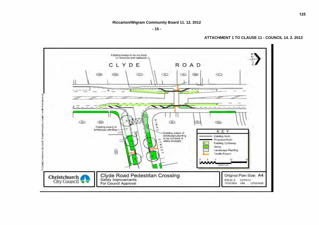
PURPOSE OF REPORT 1. The purpose of this report is to seek the Council’s approval for a signalised pedestrian crossing
in Clyde Road at Hinau Street. (refer Attachment 1). EXECUTIVE SUMMARY 2. The Council staff have facilitated the production of a School Travel Plan for Ilam School. As
part of the school community consultation, there was considerable concern raised about the safety and convenience of the existing crossing facility on Clyde Road, just north of Hinau Street. Ilam School has a significant number of children who live to the east of the school, who need to cross Clyde Road when travelling to/from school by bike or on foot.
3. This crossing point is also used by students from Kirkwood Intermediate, which also has an
entrance on Kirkwood Avenue, and also used by University of Canterbury students. 4. This crossing is on the strategic cycling route from Hagley Park to the University, and would
complement other facilities on this route. For example, signalised crossings exist across Straven Road by Matai Street West and across the railway line at Mona Vale.
5. Clyde Road is classified as a collector road in the City Plan. At this site, Clyde Road has an
average weekday daily traffic volume of 15,200 vehicles per day, recorded in May 2011. This volume is above the desirable for a collector road which is 3,000-6,000 vehicles per day. Further to this, the morning peak traffic volume average (0800 – 0900 hours) is 1,300 vehicles. This unusually high hourly volume, when school children are trying to cross the roadway, is similar to many busier arterial road morning peak volumes.
6. Cycle lanes and associated parking restrictions currently exist along the kerbside on
Clyde Road, therefore there will be no loss of parking as a result of this proposal. There are currently parking restrictions on Hinau Street at the intersection. Additional parking restrictions (broken yellow lines) will be required at the proposed crossing point on Hinau Street to maximise visibility for pedestrians crossing this local road to access the signal controlled crossing.
111

14. 2. 2013
Riccarton/Wigram Community Board 11. 12. 2012
- 2 -
1 Cont’d 7. Adjacent residents, although supportive of the need for safe crossing points for both university
and school students, have questioned the need for a crossing at this location and expressed concern about the potential effect on access to their properties. Alternative crossing locations have been considered (refer to The Options Considered paragraphs 44 - 56). Several residents have also raised concerns that the installation will have a detrimental effect on the living environment and value of their properties. Responses to these issues and to alternative suggestions made by residents have been provided to submitters by the project team (refer to Consultation Fulfilment paragraphs 21 – 42). The proposal is fully supported by Ilam School, Kirkwood Intermediate, University of Canterbury Management Staff and the Students Association, and supported by key stakeholders Royal Foundation for the Blind and Environment Canterbury.
8. A peer review of the proposed design was undertaken by external consultants in addition to the
Road Safety Audit undertaken by other external consultants. The review identified one design issue for consideration, which was the reduced median width and the implications for right turning vehicles from Clyde Road into Hinau Street, waiting for a gap in traffic and blocking through movements. It is considered that the signals could assist with providing breaks in the traffic to assist the movements. If queuing is extending back from Riccarton Road past Hinau Street then southbound drivers should not enter the intersection if it cannot be cleared, therefore gaps for right turners could also be provided this way.
9. Following consideration of community feedback the Council then commissioned an additional
independent assessment of the proposal. Traffic Engineering Consultants Beca were chosen, owing to their significant experience with pedestrian issues on roads, including research and input into the New Zealand Transport Agency’s Pedestrian Planning and Design Guide.
10. Beca was asked to assess pedestrian crossing activity on Clyde Road from the crossing island
south of Kirkwood Avenue, to the University frontage, classify pedestrians by age (school children or adult), assessing crossing safety relative to traffic gaps, to decide on the most appropriate crossing facility, and the most appropriate location of this facility on Clyde Road.
11. Beca’s independent analysis concluded that a signalised crossing just north of the Hinau Street
intersection is the most appropriate crossing facility in terms of safety and convenience for all road users.
FINANCIAL IMPLICATIONS 12. Funding for this project has been allocated from the Pedestrian Safety Initiatives and Safer
Routes to School Implementation Budgets within the 2009-19 LTCCP.
DO THE RECOMMENDATIONS OF THIS REPORT ALIGN WITH 2009-19 LTCCP BUDGETS? 13. As above. LEGAL CONSIDERATIONS 14. Part 1, Clause 5 of the Christchurch City Council Traffic and Parking Bylaw provides the
Council with the authority to install parking restrictions by resolution. 15. Section 334(1)(a) of the Local Government Act 1974 authorises the Council to construct and
enclose any part of a road as a pedestrian safety area. Section 334(1)(d) of the Local Government Act 1974 also authorises the Council to construct or provide on, over, or under any road facilities for the safety, health, or convenience of the public, or for the control of traffic or the enforcement of traffic laws. Section 334(1) goes on to state that “provided that no such construction, erection, laying out, or planting shall be carried out, unless in the opinion of the council the construction, erection, laying out, or planting will not unduly impede vehicular traffic entering or using the road …”
16. The installation of any traffic control, parking restriction signs and/or markings must comply with
the Land Transport Rule: Traffic Control Devices 2004.
112

14. 2. 2013
Riccarton/Wigram Community Board 11. 12. 2012
- 3 -
1 Cont'd
HAVE YOU CONSIDERED THE LEGAL IMPLICATIONS OF THE ISSUE UNDER CONSIDERATION? 17. As above. Staff are of the view that the proposed signalised crossing will not unduly impede
vehicular traffic entering or using the road in terms of section 334(1) of the Local Government Act 1974.
ALIGNMENT WITH LTCCP AND ACTIVITY MANAGEMENT PLANS
18. Aligns with the Streets and Transport activities by contributing to the Council’s Community
Outcomes - Safety and Community. ALIGNMENT WITH STRATEGIES 19. This project aligns with the Council’s Pedestrian, Cycling and Road Safety strategies. DO THE RECOMMENDATIONS ALIGN WITH THE COUNCIL’S STRATEGIES? 20. As above. CONSULTATION FULFILMENT 21. Council staff have been through a robust process in order to gather the views and preferences
of those persons who may interested in or affected by this matter. 22. As this project is a safety improvement in response to the concerns raised by the Ilam School
community, the school community has been informed, and approve of the proposal. During the school’s travel plan process, the University of Canterbury Facilities Management staff were also informed and approve of the proposal (refer responses below).
23. Notices were sent to adjoining residents, absentee landowners and stakeholders, informing
them of the proposal. During the two week period allowing for comment, two informal site meetings were held with residents to explain the plan and hear their concerns. Feedback and project team response is as follows:
(a) Of the twelve parties providing comment on the plan, five indicated full support. These
represented affected schools, University Management staff, Students Association, and a Hinau Street property.
(b) Two submitters representing Environment Canterbury, and the Royal Foundation for the
Blind approve of the plan and provided additional comments and suggestions. (c) Five submissions representing adjacent landowners oppose the plan at this location. 24. The University of Canterbury Manager - Estate and Assets, approves of the plan as part of the
improvement of pedestrian and cycle access to the University campus, and sees the value of the improvement in access to University Drive, that would result in the break in north-bound traffic when the pedestrian phase is activated at the crossing. The Students’ Association representative acknowledges the crossing would improve safety and visibility for pedestrians in an increasingly busy and congested area.
25. In response to a request by the Royal Foundation for the Blind for improvements to layout, the
project team confirms that tactile pavers complying with required standards will be installed at all crossing points within the project area. No changes are proposed to the western sides of the landscaping, the existing kerb cut-downs, and no tactile pavers are to be installed at the existing cut downs at the corner of Hinau Street.
26. Environment Canterbury requested additional consideration of the potential for an increase in
bus services along this route, and asked the Council to consider relocating a bus stop. The project team confirms sufficient road width has been maintained and has referred the bus stop request to the relevant Christchurch City Council staff.
113

14. 2. 2013
Riccarton/Wigram Community Board 11. 12. 2012
- 4 -
1 Cont’d 27. A resident request to leave the crossing as it is with some modifications is not considered
viable, as the signalisation was proposed in response to strong concerns about the current impediment to children for safe crossing of Clyde Road, including vulnerability while at the
island and lack of waiting space on the island. 28. There were a number of suggestions made by adjacent land owners for alternative locations to
enable students to cross Clyde Road. The pedestrian counts taken at the four locations (the existing island south of Kirkwood Avenue, between Kirkwood and Hinau Street, the existing island north of Hinau Street, and south of University Drive at the bend in the road), show that the island north of Hinau Street was consistently the most used, with 63 percent of pedestrians crossing at this location in the morning peak, 48 percent during the off-peak and 45 percent during school finishing times.
29. Locating the crossing between 60 and 62A Clyde Road, north of University Drive, as requested
by adjacent residents, has been investigated, but it is considered too far from the pedestrian desire lines for Ilam School, Kirkwood School, and the University if students are accessing University Drive, from Hinau street. The majority of University students crossing Clyde Road were observed crossing at the existing pedestrian crossing island north of Hinau Street.
30. The suggestion of two signalised crossings at different locations to meet the separate needs of
the primary and University students, is outside the scope of the project, and would not meet the objectives outlined for this project. It is considered that the proposed crossing is in a location that meets the needs of both groups. University staff have indicated concerns about increasing the already high levels of traffic on University Drive if the Clyde Road/University Drive intersection was signalised, as this would provide an improved level of service to drivers as they would have a dedicated phase to exit University Drive.
31. A suggested crossing south of Hinau Street, between the two intersections, would have an
impact on right-turning traffic in both directions from Clyde Road into Kirkwood Avenue and Hinau Street, with additional safety implications in regards to a signalised crossing immediately adjacent to left turning traffic from the side roads. The existing bus bay would also need to be relocated.
32. Concern was raised about driveway access for possible future subdivision development at
number 48 Clyde Road. It is considered that the property at 48 Clyde Road has the option to access their property from Hinau Street, although access would also be achievable from Clyde Road with modifications to the landscaping and a new cut-down. The property owner would need to apply for a new vehicle crossing as standard process. All other properties on the eastern side of Clyde Road adjacent to the crossing would continue to have existing driveway access. Vehicle access to the subdivided lots on the western side could achieve access through either shared driveways or double driveways. The provision of build outs at the crossing location would not only improve visibility between pedestrians and drivers, but also reduce the crossing time for pedestrians, and minimise the red phase (stop) time for drivers on Clyde Road.
33. Adjacent property owners on the eastern side of the road expressed concerns about the lights,
noise and pollution they believe will affect them and their property values. Due to the existing traffic flows on Clyde Road, and the queuing that currently occurs on this corridor, the proposed crossing is unlikely to affect the existing situation.
34. Experience at other signalised sites does not support resident concerns about limited access to
their properties during peak times, as motorists are more likely to leave a gap in the traffic when in a stationary queue, compared to continuous free-flowing traffic. Existing queues on Clyde Road already extend back from the Riccarton Road/Clyde Road intersection to Hinau Street in peak traffic.
114

14. 2. 2013
Riccarton/Wigram Community Board 11. 12. 2012
- 5 -
1 Cont’d 35. Resident concerns that traffic will be delayed as a result of the change in road layout at the
crossing are not considered valid. This is because reducing the width of the road at the build-outs will reduce the crossing distance, shortening the pedestrian crossing time and therefore reducing the stop (red phase) for drivers. Also, the proposed traffic lanes will be of similar width to the current arrangement, owing to the removal of the central median. The school crossing demand is unlikely to occur in the evening peak traffic period, therefore there will be minimal delay to motorists.
36. A suggestion to signalise the intersection with Clyde Road and Hinau Street was investigated,
however it was considered that it could encourage ‘rat-running’ through Hinau Street and the full pedestrian phase required would hold traffic for longer in Clyde Road.
37. In addition to the alternative crossing locations raised above, which include outside number 60 and 62 Clyde Road, Clyde Road/University Drive intersection, Clyde Road/Hinau Street
intersection, in between Hinau Street and Kirkwood Avenue on Clyde Road, and the Clyde Road/Kirkwood Avenue intersection, one further location was considered. This was at the existing crossing island south of Kirkwood Avenue. This option was considered to have some similarities to the proposed crossing location north of Hinau Street in terms of design, however it is not located on the primary desire line for pedestrians or cyclists. During the counts, pedestrians were observed using this crossing at all count times. In the morning peak hour, it was predominantly used by Kirkwood Avenue students and University students. As there is a crossing aid at this location it was the second most heavily used crossing point in the morning and afternoon periods. However, the numbers were less than half of those observed crossing at the island north of Hinau Street. Also, the Kirkwood location does not complement the proposed alignment of the future ‘City to University cycle/pedestrian’ route.
38. The existing signalised crossing at the Creyke Road/Clyde Road intersection is too far away to
service the identified catchment. 39. As part of the project, a permanent warning sign will be installed to alert drivers on the
approach from the north before they come around the bend about the presence of signals ahead.
40. Vegetation will not be removed but modified on the corner of Hinau Street to widen the path for
pedestrians, and the berm on the northeast corner is to be replaced with sealed footpath because it is worn owing to pedestrian demand and use, because of the desire line across the corner.
41. Following consideration of all issues raised during consultation, including the commissioning of
a peer review and subsequent independent assessment of the proposal (refer to paragraphs 8 - 11), the proposed Plan for Consultation remains unchanged and is presented in this report as Attachment 1.
42. All respondents have been sent a letter thanking them for their input, and a summary of
feedback and project team response. Details of the meeting were also provided so that any interested people can attend, or request speaking rights when the report is presented to the Riccarton/Wigram Community Board for their recommendation, and to the Council as final decision maker. Submitters have also been advised that the peer review and independent assessment are available on request.
THE OBJECTIVE 43. To improve safety for pedestrians and cyclists, particularly school children, via installation of
pedestrian and cycle signalised road crossing facilities.
115

14. 2. 2013
Riccarton/Wigram Community Board 11. 12. 2012
- 6 -
1 Cont’d THE OPTIONS CONSIDERED 44. Staff have identified six reasonably practicable crossing options in relation to improving the
safety and convenience of the existing crossing facility on Clyde Road, just north of Hinau Street. In addition to assessing the option of a signalised pedestrian crossing, staff
assessed eight different locations for a possible signalised pedestrian crossing. THE PREFERRED OPTION (OPTION 5) 45. After considering all of the six crossing options, technical advice and community feedback, the
preferred option is Option 5. Option 5 is the most viable solution to the safety issues which have generated this proposal. Option 5 is detailed in Attachment 1.
OPTION 1: DO NOTHING - I.E. RETAIN EXISTING CENTRAL ISLAND NORTH OF HINAU STREET 46. These central islands generally work well and allow pedestrians to cross in two phases, rather
than having to wait for a gap in traffic in both directions to cross in one attempt. However, at this site the morning peak traffic volumes, which coincide with the morning peak school crossing activity, are very high. This creates difficulties for school children and pedestrians to cross.
OPTION 2: GRADE SEPARATED FACILITY (UNDERPASS/OVER BRIDGE) 47. There are a number of issues with these facilities, apart from the very high cost of installation,
as follows: (a) resulting extra distance to walk can deter many pedestrians, who would prefer to walk the
shortest route, for example directly across the roadway. (b) Ramp gradients can create difficulties for mobility impaired pedestrians. (c) Underpasses may be associated with anti-social behaviours, which results in reluctance
by some to use them. (d) Flooding of an underpass at this site is very likely due to adjacent groundwater
conditions. (e) Ramp gradients associated with an over bridge would be significant structures, as it is
ideal to have a 6 metre clearance from the road surface to the soffit level. At the desirable 1:20 gradient (for wheelchair access), the ramp length would be 120 metres long.
(f) Over bridges have the potential for a significant downgrade in the streetscape appearance.
OPTION 3: PEDESTRIAN CROSSING 48. Experience with pedestrian crossings on busy roads is that these facilities can have safety
concerns where there is not a continuous flow of pedestrians. Pedestrian crossings function best, and more safely on roads with slow approach vehicle speeds, with a consistent higher volume of pedestrians crossing and a corresponding high expectation by the motorist to have to stop for a pedestrian. Examples of this scenario are recent pedestrian crossing installations in Hereford Street and Cathedral Square prior to the earthquakes.
49. The Clyde Road crossing activity is similar to the Ilam Road pedestrian crossing, near the
Rountree Street intersection. At this particular Ilam Road pedestrian crossing, even though there is significant pedestrian activity, there has still been a fatal collision where a motorist failed to stop for a child pedestrian on a weekend morning.
OPTION 4: KEA CROSSING (SCHOOL PATROL WITHOUT PEDESTRIAN CROSSING) 50. The implementation of a ‘kea’ crossing (swing out stop signs operated by trained child school
patrollers) at this location was not considered viable owing to the distance from the school, and
116

14. 2. 2013
Riccarton/Wigram Community Board 11. 12. 2012
- 7 -
1 Cont’d
because this system would hold the traffic for longer, as opposed to a short ‘on demand’ crossing phase.
OPTION 5: SIGNALISED PEDESTRIAN CROSSING (MID BLOCK)
51. These crossing facilities require the motorists to stop to allow the pedestrians to cross the road,
as is the case with pedestrian crossings. However experience has demonstrated that signalised crossings are more likely to result in approaching motorists stopping, compared to a
pedestrian crossing. This is due to the dynamic nature of the signals, i.e. changing colours, with
pole-mounted, and usually overhead traffic signals, changing to yellow then to red for the motorist, whereas with a pedestrian crossing, the only change may be the pedestrian walking out into the roadway.
52. Signalised crossings can be set up to account for cyclists with parallel cycle crossing facilities
e.g. Antigua/Oxford and Matai/Straven crossing facilities. At pedestrian crossings, cyclists are required to dismount to use the crossing legally.
53. As a result of the discussions above, a signalised pedestrian crossing facility has been
proposed as the most appropriate treatment for this site. OPTION 6: SIGNALISED PEDESTRIAN CROSSING AS PART OF FULL SIGNALISATION OF THE
CLYDE/HINAU INTERSECTION 54. Clyde Road is a collector road, and Hinau Street is a local road. The full signalisation of this
intersection, to assist pedestrians crossing the road could have many road network implications. Through traffic on Clyde Road would be delayed longer, as not only would pedestrians have time to cross, but Hinau Street would be given a dedicated phase. This in turn would make Hinau Street a desirable short cut on to the network and potentially lead to rat-running through local residential streets.
FURTHER ANALYSIS OF SIGNALISED PEDESTRIAN CROSSING LOCATION OPTIONS 55. Eight locations have been considered for a signalised crossing, either as a mid block facility or
incorporated into an intersection. These locations are listed in Table 1 and shown in Figure 1. 56. The advantages and disadvantages of each location are listed below and then are considered
against each option. Advantages: (a) On the primary desire line for the majority of pedestrians and cyclists (school and/or
University) (b) Minimal/no impact on vehicle entrances to property (c) Minimal/no impact on local road connections (i.e. at intersections) (d) Complements the ‘City to University cycle /pedestrian’ route objective (e) No effect on existing bus stops Disadvantages: (f) Limited access options for future developments on private land (g) Not on the primary desire line for the majority of pedestrians and cyclists (school and/or
University) (h) Does not complement the upgrade of the ‘City to University cycle/pedestrian’ route
objective (i) Affects access to local roads (j) Creates an attractive short cut route through local/private roads (k) Has effect on existing bus stops
117

14. 2. 2013
Riccarton/Wigram Community Board 11. 12. 2012
- 8 -
1 Cont’d Table 1: Advantages and Disadvantages of Locations
LOCATION ADVANTAGES DISADVANTAGES
1. North of University Drive intersection B, C, E G, H
2. Clyde Road/University Drive B, D, E G, I, J
3. North of Hinau Street at existing islands A, C, D, E F
4. Clyde Road/Hinau Street - signalisation A, D, E F, I, J
5. Clyde Road/Hinau Street – restricted movements by installation of island to restrict right turning movements into and out Clyde Road, and left turns only permitted
A, D, E F, I
6. Between Hinau Street and Kirkwood Avenue
NO ADVANTAGES F, G, H, I, K
7. Clyde Road/Kirkwood Avenue - signalisation
E F, G, H, I, J
8. South of Kirkwood Avenue C, E F, G, H
118

14. 2. 2013
Riccarton/Wigram Community Board 11. 12. 2012
- 9 -
1 Cont’d Figure 1: Crossing Locations Considered (circles indicate intersections)
1
2
3
4 5
6
7
8
11
22
33
44 55
66
77
88
INDEPENDENT ASSESSMENT 57. Beca Infrastructure Ltd was commissioned to carry out an external/independent assessment of
the pedestrian crossing issues on Clyde Road in June 2012, due to the significant concerns raised by residents regarding the proposed crossing facility upgrade, north of Hinau Street. The report, entitled ‘Pedestrian Crossing Evaluation - Clyde Road’ was submitted to the Council in August 2012.
58. The objectives of this independent assessment were: (a) to identify an appropriate pedestrian crossing location based on the needs of local users
(Primary and Intermediate school children as well as University students/adults); (b) to consider the needs of people cycling along Clyde Road and Hinau Street; (c) to identify the appropriate type of pedestrian crossing; (d) to evaluate the economic efficiency of the installation of a mid block signalised pedestrian
crossing; and (e) to review the possible options and identify any risks/benefits of the proposal, including
identifying any amendments to scheme design.
119

14. 2. 2013
Riccarton/Wigram Community Board 11. 12. 2012
- 10 -
1 Cont’d 59. The methodology used to conduct this assessment included collection of qualitative data. This
included interviews with the two local schools and the University on perceived safety and possible crossing options. All information was then used in an analysis using the New Zealand Transport Agency’s Pedestrian Planning & Design Guide (2007). Following the completion of this assessment, an economic analysis of the preferred options was undertaken including SIDRA intersection modelling. The methodology also included the collection of quantitative data in the form of:
(a) pedestrian and traffic counts; (b) crash data records (CAS data); (c) results of crash prediction modelling; (d) cost of potential schemes; and (e) road geometry – road and crossing widths. 60. The conclusions and recommendations of this assessment are: (a) Identification of an appropriate crossing location: (i) The qualitative review and pedestrian count revealed that the pedestrian refuge
north of Hinau Street was the most popular crossing point. (b) Identification of an appropriate crossing type: (i) Option C of the Beca report, ‘to provide a signalised mid block crossing north of
Hinau Street’ was found to be the most appropriate, following quantitative and qualitative analysis, supported by SIDRA modelling.
61. The recommended Option C in the Beca Infrastructure Ltd review is the same as the Council
recommendation Option 5, being the scheme presented for approval in Attachment 1. STAFF RECOMMENDATION
That the Council approve a pedestrian crossing, controlled by traffic signals be installed on Clyde Road located at a point 23 metres north of its intersection with Hinau Street.
BOARD CONSIDERATION In considering the report the Board took into consideration information received from the five
deputations addressing the Board in relation to this item (Clause 2.2 refers) including the possible financial disadvantages that local residents incur as a result of the signalised crossing being situated at the proposed site in Clyde Road. The Board agreed that the recently approved University Crossings on Ilam Road may have an impact on vehicle numbers on Clyde Road and that this may affect positioning of a signalised crossing in Clyde Road.
BOARD RECOMMENDATION
The Board recommends that the Council: (a) Delay installing a signalised crossing in Clyde Road, north of Hinau Street, until the impact of
the recently installed University Crossings on Ilam Road are known. (b) Undertake further and fuller consultation with all affected parties, including those who may be
financially disadvantaged owing to access problems to their properties. (c) Agree that matters raised by objectors are properly considered with a view to the issue of the
most appropriate alternative being reconsidered.
120

14. 2. 2013
Riccarton/Wigram Community Board 11. 12. 2012
- 11 -
PART B – REPORTS FOR INFORMATION 2. DEPUTATIONS BY APPOINTMENT 2.1 COLOMBIA AVENUE – PARKING ISSUES
Peter Hodge, property owner of Columbia Avenue, addressed the Board about his continuing concerns regarding the parking and speed of heavy transport in Colombia Avenue. Mr Hodges outlined to the Board that articulated trailers are being parked in the avenue waiting to be serviced and containers are being stored on the carriageway.
Keith Pakallus, Manager Metalcraft Roofing, Columbia Avenue could not attend.
The Board requested that staff advice be urgently sought on solutions that can be
used to elevate the issue of heavy transport parking and speed in Colombia Avenue. 2.2 CLYDE ROAD (NORTH OF HINAU) PROPOSED SIGNALISED CROSSING
Helen Thacker, resident of Clyde Road, addressed the Board about her opposition to the proposed location of a signalised crossing on Clyde Road and the impact this would have on her property.
Charles Breukes, Chairperson of the Board of Trustees, Ilam School and Jo Dally
addressed the Board in support of the proposed signalised crossing on Clyde Road.
Erin Jackson, President of the University of Canterbury Students Association could not attend.
Tony Hughes-Johnson QC, representing Mrs Clifford of Clyde Road, presented a
submission to the Board in opposition to the location of a proposed signalised crossing on Clyde Road and the potential issue of vehicle access to Mrs Clifford’s property if the property was subdivided.
Mark Lawrence, resident of Hinau Street addressed the Board in opposition to the
proposed location of a signalised crossing on Clyde Road and outlined the effects this could have on traffic flows at the intersection of Clyde Road and Hinau Street particularly cyclists.
Chris Waldron, resident of Clyde Road addressed the Board in relation to concerns to
the proposed location of signalised crossing on Clyde Road. Mr Waldron highlighted his concerns at the position of the proposed signals, the narrowing of the carriageway impacting on cyclists and the environmental effect of traffic emissions stopping and starting at the lights.
3. PETITIONS Nil. 4. NOTICES OF MOTION Nil. 5. CORRESPONDENCE The Board received a letter from the New Zealand Transport Authority regarding the location and
extent of the shared walking and cycling paths proposed for the Christchurch Southern Motorway Stage 2.
121

14. 2. 2013
Riccarton/Wigram Community Board 11. 12. 2012
- 12 -
5 Cont’d The Board received an email from Ross McFarlane, on behalf of the Halswell Residents Association
endorsing the proposed purchase of land adjacent to the existing Halswell pool site and the conceptual design plans for a new facility. It was noted that the Association while supporting the proposed additional land purchase it highlighted its disappointment for no provision of access via Steane Place.
6. BRIEFINGS Nil 7. COMMUNITY BOARD ADVISER’S UPDATE
The Board agreed to appoint a Chairperson to the Board’s Transport and Greenspace Committee at the Board’s 22 January 2013 meeting.
The Board agreed for staff to arrange the following meetings:
School Principals Breakfast (In the first school term 2013) Community Groups’ Morning Tea (prior to July 2013)
The Board were advised that the postponed Wigram Green reopening will now be held prior to
the meeting of Ngai Tahu Property and the Halswell, Awatea and Wigram Residents’ Associations on 30 January 2013 at 6.30pm. This will be an opportunity for the contribution of the half basketball court by Ngai Tahu Property to be acknowledged.
8. ELECTED MEMBERS’ INFORMATION EXCHANGE The Board received information on the following:
Discussion was held on the installation of the Gilberthorpe Residents’ Association sign in relation to erecting the sign on Council road reserve.
The Board voiced disappointment at the Council’s decision not to approve a safety audit on
Jarmac Boulevard within the Noble Village Subdivision. .
Board members discussed Racecourse Road residents concerns of heavy transport parking in the vicinity of Racecourse Hotel. The Board agreed that affected residents should address the Board directly with their concerns.
9. QUESTIONS UNDER STANDING ORDERS Nil.
122

14. 2. 2013
Riccarton/Wigram Community Board 11. 12. 2012
- 13 -
PART C – DELEGATED DECISIONS 10. (CONT’D) CLYDE ROAD - SIGNALISED CROSSING AT HINAU STREET
The Board resolved, subject to the Council approving the pedestrian crossing, controlled by traffic signals be installed on Clyde Road, to:
Revoke the following:
(a) That any parking restriction existing on the north side of Hinau Street, commencing at its intersection with Clyde Road and extending in an easterly direction for a distance of 37 metres is revoked.
(b) That any existing parking restricting existing on the south side of Hinau Street, commencing at
its intersection with Clyde Road and extending in an easterly direction for a distance of 41 metres be revoked.
Approve the following:
(c) That the stopping of vehicles be prohibited at any time on the north side of Hinau Street, commencing at its intersection with Clyde Road and extending in an easterly direction for a distance of 37 metres.
(d) That the stopping of vehicles be prohibited at any time on south side of Hinau Street,
commencing at its intersection with Clyde Road and extending in an easterly direction for a distance of 41 metres.
11. WAIMAIRI ROAD/WADELEY ROAD – PROPOSED NO STOPPING RESTRICTIONS The Board considered a report seeking its approval to approve a ‘No Stopping’ Restriction on
Waimairi Road opposite Wadeley Road. The Board resolved: (a) That all existing parking restrictions on the western side of Waimairi Road commencing at its
intersection with Dovedale Avenue and extending in a northerly direction to its intersection with Maydell Street be revoked.
(b) That the stopping of vehicles be prohibited at any time on the western side of Waimairi Road
commencing at its intersection with Dovedale Avenue and extending in a northerly direction to its intersection with Maydell Street.
12. ADJOURNMENT OF MEETING The Board resolved to adjourn the meeting at 5.48pm. The meeting resumed at 6.04pm 13. COMMUNITY BOARD ADVISER’S UPDATE CONTINUED
Community Boards’ Best Practice Awards – The Board resolved not to submit an entry to the Best Practice Awards 2013.
The Board resolved not to hold the 10 May 2013 Transport and Greenspace Committee meeting
owing to the 2013 Community Board Conference being held on this date.
123

14. 2. 2013
Riccarton/Wigram Community Board 11. 12. 2012
- 14 -
14. RESOLUTION TO EXCLUDE THE PUBLIC
The Board resolved that the recommendation set out on page 11 of the agenda be adopted: The Board Chairperson thanked Board members and staff for their attendance and contributions and declared the meeting closed at 8.26pm. CONFIRMED THIS 22ND DAY OF JANUARY 2013 MIKE MORA CHAIRPERSON
124
Riccarton/Wigram Community Board 11. 12. 2012
- 15 -
ATTACHMENT 1 TO CLAUSE 11 - COUNCIL 14. 2. 2013
125

CLAUSE 12 RICCARTON/WIGRAM COMMUNITY BOARD
22 JANUARY 2013
Minutes of a meeting of the Riccarton/Wigram Community Board held on Tuesday 22 January 2013 at 5.30pm
in the Community Room, Upper Riccarton Library. PRESENT: Mike Mora (Chairperson), Helen Broughton, Natalie Bryden, Jimmy Chen,
Sam Johnson, Judy Kirk and Peter Laloli APOLOGIES: Nil The Board observed a minute’s silence in respect of Senior Constable Brendon Griebel, Community Constable for Templeton and Halswell, who passed away suddenly on 29 December 2012. The Board reports that: PART B - REPORTS FOR INFORMATION 1. DEPUTATIONS BY APPOINTMENT
1.1 JUDY AND LIONEL JACKSON RE PARKING ISSUES IN RACECOURSE ROAD Judy and Lionel Jackson addressed the Board regarding parking issues involving heavy
transport vehicles outside 3/109 Racecourse Road including the loss of visibility when exiting their property, the noise resulting from refrigerated units working all night and the starting of trucks in the early hours of the morning.
The Chairperson thanked Mr and Mrs Jackson for their deputation. 2. PRESENTATION OF PETITIONS Nil. 3. NOTICES OF MOTION Nil. 4. CORRESPONDENCE
The Board received: 4.1 A letter from Oak Development Trust thanking the Board for the financial support towards the
Community Fun Day held on Saturday, 27 October 2012. 4.2 Correspondence from the Central Riccarton Residents’ Association requesting the Board to
consider a public computer facility in the central Riccarton area as a project for the Council’s Capital Endowment Fund: One Off Projects .
The Board agreed that the Central Riccarton Residents’ Association, with the assistance of
staff, develop a more detailed proposal for the Board to consider in the second round of funding applications for the Capital Endowment Fund: One Off Projects.
5. BRIEFINGS Nil.
126
14. 2. 2013
Riccarton/Wigram Community Board 22. 01. 2013
- 2 -
6. COMMUNITY BOARD ADVISERS’ UPDATE The Board received information on the following:
Transport and Greenspace Committee - Election of Chairperson
The Board decided that the election of a Chairperson to the Board’s Transport and Greenspace Committee be deferred until the Board’s 5 February 2013 meeting.
Christchurch City Council Proposed Cemeteries Bylaw and Handbook Review The Board decided that a working party be convened to prepare the Board’s submission on the
Christchurch City Council Proposed Cemeteries Bylaw and Handbook Review. 7. ELECTED MEMBERS’ INFORMATION EXCHANGE
Mention was made of the following items: 57 Peer Street – the Board request to have an update on any current developments proposed
for 57 Peer Street. Noble Village Subdivision - Safety Audit - The Board agreed to support Councillors to ask
the Council to reconsider its decision regarding a safety audit within the Noble Village Subdivision.
8. MEMBERS’ QUESTIONS UNDER STANDING ORDERS Nil. PART C – DELEGATED DECISIONS 9. CONFIRMATION OF MEETING MINUTES – 11 DECEMBER 2012 The Board resolved that the open minutes of its ordinary meeting of Tuesday 11 December 2012 be
adopted, subject to amendments to paragraph 2.1.2 and 2.2.3 stating that Keith Pakallus and Erin Jackson “did not attend” be amended to “could not attend”.
The Board resolved that the Public Excluded minutes of the its ordinary meeting of Tuesday
11 December 2012 be adopted, subject to Natalie Bryden be recorded as having attended the meeting.
127

14. 2. 2013
Riccarton/Wigram Community Board 22. 01. 2013
- 3 -
10. NEW ZEALAND LOCAL BOARDS’ AND COMMUNITY BOARDS’ CONFERENCE 2013 – BOARD
MEMBERS’ ATTENDANCE The Board considered a report seeking approval for a number of Riccarton/Wigram Community Board
members to attend the 2013 New Zealand Community Boards’ Conference in Wanaka on 9 to 11 May 2013.
The Board resolved to fund the attendance of up to two members to the Community Board
Conference in Wanaka on 9 to 11 May 2013. The meeting concluded at 6.25 pm. CONFIRMED THIS 5TH DAY OF FEBRUARY 2013 MIKE MORA CHAIRPERSON
128

CLAUSE 13 14. 2. 2013
SHIRLEY/PAPANUI COMMUNITY BOARD 14 NOVEMBER 2012
Report of the meeting of the Shirley/Papanui Community Board held on Wednesday 14 November 2012 at 4.06pm
in the Board Room, Papanui Service Centre, corner Langdons Road and Restell Street, Papanui.
PRESENT: Chris Mene (Chairperson), Kathy Condon, Anna Button, Pauline Cotter, Chris English and Aaron Keown.
APOLOGIES: An apology for absence was received and accepted from Ngaire Button.
An apology for early departure was received from Chris Mene who departed at 6.12pm and was absent for clauses 5, 6, 7, 15 and 16. Kathy Condon took the Chair at 6.12pm.
The Board adjourned from 5.56pm to 6.12pm. The Board reports that: PART B – REPORTS FOR INFORMATION 1. DEPUTATIONS BY APPOINTMENT 1.1 MAIREHAU HIGH SCHOOL SENIOR BOYS BASKETBALL TEAM – POSITIVE YOUTH
DEVELOPMENT SCHEME REPORT BACK Representatives from the Mairehau High School Senior Boys Basketball Team attended to
report back to the Board about their participation at the Basketball New Zealand South Island National Qualifying Tournament (Premiership) held in Westport from 5-7 September 2012.
The Chairperson thanked the team and supporting school staff for their presentation. 1.2 ASHLEIGH DAVIDSON – POSITIVE YOUTH DEVELOPMENT SCHEME REPORT BACK Ashleigh Davidson was unable to attend. 1.3 MALCOLM WESTGARTH – SANTA CLAUSE WORKSHOP CHARITABLE TRUST Malcolm Westgarth, Santa Clause Workshop Charitable Trust, updated the Board on the Trust’s
work and current accommodation partnership with Shirley Intermediate School. The Board received a tabled letter from the Principal of Shirley Intermediate supporting the
work of the Trust. The Chairperson thanked Malcolm Westgarth for his presentation, noting that staff would liaise
with him on possible funding options. 1.4 JOHN REED AND RUSSELL HAYES – BROOKLANDS VOLUNTEER FIRE BRIGADE John Reed, Chief Fire Officer and Russell Hayes, Deputy Chief Fire Officer of the Brooklands
Volunteer Fire Brigade informed the Board on progress to date with the proposed relocation of the fire station from Brooklands to the Spencerville area.
129
14. 2. 2013
Shirley/Papanui Community Board 14. 11. 2012
- 2 -
1 Cont’d A suitable site had been donated to the Fire Service. A temporary Fire Station on that land was
being discussed until design work and consent requirements had been clarified. The proposal was for the new Fire Station to include community meeting space.
The Chairperson thanked John Reed and Russell Hayes for their presentation. 1.5 GRANT EDWARDS – SPENCER PARK SURF LIFE SAVING CLUB INCORPORATED Grant Edwards, President of the Spencer Park Surf Life Saving Club Incorporated, informed the
Board of the Club’s proposals for redevelopment of the Clubhouse facility study and the feasibility report that supported it.
The Club has considered the needs of the local community and suggested that rationalisation of
facilities between active community groups would result in a planned rebuild that co-locates similar activities, therefore halving the number of buildings required for the local community.
The Club’s own needs were summarised as follows:
the Christchurch City Council (the Council) to acknowledge the needs of the Club and that of the community
an agreed way forward with local community groups for usage
the right people from the Council involved
an agreement in principle from the Council to proceed with the Clubhouse rebuild project
an agreement from the Council to implement access road reconfiguration
an agreement reached with the Council regarding apportionment of building project costs
and ownership. The Board acknowledged the need of the Club and requested the Chairperson to raise this with
the Council. The Board noted that staff were engaging with the Spencerville community including the Spencer Park Surf Life Saving Club Incorporated.
The Chairperson thanked Grant Edwards for his presentation. 2. PRESENTATION OF PETITIONS Nil. 3. NOTICES OF MOTION Nil. 4. BRIEFINGS 4.1 CAM SCOTT – METROPOLITAN COMMUNITY ADVISER DISABILITY Cam Scott, Metropolitan Community Advisor Disability attended the meeting to brief the Board
on the Council’s Disability Policies and discuss the Council’s perspective around the needs of the disabled in the Edgeware and Papanui Village areas.
130

14. 2. 2013
Shirley/Papanui Community Board 14. 11. 2012
- 3 -
4 Cont’d Also present were Hine Moke and Paul Arthur from the disabled community, who were invited to
share their views. Staff provided advice that disabled parking spaces would shortly be proposed for an area in
Winston Avenue. The Board noted that vehicles displaying mobility parking permits are permitted to park for
longer than the stated time in some standard car parks. The Board decided that staff be requested to clarify parking time limits for drivers displaying a
mobility permit when parking in standard car parks with time-limit restrictions and to provide assurance that Council Parking wardens were aware of any concessions for permit holders.
The Chairperson thanked Cam Scott for his briefing. 5. CORRESPONDENCE 5.1 GRANT EDWARDS, PRESIDENT, SPENCER PARK SURF LIFE SAVING CLUB The Board received an email from Grant Edwards, President of the Spencer Park Surf Life
Saving Club providing supplementary information to his deputation (refer clause 1.5 of these minutes) and suggestions on the way forward with the rebuild of Spencerville community facilities.
5.2 NEIL CURTIS, AVON-OTAKARO NETWORK The Board received a letter from Neil Curtis of the Avon-Otakaro Network regarding recognition
for a member of the public. The Board noted that the person referred to had received a Christchurch Earthquake Award on
22 February 2012 and decided to consider the recommendation for the Shirley/Papanui 2013 Community Awards.
5.3 MURRAY HORTON, CONVENOR, KEEP OUR ASSETS - CHRISTCHURCH The Board received an email from Murray Horton, Convenor of Keep our Assets –
Christchurch, requesting public support from the Shirley/Papanui Community Board for the continued public ownership of New Zealand’s strategic asset and continued Council ownership of its metropolitan and regional strategic assets.
The Board decided that in view of the Council not having formed an opinion on the sale of its
assets, and that the issue of New Zealand strategic assets was outside the jurisdiction of the Board, that the Board would not be making the requested resolution.
6. COMMUNITY BOARD ADVISER’S UPDATE
The Board received information from the Community Board Adviser on Board-related activities, including upcoming meetings and events. Specific mention was made of the following:
LOCAL EARTHQUAKE RECOVERY COORDINATION MEETING
The Board noted the update provided by the Community Board Adviser.
131

14. 2. 2013
Shirley/Papanui Community Board 14. 11. 2012
- 4 -
6 Cont’d
QUORUM FOR 5 DECEMBER 2012 MEETING
Due to the lack of a quorum for the Board Meeting scheduled for 3pm Wednesday 5 December 2012 until the arrival of a fourth Board member at 3.30pm, staff asked the Board to consider a later starting time of 3.30pm for this meeting.
Clause 15 (Part C) of these minutes details the Board’s decision on this matter.
QUORUM FOR 19 DECEMBER 2012 MEETING
Due to the lack of a quorum for the Board Meeting scheduled for 8.30am Wednesday 19 December 2012, staff asked the Board to consider a change in date to earlier in the week.
Clause 16 (Part C) of these minutes details the Board’s decision on this matter.
7. ELECTED MEMBERS’ INFORMATION EXCHANGE
EDIBLE GARDEN AWARDS 2013 The Board were advised that staff considered there was insufficient capacity in-house to
promote and administer the inaugural event of the proposed Edible Garden Awards within the timeframes suggested by the Board. Staff proposed that the administration and judging for the initial event be contracted out.
The Board decided to request staff to investigate contracting out the administration and judging
of the proposed Edible Garden Awards for the first year to the Canterbury Horticultural Society, with staff to bring a formal recommendation to the Board.
8. QUESTIONS UNDER STANDING ORDERS Nil. PART C – REPORT ON DELEGATED DECISIONS TAKEN BY THE BOARD 9. CONFIRMATION OF MEETING MINUTES – 31 OCTOBER 2012
The Board resolved that the minutes of its ordinary meeting of Wednesday 31 October 2012 be confirmed.
10. HAREWOOD ROAD PARKING RESTRICTION CHANGES AND NO STOPPING RESTRICTION The Board considered a report seeking the Board’s approval that the existing P30 parking restriction
on the southern side of Harewood Road, outside St Pauls Church, be changed to a P120 parking restriction; to install a new P30 parking restriction outside 29 Harewood Road and to install a no stopping restriction on the western corner of St James Avenue intersection.
The Board resolved to: (a) Revoke any existing parking restrictions on the south side of Harewood Road between its
intersection with Papanui Road and its intersection of St James Avenue. (b) Approve the following on Harewood Road:
132

14. 2. 2013
Shirley/Papanui Community Board 14. 11. 2012
- 5 -
10 Cont’d (i) That the stopping of vehicles be prohibited at any time on the south side of
Harewood Road commencing at its intersection with Papanui Road and extending in a westerly direction for a distance of 11.5 metres.
(ii) That the parking of vehicles be restricted to a maximum period of 30 minutes on the south
side of Harewood Road commencing at a point 11.5 metres west of its intersection with Papanui Road and extending in a westerly direction for a distance of 12 metres.
(iii) That the parking of vehicles be restricted to a maximum period of 120 minutes on the
south side of Harewood Road commencing at a point 33 metres west of its intersection with Papanui Road and extending in a westerly direction for a distance of 30.5 metres.
(iv) That a bus stop box be installed on the south side of Harewood Road commencing at a
point 63.5 metres west of its intersection with Papanui Road and extending in a westerly direction for a distance of 30.5 metres;
(v) That the parking of vehicles be restricted to a maximum period of 120 minutes on the
south side of Harewood Road commencing at a point 94 metres west of its intersection with Papanui Road and extending in a westerly direction for a distance of 14 metres.
(vi) That the stopping of vehicles be prohibited at any time on the south side of
Harewood Road commencing at its intersection with St James Avenue and extending in an easterly direction for a distance of 17 metres.
(vii) That the parking of vehicles be restricted to a maximum period of 30 minutes on the south
side of Harewood Road commencing at a point 36.5 metres east of its intersection with St James Avenue and extending in a easterly direction for a distance of 11 metres.
(viii) That the stopping of vehicles be prohibited at any time on the south side of
Harewood Road commencing at a point 47.5 metres east of its intersection with St James Avenue and extending in an easterly direction for a distance of 45.5 metres.
(c) Approve that the stopping of vehicles be prohibited at any time on the west side of
St James Avenue commencing at the intersection with Harewood Road and extending in a southerly direction for a distance of 10 metres.
11. APPLICATION TO THE SHIRLEY/PAPANUI COMMUNITY BOARD 2012/13 DISCRETIONARY
RESPONSE FUND – PAPANUI YOUTH DEVELOPMENT TRUST The Board considered a report seeking approval of an application for funding from the Shirley/Papanui
Community Board 2012/13 Discretionary Response Fund for the Papanui Youth Development Trust.
The Board noted this report had been laid on the table at its meeting on 5 September 2012 to enable staff to provide additional information regarding funding over different financial years.
The Board resolved to approve a grant of $3,500 from its 2012/13 Discretionary Response Fund to
the Papanui Youth Development Trust towards the cost of running Whakaoho Community Day 2013. 12. APPLICATION TO THE SHIRLEY/PAPANUI COMMUNITY BOARD’S POSITIVE YOUTH
DEVELOPMENT SCHEME – SATORI HAZLITT-BLACK AND WHITNEY NIKITA HEPBURN The Board considered a report seeking approval of an application for funding from the Shirley/Papanui
Community Board 2012/13 Positive Youth Development Scheme for Satori Hazlitt-Black and Whitney Nikita Hepburn.
133

14. 2. 2013
Shirley/Papanui Community Board 14. 11. 2012
- 6 -
12 Cont’d
The Board resolved to allocate funding as follows:
(a) $300 from 2012/13 Positive Youth Development Scheme to Satori Hazlitt-Black to compete in the Waikato Swim Championships (14–16 December 2012) and the Long Course Meet in Dargaville (22 December 2012).
(b) $300 from 2012/13 Positive Youth Development Scheme to Whitney Nikita Hepburn to assist
with the costs to represent New Zealand in the Under 16 Secondary School Age Group Football tournament in Fiji from 9-15 December 2012.
13. APPLICATION TO THE SHIRLEY/PAPANUI COMMUNITY BOARD’S 2012/13 POSITIVE YOUTH
DEVELOPMENT SCHEME – GERARD NIGEL MATTHEW TROLOVE AND CHARLIE ALEC EDWARD BRISTOW
The Board considered a report seeking approval of an application for funding from the Shirley/Papanui
Community Board 2012/13 Positive Youth Development Scheme for Gerard Nigel Matthew Trolove and Charlie Alec Edward Bristow.
The Board resolved to allocate funding as follows:
(a) $250.00 from 2012/13 Positive Youth Development Scheme to Gerard Nigel Matthew Trolove to
assist with the costs of travel and equipment to Navunibitu, Fiji to undertake a voluntary project repairing the local village boys school dormitory and water pipe installation from 27 December 2012 to 14 January 2013.
(b) $250.00 from 2012/13 Positive Youth Development Scheme to Charlie Alec Edward Bristow to
assist with the costs of travel and equipment to Navunibitu, Fiji to undertake a voluntary project repairing the local village boys school dormitory and water pipe installation from 27 December 2012 to 14 January 2013.
14. APPLICATION TO THE SHIRLEY/PAPANUI COMMUNITY BOARD’S 2012/13 POSITIVE YOUTH
DEVELOPMENT SCHEME – MIN HYEOK BAI, SARAYA ROSE MARTIN-MCKENZIE, OLIVIA ISOBEL HODGSON, STACEY MICHELLE HILDRETH AND MIKAYLA MICHELLE HILDRETH
The Board considered a report seeking approval of an application for funding from the Shirley/Papanui
Community Board 2012/13 Positive Youth Development Scheme for Min Hyeok Bai, Saraya Rose Martin-Mckenzie, Olivia Isobel Hodgson, Stacey Michelle Hildreth and Mikayla Michelle Hildreth.
STAFF RECOMMENDATION
It is recommended that the Shirley/Papanui Community Board consider the information provided in its deliberations and make the following allocations to each of the applicants:
(a) $300 from the 2012/13 Positive Youth Development Scheme to Min Hyeok Bai to assist with
costs associated with table tennis lessons for the next year. (b) $300 from the 2012/13 Positive Youth Development Scheme to Saraya Rose Martin-Mckenzie
to assist with the costs of representing Girl Guiding New Zealand at the Australian Girl Guide Jamboree Fantastic 2013 in Tasmania.
(c) $300 from the 2012/13 Positive Youth Development Scheme to Olivia Isobel Hodgson to assist
with attending the showcase dance competition being held in Brisbane from 14 - 22 January 2013.
134

14. 2. 2013
Shirley/Papanui Community Board 14. 11. 2012
- 7 -
14 Cont’d (d) $200 each from the 2012/13 Positive Youth Development Scheme to Stacey Michelle Hildreth
and Mikayla Michelle Hildreth, a total of $400, to assist with attending the Secondary National Super Touch Tournament being held in Hamilton from 6 to 9 December 2012.
BOARD DECISION The Board resolved to adopt the staff recommendations with the amendment of an increase in
funding from $200 to $250 each (a total amount of $500) for Stacey Michelle Hildreth and Mikayla Michelle Hildreth.
6. (CONT’D) COMMUNITY BOARD ADVISERS UPDATE The Board resolved to delay the meeting scheduled for Wednesday 5 December 2012 at 3pm to the
later time of 3.30pm. The Board resolved to reschedule the meeting scheduled for 8.30am Wednesday 19 December 2012
to 4pm Monday 17 December 2012. The meeting concluded at 6.52pm. CONFIRMED THIS 5TH DAY OF DECEMBER 2012 CHRIS MENE CHAIRPERSON
135

CLAUSE 14 14. 2. 2013
SHIRLEY/PAPANUI COMMUNITY BOARD 5 DECEMBER 2012
Report of the meeting of the Shirley/Papanui Community Board held on Wednesday 5 December 2012 at 3.39pm
in the Board Room, Papanui Service Centre, corner Langdons Road and Restell Street, Papanui.
PRESENT: Chris Mene (Chairperson), Ngaire Button, Kathy Condon, Pauline Cotter, Chris English and Aaron Keown.
APOLOGIES: Apologies for absence were received and accepted from Anna Button.
An apology for lateness was received and accepted from Ngaire Button who arrived at 3.43pm and was absent for clauses 1 and 9.
The Board adjourned from 4.43pm to 5.09pm. The Board reports that: PART B – REPORTS FOR INFORMATION 1. DEPUTATIONS BY APPOINTMENT 1.1 ALEXY AUDIBERT – POSITIVE YOUTH DEVELOPMENT SCHEME REPORT Alexy Audibert was unable to attend.
1.2 STATISTICS NEW ZEALAND – 2013 CENSUS Nikki Hawkey, Community Engagement Manager Census, updated the Board on the
2013 Census which was being conducted on 5 March 2013. Ms Hawkey provided information on her role and what the census means for local communities. Ms Hawkey also outlined the recruitment opportunities for Census staff from within wards to facilitate a community-oriented approach and urged the Board to promote these opportunities via their networks.
Following questions from members the Chairperson thanked Ms Hawkey for her deputation. 2. PRESENTATION OF PETITIONS Nil. 3. NOTICES OF MOTION Nil.
136

14. 2. 2013
Shirley/Papanui Community Board 5. 12. 2012
- 2 -
4. BRIEFINGS
4.1 EDIBLE GARDEN AWARDS 2013 Strengthening Communities staff reported back to the Board regarding the Board’s request of
14 November 2012 to investigate contracting out the administration and judging of the proposed Edible Garden Awards for the first year to the Canterbury Horticultural Society. The Canterbury Horticultural Society was eager to assist with the pilot. Staff supplied details of the costs involved.
Clause 13 (Part C) of these minutes details the Board’s decision on this matter. 5. CORRESPONDENCE 5.1 SPENCERVILLE RESIDENTS ASSOCIATION – SPENCERVILLE HALL The Board received correspondence from Russell Wenn, Secretary of the Spencerville
Residents Association informing the Board that following engineering advice the Association had made the decision to demolish the Spencerville Community Hall. Mr Wenn further advised that the Canterbury Earthquake Recovery Authority had given approval for the demolition plan which would commence immediately.
5.2 SPENCERVILLE RESIDENTS ASSOCIATION – SEAFIELD HALL The Board received correspondence from Russell Wenn, Secretary of the Spencerville
Residents Association requesting the Board’s help to ascertain whether: (a) The Seafield Park Hall, situated next to 71 Heyders Road, is listed on the Council’s
Building Register and in their ownership? (b) The Hall building has been inspected by engineers or is scheduled for inspection? (c) The Seafield Park Hall is considered repairable or is it being considered for demolition? The Association also asked for an undertaking that Council will consult with the local
Spencerville community before any final decision is made regarding the Seafield Park Hall. The Board requested that staff investigate the status and situation regarding the Seafield Park
Hall, as requested by Mr Wenn, and report this information back to them and Mr Wenn. 6. COMMUNITY BOARD ADVISER’S UPDATE
The Board received information from the Community Board Adviser on Board-related activities, including upcoming meetings and events. Specific mention was made of the following:
BOARD PROMOTIONAL MATERIALS
The Board noted the update provided by the Community Board Adviser for promotional signage and requested that in addition to those resources, staff be requested to investigate options and costs for monogrammed clothing.
ORION SEEKING FEEDBACK ON PROPOSAL FOR THE COMMERCE COMMISSION
The Board expressed support for Orion’s proposal to continue redevelopment of the electricity network to increase the resilience of the infrastructure. However, the Board were concerned regarding the proposed levy and the additional burden this may place on low income residents.
137
14. 2. 2013
Shirley/Papanui Community Board 5. 12. 2012
- 3 -
6 Cont’d
Staff advice was received that feedback from the Board needed to be lodged with the Council for their consideration of passing it onto Christchurch City Holdings as the majority shareholder to Orion.
The Board requested that staff develop a draft submission to the Council supporting the proposal from Orion in principle but seeking improved options for those on pay-as-you-go systems.
MOBILITY PERMITS
The Board received a Memorandum from the Inspections and Enforcement Unit Manager in response to the Board’s request of 14 November 2012 for clarification on parking time limits for drivers displaying a mobility permit when parking in standard car parks with time-limit restrictions.
The Board requested staff to pass the information on parking time limits to Paul Arthur and Hine Moke, who had raised concerns on this matter.
7. ELECTED MEMBERS’ INFORMATION EXCHANGE
SPEIGHT STREET The Board received information from the Chairperson about a complaint from a Speight Street
resident concerned that an asbestos removal firm was operating from a property in the street. Staff confirmed that the firm are operating legally under the City Plan and that the Speight Street site is used as a morning mustering point for staff being transported to the city centre, as well as administration and logistics.
SOUTHLAND BUILDING SOCIETY BANK (SBS)
The Board received information from Kathy Condon regarding the Southland Building Society
Bank’s “Helping Hand” programme for community organisations and charitable trusts.
WESTMINSTER SPORTS MONITORING GROUP The Board received a verbal report from the Chairperson of the meeting of the Westminster
Sports Monitoring Group held on Monday 3 December 2012. The Board supported the concept put forward by Westminster Sports Incorporated (WSI) for an
indoor sports facility in principle, however, requested that staff arrange a meeting between the interested parties, including relevant Council and Canterbury Earthquake Recovery Authority staff, to be held in February 2013, to enable the full Board to gain a complete picture with WSI providing an indicative business case at that time.
CAPITAL ENDOWMENT FUND
The Board noted a report was being considered by the Council on the following day, seeking
agreement to a process for implementing the new Capital Endowment Fund – Special One-off Projects Scheme.
The report proposed that all Community Boards would be invited to nominate appropriate
projects and that this must be done by 25 January 2012. The Board identified seven projects as being of primary importance within the ward that would
be considered for nomination.
138

14. 2. 2013
Shirley/Papanui Community Board 5. 12. 2012
- 4 -
7 Cont’d
BOARD REVIEW/PLANNING MEETING The Board agreed to the Chairperson’s suggestion of a 2012 Review/2013 Planning meeting to
be held in January 2013. Staff were requested to identify potential dates for an evening meeting for circulation to Board members.
8. QUESTIONS UNDER STANDING ORDERS Nil. PART C – REPORT ON DELEGATED DECISIONS TAKEN BY THE BOARD 9. CONFIRMATION OF MEETING MINUTES – 14 NOVEMBER 2012
The Board resolved that the minutes of its ordinary meeting of Wednesday 14 November 2012 be confirmed.
10. APPLICATION TO THE SHIRLEY/PAPANUI COMMUNITY BOARD 2012/13 DISCRETIONARY
RESPONSE FUND – DELTA COMMUNITY SUPPORT TRUST The Board considered a report seeking approval of an application for funding from the Shirley/Papanui
Community Board 2012/13 Discretionary Response Fund for the Delta Community Support Trust. The Board resolved to approve a grant of $3,900 from the 2012/13 Shirley/Papanui Discretionary
Response Fund to the Delta Community Support Trust towards the cost of wages for the Gardening and Bio-waste Recycling Programme.
The Board noted that their approval of this grant did not commit the Board to future support of this
programme. 11. APPLICATION TO THE SHIRLEY/PAPANUI COMMUNITY BOARD 2012/13 DISCRETIONARY
RESPONSE FUND – BELFAST COMMUNITY NETWORK INCORPORATED The Board considered a report seeking approval of an application for funding from the Shirley/Papanui
Community Board 2012/13 Discretionary Response Fund for Belfast Community Network Incorporated.
The Board resolved to approve $4,447 from the 2012/13 Shirley/Papanui Discretionary Response
Fund to Belfast Community Network Incorporated as a contribution towards the wages of a temporary administration worker for a 12 week fixed term contract.
12. APPLICATION TO THE SHIRLEY/PAPANUI COMMUNITY BOARD’S POSITIVE YOUTH
DEVELOPMENT SCHEME – TOMO NATHANAEL ZECHARIAH DORRANCE The Board considered a report seeking approval of an application for funding from the Shirley/Papanui
Community Board 2012/13 Positive Youth Development Scheme for Tomo Nathanael Zechariah Dorrance.
The Board resolved to approve a grant of $300 from the Shirley/Papanui Community Board 2012/13
Positive Youth Development Scheme to Tomo Nathanael Zechariah Dorrance to assist him with the cost of attending the South Island Colgate games athletics competition running from 11 – 13 January 2013 in Invercargill.
139

14. 2. 2013
Shirley/Papanui Community Board 5. 12. 2012
- 5 -
12 Cont’d (Note: Chris Mene declared a conflict of interest in this matter and took no part in discussion or voting.
Kathy Condon assumed the chair for this item.) 4. BRIEFINGS (CONTINUED) The Board indicated its wish to grant finance towards the running of the inaugural Edible Gardens
Award. Staff advice was given that decision making must take into account all options and that sufficient time
is given for that information to be received and considered. The Board resolved to allocate $5,000 from its Discretionary Response Fund 2012/13 for the purpose
of enabling staff to arrange for the delivery of a pilot Edible Garden Awards by the Canterbury Horticultural Society. In making this decision, the Board confirms that it has sufficient information to do so.
The meeting concluded at 5.55pm. CONFIRMED THIS 17TH DAY OF DECEMBER 2012 CHRIS MENE CHAIRPERSON
140
CLAUSE 15 14. 2. 2013
SHIRLEY/PAPANUI COMMUNITY BOARD 17 DECEMBER 2012
Report of the meeting of the Shirley/Papanui Community Board held on Monday 17 December 2012 at 4.07pm in the Board Room, Papanui Service Centre,
corner Langdons Road and Restell Street, Papanui.
PRESENT: Kathy Condon (Deputy Chairperson), Ngaire Button, Pauline Cotter and Aaron Keown.
APOLOGIES: Apologies for absence were received and accepted from Anna Button,
Chris English and Chris Mene. The Board adjourned from 5.57pm to 6.14pm. The Board reports that: PART A – MATTERS REQUIRING A COUNCIL DECISION 1. DRAFT EDGEWARE VILLAGE MASTER PLAN
General Manager responsible: General Manager Strategy and Planning, DDI 941-8281
Officer responsible: City Planning Unit Manager
Author: Carolyn Bonis, Senior Planner
PURPOSE OF REPORT 1. The purpose of this report is for the Council to consider approving the draft Edgeware Village
Master Plan (refer to Attachment) for public consultation. EXECUTIVE SUMMARY 2. The Council approved the preparation of a Master Plan for Edgeware Village at its meeting on
5 April 2012. The purpose of the master planning exercise is to respond to extensive earthquake damage in the centre, and provide a platform to support the rebuild and recovery of affected buildings and businesses.
3. The draft Edgeware Village Master Plan (‘the draft Plan’) has been developed with input from
key stakeholders, including businesses, landowners and community groups. From this input, the draft Plan provides a vision for the rebuild and recovery of the centre. This vision aims for a successful, compact, pedestrian-focused commercial centre.
4. A number of actions have been identified to support the delivery of this vision including
streetscape works and concepts for possible developments on key sites. Key actions identified in the draft Plan include:
substantial streetscape and movement improvements to slow vehicle traffic, provide for a major cycleway and support a walkable centre;
well-distributed off-street parking; new courtyard spaces and connections to support pedestrian activity and movement;
and redevelopment concepts for earthquake-damaged sites, including the Hardie and
Thomson site.
141

14. 2. 2013
Shirley/Papanui Community Board 17. 12. 2012
- 2 -
1 Cont’d 5. This report presents the draft Edgeware Village Master Plan (Attachment circulated separately)
and requests the Community Board to recommend to Council that the draft Plan be approved for public consultation.
FINANCIAL IMPLICATIONS 6. Preparation of the draft Plan, within the Strategy and Planning Group’s budget, was confirmed
through the 2012/13 Annual Plan. Any hearings would fall within this budget. Funding for implementation of the final Plan will be considered through the Long Term Plan process in 2013.
Do the Recommendations of this Report Align with 2009-19 LTCCP budgets? 7. Yes, funding for preparing the Master Plan has been provided within the Strategy and Planning
Group’s 2012/13 budget. LEGAL CONSIDERATIONS 8. There are no immediate legal considerations. Staff have met with officials from the Canterbury
Earthquake Recovery Authority (CERA) and will continue to do so to ensure that the work on the Plan is informed by, and is consistent with the Recovery Strategy and Recovery Plans. There is currently no requirement under s.19 Development of Recovery Plans of the Canterbury Earthquake Recovery Act 2011 for recovery plans for commercial centres outside the Central City.
Have you considered the legal implications of the issue under consideration? 9. Yes, as above. ALIGNMENT WITH LTCCP AND ACTIVITY MANAGEMENT PLANS 10. The draft Plan was not anticipated by the LTP or Activity Management Plans because it is a
response to natural disaster and reflects the Council’s land use planning functions. However, provision has been made for the Suburban Centres Programme in the Annual Plan.
Do the recommendations of this report support a level of service or project in the 2009-19
LTCCP? 11. Yes – the Annual Plan 2011/2012 includes a revised level of service: ‘the recovery of Suburban
Centres is supported by urban design and planning initiatives’. ALIGNMENT WITH STRATEGIES 12. The master plans being developed through the suburban centres programme are consistent
with the Urban Development Strategy objectives and its implementation tool Proposed Change One to the Regional Policy Statement. They recognise the current hierarchy of commercial centres, and are consistent with the vision of enabling the central city to be the preeminent business, social and cultural heart of the City. The master plans are also consistent with District Plan objectives for improving the amenity, design and layout of suburban centres and enabling suburban centres to meet people’s needs for goods and services.
13. The Recovery Strategy for Greater Christchurch was approved by the Minister for Canterbury
Earthquake Recovery on 31 May 2012. The Recovery Strategy’s goals and priorities include reference to suburban centres. The Canterbury Earthquake Recovery Act requires that certain plans and documents should not be inconsistent with a Recovery Strategy. Whilst the Act does not specifically refer to suburban centre master plans, the Draft Master Plan is consistent with the Recovery Strategy.
142

14. 2. 2013
Shirley/Papanui Community Board 17. 12. 2012
- 3 -
1 Cont’d 14. The draft Christchurch Transport Plan recognises Edgeware Village as a ‘walkable centre’ and
also proposes a strategic cycle route northwards from the Central City, to include Colombo and Trafalgar Streets in Edgeware. The draft Master Plan provides for both of these aspirations in the long-term vision and actions for Edgeware.
Do the recommendations align with the Council’s strategies? 15. Yes, see above. CONSULTATION FULFILMENT 16. There has been extensive information gathering in the preparation of the draft Plan. Key
stakeholders, elected members and local residents have also been involved in the preparation of the draft Plan. Approval of the draft Plan will enable a further formal stage of public consultation to be undertaken.
STAFF RECOMMENDATION It is recommended that the Council: (a) Approve the draft Edgeware Village Master Plan for public consultation. (b) Following public consultation in 2013, receive a consultation report on submissions and
consider and recommend whether to conduct hearings before the Master Plan is finalised.
BOARD DISCUSSION While supportive of the draft Edgeware Village Master Plan overall, the Board noted their concerns
regarding the proposed strategic cycle way connection from Trafalgar Street to Colombo Street. The Plan proposed a merging of the cycleway with the Village Centre, with appropriate signage directing cyclists through that pedestrian-focused space. The Board saw potential conflict in the need for cyclists at that point, to respect pedestrian priority as they moved from one leg of the cycleway to the other.
BOARD DECISION
The Board decided to recommend to the Council that the staff recommendation be adopted. Aaron Keown requested his vote against the resolution be recorded.
BACKGROUND 17. The series of earthquakes that has occurred across the region since September 2010 has
caused the loss of buildings, businesses, services and facilities that supported the residents living around Edgeware Village.
18. Several buildings have already been demolished, are vacant or have been subject to extensive
repair. There is potential for other buildings to require further work, pending the results of Detailed Engineering Evaluations. For this reason, and responding to the issues raised by the community, the Master Plan proposes a series of bold changes to the streetscape of the centre and inspires a creative approach to any site redevelopment that may be necessary in the future, including when building stock naturally comes up for renewal.
THE OBJECTIVES
19. The overall objectives for the draft Master Plan are two fold:
to facilitate the recovery of the centre, and;
143

14. 2. 2013
Shirley/Papanui Community Board 17. 12. 2012
- 4 -
1 Cont’d
to create a platform for long term regeneration.
20. In order to achieve this, the Draft Master Plan provides a vision for the centre. This is accompanied by a spatial plan showing various redevelopment concepts, and an implementation plan detailing the actions and potential timeframes for giving effect to the proposals. Through this, it is hoped to build community and investor confidence in the future of the centre.
21. A summary document will be prepared prior to consultation.
MASTER PLAN PROCESS
22. Council officers have worked with property owners, local businesses and the local community in preparing the draft Master Plan. This has included the following four stages:
Project Set Up – comprising meetings with key stakeholders, information gathering, and
site visits.
Community Engagement – ‘ideas gathering’ workshops were held with property owners, business owners, community groups, residents, and elected officials during July 2012. Over 80 people shared their likes, dislikes, concerns and aspirations for the Centre.
Inquiry by Design – Council staff participated in a Council-led one day technical design
workshop at the end of July 2012. Through an integrated and iterative process, planners, landscape architects, urban designers, engineers, recreation advisers, community engagement and resource consent staff took base information for the centre and the ideas shared during the community engagement sessions and began to generate the initial concepts for the draft Master Plan.
Documentation – this stage focused on development of the Draft Master Plan. Analysis
of the community comments has been undertaken and further technical evaluation of the concepts has occurred. The concepts have been translated into actions and an implementation plan has been developed. Preliminary concepts were discussed with the Community Board at an October workshop.
23. The Draft Master Plan can now be considered for public consultation. Council staff anticipate
that the consultation period will commence in March, if the Council approves the Draft Master Plan for consultation at its February meeting. Depending on whether or not submissions are formally heard, a report proposing adoption of the Final Master Plan is anticipated for July 2013.
KEY THEMES AND PROPOSALS
24. From the initial consultation with the community and key stakeholders a number of themes emerged, highlighting their concerns with the current function of Edgeware Village. In addition to earthquake damage and disruption, these concerns included: The speed of traffic along Edgeware Road and the safety of the pedestrian crossing. A disconnect between the different areas of shops. Insufficient public spaces, seating and planting. Poor amenity of buildings and car park areas. The loss of community facilities and services.
25. The consultation exercise not only focussed on the ‘problems’ but also looked at the centre’s
strengths and how these can be maintained and enhanced throughout the centre. From the public consultation the following key strengths were identified: A strong pedestrian customer base with lots of foot traffic. Businesses are friendly and ‘local’. There is a diverse range of shops.
144
14. 2. 2013
Shirley/Papanui Community Board 17. 12. 2012
- 5 -
1 Cont’d
It is convenient and easy to park. 26. In response, the key elements of the draft Edgeware Village Master Plan are:
Substantial streetscape and movement improvements to slow vehicle traffic, provide for a major cycleway and support a walkable centre.
Well-distributed off-street parking. New courtyard spaces and connections to support pedestrian activity and movement. Redevelopment ideas and concepts for property owners to consider for earthquake-
damaged sites, including the Hardie and Thomson site. Redevelopment ideas and concepts for property owners to consider for future
development on other sites when the building stock requires renewal. Business and community initiatives to support the centre’s function and appearance.
27. A copy of the Draft Master Plan (including appendices) is included as an attachment to this
report. This provides full details of the issues and proposals for the centre. Once the content has been approved, finishing touches and final graphic design will be completed prior to publication and distribution.
28. It is not currently proposed that a request be made to CERA for this Master Plan to become a
formal recovery plan. Further consideration can be given to the potential use of the CERA legislation following evaluation of the feedback on the draft consultation plan.
CONSULTATION 29. As outlined in paragraphs 16 and 22 above, considerable consultation has been undertaken
with the local communities during the preparation of the draft Master Plan. This focussed primarily on understanding the concerns that the community would like to see addressed by the Master Plan. A further final round of consultation is proposed, to provide the community and stakeholders with another opportunity to engage in the process and comment on the formal proposals of the draft plans. The consultation period is anticipated to commence in March.
30. Copies of the full Master Plan documentation will be made available on the Council’s web site,
with hard copies also provided for reference in the local Service Centres and Libraries. Copies of the summary version will be circulated to local households and businesses. Other relevant stakeholders will also be provided with copies. Two drop in sessions will be held in the centre during this consultation period, where staff will be available to answer questions.
31. Following this, officers will analyse the responses and prepare a consultation report on
submissions on the draft Master Plan for the Council to consider, in conjunction with the Shirley/Papanui Community Board. At this time, a decision will be sought on whether to conduct hearings, prior to adopting the final Master Plan.
PART B – REPORTS FOR INFORMATION 2. DEPUTATIONS BY APPOINTMENT Nil. 3. PRESENTATION OF PETITIONS Nil.
145

14. 2. 2013
Shirley/Papanui Community Board 17. 12. 2012
- 6 -
4. NOTICES OF MOTION Nil. 5. BRIEFINGS 5.1 UNIT MANAGER RECREATION AND SPORTS – AQUATIC FACILITIES PLAN The Board received an apology from John Filsell, Unit Manager Recreation and Sports, who
was unable to attend the meeting. The briefing will be rescheduled for the first meeting in February 2013.
5.2 STRENGTHENING COMMUNITIES TEAM – END OF YEAR REPORT Strengthening Communities Advisers, Trevor Cattermole and Claire Phillips, presented an
overview of their roles within the Northern Strengthening Communities Team and a summary of their activities for 2012.
The Board requested staff to provide them with the job description for the new Earthquake
Recovery Community Advocate positions. The Deputy Chairperson thanked Ms Phillips and Mr Cattermole for their presentation. 6. CORRESPONDENCE 6.1 NETWORK ENGINEER, TRANSPORT OPERATIONS CENTRE – CAVENDISH ROAD BUSINESS
PARK CONSULTATION The Board received correspondence from Penny Gray, Network Engineer, Transport
Operations Centre on the results of a consultation regarding a proposed parking change on Cavendish Road. Due to the results of the consultation, a report will not be progressed with the Board and time limited parking will not be installed outside of the business complex.
The Board noted their satisfaction with the improved traffic controls already in place in
Cavendish Road. 7. COMMUNITY BOARD ADVISER’S UPDATE The Board received information from the Community Board Adviser on Board-related activities,
including upcoming meetings and events. Specific mention was made of the following:
LOCAL EARTHQUAKE RECOVERY COORDINATION (LERC) MEETING The Board received the report from the Local Earthquake Recovery Coordination meeting held
on 10 December 2012.
CAPITAL ENDOWMENT FUND The Board noted the extension of the deadline from 25 January to 15 February 2013 for
Community Boards to submit nominations for appropriate projects.
WESTMINSTER SPORTS INCORPORATED – PROPOSED INDOOR SPORTS FACILITY The Board did not agree to the suggested date of 22 January 2013 at 4pm for a workshop with
Westminster Sports Incorporated, Canterbury Earthquake Recovery Authority and Council staff on a proposed indoor sports facility.
146
14. 2. 2013
Shirley/Papanui Community Board 17. 12. 2012
- 7 -
7 Cont’d It was decided that staff be requested to seek confirmation in mid-January 2013 for a
Westminster Sports Incorporated workshop date that suited the Board, possibly in February.
2012 REVIEW – 2013 PLANNING The Board did not agree on the three alternative January 2013 dates for a review and planning
workshop. It was decided that staff be requested to seek confirmation in mid-January 2013 for a review
and planning workshop date that suited the Board, possibly in February.
COMMUNITY PRIDE AWARDS The Board confirmed their preference that the Shirley/Papanui Community Board Community
Pride Awards be held on 26 February 2013, commencing at 4.30pm.
LOCAL GOVERNMENT NEW ZEALAND “KNOW HOW” TRAINING The Board were made aware of a Local Government New Zealand Know How Plus training
opportunity on “Public Consultation” on 8 March 2013. The Board decided not to take this training offer in order to conserve funding for the May 2013
New Zealand Community Boards Conference in Wanaka.
COMMUNITY POLICE CONTACT – INSPECTOR DAVE LAWRY The Board were informed of Inspector Dave Lawry’s retirement from the Police at the end of
December 2012. The Board decided to send a letter of thanks to Inspector Lawry for his liaison work with the Board over many years.
8. ELECTED MEMBERS’ INFORMATION EXCHANGE Nil. 9. QUESTIONS UNDER STANDING ORDERS Nil. PART C – REPORT ON DELEGATED DECISIONS TAKEN BY THE BOARD 10. CONFIRMATION OF MEETING MINUTES – 5 DECEMBER 2012 The Board resolved that the minutes of its ordinary meeting of Wednesday 5 December 2012 be
confirmed. 11. GREERS ROAD – PROPOSED NO STOPPING RESTRICTION REMOVAL The Board considered a report recommending that it revoke the redundant no stopping restriction on
the southeast side of Greers Road outside 450A Greers Road. The Board noted that a similar report had been presented to the Fendalton/Waimairi Community
Board, who have approved the request to revoke the redundant no stopping restriction on the northwest side of Greers Road.
147

14. 2. 2013
Shirley/Papanui Community Board 17. 12. 2012
- 8 -
11 Cont’d The Board resolved to: (a) Revoke any existing parking restrictions on the southeast side of Greers Road from its
intersection with Langdons Road and extending in a north-easterly direction for a distance of 164 metres.
(b) Approve that the stopping of vehicles be prohibited at any time on the southeast side of
Greers Road from its intersection with Langdons Road and extending in a north-easterly direction for a distance of 38 metres.
(c) Approve that the stopping of vehicles be prohibited at any time on the southeast side of
Greers Road commencing at a point 118 metres northeast from its intersection with Langdons Road and extending in a north-easterly direction for a distance of 43 metres.
12. APPLICATION TO THE SHIRLEY/PAPANUI COMMUNITY BOARD 2012/13 DISCRETIONARY
RESPONSE FUND – CANTERBURY COOK ISLANDS SPORTS ASSOCIATION INCORPORATION The Board considered a report seeking approval of an application for funding from its 2012/13
Discretionary Response Fund from the Canterbury Cook Islands Sports Association Incorporation. The Board resolved to approve a grant of $2,380 from its 2012/13 Discretionary Response Fund to
the Canterbury Cook Islands Sports Association Incorporation towards the costs of rent for their cultural nights.
The Board requested staff to arrange for the grant to be paid directly to the Shirley Rugby League
Club, as the landlord for the venue, in monthly incremental payments. 13. APPLICATION TO THE SHIRLEY/PAPANUI COMMUNITY BOARD 2012/13 POSITIVE YOUTH
DEVELOPMENT SCHEME – SHAWN DAVID THOMPSON-SAMPSON The Board considered a report seeking approval of an application for funding from its 2012/13 Positive
Youth Development Scheme from Shawn David Thompson-Samson to participate in one-on-one boxing and personal training at B.S.M. over the next six months.
The Board resolved to decline this application as the cost of the training sessions was seen as
unsustainable to achieve the perceived beneficial outcomes. The meeting concluded at 6.34pm. CONFIRMED THIS 5TH DAY OF FEBRUARY 2013 KATHY CONDON DEPUTY CHAIRPERSON
148
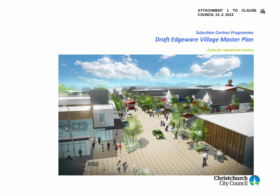
Suburban Centres Programme
Draft Edgeware Village Master Plan
A plan for rebuild and recovery
ATTACHMENT 1 TO CLAUSE 15 COUNCIL 14. 2. 2013
149

Mayor’s foreword The Edgeware shopping centre has an appealing urban village feel – an intimate shopping experience developed to meet the day‐to‐day needs of the St Albans community. It is an environment where long‐standing businesses flourished, attracting customers city‐wide. However, Edgeware Village has suffered as a result of the earthquakes. Vacant sites and damaged buildings are testament to the loss and disruption. In recent times, businesses have begun working together and it is so pleasing to see the rebuilt supermarket anchoring the centre once again. This signals the huge potential for this village centre to become a vibrant place once more. This Draft Master Plan takes account of the things people value about their village, the things they want improved and the pivotal role it plays in the life of the community. The Plan seeks to enhance the centre’s village feel by widening the footpaths, introducing seating and quality landscaping; and by developing courtyard spaces and laneways. The Plan builds on Edgeware Village’s identity as a self‐contained centre, perfectly‐sized to service the local neighbourhood. It provides a way to enliven public space and entice people to spend time walking around the various shops and attractions. I am sure the community will be as delighted by the Plan as I am. Bob Parker Mayor of Christchurch
150

Community Board foreword The Draft Edgeware Village Master Plan is an exciting opportunity for local residents, businesses, community groups and city ratepayers to help shape the future of this vibrant suburb. Free‐flowing information, shared during public drop‐in sessions, at informal chats and stakeholder meetings, means this Plan is relevant, timely and grounded, especially for local people. The Board congratulates those involved in the preparation of this Plan – particularly those residents who have so actively engaged in the series of “community conversations” held recently in St Albans; or have contributed their thoughts and ideas in other ways. This Plan has the goal of ensuring the successful rebuild and recovery of Edgeware Village, following the 22 February earthquake and subsequent aftershocks. It proposes a series of actions to create a safer, more vibrant centre in Edgeware Village, which will build investor and community confidence. This Plan belongs to the St Albans community. The Shirley/Papanui Community Board encourages you to comment on the Draft Edgeware Village Master Plan. This Plan will be a key driver for the rebuild and recovery of a very special area in Christchurch. Chris Mene Chairperson, Shirley/Papanui Community Board
151

Suburban Centres Programme ∙ Draft Edgeware Village Master Plan iv
Comments on this Draft Plan This is the first time the community has had the chance to comment on the Draft Edgeware Village Master Plan. A submission form is provided at the back of this document. You are invited to send your comments in writing to: Postal Address: Freepost 178 Draft Edgeware Village Master Plan Strategy and Planning Group Christchurch City Council PO Box 73012 CHRISTCHURCH 8154 Email: [email protected] Please make sure your comments arrive before the consultation period closes at 5pm, Friday [TBC] 2013. Disclaimer: There is no binding commitment on the Christchurch City Council to proceed with any prospective project detailed in this document. Council spending priorities are reviewed frequently, including through the Council’s Long Term Plan (LTP) process. All decisions as to whether or not a Council‐funded project will commence remain with the Council.
152

Table of Contents Mayor’s foreword................................................................................................... ii Community Board foreword...................................................................................iii Comments on this Draft Plan..................................................................................iv Table of Contents.................................................................................................... v Executive Summary ................................................................................................ 1
Overall concept plan for the development of Edgeware Village ................... 2 1. Introduction ....................................................................................................... 3
What is a master plan? .................................................................................. 3 Scope of this Draft Plan.................................................................................. 3 Master plan development framework........................................................... 3 How this Draft Plan has been developed....................................................... 4 How this Draft Plan will be implemented ...................................................... 4
2. The place............................................................................................................ 5
Strategic context ............................................................................................ 5 History of the centre...................................................................................... 6 Landscape character and built form .............................................................. 8 Land use context.......................................................................................... 10 Commercial context..................................................................................... 11 Social context and community function ...................................................... 12 Movement network ..................................................................................... 13 Impact of the earthquakes........................................................................... 14
3. Technical considerations ................................................................................. 16
The economic potential of Edgeware Village .............................................. 16 Christchurch Transport Strategic Plan ......................................................... 17 Previous master planning and streetscape work......................................... 18 Community facilities rebuild ........................................................................ 19 St Albans Pool and Pavilion project ............................................................. 19
4. Community input..............................................................................................20 5. Vision and goals................................................................................................21
Vision ............................................................................................................21 Goals.............................................................................................................22
6. Actions..............................................................................................................23
Improving the public realm ..........................................................................24 Enhancing courtyards, laneways and off‐street parking ..............................32 Rebuilding earthquake‐damaged sites.........................................................39 Supporting future development concepts ...................................................43 Addressing long‐term commercial demand .................................................45 Supporting business and community initiatives...........................................46
7. Implementation................................................................................................49
Time frames..................................................................................................49 Lead and partner ..........................................................................................49 Council cost ..................................................................................................49 Implementation Table ..................................................................................50
Appendix One – Edgeware Village Centre economic assessment (summary) ......51 Appendix Two – Consultation feedback................................................................54 Appendix Three – indicative costs of streetscape work........................................58
153

Executive Summary This Draft Master Plan presents a future vision and goals for the redevelopment of Edgeware Village. It has been prepared in response to the damage caused to the centre in the 2010 and 2011 earthquakes. It forms part of the Council’s Suburban Centres Programme. The purpose of the Draft Edgeware Village Master Plan is to guide decision‐making in regard to private investment and public expenditure, particularly relating to the development of land, buildings and transport infrastructure. The implementation of the Master Plan’s goals and actions will help Edgeware Village become stronger and more resilient in the face of future uncertainties. Several meetings and public drop‐in sessions have taken place over the past year, with a large and diverse number of people and community groups, about the rebuild and recovery of the Edgeware Village Centre. The community requested that the Draft Master Plan address:
A disconnect between the different areas of shops. Buildings and streetscape that are ‘tired’ and in need of an uplift. The speed of traffic and safety for pedestrians. Cycle parking. Outdoor seating areas.
The centre is described in the Christchurch Transport Strategic Plan (CTSP) as a ‘walkable centre’. It is also on a proposed strategic cycle route along Colombo and Trafalgar streets. These proposals in the CTSP have been considered alongside community ideas in drafting proposals for the recovery of Edgeware Village.
This Draft Master Plan presents a range of actions in response to the issues, ideas and aspirations that people have shared with the Council. In brief, these actions include: Improving the public realm. Enhancing courtyards, laneways and off‐street parking. Rebuilding earthquake damaged sites. Supporting future development concepts. Addressing long‐term commercial demand. Supporting business and community initiatives. Refer Figure (i) below for an overview of the proposed actions. An implementation plan is included within this Draft Master Plan to indicate timing and leadership for the range of proposed actions. Implementation of these actions cannot be achieved by the Council alone and earthquake recovery requires participation from all sectors of the community, including property and business owners, community groups, other government and non‐government agencies, and residents living in and beyond St Albans. To ensure the Council is on the right track with this Draft Master Plan, consultation is now open. Once public submissions have been received they will be considered and discussed, the Draft Master Plan will be amended (if required), finalised and adopted, paving the way for the Master Plan’s implementation.
154

Overall concept plan for the development of Edgeware Village
1a to 1f
Streetscape and movement improvements: 1a Develop a pedestrian priority environment and ‘gateways’ 1b Incorporate major cycleway 1c Reconfigure parking and taxi arrangements 1d Retain existing bus stops 1e Install amenity planting 1f Install street furniture, cycle stands and lighting
2a, Access and wayfinding improvements:
2b 2a Improve crossing points 2b Install wayfinding signage
3a, 1064 Colombo Street building & carpark improvements
3b, 3a Develop north‐south internal connections
3c 3b Develop outdoor courtyard spaces 3c Improve layout and landscaping of the carpark
4 Monitor parking; investigate new off‐street car park if required
5a, 5b
Edgeware Village Mall enhancements 5a Enhance indoor walkway 5b Redevelop laneway between Mall and ‘Domino’s’ building
6a, 6b, 6c
Hardie and Thomson site redevelopment 6a Redevelop retail and sales buildings fronting Sherborne St 6b Integrate parking on Sherborne Street frontage with Edgeware Mall 6c Rebuild Colombo Street shops, with parking to the rear
7 Consider a comprehensive development of the northern block
8 Consider a reconfigured Brumbys / Peter Timbs development
9 Explore future comprehensive development west of Colombo Street
10 Explore future redevelopment and intensification of Edgeware Mall
11 Monitor commercial demand and enable expansion/rezoning if required
12 Support development of an Edgeware Village market 13 Investigate new Edgeware Village events 14 Develop transitional activities/beautification projects 15
Figure (i) ‐ Overall Concept Plan for the redevelopment of Edgeware Village. The table to the right lists all proposed projects. Those projects that can be shown on a map are indicated on the concept plan above. Improve building signage
16 Retain case management service
155

1. Introduction This Draft Master Plan (‘the Draft Plan’) has been prepared for Edgeware Village in response to damage caused by the 2010 and 2011 earthquakes. Over one third of the commercial building stock in the Village Centre was damaged in some way. At least five buildings have been, or will be demolished. The community has also lost the nearby St Albans Community Centre. Ongoing repairs to buildings and infrastructure inconvenience local users and have an adverse impact on the viability of some businesses. Prepared under the Council’s Suburban Centres Programme, this Draft Plan is one of eight master plans the Council has prepared for Christchurch’s most damaged suburban centres. The Draft Plan identifies opportunities to enhance the quality of Edgeware Village both in the public spaces of the Village Centre, and for the rebuild and repair of damaged properties. It sets out a vision and goals for the short and long‐term development of the shopping area, and an action plan for achieving these.
What is a master plan? A master plan sets out the community’s vision for the future of an area, and shows how this can be achieved. It provides direction to stakeholders who can implement that vision, including residents, property and business owners, community groups and other agencies. A master plan guides decisions made by stakeholders, for example the development of land and buildings, and the provision of community services and transport infrastructure.
Scope of this Draft Plan The focus of this Draft Plan is the commercial shopping centre of Edgeware – as defined by the business zones in the Christchurch City Plan (refer Figure 2g in Section 2 The place). The Draft Plan also has regard to linkages between the Village Centre and nearby community facilities and sites, including sites such as those being used by the Edgeware Village Green and St Albans Community Centre.
Master plan development framework This Draft Plan has been developed around five themes:
Economy and business Movement Natural environment Community well‐being/culture and heritage Built environment
Figure 1a ‐ the ‘shopping lady bollards’ at the Edgeware Village pedestrian crossing
156

These themes have been developed from the Integrated Recovery Planning Guide prepared by the Canterbury District Health Board and the Christchurch City Council following the earthquakes. These themes reflect the wide range of topic areas explored in this Draft Plan, and are broadly aligned with the Earthquake Recovery Strategy prepared by the Canterbury Earthquake Recovery Authority (CERA). The Canterbury Earthquake Recovery Act 2011 does not require the Council to prepare plans for the recovery of suburban centres. However, the Edgeware Village Master Plan must be consistent with CERA’s Earthquake Recovery Strategy.
How this Draft Plan has been developed The development of the Draft Edgeware Village Master Plan began in April 2012, and follows the process shown in Figure 1c. The process began with gathering community views and thoughts on the rebuild and recovery of Edgeware Village through a series of workshops and public drop‐in sessions in June 2012. This community feedback, together with input from a range of technical experts, was used to develop the Draft Plan. Following consultation, the Master Plan will be amended to incorporate public feedback before being presented to the Council for approval and adoption.
How this Draft Plan will be implemented This Draft Plan identifies actions to implement the vision and aspirations of business owners, property owners and the community. These have been prioritised with time frames attached to them. Funding for Council‐led actions and projects contained in the Master Plan will be sought through the Council’s Annual Plan and Long‐Term Plan processes. Recovery is a long‐term process. Due to cost and land ownership constraints, some actions may not be implemented for some time. There is also an expectation that the implementation of the Master Plan is a shared task between all stakeholders involved and not solely a function of the Council.
Figure 1b ‐ the Integrated Recovery Planning Guide prepared by the Canterbury District Health Board and Christchurch City Council
Figure 1c ‐ the process of developing a master plan
157

2. The place
Strategic context Edgeware Village is a small commercial centre located in the suburb of St Albans. It is close to the Central City, located at the northern end of Colombo Street at its intersection with Edgeware Road. Figure 2a below shows Edgeware in its local context. The Village Centre services the wider St Albans residential area and is regarded as the main shopping and community hub of St Albans.
Figure 2a ‐ Edgeware Village context
158
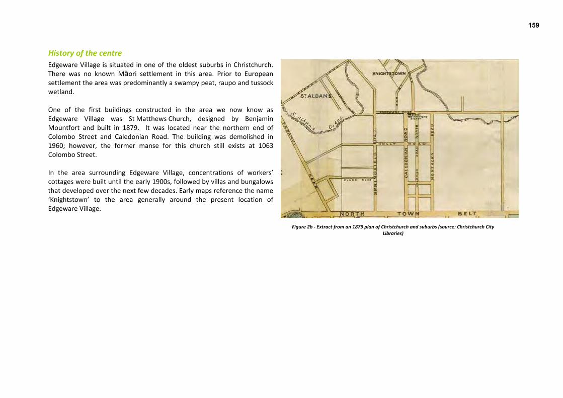
History of the centre Edgeware Village is situated in one of the oldest suburbs in Christchurch. There was no known Mäori settlement in this area. Prior to European settlement the area was predominantly a swampy peat, raupo and tussock wetland. One of the first buildings constructed in the area we now know as Edgeware Village was St Matthews Church, designed by Benjamin Mountfort and built in 1879. It was located near the northern end of Colombo Street and Caledonian Road. The building was demolished in 1960; however, the former manse for this church still exists at 1063 Colombo Street. In the area surrounding Edgeware Village, concentrations of workers’ cottages were built until the early 1900s, followed by villas and bungalows that developed over the next few decades. Early maps reference the name ‘Knightstown’ to the area generally around the present location of Edgeware Village.
Figure 2b ‐ Extract from an 1879 plan of Christchurch and suburbs (source: Christchurch City Libraries)
159

Hardie & Thomson started operating in Edgeware in 1908, providing sawmilling, timber and joinery services; the company is still in business today. The original expanse of their operations was much larger than their current footprint, previously using the site of the current BP station and behind the supermarket for air‐drying timber. The Cranford Street tramline opened in 1910 and operated until 1953, passing through Colombo Street and Edgeware Road before travelling along Cranford Street as far as Westminster Street. A cluster of shops around the Edgeware/Colombo intersection had developed around the time of World War One (1914–1918). Edgeware Village has long been a hub of community activity, with the St Albans Library established on the Colombo Street site in 1920 (see Figure 2c). The St Albans Public Swimming Pool was constructed soon afterwards in 1934. The former Library building was managed as the St Albans Community Centre from 1998 until it was demolished in 2011 due to significant earthquake damage. The pool closed in 2006.
The Century Cinema, an art deco style building designed by Wilford Melville Lawry, was built in Edgeware Village in 1940 (refer Figure 2d). The cinema operated until 1960 when it was converted to a supermarket. The building was demolished in 2011 as a result of earthquake damage. The present SuperValue supermarket building reflects the history of this building through façade design elements. Most of the present shops in Edgeware Village were developed in the 1960s and 1970s. It seems that it was during this time the name ‘Edgeware Village’ came into prominent use.
Figure 2c ‐ St Albans Community Centre at 1049 Colombo Street (demolished 2011) Figure 2d ‐ SuperValue supermarket in the former Century Cinema building (photo taken: 2009)
160

Landscape character and built form Suburban streets leading to the commercial centre are dominated by villas, character homes and workers cottages with heavily vegetated gardens and mature trees. With the exception of an existing mature tree on the supermarket site at the corner of Edgeware Road and Cornwall Street, the centre is devoid of large scale vegetation and the built form provides the dominant village character. The twelve recently planted street trees along Edgeware Road and Colombo Street will contribute to a more vegetated village character in the future. Some streetscape improvements were undertaken in 2007, including pavement upgrades, planting and decorative bollards at the Edgeware Road pedestrian crossing (refer Figure 2e). Further opportunities exist to enhance the look and feel of the centre. The natural environment of Edgeware Village has been highly modified and there is no evidence of old water channels or remnant vegetation. Sections of St Albans Creek have been naturalised through residential properties and within English Park to the north of the Village Centre. From the top end of Colombo Street attention is drawn to the significant view southwards towards the Port Hills. Conversely, the location of the buildings at the north end of Colombo Street highlights the termination point of this street (Figure 2f). Access to Abberley Park to the west and English Park to the north is through the current street layout. Although views of the Centre are obtained from the strategic road network, the gateways into the Village Centre are not well defined.
Figure 2e – Previous landscaping improvements, including decorative bollards, completed in 2007
161
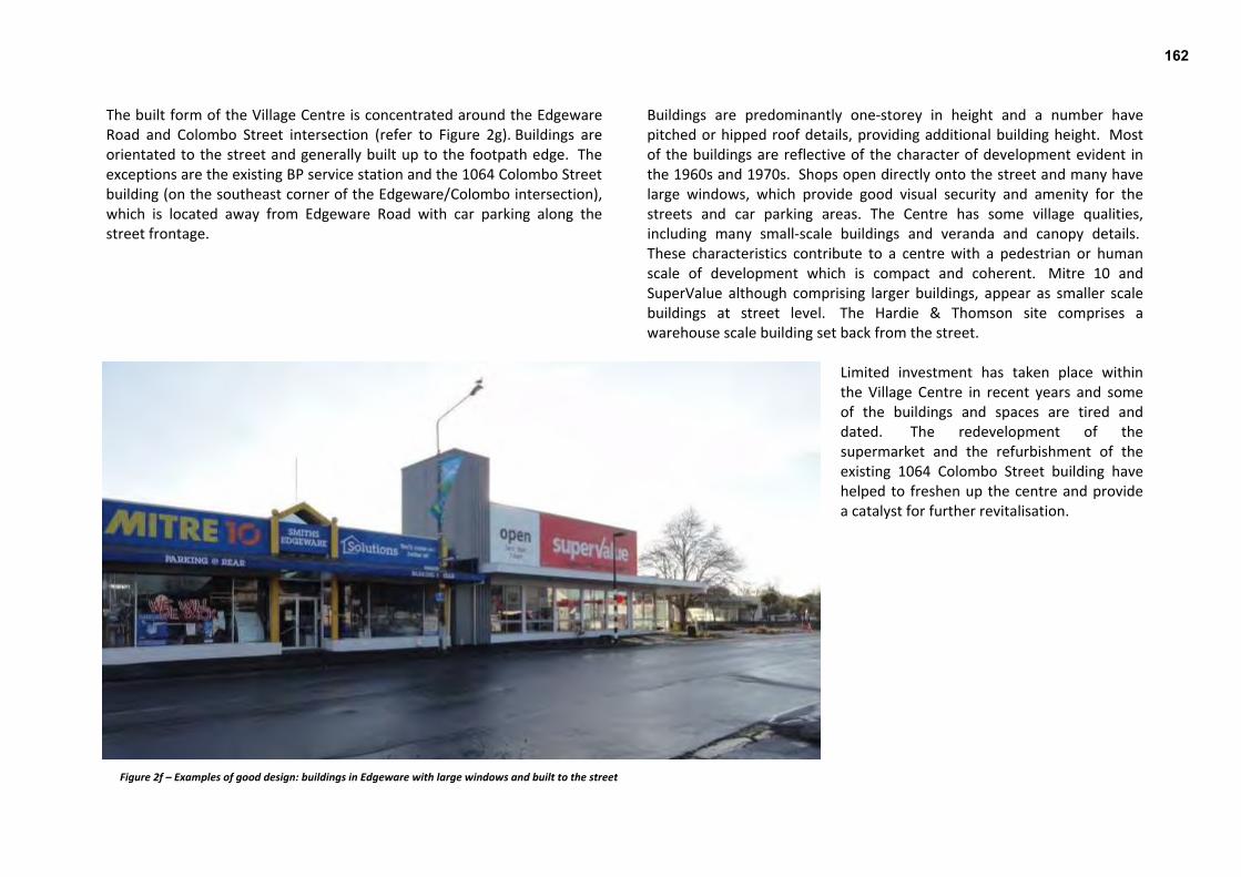
The built form of the Village Centre is concentrated around the Edgeware Road and Colombo Street intersection (refer to Figure 2g). Buildings are orientated to the street and generally built up to the footpath edge. The exceptions are the existing BP service station and the 1064 Colombo Street building (on the southeast corner of the Edgeware/Colombo intersection), which is located away from Edgeware Road with car parking along the street frontage.
Buildings are predominantly one‐storey in height and a number have pitched or hipped roof details, providing additional building height. Most of the buildings are reflective of the character of development evident in the 1960s and 1970s. Shops open directly onto the street and many have large windows, which provide good visual security and amenity for the streets and car parking areas. The Centre has some village qualities, including many small‐scale buildings and veranda and canopy details. These characteristics contribute to a centre with a pedestrian or human scale of development which is compact and coherent. Mitre 10 and SuperValue although comprising larger buildings, appear as smaller scale buildings at street level. The Hardie & Thomson site comprises a warehouse scale building set back from the street.
Limited investment has taken place within the Village Centre in recent years and some of the buildings and spaces are tired and dated. The redevelopment of the supermarket and the refurbishment of the existing 1064 Colombo Street building have helped to freshen up the centre and provide a catalyst for further revitalisation.
Figure 2f – Examples of good design: buildings in Edgeware with large windows and built to the street
162

Land use context In the City Plan, the Village Centre is zoned a combination of:
Business 1 (B1) – Local Centre / District Centre Fringe; and Business 2 (B2) – District Centre Core.
The B1 and B2 zones are designed to meet the daily convenience shopping needs of the Village Centre’s immediate residential catchment. B1 zones are typically characterised by blocks of small shops, while B2 zones are generally occupied by larger scale buildings, often a supermarket and/or community facilities. In Edgeware, the supermarket sits within the B1 zone and approximately half of the B2 zone is occupied by the Hardie & Thomson timber factory. This is a light industrial operation which has historically operated on this site, but is not the type of activity usually anticipated in a B2 zone. Some businesses have also established outside of the Business zones through resource consent, existing use rights or scheduled activity listing in the City Plan. The Village Centre is surrounded by a mix of Living 2 (L2) and Living 3 (L3) zoning. The L3 zone provides for medium density residential housing close to the Central City and larger centres. It is anticipated that infill development and townhouse redevelopment will increase the living densities of this zone over time. The L2 zone provides for low‐medium housing densities with some infill possible. A ‘community footprint’ straddles Colombo Street immediately south of the Village Centre. Community footprints overlay living zones and provide for activities such as community, health, educational and day care facilities. Refer to Figure 2g, which shows the distribution of these zones.
Figure 2g ‐Map of City Plan zoning, community footprint and scheduled activity
163

Commercial context The Village Centre has a current estimated residential catchment of around 12,250 people, or 5800 households. The majority of retail on offer in the Village Centre is ‘convenience retailing’, providing for quick and easy shopping close to the customer (examples are shown in Figure 2h). About a third of the retail activity in the Village Centre is either ‘food and beverage services’ or ‘food retail’.
Figure 2h – Examples of retail activity in Edgeware Village
In the evenings, the Village Centre attracts visitors to the restaurants and takeaway outlets. The BP service station, which faces both Edgeware Road and Cranford Street, services local residents as well as passing traffic. The Edgeware SuperValue is a small, high quality supermarket that caters for the local community’s top‐up shopping requirements. A detailed economic assessment for Edgeware Village Centre has been prepared. A summary of this document is provided in Appendix One and its implications for this Draft Plan are discussed in Section 3 Technical considerations.
164
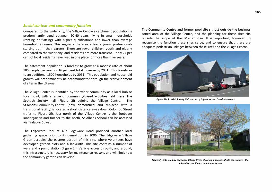
Social context and community function Compared to the wider city, the Village Centre’s catchment population is predominantly aged between 20‐40 years, living in small households (renting or flatting) with higher qualifications and lower than average household incomes. This suggests the area attracts young professionals starting out in their careers. There are fewer children, youth and elderly compared to the wider city, and residents are more transient – only 27 per cent of local residents have lived in one place for more than five years.
Figure 2i ‐ Scottish Society Hall, corner of Edgeware and Caledonian roads
Figure 2j ‐ Site used by Edgeware Village Green showing a number of site constraints – the substation, wellheads and pump station
The catchment population is forecast to grow at a modest rate of about 105 people per year, or 16 per cent total increase by 2031. This translates to an additional 1500 households by 2031. This population and household growth will predominantly be accommodated through the redevelopment of sites in the L3 zone. The Village Centre is identified by the wider community as a local hub or focal point, with a range of community‐based activities held there. The Scottish Society hall (Figure 2i) adjoins the Village Centre. The St Albans Community Centre (now demolished and replaced with a transitional facility) is located a short distance away down Colombo Street (refer to Figure 2l). Just north of the Village Centre is the Sunbeam Kindergarten and further to the north, St Albans School can be accessed via Trafalgar Street. The Edgeware Pool at 43a Edgeware Road provided another local gathering space prior to its demolition in 2006. The Edgeware Village Green occupies the eastern portion of this site, where volunteers have developed garden plots and a labyrinth. This site contains a number of wells and a pump station (Figure 2j). Vehicle access through, and around, this infrastructure is necessary for maintenance reasons and will limit how the community garden can develop.
The Community Centre and former pool site sit just outside the business zoned area of the Village Centre, and the planning for these sites sits outside the scope of this Master Plan. It is important, however, to recognise the function these sites serve, and to ensure that there are adequate pedestrian linkages between these sites and the Village Centre.
165
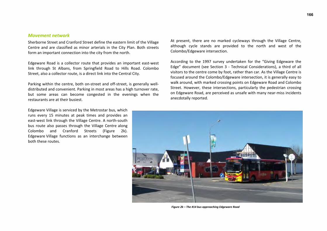
Movement network Sherborne Street and Cranford Street define the eastern limit of the Village Centre and are classified as minor arterials in the City Plan. Both streets form an important connection into the city from the north. Edgeware Road is a collector route that provides an important east‐west link through St Albans, from Springfield Road to Hills Road. Colombo Street, also a collector route, is a direct link into the Central City. Parking within the centre, both on‐street and off‐street, is generally well‐distributed and convenient. Parking in most areas has a high turnover rate, but some areas can become congested in the evenings when the restaurants are at their busiest. Edgeware Village is serviced by the Metrostar bus, which runs every 15 minutes at peak times and provides an east‐west link through the Village Centre. A north‐south bus route also passes through the Village Centre along Colombo and Cranford Streets (Figure 2k). Edgeware Village functions as an interchange between both these routes.
At present, there are no marked cycleways through the Village Centre, although cycle stands are provided to the north and west of the Colombo/Edgeware intersection. According to the 1997 survey undertaken for the “Giving Edgeware the Edge” document (see Section 3 ‐ Technical Considerations), a third of all visitors to the centre come by foot, rather than car. As the Village Centre is focused around the Colombo/Edgeware intersection, it is generally easy to walk around, with marked crossing points on Edgeware Road and Colombo Street. However, these intersections, particularly the pedestrian crossing on Edgeware Road, are perceived as unsafe with many near‐miss incidents anecdotally reported.
Figure 2k – The #14 bus approaching Edgeware Road
166

Impact of the earthquakes The closure, demolition, rebuild and repair of buildings in Edgeware Village has been ongoing following the initial September 2010 earthquake. The February and June 2011 earthquakes gave rise to a number of closures and demolitions. The status of buildings continues to change as further assessments are undertaken. Buildings on six properties, encompassing eleven businesses, were directly affected by building damage (refer to Figures 2m and 2n). Most of the businesses affected by this damage or closure have remained operating, either on‐site or relocating elsewhere, both within and beyond Edgeware Village Centre. Many of the remaining businesses have been indirectly affected by earthquake damage due to poor road conditions, infrastructure repairs and the derelict nature of damaged buildings which have reduced the overall appeal of the centre to customers.
The St Albans Community Centre (also known as the St Albans Community Resource Centre), which hosted a number of community groups and classes, was demolished in 2011. A Lions International‐sponsored transitional community facility installed on the same site has helped meet community need in this area (Figure 2l). However, the earthquakes have taken, and continue to take, a toll on the wellbeing of many residents, business and property owners. Businesses and the community have responded to the challenge of the earthquakes in a number of ways. A business group has formed and is actively working with Recover Canterbury on marketing and promotional activities. Community groups such as the St Albans Residents Association promote community resilience and continue to provide an important source of information for residents.
Figure 2l – The transitional community facility on Colombo Street
167

Suburban Centres Programme ∙ Draft Edgeware Village Master Plan 15
Figure 2m ‐ map of building damage in Edgeware Figure 2n ‐ images of earthquake damage to buildings
168
3. Technical considerations A range of technical information, assumptions and uncertainties have been factored into the development of this Draft Plan. In particular, there are decisions yet to be made regarding property and facilities that go beyond the scope of this Draft Plan. These considerations are discussed in more detail below.
The economic potential of Edgeware Village In preparing this Draft Plan, an assessment of Edgeware Village’s current and future potential as a commercial centre was undertaken for the Council by Property Economics Ltd. A summary of this assessment is provided in Appendix One. The key conclusions of this assessment are as follows:
a) Edgeware Village functions best as a supermarket and convenience‐orientated centre.
b) Improving the quality and range of goods on offer, accessibility, parking, and the physical environment will improve the overall performance of the Village Centre.
c) There is potential to develop a larger supermarket (3500 – 4000 square metres gross floor area) within the Village Centre’s catchment. By comparison, the current SuperValue supermarket has a gross floor area of just over 1000 square metres.
d) The existing business zone is sufficiently large enough to provide for the current and future commercial needs of people in the Village Centre’s catchment. Any further development would create an inefficient outcome and weaken the Village Centre as a whole.
e) Rezoning of additional land to support an expansion of the Village
Centre is unnecessary over the foreseeable future, unless the Hardie & Thomson site does not become available for commercial development, or a larger supermarket or community facility is developed within the Village Centre.
These conclusions have been factored into the Draft Master Plan by:
Identifying actions to improve the streetscape and movement networks.
Providing for a larger supermarket in the future. Supporting a compact Village Centre form.
Some future growth of the Village Centre may be appropriate, but would be a relatively small area and be dependant upon: (a) the degree to which the supermarket can expand within the current business zone; or (b) the degree to which the Hardie & Thomson site continues being used for industrial‐type activity. Any future growth of the business area would need to occur formally through resource consent or a change to the City Plan.
169

Christchurch Transport Strategic Plan The Christchurch Transport Strategic Plan (CTSP) presents an overarching framework for the development of transport networks across Christchurch for the next 20 years. A number of projects identified in the CTSP have had an impact on how the Draft Edgeware Village Master Plan has been developed. Consultation on the CTSP took place during 2012 and the Plan has now been finalised and launched. Major cycleway – Colombo Street / Trafalgar Street: A major cycleway is proposed for the length of Colombo Street, connecting with Trafalgar Street at Edgeware Village. It will be designed for cyclists of all abilities and will be fully separated from the road. Public transport framework: Edgeware Village has been identified as a connection point between the core cross‐city route used by the Metrostar, and the north‐south service linking the Central City with the northern suburbs. The CTSP emphasises good connections between services at interchange locations. Walkable centres: Edgeware Village is identified as a ‘walkable centre’ where the priority for the movement network is people. Streetscapes should have attractive footpaths, traffic will be slowed and pedestrians encouraged to linger and relax. Improvements to the walking network surrounding the Village Centre are supported.
Strategic transport network: The development of the Northern Arterial, as part of the Government’s Roads of National Significance programme, will be supported by the Council. The development of this route could lead to an increase in traffic volumes on Cranford and Sherborne streets over time, however, further investigations and modelling is required. This will have an impact on how the eastern edge of the Village Centre can develop and function in the future. The direction provided in the CTSP has been incorporated into this Master Plan by:
Providing for a separated cycleway along Colombo Street and Trafalgar Street, with a safe crossing point on Edgeware Road.
Prioritising pedestrian needs in streetscape and roading improvements.
Identifying opportunities to enhance walking links between the Village Centre and surrounding residential areas.
Supporting bus stops that enable passengers to easily transfer between services.
Limiting the spread of commercial development and access points along Sherborne and Cranford streets.
170

Previous master planning and streetscape work A document titled “Giving Edgeware the Edge” was prepared for the Council by Lucas Associates and Hugh Briggs in 1997. Concept Plans were prepared as part of that document (Figure 3a) and these were reviewed and considered in the preparation of this Draft Plan.
The St Albans Neighbourhood Plan was produced by the Council in 2000 and recommended a number of streetscape improvements in the residential areas of the suburb. There were no specific actions for Edgeware Village, but the Neighbourhood Plan introduced the concept of a “golden suburb” – creating neighbourhoods that are distinctive from the surrounding area by planting predominantly golden foliaged and flowered plants.
Figure 3a ‐ Concept Plan from 'Giving Edgeware the Edge', 1997
171

Community facilities rebuild The St Albans Community Centre is part of the Council’s Facilities Rebuild Programme. Following the earthquakes, the Council embarked on a programme to look at the future of the 1600 buildings it owns across the city. A decision regarding the future of the Community Centre will be made as part of this programme. In the meantime, the Community Centre site is occupied by a transitional facility sponsored by Lions International and managed by the Council. The Draft Plan has been prepared on the assumption that there will be a new community centre in this area, sometime in the future. However, no assumptions have been made as to whether this facility would be replaced ‘like for like’ with respect to scale, function and location.
St Albans Pool and Pavilion project There has been considerable community debate and interest in the former Edgeware Pool site (43a Edgeware Road), following the demolition of the pool in 2006. The St Albans Pavilion and Pool group has plans to build, maintain and operate a new outdoor community pool. The Council owns the site, and has agreed to sell the property subject to the necessary funds being raised by this group. Discussions between the St Albans Pavilion and Pool group and the Council regarding the sale and development of the land are ongoing. This Draft Plan does not form a position on how the swimming pool site will be developed in the future. However, it is expected that some development will occur at this site in the future, and the Draft Plan recognises this by enhancing linkages between the former swimming pool site and the Village Centre.
172

4. Community input As part of the development of this Draft Plan, the Council held four stakeholder workshops and two public drop‐in sessions over two weeks in June 2012. These sessions were attended by over 80 people, including property owners, business owners, community groups, residents, Community Board members and other agencies (Figure 3b). The purpose of these sessions was to identify the concerns, aspirations and priorities regarding the Village Centre from a range of perspectives. This input, along with various technical considerations, has helped inform the preparation of a draft vision, goals and projects as part of the Master Plan. The Draft Plan also recognises feedback provided as part of the Council‐facilitated ‘St Albans Community Conversation’, held in March 2012.
Strengths People told us they value Edgeware Village because:
It has a strong pedestrian customer base and lots of foot traffic. Businesses are friendly and “local”. It has a diverse range of shops. It is convenient and easy to access – easy to get to and easy to
park.
Weaknesses Common concerns that people raised about Edgeware Village included:
A disconnect between the different areas of shops. The loss of community facilities and services, including the
community centre and medical centre. Buildings and streetscape that are ‘tired’ and in need of an uplift. The speed of traffic along Edgeware Road and the safety of the
pedestrian crossing.
Opportunities Stakeholders identified a number of things that could be improved, including:
More public spaces and seating. More trees and planting. A stronger pedestrian focus – a pedestrian core and good links
between shopping areas. More cycle parking. A café and/or outdoor seating area. Improving the appearance of the 1064 Colombo Street car park.
For further information on thoughts and ideas from the community, see Appendix Two. Figure 4a ‐ Public drop‐in session
173

5. Vision and goals
Vision Based on feedback from the community and key stakeholders, the following draft vision has been developed to reflect the future aspirations for Edgeware Village.
Edgeware Village is a thriving neighbourhood shopping centre and community hub, at the heart of St Albans.
People enjoy visiting this attractive and compact centre, with its high quality, locally‐owned shops and restaurants and its safe, high amenity, pedestrian‐focused streets.
Edgeware Village is lively and enjoyable, reflecting its past and looking to its future.
Figure 5a – a vision for the future of Edgeware Village
174

Goals To achieve this vision, the following goals have been prepared. Each goal aligns with the five themes of integrated recovery planning.
Thriving businesses and a high‐performing Village Centre Recovery theme: Economy and business
A revitalised Village Centre that supports convenience shopping in a high quality retail environment.
A strong day and night, weekday and weekend economy. Successful businesses, trading on their ‘friendly, local’ attributes. A proactive and organised business group. A centre that has flexibility to accommodate a larger, full‐service
supermarket. A compact Village Centre that reflects its ‘neighbourhood’ centre
function; any commercial expansion occurs primarily within existing business zones.
Convenient, safe and accessible Recovery theme: Movement
A safe and accessible centre, with increased priority given to pedestrians and cyclists.
A people‐focused village heart that includes attractive public spaces and facilities for users to sit and rest.
Car parking areas that are attractive, safe and well‐distributed around the Village Centre.
High quality landscaped public space Recovery theme: Natural environment
A Village Centre characterised by high quality landscaping. Street trees, planting and street furniture that create a cohesive
Village Centre linking both public and private space.
Community heart Recovery theme: Community well‐being
The Village Centre is a hub for social interaction and community development –there are places for people to meet and socialise.
Community pride and ownership in the Village Centre is evident. There is sufficient space and support for occasional markets and
events. Strong connections are provided to nearby parks, places of
education and worship, and the Central City. Village Centre users can find information on community and
business activities in the local area.
An attractive built environment Recovery theme: Built environment
Active frontages and pedestrian‐scale buildings support a highly sociable street environment.
Elements of the Village Centre’s history are reflected in the buildings and streetscape.
The Village Centre develops a unique and distinct identity.
175

6. Actions A range of actions has been identified to implement the vision and goals of this Draft Plan. These actions have been developed from the community feedback, from the concept plans in “Giving Edgeware the Edge” and following discussions with key landholders and technical experts. These actions are explained in this section and are shown spatially in Figure (i) of the Executive Summary. In brief, they comprise the following: Improving the public realm Recovery themes: Movement; Natural environment
Action 1 Streetscape and movement improvements
Action 2 Access and wayfinding improvements Enhancing courtyards, laneways and off‐street parking Recovery themes: Movement; Economy and business; Built environment
Action 3 1064 Colombo Street building and carpark improvements
Action 4 Monitor parking; investigate new off‐street car park, if required
Action 5 Edgeware Village Mall enhancements Rebuilding earthquake damaged sites Recovery themes: Built environment; Economy and business
Action 6 Hardie & Thomson site redevelopment
Action 7 Consider a comprehensive development of the Northern Block
Action 8 Consider a reconfigured Brumbys / Peter Timbs development
Supporting future development concepts Recovery themes: Built environment; Economy and business
Action 9 Explore future comprehensive development west of Colombo Street
Action 10 Explore future redevelopment and intensification of Edgeware Mall Addressing Long term commercial demand Recovery themes: Built Environment; Economy and business
Action 11 Monitor commercial demand and enable expansion / rezoning if required
Supporting business and community initiatives Recovery themes: Economy and business; Community well‐being; Built environment
Action 12 Support development of an Edgeware Village market
Action 13 Investigate new Edgeware Village events
Action 14 Develop transitional activities / beautification projects
Action 15 Improve building signage
Action 16 Retain case management service
176
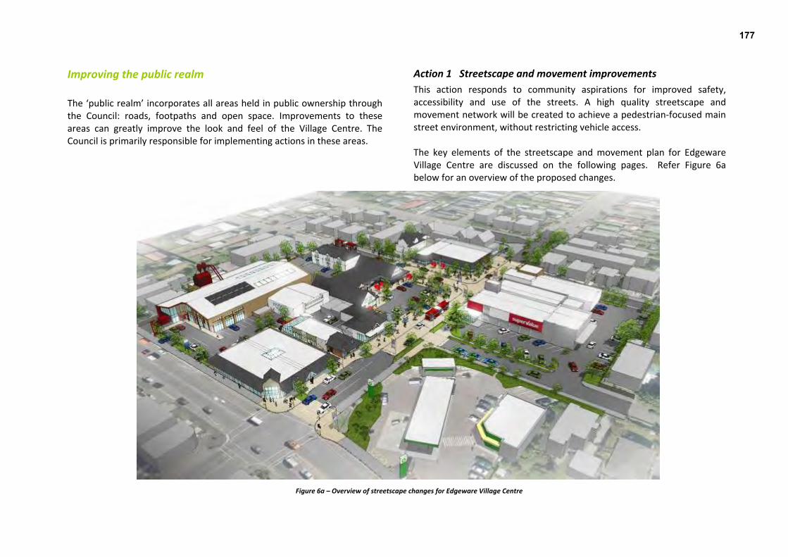
Improving the public realm Action 1 Streetscape and movement improvements The ‘public realm’ incorporates all areas held in public ownership through the Council: roads, footpaths and open space. Improvements to these areas can greatly improve the look and feel of the Village Centre. The Council is primarily responsible for implementing actions in these areas.
This action responds to community aspirations for improved safety, accessibility and use of the streets. A high quality streetscape and movement network will be created to achieve a pedestrian‐focused main street environment, without restricting vehicle access. The key elements of the streetscape and movement plan for Edgeware Village Centre are discussed on the following pages. Refer Figure 6a below for an overview of the proposed changes.
Figure 6a – Overview of streetscape changes for Edgeware Village Centre
177

1a Develop a pedestrian priority environment and ‘gateways’ In order to reinforce pedestrian priority and slow traffic, the road and footpath are shown paved at the same level (Figure 6b). Footpaths are widened in most areas, particularly along the south side of Edgeware Road, creating shorter crossing distances for pedestrians and providing space for landscaping, seating and cycle parking.
To slow traffic entering the Village Centre, clear entrance points are proposed, through landscaping a ‘gateway in the road (Figure 6c).
Figure 6b – view along Edgeware Road, showing road platform and pedestrian priority
Figure 6c – view north up Colombo Street: a gateway to the Village.
178

1b Incorporate major cycleway The proposed major cycleway along Colombo Street and Trafalgar Street merges with the Village Centre near the Colombo/Edgeware intersection (Figure 6d). Cycle signage directs cyclists through the Village Centre, indicating to cyclists that they are entering a pedestrian‐focused space and are requested to respect pedestrian priority.
Figure 6d – view west from the Edgeware Road / Colombo Street junction, showing a route for cyclists across Edgeware Road and north along Trafalgar Street
Figure 6e – Example of cycle lane treatment
179

1c Reconfigure parking and taxi arrangements Some on‐street parking will be lost to enable footpath widening and to accommodate the cycleway and some outdoor seating. However, potential future new spaces for off‐street parking on private land is indicated (refer also, action 3 regarding off‐street parking). The taxi stand is moved from Edgeware Road to Cornwall Street to be more centrally located, with improved access to the supermarket (refer Figure 6f). This will also free up on‐street parking at the western entrance to the Village Centre.
1d Retain existing bus stops Existing bus stops and services will be retained to ensure public transport remains accessible and users can easily transfer between services within the Village Centre.
Figure 6f – view from Edgeware Mall to the SuperValue site, showing taxis on Cornwall Street. This would free up on‐street parking at the western entrance to the Village
Figure 6g – view north west up Colombo Street, showing bus shelter at the southern entrance to the Village Centre
180

1e Install amenity planting The deciduous Whitebeam (Sorbus aria) is proposed as the principal street tree. It is of medium height, with a clear stem and well formed tree canopy that will provide welcome shade in the summer whilst allowing sun to penetrate during the winter months. Ground cover planting will provide interest and colour in the low planters.
Figure 6h – Whitebeam (Sorbus aria) – a possible street tree for Edgeware Village
Figure 6i – view east along Edgeware Road, showing potential new landscaping
181

1f Install street furniture, cycle stands and lighting Cycle stands, seating and decorative elements are proposed, creating interest and character and providing opportunities for people to stop and rest. The street furniture should build on existing features, such as the decorative bollards, and reflect the ‘timber’ heritage of the Village Centre. The existing community notice board will remain and space will be provided for an additional business/community information panel. The amount and style of lighting will be enhanced to improve night‐time safety and visibility.
Figure 6j – potential new outdoor seating and cycle stands
Figure 6k ‐ impressions of potential new street furniture, building on themes of wood and the existing ‘shopping lady’ bollards
182

Figure 6l ‐ impressions of potential new street furniture and sculpture, using the concept of the existing ‘shopping lady’ bollards
183

Action 2 Access and wayfinding improvements This action seeks to provide strong links between the Village Centre and the surrounding residential areas and community amenities, such as schools, parks and churches. It will help develop the Village Centre into a hub of community activity, and encourage local users to walk or cycle to the Village Centre. There are two specific actions: Improve crossing points; and Install wayfinding signage.
2a Improve crossing points The Village Centre is classed as a ‘walkable centre’ in the Christchurch Transport Strategic Plan. Pedestrian refuges will be investigated for Sherborne Street (either mid‐block or at the Canon Street intersection) and Springfield Road (south of the Springfield/Abberley/Edgeware intersection) to assist pedestrians in walking safely to and from the Village Centre. 2b Install wayfinding signage Although the Village Centre is the community hub, there are other facilities in close proximity. Improvements to signage and wayfinding will help direct people to local amenities and will also reinforce the village atmosphere.
Figure 6m – Example of potential way finder signage
184

Enhancing courtyards, laneways and off‐street parking These actions will encourage improved connections, support pedestrian movement and promote interesting and versatile spaces for people to enjoy, both day and night. Edgeware is already well‐supported by takeaway and restaurant businesses, and there are opportunities to better serve both customers and owners through reinforcing the amenity and access to these establishments. These improvements occur on private property and will require landowner support and funding. The incentives for business and landowners include increased foot traffic and the potential creation of new, or improved leasable spaces. The concepts presented have been developed by Council staff to provide property and business owners with ideas and a starting point for discussion. These actions are not requirements and there is no imperative to develop the sites as shown in the images presented below. On‐street parking areas in the core of the Village Centre are proposed to be reduced and the current parking at the 1064 Colombo Street site is also proposed to have fewer parking spaces. Instead, there is an emphasis on greater provision of off‐street parking in new developments. All off‐street parking areas should be safe for all users and have high quality surfacing, landscaping and lighting. These areas should be laid out efficiently and provide good access to shops, preferably from the rear of the site. Pockets of on‐street parking provide for short‐stop visits, while servicing and loading vehicles are encouraged to use off‐street parking areas, where possible. These actions also support business and community initiatives and events by providing spaces for landscaping for customers to pause and rest in
sheltered areas, and flexibility for village markets and events (see Actions 12 and 13).
Action 3 1064 Colombo Street building and car park improvements The 1064 Colombo Street car park is currently dominated by pavement, with no landscaping to buffer the site from the street. There is no clear path from the street to the shops, and with two vehicle crossings it is an unattractive area for pedestrians. The 1064 Colombo Street car park was highlighted during community workshops as having potential to become a focal point for the Village Centre, with a ‘town square’ type market or green space area. This was also a key concept within the ‘Giving Edgeware the Edge’ document. Better connections between this site and the redevelopment of the Hardie & Thomson site were also identified. There are three components to this action:
a) creating a connection through the 1064 Colombo Street building b) developing courtyard spaces c) redeveloping and landscaping the car park
185

3a Develop north‐south internal connection The creation of an internal connection through the 1064 Colombo Street building will provide a link to the Hardie & Thomson site car park (to be developed – see action 6c). This could be a new laneway, or could utilise an existing rear exit point.
Figure 6n – an internal link through the 1064 Colombo Street building would improve integration between different parts of the Village Centre and may encourage
additional custom
186

3b Develop outdoor courtyard spaces A potential outdoor courtyard space has been identified on the 1064 Colombo Street site adjacent to the Peter Timbs site. This sunny, sheltered corner could accommodate a ‘kiosk’‐type vendor. An active edge to this site could be achieved through the redevelopment of the Peter Timbs shop. A further courtyard space in front of the 1064 Colombo Street shops would create opportunities for spill‐out activity/outdoor dining.
Figure 6o – potential enlarged seating and pedestrian area on the northern side of the 1064 Colombo Street building
Figure 6p – potential new courtyard space between United Video and Peter Timbs
187

3c Improve layout and landscaping of the carpark Landscaping is suggested between the car park and the footpath, complementing the existing and proposed streetscape improvements. Parking is proposed to be reduced from 29 to 18 parking spaces. This shortfall for the Village Centre is proposed to be accommodated by creating new off‐street parking areas (see Action 6c).
Removing the vehicle access onto Colombo Street will support the creation of an additional courtyard/spill‐out space from the new corner bar, activating the Colombo Street frontage.
Figure 6q – view north east of the car park for the building at 1064 Colombo Street
188

Action 4 Monitor parking; investigate new off‐street car park, if required Actions 3(a), (b) and (c) show how medium and longer‐term site redevelopment can achieve more efficient use of land. Over time, it is expected that more car parking will be provided off‐street as sites are redeveloped. This would balance the proposed reduction in on‐street parking to provide for additional pavement space, landscaping and cycle corridors required as part of the streetscape and movement enhancements. It is anticipated that by promoting pedestrian‐priority (refer Action 1), more people will be encouraged to walk, cycle and bus to the Village Centre. It is also expected that parking requirements in the City Plan will be reviewed and potentially reduced as part of the City Plan review process commencing 2014, reflecting a shift towards promoting alternative transport modes and reducing the dominance of parking areas. However, this situation will be monitored. If necessary, the Council will investigate purchasing private property to off‐set the loss of parking in the Village Centre due to streetscape and private property enhancements. Such a property would need to be close to the Village Centre and in a visible location.
Action 5 Edgeware Village Mall enhancements This action relates to the buildings known as ‘Edgeware Village Mall’. These buildings are somewhat tired, but have potential for improvement and updating. The pedestrian mall area could be rejuvenated to become an indoor dining/entertainment area and laneway. This would improve access between the rear car park and Edgeware Road and create some flexible spaces that could be used for markets or dining. There is potential to reinforce the gateway to the Village Centre by enhancing the design of the corner to make it more inviting. This would involve relocating the Post Office boxes further along the building frontage. There are two components to this action:
a) Enhancing the existing indoor walkway through the Mall b) Opening up the laneway between the Mall and the ‘Dominoes’
building The combination of Actions 5a and 5b (set out below) will greatly enhance the pedestrian connections between the Mall car park and Edgeware Road and the overall Village Centre. It will make this car park area easier to find and improve its integration within the Village Centre.
Figure 6r – a more creative approach to the corner would reinforce the eastern
gateway to the Village Centre
189
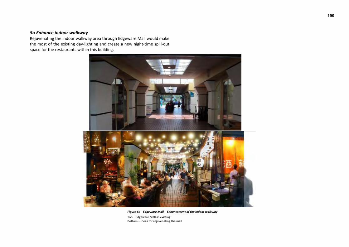
5a Enhance indoor walkway Rejuvenating the indoor walkway area through Edgeware Mall would make the most of the existing day‐lighting and create a new night‐time spill‐out space for the restaurants within this building.
Figure 6s – Edgeware Mall – Enhancement of the indoor walkway
Top – Edgeware Mall as existing Bottom – Ideas for rejuvenating the mall
190

5b Redevelop laneway between Mall and ‘Domino’s’ building Opening up the laneway at 74 Edgeware Road (between the Edgeware Mall building and Domino’s), provides an additional direct accessway for pedestrians moving between Edgeware Road and the Mall car park to the south. It would provide an additional public space which could provide for spill‐out space, outdoor dining and market stalls within a sheltered environment, adding greater vitality and interest to the Village Centre. High quality paving and lighting and additional overlooking of the space along the laneway will promote a safe route (Figures 6t, u and v). The bins that are currently stored in this area would be relocated to an alternative storage area within the rear car park.
Figure 6t – view north from the car park to the rear of Edgeware Mall, looking toward the BP service station
Figures 6u and 6v – view south from Edgeware Road down a redeveloped laneway between Edgeware Mall and the ‘Domino’s’ building – day time and night time images
191

Rebuilding earthquake‐damaged sites Making improvements through the rebuild of damaged structures presents the best opportunities for implementing the vision of this Draft Plan. The plans and drawings presented in this section of the Draft Plan are concepts only and have been developed by Council staff to provide property owners with ideas and a starting point for discussion. There is no requirement for sites to be redeveloped in this way.
Action 6 Hardie & Thomson site redevelopment Most of the existing Hardie & Thomson site will require redevelopment due to earthquake‐damage. Although most of the timber manufacturing has been moved off‐site, a retail presence will be retained and the Colombo Street shops are planned to be rebuilt. There are three components to this action:
a) Rebuilding Hardie & Thomson’s retail and sales buildings.
b) Integrating parking with Edgeware Mall. c) Rebuilding the Colombo Street shops.
6a Redevelop retail and sales buildings fronting Sherborne Street The retail, storage and sales components of Hardie & Thomson will be retained on the site. A one‐way drive through from Colombo to Sherborne streets is indicated (Figure 6w). An office area may be located on the eastern, Sherborne Street frontage, where some new parking is identified.
6b Integrate parking on Sherborne Street frontage with Edgeware Mall Additional parking can be created along the eastern edge of the Hardie & Thomson site (fronting Sherborne Street) as it is redeveloped. This would primarily service potential new commercial activity in this part of the site. However, the integration of this parking area with the existing parking behind the Edgeware Mall building would create a more efficient layout. Improved landscaping and vehicle and pedestrian access between these sites is indicated.
Figure 6w – view looking southwest across Sherborne Street to a Hardie and Thomson redevelopment, including potential integration with Edgeware Mall parking.
192

6c Rebuild Colombo Street shops, with parking to the rear The shops on Colombo Street are proposed to be rebuilt. Two‐storey development is encouraged along the street frontage, which could provide for a number of new retail units. Off‐street parking could be provided to the rear, with a potential link through the 1064 Colombo Street building (refer Action 3a). Alternative building configurations, which could provide for a medical centre or larger format retail store, also have potential in this area. If this form of development was proposed, small retail units (with windows and doors opening onto the street) are encouraged to create visual interest and activity).
Figure 6x – view northeast across Colombo Street to potential new shops on the Hardie & Thomson site. These would replace existing shops that are proposed to be rebuilt
193

Action 7 Consider a comprehensive development of the Northern Block The block to the north of Edgeware Road, encompassing the rebuilt supermarket, the currently vacant ex‐Mitre 10 store and the site of the now demolished ProMed building includes a mix of property ownerships and development options. This is a dominant corner site and the former Mitre 10 building at north end of Colombo Street can be seen from Bealey Avenue. It is important that buildings on these sites are designed to support these important qualities.
There is potential, theoretically, for the SuperValue to expand and take up much of this block to create a larger supermarket in the Village Centre, as recommended in the economic assessment. However, sale and purchase or leasing agreements will be required to enable this to occur. To maintain a village feel, such a development would ideally be ‘sleeved’ by smaller format stores fronting onto Edgeware Road and Trafalgar Street.
Figure 6y – view looking northeast across Edgeware Road of a potentially redeveloped northern block of shops, incorporating the existing SuperValue. This would allow for an expanded supermarket behind smaller store fronts
194
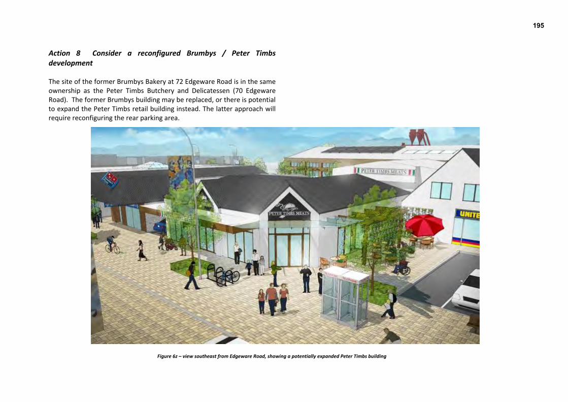
Action 8 Consider a reconfigured Brumbys / Peter Timbs development The site of the former Brumbys Bakery at 72 Edgeware Road is in the same ownership as the Peter Timbs Butchery and Delicatessen (70 Edgeware Road). The former Brumbys building may be replaced, or there is potential to expand the Peter Timbs retail building instead. The latter approach will require reconfiguring the rear parking area.
Figure 6z – view southeast from Edgeware Road, showing a potentially expanded Peter Timbs building
195
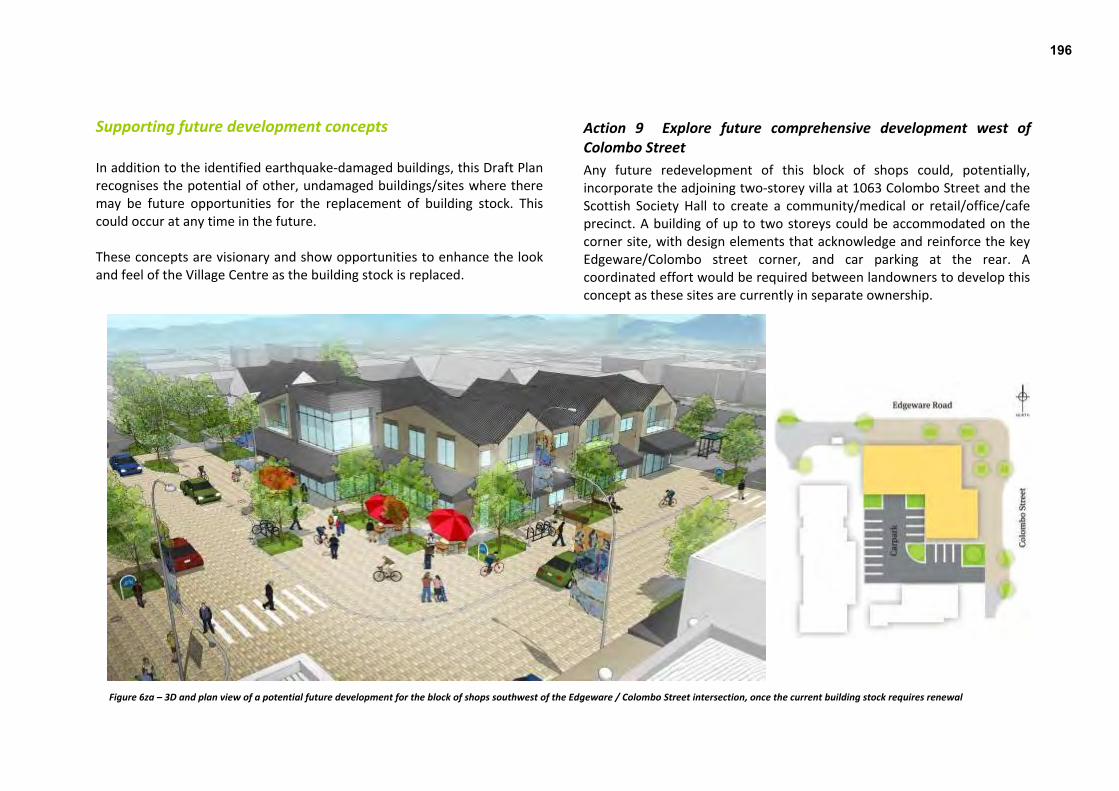
Supporting future development concepts In addition to the identified earthquake‐damaged buildings, this Draft Plan recognises the potential of other, undamaged buildings/sites where there may be future opportunities for the replacement of building stock. This could occur at any time in the future. These concepts are visionary and show opportunities to enhance the look and feel of the Village Centre as the building stock is replaced.
Action 9 Explore future comprehensive development west of Colombo Street Any future redevelopment of this block of shops could, potentially, incorporate the adjoining two‐storey villa at 1063 Colombo Street and the Scottish Society Hall to create a community/medical or retail/office/cafe precinct. A building of up to two storeys could be accommodated on the corner site, with design elements that acknowledge and reinforce the key Edgeware/Colombo street corner, and car parking at the rear. A coordinated effort would be required between landowners to develop this concept as these sites are currently in separate ownership.
Figure 6za – 3D and plan view of a potential future development for the block of shops southwest of the Edgeware / Colombo Street intersection, once the current building stock requires renewal
196

Action 10 Explore future redevelopment and intensification of Edgeware Mall This site sits on an important corner and has the longer‐term potential to be developed into a landmark building, potentially integrating with buildings on the Peter Timbs site at 70 Edgeware Road. A building of up to two or three storeys would anchor this prominent corner and gateway to Edgeware Village, and could provide additional space for car parking at the rear of the site.
Figure 6zb – 3D and plan view of a potential future development for Edgeware Mall, once the current building stock requires renewal
197

Addressing long‐term commercial demand
Action 11 Monitor commercial demand and enable expansion/rezoning if required To support a compact, successful neighbourhood centre, any commercial expansion should occur primarily within the business zone boundaries. However, limited expansion of the Village Centre may be appropriate, dependant upon whether the supermarket can expand within the current business zone and the degree to which the Hardie & Thomson site continues to be used for industrial‐type activity. If the Hardie & Thomson site becomes fully available for commercial activity, this will ease pressure for the commercial expansion of the Village Centre. However, given the intention of Hardie & Thomson to rebuild on the site, this is unlikely to occur in the foreseeable future, in which case additional zoning for commercial activity may be required. This would take the form of either:
A larger supermarket on the edge of the current centre, if the existing SuperValue store is unable to expand onto neighbouring properties over time; or
Small format stores if the SuperValue expands and displaces smaller format commercial activity.
In either scenario, rezoning of the Hardie & Thomson site for industrial activity may be required to avoid an oversupply of commercial zoning in the Village Centre.
In principle, new commercial activity should be discouraged from ‘leap‐frogging’ the more industrial Hardie & Thomson site, and the provisions of the City Plan support this. It is preferable that any expansion of the Village Centre supports a compact form (focussed around the Edgeware Road / Colombo Street intersection), rather than a ‘spread‐out’, disconnected centre. A flexible, case‐by‐case approach to commercial expansion is recommended for any applications to expand the Village Centre, whether through rezoning or resource consent.
198

Supporting business and community initiatives A business association has been established in Edgeware, with support from Recover Canterbury. The Edgeware Business Association’s initial objectives have been to establish an “Edgeware Village” brand and to coordinate marketing material. The St Albans Residents Association has also identified the “Beautification of Edgeware Village” as one of the top 20 priorities for the St Albans suburb. This reflects a willingness of the wider community to be involved in improving the look and feel of the Village Centre. Through public feedback and the design process, a number of ideas have been put forward to help businesses and residents reconnect with Edgeware Village. These ideas have been identified as individual actions below.
Action 12 Support development of an Edgeware Village market A regular market, held in a central location such as the 1064 Colombo Street car park, could broaden the Village’s appeal to a wider audience. The size and theme of the market can be set by business and community leaders. Ideally, the market would sell products that are complementary to the Edgeware Village brand and would not compete with existing businesses. A regular market may require a resource consent to establish, with the provision of parking space one of the key matters that may need to be resolved.
Figures 6zc ‐ Colombia Road flower market (London)
Action 13 Investigate new Edgeware Village Centre events A successful “Christmas @ Edgeware” event was held in December 2011 to help promote the Village Centre as a local Christmas shopping destination. Similar events could be held on an annual or more regular basis. There is potential, with the appropriate permissions in place, to temporarily close the 1064 Colombo Street car park, or part of Colombo Street, to create additional spill‐out and entertainment space.
Figure 6zd – Poster advertising a Christmas@Edgeware event in 2011
199

Action 14 Develop transitional activities / beautification projects Temporary or ‘transitional’ development is a way for the Council and the community to reinvigorate vacant space, to explore and test ideas to draw activity and business into Edgeware Village. Transitional projects (such as those facilitated by Greening the Rubble or Gap Filler) can be entirely community‐led or can involve a collaborative partnership between the community and other agencies, such as the Council. Beautification projects involve adding interest to existing buildings and sites through, for example, landscaping and planting, lighting or artwork. Such projects can be on private or public property and may be permanent or transitional until construction of the streetscape improvements occurs. Examples of potential transitional activities and/or beautification projects include:
Lighting the large Ash tree on the SuperValue site. Hanging and feature lighting – indoor and outdoor. Hanging plants or creating planted ‘green walls’ on blank facades. Art work or creation of a feature wall along the blank, western
boundary of the 1064 Colombo Street building. Art works that reflect the history of the area. Temporary planters, seating and lighting on vacant sites and
around car parks. Other potential projects may be revealed in future discussions. These projects will be most successful when they are driven by a collaborative approach by the community, property and business owners, and the Council.
Figure 6ze – examples of ways to add interest and colour to a centre
200

Action 15 Improve building signage The cumulative visual and physical clutter created by individual business signboards and banners makes it difficult for pedestrians to move around the Village Centre. To support pedestrian priority and improve the amenity of the Village Centre, a coordinated approach to business signage is encouraged. A guide to signage can be developed, building on existing Edgeware Village branding.
Action 16 Retain case management service The Council provides a case management service to help businesses and commercial property owners to work through rebuild options and to navigate through the Council’s (resource and building) consent processes. In Edgeware Village, case management has also included working with business owners and Recover Canterbury to support the recovery of the Village Centre as a whole, for example through the provision of information and discussions with business owners. It is proposed that this service will continue after the Master Plan is adopted, to support the range of projects being undertaken in Edgeware Village by the Council, businesses and the community.
Figure 6zf – improving Edgeware Village building signage
Figure 6zg – Suburban Centres Programme brochure for Case Management services
201

7. Implementation ‘Implementation’ is the means by which a vision becomes reality. An Implementation Plan has been prepared to set out how the projects identified in this Draft Plan will be realised.
Time frames Implementation of the Edgeware Village Master Plan will take time. The time frames for implementing projects are difficult to predict. The pace of implementation will be influenced by a range of factors, many of which are not fully determined at this stage. It is desirable to achieve some ‘quick wins’ where possible to boost confidence and create a sense of momentum in the recovery of the Village Centre. Some of the proposed actions will require funding to be secured (private and/or public). Some will require further investigation and more cooperation between stakeholders. For Council‐led actions, more detailed design work may be required and consultation undertaken with affected parties. Due to the uncertainty regarding funding and timing, the Implementation Plan should be considered a work in progress, subject to regular review.
Lead and partner For its recovery and future development, the Village Centre relies not just on the Council, but on many different parties – residents, community groups, property owners, businesses and other agencies, working together. Responsibilities for lead and partner have been identified in the Implementation Table for each action.
Council cost Funding for capital works (in relation to physical works such as street upgrades) must be secured through the Council’s Annual Plan process. The approximate costs to the Council have been identified in the Implementation Table. These costs are preliminary estimates only.
202

Implementation Table
Action Time frame Lead Support Council
cost? Improving the public realm
1a to 1f
Streetscape and movement improvements
4 – 6 years Council
$$$$, Capex and Opex
2a Improve crossing points 1 – 4 years Council
$, Capex and Opex
2b Install wayfinding signage 4 – 6 years Council Community $, Capex
and Opex Enhancing courtyards, laneways and off‐street parking 1064 Colombo Street building and
car park
3a Develop north‐south internal connections
3b Develop outdoor courtyard spaces
3c Improve layout and landscaping of car park
0‐10 years
Private landowner Council Opex only
4 Monitor parking; investigate new off‐street car park if required
0‐10 years
Private landowner Council Opex only
Edgeware mall 5a Enhance indoor walkway
5b Redevelop laneway between Mall and ‘Dominoes’ building
0‐10 years
Private landowner Council Opex only
Rebuilding earthquake damaged sites Hardie & Thomson site
redevelopment
6a Redevelop retail and sales buildings fronting Sherborne St
6b Integrate parking on Sherborne St frontage with Edgeware Mall
6c Rebuild Colombo Street shops, with parking to the rear
0‐3 years
Private landowner Council Opex only
7 Consider a comprehensive development of the Northern block
0 – 3 years
Private landowner Council Opex only
8 Consider a reconfigured Brumbys/Timbs development
0‐3 years
Private landowner Council Opex only
Action Time frame Lead Support Council
cost? Supporting future development concepts
9 Explore future comprehensive development west of Colombo St
0‐20 years
Private landowner / Business Community
Council Opex only
10 Explore future redevelopment and intensification of Edgeware Mall
0 – 20 years
Private landowner / Business community
Council Opex only
Addressing long term commercial demand
11 Monitor commercial demand and enable expansion / rezoning if required
0‐3 years Council Business
Community Opex only
Supporting business and community initiatives
12 Support development of an Edgeware Village market
0‐3 years
Business Community Council Opex only
13 Investigate new Edgeware Village events
0‐3 years
Business Community Council Opex only
14 Develop transitional activities/beautification projects
0‐3 years
Business Community / Council
Recover Canterbury / Greening the Rubble
Opex only
15 Improve building signage 0‐3 years Business Council Opex only
16 Retain Case management service 0‐3 years Council Opex only
For Council costs:
Opex = operational budget (principally staff or consultant time) Capex = capital budget (e.g. installing new built infrastructure)
$ = below $10,000 $$ = $10,000 ‐ $50,000 $$$ = $50,000 ‐ $1m $$$$ = above $1m
Refer Appendix Three for more detail on indicative costs of streetscape works.
203

C o n v e n ie n c e R e t a ilin g 2 0 1 2 2 0 1 6 2 0 2 1 2 0 2 6 2 0 3 1
Retail Expenditure ($m) $25 $27 $29 $32 $36Sustainable Net Floorspace (sqm) 2,773 2,982 3,229 3,582 3,981Sustainable GFA (sqm) 3,961 4,260 4,613 5,117 5,687
S u p e r m a r k e t R e t a ilin g 2 0 1 2 2 0 1 6 2 0 2 1 2 0 2 6 2 0 3 1
Retail Expenditure ($m) $46 $49 $53 $58 $64Sustainable Net Floorspace (sqm) 3,672 3,930 4,226 4,649 5,118Sustainable GFA (sqm) 5,245 5,614 6,037 6,641 7,312
Appendix One – Edgeware Village Centre economic assessment (summary) Property Economics were engaged by the Christchurch City Council to assess Edgeware Village Centre from a retail and commercial market perspective. This assessment included considering projected population growth and the long‐term outlook for retail and commercial activity. A summary of this assessment is provided below. Table and figure numbering has not been amended, to enable ease of reference to the full report. The focus the economic assessment is the B1/B2 Zone land at Edgeware Village Centre. This area includes the large Hardie & Thomson timber manufacturing and retail site. While this operation continues in Edgeware Village Centre it restricts this part of B2‐zoned land from being developed for other commercial activities. Household growth1
The Village Centre has an estimated residential catchment of around 12,250 people, comprising around 5800 households. This catchment is projected to increase by around 2000 people and 1500 dwellings by 2031. This growth is not considered significant in terms of implications for retail centre demand.
1 The household and population forecasts factor in earthquake damage, relocations and revised (post‐earthquake) growth patterns across the city.
Retail expenditure and floorspace projections The majority of the retail offer in the Village Centre is ‘convenience retailing’2. Edgeware Village’s role and function does not cater for a significant level of higher order fashion, furniture, appliance and department store retailing. Retail expenditure forecasts, including supermarket retailing, have been forecast based on the population and household growth projections and the Property Economics Retail Expenditure Model. Table 2 illustrates the total, supermarket and convenience retail expenditure generated in the identified catchment (in 2012 dollars) and the resulting level of sustainable retail floorspace3 and gross floor area (GFA).4 Table 2: Retail Expenditure and Sustainable Floorspace Projections
2 Convenience retailing can be generally defined as stores used for quick stop and frequently required shopping, used primarily due to their close proximity to the customer. 3 This is the level of floorspace proportional to an area’s retainable retail expenditure, that is likely to result in appropriate quality and offer in the retail environment. This does not necessarily mean the ‘breakeven’ point for retailers, but a level of productivity that allows retail stores to trade profitably and provide a good quality retail environment. 4 Gross Floor Area (GFA) includes space used for storage, staff rooms, offices and toilets etc. Net floorspace demand has been estimated by applying sustainable retail sales productivity rates to forecast retail expenditure on a sector by sector basis.
204

The level of supermarket expenditure indicates that only one large format supermarket can be sustained in Edgeware Village and its catchment out to 2031; given that the surrounding supermarket network also attracts some of the supermarket retail spend.
Retail supply A retail audit of Edgeware Village was undertaken In June 2012, which showed that the Village Centre was running at about 50 per cent capacity of its pre‐earthquake condition (since then, the SuperValue supermarket has re‐opened). About a third of the retail stores operate as either ‘food retailing’ or ‘food and beverage services’ and cover approximately half of all retail GFA within Edgeware Village Centre. The supermarket is not a full department supermarket, but a smaller store that caters for the local community’s ‘top up’ shopping requirements. There is a very limited range of retail activity, with no retail offer in the large format retail (LFR) sectors. This is not unusual for convenience‐orientated centres, and is in fact desirable for such centres to play their role and function successfully in the market. However, it is the quality of offer, accessibility, parking, environment and range that differentiates convenience centres: the higher the quality, the higher the performance and viability generally. Post‐earthquake reinvestment and redevelopment will improve the quality and amenity of the Village Centre.
Retail supply versus demand Supermarket: With two supermarkets nearby in Merivale and Richmond, it is estimated that there would be a natural net leakage of around 50 per cent of supermarket expenditure if a large format supermarket were developed in the Edgeware catchment. It is estimated a supermarket of around 3500‐4000 square metres could be sustained by the market over the long‐term. Other convenience retail: Given that residents also spend money at other commercial centres, there is currently a relatively high level of retail supply in Edgeware Village Centre (3500 square metres Gross Floor Area) compared with demand (4000 square metres GFA). This situation typically results in lower quality/tired retail environments that experiences limited re‐investment back into the built form, store quality and the public realm relative to other centres in the market, and therefore the shopping experience diminishes over time.
Land requirements In addition to retail activity, most centres also contain a number of localised commercial services (ie non‐retail commercial activity) such as medical practitioners, estate agents, accountants and lawyers. Table 5 shows the estimated appropriate retail and commercial land area5 for the catchment, based on what it can realistically sustain as the market grows and taking into account legitimate retail spending elsewhere (leakage). The land requirements include areas such as car parks, landscaping and walkways and therefore is a gross land requirement. It is also assumed that all retail and commercial activity will be single storey.
5 The commercial land area calculation is based on assuming a typical 30% proportion of commercial to retail activity within the centre, and 50% GFA to land area ratio.
205
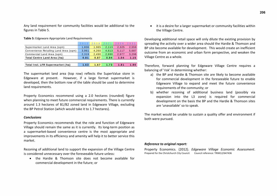
Any land requirement for community facilities would be additional to the figures in Table 5. Table 5: Edgeware Appropriate Land Requirements
2 0 1 2 2 0 1 6 2 0 2 1 2 0 2 6 2 0 3 1
Supermarket Land Area (sqm) 1,836 1,965 2,113 2,325 2,559Convenience Retailing Land Area (sqm) 3,961 4,260 4,613 5,117 5,687Commercial Land Area (sqm) 2,319 2,490 2,690 2,977 3,298Total Centre Land Area (ha) 0.81 0.87 0.94 1.04 1.15
Total Incl. LFR Supermarket (ha) 1.63 1.67 1.73 1.81 1.90
The supermarket land area (top row) reflects the SuperValue store in Edgeware at present. However, if a large format supermarket is developed, then the bottom row of the table should be used to determine land requirements. Property Economics recommend using a 2.0 hectares (rounded) figure when planning to meet future commercial requirements. There is currently around 1.3 hectares of B1/B2 zoned land in Edgeware Village, excluding the BP Petrol Station (which would take it to 1.7 hectares).
Conclusions Property Economics recommends that the role and function of Edgeware Village should remain the same as it is currently. Its long‐term position as a supermarket‐based convenience centre is the most appropriate and improvements in its efficiency and amenity will help it to better service this market. Rezoning of additional land to support the expansion of the Village Centre is considered unnecessary over the foreseeable future unless:
the Hardie & Thomson site does not become available for commercial development in the future; or
it is a desire for a larger supermarket or community facilities within the Village Centre.
Developing additional retail space will only dilute the existing provision by spreading the activity over a wider area should the Hardie & Thomson and BP site become available for development. This would create an inefficient outcome from an economic and urban form perspective, and weaken the Village Centre as a whole. Therefore, forward planning for Edgeware Village Centre requires a balancing of ‘risk’ in determining whether:
a) the BP and Hardie & Thomson site are likely to become available for commercial development in the foreseeable future to enable Edgeware Village to expand and meet the future convenience requirements of the community; or
b) whether rezoning of additional business land (possibly via expansion into the L3 zone) is required for commercial development on the basis the BP and the Hardie & Thomson sites are ‘unavailable’ so to speak.
The market would be unable to sustain a quality offer and environment if both were pursued.
Reference to original report: Property Economics. (2012). Edgeware Village Economic Assessment. Prepared for the Christchurch City Council. Council reference: TRIM12/647436
206
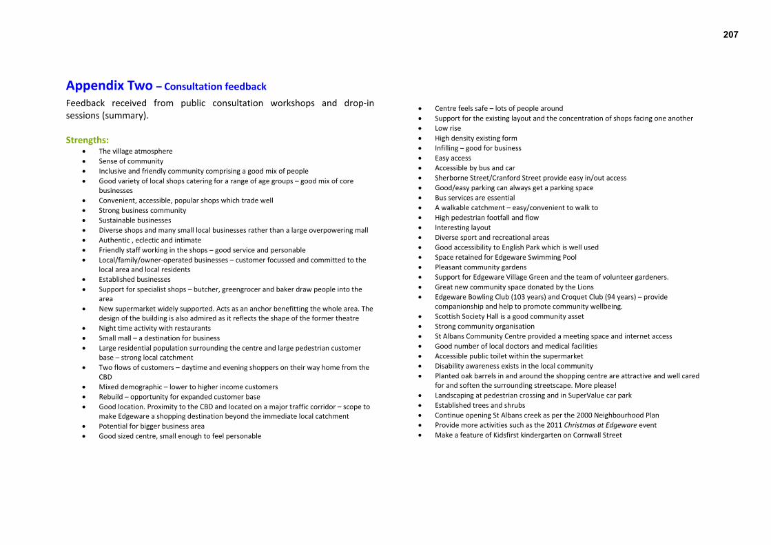
Appendix Two – Consultation feedback Feedback received from public consultation workshops and drop‐in sessions (summary). Strengths:
The village atmosphere Sense of community Inclusive and friendly community comprising a good mix of people Good variety of local shops catering for a range of age groups – good mix of core
businesses Convenient, accessible, popular shops which trade well Strong business community Sustainable businesses Diverse shops and many small local businesses rather than a large overpowering mall Authentic , eclectic and intimate Friendly staff working in the shops – good service and personable Local/family/owner‐operated businesses – customer focussed and committed to the
local area and local residents Established businesses Support for specialist shops – butcher, greengrocer and baker draw people into the
area New supermarket widely supported. Acts as an anchor benefitting the whole area. The
design of the building is also admired as it reflects the shape of the former theatre Night time activity with restaurants Small mall – a destination for business Large residential population surrounding the centre and large pedestrian customer
base – strong local catchment Two flows of customers – daytime and evening shoppers on their way home from the
CBD Mixed demographic – lower to higher income customers Rebuild – opportunity for expanded customer base Good location. Proximity to the CBD and located on a major traffic corridor – scope to
make Edgeware a shopping destination beyond the immediate local catchment Potential for bigger business area Good sized centre, small enough to feel personable
Centre feels safe – lots of people around Support for the existing layout and the concentration of shops facing one another Low rise High density existing form
Infilling – good for business Easy access Accessible by bus and car Sherborne Street/Cranford Street provide easy in/out access Good/easy parking can always get a parking space Bus services are essential A walkable catchment – easy/convenient to walk to High pedestrian footfall and flow Interesting layout Diverse sport and recreational areas Good accessibility to English Park which is well used Space retained for Edgeware Swimming Pool Pleasant community gardens Support for Edgeware Village Green and the team of volunteer gardeners. Great new community space donated by the Lions Edgeware Bowling Club (103 years) and Croquet Club (94 years) – provide
companionship and help to promote community wellbeing. Scottish Society Hall is a good community asset Strong community organisation St Albans Community Centre provided a meeting space and internet access Good number of local doctors and medical facilities Accessible public toilet within the supermarket Disability awareness exists in the local community Planted oak barrels in and around the shopping centre are attractive and well cared
for and soften the surrounding streetscape. More please! Landscaping at pedestrian crossing and in SuperValue car park Established trees and shrubs Continue opening St Albans creek as per the 2000 Neighbourhood Plan Provide more activities such as the 2011 Christmas at Edgeware event Make a feature of Kidsfirst kindergarten on Cornwall Street
207
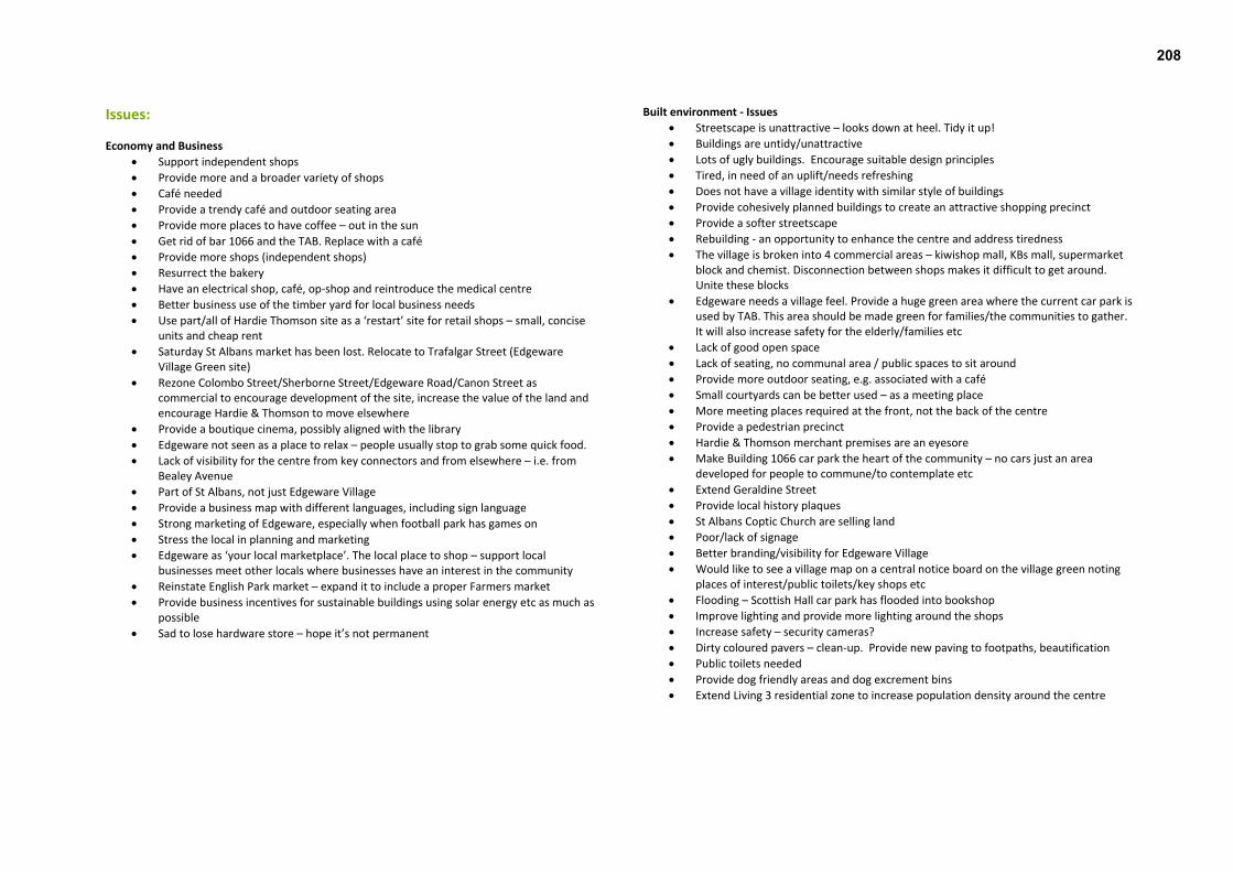
Issues:
Economy and Business Support independent shops Provide more and a broader variety of shops Café needed Provide a trendy café and outdoor seating area Provide more places to have coffee – out in the sun Get rid of bar 1066 and the TAB. Replace with a café Provide more shops (independent shops) Resurrect the bakery Have an electrical shop, café, op‐shop and reintroduce the medical centre Better business use of the timber yard for local business needs Use part/all of Hardie Thomson site as a ‘restart’ site for retail shops – small, concise
units and cheap rent Saturday St Albans market has been lost. Relocate to Trafalgar Street (Edgeware
Village Green site) Rezone Colombo Street/Sherborne Street/Edgeware Road/Canon Street as
commercial to encourage development of the site, increase the value of the land and encourage Hardie & Thomson to move elsewhere
Provide a boutique cinema, possibly aligned with the library Edgeware not seen as a place to relax – people usually stop to grab some quick food. Lack of visibility for the centre from key connectors and from elsewhere – i.e. from
Bealey Avenue Part of St Albans, not just Edgeware Village Provide a business map with different languages, including sign language Strong marketing of Edgeware, especially when football park has games on Stress the local in planning and marketing Edgeware as ‘your local marketplace’. The local place to shop – support local
businesses meet other locals where businesses have an interest in the community Reinstate English Park market – expand it to include a proper Farmers market Provide business incentives for sustainable buildings using solar energy etc as much as
possible Sad to lose hardware store – hope it’s not permanent
Built environment ‐ Issues Streetscape is unattractive – looks down at heel. Tidy it up! Buildings are untidy/unattractive Lots of ugly buildings. Encourage suitable design principles Tired, in need of an uplift/needs refreshing Does not have a village identity with similar style of buildings Provide cohesively planned buildings to create an attractive shopping precinct Provide a softer streetscape Rebuilding ‐ an opportunity to enhance the centre and address tiredness The village is broken into 4 commercial areas – kiwishop mall, KBs mall, supermarket
block and chemist. Disconnection between shops makes it difficult to get around. Unite these blocks
Edgeware needs a village feel. Provide a huge green area where the current car park is used by TAB. This area should be made green for families/the communities to gather. It will also increase safety for the elderly/families etc
Lack of good open space Lack of seating, no communal area / public spaces to sit around Provide more outdoor seating, e.g. associated with a café Small courtyards can be better used – as a meeting place More meeting places required at the front, not the back of the centre Provide a pedestrian precinct Hardie & Thomson merchant premises are an eyesore Make Building 1066 car park the heart of the community – no cars just an area
developed for people to commune/to contemplate etc Extend Geraldine Street Provide local history plaques St Albans Coptic Church are selling land Poor/lack of signage Better branding/visibility for Edgeware Village Would like to see a village map on a central notice board on the village green noting
places of interest/public toilets/key shops etc Flooding – Scottish Hall car park has flooded into bookshop Improve lighting and provide more lighting around the shops Increase safety – security cameras? Dirty coloured pavers – clean‐up. Provide new paving to footpaths, beautification Public toilets needed Provide dog friendly areas and dog excrement bins Extend Living 3 residential zone to increase population density around the centre
208

Movement – Issues High volume of traffic. Congested access to centre Conflict between cars and other transport means Traffic is too fast – needs to be calmed, enforce speed limits. Slow down traffic on
Edgeware Road from Sherborne Street / Caledonian Road through road humps Traffic speed ‐ Needs to be a ‘slow zone’. Impose a 20k/h speed limit between
Caledonian Road and Cranford Street and down Colombo to Canon Street Allow for good pedestrian circulation Need to provide safe linkages for traffic, cyclists and pedestrians Ability to slow traffic away through improving streetscape/car park area Turn Edgeware Road from Springfield Road to Hills Road into a pedestrian/cycleway
friendly boulevard. The grass verges can be turned into a combined pedestrian/cycleway with intermittent planting of trees, planters and greenery.
Too car and parking focused ‐ needs an enhanced pedestrian feel Provide stronger pedestrian links throughout the centre Provide a strong/green‐focused pedestrian core Concern for pedestrian safety. Make pedestrian access easy and friendly ‐ make
Edgeware a pleasant place to be a pedestrian Redirect the existing bus route through Colombo Street through Sherborne Street
allowing a pedestrian precinct in the T section of Colombo/Edgeware area Difficult to get people to visit the centre due to difficulties getting there Way finding to Edgeware – e.g. from Bealey Avenue – is not good. Difficult pedestrian access – crossing the road and walking through the car park Edgeware is hidden away (hidden treasure) Pedestrian refuge islands badly needed on Cranford Street. No safe crossing points for
2 blocks. Need safe crossing points – islands Pedestrian crossing by Supervalue is dangerous. Not safe for the elderly or children Safer access required for disabled persons Increase safety of pedestrian refuge island at north end of Colombo Road crossings leave a lot to be desired Provide kerbs and pathways for pedestrians and scoot mobiles which are safe Flashing, highly visible, innovative signage required to alert people that there are
school children crossing prior to 9am and after 3pm. Cranford Street crossing is a tragedy waiting to happen. Please act NOW
Provide a flashing pedestrian crossing for crossing between the shopping centre and the supermarket. Or one‐way street only to stem the flow of traffic in that area.
At the T section of Colombo/Edgeware – put humps across Edgeware Road at Caledonian Road / Sherborne Road / Colombo Street. Create a narrow two‐way traffic flow (common in Europe); make pedestrian and cycle‐ways a priority. Slow traffic down across Edgeware Road and increase the safety of pedestrians
Balancing act ‐ need to assist pedestrian and cycle safety from Hills Road through the village without losing any street parking.
Large buses pass through the village centre Poor public transport connections. Retain bus services to allow easy travel to town. Allow the route 14 bus to run more regularly Bus stop – needs to be well lit and positioned to discourage loutish behaviour Buses Colombo Street / Canon Street / Sherborne Street – take these off Edgeware
Road Conflict with access through parking on the corner of Colombo/Edgeware streets Good footpath facilities required Cornwall Street footpath needs to be improved to make it easier to drive through
when cars are parked along the street Mini roundabout at Colombo/Edgeware Roads narrowed. Pavements widened.
Pedestrian crossing on Colombo Street. Provide more cycle parking (bike stands). Designate cycle lane on Edgeware Road and Cranford Street Need more mobility parks in shopping centre and near community centre Connect the old pool site with the village Car parking should be improved, in terms of the flow of traffic in and around and out
of the parking areas Current car park needs an upgrade Get rid of cars from the car park at Colombo Street/Edgeware Road Not enough car parking ‐ busy on‐street parking. The bar uses most of the parking Lack of visibility of car parking Parking is a problem. Is the bus stop on Colombo Street necessary? Retain car parking Use angled parking to slow traffic and provide more spaces More angle parking needs to be provided outside Caledonian Hall Rethink the crossing outside the supermarket – it is damn dangerous. Turn into an
over‐bridge or an under‐bridge Concern about northern arterial coming down Cranford Street Concrete/asphalt footpaths are bland. Improve the kerbs/footpaths Keep the footpath clear especially with trimming of bushes etc Colombo onto Edgeware Road should be right of way – give way at
Edgeware/Trafalgar Access in and out of the BP Service Station is difficult and sometimes dangerous.
209

Community well‐being / culture, heritage – Issues Prioritise the development of a community building, including a swimming pool –
develop as soon as possible New community centre with facilities for table tennis, zumba, dancing – ‘social
exercise’ would be beneficial Provide something for the kids Bring back the medical centre Provide plenty of seats for the elderly Use the wide pavement for regular Saturday market Many school pools have been damaged – Edgeware swimming pool needed more than
ever As residents we are part of the St Albans suburb. Edgeware is our shopping centre. It is
important to keep it this way and not name other parts of St Albans Edgeware. This may be an issue for the post office.
Need more creative arts. Scope on the Hardie & Thomson site to build studios with living quarters? Build on the exhibition space which could also be used for small gatherings, concerts, lectures etc
Public toilets are not very visible No library – want to see a branch library (small south city size) Replace the library and provide free internet/computer training Loss of St Albans Community Centre – a wonderful place and home to the St Albans
choir. Lost a great facility and a beautiful building Loss of child play facilities within the community centre Replace the community centre – perhaps on old pool site. Provide a bigger space for
the community centre Major recreational facility removed (i.e. no swimming pool). Rebuild the swimming pool Provide a hub of community facilities – new community centre and new pool concept Lack of open areas and performance spaces Litter generated by users Provide more rubbish bins – maybe up to 500m from the centre Provide recycling bins Historical information (lack of) Create awareness of local history Lack of recognition for the many cultures of St Albans Provide more houses in the local area Encourage more people to visit Edgeware Create a facility where people can share ideas – ‘accessible caravan’ Bring back the doctor’s surgery – a good medical centre is needed. Make people aware of the availability of local medical facilities (pharmacy/doctor)
No local sports facilities now that Centennial has gone Skate park at St Albans park is too small Accessible play equipment needed Provide a farmers market. Good way of getting people together and feeling part and
proud of their neighbourhood Lack of off‐street public space (parking is being favoured)
Natural environment – Issues
Need a more attractive environment Tidy up required. Pretty up the centre Not sufficient trees, would like to see increased planting – more
vegetation/trees/greenery Not much green growth in winter – provide evergreen shrubs More native trees required Kowhai trees in Cornwall Street destroyed by Council rubbish trucks and have never
been replaced Trees – street plantings outside businesses or in any ‘spare corner’ would soften and
green the area and encourage people to slow down, stop and enjoy the ambiance. Landscaping – provide bushes rather than trees, or something similar to Cashel Mall Provide ‘Living Streets’ Planter boxes placed and maintained by Edgeware Village Green are a start to
ensuring that Edgeware maintains a natural and appealing look. Expand the planting and have a good maintenance contract that does not rely upon volunteers.
Provide outdoor seating under trees to sit and enjoy Keep better track of cutting back trees/hedges along footpaths for easy access for
both disabled users and the general public No outside water taps Improved visibility Provide a green sitting place within car park area of the Edgeware shops Open up St Albans creek Make sure any tree planting does not obstruct driver’s views Tree on the pavement at the SW corner of the BP PFS – blocks views when turning out
of Cornwall Street Stop putting grass verges outside retirement housing cluster pavements – people
don’t own lawn mowers
210

Suburban Centres Programme ∙ Draft Edgeware Village Master Plan 58
Appendix Three – indicative costs of streetscape work The following information shows indicative costs only, for Actions 1a – 1f. Capital budget required
For: New kerb alignment, crossings and buildouts. Drainage, paths (AC and pavers), street furniture, landscape and tree
planting. Intersection improvement, lane markings, car parking etc. Road shoulder restoration and carriageway reconstruction. (including contingency to allow for "unknowns" e.g. drainage and underground services conflict with new kerb): $2,200,000
For: Lighting (detail unknown so provisional amount allocated) $400,000
Total Construction Costs (approximate) $2,600,000
Other budget required For: Project Management, Survey, Design Detail and Documentation, Contract
Admin and Supervision Consultation
$660, 000
Total project cost for Actions 1a – 1f (approximate): $3,260,000 Note: this total excludes street art.
211