claudinei rodrigues de aguiar federal university of technology - parana [email protected]...
TRANSCRIPT

Claudinei Rodrigues de AguiarFederal University of Technology - Parana
Paulo de Oliveira Camargo São Paulo State University - UNESP
Real Time Ionosphere Maps from GNSS Active
Networks
Outline
• Introduction• Real time ionospheric modeling and
monitoring• Data Processing in Real Time• Experiments• Summary
LISN Workshop 2011

• GNSS has definitely been an important tool for observation of the atmosphere parameters, especially those from the ionosphere.
• Mod_Ion (Camargo, 1999) (1995 a 1999): for post processing applications was developed at FCT/UNESP;
• Kalman Filter was further implemented (Camargo, 2001);
LISN Workshop 2011
Introduction

• Mod_Ion_FK (Aguiar, 2005) - (2003 a 2005): Mod_Ion+Kalman Filter – changes in the functional model, and quality control was implemented in the Kalman filter algorithm;
• GNSS SP Network (2006): availability of real time data;
• GI e GIVE: current;
LISN Workshop 2011
Introduction

Introduction
• This work is part of a research project for atmospheric studies based on real time reference stations equipped with dual frequency GNSS receivers:
– GNSS SP (GNSS Active Network of São Paulo State)– RBMC (Brazilian Network for Continuous
Monitoring)
LISN Workshop 2011

Real time ionospheric modeling and monitoring
Two-dimensional
Analytical Models
Analytical functions Grid
Three-dimensional
Fourier seriesSpherical harmonics
Taylor series
Analytical functions
Empirical functions
LISN Workshop 2011

Bidimensional
Analytical Models
Analytical functions Grid
Tridimensional
Fourier seriesSpherical harmonics
Taylor series
Analytical functions
Empirical functions
LISN Workshop 2011
Real time ionospheric modeling and monitoring

• An ionospheric model has been developed for applications in real time;
• An algorithm based on a Kalman filter has been developed for ionosphere modeling at low latitudes and for the estimation of ionospheric parameters: absolute vertical TEC (VTEC);
• In this work we have utilized the two dimensional Fourier series for modeling the vertical ionospheric delay. However, other modeling functions are being implemented;
Real time ionospheric modeling and monitoring
LISN Workshop 2011
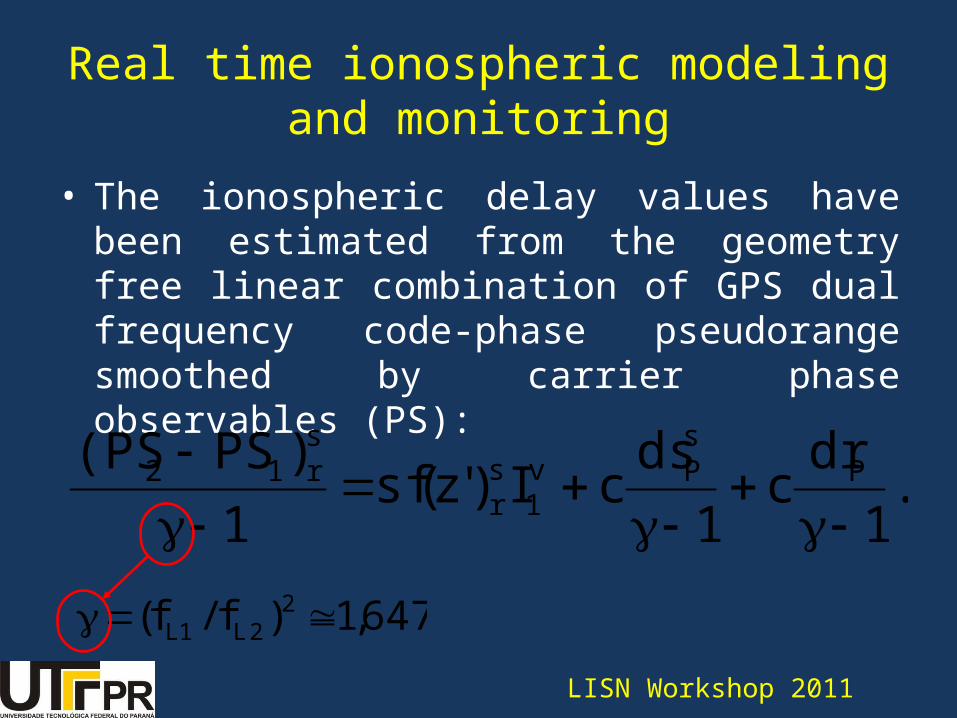
• The ionospheric delay values have been estimated from the geometry free linear combination of GPS dual frequency code-phase pseudorange smoothed by carrier phase observables (PS):
.1
drc
1
dscI)'z(sf
1
)PS(PS PsPv
1sr
sr12
647,1)f/f( 22L1L
Real time ionospheric modeling and monitoring
LISN Workshop 2011

• The ionospheric delay values have been estimated from the geometry free linear combination of GPS dual frequency code-phase pseudorange smoothed by carrier phase observables (PS):
Real time ionospheric modeling and monitoring
LISN Workshop 2011
.1
drc
1
dsc
])B sin(i a)B cos(ia[
ha])h sin(i a)h cos(ia[Baa
)'z(sf1
)PS(PS PsP
4m
102ij1i
s1j
sj
s32*n
4n
12ij1i
s1j
sj
s21
sr
sr12

• Calculation of ionospheric delay for each IPP:
1
)drsc(d
1
)PS(PSI P
sP
sr12s
r 1
e3,01)el(sf
240/el2
2IFB
2PS2
i
GIVE
LISN Workshop 2011
Real time ionospheric modeling and monitoring

• The real time modeling of the ionosphere is performed using data collected by active GNSS reference stations in Brazil;
• GNSS SP Network (GNSS Active Network of São Paulo State), leaded by FCT/UNESP and financed by FAPESP (São Paulo Research Foundation);
Real time ionospheric modeling and monitoring
LISN Workshop 2011

• GNSS SP Network: Currently, eleven GNSS active stations providing data in real time
Real time ionospheric modeling and monitoring
LISN Workshop 2011
• RBMC-IP (Brazilian Network for Continuous Monitoring of GNSS), maintained by IBGE (Brazilian Institute of Geography and Statistics );
Real time ionospheric modeling and monitoring
LISN Workshop 2011
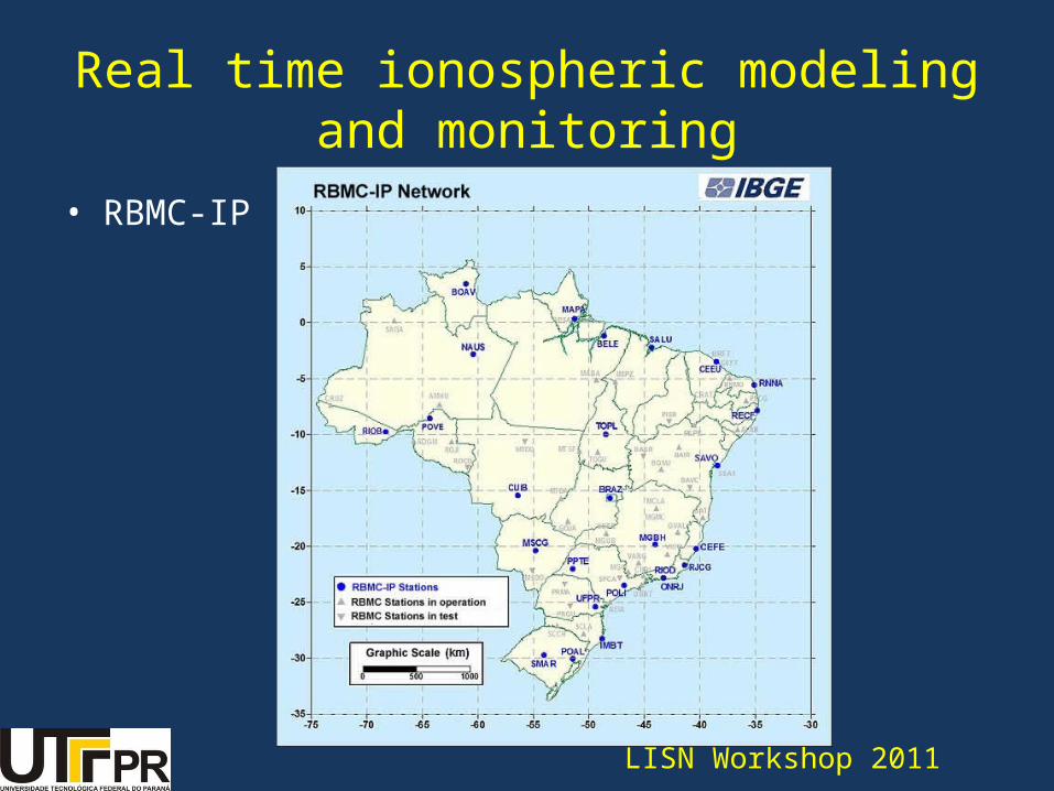
• RBMC-IP
Real time ionospheric modeling and monitoring
LISN Workshop 2011

• These networks provide their data via the Internet using Internet Protocol (NTRIP);
• The availability of GNSS data via the NTRIP protocol brings new perspectives in research related to modeling and/or monitoring of the ionosphere in real time;
Real time ionospheric modeling and monitoring
LISN Workshop 2011

• NTRIP was projected to disseminate differential data correction or other types of GNSS data to users, moving or still, by the Internet.
Real time ionospheric modeling and monitoring
LISN Workshop 2011
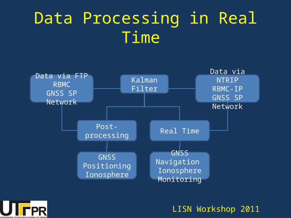
Kalman Filter
Post-processing Real Time
GNSS PositioningIonosphere
GNSS Navigation Ionosphere Monitoring
Data via FTPRBMC
GNSS SP Network
Data via NTRIPRBMC-IP
GNSS SP Network
LISN Workshop 2011
Data Processing in Real Time
Data Processing in Real Time
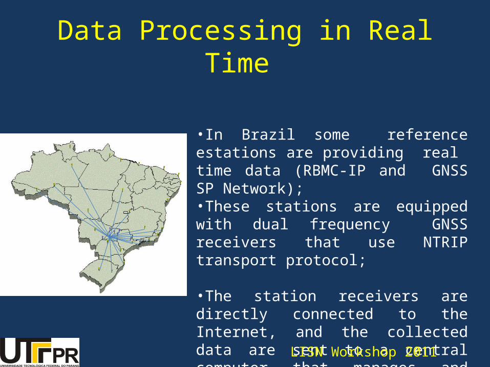
•In Brazil some reference estations are providing real time data (RBMC-IP and GNSS SP Network);•These stations are equipped with dual frequency GNSS receivers that use NTRIP transport protocol;
•The station receivers are directly connected to the Internet, and the collected data are sent to a central computer that manages and storages the data
LISN Workshop 2011

BNC
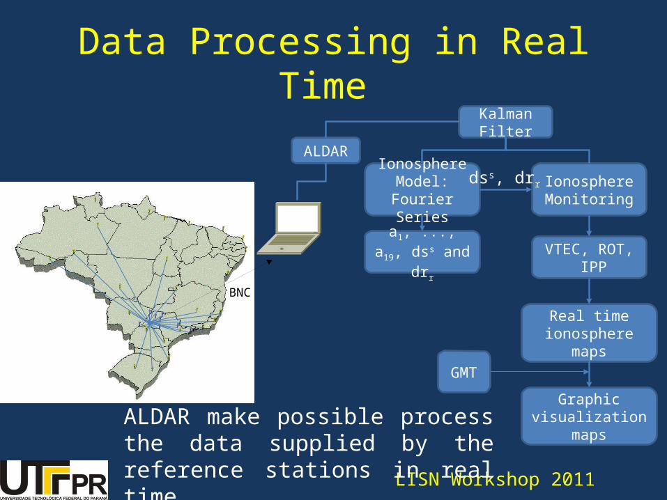
•Using a Ntrip Client program we can download these data into a computer (convert ed to RINEX);
•We developed a package of algorithms for reading RINEX files in real time and the processing these data ;
LISN Workshop 2011
Data Processing in Real Time
BNC
ALDAR
Kalman Filter
Ionosphere Model:
Fourier Series
a1, ..., a19, dss and drr
Ionosphere Monitoring
dss, drr
VTEC, ROT, IPP
Real time ionosphere maps
GMT
Graphic visualization maps
Data Processing in Real Time
LISN Workshop 2011
ALDAR make possible process the data supplied by the reference stations in real time

BNC
ALDAR
Kalman Filter
Ionosphere Model:
Fourier Series
a1, ..., a19, dss and drr
Ionosphere Monitoring
dss, drr
VTEC, ROT, IPP
Real time ionosphere maps
GMT
Graphic visualization maps
LISN Workshop 2011
Data Processing in Real Time

Grid Maps - Brazil
GIVEL1 Ionospheric Delay
• November 22, 2009;• Real time processing;• 29 NTRIP stations.
LISN Workshop 2011

Grid Maps – South America
GIVEL1 Ionospheric Dealy
• May 11, 2006;• Processing for Central and South America stations, simulating real time;• 52 stations.
LISN Workshop 2011

Surface Maps - Brazil
GIVEL1 Ionospheric Delay
VTEC and ROT Map generated near real time from Grid.
ROT MapVTEC Map
LISN Workshop 2011

Surface Maps – South America
GIVEL1 Ionospheric Delay
VTEC and ROT Map generated simulating real time.
ROT Map
VTEC Map
LISN Workshop 2011

Output File
LISN Workshop 2011
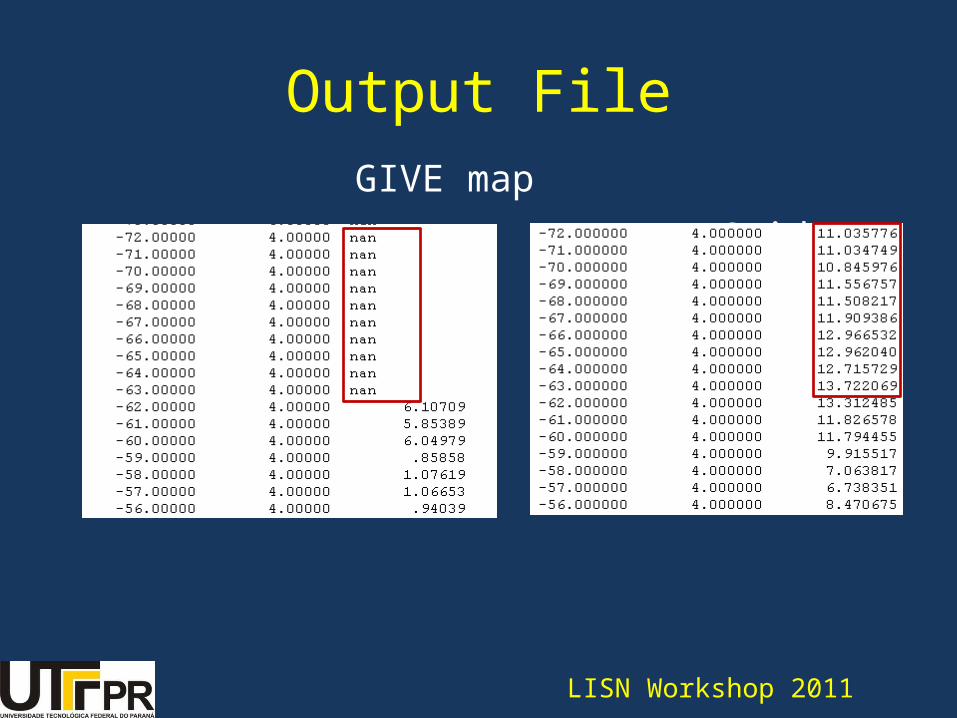
Output File GIVE map Grid Map
LISN Workshop 2011

• Analyze of the quality of ionospheric grid:
IGI versus IREFERENCE
IGI- IREFERENCE < εGIVE
Grid Quality
LISN Workshop 2011
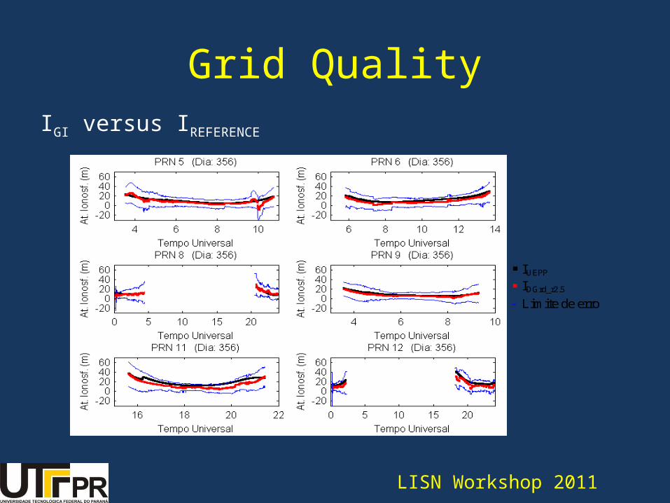
IGI versus IREFERENCE
Grid Quality
IUEPP IDGrd_r2.5
Limite de erro
LISN Workshop 2011

• The results show a limitation of the use of GI for the period of high solar activity, due to low number of the reference stations wich, consequently, results in a low number of IPP available to the generation of GI;
• When the GI degraded the results we observed that: GIVE was’nt available;
GIVE was available but did’nt have a minimum of 3 IGPs;
Impact of the density of reference stations
LISN Workshop 2011

Dez/2001 Out/2003
• Temporal availability varies from 10% (2.4 h) to 90%(21.6 h);
• Average of 70% (16.8 h monitored / unmonitored 7.2 h);
LISN Workshop 2011
Impact of the density of reference stations

Impact Analysis of the distribution of reference stations in GI
• It was developed the algortihm GS (Grid Simulator);
• GS is responsible for analyzing the distribution of reference stations.
• It is a software package that have their own libraries and also uses the GMT and ImageMagick libraries.
LISN Workshop 2011

• 29 stations (GNSS SP, RBMC-IP)
• 24 hours of data;
• 5º: coverage of 95% (22.8 h) in most of Brazil, the region under the influence SP GNSS coverage reaches 98% (23.5 h).
• 2,5º: 25% (6 hours) in the worst case, and 97% (23,3 h) in the best situation.
• 1º: the cell with better coverage (67% - 16 h); in other cell the coverage varies from 3% (0.7 h) to 50% (12 h).
5° x 5°
2,5° x 2,5°
1° x 1°
5° x 5°
2,5° x 2,5°
1° x 1°
LISN Workshop 2011
Impact Analysis of the distribution of reference stations in GI

• Considering the current configuration of the available networks in Brazil, the best results are obtained when using grids with spatial resolution greater than 2.5 °.
• In the modeling of the ionosphere in real time, the best results are to be expected in the southeast, because of the influence of GNSS SP network;
LISN Workshop 2011
Impact Analysis of the distribution of reference stations in GI

• Analysis of the average distance: Resolution 5ºx5º spacing of approx. 600 km
Resolution 2,5ºx2,5º spacing of approx. 250 km
Resolution 1ºx1º spacing of approx. 100 km
LISN Workshop 2011
Impact Analysis of the distribution of reference stations in GI

Summary• The development of real time ionospheric model is
under progress.
• Some problems of dynamic programming have to be
solved.
LISN Workshop 2011
Summary• The next step is to provide, near real time, the
ionospheric model coefficients and an ionospheric
grid to users.• Tests carried out in point positioning show that the
corrections provided by the GI should be used only when the GIVE is available;
• The software developed also use libraries of the GMT (Generic Map Tools) and Image Magick, both open source.
LISN Workshop 2011

Thank you for your attention!
LISN Workshop 2011