classification and interpretation of the shapes and...
TRANSCRIPT

Gisements alluviaux d'or, La Paz, 1-5 juin 1991
CLASSIFICATION AND INTERPRETATION OF THE SHAPES AND SURFACE TEXTURES OF GQLD GRAINS FROM TILL
R.N.W. DILABIO
Geological Survey of Canada, 601 Booth Street, Ottawa, Canada, K1A OE8
ABSTRACT Glacial dispersal trains are three-dimensional bodies of till that contain measurable amounts of distinctive clasts or minerals (such as gold) that can be traced back to a mineralized bedrock source. Gold-bearing dispersal trains show many of the structural features seen in al1 dispersal trains, such as extreme attenuation, abrupt lateral and vertical contacts, and shallow dip. Many, but not al1 trains show a marked dom-ice decrease in the abundance of the distinctive components, resulting from deposition of the components in till and dilution of the glacial load by newly eroded debris. The shape of gold grains in dispersal trains also changes along the down-ice path from I'pristine'' to "modifie&' to "reshaped", reflecting increasing distance of transport. The relative proximity to mineralized bedrock can be estimated by observing - the abundances of gold grains in the three shape classes.
RESUMEN Les traînées de dispersion glaciaire sont des masses de till en trois dimensions qui contiennent des quantités mesurables de fragments ou de minéraux distinctifs (tels que l'or) qui peuvent remonter à un socle d'origine minéralisé. Les traînees de dispersion porteuses d'or exposent plusieurs des caractéristiques structurales observées dans toutes les traînées de dispersion, telles que l'atténuation extrême, les contacts latéraux et verticaux abrupts et l'inclinaison faible. La plupart, mais non toutes les traînées, indiquent une décroissance, vers l'aval glaciaire, des composantes caractéristiques, résultant de la déposition des composantes du till et de la dilution de la charge glaciaire par les nouveaux débris arrachés. La forme des grains d'or dans les traînées de dispersion change également en direction de l'aval glaciaire, d'''intacte" à "modifiCe" à "refaçonnée", indiquant une distance de transport accrue. L a proximité relative du socle minéralisé peut être estimée en observant l'abondance des grains d'or classifiés selon ces trois formes.
INTRODUCTION
Exploration of glaciated terrain by means of drift prospecting would be simplified greatly if the exploration geologist or prospector had some examples on what patterns of glacial dispersal he could expect to find in a given area. The variations in gold grain morphology can also be applied to the mapping of auriferous dispersal trains. This Geological Survey of Canada Contribution IV 32391"
-
2 9 7

Gisements alluviaux d'or, La Paz, 1-5 juin 1991 1
first part of this paper cqntains descriptions of dispersal trains that were deposited by the hurentide Ice heet in Canada, in order to show what features they have in cornmon. The second part describes gold grain shapes and surface textures.
What characteristics do we see in examining dispersal trains that have been traced back $8 their sources? Miller (1984) has published a model that is applicable (Fig. 1). Baed on observations of srna11 trains that were studied during mineral exploration, this model shows a plan view and cross-sections through a hypothetical train. Small dispersal trains have at least five features in common. First, they are extremely thin in csmparison to their length and width. Second, they are areally hundreds ts thousands of times larger than .their bedrock sources, hence rhey form large targets for geoehemical and lithologieal exploration. Dispersa1 trains of distinctive boulders, minerals, trace elements or major elements, and radioactive cornponents may increase the size of mineral exploration targets by several orders of magnitude. Third, they
Fig. 1: Idealized model of a glacial dispersal train (msdified from Miller, 1984).

Gisements alluviaux d’or, La Paz, 1-5 juin 1991
have abrupt lateral and .vertical contacts with the enclosing till. Fourth, they climb gently within the enclosing till as they are followed down-ice from their sources. Fifth, many, but not all, show a down-ice decrease in content of distinctive components from the ‘head‘ to the ‘tail’ of the train. The tail of a dispersal train is generally many times longer than the head and is usually the part of the train that is detected first by mineral exploration programs using till geochemistry or boulder tracing. The major objective of drift prospecting is simply to detect the tail of a dispersal train, trace it back to its head, and find its source.
The size and shape of a dispersal train are controlled by the orientation of the source relative to ice flow, by the size and erodibility of source, and by the influence of topography on ice flow in the source and dispersal areas. Dispersa1 occurs at a variety of scales ranging from continental (100’s of kilometres), to regional (100 to 10’s of kilometr?), to local (< 10 kilometres), to property-scale (final stages of mineral exploration in the 100’s to 10’s of metres) (Shilts, 1984).
EXAMPLES OF GOLD-BEARING DISPERSAL TRAINS
It is clear that only through careful studies of the interna1 structure (‘anatomy’) of dispersal trains can the exploration geologist learn how to use them to find mineralized bedrock. Many trains have been described in the past few years, particularly in Fennoscandia and Canada (Hyvarinen et al., 1973; Nurmi, 1976; Minell, 1978; Bolviken and Gleeson, 1979; Salonen, 1986; Puranen, 1990; Coker and DiLabio, 1989; Hartikainen and Damsten, 1991; Saarnisto et al., 1991). Those chosen for this paper illustrate most of the main characteristics given above and are small ones that have been mapped by ‘detailed‘ sampling of exploration properties (sampling at about 100 metre spacing).
A reverse circulation overburden drilling program carried out at the Golden Pond gold deposit, Casa Berardi, Québec by (Sauerbrei et al., 1987) identified a thin till containing anomalous gold values and abundant gold grains. Of note was the discovery that glacial dispersal of gold was very limited, in the order of 200 to 400 m. This was because’the ice that deposited the lower till moved subparallel to the strike of the mineralized structure, itself recessive and a bedrock trough, which confined the dispersal train.
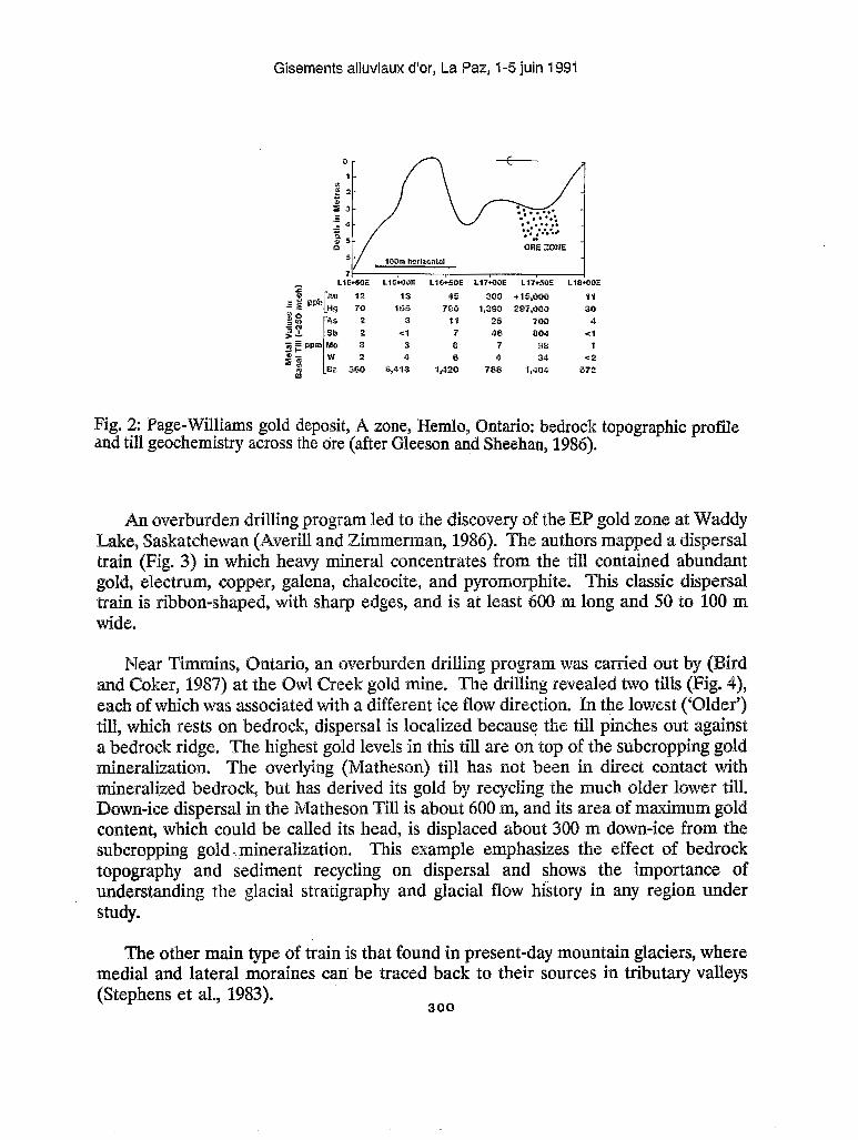
In the Hemlo, Ontario area, at the Page-Williams gold deposit - ”A” zone, (Gleeson and Sheehan, 1987) found that an exotic upper till gave little indication of the gold mineralization. The underlying locally derived till gave good response to the gold mineralization in al1 size fractions and heavy minerals, in gold, arsenic, antimony, molybdenum, mercury, tungsten, and barium (Fig. 2). Once again, dispersal was short (i.e. 200 m), partly because the deposit lies in the lee of a bedrock high and is protected, and partly because dispersal is truncated against a bedrock high down-ice.
299
Gisements alluviaux d'or, La Paz, 1-5 juin 199'1
Fig. 2: Page-Williams gsld depssit, tspsgraphic profile and till geochemistry acrsss the bre (
g program led to the discovery of the EP gold zone a% ri11 and Zimmerman, 1986). The authors mapped a d
train (Fig. 3) in which heavy mineral concentrates from the till contained abundant gold, electmm, copper, galena, chalcocite, and pyrornorphite. This classic dispersal train is ribbon-shaped, with sharp edges, and is at least 680 rn long and 50 to 106 m wide.
Near Timmim, Ontario, an overburden drilling program was carried out by (Bird and Coker, 1987) at the Owl Creek gold mine. 'The drilling revealed IWO tills ( each of which was associated with a different iee flow direction. In the Iowest ('
rests on bedrock, dispersal is localized becus? the till pinches sut against ridge. The highest gold levels in this till are on top of the subcropping gold
mineraliaatisn. The overlying (Matheson) till has not been in direct contact with mirmeralized bedrsck, but has derived its gold by reqcling the much older Iower till. Dom-ice dispersal in the Matheson Till is about 600 m, and its area of maximum content, which eould be called its head, is displaced about 300 m down-ice from the subcropping gold - mineralization. 'This example emphasizes the effect of bedrock topography and sediment reqcling on dispersal and shows the importance of understanding the glacial stratigraphy and glacial flsw histsry in any region under StUdY.
The other main type of train is that found in present-day rnountain glaciers, where medial and lateral moraines can' be traced back to their sources in tributary valleys (Stephens et al., 19
360

Gisements alluviaux d'or, La Paz, 1-5 juin 1991
LEGEND c
Fig. 3: Glacial dispersal train from the EP gold zone, Waddy Lake, Saskatchewan (after Averill and Zimmerman, 1986).
30 1

b
Gis
emen
ts a
lluvi
aux d
'sr,
La P
az, 1
-5 ju
in 1
991

Gisements alluviaux d'or, La Paz, 1-5 juin 1991
GOLD GRAINS
Since the adoption of drift prospecting in the search fbr gold deposits in glaciated terrain, several tens of thousands of till samples have been processed in commercial and government laboratories to recover heavy minerals by shaking table, heavy liquid, and panning methods (Averill, 1988). In addition to preparing the samples ' for geochemical analysis, these separation methods permit inspection and counting of minerals in the heavy concentrates. Gold grains in the concentrates are examined to estimate the relative distance that the grains have been transported from their bedrock source, by observing the degree of rounding, polishing, and bending of the grains. Most of thësZobservations have been made using a binocular microscope, which has limited the size of grain and surface feature that could be resolved.
The dominance of silt- and Clay-sized gold grains in Canadian gold deposits and the tills derived from them (Averill, 1988; Brereton et al., 1988) has prompted laboratories to improvq,?ecovery rates for fine gold, mainly by modifgrlng the procedures used with the shaking table, by making slight design changes to the table, and by panning the heavy concentrate. When examined with a binocular microscope, however, small (< 60 Pm) gold grains are not seen clearly. In this study, scanning electron microscopy (SEM) has been employed, taking advantage of the higher depth-of-field even at high magnification of the SEM (compared to light microscopy) to view the shapes and surface textures of gold in greater detail. A scanning electron microscope equipped for backscattered electron imaging (BEI) and energy-dispersive spectrometry has the added advantage of discriminating among the ore, gangue, and secondary minerals that may be present; it can also analyze their compositions. In BEI, a phase with high average atomic number (e.g., gold) appears white, and most other phases appear in shades of grey. This high contrast allows one to see the shape and texture of the gold, even where coatings and other minerals partly obscure the gold in normal secondary electron imaging. From SEM observations of shapes and surface textures, the analyst estimates the mineralogy and texture of the source mineralization and the transport and weathering history of the gold grains.
Existing classification schemes for detrital gold morphology were developed mainly for gdd from lateritic and fluvial sediments in Africa and South America (HCrail, 1984; HCrail et al., 1988; Freyssinet et al., 1989,1990; Vasconcelos and Kyle, 1989; Colin et al., 1989). Preliminary studies of gold grain shapes from till have been published by (DiLabio, 1990 and Nikkarinen, 1991). The only scheme that is specific to glacial sediments is a threefold scheme devised by S.A. Averill ("delicate-irregular-abraded") that is based solely on binocular microscope examination of grains (Averill,T988). The new scheme presented here is intended to complement Averill's, because only those analysts with access to a SEM can use it.
In order to make the study representative of different styles of mineralization, till samples from nine Canadian localities were examined. Five of the localities were
303 !

Gisements alluviaux d'or, La Paz, 1-5 juin 1991
sampled avithin 500 m of the presumed bedrock source, the other four from 1 to 5 km dom-ice of the presumed bedrock source. far as is hem, the gold in the bedrock at these sites is present in free forrn, as leaves in quartz-carbon boundary i i lm, fractur fillings, and blebs within gangue minerals. samples are from w test pits and represent the osnidized C horizon of soi1 developed on till. f the till is intenpreted as lodgment till, some as subglacial melt-out till. Samples were prepared by shaking table and panning methods; the resulting heavy concentrates were viewed under a binocular microscope and gold grains were picked out and mounted on adhesive-coated stubs, carbon-coated, and examined and photographed with an SE sst of the gold grains are silt-sized; a few are medium to fine sand-sized.
E FOR GOED G
The scheme (Table 1) is designed to facilitate communication by being graphically descriptive and nongenetic so that someone reading grain descriptions would be able to visualigb the variety of shapes and surface textures present in a sample. The vase number of morphslogical terms that have been applied to detrital gold grains (Boyle, 1979; Mkrail, 1984; Freyssinet et al., 1989) has made it difficult to choose terms that are the most useiùl. The most commonly used were chosen first and a few particularly Gvid ones were added. Terms should be used in combination to describe grains as clearly as possible. This is not meant to imply that the classification is complete; users are encouraged $0 add terms that are suitable. The main shapes and surface textures are described below.
The classification dses not prejudge the issue of the possible secondary or supergene origin of large, globular or smooth, ovoid nuggets that have been found in Canada9s glaciated terrain. Terms that wsuld describe secondary OP supergene gold have been omitted because of the rarity of such grains in till (Warren, 1982;
Stea; 1985), although the classification could be redesigned to consist of terms to describe primary and secondary gold separately.
Pristine
The pristine class of grains is analogsus to the "delicate" class of Averill, but the new name has been used because many pristine grains are no% delicate at all, being robust bloc@ shapes. The term "fresh" csuld be substituted for pristine in most cases, but the term "primary" is avoided because of the possibility that some gold crystals are seeondary authi enic precipitates in weathered till (Warren, 1982), as they seem to be in lateritic soils (Vasconselos and le, 1991; Freyssinet et al., 1998). Euhedral dodeeahedral gold crystals (Fig. 5a) were found in one sample, and at first they were believed ts be authigenic. Later, s lar crystals were obse d in fluid inclusions in veim quartz at the Tangier mine in a Scotia (Smith and ntak, 1988) and at the Sigma mine in Quebec (Robert an ly, 1987), SB crystals in till camot be assumed ts be authigenic.
3 04

Gisements alluviaux d’or, La Paz, 1-5 juin 1991
Table 1. Classification of shapes and surface textures of gold grains in till.
Class Shape Surface Texture
Pristine - block - smooth surfaces - rod or wire - angular edges - leaf - grain moulds clearly visible - crystal - thin edges not curled - star - some striae - globule or bleb
Modified - al1 pristine shapes - leaf edges and wires bent, curled damaged, but visible - blunted and clubbed edges
- grain moulds preserved where protected - moderately striated - felty texture where damaged
Reshaped - well rounded grain - porous, scaly, felty, or spongy outline - rarely striated
- .
- folded rod, wire, flake - rounded block - typical discoid
placer flake - nugget
Pristine grains appear not to have been damaged in glacial transport. The most impressive shapes in the class are angular wires or rods and delicate leaves that were fracture fillings or grain boundary films in the mineralized rock (Fig. 5b-h). Equant silt-sized grains such as block, blebs, and globules are common, and they do not appear to be pristine until they are viewed at high magnification ( ~ 1 0 0 0 ~ ) . Al1 grains in this class retain primary surface textures such as crystal faces or grain moulds, which probably held gangue minerals that have been broken out or weathered out of the gold. They have smooth surfaces that are bright in reflected light and have surface roughness of the order of 0.1 pm or less.
The surprising feature of the pristine grains is their relative abundance. Most samples contained a few pristine grains, but samples collected near mineralized bedrock are dominated by this type of grain. At three localities, samples collected within 200 m of their sources contained > 90% pristine grains. It is possible, of course, for pristine grains to have weathered out of a carbonate- or sulphide-rich host clast that was glacially transported a great distance, giving a false impression of the nearness of a sample site to mineralized bedrock. This type of problem can be evaluated by comparison of the anomalous data to those from nearby sites, and by-resampling the original site.
305

Gisements alluviaux d'or, La Paz, 1-5 juin 1991
odified
n the msdified class (analogous to erill's "irregular" class), original shapes and priaiary surface textures are visible, but al1 edges and protnusions have been
ged and appear curled, crumpled, blunted, clubbed, and bent, presurnably throu grain-to-grain impact and abrasion during transport (Fig. da-cl). Darnaged surfaces have a felty texture, having lost their original s m o ~ t h ~ ~ ~ s . Grain moulds and other primary surface features are presewed only where they were prolected in concavities in the grains (Fig. 6e-0.
ugh present on some pristine grains, striae are more cornmon on rnodified g. 6 gh). The striae are 1.8 to 6.1 pm across and appear in overlapping sets the sudaces the appearance of spread butter or wax. The striae are in.ferred
to be glacial; s d y in a few cases could the striae have been formed during sample collection (cg., drill-induced abrasion) or processing. The glacial striae probably were not CU$ by individual grains in the 1.6 to 0.1 pm size range, but were cut by the surface roughness of larger grains, which would accomt for their extremely srnall s ix . The rare artificial striae found on the grains were formed during rnsunting of the grains,
essive pressure with a needle scratched only the topmost part 0% the grains. striae have also been ruled out because the striae occur in isolated patches rolrusions and not on whole sides of grains, and because they form randody
oriented sets, not consistently oriented sets.
Striated, modified grains are strong evidence of glacial transport, but inferring an absolute distance of transport from them is difficult. It is safe to s q that where modified grains are abundant (well above local background abundance), the bedreck source should be up-ice and "nearby", probably within a few hundred metres to a few kilometres, based on the sites investigated so far. OP course, where striiated pristine grains are abundant, the source should be closer, so rnappin the relative abundances of pristine and rnodified grains shohld indicate where the source lies.
eshaped
Weshaped grains retain none of their pristine shapes or textures. distinctly s-ounded outline. The term rounded is used here solely ts denote the silhouette of the grains and it does not necessarily imply abrasion rounding in the sedimentological sense. Some are simple rounded blocks and others are repeatedly folded leaves, wires, and rods. The end-product shape of reshaped grains seems to be the classic placer flake, a flat sr toroidal dise (Fig. 7a-d). Classic "nuggets" are placed in this group, although sorne retain enough primary surface textures in recesses to warrant their inclusion in the modified group.
ir;
t:
Fig. 5: Pristine gold grains. Scale bar in pm at top of each photo. .-- L

Gisements alluviaux d'or, La Paz, 1-5 juin 1991
307


Gisements alluviaux d'or, La Paz, 1-5 juin 1991
Fig. 7: Reshaped gold grains. Scale bar in pm at top of each photo.
Striated reshaped grains are rare. The surface of reshaped grains is characteristically scaly or felty, presumably from fluvial abrasion. Some are riddled with pores about 0.1 pm in diameter. The most porous have a spongy appearance. Electron microprobe analysis of porous grains shows that a porous rirn of high purity gold, usually 1 to 5 pn thick, surrounds a massive core of primary gold that contains significant silver. Leaching of silver from the rim, not secondary precipitation of gold, is indicated by the presence of pores through glacially striated surfaces on a very small number of grains, because any glacial striae would have been obscured by secondary gold. The silver-depleted rim on placer gold grains is well known (Desborough, 1970; Giusti, 1986; Knight tk McTaggart, 1986; Groen et al., 1990); these results indicate that silver removal has been going on rapidly during the 10 O00 years or so that the tills have been weathering, if one assumes that the striae are late glacial and the pores are Holocene in age. The destruction of primary surface textures by silver leaching might 'make it difficult to recognize pristine or modified grains, but the survival of striated surfaces indicates that most original surface textures should be visible on weathered grains. Unfortunately, the vast majority of reshaped grains are classic placer flakes that ,
show evidence only of stream transport and weathering.
Fig. 6: Modified gold grains. Scale bar in pm at top of each photo. 3
* 309
,

Gisements alluviaux d'sr, La Paz, 1-5 juin 1991
Reshaped grains are present in srnall nurnbers in many samples. They are the rare "background" detrital gold grains that are essentially ubiquitous in surficial sediments. Because the surface texture and shape of these grains mainly result from weathering and fluvial abrasion, not glacial abrasion, they cannot be used to infer a distance of glacial transport. Most irnportantly, because they could have been recycled in fluvial or glaciofluvial s t r e a p many tirnes over a long period, even the entire Quaternary, the history of these grains and their ultirnate source are usually impossible to estirnate. They can be problematic where they are found in large numbers reqcled in ti'll or, where gold grains were cowcentrated by glaciolaclnstrine or g l a ~ i ~ f l u ~ i a l processes into small placers that have no discrete, known sources.
The classification scherne ('Table 1) is intended as an aid in describing gold grains and in grouping them into types that represent stages in their history. Moving from pristine to reshaped should represent increased distance of transport, so the relative proportions of the types should indicate nearness to the bedrock source, ai least qualitatively. For the grain abundances to be useful, however., the number of pristine or rnodified grains in each sarnple must be Large, say about 100 at a frequency of > 10/kg. Only then can the mapped distribution of gold abundances be used as a guide ts mineralized bedrock.
. 1988. Regional variations in the gold content of till in Canada; in Brospecting in eas of Glaciated Terrain-1988; D.R. MacDonald and K.A. Mills (ed.); Canadian Institute of Mining and Metallurgy, p. 271-284.
erill, S.A. and Zimmerman, J.R. 1986. 'The Riddle resolved: the discovery of the Partridge gold zone using sonic drilling in glacial overburden at Waddy Lake, Saskatchewan; Canadian Geology Journal of the Canadian Institute of Mining and Metallurgy, v. 1, p. 14-20.
Bird, D.J. and Coker, W.B. 1987. Quaternary stratigraphy and geochemistry at the Owl Creek gold mine, Timmins, Ontario, Canada; Journal of Geochemical Exploration, V. 28, p. 267-284.
. and Gleeson, C.F. 1979. Focus on the use of soils for geochemical exploration in glaciated terrane; in Geophysics and Geochemistry in the Search for Metallic Ores, ed. P.J. Hood, Geological Suwey of Canada, Economic Geology Report 31, p. 295-326.

Gisements alluviaux d'or, La Paz, 1-5 juin 1991
Boyle, R.W. 1979. The geochemistry of gold and its deposits; Geological Survey of Canada, Bulletin 280, 584 p.
Brereton, W.E., Briggs, D.N., and Rollinson, J.P. '1988. Till prospecting in the area of the Farley Lake gold deposits, northwestern Manitoba, Canada; in Prospecting in Areas of Glaciated Terrain - 1988; D.R. MacDonald and K.A. Mills (ed.); Canadian Institute of Mining and Metallurgy, p. 255-239.
Coker, W.B. and DiLabio, R.N.W. 1989. Geochemical exploration in glaciated terrain: geochemical responses; in Proceedings of Exploration '87, G.D. Garland (ed.); Ontario Geological Survey, Special Volume 3, p. 336-383.
Colin, F., Minko, E., and Nahon, D. 1989. L'or particulaire résiduel dans les profils latéritiques: altération géochimique et dispersion superficielle en conditions équatoriales; Comptes Rendus Académie des Sciences de Paris, t. 309, Série II, p. 553-560.
Desborough, G.A. 1970. Silver depletion indicated by microanalysis of gold from placer occurrences, western United States; Economic Geology, v. 65, p. 304-311.
DiLabio, R.N.W. 1990. Classification and interpretation of the shapes and surface textures of gold grains from till on the Canadian Shield; in Current Research, Part C, Geological Survey of Canada, Paper 90-lC, p. 323-329.
Freyssinet, Ph., Lawrance, L.M., and Butt, C.R.M. 1990. Geochemistry and morphology of gold in lateritic profiles in savanna and semi-arid climates; abstract, 2nd International Symposium on the Geochemistry of the Earth's Surface and of Minera1 Formation; Chemical Geology, v. 84, p. 61-63.
Giusti, L. 1986. The morphology, mineralogy, and behaviour of "fine-grained" gold from placer deposits of Alberta: sampling and indications for minera1 exploration; Canadian Journal of Earth Sciences, v. 23, p. 1662-1672.
Gleeson, C.F. and Sheehan, D.G. 1987. Humus and till geochemistry over the Doyon, Bousquet, and Williams gold deposits; Canadian Institute of Mining and Metallurgy Bulletin, v. 80, no. 898, p. 58-66.
Groen, J.C., Craig, J.R., and Rimstidt, J.D. 1990. Gold-rich rim formation on electrum grains in placers; Canadian Mineralogist, v. 28, p. 207-228.
31 1

Gisements alluviaux d‘sr, La Paz, 1-5 juin 1991
. and Damsten, M. 1991. Application of ,till geochermistry to gold exploration, Ilomantsi, Finland; Journal of Geschernical Exploration, v. 39, p. 323-342.
Cs-ail, G. 1984. Gkomorphologie et gitologie de 190r detritique, pikmonts et bassins -ouest de l’Espagne; Centre National de la Recherche
Hbrail, G., Fsmari, M., Miranda, V., and Viscaara, G. 1988. D6couverte de nouvelles dnkralisations primaires d90r dans la Cordillkre Royale de Bolivie B partir de l”ana1yse rnsrphoscopique de paillettes d’or prClevêes en alluvion; Comptes Rendus
cad6mie des Sciences de Paris, t. 387, SCrie II, p. 63-69.
Hyarinen, L., Kauranne, E. ., and Yletyimen, V. 1973. Modern boulder tracing in prospecting; in Prospecting in areas of Glaciated Terrain - 1973, ed. M.9. Jones,
iming and Metallurgy, London, p. 87-95.
. and McTaggart, K.C. 1986. The composition of placer and lode gold from a e r River drainage area, southwestern Brit Columbia; Canadian Geslogy
Journal of the Canadian Institute of Mining and etallura, v. 1, p. 21-36.
acEachern, 1.9. and Stea, W.W. 1985. The dispersa1 of gold and lrelated elements in tills and soils at the Forest Hill gold district, Guysborough Countyy, Nova Scotia;
ical Suwey of Canada, Paper 85-18, 31 p.
1984. Mode1 for clastic indicator trains im till; in Prospecting in d Terrain - 1984, Institution of Mining and Metallulrgy, London,
inell, H. 1978. Glaciological interpretations of boulder trains for the purpose of prospecting in till; Sveriges Geologiska Undersokning, Series C, no. 743, 51 p.
Nikkarinen, M. 1991. Size, form and composition of gold graims in glacial drift in Slomantsi, eastern Finland; Journal of Geochemical Exploration; v. 39, p. 295-382.
. 1976. Geochemistry of the till blanket at the Talluskanava Ni-& ore central Finland; Geolsgical Sulrvey of Finland, Report of
mber 15, 82 p.
odelling of glacial transport of tills; in Glacial Indicator Tracing, . Saarnisto, Balkema, Rotterdam, p. 15-34.
Ore-forming fluids in hchean gold-bearing quartz itibi greenstone belt, Quebec, Canada; Economie
G e o l o ~ , V. 82, p. 1464-1482. 31 2

,Gisements alluviaux d'or, La Paz, 1-5 juin 1991
~ 2 . m&j,. (Gladl -port distance distributions of surface boulders in ll%r&z& $Skdt~w Snmey of Fialand, Bulletin 338, 57 p.
J&.-,m and rill, S.A. 1987. Till sampling in the Casa-Berardi mkcz a case hik%~q,h orientation and discovery: Journal of Geochemical
.-w W. q p 2g-314.
Sladl@, WW.. ll984.. Till g m c h e ~ q in Finland and Canada; Journal of Geochemical , q. m,, p.. s m .
,$rmniitdt4, pK d Eonttdq, DA 9988. Meguma gold studies II: vein morphology, -a,, d &mmdiaq a new interpretation of "crack-seal" quartz veins; in
l?di.im~d Bmch Report of Activities, 1987, Part B; Nova Scotia d€l€dim~~ and Enengy, Report 88-1, p. 61-76.
.. .
3t€p&€q a" & . % Tripp, R.B., and Detra, D. 1983. Active alpine glaciers : . a &mil fax hedito& q @ h g and minera1 exploration: a case study from the 'Tl%dbzt @3kaUe~, &Q iirn Tik and Related Deposits, eds. E.B. Evenson, Ch. 5kddd&x 9 ' m d a. J3akasq Bakeba, Rotterdam, p. 195-204.
V-, E. mil K$eB J@X. 1989- Supergene geochemistry and crystal morphology ai€ g&d iin :a .senik&d w a ~ e ~ h g environment: application to gold exploration; 3 d d€ G E ~ & , B ~ c A EkpbmtiOn, V. 40, p. 115-132.
W- IH.%C BBZ 37hc sigaiidkance of a discovery of gold crystals in overburden; in in tibe Nwthern Cordillera; Association of Exploration
atim No. 10, p. 45-51.
31 3