city vision - city vision framework
DESCRIPTION
The City Vision is an over-arching strategy that sets a direction and framework for Napier City Council’s new way of working. It was adopted by Council in 2016, and establishes a range of potential future projects using a new ‘lighter, quicker, cheaper’ and more collaborative approach to interactions with the business and wider community. Although City Vision includes multiple strategies and initiatives, these should be viewed purely as ideas, rather than as a programme of projects to be ticked off at pre-determined times. Cities and opportunities continually evolve and this document marks a moment in time. Initiatives included in City Vision will only come to fruition if the time is right and the initiative is seen as a priority project.TRANSCRIPT
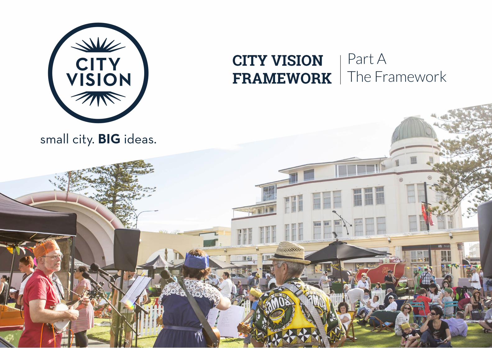
CITY VISION FRAMEWORK
Part AThe Framework
DISCLAIMERThis document (Report) has been produced independently by Wilkinson Urban Design and Placemaking (The consultant) on the request of the Napier City Council (Client) for the City Vision project.
The information, statements, statistics and commentary (together the ‘Information’) contained in this Report have been prepared from publicly available material, research and analysis by the consultant and from discussions held with stakeholders. The consultant does not express an opinion as to the accuracy or completeness of the information provided, the assumptions made by the parties that provided the information or any conclusions reached by those parties.
The consultant has based this Report on information received or obtained, on the basis that such information is accurate and, where it is represented to the consultant as such, complete. The Information contained in this Report has not been subject to an audit.
3
EXEC
UTI
VE
SUM
MA
RY
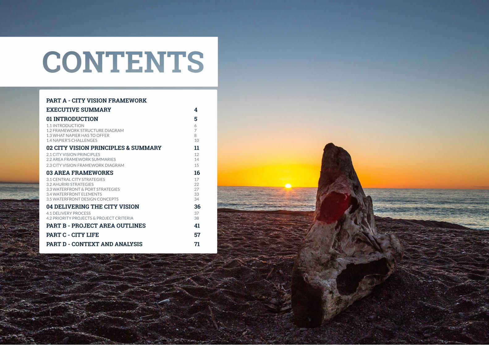
PART A - CITY VISION FRAMEWORKEXECUTIVE SUMMARY 401 INTRODUCTION 51.1 INTRODUCTION 61.2 FRAMEWORK STRUCTURE DIAGRAM 71.3 WHAT NAPIER HAS TO OFFER 81.4 NAPIER’S CHALLENGES 10
02 CITY VISION PRINCIPLES & SUMMARY 112.1 CITY VISION PRINCIPLES 122.2 AREA FRAMEWORK SUMMARIES 14
2.3 CITY VISION FRAMEWORK DIAGRAM 15
03 AREA FRAMEWORKS 163.1 CENTRAL CITY STRATEGIES 173.2 AHURIRI STRATEGIES 223.3 WATERFRONT & PORT STRATEGIES 273.4 WATERFRONT ELEMENTS 333.5 WATERFRONT DESIGN CONCEPTS 34
04 DELIVERING THE CITY VISION 364.1 DELIVERY PROCESS 374.2 PRIORITY PROJECTS & PROJECT CRITERIA 38
PART B - PROJECT AREA OUTLINES 41 PART C - CITY LIFE 57PART D - CONTEXT AND ANALYSIS 71
4
EXEC
UTI
VE
SUM
MA
RY
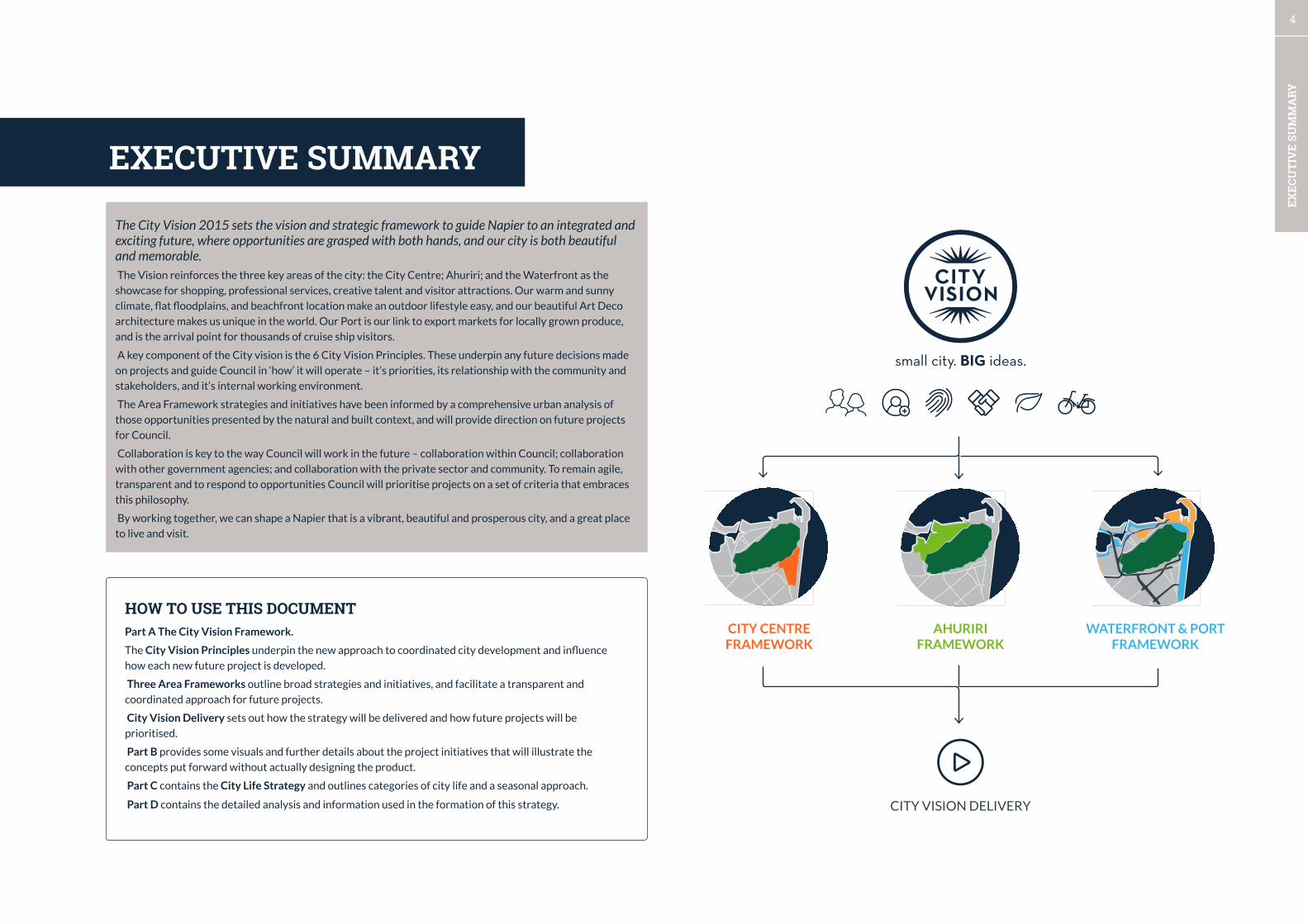
The City Vision 2015 sets the vision and strategic framework to guide Napier to an integrated and exciting future, where opportunities are grasped with both hands, and our city is both beautiful and memorable. The Vision reinforces the three key areas of the city: the City Centre; Ahuriri; and the Waterfront as the
showcase for shopping, professional services, creative talent and visitor attractions. Our warm and sunny
climate, flat floodplains, and beachfront location make an outdoor lifestyle easy, and our beautiful Art Deco
architecture makes us unique in the world. Our Port is our link to export markets for locally grown produce,
and is the arrival point for thousands of cruise ship visitors.
A key component of the City vision is the 6 City Vision Principles. These underpin any future decisions made
on projects and guide Council in ‘how’ it will operate – it’s priorities, its relationship with the community and
stakeholders, and it’s internal working environment.
The Area Framework strategies and initiatives have been informed by a comprehensive urban analysis of
those opportunities presented by the natural and built context, and will provide direction on future projects
for Council.
Collaboration is key to the way Council will work in the future – collaboration within Council; collaboration
with other government agencies; and collaboration with the private sector and community. To remain agile,
transparent and to respond to opportunities Council will prioritise projects on a set of criteria that embraces
this philosophy.
By working together, we can shape a Napier that is a vibrant, beautiful and prosperous city, and a great place
to live and visit.
EXECUTIVE SUMMARY
HOW TO USE THIS DOCUMENTPart A The City Vision Framework.
The City Vision Principles underpin the new approach to coordinated city development and influence
how each new future project is developed.
Three Area Frameworks outline broad strategies and initiatives, and facilitate a transparent and
coordinated approach for future projects.
City Vision Delivery sets out how the strategy will be delivered and how future projects will be
prioritised.
Part B provides some visuals and further details about the project initiatives that will illustrate the
concepts put forward without actually designing the product.
Part C contains the City Life Strategy and outlines categories of city life and a seasonal approach.
Part D contains the detailed analysis and information used in the formation of this strategy. CITY VISION DELIVERY
CITY CENTREFRAMEWORK
AHURIRIFRAMEWORK
WATERFRONT & PORTFRAMEWORK

6
01 IN
TRO
DU
CTIO
N
INTRODUCTION
Napier is a small city with big ideas and an equally big attitude.
The central business district, Ahuriri and the world-class waterfront is Napier’s shop front to the world. It is
the centre of commerce and professional services, and where visitors and locals head to shop, dine and be
entertained. It is a hub for visitor accommodation and where the majority of Napier’s attractions are located.
These locations will be the core focus of the city vision, although the foundation principles and philosophies
are transferable across the district.
Napier (and the Hawke’s Bay region) is perfectly placed to become the cycling mecca of New Zealand, with
its sunny climate, flat terrain, and already established cycling pathways and linkages. Smart investment in the
right infrastructure, and development oriented toward car-less mobility will further grow the cycling culture
and cement Napier’s future as a vibrant cosmopolitan regional city.
The City Vision seeks to improve people’s depth of experience. The city is shaped by the decisions made on
future development, making it critical that there is a real focus on quality design. The foresight of Napier’s
planners and architects post 1931 earthquake has gifted Napier’s citizens an internationally renowned Art
Deco city of a style and concentration seen nowhere else in the world. This, combined with our sunny warm
weather, proximity to wineries and beaches, and extensive cycling trails sets Napier apart from other cities in
New Zealand. Demanding that future changes to the city’s public realm be of world-class design will ensure
that we are building a legacy that is as strong as that which exists today.
1.1 CITY VISION OVERVIEW
PROJECT OBJECTIVES
The following objectives have guided the focus of the process:
Objective 1
Enable the city centre, Ahuriri and Waterfront in a way that enhances the development of Napier and cements its place as
an iconic destination.
Objective 2
Encourage public-private partnerships that result in the creative use of space and investment beyond property boundaries.
Objective 3
Identify, value and enhance the character of the City Centre, Ahuriri and the Waterfront, and improve connections
between these places.
Objective 4
Celebrate and strengthen the unique offerings of the City Centre, Ahuriri and the Waterfront to create three
complimentary destinations as part of a world-class experience.
Objective 5
Recognise the importance of the Port and Airport, and other integrated infrastructure to secure the future economic
vibrancy of Napier.
Equally important is the life that exists within the city spaces – the everyday happenings, places to meet your friends, fun and
vibrancy that people now expect to have in the heart of city spaces. Napier will have a seasonal programme packed full of things
to do, so there’s always a good reason to head into the city.
Napier is blessed with a developer, business and entrepreneur community who is passionate about the city and is eager to work
with others to realise their aspirations to build a better Napier. Building closer relationships and working in partnership with this
community, being open to innovation, and making our goals clear and regulation easy will support those with a role in shaping
the city to get on with getting the job done.
The City Vision will not be a report to sit on the shelves of Council staff, nor will it be a glossy coffee-table publication with
little substance. The City Vision is about changing the ways Council interact with the community and respond to development
opportunities. It’s about having clear priorities and driving a culture-shift. There is inherent risk in Council determining what
development will happen where, when land title is held privately and the free market is quick to respond to opportunities as
they arise. The City Vision presents a more agile approach, whilst pursuing those areas where Council has greater influence, and
where business partnerships can be realised for future development.
The City Vision will turn the traditional model of development model on its head. A typical Council project can take years of
research and planning before spending thousands or even millions on construction with the very real risk that the project isn’t
quite the success Council thought it would be, and having to make costly changes to layout. The City Vision challenges this
approach by using low-cost, quick-start experiments to test ideas. The approach has an engagement through action philosophy,
with projects commencing before the ink has dried on the paper for this strategy.
7
01 IN
TRO
DU
CTIO
N
FUNDING
WORK-STREAMS
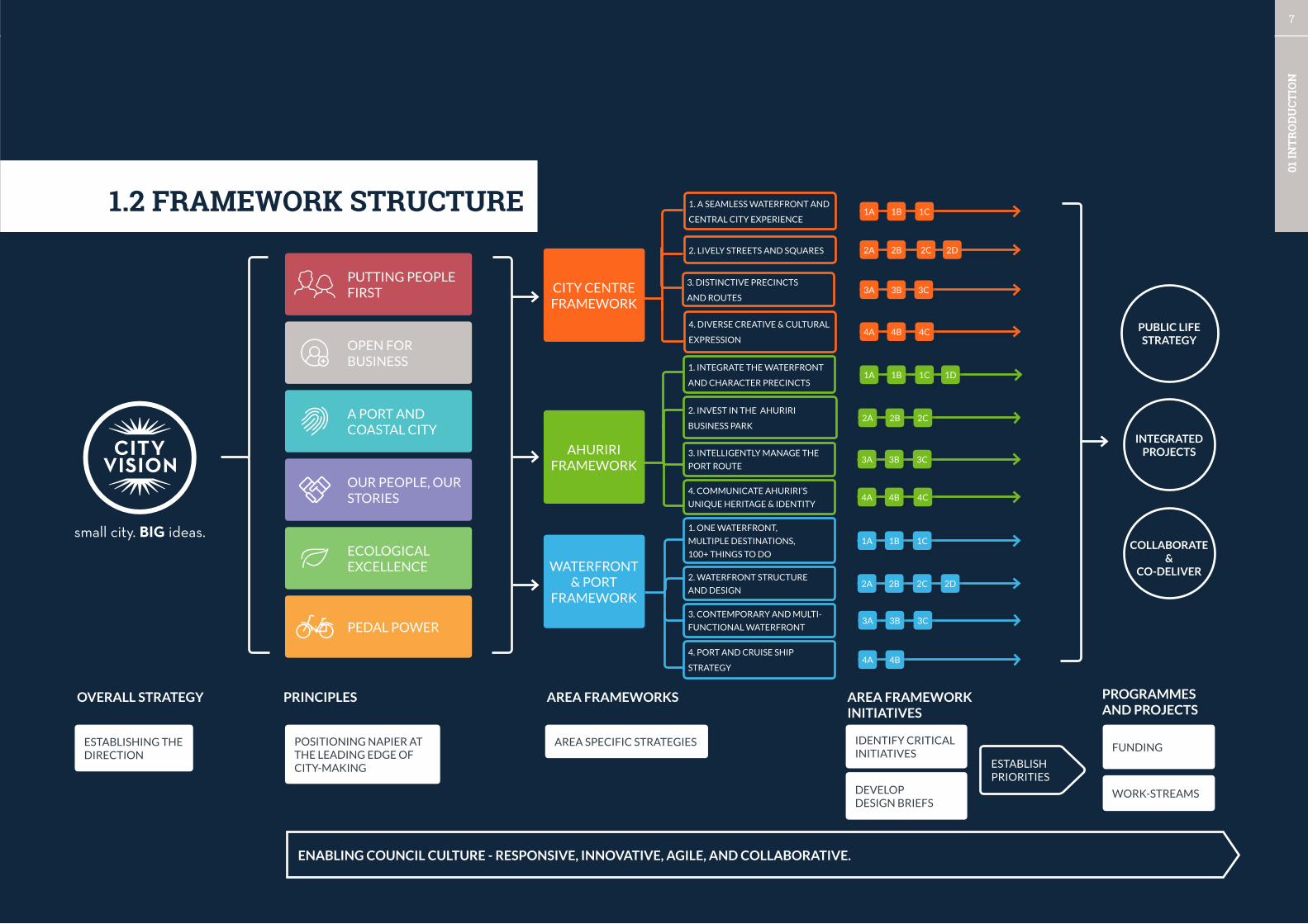
ENABLING COUNCIL CULTURE - RESPONSIVE, INNOVATIVE, AGILE, AND COLLABORATIVE.
CITY CENTRE FRAMEWORK
PUTTING PEOPLE FIRST
OPEN FOR BUSINESS
A PORT AND COASTAL CITY
OUR PEOPLE, OUR STORIES
ECOLOGICALEXCELLENCE
PEDAL POWER
WATERFRONT & PORT
FRAMEWORK
AHURIRI FRAMEWORK
OVERALL STRATEGY AREA FRAMEWORKS AREA FRAMEWORK INITIATIVES
PROGRAMMES AND PROJECTS
PRINCIPLES
1.2 FRAMEWORK STRUCTURE
ESTABLISH PRIORITIES
DEVELOPDESIGN BRIEFS
POSITIONING NAPIER AT THE LEADING EDGE OF CITY-MAKING
ESTABLISHING THE DIRECTION
AREA SPECIFIC STRATEGIES
1. INTEGRATE THE WATERFRONT
AND CHARACTER PRECINCTS
2. INVEST IN THE AHURIRI
BUSINESS PARK
4. COMMUNICATE AHURIRI’S
UNIQUE HERITAGE & IDENTITY
3. INTELLIGENTLY MANAGE THE
PORT ROUTE
1. ONE WATERFRONT,
MULTIPLE DESTINATIONS,
100+ THINGS TO DO
2. WATERFRONT STRUCTURE
AND DESIGN
4. PORT AND CRUISE SHIP
STRATEGY
1A 1B 1C 1D
2A 2B 2C
3A 3B 3C
4A 4B 4C
1A 1B 1C
2A 2B 2C 2D
3A 3B 3C
4A 4B
1A 1B 1C
3A 3B 3C
4A 4B 4C
IDENTIFY CRITICAL INITIATIVES
1. A SEAMLESS WATERFRONT AND
CENTRAL CITY EXPERIENCE
2. LIVELY STREETS AND SQUARES
3. DISTINCTIVE PRECINCTS
AND ROUTES
4. DIVERSE CREATIVE & CULTURAL
EXPRESSIONPUBLIC LIFE STRATEGY
3. CONTEMPORARY AND MULTI-
FUNCTIONAL WATERFRONT
2A 2B 2C 2D
COLLABORATE &
CO-DELIVER
INTEGRATED PROJECTS
8
01 IN
TRO
DU
CTIO
N
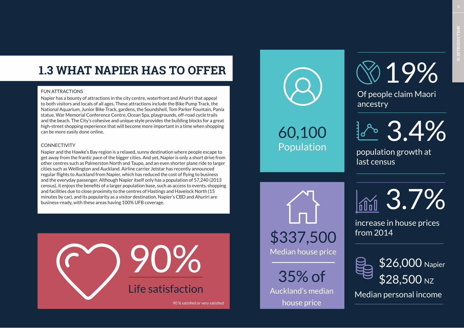
1.3 WHAT NAPIER HAS TO OFFER
3.4%population growth at last census
$337,500 Median house price
35% ofAuckland’s median
house priceMedian personal income
$26,000 Napier
$28,500 NZ
3.7%increase in house prices from 2014
90%90 % satisfied or very satisfied
Life satisfaction
19%Of people claim Maori ancestry
60,100Population
FUN ATTRACTIONS
Napier has a bounty of attractions in the city centre, waterfront and Ahuriri that appeal to both visitors and locals of all ages. These attractions include the Bike Pump Track, the National Aquarium, Junior Bike Track, gardens, the Soundshell, Tom Parker Fountain, Pania statue, War Memorial Conference Centre, Ocean Spa, playgrounds, off-road cycle trails and the beach. The City’s cohesive and unique style provides the building blocks for a great high-street shopping experience that will become more important in a time when shopping can be more easily done online.
CONNECTIVITY
Napier and the Hawke’s Bay region is a relaxed, sunny destination where people escape to get away from the frantic pace of the bigger cities. And yet, Napier is only a short drive from other centres such as Palmerston North and Taupo, and an even shorter plane ride to larger cities such as Wellington and Auckland. Airline carrier Jetstar has recently announced regular flights to Auckland from Napier, which has reduced the cost of flying to business and the everyday passenger. Although Napier itself only has a population of 57,240 (2013 census), it enjoys the benefits of a larger population base, such as access to events, shopping and facilities due to close proximity to the centres of Hastings and Havelock North (15 minutes by car), and its popularity as a visitor destination. Napier’s CBD and Ahuriri are business-ready, with these areas having 100% UFB coverage.
9
01 IN
TRO
DU
CTIO
N
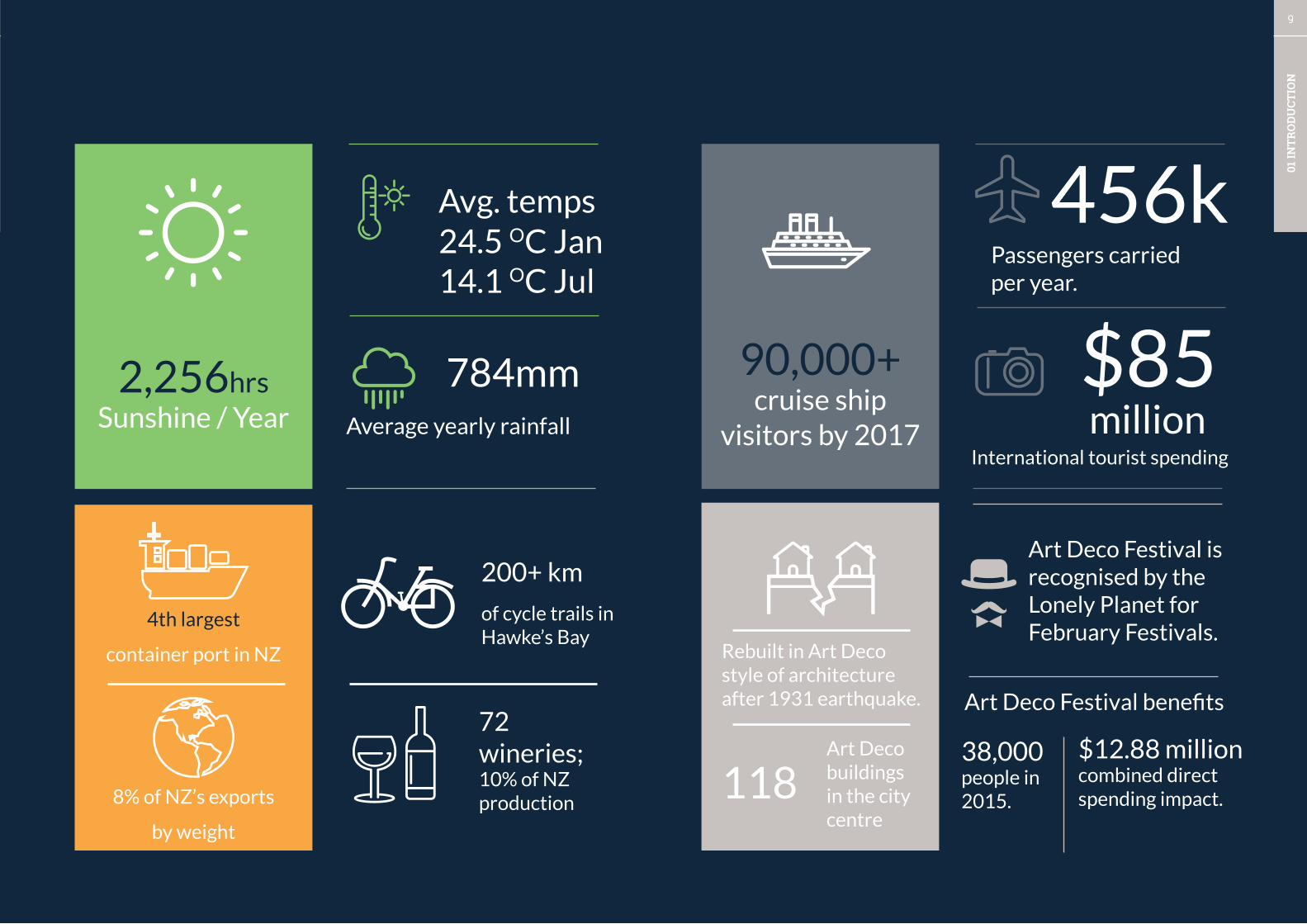
784mm $85Average yearly rainfall
International tourist spending
Rebuilt in Art Deco style of architecture after 1931 earthquake.
4th largest
container port in NZ
8% of NZ’s exports
by weight
Art Deco Festival is recognised by the Lonely Planet for February Festivals.
118Art Deco buildings in the city centre
456kPassengers carriedper year.
90,000+cruise ship
visitors by 2017 million2,256hrs
Sunshine / Year
24.5 OC JanAvg. temps
14.1 OC Jul
72 wineries;10% of NZ production
200+ km of cycle trails in Hawke’s Bay
38,000 people in 2015.
Art Deco Festival benefits
$12.88 millioncombined direct spending impact.
10
01 IN
TRO
DU
CTIO
N
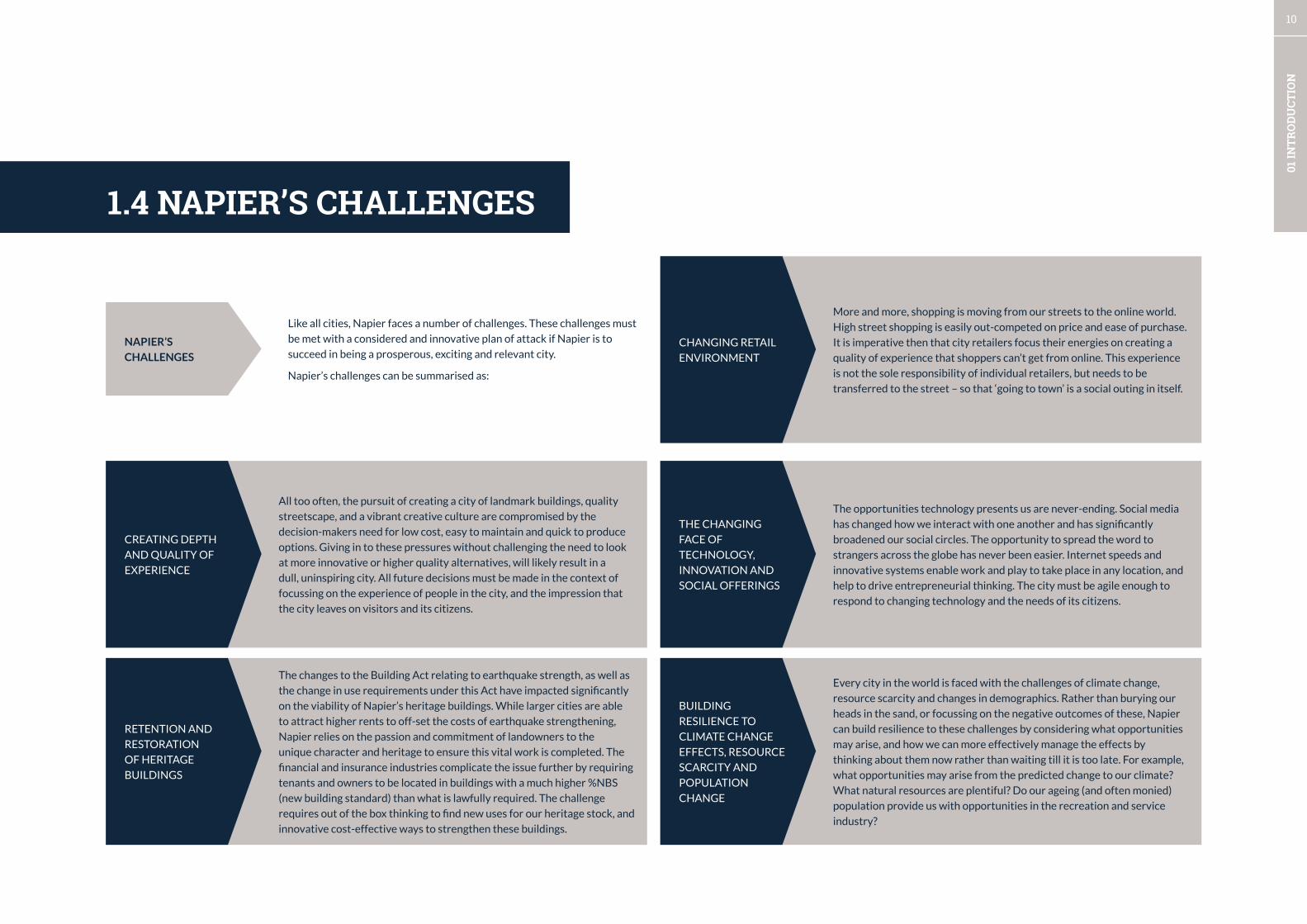
1.4 NAPIER’S CHALLENGES
CREATING DEPTH
AND QUALITY OF
EXPERIENCE
All too often, the pursuit of creating a city of landmark buildings, quality
streetscape, and a vibrant creative culture are compromised by the
decision-makers need for low cost, easy to maintain and quick to produce
options. Giving in to these pressures without challenging the need to look
at more innovative or higher quality alternatives, will likely result in a
dull, uninspiring city. All future decisions must be made in the context of
focussing on the experience of people in the city, and the impression that
the city leaves on visitors and its citizens.
RETENTION AND
RESTORATION
OF HERITAGE
BUILDINGS
The changes to the Building Act relating to earthquake strength, as well as
the change in use requirements under this Act have impacted significantly
on the viability of Napier’s heritage buildings. While larger cities are able
to attract higher rents to off-set the costs of earthquake strengthening,
Napier relies on the passion and commitment of landowners to the
unique character and heritage to ensure this vital work is completed. The
financial and insurance industries complicate the issue further by requiring
tenants and owners to be located in buildings with a much higher %NBS
(new building standard) than what is lawfully required. The challenge
requires out of the box thinking to find new uses for our heritage stock, and
innovative cost-effective ways to strengthen these buildings.
CHANGING RETAIL
ENVIRONMENT
More and more, shopping is moving from our streets to the online world.
High street shopping is easily out-competed on price and ease of purchase.
It is imperative then that city retailers focus their energies on creating a
quality of experience that shoppers can’t get from online. This experience
is not the sole responsibility of individual retailers, but needs to be
transferred to the street – so that ‘going to town’ is a social outing in itself.
THE CHANGING
FACE OF
TECHNOLOGY,
INNOVATION AND
SOCIAL OFFERINGS
The opportunities technology presents us are never-ending. Social media
has changed how we interact with one another and has significantly
broadened our social circles. The opportunity to spread the word to
strangers across the globe has never been easier. Internet speeds and
innovative systems enable work and play to take place in any location, and
help to drive entrepreneurial thinking. The city must be agile enough to
respond to changing technology and the needs of its citizens.
BUILDING
RESILIENCE TO
CLIMATE CHANGE
EFFECTS, RESOURCE
SCARCITY AND
POPULATION
CHANGE
Every city in the world is faced with the challenges of climate change,
resource scarcity and changes in demographics. Rather than burying our
heads in the sand, or focussing on the negative outcomes of these, Napier
can build resilience to these challenges by considering what opportunities
may arise, and how we can more effectively manage the effects by
thinking about them now rather than waiting till it is too late. For example,
what opportunities may arise from the predicted change to our climate?
What natural resources are plentiful? Do our ageing (and often monied)
population provide us with opportunities in the recreation and service
industry?
Like all cities, Napier faces a number of challenges. These challenges must
be met with a considered and innovative plan of attack if Napier is to
succeed in being a prosperous, exciting and relevant city.
Napier’s challenges can be summarised as:
NAPIER’S
CHALLENGES
12
02 P
RIN
CIPL
ES &
SU
MM
ARY
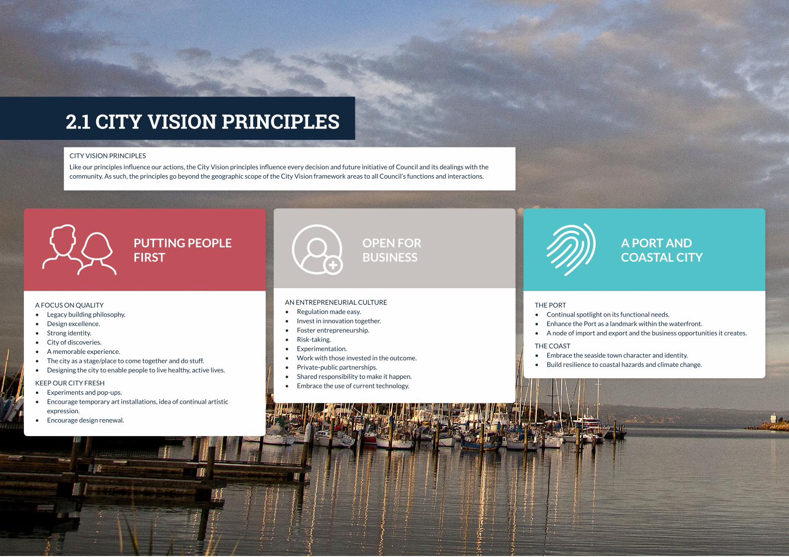
THE PORT
• Continual spotlight on its functional needs.
• Enhance the Port as a landmark within the waterfront.
• A node of import and export and the business opportunities it creates.
THE COAST
• Embrace the seaside town character and identity.
• Build resilience to coastal hazards and climate change.
A FOCUS ON QUALITY
• Legacy building philosophy.
• Design excellence.
• Strong identity.
• City of discoveries.
• A memorable experience.
• The city as a stage/place to come together and do stuff.
• Designing the city to enable people to live healthy, active lives.
KEEP OUR CITY FRESH
• Experiments and pop-ups.
• Encourage temporary art installations, idea of continual artistic
expression.
• Encourage design renewal.
PUTTING PEOPLE FIRST
AN ENTREPRENEURIAL CULTURE
• Regulation made easy.
• Invest in innovation together.
• Foster entrepreneurship.
• Risk-taking.
• Experimentation.
• Work with those invested in the outcome.
• Private-public partnerships.
• Shared responsibility to make it happen.
• Embrace the use of current technology.
OPEN FOR BUSINESS
A PORT AND COASTAL CITY
2.1 CITY VISION PRINCIPLESCITY VISION PRINCIPLES
Like our principles influence our actions, the City Vision principles influence every decision and future initiative of Council and its dealings with the
community. As such, the principles go beyond the geographic scope of the City Vision framework areas to all Council’s functions and interactions.

13
02 P
RIN
CIPL
ES &
SU
MM
ARY
• Understanding the significance of place to mana whenua through
Te Aranga Design Principles and their application to the landscape
around us.
• Understanding our past and who we are, and weaving this into our
design.
• Celebration of the unique Art Deco character.
• Culture of events and sport.
• Identify, capitalise and enhance our ecological assets - Ahuriri Estuary,
Napier Hill green network, coastal waters, and urban streams.
• Careful plant selection that enhances our identity and provides a habitat
for native fauna.
• Design that has a positive environmental impact and encourages a
relationship with nature in our urban spaces and networks.
• Promote sustainable thinking in building design, waste management,
three waters management, and active urban form.
• Building a strong cycling culture.
• Cycling designations and journeys are a memorable experience.
• Cycling is safe and easy.
• Street design focus on ‘complete’ streets – cyclists, pedestrians, cars,
opportunities for interaction.
OUR PEOPLE, OUR STORIES
ECOLOGICAL EXCELLENCE
PEDAL POWER

14
02 P
RIN
CIPL
ES &
SU
MM
ARY
STRATEGY 1 - CREATE A SEAMLESS WATERFRONT AND
CENTRAL CITY EXPERIENCE
Development of the waterfront destinations and city centre streets and squares
will be coordinated and connected to create a memorable experience.
STRATEGY 2 - LIVELY STREETS AND SQUARES
A network of high-quality streets and public spaces will be created with a
focus on increasing public life and vitality of the city, and supporting economic
viability.
STRATEGY 3 - DEVELOP DISTINCTIVE PRECINCTS AND ROUTES
A liveable City Centre which encourages discovery will be created by
encouraging a variety of experiences in the new and existing precincts, and
memorable routes which connect destinations and lead people into the City.
STRATEGY 4 - DIVERSIFY CREATIVE AND CULTURAL EXPRESSION
Napier’s identity will mature, and creative industries and culture will be
strengthened by a focus on expressing multiple narratives in addition to the Art
Deco/Earthquake story with contemporary design and media. Enhance Napier’s
expression of its Maori history and identify through the use of Te Aranga Design
Principles.
STRATEGY 1 - INTEGRATE THE WATERFRONT AND
CHARACTER PRECINCTS
The varied quality of the public spaces in Ahuriri’s distinct character precincts
and attractions will be made coherent through careful design and consideration
of materials, and through undertaking catalyst projects.
STRATEGY 2 - INVEST IN THE AHURIRI BUSINESS PARK - THE MIXED-USE
WAREHOUSE PRECINCT
Ahuriri Business Park in the mixed-use warehouse precinct will become a centre
for Napier’s entrepreneurial culture and leverage the Business Hub and the
unique setting with design qualities that reflect its emerging identity.
STRATEGY 3 - INTELLIGENTLY MANAGE THE PORT ROUTE
The safe and efficient flow of people across Bridge Street (state Highway 2)
needs to be balanced with the need to transport goods and people to the Port
with minimum delay and maximum ease. Intelligent design will ensure both
these objectives are met.
STRATEGY 4 - COMMUNICATE AHURIRI’S UNIQUE HERITAGE
AND IDENTITY
The large scale size and materials of Ahuriri’s saw-tooth warehouses and marine
industry features provide the ideal canvas for communicating Ahuriri’s unique
heritage and identity.
STRATEGY 1 - ONE WATERFRONT, MULTIPLE DESTINATIONS,
100+ THINGS TO DO
The waterfront will be developed as a coherent entity from the Pandora Estuary
to Georges Drive with a place-led approach to create destinations with distinct
identities and multiple attractions.
STRATEGY 2 - WATERFRONT STRUCTURE AND DESIGN
The scope of waterfront projects will extend into the City Centre and Ahuriri
to maximise project benefits, and build in resilience by incorporating hazard
mitigation into the landscape. Design will be improved with a place-specific
palette of materials and public space features to support use.
STRATEGY 3 - A CONTEMPORARY AND MULTI-FUNCTIONAL WATERFRONT
The waterfront will become a multi-functional and multi-layered experience
with ecological and aesthetic values, unified lighting, and memorable creative
and cultural expression.
STRATEGY 4 - PORT AND CRUISE SHIP STRATEGY
The Cruise ship tourism experience will be expanded into Ahuriri and
strengthened with a creative and adaptable pop-up approach, and the Port’s
development will be supported with on-going improvement of safety, access,
site planning, and operations.
CITY CENTRE AHURIRI WATERFRONT & PORT
2.2 AREA FRAMEWORK SUMMARIES

15
02 P
RIN
CIPL
ES &
SU
MM
ARY
Estuary eco-restoration and development, recreation and walkways.
West Quay evolution and parking redevelopment
City Entrance features
Thackeray (or Carlyle)Separated cycleway.
Aquarium - ongoing site development.
Upgraded Conference centre
Botanical Gardens on the Bay.
Bluff Hill heritage and eco-restoration.
Contemporary upgrade to Emerson St shared space
Car-parking and mixed-use development.
Cultural Quarter
City Entrance
Bridge Entrance and Marina site planning
Iron Pot redevelopment area
Business park main street on Ossian Street and Bridge St managed zone to connect to West Quay with improved pedestrian crossing points and pathways
Ahuriri Beach development
Cruise ships - Creative pop-up arrival & departure experience
Port entrance, interface, and cycling connection
Quality and creativity on the Ahuriri to City centre link.
Ahuriri entrance features and future Pandora Rd redesign
Port Access Route upgrades
Pandora Rd separated cycleway
Separated cycleways connections from suburbs to City Centres, Waterfront and Ahuriri
2.3 CITY FRAMEWORK
N
Port - Ahuriri Landmark
Perfume PointHarbour entrance
Marine Parade piazza and cruise visitor hub.
Tennyson St - NZ’s great Art Deco street
Civic and Library area and connection to waterfront
redevelopment area
Marine Parade development
Clive and Memorial Square redesign
City centre entrance feature and cycling
connections.


17
03 A
REA
FR
AM
EWO
RK
S
STRATEGY 1 - CREATE A SEAMLESS WATERFRONT AND
CENTRAL CITY EXPERIENCE
Development of the waterfront destinations and city
centre streets and squares will be coordinated and
integrated to create a coherent experience.
1A Central Waterfront Piazza & Marine Parade Boulevard
Redesign
Create a Central Waterfront Square and shared spaces at
the intersection of Marine Pde, Emerson, and Tennyson
Streets, and refining the I-site area.
Redesign Marine Parade from Vautier St to Browning St to
integrate the city with the waterfront.
1B Civic Square and Waterfront connection
Revitalise and activate the Library and Civic Quarter and
connect Station St to the waterfront.
1C Lighting - nightscaping the city
The night-time economy is increasingly important for a
city and a city’s social life. A unified lighting strategy is a
must-have for contemporary city-making.
STRATEGIES
3.1 CITY CENTRE
STRATEGY 2 - CULTIVATE LIVELY STREETS AND
SQUARES
A network of high-quality streets and public spaces will be
created with a focus on increasing public life and vitality of
the city, and supporting economic viability.
2A Street and lane design and materials
Develop high quality central street and lane designs (incl.
street trees and materials, and streetscape features)
which support activity, and prioritise pedestrians,
universal accessibility, and way-finding.
2B Squares and plazas
Develop the squares and plazas, in particular, redesigning
Clive and Memorial Squares to create a stronger anchor.
2C Street design - Emerson Street and Tennyson Street
Strengthen the Emerson St shared space, and Tennyson St
(the Art Deco Boulevard) with contemporary design and
improved connections.
2D Programme for activating our city
Support infrastructure and collateral for programming and
activation of public spaces.
STRATEGY 3 - DEVELOP DISTINCTIVE PRECINCTS AND
ENTRANCE ROUTES
A liveable City centre which encourages discovery and
diversity will be created through distinctive experiences
in the precincts and memorable routes which connect
destinations.
3A Retention and restoration of Art Deco Heritage
The city has a unique asset which puts Napier on the
global radar, and a continued long-term focus of the value
of this as a point of difference for the city is required.
3B Distinctive mixed-use precincts
The waterfront, civic and library, cultural quarter, start-up
quarter (Make.Space programme), and retail heart.
3C City entrances and connectors
Develop high-quality entrance and route designs for the
following streets:
Entrances - Kennedy Rd to Tennyson St, Munroe St,
Dalton St, Hastings St, and Marine Parade
Connectors - Carlyle and Thackeray streets
STRATEGY 4 - DIVERSIFY CREATIVE & CULTURAL
EXPRESSION
Napier’s identity will mature, and creative industries and
culture will be strengthened by a focus on expressing
multiple narratives in addition to the Art Deco and
Earthquake stories.
4A Increasing Iwi expression
Facilitate a greater iwi presence and cultural expression
through the application of the core Maori values - mana,
taiao, mauri tu, tohu, whakapapa/whakamama, ahikaa,
mahi toi.
4B Expanding the range and application of public arts
Diversify the scope and types of public arts and use these
to renew the experience of the City’s streets, lanes and
public spaces.
4C Contemporary story-telling
Use contemporary design and methods for story-telling
and leverage digital media and technology.
18
03 A
REA
FR
AM
EWO
RK
S
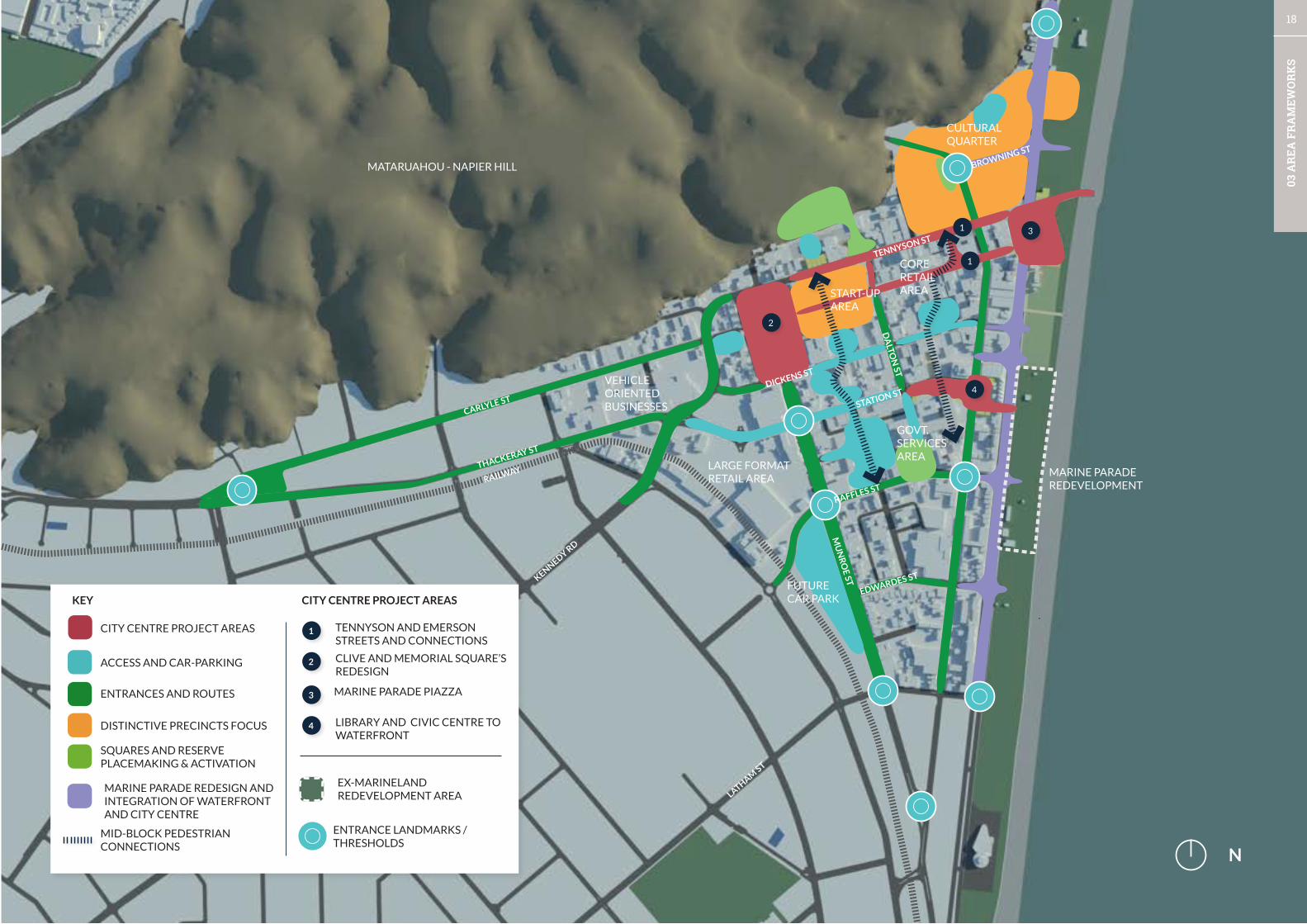
1
1
2
4
N
KEY
CLIVE AND MEMORIAL SQUARE’S REDESIGN
MARINE PARADE PIAZZA
ACCESS AND CAR-PARKING
ENTRANCES AND ROUTES
DISTINCTIVE PRECINCTS FOCUS
SQUARES AND RESERVE PLACEMAKING & ACTIVATION
MID-BLOCK PEDESTRIAN CONNECTIONS
MARINE PARADE REDESIGN AND INTEGRATION OF WATERFRONT AND CITY CENTRE
CITY CENTRE PROJECT AREAS
1
2
3
4
TENNYSON AND EMERSON STREETS AND CONNECTIONS
LIBRARY AND CIVIC CENTRE TO WATERFRONT
EX-MARINELAND REDEVELOPMENT AREA
CITY CENTRE PROJECT AREAS
LARGE FORMATRETAIL AREA
FUTURE CAR PARK
VEHICLE ORIENTED BUSINESSES
THACKERAY ST
RAILWAY
CARLYLE ST STATION ST
TENNYSON ST
BROWNING ST
DICKENS ST
KENNEDY RD
LATHAM ST
CULTURAL QUARTER
MATARUAHOU - NAPIER HILL
ENTRANCE LANDMARKS / THRESHOLDS
GOVT.SERVICES AREA
MARINE PARADE REDEVELOPMENT
START-UP AREA
MU
NR
OE ST
RAFFLES ST
EDWARDES ST
DA
LTON
ST
3
CORE RETAILAREA

19
03 A
REA
FR
AM
EWO
RK
S
STRATEGY 1 - CREATE A SEAMLESS WATERFRONT AND CENTRAL CITY
EXPERIENCE
Development of the waterfront destinations and city centre streets and squares
will be coordinated and integrated to create a coherent experience.
RATIONALE
The Waterfront and central city have been segregated by Marine Parade
due to its function as an arterial and important heavy vehicle traffic route.
Development of the road network elsewhere have allowed Marine Parade
to change and to become the feature which stitches the two major elements
together. A re-prioritisation of space can occur which focuses on space for
people, economic exchange and activity and access instead of movement.
Significant investment is occurring on the waterfront, and the places where
people work and come for leisure need to be strongly connected.
The streets which connect the city to the waterfront can be integrated through
multiple design approaches such as extending the grid block structure, and
incorporating waterfront design features into the streetscape.
INITIATIVES
1A Central Waterfront Piazza & Marine Parade Boulevard Redesign
Creating a new public space to act as the ‘hub’ of Napier’s central city by unifying
spaces at the intersection of Marine Parade, Emerson Street and Tennyson
Street. The piazza will provide active edges, shared streets, and a multi-use
public space for events and everyday happenings. Buildings with frontages to
the space will be key to creating a strong impression of the place, and will be an
active participant in the streetscape. Although the space will be prioritised for
pedestrians, other uses such as cyclists, smaller vehicles, and tour buses will
still be able to access and pass through the space. The space will connect the
attractions of the waterfront to the attractions of the City.
3.1.1 CITY CENTRE STRATEGIESThis section provides greater detail of the strategies, initiatives and the
rationale for each strategy. The images shown are from other places, and give an
indication of the types of initiatives needed for the ongoing evolution of Napier.
A number of specific City Centre project areas are then visualised with general
design directions and potential actions/options. These visualisations help people
to see the possibilities within the existing space, and are not intended to provide
a final design in any way. Once each project area becomes a priority project,
Council will engage with the public and stakeholders on community needs,
design options, and then a final design that is consistent with the City Vision
Principles.
The removal of heavy vehicles from Marine Parade will allow for the re-prioritisation
of street space to people. Marine Parade boulevard will be redesigned to fuse the
waterfront to the City Centre with a slow, safe and accessible environment, provide
space for businesses, and extend the waterfront design qualities to Hastings Street.
1B Civic Square and Waterfront Connection
Creating a southern anchor for the CBD connection with an activated civic and
learning hub which extends a shared street and unified public spaces from Dalton St
to the waterfront and links with the Marine Parade development.
1C – Lighting – Nightscaping the City
An integrated lighting strategy will be prepared for the City with consideration given
to the following needs and elements:
• Motorist and cyclist visibility and safety;
• Pedestrian safety (incorporating CPTED principles)
• Highlighting architectural building features and other features such as
vegetation;
• Lighting as art and for story-telling.
A waterfront environment can extend to the built edge when space for people and activity, and access takes priority over movement. Concept only
The central events space for a city needs a strong programme and assets to support daily public life.

20
03 A
REA
FR
AM
EWO
RK
S
STRATEGY 2 - LIVELY STREETS AND SQUARES
A network of high-quality streets and public spaces will be created with a
focus on increasing public life and vitality of the city, and supporting economic
viability.
RATIONALE
The central city streets and squares have already been subject to a variety
of streetscape improvements - continuing this tradition of creating an
uninterrupted pedestrian environment should be supported and continued to
reinforce the traditional structure of the central city, with improved squares and
streets connecting them. The secondary network of lanes and courtyards should
also be supported. Quality is important including the choice of materials and the
need to provide a contemporary high quality environment that suits all users. A
review of the streetscape palette, with particular consideration of the sensory
experience and support of the Art Deco heritage buildings) is required and will
support integration with the waterfront.
INITIATIVES
2A Street and lane design and materials
Developing and implementing high-quality street designs that prioritise pedestrians,
which are supported by a diverse secondary network of lanes and courtyards.
Way-finding and accessibility for all users and modes of travel are core components
of high-quality street design.
2B Squares and plazas
Designing and redeveloping public spaces which flow into the streetscape and invite
use, and support a diverse range of programming.
Unifying Clive and Memorial Squares (node) to strengthen it as a central city anchor.
Integrate public spaces with streets - Theatre Square, Vautier Square, and Cathedral
Square, and the War memorial conference centre area.
2C Street Design – Emerson Street and Tennyson Street
The design of Emerson Street revolutionised city centre streets in New Zealand
20 years ago. Yet the design of shared street spaces has evolved considerably over
the past few years, along with the needs of the community and the way we use our
public spaces. Emerson Street will be updated to contemporary shared space design
standards.
Contemporary shared spaces are simplified environments which strip the clutter from urban environments and allow flexible use.
Diverse high quality laneway systems provide unique potential for experiences, as well as functional pedestrian connections.
Free public events in the early evening help to cultivate the night-time economy so people participate in a series of small experiences over an evening.
Tennyson Street is an arterial route and its streetscape has remained the same for
many years – two lanes of traffic, parallel car parking, and narrow footpath. The
street is lined with elegant mostly Stripped Classical architecture, with a smattering
of Spanish Mission and Art Deco. There is no seating, no greenery and no shade
available in the street. The streetscape clearly doesn’t reflect the grandeur of
the architecture, and is not designed to focus on the needs and wants of people.
Tennyson Street will be redeveloped with wider footpaths, quality materials, seating,
shade and lighting for way-finding and to highlight elements of the streetscape and
the architecture.
2D Support for programming and activation
Providing the support infrastructure for programming of urban spaces with high
quality market experiences, weekly, seasonal, and yearly events.

21
03 A
REA
FR
AM
EWO
RK
S
STRATEGY 3 - DEVELOP DISTINCTIVE PRECINCTS AND ENTRANCE ROUTES
A liveable City centre which encourages discovery and diversity will be created
by creating distinctive experiences in the precincts and memorable routes which
connect destinations.
RATIONALE
The Central city has a traditional street and square structure with a strong core
area. The central core is a retail district and surrounding districts are developing
their own unique identities. The emerging character of the district should be
supported with a programme that highlights the distinctiveness of each place
and repairs the deficits. Some areas are struggling and need a higher degree
of management than others. The central city has a high level of amenity and
increased residential should be encouraged to take advantage of waterfront
investment, and to support a stronger night-time economy. Creative thinking
for other uses for the upper floors should be considered, such as shared working
spaces, educational facilities and studio space, The entrances into a central city
form the first and last impressions, currently the entrance experiences in the
Central city is not as good as the high-points and needs to be remedied. Similarly
some sites in the city centre offer opportunities reassert a strong urban form t
support an active street-life and walkable city.
STRATEGY 4 - DIVERSIFY CREATIVE AND CULTURAL EXPRESSION
Napier’s identity will mature, and creative industries and culture will be
strengthened by a focus on expressing multiple narratives in addition to Art
Deco, and the 1931 Earthquake.
RATIONALE
Napier has a proud tradition of creating memorials, and has a growing collection
of public arts such as sculptures, and street art, and recent investment in the
arts through the MTG and Creative Arts Napier. The Art Deco theme is strong,
and strengthens the city’s brand, yet it also limits the diversity of experience
and potential of arts and culture to surprise and delight in unexpected ways.
A city without great diversity in cultural expression only creates meaning for
a subset of the community, so in order to create a greater sense of belonging,
participation, and meaning for a greater diversity of people more variety is
required.
Story-telling features in the central city have focussed on the earthquake which
is entwined with the Art Deco brand. In future, telling this story in contemporary
ways is required along with bringing other stories to prominence. Some critical
stories which require telling are the pre-european story and allowing for Iwi
aspirations to be expressed. A move from looking backward with the city as
museum, to a canvas for expressing potential futures will allow new identities to
be experimented with and develop a playful culture.INITIATIVES
3A Distinctive mixed-use precincts
Retrofitting and adapting the central city buildings to create a mixed-use district
with good quality residential apartments and lofts, and other economically
viable uses.
Developing and differentiating the identity and presence of emerging districts -
the Cultural Quarter, the Waterfront, and Start-up hub.
Reinforcing positive qualities of existing districts and repairing deficits of the
existing retail core, civic and government, health and office area.
Develop design briefs for strategic sites.
3B City entrances and routes
Reinventing Tennyson Street (as outlined in initiatives 2C) as NZ’s great Art
Deco street with a quality streetscape that matches the unique qualities of the
built environment.
Developing contemporary street designs for the connection to Ahuriri and the
suburbs and express-way along Carlyle and Thackeray Streets.
Hastings and Dalton Street entrance routes
INITIATIVES
4A Increased Iwi expression
Facilitate a greater iwi presence and cultural expression.
The core Maori values of mana, taiao mauri tu, tohu, whakapapa/whakamana,
ahikaa, mahi toi will guide initiatives to create a platform for global cultural
exchange.
Incorporating Te Aranga design principles into the streetscape and public realm.
4B Expanding the range and application of public arts
Diversify the scope and types of public arts and take advantage of the heritage
buildings and traditional urban structure - streets, squares, lanes and courtyards
to create new experiences.
Create opportunities for local, national and international creative professionals
and for temporary, semi-permanent and permanent installations.
4C Contemporary Story-telling
Use contemporary design and methods for story-telling and leverage digital
media and technology, and lighting.
Active building edges, landmarks, quality materials, trees, and vegetation, and a clear place identity are foundations of a pleasant urban experience.
A creative city takes opportunities to express a diverse range of voices. Contemporary street art and heritage qualities easily co-exist.

22
03 A
REA
FR
AM
EWO
RK
S
STRATEGY 1 - INTEGRATE THE WATERFRONT AND
AHURIRI’S CHARACTER DISTRICTS
Ahuriri will become a coherent city district with multiple
attractions by fusing the northern Ahuriri village, West
Quay and Marina, and the mixed-use warehouse precinct /
Ahuriri Business park.
1A New and strengthened existing destinations
Catalyst projects: 1. Ahuriri beach, 2. The Iron Pot
integrated development ,3. West Quay evolution 4. Ossian
Street, 5. Marina and Estuary.
1B Stitch the warehouse precinct and waterfront together
Development of connector streets - Lever St and Nelson
Quay to Ossian St.
Reinforce and protect views of the waterfront and key
features throughout the district, and provide additional
landmarks, and way-finding.
Strategic site identification and briefing
1C Ahuriri heritage
A coherent approach to heritage and character is required
to facilitate future investment in the area.
1D Ahuriri tourist hub
Strengthen Ahuriri’s role in tourism with its water-based
tourism assets and heritage.
STRATEGIES SUMMARY
3.2 AHURIRI
STRATEGY 2 - INVEST IN THE AHURIRI BUSINESS PARK
- THE MIXED-USE WAREHOUSE PRECINCT
Ahuriri Business Park in the mixed-use warehouse
precinct will become home to Napier’s entrepreneurial
culture and leverage the Business Hub and unique setting.
2A Quality streetscapes and linkages
Invest in the quality of streets and spaces, and develop
north-south links along Dommet St, and the service lanes
and Mahia St.
Improved management and design of the on-street and
off-street parking supply.
Open space and street network development.
2B Securing complimentary uses
Encourage a mix of residential, commercial and light
industrial activities to increase life on the street during
all hours of the day, and ensure residents have adequate
access to sunlight and are protected from the effects of
inappropriate noise.
2C Increase residential opportunities close to jobs and
amenities
Increase residential opportunities with development of
mixed urban housing types near the Port Ahuriri school,
the Ahuriri Park, and facing Ahuriri Estuary.
STRATEGY 3 - INTELLIGENTLY MANAGE THE PORT
ROUTE TO SUPPORT THE PORTS GROWTH
Implement the Port Access study elements for Ahuriri.
3A Port access route
Ensure the route to the Napier Port is unrestrained
whilst ensuring conflicts with pedestrians and cyclists are
adequately addressed.
Partner with the Port of Napier, NZTA and KiwiRail
to manage users of the route and better coordinate
transportation movements to ensure maximum efficiency
for all users.
3B Bridge Street managed zone
Slowing traffic with visual narrowing, and realignment of
the road corridor and development of a separated (off-
road) shared pedestrian and cycle path.
3C Pandora Road corridor redevelopment
Street redesign as a city entrance boulevard, with a
separated cycle path from West Quay to the Express-way
shared path.
Creating landmarks at the bridge and roundabout.
STRATEGY 4 - USE THE BUILT FORM AS A CANVAS TO
BUILD IDENTITY
The saw-tooth heritage warehouses and other industrial
artefacts will be transformed from an industrial setting to
a stimulating sensory experience with depth.
4A Developing the Maori presence and cultural expression
Increasing Maori presence and identity throughout the
district by applying the core Maori principles of mana,
taiao, mauri tu, tohu, whakapapa/whakamama, ahikaa,
mahi toi.
4B Communicating Ahuriri’s rich history
Using innovative contemporary approaches to
communicate Ahuriri’s rich history as the original
settlement by using important sites and landmarks, and
points of interest as a canvas.
4C Lighting - nightscaping Ahuriri
A unified lighting strategy is required to maximise the
experience of Ahuriri Beach and West Quay as night-time
destinations, along with highlighting the area’s unique
features.
23
03 A
REA
FR
AM
EWO
RK
S
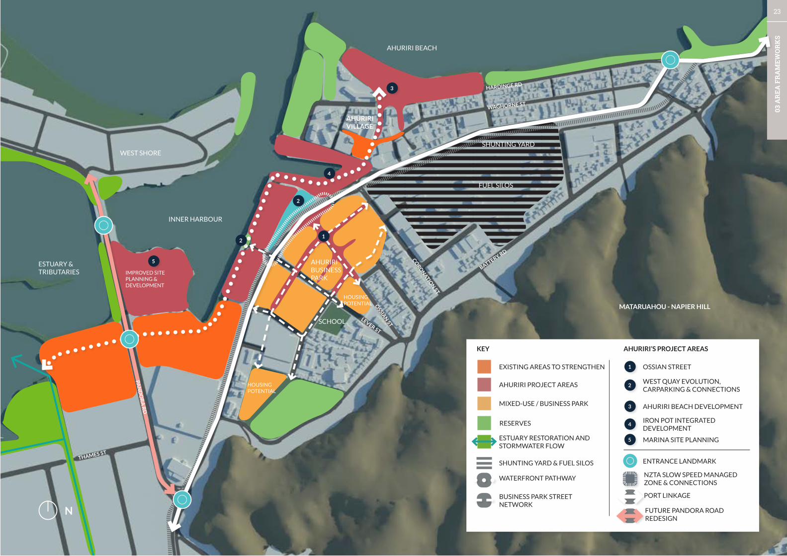
N
ESTUARY & TRIBUTARIES
INNER HARBOUR
WEST SHORE
AHURIRI BEACH
AHURIRI BUSINESS PARK
MATARUAHOU - NAPIER HILL
KEY
EXISTING AREAS TO STRENGTHEN
AHURIRI BEACH DEVELOPMENT
IRON POT INTEGRATED DEVELOPMENT
MARINA SITE PLANNING
AHURIRI PROJECT AREAS
MIXED-USE / BUSINESS PARK
ESTUARY RESTORATION AND STORMWATER FLOW
RESERVES
WATERFRONT PATHWAY
AHURIRI’S PROJECT AREAS
1
2
3
3
4
5
5
OSSIAN STREET
WEST QUAY EVOLUTION, CARPARKING & CONNECTIONS
PORT LINKAGE
FUTURE PANDORA ROAD REDESIGN
NZTA SLOW SPEED MANAGED ZONE & CONNECTIONS
SHUNTING YARD & FUEL SILOS
BUSINESS PARK STREET NETWORK
ENTRANCE LANDMARK
4
BATTERY RD
OSSIA
N ST
LEVER ST
CORO
NATIO
N ST
WAGHORNE ST
HARDINGE RD
THAMES ST
PAN
DO
RA
RD
HOUSING POTENTIAL
AHURIRI VILLAGE
FUEL SILOS
SHUNTING YARD
IMPROVED SITE PLANNING & DEVELOPMENT
1
2
2
SCHOOL
HOUSING POTENTIAL
24
03 A
REA
FR
AM
EWO
RK
S
STRATEGY 1 - INTEGRATE THE WATERFRONT AND AHURIRI’S CHARACTER
DISTRICTS
Ahuriri will become a coherent city district with multiple attraction by fusing the
northern Ahuriri village, West Quay and Marina, and the mixed-use warehouse
district / Ahuriri Business park.
RATIONALE
Ahuriri currently feels like a number of separate districts which are segregated
by transport infrastructure and a lack of pedestrian connections. The area
is very walkable and has regular nodes, apart from the central area around
Customs Quay and Nelson Quay. Some parts of the district are performing well
while others have the base conditions to create great places but need additional
features to support use by the public and to creatively resolve conflicts, such
as the working wharf and parking on West Quay. An improved public realm and
site planning of strategic locations will help resolve issues inherited from the
areas industrial past. An interdisciplinary approach with integrated solutions
will create new opportunities for the district’s future development. Ahuriri has
many tourism, heritage, and natural resources which can be integrated into the
broader Napier experience by developing them into a coherent package.
INITIATIVES
1A New and strengthened existing destinations
Undertake a series of catalyst projects to reinforce or create new destinations.
Catalyst projects for Ahuriri are:
1. Ahuriri beach development;
2. The Iron Pot integrated development - celebrate the historical significance
of the area around Customs Quay, Nelson Quay, and Bridge Street and provide
a pedestrian oriented Ahuriri waterfront along its entirety. The project will
consider opportunities for a built edge, public spaces, access to water, and
separation of HVT from the Ahuriri waterfront.
3.2.1 AHURIRI STRATEGIESThis section provides greater detail of the strategies, initiatives and the rationale for each strategy. The images shown are from other places, and give an indication of the types of initiatives needed for the ongoing evolution of Napier.
A number of specific City Centre project areas are then visualised with general design directions and potential actions/options. These visualisations help people to see the possibilities within the existing space, and are not intended to provide a final design in any way. Once each project area becomes a priority project, Council will engage with the public and stakeholders on community needs, design options, and then a final design that is consistent with the City Vision Principles.
3. West Quay evolution - wharf, shared-space and car-parking reconfiguration.
4. Ossian Street - Main street, and increased accessibility for the business park.
5. Marina and Estuary - public places, linkages and site planning.
1B Stitch the warehouse precinct and waterfront together
Development of connector streets with high-quality design from the waterfront
through the district.
- Lever Street
- Nelson Quay to Ossian St / Coronation St
Reinforce and protect views of the waterfront and key features throughout the
district, and provide additional landmarks along the Port route.
Incorporate way-finding into the coastal pathway and streets.
Strategic site identification and briefing - working with land-owners to develop
win-win solutions.
1C Ahuriri Heritage
Previous studies on the heritage and character of Ahuriri’s distinct residential,
industrial and commercial landscapes have given broad areas some level of
protection through District Plan provisions. The character of many of these
areas has changed in more recent years, and it is timely that another review of
Ahuriri’s character and heritage is carried out. This study will then guide Council
in what levels of protection are appropriate and where.
1D Ahuriri Tourist Hub
Strengthen Ahuriri’s role in tourism with a satellite hub.
Use the Custom House area as a base for walkable access to experiences which
strengthens Napier tourism offering at West Quay, Ahuriri Beach and the
warehouse district, and for water-based tourism (eg. waka).
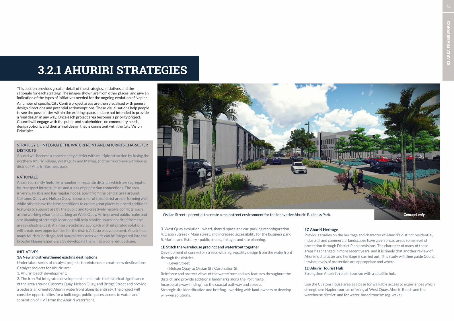
Ossian Street - potential to create a main street environment for the innovative Ahuriri Business Park. Concept only

25
03 A
REA
FR
AM
EWO
RK
S
STRATEGY 3 - INTELLIGENTLY MANAGE THE PORT ROUTE TO SUPPORT
THE PORTS GROWTH
Implement the transport switch elements for Ahuriri - The Port connector
with new design and access standards. The outcomes from the NZTA Port
Access Study will set out a long-term package of projects to support the Port’s
development.
RATIONALE
The Port has undergone substantial growth and capital investment and is one
of Hawkes Bay’s major economic assets. The NZ Government also recognises
its importance and commissioned a Port Corridor Access Study to support
the asset. The latest investment is in addition to many years of planning and
investment in a high-speed express-way network around the Hawkes Bay. The
route through Ahuriri also services as a connector for the district to access
the Ahuriri Beach and for residents to access the City centre and suburbs. In
future the design and management of the corridor must relate to the urban
context which has changed from an industrial area to mixed-use, and residential
enclaves. The express-way developments have reduced the dependence on
Pandora Road as the route north, however, it is still a major route to the Airport
and the Airport Business Park.
INITIATIVES
3A Port Access Route
Ensure the route to the Napier Port is unrestrained whilst ensuring conflicts
with pedestrians and cyclists are adequately addressed.
Partner with the Port of Napier, NZTA and KiwiRail to manage users of the route
and better coordinate transportation movements to ensure maximum efficiency
for all users.
Manage reverse sensitivity effects by requiring noise sensitive activities to
acoustically insulate against traffic noise.
Relocating the weigh-bridge and potentially realigning the road.
3B Bridge Street managed zone - slow, safe, and connected from the Iron Pot
to Lever Street.
Slowing traffic with visual narrowing of the road corridor.
Free up space along the rail corridor side for a landscaped and separated off-
road shared pedestrian and cycle path.
Provide safe and convenient cycle facilities to divert cyclists off Bridge Street to
access the Ahuriri Business Park from the southern streets.
Pedestrian refuge will be placed in the middle of Bridge St at Lever St.
Retain footpath for the tourist bus stops around the National Tobacco Building
and the Hawkes Bay Business Hub.
Parking supply - better management and design of on-street and off-street car-
parks.
Open space and street network development to create a clear and legible platform
which supports private development
(e.g. pocket parks, plazas, parks, linear parks, playgrounds, new street designs,).
2B Securing complementary uses
Refining the Mixed-use warehouse district:
• Refine activity types and mix, amenity levels, and design controls.
• Business focus and build identity through the warehouse character.
• Increasing safety and ‘night-time presence’ with residential development.
2C Increase residential close to jobs and amenities
Increasing residential density near the school and Ahuriri Park through with mixed
urban housing typologies (e.g. low-rise apartments, courtyard homes, compounds,
townhouses) to create a range of housing options.
A potential urban housing typology - a compound of low-rise apartments (image shows a north american vernacular) and town houses around a high amenity shared space. Parking is via rear lane.
STRATEGY 2 INVEST IN THE AHURIRI BUSINESS PARK - THE MIXED-USE
WAREHOUSE PRECINCT
Ahuriri Business Park in the mixed-use precinct will become home to Napier’s
entrepreneurial culture and leverage the Business Hub and unique setting.
While the wider area will be developed to support additional living and
recreation opportunities.
RATIONALE
The Warehouse precinct centred around Ossian Street and Lever Street is
known as the Ahuriri Business Park. Significant planning and investment has
occurred in this area, with over 50 new businesses locating in the area formerly
owned by British American Tobacco. The development of the Hawke’s Bay
Business Hub on the corner of Ossian and Bridge Streets further reinforces
the emerging mixed-use character of this area. A number of large sites remain
undeveloped which have great capacity to accommodate a variety of uses.
The area is potentially very attractive for increased urban housing, and can
accommodate increased residential activity as it has many support functions,
such as the primary school, daycares, gym, and cafés, and is close to the
recreation opportunities along the waterfront and harbour, the large Ahuriri
Park, and nightlife – all the elements are present to live, work and play.
The precinct needs further investment in the public space network, streets and
reserves to support the private investment in the transformation of this area
from its industrial past.
This area is not a specialty retail area (the City Centre and Ahuriri Village
fulfil these roles). Heavy industry that creates a level of effects considered
unacceptable to more sensitive activities such as residential should be
progressively moved out of this area. Residential and other noise sensitive
activities must however, acknowledge that they are in a mixed environment with
higher levels of noise and activity than in pure residential areas. Noise sensitive
activities will be required to protect themselves from higher noise levels
through acoustic insulation.
The balanced ‘mix’ of activities will need to be carefully maintained through
regulation to ensure one activity type doesn’t dominate or impact adversely on
other areas of the City.
INITIATIVES
2A Quality and structure of the warehouse district
Invest in the quality of streets and spaces of the district with Ossian Street as a
main street for the district.
Create two strong north-south links:
From Lever along the service lanes and Mahia St to Coronation St.
From the Park along Dommet to Coronation St

26
03 A
REA
FR
AM
EWO
RK
S
STRATEGY 4 - USE THE BUILT FORM AS A CANVAS TO BUILD IDENTITY
The saw-tooth heritage warehouses and other industrial artefacts will be
transformed from an industrial setting to a stimulating sensory experience.
RATIONALE
Ahuriri has a rich heritage, historical and cultural resource which is not
expressed to its fullest extent. The area around the ‘Iron Pot’ was a Maori
settlement and is recognised as the founding settlement for Napier. The area
has also been significantly changed from an estuarine and deep port by the 1931
and land reclamation. The history is referenced in names such as Bridge Street.
Other areas have lost their original names and could be restored; this relates to
both Maori names and European names.
There are promising examples of contemporary cultural expression, for example,
with contemporary carvings on West Quay and the Sea Walls. The district has
so many large canvases for cultural expression that a significant and sustained
programme will create a large scale cultural and tourist attraction which will
build a legacy for future generations.
INITIATIVES
4A Developing the Maori presence and cultural expression
Increasing Maori presence and identity throughout the district - expression of
pre-european history, through to current aspirations and post-treaty settlement
entrepreneurial activities.
In an indigenous world view all physical landscapes are inseparable from
ancestry, events and cultural practices. The core Maori principles of mana, taiao,
mauri tu, tohu, whakapapa/whakamana, ahikaa, mahi toi will guide initiatives
to create a platform for global cultural exchange. The design of our spaces will
incorporate Te Aranga design principles to ensure that design elements are
inspired by local stories and practices.
4B Communicating Ahuriri’s rich history
Innovative contemporary approaches to communicating Ahuriri’s rich history
as the original settlement and its development by using important sites and
landmarks, original landforms of the area and points of interest as a canvas (e.g.
large warehouses, silos). Integrate stories into the landscape.
Small scale cultural features make great additions to play spaces. Renewable energy generation in public spaces, for example solar panels, are a tangible expression of a community’s move towards a clean energy future.
High-quality large scale artwork can transform a dull space.
3C Pandora Road corridor redevelopment (post road classification down-
grade).
Street redesign - city entrance boulevard
Landmark sites - Bridge and roundabout
Re-prioritisation of street space for access to properties.
Potential for new land use rules (if state highway designation is removed).
Separated cycle path from Ahuriri to the Express-way Shared path.
4C Lighting – Nightscaping Ahuriri
An integrated lighting strategy will be prepared for the City with consideration given
to the following needs and elements:
Motorist and cyclist visibility and safety;
Pedestrian safety (incorporating CPTED principles)
Highlighting architectural building features and other features such as vegetation;
Lighting as art and for story-telling
27
03 A
REA
FR
AM
EWO
RK
S
STRATEGY 1 - ONE WATERFRONT, MULTIPLE
DESTINATIONS, 100+ THINGS TO DO
The waterfront will be developed as a coherent entity
from the Estuary to Georges Dr with a place-led approach
to create destinations which are composed of unique
places with multiple attractions.
1A Destinations and places
Defining the destinations and places along the waterfront,
and developing their identity and points of difference, and
delivering long-term place-based programmes to layer
activity into the waterfront, repair deficits and create new
opportunities.
1B Estuary eco-restoration and recreation development
Eco-restoration of the estuary and sensitive development
of recreation opportunities at Humber St with improved
linkages to West Quay and the Marina area.
1C Marina site planning
Site planning to improve legibility, relationships between
buildings and open space, more efficient use of land, clear
linkages, and public places.
STRATEGIES SUMMARY
STRATEGY 2 - WATERFRONT STRUCTURE & DESIGN
The scope of waterfront projects will extend one-block
into the City centre and Ahuriri urban structure to
maximise project benefits, and build in resilience. The
design of the waterfront will be coordinated.
2A User experience
Improving and expanding the user-experience by place-
specific features, ensuring accessibility for all ages, and
way-finding.
2B Integrated waterfront development
Integrated development of public space, boulevards,
streets, and buildings along the waterfront.
2C Consistent design standards and palette of materials
High quality design along the entire waterfront with
consistent design standards, and a palette of materials
which supports the development of unique place
identities.
2D Hazard and coastal processes mitigation
Integrating hazard mitigation measures into the
landscape.
STRATEGY 3 - CONTEMPORARY NZ WATERFRONT
EXPERIENCE
The waterfront will become a multifunctional and multi-
layered experience with a strong NZ aesthetic.
3A Coastal vegetation framework
A vegetation framework which delivers ecological and
aesthetic value. The framework will be place-specific
and support the development of unique experiences and
clearly identifiable places along the waterfront.
3B Creative and cultural expression
Creating a programme of cultural and creative expression
to enrich the sequential waterfront experience, learning,
and create memorable points along the waterfront.
3C Lighting - nightscaping the waterfront.
Developing a Unified Lighting Strategy - aesthetics,
functional, walkways, street lighting.
STRATEGY 4 - PORT AND CRUISE SHIP STRATEGY
The Port development will be supported, and the Cruise
ship tourism experience will have stronger links between
all tourism assets.
4A Cruise ship experience
A creative and adaptable pop-up arrival and departure
experience at the Port and at the I-site.
A memorable route to and from central city tourism hub
through the ‘NZ coastal botanical gardens’.
A walkable central city tourism experience which is clearly
identified and integrated with way-finding.
Incorporating an Ahuriri tourism i-site hub centred on the
Customs House with associated tourism experiences.
4B Supporting the Port’s development
Implementing the Port Corridor Access study which
includes the route through Ahuriri.
Creating high quality entrances and public interfaces to
the Port which communicate the significance of the Port
as an economic asset to the City and Hawkes Bay.
3.3 WATERFRONT & PORT
28
03 A
REA
FR
AM
EWO
RK
S
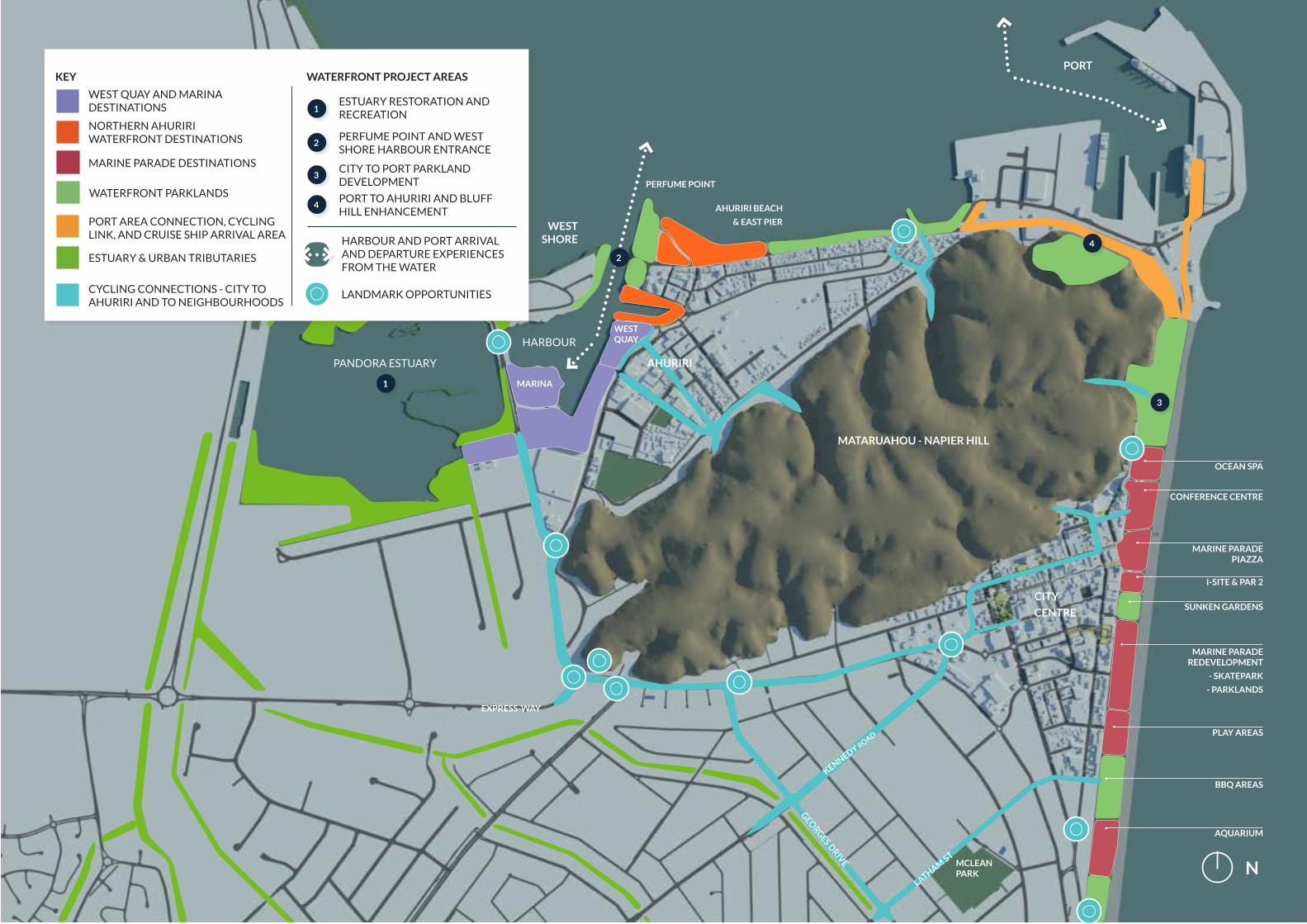
CITY
CENTRE
GEORGES D
RIVE
AHURIRI
PORT
EXPRESS-WAY
PANDORA ESTUARY
KENNEDY ROAD
MATARUAHOU - NAPIER HILL
HARBOUR
AHURIRI BEACH
& EAST PIERWEST SHORE
KEY
NORTHERN AHURIRI WATERFRONT DESTINATIONS
CYCLING CONNECTIONS - CITY TO AHURIRI AND TO NEIGHBOURHOODS
WEST QUAY AND MARINA DESTINATIONS
PORT AREA CONNECTION, CYCLING LINK, AND CRUISE SHIP ARRIVAL AREA
ESTUARY & URBAN TRIBUTARIES
WATERFRONT PARKLANDS
LANDMARK OPPORTUNITIES
MARINE PARADE DESTINATIONS
ESTUARY RESTORATION AND RECREATION
PERFUME POINT AND WEST SHORE HARBOUR ENTRANCE
CITY TO PORT PARKLAND DEVELOPMENT
PORT TO AHURIRI AND BLUFF HILL ENHANCEMENT
1
2
3
4
WATERFRONT PROJECT AREAS
PERFUME POINT
LATHAM ST
MCLEAN PARK N
1
3
4
CONFERENCE CENTRE
OCEAN SPA
MARINE PARADE PIAZZA
I-SITE & PAR 2
SUNKEN GARDENS
PLAY AREAS
BBQ AREAS
AQUARIUM
MARINE PARADE REDEVELOPMENT
- SKATEPARK
- PARKLANDS
MARINA
WEST QUAY
HARBOUR AND PORT ARRIVAL AND DEPARTURE EXPERIENCES FROM THE WATER
2

29
03 A
REA
FR
AM
EWO
RK
S
STRATEGY 1 - ONE WATERFRONT, MULTIPLE DESTINATIONS, 100+ THINGS
TO DO
The waterfront will be developed as a coherent entity from the Estuary
to Georges Dr with a place-led approach to create destinations which are
composed of unique places with multiple attractions.
RATIONALE
The Waterfront currently has a number of diverse destinations, but many of
these do not feel related, and the whole waterfront is not recognised as a whole
linear open space system. This lack of place identities and the lack of public
space features such as appropriate seating in many locations means that some
parts of the waterfront have been under-performing. The City Vision focuses on
the waterfront from the intersection of Warren St to the Pandora estuary.
The Waterfront also has a diverse range of characteristics that are on a
continuum from less-developed/more natural areas to highly developed urban
waterfront areas. A significant waterfront project is underway to redevelop
the ex-marineland and car-parking area. This will set a new benchmark for
waterfront design in Napier. The exact identity and characteristics of places
along the waterfront is an ongoing and long-term project where some places
will need a focus on creating identity and while others require retrofitting and
raising quality to meet contemporary design approaches and to meet the desires
and aspirations of this generation. Overall the aim is to create a legacy for future
generations and to create one of the great waterfronts in NZ.
The Estuary is a unique feature and its condition is not as good as it could
be. The focus for the estuary is for eco-restoration as a primary aim with the
recreational uses and improved edge conditions at Ahuriri to follow to make use
of the improved environment.
This section provides greater detail of the strategies, initiatives and the rationale for each strategy. The images shown are from other places, and give an indication of the types of initiatives needed for the ongoing evolution of Napier.
A number of specific Waterfront project areas are then visualised with general design directions and potential actions/options. These visualisations help people to see the possibilities within the existing space, and are not intended to provide a final design in any way. Once each project area becomes a priority project, Council will engage with the public and stakeholders on community needs, design options, and then a final design that is consistent with the City Vision Principles.
3.1.1 WATERFRONT & PORT STRATEGIESThe Marina site currently feels privatised due to poor definition between public
and private and the area does not provide a clear path to West Shore or a
positive entrance experience along Pandora Rd. The site planning has developed
incrementally over time and there is scope for improved site planning to provide
better public access, clear definition between sailing club areas and public areas,
and potential for development opportunities.
INITIATIVES
1A Destinations and Places
Defining the destinations and places along the waterfront, and developing
their identity and points of difference, and delivering long-term place-based
programmes to layer activity into the waterfront, repair deficits and create new
opportunities. Concentrations of activity to build critical mass and provide a
sense of vitality will be created in the Central City, Port area, Ahuriri Beach
Ahuriri Inner Harbour.
1B Estuary Eco-restoration and Recreation development
The Pandora Estuary has large amount of land with a primary ecological function
which is in contrast to most of the waterfront.
The primary recreation area on Humber St needs improved linkages to West
Quay and the Marina area.
1C Marina Site Planning
The Southern West Quay area and Marina to the Estuary and to West Shore-
need improved legibility, relationships between buildings and open space, and a
more efficient use of land through improved marina site planning, clear linkages
and public places.
A waterfront destination needs many attractions, and activity hubs should be centrally located in relation to urban centres for maximum benefit. This waterfront park with multiple areas, shade structures, and cultural expression, and play extends directly from Cairns’ main street and includes buildings with an active edge lining a waterfront esplanade. Cairns, Queensland
30
03 A
REA
FR
AM
EWO
RK
S
STRATEGY 2 - WATERFRONT STRUCTURE & DESIGN
The scope of projects will extend one-block into the City centre and Ahuriri
urban structure to maximise project benefits, and build in resilience. The design
of the waterfront will be improved by focussing on user-experience.
RATIONALE
The Waterfront currently has mix of qualities along the waterfront due to the
incremental development over decades. In places, generic features are provided
when place-specific features would create a much stronger experience (an
example of this is generic park bench seating on Marine Pde). The most uniform
feature along the waterfront is the coastal pathway which offers a uniform
experience for its length, although some sections are yet to be developed.
The waterfront does not currently support universal access as some access-
ways to the coastal pathway feature steps and materials which are difficult for
older people, people in wheel-chairs, or families with prams. The accesses to
the waterfront from streets and urban spaces is also variable and at times the
pedestrian and cycling connections are basic. Design standards have varied
over the years and some promising initiatives to raise the quality along the
waterfront to a consistent standard have already been completed, for example,
the public toilets.
Future projects can leverage the research and development completed on
materials and design approaches by the West Quay Design Group and the
Marine Parade Redevelopment for future upgrades. The coast is a source
of hazards and historical sea-walls and structures are present along the
waterfront’s length. There are a number of legacy structures that the City has
inherited, and in future the best practices of environmental engineering and
landscape architecture will be required to integrate functional features into a
coherent waterfront environment rather than creating standalone defences.
INITIATIVES
2A User experience
Improving and expanding the user-experience with waterfront features that
ensure accessibility for all ages and way-finding.
2B Integrated waterfront development (see diagrams p33-34)
Integrated development of public space (streets and landscapes), buildings along
the waterfront.
Waterfront scope to include reserves, streets, and buildings and extend one
block from the waterfront reserve.
2C Design standards and palette of materials
High quality design along the entire waterfront with consistent design
standards, and a palette of materials which supports the development of unique
place identities.
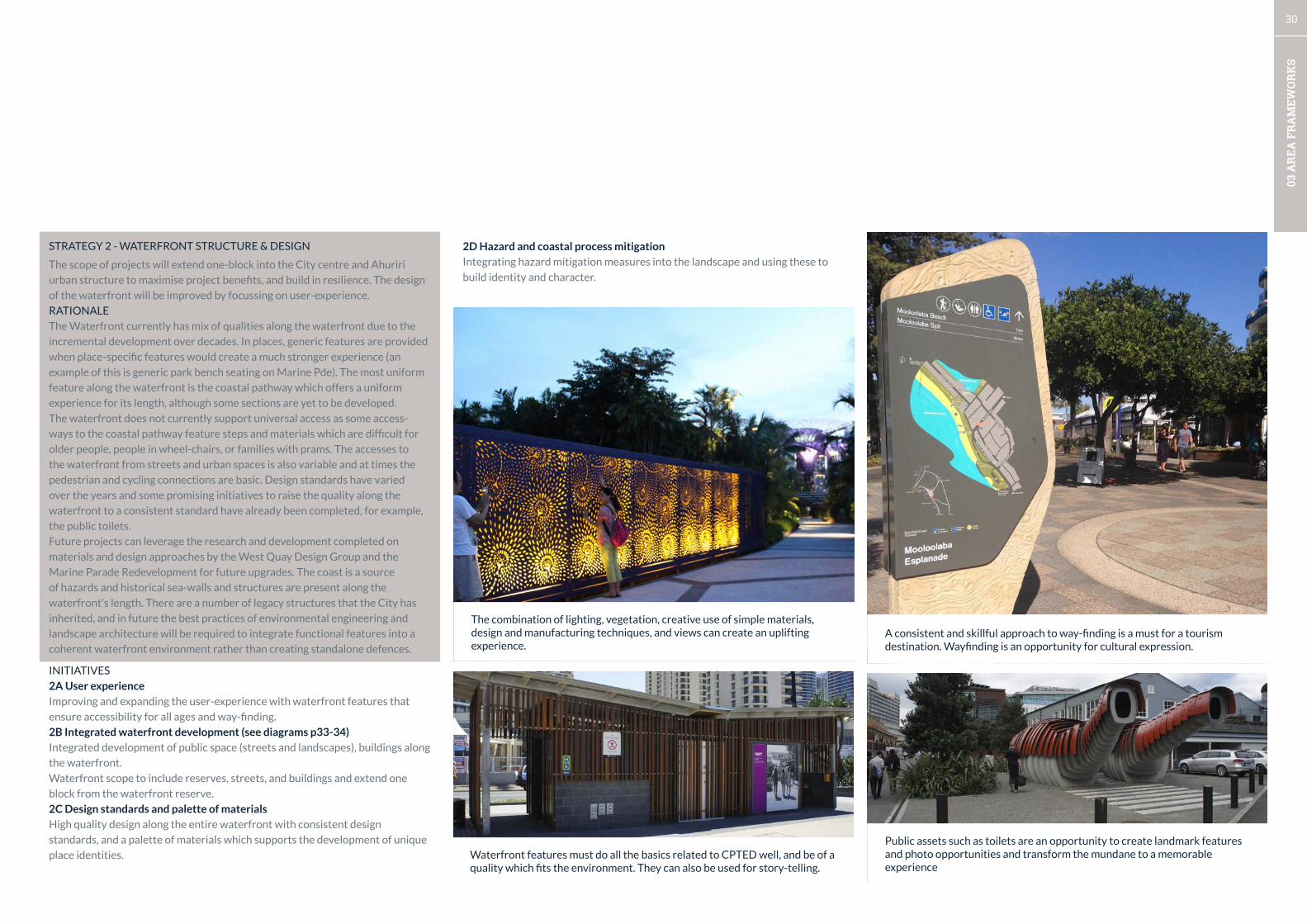
2D Hazard and coastal process mitigation
Integrating hazard mitigation measures into the landscape and using these to
build identity and character.
A consistent and skillful approach to way-finding is a must for a tourism destination. Wayfinding is an opportunity for cultural expression.
Public assets such as toilets are an opportunity to create landmark features and photo opportunities and transform the mundane to a memorable experience
The combination of lighting, vegetation, creative use of simple materials, design and manufacturing techniques, and views can create an uplifting experience.
Waterfront features must do all the basics related to CPTED well, and be of a quality which fits the environment. They can also be used for story-telling.

31
03 A
REA
FR
AM
EWO
RK
S
Norfolk pines from the road median and re-establishment along the waterfront
reserve edge, which is consistent with the majority of the waterfront, and
creates strong spatial definition.
3B Creative and cultural expression
Creating a programme of cultural and creative expression to enrich the
sequential waterfront experience, learning, and create memorable points along
the waterfront.
3C Lighting - Nightscaping the waterfront
An integrated lighting strategy will be prepared for the City with consideration
given to the following needs and elements:
Motorist and cyclist visibility and safety;
Pedestrian safety (incorporating CPTED principles)
Highlighting architectural building features and other features such as
vegetation;
Lighting as art and for story-telling
Lighting of trees along pathways creates pleasant environments which extends the use of a space over a day, and improves safety.
Lighting is fundamental to the night-time economy, and its effect is multiplied by the presence of water.
An ecological approach to vegetation produces wildly different environments with unique aesthetics compared to past formal, ornamental approaches.
Managing urban run-off with biological treatment areas is a common practice in waterfronts.
Low-spec, yet creative uses of materials and landscape design can create attractive features for public spaces with a sense of play and adventure.
STRATEGY 3 - CONTEMPORARY WATERFRONT EXPERIENCE
The waterfront will become a multifunctional and multi-layered experience
during the day and evening.
RATIONALE
The waterfront has been developed over a long period of time and largely
with ornamental qualities, the legacy of the colonial approach is present in
the high-maintenance and manicured garden beds. In order to develop a New
Zealand urban style, considerable design research has been undertaken to
make use of native and endemic species to create landscapes which have both
ecological value and aesthetic value, suited to the climate and conditions, and
maintainable. A vegetation framework which is suited to local conditions, design,
and ecological needs will create a unique waterfront which feels like Hawke’s
Bay and New Zealand.
Creative and cultural expression is common and diverse along the waterfront
and in some places the quality of expression on the waterfront is not as good as
elsewhere and needs improvement. Cultural expression on the waterfront can
take a wide variety of forms and scale, and will allow landscape architecture and
land-art to be included to create new forms which aid legibility and memorability
of the waterfront.
Lighting technology has come a long way with LED technology and controls
which allow large, long-lived installations. In addition, one of the growth areas
for cities is the night-time economy, which is supported by lighting. A recent
CPTED assessment for Clive Square demonstrated the benefits of well-lit
reserve spaces and vegetation to improve perceptions of safety and measurable
safety outcomes, while the Tom Parker Fountain showcases the benefits of
lighting for aesthetic benefits – the benefits should be extended to other
public spaces and features. The Waterfront, City Centre and Ahuriri should
be considered as a whole to create a unified lighting strategy which delivers
aesthetic, functional, and safety benefits.
INITIATIVES
3A Coastal Vegetation Framework
A vegetation framework which delivers ecological and aesthetic value. The
framework will be place-specific and support the development of unique
experiences and clearly identifiable places along the waterfront. One of the
key actions is to determine and implement the Norfolk Pine replacement
strategy. The Norfolk Pines along Marine Parade are iconic for Napier, and with
the ravages of time, poor soils, drought, salt-laden winds, vandalism, and root
damage, a number of these trees have been removed or are in poor condition.
The waterfront design concepts (p33-34) recommends gradual removal of
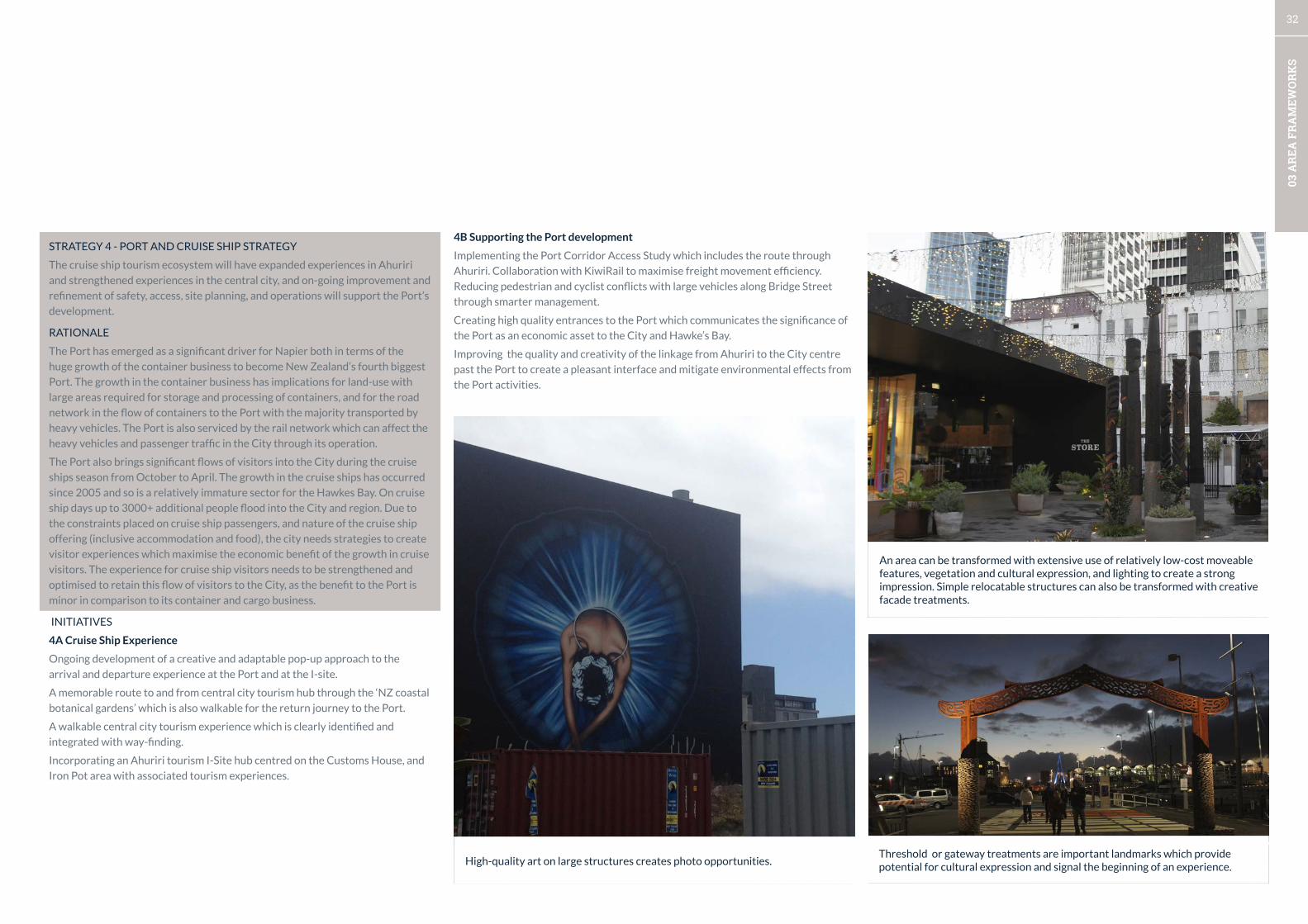
32
03 A
REA
FR
AM
EWO
RK
S
STRATEGY 4 - PORT AND CRUISE SHIP STRATEGY
The cruise ship tourism ecosystem will have expanded experiences in Ahuriri
and strengthened experiences in the central city, and on-going improvement and
refinement of safety, access, site planning, and operations will support the Port’s
development.
RATIONALE
The Port has emerged as a significant driver for Napier both in terms of the
huge growth of the container business to become New Zealand’s fourth biggest
Port. The growth in the container business has implications for land-use with
large areas required for storage and processing of containers, and for the road
network in the flow of containers to the Port with the majority transported by
heavy vehicles. The Port is also serviced by the rail network which can affect the
heavy vehicles and passenger traffic in the City through its operation.
The Port also brings significant flows of visitors into the City during the cruise
ships season from October to April. The growth in the cruise ships has occurred
since 2005 and so is a relatively immature sector for the Hawkes Bay. On cruise
ship days up to 3000+ additional people flood into the City and region. Due to
the constraints placed on cruise ship passengers, and nature of the cruise ship
offering (inclusive accommodation and food), the city needs strategies to create
visitor experiences which maximise the economic benefit of the growth in cruise
visitors. The experience for cruise ship visitors needs to be strengthened and
optimised to retain this flow of visitors to the City, as the benefit to the Port is
minor in comparison to its container and cargo business.
INITIATIVES
4A Cruise Ship Experience
Ongoing development of a creative and adaptable pop-up approach to the
arrival and departure experience at the Port and at the I-site.
A memorable route to and from central city tourism hub through the ‘NZ coastal
botanical gardens’ which is also walkable for the return journey to the Port.
A walkable central city tourism experience which is clearly identified and
integrated with way-finding.
Incorporating an Ahuriri tourism I-Site hub centred on the Customs House, and
Iron Pot area with associated tourism experiences.
Threshold or gateway treatments are important landmarks which provide potential for cultural expression and signal the beginning of an experience.High-quality art on large structures creates photo opportunities.
An area can be transformed with extensive use of relatively low-cost moveable features, vegetation and cultural expression, and lighting to create a strong impression. Simple relocatable structures can also be transformed with creative facade treatments.
4B Supporting the Port development
Implementing the Port Corridor Access Study which includes the route through
Ahuriri. Collaboration with KiwiRail to maximise freight movement efficiency.
Reducing pedestrian and cyclist conflicts with large vehicles along Bridge Street
through smarter management.
Creating high quality entrances to the Port which communicates the significance of
the Port as an economic asset to the City and Hawke’s Bay.
Improving the quality and creativity of the linkage from Ahuriri to the City centre
past the Port to create a pleasant interface and mitigate environmental effects from
the Port activities.
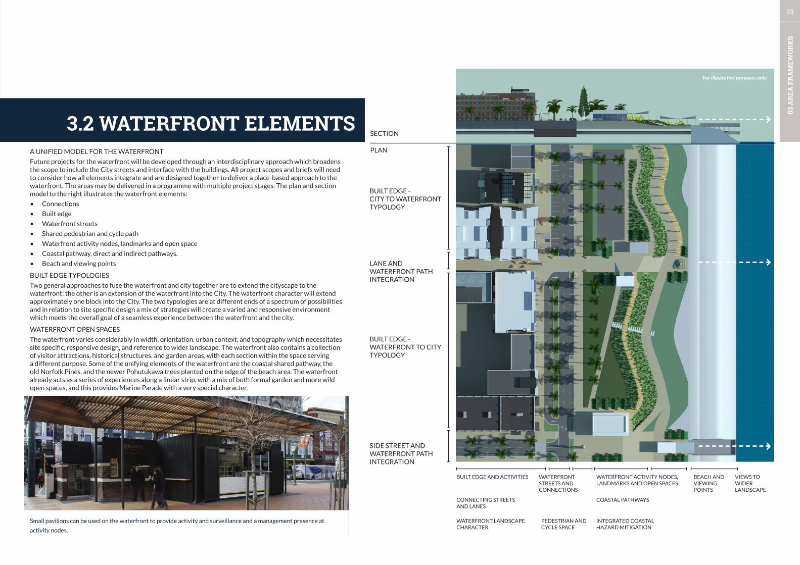
33
03 A
REA
FR
AM
EWO
RK
S
3.2 WATERFRONT ELEMENTSPLAN
BUILT EDGE -CITY TO WATERFRONT TYPOLOGY
BUILT EDGE - WATERFRONT TO CITY TYPOLOGY
BUILT EDGE AND ACTIVITIES WATERFRONT STREETS AND CONNECTIONS
COASTAL PATHWAYS
INTEGRATED COASTAL HAZARD MITIGATION
BEACH AND VIEWING POINTS
VIEWS TO WIDER LANDSCAPE
WATERFRONT ACTIVITY NODES, LANDMARKS AND OPEN SPACES
PEDESTRIAN AND CYCLE SPACE
CONNECTING STREETS AND LANES
WATERFRONT LANDSCAPE CHARACTER
LANE AND WATERFRONT PATH INTEGRATION
SIDE STREET AND WATERFRONT PATH INTEGRATION
SECTION
A UNIFIED MODEL FOR THE WATERFRONT
Future projects for the waterfront will be developed through an interdisciplinary approach which broadens the scope to include the City streets and interface with the buildings. All project scopes and briefs will need to consider how all elements integrate and are designed together to deliver a place-based approach to the waterfront. The areas may be delivered in a programme with multiple project stages. The plan and section model to the right illustrates the waterfront elements:
• Connections
• Built edge
• Waterfront streets
• Shared pedestrian and cycle path
• Waterfront activity nodes, landmarks and open space
• Coastal pathway, direct and indirect pathways.
• Beach and viewing points
BUILT EDGE TYPOLOGIES
Two general approaches to fuse the waterfront and city together are to extend the cityscape to the waterfront; the other is an extension of the waterfront into the City. The waterfront character will extend approximately one block into the City. The two typologies are at different ends of a spectrum of possibilities and in relation to site specific design a mix of strategies will create a varied and responsive environment which meets the overall goal of a seamless experience between the waterfront and the city.
WATERFRONT OPEN SPACES
The waterfront varies considerably in width, orientation, urban context, and topography which necessitates site specific, responsive design, and reference to wider landscape. The waterfront also contains a collection of visitor attractions, historical structures, and garden areas, with each section within the space serving a different purpose. Some of the unifying elements of the waterfront are the coastal shared pathway, the old Norfolk Pines, and the newer Pohutukawa trees planted on the edge of the beach area. The waterfront already acts as a series of experiences along a linear strip, with a mix of both formal garden and more wild open spaces, and this provides Marine Parade with a very special character.
Small pavilions can be used on the waterfront to provide activity and surveillance and a management presence at
activity nodes.
For illustrative purposes only

34
03 A
REA
FR
AM
EWO
RK
S
Level changes accommodated within the landscape.
Landscape to allow for swells and inundation.
Provide shade, shelter and protection from wind.Landmarks, pavilion structures and
canopies to add culture and artistic flair considered on case-by-case design strategies.
Waterfront buildings integrated with landscape and pathways.
Waterfront buildings - high degree of transparency required.
Waterfront buildings - define spaces and frame views, create multiple external spaces for activity to allow for use over the day, and seasonal variations.
Site specific designs with common design language (scale, location) along waterfront(Principles to be developed).
Viewing platforms and waterfront features, integrated with infrastructure.
Vegetation - site specific and respond to harsh environment (e.g. salt-laden winds, heat, dry, high infiltration).
Retain Norfolk pines and create an additional lower storey space defining scale of vegetation on waterfront.
Smaller pockets of destination specific parking.
Physical connection and response to existing features on case-by-case basis.
Reinterpretation of heritage not poor quality replicas.
Active ground floor uses and transparent frontages.
Upper floors - mixed use - business, visitor accommodation or residential.
Wide paths with open views that connect with the urban structure and streets.
Coherent materials palette to be developed.Lighting - functional and aesthetic via unified lighting strategy.
Lighting of trees and landscape - functional and aesthetic via unified lighting strategy.
Mix of direct and meandering paths with orientation to wider landscape features.
NZ ecology and identity - natives palette with mixed-exotics in certain locations; lower maintenance, seasonal changes.
Vegetation to have ecological and aesthetic functions.
Generously landscaped areas - vegetation framework to be developed.
Pre-treatment of run-off from car-parks and streets e.g. rain gardens.
3.3 WATERFRONT DESIGN CONCEPTSSpace for active street uses.
Lane-way linkages with active edges.
Streets with waterfront vegetation and parking.
Slow speed environment and small kerb radii for safe pedestrian connections.
Shared cyclist and pedestrian pathway.
Slow speed street environment with focus on accessibility.
Wide, clear and direct pedestrian and cycling crossing points to waterfront.
Landscape sculpting for vertical elements and variation.Linear landscape elements and spatial definition.
Human scale buildings along the waterfront - generally 2-5 storeys.
BUILDINGS
SIDE STREETS
WATERFRONT STREETS
WATERFRONT OPEN SPACES
VEGETATION
WATERFRONT PATHS
WATERFRONT BUILDINGS & STRUCTURES
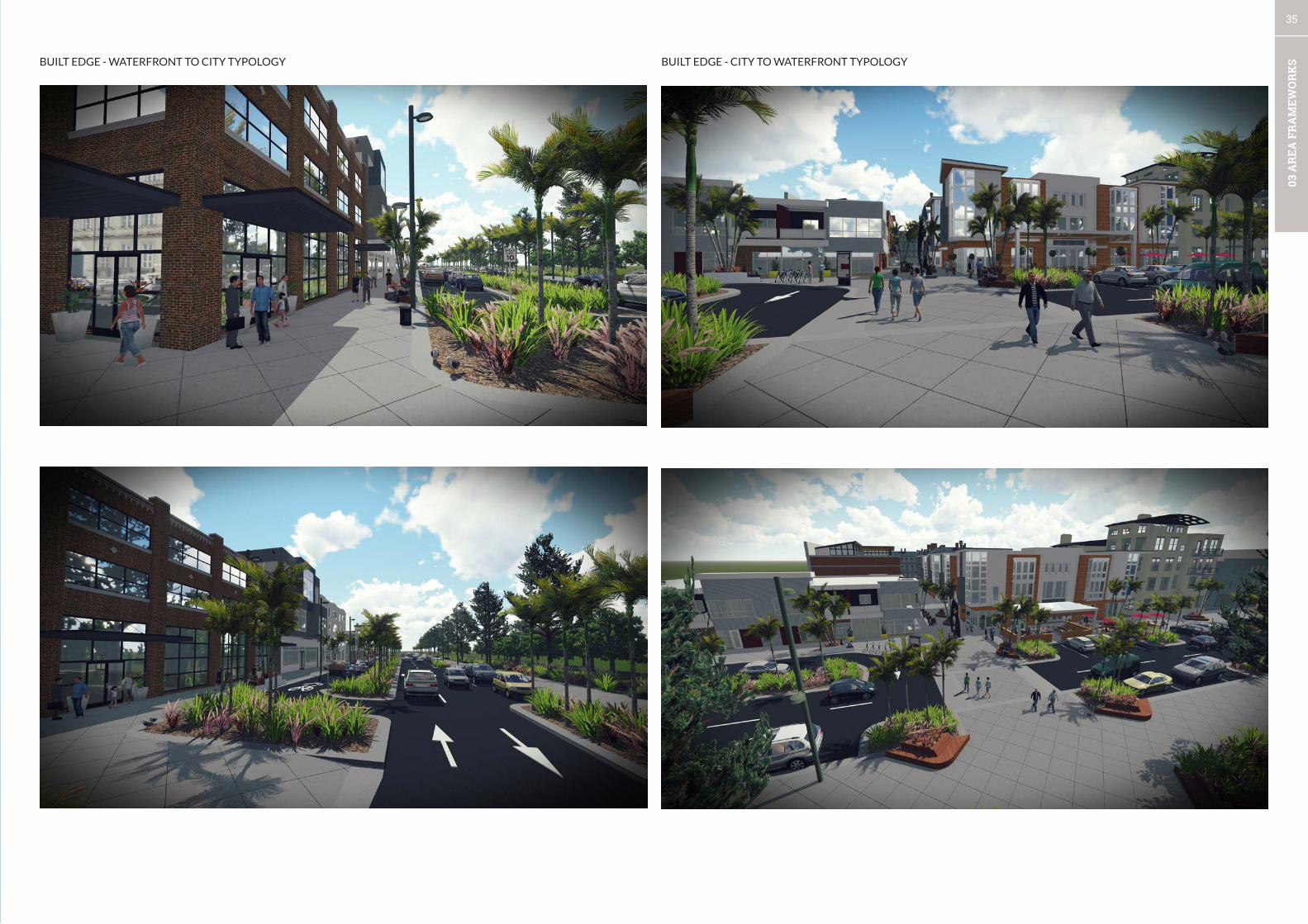
35
03 A
REA
FR
AM
EWO
RK
SBUILT EDGE - CITY TO WATERFRONT TYPOLOGYBUILT EDGE - WATERFRONT TO CITY TYPOLOGY
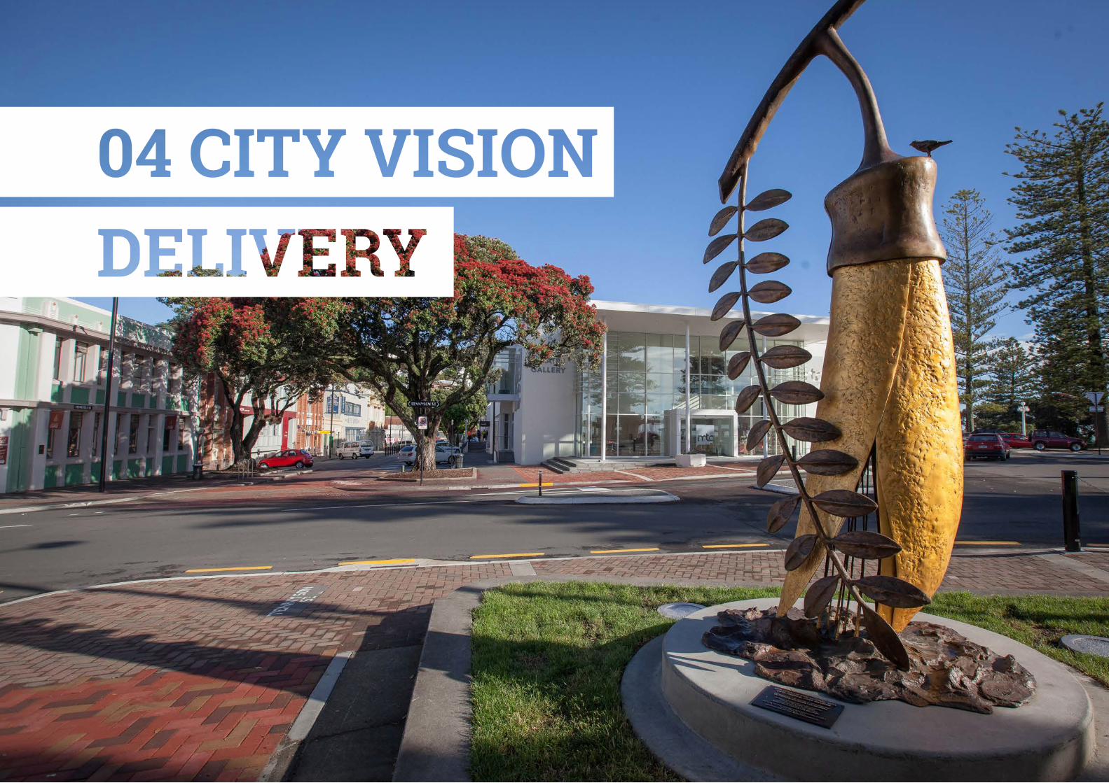

37
04 D
ELIV
ERY
INITIAL PRIORITISATION & PILOTING IDEAS
The development of the three area frameworks has identified broad areas
of priority for the next Long Term Plan process for the following 10 years.
The Frameworks present a flexible approach with staging. After each stage
is implemented the following stages can be evaluated, re-prioritised, and
re-convened after learnings and observations have been made. Council has
committed to $100,000 of funding each year for five years to pilot ideas
and projects before evaluating success and proceeding to a final design and
construction phase.
The Long Term Plan process is the final step where final prioritisation occurs for
the next year funding cycle. The Frameworks will provide a point of reference
for this decision-making and may require updates to keep them ‘live’ as elements
are implemented.
The placemaking approach to reinventing cities has been adopted by Council in
a trial format by providing funding for the 2015-20 period (as part of the wider
City Vision project) to enable rapid delivery of experimental projects and trials
and to quickly respond to opportunities to work with stakeholders and partners.
The approach’s success relies on minimal political interference, trialling projects
in the real world to understand behaviour, and allows for low-cost tests in
advance of more expensive investments. It is part of a broader approach to
urban design and development that recognises that multiple actions and small,
medium and large scales are required to transform cities into more liveable,
human, and stimulating environments. Along with the rapid implementation, a
greater appetite for risk is required as is a tolerance for failure.
ONGOING PILOT PROJECTS/POP-UPS
On a smaller scale, pop-ups such as hang-out places, parklets, installations,
and small scale events will continue to ‘pop up’ around the City. The purpose
of these is to provide fun and inexpensive places for locals and visitors to stay
a while within the city; to create some interest and activity; and to test ideas
for new public realm ‘furniture’. They will be installed in locations where some
activity exists but the opportunities of that location to attract and retain people
in the space are not fully realised. Because pop-ups rely heavily on management
partnerships, they will only be installed where there is a desire to do something.
4.1 THE DELIVERY PROCESS
MEASURING PROGRESS
Data collection is central to testing ideas. It helps to clarify what we want to
achieve when we embark on a project. It also helps us to know whether the
project is successful, and gives decision-makers confidence to take the pilot
phase further to a full implementation phase.
Data will be collected on a project-by-project basis, and will be determined
by what the project seeks to achieve. For example, a project that seeks to
change a street from one that is car-dominated, to one that is pedestrian
and cyclist dominated will most likely gather data such as before and after
project traffic speeds; vehicle numbers; percentage heavy vehicles; number
of people on the street and length of time they stay, as well as gather
feedback in the form of surveys and social media posts. One could go further
and look at commercial vacancy rates and retail turnover.
Measuring success on a project-by-project basis, as opposed to the overall
effect of the City Vision on the City, is more tangible, simpler to measure,
and more easily attributed to the impact of each project.
PRIORITY PROJECTS
Seven priority projects have been identified through the process of developing
the City Vision. Work has already progressed on a number of these projects,
while others are in the ideas stage. The Build-Measure-Learn process1 can be
applied to many of these projects to test whether ideas would be successful
before committing to more extensive costs and development. The seven priority
projects for the 2015/2016 financial year are:
1. The Transport Switch – Marine Parade Piazza, Bridge Street Managed
Zone
2. Ossian Street Pilot Project
3. Urban Design Panel
4. Make.Space. Napier
5. Thames-Tyne Stormwater Improvements (Ahuriri Estuary)
6. Cycling City – Maximising Opportunities
7. Clive Square – Activation & physical changes
These projects are further described in the next section.
1 Eric Ries, 2011. The Lean Startup.
BUILD
MEASURELEARN
BUILD MEASURE
LEARN CYCLE
DATA
FEATURESIDEAS
REGULATORY FRAMEWORK
In addition to the priority projects, the regulatory framework requires some
adjustments to better support the right development in the right places. In some
cases, addressing the regulatory framework is a key component of the priority
projects as listed above. Examples include:
• Plan Change 12 – Ahuriri Mixed Use Zone
• Heritage Review
• Marine Parade development controls
• Urban design District Plan controls
• Bylaws
• Development and Financial Contributions
• Development Incentives
These streams of work will need to be programmed into yearly budgets and LTP
funding.

38
04 D
ELIV
ERY
4.2 PRIORITY PROJECTS
CRITERIA FOR PRIORITY PROJECTS
The strategies and initiatives found in each of the Framework Areas are informed by comprehensive urban design analysis. They present a snapshot in time of ideas that would aid Napier to take full advantage of the opportunities that exist. Time, and more importantly the decisions and actions of individuals and organisations that shape the city, does not stay still however. In order to determine which projects will be implemented, it is essential to maintain an agile approach to planning. As such, a set of criteria has been developed to guide
decision-making, and make this process transparent.
THE CRITERIA FOR PRIORITY PROJECTS ARE:
1. Dependencies – one or several projects/outcomes are dependent on another.
2. Alignment with action from other agencies/alignment with action from other units of Council.
3. Opportunity to coordinate with significant private sector initiatives.
4. Moving to a proactive stance.
Marine Parade is Napier’s premier waterfront strip, with iconic architecture, attractions and Norfolk Pines. It’s the location of our i-site, our museum/theatre/gallery, our events space, and many hotels and restaurants. And yet, heavy trucks carrying goods continue to rumble along this boulevard on their way to and from the Napier Port. This has resulted in considerable conflicts and complaint over the years and demands to remove trucks from Marine Parade.
There needs to be more of a concerted effort made to switch the user priority from the movement of vehicles to a space for people. Council is working in partnership with the New Zealand Transport Agency on the Port Access Study, and will be implementing a number of projects that will result from this study.
The components of this project are:
• Re-routing heavy vehicles from Marine Parade to State Highways and through Ahuriri to the Port.
• Georges Drive and Prebensen Drive/Hyderabad Road roundabouts – potential upgrades and unknown effects
• Marine Parade Piazza
• Marine Parade boulevard redesign and redevelopment.
• Implementing elements of this Port Corridor Access Study
• Port connector through Ahuriri
• Bridge St managed zone – Lever Street to the peanut roundabout
• Coordinating with Rail – shunting yard and management.
• Pandora Road (future) down-grade and redesign.
1THE TRANSPORT SWITCH
Concept - Marine Parade North
Concept - Marine Parade South Concept - Marine Parade Piazza Option A Concept - Marine Parade Piazza Option B

39
04 D
ELIV
ERY
Ossian Street (and surrounds) has changed from a predominantly industrial and residential area, to more of a mixed-use business park, being a mix of professional offices, light industrial, retail, residential and a few remaining heavy industrial businesses. The character of this area has however remained, with its industrial styling and densities. As more professional workers and residents flood into the area, the vehicle-dominated street environment needs to adapt to something more pedestrian and cycle friendly.
The objectives of the Ossian Street pilot project are to:
• Eliminate heavy vehicles from travelling along the Bridge Street end of Ossian Street and re-directing them down Riddell Street and into Dommett Street;
• Reduce vehicle speeds in Ossian Street;
• Channel pedestrians crossing Ossian Street to identified crossing points;
• Increase the length of time people spend on the footpath area;
• Not increase the number of vehicle crashes on Ossian Street.
A design has been prepared to pilot the ideas that are hoped to achieve the above objectives. This will be tested prior to applying for LTP funding to design and implement the more significant and permanent design solution.
2.5m
5.4m
60°
KERBLINE
100mm WIDE WHITE LINES
4.7m
PROPOSED PEDESTRIAN CROSSING
PROPOSED PEDESTRIAN CROSSING
PROPOSED TIMBER KERB BUILD OUT TOPROVIDE ADDITIONAL SEATING AREA
7 No. ANGLE PARKING BAYS10 No. ANGLE PARKING BAYS
PROPOSED CONTINUITY LINE
RELOCATE MAHIA ST LIMIT LINE
MA
HIA
ST
SH
50
DO
MET
T ST
OSSIAN ST
7.75
m
3.50
m
PROPOSED RELOCATABLE PLANTERBOXES IN PAINTED MEDIAN
PROPOSED TIME LIMITED PARKING BAYS
1.82
m
PROPOSED RELOCATABLE PLANTERBOXES IN PAINTED MEDIAN
1.50
m
PROPOSED RECYCLED RUBBER ORPRECAST CONCRETE KERB ISLANDS.RELOCATABLE PLANTER BOXES TO BEPLACED WITHIN ISLAND. INFILL ISLANDWITH RIVER STONES OR PAINT
PROPOSED RELOCATABLE PLANTERBOX
200
100
5010
0mm
300
mm
Scales Project No. Sheet. No.
Project
Sheet
Revision
Original Sheet Size A1 [841x594] Plot Date 2015-12-04 at 2:04:14 p.m. Path G:\s-series\s5120\00 Ossian St Pilot Project\001NC Traffic Engineering\ACAD\2-S5122.00_01.dwg C01(A)
Drawn
Approved Approved Date
Napier Office Private Bag 6019Napier 4142New Zealand
+64 6 833 5100
DRAWING IN PROGRESSPLOTTED ON 2015-12-4 AT 2:04 p.m.
NAPIER CITY COUNCILOSSIAN STREETOSSIAN STREET PILOT PROJECT
TRAFFIC DESIGN PLAN
DRAFT
2-S5120.00 C01 A
J.TAYLOR
J.TAYLOR AS SHOWN
Designed
1:10 2010 30 7040 50 60 80 90 100 mm
@ A1@ A31:2
Approved Revision DateRevision Amendment
NUMBER OF CARPARKS
EXISTING: 33
PROPOSED OPTION: 33
ANGLE PARKING BAY DETAILSCALE 1:50 [A1]
PLANSCALE 1:250 [A1]
2OSSIAN STREET PILOT PROJECT
The buildings and streetscape of our city play a pivotal role in our identity, and how we relate to and use our public spaces. Redevelopment projects within the City Centre and many parts of Ahuriri are reliant on the expertise of the architect to create good design, with active edges and a good relationship to the street and surrounding buildings. Recent experience has proven this to not be a winning strategy. A number of design panels already exists (under various regulatory frameworks) throughout New Zealand with largely successful results. The West Quay Design Team has been in operation for many years in Napier, and has been responsible for the successful and iconic West Quay restaurant/bar area.
A design team will be formed for wider areas of the city (including the city centre) to provide greater input into ensuring excellence in design, and a regulatory framework will support this process.
3ENSURING DESIGN QUALITY
A programme based on the successful Renew Newcastle model will be created and branded to facilitate the private sector and start-up activating empty buildings and to build capacity with start-ups to test their business ideas. Strong links to the Business Hub and the Business Associations of the CBD and Ahuriri will support the programme.
Creatives (artists and makers) will be provided a 30 day revolving lease of an empty tenancy to use as their studio and shop. The tenancy will remain available for lease and if leased by a private party, those participating in the Make.Space. programme will need to move out. Where the programme has been implemented elsewhere, many of these creatives have been able to take on a lease, as the rent-free time has allowed them to build their brand and customer base.
4MAKE.SPACE. NAPIER
Concept - Ossian Street pilot project
Wellington - high-quality contemporary adaptations to buildings.
Pop-up stores.

40
04 D
ELIV
ERY
Napier City Council has recently obtained a resource consent to discharge stormwater from the Pandora/Corunna Bay area into the Thames-Tyne waterways and the Ahuriri Estuary. The consent has a number of requirements including the preparation of a stormwater management plan, pollution prevention plans, education programmes, cultural and stormwater monitoring, and the formation of a stormwater management group. The result is that Napier City Council is now working more collaboratively with local iwi, the Department of Conservation, user groups and industry to come up with ways to reduce pollution and protect cultural and ecological values of these waterways.
5THAMES-TYNE STORMWATER IMPROVEMENTS (AHURIRI ESTUARY)
Napier goal is to become the cycling capital of New Zealand. Napier will be a city for the everyday rider, not just the cycling hard-core. Cycling will be safe and fun, and an easy option for everyone. Motorists will be cycle aware and respectful, and it will be easy to park your bike in the city close to your destination.
To achieve this dream, Council will assess the current network and cycling infrastructure, and identify where issues need to be resolved and where we can maximise our opportunities. Council will work collaboratively with interest groups and stakeholders to deliver on the recommendations, and an awareness/branding programme will cement cycling in the consciousness of Napier’s residents. This is not a project that can be completed and not looked at again for 10 years. We can only maximise our cycling opportunities by always considering cycling in every future decision.
6CYCLING CITY – MAXIMISING OPPORTUNITIES
Clive and Memorial Squares are an iconic inner city park area that are as old as the city itself and whose use has varied from a sports park, to a tin town during the recovery years after the 1931 earthquake, to the Victorian-style garden and World War I memorial park that it is today. Today, the street between the two squares is home to the Urban Market on Saturday mornings and Clive Square is a popular spot for lunchtime workers.
More recently, the park has been occupied by a number of homeless people, and the scene of undesirable activity. A CPTED (Crime Prevention Through Environmental Design) Assessment has made a number of recommendations that would provide greater surveillance of the park through increased occupation, greater visual penetration into the park, improved lighting, and greater levels of activity. These physical changes and activation will work alongside efforts made to provide more social support and care for those who need it.
7CLIVE SQUARE – ACTIVATION & PHYSICAL CHANGES
Pandora estuary stormwater outfall.
Separated cycle lanes provide cyclists with their own protected space in the carriageway.
Clive Square central fountain.

41
05 P
RO
JECT
AR
EA O
UTL
INES
CITY VISION FRAMEWORK
Part BProject Area Outlines
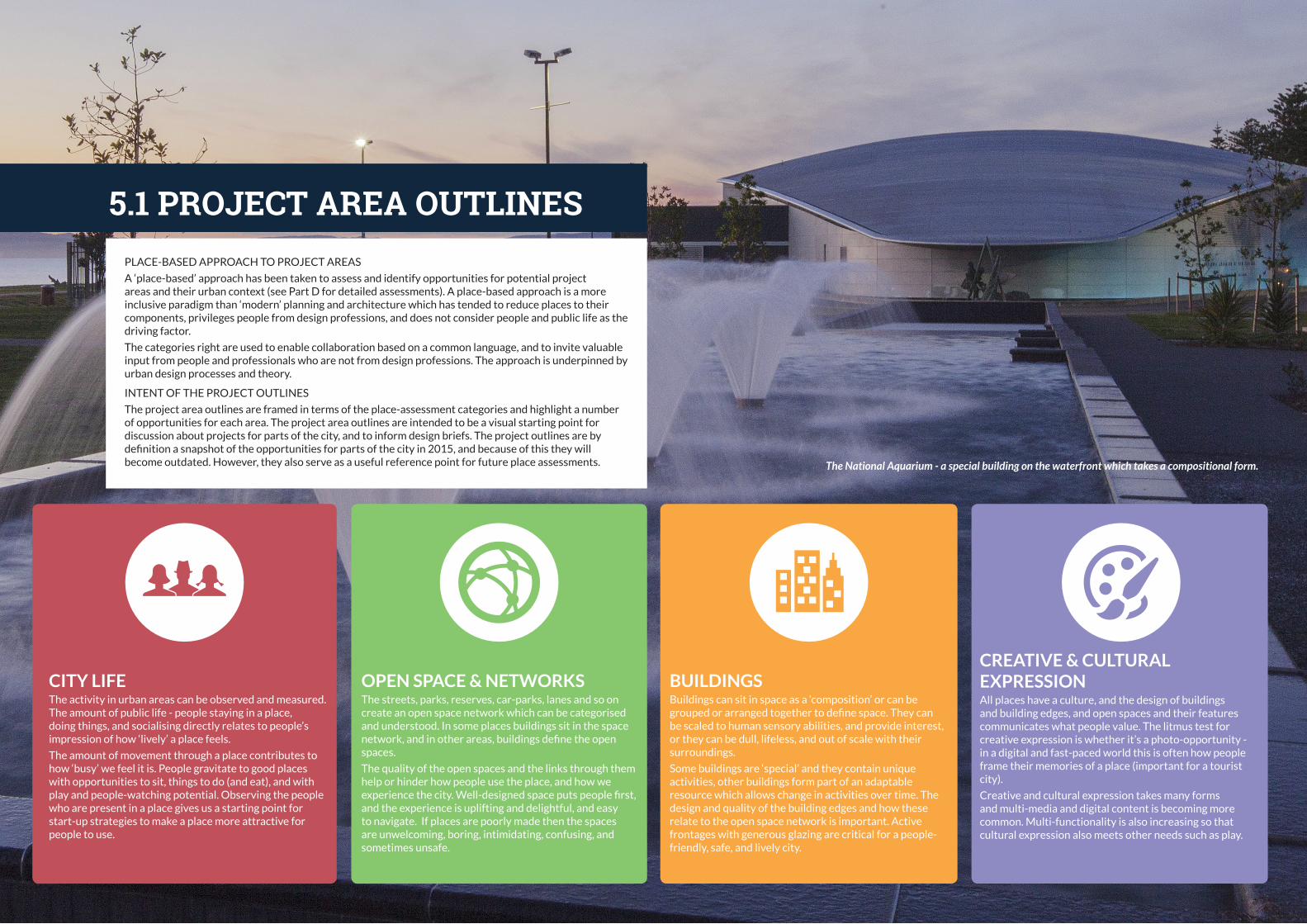
42
05 P
RO
JECT
AR
EA O
UTL
INES
5.1 PROJECT AREA OUTLINES
CITY LIFEThe activity in urban areas can be observed and measured. The amount of public life - people staying in a place, doing things, and socialising directly relates to people’s impression of how ‘lively’ a place feels.
The amount of movement through a place contributes to how ‘busy’ we feel it is. People gravitate to good places with opportunities to sit, things to do (and eat), and with play and people-watching potential. Observing the people who are present in a place gives us a starting point for start-up strategies to make a place more attractive for people to use.
OPEN SPACE & NETWORKSThe streets, parks, reserves, car-parks, lanes and so on create an open space network which can be categorised and understood. In some places buildings sit in the space network, and in other areas, buildings define the open spaces.
The quality of the open spaces and the links through them help or hinder how people use the place, and how we experience the city. Well-designed space puts people first, and the experience is uplifting and delightful, and easy to navigate. If places are poorly made then the spaces are unwelcoming, boring, intimidating, confusing, and sometimes unsafe.
BUILDINGSBuildings can sit in space as a ‘composition’ or can be grouped or arranged together to define space. They can be scaled to human sensory abilities, and provide interest, or they can be dull, lifeless, and out of scale with their surroundings.
Some buildings are ‘special’ and they contain unique activities, other buildings form part of an adaptable resource which allows change in activities over time. The design and quality of the building edges and how these relate to the open space network is important. Active frontages with generous glazing are critical for a people-friendly, safe, and lively city.
CREATIVE & CULTURAL EXPRESSIONAll places have a culture, and the design of buildings and building edges, and open spaces and their features communicates what people value. The litmus test for creative expression is whether it’s a photo-opportunity - in a digital and fast-paced world this is often how people frame their memories of a place (important for a tourist city).
Creative and cultural expression takes many forms and multi-media and digital content is becoming more common. Multi-functionality is also increasing so that cultural expression also meets other needs such as play.
PLACE-BASED APPROACH TO PROJECT AREAS
A ‘place-based’ approach has been taken to assess and identify opportunities for potential project areas and their urban context (see Part D for detailed assessments). A place-based approach is a more inclusive paradigm than ‘modern’ planning and architecture which has tended to reduce places to their components, privileges people from design professions, and does not consider people and public life as the driving factor.
The categories right are used to enable collaboration based on a common language, and to invite valuable input from people and professionals who are not from design professions. The approach is underpinned by urban design processes and theory.
INTENT OF THE PROJECT OUTLINES
The project area outlines are framed in terms of the place-assessment categories and highlight a number of opportunities for each area. The project area outlines are intended to be a visual starting point for discussion about projects for parts of the city, and to inform design briefs. The project outlines are by definition a snapshot of the opportunities for parts of the city in 2015, and because of this they will become outdated. However, they also serve as a useful reference point for future place assessments. The National Aquarium - a special building on the waterfront which takes a compositional form.

43
05 P
RO
JECT
AR
EA O
UTL
INES
5.2 PROJECT AREAS
PROJECT AREA OUTLINES
CITY CENTRE AHURIRI WATERFRONT
Marine Parade Piazza1
Civic area to the waterfront2
Clive and Memorial Squares3
Tennyson Street4
Ahuriri beach5
1
2
3
5
Iron Pot - Nelson Quay, Customs Quay, Bridge St
6
Ossian Street7
West Quay8
Marina9
Estuary Edge10
Perfume Point11
City to Port12
Port area13
6
7
8
N
9
10
12
13
11
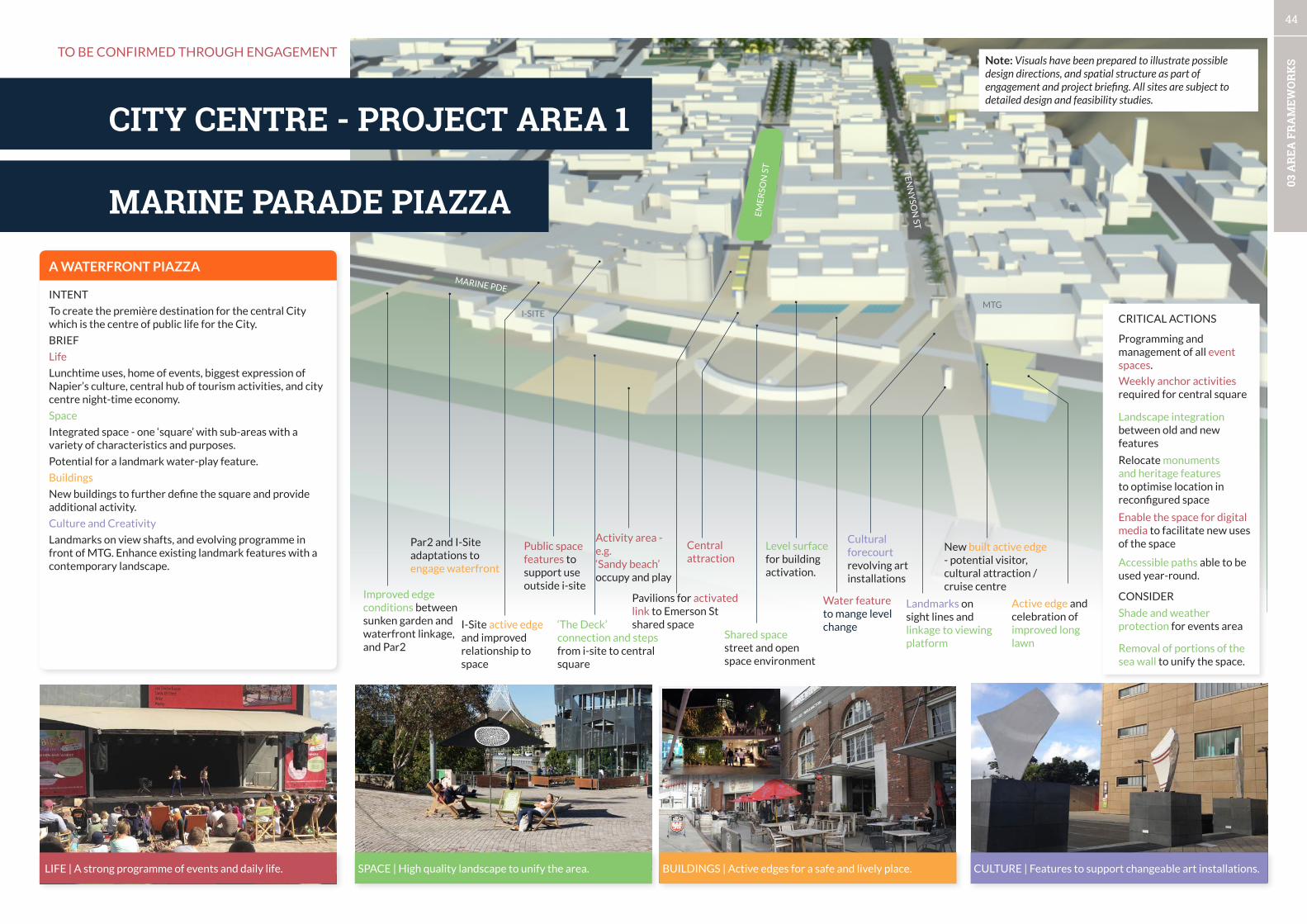
44
03 A
REA
FR
AM
EWO
RK
S
hardinge RdConnections - C
Landmarks on sight lines and linkage to viewing platform
Cultural forecourt revolving art installations
Shared space street and open space environment
Central attraction
Activity area - e.g.‘Sandy beach’ occupy and play
Active edge and celebration of improved long lawn
I-Site active edge and improved relationship to space
Public space features to support use outside i-site
Pavilions for activated link to Emerson St shared space‘The Deck’
connection and steps from i-site to central square
New built active edge - potential visitor, cultural attraction / cruise centre
Improved edge conditions between sunken garden and waterfront linkage, and Par2
Water feature to mange level change
Level surface for building activation.
MARINE PARADE PIAZZA
CITY CENTRE - PROJECT AREA 1
LIFE | A strong programme of events and daily life. SPACE | High quality landscape to unify the area. BUILDINGS | Active edges for a safe and lively place. CULTURE | Features to support changeable art installations.
A WATERFRONT PIAZZA
INTENT
To create the première destination for the central City which is the centre of public life for the City.
BRIEF
Life
Lunchtime uses, home of events, biggest expression of Napier’s culture, central hub of tourism activities, and city centre night-time economy.
Space
Integrated space - one ‘square’ with sub-areas with a variety of characteristics and purposes.
Potential for a landmark water-play feature.
Buildings
New buildings to further define the square and provide additional activity.
Culture and Creativity
Landmarks on view shafts, and evolving programme in front of MTG. Enhance existing landmark features with a contemporary landscape.
Par2 and I-Site adaptations to engage waterfront
Weekly anchor activities required for central square
Landscape integration between old and new features
Relocate monuments and heritage features to optimise location in reconfigured space
Enable the space for digital media to facilitate new uses of the space
Programming and management of all event spaces.
CRITICAL ACTIONS
CONSIDER
Removal of portions of the sea wall to unify the space.
Accessible paths able to be used year-round.
Shade and weather protection for events area
Note: Visuals have been prepared to illustrate possible design directions, and spatial structure as part of engagement and project briefing. All sites are subject to detailed design and feasibility studies.
TO BE CONFIRMED THROUGH ENGAGEMENT
MARINE PDE
EM
ER
SON
ST T
EN
NY
SON
ST
MTGI-SITE
CIVIC TO WATERFRONT

45
03 A
REA
FR
AM
EWO
RK
S
hardinge RdConnections -
Retained heritage buildings
Lane-way features
Lane-way connection to $5million waterfront redevelopment.
Active ground floor edge - customer service centre and additional private tenancies to Civic building
Active NE facing tenancies - parking behind.
Lighting of a sculptural or green wall facade to close view from lane and waterfront
New tenancies
Rationalised public and shared space with minimised level changes90o parking on North side of street.
Reconfigured entrance and active edge to library.
Redeveloped Rebel Sport SiteActive edge and potential for lanes and courtyards to connect with heritage houses
CIVIC TO WATERFRONT
CITY CENTRE - PROJECT AREA 2
LIFE | Cultural assets responsible for activating the public space.
SPACE | An accessible space connecting Dalton Street to Marine Parade.
BUILDINGS | Contemporary approach to the Civic buildingsCULTURE | Diverse cultural expression to shake off the institutional image of the government services area.
CONTEMPORARY CIVIC SPACES
INTENT
A strong southern anchor for the City centre which leverages of the presence of government agencies.
BRIEF
Life
A southern anchor area for the central city, council services, library activation, lunchtime area, and small civic events.,
Space
Simplified landscape with reduced level changes. Landscaped level surface street along Hastings street. A rationalised but more intensely developed civic square.
Buildings
Activation and increased transparency of edge of Council buildings and library. Relocate service centre to building edge. Strengthened library entrance. Maximise northern orientation.
Clear link to waterfront via active lane-way system with redeveloped Rebel sport site integrating with heritage houses rear courtyards.
Culture and Creativity
Use key locations for way-finding and city centre entrance experience, and link space to lane-way and waterfront.
Library activation and management of public space.
Cultural assets located to build identity and strengthen way-finding.
TO BE CONFIRMED THROUGH ENGAGEMENT Note: Visuals have been prepared to illustrate possible design directions, and spatial structure as part of engagement and project briefing. All sites are subject to detailed design and feasibility studies.
COUNCIL
COURTS
LIBRARY
HASTTINGS ST
MARINE PDE
ALB
ION
ST
STATION ST
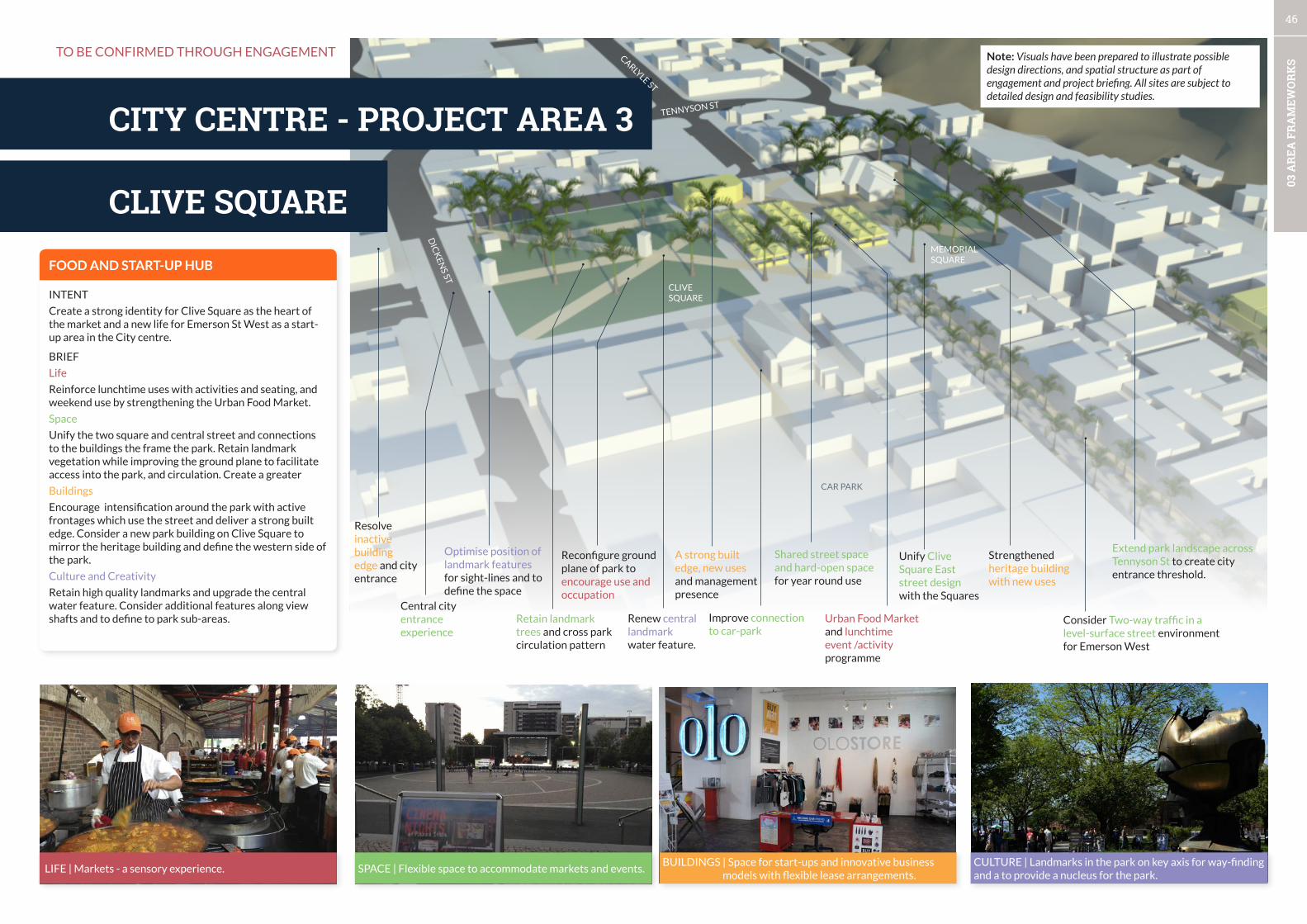
46
03 A
REA
FR
AM
EWO
RK
S
hardinge RdConnections - Cvv
Renew central landmark water feature.
Shared street space and hard-open spacefor year round use
Improve connection to car-park
Unify Clive Square East street design with the Squares
A strong built edge, new uses and management presence
Urban Food Market and lunchtime event /activity programme
Optimise position of landmark features for sight-lines and to define the space
Reconfigure ground plane of park to encourage use and occupation
Retain landmark trees and cross park circulation pattern
Consider Two-way traffic in a level-surface street environment for Emerson West
Extend park landscape across Tennyson St to create city entrance threshold.
Strengthened heritage building with new uses
Central city entrance experience
Resolve inactive building edge and city entrance
CLIVE SQUARE
CITY CENTRE - PROJECT AREA 3
LIFE | Markets - a sensory experience. SPACE | Flexible space to accommodate markets and events.BUILDINGS | Space for start-ups and innovative business
models with flexible lease arrangements.CULTURE | Landmarks in the park on key axis for way-finding and a to provide a nucleus for the park.
FOOD AND START-UP HUB
INTENT
Create a strong identity for Clive Square as the heart of the market and a new life for Emerson St West as a start-up area in the City centre.
BRIEF
Life
Reinforce lunchtime uses with activities and seating, and weekend use by strengthening the Urban Food Market.
Space
Unify the two square and central street and connections to the buildings the frame the park. Retain landmark vegetation while improving the ground plane to facilitate access into the park, and circulation. Create a greater
Buildings
Encourage intensification around the park with active frontages which use the street and deliver a strong built edge. Consider a new park building on Clive Square to mirror the heritage building and define the western side of the park.
Culture and Creativity
Retain high quality landmarks and upgrade the central water feature. Consider additional features along view shafts and to define to park sub-areas.
TO BE CONFIRMED THROUGH ENGAGEMENT
DIC
KEN
S ST
CAR PARK
CLIVE SQUARE
MEMORIAL SQUARE
TENNYSON ST
CARLYLE ST
Note: Visuals have been prepared to illustrate possible design directions, and spatial structure as part of engagement and project briefing. All sites are subject to detailed design and feasibility studies.
TENNYSON ST
CITY CENTRE - PROJECT AREA 4

47
03 A
REA
FR
AM
EWO
RK
S
hardinge RdConnections - to
Landmark at Theatre Square
Memorable avenue experience with places for occupation
Short-term creative upgrade to parking structureLong-term build active edge to multi-level car-park when additional parking is required.
Improve Market St entrance, and connections across Tennyson
Re-route Arterial from Tennyson to Browning St.
Relocate Creative Arts Napier to prominent site
Retrofit heritage buildings to create active ground floor.
Particular attention to corner sites.
Activate park with Theatre managed programme and tennancies at edge tenancy (trial )
Enhance Tiffen park with vegetation, pathways and lighting and viewing points.
Clear and direct landscaped pathway to car-parking and Tiffen Park.
Update Emerson St to contemporary design standards for shared space.
Enhance walkability of area, connections between urban spaces and the city entrance experience
Landscape threshold and linkages at Theatre Square
TENNYSON ST
CITY CENTRE - PROJECT AREA 4
LIFE | A memorable street which encourages walking and staying.
CULTURE | Contemporary storytelling integrated with buildings or public spaces.
NZ’S GREAT ART DECO STREET
INTENT
Create a memorable street and maximise the presence and contribution of the Theatre area to the City centre.
BRIEF
Life
Encourage greater pedestrian and stationary activity on the street by providing a high-amenity street and spaces for businesses to use the street. Minor changes to Theatre Square to encourage occupation and events.
Space
A memorable avenue which matches the quality of the buildings and maximises the unique veranda-less character. Improve crossing and connections to lanes and cross-streets.
Buildings
Adapt buildings with high-quality active frontages where possible, with particular attention to corners. Trial a small tenancy at the edge of Theatre Square with Food and beverage.
Culture and Creativity
Create landmarks at strategic points for way-finding and to create a sequence of experience from Memorial Square to the waterfront.
Landmarks at views.
TO BE CONFIRMED THROUGH ENGAGEMENT
BROWNING ST
BYRON ST
HASTINGS ST
EMERSON ST
TENNYSON ST
CAR PARKING
MUNICIPALTHEATRE
CAR PARKING
CAR PARKING
CAR PARKING
MARKET ST
Note: Visuals have been prepared to illustrate possible design directions, and spatial structure as part of engagement and project briefing. All sites are subject to detailed design and feasibility studies.
BUILDINGS | Active edges retrofitted into heritage buildings.SPACE | Reclaim targeted street space for higher value activ-ity which provide animation of the street.

48
05 P
RO
JECT
AR
EA O
UTL
INES
hardinge RdConnections -
Landmark on sight line
Shared space entrance areas
Coastal walkway and beach areas
New built active edge - additional tenancies
Relocated play-space & multi-purpose event space
ConnectionLane-way axis
New built active edge - additional tenancies
East Pier complex
Beach-front Motel
Landscaping to define public-private space
Relocated and reconfigured landscaped car-parking
HARDINGE RD
Connections- Village-Waterfront axis.
AHURIRI BEACH
AHURIRI - PROJECT AREA 5
LIFE | Quality beachfront features to invite use. SPACE | Playful, clear linkages from the village to the water. BUILDINGS | Active edges for a safe and lively place. CULTURE | Interactive landmarks in strategic locations.
AHURIRI’S BEACH ACTIVITY HUB
INTENT
A strong public destination for Ahuriri with landmark qualities, and improved relationships to the urban structure.
BRIEF
Life
A buzzing centre of activity with playable space and features to support waterfront use. A strong programme with a weekly anchor such as an outdoor health programmes.
Space
Strong threshold entrances into a multi-purpose shared space which brings the waterfront and built edge together. Integrate play spaces and BBQ areas. Maximises sight-lines for legibility. Attractive lighting to encourage evening use.
Buildings
Additional buildings with active edges to define the central area with integrated waterfront amenities.
Culture and Creativity
Use of landmarks to define sight-lines and create additional spatial definition of the central area. Create photo opportunities and integrate creativity and culture into the play spaces.
TO BE CONFIRMED THROUGH ENGAGEMENT
BRIDGE ST
CAR PARK
CAR PARK
BA
RR
Y S
T
Note: Visuals have been prepared to illustrate possible design directions, and spatial structure as part of engagement and project briefing. All sites are subject to detailed design and feasibility studies.
IRON POT
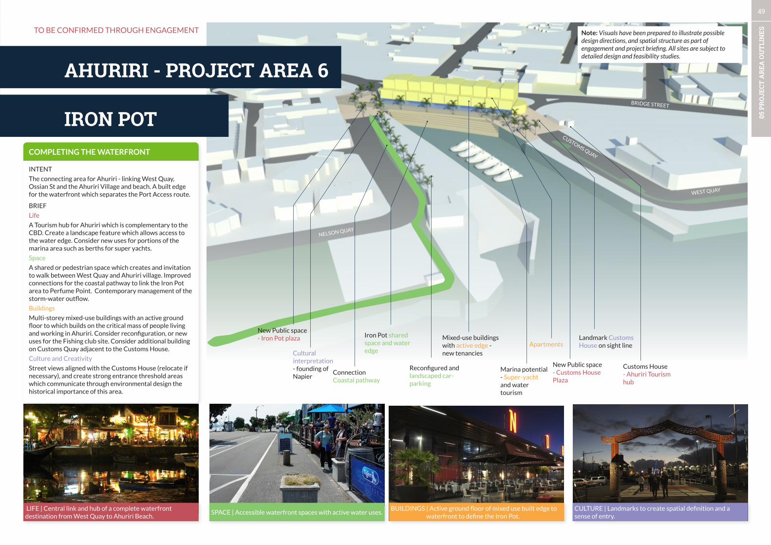
49
05 P
RO
JECT
AR
EA O
UTL
INES
hardinge RdConnections -
Landmark Customs House on sight line
Mixed-use buildings with active edge - new tenancies
Customs House - Ahuriri Tourism hub
Cultural interpretation - founding of Napier
New Public space - Customs House Plaza
ConnectionCoastal pathway
Marina potential - Super-yacht and water tourism
Apartments
Reconfigured and landscaped car-parking
Iron Pot shared space and water edge
CUSTOMS QUAY
NELSON QUAY
IRON POT
AHURIRI - PROJECT AREA 6
LIFE | Central link and hub of a complete waterfront destination from West Quay to Ahuriri Beach.
SPACE | Accessible waterfront spaces with active water uses.BUILDINGS | Active ground floor of mixed use built edge to
waterfront to define the Iron Pot.CULTURE | Landmarks to create spatial definition and a sense of entry.
COMPLETING THE WATERFRONT
INTENT
The connecting area for Ahuriri - linking West Quay, Ossian St and the Ahuriri Village and beach. A built edge for the waterfront which separates the Port Access route.
BRIEF
Life
A Tourism hub for Ahuriri which is complementary to the CBD. Create a landscape feature which allows access to the water edge. Consider new uses for portions of the marina area such as berths for super yachts.
Space
A shared or pedestrian space which creates and invitation to walk between West Quay and Ahuriri village. Improved connections for the coastal pathway to link the Iron Pot area to Perfume Point. Contemporary management of the storm-water outflow.
Buildings
Multi-storey mixed-use buildings with an active ground floor to which builds on the critical mass of people living and working in Ahuriri. Consider reconfiguration, or new uses for the Fishing club site. Consider additional building on Customs Quay adjacent to the Customs House.
Culture and Creativity
Street views aligned with the Customs House (relocate if necessary), and create strong entrance threshold areas which communicate through environmental design the historical importance of this area.
WEST QUAY
TO BE CONFIRMED THROUGH ENGAGEMENT
New Public space - Iron Pot plaza
BRIDGE STREET
Note: Visuals have been prepared to illustrate possible design directions, and spatial structure as part of engagement and project briefing. All sites are subject to detailed design and feasibility studies.
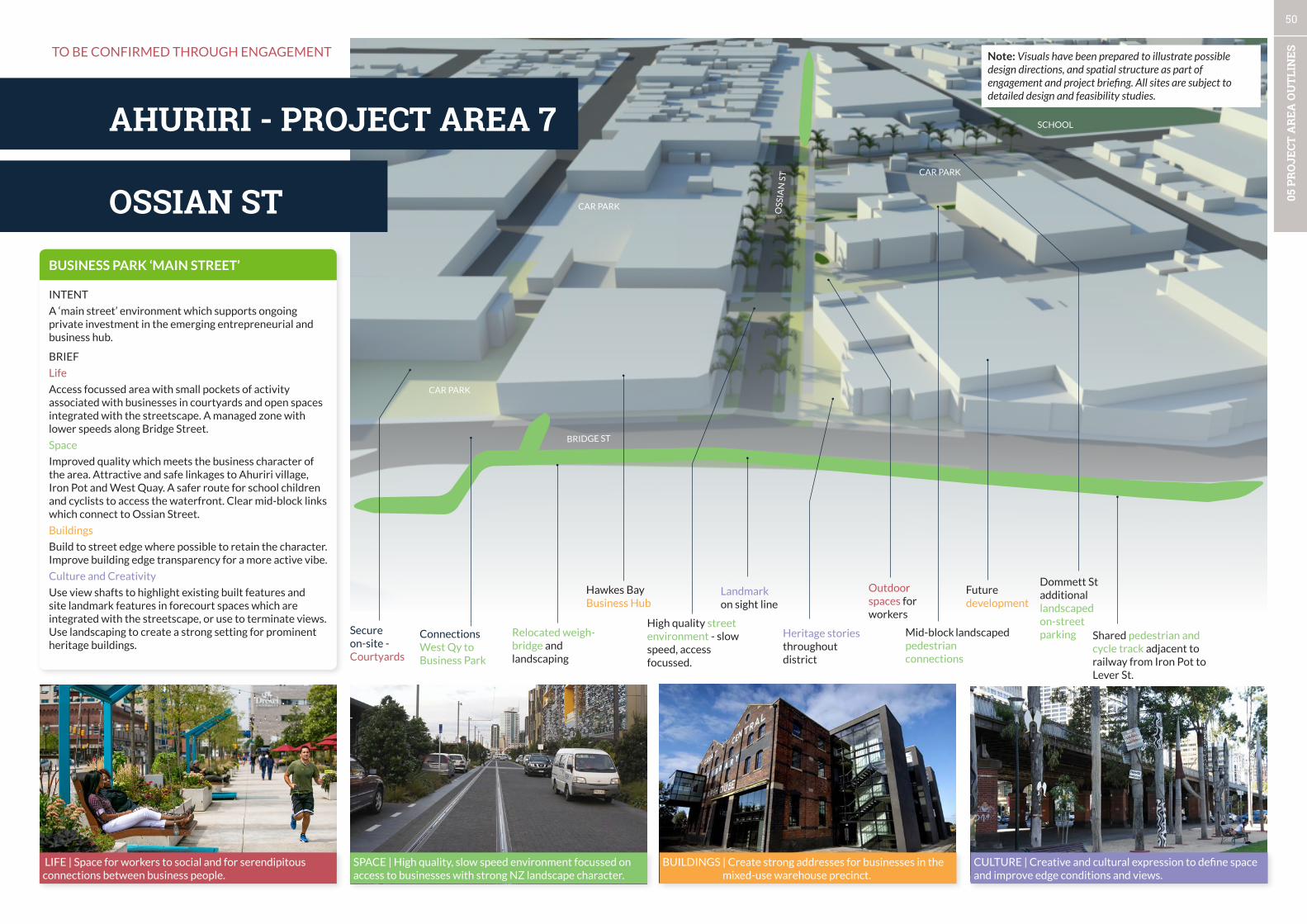
50
05 P
RO
JECT
AR
EA O
UTL
INES
hardinge RdConnections -
Landmark on sight line
Heritage stories throughout district
Shared pedestrian and cycle track adjacent to railway from Iron Pot to Lever St.
Dommett St additional landscaped on-street parkingMid-block landscaped
pedestrian connections
Outdoor spaces for workers
Secure on-site - Courtyards
Hawkes Bay Business Hub
Future development
Relocated weigh-bridge and landscaping
High quality street environment - slow speed, access focussed.
ConnectionsWest Qy to Business Park
OSSIAN ST
AHURIRI - PROJECT AREA 7
LIFE | Space for workers to social and for serendipitous connections between business people.
SPACE | High quality, slow speed environment focussed on access to businesses with strong NZ landscape character.
BUILDINGS | Create strong addresses for businesses in the mixed-use warehouse precinct.
CULTURE | Creative and cultural expression to define space and improve edge conditions and views.
BUSINESS PARK ‘MAIN STREET’
INTENT
A ‘main street’ environment which supports ongoing private investment in the emerging entrepreneurial and business hub.
BRIEF
Life
Access focussed area with small pockets of activity associated with businesses in courtyards and open spaces integrated with the streetscape. A managed zone with lower speeds along Bridge Street.
Space
Improved quality which meets the business character of the area. Attractive and safe linkages to Ahuriri village, Iron Pot and West Quay. A safer route for school children and cyclists to access the waterfront. Clear mid-block links which connect to Ossian Street.
Buildings
Build to street edge where possible to retain the character. Improve building edge transparency for a more active vibe.
Culture and Creativity
Use view shafts to highlight existing built features and site landmark features in forecourt spaces which are integrated with the streetscape, or use to terminate views. Use landscaping to create a strong setting for prominent heritage buildings.
BRIDGE ST
OSS
IAN
ST
TO BE CONFIRMED THROUGH ENGAGEMENT
CAR PARK
SCHOOL
CAR PARK
CAR PARK
Note: Visuals have been prepared to illustrate possible design directions, and spatial structure as part of engagement and project briefing. All sites are subject to detailed design and feasibility studies.
WEST QUAY
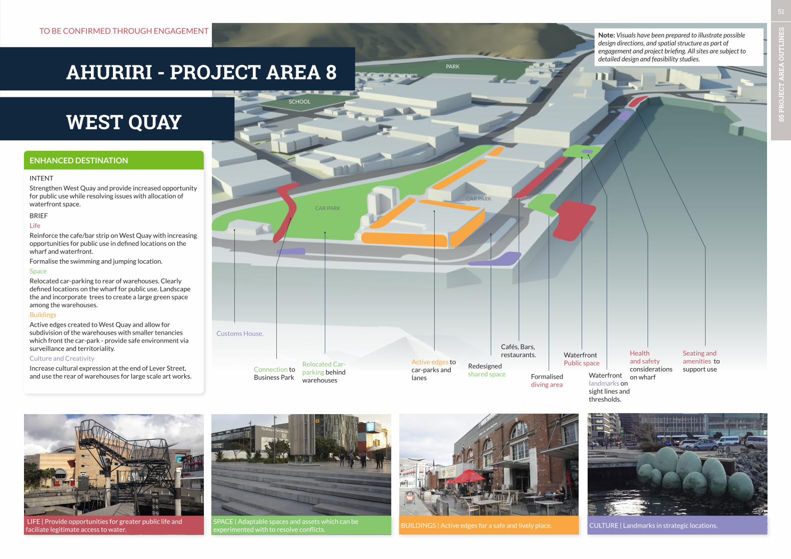
51
05 P
RO
JECT
AR
EA O
UTL
INES
hardinge RdConnections -
Formalised diving area
Waterfront Public space
Waterfront landmarks on sight lines and thresholds.
Health and safety considerations on wharf
Seating and amenities to support useRedesigned
shared space
Cafés, Bars, restaurants.
Active edges to car-parks and lanes
Relocated Car-parking behind warehouses
Customs House.
Connection to Business Park
WEST QUAY
AHURIRI - PROJECT AREA 8
LIFE | Provide opportunities for greater public life and faciliate legitimate access to water.
SPACE | Adaptable spaces and assets which can be experimented with to resolve conflicts.
BUILDINGS | Active edges for a safe and lively place. CULTURE | Landmarks in strategic locations.
ENHANCED DESTINATION
INTENT
Strengthen West Quay and provide increased opportunity for public use while resolving issues with allocation of waterfront space.
BRIEF
Life
Reinforce the cafe/bar strip on West Quay with increasing opportunities for public use in defined locations on the wharf and waterfront.
Formalise the swimming and jumping location.
Space
Relocated car-parking to rear of warehouses. Clearly defined locations on the wharf for public use. Landscape the and incorporate trees to create a large green space among the warehouses.
Buildings
Active edges created to West Quay and allow for subdivision of the warehouses with smaller tenancies which front the car-park - provide safe environment via surveillance and territoriality.
Culture and Creativity
Increase cultural expression at the end of Lever Street, and use the rear of warehouses for large scale art works.
TO BE CONFIRMED THROUGH ENGAGEMENT
CAR PARK
SCHOOL
PARK
CAR PARK
Note: Visuals have been prepared to illustrate possible design directions, and spatial structure as part of engagement and project briefing. All sites are subject to detailed design and feasibility studies.
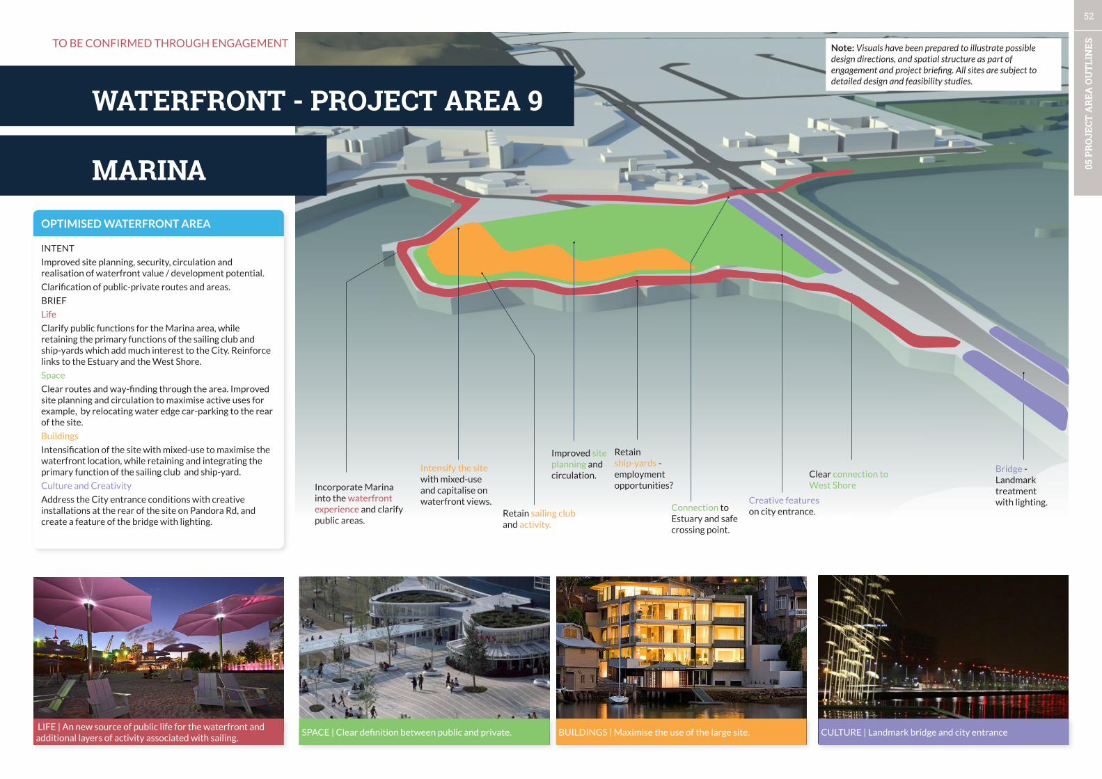
52
05 P
RO
JECT
AR
EA O
UTL
INES
hardinge RdConnections -
Improved site planning and circulation.
Retain ship-yards - employment opportunities?
Creative features on city entrance.
Bridge - Landmark treatment with lighting.
Intensify the site with mixed-use and capitalise on waterfront views.
Retain sailing club and activity.
Connection to Estuary and safe crossing point.
Clear connection to West ShoreIncorporate Marina
into the waterfront experience and clarify public areas.
MARINA
WATERFRONT - PROJECT AREA 9
LIFE | An new source of public life for the waterfront and additional layers of activity associated with sailing.
SPACE | Clear definition between public and private. BUILDINGS | Maximise the use of the large site. CULTURE | Landmark bridge and city entrance
OPTIMISED WATERFRONT AREA
INTENT
Improved site planning, security, circulation and realisation of waterfront value / development potential.
Clarification of public-private routes and areas.
BRIEF
Life
Clarify public functions for the Marina area, while retaining the primary functions of the sailing club and ship-yards which add much interest to the City. Reinforce links to the Estuary and the West Shore.
Space
Clear routes and way-finding through the area. Improved site planning and circulation to maximise active uses for example, by relocating water edge car-parking to the rear of the site.
Buildings
Intensification of the site with mixed-use to maximise the waterfront location, while retaining and integrating the primary function of the sailing club and ship-yard.
Culture and Creativity
Address the City entrance conditions with creative installations at the rear of the site on Pandora Rd, and create a feature of the bridge with lighting.
TO BE CONFIRMED THROUGH ENGAGEMENT Note: Visuals have been prepared to illustrate possible design directions, and spatial structure as part of engagement and project briefing. All sites are subject to detailed design and feasibility studies.
ESTUARY EDGE
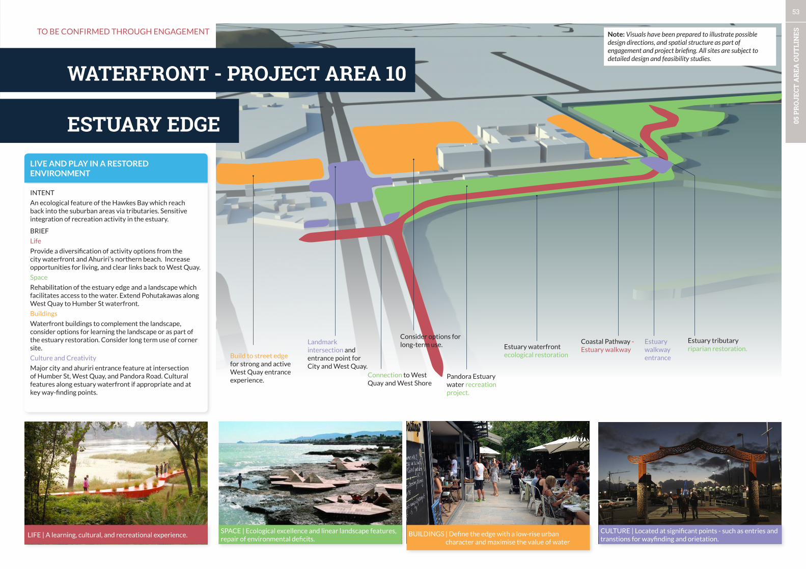
53
05 P
RO
JECT
AR
EA O
UTL
INES
hardinge RdConnections -
Pandora Estuary water recreation project.
Coastal Pathway - Estuary walkway
Estuary walkway entrance
Landmark intersection and entrance point for City and West Quay.
Connection to West Quay and West Shore
Estuary waterfront ecological restoration
Estuary tributary riparian restoration.
Build to street edge for strong and active West Quay entrance experience.
ESTUARY EDGE
WATERFRONT - PROJECT AREA 10
LIFE | A learning, cultural, and recreational experience.SPACE | Ecological excellence and linear landscape features, repair of environmental deficits.
BUILDINGS | Define the edge with a low-rise urban character and maximise the value of water
CULTURE | Located at significant points - such as entries and transtions for wayfinding and orietation.
LIVE AND PLAY IN A RESTORED ENVIRONMENT
INTENT
An ecological feature of the Hawkes Bay which reach back into the suburban areas via tributaries. Sensitive integration of recreation activity in the estuary.
BRIEF
Life
Provide a diversification of activity options from the city waterfront and Ahuriri’s northern beach. Increase opportunities for living, and clear links back to West Quay.
Space
Rehabilitation of the estuary edge and a landscape which facilitates access to the water. Extend Pohutakawas along West Quay to Humber St waterfront.
Buildings
Waterfront buildings to complement the landscape, consider options for learning the landscape or as part of the estuary restoration. Consider long term use of corner site.
Culture and Creativity
Major city and ahuriri entrance feature at intersection of Humber St, West Quay, and Pandora Road. Cultural features along estuary waterfront if appropriate and at key way-finding points.
TO BE CONFIRMED THROUGH ENGAGEMENT
Consider options for long-term use.
Note: Visuals have been prepared to illustrate possible design directions, and spatial structure as part of engagement and project briefing. All sites are subject to detailed design and feasibility studies.
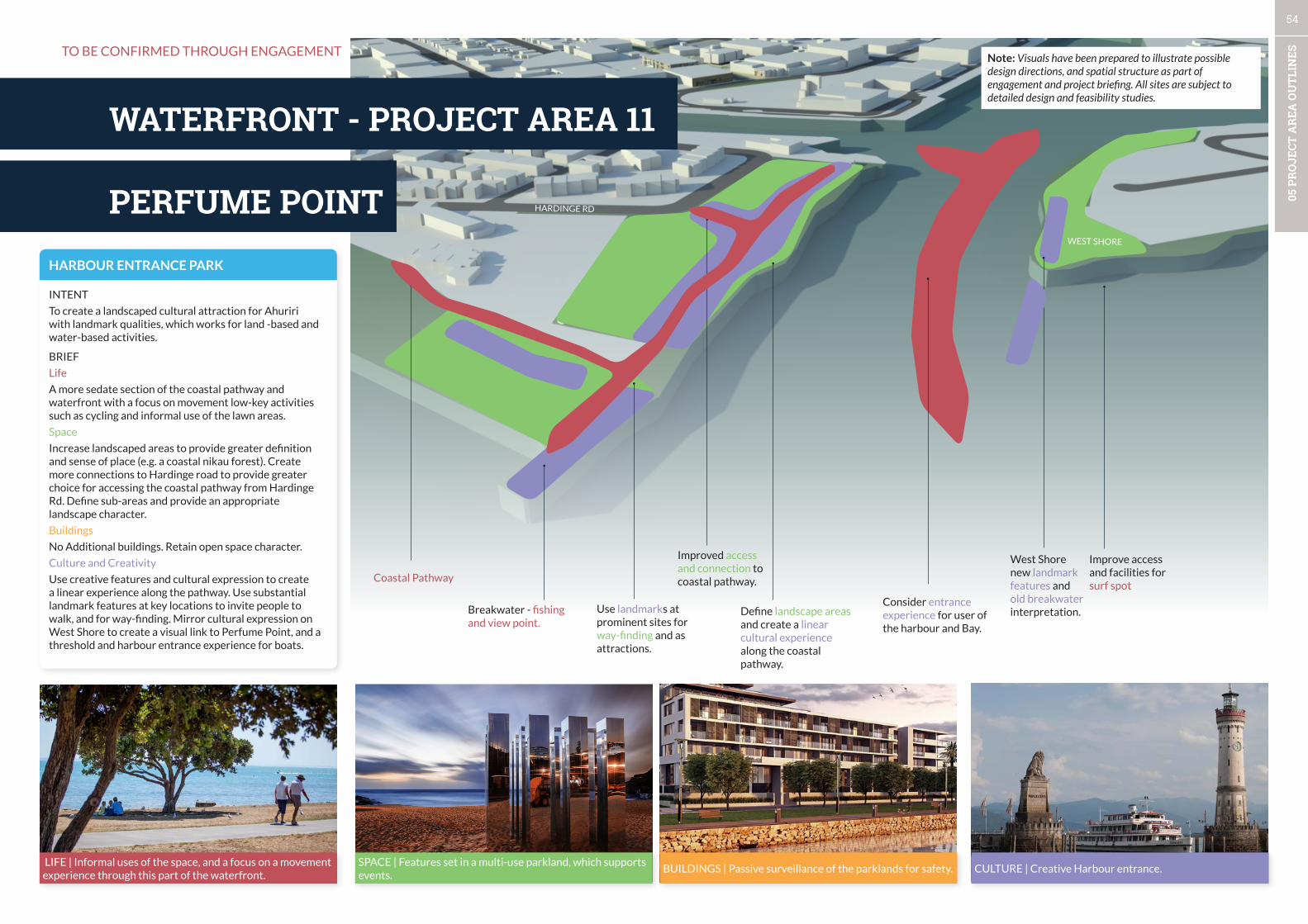
54
05 P
RO
JECT
AR
EA O
UTL
INES
hardinge RdConnections -
Define landscape areas and create a linear cultural experience along the coastal pathway.
West Shore new landmark features and old breakwater interpretation.Breakwater - fishing
and view point.
Improved access and connection to coastal pathway.
Use landmarks at prominent sites for way-finding and as attractions.
Consider entrance experience for user of the harbour and Bay.
Improve access and facilities for surf spot
Coastal Pathway
HARDINGE RDPERFUME POINT
WATERFRONT - PROJECT AREA 11
LIFE | Informal uses of the space, and a focus on a movement experience through this part of the waterfront.
SPACE | Features set in a multi-use parkland, which supports events.
BUILDINGS | Passive surveillance of the parklands for safety. CULTURE | Creative Harbour entrance.
HARBOUR ENTRANCE PARK
INTENT
To create a landscaped cultural attraction for Ahuriri with landmark qualities, which works for land -based and water-based activities.
BRIEF
Life
A more sedate section of the coastal pathway and waterfront with a focus on movement low-key activities such as cycling and informal use of the lawn areas.
Space
Increase landscaped areas to provide greater definition and sense of place (e.g. a coastal nikau forest). Create more connections to Hardinge road to provide greater choice for accessing the coastal pathway from Hardinge Rd. Define sub-areas and provide an appropriate landscape character.
Buildings
No Additional buildings. Retain open space character.
Culture and Creativity
Use creative features and cultural expression to create a linear experience along the pathway. Use substantial landmark features at key locations to invite people to walk, and for way-finding. Mirror cultural expression on West Shore to create a visual link to Perfume Point, and a threshold and harbour entrance experience for boats.
TO BE CONFIRMED THROUGH ENGAGEMENT
WEST SHORE
Note: Visuals have been prepared to illustrate possible design directions, and spatial structure as part of engagement and project briefing. All sites are subject to detailed design and feasibility studies.
CITY TO PORT
WATERFRONT - PROJECT AREA 12

55
05 P
RO
JECT
AR
EA O
UTL
INES
hardinge RdConnections -
Old railway area - interpretation, landscape and parking.
Sailors building.
Link to Port gates
Improve landscape quality of coastal Pathway - shared pedestrian and cycle trail.
Expansion land-bank for aquatic centre.
Crossing point to Centennial Gardens.
Landscape and vegetation - NZ coastal botanical garden /arboretum?
MARINE PDE
Landscape and vegetation.
LIFE | A place of respite and recharge on the waterfront. SPACE | Extend the centennial gardens out onto and along the waterfront.
BUILDINGS | Relationship to parkland spaces for safety and security, and to ‘borrow’ the landscape.
CULTURE | Way-finding, suprise, and delight.
GARDENS ON THE WATERFRONT
INTENT
Create a clear identity for the link between the Port and the central city which builds on existing assets and matches the low intensity of use.
BRIEF
Life
An area which focusses on movement through the spaces. Formalise (or otherwise resolve) freedom camping provision.
Space
Increase the intensity of landscaping, and integrate with Centennial gardens, and create localised pockets of parking. Ensure pathways and design of spaces meets CPTED guidelines.
Improve landscape quality of coastal pathway
Buildings
Potential land-bank area for future development of aquatic facility.
Culture and Creativity
Integrate creative expression with landscape and consider lighting of vegetation as primary approach to creative expression.
Provide heritage interpretation for heritage Port railway feature, and link to old Jail.
CITY TO PORT
WATERFRONT - PROJECT AREA 12
TO BE CONFIRMED THROUGH ENGAGEMENTNote: Visuals have been prepared to illustrate possible design directions, and spatial structure as part of engagement and project briefing. All sites are subject to detailed design and feasibility studies.

56
05 P
RO
JECT
AR
EA O
UTL
INES
LIFE | Activities can be housed in containers e.g. bar, cafe.SPACE | Containers can be used to define space and create an experience.
BUILDINGS | Adaptable approach to complement Port activ-ities, and ongoing development.
CULTURE | An experimental and large scale approach.
ADAPTABLE AND CREATIVE PORT
INTENT
A creative interface for the Port and an adaptable cultural arrival and departure experience for the Cruise ships. An authentic experience on Bluff Hill.
BRIEF
Life
Movement focussed along the coastal pathway past the Port. An efficient pop-up experience at the Port arrival and departure, and a discovery experience on Bluff Hill.
Space
Consider innovative measure to bring creativity and nature to the port’s interface with the coastal pathway such as living wall techniques, or moveable assets.
Update landscape and viewing points at Bluff Hill, and consider a landmark feature/lighting which is a landmark for cruise visitors.
Buildings
N/A
Culture and Creativity
Creative edge to the Port - consider permanent edge (noise mitigation?) of containers which are used for large scale creative works and vegetation. Increased cultural expression on cruise ship pop-up up containers, and in moveable assets to create the arrival/departure experience. Bluff Hill - the pre-european and significance of this site, and WWII bunkers and associated stories.
PORT AREA
WATERFRONT - PROJECT AREA 13
TO BE CONFIRMED THROUGH ENGAGEMENThardinge RdConnections -
Coastal Pathway and Port worker parking.
Consider closing Port access to heavy vehicles
Resolve land use, and landscape edge.
Innovative solutions to create a higher amenity linkage between Ahuriri and the Central City.
Use Port buildings, structures, and warehouses for cultural expression where possible.
Authentic story-telling and contemporary landscape at Bluff Hill.
Cruise ship arrival and departure experience.
MAIN PORT ACCESS ROUTE
SECONDARY PORT ACCESS
Note: Visuals have been prepared to illustrate possible design directions, and spatial structure as part of engagement and project briefing. All sites are subject to detailed design and feasibility studies.

57
06 C
ITY
LIF
E
CITY VISION FRAMEWORK
Part CCity Life
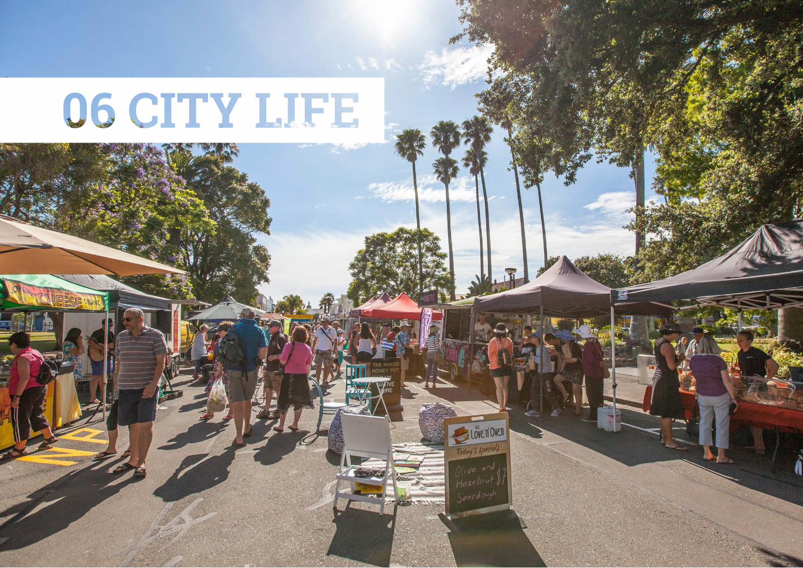
6.1 CITY LIFE OVERVIEW
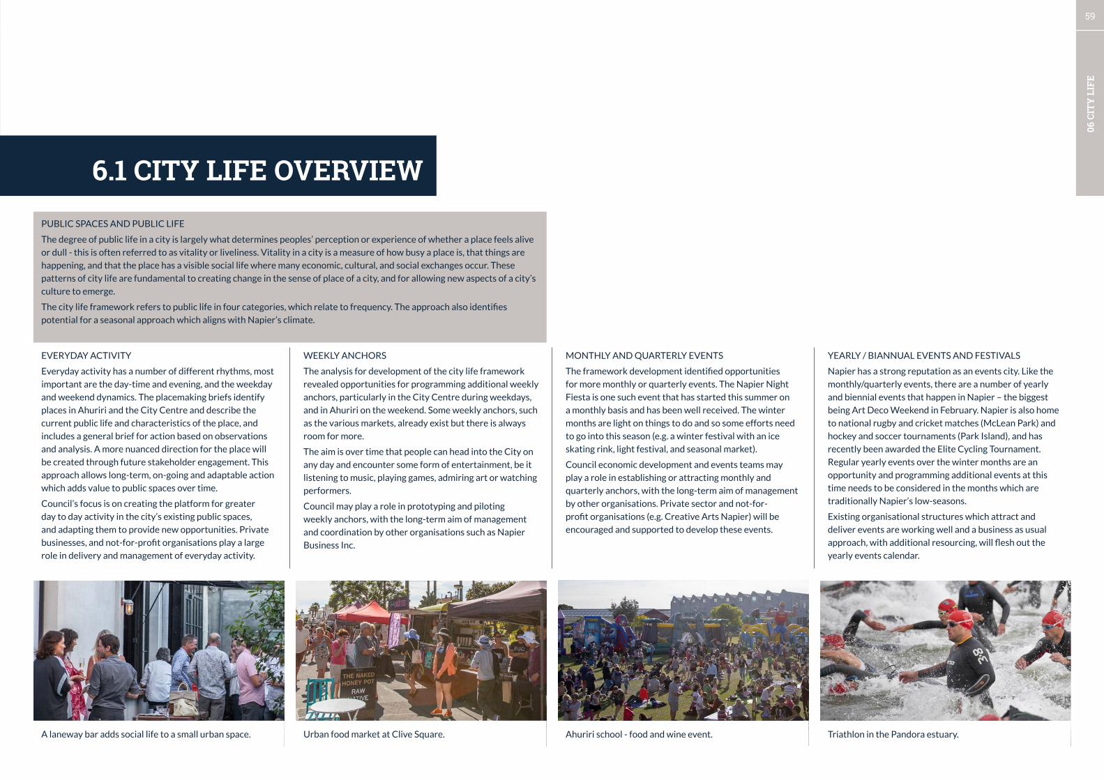
59
06 C
ITY
LIF
E
PUBLIC SPACES AND PUBLIC LIFE
The degree of public life in a city is largely what determines peoples’ perception or experience of whether a place feels alive
or dull - this is often referred to as vitality or liveliness. Vitality in a city is a measure of how busy a place is, that things are
happening, and that the place has a visible social life where many economic, cultural, and social exchanges occur. These
patterns of city life are fundamental to creating change in the sense of place of a city, and for allowing new aspects of a city’s
culture to emerge.
The city life framework refers to public life in four categories, which relate to frequency. The approach also identifies
potential for a seasonal approach which aligns with Napier’s climate.
A laneway bar adds social life to a small urban space. Urban food market at Clive Square. Triathlon in the Pandora estuary.Ahuriri school - food and wine event.
6.1 CITY LIFE OVERVIEW
EVERYDAY ACTIVITY
Everyday activity has a number of different rhythms, most
important are the day-time and evening, and the weekday
and weekend dynamics. The placemaking briefs identify
places in Ahuriri and the City Centre and describe the
current public life and characteristics of the place, and
includes a general brief for action based on observations
and analysis. A more nuanced direction for the place will
be created through future stakeholder engagement. This
approach allows long-term, on-going and adaptable action
which adds value to public spaces over time.
Council’s focus is on creating the platform for greater
day to day activity in the city’s existing public spaces,
and adapting them to provide new opportunities. Private
businesses, and not-for-profit organisations play a large
role in delivery and management of everyday activity.
WEEKLY ANCHORS
The analysis for development of the city life framework
revealed opportunities for programming additional weekly
anchors, particularly in the City Centre during weekdays,
and in Ahuriri on the weekend. Some weekly anchors, such
as the various markets, already exist but there is always
room for more.
The aim is over time that people can head into the City on
any day and encounter some form of entertainment, be it
listening to music, playing games, admiring art or watching
performers.
Council may play a role in prototyping and piloting
weekly anchors, with the long-term aim of management
and coordination by other organisations such as Napier
Business Inc.
MONTHLY AND QUARTERLY EVENTS
The framework development identified opportunities
for more monthly or quarterly events. The Napier Night
Fiesta is one such event that has started this summer on
a monthly basis and has been well received. The winter
months are light on things to do and so some efforts need
to go into this season (e.g. a winter festival with an ice
skating rink, light festival, and seasonal market).
Council economic development and events teams may
play a role in establishing or attracting monthly and
quarterly anchors, with the long-term aim of management
by other organisations. Private sector and not-for-
profit organisations (e.g. Creative Arts Napier) will be
encouraged and supported to develop these events.
YEARLY / BIANNUAL EVENTS AND FESTIVALS
Napier has a strong reputation as an events city. Like the
monthly/quarterly events, there are a number of yearly
and biennial events that happen in Napier – the biggest
being Art Deco Weekend in February. Napier is also home
to national rugby and cricket matches (McLean Park) and
hockey and soccer tournaments (Park Island), and has
recently been awarded the Elite Cycling Tournament.
Regular yearly events over the winter months are an
opportunity and programming additional events at this
time needs to be considered in the months which are
traditionally Napier’s low-seasons.
Existing organisational structures which attract and
deliver events are working well and a business as usual
approach, with additional resourcing, will flesh out the
yearly events calendar.
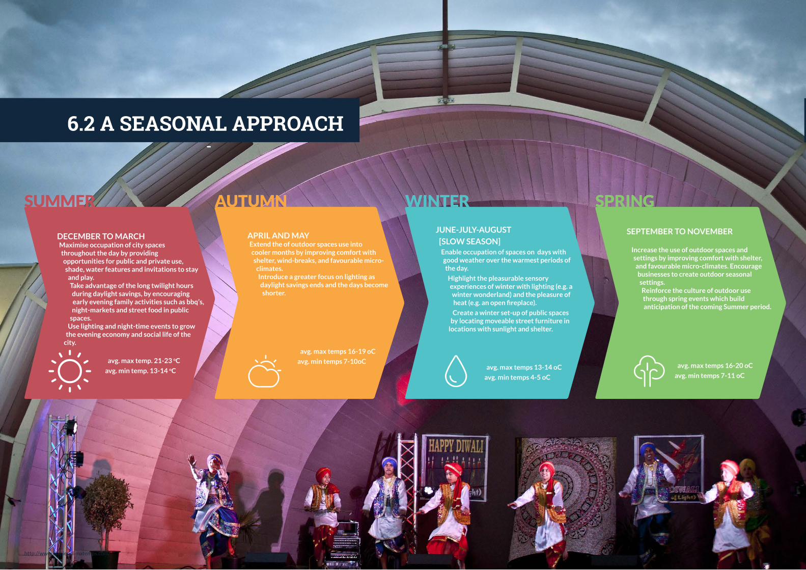
60
06 C
ITY
LIF
E
DECEMBER TO MARCHMaximise occupation of city spaces throughout the day by providing opportunities for public and private use, shade, water features and invitations to stay
and play.Take advantage of the long twilight hours during daylight savings, by encouraging early evening family activities such as bbq’s, night-markets and street food in public
spaces.Use lighting and night-time events to grow
the evening economy and social life of the city.
avg. max temp. 21-23 oC
avg. min temp. 13-14 oC
SUMMER
6.2 A SEASONAL APPROACH
APRIL AND MAYExtend the of outdoor spaces use into cooler months by improving comfort with shelter, wind-breaks, and favourable micro-
climates.Introduce a greater focus on lighting as daylight savings ends and the days become shorter.
avg. max temps 16-19 oC
avg. min temps 7-10oC
AUTUMN
http://www.Napier.climatemps.com/
JUNE-JULY-AUGUST
[SLOW SEASON]Enable occupation of spaces on days with good weather over the warmest periods of the day.
Highlight the pleasurable sensory experiences of winter with lighting (e.g. a winter wonderland) and the pleasure of heat (e.g. an open fireplace).
Create a winter set-up of public spaces by locating moveable street furniture in
locations with sunlight and shelter.
avg. max temps 13-14 oC
avg. min temps 4-5 oC
WINTER
SEPTEMBER TO NOVEMBER
Increase the use of outdoor spaces and settings by improving comfort with shelter, and favourable micro-climates. Encourage businesses to create outdoor seasonal settings.Reinforce the culture of outdoor use through spring events which build anticipation of the coming Summer period.
avg. max temps 16-20 oC
avg. min temps 7-11 oC
SPRING
6.3 CITY LIFE YEAR ONE
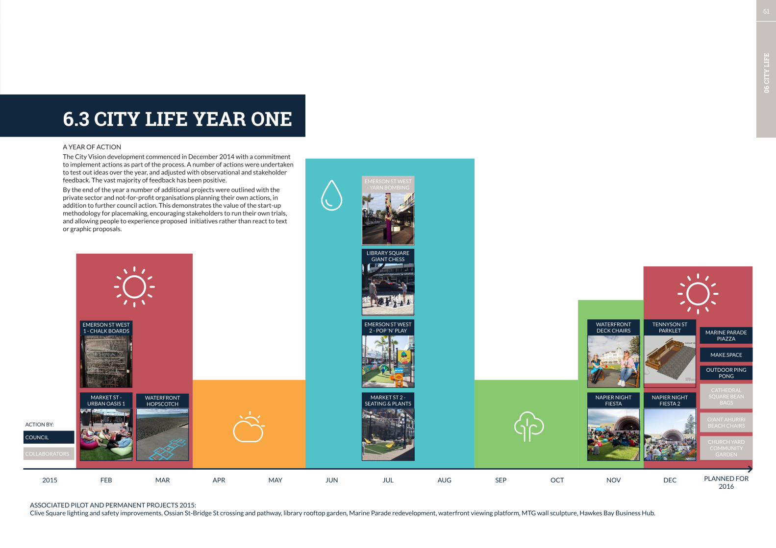
61
06 C
ITY
LIF
E
2015 FEB MAR APR MAY JUN JUL AUG SEP OCT NOV DEC PLANNED FOR 2016
MAKE.SPACE
MARINE PARADE PIAZZA
OUTDOOR PING PONG
GIANT AHURIRI BEACH CHAIRS
CATHEDRAL SQUARE BEAN
BAGS
CHURCH YARD COMMUNITY
GARDEN
COUNCIL
ACTION BY:COLLABORATORS
ASSOCIATED PILOT AND PERMANENT PROJECTS 2015:Clive Square lighting and safety improvements, Ossian St-Bridge St crossing and pathway, library rooftop garden, Marine Parade redevelopment, waterfront viewing platform, MTG wall sculpture, Hawkes Bay Business Hub.
6.3 CITY LIFE YEAR ONE
EMERSON ST WEST 2 - POP ‘N’ PLAY
MARKET ST 2 - SEATING & PLANTS
EMERSON ST WEST - YARN BOMBING
LIBRARY SQUARE GIANT CHESS
MARKET ST - URBAN OASIS 1
EMERSON ST WEST 1 - CHALK BOARDS
WATERFRONT HOPSCOTCH
NAPIER NIGHT FIESTA
WATERFRONT DECK CHAIRS
NAPIER NIGHT FIESTA 2
TENNYSON ST PARKLET
PARKLET SEAT
scottdesigncheck all dimensions with designerbefore and as work proceeds
planter boxesconstructed using150 x 25mm hardwood
ACTION BY:
A YEAR OF ACTION
The City Vision development commenced in December 2014 with a commitment to implement actions as part of the process. A number of actions were undertaken to test out ideas over the year, and adjusted with observational and stakeholder feedback. The vast majority of feedback has been positive.
By the end of the year a number of additional projects were outlined with the private sector and not-for-profit organisations planning their own actions, in addition to further council action. This demonstrates the value of the start-up methodology for placemaking, encouraging stakeholders to run their own trials, and allowing people to experience proposed initiatives rather than react to text or graphic proposals.

62
06 C
ITY
LIF
E
CITY LIFE YEAR ONE - PLACEMAKING NETWORK
After a year of placemaking activities this social network diagram was created to represent the known relationships which were leveraged to implement the actions in 6.3.
The aim of this network map is to capture the ‘software’ of placemaking, and to create a tool to highlight potential relationships which need development,
where additional connections can be made, and network points.
Internal staff - drivers of action
Internal staff - involved in delivery
External partners - strong involvement delivery
External - stakeholders / weaker involvement
Internal - tentative involvement
Linkage
Richard Munneke
RobynComms
RebeccaComms
John Wright
Fleur Lincoln
James Minehan
WikiMurphy
Jon Schwass
Georgina King
WayneJackCEO
Natasha Carswell
Mike Hyde
JacobScott
Joylene(Ahuriri
Business)
Cicada(design)
LanceTitler
AlfJohnson
Patsy
MTG staff
Artists
Property Owners -
Developers
H.B. Business
Hub(Wayne)
EIT Idea School
George - Blackdog
Design
Legal adviceMatt
Lawson
Markets(Robin)
Clever Dog -
graphic * signs
ZoeBarnes
(Napier Business )
Librarystaff?
KEY
NOVEMBER 2015
Retailers
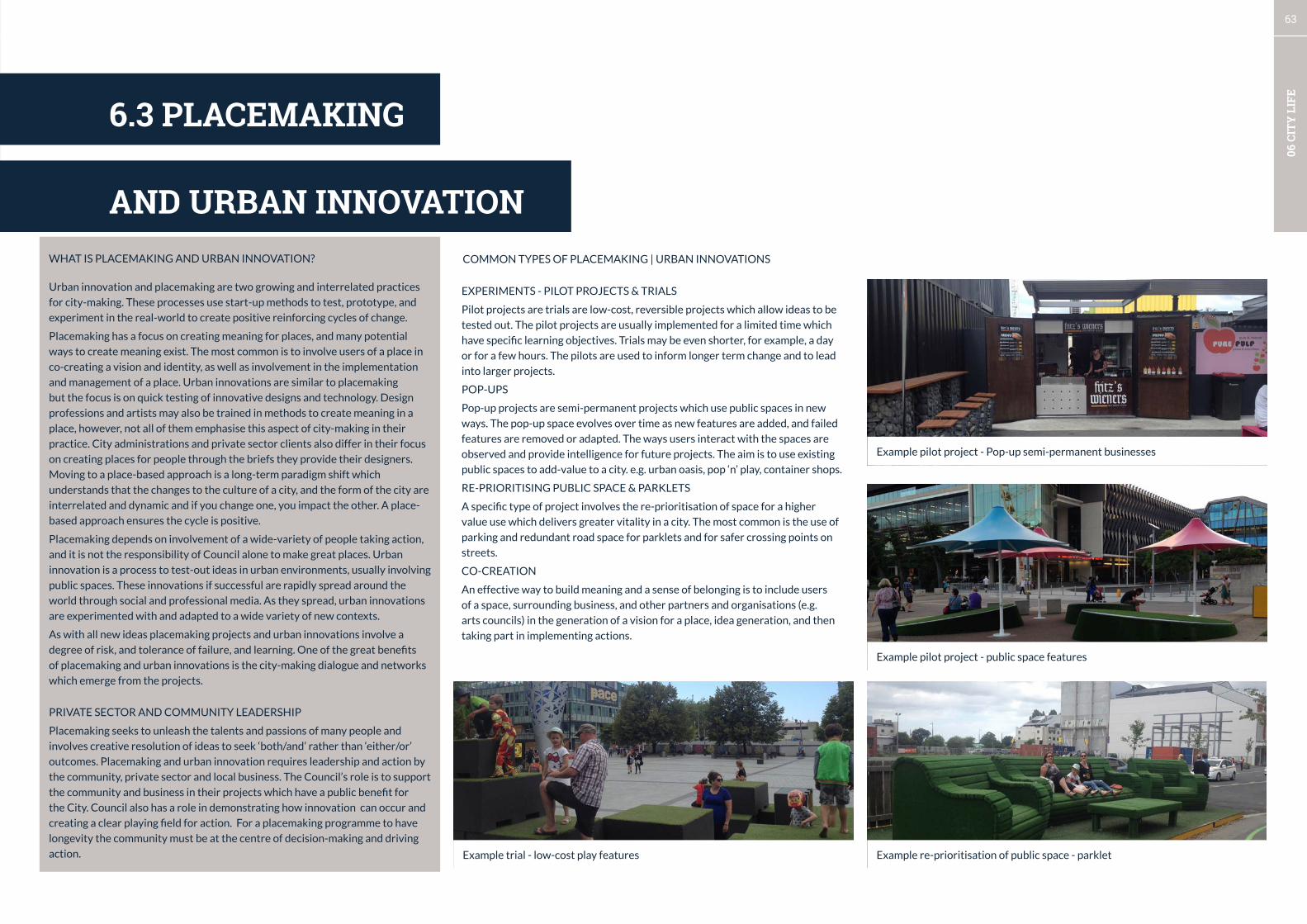
63
06 C
ITY
LIF
E
Urban innovation and placemaking are two growing and interrelated practices
for city-making. These processes use start-up methods to test, prototype, and
experiment in the real-world to create positive reinforcing cycles of change.
Placemaking has a focus on creating meaning for places, and many potential
ways to create meaning exist. The most common is to involve users of a place in
co-creating a vision and identity, as well as involvement in the implementation
and management of a place. Urban innovations are similar to placemaking
but the focus is on quick testing of innovative designs and technology. Design
professions and artists may also be trained in methods to create meaning in a
place, however, not all of them emphasise this aspect of city-making in their
practice. City administrations and private sector clients also differ in their focus
on creating places for people through the briefs they provide their designers.
Moving to a place-based approach is a long-term paradigm shift which
understands that the changes to the culture of a city, and the form of the city are
interrelated and dynamic and if you change one, you impact the other. A place-
based approach ensures the cycle is positive.
Placemaking depends on involvement of a wide-variety of people taking action,
and it is not the responsibility of Council alone to make great places. Urban
innovation is a process to test-out ideas in urban environments, usually involving
public spaces. These innovations if successful are rapidly spread around the
world through social and professional media. As they spread, urban innovations
are experimented with and adapted to a wide variety of new contexts.
As with all new ideas placemaking projects and urban innovations involve a
degree of risk, and tolerance of failure, and learning. One of the great benefits
of placemaking and urban innovations is the city-making dialogue and networks
which emerge from the projects.
PRIVATE SECTOR AND COMMUNITY LEADERSHIP
Placemaking seeks to unleash the talents and passions of many people and
involves creative resolution of ideas to seek ‘both/and’ rather than ‘either/or’
outcomes. Placemaking and urban innovation requires leadership and action by
the community, private sector and local business. The Council’s role is to support
the community and business in their projects which have a public benefit for
the City. Council also has a role in demonstrating how innovation can occur and
creating a clear playing field for action. For a placemaking programme to have
longevity the community must be at the centre of decision-making and driving
action.
WHAT IS PLACEMAKING AND URBAN INNOVATION? COMMON TYPES OF PLACEMAKING | URBAN INNOVATIONS
Example pilot project - Pop-up semi-permanent businesses
EXPERIMENTS - PILOT PROJECTS & TRIALS
Pilot projects are trials are low-cost, reversible projects which allow ideas to be
tested out. The pilot projects are usually implemented for a limited time which
have specific learning objectives. Trials may be even shorter, for example, a day
or for a few hours. The pilots are used to inform longer term change and to lead
into larger projects.
POP-UPS
Pop-up projects are semi-permanent projects which use public spaces in new
ways. The pop-up space evolves over time as new features are added, and failed
features are removed or adapted. The ways users interact with the spaces are
observed and provide intelligence for future projects. The aim is to use existing
public spaces to add-value to a city. e.g. urban oasis, pop ‘n’ play, container shops.
RE-PRIORITISING PUBLIC SPACE & PARKLETS
A specific type of project involves the re-prioritisation of space for a higher
value use which delivers greater vitality in a city. The most common is the use of
parking and redundant road space for parklets and for safer crossing points on
streets.
CO-CREATION
An effective way to build meaning and a sense of belonging is to include users
of a space, surrounding business, and other partners and organisations (e.g.
arts councils) in the generation of a vision for a place, idea generation, and then
taking part in implementing actions.
6.3 PLACEMAKING
AND URBAN INNOVATION
Example pilot project - public space features
Example re-prioritisation of public space - parkletExample trial - low-cost play features
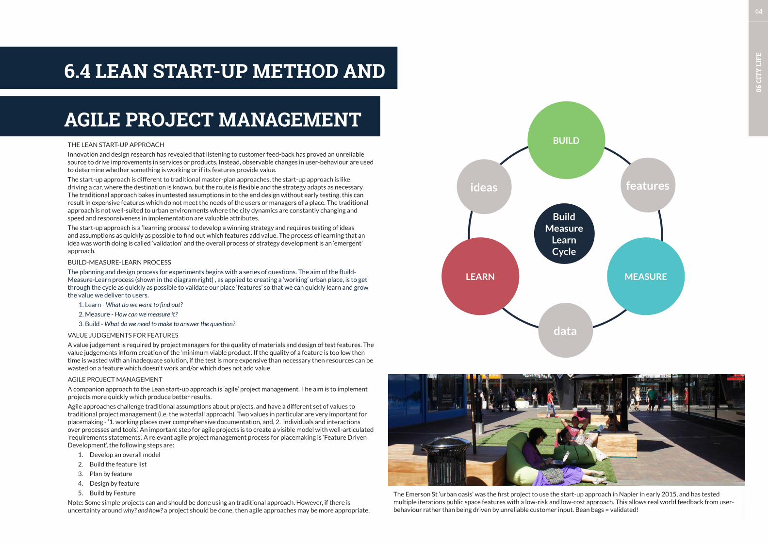
64
06 C
ITY
LIF
E
THE LEAN START-UP APPROACH
Innovation and design research has revealed that listening to customer feed-back has proved an unreliable source to drive improvements in services or products. Instead, observable changes in user-behaviour are used to determine whether something is working or if its features provide value.
The start-up approach is different to traditional master-plan approaches, the start-up approach is like driving a car, where the destination is known, but the route is flexible and the strategy adapts as necessary. The traditional approach bakes in untested assumptions in to the end design without early testing, this can result in expensive features which do not meet the needs of the users or managers of a place. The traditional approach is not well-suited to urban environments where the city dynamics are constantly changing and speed and responsiveness in implementation are valuable attributes.
The start-up approach is a ‘learning process’ to develop a winning strategy and requires testing of ideas and assumptions as quickly as possible to find out which features add value. The process of learning that an idea was worth doing is called ‘validation’ and the overall process of strategy development is an ‘emergent’ approach.
BUILD-MEASURE-LEARN PROCESS
The planning and design process for experiments begins with a series of questions. The aim of the Build-Measure-Learn process (shown in the diagram right) , as applied to creating a ‘working’ urban place, is to get through the cycle as quickly as possible to validate our place ‘features’ so that we can quickly learn and grow the value we deliver to users.
1. Learn - What do we want to find out?
2. Measure - How can we measure it?
3. Build - What do we need to make to answer the question?
VALUE JUDGEMENTS FOR FEATURES
A value judgement is required by project managers for the quality of materials and design of test features. The value judgements inform creation of the ‘minimum viable product’. If the quality of a feature is too low then time is wasted with an inadequate solution, if the test is more expensive than necessary then resources can be wasted on a feature which doesn’t work and/or which does not add value.
AGILE PROJECT MANAGEMENT
A companion approach to the Lean start-up approach is ‘agile’ project management. The aim is to implement projects more quickly which produce better results.
Agile approaches challenge traditional assumptions about projects, and have a different set of values to traditional project management (i.e. the waterfall approach). Two values in particular are very important for placemaking - ‘1. working places over comprehensive documentation, and, 2. individuals and interactions over processes and tools’. An important step for agile projects is to create a visible model with well-articulated ‘requirements statements’. A relevant agile project management process for placemaking is ‘Feature Driven Development’, the following steps are:
1. Develop an overall model
2. Build the feature list
3. Plan by feature
4. Design by feature
5. Build by Feature
Note: Some simple projects can and should be done using an traditional approach. However, if there is uncertainty around why? and how? a project should be done, then agile approaches may be more appropriate.
BUILD
MEASURELEARN
Build Measure
Learn Cycle
data
featuresideas
6.4 LEAN START-UP METHOD AND
The Emerson St ‘urban oasis’ was the first project to use the start-up approach in Napier in early 2015, and has tested multiple iterations public space features with a low-risk and low-cost approach. This allows real world feedback from user-behaviour rather than being driven by unreliable customer input. Bean bags = validated!
AGILE PROJECT MANAGEMENT
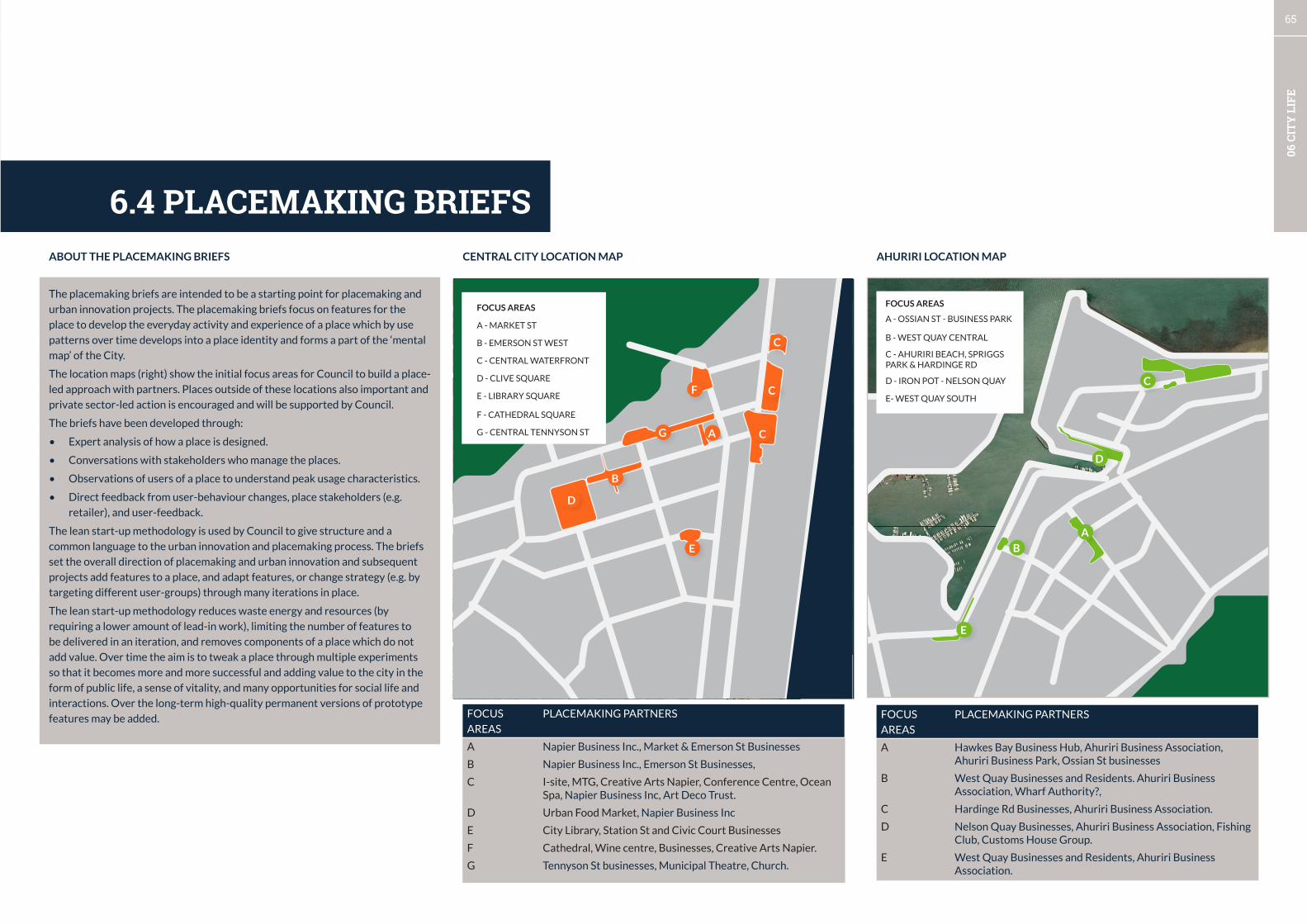
65
06 C
ITY
LIF
E
FOCUS
AREAS
PLACEMAKING PARTNERS
A Napier Business Inc., Market & Emerson St Businesses
B Napier Business Inc., Emerson St Businesses,
C I-site, MTG, Creative Arts Napier, Conference Centre, Ocean Spa, Napier Business Inc, Art Deco Trust.
D Urban Food Market, Napier Business Inc
E City Library, Station St and Civic Court Businesses
F Cathedral, Wine centre, Businesses, Creative Arts Napier.
G Tennyson St businesses, Municipal Theatre, Church.
CENTRAL CITY LOCATION MAP
A
B
C
C
C
D
E
F
FOCUS AREAS
A - MARKET ST
B - EMERSON ST WEST
C - CENTRAL WATERFRONT
D - CLIVE SQUARE
E - LIBRARY SQUARE
F - CATHEDRAL SQUARE
G - CENTRAL TENNYSON ST G
AHURIRI LOCATION MAP
A
B
C
D
E
FOCUS AREAS
A - OSSIAN ST - BUSINESS PARK
B - WEST QUAY CENTRAL
C - AHURIRI BEACH, SPRIGGS PARK & HARDINGE RD
D - IRON POT - NELSON QUAY
E- WEST QUAY SOUTH
6.4 PLACEMAKING BRIEFS
FOCUS
AREAS
PLACEMAKING PARTNERS
A Hawkes Bay Business Hub, Ahuriri Business Association, Ahuriri Business Park, Ossian St businesses
B West Quay Businesses and Residents. Ahuriri Business Association, Wharf Authority?,
C Hardinge Rd Businesses, Ahuriri Business Association.
D Nelson Quay Businesses, Ahuriri Business Association, Fishing Club, Customs House Group.
E West Quay Businesses and Residents, Ahuriri Business Association.
The placemaking briefs are intended to be a starting point for placemaking and
urban innovation projects. The placemaking briefs focus on features for the
place to develop the everyday activity and experience of a place which by use
patterns over time develops into a place identity and forms a part of the ‘mental
map’ of the City.
The location maps (right) show the initial focus areas for Council to build a place-
led approach with partners. Places outside of these locations also important and
private sector-led action is encouraged and will be supported by Council.
The briefs have been developed through:
• Expert analysis of how a place is designed.
• Conversations with stakeholders who manage the places.
• Observations of users of a place to understand peak usage characteristics.
• Direct feedback from user-behaviour changes, place stakeholders (e.g.
retailer), and user-feedback.
The lean start-up methodology is used by Council to give structure and a
common language to the urban innovation and placemaking process. The briefs
set the overall direction of placemaking and urban innovation and subsequent
projects add features to a place, and adapt features, or change strategy (e.g. by
targeting different user-groups) through many iterations in place.
The lean start-up methodology reduces waste energy and resources (by
requiring a lower amount of lead-in work), limiting the number of features to
be delivered in an iteration, and removes components of a place which do not
add value. Over time the aim is to tweak a place through multiple experiments
so that it becomes more and more successful and adding value to the city in the
form of public life, a sense of vitality, and many opportunities for social life and
interactions. Over the long-term high-quality permanent versions of prototype
features may be added.
ABOUT THE PLACEMAKING BRIEFS
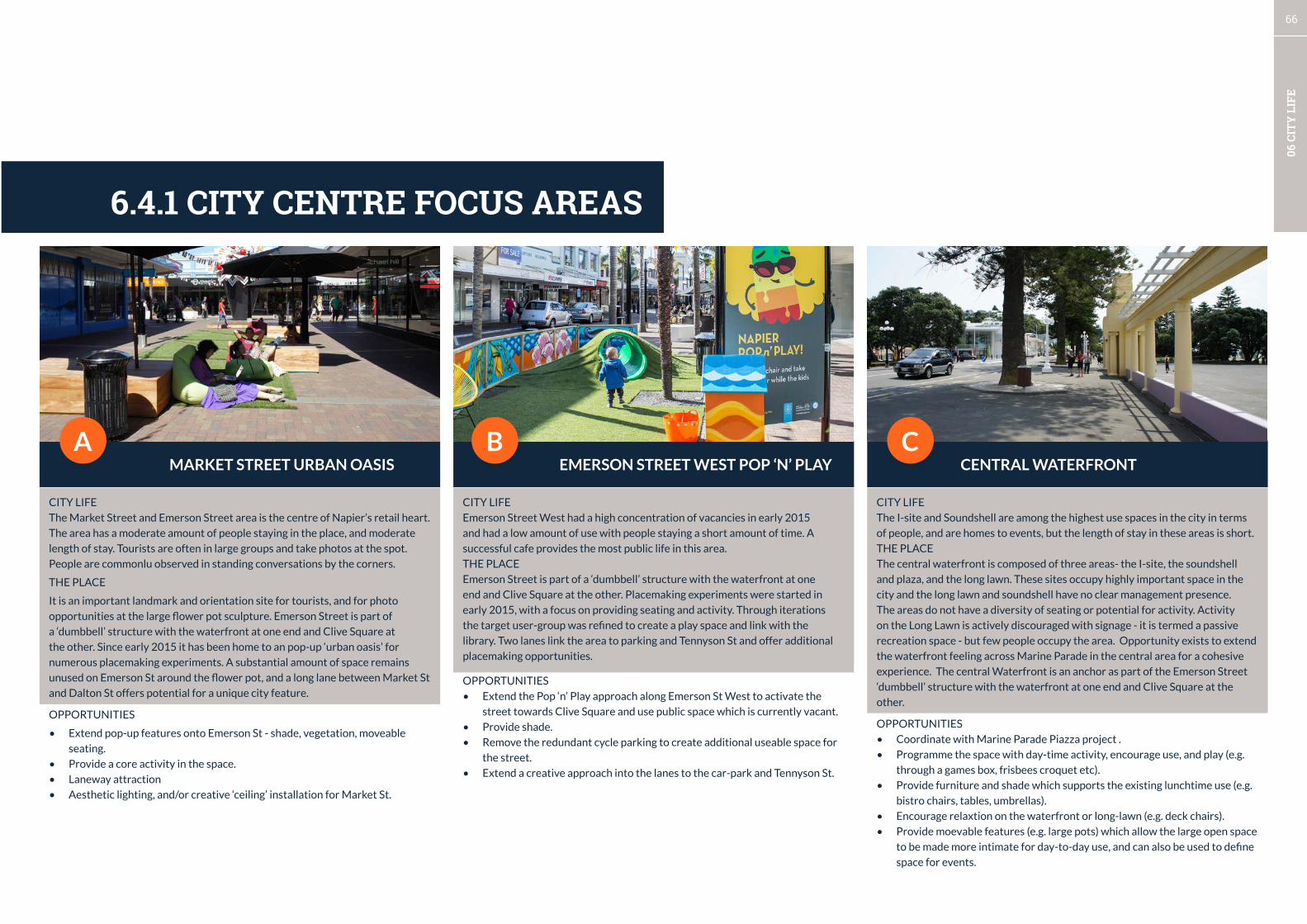
66
06 C
ITY
LIF
E
MARKET STREET URBAN OASIS EMERSON STREET WEST POP ‘N’ PLAY CENTRAL WATERFRONTA B C
6.4.1 CITY CENTRE FOCUS AREAS
CITY LIFE
Emerson Street West had a high concentration of vacancies in early 2015
and had a low amount of use with people staying a short amount of time. A
successful cafe provides the most public life in this area.
THE PLACE
Emerson Street is part of a ‘dumbbell’ structure with the waterfront at one
end and Clive Square at the other. Placemaking experiments were started in
early 2015, with a focus on providing seating and activity. Through iterations
the target user-group was refined to create a play space and link with the
library. Two lanes link the area to parking and Tennyson St and offer additional
placemaking opportunities.
OPPORTUNITIES
• Extend the Pop ‘n’ Play approach along Emerson St West to activate the
street towards Clive Square and use public space which is currently vacant.
• Provide shade.
• Remove the redundant cycle parking to create additional useable space for
the street.
• Extend a creative approach into the lanes to the car-park and Tennyson St.
CITY LIFE
The I-site and Soundshell are among the highest use spaces in the city in terms
of people, and are homes to events, but the length of stay in these areas is short.
THE PLACE
The central waterfront is composed of three areas- the I-site, the soundshell
and plaza, and the long lawn. These sites occupy highly important space in the
city and the long lawn and soundshell have no clear management presence.
The areas do not have a diversity of seating or potential for activity. Activity
on the Long Lawn is actively discouraged with signage - it is termed a passive
recreation space - but few people occupy the area. Opportunity exists to extend
the waterfront feeling across Marine Parade in the central area for a cohesive
experience. The central Waterfront is an anchor as part of the Emerson Street
‘dumbbell’ structure with the waterfront at one end and Clive Square at the
other.
OPPORTUNITIES
• Coordinate with Marine Parade Piazza project .
• Programme the space with day-time activity, encourage use, and play (e.g.
through a games box, frisbees croquet etc).
• Provide furniture and shade which supports the existing lunchtime use (e.g.
bistro chairs, tables, umbrellas).
• Encourage relaxtion on the waterfront or long-lawn (e.g. deck chairs).
• Provide moevable features (e.g. large pots) which allow the large open space
to be made more intimate for day-to-day use, and can also be used to define
space for events.
CITY LIFE
The Market Street and Emerson Street area is the centre of Napier’s retail heart.
The area has a moderate amount of people staying in the place, and moderate
length of stay. Tourists are often in large groups and take photos at the spot.
People are commonlu observed in standing conversations by the corners.
THE PLACE
It is an important landmark and orientation site for tourists, and for photo
opportunities at the large flower pot sculpture. Emerson Street is part of
a ‘dumbbell’ structure with the waterfront at one end and Clive Square at
the other. Since early 2015 it has been home to an pop-up ‘urban oasis’ for
numerous placemaking experiments. A substantial amount of space remains
unused on Emerson St around the flower pot, and a long lane between Market St
and Dalton St offers potential for a unique city feature.
OPPORTUNITIES
• Extend pop-up features onto Emerson St - shade, vegetation, moveable
seating.
• Provide a core activity in the space.
• Laneway attraction
• Aesthetic lighting, and/or creative ‘ceiling’ installation for Market St.
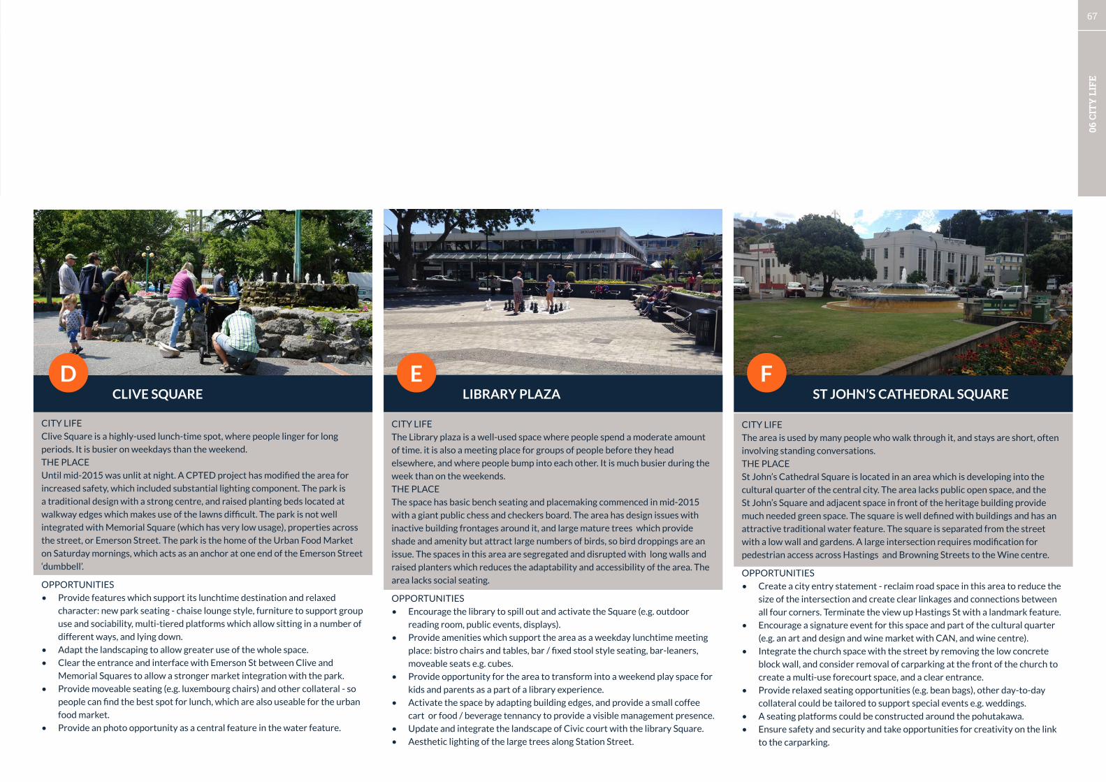
67
06 C
ITY
LIF
E
CLIVE SQUARE LIBRARY PLAZA ST JOHN’S CATHEDRAL SQUARED E F
CITY LIFE
Clive Square is a highly-used lunch-time spot, where people linger for long
periods. It is busier on weekdays than the weekend.
THE PLACE
Until mid-2015 was unlit at night. A CPTED project has modified the area for
increased safety, which included substantial lighting component. The park is
a traditional design with a strong centre, and raised planting beds located at
walkway edges which makes use of the lawns difficult. The park is not well
integrated with Memorial Square (which has very low usage), properties across
the street, or Emerson Street. The park is the home of the Urban Food Market
on Saturday mornings, which acts as an anchor at one end of the Emerson Street
‘dumbbell’.
OPPORTUNITIES
• Provide features which support its lunchtime destination and relaxed
character: new park seating - chaise lounge style, furniture to support group
use and sociability, multi-tiered platforms which allow sitting in a number of
different ways, and lying down.
• Adapt the landscaping to allow greater use of the whole space.
• Clear the entrance and interface with Emerson St between Clive and
Memorial Squares to allow a stronger market integration with the park.
• Provide moveable seating (e.g. luxembourg chairs) and other collateral - so
people can find the best spot for lunch, which are also useable for the urban
food market.
• Provide an photo opportunity as a central feature in the water feature.
CITY LIFE
The Library plaza is a well-used space where people spend a moderate amount
of time. it is also a meeting place for groups of people before they head
elsewhere, and where people bump into each other. It is much busier during the
week than on the weekends.
THE PLACE
The space has basic bench seating and placemaking commenced in mid-2015
with a giant public chess and checkers board. The area has design issues with
inactive building frontages around it, and large mature trees which provide
shade and amenity but attract large numbers of birds, so bird droppings are an
issue. The spaces in this area are segregated and disrupted with long walls and
raised planters which reduces the adaptability and accessibility of the area. The
area lacks social seating.
OPPORTUNITIES
• Encourage the library to spill out and activate the Square (e.g. outdoor
reading room, public events, displays).
• Provide amenities which support the area as a weekday lunchtime meeting
place: bistro chairs and tables, bar / fixed stool style seating, bar-leaners,
moveable seats e.g. cubes.
• Provide opportunity for the area to transform into a weekend play space for
kids and parents as a part of a library experience.
• Activate the space by adapting building edges, and provide a small coffee
cart or food / beverage tennancy to provide a visible management presence.
• Update and integrate the landscape of Civic court with the library Square.
• Aesthetic lighting of the large trees along Station Street.
CITY LIFE
The area is used by many people who walk through it, and stays are short, often
involving standing conversations.
THE PLACE
St John’s Cathedral Square is located in an area which is developing into the
cultural quarter of the central city. The area lacks public open space, and the
St John’s Square and adjacent space in front of the heritage building provide
much needed green space. The square is well defined with buildings and has an
attractive traditional water feature. The square is separated from the street
with a low wall and gardens. A large intersection requires modification for
pedestrian access across Hastings and Browning Streets to the Wine centre.
OPPORTUNITIES
• Create a city entry statement - reclaim road space in this area to reduce the
size of the intersection and create clear linkages and connections between
all four corners. Terminate the view up Hastings St with a landmark feature.
• Encourage a signature event for this space and part of the cultural quarter
(e.g. an art and design and wine market with CAN, and wine centre).
• Integrate the church space with the street by removing the low concrete
block wall, and consider removal of carparking at the front of the church to
create a multi-use forecourt space, and a clear entrance.
• Provide relaxed seating opportunities (e.g. bean bags), other day-to-day
collateral could be tailored to support special events e.g. weddings.
• A seating platforms could be constructed around the pohutakawa.
• Ensure safety and security and take opportunities for creativity on the link
to the carparking.

68
06 C
ITY
LIF
E
TENNYSON STREET - CENTRAL SECTIONG
PARKLET SEAT
scottdesigncheck all dimensions with designerbefore and as work proceeds
planter boxesconstructed using150 x 25mm hardwood
Re-prioritising car-parking to a higher value use - the design for Napier’s first parklet on Tennyson Street
CITY LIFE
The street is basic and does not have sufficient street life apart from a couple of
cafés, many inactive frontages of the heritage buildings will require creativity
to create a street life. Public life is absent in the Municipal Theatre and
Churchyard. A mobile food operator and market stalls sometimes occupy the
Churchyard and people can be seen using the free wifi in the early evening.
THE PLACE
Tennyson Street is one of NZ’s great streets with its human-scale art Deco
architecture and lack of verandahs which provide a full sky. It is a major link and
first impression of the City on the route to the waterfront. Shade and amenity
are also missing as is These parks are some of the lowest used spaces in the
City Centre. As a slow speed arterial route the street needs to work harder to
provide a positive experience for the City. The area is home to Napier’s first
experimental parklet.
OPPORTUNITIES
• Light the buildings at night to maximise the unique architecture, and create
a memorable night-time route and walk. Light the trees at the churchyard
and Tiffen Square trees and fountain.
• Provide street trees and vegetation.
• Facilitate visible public life by re-prioritising car-parking space for
businesses where there is demand for alternative uses.
• Invite people to walk - provide dedicated crossing points to encourage
crossings and connections at street intersections and lane connections.
• Test different uses and small events at Tiffen Square outside the Muncipal
Theatre kick-start the development of a new identity for Tennyson St.

69
06 C
ITY
LIF
E
OSSIAN STREET - ‘MAIN STREET’ WEST QUAY CENTRAL AHURIRI BEACH-FRONTA B C
6.4.2 AHURIRI FOCUS AREAS
CITY LIFE
The amount of public life is moderate in this area and most of it is delivered by
outdoor seating at the cafés. People spend a long time at cafés which adds much
vitality.
THE PLACE
Ossian Street is becoming the main street of the Ahuriri Business Park and it is
crossed by the Service Lane (formerly Collins St), and Mahia Street. The street is
basic and industrial in character and there is a great amount of space which can
be re-prioritised to higher value uses. Over 50 businesses now operate in the
business park which means workers need places to go and good links to parking
and the West Quay waterfront. On the south side of the street the frontages
of the buildings create potential for on site open spaces which can add to the
vitality of the street. Large warehouses may also act as canvases for cultural
expression. The area is now home to the Hawkes Bay Business Hub which needs
a setting for business to match the entrepreneurial character of its mission.
OPPORTUNITIES
• Social spaces in the street for the growing workforce which enable chance
meetings, and networking between organisations.
• Lighting - street, aesthetic lighting of buildings and vegetation, links to car-
parking and to West Quay, and security.
• Testing of different street arrangements and crossing points to test out
concepts for a main street of the business park.
• Potential to integrate building forecourts on southern side of street to
create privately owned-public spaces which contribute to the whole
district’s appeal.
CITY LIFE
The shared space along West Quay centred around Lever Street has the most
vitality of all public places in Napier with large numbers of people spending
a long time on the Quay. However, all of the activity takes place at private
establishments. Significant interest is created by the working wharf where
fishing catches are landed, and this creates Health and Safety issues.
THE PLACE
The area has all the ingredients of a great place, strong character, activity, and
places for people, and good connections. The wharf is occupied by parking which
may be used for higher value activities once additional parking is provided
behind the warehouses. Places for public occupation are needed to make the
West Quay area a more democratic public space. Diving and swimming takes
place on the Quay and is currently unmanaged.
OPPORTUNITIES
• Lighting of the pohutakawa and other aesthetic lighting of buildings and
features to support the night-time economy.
• Reprioritisation of car-parking to create a waterfront public space on West
Quay near the intersection of Lever Street, and a new stopping point on the
waterfront pathway.
• Provide photo, waterfront pathway feature ‘acupuncture’ ,and seating
opportunities associated with the pohutakwas to enable people to
experience the waterfront’s patterns of life.
• Legitimise the wharf jumping area and create a focal point for public life (e.g.
wellington waterfront precdent).
CITY LIFE
The area has moderate vitality on the street and high vitality on the waterfront.
It is busier on the weekend than on a weekday. Children and their parents
occupy the play areas.
THE PLACE
Ahuriri beach-front has several areas - Spriggs Park, the central beach and the
Hardinge Rd and Lane area. The areas have large areas of potentially underused
space which can be creatively used to take the area from good to great. The area
lacks photo opportunities and amenities to support public use, and requires
stronger linkage of the waterfront character across the street. The central
public car-park could host a weekly anchor event.
OPPORTUNITIES
• Provide photo opportunities and features which highlight ‘Ahuriri’ as a
distinct destination on the Napier waterfront.
• Supply formal and informal beach games - and programme weekend events.
• Large scale shade structures associated with play and BBQ areas.
• Landscaping and vegetation to site the successful play areas in higher-
quality environments.
• A single environment - features to connect the waterfront buildings with the
beach reserve across the street.
• Provide for short-stays (e.g. to eat an ice-cream) in the street areas near
street crossings with a diversity of seating opportunities which have a
waterfront character.
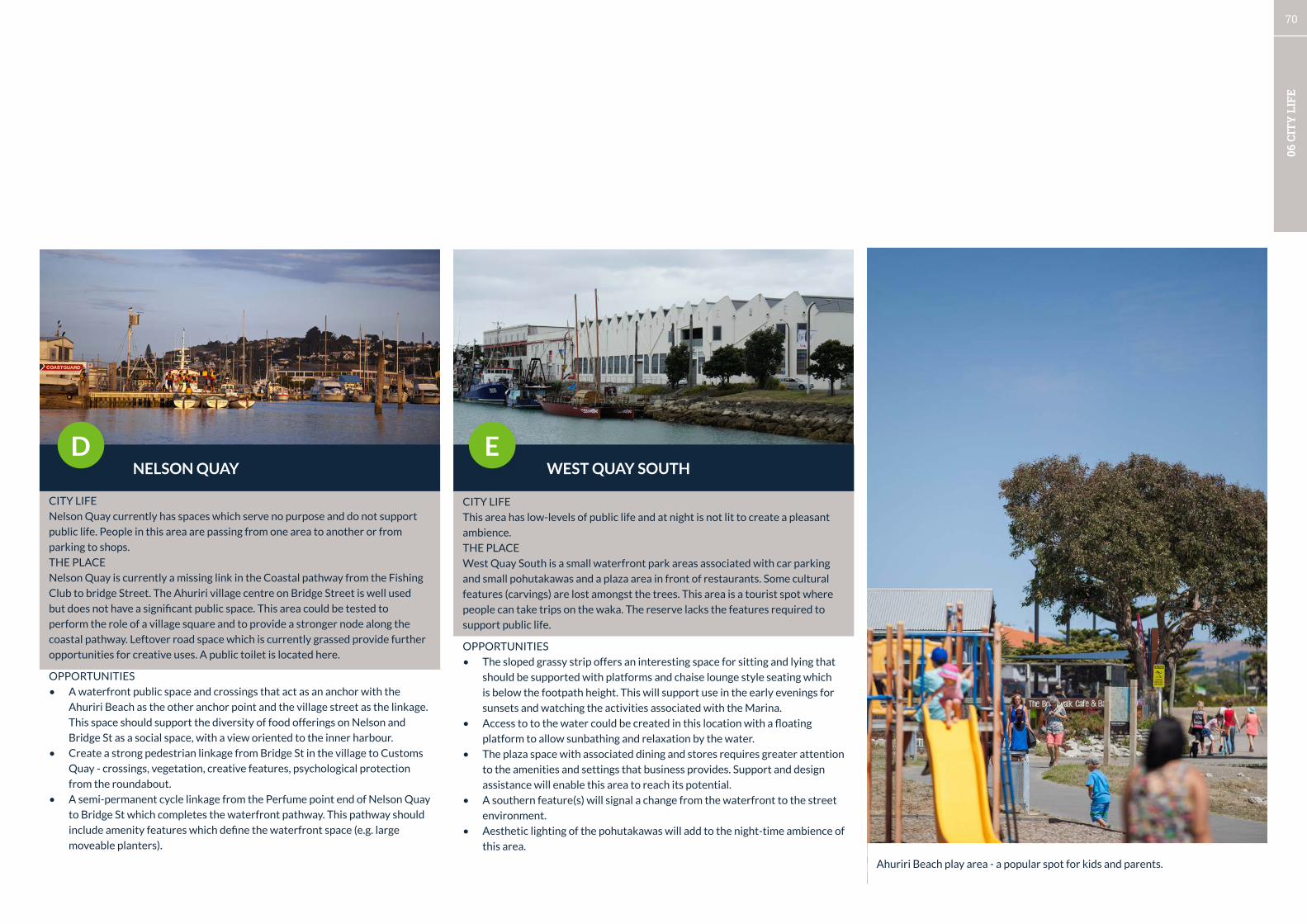
70
06 C
ITY
LIF
E
NELSON QUAY WEST QUAY SOUTHD E
Ahuriri Beach play area - a popular spot for kids and parents.
CITY LIFE
Nelson Quay currently has spaces which serve no purpose and do not support
public life. People in this area are passing from one area to another or from
parking to shops.
THE PLACE
Nelson Quay is currently a missing link in the Coastal pathway from the Fishing
Club to bridge Street. The Ahuriri village centre on Bridge Street is well used
but does not have a significant public space. This area could be tested to
perform the role of a village square and to provide a stronger node along the
coastal pathway. Leftover road space which is currently grassed provide further
opportunities for creative uses. A public toilet is located here.
OPPORTUNITIES
• A waterfront public space and crossings that act as an anchor with the
Ahuriri Beach as the other anchor point and the village street as the linkage.
This space should support the diversity of food offerings on Nelson and
Bridge St as a social space, with a view oriented to the inner harbour.
• Create a strong pedestrian linkage from Bridge St in the village to Customs
Quay - crossings, vegetation, creative features, psychological protection
from the roundabout.
• A semi-permanent cycle linkage from the Perfume point end of Nelson Quay
to Bridge St which completes the waterfront pathway. This pathway should
include amenity features which define the waterfront space (e.g. large
moveable planters).
CITY LIFE
This area has low-levels of public life and at night is not lit to create a pleasant
ambience.
THE PLACE
West Quay South is a small waterfront park areas associated with car parking
and small pohutakawas and a plaza area in front of restaurants. Some cultural
features (carvings) are lost amongst the trees. This area is a tourist spot where
people can take trips on the waka. The reserve lacks the features required to
support public life.
OPPORTUNITIES
• The sloped grassy strip offers an interesting space for sitting and lying that
should be supported with platforms and chaise lounge style seating which
is below the footpath height. This will support use in the early evenings for
sunsets and watching the activities associated with the Marina.
• Access to to the water could be created in this location with a floating
platform to allow sunbathing and relaxation by the water.
• The plaza space with associated dining and stores requires greater attention
to the amenities and settings that business provides. Support and design
assistance will enable this area to reach its potential.
• A southern feature(s) will signal a change from the waterfront to the street
environment.
• Aesthetic lighting of the pohutakawas will add to the night-time ambience of
this area.

71
07 C
ON
TEX
T &
AN
ALY
SIS
CITY VISION FRAMEWORK
Part DContext & Analysis

72
07 C
ON
TEX
T &
AN
ALY
SIS
CONTEXT
This section includes descriptive background information about Napier, the items covered are:
1. Napier’s building blocks
2. International and national context
3. Regional context
4. City context
5. Area framework statistics
ANALYSIS
This section also includes urban analysis of the study areas. The urban analysis was carried out in early 2015
and covers:
6. Strategic issues:
• The Port
• Heavy vehicle routes
• Retail and attracting investment
• Car-parking and connections
• Coordinating projects
7. Urban analysis:
• Networks
• Buildings
• Cultural and creative expression
• City Life
7.1 CONTEXT AND ANALYSIS OVERVIEWREFERENCES
The context and analysis undertaken was supplemented by review of a number of existing studies and plans. The City
Vision builds upon a great amount of design and strategy which has been undertaken in the last 15 years. The Framework
integrates the diverse inputs into a cohesive whole and where necessary adds, adjusts and updates the design thinking for
Napier’s future.
• Long Term Plan 2015-18
• City Centre Plan 2000
• Cycling Strategy
• West Quay plans (Isthmus)
• Waterfront redevelopment concepts (PMA)
• Clive Square - Emerson St West (Inner City Business Association; Viles)
• Ahuriri bypass design exploration (OPUS)
• Maori design principles (Scott Design)
• Ahuriri business park (Urban Perspectives)
• Central city parking building and linkages (Urban Perspectives)
• Hastings St streetscape design (NCC)
design strategies
draw in the beach
MARINE PARADE
protect + shelter
celebratewater
celebrate the bay - the fi n of the stingray
celebratewater
connectto sunken gardens
engage with skate park
city threshold...draw in the city + lead through to the coast
coastal threshold... draw in the coastal landscape to the city edge
draw in the beach
Marine Parade Redevelopment | Paris Magdalinos Architects
British American Tobacco Site, Ahuriri: Urban Design Assessment: Summary Report Prepared for Napier City Council by Urban Perspectives Ltd, February 2007
1
• Create two distinctive entrances to the area from Riddell St and Coronation St (Ossian St and Lever St ‘left in-left out’ only) • Link the two entrances to an internal ‘crescent’ running along Riddell St/Domett St and connecting to Coronation St via a new link • Create informal pedestrian crossing points at the ‘peanut roundabout’ and at Riddell St • Create informal pedestrian facilities at Lever St and Ossian St intersections • Create a new roundabout (or other traffic calming measure) at Coronation St/Battery Rd intersection • Widen footpath along eastern side of Bridge St, enhance with trees, feature lights, paving. Give special design attention to the area in front of the Rothman’s Building • Treat Lever St and Ossian St as slow vehicle areas - widen footpath on one side (e.g. west facing), create 90 degree parking on the opposite side, provide enhanced landscape treatment • Treat Ossian St and Lever St as enhanced green links • Create continuous cross connection linking Coronation St and Riddell St with a possibility to extend to the Ahuriri Reserve • Extend Tu Atu St to link to Ossian St via the existing on-site lane
• Treat Domett St (to the south of Lever St) as an enhanced pedestrian/green link to the Ahuriri Reserve • Treat Tu Atu St, Mahia St and Campbell St as lanes with an enhanced pedestrian character. Opportunity to create a ‘pocket park’ at the Ossian St end of the new cross link extending Tu Atu St - to enhance visual connections to key heritage buildings • Maintain key heritage buildings; encourage quality design for new buildings (e.g. design guidelines) • Create ‘transition of activities’ (from west to east) from a more ‘active commercial frontage’ around Bridge St, through mixed use activities to residential • Facilitate development opportunities of key sites through public/private initiatives
B.A.T. Site & Context: Urban Design Principles & Ideas
{3D}
1
park memorialfountain?
P 8
THE EMERSON-STRIP
MTG
LOWER EMERSON UPPER EMERSON
CLI
VE S
QU
ARE
THEA
TER
LAN
ED
ICKE
NS
LAN
E
searecreationalpark memorialcultural
©AV13
WAR MEMORIALCENTRE PANIA STATUE
RESIDENTIAL AND COMMERCIAL PROPERTY
TOM PARKERFOUNTAIN
OCEAN SPA HOT POOLS
CYCLE TRAIL RETAINED
SOUNDSHELL PAR2 MINIGOLF
NAPIER i-SITE VISITOR CENTRE SUNKEN GARDENS
CAR PARKNATIONAL AQUARIUMOF NEW ZEALAND
NAPIER SKATE PARK A ROLLER SPORTS CENTRE CATERING FOR SKATING, SKATEbOARDING, SCOOTERING, ROLLER DERbY AND INLINE HOCKEY
MARINE PARADE VIEWING PLATFORMExTENDING TO THE WATER’S EDGE, STAND AND ENjOY THE PANORAMIC VIEWS OF HAWKE bAY
proposed
WAVE RIDER IDEA
MARINE PARADEGRAND PLAN
REEF GARDEN AND AMPHITHEATREAN INTERACTIVE WATER PLAY AREA INCLUDING A LANDSCAPED AMPHITHEATRE FOR PERFORMANCE
NOW...AND INTOTHE FUTURE
OUTDOOR FITNESS CENTRE
PUMP TRACK AND FREEDOM CAMPING CARPARK FOR bMx RIDERS OF ALL SKILLS AND AGES
ApproVed
CoMpLeTIoN dUe 2016
Underway
CoMpLeTIoN dUe 2015
ApproVed
CoMpLeTIoN dUe 2015
ApproVed
CoMpLeTIoN dUe 2016
IDEAL FOR INDIVIDUALS OR bOOT CAMP GROUPS TO USE. FURTHER EQUIPMENT TO COME.
AN ARTIFICIAL SURFING WAVE
PLAYGROUND ExTENSION
CAR PARK CAR PARK
jUNIOR bIKE TRACKRECREATION AND WATER AREA
ApproVed
CoMpLeTIoN dUe 2015

73
07 C
ON
TEX
T &
AN
ALY
SIS
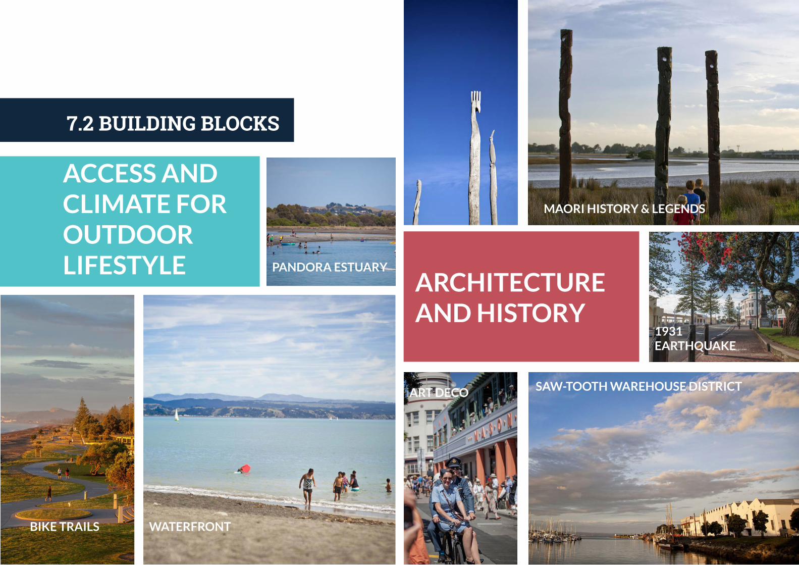
74
07 C
ON
TEX
T &
AN
ALY
SIS
ACCESS AND CLIMATE FOR OUTDOOR LIFESTYLE
BIKE TRAILS WATERFRONT
PANDORA ESTUARY
ARCHITECTURE AND HISTORY
MAORI HISTORY & LEGENDS
SAW-TOOTH WAREHOUSE DISTRICTART DECO
1931 EARTHQUAKE
7.2 BUILDING BLOCKS

CREATIVE EXPRESSION
THRIVING BUSINESS COMMUNITY
WATERFRONT ACTIVITY MIX
NORFOLK ISLAND PINES
WEST QUAY ACTIVITY MIX
MARINE PARADE FACILITIES & CULTURE
ADAPTATION OF HERITAGE BUILDINGS
PORT
WEST QUAY WHARF
AHURIRI COMMERCIAL
CBD RETAIL HEART
NIGHT-TIME ECONOMY
START-UP OPPORTUNITIES
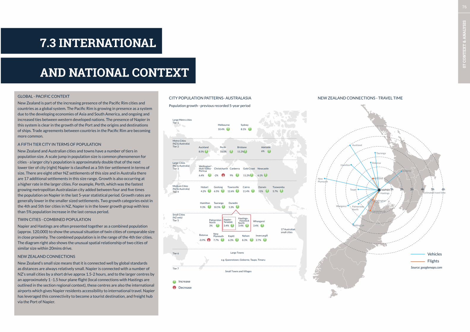
76
07 C
ON
TEX
T &
AN
ALY
SIS
7.4 HAWKES BAY CONTEXT
GLOBAL - PACIFIC CONTEXT
New Zealand is part of the increasing presence of the Pacific Rim cities and
countries as a global system. The Pacific Rim is growing in presence as a system
due to the developing economies of Asia and South America, and ongoing and
increased ties between western developed nations. The presence of Napier in
this system is clear in the growth of the Port and the origins and destinations
of ships. Trade agreements between countries in the Pacific Rim are becoming
more common.
A FIFTH TIER CITY IN TERMS OF POPULATION
New Zealand and Australian cities and towns have a number of tiers in
population size. A scale jump in population size is common phenomenon for
cities - a larger city’s population is approximately double that of the next
lower tier of city (right) Napier is classified as a 5th tier settlement in terms of
size. There are eight other NZ settlements of this size and in Australia there
are 17 additional settlements in this size range. Growth is also occurring at
a higher rate in the larger cities. For example, Perth, which was the fastest
growing metropolitan Australasian city added between four and five times
the population on Napier in the last 5-year statistical period. Growth rates are
generally lower in the smaller sized settlements. Two growth categories exist in
the 4th and 5th tier cities in NZ, Napier is in the lower growth group with less
than 5% population increase in the last census period.
TWIN CITIES - COMBINED POPULATION
Napier and Hastings are often presented together as a combined population
(approx. 120,000) to show the unusual situation of twin cities of comparable size
in close proximity. The combined population is in the range of the 4th tier cities.
The diagram right also shows the unusual spatial relationship of two cities of
similar size within 20mins drive.
NEW ZEALAND CONNECTIONS
New Zealand’s small size means that it is connected well by global standards
as distances are always relatively small. Napier is connected with a number of
NZ’s small cities by a short drive approx 1.5-2 hours, and to the larger centres by
an approximately 1 -1.5 hour plane flight (local connections with Hastings are
outlined in the section regional context), these centres are also the international
airports which gives Napier residents accessibility to international travel. Napier
has leveraged this connectivity to become a tourist destination, and freight hub
via the Port of Napier.
CITY POPULATION PATTERNS- AUSTRALASIA NEW ZEALAND CONNECTIONS - TRAVEL TIME
Melbourne Sydney
Wellington*-Hutt Valley-Porirua
Hamilton Tauranga
Hastings-Havelock
North
Large Towns
e.g. Queenstown, Gisborne, Taupo, Timaru
Small Towns and Villages
Palmerston North
New Plymouth
Whangarei
NelsonKapiti InvercargillRotorua
Dunedin
Napier-Taradale
Christchurch Canberra Gold Coast Newcastle
Perth Adelaide
10.4% 8.1%
Brisbane
11.2%16.5%
Auckland
8.5% 6%
-2%6.4% 9% 11.2% 6.1%
9.3%
3% 3.4% 3.4%
7.7% 6.3% 8.3% 2.7%
3.4%
-0.9%
10.5% 1.3%
Hobart
4.2%
Geelong
6.5%
Townsville
12.6%
Cairns
11.4%
Darwin
11%
Toowomba
5.7%
Small Cities(NZ only)Tier 5
Tier 6
Tier 7
Medium Cities(NZ & Australia)Tier 4
Large Cities(NZ & Australia)Tier 3
Metro Cities(NZ & Australia)Tier 2
Large Metro citiesTier 1
17 Australiansmall cities
Population growth - previous recorded 5-year period
Increase
Decrease
1h 3h 4h 5h 6h2h
Vehicles
Flights
Wellington
Christchurch
Wellington
Hastings
Gisborne
Palmerston North
Wanganui
Hamilton
Auckland
Tauranga
Rotorua
Auckland
Taupo
New Plymouth
Estimated travel time
Source: googlemaps.com
NAPIER
AND NATIONAL CONTEXT
7.3 INTERNATIONAL

77
07 C
ON
TEX
T &
AN
ALY
SIS
HAWKES BAY SUMMARY
The regional context of Napier can be simply understood as a series of layers
(right). Napier occupies a central location in the Hawkes Bay, where an area
of plains (light green) is surrounded by hills (green) and a number of river
systems terminate at the coast (navy). Prior to European settlement and land
reclamation, and the 1931 earthquake there were large areas of estuary and
swamp. Two clear agglomerations of urban settlement (grey) are Napier-
Taradale, and Hastings-Havelock North-Flaxmere which are generally separated
by the Tutaekuri, Ngaruroro, and Clive Rivers. A high speed express-way
network has been developed which links the urban areas, industrial areas and
airport to interregional the State Highway network (red). The City Vision project
(orange) focuses on the Napier CBD and Ahuriri, Port and waterfront - a small
but critical area of the Hawkes Bay Region.
EARLY LANDFORMS - PRE-EUROPEAN SETTLEMENT AND LAND
RECLAMATION
The diagram below shows the known landforms around the Napier area. The
area was swamp and tidal estuaries with narrow spits connecting to Mataruahou
(now known as Napier Hill). Maori settlements were spread around the base of
Mataruahou in sheltered locations, with a Pa site at Ahuriri.
HAWKES BAY
COASTLINE, ESTUARY AND RIVERS
URBAN AREAS
REGIONAL TRANSPORT NETWORK & AIRPORT
CITY VISION PROJECT AREA
HILLS AND PLAINS
7.4 HAWKES BAY CONTEXT
Napier 1865 showing large areas of tidal estuary and swamp.

78
07 C
ON
TEX
T &
AN
ALY
SIS
CITY VISION SCOPE
The central city, waterfront and Ahuriri is Napier’s glamorous face to the world.
These central commercial hubs and recreational strip are the areas where most
people work, shop, and be entertained, and where visitors to the City are drawn
to. These areas are the single focus for the City Vision, although the philosophy
underpinned by the Foundation Concepts will extend beyond these three areas
to Napier’s suburban shopping centres and transportation networks. Consistent
implementation of the Foundation Concepts across all suburban centres will
ensure strong connections to the city centre, even though each suburban centre
has its own character, community and purpose.
OVERVIEW OF CITY ISSUES
The City Vision has been prepared to meet Napier’s challenges and
opportunities, and to deliver against the project objectives (see introduction).
A snapshot of the City (right) gives an overview of Napier in 2015. Detailed
reports have been prepared and other strategies are relevant to the preparation
of the City Vision. The scope of the City Vision does not cover all issues,
and other strategic plans outline the City’s approach. The major issues and
opportunities that Napier (and the Hawkes Bay) are experiencing are:
ECONOMIC DEVELOPMENT
Napier City Council is a partner in the revision of the Hawkes Bay Regional
Economic Strategy (REDS) and is currently working on the development of a
regional Business Attraction Strategy. These two strategies work to guide the
activities of Council in achieving the goal of Napier being the leading commercial
and tourism centre in Hawkes Bay.
The aim of REDS is to increase prosperity across the region, building on regional
strengths and broadening the region’s economic base. The Business Attraction
Strategy will be one component of REDS.
PORT GROWTH, LOGISTICS AND FREIGHT NETWORK
REDS will support the growth and success of the Napier Port, as it’s key
portal for the movement of the region’s produce to markets across the world.
The Napier Port also has it’s own strategic objectives, including increasing
efficiencies, targeting new markets, and increasing the number of TEU’s
(containers) handled.
REGIONAL APPROACH - AMALGAMATION
The Local Government Commission recommended the councils of Napier City
Council, Hastings District Council, Central Hawkes Bay District Council, Wairoa
District Council and the Hawke’s Bay Regional Council amalgamate to form one
super council. The decision to do so will go to a public referendum on the 14th
7.5 THE CITY CONTEXTPOPULATION PROJECTIONS - CHANGING DEMOGRAPHICS MIGRATION BY AGE GROUPS
YOUNGER PEOPLE TEND TO MIGRATE FROM NAPIER TO CITIES WITH GREATER
EDUCATION AND EARLY CAREER OPPORTUNITIES; THE CITY GAINS POPULATION
FROM THE MID-30 YEAR OLD AGE-GROUP ONWARDS.
0
5,000
10,000
15,,000
20,000
65 and over
40–64 years
15–39 years
0-14 years
2043203820332028202320182013200620011996199119861981
-1200
-1000
-800
-600
-400
-200
0
200
4002007–13
2002–06
1997–2001
85+80–8475–7970–7465–6960–6455–5950–5445–4940–4435–3930–3425–2920–2415–1910–145–90–4
STATISTICS NZ PROJECTIONS ESTIMATE THAT IN 2043 31% OF PEOPLE IN NAPIER
WILL BE 65 AND OLDER - DOUBLE THE PERCENTAGE OF 0-14 YEAR OLDS.
September 2015. Regardless of the outcome, the City Vision will be relevant for
the future development of Napier, and the philosophy of approach is grounded
in current best practice and will likely be adopted by any future organisation of
local government, should this occur.
AGING POPULATION
The worldwide demographic shift to an ageing population cannot be ignored.
The graph right (bottom) shows the projected dramatic increase over the next
30 years of over 65 year olds. Napier City Council is currently developing a
Positive Ageing Strategy with community groups. The Strategy will look to
reduce isolation, provide greater access to medical and social needs and ensure
urban environments are designed with access to all sectors of the community
in mind. People-friendly streets in also one of the aims of the City Vision and as
such, the two strategies are compatible.
EARTHQUAKE PRONE BUILDINGS
Sections 131 and 132 of the Building Act 2004 require Councils to develop and
implement an Earthquake Prone and Insanitary Buildings Policy. In short, the
city’s commercial buildings built prior to 1976 are required to comply with at
least 34% of the NZ Building Code for new buildings (NBS) at the time of any
change in use, or within 15 years for those buildings assessed to be earthquake
prone following an IEP (Initial Earthquake Prone assessment). This puts a
sometimes significant cost on the building owner, and has resulted in difficulty
tenanting some buildings. Where rents are unable to cover the costs of earthquake
strengthening, the building is at risk of being demolished or abandoned, a fear most
keenly felt for the city’s heritage buildings. On the upside, research shows that
buildings (particularly heritage buildings) that have been earthquake strengthened
are more likely to be tenanted, and more likely to contain successful businesses.
Heritage precincts are more likely to have higher volumes of pedestrian traffic and
are visited by more tourists. The City Vision recognises the importance of heritage
in Napier and supports building owners through various means throughout the
process of earthquake strengthening.
COASTAL HAZARDS, CLIMATE CHANGE AND SEA LEVEL RISE
A regional approach to the issues of coastal hazards, climate change, and sea level
rise is being taken with physical works likely to be undertaken after 2017:
“The Clifton to Tangoio Coastal Hazards Strategy 2120 will be developed in cooperation with the Hastings District Council (HDC), the Hawke’s Bay Regional Council (HBRC), the Napier City Council (NCC), and groups representing Mana Whenua and/or Tangata Whenua. This strategy will be developed to provide a framework for assessing coastal hazards risks and options for the management of those risks for the next 105 years from 2015 to 2120.” www.hbhazards.co.nz/

79
07 C
ON
TEX
T &
AN
ALY
SIS
7.6 THE FRAMEWORK AREAS
5220 1760552residents*
1089residents
Marine Parade Waterfront
(to intersection of Warren St)
Main Port Area
Container Yard
Fuel Silo
Area area
West Shore (Inner Harbour)
Estuary Nelson Quay to West Quay to Bridge (Inner Harbour)
Ahuriri Waterfront
Total Area (Port, Silos,
Container storage)
0.690278 km2
Total waterfront area
0.58199 km2
Total Area
1.13628 km2
Total Area
0.557728 km2
STREETS35%
ON-SITE OPEN SPACE26%
BUILDINGS34%
RESERVES5%
BUILDINGS MARINE PDE5%
MARINE PDE31%
AHURIRIWATERFRONT12%
NELSON QUAY TO BRIDGE11%
WEST-SHORE INNER HARBOUR3%
ESTUARYLAND AREA35%
ON-SITE OPEN SPACE77%
CONTAINER YARD10.5%
SILO AREA13%
BUILDINGS9.5%
WATERFRONT RESERVE
AREAS
SPACESPACE
TOP FIVE USES | STREET LEVEL TOP FIVE USES | STREET LEVEL PORT AREAS
CITY CENTRE AHURIRI
THE WATERFRONT AND PORT
ON-SITE OPEN SPACE49%
BUILDINGS22%
RESERVES2%
STREETS19%
SILO AREA7%
*Selected central city StatsNZ
meshblocks, 2013.
# Excludes industrial
properties on Pandora Rd
from Humber St to the
railway line, and the silos.
PERSONAL SERVICES16%
CAFE, RESTAURANT, BAR 11%
VACANT LAND OR BUILDING9%
OFFICE9%
RETAIL35%
22% of
Napier’s jobs
7% of
Napier’s jobsemployees ** employees
**Nelson Park Area Unit, 2014
PRIVATE ACCOMMODATION54%
CAFE, RESTAURANT, BAR 9%
OFFICE7%
LIGHT INDUSTRIAL5%
RETAIL5%
OTHER22%OTHER
20%

81
07 C
ON
TEX
T &
AN
ALY
SIS
ANALYSIS CONTENTSINTRODUCTION 82PROJECT OVERVIEW PROJECT SCOPE PROJECT AREA COMPARISON ISSUES IDENTIFIED AT INITIAL WORKSHOP
STRATEGIC ISSUES 88THE PORT HEAVY VEHICLES ROUTES RETAIL AND ATTRACTING INVESTMENT COORDINATING PROJECTS
NETWORKS 102SUMMARY & RECOMMENDATIONS LANDFORMS & LANDSCAPE CONTEXT LINKAGES - CITY CENTRE LINKAGES - AHURIRI LINKAGES - SOUTHERN CONNECTOR & CYCLING SPATIAL NETWORK - CITY CENTRE VEGETATION NETWORK - CITY CENTRE SPATIAL NETWORK - AHURIRI VEGETATION NETWORK - AHURIRI WALKABLE CATCHMENTS
BUILDINGS 124SUMMARY & RECOMMENDATIONS FIGURE GROUND - CITY CENTRE FIGURE GROUND - AHURIRI THE CITY CENTRE AT EYE LEVEL AHURIRI AT EYE LEVEL LAND USE MIX - CITY CENTRE LAND USE MIX - AHURIRI
CULTURAL & CREATIVE EXPRESSION 136SUMMARY & RECOMMENDATIONS HERITAGE & SPECIAL BUILDINGS CITY CENTRE LANDMARKS, STREET ARTS & EVENTS AHURIRI LANDMARKS, STREET ARTS & EVENTS
CITY LIFE 144SUMMARY & RECOMMENDATIONS CITY LIFE STUDY CLIVE SQUARE URBAN FOOD MARKET CRUISE SHIP VISITOR EXPERIENCE
DISCLAIMERThis report (Report) has been produced independently by Geoff Wilkinson Urban Design and Placemaking (The consultant) on the request of the Napier City Council (Client) to inform the City Vision project. The views expressed in this Report are not necessarily the views of the Client.
The information, statements, statistics and commentary (together the ‘Information’) contained in this Report have been prepared from publicly available material, research and analysis by the consultant and from discussions held with stakeholders. The consultant does not express an opinion as to the accuracy or completeness of the information provided, the assumptions made by the parties that provided the information or any conclusions reached by those parties.
The consultant has based this Report on information received or obtained, on the basis that such information is accurate and, where it is represented to the consultant as such, complete. The Information contained in this Report has not been subject to an audit.

82
07 C
ON
TEX
T &
AN
ALY
SIS
INTRODUCTION

83
07 C
ON
TEX
T &
AN
ALY
SIS
A robust evidence base is a requirement for creative and coherent urban design strategies and initiatives. This document
provides a broad frame of reference for decision makers, designers, engineers and council by combining a diverse array
of existing data sources, new assessments, and highlighting where there are information gaps about the City, its centre,
the Waterfront, and Ahuriri. If a project begins with a narrow focus, then opportunities will be missed and strategies and
initiatives will reflect this narrow frame of reference. Conversely, if many associations can be made then the City will benefit
from greater creativity and innovative responses to its issues and opportunities. An overview of the project, its objectives,
and work completed to date complete the introduction.
The first section of this document aims to enable better conversations by adding context to strategic issues for a shared
starting point for development of the City Vision strategies and initiatives. The following strategic issues have associated
work programmes:
1. The Port
2. Heavy vehicle routes
3. Development and investment (retail and attracting investment, earthquake prone building redevelopment, and parking)
4. Coordination of public and private projects
The second section focuses on the City’s design and examines the relationships between form and behaviour and in the City.
There are seemingly endless relationships which can be investigated in a city and this complexity can become a barrier to
action and decision-making. This document is structured to help people understand a place. It breaks the assessment of the
city’s design into four areas:
• Built environment
• Place network
• City life
• Cultural & creative expression
Each section contains a brief summary of Napier’s performance and broad recommendations for improvement, and urban
analysis diagrams which record the rationale for the recommendations. Due to the early stage of this project and the breadth
of scope the recommendations are necessarily high level, and further development and validation is required.
Urban design is about making Cities and places work better, giving meaning, and adding value. A city is a human habitat and it
is within our power to create great places to live if we focus first on creating a city for people, once we have made the mental
shift, then everything else comes naturally. The next stage in the City Vision process is to create strategies and initiatives
which leverage existing patterns and take the opportunities to create new urban structures, prototype new uses of public
spaces, repair and rehabilitate degraded areas, and to reinforce and increase the quality of what is working well.
A LAUNCH PAD FOR CREATIVITY A CITY FOR PEOPLE:THE UNIVERSAL STARTING POINT FOR DESIGNING CITIES
• Creating a city for people - instead of one for cars and traffic - begins with designing for humans’ physical
constraints and social needs.
• People are made to walk, and so a city for people invites us to walk and to be engaged in a 360 degree
experience built around a speed of 5kph.
• People’s experience of a place is an emotional experience, and this is the starting point for what makes
some places great and others mediocre. This means that understanding what delights people, and what
builds love and attachment for a place are key considerations, as are understanding the psychological and
emotional impacts of the pervasive blandness and ugliness inherent in utilitarian city design.
• Humans are also a social species, and providing opportunities for incidental contact and spontaneous
meetings between acquaintances and friends allows deeper social exchanges to occur. Design is a powerful
force to strengthen social networks and to create a convivial culture.
• A city for people further supports social exchanges of many types through design by catering to the
dimensions at which intimate, social, public and major events take place. These are biological spatial
thresholds which relate to our sensory capabilities.
• Meaningful experiences, which are layered over time, over lifetimes, and generations add a patina of life
to a place. The best places are used and are not only ornamental, and wear and tear are a by product of a
successful place.
• A sense of belonging is an indicator of a great place. Allowing people to take part in the creation of place as
an active participant creates emotional bonds between people and where they choose to live. People also
need to be able to adapt a space to suit their needs on a day to day basis.

84
07 C
ON
TEX
T &
AN
ALY
SIS
PROJECT OBJECTIVES
PROJECT OVERVIEW
Objective 5.Recognise the importance of the Port
and other integrated infrastructure to
secure the future economic vibrancy of
Napier.
Objective 4.Celebrate and strengthen the unique
offerings of the city centre, Ahuriri
and the waterfront to create three
complimentary destinations as part of a
world-class experience.
Objective 3.Identify, value and enhance the
character of the City Centre, Ahuriri
and the Waterfront, and improve
connections between these places.
Objective 2.Encourage public-private partnerships
that result in the creative use of space
and investment beyond property
boundaries.
Objective 1 .Evolve the city centre, Ahuriri and
Waterfront in a way that enhances the
development of Napier and cements its
place as an ionic destination.
Napier City Council in collaboration with an external reference group has created this set of objectives. The
following pages illustrate the scope of the project which aims to create an overall city framework, with three more
detailed areas focusing on:
1. the Waterfront as a complete linear open space system (including associated street networks and buildings
which define the edge of the spatial experience).
2. the Central city
3. Ahuriri
The Port forms part of the spatial extent of the Waterfront framework, and issues relating to its connections and
effects will be integrated at the city framework level, and into both the Ahuriri and City Centre Area frameworks.
The Ahuriri and City Centre Area frameworks will overlap with the Waterfront in order to ensure integration.

85
07 C
ON
TEX
T &
AN
ALY
SIS
500m
N
PROJECT SCOPE
Waterfront - in scope
Ahuriri
Port
Central City
Major intersections
State highways
CBD entrance routes
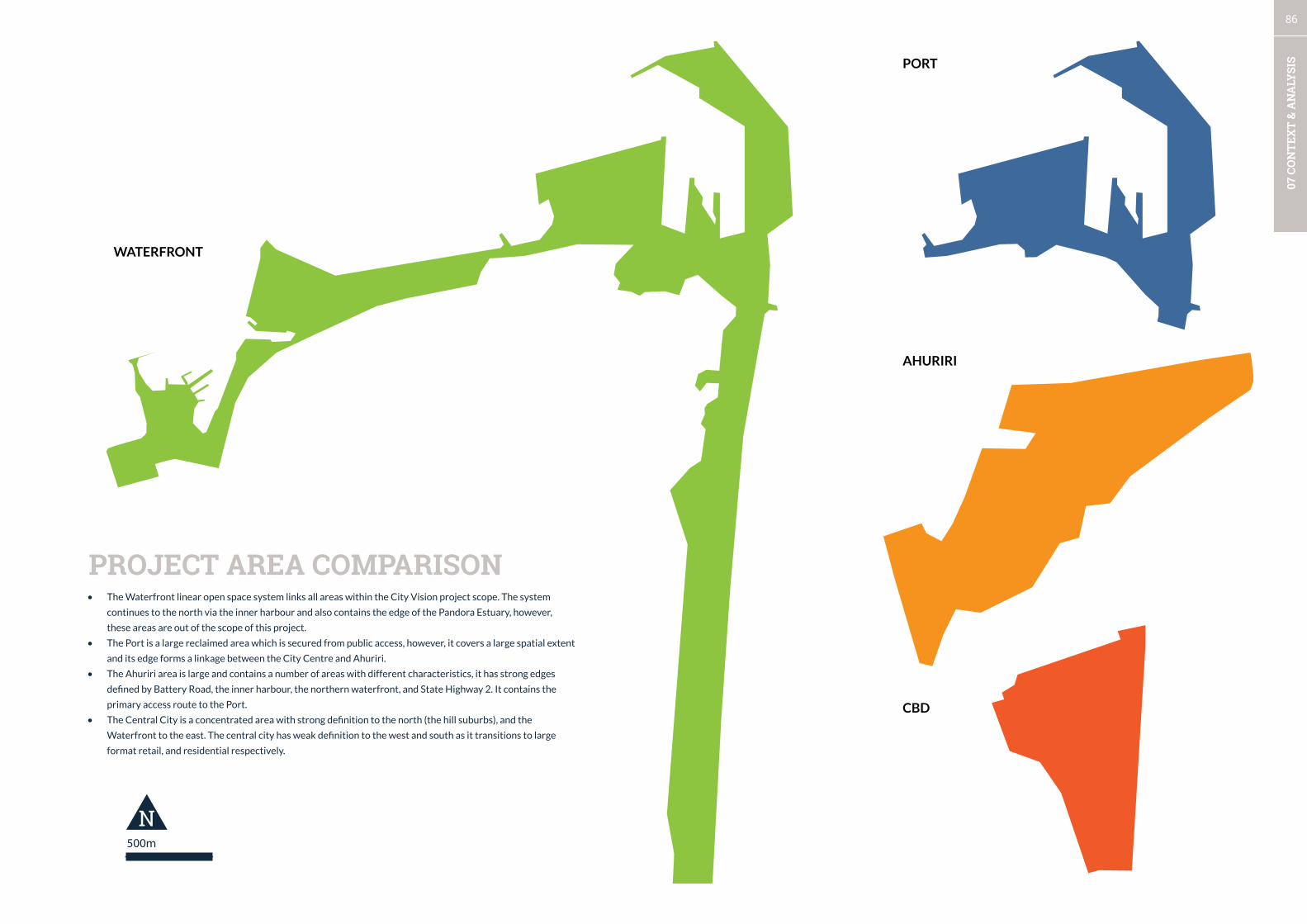
86
07 C
ON
TEX
T &
AN
ALY
SIS
500m
N
PROjECT AREAS COMPARISON PORT
wATERFRONT
AhURIRI
CBD
PROJECT AREA COMPARISON• The Waterfront linear open space system links all areas within the City Vision project scope. The system
continues to the north via the inner harbour and also contains the edge of the Pandora Estuary, however,
these areas are out of the scope of this project.
• The Port is a large reclaimed area which is secured from public access, however, it covers a large spatial extent
and its edge forms a linkage between the City Centre and Ahuriri.
• The Ahuriri area is large and contains a number of areas with different characteristics, it has strong edges
defined by Battery Road, the inner harbour, the northern waterfront, and State Highway 2. It contains the
primary access route to the Port.
• The Central City is a concentrated area with strong definition to the north (the hill suburbs), and the
Waterfront to the east. The central city has weak definition to the west and south as it transitions to large
format retail, and residential respectively.
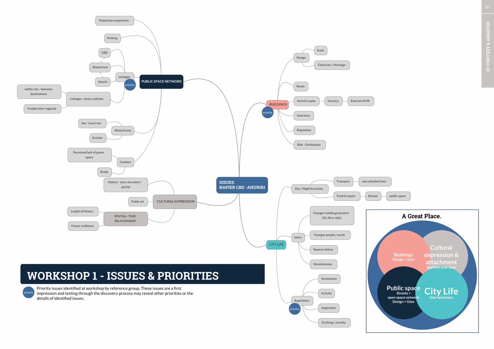
87
07 C
ON
TEX
T &
AN
ALY
SIS
ISSUESNAPIER CBD -AHURIRI
BUILDINGS
PUBLIC SPACE NETWORK
CITY LIFE
CULTURAL EXPRESSION
Parking
History - story too short /
partial
Pedestrian experience
Linkages
CBD
Waterfront
Linkages - heavy vehicles
within city - between
destinations
Freight inter-regional
Ahuriri
Waterfronts
Sea - Level rise
Erosion
Comfort
Perceived lack of green
space
Shade
Public art
SPATIAL - TIME
RELATIONSHIP
Length of history
Future resilience
Design
Activity types
Reuse
Insurance
Regulation
Risk - Earthquake
Character / Heritage
Vacancy Emerson St W
Homelessness
Day / Night Economy
Transport new alchohol laws
Users
Younger mobile generation
(25-40 yr olds)
Younger people / youth
Scale
Food & Liquor Bylaws
Experience
Excitement
Evolving / novelty
Repeat visitors
Activity
Inspiration
public space
priority
priority
priority
priority
Priorityissuesidentifiedatworkshopbyreferencegroup.Theseissuesareafirstimpressionandtestingthroughthediscoveryprocessmayrevealotherprioritiesorthedetailsofidentifiedissues.
ISSUES & PRIORITIES
A Great Place.
City LifeUser behaviour
Public spaceStreets +
open space networkDesign + Uses
BuildingsDesign + Uses
Cultural expression & attachmentImprints over time
WORKSHOP 1 - ISSUES & PRIORITIES
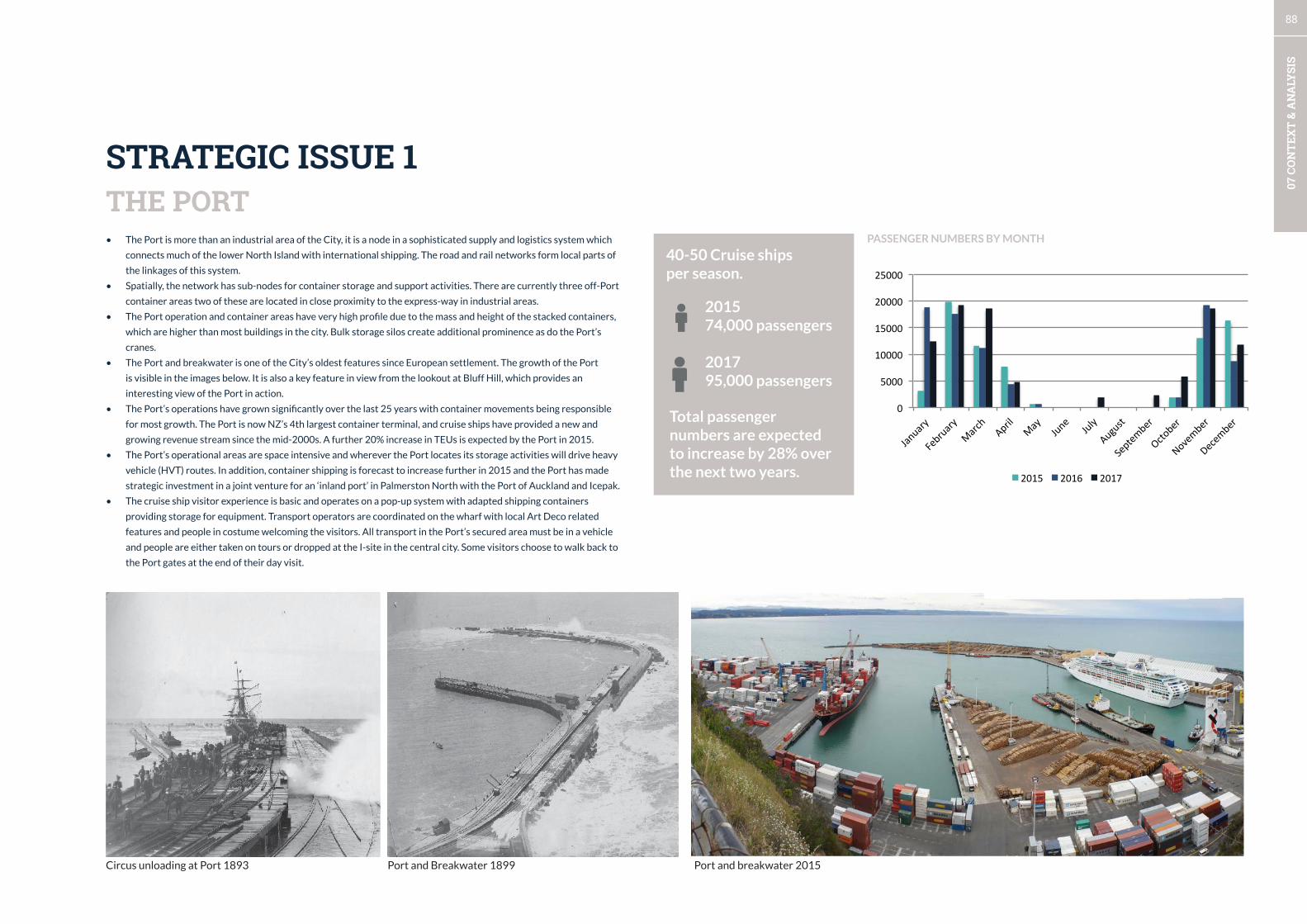
88
07 C
ON
TEX
T &
AN
ALY
SIS
• The Port is more than an industrial area of the City, it is a node in a sophisticated supply and logistics system which
connects much of the lower North Island with international shipping. The road and rail networks form local parts of
the linkages of this system.
• Spatially, the network has sub-nodes for container storage and support activities. There are currently three off-Port
container areas two of these are located in close proximity to the express-way in industrial areas.
• The Port operation and container areas have very high profile due to the mass and height of the stacked containers,
which are higher than most buildings in the city. Bulk storage silos create additional prominence as do the Port’s
cranes.
• The Port and breakwater is one of the City’s oldest features since European settlement. The growth of the Port
is visible in the images below. It is also a key feature in view from the lookout at Bluff Hill, which provides an
interesting view of the Port in action.
• The Port’s operations have grown significantly over the last 25 years with container movements being responsible
for most growth. The Port is now NZ’s 4th largest container terminal, and cruise ships have provided a new and
growing revenue stream since the mid-2000s. A further 20% increase in TEUs is expected by the Port in 2015.
• The Port’s operational areas are space intensive and wherever the Port locates its storage activities will drive heavy
vehicle (HVT) routes. In addition, container shipping is forecast to increase further in 2015 and the Port has made
strategic investment in a joint venture for an ‘inland port’ in Palmerston North with the Port of Auckland and Icepak.
• The cruise ship visitor experience is basic and operates on a pop-up system with adapted shipping containers
providing storage for equipment. Transport operators are coordinated on the wharf with local Art Deco related
features and people in costume welcoming the visitors. All transport in the Port’s secured area must be in a vehicle
and people are either taken on tours or dropped at the I-site in the central city. Some visitors choose to walk back to
the Port gates at the end of their day visit.
THE PORT
Port and Breakwater 1899Circus unloading at Port 1893 Port and breakwater 2015
STRATEGIC ISSUE 1
201574,000 passengers
201795,000 passengers
PASSENGER NUMBERS BY MONTH
0
5000
10000
15000
20000
25000
January
February
March
April
May
June
July
August
September
October
November
December
2015 2016 2017
40-50 Cruise ships per season.
Total passenger numbers are expected to increase by 28% over the next two years.
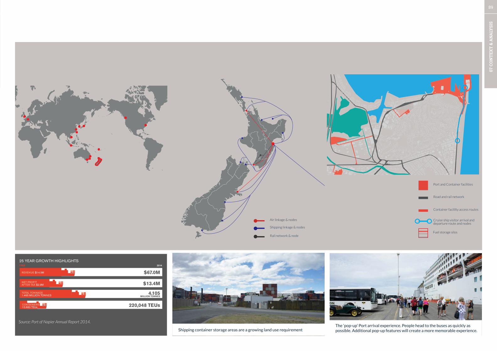
89
07 C
ON
TEX
T &
AN
ALY
SIS
32
STAKEHOLDER AND COMMUNITY
ENGAGEMENT
TRANSPORT INDUSTRY Without effective transport networks, Napier Port would struggle to handle different cargoes efficiently. In a production/export-dominated region such as Hawke’s Bay, the Port is a significant influence in the movement of heavy transport where freight is proportionately more dominant compared to the passenger transport bias of metropolitan cities. In view of this, Napier Port is an active participant in a range of forums to ensure our shippers’ and transport operators’ needs are effectively served by roading policy-makers and authorities. We try to future proof Port infrastructure, but without complementary off-port infrastructure our ability to grow may be stymied. We don’t differentiate between road, rail or sea, given the mode of choice frequently changes. Our task is to ensure we efficiently handle whatever mode our shippers use. We’re appreciative therefore of the support received from KiwiRail, NZTA, Regional Transport Committee, Territorial Local Authorities, Ministry of Transport, Maritime NZ, New Zealand Police and regional operators. While being reasonably satisfied with the current state of progress, we’re concerned about two significant interregional network issues.
The first is the dependability of numerous older bridges in the event of a major earthquake. The other is the highly questionable resilience of the Manawatu Gorge as a critical and efficient route for both road and rail users between the broader southern North Island’s eastern corridor and all points west and south. Improving the strategic network serving a significant part of New Zealand’s export oriented economy will be a focus of Napier Port future efforts.
ECONOMIC DEVELOPMENTNapier Port is a key financial supporter of Business Hawke’s Bay, the region’s economic development agency. During 2014 the Port recommitted its financial backing for a further three years as a measure of confidence in the progress being made by Business Hawke’s Bay to retain, grow and attract vibrant businesses to the region.
SPONSORSHIPFollowing a review of sponsorship activity, a number of new arrangements added to the extensive list of organisations and events supported by Napier Port. These were the Napier Port Hawke’s Bay Primary Sector Awards, Napier Port Youth Games Team, Napier Port Ocean Swim, Napier Port Paddle for Hope and Te Matau a Maui Trust’s Waka Experience.
A GENERATION ON...
25 YEARS SINCE NAPIER PORT ESTABLISHEDPort industry deregulation in the late 1980’s ushered in a sea change in how New Zealand ports were operated. Previously not-for-profit Harbour Boards “administered” ports, with Container Terminal investment licensed by central government. This structure was restrictive to most Harbour Boards and placed limits on the effectiveness of many port operations. Since 1989, Napier Port has significantly grown, now handling the vast majority of the Hawke’s Bay’s cargo base which had in part been previously shipped through other New Zealand ports. With customer-oriented investments, shipping services have grown over most years in the intervening period. 1989 saw 12,683 TEU containers being handled with an annual cargo throughput of 1.465 million tonnes. Revenues of $14.9 million and a Net Profit After Tax of $2.9 million in 1989, highlight the changed focus and significant growth the Company has enjoyed during the past 25 years.
REVENUE $14.9M
1989 2014
$67.0M
$13.4M
TOTAL TONNAGE 1.465 MILLION TONNES 4.105
MILLION TONNES
25 YEAR GROWTH HIGHLIGHTS
220,048 TEUs
NET PROFIT AFTER TAX $2.9M
CONTAINERS 12,683 TEUs
PORT OF NAPIER LIMITED ANNUAL REPORT 2014PORT OF NAPIER LIMITED ANNUAL REPORT 2014 3231 PORT OF NAPIER LIMITED ANNUAL REPORT 201431
PORT CONNECTIONSGlobal National Local
The container volume passing through Napier Port has increased by 1635% in 25 years. In 2015 a further increase to over 250,000 TEUs is expected.
Source: Port of Napier Annual Report 2014.
Air linkage & nodes
Shipping linkage & nodes
Rail network & node
Port and Container facilities
Cruise ship visitor arrival and departure route and nodes
Road and rail network
Container facililty access routes
Fuel storage silos
The ‘pop-up’ Port arrival experience. People head to the buses as quickly as possible. Additional pop-up features will create a more memorable experience.Shipping container storage areas are a growing land use requirement

90
07 C
ON
TEX
T &
AN
ALY
SIS
• Heavy vehicle traffic has become a major issue in the city as the containerisation of shipping has grown.
• The City has an integration issue with its waterfront along Marine Parade which has resulted from two incompatible
functions - the area being a route to the Port, and as a premier ‘place’ in the City.
• Heavy vehicles routes become clear when addressed at a strategic scale, and the percentage of heavy traffic is
visualised (see next page). Mapping allows identification of potential alternative routes for heavy traffic where
appropriately designated roads with low capacity exist.
• Data for heavy vehicle traffic for areas in Ahuriri were not available at the time of this report’s preparation. An area
of interest around Ossian, Lever, and Coronation Streets currently experience low total traffic volumes, it is unknown
how many heavy vehicle movements occur in this area where the land use characteristics have changed in line with the
mixed use status of the area. Traffic speed data was also unavailable for the preparation of this report.
• The high to medium amounts of heavy vehicle use along the southern connector (Hyderabad - Pandora - SH2) raise
issues for other road-users, in particular, how to connect active transport routes from residential areas and the central
city to Ahuriri and the Pandora estuary where recreation opportunities are planned to increase.
• The State Highway route between Marine Parade and the Southern connector have low HVT volumes and provides
an alternative route to Marine Parade. Sections of Marine Parade currently accommodate between 250-500 heavy
vehicles per day which would be a marginal increase along a State Highway designated route.
HEAVY VEHICLE ROUTES
ALL TRAFFIC VOLUMESSTRATEGIC ISSUE 2
Street of Interest Section HVT Volume HVT Percentage
SH2 Ahuriri northwards High High
Ahuriri bypass SH2 to Ahuriri Village High High
Ahuriri bypass Peanut to Port Medium High
Kennedy To Tennyson High High
Tennyson To Marine Parade High High
Marine Parade SH2 to Port Low Medium
SH2 Marine Parade to Southern Connector
Low Low
SH2 (southern connector) Thackery/Carlyle to Ahuriri junction
High Medium
Express-way Southern Connector to South
High High
0 to 200
200 to 1,000
1,000 to 1,500
1,500 to 3,000
3,000 to 7,000
7,000 to 10,000
10,000 to 24,000
Average Annual Daily Traffic Approximately 10,700 vechicles use Tennyson Street per day, 20% of these are heavy vehicles.
Heavy vehicles on Marine Parade are limiting its potential as a waterfont destination.

91
07 C
ON
TEX
T &
AN
ALY
SIS
HEAVY VEHICLE TRAFFIC VOLUME HEAVY VEHICLE TRAFFIC PERCENTAGE
0 to 100
100 to 250
250 to 500
500 to 750
750 to 1,000
1,000 to 2,250
Heavy Traffic Volume
0 to 2.5%
2.5 to 5%
5 to 7.5%
7.5 to 10%
10 to 15%
15 to 40%
Heavy Traffic PercentageCombined lane totals for sections of Marine Parade are estimated to vary between 275-500 heavy vehicles per day.
Heavy Vehicle traffic accounts for 27% of traffic on Ahuriri Bypass.
Potential alternative HVT route to Marine Parade State Highway.

92
07 C
ON
TEX
T &
AN
ALY
SIS
• According to Logan Stone (right) retail occupancy is at its lowest levels of the last-ten years, although there has been a
slight improvement in the last 6 months (Increasing vacancy is an issue in Hastings as well ). Logan Stone’s commentary
suggests that the structure of central business districts needs to change in relation to an ongoing reduced retail
footprint size in central areas of provincial cities.
• The vacancies in Napier city centre are highly localised with most occurring in Emerson St West and the next block over
on Tennyson St (See the graph below).
• In Ahuriri vacant frontages account for 9% of all frontages. However, the absolute numbers are low, and the properties
are large in comparison to the central city where tenancies are generally small.
• Napier City staff are investigating the successful Renew Newcastle programme from Australia which is used to tenant
vacant buildings in the short-medium term. Due to the concentration of vacant properties in the central city this
programme can have a high impact and profile.
• The drivers behind vacancy and business closures needs to be more fully understood, along with the desires of potential
start-ups and temporary users, and integrated with the proposed introduction of a ‘Renew Napier’ programme.
RETAIL & ATTRACTING INVESTMENTSTRATEGIC ISSUE 3
LOCATIONS OF VACANT FRONTAGES FEBRUARY 2015 IN STUDY CITY VISION STUDY AREA
COMMENTARY FROM LOGAN STONE RETAIL OCCUPANCY SURVEY FEB 2015 P.1 (EMPHASIS ADDED).
205 Hastings Street South PO Box 914 Hastings 4156 New Zealand [email protected] Ph: 64 6 870 9850 www.loganstone.co.nz
“Over the longer term, occupancy is decreasing in the traditional retail precincts of the region. This is the result of changing retail habits and the increasing supply of competitive premises away from the retail cores. This together with the current low population growth and increased competition from online activity suggests there is little reason for occupancy levels to increase in the near future.
Regeneration and increased activity is required if the occupancy trend is to be reversed in the main centres. Retailers are attracted to places where people are present or can easily access.... global trends suggest that for low growth provincial centres the structure of central business districts needs to change with a reduced space requirement for traditional retail business.”
LOGAN STONE RETAIL OCCUPANCY SURVEY FEB 2015
0
1
2
3
4
5
6
7
8
9
10
ALBIO
N
BROW
NING
BYRON
CARPARK -‐ DICKENS W
EST
CIVIC COURT
CLIVE SQUARE WEST
DALTON
DICKENS
EMERSON
HASTINGS
HERSCHEL
MARIN
E PARADE
MARKET
MUNROE
PAXIES LN
RAFFLES
SHAKESPEARE
STATION
TENNYSON
VAUTIER
CARPARK -‐ DICKENS EAST

93
07 C
ON
TEX
T &
AN
ALY
SIS
EARTHQUAKE PRONE BUILDINGS AND POTENTIAL DEVELOPMENTS
LOCATION OF POTENTIALLY EARTHQUAKE PRONE BUILDINGS*
*Earthquake prone building assessments are currently being carried out. This data is accurate only so far as council systems can provide information.
• The majority of potentially earthquake prone buildings are located in the city centre. This is unsurprising given the
rebuild from the 1931 earthquake. The concentration of the buildings from this period also form a large part of the
heritage resource.
• Most of the potentially earthquake prone buildings are located on Hastings (28), Emerson (23), Tennyson (15) Streets.
• It is likely that the EQPB issue overlaps with the vacancy issue as in the short-term businesses mitigate risk while
property owners and landlords move tennants around while strengthening occurs. With the large amount of properties
protentially requiring earthquake strenghtening the CBD may be relatively fluid in terms of business relocations.
• There are few Council buildings which are identified as EQPB. These are a part of an LTP programme which is further
outlined on page 16.
• Council is considering preparation of a LGNZ remit which will seek support from other Local Authorities in order to
reduce strengthening requirements and the flow on economic burden to property owners for a change in use scenario.
• Council has many large and widespread properties throughout the city which highlight its role in providing public
facilities and car-parking.
Council property
Earthquake prone buildings
Potential developments
Heritage building
0
5
10
15
20
25
30
West Quay
Waghorne
Tennyson
Shakespeare
Market
Herschell
Has<ngs
Emerson
Dickens
Dalton
Browning
PAGE INTENTIONALLY BLANK

94
07 C
ON
TEX
T &
AN
ALY
SIS
CAR PARKING & CONNECTIONS
0
500
1000
1500
2000
2500
2008 2009 2010 2011 2012 2013 2014
Off-‐Street Spaces On-‐Street Spaces
PUBLIC CAR-PARKING PROVISION
• Parking provision is seen as an attractor for development in city centre. High value is being placed upon providing
certainty to users and for commuter leased parking for workers. At the peak period of the year (December), parking
occupancy is between 90-100% for most places in the city except the Marine Parade South car-park (see map on
following page). At other times of the year parking occupancy is unknown.
• The development on Marine Parade and the ex-Marineland site will change a long established pattern of parking
provision, by reducing leased parking by 100.
• Large format retail has produced large areas or car-parking throughout the central city’s periphery which creates
poorly-defined entrance experiences and inactive or blank frontages to the street.
• In 2009, a car-parking building and for the Vautier Street area and pedestrian connections to Emerson Street were
proposed and concept designs completed with staging. Part of Stage 1 (pg 29 Urban Perspectives, 2009) of this plan
have been progressed - these are:
• 1. Construct/establish a café & walkway
• based on the ‘Soda Bar’ model
• 2. Remove the existing Senior Citizens’ building, establish at grade carpark to be rented to the HBRC
• 3. Future extension to the HBRC building
• 4. Purchase the Rawcliffe Building
• 5. Develop a site-specific design brief for the Parking Building; initiate a design competition to select architects.
• Total on-street public car-parking provision has decreased slightly since 2008, while off-street spaces have increased
slightly (see graph below, from TDG, 2015).
• At-grade car parks provide convenient access to retail and business areas, but they have also created large inactive
areas and reduced walkability and safety benefits from passive surveillance of the street. Few blocks are intact and
retain a wholy urban character with buildings lining the street edge.
• In Ahuriri, at-grade parking provision which is built to the street edge breaks the unique and established character of
the area. However, it also creates mid-block connections and shortcuts through the warehouse district.
This area connects to a large area of public car-parking on the waterfront. The landscaping is disconnected between the buildings and there is no coherent walkway, or way-finding. In future the landscaping on the waterfront must be used to create a cohesive experience.
The old waterfront car-park which will be replaced with water play areas and parking. A substantial amount of leased parking will be relocated. The quality of this area of waterfront should improve dramatically with the redevelopment.
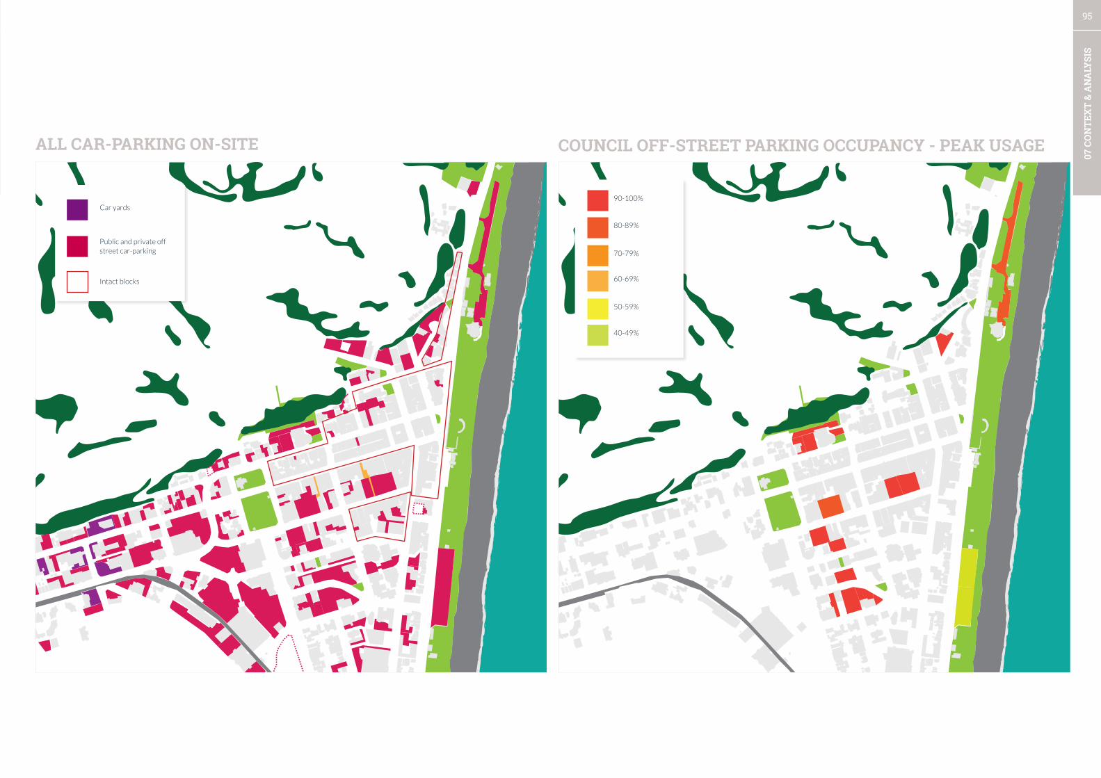
95
07 C
ON
TEX
T &
AN
ALY
SIS
ALL CAR-PARKING ON-SITE COUNCIL OFF-STREET PARKING OCCUPANCY - PEAK USAGE
Car yards
Public and private off street car-parking
40-49%
50-59%
60-69%
70-79%
80-89%
90-100%
Intact blocks

96
07 C
ON
TEX
T &
AN
ALY
SIS
• A significant amount of public design work, proposals, and private development has been progressed to varying stages
(see table and map on following page), the current status of the varying guides, plans and proposals has been difficult to
pinpoint and it is unknown how much many of these projects and proposals would cost. These existing projects and the
assumptions embedded within them form the backdrop to the City Vision project, some may be incorporated, others
may be challenged and adapted to fit with new strategies. Plans and concept diagrams appear on pages 18-21.
• The number of projects and scale of proposals is an indication of the positive and proactive approach in Napier towards
city development.
• The scope of some of the projects is too narrowly defined which means opportunities will be missed. It is of critical
importance to link projects together to create a multiplier effect. Additional coordination, staging of projects and formal
design review processes for prominent public spaces is desireable.
• There are some significant areas of private redevelopment on the Hospital Hill which will relate to Ahuriri in particular
which will introduce an additional 34 houses and 62 apartments. This development is outside of the scope of the project,
it will be visible from Ahuriri and other areas of the city.
• The Long Term Plan proposes a number of programmes with substantial funding relevant to the project area. Few of
these have existing plans or concept plans.
• Council has signalled the need to invest in several key public buildings in the central city (see 14-16 right). These have
associated public spaces which will be critical to integrate into the design process to maximise the benefit of these
investments.
• Napier Streetscape Design Guide (2000) - a design guide was created for the central city which outlined principles,
paving, and plant species for the central city. Some of the streetscape developments of the last 14 years have followed
its guidance - in part. A new set of technical document should be created in due course to update design guidance and
replace this document with a series of which relate to each framework area.
• Clive Square CPTED Assessment is being carried out by Harrison Grierson Consultants. The recommendations will
inform the CBD area framework.
COORDINATING PROJECTS
STRATEGIC ISSUE 4
• The Long Term Plan is currently being consulted on and this project list may change as a result of the consultation.
# PROJECT STATUS INITIATOR VALUE
1 ex-Marineland (skate-park/play area) Tendered - design only NCC $5+ million
2 Vautier Car-parking & links Stage 1 complete NCC unknown
3 Treaty settlement - Munroe Car-parking Negotiation OTS unknown
4 Hastings St upgrades Construction commenced NCC unknown
5 Paxies Lane public art Pending/On hold NCC $50,000
6 Lower Emerson St Clive Square lighting planned
Napier Business Assoc. unknown
7 ‘Pier’ / Storm-water - exact location unknown unknown NCC unknown
8 Napier Hill Development - Two apartment blocks, Town-houses, detached houses, cafe.
Resource consent issued Todd property/PMA Archi-tects
unknown
9 Arohaina apartments (part of Napier Hill development)
Sales Todd property/PMA Archi-tects
unknown
10 NZ Rail / Opus Landscape options - weighbridge area
Concept NZ RAIL /Opus unknown
11 The Business Hub Under construction NCC / others / The Icehouse unknown
12 BAT traffic scheme Concept/Engineering plans NCC unknown
13 Ahuriri Northern beach Concept NCC unknown
14 Earthquake strengthening Memorial Square LTP Consultation NCC Part of $1.6 million fund for strength-ening EQPB council buildings
15 Civic Centre and Library Redevelopment LTP Consultation NCC Part of $7.3 million fund for building upgrades
16 Convention Centre Development LTP Consultation NCC $4.5 million over 10 years
17 West Quay Ahuriri Traffic improvements LTP Consultation NCC $2.7 million
18 I-site upgrade LTP Consultation NCC $740,000 over 3 years
19 Pandora Pond Water sports project LTP Consultation NCC $5.1 Million over 3 years
20 Napier cycling strategy LTP Consultation(Napier Cycling Strategy)
NCC $4.8 over 6 years
21 Clive Square CPTED Assessment In progress NCC unknown
22 BAT Development framework (Urban Perspectives)
Unknown NCC/BAT unknown
CURRENT PROJECTS & PROPOSALS STATUS
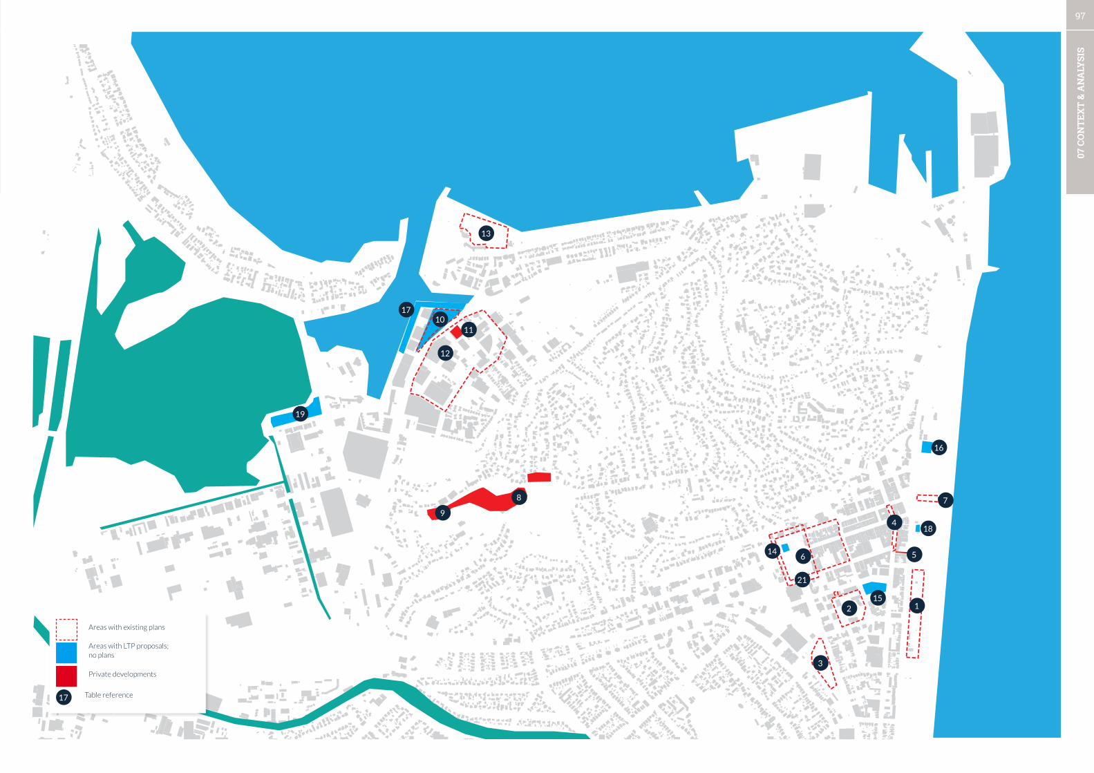
97
07 C
ON
TEX
T &
AN
ALY
SIS
12
3
4
56
21
78
9
1011
12
13
14
15
16
17
18
19
Areas with existing plans
Areas with LTP proposals; no plans
Private developments
17 Table reference
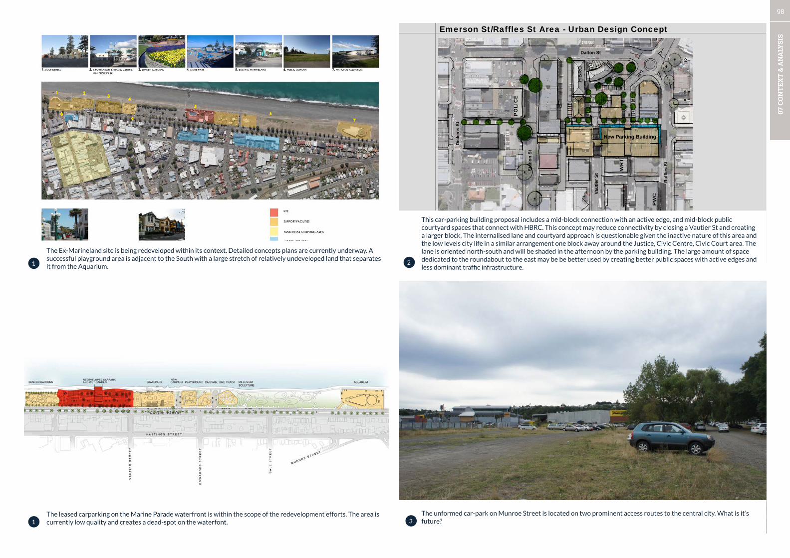
98
07 C
ON
TEX
T &
AN
ALY
SIS
Prepared for Napier City Council by Urban Perspectives Ltd, May 2009 40
Pedestrian Link & Parking Building Project Emerson St/Raffles St Area - Urban Design Concept
Indicative view from the north/west
HB
RC
WR
T
PO
LIC
E
PW
C
Monroe St
Dic
kens
St
Stat
ion
St
Raf
fles
St
Dalton St
New Parking Building
Vaut
ier S
t
The unformed car-park on Munroe Street is located on two prominent access routes to the central city. What is it’s future?
The leased carparking on the Marine Parade waterfront is within the scope of the redevelopment efforts. The area is currently low quality and creates a dead-spot on the waterfont.
The Ex-Marineland site is being redeveloped within its context. Detailed concepts plans are currently underway. A successful playground area is adjacent to the South with a large stretch of relatively undeveloped land that separates it from the Aquarium.
This car-parking building proposal includes a mid-block connection with an active edge, and mid-block public courtyard spaces that connect with HBRC. This concept may reduce connectivity by closing a Vautier St and creating a larger block. The internalised lane and courtyard approach is questionable given the inactive nature of this area and the low levels city life in a similar arrangement one block away around the Justice, Civic Centre, Civic Court area. The lane is oriented north-south and will be shaded in the afternoon by the parking building. The large amount of space dedicated to the roundabout to the east may be be better used by creating better public spaces with active edges and less dominant traffic infrastructure.
1
1
2
3

99
07 C
ON
TEX
T &
AN
ALY
SIS
3.
2.
4.5.
6.7.
8.
P 19
THE BIG PICTURE
Precinct Approach
BOUTIQE SHOPPING PEDESTRIANS CAFE
EV
EN
TS M
AR
KE
T
FARMERS MARKETFARMERS MARKET
FARMERS MARKETFARMERS MARKET
EV
EN
TS M
AR
KE
T
©AV13
1.
Central city streetscape improvement for Hastings St - will it create a memorable, walkable street? The integration with Emerson Street may need to be rethought to give higher priority to the cities most lively street.
The Inner City business association comissioned this area framework (Vile, 2013) for Emerson Street West and Clive and Memorial Square. A new CPTED assessment is underway for this area by Harrison Grierson.
Paxies Lane - a public art installation has been proposed for the blank wall along this lane. Active frontages to the lane would be preferable. General location of the ‘pier’ storm-water outfall (detail not supplied).
4
5
6
7

100
07 C
ON
TEX
T &
AN
ALY
SIS
A H U R I R I R A I L W A Y C O R R I D O R E N H A N C E M E N T P R O P O S A LL E V E R S T R E E T T O C U S T O M H O U S E - C O N C E P T D E S I G N
DRAFT - For DiscussionAugust 2014Design: S Steyn Drawn: S Steyn
R : \ 2 T _ P r o j e c t s \ t 1 0 3 2 . p p - L e v e r C u s t o m s E n h a n c e m e n t
PERSPECTIVE LOOKING FROM LEVER STREET TO CUSTOM HOUSE
STAGE 3 - INFILL PLANTING / HARD LANDSCAPE ELEMENTS
SCULPTURAL ELEMENTS AS FOCAL POINT VIEW FROM OSSIAN STREET LOOKING TOWARDS SCULPTURAL FEATURE
PLAN SHOWING ADDITIONAL LOW GROWING PLANTING
Concept only - provided by OPUS Consultants and NZ Rail to create a better corridor experience to the Port - well thought out use of materials and attention to views.
A housing development with a mix of housing types and a cafe will replace the closed hospital towers.
The future business hub location in Ahuriri on Ossian Street. How will the area’s public spaces need to change to support the change in uses?More low-rise apartments on the Napier hill take advantage of outstanding views.
8
9
10
11

101
07 C
ON
TEX
T &
AN
ALY
SIS
British American Tobacco Site, Ahuriri: Urban Design Assessment: Summary Report Prepared for Napier City Council by Urban Perspectives Ltd, February 2007
1
• Create two distinctive entrances to the area from Riddell St and Coronation St (Ossian St and Lever St ‘left in-left out’ only) • Link the two entrances to an internal ‘crescent’ running along Riddell St/Domett St and connecting to Coronation St via a new link • Create informal pedestrian crossing points at the ‘peanut roundabout’ and at Riddell St • Create informal pedestrian facilities at Lever St and Ossian St intersections • Create a new roundabout (or other traffic calming measure) at Coronation St/Battery Rd intersection • Widen footpath along eastern side of Bridge St, enhance with trees, feature lights, paving. Give special design attention to the area in front of the Rothman’s Building • Treat Lever St and Ossian St as slow vehicle areas - widen footpath on one side (e.g. west facing), create 90 degree parking on the opposite side, provide enhanced landscape treatment • Treat Ossian St and Lever St as enhanced green links • Create continuous cross connection linking Coronation St and Riddell St with a possibility to extend to the Ahuriri Reserve • Extend Tu Atu St to link to Ossian St via the existing on-site lane
• Treat Domett St (to the south of Lever St) as an enhanced pedestrian/green link to the Ahuriri Reserve • Treat Tu Atu St, Mahia St and Campbell St as lanes with an enhanced pedestrian character. Opportunity to create a ‘pocket park’ at the Ossian St end of the new cross link extending Tu Atu St - to enhance visual connections to key heritage buildings • Maintain key heritage buildings; encourage quality design for new buildings (e.g. design guidelines) • Create ‘transition of activities’ (from west to east) from a more ‘active commercial frontage’ around Bridge St, through mixed use activities to residential • Facilitate development opportunities of key sites through public/private initiatives
B.A.T. Site & Context: Urban Design Principles & Ideas
Road plans to give effect to the BAT report and traffic calming on West Quay. Formalised parking provision creating a unified access between Lever St and West Quay, and to resolve health and safety issues for the wharf.
NCC commisioned this beach redesign. Is the scope big enough and could more be achieved by including the car-parking area?
Clive Square CPTED Assessment diagram (when completed)
The BAT Development Framework (2007) seeks restructuring of circulation, connections and street design.
12
13
21
22

102
07 C
ON
TEX
T &
AN
ALY
SIS
NETWORKS

103
07 C
ON
TEX
T &
AN
ALY
SIS
• The city has a strong and interesting landscape character which it can capitalise upon. Potential exists to sensitively
restore ecological networks through the city and on the hills, which will createe both ecological, cultural, and
economic value.
• The city centre has strong pedestrian connections but lacks connection to the waterfront. Heavy vehicle traffic has
limited the development of Marine Parade as a street for people and activity.
• Ahuriri has good connection along the waterfront but lacks connection between sub-areas Ahuriri village, Ossian/
Lever St/Coronation St, and West Quay.
• The central city and Ahuriri lack street tree planting and landscaping on high use routes.
• The Southern Connector is the entrance to the City from multiple regional routes yet it is utilitarian, and lacks a sense
of arrival and way-finding. This route is heavily used by both passenger and heavy vehicles.
• The City and Ahuriri have walkable city block structures with a variety of nodes and it is apparent much effort has
gone into creating better uninterrupted walking experiences (especially in the central city).
• The shared route past the Port is utilitarian. Landscaping and other creative measures are required.
• The route to the Bluff Hill is circuitous and confusing, and there is no convenient route from Ahuriri to the lookout.
NETWORKS SUMMARY RECOMMENDATIONS
1. Expression of the pre-european and pre-earthquake landscape will give depth to the experience in the city.
2. Create clear pedestrian priority connections to the Waterfront from the central city across Marine Parade.
3. Create safe connections across Ahuriri bypass to the mixed-use district.
4. Create an integrated (open space and landscaping, buildings, transport) long-term solution between West
Quay and Bridge St that resolves the ‘peanut’ intersection.
5. Prioritise landscape and street tree planting on Tennyson (infrastructure issues), Hastings and Dalton
Streets and as a companion to improving the public space network.
6. Create a sequence of landmarks along the Southern Connector, a separated and safe cycling connection,
and a coherent landscape approach from the Bridge to City.
7. The quality of pedestrian experience between walkable catchment nodes should be a core driver of
streetscape and reserve upgrades. Car-parking catchments provide additional focus areas for improved
pedestrian connections.
8. Placemaking and activation strategies need to be concentrated and focussed within walkable catchment
areas to maximise the benefit for the city’s vitality.
9. Addtional landscaping past the Port is required to improve and humanise the coastal shared path.
10. Investigate connection between Ahuriri and the Bluff Hill lookout to add an additional node on the
waterfront experience and shared pathway.

104
07 C
ON
TEX
T &
AN
ALY
SIS
WHAT’S GOOD
• Napier is dominated by the three main features: the gravel coastline, the harbour and estuary, and the hills. Across the
plains the ranges create a clear and distant spatial datum for the district. These ranges are outside of the focus of this
report, but the features are generally well known and identified as part of an LTP program the Backdrop of Napier.
• A notable feature of the area is its newness (85 years), due to the raised estuary sea bed from the 1931 earthquake and
other land reclamation such as the port which has significantly altered the area. The city is left with a relatively ‘new’
landscape - and an opportunity to create value.
• The coastal hills are broken into a series of peaks and gullies which are disorienting for a newcomer to the area as the
road network follows the organic forms.
• Ahuriri is sited in a very favourable location with northern and western exposure for a great quality of sunlight for most
of the day, whereas the city centre is sited in a more exposed southern and shady side of the hills.
• The variation of the landforms is extremely interesting - views from different directions and from near to far provide
for a constantly changing understanding and experience as one moves around the city via the waterfront or southern
connector.
• Large areas of mixed vegetation cover the gullies and hillsides and are visually prominent. The ecological values of the
hillside and gully vegetation is unknown.
• The long eastern gravel shoreline is a large and linear open space network which extends for the entirety of the city. It
is uninterrupted on the seaward side of the road except for small pockets of development. The foreshore area appears
relatively barren for its entire length apart from some patches of intensive planting and landscaping in the urban area.
• The rocky shoreline to the north of the hills has become obscured by the Port development and other land reclamation.
The Port area is now as large as the city centre to the south, a substantial change to the pre-european situation which is
shown in the diagram to the right.
WHAT NEEDS IMPROVEMENT
• Views and viewing areas from the hills are generally privatised and the public domain on the cliff overlooking the Port is
difficult to locate.
• Local landmarks or other way-finding through the hills will increase local identity and connections. In addition, pre-
european place names will aid with creating identity in areas which currently have generic names (e.g. Hospital Hill,
Bluff Hill).
• Urban streams and water-bodies appear degraded or ornamental and may be condidates for ecological restoration.
LOCAL LANDFORMS
Napier is the result of deep structural geological processes and surface structure changes imposed by people. The place is relatively ‘new’ in geological timescales and this offers the citizens and city potential to help create ecological value (and repair poor environmental practices of the past) and develop ecosystem services which have never existed in this location.
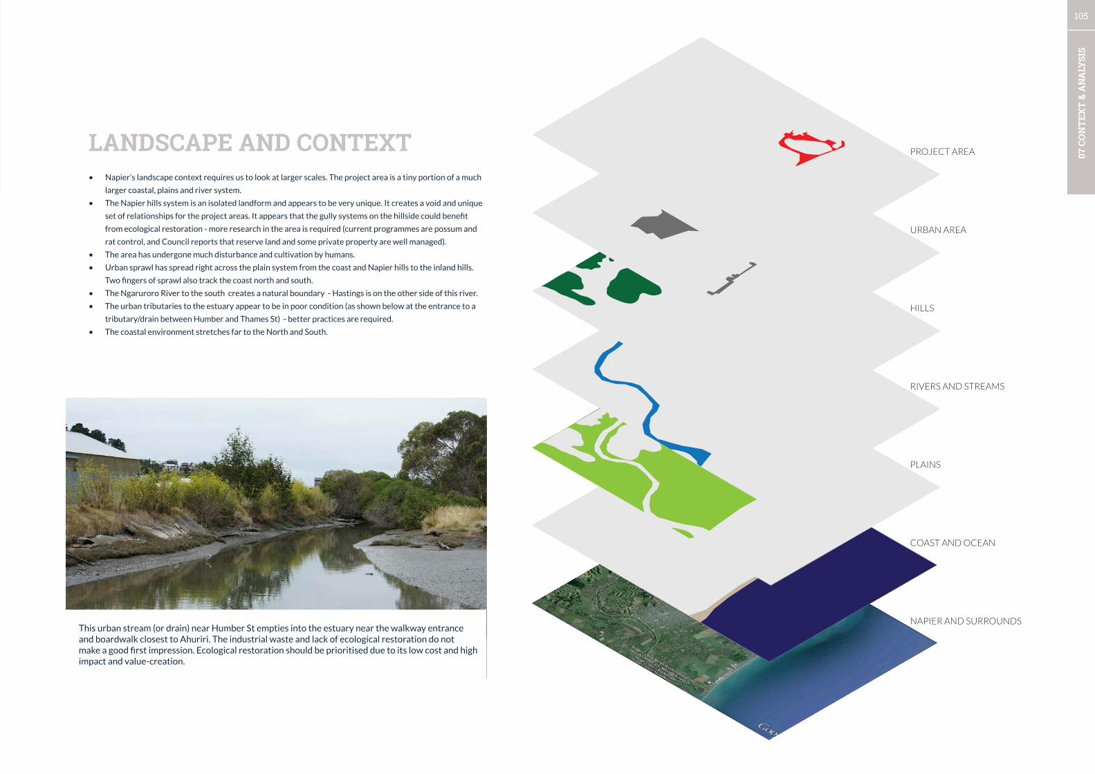
105
07 C
ON
TEX
T &
AN
ALY
SIS
LANDSCAPE AND CONTEXT
This urban stream (or drain) near Humber St empties into the estuary near the walkway entrance and boardwalk closest to Ahuriri. The industrial waste and lack of ecological restoration do not make a good first impression. Ecological restoration should be prioritised due to its low cost and high impact and value-creation.
• Napier’s landscape context requires us to look at larger scales. The project area is a tiny portion of a much
larger coastal, plains and river system.
• The Napier hills system is an isolated landform and appears to be very unique. It creates a void and unique
set of relationships for the project areas. It appears that the gully systems on the hillside could benefit
from ecological restoration - more research in the area is required (current programmes are possum and
rat control, and Council reports that reserve land and some private property are well managed).
• The area has undergone much disturbance and cultivation by humans.
• Urban sprawl has spread right across the plain system from the coast and Napier hills to the inland hills.
Two fingers of sprawl also track the coast north and south.
• The Ngaruroro River to the south creates a natural boundary - Hastings is on the other side of this river.
• The urban tributaries to the estuary appear to be in poor condition (as shown below at the entrance to a
tributary/drain between Humber and Thames St) - better practices are required.
• The coastal environment stretches far to the North and South.
PROJECT AREA
URBAN AREA
PLAINS
HILLS
RIVERS AND STREAMS
COAST AND OCEAN
NAPIER AND SURROUNDS
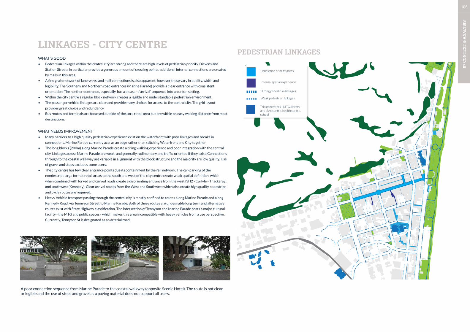
106
07 C
ON
TEX
T &
AN
ALY
SIS
WHAT’S GOOD
• Pedestrian linkages within the central city are strong and there are high levels of pedestrian priority. Dickens and
Station Streets in particular provide a generous amount of crossing points, additional internal connections are created
by malls in this area.
• A fine grain network of lane-ways, and mall connections is also apparent, however these vary in quality, width and
legibility. The Southern and Northern road entrances (Marine Parade) provide a clear entrance with consistent
orientation. The northern entrance, especially, has a pleasant ‘arrival’ sequence into an urban setting.
• Within the city centre a regular block network creates a legible and understandable pedestrian environment.
• The passenger vehicle linkages are clear and provide many choices for access to the central city. The grid layout
provides great choice and redundancy.
• Bus routes and terminals are focussed outside of the core retail area but are within an easy walking distance from most
destinations.
WHAT NEEDS IMPROVEMENT
• Many barriers to a high quality pedestrian experience exist on the waterfront with poor linkages and breaks in
connections. Marine Parade currently acts as an edge rather than stitching Waterfront and City together.
• The long blocks (200m) along Marine Parade create a tiring walking experience and poor integration with the central
city. Linkages across Marine Parade are weak, and generally rudimentary and traffic oriented if they exist. Connections
through to the coastal walkway are variable in alignment with the block structure and the majority are low quality. Use
of gravel and steps excludes some users.
• The city centre has few clear entrance points due its containment by the rail network. The car-parking of the
nondescript large format retail areas to the south and west of the city centre create weak spatial definition, which
when combined with forked and curved roads create a disorienting entrance from the west (SH2 - Carlyle - Thackeray),
and southwest (Kennedy). Clear arrival routes from the West and Southwest which also create high quality pedestrian
and cycle routes are required.
• Heavy Vehicle transport passing through the central city is mostly confined to routes along Marine Parade and along
Kennedy Road, via Tennyson Street to Marine Parade. Both of these routes are undesirable long term and alternative
routes exist with State Highway classification. The intersection of Tennyson and Marine Parade hosts a major cultural
facility - the MTG and public spaces - which makes this area incompatible with heavy vehicles from a use perspective.
Currently, Tennyson St is designated as an arterial road.
LINKAGES - CITY CENTREPEDESTRIAN LINKAGES
A poor connection sequence from Marine Parade to the coastal walkway (opposite Scenic Hotel). The route is not clear, or legible and the use of steps and gravel as a paving material does not support all users.
Pedestrian priority areas
Internal spatial experience
Strong pedestrian linkages
Weak pedestrian linkages
Trip generators - MTG, library and civic centre, health centre, school
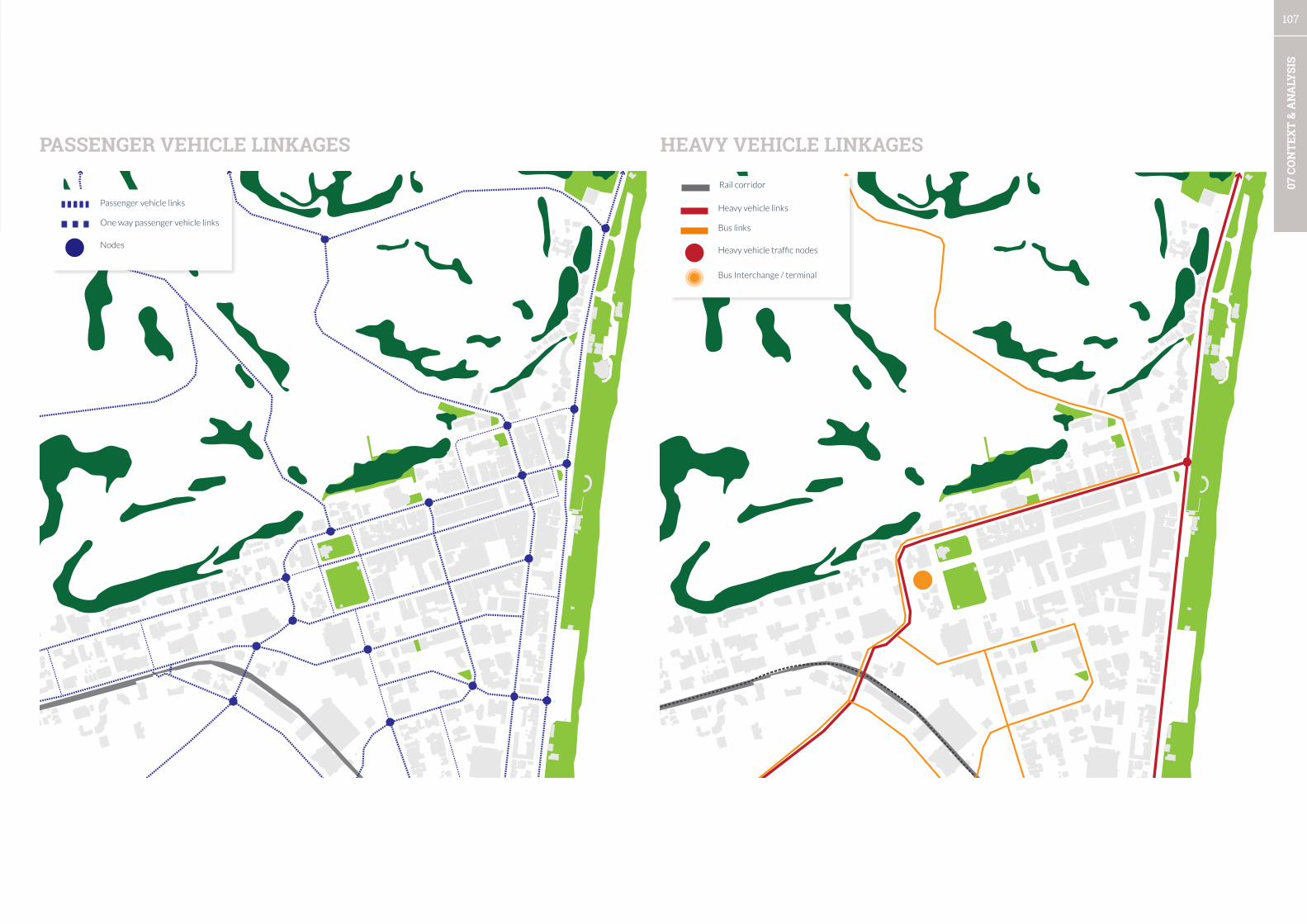
107
07 C
ON
TEX
T &
AN
ALY
SIS
PASSENGER VEHICLE LINKAGES HEAVY VEHICLE LINKAGES
Heavy vehicle links
Bus links
Heavy vehicle traffic nodes
Bus Interchange / terminal
Passenger vehicle links
One way passenger vehicle links
Nodes
Rail corridor
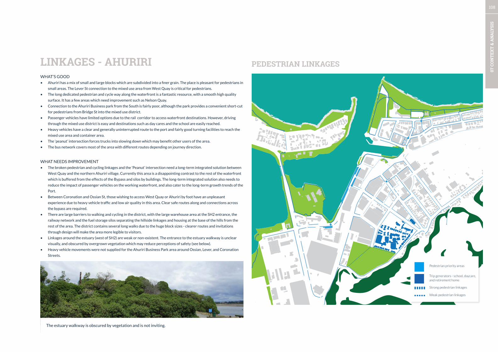
108
07 C
ON
TEX
T &
AN
ALY
SIS
WHAT’S GOOD
• Ahuriri has a mix of small and large blocks which are subdivided into a finer grain. The place is pleasant for pedestrians in
small areas. The Lever St connection to the mixed use area from West Quay is critical for pedestrians.
• The long dedicated pedestrian and cycle way along the waterfront is a fantastic resource, with a smooth high quality
surface. It has a few areas which need improvement such as Nelson Quay.
• Connection to the Ahuriri Business park from the South is fairly poor, although the park provides a convenient short-cut
for pedestrians from Bridge St into the mixed use district.
• Passenger vehicles have limited options due to the rail corridor to access waterfront destinations. However, driving
through the mixed use district is easy and destinations such as day cares and the school are easily reached.
• Heavy vehicles have a clear and generally uninterrupted route to the port and fairly good turning facilities to reach the
mixed use area and container area.
• The ‘peanut’ intersection forces trucks into slowing down which may benefit other users of the area.
• The bus network covers most of the area with different routes depending on journey direction.
WHAT NEEDS IMPROVEMENT
• The broken pedestrian and cycling linkages and the ‘Peanut’ intersection need a long-term integrated solution between
West Quay and the northern Ahuriri village. Currently this area is a disappointing contrast to the rest of the waterfront
which is buffered from the effects of the Bypass and silos by buildings. The long-term integrated solution also needs to
reduce the impact of passenger vehicles on the working waterfront, and also cater to the long-term growth trends of the
Port.
• Between Coronation and Ossian St, those wishing to access West Quay or Ahuriri by foot have an unpleasant
experience due to heavy vehicle traffic and low air quality in this area. Clear safe routes along and connections across
the bypass are required.
• There are large barriers to walking and cycling in the district, with the large warehouse area at the SH2 entrance, the
railway network and the fuel storage silos separating the hillside linkages and housing at the base of the hills from the
rest of the area. The district contains several long walks due to the huge block sizes - clearer routes and invitations
through design will make the area more legible to visitors.
• Linkages around the estuary (west of SH2) are weak or non-existent. The entrance to the estuary walkway is unclear
visually, and obscured by overgrown vegetation which may reduce perceptions of safety (see below).
• Heavy vehicle movements were not supplied for the Ahuriri Business Park area around Ossian, Lever, and Coronation
Streets.
LINKAGES - AHURIRI PEDESTRIAN LINKAGES
Pedestrian priority areas
Trip generators - school, daycare, and retirement home
Strong pedestrian linkages
Weak pedestrian linkages
The estuary walkway is obscured by vegetation and is not inviting.
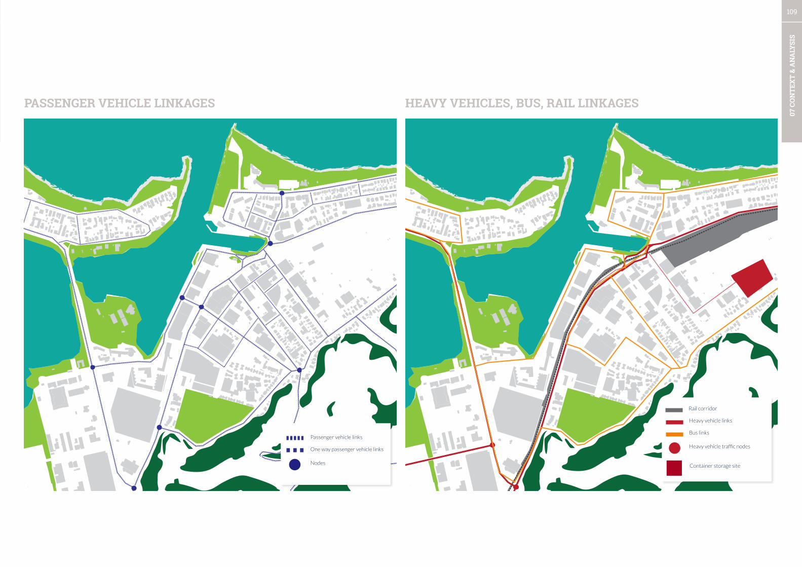
109
07 C
ON
TEX
T &
AN
ALY
SIS
PASSENGER VEHICLE LINKAGES HEAVY VEHICLES, BUS, RAIL LINKAGES
Passenger vehicle links
One way passenger vehicle links
Nodes
Heavy vehicle links
Bus links
Heavy vehicle traffic nodes
Rail corridor
Container storage site
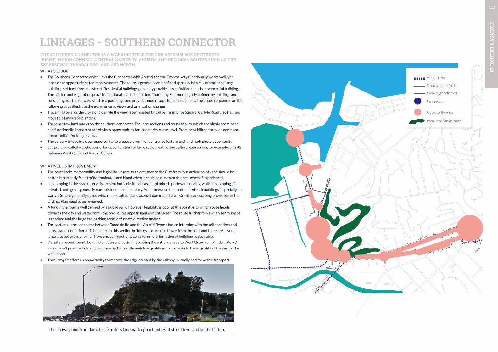
110
07 C
ON
TEX
T &
AN
ALY
SIS
WHAT’S GOOD
• The Southern Connector which links the City centre with Ahuriri and the Express-way functionally works well, yet,
it has clear opportunities for improvements. The route is generally well defined spatially by a mix of small and large
buildings set back from the street. Residential buildings generally provide less definition that the commercial buildings.
The hillside and vegetation provide additional spatial definition. Thackeray St is more tightly defined by buildings and
runs alongside the railway, which is a poor edge and provides much scope for enhancement. The photo sequences on the
following page illustrate the experience as views and orientation change.
• Travelling towards the city along Carlyle the view is terminated by tall palms in Clive Square. Carlyle Road also has new
moveable landscape planters.
• There are few land marks on the southern connector. The intersections and roundabouts, which are highly prominent,
and functionally important are obvious opportunities for landmarks at eye-level. Prominent hilltops provide additional
opportunities for longer views.
• The estuary bridge is a clear opportunity to create a prominent entrance feature and landmark photo opportunity.
• Large blank walled warehouses offer opportunities for large scale creative and cultural expression, for example, on SH2
between West Quay and Ahuriri Bypass.
WHAT NEEDS IMPROVEMENT
• The route lacks memorability and legibility - it acts as an entrance to the City from four arrival points and should be
better. It currently feels traffic dominated and bland when it could be a memorable sequence of experiences.
• Landscaping in the road reserve is present but lacks impact as it is of mixed species and quality, while landscaping of
private frontages is generally non-existent or rudimentary. Areas between the road and setback buildings (especially on
Carlyle St) are generally paved which has resulted bland asphalt dominated area. On-site landscaping provisions in the
District Plan need to be reviewed.
• A fork in the road is well defined by a public park. However, legibility is poor at this point as to which route heads
towards the city and waterfront - the two routes appear similar in character. The route further forks when Tennyson St
is reached and the large car-parking areas obfuscate direction finding.
• The section of the connector between Taradale Rd and the Ahuriri Bypass has an interplay with the rail corridors and
lacks spatial definition and character. In this section buildings are oriented away from the road and there are several
large grassed areas of which have unclear functions. Long-term re-orientation of buildings is desirable.
• Despite a recent roundabout installation and basic landscaping the entrance area to West Quay from Pandora Road/
SH2 doesn’t provide a strong invitation and currently feels low quality in comparison to the in quality of the rest of the
waterfront.
• Thackeray St offers an opportunity to improve the edge created by the railway - visually and for active transport.
LINKAGES - SOUTHERN CONNECTOR
Vehicle Links
Strong edge definition
Intersections
Opportunity areas
Weak edge definition
The arrival point from Tamatea Dr offers landmark opportunities at street level and on the hilltop.
Prominent hillside areas
THE SOUTHERN CONNECTOR IS A WORKING TITLE FOR THE ASSEMBLAGE OF STREETS (RIGHT) WHICH CONNECT CENTRAL NAPIER TO AHURIRI AND REGIONAL ROUTES SUCH AS THE EXPRESSWAY, TARADALE RD, AND SH2 NORTH.
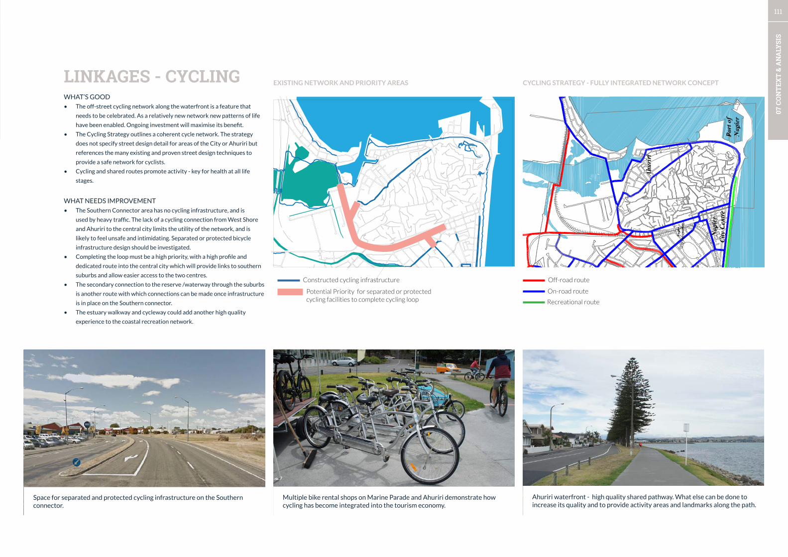
111
07 C
ON
TEX
T &
AN
ALY
SIS
WHAT’S GOOD
• The off-street cycling network along the waterfront is a feature that
needs to be celebrated. As a relatively new network new patterns of life
have been enabled. Ongoing investment will maximise its benefit.
• The Cycling Strategy outlines a coherent cycle network. The strategy
does not specify street design detail for areas of the City or Ahuriri but
references the many existing and proven street design techniques to
provide a safe network for cyclists.
• Cycling and shared routes promote activity - key for health at all life
stages.
WHAT NEEDS IMPROVEMENT
• The Southern Connector area has no cycling infrastructure, and is
used by heavy traffic. The lack of a cycling connection from West Shore
and Ahuriri to the central city limits the utility of the network, and is
likely to feel unsafe and intimidating. Separated or protected bicycle
infrastructure design should be investigated.
• Completing the loop must be a high priority, with a high profile and
dedicated route into the central city which will provide links to southern
suburbs and allow easier access to the two centres.
• The secondary connection to the reserve /waterway through the suburbs
is another route with which connections can be made once infrastructure
is in place on the Southern connector.
• The estuary walkway and cycleway could add another high quality
experience to the coastal recreation network.
LINKAGES - CYCLING
Off-road routeConstructed cycling infrastructure
Potential Priority for separated or protected cycling facilities to complete cycling loop
On-road route
Recreational route
Multiple bike rental shops on Marine Parade and Ahuriri demonstrate how cycling has become integrated into the tourism economy.
Space for separated and protected cycling infrastructure on the Southern connector.
Ahuriri waterfront - high quality shared pathway. What else can be done to increase its quality and to provide activity areas and landmarks along the path.
EXISTING NETWORK AND PRIORITY AREAS CYCLING STRATEGY - FULLY INTEGRATED NETWORK CONCEPT

112
07 C
ON
TEX
T &
AN
ALY
SIS
Carlyle
Carlyle
HyderabadThackeray
Thackeray
Carlyle
Station
Hyderabad
Pandora
State Highway 2 to Hyderabad to city centre
SOUTHERN CONNECTOR EXPERIENCE - AHURIRI TO CENTRAL CITY
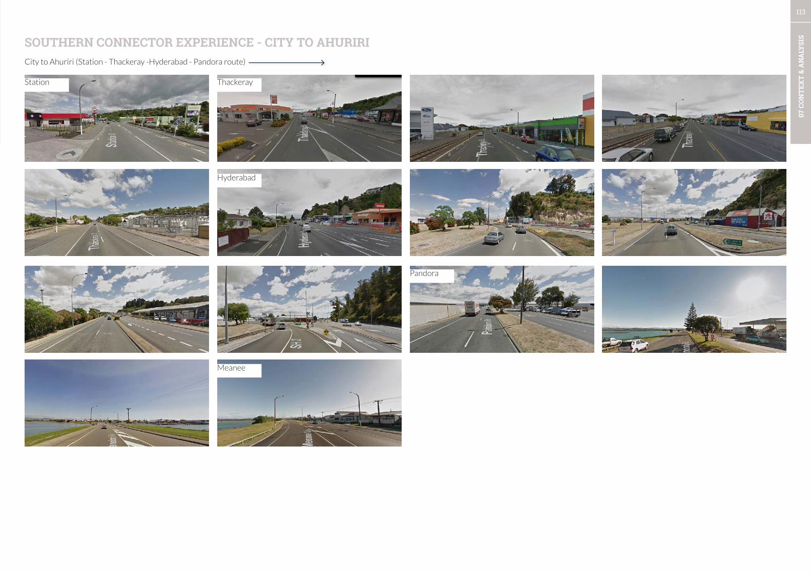
113
07 C
ON
TEX
T &
AN
ALY
SISSOUTHERN CONNECTOR EXPERIENCE - CITY TO AHURIRI
City to Ahuriri (Station - Thackeray -Hyderabad - Pandora route)
Station Thackeray
Hyderabad
Pandora
Meanee
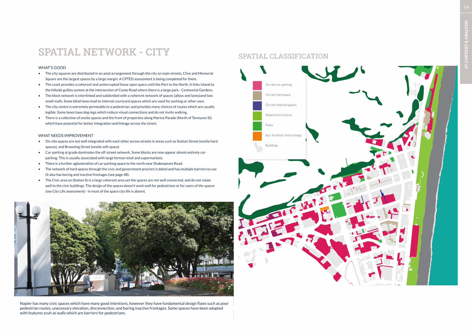
114
07 C
ON
TEX
T &
AN
ALY
SIS
SPATIAL CLASSIFICATIONSPATIAL NETWORK - CITYWHAT’S GOOD
• The city squares are distributed in an axial arrangement through the city on main streets. Clive and Memorial
Square are the largest spaces by a large margin. A CPTED assessment is being completed for them.
• The coast provides a coherent and uniterrupted linear open space until the Port to the North. It links inland to
the hillside gullies system at the intersection of Coote Road where there is a large park - Centennial Gardens.
• The block network is interlinked and subdivided with a coherent network of spaces (alleys and lanes)and two
small malls. Some blind lanes lead to internal courtyard spaces which are used for parking or other uses.
• The city centre is extremely permeable to a pedestrian, and provides many choices of routes which are usually
legible. Some lanes have dog-legs which reduce visual connections and do not invite walking.
• There is a collection of onsite spaces and the front of properties along Marine Parade (North of Tennyson St)
which have potential for better integration and linkage across the street.
WHAT NEEDS IMPROVEMENT
• On-site spaces are not well integrated with each other across streets in areas such as Station Street (onsite hard
spaces), and Browning Street (onsite soft space).
• Car-parking at grade dominates the off-street network. Some blocks are now appear almost entirely car-
parking. This is usually associated with large format retail and supermarkets.
• There is a further aglomeration of car-parking space to the north near Shakespeare Road.
• The network of hard spaces through the civic and government precinct is dated and has multiple barriers to use
(it also has boring and inactive frontages (see page 48).
• The Civic area on Station St is a large coherent area yet the spaces are not well connected, and do not relate
well to the civic buildings. The design of the spaces doesn’t work well for pedestrians or for users of the spaces
(see City Life assessment) - in most of the space city life is absent.
On-site car-parking
On-site hard space
Parks
Bus Terminal / Interchange
Waterfront reserve
On-site internal spaces
Buildings
Napier has many civic spaces which have many good intentions, however they have fundamental design flaws such as poor pedestrian routes, unecessary elevation, disconnection, and boring inactive frontages. Some spaces have been adapted with features scuh as walls which are barriers for pedestrians.

115
07 C
ON
TEX
T &
AN
ALY
SIS
VEGETATIONCITY CENTRE VEGETATIONWHAT’S GOOD
• Vegetation in the city feels limited and can be clearly identified as old street plantings, recent street tree plantings, car
parks, and parks and reserve planting.
• Old planting on streets such as Station Street demonstrate the tradition and effect of planting large trees in a formal
arrangement that is visible on Napier’s large entrance boulevards (e.g. Kennedy, Marine Parade)
• New street plantings are slowly increasing impact due to the smaller tree size when planted and relative lack of growth.
These plantings extend into car-parks along Dickens St.
• There are other isolated pockets of trees and vegetation associated with public spaces and car-parking. An effective
high density planting of Nikaus has occurred on a back street car-park, while more prominent streets have received
quite stark treatment in comparision.
WHAT NEEDS IMPROVEMENT
• Park plantings have a mix of formal and infomal planting and large old trees, and shrubs. The formal plantings along the
waterfront between the Sunken Garden and the Convention Centre divide the space in half and have created an awkard
break between Marine Parade and the coastal pathway (These plantings predate the coastal pathway). The shrubs along
the coastal path reinforce the break and while they create shelter they visually divide the space and create a potentially
unsafe environment as the coastal pathway users cannot be seen from the street.
• It feels like there is a collection of unrelated landscape approaches, which do not reinforce use of public spaces. The
shrub plantings throughout most of the city are dated and dysfunctional (e.g. Clive Square, Marine Parade) and require
updating to support Crime Prevention Through Environmental Design - assessments are currently underway.
• Landscaping in the large format retail and vehicle oriented areas does not overcome the issue of scale of the car-parks
and does not adequately define routes for vehicles.
• The most apparent lack of planting is along the two main routes - Tennyson and Hastings streets. These should be two of
Napier’s most memorable streets.
• Carlyle and Thackeray Streets have no on-street planting (except for a recent experiment with movable planters).
Recent car-park landscaping with a strong native feel and high density of planting. Could this work elsewhere (e.g. Tennyson St) and help create a streetscape as good as the buildings. The many bollards and chains in the garden are out of place - but are likely placed to protect the plants.
Landscape / Grass
Park
Tree
Informal vegetation/trees
Hillside and gully vegetation

116
07 C
ON
TEX
T &
AN
ALY
SIS
SPATIAL NETWORK - AHURIRISPATIAL CLASSIFICATION
WHAT’S GOOD
• The waterfront linear open space network continues at the end of West Quay and splits into the contained estaury
network and the coastal network which extends north. There is much variety and choice of routes in Ahuriri.
• The open space at Perfume Point is the largest open space along the entire Napier waterfront. This Northern waterfront
narrows towards the Port and is punctuated with breakwaters which define space.
• Large buildings and a tight street network reveal few onsite spaces although some newer buildings have created
forecourts or courtyards and on site open spaces in the mixed use area. There are opportunities for integration with
forecourts when streetscape upgrades occur.
• The decked private open spaces along West Quay create coherent feel, and a friendly, welcoming atmosphere.
• Large private open spaces exist at the school and bowling club.
• Northern Ahuriri has developed a fine grain of lanes and inner-block spaces which are generally intimate in scale and
character. Existing perimeter style development sets a good precedent for low-rise medium density development. This
contrasts with the privatised housing development near Pefume Point which is out of character with Ahuriri in site
planning.
• Similarly at the southern end of West Quay high quality courtyard open spaces surrounded by apartments with car-
parking at the rear demonstrates another high quality urban form.
WHAT NEEDS IMPROVEMENT
• The waterfront linear open space network is interupted in Ahuriri by the Port to the east and the inner harbour
development. Connection through the Port area is utilitarian a better linkage is required.
• The area across from Perfume Point on West Shore feels closely related and more can be made of the relationship
between both sides of the harbour entrance.
• Car-parking at-grade is scattered throughout the district and does not dominate as the size and scale of the buildings
define the spatial experience. There is some loss of this character on Dommet Street where two at grade car-parks are
opposite each other. Formalised mid-block connections which subdivide the large blocks would be beneficial.
On-site car-parking
On-site spaces
Park
Buildings
An intriguing network of small mid-block spaces that subdivide larger blocks is developing in Ahuriri.
Cafés are beginning to transform on-site spaces into social spaces in pockets throughout the mixed-use district. A secure courtyard typology is often used.
Waterfront reserve
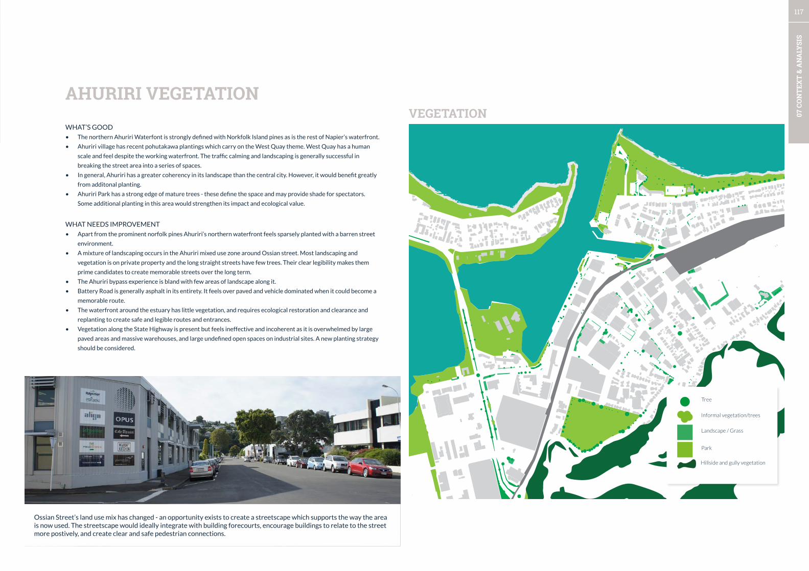
117
07 C
ON
TEX
T &
AN
ALY
SIS
VEGETATIONWHAT’S GOOD
• The northern Ahuriri Waterfont is strongly defined with Norkfolk Island pines as is the rest of Napier’s waterfront.
• Ahuriri village has recent pohutakawa plantings which carry on the West Quay theme. West Quay has a human
scale and feel despite the working waterfront. The traffic calming and landscaping is generally successful in
breaking the street area into a series of spaces.
• In general, Ahuriri has a greater coherency in its landscape than the central city. However, it would benefit greatly
from additonal planting.
• Ahuriri Park has a strong edge of mature trees - these define the space and may provide shade for spectators.
Some additional planting in this area would strengthen its impact and ecological value.
WHAT NEEDS IMPROVEMENT
• Apart from the prominent norfolk pines Ahuriri’s northern waterfront feels sparsely planted with a barren street
environment.
• A mixture of landscaping occurs in the Ahuriri mixed use zone around Ossian street. Most landscaping and
vegetation is on private property and the long straight streets have few trees. Their clear legibility makes them
prime candidates to create memorable streets over the long term.
• The Ahuriri bypass experience is bland with few areas of landscape along it.
• Battery Road is generally asphalt in its entirety. It feels over paved and vehicle dominated when it could become a
memorable route.
• The waterfront around the estuary has little vegetation, and requires ecological restoration and clearance and
replanting to create safe and legible routes and entrances.
• Vegetation along the State Highway is present but feels ineffective and incoherent as it is overwhelmed by large
paved areas and massive warehouses, and large undefined open spaces on industrial sites. A new planting strategy
should be considered.
AHURIRI VEGETATION
Landscape / Grass
Park
Tree
Informal vegetation/trees
Hillside and gully vegetation
Ossian Street’s land use mix has changed - an opportunity exists to create a streetscape which supports the way the area is now used. The streetscape would ideally integrate with building forecourts, encourage buildings to relate to the street more postively, and create clear and safe pedestrian connections.

118
07 C
ON
TEX
T &
AN
ALY
SIS
The ‘glow’ maps that follow show areas where a person can walk in 5 minutes (approximately 400m), and are centred on
public spaces and key intersections. More intensely coloured areas have many overlapping catchments, whereas lighter
colours have fewer catchments overlapping. A focus on the pedestrian experience and creating invitations to stay in public
spaces in the most intensely coloured areas will deliver value to the greatest number of people.
WHAT’S GOOD
• The central area has many overlapping catchments with a high intensity of walkable area. This is thanks to its relatively
small blocks and regularly placed network of public spaces.
• The less intensely coloured areas of the periphery show that many destinations are still a walkable distance from
the large format retail areas. This is important for encouraging people to walk from the existing parking rather than
demanding additional parking closer to the fragile centre.
• The waterfront currently has two centres for walkable catchments - these are centred around the Scenic Hotel/
Convention Centre and the Soundshell/I-site. In future, there will be other another node to the south of the CBD
near Vautier Street once the ex-Marineland development is completed. A focus on the walkability between the i-site/
soundshell and connections to the city will be an important focus area.
• Positioning of attractions where there is existing high concentration of overlapping catchments or creating new
connections will increase the vitality of the city as many more people will have opportunities to enjoy new features,
especially on Marine Parade.
WHAT NEEDS IMPROVEMENT
• The walkability of the central area is very good at a structural level. The focus should be on connection between the
waterfront and city nodes and the quality of experience for walking.
• On Marine Parade, recreation development has been occurring south of the walkable catchments stretching down to
the Aquarium. The spread of opportunities for recreation outside of the central core area and will disperse the vitality
of the city over a large area. Concentration and multi-functional areas are an important strategy in a city with a small
population to create a feeling of vitality.
WALKABLE CATCHMENTS - CITY CENTRE
Walkable catchment node
Future walkable catchment node
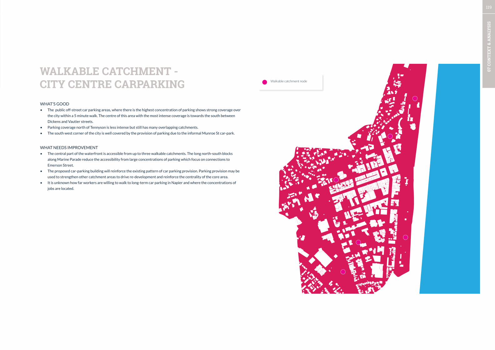
119
07 C
ON
TEX
T &
AN
ALY
SIS
WHAT’S GOOD
• The public off-street car parking areas, where there is the highest concentration of parking shows strong coverage over
the city within a 5 minute walk. The centre of this area with the most intense coverage is towards the south between
Dickens and Vautier streets.
• Parking coverage north of Tennyson is less intense but still has many overlapping catchments.
• The south west corner of the city is well covered by the provision of parking due to the informal Munroe St car-park.
WHAT NEEDS IMPROVEMENT
• The central part of the waterfront is accessible from up to three walkable catchments. The long north-south blocks
along Marine Parade reduce the accessibility from large concentrations of parking which focus on connections to
Emerson Street.
• The proposed car-parking building will reinforce the existing pattern of car parking provision. Parking provision may be
used to strengthen other catchment areas to drive re-development and reinforce the centrality of the core area.
• It is unknown how far workers are willing to walk to long-term car parking in Napier and where the concentrations of
jobs are located.
WALKABLE CATCHMENT - CITY CENTRE CARPARKING Walkable catchment node
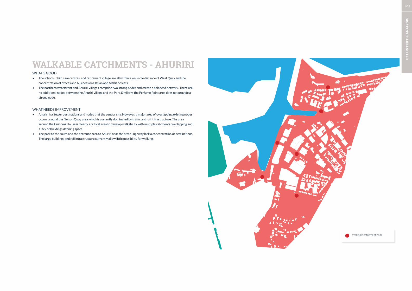
120
07 C
ON
TEX
T &
AN
ALY
SIS
WHAT’S GOOD
• The schools, child care centres, and retirement village are all within a walkable distance of West Quay and the
concentration of offices and business on Ossian and Mahia Streets.
• The northern waterfront and Ahuriri villages comprise two strong nodes and create a balanced network. There are
no additional nodes between the Ahuriri village and the Port. Similarly, the Perfume Point area does not provide a
strong node.
WHAT NEEDS IMPROVEMENT
• Ahuriri has fewer destinations and nodes that the central city, However, a major area of overlapping existing nodes
occurs around the Nelson Quay area which is currently dominated by traffic and rail infrastructure. The area
around the Customs House is clearly a critical area to develop walkability with multiple catcments overlapping and
a lack of buildings defining space.
• The park to the south and the entrance area to Ahuriri near the State Highway lack a concentration of destinations,
The large buildings and rail intrastructure currently allow little possibility for walking.
WALKABLE CATCHMENTS - AHURIRI
Walkable catchment node
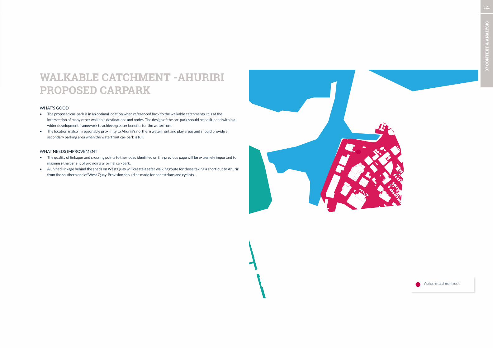
121
07 C
ON
TEX
T &
AN
ALY
SIS
WHAT’S GOOD
• The proposed car-park is in an optimal location when referenced back to the walkable catchments. It is at the
intersection of many other walkable destinations and nodes. The design of the car-park should be positioned within a
wider development framework to achieve greater benefits for the waterfront.
• The location is also in reasonable proximity to Ahuriri’s northern waterfront and play areas and should provide a
secondary parking area when the waterfront car-park is full.
WHAT NEEDS IMPROVEMENT
• The quality of linkages and crossing points to the nodes identified on the previous page will be extremely important to
maximise the benefit of providing a formal car-park.
• A unified linkage behind the sheds on West Quay will create a safer walking route for those taking a short-cut to Ahuriri
from the southern end of West Quay. Provision should be made for pedestrians and cyclists.
WALKABLE CATCHMENT -AHURIRI PROPOSED CARPARK
Walkable catchment node

122
07 C
ON
TEX
T &
AN
ALY
SIS
WHAT’S GOOD
• The Port has two entrance points which serve as nodes. The Northwestern Entrance which is closer to Ahuriri has a
small sheltered beach area.
• The Northwestern end of the Ahuriri Beach offers the most promise for concentration of activity as there is a fairly large
catchment of housing in the area as well as routes up to the hilltop suburbs.
• The Eastern entrance has an extended entrance area, and is in walkable distance to the Centennial Gardens at the base
of the hills.
• The Port areas nodes do not overlap and there is no central point to create something worth walking to as part of a
route to the Marine Parade waterfront.
WHAT NEEDS IMPROVEMENT
• The Bluff lookout is up a very steep hill and does not connect to Marine Parade waterfront. The area is isolated and
only walkable from the Northwestern node. Examination of opportunities to connect the lookout into the waterfront
network should be a priority.
WALKABLE CATCHMENTS - PORT
Walkable catchment node
Future walkable catchment node
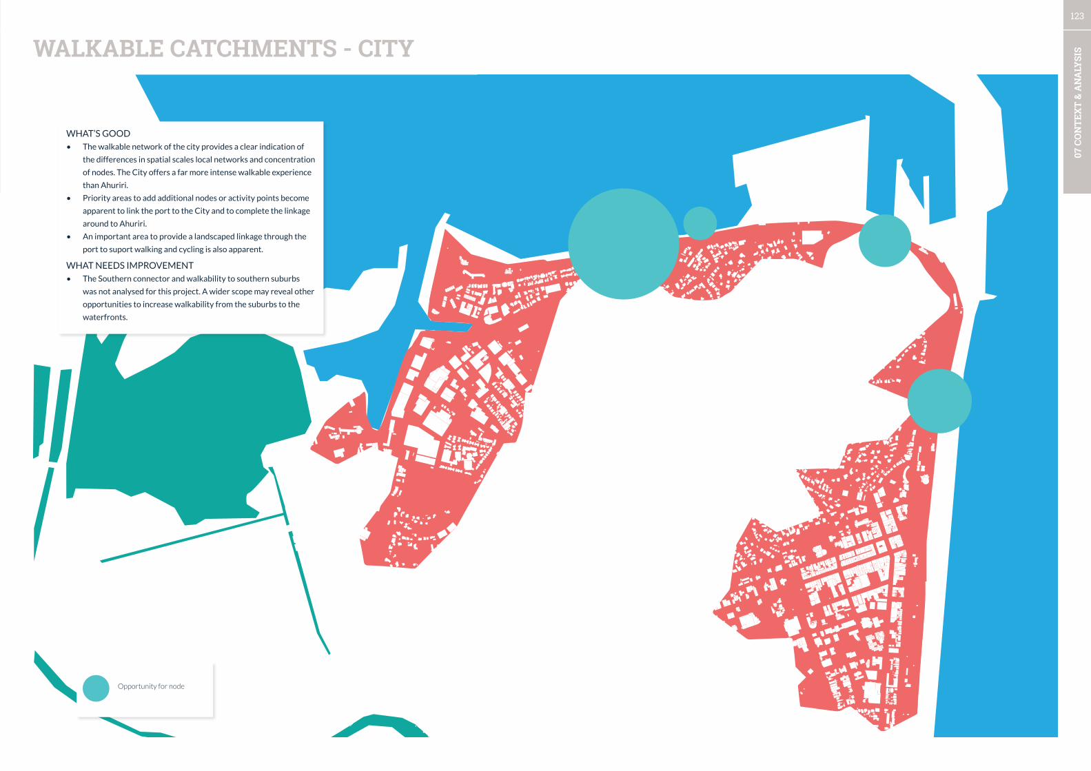
123
07 C
ON
TEX
T &
AN
ALY
SISWALKABLE CATCHMENTS - CITY
WHAT’S GOOD
• The walkable network of the city provides a clear indication of
the differences in spatial scales local networks and concentration
of nodes. The City offers a far more intense walkable experience
than Ahuriri.
• Priority areas to add additional nodes or activity points become
apparent to link the port to the City and to complete the linkage
around to Ahuriri.
• An important area to provide a landscaped linkage through the
port to suport walking and cycling is also apparent.
WHAT NEEDS IMPROVEMENT
• The Southern connector and walkability to southern suburbs
was not analysed for this project. A wider scope may reveal other
opportunities to increase walkability from the suburbs to the
waterfronts.
Opportunity for node

124
07 C
ON
TEX
T &
AN
ALY
SIS
BUILDINGS

125
07 C
ON
TEX
T &
AN
ALY
SIS
• The city’s grid network and associated public spaces which are defined by buildings give the city centre traditional
character which can be emphasized. Some parts of the central city’s built form need repair.
• Ahuriri’s structure which is related to the strongly defined waterfront gives it a clear point of difference from the central
city. The mixed-use area around Ossian St will allow introduction of a new network of public spaces.
• Active frontages are limited to relatively small areas in the central city and Ahuriri. Some of the worst examples of poor
building edges associated with public spaces are the civic buildings and buildings on the waterfront. In contrast, the
recent developments in Ahuriri set a high standard for frontages which should be celebrated and encouraged.
• The night-time economy is concentrated in Ahuriri along West Quay and Waghorne St in the Ahuriri Village area. In the
city there is more dispersal with a cluster occuring towards the coast around Tennyson, Hastings, Marine Parade.
• Retail is the dominant use in the central city and Emerson St provides the most intense retail experience by large
margin. Encouraging intensification along the waterfront for mixed-use including living may help to help grow a
concentrated night-time economy, and provide passive surveillance of the Marine Parade waterfront. In Ahuriri retail is
centred around Ahuriri Village which is limited in size, with a fine grain of frontages and local specialty stores.
• Vacancy in the central city is mostly limited to the area near Emerson St West and on the intersection of Albion St and
Marine Parade.
• Ahuriri Park has a poor edge to the West and North, and opportunity exists to leverage the area for residential to
provide multiple benefits for safety, proximity to recreation, and for new connections to the mixed use area. There is
opportunity to create a new street network where service lanes currently exist.
• Warehouse developments on the entrance to Ahuriri and along SH2 offer the opportunity for infill buildings oriented to
the street with parking to the side or rear.
BUILT FORM
1. Reinforce the traditional character of the central city with a program that improves the quality of
experience for streets and public spaces and links them to the waterfront open space network.
2. Introduce a coherent open space network to the mixed use area around Ossian Street.
3. An active frontage program should be created for the central city which works with heritage architects to
create sensitive adaptation to prominent buildings with inactive frontages.
4. A demonstration programme to create activated public space and buildings should occur with the City
Council buildings and public spaces. Repair of the Rebel Sports building’s frontage and connection to the
waterfront need to be included. Existing buildings on the waterfront need improved frontages and high
standards need to be set for any further waterfront buildings.
5. Encourage a strengthening of the concentration of night-time activities in the central city near the
waterfront around Tennyson, Emerson, Browning St.
6. Continue to support and encourage the high-quality retrofitting of Ahuriri buildings through the West
Quay design group and extend its influence throughout Ahuriri and the City centre.
7. Retain the existing approach to retail to avoid leakage of retail from the central city.
8. Progress the Renew Napier programme to fill vacant store-fronts with activity.
9. Investigate combining housing development and new access streets near Ahuriri Park, through to the
Ahuriri Business Park mixed use area.
RECOMMENDATIONS
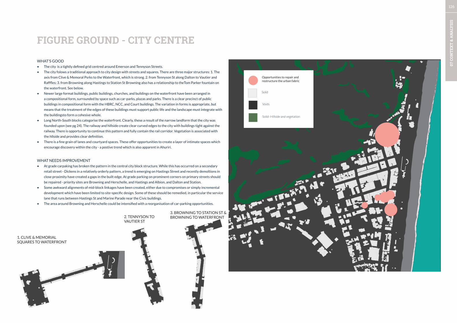
126
07 C
ON
TEX
T &
AN
ALY
SIS
FIGURE GROUND - CITY CENTRE
WHAT’S GOOD
• The city is a tightly defined grid centred around Emerson and Tennyson Streets.
• The city folows a traditional approach to city design with streets and squares. There are three major structures: 1. The
axis from Clive & Memoral Psrks to the Waterfront, which is strong. 2. from Tennyson St along Dalton to Vautier and
Rafffles; 3. from Browning along Hastings to Station St Browning also has a relationship to theTom Parker fountain on
the waterfront. See below.
• Newer large format buildings, public buildings, churches, and buildings on the waterfront have been arranged in
a compositional form, surrounded by space such as car-parks, plazas and parks. There is a clear precinct of public
buildings in compositional form with the HBRC, NCC, and Court buildings. The variation in forms is appropriate, but
means that the treatment of the edges of these buildings must support public life and the landscape must integrate with
the buildingsto form a cohesive whole.
• Long North-South blocks categorise the waterfront. Clearly, these a result of the narrow landform that the city was
founded upon (see pg 24). The railway and hillside create clear curved edges to the city with buildings tight against the
railway. There is opportunity to continue this pattern and fully contain the rail corridor. Vegetation is associated with
the hllside and provides clear definition.
• There is a fine grain of lanes and courtyard spaces. These offer opportunities to create a layer of intimate spaces which
encourage discovery within the city - a postive trend which is also apparent in Ahuriri.
WHAT NEEDS IMPROVEMENT
• At grade carpaking has broken the pattern in the central city block structure. While this has occurred on a secondary
retail street - Dickens in a relatively orderly pattern, a trend is emerging on Hastings Street and recently demoltions in
close proximity have created a gaps in the built edge. At grade parking on prominent corners on primary streets should
be repaired - priority sites are Browning and Herschelle, and Hastings and Albion, and Dalton and Station.
• Some awkward alignments of mid-block linkages have been created, either due to compromises or simply incremental
development which have been limited to site-specific design. Some of these should be remedied, in particular the service
lane that runs between Hastings St and Marine Parade near the Civic buildings.
• The area around Browning and Herschelle could be intensified with a reorganisation of car-parking opportunities.
1. CLIVE & MEMORIAL SQUARES TO WATERFRONT
2. TENNYSON TO VAUTIER ST
3. BROWNING TO STATION ST & BROWNING TO WATERFRONT
Opportunities to repair and restructure the urban fabric
Solid
Voids
Solid- Hillside and vegetation
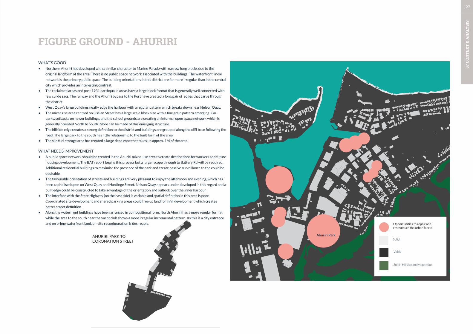
127
07 C
ON
TEX
T &
AN
ALY
SIS
FIGURE GROUND - AHURIRI
WHAT’S GOOD
• Northern Ahuriri has developed with a similar character to Marine Parade with narrow long blocks due to the
original landform of the area. There is no public space network associated with the buildings. The waterfront linear
network is the primary public space. The building orientations in this district are far more irregular than in the central
city which provides an interesting contrast.
• The reclaimed areas and post 1931 earthquake areas have a large block format that is generally well connected with
few cul de sacs. The railway and the Ahuriri bypass to the Port have created a long pair of edges that carve through
the district.
• West Quay’s large buildings neatly edge the harbour with a regular pattern which breaks down near Nelson Quay.
• The mixed use area centred on Ossian Street has a large scale block size with a fine grain pattern emerging. Car-
parks, setbacks on newer buildings, and the school grounds are creating an informal open space network which is
generally oriented North to South. More can be made of this emerging structure.
• The hillside edge creates a strong definition to the district and buildings are grouped along the cliff base following the
road. The large park to the south has little relationship to the built form of the area.
• The silo fuel storage area has created a large dead zone that takes up approx. 1/4 of the area.
WHAT NEEDS IMPROVEMENT
• A public space network should be created in the Ahuriri mixed-use area to create destinations for workers and future
housing development. The BAT report begins this process but a larger scope through to Battery Rd will be required.
Additional residential buildings to maximise the presence of the park and create passive surveillance to the could be
desirable.
• The favourable orientation of streets and buildings are very pleasant to enjoy the afternoon and evening, which has
been capitalised upon on West Quay and Hardinge Street. Nelson Quay appears under developed in this regard and a
built edge could be constructed to take advantage of the orientation and outlook over the inner harbour.
• The interface with the State Highway (on the east side) is variable and spatial definition in this area is poor.
Coordinated site development and shared parking areas could free up land for infill development which creates
better street definition.
• Along the waterfront buildings have been arranged in compositional form. North Ahuriri has a more regular format
while the area to the south near the yacht club shows a more irregular incremental pattern. As this is a city entrance
and on prime waterfront land, on-site reconfiguration is desireable.
AHURIRI PARK TO CORONATION STREET
Opportunities to repair and restructure the urban fabric
Solid
Voids
Solid- Hillside and vegetation
Ahuriri Park

128
07 C
ON
TEX
T &
AN
ALY
SIS
WHAT’S GOOD
• Emerson Street and two blocks of Hastings Street provide a high quality fine grained pedestrian experience.
• The waterfront appears to attract some public use at night with its pleasant environment and well-lit features.
• Vacancy in the central city is fairly low, but in general the vacancy is centred on Emerson St West and Tennyson Streets.
Another pocket exists around the newly developed cosmopolitan building.
• The majority of frontages overall fall into the Active, Friendly, and mixed categories - the mixed categories offer
opportunities for adaptation to friendly and active frontages. There is vast potential here.
WHAT NEEDS IMPROVEMENT
• From a pedestrian perspective Napier has a complex issue to resolve - the buildings which give the City centre is
character hamstring its attractiveness as a walkable city centre. Many of the buildings’ designs do not support public life
which contributes to a lack of perceived vitality.
• The Art Deco heritage buildings present mixed, or boring frontages for much of the streetscape on several prominent
streets. As a visitor, once the presence of the Art Deco heritage buildings loses its novelty, their other qualities create
a feeling of a high quality environment that is somewhat boring. Two blocks of Tennyson Street are affected by this
although there are some good examples of adaptations underway that demonstrate good practice (e.g. Madison
Building).
• Compounding this issue is several blocks of average frontages mixed in quality, transparency, scale, numbers of
entrances, and general lack of interest to a pedestrian.
• Marine Parade is a disappointing pedestrian experience when it feels like it should be a premier walking environment.
• The City Council Building, Library, Court precinct, HBRC, Municipal Theatre and other prominent public buildings are
the worst offenders in the city as they importantly front onto public spaces and streets and provide boring or inactive
frontages. There is very little activation offered and these spaces have been handicapped by poor design for far too long.
Sensitive repair is required to bring the quality of the spaces and buildings design to a level that meets their function.
• The city centre has very little night time economy, and what is present is dispersed. There is a core night time area near
Browning, Emerson, Hastings and Marine Parade. Encouraging concentration of night-time activity around this existing
area will be important.
THE CITY CENTRE AT EYE LEVELBUILDING FRONTAGE RATINGS*
*This rating is only for the quality of the frontage in relation to the pedestrian experience. it does not rate other qualities such as heritage values.
12%
30%
34%
17%
7%
ACTIVE
FRIENDLY
MIXTURE
BORING
INACTIVE
ACTIVE
FRIENDLY
INACTIVE
MIXED / AVERAGE
BORING
BUILDING FRONTAGE RATINGS

129
07 C
ON
TEX
T &
AN
ALY
SIS
NIGHT-TIME ECONOMY VACANT STREET FRONTAGES
Business open at night
Business closed at night (or vacant)
Tenated frontage
Vacant frontage
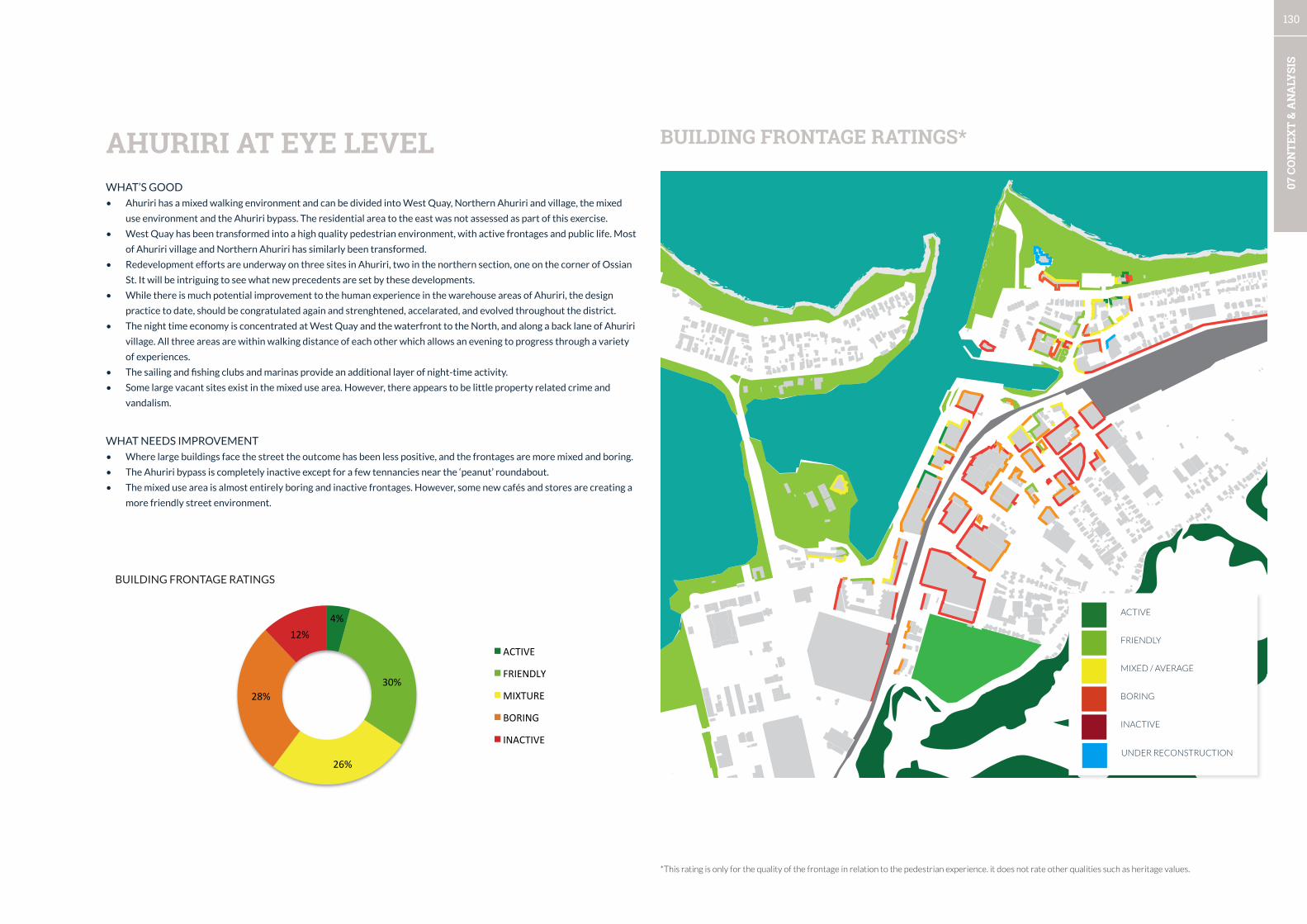
130
07 C
ON
TEX
T &
AN
ALY
SIS
WHAT’S GOOD
• Ahuriri has a mixed walking environment and can be divided into West Quay, Northern Ahuriri and village, the mixed
use environment and the Ahuriri bypass. The residential area to the east was not assessed as part of this exercise.
• West Quay has been transformed into a high quality pedestrian environment, with active frontages and public life. Most
of Ahuriri village and Northern Ahuriri has similarly been transformed.
• Redevelopment efforts are underway on three sites in Ahuriri, two in the northern section, one on the corner of Ossian
St. It will be intriguing to see what new precedents are set by these developments.
• While there is much potential improvement to the human experience in the warehouse areas of Ahuriri, the design
practice to date, should be congratulated again and strenghtened, accelarated, and evolved throughout the district.
• The night time economy is concentrated at West Quay and the waterfront to the North, and along a back lane of Ahuriri
village. All three areas are within walking distance of each other which allows an evening to progress through a variety
of experiences.
• The sailing and fishing clubs and marinas provide an additional layer of night-time activity.
• Some large vacant sites exist in the mixed use area. However, there appears to be little property related crime and
vandalism.
WHAT NEEDS IMPROVEMENT
• Where large buildings face the street the outcome has been less positive, and the frontages are more mixed and boring.
• The Ahuriri bypass is completely inactive except for a few tennancies near the ‘peanut’ roundabout.
• The mixed use area is almost entirely boring and inactive frontages. However, some new cafés and stores are creating a
more friendly street environment.
AHURIRI AT EYE LEVEL BUILDING FRONTAGE RATINGS*
*This rating is only for the quality of the frontage in relation to the pedestrian experience. it does not rate other qualities such as heritage values.
4%
30%
26%
28%
12% ACTIVE
FRIENDLY
MIXTURE
BORING
INACTIVE
ACTIVE
FRIENDLY
INACTIVE
UNDER RECONSTRUCTION
MIXED / AVERAGE
BORING
BUILDING FRONTAGE RATINGS
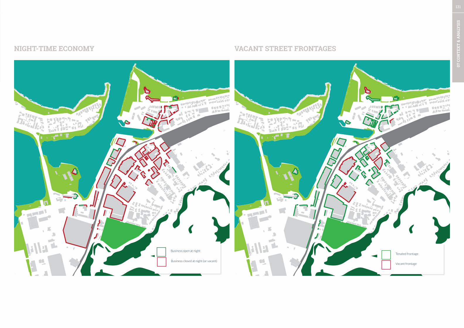
131
07 C
ON
TEX
T &
AN
ALY
SIS
NIGHT-TIME ECONOMY VACANT STREET FRONTAGES
Business open at night
Business closed at night (or vacant)
Tenated frontage
Vacant frontage
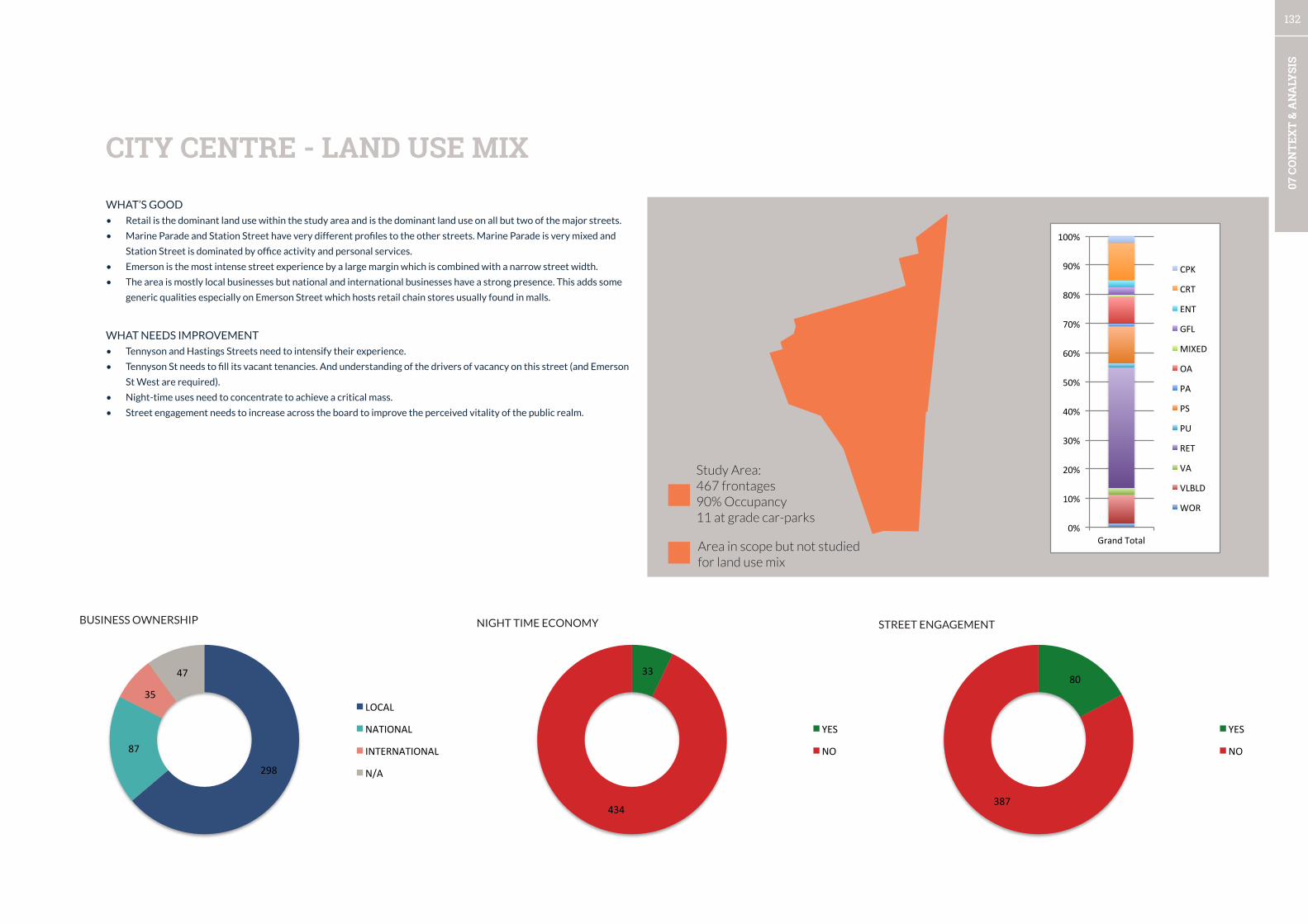
132
07 C
ON
TEX
T &
AN
ALY
SIS
WHAT’S GOOD
• Retail is the dominant land use within the study area and is the dominant land use on all but two of the major streets.
• Marine Parade and Station Street have very different profiles to the other streets. Marine Parade is very mixed and
Station Street is dominated by office activity and personal services.
• Emerson is the most intense street experience by a large margin which is combined with a narrow street width.
• The area is mostly local businesses but national and international businesses have a strong presence. This adds some
generic qualities especially on Emerson Street which hosts retail chain stores usually found in malls.
WHAT NEEDS IMPROVEMENT
• Tennyson and Hastings Streets need to intensify their experience.
• Tennyson St needs to fill its vacant tenancies. And understanding of the drivers of vacancy on this street (and Emerson
St West are required).
• Night-time uses need to concentrate to achieve a critical mass.
• Street engagement needs to increase across the board to improve the perceived vitality of the public realm.
CITY CENTRE - LAND USE MIX
0%
10%
20%
30%
40%
50%
60%
70%
80%
90%
100%
Grand Total
CPK
CRT
ENT
GFL
MIXED
OA
PA
PS
PU
RET
VA
VLBLD
WOR
Study Area: 467 frontages90% Occupancy11 at grade car-parks
Area in scope but not studied for land use mix
298
87
35
47
LOCAL
NATIONAL
INTERNATIONAL
N/A
33
434
YES
NO
80
387
YES
NO
BUSINESS OWNERSHIP STREET ENGAGEMENTNIGHT TIME ECONOMY
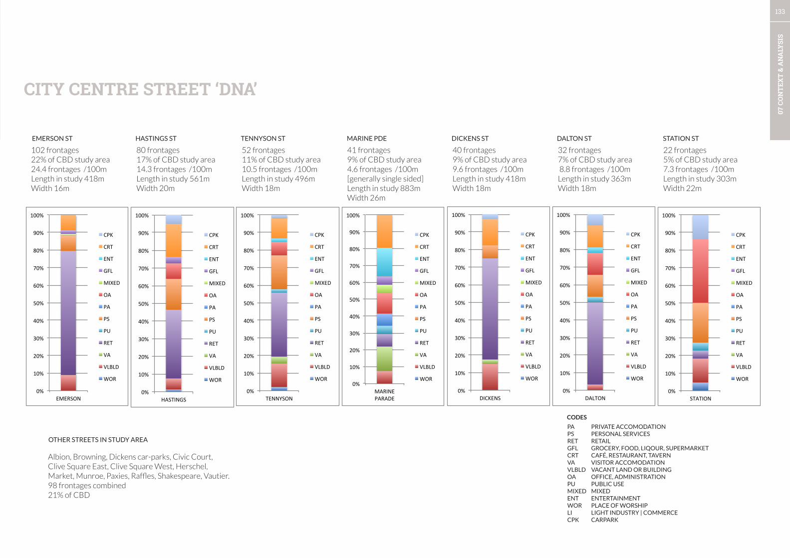
133
07 C
ON
TEX
T &
AN
ALY
SIS
0%
10%
20%
30%
40%
50%
60%
70%
80%
90%
100%
DALTON
CPK
CRT
ENT
GFL
MIXED
OA
PA
PS
PU
RET
VA
VLBLD
WOR
0%
10%
20%
30%
40%
50%
60%
70%
80%
90%
100%
DICKENS
CPK
CRT
ENT
GFL
MIXED
OA
PA
PS
PU
RET
VA
VLBLD
WOR
0%
10%
20%
30%
40%
50%
60%
70%
80%
90%
100%
EMERSON
CPK
CRT
ENT
GFL
MIXED
OA
PA
PS
PU
RET
VA
VLBLD
WOR
0%
10%
20%
30%
40%
50%
60%
70%
80%
90%
100%
HASTINGS
CPK
CRT
ENT
GFL
MIXED
OA
PA
PS
PU
RET
VA
VLBLD
WOR 0%
10%
20%
30%
40%
50%
60%
70%
80%
90%
100%
MARINE PARADE
CPK
CRT
ENT
GFL
MIXED
OA
PA
PS
PU
RET
VA
VLBLD
WOR
0%
10%
20%
30%
40%
50%
60%
70%
80%
90%
100%
STATION
CPK
CRT
ENT
GFL
MIXED
OA
PA
PS
PU
RET
VA
VLBLD
WOR
0%
10%
20%
30%
40%
50%
60%
70%
80%
90%
100%
TENNYSON
CPK
CRT
ENT
GFL
MIXED
OA
PA
PS
PU
RET
VA
VLBLD
WOR
32 frontages7% of CBD study area 8.8 frontages /100mLength in study 363mWidth 18m
22 frontages5% of CBD study area7.3 frontages /100mLength in study 303mWidth 22m
52 frontages11% of CBD study area10.5 frontages /100mLength in study 496mWidth 18m
Albion, Browning, Dickens car-parks, Civic Court, Clive Square East, Clive Square West, Herschel, Market, Munroe, Paxies, Raffles, Shakespeare, Vautier.98 frontages combined21% of CBD
40 frontages9% of CBD study area9.6 frontages /100mLength in study 418mWidth 18m
102 frontages22% of CBD study area24.4 frontages /100mLength in study 418mWidth 16m
80 frontages17% of CBD study area14.3 frontages /100mLength in study 561mWidth 20m
41 frontages9% of CBD study area4.6 frontages /100m [generally single sided]Length in study 883mWidth 26m
EMERSON ST HASTINGS ST TENNYSON ST MARINE PDE DICKENS ST DALTON ST STATION ST
OTHER STREETS IN STUDY AREA
CITY CENTRE STREET ‘DNA’
PA PRIVATE ACCOMODATIONPS PERSONAL SERVICESRET RETAILGFL GROCERY, FOOD, LIQOUR, SUPERMARKETCRT CAFÉ, RESTAURANT, TAVERNVA VISITOR ACCOMODATIONVLBLD VACANT LAND OR BUILDINGOA OFFICE, ADMINISTRATIONPU PUBLIC USEMIXED MIXEDENT ENTERTAINMENTWOR PLACE OF WORSHIPLI LIGHT INDUSTRY | COMMERCECPK CARPARK
CODES
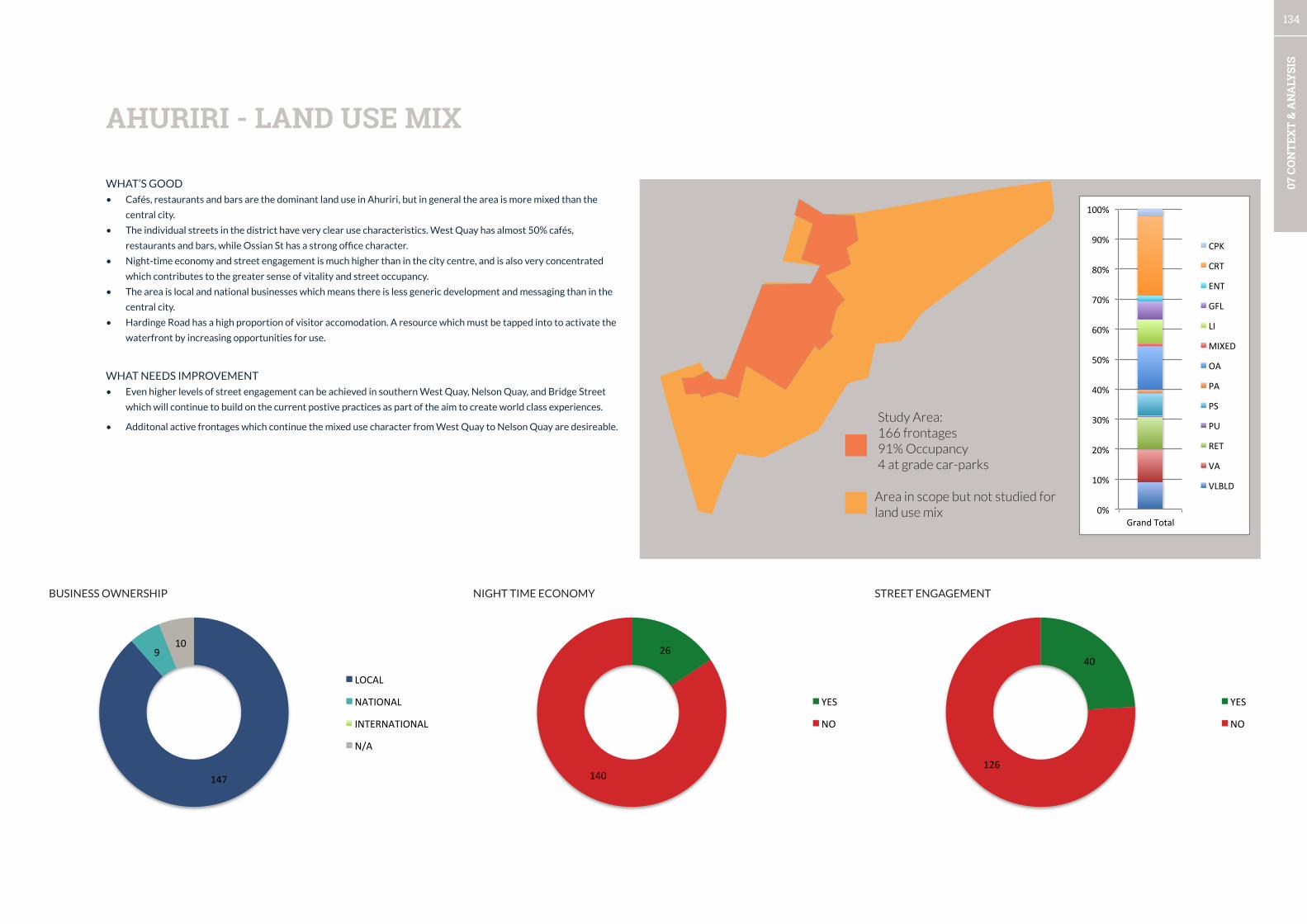
134
07 C
ON
TEX
T &
AN
ALY
SIS
147
9 10
LOCAL
NATIONAL
INTERNATIONAL
N/A
26
140
YES
NO
40
126
YES
NO
WHAT’S GOOD
• Cafés, restaurants and bars are the dominant land use in Ahuriri, but in general the area is more mixed than the
central city.
• The individual streets in the district have very clear use characteristics. West Quay has almost 50% cafés,
restaurants and bars, while Ossian St has a strong office character.
• Night-time economy and street engagement is much higher than in the city centre, and is also very concentrated
which contributes to the greater sense of vitality and street occupancy.
• The area is local and national businesses which means there is less generic development and messaging than in the
central city.
• Hardinge Road has a high proportion of visitor accomodation. A resource which must be tapped into to activate the
waterfront by increasing opportunities for use.
WHAT NEEDS IMPROVEMENT
• Even higher levels of street engagement can be achieved in southern West Quay, Nelson Quay, and Bridge Street
which will continue to build on the current postive practices as part of the aim to create world class experiences.
• Additonal active frontages which continue the mixed use character from West Quay to Nelson Quay are desireable.
AHURIRI - LAND USE MIX
Study Area:166 frontages91% Occupancy4 at grade car-parks
Area in scope but not studied for land use mix 0%
10%
20%
30%
40%
50%
60%
70%
80%
90%
100%
Grand Total
CPK
CRT
ENT
GFL
LI
MIXED
OA
PA
PS
PU
RET
VA
VLBLD
BUSINESS OWNERSHIP STREET ENGAGEMENTNIGHT TIME ECONOMY
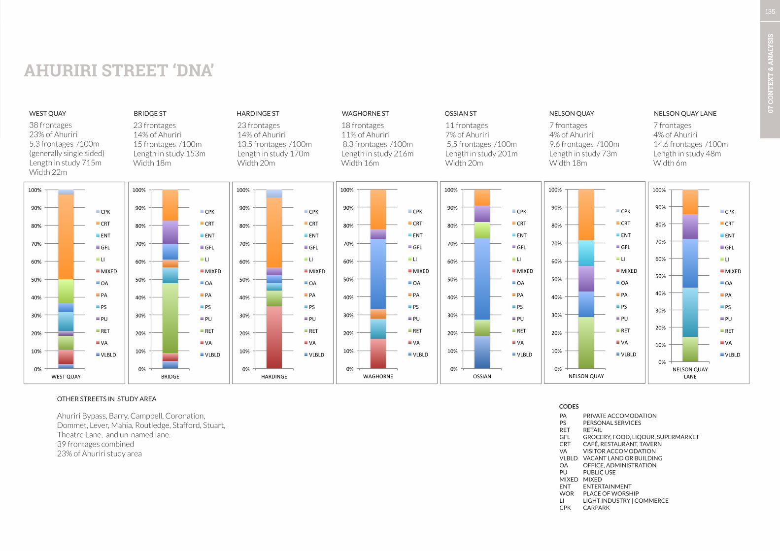
135
07 C
ON
TEX
T &
AN
ALY
SIS
Ahuriri Bypass, Barry, Campbell, Coronation, Dommet, Lever, Mahia, Routledge, Stafford, Stuart, Theatre Lane, and un-named lane.39 frontages combined23% of Ahuriri study area
23 frontages14% of Ahuriri15 frontages /100mLength in study 153mWidth 18m
18 frontages11% of Ahuriri 8.3 frontages /100mLength in study 216mWidth 16m
38 frontages23% of Ahuriri5.3 frontages /100m (generally single sided)Length in study 715mWidth 22m
OTHER STREETS IN STUDY AREA
23 frontages14% of Ahuriri13.5 frontages /100mLength in study 170mWidth 20m
7 frontages4% of Ahuriri9.6 frontages /100mLength in study 73mWidth 18m
7 frontages4% of Ahuriri14.6 frontages /100mLength in study 48mWidth 6m
11 frontages7% of Ahuriri 5.5 frontages /100mLength in study 201mWidth 20m
0%
10%
20%
30%
40%
50%
60%
70%
80%
90%
100%
WEST QUAY
CPK
CRT
ENT
GFL
LI
MIXED
OA
PA
PS
PU
RET
VA
VLBLD
0%
10%
20%
30%
40%
50%
60%
70%
80%
90%
100%
BRIDGE
CPK
CRT
ENT
GFL
LI
MIXED
OA
PA
PS
PU
RET
VA
VLBLD
0%
10%
20%
30%
40%
50%
60%
70%
80%
90%
100%
HARDINGE
CPK
CRT
ENT
GFL
LI
MIXED
OA
PA
PS
PU
RET
VA
VLBLD
0%
10%
20%
30%
40%
50%
60%
70%
80%
90%
100%
WAGHORNE
CPK
CRT
ENT
GFL
LI
MIXED
OA
PA
PS
PU
RET
VA
VLBLD
0%
10%
20%
30%
40%
50%
60%
70%
80%
90%
100%
OSSIAN
CPK
CRT
ENT
GFL
LI
MIXED
OA
PA
PS
PU
RET
VA
VLBLD
0%
10%
20%
30%
40%
50%
60%
70%
80%
90%
100%
NELSON QUAY
CPK
CRT
ENT
GFL
LI
MIXED
OA
PA
PS
PU
RET
VA
VLBLD 0%
10%
20%
30%
40%
50%
60%
70%
80%
90%
100%
NELSON QUAY LANE
CPK
CRT
ENT
GFL
LI
MIXED
OA
PA
PS
PU
RET
VA
VLBLD
AHURIRI STREET ‘DNA’
WEST QUAY BRIDGE ST HARDINGE ST WAGHORNE ST OSSIAN ST NELSON QUAY NELSON QUAY LANE
PA PRIVATE ACCOMODATIONPS PERSONAL SERVICESRET RETAILGFL GROCERY, FOOD, LIQOUR, SUPERMARKETCRT CAFÉ, RESTAURANT, TAVERNVA VISITOR ACCOMODATIONVLBLD VACANT LAND OR BUILDINGOA OFFICE, ADMINISTRATIONPU PUBLIC USEMIXED MIXEDENT ENTERTAINMENTWOR PLACE OF WORSHIPLI LIGHT INDUSTRY | COMMERCECPK CARPARK
CODES

136
07 C
ON
TEX
T &
AN
ALY
SIS
CULTURAL & CREATIVE EXPRESSION
137
07 C
ON
TEX
T &
AN
ALY
SIS
• The concentration of heritage buildings in the city centre and Ahuriri has been a clever urban design strategy which has
resulted in the evolution of two clearly distinct character areas. The development of public space associated with the
concentration of built heritage has not been as good.
• Linkages between public facilities and recreation opportunities can be improved along with the public spaces associated
with special buildings such as the MTG.
• Opportunities to take a joined-up approach to creativity have not always been taken. In future, project briefs should
be expanded to take advantage of opportunities to join up creativity, heritage, public space (streets and reserves), and
special buildings.
• The area around the Customs House has had a number of proposals for car-parking and landscaping. An integrated
approach is required.
• The heritage building at Memorial Square is closed, poorly sited and presents a poor quality edge to the Park.
Consideration of its removal or renovation should be made as part of the CPTED project and future development for
Clive and Memorial Square.
• The city has a high concentration of landmarks along the Marine Parade Waterfront, and within the city centre. Some of
these have variable quality and they could be sited more effectively. Ahuriri’s landmarks have a different character and a
collection of carvings is creating a critical mass. The northern Ahuriri landmarks are the weakest in the city.
• A contemporary sculpture collection is growing and adds a welcome diversification from Art Deco, maritime, and
memorials.
• Water features play a large role in the central city and Marine Parade Waterfront, often these features are ornamental
but some allow play and are well lit for night time ambience. The attraction of water for play is being explored through
the ex-Marineland redevelopment which continues this tradition. Care should be taken to avoid overly urban water
features in the open space network such as the new water feature to the rear of the Aquarium.
• Prominent structures in public spaces need to be capitalised upon to create landmarks and worthy of their positions.
• On the Bluff Hill a special case exists where historical gun emplacements have been built upon with an out of character
memorial garden and pergola. Reconsideration of this approach will be necessary to bring historical narratives to life.
SUMMARY
1. Upgrade streets in the areas with high concentration of character buildings to a higher quality which
matches the quality of the buildings.
2. Identification of opportunities for high profile interdisciplinary projects which include public or high profile
sites will be required for each area framework. These projects need to cross boundaries and include both
public and private space. These include, but are not limited to:
• The MTG to Soundshell/i-site to Emerson St
• The Library, Civic centre and public spaces
• The area around the Customs house.
• Ahuriri northern waterfront
• Scenic hotel, pools, and Convention centre
3. Removal or relocation/renovation of the Memorial Square building should be considered as part of an
upgrade project for Clive and Memorial Square.
4. The carvings for landmark features in Ahuriri along the waterfront are unique and effective, acceleration
of this programme along the northern waterfront (if agreed by iwi) will add rhythm and coherence and
way-finding to the coastal walkway experience.
5. A new approach to memorials and methods for communicating historical narratives is required to repair
some poor practices of the past, and new public sculptures must be more effectively sited to maximise
their public benefit.
6. Introduce landmarks along the Ahuriri Bypass at prominent views and intersections, and into the mixed-
use area around Ossian St with the creation of a public space network and street redesigns.
7. Port and Silos operators, and large warehouse operators should be approached to examine the potential
for creative approaches (e.g. large scale art installations) to landmark structures on their sites.
RECOMMENDATIONS
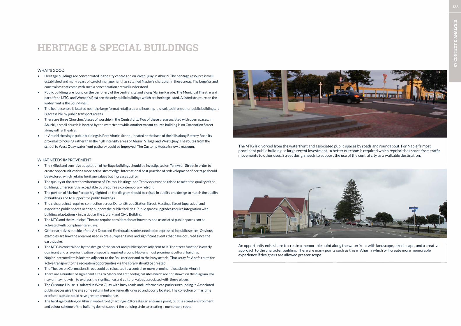
138
07 C
ON
TEX
T &
AN
ALY
SIS
WHAT’S GOOD
• Heritage buildings are concentrated in the city centre and on West Quay in Ahuriri. The heritage resource is well
established and many years of careful management has retained Napier’s character in these areas. The benefits and
constraints that come with such a concentration are well understood.
• Public buildings are found on the periphery of the central city and along Marine Parade. The Municipal Theatre and
part of the MTG, and Women’s Rest are the only public buildings which are heritage listed. A listed structure on the
waterfront is the Soundshell.
• The health centre is located near the large format retail area and housing, it is isolated from other public buildings. It
is accessible by public transport routes.
• There are three Churches/places of worship in the Central city. Two of these are associated with open spaces. In
Ahuriri, a small church is located by the waterfront while another vacant church building is on Coronation Street
along with a Theatre.
• In Ahuriri the single public buildings is Port Ahuriri School, located at the base of the hills along Battery Road its
proximal to housing rather than the high intensity areas of Ahuriri Village and West Quay. The routes from the
school to West Quay waterfront pathway could be improved. The Customs House is now a museum.
WHAT NEEDS IMPROVEMENT
• The skilled and sensitive adaptation of heritage buildings should be investigated on Tennyson Street in order to
create opportunities for a more active street edge. International best practice of redevelopment of heritage should
be explored which retains heritage values but increases utility.
• The quality of the street environment of Dalton, Hastings, and Tennyson must be raised to meet the quality of the
buildings. Emerson St is acceptable but requires a contemporary retrofit
• The portion of Marine Parade highlighted on the diagram should be raised in quality and design to match the quality
of buildings and to support the public buildings.
• The civic precinct requires connection across Dalton Street. Station Street, Hastings Street (upgraded) and
associated public spaces need to support the public facilities. Public spaces upgrades require integration with
building adaptations - in particular the Library and Civic Building.
• The MTG and the Municipal Theatre require consideration of how they and associated public spaces can be
activated with complimentary uses.
• Other narratives outside of the Art Deco and Earthquake stories need to be expressed in public spaces. Obvious
examples are how the area was used in pre-european times and significant events that have occurred since the
earthquake.
• The MTG is constrained by the design of the street and public spaces adjacent to it. The street function is overly
dominant and a re-prioritisation of space is required around Napier’s most prominent cultural building.
• Napier Intermediate is located adjacent to the Rail corridor and to the busy arterial Thackeray St. A safe route for
active transport to the recreation opportunities via the library should be created.
• The Theatre on Coronation Street could be relocated to a central or more prominent location in Ahuriri.
• There are a number of significant sites to Maori and archaeological sites which are not shown on the diagram. Iwi
may or may not wish to express the significance and cultural values associated with these places.
• The Customs House is isolated in West Quay with busy roads and unformed car-parks surrounding it. Associated
public spaces give the site some setting but are generally unused and poorly located. The collection of maritime
artefacts outside could have greater prominence.
• The heritage building on Ahuriri waterfront (Hardinge Rd) creates an entrance point, but the street environment
and colour scheme of the building do not support the building style to creating a memorable route.
HERITAGE & SPECIAL BUILDINGS
An opportunity exists here to create a memorable point along the waterfront with landscape, streetscape, and a creative approach to the character building. There are many points such as this in Ahuriri which will create more memorable experience if designers are allowed greater scope.
The MTG is divorced from the waterfront and associated public spaces by roads and roundabout. For Napier’s most prominent public building - a large recent investment - a better outcome is required which reprioritises space from traffic movements to other uses. Street design needs to support the use of the central city as a walkable destination.
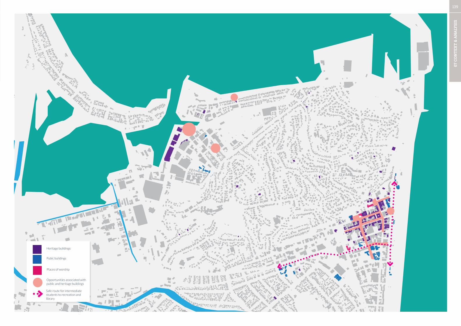
139
07 C
ON
TEX
T &
AN
ALY
SIS
Heritage buildings
Pubic buildings
Places of worship
Opportunities associated with public and heritage buildings
Safe route for intermediate students to recreation and library

140
07 C
ON
TEX
T &
AN
ALY
SIS
WHAT’S GOOD
• The city centre’s landmarks in the public realm are varied and spaced throughout the central city and waterfront. In
some areas there is a concentration such as at the intersection of Marine Parade and Emerson Street.
• Recent public sculptures are high quality additions to the streetscape, but are not always in prominent locations (e.g.
Paul Dibble kowhai opposite the MTG).
• Street art is successful in a wide variety of locations, and is a welcome addition to blank walls, alleyways, and utility
cabinets.
• Two markets are in operation which bring activation and life to two public spaces. These play an important role in the
city centre’s weekend vibe.
• The central city has a number of landmark water features. Touchable water is a major draw-card for many people,
especially children. These should be leveraged to activate public spaces.
WHAT NEEDS IMPROVEMENT
• Location of public sculptures needs to be more deliberate to maximise their value and to provide multiple benefits such
as providing a nucleus to a public space, terminating a view, or providing rhythm and structure to the coastal pathway.
• The scale of landmarks is out of place for their location and many are only ornamental or repetitious (such as an anchor
on the coastal pathway). More diversity, suitable scale, and interactive or playable installations would provide multiple
benefits to the central city.
• Street art feels manicured or curated to reflect the dominant narratives of the city (for example, Art Deco themed piece
at the bus terminal) A diversification of narratives and freedom of expression may be necessary to bring a feeling of
vitality and contemporary expression to the central city, so that the city is not locked into expressing the past.
• The bunkers on the Bluff Hill have been built on with unrelated memorials and there is little interpretation of pre-
european history. The stories which are being expressed are about prominent people but there is no interpretation as to
what they contributed to Napier.
• Many memorials throughout the city centre and waterfront appear in somewhat random locations and design is often
unrelated to the context. An example is the new fountain (shown below) near the Aquarium which is urban in character
and does not support public life as it is disconnected from other recent additions such as shade sails and BBQs.
CITY CENTRE LANDMARKS, PUBLIC AND STREET ART, EVENTS.
Sculptures, art installations and landmarks
Landmark wall and arches, and columns
Large street art / murals
Market locations
Small street art / murals
The materials used in this waterfront water feature are used throughout the central city and feel out of place on the waterfront. More could have been made of this place by integrating it with the shade sails and BBQs.
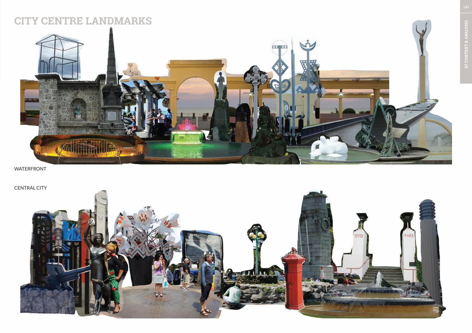
141
07 C
ON
TEX
T &
AN
ALY
SISCITY CENTRE LANDMARKS
WATERFRONT
CENTRAL CITY
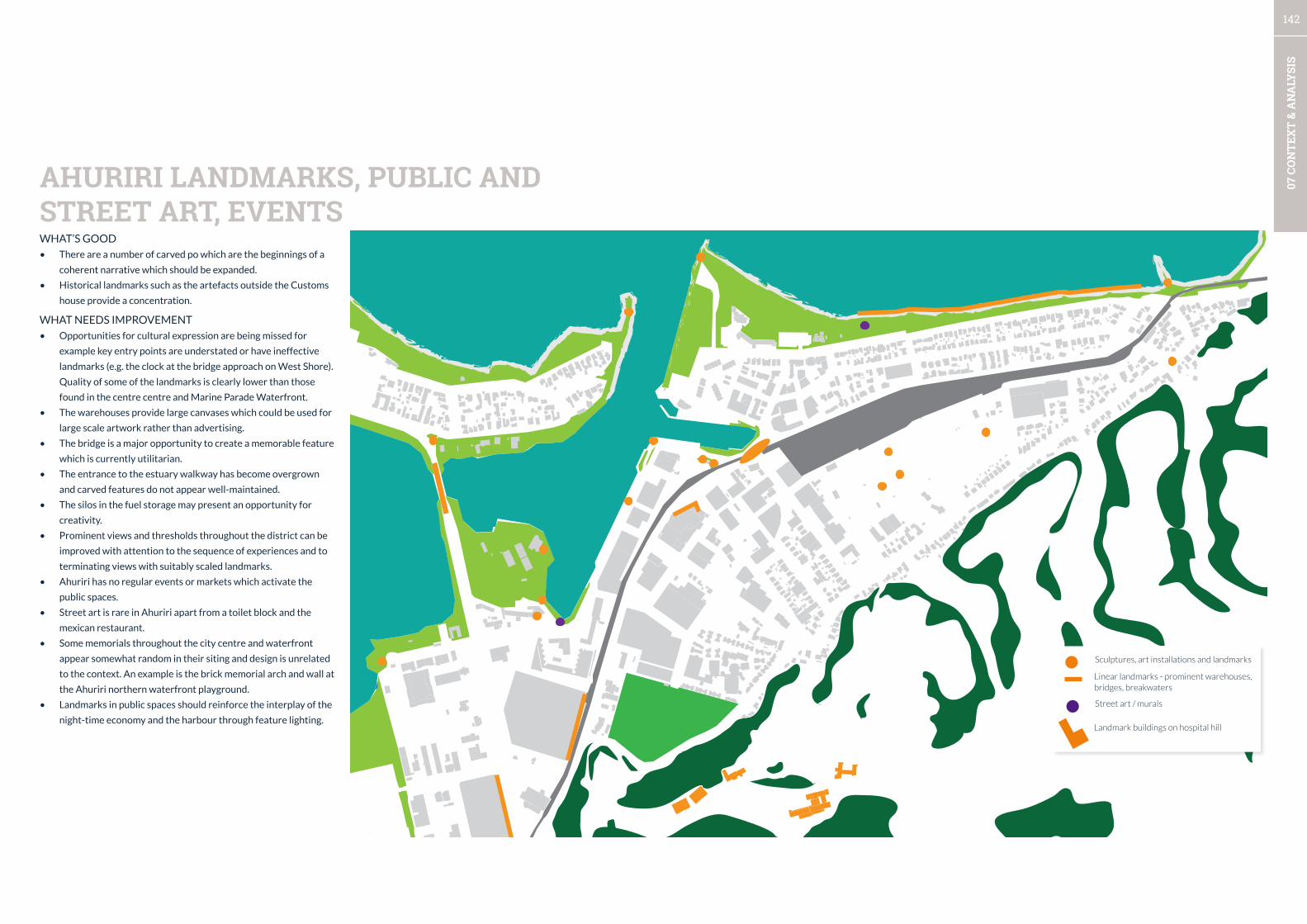
142
07 C
ON
TEX
T &
AN
ALY
SIS
WHAT’S GOOD
• There are a number of carved po which are the beginnings of a
coherent narrative which should be expanded.
• Historical landmarks such as the artefacts outside the Customs
house provide a concentration.
WHAT NEEDS IMPROVEMENT
• Opportunities for cultural expression are being missed for
example key entry points are understated or have ineffective
landmarks (e.g. the clock at the bridge approach on West Shore).
Quality of some of the landmarks is clearly lower than those
found in the centre centre and Marine Parade Waterfront.
• The warehouses provide large canvases which could be used for
large scale artwork rather than advertising.
• The bridge is a major opportunity to create a memorable feature
which is currently utilitarian.
• The entrance to the estuary walkway has become overgrown
and carved features do not appear well-maintained.
• The silos in the fuel storage may present an opportunity for
creativity.
• Prominent views and thresholds throughout the district can be
improved with attention to the sequence of experiences and to
terminating views with suitably scaled landmarks.
• Ahuriri has no regular events or markets which activate the
public spaces.
• Street art is rare in Ahuriri apart from a toilet block and the
mexican restaurant.
• Some memorials throughout the city centre and waterfront
appear somewhat random in their siting and design is unrelated
to the context. An example is the brick memorial arch and wall at
the Ahuriri northern waterfront playground.
• Landmarks in public spaces should reinforce the interplay of the
night-time economy and the harbour through feature lighting.
AHURIRI LANDMARKS, PUBLIC AND STREET ART, EVENTS
Sculptures, art installations and landmarks
Linear landmarks - prominent warehouses, bridges, breakwaters
Street art / murals
Landmark buildings on hospital hill
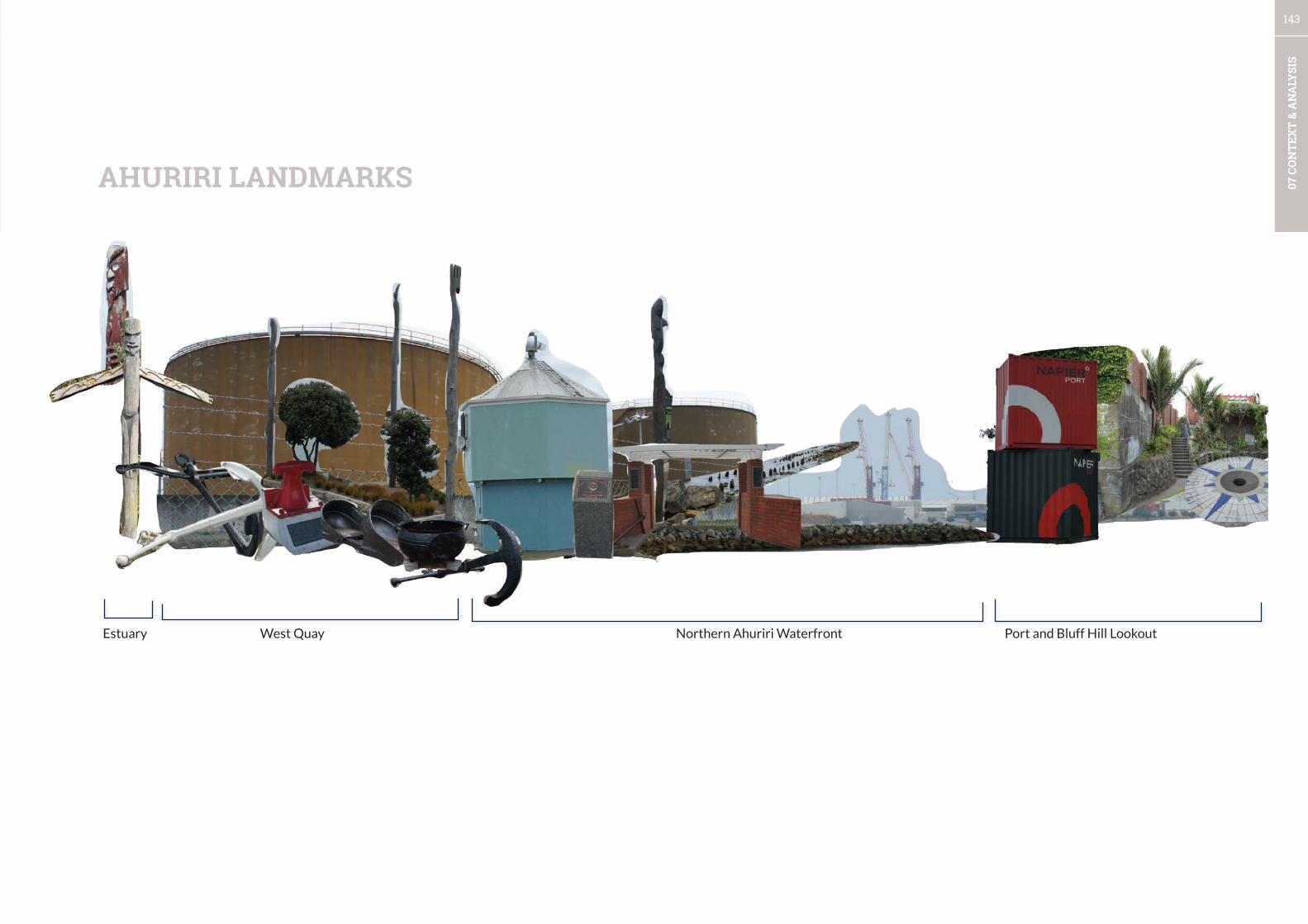
143
07 C
ON
TEX
T &
AN
ALY
SIS
Estuary West Quay Northern Ahuriri Waterfront Port and Bluff Hill Lookout
AHURIRI LANDMARKS

144
07 C
ON
TEX
T &
AN
ALY
SIS
CITY LIFE
145
07 C
ON
TEX
T &
AN
ALY
SIS
• There is little diversity of public life in the City and in general while many places are busy with people passing through
there is little use of public spaces for staying behaviours. In a city with Napier’s climate, there is a potentially huge latent
demand to make the city feel more lively and convivial by cultivating public life.
• Many public spaces lack things to do or give people reasons to be in a public space. Where low cost prototype initiatives
have been installed on Market and Emerson Streets the new features have been used. Successful features are platform
seating with market umbrellas, interactive blackboards, free wifi, bean bags, and artificial turf. Some predictions such as
providing a stage for buskers has been unsuccessful which leads to the next iteration of rapid start-up projects where
new ideas are tested for validation, pivots are made in strategy and which potential users are targeted.
• Places where there is an existing base of users provide testing grounds for introducing new things to do. The aim should
be to create a critical mass of people in places which already work to some degree before starting on unused places.
• Some places, as identified earlier through urban design analysis, have fundamental flaws in their design. These places
which have inactive frontages, the civic square, Memorial Square, the Municipal Theatre and Church, and I-site require
structural changes which cannot be fixed through tactical measures alone. Long-term repair of some of these places is
appropriate while others will remain low priority due to the buildings having special character, and other strategies of
activation are required.
• The Urban Food Market which takes place on Saturdays at Clive and Memorial Squares is an asset for the life of the
city that should be cultivated. The market requires some basic changes to its layout and set-up, and increased shared
collateral to build on what has already been achieved.
• The impact of cruise ships on public life in the city was measured in two locations on Emerson St. The visitors bring a
significant increase in levels of activity, however, cruise ships visitors move fairly quickly through public spaces, stopping
for short periods with many spending less than 5 minutes in a place. As cruise ship visitors move through a space they
are curating their memory of Napier by taking photos. Cruise ship visitor impact on Ahuriri was not measured. A focus
on creating a cohesive cruise ship visitor experience will benefit all tourists who visit Napier and Ahuriri.
CITY LIFE
1. Detailed placemaking plans should be created for public spaces (and aligned with the public life strategy)
with a coherent management structure and clear responsibility for implementation. A learning approach
is required with clear targeting of user-groups and flexible implementation that allows a pivot in strategy
over a number of iterations to test out what works and doesn’t. Risk-taking and a tolerance for failure
and the unpredictable needs to be embedded in this approach to nurture innovation.
2. Variation in public seating needs to be trialled in the central city and waterfront areas both in the City
centre and Ahuriri to encourage use of public spaces.
3. Placemaking programmes should be limited to places which have the preconditions to support greater
increases in activity. Other places require structural changes which will require substantial investments.
Some of these places (such as the Civic centre) already have redevelopment programmes highlighted in
the LTP.
4. Professionalise the Urban Food Market including improved layout, stall set-up, increased shared
collateral, and merchandising.
5. A Cruise ship visitor experience should be designed and supported with additional landmarks and photo
opportunities, interactive experiences, way-finding and walking times in the central city. The impact of
cruise ship visitors on Ahuriri should be measured to inform design an additional Ahuriri experience.
6. Upgrade the central section of Marine Parade and Emerson Street (and potentially other central streets)
to contemporary standards of shared space as part of an integrated public space network.
RECOMMENDATIONS
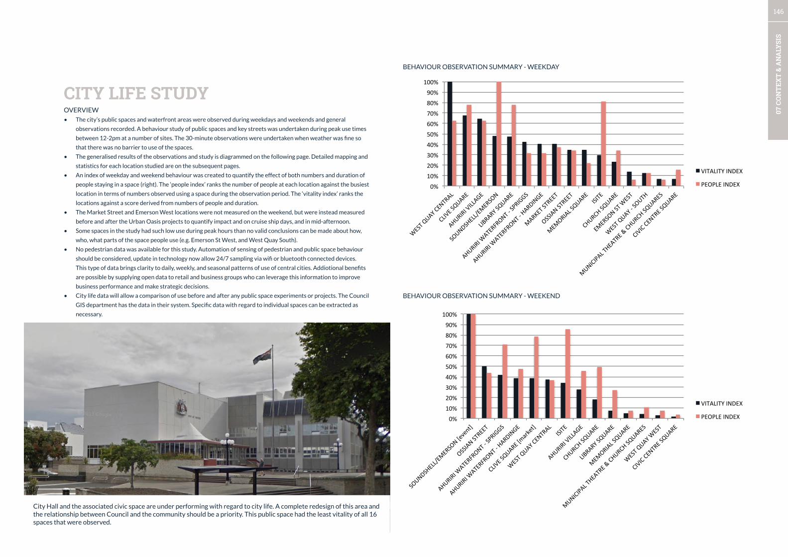
146
07 C
ON
TEX
T &
AN
ALY
SIS
OVERVIEW
• The city’s public spaces and waterfront areas were observed during weekdays and weekends and general
observations recorded. A behaviour study of public spaces and key streets was undertaken during peak use times
between 12-2pm at a number of sites. The 30-minute observations were undertaken when weather was fine so
that there was no barrier to use of the spaces.
• The generalised results of the observations and study is diagrammed on the following page. Detailed mapping and
statistics for each location studied are on the subsequent pages.
• An index of weekday and weekend behaviour was created to quantify the effect of both numbers and duration of
people staying in a space (right). The ‘people index’ ranks the number of people at each location against the busiest
location in terms of numbers observed using a space during the observation period. The ‘vitality index’ ranks the
locations against a score derived from numbers of people and duration.
• The Market Street and Emerson West locations were not measured on the weekend, but were instead measured
before and after the Urban Oasis projects to quantify impact and on cruise ship days, and in mid-afternoon.
• Some spaces in the study had such low use during peak hours than no valid conclusions can be made about how,
who, what parts of the space people use (e.g. Emerson St West, and West Quay South).
• No pedestrian data was available for this study. Automation of sensing of pedestrian and public space behaviour
should be considered, update in technology now allow 24/7 sampling via wifi or bluetooth connected devices.
This type of data brings clarity to daily, weekly, and seasonal patterns of use of central cities. Addiotional benefits
are possible by supplying open data to retail and business groups who can leverage this information to improve
business performance and make strategic decisions.
• City life data will allow a comparison of use before and after any public space experiments or projects. The Council
GIS department has the data in their system. Specific data with regard to individual spaces can be extracted as
necessary.
CITY LIFE STUDY
BEHAVIOUR OBSERVATION SUMMARY - WEEKDAY
BEHAVIOUR OBSERVATION SUMMARY - WEEKEND
0% 10% 20% 30% 40% 50% 60% 70% 80% 90%
100%
WEST QUAY CENTRAL
CLIVE SQUARE
AHURIRI VILLAGE
SOUNDSHELL/EMERSON
LIBRARY SQUARE
AHURIRI WATERFRONT -‐ SPRIGGS
AHURIRI WATERFRONT -‐ HARDINGE
MARKET STREET
OSSIAN STREET
MEMO
RIAL SQUARE
ISITE
CHURCH SQUARE
EMERSON ST W
EST
WEST QUAY -‐ SOUTH
MUNICIPAL THEATRE & CHURCH SQUARES
CIVIC CENTRE SQUARE
VITALITY INDEX
PEOPLE INDEX
0% 10% 20% 30% 40% 50% 60% 70% 80% 90%
100%
SOUN
DSHELL/EM
ERSON [event]
OSSIA
N STREET
AHURIRI WATERFRON
T -‐ SPRIG
GS
AHURIRI WATERFRON
T -‐ HA
RDINGE
CLIVE
SQUARE [m
arket]
WEST QUAY CENTRAL
ISITE
AHURIRI VILLA
GE
CHURCH SQ
UARE
LIBRARY SQ
UARE
MEMO
RIAL SQU
ARE
MUNICIP
AL TH
EATRE &
CHURCH SQ
UARES
WEST QUAY W
EST
CIVIC CENTRE SQ
UARE
VITALITY INDEX
PEOPLE INDEX
City Hall and the associated civic space are under performing with regard to city life. A complete redesign of this area and the relationship between Council and the community should be a priority. This public space had the least vitality of all 16 spaces that were observed.

147
07 C
ON
TEX
T &
AN
ALY
SIS
USE OF PUBLIC SPACESChildren playing, parents watching
Behaviour Observation location
Few walkers and cyclists, some walking dogs
People having lunch and meeting friends
People standing and talking
Few people sitting under trees
Lunchtime crowd; market users
Very few people; donut van on weekend
Few people; ‘undesirables’ exhibiting antisocial behaviour
People catching bus; homesless people sleeping in shelters
Few park users, some people walking through
Mixed ages strolling
Tourists getting info & directions, people waiting for friends, cruise ships visitors waiting for buses backt o ship.
Tourists taking photos; people watching events
Playing in fountain; watching light show; few people using formal garden
People freedom camping in evening, people renting bikes, walking dogs, using the pools.
Cruise ship visitors rushing to board buses
People watching the port, taking photos, taking in the views
Walking and cycling
Children playing, parents watching. Well used waterfront restaurants. Take away dinners.
People socialising at cafés
People socialising at cafés
People working, jumping and swimming from wharf
Water sports e.g. Stand-up paddleboarding
Little activity; some people at cafe on weekend
People grabbing lunch; cafés, cyclists taking a break
Few people fishing
Large groups of tourists taking photos. People hanging out at urban oasis using free wifi.
Few people using the space; most walking to cars. people stanfing & talking
Hardly anyone using the space. Old people resting
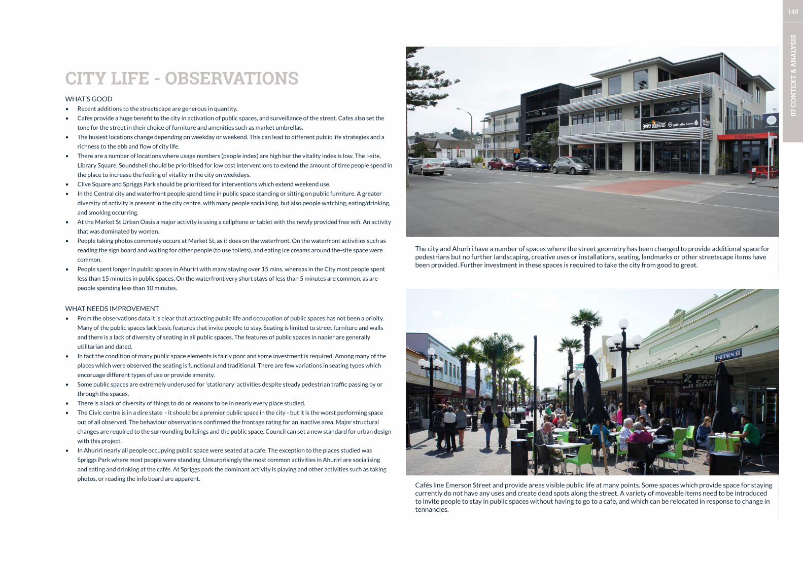
148
07 C
ON
TEX
T &
AN
ALY
SIS
WHAT’S GOOD
• Recent additions to the streetscape are generous in quantity.
• Cafes provide a huge benefit to the city in activation of public spaces, and surveillance of the street. Cafes also set the
tone for the street in their choice of furniture and amenities such as market umbrellas.
• The busiest locations change depending on weekday or weekend. This can lead to different public life strategies and a
richness to the ebb and flow of city life.
• There are a number of locations where usage numbers (people index) are high but the vitality index is low. The I-site,
Library Square, Soundshell should be prioritised for low cost interventions to extend the amount of time people spend in
the place to increase the feeling of vitality in the city on weekdays.
• Clive Square and Spriggs Park should be prioritised for interventions which extend weekend use.
• In the Central city and waterfront people spend time in public space standing or sitting on public furniture. A greater
diversity of activity is present in the city centre, with many people socialising, but also people watching, eating/drinking,
and smoking occurring.
• At the Market St Urban Oasis a major activity is using a cellphone or tablet with the newly provided free wifi. An activity
that was dominated by women.
• People taking photos commonly occurs at Market St, as it does on the waterfront. On the waterfront activities such as
reading the sign board and waiting for other people (to use toilets), and eating ice creams around the-site space were
common.
• People spent longer in public spaces in Ahuriri with many staying over 15 mins, whereas in the City most people spent
less than 15 minutes in public spaces. On the waterfront very short stays of less than 5 minutes are common, as are
people spending less than 10 minutes.
WHAT NEEDS IMPROVEMENT
• From the observations data it is clear that attracting public life and occupation of public spaces has not been a prioity.
Many of the public spaces lack basic features that invite people to stay. Seating is limited to street furniture and walls
and there is a lack of diversity of seating in all public spaces. The features of public spaces in napier are generally
utilitarian and dated.
• In fact the condition of many public space elements is fairly poor and some investment is required. Among many of the
places which were observed the seating is functional and traditional. There are few variations in seating types which
encoruage different types of use or provide amenity.
• Some public spaces are extremely underused for ‘stationary’ activities despite steady pedestrian traffic passing by or
through the spaces.
• There is a lack of diversity of things to do or reasons to be in nearly every place studied.
• The Civic centre is in a dire state - it should be a premier public space in the city - but it is the worst performing space
out of all observed. The behaviour observations confirmed the frontage rating for an inactive area. Major structural
changes are required to the surrounding buildings and the public space. Council can set a new standard for urban design
with this project.
• In Ahuriri nearly all people occupying public space were seated at a cafe. The exception to the places studied was
Spriggs Park where most people were standing. Unsurprisingly the most common activities in Ahuriri are socialising
and eating and drinking at the cafés. At Spriggs park the dominant activity is playing and other activities such as taking
photos, or reading the info board are apparent.
CITY LIFE - OBSERVATIONS
The city and Ahuriri have a number of spaces where the street geometry has been changed to provide additional space for pedestrians but no further landscaping, creative uses or installations, seating, landmarks or other streetscape items have been provided. Further investment in these spaces is required to take the city from good to great.
Cafés line Emerson Street and provide areas visible public life at many points. Some spaces which provide space for staying currently do not have any uses and create dead spots along the street. A variety of moveable items need to be introduced to invite people to stay in public spaces without having to go to a cafe, and which can be relocated in response to change in tennancies.

149
07 C
ON
TEX
T &
AN
ALY
SIS
When events are on people stay within a small radius of the stage in order to experience the performance. The crowd spreads onto the footpath laterally rather the extending back. Consideration of how this space is integrated with the street should be a factor in future development of this area.
When events are on at the soundshell the place acts as a hub of city life and activity. However, for most days and therefore most of the year it is a fairly dead space.
The crowd stays close to the action and the large paved space which forms half of the soundhshell / arches area remains unused. Contemporary strategies and a redesign should be pursued to make the most of this central waterfront space and significant structure. The inset photo shows the same behaviour approximately 50 years ago.
During the observation period when an event was on at the Soundshell, mobile foodcarts were located in the paved space. And there was little other collateral supplied which improved the event.

150
07 C
ON
TEX
T &
AN
ALY
SIS
Standing conversations are a large part of the city life on Emerson Street. The large octagonal planters and platforms do not promote relaxation, with people observed perched on the edges. However, they do create edge conditions where people gravitate to while standing and talking. A diversity of seating is required if different type of city life are to be cultivated.
This experiment with different types of seating, shade, free wifi, and the use of artificial turf to define and area and soften the space has validated predictions about how people might use Emerson St in different ways. The small stage area shown below has been unused by performers unless programmed by Council. Further iterations are planned.
Males and females were found throughout the central city spaces in fairly equal proportions apart from two places. The library square and the Market St pop-up space. The qualities of these spaces that attract women should be investigated in further detail as the presence of women can be used as a proxy for place quality.
Two locations have clear patterns where sitting is common - Clive Square, and the Soundshell area. Other places have high numbers of standing conversations, waiting, and activities such as standing and taking photos of art deco buildings and other features. Groups of people are common throughout the central city, however, in Emerson St West singles are common. In the Civic Square, few people were present and those who used it were by themselves.
Males vs. females use of central city space
Sitting vs. standing in central city spaces
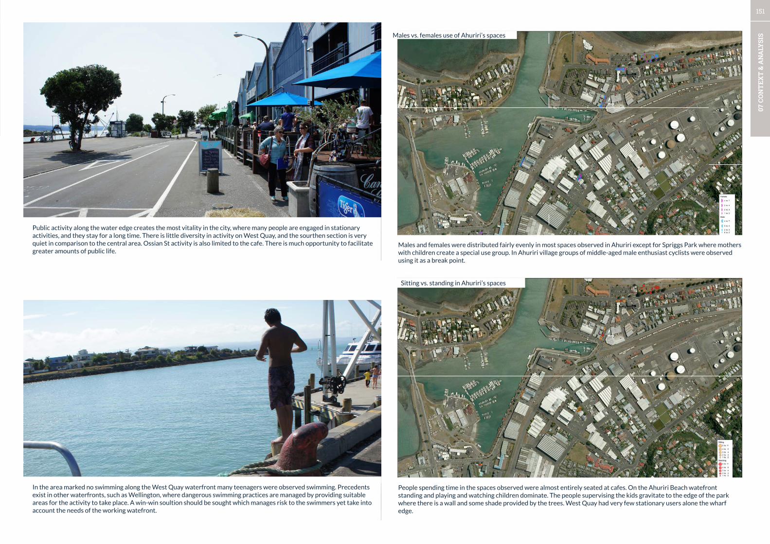
151
07 C
ON
TEX
T &
AN
ALY
SIS
In the area marked no swimming along the West Quay waterfront many teenagers were observed swimming. Precedents exist in other waterfronts, such as Wellington, where dangerous swimming practices are managed by providing suitable areas for the activity to take place. A win-win soultion should be sought which manages risk to the swimmers yet take into account the needs of the working watefront.
Males vs. females use of Ahuriri’s spaces
Males and females were distributed fairly evenly in most spaces observed in Ahuriri except for Spriggs Park where mothers with children create a special use group. In Ahuriri village groups of middle-aged male enthusiast cyclists were observed using it as a break point.
Sitting vs. standing in Ahuriri’s spaces
People spending time in the spaces observed were almost entirely seated at cafes. On the Ahuriri Beach watefront standing and playing and watching children dominate. The people supervising the kids gravitate to the edge of the park where there is a wall and some shade provided by the trees. West Quay had very few stationary users alone the wharf edge.
Public activity along the water edge creates the most vitality in the city, where many people are engaged in stationary activities, and they stay for a long time. There is little diversity in activity on West Quay, and the sourthen section is very quiet in comparison to the central area. Ossian St activity is also limited to the cafe. There is much opportunity to facilitate greater amounts of public life.
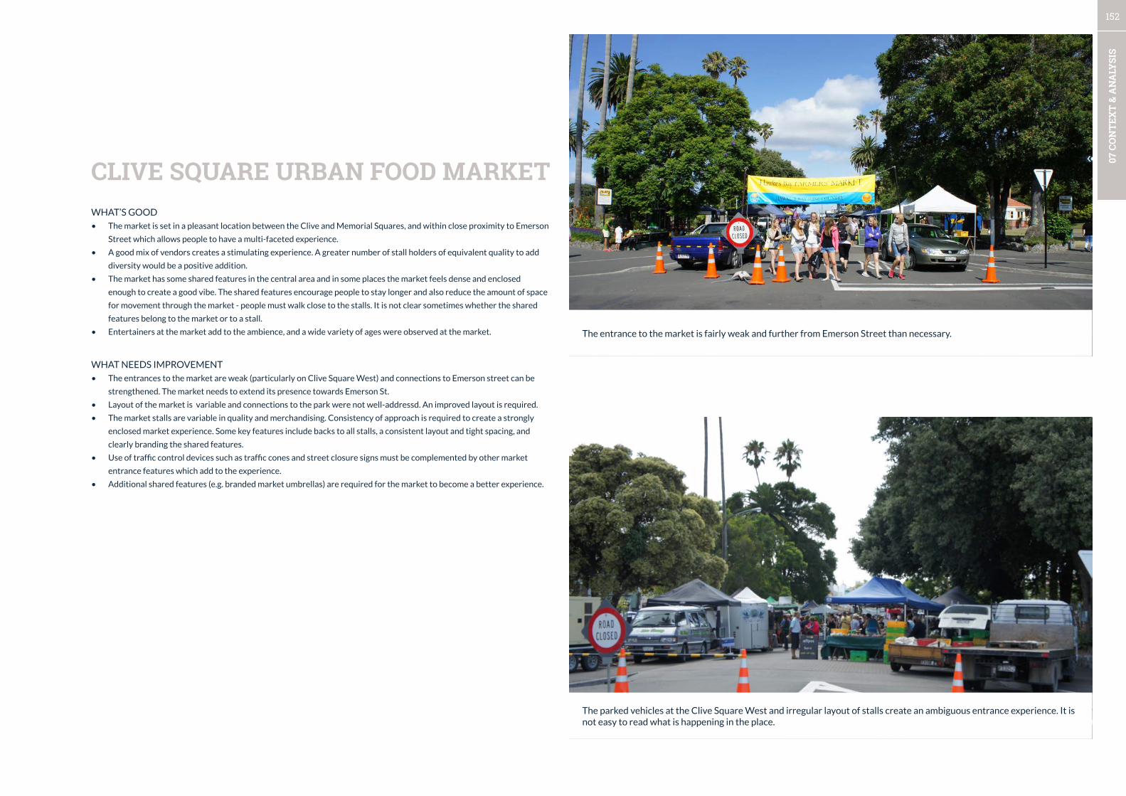
152
07 C
ON
TEX
T &
AN
ALY
SIS
WHAT’S GOOD
• The market is set in a pleasant location between the Clive and Memorial Squares, and within close proximity to Emerson
Street which allows people to have a multi-faceted experience.
• A good mix of vendors creates a stimulating experience. A greater number of stall holders of equivalent quality to add
diversity would be a positive addition.
• The market has some shared features in the central area and in some places the market feels dense and enclosed
enough to create a good vibe. The shared features encourage people to stay longer and also reduce the amount of space
for movement through the market - people must walk close to the stalls. It is not clear sometimes whether the shared
features belong to the market or to a stall.
• Entertainers at the market add to the ambience, and a wide variety of ages were observed at the market.
WHAT NEEDS IMPROVEMENT
• The entrances to the market are weak (particularly on Clive Square West) and connections to Emerson street can be
strengthened. The market needs to extend its presence towards Emerson St.
• Layout of the market is variable and connections to the park were not well-addressd. An improved layout is required.
• The market stalls are variable in quality and merchandising. Consistency of approach is required to create a strongly
enclosed market experience. Some key features include backs to all stalls, a consistent layout and tight spacing, and
clearly branding the shared features.
• Use of traffic control devices such as traffic cones and street closure signs must be complemented by other market
entrance features which add to the experience.
• Additional shared features (e.g. branded market umbrellas) are required for the market to become a better experience.
CLIVE SQUARE URBAN FOOD MARKET
The entrance to the market is fairly weak and further from Emerson Street than necessary.
The parked vehicles at the Clive Square West and irregular layout of stalls create an ambiguous entrance experience. It is not easy to read what is happening in the place.
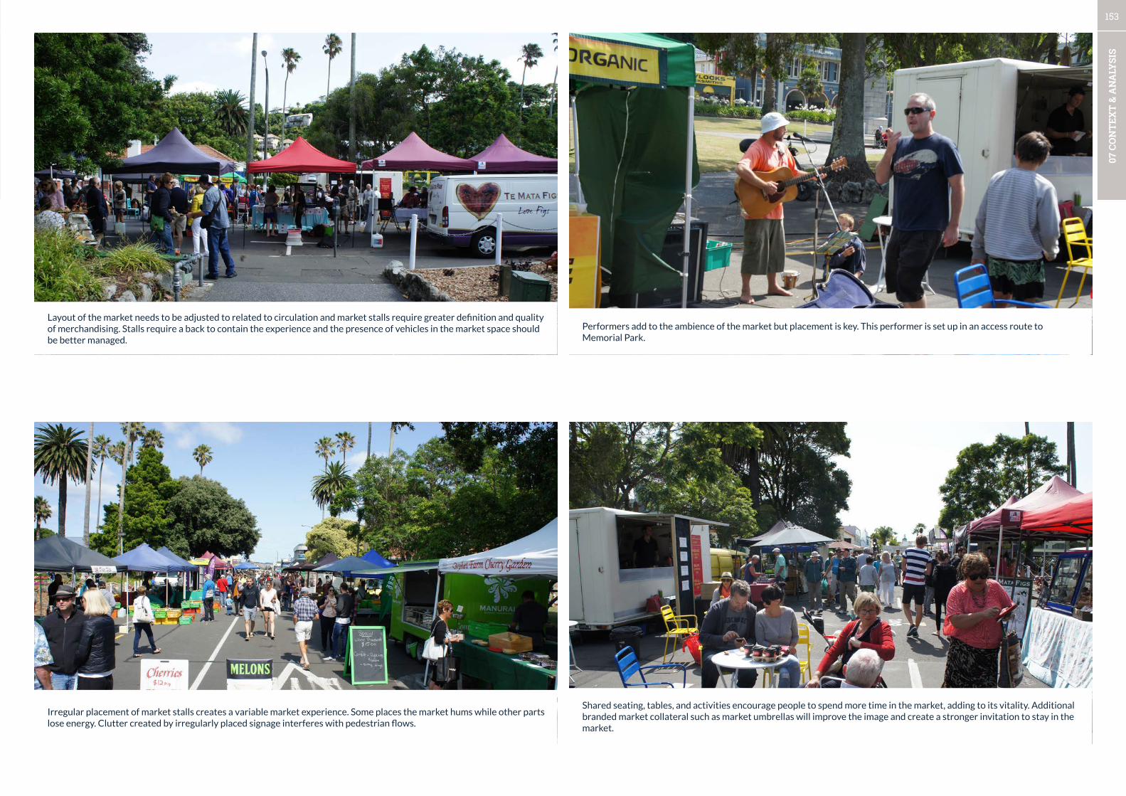
153
07 C
ON
TEX
T &
AN
ALY
SIS
Layout of the market needs to be adjusted to related to circulation and market stalls require greater definition and quality of merchandising. Stalls require a back to contain the experience and the presence of vehicles in the market space should be better managed.
Irregular placement of market stalls creates a variable market experience. Some places the market hums while other parts lose energy. Clutter created by irregularly placed signage interferes with pedestrian flows.
Shared seating, tables, and activities encourage people to spend more time in the market, adding to its vitality. Additional branded market collateral such as market umbrellas will improve the image and create a stronger invitation to stay in the market.
Performers add to the ambience of the market but placement is key. This performer is set up in an access route to Memorial Park.

154
07 C
ON
TEX
T &
AN
ALY
SIS
WHAT’S GOOD
• Cruise ship visits generally introduce an additional 2000 to 3000 people into the City. The effect of cruise ships on
central city spaces was measured at Market and Emerson Streets over a half an hour period at midday.
• Approximately 6 times as many people used Market Street on a cruise ship day as compared to a normal weekday
(69 vs. 12). Many of the cruise ship visitors are in large groups, and taking photos is the dominant activity. These
groups are very social with high amounts of conversations among group members recorded. Few visitors sat in the
spaces, and about half of the people spent less than 5 minutes in the space.
• At Emerson Street West 20 times the amount of people spent time in the space compared to a normal day (40 vs.
2). In Emerson Street West most people spent less than 5 minutes, and far fewer people were taking photos and
most were standing around chatting in this space. It appears that many were deciding on what to do and where to
go next. In contrast to Market St, most visitors in this area were alone or in groups of 2-3 people.
• On arrival cruise ship visitors are rushed from the ship to waiting buses. At the end of the day, large queues form
as people wait for the buses in the i-site area. It is generally apparent that the city makes an effort to welcome the
cruise ships with people dressed in historical costumes and vintage cars on display.
WHAT NEEDS IMPROVEMENT
• The design of the visitor experience in the central city and the waterfront needs support with additional and
renewed features in the public realm. The narratives of the city such as the earthquake, and Art Deco need a
contemporary update and supporting infrastructure such as way-finding and other informational signage is non-
existent.
• Photo opportunities in the city centre need to be increased especially in strategic locations to provide an invitation
to people to move through the city centre in a sequence. This means visual thresholds related to people vision must
be respected and unnecessary street clutter which degrades the sensory experience must be kept to a minimum.
• Given Emerson Street and the central areas of Marine Parade’s (from the Scenic Hotel to I-site) role as part of the
public life for residents and for cruise ship and other visitors an upgrade to contemporary standards of shared
space should be considered to create a safer experience. Visitors were observed tripping and falling over into the
road space (as informed by Council staff) due to their lack of vigilance as they took in the Art Deco buildings and
other features.
CITY LIFE - CRUISE SHIP VISITOR EXPERIENCE
The initial cruise ship visitor exprience is rushed and the Port is experience from buses.
At the end of the day long lines form near the I-site as most visitors are ferried back to the cruise ship.

155
07 C
ON
TEX
T &
AN
ALY
SIS
Photos are a way that people create their memory of a place. Napier has some good photo opportunities but needs to build upon this base to create a more diverse experience.
First impressions count - this area of Emerson is part of an initial sequence that people move through, more needs to be done here to link the central section of Emerson St to the Waterfront.
The route to the City from the Port is an opportunity to create a lasting experience for cruise ship visitors and other tourists. Currently, this section of the waterfront is a blank slate. Recent pohutukawa plantings are a start.
The pop-up cruise ship visitor arrival area is a pragmatic approach to the Port’s constraints. More features which can pop-up or out of containers will create a stronger more memorable arrival experience (Note: pirates in the pictures are criuse ship staff who were avoided by the majority of cruise ship passengers).
156