city richmond · man""' 1hallhey cansider relev.ltto the public in-lin making lhelr...
TRANSCRIPT

To:
From:
City of Richmond
General Purposes Committee
John Irving, P.Eng. MPA Director, Engineering
Victor Wei, P.Eng. Director, Transportation
Report to Committee
Date: August 26, 2016
File: 01-0150-20-THIG1/2016-Vol 01
Re: George Massey Tunnel Replacement Project -Application Comments for the British Columbia Environmental Assessment Process
Staff Recommendation
That the City's comments on the Provincial Environment Assessment Application for the George Massey Tunnel Replacement Project for the first round of the 30-day Working Group review period, as outlined in Attachment 1 of the staff report, titled "George Massey Tunnel Replacement Project - Application Comments for the British Columbia Environmental Assessment Process" dated August 26, 2016, be conveyed to the BC Environmental Assessment Office for consideration and response.
~~A Director, Engineering (604-276-4140)
Art. 1
ROUTED TO:
Economic Development Parks Policy Planning Fire-Rescue
REVIEWED BY STAFF REPORT I AGENDA REVIEW SUBCOMMITTEE
5120847
Victor Wei, P.Eng. Director, Transportation (604-276-4131)
REPORT CONCURRENCE
CONCURRENCE CONCURRENCE OF GENERAL MANAGER
[il"" C2?--===> ur--Gr" @""
INITIALS: APPROVED BY CAO (t4c. "1l tN(l ).
\J'?J ~~ -~
CNCL - 53

August 26, 2016 - 2-
Staff Report
Origin
On July 27, 2016, the British Columbia Environmental Assessment Office (BCEAO) advised the City that the 180-day Application Review stage for the George Massey Tunnel Replacement Project (the Project) was initiated.' During this period, the BCEAO will receive and review comments from the Working Group (includes City staff) and public as well as compile the Assessment Report for the Minister, which should be completed by January 23, 2017.
This report presents staffs initial comments on the Environmental Assessment Application (the Application) as part ofthe 30-day Working Group comment period (July 27-August 26, 2016), which is intended to comprise a technical review of the Application and the identification of outstanding issues that require clarification, analysis, mitigations, and possible conditions of the Environmental Assessment Certificate.
Findings of Fact
180-Day Application Review Stage
Figure 1 depicts the stages of the environmental assessment process. The Application Review stage (highlighted by red box) includes Working Group and public comment periods (described further below) and the drafting of the Assessment Report (the Report) by the BCEAO.
ure 1: Environmental Assessment Process
Environmental Assessment Process
I 1 Public 1 Comment I Period I
Develop Requirements
Pre-Application Stage (30 days) I Application Review Stage (no Umeline) 1 1 (180 days) --------------------------------, IE-------- Working Group Review
FIRST NATION CONSULTATION
1 The Application and related documents are available on the BCEAO website at http: //al OO.gov.bc.ca!appsdatalepic/htmUdeploy/epic project home 430.html.
5120847
Mlnislar(s) may consider anyman""' 1hallhey
cansider relev.ltto the public In-l in
making lhelr decision
CNCL - 54

August 26, 2016 - 3 -
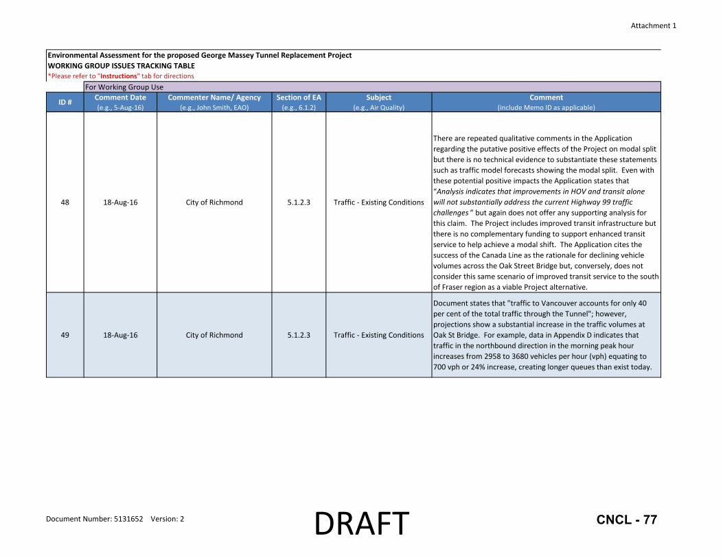
The Report documents the findings of the assessment, including the extent to which concerns have been addressed and whether any issues remain outstanding. Following the Working Group and public comment periods, the BCEAO will share its draft assessment report with the Ministry of Transportation & Infrastructure (which is the proponent) and the Working Group and seek input. The BCEAO typically provides approximately three weeks for such comment.
Working Group 30-Day Comment Period
The City and other Working Group members have 30 days beginning July 27,2016 to provide the BCEAO with comments on the Application. This is the last remaining opportunity that the City and other Working Group members have to identify technical issues, gaps and omissions as subsequent discussions between the BCEAO and Working Group members would focus on the items raised. Facilitated by the BCEAO, the Ministry of Transportation & Infrastructure (the Ministry) will respond to the Working Group comments and Working Group members will then have a second opportunity (tentatively September 12-30, 2016) to respond to the proponent's comments. Two Working Group meetings are scheduled during this time: September 20 (all day) and September 21 (half day).
Due to the relatively short and poorly scheduled comment period for the Working Group, City staff requested a 30-day extension to the deadline; the BCEAO granted an extension to September 14, 2016 to enable staff to bring forth this report for Committee and Council consideration.
Public 60-Day Comment Period
The 60-day public comment period is occurring August 3-0ctober 3, 2016. During this period three open houses are scheduled as shown in Table 1. Application materials are also available at the Project office (2030-11662 Steveston Highway) at Ironwood Plaza. Staff will attend the open house to be held in Richmond.
The intention of seeking public comments is to
Date
Aug 17
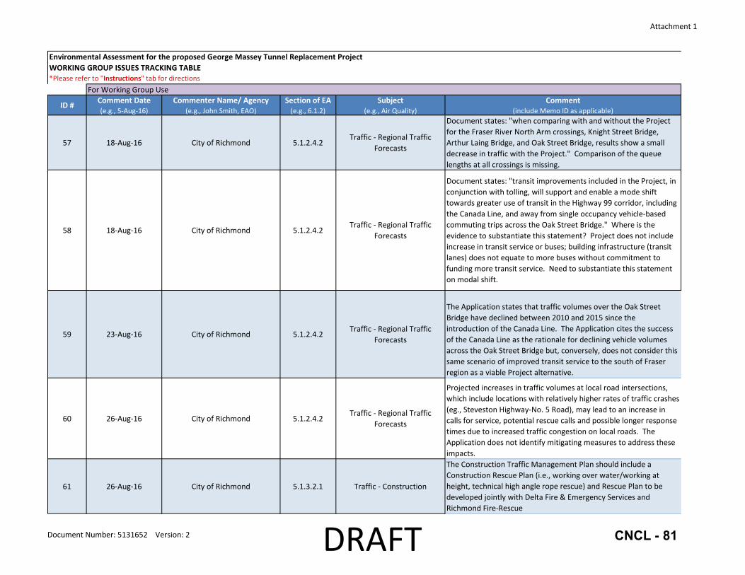
Sep 14
Sep 13
T bl 1 BCEAO P bl" 0 H a e u 1c 1pen ouses Location Time Delta Town and Country
2:00pm 6005 Highway 17A (at Highway 99) to
Delta, BC 8:00pm
Sandman Signature Hotel 2:00pm
Vancouver Airport to
10251 St. Edwards Drive 8:00pm
Richmond, BC
ensure that all potential effects - environmental, economic, social, heritage, and health - that might result from the proposed Project are identified for consideration as part of the environmental assessment process.
Referral to Ministers and Project Decision
In addition to the Assessment Report, the BCEAO provides two ministers (the Minister of Environment and the Minister of Community, Sport & Cultural Development) with recommendations as to whether or not to issue an environmental assessment certificate and a draft of the certificate. The draft certificate will identify the details according to which the Project must be designed and constructed, and the commitments the proponent has made to address concerns raised through the environmental assessment process. The ministers have 45 days in which to make a decision and have three choices: (1) issue an environmental assessment certificate with any conditions they consider necessary; (2) refuse to issue the certificate; or (3) require further study or assessment.
5120847 CNCL - 55

August 26, 2016 - 4-
Analysis
There are significant gaps in the assessment of the impacts of the Project, omissions of technical analysis as well as unsubstantiated claims of predicted Project benefits. Key issues and concerns are summarized below for the relevant sections of the Application. Attachment 1 contains a draft list of all staff comments on the Application. Following Council approval, these comments would be forwarded to the BCEAO.
Traffic
Impacts on Local Roads
The Application includes existing (2014) and forecast (2045) traffic volume information for Highway 99 interchanges and one municipal intersection (Steveston Highway-No. 5 Road) in Richmond but there is no analysis of the impacts of this increased traffic on local roads and intersections upstream and/or downstream of the Project, and thus no identification of measures to mitigate any impacts.
Table 2 identifies the forecast increases in traffic volumes for key locations that are of significant concern. Increases in traffic volumes range from 3 3 to 164 percent during the peak periods. Of particular concern is the Steveston Highway Interchange where all Highway 99 on- and offramps will be free flow (i.e., not controlled by traffic signals). There is a substantial downstream impact on the Steveston Highway-No. 5 Road intersection, particularly for westbound traffic approaching No.5 Road where traffic volumes are forecast to increase by 890 vehicles per hour (117 percent) in the PM peak. The concern of increased westbound traffic volumes is exacerbated by the potential increase in conflicts arising from southbound traffic exiting Highway 99 at Steveston Highway and seeking to weave across the lanes to make a westboundto-southbound left-turn at the intersection.
Table 2: Existing and Forecast Traffic Volumes at Key Locations in Richmond Location Direction Forecast Traffic Increase
EB Sea Island Way to SB Hwy 99 +500 vph (124%) in AM peak
Bridgeport Road-Sea +520 vph (48%) in PM peak Island Way Interchanges
NB Highway 99 Off-Ramp to Bridgeport Road +570 vph (51%) in AM peak +480 vph (78%) in PM peak
Shell Road lnterchanQe NB On-Ramp to HiQhwav 99 +490 vph (64%) in PM peak
Westminster Highway EB Westminster Hwy to SB Hwy 99 +930 vph (107%) in PM peak NB Hwy 99 Off-Ramp +440 vph (58%) in AM peak
Interchange WB Westminster Hwy to SB Hwy 99 +380 vph (89%) in PM peak
NB Hwy 99 Off-Ramp +250 vph (33%) in AM peak
Steveston Highway +590 vph (164%) in PM peak Interchange EB Steveston Hwy to SB Hwy 99 +750 vph (88%) in PM peak
SB Hwy 99 Off-Ramp +170 vph (142%) in PM peak EB Steveston Hwv approachinQ No. 5 Road +540 vph (69%) in PM peak
Steveston Highway-No. 5 SB No.5 Road to EB Steveston Hwy +130 vph (70%) in PM peak
Road NB No. 5 Road to EB Steveston Hwy +300 vph (43%) in PM peak
WB Steveston Hwy approaching No. 5 Road +420 vph (33%) in AM peak +890 vph (117%) in PM peak
NB=northbound SB=southbound EB=eastbound WB=westbound vph=vehicles per hour AM peak=7:30-8:30 am PM peak=4:30-5:30 pm
5120847 CNCL - 56

August 26, 2016 - 5 -
Forecast traffic volume data as well as detailed analysis assumptions (e.g., lane capacity, number of lanes, traffic signal phasing, geometric characteristics) and outputs (e.g., level of service, volume/capacity ratios, queuing analysis, other capacity performance indicators) are required so that the traffic impacts on municipal roads can be assessed and improvements identified, including but not limited to the following locations:
• Proposed Transit Only Lanes: intersection oflanes at Van Home Way and Great Canadian Way-Van Home Way.
• Bridgeport Road-Sea Island Way Interchanges: Garden City Road-Sea Island Way, Garden City Road-Bridgeport Road, and Bridgeport Road-Highway 99 northbound off-ramp.
• Shell Road Interchange: Cambie Road-Shell Road and Shell Road-Highway 99 ramps. • Highway 91 Interchange: Alderbridge Way-Shell Road. • Westminster Highway Interchange: Westminster Highway-No. 5 Road and Westminster
Highway-Sidaway Road. • Steveston Highway Interchange: Steveston Highway-No. 5 Road and Steveston Highway
Sidaway Road. • Proposed Rice Mill Road Ramps: intersection of ramps at Rice Mill Road and No.5 Road
Rice Mill Road.
Richmond Fire-Rescue has also identified that the projected increases in traffic volumes at the above locations, which include locations with relatively higher rates of traffic crashes, may lead to an increase in calls for service, potential rescue calls and possible longer response times due to increased traffic congestion on local roads. Given the increase in hourly vehicle volumes, ICBC should be requested to provide forecast collision data for these locations.
To enable faster response times to crashes on Highway 99 or elsewhere in the city using Highway 99 as a response route, Richmond Fire-Rescue suggest new additional on-ramps accessible by first responders only at the following two locations:
• Northbound on-ramp to Highway 99 from westbound Westminster Highway • Southbound on-ramp to Highway 99 from eastbound Cambie Road
The Project should be responsible for the funding and implementation of any necessary local road improvements to facilitate the impact of the increased traffic and thus achieve the benefits of increased safety, reliability and travel time savings claimed by the Project. The stated benefits should not rely on the actions of a third party, such as the host municipality.
Impacts on Local Pedestrian and Cycling Networks
The new interchanges and same forecast traffic volume increases identified for local roads will also impact local pedestrian and cycling networks. Of particular concern are the proposed transit only lanes underneath the Oak Street Bridge that will cut across the Bridgeport Trail and the offstreet multi-use pathway on Van Home Way with the latter being the key pedestrian-cycling connection to the Canada Line Bridge. Both facilities also provide links between the Bridgeport Canada Line Station and Transit Exchange and the Tait neighbourhood to the east. Despite anticipated frequencies of one bus every three minutes using the transit only lanes during peak periods, the Application provides no discussion, analysis or measures to mitigate this significant impact to trail and path users.
5120847 CNCL - 57

August 26, 2016 - 6-
Similarly, Rice Mill Road is a popular cycling route used by cyclists destined to east Richmond that allows bypass of the Steveston Highway Interchange. Rice Mill Road is currently has a rural two-lane cross-section with gravel shoulders. The proposed Highway 99 on- and off-ramps connecting to Rice Mill Road will introduce significantly higher traffic volumes on the roadway but, again, the Application does not identify any improvements to address this impact to other road users such as cyclists.
The new interchanges at Westminster Highway and Steveston Highway, which both feature free flow on- and/or off-ramps, and the forecast increased traffic volumes at local intersections in the vicinity of the interchanges (e.g., Steveston Highway-No. 5 Road) will also impact pedestrians and cyclists crossing the intersections and/or Highway 99.
The Ministry's Cycling Policy states that "Our goal to integrate bicycling on the province's highways by providing safo, accessible and convenient bicycle facilities and by supporting and encouraging cycling" and "Provisions for cyclists are made on all new and upgraded provincial highways." Given that the Project scope extends from Bridgeport Road in Richmond to Highway 91 in Delta and the current reference concept does not include continuous cycling facilities along this section of the Highway 99 corridor, the Project should be responsible for the funding and implementation of alternative cycling facilities within the host municipalities. This would enable a continuous, safe and convenient route that will help achieve the Project's stated goals to encourage a higher mode share for cycling, walking and transit in line with local and regional targets.
Impacts at Oak Street Bridge
The Application states that traffic volumes over the Oak Street Bridge have declined between 2010 and 2015 since the introduction of the Canada Line but also acknowledges that northbound AM peak period traffic may make "queue lengths at Oak Street a little longer during the busiest part of the rush hour." Forecast traffic volumes at the Sea Island Way Interchange indicate a notable increase of 720 vehicles per hour (24 percent) for northbound highway traffic approaching the Oak Street Bridge in the AM peak. The Application states that the transit improvements included in the Project will "enable a mode shift toward greater use of transit in the Highway 99 corridor, including the Canada Line, and away from single occupancy vehiclebased commuting trips across the Oak Street Bridge" but does not provide any evidence to substantiate this claim.
Given that 40 percent of the traffic through the Tunnel is to/from Vancouver as determined by the Ministry's Bluetooth origin-destination surveys, the project scope should include the Oak Street Bridge as otherwise the anticipated travel time savings or improved travel time reliability for traffic travelling to/from Vancouver would not be achieved in the peak periods. Further, the Application does not identify any contingency plan to address the potential lengthening queues at the Oak Street Bridge during the peak periods.
Impacts at Alex Fraser Bridge
One of the Provincial tolling guidelines is that tolls will be implemented only if a reasonable non-tolled alternative is available. The Application states that the Project will be tolled. The non-tolled alternative crossing for the south arm of the Fraser River, the Alex Fraser Bridge, is
5120847 CNCL - 58

August 26, 2016 - 7 -
forecast to experience an increase of20,000 vehicles per day (17 percent) with a tolled Project in place versus without the Project (from 120,000 to 140,000 vehicles per day). The Application states that the Alex Fraser Bridge already experiences greater congestion than the Tunnel during the peak periods; the forecast traffic diversion will only exacerbate this issue. The Ministry announced planned improvements in the Highway 91 corridor (i.e., new interchange at Highway 91-72nd A venue) in June 2016 but the Application does not identify this work or to what extent, if any, the changes may mitigate the impact of the traffic diversion. The forecast scenario also reinforces the need to move to a region-wide mobility pricing policy consistent with the Mayors' Council vision for regional transportation investments in Metro Vancouver.
Modal Shift Change
There are repeated qualitative comments in the Application regarding the putative positive effects of the Project on modal split but there is no technical evidence to substantiate these statements such as traffic model forecasts showing the modal split. Even with these potential positive impacts the Application states that "Analysis indicates that improvements in HOV and transit alone will not substantially address the current Highway 99 traffic challenges" but again does not offer any supporting analysis for this claim. The Project includes improved transit infrastructure but there is no complementary funding to support enhanced transit service to help achieve a modal shift. The Application cites the success of the Canada Line as the rationale for declining vehicle volumes across the Oak Street Bridge but, conversely, does not consider this same scenario of improved transit service to the south of Fraser region as a viable Project alternative.
Traffic Forecasts and Rationale for 1 0-Lane Bridge
The Application states that the Tunnel currently carries an average of 80,000 vehicles per day and traffic would grow to 100,000 vehicles per day by 2045 without a new bridge. Based on traffic forecasts with a new tolled bridge, traffic volumes would drop to 71,000 vehicles per day in the first year and grow to 84,000 vehicles per day by 2045.
Separate information in Appendix B (Traffic Data Overview) to the Traffic chapter states that "Modelling results ... predict that by 2045 traffic through the existing Tunnel will grow to approximately 100, 000 vehicles per day and that traffic over a new 1 0-lane bridge will be approximately 115,000 vehicles per day." Presumably, these forecast traffic volumes are based on a non-tolled crossing. These higher traffic volumes appear to be used to support the design of Project elements including the determination of the number oflanes required for the bridge.
However, the Application clearly states that the new bridge will be tolled. Thus, given that the forecast daily traffic volumes in 2045 are not substantially different from current daily traffic volumes for a tolled crossing, it is unclear why such an expansion of vehicle capacity (more than doubling from four to 10 lanes) is necessary. Moreover, per the Ministry's traffic data program, average annual daily traffic volumes for the Tunnel have declined over the 2003 to 2014 period from 82,297 to 79,105 vehicles (-0.36 percent annual growth).
5120847 CNCL - 59

August 26, 2016 - 8 -
Land Use
Compatibility with Provincial, Regional and Local Land Use and Transportation Plans
The Application references A Long-Range Transportation Plan for Greater Vancouver: Transport 2021, jointly produced in 1993 by the Ministry of Transportation and Highway (MoTH) and the Greater Vancouver Regional District and developed in support of the 1996 Livable Region Strategic Plan, and states that the report identified "the need" for additional capacity across the north and south arms of the Fraser River. However, the Transport 2021 report context is that the suggested additional capacity is one of several long-term corridor options for investigation, not an identified need. Moreover, the report states that "The choke points of the bridges and tunnels across the Fraser River and across Burrard Inlet would be used to "draw the line" and limit access to the single-occupant vehicle" and that a single occupant vehicle restraint strategy should be followed with no increase in mixed traffic peak hour capacity (i.e., high and single occupant vehicles).
The Mayors' Council Regional Transportation Investments: a Vision for Metro Vancouver has a headline target to "make half of all trips by walking, cycling and transit." One of the five goals of Metro Vancouver 2040: Shaping our Future (Metro Vancouver's Regional Growth Strategy) is to "Support sustainable transportation choices." While the Project includes dedicated transitHOY lanes, the expanded vehicle capacity for single occupant vehicles is not consistent with the Vision and the Regional Growth Strategy, or with the City's modal shift targets of the 2041 Official Community Plan given the lack of substantiation in the Application regarding forecast modal split.
With respect to cycling and walking, the proposed cycling and pedestrian infrastructure would be implemented primarily within the Highway 99 right-of-way only and any new overpasses would have a sidewalk on one side only. As noted above, municipalities appear to be responsible for any tie-ins to local networks with no additional cost-share funding to be made available. Instead, Richmond would have to compete for provincial BikeBC funding, which is currently limited to $6 million annually for the entire province.
Impacts on the City of Richmond's Gardens Agricultural Park
The Application contains no information on the impacts ofthe Project to the City's Gardens Agricultural Park. The Project requires 0.875 hectares ofland within the park and the loss of this land would result in the eastern park boundary shifting, on average, 35 metres to the west of its current location and equates to an overall17.8 percent reduction in the size of the park. Such a shift in the park's eastern boundary would significantly impact the approved park plan. In particular, the parking lot, community gardens, agricultural demonstration gardens, and landscape buffer would all be reduced in size by approximately 50 percent and would no longer function in the manner envisioned in the approved park plan. Mitigating measures to address the impacts should include:
• Financial support to the City to prepare and implement a new park plan based on a reexamination of the park's original program elements and an assessment of the extent to which the displaced elements can be integrated into the new plan or accommodated
5120847 CNCL - 60

August 26, 2016 - 9 -
elsewhere in the city including additional consulting services and a new public consultation process; and
• Identification of how the Project impacts of the widening of Highway 99 and the multi-level Steveston Highway Interchange will be managed to attenuate the additional traffic noise and reduce the poorer quality impacts on the recently approved private "Gardens" mixed use (e.g., residential, commercial, child care) development.
Impacts on the Richmond Nature Park
The Richmond Nature Park is bisected by Highway 99. While the widening of Highway 99 in this area is understood to be contained within the existing right-of-way, the additional infrastructure to be constructed in this area (i.e., wider highway, new Westminster Highway Interchange, new ramp connection from Highway 91) could have the potential to impact water levels and quality in the area and, in tum, the sustainability of the adjacent bog. The Application should include an assessment of this potential impact and, if required, identify any mitigating measures.
Agricultural Use
Widening of Highway 99 to West versus East
The Application does not contain any discussion or rationale as to why the widening of Highway 99 in Richmond will occur on the west side as opposed to the east side. Given that adjacent property is required for the Project, the City's preference is to widen Highway 99 on the east side as property on the west side is within the City's Backlands Policy area. In 1990, the City of Richmond and the Agricultural Land Commission (ALC) entered into an agreement to increase farming within the Backlands; as such, the west side should not be affected.
Impacts to Agricultural Lands
The Application states that the total projected removal of land within the Agricultural Land Reserve (ALR) is a maximum of approximately 20 hectares (ha), of which approximately 17 ha is currently productive. As discussed in the staff report regarding the Ministry's application to the Provincial Agricultural Land Commission for Transportation, Utility and Recreational Trail Use to allow for the widening of Highway 99 considered by Council at its July 25, 2016 meeting, the highway right-of-way identified for potential return to agricultural use is currently not farmed nor can the Ministry guarantee that it will be farmed. Given that there is no certainty that there will be new farming activity to off-set the loss of the actively cultivated parcels that are required for the Project, the Application should identify any mitigation measures to ensure that the Project will not negatively impact agricultural lands.
The Application provides information on the land capability rating for soils that are presently adjacent to the Highway 99 alignment and proposes the offset of land in the ALR that is anticipated to be of similar or better capability than land acquired for the Project. Further information is required to clarify how topsoil conservation will be undertaken and to validate that the highway right-of-way identified for potential return to agricultural use will be improved to a soil capability class equal to or better than that for the parcels required for the Project to ensure a net gain in soil quality, and a net zero or positive impact to agricultural land.
5120847 CNCL - 61

August 26, 2016 - 10-
Riparian Management Areal Environmentally Sensitive Area
The Application does not reference the City's designated Riparian Management Areas (RMAs) or 2041 Official Community Plan Environmentally Sensitive Areas (ESAs), which are located on both sides of Highway 99, or the Ecological Network Management Strategy. During biweekly meetings with the proponent for the past year or more, City staff have repeatedly articulated the need to replace, compensate and establish a net gain of RMA and ESA habitat. The current Application does not include any information regarding these details. The Application should demonstrate how the Project will maintain, protect and enhance the City's RMAs and ESAs within agricultural lands on both sides of Highway 99 through a net gain approach.
Impacts to Drainage and Irrigation
The Application proposes to improve irrigation and drainage infrastructure. However, it does not include drainage plans that consider the impacts to and status of the RMAs. Detailed plans should show the future status ofRMAs and also enhance drainage and irrigation water supply to agricultural lands east and west of the Project. Compensating irrigation and drainage infrastructure should be proposed and funded as part of the Project.
Flood Protection
The Application identifies the proposed construction of a median barrier along Highway 99 for Mid-Island flood protection, which the City supports. Further details regarding how this essential life safety protection element will be designed, constructed and funded are required.
The Application should also specify that the City's perimeter dike, which is within close proximity ofthe proposed bridge, will be upgraded to 4.7 m GSC (Geodetic Survey of Canada datum) as part of the Project, and that the bridge landing area accommodate the future dike upgrade to a minimum of 5.5 m GSC.
Visual Quality
The Application includes a Visual Quality Assessment (VQA) for the project with a primary focus on the impacts of the proposed bridge; however, there is little discussion of the actual proposed changes for the Steveston Highway Interchange or of the potential changes to the Highway 99 corridor. The Application notes that "a review of the existing information and the state of knowledge pertaining to visual quality assessment was undertaken to identifY the appropriate analysis methods for the Project." For guidance in conducting the VQA, the Application cites one application method (Protocol for Visual Quality Effictiveness Evaluation, B.C. MOF 2008) and four precedent projects in which "visual quality evaluations" were conducted. However, it is unclear how the VQA methodologies cited in the report have been applied.
Furthermore, there are additional visual landscape assessment criteria2 that address a broader range of considerations (e.g., coherence, complexity, imageability, visual scale, historicity,
2 Landscape Institute, Guidelines for the Landscape and Visual Impact Assessment 2013; Bell, Simon. Landscape: Pattern, Perception and Process, Routledge Press 2012; Ode, SA and M.S. Tveit, Capturing Landscape Visual Character Using Indicators: Touching Base with Landscape Aesthetic Theory, Landscape Research 2008.
5120847 CNCL - 62

August 26, 2016 - 11 -
ephemera, etc as noted in Ode et al) that are appropriate for a project of this scope and that are neither cited nor applied. These VQA approaches should be included in the Application.
In addition, the Application should provide a VQA for the entire corridor including viewpoint analysis, as well as for the City's Gardens Agricultural Park and the Steveston Highway Interchange, considering that the proposal is to replace the current two-lane overpass with a multi-level, multi-lane structure, the scale and extent of which is not currently present along the Highway 99 corridor.
Finally, the Application should clearly describe how the visual impacts will be mitigated either through the design of the bridge and its overpasses, and/or through adjacent landscape development.
Air Quality
The Air Quality assessment concludes that the project will result in reduction of some emissions (volatile organic compounds, vehicle-caused particulates, sulphur dioxide, some hydrocarbons) and increases in some other parameters (carbon monoxide, nitrous oxides, dust-related particulates, and some hydrocarbons). However, several aspects of the supporting study are incongruous with the rest of the Application, including traffic estimates and projections within the Highway 99 corridor that vary from those used in other parts of the Application. The Proponent should fully address these issues.
The fleet profile used for the Air Quality study is a regional average fleet study, and is not representative of the fleet profile for the current tunnel or for the projected bridge use as indicated in the supporting traffic study. This difference in fleet profile appears to significantly underestimate the number of both light and heavy trucks, especially diesel vehicles. The potential for a substantial shift in fleet profile towards electric and other low- or zero-emission vehicles is also underestimated in the regional fleet profile (e.g., the fleet profile used projects that electric vehicles will constitute 0.01 percent of the passenger vehicle fleet in 2031 ).
Most significantly, the Air Quality study only addresses traffic within the Highway 99 corridor, and measures the emissions related to that traffic. As discussed above, this project is anticipated to cause significant traffic changes away from the study corridor - including the Alex Fraser Bridge, the Knight and Oak Street bridges, and gateway intersections in Richmond, including Steveston Highway and No.5 Road, Bridgeport Road, Sea Island Way, and Westminster Highway. The emissions impacts of increased traffic and congestion in these locations were not evaluated in the study. In this sense, overall emissions are not likely to have been reduced, but are likely to have been displaced, largely into developed commercial and residential areas of Richmond, where the applied dispersion models may not be applicable.
Atmospheric Noise
As previously noted, the Application does not currently fully acknowledge the impact of the Project on the City's Gardens Agricultural Park, and the extent of parkland that will be required by the Project to accommodate the Project. Consequently, the Application provides no discussion of the impacts that the Project will have on noise within the park or the private Gardens development. This noise analysis should be added to the Application as well as
5120847 CNCL - 63

August 26, 2016 - 12-
proposed mitigation strategies including sound walls along the park's east boundary and sound deflectors integrated into the proposed multi-level, multi-lane Steveston Highway Interchange.
Human Health
The Application does not consider the safety impacts of increased exposure to higher traffic volumes and speeds, especially for pedestrians and cyclists at interchanges and local intersections upstream/downstream of Highway 99. The Application also states "Emergency responders report that isolated areas, such as the bases ofbridges, can attract high-risk populations to create temporary shelters that may be associated with elevated rates of petty crime" but does not identify any mitigating measures to address this concern. The Proponent should fully address these concerns.
Economic Impact
The Application does not feature an "Economic Impact" section; however, regional economic drivers and a (separate) business case are referenced as part ofthe project justification. An evaluation of the potential positive and/or negative economic impacts on businesses in the City of Richmond is required to understand how the Proponent will address business community concerns. As an example, the potential for increased traffic congestion resulting from the project at key intersections on No.5 Road, Steveston Highway, Sea Island Way, and Bridgeport Road (as described above) must be evaluated in context of protecting or improving reliable accessibility to key commercial and industrial areas of Richmond.
Financial Impact
None.
Conclusion
The 180-day Application Review stage for the George Massey Tunnel Replacement Project has commenced. As part ofthe initial30-day Working Group comment period, staffhave identified a number of omissions and gaps in the analysis of the impacts of the Project, both locally and regionally, and recommend that the comments be conveyed to the BC Environmental Assessment Office to ensure that the Proponent fully addresses the impacts and that Project does not impose any permanent negative impacts on the community and the region.
Joan Caravan Transportation Planner (604-276-4035)
JC:jc
~~~ ~N Lesley Douglas, B.Sc., R.P.Bio. ~Donna Chan, P.Eng., PTOE Manager, Environmental Sustainabiliry' 'lvianager, Transportation Planning (604-247-4672) (604-276-4126)
Att. 1: Staff Comments on Environmental Assessment Application for the George Massey Tunnel Replacement Project
5120847 CNCL - 64
Attachment 1
Environmental Assessment for the proposed George Massey Tunnel Replacement ProjectWORKING GROUP ISSUES TRACKING TABLE*Please refer to "Instructions" tab for directions
ID # Comment Date(e.g., 5‐Aug‐16)
Commenter Name/ Agency(e.g., John Smith, EAO)
Section of EA(e.g., 6.1.2)
Subject(e.g., Air Quality)
Comment(include Memo ID as applicable)
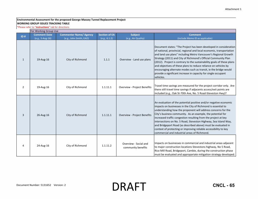
1 19‐Aug‐16 City of Richmond 1.1.1 Overview ‐ Land use plans
Document states: "The Project has been developed in consideration of national, provincial, regional and local economic, transportation and land use plans" including Metro Vancouver's Regional Growth Strategy (2011) and City of Richmond's Official Community Plan (2012). Project is contrary to the sustainability goals of these plans and objectives of these plans to reduce reliance on vehicles by encouraging alternate modes such as transit, ie the bridge would provide a significant increase in capacity for single occupant vehicles.
2 19‐Aug‐16 City of Richmond 1.1.11.1 Overview ‐ Project Benefits Travel time savings are measured for the project corridor only. Are there still travel time savings if adjacents access/exit points are included (e.g., Oak St‐70th Ave, No. 5 Road‐Steveston Hwy)?
3 26‐Aug‐16 City of Richmond 1.1.11.1 Overview ‐ Project Benefits
An evaluation of the potential positive and/or negative economic impacts on businesses in the City of Richmond is essential to understanding how the proponent will address concerns for the City’s business community. As an example, the potential for increased traffic congestion resulting from the project at key intersections on No. 5 Road, Steveston Highway, Sea Island Way, and Bridgeport Road (as described above) must be evaluated in context of protecting or improving reliable accessibility to key commercial and industrial areas of Richmond.
4 24‐Aug‐16 City of Richmond 1.1.11.2Overview ‐ Social and community benefits
Impacts on businesses in commercial and industrial areas adjacent to major construction locations Stevestons highway, No 5 Road, Rice Mill Road, Bridgeport, Cambie, during the construction phase must be evaluated and appropariate mitigation strategy developed.
For Working Group Use
Document Number: 5131652 Version: 2 DRAFT CNCL - 65

Attachment 1
Environmental Assessment for the proposed George Massey Tunnel Replacement ProjectWORKING GROUP ISSUES TRACKING TABLE*Please refer to "Instructions" tab for directions
ID # Comment Date(e.g., 5‐Aug‐16)
Commenter Name/ Agency(e.g., John Smith, EAO)
Section of EA(e.g., 6.1.2)
Subject(e.g., Air Quality)
Comment(include Memo ID as applicable)
For Working Group Use
5 19‐Aug‐16 City of Richmond 1.1.11.2Overview ‐ Social and community benefits
"… new access to/from Rice Mill Road will improve access for commercial and industrial areas in South Richmond" ‐ project needs to ensure connection extends to area of activity. Currently, Rice Mill Rd is a 2 lane local road that comes to a T‐intersection at No. 5 Road; traffic would need to access industrial area south to Machrina. Project needs to analyze impact to local roads and ensure tie‐in is appropriate to handle the traffic in order to realize benefits at no cost to the City of Richmond.
6 19‐Aug‐16 City of Richmond 1.1.11.4 Overview ‐ Health
"The Project will result in significant traffic safety benefits, reducing collision rates by more than 35 per cent." Analysis needed to determine if benefits realized from reducing number of collisions at the Tunnel are offset by an increase in number of collisions at south end of Oak Street Bridge as well as at east leg of Steveston Hwy/No 5 Road intersection and other access/egress points.
7 24‐Aug‐16 City of Richmond 1.1.3.3 Overview ‐ Project RationaleSpecify what are the points being used to measure delay. Use this same measurement of queue length for a before/after analysis to assess impacts to the local road network.
8 23‐Aug‐16 City of Richmond 1.1.3.6 Overview ‐ Public Support "Strong levels of public support" ‐ Application should state whether or not the public consultation results are statistically significant or fully representative of the Metro Vancouver population.
9 19‐Aug‐16 City of Richmond 1.1.6Overview ‐ Effects of the
Environment on the Project
The City supports the project’s proposed construction of a median barrier along Highway 99 for mid‐island flood protection. The City requests more detail regarding this mid‐island dike.
Document Number: 5131652 Version: 2 DRAFT CNCL - 66

Attachment 1
Environmental Assessment for the proposed George Massey Tunnel Replacement ProjectWORKING GROUP ISSUES TRACKING TABLE*Please refer to "Instructions" tab for directions
ID # Comment Date(e.g., 5‐Aug‐16)
Commenter Name/ Agency(e.g., John Smith, EAO)
Section of EA(e.g., 6.1.2)
Subject(e.g., Air Quality)
Comment(include Memo ID as applicable)
For Working Group Use
10 19‐Aug‐16 City of Richmond 1.1.6Overview ‐ Key project
components
"Construct a dedicated transit road under the Oak Street Bridge between Van Horne Way and Bridgeport Road." This connection will cut across the Bridgeport Trail and the off‐street multi‐use pathway on Van Horne Way with the latter being the key pedestrian‐cycling connection to the Canada Line Bridge. Both facilities also provide links between the Bridgeport Canada Line Station and Transit Exchange and the Tait neighbourhood to the east. Despite anticipated frequencies of one bus every three minutes using the transit only lanes during peak periods, the Application provides no discussion, analysis or measures to mitigate this significant impact to trail and path users.
11 19‐Aug‐16 City of Richmond 1.1.6Overview ‐ Key project
components
"Replace the Westminster Highway interchange to accommodate all existing connections and improve cyclist/pedestrian connectivity across Highway 99." Cycling/pedestrian connectivity should be on both sides of any new structures in order to accommodate any existing and future facilities.
12 19‐Aug‐16 City of Richmond 1.1.6Overview ‐ Key project
components
"…and provide a new direct connection between Rice Mill Road and Highway 99 to help alleviate congestion at the Steveston Highway/No. 5 Road intersection" ‐ Provide traffic analysis for Steveston Hwy/No 5 Rd intersection that justifies the connection to Rice Mill Road.
13 19‐Aug‐16 City of Richmond 1.1.7Overview ‐ Project Design
Considerations"relevant highway design standards" should be replaced with TAC, municipal and Ministry design standards
14 19‐Aug‐16 City of Richmond 1.1.8.3 Overiew ‐ Tolling
A regional road pricing strategy should be developed to address whether tolling is the most appropriate methodology as this could have an impact on the type of infrastructure needed to accommodate it.
15 19‐Aug‐16 City of Richmond 1.1.8.3 Overiew ‐ TollingWith tolling of the new bridge, forecast traffic volumes using the new bridge may be affected significantly, ie may not need 10 lane bridge.
16 19‐Aug‐16 City of Richmond 1.4.1 Overview ‐ Lane Requirements"10‐lane bridge provides a higher benefit‐cost ratio". How does the benefit‐cost ratio of an 8‐lane bridge compare to the 10‐lane bridge and what is the cost difference?
Document Number: 5131652 Version: 2 DRAFT CNCL - 67

Attachment 1
Environmental Assessment for the proposed George Massey Tunnel Replacement ProjectWORKING GROUP ISSUES TRACKING TABLE*Please refer to "Instructions" tab for directions
ID # Comment Date(e.g., 5‐Aug‐16)
Commenter Name/ Agency(e.g., John Smith, EAO)
Section of EA(e.g., 6.1.2)
Subject(e.g., Air Quality)
Comment(include Memo ID as applicable)
For Working Group Use
17 24‐Aug‐16 City of Richmond 4.2 Sediment ‐ Water Quality
Construction phase: Groundwater being intercepted and/or pumped during excavations or other works must not be discharged ot the City's storm drainage system, including the City's open watercourses, closed storm drainage netowrk, or pump station infrastructure without authorization from the City in accorance with City Bylaw #8475. Discharged groundwater quantity and quality must be closely monitored, and repoting available to the City such that appropriate protection of the receivning infrastructure and envrionment can be assured. The City's drainage system is connected directly to the Fraser River and fisheries habitat, and all waters discharged to the City's drainage system must meet quality standards protective of freshwater and marine aquatic life.
18 24‐Aug‐16 City of Richmond 4.4 Sediment ‐ Water Quality
Distrubance of fill used for tunnel construction present specific sediment quality hazards not otherwise considered. Construction practice in 1959 did not consider the quality of fill materials and potential impact of fille containing industrial waste products or other pollutants. Fill quality sampling prior to disturbance must be carried out to prevent the entrainment of unknown and potentially deleterious substances to fish‐bearing water column.
19 24‐Aug‐16 City of Richmond 4.10.3Atmospheric Noise ‐ Potential
Effects
The Application does not currently acknowledge the impact of the Project on The Gardens Agricultural Park, and the extent of parkland that will be required by the Project to accommodate the widened Highway 99 and the Steveston Highway Interchange. Consequently, the Application provides no discussion of the impacts that the Project will have on noise within the park. This noise analysis should be added to the Application as well as proposed mitigation strategies including sound walls along the park’s east boundary and sound deflectors integrated into the proposed multi‐level, multi‐lane Steveston Highway Interchange.
Document Number: 5131652 Version: 2 DRAFT CNCL - 68

Attachment 1
Environmental Assessment for the proposed George Massey Tunnel Replacement ProjectWORKING GROUP ISSUES TRACKING TABLE*Please refer to "Instructions" tab for directions
ID # Comment Date(e.g., 5‐Aug‐16)
Commenter Name/ Agency(e.g., John Smith, EAO)
Section of EA(e.g., 6.1.2)
Subject(e.g., Air Quality)
Comment(include Memo ID as applicable)
For Working Group Use
20 19‐Aug‐16 City of Richmond 4.9.2Air Quality ‐ Existing
Conditions
Document refers to "the travel demand modelling system EMME/2 used to estimate the volume of traffic expected along the Project corridor in the future (2031)." Why is the horizon year of 2031 used for the air quality assessment whereas the traffic section has a horizon year of 2045?
21 18‐Aug‐16 City of Richmond 4.9.3.2 Air Quality ‐ Potential Effects
"Even with an increase in traffic, the 2031 scenario with the Project is predicted to result in an overall improvement in air quality compared to existing and future conditions without the Project." Does this take into account the impact to air quality of additional traffic queuing at Oak St Bridge, Knight St Bridge, Alex Fraser Bridge due to the project? Moving 40% of the traffic using the new bridge to get to Vancouver faster across the new bridge does not reduce the traffic queuing to get into Vancouver. This queuing problem would be expected to grow for the 2045 horizon year. Tolling this bridge would also cause longer queues at the Alex Fraser Bridge.
22 18‐Aug‐16 City of Richmond 5.1Traffic ‐ Appendix B ‐ Traffic
Data OverviewCongestion analysis does not include impact at Oak St Bridge, specifically queue lengths, etc.
23 18‐Aug‐16 City of Richmond 5.1Traffic ‐ Appendix B ‐ Traffic
Data Overview
Document states: "a 10‐lane bridge (eight lanes for general traffic and two for transit/HOV) would best meet Project requirements for 2045." Where is the justification. What is the cost‐benefit ratios for a 10‐lane bridge and for an 8‐lane bridge? Is the cost‐benefit ratio for an 8‐lane bridge better than for a 10‐lane bridge?
24 18‐Aug‐16 City of Richmond 5.1Traffic ‐ Appendix B ‐ Traffic
Data Overview
Document states: "On opening day during the AM rush hour an eight‐lane bridge would be in a congested state similar to today." What is the analysis to support this statement? What about queue lengths? Are the queue lengths better with an 8‐lane bridge than it is today or are they similar?
25 23‐Aug‐16 City of Richmond 5.1Traffic ‐ Appendix C ‐ Traffic
Forecasts
The laning requirements appear to be based on 2045 forecast volumes for a non‐tolled facility. Laning requirements should be based on a tolled facility.
Document Number: 5131652 Version: 2 DRAFT CNCL - 69
Attachment 1
Environmental Assessment for the proposed George Massey Tunnel Replacement ProjectWORKING GROUP ISSUES TRACKING TABLE*Please refer to "Instructions" tab for directions
ID # Comment Date(e.g., 5‐Aug‐16)
Commenter Name/ Agency(e.g., John Smith, EAO)
Section of EA(e.g., 6.1.2)
Subject(e.g., Air Quality)
Comment(include Memo ID as applicable)
For Working Group Use
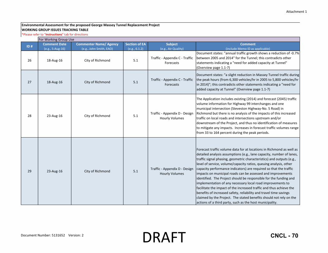
26 18‐Aug‐16 City of Richmond 5.1Traffic ‐ Appendix C ‐ Traffic
Forecasts
Document states: "annual traffic growth shows a reduction of ‐0.7% between 2005 and 2014" for the Tunnel; this contradicts other statements indicating a "need for added capacity at Tunnel" (Overview page 1.1‐7)
27 18‐Aug‐16 City of Richmond 5.1Traffic ‐ Appendix C ‐ Traffic
Forecasts
Document states: "a slight reduction in Massey Tunnel traffic during the peak hours (from 6,300 vehicles/hr in 2005 to 5,800 vehicles/hr in 2014)"; this contradicts other statements indicating a "need for added capacity at Tunnel" (Overview page 1.1‐7)
28 23‐Aug‐16 City of Richmond 5.1Traffic ‐ Appendix D ‐ Design
Hourly Volumes
The Application includes existing (2014) and forecast (2045) traffic volume information for Highway 99 interchanges and one municipal intersection (Steveston Highway‐No. 5 Road) in Richmond but there is no analysis of the impacts of this increased traffic on local roads and intersections upstream and/or downstream of the Project, and thus no identification of measures to mitigate any impacts. Increases in forecast traffic volumes range from 33 to 164 percent during the peak periods.
29 23‐Aug‐16 City of Richmond 5.1Traffic ‐ Appendix D ‐ Design
Hourly Volumes
Forecast traffic volume data for at locations in Richmond as well as detailed analysis assumptions (e.g., lane capacity, number of lanes, traffic signal phasing, geometric characteristics) and outputs (e.g., level of service, volume/capacity ratios, queuing analysis, other capacity performance indicators) are required so that the traffic impacts on municipal roads can be assessed and improvements identified. The Project should be responsible for the funding and implementation of any necessary local road improvements to facilitate the impact of the increased traffic and thus achieve the benefits of increased safety, reliability and travel time savings claimed by the Project. The stated benefits should not rely on the actions of a third party, such as the host municipality.
Document Number: 5131652 Version: 2 DRAFT CNCL - 70

Attachment 1
Environmental Assessment for the proposed George Massey Tunnel Replacement ProjectWORKING GROUP ISSUES TRACKING TABLE*Please refer to "Instructions" tab for directions
ID # Comment Date(e.g., 5‐Aug‐16)
Commenter Name/ Agency(e.g., John Smith, EAO)
Section of EA(e.g., 6.1.2)
Subject(e.g., Air Quality)
Comment(include Memo ID as applicable)
For Working Group Use
30 23‐Aug‐16 City of Richmond 5.1Traffic ‐ Appendix D ‐ Design
Hourly Volumes
Local intersections where traffic volume data and detailed analysis is required include: Proposed Transit Only Lanes (intersection of lanes at Van Horne Way and Great Canadian Way‐Van Horne Way), Bridgeport Road‐Sea Island Way Interchanges (Garden City Road‐Sea Island Way, Garden City Road‐Bridgeport Road, and Bridgeport Road‐Highway 99 northbound off‐ramp), Shell Road Interchange (Cambie Road‐Shell Road and Shell Road‐Highway 99 ramps), Highway 91 Interchange (Alderbridge Way‐Shell Road), Westminster Highway Interchange (Westminster Highway‐No. 5 Road and Westminster Highway‐Sidaway Road), Steveston Highway Interchange (Steveston Highway‐No. 5 Road and Steveston Highway‐Sidaway Road), Proposed Rice Mill Road Ramps (intersection of ramps at Rice Mill Road and No. 5 Road‐Rice Mill Road).
31 18‐Aug‐16 City of Richmond 5.1Traffic ‐ Appendix D ‐ Design
Hourly Volumes
Document shows an increase in traffic (+700 vehicles per hour or 24%) northbound to Oak Street Bridge from year 2014 to DHV (ie 2045). This is a substantial increase in the traffic volumes at Oak St Bridge, which will create longer queues than exist today. How will the project address or mitigate this?
32 23‐Aug‐16 City of Richmond 5.1Traffic ‐ Appendix D ‐ Design
Hourly Volumes
Document shows a significant increase in traffic that will impact the local road system: eastbound to southbound traffic (increase of ~500 vph or 124% in AM peak and ~520 vph or 48% in PM peak); northbound highway traffic exiting onto Bridgeport Road (increase of ~570 vph or ~51% in AM peak and ~480 vph or ~78% in PM peak). How will the project address these significant impacts? These volumes could also impact pedestrians and cyclists (eg shorter crossing times, etc). Costs of any improvements or measures to mitigate this traffic should be borne by the project.
Document Number: 5131652 Version: 2 DRAFT CNCL - 71

Attachment 1
Environmental Assessment for the proposed George Massey Tunnel Replacement ProjectWORKING GROUP ISSUES TRACKING TABLE*Please refer to "Instructions" tab for directions
ID # Comment Date(e.g., 5‐Aug‐16)
Commenter Name/ Agency(e.g., John Smith, EAO)
Section of EA(e.g., 6.1.2)
Subject(e.g., Air Quality)
Comment(include Memo ID as applicable)
For Working Group Use
33 23‐Aug‐16 City of Richmond 5.1Traffic ‐ Appendix D ‐ Design
Hourly Volumes
The new interchanges and same forecast traffic volume increases identified for local roads will also impact local pedestrian and cycling networks. Of particular concern are the proposed transit only lanes underneath the Oak Street Bridge that will cut across the Bridgeport Trail and the off‐street multi‐use pathway on Van Horne Way with the latter being the key pedestrian‐cycling connection to the Canada Line Bridge. Both facilities also provide links between the Bridgeport Canada Line Station and Transit Exchange and the Tait neighbourhood to the east. Despite anticipated frequencies of one bus every three minutes using the transit only lanes during peak periods, the Application provides no discussion, analysis or measures to mitigate this significant impact to trail and path users.
34 23‐Aug‐16 City of Richmond 5.1Traffic ‐ Appendix D ‐ Design
Hourly Volumes
The new interchanges and same forecast traffic volume increases identified for local roads will also impact local pedestrian and cycling networks. Also of particular concern is the new connection to Rice Mill Road. This road currently has a narrow rural 2‐lane cross‐section but is well‐used by cyclists due to its low traffic volumes. The new ramp connections will introduce high volumes of vehicle traffic but the Application provides no discussion, analysis or measures to mitigate this significant impact to cyclists.
35 23‐Aug‐16 City of Richmond 5.1Traffic ‐ Appendix D ‐ Design
Hourly Volumes
The new interchanges at Westminster Highway and Steveston Highway, which both feature free flow on‐ and/or off‐ramps, and the forecast increased traffic volumes at local intersections in the vicinity of the interchanges (e.g., Steveston Highway‐No. 5 Road) will also impact pedestrians and cyclists crossing the intersections and/or Highway 99.
Document Number: 5131652 Version: 2 DRAFT CNCL - 72

Attachment 1
Environmental Assessment for the proposed George Massey Tunnel Replacement ProjectWORKING GROUP ISSUES TRACKING TABLE*Please refer to "Instructions" tab for directions
ID # Comment Date(e.g., 5‐Aug‐16)
Commenter Name/ Agency(e.g., John Smith, EAO)
Section of EA(e.g., 6.1.2)
Subject(e.g., Air Quality)
Comment(include Memo ID as applicable)
For Working Group Use
36 23‐Aug‐16 City of Richmond 5.1Traffic ‐ Appendix D ‐ Design
Hourly Volumes
The proposed cycling and pedestrian infrastructure would be implemented primarily within the Highway 99 right‐of‐way only and any new overpasses would have a sidewalk on one side only. As noted above, municipalities appear to be responsible for any tie‐ins to local networks with no additional cost‐share funding to be made available. Instead, Richmond would have to compete for provincial BikeBC funding, which is currently limited to $6 million annually for the entire province.
37 23‐Aug‐16 City of Richmond 5.1Traffic ‐ Appendix D ‐ Design
Hourly Volumes
The Ministry’s Cycling Policy states that “Our goal to integrate bicycling on the province’s highways by providing safe, accessible and convenient bicycle facilities and by supporting and encouraging cycling ” and “Provisions for cyclists are made on all new and upgraded provincial highways .” Given that the Project scope extends from Bridgeport Road in Richmond to Highway 91 in Delta and the current reference concept does not include continuous cycling facilities along this section of the Highway 99 corridor, the Project should be responsible for the funding and implementation of alternative cycling facilities within the host municipalities to enable a continuous, safe and convenient route that will help achieve the Project’s stated goals to encourage a higher mode share for cycling, walking and transit in line with local and regional targets
38 23‐Aug‐16 City of Richmond 5.1Traffic ‐ Appendix D ‐ Design Hourly Volumes ‐ Shell Road
Interchange
Document shows a significant increase in traffic that will impact the local road system: Northbound on‐ramp traffic from Shell Road (increase of ~490 vph 64% in PM peak). How will the project address these significant impacts? These volumes could also impact pedestrians and cyclists (eg shorter crossing times, etc). Costs of any improvements or measures to mitigate this traffic should be borne by the project.
Document Number: 5131652 Version: 2 DRAFT CNCL - 73
Attachment 1
Environmental Assessment for the proposed George Massey Tunnel Replacement ProjectWORKING GROUP ISSUES TRACKING TABLE*Please refer to "Instructions" tab for directions
ID # Comment Date(e.g., 5‐Aug‐16)
Commenter Name/ Agency(e.g., John Smith, EAO)
Section of EA(e.g., 6.1.2)
Subject(e.g., Air Quality)
Comment(include Memo ID as applicable)
For Working Group Use
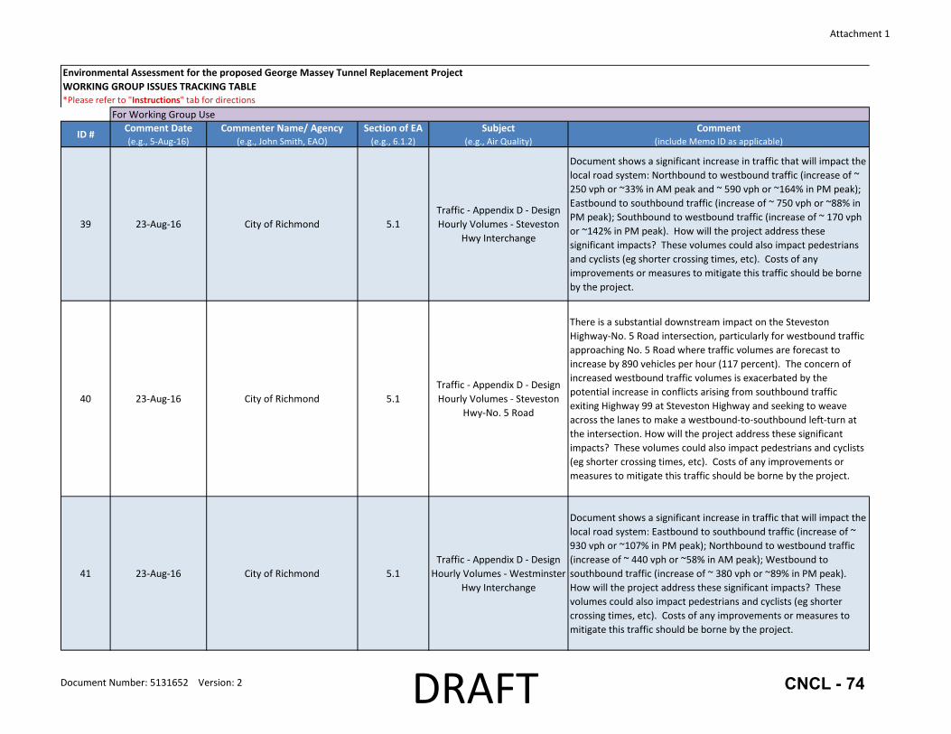
39 23‐Aug‐16 City of Richmond 5.1Traffic ‐ Appendix D ‐ Design Hourly Volumes ‐ Steveston
Hwy Interchange
Document shows a significant increase in traffic that will impact the local road system: Northbound to westbound traffic (increase of ~ 250 vph or ~33% in AM peak and ~ 590 vph or ~164% in PM peak); Eastbound to southbound traffic (increase of ~ 750 vph or ~88% in PM peak); Southbound to westbound traffic (increase of ~ 170 vph or ~142% in PM peak). How will the project address these significant impacts? These volumes could also impact pedestrians and cyclists (eg shorter crossing times, etc). Costs of any improvements or measures to mitigate this traffic should be borne by the project.
40 23‐Aug‐16 City of Richmond 5.1Traffic ‐ Appendix D ‐ Design Hourly Volumes ‐ Steveston
Hwy‐No. 5 Road
There is a substantial downstream impact on the Steveston Highway‐No. 5 Road intersection, particularly for westbound traffic approaching No. 5 Road where traffic volumes are forecast to increase by 890 vehicles per hour (117 percent). The concern of increased westbound traffic volumes is exacerbated by the potential increase in conflicts arising from southbound traffic exiting Highway 99 at Steveston Highway and seeking to weave across the lanes to make a westbound‐to‐southbound left‐turn at the intersection. How will the project address these significant impacts? These volumes could also impact pedestrians and cyclists (eg shorter crossing times, etc). Costs of any improvements or measures to mitigate this traffic should be borne by the project.
41 23‐Aug‐16 City of Richmond 5.1Traffic ‐ Appendix D ‐ Design Hourly Volumes ‐ Westminster
Hwy Interchange
Document shows a significant increase in traffic that will impact the local road system: Eastbound to southbound traffic (increase of ~ 930 vph or ~107% in PM peak); Northbound to westbound traffic (increase of ~ 440 vph or ~58% in AM peak); Westbound to southbound traffic (increase of ~ 380 vph or ~89% in PM peak). How will the project address these significant impacts? These volumes could also impact pedestrians and cyclists (eg shorter crossing times, etc). Costs of any improvements or measures to mitigate this traffic should be borne by the project.
Document Number: 5131652 Version: 2 DRAFT CNCL - 74

Attachment 1
Environmental Assessment for the proposed George Massey Tunnel Replacement ProjectWORKING GROUP ISSUES TRACKING TABLE*Please refer to "Instructions" tab for directions
ID # Comment Date(e.g., 5‐Aug‐16)
Commenter Name/ Agency(e.g., John Smith, EAO)
Section of EA(e.g., 6.1.2)
Subject(e.g., Air Quality)
Comment(include Memo ID as applicable)
For Working Group Use
42 23‐Aug‐16 City of Richmond 5.1.1.1 Traffic ‐ Assessment ContextNeed to expand pedestrian and cycling networks beyond the Hwy 99 corridor (i.e., to include local networks) as part of the project in order to achieve stated project benefits re modal shift.
43 18‐Aug‐16 City of Richmond 5.1.1.1 Traffic ‐ Assessment Context
Document states that "Project‐related changes to the road network have been designed to facilitate travel time savings and reduced idling, while providing greater travel time reliability and substantial safety improvements, which will result in health benefits". However, the scope of the project does not include the Oak Street Bridge where 40% of the traffic to/from the new bridge will be crossing, therefore, travel time savings, reduced idling and greater travel time reliability will not be realized for 40% of the traffic. How are "substantial safety benefits" quantified? Although the number of more minor accidents (eg fender‐benders) may be reduced, the severity of accidents (eg due to free flowing traffic coming to an abrupt stop at congested adjacent traffic signals) may increase.
44 18‐Aug‐16 City of Richmond 5.1.1.3Traffic ‐ Assessment
Boundaries
LAA should be expanded to include the Oak Street Bridge as well as Knight Street Bridge and Arthur Laing Bridge, particularly for analysis purposes. Reasons as noted above (40% of traffic to/from the new bridge will be crossing into/out of Vancouver. How will congestion at these crossings be mitigated? Should severe queues form based on current proposal, there should be a contingency plan on how to address/mitigate this congestion.
Document Number: 5131652 Version: 2 DRAFT CNCL - 75
Attachment 1
Environmental Assessment for the proposed George Massey Tunnel Replacement ProjectWORKING GROUP ISSUES TRACKING TABLE*Please refer to "Instructions" tab for directions
ID # Comment Date(e.g., 5‐Aug‐16)
Commenter Name/ Agency(e.g., John Smith, EAO)
Section of EA(e.g., 6.1.2)
Subject(e.g., Air Quality)
Comment(include Memo ID as applicable)
For Working Group Use
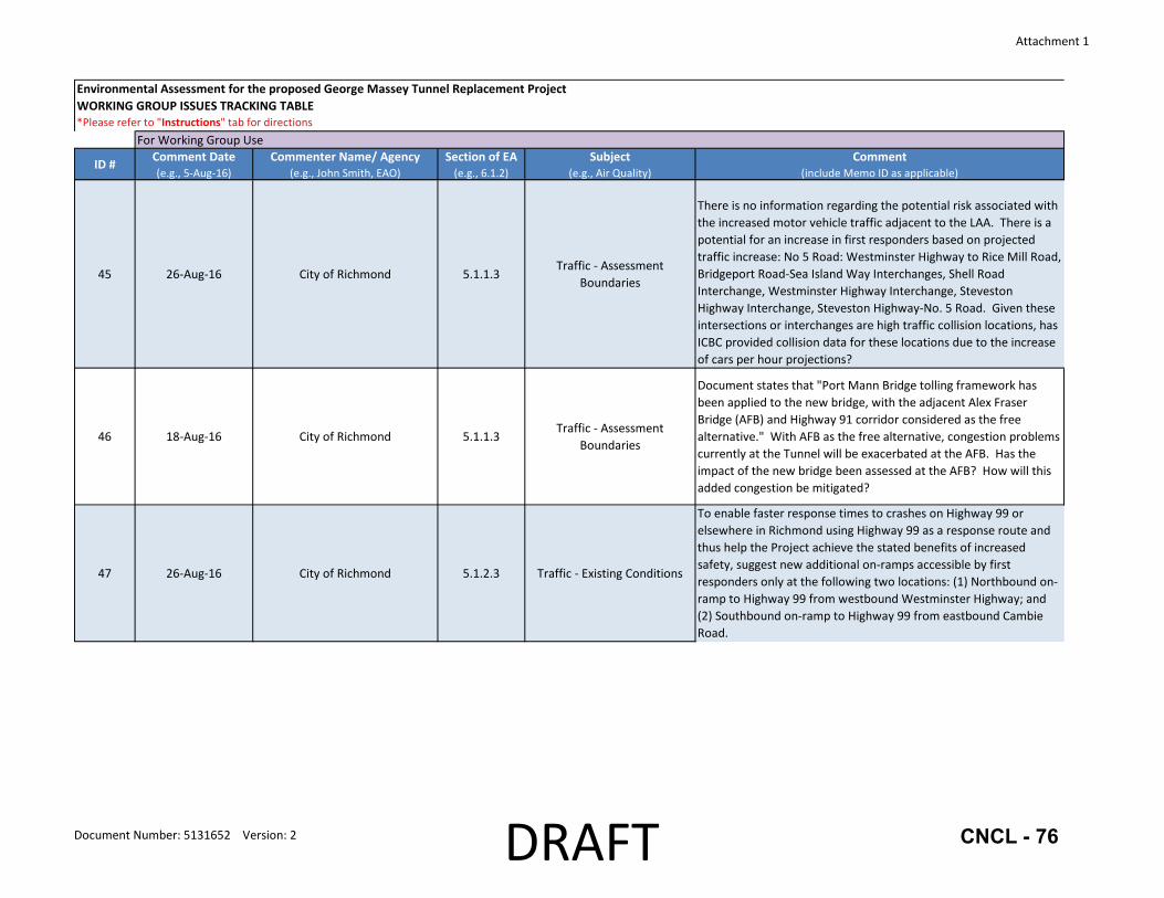
45 26‐Aug‐16 City of Richmond 5.1.1.3Traffic ‐ Assessment
Boundaries
There is no information regarding the potential risk associated with the increased motor vehicle traffic adjacent to the LAA. There is a potential for an increase in first responders based on projected traffic increase: No 5 Road: Westminster Highway to Rice Mill Road, Bridgeport Road‐Sea Island Way Interchanges, Shell Road Interchange, Westminster Highway Interchange, Steveston Highway Interchange, Steveston Highway‐No. 5 Road. Given these intersections or interchanges are high traffic collision locations, has ICBC provided collision data for these locations due to the increase of cars per hour projections?
46 18‐Aug‐16 City of Richmond 5.1.1.3Traffic ‐ Assessment
Boundaries
Document states that "Port Mann Bridge tolling framework has been applied to the new bridge, with the adjacent Alex Fraser Bridge (AFB) and Highway 91 corridor considered as the free alternative." With AFB as the free alternative, congestion problems currently at the Tunnel will be exacerbated at the AFB. Has the impact of the new bridge been assessed at the AFB? How will this added congestion be mitigated?
47 26‐Aug‐16 City of Richmond 5.1.2.3 Traffic ‐ Existing Conditions
To enable faster response times to crashes on Highway 99 or elsewhere in Richmond using Highway 99 as a response route and thus help the Project achieve the stated benefits of increased safety, suggest new additional on‐ramps accessible by first responders only at the following two locations: (1) Northbound on‐ramp to Highway 99 from westbound Westminster Highway; and (2) Southbound on‐ramp to Highway 99 from eastbound Cambie Road.
Document Number: 5131652 Version: 2 DRAFT CNCL - 76
Attachment 1
Environmental Assessment for the proposed George Massey Tunnel Replacement ProjectWORKING GROUP ISSUES TRACKING TABLE*Please refer to "Instructions" tab for directions
ID # Comment Date(e.g., 5‐Aug‐16)
Commenter Name/ Agency(e.g., John Smith, EAO)
Section of EA(e.g., 6.1.2)
Subject(e.g., Air Quality)
Comment(include Memo ID as applicable)
For Working Group Use
48 18‐Aug‐16 City of Richmond 5.1.2.3 Traffic ‐ Existing Conditions
There are repeated qualitative comments in the Application regarding the putative positive effects of the Project on modal split but there is no technical evidence to substantiate these statements such as traffic model forecasts showing the modal split. Even with these potential positive impacts the Application states that “Analysis indicates that improvements in HOV and transit alone will not substantially address the current Highway 99 traffic challenges ” but again does not offer any supporting analysis for this claim. The Project includes improved transit infrastructure but there is no complementary funding to support enhanced transit service to help achieve a modal shift. The Application cites the success of the Canada Line as the rationale for declining vehicle volumes across the Oak Street Bridge but, conversely, does not consider this same scenario of improved transit service to the south of Fraser region as a viable Project alternative.
49 18‐Aug‐16 City of Richmond 5.1.2.3 Traffic ‐ Existing Conditions
Document states that "traffic to Vancouver accounts for only 40 per cent of the total traffic through the Tunnel"; however, projections show a substantial increase in the traffic volumes at Oak St Bridge. For example, data in Appendix D indicates that traffic in the northbound direction in the morning peak hour increases from 2958 to 3680 vehicles per hour (vph) equating to 700 vph or 24% increase, creating longer queues than exist today.
Document Number: 5131652 Version: 2 DRAFT CNCL - 77

Attachment 1
Environmental Assessment for the proposed George Massey Tunnel Replacement ProjectWORKING GROUP ISSUES TRACKING TABLE*Please refer to "Instructions" tab for directions
ID # Comment Date(e.g., 5‐Aug‐16)
Commenter Name/ Agency(e.g., John Smith, EAO)
Section of EA(e.g., 6.1.2)
Subject(e.g., Air Quality)
Comment(include Memo ID as applicable)
For Working Group Use
50 26‐Aug‐16 City of Richmond 5.1.2.3 Traffic ‐ Existing Conditions
Traffic safety is assessed by comparing collision rates for a segment of a roadway to provincial averages for the same roadway type and classification. The average collision rate is measured in units of collisions per million vehicle kilometers (c/mvk), and provides a measure of the frequency of collisions in the study segment. An assessment of collision rates for the LAA is presented in the report titled George Massey Tunnel Replacement Project Collision Data Analysis (Delcan 2015). Results show that the segment of Highway 99 which includes the Steveston Highway interchange, the Tunnel, and the Highway 17A interchange, has an average collision rate of 0.44 c/mvk, which is much higher than the 0.30 c/mvk provincial average (Delcan 2015). These high traffic collision rates present an ongoing risk to safety and human health. The Steveston Highway interchange has the highest number of collisions along the assessment corridor, including relevant nearby intersections and roadways. There were 625 collisions at this interchange between 2008 and 2012. Additionally, the Steveston Highway/No. 5 Road intersection, immediately west of Highway 99, had the second highest number of collisions (545) during this period. There were 491 collisions at the Highway 99/Highway 17A interchange between 2008 and 2012, which is the third highest number of collisions along the study corridor (Delcan 2015). The Application lacks information and recommendations as to how the above collision rates will be reduced.
Document Number: 5131652 Version: 2 DRAFT CNCL - 78

Attachment 1
Environmental Assessment for the proposed George Massey Tunnel Replacement ProjectWORKING GROUP ISSUES TRACKING TABLE*Please refer to "Instructions" tab for directions
ID # Comment Date(e.g., 5‐Aug‐16)
Commenter Name/ Agency(e.g., John Smith, EAO)
Section of EA(e.g., 6.1.2)
Subject(e.g., Air Quality)
Comment(include Memo ID as applicable)
For Working Group Use
51 23‐Aug‐16 City of Richmond 5.1.2.3Traffic ‐ Existing Conditions and Traffic ‐ Appendix B
The Application states that the Tunnel currently carries an average of 80,000 vehicles per day and traffic would grow to 100,000 vehicles per day by 2045 without a new bridge. Based on traffic forecasts with a new tolled bridge, traffic volumes would drop to 71,000 vehicles per day in the first year and grow to 84,000 vehicles per day by 2045. Separate information in Appendix B (Traffic Data Overview) to the Traffic chapter states that “Modelling results…predict that by 2045 traffic through the existing Tunnel will grow to approximately 100,000 vehicles per day and that traffic over a new 10‐lane bridge will be approximately 115,000 vehicles per day.” Presumably, these forecast traffic volumes are based on a non‐tolled crossing. These higher traffic volumes appear to be used to support the design of Project elements including the determination of the number of lanes required for the bridge.However, the Application clearly states that the new bridge will be tolled. Thus, given that the forecast daily traffic volumes in 2045 are not substantially different from current daily traffic volumes for a tolled crossing, it is unclear why such an expansion of vehicle capacity (more than doubling from four to 10 lanes) is necessary. Moreover, per the Ministry’s traffic data program, average annual daily traffic volumes for the Tunnel have declined over the 2003 to 2014 period from 82,297 to 79,105 vehicles (‐0.36 percent annual growth).
52 23‐Aug‐16 City of Richmond 5.1.2.4 Traffic ‐ Traffic Forecasting
Application states that traffic demand is forecast to be 84,000 vehicles per day by 2045. Presumably, this is based on a tolled facility. These volumes are essentially the same as today so how is a 10‐lane facility justified?
Document Number: 5131652 Version: 2 DRAFT CNCL - 79

Attachment 1
Environmental Assessment for the proposed George Massey Tunnel Replacement ProjectWORKING GROUP ISSUES TRACKING TABLE*Please refer to "Instructions" tab for directions
ID # Comment Date(e.g., 5‐Aug‐16)
Commenter Name/ Agency(e.g., John Smith, EAO)
Section of EA(e.g., 6.1.2)
Subject(e.g., Air Quality)
Comment(include Memo ID as applicable)
For Working Group Use
53 18‐Aug‐16 City of Richmond 5.1.2.4 Traffic ‐ Traffic Forecasting
Document indicates that the modelled results at the Oak Street Bridge "show little change at the Oak Street during peak hours with or without a new bridge to replace the Tunnel"; this would be expected because the limited capacity of the 4 lanes at the Oak Street Bridge is the same with or without the new bridge (ie at capacity in the peak direction during peak hours), however, a comparison of the queue lengths at the Oak Street Bridge with and without the new bridge would provide more meaningful information. This information is missing from the document. Similarly, queue lengths based on forecast volumes are missing.
54 23‐Aug‐16 City of Richmond 5.1.2.4.2Traffic ‐ Regional Traffic
Forecasts
Table 5.1‐2: how can 2045 VKT without the project increase if the tunnel is already congested and traffic volumes have been declining?
55 23‐Aug‐16 City of Richmond 5.1.2.4.2Traffic ‐ Regional Traffic
ForecastsTable 5.1‐3: why is there no change in 2045 VHT with or without the project?
56 23‐Aug‐16 City of Richmond 5.1.2.4.2Traffic ‐ Regional Traffic
Forecasts
Table 5.1‐4: One of the Provincial tolling guidelines is that tolls will be implemented only if a reasonable non‐tolled alternative is available. The Application states that the Project will be tolled. As the non‐tolled alternative crossing for the south arm of the Fraser River, the Alex Fraser Bridge is forecast to experience an increase of 20,000 vehicles per day (17 percent) with a tolled Project in place versus without the Project (from 120,000 to 140,000 vehicles per day). The Application states that the Alex Fraser Bridge already experiences greater congestion than the Tunnel during the peak periods; the forecast traffic diversion will only exacerbate this issue. However, the Application does not identify any measures to mitigate this impact. The forecast scenario also reinforces the need to move to a region‐wide mobility pricing policy consistent with the Mayors’ Council vision for regional transportation investments in Metro Vancouver.
Document Number: 5131652 Version: 2 DRAFT CNCL - 80
Attachment 1
Environmental Assessment for the proposed George Massey Tunnel Replacement ProjectWORKING GROUP ISSUES TRACKING TABLE*Please refer to "Instructions" tab for directions
ID # Comment Date(e.g., 5‐Aug‐16)
Commenter Name/ Agency(e.g., John Smith, EAO)
Section of EA(e.g., 6.1.2)
Subject(e.g., Air Quality)
Comment(include Memo ID as applicable)
For Working Group Use
57 18‐Aug‐16 City of Richmond 5.1.2.4.2Traffic ‐ Regional Traffic
Forecasts
Document states: "when comparing with and without the Project for the Fraser River North Arm crossings, Knight Street Bridge, Arthur Laing Bridge, and Oak Street Bridge, results show a small decrease in traffic with the Project." Comparison of the queue lengths at all crossings is missing.
58 18‐Aug‐16 City of Richmond 5.1.2.4.2Traffic ‐ Regional Traffic
Forecasts
Document states: "transit improvements included in the Project, in conjunction with tolling, will support and enable a mode shift towards greater use of transit in the Highway 99 corridor, including the Canada Line, and away from single occupancy vehicle‐based commuting trips across the Oak Street Bridge." Where is the evidence to substantiate this statement? Project does not include increase in transit service or buses; building infrastructure (transit lanes) does not equate to more buses without commitment to funding more transit service. Need to substantiate this statement on modal shift.
59 23‐Aug‐16 City of Richmond 5.1.2.4.2Traffic ‐ Regional Traffic
Forecasts
The Application states that traffic volumes over the Oak Street Bridge have declined between 2010 and 2015 since the introduction of the Canada Line. The Application cites the success of the Canada Line as the rationale for declining vehicle volumes across the Oak Street Bridge but, conversely, does not consider this same scenario of improved transit service to the south of Fraser region as a viable Project alternative.
60 26‐Aug‐16 City of Richmond 5.1.2.4.2Traffic ‐ Regional Traffic
Forecasts
Projected increases in traffic volumes at local road intersections, which include locations with relatively higher rates of traffic crashes (eg., Steveston Highway‐No. 5 Road), may lead to an increase in calls for service, potential rescue calls and possible longer response times due to increased traffic congestion on local roads. The Application does not identify mitigating measures to address these impacts.
61 26‐Aug‐16 City of Richmond 5.1.3.2.1 Traffic ‐ Construction
The Construction Traffic Management Plan should include a Construction Rescue Plan (i.e., working over water/working at height, technical high angle rope rescue) and Rescue Plan to be developed jointly with Delta Fire & Emergency Services and Richmond Fire‐Rescue
Document Number: 5131652 Version: 2 DRAFT CNCL - 81

Attachment 1
Environmental Assessment for the proposed George Massey Tunnel Replacement ProjectWORKING GROUP ISSUES TRACKING TABLE*Please refer to "Instructions" tab for directions
ID # Comment Date(e.g., 5‐Aug‐16)
Commenter Name/ Agency(e.g., John Smith, EAO)
Section of EA(e.g., 6.1.2)
Subject(e.g., Air Quality)
Comment(include Memo ID as applicable)
For Working Group Use
62 18‐Aug‐16 City of Richmond 5.1.4 Traffic ‐ Mitigation Measures
This section talks about mitigation measures during construction. What is missing are mitigation measures beyond construction when the project is complete and operational. For example, should traffic queues at Oak Street Bridge be substantial, how will this be addressed, what is the contingency plan, can the other adjacent crossings at Arthur Laing Bridge and Knight Street Bridge handle the extra traffic?
63 24‐Aug‐16 City of Richmond 5.3.2.4 Land Use Planning
The Application references A Long‐Range Transportation Plan for Greater Vancouver: Transport 2021 , jointly produced in 1993 by the Ministry of Transportation and Highway (MoTH) and the Greater Vancouver Regional District and developed in support of the Livable Region Strategic Plan, and states that the report identified “the need” for additional capacity across the north and south arms of the Fraser River. However, the Transport 2021 report context is that the suggested additional capacity is one of several long‐term corridor options for investigation, not an identified need. Moreover, the report states that “The choke points of the bridges and tunnels across the Fraser River and across Burrard Inlet would be used to "draw the line'' and limit access to the single‐occupant vehicle ” and that a single occupant vehicle restraint strategy should be followed with no increase in mixed traffic peak hour capacity (i.e., high and single occupant vehicles). A 10‐lane bridge is not consistent with this Plan.
64 24‐Aug‐16 City of Richmond 5.3.2.4 Land Use Planning
The Mayors’ Council Regional Transportation Investments: a Vision for Metro Vancouver has a headline target to “make half of all trips by walking, cycling and transit .” One of the five goals of Metro Vancouver 2040: Shaping our Future (Metro Vancouver’s Regional Growth Strategy) is to “Support sustainable transportation choices .” While the Project includes dedicated transit‐HOV lanes, the expanded vehicle capacity for single occupant vehicles is not consistent with the Vision, the Regional Growth Strategy or the City’s Official Community Plan .
Document Number: 5131652 Version: 2 DRAFT CNCL - 82
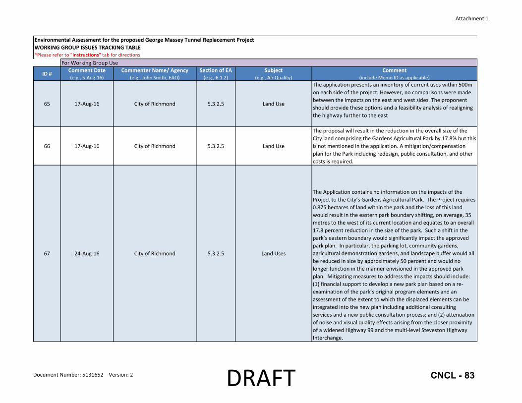
Attachment 1
Environmental Assessment for the proposed George Massey Tunnel Replacement ProjectWORKING GROUP ISSUES TRACKING TABLE*Please refer to "Instructions" tab for directions
ID # Comment Date(e.g., 5‐Aug‐16)
Commenter Name/ Agency(e.g., John Smith, EAO)
Section of EA(e.g., 6.1.2)
Subject(e.g., Air Quality)
Comment(include Memo ID as applicable)
For Working Group Use
65 17‐Aug‐16 City of Richmond 5.3.2.5 Land Use
The application presents an inventory of current uses within 500m on each side of the project. However, no comparisons were made between the impacts on the east and west sides. The proponent should provide these options and a feasibility analysis of realigning the highway further to the east
66 17‐Aug‐16 City of Richmond 5.3.2.5 Land Use
The proposal will result in the reduction in the overall size of the City land comprising the Gardens Agricultural Park by 17.8% but this is not mentioned in the application. A mitigation/compensation plan for the Park including redesign, public consultation, and other costs is required.
67 24‐Aug‐16 City of Richmond 5.3.2.5 Land Uses
The Application contains no information on the impacts of the Project to the City’s Gardens Agricultural Park. The Project requires 0.875 hectares of land within the park and the loss of this land would result in the eastern park boundary shifting, on average, 35 metres to the west of its current location and equates to an overall 17.8 percent reduction in the size of the park. Such a shift in the park’s eastern boundary would significantly impact the approved park plan. In particular, the parking lot, community gardens, agricultural demonstration gardens, and landscape buffer would all be reduced in size by approximately 50 percent and would no longer function in the manner envisioned in the approved park plan. Mitigating measures to address the impacts should include: (1) financial support to develop a new park plan based on a re‐examination of the park’s original program elements and an assessment of the extent to which the displaced elements can be integrated into the new plan including additional consulting services and a new public consultation process; and (2) attenuation of noise and visual quality effects arising from the closer proximity of a widened Highway 99 and the multi‐level Steveston Highway Interchange.
Document Number: 5131652 Version: 2 DRAFT CNCL - 83

Attachment 1
Environmental Assessment for the proposed George Massey Tunnel Replacement ProjectWORKING GROUP ISSUES TRACKING TABLE*Please refer to "Instructions" tab for directions
ID # Comment Date(e.g., 5‐Aug‐16)
Commenter Name/ Agency(e.g., John Smith, EAO)
Section of EA(e.g., 6.1.2)
Subject(e.g., Air Quality)
Comment(include Memo ID as applicable)
For Working Group Use
68 24‐Aug‐16 City of Richmond 5.3.2.5 Land Uses
The Richmond Nature Park is bisected by Highway 99. While the widening of Highway 99 in this area is understood to be contained within the existing right‐of‐way, the additional infrastructure to be constructed in this area (i.e., wider highway, new Westminster Highway Interchange, new ramp connection from Highway 91) could have the potential to impact water levels and quality in the area and, in turn, the health of the adjacent bog. The Application should include an assessment of this potential impact and, if required, identify any mitigating measures.
69 17‐Aug‐16 City of Richmond 5.3.3.3Traffic/Land Use/Human
Health
The proposal is not supported by the Richmond OCP objective to reduce the need for added road capacity (limit expansion of travel lane capacity of single‐occupant private vehicles at all regional and provincial bridges/highways and give priority to transit, trucks and high‐occupancy vehicles). Please justify that the proposal is consistent with this policy.
70 17‐Aug‐16 City of Richmond 5.3.3.4 Land Use
The Coriolis study indicates a small localized shift in regional population and employment growth as a result of the project based on modelling of an eight‐lane highway. Further study and modelling is needed using the actual proposed 10‐lane project to demonstrate that it is consistent with the Regional Growth Strategy (Metro Vancouver) and Regional Transportation Strategy (TransLink). Otherwise, provide justification of how the 10‐lane option is preferred over the eight‐lane proposal.
Document Number: 5131652 Version: 2 DRAFT CNCL - 84

Attachment 1
Environmental Assessment for the proposed George Massey Tunnel Replacement ProjectWORKING GROUP ISSUES TRACKING TABLE*Please refer to "Instructions" tab for directions
ID # Comment Date(e.g., 5‐Aug‐16)
Commenter Name/ Agency(e.g., John Smith, EAO)
Section of EA(e.g., 6.1.2)
Subject(e.g., Air Quality)
Comment(include Memo ID as applicable)
For Working Group Use
71 24‐Aug‐16 City of Richmond 5.4.2.3.2Agricultural Use ‐ Existing
Conditions
The Application does not reference the City’s designated Riparian Management Areas (RMAs) or Environmentally Sensitive Areas (ESAs), which are located on both sides of Highway 99, or the Ecological Network Management Strategy. During biweekly meetings with the proponent for the past year or more, City staff have repeatedly articulated the need to replace, compensate and establish a net gain of RMA and ESA habitat. The current Application does not include any information regarding these details. The Application should demonstrate how the Project will maintain, protect and enhance the City’s RMAs and ESAs within agricultural lands on both sides of Highway 99 through a net gain approach.
72 24‐Aug‐16 City of Richmond 5.4.3Agricultural Use ‐ Potential
Effects
The Application does not contain any discussion or rationale as to why the widening of Highway 99 in Richmond will occur on the west side as opposed to the east side. Given that adjacent property is required for the Project, the City’s preference is to widen Highway 99 on the east side as property on the west side is within the City’s Backlands Policy area. The City of Richmond and the Agricultural Land Commission (ALC) entered into an agreement to increase farming within the Backlands; as such, the west side should not be affected.
73 24‐Aug‐16 City of Richmond 5.4.3Agricultural Use ‐ Potential
Effects
The Application states that the total projected removal of land within the Agricultural Land Reserve (ALR) is a maximum of approximately 20 ha, of which approximately 17 ha is currently productive. The highway right‐of‐way identified for potential return to agricultural use is currently not farmed nor can the Ministry guarantee that it will be farmed. Given that there is no certainty that there will be new farming activity to off‐set the loss of the actively cultivated parcels that are required for the Project, the Application should identify any mitigation measures to ensure that the Project will not negatively impact agricultural lands.
Document Number: 5131652 Version: 2 DRAFT CNCL - 85
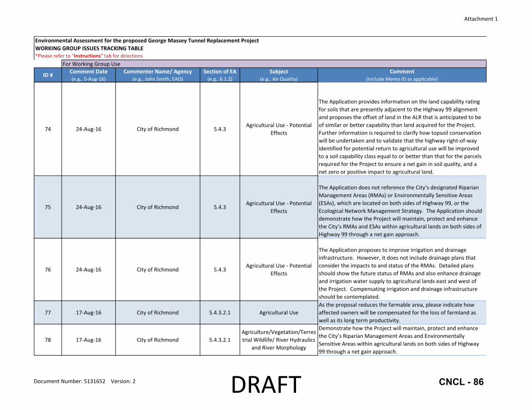
Attachment 1
Environmental Assessment for the proposed George Massey Tunnel Replacement ProjectWORKING GROUP ISSUES TRACKING TABLE*Please refer to "Instructions" tab for directions
ID # Comment Date(e.g., 5‐Aug‐16)
Commenter Name/ Agency(e.g., John Smith, EAO)
Section of EA(e.g., 6.1.2)
Subject(e.g., Air Quality)
Comment(include Memo ID as applicable)
For Working Group Use
74 24‐Aug‐16 City of Richmond 5.4.3Agricultural Use ‐ Potential
Effects
The Application provides information on the land capability rating for soils that are presently adjacent to the Highway 99 alignment and proposes the offset of land in the ALR that is anticipated to be of similar or better capability than land acquired for the Project. Further information is required to clarify how topsoil conservation will be undertaken and to validate that the highway right‐of‐way identified for potential return to agricultural use will be improved to a soil capability class equal to or better than that for the parcels required for the Project to ensure a net gain in soil quality, and a net zero or positive impact to agricultural land.
75 24‐Aug‐16 City of Richmond 5.4.3Agricultural Use ‐ Potential
Effects
The Application does not reference the City’s designated Riparian Management Areas (RMAs) or Environmentally Sensitive Areas (ESAs), which are located on both sides of Highway 99, or the Ecological Network Management Strategy. The Application should demonstrate how the Project will maintain, protect and enhance the City’s RMAs and ESAs within agricultural lands on both sides of Highway 99 through a net gain approach.
76 24‐Aug‐16 City of Richmond 5.4.3Agricultural Use ‐ Potential
Effects
The Application proposes to improve irrigation and drainage infrastructure. However, it does not include drainage plans that consider the impacts to and status of the RMAs. Detailed plans should show the future status of RMAs and also enhance drainage and irrigation water supply to agricultural lands east and west of the Project. Compensating irrigation and drainage infrastructure should be contemplated.
77 17‐Aug‐16 City of Richmond 5.4.3.2.1 Agricultural UseAs the proposal reduces the farmable area, please indicate how affected owners will be compensated for the loss of farmland as well as its long term productivity.
78 17‐Aug‐16 City of Richmond 5.4.3.2.1Agriculture/Vegetation/Terrestrial Wildlife/ River Hydraulics
and River Morphology
Demonstrate how the Project will maintain, protect and enhance the City’s Riparian Management Areas and Environmentally Sensitive Areas within agricultural lands on both sides of Highway 99 through a net gain approach.
Document Number: 5131652 Version: 2 DRAFT CNCL - 86
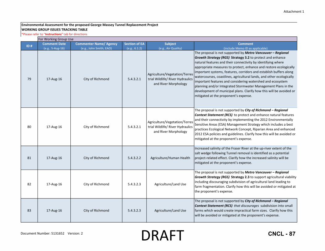
Attachment 1
Environmental Assessment for the proposed George Massey Tunnel Replacement ProjectWORKING GROUP ISSUES TRACKING TABLE*Please refer to "Instructions" tab for directions
ID # Comment Date(e.g., 5‐Aug‐16)
Commenter Name/ Agency(e.g., John Smith, EAO)
Section of EA(e.g., 6.1.2)
Subject(e.g., Air Quality)
Comment(include Memo ID as applicable)
For Working Group Use
79 17‐Aug‐16 City of Richmond 5.4.3.2.1Agriculture/Vegetation/Terrestrial Wildlife/ River Hydraulics
and River Morphology
The proposal is not supported by Metro Vancouver – Regional Growth Strategy (RGS) Strategy 3.2 to protect and enhance natural features and their connectivity by identifying where appropriate measures to protect, enhance and restore ecologically important systems, features, corridors and establish buffers along watercourses, coastlines, agricultural lands, and other ecologically important features and considering watershed and ecosystem planning and/or Integrated Stormwater Management Plans in the development of municipal plans. Clarify how this will be avoided or mitigated at the proponent’s expense.
80 17‐Aug‐16 City of Richmond 5.4.3.2.1Agriculture/Vegetation/Terrestrial Wildlife/ River Hydraulics
and River Morphology
The proposal is not supported by City of Richmond – Regional Context Statement (RCS) to protect and enhance natural features and their connectivity by implementing the 2012 Environmentally Sensitive Areas (ESA) Management Strategy which includes a best practices Ecological Network Concept, Riparian Area and enhanced 2012 ESA policies and guidelines. Clarify how this will be avoided or mitigated at the proponent’s expense.
81 17‐Aug‐16 City of Richmond 5.4.3.2.2 Agriculture/Human Health
Increased salinity of the Fraser River at the up‐river extent of the salt wedge following Tunnel removal is identified as a potential project‐related effect. Clarify how the increased salinity will be mitigated at the proponent’s expense.
82 17‐Aug‐16 City of Richmond 5.4.3.2.3 Agriculture/Land Use
The proposal is not supported by Metro Vancouver – Regional Growth Strategy (RGS) Strategy 2.3 to support agricultural viability including discouraging subdivision of agricultural land leading to farm fragmentation. Clarify how this will be avoided or mitigated at the proponent’s expense.
83 17‐Aug‐16 City of Richmond 5.4.3.2.3 Agriculture/Land Use
The proposal is not supported by City of Richmond – Regional Context Statement (RCS) that discourages subdivision into small farms which would create impractical farm sizes. Clarify how this will be avoided or mitigated at the proponent’s expense.
Document Number: 5131652 Version: 2 DRAFT CNCL - 87

Attachment 1
Environmental Assessment for the proposed George Massey Tunnel Replacement ProjectWORKING GROUP ISSUES TRACKING TABLE*Please refer to "Instructions" tab for directions
ID # Comment Date(e.g., 5‐Aug‐16)
Commenter Name/ Agency(e.g., John Smith, EAO)
Section of EA(e.g., 6.1.2)
Subject(e.g., Air Quality)
Comment(include Memo ID as applicable)
For Working Group Use
84 17‐Aug‐16 City of Richmond 5.4.4.2.1Agriculture/Sediment and
Water Quality
Conduct a soils analysis study to better document and assess the soil capability of the parcels required for the Project and the highway right‐of‐way identified for potential return to agricultural use. Clarify how topsoil conservation will be undertaken.
85 17‐Aug‐16 City of Richmond 5.4.4.2.2Agricultural Use ‐ Mitigation
Measures
The applicant proposes to improve irrigation and drainage infrastructure. More detailed drainage plans that enable highway drainage and also enhance drainage and irrigation water supply to agricultural lands east and west of the project are required. The City of Richmond also requests that the proponent construct new compensating irrigation and drainage infrastructure at their expense with the City’s guidance.
86 17‐Aug‐16 City of Richmond 5.4.4.4.1Agriculture/Sediment and
Water Quality
Validate that the highway right‐of‐way identified for potential return to agricultural use will be improved to a soil capability class equal to or better than that for the parcels required for the Project to ensure a net gain in soil quality, not just total area. Demonstrate how this will achieve a net zero or positive impact to agricultural land.
87 17‐Aug‐16 City of Richmond 5.4.4.4.1Agricultural Use ‐ Mitigation
Measures
Ensure that the highway right‐of‐way identified for potential return to agricultural use will be farmed upon completion of the Project and state who and how it is to be farmed.
Document Number: 5131652 Version: 2 DRAFT CNCL - 88

Attachment 1
Environmental Assessment for the proposed George Massey Tunnel Replacement ProjectWORKING GROUP ISSUES TRACKING TABLE*Please refer to "Instructions" tab for directions
ID # Comment Date(e.g., 5‐Aug‐16)
Commenter Name/ Agency(e.g., John Smith, EAO)
Section of EA(e.g., 6.1.2)
Subject(e.g., Air Quality)
Comment(include Memo ID as applicable)
For Working Group Use
88 24‐Aug‐16 City of Richmond 5.5.4Visual Quality ‐ Potential
Effects
The Application includes a Visual Quality Assessment (VQA) for the project, with a primary focus on the impacts of the proposed bridge and little discussion of changes proposed for the Steveston Highway Interchange, nor of potential changes to the Highway 99 corridor. The Application notes that “a review of the existing information and the state of knowledge pertaining to visual quality assessment was undertaken to identify the appropriate analysis methods for the Project. ” For guidance in conducting the VQA, the Application cites one application method (Protocol for Visual Quality Effectiveness Evaluation, B.C. MOF 2008) and four precedent projects in which “visual quality evaluations” were conducted. However, it is unclear how the VQA methodologies cited in the report have been applied.
89 24‐Aug‐16 City of Richmond 5.5.4Visual Quality ‐ Potential
Effects
There are additional visual landscape assessment criteria that address a broader range of considerations (e.g., coherence, complexity, imageability, visual scale, historicity, ephemera, etc) that are appropriate for a project of this scope and that are neither cited nor applied. These VQA approaches should be included in the Application.
90 24‐Aug‐16 City of Richmond 5.5.4Visual Quality ‐ Potential
Effects
The Application should provide a VQA for the entire corridor including viewpoint analysis, as well as for The Gardens Agricultural Park and the Steveston Highway Interchange, considering the proposal is to replace the current two‐lane overpass with a multi‐level, multi‐lane structure, the scale and extent of which is not currently present along the Highway 99 corridor.
91 24‐Aug‐16 City of Richmond 5.5.4Visual Quality ‐ Potential
EffectsThe Application should clearly describe how the visual impacts will be mitigated either through the design of the bridge and its overpasses, and/or through adjacent landscape development.
92 24‐Aug‐16 City of Richmond 7.1.3Human Health ‐ Potential
Effects
The Application does not consider the impacts of increased exposure to higher traffic volumes and speeds, especially for pedestrians and cyclists at interchanges and local intersections upstream/downstream of Highway 99.
Document Number: 5131652 Version: 2 DRAFT CNCL - 89

Attachment 1
Environmental Assessment for the proposed George Massey Tunnel Replacement ProjectWORKING GROUP ISSUES TRACKING TABLE*Please refer to "Instructions" tab for directions
ID # Comment Date(e.g., 5‐Aug‐16)
Commenter Name/ Agency(e.g., John Smith, EAO)
Section of EA(e.g., 6.1.2)
Subject(e.g., Air Quality)
Comment(include Memo ID as applicable)
For Working Group Use
93 24‐Aug‐16 City of Richmond 7.2.5.10Human Health ‐ HIA ‐ Safety
and Security
The Application states "Emergency responders report that isolated areas, such as the bases of bridges, can attract high‐risk populations to create temporary shelters that may be associated with elevated rates of petty crime" but does not identify any mitigating measures to address this concern.
94 26‐Aug‐16 City of Richmond 8.0 Accidents and Malfunctions
Emergency responder access to the highway will be improved due to the additional capacity, reduction in traffic congestion, and improved emergency vehicle access to incidents. Notwithstanding these considerations, the Application does not included analysis of traffic‐related crashes and malfunctions during Project operations.
95 19‐Aug‐16 City of Richmond 9.5Effects of the Environment on
the Project
The City requests that the perimeter dike within close proximity of the GMTR bridge be upgraded to 4.7m GSC as part of this project, and that the bridge landing area accommodates future upgrade of the dike to a minimum of 5.5m GSC.
96 19‐Aug‐16 City of Richmond 11.1.2Public Consultation ‐ Stakeholder Profiles
The list of questions and interests are not complete with respect to the City of Richmond.
97 23‐Aug‐16 City of Richmond 11.1.2Public Consultation ‐ Stakeholder Profiles
Does not identify that the Board of Metro Vancouver is opposed to the project.
98 24‐Aug‐16 City of Richmond 12.5Management Plans ‐ CEMP &
OEMPRequest opportunity to review the Construction Environmental Management Plan and Operation Environmental Management Plan for completeness as part of the current EA process.
99 24‐Aug‐16 City of Richmond 16.1 Reference Concept Drawings
Response #111 from the proponent during the dAIR process stated "The Application will include additional conceptual design details which will support the assessment on the local road network." The information available in the Application is insufficient to allow this assessment.
Document Number: 5131652 Version: 2 DRAFT CNCL - 90

Attachment 1
Environmental Assessment for the proposed George Massey Tunnel Replacement ProjectWORKING GROUP ISSUES TRACKING TABLE*Please refer to "Instructions" tab for directions
ID # Comment Date(e.g., 5‐Aug‐16)
Commenter Name/ Agency(e.g., John Smith, EAO)
Section of EA(e.g., 6.1.2)
Subject(e.g., Air Quality)
Comment(include Memo ID as applicable)
For Working Group Use
100 24‐Aug‐16 City of Richmond 16.5Air Quality Study ‐ Potential
Effects
The fleet profile used for the Air Quality study is a regional average fleet study, and is not representative of the fleet profile for the current tunnel or for the projected bridge use as indicated in the SDG traffic study. This difference in fleet profile appears to significantly underestimate the number of both light and heavy trucks, especially diesel vehicles. The potential for a substantial shift in fleet profile towards electric and other low‐ or zero‐emission vehicles is also underestimated in the regional fleet profile (e.g: the fleet profile used projects that electric vehicles will constitute 0.01% of the passenger vehicle fleet in 2031).
101 24‐Aug‐16 City of Richmond 16.5Air Quality Study ‐ Potential
Effects
Air Quality study only addresses traffic within the Highway 99 corridor, and measures the emissions related to that traffic.The project is anticipated to cause significant traffic changes away from the study corridor – including the Alex Fraser Bridge, the Knight and Oak Street bridges, and gateway intersections in Richmond, including Steveston and No 5 Road, Bridgeport Road, Sea Island Way, and Westminster Highway. The emissions impacts of increased traffic and congestion in these locations were not evaluated in the study. Overall emissions are not likely to have been reduced, but are likely to have been displaced, largely into developed commercial and residential areas of Richmond, where the applied dispersion models may not be applicable.
102 24‐Aug‐16 City of Richmond 16.5Air Quality Study ‐ Potential
Effects
The Air Quality assessment uses current traffic estimates from 2011 and projected traffic estimates for 2031 that are not the same as those used in other parts fo the EA. Use of TransLink RTM (Table 11) is limiting.
Document Number: 5131652 Version: 2 DRAFT CNCL - 91