city recorder: virtual city tour using geo-referenced...
TRANSCRIPT

City Recorder: Virtual City TourUsing Geo-Referenced Videos
Guangqiang Zhao, Mingjin Zhang, Tao Li, Shu-ching Chen and Naphtali Rishe
School of Computing and Information Sciences,Florida International University, Miami, Florida, 33199, USA
Email: {gzhao002,zhangm,taoli,chens,rishen}@cs.fiu.edu
Abstract—Dashboard cameras are increasingly used thesedays worldwide to record driving videos. These devices gen-erate a vast amount of geo-referenced videos. However, mostof this valuable data is lost due to loop recording. We presentthe City Recorder, a platform to provide street level videotours based on user-uploaded driving videos. We demonstratehere how to get a smooth route previewing experience usingthe best available videos. We show several use cases in a realurban environment.
Keywords-Digital City; Route Preview; Geo-ReferencedVideo; Online Map; Dashboard Camera
I. INTRODUCTION
Map have been extremely important trip planning tools for
thousands of years. With the rapid development of online
GIS services, Web based map applications have become
popular in everyday life. Increasingly, drivers tend to review
their desired route using online maps before visiting an
unknown destination. Some people even engage in a virtual
tour instead of physically going to a location. Beyond normal
road maps, the use of geo-tagged multimedia can provide the
users an immersive experience. Many existing online map
services include geo-tagged photos and videos of certain
places, either uploaded by users or collected by the provider
[1].
In recent years, dashboard cameras (dashcam) are widely
used and their numbers are increasing rapidly [2]. Many of
these videos are geo-tagged or are accompanied with po-
sition logs. Dashboard cameras continuously record videos
in the loop mode while users are driving (i.e., the newest
footage overwrites the oldest footage), just like security
cameras. Considering the fast-growing user group and glob-
alized coverage, if saved and not automatically overwritten,
dashcam videos big data can be utilized to benefit our
society, such as reporting problems encountered on the road
to city managers [2] or mining life patterns [3].
This paper proposes the City Recorder, a framework to
collect user-uploaded dashcam videos for immersive route
preview. Compared with the state of the art, our main
contributions include:
• A smart data importing system able to recognize the
different brands of dashboard cameras and support
various other data sources like smartphone applications
• Automatically and intelligently retrieve and merge re-
lated videos for specific locations and route previews
• An efficient route selection algorithm to ensure high
visibility and minimum video switching
• Synchronous playback of both the video and the route,
with cross-interactive capability
• Suggest related videos for a same place but with
different time, weather, season and resolution.
• Integrate various kinds of privacy protection techniques
into one system
The rest of the paper is organized as follows. In Section
II, we introduce the related work. We then describe the
architecture of our framework in Section III. A prototype
has been implemented and used to validate our system using
volunteer collected data, which is discussed in Section VI.
Finally, we conclude in Section VII.
II. RELATED WORK
Displaying street-level scenery on a map is not a new
idea. Many products on the market can display geo-tagged
multimedia on a map [1][4], most of which are photo-based.
However they only reference videos and photos as points on
the map. It is difficult for users to completely experience the
whole street by these scattered points. Google developed the
product named Street-View, based on Google-Maps, which
provides panoramic view-points along streets worldwide [5].
Although Street-View covers almost all sceneries along the
road, it’s still discrete panoramic photos. Users have to press
forward again and again to jump from one point to another.
Some systems have been proposed to solve this problem by
generating smooth videos or photos from panoramas along
streets [6][7][8]. These methods depend on the intensity of
the panoramas collected and therefore the quality of the
videos or images generated from these panoramas can be
compromised.
Recently, several platforms and frameworks have been
proposed to utilize geo-referenced videos along with the
map. These kinds of videos come with spatial and temporal
information bound to frames of the video. PLOCAN [9]
focuses on combining a Web-based video player and a map
together to play dedicated videos with positions shown on
the map. Citywatcher [2] lets users annotate dashcam videos
2015 IEEE 16th International Conference on Information Reuse and Integration
978-1-4673-6656-4/15 $31.00 © 2015 IEEE
DOI 10.1109/IRI.2015.53
281
2015 IEEE 16th International Conference on Information Reuse and Integration
978-1-4673-6656-4/15 $31.00 © 2015 IEEE
DOI 10.1109/IRI.2015.53
281
2015 IEEE 16th International Conference on Information Reuse and Integration
978-1-4673-6656-4/15 $31.00 © 2015 IEEE
DOI 10.1109/IRI.2015.53
281
2015 IEEE 16th International Conference on Information Reuse and Integration
978-1-4673-6656-4/15 $31.00 © 2015 IEEE
DOI 10.1109/IRI.2015.53
281
2015 IEEE 16th International Conference on Information Reuse and Integration
978-1-4673-6656-4/15 $31.00 © 2015 IEEE
DOI 10.1109/IRI.2015.53
281
2015 IEEE 16th International Conference on Information Reuse and Integration
978-1-4673-6656-4/15 $31.00 © 2015 IEEE
DOI 10.1109/IRI.2015.53
281
2015 IEEE 16th International Conference on Information Reuse and Integration
978-1-4673-6656-4/15 $31.00 © 2015 IEEE
DOI 10.1109/IRI.2015.53
281
2015 IEEE 16th International Conference on Information Reuse and Integration
978-1-4673-6656-4/15 $31.00 © 2015 IEEE
DOI 10.1109/IRI.2015.53
281
2015 IEEE 16th International Conference on Information Reuse and Integration
978-1-4673-6656-4/15 $31.00 © 2015 IEEE
DOI 10.1109/IRI.2015.53
281
2015 IEEE 16th International Conference on Information Reuse and Integration
978-1-4673-6656-4/15 $31.00 © 2015 IEEE
DOI 10.1109/IRI.2015.53
281
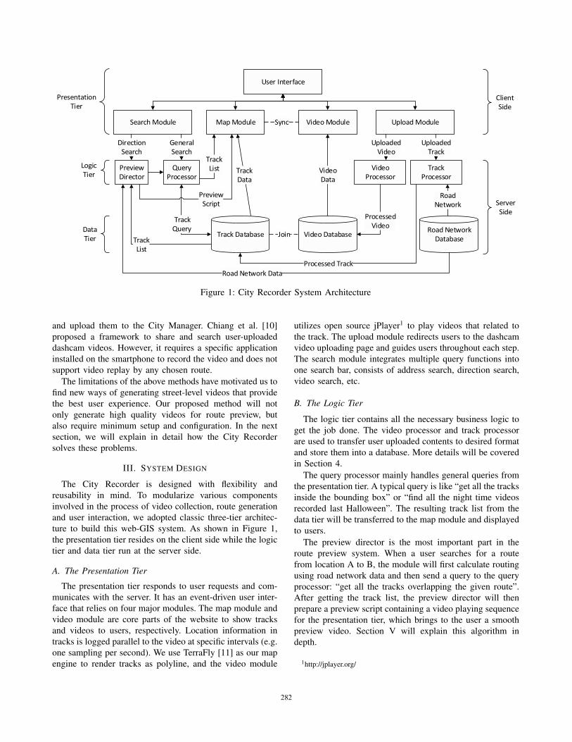
Figure 1: City Recorder System Architecture
and upload them to the City Manager. Chiang et al. [10]
proposed a framework to share and search user-uploaded
dashcam videos. However, it requires a specific application
installed on the smartphone to record the video and does not
support video replay by any chosen route.
The limitations of the above methods have motivated us to
find new ways of generating street-level videos that provide
the best user experience. Our proposed method will not
only generate high quality videos for route preview, but
also require minimum setup and configuration. In the next
section, we will explain in detail how the City Recorder
solves these problems.
III. SYSTEM DESIGN
The City Recorder is designed with flexibility and
reusability in mind. To modularize various components
involved in the process of video collection, route generation
and user interaction, we adopted classic three-tier architec-
ture to build this web-GIS system. As shown in Figure 1,
the presentation tier resides on the client side while the logic
tier and data tier run at the server side.
A. The Presentation Tier
The presentation tier responds to user requests and com-
municates with the server. It has an event-driven user inter-
face that relies on four major modules. The map module and
video module are core parts of the website to show tracks
and videos to users, respectively. Location information in
tracks is logged parallel to the video at specific intervals (e.g.
one sampling per second). We use TerraFly [11] as our map
engine to render tracks as polyline, and the video module
utilizes open source jPlayer1 to play videos that related to
the track. The upload module redirects users to the dashcam
video uploading page and guides users throughout each step.
The search module integrates multiple query functions into
one search bar, consists of address search, direction search,
video search, etc.
B. The Logic Tier
The logic tier contains all the necessary business logic to
get the job done. The video processor and track processor
are used to transfer user uploaded contents to desired format
and store them into a database. More details will be covered
in Section 4.
The query processor mainly handles general queries from
the presentation tier. A typical query is like “get all the tracks
inside the bounding box” or “find all the night time videos
recorded last Halloween”. The resulting track list from the
data tier will be transferred to the map module and displayed
to users.
The preview director is the most important part in the
route preview system. When a user searches for a route
from location A to B, the module will first calculate routing
using road network data and then send a query to the query
processor: “get all the tracks overlapping the given route”.
After getting the track list, the preview director will then
prepare a preview script containing a video playing sequence
for the presentation tier, which brings to the user a smooth
preview video. Section V will explain this algorithm in
depth.
1http://jplayer.org/
282282282282282282282282282282

C. The Data Tier
The primary task for this tier is CRUD operations (Create,
Read, Update and Delete). Videos and tracks will be stored
in the spatial-temporal database to support complicated
queries coming from the Logic Tier. Additionally, a road
network spatial database is required for routing calculation
and map matching of tracks. Our implementation uses open
road network data of the OpenStreetMap2 project. Other data
sources like base-map layer data and POI (point of interest)
data are basic part of the Map Module and are not separately
listed in the Figure 1.
IV. DATA COLLECTION
A. Track Data Processor
The track data processor extract tracks from the user
uploaded file and stores them in the track database.
The first step is converting these tracks to a device-
independent format. Since dashboard cameras are still in
the development stage, many manufacturers entered this
market lately and have developed different standards. Unlike
the mature technology of photography meta-data (e.g. the
Exif format) to embed geo-tag information, there is no
unified method to store the tracking log within a video
file. One approach directly encodes location information into
particular frames inside the video file (e.g. MISB Standard
61013). Another popular way is using a separate waypoint
log file to accompany the video file (e.g. NMEA 01834,
GPX, and KML). Some devices add a text overlay on the
video to store real-time coordinates. A track parse module
inside this processor handles all the track extraction tasks.
The next step is using a map matching algorithm (MMA)
to align the track data based on the road network. As a
result of limitations of positioning devices and inaccuracy of
digital road map, location points inside the track data may
be slightly off the road. To determine the road of the driving
video, we need to match these points on road segments using
MMA module. The matched track will be used by the route
preview director as explained in Section 5.
B. Video Data Processor
The video data processor preprocesses the video to a
unified format that is suitable for Web-based players. Video
formats differ from one device to another. To ensure smooth
video switching while previewing the route, it is desirable
to have only one format across all videos. Here we choose
mp4 (MPEG-4 Part 14) format because of its broad network
compatibility.
Another issue is that most devices support at least 720p
video recording, at the 512kbps bit rate, which is about
2https://www.openstreetmap.org3http://www.gwg.nga.mil/misb/docs/standards/ST0601.7.pdf4http://en.wikipedia.org/wiki/NMEA 0183
(a) (b)
(c) (d)
Figure 2: (a) Intersection. (b) Available Videos.
(c) Smooth Turn. (d) Sharp Turn.
60MB per minute in the raw format. Considering the net-
work bandwidth limitations for most users, compression will
be performed to reduce the video size. We utilize a free
video processing tool FFmpeg5 to perform video re-coding
and compression tasks.
V. PREVIEW DIRECTOR
The preview director collects a series of video clips
related to the route and arranges them on a timeline to
form a preview script. The script will be executed in the
presentation tier to show a seamless preview video.
A high quality route preview normally meets the following
criteria:
1) Low switching frequency. This is to facilitate users’
adaption to the changes caused by the transition from
one video clip to another, since videos differ in many
ways, like the time of day, the season of the year, the
weather conditions, the device type and the lane of
driving.
2) Natural transition between videos, even at road inter-
sections. Video clips must have the same directions to
generate the preview route. In addition, the ones which
have the same turning direction with the preview route
are preferred. Figure 2a illustrates the most common
4-way intersection that contains 12 possible driving
directions. For a route from A to D, we have three
available video clips in Figure 2b. It is easy to observe
that the solution in Figure 2c is smoother than in
Figure 2d although it has one more transition.
5https://www.ffmpeg.org/
283283283283283283283283283283

(a)
(b)
Figure 3: (a) Interval Modal. (b) Graph Modal.
3) Using high quality videos first when we have multiple
candidates. Factors affecting the video choice include
the time of day, the weather conditions, resolution, bit
rate, etc. Normally, day-time videos are better than
night-time, and 1024p videos have more details than
720p.
A. Query Related Videos
First we get the preview route from the routing service
OSRM6, which calculates the directions between locations
given by users using the road network database. Here we
define related videos as the ones at least partially overlapping
the preview route and having same direction with it. Then
we cut non-overlapping parts off the videos and generate a
list of related video clips. Ideally these clips will cover the
whole preview route.
B. Video Selection Algorithm
Our task is to select the minimum required videos with
high quality to cover the preview route. It can be reduced
to the well-known weighted interval coverage problem [12].
Consider a preview route from an origin o to a destination
d as an interval I = [o, d] and a set S of intervals
Ii = [si, ei], i = 1, . . . , n ( Ii is the ith related video which
overlaps I from si to ei). Here we assume that S covers
I . Each video clip has a weight wi calculated by adding up
flaw factors (a lower weight number represents a better video
quality). A path S′ = J1, . . . , Jk from o to d is a subset of
S such that Ji and Ji+1 overlap (or, at least, connected)
for every i ∈ 1, . . . , k − 1. The length l of S′ is defined as
l =∑k
i=1 wi. Our task is finding the subset S′ which has
the minimum length l for given S.
Using this method we can convert the available video
tracks in Figure 2b into an interval model as shown in Figure
3a. If we view intervals as nodes and use edges to indicate
6http://project-osrm.org/
(a)
(b)
Figure 4: (a) Main Page. (b) Geo-Video Player.
that two intervals are overlapped, the problem can also be
converted into a graph model as presented in Figure 3b. Note
the interval nodes are weighted. Here we use a dotted line
because the transition from Interval 1 to 2 is too sharp (we
define a direction change of more than 45 degrees as sharp).
We can give these dotted lines high weights compared to
other lines with weight 1. This problem can be solved using
a variant of Dijkstra’s algorithm [13], by calculating the
shortest distance using weight of nodes and edges together.
In reality, we cannot guarantee full video coverage over a
city. In the situation that no video is available for a section
of a route, we use alternative data sources described in [8].
C. Generating Scripts
After executing the above mentioned algorithm we get a
sequence of video clips. The present step prepares a script
for the online player, which contains multiple modes of ac-
tion. An action has the form [video id, start time,end time],
indicating which videos should be played at what time. One
thing we have to consider is choosing the correct cutting
position for the video clips. If two videos are connected
with no overlaps then no cutting is necessary. We just play
the next one after the previous one ends. If they have an
overlapping part, we choose a point with the minimum
direction changes as the transition point.
VI. USE CASE STUDY
In this section we will demonstrate the effectiveness of
our system and show how it is used to help people through
a series of use cases.
284284284284284284284284284284
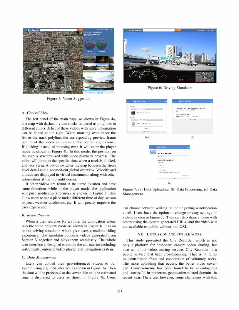
Figure 5: Video Suggestion
A. General View
The left panel of the main page, as shown in Figure 4a,
is a map with dashcam video tracks rendered as polylines in
different colors. A list of these videos with more information
can be found at top right. When mousing over either the
list or the track polyline, the corresponding preview frame
picture of the video will show at the bottom right corner.
If clicking instead of mousing over, it will enter the player
mode as shown in Figure 4b. In this mode, the position on
the map is synchronized with video playback progress. The
video will jump to the specific time when a track is clicked,
and vice versa. A button switches the map between the street
level detail and a zoomed-out global overview. Velocity and
altitude are displayed in virtual instruments along with other
information at the top right corner.
If other videos are found at the same location and have
same directions while in the player mode, the application
will push notifications to users as shown in Figure 5. This
allow users to see a place under different time of day, season
of year, weather conditions, etc. It will greatly improve the
user experience.
B. Route Preview
When a user searches for a route, the application enters
into the route preview mode as shown in Figure 6. It is an
online driving simulator, which give users a realistic riding
experience. The simulator connects videos generated from
Section V together and plays them seamlessly. The whole
user interface is designed to mimic the car interior including
instruments, onboard video player, and navigation system.
C. Data Management
Users can upload their geo-referenced videos to our
system using a guided interface as shown in Figure 7a. Then
the data will be processed at the server side and the estimated
time is displayed to users as shown in Figure 7b. Users
Figure 6: Driving Simulator
(a) (b)
(c)
Figure 7: (a) Data Uploading. (b) Data Processing. (c) Data
Management.
can choose between waiting online or getting a notification
email. Users have the option to change privacy settings of
videos as seen in Figure 7c. They can also share a video with
others using the system generated URLs, and the video will
not available to public without this URL.
VII. DISCUSSION AND FUTURE WORK
This study presented the City Recorder, which is not
only a platform for dashboard camera video sharing, but
also an online video touring service. City Recorder is a
public service that uses crowdsourcing. That is, it relies
on contribution from and cooperation of voluntary users.
The more uploading that occurs, the better video cover-
age. Crowdsourcing has been found to be advantageous
and successful in numerous geolocation-related domains in
recent year. There are, however, some challenges with this
285285285285285285285285285285

approach. It is difficult to ensure the quality of the preview
in low coverage areas, even after patching with alternative
solutions.Another concern is privacy protection. Users now can set
the sharing levels to public or private, and they can cut
off unwanted parts while uploading. In the future, we will
further utilize some mature technologies like automatically
blurring faces and license plates [14] to prevent leakage
of sensitive information. One interesting research approach
shows how to make the objects immediately in front of cars
transparent after analyzing a set of videos recorded at same
place [15]. It can also be used in our system to improve the
video quality.Route previewing is only one of the beneficial usages of
this Big Data. Much useful information can be discovered
by mining the data, such as road hazard report, traffic con-
gestion area detection, finding carpool partners, and climate
research. We are planning to add a data mining interface for
this platform to perform further analyses.
VIII. ACKNOWLEDGEMENT
This material is based in part upon work supported by the
National Science Foundation under Grant Nos. I/UCRC IIP-
1338922, AIR IIP-1237818, SBIR IIP-1330943, III-Large
IIS-1213026, MRI CNS-1429345, MRI CNS-0821345,
MRI CNS-1126619, CREST HRD-0833093, I/UCRC IIP-
0829576, MRI CNS-0959985, RAPID CNS-1507611, and
U.S. DOT Grant ARI73. Includes material licensed by
TerraFly (http://terrafly.com) and the NSF CAKE Center
(http://cake.fiu.edu).
REFERENCES
[1] J. Luo, D. Joshi, J. Yu, and A. Gallagher, “Geotagging inmultimedia and computer vision-a survey,” Multimedia Toolsand Applications, vol. 51, no. 1, pp. 187–211, 2011.
[2] A. Medvedev, A. Zaslavsky, V. Grudinin, and S. Khoruzh-nikov, “Citywatcher: Annotating and searching video datastreams for smart cities applications,” in Internet of Things,Smart Spaces, and Next Generation Networks and Systems.Springer, 2014, pp. 144–155.
[3] Y. Zheng, L. Wang, R. Zhang, X. Xie, and W.-Y. Ma,“Geolife: Managing and understanding your past life overmaps,” in Mobile Data Management, 2008. MDM’08. 9thInternational Conference on. IEEE, 2008, pp. 211–212.
[4] Y.-T. Zheng, Z.-J. Zha, and T.-S. Chua, “Research and appli-cations on georeferenced multimedia: a survey,” MultimediaTools and Applications, vol. 51, no. 1, pp. 77–98, 2011.
[5] D. Anguelov, C. Dulong, D. Filip, C. Frueh, S. Lafon,R. Lyon, A. Ogale, L. Vincent, and J. Weaver, “Google streetview: Capturing the world at street level,” Computer, no. 6,pp. 32–38, 2010.
[6] B. Chen, B. Neubert, E. Ofek, O. Deussen, and M. F.Cohen, “Integrated videos and maps for driving directions,”in Proceedings of the 22nd annual ACM symposium on Userinterface software and technology. ACM, 2009, pp. 223–232.
[7] J. Kopf, B. Chen, R. Szeliski, and M. Cohen, “Street slide:browsing street level imagery,” in ACM Transactions onGraphics (TOG), vol. 29, no. 4. ACM, 2010, p. 96.
[8] C. Peng, B.-Y. Chen, and C.-H. Tsai, “Integrated googlemaps and smooth street view videos for route planning,”in Computer Symposium (ICS), 2010 International. IEEE,2010, pp. 319–324.
[9] J. Rodrı́guez, A. Quesada-Arencibia, D. Horat, andE. Quevedo, “Web georeferenced video player with super-resolution screenshot feature,” in Computer Aided SystemsTheory-EUROCAST 2013. Springer, 2013, pp. 87–92.
[10] C.-Y. Chiang, S.-M. Yuan, S.-B. Yang, G.-H. Luo, and Y.-L.Chen, “Vehicle driving video sharing and search frameworkbased on gps data,” in Genetic and Evolutionary Computing.Springer, 2014, pp. 389–397.
[11] N. Rishe, S.-C. Chen, N. Prabakar, M. A. Weiss, W. Sun,A. Selivonenko, and D. Davis-Chu, “Terrafly: A high-performance web-based digital library system for spatial dataaccess.” in ICDE Demo Sessions, 2001, pp. 17–19.
[12] M. J. Atallah, D. Z. Chen, and D. Lee, “An optimal algorithmfor shortest paths on weighted interval and circular-arc graphs,with applications,” Algorithmica, vol. 14, no. 5, pp. 429–441,1995.
[13] E. W. Dijkstra, “A note on two problems in connexion withgraphs,” Numerische mathematik, vol. 1, no. 1, pp. 269–271,1959.
[14] A. Frome, G. Cheung, A. Abdulkader, M. Zennaro, B. Wu,A. Bissacco, H. Adam, H. Neven, and L. Vincent, “Large-scale privacy protection in google street view,” in ComputerVision, 2009 IEEE 12th International Conference on. IEEE,2009, pp. 2373–2380.
[15] S.-C. Chen, H.-Y. Chen, Y.-L. Chen, H.-M. Tsai, and B.-Y. Chen, “Making in-front-of cars transparent: Sharing first-person-views via dashcam,” in Computer Graphics Forum,vol. 33, no. 7. Wiley Online Library, 2014, pp. 289–297.
286286286286286286286286286286