city of winkler – northland parkway traffic impact...
TRANSCRIPT
CITY OF WINKLER – NORTHLAND PARKWAY TRAFFIC IMPACT STUDY
David Wiebe, P.Eng. Associate, Dillon Consulting Limited (presenter) Dave Krahn, P.Eng. Partner, Dillon Consulting Limited
200-895 Waverley Street
Winnipeg, Manitoba R3T 5P4 Tel: 204-453-2301 Fax: 204-452-4412
[email protected], [email protected]
Paper prepared for presentation at the
Best Practices in Urban Transportation Planning – An Economic Enabler Session of the 2007 Annual Conference of the Transportation Association of Canada
Saskatoon, Saskatchewan
City of Winkler 2007 TAC Conference Northland Parkway – Traffic Impact Study
1 ABSTRACT
The City of Winkler (Winkler) is located 120 km southwest of the City of Winnipeg. Winkler has experienced rapid growth over the last several years, giving rise to the need for a more organized large-scale development plan. Winkler intends to develop over 1100 acres of land deemed the “Northland Parkway” development, named after the major east-west roadway that is anticipated to be built as part of the development. It is expected that this area will be the major growth centre for Winkler over the next many years. Winkler, along with Manitoba Infrastructure and Transportation (MIT), engaged Dillon Consulting Limited (Dillon) to undertake a traffic impact study and functional design plan to identify the development impact on the existing provincial and municipal road network, recommend improvements to the existing and proposed roadways and intersections, as well as anticipate costs and recommend cost sharing strategies. The report is intended as a blueprint for the long-term development of the Northland Parkway area, including use in negotiations with developers and government agencies for development charges. Existing traffic volumes were extrapolated over a 20-year study period and were combined with zone trip generation/assignment calculations to model the impact of traffic from the new development area. Computer simulation models were used to combine the traffic data and model the entire project area. The traffic volumes were used to determine the capacity analysis and motorist delay on roadway links and intersections. This was one of the major measuring tools used to determine required upgrades to existing roadway infrastructure. Minimum parameters were set to determine trigger points for upgrades to the roadway infrastructure such as additional through lanes or turning lanes, property access, and signalization. Functional design of these upgrades on the existing Provincial road network and new major City collector roadways in the Northland Parkway area were designed and the capital costs developed. This planning will allow for improved movement of people and goods in and around Winkler. The roadway infrastructure costs are recognized to benefit both the existing City and the new development areas; as a result, development charges protocols were suggested to fairly allocate capital construction costs to the Province, City, and developers. Proper planning of the road network is vital to the economic viability of Winkler as a whole. Planning for growth now allows Winkler to budget, finance and carry out infrastructure development in a pro-active manner.
2 INTRODUCTION
2.1 Background
Winkler, the eighth largest community in Manitoba, is located 120 km southwest of the City of Winnipeg (Winnipeg). Winkler has experienced rapid growth over the last several years. Based on information from Statistics Canada, Winkler saw a population growth of 9.7% between the years of 1996 - 2001, compared to a Manitoba growth of 0.5%. Winkler has continued to grow and currently has a population of approximately 9,000 people.
1
City of Winkler 2007 TAC Conference Northland Parkway – Traffic Impact Study
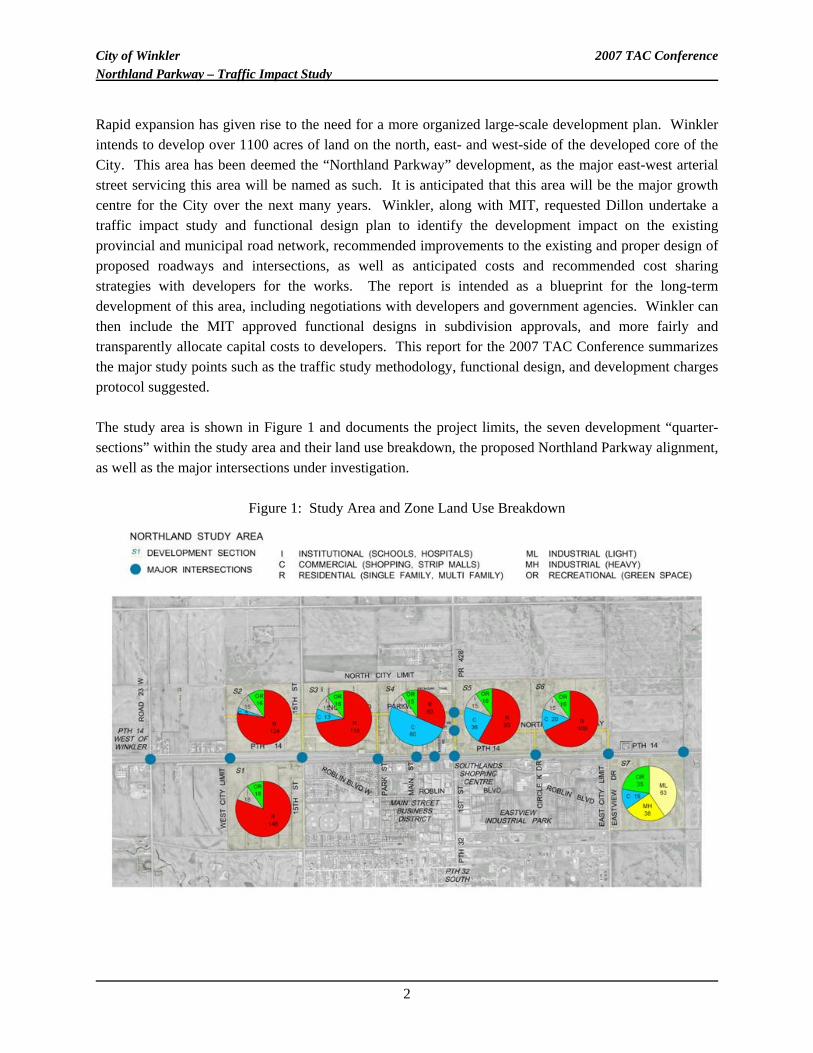
Rapid expansion has given rise to the need for a more organized large-scale development plan. Winkler intends to develop over 1100 acres of land on the north, east- and west-side of the developed core of the City. This area has been deemed the “Northland Parkway” development, as the major east-west arterial street servicing this area will be named as such. It is anticipated that this area will be the major growth centre for the City over the next many years. Winkler, along with MIT, requested Dillon undertake a traffic impact study and functional design plan to identify the development impact on the existing provincial and municipal road network, recommended improvements to the existing and proper design of proposed roadways and intersections, as well as anticipated costs and recommended cost sharing strategies with developers for the works. The report is intended as a blueprint for the long-term development of this area, including negotiations with developers and government agencies. Winkler can then include the MIT approved functional designs in subdivision approvals, and more fairly and transparently allocate capital costs to developers. This report for the 2007 TAC Conference summarizes the major study points such as the traffic study methodology, functional design, and development charges protocol suggested. The study area is shown in Figure 1 and documents the project limits, the seven development “quarter-sections” within the study area and their land use breakdown, the proposed Northland Parkway alignment, as well as the major intersections under investigation.
Figure 1: Study Area and Zone Land Use Breakdown
2
City of Winkler 2007 TAC Conference Northland Parkway – Traffic Impact Study
2.2 Major Items of Work
The significant tasks for this study included:
• Determining the existing and future anticipated traffic patterns in-and-adjacent to the study area over a 20-year study period.
• Determining the traffic generation that is expected from the study area taking into consideration the expected growth and expansion for the Northland area over the 20-year study period.
• Carrying out a capacity and Level of Service analysis of the major roadways surrounding the Northland development, which would include PTH 14 and PR 428.
• Developing conceptual at-grade intersection improvements, signalization warrants, road link design, and access management review for the study area roadways and intersections.
• Producing functional/conceptual design plans and preliminary cost estimates.
• Recommending a development charges protocol to assist Winkler in assigning capital cost improvements to developers, government agencies, and Winkler.
2.3 Site Characteristics
Access between Winkler and Winnipeg is either via north-south PTH 75/east-west PTH 14, or via northeast-southwest PTH 3/east-west PTH 14. Travel between Winkler and other communities (Morden and Altona) in the area are via PTH 14. The proposed Northland Parkway Development encompasses over 1100 acres of land on the north, east- and west-side of the developed core of Winkler. Access to the development will be via existing Provincial routes, namely PTH 14 and PR 428 and new municipal roads as necessary. PTH 14 and PR 428 experience existing Annual Average Daily Traffic (AADT) volumes of 11,000 and 2,500 respectively. Existing and proposed intersections as shown in Figure 1 needed to be reviewed based on proposed development and connections to the provincial road system. Functional design of the intersections and links in light of the increased traffic was determined.
3 TRAFFIC IMPACT STUDY
3.1 Background Traffic Volumes
To adequately determine the impact of traffic generated from the Northland Parkway on the existing provincial road infrastructure, the background traffic from existing and future had to be determined first. Existing traffic counts from all major roadways and intersections in the study area were reviewed and normalized. Based on various factors, including historical population growth rates and traffic growth
3
City of Winkler 2007 TAC Conference Northland Parkway – Traffic Impact Study
rates in the area, a combined weighted annual growth rate of 3.0% was selected over the 20-year study period. The background traffic volumes were then developed with this growth rate. Background traffic volumes, referred to as “base” traffic volumes in this study, accounted for all existing traffic and expected growth in traffic from all existing developed areas of Winkler and the surrounding area, excluding the Northland Parkway Development.
3.2 Northland Parkway Traffic Volumes
Anticipated Northland Parkway Development generated traffic was estimated using methodologies prescribed by the ITE publication Trip Generation (7th Edition, 2003) [1]. The Trip Generation report is intended for use in estimating the number of trips that might be generated to/from a specific land use. The land uses and associated acreages are shown in Figure 1. Generally, each of the seven sections comprises approximately 160 acres. Trips are defined as single or one-direction movements with either the origin or the destination inside a study site. For trip generation purposes, the total trip ends are a total of all trips entering plus all trips exiting a site. Winkler supplied Dillon with anticipated acreages/populations, etc for the various land uses in each zone based on their community development plan. Trip generation estimates were based on this document. Using the trip generation rates prescribed for each land use, and the land use breakdown, the total trips generated by the Northland Parkway development before rate of internalization reduction were approximately 86,000 trips per day (43,000 in/43,000 out), with 4,140 occurring during the A.M peak hour and 8,475 occurring during the P.M. peak hour. The ITE Trip Generation Manual generates new traffic destined to/from a particular land use. The rates do not specifically account for land use synergy or multi-purpose trips. For example, traffic destined to/from neighbourhood retail/commercial land uses will be largely comprised of trips already accounted for by the residential land uses in the area. This results in “double-counting”. For example, it is reasonable to assume that 50% of parents dropping their children off at the elementary school are likely to continue directly to work or to run errands, rather than returning home, and then making a separate trip. A 50% rate of internalization for the elementary school then prevents “double counting”. Another example would be a shopper visiting multiple stores and locations on the same shopping trip, again resulting in a multi-purpose trip. For transportation forecasting exercises of this magnitude, it is common practice to assume a rate of internalization for certain types of land uses. Table 1 outlines the rate of internalization assumed for certain land uses in the study area.
4
City of Winkler 2007 TAC Conference Northland Parkway – Traffic Impact Study
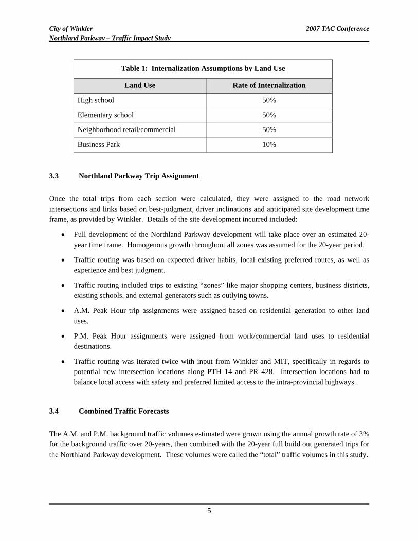
Table 1: Internalization Assumptions by Land Use
Land Use Rate of Internalization
High school 50%
Elementary school 50%
Neighborhood retail/commercial 50%
Business Park 10%
3.3 Northland Parkway Trip Assignment
Once the total trips from each section were calculated, they were assigned to the road network intersections and links based on best-judgment, driver inclinations and anticipated site development time frame, as provided by Winkler. Details of the site development incurred included:
• Full development of the Northland Parkway development will take place over an estimated 20-year time frame. Homogenous growth throughout all zones was assumed for the 20-year period.
• Traffic routing was based on expected driver habits, local existing preferred routes, as well as experience and best judgment.
• Traffic routing included trips to existing “zones” like major shopping centers, business districts, existing schools, and external generators such as outlying towns.
• A.M. Peak Hour trip assignments were assigned based on residential generation to other land uses.
• P.M. Peak Hour assignments were assigned from work/commercial land uses to residential destinations.
• Traffic routing was iterated twice with input from Winkler and MIT, specifically in regards to potential new intersection locations along PTH 14 and PR 428. Intersection locations had to balance local access with safety and preferred limited access to the intra-provincial highways.
3.4 Combined Traffic Forecasts
The A.M. and P.M. background traffic volumes estimated were grown using the annual growth rate of 3% for the background traffic over 20-years, then combined with the 20-year full build out generated trips for the Northland Parkway development. These volumes were called the “total” traffic volumes in this study.
5
City of Winkler 2007 TAC Conference Northland Parkway – Traffic Impact Study
4 FUNCTIONAL DESIGN STUDY
4.1 General Methodology
The functional design of PTH 14, PR 428, and the Northland Parkway was based on the traffic volumes compiled and calculated in the previous section of the study. Capacity analysis and motorist delay were the driving forces used to perform the functional design. Capacity analysis is an estimation of the traffic-carrying ability of facilities and an objective measure of driver comfort/maneuverability of a roadway. It is measured in terms of delay based level-of-service (LOS), with six LOS defined and given letter designations from “A” to “F”. LOS “A” represents best operating conditions and LOS “F” is the worst. In this study, the A.M. peak hour and P.M. peak hour were reviewed. This is typically called the “morning and afternoon rush hour”. It is these hours where traffic volumes peak and were therefore analyzed for capacity. These volumes were analyzed in the 2006 base traffic (no Northland), 2026 base traffic (no Northland) and 2026 total traffic (Northland fully developed). To perform this analysis, the Synchro/Simtraffic modeling software was used to automate this design. This allowed for quick comparisons of the LOS if, for example, a left turn storage lane was added or signalization suggested.
4.1.1 Intersection Design Methodology
For most design or planning purposes, LOS “C” in the peak hours is an acceptable limit for rural traffic operations. For urban traffic operations, LOS “D” can be generally understood to be the acceptable limit because driver expectations include more traffic congestion. Intersection capacity is driven by delay (in seconds) at an intersection. The longer the delay for the motorist at an intersection, the lower the LOS. In this study, each intersection movement volume, rather than the combined approach volume, was reviewed for LOS. When individual movement LOS was below D, geometric improvements such as the addition of storage lanes, or right turn cut-offs were added based on Transportation Association of Canada (TAC) standards, MIT standards, and best practices for the local conditions. If this was not sufficient, signalization was implemented. This was an iterative process. In the two-lane sections of PTH 14 and PR 428, the MIT design guide “Warrants and Standards for Intersection Treatments of Rural Two-Lane Highways” [2] was not directly utilized, as any improvements this guide recommended may be “throw-away” if four-laning occurs in the future. Some improvements to intersections were also based on system continuity, safety issues, and engineering best practices.
6
City of Winkler 2007 TAC Conference Northland Parkway – Traffic Impact Study
In addition to recommending signalization based on LOS only, warrants for signalization at the intersections were also reviewed based on the “TAC Canadian Traffic Signal Warrant Procedure [3]”. This procedure takes into account traffic volumes, opposing turn volumes, number of traffic lanes, posted speed limits, types of design vehicles, intersection geometry, proximity to trip generators, and peak travel times. Signals are considered when there is a total of 100 points or more.
4.1.2 Link Design Methodology
Intersections are the governing locations when it comes to LOS. Congestion almost always occurs at intersections first rather than the roadway links between them. This is due to the opposing traffic flows, driver decisions, and lower speeds associated with intersections. However, the LOS on a roadway link can drop to unacceptable levels if there is not enough capacity to carry the traffic. Increasing the number of lanes then becomes desirable. LOS “B” for a roadway link in the peak hours is generally an acceptable limit for rural traffic operations. For urban traffic operations, LOS “C” can be generally understood to be the acceptable limit because driver expectations include more traffic congestion. In addition to LOS, MIT also has basic design standards outlined in their Transportation Planning Manual (TPM) [4], which can be used to suggest when to increase from two lanes to four lanes. This is based on AADT volumes and other factors such as economics, safety, truck traffic, seasonal variations, and local conditions. In this study, a LOS of C or better and an AADT within the ranges specified above was considered acceptable to remain as a two-lane facility. Special conditions were also reviewed which had bearing on the decision.
4.2 Functional Design Recommendations
4.2.1 Signalization Warrants
In addition to the existing signalized intersections, results of the warrant analysis for PTH 14, PR 428, and the Northland Parkway roadways showed that signalization was required at two intersections with PTH 14 at various timeframes within the 20-year study if the Northland Parkway development occurs. These intersections were PTH 14/15th Street, and PTH 14/Park Street. Of interest is that both of the intersections recommended for signalization based on the Warrant Analysis alone also required signals to bring the LOS to D or greater for the peak hours.
7
City of Winkler 2007 TAC Conference Northland Parkway – Traffic Impact Study
4.2.2 Intersection Analysis
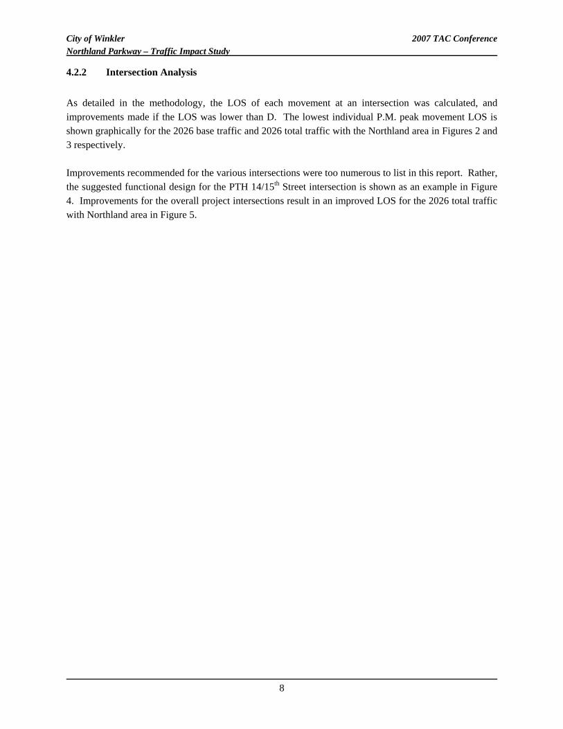
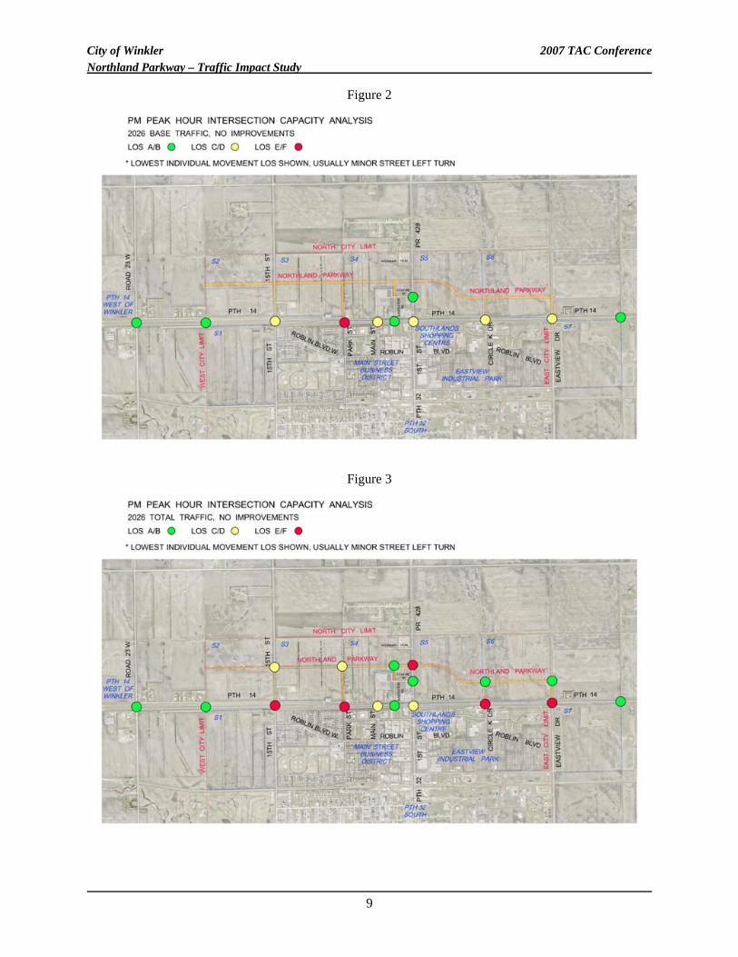
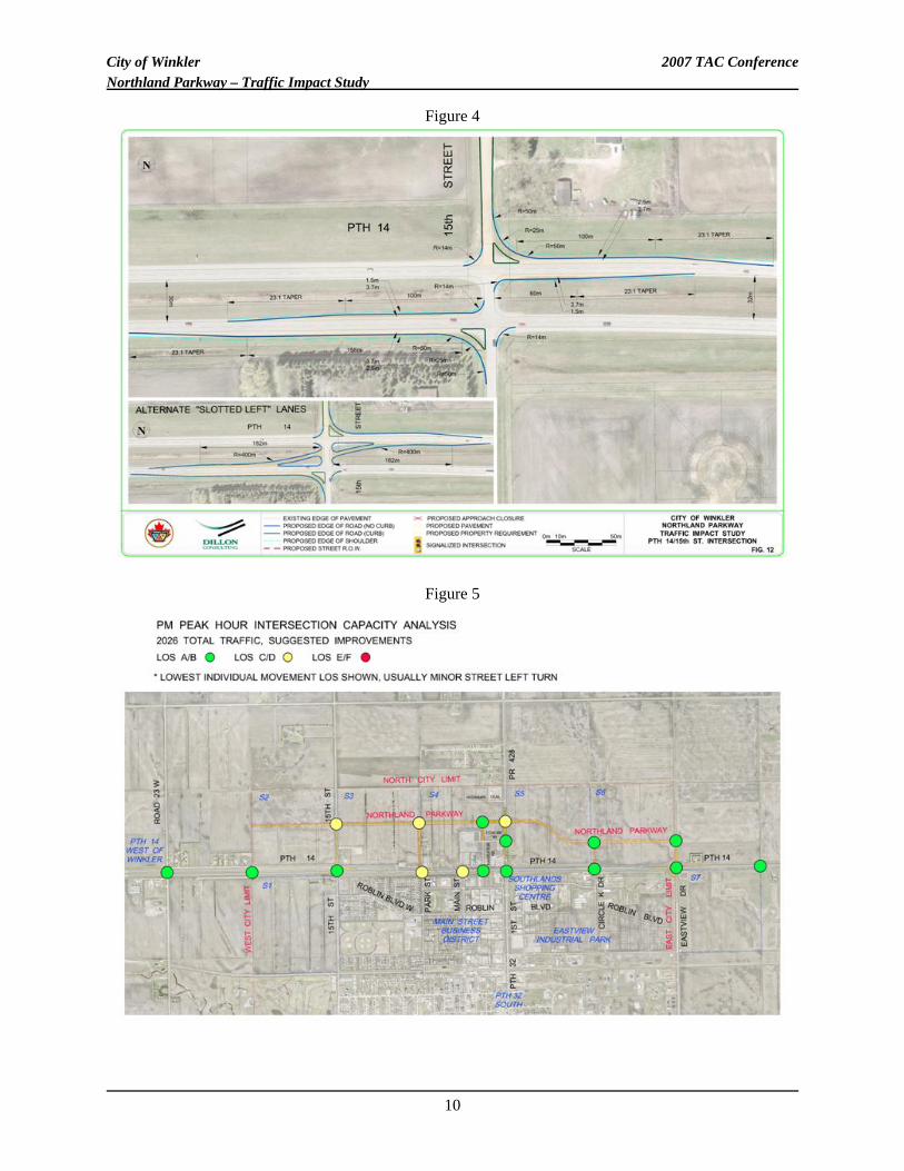
As detailed in the methodology, the LOS of each movement at an intersection was calculated, and improvements made if the LOS was lower than D. The lowest individual P.M. peak movement LOS is shown graphically for the 2026 base traffic and 2026 total traffic with the Northland area in Figures 2 and 3 respectively. Improvements recommended for the various intersections were too numerous to list in this report. Rather, the suggested functional design for the PTH 14/15th Street intersection is shown as an example in Figure 4. Improvements for the overall project intersections result in an improved LOS for the 2026 total traffic with Northland area in Figure 5.
8
City of Winkler 2007 TAC Conference Northland Parkway – Traffic Impact Study
Figure 2
Figure 3
9
City of Winkler 2007 TAC Conference Northland Parkway – Traffic Impact Study
Figure 4
Figure 5
10
City of Winkler 2007 TAC Conference Northland Parkway – Traffic Impact Study
4.2.3 Link Analysis
As with the intersection analysis, the factors reviewed for the link analysis were numerous. Issues such as LOS, traffic volumes, economics, safety, and other issues also play a role in the decision. Based on these, and other local considerations, it was suggested that the portion of PR 428 between Northland Parkway and PTH 14 be four-laned. In addition, a portion of Northland Parkway in the vicinity of PR 428 was also suggested for four-laning.
4.3 Access Management Review
Recommended access to roadways is dependant on a number of factors, including the class of roadway, intended use, surrounding development type, and alternative access. Within the study area, access was reviewed for the three major roadways under functional design. Access alterations must balance the needs of local residents and businesses, which perceive multiple accesses to all roads as a benefit, with the needs of intra-provincial travelers, where high speed roadways with limited access are preferred. Some access alterations may be received negatively by existing residents or businesses. This is especially likely around commercialized frontage to the provincial roads. As PTH 14 is a provincial trunk highway, limited direct access was suggested. Private access was discouraged, and was routed to the crossing intersections instead at a preferred one mile spacing. Traditional frontage roads and service roads adjacent to PTH 14 were not recommended, as access to the lots in the new Northland area will be from the internal road system. Existing frontage roads in the study area create capacity and safety issues at the intersections such as PTH 14 and Park Street where they are not set back far enough from the travel lanes of PTH 14. If frontage roads will be considered by developers, allowance for a setback of 50 m from the edge of PTH 14 to the edge of the frontage road at intersections with PTH 14 was recommended. For Provincial Road 428, limited direct access was preferred similar to PTH 14. Private access was discouraged, and should be routed to the intersections instead. As with PTH 14, frontage/service roads directly adjacent to the highway were not recommended unless they are setback at least 50 m at intersections. In contrast, the Northland Parkway will be the main east-west arterial street for the quarter sections north of PTH 14. Private access on the Northland Parkway should be allowed, although exact locations should be determined as part of a detailed traffic study or in light of acceptable spacing and local conditions. For instance, opportunities to combine accesses to neighboring commercial properties would be beneficial.
11
City of Winkler 2007 TAC Conference Northland Parkway – Traffic Impact Study
Median openings in the four-lane section of Northland should only be for major traffic generators. Other accesses should be limited to right in/right out only. Private access on the cross Collector streets of the Northland area should be allowed, with exact locations approved based on acceptable spacing and local conditions.
4.4 Capital Costs and Development Charges Protocol
4.4.1 Capital Cost Estimates
With the recommended functional design of the intersections, PR 428 widening, and the major Northland Parkway links, preliminary capital cost estimates were carried out. These construction costs were carried out using the following methodology and assumptions:
• Costs were broken up into separate “projects” to allow for staging of the improvements. This generally meant that each intersection requiring improvements was considered a project area. In addition, roadway links requiring new construction or four-laning were also considered “projects”. Projects were grouped into those on the provincial roads and those on the Northland Parkway internal road system. This was done to better facilitate assigning the capital costs between the Province, City, and developers in the next section of the report. Generally, the costs for the Northland Parkway internal road system are solely the responsibility of the developer and no allocation between government and the developers was deemed necessary. They are not discussed further in this report.
• The costs are preliminary roadway construction costs, and do not include items such internal finance and administration costs, taxes, construction of service roads or internal development roads, street lighting, landscaping aesthetics, pavement markings, highway signage, or necessary land acquisition.
• The costs do not include other public services required for land development such as sewer and water delivery systems, land drainage, or electricity or gas delivery. The costs focus solely on transportation related infrastructure.
It was found that functional improvements to the provincial road system (PTH 14 and PR 428) due to traffic demands over the next 20 years resulted in an estimated capital cost in the range of $5 million. A breakdown of each project area and its recommended construction timeframe based on traffic demands was included in the original client report to facilitate planning.
4.4.2 Development Charges Background
The future growth modeled over the next 20 years within Winkler will focus on the Northland Parkway area, creating demands for new transportation links and the need to improve a number of existing infrastructure elements, namely on PTH 14 and PR 428. As these provincial roads also serve the needs of
12
City of Winkler 2007 TAC Conference Northland Parkway – Traffic Impact Study
the Province and the existing City residents, Winkler was looking to develop an appropriate cost sharing formula for the required capital costs. Equitable cost sharing that assigns appropriate costs to new development is an issue that is frequently faced by other Municipalities, and there are several options available. Calculation and application of Local Development Charges was the cost-recovery method suggested for Winkler. Development Charges (or D/C’s) are a common tool used by municipalities both in Manitoba and other provinces. D/C’s are equitable, as they divide costs between all parties (existing users and future developers) based on proportional use of the infrastructure, and they provide Planning Authorities with a tool that enables easy collection of required capital contributions as development occurs. D/C’s establish “per unit” costs for planned land uses, based on the total required developer costs and the planned development levels. With a “per unit” cost in hand, Municipalities levy the required charges when processing development application. Examples of development charges frameworks are provided below. 4.4.2.1 Manitoba Municipal Act and Planning Act The governing municipal act for this province states that municipalities can charge for the construction or maintenance of works required to service the populace. This is referenced in the Muncipal Act C.C.S.M. c. M225 Sections 250(2) and 252. In addition, the Planning Act C.C.S.M. c. P80 Section 135 references that developers may have to enter into a development agreement with the municipality which may include the construction or maintenance of services such as roadways, sewer and water service, and other public services. A defined protocol or formula for development charges is not spelled out, but the Acts do show that development charges are appropriate for assigning the cost of transportation infrastructure. [5], [6] 4.4.2.2 Ontario Development Charges Act In 1989 the Province of Ontario enacted the Development Charges Act as a tool to allow Municipalities to collect contributions from new development to offset the cost of capital works necessitated by growth. In 1997 the Act was amended to fine-tune some of the elements of the cost allocation formula. The Act and the formula were not fundamentally changed by the amendment. The basic principle behind the Act is that costs are to be calculated by determining the total value of growth-related capital works anticipated over a defined area and defined time period of time and allocating them to the growth that will occur within the area and time period. Essentially: Development Charge Rate = Total Value of Required Capital Improvements Growth
13
City of Winkler 2007 TAC Conference Northland Parkway – Traffic Impact Study
To establish the numerator, the Municipality needs to establish an area to which the charge will apply, the capital works that will be necessary to support the proposed development, the time period over which the capital works are to be installed, and the portion (if any) of the service that benefits the existing community and development beyond the timeframe of the study. To establish the denominator, the Municipality needs to establish the anticipated growth in residential population (or number of residential units) and non-residential floor space over the planning period in the service area chosen in the numerator. A “per unit” charge is developed for residential units, and industrial, commercial and institutional floor space. Many of the Municipalities in Ontario have prepared Development Charges (D/C) by-laws to implement the Development Charges Act. Background studies are prepared to establish the numerator and the denominator and the “per unit” costs are established. The By-law is updated every five years to keep the unit costs up to date. [7] 4.4.2.3 Halifax Regional Municipality Capital Cost Contribution Policy The Nova Scotia Municipal Government Act (MGA) permit municipalities to impose an infrastructure charge to recover the capital costs incurred by a Municipality by reason of the subdivision and future development of land. The Halifax Regional Municipality (HRM) Capital Cost Contribution (CCC) Policy was prepared in October 2001 as an implementation tool to achieve this goal in compliance with the MGA. Under the MGA, infrastructure charges can include amounts in respect of:
• New or expanded water systems; • New or expanded wastewater facilities; • New or expanded storm water systems; • New or expanded streets; and • Upgrading of intersections, installation of traffic signals and signs, and new transit bus bays.
The CCC Policy has a number of guiding principles and policies, but essentially it is the intent to direct the costs of infrastructure to the “cost causer”. Whoever derives a “direct” benefit from the infrastructure pays a portion of the costs consistent with the direct benefit derived from the infrastructure. Where an existing developed area receives a direct service benefit from Oversized Infrastructure, the Municipality may pay a share of the oversized system costs; the Municipality may recover CCC charges by permitting infilling, rezoning, or subdivision within the existing community, so long as it is within the geographic Charge area. [8] In the case of traffic-related infrastructure, a trip generation factor will be used to apportion costs.
4.4.3 Recommended Development Charges Approach for Winkler
14
City of Winkler 2007 TAC Conference Northland Parkway – Traffic Impact Study
Considering the approaches to calculating D/C’s, the following seven-step approach was suggested for consideration to Winkler:
1. Define the geographic limits for the Development Charges Area.
2. Identify the projects that need to be undertaken to support the proposed development within the Development Charges Area.
3. Determine the general responsibilities for the required projects. Projects will either be: (1) the shared responsibility of all or some of the Province, Winkler, and the developers; or (2) solely the responsibility of the developer.
4. For those projects that are the shared responsibility of the Province, Winkler, and the developers, determine the percentage allocation of the costs between the parties.
5. Develop Capital Cost estimates for the required projects.
6. Determine the total value of the required projects that is to be allocated to the area developers by summing the costs for the developer-only projects and the developer’s portion of the costs of the shared-responsibility projects.
7. Develop “per unit” costs for residential units and institutional, commercial, and industrial land uses.
4.4.4 Northland Parkway Development Charges Calculations
Development Charge Rates for the Northland Parkway Development area were determined using the suggested approach described above. The general results are detailed below. Step 1 – Establish Development Charges Area The Northland Parkway development charges area was defined earlier in the report and is shown in Figure 1. It is roughly defined as seven “quarter sections” (S1 to S7) to the north of the existing Winkler built up area. Development outside this area, of which there is some, is not included. Therefore for the purposes of the recommended D/C charges, the term “developer” only refers to developers within S1 to S7. Step 2 – Determine Required Projects The “project” areas are those defined for the capital cost estimates in the previous section of this study. These projects are necessary to support the proposed development: Note that these projects include only the improvements to the provincial highway system (PTH 14 and PR 428). The Northland Parkway, local and collector streets within individual developments are not included as they are generally solely the cost of the developer, with no capital cost contributed by the City or Province. There were some exceptions noted in the original client report but they are not discussed here.
15
City of Winkler 2007 TAC Conference Northland Parkway – Traffic Impact Study
Step 3 – Determine the General Responsibilities for the Required Projects Essentially, the projects on PTH 14 and PR 428 are judged to be the shared responsibility of the Province, Winkler, and the area developers. There were some exceptions that were noted in the original client report. Step 4 – Determine the Percentage Allocation of the Shared Project Costs Three options were considered for the allocation of costs between parties to determine the developer’s portion of the costs as follows:
1. Ratio of Total Development Traffic to Total Future Traffic on the Facility Calculated as an average value across all shared projects
i. Intersection Improvements: Sum of all traffic volumes on all approaches ii. Road Link Improvements: Sum of all traffic volumes in both directions mid-
block
2. Ratio of Total Development Traffic to Total Future Traffic on the Facility Calculated on a project-by-project basis
i. Intersection Improvements: Sum of all traffic volumes on all approaches ii. Road Link Improvements: Sum of all traffic volumes in both directions mid-
block
3. Equal allocation of project costs, based on number of parties sharing costs (i.e., 1/3, 1/3, 1/3) It should be noted that the cost for the existing background traffic is assumed to be split evenly between Winkler and the Province, except in some special cases detailed in the original client report. The sensitivity of the three options suggested above was reviewed. Overall, Cost allocation Option 2 seemed to be the most equitable approach to cost allocation for the shared-cost projects. The traffic generated at each individual project location was used to calculate the portion of capital cost at each location allocated to the development as a whole. This resulted in 25% of PM peak traffic assigned to the developer, and thus 25% of the roadway infrastructure costs. This is a reflection that the background traffic growth in the area over 20 years is higher than the traffic that will be added to the provincial road system due to the development of the Northland area. Step 5 – Determine Capital Costs The capital costs of the individual projects were calculated previously. Generally, the improvements on PTH 14 and PR 428 combined were in the range of $5 million dollars.
16
City of Winkler 2007 TAC Conference Northland Parkway – Traffic Impact Study
Step 6 – Determine Developer’s Capital Cost Allocation Using Cost Option 2 for allocation, the capital costs were distributed among the Province, City, and developers. The developers are responsible for 25% of the total capital cost. Step 7 – Calculate “Per Unit” Costs Per unit costs are apportioned by dividing the total developer costs by the total number of P.M. peak hour site trips forecasted (resulting in $/trip generated), and, using typical trip generation rates from the ITE Trip Generation Handbook, determining the cost per development unit. The formula used was as follows:
tUnitDevelopmenCosttUnitDevelopmentionTripGenera
GeneratedTotalTripsoperCostTotalDevel /($)*
)8475(($)
=
The “per unit” costs are listed in a manner that they are easily ascribed to a particular development. Most are by area in acres. For example, there is a $cost/acre for light industrial use, commercial, and all other identified land use types in Figure 1 The values provided were a suggestion based on the traffic volumes modeled and capital costs expected for these projects. The rates can be adjusted as necessary when new cost and traffic information is available, or changes to developer allocation are determined.
5 CONCLUSIONS AND RECOMMENDATIONS
The development of the Northland Parkway area will add a significant amount of traffic to the existing road network. This study has outlined the recommended intersection and roadway link facilities required to safely and efficiently handle the anticipated traffic. Capital cost estimates have been calculated, along with a suggested development charge to fairly recoup the cost of providing these transportation services. A traffic study such as this one assists in the economic development of an area by providing an overview of the transportation infrastructure required. Potential developers can more clearly see their impact and fair cost of an improvement. For example, an improvement at one intersection is not due solely to the immediately adjacent development. Developer charges spread the cost of the improvements over the entire area, rather than penalizing the first developer next to an intersection requiring improvements. The traffic model can also be modified in the future to better reflect actual growth rates, or “hot zones” of development. The implementation period of the improvements can then be modified as necessary. Overall, a pro-active approach to transportation planning for an area benefits both the municipalities responsible for delivering and maintaining infrastructure, and the developers wishing to utilize and expand it.
17
City of Winkler 2007 TAC Conference Northland Parkway – Traffic Impact Study
6 REFERENCES
1. Institute of Transportation Engineers. “Trip Generation, 7th Edition”, ISBN 0-935403-79-5, 2003. 2. Manitoba Infrastructure and Transportation (formerly Manitoba Highways and Transportation),
ND LEA Engineers & Planners Inc. . “Warrants and Standards for Intersection Treatments of Rural Two-Lane Highways”, Second Edition, May 2001.
3. Transportation Association of Canada. “Canadian Traffic Signal Warrant Procedure”, ISBN 1-55187-152-1, Februrary 2003.
4. Manitoba Infrastructure and Transportation (formerly Manitoba Highways and Transportation). “Transportation Planning Manual”, February 1998.
5. Manitoba. “The Municipal Act, C.C.S.M. c. M225” 6. Manitoba. The Planning Act, C.C.S.M. c. P80” 7. Ontario. “Development Charges Act, 1997” 8. Halifax Regional Municipality. “Capital Cost Contribution Policy”, October 2001
18