city of westwood master plan15efba29-5ad1-451a-8674... · city of westwood master plan february...
TRANSCRIPT

CITY OF WESTWOOD
MASTER PLAN
February 2017
COMPREHENSIVE LAND USE PLAN

PREPARED BY
Shockey Consulting
Services, llc
ASSISTED BY
PAGE 2 WESTWOOD MASTER PLAN

ACKNOWLEDGMENTS
MAYOR AND CITY COUNCIL Mayor John Yé Margaret Bowen Lisa Cummins Jason Hannaman David Waters Joe Whisler
CITY STAFF Department Directors: Fred Sherman, Chief Administrative Officer / City Clerk John Sullivan, Public Works Director Greg O'Halloran, Police Chief
STEERING COMMITTEE Kevin Breer, Planning Commission Justin Bridges, 47th Street and Mission Road Committee Dave Buck, Resident Lisa Cummins, City Council/Westwood Foundation Reagan Cussimanio, University of Kansas Medical Center (substitute) Jason Hannaman, City Council Jeff Harris Resident R. Kaye Johnston, Resident Robert Junk Planning Commission Colt McArthur, 47th Street and Mission Road Committee Valerie Morrill, Resident Kumud Payakuryal, Westwood Foundation Christopher Ross, Planning Commission Blair Tanner, Woodside Village Jeff Wright, University of Kansas Medical Center
PAGE 3

COMMUNITY PARTICIPANTS
Carla Aamodt Blythe Jones Kent Peterson
Helen Ackmann Bill Joyce Bill Plant
Carolyn Anderson Brian Kaiser Steve Quade
Kurt Anderson Samantha Kaiser Stephanie Reid
James Arnold Sara Keehn Ken Richardson
Brad Baker Debra Klem Gloria Roque
Summer Baltezor-Finkelston Steve Klem Bill Roland
Liz Barton Rachel Knox Mike Ross
Dennis Baughman Tyler Kopp Vicki Ross
Becky Beilharz Joe Kordalski Steve Scavuzzo
Shannon Benes Jan Kyle Paula Schwach
Belinda Borchardt Catherine Lewis Kevin Shea
Sondra Branham Ken Low Kay Simonsen
Zac Brooks Stephanie Low Tammy Smith
Chris Burns Connie Mangiaracina Mike Smith
Jane Clements Phil Mangiaracina Beth Springgate
Mike Coffman Colt McArthur Kerry Stanley
Mark Cohan Michael McCorkle Gary Stevens
Gary Coleman Steve McClure Christopher Stohrer
Paul Day Diane McClure Jeff Stottle
Spencer Day Noella McCray Shawn Strate
Ken Decker Eddie McNeil Courtney Sullivan
David Delacruz Edana McSweeney Bob Sutton
Jim Donovan Dan Miller Leni Swails
Kathleen Brogan Farren Geo Mills Mark Swails
Lisa Fielden Paul Minto Gary Talbert
Phil Fields Megan Monroe Jayme Tebow
Christine Folgmann Malisa Monyakula Wilma Trial
John Gaar Matt Moore Brooke Tuley
Bob Garcia Lori Moore David Twiddy
Chip George Donna Muiller Erich Ulmer
Pascal Gephardt Kevin Murphy Kay Ulmer
Kate Ghio Susan Myers Sylvia Villanueva
Luz de la Paz Gomez Lyle Niedens Laurel Wallerstedt
Salvador Gomez Caryl Niedens Debbie Wallin
David Gomoletz Terry Nygaard M. Scott Weaver
Leslie Greathouse Diane Nygaard Jason White
Kathy Hanis Nancy Oglesby Laurie White
Blair Hannaman Rachel Olson Norma Wirthman
Julie Hans Jim Orr Elizabeth Wilson
Jonas Heinrich Teri Orr Damon Wittenborn
Ann Holliday Dave Owens Lindsay Wolf Smith
Clint Hooker Megan Painter Kearsha Xu
Ryan Hunter Masae Parker Christine Yé
Wayne Hunthausen Constance Pearson Dane Zeller
Monita Ireland William Pearson
Brad Johnson Diana Perkins
Karen Johnson Jessie Peterson
Matt Jones Julie Peterson
PAGE 4 WESTWOOD MASTER PLAN

TABLE OF CONTENTS
CHAPTER 1: INTRODUCTION 1.1 OVERVIEW 1.2 STUDY AREA BOUNDARY 1.3 REGIONAL CONTEXT 1.4 PLANNING PROCESS 1.5 HOW TO USE THIS PLAN 1.6 MONITORING PLAN PROGRESS 1.7 PLAN FORMAT
CHAPTER 2: COMMUNITY VISION 2.1 INTRODUCTION 2.2 VISION STATEMENT 2.3 PLAN THEMES 2.4 COMMUNITY GOALS
CHAPTER 3: EXISTING LAND USE AND ZONING 3.1 INTRODUCTION 3.2 LAND USE CLASSIFICATIONS 3.3 LAND USES IN WESTWOOD 3.4 TRANSPORTATION AND MAJOR ROADS
CHAPTER 4: FUTURE LAND USE PLAN AND DEVELOPMENT POLICIES 4.1 INTRODUCTION 4.2 FUTURE LAND USE PLAN 4.3 CHARACTER AREAS 4.4 LAND USE POLICIES 4.5 FUTURE LAND USE OPPORTUNITIES
CHAPTER 5: COMMUNITY PROFILE 5.1 INTRODUCTION 5.2 POPULATION AND DEMOGRAPHICS 5.3 INFRASTRUCTURE 5.4 UTILITIES 5.5 EDUCATION 5.6 PUBLIC SAFETY 5.7 PUBLIC FACILITIES & BUILDINGS 5.8 PARKS AND RECREATION 5.9 TRANSPORTATION 5.10 ENVIRONMENT 5.11 HOUSING 5.12 EMPLOYMENT & INCOME 5.13 LOCAL BUSINESSES & ECONOMIC DEVELOPMENT 5.14 SOCIAL SERVICES 5.15 LOCAL GOVERNMENT FINANCE
APPENDICES PAGE 5

TABLES
Table 3.1 Street Names and Types in Westwood p. 3-8
Table 5.1 General Population Characteristics p. 5-3
Table 5.2 City of Westwood, Kansas - Crime Statistics (2009-2014) p. 5-12
Table 5.3 Medical Facilities Serving Westwood p. 5-14
Table 5.4 Housing Unit Characteristics, 2000/2010 p. 5-23
Table 5.5 Employment Characteristics - City of Westwood p. 5-26
Table 5.6 Westwood Business Statistics - 2013-2015 p. 5-28
Table 5.7 Top 10 Employers - Westwood p. 5-28
Table 5.8 Nursing Homes in Surrounding Communities p. 5-30
Table 5.9 Total Revenues and Expenditures - FY2013-FY2015 p. 5-31
Table 5.10 Mill Levy FY2010-FY2015 p. 5-32
PAGE 6 WESTWOOD MASTER PLAN

FIGURES
Figure 1.1 City of Westwood p. 1-5
Figure 1.2 Kansas City Metropolitan Area and Westwood, Kansas p. 1-6
Figure 1.3 Joe Dennis Park p. 1-7
Figure 1.4 Housing Type in Westwood p. 1-7
Figure 3.1 Existing Land Use Map p. 3-5
Figure 3.2 Existing Land Use - Percentages of Each Land Use Category p. 3-6
Figure 4.1 Future Land Use - Percentages of Each Land Use Category p. 4-7
Figure 4.2 Future Land use Map p. 4-8
Figure 4.3 Future Land Use - Character Areas Map p. 4-10
Figure 4.4 Westwood Opportunity Areas p. 4-16
Figure 5.1 Age Distribution p. 5-4
Figure 5.2 Educational Attainment (Over 25 Years of Age) p. 5-8
Figure 5.3 Westwood View Elementary School p. 5-9
Figure 5.4 Westwood View Elementary School Attendance Area p. 5-10
Figure 5.5 Westwood View Elementary School Enrollment p. 5-11
Figure 5.6 City Hall p. 5-15
Figure 5.7 5050 Rainbow p. 5-15
Figure 5.8 Joe D. Dennis Park p. 5-16
Figure 5.9 Joe D. Dennis Park p. 5-16
Figure 5.10 Street Classification - Westwood, Kansas p. 5-19
Figure 5.11 Average Monthly High and Low Temperature and Average
Monthly Rainfall (inches) - Westwood, Kansas p. 5-21
Figure 5.12 Single Family Homes Year Built p. 5-24
Figure 5.13 Single Family Home Value p. 5-25
Figure 5.14 Employment by Industry (2010) - City of Westwood p. 5-27
PAGE 7

CHAPTER 1
INTRODUCTION
SECTION 1.1 OVERVIEW
SECTION 1.2 STUDY AREA BOUNDARY
SECTION 1.3 REGIONAL CONTEXT
SECTION 1.4 PLANNING PROCESS
SECTION 1.5 MONITORING PLAN PROGRESS
SECTION 1.6 PLAN FORMAT
PAGE 1-1

PAGE 1-2 WESTWOOD MASTER PLAN

INTRODUCTION
SECTION 1.1
OVERVIEW The Westwood Master Plan creates an overall blueprint for the community, and recognizes appropriate plans
for the City’s discrete and unique physical, social, and economic assets. The Master Plan respects the needs
and desires of the present generation without compromising the ability of future generations to meet their
needs. The Master Plan includes both a Comprehensive Plan element, and a Strategic Plan element. This
Master Plan concept attempts connects the long-term vision of the Comprehensive Plan to the immediate
priorities of the Strategic Plan.
STRATEGIC PLAN The Strategic Plan outlines a realistic list of the City’s current and future priorities and creates shared
commitments regarding the goals and strategies required to appropriately address these priorities. The Strategic Plan reinforces the long-term planning efforts of the Comprehensive Plan for both operating and
capital programs.
COMPREHENSIVE PLAN (The Plan) This Master Plan fulfills the requirements for the adoption of a Comprehensive Plan by the Westwood Planning Commission and Governing Body pursuant to K.S.A. 12-747. The Comprehensive Plan element (The Plan) is the principal guide for community and the governmental decision-making body regarding land use, zoning, transportation planning, economic development, capital budgeting, and the provision of municipal services and facilities. The Comprehensive Plan addresses the built environment as it relates to the location, density, type and scale of development in the community. A comprehensive plan does not include decisions about zoning. However, it is used as a guide for making zoning decisions.
WHAT A COMPREHENSIVE PLAN IS AND WHAT IT IS NOT.
Comprehensive land use planning is the process of establishing a vision for the future of a community and developing a plan or blueprint for how the community achieves that vision. A comprehensive plan is the document that includes that information. Development of the plan includes evaluating existing conditions and issues facing the community, and identifying policies for addressing those conditions. For Westwood, this plan looks at achieving its vision over the next 10-15 years.
A comprehensive plan does not include decisions about zoning. However, it is used as a policy guide for making future zoning decisions. The zoning ordinance and municipal codes are more specific, and outline guidelines and standards for the location, density, scale, design, quality, and use of the built environment in the community.
A comprehensive plan is a high-level plan that provides recommendations for projects and programs. The Westwood Planning Commission and City Council then determine how to apply the recommendations laid forth in this plan, which may include the need for rezoning, and other code and ordinance changes.
PAGE 1-3

Three themes make up The Plan - Character, Choice, and Collaboration. The themes are briefly summarized below and further detailed later in this document.
CHARACTER
• Promote and protect the
neighborhood character of existing single-family detached homes
• Respecting the scale and
design of the existing built environment
• Community civic spaces &
additional open green space areas
• Defined gateways and
corridors
• Property maintenance & codes enforcement
• Unique and distinctive
identity
CHOICE
• Encourage the reinvestment and improvement of existing housing
• Provide homes for all
ages and a broader
market demand
• Encourage owner
occupancy while
facilitating a housing
rental market • Improved mobility
• Pedestrian and bicycle improvements
COLLABORATION
• Assist the school district with planning for the future
• Existing and new
residences – listen to the past, look to the future
• Local businesses, patrons
and visitors
• Greater collaboration with neighboring municipalities and other elected officials
• Partnerships with agencies
that can build upon a shared understanding of values and culture to support mutual needs of the community.
PAGE 1-4 WESTWOOD MASTER PLAN

INTRODUCTION
SECTION 1.2
STUDY AREA BOUNDARY The focus of this plan is the area within the city limits of Westwood, shown in Figure 1.1 below. The community
is approximately 260 acres and is landlocked. There are currently no plans to incorporate any surrounding communities into the Westwood city limits.
Figure 1.1: City of Westwood
PAGE 1-5

SECTION 1.3
REGIONAL CONTEXT The City of Westwood is greatly influenced by the Kansas City Metropolitan area where more than 2 million
people live, according to 2015 population estimates. Westwood is adjacent to both Kansas City, Kansas, and
Kansas City, Missouri, with convenient roadway access to both cities. From 2010 to 2015, the metropolitan area
grew, on average, 3.6 percent annually compared to 1.8 percent for the State of Kansas and 3.9 percent for the
United States.
Westwood is located on U.S. 56 Highway, connecting the community to Rainbow Boulevard to the north and
Shawnee Mission Parkway on the south end of the community. These key transportation routes allow for a
convenient residential commute to many employment centers in the region. As is shown in Figure 1.2 below,
Westwood is located in the center of the region.
Figure 1.2: Kansas City Metropolitan Area and Westwood, Kansas Source: Mid-America Regional Council
PAGE 1-6 WESTWOOD MASTER PLAN

INTRODUCTION
SECTION 1.4
PLANNING PROCESS The Comprehensive Plan identified the community’s strengths and weaknesses. The process coordinated
with the development of the City Council’s strategic plan to develop a plan of action to achieve particular
goals and outcomes for the community which guides the decision-making for the next five to ten years (see
Appendices - page 1). The coordination of these two planning efforts allowed the community to not only
identify significant issues and opportunities for the next several years but also to outline and prioritize actions
to take by elected officials to address the community needs.
The purpose of the planning effort was to: • Engage the community and stakeholders through a dynamic and engaging planning process that
includes residents and the business community; • Establish a clear vision for the future, shared by the Governing Body and the community’s residents,
including citizens, business owners and elected officials; • Incorporate a short-term Strategic Plan element to assist the Governing Body in its efforts to allocate
city resources. The Strategic plan will serve as a guide when developing the city’s annual budget,
considering contracts, capital outlays, staffing levels, debt structuring, and other expenditures; and • Satisfy state requirements for a Comprehensive Plan.
The planning involved an analysis of existing conditions, an evaluation of the effectiveness of potential
strategies, and the development of action steps. The result involves a shared commitment to the
implementation of the plan.
PROJECT DISCOVERY, DATA SYNTHESIS AND ANALYSIS Review and analysis of base data helped to understand the existing conditions of the community. The
collection of background information included site visits to observe and record conditions. It also included
identification of trends and issues from existing written sources and through in-person meetings with staff or
stakeholders. A public engagement plan outlined how and when the public is engaged. Figure 1.3: Joe D. Dennis Park Figure 1.4: A Housing Type in Westwood
PAGE 1-7

PUBLIC ENGAGEMENT Local officials, steering committee members and the community came together to develop a vision for the
future of Westwood which were the foundation for the Comprehensive and Strategic Plans. The following details the process.
PAGE 1-8 WESTWOOD MASTER PLAN

INTRODUCTION
Stakeholder Interviews In February and March of 2016, project team members held stakeholder interviews to discuss specific topics of interest as they relate to the development of the Westwood Master Plan. The topics included:
• Education • Business • Business – Larger • Landlords and Housing • Transit
The City identified and invited more than 100 stakeholders that represented one or more of the above topics
to participate in one of the 1.5-hour interviews (i.e., small group discussions). During the interviews, the 17
participants visited with the project team to identify strengths, weaknesses or issues in the community.
Steering Committee Meetings The Steering Committee for this Master Plan process comprised of City Council members, Planning
Commission members, residents, business interests, and Westwood Foundation representatives. The
committee met five times to discuss the topics listed below. Meeting summaries from the committee
meetings are found in the Appendices - starting on page 116.
• Current issues in Westwood • How to involve area stakeholders • Community goals as a basis of the plan • Desired outcomes • Opportunity areas located in the community • Potential land uses for the planning area
PAGE 1-9

Community Survey Westwood residents, business owners, stakeholders, and interested people were invited to take a
community survey for the Westwood Master Plan. Between March 1 to March 25, 2016, 212 people
responded to the survey. Respondents could respond online or by completing a paper survey, mailed to
each Westwood resident. The results of the survey were reviewed and evaluated to highlight significant
themes and ideas.
Survey respondents desire: • Livable neighborhoods • Schools • Appearance of the community • Public safety • Small-town character
Survey respondents said they prefer to see residential (single-family) land uses in the community (64
percent of respondents), followed by mixed use businesses that include residential and commercial (38 percent of respondents).
Survey respondents expressed concern about: • Potential conflict between businesses and residential areas • Development of apartment and senior living units
Most important issues to address in the next ten years: • Aging infrastructure • Balancing what people want versus spending/capacity • Aging housing stock
In addition, survey respondents recommended focusing on preserving and enhancing the existing residential areas rather than building new. A majority of respondents did not want to grow the community, but rather
protect and enhance the existing community character.
The detailed survey summary can be found in the Appendices on page 553.
Website A project website, linked to the City’s website, acted as the central location for people to receive information
about the planning process. The website promoted public meetings and activities, provided background
information and meeting summaries, and allowed for people to provide comments directly on the site.
Over the course of the planning period, the website received approximately 1,100 visitors who viewed the website pages 4,300 times.
PAGE 1-10 WESTWOOD MASTER PLAN

INTRODUCTION
Public Meeting #1 The first public meeting for the Westwood Master Plan was Monday, February 29, 2016 from 7:00 p.m. – 9:00 p.m. at Westwood View Elementary School. Approximately 120 people attended the meeting. A complete meeting summary is included in the Appendices - page 330. The following provides highlights.
The meeting provided general information to the attendees and allowed attendees to provide feedback on a
vision for Westwood in the next 10-15 years. Meeting participants received an overview of the planning
process and received information about general demographics and trends occurring in Westwood.
In small groups, participants brainstormed words describing their vision for the future of Westwood.
Participants also discussed strengths and weaknesses of Westwood by answering the questions outlined below (top responses are shown).
WHAT DO YOU WANT TO WHAT DO YOU WANT WHAT DO YOU WANT PROTECT/MAINTAIN? TO CHANGE? TO CREATE?
• Westwood View • More public transit • Upgrade school
Elementary • Smart growth between • Improve property
• Single-family owned residential and maintenance codes and
homes commercial enforcement
• Green space • Bike/pedestrian paths • Better dialogue with city
• Good police protection • Community center • Neighborhood
and public safety connectivity
PAGE 1-11

Public Meeting #2 The second public meeting for the Westwood Master Plan was Tuesday, May 10, 2016 from 7:00 p.m. –
9:00 p.m. at the Olivet Baptist Church located at 4901 Mission Road. Approximately 60 people attended
the meeting. A complete meeting summary is included in the Appendices - page 374, but the following
provides highlights.
At the meeting, attendees received a status update and provided input into the vision statement.
A majority of the meeting involved small groups discussing potential objectives and action steps to meet the
five draft goals presented. The attendees worked in small groups to answer “how”, “who”, and “when”. The five goal statements, later refined, are:
• Ensure well maintained properties throughout the community. • Represent and communicate a sense of place and unique identity. • Capitalize on redevelopment opportunities. • Provide housing stock that meets future demands. • Reinvest in infrastructure and facilities.
After their discussions, the meeting attendees provided general comments about community issues within
their small groups. Groups identified key issues such as property maintenance and resources to assist property owners, economic development policy (including TIF), and communication with the City.
PAGE 1-12 WESTWOOD MASTER PLAN

INTRODUCTION
Public Meeting #3 - Open House The final public meeting for the Westwood Master Plan was Wednesday, September 14, 2016 from 6:00 p.m. – 8:00 p.m. at Westwood City Hall. Approximately 100 people attended the open house event.
The meeting presented draft plan elements to the public. The plan elements included the existing and future
land use, opportunity areas that have specific issues or opportunities to address in the future, land use
policies, and the strategic plan. Following the meeting, people could review and provide comments to the
materials online. A compilation of the comments received are included in the Appendices - starting on page
444. The comments provided by the public helped to refine the final draft plan.
PAGE 1-13

SECTION 1.5
HOW TO USE THIS PLAN The Westwood Comprehensive Plan consists of both written and graphic components that reflect the Master Plan Vision Statement and Plan Themes provided in the following elements of this document:
Community Goals
Land Use Configuration
Land Use Policies
Future Land Use Opportunities The overall Master Plan for Westwood contain a series of goals, objectives and implementation strategies, or actions which align in order to achieve the community’s vision.
A Goal is a broad statement of values or aspirations needed to achieve the vision. Goals help guide the community’s decisions about public and private investment and development. Goals are not tied to specific dates or targets, but are enduring and provide a general direction for more refined objective statements to assist decision-makers.
An Objective provides a course of action with directions and guides the actions of staff, developers and
policy makers necessary to achieve the goal.
A Policy is a specific task or process used to implement an objective and work toward achieving the goal.
Two key elements of the Comprehensive Plan consist of the Future Character Map, and the Westwood Opportunity Areas, described in more detail on the next page. This Comprehensive Plan is for Citizens of Westwood to use as a guide for what they can expect for redevelopment within Westwood. City Officials and Staff will use this Plan as a guide for decision making while developers and landowners have the responsibility to demonstrate how their project has met the intent of the Comprehensive Plan in their application materials.
PAGE 1-14 WESTWOOD MASTER PLAN

INTRODUCTION
FUTURE CHARACTER PLAN MAP The Future Character Plan Map is established as a framework to effectively guide future development in a way that will accomplish Westwood’s Master Plan Vision Statement and Plan Themes. This Plan is based, in a large part, on defining two key issues:
1) Stabilization Areas vs. Opportunity Areas
2) The relative intensity of future redevelopment projects In order to establish the City’s future character, it is important to know where change is desired and where it is not desired. These areas are identified as:
Stabilization Areas: These are areas where the current residential character is maintained and enhanced. Actions identified within the Comprehensive Plan look to foster active neighborhood environments, maintain and improve residential properties and streets.
Opportunity Areas: These areas may see some increase in density and/or changes in use that will
evolve over time, or some areas could be developed into additional open green space areas. One specific area, adjacent to 47th and Rainbow Blvd, may see dramatic changes in use or density in the future due to under-utilization of property and its proximity to the mixed-use Woodside Village development. This intersection is one of Westwood's “Front Door” gateways.
WESTWOOD OPPORTUNITY AREAS This section of the Plan provides a broad view on how specific areas of the City could redevelop and/or change in the future while corresponding with the guiding principles, goals and objectives throughout The Plan. It draws on current conditions and previous planning efforts and also reflects the market realities and potential fiscal analysis. This section of the Plan is intended to provide strategic guidance and general land use options for future redevelopment opportunities.
PAGE 1-15

SECTION 1.6
MONITORING PLAN PROGRESS Elected officials along with members of the Westwood community are responsible for the achievement of the
goals, objectives, strategies, and land use policies outlined in this report. The future of Westwood is
dependent on active community engagement and follow-through on these recommendations.
PLAN REVIEW A review of the plan elements should be conducted annually to describe accomplishments and identify any changes in priorities or land use policies.
According to Kansas state statutes, “At least once each year, the planning commission shall review or
reconsider the plan or any part thereof and may propose amendments, extensions or additions to the
same. The procedure for the adoption of any such amendment, extension or addition to any plan or part
thereof shall be the same as that required for the adoption of the original plan or part thereof.”1
In addition to the annual reviews, it is recommended that a comprehensive reconsideration the Plan every
five to seven years. The City, in conjunction with the Planning Commission and any other stakeholders
involved in implementation, can spearhead the updates. It will be beneficial to re-engage those groups
involved with this plan’s development from time to time.
1 K.S.A. 12-747
PAGE 1-16 WESTWOOD MASTER PLAN

INTRODUCTION
SECTION 1.6
PLAN FORMAT This plan includes the following chapters:
CHAPTER 2: COMMUNITY VISION The community’s vision for the future is more than a future land use map - it’s a plan that includes strategies
and policies necessary to sustain and improve the community. The chapter contains the community’s vision
statement, plan themes, and goals, and objectives. The detailed strategies and action plan is included in the
Appendices - page 1 as part of the strategic plan.
CHAPTER 3: EXISTING LAND USE This chapter provides information about the existing land uses in Westwood, including existing classifications and an existing land use map.
CHAPTER 4: FUTURE LAND USE PLAN AND POLICIES This chapter contains a future land use map to assist in decision-making about changes in zoning and
capital improvements. A series of land use policies is included in this chapter to provide the public and
community decision-makers a clear set of statements that define the intent of the City of Westwood on
specific issues concerned with community growth and development. The future land use map functions as a
generalized “road map” to assist local civic and government leaders, business interests, and citizens make
informed decisions about Westwood’s future land use.
CHAPTER 5: COMMUNITY PROFILE The evaluation of these existing conditions was a critical first step in the planning process. A review of
existing documents and plans, as well as personal interviews, provided background information about the
community. Finally, demographic review and analysis helped identify population data and housing trends.
APPENDICES The appendices includes documentation from the public outreach activities, including the entire community
survey results. The appendices includes the strategic plan, mentioned earlier, and all public comments
received through the planning process.
PAGE 1-17

COMMUNITY VISION
CHAPTER 2
COMMUNITY VISION
SECTION 2.1 INTRODUCTION
SECTION 2.2 VISION STATEMENT
SECTION 2.3 PLAN THEMES
SECTION 2.4 COMMUNITY GOALS
PAGE 2-1

PAGE 2-2 WESTWOOD MASTER PLAN
COMMUNITY VISION
SECTION 2.1
INTRODUCTION The purpose of this Plan is to provide the City of Westwood a basis for making land use and community
development decisions. The foundation of a plan begins with a set of goals and a future vision of the city.
Planning decisions that are consistent with the goals and vision statement help to ensure the City’s ability to
achieve desired outcomes for a healthy, thriving, and sustainable future.
The crafting of a vision statement and goals resulted from public comment and feedback over the past year.
The planning process allowed the community to identify significant issues and opportunities and outlined and
prioritized actions that elected officials can take to address the community’s needs. The detailed strategic plan
can be found in the Appendices - page 1.
SECTION 2.2
VISION STATEMENT Working first with the steering committee and later with the general public, ideas and input resulted in a vision statement that describes the future of Westwood for the next 10-15 years.
WESTWOOD’S VISION
Westwood, Kansas is a charming, vibrant and diverse
place which is safe, walkable, bikeable and
comfortable. It is connected to other communities and
boasts locally-owned businesses, schools, and parks.
Citizens strongly identify with, and value the unique
and welcoming character of the community.
PAGE 2-3

SECTION 2.3
PLAN THEMES
CHARACTER
CHOICE COLLABORATION
PAGE 2-4 WESTWOOD MASTER PLAN

COMMUNITY VISION
CHARACTER
Promote and protect the neighborhood character of existing single-family detached homes Residents highly value the character of the single-family detached homes located throughout the majority of the community. The Plan seeks to protect and enhance these residential areas by focusing and encouraging commercial redevelopment activity only on to two exterior corridors of the community. The Plan also promotes various goals and strategies for stabilization where the current residential character is maintained and enhanced. Actions identified within this Plan look to foster active neighborhood environments, focus on scale and design, maintain and improve residential properties and streets.
Respecting the scale and design of the existing built environment Westwood offers a unique combination of small-town character with in close proximity to urban metropolitan amenities. Throughout the comprehensive planning process, residents have emphasized the importance of retaining that character into the future, even as development patterns adapt to changing demographics and economic realities. The Plan outlines specific goals and strategies to protect this important character trait. The scale, design, massing, and density of any redevelopment activity within the community should provide a welcoming atmosphere and create a sense of comfort for those that live there. Redevelopment projects should have compatible architectural styles, scale of structures, and a compatible density to the adjacent residential areas. Commercial redevelopment activity should focused together along the 47th Street and Rainbow Boulevard corridors, with smartly-designed transitions into the adjacent residential areas. This includes developments with a distinctive character that is compatible with a walkable, livable place. Pedestrian-friendly streetscapes enhance activity and commercial viability. Smaller scaled commercial businesses, services, and non-residential redevelopments adjacent to residential areas and should have a similar scale and massing to be compatible. Mixed-use developments and high intensity commercial areas should be directed towards the 47th Street and Rainbow intersection activity node, and can accommodate taller buildings with a denser footprint.
Community civic spaces & additional open green space areas Communities with a high quality of living component connect residents to each other through the built environment. Community civic spaces and outdoor open green space areas function as social settings that encourage people to walk and gather within the community. The Plan outlines the desire and strategies for the development of community connection areas - additional open green space areas and community civic space opportunities.
PAGE 2-5

Defined gateways and corridors Gateways and corridors are the first and more prominent impression of the community. Westwood currently maintains two city two branded monument signs at the corner of 47th Street and Mission Road, and on Belinder Ave south of 51st Terrace. The Plan includes policies and suggestions for improving other prominent gateways and corridors. The Plan seeks to create an identity and branding scheme that welcomes travelers and patrons to Westwood with well-designed developments and coordinated public improvements. To focus efforts on encouraging pedestrian-friendly design, high quality public realm, and celebrating the assets and uniqueness of each corridor.
Property maintenance & codes enforcement Property maintenance and codes enforcement is an important component of the planning framework as it is critical to helping to protect the character and charm of the community. A lack of maintenance on properties degrades the public’s perception of the community, and negatively impacts the quality of life and property values. The Plan seeks to protect and enhance all areas for Westwood’s future. It is important that property maintenance and reinvestment activity supports these efforts to enhance and protect property values and overall community quality of life.
Unique and distinctive identity Natural limestone rock walls and streetscape features throughout the community set Westwood apart from many other first-tier suburban communities. The Plan recommends preserving and enhancing these type of special elements and incorporating new compatible elements that fit with this character. These streetscape features will need maintenance and preservation over time, and where appropriate, new developments should incorporate a similar robust streetscape aesthetic.
PAGE 2-6 WESTWOOD MASTER PLAN

COMMUNITY VISION
CHOICE
Encourage the reinvestment and improvement of existing housing As Westwood’s housing stock continues to age and housing needs and trends change, renovations and updates to existing single-family detached homes is needed to help keep and attract residents to the community. The unique character of Westwood and its prime location in the metropolitan area greatly influences demand. The Plan encourages the creation of systems and programs that support the reinvestment in and improvements to the existing housing stock.
Provide homes for all ages and a broader market demand Communities that offer housing choices that accommodate people in different life-cycle stages allow people to age in their community. New housing is needed when the existing housing stock cannot fulfill a market. This may include different types and configurations of housing developments to meet the ever-changing housing demand, or even tearing down an existing home to replace it with a new home. Some residents desire to live-out their lives in their existing community, but can’t make improvements and enhancements without much difficulty. The Plan recognizes the need to provide a variety of housing types, densities, and value within the community so that Westwood can attract and accommodate residents from a variety of backgrounds and different lifestyle preferences.
Encourage owner occupancy while facilitating a housing rental market The Plan is committed to making homes in the community available to a variety of people, including opportunities for homeownership, as well income properties for rent. The Plan encourages a flexible planning framework for private investment to attract diverse housing opportunities.
Improved mobility Careful planning and design of a multi-modal transportation network takes into account pedestrians and bicyclists as well as automobiles and transit. The Plan includes transportation and parking policies to consider when making decisions about development opportunities or capital projects. The Plan also encourages active living by design, and supports an attractive walkable environment within the community in an effort to promote livability, quality-of-life, a stronger sense of place and healthy lifestyles.
Pedestrian and bicycle improvements Westwood citizens desire a more pedestrian and bike friendly scale and facilities. The Plan outlines additional opportunities and related policies to target pedestrian and bicycle improvements in the community, including pedestrian-scale lighting. The Plan facilitates a walkable environment to promote community interaction, as people are more likely to talk with neighbors and shop at local stores when they are on foot.
PAGE 2-7
COLLABORATION
Assist the school district in planning for the future Arguably one of the most important components of the Westwood community, both in heart and in land use, is Westwood View Elementary School. Many future land use decisions are dependent on the school district’s future plan for the existing school facility, and the plan for the former Entercom property, recently acquired by the Shawnee Mission school district.
Existing and new residences – listen to the past, look to the future The recommendations and policies described in this plan document need the support of the community to succeed. When implementing The Plan, efforts should focus on identifying resources, projects, or programs that residents are in tune to, and find ways to apply them to maximize results in benefiting the community for Westwood’s future.
Local businesses, patrons and visitors Businesses in Westwood, like residents, have an interest in the overall well-being of the community. It is essential for Westwood to strive for future development projects that work within a unified framework fostering civic life and economic vitality. The Plan demonstrates the commitment to the commercial corridors along 47th Street and Rainbow Boulevard. Also, these businesses will benefit from the policies that focus on capital investments such as sidewalk improvements, street lighting, and parking.
Greater collaboration with neighboring municipalities and other elected officials Implementation of the ideas contained in a comprehensive plan rely on the financial capability of the government to finance public improvement projects. Long-range planning demonstrates that elected officials are taking necessary steps to forecast long-range public needs facing their community.
Partnerships with agencies that can build upon a shared understanding of values and culture to support mutual needs of the community. Westwood must balance the support of existing resources with investment in the future to survive over a long period. This will involve working with stakeholders - people or organizations that have an interest or a stake in the Westwood community. Collaboration and coordination with these entities is needed as the values and needs of the community changes over time.
PAGE 2-8 WESTWOOD MASTER PLAN

COMMUNITY VISION
SECTION 2.4
COMMUNITY GOALS The following goal statements and related objectives are the guiding principles of entire Master Plan
process for Westwood. These goals and objects acknowledge the City’s past while shaping the future.
The following were developed to reflect the core values of the community. They describe the
community’s aspirations and provide the framework for specific policies and direction of The Plan.
GOAL A: MAKE SURE PROPERTIES ARE WELL-MAINTAINED THROUGHOUT THE
COMMUNITY. OBJECTIVE A.1: Maintain existing properties while protecting community character and resources.
GOAL B: REPRESENT A SENSE OF PLACE AND UNIQUE IDENTITY. OBJECTIVE B.1: Create attractive gateways and corridors in the community.
OBJECTIVE B.2: Promote unique components of the community.
GOAL C: INCREASE ENGAGEMENT AND COLLABORATION. OBJECTIVE C.1: Align resources to coordinate community efforts.
OBJECTIVE C.2: Maintain current and develop additional community events and activities to meet the needs of all residents.
OBJECTIVE C.3: Improve communication between citizens, elected officials, and city staff.
OBJECTIVE C.4: Keep Westwood View Elementary in Westwood.
GOAL D: SUPPORT EXISTING BUSINESSES AND CAPITALIZE ON
REDEVELOPMENT OPPORTUNITIES. OBJECTIVE D.1: Maintain a strong, prosperous economy.
OBJECTIVE D.2: Provide support for local businesses.
OBJECTIVE D.3: Cluster commercial development into designated commercial areas.
GOAL E: ENSURE HOUSING STOCK MEETS FUTURE DEMANDS. OBJECTIVE E.1: Use existing housing stock to meet future demands.
OBJECTIVE E.2: Build new housing stock.
GOAL F: INCREASE INVESTMENT IN INFRASTRUCTURE AND FACILITIES. OBJECTIVE F.1: Provide public facilities and infrastructure that serve existing and future residents.
OBJECTIVE F.2: Enhance walkability and bikeability of the community.
OBJECTIVE F.3: Improve mobility and parking throughout the community.
PAGE 2-9

EXISTING LAND USE AND ZONING
CHAPTER 3
EXISTING LAND USE AND ZONING
SECTION 3.1 INTRODUCTION
SECTION 3.2 LAND USE CLASSIFICATIONS
SECTION 3.3 LAND USES IN WESTWOOD
SECTION 3.4 TRANSPORTATION AND MAJOR ROADS
PAGE 3-1

PAGE 3-2 WESTWOOD MASTER PLAN

EXISTING LAND USE AND ZONING
SECTION 3.1
INTRODUCTION The existing land use map is created and studied is to allow for informed decision-making when developing the
future land use plan. Documenting the existing land use pattern creates an awareness and understanding of the
community. This base knowledge is the underlying basis that allows the future land use plan to be respectful of
the existing development pattern.
Further comparison of existing zoning of individual parcels with the actual land uses helps to identify and
correct areas that lack continuity, or result in continued non-conforming uses. Understanding the potential
market demands can also neccessitate the need for land use changes.
PAGE 3-3

SECTION 3.2
LAND USE CLASSIFICATIONS The following land use classifications describe the current land use pattern outlined in Figure 3.1, Existing Land Use Map.
RESIDENTIAL Land occupied by dwelling units, including accessory buildings, used for sheltering individuals, families, or groups of persons. Single family detached, or two family residential uses at typical urban and/or suburban
densities.
COMMERCIAL Lots or parcels containing small-scale retail or offices, professional services, convenience retail, and storefront retail. Permitted uses include business, professional, and financial offices as well as offices for
individuals and non-profit organizations.
Permitted retail uses include lots or parcels containing retail sales, services, and recreational services that are predominantly privately owned and operated for profit.
MIXED-USE - COMMERCIAL/MULTI-FAMILY An area that is appropriate for a mix of commercial (small-scale retail or offices, professional services, convenience retail, and neighborhood retail) and medium-density residential uses.
PUBLIC/SEMI-PUBLIC Any site for public or semi-public facilities, including governmental offices, police and fire facilities, and public and private schools as well as religious facilities and other religious activities.
OPEN SPACE This category recognizes public park areas such as trails and easements, drainage-ways and detention basins, and any other public usage of open land.
INSTITUTIONAL/MEDICAL Lots or parcels that are significant medical facilities.
UTILITY Land used or dedicated for public and private utilities, including pipelines, utility lines, water and wastewater facilities, substations, and telephone.
VACANT Property that is vacant, or lacks permanent improvement.
NON-CONFORMING Land uses and structures that were established prior to the incorporation of the City of Westwood, and are non-compliant to the base underlying zoning.
PAGE 3-4 WESTWOOD MASTER PLAN

EXISTING LAND USE AND ZONING
SECTION 3.3
LAND USES IN WESTWOOD Figure 3.1 displays the existing land use pattern based on information obtained from the City.
Figure 3.1: Existing Land Use Map
PAGE 3-5
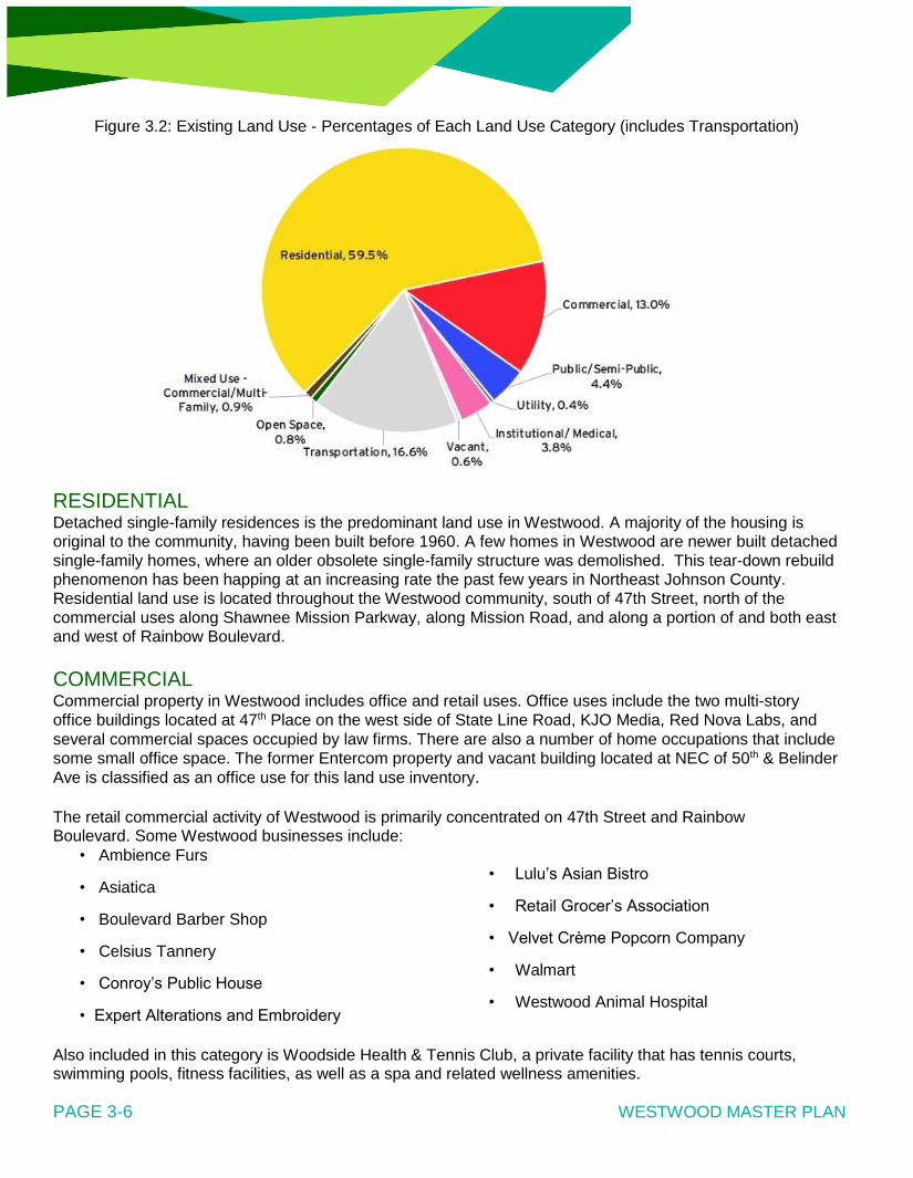
Figure 3.2: Existing Land Use - Percentages of Each Land Use Category (includes Transportation)
RESIDENTIAL Detached single-family residences is the predominant land use in Westwood. A majority of the housing is original to the community, having been built before 1960. A few homes in Westwood are newer built detached
single-family homes, where an older obsolete single-family structure was demolished. This tear-down rebuild
phenomenon has been happing at an increasing rate the past few years in Northeast Johnson County.
Residential land use is located throughout the Westwood community, south of 47th Street, north of the
commercial uses along Shawnee Mission Parkway, along Mission Road, and along a portion of and both east and west of Rainbow Boulevard.
COMMERCIAL Commercial property in Westwood includes office and retail uses. Office uses include the two multi-story
office buildings located at 47th Place on the west side of State Line Road, KJO Media, Red Nova Labs, and
several commercial spaces occupied by law firms. There are also a number of home occupations that include
some small office space. The former Entercom property and vacant building located at NEC of 50th & Belinder
Ave is classified as an office use for this land use inventory.
The retail commercial activity of Westwood is primarily concentrated on 47th Street and Rainbow Boulevard. Some Westwood businesses include:
• Ambience Furs • Lulu’s Asian Bistro
• Asiatica • Retail Grocer’s Association
• Boulevard Barber Shop • Velvet Crème Popcorn Company
• Celsius Tannery • Walmart
• Conroy’s Public House • Westwood Animal Hospital
• Expert Alterations and Embroidery
Also included in this category is Woodside Health & Tennis Club, a private facility that has tennis courts, swimming pools, fitness facilities, as well as a spa and related wellness amenities.
PAGE 3-6 WESTWOOD MASTER PLAN
EXISTING LAND USE AND ZONING
MIXED-USE - COMMERCIAL/MULTI-FAMILY Westwood’s first mixed-use development, Woodside Village, is currently under development. The first
northern phase was completed in early 2017. Located at the corner of 47th Street and Rainbow Boulevard, the development includes apartment multi-family housing, neighborhood retail and dining businesses.
PUBLIC/SEMI-PUBLIC The largest semi-public property is owned by the Shawnee Mission School District at the location of
Westwood View Elementary. Other semi-public land uses include one church – the Olivet Baptist Church, located at 4901 Mission Road.
The public land uses includes a portion of the Westwood City Hall property, a Public Works building, and a former church property currently owned by the City located at 5050 Rainbow Boulevard.
OPEN SPACE Westwood has one primary park, Joe D. Dennis located at the corner SWC of 50th Street and Rainbow Boulevard. This 0.95-acre park offers tennis courts, a fountain, open space, and trails. Westwood also has several pocket park open green areas on 47th Terrace, both east and west of Rainbow Boulevard, east of the Public Works building located at 2545 W. 47th Street; and the southern ¾ of an acre of the City Hall property at 47th Street & Rainbow Blvd. The City also owns a small community civic space at 47th & Mission Road, northwest of the Walmart property. This classification recognizes public park areas, and in the future could also include trails and easements, drainage-ways and detention basins, and any other public usage of open land.
INSTITUTIONAL/MEDICAL Several properties in Westwood are owned by the University of Kansas (KU) Medical Center and the
University of Kansas Hospital (KUHA), located along Shawnee Mission Parkway and Rainbow Boulevard.
These businesses are important community partners and employment centers.
UTILITY Southern Star Gas owns a parcel roughly 1-acre in size at the corner of 47th Street and Belinder Avenue for a natural gas substation.
VACANT Two areas in Westwood currently classified as vacant is near the former Entercom property along Booth Street, and two vacant lots on the west side of Adams Street, just to the west of the City Hall property.
NON-CONFORMING The broadcast towers and office building on the former Entercom property is a legal non-conforming use, as the underlying zoning of the property is R-1, single-family development and uses. The status of this land is shown as an overlay on the Existing Land Use Map.
PAGE 3-7

SECTION 3.4
TRANSPORTATION AND MAJOR ROADS Functional classification is the process by which the nation's network of streets and highways are ranked
according to the type of service they provide. It determines how travel is "channelized" within the roadway
network by defining the part that any road or street should play in serving the flow of trips through a highway network.
Functional classification is used in transportation planning, in roadway design and for the allocation of federal
roadway improvement funds. It was introduced by the Federal Highway Administration (FHWA) in the late
1960s, which developed guidelines for local governments and planning organizations to use in maintaining the functional classification system in their own jurisdictions.
As the Metropolitan Planning Organization (MPO) for the Kansas City region, Mid-America Regional Council
(MARC) maintains the Functional Classification System of roadways within its planning boundaries through
coordination with local cities, counties and the states' Departments of Transportation.
MARC’s functional street classification system is consistent with the Johnson County’s County Assistance Road System (CARS), a county cost share program for road improvement. There are three broad functional
classification of streets serving Westwood, as outlined below:
• Local Streets. Local streets accumulate traffic from residential clusters and conduct vehicles to
collector streets and distribute vehicles within residential neighborhoods.
• Collector Streets. The collector street intercepts traffic from a number of local streets and carries it to the nearest major streets.
• Arterial Streets. The primary purpose of these streets is to intercept collector streets and carry through
traffic across the region at higher speeds.
Typically, land use planning is coordinated with the street hierarchy to provide appropriate levels of traffic and
access. Under this concept access is freely provided on all local streets, is distance separated on collector
streets, and is restricted to intersections and designated turning points on arterials. Low and moderate density
residential uses are appropriate on local streets, higher density residential uses should be guided towards
collector and arterial streets, and commercial or business along arterials.
The existing street classification in Westwood is listed in Table 3.1 below.
PAGE 3-8 WESTWOOD MASTER PLAN

Table 3.1: Street Names and Types in Westwood
Street Name Street Type
47th Street Collector
47th Terrace Local
47th Place Collector
48th Street Local
48th Terrace Local
49th Street Local
49th Terrace Local
49th Place Local
50th Place Local
50th Street Local
50th Terrace Local
51st Street Local
51st Terrace Local
Adams Street Local
Belinder Avenue Local
Belinder Court Local
Booth Street Local
Fairway Road Local
Mission Road Arterial
Norwood Street Local
Rainbow Boulevard Arterial
Shawnee Mission Parkway Arterial
State Line Road Collector
PAGE 3-9 WESTWOOD MASTER PLAN

CHAPTER 4
FUTURE LAND USE PLAN AND
DEVELOPMENT POLICIES
SECTION 4.1 INTRODUCTION
SECTION 4.2 FUTURE CHARACTER PLAN
SECTION 4.3 GENERAL LAND USE CONSIDERATIONS
SECTION 4.4 LAND USE POLICIES
SECTION 4.5 FUTURE LAND USE OPPORTUNITIES
PAGE 4-1

SECTION 4.1
FUTURE CHARACTER PLAN A future character plan is a general guide to assist local civic and government leaders, business interests, and
citizens to make informed decisions on development, efficient use of land, and anticipated changes to
developed areas of Westwood.
The future character plan is a fluid document, capable of adapting to changing conditions in the community. The
future character plan, used in concert with the goals and policies outlined in this document, forms the basis for
all development and redevelopment decisions. The Future Character Plan Map is established as a framework to
effectively guide future development in a way that will accomplish Westwood’s Master Plan Vision Statement
and Plan Themes. It is an important tool to frame some of the fiscal issues facing local taxpayers and reveals a
commitment to the future, based on public input and community values. A community achieves its goals through
leadership, vision and determination.
From a planning perspective, a key to future success lies in understanding and respecting the physical
elements that promote the character of the community. Some examples of physical elements of the community character that are worth preserving and protecting are:
• Well-maintained, unique detached single-family homes in stable neighborhoods.
• Pedestrian-friendly street design with mature trees lining the streets.
• Significant business partners, such as the University of Kansas Hospital Authority, Midwest Transplant
Network, and Woodside Health & Tennis Club.
• Park and open space with a variety of amenities.
The City can guide the type, location, and character of any proposed redevelopment projects. As land use and redevelopment decisions are made in the years ahead, the impact of developments on community
character must be taken into consideration.
PAGE 4-2

SECTION 4.2
GENERAL LAND USE CONSIDERATIONS The following outlines general land use considerations for residential and commercial areas of the community.
Residential It is important to consider the built environment when reviewing proposed building and redevelopment projects. A community that examines the scale, size, and function of residential areas enables people to
connect with their neighbors and community. Existing residential areas in Westwood, Kansas
PAGE 4-3

FUTURE CHARACTER PLAN AND DEVELOPMENT POLICIES
Allowing different home types and configurations of residences are important to allow people of all life-cycle
stages to reside in the community. It is also important to assert that redevelopment projects compliment
surrounding homes and reflect the scale of the adjacent properties.
Some future residential developments projects in Westwood could incorporate an arrangements of
residential housing other than detached single-family homes, recognizing that demographic and market
trends of today may not be the same in the future. This will also provide opportunities to incorporate open
green space areas or community civic spaces into redevelopment project areas.
An option that moves away from the traditional single-family detached home development pattern with a
larger individual yards, and instead moves towards more compact development patterns, such as with
townhomes, patio homes, or other clustered single-family detached housing developments that provide
common open space areas.
Residential uses in Westwood should continue adhere to a fundamental sound city planning concept,
where housing is primarily located in the middle of a community, arterial streets, higher density residential
developments and commercial areas are located on the perimeter, and local and collector streets connect residents to areas businesses and schools.
PAGE 4-4

Existing single-family lots should continue to be well-maintained and improvements should mostly fit within
the current lot configuration of the community. Any redevelopment or infill projects need to respect the
character of the surrounding homes and provide an orderly transition from adjacent homes to other land
uses.
Example: Prairie Village, Kansas Example: Westwood, Kansas Redeveloped Housing Typical Character Housing
Some Opportunity areas in Westwood, primarily those located near or adjacent to a collector or an arterial
street, may take on a more urban character as it redevelops. Existing amenities and future enhancements
may attract a different type of resident to Westwood who want to live in a more urban and modern residential
environment. The aesthetic can include different types, styles, and configurations of housing, as opposed to
the traditional detached single-family residential homes that are predominant in the community today.
Example: Kansas City, Missouri Example: Westwood, Kansas Kirkwood Circle Townhome Upper East Westwood
PAGE 4-5

Commercial Land Use
The commercial land use sites illustrated on the Future Character Map include existing retail developments
and sites presently classified as commercial. The primary commercial corridors in the community are 47th
Street and Rainbow Boulevard. There is potential for increased commercial development opportunities along
those two corridors.
The Plan includes a set of commercial development policies to guide decision-making for commercial and
mixed-use development requests. This recognizes that some transitional land areas may need to be
rezoned to accommodate future commercial development projects. Rainbow Boulevard and 47th Street
are the principal commercial corridors in Westwood, the land uses, signage, architectural, and site design
should present a positive community image. City officials should carefully evaluate development proposals
to consider both the short-term as well as long-term contribution to the community, including tax base and
marketability of Westwood.
Existing commercial areas in Westwood, Kansas
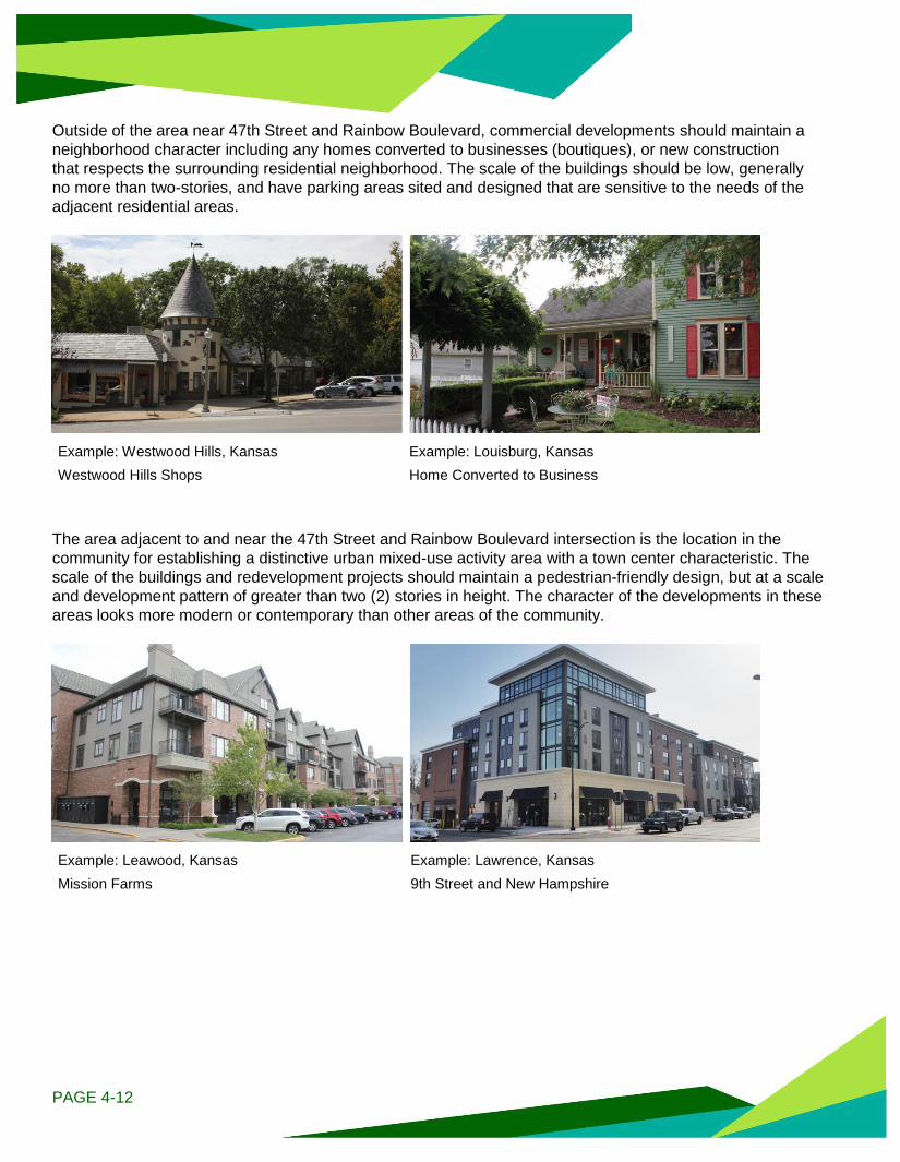
Outside of the area near 47th Street and Rainbow Boulevard, commercial developments should maintain a
neighborhood character including any homes converted to businesses (boutiques), or new construction
that respects the surrounding residential neighborhood. The scale of the buildings should be low, generally
no more than two-stories, and have parking areas sited and designed that are sensitive to the needs of the
adjacent residential areas.
Example: Westwood Hills, Kansas Example: Louisburg, Kansas Westwood Hills Shops Home Converted to Business
The area adjacent to and near the 47th Street and Rainbow Boulevard intersection is the location in the
community for establishing a distinctive urban mixed-use activity area with a town center characteristic. The
scale of the buildings and redevelopment projects should maintain a pedestrian-friendly design, but at a scale
and development pattern of greater than two (2) stories in height. The character of the developments in these
areas looks more modern or contemporary than other areas of the community.
Example: Leawood, Kansas Example: Lawrence, Kansas Mission Farms 9th Street and New Hampshire
PAGE 4-12

SECTION 4.4
LAND USE POLICIES Land use policies are intended to guide land use decision-making in conjunction with the future land use map. The Planning Commission should adhere to the policies when considering changes in zoning or community
development and redevelopment.
RESIDENTIAL AREA POLICIES 1.1. Protect the character and quality of established residential areas, particularly areas with single-
family homes, from the intrusion of incompatible land uses and excessive through traffic. 1.2. Consider various housing options and choices. 1.3. Encourage reinvestment in property.
1.4. Protect property values and encourage homeowner investment by enforcing housing and property
maintenance codes. 1.5. Preserve structures of architectural significance and discourage incompatible residential design. 1.6. Rebuild or restore deteriorated streets.
1.7. Improve storm drainage systems.
1.8. Improve the vehicular and pedestrian connection of residential streets between each other and with
shopping areas and parks.
1.9. Coordinate the installation of pedestrian-scale lighting, when feasible, with capital public works projects to enhance community character.
1.10. Support infill development or redevelopment that is compatible with surrounding properties.
1.11. Encourage new residential housing construction to be consistent with existing community character.
1.12. Encourage pedestrian-friendly residential development/redevelopment, which includes sidewalks on
both sides of the street (when feasible), planting trees, and orienting housing towards the street.
1.13. Facilitate redevelopments to occur, provided that careful attention is paid to site design and neighborhood compatibility. This includes site design factors of overall density and size of the project, building size and scale, transition areas, screening, open space, lighting, traffic, and on-site parking.
1.14. Encourage the use of durable and high-quality architectural finishes.
1.15. Support home-based businesses that are compatible with the residential character of the
neighborhood.
PAGE 4-13 WESTWOOD MASTER PLAN

FUTURE CHARACTER PLAN AND DEVELOPMENT POLICIES
COMMERCIAL DEVELOPMENT POLICIES 2.1. Cluster new commercial development into focus areas or nodes, subject to the following criteria:
• Use architecture that is in scale and harmony with nearby structures.
• Provide a desirable transition with the streetscape and provide for adequate plantings, safe
pedestrian movement, and parking areas.
• Contain landscape plantings that enhance the architectural features or provide shade, buffering or screening.
• Enhance the building design and adjoining landscape with exterior lighting, as needed. Restrain
lighting and building fixtures to avoid excessive brightness.
• Scale and proportion all signage appropriately in their design and visual relationship to buildings
and surroundings. Design signage as an integral architectural element of the building and site.
2.2. Design commercial developments to include internal connections between building sites and/or parking lots to maintain access control.
2.3. Install landscaping on the perimeter, and landscaping islands in the interior of a parking lot to screen
and soften the negative impact of parking lots. 2.4. Incorporate smartly designed transitions with landscaping and screening when commercial
development is located adjacent to residential or incompatible uses. 2.5. Discourage isolated commercial rezoning in established residential developments. 2.6. Encourage the upkeep, beautifying and revitalization of existing commercial buildings and signage. 2.7. Protect property values and encourage property investment by enforcing property maintenance codes.
PARKS, OPEN SPACE, AND RECREATION POLICIES 3.1. Plan for safe pedestrian and bicycle connections within the community to schools and parks
including connections to regional parks. 3.2. Support a wide selection of public recreational facilities, community spaces, and programs to meet
the interests and needs of all ages, incomes, and abilities. 3.3. Encourage the shared use of any green space, open utility corridor areas, or exterior facilities.
INTERGOVERNMENTAL POLICIES 4.1. Consider the impact of other communities’ plans and policies, and in turn how Westwood’s plans and
policies impact other area communities. 4.2. Work with Johnson County, Wyandotte County, the Shawnee Mission School District, KU
Med, Water One and other utility stakeholders in collaborative relationships on issues such as economic development, road improvements, transit, and park and stormwater improvements.
PAGE 4-14

STORMWATER MANAGEMENT POLICIES 5.1. Promote resources and best management practices (e.g., rain gardens, detention basins, native
landscaping) for businesses and residents to help reduce localized flooding on their property, and also improving water quality.
5.2. Meet regulatory standards for stormwater management.
LOCAL TRANSPORTATION POLICIES 6.1. Maintain a network of streets that effectively serve all residents.
6.2. Provide reasonable ingress and egress from developments, adequate emergency access, and
minimized adverse impacts on the function of adjacent collector and thoroughfare roadways. 6.3. Provide for pedestrian mobility by building and maintaining sidewalks. 6.4. Integrate bicycle and pedestrian projects, where appropriate, into the street network. 6.5. Coordinate with area businesses and organizations to install bicycle and pedestrian amenities, such as
a bike share program. 6.6. Accommodate transit service and transit amenities to better serve Westwood residents and those who
come to Westwood for employment or services. 6.7. Promote on-street parking that accommodates service by emergency vehicles, encourages safe travel of
vehicles, and is pedestrian-friendly.
ECONOMIC DEVELOPMENT POLICIES 7.1. Coordinate economic development strategies with the capital improvement strategies, ensuring that
necessary infrastructure is developed to support economic development. 7.2. Maintain economic incentives policy that is directly related to the economic development goals of the
community.
PAGE 4-15

WESTWOOD MASTER PLAN

SECTION 4.5
FUTURE LAND USE OPPORTUNITIES The following pages outline several areas with considerable opportunity for varying land use or arrangements
of public spaces. More evaluation and analysis is needed to determine the feasibility of the opportunities
outlined.
The reality of whether or not changes can occur depends on many factors, some outside of the control of the
City of Westwood. If one piece falls into place, others may follow. Ultimately, the City is only responsible for the
land it currently owns and therefore must strive to apply the planning principles outlined in this plan to those
properties. Private developers will have a responsibility to demonstrate to the Planning Commission and
Governing Body, as well as nearby property owners, that their development proposal achieves the planning
principles expressed in this plan. The City also plays an important role in communicating the principles and
desires of the community.
The opportunity areas, displayed in Figure 4.4 and described on the following pages, include: • Desired outcomes identified by the steering committee • Corresponding land use policies • Corresponding strategies outlined in the Strategic Plan (see the Appendices - page 1)
Figure 4.4: Westwood Opportunity Areas

ENTERCOM PROPERTY THE PRESENT Located in the center of the community is a property formerly occupied by Entercom Radio. Because of its location, this 6.5-acre site, located at 50th Street and Belinder Avenue, is long been seen as an area with great development potential. In the recent past, a proposal was pitched to develop a senior living facility on the property. Many Westwood residents vocalized their opposition to that type of commercial-like land use on this particular property.
In contrast, the potential development of a new school facility at this site aligns with many of the goals and objectives of this Master Plan. A study conducted by an Urban Land Institute (ULI) Technical Advisory Panel in May of 2015 provided two different site design concepts for this site, including the development of a new school as well as alternative housing arrangements with shared green spaces. The Shawnee Mission School District purchased 6.5 acres of the property in March 2016.
THE POSSIBILITIES City and School District officials have discussed the possibly of the City acquiring a first right of refusal for
both the Entercom site and/or the existing Westwood View Elementary School site if the school district
ever chooses to sell either of these properties. This would put the City of Westwood in a superior position of controlling the ultimate redevelopment of either property.
If a new school is built, it should be compatible to the style, architecture, and character of the adjacent
neighborhood. A 2-story school structure could better fit on the site to maximize open green space
opportunities and the potential for shared community use.
Potential uses for this site include: • New elementary school facility • Park and open green space • Civic uses - Community Center / City Hall • Residential property for detached single-family homes
• Cluster subdivision developments that concentrates residential units on one area of the property to
maximize open green space.

RELATED FUTURE LAND USE
POLICIES Protect character of established neighborhoods (1.1)
Pedestrian-scale lighting (1.8)
Support infill development that is compatible with surrounding properties (1.9)
Support wide selection of recreational facilities and programs for residents (3.2)
Encourage shared use of green space (3.3)
Consider other area plans & policies (4.1)
Reduce localized flooding with on-site stormwater improvements (5.1)
RELATED STRATEGIES Participate in school district decision processes; lobby for inclusion of school in the community
Identify targeted areas where different styles of housing stock is allowed.
Communicate with developers to discuss market demands for new housing.
Develop a strategy to implement updates to Joe D. Dennis Park and potentially adjacent properties.
DESIRED OUTCOMES Protect and minimize impacts to adjacent residential property.
Offer indoor and/or outdoor community activity/gathering spaces.
Attract and keep residents.

WESTWOOD VIEW ELEMENTARY THE PRESENT This 50-year old elementary school, located at 2511 W. 50th Street, is a significant element in the Westwood community, providing education for children in Westwood and in the nearby communities of Fairway, Mission Hills, Mission Woods, and Westwood Hills. The site has historical significance in the community, providing education for generations of Westwood area residents.
Over the years, this school has been “on the chopping block” due to declining attendance, although the school district’s current Superintendent has recently stated that this school will remain open. The district did recognize the need for repairs and updates to the facility, and several renovation projects have recently been completed at this facility. The future for this school’s structure is currently undetermined due to the recent purchase of the former Entercom site by the school district. The school district could choose to keep the existing school facility and make additional updates to the building.
It is of high importance that the school remain in Westwood either at this site or the former Entercom site.
THE POSSIBILITIES As stated previously, the City and the school district are discussing an agreement that if a new Westwood View school facility were built at the Entercom site, the City would have the option to purchase the site. several opportunities have been identified for this site. Combined with the adjacent Joe D. Dennis Park and 5050 Rainbow site, this area has a lot of potential. Previous discussions with the public indicated that the addition of single-family homes and a large park space are favorable types of development. It’s important to note that the decision to move or not to move the school is in the hands of the school district. This subject property was also studied by an Urban Land Institute (ULI) Technical Advisory Panel in May of 2015. The different alternatives outline from this study included expanding Dennis Park with open green space areas, utilizing the site in conjunction with the adjacent 5050 Rainbow property to allow the construction of a new school to the east of the existing elementary school, as well as alternative housing arrangements with shared green spaces.

The public has provided some limited input into alternative land use configurations from this area. Four (4) different land use alternatives were presented at an Open Forum for this Master Plan planning process. Each involve the extension of a public local Street from 50th Street, connecting to 51st Street to the south and the demolition of the existing elementary school building. The purpose of the proposed road is to connect the surrounding residential area to the expanded park area, and help define the edges between different land uses. The feasibility of this roadway extension is not yet determined and further evaluation is needed; an alternative connection may be selected based on the results of the evaluation. The alternative most favored by the public was Alternative A, which included residential uses and increased open space along 50th Street, and mixed-use development fronting on Rainbow Boulevard. Park improvements could include a park shelter and general open spaces or play fields. The development of a mixed-use component would need to respect the character of the adjacent residences, and could include civic space, such as a relocated City Hall / Community Center.
RELATED FUTURE LAND USE
POLICIES Protect character of established neighborhoods (1.1)
Provide housing options (1.2)
Pedestrian-scale lighting (1.8)
Support infill development that is compatible with surrounding properties (1.9)
Safe bicycle and pedestrian connections (3.1)
Support wide selection of recreational facilities and programs for residents (3.2)
Encourage shared use of green space (3.3)
Consider other area plans & policies (4.1)
Reduce localized flooding with on-site stormwater improvements (5.1)
Bicycle and pedestrian facilities (6.6)
RELATED STRATEGIES Determine what projects, programs and improvements need to be financed and identify funding
mechanisms.
Develop economic development policy.
Build relationships with parties who have development plans and potential developments.
Develop a strategy to implement updates to Joe D. Dennis Park and potentially adjacent properties.
Conduct feasibility analysis or request for proposals to determine the need and location of community buildings.
DESIRED OUTCOMES Protect/minimize impacts to adjacent residential property. Offer indoor and/or outdoor community activity/gathering spaces. Retain and grow property values.

5050 RAINBOW THE PRESENT In Spring 2014, the City of Westwood purchased the former Westwood Christian Church property. This 2-acre site is located directly off of Rainbow Boulevard and adjacent to the existing Joe D. Dennis Park and Westwood View Elementary. The property still includes the former church structure, which is approximately 8,200 square feet in size.
This subject property was also studied by an Urban Land Institute (ULI) Technical Advisory Panel in May of 2015. The different alternatives outline from this study included expanding Dennis Park with open green space areas, utilizing the site in conjunction with the adjacent Westwood View school property to allow the construction of a new school to the east of the existing elementary school building. This property was also evaluated in 2013 and 2014 by Indigo Deisgn, and professional park planning firm. Different configurations for expanding Dennis park amenities and incorporating different configurations of the existing building into various site design options was examined.
THE POSSIBILITIES Possibilities for this site have maximum impact when combined with potential opportunities for the Westwood View Elementary school site, discussed previously. The surrounding land uses (park and residential) would conflict with most commercial development, but there is an opportunity for mixed-use and/or civic use development along Rainbow Boulevard. The possibilities for this site include:
Park and open space. Joe D. Dennis Park can be expanded onto this site which would allow for additional park features and recreational opportunities in the community such as green space, a community garden, a new playground, and general fields for pick-up games.
Mixed-use development. This low-density development could include light retail, offices, and other complimentary services to nearby businesses. There is also an opportunity to include a new city hall or community center as part of this development.

RELATED FUTURE LAND USE

POLICIES
Improve vehicular and pedestrian connections (1.7)
Pedestrian-scale lighting (1.8)
Cluster new development into focus areas or nodes (2.1)
Safe bicycle and pedestrian connections (3.1)
Support wide selection of recreational facilities and programs for residents (3.2)
Reduce localized flooding with on-site stormwater improvements (5.1)
Bicycle and pedestrian facilities (6.6)
RELATED STRATEGIES Develop signage and monumentation along major roadways to welcome people.
Convene volunteer arts committee to incorporate public art in high profile areas of the community.
Expand activities associated with Joe D. Dennis Park.
Build relationships with parties who have development plans and potential developments.
Develop a strategy to implement updates to Joe D. Dennis Park and potentially adjacent properties.
Conduct feasibility analysis or request for proposals to determine the need and location of community buildings.
DESIRED OUTCOMES Offer indoor and/or outdoor community activity/gathering spaces.
Support local/small business development.

WESTWOOD CITY HALL THE PRESENT Westwood City Hall is located on a 2.4-acre parcel on the corner of 47th Street and Rainbow Boulevard. This building is situated at a major intersection in the community as well as the region.
Built in 1991, the Westwood City Hall building is the primary civic building in the community, and is used not only for day-to-day city business, but also for community events and meetings. Given the age of the building, several expensive maintenance projects to the building and parking lot is needed soon if City Hall is to remain in its current function and configuration for the long term. The southern extent of the City Hall property is currently maintained as a passive open green space area. Located south of and adjacent to the City Hall property is the former Hudson Oil building, currently owned and utilized by the University of Kansas Hospital Authority.
THE POSSIBILITIES Given the near-by development activity and its relationship to other activity and employment areas in the
region, the corner site where City Hall currently resides has a high potential for future development or
redevelopment. Depending on the many factors listed previously, there is an opportunity for a mixed-use
development that can or cannot include City Hall.
A future improvements to the site could include space for a farmers market or other civic gathering space while
keeping the current City Hall building in place as well. Conversely, City Hall could move to a new site
altogether to open up the opportunity to sell or lease the existing City Hall property. If combined with the
adjacent KUHA property, a compatible mix-used development to the Woodside Village project could be
considered on the west side of Rainbow Boulevard.
Potential uses for this site include: • New City Hall mixed-use. City Hall can act as an anchor to the new development. If the property to the
south was incorporated, there could be an opportunity for a larger footprint for this mixed-use development.
• Mixed-use development. Development could include housing and retail businesses and services that compliment other businesses in the community to diversify the community’s tax base. City Hall would be relocated in this scenario.

RELATED FUTURE LAND USE
POLICIES Protect character of established neighborhoods (1.1)
Pedestrian-scale lighting (1.8)
Support infill development that is compatible with surrounding properties (1.9)
Cluster new commercial development (2.1)
Design developments to include internal connections to maintain access control (2.2)
Soften negative impacts of parking lots (2.3)
Buffer landscaping (2.4)
Reduce localized flooding with on-site stormwater improvements (5.1)
RELATED STRATEGIES Develop design standards for public infrastructure in commercial corridors.
Develop economic development policy.
Engage with commercial and non-profit land owners about the status of these properties.
Participate in Northeast Johnson County Chamber and 47th Street Overlay Committee activities.
Build relationships with parties who have development plans and potential developments.
Conduct feasibility analysis or request for proposals to determine the need and location of community buildings.
DESIRED OUTCOMES
Diversify the tax base.
Offer more commercial business or mixed-use opportunities.

47TH STREET THE PRESENT 47th Street is a shared road with Kansas City, Kansas. The Kansas City side has several regional restaurant attractions, include Joe’s KC and Taco Republic, which both create traffic and parking issues. The average daily traffic count along 47th Street is 10,000 vehicles. Also, there are some left-hand turn issues from 47th Street south onto Mission Road. The 47th Street and Mission Road Committee formed several decades ago to better coordinate implementation efforts along this corridor. This group is a multi-jurisdictional advisory body with members appointed from the cities of Westwood, Roeland Park, and Unified Government of KCK-Wyandotte County.
The committee assists with the implementation of the 47th & Mission Road corridor Concept Plan (2000) and the 47th Street Redevelopment Study (2007). The Concept Plan document was adopted as a supplement or alterative to Westwood’s Comprehensive Plan in July of 2000 with the approval of Ordinance 915. Unified Government of Kansas City, Kansas recently approved the Rosedale Master Plan for the neighborhood area located north of 47th Street, west of Rainbow Boulevard. That Master plan also includes various recommendations for this corridor.

THE POSSIBILITIES
Road diet/lane reduction. This type of roadway improvement can alleviate traffic flow issues and provide room for parking and/or bicycle improvements. The lane reduction would reduce the number of travel lanes from 4 to 2, and would add a center turn lane to alleviate left-hand turning issues at Mission Road. This recommendation concurs with the recently completed Rosedale Master Plan.
Parking improvements. Parallel parking could be slated for the north side of 47th Street based on the recommendations in the Rosedale Master Plan.
Bike lanes. There have been discussions regarding opportunities to enhance economic development that radiates from the Mission Road corner by enhancing bicycle and pedestrian aesthetics and creating bicycle accommodations. With this level of traffic on the corridor, a bicycle lane with a physical separation often called a “cycle track” would be the most appropriate solution for on-street bicycle accommodations. With a number of driveways on the north side of 47th Street, a wide sidepath for bicyclists is not recommended. The cycle track has the opportunity to connect with KU Med, the County Club Plaza, and Westport.
Protected pedestrian corrsings. Provide safe crossing connections at 47th Street and Belinder. Because Belinder is one of the only north/south routes coming to and from Westwood, pavement markings and signage should be added to increase safety and awareness of multi-modal users at this intersection.
Upgrade existing transit stops. An existing transit stop at 47th Street and Mission Road can be upgraded to include a shelter to provide added amenities for transit users and those who are interested in using transit.
Nodal development. Nodal development type is preferred for this road as opposed to linear development. There is an additional opportunity to redevelop a portion of 47th Street, east of Belinder.
Adams Street redevelopment. Depending on the type and scale of any redevelopment project on the City Hall property discussed previously, the residential properties located on the west side of Adams Street, south of 47th Street and north of 47th Terr, could be incorporated into a redevelopment scenario of the City Hall property.

RELATED FUTURE LAND USE
POLICIES Improve vehicular and pedestrian connections (1.7)
Pedestrian-scale lighting (1.8)
Support infill development that is compatible with surrounding properties (1.9)
Cluster new commercial development (2.1)
Buffer landscaping (2.4)
Revitalize existing buildings and signage (2.6)
Integrate bicycle and pedestrian projects into street network (6.4)
Bicycle and pedestrian facilities (6.6)
Expand transit service (6.7)
Coordinate economic development and infrastructure strategies (7.1)
RELATED STRATEGIES Develop design standards for public infrastructure in commercial corridors that reflect quality
development.
Work with other organizations to assess and identify development strategies that link Westwood to the metropolitan/regional economy.
Enhance partnerships with commercial and non-profit land owners about the status of their properties.
Research programs and grant opportunities for businesses to fund exterior enhancements and energy efficiency upgrades.
Participate in Northeast Johnson County Chamber and 47th Street Overlay Committee activities.
DESIRED OUTCOMES Enhance community character.
Support local/small business development.

RAINBOW BOULEVARD THE PRESENT Rainbow Boulevard is a thoroughfare that connects to I-35 on the north and Shawnee Mission Parkway on the south. Significant employment centers located along this road include KU Medical Center. It is also state Highway 169 under the jurisdiction of the Kansas Department of Transportation (KDOT). The Rosedale Master Plan contemplates on-street bicycle facilities on portions of Rainbow Boulevard. With the approximately 15,000 ADT traffic counts and with a number of large commercial vehicles using the Rainbow corridor, considerations for bicyclist safety is essential in evaluating on-street facilities. An alternative recommendation is to evaluate corridors parallel to Rainbow that have less traffic, such as Belinder Avenue. Commercial development on this road is primarily clustered at key locations along the road, in small strip centers. About half of the businesses have parking located in front with other businesses with parking areas in the rear.
THE POSSIBILITIES
• Rainbow Boulevard is the community’s key gateway and as such, focused monuments and signage should be applied along this corridor. Monuments should include stone installments that are reflective of the existing community character.
• As the road network is repaired, the lighting could be converted to pedestrian-level street lighting. This
also allows for the installation of new banner signs that can identify when someone enters the Westwood community.
• Commercial development along this corridor should focus in key areas or nodes. At this time,
commercial development south of 49th Street is discouraged, except for the potential development scenarios previously discussed on the 5050 Rainbow site.

• There is an opportunity to extend similar developments adjacent to the Woodside Village development
closer to 47th Street, which may require the acquisition of some properties in the Westport Annex area. Any development should meet at a minimum the standard design guidelines for commercial businesses.
• Crosswalks should be placed across Rainbow, connecting areas to the east to Joe D. Dennis Park and
Westwood View Elementary. The crosswalks can receive a unique treatment, such as painted pavement or raised surface to accentuate the feature to those traveling on the roadway.
RELATED FUTURE LAND USE
POLICIES Protect character of established neighborhoods (1.1)
Improve vehicular and pedestrian connections (1.7)
Pedestrian-scale lighting (1.8)
Cluster new commercial development (2.1)
Design developments to include internal connections to maintain access control (2.2)
Revitalize existing buildings and signage (2.6)
Pedestrian safety (6.3)
Integrate bicycle and pedestrian projects into street network (6.4)
Bicycle and pedestrian facilities (6.6)
Coordinate economic development and infrastructure strategies (7.1)
RELATED STRATEGIES Develop design standards for public infrastructure in commercial corridors.
Develop signage and monumentation along major roadways to welcome people.
Work with other organizations to assess and dentify development strategies that link Westwood to the metropolitan/regional economy.
Engage with commercial and non-profit land owners to be informed about the status of these properties.
Repair broken sidewalks and connect gaps throughout the community.
DESIRED OUTCOMES
Diversify tax base.
Support local/small business development.
Offer more commercial business or mixed-use opportunities.

UPPER EAST WESTWOOD
THE PRESENT This residential area of Westwood is located east of Rainbow Boulevard along both 47th Terrace and 48th Street, south of and adjacent to the southern phase of the Woodside Village development, and next to Kansas City, Missouri to the east. The properties in this area are some of the most diverse and unique homes in the community. This area was annexed into the city in July of 1960 with the approval of ordinance 294, eleven years after the incorporation of the City of Westwood.
The dedicated rights-of-way of 47th Terrace and 48th Street is only approximately 42.5 feet. The platted lot sizes are generally only 40 feet wide and 110 feet in length, with short front yard setbacks. Some of the homes have only a one-car garage, lending to a pattern of on-street parking. Because of the narrow right-of-way and topographic changes along these narrow streets, navigating these two roads can be difficult for automobiles and pedestrians. Sidewalks are only intermittent and mostly non-existent, and on-street parking makes it difficult for cars to travel safely in two directions when cars are parked on the street.
The approved plans for the southern phase of the Woodside Village project incorporate an improved linear green space area with walkways within a 50-foot wide gas line easement, which runs from Rainbow Boulevard to State Line road adjacent to the property located on the north side of 47th Terrace. With the steep topography next to State Line Road, connecting this proposed walkway to Woodside Park may need to be incorporated along 47th Terrace, utilizing a mid-block 15-foot wide alleyway that is dedicated between the properties located at 2016 W. 47th Terrace and 2022 W. 47th Terrace.
THE POSSIBILITIES
The streets should be evaluated to determine the preferred configuration of future roadway improvements. Options include:
-- Converting 47th Terrace and 48th Street to one-way pared streets. Parking would be allowed on one side of the road while the other would be the sole travel lane. -- Install hard vertical curbs on both sides of the road and sidewalks adjacent to the road on one side (north or south), and incorporate some type of traffic calming improvements, similar to improvements found in Westwood Hills.
Sidewalks improvements included with street improvements. Sidewalks could focus on one side of the street, adjacent to the on-street parking.
Due to the small lots, denser residential development could be considered.
Some existing residential properties closer to Rainbow may need to be incorporated into commercial redevelopment projects along Rainbow Boulevard to provide sufficient land areas for new commercial uses.

RELATED FUTURE LAND USE
POLICIES Provide housing options (1.2)
Protect property values - property maintenance enforcement (1.4)
Restore neighborhood streets (1.6)
Improve vehicular and pedestrian connections (1.7)
Pedestrian-scale lighting (1.8)
Support infill development that is compatible with surrounding properties (1.9)
New developments reflect community character (1.10)
Allow medium-density developments (1.12)
Provide buffering between developments (1.13)
Maintain a network of streets that serves all residents (6.1)
RELATED STRATEGIES Establish a residential rehabilitation financing or grant program to assist with declining
properties.
Identify targeted areas where different housing stock is allowed/ incentivized.
Explore use of neighborhood revitalization act.
Strategically purchase properties when owners voluntarily sell in order to assemble lots for redevelopment.
Repair broken sidewalks and connect gaps throughout the community. Conduct traffic analysis to determine strategies to allow for on-street parking and reduced
speeds.
DESIRED OUTCOMES Attract and keep residents.
Retain and grow property values.
Offer a variety of housing choices (cost and type).

BELINDER AVENUE
THE PRESENT Belinder Avenue is a residential corridor that runs through the middle of the Westwood community from Shawnee Mission Parkway across 47th Street into Kansas City, Kansas.
The road contains monument features in the form of rock retaining walls at many intersections. The eastern side of the road contains overhead electrical utility lines. Sidewalks are directly adjacent to the western side of the road without any buffer. Belinder borders the former Entercom property site, which is expected to redevelop during the planning horizon.
THE POSSIBILITIES Focused bicycle and pedestrian improvements are along this corridor, because this road traverses the
entire community from north to south and has lower traffic volumes than other north-south through streets. The potential development of a new school at the Entercom site is another opportunity for focused bicycle and pedestrian improvements.
Since the road is primarily residential, no amenity features such as benches may be desired to maximize privacy to surrounding properties.
Pedestrian-level street lighting should be incorporated.
Protect and maintain stone retaining walls that currently exist along this corridor as they add to the character of the community.
The installation of sidewalks on both sides of the street maximizes the pedestrian improvements. The application of share-the-road bicycle signage and pavement paint can raise awareness of bicycles in the area.
Burying the existing utilities on the eastern side of the road would allow more room for sidewalks and help make this corridor more aesthetically pleasing.
Improvements would involve a significant investment in the community as right-of-way acquisition would be needed for the eastern side of the road.

RELATED FUTURE LAND USE
POLICIES Preserve historical structures (1.5)
Restore neighborhood infrastructure (1.6)
Improve vehicular and pedestrian connections (1.7)
Pedestrian-scale lighting (1.8)
Protect character of established neighborhoods (1.9)
Safe bicycle and pedestrian connections (3.1)
Consider other area plans and policies (4.1)
Maintain a network of streets that serves all residents (6.1)
Pedestrian safety (6.3)
Safe bicycle and pedestrian circulation (6.4)
RELATED STRATEGIES Install pedestrian-scale lighting as capital improvement projects are made.
Work with electrical company to bury overhead utilities on a case by case basis when feasible.
Conduct feasibility analysis or study to determine if Belinder Avenue could include targeted bicycle and pedestrian pathways.
Repair broken sidewalks and connect gaps throughout the community.
Review existing parking policy and determine if revisions are necessary, including the addition of shared parking.
DESIRED OUTCOMES
Attract and keep residents.
Retain and grow property values.
Effectively use financial tools and resources.
COMMUNITY PROFILE
CHAPTER 5
COMMUNITY PROFILE
SECTION 5.1 INTRODUCTION
SECTION 5.2 POPULATION AND DEMOGRAPHICS
SECTION 5.3 INFRASTRUCTURE
SECTION 5.4 UTILITIES
SECTION 5.5 EDUCATION
SECTION 5.6 PUBLIC SAFETY
SECTION 5.7 PUBLIC FACILITIES & BUILDINGS
SECTION 5.8 PARKS AND RECREATION
SECTION 5.9 TRANSPORTATION
SECTION 5.10 ENVIRONMENT
SECTION 5.11 HOUSING
SECTION 5.12 EMPLOYMENT & INCOME
SECTION 5.13 LOCAL BUSINESSES & ECONOMIC
DEVELOPMENT
SECTION 5.14 SOCIAL SERVICES
SECTION 5.15 LOCAL GOVERNMENT FINANCE
PAGE 5-1

PAGE 5-2 WESTWOOD MASTER PLAN

COMMUNITY PROFILE
SECTION 5.1
INTRODUCTION While it’s important to plan for a community’s future, it’s equally important to understand its history and its
current state. Such information provides a strong foundation on which to build. To that end, an assessment of
Westwood’s existing conditions was completed. The information contained herein was obtained from a variety
of sources, including the City of Westwood, Johnson County, WaterOne, and the Shawnee Mission School
District. The U.S. Census Bureau was used as the source for all demographic information.
The information included in this chapter offers a snapshot of the community; it focuses on the social,
governmental, and economic details of what makes Westwood the thriving community it is. It has not been
overloooked that changes in the community may have taken place since 2010 that impact the overall profile
as described in the following narrative.
It is important to note that additional information was available through the US Census Bureau’s American
Community Survey (ACS) between 2011 and 2014. This data was not relied upon because of the potential
error rate of +/- 10% related to the small size of Westwood. For comprehensive planning purposes, US Census
information is considered the authoritative demographic data source.
SECTION 5.2
POPULATION AND DEMOGRAPHICS
POPULATION Population has steadily declined from 1970 (2,329) to 2010 (1,506). This 35 percent loss in population may be attributed to a decrease in households (749 to 693 respectively), as well as a decrease in household size from
3.1 people per household to 2.17 people per household during this period of time.
Table 5.1: General Population Characteristics Source: US Census Bureau
1970 1980 1990 2000 2010
Population 2,329 1,783 1,772 1,533 1,506
Households 749 713 775 711 693
Median Age 34.1 37.2 38.1 39.2 38.8
% Under 18 yrs 34.3% 22.2% 19.5% 20.6% 21.2%
% Over 65 Yrs 13.2% 20.4% 20.5% 17.2% 14.8%
Household Size 3.1 2.5 2.29 2.16 2.17
PAGE 5-3

Additionally, the median age of Westwood residents rose from 34.1 in 1970 to 38.8 in 2010. While this
increase in median age tends to follow national aging trends, the median age in Westwood declined between
2000 and 2010 from 39.2 to 38.8. Also of note for the period between 2000 and 2010, the percentage of
population under the age of 18 increased and the percentage of population over 65 decreased.
Figure 5.1: Age Distribution Source: US Census Bureau
350
300
250
200
150
100
50
0 Under 5-14 15-24 25-34 34-44 45-54 55-64 65-74 75-84 85 and
5 older
1990
2000
2010
PAGE 5-4 WESTWOOD MASTER PLAN

SECTION 5.3
INFRASTRUCTURE WATER SUPPLY Water District #1 of Johnson County (WaterOne) provides the water supply to the City of Westwood. The
water mains installed throughout the city are owned and maintained by the Johnson County Public Water
Supply District (PWSD) #12. WaterOne bills directly to the residents and businesses in the City.
There are no future constraints on providing service for future development growth. As the dividing line to the
prairie and high plains, northeast Kansas and parts of southeast Kansas are fertile with a sufficient supply of
fresh ground and surface water. WaterOne draws its water from the Kansas and Missouri Rivers and
adjacent collector wells. Although northeast Kansas is fortunate to have robust water resources, WaterOne
stays engaged in statewide water policy and is a member of Kansas River Water Assurance District No. 1.
The purpose of these districts is to ensure a more level supply of water by managing releases from upstream
federal reservoirs during drier times of the year.
WASTEWATER SYSTEMS Johnson County Wastewater provides wastewater sewer service for the City of Westwood. The wastewater
treatment plant serving Westwood is not located in the community. Wastewater bills are paid to the Johnson
County Wastewater bimonthly. Charges from Johnson County Wastewater are for the safe and efficient
transport of wastewater from homes and the treatment of that water before returning it to area creeks, lakes,
and rivers.
Johnson County Wastewater provides sanitary sewer service to more than 400,000 people throughout the
County with approximately 1,500 miles of pipe. Johnson County Wastewater processed an average of 16.3 billion gallons of wastewater in 2014.
Wastewater from homes and businesses in Westwood flows to pump stations located in Kansas City,
Missouri. The cost to continue sending flow and paying Kansas City to treat its wastewater may impact
Westwood residents. Rates may increase to help pay for improvements as part of Kansas City’s $4.5 billion
sewer overflow program that includes planned infrastructure improvements over the next several decades.
STORMWATER SEWER SYSTEM The City of Westwood owns and maintains its stormwater sewer system. Most of the stormwater pipes are between 80 and 90 years old and consist of corrugated metal, with some reinforced concrete pipes.
The stormwater system in Westwood has both immediate and long-term needs for repairs and maintenance.
The pipes and structures are aging and need repair or replacement in the near future. Westwood also
operates an annual leaf-pick up program in the fall, which also helps in the management of the city’s
stormwater system.
In previous years, maintenance of the city’s storm drains and stormwater sewer system, as well as the
operation of the leaf pick-up program, was paid out of the city’s general fund, primarily revenue from
property and sales taxes. Since the general fund pays for a wide variety of services, the stormwater sewer
system often did not receive the necessary funds to make the needed improvements and maintenance. In
2013, the City established a stormwater service management fee to generate approximately $95,000 in
revenue annually. The revenue from the fee is dedicated to stormwater improvements such as replacing
stormwater pipes, street inlets, curbs and gutters, and the operation of the city’s annual leaf pick-up
program. The stormwater fee rate is $1.00 per month for every 500-feet of impervious surface area.
PAGE 5-5

In February 2008, the City of Westwood adopted new stormwater design requirements for all new
development within the city limits. These new regulations require developers to capture stormwater and
treat the runoff before the stormwater can leave the site. The new regulations require the runoff leaving the
site to be equal to what runoff was before development.
For the next several years, the City of Westwood will implement new measures as part of an overall
stormwater management program. The City will also need to meet new water quality standards as well as surface water (or flooding) standards mandated by the U.S. Environmental Protection Agency (US EPA).
SOLID WASTE DISPOSAL Town and Country Disposal, part of WCA of Western Missouri, a private firm from Harrisonville, Missouri,
provides solid waste disposal service for the City of Westwood. Solid waste is collected once per week by Town and Country for $9.75 per month.
Town and Country provides a 65-gallon trash cart. Each household is allowed bulk pick up for two bulk
items per month. Bulk items include furniture, mattresses, and tubs. Washers, dryers, refrigerators and freezers are collected by appointment only.
Town and Country also provides recycling services for free to customers who are interested. The Show-Me Sanitary Landfill in Warrensburg, Missouri receives Westwood’s solid waste.
PAGE 5-6 WESTWOOD MASTER PLAN

COMMUNITY PROFILE
SECTION 5.4
UTILITIES NATURAL GAS SERVICE Kansas Gas Services provides natural gas services for the City and residents of Westwood. Natural gas
lines are along arterial roads in the community and a substation is at the corner of 47th Street and Belinder Avenue.
Based on the research for this plan, there are no future constraints on providing service for future
development growth. Developers are required to pay for extending required infrastructure for all new projects.
ELECTRIC SERVICE Kansas City Power & Light (KCP&L) provides electric services for the City and residents of Westwood. Lines that service the community are located above-ground. The City currently owns and maintains the street lights
that are located throughout the City.
COMMUNICATIONS The primary local telephone service for Westwood is through AT&T. Residents may also receive service from smaller service providers such as Vonage. Cellular service is available in the region provided by many
service providers such as Verizon Wireless, AT&T, Sprint, and T-Mobile.
Many companies now provide a bundle of services to provide an added convenience for customers for
internet and cable service. AT&T is one such provider for Westwood. AT&T provides internet service, digital
television service, and satellite television service (DirecTV). Comcast also provides high-speed internet
service and TimeWarner provides satellite television services.
The cities of Westwood, Westwood Hills and Mission Woods entered into a joint Development Agreement with Google Fiber Inc. in August of 2012 to extend new fiber-optic-based Internet service into these cities.
As part of the executed Development Agreement, Google Fiber Inc. committed to extend high-speed
internet services to four (4) defined locations: Westwood City Hall, Westwood Public Works facility, Westwood View Elementary School, and Westwood Community Center. These locations will receive
broadband Internet service by Google Fiber Inc. with a service speed of up to 1 Gigabit per seoncd (Gbps), free of charge for the term of the agreement. A service connection from Google Fiber Inc. to Westwood
View Elementary School is being evaluated and processed separately by Shawnee Mission School District
staff.
PAGE 5-7

SECTION 5.5
EDUCATION EDUCATIONAL ATTAINMENT Educational attainment in Westwood is higher than both national and state averages. In 2010, the ACS
reported that just 3.4 percent of the population over 25 years of age had less than a high school education
(10.8 percent and 14.9 percent for Kansas and the United States respectively). Approximately 35 percent of
the population achieved college degrees (associate or bachelor) compared to 26.6 percent for Kansas and
25.1 percent for the United States, and 24.8 percent of Westwood residents received a graduate or
professional degree (10.1 percent in Kansas and 10.3 percent in the United States). Educational attainment
levels in Westwood improved significantly since 1990 when 10.6 percent of the population over 25 years of
age had less than a high school education, 26.9 percent had achieved college degrees and 17.4 percent had
a graduate or professional degree.
Figure 5.2: Educational Attainment (Over 25 Years of Age) Source: US Census Bureau
450
400
350
300
250
200
150
100
50
0 Less than 9th 9th to 12th High School Some college, Associate's Bachelor's Graduate /
Grade Grade (no Graduate no degree Degree Degree Professional
diploma) Degree
1990 2000 2010
DAYCARE Although many Westwood’s residents include families with school-aged children and younger, there are limited resources for child care. The Shawnee Mission Christian School is one provider that offers preschool and child care services, and there are daycare providers and preschools in nearby communities.
PAGE 5-8 WESTWOOD MASTER PLAN

COMMUNITY PROFILE
SCHOOL DISTRICT Westwood is within the Shawnee Mission School District boundaries. The 117-square mile district is the
third largest school district in the state of Kansas. The district is located in northeast Johnson County and
serves approximately 27,500 students. The fully-accredited district has 33 elementary schools, five middle
schools, and five high schools.
At this point, the school district plans to continue renovating and expanding as needed. In March 2016, the
district purchased the former Entercom property in Westwood. There is potential that the property can be used
to build a new Westwood View Elementary. If the district decides to build a new elementary school on the
land, it would require additional funding as part of a new bond issue not yet developed. The bond issue will
fund new facilities to handle growth and student needs, additional classrooms.
SCHOOL FACILITIES
The City of Westwood is fortunate to have a school Figure 5.3: Westwood View Elementary School
facility, Westwood View Elementary, located in the center of the community. The school, located at 2511
West 50th Street, serves children in Kindergarten
through Sixth Grade. Children in Westwood attend the
elementary school as well as children from
neighboring communities. Figure 5.4 on the following
page displays the Westwood View Elementary
attendance area.
The first elementary school built on the existing school site (1928), acted as a combination school for primary and intermediate grades. The present Westwood View building was built in 1969 when 13 individual school districts unified to become Shawnee Mission Unified School District No. 512.
Middle School students (grades 7 to 8) who live in Westwood attend Indian Hills Middle School located at
64th Street and Mission Road. The school opened in 2000 and accommodated 820 students. An expansion
in 2004 increased the capacity to nearly 1,000 students. High School students in Westwood (grades 9 to 12)
attend Shawnee Mission East High School located at 75th and Mission Road. The school opened in 1958
and was designed to accommodate 1,600 students. The current enrollment is 1,781.
Westwood residents can also attend the following private schools nearby: Saint Agnes, Shawnee Mission Christian School, Bishop Miege, and Pembroke High School.
PAGE 5-9

Figure 5.4: Westwood View Elementary School Attendance Area Source: Shawnee Mission School District Demographics and Enrollment ProjectionStudy, Dec. 2014
PAGE 5-10 WESTWOOD MASTER PLAN

COMMUNITY PROFILE
SCHOOL ENROLLMENT According to the Kansas State Department of Education, the 2015/2016 enrollment at Westwood View
Elementary was 296, which is one of the lowest elementary school enrollments in the Shawnee Mission
School District. Figure 5.5 below shows the enrollment figures from 2000-2016 for Westwood View
Elementary.2
To
tal #
Stu
de
nts
Figure 5.5: Westwood View Elementary School Enrollment (2000-2016)
310 308 304
307 302
300 291 291 292 291
296
288 285 290 285 284 286
280 279
274
270
260
250
PAGE 5-11

SECTION 5.6
PUBLIC SAFETY
LAW ENFORCEMENT The Westwood Police Department currently has eight full-time police officers. This police force works out
of the Westwood City Hall located at 4700 Rainbow Boulevard. In addition to Westwood, the Police
Department provides public safety services to Westwood Hills and Mission Woods.
The City of Westwood has a track record of little or no violent crime and very low numbers of non-violent crime. Table 5.2 shows the crime statistics for the past five years. The Kansas Bureau of Investigation (KBI)
Uniform Crime Report Program3 collects offense information for murder and non-negligent manslaughter,
forcible rape, robbery, aggravated assault, burglary, larceny-theft, motor vehicle theft, and arson.
Table 5.2: City of Westwood, Kansas - Crime Statistics (2009-2014) Source: Kansas Bureau of Investigation
2009 2010 2011 2012 2013 2014
Murder 0 0 0 0 0 0
Rape 0 0 0 0 0 0
Robbery 0 0 0 0 0 0
Aggravated Assault/Battery 2 1 0 0 0 0
Burglary 6 9 7 10 11 12
Theft 44 33 36 26 28 25
Motor Vehicle Theft 0 2 5 3 4 2
Arson 0 0 0 0 0 0
FIRE PROTECTION The protection of life and property from fire is one of the most important and essential services provided by
local governments. The provision of this service must be seamless so that all citizens can receive
assistance, when needed, as quickly as possible.
Johnson County Consolidated Fire District #2 (CFD2) provides fire protection for Westwood. CFD2 provides
services to the community in the areas of fire protection, emergency medical services, rescue services,
hazardous materials, and emergency management. The organization is assigned most emergency service
functions of the City other than law enforcement.
The City of Westwood does not have a fire station in the city limits. The closest fire station, CFD2 Station
Number 22 located at 3921 W. 63rd Street, responds to emergencies. CFD2 Station 22 staff members
include the Battalion Chief, a captain, lieutenant, two apparatus Operators and two Firefighters. CFD2
provides emergency operations, emergency medical services, fire prevention and public education. All frontline fire apparatus include thermal imaging cameras, carbon monoxide detectors, and vehicle extrication equipment.
3 Background information accessed online through the Federal Bureau of Investigation (FBI) on May 25, 2016 at:
http://www.kansas.gov/kbi/stats/stats_crime.shtml
PAGE 5-12 WESTWOOD MASTER PLAN

COMMUNITY PROFILE
All sworn personnel are state-licensed emergency medical technicians or paramedics and are qualified to
provide emergency medical service. The department equips all fire apparatus with emergency medical supplies and operates four paramedic-staffed rescue ambulances.
All fire fighters are hazardous materials first responders, and the department operates an advanced
hazardous materials response team. The fire department serves as the coordinator for the City in managing citywide emergencies and disasters.
The City of Westwood has adopted the 2003 International Building, Plumbing, Fire, Residential, and Mechanical Codes as well as the National 2002 Electrical Codes and the 2004 edition of Johnson County
Environmental Sanitary Code.
EMERGENCY SERVICES AND PREPAREDNESS In addition to police and fire protection, it is vital for communities to have access to quality emergency
medical services. The local and regional hospitals provide the next step in care after the fire department
personnel and police have assisted someone needing help. Having an emergency preparedness plan and
designated emergency shelters can mean the difference between a community being able to handle a
larger crisis, such as a tornado, or not.
Johnson County is responsible for the dispatch of all emergency medical services in Westwood. MED-ACT
provides county-wide Emergency Medical Service with Advanced Life Support (ALS) capability. MED-ACT
serves all cities located in Johnson County. They have a call volume of over 35,000 calls per year. They
operate from 17 fixed stations and employ 140 employees.4
The City of Westwood does not have a major emergency medical center in the city limits, but KU Med offers
urgent care services for issues not considered to be an emergency. The services are provided at the Richard
and Annette Bloch Cancer Care Pavilion in the evenings during the week days and 8 a.m. to 4 p.m. on the
weekends.
The city’s proximity to the University of Kansas Medical Center and St. Luke’s Hospital of Kansas City
allows Westwood residents quick access to some of the best emergency medical care in the Kansas City metropolitan area. The medical centers utilized in case of emergencies are shown in Table 5.3.
4 Information obtained online. Accessed on May 25, 2016: http://www.jocogov.org/department/med-act PAGE 5-13

Table 5.3: Medical Facilities Serving Westwood
Facility Location Services Provided
University of Kansas 3901 Rainbow Boulevard/ Cancer Center, Diabetes & Endocrinology, Ear,
Medical Center Shawnee Mission Nose & Throat, Gastroenterology & GI Surgery,
Geriatrics, Gynecology, Heart Care, Nephrology,
Neurology & Neurosurgery, Orthopedics,
Pulmonology, and Urology
St. Luke’s Hospital of 4401 Wornall Road Heart Care, Neurology, Cancer, Level 1 Trauma,
Kansas City Neonatal Intensive Care Unit, Maternity Care,
Kidney dialysis/transplant center, Women’s care
The Johnson County government handles emergency preparedness for the City with municipality input and
willing participation. The County has a mass notification system designed to keep Johnson County residents
and businesses informed of emergencies. All Johnson County residents automatically receive county-wide
alert notifications. Also, WaterOne notifies their customers about emergencies affecting their water service.
Johnson County’s Office of Emergency Management is responsible for preparing, planning and coordinating
the various agencies that would respond to emergency situations within Johnson County, including
Westwood. The County Emergency Operations Plan, adopted through Johnson County Resolution 022-11 on
April 28, 2011, defines the policies, coordination, and roles and responsibilities required to meet the needs
generated by a disaster in Johnson County. The current plan incorporates minor revisions that have been
made as part of the ongoing planning process and approved by the County Manager’s Office on August 13th,
2013.
PAGE 5-14 WESTWOOD MASTER PLAN

COMMUNITY PROFILE
SECTION 5.7
PUBLIC FACILITIES AND BUILDINGS Just as with any business, the adequacy of Westwood’s public buildings impacts the work and activities that take
place in those buildings. If the buildings are not adequate to meet the needs of the public or employees, then it is unsuitable for an efficient work environment and is difficult for the public to use.
City Hall, located at 4700 Rainbow Blvd, was built in 1993 on 2.41 acres of land. City Hall includes space for the Police Department, city staff offices, Municipal Court and City Council meetings and a community room.
The Public Works building, located at 2545 West 47th Street, houses a total of four employees. The City also owns a property at 5050 Rainbow, the former site of Westwood Christian Church.
Figure 5.6: City Hall Figure 5.7: 5050 Rainbow
PAGE 5-15
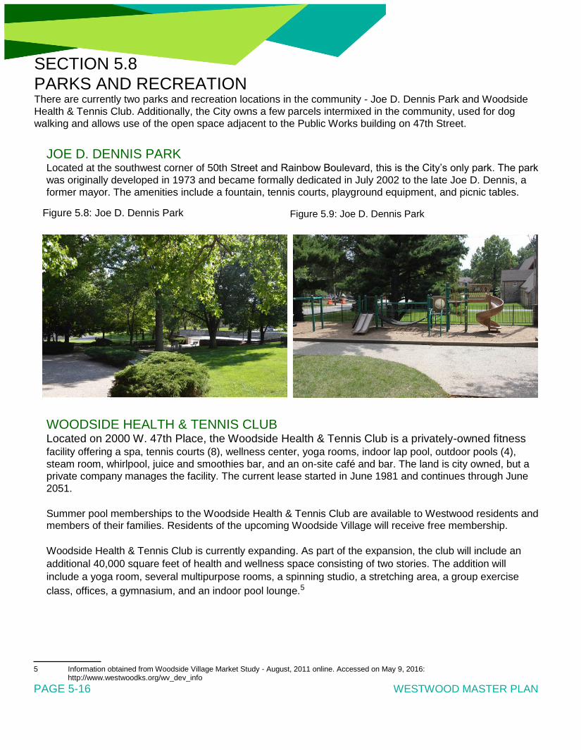
SECTION 5.8
PARKS AND RECREATION There are currently two parks and recreation locations in the community - Joe D. Dennis Park and Woodside
Health & Tennis Club. Additionally, the City owns a few parcels intermixed in the community, used for dog
walking and allows use of the open space adjacent to the Public Works building on 47th Street.
JOE D. DENNIS PARK Located at the southwest corner of 50th Street and Rainbow Boulevard, this is the City’s only park. The park
was originally developed in 1973 and became formally dedicated in July 2002 to the late Joe D. Dennis, a
former mayor. The amenities include a fountain, tennis courts, playground equipment, and picnic tables.
Figure 5.8: Joe D. Dennis Park Figure 5.9: Joe D. Dennis Park
WOODSIDE HEALTH & TENNIS CLUB Located on 2000 W. 47th Place, the Woodside Health & Tennis Club is a privately-owned fitness facility offering a spa, tennis courts (8), wellness center, yoga rooms, indoor lap pool, outdoor pools (4),
steam room, whirlpool, juice and smoothies bar, and an on-site café and bar. The land is city owned, but a
private company manages the facility. The current lease started in June 1981 and continues through June
2051.
Summer pool memberships to the Woodside Health & Tennis Club are available to Westwood residents and members of their families. Residents of the upcoming Woodside Village will receive free membership.
Woodside Health & Tennis Club is currently expanding. As part of the expansion, the club will include an
additional 40,000 square feet of health and wellness space consisting of two stories. The addition will
include a yoga room, several multipurpose rooms, a spinning studio, a stretching area, a group exercise
class, offices, a gymnasium, and an indoor pool lounge.5
5 Information obtained from Woodside Village Market Study - August, 2011 online. Accessed on May 9, 2016:
http://www.westwoodks.org/wv_dev_info PAGE 5-16 WESTWOOD MASTER PLAN

COMMUNITY PROFILE
PARK DEVELOPMENT AND RECREATION ACTIVITIES The City currently does not offer any recreational programs. The City’s Parks & Recreation Committee
meets once a month and is responsible for several community activities such as the Annual Egg Hunt,
Fourth of July Fireworks display, Movies in the Park, and the Christmas Lighting Contest.
The City is looking for ways to obtain additional parkland with limited resources. The City would like to
determine the logistics of how to go beyond the land donation and discuss purchasing and maintaining the dedicated sites.
ADJACENT NEIGHBORHOOD PARKS AND RECREATION OPPORTUNITIES Westwood Park Located across the Kansas/Missouri state line at 47th Street and Wyoming Street, this 9-acre park includes a
picnic shelter, ball diamond, and paved trails. The property is owned and maintained by the City of Kansas
City Missouri Parks & Recreation Department.6
Rosedale Park Located in Kansas City, Kansas at Mission Road and West 41st Street, this 55-acre park is managed by
the Unified Government of Wyandotte County/Kansas City, Kansas. The amenities include picnic tables (5),
a grill, playground, lighted softball fields, three non-lighted softball fields, two lighted tennis courts, shelter,
skate park drinking fountain, and two 18-hole disc golf courses. There is also 3.5 miles of trail in the park
that help connect Rosedale residents with nature and several local sites.7
6 Obtained online on May 9, 2016: http://kcparks.org/park/westwood-park/ 7 Obtained online on May 9, 2016: http://www.wycokck.org PAGE 5-17

SECTION 5.9
TRANSPORTATION STREET NETWORK Westwood is bordered by either an arterial (Shawnee Mission Pkwy, Rainbow Blvd, Mission Rd) or collector
road (47th Street). Most of the local residential streets are somewhat narrow (25-30 feet from curb to curb)
and must accommodate some parking during the day. The local roadway network does lack connectivity on
both east/west and north/south streets in the residential areas. The street network is an offset grid, where
the streets align in some areas, and other areas connect at mid-block. This variation in the grid pattern can
make wayfinding challenging, and biking and walking inconvenient.
Parking is a challenge for the residential areas in Westwood because the many homes have one-car
garages and driveways are one car-width. In addition, the City prohibits parking on local roads for more
than two hours between the hours of 12:01 a.m. and 6:00 a.m. The short length of blocks provides limited
spaces for parking.
The City’s Public Works Department uses a street classification system consistent with the Johnson County’s County Assistance Road System (CARS) program, which includes three road designations (see
Figure 5.10): • Local • Collector • Arterial (Minor and Principal)
The only street designated as a Major Collector is West 47th Street. This street is primarily a commercial
corridor with some residential near Rainbow Boulevard and also connects Westwood with Kansas City,
Kansas and Roeland Park. The street has a 45-foot right-of-way, which serves its 10,300 cars per day
adequately.
Mission Road is the only Minor Arterial in Westwood, although its functional classification status as an arterial
roadway is due to the traffic it gains from the I-35 exit in Kansas City, Kansas (21,400 average daily traffic
count (ADT)). By the time Mission Road enters Westwood at West 47th Street, the ADT is 7,300 where it
mostly takes traffic to Shawnee Mission Parkway. Mission Road is the boundary of Westwood and Roeland
Park. In most areas, Mission Road is 35 feet from curb to curb and is in adequate condition.
Westwood has two roadways classified as a Principal Arterial. The first is Shawnee Mission Parkway,
which is the southern boundary of the City. Shawnee Mission Parkway is part of the Kansas Department of
Transportation (KDOT) network, designated as U.S. 169, and provides a significant regional connection in
Johnson County. The other Principal Arterial is Rainbow Boulevard. Rainbow Boulevard is also on the
KDOT network, designated as U.S. 169 and is the public face of Westwood. The majority of the corridor is
45 feet from curb to curb and sees approximately 15,000 ADT within Westwood’s boundaries.
PAGE 5-18 WESTWOOD MASTER PLAN

COMMUNITY PROFILE
Figure 5.10: Street Classification - Westwood, Kansas
PAGE 5-19

BIKING AND WALKING Westwood has an active population interested in bicycling and walking for transportation and recreation. As
previously noted, the offset grid pattern of the residential streets makes wayfinding challenging for all roadway
users, but it is particularly challenging for bikers and walkers because it requires those users to travel out of
their way to get to their final destination.
Sidewalks in Westwood are available but not robust. Most of the roads in the residential areas have narrow
sidewalks on one side of the street. On the collectors and arterials, the sidewalks are wider with a narrow grass buffer. There are limited marked crosswalks to enhance the pedestrian environment.
BikeWalkKC manages a bike share program in the Kansas City metropolitan area, and targeted Westwood
as a potential city for expansion. Their interest is due to its population density, key employment centers,
and location close to other bike share stations. Locations discussed are along West 47th Street and
Rainbow Boulevard.
TRANSIT RideKC is the new brand for all public transit services in the Kansas City region. This includes routes in
Westwood operated by the Kansas City Area Transportation Authority (KCATA), Johnson County, and
Unified Government Transit. Current routes around Westwood travel on either 47th Street or Shawnee
Mission Parkway. Demand-response service for eligible populations is also available.
RideKC Bus
Route 107 travels along 47th Street on Westwood’s northern boundary. This route provides service six days
a week to Downtown Kansas City, Kansas, and Midtown Kansas City, Kansas. Buses run every 30 minutes
on weekdays and every hour on Saturday. Some rush-hour trips on weekdays extend southwest to Mission
Transit Center. Destinations near Westwood include the University of Kansas Medical Center (KU Med),
Wal-Mart Neighborhood Market, Woodside Health and Tennis Club, and Westwood City Hall.
Route 401 Metcalf-Plaza travels along Shawnee Mission Parkway connecting Metcalf Avenue in Overland
Park to the Country Club Plaza and UMKC in Kansas City, Missouri. Service operates on weekdays with
trips every 30 minutes in rush hours and every hour in the midday. Destinations near Westwood include the
KU Westwood Cancer Center and the Fairway Shops.
Route 405 Nall-Downtown travels along 47th Street connecting Nall Avenue in Overland Park to Downtown
Kansas City, Missouri. This route has limited service, with two morning trips and two evening trips each
weekday. Destinations near Westwood include the University of Kansas Medical Center (KU Med), Wal-Mart
Neighborhood Market, Woodside Health and Tennis Club, and Westwood City Hall.
RideKC Bridj
Bridj is an everyday transportation system that adapts in real-time to where people live, work, and play.8
Powered by data, an app coordinates a network of express shuttles that offer efficient and flexible trips. Bridj
currently brings workers to downtown Kansas City, Hospital Hill, KU Med from Westwood, Rosedale,
Roeland Park and West 39th Street, along with the 18th and Vine Jazz District and nearby neighborhoods. It
is a one-year pilot program that began service March 7, 2016
RideKC Access
Paratransit service is available to those who meet certain qualifications. In Westwood, Johnson County offers
Special Edition, a shared ride program providing affordable curb-to-curb transportation for registered
residents of Johnson County. Rides may be provided by Special Edition vehicles or through a local taxi
provider that is scheduled by Johnson County. The cost of Special Edition rides is determined by trip length.
Eligible populations include residents who are age 65 and over, have a documented disability, or meet low-
income guidelines.
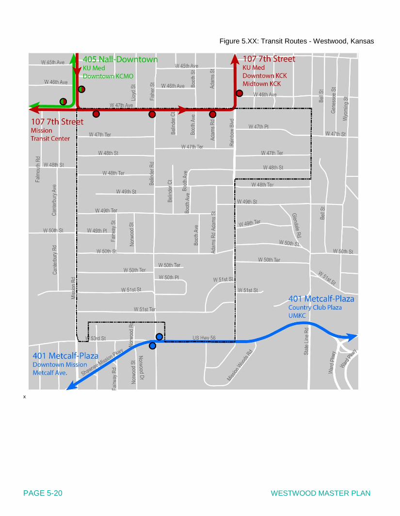
Figure 5.XX: Transit Routes - Westwood, Kansas x PAGE 5-20 WESTWOOD MASTER PLAN

COMMUNITY PROFILE
SECTION 5.10
ENVIRONMENT Land use and development activities of an area are affected by and to some extent dependent upon its physical features and natural resources. These features sometimes form avenues encouraging the development of particular land uses, but they can also sometimes restrict development possibilities and limit
directions available for urban growth. Consideration should be given to the physical features in an area so that
developmental policies and guidelines are established to maximize their advantages and minimize their
disadvantages.
CLIMATE Westwood has a continental climate characterized by large seasonal changes of temperature, warm to hot
summers, moderate humidity, considerable sunshine, moderate winds, light precipitation in winter, and a pronounced rainfall maximum in late spring and early summer.
Figure 5.11 displays climate information for Westwood. The average yearly high is 90°F, and the average
yearly low is 20°F. On average, the warmest month is July and the coldest month is January. The most precipitation on average occurs in June with an average rainfall of 4.73 inches. The total annual precipitation in Westwood is 35.51 inches with an average monthly precipitation of 3.43 inches. Most of the
annual precipitation (75 percent) occurs between April and October.

T0POGRAPHY AND DRAINAGE Topography and the resulting drainage systems are important factors in determining land suitability and capability for urban uses. Topography influences the location and design of storm drainage
systems and location of water and sanitary sewer lines. The location of the infrastructure determines the
general direction and location of a town’s development pattern and resulting land use pattern. Specific land
uses can be equally influenced by topography because of the ease or difficulty of construction associated
with site grade.
Westwood’s natural drainage basins in the City drain into Brush Creek. The basin is the 29 square mile10 portion of the Blue River watershed which eventually drains into the Missouri River.
10 Brush Creek Watershed information accessed online on Brush Creek Watershed website on April 28, 2016:
http://brushcreekwatershed.com/
PAGE 5-22 WESTWOOD MASTER PLAN
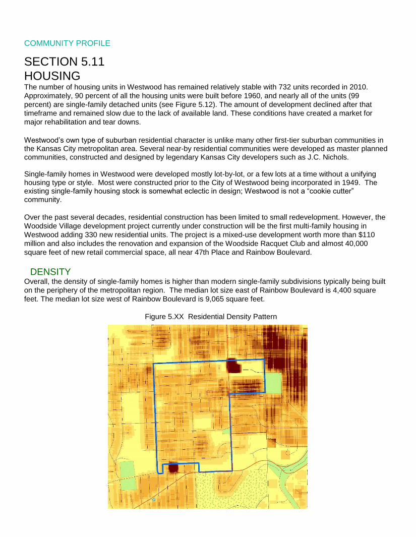
COMMUNITY PROFILE
SECTION 5.11
HOUSING The number of housing units in Westwood has remained relatively stable with 732 units recorded in 2010.
Approximately, 90 percent of all the housing units were built before 1960, and nearly all of the units (99
percent) are single-family detached units (see Figure 5.12). The amount of development declined after that
timeframe and remained slow due to the lack of available land. These conditions have created a market for
major rehabilitation and tear downs.
Westwood’s own type of suburban residential character is unlike many other first-tier suburban communities in the Kansas City metropolitan area. Several near-by residential communities were developed as master planned communities, constructed and designed by legendary Kansas City developers such as J.C. Nichols. Single-family homes in Westwood were developed mostly lot-by-lot, or a few lots at a time without a unifying housing type or style. Most were constructed prior to the City of Westwood being incorporated in 1949. The existing single-family housing stock is somewhat eclectic in design; Westwood is not a “cookie cutter” community.
Over the past several decades, residential construction has been limited to small redevelopment. However, the
Woodside Village development project currently under construction will be the first multi-family housing in
Westwood adding 330 new residential units. The project is a mixed-use development worth more than $110
million and also includes the renovation and expansion of the Woodside Racquet Club and almost 40,000
square feet of new retail commercial space, all near 47th Place and Rainbow Boulevard.
DENSITY Overall, the density of single-family homes is higher than modern single-family subdivisions typically being built
on the periphery of the metropolitan region. The median lot size east of Rainbow Boulevard is 4,400 square
feet. The median lot size west of Rainbow Boulevard is 9,065 square feet.
Figure 5.XX Residential Density Pattern

TENURE In 2010, 85.3 percent of the units were owner-occupied, which was a slight decrease from 87.6 percent in 2000. The vacancy rate of these units was 5.3 percent in 2010.
Table 5.4: Housing Unit Characteristics, 2000/2010
2000 2010
Total Housing Units 731 732
Occupied Housing Units 711 693
% Owner-Occupied 87.6% 85.3%
% Renter-Occupied 12.4% 14.7%
% Vacant (of total units) 2.7% 5.3%
Rental Vacancy Rate 2.2% 4.7%
HOME VALUES The median home value in 2010 was $206,900 for owner-occupied units, with approximately 70 percent of
homeowners having moved into their home since 1990. The median monthly cost for a homeowner with a
mortgage was $1,518 in 2010; 42.1 percent of homeowners paid less than 20 percent of their household
income on monthly housing costs, while 20.9 percent spent 35 percent or more of the household income on
housing costs.
The median gross monthly rent in 2010 for Westwood was $1,210; 39.5 percent of renters paying less than
15 percent of their household income on gross rent, while 40.8 percent spent 35 percent or more of their
household income on gross rent. Figure 5.13 displays the single-family home valuation for 2015 according
to the Johnson County Assessors Office. For comparison, the map also includes valuation of homes in
Westwood Hills and homes located south of Shawnee Mission Parkway.
PAGE 5-23

Figure 5.12: Single Family Homes Year Built Source: City of Westwood,
Kansas
PAGE 5-24 WESTWOOD MASTER PLAN

COMMUNITY PROFILE
Figure 5.13: Single Family Home Value Source: City of Westwood, Kansas - 2015 Johnson County Assessment
PAGE 5-25

SECTION 5.12
EMPLOYMENT AND INCOME EMPLOYMENT Historically, Westwood’s civilian labor force (those over 16 years of age) benefited from low unemployment
rates. The unemployment rate spiked in 2010 at 6.2 percent according to ACS data, since then the rate
rebounded to a level of around 2 percent according to the 2014 ACS.
Table 5.5: Employment Characteristics - City of Westwood Source: US Census Bureau, American Community Survey (estimates)
1990 2000 2010
Total Employed 928 856 762
Employed Male 484 412 381
Employed Female 444 444 381
Unemployed Total 26 11 50
Unemployed Male 19 6 14
Unemployed Female 7 5 36
Unemployment Rate 2.70% 1.26% 6.20%
Total Labor Force (civilian) 954 867 812
Total Population 16yrs or over 1,449 1,282 1,180
Participation Rate (% of Labor Force) 65.80% 67.60% 68.80%
Figure 5.14 on the following pages shows that the labor force mostly consists of employees in three industry sectors in 2010:
• Education services, and health care and social assistance (27.8 percent); • Professional, scientific, and management and administrative services (20.3 percent); and • Finance and insurance, and real estate and rental and leasing (9.7 percent).
The size of Westwood’s civilian labor force has been decreasing since 1990 (928) to 2010 (762), a decrease of 17.8 percent during the 20-year period.
PAGE 5-26 WESTWOOD MASTER PLAN

COMMUNITY PROFILE
Figure 5.14: Employment by Industry (2010) - City of Westwood
Source: US2010Census Bureau
Educational services, and health
care and social assistance, 28%
Arts, entertainment, &
recreation, and
accommodation & food
services, 4%
Other services, except public
administration, 7%
Professional, scientific, and
management, and
administrative and waste
management services,
20%
Public administration, 1%
Construction, 4%
Manufacturing, 6%
Wholesale trade, 2%
Retail trade, 7%
Transportation and
warehousing, and utilities, 4%
Finance and insurance, Information, 6% and real estate and
rental and leasing, 10%
INCOME Regarding income, Westwood residents have seen a steady growth in income in recent history. Median family income increased from $46,989 in 1989 to $79,250 in 2010 (an increase of 68.6 percent).
Approximately 3.8 percent of families in Westwood lived below the poverty level in 2010.
Median household income rose to $69,375 and per capita income rose to $37,361 (a 92.3 percent increase). In 2010, median household income was $49,424 in Kansas and $51,914 in the United States, while per
capita income was $25,683 and $27,334 per capita respectively.
COMMUTING According to the 2010 US Census, the mean travel time for workers 16 years of age or older to work was
17.6 minutes. Fewer than 5 percent of these workers worked at home, while 88 percent drove alone to work,
3.9 percent carpooled, and 2.3 percent walked or used other means to get to work. According to the US
Census, no Westwood residents used public transportation to commute to work.
PAGE 5-27

SECTION 5.13
LOCAL BUSINESSES & ECONOMIC DEVELOPMENT LOCAL BUSINESSES Nearly all of the commercial development in the City is located on the edge of the community, along the major streets.
• 47th Street: seven businesses • Rainbow Boulevard: sixteen businesses • Stateline and Westport Annex: cluster of businesses
According to City, Westwood had 74 businesses in 2015, including home-based businesses. Of those businesses,
50 are independently-owned and 2 are franchises. Table 5.6 displays the number of businesses and employees
from 2013 to 2015. The top five business types in Westwood include law offices (8), retail (6), fitness (5), real estate (4), and medical offices (4). The types of businesses may expand as the Woodside Village development is complete. Table 5.7 lists the top employers in Westwood.
Table 5.6: Westwood Business Statistics - 2013-201511
Source: City of Westwood, Kansas
Total No. Businesses Total No. Employees
(FTE/PTE)
2013 67 785
2014 80 587/197
2015 74 545/190
Table 5.7: Top 10 Employers - Westwood Source: City of Westwood, Kansas
Employer Total No. Full-
Time Employees
Midwest Transplant Network 146
Wal-Mart Stores, Inc 49
Total Distribution System, Inc 47
Red Nova Labs, Inc 40
PGAV Architects 30
RAI Care Centers of Kansas City 27
Ticket Boat LLC 25
Heartland Food Products, Inc 21
Integra Realty Resources 16
Miller Haviland Ketter 14
11 U.S. Census information obtained on the Westwood website at http://www.metrodataline.org/business_ employment.htm PAGE 5-28 WESTWOOD MASTER PLAN

COMMUNITY PROFILE
ECONOMIC DEVELOPMENT Westwood currently does not have an economic development corporation exclusively supporting the
community. However, the community is a member of the Northeast Johnson County Chamber of
Commerce (NJCC). NJCC’s mission is helping small businesses grow. They work with members in the
following areas: 1. Community and Civic Involvement; 2. Networking; 3. Public Policy; 4. Economic Development; and 5. Leadership development.
The City formalized an economic development policy in August 2010. The policy states that Tax Increment
Financing, Community Improvement Districts, Transportation Development Districts, tax abatement, and
other incentives are permissable tools to use to attract businesses.
PAGE 5-29

SECTION 5.14
SOCIAL SERVICES The availability of general health care services, nursing homes, assisted care living facilities and other resident
care facilities can offer citizens a peace of mind that they have what they need in their community or nearby.
Table 5.8: Nursing Homes in Surrounding Communities12
Facility Location Miles from
# of Beds Westwood
Kansas City Transition Care Center Kansas City, KS 1.8 miles 96
Bishop Spencer Place Kansas City, MO 1.9 miles 57
Brighton Gardens of Prairie Village Prairie Village, KS 3.3 miles 45
Clara Manor Nursing Home Kansas City, MO 3.1 miles 90
Plaza Rehabilitation and Health Care Center Kansas City, MO 2.1 miles 154
Claridge Court Prairie Village, KS 4.5 miles 45
Johnson County Developmental Supports (JCDS) is the Community Developmental Disabilities Organization
(CDDO) for Johnson County. They provide a wide array of programs and services that directly and indirectly
benefit persons with developmental disabilities. These programs and services include providing a single point
of entry for people seeking services, determining individual eligibility for services, coordinating access to
services and assisting individuals in choosing from an array of service options.
12 Information obtained online. Accessed on May 9, 2016: https://www.medicare.gov/ PAGE 5-30 WESTWOOD MASTER PLAN

8.022 8.914 10.924
12.902 13.090
16.746
19.551
22.604
25.571 23.493 23.499 23.881 24.464 23.676
22.275 22.523 21.301
0
5
10
15
20
25
30
2000 2001 2002 2003 2004 2005 2006 2007 2008 2009 2010 2011 2012 2013 2014 2015 2016
Westwood Mill Levy
COMMUNITY PROFILE
SECTION 5.15
LOCAL GOVERNMENT FINANCE CITY BUDGET OVERVIEW Table 5.9 shows revenue collections and expenditures from Fiscal Year (FY) 2013 through FY2015. There
are other sources of revenue that contribute to the total cash receipts of Westwood, such as fines, forfeiture
and penalties, interest, rental income, and reimbursed expense and transfers. Several economic factors will
impact future revenue collections. If the slow-down in the housing market continues, there may be negative
impacts on revenues related to growth (e.g., property tax, building permits). Increases in energy, food, and
housing costs may drive down consumer spending, reducing growth in sales tax revenue.
Expenditures include all operating expenditures, including personal services, contractual services,
commodities, and capital outlay. Fuel and energy will be major cost drivers for the foreseeable future. Inflation and health care costs will also significantly impact expenditures.
The economic factors described above will affect the annual budget process and the financial health of
Westwood. By diversifying revenues, expanding the tax base, and using long-term financial forecasting to anticipate needs, Westwood will become better insulated to variations in the general economy.
Table 5.9: Total Revenues and Expenditures - FY2013-FY2016
Source: City of Westwood, Kansas
Year Total Revenues Total Expenditures
2016 $2,304,349 $2,227,507
2015 $2,197,129 $2,242,274
2014 $2,199,251 $2,188,322
2013 $2,169,586 $2,104,586
LOCAL MILL LEVY AND ASSESSED VALUATION Each year during the city budget adoption process, the City Council sets amount of ad valorem revenue to
be collected for city operations. The dollar amount of ad valorem revenue is used by the county to establish the mill levy, or property tax rate. Table 5.10 provides the mill levy rates for Westwood for the
FY2000 to FY2016 property tax cycles.
Graphic 5.10: Mill Levy
PAGE 5-31 WESTWOOD MASTER PLAN

APPENDICES
LIST OF DOCUMENTS Strategic Plan pp. 1-20
Fact Sheets
No.1 - February 2016 pp. 21-22
No. 2 - May 2016 pp. 23-24
City Council Workshops
Meeting No.1 - May 7, 2016
Agenda p. 25
Pre-Workshop Survey Results pp. 26-66
Presentation pp. 67-81
Meeting Summary pp. 82-84
Meeting No. 2 - August 27, 2016
Agenda p. 85
Vision Handout p. 86
Goals & Objectives Handout pp. 87-91
Presentation pp. 92-112
Meeting Summary pp. 113-115
Steering Committe Meetings
Meeting No. 1 - January 11, 2016
Agenda Packet pp. 116-121
Presentation pp. 122-135
Meeting Summary pp. 136-143
Meeting No. 2 - March 7, 2016
Agenda p. 144
Presentation pp. 145-160
Meeting Summary pp. 161-166
Meeting No. 3 - June 17, 2016
Agenda Packet p. 167-168
Public Meeting Input pp. 169-182
Vision Statement Handout p. 183
Draft Goals and Objectives pp. 184-189
Meeting Summary pp. 190-195
Meeting No. 4 - August 11, 2016
Summary pp. 196-198
Meeting No. 5 - August 27, 2016
Agenda p. 199
Goals & Objectives Handout pp. 200-204
Presentation pp. 205-225
Meeting Summary pp. 226-228
Public Meetings Meeting No. 1 - February 29, 2016
Meeting Announcement p. 229
Meeting Postcard pp. 230-231
Door Hanger p. 232
Agenda p. 233
Feedback Form pp. 234-235
Presentation pp. 236-257
In Person Meeting Comments pp. 258-329
Meeting Summary pp. 330-340
Meeting No. 2 - May 10, 2016
Meeting Announcement p. 341
Meeting Postcard pp. 342-343
Door Hanger p. 344
Yard Sign p. 345
Agenda p. 346
Feedback Form p. 347
Vision Feedback Form p. 348
Presentation pp. 349-373
Meeting Summary pp. 374-376
Vision Feedback pp. 377-390
In Person Meeting Comments pp. 391-419
Meeting No. 3 - September 14, 2016
Meeting Announcement p. 420
Meeting Postcard pp. 421-422
Yard Sign p. 423
Meeting Handout pp. 424-427
Feedback Form p. 428
Meeting Displays pp. 429-443
In Person Meeting Comments pp. 444-474
Online Meeting Comments pp. 475-504
Other Comments Received pp. 505-532
Stakeholder Interviews Invitation Letter p. 533
Interview Questions p. 534
Stakeholder Invite List pp. 535-537
Summary pp. 538-552
Community Survey Survey Tool pp. 553-559
Survey Results Summary pp. 560-566
Survey Comments pp. 567-595

WESTWOOD MASTER PLAN