city of marquette land development code chapter 54 code of ... · 10/12/2018 · city of marquette...
TRANSCRIPT
City of Marquette Land Development Code
Chapter 54
Code of Ordinances
DRAFT DATED: October 12, 2018 ADOPTED: ____________ EFFECTIVE: ____________ AS AMENDED: ____________ Acknowledgement The development of the City of Marquette Land Development Code is part of the Michigan Association of Planning's Coastal Resilience Initiative: Regulatory Solutions grant program. Financial assistance for this project was provided, in part, by the Michigan Coastal Zone Management Program, Office of the Great Lakes, Department of Environmental Quality, under the National Coastal Zone Management Program, through a grant from the National Oceanic and Atmospheric Administration, U.S. Department of Commerce.

City of Marquette Land Development Code As Amended: October 12, 2018
Summary Table of Amendments
Ordinance Number
Effective Date
Amended Section(s)
Description
City of Marquette Land Development Code Draft Dated: October 12, 2018
Table of Contents
ARTICLE 1 TITLE, PURPOSE, AND SCOPE....................................................................................................... 1-1
SECTION 54.101 SHORT TITLE (CURRENTLY SECTION 80.01) ....................................................................................... 1-1 SECTION 54.102 PURPOSE AND INTENT (NEW SECTION) ............................................................................................. 1-1 SECTION 54.103 APPLICATION OF THE LAND DEVELOPMENT CODE (CURRENTLY SECTIONS 80.03 AND 82.6) ...................... 1-1 SECTION 54.104 VESTED RIGHTS (CURRENTLY SECTIONS 80.04 AND 82.7) ................................................................... 1-1 SECTION 54.105 RELATIONSHIP TO OTHER LAWS AND ORDINANCES (CURRENTLY SECTIONS 80.07 AND 82.4) ..................... 1-2 SECTION 54.106 SEVERABILITY (CURRENTLY SECTION 80.08) ...................................................................................... 1-2 SECTION 54.107 EFFECTIVE DATE AND REPEAL OF PRIOR ORDINANCE (CURRENTLY SECTIONS 80.09 AND 82.8) .................. 1-2
ARTICLE 2 DEFINITIONS ............................................................................................................................... 2-1
SECTION 54.201 RULES OF INTERPRETATION (CURRENTLY PART OF SECTION 80.02) ........................................................ 2-1 SECTION 54.202 SPECIFIC TERMS (CURRENTLY SECTIONS 80.02, 80.34(2), 80.37(1), 80.37(2), 80.37(3), PART OF
80.42(2)(C), 80.80(2), 86.01, ) ................................................................................................................................ 2-1
ARTICLE 3 ZONING DISTRICTS AND MAP ..................................................................................................... 3-1
SECTION 54.301 ESTABLISHMENT OF ZONING DISTRICTS (CURRENTLY SECTION 80.05(1)) ............................................... 3-1 SECTION 54.302 OFFICIAL ZONING MAP (CURRENTLY SECTION 80.05(2)) .................................................................... 3-1 SECTION 54.303 INTERPRETATION OF ZONING DISTRICT BOUNDARIES (CURRENTLY SECTION 80.05(3) AND (5)) .................. 3-1 SECTION 54.304 NEWLY ANNEXED AREAS (CURRENTLY SECTION 80.05(4)) .................................................................. 3-2 SECTION 54.305 CATEGORIES WITHIN ZONING DISTRICTS (NEW SECTION, WHICH WILL DESCRIBE DIFFERENCE BETWEEN
PERMITTED USES AND SPECIAL LAND USES) .................................................................................................................... 3-2 SECTION 54.306 PERMITTED USES BY DISTRICT (NEW TABLE OF LAND USES, WHICH INCLUDES APPLICABLE PARTS OF CURRENT
SECTIONS 80.20, 80.21, 80.22, 80.23, 80.24, 80.25, 80.26, 80.27, 80.28, AND 80.29) ............................................... 3-3 SECTION 54.307 SFR, SINGLE-FAMILY RESIDENTIAL DISTRICT (CURRENTLY SECTION 80.20) ............................................. 3-6 SECTION 54.308 GR, GENERAL RESIDENTIAL DISTRICT (CURRENTLY SECTION 80.21) ...................................................... 3-7 SECTION 54.309 MFR, MULTIPLE FAMILY RESIDENTIAL DISTRICT (CURRENTLY SECTION 80.22) ........................................ 3-8 SECTION 54.310 MHP, MOBILE HOME PARK DISTRICT (NEW SECTION) ..................................................................... 3-10 SECTION 54.311 M-U, MIXED-USE DISTRICT (NEW SECTION) .................................................................................. 3-11 SECTION 54.312 CBD, CENTRAL BUSINESS DISTRICT (CURRENTLY SECTION 80.25) ....................................................... 3-13 SECTION 54.313 GC, GENERAL COMMERCIAL DISTRICT (CURRENTLY SECTION 80.26) ................................................... 3-15 SECTION 54.314 RC, REGIONAL COMMERCIAL DISTRICT (NEW SECTION) .................................................................... 3-17 SECTION 54.315 M, MUNICIPAL DISTRICT (NEW SECTION) ....................................................................................... 3-19 SECTION 54.316 C, CIVIC DISTRICT (NEW SECTION) ................................................................................................ 3-20 SECTION 54.317 IM, INDUSTRIAL/MANUFACTURING DISTRICT (CURRENTLY SECTION 80.27) ......................................... 3-21 SECTION 54.318 CR, CONSERVATION AND RECREATION DISTRICT (CURRENTLY SECTION 80.28)...................................... 3-22 SECTION 54.319 BLP, BOARD OF LIGHT AND POWER DISTRICT (NEW SECTION) ............................................................ 3-23 SECTION 54.320 RO, RIPARIAN OVERLAY DISTRICT (NEW SECTION) ........................................................................... 3-24 SECTION 54.321 MARQUETTE DOWNTOWN WATERFRONT DISTRICT FORM-BASED CODE (CURRENTLY SECTION 80.35, TO BE
REFORMATTED INTO THE LDC) .................................................................................................................................... 3-30 SECTION 54.322 THIRD STREET CORRIDOR DISTRICT FORM-BASED CODE (NEW SECTION) ............................................. 3-78 SECTION 54.323 PUD, PLANNED UNIT DEVELOPMENT DISTRICT (CURRENTLY SECTION 80.30) ..................................... 3-116
ARTICLE 4 SCHEDULE OF REGULATIONS ....................................................................................................... 4-1
SECTION 54.401 SCOPE OF REGULATIONS TO LIMIT HEIGHT, BULK, DENSITY, AREA, AND PLACEMENT BY DISTRICT (CURRENTLY
SECTION 80.40(1)) 4-1 SECTION 54.402 SCHEDULE OF REGULATIONS (CURRENTLY SECTION 80.40(2)) ............................................................. 4-1 SECTION 54.403 FOOTNOTES TO SCHEDULE OF REGULATIONS (CURRENTLY SECTION 80.40(3) AND 80.41) ........................ 4-2
ARTICLE 5 SUPPLEMENTAL ZONING DISTRICT STANDARDS .......................................................................... 5-1

City of Marquette Land Development Code As Amended: October 12, 2018
SECTION 54.501 SUBDIVISION DEVELOPMENTS (CURRENTLY PARTS OF CHAPTER 85 OF THE CODE OF ORDINANCES) .............. 5-1 SECTION 54.502 LAND DIVISION REGULATIONS (CURRENTLY PARTS OF CHAPTER 85 AND CHAPTER 40, ARTICLE 2 OF THE CODE
OF ORDINANCES) 5-28 SECTION 54.503 CONDOMINIUM DEVELOPMENTS (CURRENTLY PARTS OF CHAPTER 85 OF THE CODE OF ORDINANCES)........ 5-33
ARTICLE 6 STANDARDS APPLICABLE TO SPECIFIC LAND USES ....................................................................... 6-1
SECTION 54.601 ADULT ENTERTAINMENT (NEW SECTION) ......................................................................................... 6-1 SECTION 54.602 ADULT FOSTER CARE SMALL GROUP HOME, LARGE GROUP HOME, AND CONGREGATE FACILITY (CURRENTLY
SECTION 80.65(4)(A)(12))......................................................................................................................................... 6-3 SECTION 54.603 BED AND BREAKFAST HOME (CURRENTLY SECTIONS 80.65(4)(A)(14), 80.65(4)(B)(2), 80.65(4)(C)(4), AND
80.65(4)(D)(3)) 6-4 SECTION 54.604 BED AND BREAKFAST INN (CURRENTLY SECTIONS 80.65(4)(C)(4) AND 80.65(4)(D)(3)) ......................... 6-5 SECTION 54.605 BULK STORAGE (CURRENTLY SECTION 80.65(4)(F)(3)) ...................................................................... 6-6 SECTION 54.606 CEMETERIES (CURRENTLY PART OF SECTION 80.65(4)(A)(6)) .............................................................. 6-6 SECTION 54.607 COLLEGES, UNIVERSITIES, AND INSTITUTIONS OF HIGHER LEARNING (CURRENTLY SECTION 80.65(4)(A)(5)) 6-7 SECTION 54.608 DAY CARE, GROUP HOME (CURRENTLY SECTION 80.65(4)(A)(2)) ....................................................... 6-7 SECTION 54.609 DAY CARE CENTERS (CURRENTLY SECTION 80.65(4)(A)(2)) ................................................................ 6-7 SECTION 54.610 DOMESTIC VIOLENCE SHELTER (CURRENTLY SECTION 80.65(4)(A)(12)) ............................................... 6-7 SECTION 54.611 DRIVE-THROUGH USES (NEW SECTION) ........................................................................................... 6-8 SECTION 54.612 DWELLING, ACCESSORY UNIT (CURRENTLY SECTION 80.23(3)) ............................................................ 6-8 SECTION 54.613 DWELLING, DUPLEX (CURRENTLY SECTION 80.65(4)(A)(11)) ........................................................... 6-10 SECTION 54.614 DWELLING, INTENTIONAL COMMUNITY (NEW SECTION) .................................................................... 6-10 SECTION 54.615 DWELLING, LIVE/WORK (CURRENTLY PARTS OF SECTIONS 80.23(3) AND 80.24(3)) ............................. 6-11 SECTION 54.616 DWELLING, MULTIPLE FAMILY AND APARTMENTS (CURRENTLY SECTIONS 80.40(3)(A), 80.65(4)(A)(4), AND
80.65(4)(A)(9)) 6-11 SECTION 54.617 DWELLING, SINGLE-FAMILY RESIDENTIAL DETACHED (SECTION 80.20(3)(A) AND 80.22(2)(A)) ............. 6-12 SECTION 54.618 FARMERS’ MARKETS (CURRENTLY SECTION 80.25(2)(A)) ................................................................. 6-12 SECTION 54.619 FOOD PRODUCTION, MINOR (NEW SECTION) .................................................................................. 6-12 SECTION 54.620 HALFWAY HOUSE (CURRENTLY SECTION 80.65(4)(A)(12)) .............................................................. 6-14 SECTION 54.621 HOME OCCUPATIONS (CURRENTLY SECTION 80.65(4)(A)(1)) ........................................................... 6-14 SECTION 54.622 HOME OFFICES (CURRENTLY SECTIONS 80.20(5)(A), 80.21(5)(A), 80.22(5)(A)) ............................... 6-15 SECTION 54.623 HOMELESS SHELTERS (CURRENTLY SECTIONS 80.65(4)(B)(3), 80.65(4)(C)(6), AND 80.65(4)(D)(5)) ... 6-15 SECTION 54.624 HOMESTAYS AND VACATION HOME RENTALS (CURRENTLY SECTIONS 80.20(3)(B), 80.21(3)(B), 80.22(3)(A), AND 80.65(4)(A)(14)) ............................................................................................................................................ 6-16 SECTION 54.625 HOSPITALS (CURRENTLY 80.65(4)(A)(10)) .................................................................................... 6-17 SECTION 54.626 HOSPITAL HOSPITALITY HOUSES (CURRENTLY SECTION 80.65(4)(A)(15)) ........................................... 6-18 SECTION 54.627 LIGHT MANUFACTURING (CURRENTLY SECTIONS 80.65(4)(C)(5), 80.65(4)(D)(4), AND 80.65(4)(E)(1)) 6-18 SECTION 54.628 MOBILE HOME PARKS (NEW SECTION) .......................................................................................... 6-19 SECTION 54.629 NATURAL RESOURCE EXTRACTION OPERATIONS (NEW SECTION) ......................................................... 6-20 SECTION 54.630 NURSING HOME, CONVALESCENT HOME, EXTENDED CARE FACILITY, ASSISTED LIVING FACILITY (CURRENTLY
PART OF SECTION 80.65(4)(A)(6)) ............................................................................................................................. 6-21 SECTION 54.631 OFFICE USES (CURRENTLY SECTION 80.65(4)(B)(1)(A)) ................................................................... 6-21 SECTION 54.632 OPEN STORAGE (CURRENTLY SECTION 80.26(3), 80.27(3), AND 80.28(3)) ....................................... 6-22 SECTION 54.633 OUTDOOR FOOD AND BEVERAGE SERVICE (NEW SECTION) ................................................................ 6-22 SECTION 54.634 OUTDOOR TEMPORARY SALES AND EVENTS (CURRENTLY SECTION 80.25(2)(B) AND 80.42(2)(D)) ......... 6-22 SECTION 54.635 PORT FACILITIES AND DOCKS (CURRENTLY SECTION 80.28(4)(B) AND 80.65(4)(G)(2)) ........................ 6-23 SECTION 54.636 RECREATIONAL USES, LAND INTENSIVE (CURRENTLY SECTION 80.65(4)(G)(1)) .................................... 6-23 SECTION 54.637 RELIGIOUS INSTITUTIONS AND PLACES OF ASSEMBLY (CURRENTLY PART OF SECTION 80.65(4)(A)(6)) ....... 6-23 SECTION 54.638 RESIDENTIAL LIMITED ANIMAL KEEPING ......................................................................................... 6-24 SECTION 54.639 ROOMING HOUSES AND HOSTELS (CURRENTLY SECTION 80.65(4)(A)(13)) ......................................... 6-26 SECTION 54.640 SCHOOLS (CURRENTLY SECTION 80.65(4)(A)(8)) ............................................................................ 6-27 SECTION 54.641 WIRELESS TELECOMMUNICATIONS FACILITIES (CURRENTLY SECTION 80.80) ......................................... 6-27
City of Marquette Land Development Code Draft Dated: October 12, 2018
ARTICLE 7 GENERAL PROVISIONS ................................................................................................................ 7-1
SECTION 54.701 ONE DETACHED SINGLE FAMILY RESIDENCE PER LOT (CURRENTLY SECTIONS 80.20(3) AND 80.21(3)) ....... 7-1 SECTION 54.702 PERMITTED ENCROACHMENTS INTO REQUIRED YARD SETBACKS (CURRENTLY SECTION 80.37(5) ................ 7-1 SECTION 54.703 EXEMPT USES FROM LAND DEVELOPMENT CODE REGULATIONS (CURRENTLY SECTION 80.46(1)) .............. 7-2 SECTION 54.704 CLEAR VISION TRIANGLE AREA (NEW SECTION) ................................................................................. 7-2 SECTION 54.705 ACCESSORY BUILDINGS AND STRUCTURES ......................................................................................... 7-5 SECTION 54.706 FENCES AND WALLS (CURRENTLY CHAPTER 86 OF THE CODE OF ORDINANCES) ........................................ 7-7 SECTION 54.707 SWIMMING POOLS (CURRENTLY SECTIONS 80.40(3)(E)(D) AND 80.65(4)(A)(4)(C)) ............................ 7-10 SECTION 54.708 SOLAR ENERGY (NEW SECTION) .................................................................................................... 7-10 SECTION 54.709 SMALL WIND ENERGY (NEW SECTION) ........................................................................................... 7-13 SECTION 54.710 STORAGE OF RECREATIONAL VEHICLES (NEW SECTION) ..................................................................... 7-16 SECTION 54.711 SECURITY OF PROPERTY (NEW SECTION) ......................................................................................... 7-16 SECTION 54.712 TEMPORARY USES, BUILDINGS, AND STRUCTURES ............................................................................ 7-17
ARTICLE 8 ENVIRONMENTAL PERFORMANCE STANDARDS .......................................................................... 8-1
SECTION 54.801 STANDARDS APPLICABLE TO INDUSTRIAL USES, PROCESSES, AND DISTRICTS (CURRENTLY PARTS OF SECTIONS
80.65(4)(C)(5), 80.65(4)(D)(4), AND 80.65(4)(E)(1) ................................................................................................. 8-1 SECTION 54.802 EXTERIOR LIGHTING (CURRENTLY SECTIONS 80.34(8)(A)(16), 80.34(8)(B)(8), 80.34(8)(C)(2), AND
80.42(2)(C)(11)) 8-2 SECTION 54.803 STORM WATER MANAGEMENT (NEW SECTION) ................................................................................ 8-5 SECTION 54.804 RIPARIAN BUFFERS (NEW SECTION) ................................................................................................. 8-6 SECTION 54.805 WETLAND PROTECTION (NEW SECTION)........................................................................................... 8-6 SECTION 54.806 STEEP SLOPES AND RIDGE LINES (NEW SECTION) ............................................................................... 8-7 SECTION 54.807 WOODLAND PROTECTION AND TREE MITIGATION (NEW SECTION) ........................................................ 8-7
ARTICLE 9 PARKING, LOADING, AND ACCESS MANAGEMENT (CURRENTLY SECTION 80.42) .......................... 9-1
SECTION 54.901 INTENT (CURRENTLY SECTION 80.42(1)) ......................................................................................... 9-1 SECTION 54.902 PARKING REGULATIONS (CURRENTLY SECTION 80.42(2)(B) AND 80.42(C)(1)) ...................................... 9-1 SECTION 54.903 MINIMUM NUMBER OF PARKING SPACES REQUIRED (CURRENTLY SECTION 80.42(2)(A))......................... 9-5 SECTION 54.904 BARRIER-FREE PARKING REQUIRED (NEW SECTION) ........................................................................... 9-8 SECTION 54.905 PARKING LAYOUT, DESIGN, CONSTRUCTION, AND MAINTENANCE (CURRENTLY SECTION 80.42(2)(C)) ........ 9-9 SECTION 54.906 OFF-STREET LOADING ZONES (CURRENTLY SECTION 80.42(3)) .......................................................... 9-12 SECTION 54.907 ACCESS MANAGEMENT AND SIDEWALKS (NEW SECTION) .................................................................. 9-12
ARTICLE 10 LANDSCAPING AND SCREENING ............................................................................................. 10-1
SECTION 54.1001 INTENT (NEW SECTION) .............................................................................................................. 10-1 SECTION 54.1002 SCOPE OF APPLICATION (NEW SECTION) ......................................................................................... 10-2 SECTION 54.1003 LANDSCAPING DESIGN REQUIREMENTS (NEW SECTION) .................................................................... 10-2 SECTION 54.1004 STANDARDS FOR PLANT MATERIALS (NEW SECTION) ........................................................................ 10-9 SECTION 54.1005 INSTALLATION AND MAINTENANCE (CURRENTLY SECTION 80.43) ..................................................... 10-11 SECTION 54.1006 MODIFICATIONS TO LANDSCAPING REQUIREMENTS (NEW SECTION) .................................................. 10-13
ARTICLE 11 SIGNS (CURRENTLY CHAPTER 82 OF THE CODE OF ORDINANCES) ........................................... 11-1
SECTION 54.1101 PURPOSE AND INTENT (CURRENTLY SECTION 82.2) .......................................................................... 11-1 SECTION 54.1102 COMPELLING/IMPORTANT MUNICIPAL OBJECTIVES AND RELATIONSHIP OF REGULATIONS TO THE OBJECTIVES
(NEW SECTION) 11-2 SECTION 54.1103 DEFINITIONS (CURRENTLY SECTION 82.3) ..................................................................................... 11-12 SECTION 54.1104 SUBSTITUTION CLAUSE (NEW SECTION) ........................................................................................ 11-26 SECTION 54.1105 SIGNS PERMITTED BY ZONING DISTRICT (CURRENTLY SECTION 82.13) ............................................... 11-27 SECTION 54.1106 PERMITS AND APPLICATIONS (CURRENTLY SECTION 82.9) ............................................................... 11-38 SECTION 54.1107 EXEMPT SIGNS PERMITTED IN ALL ZONING DISTRICTS (CURRENTLY SECTION 82.10) ............................. 11-39 SECTION 54.1108 PROHIBITED SIGNS (CURRENTLY SECTION 82.11) ........................................................................... 11-41

City of Marquette Land Development Code As Amended: October 12, 2018
SECTION 54.1109 GENERAL SIGN STANDARDS (CURRENTLY SECTION 82.12) ............................................................... 11-43 SECTION 54.1110 SIGN ILLUMINATION STANDARDS (CURRENTLY SECTION 82.11(3) AND (4)) ........................................ 11-47 SECTION 54.1111 NONCONFORMING SIGNS AND ABANDONED SIGNS (CURRENTLY SECTION 82.14) ................................ 11-49 SECTION 54.1112 SIGN MAINTENANCE (CURRENTLY SECTION 82.15) ........................................................................ 11-50 SECTION 54.1113 SIGN REMOVAL (CURRENTLY SECTION 82.16) ............................................................................... 11-51 SECTION 54.1114 DANGEROUS SIGNS (CURRENTLY SECTION 82.17) .......................................................................... 11-51 SECTION 54.1115 ADMINISTRATION AND SIGN OFFICIAL (CURRENTLY SECTION 82.18) ................................................. 11-51 SECTION 54.1116 VARIANCES (CURRENTLY SECTION 82.19) .................................................................................... 11-52 SECTION 54.1117 ENFORCEMENT (CURRENTLY SECTION 82.20) ............................................................................... 11-52 SECTION 54.1118 SEVERABILITY (CURRENTLY SECTION 82.5) .................................................................................... 11-52
ARTICLE 12 NONCONFORMITIES .............................................................................................................. 12-1
SECTION 54.1201 INTENT (NEW SECTION) .............................................................................................................. 12-1 SECTION 54.1202 NONCONFORMING USES AND STRUCTURES (CURRENTLY SECTION 80.44) ............................................ 12-1 SECTION 54.1203 NONCONFORMING LOTS (CURRENTLY SECTION 80.45) ..................................................................... 12-4
ARTICLE 13 ADMINISTRATIVE ORGANIZATION ......................................................................................... 13-1
SECTION 54.1301 ZONING ADMINISTRATOR (CURRENTLY SECTION 80.63) .................................................................... 13-1 SECTION 54.1302 CITY COMMISSION (NEW SECTION) ............................................................................................... 13-3 SECTION 54.1303 PLANNING COMMISSION (NEW SECTION) ....................................................................................... 13-3 SECTION 54.1304 BOARD OF ZONING APPEALS (CURRENTLY SECTION 80.64) ................................................................ 13-4
ARTICLE 14 ADMINISTRATIVE PROCEDURES ............................................................................................. 14-1
SECTION 54.1401 ZONING PERMITS AND ZONING COMPLIANCE REVIEW (CURRENTLY SECTION 80.52) .............................. 14-1 SECTION 54.1402 SITE PLAN REVIEW (CURRENTLY SECTION 80.62)............................................................................. 14-3 SECTION 54.1403 SPECIAL LAND USE REVIEW (CURRENTLY SECTION 80.65) ............................................................... 14-13 SECTION 54.1404 VARIANCES AND APPEALS (CURRENTLY SECTIONS 80.64(3), 80.64(4), AND 82.19) ........................... 14-17 SECTION 54.1405 ZONING ORDINANCE AMENDMENT PROCEDURES (CURRENTLY SECTION 80.06) .................................. 14-20 SECTION 54.1406 PUBLIC HEARINGS (CURRENTLY SECTIONS 80.06(B), 80.64(5), AND 80.65(2)(C)) ............................ 14-26
ARTICLE 15 VIOLATIONS, PENALTIES, AND ENFORCEMENT ....................................................................... 15-1
SECTION 54.1501 ENFORCEMENT (NEW SECTION) .................................................................................................... 15-1 SECTION 54.1502 FALSE STATEMENTS AND REVOCATION OF APPROVALS (CURRENTLY SECTIONS 80.66(1) AND 82.20(1)) ... 15-1 SECTION 54.1503 VIOLATIONS AND PENALTIES (CURRENTLY SECTIONS 80.63(2)(H), 80.63(2)(J), 80.66(2), AND 82.20(2)) 15-1 SECTION 54.1504 PROCEDURES FOR REPORTING VIOLATIONS (CURRENTLY SECTIONS 80.66(3) AND 82.20(3)) .................. 15-1 SECTION 54.1505 PAYMENT OF CIVIL FINES, COSTS, OR JUSTICE SYSTEM ASSESSMENTS PRIOR TO PERMIT REVIEW (NEW SECTION) 15-1
Article 1: Title, Purpose, and Scope
City of Marquette Land Development Code Draft Dated: October 12, 2018 1-1
Article 1 Title, Purpose, and Scope
Section 54.101 Short Title (currently Section 80.01) This Ordinance shall be known and may be cited as the City of Marquette Land Development Code.
Section 54.102 Purpose and Intent (new Section) Pursuant to the Michigan Zoning Enabling Act (Public Act 110 of 2006, as amended), the Land Development Code (a.k.a., Zoning Ordinance) is designed to implement and be consistent with the goals, objectives, policies, and strategies of the adopted Master Plan of the City of Marquette through complete, integrated, effective, and concise land development regulations to:
(A) Protect the public health, safety, and general welfare of residents and visitors of the City;
(B) Regulate the use of land and buildings by dividing the City of Marquette into districts;
(C) Provide for the orderly development of the City to regulate the location, height, bulk, erection and construction of structures and buildings to be used for business, industry, residence, agriculture, energy production, social purposes and other specified purposes;
(D) Provide for adequate light, air, and convenience of access to secure safety from fire and other
hazards;
(E) Avoid undue concentration of population by establishing minimum open spaces, yards, and other open spaces;
(F) Provide for traffic safety and adequacy of parking and loading vehicles;
(G) Facilitate the development of adequate systems of fire protection, education, recreation, and
public utilities and services;
(H) Protect the quality of the shoreline and other environmentally sensitive areas;
(I) Conserve natural resources and promote additional natural resources.
Section 54.103 Application of the Land Development Code (currently Sections 80.03 and 82.6) No structure, or part thereof, shall be constructed, erected, placed, altered, or maintained, and no land use or earthwork commenced or continued within the City of Marquette, except as specifically, or by necessary implication, authorized by this ordinance. Within each zoning district, no structure or use of any structure or land shall be lawful except the Principal Uses and Special Land Uses provided for this ordinance. Special Land Uses are allowed on permit granted by the City Planning Commission. Where a lot is devoted to a Principal Use, accessory uses and structures are authorized as provided in this ordinance except as prohibited specifically or by necessary implication.
Section 54.104 Vested Rights (currently Sections 80.04 and 82.7)

Article 1: Title, Purpose, and Scope
City of Marquette Land Development Code Draft Dated: October 12, 2018 1-2
Nothing in this ordinance shall be interpreted or construed to give rise to any permanent vested rights in the continuation on any particular use, district, zoning classification or any permissible activities therein, and they are hereby declared to be subject to subsequent amendment, change or modification as may be necessary to the preservation or protection of public health, safety and welfare.
Section 54.105 Relationship to Other Laws and Ordinances (currently Sections 80.07 and 82.4) Whenever regulations or restrictions imposed by this ordinance are either more or less restrictive than regulations or restrictions imposed by any governmental authority through legislation, rule, or regulation, the regulations, rules, or restrictions which are more restrictive or which impose higher standards or requirements shall govern. Where two (2) or more provisions of this ordinance conflict, the more restrictive provision shall prevail. Regardless of any other provision of this ordinance, no land shall be used and no structure erected or maintained in violation of any state or federal law or regulation.
Section 54.106 Severability (currently Section 80.08)
(A) General Severability. This ordinance and the various parts, sections, subsections, in clauses thereof, are hereby declared to be severable. If any part, sentence, paragraph, subsection, section, or clause is adjusted unconstitutional or invalid, it is hereby provided that the remainder of the ordinance shall not be affected thereby. If any part, sentence, paragraph, subsection, or clause is adjudged unconstitutional or invalid as applied to a particular property, building, or other structure, it is hereby provided that the application of such portion of the ordinance to other property, building, or structures shall not be affected thereby.
(B) Conditions of Approval. Whenever any condition of limitation is included in an order
authorizing a planned unit development, special land use permit, variance, zoning compliance permit, certificate of occupancy, site plan approval, conditional rezoning, or nonconformity, it shall be "conclusively presumed" that the authorizing officer of body considered such condition or limitation necessary to carry out the spirit and purpose of this ordinance or the requirement of some provision thereof, and to protect the public health, safety, and welfare, and that the officer, commission, or board would not have granted the authorization to which the condition or limitation pertains except in the belief that the condition or limitation was lawful.
Section 54.107 Effective Date and Repeal of Prior Ordinance (currently Sections 80.09 and 82.8) This ordinance shall take effect on ____________, said date being __ days after adoption by the City Commission and 8 days after publication or at such later date after publication as may be specified in the City Charter. The Land Development Code adopted by the City Commission on the __ day of ____________, 20__ and all amendments thereto are hereby repealed as of the effective date of this ordinance. The repeal of the above ordinance does not affect or impair any act done, offense committed, or right occurring, accrued or acquired, or liability, penalty forfeiture or punishment incurred prior to the time enforces, prosecuted, or inflicted. The Land Development Code, and any amendments thereto, are adopted as a zoning ordinance in accordance with the Michigan Zoning Enabling Act (Public Act 110 of 2006, as amended).
Article 2: Definitions
City of Marquette Land Development Code Draft Dated: October 12, 2018 2-1
Article 2 Definitions
Section 54.201 Rules of Interpretation (currently part of Section 80.02) For the purpose of this Ordinance, certain terms, or words used herein shall be interpreted as follows:
(A) All words used in the present tense shall include the future;
(B) Words in the singular number include the plural number and all words in the plural number include the singular number;
(C) The word "building" includes the word "structure," and "dwelling" includes "residence;"
(D) The word "person" includes "corporation," "co-partnership," “company,” “family,” “firm,” as
well as an "individual";
(E) The word "shall" is mandatory and the word "may" is permissive;
(F) The word "lot" includes "plot" or "parcel;"
(G) The words "used" or "occupied" includes the words "intended," "designed," or "arranged to be used or occupied."
(H) Terms not herein defined shall have the meaning customarily assigned to them.
Section 54.202 Specific Terms (currently Sections 80.02, 80.34(2), 80.37(1), 80.37(2), 80.37(3), part of 80.42(2)(C), 80.80(2), 86.01, )
(A) The following terms shall have the following meaning:
Abutting: Having property or district lines in common.
Accessory Building and Accessory Structures: A building and/or structure, the use of which is clearly subordinate and incidental to that of the principal building or to the use of the land located on the same lot.
Accessory Office Residential: See definitions of “Home Occupation” and “Live/Work or
Accessory Office Residential.”
Accessory Use: See definition of “Use, Accessory.”
Adult Foster Care, Family Home: An adult foster care facility with the approved capacity to receive six (6) or fewer adults to be provided with foster care for five (5) or more days a week and for two (2) or more consecutive weeks. The adult foster care family home licensee shall be a member of the household, and an occupant of the residence.
Article 2: Definitions
City of Marquette Land Development Code Draft Dated: October 12, 2018 2-2
Adult Foster Care, Large Group Home: An adult foster care facility with the approved capacity to receive at least thirteen (13) but not more than twenty (20) adults who shall be provided foster care.
Adult Foster Care, Small Group Home: An adult foster care facility with the approved
capacity of not more than twelve (12) adults who shall be provided foster care.
Adult Foster Care Facility: A governmental or nongovernmental establishment that provides foster care to adults. Subject to Michigan Public Act 218 of 1979, as amended, adult foster care facilities include facilities and foster care family homes for adults who are aged, mentally ill, developmentally disabled, or physically disabled who require supervision on an ongoing basis but who do not require continuous nursing care. An adult foster care facility does not include a nursing home, home for the aged, hospital, hospital for the mentally ill, facility for the developmentally disabled, county infirmary, child caring institution, an establishment commonly described as an alcohol or substance abuse rehabilitation center, a residential facility for persons released from or assigned to adult correctional institution, and any other use excluded under Act 218 of 1979, as amended.
Adult Entertainment Uses: See Section 54.601.
Agriculture: A land use that includes all of the following: (1) a farm operation, (2) producing a farm product, and (3) as commercial activity. The land use also includes accessory uses for housing and dwellings for the farmer and farm employees.
Agriculture-Like: A land use that is one (1) of the following:
(a) A land use which may be the principal use or accessory use on a parcel that includes some, but not all, of the following: (1) a farm operation, (2) producing a farm product, or (3) commercial agriculture activity; or
(b) Any agriculture or agriculture-like land use where the Right to Farm Act (MCL
286.471 et seq., as amended) or Generally Accepted Agricultural and Management Practices (GAAMPs) delegates regulatory control back to local government, such as but not limited to, agriculture considered to be in a Category 4 Site, as used in the Site Selection and Odor Control for New and Expanding Livestock Facilities GAAMPs, which is published by the Michigan Department of Agriculture & Rural Development (MDARD) and may be amended by MDARD from time to time.
Alley: Any dedicated public way affording a secondary means of access to abutting property, and not intended for general traffic circulation. However, an alley can be used for the placement of public utilities.
Alterations: Any change, addition or modification to a structure or type of occupancy or use of structure or land or any change in the structural members of a building, such as walls or partitions, columns, beams or girders, the consummated act of which may be referred to herein as "altered" or "reconstructed" or "changed".

Article 2: Definitions
City of Marquette Land Development Code Draft Dated: October 12, 2018 2-3
Animal: A farm animal or a domestic animal, but not an animal used for research in a scientific laboratory, or specimens in a zoo, or wild animal in a rehabilitation facility.
Animal, Farm: A farm animal includes exotic animals and any other animal, including domestic animals, so long as the animal is kept for the purpose of a farm product, for farm operation, or service to humans. Farm animal does not include animals used for research in a scientific laboratory, specimens in a zoo, wild animals, and other animals in a rehabilitation facility.
Animal, Domestic: Domestic animals, otherwise known pets, are animals primarily for a person’s company, companionship, performance, attractive appearances, loyalty, for human therapy, playful personalities, or is a service animal pursuant to MCL 287.291. Domestic animals do not include working animals, farm animals, animals used for research in a scientific laboratory, specimens in a zoo, wild animals, and other animals in a rehabilitation facility.
Art Accessory Structure. See definition of “Structural Amenity” and the regulations of Section 54.702(G).
Assisted Living Facility: See definition of “Nursing Home, Convalescent Home, Extended Care Facility, Assisted Living Facility.”
Bar: An establishment selling alcoholic beverages for on-premises consumption where more than 50% of the gross sales revenue are from the sale of alcoholic beverages. Bars may include a restaurant in accordance with the regulations of the zoning district.
Basement: A portion of the building partially underground, which has less than one third (1/3) of its height measured from finished floor to finished ceiling, above the average grade of the adjoining ground. (See Figure 1. Basement)
Figure 1. Basement
Article 2: Definitions
City of Marquette Land Development Code Draft Dated: October 12, 2018 2-4
Bed and Breakfast: An owner occupied dwelling where no more than 5 (five) guest rooms are made available for the temporary accommodation of the traveling or vacationing public. Such an establishment may offer meals only to those persons temporarily residing at the establishment. See also definition of “Bed and Breakfast Inn” and “Homestay.”
Bed and Breakfast Inn: A structure primarily used for lodging purposes where the use as a residence is clearly secondary. A structure where more than 5 (five) but not more than 30 (thirty) guest rooms are made available for the temporary accommodation of the traveling or vacationing public. Such an establishment may offer meals to the public and persons temporarily residing at the establishment. See also definition of “Bed and Breakfast” and “Homestay.”
Best Management Practices (BMPs). Conservation practices or management measures approved by the Michigan Department of Environmental Quality (MDEQ) or the City that prevent, control, and reduce nonpoint source pollution.
Building: A structure designed, built or occupied as a shelter or roofed enclosure for persons, animals, or property. The term building shall be construed under this ordinance as if followed by the words "or parts thereof." Roof shall include coverings of any material whether or not permanent in nature. Unconventional enclosed structures, such as converted shipping containers, may be classified as “buildings” if they meet all of the requirements of a building pursuant to this ordinance and the Building Code.
Building, Accessory: See definition of “Accessory Building and Structures.”
Building, Height: The vertical distance between the average grade (see definition of “Grade”) and the highest point of the roof surface for flat roofs; to the deck line of Mansard roofs; the average height between eaves and ridge for gable, hip, and gambrel roofs; and the average height between the lowest point and the highest point on a shed roof. (See Figure 2. Building Height)
Figure 2. Building Height

Article 2: Definitions
City of Marquette Land Development Code Draft Dated: October 12, 2018 2-5
Building(s), Main or Principal:
(a) Any individual structure, on a lot or site, which contains one or more principal or special land uses.
(b) The separate structures, on a single site, in which one or more principal or special
land uses are located.
Building, Nonconforming: Any structure, the construction of which was lawfully established prior to the passage of this ordinance (or any amendments thereto), that for any reason does not meet all of the applicable regulations contained in the ordinance (or its amendments).
Building Code: The building code as currently enforced pursuant to the laws of the State of Michigan.
Building Façade: That portion of any exterior elevation of a building extending vertically from grade to the top of a parapet wall or eaves and horizontally across the entire width of the building elevation.
Bulk Storage: See definition of “Storage, Bulk.”
Article 2: Definitions
City of Marquette Land Development Code Draft Dated: October 12, 2018 2-6
Child Care or Day Care, Family Home: A private home in which more than one (1) but less than seven (7) minor children are received for care and supervision for periods of less than 24 hours a day, unattended by a parent or legal guardian, except children related to an adult member of the family by blood, marriage, or adoption. A family day care home includes a home that gives care to an unrelated child for more than four (4) weeks during a calendar year. All family day care homes shall be registered with or licensed by the Michigan Department of Licensing and Regulatory Affairs or successor agency.
Child Care or Day Care, Group Home: A private home in which more than six (6) but not more than 12 minor children are given care and supervision for periods of less than 24 hours a day, unattended by a parent or legal guardian, except children related to an adult member of the family by blood, marriage, or adoption. Group day care home includes a home that gives care to an unrelated minor child for more than four (4) weeks during a calendar year. All group day care homes shall be registered with or licensed by the Michigan Department of Licensing and Regulatory Affairs or successor agency.
Child Care Center or Day Care Center: A facility, other than a private residence, receiving one (1) or more preschool or school age children for care for periods of less than 24 hours a day, and where the parents or guardians are not immediately available to the child. Child care center or day care center includes a facility that provides care for not less than two (2) consecutive weeks, regardless of the number of hours of care per day. The facility is generally described as a child care center, day care center, day nursery, nursery school, parent cooperative preschool, play group, or drop-in center. All child care centers and day care centers shall be registered with or licensed by the Michigan Department of Licensing and Regulatory Affairs or successor agency. Refer to Public Act 116 of 1973, as amended, for a list of facilities that are excluded from the definition of “Child Care Center” or “Day Care Center.”
Clear Vision Triangle Area: See Section 54.704.
Colony, Honeybee: See “Honeybee Colony or Hive”
Commercial: An activity conducted with the intent of realizing a financial gain from the sale of goods or services to others.
Commercial Development: Development for the purpose of exchanging, buying, or selling commodities on a large scale, which involve transportation from place to place.
Community Garden: A collective activity by a group of people, utilizing either individual or shared plots to grow food crops, plant fiber, ornamentals, or other plants for personal or institutional use, consumption, or donation. Community gardens may include common areas maintained and used by group members.
Condominium: A condominium project established in conformance with the Michigan Condominium Act (Act 59 of 1978).
Condominium Act: Public Act 59, 1978, as amended.
Article 2: Definitions
City of Marquette Land Development Code Draft Dated: October 12, 2018 2-7
Condominium Common Elements: Portions of the condominium project other than the condominium units.
Condominium General Common Elements: Condominium General Common Elements include the following: (a) The land in the condominium project; (b) The foundations, main walls, roofs, halls, lobbies, stairway entrances, exits or
communication ways; (c) The basements, flat roofs, yards and gardens, except as otherwise provided or
stipulated; (d) The premises for the use of janitors or persons in charge of the condominium
project, including lodging, except as otherwise provided or stipulated; (e) The compartments or installations of central services such as heating, power, light,
gas, cold and hot water, refrigeration, air-conditioning, reservoirs, water tanks and pumps the like;
(f) The elevators, incinerators and, in general, all devices or installations existing for common use; and;
(g) All other elements of the condominium project owned in common and intended for the common use or necessary to the existence, upkeep and safety of the project.
Condominium Limited Common Elements: Those common elements which are reserved in the master deed for the exclusive uses of less than all of the co-owners.
Condominium Project: A plan or project consisting of not less than two (2) condominium units established in conformance with the Condominium Act.
Condominium Subdivision Plan: A plan meeting the requirements of Section 66 of the Condominium Act, which shall consist of: site, survey and utility plans; floor plans; and Sections, as appropriate showing the existing and proposed structures and improvements including the location thereof on the land. The condominium subdivision plan shall show the size, location, area, vertical boundaries and volume for each unit comprised of enclosed air space. A number shall be assigned to each condominium unit. The condominium subdivision plan shall include the nature, location and approximate size of common elements. The condominium subdivision plan shall also include the adopted site plan and/or Exhibit B as required by P.A. 59 of 1978, as amended.
Condominium Unit: That portion of the condominium project designed and intended for separate fee simple ownership and use, as described in the master deed.
Convalescent Home: See definition of “Nursing Home, Convalescent Home, Extended Care Facility, Assisted Living Facility.”
District, Zoning: A portion of the incorporated area of the city in which certain regulations and requirements or various combinations thereof apply uniformly under the provisions of this ordinance.
Distributive Operations: See definition of “Warehousing.”

Article 2: Definitions
City of Marquette Land Development Code Draft Dated: October 12, 2018 2-8
Domestic Violence Abuse Shelter: A home for the temporary residence of victims of domestic violence.
Drive-Through Use: A retail, service, or restaurant establishment providing a driveway approach or parking spaces designed and used to serve patrons remaining in motor vehicles, such as drive-in restaurants, drive-through restaurants, cleaners, banks, and pharmacies.
Driveway: A private or public approach giving vehicles access from a public way to a building or parking space(s) on the same site.
Dwelling Unit: One (1) or more rooms, in a building, with bathroom and principal kitchen facilities, designed as a self-contained unit for permanent residential occupancy by one (1) family for such purposes as cooking, bathing, gathering, entertainment, and sleeping. Tents, recreational vehicles and other structures designed for temporary occupancy are not to be used as dwelling units in the City of Marquette, with the exception of areas where they are specifically allowed, such as Tourist Park or other areas where camping may be authorized during emergencies or otherwise. See definitions of “Occupancy, Permanent” and “Occupancy, Temporary.”
Dwelling, Accessory Unit: A residential dwelling unit, but not a mobile home, located on the same lot as a detached single-family dwelling unit, either within the same building as the single-family dwelling unit or in a detached building in accordance with the provisions of this ordinance.
Dwelling, Intentional Community: See definition of “Intentional Community.”
Dwelling, Two-Family (Duplex): A building containing two (2) separate dwelling units, attached side-to-side or with one (1) dwelling unit located above the second dwelling unit and without interior access to the other dwelling unit; designed for or occupied exclusively by two (2) families living independently of each other.
Dwelling, Multiple Family: A building or portion thereof designed or modified to contain three (3) or more separate dwelling units, without interior access to the other dwelling units; designed for or occupied exclusively by three (3) or more families living independently of each other.
Dwelling, Single Family: A building designed exclusively for use as one (1) dwelling unit in a single-family zoning district. Not more than one (1) family may occupy each dwelling unit.
Earthwork: The removal of earth materials, clearing of vegetation, mass grading, or regrading of a site.
Easement: A quantity of land set aside or over which a liberty, privilege, or advantage is granted by the owner to the public, a corporation, or some particular person or part of the public for specific uses and purposes, and shall be designated a "public" or "private" easement depending on the nature of the user.

Article 2: Definitions
City of Marquette Land Development Code Draft Dated: October 12, 2018 2-9
Electrical Code: The electrical code as currently enforced pursuant to the laws of the State of Michigan.
Erected: Includes built, constructed, altered, reconstructed, moved upon, or any physical operations on the premises required for construction. Excavation, fill, drainage, installation of utilities, and the like, shall be considered a part of erection.
Emergency Services: Facilities that provide ambulatory and related services.
Enclosed: To surround or close off on all sides
Essential Services: The erection, construction, alteration or maintenance by public utilities or municipal departments, of emergency outdoor warning sirens; overhead, surface, or underground gas, electrical, steam, fuel, or water transmission or distribution systems; collection, communication, supply or disposal systems, including towers, poles, wires, mains, drains, hydrants, and similar accessories in connection therewith necessary for the furnishing of such services. “Essential Services” do not include telecommunication towers, solar energy facilities, and wind energy conversion systems.
Façade: See “Building Façade.”
Family: “Family” means either of the following.
(a) Any group of individuals living together as a single housekeeping unit or the
functional equivalent of a family, where the residents are a close group with social, economic, and psychological commitments to each other and whose relationship is of a continuous, non-transient, domestic character with a demonstrable and recognizable bond which constitutes the functional equivalent of the bonds which render the domestic family a cohesive unit;
(b) Not more than four (4) unrelated persons living together as a single housekeeping
unit;
(c) The tenants of a short-term rental property for which a valid permit has been issued by the Fire Department;
(d) The “functional equivalent of a family” shall not include any organization such as a
club, fraternity, sorority, lodge, monastery, or intentional community, nor any individuals whose association is seasonal or for limited durations defined by their occupation/jobs or educational pursuits, nor shall it include a group who share a dwelling unit explicitly for financial or philosophical reasons, or include any state-licensed facility except to the extent permitted by law.
Farm: The land, plants, animals, buildings, structures, including ponds used for agricultural or aquacultural activities, machinery, equipment, and other appurtenances used in the commercial production of farm products.
Article 2: Definitions
City of Marquette Land Development Code Draft Dated: October 12, 2018 2-10
Farm Operation: The operation and management of a farm or a condition or activity that occurs at any time as necessary on a farm in connection with the commercial production, harvesting, and storage of farm products, and includes the activities listed in the definition of “Farm Operation” in the Michigan Right to Farm Act (P.A. 93 of 1981, as amended).
Farm Product: Those plants and animals useful to human beings produced by agriculture and includes, but is not limited to, forages and sod crops, grains and feed crops, field crops, dairy and dairy products, poultry and poultry products, cervidae, livestock, including breeding and grazing, equine, fish, and other aquacultural products, bees and bee products, berries, herbs, fruits, vegetables, flowers, seeds, grasses, nursery stock, trees and tree products, mushrooms, and other similar products, or any other product which incorporates the use of food, feed, fiber, or fur, as determined by the Michigan commission of agriculture.
Farmers Market: A location established in accordance with local ordinance and operated in compliance with Act No. 92, the Michigan Food Law, as amended, where farmers may transport and sell to the public fruits, vegetables or other agricultural products. Vendors of other retail items may also be permitted by the City.
Fence: A vertical structure of definite height and location to serve as an enclosure, dividing marker, or barrier in carrying out the requirements of this ordinance. A fence includes a barrier designed to bound an area, including partitions and gates. A fence enclosed above by an impermeable material shall be regulated as a building.
Fence, Adjacent Grade: Adjacent grade for a fence shall be construed as the average grade measured at a point three (3) feet on each side of the fence. In the case of a fence on a retaining wall, adjacent grade shall be the grade of the top of the retaining wall.
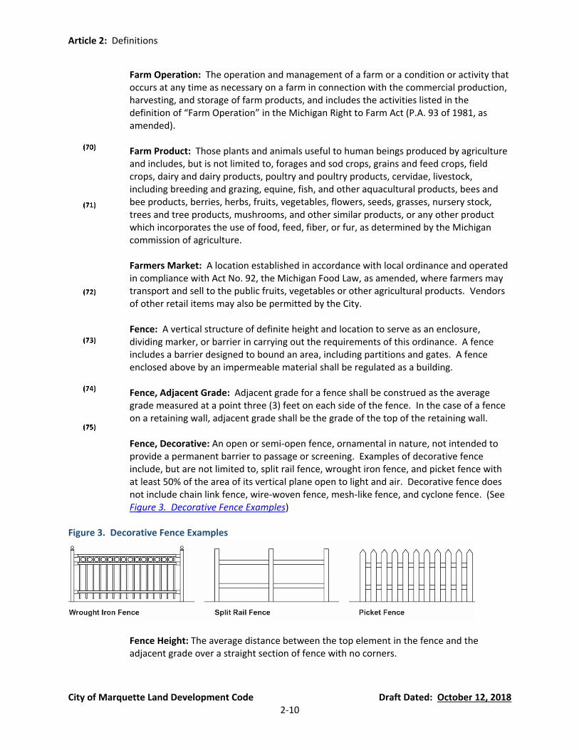
Fence, Decorative: An open or semi-open fence, ornamental in nature, not intended to provide a permanent barrier to passage or screening. Examples of decorative fence include, but are not limited to, split rail fence, wrought iron fence, and picket fence with at least 50% of the area of its vertical plane open to light and air. Decorative fence does not include chain link fence, wire-woven fence, mesh-like fence, and cyclone fence. (See Figure 3. Decorative Fence Examples)
Figure 3. Decorative Fence Examples
Fence Height: The average distance between the top element in the fence and the adjacent grade over a straight section of fence with no corners.
Article 2: Definitions
City of Marquette Land Development Code Draft Dated: October 12, 2018 2-11
Fence, Protective Measures: A fence erected for the express purpose of protecting an enclosed area and the property therein, or a fence intended to deny access to a dangerous property or location
Fence, Screening: A structure of definite height and location, maintained to prevent passage of light and to screen and separate a use from adjacent property.
Fence, Temporary: A fence approved by the City in conjunction with an approved temporary activity, such as construction or temporary/seasonal events, the purpose of which is to secure a site and/or restrict areas accessible to the public. A temporary fence is generally installed prior to the temporary activity and removed soon after the end of the temporary activity. Temporary fences must comply with all other provisions of this ordinance. The City may require a permit for a temporary fence.
Floor: The level base of the room, hollow structure, or enclosed area capable of supporting individuals of other materials, including basements.
Floor Area: The total gross area of all floors, as measured to the outside surfaces of exterior walls.
Flyway Barrier: See “Honeybee Flyway Barrier.”
Foster Family Home: A private home in which at least one (1) but not more than four (4) minor children, who are not related to an adult member of the household by blood or marriage, or who are not placed in the household pursuant to the adoption code, chapter X of Act No. 288 of the Public Acts of 1939, as amended, are given care and supervision for 24 hours a day, for 4 or more days a week, for 2 or more consecutive weeks, unattended by a parent or legal guardian.
Foster Family Group Home: A private home in which more than four (4) but fewer than seven (7) minor children, who are not related to an adult member of the household by blood or marriage, or who are not placed in the household pursuant to chapter X of Act No. 288 of the Public Acts of 1939, as amended, are provided care for 24 hours a day, for 4 or more days a week, for 2 or more consecutive weeks, unattended by a parent or legal guardian
Fraternity of Sorority House: A building occupied and maintained exclusively for students affiliated with and formally recognized as a group by an academic or professional college or university or other recognized institution of higher learning.
Front Area: That area located between the edge of the physical street and the nearest point of the dwelling, projected parallel to the street
Gasoline Service Station: A place for the dispensing, sale, or offering for sale of motor fuels directly to users of motor vehicles, together with the retail sale of minor accessories, but not including “Vehicle Repair and Service” unless approved as a separate land use on the site.

Article 2: Definitions
City of Marquette Land Development Code Draft Dated: October 12, 2018 2-12
Grade: The average level of the finished surface levels of the ground adjacent to all exterior walls of those buildings more than five feet from a right-of-way. The average level of the finished surface level of the ground adjacent to each side of a building wall shall be determined by averaging the highest and lowest points along the wall. For buildings closer than five feet to a right-of-way, the grade is the curb elevation at the center of the building. If there is no curb, the City Engineer shall establish the grade.
Halfway House: A house licensed by a State Agency for the continued care, treatment and counseling of individuals who have successfully completed institutional treatment and who will benefit from a controlled atmosphere in a residential setting.
Hard Parking Surface: For one and two family dwellings a hard parking surface shall comprise of compacted gravel at least six (6) inches in depth, concrete or asphalt pavement, pavers (pervious or impervious) or other products designed for parking. For all other uses, a hard parking surface shall exclude gravel. The City Engineer may require minimum standards for hard parking surface (e.g., material depth, material specifications, construction techniques, etc.).
Health Services: Establishments engaged in providing diagnostic services including general medical services, medical laboratories, and outpatient care facilities.
Hive, Honeybee: See “Honeybee Colony or Hive”
Home Occupation: An occupation or profession, carried on in a dwelling unit by members of the immediate family residing on the premises, which are clearly incidental or secondary to the use of the dwelling for dwelling purposes.
Homeless Shelter: A residential facility that provides temporary accommodations and support services for persons or families requiring interim housing arrangements and who would otherwise be without safe overnight shelter.
Homestay: An owner occupied single family dwelling of which the rental of rooms is clearly secondary in use to the dwelling, where no more than three (3) guest rooms are made available for the temporary accommodation of the traveling or vacationing public. Such an establishment may offer meals only to those persons temporarily residing at the establishment. See also definition of “Bed and Breakfast” and “Bed and Breakfast Inn.”
Honeybee: All life stages of the common domestic honeybee, Apis mellifera species.
Honeybee Colony or Hive: An aggregate of honeybees consisting principally of workers, but having, when perfect, one queen and at times many drones, including brood, combs, honey and the receptacle inhabited by the honeybees.
Honeybee Flyway Barrier: A solid wall, fence, or dense vegetation or combination thereof that provides an obstruction through which honeybees cannot readily fly. The flyway barrier must surround the immediate vicinity of the colony(s) or hive(s) yet leave sufficient space for beekeeper to maintain colony(s) or hive(s). Property line fences or barriers do not constitute flyway barriers.

Article 2: Definitions
City of Marquette Land Development Code Draft Dated: October 12, 2018 2-13
Honeybee Swarm: A partial honeybee colony in search of shelter that has split from an established honeybee colony.
Hoop House: An enclosed, temporary semi-circular tunnel structure composed of solid framing and a flexible plastic covering, the purpose of which is for growing plants inside the structure.
Hospice: A facility that provides residential living quarters for up to six (6) terminally ill persons.
Hospitals: An institution providing health services for inpatient and/or outpatient medical or surgical care of the sick or injured and including related facilities such as, but not limited to, laboratories, outpatient departments, central staff service facilities, and staff offices that are an integral part of the institution.
Hospital Hospitality Houses: A noncommercial use of a residential structure where rooms are let to transient patients and family members of transient patients of a local hospital concurrent with the patient’s treatment at the hospital.
Hostel: A building where sleeping accommodations are available for remuneration for periods of one night or longer. Board shall not be included with the accommodations, but the facility may have a kitchen and dining space.
Hotel or Motel: A commercial establishment offering overnight lodging to travelers and sometimes permanent residents, and often having amenities such as restaurants, swimming pools, stores, etc., that may be available to the public. Each hotel or motel room must contain at least a bedroom and bathroom.
Impervious Surface: Any surface that cannot be effectively and easily penetrated by water, thereby resulting in runoff. Examples include, but are not limited to, “Lot Coverage” (as defined in this Ordinance) and any material (asphalt, concrete, compacted stone and gravel, etc.) used in roads, driveways, decks, terraces, patios, porches, or sidewalks that cannot be effectively and easily penetrated by water. Impervious surfaces shall exclude roads, driveways, and sidewalks that are composed of materials that will allow infiltration and prevent runoff, such as permeable pavers, permeable pavement, or crushed stone or pea stone that does not bind. The definition of an impervious surface shall also exclude decks, terraces, patios, or porches that are composed of pervious materials and/or designed to allow for easy infiltration and underlain with materials that will allow infiltration and prevent runoff. Natural and artificial water bodies, including swimming pools, shall not be classified as impervious surfaces.
Indoor Recreation: Indoor commercial or non-commercial amusement services such as bowling alleys, skating rinks, billiard halls, stadium and sports arenas, movie theaters (excluding drive-in theaters), dance halls, and other indoor recreational facilities. “Indoor Recreation” excludes “Adult Entertainment Uses.”

Article 2: Definitions
City of Marquette Land Development Code Draft Dated: October 12, 2018 2-14
Industrial: Of, relating to, concerning, or arising from the assembly, fabrication, finishing, manufacturing, packaging, or processing of goods.
Intentional Community: A planned residential community designed to have a high degree of social cohesion. The members of an intentional community typically have common interests, which may be an organizing factor, such as a social, religious, or spiritual philosophy, and are likely to share responsibilities and resources. Intentional communities include cooperative housing communities, communes, convents, eco-villages, and housing cooperatives. Property may be owned collectively, and/or new members of an intentional community may be selected by the community’s existing membership.
Land Development Code: The official Zoning Ordinance adopted by the City Commission of the City of Marquette, Michigan in accordance with Public Act 110 of 2006, as amended.
Landscaping: The modification of the landscape for an aesthetic or functional purpose. It includes the preservation of existing vegetation, installation of new vegetation, and the continued maintenance thereof together with the installation of minor structures, appurtenances, and accessories such as mulch.
Lessee: A person or party to whom a lease is granted; a tenant under a lease. Also a renter.
Lessor: A person, group, etc., who grants a lease. Also a landlord.
Live/Work or Accessory Office Residential: A mixed-use dwelling unit combining a permitted residential use type with an office or limited commercial use type or, if permitted by this ordinance, a limited industrial use type. This use classification includes but is not limited to: office, live/work facilities, or other similar uses.
Loading Space: An off-street space typically on the same lot with a building, or group of buildings, for temporary parking of a commercial vehicle while loading and unloading merchandise or materials.
Lot: For purpose of this ordinance a lot is a parcel of land of at least sufficient size to meet minimum zoning requirements for use, coverage, and area to provide such yards and other open spaces as are herein required. Two (2) or more contiguous lots may be classified as a single lot only if one of the lots, by itself, cannot meet the minimum area, width, setback, lot coverage, or frontage requirements. Every lot shall have its front line abutting a public street, or a private street meeting the standards of an approved PUD, and may consist of:
(a) A single lot of record;
(b) A portion of a lot of record;
Article 2: Definitions
City of Marquette Land Development Code Draft Dated: October 12, 2018 2-15
(c) A combination of complete lots of record, complete lots of record and portions of lots of record, or of portions of lots of record; or
(d) A parcel of land described by metes and bounds.
Lot Coverage: The area of a lot covered by the maximum horizontal cross section of a building or buildings to the area of the site (i.e. 20 square feet of building cross section on 100 square feet of land would give a ratio of 20/100 or 0.20). Accessory structures four (4) feet in height or less shall not be considered in computing maximum percent of lot coverage in a residential district.
Lot, Nonconforming: A lot, the area, width or other characteristic of which fails to meet requirements of the Zoning District in which it is located and which was conforming (“of record”) prior to enactment of this ordinance.
Lot of Record: A lot that is part of a plat, site condominium, or a lot or parcel described by metes and bounds recorded in the Office of the County Register of Deeds prior to, or at the time of, adoption of this ordinance.
Lot Frontage: See “Lot Line, Front.”
Lot Lines: The line abounding a lot as defined herein (See Figure 4. Lot Types, Figure 6. Yard Terms, and Figure 7. Yards of a Corner Lot): (a) Lot Line, Front: Those property boundary lines separating the lot from any right-of-
way, unless otherwise stated in this ordinance. (b) Lot Line, Rear: That lot line opposite and most distant from the front lot line. In the
case of a corner lot, the rear lot line shall be opposite the front lot line that provides the primary frontage, at the discretion of the property owner.
(c) Lot Line, Side: Any lot line that is not a front lot line or a rear lot line.
Lot Types: Lot Types are as follows (See Figure 4. Lot Types) (a) Lot, Corner: A lot where the interior angle of two adjacent sides at the intersection
of two streets is less than one hundred and thirty five (135) degrees. A lot abutting upon a curved street or streets shall be considered a corner lot for the purposes of the ordinance, if the arc is of less radius than one hundred fifty (150) feet and the tangents to the curve, at the two points where the lot lines meet the curve or the straight street line extended, form an interior angle of less than one hundred thirty five (135) degrees.
(b) Lot, Flag: A pre-existing nonconforming lot that uses a narrow, unbuildable strip of land that does not meet the frontage requirements of the district in which is it located, which provides access to, or legal frontage on, a public or private street.
(c) Lot, Interior: A lot other than a corner lot with only one (1) frontage on a street or road.
(d) Lot, Through or Double-Frontage: An interior lot having frontage on two more or less parallel streets as distinguished from a corner lot. All sides of said lots adjacent to streets shall be considered frontage, and front yards shall be provided as required. Properties that share a property line with a city street on one side and limited access highway on the other side are not “Through Lots.”

Article 2: Definitions
City of Marquette Land Development Code Draft Dated: October 12, 2018 2-16
Figure 4. Lot Types
Lot Width: The horizontal distance between the side lot lines, measured at the two points where the front yard setback intersects with the side lot lines. For corner lots, which have only one side lot line, the distance shall be measured from that side lot line to the opposing front lot line.
Major Repair and Maintenance Operations: The servicing, repairing, altering, or maintenance of any heavy equipment or heavy machinery to perpetuate the use or purpose for which such premises, appliance, apparatus, or equipment was originally intended.
Major Street: See “Street, Major.”
Manufacturing, Heavy: Heavy manufacturing means primarily moderate-and-high-impact industrial uses that need to be separated from residential and other uses due to potential land use conflicts. Heavy manufacturing usually means continuous processing, as in the assembly of motor vehicles or the manufacture of chemicals, and may involve the manufacture, processing or packaging of raw or unprocessed materials that are inherently dangerous or hazardous due to flammability, radioactivity, explosiveness, or toxicity. This category shall also include any establishment or facility using large unscreened outdoor structures such as conveyor belt systems, cooling towers, cranes, storage silos, or similar equipment, that cannot be integrated into the building design, or engaging in largescale outdoor storage. Any industrial use that generates noise, odor, vibration, illumination, or particulate that may be offensive or obnoxious adjacent land uses, or requires a significant amount of on-site hazardous chemical storage shall be classified under this land use. This use shall include any packaging of the product being manufactured on-site. Examples include but are not limited to the production of the

Article 2: Definitions
City of Marquette Land Development Code Draft Dated: October 12, 2018 2-17
following: large-scale food and beverage operations, lumber, milling, and 2-17lanning facilities; aggregate, concrete, and asphalt plants; foundries, forge shops, open air welding, and other intensive metal fabrication facilities; chemical blending, mixing, or production, and plastic processing and production
Manufacturing, Light: Light manufacturing refers to industrial activity that uses small or moderate amounts of raw or partially processed materials to produce items of relatively high value per unit weight. Light manufacture is most often associated with batches or discrete production runs. Normally absent from light manufacturing facilities are any type of heavy machinery, welding operations, cranes, or hazardous materials. The manufacturing of clothes, furniture, consumer electronics, household items, jewelry, pottery, food, and beverages are some examples of light manufacturing. In determining whether a use is classified as light manufacturing or some other classification of use (e.g., heavy manufacturing, commercial, accessory use, home occupation, etc.), the Zoning Administrator shall consider the material, process, quantities, and/or other similar factors. For example purposes only, the food preparation use for a restaurant or caterer is classified as an accessory use to the principal use.
Master Plan: Comprehensive land use plan adopted by the Planning Commission pursuant to Public Act 33 of 2008, as amended.
Medical Hospital Related Accessory Uses: Privately owned facilities that provide support for patients, employees, and visitors of a hospital to include; financial institutions, insurance companies, medical equipment sales, pharmaceutical sales, barber shops, clothing rental, health clubs, photographic studios, cleaning and garment services (but not including power laundries or dry cleaning services), restaurants and cafeterias, bookstores, floral shops and gift stores provided there is no visible indication outside of any building. The definition excludes “Hospital Hospitality Houses.”
Medical Hospital Related Office: A place that functions such as directing, consulting, record keeping, clerical work, and sales without the presence of merchandise of a hospital.
Medical Hospital Related Uses: Medical schools and associated dormitories, medical conference centers, medical appliance sales, facilities for carrying on investigation in the natural or physical sciences, or engineering and development as an extension of investigation with the objective of creating end products.
Minor Street: See “Street, Minor.”
Mobile Home: A mobile home is a structure, transportable in one or more sections, that is built on a chassis and designed to be used as a dwelling with or without permanent foundation, when connected to the required utilities, and includes the plumbing, heating, air-conditioning, and electrical systems contained in the structure. When occupied as a dwelling unit, such home must be located in an area that was approved in accordance with City ordinances, specifically to accommodate this type of housing. The term “mobile home” shall not include pick-up campers, travel trailers, motor homes, modular homes,

Article 2: Definitions
City of Marquette Land Development Code Draft Dated: October 12, 2018 2-18
recreational vehicles, converted buses, tent trailers, or other transportable structures designed for temporary use.
Mobile Home Park: A parcel of land designed for the placement of mobile homes for residential use.
Motel: See definition of “Hotel or Motel.”
Natural Resource Extraction Operations: A lot or part thereof used for the purpose of extracting natural resources such as minerals, stone, sand, gravel, clay, or topsoil for sale, but excludes the process of grading a lot preparatory to the construction of a building for which a building permit has been approved.
Nearest vertical plane/exterior wall of the structure: For the purposes of determining the size of required yards, the “nearest vertical plane/exterior wall of the structure” is that exterior wall of any living space, including cladding, which is closest to the nearest property line (or right-of-way line). This includes any cantilevered walls that do not extend to the ground. Not included are items identified in this ordinance that are permitted to encroach into required yard setbacks.
Nonconforming Building: See definition of “Building, Nonconforming.”
Nonconforming Lot: See definition of “Lot, Nonconforming.”
Nonconforming Use: See definition of “Use, Nonconforming.”
Nonpoint Source Pollution. Pollution that is generated by various land use activities rather than from an identifiable or discrete source and is conveyed to waterways through natural and manmade processes, such as rainfall, storm water runoff, or groundwater seepage rather than direct discharges.
Nursing Home, Convalescent Home, Extended Care Facility, Assisted Living Facility: An establishment licensed under State law that provides full-time convalescent, or extended care, or both for three (3) of more individuals who are not related by blood or marriage to the operator and, who, by reason of chronic illness or infirmity are unable to care for themselves. Surgical and obstetrical services and care for the acutely ill are not available on the premises.
Occupants, Capacity: Maximum number of persons who may occupy a structure as determined by the City Fire Chief, as authorized by state or local statute.
Occupancy: Being present in any manner of form. Includes the meaning of intent, design, or arrangement for the use, or inhabitation of.
Occupancy, Permanent: Occupancy that takes place for 14 days or more with or without a rental or lease agreement.
Article 2: Definitions
City of Marquette Land Development Code Draft Dated: October 12, 2018 2-19
Occupancy, Temporary: Occupancy that takes place for less than 14 days without a rental or lease agreement.
Office, Medical: A building used exclusively by physicians, dentists, and similar medical personnel for the treatment and examination of patients solely on an outpatient basis, provided that no overnight patients shall be kept on the premises
Office, Professional: A building or portion of a building wherein office-related services are performed including, predominantly administrative, professional, executive, research, or clerical operations.
Open Space: That portion of a site not covered by structures (see also outdoor livability space).
Open Storage: See definition of “Storage, Open.”
Outdoor Food and Beverage Service: An establishment where food and/or beverages are prepared and served for consumption outdoors in a designated dining area, which excludes drive-through restaurants. See definitions of “Bar” and “Restaurant, Indoor Service.”
Outdoor Livability Space: Any area of a site which is not covered by a structure, is not included in required parking area, and is available for use by residents and visitors.
Outdoor Temporary Sales: A seasonal or temporary outdoor arrangement of objects, items, products, or other materials, typically not in a fixed position and capable of rearrangement. The City may require an Outdoor Temporary Sales permit in accordance with an applicable ordinance prior to the establishment of the outdoor temporary sales use.
Parcel: See definition of “Lot.”
Parking Lot: A durable, smooth, hard surfaced, and dust free area with well-defined entrances and exit lanes for unencumbered access to individual parking spaces. See definition of “Hard Parking Surface.”
Parking Space: A defined area for the storage or parking of a single permitted vehicle. This area is to be exclusive of drives, driveways, aisle, or entrances giving access to the space from the public right-of-way.
Permanent Structure: Any building, (whether residential, commercial, or industrial), mobile home, accessory structure or related building, or any septic system, tile field or other waste handling facility erected, installed or moved onto a parcel of property. Excluded are recreational vehicles, picnicking shelters or moveable storage sheds, stairways, docks, or erosion control structures.
Pet Boarding Facility: A business for the temporary boarding and care of common household pets, sometimes referred to as a “doggy day care.” Boarding generally occurs
Article 2: Definitions
City of Marquette Land Development Code Draft Dated: October 12, 2018 2-20
during daytime hours, but may include overnight boarding. Pet boarding facilities may provide related services such as retail sales, grooming, or training, but no animals may be bred or sold at a pet boarding facility.
Planned Unit Development (PUD): A development of flexible design, which meets the requirements of the Planned Unit Development District, other applicable sections of this ordinance and any additional requirements placed upon it by the Planning Commission.
Planning Commission: The City Planning Commission of the City of Marquette, established by Public Act 33 of 2008, as amended.
Porches, Open: An entrance to a building or structure, which may be covered by a roof, that projects from the main wall of the building or structure but is unenclosed except for columns supporting the roof and a required rail/barrier.
Port Facilities and Docks: A facility for the docking, loading, or unloading of ships, barges, or boats, including marinas and facilities that primarily transport freight. This use excludes warehousing and outdoor storage of materials, goods, or products.
Public Utility: Any person, firm or corporation, municipal department, board or commission duly authorized to furnish and furnishing under Federal, State, or Municipal regulation to the public, gas, steam, electricity, sewage disposal, communication, telegraph, transportation, water, or storm water control. “Public utility” does not include telecommunication towers, solar energy facilities, and wind energy conversion systems.
Recreational Use, Land Intensive: A public or quasi-public recreational use for which a large land area is required.
Recreational Vehicle: Includes camping trailers, travel trailers, pickup campers, motor homes, folding tent trailers, boat trailers, snowmobiles, all terrain or special terrain vehicles, utility trailers, and similar equipment used for transporting recreational equipment. For the purposes of this ordinance, a recreational vehicle is not to be used as a single-family dwelling unit in residential zoning districts. See also definitions of “Camping Trailer” and “Travel Trailer.”
Religious Institution: A Religious Institution for the purpose of this Ordinance shall mean: an institution that people regularly attend to participate in or hold religious services, meetings and other activities. The term “Religious Institution” shall not carry a secular connotation and shall include buildings in which the religious services of any denomination are held. Structures owned or operated by Religious Institutions located on parcels other than where the principal structure for religious services are held shall not, for the purpose of this Ordinance, be considered a Religious Institution, and the principal use of this structure shall be its use and the use shall conform to the requirements of the district in which it is located.
Renter: A person or organization that holds, or has the use of, property by payment of rent.
Article 2: Definitions
City of Marquette Land Development Code Draft Dated: October 12, 2018 2-21
Restaurant, Indoor Service: An establishment where food is prepared and served for consumption within the principal building or for carry-out for off-premises consumption.
Restaurant, Drive-Through. See definition of “Drive-Through Use.”
Retail Business: A business that sells commodities or goods in small quantities to the public for personal, household, or business consumption.
Rooming House: A building where sleeping accommodations are available for remuneration for periods of one week or longer. Board may or may not be included with the accommodations.
Service: A useful labor that does not produce a tangible commodity.
Service Establishment: Any establishment whose primary activity is the provision of assistance, as opposed to products, to individuals, business, industry, government, and other enterprises including printing, legal, engineering, consulting, barber and beauty shops, photographic studios, drop-off/pick-up dry cleaners with no on-site treatment, and other similar services.
Setback: The minimum required horizontal distance between the foundation of a building or other structure, excluding allowable projections and encroachments, and the lot line or right-of-way line. See definitions for “Yard” and Figure 6.
Shoreline: The area of the shorelines where land and water meet.
Short-Term Rental: A residential rental property for which a dwelling unit or rooms may be rented for overnight accommodations, for periods as short as one overnight stay. Meals are not provided with rental, but kitchen and/or dining facilities customarily are available for guests to prepare their own meals. Homestays and Vacation Home Rentals, as defined in this ordinance, are the two types of short-term rentals permitted in the City of Marquette.
Single Housekeeping Unit: One person or two or more individuals living together sharing household responsibilities and activities, which may include sharing expenses, chores, eating meals together and participating in recreational activities and having close social, economic and psychological commitments to each other.
Sign: Refer to Article 11.
Site: One or more lots under the same ownership or control, which are proposed to the Zoning Administrator as a whole for the purpose of compliance with the requirements and regulations of this ordinance.
Site Area, Net: In the Planned Unit Development District the net site area shall include the area of any existing or required right-of-way located within the boundaries of the site. In all other districts, the net site area shall be the total site area exclusive of any existing or required right-of-way.

Article 2: Definitions
City of Marquette Land Development Code Draft Dated: October 12, 2018 2-22
Site Improvements: Any work performed on a site that is not building construction or earthwork.
Site Plan: A graphic document of existing site conditions and proposed alterations and construction submitted in compliance with the requirements of this ordinance.
Storage, Bulk: Goods for sale, storage, or display that have a large size, mass, or volume and are not easily moved or carried, such as railroad ties, large bags of feed, fertilizer, wood, sand, gravel, stone, lumber, equipment, and other similar materials and supplies.
Storage, Open: The storage of any material for a period greater than 24 hours, including items for sale, lease, processing, and repair (including vehicles) not in an enclosed building.
Stream Channel. Part of a watercourse either naturally or artificially created that contains an intermittent or perennial base flow of groundwater origin. Base flows of groundwater origin can be distinguished by any of the following physical indicators: (a) Hydrophytic vegetation, hydric soils, or other hydrologic indicators in the area(s)
where groundwater enters the stream channel in the vicinity of the stream headwaters, channel bed, or channel banks.
(b) Flowing water not directly related to a storm event. (c) Historical records of a local high groundwater table, such as well and stream gauge
records.
Street: An improvement in a dedicated public right-of-way that affords the principal means of vehicular and non-motorized access to abutting property. A street includes the entire right-of-way and any improvements constructed thereon whether designated as a street, highway, thoroughfare, parkway, road, avenue, lane, or however otherwise designated, and including the land between the right-of-way lanes whether improved or unimproved and may comprise pavement, curbs and gutters, shoulders, sidewalks, parking areas, lawn areas and other areas within the right-of-way lines.
Street, Major: A street, designated as a major street pursuant to Act 51 of the public Acts of 1951, with access control, channelized intersections, and restricted parking that collects and distributes traffic to and from minor arterials/streets. A “Major Street” includes an arterial street of great continuity which is intended to serve as a large volume trafficway for both the immediate area and region beyond, and may be designated in the Major Thoroughfare Plan as a major thoroughfare, parkway, expressway or equivalent term to identify those streets comprising the basic structure of the street plan.
Street, Marginal Access: A minor street parallel and adjacent to a major thoroughfare, and which provides access to abutting propertied and protection from through traffic.
Street, Minor: A street designated as a minor street pursuant to Act 51 of the Public Acts of 1951 intended primarily for providing access to abutting properties. A “Minor Street” includes a street supplementary to a secondary street intended to serve the local
Article 2: Definitions
City of Marquette Land Development Code Draft Dated: October 12, 2018 2-23
needs of the neighborhood and of limited continuity used primarily as access to abutting residential properties.
Street, Secondary: A street intended to serve as a means of access from minor streets to a major streets and has considerable continuity within the framework of the Major Thoroughfare Plan.
Structural Amenity: A non-plant element such as outdoor art, paintings, sculpture, fountains and similar water features, benches, arbors, doghouses, playsets, birdfeeders, clotheslines, air conditioners, detached open structures, and similar amenities as determined by the Zoning Administrator, and which meets the requirements of Section 54.702(G).
Structure: Anything constructed or erected, the use of which requires location on the ground or attachment to something having location on the ground, except driveways and pavement, but including retaining walls.
Structure, Temporary: A structure without any foundation or footing and removed when the designated time period, activity, or use for which the temporary structure was erected has ceased. Examples of temporary structures include, but are not limited to, tents, portable storage units, portable offices
Swarm, Honeybee: See “Honeybee Swarm.”
Temporary Structure: See definition of “Structure, Temporary.”
Temporary Use: See definition of “Use, Temporary.”
Tenant: A person entitled only under the terms of a rental agreement to occupy a dwelling unit to the exclusion of others. Tenant shall not include (i) an authorized occupant, (ii) a guest or invitee, or (iii) any person who guarantees or cosigns the payment of the financial obligations of a rental agreement but has no right to occupy a dwelling unit.
Tent: A structure whose walls and roof are entirely or primarily made of fabric. When used for temporary residential occupancy in accordance with City ordinances, a tent must be located in a rear yard. Tents shall not be used for residential occupancy in locations not approved for the use.
Transitional Yard: See definition of “Yard, Transitional.”
Travel Trailer: A vehicular, portable structure mounted on wheels and of a size and weight as not to require special highway movement permits alone or when drawn by a stock passenger automobile or a fifth wheel hitch mounted on a motor vehicle, and is primarily designed, and used for temporary residential occupancy during recreational camping or travel. See also definitions of “Camping Trailer” and “Recreational Vehicle.”
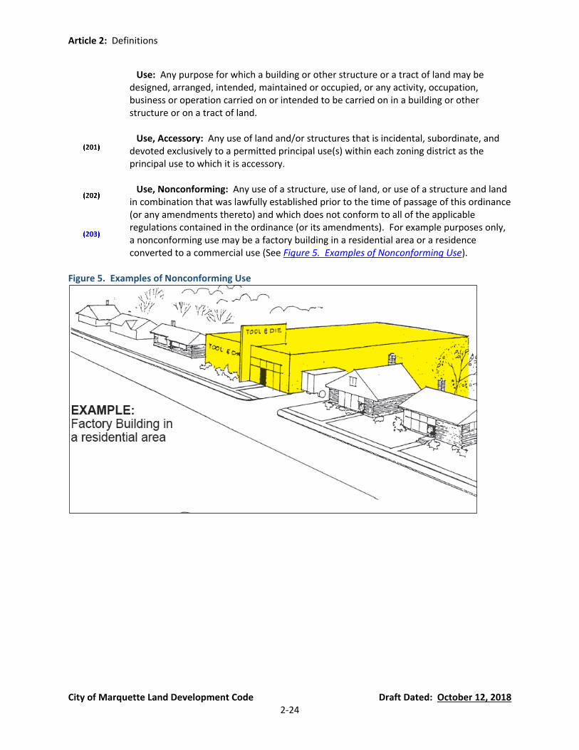
Article 2: Definitions
City of Marquette Land Development Code Draft Dated: October 12, 2018 2-24
Use: Any purpose for which a building or other structure or a tract of land may be designed, arranged, intended, maintained or occupied, or any activity, occupation, business or operation carried on or intended to be carried on in a building or other structure or on a tract of land.
Use, Accessory: Any use of land and/or structures that is incidental, subordinate, and devoted exclusively to a permitted principal use(s) within each zoning district as the principal use to which it is accessory.
Use, Nonconforming: Any use of a structure, use of land, or use of a structure and land in combination that was lawfully established prior to the time of passage of this ordinance (or any amendments thereto) and which does not conform to all of the applicable regulations contained in the ordinance (or its amendments). For example purposes only, a nonconforming use may be a factory building in a residential area or a residence converted to a commercial use (See Figure 5. Examples of Nonconforming Use).
Figure 5. Examples of Nonconforming Use

Article 2: Definitions
City of Marquette Land Development Code Draft Dated: October 12, 2018 2-25
Use, Permitted: A use by right that is specifically authorized in a particular zoning district.
Use, Principal: The main use of land or structures as distinguished form a secondary or accessory use.
Use, Special Land: Any building, structure, or use that complies with the applicable regulations governing uses, other than principal and accessory uses, in the zoning district in which such building, structure, or use us located, and for which a permit has been issued by the City Planning Commission.
Uses Subject to Standards Applicable to Specific Land Uses: A use that includes associated development and performance standards unique to the use (see Article 6).
Use, Temporary: A use intended and/or permitted for limited duration in accordance with City ordinances, subject to City approval.
Utility Electrical Power Generation: The erection, construction, alteration, operation, or maintenance by public utilities or municipal departments for the purpose of electrical power generation facilities and similar accessories in connection therewith.
Vacation Home Rental: A single-family home, or a dwelling unit in a duplex or multi-family dwelling structure, or any other dwelling unit, in which up to four (4) bedrooms are rented by a single lessee or renter for overnight accommodations, for periods as short as one overnight stay. Meals are not provided with rental, but kitchen and/or dining facilities are available for guests to prepare their own meals. The property owner may or may not live in the dwelling unit for part of the year, but the property owner may not live in the unit concurrently with any lessee. Only properties that have received approval of a

Article 2: Definitions
City of Marquette Land Development Code Draft Dated: October 12, 2018 2-26
rental registration application are recognized as a Vacation Home Rental for purposes of complying with City of Marquette ordinances.
Variance: See definition of “Zoning Variance.”
Vehicle Repair and Service: Engine tune-ups and rebuilding; transmission service and rebuilding; servicing of brakes, air conditioning, exhaust systems; oil change or lubrication; wheel alignment or balancing; collision service such as body, frame, or fender straightening or repair; steam cleaning, undercoating, and rustproofing; and other similar servicing or repairs that may require disassembly or storing of automobiles on the premises overnight while awaiting repairs or pick up.
Veterinary Clinic (Domestic Animals Only): An institution that is licensed by the State of Michigan to provide for the care, diagnosis, and treatment of sick or injured domestic animals, including those in need of medical or surgical attention. A veterinary clinic may include customary pens or cages within the walls of the clinic structure, but shall not include overnight boarding unless separately approved for a pet boarding facility use. A veterinary clinic may include such related facilities as laboratories, testing services, and offices.
Wall, Decorative Masonry: A solid wall composed of decorative masonry materials, including brick, face brick, stone, or similar decorative masonry material. Poured concrete, concrete masonry units (CMUs), split-faced block and similar materials are not acceptable decorative masonry materials.
Warehousing: A use engaged primarily in indoor storage, wholesale, and distribution of goods, products, supplies, and equipment, excluding bulk storage of materials.
Water Pollution. Any contamination or alteration of the physical, chemical, or biological properties of any waters that will render the waters harmful or detrimental to: (a) The City’s potable water intake in Lake Superior. (b) Public health, safety, or welfare. (c) Domestic, commercial, industrial, agricultural, recreational, or other legitimate
beneficial uses. (d) Livestock, wild animals, or birds. (e) Fish or other aquatic life.
Water Pollution Hazard. A land use or activity that causes a relatively high risk of potential water pollution.
Waterway. For the purposes of this Ordinance, waterways shall include rivers, stream channels, brooks, drains, and other riparian water bodies illustrated on the Official Zoning Map.
Wetlands. Land characterized by the presence of water at a frequency and duration sufficient to support, and that under normal circumstances does support, wetland vegetation or aquatic life, and is commonly referred to as a bog, swamp, or marsh. The
Article 2: Definitions
City of Marquette Land Development Code Draft Dated: October 12, 2018 2-27
boundaries of wetlands are determined in accordance with the Michigan Department of Environmental Quality.
Wholesale Trade Establishments: An establishment or place of business primarily engaged in selling and/or distributing wholesale merchandise to retailers, business users, other wholesalers, or individuals.
Wholesaling Operations: The storage and sale of goods to other firms for resale, as well as activities involving significant movement and storage of products or equipment, including warehousing and indoor storage activities.
Wireless Communication Antenna: Any exterior transmitting or receiving device mounted on a tower, building or structure and used in communications that radiate or capture electromagnetic waves, digital signals, analog signals, radio frequencies (excluding radar signals), wireless telecommunications signals or other communication signals.
Wireless Communication Backhaul Network: The lines that connect a provider's towers and/or cell sites to one or more cellular telephone switching offices, and/or long distance providers, or the public switched telephone network.
Wireless Communication Tower: Any structure that is designed and constructed primarily for the purpose of supporting one or more antennas for telephone, radio and similar communication purposes, including self-supporting lattice towers, guyed towers, or monopole towers. The term includes radio and television transmission towers, microwave towers, common-carrier towers, cellular telephone towers, alternative tower structures, and the like. The term includes the structure and any support thereto.
Wireless Communication Tower, Height: The distance measured from the finished grade of the parcel to the highest point on the tower or other structure, including the base pad and any antenna.
Wireless Communication Tower, Preexisting and preexisting antennas: Any tower or antenna for which a building permit or special land use permit has been properly issued prior to the effective date of this ordinance, including permitted towers or antennas that have not yet been constructed so long as such approval is current and not expired.
Wireless Communication Tower Structure, Alternative: Man-made trees, clock towers, bell steeples, light poles and similar alternative-design mounting structures that camouflage or conceal the presence of antennas or towers.
Yard: Open space on the same site as a main building, unoccupied and unobstructed by man-made fixed objects from the ground upward except as otherwise provided in the City Code, as defined therein.
Yard, Front: An open space extending the full width of the lot, the depth of which is the horizontal distance between the front lot line/right-of-way line and the nearest vertical plane/exterior foundation of the main structure. Through lots must provide a front yard
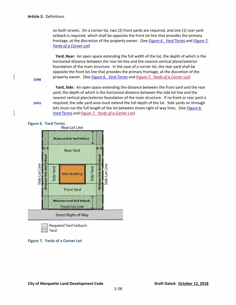
Article 2: Definitions
City of Marquette Land Development Code Draft Dated: October 12, 2018 2-28
on both streets. On a corner lot, two (2) front yards are required, and one (1) rear yard setback is required, which shall be opposite the front lot line that provides the primary frontage, at the discretion of the property owner. (See Figure 6. Yard Terms and Figure 7. Yards of a Corner Lot)
Yard, Rear: An open space extending the full width of the lot, the depth of which is the horizontal distance between the rear lot line and the nearest vertical plane/exterior foundation of the main structure. In the case of a corner lot, the rear yard shall be opposite the front lot line that provides the primary frontage, at the discretion of the property owner. (See Figure 6. Yard Terms and Figure 7. Yards of a Corner Lot)
Yard, Side: An open space extending the distance between the front yard and the rear yard, the depth of which is the horizontal distance between the side lot line and the nearest vertical plan/exterior foundation of the main structure. If no front or rear yard is required, the side yard area must extend the full depth of the lot. Side yards on through lots must run the full length of the lot between street right of way lines. (See Figure 6. Yard Terms and Figure 7. Yards of a Corner Lot)
Figure 6. Yard Terms
Figure 7. Yards of a Corner Lot

Article 2: Definitions
City of Marquette Land Development Code Draft Dated: October 12, 2018 2-29
Yard, Transitional: A required yard located on sites abutting zoning district boundaries for the purpose of creating a buffer zone to reduce conflict between incompatible districts or land uses. The provision for transition yards as documented in Article 10 are not modified by any of the provisions for yard setbacks.
Zoning Administrator: The person(s) appointed by the City Manager to administer and enforce this Land Development Code in accordance with the duties of Section 54.1301.
Zoning District: See definition of “District, Zoning.”
Zoning Ordinance: See “Land Development Code.”
Zoning Variance: A modification of the literal provisions of the Land Development Code granted by the Board of Zoning Appeals when in its judgment the strict enforcement of the Land Development Code would cause practical difficulty owing to circumstances unique to the individual property on which the variance is granted.

Article 3: Zoning Districts and Map
City of Marquette Land Development Code Draft Dated: October 12, 2018 3-1
Article 3 Zoning Districts and Map
Section 54.301 Establishment of Zoning Districts (currently Section 80.05(1))
(A) For the purpose of this ordinance, the city is hereby divided into zoning districts as named and described in this Article, and summarized as follows:
SFR, Single-Family Residential District (See summary in Section 54.307) GR, General Residential District (See summary in Section 54.308) MFR, Multiple-Family Residential District (See summary in Section 54.309) MHP, Mobile Home Park District (See summary in Section 54.310) M-U, Mixed-Use District (See summary in Section 54.311) CBD, Central Business District (See summary in Section 54.312) GC, General Commercial District (See summary in Section 54.313) RC, Regional Commercial District (See summary in Section 54.314) M, Municipal District (See summary in Section 54.315) C, Civic District (See summary in Section 54.316) IM, Industrial/Manufacturing District (See summary in Section 54.317) CR, Conservation and Recreation District (See summary in Section 54.318) BLP, Board of Light and Power District (See summary in Section 54.319) RO, Riparian Overlay District (See summary in Section 54.320) MDW, Marquette Downtown Waterfront District Form-Based Code (See summary in Section 54.321)
TSC, Third Street Corridor Form-Based Code (See summary in Section 54.322) PUD, Planned Unit Development District (See summary in Section 54.323)
Section 54.302 Official Zoning Map (currently Section 80.05(2)) The boundaries of said districts are hereby established as shown on the Official Zoning Map.
(A) The Official Zoning Map shall be identified by the signatures of the Mayor and City Clerk.
(B) The Official Zoning Map shall be kept in the office of the Zoning Administrator whose responsibility it shall be to enter on the map all amendments adopted by the City Commission.
Section 54.303 Interpretation of Zoning District Boundaries (currently Section 80.05(3) and (5)) Unless otherwise shown the boundaries of said districts shall be interpreted as follows:
(A) Rights-of-Way and Waterways. Boundaries approximately following public, railroad, utility, or other rights-of-way, streams, rivers, or canals, shall be construed to follow the centerlines of such features.
(B) Lot Lines and City Boundary Lines. Boundaries approximately platted lot lines, or the city
limits shall be construed as following these lines.

Article 3: Zoning Districts and Map
City of Marquette Land Development Code Draft Dated: October 12, 2018 3-2
(C) Shoreline. Projections from the shoreline into unzoned water areas shall be subject to the regulations of the zoning district of the land at the shoreline.
(D) Vacated Public Ways. Public ways vacated by the City Commission action shall be construed
as being in the zoning district that applies to the lands to which they become attached.
(E) Filled or Accreted Land. Whenever fill is placed in any lake, river, or stream or land is created by accretion, the land thus created shall automatically and without further governmental action thenceforth acquire and be subjected to the same zoning regulations as are applicable to lands to which the same shall attach or be adjacent, and the same shall be used for the same purposes as are permitted under this ordinance for such adjoining lands.
(F) Unresolved District Boundaries. Where the application of the aforesaid rules leaves a
reasonable doubt as to the boundaries between two (2) or more districts, the regulations of the more restrictive district shall govern the entire parcel in question, unless otherwise determined by the Board of Zoning Appeals.
Section 54.304 Newly Annexed Areas (currently Section 80.05(4)) Areas annexed to the city shall be subject to the regulations of the districts in this ordinance that most closely approximate their zoning, as determined by the Zoning Administrator. Within four (4) months the City Commission shall upon recommendation of the City Planning Commission either concur with the district(s) that the Zoning Administrator has chosen, or following a public hearing, designate a different district.
Section 54.305 Categories within Zoning Districts (new Section, which will describe difference between Permitted Uses and Special Land Uses) In order to avoid intrusion of undesirable uses and to foster all possible benefits for a continued high quality environment, all land, uses, and structures have been classified into permitted uses and uses allowed by special use permit. Permitted uses include those that require a minimum amount of limitations; but those uses presenting potential injurious effect upon residential and other property, unless authorized under specific imposed conditions, are controlled through the issuance of special land use permits.
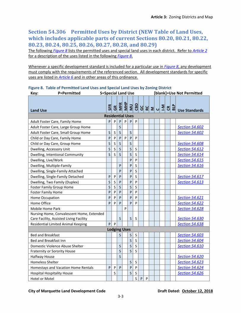
Article 3: Zoning Districts and Map
City of Marquette Land Development Code Draft Dated: October 12, 2018 3-3
Section 54.306 Permitted Uses by District (NEW Table of Land Uses, which includes applicable parts of current Sections 80.20, 80.21, 80.22, 80.23, 80.24, 80.25, 80.26, 80.27, 80.28, and 80.29) The following Figure 8 lists the permitted uses and special land uses in each district. Refer to Article 2 for a description of the uses listed in the following Figure 8. Whenever a specific development standard is included for a particular use in Figure 8, any development must comply with the requirements of the referenced section. All development standards for specific uses are listed in Article 6 and in other areas of this ordinance. Figure 8. Table of Permitted Land Uses and Special Land Uses by Zoning District
Key: P=Permitted S=Special Land Use [blank]=Use Not Permitted
Land Use SFR
G
R
MFR
M
HP
M
U
CB
D
GC
R
C
M
C
I-M
C
R
BLP
Use Standards
Residential Uses
Adult Foster Care, Family Home P P P P P P
Adult Foster Care, Large Group Home S Section 54.602
Adult Foster Care, Small Group Home S S S S Section 54.602
Child or Day Care, Family Home P P P P P P
Child or Day Care, Group Home S S S S Section 54.608
Dwelling, Accessory Unit S S S S S Section 54.612
Dwelling, Intentional Community S S S S S Section 54.614
Dwelling, Live/Work P P Section 54.615
Dwelling, Multiple-Family P P S Section 54.616
Dwelling, Single-Family Attached P P S
Dwelling, Single-Family Detached P P P P S Section 54.617
Dwelling, Two Family (Duplex) S S P P P Section 54.613 Foster Family Group Home S S S S S
Foster Family Home P P P P P
Home Occupation P P P P P Section 54.621
Home Office P P P P P Section 54.622
Mobile Home Park P Section 54.628 Nursing Home, Convalescent Home, Extended Care Facility, Assisted Living Facility S S S
Section 54.630
Residential Limited Animal Keeping P P Section 54.638
Lodging Uses
Bed and Breakfast S S S Section 54.603
Bed and Breakfast Inn S S Section 54.604
Domestic Violence Abuse Shelter S S S Section 54.610
Fraternity or Sorority House S S S
Halfway House S Section 54.620
Homeless Shelter S S Section 54.623
Homestays and Vacation Home Rentals P P P P P Section 54.624
Hospital Hospitality House S S S Section 54.626
Hotel or Motel S P P

Article 3: Zoning Districts and Map
City of Marquette Land Development Code Draft Dated: October 12, 2018 3-4
Key: P=Permitted S=Special Land Use [blank]=Use Not Permitted
Land Use SFR
G
R
MFR
M
HP
M
U
CB
D
GC
R
C
M
C
I-M
C
R
BLP
Use Standards
Rooming House and Hostel S S S Section 54.639
Medical Uses Emergency Services P P P P
Health Services P P P P
Hospice P P P P
Hospital S S S S S Section 54.625 Medical Hospital Related Accessory Uses P P P P
Medical Hospital Related Office P P P P
Medical Hospital Related Uses P P P P
Office, Medical P P P P P Section 54.631
Veterinary Clinic (Domestic Animals Only) P P P P P
Public and Quasi-Public Uses
Cemetery S S S P P Section 54.606 Conservation, Recreational and Educational Opportunities P P P P
Public or Governmental Building S S S P P P P P P P P P
Recreational Use, Land Intensive S Section 54.636 Recreational Use, Public S S S P P S S
Religious Institution S S S P S P P P Section 54.637
School, Primary or Secondary S S S S S P P Section 54.640
School, University S S S S P P Section 54.607
Commercial and Retail Uses
Adult Entertainment Uses S Section 54.601 Bar S P P P
Child Care Center or Day Care Center S S P S P P Section 54.609
Drive-Through Uses S S S Section 54.611
Farmers’ Markets P P P P P P Section 54.618
Gasoline Service Stations S P P P
Indoor Recreation P P P P P P P
Office, Professional P P P P P P P Section 54.631 Outdoor Entertainment and Community Events P P P P
Outdoor Food and Beverage Service S S P P Section 54.633
Pet Boarding Facility S S S Restaurant, Indoor Service P P P P
Retail Business, Indoor P P P P P
Retail Business, Outdoor Permanent S S S
Retail Business, Outdoor Temporary P P P P Section 54.634
Service Establishment P P P P P
Storage, Open P P P P P P P Section 54.632 Vehicle Repair and Service S S P P
Industrial Uses Major Repair and Maintenance Operations S P
Manufacturing, Heavy S

Article 3: Zoning Districts and Map
City of Marquette Land Development Code Draft Dated: October 12, 2018 3-5
Key: P=Permitted S=Special Land Use [blank]=Use Not Permitted
Land Use SFR
G
R
MFR
M
HP
M
U
CB
D
GC
R
C
M
C
I-M
C
R
BLP
Use Standards
Manufacturing, Light S S S S P Section 54.627
Natural Resource Extraction Operations S Section 54.629
Port Facilities and Docks S S S S Section 54.635
Railroad Facilities P
Storage, Bulk S S P Section 54.605
Utility Electrical Power Generation P Warehousing S P P
Wholesale Trade Establishment P P P
Wholesaling Operations S P
Other Uses
Accessory Building or Structure P P P P P P P P P P P P Section 54.705 Accessory Use, Non-Single Family Residential Lots P P S S S S S S S S S S
Accessory Use, Single-Family Residential Lots P P P P S
Agriculture-Like Operation, including Forestry P P P P
Food Production, Minor P P P P P P P P P P P P P Section 54.619
Recycling Collection and Transfer Stations S Structures between the shoreline of Lake Superior and the pavement of the nearest public street or highway. S S S
Wireless Telecommunications Facilities S S S S S P S S Section 54.641
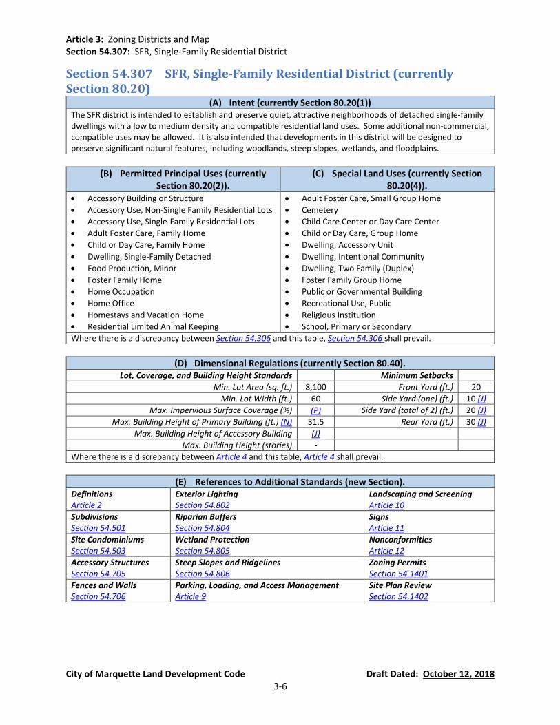
Article 3: Zoning Districts and Map Section 54.307: SFR, Single-Family Residential District
City of Marquette Land Development Code Draft Dated: October 12, 2018 3-6
Section 54.307 SFR, Single-Family Residential District (currently Section 80.20)
(A) Intent (currently Section 80.20(1)) The SFR district is intended to establish and preserve quiet, attractive neighborhoods of detached single-family dwellings with a low to medium density and compatible residential land uses. Some additional non-commercial, compatible uses may be allowed. It is also intended that developments in this district will be designed to preserve significant natural features, including woodlands, steep slopes, wetlands, and floodplains.
(B) Permitted Principal Uses (currently Section 80.20(2)).
(C) Special Land Uses (currently Section 80.20(4)).
• Accessory Building or Structure
• Accessory Use, Non-Single Family Residential Lots
• Accessory Use, Single-Family Residential Lots
• Adult Foster Care, Family Home
• Child or Day Care, Family Home
• Dwelling, Single-Family Detached
• Food Production, Minor
• Foster Family Home
• Home Occupation
• Home Office
• Homestays and Vacation Home
• Residential Limited Animal Keeping
• Adult Foster Care, Small Group Home
• Cemetery
• Child Care Center or Day Care Center
• Child or Day Care, Group Home
• Dwelling, Accessory Unit
• Dwelling, Intentional Community
• Dwelling, Two Family (Duplex)
• Foster Family Group Home
• Public or Governmental Building
• Recreational Use, Public
• Religious Institution
• School, Primary or Secondary
Where there is a discrepancy between Section 54.306 and this table, Section 54.306 shall prevail.
(D) Dimensional Regulations (currently Section 80.40). Lot, Coverage, and Building Height Standards Minimum Setbacks
Min. Lot Area (sq. ft.) 8,100 Front Yard (ft.) 20
Min. Lot Width (ft.) 60 Side Yard (one) (ft.) 10 (J)
Max. Impervious Surface Coverage (%) (P) Side Yard (total of 2) (ft.) 20 (J)
Max. Building Height of Primary Building (ft.) (N) 31.5 Rear Yard (ft.) 30 (J)
Max. Building Height of Accessory Building (J)
Max. Building Height (stories) -
Where there is a discrepancy between Article 4 and this table, Article 4 shall prevail.
(E) References to Additional Standards (new Section). Definitions Article 2
Exterior Lighting Section 54.802
Landscaping and Screening Article 10
Subdivisions Section 54.501
Riparian Buffers Section 54.804
Signs Article 11
Site Condominiums Section 54.503
Wetland Protection Section 54.805
Nonconformities Article 12
Accessory Structures Section 54.705
Steep Slopes and Ridgelines Section 54.806
Zoning Permits Section 54.1401
Fences and Walls Section 54.706
Parking, Loading, and Access Management Article 9
Site Plan Review Section 54.1402

Article 3: Zoning Districts and Map Section 54.308: GR, General Residential District
City of Marquette Land Development Code Draft Dated: October 12, 2018 3-7
Section 54.308 GR, General Residential District (currently Section 80.21)
(A) Intent (currently Section 80.21(1)) The GR district is intended to establish and preserve medium density residential neighborhoods that present an environment acceptable to a range of users, including families of all types. Some additional non-residential compatible uses may be allowed. It is important to the community to preserve and enhance the pedestrian-friendly, compact neighborhood types where homes and buildings are of similar scale and character.
(B) Permitted Principal Uses (currently Section 80.21(2)).
(C) Special Land Uses (currently Section 80.21(4)).
• Accessory Building or Structure
• Accessory Use, Non-Single Family Residential Lots
• Accessory Use, Single-Family Residential Lots
• Adult Foster Care, Family Home
• Child or Day Care, Family Home
• Dwelling, Single-Family Detached
• Food Production, Minor
• Foster Family Home
• Home Occupation
• Home Office
• Homestays and Vacation Home
• Residential Limited Animal Keeping
• Adult Foster Care, Small Group Home
• Cemetery
• Child Care Center or Day Care Center
• Child or Day Care, Group Home
• Dwelling, Accessory Unit
• Dwelling, Intentional Community
• Dwelling, Two Family (Duplex)
• Foster Family Group Home
• Hospital Hospitality House
• Public or Governmental Building
• Recreational Use, Public
• Religious Institution
• School, Primary or Secondary
• School, University
Where there is a discrepancy between Section 54.306 and this table, Section 54.306 shall prevail.
(D) Dimensional Regulations (currently Section 80.40). Lot, Coverage, and Building Height Standards Minimum Setbacks
Min. Lot Area (sq. ft.) 4,500 (B) Front Yard (ft.) 15 (A)
Min. Lot Width (ft.) 37.5 (C) Side Yard (one) (ft.) 5 (J)
Max. Impervious Surface Coverage (%) (P) Side Yard (total of 2) (ft.) 13 (J)
Max. Building Height of Primary Building (ft.) (N) 31.5 Rear Yard (ft.) 20 (J)
Max. Building Height of Accessory Building (J)
Max. Building Height (stories) -
Where there is a discrepancy between Article 4 and this table, Article 4 shall prevail.
(E) References to Additional Standards (new Section). Definitions Article 2
Exterior Lighting Section 54.802
Landscaping and Screening Article 10
Subdivisions Section 54.501
Riparian Buffers Section 54.804
Signs Article 11
Site Condominiums Section 54.503
Wetland Protection Section 54.805
Nonconformities Article 12
Accessory Structures Section 54.705
Steep Slopes and Ridgelines Section 54.806
Zoning Permits Section 54.1401
Fences and Walls Section 54.706
Parking, Loading, and Access Management Article 9
Site Plan Review Section 54.1402
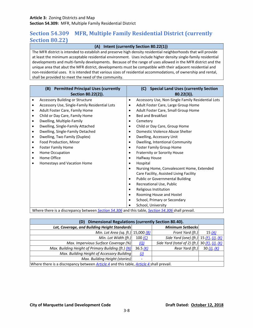
Article 3: Zoning Districts and Map Section 54.309: MFR, Multiple Family Residential District
City of Marquette Land Development Code Draft Dated: October 12, 2018 3-8
Section 54.309 MFR, Multiple Family Residential District (currently Section 80.22)
(A) Intent (currently Section 80.22(1)) The MFR district is intended to establish and preserve high density residential neighborhoods that will provide at least the minimum acceptable residential environment. Uses include higher density single-family residential developments and multi-family developments. Because of the range of uses allowed in the MFR district and the unique area that abut the MFR district, developments must be compatible with their adjacent residential and non-residential uses. It is intended that various sizes of residential accommodations, of ownership and rental, shall be provided to meet the need of the community.
(B) Permitted Principal Uses (currently Section 80.22(2)).
(C) Special Land Uses (currently Section 80.22(3)).
• Accessory Building or Structure
• Accessory Use, Single-Family Residential Lots
• Adult Foster Care, Family Home
• Child or Day Care, Family Home
• Dwelling, Multiple-Family
• Dwelling, Single-Family Attached
• Dwelling, Single-Family Detached
• Dwelling, Two Family (Duplex)
• Food Production, Minor
• Foster Family Home
• Home Occupation
• Home Office
• Homestays and Vacation Home
• Accessory Use, Non-Single Family Residential Lots
• Adult Foster Care, Large Group Home
• Adult Foster Care, Small Group Home
• Bed and Breakfast
• Cemetery
• Child or Day Care, Group Home
• Domestic Violence Abuse Shelter
• Dwelling, Accessory Unit
• Dwelling, Intentional Community
• Foster Family Group Home
• Fraternity or Sorority House
• Halfway House
• Hospital
• Nursing Home, Convalescent Home, Extended Care Facility, Assisted Living Facility
• Public or Governmental Building
• Recreational Use, Public
• Religious Institution
• Rooming House and Hostel
• School, Primary or Secondary
• School, University
Where there is a discrepancy between Section 54.306 and this table, Section 54.306 shall prevail.
(D) Dimensional Regulations (currently Section 80.40). Lot, Coverage, and Building Height Standards Minimum Setbacks
Min. Lot Area (sq. ft.) 15,000 (B) Front Yard (ft.) 15 (A)
Min. Lot Width (ft.) 100 (C) Side Yard (one) (ft.) 15 (F), (J), (K)
Max. Impervious Surface Coverage (%) (Q) Side Yard (total of 2) (ft.) 30 (F), (J), (K)
Max. Building Height of Primary Building (ft.) (N) 36.5 (K) Rear Yard (ft.) 30 (J), (K)
Max. Building Height of Accessory Building (J)
Max. Building Height (stories) -
Where there is a discrepancy between Article 4 and this table, Article 4 shall prevail.
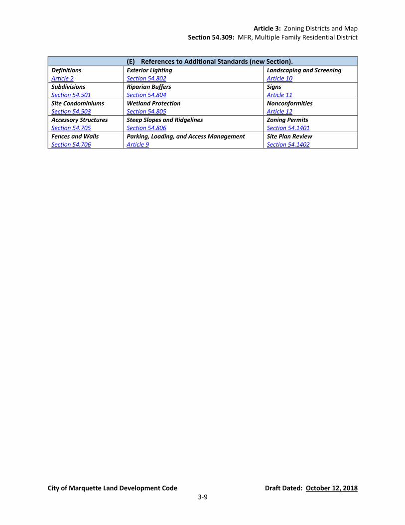
Article 3: Zoning Districts and Map Section 54.309: MFR, Multiple Family Residential District
City of Marquette Land Development Code Draft Dated: October 12, 2018 3-9
(E) References to Additional Standards (new Section). Definitions Article 2
Exterior Lighting Section 54.802
Landscaping and Screening Article 10
Subdivisions Section 54.501
Riparian Buffers Section 54.804
Signs Article 11
Site Condominiums Section 54.503
Wetland Protection Section 54.805
Nonconformities Article 12
Accessory Structures Section 54.705
Steep Slopes and Ridgelines Section 54.806
Zoning Permits Section 54.1401
Fences and Walls Section 54.706
Parking, Loading, and Access Management Article 9
Site Plan Review Section 54.1402
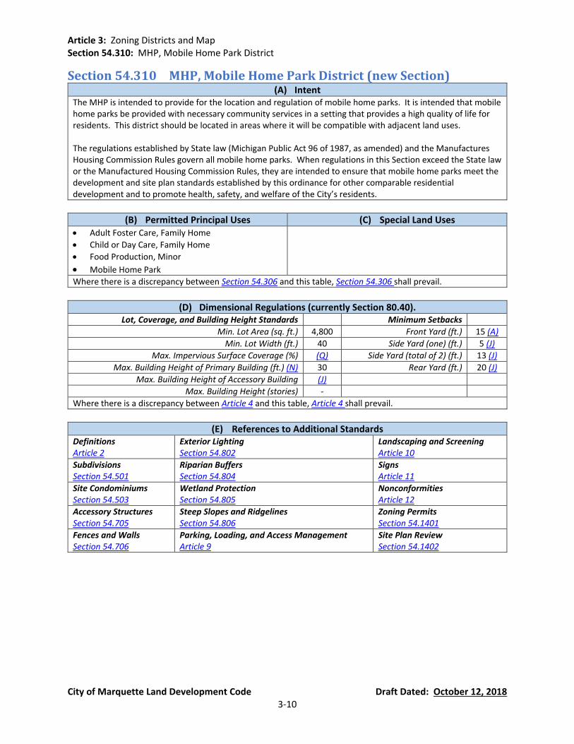
Article 3: Zoning Districts and Map Section 54.310: MHP, Mobile Home Park District
City of Marquette Land Development Code Draft Dated: October 12, 2018 3-10
Section 54.310 MHP, Mobile Home Park District (new Section) (A) Intent
The MHP is intended to provide for the location and regulation of mobile home parks. It is intended that mobile home parks be provided with necessary community services in a setting that provides a high quality of life for residents. This district should be located in areas where it will be compatible with adjacent land uses. The regulations established by State law (Michigan Public Act 96 of 1987, as amended) and the Manufactures Housing Commission Rules govern all mobile home parks. When regulations in this Section exceed the State law or the Manufactured Housing Commission Rules, they are intended to ensure that mobile home parks meet the development and site plan standards established by this ordinance for other comparable residential development and to promote health, safety, and welfare of the City’s residents.
(B) Permitted Principal Uses (C) Special Land Uses • Adult Foster Care, Family Home
• Child or Day Care, Family Home
• Food Production, Minor
• Mobile Home Park
Where there is a discrepancy between Section 54.306 and this table, Section 54.306 shall prevail.
(D) Dimensional Regulations (currently Section 80.40). Lot, Coverage, and Building Height Standards Minimum Setbacks
Min. Lot Area (sq. ft.) 4,800 Front Yard (ft.) 15 (A)
Min. Lot Width (ft.) 40 Side Yard (one) (ft.) 5 (J)
Max. Impervious Surface Coverage (%) (Q) Side Yard (total of 2) (ft.) 13 (J)
Max. Building Height of Primary Building (ft.) (N) 30 Rear Yard (ft.) 20 (J)
Max. Building Height of Accessory Building (J)
Max. Building Height (stories) -
Where there is a discrepancy between Article 4 and this table, Article 4 shall prevail.
(E) References to Additional Standards Definitions Article 2
Exterior Lighting Section 54.802
Landscaping and Screening Article 10
Subdivisions Section 54.501
Riparian Buffers Section 54.804
Signs Article 11
Site Condominiums Section 54.503
Wetland Protection Section 54.805
Nonconformities Article 12
Accessory Structures Section 54.705
Steep Slopes and Ridgelines Section 54.806
Zoning Permits Section 54.1401
Fences and Walls Section 54.706
Parking, Loading, and Access Management Article 9
Site Plan Review Section 54.1402
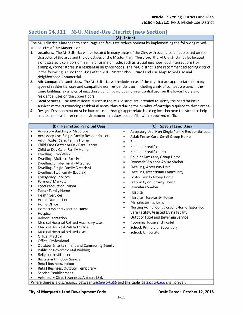
Article 3: Zoning Districts and Map Section 53.312: M-U, Mixed-Use District
City of Marquette Land Development Code Draft Dated: October 12, 2018 3-11
Section 54.311 M-U, Mixed-Use District (new Section) (A) Intent
The M-U district is intended to encourage and facilitate redevelopment by implementing the following mixed-use policies of the Master Plan: 1. Locations. The M-U district will be located in many areas of the City, with each area unique based on the
character of the area and the objectives of the Master Plan. Therefore, the M-U district may be located along strategic corridors or in a major or minor node, such as crucial neighborhood intersections (for example, corner stores in a residential neighborhood). The M-U district is the recommended zoning district in the following Future Land Uses of the 2015 Master Plan Future Land Use Map: Mixed Use and Neighborhood Commercial.
2. Mix Compatible Land Uses. The M-U district will include areas of the city that are appropriate for many types of residential uses and compatible non-residential uses, including a mix of compatible uses in the same building. Examples of mixed-use buildings include non-residential uses on the lower floors and residential uses on the upper floors.
3. Local Services. The non-residential uses in the M-U district are intended to satisfy the need for basic services of the surrounding residential areas, thus reducing the number of car trips required to these areas.
4. Design. Development must be human-scale through appropriate building location near the street to help create a pedestrian-oriented environment that does not conflict with motorized traffic.
(B) Permitted Principal Uses (C) Special Land Uses
• Accessory Building or Structure • Accessory Use, Single-Family Residential Lots • Adult Foster Care, Family Home • Child Care Center or Day Care Center • Child or Day Care, Family Home • Dwelling, Live/Work • Dwelling, Multiple-Family • Dwelling, Single-Family Attached • Dwelling, Single-Family Detached • Dwelling, Two Family (Duplex) • Emergency Services • Farmers’ Markets • Food Production, Minor • Foster Family Home • Health Services • Home Occupation • Home Office • Homestays and Vacation Home • Hospice • Indoor Recreation • Medical Hospital Related Accessory Uses • Medical Hospital Related Office • Medical Hospital Related Uses • Office, Medical • Office, Professional • Outdoor Entertainment and Community Events • Public or Governmental Building • Religious Institution • Restaurant, Indoor Service • Retail Business, Indoor • Retail Business, Outdoor Temporary • Service Establishment • Veterinary Clinic (Domestic Animals Only)
• Accessory Use, Non-Single Family Residential Lots
• Adult Foster Care, Small Group Home
• Bar
• Bed and Breakfast
• Bed and Breakfast Inn
• Child or Day Care, Group Home
• Domestic Violence Abuse Shelter
• Dwelling, Accessory Unit
• Dwelling, Intentional Community
• Foster Family Group Home
• Fraternity or Sorority House
• Homeless Shelter
• Hospital
• Hospital Hospitality House
• Manufacturing, Light
• Nursing Home, Convalescent Home, Extended Care Facility, Assisted Living Facility
• Outdoor Food and Beverage Service
• Rooming House and Hostel
• School, Primary or Secondary
• School, University
Where there is a discrepancy between Section 54.306 and this table, Section 54.306 shall prevail.
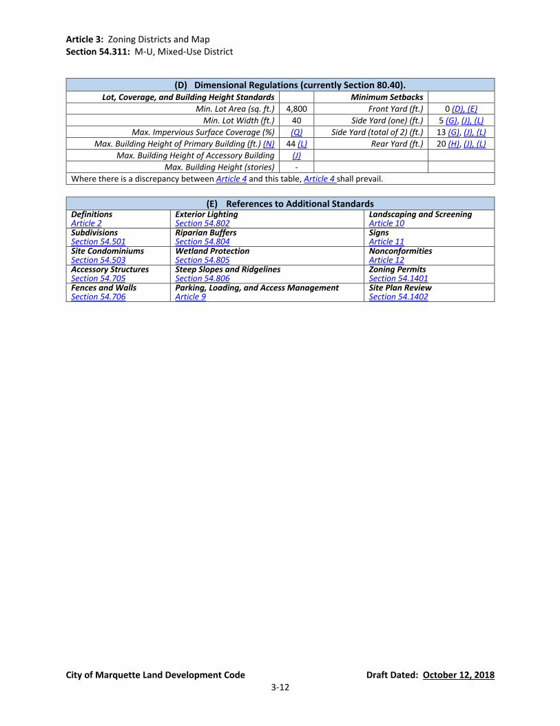
Article 3: Zoning Districts and Map Section 54.311: M-U, Mixed-Use District
City of Marquette Land Development Code Draft Dated: October 12, 2018 3-12
(D) Dimensional Regulations (currently Section 80.40). Lot, Coverage, and Building Height Standards Minimum Setbacks
Min. Lot Area (sq. ft.) 4,800 Front Yard (ft.) 0 (D), (E)
Min. Lot Width (ft.) 40 Side Yard (one) (ft.) 5 (G), (J), (L)
Max. Impervious Surface Coverage (%) (Q) Side Yard (total of 2) (ft.) 13 (G), (J), (L)
Max. Building Height of Primary Building (ft.) (N) 44 (L) Rear Yard (ft.) 20 (H), (J), (L)
Max. Building Height of Accessory Building (J)
Max. Building Height (stories) -
Where there is a discrepancy between Article 4 and this table, Article 4 shall prevail.
(E) References to Additional Standards Definitions Article 2
Exterior Lighting Section 54.802
Landscaping and Screening Article 10
Subdivisions Section 54.501
Riparian Buffers Section 54.804
Signs Article 11
Site Condominiums Section 54.503
Wetland Protection Section 54.805
Nonconformities Article 12
Accessory Structures Section 54.705
Steep Slopes and Ridgelines Section 54.806
Zoning Permits Section 54.1401
Fences and Walls Section 54.706
Parking, Loading, and Access Management Article 9
Site Plan Review Section 54.1402

Article 3: Zoning Districts and Map Section 54.312: CBD, Central Business District
City of Marquette Land Development Code Draft Dated: October 12, 2018 3-13
Section 54.312 CBD, Central Business District (currently Section 80.25) (A) Intent (currently Section 80.25(1))
The CBD is the historic hub of city commerce and intended to provide suitable regulations for the business-oriented core area of the city which serves both local and regional markets such as offices, retail or wholesale sales or service, light manufacturing, and mixed uses that include residential.
(B) Permitted Principal Uses (currently Section 80.25(2)).
(C) Special Land Uses (currently Section 80.25(5)).
• Accessory Building or Structure
• Adult Foster Care, Family Home
• Bar
• Child or Day Care, Family Home
• Dwelling, Live/Work
• Dwelling, Two Family (Duplex)
• Emergency Services
• Farmers’ Markets
• Food Production, Minor
• Foster Family Home
• Health Services
• Home Occupation
• Home Office
• Homestays and Vacation Home
• Hospice
• Indoor Recreation
• Medical Hospital Related Accessory Uses
• Medical Hospital Related Office
• Medical Hospital Related Uses
• Office, Medical
• Office, Professional
• Outdoor Entertainment and Community Events
• Public or Governmental Building
• Restaurant, Indoor Service
• Retail Business, Indoor
• Retail Business, Outdoor Temporary
• Service Establishment
• Veterinary Clinic (Domestic Animals Only)
• Accessory Use, Non-Single Family Residential Lots
• Accessory Use, Single-Family Residential Lots
• Bed and Breakfast
• Bed and Breakfast Inn
• Child Care Center or Day Care Center
• Domestic Violence Abuse Shelter
• Drive-Through Uses
• Dwelling, Accessory Unit
• Dwelling, Intentional Community
• Dwelling, Multiple-Family
• Dwelling, Single-Family Attached
• Dwelling, Single-Family Detached
• Foster Family Group Home
• Fraternity or Sorority House
• Gasoline Service Stations
• Homeless Shelter
• Hospital
• Hospital Hospitality House
• Hotel or Motel
• Manufacturing, Light
• Nursing Home, Convalescent Home, Extended Care Facility, Assisted Living Facility
• Outdoor Food and Beverage Service
• Religious Institution
• Rooming House and Hostel
• School, Primary or Secondary
• School, University
• Vehicle Repair and Service
• Wireless Telecommunications Facilities
Where there is a discrepancy between Section 54.306 and this table, Section 54.306 shall prevail.
(D) Dimensional Regulations (currently Section 80.40). Lot, Coverage, and Building Height Standards Minimum Setbacks
Min. Lot Area (sq. ft.) None Front Yard (ft.) 0
Min. Lot Width (ft.) None Side Yard (one) (ft.) 5 (G)
Max. Impervious Surface Coverage (%) (Q) Side Yard (total of 2) (ft.) 10 (G)
Max. Building Height of Primary Building (ft.) (N) 60 Rear Yard (ft.) 10 (H)
Max. Building Height of Accessory Building 18
Max. Building Height (stories) -
Where there is a discrepancy between Article 4 and this table, Article 4 shall prevail.
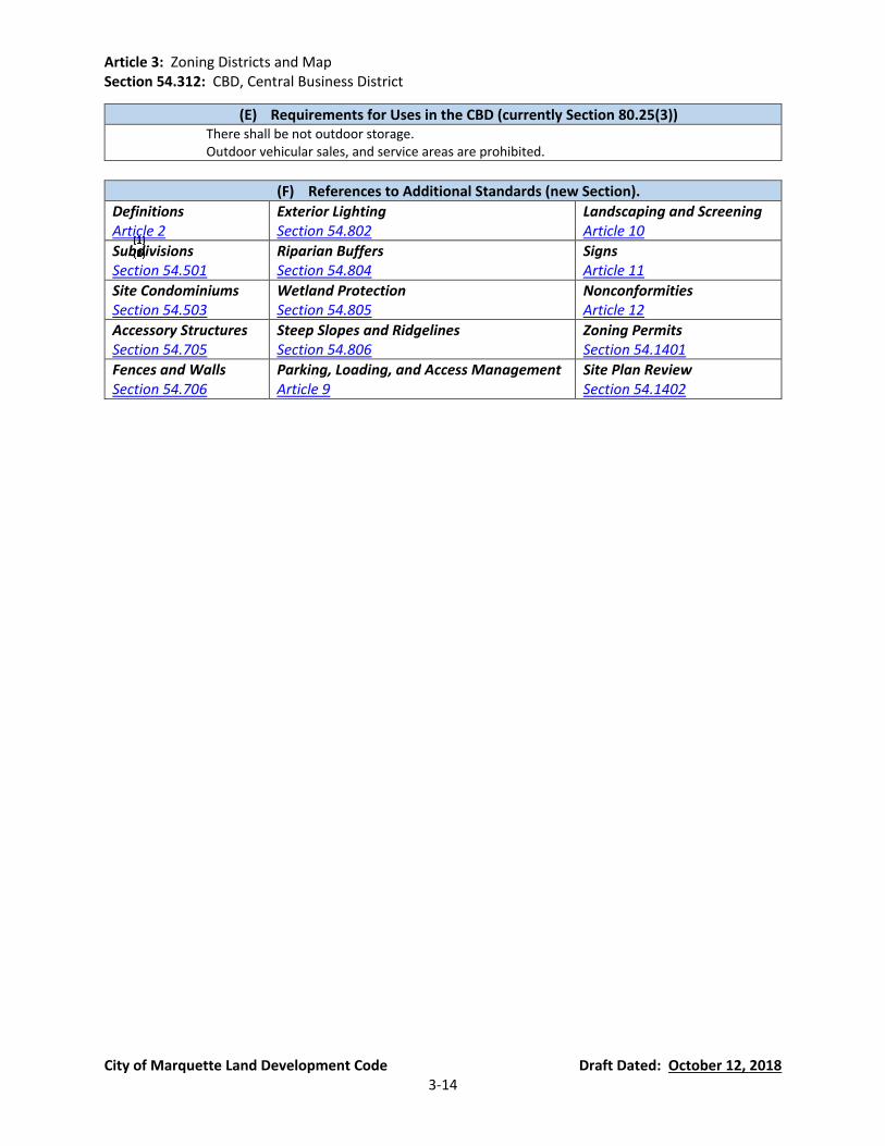
Article 3: Zoning Districts and Map Section 54.312: CBD, Central Business District
City of Marquette Land Development Code Draft Dated: October 12, 2018 3-14
(E) Requirements for Uses in the CBD (currently Section 80.25(3)) There shall be not outdoor storage. Outdoor vehicular sales, and service areas are prohibited.
(F) References to Additional Standards (new Section).
Definitions Article 2
Exterior Lighting Section 54.802
Landscaping and Screening Article 10
Subdivisions Section 54.501
Riparian Buffers Section 54.804
Signs Article 11
Site Condominiums Section 54.503
Wetland Protection Section 54.805
Nonconformities Article 12
Accessory Structures Section 54.705
Steep Slopes and Ridgelines Section 54.806
Zoning Permits Section 54.1401
Fences and Walls Section 54.706
Parking, Loading, and Access Management Article 9
Site Plan Review Section 54.1402

Article 3: Zoning Districts and Map Section 53.313: GC, General Commercial District
City of Marquette Land Development Code Draft Dated: October 12, 2018 3-15
Section 54.313 GC, General Commercial District (currently Section 80.26)
(A) Intent (currently Section 80.26(1)) The GC district is intended to provide suitable areas for businesses that cater to both the local and regional market. Uses include offices, retail and wholesale businesses, services, light manufacturing, comparison shopping and land intensive establishments, which may be located so as to utilize a common parking area, or may provide their own parking separately. The GC district also serves as a transition between the urban development character of the CBD and the suburban character of the RC district.
(B) Permitted Principal Uses (currently Section 80.26(2)).
(C) Special Land Uses (currently Section 80.26(4)).
• Accessory Building or Structure • Bar • Child Care Center or Day Care Center • Emergency Services • Farmers’ Markets • Food Production, Minor • Gasoline Service Stations • Health Services • Hospice • Hotel or Motel • Indoor Recreation • Medical Hospital Related Accessory Uses • Medical Hospital Related Office • Medical Hospital Related Uses • Office, Medical • Office, Professional • Outdoor Food and Beverage Service • Public or Governmental Building • Religious Institution • Restaurant, Indoor Service • Retail Business, Indoor • Retail Business, Outdoor Temporary • Service Establishment • Storage, Open • Veterinary Clinic (Domestic Animals Only) • Wholesale Trade Establishment
• Accessory Use, Non-Single Family Residential Lots
• Drive-Through Uses
• Hospital
• Manufacturing, Light
• Pet Boarding Facility
• Retail Business, Outdoor Permanent
• Vehicle Repair and Service
• Wireless Telecommunications Facilities
Where there is a discrepancy between Section 54.306 and this table, Section 54.306 shall prevail.
(D) Dimensional Regulations (currently Section 80.40). Lot, Coverage, and Building Height Standards Minimum Setbacks
Min. Lot Area (sq. ft.) None Front Yard (ft.) 0 (D), (E)
Min. Lot Width (ft.) None Side Yard (one) (ft.) 15 (G)
Max. Impervious Surface Coverage (%) (Q) Side Yard (total of 2) (ft.) 30 (G)
Max. Building Height of Primary Building (ft.) (N) 40 Rear Yard (ft.) 20
Max. Building Height of Accessory Building 18
Max. Building Height (stories) -
Where there is a discrepancy between Article 4 and this table, Article 4 shall prevail.

Article 3: Zoning Districts and Map Section 54.313: GC, General Commercial District
City of Marquette Land Development Code Draft Dated: October 12, 2018 3-16
(E) References to Additional Standards (new Section). Definitions Article 2
Exterior Lighting Section 54.802
Landscaping and Screening Article 10
Subdivisions Section 54.501
Riparian Buffers Section 54.804
Signs Article 11
Site Condominiums Section 54.503
Wetland Protection Section 54.805
Nonconformities Article 12
Accessory Structures Section 54.705
Steep Slopes and Ridgelines Section 54.806
Zoning Permits Section 54.1401
Fences and Walls Section 54.706
Parking, Loading, and Access Management Article 9
Site Plan Review Section 54.1402
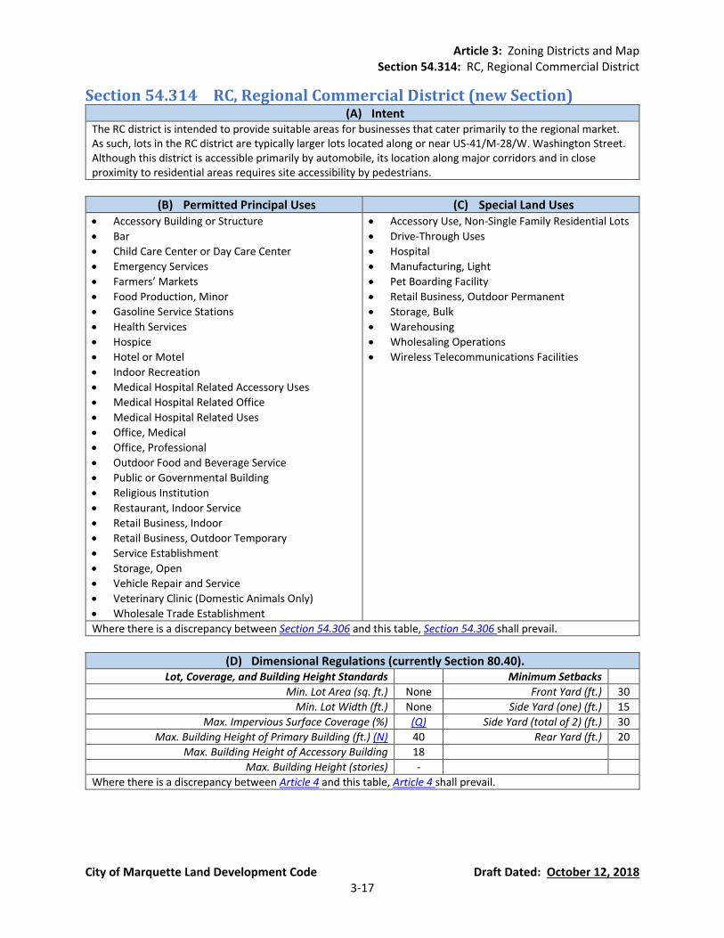
Article 3: Zoning Districts and Map Section 54.314: RC, Regional Commercial District
City of Marquette Land Development Code Draft Dated: October 12, 2018 3-17
Section 54.314 RC, Regional Commercial District (new Section) (A) Intent
The RC district is intended to provide suitable areas for businesses that cater primarily to the regional market. As such, lots in the RC district are typically larger lots located along or near US-41/M-28/W. Washington Street. Although this district is accessible primarily by automobile, its location along major corridors and in close proximity to residential areas requires site accessibility by pedestrians.
(B) Permitted Principal Uses (C) Special Land Uses • Accessory Building or Structure
• Bar
• Child Care Center or Day Care Center
• Emergency Services
• Farmers’ Markets
• Food Production, Minor
• Gasoline Service Stations
• Health Services
• Hospice
• Hotel or Motel
• Indoor Recreation
• Medical Hospital Related Accessory Uses
• Medical Hospital Related Office
• Medical Hospital Related Uses
• Office, Medical
• Office, Professional
• Outdoor Food and Beverage Service
• Public or Governmental Building
• Religious Institution
• Restaurant, Indoor Service
• Retail Business, Indoor
• Retail Business, Outdoor Temporary
• Service Establishment
• Storage, Open
• Vehicle Repair and Service
• Veterinary Clinic (Domestic Animals Only)
• Wholesale Trade Establishment
• Accessory Use, Non-Single Family Residential Lots
• Drive-Through Uses
• Hospital
• Manufacturing, Light
• Pet Boarding Facility
• Retail Business, Outdoor Permanent
• Storage, Bulk
• Warehousing
• Wholesaling Operations
• Wireless Telecommunications Facilities
Where there is a discrepancy between Section 54.306 and this table, Section 54.306 shall prevail.
(D) Dimensional Regulations (currently Section 80.40). Lot, Coverage, and Building Height Standards Minimum Setbacks
Min. Lot Area (sq. ft.) None Front Yard (ft.) 30
Min. Lot Width (ft.) None Side Yard (one) (ft.) 15
Max. Impervious Surface Coverage (%) (Q) Side Yard (total of 2) (ft.) 30
Max. Building Height of Primary Building (ft.) (N) 40 Rear Yard (ft.) 20
Max. Building Height of Accessory Building 18
Max. Building Height (stories) -
Where there is a discrepancy between Article 4 and this table, Article 4 shall prevail.
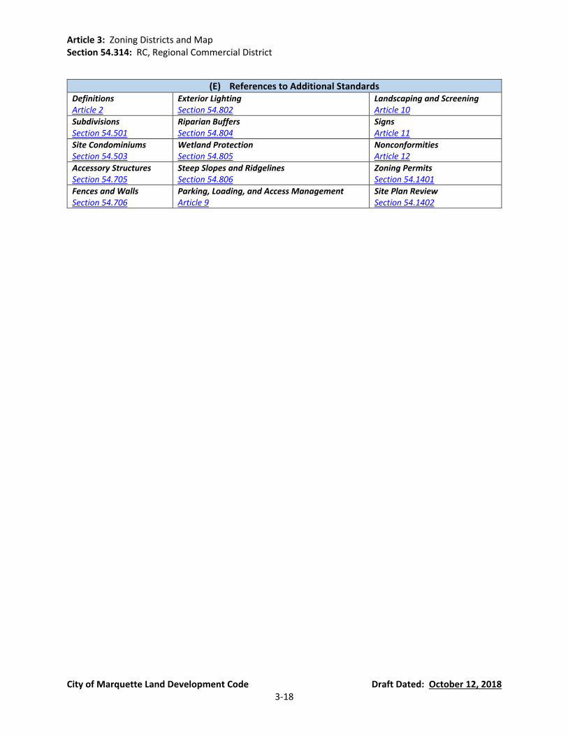
Article 3: Zoning Districts and Map Section 54.314: RC, Regional Commercial District
City of Marquette Land Development Code Draft Dated: October 12, 2018 3-18
(E) References to Additional Standards Definitions Article 2
Exterior Lighting Section 54.802
Landscaping and Screening Article 10
Subdivisions Section 54.501
Riparian Buffers Section 54.804
Signs Article 11
Site Condominiums Section 54.503
Wetland Protection Section 54.805
Nonconformities Article 12
Accessory Structures Section 54.705
Steep Slopes and Ridgelines Section 54.806
Zoning Permits Section 54.1401
Fences and Walls Section 54.706
Parking, Loading, and Access Management Article 9
Site Plan Review Section 54.1402
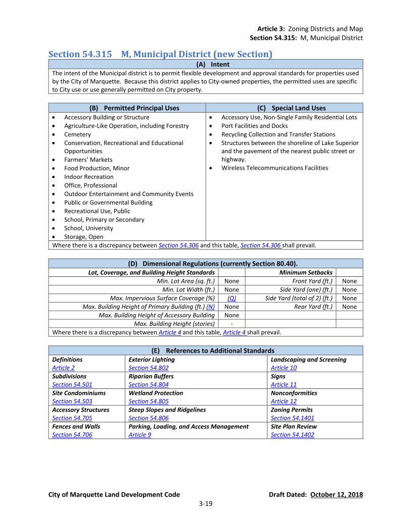
Article 3: Zoning Districts and Map Section 54.315: M, Municipal District
City of Marquette Land Development Code Draft Dated: October 12, 2018 3-19
Section 54.315 M, Municipal District (new Section) (A) Intent
The intent of the Municipal district is to permit flexible development and approval standards for properties used by the City of Marquette. Because this district applies to City-owned properties, the permitted uses are specific to City use or use generally permitted on City property.
(B) Permitted Principal Uses (C) Special Land Uses • Accessory Building or Structure
• Agriculture-Like Operation, including Forestry
• Cemetery
• Conservation, Recreational and Educational Opportunities
• Farmers’ Markets
• Food Production, Minor
• Indoor Recreation
• Office, Professional
• Outdoor Entertainment and Community Events
• Public or Governmental Building
• Recreational Use, Public
• School, Primary or Secondary
• School, University
• Storage, Open
• Accessory Use, Non-Single Family Residential Lots
• Port Facilities and Docks
• Recycling Collection and Transfer Stations
• Structures between the shoreline of Lake Superior and the pavement of the nearest public street or highway.
• Wireless Telecommunications Facilities
Where there is a discrepancy between Section 54.306 and this table, Section 54.306 shall prevail.
(D) Dimensional Regulations (currently Section 80.40). Lot, Coverage, and Building Height Standards Minimum Setbacks
Min. Lot Area (sq. ft.) None Front Yard (ft.) None
Min. Lot Width (ft.) None Side Yard (one) (ft.) None
Max. Impervious Surface Coverage (%) (Q) Side Yard (total of 2) (ft.) None
Max. Building Height of Primary Building (ft.) (N) None Rear Yard (ft.) None
Max. Building Height of Accessory Building None
Max. Building Height (stories) -
Where there is a discrepancy between Article 4 and this table, Article 4 shall prevail.
(E) References to Additional Standards Definitions Article 2
Exterior Lighting Section 54.802
Landscaping and Screening Article 10
Subdivisions Section 54.501
Riparian Buffers Section 54.804
Signs Article 11
Site Condominiums Section 54.503
Wetland Protection Section 54.805
Nonconformities Article 12
Accessory Structures Section 54.705
Steep Slopes and Ridgelines Section 54.806
Zoning Permits Section 54.1401
Fences and Walls Section 54.706
Parking, Loading, and Access Management Article 9
Site Plan Review Section 54.1402
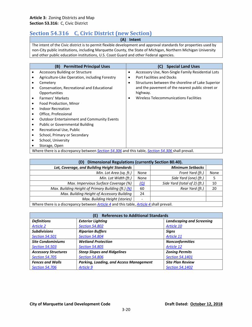
Article 3: Zoning Districts and Map Section 53.316: C, Civic District
City of Marquette Land Development Code Draft Dated: October 12, 2018 3-20
Section 54.316 C, Civic District (new Section) (A) Intent
The intent of the Civic district is to permit flexible development and approval standards for properties used by non-City public institutions, including Marquette County, the State of Michigan, Northern Michigan University and other public education institutions, U.S. Coast Guard and other Federal agencies.
(B) Permitted Principal Uses (C) Special Land Uses • Accessory Building or Structure
• Agriculture-Like Operation, including Forestry
• Cemetery
• Conservation, Recreational and Educational Opportunities
• Farmers’ Markets
• Food Production, Minor
• Indoor Recreation
• Office, Professional
• Outdoor Entertainment and Community Events
• Public or Governmental Building
• Recreational Use, Public
• School, Primary or Secondary
• School, University
• Storage, Open
• Accessory Use, Non-Single Family Residential Lots
• Port Facilities and Docks
• Structures between the shoreline of Lake Superior and the pavement of the nearest public street or highway.
• Wireless Telecommunications Facilities
Where there is a discrepancy between Section 54.306 and this table, Section 54.306 shall prevail.
(D) Dimensional Regulations (currently Section 80.40). Lot, Coverage, and Building Height Standards Minimum Setbacks
Min. Lot Area (sq. ft.) None Front Yard (ft.) None
Min. Lot Width (ft.) None Side Yard (one) (ft.) 5
Max. Impervious Surface Coverage (%) (Q) Side Yard (total of 2) (ft.) 10
Max. Building Height of Primary Building (ft.) (N) 60 Rear Yard (ft.) 20
Max. Building Height of Accessory Building 24
Max. Building Height (stories) -
Where there is a discrepancy between Article 4 and this table, Article 4 shall prevail.
(E) References to Additional Standards Definitions Article 2
Exterior Lighting Section 54.802
Landscaping and Screening Article 10
Subdivisions Section 54.501
Riparian Buffers Section 54.804
Signs Article 11
Site Condominiums Section 54.503
Wetland Protection Section 54.805
Nonconformities Article 12
Accessory Structures Section 54.705
Steep Slopes and Ridgelines Section 54.806
Zoning Permits Section 54.1401
Fences and Walls Section 54.706
Parking, Loading, and Access Management Article 9
Site Plan Review Section 54.1402
Article 3: Zoning Districts and Map Section 53.317: IM, Industrial/Manufacturing District
City of Marquette Land Development Code Draft Dated: October 12, 2018 3-21
Section 54.317 IM, Industrial/Manufacturing District (currently Section 80.27)
(A) Intent (currently Section 80.27(1)) It is the intent of the Industrial/Manufacturing district to regulate the establishment of industrial uses in the city in such a way as to prevent the deterioration of the environment to protect the desired qualities of adjoining districts and to exert a minimum nuisance on adjacent uses within this district.
(B) Permitted Principal Uses (currently Section 80.27(2)).
(C) Special Land Uses (currently Section 80.27(4)).
• Accessory Building or Structure • Food Production, Minor • Gasoline Service Stations • Indoor Recreation • Manufacturing, Light • Office, Medical • Office, Professional • Public or Governmental Building • Railroad Facilities • Religious Institution • Retail Business, Indoor • Service Establishment • Storage, Open • Vehicle Repair and Service • Veterinary Clinic (Domestic Animals Only) • Warehousing • Wholesale Trade Establishment • Wholesaling Operations • Wireless Telecommunications Facilities
• Accessory Use, Non-Single Family Residential Lots
• Adult Entertainment Uses
• Major Repair and Maintenance Operations
• Manufacturing, Heavy
• Pet Boarding Facility
• Retail Business, Outdoor Permanent
• Storage, Bulk
Where there is a discrepancy between Section 54.306 and this table, Section 54.306 shall prevail.
(D) Dimensional Regulations (currently Section 80.40).
Lot, Coverage, and Building Height Standards Minimum Setbacks Min. Lot Area (sq. ft.) None Front Yard (ft.) 40
Min. Lot Width (ft.) None Side Yard (one) (ft.) 20 Max. Impervious Surface Coverage (%) (Q) Side Yard (total of 2) (ft.) 40
Max. Building Height of Primary Building (ft.) (N) 80 (M) Rear Yard (ft.) 40 Max. Building Height of Accessory Building 60 (M)
Max. Building Height (stories) - Where there is a discrepancy between Article 4 and this table, Article 4 shall prevail.
(E) References to Additional Standards (new Section).
Definitions Article 2
Exterior Lighting Section 54.802
Landscaping and Screening Article 10
Subdivisions Section 54.501
Riparian Buffers Section 54.804
Signs Article 11
Site Condominiums Section 54.503
Wetland Protection Section 54.805
Nonconformities Article 12
Accessory Structures Section 54.705
Steep Slopes and Ridgelines Section 54.806
Zoning Permits Section 54.1401
Fences and Walls Section 54.706
Parking, Loading, and Access Management Article 9
Site Plan Review Section 54.1402
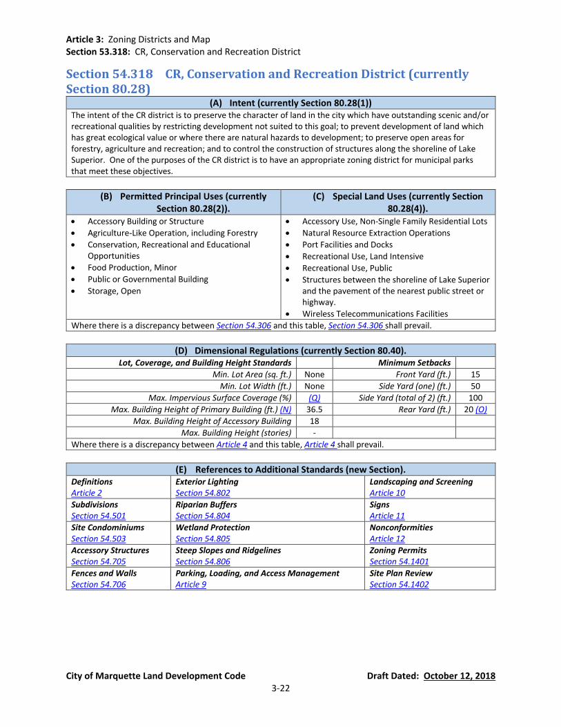
Article 3: Zoning Districts and Map Section 53.318: CR, Conservation and Recreation District
City of Marquette Land Development Code Draft Dated: October 12, 2018 3-22
Section 54.318 CR, Conservation and Recreation District (currently Section 80.28)
(A) Intent (currently Section 80.28(1)) The intent of the CR district is to preserve the character of land in the city which have outstanding scenic and/or recreational qualities by restricting development not suited to this goal; to prevent development of land which has great ecological value or where there are natural hazards to development; to preserve open areas for forestry, agriculture and recreation; and to control the construction of structures along the shoreline of Lake Superior. One of the purposes of the CR district is to have an appropriate zoning district for municipal parks that meet these objectives.
(B) Permitted Principal Uses (currently Section 80.28(2)).
(C) Special Land Uses (currently Section 80.28(4)).
• Accessory Building or Structure
• Agriculture-Like Operation, including Forestry
• Conservation, Recreational and Educational Opportunities
• Food Production, Minor
• Public or Governmental Building
• Storage, Open
• Accessory Use, Non-Single Family Residential Lots
• Natural Resource Extraction Operations
• Port Facilities and Docks
• Recreational Use, Land Intensive
• Recreational Use, Public
• Structures between the shoreline of Lake Superior and the pavement of the nearest public street or highway.
• Wireless Telecommunications Facilities
Where there is a discrepancy between Section 54.306 and this table, Section 54.306 shall prevail.
(D) Dimensional Regulations (currently Section 80.40). Lot, Coverage, and Building Height Standards Minimum Setbacks
Min. Lot Area (sq. ft.) None Front Yard (ft.) 15
Min. Lot Width (ft.) None Side Yard (one) (ft.) 50
Max. Impervious Surface Coverage (%) (Q) Side Yard (total of 2) (ft.) 100
Max. Building Height of Primary Building (ft.) (N) 36.5 Rear Yard (ft.) 20 (O)
Max. Building Height of Accessory Building 18
Max. Building Height (stories) -
Where there is a discrepancy between Article 4 and this table, Article 4 shall prevail.
(E) References to Additional Standards (new Section). Definitions Article 2
Exterior Lighting Section 54.802
Landscaping and Screening Article 10
Subdivisions Section 54.501
Riparian Buffers Section 54.804
Signs Article 11
Site Condominiums Section 54.503
Wetland Protection Section 54.805
Nonconformities Article 12
Accessory Structures Section 54.705
Steep Slopes and Ridgelines Section 54.806
Zoning Permits Section 54.1401
Fences and Walls Section 54.706
Parking, Loading, and Access Management Article 9
Site Plan Review Section 54.1402
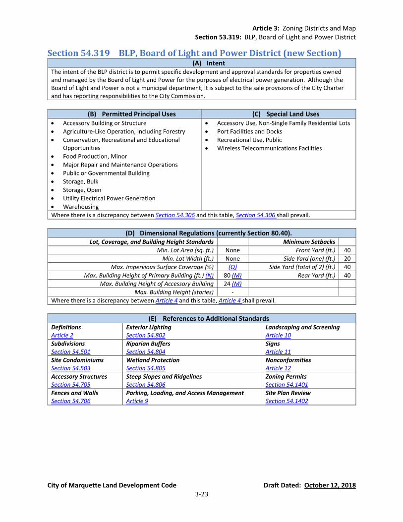
Article 3: Zoning Districts and Map Section 53.319: BLP, Board of Light and Power District
City of Marquette Land Development Code Draft Dated: October 12, 2018 3-23
Section 54.319 BLP, Board of Light and Power District (new Section) (A) Intent
The intent of the BLP district is to permit specific development and approval standards for properties owned and managed by the Board of Light and Power for the purposes of electrical power generation. Although the Board of Light and Power is not a municipal department, it is subject to the sale provisions of the City Charter and has reporting responsibilities to the City Commission.
(B) Permitted Principal Uses (C) Special Land Uses • Accessory Building or Structure
• Agriculture-Like Operation, including Forestry
• Conservation, Recreational and Educational Opportunities
• Food Production, Minor
• Major Repair and Maintenance Operations
• Public or Governmental Building
• Storage, Bulk
• Storage, Open
• Utility Electrical Power Generation
• Warehousing
• Accessory Use, Non-Single Family Residential Lots
• Port Facilities and Docks
• Recreational Use, Public
• Wireless Telecommunications Facilities
Where there is a discrepancy between Section 54.306 and this table, Section 54.306 shall prevail.
(D) Dimensional Regulations (currently Section 80.40). Lot, Coverage, and Building Height Standards Minimum Setbacks
Min. Lot Area (sq. ft.) None Front Yard (ft.) 40
Min. Lot Width (ft.) None Side Yard (one) (ft.) 20
Max. Impervious Surface Coverage (%) (Q) Side Yard (total of 2) (ft.) 40
Max. Building Height of Primary Building (ft.) (N) 80 (M) Rear Yard (ft.) 40
Max. Building Height of Accessory Building 24 (M)
Max. Building Height (stories) -
Where there is a discrepancy between Article 4 and this table, Article 4 shall prevail.
(E) References to Additional Standards Definitions Article 2
Exterior Lighting Section 54.802
Landscaping and Screening Article 10
Subdivisions Section 54.501
Riparian Buffers Section 54.804
Signs Article 11
Site Condominiums Section 54.503
Wetland Protection Section 54.805
Nonconformities Article 12
Accessory Structures Section 54.705
Steep Slopes and Ridgelines Section 54.806
Zoning Permits Section 54.1401
Fences and Walls Section 54.706
Parking, Loading, and Access Management Article 9
Site Plan Review Section 54.1402

Article 3: Zoning Districts and Map Section 54.320: RO, Riparian Overlay District
City of Marquette Land Development Code Draft Dated: October 12, 2018 3-24
Section 54.320 RO, Riparian Overlay District (new Section)
(A) Purpose. The purpose of a Riparian Overlay District in the City of Marquette is fulfill the objectives of the City of Marquette Community Master Plan of ensuring the protection of water quality within the local waterways and ultimately Lake Superior. Erosion and sedimentation reduce water quality by adding excessive amounts of nutrients, animal wastes, toxins, and turbidity in storm runoff. The enhancement of the natural vegetation adjacent to waterways is intended to protect the physical integrity of the system, reduce the amount of non-point source pollution entering these systems, and protect and enhance the aquatic habitat of the region.
(B) Intent. The intent of the Riparian Overlay District to fulfill the objectives of the City of
Marquette Community Master Plan which includes establishing minimal acceptable requirements for the design and preservation of buffers to protect the waterways, wetlands, and floodplains of the City of Marquette and to protect the water quality of Lake Superior, watercourses, reservoirs, lakes, and other significant water resources within the City of Marquette.
(C) Background. Buffers adjacent to waterways help water quality by providing numerous
environmental protection and resource management benefits that can include the following:
Restoring and maintaining the chemical, physical, and biological integrity of the water resources.
Removing and filtering pollutants delivered from urban storm water.
Reducing erosion and sediment entering the waterway.
Stabilizing stream banks.
Providing infiltration of storm water runoff.
Maintaining base flow of streams.
Contributing the natural organic matter that is a source of food and energy for the aquatic
ecosystem.
Providing tree canopy to shade waterways, keeping dissolved oxygen levels high, and promoting desirable aquatic organisms.
Encouraging riparian wildlife habitat.
Furnishing scenic value and recreational opportunity for residents and visitors alike.
It is the desire of the City of Marquette to protect and maintain the native vegetation in riparian and wetland areas by implementing specifications for the establishment, protection, and maintenance of vegetation along all waterways within the City’s jurisdictional authority.

Article 3: Zoning Districts and Map Section 54.320: RO, Riparian Overlay District
City of Marquette Land Development Code Draft Dated: October 12, 2018 3-25
(D) Definitions. In addition to the general definitions of Article 2, the following definitions shall apply to the Riparian Overlay District:
Best Management Practices (BMPs). See Article 2.
Buffer. A vegetated area, including trees, shrubs, and herbaceous vegetation, that exists
or is established to protect a waterway, lake, or reservoir.
Buffer Corridor. The total width of the buffers on each side of a waterway and the waterway itself.
Wetlands. See Article 2.
Nonpoint Source Pollution. See Article 2.
Stream Channel. See Article 2.
Top of Bank. The top of bank is the point on the bank or shore up to which the presence
and action of the water is so continuous as to leave a distinct mark either by erosion, destruction of terrestrial vegetation or other easily recognized characteristic.
Waterway. See Article 2.
Water Pollution. See Article 2.
Water Pollution Hazard. See Article 2.
(E) Boundary of Riparian Overlay District. The RO district is a floating zone on the Official Zoning
Map with boundaries determined by the presence of regulated natural features such as waterways, steep slopes, and wetlands, where development or disturbance may adversely affect water quality, wetlands, or other waterbodies. Where a portion of a parcel is within the RO district, the regulations of the RO district shall apply only to that portion of the parcel within the RO district. The RO district includes any land that is located within:
A waterway, including the top bank, and 25 feet perpendicularly away from the bank plus
any additional buffer width as specified in this Section.
A wetland and 10 feet beyond the edge of the wetland.
Steep slopes adjacent to a waterway, which are added to the 25-foot riparian buffer of a waterway or drain (Section 54.320(E)(1)) in relation to the slope of the bank, calculated as follows: (See Figure 42 in Section 54.806 regarding calculating the percentage of a slope.)
Percent Slope Buffer Extension
Total Width of Riparian Buffer
Total Width of Buffer Corridor
15%-17% Add 5 feet 30 feet Waterway plus 60 feet
18%-20% Add 10 feet 35 feet Waterway plus 70 feet
21%-23% Add 15 feet 40 feet Waterway plus 80 feet

Article 3: Zoning Districts and Map Section 54.320: RO, Riparian Overlay District
City of Marquette Land Development Code Draft Dated: October 12, 2018 3-26
24%-25% Add 20 feet 45 feet Waterway plus 90 feet
Greater than 25% Add 25 feet 50 feet Waterway plus 100 feet
(F) Vegetative Strip Required. A riparian buffer for the areas delineated in Section 54.320(E) shall
consist of a vegetated strip of land extending along both sides of the waterway and its adjacent wetlands or steep slopes. The riparian buffer shall contain undisturbed (unmowed) native vegetation. Permitted species must comply with Section 54.320(H)(5).
(G) Permitted and Prohibited Uses and Structures in Riparian Buffers. The riparian buffer,
including wetlands and steep slopes, shall be managed to enhance and maximize the unique value of these resources. Management includes specific limitations on alteration of the natural conditions of these resources as follows:
Allowable Uses and Structures. No buildings or impervious surfaces shall be constructed
or placed within the riparian buffer area except as permitted within this ordinance. The following structures, practices, and activities are permitted in the riparian buffer, with specific design or maintenance features, subject to the review of the City of Marquette Planning Commission, and subject to all applicable Local, State and Federal regulations. (a) Roads, road crossings, bridges, paths, utilities, and utility rights-of-way, where
permitted. (b) Flood control structures in accordance with all applicable regulatory permits. (c) An access path perpendicular to the waterway which is 10 feet wide. This path may
be mowed. (d) Removal of poison ivy, poison sumac, poison oak and species that are recognized as
highly invasive, as contained on a “List of Invasive Species” maintained on file in the office of the City Clerk.
(e) Stream restoration projects, facilities and activities. (f) Water quality monitoring and stream gauging. (g) Individual trees within the riparian buffer that are in danger of falling on dwellings or
other structures, or causing blockage of the stream may be removed. (h) Other timber cutting techniques within the riparian buffer that are approved by the
City to preserve the forest from extensive pest infestation, disease infestation, or threat from fire.
Prohibited Activities. The following practices and activities are prohibited within the
riparian buffer: (a) Clearing, cutting, and mowing of existing vegetation (except as listed below). (b) Soil disturbance by grading, stripping, or other practices. (c) Filling or dumping. (d) Drainage by ditching, underdrains, or other systems. (e) Use, storage, or application of pesticides and herbicides. (f) Housing, grazing, or other maintenance of livestock. (g) Storage or operation of motorized vehicles, except for permitted maintenance or
emergency use. (h) Use, storage, or application of any fertilizer. (i) Construction or placement of buildings and structures unless permitted by Section
54.320(G)(1).
Article 3: Zoning Districts and Map Section 54.320: RO, Riparian Overlay District
City of Marquette Land Development Code Draft Dated: October 12, 2018 3-27
Water Pollution Hazards. In addition to being prohibited within the required riparian buffers delineated in Section 54.320(E), the following land uses and/or activities are designated as potential water pollution hazards and must be set back from any waterway or waterbody by the distance indicated below: (a) Storage of hazardous substances - (150 feet) (b) Above ground or underground petroleum storage facilities - (150 feet) (c) Drainfields from onsite sewage disposal and treatment system (i.e., septic systems) -
(100 feet) (d) Raised septic systems - (250 feet) (e) Solid waste landfills or junkyards - (300 feet) (f) Confined animal feedlot operations - (250 feet) (g) Land application of biosolids - (100 feet)
(H) Required Planting.
Activities that Require Planting. In addition to maintaining the required vegetative strip
(Section 54.320(F)) within all riparian buffer areas, the following condition(s) shall trigger the requirement for inventorying and, if necessary, planting of native vegetation in areas where riparian buffers are required as shown on the Official Zoning Map: (a) Site plan review for parcel, site condominium, planned unit development (PUD). (b) Application for a building permit. (c) Any work requiring a Soil Erosion and Sedimentation Control Permit. (d) Any work requiring an Inland Lakes and Streams Permit.
Required Plan Information. All plans prepared for recording, site plan review, and all
right-of-way plans shall clearly: (a) Show the extent, including dimensions, of any riparian buffer on the subject
property. (b) Identify all adjacent wetlands. (c) Identify percent slope of lands adjacent to waterway. (d) Identify the 100-year floodplain limits. (e) Label the riparian buffer. (f) Provide a note to reference the riparian buffer stating: “There shall be no clearing,
grading, construction or disturbance of vegetation except as permitted by the City of Marquette”.
Required Native Trees and Shrubs. The following are the required minimum frequencies
for plants in a riparian buffer area when an activity requires inventory and, if necessary, planting (see Section 54.320(H)(5) for species requirements): (a) One (1) native tree per every 10 lineal feet of each stream bank. (b) Four (4) native shrubs per every 10 lineal feet of each stream bank.
Required Native Groundcover. If any part of the riparian buffer area is fallow or lacking
any plants at all, native grass and/or native wildflowers shall be planted using the following (see Section 54.320(H)(5) for species requirements): (a) Grass seed at a rate required by seed package. (b) Straw mulch at one bale per 100 square feet.

Article 3: Zoning Districts and Map Section 54.320: RO, Riparian Overlay District
City of Marquette Land Development Code Draft Dated: October 12, 2018 3-28
Permitted and Prohibited Species of Plantings. A list of allowable and prohibited native species of trees, shrubs, and groundcover shall be maintained by City staff and may include recommended species of the Natural Resources Conservation Service (NRCS) based on general soil type.
(I) Enforcement Procedures. Riparian buffers meeting the requirements of this ordinance are
required on all parcels of land in the city to which they apply. The City of Marquette is authorized and empowered to enforce the requirements of this ordinance in accordance with Article 15 and other applicable provisions of this ordinance.
(J) Access. The creation of riparian buffer area by this ordinance shall not be interpreted to mean
that this conveys to the general public the right of access to this area. However, the City of Marquette shall reserve the right to inspect the buffer for compliance to this ordinance.
(K) Waivers. Waivers from the provisions of the Riparian Overlay District must meet the following
requirements:
Buffer Requirements Eligible for Waiver Applications. The City of Marquette Planning Commission may grant a waiver from the provisions of the Riparian Overlay District for the following:
(a) Riparian Buffer Width. The buffer width may be reduced at some points, provided
the average width of the buffer meets the minimum requirement. This averaging of the buffer may be used to allow for the presence of an existing structure or to recover a lost lot. The Planning Commission may consider credit for additional density elsewhere on the site in compensation for the loss of developable land due to the requirements of the Riparian Overlay District. This compensation may increase the total number of dwelling units on the site up to the amount permitted under the base zoning.
(b) Uses and Activities. The following uses and activities may be considered by the
Planning Commission. In granting a request for a waiver, the Planning Commission may require site design, landscaping planting, fencing, signs, and water quality best management practices to reduce adverse impacts on water quality, waterways, wetlands and floodplains. (i) Those projects or activities for which it can be demonstrated that there is no
prudent, practical, or reasonable alternative. (ii) Those projects or activities serving a public need where no feasible alternative is
available. (iii) The repair and maintenance of public improvements where avoidance and
minimization of adverse impacts to wetlands and associated aquatic ecosystems have been addressed.
Waiver Application Requirements. The applicant must submit a written request for a
waiver to the Planning Commission. The application shall include specific reasons justifying the waiver and any other information necessary to evaluate the proposed waiver request. The City shall require an alternative analysis that clearly demonstrates
Article 3: Zoning Districts and Map Section 54.320: RO, Riparian Overlay District
City of Marquette Land Development Code Draft Dated: October 12, 2018 3-29
that no other prudent, practical, or reasonable alternatives exist and that minimal impact will occur as a result of the project or development.
Appeals of Waiver Decisions. Decisions by the Planning Commission on waiver
applications may be appealed to the Board of Zoning Appeals pursuant to Section 54.1404.
Article 3: Zoning Districts and Map Section 54.321: MDW, Marquette Downtown Waterfront District Form-Based Code
City of Marquette Land Development Code Draft Dated: October 12, 2018 3-30
Section 54.321 Marquette Downtown Waterfront District Form-Based Code (currently Section 80.35, to be reformatted into the LDC)
(A) Marquette Downtown Waterfront District Form-Based Code Introduction. The Marquette Downtown Waterfront District Form-Based Code (also referred to herein as "the MDW District ") is a legal document that regulates land-development by setting careful and coherent controls on building form—while employing more flexible parameters relative to building use and density. The MDW District Form-Based Code uses simple and clear graphic prescriptions and parameters for height, siting, and building elements to address the necessities for defining good public space; and broad parameters for regulating use.
The proposed Marquette Downtown Waterfront District is roughly bounded by Lake Superior/Marquette Bay on the east, Front Street on the west, Lakeshore to the north and Baraga Street to the south. (See the REGULATING PLAN in Section 54.321(B)(3) for specific boundaries).
Guiding Principles. With proper urban form, a greater integration of building uses is
natural and comfortable. (a) Buildings form the space of the street. (b) The street is a coherent space, with consistent building form. This agreement of
buildings facing across the street-space contributes to a clear public space and street-space identity.
(c) Buildings oversee the street-space with active fronts. This overview of the street-space contributes to vital and safe public space.
(d) Property lines are physically defined as much as possible. Land should be clearly public or private—in public view and under surveillance or private and protected.
(e) Buildings are designed for towns and cities. Rather than being simply pushed closer together, as in many suburban developments, buildings must be designed for the urban situation within towns and cities. Views are directed to the public space as much as possible.
(f) Vehicle storage/parking, (not including on-street parking), garbage and mechanical equipment are kept away from the street-space.
Intent.
(a) The MDW District Form-Based Code is designed to foster infill redevelopment in a
sustainable mixed-use pattern as part of a vibrant, diverse urban and working waterfront district. The MDW District is intended to promote traditional urban form and a lively mix of uses, allowing for shopfronts, and other commercial uses at the street level, with wide sidewalks and canopy shade trees, overlooked by upper story residences and offices, while maintaining a working waterfront. Physical access and a sense of connection to Lake Superior are very important to the future of the historic downtown.
(b) Redevelopment within the Downtown Waterfront District shall be regulated as set
forth below in order to achieve the vision set forth during the Public Participation

Article 3: Zoning Districts and Map Section 54.321: MDW, Marquette Downtown Waterfront District Form-Based Code
City of Marquette Land Development Code Draft Dated: October 12, 2018 3-31
Charrette in December 2006 and as previously adopted in the Lower Harbor Redevelopment Plan for the designated area.
How to Use the MDW District Code. In order to understand what the MDW District Code
allows on property within the Downtown Waterfront District there are two basic steps. The MDW District Code will explain where the building will sit on the site, the parameters for its three-dimensional form, both required and allowed architectural/functional elements and the range of allowable uses. (For exact dimensions specific to your property, consult with City Staff.)
(a) Initial Steps.
(i) Look at the REGULATING PLAN. Find the property in question. Note the REQUIRED BUILDING LINE (RBL), the parking setback line, and the REQUIRED BUILDING ZONE (RBZ). Note the color of the fronting street-space—this determines the applicable BUILDING FORM STANDARD. (See the key at the lower right of the REGULATING PLAN.)
(ii) Find the appropriate BUILDING FORM STANDARD (BFS) page in the MDW District Code. The BFS will tell you the basic parameters for building on this site in terms of height, siting, elements, and use.
(b) Additional Information. Additional information regarding the street-space is located
in Section 54.321(J)(1) and Section 54.321(J)(2). These sections will show the general parameters for the character of the street-space including vehicular traffic lane widths, curb radii, sidewalk and tree planting area dimensions, and on-street parking configurations.
Components of a Form-Based Code. The primary components of this form-based code
are: the REGULATING PLAN, the BUILDING FORM STANDARDS, Streetscape Principles, illustrative STREET TYPE SPECIFICATIONS, and DEFINITIONS, all of which are included in this Handbook. Many codes also include detailed Streetscape and Architectural Standards. In addition, in order to fully implement a Code, Administrative Procedures are required to incorporate the new standards with existing City processes and procedures.
(a) The Regulating Plan
(i) Building on the Lower Harbor Redevelopment Plan and the public participation charrette, a REGULATING PLAN, has been produced for the Marquette Downtown Waterfront District.
(ii) The REGULATING PLAN is the coding key for the Downtown Waterfront District that provides a public space master plan with specific information on permitted development for each parcel within the district. It provides standards for the disposition of each property or lot and illustrates how each relates to the adjacent properties and street-space.
(iii) The REGULATING PLAN identifies the BUILDING FORM STANDARDS for all building sites within the Waterfront District. It shows how each lot relates to public spaces (STREET-SPACE, CIVIC GREENS, PEDESTRIAN PATHWAYS, etc.) and the surrounding neighborhoods. There may be additional regulations for special locations as identified on the REGULATING PLAN. The key below explains the
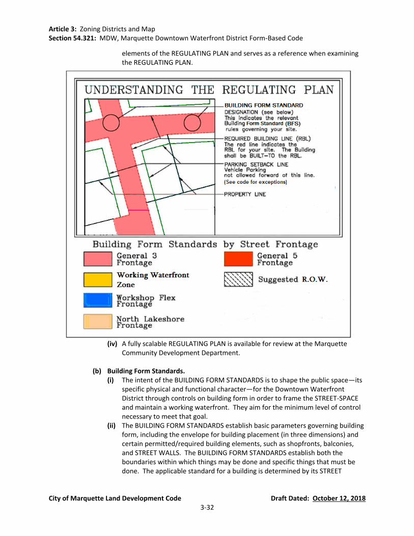
Article 3: Zoning Districts and Map Section 54.321: MDW, Marquette Downtown Waterfront District Form-Based Code
City of Marquette Land Development Code Draft Dated: October 12, 2018 3-32
elements of the REGULATING PLAN and serves as a reference when examining the REGULATING PLAN.
(iv) A fully scalable REGULATING PLAN is available for review at the Marquette
Community Development Department.
(b) Building Form Standards. (i) The intent of the BUILDING FORM STANDARDS is to shape the public space—its
specific physical and functional character—for the Downtown Waterfront District through controls on building form in order to frame the STREET-SPACE and maintain a working waterfront. They aim for the minimum level of control necessary to meet that goal.
(ii) The BUILDING FORM STANDARDS establish basic parameters governing building form, including the envelope for building placement (in three dimensions) and certain permitted/required building elements, such as shopfronts, balconies, and STREET WALLS. The BUILDING FORM STANDARDS establish both the boundaries within which things may be done and specific things that must be done. The applicable standard for a building is determined by its STREET

Article 3: Zoning Districts and Map Section 54.321: MDW, Marquette Downtown Waterfront District Form-Based Code
City of Marquette Land Development Code Draft Dated: October 12, 2018 3-33
FRONTAGE, as identified on the REGULATING PLAN. This produces a coherent STREET-SPACE and allows the building greater latitude behind its street FACADE.
(c) The Street-Space Principles. The purpose of the STREET-SPACE Principles is to define
coherent street-space and to assist owners and builders with understanding the relationship between the public space of the Downtown Waterfront District and their own building/lot. These principles describe the parameters for the placement of STREET TREES and other amenities or appurtenances (e.g., benches, signs, street lights, etc.) on or near each building site. They also describe the general physical characteristics of a STREET-SPACE to establish an environment that encourages and facilitates pedestrian activity.
(d) The Street-Type Specifications.
(i) The Street-Type Specifications illustrate recommended configurations for streets within the Downtown Waterfront District. Specifications address vehicular traffic lane widths, curb radii, sidewalk and tree planting area dimensions, and on-street parking configurations. They also provide a comparative pedestrian crossing distance as a gauge of pedestrian comfort. These specifications may be modified by the Planning Commission to meet the needs of streets that have more or less right of way.
(ii) Streets must balance the needs of all forms of traffic—auto, bicycle and pedestrian—to maximize mobility and convenience for all the citizens of Marquette and all users of the Downtown Waterfront District. While all streets will appropriately balance pedestrian and automobile needs, their character will vary with their location. Some streets will carry a large volume of traffic and provide a more active and intense urban pedestrian experience while others will provide a less active and more intimately scaled street-space.
(e) Definitions. Some words used in the MDW District are used in a more specific way
than that found in common usage, and have been defined herein. Wherever a word is in CAPITAL LETTER format, consult the Definitions (Section 54.321(K)) for the specific meaning. Words used in the Downtown Waterfront District, but not defined by the Downtown Waterfront District, which are defined in Article 2, shall have the meanings set forth therein.
(f) Approval Process. In order to obtain zoning compliance approval for construction
within the boundaries of this district, an applicant shall follow the process outlined in Section 54.1402 of the City of Marquette Land Development Code; however, Planning Commission review and approval of a site plan is not necessary unless otherwise provided in this Section.
Article 3: Zoning Districts and Map Section 54.321: MDW, Marquette Downtown Waterfront District Form-Based Code
City of Marquette Land Development Code Draft Dated: October 12, 2018 3-34
Conflicting Provisions. Wherever there appears to be a conflict between the MDW District Form-Based Code and other sections of the Marquette City Land Development Code, the requirements specifically set forth in the MDW District Form-Based Code shall prevail. For development standards not covered by the MDW District Code, the other applicable sections in the Marquette City Land Development Code shall be used as the requirement. Similarly, all development must comply with all relative Federal, State or local regulations and ordinances regarding health and safety.
(B) The Downtown Waterfront District Regulating Plan.
Understanding the Regulating Plan. The REGULATING PLAN is the controlling document
and principal tool for implementing the MDW District Code. It identifies the BUILDING FORM STANDARD (BFS) for the building site, which provides standards for the disposition of each property or lot, and illustrates how each relates to the adjacent properties and the street-space.
Rules for New Development. New development in the Downtown Waterfront District
shall integrate street (roadway) design and land development to create a complementary and connected pattern for growth and development. The rules below will establish/create a compact, mixed-use district and provide flexible opportunities for residential, employment, commerce, and recreational uses.
(a) Streets, Blocks and Alleys
(i) Connectivity of the street grid throughout the MDW District, specifically intersection alignments, is regulated by this Section. Where a street stub-out is shown on the REGULATING PLAN, no other curb cut/intersecting street is permitted within 50 feet.
(ii) Curb cuts shall be limited to no more than one per 100 feet of street frontage (minimum centerline separation distance of 50 feet). All curb cuts and separation distances must meet the requirements of Chapter 42 of the Code of Ordinances (Streets, Sidewalks, and Other Public Places).
(iii) All lots, except those found in the WORKING WATERFRONT, shall share a frontage line with a STREET-SPACE.
(iv) All lots and/or all contiguous lots shall be considered to be part of a BLOCK for this purpose. No block face shall have a length greater than 400 feet without an ALLEY, common drive or access easement, or PEDESTRIAN PATHWAY providing through-access to another street, ALLEY or common access easement, STREET-SPACE, or conservation restricted land. Individual lots with less than 75 feet of frontage are exempt from the requirement to interrupt the block face; those with over 250 feet of frontage shall meet the requirement within their lot, unless already satisfied within that block face.
(v) Where designated on the REGULATING PLAN, except where lots are on a perimeter common to non-developable, lakeshore, or conservation lands: a. ALLEYS shall provide access to the rear of all lots. ALLEY construction is
required as part of the redevelopment project within the rear setback, unless an ALLEY already exists. ALLEYS shall be constructed to meet the City construction standards in order to be suitable for emergency and service vehicle access.

Article 3: Zoning Districts and Map Section 54.321: MDW, Marquette Downtown Waterfront District Form-Based Code
City of Marquette Land Development Code Draft Dated: October 12, 2018 3-35
b. ALLEYS shown on the REGULATING PLAN represent suggested & approximate configurations. Access through the BLOCK and to the rear of lots within the BLOCK is required. The specific configuration may include shared parking areas and other uses so long as reasonable service access is relatively unimpeded.
c. Where an alley does not exist and is not feasible to construct at the time of redevelopment of any property, the applicant is required to maintain the area within the rear setback by, at a minimum: i. Sodding and providing routine landscape maintenance to the area. ii. Keeping the area clear of debris, stored materials, and vehicles.
(vi) Stub streets shown on the REGULATING PLAN are not considered to be established until the City of Marquette obtains the property. Until this occurs, the RBL/RBZ will be the current property line.
(b) Buildings
(i) The maximum building floor-plate (footprint) is 25,000 square feet; beyond that limit a Site Plan Review in accordance with Section 54.1402 of the City Land Development Code is required.
(ii) Building FACADES are the public "face" of every building. (The private, interior portions of the lots allow commercial operators to utilize these spaces as efficient working environments unseen by the public and allow residents to have private and semi-private (for apartment and condominium buildings) gardens and courtyards.)
(iii) For each block face within the Waterfront District, building(s) along an RBL shall present a complete and discrete vertical FAÇADE composition (i.e., a new façade design) at an average street frontage length of no greater than 70 feet. Each FAÇADE composition shall include a functioning, primary street-space entry. The entry requirement may be satisfied through the use of liner shops—small shops with direct access onto the fronting sidewalk—wrapping large floor-plate/footprint buildings. Individual infill projects on lots with frontage of less than 100 feet are exempted from the FAÇADE composition requirement.
(iv) When the BUILDING FORM STANDARD (BFS) designation changes along the RBL of a lot, the property owner has the option of applying either BFS for a maximum additional distance of 50 feet in either direction along the RBL of that lot.
(v) All buildings shall be designed to minimize the shedding of snow and rain runoff into the STREET-SPACE.
(vi) Cladding materials shall be of typical wood finish materials, typical masonry materials (e.g. brick, stone, concrete, cement, tile, stucco, granite, limestone, cast stone), and non-polished metals, unless otherwise designated by the individual building form standards. Glass curtain walls, reflective glass, and other materials of greater than 30% reflectance are prohibited due to the undesirable blinding effect compounded by snow. Metal cladding shall be limited to not more than 40% of the non-fenestrated facade area, except in the Working Waterfront and Workshop Flex subdistricts.
(vii) Mechanical and electrical equipment including, but not limited to, air compressors, pumps, exterior water heaters, water softeners, private garbage

Article 3: Zoning Districts and Map Section 54.321: MDW, Marquette Downtown Waterfront District Form-Based Code
City of Marquette Land Development Code Draft Dated: October 12, 2018 3-36
cans (not including public sidewalk waste bins), and storage tanks must be screened in accordance with Section 54.1003(F) and Section 54.1003(G).
(c) Streetscape Requirements. At the time of, and within, new or infill development:
(i) STREET TREES shall be planted at an average spacing of no greater than 30 feet on the side(s) of the STREET-SPACE being developed (dependent available right of way width).
(ii) The developer is required to install sidewalks if none currently exist.
(d) Parking. (i) Parking goals for the Downtown Waterfront District are to:
a. Promote a “park once” environment that will enable people to conveniently park and access a variety of commercial and civic enterprises in pedestrian friendly environments by encouraging shared parking.
b. Reduce fragmented, uncoordinated, inefficient, single-purpose reserved parking.
c. Avoid adverse parking impacts on neighborhoods adjacent to the Waterfront District
d. Maximize on-street parking wherever possible. e. Increase visibility and accessibility of publicly available parking. f. Provide flexibility for redevelopment of small sites. g. Promote early prototype projects using flexible and creative incentives. h. Incorporate convenient bicycle parking.
(ii) A minimum of 1 and 1/8 parking space per residential unit, of which a minimum of 1/8 parking space per residential unit shall be provided as shared parking. There are no maximum limits on shared parking.
(iii) Achieving Parking: a. Parking requirements may be met either on-site or within a 600 foot radius
of the development parcel. b. Shared parking shall be designated by appropriate signage and markings as
required by City policy. c. Vehicular parking spaces may not be placed over a public utility easement
without the approval of the City Engineer and the Zoning Administrator, except where Planning Commission approval is required.
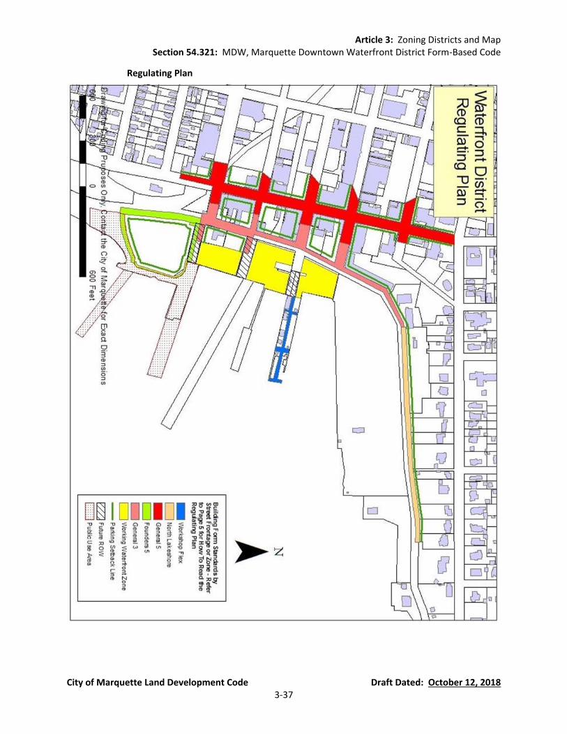
Article 3: Zoning Districts and Map Section 54.321: MDW, Marquette Downtown Waterfront District Form-Based Code
City of Marquette Land Development Code Draft Dated: October 12, 2018 3-37
Regulating Plan
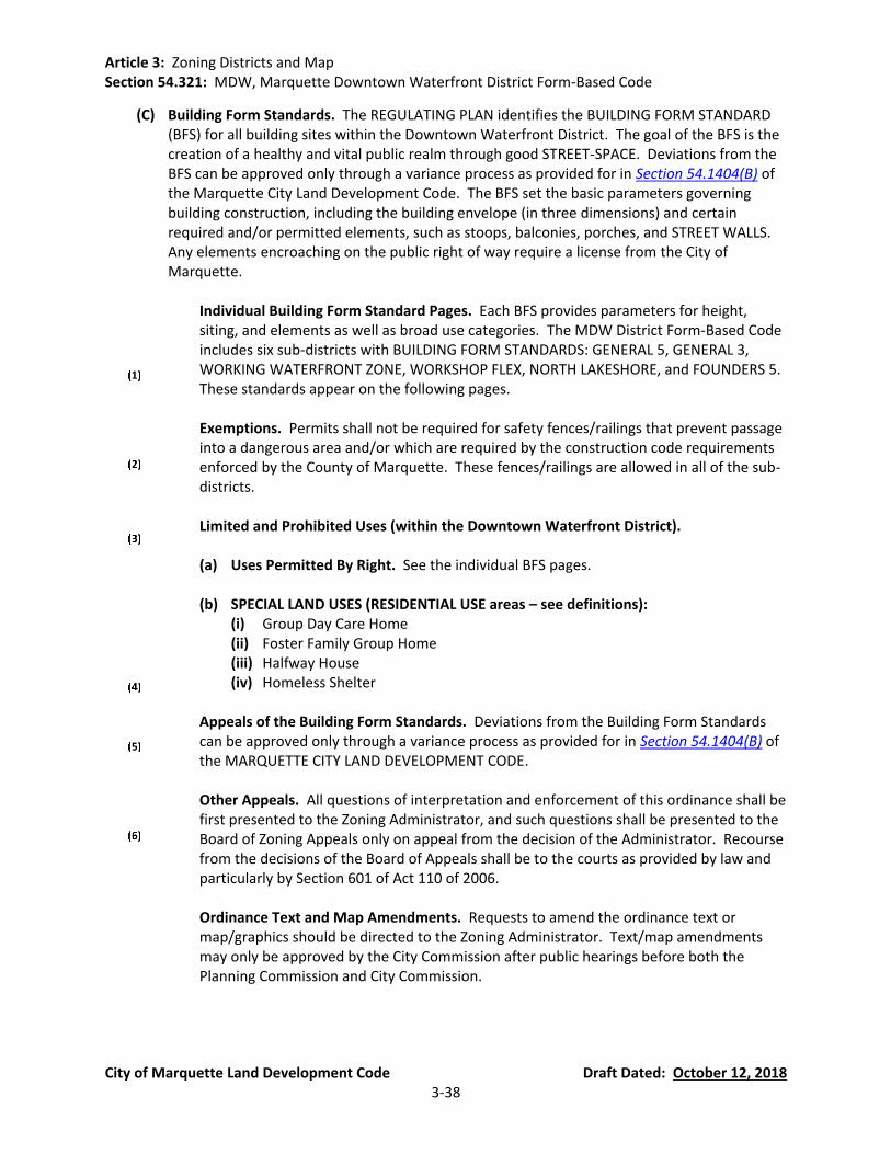
Article 3: Zoning Districts and Map Section 54.321: MDW, Marquette Downtown Waterfront District Form-Based Code
City of Marquette Land Development Code Draft Dated: October 12, 2018 3-38
(C) Building Form Standards. The REGULATING PLAN identifies the BUILDING FORM STANDARD (BFS) for all building sites within the Downtown Waterfront District. The goal of the BFS is the creation of a healthy and vital public realm through good STREET-SPACE. Deviations from the BFS can be approved only through a variance process as provided for in Section 54.1404(B) of the Marquette City Land Development Code. The BFS set the basic parameters governing building construction, including the building envelope (in three dimensions) and certain required and/or permitted elements, such as stoops, balconies, porches, and STREET WALLS. Any elements encroaching on the public right of way require a license from the City of Marquette.
Individual Building Form Standard Pages. Each BFS provides parameters for height,
siting, and elements as well as broad use categories. The MDW District Form-Based Code includes six sub-districts with BUILDING FORM STANDARDS: GENERAL 5, GENERAL 3, WORKING WATERFRONT ZONE, WORKSHOP FLEX, NORTH LAKESHORE, and FOUNDERS 5. These standards appear on the following pages.
Exemptions. Permits shall not be required for safety fences/railings that prevent passage
into a dangerous area and/or which are required by the construction code requirements enforced by the County of Marquette. These fences/railings are allowed in all of the sub-districts.
Limited and Prohibited Uses (within the Downtown Waterfront District).
(a) Uses Permitted By Right. See the individual BFS pages.
(b) SPECIAL LAND USES (RESIDENTIAL USE areas – see definitions):
(i) Group Day Care Home (ii) Foster Family Group Home (iii) Halfway House (iv) Homeless Shelter
Appeals of the Building Form Standards. Deviations from the Building Form Standards
can be approved only through a variance process as provided for in Section 54.1404(B) of the MARQUETTE CITY LAND DEVELOPMENT CODE.
Other Appeals. All questions of interpretation and enforcement of this ordinance shall be
first presented to the Zoning Administrator, and such questions shall be presented to the Board of Zoning Appeals only on appeal from the decision of the Administrator. Recourse from the decisions of the Board of Appeals shall be to the courts as provided by law and particularly by Section 601 of Act 110 of 2006.
Ordinance Text and Map Amendments. Requests to amend the ordinance text or
map/graphics should be directed to the Zoning Administrator. Text/map amendments may only be approved by the City Commission after public hearings before both the Planning Commission and City Commission.
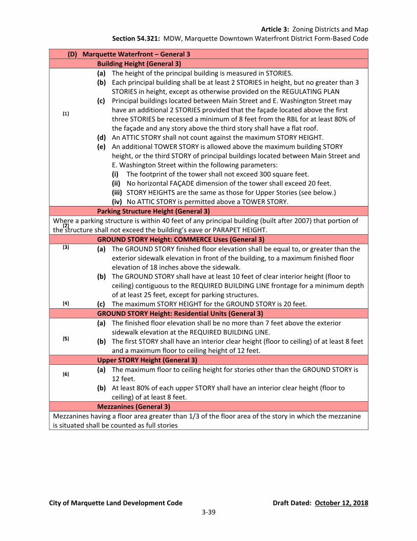
Article 3: Zoning Districts and Map Section 54.321: MDW, Marquette Downtown Waterfront District Form-Based Code
City of Marquette Land Development Code Draft Dated: October 12, 2018 3-39
(D) Marquette Waterfront – General 3
Building Height (General 3)
(a) The height of the principal building is measured in STORIES. (b) Each principal building shall be at least 2 STORIES in height, but no greater than 3
STORIES in height, except as otherwise provided on the REGULATING PLAN (c) Principal buildings located between Main Street and E. Washington Street may
have an additional 2 STORIES provided that the façade located above the first three STORIES be recessed a minimum of 8 feet from the RBL for at least 80% of the façade and any story above the third story shall have a flat roof.
(d) An ATTIC STORY shall not count against the maximum STORY HEIGHT. (e) An additional TOWER STORY is allowed above the maximum building STORY
height, or the third STORY of principal buildings located between Main Street and E. Washington Street within the following parameters: (i) The footprint of the tower shall not exceed 300 square feet. (ii) No horizontal FAÇADE dimension of the tower shall exceed 20 feet. (iii) STORY HEIGHTS are the same as those for Upper Stories (see below.) (iv) No ATTIC STORY is permitted above a TOWER STORY.
Parking Structure Height (General 3)
Where a parking structure is within 40 feet of any principal building (built after 2007) that portion of the structure shall not exceed the building’s eave or PARAPET HEIGHT.
GROUND STORY Height: COMMERCE Uses (General 3)
(a) The GROUND STORY finished floor elevation shall be equal to, or greater than the exterior sidewalk elevation in front of the building, to a maximum finished floor elevation of 18 inches above the sidewalk.
(b) The GROUND STORY shall have at least 10 feet of clear interior height (floor to ceiling) contiguous to the REQUIRED BUILDING LINE frontage for a minimum depth of at least 25 feet, except for parking structures.
(c) The maximum STORY HEIGHT for the GROUND STORY is 20 feet.
GROUND STORY Height: Residential Units (General 3)
(a) The finished floor elevation shall be no more than 7 feet above the exterior sidewalk elevation at the REQUIRED BUILDING LINE.
(b) The first STORY shall have an interior clear height (floor to ceiling) of at least 8 feet and a maximum floor to ceiling height of 12 feet.
Upper STORY Height (General 3)
(a) The maximum floor to ceiling height for stories other than the GROUND STORY is 12 feet.
(b) At least 80% of each upper STORY shall have an interior clear height (floor to ceiling) of at least 8 feet.
Mezzanines (General 3)
Mezzanines having a floor area greater than 1/3 of the floor area of the story in which the mezzanine is situated shall be counted as full stories

Article 3: Zoning Districts and Map Section 54.321: MDW, Marquette Downtown Waterfront District Form-Based Code
City of Marquette Land Development Code Draft Dated: October 12, 2018 3-40
Street FACADE (General 3)
(a) On each lot the building FAÇADE shall be built to the REQUIRED BUILDING LINE for at least 75% of the REQUIRED BUILDING LINE length.
(b) The building FAÇADE shall be built to RBL within 30 feet of a BLOCK CORNER. The ground floor FAÇADE, within 7 feet of the BLOCK CORNER may be chamfered to form a corner entry.
(c) These portions of the building FAÇADE (the required minimum build- to) may include jogs of not more than 18 inches in depth except as otherwise provided to allow bay windows, shopfronts, and balconies.
BUILDABLE AREA (General 3)
(a) Buildings may occupy the portion of the lot specified by these BUILDING FORM STANDARDS.
(b) An OPEN AREA equal to at least 10% of the total BUILDABLE AREA shall be preserved on every lot. Such OPEN AREA may be located anywhere behind the RBL, at or above grade.
(c) No part of any building, except overhanging EAVES, awnings, or balconies shall occupy the remaining lot area.
Side Lot Setbacks (General 3)
There are no side lot setbacks.
Garage and Parking (General 3)
(a) GARAGE ENTRIES or driveways shall be located at least 50 feet away from any BLOCK CORNER or another GARAGE ENTRY on the same BLOCK, unless otherwise designated on the REGULATING PLAN.
(b) GARAGE ENTRIES shall have neither a clear height greater than 16 feet nor a clear width exceeding 24 feet.
(c) Vehicle parking areas on private property shall be located behind the PARKING SETBACK LINE, except where parking is provided inside or below the building.
(d) These requirements are not applicable to on-street parking.
ALLEYS (General 3)
There is no required setback from ALLEYS.
Corner Lots (General 3)
Corner lots shall satisfy the MDW District requirements for the full RBL length – unless otherwise specified in this Section.
Unbuilt REQUIRED BUILDING LINE and COMMON LOT LINE Treatment (General 3)
(a) A STREET WALL no greater than 18 feet in height may be constructed along any RBL frontage that is not otherwise occupied by a building, except on the east side of Lakeshore Boulevard, The STREET WALL shall be located not more than 8 inches behind the REQUIRED BUILDING LINE.
(b) A vehicle entry gate no wider than 18 feet or a pedestrian entry gate no wider than 5 feet shall be permitted within any required STREET WALL.
(c) PRIVACY FENCES may be constructed along that portion of a COMMON LOT LINE not otherwise occupied by a building, except on the east side of Lakeshore Boulevard.
(d) DECORATIVE FENCES of not more than 4 feet in height with not more than 50% of the fence area comprised of solid matter or closed construction, may be constructed along that portion of a common lot line not otherwise occupied by a building

Article 3: Zoning Districts and Map Section 54.321: MDW, Marquette Downtown Waterfront District Form-Based Code
City of Marquette Land Development Code Draft Dated: October 12, 2018 3-41
FENESTRATION (General 3)
(a) Blank lengths of wall exceeding 20 linear feet are prohibited on all REQUIRED BUILDING LINES (RBL).
(b) FENESTRATION on the ground story FACADES shall comprise at least 30%, but not more than ninety 90%, of the FACADE (measured as a percentage of the FACADE between floor levels).
(c) FENESTRATION on the upper STORY FACADES shall comprise at least 20%, but no more than 60%, of the FACADE area per STORY (measured as a percentage of the FACADE between floor levels).
Building Projections (General 3)
(a) Balconies and STOOPS shall not project closer than 5 feet to a COMMON LOT LINE. (b) No part of any building, except overhanging EAVES, awnings, balconies, bay
windows, STOOPS, porches, shopfronts, and mechanical and electrical equipment as specified by the MDW District, shall encroach beyond the REQUIRED BUILDING LINE.
(c) Awnings shall project a minimum of 6 feet and a maximum of within 1 foot of back of curb (where there are no STREET TREES) or 1 foot into the tree lawn (where there are STREET TREES.)
(d) Awnings that project over the sidewalk portion of a STREET-SPACE shall maintain a clear height of at least 10 feet.
(e) Awnings may have supporting posts at their outer edge provided that they: (f) Have a minimum of 8 feet clear width between the FACADE and the support posts
or columns of the awnings. (g) Provide for a continuous public access easement at least 4 feet wide running
adjacent and parallel to the awning columns/posts.
Doors/Entries (General 3)
(a) At least one functioning entry door(s) shall be provided along the GROUND STORY FACADE of each building and at intervals not greater than 60 linear feet.
(b) Doors shall not swing out past the RBL.
Roofs (General 3)
Where the roof is not hidden from the adjacent STREET-SPACE by a PARAPET wall, its pitch shall be between 4:12 and 12:12.
GROUND STORY (General 3)
The GROUND STORY shall house COMMERCE or RESIDENTIAL uses. See height specifications for this sub-district for specific requirements unique to each use.
Upper STORIES (General 3)
(a) The upper STORIES shall house RESIDENTIAL or COMMERCE uses. No retail sales uses shall be allowed in upper STORIES unless they are second STORY extensions equal to or less than the area of the GROUND STORY use.
(b) No COMMERCE use is permitted above a RESIDENTIAL use. (c) Additional habitable space is permitted within the roof where the roof is
configured as an ATTIC STORY. (d) Additional habitable space is permitted within a TOWER STORY.
Permitted Uses (General 3)
RESIDENTIAL, COMMERCE, and LIGHT MANUFACTURING uses as defined by this Section or Article 2, as applicable.
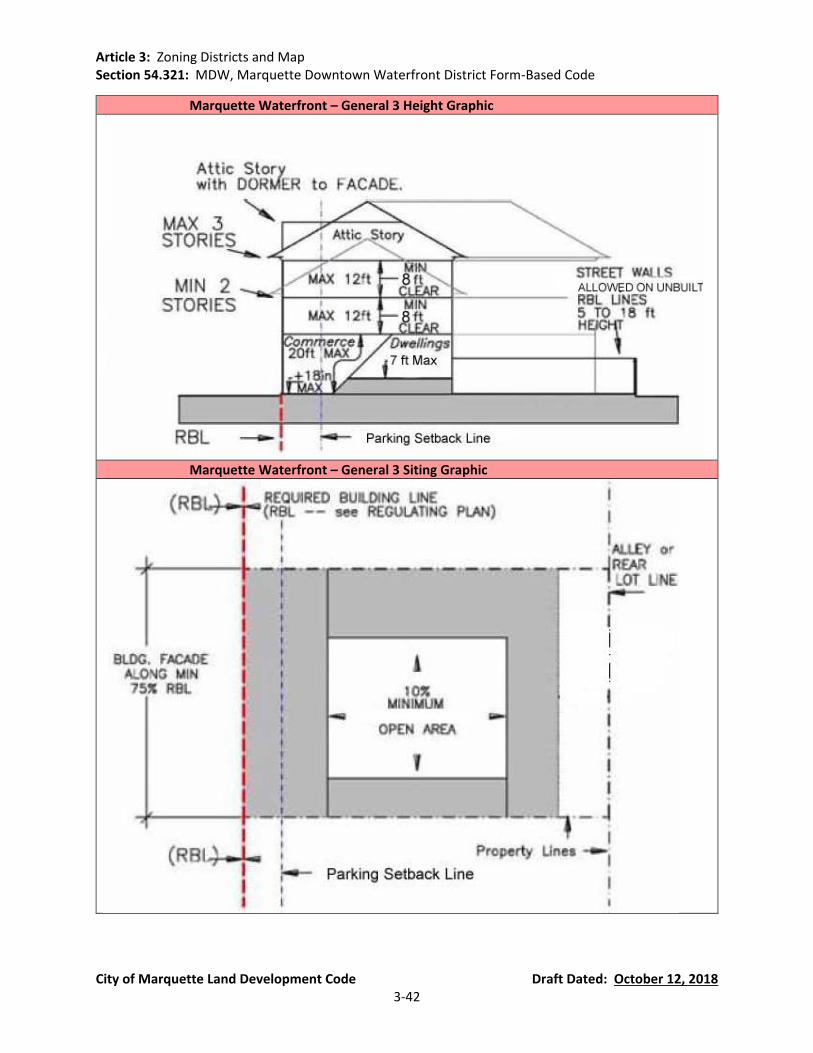
Article 3: Zoning Districts and Map Section 54.321: MDW, Marquette Downtown Waterfront District Form-Based Code
City of Marquette Land Development Code Draft Dated: October 12, 2018 3-42
Marquette Waterfront – General 3 Height Graphic
Marquette Waterfront – General 3 Siting Graphic
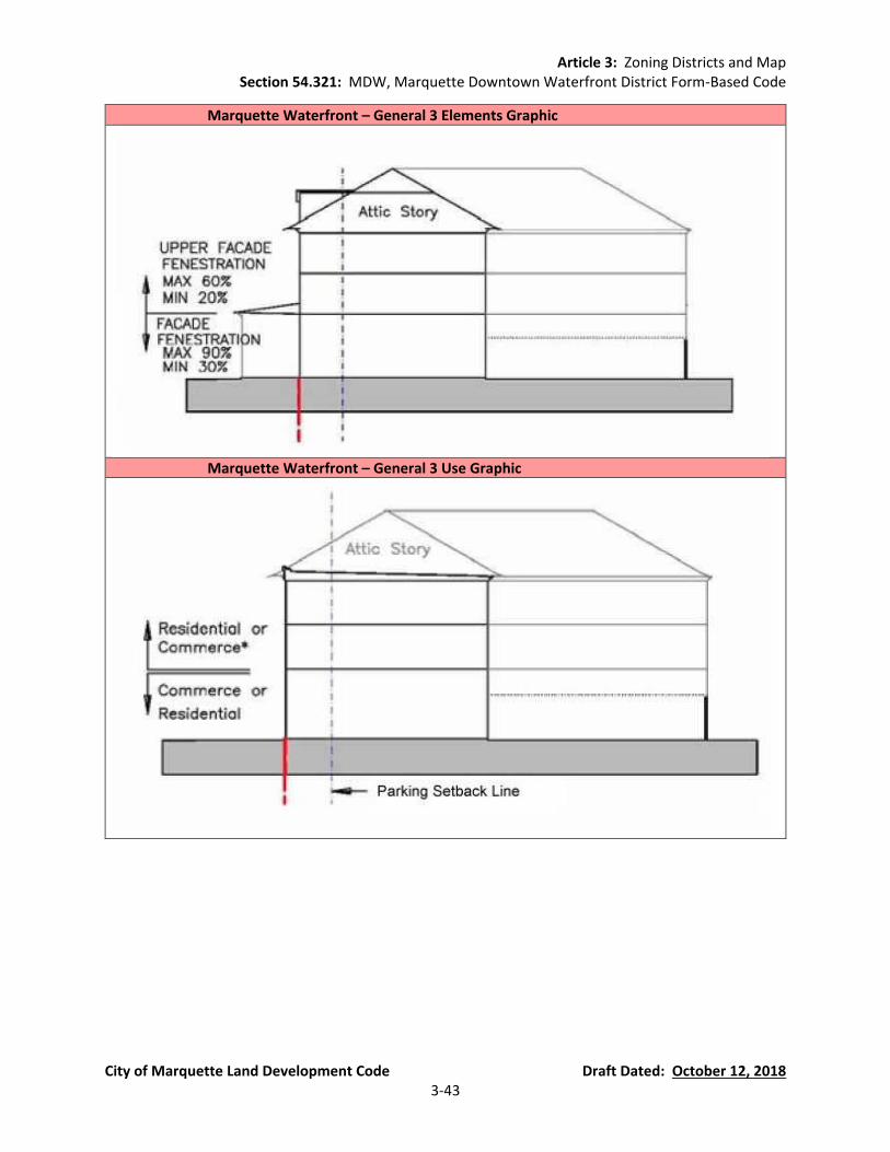
Article 3: Zoning Districts and Map Section 54.321: MDW, Marquette Downtown Waterfront District Form-Based Code
City of Marquette Land Development Code Draft Dated: October 12, 2018 3-43
Marquette Waterfront – General 3 Elements Graphic
Marquette Waterfront – General 3 Use Graphic
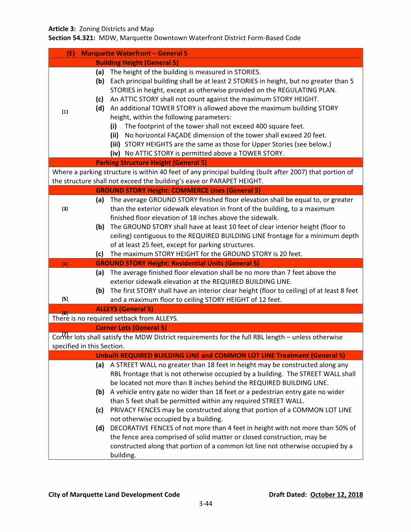
Article 3: Zoning Districts and Map Section 54.321: MDW, Marquette Downtown Waterfront District Form-Based Code
City of Marquette Land Development Code Draft Dated: October 12, 2018 3-44
(E) Marquette Waterfront – General 5
Building Height (General 5)
(a) The height of the building is measured in STORIES. (b) Each principal building shall be at least 2 STORIES in height, but no greater than 5
STORIES in height, except as otherwise provided on the REGULATING PLAN. (c) An ATTIC STORY shall not count against the maximum STORY HEIGHT. (d) An additional TOWER STORY is allowed above the maximum building STORY
height, within the following parameters: (i) The footprint of the tower shall not exceed 400 square feet. (ii) No horizontal FAÇADE dimension of the tower shall exceed 20 feet. (iii) STORY HEIGHTS are the same as those for Upper Stories (see below.) (iv) No ATTIC STORY is permitted above a TOWER STORY.
Parking Structure Height (General 5)
Where a parking structure is within 40 feet of any principal building (built after 2007) that portion of the structure shall not exceed the building’s eave or PARAPET HEIGHT.
GROUND STORY Height: COMMERCE Uses (General 5)
(a) The average GROUND STORY finished floor elevation shall be equal to, or greater than the exterior sidewalk elevation in front of the building, to a maximum finished floor elevation of 18 inches above the sidewalk.
(b) The GROUND STORY shall have at least 10 feet of clear interior height (floor to ceiling) contiguous to the REQUIRED BUILDING LINE frontage for a minimum depth of at least 25 feet, except for parking structures.
(c) The maximum STORY HEIGHT for the GROUND STORY is 20 feet.
GROUND STORY Height: Residential Units (General 5)
(a) The average finished floor elevation shall be no more than 7 feet above the exterior sidewalk elevation at the REQUIRED BUILDING LINE.
(b) The first STORY shall have an interior clear height (floor to ceiling) of at least 8 feet and a maximum floor to ceiling STORY HEIGHT of 12 feet.
ALLEYS (General 5)
There is no required setback from ALLEYS.
Corner Lots (General 5)
Corner lots shall satisfy the MDW District requirements for the full RBL length – unless otherwise specified in this Section.
Unbuilt REQUIRED BUILDING LINE and COMMON LOT LINE Treatment (General 5)
(a) A STREET WALL no greater than 18 feet in height may be constructed along any RBL frontage that is not otherwise occupied by a building. The STREET WALL shall be located not more than 8 inches behind the REQUIRED BUILDING LINE.
(b) A vehicle entry gate no wider than 18 feet or a pedestrian entry gate no wider than 5 feet shall be permitted within any required STREET WALL.
(c) PRIVACY FENCES may be constructed along that portion of a COMMON LOT LINE not otherwise occupied by a building.
(d) DECORATIVE FENCES of not more than 4 feet in height with not more than 50% of the fence area comprised of solid matter or closed construction, may be constructed along that portion of a common lot line not otherwise occupied by a building.

Article 3: Zoning Districts and Map Section 54.321: MDW, Marquette Downtown Waterfront District Form-Based Code
City of Marquette Land Development Code Draft Dated: October 12, 2018 3-45
Upper STORY HEIGHT (General 5)
(a) The maximum floor to ceiling STORY HEIGHT for STORIES other than the GROUND STORY is 12 feet.
(b) At least 80% of each upper story shall have an interior clear height (floor to ceiling) of at least 8 feet.
Mezzanines (General 5)
Mezzanines having a floor area greater than 1/3 of the floor area of the STORY in which the mezzanine is situated shall be counted as full STORIES.
Street FACADE (General 5)
(a) On each lot the building FAÇADE shall be built to the REQUIRED BUILDING LINE for at least 75% of the REQUIRED BUILDING LINE (RBL) length.
(b) The building FAÇADE shall be built to RBL within 30 feet of a BLOCK CORNER. The ground floor FAÇADE, within 7 feet of the BLOCK CORNER may be chamfered to form a corner entry.
(c) These portions of the building FAÇADE (the required minimum build- to) may include jogs of not more than 18 inches in depth except as otherwise provided to allow bay windows, shopfronts, and balconies.
BUILDABLE AREA (General 5)
(a) Buildings may occupy the portion of the lot specified by these BUILDING FORM STANDARDS.
(b) A contiguous OPEN AREA equal to at least 10% of the total BUILDABLE AREA shall be preserved on every lot. Such contiguous OPEN AREA may be located anywhere behind the PARKING SETBACK, at or above grade.
(c) No part of any building, except overhanging EAVES, awnings, or balconies shall occupy the remaining lot area.
Side Lot Setbacks (General 5)
There are no side lot setbacks.
Garage and Parking (General 5)
(a) GARAGE ENTRIES or driveways shall be located at least 50 feet away from any BLOCK CORNER or another GARAGE ENTRY on the same BLOCK, unless otherwise designated on the REGULATING PLAN.
(b) GARAGE ENTRIES shall have neither a clear height greater than16 feet nor a clear width exceeding 24 feet.
(c) Vehicle parking areas on private property shall be located behind the PARKING SETBACK LINE, except where parking is provided below grade(measured such that the upper ceiling of the parking shall not exceed 18 inches above the sidewalk in front of the building)
(d) These requirements are not applicable to on-street parking.
FENESTRATION (General 5)
(a) Blank lengths of wall exceeding 20 linear feet are prohibited on all REQUIRED BUILDING LINES (RBL).
(b) FENESTRATION on the GROUND STORY FACADES shall comprise at least 30%, but not more than 90%, of the FACADE (measured as a percentage of the FACADE between floor levels).
(c) FENESTRATION on the upper story FACADES shall comprise at least 20%, but no more than 60%, of the FACADE area per STORY (measured as a percentage of the FACADE between floor levels).
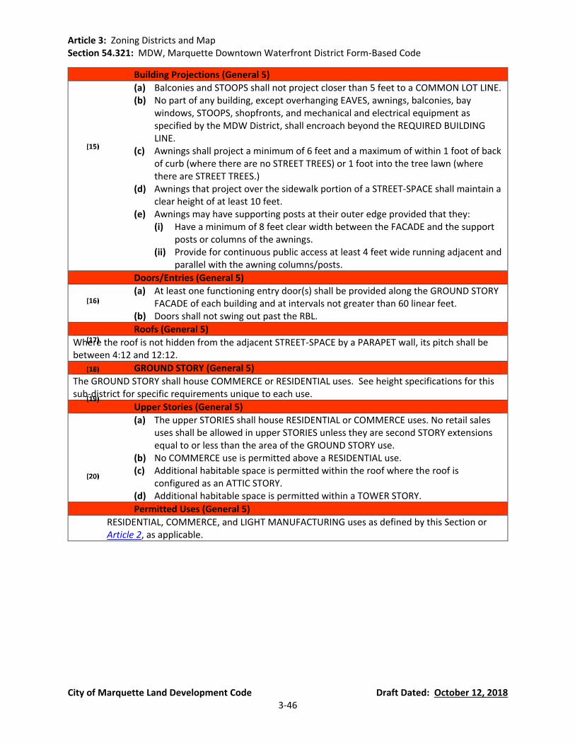
Article 3: Zoning Districts and Map Section 54.321: MDW, Marquette Downtown Waterfront District Form-Based Code
City of Marquette Land Development Code Draft Dated: October 12, 2018 3-46
Building Projections (General 5)
(a) Balconies and STOOPS shall not project closer than 5 feet to a COMMON LOT LINE. (b) No part of any building, except overhanging EAVES, awnings, balconies, bay
windows, STOOPS, shopfronts, and mechanical and electrical equipment as specified by the MDW District, shall encroach beyond the REQUIRED BUILDING LINE.
(c) Awnings shall project a minimum of 6 feet and a maximum of within 1 foot of back of curb (where there are no STREET TREES) or 1 foot into the tree lawn (where there are STREET TREES.)
(d) Awnings that project over the sidewalk portion of a STREET-SPACE shall maintain a clear height of at least 10 feet.
(e) Awnings may have supporting posts at their outer edge provided that they: (i) Have a minimum of 8 feet clear width between the FACADE and the support
posts or columns of the awnings. (ii) Provide for continuous public access at least 4 feet wide running adjacent and
parallel with the awning columns/posts.
Doors/Entries (General 5)
(a) At least one functioning entry door(s) shall be provided along the GROUND STORY FACADE of each building and at intervals not greater than 60 linear feet.
(b) Doors shall not swing out past the RBL.
Roofs (General 5)
Where the roof is not hidden from the adjacent STREET-SPACE by a PARAPET wall, its pitch shall be between 4:12 and 12:12.
GROUND STORY (General 5)
The GROUND STORY shall house COMMERCE or RESIDENTIAL uses. See height specifications for this sub-district for specific requirements unique to each use.
Upper Stories (General 5)
(a) The upper STORIES shall house RESIDENTIAL or COMMERCE uses. No retail sales uses shall be allowed in upper STORIES unless they are second STORY extensions equal to or less than the area of the GROUND STORY use.
(b) No COMMERCE use is permitted above a RESIDENTIAL use. (c) Additional habitable space is permitted within the roof where the roof is
configured as an ATTIC STORY. (d) Additional habitable space is permitted within a TOWER STORY.
Permitted Uses (General 5)
RESIDENTIAL, COMMERCE, and LIGHT MANUFACTURING uses as defined by this Section or Article 2, as applicable.

Article 3: Zoning Districts and Map Section 54.321: MDW, Marquette Downtown Waterfront District Form-Based Code
City of Marquette Land Development Code Draft Dated: October 12, 2018 3-47
Marquette Waterfront – General 5 Height Graphic
Marquette Waterfront – General 5 Siting Graphic
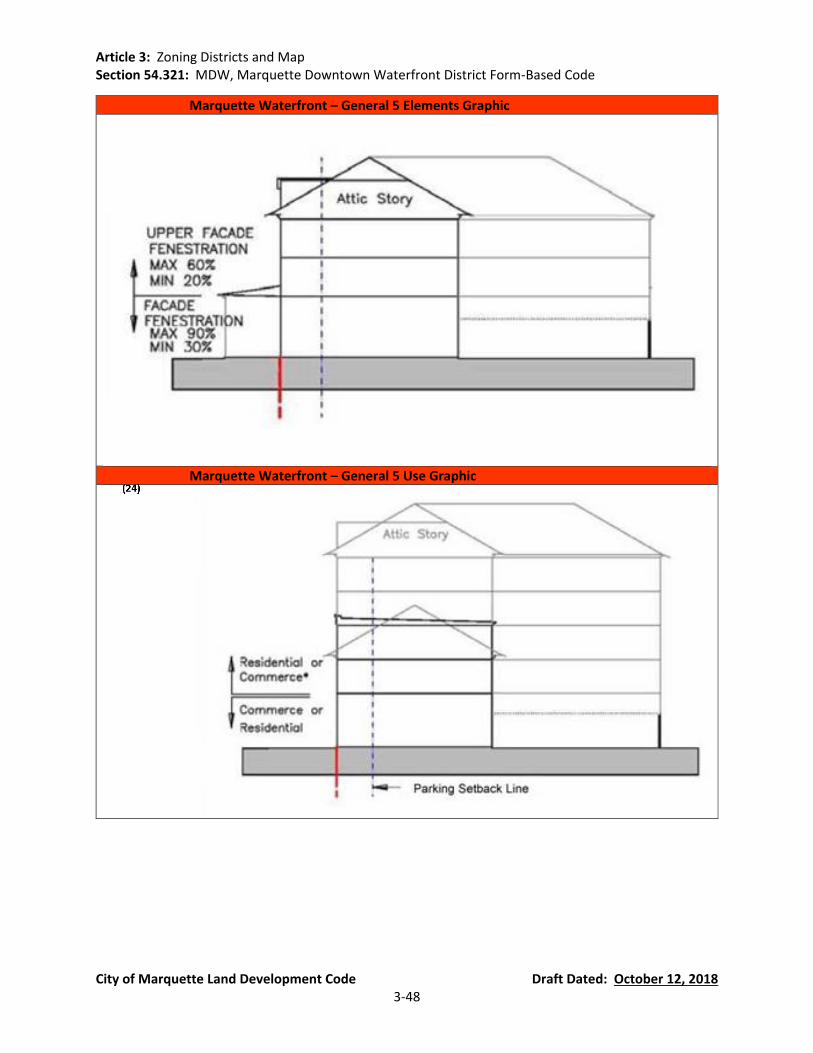
Article 3: Zoning Districts and Map Section 54.321: MDW, Marquette Downtown Waterfront District Form-Based Code
City of Marquette Land Development Code Draft Dated: October 12, 2018 3-48
Marquette Waterfront – General 5 Elements Graphic
Marquette Waterfront – General 5 Use Graphic
Article 3: Zoning Districts and Map Section 54.321: MDW, Marquette Downtown Waterfront District Form-Based Code
City of Marquette Land Development Code Draft Dated: October 12, 2018 3-49
(F) Marquette Waterfront – North Lakeshore Frontages
Building Height (North Lakeshore)
(a) The height of the principal building is measured in STORIES. (b) Each principal building shall be at least 1 STORY in height, but no greater than 3
STORIES in height, except as otherwise provided on the REGULATING PLAN. (c) An ATTIC STORY shall not count against the maximum STORY HEIGHT. (d) An additional TOWER STORY is allowed above the maximum building STORY
height, within the following parameters: (i) The footprint of the tower shall not exceed 250 feet. (ii) No horizontal FAÇADE dimension of the tower shall exceed 20 feet. (iii) The minimum and maximum STORY HEIGHTS are the same as those for Upper
STORIES (see below.) (iv) No ATTIC STORY is permitted above a TOWER STORY.
Parking Structure Height (North Lakeshore)
Where a parking structure is within 40 feet of any principal building (built after 2007) that portion of the structure shall not exceed the building’s EAVE or PARAPET HEIGHT.
GROUND STORY Height (North Lakeshore)
(a) The average finished floor elevation shall be no more than 8 feet above the exterior sidewalk elevation at the REQUIRED BUILDING LINE.
(b) The first STORY shall have an interior clear height (floor to ceiling) of at least 8 feet and a maximum floor to ceiling STORY HEIGHT of 12 feet.
Upper STORY HEIGHT (North Lakeshore)
(a) The maximum floor to ceiling STORY HEIGHT for stories other than the GROUND STORY is 12 feet.
(b) At least 80% of each upper STORY shall have an interior clear height (floor to ceiling) of at least 8 feet.
Street FACADE (North Lakeshore)
(a) On each lot the building FAÇADE shall be built to the REQUIRED BUILDING LINE for at least 70% of the REQUIRED BUILDING LINE (RBL) length.
(b) The building FAÇADE shall be built to RBL within 30 feet of a BLOCK CORNER. The ground floor FAÇADE, within 7 feet of the BLOCK CORNER may be chamfered to form a corner entry.
(c) These portions of the building FAÇADE (the required minimum build- to) may include jogs of not more than 18 inches in depth except as otherwise provided to allow bay windows, shopfronts, and balconies.
BUILDABLE AREA (North Lakeshore)
(a) Buildings may occupy the portion of the lot specified by these BUILDING FORM STANDARDS.
(b) A contiguous OPEN AREA equal to at least 20% of the total BUILDABLE AREA shall be preserved on every lot. Such contiguous OPEN AREA may be located anywhere behind the PARKING SETBACK, at grade.
(c) No part of any building, except overhanging EAVES or balconies shall occupy the remaining lot area.
Side Lot Setbacks (North Lakeshore)
There are no required side lot setbacks.

Article 3: Zoning Districts and Map Section 54.321: MDW, Marquette Downtown Waterfront District Form-Based Code
City of Marquette Land Development Code Draft Dated: October 12, 2018 3-50
Garage and Parking (North Lakeshore)
(a) GARAGE ENTRIES or driveways fronting an RBL shall be located at least 50 feet away from any BLOCK CORNER or another GARAGE ENTRY on the same block, unless otherwise designated on the REGULATING PLAN.
(b) GARAGE ENTRIES shall have neither a clear height greater than 9 feet nor a clear width exceeding 24 feet.
(c) Vehicle parking areas on private property shall be located behind the PARKING SETBACK LINE.
(d) These requirements are not applicable to on-street parking.
ALLEYS (North Lakeshore)
There is no required setback from ALLEYS.
Corner Lots (North Lakeshore)
Corner lots shall satisfy the MDW District requirements for the full RBL length – unless otherwise specified in this Section.
Unbuilt REQUIRED BUILDING LINE and COMMON LOT LINE Treatment (North Lakeshore)
(a) PRIVACY FENCES may be constructed along that portion of a common lot line not occupied by a building.
(b) Decorative fences of not more than 4 feet in height with not more than 50% of the fence area comprised of solid matter or closed construction, may be constructed along that portion of the RBL not otherwise occupied by a building
FENESTRATION (North Lakeshore)
(a) Blank lengths of wall exceeding 30 linear feet are prohibited on all REQUIRED BUILDING LINES (RBL).
(b) FENESTRATION on all FACADES shall comprise at least 20%, but not more than 75%, of the FACADE (measured as a percentage of the FACADE between floor levels).
Building Projections (North Lakeshore)
(a) Balconies and STOOPS shall not project closer than 5 feet to a COMMON LOT LINE. (b) Each lot/unit may include a STOOP of not more than 5 feet deep and 6 feet wide
(plus steps) or a front PORCH, not more than 8 feet deep with a width not less than 12 feet.
(c) No part of any building, except overhanging EAVES, balconies, BAY WINDOWS, PORCHES, STOOPS, and mechanical and electrical equipment as specified by the MDW District, shall encroach beyond the REQUIRED BUILDING LINE.
Doors/Entries (North Lakeshore)
At least one functioning entry door(s) shall be provided along the GROUND STORY FACADE of each building and at intervals not greater than 75 linear feet.
Roofs (North Lakeshore)
Where the roof is not hidden from the adjacent STREET-SPACE by a PARAPET wall, its pitch shall be between 4:12 and 12:12.
GROUND STORY (North Lakeshore)
The GROUND STORY shall house RESIDENTIAL uses.
Article 3: Zoning Districts and Map Section 54.321: MDW, Marquette Downtown Waterfront District Form-Based Code
City of Marquette Land Development Code Draft Dated: October 12, 2018 3-51
Upper STORIES (North Lakeshore)
(a) The upper stories shall house RESIDENTIAL uses. (b) Additional habitable space is permitted within the roof where the roof is
configured as an ATTIC STORY. (c) Additional habitable space is permitted within a TOWER STORY.
Permitted Uses (North Lakeshore)
RESIDENTIAL uses as defined by this Section.
Standards for Permitted Uses (North Lakeshore)
(a) Short-Term Rentals (i) Short-term rental is limited to units owned or occupied by property owners,
subletting is not allowed (tenants may not rent to other parties). (ii) A maximum of four (4) units may be rented for a short-term basis in housing
structures/complexes that have up to forty-nine (49) units; a maximum of ten percent of units may be rented for a short-term basis in housing structures/complexes that have fifty (50) or more units.

Article 3: Zoning Districts and Map Section 54.321: MDW, Marquette Downtown Waterfront District Form-Based Code
City of Marquette Land Development Code Draft Dated: October 12, 2018 3-52
Marquette Waterfront – North Lakeshore Frontages Height Graphic
Marquette Waterfront – North Lakeshore Frontages Siting Graphic

Article 3: Zoning Districts and Map Section 54.321: MDW, Marquette Downtown Waterfront District Form-Based Code
City of Marquette Land Development Code Draft Dated: October 12, 2018 3-53
Marquette Waterfront – North Lakeshore Frontages Elements Graphic
Marquette Waterfront – North Lakeshore Frontages Use Graphic

Article 3: Zoning Districts and Map Section 54.321: MDW, Marquette Downtown Waterfront District Form-Based Code
City of Marquette Land Development Code Draft Dated: October 12, 2018 3-54
(G) Marquette Waterfront – Working Waterfront Zone
Building Height (Working Waterfront Zone)
(a) The height of the building is measured in STORIES. (b) Each principal building shall be at least 1 STORY in height, but no greater than 2
STORIES in height, except as otherwise provided on the REGULATING PLAN. (c) An ATTIC STORY shall not count against the maximum STORY HEIGHT. (d) An additional TOWER STORY is allowed above the maximum building STORY
HEIGHT, within the following parameters: (i) The footprint of the tower shall not exceed 300 square feet. (ii) No horizontal FAÇADE dimension of the tower shall exceed 20 feet. (iii) STORY HEIGHTS are the same as those for Upper STORIES (see below.) (iv) No ATTIC STORY is permitted above a TOWER STORY.
GROUND STORY HEIGHT (Working Waterfront Zone)
The maximum STORY HEIGHT for the GROUND STORY is 20 feet, except for marine service buildings which shall be limited to a maximum story height of 35 feet
Upper STORY Height (Working Waterfront Zone)
(a) The maximum floor-to-ceiling STORY HEIGHT for STORIES other than the GROUND STORY is 12 feet.
(b) At least 80% of each upper STORY shall have an interior clear height (floor to ceiling) of at least 8 feet.
Mezzanines (Working Waterfront Zone)
Mezzanines having a floor area greater than 1/3 of the floor area of the STORY in which the mezzanine is situated shall be counted as full STORIES.
BUILDABLE AREA (Working Waterfront Zone)
Buildings may occupy any portion of the lot that lies within the REQUIRED BUILDING ZONE.
Building Separation (Working Waterfront Zone)
There shall be a minimum setback of 10 feet between any structures (measured from any building projections).
Garage and Parking (Working Waterfront Zone)
(a) GARAGE ENTRIES or driveways shall be located at least 50 feet away from any BLOCK CORNER or 50 feet from another garage entry on the same BLOCK, unless otherwise designated on the REGULATING PLAN.
(b) GARAGE ENTRIES shall have neither a clear height greater than16 feet nor a clear width exceeding 24 feet.
(c) These requirements are not applicable to on-street parking.
ALLEYS (Working Waterfront Zone)
There is no required setback from ALLEYS.
Unbuilt REQUIRED BUILDING LINE and COMMON LOT LINE Treatment (Working Waterfront Zone)
DECORATIVE FENCES of not more than 4 feet in height with not more than 50% of the fence area comprised of solid matter or closed construction, may be constructed along that portion of a common lot line not otherwise occupied by a building.
FENESTRATION (Working Waterfront Zone)
Blank lengths of wall exceeding 20 linear feet are prohibited within the REQUIRED BUILDING ZONE

Article 3: Zoning Districts and Map Section 54.321: MDW, Marquette Downtown Waterfront District Form-Based Code
City of Marquette Land Development Code Draft Dated: October 12, 2018 3-55
Building Projections (Working Waterfront Zone)
(a) Balconies and STOOPS shall not project closer than 5 feet to a COMMON LOT LINE. (b) No part of any building, except overhanging EAVES, awnings, balconies, bay
windows, STOOPS, shopfronts, and mechanical and electrical equipment as specified by the MDW District, shall encroach beyond the public right of way.
(c) Awnings for buildings fronting on a public right of way or sidewalk may project a minimum of 6 feet and a maximum of within 1 foot of back of curb (where there are no STREET TREES) or 1 foot into the tree lawn (where there are STREET TREES.)
(d) Awnings that project over the sidewalk portion of a STREET-SPACE shall maintain a clear height of at least 10 feet.
(e) Awnings may have supporting posts at their outer edge provided that they: (i) Have a minimum of 8 feet clear width between the FACADE and the support
posts or columns of the awnings. (ii) Provide for continuous public access at least 4 feet wide running adjacent and
parallel with the awning columns/posts.
Building Materials (Working Waterfront Zone)
Non-Glossy/Non-Reflective Metal may be used on the outside of structures in order to compliment or replicate the character of existing structures.
Doors/Entries (Working Waterfront Zone)
(a) At least one functioning entry door(s) shall be provided along the GROUND STORY FACADE of each building and at intervals not greater than 75 linear feet.
(b) Doors shall not swing out past a public right of way.
GROUND STORY (Working Waterfront Zone)
The GROUND STORY shall house COMMERCE, RESIDENTIAL, OR LIGHT INDUSTRIAL uses. See height specifications for this sub-district for specific requirements unique to each use.
Upper STORIES (Working Waterfront Zone)
(a) The upper STORIES shall house RESIDENTIAL or COMMERCE USES. No retail sales uses shall be allowed in upper STORIES unless they are second STORY extensions equal to or less than the area of the GROUND STORY use.
(b) No COMMERCE USE is permitted above a residential use. (c) Additional habitable space is permitted within the roof where the roof is
configured as an ATTIC STORY. (d) Additional habitable space is permitted within a TOWER STORY.
Permitted Uses (Working Waterfront Zone)
RESIDENTIAL, COMMERCE, AND LIGHT INDUSTRIAL USES as defined by this Section or Article 2, as applicable.
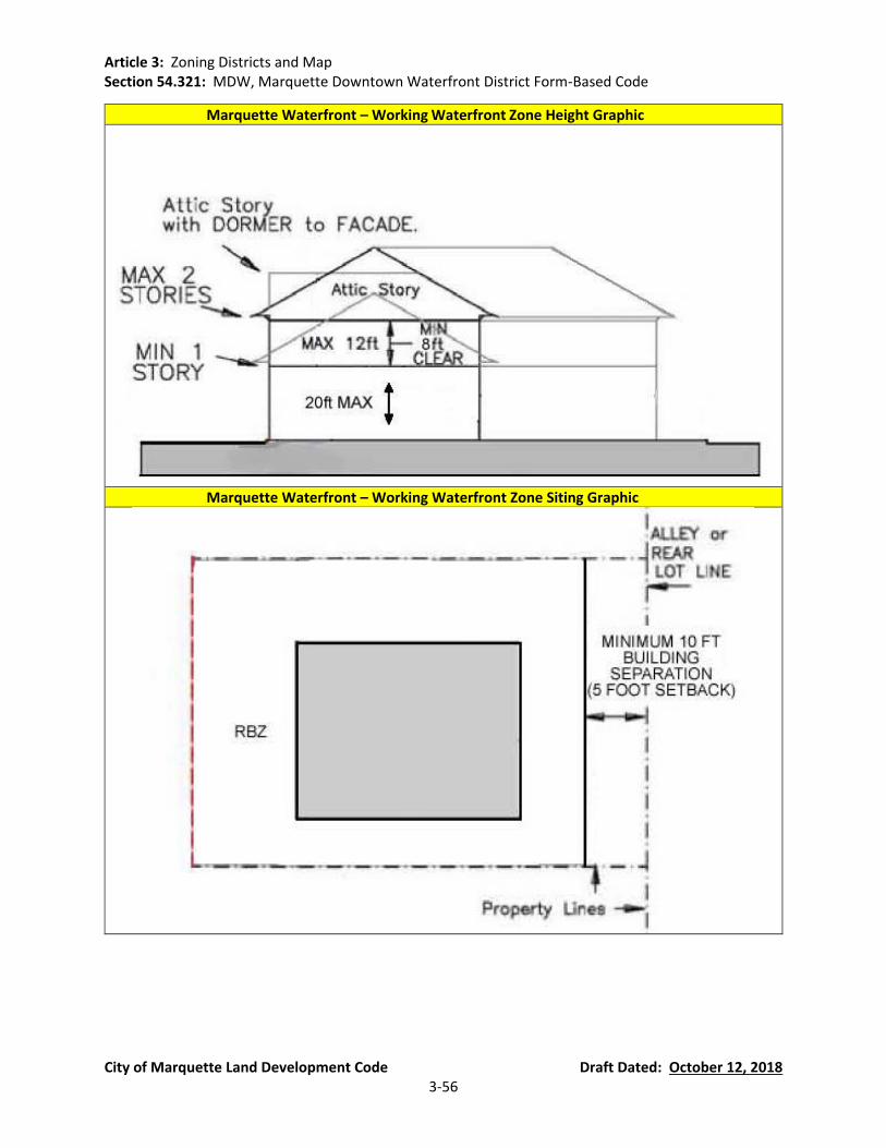
Article 3: Zoning Districts and Map Section 54.321: MDW, Marquette Downtown Waterfront District Form-Based Code
City of Marquette Land Development Code Draft Dated: October 12, 2018 3-56
Marquette Waterfront – Working Waterfront Zone Height Graphic
Marquette Waterfront – Working Waterfront Zone Siting Graphic
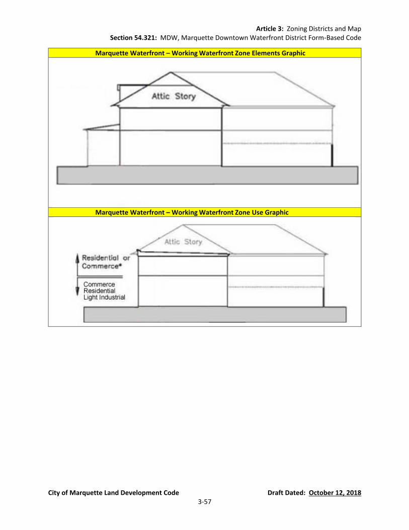
Article 3: Zoning Districts and Map Section 54.321: MDW, Marquette Downtown Waterfront District Form-Based Code
City of Marquette Land Development Code Draft Dated: October 12, 2018 3-57
Marquette Waterfront – Working Waterfront Zone Elements Graphic
Marquette Waterfront – Working Waterfront Zone Use Graphic

Article 3: Zoning Districts and Map Section 54.321: MDW, Marquette Downtown Waterfront District Form-Based Code
City of Marquette Land Development Code Draft Dated: October 12, 2018 3-58
(H) Marquette Waterfront – Workshop Flex
Building Height (Workshop Flex)
(a) The height of the building is measured in STORIES. (b) Buildings shall be no greater than 1 STORY or 20 feet, measured to the EAVE or top
of parapet, except as otherwise provided on the REGULATING PLAN. (c) An ATTIC STORY shall not be counted towards the building height.
STORY HEIGHT (Workshop Flex)
The maximum STORY HEIGHT for the GROUND STORY is 20 feet.
Mezzanines (Workshop Flex)
Mezzanines having a floor area greater than 1/3 of the floor area of the STORY in which the mezzanine is situated shall be counted as full STORIES.
Street FACADE (Workshop Flex)
On each lot the building FAÇADE shall be built to the REQUIRED BUILDING LINE (RBL) for at least 50% of the RBL length
BUILDABLE AREA (Workshop Flex)
(a) Buildings may occupy the portion of the lot specified by these BUILDING FORM STANDARDS.
(b) No individual building footprint shall exceed 2000 square feet. (c) No part of any building, except overhanging EAVES, awnings, or balconies shall
occupy the remaining lot area.
Side Lot Setbacks (Workshop Flex)
(a) Each building shall be set back at least 5 feet from a COMMON LOT LINE. (b) Side lots shall not be used for parking.
Parking (Workshop Flex)
There shall be no minimum vehicle parking requirements for WORKSHOP FLEX sites.
Corner Lots (Workshop Flex)
Corner lots shall satisfy the MDW District requirements for their full RBL length – unless otherwise specified in this Section.
COMMON LOT LINE Treatment (Workshop Flex)
PRIVACY FENCES may be constructed along that portion of a COMMON LOT LINE not otherwise occupied by a building.
FENESTRATION (Workshop Flex)
Blank lengths of wall exceeding 20 linear feet are prohibited on all REQUIRED BUILDING LINES (RBL).
Building Projections (Workshop Flex)
(a) No part of any building, except overhanging EAVES, awnings, balconies, bay windows, STOOPS, shopfronts, and mechanical and electrical equipment as specified by the MDW District, shall encroach beyond the REQUIRED BUILDING LINE.
(b) Awnings that project over the sidewalk portion of a STREET-SPACE shall maintain a clear height of at least 10 feet.
Building Materials (Workshop Flex)
Non-Glossy/Non-Reflective Metal may be used on the outside of structures in order to compliment or replicate the character of existing structures.
Doors/Entries (Workshop Flex)
(a) At least one functioning entry door(s) shall be provided along the GROUND STORY FACADE of each building.
(b) Doors shall not swing out past the RBL.
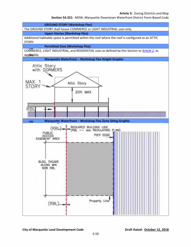
Article 3: Zoning Districts and Map Section 54.321: MDW, Marquette Downtown Waterfront District Form-Based Code
City of Marquette Land Development Code Draft Dated: October 12, 2018 3-59
GROUND STORY (Workshop Flex)
The GROUND STORY shall house COMMERCE or LIGHT INDUSTRIAL uses only.
Upper Stories (Workshop Flex)
Additional habitable space is permitted within the roof where the roof is configured as an ATTIC STORY.
Permitted Uses (Workshop Flex)
COMMERCE, LIGHT INDUSTRIAL, and RESIDENTIAL uses as defined by this Section or Article 2, as applicable.
Marquette Waterfront – Workshop Flex Height Graphic
Marquette Waterfront – Workshop Flex Zone Siting Graphic
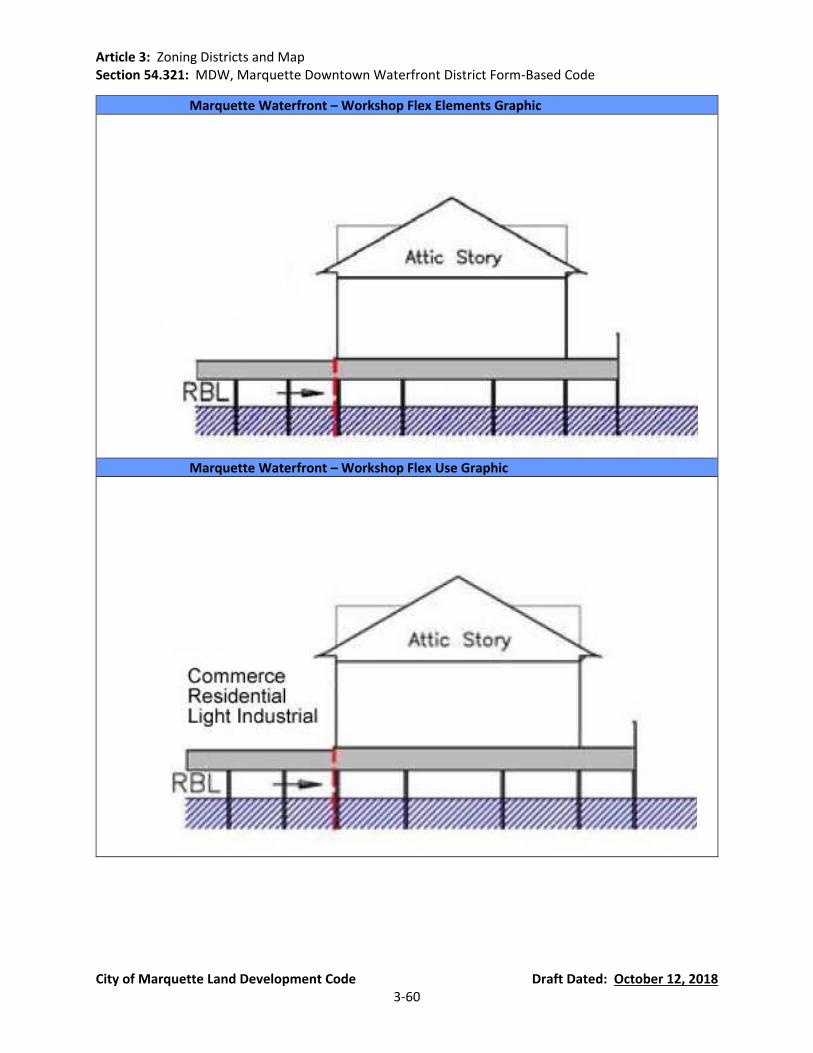
Article 3: Zoning Districts and Map Section 54.321: MDW, Marquette Downtown Waterfront District Form-Based Code
City of Marquette Land Development Code Draft Dated: October 12, 2018 3-60
Marquette Waterfront – Workshop Flex Elements Graphic
Marquette Waterfront – Workshop Flex Use Graphic
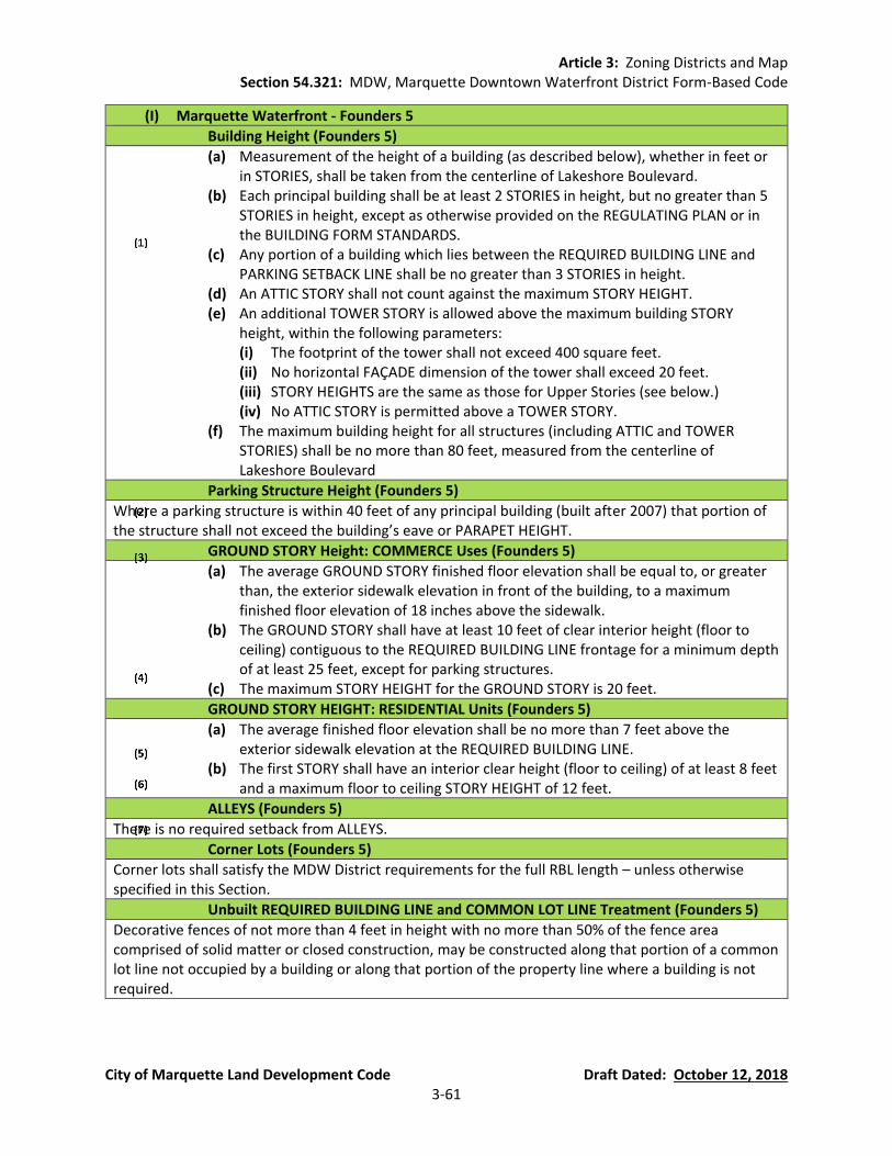
Article 3: Zoning Districts and Map Section 54.321: MDW, Marquette Downtown Waterfront District Form-Based Code
City of Marquette Land Development Code Draft Dated: October 12, 2018 3-61
(I) Marquette Waterfront - Founders 5
Building Height (Founders 5)
(a) Measurement of the height of a building (as described below), whether in feet or in STORIES, shall be taken from the centerline of Lakeshore Boulevard.
(b) Each principal building shall be at least 2 STORIES in height, but no greater than 5 STORIES in height, except as otherwise provided on the REGULATING PLAN or in the BUILDING FORM STANDARDS.
(c) Any portion of a building which lies between the REQUIRED BUILDING LINE and PARKING SETBACK LINE shall be no greater than 3 STORIES in height.
(d) An ATTIC STORY shall not count against the maximum STORY HEIGHT. (e) An additional TOWER STORY is allowed above the maximum building STORY
height, within the following parameters: (i) The footprint of the tower shall not exceed 400 square feet. (ii) No horizontal FAÇADE dimension of the tower shall exceed 20 feet. (iii) STORY HEIGHTS are the same as those for Upper Stories (see below.) (iv) No ATTIC STORY is permitted above a TOWER STORY.
(f) The maximum building height for all structures (including ATTIC and TOWER STORIES) shall be no more than 80 feet, measured from the centerline of Lakeshore Boulevard
Parking Structure Height (Founders 5)
Where a parking structure is within 40 feet of any principal building (built after 2007) that portion of the structure shall not exceed the building’s eave or PARAPET HEIGHT.
GROUND STORY Height: COMMERCE Uses (Founders 5)
(a) The average GROUND STORY finished floor elevation shall be equal to, or greater than, the exterior sidewalk elevation in front of the building, to a maximum finished floor elevation of 18 inches above the sidewalk.
(b) The GROUND STORY shall have at least 10 feet of clear interior height (floor to ceiling) contiguous to the REQUIRED BUILDING LINE frontage for a minimum depth of at least 25 feet, except for parking structures.
(c) The maximum STORY HEIGHT for the GROUND STORY is 20 feet.
GROUND STORY HEIGHT: RESIDENTIAL Units (Founders 5)
(a) The average finished floor elevation shall be no more than 7 feet above the exterior sidewalk elevation at the REQUIRED BUILDING LINE.
(b) The first STORY shall have an interior clear height (floor to ceiling) of at least 8 feet and a maximum floor to ceiling STORY HEIGHT of 12 feet.
ALLEYS (Founders 5)
There is no required setback from ALLEYS.
Corner Lots (Founders 5)
Corner lots shall satisfy the MDW District requirements for the full RBL length – unless otherwise specified in this Section.
Unbuilt REQUIRED BUILDING LINE and COMMON LOT LINE Treatment (Founders 5)
Decorative fences of not more than 4 feet in height with no more than 50% of the fence area comprised of solid matter or closed construction, may be constructed along that portion of a common lot line not occupied by a building or along that portion of the property line where a building is not required.
Article 3: Zoning Districts and Map Section 54.321: MDW, Marquette Downtown Waterfront District Form-Based Code
City of Marquette Land Development Code Draft Dated: October 12, 2018 3-62
Upper STORY HEIGHT (Founders 5)
(a) The maximum floor to ceiling STORY HEIGHT for STORIES other than the GROUND STORY is 12 feet.
(b) At least 80% of each upper story shall have an interior clear height (floor to ceiling) of at least 8 feet.
Mezzanines (Founders 5)
Mezzanines having a floor area greater than 1/3 of the floor area of the STORY in which the mezzanine is situated shall be counted as full STORIES.
Street FACADE (Founders 5)
(a) On each lot the building FAÇADE shall be built to the REQUIRED BUILDING LINE for at least 50% of the REQUIRED BUILDING LINE (RBL) length.
(b) The building FAÇADE shall be built to RBL within 30 feet of a BLOCK CORNER. The ground floor FAÇADE, within 7 feet of the BLOCK CORNER may be chamfered to form a corner entry.
(c) These portions of the building FAÇADE (the required minimum build-to) may include jogs of not more than 18 inches in depth except as otherwise provided to allow bay windows, shopfronts, and balconies.
BUILDABLE AREA (Founders 5)
(a) Buildings may occupy the portion of the lot specified by these BUILDING FORM STANDARDS.
(b) A contiguous OPEN AREA equal to at least 10% of the total BUILDABLE AREA shall be preserved on every lot. Such contiguous OPEN AREA may be located anywhere behind the PARKING SETBACK, at or above grade.
(c) No part of any building, except overhanging EAVES, awnings, or balconies shall occupy the remaining lot area.
Side Lot Setbacks (Founders 5)
There are no side lot setbacks.
Garage and Parking (Founders 5)
(a) GARAGE ENTRIES or driveways shall be located at least 50 feet away from any BLOCK CORNER or another GARAGE ENTRY on the same BLOCK, unless otherwise designated on the REGULATING PLAN.
(b) GARAGE ENTRIES shall have neither a clear height greater than16 feet nor a clear width exceeding 24 feet.
(c) Vehicle parking areas on private property shall be located behind the PARKING SETBACK LINE, except where parking is provided: 1) inside or below the building; or 2) behind a masonry wall that is at most three feet behind the REQUIRED BUILDING LINE and is between three and four feet in height.
(d) These requirements are not applicable to on-street parking.
FENESTRATION (Founders 5)
(a) Blank lengths of wall exceeding 20 linear feet are prohibited on all REQUIRED BUILDING LINES (RBL).
(b) FENESTRATION on the GROUND STORY FACADES shall comprise at least 30%, but not more than 90%, of the FACADE (measured as a percentage of the FAÇADE between floor levels).
(c) FENESTRATION on the upper story FACADES shall comprise at least 20%, but no more than 60%, of the FACADE area per STORY (measured as a percentage of the FACADE between floor levels).
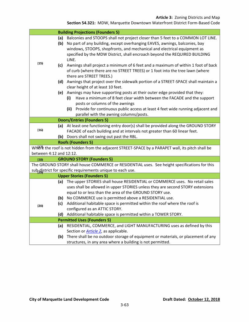
Article 3: Zoning Districts and Map Section 54.321: MDW, Marquette Downtown Waterfront District Form-Based Code
City of Marquette Land Development Code Draft Dated: October 12, 2018 3-63
Building Projections (Founders 5)
(a) Balconies and STOOPS shall not project closer than 5 feet to a COMMON LOT LINE. (b) No part of any building, except overhanging EAVES, awnings, balconies, bay
windows, STOOPS, shopfronts, and mechanical and electrical equipment as specified by the MDW District, shall encroach beyond the REQUIRED BUILDING LINE.
(c) Awnings shall project a minimum of 6 feet and a maximum of within 1 foot of back of curb (where there are no STREET TREES) or 1 foot into the tree lawn (where there are STREET TREES.)
(d) Awnings that project over the sidewalk portion of a STREET-SPACE shall maintain a clear height of at least 10 feet.
(e) Awnings may have supporting posts at their outer edge provided that they: (i) Have a minimum of 8 feet clear width between the FACADE and the support
posts or columns of the awnings (ii) Provide for continuous public access at least 4 feet wide running adjacent and
parallel with the awning columns/posts.
Doors/Entries (Founders 5)
(a) At least one functioning entry door(s) shall be provided along the GROUND STORY FACADE of each building and at intervals not greater than 60 linear feet.
(b) Doors shall not swing out past the RBL.
Roofs (Founders 5)
Where the roof is not hidden from the adjacent STREET-SPACE by a PARAPET wall, its pitch shall be between 4:12 and 12:12.
GROUND STORY (Founders 5)
The GROUND STORY shall house COMMERCE or RESIDENTIAL uses. See height specifications for this sub-district for specific requirements unique to each use.
Upper Stories (Founders 5)
(a) The upper STORIES shall house RESIDENTIAL or COMMERCE uses. No retail sales uses shall be allowed in upper STORIES unless they are second STORY extensions equal to or less than the area of the GROUND STORY use.
(b) No COMMERCE use is permitted above a RESIDENTIAL use. (c) Additional habitable space is permitted within the roof where the roof is
configured as an ATTIC STORY. (d) Additional habitable space is permitted within a TOWER STORY.
Permitted Uses (Founders 5)
(a) RESIDENTIAL, COMMERCE, and LIGHT MANUFACTURING uses as defined by this Section or Article 2, as applicable.
(b) There shall be no outdoor storage of equipment or materials, or placement of any structures, in any area where a building is not permitted.

Article 3: Zoning Districts and Map Section 54.321: MDW, Marquette Downtown Waterfront District Form-Based Code
City of Marquette Land Development Code Draft Dated: October 12, 2018 3-64
Marquette Waterfront – Founders 5 Height Graphic
Marquette Waterfront – Founders 5 Siting Graphic
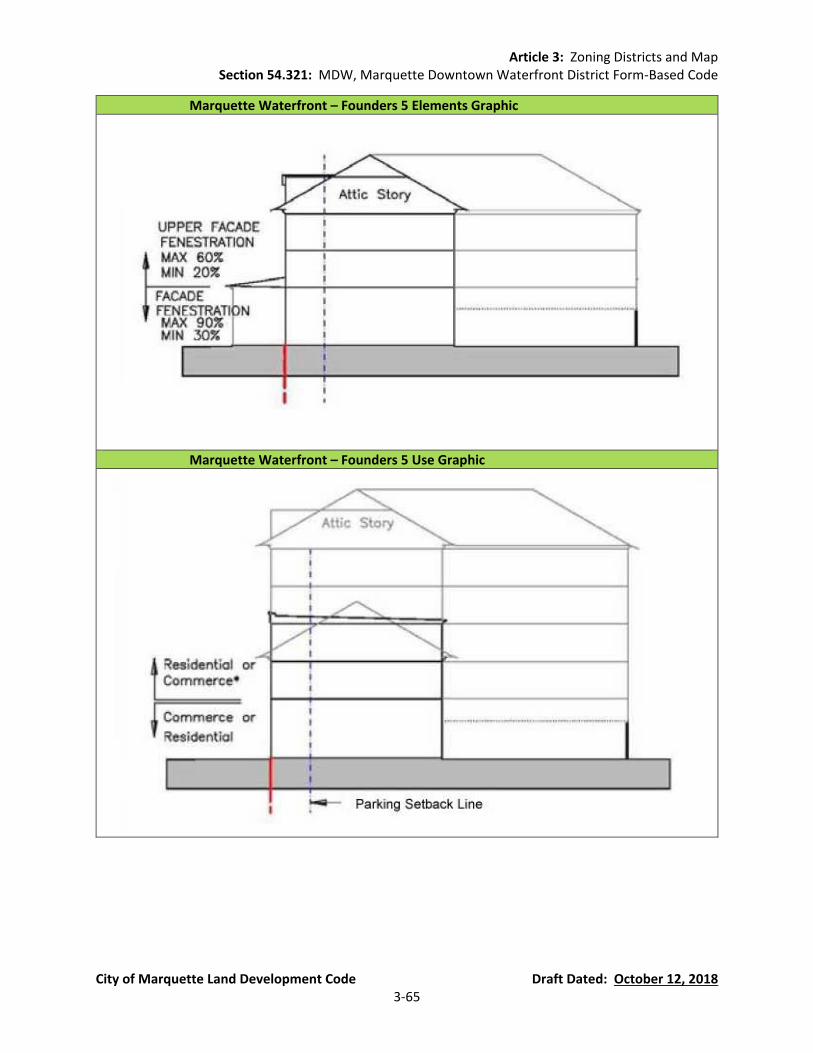
Article 3: Zoning Districts and Map Section 54.321: MDW, Marquette Downtown Waterfront District Form-Based Code
City of Marquette Land Development Code Draft Dated: October 12, 2018 3-65
Marquette Waterfront – Founders 5 Elements Graphic
Marquette Waterfront – Founders 5 Use Graphic

Article 3: Zoning Districts and Map Section 54.321: MDW, Marquette Downtown Waterfront District Form-Based Code
City of Marquette Land Development Code Draft Dated: October 12, 2018 3-66
(J) Street-Space. Streets are a city’s first and foremost public spaces and should therefore be just as carefully designed and planned for as any park or public building. The STREET-SPACE is that public domain between the building FACADES: the cartway or travel lanes between the curbs as well as the sidewalks; the public plazas as well as the urban parks and greens. The character of the STREET-SPACE—both its scale and its details—plays a significant role in determining the pedestrian quality of a given location. Streets must balance the needs of all forms of traffic—auto, bicycle and pedestrian—to maximize mobility and convenience for all the citizens of Marquette and all users of the Downtown Waterfront District.
General Principles. The Street-Space Principles define the coherence of the STREET-
SPACE. They also serve to assist building owners and operators with understanding the relationship between the STREET-SPACE and their own lots. This Section requires that the MDW District sites will be developed with buildings placed at the RBL, along the frontage of the lots they occupy. These principles also establish an environment that encourages and facilitates pedestrian activity. “Walkable” streets should be comfortable, efficient, safe, and interesting.
(a) The BUILDING FORM STANDARDS provide the framework in which the STREET-SPACE
occurs. (i) The RBL frontages shape the STREET-SPACE. (ii) The required building elements will provide active building/shopfronts.
(b) STREET TREES provide both form (canopy) and comfort (shade) to the STREET-SPACE.
Native trees and plants contribute to the reduction of air and noise pollution, maintenance of natural habitat, the conservation of water, and rainwater management. (i) STREET TREES give special character and coherence to each STREET-SPACE
through their regular spacing (along the street tree alignment line) and species selection (see Waterfront District Street Tree List in Section 54.321(J)(3)) Therefore, species should be planted consistently along a given street-space. Provide species diversity by planting different streets with different trees.
(ii) Tree planting areas should be at grade (no raised or curbed planters) and maximize soil area to encourage healthy growth.
(iii) STREET TREES must be maintained – watered regularly and “limbed up” as they gain appropriate maturity so as to not interfere with pedestrian or truck travel (minimum 7 feet clear over the sidewalk and 14 feet over the travel lanes of the street).
(iv) Streetscape furniture (street lights, benches, bicycle racks, etc.) should contribute to the coherence and form of the street-space through its placement along the street tree alignment line.
(v) Although permitted in the road right-of-way, STREET TREES and streetscape furniture must meet traffic visibility regulations of Section 54.704.
(vi) Street trees shall not be planted over public underground utilities without the approval of the City Engineering Department.
(c) Sidewalks provide both access to the fronts of buildings and passage for pedestrians
along the block.
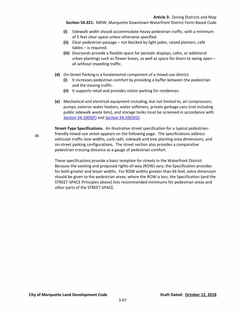
Article 3: Zoning Districts and Map Section 54.321: MDW, Marquette Downtown Waterfront District Form-Based Code
City of Marquette Land Development Code Draft Dated: October 12, 2018 3-67
(i) Sidewalk width should accommodate heavy pedestrian traffic, with a minimum of 5 feet clear space unless otherwise specified.
(ii) Clear pedestrian passage – not blocked by light poles, raised planters, café tables – is required.
(iii) Dooryards provide a flexible space for periodic displays, cafes, or additional urban plantings such as flower boxes, as well as space for doors to swing open – all without impeding traffic.
(d) On-Street Parking is a fundamental component of a mixed-use district.
(i) It increases pedestrian comfort by providing a buffer between the pedestrian and the moving traffic.
(ii) It supports retail and provides visitor parking for residences.
(e) Mechanical and electrical equipment including, but not limited to, air compressors, pumps, exterior water heaters, water softeners, private garbage cans (not including public sidewalk waste bins), and storage tanks must be screened in accordance with Section 54.1003(F) and Section 54.1003(G).
Street-Type Specifications. An illustrative street specification for a typical pedestrian-
friendly mixed-use street appears on the following page. The specifications address vehicular traffic lane widths, curb radii, sidewalk and tree planting area dimensions, and on-street parking configurations. The street section also provides a comparative pedestrian crossing distance as a gauge of pedestrian comfort.
These specifications provide a basic template for streets in the Waterfront District. Because the existing and proposed rights-of-way (ROW) vary, the Specification provides for both greater and lesser widths. For ROW widths greater than 66 feet, extra dimension should be given to the pedestrian areas; where the ROW is less, the Specification (and the STREET-SPACE Principles above) lists recommended minimums for pedestrian areas and other parts of the STREET-SPACE.
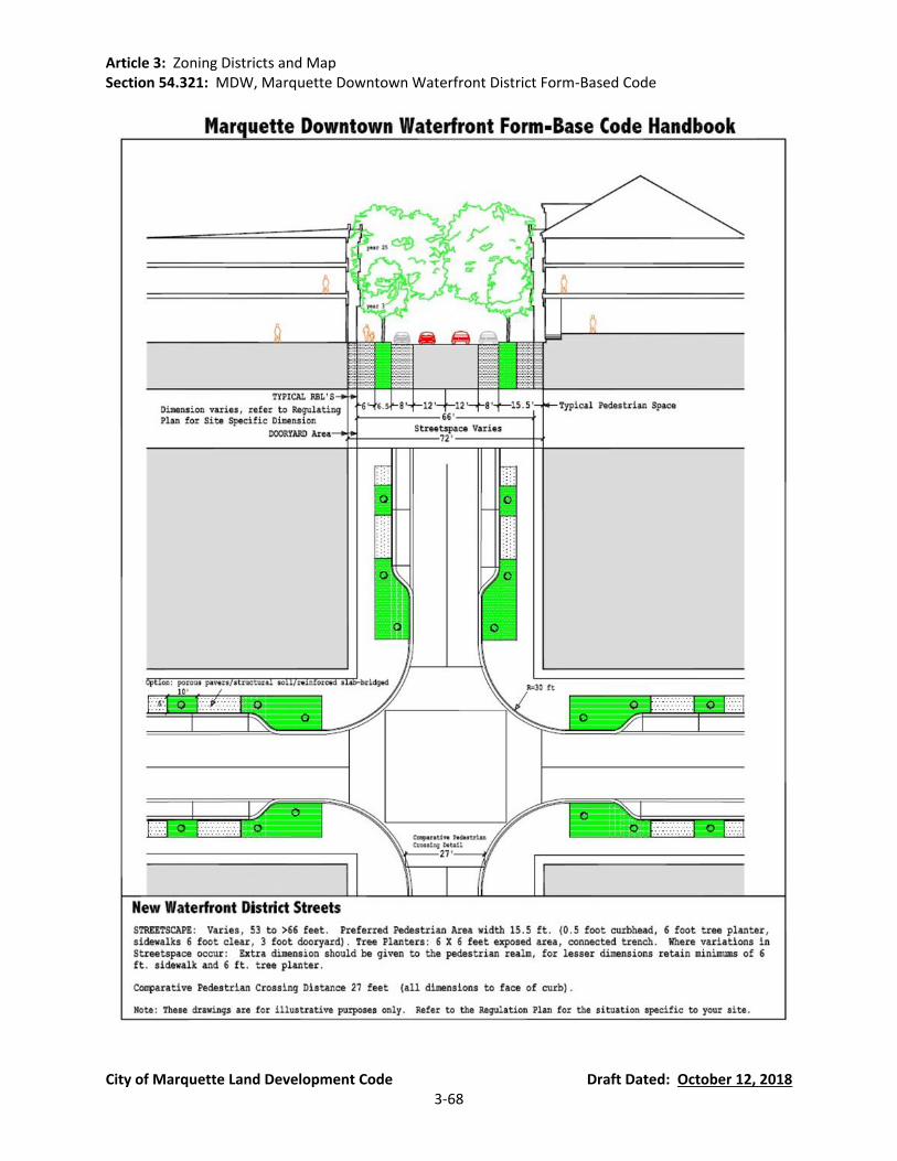
Article 3: Zoning Districts and Map Section 54.321: MDW, Marquette Downtown Waterfront District Form-Based Code
City of Marquette Land Development Code Draft Dated: October 12, 2018 3-68
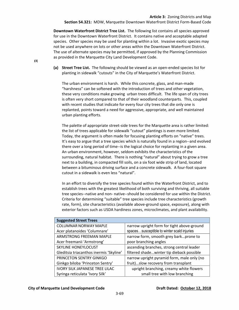
Article 3: Zoning Districts and Map Section 54.321: MDW, Marquette Downtown Waterfront District Form-Based Code
City of Marquette Land Development Code Draft Dated: October 12, 2018 3-69
Downtown Waterfront District Tree List. The following list contains all species approved for use in the Downtown Waterfront District. It contains native and acceptable adapted species. Other species may be used for planting within a lot. Invasive exotic species may not be used anywhere on lots or other areas within the Downtown Waterfront District. The use of alternate species may be permitted, if approved by the Planning Commission as provided in the Marquette City Land Development Code.
(a) Street Tree List. The following should be viewed as an open-ended species list for
planting in sidewalk “cutouts” in the City of Marquette’s Waterfront District.
The urban environment is harsh. While this concrete, glass, and man-made “harshness” can be softened with the introduction of trees and other vegetation, these very conditions make growing urban trees difficult. The life span of city trees is often very short compared to that of their woodland counterparts. This, coupled with recent studies that indicate for every four city trees that die only one is replanted, points toward a need for aggressive, appropriate, and well maintained urban planting efforts.
The palette of appropriate street-side trees for the Marquette area is rather limited: the list of trees applicable for sidewalk “cutout” plantings is even more limited. Today, the argument is often made for focusing planting efforts on “native” trees. It’s easy to argue that a tree species which is naturally found in a region--and evolved there over a long period of time--is the logical choice for replanting in a given area. An urban environment, however, seldom exhibits the characteristics of the surrounding, natural habitat. There is nothing “natural” about trying to grow a tree next to a building, in compacted fill soils, on a six foot wide strip of land, located between a bituminous driving surface and a concrete sidewalk. A four-foot square cutout in a sidewalk is even less “natural”.
In an effort to diversify the tree species found within the Waterfront District, and to establish trees with the greatest likelihood of both surviving and thriving, all suitable tree species--native and non- native--should be considered for use within the District. Criteria for determining “suitable” tree species include tree characteristics (growth rate, form), site characteristics (available above-ground space, exposure), along with exterior factors such as USDA hardiness zones, microclimates, and plant availability.
Suggested Street Trees
COLUMNAR NORWAY MAPLE Acer platanoides ‘Columnare’
narrow upright form for tight above-ground spaces…susceptible to winter scald injuries
ARMSTRONG FREEMAN MAPLE Acer freemanii ‘Armstrong’
narrow form, smooth grey bark…prone to poor branching angles
SKYLINE HONEYLOCUST Gleditsia triacanthos inermis ‘Skyline’
ascending branches, strong central leader filtered shade…winter tip dieback possible
PRINCETON SENTRY GINKGO Ginkgo biloba ‘Princeton Sentry’
narrow upright pyramid form, male only (no fruit)…slow recovery from transplant
IVORY SILK JAPANESE TREE LILAC Syringa reticulata ‘Ivory Silk’
upright branching, creamy white flowers small tree with low branching
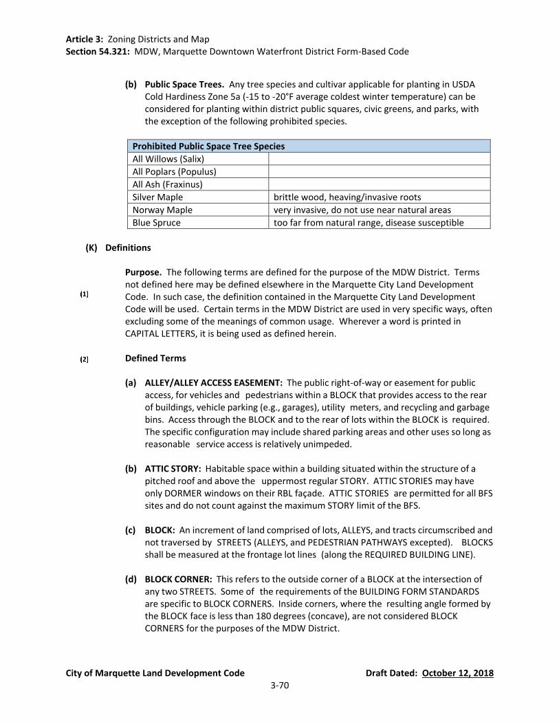
Article 3: Zoning Districts and Map Section 54.321: MDW, Marquette Downtown Waterfront District Form-Based Code
City of Marquette Land Development Code Draft Dated: October 12, 2018 3-70
(b) Public Space Trees. Any tree species and cultivar applicable for planting in USDA
Cold Hardiness Zone 5a (-15 to -20°F average coldest winter temperature) can be considered for planting within district public squares, civic greens, and parks, with the exception of the following prohibited species.
Prohibited Public Space Tree Species
All Willows (Salix)
All Poplars (Populus)
All Ash (Fraxinus)
Silver Maple brittle wood, heaving/invasive roots
Norway Maple very invasive, do not use near natural areas
Blue Spruce too far from natural range, disease susceptible
(K) Definitions
Purpose. The following terms are defined for the purpose of the MDW District. Terms
not defined here may be defined elsewhere in the Marquette City Land Development Code. In such case, the definition contained in the Marquette City Land Development Code will be used. Certain terms in the MDW District are used in very specific ways, often excluding some of the meanings of common usage. Wherever a word is printed in CAPITAL LETTERS, it is being used as defined herein.
Defined Terms
(a) ALLEY/ALLEY ACCESS EASEMENT: The public right-of-way or easement for public
access, for vehicles and pedestrians within a BLOCK that provides access to the rear of buildings, vehicle parking (e.g., garages), utility meters, and recycling and garbage bins. Access through the BLOCK and to the rear of lots within the BLOCK is required. The specific configuration may include shared parking areas and other uses so long as reasonable service access is relatively unimpeded.
(b) ATTIC STORY: Habitable space within a building situated within the structure of a
pitched roof and above the uppermost regular STORY. ATTIC STORIES may have only DORMER windows on their RBL façade. ATTIC STORIES are permitted for all BFS sites and do not count against the maximum STORY limit of the BFS.
(c) BLOCK: An increment of land comprised of lots, ALLEYS, and tracts circumscribed and
not traversed by STREETS (ALLEYS, and PEDESTRIAN PATHWAYS excepted). BLOCKS shall be measured at the frontage lot lines (along the REQUIRED BUILDING LINE).
(d) BLOCK CORNER: This refers to the outside corner of a BLOCK at the intersection of
any two STREETS. Some of the requirements of the BUILDING FORM STANDARDS are specific to BLOCK CORNERS. Inside corners, where the resulting angle formed by the BLOCK face is less than 180 degrees (concave), are not considered BLOCK CORNERS for the purposes of the MDW District.

Article 3: Zoning Districts and Map Section 54.321: MDW, Marquette Downtown Waterfront District Form-Based Code
City of Marquette Land Development Code Draft Dated: October 12, 2018 3-71
(e) BUILDABLE AREA: The area of the lot that building(s) may occupy, which includes the entire area of the lot behind the RBL, exclusive of any setbacks. The BUILDABLE AREA sets the limits of the building footprint. Additions to structures must be within the designated area.
(f) BUILDING CORNER: This refers to the outside corner of a building where the primary
building mass is within an angle less than 180 degrees. Some of the proscriptions of the BUILDING FORM STANDARD are specific to BUILDING CORNERS. Inside corners, where the exterior space of the building mass forms an angle of more than 180 degrees, are not considered BUILDING CORNERS for the purposes of the MDW District.
(g) BUILDING FORM STANDARDS (BFS): The part of the MDW District that establishes basic parameters regulating building form, including the envelope, placement (in three dimensions) and certain permitted/required building elements, such as storefronts, BALCONIES, and STREET WALLS. The BUILDING FORM STANDARD establishes both the boundaries within which things may be done and specific things that must be done. The applicable BFS for a site is determined by its STREET FRONTAGE as per the REGULATING PLAN. This produces a coherent STREET-SPACE and allows the building greater latitude behind its street FACADE.
(h) COMMERCE: (See USE)
(i) COMMON LOT LINES: Lot lines shared by adjacent private lots (See also REAR LOT
LINES).
(j) DECORATIVE FENCE: A fence of open construction that serves as a decorative landscape element. A fence that exhibits a decorative aspect across the entire face of the fence, through the use of multiple materials or other features that place an emphasis on the decorative character of the fence rather than the functional aspect of the fence to enclose or otherwise identify a space. Examples of DECORATIVE FENCES include, by example, picket fences, wrought iron fences, and combinations thereof. Unless expressly provided for elsewhere in this Ordinance, “decorative

Article 3: Zoning Districts and Map Section 54.321: MDW, Marquette Downtown Waterfront District Form-Based Code
City of Marquette Land Development Code Draft Dated: October 12, 2018 3-72
fence” shall not be construed to include split-rail, wire-woven, mesh-like and other similar appearing fences, including those commonly referred to as cyclone and chain-link fences, and mesh-like fences commonly used to contain farm animals irrespective of the dimensions of the mesh comprising the fence.
(k) DOORYARD: The area, within the STREET-SPACE, between the FAÇADE of the
building (generally the RBL) and the property line. STOOPS, balconies, and for appropriate COMMERCE uses, temporary displays, café seating, and other encroachments as specified by the City may be placed within the DOORYARD area.
(l) DORMERS: Small, roofed ancillary structures with windows providing light and air to
habitable space within the roof. DORMERs are permitted and do not constitute a STORY so long as they do not break the façade plane, are individually less than 15 feet wide, and are collectively not more than 60% of the REQUIRED BUILDING LINE FAÇADE length. (See also ATTIC STORY).
(m) EAVE HEIGHT: Where used to limit building height in the MDW District, EAVE HEIGHT
shall be measured at the bottom of the top layer of roofing material at its outermost point from the building wall.
(n) FAÇADE: Building face; the building elevations facing the STREET-SPACE. (Building
walls facing interior courts, COMMON LOT LINES, and ALLEYS are not FACADES.)
(o) FENESTRATION: Openings in the building wall, including windows, doors, louvres, vents, wall panels, skylights, storefronts, curtain walls, and slope glazed systems, which allow light and views between interior and exterior. FENESTRATION is measured as glass or open area (excluding muntins and similar window frame elements with a width dimension equal to or greater than 2 inches) for conditioned space and as open area for parking structures or other un-conditioned, enclosed space.
(p) FIRST FLOOR (See GROUND STORY.)
(q) GARAGE ENTRY: An opening (with curb cut) in the building FAÇADE and/or STREET
WALL where vehicles may access the BLOCK interior for parking and business servicing. GARAGE ENTRIES shall not exceed 16 feet clear height and 24 feet clear width and shall be sited in accordance with this Section. GARAGE ENTRY portals may be set back up to 24 inches behind the surrounding FAÇADE.
(r) GENERAL FRONTAGE BUILDING: Building types as defined in the BUILDING FORM
STANDARDS for both GENERAL 3 and GENERAL 5 Sites.
(s) GROUND STORY: The first level of a building at or above grade. When a RESIDENTIAL use/unit occupies the GROUND STORY, the finished floor elevation shall be no more than 7 feet above the fronting sidewalk elevation, unless otherwise specified in the BUILDING FORM STANDARDS. The next STORY above the GROUND STORY is the second floor.
Article 3: Zoning Districts and Map Section 54.321: MDW, Marquette Downtown Waterfront District Form-Based Code
City of Marquette Land Development Code Draft Dated: October 12, 2018 3-73
(t) NORTH LAKESHORE FRONTAGE BUILDING: Building types as defined in the BUILDING FORM STANDARDS for NORTH LAKESHORE FRONTAGE Sites.
(u) OPEN AREA: The area within the BUILDABLE AREA and behind the PARKING
SETBACK LINE accessible to occupants of the particular building or site as private open space and (primarily) open to the sky. Additional specifications for the OPEN AREA may be included in each BUILDING FORM STANDARD. OPEN AREA shall not be built upon, parked, or driven upon (except for emergency access.)
(v) PARAPET HEIGHT: Where used to limit building height in the MDW District, PARAPET
HEIGHT shall be measured at the top of the parapet, including any coping. An additional 3 feet in height by 12 feet in width (or 15% of the subject façade, whichever is greater) is permitted for a section of the parapet emphasizing the building’s primary STREET-SPACE entry or a BLOCK CORNER.
(w) PARKING:
(i) RESERVED: Parking not available to the public, but only to specifically identified
users (either a single user per space or a set of users for a group of spaces), whether for free or at a fee.
(ii) SHARED: Parking available to the public on an unreserved basis for free or at
the same fee for all users. Time limits may be imposed to ensure turn-over. Hours of public availability may also be restricted.
(x) PARKING SETBACK LINE: A line/plane indicated on the REGULATING PLAN which
generally extends vertically and parallel with the RBL. All parking shall be behind this line, except where indicated on the REGULATING PLAN, or in the BUILDING FORM STANDARDS. The PARKING SETBACK LINE is a minimum distance from the RBL and parking may be placed anywhere within the lot behind this line, except where otherwise specified in the MDW District.
(y) PEDESTRIAN PATHWAY: Interconnecting paved ways that provide pedestrian and
bicycle passage through BLOCKS running from a STREET-SPACE to another STREET-SPACE, an ALLEY or a BLOCK interior parking area. The area within a PEDESTRIAN PATHWAY shall be a public access easement or public right-of-way. The easement width for these pathways shall not be less than 20 feet with a paved walkway not less than 10 feet wide, except where otherwise specified on the REGULATING PLAN, and shall provide an unobstructed view straight through their entire length.
(z) PORCH: The ground floor platform attached to the front or STREET-SPACE side of the
main building. Required porches, as defined in the BUILDING FORM STANDARDS, must be roofed and enclosed by balustrades (railings) and posts that extend up to the roof and may not be otherwise enclosed except with insect screening.
(aa) PRIVACY FENCE: An opaque fence made of wood or masonry (not chain link or any
other type of rolled fence) along ALLEYS and COMMON LOT LINES (where more than

Article 3: Zoning Districts and Map Section 54.321: MDW, Marquette Downtown Waterfront District Form-Based Code
City of Marquette Land Development Code Draft Dated: October 12, 2018 3-74
10 feet away from the REQUIRED BUILDING LINE). It may be as high as 6 feet above the adjacent ground.
(bb) PUBLIC ART: Art that is visually or physically accessible to the public (within the
public realm e.g. a STREET- SPACE) and that is acquired by City funds, donated to the City, or provided by a private entity as a community benefit, including monuments and statues, building ornament, and visible public infrastructure such as bridges, etc.
(cc) REAR LOT LINES: Lot lines, generally COMMON LOT LINES parallel with the RBL and
often along ALLEYS. For purposes of minimum rear setbacks prescribed in the BFS, lot lines more than 150 feet from the RBL are considered REAR LOT LINES.
(dd) REGULATING PLAN: Part of the MDW District Form-Based Code that is the coding
key for the BUILDING FORM STANDARD that provides specific information for the disposition of each building. The REGULATING PLAN also shows how each site relates to adjacent STREET-SPACE, the overall Waterfront District, and the surrounding neighborhoods.
(ee) REQUIRED BUILDING LINE (RBL): A line/plane indicated on the REGULATING PLAN,
defining the STREET FRONTAGE which extends vertically and generally parallel with the street, at which the building FAÇADE shall be placed. The building (including the outer edge of the footings, shall be built-to the REQUIRED BUILDING LINE (RBL) as shown on the REGULATING PLAN. The RBL is a requirement, not a permissive minimum as is a setback. The RBL for each site is shown on the Waterfront District REGULATING PLAN. The minimum length of building that is required to be built-to the RBL is shown on the appropriate BUILDING FORM STANDARD.
(ff) REQUIRED BUILDING ZONE (RBZ): An area indicated on the REGULATING PLAN
within which buildings shall be placed, provided all other conditions of the applicable BUILDIN FORM STANDARDS are met.
(gg) RETAIL (See USE)
(hh) SIDEWING: The portion of a building extending along a side lot line toward the ALLEY
or rear of the lot.
(ii) STOOP: An entry platform on the RBL side of a building. STOOPS may be roofed, but they shall not be enclosed or have walls.
(jj) STORY/STORY HEIGHT: That space within a building, and above grade, that is
situated between one floor level and the floor level next above, or if there is no floor above, the ceiling or roof above unless otherwise described in the BUILDING FORM STANDARD. STORY HEIGHT parameters are as specified by the appropriate BUILDING FORM STANDARD.
(kk) STREET FRONTAGE: That portion of the lot or building fronting on a public street that
is coincident with the RBL as required by the MDW District.

Article 3: Zoning Districts and Map Section 54.321: MDW, Marquette Downtown Waterfront District Form-Based Code
City of Marquette Land Development Code Draft Dated: October 12, 2018 3-75
(ll) STREET LIGHT: A luminaire installed on both sides of streets, along the STREET TREE ALIGNMENT LINE, unless otherwise designated on the REGULATING PLAN, at intervals of no more than 75 feet measured parallel with the street. STREET LIGHTS shall be between 9 and 16 feet above ground in height. Lighting standards for STREET-SPACES and ALLEYs should be developed to meet the minimum standards of the Illumination Engineering Society (with the design criteria giving equal weight to the lighting of the pedestrian areas and the automobile areas).
(mm) STREET-SPACE: Includes all space between fronting RBLs (travel-lanes,
sidewalks, squares, PEDESTRIAN PATHWAYS, civic greens, sidewalks, parks)—including any transit service operator passenger platform—but not GARAGE ENTRIES or ALLEYS.
(nn) STREET TREE: A required tree listed in the Waterfront District STREET TREE List,
located in Section 54.321(J)(3). STREET TREES shall be planted at an average no greater than 30 feet on center (measured per BLOCK face). Where necessary, spacing allowances may be made to accommodate curb cuts, fire hydrants and other infrastructure elements, however, at no location shall spacing exceed 45 feet on center.
(oo) STREET TREE ALIGNMENT LINE: A line along which STREET TREES are to be planted
and STREET LIGHTs and other such infrastructure are to be placed. The STREET TREE ALIGNMENT LINE is parallel with the street or SQUARE right-of way and, unless otherwise specified, is 3 feet behind the back-of-curb. (Existing trees are not required to be relocated by this requirement.)
(pp) STREET WALL: A masonry wall set along the RBL and built to the height specified in
the BUILDING FORM STANDARDS. A vehicle entry gate and a pedestrian entry gate are both allowed within any required STREET WALL length. See individual BFS for exact specifications.
(qq) TOWER STORY: An allowable additional STORY above the maximum building story
height. See individual BFS for exact specifications.
(rr) USE, CIVIC: Community uses open to the public including: meeting halls; libraries; schools; police and fire stations; post offices (retail operations only, no primary distribution facilities); places of worship; museums; cultural, visual and performing art centers; transit centers; and government functions open to the public.
(ss) USE, COMMERCE: For the purpose of the Waterfront District, COMMERCE uses shall
be considered to encompass all of the following: (i) Executive, Administrative, and Professional Offices (ii) Medical and Dental Offices, and Clinics (iii) Day Care Centers (iv) On-premise Alcohol Sales (v) Outdoor Food and Beverage Service (vi) All of the Civic Use Categories Except Passenger Terminals (vii) All of the Retail Use Categories

Article 3: Zoning Districts and Map Section 54.321: MDW, Marquette Downtown Waterfront District Form-Based Code
City of Marquette Land Development Code Draft Dated: October 12, 2018 3-76
(viii) Parking Facilities and Structures
(tt) USE, SPECIAL LAND: For the purpose of the Waterfront District, SPECIAL LAND USES (see Section 54.321(C)(3)(b)) may be considered for placement in the RESIDENTIAL USE classification after review by the Planning Commission in accordance with Section 54.1403 of the City of Marquette Land Development Code.
(uu) USE, LIGHT INDUSTRIAL: For the purpose of the Waterfront District, LIGHT
INDUSTRIAL uses shall be considered to encompass all of the following: (i) Light Manufacturing (ii) Waterfront Related Repair and Maintenance (iii) Mooring and Docking of Boats
(iv) Winter Storage of Watercraft Between the Dates of October 1st and May 30th
(vv) USE, RESIDENTIAL: For the purpose of the Waterfront District, RESIDENTIAL uses shall be considered to encompass all of the following: (i) Dwelling Units (ii) Bed and Breakfasts (iii) Bed and Breakfast Inns (iv) Adult Foster Care Family Home (v) Family Day Care Homes (vi) Foster Family Homes (vii) Domestic Violence Shelter (viii) Homestays (ix) Vacation Home Rentals
(ww) USE, RETAIL: RETAIL uses shall be considered to encompass all of the following:
(i) RETAIL SERVICE: Establishments providing services, as opposed to products, to the general public, including restaurants, hotels and motels, finance, real estate and insurance, travel agencies, health, and educational services, galleries, and temporary storage of recreational equipment, provided that the temporary storage is ancillary to the primary retail service.
(ii) RETAIL SPECIALTY: Include, but are not limited to the sale of gifts, antiques, flowers, books, jewelry, wearing apparel or craft shops making articles exclusively for sale at retail on the premises.
(iii) RETAIL TRADE: Establishments engaged in selling new goods or merchandise to the general public for personal or household consumption and rendering services incidental to the sale of such goods.
(xx) WHERE CLEARLY VISIBLE FROM THE STREET-SPACE”: Many requirements of the
MDW District apply only where the subject is “CLEARLY VISIBLE FROM THE STREET-SPACE.” Note that the definition of STREET-SPACE includes squares, civic greens, parks, and all public spaces except ALLEYS. A building element more than 40 feet from the RBL /STREET-SPACE (such as elements facing a COMMON LOT LINE more than 40 feet away from a RBL and/or street) is by definition not CLEARLY VISIBLE FROM THE STREET-SPACE, but is nevertheless required to meet the BUILDING FORM STANDARDS . Also common and/or party walls are by definition not CLEARLY

Article 3: Zoning Districts and Map Section 54.321: MDW, Marquette Downtown Waterfront District Form-Based Code
City of Marquette Land Development Code Draft Dated: October 12, 2018 3-77
VISIBLE FROM THE STREET-SPACE. This does not exempt vehicle parking spaces/lots from any BFS requirements.
(yy) WORKING WATERFRONT ZONE: Building types as defined in the BUILDING FORM
STANDARDS for WORKING WATERFRONT ZONE Sites.
(zz) WORKSHOP FLEX FRONTAGE BUILDING: Building types as defined in the BUILDING FORM STANDARDS for WORKSHOP FLEX FRONTAGE Sites.
Article 3: Zoning Districts and Map Section 54.322: TSC, Third Street Corridor District Form-Based Code
City of Marquette Land Development Code Draft Dated: October 12, 2018 3-78
Section 54.322 Third Street Corridor District Form-Based Code (New Section)
(A) Third Street Corridor District Form-Based Code Introduction.
Intent.
(a) The Third Street Corridor District Form-Based Code is designed to foster infill redevelopment in a sustainable mixed-use pattern as part of a vibrant, diverse, urban corridor.
(b) This Section is intended to promote traditional urban form and a lively mix of uses,
allowing for shopfronts, sidewalk cafes, and other commercial uses at the street level, with wide sidewalks and shade trees, overlooked by upper story residences and offices.
(c) Physical access and a sense of connection to the historic downtown, the university,
and the adjacent neighborhoods are very important to the future of the corridor.
(d) A range of open spaces including plazas, squares, and playgrounds should be distributed within neighborhoods and along mixed-use corridors.
(e) Buildings and landscaping should contribute to the physical definition of
thoroughfares as civic places.
(f) The Transect District descriptions in Section 54.322(A)(3) Transect Districts shall constitute the intent of this Section with regard to the general character of both of these environments.
Conflicting Ordinances. Wherever there appears to be a conflict between the Third
Street Corridor District Form-Based Code and other sections of the Marquette City Land Development Code, the requirements specifically set forth in the Third Street Corridor District Form-Based Code shall prevail. For development standards not covered by the Third Street Corridor District Form-Based Code, the other applicable sections in the Marquette City Land Development Code shall be used as the requirement. Similarly, all development shall comply with all relative Federal, State, or local regulations and ordinances regarding health and safety.
Transect Districts. Zoning districts under this Section are limited to the following Transect
District designations:
(a) T5 Urban Center (T5): This district consists of higher intensity mixed-use buildings that accommodate retail, offices, institutional, townhouses, and apartments. The thoroughfares have wide sidewalks and buildings are set close to the sidewalks.
(b) T4 General Urban (T4): This district includes a mix of uses but is primarily in the
form of medium intensity residential structures. It may have a wide range of building

Article 3: Zoning Districts and Map Section 54.322: TSC, Third Street Corridor District Form-Based Code
City of Marquette Land Development Code Draft Dated: October 12, 2018 3-79
types: houses, townhouses, duplexes, small apartment buildings, live-work units, and small commercial buildings. Setbacks and landscaping are variable. Commercial uses are freely permitted although the form is more residential in character than the T5 District.
Approval Process. In order to obtain zoning compliance approval for construction within
the boundaries of this Section, an applicant shall follow the site plan review process outlined in Section 54.1402 of the City of Marquette Land Development Code; however, Planning Commission review and approval of a site plan is not necessary if the development meets the criteria for Zoning Compliance Review standards of Section 54.1401 or is otherwise exempt from the site plan review requirements by this Section.
Appeals. Deviations from the Building Form Standards (see Figure 12 and Figure 13) can
be approved only through a variance process as provided for in Section 54.1404 of the City of Marquette Land Development Code or by the Administrative Waiver process pursuant to Section 54.322(A)(5)(a) below.
(a) An administrative waiver is a ruling that would permit a practice that is not
consistent with a specific provision of this Section but is justified by the provisions of Section 54.322(A)(1). The Zoning Administrator shall have the authority to approve or disapprove administratively a request for an administrative waiver if listed as eligible for an administrative waiver within this Section.
(b) General Standards. No administrative waiver shall be approved unless the
Community Development Director or his designee shall find:
(i) The administrative waiver is consistent with Section 54.322(A)(1) of this Section.
(ii) The administrative waiver is consistent with the Master Plan.
(iii) The administrative waiver will not materially endanger the public health or safety or constitute a public nuisance if located where proposed and developed according to the plans and information submitted and approved.
(iv) The administrative waiver will not substantially injure the value of adjoining
property; or that the use is a public necessity.
(v) The location and character of the use, if developed according to the plans and information approved, will be in harmony with proximate land uses, and consistent with the purposes of the district.
(vi) The administrative waiver will advance the presence of the intended form of the
development.
(vii) The administrative waiver will advance pedestrian friendly activity.
(viii) The administrative waiver will provide for the enhancement, coordination, or demarcation between the public and private realm.

Article 3: Zoning Districts and Map Section 54.322: TSC, Third Street Corridor District Form-Based Code
City of Marquette Land Development Code Draft Dated: October 12, 2018 3-80
(ix) Specific Standards. Items eligible for administrative waivers have specific
standards in the sections of the Section related to those items.
(x) Any decision regarding a grant or denial of an administrative waiver shall in writing state the reasons for the grant or denial and shall be delivered to the applicant by either first class mail or electronically.
(c) The request for an administrative waiver, waiver, or variance shall not subject the
entire application to public hearing, but only that portion necessary to rule on the specific issue requiring the relief.
The Third Street Regulating Plan.
(a) Transect Districts. The Regulating Plan includes Transect Districts (T4 and T5), which
are described in Section 54.322(A)(3).
(b) The regulating plan is the controlling document and principal tool for implementing the Third Street Corridor District. It identifies the transect district (T-zone) for the building site (See Figure 12 and Figure 13), which provides standards for the disposition of each lot, and illustrates how each relates to the adjacent properties and to the street.
(c) New development on the Third Street corridor shall provide sidewalk improvements,
civic space, and contribute to a shared parking and access strategy to create a complementary pattern for growth and development. The rules below will enhance a compact, mixed-use corridor that complements the adjacent neighborhoods and provides flexible opportunities for residential, employment, and commerce uses.
(d) Parking and access:
(i) Access and parking for lots fronting the Third Street corridor is regulated by this
Section.
(ii) The location of new curb cuts shall be limited to no more than one per 100 feet of street frontage.
(iii) Where designated on the regulating plan:
a. Alleys shall provide access to the rear of all lots. Alley construction within
the rear setback is required as part of a redevelopment project. Alleys shall be constructed to meet the City construction standards in order to be suitable for emergency and service vehicle access pursuant to Figure 30. Access.
b. Alleys shown on the regulating plan represent suggested & approximate
configurations. Access through the block and to the rear of lots within the
Article 3: Zoning Districts and Map Section 54.322: TSC, Third Street Corridor District Form-Based Code
City of Marquette Land Development Code Draft Dated: October 12, 2018 3-81
block is required. The specific configuration should include shared parking areas and other uses so long as reasonable service access is unimpeded.
(e) Bicycle Parking. Bicycle parking is to be allocated across the Transect Zones by type,
but detailed in quantity and location by land use, demand, and building size.
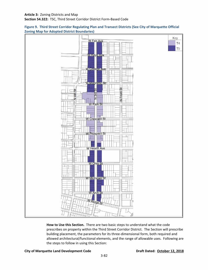
Article 3: Zoning Districts and Map Section 54.322: TSC, Third Street Corridor District Form-Based Code
City of Marquette Land Development Code Draft Dated: October 12, 2018 3-82
Figure 9. Third Street Corridor Regulating Plan and Transect Districts (See City of Marquette Official Zoning Map for Adopted District Boundaries)
How to Use this Section. There are two basic steps to understand what the code prescribes on property within the Third Street Corridor District. The Section will prescribe building placement, the parameters for its three-dimensional form, both required and allowed architectural/functional elements, and the range of allowable uses. Following are the steps to follow in using this Section:

Article 3: Zoning Districts and Map Section 54.322: TSC, Third Street Corridor District Form-Based Code
City of Marquette Land Development Code Draft Dated: October 12, 2018 3-83
(a) Consult the regulating plan, and note this plan identifies two (2) sub-districts within
the Third Street Corridor District. Find the property in question. Note the color of the sub-district — this determines the applicable building form standards, streetscape standards and landscape standards for each property. See regulating plan key for guidance.
(b) Find the appropriate Building Form Standards (BFS) (Figure 12 and Figure 13) in the
code (color coded to match the regulating plan). The BFS explains the basic parameters for building on a particular site in terms of building placement and building form. See Figure 23. Use for specific building use.
(c) See Figure 26. Public Frontage Type for illustrations of general parameters
pertaining to streetscape improvements.
Definitions. The following definitions apply to the Third Street Corridor District only, unless the term has general applicability:
(a) Bicycle Corral: a series of bicycle parking racks that replace on-street automobile
parking. Typically applied where bicycle parking and demand and pedestrian volumes are high. Depending on its configuration, a single motor vehicle parking space may yield between 6 and 12 bicycle parking spaces.
(b) Bicycle Locker: an enclosed and secured locker that provides bicycle parking for long-
term use.
(c) Bicycle Sharing: a fleet of bicycles made publicly available for shared use to individuals for a short period of time.
(d) Bicycle Shelter: a roofed shelter that provides protection from the elements on three
sides and multiple bicycle racks for public use.
(e) Block: the aggregate of private lots, passages, rear alleys and rear lanes, circumscribed by connecting thoroughfares.
(f) Civic Space: an outdoor informal or formal area permanently dedicated for public
use.
(g) Elevation: an exterior wall of a building not along a frontage line. See: facade.
(h) Encroach: to break the plane of a vertical or horizontal regulatory limit with a structural element extending into a setback, into the public frontage, or above a height limit.
(i) Encroachment: any structural element that breaks the plane of a vertical or
horizontal regulatory limit extending into the public frontage setback, or above a height limit.
Article 3: Zoning Districts and Map Section 54.322: TSC, Third Street Corridor District Form-Based Code
City of Marquette Land Development Code Draft Dated: October 12, 2018 3-84
(j) Facade: the exterior wall or elevation of a building that is set along a frontage line.
(k) Forecourt: a private frontage wherein a portion of the facade is close to the frontage and the central portion is set back.
(l) Frontage: the area between a building facade and the vehicular lanes, inclusive of its
built and planted components. Frontage is divided into private and public frontages.
(m) Frontage Buildout: the percentage of the lot width that is occupied by the building facade at the front setback.
(n) Frontage Line: a lot line bordering a public frontage. Facades facing frontage lines
define the public realm and are therefore more regulated than the elevations facing other lot lines.
(o) Landscaped Area: the area of a lot or parcel exclusive of building footprints,
driveway and walkway pavements, and other impervious hardscape areas, and exclusive of ponds, pools and other water features.
(p) Liner Building: a building specifically designed to mask a parking lot or a parking
structure from a public frontage.
(q) Live-Work: a mixed-use unit consisting of a commercial and residential use. The commercial use may be anywhere in the unit.
(r) Lot Coverage: the percentage of a lot that is covered by buildings and other roofed
structures.
(s) Mixed-Use: multiple uses within the same building or in multiple buildings.
(t) Outbuilding: an accessory building, usually located toward the rear of the same lot as a principal building.
(u) Plaza: a civic space type designed for civic purposes and commercial activities in the
morn urban areas, generally paved and spatially defined by building frontages.
(v) Principal Entrance: the main point of access for pedestrians into a building.
(w) Principal Frontage: on corner lots, the private frontage designated to bear the address and principal entrance to the building, and the measure of minimum lot width. Prescriptions for the parking locations pertain only to the principal frontage. Prescriptions for the front setback pertain to both frontages of a corner lot. See frontage.
(x) Private Frontage: the privately owned setback between the frontage line and
principal building facade.
Article 3: Zoning Districts and Map Section 54.322: TSC, Third Street Corridor District Form-Based Code
City of Marquette Land Development Code Draft Dated: October 12, 2018 3-85
(y) Secondary Frontage: on corner lots, the private frontage not on the primary thoroughfare.
(z) Shopfront: a private building frontage for parking spaces that are available to more
than one use with the building entrance at sidewalk grade.
(aa) Square: a civic space type designed for unstructured recreation and civic purposes, spatially defined by building frontages with formal paths, lawns, and trees.
(bb) Stoop: a private frontage wherein the facade is aligned close to the frontage line
with the first story elevated from the sidewalk for privacy, with an exterior stair and landing at the entrance.
(cc) Story: a habitable level within a building, excluding an attic or raised basement.
(dd) Street Screen: a freestanding wall built along the frontage line with the facade. It
may mask a parking lot from the public frontage, provide privacy to a side yard, and/or strengthen the spatial definition of the public realm. (Synonym: street wall).
(ee) Substantial Modification: alternation to a building that is valued at more than 50%
of the replacement cost of the entire building, if new.
(ff) Terrace: a private frontage type with a shallow setback and front elevated patio, usually with a low wall at the frontage line. This type buffers residential uses from urban sidewalks. Terraces are also suitable for outdoor cafes.
(gg) Use, Civic: community uses open to the public including: meeting halls; libraries;
schools; police and fire stations; post offices (retail operations only, no primary distribution facilities); places of worship; museums; cultural, visual and performing art centers; transit centers; and government functions open to the public.
(hh) Use, Commerce: tor the purpose of the Third Street Corridor District, commerce uses
shall be considered to encompass all of the following:
(i) Executive, Administrative, and Professional Offices (ii) Medical and Dental Offices, and Clinics (iii) Day Care Centers (iv) On-premise Alcohol Sales (v) Sidewalk Cafes (vi) Outdoor Food and Beverage Service (vii) All of the Civic Use Categories (viii) All of the Retail Use Categories (ix) Parking Facilities and Structures
(ii) Use, Special Land: for the purpose of the Third Street Corridor District, special land
uses (see Section 54.322(C)(7)(a)) may be considered for placement in the residential classification after review by the Planning Commission in accordance with Section 54.1403 of the City of Marquette Land Development Code.
Article 3: Zoning Districts and Map Section 54.322: TSC, Third Street Corridor District Form-Based Code
City of Marquette Land Development Code Draft Dated: October 12, 2018 3-86
(jj) Use, Light Industrial: for the purpose of the Third Street Corridor District, light
industrial uses shall be considered to encompass all of the following:
(i) Light Manufacturing
(kk) Use, Lodging: for the purpose of the Third Street Corridor District, lodging uses are defined as premises available for daily and weekly renting of bedrooms and shall be considered to encompass all of the following:
(i) Bed and Breakfast (ii) Bed Breakfast Inn (iii) Motel (iv) Hotel
(ll) Use, Residential: for the purpose of the Third Street Corridor District, residential
uses shall be considered to encompass all of the following:
(i) Dwelling Units (ii) Adult Foster Care Family Home (iii) Family Day Care Homes (iv) Foster Family Homes (v) Spouse Abuse Shelter
(mm) Use, Retail: shall be considered to encompass all of the following:
(i) Retail Service: establishments providing services, as opposed to products, to the
general public, including restaurants, finance, real estate and insurance, travel agencies, health and educational services, galleries, and temporary storage of recreational equipment, provided that the temporary storage is ancillary to the primary retail service.
(ii) Retail Specialty: Include, but are not limited to the sale of gifts, antiques,
flowers, books, jewelry, wearing apparel or craft shops making articles exclusively for sale at retail on the premises.
(iii) Retail Trade: Establishments engaged in selling new goods or merchandise to
the general public for personal or household consumption and rendering services incidental to the sale of such goods.
(B) Third Street Corridor Form-Based Code General Standards.
Instructions.
(a) Site and buildings plans submitted under this Section require administrative approval
by the Planning Department.

Article 3: Zoning Districts and Map Section 54.322: TSC, Third Street Corridor District Form-Based Code
City of Marquette Land Development Code Draft Dated: October 12, 2018 3-87
(b) Building and site plans submitted under this Section shall show the following, in compliance with the standards described in this Section:
(i) For site and building approval:
a. Building Placement b. Building Specifications c. Building Use d. Parking Standards e. Fencing Standards f. Landscape Standards g. Signage Standards
Pre-Existing Conditions.
(a) Existing buildings and appurtenances that do not conform to the provisions of this
Section may continue in use as they are until a substantial modification is requested.
(b) The modification of existing buildings is permitted by right if such changes result in greater conformance with the specifications of this Section.
Civic Spaces (CS)
(a) Civic spaces shall be generally designed as described in Figure 10. Civic Space.
Figure 10. Civic Space
a. Square: A square is spatially defined by building frontages. Its landscape shall consist of paths, lawns, and trees, formally disposed. Squares shall be located at the intersection of important thoroughfares. The minimum size shall be 1/4 acre and the maximum shall be 3 acres.
T4
T5
b. Plaza: A plaza shall be spatially defined by building frontages. Its landscape shall consist primarily of pavement. Trees are optional. Plazas should be located at the intersection of important streets. The minimum size shall be 1/4 acre and the maximum shall be 2 acres.
T4
T5
T4
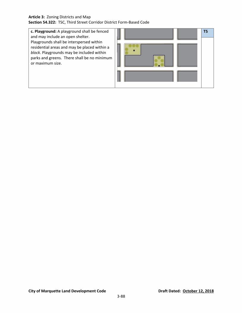
Article 3: Zoning Districts and Map Section 54.322: TSC, Third Street Corridor District Form-Based Code
City of Marquette Land Development Code Draft Dated: October 12, 2018 3-88
c. Playground: A playground shall be fenced and may include an open shelter. Playgrounds shall be interspersed within residential areas and may be placed within a block. Playgrounds may be included within parks and greens. There shall be no minimum or maximum size.
T5
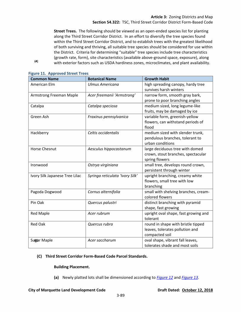
Article 3: Zoning Districts and Map Section 54.322: TSC, Third Street Corridor District Form-Based Code
City of Marquette Land Development Code Draft Dated: October 12, 2018 3-89
Street Trees. The following should be viewed as an open-ended species list for planting along the Third Street Corridor District. In an effort to diversify the tree species found within the Third Street Corridor District, and to establish trees with the greatest likelihood of both surviving and thriving, all suitable tree species should be considered for use within the District. Criteria for determining “suitable” tree species include tree characteristics (growth rate, form), site characteristics (available above-ground space, exposure), along with exterior factors such as USDA hardiness zones, microclimates, and plant availability.
Figure 11. Approved Street Trees
Common Name Botanical Name Growth Habit
American Elm Ulmus Americana high spreading canopy, hardy tree survives harsh winters
Armstrong Freeman Maple Acer freemanii ‘Armstrong’ narrow form, smooth gray bark, prone to poor branching angles
Catalpa Catalpa speciosa medium sized, long legume-like fruits, may be damaged by ice
Green Ash Fraxinus pennsylvanica variable form, greenish-yellow flowers, can withstand periods of flood
Hackberry Celtis occidentalis medium sized with slender trunk, pendulous branches, tolerant to urban conditions
Horse Chesnut Aesculus hippocastanum large deciduous tree with domed crown, stout branches, spectacular spring flowers
Ironwood Ostrya virginiana small tree, develops round crown, persistent through winter
Ivory Silk Japanese Tree Lilac Syringa reticulata ‘Ivory Silk’ upright branching, creamy white flowers, small tree with low branching
Pagoda Dogwood Cornus alternifolia small with shelving branches, cream-colored flowers
Pin Oak Quercus palustri distinct branching with pyramid shape, fast growing
Red Maple Acer rubrum upright oval shape, fast growing and tolerant
Red Oak Quercus rubra round in shape with bristle tipped leaves, tolerates pollution and compacted soil
Sugar Maple Acer saccharum oval shape, vibrant fall leaves, tolerates shade and most soils
(C) Third Street Corridor Form-Based Code Parcel Standards.
Building Placement.
(a) Newly platted lots shall be dimensioned according to Figure 12 and Figure 13.

Article 3: Zoning Districts and Map Section 54.322: TSC, Third Street Corridor District Form-Based Code
City of Marquette Land Development Code Draft Dated: October 12, 2018 3-90
(b) Buildings shall be placed in relation to the boundaries of their lots according to
Figure 12 and Figure 13.
(c) Lot coverage by building shall not exceed that recorded in Figure 12 and Figure 13.
(d) Facades shall be built parallel to a rectilinear principal frontage line or to the tangent of a curved principal frontage line, and along a minimum percentage of the frontage width at the setback, as specified as frontage buildout on Figure 12 and Figure 13.
(e) Setbacks for principal buildings shall be as shown in Figure 12 and Figure 13.
Setbacks may be adjusted by up to 10% by administrative waiver to accommodate specific site conditions. The Planning Director or his designee shall make the following written findings:
(i) The waiver is consistent with the provisions of Section 54.322(A)(1).
(ii) The waiver is consistent with the Community Master Plan.
(iii) The building placement will not materially endanger the public health or safety.
(iv) The building placement will not substantially injure the value of adjoining
property; or that the use is a public necessity.
(v) The location and character of the building placement, if developed according to the plans and information approved, will be in harmony with proximate land uses, and consistent with the purposes of the district.
(vi) The building placement will not adversely affect the district by altering its
character.
(f) Rear setbacks for outbuildings shall be a minimum of 3 feet measured from the property line. In the absence of rear alley or rear lane, the rear setback shall be as shown in Figure 12 and Figure 13.
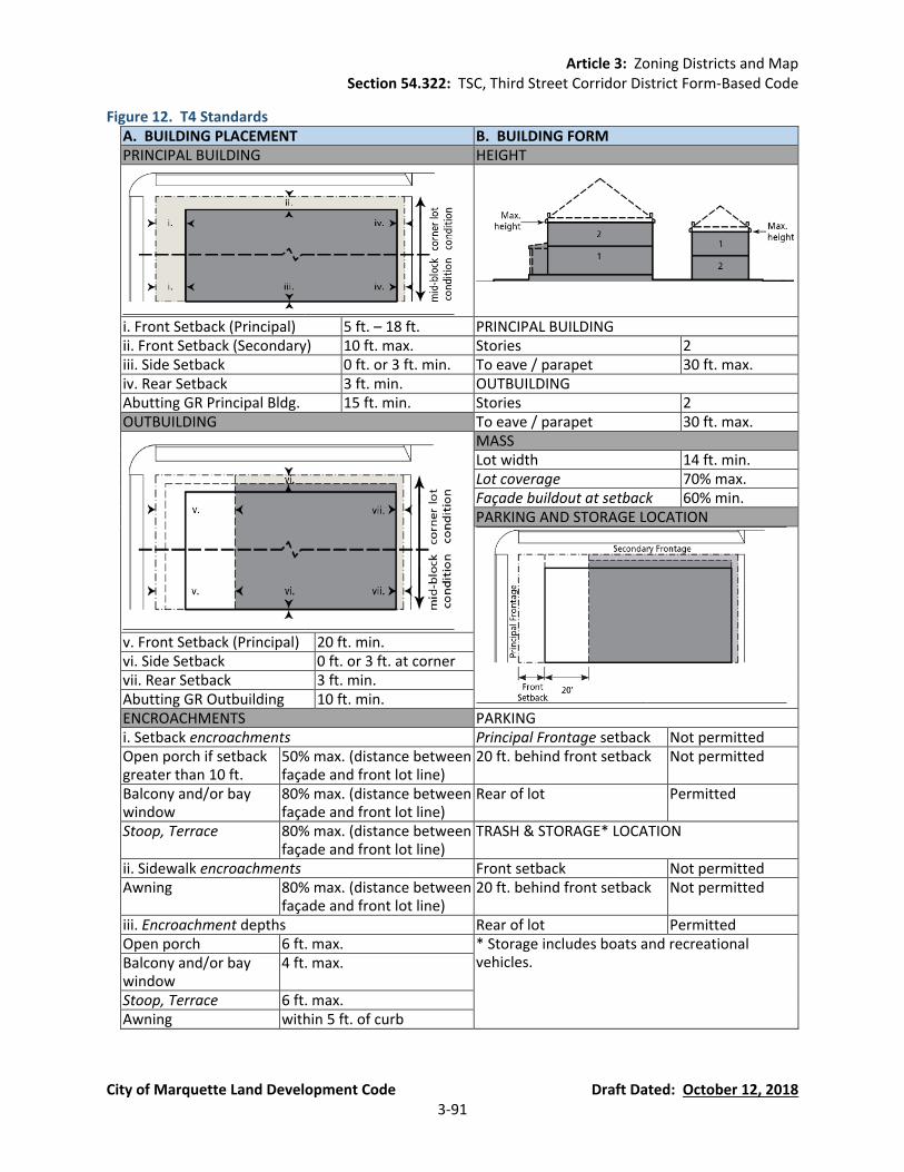
Article 3: Zoning Districts and Map Section 54.322: TSC, Third Street Corridor District Form-Based Code
City of Marquette Land Development Code Draft Dated: October 12, 2018 3-91
Figure 12. T4 Standards A. BUILDING PLACEMENT B. BUILDING FORM PRINCIPAL BUILDING HEIGHT
i. Front Setback (Principal) 5 ft. – 18 ft. PRINCIPAL BUILDING ii. Front Setback (Secondary) 10 ft. max. Stories 2 iii. Side Setback 0 ft. or 3 ft. min. To eave / parapet 30 ft. max. iv. Rear Setback 3 ft. min. OUTBUILDING Abutting GR Principal Bldg. 15 ft. min. Stories 2 OUTBUILDING To eave / parapet 30 ft. max.
MASS Lot width 14 ft. min. Lot coverage 70% max. Façade buildout at setback 60% min. PARKING AND STORAGE LOCATION
v. Front Setback (Principal) 20 ft. min. vi. Side Setback 0 ft. or 3 ft. at corner vii. Rear Setback 3 ft. min. Abutting GR Outbuilding 10 ft. min. ENCROACHMENTS PARKING i. Setback encroachments Principal Frontage setback Not permitted Open porch if setback greater than 10 ft.
50% max. (distance between façade and front lot line)
20 ft. behind front setback Not permitted
Balcony and/or bay window
80% max. (distance between façade and front lot line)
Rear of lot Permitted
Stoop, Terrace 80% max. (distance between façade and front lot line)
TRASH & STORAGE* LOCATION
ii. Sidewalk encroachments Front setback Not permitted Awning 80% max. (distance between
façade and front lot line) 20 ft. behind front setback Not permitted
iii. Encroachment depths Rear of lot Permitted Open porch 6 ft. max. * Storage includes boats and recreational
vehicles. Balcony and/or bay window
4 ft. max.
Stoop, Terrace 6 ft. max. Awning within 5 ft. of curb
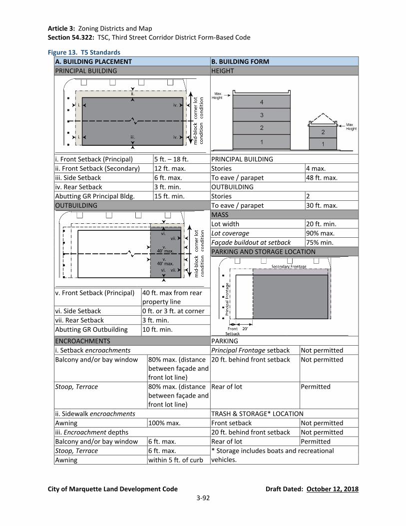
Article 3: Zoning Districts and Map Section 54.322: TSC, Third Street Corridor District Form-Based Code
City of Marquette Land Development Code Draft Dated: October 12, 2018 3-92
Figure 13. T5 Standards
A. BUILDING PLACEMENT B. BUILDING FORM
PRINCIPAL BUILDING HEIGHT
i. Front Setback (Principal) 5 ft. – 18 ft. PRINCIPAL BUILDING
ii. Front Setback (Secondary) 12 ft. max. Stories 4 max.
iii. Side Setback 6 ft. max. To eave / parapet 48 ft. max.
iv. Rear Setback 3 ft. min. OUTBUILDING
Abutting GR Principal Bldg. 15 ft. min. Stories 2
OUTBUILDING To eave / parapet 30 ft. max.
MASS
Lot width 20 ft. min.
Lot coverage 90% max.
Façade buildout at setback 75% min.
PARKING AND STORAGE LOCATION
v. Front Setback (Principal) 40 ft. max from rear property line
vi. Side Setback 0 ft. or 3 ft. at corner
vii. Rear Setback 3 ft. min.
Abutting GR Outbuilding 10 ft. min.
ENCROACHMENTS PARKING
i. Setback encroachments Principal Frontage setback Not permitted
Balcony and/or bay window 80% max. (distance between façade and front lot line)
20 ft. behind front setback Not permitted
Stoop, Terrace 80% max. (distance between façade and front lot line)
Rear of lot Permitted
ii. Sidewalk encroachments TRASH & STORAGE* LOCATION
Awning 100% max. Front setback Not permitted
iii. Encroachment depths 20 ft. behind front setback Not permitted
Balcony and/or bay window 6 ft. max. Rear of lot Permitted
Stoop, Terrace 6 ft. max. * Storage includes boats and recreational vehicles. Awning within 5 ft. of curb

Article 3: Zoning Districts and Map Section 54.322: TSC, Third Street Corridor District Form-Based Code
City of Marquette Land Development Code Draft Dated: October 12, 2018 3-93
Figure 14. Frontages and Elevations
Building Specifications: Height
(a) Building height is pursuant to Figure 15, measured as follows:
(i) Building height is measured in above ground stories.
(ii) Stories are measured from finished floor to finished ceiling.
(iii) Stories above the ground floor are limited to 14 feet after which height they are counted as two stories.
(iv) For residential uses, a ground floor story of 18 feet or less is counted as one
story. Ground floors exceeding 18 feet in height are counted as two stories.
(v) For non-residential and mixed-uses a ground floor story shall be no less than 10 feet in height. A ground floor story of 25 feet or less is counted as one story. Ground floors exceeding 25 feet in height are counted as two stories.
(vi) Height limits do not apply to unfinished attics, masts, belfries, clock towers,
chimney flues, water tanks, or elevator bulkheads.
(vii) Building stepbacks shall be required in T5 pursuant to the following dimensions (See Figure 15):
a. Facades facing GR parcels shall maintain a 45° height plane beginning at 35
feet above the average grade at the property line.
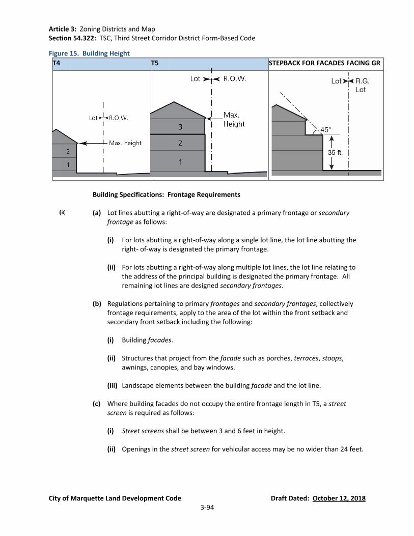
Article 3: Zoning Districts and Map Section 54.322: TSC, Third Street Corridor District Form-Based Code
City of Marquette Land Development Code Draft Dated: October 12, 2018 3-94
Figure 15. Building Height
T4 T5 STEPBACK FOR FACADES FACING GR
Building Specifications: Frontage Requirements
(a) Lot lines abutting a right-of-way are designated a primary frontage or secondary
frontage as follows:
(i) For lots abutting a right-of-way along a single lot line, the lot line abutting the right- of-way is designated the primary frontage.
(ii) For lots abutting a right-of-way along multiple lot lines, the lot line relating to
the address of the principal building is designated the primary frontage. All remaining lot lines are designed secondary frontages.
(b) Regulations pertaining to primary frontages and secondary frontages, collectively
frontage requirements, apply to the area of the lot within the front setback and secondary front setback including the following:
(i) Building facades.
(ii) Structures that project from the facade such as porches, terraces, stoops,
awnings, canopies, and bay windows.
(iii) Landscape elements between the building facade and the lot line.
(c) Where building facades do not occupy the entire frontage length in T5, a street screen is required as follows:
(i) Street screens shall be between 3 and 6 feet in height.
(ii) Openings in the street screen for vehicular access may be no wider than 24 feet.

Article 3: Zoning Districts and Map Section 54.322: TSC, Third Street Corridor District Form-Based Code
City of Marquette Land Development Code Draft Dated: October 12, 2018 3-95
(iii) Street screens may be made of the following materials: brick, stone; stucco over masonry, iron, steel, or aluminum that appears to be iron. Non-opaque street screens require planting behind to increase opacity.
(d) Frontages are divided into the following types: porch, stoop, terrace, common entry,
forecourt, and shopfront.
(e) The Zoning Administrator shall designate which frontage type corresponds to the building(s) on the site or are proposed to be built, and the site shall comply with the standards for that type when new construction or substantial rehabilitation is proposed.
(i) Frontage types are limited by transect zone according to Figure 16, Figure 17,
and Figure 18.
(ii) A shopfront frontage is required for all ground floor retail uses. Shopfronts may be combined with terraces and forecourts.
(f) Where buildings have multiple frontages or multiple buildings are located on one lot,
similar frontage types should be selected for all frontages.
(g) Loading docks and service areas up to a combined width of 30 feet may be incorporated into frontages as follows:
(i) At secondary frontages located towards the rear of the lot.
(ii) At primary frontages where lots have no secondary frontage and lot width
exceeds 100 feet.
(h) Roof overhangs, cornices, window and door surrounds and other facade decorations may encroach into the front setback up to 2 feet beyond the structure they are attached to but not beyond the lot line.
(i) Other structural encroachments shall be pursuant to Figure 12 and Figure 13.
(j) Encroachments into the front setback are prohibited except where specifically
permitted in this Section or Figure 12 and Figure 13.

Article 3: Zoning Districts and Map Section 54.322: TSC, Third Street Corridor District Form-Based Code
City of Marquette Land Development Code Draft Dated: October 12, 2018 3-96
Figure 16. Private Frontages (Porches and Stoops)
SECTION PLAN
FRONT SETBACK REGULATIONS PRIVATE FRONTAGE
PUBLIC FRONTAGE
PRIVATE FRONTAGE
PUBLIC FRONTAGE
PORCH
Transect district T4
Required elements
Porch; hedges, fences, or walls
Porch requirements
Shall occupy a minimum of 60% of the width of the building facade. 6 feet deep minimum.
Porch encroachments into setback
50% of the distance between façade and front lot line
Surface Treatment
Grass, groundcover
Special requirements
Fences, hedges and walls shall be along frontage lines or parallel with the façade of the principal building. The first floor shall have a minimum elevation of 18 inches above average grade along the front lot line and a maximum elevation of 36 inches.
STOOP
Transect district T4, T5
Permitted elements
Hedges and metal fences
Encroachments into setback
80% of the distance between façade and front lot line
Surface Treatment
Paved in coordination with the public frontage or with pervious materials
Special requirements
May be recessed into the building façade where a front setback is less than 10 feet. The first floor shall have a minimum elevation of 20 inches above average grade along the front lot line and a maximum of 36 inches. Stoops shall have a landing between 4 and 6 feet deep. Stairs providing access to a stoop may encroach up to the lot line.
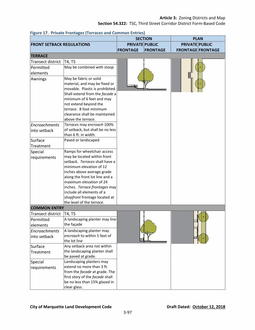
Article 3: Zoning Districts and Map Section 54.322: TSC, Third Street Corridor District Form-Based Code
City of Marquette Land Development Code Draft Dated: October 12, 2018 3-97
Figure 17. Private Frontages (Terraces and Common Entries)
SECTION PLAN
FRONT SETBACK REGULATIONS PRIVATE FRONTAGE
PUBLIC FRONTAGE
PRIVATE FRONTAGE
PUBLIC FRONTAGE
TERRACE
Transect district T4, T5
Permitted elements
May be combined with stoop
Awnings May be fabric or solid material, and may be fixed or movable. Plastic is prohibited. Shall extend from the facade a minimum of 6 feet and may not extend beyond the terrace. 8 foot minimum clearance shall be maintained above the terrace.
Encroachments into setback
Terraces may encroach 100% of setback, but shall be no less than 6 ft. in width.
Surface Treatment
Paved or landscaped
Special requirements
Ramps for wheelchair access may be located within front setback. Terraces shall have a minimum elevation of 12 inches above average grade along the front lot line and a maximum elevation of 24 inches. Terrace frontages may include all elements of a shopfront frontage located at the level of the terrace.
COMMON ENTRY
Transect district T4, T5
Permitted elements
A landscaping planter may line the façade
Encroachments into setback
A landscaping planter may encroach to within 5 feet of the lot line
Surface Treatment
Any setback area not within the landscaping planter shall be paved at grade.
Special requirements
Landscaping planters may extend no more than 3 ft. from the facade at grade. The first story of the facade shall be no less than 15% glazed in clear glass.
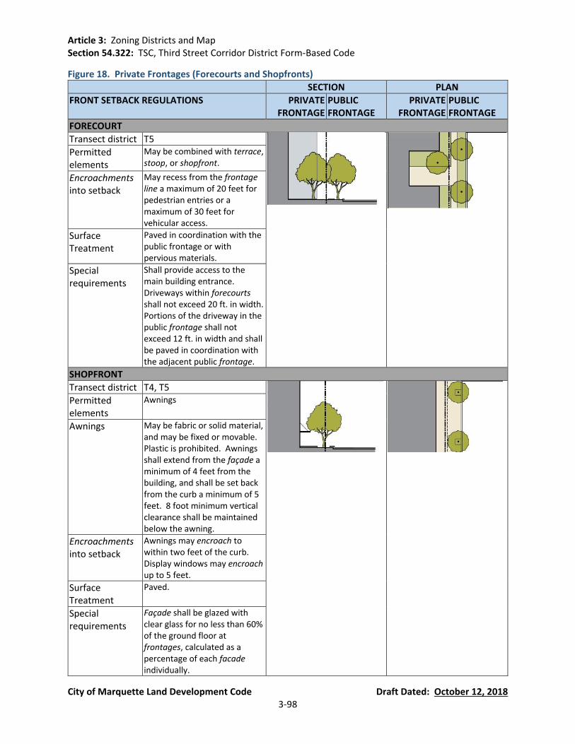
Article 3: Zoning Districts and Map Section 54.322: TSC, Third Street Corridor District Form-Based Code
City of Marquette Land Development Code Draft Dated: October 12, 2018 3-98
Figure 18. Private Frontages (Forecourts and Shopfronts)
SECTION PLAN
FRONT SETBACK REGULATIONS PRIVATE FRONTAGE
PUBLIC FRONTAGE
PRIVATE FRONTAGE
PUBLIC FRONTAGE
FORECOURT
Transect district T5
Permitted elements
May be combined with terrace, stoop, or shopfront.
Encroachments into setback
May recess from the frontage line a maximum of 20 feet for pedestrian entries or a maximum of 30 feet for vehicular access.
Surface Treatment
Paved in coordination with the public frontage or with pervious materials.
Special requirements
Shall provide access to the main building entrance. Driveways within forecourts shall not exceed 20 ft. in width. Portions of the driveway in the public frontage shall not exceed 12 ft. in width and shall be paved in coordination with the adjacent public frontage.
SHOPFRONT
Transect district T4, T5
Permitted elements
Awnings
Awnings May be fabric or solid material, and may be fixed or movable. Plastic is prohibited. Awnings shall extend from the façade a minimum of 4 feet from the building, and shall be set back from the curb a minimum of 5 feet. 8 foot minimum vertical clearance shall be maintained below the awning.
Encroachments into setback
Awnings may encroach to within two feet of the curb. Display windows may encroach up to 5 feet.
Surface Treatment
Paved.
Special requirements
Façade shall be glazed with clear glass for no less than 60% of the ground floor at frontages, calculated as a percentage of each facade individually.

Article 3: Zoning Districts and Map Section 54.322: TSC, Third Street Corridor District Form-Based Code
City of Marquette Land Development Code Draft Dated: October 12, 2018 3-99
Fencing Standards.
(a) Hedges in frontage fences shall be evergreen.
(b) Wood frontage fences shall be painted or stained.
(c) No single frontage fence horizontal panel shall exceed 42 inches in height along a
frontage lot line. See Figure 22. Fence Panels.
(d) Private lot line fences shall be between 60 and 72 inches in height. See Figure 21. Fence Locations.
(e) Frontage fences may occur at the lot line, or up to 18” behind the lot line to permit
landscaping.
(f) When erected on a lot line, all of the fence and any of its supporting structures shall be contained within the lot.
(g) The supporting members and posts shall be on the inside, and the smooth or flat
faces on the outside. If two faces are used, each face shall be of the same type and finish. Board on board fences is considered equal treatment.
(h) Barbed wire, razor wire, and electrically charged fences are not permitted.
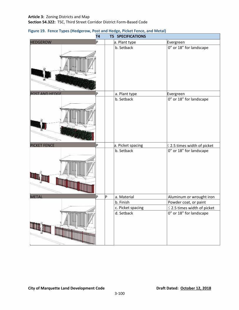
Article 3: Zoning Districts and Map Section 54.322: TSC, Third Street Corridor District Form-Based Code
City of Marquette Land Development Code Draft Dated: October 12, 2018 3-100
Figure 19. Fence Types (Hedgerow, Post and Hedge, Picket Fence, and Metal)
T4 T5 SPECIFICATIONS
HEDGEROW P a. Plant type Evergreen
b. Setback 0” or 18” for landscape
POST AND HEDGE P a. Plant type Evergreen b. Setback 0” or 18” for landscape
PICKET FENCE P a. Picket spacing ≤ 2.5 times width of picket b. Setback 0” or 18” for landscape
METAL P P a. Material Aluminum or wrought iron b. Finish Powder coat, or paint
c. Picket spacing ≤ 2.5 times width of picket d. Setback 0” or 18” for landscape

Article 3: Zoning Districts and Map Section 54.322: TSC, Third Street Corridor District Form-Based Code
City of Marquette Land Development Code Draft Dated: October 12, 2018 3-101
Figure 20. Fence Types (Masonry, and Metal and Masonry)
T4 T5 SPECIFICATIONS
MASONRY P P a. Material Stone, brick, or stucco
b. Setback 0” or 18” for landscape
METAL AND MASONRY P a. Material
Stone, brick or stucco with metal panels
b. Setback 0” or 18” for landscape

Article 3: Zoning Districts and Map Section 54.322: TSC, Third Street Corridor District Form-Based Code
City of Marquette Land Development Code Draft Dated: October 12, 2018 3-102
Figure 21. Fence Locations
Figure 22. Fence Panels

Article 3: Zoning Districts and Map Section 54.322: TSC, Third Street Corridor District Form-Based Code
City of Marquette Land Development Code Draft Dated: October 12, 2018 3-103
Signage Standards. See Article 11.
Architectural Standards. This section does not apply to single-family and two-family edge yard and side yard residential unit building types.
(a) Façade Standards:
(i) Glazing (i.e., windows) above the first story shall not exceed 60% of the total
building facade wall area, with each facade being calculated independently.
(ii) The shopfront private frontage shall be no less than 70% glazing (i.e., windows).
(iii) All glass shall be clear and free of color.
(iv) Low pitch or flat roofs shall be enclosed by a parapet that as high as necessary to conceal mechanical equipment.
(v) Exterior building materials shall be masonry, concrete, tile, stone, and wood,
unless otherwise designated by the individual building form standards; glass curtain walls and reflective glass of greater than 30% reflectance are prohibited due to the undesirable blinding effect compounded by snow.
Use. Buildings, as the primary element of town planning, are subject to variations in use,
placement and configuration.
(a) Special land uses shall be administered by the Planning Commission in accordance with Section 54.1403 of the Land Development Code. Special land use permits shall be granted if the following conditions are met:
(i) The use will not materially endanger the public health or safety or constitute a
public nuisance if located where proposed and developed according to the plans and information submitted and approved.
(ii) The use will not substantially injure the value of adjoining property; or that the
use in a public necessity.
(iii) The location and character, if developed according to the plans and information approved, will be in harmony with the proximate land uses, and consistent with the purposes of the district.
(b) Uses permitted By Right. See Figure 23.
(c) Special Land Uses:
(i) Group Day Care Home (ii) Foster Family Group Home (iii) Halfway House

Article 3: Zoning Districts and Map Section 54.322: TSC, Third Street Corridor District Form-Based Code
City of Marquette Land Development Code Draft Dated: October 12, 2018 3-104
(d) General to all sub-districts:
(i) All buildings in each transect district shall conform to the uses and types on Figure 23. Use.
Figure 23. Use
USE T4 T5 USE T4 T5
A. RESIDENTIAL F. AUTOMOTIVE
Mixed use building P P Gasoline P P
Multi-family dwelling (Section 54.616) P P Service P P
Live-work unit (Section 54.615) P P Sales P P
Two-family dwelling (Section 54.613) P P Truck maintenance
Townhouse P P Drive-through facility (Section 54.611) P P
Single-family dwelling (Section 54.617) P P G. CIVIL SUPPORT
Group day care home (Section 54.608) S S Funeral home P P
Foster family home S S Hospital (Section 54.625) S
Halfway house (Section 54.620) S S Medical clinic P P
Home occupation (Section 54.621) P P Veterinary clinic P P
Home office (Section 54.622) P P Pet boarding facility S S
B. LODGING H. EDUCATION
Hotel S P High school S S
Inn (up to 12 rooms) (Section 54.604) P P Elementary school P P
Bed & Breakfast (up to 6 rooms) (Section 54.603)
P P Childcare center P P
C. OFFICE I. INDUSTRIAL
Office building (Section 54.631) P P Heavy industrial facility
Mixed use building P P Light industrial facility (Section 54.627) S S
Live-work unit (Section 54.615) P P Laboratory facility S S
D. RETAIL Warehouse S S
Open market building P P Mini-storage S
Mixed use building P P
Retail building P P
Gallery P P
Restaurant P P
Kiosk P P
Push cart P P
E. INSTITUTIONAL
Conference center P
Live theater S P
Movie theater S P
Museum P P Permitted Use P
Religious assembly (Section 54.637) P P Special Land Use S
Parking Location and Access.
(a) Parking shall not be located within 25 feet of the primary frontage.

Article 3: Zoning Districts and Map Section 54.322: TSC, Third Street Corridor District Form-Based Code
City of Marquette Land Development Code Draft Dated: October 12, 2018 3-105
(b) Required parking may be fulfilled in the following locations:
(i) Parking spaces provided within the lot.
(ii) Parking spaces provided along a parking lane (on-street) corresponding to lot
frontages.
(iii) Parking spaces may be leased from a private or public parking facility within 500 feet of the lot.
(c) Off-street parking shall be accessed by alleys where available.
(d) Where alleys are not available, off-street parking may be accessed from the following
locations:
(i) From secondary frontages; driveways should be located near the rear lot line.
(ii) Where secondary frontages are not available, parking may be accessed from the primary frontage in T4 for lots with a minimum width of 45 feet, in T5 for lots with a minimum width of 60 feet.
(e) Driveways providing access to off-street parking are limited to 10 feet in width in T4
and 24 feet in T5.
Off-street Parking Design.
(a) Off-street parking for single-family residential uses are not subject to the design requirements of this section.
(b) All off-street parking spaces and aisles shall meet AASHTO size and configuration
standards.
(c) Off-street parking facilities shall have a minimum vertical clearance of 7 feet. Where such a facility is to be used by trucks or for loading, the minimum clearance is 15 feet.
(d) Parking lots and structures visible from frontages require one of the following
screening methods or a combination of methods:
(i) Liner buildings, optional at parking lots and required at parking structures. A mini- mum of 70% of parking structure width shall be screened ground floor frontages.
(ii) A masonry wall no less than 4 feet in height.
(iii) A metal fence with an evergreen hedge or other landscape element to screen
the view of parking.

Article 3: Zoning Districts and Map Section 54.322: TSC, Third Street Corridor District Form-Based Code
City of Marquette Land Development Code Draft Dated: October 12, 2018 3-106
Figure 24. Parking Requirements
T4 T5
Residential * 1.125 / dwelling 1.0 / dwelling
Lodging 1.0 / bedroom 1.0 / bedroom
Office no minimum no minimum
Retail no minimum no minimum
Civic 1.0 / 5 seat assembly use 1.0 / 1,000 sq. ft. of exhibition or indoor recreation area. Parking requirement may be reduced pursuant to Figure 25. Parking may be provided by ownership or lease offsite within 1,000 feet.
1.0 / 5 seat assembly use 1.0 / 1,000 sq. ft. of exhibition or indoor recreation area. Parking requirement may be reduced pursuant to Figure 25. Parking may be provided by ownership or lease offsite within 1,000 feet.
* Senior housing or student housing requirements may be reduced by 50%.
Figure 25. Parking Occupancy Rates
USES MONDAY THROUGH FRIDAY M – F M – F
SATURDAY AND SUNDAY
8AM – 6PM 6PM – 12AM 12AM – 8AM 8AM – 6PM 6PM – 12AM 12AM – 8AM
Residential 60% 100% 100% 80% 100% 100%
Lodging 70% 100%
100% 70% 100% 100%
Office 100% 20% 5% 5% 5% 5%
Retail 90% 80% 5% 100% 70% 5%
Restaurant 70% 100% 100% 70% 100% 100%
Movie theater 40% 80% 10% 80% 100% 10%
Entertainment 40% 100% 10% 80% 100% 50%
Conference 100% 100% 5% 100% 100% 5%
Civic (non-church) 100% 20% 5% 10% 10% 5%
Civic (church) 20% 20% 5% 100% 50% 5%
Planning Staff shall provide a spreadsheet that will perform calculations for specific applications based upon the above occupancy rates.
Bicycle Parking.
(a) Intent. Short and long-term bicycle parking facilities shall:
(i) Maximize visibility and minimize opportunities for vandalism by being located in
locations within clear view of pedestrian traffic, windows, doors, and/or well-lit areas.
(ii) Deter theft and provide for convenient parking ingress and egress by supporting
the bicycle frame in at least two places.
Article 3: Zoning Districts and Map Section 54.322: TSC, Third Street Corridor District Form-Based Code
City of Marquette Land Development Code Draft Dated: October 12, 2018 3-107
(iii) Protect bicycles from inclement weather to the extent possible, as long as the facilities meet or exceed visibility, spacing, and performance standards.
(iv) Secure bicycles at a safe distance away from automobiles parked on-street, in
lots, or in structures so that bicycles will not be damaged by opening doors or errant driving behavior.
(v) Not obstruct pedestrian movement in any way.
(vi) Place the rack(s) between the primary road/path used by bicyclists and the
entrance to the destination(s) they serve. See Figure 29 for bicycle parking proximity guidelines.
(vii) Not obstruct stairs, walls, berms, or handicap accessible ramps.
(viii) Provide enough space for bicycles of all types to maximize the intended bicycle
parking capacity of a given facility.
Landscape Standards.
(a) Intent. A transect-based landscape plan provides many aesthetic, ecological, functional and health/safety benefits. The standards of this section promote public health, safety, and welfare by establishing minimum standards for the design, construction and maintenance of landscape improvements for public frontages and private frontages, lots, civic spaces, and thoroughfares.
(i) Aesthetics/Walkability. These standards should enhance the overall aesthetic
condition of communities, neighborhoods and the public realm with landscaping by:
a. Providing spatial definition to the public realm
b. Providing screening of unsightly places and/or mitigation of conditions that
are incongruent with Section 54.322(A)(1) of this Section.
(ii) Health/Safety. These standards should enhance comfort, safety, and utilization of the public realm by moderating the local microclimate through the application of trees and landscaping to:
a. Improve air quality b. Mitigate noise pollution c. Provide seasonal shade, sun and temperature regulation d. Reduce reflected light e. Mitigate wind gusts f. Provide a partial barrier between sidewalks and vehicular lanes g. Provide areas for the convenient removal and storage of snow
(b) Landscape Design Standards Applicable to All Sub-Districts.

Article 3: Zoning Districts and Map Section 54.322: TSC, Third Street Corridor District Form-Based Code
City of Marquette Land Development Code Draft Dated: October 12, 2018 3-108
(i) The spacing and placement of plants shall be adequate and appropriate for the
typical size, shape, and habit of the plant species at maturity.
(ii) Proposed trees and understory trees shall be centered horizontally and minimally:
a. Two (2) feet from walkways, curbing, and other impervious pavements
when planted in a tree well or continuous planter;
b. Three (3) feet from walkways, curbing and other impervious pavements when planted in a continuous swale;
c. Five (5) feet from street lights, underground utilities, utility meters and
service lines, fences, walls and other ground level obstructions;
d. Six (6) feet from porch eaves, and awnings and similar overhead obstructions associated with the ground level of buildings;
e. Eight (8) feet from balconies, verandas, building eaves and cornices, and
similar overhead obstructions associated with the upper stories of buildings.
(iii) Proposed trees shall be a minimum height of ten (10) feet and / or three (3)
inches in caliper.
(iv) Proposed understory trees shall be a minimum of eight (8) feet in height and/ or two-and-one-half (2-1/2) inches in caliper.
(v) Proposed Shrubs shall be of a five (5) gallon container minimum. Shrubs shall
be 18” – 24” minimum clear from any sidewalk or pavement edge at the Lot line.
(vi) Ground vegetation or Shrub plantings with spines, thorns, or needles that may
present hazards to pedestrians, bicyclists or vehicles are prohibited in the first two (2) feet of the front setback.
(vii) Bare and exposed ground on the site and / or in landscaped areas shall be
covered with live plant materials and / or mulch, with the following exceptions:
(viii) Artificial plants or artificial turf are prohibited.
(ix) Buffers and screening elements shall be used to screen parking areas from public view, to screen service yards and other places that are unsightly.
(c) Landscape Construction Standards.

Article 3: Zoning Districts and Map Section 54.322: TSC, Third Street Corridor District Form-Based Code
City of Marquette Land Development Code Draft Dated: October 12, 2018 3-109
(i) All plant materials shall meet with the minimum container size, class and other requirements outlined in American Standard for Nursery Stock (ANSI Z60.1-2004) published by the American Nursery and Landscape Association (ANLA) or other local Nursery Association Standards.
(ii) The soil structure of planting strips shall be protected from compaction with a
temporary construction fence. Standards of access, excavation, movement, storage and backfilling of soils in relation to the construction and maintenance of deep utilities and manholes shall be specified.
(iii) The topsoil within the construction area’s limits of disturbance shall be
removed, stored and amended as recommended by a landscape soils test.
(iv) Wind erosion shall be mitigated and controlled though dust abatement and similar practices during the period of site work and construction.
(v) Landscape soils that have been compacted during construction activities shall be
loosened and aerated to a depth of at least six (6) inches before planting.
(vi) Plants shall have normal, well-developed branches and vigorous root systems.
(vii) Temporary spray irrigation systems may be used to establish seeded areas for grass and groundcover.
(d) Landscape Maintenance.
(i) All grass and vegetation shall be lightly fertilized to avoid fertilizer pollution to
groundwater, streams, and ponds.
(ii) No disturbed ground shall be left exposed. Turf grass and other approved and appropriate groundcovers or mulch shall cover all non-paved and non-built developed areas.
(iii) It shall be the responsibility of the property owner(s) or his assigned agent(s) to:
a. Maintain and keep all screening and fencing in good condition at all times;
and
b. Maintain landscaping by keeping Turf grass lawns properly mowed and edged, plants properly pruned and disease-free, and planting beds mulched, groomed and weeded, except in areas of naturally occurring vegetation and undergrowth; and
c. Replace any required planting(s) that are significantly damaged, removed,
infested, disease ridden, or dead within one year or the next planting season, whichever occurs first, except in areas of naturally occurring vegetation and undergrowth.

Article 3: Zoning Districts and Map Section 54.322: TSC, Third Street Corridor District Form-Based Code
City of Marquette Land Development Code Draft Dated: October 12, 2018 3-110
(e) Specific to sub-district T4:
(i) The minimum required landscape area shall be twenty (20) percent of the front setback.
(ii) Preservation of on-site existing trees and vegetation is encouraged and may be
used to fulfill the landscape requirements.
a. The root zones of existing trees and vegetation to be preserved shall be protected from clearing or construction activities.
b. The size and limits of existing vegetation shall be indicated on the
landscape plan.
(iii) The applicant may remove mature, healthy, non-invasive trees only within areas of a lot that are inside the proposed footprint of the primary structure.
(iv) The applicant shall replace mature trees that are removed on the site with trees
of the same or similar species whose combined caliper dimensions equal that of the tree removed.
(v) During construction, the root zone of existing vegetation to be preserved shall
be enclosed by a temporary protective fence.
(vi) All landscape areas compacted during construction activities shall be retiled and re- conditioned to provide an arable topsoil layer that can support the long term health and vitality of landscaping.
(vii) The topsoil within the construction area’s limits of disturbance shall be
removed, stored, and amended with organic soil additives as recommended by a landscape soils test prior to being redistributed.
(f) Specific to sub-district T5:
(i) Landscape islands in interior parking lots shall only occur at the end of drive
aisles. Islands should be the minimum size for healthy growth for the specific species of tree.
(ii) Porous paving materials should be used in order to increase storm water
infiltration on site.
(g) Specific to neighborhood edges:
(i) A landscape buffer located along common property lines shall be required between Third Street Corridor District properties and the residential properties adjacent. The landscape buffer shall be a minimum of five feet wide.

Article 3: Zoning Districts and Map Section 54.322: TSC, Third Street Corridor District Form-Based Code
City of Marquette Land Development Code Draft Dated: October 12, 2018 3-111
a. Minimum of three (3) trees shall be planted within the side and rear setbacks for every 500 square feet of landscape buffer.
b. Shrubs shall be five (5) gallon container and twenty-four (24) inches height
mini- mum, and of a type that, at maturity, will provide a continuous opaque screen at least thirty-six (36) inches in height.
c. Trees shall be four (4) inches caliper minimum, or in the case of evergreen
trees, twelve (12) feet minimum height.
(h) Public Space Trees. Any tree species and cultivar applicable for planting in USDA Cold Hardiness Zone 5a (-15 to -20°F average coldest winter temperature) can be considered for planting within district public squares, plazas, and private parcels, with the exception of the following prohibited species.
(i) Prohibited Tree Species.
(i) All Willows (Salix) (ii) All Poplars (Populus) (iii) Silver Maple
Streetscape Standards. The primary use of thoroughfares is to provide access to private lots and public civic spaces. In accordance with the intent of this Section, thoroughfares shall be designed to support several modes of transportation: public transportation, motor vehicles, and non-motorized vehicles such as bicycles and pedestrians.
(a) Alley easements include one (1) bi-directional vehicular lane, within a total width no
more than twenty-four (24) feet pursuant to Figure 30. Access. The entire right-of-way should be paved.
(b) At the time of, and within, new or infill development:
(i) Trees shall be planted at an average spacing of no greater than 40 feet within
the front setback of the parcel being developed unless the front setback is less than 6 feet pursuant to Figure 26. Public Frontage Type.
(ii) The developer is required to widen the sidewalk within the first 5 feet of the
front setback pursuant to Figure 26. Public Frontage Type.
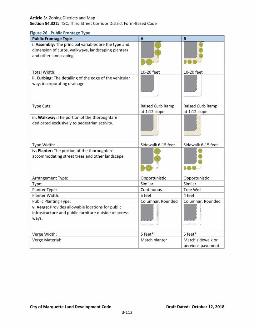
Article 3: Zoning Districts and Map Section 54.322: TSC, Third Street Corridor District Form-Based Code
City of Marquette Land Development Code Draft Dated: October 12, 2018 3-112
Figure 26. Public Frontage Type
Public Frontage Type A B
i. Assembly: The principal variables are the type and dimension of curbs, walkways, landscaping planters and other landscaping.
Total Width: 10-20 feet 10-20 feet
ii. Curbing: The detailing of the edge of the vehicular way, incorporating drainage.
Type Cuts: Raised Curb Ramp
at 1:12 slope Raised Curb Ramp at 1:12 slope
iii. Walkway: The portion of the thoroughfare dedicated exclusively to pedestrian activity.
Type Width: Sidewalk 6-15 feet Sidewalk 6-15 feet
iv. Planter: The portion of the thoroughfare accommodating street trees and other landscape.
Arrangement Type: Opportunistic Opportunistic
Type: Similar Similar
Planter Type: Continuous Tree Well
Planter Width: 5 feet 4 feet
Public Planting Type: Columnar, Rounded Columnar, Rounded
v. Verge: Provides allowable locations for public infrastructure and public furniture outside of access ways.
Verge Width: 5 feet* 5 feet*
Verge Material: Match planter Match sidewalk or pervious pavement
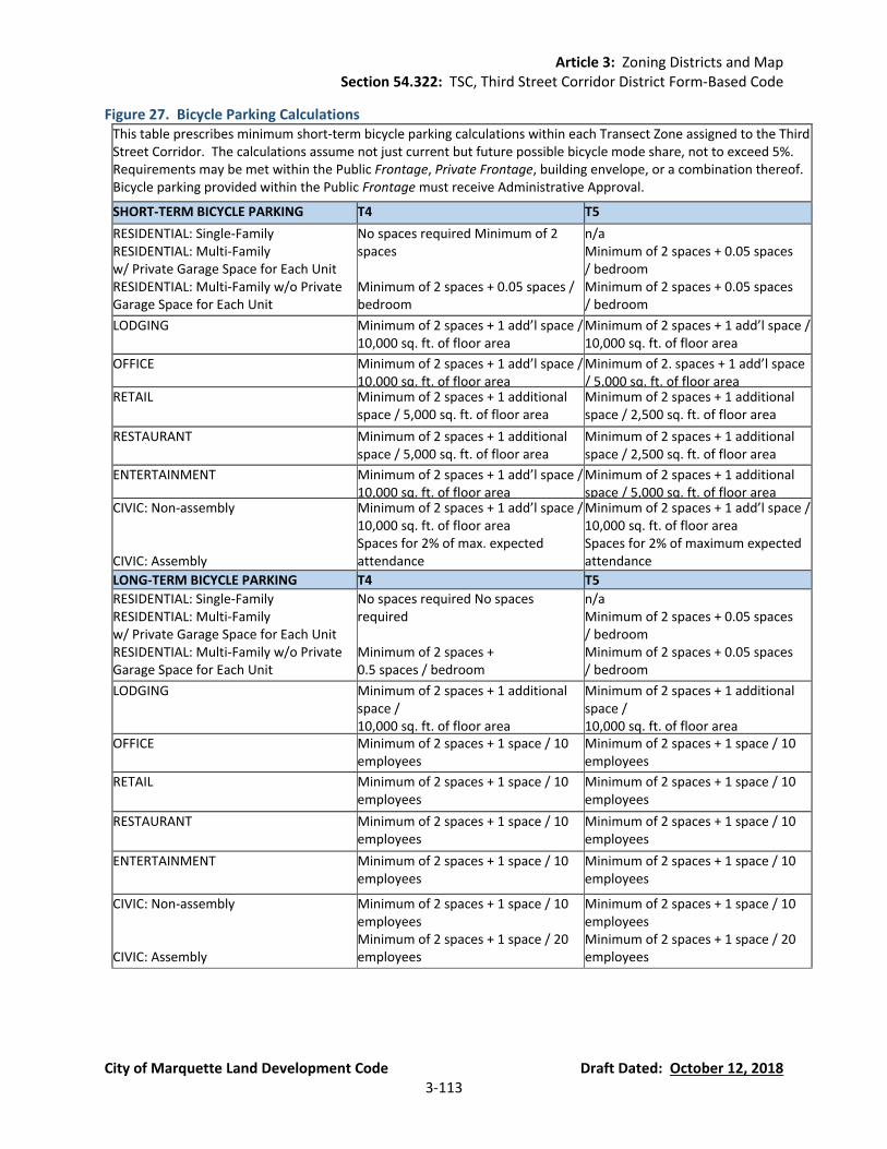
Article 3: Zoning Districts and Map Section 54.322: TSC, Third Street Corridor District Form-Based Code
City of Marquette Land Development Code Draft Dated: October 12, 2018 3-113
Figure 27. Bicycle Parking Calculations This table prescribes minimum short-term bicycle parking calculations within each Transect Zone assigned to the Third Street Corridor. The calculations assume not just current but future possible bicycle mode share, not to exceed 5%. Requirements may be met within the Public Frontage, Private Frontage, building envelope, or a combination thereof. Bicycle parking provided within the Public Frontage must receive Administrative Approval.
SHORT-TERM BICYCLE PARKING T4 T5
RESIDENTIAL: Single-Family RESIDENTIAL: Multi-Family w/ Private Garage Space for Each Unit RESIDENTIAL: Multi-Family w/o Private Garage Space for Each Unit
No spaces required Minimum of 2 spaces Minimum of 2 spaces + 0.05 spaces / bedroom
n/a Minimum of 2 spaces + 0.05 spaces / bedroom Minimum of 2 spaces + 0.05 spaces / bedroom
LODGING Minimum of 2 spaces + 1 add’l space / 10,000 sq. ft. of floor area
Minimum of 2 spaces + 1 add’l space / 10,000 sq. ft. of floor area
OFFICE Minimum of 2 spaces + 1 add’l space / 10,000 sq. ft. of floor area
Minimum of 2. spaces + 1 add’l space / 5,000 sq. ft. of floor area
RETAIL Minimum of 2 spaces + 1 additional space / 5,000 sq. ft. of floor area
Minimum of 2 spaces + 1 additional space / 2,500 sq. ft. of floor area
RESTAURANT Minimum of 2 spaces + 1 additional space / 5,000 sq. ft. of floor area
Minimum of 2 spaces + 1 additional space / 2,500 sq. ft. of floor area
ENTERTAINMENT Minimum of 2 spaces + 1 add’l space / 10,000 sq. ft. of floor area
Minimum of 2 spaces + 1 additional space / 5,000 sq. ft. of floor area
CIVIC: Non-assembly CIVIC: Assembly
Minimum of 2 spaces + 1 add’l space / 10,000 sq. ft. of floor area Spaces for 2% of max. expected attendance
Minimum of 2 spaces + 1 add’l space / 10,000 sq. ft. of floor area Spaces for 2% of maximum expected attendance
LONG-TERM BICYCLE PARKING T4 T5
RESIDENTIAL: Single-Family RESIDENTIAL: Multi-Family w/ Private Garage Space for Each Unit RESIDENTIAL: Multi-Family w/o Private Garage Space for Each Unit
No spaces required No spaces required Minimum of 2 spaces + 0.5 spaces / bedroom
n/a Minimum of 2 spaces + 0.05 spaces / bedroom Minimum of 2 spaces + 0.05 spaces / bedroom
LODGING Minimum of 2 spaces + 1 additional space / 10,000 sq. ft. of floor area
Minimum of 2 spaces + 1 additional space / 10,000 sq. ft. of floor area
OFFICE Minimum of 2 spaces + 1 space / 10 employees
Minimum of 2 spaces + 1 space / 10 employees
RETAIL Minimum of 2 spaces + 1 space / 10 employees
Minimum of 2 spaces + 1 space / 10 employees
RESTAURANT Minimum of 2 spaces + 1 space / 10 employees
Minimum of 2 spaces + 1 space / 10 employees
ENTERTAINMENT Minimum of 2 spaces + 1 space / 10 employees
Minimum of 2 spaces + 1 space / 10 employees
CIVIC: Non-assembly CIVIC: Assembly
Minimum of 2 spaces + 1 space / 10 employees Minimum of 2 spaces + 1 space / 20 employees
Minimum of 2 spaces + 1 space / 10 employees Minimum of 2 spaces + 1 space / 20 employees
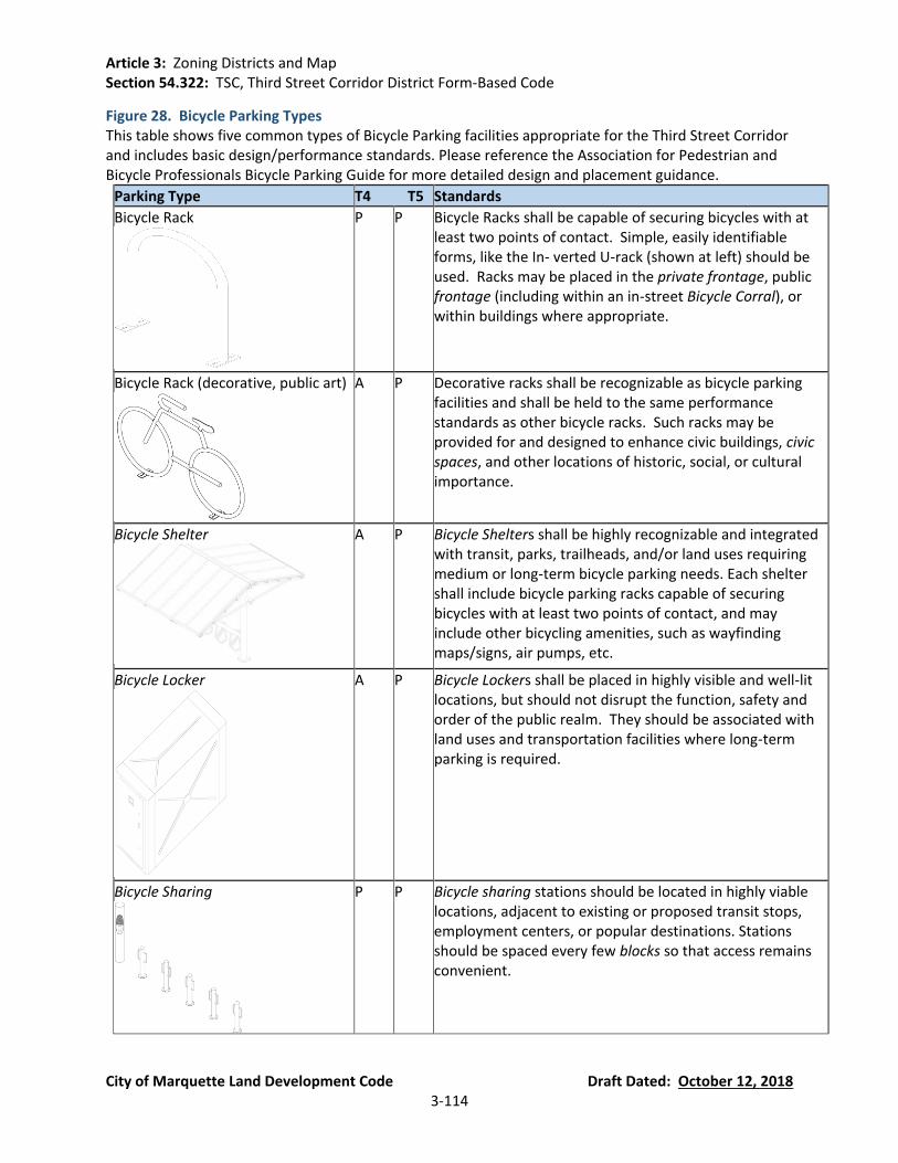
Article 3: Zoning Districts and Map Section 54.322: TSC, Third Street Corridor District Form-Based Code
City of Marquette Land Development Code Draft Dated: October 12, 2018 3-114
Figure 28. Bicycle Parking Types This table shows five common types of Bicycle Parking facilities appropriate for the Third Street Corridor and includes basic design/performance standards. Please reference the Association for Pedestrian and Bicycle Professionals Bicycle Parking Guide for more detailed design and placement guidance.
Parking Type T4 T5 Standards
Bicycle Rack
P P Bicycle Racks shall be capable of securing bicycles with at least two points of contact. Simple, easily identifiable forms, like the In- verted U-rack (shown at left) should be used. Racks may be placed in the private frontage, public frontage (including within an in-street Bicycle Corral), or within buildings where appropriate.
Bicycle Rack (decorative, public art)
A P Decorative racks shall be recognizable as bicycle parking facilities and shall be held to the same performance standards as other bicycle racks. Such racks may be provided for and designed to enhance civic buildings, civic spaces, and other locations of historic, social, or cultural importance.
Bicycle Shelter
A P Bicycle Shelters shall be highly recognizable and integrated with transit, parks, trailheads, and/or land uses requiring medium or long-term bicycle parking needs. Each shelter shall include bicycle parking racks capable of securing bicycles with at least two points of contact, and may include other bicycling amenities, such as wayfinding maps/signs, air pumps, etc.
Bicycle Locker
A P Bicycle Lockers shall be placed in highly visible and well-lit locations, but should not disrupt the function, safety and order of the public realm. They should be associated with land uses and transportation facilities where long-term parking is required.
Bicycle Sharing
P P Bicycle sharing stations should be located in highly viable locations, adjacent to existing or proposed transit stops, employment centers, or popular destinations. Stations should be spaced every few blocks so that access remains convenient.
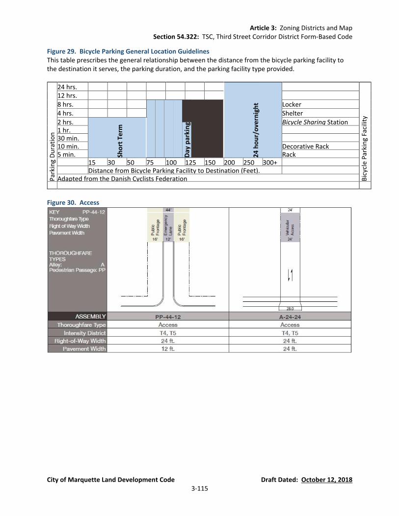
Article 3: Zoning Districts and Map Section 54.322: TSC, Third Street Corridor District Form-Based Code
City of Marquette Land Development Code Draft Dated: October 12, 2018 3-115
Figure 29. Bicycle Parking General Location Guidelines This table prescribes the general relationship between the distance from the bicycle parking facility to the destination it serves, the parking duration, and the parking facility type provided.
Par
kin
g D
ura
tio
n
24 hrs.
24
ho
ur/
ove
rnig
ht
Bic
ycle
Par
kin
g Fa
cilit
y
12 hrs. 8 hrs.
Day
par
kin
g
Locker 4 hrs. Shelter 2 hrs.
Sho
rt T
erm
Bicycle Sharing Station 1 hr. 30 min. 10 min. Decorative Rack 5 min. Rack 15 30 50 75 100 125 150 200 250 300+ Distance from Bicycle Parking Facility to Destination (Feet). Adapted from the Danish Cyclists Federation
Figure 30. Access
Article 3: Zoning Districts and Map Section 53.323: PUD, Planned Unit Development District
City of Marquette Land Development Code Draft Dated: October 12, 2018 3-116
Section 54.323 PUD, Planned Unit Development District (currently Section 80.30)
(A) Purpose. The Planned Unit Development (PUD) option is intended to encourage, with City approval, private or public development that is substantially in accord with the goals and objectives of the Community Master Plan. Development permitted under this Section shall be considered as an optional means of development only upon terms agreeable to the City. Use of the PUD option will permit flexibility in the regulation of land development and benefit the City by:
Encouraging innovation through an overall development plan to provide variety in design
and layout.
Achieving economy and efficiency in the use of land, natural resources, energy, and in the provision of public services and utilities.
Encouraging the creation of useful open spaces particularly suited to the needs of the
parcel in question.
Providing appropriate housing, employment, service, and shopping opportunities suited to the needs of residents of Marquette.
(B) Use. The PUD may be used to:
Permit nonresidential uses of residentially zoned areas.
Permit residential uses of non-residentially zoned areas.
Permit land uses and the mixing of land uses that would otherwise not be permitted,
provided the objectives are supported by the Master Plan and the intent of this ordinance and the resulting development promotes the public health, safety, and welfare without a material adverse impact on adjoining existing and planned uses.
(C) Minimum Size. The minimum size of a PUD must be two (2) acres of contiguous land.
However, the City Commission, upon recommendation from the Planning Commission, may permit a smaller PUD under the following circumstances:
The proposed project has unique characteristics and benefits; and/or
The parcel in question has unique characteristics that significantly impact development,
such as unusual topography, tree stands, wetlands, poor soil conditions on portions of the parcel, water courses, unusual shape or proportions, or utility easements that cross the parcel.
In such case, the applicant must submit a letter to the City requesting a waiver of the minimum PUD size requirements. The request must be submitted at the time of the submittal of Concept and Request for Consideration of Project Qualifications (Section 54.323(G)). The

Article 3: Zoning Districts and Map Section 53.323: PUD, Planned Unit Development District
City of Marquette Land Development Code Draft Dated: October 12, 2018 3-117
Planning Commission shall review the request and make a recommendation to the City Commission. The City Commission shall make the final decision concerning a request to waive the PUD size requirements.
(D) Density, Layout, and Bulk.
Densities, setbacks, height, lot coverage, or lot sizes may be permitted that are different
from the current zoning district and unique to the proposed PUD district, provided the other objectives of this ordinance are met and the resulting development would promote the public health, safety, and welfare. The requirements of the Riparian Overlay District must be met.
The PUD shall be laid out so various land uses and building bulk relate to each other and
to adjoining existing and planned uses with no material adverse impact of one use on another. Clustering development is encouraged in areas that are not located in the Riparian Overlay District.
(E) Definitions.
A “Planned Unit Development” (PUD) is a zoning district that shall apply to a specific
parcel of land or several contiguous parcels of land, for which a comprehensive physical plan has been recommended by the Planning Commission, approved by the City Commission, and documented in a contract (PUD Agreement) between the City and site owner/developer. Such plan and contracted development will establish functional use areas and density patterns; will provide a fixed system of streets, public utilities, drainage, and other essential services; and account for similar factors necessary for and incidental to the intended land uses. The Planning Commission may, but is not required to, consider parcels separated by a public street as eligible for inclusion in a PUD.
A “Pattern Book” is a document prepared by the applicant’s design firm that contains
specific information on the site master plan, and architectural designs for planned buildings. Information should include specifications on building materials, size, and dimensions, building elevations, and site design elements such as pedestrian walkways, lighting, landscaping, and signage.
(F) Criteria for Qualifications. The PUD option may be permitted anywhere in the City except in
the Conservation and Recreation (CR) district. To be considered for the PUD option, it must be demonstrated that all of the following criteria are met:
Use of this option shall not be for the purpose of avoiding applicable zoning
requirements. Any permission given for any activity or building or use not normally permitted shall result in an improvement to the public health, safety, and welfare in the area affected.
The PUD shall not be utilized in situations where the same land use objectives can be
accomplished by application of conventional zoning provisions or standards. Problems or constraints presented by applicable zoning provisions shall be identified in the PUD application.

Article 3: Zoning Districts and Map Section 53.323: PUD, Planned Unit Development District
City of Marquette Land Development Code Draft Dated: October 12, 2018 3-118
The PUD option may be effectuated only when proposed land use will not materially add
service and facility loads beyond those contemplated in the Master Plan unless the proponent can demonstrate to the sole satisfaction of the City that such added loads will be accommodated or mitigated by the proponent as part of the PUD.
The PUD shall not be allowed solely as a means of increasing density or as a substitute for
a variance request; such objectives should be pursued through the normal zoning process by requesting a Zoning Map amendment or variance.
The Planned Unit Development must substantially meet, as a minimum, three (3) or more
of the following objectives. The benefits given to the developer through the flexibility of the PUD must be balanced with the benefits to the City:
(a) To permanently preserve open space or natural features because of their exceptional
characteristics or because they can provide a permanent transition or buffer between land uses.
(b) To permanently establish land use patterns that are compatible or that will protect
existing or planned uses.
(c) To accept dedication or set aside open space areas in perpetuity.
(d) To provide alternative uses for parcels that can provide transition buffers to residential areas.
(e) To guarantee provision of a public improvement that could not otherwise be
required that would further the public health, safety, or welfare; protect existing or future uses from the impact of a proposed use; or alleviate an existing or potential problem relating to public facilities.
(f) To promote the goals and objectives of the Community Master Plan.
(g) To foster the aesthetic appearance of the City through quality building design and
site development; the provision of trees and landscaping beyond minimum requirements; the preservation of unique and/or historic sites or structures; and the provision of open space or other desirable features of a site beyond minimum requirements.
(h) To bring about redevelopment of sites where an orderly change of use or
requirements is determined to be desirable.
(i) To bring about redevelopment of sites that have been identified as environmentally distressed or Brownfields.
(j) To facilitate appropriate development of environmentally sensitive areas.
(G) Submittal of Concept and Request for Consideration of Project Qualifications.
Article 3: Zoning Districts and Map Section 53.323: PUD, Planned Unit Development District
City of Marquette Land Development Code Draft Dated: October 12, 2018 3-119
Any person owning or controlling land in the City may make application for consideration
of a PUD. Such application shall be made by submitting a request for a preliminary determination as to whether or not a parcel qualifies for the PUD option.
A written and graphic request shall be submitted to the Marquette City Planning
Commission through the Community Development Department. The submission shall include information required by Section 54.323(G)(3) below.
Based on the documentation submitted, and following a public hearing the Planning
Commission shall review the applicant’s request and make a preliminary determination as to whether or not a parcel qualifies for the PUD option under the provisions of Criteria for Qualifications (Section 54.323(F)). The submittal must include the following:
(a) Substantiation that the criteria set forth in Criteria for Qualifications (Section
54.323(F)) are or will be met.
(b) A schematic land use plan containing the required information of a preliminary site plan (Section 54.1402(C)) with enough detail to explain the function of open space; the location of land use areas, streets providing access to the site, pedestrian and vehicular circulation within the site; dwelling unit density and types; and buildings or floor areas contemplated, as applicable.
(c) A plan for the protection of natural, cultural, and historic features and preservation
of open space, green space, or public access, as applicable.
(d) The proposed phasing of the project.
(H) Submittal and Approval of Preliminary PUD Plan. An application for Preliminary PUD Plan approval may be made for consideration with the submission of the following materials and Planning Commission review. To expedite PUD projects, the Planning Commission, at its discretion, may waive submitted information required in Section 54.323(H) and Section 54.1402(C):
Submittal of Proposed PUD Plan. An application shall be made to the Community
Development Department for review and recommendation by the Planning Commission that complies with the preliminary site plan information requirements of Section 54.1402, including but not limited to the following graphic and written representations of the project at a scale not to be smaller than one (1) inch equals one hundred (100) feet unless approved by the City:
(a) A boundary survey of the PUD boundaries being requested completed by a licensed
land surveyor.
(b) A topographic map of the entire area at a contour interval of not more than one (1) foot and spot elevations at intervals not to exceed fifty (50) feet, unless waived.
Article 3: Zoning Districts and Map Section 53.323: PUD, Planned Unit Development District
City of Marquette Land Development Code Draft Dated: October 12, 2018 3-120
(c) Existing natural areas including, but not limited to, major stands of trees, bodies of water, wetlands, floodplains, steep slopes, and un-buildable areas.
(d) A proposed land use plan.
(e) Parcel and lot lines, land use, access points, and zoning of all parcels within 100 feet
of the PUD site.
(f) Vehicular circulation including major drives and location of vehicular access. Proposed project cross sections including public streets or private roads.
(g) Transition treatment, including minimum building setbacks to land adjoining the PUD
and between different land use areas within the PUD.
(h) The location of nonresidential buildings and parking areas, estimated floor areas, building coverage, and number of stories and heights for each structure.
(i) The location of residential unit types and densities, and lot parcel or land units by
frontages and areas.
(j) The location of all wetlands, water and watercourses, and proposed water detention areas.
(k) The boundaries of open space areas that are to be preserved or reserved and an
indication of the proposed ownership thereof.
(l) A schematic landscape treatment plan for open space areas, streets, and border/transition areas to adjoining properties.
(m) A preliminary grading plan, indicating the extent of grading and delineating any areas
that are not to be graded or disturbed.
(n) An indication of the contemplated water distribution, storm, and sanitary sewer plan.
(o) A written statement explaining in detail the full intent of the applicant, indicating the
type of dwelling units or uses contemplated and resultant population, floor area, parking, and supporting documentation, including the intended schedule of development.
(p) The proposed phasing of the project, tentative development timetables, and future
ownership intentions. Each phase of the project should be capable of standing alone.
(q) Minimum of two (2) site sections, showing major building relationships and building
site features.

Article 3: Zoning Districts and Map Section 53.323: PUD, Planned Unit Development District
City of Marquette Land Development Code Draft Dated: October 12, 2018 3-121
(r) Detailed design guidelines, drawings, and / or pattern book, which depict the design character of the project; the architectural details of proposed buildings; details on various site elements such as lights, furniture, landscaping, signage; and such other information deemed appropriate by the Planning Commission.
Planning Commission Review of Proposed PUD Plan.
(a) Public Hearing and Review Procedure. The Planning Commission shall give notice of
a public hearing as provided in Section 54.1406 and hold a public hearing on the PUD and conduct a review of the PUD Plan and rezoning pursuant to the rezoning procedures of Section 54.1405.
(b) Planning Commission Review and Determination. The Planning Commission shall
review the proposed PUD plan and make a recommendation to the City Commission as to the proposal's qualification for the PUD option and for adherence to the following objectives and requirements:
(i) The proposed PUD adheres to the criteria for qualification of the PUD option
(Section 54.323(F)) and promotes the land use goals and objectives of the City.
(ii) All applicable provisions of this Section shall be met. Insofar as any provision of this Section shall be in conflict with the provisions of any other section of this ordinance, the provisions of this Section shall apply to the lands embraced within a PUD area.
(iii) There is, or will be, at the time of development, an adequate means of disposing
of sanitary sewage and of supplying the development with water, and that the road system and storm water drainage system are or will be adequate.
Performance Guarantee. The City Commission and/or Planning Commission can require
the applicant to submit a performance guarantee, escrow funds, or other such performance-based guarantees to the City as a condition of PUD approval pursuant to Section 54.1402(H). The amount of the performance guarantee shall be recommended to the Planning Commission by the City Attorney after discussion with the applicant, City Engineering Department, and other involved parties.
(I) Final Approval of Planned Unit Development.
City Commission Action. Upon receipt of the report and recommendation of the
Planning Commission, the City Commission shall hold a public hearing in accordance with Section 54.1406 and review all findings. If the City Commission approves the PUD, approval shall be granted only upon the City Commission determining that all provisions of this Section have been met and that the proposed development will not adversely affect the public health, welfare, and safety.
PUD Zoning. Upon approval by the City Commission, the subject site shall be rezoned to
“Planned Unit Development” in accordance with the procedures of Section 54.1405.

Article 3: Zoning Districts and Map Section 53.323: PUD, Planned Unit Development District
City of Marquette Land Development Code Draft Dated: October 12, 2018 3-122
PUD Agreement. Upon approval of the PUD by the City Commission, the City Commission shall instruct the City Attorney to prepare a contract setting forth the conditions upon which such approval is based and which contract, after approval by resolution of the City Commission, shall be executed by the City and the applicant. The agreement shall become effective upon execution after its approval. The agreement shall be recorded with the County Register of Deeds by the City Clerk. If the agreement is not executed within one (1) year of approval of the by the City Commission, the PUD approval shall expire.
PUD Development. Once an area has been included within a plan for PUD and the City
Commission has approved such plan, all development must take place in accordance with such plan unless changes have been approved by the City Commission.
Termination by Applicant. An approved PUD plan may be terminated by the applicant or
the applicant's successors or assigns, prior to any development within the area involved, by filing with the City Clerk and Community Development Department, and recording in the County Register of Deeds an affidavit so stating. The approval of the PUD plan shall terminate upon such recording. No approved PUD plan shall be terminated after development commences except with the approval of the City Commission and of all parties with interest in the land. After termination, the City shall commence rezoning the site to its previous zoning classification or a different zoning classification supported by the Master Plan, in accordance with Section 54.1405.
Expiration. Within a period of two (2) years following approval of the PUD Agreement by
the City Commission, preliminary plats (Section 54.501) or final site plans (Section 54.1402) for an area embraced within the PUD must be submitted as hereinafter provided. If such plats or plans have not been submitted within the two-year period, the right to develop under the approved plan shall be terminated by the City. Upon the developer’s showing of good cause, the Planning Commission can recommend and the City Commission grant an extension of up to two (2) years for submission of the preliminary plat and/or final site plan. If the right to develop under the approved plan is terminated by the City, the City shall commence rezoning the site to its previous zoning classification or a different zoning classification supported by the Master Plan, in accordance with Section 54.1405.
(J) Submission of Preliminary Plat or Final Site Plans; Schedule for Completion of PUD. Before
any permits are issued for any activity within the area of a PUD, preliminary plats (Section 54.501) or final site plans (Section 54.1402) and open space plans for a project area shall be submitted to the Community Development Department for review by the Planning Commission. Review and approval of final site plans shall comply with the Marquette City Land Development Code as well as this Section and the terms of the contract and approved plan. Before approving any preliminary plat or final site plan, the Planning Commission shall determine all of the following:
All portions of the project area shown upon the approved plan for the PUD for use by the
public or the residents of lands within the PUD have been committed to such uses in accordance with the PUD contract through recording of a deed, deed restrictions, and/or
Article 3: Zoning Districts and Map Section 53.323: PUD, Planned Unit Development District
City of Marquette Land Development Code Draft Dated: October 12, 2018 3-123
a master deed for creation of a property owner’s association with authority to levy assessments.
The preliminary plats or final site plans are in substantial conformity with the approved
contract and plan for the PUD.
Provisions have been made in accordance with the PUD contract to provide for the financing of any improvements shown on the project area plan for open spaces and common areas that are to be provided by the applicant and that maintenance of such improvements is assured in accordance with the PUD contract. If development of approved preliminary plats or final site plans are not completed in five (5) years after approval, further final submittals under the PUD shall cease until the part in question is completed or cause can be shown for not completing same. When the developer is in default of the PUD timetable, the City Commission may, at the recommendation of the Planning Commission take any or all of the following actions:
(a) Withdraw approval of any other phase;
(b) Require the applicant to submit a new PUD application for any additional phases;
and/or
(c) Invoke the performance guarantees to complete the project or make necessary repairs.
(K) Filing of As-Built Plans and Final Plats Prior to Release of Performance Guarantee. As-built
site plans and final plats must be filed with the City Engineering Department and the Community Development Department. Performance guarantees shall not be released until these documents have been submitted.
(L) Fees. Fees for review of PUD plans under this Section shall be established by resolution of the
City Commission.
(M) Interpretation of Approval. Approval of a PUD under this Section shall be considered an optional method of development and improvement of property subject to the mutual agreement of the City and the applicant.
(N) Amendments to PUD Plan. Proposed amendments or changes to an approved PUD plan shall
be submitted to the Zoning Administrator. The Zoning Administrator shall determine whether the proposed modification is of such minor nature as not to violate the area and density requirements or to affect the overall character of the plan, as guided by Section 54.323(N)(1), and in such event may approve or deny the proposed amendment. If the Zoning Administrator determines the proposed amendment is major in nature, the Planning Commission shall review the amendment in accordance with the provisions and procedures of this Section as they relate to final approval of the PUD and make a recommendation to the City Commission to approve or deny the changes. The Zoning Administrator may refer any proposed amendment to the Planning Commission at his/her discretion for determination of minor/major amendment status.
Article 3: Zoning Districts and Map Section 53.323: PUD, Planned Unit Development District
City of Marquette Land Development Code Draft Dated: October 12, 2018 3-124
Minor Amendment. Minor amendments are those that may have no foreseeable effect beyond the property boundary, such as minor changes in the siting of buildings, the alignment of utilities and the alignment of interior roadways and parking areas. Minor amendments for good cause may be authorized by the Zoning Administrator without notice or hearing, provided no such changes shall substantially increase the size or height of structures, reduce the efficiency or number of public facilities serving the PUD, reduce usable open space, significantly reduce or increase the number of approved parking spaces, or encroach on natural features proposed by the plan to be protected. The degree of permitted minor amendments may be further described in the PUD Agreement. The Zoning Administrator shall inform the Planning Commission and City Commission of any approved minor amendments.
Major Amendment. Any amendment not qualifying as a minor amendment is considered
to be a major amendment and must be reviewed by the Planning Commission and approved by the City Commission, to be amended according to the procedures authorized by this section for approval of a PUD.
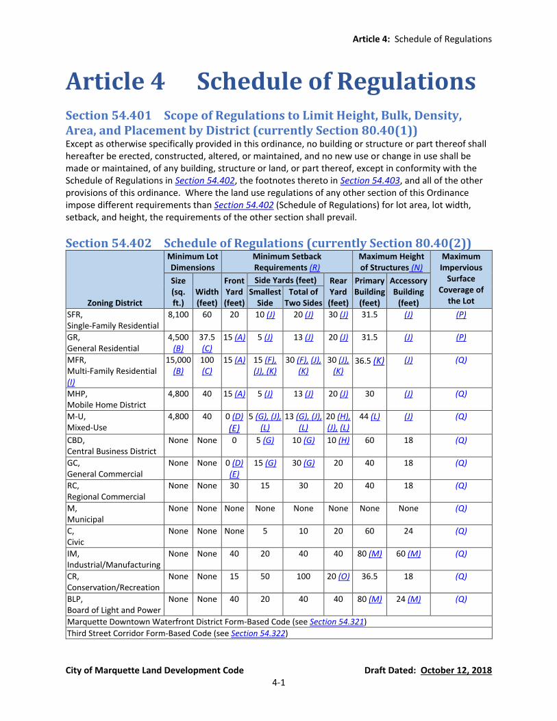
Article 4: Schedule of Regulations
City of Marquette Land Development Code Draft Dated: October 12, 2018 4-1
Article 4 Schedule of Regulations
Section 54.401 Scope of Regulations to Limit Height, Bulk, Density, Area, and Placement by District (currently Section 80.40(1)) Except as otherwise specifically provided in this ordinance, no building or structure or part thereof shall hereafter be erected, constructed, altered, or maintained, and no new use or change in use shall be made or maintained, of any building, structure or land, or part thereof, except in conformity with the Schedule of Regulations in Section 54.402, the footnotes thereto in Section 54.403, and all of the other provisions of this ordinance. Where the land use regulations of any other section of this Ordinance impose different requirements than Section 54.402 (Schedule of Regulations) for lot area, lot width, setback, and height, the requirements of the other section shall prevail.
Section 54.402 Schedule of Regulations (currently Section 80.40(2))
Zoning District
Minimum Lot Dimensions
Minimum Setback Requirements (R)
Maximum Height of Structures (N)
Maximum Impervious
Surface Coverage of
the Lot
Size (sq. ft.)
Width (feet)
Front Yard (feet)
Side Yards (feet) Rear Yard (feet)
Primary Building
(feet)
Accessory Building
(feet) Smallest
Side Total of
Two Sides
SFR, Single-Family Residential
8,100 60 20 10 (J) 20 (J) 30 (J) 31.5 (J) (P)
GR, General Residential
4,500 (B)
37.5 (C)
15 (A) 5 (J) 13 (J) 20 (J) 31.5 (J) (P)
MFR, Multi-Family Residential (I)
15,000 (B)
100 (C)
15 (A) 15 (F), (J), (K)
30 (F), (J), (K)
30 (J), (K)
36.5 (K) (J) (Q)
MHP, Mobile Home District
4,800 40 15 (A) 5 (J) 13 (J) 20 (J) 30 (J) (Q)
M-U, Mixed-Use
4,800 40 0 (D)
(E) 5 (G), (J),
(L) 13 (G), (J),
(L) 20 (H), (J), (L)
44 (L) (J) (Q)
CBD, Central Business District
None None 0 5 (G) 10 (G) 10 (H) 60 18 (Q)
GC, General Commercial
None None 0 (D) (E)
15 (G) 30 (G) 20 40 18 (Q)
RC, Regional Commercial
None None 30 15 30 20 40 18 (Q)
M, Municipal
None None None None None None None None (Q)
C, Civic
None None None 5 10 20 60 24 (Q)
IM, Industrial/Manufacturing
None None 40 20 40 40 80 (M) 60 (M) (Q)
CR, Conservation/Recreation
None None 15 50 100 20 (O) 36.5 18 (Q)
BLP, Board of Light and Power
None None 40 20 40 40 80 (M) 24 (M) (Q)
Marquette Downtown Waterfront District Form-Based Code (see Section 54.321)
Third Street Corridor Form-Based Code (see Section 54.322)

Article 4: Schedule of Regulations
City of Marquette Land Development Code Draft Dated: October 12, 2018 4-2
Section 54.403 Footnotes to Schedule of Regulations (currently Section 80.40(3) and 80.41)
(A) Permitted Front Yard Setback Encroachments in the GR, MFR, and MHP Districts. In the GR, MFR, and MHP districts, open front porches may encroach into the required front yard setback, provided the encroaching porch is for the first story only, is not wider than 50% of the façade, and is setback at least ten (10) feet from the front lot line.
(B) Minimum Lot Area for Two-Family Dwellings (Duplexes) in the GR and MFR Districts. In the
GR District, the minimum lot area for a two-family dwelling (duplexes) is: 6,000 sq. ft. for lots created prior to the adoption of this ordinance. 9,000 sq. ft. for lots created after the adoption of this ordinance.
(C) Minimum Lot Width for Two-Family Dwellings (Duplexes) in the GR and MFR Districts. In the
GR District, the minimum lot width for a two-family dwelling (duplex) is: 50 feet for lots created prior to the adoption of this ordinance. 75 feet for lots created after the adoption of this ordinance.
(D) Minimum Front Yard Setback in the M-U and GC Districts. In the M-U and GC districts, the
minimum front yard setback is 0 ft. if there is at least a 10-foot distance between the front lot line and the curb/edge of the street. If there is not at least a 10-foot distance between the front lot line and the curb/edge of the street in these districts, the minimum front yard setback shall be increased accordingly so that the minimum separation distance between a structure and the curb/edge of the street is at least ten (10) feet.
(E) Maximum Front Yard Parking in the M-U and GC Districts. Although there are no maximum
front yard setbacks in the M-U and GC districts, refer to Article 9 for the maximum allowable parking in the front yard of the M-U (Section 54.902(E)(3)) and GC (Section 54.902(E)(4)) districts.
(F) Separation Distance of Multiple-Family Structures in the MFR District. In the MFR, Multiple
Family Residential District, the minimum distance between any two (2) buildings on the same site shall be one and one-half (1.5) times the average height of the two (2) buildings. For example purposes only, the separation distance between a 36-foot high multiple-family building and a 30-foot high multiple family building shall be 49.5 feet (i.e., 1.5 times 33 feet, which is the average height of the two buildings).
(G) Reduced Side Yard Setbacks in the M-U, CBD, and GC Districts. In the M-U, CBD, and GC
districts the side yards may be eliminated under the following conditions: The side walls are of fireproof construction and are wholly without opening. The zoning of the adjacent property is M-U, CBD, GC, Marquette Downtown Waterfront
District, or Third Street Corridor District.
(H) Modified Rear Yard Setbacks in the M-U and CBD Districts. In the M-U and CBD districts the required rear yard may be measured from the center of an alley abutting the rear lot line, provided the structure is not located in the alley.

Article 4: Schedule of Regulations
City of Marquette Land Development Code Draft Dated: October 12, 2018 4-3
(I) Each parcel in the MFR district that contains a multiple-family residential use shall have: A maximum lot coverage ratio of 0.20. Minimum outdoor livability space of 0.40.
(J) Accessory Buildings and Structures. For accessory buildings and structures, additional
requirements for side yard setbacks, rear yard setbacks, and height are in Section 54.705.
(K) Height Exceptions and Increased Setbacks for Multiple-Family Dwelling Buildings in the MFR District. For multiple-family buildings in the MFR District, the height may be increased above 36.5 feet provided that 1 foot shall be added to all of the minimum yard setbacks for each 1 foot that the building exceeds 36.5 feet in height.
(L) Height Exceptions and Increased Setbacks for Buildings in the M-U District. If the subject lot
is adjacent to a lot zoned GR, SFR, C, or CR, any portion of the building higher than 36.5 feet must be setback at least 8 feet from a minimum front yard setback line and at least 10 feet from any other minimum yard setback line.
(M) Modified Height and Setback Requirements in the IM and BLP Districts. The Planning
Commission may permit via special land use approval a greater height than the maximum allowed in the schedule of regulations in the IM and BLP districts, provided that the front, side, and rear yards specified in Section 54.402 and Article 6 are increased by one (1) foot for each foot of building height that exceeds the maximum allowed. However, in no case shall the height of any structure in the IM and BLP districts exceed the horizontal setback distance from the structure to a lot line; where the property abuts a right-of-way, up to 1/2 width of said right-of-way may be used in calculation the required yard; in no instance may the yard be less than the minimum specified in Section 54.402.
(N) Height Exemptions. There shall be no height restriction on chimneys, flagpoles, public
monuments, and wireless telecommunications facilities except when they are part of a special land use.
(O) Increased Rear Yard Setbacks for Lots in the CR District. Lots in the CR district must have a
minimum rear yard setback of 50 feet from the ordinary high water mark of Lake Superior.
(P) Maximum Impervious Surface Coverage of a Lot in the SFR and GR Districts: The maximum impervious surface coverage of a lot in the SFR and GR Districts shall be based on the lot areas as follows:
Maximum Impervious Surface Coverage Based on Lot Area
60% of the lot area up to 8,712 sq. ft. (1/5 acre or less); plus
50% of the area of the lot between 8,713 sq. ft. and 21,780 sq. ft. (1/2 acre); plus
40% of the area of the lot between 21,781 sq. ft. and 43,560 sq. ft. (1 acre); plus
30% of the area of the lot over 1 acre
(Q) City of Marquette Design and Construction Standards. Refer to the City of Marquette Design
and Construction Standards for limits on impervious surfaces.
(R) Landscape Buffer and Greenbelt Requirements. The minimum setbacks may be increased in accordance with the landscape buffer and greenbelt standards of Section 54.1003(D).

Article 4: Schedule of Regulations
City of Marquette Land Development Code Draft Dated: October 12, 2018 4-4
Article 5: Supplemental Zoning District Standards Section 54.501: Subdivision Regulations
City of Marquette Land Development Code Draft Dated: October 12, 2018 5-1
Article 5 Supplemental Zoning District Standards
Section 54.501 Subdivision Developments (currently parts of Chapter 85 of the Code of Ordinances)
(A) Intent and Application. The following regulations shall apply to all subdivision developments within the City of Marquette.
(B) Definitions Applicable to Subdivisions. The following definitions shall be applicable to
subdivisions only. Other applicable definitions are in Article 2 and Public Act 288 of 1967 (Land Division Act):
Improvements: Street pavements, curbs, gutters, sidewalks, cross-walks, water mains,
sanitary and storm sewers, street trees, street signs, and other appropriate items.
Plat, Final: A map of all or part of a subdivision prepared and certified as to its accuracy by a registered engineer or land surveyor. Such maps must meet the requirements of the Plat Act, Public Act 288 of 1967, as amended, and be suitable for recording by the County Register of Deeds.
Plat, Preliminary: A map indicating the proposed layout of the subdivision in sufficient
detail to provide adequate basis for preliminary review and to meet the requirements and procedures set forth hereinafter.
Public Walkway: A right of way dedicated for the purpose of a pedestrian access through
residential areas, and located so as to connect to two or more streets, or a street and a public land parcel.
Subdivide or Subdivision: The partitioning or splitting of a parcel or tract of land by the
proprietor thereof or by his or her heirs, executors, administrators, legal representatives, successors, or assigns for the purpose of sale, or lease of more than 1 year, or of building development that results in 1 or more parcels of less than 40 acres or the equivalent, and that is not exempted from the platting requirements of Public Act No. 288 of 1967 (MCL 560.101 et seq.), as amended. "Subdivide" or "subdivision" does not include a property transfer between 2 or more adjacent parcels, if the property taken from 1 parcel is added to an adjacent parcel; and any resulting parcel shall not be considered a building site unless the parcel conforms to the requirements of this ordinance or Public Act No. 288 of 1967 (MCL 560.101 et seq.), as amended.
Subdivider: Shall be deemed to include the plural as well as the singular and may mean a
person, firm, association, partnership, corporation, or any legal combination of them or any other legal entity proceeding under these regulations to effect a subdivision of land for himself or for another.

Article 5: Supplemental Zoning District Standards Section 54.501: Subdivision Regulations
City of Marquette Land Development Code Draft Dated: October 12, 2018 5-2
(C) Extension of Review Deadlines. Deadlines for the City to take action on a preliminary or final
plat, as specified in the Land Division Act and reiterated in this section, may be extended by mutual written consent of the proprietor and the City. A waiver of the review deadlines may be required to permit concurrent processing of related review applications. In the absence of written consent for such a waiver, denial of a plat shall be considered appropriate if the proprietor has been unable to complete submittal requirements and/or bring the plat into compliance with ordinance regulations within the review deadline.
(D) Subdivision Review Procedures. The Preparation of a subdivision for platting shall be carried
out through the following stages in accordance with the procedure as follows.
Pre-Application Conference. Prior to the preparation of a preliminary plat, the subdivider may meet informally with the Planning Director or City Planner to investigate the procedures and standards of the City of Marquette with reference to subdivision regulations and with the policies of the Master Plan as they affect the area in which the proposed subdivision is located. The subdivider shall concern himself with the following factors: (a) The area for the proposed subdivision shall be properly zoned for the intended use. (b) Examination of physical site characteristics which may affect site layout, drainage
and utility service. (c) Determine the existence of or status of any state, county, regional or city plans
relating to land use, traffic routes, access management guidelines, scenic highways and/or neighborhoods which may bear on the proposed subdivision.
(d) The relationship of the proposed subdivision with respect to Major and Secondary Streets and plans for widening of streets shall be investigated by the subdivider.
(e) Standards for sewage disposal, water supply, electric power facilities and drainage of the City of Marquette (City of Marquette Engineering Department General Guidelines and Standards for Street and Utility Design) and health standards of Marquette County and the State of Michigan shall be investigated by the subdivider.
Optional Sketch Plan Review. Optional Sketch Plan Review involves Planning Commission
review but no formal action. The purpose of Sketch Plan Review is to provide the proprietor with information needed to complete the plat, to explain applicable standards and regulations, and to acquaint the City with the proposed plat. Comments made during Sketch Plan Review about the proposed plat shall not be binding on the City or the proprietor. (a) Purpose. Pursuant to section 107(1) of the land division act, a proprietor may submit
a proposed plat for Sketch Plan Review. The purposes of the Sketch Plan Review are as follows: (i) To determine if the land is appropriately zoned. (ii) To acquaint the City staff and Planning Commission with the proposed plat. (iii) To inform the proprietor of the procedures for approval of the plat. (iv) To inform the proprietor of applicable City ordinances and regulations related to
subdivision and improvement of land, including the subdivision control ordinance, Land Development Code, and engineering design and construction standards.

Article 5: Supplemental Zoning District Standards Section 54.501: Subdivision Regulations
City of Marquette Land Development Code Draft Dated: October 12, 2018 5-3
(v) To inform the proprietor generally about requirements regarding layout of streets, street improvements, and relationship of subdivision streets to the overall city street network and to major streets. The traffic study standards of the City of Marquette Engineering Department General Guidelines and Standards for Street and Utility Design apply.
(vi) To inform the proprietor generally about the requirements for and/or availability of public facilities and services, including water, drainage, sanitary sewers and wastewater treatment, fire and police protection, recreation and open space, and schools.
(vii) To determine the impact of floodplains and wetlands on the use of land and design of the plat.
(viii) To identify woodlands, topography, watercourses, and other natural features that should be protected.
(ix) To inform the proprietor about development options that would achieve the planning goals of the City while satisfying the proprietor's objectives.
(x) To provide the proprietor with any other information to aid in the preparation of the preliminary plat.
(b) Submittal Requirements. A sketch plan shall be submitted for review for proposed residential subdivision plats. The sketch plan shall illustrate in schematic form the proposed subdivision layout based on the uses of land, dimensional requirements, and density allowed by right in the district in which the land is located. The sketch plans shall illustrate in conceptual form the proposed subdivision and existing features on the site and on surrounding properties that may affect the design of the subdivision. Accordingly, the following information shall be provided for sketch plan review: (i) A completed application for sketch plan review. (ii) The name, mailing address, and telephone of the proprietor(s). (iii) The name, mailing address, and telephone of the professional person(s)
responsible for the subdivision design, for the design of public improvements, and for surveys.
(iv) The name, mailing address, and telephone of the legal owner(s) or agent(s) of the property.
(v) The proprietor's interest in the property. (vi) Location of the property by section, town and range, or by other legal
description along with a vicinity map showing the general relationship of the proposed subdivision to the surrounding area.
(vii) Existing conditions and characteristics of the site and adjacent land, including: a. Approximate boundaries of woodlands, wetlands, floodplains, and
watercourses. b. The approximate location and intended future use of existing structures on
the site. c. Existing land use on surrounding properties. d. Location of existing easements on the site. e. For each sketch plan, the proposed approximate layout of streets, blocks,
and lots. f. For each sketch plan, the approximate location, dimensions, and area of all
parcels of land proposed to be set aside for park or playground use or other public use, or for the use of property owners in the proposed subdivision.
Article 5: Supplemental Zoning District Standards Section 54.501: Subdivision Regulations
City of Marquette Land Development Code Draft Dated: October 12, 2018 5-4
(c) Sketch Plan Review Procedures. (i) Copies. The proprietor shall submit a minimum of 14 copies of each sketch plan
design to the City along with the review fee authorized by the City Commission. (ii) Review Authority. Within 60 days of the date of filing, the Planning
Commission or a subcommittee of the Planning Commission along with appropriate City staff shall review the plans with the proprietor and/or the proprietor's agents and consultants. The Commission may also request that copies of the sketch plan be submitted to other public agencies having jurisdiction over various aspects of the plat.
(iii) Comments. Planning Commissioners, staff, and consultants shall offer comments and suggestions concerning the proposed development in the interest of achieving the purposes of sketch plan review and the planning goals of the City. The Planning Commission shall take no formal action to approve or deny a sketch plan, but may offer suggestions as to which sketch plan design best meets the intent and requirements of this section, the Land Development Code, and the Master Plan. Comments and suggestions made during Sketch Plan Review about the proposed plat shall not be binding on the City or the proprietor.
Tentative Preliminary Plat Review. Tentative Preliminary Plat Review, involving review
and action to recommend approval or denial of the plat by the Planning Commission within 60 days from the date of filing, followed by review and action to approve or deny the plat by the City Commission within 90 days from the date of filing, shall be in accordance with the following procedures and requirements: (a) Purpose. Preliminary Plat Review provides for formal application by a proprietor for
City approval of a subdivision plat as described in this section and the Land Division Act (Act 288 of 2967, as amended). Preliminary Plat Review also provides the City with the opportunity to review a proposed plat to determine whether it is in compliance with City ordinances and regulations, and to approve or deny the plat on the basis of that determination.
(b) Preliminary Plat Review involves two (2) steps: (i) Tentative Preliminary Plat Review, which provides for review of all of the salient
features of a proposed subdivision, except detailed engineering and approvals from other authorities, and
(ii) Final Preliminary Plat Review, which includes review of engineering plans and requires approvals from other authorities.
(c) Submittal requirements. The tentative preliminary plat shall illustrate the proposed subdivision layout based on the uses of land, dimensional requirements, and density allowed by right in the district in which the land is located (i.e., a conventional development). The preliminary plat submitted for tentative approval shall show all of the salient features of the proposed subdivision to allow the City to determine whether the proposal is in compliance with this and other applicable ordinances. The lack of information related to any item specified herein, or improper information supplied by the applicant, shall be cause for disapproval of a tentative preliminary plat. The following information shall be provided for tentative preliminary plat review:

Article 5: Supplemental Zoning District Standards Section 54.501: Subdivision Regulations
City of Marquette Land Development Code Draft Dated: October 12, 2018 5-5
(i) Application. A completed application for tentative preliminary plat review shall be submitted on a form supplied by the City, which shall contain the following information: a. The name, mailing address, and telephone of the proprietor(s). b. The name, mailing address, and telephone of the professional person(s)
responsible for the subdivision design, for the design of public improvements, and for surveys.
c. The name, mailing address, and telephone of the legal owner(s) or agent(s) of the property. The citation of the last instrument conveying title to each parcel of property in the proposed subdivision shall be provided.
d. The proprietor's interest in the property. The proprietor shall submit proof of ownership in the form of a title insurance policy or a title opinion prepared by an attorney licensed in Michigan. Such documentation or other legal opinion shall be required showing the legal and equitable owners (including mortgagees, contract purchasers, and fee owners) of the land to be platted, plus all grants, reservations, deed restrictions and easements of record which may condition the use of the property.
(ii) Tentative Preliminary Plat. Fourteen (14) copies of the tentative preliminary plat, sealed by the professional surveyor who prepared the plat, shall be submitted to the City Planning Department, along with the completed application and the fee authorized by the City Commission. The date of submittal shall be recorded on the plat, on the application, and on supporting documentation. These materials must be submitted at least 21 days prior to the Planning Commission or City Commission meeting where review is desired. The tentative preliminary plat shall be on paper that is no greater than 24 inches by 36 inches, and shall be drawn at a scale of not more than 200 feet to one (1) inch. The plat shall provide a scale, north arrow, and date of original submittal and dates of any revisions. The sheets shall be numbered in sequence if more than one sheet is used.
(iii) Tentative Preliminary Plat—Existing Conditions. The tentative preliminary plat shall include one (1) or more sheets containing the following information, at minimum, regarding existing conditions: a. Location of the property by section, town and range, or by other legal
description. b. An area map showing the general relationship of the proposed subdivision
to the surrounding area, to nearby community facilities, such as parks, schools, bicycle paths, existing and planned open space, and to shopping centers. The map should also identify the boundaries of school districts serving the development, if applicable.
c. Boundary of the proposed subdivision and the location of any easements with dimensions of the overall property and of the individual easements.
d. Property lines of adjacent land within 500 feet of the proposed subdivision and across abutting roads. The plat shall identify the owners of all adjacent properties based on the most current assessment roll and the names of adjoining developments, including developments across abutting roads. The plat should also identify the names of adjacent subdivisions.
e. A site analysis consisting of maps and written analysis which identify, describe, and quantity the following features, at minimum:
Article 5: Supplemental Zoning District Standards Section 54.501: Subdivision Regulations
City of Marquette Land Development Code Draft Dated: October 12, 2018 5-6
i. Where woodlands will be cut as a result of construction of roads, stormwater drainage facilities, and other subdivision improvements, the woodlands inventory shall identify the location and check species of all trees six (6) inches or greater in caliper, measured four and one-half (4.5) feet above the ground. The character of other vegetation on the site shall also be noted on the plat.
ii. Boundaries and character of any water bodies, watercourses, wetlands (including the required setback from wetlands or water features located on adjacent sites), and 100-year floodplain datum. Wetland boundaries shall be determined by a qualified wetlands consultant and surveyed by a professional surveyor. Documentation supporting the wetland delineation shall be submitted, including but not necessarily limited to: dominant vegetation, wetland indicators, and a description of the soil profile.
iii. Groundwater recharge areas, to the extent that such information is available from existing data sources.
iv. Existing stormwater drainage patterns, systems, and structures, including approximate locations of farm field drain titles, if known.
v. Soils (based on U.S. Soil Conservation Survey or soil borings). vi. Habitats of threatened and endangered species (i.e., federal and state
listed species), if known. vii. Sight distance limitations along existing and proposed roads. viii. Topographic relief of the site and within 200 feet of the site at two (2)
foot contour intervals, referenced to U.S.G.S. elevation datum. ix. If any streets are proposed as dead-end streets at or near the
subdivision boundary which abuts vacant land, the general topography and features of the adjacent land shall be delineated. This information shall be used to determine if future street extensions are desirable.
x. Water main and pressure districts. xi. Other features uniquely affecting the site.
f. Zoning classification of the proposed subdivision and all adjoining properties.
g. Name, location, and right-of-way width of any existing public, private, or platted streets, roads, highways, or railroads abutting or on the subdivision site or within 500 feet of the subdivision site. The number of lanes and the most current traffic volumes shall be noted for existing streets, roads and highways.
h. Locations and sizes of all existing sanitary and storm sewers, existing county and private drains, cross culverts under existing roads, and other underground structures within the subdivision site or immediately adjacent to it.
i. Locations of other above-or below-ground utilities within the subdivision site or immediately adjacent to it, including but not limited to gas, electric, telephone, and cable television utilities.
j. Location of existing permanent structures on and within 100 feet of the subdivision site. Structures to be removed shall be so marked.

Article 5: Supplemental Zoning District Standards Section 54.501: Subdivision Regulations
City of Marquette Land Development Code Draft Dated: October 12, 2018 5-7
k. The water elevations of lakes, streams and other water bodies on or adjacent to the site, and the ordinary high- and low- water elevations of such water bodies.
(iv) Tentative Preliminary Plat—Proposed Improvements. The tentative preliminary plat shall contain the following information regarding proposed improvements, at minimum: a. Name of the proposed subdivision. The proposed name shall not duplicate
the name of any plat previously recorded unless the proposed subdivision is an addition contiguous to a plat with the same name or the proposed subdivision is a part of a previously approved plat of the same name.
b. Layout, right-of-way width, typical cross-section, and names of proposed public or private streets or roads. The plat should also indicate if on-street parking will be permitted.
c. Sight distance plan and profile at each intersection of a proposed subdivision street with any existing or proposed public road or street.
d. The locations, width, and type of construction of any sidewalks, bicycle paths, and multi-use paths.
e. The location, width, and purpose of any proposed easements. f. The location, approximate dimensions, and approximate area of all
proposed lots. Lots shall be numbered consecutively beginning with lot number one (1). The front and rear yards shall be identified on all corner lots and lots located on cul-de-sacs.
g. The tentative preliminary plat shall have a table that provides the following information for each lot: net lot area (in square feet), road frontage, and lot width measured at the front setback line.
h. The location and dimensions of required front, side and rear yard setbacks on each lot (i.e., the building envelope), as well as the required setbacks from any wetland or shoreline.
i. The location, approximate dimensions, approximate area, and proposed use of all parcels of land proposed to be set aside for park or playground use or other public use, or for the use of property owners in the proposed subdivision. The conditions, if known, of any such dedication, reservation, or conservation easement shall be specified.
j. Where a proprietor proposes to subdivide land in phases, the tentative preliminary plat shall include a general layout for the entire development. The initial phase and the method of temporary construction and permanent access to subsequent phases shall be clearly identified.
k. An indication of the ownership and existing and proposed uses of any parcels identified as "excepted" on the tentative preliminary plat. If the proprietor has an ownership interest in any excepted parcel, the tentative preliminary plat shall indicate how this parcel could be developed in accordance with the requirements of the existing zoning district in which it is located and in a manner that is compatible with and relates to the proposed plat in terms of utilities, streets, and land uses.
l. If the subdivision abuts undeveloped residentially zoned land or includes any outlots or excepted parcels, information shall be provided to demonstrate that the adjacent or remaining land can be used or subdivided in conformance with City standards.

Article 5: Supplemental Zoning District Standards Section 54.501: Subdivision Regulations
City of Marquette Land Development Code Draft Dated: October 12, 2018 5-8
m. Landscape plan, which shall identify existing trees to be saved and removed, and species, locations, and sizes of all proposed plantings.
(v) Tentative Preliminary Plat—Other Submittals. The following additional information shall be provided, unless otherwise indicated, with the application for Tentative Preliminary Plat Review: a. If the proprietor chooses, he/she may cause temporary stakes to be
located on site to enable the City officials to find and evaluate features of the tentative preliminary plat in the field.
b. If the intended use of the proposed plat is not entirely residential single-family, then a written statement specifying the intended use should be submitted. The location and size of proposed multiple-family dwellings, shopping centers, institutional uses, commercial or industrial facilities, etc. should be noted.
c. A "traffic assessment" shall be required for developments that would generate between 50 and 99 directional trips during a peak hour of traffic, and a "transportation impact study" shall be required for new developments that would generate over 100 direction trips during a peak hour or over 750 trips on an average day. The transportation impact study must follow the City of Marquette Engineering Department General Guidelines and Standards for Street and Utility Design. The threshold conversions shall be based on the current Trip Generation Manual, which is published by the Institute of Transportation Engineers (ITE), and updated as needed. The requirement for a traffic assessment or transportation impact study may be waived by the Planning Commission or City Commission in the following instances: i. The existing level of service is not expected to be significantly
impacted by the proposed development due to the nature of the request or specific conditions at the subject site.
ii. A similar traffic study was previously prepared for the subject site and is still considered applicable.
d. Comments from other review authorities. The proprietor shall submit copies of the tentative preliminary plan to County, regional and State agencies that have jurisdiction over any aspect of the subdivision including, where applicable, the Marquette County Road Commission, Marquette County Drain Commission, Michigan Department of Transportation, Michigan Department of Environmental Quality, and Marquette County Health Department. Although approval from these agencies is not required for tentative preliminary plat approval, any written comments received from these agencies shall be submitted to aid the City review process.
(d) Planning Commission Review Procedures. (i) Initial Review. Upon receipt of the tentative preliminary plat, the City Planning
shall check it for completeness. If required data specified in this section has been omitted, the proprietor shall be notified of the additional data required and that the application will be delayed until the required data are received. The "date of filing" shall be considered the date on which a plat containing all required data is received by the City.
(ii) Placement on Planning Commission Agenda. When the information is complete, the proposed tentative preliminary plat shall be placed on the agenda

Article 5: Supplemental Zoning District Standards Section 54.501: Subdivision Regulations
City of Marquette Land Development Code Draft Dated: October 12, 2018 5-9
of the next regular Planning Commission meeting, and copies shall be distributed to appropriate City staff and consultants to obtain planning, preliminary engineering, wetland, and public safety review.
(iii) Public Notice. Prior to action on the tentative preliminary plat by the Planning Commission, notice shall be sent to all property owners within 300 feet of the boundary of the proposed subdivision, based on the most current assessment records on file with the City. Such notice shall be mailed at least five (5) days prior to the Planning Commission meeting. The notice shall explain that a subdivision has been proposed, give the location and general information, and note the time and place where the public can attend the meeting when the subdivision proposal will be discussed. The purpose of the notification is to inform the public of the project; it is not a "public hearing.” The Planning Commission, however, may elect to accept comments from the public during the informational meeting.
(iv) Planning Commission Review. The Planning Commission shall review the tentative preliminary plat with respect to the requirements of this section, the Land Development Code, other applicable ordinances and standards, and the Master Plan.
(v) Planning Commission Recommendation. The Planning Commission shall recommend approval, conditional approval, or denial of the proposed tentative preliminary plat, as indicated below, within 60 days after the plat was filed with the City unless the proprietor has waived the review deadlines in writing, pursuant to Section 54.501(C). If no action is taken within 60 days and the review deadline has not been waived, the tentative preliminary plat shall be deemed "recommended approved" by the Planning Commission. If the proprietor submitted more than one (1) tentative preliminary plat design for review, the Planning Commission shall review each design but only one (1) such design shall be recommended for approval or conditional approval to the City Commission. The Planning Commission may, however, recommend denial of all tentative preliminary plat designs submitted for review. a. Conditional Approval. Conditional approval shall be granted only if the
proprietor has waived the review deadlines in writing, pursuant to Section 54.501(C), in which case the tentative preliminary plat shall not be forwarded to the City Commission until said conditions have been properly addressed on a revised tentative preliminary plat and with supporting documentation. At its discretion, the Planning Commission may waive its right to review the revised plat in lieu of administrative review by City staff or Planning Director.
b. Denial. Upon determination that the tentative preliminary plat does not comply with the standards and regulations in this section and other applicable ordinances, standards, and plans, the Planning Commission shall recommend denial. The reasons for denial shall be recorded in the meeting minutes and a copy of the minutes and the tentative preliminary plat shall be forwarded to the City Commission and proprietor.
c. Approval without Conditions. Upon determining that the tentative preliminary plat is in compliance with the standards and regulations in this section and other applicable ordinances, standards, and plans, the Planning Commission shall recommend approval, and the Planning Director shall
Article 5: Supplemental Zoning District Standards Section 54.501: Subdivision Regulations
City of Marquette Land Development Code Draft Dated: October 12, 2018 5-10
make a notation to that effect on the tentative preliminary plat. One (1) copy of the approved plat shall become a matter of permanent record in the Planning Commission files, one (1) copy shall be returned to the proprietor, one (1) copy shall be kept on file by the Planning Director, and one (1) copy shall be forwarded to the City Commission with a copy of the Planning Commission minutes.
(e) City Commission Review Procedures. (i) Notification of Planning Commission Action. The City Commission shall not
receive or take action on a preliminary plat until it has received the review and recommendations from the Planning Commission or until the City Commission has been notified that the review period for the Planning Commission expired. The Planning Commission's recommendations may be transmitted to the City Commission in the form of minutes from the meeting at which action was taken. A draft copy of the minutes may be transmitted to the City Commission prior to being approved by the Planning Commission, provided that it is noted that the minutes are subject to approval and provided that adopted minutes are transmitted as soon as feasible.
(ii) Review Deadline. Following receipt of the Planning Commission's action, the City Commission shall take action on the preliminary plat within 90 days of the date of filing of the tentative preliminary plat with the City Planning Department, unless the proprietor has waived the review deadlines in writing, pursuant to Section 54.501(C).
(iii) City Commission Action. The City Commission shall approve, conditionally approve, or disapprove the proposed plat, as follows: a. Conditional Approval. Conditional approval shall be granted only if the
proprietor has waived the review deadlines in writing, pursuant to Section 54.501(C). The proprietor may resubmit the plat to the City Commission for approval after the conditions have been properly addressed. At its discretion, the City Commission may waive its right to review the revised plat in lieu of administrative review by the Planning Director.
b. Denial. Upon determination that the preliminary plat does not comply with the standards and regulations in this section and other applicable ordinances, standards, and plans, the City Commission shall deny the tentative preliminary plat.
c. Approval without Conditions. Upon determining that the preliminary plat is in compliance with the standards and regulations in this section and other applicable ordinances, standards, and plans, the City Commission shall approve the tentative preliminary plat.
(iv) Notification. The Clerk or the Clerk's designee shall promptly notify the proprietor, the Planning Commission, and all other agencies involved in the plat review process of approval or disapproval in writing, and the reasons if the plat was disapproved. One (1) copy of the approved or disapproved plat shall become a matter of the permanent records of each of the following City departments: Planning Commission, City Commission, Planning Director, Zoning Administrator, and Building Department. One (1) copy appropriately designated "approved" or "denied" shall be transmitted to the applicant.
(v) Effect of Approval.
Article 5: Supplemental Zoning District Standards Section 54.501: Subdivision Regulations
City of Marquette Land Development Code Draft Dated: October 12, 2018 5-11
a. Approval of the tentative preliminary plat by the City Commission shall confer upon the proprietor for a period of one (1) year from the date of approval, approval of lot sizes, lot orientation, and street layout. The one-year period may be extended if applied for in writing by the proprietor prior to the expiration date and granted by the City Commission in writing. The City Commission shall seek the Planning Commission's recommendation on any such extension. If the extension is granted, the City Clerk shall notify the other approving authorities. In approving an extension, the City Commission may impose new standards (not necessarily related solely to lot size, lot orientation, and street layout) as a result of new standards, changing conditions on surrounding parcels, or other considerations, provided that the revised plat shall still be considered substantially conforming to the previously approved tentative preliminary plat.
b. Tentative approval of the preliminary plat grants the proprietor no rights to begin installation or construction of improvements, including grading, tree removal, or land balancing.
Final Preliminary Plat Review. Final Preliminary Plat Review, involving review by outside
agencies (State and Marquette County agencies) prior to action by the City Commission within 20 days from the date of filing, shall be in accordance with the following procedures and requirements: (a) Submittal Requirements. Fourteen (14) copies of the final preliminary plat, sealed
by the engineer or surveyor who prepared the plat, shall be submitted along with the completed application, the fee authorized by the City Commission, and a copy of the drawings in digital format. These materials must be submitted at least 20 days prior to the City Commission meeting where review is desired. The final preliminary plat shall be on paper that is no greater than 24 inches by 36 inches, and shall be drawn at a scale of not more than 200 feet to one (1) inch. The plat shall provide a scale, north arrow, and date of original submittal and dates of any revisions. The sheets shall be numbered in sequence if more than one sheet is used. The digital files shall be provided to the City in a file format that is deemed acceptable to the City.
(b) Final Preliminary Plat—Required Information. The final preliminary plat submittal shall contain all of the information required for the tentative preliminary plat listed in Section 54.501(D)(3), plus the following information: (i) Copies of proposed restrictive or protective covenants and deed restrictions
(required to determine consistency with the ordinance, the Land Development Code, and other applicable ordinances and regulations and to determine that maintenance and funding of public spaces have been adequately addressed). The covenants shall indicate that maintenance of improvements illustrated on the approved final preliminary plat and final plat and in supporting documentation shall be a continuing responsibility of the subdivision association and individual owners of lots on which the improvements are located.
(ii) A written explanation of any proposed restrictions on construction traffic. (iii) Preliminary engineering plans shall be provided as follows:
a. The preliminary engineering plans shall be submitted in sufficient detail to enable the Planning Commission, City Commission, City Engineer, and other reviewing authorities to make a preliminary determination that the

Article 5: Supplemental Zoning District Standards Section 54.501: Subdivision Regulations
City of Marquette Land Development Code Draft Dated: October 12, 2018 5-12
proposed improvements comply with applicable regulations and standards of the City and other agencies.
b. At minimum, the preliminary engineering plans shall show the general locations of and provide preliminary specifications for sewage disposal systems, water supply systems (including fire hydrants), stormwater drainage systems, site grading, street trees, street lighting, street signs, and sidewalks. Stormwater runoff calculations shall be provided to analyze the adequacy of proposed drainage facilities.
c. The preliminary engineering plans shall show connections to any existing or proposed gas, electric, telephone, cable television or other utility systems.
d. If the subdivision will not be served by sanitary sewers, the plans shall show the locations and results of all soil borings in sufficient detail to demonstrate that it would be feasible to create the subdivision relying on septic systems.
(iv) A detailed drawing to scale of any proposed entry features including specifications and locations of walls, landscaping, signs, and lighting.
(v) General information concerning the proposed construction operations plan, as described in Section 54.501(D)(5).
(vi) The proprietor shall submit a list of all agencies to which the proprietor has sent copies of the final preliminary plat, certifying that the list shows all authorities listed in this subsection. The proprietor shall also submit copies of the final preliminary plat bearing the necessary approvals of all authorities as required by the Land Division Act and this section, including: a. Marquette County Road Commission, if any of the proposed subdivision
abuts a county road, or includes streets or roads that connect with or lie within the right-of-way of a county road.
b. Marquette County Drain Commissioner. c. Michigan Department of Transportation, if any of the proposed subdivision
abuts a state trunk line highway, or includes streets or roads that connect with or lie within the right-of-way of state trunkline highways.
d. Michigan Department of Environmental Quality, if the land proposed to be subdivided abuts a lake or stream, or abuts an existing or proposed channel or lagoon affording access to a lake or stream where public rights may be affected, or contains regulated wetlands, or lies wholly or in part within a flood plain of a river, stream, creek or lake.
e. Marquette County Health Department, if public water or sanitary sewers are not available and accessible to the land proposed to be subdivided, and for appropriate comment on matters under the Health Department's jurisdiction.
f. The plat shall also be submitted to the County Plat Board, utilities serving the area, the post office, and the school board(s) of the school district(s) serving the area, for informational purposes. The school district(s) shall be requested to specify school bus loading/unloading requirements. The post office shall be requested to specify mailbox requirements, including whether cluster mailboxes will be required.
(c) Conformance to Tentative Preliminary Plat. The final preliminary plat shall conform substantially to the tentative preliminary plat as approved. In determining whether
Article 5: Supplemental Zoning District Standards Section 54.501: Subdivision Regulations
City of Marquette Land Development Code Draft Dated: October 12, 2018 5-13
the final preliminary plat satisfies this requirement, the City Commission shall consider the following: (i) A final preliminary plat shall be considered no longer substantially conforming
to the tentative preliminary plat if any of the following revisions have been made, provided that the City Commission may exercise discretion in applying these criteria where changes to the plat beyond the limits described below were required by an outside agency having jurisdiction over some portion of the plat: a. An increase in the number of lots. b. An increase or decrease in the buildable area of any lot by over ten percent
(10%). c. A change in the boundary of a regulated wetland or floodplain that reduces
the building envelope on any lot below minimum requirements or would create nonconformance with required water feature setbacks.
d. Expansion of a construction zone into areas which were previously shown as "not to be disturbed."
e. Realignment of proposed roads and intersections. f. Change in the basic layout of the subdivision and lots. g. An increase in the volume or surface coverage of a detention or retention
basin by more than ten percent (10%). h. Deletion of sidewalks, bicycle paths or nature trails.
(ii) A final preliminary plat shall still be considered substantially conforming to the tentative preliminary plat if any of the following revisions have been made, provided that the City Commission may determine that several of the following revisions implemented in combination may be deemed no longer substantially conforming. a. Decrease in the number of lots without changing the basic layout. b. Revisions to horizontal or vertical alignment of streets to satisfy City
engineering or County Road Commission standards, provided that such revisions do not affect the overall arrangement of streets.
c. Adjustment to lot lines or setbacks due to a more precise wetland or floodplain boundary where such an adjustment has an insignificant impact on lot area, setbacks, or buffer zone requirements.
d. Change in location of monuments or lot markers to correct surveying errors.
e. Increase in the amount of landscaping. f. Replacement of landscape species with other species. g. The addition of sidewalks, bicycle paths, and nature trails. h. A change in entranceway design that still meets ordinance requirements. i. Minor relocation of a stormwater detention or retention basin.
(d) Review Procedures. (i) Initial Review. Upon receipt of the final preliminary plat, the Planning Director
shall check it for completeness. Should any of the required data specified in this section be omitted, the proprietor shall be notified of the additional data required and that the application will be delayed until the required data are received. The "date of filing" shall be considered the date on which a plat containing all required data is received by the City.
Article 5: Supplemental Zoning District Standards Section 54.501: Subdivision Regulations
City of Marquette Land Development Code Draft Dated: October 12, 2018 5-14
(ii) Placement on City Commission Agenda. When the information is complete, the proposed final preliminary plat shall be placed on the agenda of the next regular City Commission meeting.
(iii) Distribution for Review. Copies of the plat shall be distributed to the Planning Commission and appropriate City staff and consultants to obtain planning, engineering, and public safety review and to determine if the final preliminary plat conforms substantially to the approved tentative preliminary plat. The Planning Commission shall review the final preliminary plat and make a recommendation to approve, approve with conditions, or deny the plat.
(iv) Review Deadline. The City Commission shall take action on the final preliminary plat at its next regular meeting or within 20 days of the date of filing the plat with the City, unless the proprietor has waived the review deadlines in writing, pursuant to Section 54.501(C).
(v) City Commission Action. The City Commission shall approve, conditionally approve, or disapprove the proposed final preliminary plat, as follows: a. Conditional Approval. Conditional approval shall be granted only if the
proprietor has waived the review deadlines in writing, pursuant to Section 54.501(C). The proprietor may resubmit the plat to the City Commission for approval after the conditions have been properly addressed. At its discretion, the City Commission may waive its right to review the revised plat in lieu of administrative review by the Planning Director.
b. Denial. Upon determination that the final preliminary plat does not comply with the standards and regulations in this section and other applicable ordinances, standards, and plans, the City Commission shall deny the final preliminary plat.
c. Approval without Conditions. Upon determining that the final preliminary plat is in compliance with the standards and regulations in this section and other applicable ordinances, standards, and plans, the City Commission shall approve the final preliminary plat.
(vi) Notification. The Clerk or the Clerk's designee shall promptly notify the proprietor, the Planning Commission, and all outside agencies involved in the plat review process of approval or disapproval in writing, and the reasons if the plat was disapproved. One (1) copy of the approved or disapproved final preliminary plat shall become a matter of the permanent records of each of the following City departments: Planning Commission, City Commission, City Planner, City Engineer, and Building Department. One (1) copy of the plat appropriately designated "approved" or "denied" shall be transmitted to the applicant.
(vii) Effect of Approval. Approval of the final preliminary plat by the City Commission shall confer upon the proprietor for a period of two (2) years from the date of approval, the conditional right that the general terms and conditions under which preliminary approval was granted will not be changed. The two-year period may be extended if applied for in writing by the proprietor prior to the expiration date and granted by the City Commission in writing. The City Commission may seek the Planning Commission's recommendation on any such extension. If the extension is granted, the City Clerk (or Planning Director if so designated by the Clerk) shall notify the other approving authorities.
Article 5: Supplemental Zoning District Standards Section 54.501: Subdivision Regulations
City of Marquette Land Development Code Draft Dated: October 12, 2018 5-15
Completion of Subdivision Improvements. (a) Condition of Final Plat Approval. Before the final plat is approved by the City, the
proprietor shall be required to complete all of the following improvements at his/her expense and without reimbursement from any public agency or any improvement district (except as may be permitted by state law), and in accordance with the conditions and specifications contained in this section, except as provided in Section 54.501(D)(5)(c), following. If the proprietor, in concert with the City or other public body does form or cause to be formed a special district or districts to finance or construct required improvements (e.g., special assessment district, tax increment finance district, etc.), such action does not release the proprietor from his/her obligations to complete such improvements. Where applicable, the proprietor shall dedicate these improvements to the City or other applicable governmental unit, free and clear of all liens and encumbrances on the dedicated property and public improvements. These improvements shall be completed in accordance with the approved final preliminary plat, the approvals of other authorities, the regulations in this section, and the requirements of other applicable ordinances, laws and regulations, and shall be subject to inspection by the City Engineer and other authorities having jurisdiction over such improvements. Required improvements include, where applicable: (i) Monuments shall be set in accordance with Michigan Public Act 288 of 1967, as
amended (the Land Division Act), and the rules of the State of Michigan. If any monument or lot marker is removed during construction the responsible party shall secure the services of a professional surveyor to replace the monument or lot marker.
(ii) Streets (including curbs and gutters). (iii) Utility lines. (iv) Storm drainage. (v) Water supply system. (vi) Sanitary sewer system. (vii) Street signs. (viii) Sidewalks, pedestrian-bicycle pathways, and crosswalks. (ix) Landscaping, including street trees. (x) Soil erosion and sedimentation control measures. (xi) Mailbox clusters, if required by the U. S. Postal Service. (xii) Other improvements proposed by the proprietor and made a part of the
approved final preliminary plat; including, but not limited to improvements in common areas, playground or recreation facilities, school bus waiting shelter, creation of conservation easements, etc.
(b) Construction Plans and Specifications. No installation or construction of any improvements shall be made before construction/engineering plans and specifications have been approved by the City Engineer and by other authorities that have jurisdiction over the improvements. Where a plat straddles municipal boundaries, no permits for construction shall be issued until verification has been received that the preliminary plat has been approved by both municipalities.
(c) Alternative to Completing Improvements—Subdivision Improvement Agreement. In lieu of completion of all applicable public improvements prior to approval of the final plat, the City Commission may permit the proprietor to enter into a subdivision improvement agreement by which the proprietor covenants to complete all required
Article 5: Supplemental Zoning District Standards Section 54.501: Subdivision Regulations
City of Marquette Land Development Code Draft Dated: October 12, 2018 5-16
public improvements no later than two (2) years following the date on which the final plat is signed by the City. The subdivision improvement agreement shall provide for the following: (i) Performance Guarantee. The proprietor shall agree to furnish a performance
guarantee in an amount not to exceed 120 percent (120%) of the cost of installation of the improvements. The performance guarantee shall be in a form specified in Section 54.1402(H). A performance guarantee shall not be required by the City for improvements covered by a performance guarantee required by another agency.
(ii) Subdivision Improvement Agreement. The subdivision improvement agreement shall provide that the covenants contained in the agreement shall run with the land and bind all successors, heirs and assignees of the proprietor. The subdivision improvement agreement shall be adopted by the City Commission and recorded pursuant to applicable state and local laws and ordinances.
(iii) Completion of Improvements. Upon substantial completion of all required improvements, the proprietor shall notify the Building Department in writing of the completion or substantial completion of improvements, and shall send a copy to the City Engineer and other agencies that have authority over the project. The City Engineer shall inspect all improvements identified in the notice that are under the jurisdiction of the City and shall file a written report with the Building Department indicating approval, partial approval, or rejection of such improvements with a statement of reasons for any partial approval or rejection. The cost of the improvements as approved or rejected shall be listed.
(iv) Approval of Improvements. The City Engineer shall either approve, partially approval, or reject the improvements and shall notify the proprietor in writing of the contents of the report and the action taken no later than 30 days after receipt of the notice from the proprietor of the completion of the improvements. Failure of the City Engineer to send or provide such notification within 30 days shall be deemed to constitute approval, and the obligor and surety, if any, shall be released from all liability pursuant to such performance guarantee.
(v) Partial Approval. Where partial approval is granted, the proprietor shall be released from all liability except for that portion of improvements not yet approved.
(vi) Sidewalk and Bicycle Path Installation. The proprietor of the plat may pass the responsibility for construction of sidewalks and bicycle paths onto the builders of homes on each lot, provided that a performance guarantee covering the full cost of the sidewalk or bicycle path is submitted to the City prior to expiration of the proprietor's performance guarantee.
(d) Review of Construction Plans and Specifications. Review of the construction plans and specifications by the City shall be initiated by submitting the plans and specifications in the form and quantity and according to the process specified by the Building Department. (i) Required Plans. Plans and specifications shall be submitted for all proposed
improvements including, where applicable: sanitary sewers; public water; storm sewers; sidewalks; bicycle paths; soil erosion and sedimentation control measures; site grading (including all information required by the City Engineer);
Article 5: Supplemental Zoning District Standards Section 54.501: Subdivision Regulations
City of Marquette Land Development Code Draft Dated: October 12, 2018 5-17
roads (including road and paving cross-sections and profiles); street lighting; landscaping; ponds; and signs. Cost estimates for each such improvement shall be included.
(ii) Construction Operations Plan. The proprietor shall also submit a construction operations plan for review and approval, which shall include the following information: a. The routes to be used by all construction traffic in the first phase and in
subsequent phases. Construction traffic shall be routed to minimize impact on existing residential development, to the extent feasible.
b. The method of storage, frequency of removal, type of covering, and disposal destination of all construction debris. No cut trees, timber, debris, rocks, junk, rubbish, or other waste materials of any kind shall be buried within the subdivision, or left or deposited on any street. Removal of such waste materials shall be required at the time of expiration of any subdivision improvement agreement or dedication of public improvements, whichever is sooner, unless weight restrictions on roads prevent removal, in which case the City may extend the time limit for removal. As a condition of extending the time limit, the City may require a performance guarantee to assure removal of waste materials.
c. The methods and frequency of dust control (including dust, dirt, and other material deposited or tracked onto public streets).
d. The methods to protect adjacent property, including wetlands, other natural areas, and residential developments, from construction impacts (e.g., temporary screen walls, fencing, landscaped buffer, silt fencing, and other appropriate actions, including actions necessary to comply with Michigan Public Act 451 of 1994 and other applicable statutes).
e. The approximate construction timetable on a month-by-month basis, the days of the week when construction will occur, and the maximum daily starting and ending times for construction.
f. The methods that will be used to notify subcontractors of the requirements in the construction operations plan.
g. The methods established to control impacts from construction in accordance with an approved construction operations plan shall be maintained on a continuing basis for the duration of the construction project.
(iii) Covenants and Restrictions. If a homeowners association is proposed, the proprietor shall submit a copy of the declaration of covenants and restrictions that will govern the association, which shall be subject to review and approval of the City Attorney, City Engineer, and Planning Director. If the homeowners association is proposed as the method by which common areas and facilities will be maintained, then these covenants and restrictions shall specify, at a minimum, when the homeowners association will be established; whether membership will be mandatory for each home buyer and any successive home buyer; whether the association or another entity will be responsible for liability insurance, applicable taxes, and the continuing upkeep and proper maintenance of recreation, open space, and other common facilities; whether homeowners will be required to pay their pro rata share of the cost of maintenance, and how

Article 5: Supplemental Zoning District Standards Section 54.501: Subdivision Regulations
City of Marquette Land Development Code Draft Dated: October 12, 2018 5-18
unpaid assessments will be collected; and how the association will adjust any assessment to meet changing needs.
(iv) Alternative Method of Maintenance. If a homeowners association is not proposed then the person or organization responsible for the continuing upkeep and proper maintenance of recreational, open space, and other common facilities shall be identified, and the method of financing such maintenance shall be outlined.
(v) Review by Other Authorities—Proprietor's Responsibility. It shall be the responsibility of the proprietor to obtain review and approval of construction plans and specifications for public improvements that are under the jurisdiction of authorities other than the City. Evidence of all approvals required from other authorities shall be submitted in the form specified by the City prior to issuance of any permits for construction.
(e) Authorization to Proceed. (i) Proprietor Requirements. Authorization to proceed with construction may be
granted after: a. Construction plans and specifications have been approved by the City and
other applicable authorities; b. The proprietor has submitted evidence of public liability and property
damage insurance in a form and amount specified by the City; and c. The proprietor has submitted an inspection fee deposit in an amount
specified by the City. (ii) Grading Permit. Notwithstanding the preceding requirements, subsequent to
final preliminary plat approval the proprietor may apply for a topsoil, tree removal, and excavation permit from the Building Department, provided that the final grading plan has been approved by the City Engineer and is compliant with the City's Woodland Protection and Tree Mitigation requirements (Section 54.807). Upon receipt of the grading permit, the proprietor may commence construction to the grades and elevations specified on the approved grading plan.
(iii) Construction of Homes Prior to Final Approval. The Building Official may permit construction of up to three (3) homes which may be used as model homes prior to final plat approval, subject to applicable zoning standards and the following conditions: a. The lots on which such homes are constructed shall be described by a
metes and bounds description and shall have direct access to an existing county road, except as noted in Section 54.501(D)(5)(e)(iii)b, following.
b. The proprietor shall submit plans and specifications and a performance guarantee to cover the cost of all improvements (including improvements required to provide proper access to a public road) that would be necessary to achieve a certificate of occupancy for single-family homes in the event that the remainder of the subdivision is not constructed.
c. The model homes shall not be offered for sale until certificates of occupancy have been properly issued and approval has been obtained from other local, county or state agencies, as necessary.
(f) Preconstruction Meeting. At least ten (10) days prior to construction of subdivision improvements, including site grading, the contractor shall contact the Building Department to establish a date and time for a pre-construction meeting which
Article 5: Supplemental Zoning District Standards Section 54.501: Subdivision Regulations
City of Marquette Land Development Code Draft Dated: October 12, 2018 5-19
should occur at least five (5) days prior to commencement of construction. The proprietor shall be responsible for making all arrangements and notifying meeting attendees, unless otherwise notified by the Building Department. Except where proposed improvements include only site grading, those invited to attend shall include, but may not necessarily be limited to: the proprietor, the proprietor's engineer, the contractor and the contractor's on-site superintendent, subcontractor representatives, the City Engineer, representatives from the Marquette County Road Commission (if the project abuts a County road), representatives from the Marquette County Drain Commission, representatives from the Michigan Department of Transportation (if the project abuts a State highway), and the Building Official. In addition, utility companies, representatives of the owners of the wastewater treatment facility, and other state, county, or local governmental agencies that have facilities that may be affected by the proposed development, or that may be able to contribute information of use to the construction project, shall be informed of and invited to attend the preconstruction meeting. If proposed improvements involve only site grading, those invited to attend shall include the proprietor, the proprietor's engineer, the contractor and the contractor's on-site superintendent, the City Engineer, the Building Official and representatives from the Marquette County Drain Commission. Prior to the pre-construction meeting, the contractor must obtain all required permits, including permits to connect to existing City utilities.
(g) Inspections. No work on water mains, sanitary sewers, storm drains and retention basins, and paving shall proceed without prior notification of the Building Department and/or City Engineer to allow the City to schedule inspections, as deemed necessary. The contractor or proprietor shall contact the Building Department and/or City Engineer at least 48 hours prior to the start of construction to arrange for the inspection and to deposit the required inspection fee. Work installed without required inspections may not be accepted for dedication to the City and may not be allowed to connect to the public system and/or be issued a certificate of occupancy.
(h) Field Changes. Where actual conditions encountered on the construction site warrant design modifications, such modifications may be permitted, subject to the following conditions: (i) Prior written review and approval by the Building Official shall be required (the
building official may seek the advice of the City Engineer or others prior to making a decision).
(ii) All such modifications shall comply with the regulations in this section and other applicable ordinances, laws, and codes.
(iii) The modifications shall not result in significant changes to the subdivision layout, lot sizes, or lot dimensions. Changes to the subdivision layout or lot size or dimensions, where such changes result in an increase or decrease of greater than ten percent (10%) in lot size, lot width, or lot depth for any lot, shall be subject to Planning Commission review and City Commission approval.
(i) Escrow Deposits for Seasonal Improvements. If certain improvements cannot be completed because of the season of the year, the Building Official may issue a certificate of occupancy, provided there is no danger to health, safety or general welfare, upon accepting a cash escrow deposit or certified letter of credit for the full cost of the uncompleted improvements. All required seasonal improvements for which escrow funds have been accepted shall be installed by the proprietor within a

Article 5: Supplemental Zoning District Standards Section 54.501: Subdivision Regulations
City of Marquette Land Development Code Draft Dated: October 12, 2018 5-20
period of nine (9) months from the date of deposit and issuance of the certificate of occupancy. If the improvements have not been properly installed at the end of this time period, the Building Official shall give notice to the proprietor that the improvements shall be installed within two (2) weeks. If the improvements are not properly installed after two (2) weeks, the Building Official may request the City Commission to authorize proceeding to contract out the work for installation of the improvements for a cost not to exceed the amount of the escrow deposit. At the time of issuance of the certificate of occupancy for which escrow monies are being deposited, the proprietor shall file a notarized statement from the purchaser or purchasers of the premises authorizing the City to install the improvements at the end of the nine (9) month period if the improvements have not been properly installed by the proprietor.
(j) Final Inspections and Acceptance. (i) Final Inspection and Tests. Prior to acceptance of public facilities or utilities for
use and maintenance by the City or other public entity having jurisdiction, all improvements shall have been completed and equipment removed from the site, and the final inspection and all required tests shall be completed. Any tests which fail shall be repeated after repairs have been made. Any portions of the work found to be unacceptable shall be repaired or replaced prior to acceptance.
(ii) As-Built Drawings. As-built (record) drawings showing the final locations and grades of all utilities and other improvements shall be submitted to the City for review and acceptance. As-built drawings must be in CAD format and compatible with current City CAD software.
Final Plat Approval.
(a) Submittal Requirements. The following information shall be submitted to the City, along with the completed application, the review fee authorized by the City Commission, and the recording and filing fee required by the Land Division Act. These materials shall be submitted at least ten (10) days prior to the City Commission meeting at which review is desired. (i) The final plat shall be prepared and submitted in a form that is consistent with
the requirements in the Land Division Act, Michigan Public Act 288 of 1967, as amended by Michigan Public Act 591 of 1996, as amended.
(ii) The final plat shall conform substantially to the final preliminary plat as approved. In determining whether the final plat satisfies this criterion, the City Commission shall use the criteria set forth in Section 54.501(D)(4)(c).
(iii) The proprietor shall submit an abstract of title, a policy of title insurance, or an attorney's title opinion based on the abstract of title, in accordance with Section 245 of Michigan Public Act 288 of 1967, as amended.
(iv) All easements and utility agreements shall be executed by the City and/or appropriate utility authority and the subdivider, setting forth the terms of utility arrangements and the use and/or development of any land reserved for the use of the public and/or future subdivision property owners.
(v) The proprietor shall submit, where applicable, recorded copies of the declaration of covenants and restrictions, conservation easements, and deeds of any common areas to homeowners associations.

Article 5: Supplemental Zoning District Standards Section 54.501: Subdivision Regulations
City of Marquette Land Development Code Draft Dated: October 12, 2018 5-21
(b) Submittal to Approving Authorities. The proprietor shall submit the final plat and as-built engineering plans, where required for approval, to obtain final approval signatures on the final plat mylar as required by Section 142 of the Land Division Act, Michigan Public Act 288 of 1967, as amended.
(c) Initial Review. Upon receipt of the final plat, the City staff and Planning Director shall check the plat for completeness. Should any of the required data specified in this section be omitted, the proprietor shall be notified of the additional data required and that review will be delayed until the required data are received. The date of filing shall be considered the date on which a plat containing all required data is received by the City.
(d) Placement on City Commission Agenda. When the information is complete, the proposed final plat shall be placed on the agenda of the next regular City Commission meeting.
(e) Distribution for Review. Copies of the final plat shall be distributed to the Planning Commission, the Planning Director, the City Engineer, and the Building Official for review. The Planning Director, City Engineer, and Building Official shall determine if the final plat is in compliance with the approved final preliminary plat and with plans for utilities and other improvements, and shall inform the Planning Commission of their findings. The Planning Commission shall review the final plat and make a recommendation to approve, approve with conditions, or deny the final plat.
(f) City Commission Action. Within 20 days of the date of filing, the City Commission shall review the proposed final plat to determine conformance with the Land Division Act, this section, the preliminary plat, and any conditions of approval attached to the preliminary plat. The City Commission may approve or deny the final plat as follows: (i) Denial. Upon determination that the final plat does not comply with the
standards and regulations in this section and other applicable ordinances and laws, the City Commission shall deny the final plat, record the reasons for denial in the official minutes, and refund the filing recording fee.
(ii) Approval. Upon determining that the final plat is in compliance with the standards and regulations in this section and other applicable ordinances and laws, the City Commission shall approve the final plat and direct the City Clerk to sign the plat. The City Clerk shall forward all copies of the plat to the Clerk of the County Plat Board, together with the filing and recording fee.
Building Permits and Certificates of Occupancy.
(a) Proposals to construct residential or nonresidential structures shall comply with the review and permit requirements in the adopted building code and Land Development Code.
(b) When a subdivision improvement agreement and performance guarantee have been required for a subdivision, no certificate of occupancy for any building in the subdivision shall be issued prior to the completion of the required public improvements and the acceptance of dedication of those improvements by the City or other authority having jurisdiction.
(E) Design Standards. The subdivision design standards set forth under this section are
development guides for the assistance of the developer. The City of Marquette Engineering Department standards also apply. All final plans must be reviewed and meet the approval of the City Commission.

Article 5: Supplemental Zoning District Standards Section 54.501: Subdivision Regulations
City of Marquette Land Development Code Draft Dated: October 12, 2018 5-22
Streets. Streets shall conform to at least all minimum requirements, general
specifications, typical cross sections, and other conditions set forth in the improvement section of this regulation and by the City Commission. (a) Location and Arrangement.
(i) The proposed subdivision shall conform to the various elements of the Master Plan and shall be considered in relation to existing and planned major streets and secondary streets, and roads of the proposed plat which would be part of such thoroughfares shall be plotted in the location and the width indicated on such plan. The Standards for county roads are intended to be in harmony with all of the roads right-of-way standards and policies of the Marquette County Road Commission.
(ii) The street layout shall provide for continuation of secondary streets in the adjoining property is not subdivided (generally not more than 1,300 feet apart); or conform to a plan for a neighborhood unit drawn up and adopted by the Planning Commission.
(iii) The street layout shall include minor streets so laid out the their use by through traffic shall be discouraged.
(iv) Should a proposed subdivision border on or contain an existing or proposed major street, the Planning Commission may require marginal access streets, reverse frontage, or such other treatment as may be necessary for adequate protection of residential properties and to afford separation and reduction of traffic hazards.
(v) Should a proposed subdivision border on or contain an expressway, or other limited access highway right-of-way, the Planning Commission may require the location of a street approximately parallel to and on each side of such right-of-way at a distance suitable for the development of an appropriate use of the intervening land as for parks in residential districts or for commercial or industrial purposes in appropriate districts. Such distances shall be determined with due consideration of the minimum distance required for approach grades to future grade separation.
(b) Design Standards. (i) Major and secondary street right-of-way widths shall conform to the major
thoroughfare plan of the Master Plan of the City of Marquette. (ii) Minor streets shall have a right-of-way width of not less than 66 feet. (iii) Marginal access streets shall have a right-of-way width of not less than 66 feet,
unless, approved by the City Commission. (iv) Cul-de-sac streets shall have a right-of-way width of not less than 66 feet and
shall terminate in a vehicular turn-around with a minimum diameter of 125 feet and with an improved roadway width of not less than 100 feet in diameter. Maximum length for cul-de-sac streets shall be 500 feet unless it can be conclusively shown that greater length is essential to proper development of the land area.
(v) Turn-around streets shall have a right-of-way width of not less than 125 feet and shall have an improved roadway width of not less than 100 feet in diameter at its terminating loop.
(vi) Half streets shall be prohibited, except where absolutely essential to the reasonable development of the subdivision in conformity with the other
Article 5: Supplemental Zoning District Standards Section 54.501: Subdivision Regulations
City of Marquette Land Development Code Draft Dated: October 12, 2018 5-23
requirements of these regulations and where the Planning Commission finds it will be practicable to require the dedication of the other half when the adjoining property is developed. Wherever there exists adjacent to the tract to be subdivided, a dedication or platted and recorded half street; the other half shall be platted.
(vii) Alleys, where permitted, shall have a width of not less than 20 feet. (viii) Access to streets across all ditches shall be provided by the subdivider in a
standard method approved by the City Engineer. (c) Street Grades. For adequate drainage, the standards listed below shall be followed:
(i) Minimum Grades. a. Concrete streets and gutters 0.5%. b. All other types of street surfacing 0.5%.
(ii) Maximum Grades. a. Major Streets and Secondary Streets - not greater than 3.0%. b. Minor Streets - not greater than 8.0%.
(d) Alignment. (i) Vertical Curves.
a. Major streets shall have profile grade changes where the grade change is over a total of 1.5 percent, connected by vertical curves of a minimum length equivalent to twenty (20) times the algebraic difference in rate of grade, expressed in feet per hundred.
b. Secondary streets shall have profile grade changes where the grade is over a total of 1.5 percent, connected by vertical curves of minimum length equivalent to fifteen (15) times the algebraic difference in the rate of grade, expressed in feet per hundred.
c. Minor streets shall have profile grade changes where the grade change is over a total of 1.5 percent, connected by vertical curves of minimum length equivalent to ten (10) times the algebraic difference in the rate of grade, expressed in feet per hundred.
(ii) Minimum Horizontal. The radius of centerline curvature: a. Major Streets - 475 feet radius. b. Secondary Streets - 300 feet radius. c. Minor Streets - 200 feet radius.
(iii) Visibility Requirements. a. Minimum vertical visibility (measured from four and one-half (4.5) floor
eye-level to eighteen (18) inch tail light shall be: i. 500 feet on Major streets. ii. 300 feet on Secondary streets. iii. 200 feet on Minor Streets. iv. 100 feet on Minor Streets less than 500 feet in length
b. Minimum horizontal visibility shall be: i. 300 feet on Major streets, measured on centerline. ii. 200 feet on Secondary streets, measured on centerline. iii. 100 feet on Minor Streets, measured on centerline.
(iv) Streets shall be laid out so as to intersect as nearly as possible to 90 degrees. (v) Curved streets intersecting with major streets and secondary streets shall do so
with a tangent section of centerline 50 feet in length measured from the right-of-way line of the major thoroughfare or secondary thoroughfare.

Article 5: Supplemental Zoning District Standards Section 54.501: Subdivision Regulations
City of Marquette Land Development Code Draft Dated: October 12, 2018 5-24
(vi) Streets which intersect the same street shall have a distance of no less than one hundred (100) feet between them, measured from centerline to centerline.
Blocks. Blocks within subdivision shall conform to the following standards:
(a) Sizes. (i) Maximum length for blocks shall not exceed 1,300 feet in length, except where
in the opinion of the Planning Commission, physical conditions may justify a greater distance.
(ii) Widths of blocks shall be determined by the condition of the layout and shall be suited to the intended layout.
(iii) Block length shall not be less than six (6) times the minimum width of a residential lot, as prescribed in the City's Land Development Code in the applicable zoning district or 400 feet, whichever is longer.
(b) Public Walkways. (i) Location of public walkways or crosswalks may be required by the Planning
Commission to obtain satisfactory pedestrian circulation within the subdivision where blocks exceed 900 feet in length.
(ii) Widths of public walkways shall be at least twelve (12) feet in width and shall be in the nature of an easement for this purpose.
(c) Easements. (i) Location of utility line easement shall be provided along the rear or side lot lines
as necessary for utility lines. Easements shall give access to every lot, park or public grounds. Such easements shall be a total of not less than 12 feet wide, 6 feet from each parcel. For sewer and water lines, where trench excavation is required a temporary construction easement 30 feet wide and a permanent maintenance easement at least 12 feet wide shall be provided.
(ii) Recommendations on the proposed layout of telephone and electric line easements should be sought from all of the utility companies serving the area.
Lots.
(a) Sizes and Shapes. (i) Lot widths and building set back lines shall in no case be less than that required
by the Land Development Code for the districts in which the subdivision is proposed.
(ii) Excessive lot depth in relation to width shall be avoided. A depth-to-width ratio of 3 to 1 shall normally be considered a maximum.
(iii) Corner lots shall be platted a minimum of at least ten (10) feet wider than interior lots in order to permit conformance to set back lines on side lotted streets.
(iv) Lots abutting a major or secondary streets shall be no less than one hundred and forty-five (145) feet in depth on a major street and one hundred and thirty-five (135) feet in depth on a secondary street.
(v) Lots intended for purposes other than residential use shall be specifically designed for such purposes, and shall have adequate provision for off-street parking and off-street loading all in accordance with the requirements of the Land Development Code. If the use intended is subject to special conditions, the approval of the Building Inspector shall be obtained prior to approval of the final plat.

Article 5: Supplemental Zoning District Standards Section 54.501: Subdivision Regulations
City of Marquette Land Development Code Draft Dated: October 12, 2018 5-25
(b) Arrangement. (i) Every lot shall front or abut on a street. (ii) Side lot lines shall be at right angles or radial to the street lines, or as nearly
possible thereto. (iii) Residential lots abutting major streets or secondary streets, where marginal
access streets are onto desirable or possible to attain, shall be platted with reverse frontage lots, or with side lot lines parallel to the major traffic streets, or shall be platted with extra depth as required in Section 54.501(E)(3)(a).
Floodplain. Any areas of land within the proposed subdivision which lie either wholly or
in part within the floodplain of a river, stream, creek or lake, or any other areas which are subject to flooding or inundation by storm water shall not be platted for any use which may increase danger to health, life, or property. The subdivider may show, by way or accurately engineered plans that a change to the topography in the proposed subdivision will eliminate flooding in the area in question and shall clearly demonstrate that any such planned topographical change will not unduly aggravate the flood hazard beyond the limits of the proposed subdivision. If the City Commission determines that a flood problem does exist, then it shall reject all or that part of the proposed subdivision lying within the floodplain.
Natural Features. The natural feature and character of lands must be preserved
wherever possible. Due regard must be shown for all natural features such as large trees, natural grooves, water courses, and similar community assets that will add attractiveness and value to the property, if preserved. The preservation of drainage and natural stream channels must be considered by the subdivider and the dedication and provision of adequate barriers, where appropriate, shall be required.
Improvements. The improvements set forth under this section are to be considered as the minimum acceptable standard. All those improvements for which standards are not specifically set forth shall have said standards set by the City Commission. All improvements must meet the approval of the City Commission. Prior to issuing the certificate of approval on the final plat (Section 54.501(D)(6)) the City Commission must be satisfied that all improvements required under this Section have been constructed. In lieu of the completion of the improvements required under this Section have been constructed. In lieu of the completion of the improvements, the proprietors shall be required to deposit with the City Clerk, cash, certified check or surety bond, whichever the proprietors elect, running to the City of Marquette to insure construction of all improvements. The deposit of bond shall guarantee the completion of the required improvements in accordance with the schedule shown below in Figure 31. The City Commission shall rebate to the proprietors as the work progresses, amounts of any cash deposits equal to the ratio of the work completed to the entire project. Figure 31. Schedule of Subdivision Improvements
Improvement By Subdivider By City Completion Date
Sewer mains and laterals
100% -0- Prior to acceptance of final plat
Water mains and taps 100% -0- Prior to acceptance of final plat
Gravel streets 100% -0- Prior to acceptance of final plat
Paving 100% -0- When 2/3 of the lots in the plat are sold
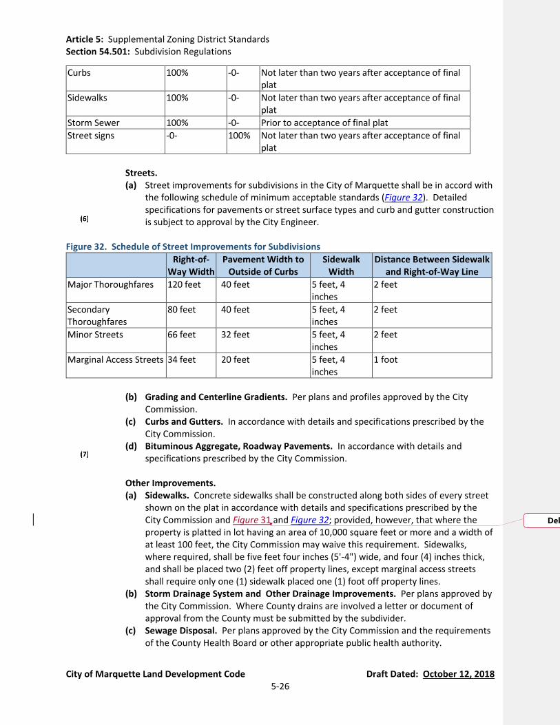
Article 5: Supplemental Zoning District Standards Section 54.501: Subdivision Regulations
City of Marquette Land Development Code Draft Dated: October 12, 2018 5-26
Curbs 100% -0- Not later than two years after acceptance of final plat
Sidewalks 100% -0- Not later than two years after acceptance of final plat
Storm Sewer 100% -0- Prior to acceptance of final plat
Street signs -0- 100% Not later than two years after acceptance of final plat
Streets.
(a) Street improvements for subdivisions in the City of Marquette shall be in accord with the following schedule of minimum acceptable standards (Figure 32). Detailed specifications for pavements or street surface types and curb and gutter construction is subject to approval by the City Engineer.
Figure 32. Schedule of Street Improvements for Subdivisions
Right-of-Way Width
Pavement Width to Outside of Curbs
Sidewalk Width
Distance Between Sidewalk and Right-of-Way Line
Major Thoroughfares 120 feet 40 feet 5 feet, 4 inches
2 feet
Secondary Thoroughfares
80 feet 40 feet 5 feet, 4 inches
2 feet
Minor Streets 66 feet 32 feet 5 feet, 4 inches
2 feet
Marginal Access Streets 34 feet 20 feet 5 feet, 4 inches
1 foot
(b) Grading and Centerline Gradients. Per plans and profiles approved by the City
Commission. (c) Curbs and Gutters. In accordance with details and specifications prescribed by the
City Commission. (d) Bituminous Aggregate, Roadway Pavements. In accordance with details and
specifications prescribed by the City Commission.
Other Improvements. (a) Sidewalks. Concrete sidewalks shall be constructed along both sides of every street
shown on the plat in accordance with details and specifications prescribed by the City Commission and Figure 31 and Figure 32; provided, however, that where the property is platted in lot having an area of 10,000 square feet or more and a width of at least 100 feet, the City Commission may waive this requirement. Sidewalks, where required, shall be five feet four inches (5'-4") wide, and four (4) inches thick, and shall be placed two (2) feet off property lines, except marginal access streets shall require only one (1) sidewalk placed one (1) foot off property lines.
(b) Storm Drainage System and Other Drainage Improvements. Per plans approved by the City Commission. Where County drains are involved a letter or document of approval from the County must be submitted by the subdivider.
(c) Sewage Disposal. Per plans approved by the City Commission and the requirements of the County Health Board or other appropriate public health authority.
Deleted: Figure 31
Article 5: Supplemental Zoning District Standards Section 54.501: Subdivision Regulations
City of Marquette Land Development Code Draft Dated: October 12, 2018 5-27
(d) Water Supply. Water distribution system plans approved by the City Commission and in conformance with the Regulations of the Michigan Department of Environmental Quality relating to Municipal Water Supplies.
(e) Street Signs. Street name signs of a type approved by the City Engineer shall be placed at all street intersections and shall be of permanent weather resistant construction, visible form two directions.
(f) Street Trees. See Section 54.1003(A).
(F) Performance Guarantee. See Section 54.1402(H).
(G) Violations, Penalties, and Enforcement. See Article 15.

Article 5: Supplemental Zoning District Standards Section 54.502: Land Division Regulations
City of Marquette Land Development Code Draft Dated: October 12, 2018 5-28
Section 54.502 Land Division Regulations (currently parts of Chapter 85 and Chapter 40, Article 2 of the Code of Ordinances)
(A) Purpose. The City finds that this section is necessary to regulate the division and partitioning of parcels of land which are not subject to platting procedures and requirements, and to regulate division and partitioning of parcels located in recorded subdivisions. The purpose of this section is to enable the parcel owners in the City of Marquette to divide their parcels, including subdivision parcels as there is a legitimate question of law as to whether subdivision parcels can be split without a City ordinance to that effect. This section shall promote the public health, safety, and general welfare by regulating the division of parcels so that the resulting partial parcel owners and neighboring parcel owners shall not be adversely affected by undersized parcels of land or illegal parcel splits. This section is created pursuant to Public Act No. 110 of 2006 (MCL 125.3101 et seq.) and Public Act No. 288 of 1967 (MCL 560.101 et seq.), as amended. This section of the Land Development Code shall be considered the ordinance referred to in Section 109(5) of Public Act No. 288 of 1967 (MCL 560.109(5)) which have been adopted to carry out the provisions of Act No. 288.
(B) Definitions. In addition to the definitions in Article 2, related terms defined elsewhere in the
Land Development Code, and Public Act 288 of 1967 (Land Division Act), the following definitions apply to this Section:
Division or Split: The partitioning or splitting of a parcel or tract of land by the proprietor
thereof or by his or her heirs, executors, administrators, legal representatives, successors, or assigns for the purpose of sale, or lease of more than 1 year, or of building development that results in 1 or more parcels of less than 40 acres or the equivalent, and that satisfies the requirements of this ordinance and Public Act No. 288 of 1967 (MCL 560.101 et seq.), as amended. The term “division” does not include a property transfer between 2 or more adjacent parcels, if the property taken from 1 parcel is added to an adjacent parcel; and any resulting parcel shall not be considered a building site unless the parcel conforms to the requirements of this ordinance.
Exempt Split: The partitioning or splitting of a parcel or tract of land by the proprietor
thereof or by his or her heirs, executors, administrators, legal representatives, successors, or assigns that does not result in 1 or more parcels of less than 40 acres or the equivalent. For a property transfer between 2 or more adjacent parcels, if the property taken from 1 parcel is added to an adjacent parcel, any resulting parcel shall not be considered a building site unless the parcel conforms to the requirements of this ordinance.
Subdivide or Subdivision: The partitioning or splitting of a parcel or tract of land by the
proprietor thereof or by his or her heirs, executors, administrators, legal representatives, successors, or assigns for the purpose of sale, or lease of more than 1 year, or of building development that results in 1 or more parcels of less than 40 acres or the equivalent, and that is not exempted from the platting requirements of Public Act No. 288 of 1967 (MCL 560.101 et seq.), as amended. "Subdivide" or "subdivision" does not include a property transfer between 2 or more adjacent parcels, if the property taken from 1 parcel is added to an adjacent parcel; and any resulting parcel shall not be considered a building site

Article 5: Supplemental Zoning District Standards Section 54.502: Land Division Regulations
City of Marquette Land Development Code Draft Dated: October 12, 2018 5-29
unless the parcel conforms to the requirements of this ordinance or Public Act No. 288 of 1967 (MCL 560.101 et seq.), as amended.
(C) Scope of Regulations. Parcels in the city shall not be divided without prior review and
approval by the City Assessor, or other official designated by the City Commission, upon consultation with the Zoning Administrator, in accordance with the provisions of this section, unless the division or partition is approved and a part of a recorded plat, pursuant to Public Act No. 288 of 1967 (MCL 560.101 et seq.), or unless such division or partition is approved pursuant to the Condominium Act, Public Act No. 59 of 1978 (MCL 559.101 et seq.). Exempt from the requirements of this section are parcels split through a Circuit Court action under MCLA 560.221 through 560.229.
(D) Application for Land Divisions. An applicant shall file with the City Assessor, or other official
designated by the City Commission, all of the following for review and approval of a proposed parcel split before any split can be made:
Application. A completed application on such form as may be provided by the City. If a
transfer of division rights is proposed in the land transfer, then information about the terms and availability of the proposed division rights transfer shall be submitted with the application. Such information shall be in a form that satisfies the written notice requirements specified in Section 109(2) of the Land Division Act.
Proof of Ownership. Proof of fee ownership of the land to be divided.
Survey or Tentative Parcel Map. A survey or tentative parcel map of the parcel, including
the location, setbacks, and dimensioned encroachments of all existing structures, indicating the adequate and accurate dimensions and legal description of the entire parcel and each split to be made. The survey or tentative parcel map must include the means of access from each resulting parcel to an existing road or street, the location of all existing and proposed public and private easements and rights-of-way, and the location of surface water, lakes, ponds, streams, and wetlands.
Legal Descriptions. A legal description of existing parcels of land involved in the proposed
land division. Tentative approval may be granted without formal legal descriptions of all parcels that would result from the requested division of land, but legal descriptions must be received before final approval is granted. The legal descriptions shall be in a form sufficient for recording with the Marquette County Register of Deeds, and shall indicate the acreage of all parcels.
Deed Restrictions. Copies of existing or proposed deed restrictions related to the
proposed parcels.
Proof that Land Division Standards are Met. Proof that all requirements of Section 54.502(F) of this section have been met.
History of Prior Divisions. History of any prior parcel splits regarding this parcel.
Article 5: Supplemental Zoning District Standards Section 54.502: Land Division Regulations
City of Marquette Land Development Code Draft Dated: October 12, 2018 5-30
Fee. The fee as may from time to time be established by resolution of the City Commission.
(E) Procedures for Review and Approval.
Application Review. Upon receipt of a land division application and all other supporting
documents, the City Assessor, or other official designated by the City Commission, upon consultation with the Zoning Administrator, shall approve, approve with reasonable conditions to assure compliance with this article, or disapprove the parcel split within 45 days after receipt of the complete application package. The applicant shall be sent notice of the decision in writing within the 45 days and, if disapproved, the reasons for the denial. If the application package does not conform to the article requirements, the application may be returned to the applicant for refiling. If the land division application meets the requirements of this Ordinance but includes a tentative parcel map instead of a survey, the land division application shall be approved with conditions within 45 days with the condition that a survey must be submitted for City review and confirmation with Ordinance standards prior to recording the land division survey with the Marquette County Register of Deeds.
Appeals. Any applicant aggrieved by the decision of the Assessor, or designee, may,
appeal the decision per Section 54.1404.
Record of Applications and Decisions. The City Assessor, or other official designated by the City Commission, shall maintain an official record of all parcel splitting applications and decisions.
(F) Standards for Granting Land Division Approval. The splitting or partitioning of a parcel is
prohibited unless approved in the manner required by this section in complete accordance with the following rules and regulations:
Number of Divisions for Non-Platted Parcels. The number of parcels created by a land
division shall not exceed the amount specified by Section 108 of the Land Division Act (MCL 560.108). Accordingly, a proposed land division, together with any previous divisions of the same parent parcel or parent tract, shall result in a number of parcels not more than the sum of the following:
(a) For the first ten (10) acres, or fraction thereof, in the parent parcel or parent tract:
four (4) parcels.
(b) For each whole ten (10) acres in excess of the first ten (10) acres in the parent parcel or parent tract: one (1) additional parcel, for up to a maximum of 11 additional parcels.
(c) For each whole 40 acres in excess of the first 120 acres in the parent parcel or parent
tract: one (1) additional parcel.

Article 5: Supplemental Zoning District Standards Section 54.502: Land Division Regulations
City of Marquette Land Development Code Draft Dated: October 12, 2018 5-31
(d) If the parent parcel or parent tract is 20 acres or greater, the land division may result in a total of two (2) additional parcels, provided, one or both of the following conditions exist:
(i) Because of the establishment of one or more new roads, no new driveway
access to an existing public road is required or created for any of the resulting parcels.
(ii) One of the resulting parcels comprises not less than 60% of the area of the
parent parcel or parent tract.
(e) A parcel of 40 acres or more created by the division of a parent parcel or parent tract shall not be counted toward the number of parcels permitted, and is not subject to Section 109 of the Land Division Act (MCL 560.109).
Additional Future Divisions for Non-Platted Parcels. A parcel or tract created by an
exempt split or a division is not a new parent parcel or parent tract and may be further partitioned or split without being subject to the platting requirements of the Land Division Act if all of the following requirements are met:
(a) Not less than ten (10) years have elapsed since the parcel or tract was recorded.
(b) The partitioning or splitting results in not more than the following number of parcels,
whichever is less:
(i) Two (2) parcels for the first ten (10) acres, or fraction thereof, in the parcel or tract, plus one (1) additional parcel for each whole ten (2) acres in excess of the first ten (10) acres in the parcel or tract.
(ii) A total of seven (7) parcels, except that a total of ten (10) parcels may result if
one of the resulting parcels under this subsection comprises not less than 60% of the area of the parcel or tract being partitioned or split.
(iii) The partitioning or splitting satisfies the requirements of Section 109 of the
Land Division Act (MCL 560.109).
Depth-to-Width Ratio of Non-Platted Parcels. Depths of parcels created as a result of division of land shall be not greater than four (4) times the parcel width. The City may permit parcels with proportions that vary from such standards where such action would reduce existing nonconformance with the standards set forth in this ordinance or, in the determination of the Zoning Administrator, a variation is necessary due to exceptional topographic or physical conditions with respect to the parcel and compatibility with surrounding lands.
Zoning Requirements for Non-Platted Parcels. All parcels created as a result of a division
of land shall comply with all applicable zoning requirements, including minimum lot area, lot width, public road frontage and parking requirements. Each parcel created as a result of a division of land shall be “accessible” (see definition of “Accessible” in Public Act 288
Article 5: Supplemental Zoning District Standards Section 54.502: Land Division Regulations
City of Marquette Land Development Code Draft Dated: October 12, 2018 5-32
of 1967, as amended). A parcel that is smaller in area than currently required by the this Ordinance shall not be divided further. Notwithstanding such requirements, land division proposals may be approved in the following circumstances:
(a) When the proposed division of land would reduce the degree of existing
nonconformity with zoning standards; or
(b) When the division of land is proposed with the intention of immediately combining portions of the original parcel with additional land for the purpose of creating a new parcel, provided the new parcel is in compliance with this ordinance or reduces the degree of nonconformity with zoning requirements.
Division of Land in a Recorded Plat. A subdivision parcel, outlot, or other parcel of land
in a recorded plat may be divided pursuant to the requirements of this section only if such parcel, outlot, or other parcel meets all of the following requirements:
(a) No parcel in a recorded plat shall be divided into more than four (4) parts.
(b) No resulting parcel shall be less than those dimensions prescribed in this Ordinance.
(c) All resulting lots shall abut a public road or an existing private road on a recorded
plat map.
(d) In the event that one or more of the four (4) possible resulting parcels would be an addition to an adjoining subdivision parcel, without creating a new parcel, the width and area requirements of this Ordinance do not have to be met. The resulting parcel cannot be split off from the adjoining parcel as a separate parcel. See definitions of “Division,” “Exempt Split,” and “Subdivide or Subdivision” in Section 54.502(B) for property transfers between two (2) or more adjacent parcels.
(G) Enforcement. The City Assessor or other designated official shall inform the grantors and
grantees of any such violation of this section and these parties shall take immediate steps to correct the matter. In the event that the violation of this section is not corrected within 30 days after written notice is mailed or personally delivered, the violation may be punished as a municipal civil infraction in accordance with Article 15.

Article 5: Supplemental Zoning District Standards Section 54.503: Site Condominiums
City of Marquette Land Development Code Draft Dated: October 12, 2018 5-33
Section 54.503 Condominium Developments (currently parts of Chapter 85 of the Code of Ordinances)
(A) Intent and Application. The following regulations shall apply to all site condominium developments within the City of Marquette.
(B) Site Condominiums. Pursuant to authority conferred by Section 141 (Law, Ordinance, or
Regulation of Local Unit of Government) of the Condominium Act 59 of 1978, as amended, all condominium subdivision plans must be approved by the City Commission following review and recommendation for approval by the Planning Commission. In determining whether to recommend a condominium subdivision plan for approval to the City Commission, the Planning Commission shall consult with and receive a written response from the Planning Director, City Attorney, City Engineer, and Zoning Administrator regarding the adequacy of the master deed, deed restrictions, utility systems and street, development layout and design and compliance with all requirements of the Condominium Act and the Land Development Code.
(C) Initial Information. Concurrently with notice required to be given to the City of Marquette
pursuant to Section 71 (Notice of Proposed Action) of Public Act 59 of 1978, as amended (the Condominium Act), the condominium subdivision plan for each condominium project shall be prepared by a licensed architect, licensed professional surveyor, or licensed professional engineer and shall bear the signature and seal of the licensed architect, licensed professional surveyor, or licensed professional engineer. In addition to any information required by Public Act 59 1978 or Department of Licensing and Regulatory Affairs (LARA) Administrative Rules 559.010-559-903, condominium subdivision plan must include the following information:
The name, address, telephone number, and email address of: (a) All persons, firms or corporation with an ownership interest in the land on which the
condominium development will be located together with a description of the nature of each entity’s interest (for example, fee owner, optionee, or land contract vendee).
(b) All engineers, attorneys, architects or registered land surveyors associated with the project.
(c) The developer or proprietor of the condominium development. A cover sheet. The cover sheet shall list all documents included in the condominium
subdivision plan and contain a notice that reads substantially as follows: “This condominium subdivision plan is not required to contain detailed project design plans prepared by the appropriate licensed design professional. Such project design plans are filed, as part of the construction permit application, with the enforcing agency for the state construction code in the relevant governmental subdivision. The enforcing agency may be a local building department or the state department of licensing and regulatory affairs.”
A survey plan, including the legal description of the land on which the condominium project will be developed together with appropriate tax identification numbers. The survey plan shall be signed and sealed by the licensed professional surveyor preparing the boundary survey for the condominium project.
A floodplain plan, if the condominium lies within or abuts a floodplain area. A site plan (See Section 54.1402(C)). A utility plan, including a description of the water and sewer service. Floor plans.
Article 5: Supplemental Zoning District Standards Section 54.503: Site Condominiums
City of Marquette Land Development Code Draft Dated: October 12, 2018 5-34
The size, location, area, and horizontal boundaries of each condominium unit and the acreage content of the land on which the condominium development will be developed.
A number assigned to each condominium unit. The vertical boundaries and volume for each unit comprised of enclosed air space. Building sections showing the existing and proposed structures and improvements including their location on the land. Any proposed structure or improvement shall be labeled either “must be built” or “need not be built”. To the extent that a developer is contractually obligated to deliver utility conduits, buildings, sidewalks, driveways, landscaping, and an access road, the same shall be shown and designated as “must be built”, but the obligation to deliver such items exists whether or not they are so shown and designated.
The nature, location, and approximate size of the common elements. Other information deemed necessary by the Planning Director.
(D) Site Plans for New Projects. Prior to recording of the master deed required by Section 72
(Establishment of Condominium Project) of Public Act 59 of 1978, as amended, the condominium development shall undergo site plan review and approval pursuant to the requirements of Section 54.1402 of this ordinance. In addition, the City shall require appropriate engineering plans and inspections prior to the issuance of any certificates of occupancy. All condominium projects are subject to the zoning requirements of their respective zoning districts and this ordinance.
(E) Plans for Expandable or Convertible Projects. Prior to expansion or conversion of a
condominium development to additional land, the new phase of the project shall undergo site plan review and approval pursuant to Section 54.1402 of this ordinance and this Section 54.503. The conversion of any development to condominium form of ownership shall require all standards and requirements of this ordinance regarding condominiums to be met.
(F) Master Deed, Restrictive Covenants, “As Built” Survey, and Association Bylaws to be
Furnished. The condominium project developer shall furnish the Planning Director with the following
for review: one (1) copy of the recorded master deed, one (1) copy of all restrictive covenants, one (1) copy of the condominium owner’s association bylaws, and two (2) copies of an “as built survey”. The “as built survey” shall be reviewed by the City Engineer for compliance with City ordinances and standards. Fees for this review shall be will be established by resolution of the City Commission.
The master deed and/or restrictive covenants of site condominiums approved subsequent to the adoption of this amendment shall include any required standards of this ordinance. Copies of the master deed and/or restrictive covenants shall be provided for review by the City prior to final approval of the site condominium or as a condition of final approval and shall be recorded in the office of the Marquette County Register of Deeds.
(G) Design and Engineering Standards and Required Improvements for Condominium
Developments. The design and engineering standards for condominium developments, as well as required improvements for condominium developments, shall be the same as those required for subdivisions in Section 54.501(E).
Article 5: Supplemental Zoning District Standards Section 54.503: Site Condominiums
City of Marquette Land Development Code Draft Dated: October 12, 2018 5-35
(H) Approval Period. Approval of the condominium subdivision plan or phase thereof by the City Commission shall confer upon the proprietor for a period of one (1) year from the date of approval, approval of lot sizes, lot orientation, and street layout. The one-year period may be extended if applied for in writing by the proprietor prior to the expiration date and granted by the City Commission in writing. The City Commission shall seek the Planning Commission's recommendation on any such extension. If the extension is granted, the City Clerk shall notify the other approving authorities. In approving an extension, the City Commission may impose new standards (not necessarily related solely to lot size, lot orientation, and street layout) as a result of new standards, changing conditions on surrounding parcels, or other considerations, provided that the revised plat shall still be considered substantially conforming to the previously approved tentative preliminary plat.
(I) Monuments Required. All condominium developments which consist in whole or in part of
condominium units which are building sites, mobile home sites, or recreational sites shall be marked with monuments, which shall be set in accordance with Michigan Public Act 288 of 1967, as amended (the Land Division Act), and the rules of the State of Michigan. If any monument or lot marker is removed during construction the responsible party shall secure the services of a professional surveyor to replace the monument or lot marker.
(J) Compliance with Federal, State, and Local Law. All condominium development shall comply
with Federal and State statues and local ordinances, including Public Act 59 of 1978 and the Department of Licensing and Regulatory Affairs (LARA) Administrative Rules 559.010-559-903.
(K) Subdivision of Condominium Lots. All subdivisions of individual condominium units shall
conform to the requirements of this ordinance for minimum lot width, lot area, and building setback requirements, for the district in which the site condominium project is located, and these requirements shall be made part of the bylaws and recorded as part of the master deed. Subdivisions of individual condominium units shall be in accordance with Section 54.502.
(L) Encroachment Prohibited. Encroachment of one condominium lot upon another, as described
in Section 40 of the Condominium Act, shall be prohibited by the condominium bylaws and recorded as part of the master deed.
(M) Relocation of Boundaries. The relocation of boundaries, as described in Section 48 of the
Condominium Act, shall conform to all setback requirements of this ordinance for the district in which the project is located, shall be approved by the Zoning Administrator, and this requirement shall be made part of the bylaws and recorded as part of the master deed.
(N) Performance Guarantee. The Planning Director may allow occupancy of the condominium
development before all improvements required by this ordinance are installed provided that cash, a certified check, or an irrevocable bank letter of credit is submitted sufficient in amount and type to provide for the installation of improvements before the expiration of the temporary occupancy permit without expense to the City. The expiration date of a temporary occupancy permit shall be as determined by the Planning Director upon issuance of the permit.
(O) Final Documents to be Provided. After submittal of the condominium plan and bylaws as part
of the master deed, the proprietor shall furnish to the City a copy of the site plan on 24 inch by
Article 5: Supplemental Zoning District Standards Section 54.503: Site Condominiums
City of Marquette Land Development Code Draft Dated: October 12, 2018 5-36
36 inch sheets and in a digital format acceptable to the City. As-built plans are required pursuant to Section 54.1402(L).
Article 6: Standards Applicable to Specific Uses
City of Marquette Land Development Code Draft Dated: October 12, 2018 6-1
Article 6 Standards Applicable to Specific Land Uses
Section 54.601 Adult Entertainment (New Section)
(A) Purpose and Intent. It is recognized that adult entertainment uses, which because of their very nature, have serious objectionable operational characteristics, particularly when several of them are concentrated under certain circumstances thereby having a deleterious effect upon the adjacent areas. Special regulation of adult entertainment uses is necessary to ensure that these adverse effects will not contribute to the blighting or downgrading of the surrounding neighborhood. These special regulations are itemized in Article 3 and in this Section. It is the purpose of this Ordinance to regulate adult entertainment uses to promote and protect the health, safety, morals and general welfare of this citizens of the City of Marquette and to establish reasonable and uniform regulations to prevent a concentration of adult entertainment businesses with the City. These regulations are intended to control the negative secondary impacts such businesses have been documents to have on the surrounding area and the community. The provisions of this Section have neither the purpose nor effect of imposing a limitation or restriction on the content of any communicative materials, including sexually oriented materials. Similarly, it is not the intent nor effect of this Section to restrict or deny access by adults to adult entertainment materials protected by the First Amendment or to deny access by the distributors and exhibitors of sexually oriented entertainment to their intended market.
The provisions of this section regarding massage parlors shall not apply to health care facilities licensed by the state under the Public Health Code, MCL 333.2223 et seq., such as hospitals, sanitariums, nursing homes, medical clinics or the office of a physician, surgeon, chiropractor, dentist, psychologist, clinical social worker, family counselor, physical therapist or other members of the health occupations licensed or regulated by the State. In addition, the provisions of this section regarding massage parlors shall not apply to individuals permitted to practice with a temporary license under required supervision as provided by the State Public Health Code, MCL 333.16101 et seq., as well as clergy, and certified members of the American Massage and Therapy Association.
It is determined necessary for the health, safety, and welfare of the City to adopt this section pertaining to and regulating adult businesses for the following reasons:
Many parents are concerned about the influence of pornographic entertainment outlets
and businesses and have chosen the City to raise their families because of the absence of such adult businesses.
Location of and easy availability of adult businesses in close proximity to homes,
apartments, schools, religious institutions, and public parks give an impression of legitimacy to such uses and have adverse effects upon children, established family relations, respect for marital relationships, and the concept of nonaggressive consensual sexual relations.
Article 6: Standards Applicable to Specific Uses
City of Marquette Land Development Code Draft Dated: October 12, 2018 6-2
Location of adult businesses in close proximity to houses, apartments, schools, religious
institutions, and public parks will draw persons who are not known in the community and will create police and safety problems in areas of the City which should be free of such problems.
Property values in areas adjacent to adult businesses will decline, thus causing a blight
upon both commercial and residential areas of the City.
(B) Definitions. The following words, terms and phrases, when used in this section, shall have the meanings ascribed to them in this subsection, except where the context clearly indicates a different meaning:
Adult Bookstore or Adult Video Store: An establishment having a substantial or
significant portion of its stock in trade in video cassettes, discs, or films or media recorded, pressed, engraved, or prepared for playback and books, magazines, and other periodicals which are distinguished or characterized by their emphasis on matter depicting, describing, or relating to specified sexual activities or specified anatomical areas, or an establishment with a segment or section devoted to the sale, rental, and/or display of such material.
Adult Cabaret: An establishment which features one or more dancers, strippers, male or
female impersonators, or similar entertainers, performers, wait staff, or other persons who reveal or show specified anatomical areas of their bodies or who engage in, perform, or simulate specified sexual activities on or with any person.
Adult Entertainment Use or Adult Entertainment Business: An adult bookstore, adult
motion picture theater, adult personal service business, adult cabaret, adult novelty business, massage parlor, nude modeling studio, or any combination thereof.
Adult Motion Picture Theater: An enclosed building used for presenting motion picture
films, videocassettes, cable television, or any other such visual media, distinguished or characterized by an emphasis on matter depicting, describing, or relating to specified sexual activities or specified anatomical areas for observation by patrons therein.
Specified Anatomical Areas means:
(a) Less than completely and opaquely covered human genitals, pubic region, buttock,
and female breast below a point immediately above the top of the areola; and
(b) Human male genitals in a discernibly turgid state, even if completely and opaquely covered.
Specified Sexual Activities means:
(a) Human genitals in a state of sexual stimulation or arousal;
(b) Acts of human masturbation, sexual intercourse, or sodomy; and/or

Article 6: Standards Applicable to Specific Uses
City of Marquette Land Development Code Draft Dated: October 12, 2018 6-3
(c) Fondling or other erotic touching of human genitals, pubic region, buttock, or female
breast.
Used, in the definition of the term "Adult Motion Picture Theater" in this section, describes a continuing course of conduct of exhibiting specified sexual activities and specified anatomical areas in a manner which appeals to a prurient interest.
(C) Specific Requirements.
Separation from Religious Institutions, Schools, Public Parks, Noncommercial Public
Assembly Facilities, and Public Office Buildings. No adult entertainment use or business shall be located within 500 feet of a religious institution, school, public park, noncommercial public assembly facility, or public office building.
Separation from Residential Land Uses and Residential Zoning Districts. The site of an
adult entertainment use or business shall not be adjacent to or within 300 feet of any residential land use or residential zoning district.
Separation from Another Adult Entertainment or Use. The site of an adult
entertainment use or business shall not be within 500 feet of any other adult entertainment use or business.
Signs. Window displays, signs, decorative or structural elements of buildings shall not
include or convey specific examples of the adult entertainment use or business activity, are limited to a single sign and all such displays shall be part of specific approvals for all the uses or activities on the site. Any alteration to the above media shall be approved by the Planning Commission.
Compatibility with Adjacent Uses. The site layout, setback, structures, and overall
appearance and function of the use shall be compatible with adjacent uses.
Residential Use Prohibited. No person shall reside in, or permit any person to reside in, the premises of an adult entertainment use or business.
Section 54.602 Adult Foster Care Small Group Home, Large Group Home, and Congregate Facility (currently Section 80.65(4)(A)(12))
(A) On-Site Manager. Adult Foster Care Small Group Homes, Large Group Homes, and Congregate Facilities shall have a manager on duty at all times.
(B) Parking. Adult Foster Care Small Group Homes, Large Group Homes, and Congregate Facilities
shall have a minimum of three (3) off-street parking spaces, or one (1) space for each tenant with a vehicle plus one (1) space for each staff member on duty whichever is greater. In authorizing construction of new structures, the Planning Commission may require sufficient yard area to be reserved as potential parking to facilitate conversion to a permitted use in the district, should the group home cease to operate.

Article 6: Standards Applicable to Specific Uses
City of Marquette Land Development Code Draft Dated: October 12, 2018 6-4
(C) Resident Requirements. All residents shall have met the sponsoring agency's referral
specifications and participate in all required treatment and counseling programs.
(D) Site Plan and Property Maintenance Requirements. Existing structures shall meet all the minimum property maintenance and site plan requirements for licensing. Applications for new building shall include a site plan, floor plan, and elevations.
(E) Maximum Number of Occupants. Approval of a site plan and/or special land use permit shall
specify compliance with the number of occupants. Violation of this condition shall result in a public hearing before the Planning Commission and shall be grounds for revocation of the Special Land Use Permit.
(F) Special Land Use Conditions of Approval. If the use is a special land use, subject to the
standards of Section 54.1403(C), the Planning Commission may adopt conditions of approval that ensure compliance with the special land use standards.
(G) Minimum Separation Distance Between Similar Facilities. In no case shall an Adult Foster
Care Small Group Home, Large Group Home, or Congregate Facility be permitted within 500 feet of another similar facility.
(H) Pre-Application. Prior to application for zoning approval, the applicant shall meet with the
Planning Department and is encouraged to inform the neighbors of plans for the facility.
Section 54.603 Bed and Breakfast Home (currently Sections 80.65(4)(A)(14), 80.65(4)(B)(2), 80.65(4)(C)(4), and 80.65(4)(D)(3))
(A) Room Size. A minimum room size of 70 Sq. Ft. for the first occupant and an additional 50 Sq. Ft. for each occupant thereafter shall be provided.
(B) Length of Stay. No one guest’s stay is to exceed 14 consecutive days.
(C) Parking. In Residential Districts and the M-U District, there must be at least one (1) space per
room, plus two (2) spaces for the owner. In Commercial Districts, parking shall be provided in accordance with the requirements provided in the Zoning Ordinance for hotels and motels.
(D) Signage. A Bed and Breakfast Home licensed under the ordinance shall be allowed one
additional sign on the property. The sign shall be non- illuminated, mounted flush against the building, with a maximum size of five (5) square feet. Other signage shall be regulated by Article 11.
(E) Proximity. In Residential Districts, a Bed and Breakfast Home shall not be located within 300
lineal feet measured along the street right of way of another Bed and Breakfast Home or Bed and Breakfast Inn.
(F) Transferability. Special land use permits for Bed and Breakfast Homes in a Residential District
may not be transferred from owner to owner without Planning Commission approval.

Article 6: Standards Applicable to Specific Uses
City of Marquette Land Development Code Draft Dated: October 12, 2018 6-5
(G) Code Compliance. A Bed and Breakfast Home shall not commence or continue to operate
without compliance with all applicable code requirements. Owners shall submit to inspections of both the exterior and interior of the dwelling to ensure compliance with health, safety, and welfare regulations pursuant to all applicable city code requirements.
(H) Structure. Building modifications or additions shall be architecturally designed to blend with
the character of the existing structure and neighborhood.
(I) Site Plans. A site plan meeting the specifications of the Land Development Code shall be submitted with the application prior to a public hearing for a Bed and Breakfast Establishment.
(J) Review Considerations. The Planning Commission shall be guided by the standards set forth
in Section 54.1402(E).
Section 54.604 Bed and Breakfast Inn (currently Sections 80.65(4)(C)(4) and 80.65(4)(D)(3))
(A) Room Size. A minimum room size of 70 Sq. Ft. for the first occupant and an additional 50 Sq. Ft. for each occupant thereafter shall be provided.
(B) Length of Stay. No one guest’s stay is to exceed 14 consecutive days.
(C) Parking. In non-Commercial Districts, one space per room, plus two (2) spaces for the owner.
In Commercial Districts, parking shall be provided in accordance with the requirements provided in the Zoning Ordinance for hotels and motels.
(D) Signage. Signage regulated by Article 11.
(E) Proximity. In Residential Districts, Bed and Breakfast Inns shall not be located within 300
lineal feet measured along the street right of way of another Bed and Breakfast Inn or Bed and Breakfast Home.
(F) Transferability. Special land use permits for Bed and Breakfast Inns in a Residential District
may not be transferred from owner to owner without Planning Commission approval.
(G) Code Compliance. A Bed and Breakfast Inn shall not commence or continue to operate without compliance with all applicable code requirements. Owners shall submit to inspections of both the exterior and interior of the dwelling to ensure compliance with health, safety, and welfare regulations pursuant to all applicable city code requirements.
(H) Structure. No main building shall be removed in order to allow for a Bed and Breakfast Inn in
residential districts nor shall such a structure be removed in order to provide parking for such an establishment. Building modifications or additions shall be architecturally designed to blend with the character of the existing structure and neighborhood in residential districts.
Article 6: Standards Applicable to Specific Uses
City of Marquette Land Development Code Draft Dated: October 12, 2018 6-6
(I) Site Plans. A site plan meeting the specifications of the Land Development Code shall be submitted with the application prior to a public hearing for a Bed and Breakfast Establishment.
(J) Review Considerations. The Planning Commission shall be guided by the standards set forth
in Section 54.1402(E) and, if applicable, Section 54.1403(C) if the Bed and Breakfast Inn is a special land use.
Section 54.605 Bulk Storage (currently Section 80.65(4)(F)(3))
(A) Noise, vibration, smoke, dust, odors, glare, and similar or related nuisances shall be confined to the site to the maximum extent possible and mitigated on-site to the maximum extent possible. Any nuisances which are anticipated to not be contained to the applicant’s property and not mitigated on the property shall be identified in the Project Proposal Document submitted with the Special Land Use Permit application.
(B) Operations shall be approved only upon documentation by the applicant that no dangerous,
noxious or nuisance conditions will impact any adjacent premises. The manufacture, processing or packaging of materials which are inherently dangerous or hazardous due to flammability, radioactivity, explosiveness, or severe toxicity will not be permitted.
(C) Prior to final approval of a special land use permit each applicant shall obtain the necessary
state and federal permits, including permits or waiver for permits. The applicant shall, upon Planning Commission request, forward all reports and findings from the state and federal agencies to the Zoning Administrator, along with site plans as described in Section 54.1402.
(D) Notice of intent to build or expand must be given to the Zoning Administrator at the same time
application is made to federal or state agencies, which may require permits.
(E) When industrial activity is discontinued or the site is vacated, the site shall be left in a condition free from hazards (including but not limited to dangerous excavations, and abandoned structures above or below ground).
(F) The Planning Commission may require additional safeguards to meet the intent of the
industrial district and to assure opportunity for additional industrial uses and for growth within each area of the city which is zoned industrial.
Section 54.606 Cemeteries (currently part of Section 80.65(4)(A)(6))
(A) A cemetery shall be located so that the site has direct ingress from and egress to a major street or a minor street no more than 400 feet from its intersection with a major street.
(B) No building for a cemetery use shall be located closer than thirty (30) feet to a lot line.
(C) Spires shall be exempt from height requirement.
(D) Service entrances shall be screened from the view of adjacent residential property.
Article 6: Standards Applicable to Specific Uses
City of Marquette Land Development Code Draft Dated: October 12, 2018 6-7
Section 54.607 Colleges, Universities, and Institutions of Higher Learning (currently Section 80.65(4)(A)(5))
(A) All ingress and egress from the campus buildings and facilities shall be onto a major street having a right-of-way of at least sixty-six (66) feet.
(B) No building or other use of land except landscaped passive areas or parking shall be situated
within thirty (30) feet of the lot line.
Section 54.608 Day Care, Group Home (currently Section 80.65(4)(A)(2)) Group Day Care Homes shall be licensed as a group day care home by the State of Michigan prior to commencement of the use.
Section 54.609 Day Care Centers (currently Section 80.65(4)(A)(2)) Day Care Centers shall be licensed as a day care center by the State of Michigan prior to commencement of the use.
Section 54.610 Domestic Violence Shelter (currently Section 80.65(4)(A)(12))
(A) On-Site Manager. Domestic Violence Shelters shall have a manager on duty at all times.
(B) Parking. Domestic Violence Shelters shall have a minimum of three (3) off-street parking spaces. In authorizing construction of new structures, the Planning Commission may require sufficient yard area to be reserved as potential parking to facilitate conversion to a permitted use in the district, should the group home cease to operate.
(C) Resident Requirements. All residents shall have met the sponsoring agency's referral
specifications.
(D) Site Plan and Property Maintenance Requirements. Existing structures shall meet all the minimum property maintenance and site plan requirements for licensing, along with a statement of intent to comply with any required changes to bring the structure into compliance. Applications for new building shall include a site plan, floor plan, and elevations.
(E) Maximum Number of Occupants. Approval of a site plan and/or special land use permit shall
specify compliance with the number of occupants. Violation of this condition shall result in a public hearing before the Planning Commission and shall be grounds for revocation of the Special Land Use Permit.
(F) Special Land Use Conditions of Approval. If the use is a special land use, subject to the
standards of Section 54.1403(C), the Planning Commission may adopt conditions of approval that ensure compliance with the special land use standards.

Article 6: Standards Applicable to Specific Uses
City of Marquette Land Development Code Draft Dated: October 12, 2018 6-8
(G) Minimum Separation Distance Between Similar Facilities. In no case shall a Domestic Violence Shelter be permitted within 500 feet of another similar facility.
(H) Pre-Application. Prior to application for zoning approval, the applicant shall meet with the
Planning Department.
Section 54.611 Drive-Through Uses (new Section)
(A) Building Design. Drive-through uses must be built as an integral architectural element of the primary structure and use. Building materials shall be the same as those used in the primary structure. Drive through facilities and structures separate from the primary structure are prohibited.
(B) Drive-Through Setback. Drive-through uses, including the drive-through window and any
canopies, must be located to the rear or side of the primary structure, except that corner parcels may use one (1) frontage of the building for drive-through window service. All drive-through service windows must be set back a minimum of 8 feet from the front building wall of the primary structure.
(C) Traffic and Pedestrian Safety. A curb opening for a driveway is prohibited where the driveway
would create a safety or traffic hazard because of its location in relation to pedestrian entrances or crossings.
(D) Stacking Lane Location. Stacking lanes may not be located in a required front yard setback
and must not create hazardous conditions for pedestrians or other users on the site or in any adjacent right-of-way.
(E) Headlight Glare. Drive-through uses must be designed and configured and screened such that
glare from the headlights of vehicles waiting in the stacking lane is obstructed from shining into neighboring residential or commercial uses, and so that glare does not create a driving hazard on streets or roads abutting the drive-through use.
(F) Landscaping. A landscape buffer meeting the requirements of Section 54.1003 shall be
provided along rear and side lot lines of a drive-through use located adjacent to a residentially zoned or used property
Section 54.612 Dwelling, Accessory Unit (currently Section 80.23(3)) Accessory dwelling units (ADU) shall comply with all of the following standards:
(A) One ADU Per Lot. One ADU is permitted per lot containing an existing detached single-family dwelling unit, provided the ADU complies with all of the requirements of this Section and this ordinance.
(B) Minimum Lot Area and Width. ADUs are only be permitted on lots that meet the minimum
lot area and lot width standards of the zoning district.

Article 6: Standards Applicable to Specific Uses
City of Marquette Land Development Code Draft Dated: October 12, 2018 6-9
(C) Setbacks and Height. ADUs must meet all requirements of this ordinance for minimum setbacks and maximum height. However, the height of an ADU shall not exceed two (2) stories or 20 feet.
(D) Maximum Occupancy. The occupancy of the accessory dwelling unit shall not exceed two (2)
persons.
(E) Family Member Occupancy Only. The ADU shall be occupied only by persons related by blood, marriage, or adoption to the family occupying the principal dwelling or employees not related to the family occupying the principal dwelling.
(F) Owner-Occupancy Required of the Principal Dwelling is as follows:
Either the principal dwelling unit or the accessory dwelling unit shall be occupied by the
person who has a legal or equitable ownership interest with the property, and who bears all or part of the economic risk of decline in value of the property and who receives all or part of the payment, if any, derived from the lease or rental of the dwelling unit. The owner-occupant shall prove residency by means such as a voter registration, car registration, or other method acceptable to the City.
Ownership of the ADU shall remain with the owner of the property. In no case may the
owner of the property divide ownership rights between the principal and accessory dwelling units through condominium or other means.
To ensure continued compliance by current and subsequent owners, the applicant shall
provide and record in the Marquette County Register of Deeds a covenant in a form acceptable to the City Attorney that the existence of the ADU is predicated upon the occupancy of either the principal or accessory dwelling unit by a person who owns the property, and that the ADU shall remain in the ownership of the person who owns the property. The applicant shall provide the City with evidence of filing of the restrictive covenant with the Register of Deeds prior to the City issuing a final certificate of occupancy for the ADU.
Any owner of the property must notify a prospective buyer of the limitations of this
Section. Violations of the terms of this covenant shall result in the loss of the special use permit.
(G) Yearly Certification. Conformance with the conditions of the ADU special use permit shall be
certified yearly by the owner subject to inspection by the City. The City may adopt an ordinance or administrative standards for certification and inspection. Inspection shall be allowed by the owner after 48 hours’ notice by certified mail from the City. The certification process shall be subject to an appropriate fee as determined by the City Commission.
(H) Maximum Floor Area of ADU. The floor area of the ADU shall not exceed 750 square feet, or
50% of the gross floor area of the principal residence, whichever is less.
(I) Attachment Options. The ADU may be attached to the single-family dwelling or constructed on the second story of a conforming detached accessory building on the site. If the ADU is
Article 6: Standards Applicable to Specific Uses
City of Marquette Land Development Code Draft Dated: October 12, 2018 6-10
attached to the single-family dwelling, the ADU may be located within the existing footprint or added to the existing footprint, provided all of the requirements of this Ordinance are met.
(J) Architecture and Design.
An ADU must be designed to maintain the architectural character and appearance of the
principal building. If an ADU extends beyond the existing footprint of the main building, the addition must be consistent with the existing façade, roof pitch, siding, and windows.
Entrances to ADUs, including exterior stairs leading to a second story entrance, are
restricted to the side or rear façade of the building to which it is attached. This provision does not apply if the ADU’s primary entrance is the same as the entrance to the principal residence.
(K) Parking. One (1) off-street parking space shall be provided for the ADU in a driveway or in a
rear or side yard on the lot. No parking space may be provided in the front yard except in paved driveways or hard surfaced parking spaces in accordance with this Ordinance (see definition of “Hard Parking Surface” in Section 54.202(A)(90)). Parking spaces are not subject to setback requirements. The Zoning Administrator may grant an exception to the parking space requirement if the property owner submits a signed and notarized affidavit to the City affirming that the ADU occupant will not have a motor vehicle on site.
(L) Duration of Lease or Rental. Leasing or rental of the ADU for less than 30 days is prohibited.
Section 54.613 Dwelling, Duplex (currently Section 80.65(4)(A)(11))
(A) Lot Area and Lot Width. The minimum lot area and lot width for lots with a duplex must meet the requirements of Article 4.
(B) Side Yard Setback. The minimum required side yard setback for a duplex is 10 feet on each
side unless a larger side yard setback is required by the zoning district in Article 4.
(C) Parking. Two (2) parking spaces for each dwelling unit, located in the side or rear yard only, shall be provided unless otherwise exempted by this Code.
(D) Outdoor Livability Space. On each lot containing a duplex, at least 50% of the lot must be
used for outdoor livability space such as lawns, gardens, and/or outdoor patios.
Section 54.614 Dwelling, Intentional Community (new Section)
(A) Maximum Occupancy. Occupancy of an Intentional Community Dwelling shall not exceed more than one person per 200 square feet of habitable space
(B) Parking. Each applicant for an Intentional Community Dwelling shall prepare a parking
management plan. The plan shall limit the number of automobiles to be parked in the public right of way to three.
Article 6: Standards Applicable to Specific Uses
City of Marquette Land Development Code Draft Dated: October 12, 2018 6-11
(C) Conversion from Single-Family Residential Buildings. When an Intentional Community Dwelling is established within a single-family dwelling, the single-family appearance and function of the building shall not be altered through the addition of separate entrances or kitchens.
(D) Conversion from Duplex and Multi-Family Residential Buildings. When two-family and multi-
family buildings are converted into an Intentional Community Dwelling, the entire building must remain an Intentional Community Dwelling while any portion of it is so occupied.
(E) Proximity to Other Intentional Community Dwellings. The lot on which an Intentional
Community Dwelling is located shall not be within 1,500 feet from a lot on which another Intentional Community Dwelling is located, but the Planning Commission may permit two (2) Intentional Community Dwelling units to be located closer than 1,500 feet apart if they are separated by a major physical barrier, including, without limitation, an arterial street, a commercial district, or a topographic feature that avoids the need for dispersal.
(F) Violations. No person shall occupy an Intentional Community Dwelling in violation of this
section or intentionally or negligently misrepresent the permitted occupancy of a dwelling unit in violation of this section.
(G) Revocation. Violation of this Ordinance or any conditions of approval required by the Planning
Commission shall be grounds for revocation of the Special Land Use Permit in accordance with this Ordinance.
Section 54.615 Dwelling, Live/Work (currently parts of Sections 80.23(3) and 80.24(3))
(A) Maximum Dwelling Units in a Building. No more than two (2) dwelling units shall be permitted in a building permitted for a Live/Work Dwelling. Such units combined shall not occupy more than 50% of the floor area of the building excluding the basement.
(B) Applicable Codes. Such units must meet all the requirements of the State Building Code and
the City Housing Ordinance.
(C) Flammable or Hazardous Material Prohibited. There shall be no use or storage of flammable or hazardous materials in the building.
(D) Parking. Two (2) parking places for each such dwelling unit with direct access to the parking
area from the residential unit shall be provided in accordance with Article 9.
Section 54.616 Dwelling, Multiple Family and Apartments (currently Sections 80.40(3)(A), 80.65(4)(A)(4), and 80.65(4)(A)(9))
(A) Separation Distances in the MFR District. Multiple Family Dwellings and Apartment Buildings in the MFR District must meet the separation distance requirements of Section 54.403(F).

Article 6: Standards Applicable to Specific Uses
City of Marquette Land Development Code Draft Dated: October 12, 2018 6-12
(B) Minimum Setbacks and Maximum Height in the MFR District. In addition to the setback and height requirements of Section 54.402, multiple-family buildings in the MFR District must also meet the setback and height requirements of Section 54.403(K), if required.
(C) Accessory Structures and Uses in the MFR District: In the MFR District, the following
requirements apply to multiple-family buildings and apartments:
Detached Accessory Buildings. No detached accessory building may exceed 15 feet in height. Detached accessory building shall be located ten (10) feet from the side and rear property lines. No detached accessory building shall be located in a front yard.
Attached Accessory Buildings. Attached accessory building shall meet the yard
requirements of the Schedule of Regulations (Article 4).
Swimming Pools. Outdoor swimming pools shall not be located closer than ten (10) feet to any building or lot line. The pool must comply with Section 54.707.
(D) Maximum Lot Coverage and Minimum Outdoor Livability Space in the MFR District. See
Section 54.403(I).
(E) Parking. Parking, other than in structures, shall not occupy more than 40% of the lot area.
Section 54.617 Dwelling, Single-Family Residential Detached (Section 80.20(3)(A) and 80.22(2)(A))
(A) Maximum Number Per Lot. No more than one single family dwelling unit may be located on a lot unless permitted elsewhere in this ordinance.
(B) Multiple-Family Residential (MFR) District: In the MFR district, detached single-family
dwellings are only permitted on lots that were platted prior to the adoption of this ordinance and are subject to the setback and height standards of the MFR district.
Section 54.618 Farmers’ Markets (currently Section 80.25(2)(A)) Farmers’ Markets and other outdoor markets must be in accordance with all applicable provisions of the Marquette City Code.
Section 54.619 Food Production, Minor (new Section) Minor Food Production, such as home gardens and community gardens, are subject to the following requirements:
(A) Minimum Setbacks and Clear Vision Triangle Area. All garden structures must maintain a three-foot setback from all property lines as well as meet traffic visibility regulations of Section 54.704. Garden vegetation shall not encroach onto adjacent lots.
(B) Permitted Structures. In addition to the accessory structure regulations of Section 54.705, the
following requirements shall apply to Minor Food Production structures, such as home gardens and community gardens:

Article 6: Standards Applicable to Specific Uses
City of Marquette Land Development Code Draft Dated: October 12, 2018 6-13
Trellises and Arbors. If located in a required setback area (see Article 4), the maximum
height of a trellis or arbor is 8 feet.
Raised Planting Beds. If located in a required setback (see Article 4) or in a front yard, the maximum height of a raised planting bed is 24 inches. Raised planting beds higher than 24 inches must meet the minimum setback requirements for accessory structures in the district (Section 54.705).
Temporary Hoop Houses or Plant Covers. Temporary hoop houses or plant covers for
early start-up plants are permitted (see Section 54.705 for permanent accessory structures), provided the temporary hoop houses or plant covers:
(a) Do not exceed 8 feet in height;
(b) Maintain a setback of at least 3 feet from all lot lines and meet the clear vision
requirements of Section 54.704.
(c) Are maintained in good repair.
(C) Sales. Sale of goods grown in a garden/community garden is prohibited in residential districts unless the sales are conducted without any noticeable accouterment of sales (e.g., special structures, signs/handbills, or items used to draw attention to the property) or the sales are otherwise permitted in this Ordinance (e.g., a Home Occupation). Sales of goods in other districts are subject to underlying district requirements.
(D) Property Maintenance. The property shall be maintained in an orderly and neat condition and
shall not be detrimental to the physical environment or to public health and general welfare, and remains subject to compliance with the property maintenance code, noise ordinance, and related ordinances.
(E) Off-Site Impacts. The site shall be maintained so as to prevent the free flow of storm water,
irrigation water, chemicals, dirt, or mud across or onto adjacent lots, properties, public streets, or alleys.
(F) Noise. Motorized equipment within a residential zoning district or residential planned unit
development district must meet the noise regulations of the City.
(G) Compost. Compost piles may only be used for waste generated on site, and are subject to the setbacks of the district and all other regulations of City Codes with respect to odor, blight, and other elements of composting that may become a nuisance. Compost in a raised planting bed must meet the requirements of Section 54.619(B)(2). Other compost structures must meet the minimum setback requirements for accessory structures in the district (Section 54.705).
(H) Private Nuisance Action. Nothing in this Section is intended to preclude any person from filing
a private nuisance action against an offensive use.
Article 6: Standards Applicable to Specific Uses
City of Marquette Land Development Code Draft Dated: October 12, 2018 6-14
(I) Farm Animals Prohibited. Unless permitted in Section 54.638, the keeping of farm animals (e.g., chickens, honeybees, rabbits, etc.) is not permitted as a Residential Limited Animal Keeping use.
Section 54.620 Halfway House (currently Section 80.65(4)(A)(12))
(A) On-Site Manager. Halfway Houses shall have a manager on duty at all times.
(B) Parking. Halfway Houses shall have a minimum of three (3) off-street parking spaces. In authorizing construction of new structures, the Planning Commission may require sufficient yard area to be reserved as potential parking to facilitate conversion to a permitted use in the district, should the group home cease to operate.
(C) Site Plan and Property Maintenance Requirements. Existing structures shall meet all the
minimum property maintenance and site plan requirements for licensing. Applications for new building shall include a site plan, floor plan and elevations.
(D) Maximum Number of Occupants. Approval of the site plan and/or special land use permit
shall specify compliance with the number of occupants. Violation of this condition shall result in a public hearing before the Planning Commission and shall be grounds for revocation of the Special Land Use Permit.
(E) Minimum Separation Distance Between Similar Facilities. In applying the standards (Section
54.1402(E)) the Commission shall consider the density of similar uses. In no case shall a Halfway House be permitted within 500 feet of another similar facility.
(F) Pre-Application. Prior to application for zoning approval, the applicant shall meet with the
Planning Department and is encouraged to inform the neighbors of plans for the Halfway House.
Section 54.621 Home Occupations (currently Section 80.65(4)(A)(1))
(A) One Non-Resident Employee. A Home Occupation shall not employ more than one (1) person who is not a member of the household.
(B) Signs. A Home Occupation shall not have signage unless permitted in Article 11.
(C) Accessory Structure Use Prohibited. A Home Occupation shall not be conducted in an
accessory building.
(D) Limited Customer Traffic. A Home Occupation shall not constitute a retail store, but limited customer traffic is permitted. No commodity other than that produced or processed on the premises shall be sold.
(E) Commercial Vehicles. Commercial vehicles used for the home occupation cannot be used
primarily for commercial advertising.

Article 6: Standards Applicable to Specific Uses
City of Marquette Land Development Code Draft Dated: October 12, 2018 6-15
(F) Maximum Floor Area. A Home Occupation shall not occupy more than 25% of the floor area of the dwelling unit or a maximum of 500 square feet, whichever is smaller.
(G) Non-Transferrable. Approval of a Home Occupation shall vest only in the person making the
application and is non-transferrable to another person.
(H) Application and City Approval. A Home Occupation requires an application and approval from the City of Marquette.
Section 54.622 Home Offices (currently Sections 80.20(5)(A), 80.21(5)(A), 80.22(5)(A))
(A) Maximum Floor Area. The office may not occupy more than 25% of the floor area of the dwelling unit or a maximum of 500 square feet, whichever is smaller.
(B) Resident Employees Only. No persons who are not lawful residents of the dwelling may be
employed.
(C) Signs. There shall be no signs except as provided for in Article 11.
(D) No Customer or Client Traffic. Persons other than residents of the dwelling shall not visit the home office for business purposes.
(E) Equipment Operation. There shall be no equipment used, the operation of which can be
sensed outside of the dwelling unit.
(F) Accessory Structure Use Prohibited. No activity related to the office shall take place in an accessory structure.
(G) Non-Transferable Approval. Approval of a home office shall vest only in the person making
application, and shall not be transferable to another person.
(H) Authorized Applicant. Application for approval of a home office shall include a signature indicating approval of the property owner if that person is different from the applicant.
Section 54.623 Homeless Shelters (currently Sections 80.65(4)(B)(3), 80.65(4)(C)(6), and 80.65(4)(D)(5))
(A) Charitable Organization or Governmental Agency Affiliation. The homeless shelter must be associated with a charitable association, such as a 501 (c) organization or a governmental agency.
(B) Staffing. Staff must be located on site during open hours for programs that provide on-site
overnight sleeping accommodations.
Article 6: Standards Applicable to Specific Uses
City of Marquette Land Development Code Draft Dated: October 12, 2018 6-16
(C) Safety of Public and Facility Residents. The homeless shelter applicant and the operator will provide adequate measures for safeguarding the public and the facility residents. Such measures shall include intake screening, supervision, and security.
(D) Register. Operators shall keep a list of the names of all persons staying at the facility and the
register shall be available for inspection by City Officials at any time.
(E) Number of Beds. The number of beds in the homeless shelter shall not exceed thirty (30), except in an emergency situation (as declared by local emergency management officials), and with the approval of the Fire Inspector to add more beds as appropriate given the occupancy constraints of the building.
(F) Compensation and Short-Term Occupancy. Overnight sleeping accommodations shall be
offered for little or no financial compensation, and shall be operated in a manner that encourages short-term occupancy by residents.
(G) Accessory Support Services. Such facility may include accessory support services but shall not
be operated in such a manner that changes its primary function to any alternative uses such as a community corrections facility, a hospital, an assisted living facility, a group home, a rehabilitation center for the disabled, or a residence for older adults.
(H) Fire, Life Safety, and Building Codes. Prior to occupancy, the homeless shelter must be
approved by the City of Marquette's Fire/Life Safety Code Inspector, and by all relevant Marquette County building code inspectors.
(I) Fire Safety and Emergency Escape Plan. There shall be a written fire safety and emergency
escape plan.
(J) Parking Permits or Agreements. Parking permits or agreements must be obtained for any motor vehicle parking needs of staff and/or residents if off-street parking is not available on site.
Section 54.624 Homestays and Vacation Home Rentals (currently Sections 80.20(3)(B), 80.21(3)(B), 80.22(3)(A), and 80.65(4)(A)(14))
(A) Homestays and Vacation Home Rentals in the Single Family Residential (SFR) District and General Residential (GR) Districts. In the SFR and GR zoning districts, the following regulations shall apply to Homestays and Vacation Home Rentals:
Location Requirements. Registered Short-Term Rentals (Homestays and Vacation Home
Rentals) shall be limited in proximity to one another by the following standards:
(a) Separation Distance Between Short-Term Rentals (Homestays and Vacation Homes). One (1) registered Homestay and/or one (1) registered Vacation Home Rental may be permitted (by application) per street segment or block face between intersections, except where the street segment or block face exceeds 500 linear feet in length, in which case one (1) additional Short-Term Rental of each type is allowed

Article 6: Standards Applicable to Specific Uses
City of Marquette Land Development Code Draft Dated: October 12, 2018 6-17
for each exceedance of 500 linear feet of the street segment/block face between intersections. Corner houses are assigned to the block face/street segment that corresponds to the property street address; the Zoning Administrator shall keep a map of the registered and approved short-term rentals for purposes of verifying their location and reviewing applications for short-term rentals.
(b) Parcel or Right-of-Way Separation. Registered Short-Term Rentals (Vacation Home
or Homestay) must be separated from one another by a minimum of one parcel of developable property not registered or intended for use as a Vacation Home or Homestay, and/or by a public street corridor (right-of-way).
(c) Maximum Number of Vacation Home Rental Units Per Parcel. If in compliance with
this Section (Section 54.624) and other Zoning Ordinance requirements, up to three (3) dwelling units on one (1) parcel may be registered as vacation home rentals.
(d) Use of a Vacation Home Rental as a Homestay. A Vacation Home Rental that is in
compliance with this Section (Section 54.624) and other Zoning Ordinance requirements may also be a Homestay if it meets the Homestay requirements and is approved by the Zoning and Fire Departments as both a Vacation Home Rental and a Homestay. In this case, the proximity standards specified in this Section (Section 54.624) will be applied only as a Vacation Home Rental to such a property, not as both a Vacation Home and a Homestay.
(B) Short-Term Rentals in the Multiple Family Residential (MFR) District. In the MFR zoning
district, the following regulations shall apply to Homestays and Vacation Home Rentals:
Subletting Prohibited. Short-term rental is limited to property owners, and subletting is not allowed (tenants may not rent to other parties).
Maximum Number Per Housing Structure/Complex. A maximum of four (4) units may be
rented for a short-term basis in housing structures/complexes that have up to forty-nine (49) units, and a maximum of ten (10) percent of units may be rented for a short-term basis in housing structures/complexes that have fifty (50) or more units.
(C) Compliance with City Codes and Ordinances. All Short-Term Rentals, Homestays, and
Vacation Home Rentals must comply with the City of Marquette Rental Fire Code and all other related City codes and ordinances.
Section 54.625 Hospitals (currently 80.65(4)(A)(10))
(A) Shall be so located to have at least one (1) lot line abutting a major street. All ingress and egress to the site shall be directly onto said thoroughfare or a marginal access service drive.
(B) No building shall be located closer than 30 feet to a lot line.
(C) Service entrances shall be screened from the view of adjacent residential property.
(D) Height of any structure shall not exceed 120 feet.

Article 6: Standards Applicable to Specific Uses
City of Marquette Land Development Code Draft Dated: October 12, 2018 6-18
Section 54.626 Hospital Hospitality Houses (currently Section 80.65(4)(A)(15))
(A) General Considerations. Hospital Hospitality Houses shall: be endorsed by a local hospital; let rooms for periods of five (5) consecutive days or less; provide parking for all patients off of the premises; let rooms primarily during weekdays; provide 24 hour management of the residence when patients are present; and provide a management plan as a part of the special land use application.
(B) Review Considerations. In determining the granting of such a permit the Planning
Commission will consider the impact on the surrounding neighborhood; physical alterations to the residence and property; and the management plan as it relates to the intent of this section.
(C) Occupancy. Occupancy will be based on the general intent of this section; the City of
Marquette Property Maintenance Code; and the State of Michigan Building Code.
Section 54.627 Light Manufacturing (currently Sections 80.65(4)(C)(5), 80.65(4)(D)(4), and 80.65(4)(E)(1))
(A) Environmental Factors. Noise, vibration, smoke, dust, odors, glare, and similar or related nuisances shall be confined to the site to the maximum extent possible and mitigated on-site to the maximum extent possible. Any nuisances which are anticipated to not be contained to the applicant’s property and not mitigated on the property shall be identified in the Project Proposal Document submitted with the Site Plan and/or Special Land Use Permit application.
(B) Dangerous, Noxious, and Nuisance Conditions Prohibited. Operations shall be approved only
upon documentation by the applicant that no dangerous, noxious or nuisance conditions will impact any adjacent premises. The manufacture, processing or packaging of materials which are inherently dangerous or hazardous due to flammability, radioactivity, explosiveness, or severe toxicity will not be permitted.
(C) Permits. Prior to final approval of a special land use permit each applicant shall obtain the
necessary state and federal permits, including permits or waiver for permits from the Michigan Department of Environmental Quality. The applicant shall, upon request, forward all reports and findings from the state and federal agencies to the Zoning Administrator, along with site plans as described in Section 54.1402.
(D) Notice of Intent to Build or Expand. Notice of intent to build or expand must be given to the
Zoning Administrator at the same time application is made to federal or state agencies which may require permits.
(E) Discontinued Activity. When industrial activity is discontinued or the site is vacated, the site
shall be left in a condition free from hazards (including but not limited to dangerous excavations, and abandoned structures above or below ground).
Article 6: Standards Applicable to Specific Uses
City of Marquette Land Development Code Draft Dated: October 12, 2018 6-19
(F) Additional Safeguards. The Planning Commission may require additional safeguards to meet the intent of the district and to assure opportunity for additional industrial uses and for growth within each area of the city which permits industrial uses.
Section 54.628 Mobile Home Parks (new Section)
(A) Site Plan Review. Mobile Home Parks must be reviewed by the Planning Commission pursuant to the site plan review requirements in Section 54.1402.
(B) Frontage Landscaping and Greenbelt Buffer. The frontage landscaping requirement of Section
54.1003(B) must be met along the frontage road(s) from which a mobile park has access. All mobile home parks must be enclosed by a greenbelt in the side and rear yards that comply with the standards in Section 54.1003(D).
(C) Schedule of Regulations and Riparian Overlay. The mobile home park shall be developed with
mobile home sites that meet the requirements of Article 4 and Section 54.320.
(D) Internal Road(s). All internal roads in a mobile home park shall be hard-surfaced and designed as to access, curvature, intersections and pavement width, considering one (1) or two (2) way traffic and parking or non-parking situations, as is required under R 125.1920, Rule 920 and R 125.7926 Rule 926 (5) of Michigan Administrative Code or successor regulations. Rule 920 requires twenty-one (21) foot driving surface for two (2) way roads with no parking. Greater width, if off-street parking bays are provided, is required depending upon schedule in Rule 926.
(E) Access Road(s). A mobile home park shall be constructed and/or maintained on a lot or a
parcel which can provide principal entrances and exists to an all-weather paved road having at least a twenty-four (24) foot wide pavement with no parking permitted, thereon, meeting construction and design standards of the City of Marquette Department of Public Works.
(F) Circulation and Lighting. All vehicular and pedestrian circulation system within a mobile home
park shall be lighted at night pursuant to illumination standards in R 125.1929, Rule 929 of Michigan Administrative Code or successor regulation. Further, lighting emitted will not be directed onto adjacent residentially zoned or developed areas or create a driving hazard on streets or roads abutting the mobile home park property.
(G) Open Space. A minimum of two percent (2%) of the total land area shall be left in open space
for recreation purposes. Such open space shall not include roads, sidewalks, greenbelts or lands under water and shall be graded and developed so as to have adequate drainage and usability by residents of the park. A landscape plan of the proposed recreation area is to be submitted to and proceeded by Planning Commission with the site plan required by Section 54.1402. Performance guarantee to assure completion of all improvements shall be as provided under Section 54.1402(H) of this Ordinance.
(H) Utilities. All utilities in a mobile home park shall be underground and shall comply with R
125.1932, Rule 932 through R 125.1940, Rule 940 of Michigan Administrative Code or successor regulation. Fire hydrants shall be placed at five hundred (500) foot intervals measured along roadways.

Article 6: Standards Applicable to Specific Uses
City of Marquette Land Development Code Draft Dated: October 12, 2018 6-20
Section 54.629 Natural Resource Extraction Operations (new Section)
(A) Setbacks. No topsoil, earth, gravel, or sand shall be removed, and no excavation, washing and stockpiling of extracted material shall be conducted closer than three hundred (300) feet to the outer boundary of the area approved for extractive operation. This setback may be reduced by the Planning Commission upon making the determination that the operations can still be carried out in a manner that is compatible with surrounding land use. Extractive operations shall not encroach upon required setback areas. Greenbelt plantings and landscaping must be provided in the setback area as required.
(B) Control of Off-Site Impacts. In order to reduce the effects of airborne dust, dirt, and noise, all
equipment for sorting, crushing, grinding, loading, weighing, and other operational structures shall not be built closer than three hundred (300) feet from any public street right-of-way line or adjacent property lines. This setback may be reduced by the Planning Commission upon making the determination that the operations can still be carried out in a manner that is compatible with surrounding use. All such activities, equipment, roadways, and material storage areas shall be treated, covered, muffled, or otherwise controlled to minimize adverse impact beyond the property line. Trucks hauling extractive materials to or from the site shall be loaded and covered in accordance with all applicable State and County and local regulations. Private access roads serving the operation must be treated to create dust-free surfaces for a distance of three hundred (300) feet from any public access road. Arrangements shall also be made to minimize dust on public access routes traveled in the City.
(C) Fill Material. No garbage or refuse of any nature shall be used for fill. Only the following
materials may be used for fill: sand, gravel, clay, broken concrete, topsoil, and other clean earth materials which provide a suitable base for future building sites.
(D) Standing Water. The premises must at all times be graded so that surface contours shall tend
to forestall local depressions or cause water to stand or accumulate.
(E) Fence. Where there is an excavation with a depth in excess of five (5) feet not subject to standard to City building codes and trenching regulations, the permit holder shall erect a fence of at least six (6) feet, but not more than ten (10) feet in height, of wire mesh or such other suitable materials to afford protection to persons and property. Any gates required must be kept locked, daily, when operations are stopped.
(F) Processing. Processing of materials mined from any property shall be permitted only in an IM
(Industrial/Manufacturing) Zoning District.
(G) Liability. The owner or operator shall maintain liability insurance with the City named as an insured party, and the City shall be indemnified and held harmless in respect to any liability and claims which may arise in conjunction with the extractive operations.
(H) Post Closure or End Use Land Use Plan. As a part of the special land use approval and site
plan review process, a post closure land use plan for the facility must be submitted by the applicant for review. Such a plan must include the end use of all facilities after closure as

Article 6: Standards Applicable to Specific Uses
City of Marquette Land Development Code Draft Dated: October 12, 2018 6-21
defined by the Michigan Department of Natural Resources for the technical aspects of closing the solid waste facility, mine or quarry. The contents of the Closure Plan must include:
Boundary lines of the property and dimensions and bearings of the property lines
correlated with legal description;
Location and extent of all natural features to be retained during operation;
The slope of all restored areas;
Proposed completed topography at contour intervals of not more than two (2) feet;
A schedule integrating the areas of progressive rehabilitation with the final restoration plan;
The estimated date of completion of the requirements of the restoration plan;
Proposed ground cover and other plantings to stabilize the soil surface and to beautify the
restored areas;
A description of the methods and materials to be utilized in restoring the site;
Sketch plan of the proposed use or uses of the restored site;
For solid waste facilities, a program of continued groundwater monitoring for at least ten years after closure must be approved by the appropriate local and State officials; and;
Names, addresses and telephone numbers of applicant, property owner, operator and professional engineer who prepared the restoration plan.
Section 54.630 Nursing Home, Convalescent Home, Extended Care Facility, Assisted Living Facility (currently part of Section 80.65(4)(A)(6))
(A) Nursing Homes, Convalescent Homes, Extended Care Facilities, and Assisted Living Facilities shall be located so that the site has direct ingress from and egress to a major street or a minor street no more than 400 feet from its intersection with a major street.
(B) Service entrances shall be screened from the view of adjacent residential property.
Section 54.631 Office Uses (currently Section 80.65(4)(B)(1)(a)) A business which is an accessory use to a principal office use may be permitted provided that it is located within the same structure as the use it services. Such businesses shall not occupy more than 15% of the floor area of such structure.
Article 6: Standards Applicable to Specific Uses
City of Marquette Land Development Code Draft Dated: October 12, 2018 6-22
Section 54.632 Open Storage (currently Section 80.26(3), 80.27(3), and 80.28(3))
(A) Open storage of any equipment, vehicles, and all materials including wastes must be screened from public view, from public streets and from adjoining properties by an enclosure consisting of a wall or an obscuring, opaque fence of a height of not less than six (6) feet to obscure such stored materials.
(B) Open storage shall not be in excess of twenty (20) feet in height.
Section 54.633 Outdoor Food and Beverage Service (new Section) Outdoor food and beverage service on public property is subject to the requirements of Chapter 12 (Business), Article 6 (Sidewalk Care Permits) of the City Code of Ordinances. Outdoor food and beverage service on private property is subject to the following requirements:
(A) Accessibility. Outdoor food and beverage service on private property shall be located in a manner that will not interfere with vehicular or pedestrian mobility or access, and shall meet Michigan barrier-free requirements. Outdoor food and beverage service areas shall not obstruct the entrance to any building or sidewalk, nor shall they obstruct any barrier-free ramp or access aisle. If outdoor food and beverage service areas are located on a private sidewalk, a minimum five (5) foot wide unobstructed pathway shall be maintained on the sidewalk, for pedestrian traffic.
(B) Mobile Food Vending Units. Mobile Food Vending Units per Chapter 35 of the City Code are
not considered Outdoor Food and Beverage Service.
(C) Location of Outdoor Food and Beverage Service Areas. Tables and chairs must remain within a well-defined and clearly marked area. The City may require enclosures consisting of metal railing, brick walls, landscape planters or other suitable materials using decorative, wrought iron fencing, or other suitable materials.
Section 54.634 Outdoor Temporary Sales and Events (currently Section 80.25(2)(B) and 80.42(2)(D))
(A) Temporary sales and event areas may be permitted to occupy not more than twenty-five percent (25%) of the existing or required parking spaces on the site, for a total of not more than 90 days in any 12-month period. The location of sales merchandise, events, and/or temporary structures shall not interfere with pedestrian accessibility, traffic patterns, or access to remaining parking spaces. Prior to placement of merchandise or erection of temporary structures, the Zoning Administrator must be notified of the date of removal. The location and construction of all temporary structures (including tents) erected in association with the temporary sale of merchandise shall require the approval of the Zoning Administrator and the Fire Administrator. It is the responsibility of the business owner to contact the Building Code Administrator to determine if a building permit is required.
(B) Mobile Food Vending Units per Chapter 35 of the City Code are exempt from Section
54.634(A).

Article 6: Standards Applicable to Specific Uses
City of Marquette Land Development Code Draft Dated: October 12, 2018 6-23
(C) Temporary sales areas that require a person to obtain a license from the City Clerk’s Office are
exempt from obtaining a Zoning Compliance Permit, but must meet the requirements of Section 54.634(A).
(D) Temporary outdoor sales and display of merchandise in conjunction with Marquette
Downtown Development Authority and Downtown Marquette Association sanctioned events are exempt from Section 54.634(A) but must be removed at the conclusion of the event.
Section 54.635 Port Facilities and Docks (currently Section 80.28(4)(B) and 80.65(4)(G)(2))
(A) Excluded Uses. The use of port facilities and docks excludes warehousing and outdoor storage of materials, goods, or products unless the warehousing and outdoor storage has been approved by the Planning Commission as an accessory use and the warehousing and outdoor storage meets all applicable requirements of this Ordinance.
(B) The applicant shall obtain from the Michigan Department of Natural Resources a permit to use
the bottom lands prior to the issuing of a special land use permit for any dock.
(C) Docks may be erected to a height of 80 feet.
(D) Marina facilities shall be designed to facilitate pedestrian and vehicular traffic and to reduce congestion at loading and launching sites.
Section 54.636 Recreational Uses, Land Intensive (currently Section 80.65(4)(G)(1))
(A) Loud Speakers and Public Address Systems. No loud speakers or public address systems shall be used except by approval of the Planning Commission, which shall determine that no public nuisance or disturbance will be established.
(B) Setbacks and Landscaping. No structure other than fencing shall be located closer than the
yards specified in the Schedule of Regulations (Article 4). A landscaped buffer strip of at least 25 feet shall be located between any residential district (See Article 10).
(C) Lighting. All lighting shall be shielded from adjacent districts.
(D) Accessory Commercial Uses. Commercial uses accessory to the principal use shall be located
on the same site as the main recreational use and shall be clearly secondary to the main use.
Section 54.637 Religious Institutions and Places of Assembly (currently part of Section 80.65(4)(A)(6))
(A) Spires shall be exempt from height requirement.

Article 6: Standards Applicable to Specific Uses
City of Marquette Land Development Code Draft Dated: October 12, 2018 6-24
(B) Service entrances shall be screened from the view of adjacent residential property.
Section 54.638 Residential Limited Animal Keeping
(A) Requirements Applicable to All Residential Limited Animal Keeping.
Accessory Use of On-Site Residents. The accessory use of Residential Limited Animal Keeping is permitted upon application for a non-transferable Residential Limited Animal Keeping Permit approved by the Zoning Administrator and, upon approval, is intended to be for the benefit of the occupants of the dwelling on-site, and not for commercial use.
Applicable Zoning Districts. This Residential Limited Animal Keeping use is permitted
only in the SFR and GR districts as an accessory use, where there is a separate occupied dwelling.
General Animal Care. Animals being kept in a residential environment must be cared for
and monitored daily to maintain animal health and to prevent nuisance problems with neighbors and the community.
Permitted Animals. Unless classified as a bona fide household pet, only animals explicitly
permitted in this Section (i.e., hens, rabbits, and honeybees) qualify as animals that may be kept as a Residential Limited Animal.
Zoning Compliance Review Required. Zoning Compliance Review in accordance with
Section 54.1401 is required prior to the establishment of the Residential Limited Animal Keeping use.
Location of Animals on the Same Lot as the Dwelling and in the Rear Yard. The location
of animals permitted in accordance with this Section must be on the same property as the dwelling to which they are accessory and must be located in the rear yard.
Storage of Seed, Fertilizer, and Feed. All seed, fertilizer, and animal feed shall be stored
in secured, rodent- and animal-proof containers and kept within an enclosed structure.
On-Site Commercial Sale Prohibited. The commercial sale of animal products including eggs, honey, hens or rabbits is prohibited on the site.
Sanitation, Waste, and Odors. All animal structures and roaming areas must be kept
sanitary and free from accumulations of animal excrement and objectionable odors. Waste must be composted or disposed of in accordance with all City requirements. The City may require a Residential Refuse Collection Agreement as a condition of Zoning Permit approval. Piling of waste materials on the property is not permitted unless composted in accordance with Section 54.619(G).
Runoff. No runoff from nutrient sources shall be allowed to leave the property, nor be discharged into the storm sewer.

Article 6: Standards Applicable to Specific Uses
City of Marquette Land Development Code Draft Dated: October 12, 2018 6-25
(B) Requirements Applicable to Residential Limited Animal Keeping of Female Chickens (Hens). In addition to the requirements of Section 54.638(A), the following shall apply to the Residential Limited Animal Keeping of hens:
Maximum Number of Hens. A maximum of six (6) hens per single-family or two-family
dwelling unit may be kept.
Male Chickens (Roosters) Prohibited. Male chickens (roosters) are prohibited.
Prohibited Locations of Keeping Hens. Hens are prohibited in a residence, porch, or attached garage.
Keeping of Hens Required on the Lot. Hens must be confined to the lot.
Enclosure Housing for Hens. Enclosed housing for hens (the hen house or coop) is
prohibited in a front yard. Enclosed housing must be fully enclosed, roofed, and provide at least one (1) square foot of indoor usable floor space per animal. Enclosed housing must be designed to discourage rodents, dogs, cats, and wildlife from gaining entry.
Access to Fresh Water. Fresh water must be provided for hens at all times.
Outdoor Usable Space for Hens. Outdoor usable space (a run) of at least forty-four (44)
square feet per hen must be provided and be attached to the coop. Outdoor usable space must enclosed to prevent hens from leaving the lot and must not be located in a front yard.
Setback of Housing for Hens. Enclosed housing for hens must meet the same setback
requirements for accessory buildings (Section 54.705(A)), except that the enclosed housing must be set back at least 20 feet from a principal building on an adjoining property. Mobile chicken housing must meet the required setbacks at all times.
(C) Requirements Applicable to Residential Limited Animal Keeping of Rabbits. In addition to
the requirements of Section 54.638(A), the following shall apply to the Residential Limited Animal Keeping of rabbits:
Maximum Number of Rabbits. A maximum of six (6) adult rabbits per single-family or
two-family dwelling unit may be kept.
Keeping of Rabbits Required on the Lot. Rabbits must be confined to the lot.
Enclosure Housing for Rabbits. Enclosed housing for rabbits (cage or hutch) is prohibited in a front yard. Enclosed housing must be fully enclosed, roofed, and provide at least five (5) square feet of indoor usable floor space per animal. Enclosed housing must be designed to discourage rodents, dogs, cats, and wildlife from gaining entry.
Access to Fresh Water. Fresh water must be provided for rabbits at all times.

Article 6: Standards Applicable to Specific Uses
City of Marquette Land Development Code Draft Dated: October 12, 2018 6-26
Outdoor Usable Space for Hens. Rabbits shall only be kept within enclosed housing except for monitored exercise periods. Outdoor usable space must be enclosed to prevent rabbits from leaving the lot and must not be located in a front yard.
Setback of Housing for Rabbits. Enclosed housing for rabbits must meet the same
setback requirements for accessory buildings (Section 54.705(A)), except that the enclosed housing must be set back at least 20 feet from a principal building on an adjoining property. Mobile rabbit housing must meet the required setbacks at all times.
(D) Requirements Applicable to Residential Limited Animal Keeping of Honeybees. In addition to
the requirements of Section 54.638(A), the following shall apply to the Residential Limited Animal Keeping of honeybees:
Maximum Number of Honeybee Hives or Colonies. A maximum of 10 honeybee hives is
permitted on a lot.
Location. Honeybee hives must be located on an undeveloped area of the lot.
Minimum Setback. Honeybee hives must be set back at least twenty-five (25) feet from any lot line. The setback for hives may be reduced to ten (10) feet to a lot line if a six (6) foot high flyway barrier surrounds the immediate vicinity of the hive(s) consisting of a solid fence, wall, or dense vegetation that prevents a direct line of flight from the hives into neighboring properties or public use rights-of-way.
Honeybee Hive Manipulation. Beekeepers must make every reasonable effort to
perform hive manipulations as quickly as possible, with minimum disturbance to the bees and at times of the day when outdoor activity of neighbors is minimized.
Honeybee Swarm Prevention. Beekeepers must use best beekeeping management
practices to prevent or minimize swarming. Beekeepers must take reasonable measures to retrieve swarms.
Access to Fresh Water. A supply of fresh water shall be provided for all honeybee hives
throughout the active flight season.
Section 54.639 Rooming Houses and Hostels (currently Section 80.65(4)(A)(13))
(A) On-Site Manager. Rooming Houses and Hostels must have a manager on the premises when occupants are resideing in the Rooming House or Hostel.
(B) Setback Requirements. Rooming Houses and Hostels must comply with the yard
requirements for duplexes (See Section 54.613 and Article 4).
(C) Inspections. Rooming Houses and Hostels must be inspected and licensed on a yearly basis, in compliance with the Property Maintenance Code and the City Business license section of the City Code.

Article 6: Standards Applicable to Specific Uses
City of Marquette Land Development Code Draft Dated: October 12, 2018 6-27
(D) Parking. At least three (3) off-street parking spaces must be provided on the site.
(E) Setback from Other Rooming Houses and Hostels. No rooming house or hostel shall be
located within 500 feet of another rooming house or hostel.
(F) Outdoor Livability Space. At least 25% of the lot must be used for outdoor livability space such as lawns, gardens, and/or outdoor patios.
(G) Pre-Application. Prior to application for zoning approval, the applicant must meet with the
Planning Department and is encouraged to inform the neighbors of plans for the rooming house or hostel.
(H) Minimum Lot Area and Width. Rooming Houses and hostels must be located on sites having
at least 9,000 square feet and 50 feet of frontage.
Section 54.640 Schools (currently Section 80.65(4)(A)(8))
(A) A required yard setback of thirty (30) feet is required for all buildings.
(B) Off-street passenger loading zones must be provided for school buses and private vehicles.
Section 54.641 Wireless Telecommunications Facilities (currently Section 80.80)
(A) Purpose. The purpose of this ordinance is to establish general guidelines for the siting of wireless communications towers and antennas. The goals of this ordinance are to:
Protect residential areas and land uses from potential adverse impacts of towers and
antennas;
Encourage the location of towers in non-residential areas;
Minimize the total number of towers throughout the community;
Strongly encourage the joint use of new and existing tower sites as a primary option rather than construction of additional single- use towers;
Encourage users of towers and antennas to locate them, to the extent possible, in areas
where the adverse impact on the community is minimal;
Encourage users of towers and antennas to configure them in a way that minimizes the adverse visual impact of the towers and antennas through careful design, siting, landscape screening, and innovative camouflaging techniques;
Enhance the ability of the providers of telecommunications services to provide such
services to the community quickly, effectively, and efficiently;
Article 6: Standards Applicable to Specific Uses
City of Marquette Land Development Code Draft Dated: October 12, 2018 6-28
Consider the public health and safety of communication towers; and
Avoid potential damage to adjacent properties from tower failure through engineering
and careful siting of tower structures. In furtherance of these goals, City of Marquette shall give due consideration to the City's master plan, zoning map, existing land uses, and environmentally sensitive areas in approving sites for the location of towers and antennas.
(B) Applicability.
New Towers and Antennas. All new towers or antennas in the City of Marquette shall be
subject to these regulations, except as provided in Section 54.641(B)(2) through (4), inclusive.
Amateur Radio Station Operators and/or Receive Only Antennas. This ordinance shall
not govern any tower, or the installation of any antenna, that is under seventy (70) feet in height and is owned and operated by a federally-licensed amateur radio station operator or is used exclusively for receive only antennas.
Preexisting Towers or Antennas. Preexisting towers and preexisting antennas shall not
be required to meet the requirements of this ordinance, other than the requirements of Section 54.641(C)(6) and Section 54.641(C)(7).
AM Array. For purposes of implementing this ordinance, an AM array, consisting of one
or more tower units and supporting ground system which functions as one AM broadcasting antenna, shall be considered one tower. Measurements for setbacks and separation distances shall be measured from the outer perimeter of the towers included in the AM array. Additional tower units may be added within the perimeter of the AM array by right.
(C) General Requirements.
Principal or Accessory Use. Antennas and towers may be considered either principal or
accessory uses. A different existing use of an existing structure on the same lot shall not preclude the installation of an antenna or tower on such lot.
Lot Size. For purposes of determining whether the installation of a tower or antenna
complies with district development regulations, including but not limited to yard or setback requirements, lot coverage requirements, and other such requirements, the dimensions of the entire lot shall control, even though the antennas or towers may be located on leased parcels within such lot.
Inventory of Existing Sites. Each applicant for an antenna and/or tower must provide to
the Zoning Administrator an inventory of its existing towers, antennas, or sites approved for towers or antennas, that are either within the jurisdiction of City of Marquette or within one (1) mile of the border thereof, including general information about the location, height, and design of each tower. The Zoning Administrator may share such
Article 6: Standards Applicable to Specific Uses
City of Marquette Land Development Code Draft Dated: October 12, 2018 6-29
information with other applicants applying for administrative approvals or special land use permits under this ordinance or other organizations seeking to locate antennas within the jurisdiction of City of Marquette, provided, however that the Zoning Administrator is not, by sharing such information, in any way representing or warranting that such sites are available or suitable.
Aesthetics. Towers and antennas shall meet the following requirements:
(a) Towers must either maintain a galvanized steel gray finish or, subject to any
applicable standards of the FAA, be painted a neutral color approved by the City so as to reduce visual obtrusiveness.
(b) At a tower site, the design of the buildings and related structures shall, to the extent
possible, use materials, colors, textures, screening, and landscaping that will blend them into the natural setting and surrounding buildings.
(c) If an antenna is installed on a structure other than a tower, the antenna and
supporting electrical and mechanical equipment must be of a neutral color that is identical to, or closely compatible with, the color of the supporting structure so as to make the antenna and related equipment as visually unobtrusive as possible.
Lighting. Towers shall not be artificially lighted, unless required by the FAA or other
applicable authority. If lighting is required, the lighting alternatives and design chosen must cause the least disturbance to the surrounding views.
State or Federal Requirements. All towers must meet or exceed current standards and
regulations of the FAA, the FCC, and any other agency of the state or federal government with the authority to regulate towers and antennas. If such standards and regulations are changed, then the owners of the towers and antennas governed by this ordinance must bring such towers and antennas into compliance with such revised standards and regulations within six (6) months of the effective date of such standards and regulations, unless a different compliance schedule is mandated by the controlling state or federal agency. Failure to bring towers and antennas into compliance with such revised standards and regulations shall constitute grounds for the removal of the tower or antenna at the owner's expense.
Building Codes and Safety Standards. To ensure the structural integrity of towers, the
owner of a tower shall ensure that it is maintained in compliance with standards contained in applicable state or local building codes and the applicable standards for towers that are published by the Telecommunications Industries Association, as amended from time to time. If, upon inspection, the City of Marquette concludes that a tower fails to comply with such codes and standards and constitutes a danger to persons or property, then upon notice being provided to the owner of the tower, the owner shall have thirty (30) days to bring such tower into compliance with such standards. Failure to bring such tower into compliance within said 30 days shall constitute grounds for the removal of the tower or antenna at the owner’s expense.

Article 6: Standards Applicable to Specific Uses
City of Marquette Land Development Code Draft Dated: October 12, 2018 6-30
Measurement. For purposes of measurement, tower setbacks and separation distances shall be calculated and applied to facilities located in City of Marquette irrespective of municipal and county jurisdictional boundaries.
Not Essential Services. Towers and antennas shall be regulated and permitted pursuant
to this ordinance and shall not be regulated or permitted as essential services, public utilities, or private utilities.
Franchises. Owners and/or operators of towers or antennas shall certify that all franchises required by law for the construction and/or operation of a wireless communication system in City of Marquette have been obtained and shall file a copy of all required franchises with the Zoning Administrator.
Public Notice. For purposes of this ordinance, any special land use request, variance request, or appeal of an administratively approved use or special land use shall require public notice in accordance with Section 54.1406.
Signs. No signs shall be allowed on an antenna or tower unless deemed necessary by the City for public safety purposes.
Buildings and Support Equipment. Buildings and support equipment associated with antennas or towers shall comply with the requirements of Section 54.641(F).
Multiple Antenna/Tower Plan. City of Marquette encourages the users of towers and antennas to submit a single application for approval of multiple towers and/or antenna sites. Applications for approval of multiple sites shall be given priority in the review process.
Maximum Height. Unless otherwise stated herein, the maximum height of any new or modified tower, including antenna attachments, shall be less than 200 feet.
(D) Administratively Approved Uses.
General. The following provisions shall govern the issuance of administrative approvals
for towers and antennas.
(a) The Zoning Administrator may administratively approve the uses listed in this Section in accordance with Section 54.1401.
(b) Each applicant for administrative approval shall apply to the Zoning Administrator
providing the information set forth in Section 54.641(E)(2)(a) and Section 54.641(E)(2)(c) of this ordinance and a nonrefundable fee as established by resolution of the City Commission to reimburse the City for the costs of reviewing the application. The fee shall not exceed the maximum fee permitted by the Michigan Zoning Enabling Act.
Article 6: Standards Applicable to Specific Uses
City of Marquette Land Development Code Draft Dated: October 12, 2018 6-31
(c) The Zoning Administrator shall review the application for administrative approval and determine if the proposed use complies with Section 54.641(C), Section 54.641(E)(2)(d), and Section 54.641(E)(2)(e) of this ordinance.
(d) The Zoning Administrator shall respond to each such application within fourteen (14)
business days after receiving it to notify the applicant whether the application is administratively complete. If the Zoning Administrator fails to respond to the applicant within said fourteen (14) business days, then the application shall be deemed to be approved. If the application is administratively complete, the Zoning Administrator shall approve or deny the application within sixty (60) days. If the application is not administratively complete, it shall be returned to the applicant with an explanation of the additional information and/or feed necessary to make the application administratively complete.
(e) In connection with any such administrative approval, the Zoning Administrator may,
in order to encourage shared use (collocation), administratively waive any zoning district setback requirements in Section 54.641(E)(2)(d) or separation distances between towers in Section 54.641(E)(2)(e) by up to fifty percent (50%).
(f) In connection with any such administrative approval, the Zoning Administrator may,
in order to encourage the use of monopoles, administratively allow the reconstruction of an existing tower to monopole construction.
(g) If an administrative approval is denied, the applicant shall file an application for a
special land use permit pursuant to Section 54.641(E) prior to filing any appeal that may be available under the Zoning Ordinance.
List of Administratively Approved Uses. The following uses may be approved by the
Zoning Administrator after conducting an administrative review:
(a) Locating a tower or antenna, including the placement of additional buildings or other supporting equipment used in connection with said tower or antenna, in any M, C, IM, or BLP zoning districts, provided the applicable standards of Section 54.641 for new towers are met.
(b) Locating antennas on existing structures or towers consistent with the terms of
Section 54.641(D)(2)(b)(i) and Section 54.641(D)(2)(b)(ii) below.
(i) Antennas on Existing Structures. Any antenna that is not attached to a tower may be approved by the Zoning Administrator as an accessory use to any commercial, industrial, professional, or institutional structure, provided:
a. The antenna does not extend more than thirty (30) feet above the highest
point of the structure;
b. The antenna complies with all applicable FCC and FAA regulations; and
c. The antenna complies with all applicable building codes.
Article 6: Standards Applicable to Specific Uses
City of Marquette Land Development Code Draft Dated: October 12, 2018 6-32
(ii) Antennas on Existing Towers. An antenna that is attached to an existing tower
may be approved by the Zoning Administrator and, to minimize adverse visual impacts associated with the proliferation and clustering of towers, collocation of antennas by more than one (1) carrier on existing towers shall take precedence over the construction of new towers, provided such collocation is accomplished in a manner consistent with the following:
a. A tower that is modified or reconstructed to accommodate the collocation
of an additional antenna shall be of the same tower type as the existing tower, unless the Zoning Administrator allows reconstruction as a monopole.
b. Height
i. An existing tower may be modified or rebuilt to a taller height, not to
exceed twenty (20) feet over the tower’s existing height or ten percent (10%) over the tower’s original height, whichever is greater, to accommodate the collocation of an additional antenna.
ii. The height change referred to in Section 54.641(D)(2)(b)(ii)b.i may only
occur one time per communication tower and the resulting height of the tower shall not exceed the maximum permitted height.
iii. The additional height referred to in Section 54.641(D)(2)(b)(i) shall not
require an additional distance separation as set forth in Section 54.641(E). The tower’s pre-modification height shall be used to calculate such distance separations.
c. Onsite Location
i. A tower that is being rebuilt to accommodate the collocation of an
additional antenna may be moved onsite within fifty (50) feet of its existing location.
ii. After the tower is rebuilt to accommodate collocation, only one (1)
tower may remain on the site.
iii. A relocated onsite tower must continue to be measured from the original tower location for purposes of calculating separation distances between towers pursuant to Section 54.641(E)(2)(e). The relocation of a tower hereunder shall in no way be deemed to cause a violation of Section 54.641(E)(2)(e).
iv. The onsite relocation of a tower that comes within the separation
distances to residential units or residentially zoned lands as established in Section 54.641(E)(2)(e) shall only be permitted when approved by the Zoning Administrator.
Article 6: Standards Applicable to Specific Uses
City of Marquette Land Development Code Draft Dated: October 12, 2018 6-33
d. Equipment Compound. The collocation shall not increase the area of the
existing equipment compound to greater than 2,500 square feet.
(c) New Towers in Non-Residential Zoning Districts. The Zoning Administrator may permit locating any new tower in a non-residential zoning district other than M, C, I-M, and BLP if the following conditions are met:
(i) A licensed professional engineer certifies the tower can structurally
accommodate the number of shared users proposed by the applicant;
(ii) The Zoning Administrator concludes the tower is in conformity with the goals set forth in Section 54.641(A) and the requirements of Section 54.641(C);
(iii) The tower meets the setback requirements in Section 54.641(E)(2)(d) and
separation distances in Section 54.641(E)(2)(e); and
(iv) The tower meets the following height and usage criteria:
a. For a single user, up to ninety (90) feet in height;
b. For two (2) users, up to one hundred twenty (120) feet in height; and
c. For three (3) or more users, up to one hundred fifty (150) feet in height.
(v) The facility meets the fencing requirements in Section 54.641(E)(2)(f), landscaping requirements in Section 54.641(E)(2)(g), and building and equipment storage requirements in Section 54.641(F).
(d) Locating any alternative tower structure in a zoning district other than I-M, M, C, and
BLP that in the judgment of the Zoning Administrator is in conformity with the goals set forth in Section 54.641(A) of this ordinance.
(e) Installing a cable microcell network or distributed antenna system (DAS) through the
use of multiple low-powered transmitters and/or receivers attached to existing wireline systems, such as conventional cable or telephone wires, or similar technology that does not require the use of towers.
(f) Towers in a PUD district shall be explicitly in the preliminary and final development
plans and may not vary from those plans unless the plan is amended.
(E) Towers Requiring Special Land Use Permits.
General. The following provisions shall govern the issuance of special land use permits for towers or antennas by the Planning Commission:
Article 6: Standards Applicable to Specific Uses
City of Marquette Land Development Code Draft Dated: October 12, 2018 6-34
(a) If the tower or antenna is not permitted to be approved administratively pursuant to Section 54.641(D) of this ordinance, then a special land use permit is required for the construction of a tower or the placement of an antenna in all zoning districts.
(b) Applications for special land use permits under this Section shall be subject to the
procedures and requirements of Section 54.1403 of the Land Development Code, except as modified in this Section.
(c) In granting a special land use permit, the Planning Commission may impose
conditions to the extent the Planning Commission concludes such conditions are necessary to minimize any adverse effect of the proposed tower on adjoining properties. Because the site plan review standards of this ordinance are general and, consequently, could be construed as more limiting than enabling in terms of Planning Commission decisions, the Planning Commission shall make use of the intent of this section rather than Section 54.1402(E).
(d) Any information of an engineering nature that the applicant submits, whether civil,
mechanical, or electrical, must be certified by a licensed professional engineer.
(e) An applicant for a special land use permit shall submit the information described in this Section and a non-refundable fee as established by resolution of the City Commission to reimburse the City of Marquette for the costs of reviewing the application. The fee shall not exceed the maximum fee permitted by the Michigan Zoning Enabling Act.
Towers.
(a) Information Required. In addition to any information required for applications for
special land use permits pursuant Section 54.1403 of the Zoning Ordinance, applicants for a special land use permit for a tower must submit the following information:
(i) A scaled site plan clearly indicating the location, type and height of the
proposed tower, on-site land uses and zoning, adjacent land uses and zoning (including when adjacent to other municipalities), Master Plan classification of the site and all properties within the applicable separation distances set forth in Section 54.641(E)(2)(e), adjacent roadways, proposed means of access, setbacks from property lines, elevation drawings of the proposed tower and any other structures, topography, parking, and other information deemed by the Zoning Administrator to be necessary to assess compliance with this ordinance.
(ii) Legal description of the parent tract and leased parcel (if applicable).
(iii) The setback distance between the proposed tower and the nearest residential
unit, platted residentially zoned properties, and un-platted residentially zoned properties.
Article 6: Standards Applicable to Specific Uses
City of Marquette Land Development Code Draft Dated: October 12, 2018 6-35
(iv) The separation distance from other towers described in the inventory of existing sites submitted pursuant to Section 54.641(C)(3) must be shown on an updated site plan or map. The applicant shall also identify the type of construction of the existing tower(s) and the owner and/or operator of the existing tower(s), if known.
(v) A landscape plan showing specific landscape materials.
(vi) The method of fencing, finished color and, if applicable, the method of
camouflage and illumination.
(vii) A description of compliance with Section 54.641(C), Section 54.641(E)(2)(d), Section 54.641(E)(2)(e), and all applicable federal, state or local laws.
(viii) A notarized statement by the applicant affirming that the construction of the
tower will accommodate collocation of additional antennas.
(ix) Identification of the entities providing the backhaul network for the tower(s) described in the application and other cellular sites owned or operated by the applicant in the municipality.
(x) A description of the suitability of the use of existing towers, other structures, or
alternative technology which does not require the use of towers or structures in order to provide the services which will be provided through the use of the proposed new tower.
(xi) A description of the feasible location(s) of future towers or antennas within the
City of Marquette based upon existing physical, engineering, technological, or geographical limitations in the event the proposed tower is erected.
(b) Factors Considered in Granting Special Land Use Permits for Towers. In addition to
any standards for consideration of special land use permit applications pursuant to Section 54.1403 of the Land Development Code, the Planning Commission shall consider the following factors in determining whether to issue a special land use permit, although the Planning Commission may waive or reduce the burden on the applicant of one or more of these criteria if the Planning Commission concludes that the goals of this ordinance are better served thereby:
(i) Height of the proposed tower;
(ii) Proximity of the tower to residential structures and residential district
boundaries;
(iii) Nature of uses on adjacent and nearby properties;
(iv) Surrounding topography;
(v) Surrounding tree coverage and foliage;
Article 6: Standards Applicable to Specific Uses
City of Marquette Land Development Code Draft Dated: October 12, 2018 6-36
(vi) Design of the tower, with particular reference to design characteristics that
have the effect of reducing or eliminating visual obtrusiveness;
(vii) Proposed ingress and egress; and
(viii) Availability of suitable existing towers, other structures, or alternative technologies not requiring the use of towers or structures, as discussed in Section 54.641(E)(2)(c) of this ordinance.
(c) Availability of Suitable Existing Towers, Other Structures, or Alternative
Technology. No new tower shall be permitted unless the applicant demonstrates to the reasonable satisfaction of the Planning Commission that no existing tower, structure, or alternative technology that does not require the use of towers or structures, can accommodate the applicant's proposed antenna. An applicant shall submit information requested by the Planning Commission related to the availability of suitable existing towers, other structures, or alternative technology. Evidence submitted to demonstrate that no existing tower, structure, or alternative technology can accommodate the applicant's proposed antenna may consist of any of the following:
(i) No existing towers or structures are located within the geographic area that
meet applicant's engineering requirements.
(ii) Existing towers or structures are not of sufficient height to meet applicant's engineering requirements.
(iii) Existing towers or structures do not have sufficient structural strength to
support applicant's proposed antenna and related equipment.
(iv) The applicant's proposed antenna would cause electromagnetic interference with the antenna(s) on the existing towers or structures, or the antenna(s) on the existing towers or structures would cause interference with the applicant's proposed antenna.
(v) The fees, costs, or contractual provisions required by the owner in order to
share an existing tower or structure or to adapt an existing tower or structure for sharing are unreasonable. Costs exceeding new tower development are presumed to be unreasonable.
(vi) The applicant demonstrates that there are other limiting factors that render
existing towers and structures unsuitable.
(vii) The applicant demonstrates that an alternative technology that does not require the use of towers or structures, such as a cable microcell network or distributed antenna system (DAS) using multiple low-powered transmitters and/or receivers attached to a wireline system, is unsuitable. Costs of

Article 6: Standards Applicable to Specific Uses
City of Marquette Land Development Code Draft Dated: October 12, 2018 6-37
alternative technology that exceed new tower or antenna development shall not be presumed to render the technology unsuitable.
(d) Setbacks. The following setback requirements shall apply to all towers for which a
special land use permit is required; provided, however, that the Planning Commission may reduce the standard setback requirements if the goals of this ordinance would be better served thereby:
(i) Towers must be set back a distance equal to at least seventy-five percent (75%)
of the height of the tower from any adjoining lot line.
(ii) Guys and accessory buildings must satisfy the minimum zoning district setback and yard requirements.
(e) Separation. The following separation requirements shall apply to all towers and
antennas for which a special land use permit is required; provided, however, that the Planning Commission may reduce the standard separation requirements if the goals of this ordinance would be better served thereby.
(i) Separation from off-site uses and/or designated areas.
a. Tower separation shall be measured from the base of the tower to the lot
line of the off-site uses and/or designated areas as specified in Figure 33, except as otherwise provided in Figure 33.
b. Separation requirements for towers shall comply with the minimum
standards established in Figure 33. Figure 33. Separation from Off-Site Uses and/or Designated Areas
Off-Site Use or Designated Area Separation Distance1
Existing residential zoning Districts 300% height of tower
Non-residentially zoned lands or non-residential uses None, only setbacks apply. 1Separation measured from base of tower to closest building setback or yard line.
(ii) Separation Distances Between Towers. Separation distances between towers
shall be applicable for and measured between the proposed tower and preexisting towers. The separation distances shall be measured by drawing or following a straight line between the base of the existing tower and the proposed base, pursuant to a site plan, of the proposed tower. The separation distances (listed in linear feet) shall be as shown in Figure 34.
Figure 34. Separation Distances Between Towers
Existing Towers – Types Lattice Guyed Monopole 75 Ft in Height or Greater
Monopole Less Than 75 Ft in Height
Lattice 5,000 5,000 1,500 750
Guyed 5,000 5,000 1,500 750

Article 6: Standards Applicable to Specific Uses
City of Marquette Land Development Code Draft Dated: October 12, 2018 6-38
Monopole 75 Ft in Height or Greater
1,500 1,500 1,500 750
Monopole Less Than 75 Ft in Height
750 750 750 750
(f) Security Fencing. Towers shall be enclosed by security fencing not less than six (6)
feet in height and must also be equipped with an appropriate anti-climbing device which is consistent with Section 54.706; provided however, that the Planning Commission may waive such requirements, as it deems appropriate.
(g) Landscaping. The following requirements shall govern the landscaping surrounding
towers for which a special land use permit is required; provided, however, that the Planning Commission may waive such requirements if the goals of this ordinance would be better served thereby.
(i) Tower facilities must be landscaped with a buffer of evergreen trees or upright
evergreen shrubs that effectively screen the view of the tower compound from property used for residences. The standard buffer must consist of a landscaped strip at least four (4) feet wide outside the perimeter of the compound. The evergreen trees or upright shrubs must be six (6) feet in height at the time of planting and must be spaced to achieve a minimum opacity of 80% within three (3) years of planting. If the opacity is every below 80% after three (3) years of initial planting, additional evergreen trees or upright evergreen shrubs must be planted to meet the opacity requirement.
(ii) In locations where the visual impact of the tower would be minimal, the
landscaping requirement may be reduced or waived.
(iii) Existing mature tree growth and natural land forms on the site shall be preserved to the maximum extent possible. In some cases, such as towers sited on large, wooded lots, natural growth around the property perimeter may be sufficient buffer.
(F) Buildings or Other Equipment Storage.
Antennas Mounted on Structures or Rooftops. The equipment cabinet or structure used
in association with antennas shall comply with the following:
(a) The cabinet or structure shall not contain more than 100 square feet of gross floor area or be more than eight (8) feet in height. In addition, for buildings and structures that are less than 65 feet in height, the related unmanned equipment structure, if over 50 square feet of gross floor area or six and one half (6.5) feet in height, must be located on the ground and shall not be located on the roof of the structure.
(b) If the equipment structure is located on the roof of a building, the area of the
equipment structure and other equipment and structures shall not occupy more than ten percent (10%) of the roof area.

Article 6: Standards Applicable to Specific Uses
City of Marquette Land Development Code Draft Dated: October 12, 2018 6-39
(c) Equipment storage buildings or cabinets shall comply with all applicable building codes.
Antennas Mounted on Utility Poles or Light Poles. The equipment cabinet or structure
used in association with antennas shall be located in accordance with the following:
(a) In residential districts, the equipment cabinet or structure may be located:
(i) Behind the required front yard setback or in a side yard provided the cabinet or structure is no greater than eight feet (8) in height or 100 square feet of gross floor area and the cabinet or structure is located a minimum of five (5) feet from all lot lines. The cabinet or structure must be screened by an evergreen hedge with a minimum height at maturity of at least 48 inches and planted at a height of at least 36 inches.
(ii) In a rear yard, provided the cabinet or structure is no greater than eight (8) feet
in height or 100 square feet in gross floor area. The cabinet or structure must be screened by an evergreen hedge with a minimum height at maturity of eight (8) feet and planted at a height of at least 36 inches.
(b) In non-residential districts, the equipment cabinet or structure shall be no greater
than eight (8) feet in height or 100 square feet in gross floor area. The structure or cabinet must be screened by an evergreen hedge with a minimum height at maturity of eight (8) feet and planted at a height of at least 36 inches. In all other instances, structures or cabinets must be screened from view of all residential properties that abut or are directly across the street from the structure or cabinet by a solid fence six (6) feet in height or an evergreen hedge with a minimum height at maturity of eight (8) feet and planted at a height of at least 36 inches.
Antennas Located on Towers. The related unmanned equipment structure shall not
contain more than 400 square feet of gross floor area or be more than 12 feet in height, and shall be located in accordance with the minimum yard requirements of the zoning district in which it is located.
Modification of Building Size Requirements. The requirements of Section 54.641(F)(1)
through Section 54.641(F)(3) may be modified by the Zoning Administrator in the case of administratively approved uses or by the Planning Commission in the case of uses permitted by special land use, to encourage collocation.
(G) Removal of Abandoned Antennas and Towers. Any antenna or tower that is not operated for
a continuous period of 12 months shall be considered abandoned, and the owner of such antenna or tower shall remove the same within 90 days of receipt of notice from the City of Marquette notifying the owner of such abandonment. Failure to remove an abandoned antenna or tower within said 90 days shall be grounds for the City to may seek an appropriate equitable legal action in the Marquette County Circuit Court to remove the tower or antenna at the owner's expense. If there are two (2) or more users of a single tower, then this provision shall not become effective until all users cease using the tower.

Article 6: Standards Applicable to Specific Uses
City of Marquette Land Development Code Draft Dated: October 12, 2018 6-40
(H) Nonconforming Uses.
Not Expansion of Nonconforming Use. Towers that are constructed and antennas that are installed, in accordance with the provisions of this ordinance shall not be deemed to constitute the expansion of a nonconforming use or structure.
Preexisting Towers. Preexisting towers are allowed to continue their usage as they
presently exist. Routine maintenance (including equipment changes and replacement with a new tower of like construction and height) is permitted on such preexisting towers. New construction other than routine maintenance on a preexisting tower must comply with the requirements of this ordinance.
Rebuilding Damaged or Destroyed Nonconforming Towers or Antennas.
Notwithstanding Section 54.641(G), bona fide nonconforming towers or antennas that are damaged or destroyed may be rebuilt without having to first obtain administrative approval or a special land use permit and without being required to meet the separation requirements specified in Section 54.641(E)(2)(d) and Section 54.641(E)(2)(e). The type, height, and location of the tower on-site must be of the same type and intensity as the original facility approval. Building permits to rebuild the facility must comply with the then applicable building codes and shall be obtained within 180 days from the date the facility is damaged or destroyed. If no permit is obtained or if said permit expires, the tower or antenna shall be deemed abandoned as specified in Section 54.641(G).

Article 7: General Provisions
City of Marquette Land Development Code Draft Dated: October 12, 2018 7-1
Article 7 General Provisions
Section 54.701 One Detached Single Family Residence per Lot (currently Sections 80.20(3) and 80.21(3)) No more than one single family dwelling unit may be located on a lot unless permitted elsewhere in this ordinance.
Section 54.702 Permitted Encroachments into Required Yard Setbacks (currently Section 80.37(5) The following features may be located within required yard setbacks to the extent indicated. Unless explicitly permitted, under no circumstances shall any structure or attachment to a structure protrude to within five (5) feet of a right-of-way line and/or rear property line, or closer than three (3) feet to the side yard property line.
(A) Sidewalks and Landscaping. Sidewalks and landscaping may be located in any yard setback.
(B) Architectural Features. Cornices, canopies, eaves, or similar architectural features may project into required yard setback areas by up to two and one-half (2.5) feet.
(C) Access Ways. Unenclosed stairs, steps, fire escapes, and access ramps may project into yard
setbacks, provided that they are set back at least five (5) feet from the front and rear lot lines and three (3) feet from the side lot lines; however, front yard setbacks are not required for barrier-free access ramps. Window wells, egress windows, and basement escape ladders required by fire codes may project into required yard setbacks the minimum amount necessary to meet the fire code requirement.
(D) Unenclosed Balconies and Open Porches. Unenclosed balconies and open porches may
project into a required yard setback by up to ten (10) feet provided they are at least five (5) feet from the rear lot lines, at least three (3) feet from the side lot lines, and at least five (5) feet from the front lot lines unless a different front yard setback for unenclosed balconies and open porches is permitted or required by Article 4.
(E) Bay Windows and Chimneys. Bay windows and chimneys may project into yard setbacks by
up to two (2) feet, provided that such features do not occupy, in the aggregate, more than one-third (1/3) the length of the building wall on which they are located.
(F) Accessory Structures. Accessory structures may project as allowed in Section 54.705.
(G) Structural Amenities. A structural amenity, such as outdoor art, paintings, sculpture,
fountains and similar water features, benches, arbors, doghouses, playsets, birdfeeders, clotheslines, air conditioners, detached open structures, and similar amenities as determined by the Zoning Administrator may be located a minimum of three (3) feet from a side lot line and a minimum of five (5) feet from a front or rear lot line, subject to the following requirements:

Article 7: General Provisions
City of Marquette Land Development Code Draft Dated: October 12, 2018 7-2
Clear Vision Triangle Area. All structural amenities must meet traffic visibility regulations of Section 54.704.
Durable Materials and Construction. Structural amenities must be composed of durable
materials such as steel, bronze, stained glass, concrete, wood, ceramic tile, stone, or other similar material durable against weather and requiring a low level of maintenance.
Maintenance. Structural amenities must be maintained in a safe, neat, and orderly
manner acceptable to the City. The City may require the owner of the structural amenity to submit a maintenance plan for review. The City shall determine the acceptable maintenance of a structural amenity to prevent blight.
Secure Location. Structural amenities must be properly secured to provide stability. The
structural amenity may be attached or secured to the ground, or it may be attached to the principal structure or accessory structure (excluding roof attachment).
Minimum Setback. In addition to the minimum setbacks of Section 54.702(G), structural
amenities shall be set back from all lot lines a distance of one and one-half (1.5) times the height of the structural amenity.
Prohibitions. The following are prohibited:
(a) Structural amenities that have deteriorated or are otherwise determined by the City
to be blight.
(b) Structures that are beyond the scope of a structural amenity and should be regulated under a different section of this ordinance, such as fences (Section 54.706), accessory structures (Section 54.705), or signs (Article 11).
(H) Food Production, Minor. Where Minor Food Production is permitted, the permitted structure
encroachments are regulated in Section 54.619.
Section 54.703 Exempt Uses from Land Development Code Regulations (currently Section 80.46(1))
(A) Essential Services. Essential services authorized under any franchise form or regulated by any law of the State of Michigan or Ordinance of the City of Marquette are exempt from the application of the Land Development Code.
(B) Railroad Tracks and Yards. The location of railroad tracks and yards are exempt from
regulations under this ordinance.
Section 54.704 Clear Vision Triangle Area (new Section) No structure, wall, fence, sign, tree, or shrubbery shall be erected, maintained, or planted on any lot or front yard thereof, which unreasonably obstructs or interferes with traffic visibility on a curve or at any intersection of any street, driveway, or other vehicular way. Fences, walls, structures, signs, trees,
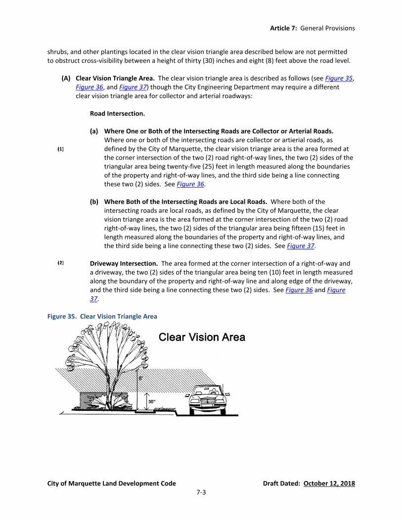
Article 7: General Provisions
City of Marquette Land Development Code Draft Dated: October 12, 2018 7-3
shrubs, and other plantings located in the clear vision triangle area described below are not permitted to obstruct cross-visibility between a height of thirty (30) inches and eight (8) feet above the road level.
(A) Clear Vision Triangle Area. The clear vision triangle area is described as follows (see Figure 35, Figure 36, and Figure 37) though the City Engineering Department may require a different clear vision triangle area for collector and arterial roadways:
Road Intersection.
(a) Where One or Both of the Intersecting Roads are Collector or Arterial Roads.
Where one or both of the intersecting roads are collector or artierial roads, as defined by the City of Marquette, the clear vision triange area is the area formed at the corner intersection of the two (2) road right-of-way lines, the two (2) sides of the triangular area being twenty-five (25) feet in length measured along the boundaries of the property and right-of-way lines, and the third side being a line connecting these two (2) sides. See Figure 36.
(b) Where Both of the Intersecting Roads are Local Roads. Where both of the
intersecting roads are local roads, as defined by the City of Marquette, the clear vision triange area is the area formed at the corner intersection of the two (2) road right-of-way lines, the two (2) sides of the triangular area being fifteen (15) feet in length measured along the boundaries of the property and right-of-way lines, and the third side being a line connecting these two (2) sides. See Figure 37.
Driveway Intersection. The area formed at the corner intersection of a right-of-way and
a driveway, the two (2) sides of the triangular area being ten (10) feet in length measured along the boundary of the property and right-of-way line and along edge of the driveway, and the third side being a line connecting these two (2) sides. See Figure 36 and Figure 37.
Figure 35. Clear Vision Triangle Area

Article 7: General Provisions
City of Marquette Land Development Code Draft Dated: October 12, 2018 7-4
Figure 36. Clear Vision Triangle Area Where One or Both of the Intersecting Roads are Collector or Arterial Roads
Figure 37. Clear Vision Triangle Area Where Both of the Intersecting Roads are Local Roads
(B) Specific Buildings Allowed in the Clear Vision Triangle. Buildings may be permitted in the clear vision triangle if they are permitted by the front yard setback requirements of their respective zoning district, provided the building shall not be located in a manner which unreasonably obstructs or interferes with traffic visibility on a curve or at any intersection of any street, driveway, or other vehicular way.
(C) Trees. Trees may be permitted in the clear vision triangle area provided that limbs and foliage
are trimmed so that they are not less than eight (8) feet above the road level within the clear vision triangle area. See Figure 35.
(D) Shrubs. Shrubs may be permitted in the clear vision triangle area provided that they are
trimmed so that they are not more than thirty (30) inches above the road level. See Figure 35.
(E) Landscaping. All landscaping, except turf grass or ground cover, shall not be located closer than three (3) feet from the edge of any driveway or road within a clear vision triangle area.
Article 7: General Provisions
City of Marquette Land Development Code Draft Dated: October 12, 2018 7-5
(F) Snow Storage. Snow storage on lot corners and near driveway entrances may be permitted in the clear vision triangle area provided that the snow storage does not exceed thirty (30) inches above the road level within a clear vision triangle area.
Section 54.705 Accessory Buildings and Structures All accessory buildings and structures must meet the setback and height requirements of Article 4 unless otherwise stated in this Section or in another section of this ordinance applicable to accessory buildings and structures. No accessory building or structure may be located on any parcel of land which does not have a principal building or use already established or being established contemporaneously with the accessory building or structure.
(A) Accessory Buildings and Structures in the Single-Family Residential (SFR) District, General Residential (GR) District, Mobile Home Park (MHP), and Mixed-Use (M-U) District (currently Section 80.40(3)(e) and 80.65(4)(B)(1)(b)).
Attached Accessory Buildings. Where the accessory building is structurally attached to a
main building, it shall be subject to, and must conform to, all yard regulations of this ordinance, applicable to main building.
Location. Detached accessory buildings shall not be located in any required yard setback
except as permitted in Section 54.705(A)(4).
Maximum Lot Coverage. Detached accessory buildings shall not occupy more than twenty-five percent (25%) of a rear yard area, provided that in no instance shall the total ground floor area of the detached accessory buildings exceed the ground floor area of the main building and provided the impervious surface coverage limits of the lot (see Article 4) are not exceeded.
Separation and Setback Distances. No detached accessory building shall be located
closer than five (5) feet to any main building nor closer than three (3) feet from a side or rear lot line, except swimming pools, which are regulated in Section 54.707. Non-building accessory structures (e.g., fences and steps) or open buildings (i.e., a shelter without walls including an open lean-to or open carports) are not subject to the minimum separation distance requirements unless a minimum separation distance is required by the Building Official.
Maximum Height. Unless otherwise stated in this Ordinance, no attached or detached
accessory building in a the SFR, GR, MHP, and M-U Districts shall exceed sixteen and one-half (16.5) feet in height. The height of Accessory Dwelling Units must comply with Section 54.612.
(B) Accessory Buildings and Structures in the Multiple Family Residential (MFR) District
(currently Section 80.65(4)(A)(4)). In the MFR District, accessory buildings and structures for multiple-family buildings and apartments must meet the requirements of Section 54.616(C). For all other uses in the MFR District, the following requirements apply:

Article 7: General Provisions
City of Marquette Land Development Code Draft Dated: October 12, 2018 7-6
Detached Accessory Buildings. No detached accessory building may exceed 16.5 feet in height. Detached accessory buildings shall be located at least ten (10) feet from the side and rear property lines. No detached accessory building shall be located in a front yard.
Attached Accessory Buildings. Attached accessory building shall meet the yard
requirements of the Schedule of Regulations (Article 4).
Swimming Pools. Outdoor swimming pools shall not be located closer than ten (10) feet to any building or lot line. The pool must comply with Section 54.707.
(C) Accessory Buildings in the Central Business District (CBD), General Commercial (GC), Regional
Commercial (RC), Municipal (M), Civic (C), Industrial/Manufacturing (I-M), Conservation and Recreation (CR), and Board of Light and Power (BLP) Districts.
Maximum Lot Coverage. No detached accessory building in the CBD, GC, RC, C, I-M, CR,
and BLP district may exceed the lot coverage of the principal building.
(D) Exemptions. Structural amenities, as described and regulated in Section 54.702(G), are not classified as accessory buildings and structures in this ordinance.
(E) Structures Accessory to Food Production, Minor. See Section 54.619.
(F) Temporary Structures in all Zoning Districts. The City may permit temporary structures in any
zoning district during the duration of a permitted temporary land use, subject to the following requirements:
Outdoor Sales and Temporary Events. Temporary structures for outdoor sales and
temporary events must meet the requirements of Section 54.634.
Applications and Permits. The property owner must contact the Zoning Administrator to determine if a Zoning Permit is required prior to establishment of a temporary structure. The property owner must also contact the County Building Code Administrator to determine if a building permit is required. Temporary structures intended to be used for non-customary commercial activity (e.g., those requiring Special Land Use permits, use for recurring sales in a parking lot, or an alcohol permit) require the approval of the Zoning Administrator and the Fire Administrator prior to erection and use.
Secure Placement of Temporary Structures. Temporary structures shall not have
foundations or footings, but must be properly secured to the ground.
Location and Size. The location, size, and construction of all temporary structures (including tents) require approval by the Zoning Administrator and the Fire Administrator. The location of the temporary structures shall not interfere with traffic patterns or access to required parking spaces. The Zoning Administrator or Fire Administrator may deny a permit for a temporary structure if the structure interferes with traffic patterns or access to required parking spaces, or if the Zoning Administrator or Fire Administrator determine that the size of the structure is excessive for the temporary land use.
Article 7: General Provisions
City of Marquette Land Development Code Draft Dated: October 12, 2018 7-7
Duration and Removal. Prior to the erection of a temporary structure, the Zoning Administrator must be notified of the date of removal. The temporary structure must be removed when the associated temporary use has ceased. In no case shall a temporary structure be permitted for more than 90 days in a 12-month period.
(G) Rooftop Accessory Buildings and Structures. Rooftop accessory structures are permitted,
subject to all other requirements for setbacks, height, location, and use.
Section 54.706 Fences and Walls (currently Chapter 86 of the Code of Ordinances)
(A) Requirements. It shall be unlawful for any person, firm, or corporation to construct or cause to have constructed any fence or wall upon any property within the corporate limits of the City of Marquette, except in accordance with the requirements and restrictions herein provided.
(B) Permit. Any person desiring to build or cause to be built a fence or wall upon property within
the corporate limits of the City of Marquette shall first apply to the Zoning Department for a permit in accordance with Section 54.1401. Application for such permit must contain any and all information, including drawings, required and necessary for the determination of whether the erection of such fence or wall would be contrary to the provisions of this ordinance or the laws of the State of Michigan.
(C) Requirements by Zoning District:
SFR, GR, MFR, and MHP Districts.
(a) Height. Fences and walls shall not exceed six (6) feet in height, with the following
exceptions:
(i) Adjoining a Lot Containing a One- or Two Family Dwelling or Adjoining a Vacant Lot that Could Contain a One- or Two-Family Dwelling. Where a fence or wall is within ten (10) feet of an adjoining lot containing a one- or two-family dwelling or within ten (10) feet of an adjoining a vacant lot that could contain a one- or two-family dwelling; the fence or wall shall not exceed four (4) feet in height if it is located in the side or front yard (see Section 54.706(C)(1)(a)(iii) for additional front yard requirements).
(ii) Street Sides of Corner Lots. On the street sides of corner lots, a fence or wall
may not exceed four (4) feet in height between the rear of the dwelling and the corner on either street frontage.
(iii) Front Yard Requirements. A fence in a front yard must be a decorative fence
and may not exceed four (4) feet in height. Walls are prohibited in a front yard except for retaining walls.
(b) Construction. A six (6) foot high fence may be of solid, opaque construction. A fence
limited to four (4) feet, as stated above, may not have more than 50% of the fence

Article 7: General Provisions
City of Marquette Land Development Code Draft Dated: October 12, 2018 7-8
area of solid matter or of closed construction. A screening fence required by any City ordinance or by State law may be of solid, opaque construction.
M-U and CBD Districts.
(a) Height. Fences and walls in the side or rear yard shall not exceed six (6) feet in
height, except that a wall or fence in the side or rear yard of an approved commercial Outdoor Food and Beverage Service use (see Section 54.633) may be up to eight (8) feet in height for the purpose of screening the outdoor food and beverage service use . A fence in a front yard must be a decorative fence and may not exceed four (4) feet in height.. Walls are prohibited in a front yard except for retaining walls.
(b) Construction. Fences may not have more than 50% of the fence area of solid,
opaque construction. A screening fence required by any City ordinance or by State law may be of solid, opaque construction.
GC, RC, M, C, I-M, CR, and BLP Districts.
(a) Height. Fences and walls shall not exceed ten (10) feet in height. In the GC and RC
districts, a fence in a front yard must be a decorative fence and may not exceed four (4) feet in height. In the GC and RC districts, walls are prohibited in a front yard except for retaining walls.
(b) Construction. Fences may not have more than 50% of the fence area of solid,
opaque construction. A screening fence required by any City ordinance or by State Law may be of solid, opaque construction.
(D) Requirements Applicable to All Fences.
Location. All fences must be located on the private property of the person, firm, or
corporation constructing the fence, and shall not extend toward the street beyond the front lot line.
Construction and Materials. Fences shall be constructed with boards, chain link
construction, or other suitable material firmly connected to posts sunk in the soil at least two (2) feet or more as necessary to properly support the fence.
Orientation of Finished Side. Except where partition fences between two (2) properties
may be erected by written agreement between the owners thereof, the finished or decorative side of the fence (e.g., the outside of the boards, chain link, or other material used in the building of a fence) shall be oriented to face outward toward the adjacent parcel or right-of-way (i.e., fixed to that side of the posts nearest to the property line).
Electrical Fence Prohibited. No fence shall be constructed, maintained, or placed on any
property in the City of Marquette of metal construction or otherwise, which is charged or connected with an electrical current in such manner as to transmit said current to persons, animals, or things which intentionally or unintentionally might come in contact with it.

Article 7: General Provisions
City of Marquette Land Development Code Draft Dated: October 12, 2018 7-9
Barbed Wire Prohibited. Barbed wire is prohibited in the City of Marquette except as
permitted by the Board of Zoning Appeals on approved protective measures fences.
Strands of Wire, Rope, or Similar Material. Where a fence is made up of individual strands of wire, rope, or similar material smaller than one (one) inch in width, thickness, or diameter, the strands must be strung, between posts, parallel with the grade of the land, must be evenly spaced between the top and bottom of the posts, and must be no more than six (6) inches apart.
Clear Vision Triangle Area. No fence shall be located within a clear vision triangle area of
any lot except in compliance with Section 54.704(A).
Sharp Wire Prohibited. Concertina wire, and similar types of fence with sharp edges designed to injure, are prohibited in the City of Marquette.
Right-of-Way Location Prohibited. Fences may not be located in the right-of-way unless
located by a public entity in connection with a public project or event, or upon the grant of a license to use the municipal property.
(E) Special Purpose Fences.
Swimming Pools. All swimming pools with a water depth of two (2) feet or greater at any
point must be enclosed with a six (6) foot high fence, not closer than four (4) feet from the pool's edge on any side. Gates in the fence must have a self-latching catch or lock located not closer to the grade than four (4) feet and otherwise made inaccessible from the outside to small children.
Protective Measures Fence. A protective measures fence may only be erected upon a
finding by the Board of Zoning Appeals of the need for such fence. The BZA's established procedures of Section 54.1404 must be followed. In determining whether the applicant has a practical difficulty, the BZA shall determine that the definition of a “protective measures fence” is met and that there is no reasonable alternative to the erection of the fence. A protective measures fence shall not exceed twelve (12) feet in height in the I-M district, ten (10) feet in height in the GC, RC, M, C, CR, and BLP, and eight (8) feet in height in all other districts. The BZA may permit the owner of a protective measures fence to erect necessary and reasonable barriers along the uppermost edge of such fence including barbed wire. Security fences for telecommunications towers and other facility that require such fencing are exempt from the provisions of this sub-section.
Temporary Fences. Temporary fences, as defined herein, may be permitted by the City in
conjunction with an approved temporary activity, such as construction, temporary events, or snow fence, the purpose of which is to secure a site and/or restrict areas accessible to the public. A temporary fence must be installed prior to the temporary activity and removed soon after the end of the temporary activity.
(F) Maintenance of Nuisances. Fences and walls must be maintained so as not to endanger life or
property. Any fence or wall which, through lack of repair, type of construction, or otherwise,

Article 7: General Provisions
City of Marquette Land Development Code Draft Dated: October 12, 2018 7-10
imperils life or property, shall be deemed a nuisance. The Zoning Administrator or Zoning Official shall notify the owner of the property on which such a fence or wall is located of the existence of such a nuisance. The owner must then abate said nuisance within six (6) days after receiving such notice. In the case of immediate danger to life or property the Zoning Administrator may require immediate abatement by removing or securing removal of the fence or wall. The City’s actual cost and reasonable administrative charges may be placed as a lien on the property and the lien on the property shall be superior to all other liens except taxes.
(G) Unsafe Fences and Walls. Fences or walls containing barbed wire, concertina or similar wire,
individual strand fences not meeting the spacing requirements of Section 54.706(D)(6), electric fences, and private fences and walls located in a right-of-way are hereby declared hazardous to public safety. The Zoning Administrator may order the removal of such fences or walls when they are located in a residential zoning district. Such fences and walls located in other zoning districts may not be maintained or repaired and must be removed when they become dilapidated. If the City removes the fence or wall or secures removal of the fence or wall, the City’s actual cost and reasonable administrative charges may be placed as a lien on the property and the lien on the property shall be superior to all other liens except taxes. Exception: Barbed wire which is part of a protective measures fence approved under this or a previous ordinance is exempt from this requirement.
Section 54.707 Swimming Pools (currently Sections 80.40(3)(e)(d) and 80.65(4)(A)(4)(c))
(A) Location. Swimming pools shall not be located closer than ten (10) feet to a side or rear lot line and not further forward than four (4) feet from the extreme rear line of the dwelling on the lot adjoining, nor closer than twenty (20) feet, at any one point, to the adjoining lot’s main structure.
(B) Barriers. The barrier around the perimeter of the pool and any gate must meet the
requirements of Section 54.706(E)(1).
(C) Swimming Pools for Multiple-Family Buildings and Apartments in the MFR District. See Section 54.616(C)(3).
Section 54.708 Solar Energy (new Section)
(A) Purpose. It is the purpose of this section to promote the safe, effective, and efficient use of solar energy systems to generate electricity and heat. Further, it is the purpose of this section to standardize and streamline the review and permitting process for solar energy systems.
(B) Findings. The City has found that solar energy is an abundant, renewable, and nonpolluting
energy resource of which some residents and utility companies would like to make use. Generation of electricity by these facilities will reduce dependence on non-renewable energy resources and decrease air and water pollution that results from the use of conventional fossil fuels. Solar energy systems will also enhance the reliability and power quality of the power grid, reduce peak power demands, and help diversify the City’s energy supply.
Article 7: General Provisions
City of Marquette Land Development Code Draft Dated: October 12, 2018 7-11
(C) Roof-Mounted and Wall-Mounted Solar Energy Systems: Roof-mounted and wall-mounted
solar energy systems for on-site use are permitted accessory structures in all zoning districts, subject to the following regulations:
Height. Roof-mounted systems shall not extend more than three (3) feet above the
surface of the roof. Wall-mounted systems shall not exceed the height of the wall.
Location. Roof-mounted solar energy systems may be located anywhere on a roof of a principal or accessory structure, but shall not be located in a required setback nor protrude beyond the edge of the roof. However, a solar panel may function as a roof element, such as an awning or carport. Wall-mounted solar energy systems may be located anywhere on the wall of a principal or accessory structure, but shall not be located within a required setback area.
(D) Ground-Mounted Solar Energy Systems (10 kW or less). Ground mounted and freestanding
solar energy systems of 10kW or less for on-site use are permitted accessory structures in all zoning districts, subject to the following regulations:
Location and Setbacks. Ground-mounted solar energy systems shall be located to the
side or rear of the principal building. Solar energy systems shall be located at least three (3) feet from a side lot line and at least five (5) feet from a rear lot line.
Height. The height of the solar energy system and any mounts shall not exceed ten (10)
feet when oriented at maximum tilt.
Area. Ground-mounted solar energy systems are not classified as lot coverage and are therefore not subject to the maximum lot coverage standards of the zoning district.
Power Lines. All power lines between solar panels and inverters must be placed
underground.
(E) Ground-Mounted Solar Energy Facilities – Utility Grade (over 10 kW, operated by a public utility, government entity, or on-site business only). Ground mounted and freestanding solar energy systems over 10 kW capacity are permitted for public utilities, government entities, and on-site businesses only, subject to special land use approval in the C, I-M, CR, and BLP zoning districts and subject to the following regulations:
Location and Setbacks. The solar energy system shall not be located closer to the street
than any portion of the principal building, and shall meet the minimum front, side and rear yard setbacks of the zoning district.
Height. The height of the solar energy system and any mounts shall not exceed fifteen
(15) feet when oriented at maximum tilt.
Area. Ground-mounted solar energy systems are not classified as lot coverage and are therefore not subject to the maximum lot coverage standards of the zoning district.

Article 7: General Provisions
City of Marquette Land Development Code Draft Dated: October 12, 2018 7-12
Power Lines. All power lines between solar panels and inverters must be placed underground.
(F) General Standards. The following requirements are applicable to all roof-mounted, wall-
mounted, or ground-mounted solar energy systems.
Permit. A zoning compliance permit shall be required for any roof-mounted, wall-mounted, or ground-mounted solar energy system. A building permit may be required for these facilities.
Batteries. If solar storage batteries are included as part of the solar collector system, they
must be placed installed according to all requirements set forth in the National Electric Code and State Fire Code when in operation. When no longer in operation, the batteries shall be disposed of in accordance with the laws and regulations of the City and any other applicable laws and regulations relating to hazardous waste disposal. If located in an accessory building, the accessory building must meet the requirements of Section 54.705.
Electrical Emissions. The design and construction of solar energy systems shall not
produce electrical emissions that would interfere with aircraft communications systems or navigation equipment.
Light Emissions and Reflection. The design and construction of solar energy systems shall
not produce light emissions, either director or indirect (reflective), that would interfere with pilot vision and/or air traffic control operations. The solar panels shall be composed of anti-reflective material and/or treated with anti-reflective coating.
Removal Provisions. As a condition of approval, the City may require that the property
owner enter into an agreement with the City for the removal of the solar energy system upon disuse or abandonment of the system as described in Section 54.708(F)(6). The agreement shall be in recordable form, provide the necessary authority for the City to enter the property to remove the unit when a property owner fails to do so as required in Section 54.708(F)(6), and also provide that the City may have a lien for costs if it becomes necessary for the City to exercise its rights under the agreement. This agreement shall be recorded with the Marquette County Register of Deeds.
Removal. If a solar energy system ceases to perform its intended function (generating
electricity) for more than twelve (12) consecutive months, the operator shall remove the collectors, mounts, and associated equipment and facilities no later than ninety (90) days after the end of the twelve (12) month period. Where the removal has not been lawfully completed as required above, and after at least thirty (30) days written notice, the City may remove or secure the removal of the solar energy system or portion thereof only if there is a recorded agreement authorizing the City to do so pursuant to Section 54.708(F)(5). If there is a recorded agreement authorizing the City to remove the solar energy system or portion thereof pursuant to Section 54.708(F)(5), the City’s actual cost and reasonable administrative charges may be placed as a lien on the property and the lien on the property shall be superior to all other liens except taxes. If there is no recorded agreement authorizing the City to remove the solar energy system or portion
Article 7: General Provisions
City of Marquette Land Development Code Draft Dated: October 12, 2018 7-13
thereof, the City may issue Civil Infraction tickets to the owner and/or operator and seek an order to remove the system in the Marquette County Circuit Court.
Section 54.709 Small Wind Energy (new Section)
(A) Purpose. It is the purpose of this section to promote the safe, effective, and efficient use of wind energy systems to generate electricity and thereby reduce or replace on-site consumption of utility-supplied electricity. Further, it is the purpose of this sub-section to standardize and streamline the review and permitting process for wind energy system.
(B) Findings. The City has found that wind energy is an abundant, renewable, and nonpolluting
energy resource that some residents and businesses of the City would like to use. Generation of electricity by these facilities will reduce dependence on non-renewable energy resources and decrease air and water pollution that results from the use of conventional fossil fuels. Wind energy systems will also enhance the reliability and power quality of the power grid, reduce peak power demands, and help diversity the City’s energy supply.
(C) Small Wind Energy Systems.
Where Permitted.
(a) Roof-Mounded Small Wind Energy Systems are permitted by right in all zoning
districts, provided that all of the applicable requirements of this Ordinance are met.
(b) Tower-Mounted Small Wind Energy Systems may be permitted as a special land use in the GC, RC, M, C, IM, CR, and BLP districts, provided that all of the applicable requirements of this Ordinance are met.
Minimum Lot Area.
(a) Roof-Mounted Small Wind Energy Systems shall have no minimum lot area.
(b) Tower-Mounted Small Wind Energy Systems shall be located on a lot with a
minimum area of one (1) acre.
Maximum Wind Turbine Height.
(a) Roof-Mounted Small Wind Energy Systems shall have a maximum height of ten (10) feet above the highest point of the roof or ten (10) feet above the maximum height of the zoning district, whichever is lower.
(b) Tower-Mounted Small Wind Energy Systems shall have a maximum height of twenty
(20) meters (65.617 feet).
Minimum Setbacks.
(a) Roof-Mounted Small Wind Energy Systems shall adhere to the minimum setbacks of the zoning district.
Article 7: General Provisions
City of Marquette Land Development Code Draft Dated: October 12, 2018 7-14
(b) Tower-Mounted Small Wind Energy Systems shall be set back from all property lines,
overhead utility rights-of-way and easements, and other towers a distance equal to or greater than the height of the wind turbine or tower.
General Standards. The following requirements are applicable to all wind energy
systems.
(a) Noise. A noise from a wind energy system shall not exceed 40 dB at the property line and shall comply with the noise standards set forth in the City’s Ordinances.
(b) Shadow Flicker. The application for a wind energy system shall include a shadow
flicker analysis demonstrating impact on adjacent and nearby residential properties. Wind energy systems shall be constructed in locations that minimize the impacts of shadow flicker on residences.
(c) Lighting. No wind energy system shall be artificially lighted unless required by the
Federal Aviation Administration (FAA).
(d) Appearance, Color, and Finish. The wind energy system shall be maintained in the color or finish that was originally applied by the manufacturer, unless otherwise approved in the zoning compliance permit. All wind energy systems shall be a single non-reflective, non-obtrusive, matte finished color (e.g. white or gray).
(e) Signs. The manufacturer or installer’s identification sign, appropriate warnings signs,
and an owner identification sign, are permitted. All other signs are prohibited.
(f) Electrical Wires. All electrical wires associated with a wind energy system, other than wires necessary to connect the wind generator to the tower wiring, the tower wiring to the disconnect junction box, and grounding wires, shall be located underground.
(g) Compliance with Electrical Code. Permit applications for wind energy systems shall
be accompanied by line drawings of the electrical components in sufficient detail to allow for a determination that the manner of installation conforms to the National Electrical Code.
(h) Construction Codes, Towers, and Interconnection Standards. Wind energy systems,
including towers, shall comply with all applicable state construction and electrical codes and local building permit requirements. Wind energy systems including towers, shall comply with the FAA requirements, the Michigan Airport Zoning Act (Public Act 23 of 1950 as amended), and other applicable local and state regulations. A wind energy system connected to the public utility electrical grid shall comply with the Michigan Public Service Commission and Federal Energy Regulatory Commission standards.
Article 7: General Provisions
City of Marquette Land Development Code Draft Dated: October 12, 2018 7-15
(i) System Access. Small wind energy systems shall be designed and installed such that step bolts, ladders, or other means of access readily accessible to the public are located at least eight (8) feet above grade level.
(j) Safety. A wind energy system shall have an automatic braking, governing, or
feathering system to prevent uncontrolled rotation or over speeding. All wind towers shall have lightning protection. If a tower is supported by guy wires, the wires shall be clearly visible to a height of at least six (6) feet above the guy wire anchors.
(k) Minimum Ground Clearance. The lowest extension of any blade or other exposed
moving component of a wind energy system shall be at least twenty (20) feet above the surrounding grade at its highest point within twenty (20) feet of the base of the tower and at least twenty (20) feet above any outdoor surface intended for human use, such as balconies or roof gardens, that are located below the wind energy system.
(l) Roof-Mounted Small Wind Energy Systems. Roof-mounted small wind energy
systems shall be limited to roof mounting and shall not be mounted on any other building wall or surface.
(m) Removal Provisions. As a condition of approval, the City may require that the
property owner enter into an agreement with the City for the removal of the wind energy system upon disuse or abandonment of the system as described in Section 54.709(C)(5)(n). The agreement shall be in recordable form, provide the necessary authority for the City to enter the property to remove the unit when a property owner fails to do so as required in Section 54.709(C)(5)(n), and also provide that the City may have a lien for costs if it becomes necessary for the City to exercise its rights under the agreement. This agreement shall be recorded with the Marquette County Register of Deeds.
(n) Removal. If a small wind energy system ceases to perform its intended function
(generating electricity) for more than six (6) consecutive months or has been abandoned, the property owner shall remove the wind energy system, electrical components, and all other associated facilities no later than ninety (90) days after the end of the six (6) month period. Where the removal has not been lawfully completed as required above, and after at least thirty (30) days written notice, the City may remove or secure the removal of the wind energy facility or portion thereof only if there is a recorded agreement authorizing the City to do so pursuant to Section 54.709(C)(5)(m). If there is a recorded agreement authorizing the City to remove the solar energy system or portion thereof pursuant to Section 54.709(C)(5)(m), the City’s actual cost and reasonable administrative charges may be placed as a lien on the property and the lien on the property shall be superior to all other liens except taxes. If there is no recorded agreement authorizing the City to remove the wind energy system or portion thereof, the City may issue Civil Infraction tickets to the owner and/or operator and seek an order to remove the system in the Marquette County Circuit Court.
Article 7: General Provisions
City of Marquette Land Development Code Draft Dated: October 12, 2018 7-16
(o) Performance Guarantee. All applications for a small wind energy system shall be accompanied by a performance guarantee in an amount sufficient to ensure the decommissioning and removal of the system when it is abandoned or no longer needed.
(p) Insurance. The applicant shall submit proof of sufficient property damage and
liability insurance.
(q) Utility Connection. The applicant shall submit evidence that the utility company has been informed of the customer’s intent to install an interconnected, customer-owned wind energy generator and that such connection has been approved. Off-grid systems shall be exempt from this requirement.
Section 54.710 Storage of Recreational Vehicles (new Section) Unless prohibited elsewhere in the Code of Ordinances, the storage of recreational vehicles is subject to the following requirements:
(A) Personal Storage by City Residents. Residents of the City may store their own recreational vehicles on their own property for an indefinite period of time, provided the vehicles meet the following requirements:
The recreational vehicle must be in operable condition.
The recreational vehicle must be parked in the rear yard if the registration is not current.
The recreational vehicle must meet the side and rear setback requirements of Article 4.
(B) Other Storage. The open parking or storage of up to one (1) recreational vehicle not owned by the property owner or tenant of the City on lands not specifically designated for such parking and storage is permitted, subject to the following requirements:
Any parking longer than 14 days is prohibited unless a temporary storage permit is issued
by a Zoning Official. The temporary occupancy of a recreational vehicle shall not exceed 14 consecutive days or 30 days in a calendar year.
The owner of the property shall not charge rent to the occupant of the recreational
vehicle.
(C) Surfacing. If parked in a front yard area, a recreational vehicle must be parked on a hard parking surface (see definition of “Hard Parking Surface” in Section 54.202(A)(90)).
(D) Sanitary Facility Connections Prohibited. A recreational vehicle parked or stored on a lot shall
not be connected to sanitary facilities unless it is an approved campground.
Section 54.711 Security of Property (new Section) Home alarms, automatic lights, cameras, and other similar equipment that does not cause bodily harm is permitted for the security of buildings and property. Unless explicitly permitted elsewhere in this ordinance (such as barbed wire permitted for security on certain fences), any equipment that may cause

Article 7: General Provisions
City of Marquette Land Development Code Draft Dated: October 12, 2018 7-17
bodily harm to humans is prohibited. Prohibited equipment includes, but is not limited to, spring-loaded traps, explosive devices, bed of nails, and similar equipment.
Section 54.712 Temporary Uses, Buildings, and Structures
(A) Outdoor Temporary Sales and Events. See Section 54.634.
(B) Temporary Buildings and Structures.
Temporary Structures. See Section 54.705(F).
Temporary Fences. See Section 54.706(E)(3).

Article 8: Environmental Performance Standards
City of Marquette Land Development Code Draft Dated: October 12, 2018 8-1
Article 8 Environmental Performance Standards
Section 54.801 Standards Applicable to Industrial Uses, Processes, and Districts (currently parts of Sections 80.65(4)(C)(5), 80.65(4)(D)(4), and 80.65(4)(E)(1) The following standards are applicable to Light Manufacturing Uses, Heavy Manufacturing Uses, and industrial uses listed in Section 54.306. This Section does not supersede Chapter 22 (Environment) of the Code of Ordinances. Where the provisions of this Section conflict with another provision of this Ordinance for industrial uses, processes, and districts, the more restrictive provision shall prevail.
(A) Environmental Factors. Noise, vibration, smoke, dust, odors, glare, and similar or related nuisances shall be confined to the site to the maximum extent possible and mitigated on-site to the maximum extent possible. Any nuisances which are anticipated to not be contained to the applicant’s property and not mitigated on the property shall be identified in the Project Proposal Document submitted with the Site Plan and/or Special Land Use Permit application.
(B) Dangerous, Noxious, and Nuisance Conditions Prohibited. Operations shall be approved only
upon documentation by the applicant that no dangerous, noxious or nuisance conditions will impact any adjacent premises. The manufacture, processing or packaging of materials which are inherently dangerous or hazardous due to flammability, radioactivity, explosiveness, or severe toxicity will not be permitted.
(C) Permits. Prior to final approval of a Site Plan and/or Special Land Use Permit each applicant
shall obtain the necessary state and federal permits, including permits or waiver for permits from the Michigan Department of Environmental Quality. The applicant shall, upon request, forward all reports and findings from the state and federal agencies to the Zoning Administrator, along with site plans as described in Section 54.1402.
(D) Notice of Intent to Build or Expand. Notice of intent to build or expand must be given to the
Zoning Administrator at the same time application is made to federal or state agencies which may require permits.
(E) Discontinued Activity. When industrial activity is discontinued or the site is vacated, the site
shall be left in a condition free from hazards (including but not limited to dangerous excavations, and abandoned structures above or below ground).
(F) Additional Safeguards. The Planning Commission may require additional safeguards to meet
the intent of the district and to assure opportunity for additional industrial uses and for growth within each area of the city which permits industrial use.

Article 8: Environmental Performance Standards
City of Marquette Land Development Code Draft Dated: October 12, 2018 8-2
Section 54.802 Exterior Lighting (currently Sections 80.34(8)(A)(16), 80.34(8)(B)(8), 80.34(8)(C)(2), and 80.42(2)(C)(11))
(A) Purpose and Intent. The purpose of lighting regulations is to ensure that sufficient lighting is provided in the publicly accessible areas of buildings, parking lots, travel areas, and surrounding property, in order to provide for the security of property and safety of the general public. These regulations promote the use of appropriate lighting practices and systems, and discourage the adverse effects of inappropriate lighting such as glare, excessive light trespass onto adjoining properties, light pollution and sky glow, and energy waste. This section also intends to encourage the use of innovative lighting designs and fixtures which complement the natural and built environments found throughout the City.
(B) General Lighting Requirements.
Shielding. Unless otherwise exempt, all outdoor lighting must be shielded so the surface
of the source of the light shall not be visible from adjacent residential districts, adjacent residences, and public right-of-way. All outdoor lighting shall be directed toward and confined to the ground areas. Full cut-off fixtures shall be used to prevent light from projecting above a ninety (90) degree horizontal plane (see Figure 38). For uses with a canopy, lights under the canopy must be recessed into the canopy so that the bottom of the light fixture is not below the bottom of the canopy (see Figure 39).
Figure 38. Light Fixture Cutoff and Shielding
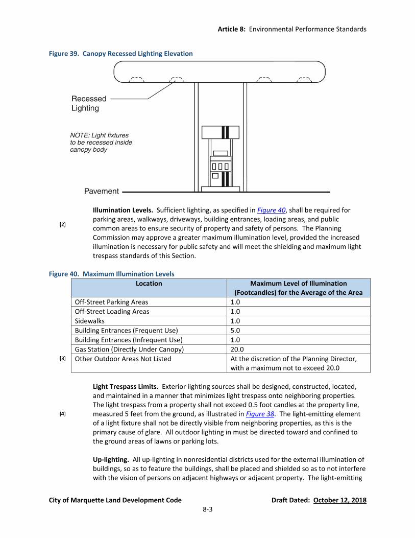
Article 8: Environmental Performance Standards
City of Marquette Land Development Code Draft Dated: October 12, 2018 8-3
Figure 39. Canopy Recessed Lighting Elevation
Illumination Levels. Sufficient lighting, as specified in Figure 40, shall be required for parking areas, walkways, driveways, building entrances, loading areas, and public common areas to ensure security of property and safety of persons. The Planning Commission may approve a greater maximum illumination level, provided the increased illumination is necessary for public safety and will meet the shielding and maximum light trespass standards of this Section.
Figure 40. Maximum Illumination Levels
Location Maximum Level of Illumination (Footcandles) for the Average of the Area
Off-Street Parking Areas 1.0
Off-Street Loading Areas 1.0
Sidewalks 1.0
Building Entrances (Frequent Use) 5.0
Building Entrances (Infrequent Use) 1.0
Gas Station (Directly Under Canopy) 20.0
Other Outdoor Areas Not Listed At the discretion of the Planning Director, with a maximum not to exceed 20.0
Light Trespass Limits. Exterior lighting sources shall be designed, constructed, located,
and maintained in a manner that minimizes light trespass onto neighboring properties. The light trespass from a property shall not exceed 0.5 foot candles at the property line, measured 5 feet from the ground, as illustrated in Figure 38. The light-emitting element of a light fixture shall not be directly visible from neighboring properties, as this is the primary cause of glare. All outdoor lighting in must be directed toward and confined to the ground areas of lawns or parking lots.
Up-lighting. All up-lighting in nonresidential districts used for the external illumination of
buildings, so as to feature the buildings, shall be placed and shielded so as to not interfere with the vision of persons on adjacent highways or adjacent property. The light-emitting
Article 8: Environmental Performance Standards
City of Marquette Land Development Code Draft Dated: October 12, 2018 8-4
element of such fixtures shall not be directly visible from a vehicle or pedestrian travel area so as to not interfere with the vision of persons on adjacent highways or adjacent property. Such lighting shall be shielded in such a manner as to minimize or eliminate light pollution and sky glow.
(C) Height. The height of light fixtures on a light pole shall be measured from the finished grade
to the top of the fixture. Light fixtures on a light pole shall be a maximum of twenty (20) feet in height. In the Municipal (M), Civic (C), Industrial/Manufacturing (IM), Conservation and Recreation (CR), and Board of Light and Power (BLP) districts, the Planning Commission or Zoning Administrator (depending on who has the reviewing authority pursuant to Section 54.1402) may approve lighting fixtures on light poles up to a maximum height of thirty-five (35) feet if the proposed lighting over twenty (20) feet in height has no adverse impacts on the surrounding land uses and on the natural environment.
(D) Signs. Illumination of signs shall be in accordance with Article 11.
(E) Prohibited Lighting.
Flashing or Moving Lights. All illumination of outdoor features of a flashing, moving, or
intermittent type are prohibited.
Recreational Facility Lighting. No outdoor recreational facility, public or private, shall be illuminated after 11:00 p.m., except to conclude a permitted recreational or sporting event or other activity already in progress prior to 11:00 p.m.
Outdoor Building and Landscaping Lighting. Unshielded illumination of the exterior of a
building or landscaping is prohibited except outdoor residential lighting of 1,500 lumens or less and outdoor non-residential lighting of 750 lumens or less.
Mercury Vapor Fixtures and Lamps. The installation of any mercury vapor fixture or lamp
for use as outdoor lighting is prohibited.
Metal Halide Fixtures and Lamps. The installation of any metal halide fixture or lamp for use as outdoor lighting is prohibited except that outdoor recreation area and amusement area lighting is permitted, provided such fixtures are properly equipped with baffling and glare guards to meet the requirements of this Section.
Wall Pack Lighting. Wall pack fixtures are prohibited, except where the lens is fully
shielded.
Laser Source Light. The use of laser source light or any similar intensity light for outdoor advertising or entertainment is prohibited.
Searchlights. The operation of searchlights for advertising purposes is prohibited.
(F) Exempt Lighting. The following exterior lighting fixtures and systems are exempt from the
regulations of this section. However, the Zoning Administrator reserves the right to enforce

Article 8: Environmental Performance Standards
City of Marquette Land Development Code Draft Dated: October 12, 2018 8-5
standards to minimize glare, reduce light pollution, and otherwise protect the health, safety, and welfare of the public.
Decorative holiday lighting fixtures.
Pedestrian walkway lighting.
Light from the burning of fossil fuels, such as in gas lamps.
Temporary festival and civic lighting.
Temporary construction or emergency lighting.
Outdoor residential lighting of 1,500 lumens or less and outdoor non-residential lighting
of 750 lumens or less.
Instances where Federal, State, County, or City laws, rules, or regulations take precedence over the provisions of this section.
Section 54.803 Storm Water Management (new Section)
(A) Approved Runoff and On-Site Detention. All plans for redevelopment or new construction must include provisions for proper management of storm water. Unless permitted to discharge into a City storm sewer or approved detention or retention pond in accordance with City Ordinances, all lots shall retain storm water runoff on-site or detain it so as to allow discharge at a rate that is equal to or less than what left the site prior to redevelopment or new construction. Because the melting of snow will create storm water, snow may be pushed into and stored in a detention or retention pond, subject to approval by the City. No development shall be permitted which will increase the rate of runoff discharge from a lot or parcel onto an abutting property including a surface water body. No land uses shall be permitted which will reduce the level of service currently being provided by existing storm water management infrastructure or existing drainage patterns. Direct discharging of untreated storm water to a water body is prohibited.
(B) Design and Installation. The proposed development must utilize a means to control discharge
in accordance with the City of Marquette Engineering Design Standards. That site must have an on-site storm water management system that properly lowers peak discharge from a 24-hour 10-year event as described in Section 54.803(A) above. For the added benefit of water quality, the City also encourages the use of underground infiltration trenches (a.k.a., French drains), rain gardens (see example in Figure 41), cisterns, swales, green roofs, pervious pavers, and rain barrels. A vegetated yard area may be used when, in the opinion of the City approving authority, the slope, underlying soil conditions, and vegetation will allow for rapid infiltration.

Article 8: Environmental Performance Standards
City of Marquette Land Development Code Draft Dated: October 12, 2018 8-6
Figure 41. Rain Garden Design Example
Source: Low Impact Development Manual for Michigan: A Design Guide for Implementation and Reviewers
(C) Maintenance. All storm water management systems must be properly maintained so as to comply with the requirements of this Section and the City of Marquette Engineering Design Standards. Each application requiring an on-site storm water management system must include a maintenance agreement to be reviewed and approved by the City approving authority. The City may require the maintenance agreement to be notarized and recorded with the Marquette County Register of Deeds.
Section 54.804 Riparian Buffers (new Section) Riparian areas, as defined in the Riparian Overlay District (Section 54.320), are subject to the provisions of the Riparian Overlay District for setbacks, buffers, and permitted and prohibited activities within the riparian and riparian buffer areas.
Section 54.805 Wetland Protection (new Section) All wetlands are located in the Riparian Overlay District (Section 54.320) and subject to the regulations therein. The Riparian Overlay District includes provisions for definitions, setbacks, buffers, and permitted and prohibited activities within wetlands and wetland buffer areas. Wetlands are defined in the Michigan Natural Resources and Environmental Protection Act (Public Act 451 of 1994, as amended). No activity shall be permitted in a wetland unless done in accordance the Riparian Overlay District and, if necessary, a wetlands permit has been obtained by the applicant from the Michigan Department of Environmental Quality.

Article 8: Environmental Performance Standards
City of Marquette Land Development Code Draft Dated: October 12, 2018 8-7
Section 54.806 Steep Slopes and Ridge Lines (new Section) Where development is proposed on or near a slope greater than 12%, the Zoning Administrator or Planning Commission may require that the plan be reviewed by the City Engineer to determine the development’s impact on the slope prior to approval of a site plan or zoning permit, regardless of whether the activity requires a Soil Erosion and Sedimentation Control Permit. Where applicable, the City Engineer may require adequate measures for control of erosion and siltation, including natural and structural protections. Minor activities, such as normal gardening activities in compliance with this Ordinance, do not require a Soil Erosion and Sedimentation Control permit. (See Figure 42 regarding calculating the percentage of a slope.) Figure 42. Example of Slope Calculation by Percentage
Section 54.807 Woodland Protection and Tree Mitigation (new Section)
(A) Findings. Development and increasing demands upon natural resources has the effect of encroaching upon, despoiling or eliminating many of the trees and other forms of vegetation and natural resources and associated processes which, if preserved and maintained in an undisturbed and natural condition, constitute important physical, aesthetic, recreational and economic assets to existing and future residents of the City. Specifically, the City finds that woodlands and trees:
Protect public health by: promoting water absorption and filtration; reducing noise and
the mental and physical damage related to noise pollution; absorbing air pollutants and contamination by providing buffering to reduce wind and storm impacts; and by maintaining visual screening with its accompanying cooling effect during the summer months.
Provide for further public safety through the prevention of erosion, siltation, and
flooding.

Article 8: Environmental Performance Standards
City of Marquette Land Development Code Draft Dated: October 12, 2018 8-8
Contribute significantly to the general welfare of the City by maintaining natural beauty, providing recreational and educational opportunities and representing an irreplaceable heritage for existing and future residents.
Are matters of paramount public concern, as provided by Article IV, Section 52 of the
Constitution of the State of Michigan of 1963, as well as the Natural Resources and Environmental Protection Act of 1994, Being Act 451 of the Public Acts of 1994, as amended.
(B) Purpose. The purpose of these requirements is as follows:
To provide for the protection, preservation, replacement, proper maintenance and use of
trees and woodlands located in the City, in order to minimize disturbance, to prevent damage from erosion and siltation and to prevent loss of wildlife habitat and vegetation. In this regard, it is the intent of this Section to protect the integrity of woodlands as a whole, recognizing that woodlands serve as a part of an ecosystem and to place priority on preservation of woodlands and trees to the greatest extent reasonably possible.
To protect the woodlands and trees of the City, in order to support local property values
and to promote the natural beauty of the City.
To prevent owners or developers of property from removing trees from land prior to or in anticipation of development.
To provide for the replacement of trees removed, where no feasible alternative site
development is available.
To respond to the public concern for the preservation of these natural resources in the interest of public health, safety and general welfare of the residents of the City.
(C) Scope of Regulation. The provisions of this Section 54.807 do not apply to trees in public areas
that are regulated by Chapter 22, Article 5 (Trees) of the City of Marquette Code of Ordinances.
(D) Exemptions. Notwithstanding the provisions of Section 54.807(F), the following activities are
exempt from the provisions of this Section, unless otherwise prohibited by statue or ordinance:
Resident Owners. The removal, transplanting, trimming, or destruction of any trees by or
on behalf of a resident owner of a single-family dwelling lot or unit, single-family subdivision lot, single-family site condominium unit or other residential condominium unit from an area under the owner’s exclusive control. This exception shall not apply to removal of trees from common areas or removal of trees required on an approved site plan.
Public Utilities. The removal or trimming of trees necessitated by the installation, repair,
or maintenance work performed in a public utility easement or approved private easement for public utilities.

Article 8: Environmental Performance Standards
City of Marquette Land Development Code Draft Dated: October 12, 2018 8-9
Public Agencies. The removal or trimming of trees if performed by or on behalf of the
City, County, State or other public agencies in a public right-of-way, on public property or on an easement for public utilities in connection with a publicly awarded construction project such as the installation of public streets or public sidewalks.
Routine Maintenance. The trimming and pruning of trees as part of normal maintenance
of landscaping or orchards, if performed in accordance with accepted forestry or agricultural standards and techniques.
Public Safety. The removal or trimming of dead, diseased, or damaged trees if performed
by or on behalf of the City, County, State or other public agencies in a public right-of-way or on public property if done to prevent injury or damage to persons or property.
Accidental Damage. The removal or trimming of dead, diseased or damaged trees (as
described by a certified forester and approved by the City) provided that the damage resulted from an accident or non-human cause and provided further that the removal or trimming is accompanied through the use of standard forestry practices and techniques.
Commercial Nurseries and Tree Farms. The removal or transplanting of trees during the
operation of a commercial nursery or tree farm; provided, however, that this exception shall only be applicable if the commercial nursery or tree farm has a valid Grower License from the State of Michigan.
Disasters and Emergencies. Actions made necessary by an emergency, such as tornado,
windstorm, flood, freeze, or dangerous and infectious insect infestation or disease or other disaster, in order to prevent injury or damage to persons or property or restore order.
Agricultural Uses. The removal, transplanting or destruction of trees occurring during a
farm operation, as defined in the Michigan Right to Farm Act (Act 93 of the Public Acts of 1981, as amended), for parcels zoned for agricultural uses; or during a farm operation, as defined in the Michigan Right to Farm Act (Act 93 of the Public Acts of 1981, as amended), on land zoned for other than agricultural uses.
Removal of Removable Trees. The removal of Removable Trees as defined in Section 54.807(E).
(E) Definitions. The following terms, words and phrases shall have the following meaning for
purposes of this Section 54.807:
Critical Root Zone. The circular area surrounding a tree which is considered to contain tree roots within 18 inches of the ground surface. The radius of the critical root zone is, in feet, the same numerical value as the tree’s DBH in inches and is measured outward from the center of the tree. For example, the critical root zone of a 12-inch DBH tree has a radius of 12 feet.
Article 8: Environmental Performance Standards
City of Marquette Land Development Code Draft Dated: October 12, 2018 8-10
Diameter at Breast Height (DBH). Diameter of a tree in inches measured four and one-half (4 ½) feet above the existing grade.
Protected Tree. Any tree that has a DBH of six (6) inches or greater and that is not
included in the definition of “Removable Tree.” Protected trees shall not be removed or relocated without a tree removal permit.
Removable Tree. Those trees designated by the City Planning Director as being
appropriate for removal due to their characteristics. Such trees shall be listed by common and botanical name. Such list shall be maintained by the City and shall initially include the prohibited species listed in the Landscaping and Screening article (Section 54.1004(C)), plus fruit trees in an abandoned orchard and trees that are dead or in poor or very poor condition as determined using the current International Society of Arboriculture guidelines.
Replacement Tree. Those trees considered by the City to be acceptable to replace trees
that are proposed to be removed. The trees listed as recommended species in the Landscaping and Screening article (Section 54.1004(B)) can be used as replacement trees, as well as any tree approved by the City that contains the following characteristics:
(a) Minimal fruit litter.
(b) Resistance to disease.
(c) No thorns on trunk or branches.
(d) Resistance to drought.
(e) Salt tolerance.
Woodland. A forested area of one-half (½) acre or more (excluding existing right-of-way)
containing 20 trees per one-half (½) acre greater than 6 inches in diameter at breast height (DBH). The critical root zone of all trees on the perimeter of the forested area or plantation defines the area of a woodland.
(F) Tree Removal Permit Requirements.
Permit Required. Except as otherwise provided in this Section, no person shall do any
one (1) or more of the following without first having obtained a tree removal permit in accordance with the provisions of this Section:
(a) Tree Removal In a Woodland. Remove, transplant, damage or destroy a protected
tree species of six (6) inches DBH in a woodland.
(b) Tree Removal Outside of a Woodland. Remove, transplant, damage or destroy any protected tree or similar woody vegetation of six (6) inches in D.B.H. greater which is not located in a woodland.

Article 8: Environmental Performance Standards
City of Marquette Land Development Code Draft Dated: October 12, 2018 8-11
Application for Permit. When a site is proposed for development necessitating review and approval of a Site Plan (Section 54.1402) or Certificate of Zoning Compliance (Section 54.1401) pursuant to this Ordinance, the application for a tree removal permit shall be made at the same time as such other related application. The application for a tree removal permit must consist of the following information:
(a) Site Plan or Zoning Compliance Plan Information. The required information for a
Site Plan or plan for Zoning Compliance review, as applicable.
(b) Tree Inventory. The plan must include an inventory of protected trees that includes the locations, species, sizes, and health of all trees on the site. However, the Planning Commission or Zoning Administrator may require the tree inventory to include only those protected trees that are proposed for removal. Protected trees that are dead or in poor or very poor condition are classified as Removable Trees as defined in Section 54.807(E).
Permit Expiration. The tree removal permit issued by the City shall expire based on the
approval period of the Site Plan (Section 54.1402) or Certificate of Zoning Compliance (Section 54.1401).
(G) Tree Replacement or Relocation Requirements. Whenever a tree removal permit has been
issued authorizing removal of a protected tree of six (6) inches or greater DBH, the permit holder shall replace each such tree with one (1) 3-inch caliper deciduous tree or one (1) 8-foot high evergreen tree that meets the requirements of Section 54.1004. The planting of a replacement tree must be on the same site from which the protected tree was removed unless the Planning Commission or Planning Director, as applicable, approves planting the replacement tree in public area of the city and the City Arborist approves of the planting on public property in accordance with Chapter 22, Article 5 (Trees) of the Code of Ordinances. As an alternative to removing a protected tree, the Planning Commission or Planning Director, as applicable, may approve the relocation of the protected tree to another area on the same site or in an approved public area of the city if the City Arborist approves of the planting on public property in accordance with Chapter 22, Article 5 (Trees) of the Code of Ordinances. All planting must be installed and maintained in accordance with the requirements of Section 54.1005.
(H) Protection of Protected Trees and Woodlands During Construction.
All trees which have been approved for removal shall be so identified on site by
fluorescent spray paint or by bright flagging tape prior to any activity. Trees selected for transplanting shall be flagged with a separate distinguishing color.
The critical root zone of any tree designated to remain must be protected from solvents
and fuels. No earthwork or building activity shall cause root damage.
During construction, no person shall attach a device or wire to any remaining tree, except to cordon off protect areas as required.
Article 8: Environmental Performance Standards
City of Marquette Land Development Code Draft Dated: October 12, 2018 8-12
Before development, land clearing, filing, or any property alteration for which a tree removal permit is required, the developer or builder shall provide a maintain suitable barriers such as snow fencing, cyclone fencing, etc., to protect remaining trees. Protective barriers shall remain in place until the City authorizes their removal or issues a final Certificate of Occupancy whichever occurs first. Barriers are required for all trees designated to remain, except as follows:
(a) Street rights-of-way and utility easements may be cordoned by placing stakes a
minimum of fifty (50) feet apart and tying ribbon, plastic tape, or other brightly visible materials at least two and one half (2½) feet above the ground from stake along the outside perimeters of acres to be cleared.
(b) Large property areas separate from the construction or land clearing are onto which
no equipment will venture may also be cordoned off as described above.

Article 9: Parking Loading, and Access Management
City of Marquette Land Development Code Draft Dated: October 12, 2018 9-1
Article 9 Parking, Loading, and Access Management (currently Section 80.42)
Section 54.901 Intent (currently Section 80.42(1)) It is hereby determined that the provision of off-street parking spaces is necessary to reduce traffic hazards and the congestion of streets. It is also determined that regulation of location, design, maintenance, and other features of off-street parking lots is in the interest of public safety and welfare.
Section 54.902 Parking Regulations (currently Section 80.42(2)(B) and 80.42(C)(1))
(A) Uses Not Provided. For those uses not specifically mentioned in Section 54.903 of this ordinance, the requirements for off-street parking facilities shall be in accord with a use that the Zoning Administrator considers as similar in type. In determining a similar use, the Zoning Administrator may consult the most recent edition of Parking Generation, published by the Institute of Transportation Engineers (ITE), or other acceptable publication.
(B) Fractional Spaces. Where calculation of parking requirements with the foregoing list in
Section 54.903 results in a fraction of a space, a full space must be provided unless otherwise modified by this Article.
(C) Joint/Shared Parking. Two (2) or more non-residential buildings or uses may collectively
provide the required off-street parking subject to the following conditions:
Number of Joint/Shared Parking Spaces. The required number of parking spaces shall not be less than the sum of the requirements for the several individual uses computed separately. In the instance of dual function of off-street parking spaces where operating hours of the buildings or uses do not overlap, the Planning Commission or Zoning Administrator (for Minor Site Plan Review) may grant exception to the number of parking spaces required. In determining whether to grant an exception to the number of parking spaces required based on different parking levels and/or peak parking times, the Planning Commission or Zoning Administrator, as applicable, may consider a professional study submitted by the owner(s), the most recent edition of Parking Generation published by ITE, and/or the most recent edition of Shared Parking published by the Urban Land Institute (ULI).
Pedestrian Access. There must be adequate pedestrian access provided between the
shared parking lot and the associated buildings and uses.
Shared Parking Agreement. A written shared parking agreement between the joint non-residential users in a form approved by the City must be notarized and recorded with the
Article 9: Parking Loading, and Access Management
City of Marquette Land Development Code Draft Dated: October 12, 2018 9-2
Marquette County Register of Deeds. The agreement must assure the continued availability of the off-site parking facilities for the uses it is intended to serve.
(D) Change in Use of Off-Street Parking Lot. Any area once designated as a required off-street
parking lot shall not be changed to another use unless and until equal facilities are provided elsewhere subject to the recommendation of the Zoning Administrator and Planning Commission approval, as applicable (see Figure 51).
(E) Parking Standards Applicable to Specific Zoning Districts.
SFR and GR Districts.
(a) Definition of “Front Area.” For the purposes of Section 54.902(E)(1) only, the “Front
Area” is that area located between the edge of the physical street and the nearest point of the dwelling foundation (excluding open porch projections), projected parallel from the street.
(b) Off-Site Parking in the SFR and GR Districts. In the SFR and GR districts, off-street
parking may be located on a site other than the site to which it pertains, and within the City limits or in an adjacent township..
(c) Maximum Rear Yard Paving. In the SFR and GR districts, no more than 25% of the
rear yard may be paved for parking provided the impervious surface coverage limits of the lot (see Article 4) are not exceeded.
(d) “Front Area” Parking Limitations. Parking in the front area is permitted only on an
approved hard surface parking space and/or driveway, or in a garage (see definition of “Hard Parking Surface” in Section 54.202(A)(90)). Driveways must be separated from the side lot line by a minimum of 12 inches of unpaved land to ensure a buffer between driveways and the adjacent lot line. Parking spaces in the front yard area must be at least two (2) feet from the side lot line, at least two (2) feet from the inside edge of a sidewalk, and at least ten (10) feet from the edge of an established street. The encroaching driveways and parking spaces must be drained so as to dispose of all surface water accumulated in such a way as to preclude drainage of water onto adjacent property or toward adjacent buildings. The Zoning Administrator may permit parking in a front area during the winter parking ban period for single-family or duplex dwelling units upon request for a Front Yard Parking Waiver for a limited time when the site cannot be altered without causing a hardship on the property owner, or indefinitely in rare cases that the site cannot be reasonably altered to create one (1) additional parking space or a widened driveway. Self-created difficulties, such as adding renters and vehicles, are not applicable to the consideration for a Front Yard Parking Waiver.
(e) Maximum Driveway Width and Paved Area. The maximum width of a driveway is
18 feet wide on a lot up to and including 50 feet in width and 24 feet wide on a lot 100 or more feet in width. The width of driveways on lot widths between 50 and 100 feet are prorated accordingly. A driveway may be widened beginning at a point two (2) feet from the inside edge of a sidewalk or ten (10) feet from the edge of an
Article 9: Parking Loading, and Access Management
City of Marquette Land Development Code Draft Dated: October 12, 2018 9-3
established street without sidewalks, provided the hard parking surface areas of the driveway or driveways and parking spaces utilize no more than 30% of the front area. An application for the paving of more than 30% of the front area can only be accepted if a variance is first approved for the proposed paving pursuant to Section 54.1404. On corner lots, there shall be two (2) front areas. The overlapped area at the corner may be counted with either front area, but not both, at the discretion of the property owner. The two (2) front areas may not be combined for the purpose of exceeding the 30% maximum hard parking surface within either front area.
(f) Maximum Number of Driveway Openings Per Site. On lots with one (1) frontage, a
maximum of two (2) driveway openings per site are permitted, provided the lot is at least 100 feet wide. On lots with more than one (1) frontage, a maximum of one (1) driveway opening per frontage is permitted. All curb cuts and separation distances must meet the requirements of Chapter 42 of the Code of Ordinances (Streets, Sidewalks, and Other Public Places).
(g) Previously Approved Hard Parking Surface Residential Locations. Hard parking
surface residential parking locations approved under a previous ordinance are not subject to provisions of Section 54.902(E)(1) provided that the minimum safeguards are met for all parking uses where vision hazards and locations impact public safety.
(h) Application of Parking Development Standards. All one- and two-family residential
parking spaces shall be exempt from the standards of Section 54.905, except that site plans drawn to scale shall be submitted to the Zoning Administrator for review and approval for creation of driveways or parking spaces. Parking spaces may be on pavers or other hard parking surfaces that have an unpaved strip between the surfaces supporting the wheels. Driveways in the front yard must be a full-width hard parking surface. Curb cut and driveway permits shall be obtained from the City Engineer when curb cuts are made or modified or if there is any work in the right-of-way for a driveway.
MFR District.
(a) Off-Street Parking in the MFR District. In the MFR District, the required off-street
parking shall be located on the same site as the use to which it pertains unless off-site parking is approved pursuant to Section 54.902(E)(5).
(b) Additional Requirements. See additional requirements of Section 54.902(E)(5).
M-U District. In the M-U District, parking in the front yard is prohibited except that a
single row of parking (perpendicular, angled, or parallel) may be located in the front yard, provided the landscaping requirements are met for street trees (Section 54.1003(A)), frontage landscaping (Section 54.1003(B)), and parking lot landscaping (Section 54.1003(C)). The depth of the parking spaces and width of the aisle shall not be larger than the minimum dimensional requirements of Figure 45 and Figure 46. See also Section 54.902(E)(5).
Article 9: Parking Loading, and Access Management
City of Marquette Land Development Code Draft Dated: October 12, 2018 9-4
GC District. In the GC District, parking in the front yard is prohibited except that a double row of parking (perpendicular, angled, or parallel) may be located in the front yard, provided the landscaping requirements are met for street trees (Section 54.1003(A)), frontage landscaping (Section 54.1003(B)), and parking lot landscaping (Section 54.1003(C)). The depth of the parking spaces and width of the aisle shall not be larger than the minimum dimensional requirements of Figure 45 and Figure 46. See also Section 54.902(E)(5).
Non-SFR and Non-GR Districts. In all districts except the SFR and GR districts, the
following requirements apply:
(a) Parking Lot Location and Off-Site Parking. Parking must be located within 2,000 feet of the lot on which the use is located measured from lot corner along a street or streets. If the use is located in a building the distance shall be measured along streets from the nearest point of the building to the nearest corner of the lot on which the parking is located.
(b) Site Plan Review of Off-Site Parking. In all districts, except residential, where off-
street parking is located on a lot other than the lot occupied by the use which requires it, site plan approval for both lots is required.
CBD (currently Section 80.25(4)).
(a) Front Yard Parking Prohibited. In the CBD, parking in the front yard is prohibited.
(b) Parking Space Requirements. Parking space requirements for principal uses in the
CBD apply only to residential uses, and all other principal uses in the CBD are exempt from parking space requirements. Special land uses, except outdoor food and beverage service, must meet minimum parking requirements unless modified in accordance with this Article.
(c) Additional Requirements. See also Section 54.902(E)(5).
(F) Compliance with All Parking Requirements of this Article. The parking requirements of this
Article must be met when one (1) or more of the following takes place. Depending on the scope of work, the approving authority will be the Zoning Administrator or the Planning Commission as stated in Article 14:
At the time of construction of any new building or structure, or at the time of
commencement of use of any land.
If any alterations are made to a building or structure which would require additional parking.
If the use of any building, structure, of land is altered in a manner that would require
additional parking.

Article 9: Parking Loading, and Access Management
City of Marquette Land Development Code Draft Dated: October 12, 2018 9-5
(G) Parking Reduction Formula. After calculating the number of parking spaces necessary to meet the standards in Section 54.903, the parking requirements for uses, other than residential, in the non-residential zoning districts (i.e., non-SFR, -GR, -MFR, and –MHP zoning districts) may be modified using Figure 43. If a greater parking reduction is requested, the City may approve fewer parking spaces based on a professionally prepared parking study and/or the most recent edition of Parking Generation published by ITE.
Figure 43. Parking Reduction Formula
Spaces Calculated
Percentage Required
Less than 5 50%
6-10 60%
11-20 70%
21-30 80%
31-40 90%
41-50 100%
51-60 90%
61-70 80%
71-80 70%
81 or more 60%
(H) Maximum Parking Allowed. In order to minimize excessive areas of pavement which
depreciate aesthetic standards and contribute to higher rates of storm water runoff and higher micro temperatures, exceeding the minimum parking space requirements of Section 54.903 by greater than twenty percent (20%) is prohibited, except as approved by the Planning Commission or Zoning Administrator (see Article 14). In its request for additional parking spaces, the applicant must submit a parking study to the Planning Commission or Zoning Administrator (see Article 14) demonstrating that additional parking spaces are needed based on the nature of the use and/or peak times thereof. In determining whether to grant additional parking spaces, the Planning Commission shall also consult the most recent edition of the Parking Generation, published by the ITE, or other acceptable standard.
Section 54.903 Minimum Number of Parking Spaces Required (currently Section 80.42(2)(A)) In all districts there shall be provided off-street parking for motor vehicles. When a public parking lot has been provided by special assessment, the minimum required parking may be reduced by the number of spaces in the public lot representing the same percentage as the property's participation in the special assessment district costs. The minimum number of spaces to be provided shall be based on the following schedule, which may only be increased in accordance with Section 54.902(H) and may only be reduced in accordance with the parking reduction standards of Section 54.902(G) or the shared parking standards of Section 54.902(C):
Land Use Minimum Parking Requirement
(A) Residential and Lodging
Single-Family and Two-Family units
Two (2) spaces per dwelling unit, except the M-U and CBD zoning districts require 1.125 spaces per dwelling unit. For parking spaces provided for
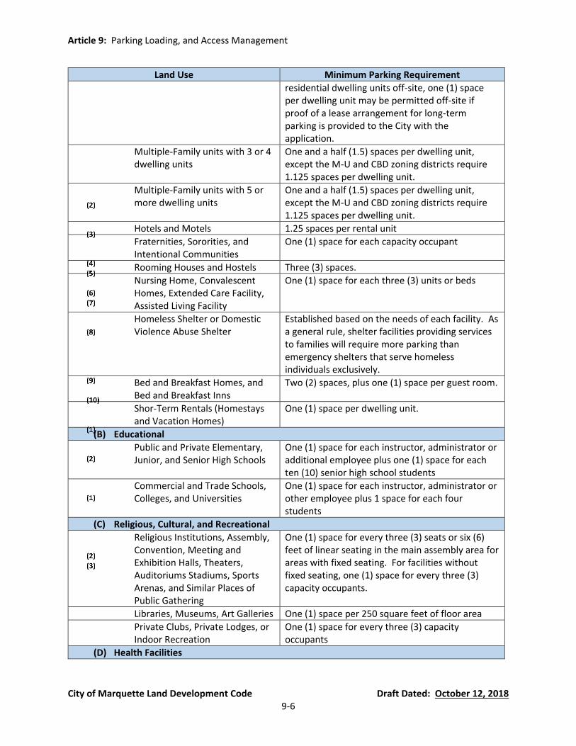
Article 9: Parking Loading, and Access Management
City of Marquette Land Development Code Draft Dated: October 12, 2018 9-6
Land Use Minimum Parking Requirement
residential dwelling units off-site, one (1) space per dwelling unit may be permitted off-site if proof of a lease arrangement for long-term parking is provided to the City with the application.
Multiple-Family units with 3 or 4 dwelling units
One and a half (1.5) spaces per dwelling unit, except the M-U and CBD zoning districts require 1.125 spaces per dwelling unit.
Multiple-Family units with 5 or more dwelling units
One and a half (1.5) spaces per dwelling unit, except the M-U and CBD zoning districts require 1.125 spaces per dwelling unit.
Hotels and Motels 1.25 spaces per rental unit
Fraternities, Sororities, and Intentional Communities
One (1) space for each capacity occupant
Rooming Houses and Hostels Three (3) spaces.
Nursing Home, Convalescent Homes, Extended Care Facility, Assisted Living Facility
One (1) space for each three (3) units or beds
Homeless Shelter or Domestic Violence Abuse Shelter
Established based on the needs of each facility. As a general rule, shelter facilities providing services to families will require more parking than emergency shelters that serve homeless individuals exclusively.
Bed and Breakfast Homes, and Bed and Breakfast Inns
Two (2) spaces, plus one (1) space per guest room.
Shor-Term Rentals (Homestays and Vacation Homes)
One (1) space per dwelling unit.
(B) Educational
Public and Private Elementary, Junior, and Senior High Schools
One (1) space for each instructor, administrator or additional employee plus one (1) space for each ten (10) senior high school students
Commercial and Trade Schools, Colleges, and Universities
One (1) space for each instructor, administrator or other employee plus 1 space for each four students
(C) Religious, Cultural, and Recreational
Religious Institutions, Assembly, Convention, Meeting and Exhibition Halls, Theaters, Auditoriums Stadiums, Sports Arenas, and Similar Places of Public Gathering
One (1) space for every three (3) seats or six (6) feet of linear seating in the main assembly area for areas with fixed seating. For facilities without fixed seating, one (1) space for every three (3) capacity occupants.
Libraries, Museums, Art Galleries One (1) space per 250 square feet of floor area
Private Clubs, Private Lodges, or Indoor Recreation
One (1) space for every three (3) capacity occupants
(D) Health Facilities

Article 9: Parking Loading, and Access Management
City of Marquette Land Development Code Draft Dated: October 12, 2018 9-7
Land Use Minimum Parking Requirement
Hospitals and Inpatient Mental Health or Substance Abuse Facility
Two (2) spaces for each bed
Medical and Dental Clinics, Doctors' and Dentists' Offices, Veterinary Clinics, and Outpatient Mental Health or Substance Abuse Facilities with less than 20 Licensed Health Professionals
One (1) space per 200 square feet of gross floor area plus one (1) per employee on peak shift.
Medical and Dental Clinics, Doctors' and Dentists' Offices, Veterinary Clinics, and Outpatient Mental Health or Substance Abuse Facilities containing twenty or more Licensed Health Professionals
One (1) space per 250 square feet of gross floor area plus one (1) per employee on peak shift.
(E) Transportation, Communication, and Utilities
Rail, Bus, Air and Water Passenger Terminals
No minimum
Air, Rail, Motor and Water Freight Terminals
One (1) space per 200 square feet of floor area
Radio and Television Stations One (1) space per 100 square feet
Public Utility Operations other than Offices
One (1) space per 1,000 square feet of floor area plus One (1) space per 10,000 square feet of site area
(F) Industrial/Wholesaling/Warehousing
Production or Processing of Materials, Goods, or Products
One (1) space per 1,000 square feet of floor area plus one (1) space per 10,000 square feet of site area
Testing, Repairing, Cleaning or Servicing of Materials, Goods, or Products
One (1) space per 1,000 square feet of floor area plus One (1) space per 10,000 square feet of site area
Warehousing and Wholesaling One (1) space per 1,000 square feet of floor area plus One (1) space for every 10,000 square feet of outdoor storage or sales area
(G) Retail Trade
Establishments for the Consumption of Food or Beverages on the Premises, excluding Drive-Through Restaurants
1 space for every two (2) capacity occupants
Drive-Through Restaurants 1 space for every two (2) capacity occupants plus five (5) stacking spaces between the pick-up window and the order station and five (5) stacking spaces that do not conflict with access to required
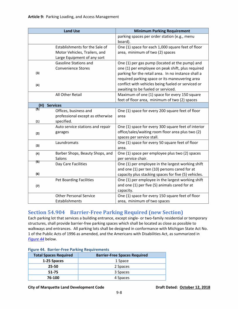
Article 9: Parking Loading, and Access Management
City of Marquette Land Development Code Draft Dated: October 12, 2018 9-8
Land Use Minimum Parking Requirement
parking spaces per order station (e.g., menu board).
Establishments for the Sale of Motor Vehicles, Trailers, and Large Equipment of any sort
One (1) space for each 1,000 square feet of floor area, minimum of two (2) spaces
Gasoline Stations and Convenience Stores
One (1) per gas pump (located at the pump) and one (1) per employee on peak shift, plus required parking for the retail area. In no instance shall a required parking space or its maneuvering area conflict with vehicles being fueled or serviced or awaiting to be fueled or serviced.
All Other Retail Maximum of one (1) space for every 150 square feet of floor area, minimum of two (2) spaces
(H) Services
Offices, business and professional except as otherwise specified.
One (1) space for every 200 square feet of floor area
Auto service stations and repair garages
One (1) space for every 300 square feet of interior office/sales/waiting room floor area plus two (2) spaces per service stall.
Laundromats One (1) space for every 50 square feet of floor area.
Barber Shops, Beauty Shops, and Salons
One (1) space per employee plus two (2) spaces per service chair.
Day Care Facilities One (1) per employee in the largest working shift and one (1) per ten (10) persons cared for at capacity plus stacking spaces for five (5) vehicles.
Pet Boarding Facilities One (1) per employee in the largest working shift and one (1) per five (5) animals cared for at capacity.
Other Personal Service Establishments
One (1) space for every 150 square feet of floor area, minimum of two spaces
Section 54.904 Barrier-Free Parking Required (new Section) Each parking lot that services a building entrance, except single- or two-family residential or temporary structures, shall provide barrier-free parking spaces which shall be located as close as possible to walkways and entrances. All parking lots shall be designed in conformance with Michigan State Act No. 1 of the Public Acts of 1996 as amended, and the Americans with Disabilities Act, as summarized in Figure 44 below. Figure 44. Barrier-Free Parking Requirements
Total Spaces Required Barrier-Free Spaces Required
1-25 Spaces 1 Space
25-50 2 Spaces
51-75 3 Spaces
76-100 4 Spaces

Article 9: Parking Loading, and Access Management
City of Marquette Land Development Code Draft Dated: October 12, 2018 9-9
101-150 5 Spaces
151-200 6 Spaces
201-300 7 Spaces
301-400 8 Spaces
401-500 9 Spaces
501-1,000 2% of total
Greater than 1,000 20, plus one (1) for each 100 spaces over 1,000
Section 54.905 Parking Layout, Design, Construction, and Maintenance (currently Section 80.42(2)(C)) All off-street parking shall be laid out, constructed, and maintained according to the following standards and regulations:
(A) Required Parking Space Dimensions. Unless otherwise stated in Section 54.905(C), all parking spaces shall be laid out in the dimensions of nine (9) feet wide by eighteen (18) feet long, exclusive of maneuvering lanes.
(B) Snow Storage. An area equivalent to 10% of the required parking stall area must be provided
for snow storage. The snow storage area shall be landscaped and shall be located within any fence bounding the parking lot. The snow storage area may be located in a landscape area required in Article 10 or in a storm water detention or retention pond, subject to approval by the City. Snow storage on lot corners and near driveway entrances must meet the clear vision requirements of Section 54.704.
(C) Parking Layout Requirements. Plans for the layout of the parking lot shall show the
dimensions of the total lot, shall show the location and dimensions of all parking spaces, maneuvering lanes, entrances, exits, borders and snow storage areas. Means of limiting ingress and egress to the parking lot shall also be shown. One of the following patterns shall be used for the layout of parking spaces:
Figure 45. Minimum Parking Layout Dimension Requirements (Text)
Angle (In Degrees) Min. Stall Length Min. Stall Width Min. Maneuvering Lane Width
0 (parallel) 23 ft. 9 ft. 12 ft. (one way)
30-53 18 ft. 9 ft. 15 ft. (one way)
54-74 18 ft. 9 ft. 18 ft. (one way)
75-90 18 ft. 9 ft. 24 ft. (two way)
Figure 46. Minimum Parking Layout Dimension Requirements (Graphic)
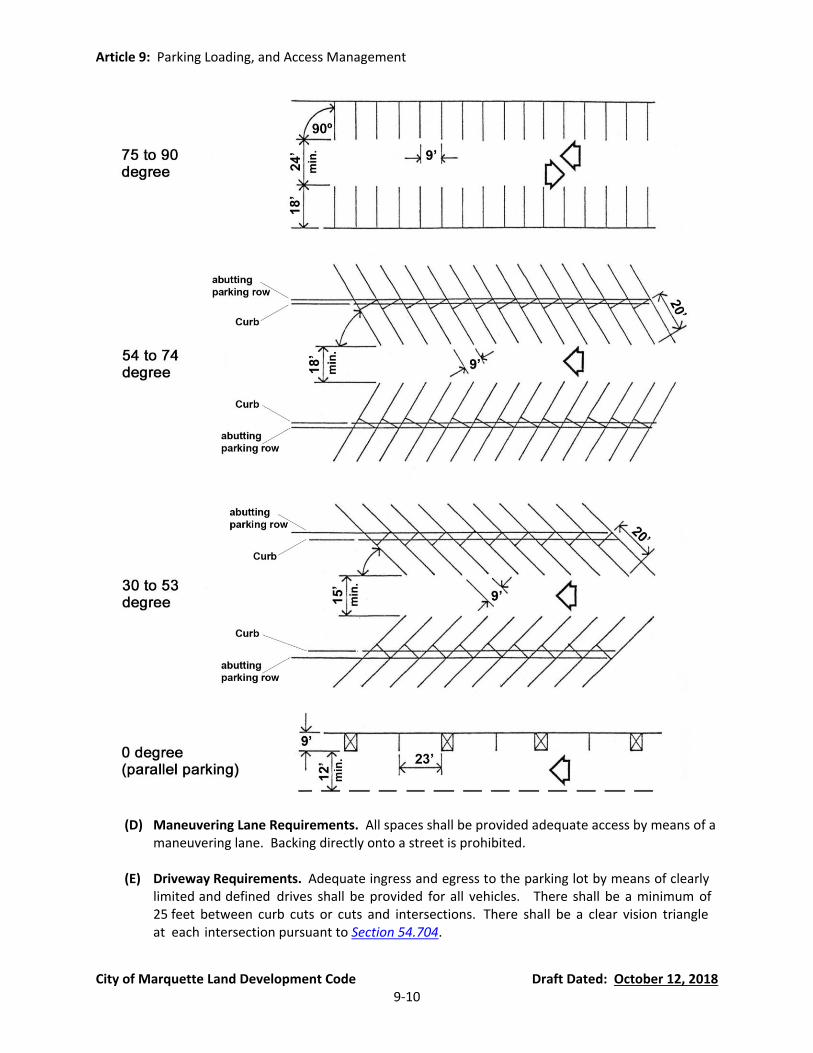
Article 9: Parking Loading, and Access Management
City of Marquette Land Development Code Draft Dated: October 12, 2018 9-10
(D) Maneuvering Lane Requirements. All spaces shall be provided adequate access by means of a maneuvering lane. Backing directly onto a street is prohibited.
(E) Driveway Requirements. Adequate ingress and egress to the parking lot by means of clearly
limited and defined drives shall be provided for all vehicles. There shall be a minimum of 25 feet between curb cuts or cuts and intersections. There shall be a clear vision triangle at each intersection pursuant to Section 54.704.

Article 9: Parking Loading, and Access Management
City of Marquette Land Development Code Draft Dated: October 12, 2018 9-11
(F) Curb Cut Setback From Residential District. Each exit and entrance to and from any off-
street parking lot located in an area zoned for other than Single-Family Residential District (SFR) and General Residential District (GR) must be at least 25 feet from any adjacent property located in a SFR or GR zoning district.
(G) Surface and Drainage. The entire parking lot including parking spaces and maneuvering lanes
required under this Section, must be provided with a hard paving surface in accordance with specifications approved by the City Engineer (see definition of “Hard Parking Surface” in Section 54.202(A)(90)). The parking area shall be surfaced within (1) year of the date the permit is issued. Off-street parking lots, including the driveways, must be drained so as to dispose of all surface water accumulated in the parking areas and driveways in such a way as to preclude drainage of water onto adjacent property or toward buildings. Storm water management systems are encouraged to include one (1) or more of the Best Management Practices (BMPs) published by the Michigan Department of Environmental Quality (MDEQ) or any other BMP accepted by the City, such as underground infiltration trenches, rain gardens, cisterns, and swales.
(H) Curbing and Painted Lines. Except for those parking areas serving a single- or two-family
dwelling unit in a SFR or GR zoning district, concrete curbs, sidewalks, and other items necessary for the protection of the public and adjoining properties must be provided and maintained around all parking areas, including where parking spaces abut landscaping, property lines, or required setback areas. In lieu of concrete curbing, the City may approve concrete wheel stops/parking blocks. All parking spaces shall be clearly defined by painted lines, except for those parking areas serving a single- or two-family dwelling unit in a SFR or GR zoning district.
(I) Parking Lots Abutting a Residential District. An off-street parking lot abutting the SFR, GR,
MFR, or MHP districts must be provided with a continuous six (6) foot high solid or stockade style screening fence. This screening fence must meet the requirements of Section 54.706, and be provided on all sides where the abutting zoning district is designated as a residential district. In lieu of a wall or fence, the owner may plant and maintain an evergreen greenbelt buffer in accordance with Section 54.1003(D)(2)(c).
(J) Lighting. All lighting used to illuminate any off-street parking area must meet the
requirements of Section 54.802 and be confined within and directed onto the parking lot only. In no case may the source of light exceed twenty feet in overall height above ground level.
(K) Maintenance: The off-street parking lot, required borders, and landscaped areas must be
maintained in a litter free condition. All landscaping and screening must be maintained in a healthy growing condition pursuant to Article 10, and neat and orderly in appearance. Snow must be removed as necessary to permit the use of all required parking spaces.
(L) Parking Lot Border. Unless parking lot landscaping and screening is required by Section
54.1003(C)(1), a two-foot wide border must be created and maintained between a parking lot, and the adjacent buildings and/or property lines. This border must be landscaped or paved with concrete as a walkway, and may be included in the required snow storage area.
Article 9: Parking Loading, and Access Management
City of Marquette Land Development Code Draft Dated: October 12, 2018 9-12
(M) Repaving and Restriping. Prior to repaving or restriping a parking lot, a plot plan must be submitted to the Zoning Administrator for Zoning Compliance Review pursuant to Section 54.1401.
Section 54.906 Off-Street Loading Zones (currently Section 80.42(3)) On the same site with every building or structure, except single- and two-family dwelling units in the SFR or GR zoning district, there must be provided and maintained a minimum of one (1) space for standing, loading, and unloading of delivery vehicles in order to prevent interference with public use of a dedicated right-of-way.
(A) Joint Loading Spaces. Two (2) or more adjacent buildings or lots may jointly share off-street loading facilities if adequate access to the individual uses is provided.
(B) Loading Dock Approaches. For uses that have loading docks, the loading dock approaches
must be provided with a pavement having an asphaltic or cement binder so as to provide a permanent, durable, and dust free surface.
(C) Required Loading Space Dimensions. All loading spaces must be laid out in the dimensions of
at least 10 feet by 50 feet. The Zoning Administrator or Planning Commission, as applicable, may modify this requirement during Minor Site Plan Review or Site Plan Review (see Figure 51), respectively, to be less than 10 feet by 50 feet if the minimum dimensions are impractical based on the use of the site or the site cannot reasonably accommodate a loading space of 10 feet by 50 feet. If a smaller loading area is approved, it must be the minimum dimensions necessary to accommodate loading on the site. If the site cannot reasonably accommodate a loading space of 10 feet by 50 feet, the Planning Commission may consider temporary loading area alternatives pursuant to the standards of Section 54.906(E).
(D) Commercial Vehicle Parking. Off-street parking spaces must be provided for all commercial
vehicles owned by or customarily used by the on-site business or industry. The Zoning Administrator may permit the off-street loading area to be used for this purpose, provided that the parking of commercial vehicles does not interfere with loading activities.
(E) Temporary Loading Area Alternatives. Where the site cannot reasonably accommodate a
loading space, the Planning Commission or Zoning Administrator, as applicable (see Figure 51), may permit a temporary loading area in parking spaces or on one (1) side of a two-way maneuvering lane, provided the temporary loading area is clearly shown on the plans, includes a sign stating the permitted times of loading/unloading, is not located in an area that is hazardous to traffic safety, and does not prevent emergency vehicle access.
(F) Loading Zone Identification. Off-street loading zones must be designated with appropriate
signs and pavement marking that prohibit parking of non-loading vehicles. Because pavement markings are covered by snow for much of the time, pavement markings shall be supplemental to – not in lieu of – the signs.
Section 54.907 Access Management and Sidewalks (new Section)

Article 9: Parking Loading, and Access Management
City of Marquette Land Development Code Draft Dated: October 12, 2018 9-13
(A) Curb Cuts and Driveway Separation Distances. All curb cuts and separation distances must meet the requirements of Chapter 42 of the Code of Ordinances (Streets, Sidewalks, and Other Public Places). Unless stated otherwise in this Ordinance, driveways must be separated from the side lot line or rear lot line by a minimum of 12 inches of unpaved land to ensure a buffer between driveways and the adjacent lot line.
(B) Sidewalks. In addition to the requirement to construct and maintain sidewalks in the Code of
Ordinances, interior sidewalks must also be provided within a development to provide circulation between the parking areas and the public right-of-way; the parking areas and the building entrance(s); and adjacent development(s) where practical. Interior sidewalks must be five (5) feet wide (unless a greater width is required elsewhere in this Ordinance) and must conform to the City engineering and sidewalk standards. The Planning Commission or Zoning Administrator, as applicable, may modify the location of interior sidewalks during Site Plan Review or Minor Site Plan Review (see Figure 51), respectively, based on the adequacy of the on-site circulation.
(C) Pedestrian Crosswalk Access. Pedestrian areas that cross vehicular traffic within parking lots
must be clearly marked, and vehicular traffic must be encouraged to slow down near pedestrian crossings. The City may require accent paving, such as stamped concrete, to be incorporated at key crossings that may accommodate heavy pedestrian traffic. Where accent paving is not used, pavement striping must be installed to increase visibility. The pavement striping material and pattern must be reviewed and approved by the City of Marquette. Pedestrian crosswalks must be adequately lighted, have clear sight distances, kept clear of snow and ice, and be free from view-hindering obstructions such as foliage and poles at crosswalk entries and median refuge islands.
(D) Cross Access with Adjacent Sites. At the time of Site Plan Review or Minor Site Plan Review
(see Figure 51), as applicable, the City may require a site to include blanket cross-access easements for all driveways, maneuvering lanes, and curb cuts to ensure that the internal circulation system connects to the internal circulation system on adjacent parcels. Where cross-access is anticipated to an adjacent site, the City may require a driveway or maneuvering lane termination at the lot line shared with the adjacent site. The blanket cross-access agreement must be recorded with the Marquette County Register of Deeds and provide for reciprocal cross-access for connection to adjacent parcels and curb cuts without limitation. Reciprocal cross-access easements throughout the city will have the long-term effect of reducing traffic on roads, reducing curb cuts, and encouraging more cohesive development.
(E) Bicycle Access and Parking. Where there is a bicycle network in the public right-of-way, new
developments must connect to the bicycle transportation network. Where bicycle parking is required by the Planning Commission or Zoning Administrator, as applicable, during Site Plan Review or Minor Site Plan Review (see Figure 51), respectively, bicycle parking must be conveniently located near the public entrance and well-lit to discourage theft or vandalism.
(F) Transportation Impact Studies. Where required by this ordinance or determined necessary by
the City Engineer pursuant to the City of Marquette Transportation Impact Study Criteria Engineering Design Guidelines and Standards, a transportation impact study (TIS) must be submitted for a development proposal reviewed by the Planning Commission. The TIS shall

Article 9: Parking Loading, and Access Management
City of Marquette Land Development Code Draft Dated: October 12, 2018 9-14
follow the guidelines set forth in the City of Marquette Engineering Design Guidelines and Standards.

Article 10: Landscaping and Screening
City of Marquette Land Development Code Draft Dated: October 12, 2018 10-1
Article 10 Landscaping and Screening
Section 54.1001 Intent (new Section) Landscaping, greenbelts, and screening are necessary for the protection and enhancement of the environment and for the continued vitality of all land uses in the City. The purpose and intent of this Article is as follows:
(A) To protect the health, safety, and general welfare of the public by creating an environment that is aesthetically pleasing and that promotes economic development through an enhanced quality of life;
(B) To aid in stabilizing the environment’s ecological balance by contributing to the process of air
purification, carbon dioxide storage, oxygen regeneration, groundwater recharge and storm water runoff retardation while at the same time aiding in noise, glare and heat abatements;
(C) To encourage the preservation of existing trees and vegetation;
(D) To assist in providing adequate light and air and in preventing overcrowding of land;
(E) To provide for and enhance the beautification of the City;
(F) To safeguard and enhance property values and to protect public and private investment;
(G) To preserve, protect and restore the unique identity and environment of the City of Marquette
and preserve the economic base attracted to the City by such factors;
(H) To conserve energy and to protect the public health, safety and general welfare;
(I) To reduce the negative environmental effects of development while protecting the value of developed properties and the surrounding area;
(J) To reduce soil erosion and increase infiltration in permeable land areas essential to storm
water management and aquifer recharge;
(K) To mitigate air, dust, noise, heat, chemical pollution, glare, and other adverse environmental effects of development;
(L) To screen unsightly equipment or materials from view of persons on public streets or abutting
properties and buffering from uncomplimentary land uses;
(M) To reduce “heat-island” effect of impervious surfaces such as parking lots, by cooling and shading the surface area and breaking up large expanses of pavement;
Article 10: Landscaping and Screening
City of Marquette Land Development Code Draft Dated: October 12, 2018 10-2
(N) To provide habitat for living things that might not otherwise occur or be found in urban and suburban environs.
Section 54.1002 Scope of Application (new Section)
(A) Uses, Lots, Sites, and Parcles for Which Site Plan Review is Required. The requirements set forth in this Article shall apply to all uses, lots, sites, and parcels for which Site Plan Review is required and which are developed or expanded following the effective date of this Ordinance. No site plan shall be approved unless that site plan shows landscaping consistent with the provisions of this Article. Furthermore, where landscaping is required, a Zoning Compliance Permit shall not be issued until the required landscape plan is submitted and approved and a Certificate of Occupancy shall not be issued unless provisions set forth in this Article have been met or a performance guarantee has been posted in accordance with the provisions set forth in Section 54.1402(H).
(B) Existing Buildings. In cases where the use of an existing building changes or an existing
building is altered or re-occupied, all of the standards of this Article shall be met, where possible, without altering the layout of the buildings, structures, parking areas, and vehicle and pedestrian circulation systems.
(C) Additional Requirements for Landscaping. The requirements of this Article are minimum
requirements, and nothing in this Article shall preclude a developer and the City from agreeing to more extensive landscaping.
(D) Existing Landscaping. Existing landscaping that meets the requirements of this Article may be
used to comply with the requirements of Section 54.1003.
Section 54.1003 Landscaping Design Requirements (new Section) Except as otherwise specified in the general requirements for each zoning district or for the specific land use, all landscaping must conform to the following standards. The clear vision triangle area requirements of Section 54.704 must also be met. Existing landscaping that meets the requirements of this Article may be used to comply with the following standards:
(A) Street Trees (new Section).
Intent. Street trees provide both form (canopy) and comfort (shade) to the street-space. Native trees and plants contribute to the reduction of air and noise pollution, maintenance of natural habitat, the conservation of water, and rainwater management.
Where Applicable. Street trees must be planted within the road right-of-way, provided
there is sufficient area within the right-of-way for street trees and the planting is approved by the City Arborist pursuant to Chapter 22, Article 5 of the City of Marquette Code of Ordinances.
Required Street Trees. Street trees shall be planted at an average no greater than one (1)
tree per 30 feet on center. Where necessary, spacing allowances may be made to accommodate curb cuts, fire hydrants and other infrastructure elements, however, at no

Article 10: Landscaping and Screening
City of Marquette Land Development Code Draft Dated: October 12, 2018 10-3
location shall spacing exceed 45 feet on center. Existing trees in good condition and of a desirable species located in or near the right-of-way must be preserved when feasible. Such preserved trees shall count towards the street tree planting requirement.
Location of Planting. Street trees may be planted in a tree lawn (the area in between the
sidewalk and the curb or edge of pavement) or in tree grates where no tree lawn exists between the curb and the sidewalk. Street trees shall not be planted over public underground utilities without the approval of the City Engineering Department. Street trees must be centered horizontally and meet the following separation requirements:
(a) Two (2) feet from walkways, curbing, and other impervious pavements when planted
in a tree well or continuous planter;
(b) Three (3) feet from walkways, curbing and other impervious pavements when planted in a continuous swale;
(c) Five (5) feet from street lights, underground utilities, utility meters and service lines,
fences, walls and other ground level obstructions;
(d) Six (6) feet from porch eaves, and awnings and similar overhead obstructions associated with the ground level of buildings;
(e) Eight (8) feet from balconies, verandas, building eaves and cornices, and similar
overhead obstructions associated with the upper stories of buildings.
Groundcover in Tree Lawn. Tree lawns located in the public right-of-way must be at grade (no raised or curbed planters), contain sufficient soil area to encourage healthy growth, and planted with grass or other suitable live ground cover.
Clearance. Street trees must remain “limbed up” as they gain appropriate maturity so as
to not interfere with pedestrian or vehicle travel. A minimum clearance of seven (7) feet must be maintained over a sidewalk or walkway, and a minimum clearance of 14 feet must be maintained over the travel lanes of the street.
Street Tree Planting List. Street trees must be chosen among the list of trees in Figure 47,
unless a similar suitable species is approved by the City. Criteria for determining “suitable” tree species include tree characteristics (growth rate, form), site characteristics (available above-ground space, exposure), along with exterior factors such as USDA hardiness zones, salt tolerance, microclimates, and plant availability.
Figure 47. Street Tree Planting List
Common Name Botanical Name Growth Habit
American Elm Ulmus Americana high spreading canopy, hardy tree survives harsh winters
Armstrong Freeman Maple
Acer freemanii ‘Armstrong’
narrow form, smooth gray bark, prone to poor branching angles
Catalpa Catalpa speciosa medium sized, long legume-like fruits, may be damaged by ice
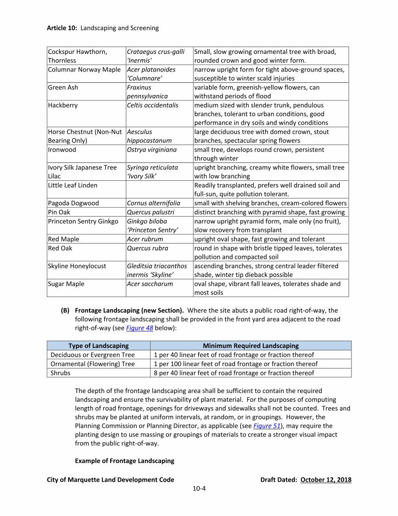
Article 10: Landscaping and Screening
City of Marquette Land Development Code Draft Dated: October 12, 2018 10-4
Cockspur Hawthorn, Thornless
Crataegus crus-galli 'Inermis'
Small, slow growing ornamental tree with broad, rounded crown and good winter form.
Columnar Norway Maple Acer platanoides ‘Columnare’
narrow upright form for tight above-ground spaces, susceptible to winter scald injuries
Green Ash Fraxinus pennsylvanica
variable form, greenish-yellow flowers, can withstand periods of flood
Hackberry Celtis occidentalis medium sized with slender trunk, pendulous branches, tolerant to urban conditions, good performance in dry soils and windy conditions
Horse Chestnut (Non-Nut Bearing Only)
Aesculus hippocastanum
large deciduous tree with domed crown, stout branches, spectacular spring flowers
Ironwood Ostrya virginiana small tree, develops round crown, persistent through winter
Ivory Silk Japanese Tree Lilac
Syringa reticulata ‘Ivory Silk’
upright branching, creamy white flowers, small tree with low branching
Little Leaf Linden Readily transplanted, prefers well drained soil and full-sun, quite pollution tolerant.
Pagoda Dogwood Cornus alternifolia small with shelving branches, cream-colored flowers
Pin Oak Quercus palustri distinct branching with pyramid shape, fast growing
Princeton Sentry Ginkgo Ginkgo biloba ‘Princeton Sentry’
narrow upright pyramid form, male only (no fruit), slow recovery from transplant
Red Maple Acer rubrum upright oval shape, fast growing and tolerant
Red Oak Quercus rubra round in shape with bristle tipped leaves, tolerates pollution and compacted soil
Skyline Honeylocust Gleditsia triacanthos inermis ‘Skyline’
ascending branches, strong central leader filtered shade, winter tip dieback possible
Sugar Maple Acer saccharum oval shape, vibrant fall leaves, tolerates shade and most soils
(B) Frontage Landscaping (new Section). Where the site abuts a public road right-of-way, the
following frontage landscaping shall be provided in the front yard area adjacent to the road right-of-way (see Figure 48 below):
Type of Landscaping Minimum Required Landscaping
Deciduous or Evergreen Tree 1 per 40 linear feet of road frontage or fraction thereof
Ornamental (Flowering) Tree 1 per 100 linear feet of road frontage or fraction thereof
Shrubs 8 per 40 linear feet of road frontage or fraction thereof
The depth of the frontage landscaping area shall be sufficient to contain the required landscaping and ensure the survivability of plant material. For the purposes of computing length of road frontage, openings for driveways and sidewalks shall not be counted. Trees and shrubs may be planted at uniform intervals, at random, or in groupings. However, the Planning Commission or Planning Director, as applicable (see Figure 51), may require the planting design to use massing or groupings of materials to create a stronger visual impact from the public right-of-way.
Example of Frontage Landscaping
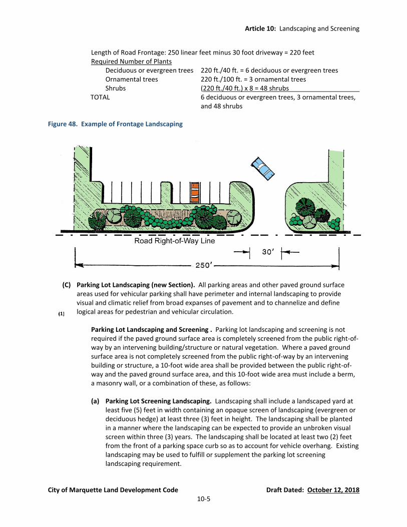
Article 10: Landscaping and Screening
City of Marquette Land Development Code Draft Dated: October 12, 2018 10-5
Length of Road Frontage: 250 linear feet minus 30 foot driveway = 220 feet Required Number of Plants
Deciduous or evergreen trees 220 ft./40 ft. = 6 deciduous or evergreen trees Ornamental trees 220 ft./100 ft. = 3 ornamental trees Shrubs (220 ft./40 ft.) x 8 = 48 shrubs
TOTAL 6 deciduous or evergreen trees, 3 ornamental trees, and 48 shrubs
Figure 48. Example of Frontage Landscaping
(C) Parking Lot Landscaping (new Section). All parking areas and other paved ground surface
areas used for vehicular parking shall have perimeter and internal landscaping to provide visual and climatic relief from broad expanses of pavement and to channelize and define logical areas for pedestrian and vehicular circulation.
Parking Lot Landscaping and Screening . Parking lot landscaping and screening is not
required if the paved ground surface area is completely screened from the public right-of-way by an intervening building/structure or natural vegetation. Where a paved ground surface area is not completely screened from the public right-of-way by an intervening building or structure, a 10-foot wide area shall be provided between the public right-of-way and the paved ground surface area, and this 10-foot wide area must include a berm, a masonry wall, or a combination of these, as follows:
(a) Parking Lot Screening Landscaping. Landscaping shall include a landscaped yard at
least five (5) feet in width containing an opaque screen of landscaping (evergreen or deciduous hedge) at least three (3) feet in height. The landscaping shall be planted in a manner where the landscaping can be expected to provide an unbroken visual screen within three (3) years. The landscaping shall be located at least two (2) feet from the front of a parking space curb so as to account for vehicle overhang. Existing landscaping may be used to fulfill or supplement the parking lot screening landscaping requirement.
Article 10: Landscaping and Screening
City of Marquette Land Development Code Draft Dated: October 12, 2018 10-6
(b) Parking Lot Screening Berm. Berms shall be at least three (3) feet in height (measured above the elevation of the adjacent parking surface) and meet the requirements of Section 54.1003(H).
(c) Parking Lot Screening Wall. Walls shall be at least three (3) feet in height and
constructed of red or brown brick or stone.
Interior Parking Lot Landscaping.
(a) Size of Interior Parking Lot Landscaping Areas. Interior landscaping shall account for a minimum of five percent (5%) of all paved parking areas, including parking and loading spaces, driveways, and aisles. Sidewalks within the right-of-way shall be excluded from the calculation of paved area. Each separate interior landscaped area must be a minimum of 360 square feet in area or five percent (5%) of all paved parking areas, whichever is less. Each separate interior landscaped area must have a minimum width of ten (10) feet.
(b) Minimum Number of Deciduous Trees. Each interior landscape area shall contain at
least one (1) deciduous tree. One (1) deciduous tree shall be planted for each 300 square feet of interior landscaping.
(c) Location of Landscaping. All required interior parking lot landscaping shall be
planted within the landscaped islands or in landscaped areas within 20 feet of the perimeter of the parking lot, provided that such landscaping is not also counted toward other landscape or screening requirements.
(d) Groundcover. Interior parking lot landscape areas shall include groundcover of
grass, perennials, shrubs, and or hardwood mulch. Rock, stone, or pebbles are not permitted ground cover.
(e) Protection with Curbing or Wheel Stops. All interior parking lot landscaping shall be
protected from vehicular encroachment by six (6) inch high concrete curbing or wheel stops unless a separate method is approved by the City.
(f) Maximum Number of Parking Spaces in a Bay or Row. Landscaping islands with or
without walkways shall be used to subdivide parking areas into parking bays with not more than 40 spaces, provided that no more than 20 spaces shall be in an uninterrupted row.
(g) Maintenance. The internal landscaping shall be installed and maintained so that,
when mature, it does not obscure traffic signs, fire hydrants, lighting, drainage patterns, or obstruct vision for safety or ingress or egress.
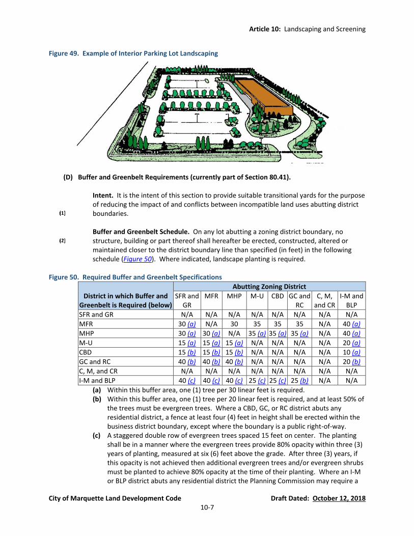
Article 10: Landscaping and Screening
City of Marquette Land Development Code Draft Dated: October 12, 2018 10-7
Figure 49. Example of Interior Parking Lot Landscaping
(D) Buffer and Greenbelt Requirements (currently part of Section 80.41).
Intent. It is the intent of this section to provide suitable transitional yards for the purpose of reducing the impact of and conflicts between incompatible land uses abutting district boundaries.
Buffer and Greenbelt Schedule. On any lot abutting a zoning district boundary, no
structure, building or part thereof shall hereafter be erected, constructed, altered or maintained closer to the district boundary line than specified (in feet) in the following schedule (Figure 50). Where indicated, landscape planting is required.
Figure 50. Required Buffer and Greenbelt Specifications
District in which Buffer and Greenbelt is Required (below)
Abutting Zoning District
SFR and GR
MFR MHP M-U CBD GC and RC
C, M, and CR
I-M and BLP
SFR and GR N/A N/A N/A N/A N/A N/A N/A N/A
MFR 30 (a) N/A 30 35 35 35 N/A 40 (a)
MHP 30 (a) 30 (a) N/A 35 (a) 35 (a) 35 (a) N/A 40 (a)
M-U 15 (a) 15 (a) 15 (a) N/A N/A N/A N/A 20 (a)
CBD 15 (b) 15 (b) 15 (b) N/A N/A N/A N/A 10 (a)
GC and RC 40 (b) 40 (b) 40 (b) N/A N/A N/A N/A 20 (b)
C, M, and CR N/A N/A N/A N/A N/A N/A N/A N/A
I-M and BLP 40 (c) 40 (c) 40 (c) 25 (c) 25 (c) 25 (b) N/A N/A
(a) Within this buffer area, one (1) tree per 30 linear feet is required. (b) Within this buffer area, one (1) tree per 20 linear feet is required, and at least 50% of
the trees must be evergreen trees. Where a CBD, GC, or RC district abuts any residential district, a fence at least four (4) feet in height shall be erected within the business district boundary, except where the boundary is a public right-of-way.
(c) A staggered double row of evergreen trees spaced 15 feet on center. The planting shall be in a manner where the evergreen trees provide 80% opacity within three (3) years of planting, measured at six (6) feet above the grade. After three (3) years, if this opacity is not achieved then additional evergreen trees and/or evergreen shrubs must be planted to achieve 80% opacity at the time of their planting. Where an I-M or BLP district abuts any residential district the Planning Commission may require a

Article 10: Landscaping and Screening
City of Marquette Land Development Code Draft Dated: October 12, 2018 10-8
screening fence, not to exceed 12 feet in height to be erected on the industrial property pursuant to Section 54.706 to obscure the industrial use and storage from the adjacent residential property.
Exceptions to Buffer and Greenbelt Schedule.
(a) Where the district boundary is the centerline of a right-of-way, the greenbelt and
buffering standards of this sub-section do not apply in these areas and other landscaping and buffering requirements of this Article apply instead (e.g., frontage landscaping requirements and loading area requirements).
(b) In all cases where buffer and greenbelt requirements are not applicable, the required
yard is the same as the minimum yard setback requirements in Article 4, Schedule of Regulations.
(E) Loading Area Landscaping (new Section). All major loading areas (including, but not limited
to, truck docks, overhead doors, or trailer staging areas) not screened by an intervening building shall be screened from a perpendicular view from any public street rights-of-way or adjacent residential zoning district for the entire length except for necessary access. It is the intent of this Section to screen major loading areas as completely as practicable, with the understanding that screening is impractical in many areas due to lot configuration and screening is not necessary for minor delivery vehicles (e.g., postal delivery, parcel delivery, etc.). Screening for major loading areas may be accomplished by one (1) or a combination of the following:
An opaque fence or wall which is at least six (6) feet high and is made of the same or
compatible material, in terms of texture and quality, as the material and color of the principal building.
Evergreen trees at least eight (8) feet in height and planted in a staggered double row
spaced fifteen (15) feet on center. Any plant material used to fulfill these requirements shall meet or exceed the minimum size requirements of this Article when planted
(F) Garbage and Dumpster Screening (new Section). An enclosure of sufficient height to
completely screen the dumpster is required on three (3) sides of the dumpster with a solid, opaque gate on the fourth side. The height of the enclosure shall be not less than six (6) feet or at least one (1) foot above the height of the dumpster, whichever is greater. Enclosures shall meet the following standards:
The enclosure must be constructed of brick, decorative concrete, vinyl composite material
which matches or complements the principal building or structure.
Enclosure gates must be constructed of solid metal or steel-reinforced wood or vinyl composite material. If wood is used, it must be pressure treated or wolmanized.
(G) Screening of Mechanical Equipment (new Section). When located outside of a building,
support equipment including air conditioning and heating devices, but not including plumbing or exhaust vents or chimneys, must be screened to the height of the particular piece of

Article 10: Landscaping and Screening
City of Marquette Land Development Code Draft Dated: October 12, 2018 10-9
equipment as follows (the requirement do not apply to single-family residential or two-family residences):
Roof- or Wall-Mounted Equipment. Roof- or wall-mounted equipment must be screened
by architectural features from the view of pedestrians on abutting streets and parcels.
Other Exterior Equipment. Other exterior equipment, such as ground-mounted equipment, must be screened by evergreen landscaping in accordance with this Article or a wall or solid fence (pursuant to Section 54.706) from the view of pedestrians on abutting streets and parcels. Such equipment is encouraged to be installed on the rear building elevation.
(H) Berms (new Section). Where required, earth berms or landscaped berms shall conform to the
following standards:
The berm shall be at least constructed with slopes no steeper than one (1) foot vertical for each three (3) feet horizontal with at least a two (2) foot flat area on the top unless a different size is required in this Ordinance.
The berm shall be planted with grass or other suitable ground cover to ensure that it
withstands wind, weather, and erosion, and retains its height and shape.
Unless a specific planting pattern is required by the Land Development Code or the Planning Commission, required trees and shrubs may be planted at uniform intervals, at random or in groupings.
For the purpose of determining required plant material, required berm length shall be
measured along the exterior periphery of the berm.
Berm height shall be measured as elevation above grade. For the purposes of this provision, grade elevation shall be the ground elevation at the property line adjacent to the proposed berm.
Section 54.1004 Standards for Plant Materials (new Section)
(A) Lawn Areas and Other Open Space Areas. Lawn areas and other open space areas shall be planted in species of grass or other perennials normally grown in the Upper Peninsula to provide suitable groundcover and prevent soil erosion. Lawn areas and other open space areas may be sodded or seeded and mulched, except that City may require solid sod or additional planting requirements in swales or other areas subject to erosion and periodic high water volumes. Sod or seed shall be clean, free of weeds and noxious pests or disease.
(B) Recommended Species of Trees, Shrubs, and Perennials. The plant palette should emphasize
native trees, shrubs, and perennials which are hardy to the Upper Peninsula region. Any tree species and cultivar applicable for planting in USDA Cold Hardiness Zone 5a (-15 to -20°F average coldest winter temperature) can be considered for planting, with the exception of the prohibited species listed in Section 54.1004(C). The following is a list of recommended species
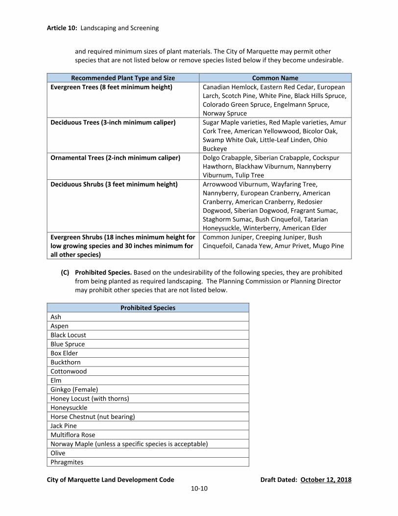
Article 10: Landscaping and Screening
City of Marquette Land Development Code Draft Dated: October 12, 2018 10-10
and required minimum sizes of plant materials. The City of Marquette may permit other species that are not listed below or remove species listed below if they become undesirable.
Recommended Plant Type and Size Common Name
Evergreen Trees (8 feet minimum height) Canadian Hemlock, Eastern Red Cedar, European Larch, Scotch Pine, White Pine, Black Hills Spruce, Colorado Green Spruce, Engelmann Spruce, Norway Spruce
Deciduous Trees (3-inch minimum caliper) Sugar Maple varieties, Red Maple varieties, Amur Cork Tree, American Yellowwood, Bicolor Oak, Swamp White Oak, Little-Leaf Linden, Ohio Buckeye
Ornamental Trees (2-inch minimum caliper) Dolgo Crabapple, Siberian Crabapple, Cockspur Hawthorn, Blackhaw Viburnum, Nannyberry Viburnum, Tulip Tree
Deciduous Shrubs (3 feet minimum height) Arrowwood Viburnum, Wayfaring Tree, Nannyberry, European Cranberry, American Cranberry, American Cranberry, Redosier Dogwood, Siberian Dogwood, Fragrant Sumac, Staghorm Sumac, Bush Cinquefoil, Tatarian Honeysuckle, Winterberry , American Elder
Evergreen Shrubs (18 inches minimum height for low growing species and 30 inches minimum for all other species)
Common Juniper, Creeping Juniper, Bush Cinquefoil, Canada Yew, Amur Privet, Mugo Pine
(C) Prohibited Species. Based on the undesirability of the following species, they are prohibited
from being planted as required landscaping. The Planning Commission or Planning Director may prohibit other species that are not listed below.
Prohibited Species
Ash
Aspen
Black Locust
Blue Spruce
Box Elder
Buckthorn
Cottonwood
Elm
Ginkgo (Female)
Honey Locust (with thorns)
Honeysuckle
Horse Chestnut (nut bearing)
Jack Pine
Multiflora Rose
Norway Maple (unless a specific species is acceptable)
Olive
Phragmites
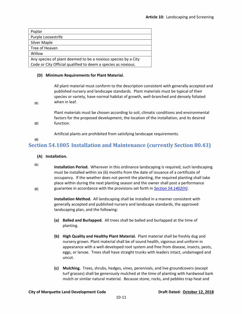
Article 10: Landscaping and Screening
City of Marquette Land Development Code Draft Dated: October 12, 2018 10-11
Poplar
Purple Loosestrife
Silver Maple
Tree of Heaven
Willow
Any species of plant deemed to be a noxious species by a City Code or City Official qualified to deem a species as noxious.
(D) Minimum Requirements for Plant Material.
All plant material must conform to the description consistent with generally accepted and
published nursery and landscape standards. Plant materials must be typical of their species or variety, have normal habitat of growth, well-branched and densely foliated when in leaf.
Plant materials must be chosen according to soil, climatic conditions and environmental
factors for the proposed development, the location of the installation, and its desired function.
Artificial plants are prohibited from satisfying landscape requirements.
Section 54.1005 Installation and Maintenance (currently Section 80.43)
(A) Installation.
Installation Period. Wherever in this ordinance landscaping is required, such landscaping must be installed within six (6) months from the date of issuance of a certificate of occupancy. If the weather does not permit the planting, the required planting shall take place within during the next planting season and the owner shall post a performance guarantee in accordance with the provisions set forth in Section 54.1402(H).
Installation Method. All landscaping shall be installed in a manner consistent with
generally accepted and published nursery and landscape standards, the approved landscaping plan, and the following:
(a) Balled and Burlapped. All trees shall be balled and burlapped at the time of
planting.
(b) High Quality and Healthy Plant Material. Plant material shall be freshly dug and nursery grown. Plant material shall be of sound health, vigorous and uniform in appearance with a well-developed root system and free from disease, insects, pests, eggs, or larvae. Trees shall have straight trunks with leaders intact, undamaged and uncut.
(c) Mulching. Trees, shrubs, hedges, vines, perennials, and live groundcovers (except
turf grasses) shall be generously mulched at the time of planting with hardwood bark mulch or similar natural material. Because stone, rocks, and pebbles trap heat and
Article 10: Landscaping and Screening
City of Marquette Land Development Code Draft Dated: October 12, 2018 10-12
do not retain moisture, these materials shall not be permitted as a ground cover or mulch.
(d) Topsoil. A minimum of four (4) inches of topsoil shall be provided for all lawn areas,
ground covers, berms, and planting beds.
(e) Plant Material Required in All Portions of Landscaped Areas. Landscaping shall include ground covering material (such as turf grass), of sufficient density to prevent the washing, blowing, or shifting of soil.
(f) Planting Locations. Unless a specific planting pattern is required by the Zoning
Ordinance or the Planning Commission, required trees and shrubs may be planted at uniform intervals, at random, or in groupings, provided they are planted in accordance with the approved plan. Landscaping shall be located and maintained in a manner that minimizes conflicts with overhead or underground utilities, and that allows reasonable view of storefronts and signs. When trees are planted with five (5) feet of a permanent building, structure, or paved area, structural soil systems shall be used to direct new root growth downward. When structural soils are used, a minimum depth of six (6) feet of structural soil shall be provided underneath trees.
(g) Protection of Existing Vegetation. Existing vegetation to be preserved shall be
protected during construction through the use of temporary fencing around the drip line.
(B) Maintenance. The owner of the property is responsible for the regular maintenance of all
plants and must replenish mulch, control weeds (including the removal of noxious weeds), fertilize plants and prune plants as necessary beginning upon completion of construction of landscaping. All diseased, dead, or damaged plants shall be replaced within 30 days, unless the season is not appropriate for planting, in which case such plant material shall be replaced at the beginning of the next planting season.
The approved landscape plan shall be considered a permanent record and integral part of site plan approval. Unless otherwise approved in accordance with the aforementioned procedures, any revisions to or removal of, plant materials will place the site in nonconformity with the originally approved landscape plan and shall be viewed as a violation of this Ordinance and the agreed upon terms of site plan approval. To ensure continued maintenance after planting, the City may retain a portion of the performance guarantee required under Section 54.1402(H) for twelve (12) months from the date required landscaping is completed to ensure plant materials remain in a live condition.
(C) Irrigation Required. Automatic underground irrigation systems should be installed to maintain
site landscaping (including lawns), depending on the characteristics of the plant materials. The approving authority (Planning Commission or Planning Director) may require irrigation for landscaped areas if it is not provided, approve an alternate form of irrigation for a particular area if there is an acceptable alternative water source, or waive the irrigation requirement in an area upon determining that the underground irrigation is not necessary to maintain site landscaping in good condition due to the drought resistant characteristics of the proposed plant materials.
Article 10: Landscaping and Screening
City of Marquette Land Development Code Draft Dated: October 12, 2018 10-13
(D) Snow Storage. Landscape areas may be used for snow storage, provided they are designed to
accommodate the large volumes of snow, planted with landscape material that can survive in those conditions (e.g., salt tolerant), and maintained in accordance with this Article.
Section 54.1006 Modifications to Landscaping Requirements (new Section) In consideration of the overall design and impact of the landscape plan, the Planning Commission may modify or adjust the requirements outlined in this Article for required landscaping, provided that any such adjustment is keeping with the intent of this Ordinance and more specifically, with the intent of this Article.

Article 11: Signs
City of Marquette Land Development Code Draft Dated: October 12, 2018 11-1
Article 11 Signs (currently Chapter 82 of the Code of Ordinances)
Section 54.1101 Purpose and Intent (currently Section 82.2) It is the intent of this Article to regulate signs in the City of Marquette so as to protect and enhance public health, safety and the public welfare while preserving the right of free speech and expression as guaranteed by the First Amendment of the U.S. Constitution. This is accomplished by regulating the size, placement, relationships, construction, illumination, and other aspects of signs in the City. It is determined that such regulation is necessary for several reasons.
(A) Enable Convenient Access and Discourage Confusion. To enable the public to locate goods, services, and facilities without difficulty and confusion.
(B) Prevent Clutter. To prevent visual clutter and the dangerous and distracting demands for
attention between advertising signs and traffic control signs and signals, which can jeopardize public safety and the mental and physical wellbeing of the public.
(C) Prohibit Unsafe Signs. To protect public safety by preventing or removing signs which are
potentially dangerous to the public due to structural deficiencies or disrepair.
(D) Effective Communication. To encourage appropriate design, scale, and placement of signs in a manner that communicates effectively to the intended reader.
(E) Aesthetic Quality and Character. To protect and enhance the continued attractiveness of the
community (including showing special concern for the value of its historic, cultural, and natural features, scenic areas, viewsheds, and the dark night sky) by preventing blight, visual clutter, excessive lighting, and out-of-scale signage that degrade the aesthetic views of the community. Also, to promote signage that contributes to the streetscape element and aids in creating a “sense of place.”.
(F) Protect Property Values. To protect property values within the community and public/private
investments in property through the use of signs which are aesthetically pleasing, of appropriate scale, and integrated with surrounding buildings and landscape. At the same time, prohibit signs that create blight and visual clutter, which can have a negative impact on the value of the subject property as well as the value of surrounding properties..
(G) Conformance with Standards of the Land Development Code. Signs which may lawfully be
erected and maintained under the provisions of this Ordinance are consistent with customary usage and that signs which may not lawfully be erected or maintained under the provisions of this Ordinance are not consistent with customary usage, are an abuse thereof, and are an unwarranted invasion of legitimate business interests and of the public.
Article 11: Signs
City of Marquette Land Development Code Draft Dated: October 12, 2018 11-2
Section 54.1102 Compelling/Important Municipal Objectives and Relationship of Regulations to the Objectives (new Section) The following municipal interests are considered by the community to be “compelling” and “important” government interests. Each interest is intended to be achieved in a manner that represents the least restrictive means of accomplishing the stated interest, and in all events intended to promote an important government interest that would be achieved less effectively absent the regulation. These important government interests are in no respect intended to target the content of messages to be displayed on signs, but seek to achieve non-speech objectives. In no respect do the regulations of signage prohibit a property owner or occupant from an effective means of conveying the desired message.
(A) Residential Districts (SFR, GR, MFR, and MHP) and Non-Residential Districts with Residential Uses(M-U, CBD, MDW, and TSC). In residential districts and non-residential districts with residential uses, some of the government interests and objectives, and the relationship of regulations to the achievement of such interests and objectives, are summarized as follows:
Traffic, Pedestrian, and Child Safety in Residential Districts (SFR, GR, MFR, and MHP) and Non-Residential Districts with Residential Uses(M-U, CBD, MDW, and TSC). In residential districts and non-residential districts with residential uses, maintaining traffic, pedestrian, and child safety are predominant and compelling government interests, with particular emphasis on the safety of neighborhood children. Regulating the size and location of signage in the most narrowly tailored manner represents the least restrictive means of addressing these targeted government interests. (a) Most signage is intended and designed to attract the attention of operators of motor
vehicles, thereby creating distractions from vigilance for traffic and pedestrian safety. Such distractions in turn create a greater risk for crashes, property damage, injuries, and fatalities.
(b) As the size of signage increases, and as the placement of signage encroaches further into sight lines, there is a corresponding increase in the encroachment of a clear view for operators of motor vehicles, pedestrians, and those in custody of children attempting of view them from homes and other locations, thus causing or delaying critical notice of impending dangers of traffic-pedestrian conflicts, child endangerment, and other undesirable circumstances.
Character and Quality of Life in Neighborhoods in Residential Districts (SFR, GR, MFR, and MHP) and Non-Residential Districts with Residential Uses(M-U, CBD, MDW, and TSC). Protection and promotion of the character and quality of life of and in residential neighborhoods has always been a major and compelling priority of land use regulation in the United States. Achieving and maintaining attractive, orderly, and desirable places to live is directly related to the stability of property values needed to provide and finance quality public services and facilities within the community, and directly related to securing productive and inspiring places in which to rear families. Utilizing narrowly tailored regulations to achieve these compelling government objectives is found to be of critical necessity and importance to the community. (a) Allowing signs that are of sufficient, but not excessive, size to perform their intended
function is necessary to provide residential neighborhood character. (b) Allowing signs that are of sufficient, but not excessive, size, and located in an orderly
pattern in relation to homes and thoroughfares is critical to the well-being and quality of life in the community, and to the stability of property values.

Article 11: Signs
City of Marquette Land Development Code Draft Dated: October 12, 2018 11-3
Avoidance of Nuisance-Like Conditions in Residential Districts (SFR, GR, MFR, and MHP) and Non-Residential Districts with Residential Uses(M-U, CBD, MDW, and TSC). The City Commission finds that it is a compelling interest to avoid blight, physical clutter, and visual clutter in residential neighborhoods, recognizing that such conditions tend to create nuisance-like conditions contrary to the public welfare, and if permitted to persist, contrary to the public health and safety. Such conditions also lead to a reduction in motivation for residents in neighborhoods to maintain their residences and private properties. The result of any and all such circumstances leads to diminished property values and reduced quality of life within the neighborhoods. Minimum regulations that substantially relate to signage impacting upon these interests and objectives is fundamental and necessary for the maintenance and well-being of positive conditions directly relating to the character and quality of life of neighborhoods and the community as a whole, and ultimately for the protection of all ordinance-related values. (a) An excessive number of signs in one location creates visual blight and clutter, as well
as confusion of the public. Thus, limiting the number of signs on properties, and establishing setbacks from property lines is a compelling interest that can be directed with minimum regulation.
(b) Signs that are too large and not properly spaced can lead to confusion, undermine the purposes of the signs, and ultimately lead to physical and visual clutter, and establishing maximum sizes and locations can be the subject of clear and effective regulations that address this compelling interest.
(c) A lack of uniformity of treatment of signage among property owners can lead to disputes and a failure to conform to applicable regulations. Consistent and uniform regulation within residential districts can be accomplished in a simple and narrowly tailored manner.
(d) Requiring minimum construction and maintenance specifications for signs can minimize the creation of blight and clutter due to the deterioration of signs that are not durable or otherwise well-constructed, and such regulations would be consistent with construction codes for other structures.
Property Identification for Emergency Response and Wayfinding Purposes in Residential Districts (SFR, GR, MFR, and MHP) and Non-Residential Districts with Residential Uses(M-U, CBD, MDW, and TSC). (a) Locating a residence by emergency police, fire, and other emergency responders can
be a matter of life and death, and thus it is a compelling interest to ensure that proper, understandable, unambiguous, and coordinated signage be permitted and required, and specifications for such purposes can be accomplished in a simple and narrow manner.
(b) Wayfinding for vehicular and pedestrian purposes is also a compelling interest in order to avoid confusion in public rights-of-way, and unnecessary intrusions on private property, and sign specifications for such wayfinding can be coordinated with property identification for emergency purposes.
(B) Commercial Districts (M-U, CBD, MDW, TSC, GC, and RC). In commercial districts, some of the
government interests and objectives, and the relationship of regulations to the achievement of such interests and objectives, are summarized as follows:
Traffic and Pedestrian Safety in Commercial Districts (M-U, CBD, MDW, TSC, GC, and RC). In commercial districts, maintaining traffic and pedestrian safety are predominant and compelling government interests, with particular emphasis on the safety of

Article 11: Signs
City of Marquette Land Development Code Draft Dated: October 12, 2018 11-4
pedestrians. The commercial districts have the heaviest concentration of pedestrian activity in the municipality, and this pedestrian activity is a key factor in the economic success of these districts. Pedestrian traffic leads to retail sales and it serves commercial/business, entertainment, government, and residential uses in these districts. In addition, commercial districts have a high concentration of motor vehicle trips, with vehicles generally travelling at higher rates of speed than in residential districts. Regulating the size and location of signage in the most narrowly tailored manner represents the least restrictive means of addressing the targeted government interests of achieving pedestrian and vehicular safety and efficiency. (a) Most signage is intended and designed to attract the attention of operators of motor
vehicles, thereby creating distractions from vigilance for traffic and pedestrian safety. Such distractions in turn create a greater risk for crashes, property damage, injuries, and fatalities, particularly considering the rate of speed at which the vehicles are traveling in these districts.
(b) The commercial districts provide the proper venue for more signage that is oriented to pedestrian in addition to emphasis on signage that is auto-oriented. Motorists eventually park in surface parking lots, parking structures or on-street. It is understood that motorists are likely not to park on the same lot as their destination, and will have greater walking distances from their vehicle to their destination(s). Signage must be encouraged that will inform pedestrians with regard to their desired locations without conflicting with other structures and improvements in these districts, while concurrently allowing effective signage for motorists. These interests are legitimately supported by limiting the maximum size of signage, providing setbacks where relevant, and specifying minimum-sized characters for efficient perception by motorists and pedestrians.
(c) In some circumstances, adjusting the size, setback, and other regulations applicable to signage may be important to avoid confusion and promote clarity where vehicular speeds vary on commercial/business thoroughfares.
(d) In multi-tenant buildings and centers, it is compelling and important to provide distinct treatment with a gradation of regulation for individual identification depending on base sign size, amount of road frontage, and the like, all intending to provide clarity to alleviate confusion and thus additional traffic maneuvers, provide a minimum size of characters to allow identification, and maintain maximum-sized overall signage to prevent line-of-sight issues.
(e) Maximum size and minimum setback of signage is compelling and important to maintain clear views for both traffic and pedestrian purposes.
Character and Quality of Life in Commercial Districts (M-U, CBD, MDW, TSC, GC, and RC). Protection and promotion of the character and corresponding economic value in commercial districts is a compelling priority of land use regulation in the United States. Achieving and maintaining attractive, orderly, and desirable places to conduct business, celebrate civic events, entertain people, and provide for housing opportunities is directly related to the stability of property values needed to provide and finance quality public services and facilities within the community, and directly related to securing places that function within the overall community. Commercial districts often have the highest property values per square foot of land in the community. Utilizing narrowly tailored regulations to achieve these compelling government objectives is found to be of critical necessity and importance to the community.

Article 11: Signs
City of Marquette Land Development Code Draft Dated: October 12, 2018 11-5
(a) Allowing signs that are of sufficient, but not excessive, size to perform their intended function is necessary to provide commercial/business character.
(b) Allowing signs that are of sufficient, but not excessive size, and being located in an orderly pattern in relation to business and thoroughfares, is critical to the well-being and quality of life in the community, and to the stability of property values.
(c) Allowing signs that focus on pedestrian flow and information is necessary to capture potential sales and assist pedestrians in locating other venues in these districts, and in this manner ultimately promote successful commerce.
(d) Prohibiting signs that promote neglect, increase the potential conflict between vehicular and pedestrian targeted messages, hinder sight distance, and distract from the pedestrian experience is critical to preserving the character and unique experience that fosters these highly-valued districts.
(e) Establishing themes for signage in various districts can be an important means of promoting character and quality of life without sacrificing or restricting the content of signage.
Promotion of Economic Development and Property Values in Commercial Districts (M-U, CBD, MDW, TSC, GC, and RC). It is found and determined that there is a clear relationship between the promotion of a set of specifications and restrictions for signage and the promotion of economic development, recognizing that unregulated and haphazard determinations concerning the size, location, and other characteristics of signs has a realistic tendency to result in an appearance that reduces economic development, and in the long term property values. In addition, the establishment of the restrictions in this ordinance has a direct relationship to creating stability and predictability, allowing each private interest to secure reasonable exposure of signage, and thus promote business success. The application of the restrictions in this ordinance allows businesses to reasonably command attention to the content and substance of their messages while concurrently allowing the promotion of other visuals, including types of business, landscaping, and architecture, all promoting economic development and property value enhancement.
Avoidance of Nuisance-Like Conditions in Commercial Districts (M-U, CBD, MDW, TSC, GC, and RC). The City Commission finds that, due to the concentration of people and activities, there is a potential for, and it is a compelling interest to avoid, blight, physical clutter, and visual clutter in the commercial districts, recognizing that such conditions tend to create nuisance-like conditions contrary to the public welfare. If permitted to persist, these conditions are also contrary to the public health and safety, and ultimately lead to a reduction in motivation on the part of property owners and tenants to maintain their businesses and private properties. The result of any and all such circumstances leads to diminished property values, reduced attractiveness of the community, and reduced quality of life within these districts. Minimum regulations that substantially relate to signage, impact upon these interests and objectives, are compelling and important, and are necessary for the maintenance and well-being of positive conditions, good character and quality of life in the commercial districts and the community as a whole. Ultimately, these regulations are compelling and important for the protection of all ordinance-related values. (a) An excessive number of signs in one location creates visual blight and clutter, as well
as confusion of the public. Thus, limiting the number of signs on properties, and establishing setbacks from property lines is a compelling interest that can be directed with minimum regulation.

Article 11: Signs
City of Marquette Land Development Code Draft Dated: October 12, 2018 11-6
(b) Signs that are too large and not properly spaced can lead to confusion, undermine the purposes of the signs, and ultimately lead to physical and visual clutter. Establishing maximum sizes and locations can be the subject of clear and effective regulations that address this compelling and important interest.
(c) A lack of uniformity of treatment of signage among property owners can lead to disputes, a failure to conform to applicable regulations, and a breakdown in motivation to serve the community in positive respects. Consistent and uniform regulation within commercial districts can be accomplished in a simple and narrowly tailored manner.
(d) Requiring minimum construction and maintenance specifications for signs can minimize the creation of blight and clutter due to the deterioration of signs that are not durable or otherwise well-constructed, and such regulations would be consistent with construction codes for other structures. These requirements can be enforced with efficient application and review.
Property Identification for Emergency Response and Wayfinding Purposes in Commercial Districts (M-U, CBD, MDW, TSC, GC, and RC). (a) Locating a business or residence by emergency police, fire, and other emergency
responders can be a matter of life and death, and thus it is a compelling interest to ensure that proper, understandable, unambiguous, and coordinated signage be permitted and required, and specifications for such purposes can be accomplished in a simple and narrow manner.
(b) Wayfinding for vehicular and pedestrian purposes is also a compelling interest in order to avoid confusion in public rights-of-way, and unnecessary intrusions on private property, and sign specifications for such wayfinding can be coordinated with property identification for emergency purposes.
(c) Promoting the establishment of consistent patterns and themes of signage allows pedestrians and motorists to become accustomed to the location of various types of signage, and thus more efficiently secure the content of intended messages.
(C) Municipal (M), Civic (C), and Conservation and Recreation (CR) Districts.
Traffic and Pedestrian Safety in Municipal (M), Civic (C), and Conservation and Recreation (CR) Districts. In M, C, and CR districts, maintaining traffic and pedestrian safety are predominant and compelling government interests. Like commercial/business districts, M, C, and CR districts have a concentration of pedestrian activity in the municipality which is a key factor in the economic success of these districts. Pedestrian traffic leads to successful businesses, and it serves many related interests in these districts. In addition, M, C, and CR districts have a high concentration of motor vehicle trips – often in confined time periods based on the demand of a use, with vehicles generally travelling at higher rates of speed than in residential districts. Regulating the size and location of signage in the most narrowly tailored manner represents the least restrictive means of addressing the targeted government interests of achieving pedestrian and vehicular safety and efficiency. (a) Most signage is intended and designed to attract the attention of operators of motor
vehicles, thereby creating distractions from vigilance for traffic and pedestrian safety. Such distractions in turn create a greater risk for crashes, property damage, injuries, and fatalities, particularly considering the rate of speed at which the vehicles are traveling in these districts.
Article 11: Signs
City of Marquette Land Development Code Draft Dated: October 12, 2018 11-7
(b) M, C, and RC districts provide the proper venue for more signage that is oriented to pedestrian in addition to emphasis on signage that is auto-oriented. Motorists eventually park in surface parking lots, parking structures, or on-street. Signage must be encouraged that will inform pedestrians with regard to their desired locations without conflicting with other structures and improvements in these districts, while concurrently allowing effective signage for motorists. These interests are legitimately supported by limiting the maximum size of signage, providing setbacks where relevant, and specifying minimum-sized characters for efficient perception by motorists and pedestrians.
(c) In some circumstances, adjusting the size, setback, and other regulations applicable to signage may be important to avoid confusion and promote clarity where vehicular speeds vary on M, C, and CR thoroughfares.
(d) In multi-tenant buildings and centers, it is compelling and important to provide distinct treatment, with a gradation of regulation for individual identification depending on base sign size, amount of road frontage, and the like, all intending to provide clarity to alleviate confusion and thus additional traffic maneuvers, provide a minimum size of characters to allow identification, and maintain maximum-sized overall signage to prevent line-of -sight issues.
(e) Maximum size and minimum setback of signage is compelling and important to maintain clear views for both traffic and pedestrian purposes.
Character and Quality of Life in the in Municipal (M), Civic (C), and Conservation and Recreation (CR) Districts. Protection and promotion of the character and corresponding economic value in M, C, and CR districts is a compelling priority of land use regulation in the United States. Achieving and maintaining attractive, orderly, and desirable places to conduct business, celebrate civic events, entertain people, and provide for recreational opportunities is directly related to the stability of property values in other areas of the city needed to provide and finance quality public services and facilities within the community, and directly related to securing places that function within the overall community. Utilizing narrowly tailored regulations to achieve these compelling government objectives is found to be of critical necessity and importance to the community. (a) Allowing signs that are of sufficient, but not excessive, size to perform their intended
function is necessary to provide office character. (b) Allowing signs that are of sufficient, but not excessive size, and being located in an
orderly pattern in relation to business and thoroughfares, is critical to the well-being and quality of life in the community, and to the stability of property values nearby.
(c) Allowing signs that focus on pedestrian flow and information is necessary to assist pedestrians in locating venues in these districts, and in this manner ultimately promote successful transactions.
(d) Prohibiting signs that promote neglect, increase the potential conflict between vehicular and pedestrian targeted messages, hinder sight distance, and distract from the pedestrian experience is critical to preserving the character and unique experience that fosters these highly-valued districts.
(e) Establishing themes for signage in various districts can be an important means of promoting character and quality of life without sacrificing or restricting the content of signage.
Promotion of Economic Development and Property Values Near the Municipal (M), Civic (C), and Conservation and Recreation (CR) Districts. It is found and determined that
Article 11: Signs
City of Marquette Land Development Code Draft Dated: October 12, 2018 11-8
there is a clear relationship between the promotion of a set of specifications and restrictions for signage and the promotion of economic development, recognizing that unregulated and haphazard determinations concerning the size, location, and other characteristics of signs has a realistic tendency to result in an appearance that reduces economic development in the area, and in the long term property values. In addition, the establishment of the restrictions in this ordinance has a direct relationship to creating stability and predictability, allowing each private interest to secure reasonable exposure of signage, and thus promote business success where appropriate. The application of the restrictions in this ordinance allows uses in the M, C, and CR districts to reasonably command attention to the content and substance of their messages while concurrently allowing the promotion of other visuals, including types of uses, landscaping, and architecture, all promoting economic development and property value enhancement in the area.
Avoidance of Nuisance-Like Conditions in Municipal (M), Civic (C), and Conservation and Recreation (CR) Districts. The City Commission finds that, due to the concentration of people and activities, there is a potential for, and it is a compelling interest to avoid, blight, physical clutter, and visual clutter in the M, C, and CR districts, recognizing that such conditions tend to create nuisance-like conditions contrary to the public welfare. If permitted to persist, these conditions are also contrary to the public health and safety, and ultimately lead to a reduction in motivation on the part of property owners and tenants to maintain their businesses and private properties in other areas of the city. The result of any and all such circumstances leads to diminished property values, reduced attractiveness of the community, and reduced quality of life within those areas of the city. Minimum regulations that substantially relate to signage impact upon these interests and objectives, are compelling and important, and are necessary for the maintenance and well-being of positive conditions, good character and quality of life in the M, C, and CR districts and the community as a whole. Ultimately, these regulations are compelling and important for the protection of all ordinance-related values. (a) An excessive number of signs in one location creates visual blight and clutter, as well
as confusion of the public. Thus, limiting the number of signs on properties, and establishing setbacks from property lines is a compelling interest that can be directed with minimum regulation.
(b) Signs that are too large and not properly spaced can lead to confusion, undermine the purposes of the signs, and ultimately lead to physical and visual clutter. Establishing maximum sizes and locations can be the subject of clear and effective regulations that address this compelling and important interest.
(c) A lack of uniformity of treatment of signage among property owners can lead to disputes, a failure to conform to applicable regulations, and a breakdown in motivation to serve the community in positive respects. Consistent and uniform regulation within M, C, and CR districts can be accomplished in a simple and narrowly tailored manner.
(d) Requiring minimum construction and maintenance specifications for signs can minimize the creation of blight and clutter due to the deterioration of signs that are not durable or otherwise well-constructed, and such regulations would be consistent with construction codes for other structures. These requirements can be enforced with efficient application and review.
Property Identification for Emergency Response and Wayfinding Purposes in Municipal (M), Civic (C), and Conservation and Recreation (CR) Districts.

Article 11: Signs
City of Marquette Land Development Code Draft Dated: October 12, 2018 11-9
(a) Locating a building, facility, or site in the M, C, and CR districts by emergency police, fire, and other emergency responders can be a matter of life and death, and thus it is a compelling interest to ensure that proper, understandable, unambiguous, and coordinated signage be permitted and required, and specifications for such purposes can be accomplished in a simple and narrow manner.
(b) Wayfinding for vehicular and pedestrian purposes is also a compelling interest in order to avoid confusion in public rights-of-way, and unnecessary intrusions on private property, and sign specifications for such wayfinding can be coordinated with property identification for emergency purposes.
(c) Promoting the establishment of consistent patterns and themes of signage allows pedestrians and motorists to become accustomed to the location of various types of signage, and thus more efficiently secure the content of intended messages.
(D) Industrial/Manufacturing (IM) and Board of Light and Power (BLP) Districts.
Traffic and Pedestrian Safety in the Industrial/Manufacturing (IM) and Board of Light and Power (BLP) Districts. In the IM and BLP districts, maintaining traffic and pedestrian safety are predominant and compelling government interests. While there is less concentration of pedestrian activity in the IM and BLP districts, they have a high concentration of motor vehicle trips – often with a greater variety of vehicles travelling at high rates of speed. Regulating the size and location of signage in the most narrowly tailored manner represents the least restrictive means of addressing the targeted government interests of achieving pedestrian and vehicular safety and efficiency. (a) Most signage is intended and designed to attract the attention of operators of motor
vehicles, thereby creating distractions from vigilance for traffic and pedestrian safety. Such distractions in turn create a greater risk for crashes, property damage, injuries, and fatalities, particularly considering the rate of speed at which the vehicles are traveling in these districts.
(b) The IM and BLP districts provide the proper venue for more signage that is oriented to motorists and signage must be encouraged that will inform such motorists with regard to their desired locations without conflicting with other structures and improvements in these districts. These interests are legitimately supported by limiting the maximum size of signage, providing setbacks where relevant, and specifying minimum-sized characters for efficient perception by motorists and pedestrians.
(c) In some circumstances, adjusting the size, setback, and other regulations applicable to signage may be important to avoid confusion and promote clarity where vehicular speeds vary on industrial thoroughfares.
(d) Maximum size and minimum setback of signage is compelling and important to maintain clear views for both traffic and pedestrian purposes.
(e) Considering the variety of vehicles, as well as their maneuverability, sign size and location, and the size of characters on the signs, must be particularly sensitive to speed limits and building orientation.
Character and Quality of Life in the Industrial/Manufacturing (IM) and Board of Light and Power (BLP) Districts. Protection and promotion of the character and corresponding economic value in the IM and BLP districts is a compelling priority in terms of promoting and attracting new industrial uses and competing with other communities in the region. Achieving and maintaining attractive, orderly, and desirable places to conduct business is directly related to the stability of property values needed to provide and finance quality
Article 11: Signs
City of Marquette Land Development Code Draft Dated: October 12, 2018 11-10
public services and facilities within the community, and directly related to securing places that function within the overall community. Utilizing narrowly tailored regulations to achieve these compelling government objectives is found to be of critical necessity and importance to the community. (a) Allowing signs that are of sufficient, but not excessive, size to perform their intended
function is necessary to provide industrial character. (b) Allowing signs that are of sufficient, but not excessive size, and being located in an
orderly pattern in relation to business and thoroughfares, is critical to the well-being and quality of life in the community, and to the stability of property values.
(c) Allowing signs that focus on traffic flow and information is necessary to promote successful commerce.
(d) Prohibiting signs that promote neglect, increase the potential conflict between vehicular and pedestrian targeted messages, hinder sight distance, and distract from the pedestrian experience is critical to preserving the character and unique experience that fosters these highly-valued districts.
(e) Establishing themes for signage in various districts can be an important means of promoting character and quality of life without sacrificing or restricting the content of signage.
Promotion of Economic Development and Property Values in the Industrial/Manufacturing (IM) and Board of Light and Power (BLP) Districts. It is found and determined that there is a clear relationship between the promotion of a set of specifications and restrictions for signage and the promotion of economic development, recognizing that unregulated and haphazard determinations concerning the size, location, and other characteristics of signs has a realistic tendency to result in an appearance that reduces economic development, and in the long term property values. In addition, the establishment of the restrictions in this ordinance has a direct relationship to creating stability and predictability, allowing each private interest to secure reasonable exposure of signage, and thus promote business success. The application of the restrictions in this ordinance allows businesses to reasonably command attention to the content and substance of their messages while concurrently allowing the promotion of other visuals, including types of business, landscaping, and architecture, all promoting economic development and property value enhancement.
Avoidance of Nuisance-Like Conditions in the Industrial/Manufacturing (IM) and Board of Light and Power (BLP) Districts. The City Commission finds that, due to the concentration of people and activities, there is a potential for, and it is a compelling interest to avoid, blight, physical clutter, and visual clutter in the IM and BLP districts, recognizing that such conditions tend to create nuisance-like conditions contrary to the public welfare. If permitted to persist, these conditions are also contrary to the public health and safety, and ultimately lead to a reduction in motivation on the part of property owners and tenants to maintain their businesses and private properties. The result of any and all such circumstances leads to diminished property values, reduced attractiveness of the community, and reduced quality of life within these districts. Minimum regulations that substantially relate to signage impact upon these interests and objectives, are compelling and important, and are necessary for the maintenance and well-being of positive conditions, good character and quality of life in the IM and BLP districts and the community as a whole. Ultimately, these regulations are compelling and important for the protection of all ordinance-related values.
Article 11: Signs
City of Marquette Land Development Code Draft Dated: October 12, 2018 11-11
(a) An excessive number of signs in one location creates visual blight and clutter, as well as confusion of the public. Thus, limiting the number of signs on properties, and establishing setbacks from property lines is a compelling interest that can be directed with minimum regulation.
(b) Signs that are too large and not properly spaced can lead to confusion, undermine the purposes of the signs, and ultimately lead to physical and visual clutter. Establishing maximum sizes and locations can be the subject of clear and effective regulations that address this compelling and important interest.
(c) A lack of uniformity of treatment of signage among property owners can lead to disputes, a failure to conform to applicable regulations, and a breakdown in motivation to serve the community in positive respects. Consistent and uniform regulation within the IM and BLP districts can be accomplished in a simple and narrowly tailored manner.
(d) Requiring minimum construction and maintenance specifications for signs can minimize the creation of blight and clutter due to the deterioration of signs that are not durable or otherwise well-constructed, and such regulations would be consistent with construction codes for other structures. These requirements can be enforced with efficient application and review.
Property Identification for Emergency Response and Wayfinding Purposes in the Industrial/Manufacturing (IM) and Board of Light and Power (BLP) Districts. (a) Locating a business by emergency police, fire, and other emergency responders can
be a matter of life and death, and thus it is a compelling interest to ensure that proper, understandable, unambiguous, and coordinated signage be permitted and required, and specifications for such purposes can be accomplished in a simple and narrow manner.
(b) Wayfinding for vehicular and pedestrian purposes is also a compelling interest in order to avoid confusion in public rights-of-way, and unnecessary intrusions on private property, and sign specifications for such wayfinding can be coordinated with property identification for emergency purposes.
(c) Promoting the establishment of consistent patterns and themes of signage allows pedestrians and motorists to become accustomed to the location of various types of signage, and thus more efficiently secure the content of intended messages.

Article 11: Signs
City of Marquette Land Development Code Draft Dated: October 12, 2018 11-12
Section 54.1103 Definitions (currently Section 82.3)
(A) Rules of Interpretation. Refer to Section 54.201 for rules of interpretation of terms and words in this Article.
(B) Sign Definitions, Sign Types. The following definitions apply to types of signs based on the
characteristics of the sign without respect to the content of the message:
Air-Activated Sign: A type of Temporary Sign that is an air inflated object, is made of a flexible fabric, which may be of various shapes, rests on the ground or structure and is equipped with a portable blower motor that provides constant air flow into the device. Air-activated signs are restrained, attached, or held in place by a cord, rope, cable, or similar method.
Animated Sign: A sign employing actual motion, the illusion of motion, or light and/or
color changes achieved through mechanical, electrical, or electronic means. Animated signs, which are differentiated from changeable signs as defined and regulated by this Ordinance, include the following types:
(a) Animated Sign, Electrically Activated: Animated signs producing the illusion of
movement by means of electronic, electrical, or electromechanical input and/or illumination capable of simulating movement through employment of the characteristics of one or both of the classifications noted below:
(i) Flashing: Animated signs or animated portions of signs whose illumination is
characterized by a repetitive cycle in which the period of illumination is either the same as or less than the period of non-illumination. For the purposes of this Ordinance, flashing will not be defined as occurring if one cyclical period of on-off phases of illumination exceeds four (4) seconds.
(ii) Patterned Illusionary Movement: Animated signs or animated portions of signs
whose illumination is characterized by simulated movement through alternate or sequential activation of various illuminated elements for the purpose of producing repetitive light patterns designed to appear in some form of constant motion.
(b) Animated Sign, Environmentally Activated: Animated signs or devices motivated by
wind, thermal changes, or other natural environmental input. Environmentally Activated Animated Signs includes spinners, pinwheels, pennant strings, and/or other devices or displays that respond to naturally occurring external motivation.
(c) Animated Sign, Mechanically Activated: Animated signs characterized by repetitive
motion and/or rotation activated by a mechanical system powered by electric motors or other mechanically induced means.
Awning Sign: A Projecting Sign displayed on or attached flat against the surface or
surfaces of an awning. See also: “Projecting Sign.” Only the sign or copy area displayed
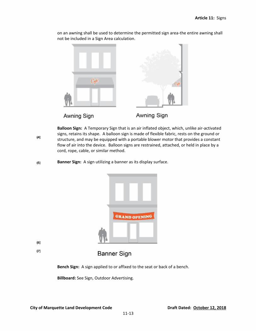
Article 11: Signs
City of Marquette Land Development Code Draft Dated: October 12, 2018 11-13
on an awning shall be used to determine the permitted sign area-the entire awning shall not be included in a Sign Area calculation.
Balloon Sign: A Temporary Sign that is an air inflated object, which, unlike air-activated signs, retains its shape. A balloon sign is made of flexible fabric, rests on the ground or structure, and may be equipped with a portable blower motor that provides a constant flow of air into the device. Balloon signs are restrained, attached, or held in place by a cord, rope, cable, or similar method.
Banner Sign: A sign utilizing a banner as its display surface.
Bench Sign: A sign applied to or affixed to the seat or back of a bench.
Billboard: See Sign, Outdoor Advertising.

Article 11: Signs
City of Marquette Land Development Code Draft Dated: October 12, 2018 11-14
Blade Sign: A Projecting Sign, which is suspended from an overhang, canopy, marquee, or awning, or is suspended from a mounting attached directly to the building wall, and hangs perpendicular to the building wall.
Canopy Sign: A permanent Projecting Sign affixed to the side or bottom surface(s) of an attached or freestanding canopy. Such signs may be internally illuminated pursuant to the requirements of this Article.
Article 11: Signs
City of Marquette Land Development Code Draft Dated: October 12, 2018 11-15
Changeable Sign: A sign with the capability of content change by means of manual or remote input, includes the following types:
(a) Changeable Sign, Electrically Activated: Changeable sign whose message copy or
content can be changed by means of remote electrically energized on-off switching combinations of alphabetic or pictographic components arranged on a display surface. Illumination may be integral to the components, such as characterized by lamps or other light-emitting devices; or it may be from an external light source designed to reflect off the changeable component display. See also: “Electronic Message Center” and “Animated Sign.”
(b) Changeable Sign, Manually Activated: Changeable sign whose message copy or
content can be changed manually on a display surface.
Electric Sign: Any sign activated or illuminated by means of electrical energy.
Electronic Message Center (EMC) Sign: An electrically activated changeable sign whose variable message and/or graphic presentation capability is electronically programmable. Also known as a digital sign. EMCs typically use light emitting diodes (LEDs) as a lighting source, and liquid-crystal display (LCDs) for light modulation. See also following terms principally associated with Electronic Message Centers:
(a) Display Time: The amount of time a message and/or graphic is displayed on an
Electronic Message Sign.
(b) Dissolve: A mode of message transition on an Electronic Message Sign accomplished by varying the light intensity or pattern, in which the first message gradually appears to dissipate and lose legibility with the gradual appearance and legibility of the second message.
(c) Dynamic Frame Effect: An Electronic Message Sign frame effect in which the illusion
of motion and/or animation is used.
(d) Scroll: A mode of message transition on an Electronic Message Sign in which the message appears to move vertically across the display surface.
(e) Transition: A visual effect used on an Electronic Message Sign to change from one
message to another.
Festoons: A string of ribbons, pennants, spinners, streamers, tinsel, small flags, pinwheels, or lights, typically strung overhead and/or in loops.
Flag: A flexible piece of fabric or other material that is attached to a permanent conforming flagpole or attached flat to wall.
Flashing Sign: See “Animated Sign, Electrically Activated.”
Article 11: Signs
City of Marquette Land Development Code Draft Dated: October 12, 2018 11-16
Flexible Sign: A sign made of fabric, thin plastic, or other flexible material, and is two-dimensional in nature.

Article 11: Signs
City of Marquette Land Development Code Draft Dated: October 12, 2018 11-17
Freestanding Sign: A sign principally supported by one or more bases, monuments, columns, poles, or braces placed in or attached to the ground (e.g. cemented in a post-hole or screwed to cement). May also be referenced as a “Monument Sign” or “Pole Sign.”
(a) Monument Sign: A base-mounted freestanding sign supported by one or more
uprights or a base and not attached to any building or other structure. A Monument Sign must have a supporting base equal to or greater than the width of the sign face constructed of a decorative and durable material (e.g., masonry), and shall not no separations between the sign face and the base.
(b) Pole Sign: A sign supported by one or more uprights or braces in or upon the ground.
Historic Sign: A sign that is attached to a building listed on the State and/or National Register of Historic Places, or that is recognized by local historians and the Planning Director as having significant value as an element of the City’s heritage or development, which was attached to the building at the time of said listing; or a sign that is at least 50 years old, not significantly altered from its historic appearance, and demonstrates historic value to the community.
Illuminated Sign: A sign characterized by the use of artificial light, either projecting through its surface(s) [Internally or trans-illuminated]; or reflecting off its surface(s) [Externally illuminated].
Incidental Sign: A small sign, usually 2 square feet or less, designed and located to be read only by people within the site and generally not legible from the right-of-way or adjacent properties. Examples of incidental signs include, but are not limited to, credit card signs, signs indicating hours of business, no smoking signs, signs used to designate bathrooms, handicapped signs, traffic control signs that conform to the requirements of the Michigan Manual of Uniform Traffic Control Devices, and other signs providing information to be read at close proximity. The Sign Official shall determine whether a
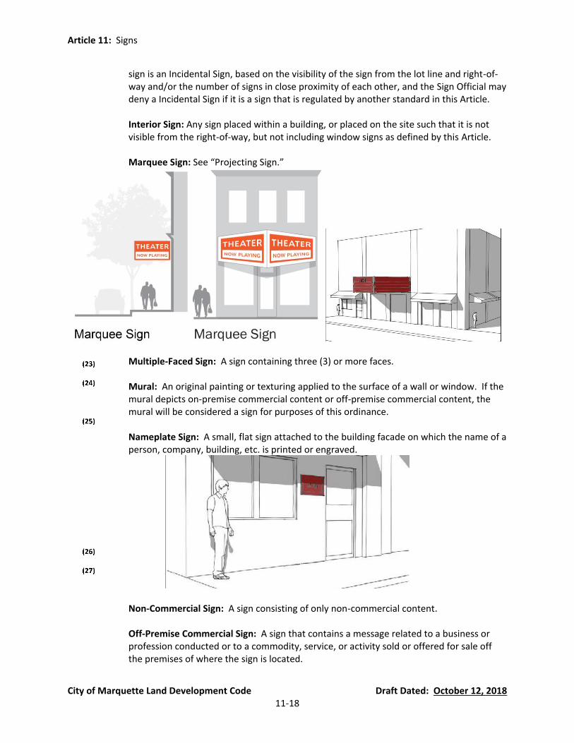
Article 11: Signs
City of Marquette Land Development Code Draft Dated: October 12, 2018 11-18
sign is an Incidental Sign, based on the visibility of the sign from the lot line and right-of-way and/or the number of signs in close proximity of each other, and the Sign Official may deny a Incidental Sign if it is a sign that is regulated by another standard in this Article.
Interior Sign: Any sign placed within a building, or placed on the site such that it is not visible from the right-of-way, but not including window signs as defined by this Article.
Marquee Sign: See “Projecting Sign.”
Multiple-Faced Sign: A sign containing three (3) or more faces.
Mural: An original painting or texturing applied to the surface of a wall or window. If the mural depicts on-premise commercial content or off-premise commercial content, the mural will be considered a sign for purposes of this ordinance.
Nameplate Sign: A small, flat sign attached to the building facade on which the name of a person, company, building, etc. is printed or engraved.
Non-Commercial Sign: A sign consisting of only non-commercial content.
Off-Premise Commercial Sign: A sign that contains a message related to a business or profession conducted or to a commodity, service, or activity sold or offered for sale off the premises of where the sign is located.

Article 11: Signs
City of Marquette Land Development Code Draft Dated: October 12, 2018 11-19
On-Premise Commercial Sign: A sign that contains a message related to a business or profession conducted or to a commodity, service, or activity sold or offered for sale upon the premises where the sign is located. Examples of on-premise commercial signs include, but are by no means limited to, real estate signs, garage sale and yard sale signs, signs advertising a permitted on-site commercial use, and signs of a contractor or other commercial entity affiliated with an on-site project under development.
Outdoor Advertising Sign: A permanent sign erected, maintained or used in the outdoor environment for the purpose of display of commercial or non-commercial messages not typically appurtenant to the use of, products sold on, or the sale of lease of, the property on which it is displayed. May also be referenced as an “Off-Premise Sign” or “Billboard.”
Pennant: A flexible piece of fabric or other material designed to attract attention or convey information. See definition of “Festoon.”
People Sign: A portable sign held by a person and displayed for the purposes of expressing a message.
Permanent Sign: A sign of durable construction and durable materials designed to remain in one location and position either through attachment to a building element or mounting on a standard secured to a below grade footing.
Plaque, Commemorative: An inscribed tablet of brass or other non-corrosive metal or stone, identifying a place of historical or cultural significance.
Portable Message Sign: A sign attached to or pulled by a vehicle that includes a manual and/or electronic changeable copy sign, an electronic graphic display sign, a video display sign, or multi-vision/tri-vision sign that may be displayed or affixed to a movable object such as but not limited to a car, truck, trailer, or similar transportation device. A “Portable Message Sign” shall not include a “Vehicle Sign.”
Portable Sign: Any sign not permanently attached to the ground and can be removed without the use of tools.
Projector-Image Sign: A sign that is displayed through light by a projector.
Projecting Sign: A sign which is attached directly to the building wall, and which extends more than fifteen (15) inches from the face of the wall. A “Projecting Sign” is differentiated from a “Wall Sign” based on the distance the sign projects from the surface of the building. See also: “Awning Sign,” “Blade Sign,” “Canopy Sign,” and “Marquee Sign.”
Revolving Sign: An animated sign that revolves around an external axis driven by wind, or electromechanical devices.
Roof Sign: A sign mounted on the main roof portion of a building or on the uppermost edge of a parapet wall of a building and which is wholly or partially supported by such

Article 11: Signs
City of Marquette Land Development Code Draft Dated: October 12, 2018 11-20
building. Signs mounted on mansard facades, pent eaves, and architectural projections such as canopies or marquees shall not be considered to be roof signs.
Rotating Sign: An animated sign that rotates around an internal axis driven by wind, or electromechanical devices.
Sidewalk Sign: A portable Temporary Sign or sign board that is freestanding and not permanently anchored or secured to either a building, structure, or the ground. Often referred to as “sandwich board signs,” sidewalk signs include, but are not limited to, so called “A” frame, “T” shaped, or inverted “T” shaped stands, or with swinging type construction. See also “Yard Sign.”
Streamer: See ”Pennant.”
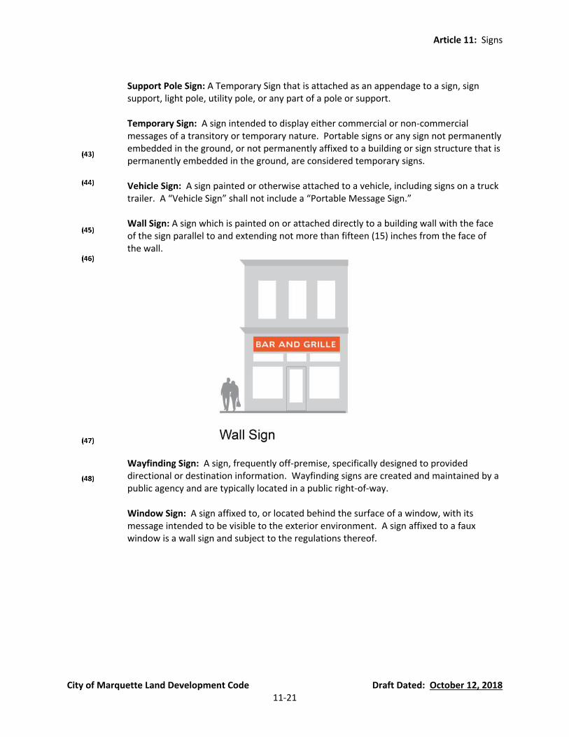
Article 11: Signs
City of Marquette Land Development Code Draft Dated: October 12, 2018 11-21
Support Pole Sign: A Temporary Sign that is attached as an appendage to a sign, sign support, light pole, utility pole, or any part of a pole or support.
Temporary Sign: A sign intended to display either commercial or non-commercial messages of a transitory or temporary nature. Portable signs or any sign not permanently embedded in the ground, or not permanently affixed to a building or sign structure that is permanently embedded in the ground, are considered temporary signs.
Vehicle Sign: A sign painted or otherwise attached to a vehicle, including signs on a truck trailer. A “Vehicle Sign” shall not include a “Portable Message Sign.”
Wall Sign: A sign which is painted on or attached directly to a building wall with the face of the sign parallel to and extending not more than fifteen (15) inches from the face of the wall.
Wayfinding Sign: A sign, frequently off-premise, specifically designed to provided directional or destination information. Wayfinding signs are created and maintained by a public agency and are typically located in a public right-of-way.
Window Sign: A sign affixed to, or located behind the surface of a window, with its message intended to be visible to the exterior environment. A sign affixed to a faux window is a wall sign and subject to the regulations thereof.
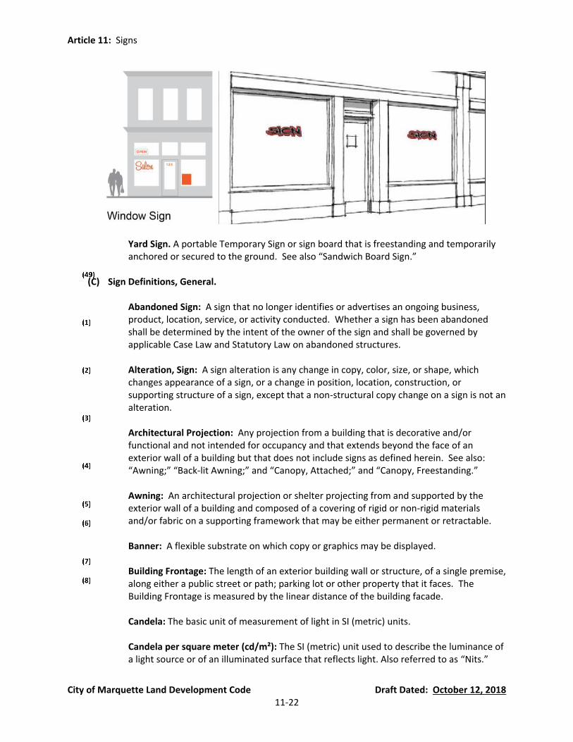
Article 11: Signs
City of Marquette Land Development Code Draft Dated: October 12, 2018 11-22
Yard Sign. A portable Temporary Sign or sign board that is freestanding and temporarily anchored or secured to the ground. See also “Sandwich Board Sign.”
(C) Sign Definitions, General.
Abandoned Sign: A sign that no longer identifies or advertises an ongoing business,
product, location, service, or activity conducted. Whether a sign has been abandoned shall be determined by the intent of the owner of the sign and shall be governed by applicable Case Law and Statutory Law on abandoned structures.
Alteration, Sign: A sign alteration is any change in copy, color, size, or shape, which
changes appearance of a sign, or a change in position, location, construction, or supporting structure of a sign, except that a non-structural copy change on a sign is not an alteration.
Architectural Projection: Any projection from a building that is decorative and/or
functional and not intended for occupancy and that extends beyond the face of an exterior wall of a building but that does not include signs as defined herein. See also: “Awning;” “Back-lit Awning;” and “Canopy, Attached;” and “Canopy, Freestanding.”
Awning: An architectural projection or shelter projecting from and supported by the
exterior wall of a building and composed of a covering of rigid or non-rigid materials and/or fabric on a supporting framework that may be either permanent or retractable.
Banner: A flexible substrate on which copy or graphics may be displayed.
Building Frontage: The length of an exterior building wall or structure, of a single premise,
along either a public street or path; parking lot or other property that it faces. The Building Frontage is measured by the linear distance of the building facade.
Candela: The basic unit of measurement of light in SI (metric) units.
Candela per square meter (cd/m²): The SI (metric) unit used to describe the luminance of
a light source or of an illuminated surface that reflects light. Also referred to as “Nits.”
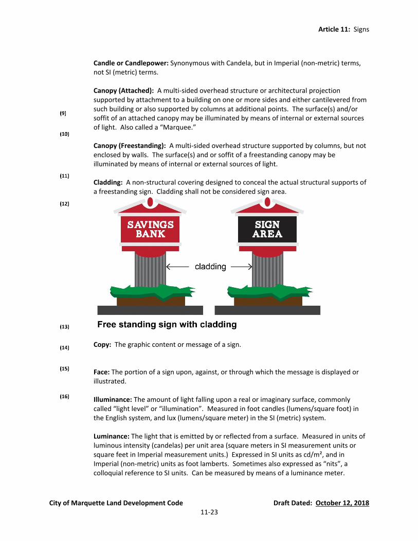
Article 11: Signs
City of Marquette Land Development Code Draft Dated: October 12, 2018 11-23
Candle or Candlepower: Synonymous with Candela, but in Imperial (non-metric) terms,
not SI (metric) terms.
Canopy (Attached): A multi-sided overhead structure or architectural projection supported by attachment to a building on one or more sides and either cantilevered from such building or also supported by columns at additional points. The surface(s) and/or soffit of an attached canopy may be illuminated by means of internal or external sources of light. Also called a “Marquee.”
Canopy (Freestanding): A multi-sided overhead structure supported by columns, but not enclosed by walls. The surface(s) and or soffit of a freestanding canopy may be illuminated by means of internal or external sources of light.
Cladding: A non-structural covering designed to conceal the actual structural supports of a freestanding sign. Cladding shall not be considered sign area.
Copy: The graphic content or message of a sign.
Face: The portion of a sign upon, against, or through which the message is displayed or illustrated.
Illuminance: The amount of light falling upon a real or imaginary surface, commonly called “light level” or “illumination”. Measured in foot candles (lumens/square foot) in the English system, and lux (lumens/square meter) in the SI (metric) system.
Luminance: The light that is emitted by or reflected from a surface. Measured in units of luminous intensity (candelas) per unit area (square meters in SI measurement units or square feet in Imperial measurement units.) Expressed in SI units as cd/m², and in Imperial (non-metric) units as foot lamberts. Sometimes also expressed as “nits”, a colloquial reference to SI units. Can be measured by means of a luminance meter.

Article 11: Signs
City of Marquette Land Development Code Draft Dated: October 12, 2018 11-24
Mansard Roof: A roof, or structure on a building imitating a roof, which is at an angle of 60 degrees or greater from the horizontal.
Marquee: See Canopy, Attached.
Nit: A photometric unit of measurement referring to luminance. One nit is equal to one cd/m². See “Candela per square meter (cd/m²).”
Premises: A “lot” in the same ownership or control which is not divided by a street.
Shopping Center: A shopping center shall mean a unified commercial development occupied by a group of five (5) or more separate retail businesses occupying substantially separate divisions of a building or buildings fronting on a privately owned common mall or parking lot rather than a public street.
SI (International System of Units): The modern metric system of measurement; abbreviated SI for the French term “Le Systeme International d’Unites.”
Sign: A name, identification, image, description, display, message, or illustration which is affixed to, painted, or otherwise located, set upon, in, or on, a building, structure, or piece of land and which directs attention to an institution, organization, object, product, place, activity, person, idea, message, or business and which is visible from any street, right-of-way, sidewalk, alley, park, other public property, or any adjacent property. Customary displays of merchandise or objects and material placed behind a store window are not signs or parts of signs.
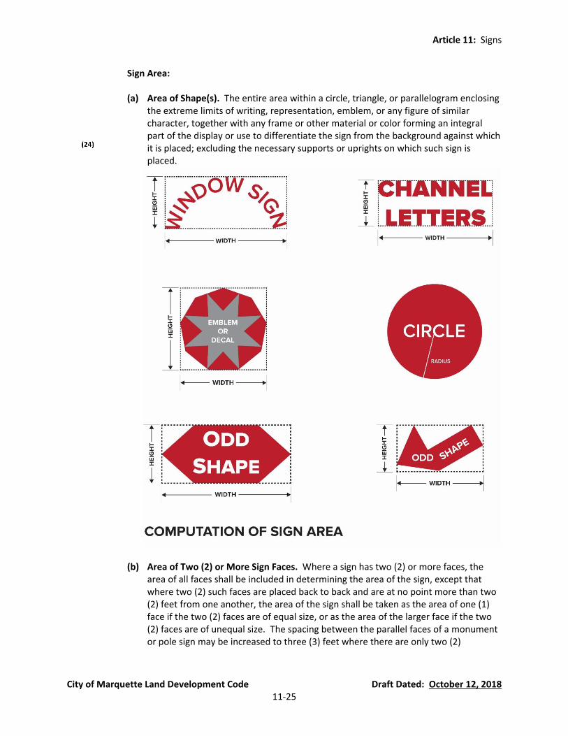
Article 11: Signs
City of Marquette Land Development Code Draft Dated: October 12, 2018 11-25
Sign Area:
(a) Area of Shape(s). The entire area within a circle, triangle, or parallelogram enclosing the extreme limits of writing, representation, emblem, or any figure of similar character, together with any frame or other material or color forming an integral part of the display or use to differentiate the sign from the background against which it is placed; excluding the necessary supports or uprights on which such sign is placed.
(b) Area of Two (2) or More Sign Faces. Where a sign has two (2) or more faces, the area of all faces shall be included in determining the area of the sign, except that where two (2) such faces are placed back to back and are at no point more than two (2) feet from one another, the area of the sign shall be taken as the area of one (1) face if the two (2) faces are of equal size, or as the area of the larger face if the two (2) faces are of unequal size. The spacing between the parallel faces of a monument or pole sign may be increased to three (3) feet where there are only two (2)

Article 11: Signs
City of Marquette Land Development Code Draft Dated: October 12, 2018 11-26
supports. In no case shall a support have a greater cross sectional width than 36 inches.
(c) Area of Wall Sign or Window Sign with No Border, Panel, or Background. Where a
sign consists solely of lettering, graphics, images, or other sign elements printed or mounted on a wall or window of a building without any distinguishing border, panel or background, any blank rectangular area which is more than ten percent (10%) of the area of the sign as otherwise computed shall be disregarded. All of the lettering, graphics, images, and other sign elements printed or mounted upon a wall or window of a building without any distinguishing border, panel, or background and pertaining to the same enterprise shall be treated as a single sign for purposes of area computation.
Sign Erector or Sign Installer. Any person engaged in the business of erecting, altering or removing signs on a contractual or hourly basis.
Sign Height:
(a) Sign Height, Maximum Height: The maximum height of the sign shall be measured
from the grade to the top of the sign. The minimum height, if applicable, shall be measured from the sign grade to the bottom of the sign.
(b) Sign Height, Minimum Height: The minimum height of a sign (also known as vertical
clearance), if required, shall be measured from the sign grade to the lowest point of the sign, including any framework or other embellishments.
Section 54.1104 Substitution Clause (new Section) Any lawful sign that can be displayed under the provisions of this Article may contain a noncommercial message.
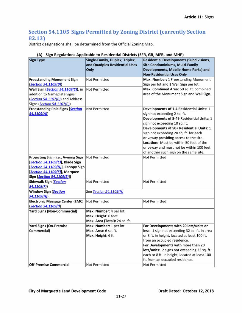
Article 11: Signs
City of Marquette Land Development Code Draft Dated: October 12, 2018 11-27
Section 54.1105 Signs Permitted by Zoning District (currently Section 82.13) District designations shall be determined from the Official Zoning Map.
(A) Sign Regulations Applicable to Residential Districts (SFR, GR, MFR, and MHP) Sign Type Single-Family, Duplex, Triplex,
and Quadplex Residential Uses Only
Residential Developments (Subdivisions, Site Condominiums, Multi-Family Developments, Mobile Home Parks) and Non-Residential Uses Only
Freestanding Monument Sign (Section 54.1109(B))
Not Permitted Max. Number: 1 Freestanding Monument Sign per lot and 1 Wall Sign per lot. Max. Combined Area: 50 sq. ft. combined area of the Monument Sign and Wall Sign.
Wall Sign (Section 54.1109(C)), in addition to Nameplate Signs (Section 54.1107(B)) and Address Signs (Section 54.1107(C))
Not Permitted
Freestanding Pole Signs (Section 54.1109(A))
Not Permitted Developments of 1-4 Residential Units: 1 sign not exceeding 2 sq. ft. Developments of 5-49 Residential Units: 1 sign not exceeding 10 sq. ft. Developments of 50+ Residential Units: 1 sign not exceeding 20 sq. ft. for each driveway providing access to the site. Location: Must be within 50 feet of the driveway and must not be within 100 feet of another such sign on the same site.
Projecting Sign (i.e., Awning Sign [Section 54.1109(E)], Blade Sign [Section 54.1109(D)], Canopy Sign [Section 54.1109(E)], Marquee Sign [Section 54.1109(E)])
Not Permitted Not Permitted
Sidewalk Sign (Section 54.1109(F))
Not Permitted Not Permitted
Window Sign (Section 54.1109(H))
See Section 54.1109(H)
Electronic Message Center (EMC) (Section 54.1109(I))
Not Permitted Not Permitted
Yard Signs (Non-Commercial) Max. Number: 4 per lot Max. Height: 6 feet Max. Area (Total): 24 sq. ft.
Yard Signs (On-Premise Commercial)
Max. Number: 1 per lot Max. Area: 6 sq. ft. Max. Height: 6 ft.
For Developments with 20 lots/units or less: 1 sign not exceeding 32 sq. ft. in area or 8 ft. in height, located at least 100 ft. from an occupied residence. For Developments with more than 20 lots/units: 2 signs not exceeding 32 sq. ft. each or 8 ft. in height, located at least 100 ft. from an occupied residence.
Off-Premise Commercial Not Permitted Not Permitted

Article 11: Signs
City of Marquette Land Development Code Draft Dated: October 12, 2018 11-28
(B) Sign Regulations Applicable to the Mixed-Use District (M-U) Sign Type Single-Family, Duplex,
Triplex, and Quadplex Residential Uses Only
Multi-Family Residential Developments and Non-Residential Uses
Freestanding Monument Sign (Section 54.1109(B))
Not Permitted. Maximum Number: 1 per lot. Maximum Area: 50 sq. ft.
Freestanding Pole Signs (Section 54.1109(A))
Not Permitted. Not Permitted.
Wall Sign (Section 54.1109(C)), in addition to Nameplate Signs (Section 54.1107(B)) and Address Signs (Section 54.1107(C))
Not Permitted. Signage Allocation Per Tenant Based on a Tenant’s Number of Building Frontages From
Which the Tenant Has a Building Entrance (Upper floor tenants and tenants with no
building frontages shall be entitled to signage based on 1 building frontage)
Width of Building Based on Building Address
1 building frontage
2 building frontages
3 building frontages
4 building frontages
<50’ 24 sq. ft. 32 sq. ft. 40 sq. ft. 48 sq. ft.
50’-99’ 32 sq. ft. 48 sq. ft. 64 sq. ft. 80 sq. ft.
100’-149’ 48 sq. ft. 72 sq. ft. 96 sq. ft. 120 sq. ft.
150’-199’ 72 sq. ft. 108 sq. ft. 144 sq. ft. 180 sq. ft.
200’-249’ 108 sq. ft. 156 sq. ft. 180 sq. ft. 216 sq. ft.
≤250’ 156 sq. ft. 204 sq. ft. 252 sq. ft. 300 sq. ft.
Projecting Sign (i.e., Awning Sign [Section 54.1109(E)], Blade Sign [Section 54.1109(D)], Canopy Sign [Section 54.1109(E)], Marquee Sign [Section 54.1109(E)])
Not Permitted. Maximum Number: 1 per lot or building tenant. Maximum Area: 24 sq. ft. total. However, permitted Wall Sign area may be allocated on a marquee to allow the Marquee Sign area to exceed 24 sq. ft.
Sidewalk Sign (Section 54.1109(F))
See Section 54.1109(F) See Section 54.1109(F)
Window Sign (Section 54.1109(H))
See Section 54.1109(H)
Electronic Message Center (EMC) (Section 54.1109(I))
Not Permitted. Not Permitted.
Yard Signs (Non-Commercial) Max. Number: 4 per lot Max. Height: 6 feet Max. Area (Total): 24 sq. ft.
Yard Signs (On-Premise Commercial)
Max. Number: 1 per lot Max. Area: 6 sq. ft. Max. Height: 6 ft.
Max. Number: 1 per lot Max. Area: 32 sq. ft. Max. Height: 6 ft.
Off-Premise Commercial Not Permitted Not Permitted

Article 11: Signs
City of Marquette Land Development Code Draft Dated: October 12, 2018 11-29
(C) Sign Regulations Applicable to the Central Business District (CBD)
Sign Type CBD Districts Freestanding Monument Sign (Section 54.1109(B))
Maximum Number: 1 per lot. Maximum Area: 75 sq. ft.
A parcel with an approved drive-through lane may have 1 additional monument sign per approved drive-through lane located within 6 feet of the drive-through lane, not greater than 8 feet high, not greater than 60 sq. ft., and not legible from the right-of-way or any lot line. The City may require screening pursuant to Article 10.
Freestanding Pole Signs (Section 54.1109(A))
Not Permitted.
Wall Sign (Section 54.1109(C)), in addition to Nameplate Signs (Section 54.1107(B)) and Address Signs (Section 54.1107(C))
Signage Allocation Per Tenant Based on a Tenant’s Number of Building Frontages From Which the
Tenant Has a Building Entrance (Upper floor tenants and tenants with no building frontages shall be
entitled to signage based on 1 building frontage)
Width of Building Based on Building Address
1 building frontage
2 building frontages
3 building frontages
4 building frontages
<50’ 24 sq. ft. 32 sq. ft. 40 sq. ft. 48 sq. ft.
50’-99’ 32 sq. ft. 48 sq. ft. 64 sq. ft. 80 sq. ft.
100’-149’ 48 sq. ft. 72 sq. ft. 96 sq. ft. 120 sq. ft.
150’-199’ 72 sq. ft. 108 sq. ft. 144 sq. ft. 180 sq. ft.
200’-249’ 108 sq. ft. 156 sq. ft. 180 sq. ft. 216 sq. ft.
≤250’ 156 sq. ft. 204 sq. ft. 252 sq. ft. 300 sq. ft.
Projecting Sign (i.e., Awning Sign [Section 54.1109(E)], Blade Sign [Section 54.1109(D)], Canopy Sign [Section 54.1109(E)], Marquee Sign [Section 54.1109(E)])
Maximum Number: 1 per lot or building tenant. Maximum Area: 24 sq. ft. total. However, permitted Wall Sign area may be allocated on a marquee to allow the Marquee Sign area to exceed 24 sq. ft.
Sidewalk Sign (Section 54.1109(F)) See Section 54.1109(F)
Window Sign (Section 54.1109(H)) See Section 54.1109(H)
Electronic Message Center (EMC) (Section 54.1109(I))
Not permitted.
Permanent Rotating Wall Sign Maximum Number: 1 per building or tenant. Maximum Height: 8 feet. Maximum Dimensions of Rotating Area: 6 in. wide or deep, and 2 ft. high. Maximum Rotating Speed: 30 rotations per minute.
Yard Signs (Non-Commercial) Max. Number: 4 per lot Max. Height: 6 feet Max. Area (Total): 24 sq. ft.
Yard Signs (On-Premise Commercial) Max. Number: 1 per lot Max. Area: 32 sq. ft. Max. Height: 6 ft.
Off-Premise Commercial Not Permitted.
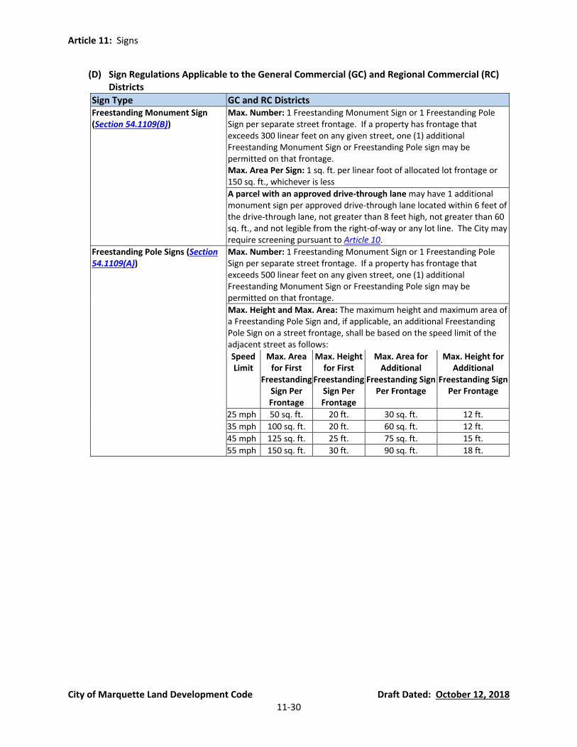
Article 11: Signs
City of Marquette Land Development Code Draft Dated: October 12, 2018 11-30
(D) Sign Regulations Applicable to the General Commercial (GC) and Regional Commercial (RC) Districts
Sign Type GC and RC Districts Freestanding Monument Sign (Section 54.1109(B))
Max. Number: 1 Freestanding Monument Sign or 1 Freestanding Pole Sign per separate street frontage. If a property has frontage that exceeds 300 linear feet on any given street, one (1) additional Freestanding Monument Sign or Freestanding Pole sign may be permitted on that frontage. Max. Area Per Sign: 1 sq. ft. per linear foot of allocated lot frontage or 150 sq. ft., whichever is less
A parcel with an approved drive-through lane may have 1 additional monument sign per approved drive-through lane located within 6 feet of the drive-through lane, not greater than 8 feet high, not greater than 60 sq. ft., and not legible from the right-of-way or any lot line. The City may require screening pursuant to Article 10.
Freestanding Pole Signs (Section 54.1109(A))
Max. Number: 1 Freestanding Monument Sign or 1 Freestanding Pole Sign per separate street frontage. If a property has frontage that exceeds 500 linear feet on any given street, one (1) additional Freestanding Monument Sign or Freestanding Pole sign may be permitted on that frontage.
Max. Height and Max. Area: The maximum height and maximum area of a Freestanding Pole Sign and, if applicable, an additional Freestanding Pole Sign on a street frontage, shall be based on the speed limit of the adjacent street as follows:
Speed Limit
Max. Area for First
Freestanding Sign Per Frontage
Max. Height for First
Freestanding Sign Per Frontage
Max. Area for Additional
Freestanding Sign Per Frontage
Max. Height for Additional
Freestanding Sign Per Frontage
25 mph 50 sq. ft. 20 ft. 30 sq. ft. 12 ft.
35 mph 100 sq. ft. 20 ft. 60 sq. ft. 12 ft.
45 mph 125 sq. ft. 25 ft. 75 sq. ft. 15 ft.
55 mph 150 sq. ft. 30 ft. 90 sq. ft. 18 ft.
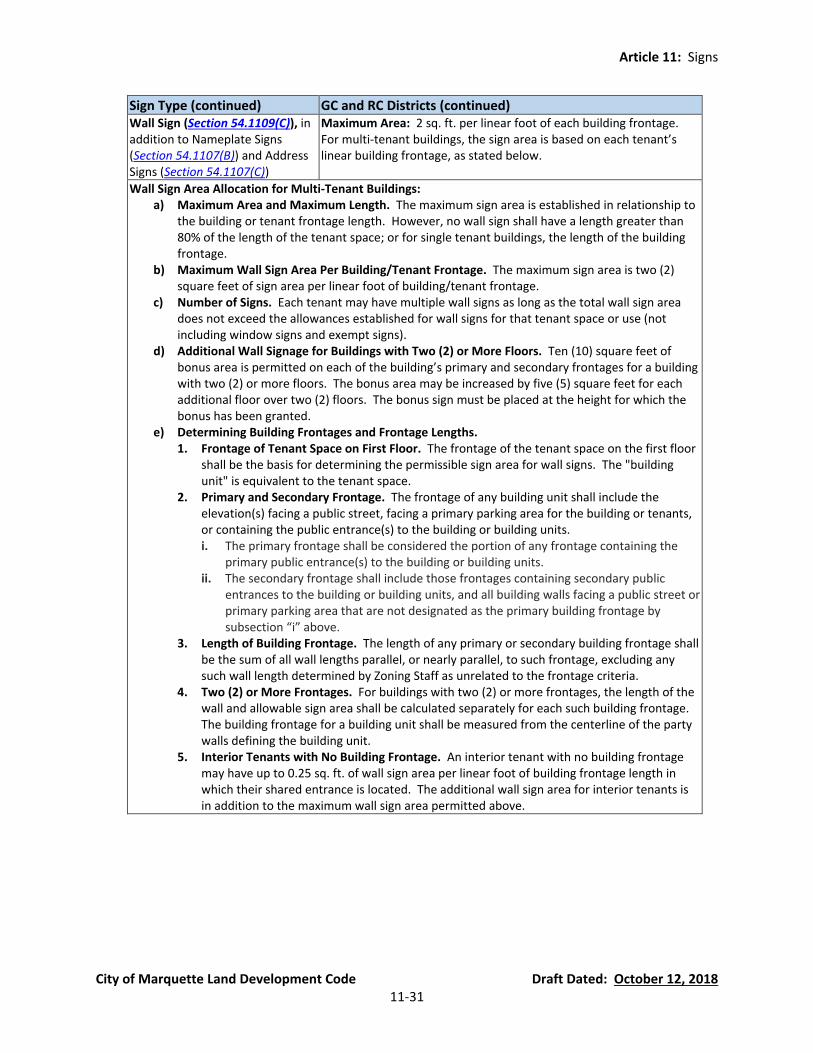
Article 11: Signs
City of Marquette Land Development Code Draft Dated: October 12, 2018 11-31
Sign Type (continued) GC and RC Districts (continued)
Wall Sign (Section 54.1109(C)), in addition to Nameplate Signs (Section 54.1107(B)) and Address Signs (Section 54.1107(C))
Maximum Area: 2 sq. ft. per linear foot of each building frontage. For multi-tenant buildings, the sign area is based on each tenant’s linear building frontage, as stated below.
Wall Sign Area Allocation for Multi-Tenant Buildings: a) Maximum Area and Maximum Length. The maximum sign area is established in relationship to
the building or tenant frontage length. However, no wall sign shall have a length greater than 80% of the length of the tenant space; or for single tenant buildings, the length of the building frontage.
b) Maximum Wall Sign Area Per Building/Tenant Frontage. The maximum sign area is two (2) square feet of sign area per linear foot of building/tenant frontage.
c) Number of Signs. Each tenant may have multiple wall signs as long as the total wall sign area does not exceed the allowances established for wall signs for that tenant space or use (not including window signs and exempt signs).
d) Additional Wall Signage for Buildings with Two (2) or More Floors. Ten (10) square feet of bonus area is permitted on each of the building’s primary and secondary frontages for a building with two (2) or more floors. The bonus area may be increased by five (5) square feet for each additional floor over two (2) floors. The bonus sign must be placed at the height for which the bonus has been granted.
e) Determining Building Frontages and Frontage Lengths. 1. Frontage of Tenant Space on First Floor. The frontage of the tenant space on the first floor
shall be the basis for determining the permissible sign area for wall signs. The "building unit" is equivalent to the tenant space.
2. Primary and Secondary Frontage. The frontage of any building unit shall include the elevation(s) facing a public street, facing a primary parking area for the building or tenants, or containing the public entrance(s) to the building or building units. i. The primary frontage shall be considered the portion of any frontage containing the
primary public entrance(s) to the building or building units. ii. The secondary frontage shall include those frontages containing secondary public
entrances to the building or building units, and all building walls facing a public street or primary parking area that are not designated as the primary building frontage by subsection “i” above.
3. Length of Building Frontage. The length of any primary or secondary building frontage shall be the sum of all wall lengths parallel, or nearly parallel, to such frontage, excluding any such wall length determined by Zoning Staff as unrelated to the frontage criteria.
4. Two (2) or More Frontages. For buildings with two (2) or more frontages, the length of the wall and allowable sign area shall be calculated separately for each such building frontage. The building frontage for a building unit shall be measured from the centerline of the party walls defining the building unit.
5. Interior Tenants with No Building Frontage. An interior tenant with no building frontage may have up to 0.25 sq. ft. of wall sign area per linear foot of building frontage length in which their shared entrance is located. The additional wall sign area for interior tenants is in addition to the maximum wall sign area permitted above.
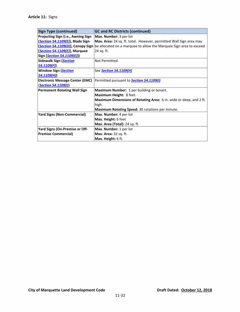
Article 11: Signs
City of Marquette Land Development Code Draft Dated: October 12, 2018 11-32
Sign Type (continued) GC and RC Districts (continued)
Projecting Sign (i.e., Awning Sign [Section 54.1109(E)], Blade Sign [Section 54.1109(D)], Canopy Sign [Section 54.1109(E)], Marquee Sign [Section 54.1109(E)])
Max. Number: 3 per lot Max. Area: 24 sq. ft. total. However, permitted Wall Sign area may be allocated on a marquee to allow the Marquee Sign area to exceed 24 sq. ft.
Sidewalk Sign (Section 54.1109(F))
Not Permitted.
Window Sign (Section 54.1109(H))
See Section 54.1109(H)
Electronic Message Center (EMC) (Section 54.1109(I))
Permitted pursuant to Section 54.1109(I)
Permanent Rotating Wall Sign Maximum Number: 1 per building or tenant. Maximum Height: 8 feet. Maximum Dimensions of Rotating Area: 6 in. wide or deep, and 2 ft. high. Maximum Rotating Speed: 30 rotations per minute.
Yard Signs (Non-Commercial) Max. Number: 4 per lot Max. Height: 6 feet Max. Area (Total): 24 sq. ft.
Yard Signs (On-Premise or Off-Premise Commercial)
Max. Number: 1 per lot Max. Area: 32 sq. ft. Max. Height: 6 ft.

Article 11: Signs
City of Marquette Land Development Code Draft Dated: October 12, 2018 11-33
(E) Sign Regulations Applicable to the Industrial/Manufacturing (IM) and Board of Light and Power (BLP) Districts
Sign Type IM and BLP Districts Freestanding Monument Sign (Section 54.1109(B))
Max. Number: 1 Freestanding Monument Sign or 1 Freestanding Pole Sign per 300 ft. site frontage Max. Area: 1 sq. ft. per linear foot of allocated lot frontage or 150 sq. ft. , whichever is less
Freestanding Pole Signs (Section 54.1109(A))
Max. Number: 1 Freestanding Monument Sign or 1 Freestanding Pole Sign per 300 ft. site frontage Max. Height: 30 feet Max. Area: 1 sq. ft. per linear foot of allocated lot frontage or 150 sq. ft. , whichever is less
Wall Sign (Section 54.1109(C)), in addition to Nameplate Signs (Section 54.1107(B)) and Address Signs (Section 54.1107(C))
Maximum Area: 1 sq. ft. per linear foot of each building frontage. For multi-tenant buildings, the sign area is based on each tenant’s linear building frontage.
Wall Sign Area Allocation for Multi-Tenant Buildings: a) Maximum Area and Maximum Length. The maximum sign area is established in relationship to
the building or tenant frontage length. However, no wall sign shall have a length greater than 80% of the length of the tenant space; or for single tenant buildings, the length of the building frontage.
b) Maximum Wall Sign Area Per Building/Tenant Frontage. The maximum sign area is two (2) square feet of sign area per linear foot of building/tenant frontage.
c) Number of Signs. Each tenant may have multiple wall signs as long as the total wall sign area does not exceed the allowances established for wall signs for that tenant space or use (not including window signs and exempt signs).
d) Additional Wall Signage for Buildings with Two (2) or More Floors. Ten (10) square feet of bonus area is permitted on each of the building’s primary and secondary frontages for a building with two (2) or more floors. The bonus area may be increased by five (5) square feet for each additional floor over two (2) floors. The bonus sign must be placed at the height for which the bonus has been granted.
e) Determining Building Frontages and Frontage Lengths. 1. Frontage of Tenant Space on First Floor. The frontage of the tenant space on the first floor
shall be the basis for determining the permissible sign area for wall signs. The "building unit" is equivalent to the tenant space.
2. Primary and Secondary Frontage. The frontage of any building unit shall include the elevation(s) facing a public street, facing a primary parking area for the building or tenants, or containing the public entrance(s) to the building or building units. i. The primary frontage shall be considered the portion of any frontage containing the
primary public entrance(s) to the building or building units. ii. The secondary frontage shall include those frontages containing secondary public
entrances to the building or building units, and all building walls facing a public street or primary parking area that are not designated as the primary building frontage by subsection “i” above.
3. Length of Building Frontage. The length of any primary or secondary building frontage shall be the sum of all wall lengths parallel, or nearly parallel, to such frontage, excluding any such wall length determined by Zoning Staff as unrelated to the frontage criteria.
4. Two (2) or More Frontages. For buildings with two (2) or more frontages, the length of the wall and allowable sign area shall be calculated separately for each such building frontage. The building frontage for a building unit shall be measured from the centerline of the party walls defining the building unit.
5. Interior Tenants with No Building Frontage. An interior tenant with no building frontage may have up to 0.25 sq. ft. of wall sign area per linear foot of building frontage length in which their shared entrance is located. The additional wall sign area for interior tenants is in addition to the maximum wall sign area permitted above.
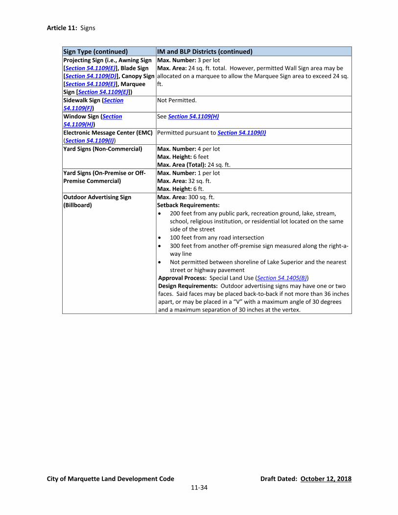
Article 11: Signs
City of Marquette Land Development Code Draft Dated: October 12, 2018 11-34
Sign Type (continued) IM and BLP Districts (continued) Projecting Sign (i.e., Awning Sign [Section 54.1109(E)], Blade Sign [Section 54.1109(D)], Canopy Sign [Section 54.1109(E)], Marquee Sign [Section 54.1109(E)])
Max. Number: 3 per lot Max. Area: 24 sq. ft. total. However, permitted Wall Sign area may be allocated on a marquee to allow the Marquee Sign area to exceed 24 sq. ft.
Sidewalk Sign (Section 54.1109(F))
Not Permitted.
Window Sign (Section 54.1109(H))
See Section 54.1109(H)
Electronic Message Center (EMC) (Section 54.1109(I))
Permitted pursuant to Section 54.1109(I)
Yard Signs (Non-Commercial) Max. Number: 4 per lot Max. Height: 6 feet Max. Area (Total): 24 sq. ft.
Yard Signs (On-Premise or Off-Premise Commercial)
Max. Number: 1 per lot Max. Area: 32 sq. ft. Max. Height: 6 ft.
Outdoor Advertising Sign (Billboard)
Max. Area: 300 sq. ft. Setback Requirements:
• 200 feet from any public park, recreation ground, lake, stream, school, religious institution, or residential lot located on the same side of the street
• 100 feet from any road intersection
• 300 feet from another off-premise sign measured along the right-a-way line
• Not permitted between shoreline of Lake Superior and the nearest street or highway pavement
Approval Process: Special Land Use (Section 54.1405(B)) Design Requirements: Outdoor advertising signs may have one or two faces. Said faces may be placed back-to-back if not more than 36 inches apart, or may be placed in a “V” with a maximum angle of 30 degrees and a maximum separation of 30 inches at the vertex.

Article 11: Signs
City of Marquette Land Development Code Draft Dated: October 12, 2018 11-35
(F) Sign Regulations Applicable to the Municipal (M) District and Civic (C) District
Sign Type M and C Districts Freestanding Monument Sign (Section 54.1109(B))
Max. Number: 1 Freestanding Monument Sign or 1 Freestanding Pole Sign per 300 ft. site frontage Max. Area: 1 sq. ft. per linear foot of allocated lot frontage or 150 sq. ft., whichever is less
Freestanding Pole Signs (Section 54.1109(A))
Max. Number: 1 Freestanding Monument Sign or 1 Freestanding Pole Sign per 300 ft. site frontage Max. Height: 30 feet Max. Area: 1 sq. ft. per linear foot of allocated lot frontage or 150 sq. ft., whichever is less
Wall Sign (Section 54.1109(C)), in addition to Nameplate Signs (Section 54.1107(B)) and Address Signs (Section 54.1107(C))
Maximum Area: 1 sq. ft. per linear foot of each building frontage. For multi-tenant buildings, the sign area is based on each tenant’s linear building frontage.
Projecting Sign (i.e., Awning Sign [Section 54.1109(E)], Blade Sign [Section 54.1109(D)], Canopy Sign [Section 54.1109(E)], Marquee Sign [Section 54.1109(E)])
Max. Number: 3 per lot Max. Area: 24 sq. ft. total. However, permitted Wall Sign area may be allocated on a marquee to allow the Marquee Sign area to exceed 24 sq. ft.
Sidewalk Sign (Section 54.1109(F))
See Section 54.1109(F)
Window Sign (Section 54.1109(H))
See Section 54.1109(H)
Electronic Message Center (EMC) (Section 54.1109(I))
Not Permitted.
Yard Signs Max. Number: 4 per lot Max. Height: 6 feet Max. Area (Total): 24 sq. ft.

Article 11: Signs
City of Marquette Land Development Code Draft Dated: October 12, 2018 11-36
(G) Sign Regulations Applicable to the Conservation and Recreation (CR) District Sign Type Residential
Uses Commercial Uses Non-Residential and Non-
Commercial Uses
Freestanding Monument Sign (Section 54.1109(B))
See Section 54.1105(A)
Max. Number: 1 Freestanding Monument Sign, 1 Freestanding Pole Sign, or 1 Projecting Sign per lot. Max. Area: 150 sq. ft.
Max. Number: 1 Freestanding Monument Sign, 1 Freestanding Pole Sign, or 1 Projecting Sign per lot. Max. Area: 20 sq. ft.
Freestanding Pole Signs (Section 54.1109(A))
Max. Number: 1 Freestanding Monument Sign, 1 Freestanding Pole Sign, or 1 Projecting Sign per lot. Max. Height: 30 feet Max. Area: 150 sq. ft.
Max. Number: 1 Freestanding Monument Sign, 1 Freestanding Pole Sign, or 1 Projecting Sign per lot. Max. Height: 30 feet Max. Area: 20 sq. ft.
Wall Sign (Section 54.1109(C)), in addition to Nameplate Signs (Section 54.1107(B)) and Address Signs (Section 54.1107(C))
Maximum Area: 1 sq. ft. per linear foot of each building frontage. For multi-tenant buildings, the sign area is based on each tenant’s linear building frontage.
Maximum Area: 20 sq. ft.
Projecting Sign (i.e., Awning Sign [Section 54.1109(E)], Blade Sign [Section 54.1109(D)], Canopy Sign [Section 54.1109(E)], Marquee Sign [Section 54.1109(E)])
Max. Number: 1 Freestanding Monument Sign, 1 Freestanding Pole Sign, or 1 Projecting Sign per lot. Max. Area: 20 sq. ft. total. However, permitted Wall Sign area may be allocated on a marquee to allow the Marquee Sign area to exceed 24 sq. ft.
Max. Number: 1 Freestanding Monument Sign, 1 Freestanding Pole Sign, or 1 Projecting Sign per lot. Max. Area: 20 sq. ft. total. However, permitted Wall Sign area may be allocated on a marquee to allow the Marquee Sign area to exceed 24 sq. ft.
Portable Sign (Section 54.1107(M))
See Section 54.1107(M)
Window Sign (Section 54.1109(H))
See Section 54.1109(H)
Electronic Message Center (EMC) (Section 54.1109(I))
Not Permitted.
Yard Signs (Non-Commercial or On-Premise Commercial)
Max. Number: 4 per lot Max. Height: 6 feet Max. Area (Total): 24 sq. ft.
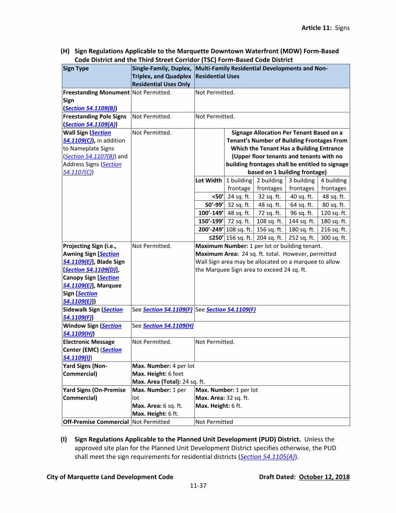
Article 11: Signs
City of Marquette Land Development Code Draft Dated: October 12, 2018 11-37
(H) Sign Regulations Applicable to the Marquette Downtown Waterfront (MDW) Form-Based Code District and the Third Street Corridor (TSC) Form-Based Code District
Sign Type Single-Family, Duplex, Triplex, and Quadplex Residential Uses Only
Multi-Family Residential Developments and Non-Residential Uses
Freestanding Monument Sign (Section 54.1109(B))
Not Permitted. Not Permitted.
Freestanding Pole Signs (Section 54.1109(A))
Not Permitted. Not Permitted.
Wall Sign (Section 54.1109(C)), in addition to Nameplate Signs (Section 54.1107(B)) and Address Signs (Section 54.1107(C))
Not Permitted. Signage Allocation Per Tenant Based on a Tenant’s Number of Building Frontages From
Which the Tenant Has a Building Entrance (Upper floor tenants and tenants with no
building frontages shall be entitled to signage based on 1 building frontage)
Lot Width 1 building frontage
2 building frontages
3 building frontages
4 building frontages
<50’ 24 sq. ft. 32 sq. ft. 40 sq. ft. 48 sq. ft.
50’-99’ 32 sq. ft. 48 sq. ft. 64 sq. ft. 80 sq. ft.
100’-149’ 48 sq. ft. 72 sq. ft. 96 sq. ft. 120 sq. ft.
150’-199’ 72 sq. ft. 108 sq. ft. 144 sq. ft. 180 sq. ft.
200’-249’ 108 sq. ft. 156 sq. ft. 180 sq. ft. 216 sq. ft.
≤250’ 156 sq. ft. 204 sq. ft. 252 sq. ft. 300 sq. ft.
Projecting Sign (i.e., Awning Sign [Section 54.1109(E)], Blade Sign [Section 54.1109(D)], Canopy Sign [Section 54.1109(E)], Marquee Sign [Section 54.1109(E)])
Not Permitted. Maximum Number: 1 per lot or building tenant. Maximum Area: 24 sq. ft. total. However, permitted Wall Sign area may be allocated on a marquee to allow the Marquee Sign area to exceed 24 sq. ft.
Sidewalk Sign (Section 54.1109(F))
See Section 54.1109(F) See Section 54.1109(F)
Window Sign (Section 54.1109(H))
See Section 54.1109(H)
Electronic Message Center (EMC) (Section 54.1109(I))
Not Permitted. Not Permitted.
Yard Signs (Non-Commercial)
Max. Number: 4 per lot Max. Height: 6 feet Max. Area (Total): 24 sq. ft.
Yard Signs (On-Premise Commercial)
Max. Number: 1 per lot Max. Area: 6 sq. ft. Max. Height: 6 ft.
Max. Number: 1 per lot Max. Area: 32 sq. ft. Max. Height: 6 ft.
Off-Premise Commercial Not Permitted Not Permitted
(I) Sign Regulations Applicable to the Planned Unit Development (PUD) District. Unless the
approved site plan for the Planned Unit Development District specifies otherwise, the PUD shall meet the sign requirements for residential districts (Section 54.1105(A)).
Article 11: Signs
City of Marquette Land Development Code Draft Dated: October 12, 2018 11-38
(J) Sign Regulations Applicable to Other Districts. Signs in any of the overlay districts shall be
governed by the specific zoning regulations for that district or the underlying zoning district.
Section 54.1106 Permits and Applications (currently Section 82.9)
(A) Certificate of Zoning Compliance Required. It shall be unlawful for any person to erect, relocate, or structurally alter or repair, any sign or other advertising structure within the City of Marquette, as defined by this ordinance without first obtaining a Certificate of Zoning Compliance. All signs shall be subject to the Building Code and this Ordinance, and all illuminated signs shall be subject to the provisions of the State Electrical Code (See Section 54.1112, for maintenance exceptions which do not require a Certification of Compliance).
(B) Zoning Approval Prior to Building or Electrical Permit. A Certificate of Zoning Compliance
shall be obtained from the Sign Official prior to the issuance of a building permit or electrical permit.
(C) Application for Certificate of Zoning Compliance. Application for a Certificate of Zoning
Compliance shall be made upon forms provided by the Sign Official and shall contain or have attached the following information:
Name, address, telephone number, and signature of the applicant (sign erector).
Name, address, telephone number and signature of the owner of the land on which the
sign is to be erected.
A scale drawing showing the position of the sign in relation to nearby buildings, signs, structures, and lot lines. All dimensions are to be included.
A copy of the plans, specifications and method of construction and attachment to the
building or in the ground.
Insurance policy and/or performance guarantee as required herein.
Such additional information as required by the Sign Official to show full compliance with this and all other laws and ordinances of the City and the State of Michigan.
Zoning district in which the sign is to be located.
Any other information deemed necessary by the Sign Official to ensure compliance with
this Ordinance.
(D) Application Review and Action. The Sign Official shall review all completed applications for a Certificate of Zoning Compliance as expeditiously as possible. Reasons for any denial shall be set forth in writing and shall include any recommended changes which would make the plan acceptable. The applicant may appeal any denial to the Board of Zoning Appeals in accordance with Section 54.1404. No more than ten (10) business days shall be required to review an
Article 11: Signs
City of Marquette Land Development Code Draft Dated: October 12, 2018 11-39
application unless, in the opinion of the Sign Official, more time is necessary to determine compliance with this Ordinance.
Section 54.1107 Exempt Signs Permitted in All Zoning Districts (currently Section 82.10) Certificates of Zoning Compliance shall not be required for the following signs provided that said signs meet all other requirements of this Ordinance, including but not limited to those in Section 54.1109. Approval of the property owner is required prior to the erection of a sign. It is the responsibility of the party erecting the sign to determine if a building permit is required.
(A) Temporary signage in accordance with Section 54.1109 and Section 54.1105, unless otherwise stated in this Ordinance.
(B) One nameplate sign per building address, subject to the requirements of Section 54.1109(J).
Such signs are necessary for site identification by emergency vehicles and benefit the health, safety, and welfare of the general public by allowing for identification of residents, visitors, and delivery vehicles.
(C) Address numbers, being essential for public safety and emergency response, with a numeral
height no greater than six (6) inches for each dwelling unit and 18 inches for any other use, including multiple-family buildings.
(D) Special decorative displays used for holidays, public demonstrations or promotion of civic
welfare or charitable purposes, on which there is no commercial advertising, providing the jurisdiction is held harmless for any damage resulting therefrom.
Special decorative displays may include temporary signs, banners, or balloons.
Length of use shall not extend more than 90 days in a calendar year.
(E) Any sign or notice required by state, federal or local laws.
(F) Incidental signs, subject to approval by the Sign Official.
(G) Interior signs.
(H) Any lawful sign in a public or private right-of-way installed by an authorized public agency,
including but not limited to street signs, directional signs, and address signs.
(I) Private traffic control signs that conform to the requirements of the Michigan Manual of Uniform Traffic Control Devices.
(J) On-premise directional signs on public property by a public agency with jurisdiction over the
property, the purpose of which is to promote safety for vehicles and pedestrians. For all other properties, the maximum sizes of permitted on-premise directional signs, which are constructed for the purpose of promoting safety for vehicles and pedestrians, are based on the following table:
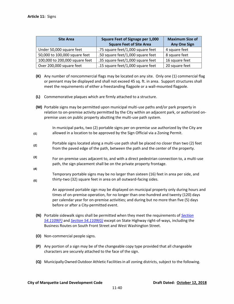
Article 11: Signs
City of Marquette Land Development Code Draft Dated: October 12, 2018 11-40
Site Area Square Feet of Signage per 1,000 Square Feet of Site Area
Maximum Size of Any One Sign
Under 50,000 square feet .75 square feet/1,000 square feet 4 square feet
50,000 to 100,000 square feet .50 square feet/1,000 square feet 8 square feet
100,000 to 200,000 square feet .35 square feet/1,000 square feet 16 square feet
Over 200,000 square feet .15 square feet/1,000 square feet 20 square feet
(K) Any number of noncommercial flags may be located on any site. Only one (1) commercial flag
or pennant may be displayed and shall not exceed 45 sq. ft. in area. Support structures shall meet the requirements of either a freestanding flagpole or a wall-mounted flagpole.
(L) Commemorative plaques which are firmly attached to a structure.
(M) Portable signs may be permitted upon municipal multi-use paths and/or park property in
relation to on-premise activity permitted by the City within an adjacent park, or authorized on-premise uses on public property abutting the multi-use path system.
In municipal parks, two (2) portable signs per on-premise use authorized by the City are
allowed in a location to be approved by the Sign Official via a Zoning Permit.
Portable signs located along a multi-use path shall be placed no closer than two (2) feet from the paved edge of the path, between the path and the center of the property.
For on-premise uses adjacent to, and with a direct pedestrian connection to, a multi-use
path, the sign placement shall be on the private property frontage.
Temporary portable signs may be no larger than sixteen (16) feet in area per side, and thirty-two (32) square feet in area on all outward-facing sides.
An approved portable sign may be displayed on municipal property only during hours and
times of on-premise operation, for no longer than one-hundred and twenty (120) days per calendar year for on-premise activities; and during but no more than five (5) days before or after a City-permitted event.
(N) Portable sidewalk signs shall be permitted when they meet the requirements of Section
54.1109(F) and Section 54.1109(G) except on State Highway right-of-ways, including the Business Routes on South Front Street and West Washington Street.
(O) Non-commercial people signs.
(P) Any portion of a sign may be of the changeable copy type provided that all changeable
characters are securely attached to the face of the sign.
(Q) Municipally Owned Outdoor Athletic Facilities in all zoning districts, subject to the following.
Article 11: Signs
City of Marquette Land Development Code Draft Dated: October 12, 2018 11-41
An amateur athletic organization may erect advertising signs on the field where its games are played. Said signs are subject to the following conditions:
(a) Height and Area.
(i) Monument signs may not exceed eight (8) feet in height or thirty-six (36) square
feet per sign.
(ii) Wall signs may not exceed eight (8) feet in height or thirty-six (36) square feet per sign.
(iii) Pole signs are not permitted.
(iv) Illuminated signs are not permitted.
(b) The number of signs may not exceed twenty (20) per field.
(c) Only the side of the sign facing the playing field may contain advertising. The other
side must be painted a neutral color.
(d) Signs may be present only during the season of play of the organization erecting the sign.
Additional Exemptions:
(a) Lighted scoreboards which may be illuminated only during time of organized play.
Said scoreboards may not exceed 200 square feet in size and may be no taller than 20 feet in height.
(b) The BMX track located in the River Park Sports Complex may have 24 signs which
meet the above requirements.
(R) Murals. See definition in Section 54.1103(B)(24).
(S) Window signs, provided the window sign is permitted in the zoning district by Section 54.1105 and complies with the requirements of Section 54.1109(H).
Section 54.1108 Prohibited Signs (currently Section 82.11) The following signs are prohibited in all zoning districts, notwithstanding anything to the contrary in this Article.
(A) Any sign not expressly permitted by this Article.
(B) Signs or handbills placed on any property without the approval of the property owner.
(C) Support Pole Signs, and signs or handbills posted on any tree or utility pole.
(D) Abandoned Signs.
Article 11: Signs
City of Marquette Land Development Code Draft Dated: October 12, 2018 11-42
(E) Projector-Image Signs.
(F) Any sign located on or near any street, street corner, driveway, parking lot, or other access
point which would obscure the vision of drivers or conflict with traffic control signs or signals in any location (See required Clear Vision Triangle Area Section 54.704. Additionally, no sign shall obstruct the vision of drivers at any driveway, parking lot or other route providing access to any land use.
(G) Any sign mimicking a traffic sign in terms of its design, by use of the words “Stop,” Danger,”
“Caution,” or similar words, or otherwise installed so as to confuse or mislead traffic, or any sign that mimics traffic control signals or emergency service vehicle lighting.
(H) Any sign in a right-of-way or access easement other than traffic control signs, non-commercial
directional signs, and wayfinding signs erected by a municipality or public road agency, or a projecting sign permitted in this Article.
(I) Roof Signs. A mansard roof shall be considered a wall for the purpose of applying this
regulation. (See Section 54.1109(C) also).
(J) Revolving Signs.
(K) Rotating Signs.
(L) Any swinging movements of signs, unless on under-canopy signs designed to a pedestrian scale and swinging-style sidewalk signs. The rotation of signs and any form of animation or moving device are prohibited.
(M) Portable or moveable signs are prohibited, with the exception of portable/sidewalk signs as
permitted in Section 54.1107(M) and Section 54.1109(F), and permitted temporary signs. All other signs must be permanently and securely attached to a below-ground footing.
(N) Festoons, except for decorations commemorating a holiday or approved in conjunction with
an approved temporary land use permit.
(O) Air-activated signs and balloon signs, except for decorations commemorating a holiday or approved in conjunction with an approved temporary land use permit.
(P) Bench Signs.
(Q) Vehicle signs when the subject vehicle is not parked in an approved parking space or operating
lawfully.
(R) Commercial People Signs.
(S) Animated Signs.
(T) Portable Message Signs unless operating lawfully in a public or private road right-of-way.
Article 11: Signs
City of Marquette Land Development Code Draft Dated: October 12, 2018 11-43
(U) Any sign containing off-premise commercial content, except as permitted by Section 54.1105.
Section 54.1109 General Sign Standards (currently Section 82.12)
(A) Freestanding Pole Signs:
Maximum Height. See Section 54.1105. Pole signs in any non-residential district that are within 100 feet of a residential district must be reduced in height ten percent (10%) for each ten (10) feet less than 100 feet they are located from the residential district.
Minimum Height. There shall be a minimum unobstructed distance of ten (10) feet
between the bottom of any display area and the ground for any sign located in or at the right-of-way. For every 2.5 feet the sign is set back from the right-of-way, the base of the display area may be lowered by one (1) foot.
(B) Freestanding Monument Signs:
Minimum Setback From Intersections. No monument sign shall be located closer than 25
feet to any intersection of a right-of-way with another right-of-way or with the pavement of any driveway or alley.
Minimum Side Yard Setback. No monument sign shall be located closer to a side lot line
than the distance specific for side yards in that district (see Article 4).
Minimum Landscaping Around the Monument Sign. For every two (2) square feet of sign, one (1) square foot of planting or lawn must be provided and maintained, at the base of the sign.
Maximum Height. No portion of a monument sign may exceed eight (8) feet in height.
(C) Wall Signs:
Prohibited Locations. No wall sign shall cover, wholly or partially, any wall opening nor
shall any sign project beyond the ends or top of the wall to which it is attached.
Maximum Projection from Wall. A wall sign shall not project more than 15 inches from the wall.
(D) Blade Signs:
Minimum Height. No portion of a blade sign shall be less than ten (10) feet above grade.
Minimum Distance from the Wall. The distance between a blade sign and the wall to
which it is attached may not be greater than to two (2) feet.
Article 11: Signs
City of Marquette Land Development Code Draft Dated: October 12, 2018 11-44
Concealment of Support Structures. All blade signs shall be designed, installed and erected in such a manner that there shall be no visible angle iron or wire support structures above the roof line or parapet.
Maximum Projection from the Wall. A blade sign may project three (3) inches for each
linear foot of distance to the nearest side lot line, provided that in no instance may a sign project more than four (4) feet into the public right-of-way. This requirement shall not apply to blade signs suspended under a canopy or marquee pursuant to Section 54.1109(E)(6).
Prohibited Over Alleys and Private Access Lanes. No blade sign may project over an alley
or private access lane.
Minimum Setback from Intersections. No blade sign shall be located closer than ten (10) feet to any intersecting rights-of-ways.
Maximum Height. A blade sign may not extend vertically above the roofline by more
than 6 feet, but in no case shall more than 50% of the sign area be above the roofline regardless of whether there is a parapet.
Review of Blade Signs in the Public Right-of-Way. Prior to the erection of a sign
overhanging a public right-of-way, the person erecting such sign shall receive the approval of the proper governmental agency (City, County, or State) having jurisdiction over such right-of-way.
Design of Hardware, Supports, and Brackets. Mounting hardware, such as supports and
brackets, and shall complement the design of the sign, the building, or both.
(E) Awning, Canopy, and Marquee Signs:
Minimum Height. Awnings, canopies, and marquees shall not be placed less than ten (10) feet above a public sidewalk or right-of-way.
Prohibited Locations. Awnings, canopies, and marquees shall not extend beyond the
width of the building or tenant space, nor encroach above the roof line or the story above.
Maximum Projection from the Wall. Awning, canopy, and marquee signs shall not be
located closer than two (2) feet, measured horizontally, from an established curb.
Signs Attached to the Face of the Awning, Canopy, or Marquee (Parallel to the Flow of Traffic). Signs attached to the face of an awning, marquee, or canopy which are parallel to the flow of traffic shall meet the requirements of wall signs, may not project more than six (6) inches from the face of the awning, canopy, or marquee, and may not exceed three (3) feet in height.
Signs Attached to the Sides of the Awning, Canopy, or Marquee (Not Parallel to the
Flow of Traffic). Signs attached to the sides of an awning, marquee, or canopy which are
Article 11: Signs
City of Marquette Land Development Code Draft Dated: October 12, 2018 11-45
not parallel to the flow of traffic shall meet the requirements of blade signs (Section 54.1109(D)) except that the maximum projection from the wall (Section 54.1109(D)(4)) shall not apply if the sign is entirely contained on the side of the awning, marquee, or canopy.
Signs Suspended Under Awnings, Canopies, and Marquees. Where signs are suspended
under awnings, canopies, or marquees, the following conditions shall apply:
(a) Maximum Area. Signs shall not be greater than six (6) square feet.
(b) Maximum Number. There shall not be more than one (1) such sign per tenant or address.
(c) Minimum Height. Signs shall be no less than nine (9) feet above the sidewalk
(d) Minimum Distance from Established Curb. Signs shall not be located closer than
two (2) feet, measured horizontally, from any established curb.
(e) Maximum Vertical Separation from Awning, Canopy, or Marquee. Signs may swing provided that the distance between the top of the sign and the underside of the canopy or marquee is not greater than four (4) inches.
(f) Perpendicular Location to Pedestrian Traffic Flow. Signs shall be perpendicular to
the flow of pedestrians.
Review of Awning, Canopy, or Marquee Signs in the Public Right-of-Way. Prior to the erection of a sign overhanging a public right-of-way, the person erecting such sign shall receive the approval of the proper governmental agency (City, County, or State) having jurisdiction over such right-of-way.
(F) Sidewalk Signs:
Permitted Time(s) of Placement. Sidewalk signs are permitted during the hours a
business is open to the public, but in no instance may a sign be placed in the right-of-way earlier than 8:00 a.m. or later than 9:00 p.m.
Allowable Construction. Sidewalk signs shall be of A-frame or swinging-style
construction.
Maximum Height and Area. The maximum height of a sidewalk sign shall be four (4) feet and the sign shall not exceed nine (9) square feet in area nor occupy more than nine (9) square feet of sidewalk. The allowable area of the sidewalk sign is exempt from the maximum sign area of the site.
Stability. The sign shall be sturdy, stable, and shall stay in place when experiencing
typical winds without flipping over or sliding.
Article 11: Signs
City of Marquette Land Development Code Draft Dated: October 12, 2018 11-46
Sign Surface Requirements. The surfaces of sidewalk signs shall be durable. Copy may be painted or printed on the surface. Loose paper faces shall not be permitted.
Illumination. Sidewalk signs shall not be illuminated by any means except natural light
and existing street lights.
Allowable Locations. At all times of the year, sidewalk signs shall be placed directly in front of the associated building or use, a minimum of two (2) feet from the curb, and shall allow a minimum of five (5) feet of unobstructed sidewalk for pedestrians. Sidewalk signs shall not be placed within 25 feet of an intersection, measured perpendicularly from the intersecting curb. When snow is present, the sidewalk shall be completely clear of snow prior to placement and sidewalk signs shall not be placed on snow banks.
Minimum Separation of Sidewalk Signs. Sidewalk signs shall be spaced a minimum of ten
(10) feet from one another. If signs fail to meet the minimum spacing requirements, all improperly placed signs will be considered to be in violation.
Sign Owner Liability. The owner of the sign and the owner of the site upon which it is
located must sign a statement assuming all liability for damage and injury caused by the sign.
One Sidewalk Sign Permitted Per Lot or Tenant Thereof. There shall be one (1) sidewalk sign allowed for each lot or tenant thereof, provided that all of the requirements of this section are met.
(G) Flexible Signs.
Permitted on Pole, Freestanding, or Wall Signs. Flexible signs of fabric, thin plastic, or
other flexible material may be erected as pole, freestanding, or wall signs provided that all requirements for those types of signs are met.
Attachment. The outer perimeter of the flexible sign shall be held taut. No ropes or guy
wires may be fastened so as to cause a hazard.
Removal Due to Wear. Flexible signs shall be removed at the first evidence of wear of deterioration.
(H) Window Signs: Window signs, both permanent and temporary, shall not exceed 50% of the
area within a single window frame, and the total area of window signs shall not exceed fifty percent (50%) of the total window area of that story of the building.
(I) Changeable Signs and Electronic Message Center Signs (EMCs):
Permitted Zoning Districts. See Section 54.1105.
Prohibited Areas. EMCs are prohibited on any lot fronting Lakeshore Boulevard.
Maximum Area. The face of the EMC may not exceed 15 square feet.

Article 11: Signs
City of Marquette Land Development Code Draft Dated: October 12, 2018 11-47
Frequency of Message Changes. Copy may not change more than once every four (4)
seconds, and no single electronic message is permitted to be repeated more than once every eight (8) seconds. The copy of an EMC must change instantaneously. Flashing, scrolling, facing, dissolving, osculating, spinning, twirling, video display, or other type of motion or animation is prohibited.
Non-Electronic and Non-Mechanical Changeable Copy Permitted on Any Lawful Sign.
Changeable copy by non-electronic and non-mechanical means may be utilized on any permitted sign.
Automatic Dimming Required for EMCs. All EMC signs are required to have automatic
dimming capability that adjusts the brightness to the ambient light at all times of the day and night, either by photocell (hardwired) or via software settings.
Maximum Illumination of EMCs. See Section 54.1110(C).
Maximum EMCs Per Lot. Only one (1) EMC sign is permitted on a lot for each street on
which the lot fronts.
Audio Prohibited. Changeable signs and EMCs may not utilize audio devices to create sound.
(J) Nameplate Signs:
Maximum Number. One (1) nameplate sign is permitted per building address.
Maximum Area. Nameplate signs shall not to exceed two (2) square feet in area.
Location. Nameplate signs must be attached to the building and located within (10) feet
of an entrance to the building.
Materials. Nameplate signs must be constructed of durable materials and located within ten (10) feet of an entrance to the building. Specific to Nameplate Signs:
Section 54.1110 Sign Illumination Standards (currently Section 82.11(3) and (4))
(A) General Lighting. No sign shall be illuminated by other than natural, electrical, or electronic means.
(B) External Illumination and Shielding. All flood or spot lighting for illumination of signs shall be
directed away from and shall be shielded from any adjacent lot. Signs that have external illumination, whether the lighting is mounted above or below the sign face or panel, shall have lighting fixtures or luminaries that are fully shielded. Illumination is not to be greater than

Article 11: Signs
City of Marquette Land Development Code Draft Dated: October 12, 2018 11-48
necessary to meet the needs of the business or use served, and sign lighting shall not be allowed to create hazardous or otherwise problematic glare.
(C) Internal Illumination. The luminance level of an EMC or other internally illuminated sign shall
be limited by appropriate means to not exceed seven hundred fifty (750) cd/m² or Nits at least one-half hour before Apparent Sunset as determined by the National Oceanic and Atmospheric Administration (NOAA) for the location of Marquette and date. All signs must comply with this maximum luminance level throughout the night, if the sign is energized, until Apparent Sunrise, as determined by NOAA, at which time the sign may resume luminance levels not exceeding the ambient light level.
(D) Prohibited Illumination. No signs shall utilize flashing illumination, exposed bulbs or other
illuminating devices which have a changing light intensity or brightness of color, with the exception of historic signs being used in a historical capacity, and electronic message center (EMC) signs, as described in Section 54.1109(I).

Article 11: Signs
City of Marquette Land Development Code Draft Dated: October 12, 2018 11-49
Section 54.1111 Nonconforming Signs and Abandoned Signs (currently Section 82.14) Nonconforming signs are those which do not comply with size, placement, construction, or other provisions or regulations of this Ordinance but which were lawfully established prior to the adoption of this Ordinance. It is the intent of this ordinance to discourage the continuance of nonconforming signs, and to encourage their removal by whatever lawful means available.
(A) Structural Alterations and Repairs Prohibited. Nonconforming signs shall not be structurally altered or structurally repaired so as to prolong the life of the sign or so as to change the shape or size of the sign. Electronic Message Center signs are exempt from this provision, due to the fragile nature of electronic components and the high cost of the initial investment in the sign, if the following circumstances apply to the sign(s) in question:
The sign was permitted when it was initially installed.
Digital signs that are located in zoning districts that don’t allow for them shall be brought
into conformity with this Article.
The sign will not employ technology including flashing, full motion video/film display, or background effects if those features are not specifically permitted in the zoning district where the sign is located.
An application is submitted for intended structural alterations or repairs.
(B) Face Changes or Copy Changes to Nonconforming Signs Permitted. The display face of a
nonconforming sign may be modified as necessary to renew or update the copy so long as no nonconforming structural alterations are made. Digital signs modified under Section 54.1111(A) are exempt from this provision when the modification is done in conjunction with structural alterations or repairs that are approved by application.
(C) Normal Maintenance of Nonconforming Signs Permitted. Normal sign maintenance is
permitted. Examples of normal sign maintenance include ornamental molding, frames, trellises or ornamental features or landscaping below the base line; or the addition, construction, installation or changing of electrical wiring or electrical devices, backgrounds, letters, figures or characters or other embellishments. No changes or additions shall be made to any signs so as to increase their total nonconformity
(D) Removal of Nonconforming Signs Requiring Structural Repair. Nonconforming signs requiring
structural repair to make them safe shall be removed.
(E) Abandoned Signs. Abandoned signs shall be removed by the property owner within 30 days of notice from the Sign Official in accordance with enforcement provisions of this Ordinance. An abandoned sign is created by any of the following:
Abandoned Sign Due to Deterioration of Sign. Any sign which has not been properly
maintained in accordance with this Article, regardless of whether the sign pertains to an event, time, or purpose, may be deemed abandoned by the Sign Official if it is apparent
Article 11: Signs
City of Marquette Land Development Code Draft Dated: October 12, 2018 11-50
that the intent of the property owner is not to maintain the sign in accordance with this Article.
Abandoned Sign Related to a Discontinued On-Site Use or Activity. Any sign which is
located on property which becomes vacant and unoccupied or is applicable to a business which has been discontinued because of relocation or a change in ownership or management shall be deemed an off-premise sign and abandoned when the property remains vacant or the business or activity remains inactive for a period of six (6) months.
(F) Increases in Nonconformities Prohibited. Changes or additions shall not be made to any signs
on a site so as to increase their total nonconformity.
(G) Temporary Sidewalk Signs Exempt. This section does not apply to sidewalk signs due to their temporary and portable nature.
Section 54.1112 Sign Maintenance (currently Section 82.15) Every sign shall be maintained in accordance with the following standards:
(A) Sign Maintenance Activities Not Requiring a Permit. The repainting of any portion of a sign structure, the periodic changing of a bulletin board or billboard panel, the renewing of copy which has been made unacceptable or unusable by ordinary wear, and/or the replacing or repairing of non-structural portions of a sign shall be permitted on all signs and no permit shall be required for those these types of maintenances activities if they are done in accordance with this Ordinance.
(B) Sign Maintenance Activities Requiring a Permit. Structural alteration, repair or replacement
shall require a permit. Per Section 54.1111(A), structural alterations and structural repairs to nonconforming signs is prohibited.
(C) General Maintenance Requirements. All signs shall be maintained in a condition of good
repair. Peeling or missing paint, holes, broken, cracked, bent, warped, rotted, discolored, sagging, out-of-plumb, rusted, or missing material or parts shall be repaired in accordance with the written notification by the Sign Official or Building Inspector.
(D) Building Code. If applicable, signs shall be designed, constructed, and maintained in
conformity with the provisions for materials, loads, and stresses of the latest adopted edition of the Building Code. Unless the provisions of this Article are more stringent, the Building Code shall regulate sign construction and maintenance where applicable.
(E) Safety. All signs must be erected in such a manner and with such materials to remain safe and
secure during the period of use and all bolts, cables, and other parts of such signs shall be kept painted and free of corrosion. Any defect shall be repaired by the sign erector regardless of whether that defect was caused by the sign erector.
(F) Cleanliness of Sign Area. Property surrounding any monument sign shall be kept clean,
sanitary, and free from obnoxious and offensive substances, weeds, and rubbish.
Article 11: Signs
City of Marquette Land Development Code Draft Dated: October 12, 2018 11-51
Section 54.1113 Sign Removal (currently Section 82.16) The Sign Official shall order the removal of any sign for which no Certificate of Compliance has been issued or signs erected in violation of this Ordinance in accordance with the following procedures:
(A) Notify Property Owner of Violation. The Sign Official shall notify the property owner by first class mail describing the sign, specifying the violation involved, and ordering correction of the violation within 15 days.
(B) Timely Action by Property Owner. The property owner shall remove the offending sign,
obtain a permit if the sign can be conforming, or initiate an appeal to the Board of Zoning Appeals in accordance with Section 54.1404 within 15 days of receipt of the letter. The filing of an appeal stays all proceedings unless the official from whom the appeal is taken certifies to the Board of Appeals that a stay would cause imminent peril to life or property, in which case the Sign Official may continue to pursue enforcement in accordance with Article 15.
(C) Enforcement. If at the expiration of the time limit in said notice, the owner has not complied
with the requirements thereof, or appealed the decision of the Sign Official, the Sign Official shall carry out the requirements of the notice pursuant to Article 15 to seek the legal removal of the sign. The costs of such abatement may be charged against the premises and the owner thereof in accordance with the provisions of the City Code.
Section 54.1114 Dangerous Signs (currently Section 82.17) In the case of a sign which presents imminent danger to life or property, the sign owner, or if he or she cannot be reached, a responsible City official, must take immediate action as is necessary to seek the legal removal of the danger in order to protect the health, safety, and welfare of the community.
Section 54.1115 Administration and Sign Official (currently Section 82.18)
(A) Sign Official. The City Manager shall appoint a Sign Official who shall be responsible for the administration of this ordinance. The Sign Official shall have all administrative powers not specifically assigned to some other officer or body. The Sign Official may also be the Zoning Administrator and carry out the duties of Section 54.1301(B).
(B) Application Review and Scope. The Sign Official shall review all Certificate of Compliance
applications and site plans for compliance with the provisions of this Article or any written order from the Board of Zoning Appeals or Planning Commission. The Sign Official shall have no power to vary or waive ordinance requirements.
(C) Maintain Records. The Sign Official shall keep records of all official actions, all of which shall
be a public record.
(D) Inspections. The Sign Official shall have the power to make lawful inspections of buildings and premises necessary to carry out official duties in the enforcement of this Ordinance.
(E) Collect Fees. The Sign Official shall collect such permit and inspection fees as determined by
the City Commission.
Article 11: Signs
City of Marquette Land Development Code Draft Dated: October 12, 2018 11-52
(F) Enforcement. If any provisions of this Article are being violated, the Sign Official shall notify in
writing the person responsible for such violation indicating the nature and location of the violation and ordering the action necessary to correct it. The Sign Official shall order discontinuance of any illegal work being done; or shall take any other action authorized by Article 15 to insure compliance with or to prevent violation of the provisions of this Article.
(G) Reports and Recommendations. The Sign Official shall forward an analysis of site factors and
other information pertaining to any appeal or request to the appropriate body. The analysis may include a recommendation for action.
Section 54.1116 Variances (currently Section 82.19) The Board of Zoning Appeals (BZA) as provided in the Section 54.1304 shall be the body responsible for hearing and deciding upon variances in accordance with Section 54.1404. In determining whether a variance is appropriate, the BZA shall also study the sign proposal, giving consideration to any extraordinary circumstances, such as those listed below, that would cause practical difficulty in complying with the sign standards. In determining whether a practical difficulty existing to justify a variance pursuant to the standards of Section 54.1404(B), the BZA may consider the presence of any of the circumstances listed below as sufficient to justify a practical difficulty; however, the BZA may decline to grant a variance even if certain of one or more of the following circumstances is present based on the failure of a variance request to meet the other standards of Section 54.1404(B).
(A) Permitted signage could not be easily seen by passing motorists due to the configuration of existing buildings, trees, or other obstructions, which cannot be legally and/or practically removed.
(B) Permitted signage could not be seen by passing motorists in sufficient time to permit safe
deceleration and exit. In determining whether such circumstances exist, the BZA shall consider the width of the road, the number of moving lanes, the volume of traffic, and speed limits.
(C) Existing signs on nearby parcels would substantially reduce the visibility or advertising impact
of a conforming sign on the subject parcel.
(D) Construction of a conforming sign would require removal or severe alteration to natural features on the parcel, such as but not limited to: removal of trees, alteration of the natural topography, filling of wetlands, or obstruction of a natural drainage course.
(E) Construction of a conforming sign would obstruct the vision of motorists or otherwise
endanger the health or safety of passers-by.
Section 54.1117 Enforcement (currently Section 82.20) All enforcement of this Article, including violations and penalties, is in Article 15.
Section 54.1118 Severability (currently Section 82.5) This Article and the various parts, sections, subsections, and clauses thereof are hereby declared to be severable. If any part, sentence, paragraph, subsection, section, or clause is adjudged unconstitutional or invalid by a court of competent jurisdiction, it is hereby provided that the remainder of the ordinance
Article 11: Signs
City of Marquette Land Development Code Draft Dated: October 12, 2018 11-53
shall not be affected thereby. If any part, sentence, paragraph, subsection, section, or clause is adjudged unconstitutional or invalid by a court of competent jurisdiction as applied to a particular property, or other structure, it is hereby provided that the application of such portion of this Article to other property, buildings, or structures shall not be affected thereby.

Article 12: Nonconformities
City of Marquette Land Development Code Draft Dated: October 12, 2018 12-1
Article 12 Nonconformities
Section 54.1201 Intent (new Section) Nonconformities are uses, structures, buildings, or lots which do not conform to one or more provisions or requirements of this Ordinance or a subsequent amendment, but which were lawfully established prior to the time of adoption of the Ordinance or amendment. Such nonconformities are generally not compatible with the current or intended use of land in the district in which they are located. Therefore, it is the intent of this Ordinance to permit such nonconformities to continue under certain conditions, but to discourage their expansion, enlargement, or extension. Accordingly, the purpose of this article is to establish regulations that govern the completion, restoration, reconstruction, extension, and/or substitution of nonconformities, and to specify the circumstances and conditions under which nonconformities shall be permitted to continue.
Section 54.1202 Nonconforming Uses and Structures (currently Section 80.44) If a structure or the use of a structure or of the land is lawful at the time of enactment of this Ordinance or an amendment to this Ordinances, then that structure or use may be continued although the structure or use does not conform to the Ordinance or amendment. The following sub-sections contain provisions for: classifications of different nonconforming uses and structures; repairs; maintenance; discontinuance; substitutions; expansions; and reconstruction of nonconforming structures and uses:
(A) Classifications of Nonconforming Uses and Structures (currently Section 80.44(1)). Pursuant to Section 208 of the Michigan Zoning Enabling Act (Public Act 110 of 2006, as amended), the City of Marquette establishes different classifications of nonconforming uses and structures as defined and provided for in this article. Class A Nonconforming Uses and Structures are regulated in Section 54.1202(B), and Class B Nonconforming Uses and Structures are regulated in Section 54.1202(C):
(B) Regulations Pertaining to Class A Nonconforming Use or Structure Designation (currently
Section 80.44(2)-(4)).
Class A Nonconforming Uses and Structures. Class A Nonconforming Uses or Structures are:
(a) One- and Two-Family Uses and Structures. One- and two-family uses and structures
that are nonconforming may be maintained, repaired, altered, or added to as long as they remain otherwise conforming. Additions or alterations to the exterior of the structure shall conform to all requirements of this ordinance.
(b) Nonconforming Uses or Structures Designated by the Board of Zoning Appeals as
Class A Nonconforming Uses or Structures. Nonconforming uses or structures which have been so designated by the Board of Zoning Appeals as Class A Nonconforming Uses or Structures. To qualify as a Class A Nonconforming Use or Structure, the Board of Zoning Appeals must make affirmative findings on all of the following:
Article 12: Nonconformities
City of Marquette Land Development Code Draft Dated: October 12, 2018 12-2
(i) Continuance thereof would not be contrary to the public health, the safety, or welfare, or to the spirit of this ordinance.
(ii) The use of structure does not and is not likely to significantly depress the value
of nearby properties.
(iii) The use or structures was lawful at the time of its inception.
(iv) No useful purpose would be served by strict application of the provisions or requirements of this ordinance with which the use or structures does not conform. All nonconforming uses and structures not designated as Class A are Class B nonconforming uses or structures. Class A or Class B designations do not apply to nonconforming lots (Section 54.1203).
Procedure for Obtaining Class A Designation Conditions. A written application shall be
filed setting forth the name and address of the applicant, stating the nonconformity’s applicability to Section 54.1202(B)(1), giving a legal description of the property to which the application pertains, and including such other information as may be necessary to enable the Board of Zoning Appeals to make a determination of the matter. The notice and hearing procedure before the Board of Zoning Appeals shall be the same as in Section 54.1406. The decision shall be in writing and shall set forth the findings and reasons on which it is based. Conditions shall be attached, including any time limit, where necessary to assure that the use or structure does not become contrary to the public health, safety, or welfare of the spirit and purpose of this ordinance. No vested interest shall arise out of a Class A designation except as permitted by this article.
Revocation of Class A Designation. Any Class A designation shall be revoked, following
the same procedure required for designation, upon a finding that as a result of any change of conditions or circumstances the use or structure no longer qualifies for Class A designation.
Regulations Pertaining to Class A Nonconforming Uses and Structures. No Class A
nonconforming use shall be resumed if it has been discontinued for a continuous period of at least 18 months or if it has been changed to a conforming use for any period of time. No Class A structure shall be used, altered, or enlarged in violation of any condition imposed in its designation.
(C) Regulations Pertaining to Class B Nonconforming Use or Structure Designation (currently
Section 80.44(5).
Class B Nonconforming Uses and Structures. A Class B nonconforming use or structure is any nonconforming use or structure that is not a one- or two-family nonconforming use or structure (see Section 54.1202(B)(1)(a)) or has not been classified as a Class A nonconforming use or structure by the Board of Zoning Appeals pursuant to Section 54.1202(B).

Article 12: Nonconformities
City of Marquette Land Development Code Draft Dated: October 12, 2018 12-3
Prohibited Continuance of Illegally Established Class B Nonconforming Uses and Structures. No Class B nonconforming use or structure shall be permitted to continue in existence if it was unlawful at the time of its inception.
Purpose for Class B Nonconforming Uses and Structures. It is a purpose of this ordinance
to eliminate Class B nonconforming uses and structures as rapidly as is permitted by law without payment of compensation.
Discontinuance of a Class B Nonconforming Use. No Class B nonconforming use shall be
resumed if it has been discontinued for a continuous period of six (6) months or if it has been changed to conforming use for any period of time. If the structure in which the use is housed or conducted is damaged by casualty or neglect to the point where the structure must be removed or reconstructed, the standards of Section 54.1202(C)(7) apply. If the Class B nonconforming use was legally in existence up until the time the structure in which the use is housed required removal or reconstruction, the owner shall have up to 24 months to re-establish the nonconforming use, provide such re-establishment shall not increase the nonconformity of the use, structure, or building.
Prohibited Substitutions and Expansions of Class B Nonconforming Uses. No Class B
nonconforming use shall be changed to a substantially different nonconforming use, nor enlarged so as to make use of more land area than used at the time of becoming nonconforming.
Maintenance and Repair of Class B Nonconforming Structures. For the purpose of
maintaining health and safety, Class B nonconforming structures and buildings may be repaired and maintained. Such repair and maintenance shall not increase the nonconformity of the structure, building, or uses therein, nor shall such repair and maintenance total more the market value of the structure excluding land and other structures on the site as determined by the City Assessor using the current tax roll and field sheets. The Zoning Administrator may adjust the market value of the structure based on calculation procedures of Section 54.1202(C)(8). In the event that a nonconforming structure has become destroyed or damaged to the point where the structure must be removed or reconstructed, the standards of Section 54.1202(C)(7) apply.
Reconstruction Class B Nonconforming Structures. No Class B nonconforming structure
shall be enlarged or structurally altered, nor shall it be reconstructed, if damaged by casualty or neglect to the extent that the cost of reconstruction or similar repair exceeds the market value of the structure excluding land and other structures on the site as determined by the City Assessor using the current tax roll and field sheets. The Zoning Administrator may adjust the market value of the structure based on calculation procedures of See Section 54.1202(C)(8). In the event that a nonconforming structure has become destroyed or damaged to the point where the structure must be removed or reconstructed, the owner shall have up to 24 months to rebuild the nonconforming structure, provided such reconstruction shall not increase the nonconformity of the structure, building, or uses therein. However, the owner may construct a conforming addition to a nonconforming structure, provided the addition meets all of the requirements of this Ordinance.
Article 12: Nonconformities
City of Marquette Land Development Code Draft Dated: October 12, 2018 12-4
Calculation of Repairs and/or Reconstruction of Class B Nonconforming Structures. For
the purpose of calculating a fair and equitable cost of repairs and reconstruction regulated by this section, the average of two (2) bid estimates from licensed contractors shall be used. All work requiring permits under state and local regulations, and materials necessary to bring the structure up to current code shall be included. Clean up costs, demolition, furnishings and appliances shall not be included. The actual repair and reconstruction may be done by the homeowner or contractor of his choice. If the Zoning Administrator questions the accuracy of the bid estimates, or proposed work or materials, he/she may consult with the Building Code Department and City Assessor, and/or refer the matter to the Board of Zoning Appeals. There shall be no cap on the value of a conforming addition to a nonconforming structure, provided the addition meets all of the requirements of this Ordinance.
Permitted Continuance of Class B Nonconforming Mineral Removal Operations. In the
case of mineral removal operations, existing holes or shafts may be worked and enlarged on the land which constituted the site on which operations were conducted at the time of becoming nonconforming, but no new holes or shafts shall be established.
Section 54.1203 Nonconforming Lots (currently Section 80.45)
(A) Compliance of All New or Combined Lots or Parcels. All lots or parcels of land created through division and/or combination with other lots or parcels of land shall conform to the lot area and lot width requirements of this ordinance and the district in which they are located.
(B) Prohibited Use of a Nonconforming Lot. Unless permitted in Section 54.1203(D), a
nonconforming lot may not be used.
(C) Contiguous Nonconforming Lots in Single Ownership. Unless otherwise permitted in Section 54.1203(D), contiguous nonconforming lots simultaneously under the same ownership are considered, under the terms of this ordinance, to have been combined as necessary to eliminate or reduce the nonconformity. When two (2) or more contiguous nonconforming lots are under the same ownership, the owner shall not sell or transfer the lots separately. Such lots are encouraged to be combined to reduce the nonconformity as much as possible.
(D) Exceptions to Section 54.1203(B) and Section 54.1203(C).
Continuation of Existing Structures and Uses. Where structures or uses which were
lawful prior to the adoption of this ordinance exist on nonconforming lots at the time of adoption of this ordinance, said nonconforming lots may be used for any of the permitted uses in the districts in which they are located provided all other requirements of this ordinance are met.
Use of Vacant Nonconforming Lots Contiguous to a Single-Family Residential Use.
Where two (2) or more contiguous nonconforming lots under the same ownership exist, and where one of said lots is occupied by one (1) single-family dwelling and the other lot(s) is/are vacant, the vacant lot(s) may be used for any of the permitted uses in the districts in which they are located provided all other requirements of this ordinance are

Article 12: Nonconformities
City of Marquette Land Development Code Draft Dated: October 12, 2018 12-5
met. In the event there are two (2) or more vacant nonconforming lots, these lots must be combined prior to the establishment of a use.
A nonconforming lot may be used for one (1) one family dwelling in districts where
permitted if it does not fall under Section 54.1203(C). All other requirements of this district and this ordinance must be met unless a variance is granted by the Board of Zoning Appeals.

Article 13: Administrative Organization
City of Marquette Land Development Code Draft Dated: October 12, 2018 13-1
Article 13 Administrative Organization
Section 54.1301 Zoning Administrator (currently Section 80.63)
(A) Establishment (currently Section 80.63(1)). The office of Zoning Administrator is hereby established. The Zoning Administrator shall be appointed by the City Manager. The Zoning Administrator shall receive such compensation as the City Manager may determine. The Zoning Administrator may be provided with the assistance of such other persons as the City Manager may direct.
(B) Duties (currently Section 80.63(2)).
Administration of Land Development Code and City Ordinances (currently Section
80.63(2)(A)). The Zoning Administrator shall administer the provisions of this ordinance and shall have all administrative powers in connection therewith which are not specifically assigned to some other officer or body. Where applicable for Site Plan Review, the Zoning Administrator shall be guided by the standards set forth in Section 54.1402(E). Where it is alleged there is error in any order, requirement, decision, or determination made by the Zoning Administrator in the administration of this Ordinance, an applicant may appeal the decision to the Board of Zoning Appeals pursuant to Section 54.1404(A).
Certificate of Zoning Compliance (currently Section 80.63(2)(B)). The Zoning
Administrator shall review all Zoning Permits and site plans for compliance with the provision of this ordinance, or any written order from the Board of Zoning Appeals or Planning Commission. The following restrictions apply to all Certificates of Zoning Compliance:
(a) The Zoning Administrator shall have no power to vary or waive any ordinance
requirement.
(b) The Zoning Administrator shall not issue a Certificate of Zoning Compliance where it appears that any land area required to conform to any provision of this ordinance is also required as a part of any adjoining property to keep the development or use thereof in conformity with this ordinance, or to keep it from becoming more nonconforming if such land area was, at any time, subsequent to the commencement of development or use of such adjoining property, in common ownership with such adjoining property.
Zoning Compliance Prior to Building Permits and/or Certificate of Occupancy (currently
Section 80.63(2)(C)). Prior to the release of Building and/or Occupancy Permits by the Marquette County Building Codes Department, the Zoning Administrator or his/her designee shall determine that the Certificate of Zoning Compliance has been complied with. Said approval shall not be granted if zoning compliance is not demonstrated.

Article 13: Administrative Organization
City of Marquette Land Development Code Draft Dated: October 12, 2018 13-2
Approval may be waived by the Zoning Administrator for one- or two-family residences. The Zoning Administrator shall have ten business (10) days to determine compliance, but may extend this period if additional time is required to determine compliance and/or obtain additional information necessary to determine compliance. A Temporary Certificate for a period of no more than 180 days may be issued at the discretion of the Zoning Administrator.
Maintain Records (currently Section 80.63(2)(D), (E), and (F)).
(a) Zoning Orders Book. The Zoning Administrator shall record in a digital “Zoning
Orders Book” all decisions of the staff of the City Zoning Division, Planning Commission, and Board of Zoning Appeals, which authorizes or recommends a land use activity that was presented to the authority as a request for action, with the exception of action on business permits by staff. Action taken by staff on business permits will be documented digitally by staff, with other information about the parcel(s) affected, in the most effective manner for easy retrieval and secure storage.
(b) Records of Official Actions. The Zoning Administrator shall keep records of all
official actions, all of which shall be a public record.
(c) Official Zoning Map. The Zoning Administrator shall maintain and make available for public inspection the Official Zoning Map.
Inspections (currently Section 80.63(2)(G)). The Zoning Administrator shall have the
power to make inspections of buildings and premises necessary to carry out his duties in the enforcement of this ordinance.
Enforcement (currently Section 80.63(2)(H) and (J)).
(a) If the Zoning Administrator shall find that any of the provisions of this ordinance are
being violated he/she shall notify in writing the person responsible for such violation, indicating the nature and location of the violation, and ordering the action necessary to correct it. The Zoning Administrator shall order discontinuance of illegal additions, alterations, or structural changes; discontinuance of any illegal additions, alterations, or structural changes; discontinuance of any illegal use; or shall take any other action authorized by this ordinance (including Article 15) to ensure compliance with or to prevent violation of the provisions of this ordinance. Where it is alleged there is error in any order, requirement, decision, or determination made by the Zoning Administrator in the enforcement of this Ordinance, an applicant may appeal the decision to the Board of Zoning Appeals pursuant to Section 54.1404(A).
(b) The Zoning Administrator and his/her assistants are hereby authorized to issue and
serve civil infraction tickets pursuant to Article 15 with respect to any violation of the following ordinances: (i) Marquette City Land Development Code, Chapter 54. (ii) The International Property Maintenance Code, Chapter 10, Article 3. (iii) N. F. P. A. #101 Life Safety Code, Chapter 27, Article 2.
Article 13: Administrative Organization
City of Marquette Land Development Code Draft Dated: October 12, 2018 13-3
Reports and Recommendations (currently Section 80.63(I)). The Zoning Administrator shall review all requests for administration or legislative action. He/she shall forward an analysis of site factors and other information pertaining to the request to the appropriate body. The analysis may include a recommendation for action.
Interpretation of Land Development Code. All questions of interpretation and
enforcement of this Ordinance shall be first presented to the Zoning Administrator. The Zoning Administrator shall keep a record of interpretations of this Ordinance in order to guide future interpretations and decisions by the Zoning Administrator, or to recommend amendments to this Ordinance pursuant to Section 54.1405. Where it is alleged there is error in any order, requirement, decision, or determination made by the Zoning Administrator in the interpretation of this Ordinance, an applicant may appeal the interpretation to the Board of Zoning Appeals pursuant to Section 54.1404(A).
Section 54.1302 City Commission (new Section)
(A) Adoption of Land Development Code and Amendments (new Section). In accordance with the intent and purposes of this Ordinance, and pursuant to the authority conferred by the Michigan Zoning Enabling Act, PA 110 of 2006, as amended, the City Commission shall have the authority to adopt this Ordinance, as well as adopt amendments to this Ordinance.
(B) Appointment of Planning Commission Members (new Section). In accordance with the
Michigan Planning Enabling Act, Michigan Public Act 33 of 2008, as amended, members of the Planning Commission shall be appointed by the Mayor, or Mayor Pro Tem in the absence of the Mayor, with approval of the City Commission.
(C) Approval of the Board of Zoning Appeals Members (new Section). In accordance with the
Michigan Zoning Enabling Act, Michigan Public Act 110 of 2006, as amended, members of the Board of Zoning Appeals shall be appointed and approved by the City Commission.
(D) Setting of Fees (currently Section 80.61). The City Commission shall have the authority to set
all application fees for Zoning Permits, Site Plan Review, Special Land Use Review, Variances and Appeals, Zoning Ordinance Amendments (Rezonings), and Planned Unit Development review. No activity on such request or appeal shall commence until said fee has been paid. Said fees are waived for actions initiated by the City Commission or the Planning Commission.
Section 54.1303 Planning Commission (new Section)
(A) Establishment. The establishment of the Planning Commission is confirmed in Chapter 2, Article 4, Division 3 of the Marquette Code of Ordinances.
(B) In General. The Planning Commission is designated as the commission specified in the
Michigan Planning Enabling Act, Public Act 33 of 2008, as amended, and shall perform the duties of such commission as provided in the statute and the City of Marquette Code of Ordinances, as amended. The Planning Commission shall adopt bylaws for the transaction of business.
Article 13: Administrative Organization
City of Marquette Land Development Code Draft Dated: October 12, 2018 13-4
(C) Succeeding Body to the Zoning Commission. As specified in the Michigan Zoning Enabling Act, Public Act 110 of 2006, as amended, the Planning Commission is designated as the succeeding body of the Zoning Commission, and shall perform the duties of the Zoning Commission as provided in the statute and the City of Marquette Code of Ordinances, as amended.
Section 54.1304 Board of Zoning Appeals (currently Section 80.64)
(A) Intent (currently Section 80.64(1)). It is the intent of this ordinance that all questions of interpretation and enforcement of this ordinance shall be first presented to the Zoning Administrator pursuant to Section 54.1301 and that such questions shall be presented to the Board of Appeals only on appeal from the decision of the Administrator pursuant to Section 54.1404. Recourse from the decisions of the Board of Appeals shall be to the courts as provided by law an particularly by Section 601 of Act 110 of 2006.
(B) Establishment (currently Section 80.64(2)). There is hereby established a Board of Zoning
Appeals, which shall perform its duties and exercise its powers as provided to the Board of Zoning Appeals in Public Act 110 of 2006, as amended, in such a way that the objectives of this Ordinance shall be observed, public safety secured and substantial justice done.
Regular Members. A Board of Appeals is hereby established, which shall consist of seven
(7) members as follows: Six (6) members to be appointed by the City Commission each for a term of three (3) years plus one (1) member who is also a member of the Planning Commission, who shall be appointed pursuant to Section 601 of Act 110 of 2006.
Alternate Members. The City Commission shall appoint two (2) alternate members to the
Board of Zoning Appeals. Said alternate members shall have three (3) year terms under the same provisions as regular members.
(a) When an Alternate Member May Serve. An alternate member shall serve under
one of the following conditions:
(i) If a regular Board Member is unable to attend a regularly scheduled meeting, an alternate may be called to serve at that meeting.
(ii) If a regular member must abstain from voting on a particular issue, an alternate
may be called to serve for the duration of that issue.
(b) Seating and Service of an Alternate Member. For an alternate to be called, the regular member must notify the Staff Liaison of the Board of Zoning Appeals prior to the meeting which he/she cannot attend. The Secretary shall request that an alternate attend the meeting in place of the regular member. Alternates shall serve on an alternating basis except that if the alternate who would normally be called cannot serve the other alternate may be called. The remaining members of the Board of Zoning Appeals shall formally recognize the seating of an alternate on the Board of Zoning Appeals for a meeting or for a particular case. Once an alternate has started a case, he shall remain an active member of the Board for case until a final decision is reached on it.

Article 13: Administrative Organization
City of Marquette Land Development Code Draft Dated: October 12, 2018 13-5
(c) Duration of Maximum Service. If an alternate is appointed to the Board of Zoning Appeals as a regular member, the years served as an alternate shall not be included in determining the maximum amount of time that person may serve as a regular member.
Eligibility. Members of the Board of Zoning Appeals must meet eligibility requirements
contained in the City Charter, for officers and employees of the City. Members of the Board of Zoning Appeals shall be electors of the City and residents of the City, and shall be representative of the population distribution and of the various interests present in the city. No employee or contractor of the City Commission may serve simultaneously as a member of the Board of Zoning Appeals. Members of the present Board of Appeals shall continue in office until the expiration of their terms. The City Commission shall appoint as necessary persons to fill vacant positions for varying terms so that not more than three (3) terms expire in any given year.
(C) Removal (currently part of Section 80.64(2)). Any member of the Board of Zoning Appeals
may be removed from office for misfeasance, malfeasance, or nonfeasance in office by the City Commission upon written charges and after a public hearing, pursuant to Section 601 of Act 110 of 2006.
(D) Powers and Duties (currently part of Section 80.64(3) and (4)).
Adoption of Rules of Procedure (Bylaws). The Board of Zoning Appeals shall adopt rules
necessary to the conduct of its affairs and in keeping with the provisions of this ordinance (a.k.a., bylaws).
Appeals of Administrative Decisions. The Board of Zoning Appeals shall hear and decide
appeals in accordance with Section 54.1404 where it is alleged there is error in any order, requirement, permit, decision, refusal, or determination made by an administrative official in the enforcement of this ordinance.
Variances. The Board of Zoning Appeals may authorize upon appeal in specific cases such
variance from the terms of this ordinance as will not be contrary to the public interest where, owing to special conditions, a literal enforcement of the provisions of this ordinance would result in practical difficulty in accordance with Section 54.1404.
(E) Meetings (currently part of Section 80.64(3) and (4).
Calling of a Meeting. Meetings shall be held at the call of the chairperson and at such
other times as the Board of Zoning Appeals may determine.
Quorum to Conduct Business and Take Official Actions. The Board of Zoning Appeals shall not conduct business unless a majority of the members are present. The concurring vote of a majority of the members of the Board of Zoning Appeals shall be necessary to reverse any order, requirement, decision, or determination of the Zoning Administrator, or to decide in favor of the applicant any matter upon which they are required to pass under this ordinance, or to effect any variation in the application of this ordinance.

Article 13: Administrative Organization
City of Marquette Land Development Code Draft Dated: October 12, 2018 13-6
Administration of Oaths and Testimony. The chairperson, or in his/her absence the acting chairperson, shall have the power to administer oaths and compel the attendance of witnesses.
All Meetings Open to the Public. All meetings shall be open to the public.
Meeting Minutes. The Board of Zoning Appeals shall keep minutes of its proceedings
showing the vote of each member upon each question, or if absent or failing to vote indicating such fact, and shall keep records of its examinations, all of which shall be public record and be filed in the office of the Zoning Administrator in accordance with State Law.

Article 14: Administrative Procedures Section 54.1401: Zoning Permits and Zoning Compliance Review
City of Marquette Land Development Code Draft Dated: October 12, 2018 14-1
Article 14 Administrative Procedures
Section 54.1401 Zoning Permits and Zoning Compliance Review (currently Section 80.52)
(A) Submission of Zoning Compliance Application Required (currently Section 80.52(1)). No person shall commence to erect, alter, or repair any structure or to replace or enlarge any of the uses listed in Section 54.1401(B), without first obtaining Zoning Compliance and approval of plans. No use shall be carried on, nor construction undertaken, except as shown upon an approved Zoning Compliance application and plan. Plans shall be submitted to the Zoning Administrator or designated official.
(B) Permitted Uses and Development Subject to Zoning Compliance Review (currently Section
80.10 [a.k.a., Uses Subject to Appeal] and Section 80.52(1)(A)-(C)). The following uses and development are subject to Zoning Compliance Review:
One- or two-family dwellings and associated accessory structures, including additions and
alterations.
Interior remodeling of a non-residential use, provided such remodeling is not subject to Site Plan Review pursuant to Section 54.1402(B).
Re-paving of an off-street parking lot, provided there are no grading changes and no
changes to the configuration of the parking lot layout.
The establishment of a permitted use in the district, provided that the use must meet all requirements of this ordinance including any special requirements listed for that zoning district. Any development requiring Site Plan Review must be reviewed in accordance with to Section 54.1402(B) and special land uses must be reviewed in accordance with Section 54.1403.
Minor alterations to any building such as exterior windows, doors, decks, steps, siding,
cladding, roofing, and facades/walls without structural alterations, provided such alterations are not subject to Site Plan Review pursuant to Section 54.1402(B).
(C) Required Information for Zoning Compliance Review (currently Section 80.52(2)). The
required form of, and information on, plans shall include:
Name and address of the applicant and plan preparation date.
Dimensioned property lines of the area included in the plan and a north arrow.

Article 14: Administrative Procedures Section 54.1401: Zoning Permits and Zoning Compliance Review
City of Marquette Land Development Code Draft Dated: October 12, 2018 14-2
The scaled shape, size, use, location, height, eave size, floor area, parking spaces, driveways, sidewalks, exterior architectural design of all structures, the floor area and ground coverage ratios of residential structures if applicable.
The elevation of the finished floor and the elevation at the curb for driveways when the
proposed construction is new or when this information is otherwise deemed necessary by the Zoning Administrator to determine the runoff flow of storm water.
All proposed and existing structures and their relationship to each other and adjacent
property lines, including setbacks.
For non-residential interior remodeling, two (2) copies of plans sized 24 inches by 36 inches shall be drawn to a scale acceptable to the Zoning Administrator and shall be seales by a professional engineer or architect.
Any other information deemed necessary by the Zoning Administrator to establish
compliance with this and other ordinances.
If no exterior dimensional changes will result from the proposed construction or alteration, the Zoning Administrator may permit the plan to consist of the minimum applicable information listed above to determine compliance with the Zoning Ordinance and applicable codes.
(D) Zoning Compliance Review Procedure (currently Section 80.52(3)). Upon receipt of any
Zoning Compliance application and plan, the Zoning Administrator or designated official shall review to determine whether it is in proper form, contains all of the required information and shows compliance with the ordinance. The Zoning Administrator or designated review official shall, within ten (10) business days, grant approval in writing or deny approval in writing, setting forth in detail the reasons which shall be limited to any defect in form or required information, any violation of any provision of this ordinance, and any changes which would make the plan acceptable. The Zoning Administrator or designated official may extend this ten (10) business day period if additional time is required to determine compliance and/or obtain additional information necessary to determine compliance. In determining compliance with this ordinance, the Zoning Administrator or designated official shall take into consideration all applicable standards of this ordinance, such as setbacks, height, parking, landscaping, etc. If non-compliance with any standard of this ordinance is demonstrated, the Zoning Administrator or designated official shall deny approval of the plan. The applicant may appeal any denial to the Board of Zoning Appeals.
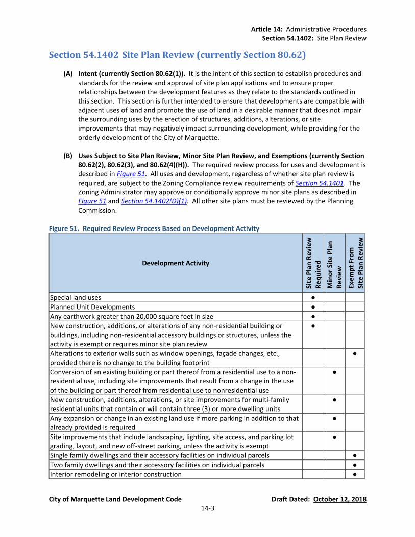
Article 14: Administrative Procedures Section 54.1402: Site Plan Review
City of Marquette Land Development Code Draft Dated: October 12, 2018 14-3
Section 54.1402 Site Plan Review (currently Section 80.62)
(A) Intent (currently Section 80.62(1)). It is the intent of this section to establish procedures and standards for the review and approval of site plan applications and to ensure proper relationships between the development features as they relate to the standards outlined in this section. This section is further intended to ensure that developments are compatible with adjacent uses of land and promote the use of land in a desirable manner that does not impair the surrounding uses by the erection of structures, additions, alterations, or site improvements that may negatively impact surrounding development, while providing for the orderly development of the City of Marquette.
(B) Uses Subject to Site Plan Review, Minor Site Plan Review, and Exemptions (currently Section
80.62(2), 80.62(3), and 80.62(4)(H)). The required review process for uses and development is described in Figure 51. All uses and development, regardless of whether site plan review is required, are subject to the Zoning Compliance review requirements of Section 54.1401. The Zoning Administrator may approve or conditionally approve minor site plans as described in Figure 51 and Section 54.1402(D)(1). All other site plans must be reviewed by the Planning Commission.
Figure 51. Required Review Process Based on Development Activity
Development Activity
Site
Pla
n R
evi
ew
Re
qu
ire
d
Min
or
Site
Pla
n
Re
vie
w
Pe
rmim
itte
d
Exe
mp
t Fr
om
Site
Pla
n R
evi
ew
Special land uses ●
Planned Unit Developments ●
Any earthwork greater than 20,000 square feet in size ●
New construction, additions, or alterations of any non-residential building or buildings, including non-residential accessory buildings or structures, unless the activity is exempt or requires minor site plan review
●
Alterations to exterior walls such as window openings, façade changes, etc., provided there is no change to the building footprint
●
Conversion of an existing building or part thereof from a residential use to a non-residential use, including site improvements that result from a change in the use of the building or part thereof from residential use to nonresidential use
●
New construction, additions, alterations, or site improvements for multi-family residential units that contain or will contain three (3) or more dwelling units
●
Any expansion or change in an existing land use if more parking in addition to that already provided is required
●
Site improvements that include landscaping, lighting, site access, and parking lot grading, layout, and new off-street parking, unless the activity is exempt
●
Single family dwellings and their accessory facilities on individual parcels ●
Two family dwellings and their accessory facilities on individual parcels ●
Interior remodeling or interior construction ●

Article 14: Administrative Procedures Section 54.1402: Site Plan Review
City of Marquette Land Development Code Draft Dated: October 12, 2018 14-4
Development Activity
Site
Pla
n R
evi
ew
Re
qu
ire
d
Min
or
Site
Pla
n
Re
vie
w
Pe
rmim
itte
d
Exe
mp
t Fr
om
Site
Pla
n R
evi
ew
Landscaping that is less than 25% of the parcel size or 5,000 square feet, whichever is less
●
Additions, alterations, and renovations that are less than 20% of the size of the original building footprint or less than 2,000 square feet
●
Site improvements that are less than 2,000 square feet (whichever is less), unless the activity requires site plan review or minor site plan review
●
All buildings less than 2,000 square feet, unless the activity requires site plan review
●
Re-paving of an off-street parking lot, provided there are no grading changes and no changes to the configuration of the parking lot layout
●
(C) Information Required for Site Plans and Sketch Plans (currently Section 80.62(4)(D)). The site
plan review application materials shall include all the following information, unless the Zoning Administrator determines that some of the required information is not reasonably necessary for consideration of the plan.
Application and Fee. A completed application form, supplied by the Zoning
Administrator, and an application fee.
Proof of Ownership. Current proof of ownership or evidence of a contractual ability to acquire such land, such as an option or purchase agreement or a written statement from the property owner indicating permission for the filing of the application.
Site Plan. Twelve (12) copies of plan sheet(s) providing the information listed below
(Figure 52). For minor site plans, three (3) copies of plan sheets are required. Sheet size of submitted drawings shall be at least 24-inches by 36-inches, with graphics at an engineer’s scale of one (1) inch equals twenty (20) feet for sites of 20 acres or less; and one (1) inch equals fifty (50) feet for sites over 20 acres. The surrounding area drawing may be in a scale of one (1) inch equals one-hundred (100). Digital plans must also be submitted. Upon request of the applicant, the Zoning Administrator may waive individual site plan requirements if the requirements are found to be unnecessary or irrelevant to the intent of providing the information; however, the Planning Commission has the right to require all of the in information in Figure 52.
Sketch Plan. A sketch plan must include the information listed below (Figure 52). The
number of plans submitted is determined by the Zoning Administrator, and the Zoning Administrator may accept digital plans. The sheet size of submitted drawings shall be at a scale acceptable to the Zoning Administrator. Upon request of the applicant, the Zoning Administrator may waive individual sketch plan requirements if the requirements are found to be unnecessary or irrelevant to the intent of providing the information;

Article 14: Administrative Procedures Section 54.1402: Site Plan Review
City of Marquette Land Development Code Draft Dated: October 12, 2018 14-5
however, the Planning Commission has the right to require all of the in information in Figure 52.
Figure 52. Site Plan Information Required
Site Plan Information Required
Ske
tch
Pla
n
Pre
limin
ary
Site
Pla
n
Fin
al S
ite
Pla
n
Identification of Project
The applicant’s name. ● ● ●
Name of the development. ● ● ●
The preparer’s name and professional seal of architect, engineer, or landscape architect indicating license in the State of Michigan.
● ●
Small scale location sketch of sufficient size and scale. ●
A survey of the property, sealed by a surveyor licensed in the State of Michigan. ● ●
Date of preparation and any revisions. ● ● ●
North arrow. ● ● ●
Complete and current legal description and size of property in acres. ● ● ●
Existing Features
Property lines and dimensions drawn to scale. ● ● ●
Zoning and current land use of applicant’s property and all abutting properties and of properties across any public or private street from the site.
● ● ●
Lot lines and all structures on the property and within 100 feet of the site’s property lines.
● ●
Locations of all significant natural features, including Riparian Buffers (see Section 54.804), wetlands (see Section 54.805), steep slopes (see Section 54.806), woodlands and protected trees (see Section 54.807), floodplains, etc.)
● ● ●
Location of any access points on both sides of the street within 100 feet of the site along streets where access to the site is proposed.
● ● ●
Locations of existing utilities. ● ● ●
Existing topography at a minimum of two (2) foot contour intervals. ● ●
Proposed Construction
Building footprints, setbacks, and elevations showing height for all proposed structures with the acreage allotted to each use. See Article 3, Article 4, and Article 7.
● ● ●
Floor area and ground coverage ratios. See Article 3 and Article 4. ● ● ●
Proposed locations of utility services (with sizes) and storm water management, including storm drainage, retention or detention ponds, fire hydrants, and any public or private easements. See Section 54.803.
● ●
Proposed topography with a site grading plan with topography at a maximum of two (2) foot contour intervals.
● ●
Location and method of screening for all waste dumpsters. See Section 54.1003(F). ● ●
Location and dimensions of parking spaces. See Article 9. ● ● ●
General landscaping design concept acceptable to the Zoning Administrator. ●
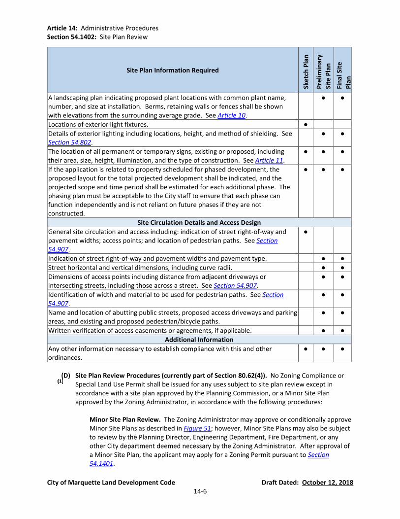
Article 14: Administrative Procedures Section 54.1402: Site Plan Review
City of Marquette Land Development Code Draft Dated: October 12, 2018 14-6
Site Plan Information Required
Ske
tch
Pla
n
Pre
limin
ary
Site
Pla
n
Fin
al S
ite
Pla
n
A landscaping plan indicating proposed plant locations with common plant name, number, and size at installation. Berms, retaining walls or fences shall be shown with elevations from the surrounding average grade. See Article 10.
● ●
Locations of exterior light fixtures. ●
Details of exterior lighting including locations, height, and method of shielding. See Section 54.802.
● ●
The location of all permanent or temporary signs, existing or proposed, including their area, size, height, illumination, and the type of construction. See Article 11.
● ● ●
If the application is related to property scheduled for phased development, the proposed layout for the total projected development shall be indicated, and the projected scope and time period shall be estimated for each additional phase. The phasing plan must be acceptable to the City staff to ensure that each phase can function independently and is not reliant on future phases if they are not constructed.
● ● ●
Site Circulation Details and Access Design
General site circulation and access including: indication of street right-of-way and pavement widths; access points; and location of pedestrian paths. See Section 54.907.
●
Indication of street right-of-way and pavement widths and pavement type. ● ●
Street horizontal and vertical dimensions, including curve radii. ● ●
Dimensions of access points including distance from adjacent driveways or intersecting streets, including those across a street. See Section 54.907.
● ●
Identification of width and material to be used for pedestrian paths. See Section 54.907.
● ●
Name and location of abutting public streets, proposed access driveways and parking areas, and existing and proposed pedestrian/bicycle paths.
● ●
Written verification of access easements or agreements, if applicable. ● ●
Additional Information
Any other information necessary to establish compliance with this and other ordinances.
● ● ●
(D) Site Plan Review Procedures (currently part of Section 80.62(4)). No Zoning Compliance or
Special Land Use Permit shall be issued for any uses subject to site plan review except in accordance with a site plan approved by the Planning Commission, or a Minor Site Plan approved by the Zoning Administrator, in accordance with the following procedures:
Minor Site Plan Review. The Zoning Administrator may approve or conditionally approve
Minor Site Plans as described in Figure 51; however, Minor Site Plans may also be subject to review by the Planning Director, Engineering Department, Fire Department, or any other City department deemed necessary by the Zoning Administrator. After approval of a Minor Site Plan, the applicant may apply for a Zoning Permit pursuant to Section 54.1401.

Article 14: Administrative Procedures Section 54.1402: Site Plan Review
City of Marquette Land Development Code Draft Dated: October 12, 2018 14-7
Pre-Application Concept Plan Review. At the option of the applicant, the applicant may
submit a concept plan to the City be reviewed by the Zoning Administrator, City Planner, and Engineering Department prior to submitting an application for site plan review. Depending on the scope of the development proposal, the City staff may require the concept plan to contain as little detail as a Zoning Compliance Review (Section 54.1401(C)) or as much detail as a Sketch Plan Review (Figure 52). The concept plan must contain enough detail to explain the location of land use areas, streets providing access to the site, pedestrian and vehicular circulation within the site; dwelling unit density and types; function of open space; and buildings or floor areas contemplated, as applicable. The purpose of concept plan review is for the City staff to review the concept plan and provide the applicant an advisory opinion whether the concept plan appears to meet the standards of this ordinance with respect to use, location, character, and zoning district requirements. The City’s review of a concept plan is advisory only, and the City shall not approve, deny, or take any other action on a concept plan.
Sketch Plan Review (currently Section 80.62(4)(B)). At the option of the applicant,
preliminary sketches of proposed site plans may be submitted for review to the Planning Commission prior to submission for formal site plan review. Submission of preliminary sketch plans shall be made no later than fourteen (14) days prior to the meeting at which the review is to take place. The Planning Commission shall advise the applicant as to the general acceptability of the proposed plan, but shall not be bound by any statements or indications of acceptance to the plan. The Zoning Administrator shall determine the number of plans to be submitted. Sketch plans must include at a minimum the required information for sketch plans in Figure 52.
Preliminary Site Plan Review (new Section). The purpose of preliminary site plan review
is to allow for the review and decision on most aspects of the site without the need for final detailed engineering unless required by the City Engineer. Applications for preliminary site plan review must be submitted to the Zoning Administrator at least twenty (20) business days prior to the meeting at which the review is to take place. The Planning Commission shall review the preliminary site plan, together with any reports and recommendations from staff, consultants and other reviewing agencies and any public comments. The Planning Commission shall then make a determination based on the requirements of this Ordinance and the standards of Section 54.1402(E). The Planning Commission is authorized to postpone, approve, approve subject to conditions or deny the preliminary site plan as follows:
(a) Postponement. Upon determination by the Planning Commission that a preliminary
site plan is not sufficiently complete for approval or denial or upon a request by the applicant, the Planning Commission may postpone consideration until a later meeting.
(b) Denial. Upon determination that a preliminary site plan does not comply with the
standards and regulations set forth in this Ordinance, or would require extensive revisions to comply with said standards and regulations, the site plan shall be denied. If a site plan is denied, a written record shall be provided to the applicant listing the reasons for such denial.
Article 14: Administrative Procedures Section 54.1402: Site Plan Review
City of Marquette Land Development Code Draft Dated: October 12, 2018 14-8
(c) Approval. Upon determination that a preliminary site plan is in compliance with the
requirements of this Ordinance and other applicable ordinances and laws, including the standards of Section 54.1402(E), the preliminary site plan shall be approved. Upon approval of the preliminary site plan, the applicant may apply for final site plan review.
(d) Approval subject to conditions. The Planning Commission may approve a
preliminary site plan, subject to one (1) or more conditions necessary to address minor modifications to the preliminary site plan, ensure that public services and facilities can accommodate the proposed use, protect significant natural features, ensure compatibility with adjacent land uses, or otherwise meet the intent and purpose of this Ordinance. Such conditions may include the need to obtain variances or approvals from other agencies. Upon approval of the preliminary site plan and the satisfaction of conditions, the applicant may apply for final site plan review.
Final Site Plan Review (currently Section 80.62(4)(C), (E), (F), (G), (I), (J), and (K)).
(a) Deadline to Submit Final Site Plan Application. Applications for final site plan
approval shall be submitted to the Zoning Administrator at least twenty (20) business days prior to the meeting at which the review is to take place.
(b) Staff Review of Site Plan Materials. The Zoning Administrator, Engineering
Department, Fire Department, Planning Staff, and other City departments if required by the Planning Commission to determine compliance with this Ordinance, will review application materials to determine if they are in proper form, all of the required information is present, and the site plan is in compliance with this Ordinance. Each department that reviews an application shall provide a report or relevant comments to the Zoning Administrator. If the site plan is determined to not be complete or in compliance with the ordinances, the Zoning Administrator shall return the reports to the applicant. The Planning Commission shall not review a site plan that is not complete unless the incomplete items are minor.
(c) Additional Information. The Planning Commission, prior to granting approval of a
site plan, may request from the applicant any additional graphics or written materials, prepared by a qualified person or person(s), to assist in determining the appropriateness of the site plan. Such material may include, but is not limited to, photographs, estimated impact on public schools and utilities, and traffic impacts.
(d) Planning Commission Action. Except as noted above, the Planning Commission shall
approve, approve with conditions, or deny the site plan based on the compliance of the plan with City Ordinances and the review standards of this ordinance. If conditional approval is granted, the conditions shall be stated specifically so that the Zoning Administrator or other reviewing departments can determine compliance with the conditions and grant approval following submission of revised plans; said review not to exceed ten business (10) days unless additional time is required by the Zoning Administrator or other reviewing departments to determine compliance with the conditions of site plan approval. A site plan shall be approved if it contains all of

Article 14: Administrative Procedures Section 54.1402: Site Plan Review
City of Marquette Land Development Code Draft Dated: October 12, 2018 14-9
the information required by the ordinance and is in compliance with the standards of the Land Development Code (including Section 54.1402(E)), other City planning documents, City ordinances, and state and federal statutes.
(e) Signed Copies of Final Approved Plans. The Planning Commission Chair and the
applicant shall sign two (2) copies of the approved site plan, one of which is kept by the Zoning Administrator, the other by the applicant. If the site plan is approved with conditions that require revisions to the site plan, the applicant must make the required revisions and submit the revised plans to the City be signed.
(f) Certificate of Zoning Compliance. A Zoning Compliance permit shall not be issued
until the Planning Commission has approved the plan. The Zoning Compliance permit shall be reviewed and issued in accordance with Section 54.1401.
Single-Step Site Plan Approval. Nothing in this Ordinance shall prohibit the Planning
Commission from granting final site plan approval without first granting a preliminary site plan approval if the plans are in compliance with the requirements of this Ordinance for a final site plan.
(E) Site Plan Review Standards (currently Section 80.62(5)(A). In addition to the development
standards of this ordinances as well as the underlying zoning district, each site plan shall be designed to ensure that:
Public Health, Safety, and Welfare. The uses proposed will not harm the public health,
safety, or welfare. All elements of the site plan shall be designed to take into account the site’s topography, the character of adjoining property, and the type and size of buildings. The site shall be developed so as not to impede the normal and ordinary development or improvement of surrounding property for uses permitted in this ordinance.
Safe and Efficient Traffic Operations. Safe, convenient, uncongested, and well-defined
vehicular and pedestrian circulation within and to the site shall be provided. Drives, streets, and other elements such as walkways shall be designed to promote safe and efficient traffic operations within the site and at its access points.
Vehicular and Pedestrian Circulation. The arrangement of public or common ways for
vehicular and pedestrian circulation shall be connected to existing or planned street and pedestrian or bicycle pathways in the area. There shall be provided a pedestrian circulation system which is separated from the vehicular circulation system. In order to ensure public safety, special pedestrian measures, such as crosswalks, crossing signals and other such facilities may be required in the vicinity of schools, playgrounds, shopping centers, and other uses which generate a considerable amount of pedestrian traffic.
Topography and Landscaping. The landscape shall be preserved in its natural state,
insofar as practical, by removing only those areas of vegetation or making those alterations to the topography which are reasonably necessary to develop the site in accordance with the requirements of this ordinance. Landscaping shall be preserved and/or provided to ensure that proposed uses will be adequately buffered from one another and from surrounding property.
Article 14: Administrative Procedures Section 54.1402: Site Plan Review
City of Marquette Land Development Code Draft Dated: October 12, 2018 14-10
Storm Water Management. Appropriate measures shall be taken to ensure that removal
of surface waters will not adversely affect neighboring properties or the public storm drainage system. Surface water on all paved areas shall be collected so that it will not obstruct the flow of vehicular or pedestrian traffic or create standing water.
Emergency Vehicle Access. All buildings or groups of buildings shall be arranged so as to
permit emergency vehicle access as required by the Fire Department and Police Department.
Outdoor Storage and Loading and Unloading Areas. All outside storage areas, including
refuse storage stations, shall be screened from the view of the street and/or adjacent residentially zoned properties. All loading and unloading areas shall be reasonably screened for residentially zoned properties.
Lighting. Exterior lighting shall be arranged so that it is deflected away from adjacent
properties and bodies of water so that it does not impede the vision of traffic along adjacent streets or impair navigation on the waterway. Flashing or intermittent lights shall not be permitted.
Location of Building Entrances. For consistency in areas where adjoining properties face
the street, the Planning Commission may require that primary structures shall be oriented so that their main entrance faces the street upon which the lot fronts. If the development is on a corner lot, the main entrance may be oriented to either street or to the corner.
Nuisances. No noise, vibration, dust, fumes, or other nuisance shall leave the property in a manner that affects the surrounding area.
City of Marquette Engineering Design and Construction Standards. The site plan must comply with the City of Marquette Engineering Design and Construction Standards.
(F) Validity of Approved Site Plans and Expiration (currently Section 80.62(5) and 80.62(7)).
Approval, including Conditions, Attached to the Property. Approval of a site plan,
including conditions made as part of the approval, is attached to the property described as part of the application and not to the owner of such property.
Validity of Approved Site Plans.
(a) Expiration. Site plan approval shall expire one (1) year from the date of approval by
the Planning Commission except for phased projects that are required to follow a project timeline. If the site plan is approved with conditions that require revisions to the site plan, the applicant must make the required revisions and submit the revised plans to the City prior to the expiration date.
(b) Halt in Construction. The Planning Commission or Zoning Administrator, according
to which entity approved the plan, may revoke the zoning approval if work on a
Article 14: Administrative Procedures Section 54.1402: Site Plan Review
City of Marquette Land Development Code Draft Dated: October 12, 2018 14-11
project is halted for at least two (2) months, except during winter conditions, if the conditions warrant.
(c) Extension. The Planning Commission may grant a one (1) time extension to the
expiration deadline not to exceed one (1) year provided the request for an extension must be is submitted at least 45 days prior to the expiration of the site plan approval and must meet the following standards.
(i) The approved plan conforms to zoning at the time the extension is granted
(ii) Any and all Federal and State approvals and permits are current.
(d) Resubmission of Expired Plans. Site plans whose approval has expired shall require
resubmission as an initial application.
(G) Amendments to Approved Site Plans (currently Section 80.62(6)).
No changes, erasures, modifications, or revisions shall be allowed for any approved site plan without prior approval by the Zoning Administrator or the Planning Commission, in accordance with Figure 51 of this Ordinance.
The ability to approve any changes to an approved site plan shall remain consistent with
the ability of the Planning Commission or Zoning Administrator to approve or deny a specific development activity stated in Figure 51.
(H) Performance Guarantees (currently Section 80.62(8)). To ensure compliance with this
ordinance and any condition imposed thereunder, the City may require that a cash deposit, certified check, irrevocable bank letter of credit, or other financial instrument acceptable to the City covering the estimated cost of improvements associated with a project (verified by the City Engineer) for which site plan approval is sought, be deposited with the Treasurer of the City to ensure faithful completion of the improvements and also be subject to the following:
Prior to development activity or the issuance of a permit, the performance guarantee
shall be deposited prior to the issuance of the building permit authorizing the activity of the project. The City shall return the performance guarantee on deposit upon verification by the City that all work and improvements have been satisfactorily completed. A return of the performance guarantee does not relieve the applicant from satisfying all applicable maintenance warranties and/or guarantees necessary to ensure the proper functioning of the public improvements.
As used in this Section, “improvements” means those features and actions associated
with a project which are considered necessary by the body or official granting approval, to protect natural resources, or the health, safety and welfare of the residents of the City and future users or inhabitants of the proposed project or project area, including roadways, lighting, utilities, sidewalks, screening, landscaping and surface drainage.
(I) Development Agreement (new Section). The Planning Commission may require, as a
condition of approval, that the owner/developer enter into a Development Agreement with
Article 14: Administrative Procedures Section 54.1402: Site Plan Review
City of Marquette Land Development Code Draft Dated: October 12, 2018 14-12
the City of Marquette, incorporating therein the terms and conditions of final site plan approval, and record the same in the Office of the Register of Deeds for Marquette County. The Development Agreement shall be signed by the applicant and/or developer and approved by the City Commission. The Agreement shall include such provisions as the deposit of funds to defray variable costs and expenses and performance guarantees per Section 54.1402(H) to ensure that improvements depicted on a site plan meet the provisions of this Ordinance, adopted standards and regulations, and conditions set by the Planning Commission. The cost to prepare, review, and record this Agreement shall be borne by the applicant/developer.
(J) Compliance Guarantees (currently Section 80.62(8)). Prior to construction, the Zoning
Administrator may require that the property boundaries be staked by a licensed surveyor. At any time during construction, the Zoning Administrator may inspect the site to determine compliance with the approved site plan. If the Zoning Administrator determines that the construction is not in accordance with the approved site plan, the Zoning Administrator shall issue a stop work order and take action to ensure compliance with the approved site plan.
(K) Appeals of Site Plans (currently Section 80.62(9)).
Any person aggrieved by the decision of the Planning Commission or Zoning
Administrator with respect to an approval or denial of a site plan shall have the right of an appeal to the Board of Zoning Appeals in accordance with Section 54.1404. The appeal shall be filed in writing within thirty (30) days of the decision.
The filing of such an appeal shall act to stay or suspend the issuance of any permit.
No new evidence may be submitted to the Board of Zoning Appeals that is in addition to
the evidence considered by the Zoning Administrator or Planning Commission during its review.
(L) Required As-Built Plans. Upon completion of the development, as-built plans of the final
development must be provided to the City in CAD format or other digital format required by the City.

Article 14: Administrative Procedures Section 54.1403: Special Land Use Review
City of Marquette Land Development Code Draft Dated: October 12, 2018 14-13
Section 54.1403 Special Land Use Review (currently Section 80.65)
(A) Intent (currently Section 80.65(1)). This section of the ordinance governs permitting of special land uses which may be located in specific districts (see Figure 8 for special land uses within each district) when the standards of special land use review have been met and the use and development comply with the standards of this Ordinance. It is the purpose of this section to maintain adequate provision for the security of the health, safety, convenience and general welfare of the inhabitants and uses of the zoning district and adjoining districts.
(B) Procedures (currently Section 80.65(2)). No special land use shall be established in any zoning
district except upon permit issued by the Planning Commission. The Planning Commission shall be guided in making a decision by the standards set forth in this ordinance in Section 54.1403(C). The Planning Commission shall hear and decide only such special land uses as specifically authorized by district and by the terms of this ordinance. Special land use applications shall be submitted and reviewed according to the following procedures:
Application and Fees. Any application for a special land use permit shall be submitted to
the Zoning Administrator and shall be accomplished by such fees as set by the City Commission.
Site Plan Submittal and Other Required Information. Any person seeking a special land
use permit shall submit a site plan and provide the Planning Commission with all information required for site plan review (Section 54.1402) and additional information as the Planning Commission may reasonably require to determine whether the granting of the permit is consistent with the intent of this ordinance. The City may adopt administrative standards for additional information based on specific uses and zoning districts.
Public Hearing. The staff liaison of the Planning Commission shall set a time and date for
a public hearing, and the public hearing shall be noticed in accordance with Section 54.1406. Any party may appear in person or by a duly authorized agent or attorney to comment on any aspect of the special land use. Written comments may be submitted prior to the hearing.
Planning Commission Action. The Planning Commission shall hold the public hearing and
consider all requests for a special land use permit at the first or second conducted Planning Commission meeting following staff acceptance of the special land use application and all other required materials, depending on submission deadline and the established schedule for hearings. The Planning Commission shall take final action within three months of the receipt of the required materials unless the Planning Commission determines that additional time is necessary to obtain additional information to comply with this ordinance. When taking action on the application, the Planning Commission must make findings on all of the standards of Section 54.1403(C).
Conditions of Approval and Violations. In permitting any special land use, the Planning
Commission may prescribe appropriate conditions and safeguards. Violation of any conditions or safeguards, made a part of the terms of the special land use permit, shall be deemed a violation of this ordinance, and shall be punished under Article 15 of this
Article 14: Administrative Procedures Section 54.1403: Special Land Use Review
City of Marquette Land Development Code Draft Dated: October 12, 2018 14-14
ordinance. Permits issued on the basis of false information shall be void and continuance of the use shall be deemed a violation of this ordinance. No special land use may be commenced until all conditions have been met. If the applicant proposes an alteration of the conditions of approval or the Planning Commission considers revocation of the special land use permit, a public hearing shall be held by the Planning Commission prior to alteration of conditions or revocation of a permit in accordance with Section 54.1403(B)(3). The Zoning Administrator may approve changes to the approved site plan only if the development activity can be approved by the Zoning Administrator in accordance with Figure 51 and the proposed changes do not alter the Planning Commission’s conditions of approval.
(C) Standards of Special Land Use Review (currently Sections 80.65(2)(E)), 80.65(3), and 80.60).
In permitting a special land use, the Planning Commission shall make a finding that the special land use will be in compliance with the general purpose of the ordinance and the intent of the district in which it is located and will not be injurious to the spirit of this ordinance and intent of the district, and will not be injurious to the neighborhood, or otherwise detrimental to the public health and welfare. A request for approval of a land use or activity shall be approved if the request is in compliance with the following standards, as well as other applicable City ordinances, and state and federal statutes:
Intent of Zoning District. The intent of the Zoning District is met and the proposed use is
in harmony with appropriate and orderly development of the district.
Use of Adjacent Lands. The current use of adjacent lands and neighborhood are compatible with the proposed use.
Physical Appearance of Structures. The physical appearance of existing or proposed
structures (location, height, bulk of building as well as construction materials) meets the standards of this ordinance.
Landscaping. The suitability of the proposed landscaping in providing ground cover,
screening, and decoration on the site. See Article 10.
Operations of Use. The nature and intensity of operations involved in or conducted in connection with the proposed use is appropriate for the site and not in conflict with surrounding properties and uses.
Time of Use, and Physical and Economic Relationship. The proposed or estimated
time(s) of use and the physical and economic relationship of one type of use to another are not in conflict with each other or with surrounding properties and uses.
Number of Persons or Employees. The proposed or estimated assembly of persons or
employees shall not be hazardous to the neighborhood or incongruous or conflict with normal traffic or activity in the vicinity.
Vehicular and Pedestrian Circulation. Proposed or estimated vehicular and pedestrian
traffic volumes and patterns, particularly of children, as well as vehicular turning
Article 14: Administrative Procedures Section 54.1403: Special Land Use Review
City of Marquette Land Development Code Draft Dated: October 12, 2018 14-15
movements do not negatively impact traffic flows, intersections, site distances, and safety.
Physical Characteristics of the Site. The current and proposed physical characteristics of
the site such as area, drainage, topography, open space, landscaping, and access to minor and/or major streets will meet the requirements of this ordinance and all other City standards. The use and development shall consider the natural environment and help conserve natural resources.
Public Services. Proposed or estimated demands upon public services such as electricity, sewer, water, police, and fire protection, schools and refuse disposal shall not be overly burdensome, based on the readily available information.
Environmental Factors. The type and amount of litter, waste, noise, dust, traffic, fumes, glare and vibration which may be generated by such use shall be minimized and/or properly mitigated.
Site Area and Potential Future Expansion Areas. That the Planning Commission has determined that there is sufficient site area for the proposed use to prevent nuisances to neighboring uses, and that there is the potential for reasonable anticipated expansion of the use without nuisances to neighboring uses.
Additional Neighborhood Factors. Other factors shall be considered as necessary to maintain property values in the neighborhood and guarantee safety, light, air and privacy to the principal uses in the district.
Master Plan. Conformance and harmony with the Master Plan.
(D) Approval Period (currently Section 80.65(2)(J)). If action is not taken by the petitioner to
implement a special land use permit within one (1) year of the date of its approval by the Planning Commission, said permit shall expire. The Planning Commission, upon application made before said expiration, may grant an extension of not more than one (1) year from the expiration date. The Commission, at its discretion, may schedule a public hearing prior to granting an extension in accordance with Section 54.1403(B)(3). Not more than two (2) such extensions may be granted.
(E) Performance Guarantee (currently Section 80.65(2)(G)). The Planning Commission may
require the applicant to submit a performance guarantee, escrow funds, or other such performance-based guarantees to the City as a condition of special land use approval pursuant to Section 54.1402(H). The amount of the performance guarantee shall be recommended to the Planning Commission by the City Attorney after discussion with the applicant, City Engineering Department, and other involved parties.
(F) Appeals of Decisions on Special Land Uses (currently Section 80.65(2)(I)). Appeals of the
Planning Commission’s decision on a special land use permit shall be filed in Marquette County Circuit Court. Appeals of the Planning Commission’s decision on a special land use may not be taken to the Board of Zoning Appeals.
Article 14: Administrative Procedures Section 54.1403: Special Land Use Review
City of Marquette Land Development Code Draft Dated: October 12, 2018 14-16

Article 14: Administrative Procedures Section 54.1404: Variances and Appeals
City of Marquette Land Development Code Draft Dated: October 12, 2018 14-17
Section 54.1404 Variances and Appeals (currently Sections 80.64(3), 80.64(4), and 82.19)
(A) Appeals of Administrative Decisions (currently part of Section 80.64(3), Sections 80.64(4)(A), 80.64(4)(C), and 80.64(4)(D)).
Appeals. The Board of Zoning Appeals shall hear and decide appeals where it is alleged
there is error in any order, requirement, decision, or determination made by an administrative official in the enforcement of this ordinance. Appeals to the Board of Zoning Appeals concerning an appeal of a decision or interpretation of administration of this ordinance may be filed by any person aggrieved or any officer or bureau of the governing body of the city affected by any decision of the Zoning Administrator. Such appeals shall be filed within a reasonable time, not to exceed 30 days or such lesser period as may be provided by the rules of the Board, by filing with the Zoning Administrator a written notice of appeal specifying the grounds thereof. The Zoning Administrator shall transmit to the Board of Zoning Appeals all papers and records regarding the appeal. The Board of Appeals shall set a reasonable time and date for a public hearing of the appeal, and the public hearing shall be noticed in accordance with Section 54.1406.
Stay of Proceedings. An appeal stays all proceedings in furtherance of the action
appealed from unless the Zoning Administrator certifies to the Board of Zoning Appeals after the notice of appeal is filed with him/her, that by reason of facts stated in the certificate, a stay would, in his/her opinion, cause imminent peril to life and property. In such case proceedings shall not be stayed other than by a restraining order which may be granted by the Board of Zoning Appeals or by a court of record on application, on notice to the Zoning Administrator and due cause shown.
Reversing Decision of Administrative Official. In exercising the above mentioned
powers, the Board of Zoning Appeals may, so long as such action is in conformity with the terms of this ordinance, reverse or affirm, wholly or partly, or may modify the order, requirement, decision, or determination as ought to be made, and to that end shall have the powers of the administrative official from whom the appeal is taken.
(B) Variances (currently part of Section 80.64(4)(B)). The Board of Zoning Appeals may authorize
upon appeal in specific cases such variance form the terms of this ordinance as will not be contrary to the public interest where, owing to special conditions, a literal enforcement of the provisions of this ordinance would result in practical difficulty in accordance with this Section. A variance from the terms of this ordinance shall not be granted by the Board of Zoning Appeals unless and until all of the following are fulfilled:
Application. A complete written application for a variance is submitted.
Payment of Fees. All fees, as set by the City Commission, must be paid by the applicant
to cover the administrative costs of such application.
Notice of Public Hearing. Notice of public hearing shall be given as in Section 54.1406.
Article 14: Administrative Procedures Section 54.1404: Variances and Appeals
City of Marquette Land Development Code Draft Dated: October 12, 2018 14-18
Public Hearing. The public hearing shall be held. Any party may appear in person, or by a
duly authorized agent or by attorney to act on behalf of the applicant.
Required Standards of Review. The Zoning Board of Appeals shall make findings that a “practical difficulty” has been shown by the applicant by finding that all of the following requirements have been met by the applicant for a variance.
(a) Special Conditions and Circumstances Unique to the Land, Structure, or Building.
That special conditions and circumstances exist which are peculiar to the land, structure, or building involved and which are not generally applicable to other lands, structures, or buildings in the same district;
(b) Rights of Similar Properties in the Same Districts. That literal interpretation of the provisions of this ordinance would deprive the applicant of rights commonly enjoyed by other similar properties in the same district under the terms of this ordinance;
(c) Not a Result of Actions of the Applicant. That the special conditions and circumstances do not result from the actions of the applicant;
(d) Special Privileges Prohibited. That granting the variance requested will not confer on the applicant any special privilege that is denied by this ordinance to other lands, structures, or buildings in the same district;
(e) Comparison to Other Lands, Structures, or Buildings Not a Factor. That no nonconforming use of neighboring lands, structures, or buildings in the same district and no permitted or nonconforming use of lands, structures, or buildings in other districts shall be considered grounds for the issuance of a variance.
(f) Strict Compliance is Unnecessarily Burdensome. That strict compliance with area,
setbacks, frontage, height, bulk or density would unreasonably prevent the owner from using the property for a permitted purpose and would thereby render the conformity unnecessarily burdensome for other than financial reasons;
(g) Substantial Justice. That a variance would do substantial justice to the applicant, as
well as to other property owners in the district (the BZA, however, may determine that a reduced relaxation would give substantial relief and be more just);
(h) Impact. That the proposed variance will not impair an adequate supply of light and
air to adjacent property or increase the congestion in public streets; that the variance will not increase the hazard of fire or flood or endanger public safety; that that the variance will not unreasonably diminish or impair established property values within the surrounding area; and that the variance will not be injurious to the neighborhood or otherwise detrimental to the public welfare.
(i) Minimum Variance Necessary. That the variance is the minimum variance that will
make possible the reasonable use of the land, building, or structure.

Article 14: Administrative Procedures Section 54.1404: Variances and Appeals
City of Marquette Land Development Code Draft Dated: October 12, 2018 14-19
(j) Purpose and Intent of the Land Development Code. That the granting of the variance, will be in harmony with the general purpose and intent of this ordinance.
Conditions and Violations. In granting any variance, the Board of Zoning Appeals may
prescribe appropriate conditions and safeguards in conformity with this ordinance. Violation of such conditions and safeguards, when made a part of the terms under which the variance is granted, shall be deemed a condition of this ordinance punishable under Article 15 of this ordinance.
(C) Use Variances Prohibited (currently Section 80.64(4)(B)(9)). Under no circumstances shall the
Board of Zoning Appeals grant a variance to allow a use not permissible under the terms of this ordinance in the district involved, or any use expressly or by implication prohibited by terms of this ordinance in said district.
(D) Approval Period (currently Section 80.64(4)(B)(10)). If the petitioner has not obtained a
Zoning Permit, obtained a Building Permit and commenced construction to implement a variance within one (1) year of the date of its approval by the Board of Zoning Appeals, said variance shall expire. The Board of Zoning Appeals, upon application made before expiration, may grant an extension of not more than one (1) year from the expiration date. The Board Zoning Appeals, at its discretion, may schedule a public hearing in accordance with Section 54.1406 prior to granting an extension. Not more than two (2) such extensions may be granted.
(E) Appeals of Decisions of the Board of Zoning Appeals (new Section). The decision of the
Board of Zoning Appeals shall be final. An appeal of a decision of the Board of Zoning Appeals shall be taken to the Marquette County Circuit Court within a time period specified in the Michigan Zoning Enabling Act (P.A. 110 of 2006, as amended) and by such persons permitted by State statue and common law. Upon appeal, the court shall review the record and decision of the BZA to insure that the decision complies with the constitution and laws of the state, is based upon proper procedure, is supported by competent, material and substantial evidence on the record and represents the reasonable exercise of discretion granted by law to the BZA. As a result of this review required by this Section, the court may affirm, or modify the decision of the BZA.

Article 14: Administrative Procedures Section 54.1405: Zoning Ordinance Amendment Procedures
City of Marquette Land Development Code Draft Dated: October 12, 2018 14-20
Section 54.1405 Zoning Ordinance Amendment Procedures (currently Section 80.06)
(A) Initiation of Amendments (currently part of Section 80.06(A)). The City Commission, the Planning Commission, or the property owner (including a designated agent of the property owner) may at any time originate a petition to amend or change the zoning district boundaries pursuant to the authority and procedure established by Act 110 of Public Acts of 2006 as amended. Changes in the text of this ordinance may be proposed by the City Commission, Planning Commission, or any interested person or organization.
(B) Application for Amendment (currently part of Section 80.06(A)). Each petition by one (1) or
more persons for an amendment shall be submitted to the Zoning Administrator. Documents to support the application may be filed with the Zoning Administrator. A fee, as established by the City Commission shall accompany each petition, except those originated by the Planning Commission or City Commission.
(C) Amendment Review Procedures (currently Section 80.06(B), (C), and (D))
Public Hearing. The staff liaison to the Planning Commission shall set a time and date for
a public hearing, and the public hearing shall be noticed in accordance with Section 54.1406. The Planning Commission may refuse to schedule a hearing on a petition for rezoning which includes any portion of a site considered for rezoning in the previous six (6) months.
Planning Commission Consideration of the Proposed Amendment. The Planning
Commission shall review the proposed amendment, together with any reports and recommendations from staff, consultants, other reviewing agencies, and any public comments. The Planning Commission shall identify and evaluate all factors relevant to the petition, including the appropriate criteria listed in this Section. Following the public hearing, the Planning Commission shall make a recommendation to the City Commission to either approve or deny the petition and report its findings to the City Commission.
City Commission Consideration of the Proposed Amendment. The City Commission,
upon recommendation from the Planning Commission, shall either schedule a public hearing or deny the petition. This hearing shall be advertised in accordance with Section 54.1406. If determined to be necessary, the City Commission may refer the amendment back to the Planning Commission for further consideration. In the case of an amendment to the Official Zoning Map, the City Commission shall approve or deny the amendment, based upon its consideration of the criteria contained in this ordinance.
(D) Standards of Review for Amendments (new Sub-Section). In considering any petition for an
amendment to the text of this ordinance or to the Official Zoning Map, the Planning Commission and City Commission shall consider the following criteria that apply to the application in making findings, recommendations, and a decision. The Planning Commission and City Commission may also take into account other factors or considerations that are applicable to the application but are not listed below.
Article 14: Administrative Procedures Section 54.1405: Zoning Ordinance Amendment Procedures
City of Marquette Land Development Code Draft Dated: October 12, 2018 14-21
Master Plan. Consistency with the recommendations, goals, policies and objectives of the Master Plan and any sub-area plans. If conditions have changed since the Master Plan was adopted, consistency with recent development trends in the area shall be considered.
Intent and Purpose of the Zoning Ordinance. Consistency with the basic intent and
purpose of this Zoning Ordinance.
Street System. The capability of the street system to safely and efficiently accommodate the expected traffic generated by uses permitted in the requested zoning district.
Utilities and Services. The capacity of the City’s utilities and services sufficient to
accommodate the uses permitted in the requested district without compromising the health, safety, and welfare of the City.
Changed Conditions Since the Zoning Ordinance Was Adopted or Errors to the Zoning
Ordinance. That conditions have changed since the Zoning Ordinance was adopted or there was an error in the Zoning Ordinance that justifies the amendment.
No Exclusionary Zoning. That the amendment will not be expected to result in
exclusionary zoning.
Environmental Features. If a rezoning is requested, compatibility of the site’s physical, geological, hydrological and other environmental features with the uses permitted in the proposed zoning district.
Potential Land Uses and Impacts. If a rezoning is requested, compatibility of all the
potential uses allowed in the proposed zoning district with surrounding uses and zoning in terms of land suitability, impacts on the environment, density, nature of use, traffic impacts, aesthetics, infrastructure and potential influence on property values.
Relationship to Surrounding Zoning Districts and Compliance with the Proposed District.
If a rezoning is requested, the boundaries of the requested rezoning district will be reasonable in relationship to surrounding zoning districts, and construction on the site will be able to meet the dimensional regulations for the requested zoning district.
Alternative Zoning Districts. If a rezoning is requested, the requested zoning district is considered to be more appropriate from the City’s perspective than another zoning district.
Rezoning Preferable to Text Amendment, Where Appropriate. If a rezoning is requested to allow for a specific use, rezoning the land is considered to be more appropriate than amending the list of permitted or special land uses in the current zoning district to allow the use.
Isolated or Incompatible Zone Prohibited. If a rezoning is requested, the requested rezoning will not create an isolated or incompatible zone in the neighborhood.
Article 14: Administrative Procedures Section 54.1405: Zoning Ordinance Amendment Procedures
City of Marquette Land Development Code Draft Dated: October 12, 2018 14-22
(E) Notice of Adoption of Amendment (currently Section 80.06(E)). Following adoption of an amendment by the City Commission, one (1) notice of adoption shall be filed with the City Clerk and one (1) notice shall be published in a newspaper of general circulation in the City within fifteen (15) days after adoption, in accordance with the Michigan Zoning Enabling Act, Public Act 110 of 2006, as amended. Amendments shall take effect eight (8) days after publication. A record of all amendments shall be maintained by the City Clerk. A Zoning Map shall be maintained by the City Clerk or his/her designee, which shall identify all map amendments. The required notice of adoption shall include all of the following information:
In the case of a newly adopted Zoning Ordinance, the following statement: "A zoning
ordinance regulating the development and use of land has been adopted by the City of Marquette."
In the case of an amendment(s) to the existing Zoning Ordinance, either a summary of the
regulatory effect of the amendment(s), including the geographic area affected, or the text of the amendment(s).
The effective date of the ordinance or amendment.
(F) Protest Petition of Amendment (new Sub-Section). An amendment under this Chapter is
subject to a protest petition in accordance with Section 403 of the Michigan Zoning Enabling Act, PA 110 of 2006 (as amended), summarized as follows:
Petition Submittal Requirements. The protest petition shall be presented to the City
Commission before final legislative action on the amendment, and shall be signed by one (1) or more of the following:
(a) The owners of at least 20% of the area of land included in the proposed change.
Publicly owned land shall be excluded in calculating the 20% land area.
(b) The owners of at least 20% of the area of land included within an area extending outward 100 feet from any point on the boundary of the land included in the proposed change. Publicly owned land shall be excluded in calculating the 20% land area.
Vote. If a protest petition is filed, approval of the amendment to this Ordinance shall
require a 2/3 vote of the City Commission.
(G) Referendum (new Sub-Section). Within thirty (30) days following the passage of the Zoning Ordinance, a petition signed by a number of registered electors may be filed with the City Clerk requesting submission of this Ordinance or part of this Ordinance to the electors for their approval, in accordance with Section 402 of the Michigan Zoning Enabling Act, PA 110 of 2006, as amended. Whenever there is a conflict between this section of the Zoning Ordinance or P.A. 110 of 2006, as amended, the provisions of P.A. 110 of 2006, as amended, shall govern.
(H) Rezoning (Zoning Map Amendment) with Conditions (new Sub-Section). Pursuant to MCL
125.3405, the City Commission, following a public hearing and recommendation by the Planning Commission, may approve a petition for a rezoning with conditions requested by a

Article 14: Administrative Procedures Section 54.1405: Zoning Ordinance Amendment Procedures
City of Marquette Land Development Code Draft Dated: October 12, 2018 14-23
property owner. The standards of this section shall grant a property owner the option of proposing conditions for the development and use of property in conjunction with an application for rezoning. Such conditions may be proposed at the time the application for rezoning is filed, or at a subsequent point in the process of review of the proposed rezoning.
Conditional Rezoning Agreement. The conditions attached to the rezoning shall be set
forth by submitting a conditional rezoning agreement listing the proposed conditions. A conditional rezoning agreement shall contain the following information:
(a) A statement acknowledging that the rezoning with conditions was proposed by the
applicant to induce the City to grant the rezoning, and that the City relied upon such proposal and would not have granted the rezoning but for the terms spelled out in the conditional rezoning agreement; and, further agreement and acknowledgment that the conditions and conditional rezoning agreement are authorized by all applicable state and federal law and constitution, and that the Agreement is valid and was entered on a voluntary basis, and represents a permissible exercise of authority by the City.
(b) Agreement and understanding that the property in question shall not be developed
or used in a manner inconsistent with the conditional rezoning agreement.
(c) Agreement and understanding that the approval and conditional rezoning agreement shall be binding upon and inure to the benefit of the property owner and City, and their respective heirs, successors, assigns, and transferees.
(d) The date upon which the rezoning with conditions becomes void, as specified in
Section 54.1405(H)(3), below. If an extension of approval is granted by the City Commission, a new conditional rezoning agreement with the new expiration date shall be recorded.
(e) Agreement and understanding that, if a rezoning with conditions becomes void in
the manner provided in Section 54.1405(H)(3), below, no development shall be undertaken or permits for development issued until a new zoning district classification of the property has been established.
(f) Agreement and understanding that each of the requirements and conditions in the
conditional rezoning agreement represents a necessary and reasonable measure which, when considered with all other conditions and requirements, is roughly proportional to the increased impact created by the use represented in the approved rezoning with conditions, taking into consideration the changed zoning district classification and the specific use authorization granted.
(g) A legal description of the property affected by the rezoning with conditions.
(h) Development regulations affected by the conditions of rezoning, including but not
limited to density, setbacks, height, site coverage, signs, parking, architecture, lighting, landscaping etc.

Article 14: Administrative Procedures Section 54.1405: Zoning Ordinance Amendment Procedures
City of Marquette Land Development Code Draft Dated: October 12, 2018 14-24
(i) Revocation of approval provisions returning the property to its original zoning designation if the developer violates the terms of the agreement.
(j) A conditional rezoning agreement may contain a conditional rezoning plan as an
attachment, with such detail and inclusions proposed by the applicant and approved by the City Commission in accordance with this Section, following recommendation by the Planning Commission. Inclusion of a conditional rezoning plan as an attachment to a conditional rezoning agreement shall not replace the requirement for Preliminary and Final Site Plan, Subdivision, Condominium, or Special Land Use review and approval, as the case may be.
Amendment to Conditional Rezoning Agreement. A proposed amendment to a
conditional rezoning agreement shall be reviewed and approved in the same manner as a new rezoning with conditions.
Period of Approval. Unless extended by the City Commission for good cause, the
rezoning with conditions shall expire following a period of two (2) years from the effective date of the rezoning unless bona fide development of the property pursuant to approved building and other permits required by the City commences within the two (2) year period and proceeds diligently and in good faith as required by ordinance to completion.
(a) Expiration or Extension. In the event bona fide development has not commenced
within two (2) years from the effective date of the rezoning, the rezoning with conditions and the conditional rezoning agreement shall be void and of no effect. The landowner may apply for a one (1) year extension one (1) time. The request must be submitted to the Zoning Administrator before the two (2) year time limit expires. The landowner must provide to the City Commission good cause as to why the extension should be granted. If an extension of approval is granted by the City Commission, a new conditional rezoning agreement with the new expiration date shall be recorded.
(b) Effect of Expiration. If the rezoning with conditions becomes void in the manner
provided in this section, either or both of the following actions may be taken:
(i) The property owner may seek a new rezoning of the property; and/or
(ii) Pursuant to MCL 125.3405, the land shall revert to its former zoning classification following the process for approval of a rezoning with conditions.
Zoning Map. If approved, the zoning district classification of the rezoned property shall
consist of the district to which the property has been rezoned accompanied by a reference to “CR Conditional Rezoning.” The Zoning Map shall specify the new zoning district plus a reference to CR. By way of example, the zoning classification of the property may be “CBD Central Business District with CR Conditional Rezoning,” with a Zoning Map designation of “CBD CR.”
Review and Approval Process. An application for a rezoning with conditions shall be
reviewed following the same process and procedures applicable to a rezoning set forth in

Article 14: Administrative Procedures Section 54.1405: Zoning Ordinance Amendment Procedures
City of Marquette Land Development Code Draft Dated: October 12, 2018 14-25
Section 54.1405(C), with the exception that the conditional rezoning agreement shall be executed between the applicant and the City Commission at the time of City Commission approval of a rezoning with conditions.
Recordation of a Conditional Rezoning Agreement. A rezoning with conditions shall
become effective following publication in the manner provided by law, and after the conditional rezoning agreement is recorded with the County Register of Deeds.
Article 14: Administrative Procedures Section 54.1406: Public Hearings
City of Marquette Land Development Code Draft Dated: October 12, 2018 14-26
Section 54.1406 Public Hearings (currently Sections 80.06(B), 80.64(5), and 80.65(2)(C))
(A) Public Hearings (new Section). The staff liaison of the body charged with conducting a public hearing required by this Ordinance shall, upon receipt of a completed application, select a reasonable time and place for such hearing on behalf of the relevant body. Such hearings shall be subject to the procedures set forth in the Michigan Zoning Enabling Act, Public Act 110 of 2006, as amended, and the provisions of this Ordinance.
(B) General Public Hearing Procedures (currently Section 80.64(5) and 80.65(2)(C)). The
following procedures are applicable to all public hearings except zoning ordinance text and map amendments, which are described in Section 54.1406(C), below.
Publication in a Newspaper of General Circulation. Notice of the request shall be
published in a newspaper of general circulation not less than 15 days before the date the application will be considered for approval.
Personal and Mailed Notice.
(a) Notice shall be sent by mail or personal delivery to the owners of property for which
approval is being considered.
(b) Notice shall be sent to all persons to whom real property is assessed within 300 feet of the property, regardless of municipal jurisdiction.
(c) Notice shall be given to the occupants of all structures within 300 feet of the
property regardless of municipal jurisdiction. Notification need not be given to more than one occupant of a structure, except that if a structure contains more than one (1) dwelling unit or spatial area leased by different persons, one occupant of each unit or spatial area shall be given notice. If a single structure contains more than four (4) dwelling units or other distinct spatial areas owned or leased by different persons, notice may be given to the manager or owner of the structure who shall be requested to post the notice at the primary entrance(s) to the structure.
(d) All notice delivered by mail or personal delivery must be given not less than 15 days
before the date of the public hearing. Notice shall be deemed given when personally delivered or when deposited during normal business hours for delivery with the U.S. Postal Service or other public or private delivery service. If the name of the occupant is not known, the term “occupant” may be used for the intended recipient of the notice.
(e) The City shall prepare a list of property owners and occupants to whom notice was
mailed.
Content. Any notice published in a newspaper and/or delivered by mail shall:
(a) Describe the nature of the request.

Article 14: Administrative Procedures Section 54.1406: Public Hearings
City of Marquette Land Development Code Draft Dated: October 12, 2018 14-27
(b) Indicate the property that is the subject of the request.
(c) Include a listing of all existing street addresses within the property. If no such addresses exist, other means of identifying the property may be used.
(d) When and where the public hearing will occur.
(e) When and where written comments may be submitted concerning the request.
(C) Zoning Ordinance Amendment Public Hearing Procedures (currently Section 80.06(B)(1)).
Public hearings for Zoning Ordinance amendments, including both text and map amendments, shall be noticed as follows:
Map Amendments Affecting 10 or Fewer Adjacent Parcels. If the proposed map
amendment will impact 10 or fewer adjacent parcels, notice shall be given as specified in Section 54.1406(B).
Text Amendments or Map Amendments Affecting 11 or More Adjacent Parcels. If a text
amendment is proposed or map amendment is proposed that will impact 11 or more adjacent parcels, notice shall be given as specified in Section 54.1406(B), except that the requirements of Section 54.1406(B)(2) and Section 54.1406(B)(3)(c) do not apply.
Notice to Other Entities. Notice of the time and place of the public hearing shall also be
given by mail to any of the following entities that have registered their name with the City Clerk for the purposes of receiving public notice: any electric, gas, or pipeline public utility company; each telecommunication service provider; each railroad operating within the district or zone affected; and the airport manager of each airport.
Additional Information Required in Notice. Any notice required under this section shall
include the places and times at which the proposed text or map amendment may be examined.

Article 15: Violations, Penalties, and Enforcement
City of Marquette Land Development Code Draft Dated: October 12, 2018 15-1
Article 15 Violations, Penalties, and Enforcement
Section 54.1501 Enforcement (new Section) The provisions of this Ordinance shall be administered and enforced by the City Commission and the Zoning Administrator and his/her subordinates or any other employees, inspectors, and officials as the City Commission may delegate to enforce the provisions of the Ordinance
Section 54.1502 False Statements and Revocation of Approvals (currently Sections 80.66(1) and 82.20(1)) Any zoning compliance statement based on any false statement in the application or supporting documents is absolutely void ab initio and shall be revoked. No zoning compliance permit shall remain valid if the use(s) or structure(s) it authorizes becomes nonconforming. The Zoning Administrator shall not refuse to issue a zoning compliance permit when conditions imposed by this and other City Ordinances are complied with by the applicant despite violations of contracts, such as covenants or private agreements which may occur upon the granting of said permits. The Zoning Administrator may refuse to issue a zoning compliance permit if conditions imposed by this or other City Ordinances are not complied with.
Section 54.1503 Violations and Penalties (currently Sections 80.63(2)(H), 80.63(2)(J), 80.66(2), and 82.20(2)) Any person who violates any provision of this ordinance or any amendment thereto, or who fails to perform any act required hereunder or does any prohibited act, shall be guilty of a civil infraction. Each and every day on which any violation is committed or permitted to continue shall constitute a separate offense and shall be punishable as such hereunder. Any violation of this ordinance is hereby declared to be a public nuisance per se. See also Section 54.1301(B)(6).
Section 54.1504 Procedures for Reporting Violations (currently Sections 80.66(3) and 82.20(3)) Apparent violations of this Ordinance may be reported to the Zoning Administrator or Planning Commission by anyone.
Section 54.1505 Payment of Civil Fines, Costs, or Justice System Assessments Prior to Permit Review (new Section) A person is not eligible to apply for a rezoning, site plan approval, special land use approval, planned unit development approval, variance, or other zoning authorization if the person is delinquent in paying a civil fine, costs, or a justice system assessment imposed by an administrative hearings bureau established by the City pursuant to the Home Rule City Act, 1909 PA 279, MCL 117.4q.