city of los angeles department of city planning 6/23/2018 ...€¦ · city of los angeles...
TRANSCRIPT

City of Los AngelesDepartment of City Planning
6/23/2018
PARCEL PROFILE REPORT Address/Legal Information
PIN Number 120B185 783
Lot/Parcel Area (Calculated) 6,620.1 (sq ft)
Thomas Brothers Grid PAGE 633 - GRID F7
Assessor Parcel No. (APN) 5051031030
Tract TR 5580
Map Reference M B 62-24/25
Block G
Lot FR 25
Arb (Lot Cut Reference) None
Map Sheet 120B185
Jurisdictional Information
Community Plan Area West Adams - Baldwin Hills - Leimert
Area Planning Commission South Los Angeles
Neighborhood Council United Neighborhoods of the Historic Arlington Heights, West Adams,and Jef
Council District CD 10 - Herb J. Wesson, Jr.
Census Tract # 2193.00
LADBS District Office Los Angeles Metro
Planning and Zoning Information
Special Notes None
Zoning C2-1VL-CPIO
Zoning Information (ZI) ZI-2280 Mid City Recovery Redevelopment Project
ZI-2374 LOS ANGELES STATE ENTERPRISE ZONE
ZI-2468 West Adams Community Plan Implementation Overlay (CPIO)District
ZI-2452 Transit Priority Area in the City of Los Angeles
ZI-2174 Mid City Recovery Redevelopment Project
General Plan Land Use Neighborhood Commercial
General Plan Note(s) Yes
Hillside Area (Zoning Code) No
Specific Plan Area South Los Angeles Alcohol Sales
Subarea None
Special Land Use / Zoning None
Design Review Board No
Historic Preservation Review No
Historic Preservation Overlay Zone None
Other Historic Designations None
Other Historic Survey Information None
Mills Act Contract None
CDO: Community Design Overlay None
CPIO: Community Plan Imp. Overlay West Adams - Baldwin Hills - Leimert
Subarea Commercial Corridors
CUGU: Clean Up-Green Up None
NSO: Neighborhood Stabilization Overlay No
POD: Pedestrian Oriented Districts None
SN: Sign District No
Streetscape No
PROPERTY ADDRESSES
3303 W JEFFERSON BLVD
3301 W JEFFERSON BLVD
ZIP CODES
90018
RECENT ACTIVITY
None
CASE NUMBERS
CPC-2010-2278-GPA
CPC-2007-3827-ICO
CPC-2006-5567-CPU
CPC-2004-2395-ICO
CPC-1999-2293-ICO
CPC-1990-346-CA
CPC-1983-506-SP
CPC-1983-506
ORD-184796-SA961
ORD-184794
ORD-180103
ORD-177323
ORD-173607
ORD-171682
ORD-171681
ORD-162128
ENV-2010-2279-CE
ENV-2008-478-EIR
This report is subject to the terms and conditions as set forth on the website. For more details, please refer to the terms and conditions at zimas.lacity.org(*) - APN Area is provided "as is" from the Los Angeles County's Public Works, Flood Control, Benefit Assessment.
zimas.lacity.org | planning.lacity.org
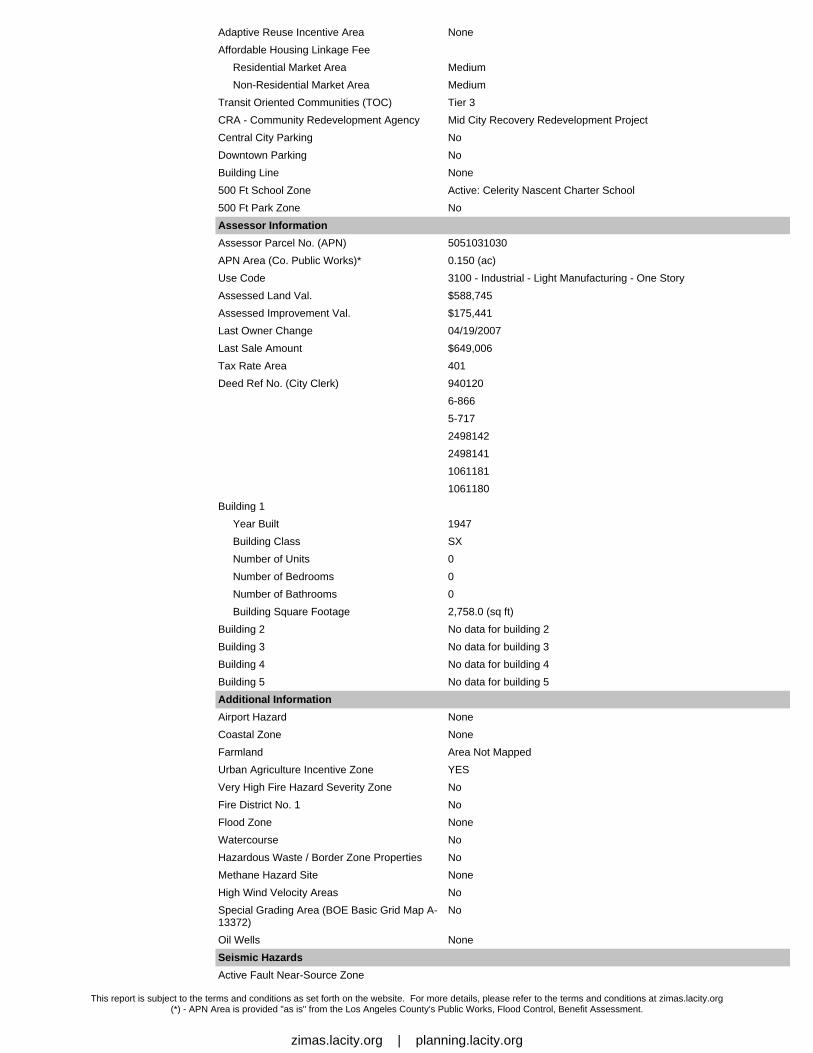
Adaptive Reuse Incentive Area None
Affordable Housing Linkage Fee
Residential Market Area Medium
Non-Residential Market Area Medium
Transit Oriented Communities (TOC) Tier 3
CRA - Community Redevelopment Agency Mid City Recovery Redevelopment Project
Central City Parking No
Downtown Parking No
Building Line None
500 Ft School Zone Active: Celerity Nascent Charter School
500 Ft Park Zone No
Assessor Information
Assessor Parcel No. (APN) 5051031030
APN Area (Co. Public Works)* 0.150 (ac)
Use Code 3100 - Industrial - Light Manufacturing - One Story
Assessed Land Val. $588,745
Assessed Improvement Val. $175,441
Last Owner Change 04/19/2007
Last Sale Amount $649,006
Tax Rate Area 401
Deed Ref No. (City Clerk) 940120
6-866
5-717
2498142
2498141
1061181
1061180
Building 1
Year Built 1947
Building Class SX
Number of Units 0
Number of Bedrooms 0
Number of Bathrooms 0
Building Square Footage 2,758.0 (sq ft)
Building 2 No data for building 2
Building 3 No data for building 3
Building 4 No data for building 4
Building 5 No data for building 5
Additional Information
Airport Hazard None
Coastal Zone None
Farmland Area Not Mapped
Urban Agriculture Incentive Zone YES
Very High Fire Hazard Severity Zone No
Fire District No. 1 No
Flood Zone None
Watercourse No
Hazardous Waste / Border Zone Properties No
Methane Hazard Site None
High Wind Velocity Areas No
Special Grading Area (BOE Basic Grid Map A-13372)
No
Oil Wells None
Seismic Hazards
Active Fault Near-Source Zone
This report is subject to the terms and conditions as set forth on the website. For more details, please refer to the terms and conditions at zimas.lacity.org(*) - APN Area is provided "as is" from the Los Angeles County's Public Works, Flood Control, Benefit Assessment.
zimas.lacity.org | planning.lacity.org

Nearest Fault (Distance in km) 3.1970472
Nearest Fault (Name) Newport - Inglewood Fault Zone (Onshore)
Region Transverse Ranges and Los Angeles Basin
Fault Type B
Slip Rate (mm/year) 1.00000000
Slip Geometry Right Lateral - Strike Slip
Slip Type Poorly Constrained
Down Dip Width (km) 13.00000000
Rupture Top 0.00000000
Rupture Bottom 13.00000000
Dip Angle (degrees) 90.00000000
Maximum Magnitude 7.10000000
Alquist-Priolo Fault Zone No
Landslide No
Liquefaction Yes
Preliminary Fault Rupture Study Area No
Tsunami Inundation Zone No
Economic Development Areas
Business Improvement District None
Promise Zone None
Renewal Community No
Revitalization Zone Central City
State Enterprise Zone LOS ANGELES STATE ENTERPRISE ZONE
Targeted Neighborhood Initiative None
Housing
Direct all Inquiries to Housing+Community Investment Department
Telephone (866) 557-7368
Website http://hcidla.lacity.org
Rent Stabilization Ordinance (RSO) No
Ellis Act Property No
Public Safety
Police Information
Bureau South
Division / Station Southwest
Reporting District 334
Fire Information
Bureau South
Batallion 18
District / Fire Station 34
Red Flag Restricted Parking No
This report is subject to the terms and conditions as set forth on the website. For more details, please refer to the terms and conditions at zimas.lacity.org(*) - APN Area is provided "as is" from the Los Angeles County's Public Works, Flood Control, Benefit Assessment.
zimas.lacity.org | planning.lacity.org

CASE SUMMARIESNote: Information for case summaries is retrieved from the Planning Department's Plan Case Tracking System (PCTS) database.
Case Number: CPC-2010-2278-GPA
Required Action(s): GPA-GENERAL PLAN AMENDMENT
Project Descriptions(s): GENERAL PLAN AMENDMENT FOR EXISTING FAST FOOD INTERIM CONTROL ORDINANCE (ICO) TO CREATE A GENERALPLANT FOOTNOTE FOR THE PROHIBITION OF CERTAIN PROJECTS.
Case Number: CPC-2007-3827-ICO
Required Action(s): ICO-INTERIM CONTROL ORDINANCE
Project Descriptions(s): ESTABLISHMENT OF AN ICO TO TEMPORARILY PROHIBIT THE ISSUANCE OF ALL PERMITS RELATED TO THEESTABLISHMENT OF NEW FAST-FOOD RESTAURANTS LOCATED IN WHOLE OR IN PART WITHIN THE PROPOSED ICOBOUNDARY.
Case Number: CPC-2006-5567-CPU
Required Action(s): CPU-COMMUNITY PLAN UPDATE
Project Descriptions(s): 1.PURSUANT TO PROCEDURES SET FORTH IN SECTION 11.5.6 OF THE MUNICIPAL CODE AND CITY CHARTER SECTIONS555 AND 558, AMEND THE WEST ADAMS-BALDWIN HILLS-LEIMERT COMMUNITY PLAN AS PART OF THE GENERAL PLAN OFTHE CITY OF LOS ANGELES, AS MODIFIED IN THE ATTACHED WEST ADAMS-BALDWIN HILLS-LEIMERT NEW COMMUNITYPLAN RESOLUTION, THE WEST ADAMS-BALDWIN HILLS-LEIMERT NEW COMMUNITY PLAN TEXT AND CHANGE MAPS(EXHIBITS A, B, C, M, O) AND ADDITIONAL PLAN MAP SYMBOL, FOOTNOTE, CORRESPONDING ZONE AND LAND USENOMENCLATURE CHANGES (EXHIBIT K).
2.PURSUANT TO SECTIONS 11.5.7.G., 16.50.D., 12.32. AND 12.04 OF THE MUNICIPAL CODE AND CITY CHARTER SECTION558, AMEND THE CRENSHAW CORRIDOR SPECIFIC PLAN, AS SHOWN IN THE PROPOSED CRENSHAW CORRIDOR SPECIFICPLAN AMENDMENTS (EXHIBIT G).
3.PURSUANT TO SECTION 13.14.C., 12.32, AND 12.04 OF THE MUNICIPAL CODE AND CITY CHARTER SECTION 558, ADOPTTHE WEST ADAMS-BALDWIN HILLS-LEIMERT COMMUNITY PLAN IMPLEMENTATION OVERLAY (CPIO) DISTRICT, AS SHOWNIN THE PROPOSED CPIO SUBDISTRICT ORDINANCES (EXHIBIT F).
4.PURSUANT TO SECTION 12.32 OF THE MUNICIPAL CODE, ADOPT REZONING ACTIONS TO EFFECT CHANGES OF ZONEAS IDENTIFIED ON THE LAND USE CHANGE MAP (EXHIBIT H), LAND USE CHANGE MATRIX (EXHIBIT I) AND PROPOSEDZONING MAP (EXHIBIT Q).
5.PURSUANT TO PROCEDURES SET FORTH IN SECTION 11.5.6 OF THE MUNICIPAL CODE AND CITY CHARTER SECTIONS555 AND 558, AMEND THE HIGHWAYS AND FREEWAYS MAP OF THE TRANSPORTATION ELEMENT OF THE GENERAL PLANTO RECLASSIFY SELECTED STREETS WITHIN THE WEST ADAMS-BALDWIN HILLS-LEIMERT NEW COMMUNITY PLAN ASSHOWN ON THE STREET REDESIGNATION MATRIX (EXHIBIT J).
6.PURSUANT TO PROCEDURES SET FORTH IN SECTION 11.5.6 OF THE MUNICIPAL CODE AND CITY CHARTER SECTIONS555 AND 558, AMEND THE LONG RANGE LAND USE DIAGRAM OF THE CITYWIDE GENERAL PLAN FRAMEWORK ELEMENTTO REFLECT CHANGES AND MODIFICATIONS TO THE GEOGRAPHY OF NEIGHBORHOOD DISTRICTS, COMMUNITYCENTERS, REGIONAL CENTERS, AND MIXED USE BOULEVARDS AS SHOWN ON THE PROPOSED LON
Case Number: CPC-2004-2395-ICO
Required Action(s): ICO-INTERIM CONTROL ORDINANCE
Project Descriptions(s): ICO TO REGULATE THE ISSUANCE OF PERMITS RELATED TO AUTOMOTIVE-RELATED USES, INCLUDING BUT NOT LIMITEDTO AUTOMOBILE, TRAILER SALES, ETC
Case Number: CPC-1999-2293-ICO
Required Action(s): ICO-INTERIM CONTROL ORDINANCE
Project Descriptions(s): INTERIM CONTROL ORDINANCE.
Case Number: CPC-1990-346-CA
Required Action(s): CA-CODE AMENDMENT
Project Descriptions(s): AMENDMENT TO THE L.A.M.C. TO - DRAFT AN ORDINANCE TO PROHIBIT THE GRANTING OF A CONDITIONAL USE PERMITFOR THE OFF-SITE SALE OF ALCOHOLIC BEVERAGES (LOURDES GREEN/KAREN HOO)\
Case Number: CPC-1983-506-SP
Required Action(s): SP-SPECIFIC PLAN (INCLUDING AMENDMENTS)
Project Descriptions(s): Data Not Available
Case Number: CPC-1983-506
Required Action(s): Data Not Available
Project Descriptions(s): SPECIFIC PLN ORD FOR INTERIM CONDITIONAL USE APPRVL FOR ESTABLISHMENTS FOR THE SALE OF ALCOHOL WHICHARE GENERALLY LOCATED INTHE SOUTH CENTRAL AREA OF THE CITY
Case Number: ENV-2010-2279-CE
Required Action(s): CE-CATEGORICAL EXEMPTION
Project Descriptions(s): GENERAL PLAN AMENDMENT FOR EXISTING FAST FOOD INTERIM CONTROL ORDINANCE (ICO) TO CREATE A GENERALPLANT FOOTNOTE FOR THE PROHIBITION OF CERTAIN PROJECTS.
Case Number: ENV-2008-478-EIR
Required Action(s): EIR-ENVIRONMENTAL IMPACT REPORT
This report is subject to the terms and conditions as set forth on the website. For more details, please refer to the terms and conditions at zimas.lacity.org(*) - APN Area is provided "as is" from the Los Angeles County's Public Works, Flood Control, Benefit Assessment.
zimas.lacity.org | planning.lacity.org

Project Descriptions(s): WEST ADAMS-BALDWIN HILLS-LEIMERT CPU
DATA NOT AVAILABLEORD-184796-SA961
ORD-184794
ORD-180103
ORD-177323
ORD-173607
ORD-171682
ORD-171681
ORD-162128
This report is subject to the terms and conditions as set forth on the website. For more details, please refer to the terms and conditions at zimas.lacity.org(*) - APN Area is provided "as is" from the Los Angeles County's Public Works, Flood Control, Benefit Assessment.
zimas.lacity.org | planning.lacity.org

ZIMAS PUBLIC 2014 Digital Color-Ortho 06/23/2018City of Los Angeles
Department of City Planning
Address: 3301 W JEFFERSON BLVD Tract: TR 5580 Zoning: C2-1VL-CPIO
APN: 5051031030 Block: G General Plan: Neighborhood Commercial
PIN #: 120B185 783 Lot: FR 25
Arb: None
Streets Copyright (c) Thomas Brothers Maps, Inc.

LAND USERESIDENTIAL
Minimum Residential
Very Low / Very Low I Residential
Very Low II Residential
Low / Low I Residential
Low II Residential
Low Medium / Low Medium I Residential
Low Medium II Residential
Medium Residential
High Medium Residential
High Density Residential
Very High Medium Residential
COMMERCIAL
Limited Commercial
Limited Commercial - Mixed Medium Residential
Highway Oriented Commercial
Highway Oriented and Limited Commercial
Highway Oriented Commercial - Mixed Medium Residential
Community Commercial
Community Commercial - Mixed High Residential
Regional Center Commercial
INDUSTRIAL
Commercial Manufacturing
Limited Manufacturing
Light Manufacturing
Heavy Manufacturing
PARKING
PORT OF LOS ANGELES
General / Bulk Cargo - Non Hazardous (Industrial / Commercial)
General / Bulk Cargo - Hazard
Commercial Fishing
Recreation and Commercial
Intermodal Container Transfer Facility Site
LOS ANGELES INTERNATIONAL AIRPORTAirport Landside
Airport Airside
Airport Northside
OPEN SPACE / PUBLIC FACILITIES
Open Space
Public / Open Space
Public / Quasi-Public Open Space
Other Public Open Space
Public FacilitiesFRAMEWORKCOMMERCIAL
Neighborhood Commercial
General Commercial
Community Commercial
Regional Mixed Commercial
INDUSTRIAL
Limited Industrial
GENERAL PLAN LAND USE
Light Industrial
Hybrid Industrial
GENERALIZED ZONINGOS, GW
A, RA
RE, RS, R1, RU, RZ, RW1
R2, RD, RMP, RW2, R3, RAS, R4, R5
CR, C1, C1.5, C2, C4, C5, CW, ADP, LASED, CEC, USC, PVSP, PPSP
CM, MR, WC, CCS, UV, UI, UC, M1, M2, LAX, M3, SL
P, PB
PF
LEGEND

STREET[[[[[[[[[[[ [[[[[[[[[[[
[[[[[[[[[[[ [ [ [ [ [ [ [ [ [ [[
[[[[[[[[[[[
[[[[[[[[[[[[[[[[
[[[[[[[[[[[
[[[[[[[[[[[
[[[[[[[[[[[
[[[[[[[[[[[
[[[[[[[[[[
! ! ! ! !( ( ( ( (
) ) )
##########
( (
8 8 8 8 8 8
! ! ! ! !
( ( ( (
U U
U U
( (
?
8 8 8 8 8 8
Arterial Mountain Road
Collector Scenic Street
Collector Street
Collector Street (Hillside)
Collector Scenic Street (Proposed)
Major Scenic Highway
Major Scenic Highway II
Mountain Collector Street
Park Road
Parkway
Principal Major Highway
Private Street
Scenic Divided Major Highway II
Scenic Park
Scenic Parkway
Secondary Highway
Secondary Scenic Highway
Special Collector Street
Super Major Highway
MSA Desirable Open Space
Major Scenic Controls
Multi-Purpose Trail
Natural Resource Reserve
Park Road
Park Road (Proposed)
Quasi-Public
Rapid Transit Line
Residential Planned Development
Scenic Highway (Obsolete)
Secondary Scenic Controls
Secondary Scenic Highway (Proposed)
Site Boundary
Southern California Edison Power
Special Study Area
Stagecoach Line
Wildlife Corridor
CIRCULATION
Collector Street (Proposed)
Country Road
Divided Major Highway II
Divided Secondary Scenic Highway
Local Scenic Road
Local Street
Major Highway I
Major Highway II
FREEWAYSFreeway
Interchange
Railroad
Scenic Freeway Highway
MISC. LINESAirport Boundary
Bus Line
Coastal Zone Boundary
Coastline Boundary
Commercial Areas
Community Redevelopment Project Area
Commercial Center
Country Road
DWP Power Lines
Desirable Open Space
Detached Single Family House
Endangered Ridgeline
Equestrian and/or Hiking Trail
Hiking Trail
Historical Preservation
Horsekeeping Area
Local Street

POINTS OF INTEREST

Lot LineTract Line
Lot CutEasementZone Boundary
Building LineLot Split
Community DrivewayTract MapParcel Map
J Lot Ties
!(
Airport Hazard Zone
Census Tract
Coastal ZoneCouncil District
Downtown ParkingFault ZoneFire District No. 1
Flood Zone
Hazardous Waste
High Wind ZoneHillside GradingHistoric Preservation Overlay Zone
Very High Fire Hazard Severity ZoneOil Wells
OTHER SYMBOLS
Building Outlines 2014
Building Outlines 2008
Calvo Exclusion Area
Dual Jurisdictional Coastal Zone
Coastal Zone Commission Authority
COASTAL ZONE
Not in Coastal Zone
No vehicle dwelling overnight between 9:00 PM - 6:00 AM. Must comply with all posted parking restrictions
Vehicle dwelling allowed. Must comply with all posted parking restrictions
No vehicle dwelling anytime
LAMC SECTION 85.02 (VEHICLE DWELLING)
CT Charter School
ES Elementary School
Other Facilities
Park / Recreation Centers
Parks
Performing / Visual Arts Centers SP Span School
Recreation Centers
Senior Citizen Centers
OS Opportunity School
HS High School
SE Special Education School
MS Middle School
SCHOOLS/PARKS WITH 500 FT. BUFFER
TRANSIT ORIENTED COMMUNITIES (TOC)
Tier 1
Tier 2
Tier 3
Tier 4
Note: TOC Tier designation and map layers are for reference purposes only. Eligible projects shall demonstrate compliance with Tier eligibility standardsprior to the issuance of any permits or approvals. As transit service changes, eligible TOC Incentive Areas will be updated.
WAIVER OF DEDICATION OR IMPROVEMENTPublic Work Approval (PWA)
Waiver of Dedication or Improvement (WDI)
Existing School/Park Site Planned School/Park Site
Early Education CenterEEC
Aquatic Facilities
Beaches
Child Care Centers
Dog Parks
Golf Course
Historic Sites
Horticulture/Gardens
Skate Parks