city of florissant street guide · street on right east on mullanphy from shackelford is 1570...
TRANSCRIPT

CITY OF FLORISSANT STREET GUIDE
Street Name Address range Zip Code Ward Description of street
Acredale 1180-1415 63033 7 Dunn & S. Waterford. 1st Street Hadwin which is 2nd street North of Dunn on S. Waterford.
Aintree Drive 1420-1560 (Even) 63033 8 Parker Spur & New Halls Ferry. Runs from Waterford to New Halls Ferry; 1st street north of Parker Spur
1425-1565 (Odd) 63033 9 Parker Spur & New Halls Ferry. Runs from Waterford to New Halls Ferry; 1st street north of Parker Spur
Alandale Court 2-24 63031 2 Lindsay Lane & N. Hwy 67 Runs off Lindsay Lane. 2nd street NW of N Hwy 67.
Albert Drive 190-470 and 85-145
63031 3 Charbonier & Shackelford. 2nd street on right from Shackelford SE on Charbonier (190-470). Charbonier & Howdershell. SW on Howdershell to 2nd left, Flordawn. Flordawn to the 1st street, Albert. Albert runs between Croftdale and Layven (85-145)
Alberto Lane 70-170 63031 2 Lindsay Lane & Schackelford or Charbonier & Shackelford. Off Monterey or Eldorado 4th street on right off Lindsay from Shackelford is Eldorado. OR Charbonier to Ocala to Loekes left to Florisota left to Alberto.
Allen Drive 1860-1880 W-E 63033 5 New Florissant Road North & St. Catherine. East on St. Catherine to Larry Drive, right to 1800 -1860 Allan; or continue on St. Catherine to 500 Allan. Also St. Anthony east to St. Edward, left to 1900 Allan Drive(1st cross st.)
* Designates streets not city maintained Page 1 of 134Revised September 2016

Street Name Address range Zip Code Ward Description of street
Allen Drive 1900-1920 63033 5 New Florissant Road North & St. Catherine. East on St. Catherine to Larry Drive, right to 1800 -1860 Allan; or continue on St. Catherine to 500 Allan. Also St. Anthony east to St. Edward, left to 1900 Allan Drive(1st cross st.)
1930-1960 63033 6 New Florissant Road North & St. Catherine. East on St. Catherine to Larry Drive, right to 1800 -1860 Allan; or continue on St. Catherine to 500 Allan. Also St. Anthony east to St. Edward, left to 1900 Allan Drive(1st cross st.)
2180-2510 (Even) 63033 8 New Florissant Road North & St. Catherine. East on St. Catherine to Larry Drive, right to 1800 -1860 Allan; or continue on St. Catherine to 500 Allan. Also St. Anthony east to St. Edward, left to 1900 Allan Drive(1st cross st.)
2245-2485 (Odd) 63033 6 New Florissant Road North & St. Catherine. East on St. Catherine to Larry Drive, right to 1800 -1860 Allan; or continue on St. Catherine to 500 Allan. Also St. Anthony east to St. Edward, left to 1900 Allan Drive(1st cross st.)
330-530 (Even) 63033 8 New Florissant Road North & St. Catherine. East on St. Catherine to Larry Drive, right to 1800 -1860 Allan; or continue on St. Catherine to 500 Allan. Also St. Anthony east to St. Edward, left to 1900 Allan Drive(1st cross st.)
355-525 (Odd) 63033 6 New Florissant Road North & St. Catherine. East on St. Catherine to Larry Drive, right to 1800 -1860 Allan; or continue on St. Catherine to 500 Allan. Also St. Anthony east to St. Edward, left to 1900 Allan Drive(1st cross st.)
Almonte Court 2-5 63033 9 New Halls Ferry & Santiago. East on Santiago to end; left on Pyrenees to Almonte Ct. 1st street on left.
* Designates streets not city maintained Page 2 of 134Revised September 2016

Street Name Address range Zip Code Ward Description of street
Alpha Drive 15-105 63031 5 New Florissant Rd North & Washington St. off Washington 3rd street on right south of New Florissant Rd. N. Also at the end of 1300 blk of St. Marie.
Amblewood Court 2-5 63033 8 From Parker & Meadowgrass south to 1st left (Steed), east to 3rd right (Liverpool), left onto Amblewood to 1st street on right. (Area 10)
Amblewood Drive 3425-3660 63033 8 From Parker & Meadowgrass south to 1st left (Steed), east to 3rd right (Liverpool), left onto Amblewood. (Area 10)
Angelus Drive 1405-1580 63031 4 Patterson Rd & N Hwy 67. Off Patterson Rd 2nd street north of N Hwy 67 (500 blk). Also off Mullanphy one block west of Patterson Rd. (1500 blk).
500-540 63031 4 Patterson Rd & N Hwy 67. Off Patterson Rd 2nd street north of N Hwy 67 (500 blk). Also off Mullanphy one block west of Patterson Rd (1500 blk).
Apache Court 2-9 63033 7 Waterford & Derhake. Off of Apache Dr.
Apache Dr. 1035-1175 63033 7 Waterford & Derhake. Off Waterford Dr. 1st street north of Derhake. Also 1st street north of Derhake off , near Robinwood School.
Appleblossom Court 1800-1980 63031 4 Patterson & Humes, OR Patterson Rd & Mullanphy East on Humes to 300 blk, OR via Cherrydale which is off east side of Patterson Rd between Humes & Mullanphy (1800 blk).
* Designates streets not city maintained Page 3 of 134Revised September 2016

Street Name Address range Zip Code Ward Description of street
Aqueduct Drive 1610-2265 63033 9 New Halls Ferry & Santiago. East of Santiago to 2nd street on left or right. 2000 blk left, 1900 right. OR New Halls Ferry & Hambletonian; east on Hambletonian to 1st street on left, 1600 Aqueduct.
Ardmore Drive 1810-1895 63033 8 St. Anthony & Waterford Dr. East on St. Anthony to Broadmere (7th street) - to Ardmore. Also east on Derhake from Waterford, then north on Bon Aire to Arundel - east on Arundel to Broadmere left to Ardmore.
Argo Drive 2005-2265 63031 7 McCluer Sr High School. South on S. Florissant Rd. from Dunn Rd to Wadsworth; east on Wadsworth to 2nd right. OR south on Washington/Elizabeth to Milbank; Milbank to Argo.
Aristocrat Drive 2011-2192 63031 1 Humes & Shackelford. SE on Humes to 3rd left North Pointe to 1st right. Fifth Plaza turns into North Pointe at 1st NW end.
Arlington Drive 1300-1550 63033 6 Parker & New Florissant North. East on Parker to 6th Street on left. OR 2nd street west of Paddock off Parker Rd.
Armada Court 916-1097 63031 1 Lindsay & Shackelford, north on Lindsay to 3rd right or 4th left, (Armada Ct.) 1007-1097 on right and 916-987 on left.
Arundel Drive 1650-1860 63033 8 Waterford & Derhake. East on Derhake then North on Bon Aire to Arundel.
Ascot Terrace 1420-1590 63033 9 Parker Spur & N. Waterford. West on N. Waterford to 2nd street on right.
* Designates streets not city maintained Page 4 of 134Revised September 2016
Street Name Address range Zip Code Ward Description of street
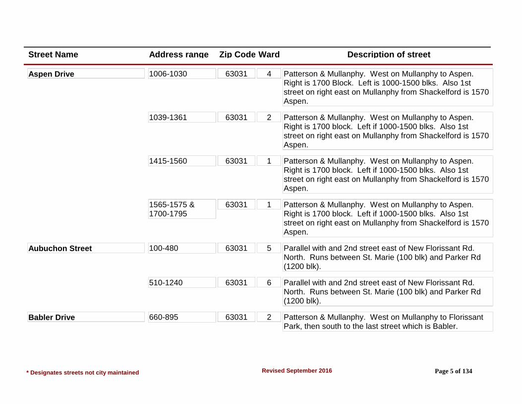
Aspen Drive 1006-1030 63031 4 Patterson & Mullanphy. West on Mullanphy to Aspen. Right is 1700 Block. Left is 1000-1500 blks. Also 1st street on right east on Mullanphy from Shackelford is 1570 Aspen.
1039-1361 63031 2 Patterson & Mullanphy. West on Mullanphy to Aspen. Right is 1700 block. Left if 1000-1500 blks. Also 1st street on right east on Mullanphy from Shackelford is 1570 Aspen.
1415-1560 63031 1 Patterson & Mullanphy. West on Mullanphy to Aspen. Right is 1700 block. Left if 1000-1500 blks. Also 1st street on right east on Mullanphy from Shackelford is 1570 Aspen.
1565-1575 & 1700-1795
63031 1 Patterson & Mullanphy. West on Mullanphy to Aspen. Right is 1700 block. Left if 1000-1500 blks. Also 1st street on right east on Mullanphy from Shackelford is 1570 Aspen.
Aubuchon Street 100-480 63031 5 Parallel with and 2nd street east of New Florissant Rd. North. Runs between St. Marie (100 blk) and Parker Rd (1200 blk).
510-1240 63031 6 Parallel with and 2nd street east of New Florissant Rd. North. Runs between St. Marie (100 blk) and Parker Rd (1200 blk).
Babler Drive 660-895 63031 2 Patterson & Mullanphy. West on Mullanphy to Florissant Park, then south to the last street which is Babler.
* Designates streets not city maintained Page 5 of 134Revised September 2016

Street Name Address range Zip Code Ward Description of street
Balmoral Drive 1400-1595 63033 9 New Halls Ferry & E on Hambletonian to last street on right (1500 blk).
Baltic Drive 506-530 63031 4 From Jana Drive & Patterson Road Intersection northeast on Patterson Rd to 1st street on right (Baltic Dr). Also, from New Halls Ferry Rd & Patterson Rd Intersection southwest on Patterson Rd to 3rd street on left (Baltic Dr).
Banstead Drive 1760-1880 63033 9 Trotter Way & N Hwy 67 OR Trotter Way & N Waterford, south on Trotter Way from 67 to 1st right (Sorrel) to Banstead; OR North on Trotter Way from N Waterford to 2nd left (Stirrup) to Banstead.
Barat Lane 885-935 63033 7 800 Blk Derhake Rd at Robinwood School. 1st street south of Derhake off Duquette Dr, runs between Grenoble & Duquette.
Barcelona Drive 2010-2255 63033 9 New Halls Ferry & Santiago. East on Santiago to 3rd street on left.
Bardot Drive 401 & 409 (vacant lots)
63031 4 Patterson & Humes. North on Patterson to 6th street N of Humes on right.
470-595 63031 4 Patterson & Humes. North on Patterson to 6th street N of Humes on right.
Barto Drive 101 Only 63031 5 From Hwy. 270 & Dunn, south to 2nd street on right, Barto Drive. West of Barto to 1st street, Boehner Dr. Turn right onto gravel drive and go to end. This is 101 Barto. NOTE: Addresses 203, 221, 223, 227 & 231 Barto Dr are inaccessible vacant lots.
* Designates streets not city maintained Page 6 of 134Revised September 2016

Street Name Address range Zip Code Ward Description of street
Bay Meadows Drive 1470-1750 63033 9 Waterford Dr & North Waterford Dr 3rd street on left off of N Waterford E of Waterford. Runs from N Waterford to Delaware.
Bayberry Lane 2-15 63033 8 St. Anthony & Waterford Dr. West on St. Anthony to Countryside. North on Countryside to 2nd street OR St. Catherine & Waterford. West on St. Catherine to Holiday Hill, South to Countryside to Bayberry Lane.
Belair Terrace 2600-2660 (Even) 63033 6 Paddock & Parker. South on Paddock to 1st street on left (Steeplechase), left on Steeplechase to Preakness to 1st street.
2625-2705 (Odd) 63033 8 Paddock & Parker. South on Paddock to 1st street on left (Steeplechase), left on Steeplechase to Preakness to 1st street.
Bellarmine Lane 665-1245 63031 3 N. Hwy 67 & Charbonier. South on N. Hwy 67 to 4th street Loyola (northmost) entrance. Loyola to 1st street on right.
Bellm Lane 215-255 63031 5 Washington & St. Charles. South on St. Charles to 4th street on right.
Belmont Terrace 960-1115 63033 6 Paddock & St. Catherine. North on Paddock 3rd street on left. Also Parker & Paddock. South on Paddock 2nd street on right.
Beltower Drive (Private Rd) 1315-1393 63033 6 N. Hwy 67 & New Florissant Rd. North, North on New Florissant Rd. to 2nd left (Beltower Dr.)
* Designates streets not city maintained Page 7 of 134Revised September 2016

Street Name Address range Zip Code Ward Description of street
Benne Drive 2715-2785 63031 4 Patterson & Humes. North on Patterson to 7th street on right (Jana), east on Jana to 1st street (Benne) on left.
450-575 63031 4 Patterson & Humes. North on Patterson to 7th street on right (Jana), east on Jana to 1st street (Benne) on left.
Berchmans Lane 1005-1130 63031 3 N. Lindbergh/S. Hwy. 67 & Manresa. NW on Manresa to Canisius Right on Canisius to 1st left.
Beta Drive 1450-1575 63031 5 New Florissant Rd North & Washington St. South on Washington to 3rd street on right (Alpha), right on Alpha to 1st street on left.
Beverly Drive 1600-1790 63031 6 N. Hwy. 67 & St. Jean. North on St. Jean (Electric Signal) to last street which is Marquette, right on Marquette to Queens. Left on Queens to 1st street (Pamela), right on Pamela to end which becomes Beverly.
Birch Hill Drive 2308-2448 63033 8 Derhake & St. Catherine. South on Derhake to Salazar (which is between St. Anthony & St. Catherine) to Pontchartrain, then left to Birch Hill.
3610-3655 63033 8 Derhake & St. Catherine. South on Derhake to Salazar (which is between St. Anthony & St. Catherine) to Pontchartrain, then left to Birch Hill.
Birchbark Drive 3430-3670 63033 8 From Parker and Meadowgrass, south to 1st left (Steed), east to 3rd right (Liverpool). Right on Liverpool to 1st left. (Area 10)
* Designates streets not city maintained Page 8 of 134Revised September 2016
Street Name Address range Zip Code Ward Description of street
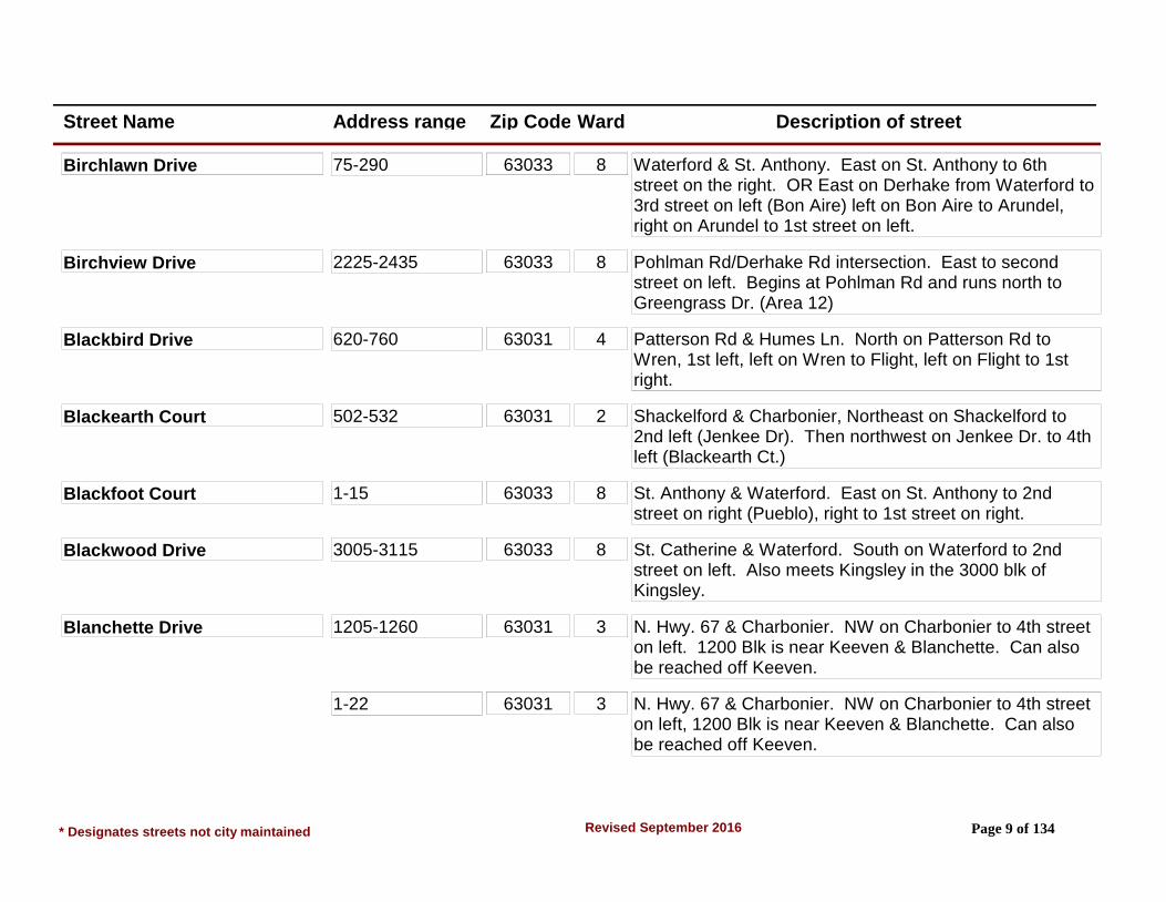
Birchlawn Drive 75-290 63033 8 Waterford & St. Anthony. East on St. Anthony to 6th street on the right. OR East on Derhake from Waterford to 3rd street on left (Bon Aire) left on Bon Aire to Arundel, right on Arundel to 1st street on left.
Birchview Drive 2225-2435 63033 8 Pohlman Rd/Derhake Rd intersection. East to second street on left. Begins at Pohlman Rd and runs north to Greengrass Dr. (Area 12)
Blackbird Drive 620-760 63031 4 Patterson Rd & Humes Ln. North on Patterson Rd to Wren, 1st left, left on Wren to Flight, left on Flight to 1st right.
Blackearth Court 502-532 63031 2 Shackelford & Charbonier, Northeast on Shackelford to 2nd left (Jenkee Dr). Then northwest on Jenkee Dr. to 4th left (Blackearth Ct.)
Blackfoot Court 1-15 63033 8 St. Anthony & Waterford. East on St. Anthony to 2nd street on right (Pueblo), right to 1st street on right.
Blackwood Drive 3005-3115 63033 8 St. Catherine & Waterford. South on Waterford to 2nd street on left. Also meets Kingsley in the 3000 blk of Kingsley.
Blanchette Drive 1205-1260 63031 3 N. Hwy. 67 & Charbonier. NW on Charbonier to 4th street on left. 1200 Blk is near Keeven & Blanchette. Can also be reached off Keeven.
1-22 63031 3 N. Hwy. 67 & Charbonier. NW on Charbonier to 4th street on left, 1200 Blk is near Keeven & Blanchette. Can also be reached off Keeven.
* Designates streets not city maintained Page 9 of 134Revised September 2016
Street Name Address range Zip Code Ward Description of street
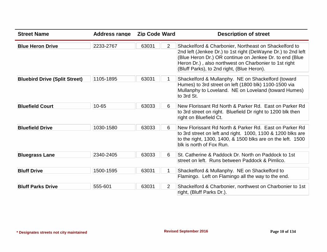
Blue Heron Drive 2233-2767 63031 2 Shackelford & Charbonier, Northeast on Shackelford to 2nd left (Jenkee Dr.) to 1st right (DeWayne Dr.) to 2nd left (Blue Heron Dr.) OR continue on Jenkee Dr. to end (Blue Heron Dr.) , also northwest on Charbonier to 1st right (Bluff Parks), to 2nd right, (Blue Heron).
Bluebird Drive (Split Street) 1105-1895 63031 1 Shackelford & Mullanphy. NE on Shackelford (toward Humes) to 3rd street on left (1800 blk) 1100-1500 via Mullanphy to Loveland. NE on Loveland (toward Humes) to 3rd St.
Bluefield Court 10-65 63033 6 New Florissant Rd North & Parker Rd. East on Parker Rd to 3rd street on right. Bluefield Dr right to 1200 blk then right on Bluefield Ct.
Bluefield Drive 1030-1580 63033 6 New Florissant Rd North & Parker Rd. East on Parker Rd to 3rd street on left and right. 1000, 1100 & 1200 blks are to the right, 1300, 1400, & 1500 blks are on the left. 1500 blk is north of Fox Run.
Bluegrass Lane 2340-2405 63033 6 St. Catherine & Paddock Dr. North on Paddock to 1st street on left. Runs between Paddock & Pimlico.
Bluff Drive 1500-1595 63031 1 Shackelford & Mullanphy. NE on Shackelford to Flamingo. Left on Flamingo all the way to the end.
Bluff Parks Drive 555-601 63031 2 Shackelford & Charbonier, northwest on Charbonier to 1st right, (Bluff Parks Dr.).
* Designates streets not city maintained Page 10 of 134Revised September 2016
Street Name Address range Zip Code Ward Description of street
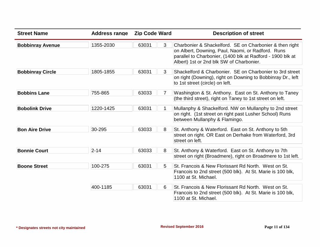
Bobbinray Avenue 1355-2030 63031 3 Charbonier & Shackelford. SE on Charbonier & then right on Albert, Downing, Paul, Naomi, or Radford. Runs parallel to Charbonier, (1400 blk at Radford - 1900 blk at Albert) 1st or 2nd blk SW of Charbonier.
Bobbinray Circle 1805-1855 63031 3 Shackelford & Charbonier. SE on Charbonier to 3rd street on right (Downing), right on Downing to Bobbinray Dr., left to 1st street (circle) on left.
Bobbins Lane 755-865 63033 7 Washington & St. Anthony. East on St. Anthony to Taney (the third street), right on Taney to 1st street on left.
Bobolink Drive 1220-1425 63031 1 Mullanphy & Shackelford. NW on Mullanphy to 2nd street on right. (1st street on right past Lusher School) Runs between Mullanphy & Flamingo.
Bon Aire Drive 30-295 63033 8 St. Anthony & Waterford. East on St. Anthony to 5th street on right. OR East on Derhake from Waterford, 3rd street on left.
Bonnie Court 2-14 63033 8 St. Anthony & Waterford. East on St. Anthony to 7th street on right (Broadmere), right on Broadmere to 1st left.
Boone Street 100-275 63031 5 St. Francois & New Florissant Rd North. West on St. Francois to 2nd street (500 blk). At St. Marie is 100 blk, 1100 at St. Michael.
400-1185 63031 6 St. Francois & New Florissant Rd North. West on St. Francois to 2nd street (500 blk). At St. Marie is 100 blk, 1100 at St. Michael.
* Designates streets not city maintained Page 11 of 134Revised September 2016

Street Name Address range Zip Code Ward Description of street
Borgia Lane 710-880 63031 3 Manresa & S. Hwy. 67/N. Lindbergh. NW on Manresa to Loyola. Left on Loyola to 1st street on right which is Borgia. (Also runs off Canisius)
Boulder Drive 965-1585 63031 2 Mullanphy & Shackelford. SE on Mullanphy to 2nd street on right (Loveland), right on Loveland to 2nd street, (Boulder). OR NW on Lindsay from N. Hwy. 67 to 6th street on right (Manor), right on Manor to 2nd street.
Brackleigh Lane 40-370 63031 5 Dunn & S. Florissant Rd. to Jean Dr. Right on Jean to Pershall to 6th street on left, (Brackleigh). OR Dunn & Graham (Hanley). South on Hanley to Pershall, left to 2nd street on right.
Bradstone Drive 3530-3635 63033 8 From Derhake and Stonehaven west to 1st left (Brookstone) to 1st street on right. (Area 10)
Brebouef Lane #5 & #10 Only 63031 5 Dunn & Graham/Hanley. South on Hanley to Pershall, left to 3rd street (Clover), right on Clover to Marechal, left to Brebouef Lane.
Bridle Path Court 2-11 63033 6 Waterford & N. Waterford. South on Waterford from N. Waterford to 1st street on right (Narraganset), right to 1st street on the left, (Bridle Path Ct).
Brightmoor Drive 55-290 63033 8 St. Anthony & Waterford. East on St. Anthony to 4th street on right. Also, east on Derhake from Waterford to 3rd street on left (Bon Aire) left on Bon Aire to 1st street on left (Arundel), left on Arundel to Curve.
* Designates streets not city maintained Page 12 of 134Revised September 2016
Street Name Address range Zip Code Ward Description of street
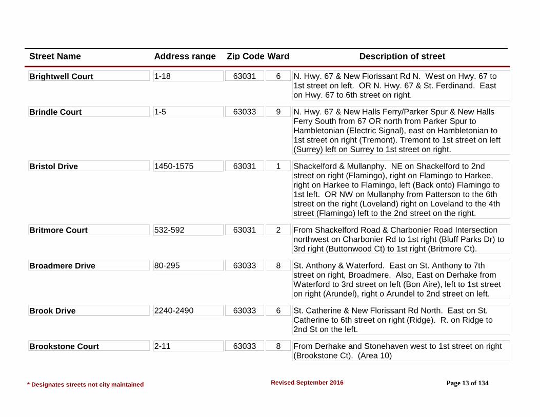
Brightwell Court 1-18 63031 6 N. Hwy. 67 & New Florissant Rd N. West on Hwy. 67 to 1st street on left. OR N. Hwy. 67 & St. Ferdinand. East on Hwy. 67 to 6th street on right.
Brindle Court 1-5 63033 9 N. Hwy. 67 & New Halls Ferry/Parker Spur & New Halls Ferry South from 67 OR north from Parker Spur to Hambletonian (Electric Signal), east on Hambletonian to 1st street on right (Tremont). Tremont to 1st street on left (Surrey) left on Surrey to 1st street on right.
Bristol Drive 1450-1575 63031 1 Shackelford & Mullanphy. NE on Shackelford to 2nd street on right (Flamingo), right on Flamingo to Harkee, right on Harkee to Flamingo, left (Back onto) Flamingo to 1st left. OR NW on Mullanphy from Patterson to the 6th street on the right (Loveland) right on Loveland to the 4th street (Flamingo) left to the 2nd street on the right.
Britmore Court 532-592 63031 2 From Shackelford Road & Charbonier Road Intersection northwest on Charbonier Rd to 1st right (Bluff Parks Dr) to 3rd right (Buttonwood Ct) to 1st right (Britmore Ct).
Broadmere Drive 80-295 63033 8 St. Anthony & Waterford. East on St. Anthony to 7th street on right, Broadmere. Also, East on Derhake from Waterford to 3rd street on left (Bon Aire), left to 1st street on right (Arundel), right o Arundel to 2nd street on left.
Brook Drive 2240-2490 63033 6 St. Catherine & New Florissant Rd North. East on St. Catherine to 6th street on right (Ridge). R. on Ridge to 2nd St on the left.
Brookstone Court 2-11 63033 8 From Derhake and Stonehaven west to 1st street on right (Brookstone Ct). (Area 10)
* Designates streets not city maintained Page 13 of 134Revised September 2016
Street Name Address range Zip Code Ward Description of street
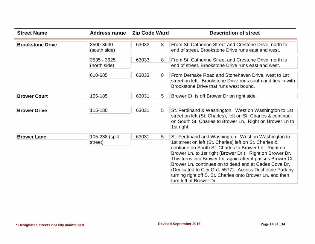
Brookstone Drive 3500-3630 (south side)
63033 8 From St. Catherine Street and Crestone Drive, north to end of street. Brookstone Drive runs east and west.
3535 - 3625 (north side)
63033 8 From St. Catherine Street and Crestone Drive, north to end of street. Brookstone Drive runs east and west.
610-685 63033 8 From Derhake Road and Stonehaven Drive, west to 1st street on left. Brookstone Drive runs south and ties in with Brookstone Drive that runs west bound.
Brower Court 155-185 63031 5 Brower Ct. is off Brower Dr on right side.
Brower Drive 115-180 63031 5 St. Ferdinand & Washington. West on Washington to 1st street on left (St. Charles), left on St. Charles & continue on South St. Charles to Brower Ln. Right on Brower Ln to 1st right.
Brower Lane 105-238 (split street)
63031 5 St. Ferdinand and Washington. West on Washington to 1st street on left (St. Charles) left on St. Charles & continue on South St. Charles to Brower Ln. Right on Brower Ln. to 1st right (Brower Dr.). Right on Brower Dr. This turns into Brower Ln. again after it passes Brower Ct. Brower Ln. continues on to dead end at Cades Cove Dr. (Dedicated to City-Ord. 5577). Access Duchesne Park by turning right off S. St. Charles onto Brower Ln. and then turn left at Brower Dr.
* Designates streets not city maintained Page 14 of 134Revised September 2016

Street Name Address range Zip Code Ward Description of street
Brower Lane 1-10 (split street) 63031 5 St. Ferdinand and Washington. West on Washington to 1st street on left (St. Charles) left on St. Charles & continue on South St. Charles to Brower Ln. Right on Brower Ln. to 1st right (Brower Dr.). Right on Brower Dr. This turns into Brower Ln. again after it passes Brower Ct. Brower Ln. continues on to dead end at Cades Cove Dr. (Dedicated to City-Ord. 5577). Access Duchesne Park by turning right off S. St. Charles onto Brower Ln. and then turn left at Brower Dr.
Brown Street 146-190 (split street)
63031 5 Washington & New Florissant Rd. Northwest on Washington to 1st street on right, 400 blk Brown St. Ends at St. Antoine (800 blk). 100 Blk is off St. Marie one blk west of New Florissant Rd N. (200-300 blks).
510-1160 (split street)
63031 6 Washington & New Florissant Rd. Northwest on Washington to 1st street on right, 400 blk Brown St. Ends at St. Antoine (800 blk). 100 Blk is off St. Marie one blk west of New Florissant Rd N. (200-300 blks).
Bruce Drive 1-18 63031 3 N. Hwy 67 & Charbonier. South on N. Hwy. 67 to 1st street on left. Apartment complex buildings numbered 1-16.
Burning Tree Drive 1305-1530 63033 6 Parker Rd & New Florissant Rd North. East on Parker Rd to 5th street on left. Burning Tree also runs into Fox Run.
Buttonwood Court 2316-2485 63031 2 Shackelford & Charbonier, NW on Charbonier to 1st right (Bluff Parks Dr.) to 3rd right (Buttonwood Ct.) (#2366 is common ground-no residence).
* Designates streets not city maintained Page 15 of 134Revised September 2016

Street Name Address range Zip Code Ward Description of street
Cades Cove Drive 800-941 63031 5 St. Ferdinand & Washington. West on Washington to 1st street on left, St. Charles. Left on St. Charles to Brower Ln. Right on Brower Ln to 1st street on right, Brower Dr. Right on Brower Dr. This turns into Brower Ln after it passes Brower Ct. Continue on Brower Ln to the dead end. (Cades Cove Dr. dedicated to City-Ord. 5577).
Calavera Drive 2477-4099 63033 8 Derhake Rd/Greengrass Rd intersection east to first street on left. New Halls Ferry Rd west on Greengrass Rd to first street on right. (Area 12)
Calbreath Court 4-240 63031 5 Dunn & Graham. North on Graham Rd to 3rd street on left. (2nd Electric Signal northbound on Graham from Dunn Rd) Also 6th street on right, south on St. Ferdinand/Graham from Washington St.
Calumet Lane 1095 63033 6 Parker & Paddock. South on Paddock to 1st street on left. Steeplechase to 1st street on right (Preakness), right on Preakness to 1st street on left (Bel Aire Terr). At end of Bel Air Terr is Calumet.
960-1060 63033 8 Parker & Paddock. South on Paddock to 1st street on left. Steeplechase to 1st street on right (Preakness), right on Preakness to 1st street on left (Bel Aire Terr). At end of Bel Air Terr is Calumet.
Campion Lane 805-1140 63031 3 S. Hwy 67/N. Lindbergh & Manresa. NW on Manresa to end (6th street) OR SE on Tahoe from Howdershell 2nd street on left.
* Designates streets not city maintained Page 16 of 134Revised September 2016

Street Name Address range Zip Code Ward Description of street
Canary Court 2-6 63031 1 Mullanphy & Shackelford. NW on Mullanphy to 7th street on right (Night Dr), right on Night Dr to 1st street on right. Backs up to NW side of Mullanphy Pk.
Canisius Lane 10-1065 63031 3 Manresa & S. Hwy 67/N. Lindbergh. NW on Manresa to 3rd street (Right 900 blk - Left 1000 blk). Also SE on Keeven from Howdershell to 4th or 5th street (Flora), right on Flora to Canisius.
Cantabrian Court 1-14 63033 9 New Halls Ferry Rd & N Hwy 67. South on New Halls Ferry to 4th street on left, (Santiago) left on Santiago to 1st left, Cantabrian Ct OR north on New Halls Ferry from Parker to Santiago, right on Santiago to 1st left.
Canter Drive 1565-1670 63033 9 N Hwy 67 & N. Waterford. East on N. Waterford to 6th left, OR West on N Waterford from Waterford to 4th street on right. Also runs into Northridge one block east of Trotter Way.
Cape Cod Drive 2803-2823 63033 8 Derhake/Stonehaven Dr intersection. East to Cranberry Ct. East to first street on left. (Area 12)
Capri Drive 5-230 63033 7 Dunn & Washington. North on Washington to 1st street on right (Lynn Meadows), Lynn Meadows to 1st street on right, (Capri). OR South on Lynn Meadows from Derhake to 1st street on left (Northmoor), Northmoor to Curve.
Cardinal Drive 2145-2385 63033 9 N. Hwy 67 & Thunderbird/N. Waterford. North on Thunderbird to 2nd street on right Cardinal Dr.
* Designates streets not city maintained Page 17 of 134Revised September 2016

Street Name Address range Zip Code Ward Description of street
Cardinal Lane 1225-1395 63031 1 Mullanphy & Shackelford. NW on Mullanphy to 1st street on right. Also crosses Bluebird, Swallow and Flicker in 1800 Blocks.
Carefree Lane 2030-2102 63033 9 New Halls Ferry Rd & N Hwy 67. South on New Halls Ferry to 3rd street on left. Also North on New Halls Ferry from Parker Spur to 7th street on right. LEISUREWOOD APARTMENTS.
3159-3250 63033 9 New Halls Ferry Rd & N. Hwy 67. South on New Halls Ferry to 3rd street on left. Also North on New Halls Ferry from Parker Spur to 7th street on right. LEISUREWOOD APARTMENTS.
Carla Drive 1025-1425 63031 6 From New Florissant Road, N & North Hwy 67 Intersection north to last street on left (Carla Dr).
1420-1480 63033 6 KENSINGTON APARTMENTS.
1475 63033 9 From New Florissant Road, N & North Hwy 67 Intersection north to last street on left (Carla Dr).
Carmelita Lane 750-885 63031 3 N Hwy 67 & Charbonier. NW on Charbonier to 1st left (Rosetta), left on Rosetta to Keeven, left on Keeven and a quick right back onto Rosetta to 1st street on right, OR SE on Keeven from Howdershell to Flora Lane, 5th right; Flora Lane to 1st left, Carmelita Ln.
* Designates streets not city maintained Page 18 of 134Revised September 2016

Street Name Address range Zip Code Ward Description of street
Carmona Drive 1090-1385 63033 7 Dunn & South Waterford. North on S. Waterford to 3rd street on the right (Ramport), right on Ramport to end, 1100 blk to the left - 1200 blk to the right. Also South on S. Waterford from Derhake to 1st street on left (Penhurst), Penhurst to end, 1000-1100 blks of Carmona.
Carson Court 2-9 63033 7 Derhake & Waterford. West on Derhake to 1st left (Coteau), left on Coteau to end (Rogers) right on Rogers to 1st street on right - Carson Ct. Also South on Duquette to Rogers from Derhake, left on Rogers to 4th street on left.
Castello St. S 470-620 63031 5 St. Anthony & New Florissant Rd South. East on St. Anthony to 1st street on left (Not shopping center) 600 blk. Can also be reached via driveway entrance to Duchesne School across from Bangert Park - 400 blk.
Castello Street 100-380 63031 5 Washington & New Florissant Rd. North. East on Washington to 1st street. 100-300 blk right, 400-1100 blks left. Runs into Parker Rd 1 blk east of New Florissant Rd North.
415-1190 63031 6 Washington & New Florissant Rd North. East on Washington to 1st street. 100-300 blk right, 400-1100 blks left. Runs into Parker Rd 1 blk east of New Florissant Rd North.
Cedar Park Drive 2-23 (right side) 63031 2 Lindsay & N Hwy 67. NW on Lindsay to 6th street on left. From Shackelford, SE on Lindsay to 6th street on right.
2-33 63031 2 Lindsay & N Hwy 67. NW on Lindsay to 6th street on left. From Shackelford, SE on Lindsay to 6th street on right.
* Designates streets not city maintained Page 19 of 134Revised September 2016

Street Name Address range Zip Code Ward Description of street
Cedar Park Drive 24-33 (left side) 63031 2 Lindsay & N Hwy 67. NW on Lindsay to 6th street on left. From Shackelford, SE on Lindsay to 6th street on right.
Cedar Place 1035-1155 63031 1 Shackelford & Mullanphy. SW on Shackelford to 1st street on right (Teakwood Manor), right on Teakwood Manor to 4th street (Cedar Place). Can be reached via Hawthorne & Oakwood Manor.
Central Parkway 1210-1425 63031 1 Patterson Rd & Humes Ln. NE on Patterson Rd to 3rd street on left, Shackelford (Fire House #3) NE on Shackelford to 1st street on right (Central/Parkway/Urbandale), right turn and bear left continue to Florissant City Limits at 1425 Central Parkway.
615-880 63031 4 Patterson Rd & Humes Ln. NE on Patterson Rd to 3rd street on left, Shackelford (Fire House #3) NE on Shackelford to 1st street on right (Central/Parkway/Urbandale), right turn and bear left continue to Florissant City Limits at 1425 Central Parkway.
935-1175 63031 1 Patterson Rd & Humes Ln. NE on Patterson Rd to 3rd street on left, Shackelford (Fire House #3) NE on Shackelford to 1st street on right (Central/Parkway/Urbandale), right turn and bear left continue to Florissant City Limits at 1425 Central Parkway.
Champlain Court 1-8 63031 6 St. Jean & N Hwy 67. North on St. Jean to 1st street on right (St. Celeste), right on St. Celeste to 1st street on left. Also can be reached via north on Florval to St. Celeste from N. Hwy. 67, left on St. Celeste to 3rd street on right, Champlain Court.
* Designates streets not city maintained Page 20 of 134Revised September 2016

Street Name Address range Zip Code Ward Description of street
Chandler Court 1-21 (Private Rd) 63031 6 Lindsay & N Hwy 67. East on Lindsay to 1st left. Also 2nd right off St. Denis NW of St. Ferdinand.
Chapel Cross Drive 503-547 63031 4 From Jana Dr & Patterson Rd Intersection northeast on Patterson Rd to 1st street on right (Rancho Ln) to 1st street on right (Chapel View Dr) to 1st street on left (Chapel Cross Dr). Street runs between Chapel View Dr on west and east side.
Chapel View Drive 2701-2871 63031 4 From Jana Dr & Patterson Rd Intersection northeast on Patterson Rd to 1st street on right (Rancho Ln) to 1st street on right (Chapel View Dr). Street is long and follows a counter-clockwise direction. Also, follow Rancho Ln to end of street which begins Chapel Hill Dr at 2871.
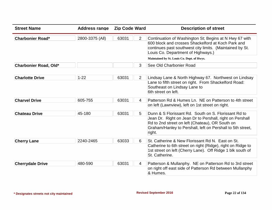
Charbonier Rd* 620-2800 (Even) 63031 3 Continuation of Washington St; Begins at N Hwy 67 with 600 block and crosses Shackelford at Koch Park and continues past southwest city limits. (Maintained by St. Louis Co. Department of Highways.)
Maintained by St. Louis Co. Dept. of Hwys.
673-2775 (Odd) 63031 2 Continuation of Washington St; Begins at N Hwy 67 with 600 block and crosses Shackelford at Koch Park and continues past southwest city limits. (Maintained by St. Louis Co. Department of Highways.)
Maintained by St. Louis Co. Dept. of Hwys.
Charbonier Road* 2300-2590 (Even) 63031 2 Continuation of Washington St; Begins at N Hwy 67 with 600 block and crosses Shackelford at Koch Park and continues past southwest city limits. (Maintained by St. Louis Co. Department of Highways.)
Maintained by St. Louis Co. Dept. of Hwys.
* Designates streets not city maintained Page 21 of 134Revised September 2016
Street Name Address range Zip Code Ward Description of street
Charbonier Road* 2800-3375 (All) 63031 2 Continuation of Washington St; Begins at N Hwy 67 with 600 block and crosses Shackelford at Koch Park and continues past southwest city limits. (Maintained by St. Louis Co. Department of Highways.)
Maintained by St. Louis Co. Dept. of Hwys.
Charbonier Road, Old* 3 See Old Charbonier Road
Charlotte Drive 1-22 63031 2 Lindsay Lane & North Highway 67. Northwest on Lindsay Lane to fifth street on right. From Shackelford Road: Southeast on Lindsay Lane to 6th street on left.
Charvel Drive 605-755 63031 4 Patterson Rd & Humes Ln. NE on Patterson to 4th street on left (Lawnview), left on 1st street on right.
Chateau Drive 45-180 63031 5 Dunn & S Florissant Rd. South on S. Florissant Rd to Jean Dr. Right on Jean Dr to Pershall, right on Pershall Rd to 2nd street on left (Chateau), OR South on Graham/Hanley to Pershall, left on Pershall to 5th street, right.
Cherry Lane 2240-2465 63033 6 St. Catherine & New Florissant Rd N. East on St. Catherine to 6th street on right (Ridge), right on Ridge to 1st street on left (Cherry Lane). Off Ridge 1 blk south of St. Catherine.
Cherrydale Drive 480-590 63031 4 Patterson & Mullanphy. NE on Patterson Rd to 3rd street on right off east side of Patterson Rd between Mullanphy & Humes.
* Designates streets not city maintained Page 22 of 134Revised September 2016

Street Name Address range Zip Code Ward Description of street
Chestnut Circle 1-5 63033 6 Paddock Dr & Parker Rd. North on Paddock to 1st street on left. Off Paddock Dr 2nd street north of Parker Rd.
Cheyenne Drive 10-35 63033 8 Waterford & Derhake. North on Waterford to 1st right 1200 blk, OR 2nd left 1100 blk. 10-35 are at end of 1200 blk and can be reached from Derhake; 1st left east of Waterford. 900 blk can also be reached off Countryside.
950-1295 63033 7 Waterford & Derhake. North on Waterford to 1st right 1200 blk, OR 2nd left 1100 blk. 10-35 are at end of 1200 blk and can be reached from Derhake; 1st left east of Waterford. 900 blk can also be reached off Countryside.
Chickadee Lane 1510-1605 63031 1 Shackelford & Mullanphy. NE on Shackelford to 4th street on left (Flamingo), left on Flamingo to 1st street on right.
Churchill Downs 2400-2565 63033 6 Paddock & Parker. South on Paddock to 1st street on right. Runs into Belmont Terrace.
Citation Court 2-6 63033 6 St. Catherine & Waterford. West on St. Catherine to 2nd street on right (Pimlico), right on Pimlico to 1st street on right. From Parker & Paddock - South on Padock to 3rd street on right (Johnstown), bear right on Johnstown to 1st left (Pimlico), left on Pimlico to 2nd left.
Claire Court 11, 13, 15, 19, 21 63031 7 Dunn & New Florissant Rd South. North on New Florissant Road S to 1st street on left. Left on Claire Dr. to first street on right.
Claire Drive 1-30 63031 5 Dunn & New Florissant Rd South. North on New Florissant Rd S to 1st street on left.
* Designates streets not city maintained Page 23 of 134Revised September 2016
Street Name Address range Zip Code Ward Description of street
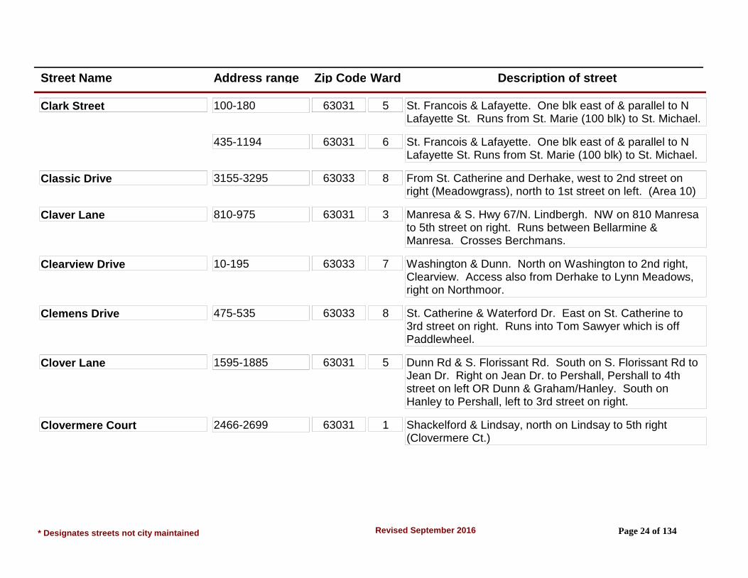
Clark Street 100-180 63031 5 St. Francois & Lafayette. One blk east of & parallel to N Lafayette St. Runs from St. Marie (100 blk) to St. Michael.
435-1194 63031 6 St. Francois & Lafayette. One blk east of & parallel to N Lafayette St. Runs from St. Marie (100 blk) to St. Michael.
Classic Drive 3155-3295 63033 8 From St. Catherine and Derhake, west to 2nd street on right (Meadowgrass), north to 1st street on left. (Area 10)
Claver Lane 810-975 63031 3 Manresa & S. Hwy 67/N. Lindbergh. NW on 810 Manresa to 5th street on right. Runs between Bellarmine & Manresa. Crosses Berchmans.
Clearview Drive 10-195 63033 7 Washington & Dunn. North on Washington to 2nd right, Clearview. Access also from Derhake to Lynn Meadows, right on Northmoor.
Clemens Drive 475-535 63033 8 St. Catherine & Waterford Dr. East on St. Catherine to 3rd street on right. Runs into Tom Sawyer which is off Paddlewheel.
Clover Lane 1595-1885 63031 5 Dunn Rd & S. Florissant Rd. South on S. Florissant Rd to Jean Dr. Right on Jean Dr. to Pershall, Pershall to 4th street on left OR Dunn & Graham/Hanley. South on Hanley to Pershall, left to 3rd street on right.
Clovermere Court 2466-2699 63031 1 Shackelford & Lindsay, north on Lindsay to 5th right (Clovermere Ct.)
* Designates streets not city maintained Page 24 of 134Revised September 2016

Street Name Address range Zip Code Ward Description of street
Club Grounds Drive North 1-76 63033 9 New Halls Ferry Rd & N. Hwy. 67. South on New Halls Ferry Rd to the 8th street on the left, or 2nd right from Parker Rd, north on New Halls Ferry to Estates Dr. Estates Dr. to 2nd street on left, Lisa Dr. Lisa turns into Club Grounds North. (Paddock Estates Annexation)
Club Grounds Drive South 2-35 63033 8 New Halls Ferry Rd & N Hwy 67. South on New Halls Ferry to the 8th street on the left, or, 2nd right from Parker Road, north on New Halls Ferry to Estates Dr. Estates to 2nd street on left, Lisa Dr. Lisa to 2nd street on the right. (Paddock Estates Annexation)
Cobblestone Creek Court 1602-1615 63031 2 Shackelford & Lindsay, north on Lindsay to 1st left (Torero Ln.) to 1st left (Cobblestone Creek Ct.)
Cobblestone Creek Drive 1601-1661 63031 2 Shackelford & Lindsay, north on Lindsay to 1st left (Torero Ln.), which becomes Cobblestone Creek Dr.
Collier Drive 2025-2255 63031 1 Humes & Patterson Rd. NW on Humes Ln to 3rd street on right. Runs into Sherman at end.
2060-2270 63031 4 Humes & Patterson Rd. NW on Humes Ln to 3rd street on right. Runs into Sherman at end.
Colonial Court 2-6 63031 4 Patterson Rd & Humes Ln. NE on Patterson to 4th street on left (Lawnview), left to 1st street on right, Charvel, to 1st street on left (Middle of Charvel), Colonial Court.
Colt Circle 1-8 63033 9 Waterford & N. Waterford. East on N. Waterford to 4th left. Also 7th right from Parker Spur & New Halls Ferry, West on Parker.
* Designates streets not city maintained Page 25 of 134Revised September 2016

Street Name Address range Zip Code Ward Description of street
Comanche Lane 125-290 63033 8 St. Anthony & Waterford. East on St. Anthony to 1st right. Runs into Navajo. 100 blk begins at Navajo.
Cordoba Drive 1870-2180 63033 9 N Hwy 67 & New Halls Ferry. South on New Halls Ferry to Santiago (4th street on left), left to 7th street, Cordoba. Right is 1900 and left is 2000 blk. Santiago is also 6th street on right, N on New Halls Ferry from Parker Spur.
Cornflower Court 1-15 63033 8 Derhake Rd/Helmkampf Dr. intersection. East to second street on right. (Area 12)
Cortez Drive 5-205 63031 2 Lindsay & N Hwy 67. NW on Lindsay to 9th street on right. Also 2nd street on left, SE on Lindsay from Shackelford.
Coteau Lane 70-275 63033 7 Derhake & Waterford. West on Derhake to 1st street on left. Runs into Rogers at South end.
Cougar Drive 14205 (Private Road)
63033 9 N Hwy 67 & New Halls Ferry Rd. SW on Hwy 67 to 1st street on right. Entrance to Cross Keys Jr High & Wedgewood Schools.
Count Fleet Cir 1-8 63033 6 Waterford & North Waterford. South on Waterford to 1st right, (Narraganset) right on Narraganset to 4th left, Count Fleet. From Parker Rd & New Florissant Rd N, east on Parker to 7th street on left (Hialeah), left to end (Narraganset) to Count Fleet.
Country Green Court 3013-3070 (Private Rd)
63033 8 Waterford & St. Catherine. North on Waterford to 1st apartment complex driveway entrance on right. Waterford Square Apts.
* Designates streets not city maintained Page 26 of 134Revised September 2016

Street Name Address range Zip Code Ward Description of street
Country Lane 1-24 63033 6 St Catherine & New Florissant Rd. North East on St. Catherine to 6th street on right (Ridge), Ridge to 3rd street on left. OR from St. Anthony & Washington east on St. Anthony to St Edward (2nd street), left to Allan Dr, right on Allan to Ridge, Left on Ridge to Country Ln.
Countryside Drive 205-515 (S to N) 63033 7 Waterford & St. Anthony. West on St. Anthony to 2nd street. Left for 200 blk, right for 300-500 & 2600-2800 blks. From Waterford & St. Catherine, west on St. Catherine to Holiday Hill (1st left), to Countryside 1st right.
2625-2805 (W to E)
63033 8 Waterford & St. Anthony. West on St. Anthony to 2nd street. Left for 200 blk, right for 300-500 & 2600-2800 blks. From Waterford & St. Catherine, west on St. Catherine to Holiday Hill (1st left), to Countryside 1st right.
Courtesy Lane 700-725 63033 6 St. Catherine & New Florissant Rd North, east on St. Catherine to St. Gabrielle (3rd street on left), left to end, right on St. Louis to 1st left, Courtesy Ln. Runs North and South between St. Denis and St. Louis.
Crabapple Lane 645-775 63031 4 Patterson Rd & Humes Ln. NE on Patterson to Wren (1st left), to Flight, left to Blackbird to 1st street on right. From Shackelford & Humes, SE on Humes to Grants Parkway (5th street on left), Grants Parkway to 1st right (Madison), Madison to 1st left (Love Lane), Love Lane to 2nd street.
Cranberry Court 2781-3778 63033 8 Derhake Rd/Stonehaven Drive intersection. East to dead end. This is Cranberry Court. Runs north and south. (Area 12)
* Designates streets not city maintained Page 27 of 134Revised September 2016
Street Name Address range Zip Code Ward Description of street
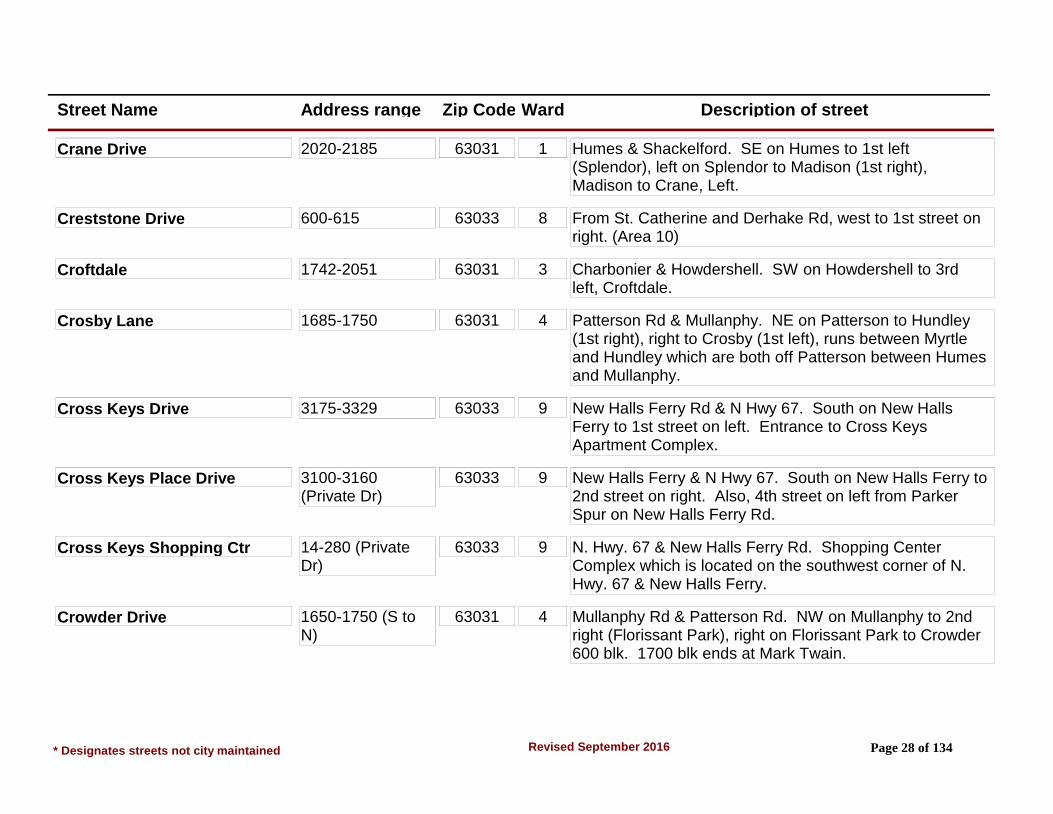
Crane Drive 2020-2185 63031 1 Humes & Shackelford. SE on Humes to 1st left (Splendor), left on Splendor to Madison (1st right), Madison to Crane, Left.
Creststone Drive 600-615 63033 8 From St. Catherine and Derhake Rd, west to 1st street on right. (Area 10)
Croftdale 1742-2051 63031 3 Charbonier & Howdershell. SW on Howdershell to 3rd left, Croftdale.
Crosby Lane 1685-1750 63031 4 Patterson Rd & Mullanphy. NE on Patterson to Hundley (1st right), right to Crosby (1st left), runs between Myrtle and Hundley which are both off Patterson between Humes and Mullanphy.
Cross Keys Drive 3175-3329 63033 9 New Halls Ferry Rd & N Hwy 67. South on New Halls Ferry to 1st street on left. Entrance to Cross Keys Apartment Complex.
Cross Keys Place Drive 3100-3160 (Private Dr)
63033 9 New Halls Ferry & N Hwy 67. South on New Halls Ferry to 2nd street on right. Also, 4th street on left from Parker Spur on New Halls Ferry Rd.
Cross Keys Shopping Ctr 14-280 (Private Dr)
63033 9 N. Hwy. 67 & New Halls Ferry Rd. Shopping Center Complex which is located on the southwest corner of N. Hwy. 67 & New Halls Ferry.
Crowder Drive 1650-1750 (S to N)
63031 4 Mullanphy Rd & Patterson Rd. NW on Mullanphy to 2nd right (Florissant Park), right on Florissant Park to Crowder 600 blk. 1700 blk ends at Mark Twain.
* Designates streets not city maintained Page 28 of 134Revised September 2016

Street Name Address range Zip Code Ward Description of street
Crowder Drive 680-800 (E to W) 63031 4 Mullanphy Rd & Patterson Rd. NW on Mullanphy to 2nd right (Florissant Park), right on Florissant Park to Crowder 600 blk. 1700 blk ends at Mark Twain.
Curtis Court 1810-1915 63031 4 Patterson Rd. & Humes Ln. South on Patterson to 2nd right (Lilac), right on Lilac to 2nd street, (Curtis Ct). From Mullanphy & Patterson, Lilac is 1st street on left. (Violet, Gardenia and Shirlene also provide access to Lilac from Humes Ln).
Cypress Drive 1180-1195 63031 1 Shackelford & Mullanphy. NW on Mullanphy to 3rd street on left. Runs between Mullanphy & Hawthorne Manor.
Danelle Court 2240-2285 63031 1 Court is at NW end of Danelle Drive. (Below)
Danelle Drive 1930-2185 63031 1 Shackelford & Mullanphy. SW on Shackelford to Teakwood Manor (1st right), Teakwood Manor to Randall (1st street), left to Danelle Dr. Runs between DeWayne & Randall.
Daniel Boone Drive 665-945 63031 2 Mullanphy & Patterson Rd. NW on Mullanphy to Florissant Pk (3rd left), left to Daniel Boone. OR From Lindsay & N. Hwy. 67 NW on Lindsay to Mercury (3rd right), right on Mercury to Daniel Boone. Daniel Boone turns into Boulder at end of 900 blk Daniel Boone.
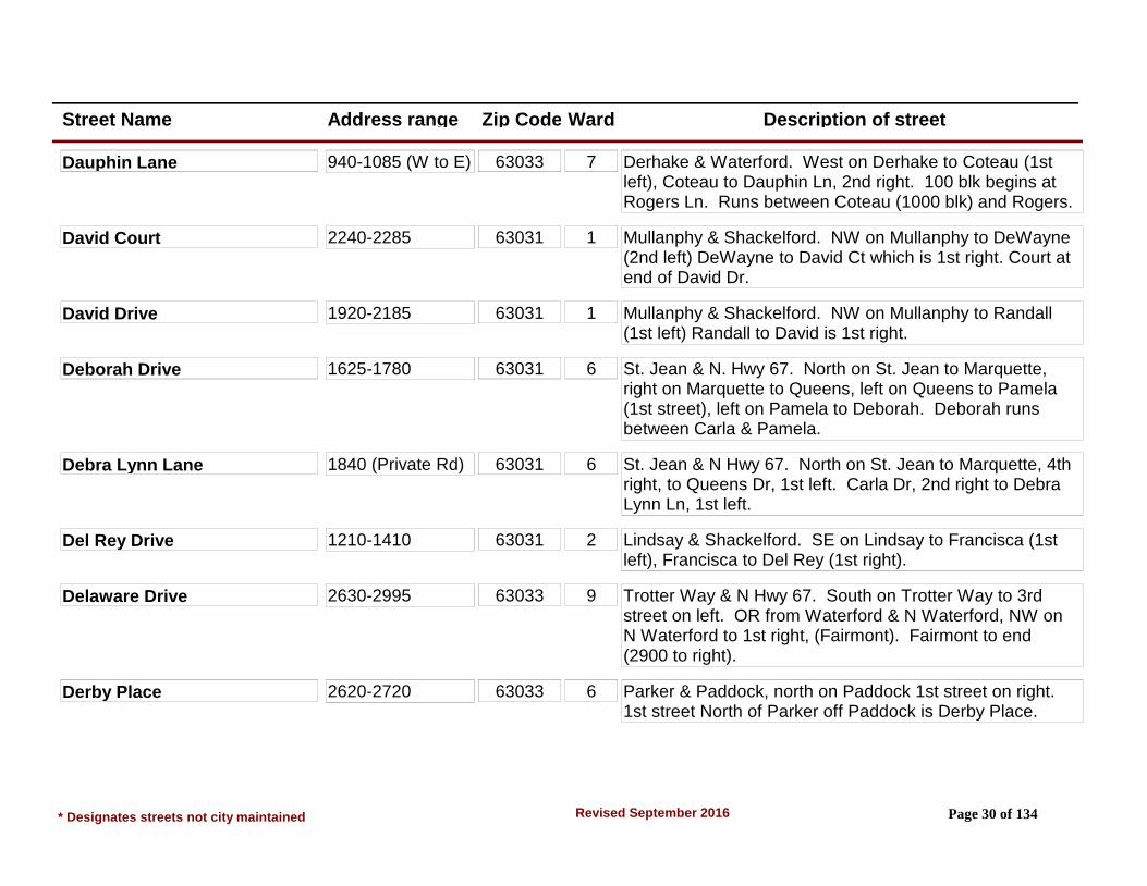
Dauphin Lane 110-175 (S to N) 63033 7 Derhake & Waterford. West on Derhake to Coteau (1st left), Coteau to Dauphin Ln, 2nd right. 100 blk begins at Rogers Ln. Runs between Coteau (1000 blk) and Rogers.
* Designates streets not city maintained Page 29 of 134Revised September 2016
Street Name Address range Zip Code Ward Description of street
Dauphin Lane 940-1085 (W to E) 63033 7 Derhake & Waterford. West on Derhake to Coteau (1st left), Coteau to Dauphin Ln, 2nd right. 100 blk begins at Rogers Ln. Runs between Coteau (1000 blk) and Rogers.
David Court 2240-2285 63031 1 Mullanphy & Shackelford. NW on Mullanphy to DeWayne (2nd left) DeWayne to David Ct which is 1st right. Court at end of David Dr.
David Drive 1920-2185 63031 1 Mullanphy & Shackelford. NW on Mullanphy to Randall (1st left) Randall to David is 1st right.
Deborah Drive 1625-1780 63031 6 St. Jean & N. Hwy 67. North on St. Jean to Marquette, right on Marquette to Queens, left on Queens to Pamela (1st street), left on Pamela to Deborah. Deborah runs between Carla & Pamela.
Debra Lynn Lane 1840 (Private Rd) 63031 6 St. Jean & N Hwy 67. North on St. Jean to Marquette, 4th right, to Queens Dr, 1st left. Carla Dr, 2nd right to Debra Lynn Ln, 1st left.
Del Rey Drive 1210-1410 63031 2 Lindsay & Shackelford. SE on Lindsay to Francisca (1st left), Francisca to Del Rey (1st right).
Delaware Drive 2630-2995 63033 9 Trotter Way & N Hwy 67. South on Trotter Way to 3rd street on left. OR from Waterford & N Waterford, NW on N Waterford to 1st right, (Fairmont). Fairmont to end (2900 to right).
Derby Place 2620-2720 63033 6 Parker & Paddock, north on Paddock 1st street on right. 1st street North of Parker off Paddock is Derby Place.
* Designates streets not city maintained Page 30 of 134Revised September 2016

Street Name Address range Zip Code Ward Description of street
Derhake Road Starts at New Florissant Road, north. Goes east to Dunegant Park and then north to Parker Road.
10-395 63031 7 New Florissant Rd. east to Washington, both sides.
1935-2565 63033 8 Dunegant Park north to St. Catherine, west side.
2000-2926 63033 8 Dunegant Park north to Parker, east side.
2635-2983 63033 8 St. Catherine north to Parker, west side.
565-705 63033 7 Washington east to Taney, north side.
570-1520 63033 7 Washington east to Waterford, south side.
765-1885 63033 8 Taney east to Dunegant Park, north side.
Desmet Drive 65-360 63031 5 South Florissant Rd & Dunn Rd, south on S. Florissant Rd to Jean Dr., right on Jean to Pershall to 3rd street on left. Desmet is the street west of Dubourg. Also can be reached from Hanley Rd by going east on Pershall to 4th street on right.
DeWayne Drive 650-755 63031 2 Shackelford & Charbonier. Northeast on Shackelford to 2nd left (Jenkee) then to 1st right, DeWayne. Also Shackelford & Mullanphy, take Mullanphy, NE to 2nd left, (DeWayne).
* Designates streets not city maintained Page 31 of 134Revised September 2016

Street Name Address range Zip Code Ward Description of street
DeWayne Drive 800-1185 63031 1 Shackelford & Charbonier. Northeast on Shackelford to 2nd left (Jenkee) then to 1st right, DeWayne. Also Shackelford & Mullanphy, take Mullanphy, NE to 2nd left, (DeWayne).
Dewdrop Lane 1240-1295 63031 1 Humes & Shackelford. SE on Humes to Loveland (2nd steet to left), left on Loveland to Sandy, left on Sandy & follow around to Dewdrop. Dewdrop also runs into Palm one blk SW of Central Parkway, (Central Parkway to Palm to Dewdrop).
Don Donna Drive 1800-1877 63031 1 Humes & Patterson Rd. NW on Humes to 4th street on left. OR Mullanphy & Shackelford SE on Mullanphy to 4th left, Fernbrook, to Verlene, left to Don Donna 1st street on right. (Fernbrook also meets Don Donna).
Dove Drive (split street) 2300-2780 63031 1 Mullanphy & Shackelford. NW on Mullanphy to Swan (6th right), to end for 2300 blk of Dove Dr. 2500-2700 blk is reached by continuing NW on Mullanphy to Night Dr (7th right from Shackelford), right on Night Dr to end at Dove, 2500 to right - 2600/2700 to left. (Flamingo also crosses Swan & Night, access from Shackelford).
Downing Avenue 200-470 63031 3 Charbonier & Shackelford. SE on Charbonier to 3rd street on right. Runs between Charbonier & Bobbinray.
Dubourg Lane 55-270 63031 5 S. Florissant Rd & Dunn Rd, south on S. Florissant Rd to Jean Dr, right on Jean to Pershall to 3rd street on left. Dubourg is the street east of Desmet. (Also 4th street from Hanley).
* Designates streets not city maintained Page 32 of 134Revised September 2016

Street Name Address range Zip Code Ward Description of street
Duchesne Dr (E) 1370-1565 63031 7 New Florissant Rd S & Dunn Rd. Either north on New Florissant Rd S to 1st street on right (Duchesne Dr), right on Duchesne to end which meets Duchesne Dr West OR East on Dunn Road to 1st street on left (Plaza Duchesne Dr.), left on Plaza Duchesne Dr. to end which meets Duchesne Dr. South. Duchesne Dr North, South, East, West (also known as North, South, East and West Duchesne Drives) are all connected in a circle. Each is accessible by proceeding to the appropriate end of the circle via the others.
aka E. Duchesne Dr.
Duchesne Dr (N) 1-27 63031 7 See Directions for Duchesne Dr. (E).
aka N. Duchesne Dr.
Duchesne Dr (S) 1-22 63031 7 See Directions for Duchesne Dr. (E).
aka S. Duchesne Dr.
Duchesne Dr (W) 1405-1535 63031 7 See Directions for Duchesne Dr. (E).
aka W. Duchesne Dr.
Duchesne Drive 1-8 63031 7 Dunn & New Florissant Rd S. North on New Florissant Rd S to 1st street on right. Runs from New Florissant S to West Duchesne.
Dunn Road (West) #180 63031 5 A portion of Dunn Rd designated WEST with respect to the Myers Historical House located at the west end of the city limits which has an even numbered address (180) on the odd numbered side of the street.
* Designates streets not city maintained Page 33 of 134Revised September 2016

Street Name Address range Zip Code Ward Description of street
Dunn Road* 1475-1851 63033 7 South side of City, Runs parallel to I-270 within City limits from a point east of S. Waterford Dr to a point just west of Graham Rd. Proper name is North Outer Interstate 270 - and is a Federal Route.
Maintained by Missouri Dept. of Transportation
55-853 63031 5 South side of City, Runs parallel to I-270 within City limits from a point east of S. Waterford Dr to a point just west of Graham Rd. Proper name is North Outer Interstate 270 - and is a Federal Route.
Maintained by Missouri Dept. of Transportation
895-1399 63031 5 South side of City, Runs parallel to I-270 within City limits from a point east of S. Waterford Dr to a point just west of Graham Rd. Proper name is North Outer Interstate 270 - and is a Federal Route.
Maintained by Missouri Dept. of Transportation
Duquette Lane 95-270 63033 7 Derhake & Waterford. West on Derhake to 2nd left. OR Derhake & Washington, east on Derhake to 3rd right.
Durwood Drive 3005-3175 (W to E)
63033 8 Waterford & St. Catherine, south on Waterford to 1st left. OR Waterford & St. Anthony, north on Waterford to Kingsley (1st right), to Durwood (400 blk) 2nd street on left.
420-530 (S to N) 63033 8 Waterford & St. Catherine, south on Waterford to 1st left. OR Waterford & St. Anthony, north on Waterford to Kingsley (1st right), to Durwood (400 blk) 2nd street on left.
* Designates streets not city maintained Page 34 of 134Revised September 2016

Street Name Address range Zip Code Ward Description of street
Dwyer Lane 3425-3620 63033 9 New Halls Ferry Rd & N Hwy 67. South on New Halls Ferry to Santiago (4th left), East on Santiago to Aqueduct (2nd right) south on Aqueduct to Dwyer (1st left). May also be reached by taking Hambletonian (Electric signal) east from New Halls Ferry to Aqueduct (1st left), then north on Aqueduct.
Edgestone Court 2-10 63033 8 From Derhake and Stonehaven, west to 3rd street on right. (Area 10)
Edna Drive 1120-1195 63031 2 Patterson Rd & N Hwy 67. North on Patterson to 1st left (Sally), Sally to Sharon-either right or left; then from Sharon, either left back onto Sally or right onto Ruth. Sally turns into Edna at end, Ruth crosses Edna. Also, Longhenrich from Lindsay crosses Ruth, then right on Ruth.
Elder Drive 1130-1185 63033 7 Derhake & Waterford. East on Derhake to 2nd right, Ermanda. Ermanda to end which becomes Elder. Runs between Ermanda and Carmona.
Eldorado Drive 10-290 63031 2 Lindsay & Shackelford. Southeast on Lindsay to 4th right. Also, 8th street on left off Lindsay from N. Hwy. 67.
Elizabeth Ave (N)* 2245-2285 (Odd #'s Only)
63033 5 Washington & Dunn. South on Washington across I-270 becomes Elizabeth Ave. Near Milbank also known as Old Florissant Rd.
Maintained by St. Louis Co. Dept. of Hwys.
Elizabeth Court 1-8 63031 3 Charbonier & Shackelford. SE on Charbonier to 2nd right (Albert), to 1st right (Bobbinray) to 1st right (Raymond) to 1st left, (Elizabeth Ct.).
* Designates streets not city maintained Page 35 of 134Revised September 2016

Street Name Address range Zip Code Ward Description of street
Elm Drive 1-19 63031 5 W St. Anthony & New Florissant Rd S. west on W St. Anthony to 1st left, (Elm). Valley & Locust also cross Elm and are 1st & 2nd streets south of W St. Anthony off New Florissant Rd S.
Elmdale Court 108-296 63031 5 St. Ferdinand & Washington. South on St. Ferdinand/Graham to 3rd left; left on Westcott to end, (Elmdale Ct). (100 blk is left, 200 blk is right) Westcott is across from Quick Plaza in the 200 blk of Graham.
Elwood Court 1-27 63031 3 Charbonier & N Hwy 67. NW on Charbonier to 5th left. Also 11th street on right off Charbonier from Shackelford.
Ensenada Drive 1210-1400 63031 2 Lindsay & Shackelford. SE on Lindsay to 1st left (Francisca); Francisca to Ensenada - 2nd right also off Cortez off Lindsay.
Ermanda Drive 1000-1095 63033 7 Derhake & Waterford. East on Derhake to 2nd right. Runs between Derhake (1000 blk) and Elder (1095).
Estates Drive 3600-3790 63033 8 New Halls Ferry Rd & N. Hwy 67. South on New Halls Ferry to 8th street on the left. Also, 2nd right from Parker Rd, north on New Halls Ferry. (Paddock Estates Annexation)
Estes Court 904-912 63031 2 Shackelford Road & Lindsay Lane. Southest on Lindsay Lane to Cortez Drive - second left, Cortez Drive to end. Left on Estes Drive. to second right.
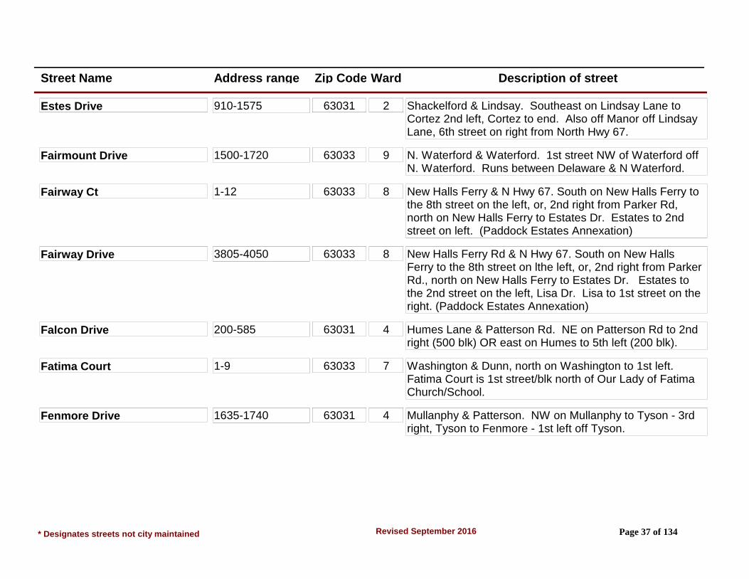
Estes Drive 1576-1636 63031 2 Shackelford & Lindsay. SE on Lindsay to Cortez 2nd left, Cortez to end. Also off Manor off Lindsay, 6th street on right from N Hwy 67.
* Designates streets not city maintained Page 36 of 134Revised September 2016
Street Name Address range Zip Code Ward Description of street
Estes Drive 910-1575 63031 2 Shackelford & Lindsay. Southeast on Lindsay Lane to Cortez 2nd left, Cortez to end. Also off Manor off Lindsay Lane, 6th street on right from North Hwy 67.
Fairmount Drive 1500-1720 63033 9 N. Waterford & Waterford. 1st street NW of Waterford off N. Waterford. Runs between Delaware & N Waterford.
Fairway Ct 1-12 63033 8 New Halls Ferry & N Hwy 67. South on New Halls Ferry to the 8th street on the left, or, 2nd right from Parker Rd, north on New Halls Ferry to Estates Dr. Estates to 2nd street on left. (Paddock Estates Annexation)
Fairway Drive 3805-4050 63033 8 New Halls Ferry Rd & N Hwy 67. South on New Halls Ferry to the 8th street on lthe left, or, 2nd right from Parker Rd., north on New Halls Ferry to Estates Dr. Estates to the 2nd street on the left, Lisa Dr. Lisa to 1st street on the right. (Paddock Estates Annexation)
Falcon Drive 200-585 63031 4 Humes Lane & Patterson Rd. NE on Patterson Rd to 2nd right (500 blk) OR east on Humes to 5th left (200 blk).
Fatima Court 1-9 63033 7 Washington & Dunn, north on Washington to 1st left. Fatima Court is 1st street/blk north of Our Lady of Fatima Church/School.
Fenmore Drive 1635-1740 63031 4 Mullanphy & Patterson. NW on Mullanphy to Tyson - 3rd right, Tyson to Fenmore - 1st left off Tyson.
* Designates streets not city maintained Page 37 of 134Revised September 2016
Street Name Address range Zip Code Ward Description of street
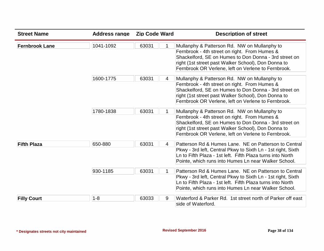
Fernbrook Lane 1041-1092 63031 1 Mullanphy & Patterson Rd. NW on Mullanphy to Fernbrook - 4th street on right. From Humes & Shackelford, SE on Humes to Don Donna - 3rd street on right (1st street past Walker School), Don Donna to Fernbrook OR Verlene, left on Verlene to Fernbrook.
1600-1775 63031 4 Mullanphy & Patterson Rd. NW on Mullanphy to Fernbrook - 4th street on right. From Humes & Shackelford, SE on Humes to Don Donna - 3rd street on right (1st street past Walker School), Don Donna to Fernbrook OR Verlene, left on Verlene to Fernbrook.
1780-1838 63031 1 Mullanphy & Patterson Rd. NW on Mullanphy to Fernbrook - 4th street on right. From Humes & Shackelford, SE on Humes to Don Donna - 3rd street on right (1st street past Walker School), Don Donna to Fernbrook OR Verlene, left on Verlene to Fernbrook.
Fifth Plaza 650-880 63031 4 Patterson Rd & Humes Lane. NE on Patterson to Central Pkwy - 3rd left, Central Pkwy to Sixth Ln - 1st right, Sixth Ln to Fifth Plaza - 1st left. Fifth Plaza turns into North Pointe, which runs into Humes Ln near Walker School.
930-1185 63031 1 Patterson Rd & Humes Lane. NE on Patterson to Central Pkwy - 3rd left, Central Pkwy to Sixth Ln - 1st right, Sixth Ln to Fifth Plaza - 1st left. Fifth Plaza turns into North Pointe, which runs into Humes Ln near Walker School.
Filly Court 1-8 63033 9 Waterford & Parker Rd. 1st street north of Parker off east side of Waterford.
* Designates streets not city maintained Page 38 of 134Revised September 2016
Street Name Address range Zip Code Ward Description of street
Flamingo Drive 1210-2780 63031 1 Mullanphy & Shackelford. NE on Shackelford to Flamingo - 4th street on left or 2nd street on right. (1st street left & right from Humes off Shackelford) NW of Shackelford is 1800-2700 blks SE of Shackelford is 1200-1700 blks. Runs from Bluff Dr, NW end to Verlene on SE end.
Fleming Drive 2250-2255 63031 7 Washington & Dunn. South on Washington to Milbank - Milbank to Fleming - 2nd left. Runs between Milbank & Zurich. From South Florissant Rd, take Wadsworth (1st left past McCluer Entrance) to Milbank, left on Milbank to Fleming.
Fleurissant Parc Place Lane 1401 - 1542 6 From the intersection of N. Hwy. 67 and North New Florissant Road , travel to the end of North New Florissant Road.
NOTE: Beginning at the first left turn into the subdivision, turn left and the house numbers begin at 1401 and increase in a clockwise direction ending at 1542 by the entrance into the subdivision.
Flicker Drive 1105-1875 (Split Street)
63031 1 Mullanphy & Shackelford. 1st street NE of Mullanphy off Shackelford - 1800 blk runs between Shackelford and Cardinal. 1100-1500 runs between Mullan and Aspen, and crosses Loveland. Mullan, Aspen, and Loveland are SW of Shackelford off north Side of Mullanphy.
Flight Drive 2040-2330 63031 4 Patterson & Humes. NE on Patterson Rd to Wren 1st left, left on Wren to Flight. Runs between Starlet and Madison.
* Designates streets not city maintained Page 39 of 134Revised September 2016
Street Name Address range Zip Code Ward Description of street
Flo Lynn Meadows Shopping 1752-1798 (Private Rd) (Even #'s only)
63031 6 N Hwy 67 & New Florissant Rd North. Shopping Center located on northeast corner of intersection.
Flora Court 2-4 63031 3 Manresa & S. Hwy 67/N. Lindbergh, NW on Manresa to Canisius - 3rd street, right on Canisius to Flora Ln - 4th street, left to Flora Ct - 3rd street or 2nd Ct on left. From Howdershell & Keeven, SE on Keeven to Flora.
Flora Lane Manresa to 860-1285
63031 3 Manresa & S. Hwy 67/N. Lindbergh, NW on Canisius, 3rd street, right on Canisius to Flora Ln - 4th street. Florland, NW off S Hwy 67 & Keeven, SE from Howdershell also crosses Flora.
Flordawn Drive 1100-1960 63031 3 Manresa & S. Hwy 67/N. Lindbergh, NW on Manresa to Canisius - 3rd street, right on Canisius to Flora Ln 4th street, left to Flordawn Dr. Also, Keeven SE to Flora, right to Flordawn. OR
2121-2267 (Private Drive)
63031 3 Charbonier & Howdershell. South on Howdershell to 2nd light, Flordawn. Flordawn becomes a private street after if crosses the 1st street on left, Pratt.
PELICAN COVE APARTMENTS
Florella Court 1-6 63031 3 Manresa & S. Hwy 67/N. Lindbergh, NW on Manresa to Canisius - 3rd street, right on Canisius to Flora Ln, left to 1st Court on right.
Florentine Court 1-6 63031 3 Manresa & S. Hwy 67/N. Lindbergh, NW on Manresa to Canisius - 3rd street, right on Canisius to Flora Ln, left to 2nd court on right.
* Designates streets not city maintained Page 40 of 134Revised September 2016

Street Name Address range Zip Code Ward Description of street
Florisota Drive 15-260 63031 2 Lindsay & N Hwy 67, NW on Lindsay to 7th street on left. Also, 5th street on right off Lindsay from Shackelford.
Florissant Meadows Shopping 410-790 (Private Drive)
63031 6 N. Hwy 67 & Washington. N Hwy 67 & Lindsay, Shopping Center on east side of N. Hwy 67 between Washington & St. Denis/Lindsay. Shopping Center addresses are N Hwy 67 addresses.
Florissant Oaks Shopping Cen 15-123 (Private Drive)
63031 2 Patterson & N Hwy 67. Shopping Center on NW side of N. Hwy 67. Located between Patterson & Lindsay off N. Hwy. 67.
Florissant Park Drive 1605-1745 63031 4 Patterson & Mullanphy. NW on Mullanphy to 2nd right, or 3rd left. Right is 1600-1700 blks, left is 20-135.
20-135 63031 4 Patterson & Mullanphy. NW on Mullanphy to 2nd right, or 3rd left. Right is 1600-1700 blks, left is 20-135.
Florissant Road See New Florissant Road.
Florland Court 1-5 63031 3 N Hwy 67 & Washington. South on N Hwy 67 to 3rd street on right which is Florland, Florland to 3rd right.
Florland Drive 600-1125 63031 3 N Hwy 67 & Washington. South on N Hwy 67 to 3rd street on right. (#s 735 & 755 face Rosetta).
Florval Drive 8-54 63031 6 N Hwy 67 & New Florissant Rd North. SW on N Hwy 67 to 2nd street on right. Also off St. Celeste off St. Jean.
Flower Valley Shopping Cente 1-175 63033 9 N Hwy 67 and New Halls Ferry Rd.
* Designates streets not city maintained Page 41 of 134Revised September 2016

Street Name Address range Zip Code Ward Description of street
Floweridge Lane 1-26 63031 3 Charbonier & N Hwy 67. NW on Charbonier, 2nd left. Runs between Charbonier & Thompson.
Fountain Court 1-10 63033 5 Washington & New Florissant Rd North. East on Washington to 4th street on left, (Orchard), Orchard to end, Fountain Ct.
Foxrun Drive 1200-1565 63033 6 New Florissant Rd North & N Hwy 67. 1st street on left off New Florissant Rd North, South of Hwy 67.
Francisca Drive 10-335 63031 2 Lindsay & Shackelford. SE on Lindsay to 1st left. Runs into Cortez which is also off Lindsay.
Fremont Court 2-9 63033 7 Derhake & Waterford. West on Derhake to 1st left, Coteau to end, (Rogers Ln), right on Rogers to 2nd Court on right. Also Derhake to Duquette to Rogers to Fremont Ct.
Friendship Court 2103-2160 63031 2 Shackelford & Charbonier, northwest on Shackelford to 1st left (Friendship Ct.)
Furlong Lane 2460-2520 63033 8 St. Catherine & Waterford. West on St. Catherine to Paddock (1st right), Paddock to 1st right, (Furlong). Paddock is 7th left off St. Catherine from New Florissant N.
Note: Address No. 2485 is in Ward 6
Gahan Drive 1105-1430 63031 5 South Lafayette & DunnRoad. North on Lafayette to St. Cornelius (1st street to right) which turns into Gahan Drive. Also via Maple Drive from South Lafayette, Valley, or Elm.
* Designates streets not city maintained Page 42 of 134Revised September 2016

Street Name Address range Zip Code Ward Description of street
Gallant Fox Drive 1500-1725 63033 9 N Waterford & Waterford. East on N Waterford to 1st left. Runs between N Waterford & Delaware.
Gallop Lane 1540-1680 63033 9 N Waterford & Waterford. West on N Waterford to 3rd right. 7th street on left off N Waterford from N Hwy 67.
Garden Plaza Dr (Private Dr) The Bridge on Garden Plaza Dr.
63033 9 Parker Rd. at Paddock Drive. Go west on Parker Rd. to 1st street on left.
Not city maintained
Gardenia Drive 1810-1930 63031 4 Patterson Rd & Humes Ln. NW on Humes, to 2nd street to left. Runs between Lilac & Humes.
Garnier Court 2-11 63031 3 Manresa & S. Hwy 67/N. Lindbergh, NW on Manresa, 4th street on right. From Campion & Manresa, 2nd street on left.
Gateswood Drive 600-770 63033 8 From St. Catherine and Derhake to 3rd street on right. (Area 10)
Gerald Avenue 620-840 63031 2 Lindsay & Shackelford. SE on Lindsay Ln to 1st street on right, (Gerald Ave).
Gerald Drive 1720-1765 63031 3 Charbonier & Shackelford. SE on Charbonier to 4th street (Paul), right on Paul to 1st street on right, (Gerald Dr).
200-445 (Split Street)
63031 3 Charbonier & Shackelford. SE on Charbonier to 4th street (Paul), right on Paul to 1st street on right, (Gerald Dr).
Gladiola Drive 860-900 63031 3 Charbonier & N Hwy 67. NW on Charbonier to Rosetta (1st left). Rosetta to Keeven & right to 1st left (Gladiola).
* Designates streets not city maintained Page 43 of 134Revised September 2016
Street Name Address range Zip Code Ward Description of street
Glynn Drive 3-22 63031 3 Charbonier & N Hwy 67. NW on Charbonier, 7th left. Also 9th right off Charbonier from Shackelford.
Gold Finch Drive 2241-2352 63031 2 Shackelford & Charbonier, northeast on Shackelford to 2nd left (Jenkee Dr.) to 1st right (DeWayne Dr.) to 1st left (Goldfinch Dr.)
Golden Gate Drive 1480-1585 63033 9 N Waterford & Waterford. 2nd street east of Waterford off N Waterford. 11th street on left N Hwy 67.
Gonzaga Lane 705-925 63031 3 Manresa & S. Hwy 67/N. Lindbergh, NW on Manresa to Loyola 2nd street, right to Gonzaga 1st left. Runs between Canisius & Loyola.
Graham Road* 100-1281 63031 5 Runs from Quick Plaza (becomes Graham Rd from St. Ferdinand) 100 blk and runs south to Dunn Rd 1200 blk, S City Limits.
Maintained by St. Louis Co. Dept. Hwys.
Granada Drive 2015-2110 63033 9 New Halls Ferry & N Hwy 67. New Halls Ferry south to (4th left) Santiago, east to 5th street on left, Granada.
Grandview Drive 1360 - St. Louis Christian College
63033 7 From south Waterford Dr & Dunn, go east to 1st street Grandview Dr. Left onto Grandview Drive. (Proposed Area 13 annexation included)
1465-1495 west side
63033 7 From south Waterford Dr & Dunn, go east to 1st street Grandview Dr. Left onto Grandview Drive. (Proposed Area 13 annexation included)
1520-1640 east side (1540 vacant lot)
63033 7 From south Waterford Dr & Dunn, go east to 1st street Grandview Dr. Left onto Grandview Drive. (Proposed Area 13 annexation included)
* Designates streets not city maintained Page 44 of 134Revised September 2016
Street Name Address range Zip Code Ward Description of street
Grandview Gardens Court 1055 -1222 63033 7 S Waterford & Dunn. 1st street north of Dunn off S Waterford.
GRANDVIEW GARDENS APARTMENT COMPLEX
Grandview Medical Center #68 Suites 1-8 (Private Rd)
63033 7 Located in East end of Grandview Plaza. Access drive off S Waterford in 1200 blk, off of 1600 blk Dunn Rd.
Grandview Plaza Shopping Ce 1-78 & 1625 (Private Rd)
63033 7 Dunn & S Waterford. Access Drives off S Waterford in 1200 blk, or off of 1600 blk of Dunn Rd.
*Not city maintained
Grants Parkway 2020-2620 63031 1 Humes & Patterson Rd. NW on Humes, 2nd street on right. Runs from North Park Ln to Humes Ln.
Grassland Drive 2320-2390 8 New Halls Ferry Rd/Helmkampf Dr intersection. West to first street. Runs north and south from intersection. (Area 12)
Graybrooke Lane 3-34 63031 5 Graham & Dunn Rds. North on Graham, 1st street on left across from Sacred Heart Cemetary.
Greeley Drive 1030-1201 63031 2 Mullanphy & Patterson Rd. NW on Mullanphy 6th left. Also, Manor (from Lindsay) to Boulder, right to 1st left.
1103 63031 1 Mullanphy & Patterson Rd. NW on Mullanphy 6th left. Also, Manor (from Lindsay) to Boulder, right to 1st left.
Greenberry Drive 2320-2580 63033 8 Derhake Rd/Helmkampf Dr intersection. East to first street on left. Greenberry runs between Helmkampf Dr and Greengrass Dr. (Area 12)
* Designates streets not city maintained Page 45 of 134Revised September 2016

Street Name Address range Zip Code Ward Description of street
Greengrass Drive 3715-4120 63033 8 St. Catherine St. turns into Greengrass Dr after crossing Derhake Rd. Runs from Derhake Rd. to New Halls Ferry Rd. (Area 12)
Greentree Drive No Addresses 63033 8 St. Catherine to Paddock Dr. North on Paddock to Furlong to Preakness, 1st right. Rear of McCluer North High.
Grenoble Lane 110-205 63033 7 Derhake & Waterford. West on Derhake to Coteau to 1st right, 1000 blk. OR Derhake to Duquette, Duquette South to 1st left, Barat, to Grenoble. 900 on left, 200 on right.
935-1100 63033 7 Derhake & Waterford. West on Derhake to Coteau to 1st right, 1000 blk. OR Derhake to Duquette, Duquette South to 1st left, Barat, to Grenoble. 900 on left, 200 on right.
Guildford Drive 2520-2675 63033 9 Trotter Way & N Hwy 67. South on Trotter Way to 3rd street. Also, 3rd street north of N Waterford crossing Trotter Way.
Hackney Drive 2525-2590 63033 9 Trotter Way & N Hwy 67. South on Trotter Way to 2nd street. Also, 4th street north of N Waterford on Trotter Way.
Hadwin Drive 1040-1180 63033 7 S Wateford & Dunn. North on S. Waterford to 2nd right. Runs between Carmona & S Waterford.
Hallwood Drive 1050-1185 63033 7 S Waterford & Dunn. North on S. Waterford to 4th right. Also, south on S Waterford from Derhake, 3rd left.
* Designates streets not city maintained Page 46 of 134Revised September 2016

Street Name Address range Zip Code Ward Description of street
Hambletonian Drive 3305-3855 63033 9 New Halls Ferry & N Hwy 67. 7th street left south from N Hwy 67. Also, 3rd right from Parker Spur, north on New Halls Ferry.
Hammes Drive 1-33 63031 2 Lindsay & North Hwy 67. Northwest on Lindsay Lane, 2nd street on right. 9th street on left from Shackelford Road, Southeast on Lindsay.
Hargrove Lane 3100-3190 (E & W)
63033 8 St. Catherine & Waterford. East on St. Catherine to Wilshire (1st cross street), left to 1st street on right. 3100 at Wilshire, 600 blk at Stafford.
640-695 (N & S) 63033 8 St. Catherine & Waterford. East on St. Catherine to Wilshire (1st cross street), left to 1st street on right. 3100 at Wilshire, 600 blk at Stafford.
Harkee Drive 1355-1610 63031 1 Mullanphy & Shackelford, NE on Shackelford to 1st right, Swallow to Harkee, 1st left. Harkee also runs into Humes.
Harness Drive 3030-3290 63033 8 From St. Catherine and Saddle, north to 1st street on left. (Area 10)
Harrison Street 115-1400 (113 parking lot)
63031 5 New Florissant Rd N & Washington. 1st street south of and parallel to Washington. Runs from St. Ferdinand to Aubuchon.
Hawthorne Manor Drive 2305-2575 63031 1 Shackelford & Mullanphy. NW on Mullanphy to 3rd or 4th street on left (Linden to Cypress), left to Hawthorne Manor.
Hazelnut Court 1-19 63033 8 Derhake Rd/Helmkampf Dr intersection. East to first street on right. (Area 12)
* Designates streets not city maintained Page 47 of 134Revised September 2016

Street Name Address range Zip Code Ward Description of street
Helmkampf Drive 3720-4080 63033 8 Runs between Derhake Rd and New Halls Ferry Rd. Helmkampf is the first street north from St. Anthony Ln and Derhake Rd intersection. (Area 12)
Henson Lane* #5 & #15 (Private Dr)
63031 5 Graham & Dunn. North on Graham to driveway north of Graybrooke. West side of Graham across from Sacred Heart Cemetary.
*Not city maintained
Herbst Drive 660-850 63031 2 Shackelford & Charbonier. NE on Shackelford to 2nd right (Jenkee) to 1st left, Herbst. Also at end of Miller & Moellering.
Hermoso Drive 3250-3395 63033 9 New Halls Ferry & N Hwy 67. S on New Halls Ferry to 5th left. Also, 5th right from Parker Spur. N on New Halls Ferry.
Hialeah Place 1300-1545 63033 6 Parker & New Florissant Rd N., east on Parker, 7th left. Also runs into Narraganset which is off Waterford.
Highwillow Drive 3975-4095 63033 8 Helmkampf Dr/Derhake Rd. intersection. East to fourth street on left. (Area 12)
Holiday Hill 2620-2930 (W to E)
63033 8 St. Catherine & Waterford. 1 blk (1st left) West on St. Catherine, (500 blk). From St. Anthony & Washington, east on St. Anthony to 3rd left (Countryside) to 1st right, 2600.
310-545 (S to N) 63033 8 St. Catherine & Waterford. 1 blk (1st left) West on St. Catherine, (500 blk). From St. Anthony & Washington, east on St. Anthony to 3rd left (Countryside) to 1st right, 2600.
* Designates streets not city maintained Page 48 of 134Revised September 2016
Street Name Address range Zip Code Ward Description of street
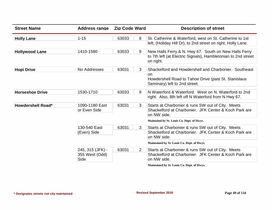
Holly Lane 1-15 63033 8 St. Catherine & Waterford, west on St. Catherine to 1st left, (Holiday Hill Dr), to 2nd street on right, Holly Lane.
Hollywood Lane 1410-1580 63033 9 New Halls Ferry & N. Hwy 67. South on New Halls Ferry to 7th left (at Electric Signals), Hambletonian to 2nd street on right.
Hopi Drive No Addresses 63031 3 Shackelford and Howdershell and Charbonier. Southeast on Howdershell Road to Tahoe Drive (past St. Stanislaus Seminary) left to 2nd street.
Horseshoe Drive 1530-1710 63033 9 N Waterford & Waterford. West on N. Waterford to 2nd right. Also, 8th left off N Waterford from N Hwy 67.
Howdershell Road* 1090-1180 East or Even Side
63031 3 Starts at Charbonier & runs SW out of City. Meets Shackelford at Charbonier. JFK Center & Koch Park are on NW side.
Maintaind by St. Louis Co. Dept. of Hwys.
130-540 East (Even) Side
63031 3 Starts at Charbonier & runs SW out of City. Meets Shackelford at Charbonier. JFK Center & Koch Park are on NW side.
Maintained by St. Louis Co. Dept. of Hwys.
245, 315 (JFK) - 355 West (Odd) Side
63031 2 Starts at Charbonier & runs SW out of City. Meets Shackelford at Charbonier. JFK Center & Koch Park are on NW side.
Maintained by St. Louis Co. Dept. of Hwys.
* Designates streets not city maintained Page 49 of 134Revised September 2016

Street Name Address range Zip Code Ward Description of street
Howdershell Road* 495-577 (Odd side)
63031 3 Starts at Charbonier & runs SW out of City. Meets Shackelford at Charbonier. JFK Center & Koch Park are on NW side.
Maintained by St. Louis Co. Dept. of Hwys.
Huckleberry Drive 3245-3299 63033 8 St. Catherine & Waterford. East on St. Catherine to 2nd right (Paddlewheel), right to 2nd left. St. Anthony & Kingsley also cross Paddlewheel east of Waterford Dr.
Humes Lane 100-1075 63031 4 Runs SE to NW, crosses Patterson Rd. as 6th street north of N Hwy 67. Ends at Shackelford where it changes names to Sunset Park Dr. (1605 Humes is a narrow vacant lot next to Firehouse #3 and is in the City.) Note: Fire House #3, 1601 Humes, at the corner of Humes/Shackelford is St. Louis County.
1095-1605 63031 1 Runs SE to NW, crosses Patterson Rd. as 6th street north of N Hwy 67. Ends at Shackelford where it changes names to Sunset Park Dr. (1605 Humes is a narrow vacant lot next to Firehouse #3 and is in the City.) Note: Fire House #3, 1601 Humes, at the corner of Humes/Shackelford is St. Louis County.
Hummingbird Drive 2120-2395 63033 9 Thunderbird/N Waterford & N Hwy 67. North on Thunderbird to 4th right.
Hundley Drive 420-485 63031 4 Patterson Rd & Mullanphy. 1st right north of Mullanphy off Patterson Rd. (Patterson Rd N to 1st right).
Hwy 67 North 63031 SEE NORTH HWY 67.
* Designates streets not city maintained Page 50 of 134Revised September 2016

Street Name Address range Zip Code Ward Description of street
Industrial Lane 3-10 63031 3 Manresa S. Hwy 67/N. Lindbergh. South on N. Lindbergh to 1st left. Business Complex.
Interstate 270* No Addresses 5 Runs East & West on South end of City. Florissant Jurisdiction is from Washington to Lafayette Street Pedestrian Overpass. Access east-bound from Graham Rd or South Florissant Rd. Access westbound from Dunn W of New Florissant Rd S.
Maintained by Mo. Dept. of Transportation
No Addresses 7 Runs East & West on South end of City. Florissant Jurisdiction is from Washington to Lafayette Street Pedestrian Overpass. Access east-bound from Graham Rd or South Florissant Rd. Access westbound from Dunn W of New Florissant Rd S.
Maintained by Mo. Dept. of Transportation
Iris Drive 860-915 63031 4 Humes & Patterson. NW on Humes to 2nd or 3rd street on left (Gardenia or Violet) left 1/2 blk to Iris. Gardenia & Violet are also the 4th & 5th streets on right off Humes from Shackelford.
Jackson Lane 1145-1655 63031 1 Humes & Shackelford. SE on Humes to 1st or 2nd street on left (Splendor & Loveland). Jackson Dr is at end of Splendor. From Loveland, Jackson Dr. is 3rd street right or left.
920-1075 63031 4 Humes & Patterson Rd. NW on Humes to 2nd or 3rd street on right (Grants Parkway or Collier) then right to 3rd street.
* Designates streets not city maintained Page 51 of 134Revised September 2016
Street Name Address range Zip Code Ward Description of street
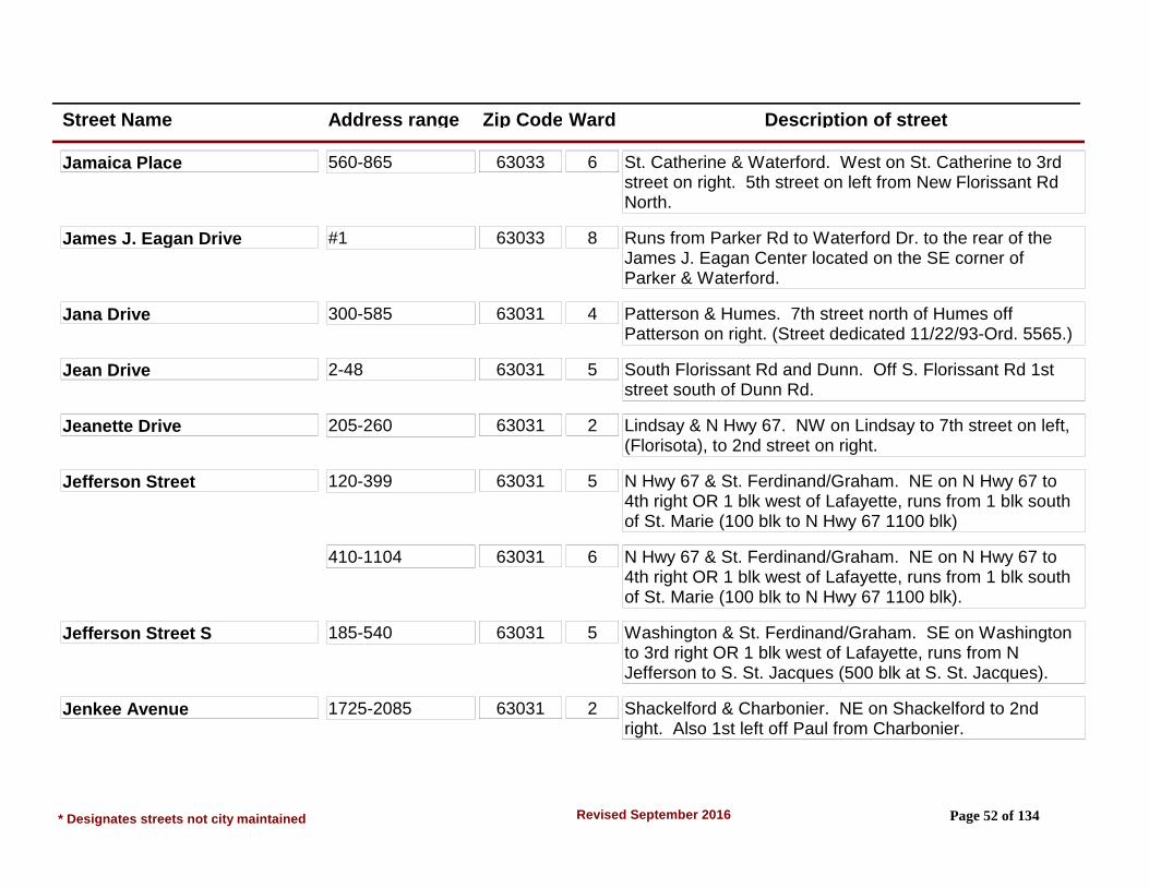
Jamaica Place 560-865 63033 6 St. Catherine & Waterford. West on St. Catherine to 3rd street on right. 5th street on left from New Florissant Rd North.
James J. Eagan Drive #1 63033 8 Runs from Parker Rd to Waterford Dr. to the rear of the James J. Eagan Center located on the SE corner of Parker & Waterford.
Jana Drive 300-585 63031 4 Patterson & Humes. 7th street north of Humes off Patterson on right. (Street dedicated 11/22/93-Ord. 5565.)
Jean Drive 2-48 63031 5 South Florissant Rd and Dunn. Off S. Florissant Rd 1st street south of Dunn Rd.
Jeanette Drive 205-260 63031 2 Lindsay & N Hwy 67. NW on Lindsay to 7th street on left, (Florisota), to 2nd street on right.
Jefferson Street 120-399 63031 5 N Hwy 67 & St. Ferdinand/Graham. NE on N Hwy 67 to 4th right OR 1 blk west of Lafayette, runs from 1 blk south of St. Marie (100 blk to N Hwy 67 1100 blk)
410-1104 63031 6 N Hwy 67 & St. Ferdinand/Graham. NE on N Hwy 67 to 4th right OR 1 blk west of Lafayette, runs from 1 blk south of St. Marie (100 blk to N Hwy 67 1100 blk).
Jefferson Street S 185-540 63031 5 Washington & St. Ferdinand/Graham. SE on Washington to 3rd right OR 1 blk west of Lafayette, runs from N Jefferson to S. St. Jacques (500 blk at S. St. Jacques).
Jenkee Avenue 1725-2085 63031 2 Shackelford & Charbonier. NE on Shackelford to 2nd right. Also 1st left off Paul from Charbonier.
* Designates streets not city maintained Page 52 of 134Revised September 2016

Street Name Address range Zip Code Ward Description of street
Jenkee Drive 2100-2495 63031 2 Shackelford & Charbonier. NE on Shackelford to 2nd left.
Jodphur Drive 1620-1705 63033 9 N Waterford & N Hwy 67. East on N Waterford to 3rd street on left. Turns into Stirrup at end.
Johnstown Drive 2225-2425 63033 6 Parker & Waterford. West on Parker to Paddock 1st left, Paddock to 3rd right. (2nd left from St. Catherine off Paddock).
Kael Lane* 1310-1391 (Private)
63033 6 N. Hwy. 67 & New Florissant Road North, north on New Florissant Road North to 3rd left (Kael Ln).
*Not city maintained
Kathleen Court 1-8 63031 4 Patterson Rd & Humes Ln. South on Patterson Rd to 1st street on right. (1 blk south of Humes).
Kay Drive 1600-1790 63031 6 St. Jean & N Hwy 67. North on St. Jean to end becomes Marquette, east on Marquette to 1st left (Queens), left on Queens to Pamela, right on Pamela to 1st left.
Keeven Lane 2105-2280 63031 2 Charbonier & N Hwy 67, NW on Charbonier to 1st left (Rosetta), Rosetta to 2nd cross street, Keeven Ln, (800 blk). From Howdershell and Charbonier; SW on Howdershell to 1st left past Koch Park (2075-800). Right is Villa del Cresta Apts. (2105-2280).
800-2075 63031 3 Charbonier & N Hwy 67, NW on Charbonier to 1st left (Rosetta), Rosetta to 2nd cross street, Keeven Ln, (800 blk). From Howdershell and Charbonier; SW on Howdershell to 1st left past Koch Park (2075-800). Right is Villa del Cresta Apts. (2105-2280).
* Designates streets not city maintained Page 53 of 134Revised September 2016

Street Name Address range Zip Code Ward Description of street
Kenstone Court 2-10 63033 8 From Derhake and Stonehaven, west to 2nd street on right. (Area 10)
Kinderling Lane 1033-1083 63031 1 Humes Ln & Patterson Rd. NW on Humes to 4th left (Don Donna) left to 1st street on left. Don Donna is also 3rd right from Shackelford off Humes Lane.
Kingsbrook Drive 915-1075 63031 4 Humes & Patterson Rd. NW on Humes to 2nd right (Grants Parkway), right to 2nd left. Also: 4th or 5th left from Shackelford off Humes to 2nd street.
Kingsley Drive 3000-3351 63033 8 Waterford & St. Catherine. South on Waterford to 3rd left. Also 1st right off Waterford, north from St. Anthony.
Knollwood Lane 2630-2775 63031 4 Patterson Rd & Humes. NW on Patterson to 5th left, Sherwood; OR 6th left Rancho. 1st right off Sherwood, 1st left off Rancho.
Koch Drive 1605-1765 63033 9 New Halls Ferry & N Hwy 67. South on New Halls Ferry to 3rd right (Mohan). Rigth on Mohan to end. Also north on New Halls Ferry from Parker Spur to 3rd left, (Mohan); to end is Koch Drive.
Kostka Lane 680-1220 63031 3 Manresa & N Lindbergh/ S. Hwy 67. NW on Manresa to 2nd street, Loyola; left on Loyola to 2nd right.
La Crosse Drive 830-930 63031 2 N Hwy 67 & Lindsay Ln. NW on Lindsay to 4th street on left, (La Venta), La Venta to end. Also 7th or 8th streets on right off Lindsay from Shackelford (LaSierra or LaVenta), right to LaCrosse.
* Designates streets not city maintained Page 54 of 134Revised September 2016
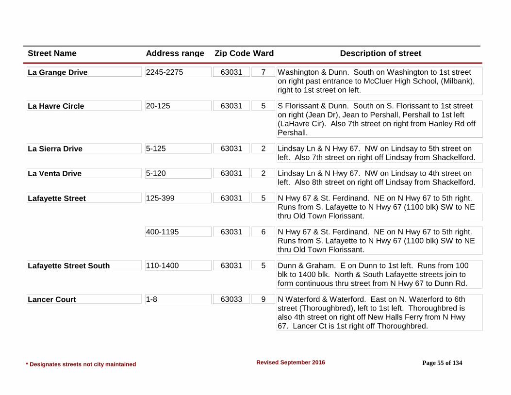
Street Name Address range Zip Code Ward Description of street
La Grange Drive 2245-2275 63031 7 Washington & Dunn. South on Washington to 1st street on right past entrance to McCluer High School, (Milbank), right to 1st street on left.
La Havre Circle 20-125 63031 5 S Florissant & Dunn. South on S. Florissant to 1st street on right (Jean Dr), Jean to Pershall, Pershall to 1st left (LaHavre Cir). Also 7th street on right from Hanley Rd off Pershall.
La Sierra Drive 5-125 63031 2 Lindsay Ln & N Hwy 67. NW on Lindsay to 5th street on left. Also 7th street on right off Lindsay from Shackelford.
La Venta Drive 5-120 63031 2 Lindsay Ln & N Hwy 67. NW on Lindsay to 4th street on left. Also 8th street on right off Lindsay from Shackelford.
Lafayette Street 125-399 63031 5 N Hwy 67 & St. Ferdinand. NE on N Hwy 67 to 5th right. Runs from S. Lafayette to N Hwy 67 (1100 blk) SW to NE thru Old Town Florissant.
400-1195 63031 6 N Hwy 67 & St. Ferdinand. NE on N Hwy 67 to 5th right. Runs from S. Lafayette to N Hwy 67 (1100 blk) SW to NE thru Old Town Florissant.
Lafayette Street South 110-1400 63031 5 Dunn & Graham. E on Dunn to 1st left. Runs from 100 blk to 1400 blk. North & South Lafayette streets join to form continuous thru street from N Hwy 67 to Dunn Rd.
Lancer Court 1-8 63033 9 N Waterford & Waterford. East on N. Waterford to 6th street (Thoroughbred), left to 1st left. Thoroughbred is also 4th street on right off New Halls Ferry from N Hwy 67. Lancer Ct is 1st right off Thoroughbred.
* Designates streets not city maintained Page 55 of 134Revised September 2016
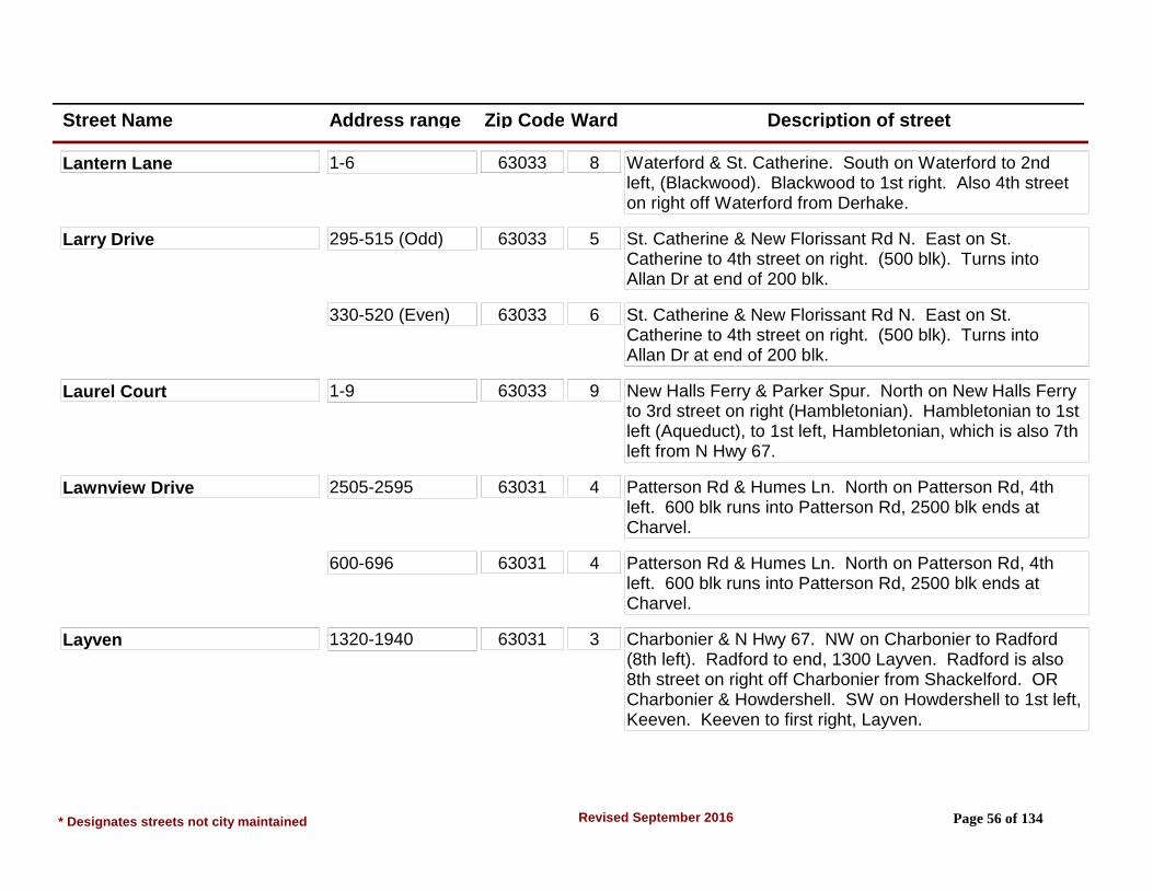
Street Name Address range Zip Code Ward Description of street
Lantern Lane 1-6 63033 8 Waterford & St. Catherine. South on Waterford to 2nd left, (Blackwood). Blackwood to 1st right. Also 4th street on right off Waterford from Derhake.
Larry Drive 295-515 (Odd) 63033 5 St. Catherine & New Florissant Rd N. East on St. Catherine to 4th street on right. (500 blk). Turns into Allan Dr at end of 200 blk.
330-520 (Even) 63033 6 St. Catherine & New Florissant Rd N. East on St. Catherine to 4th street on right. (500 blk). Turns into Allan Dr at end of 200 blk.
Laurel Court 1-9 63033 9 New Halls Ferry & Parker Spur. North on New Halls Ferry to 3rd street on right (Hambletonian). Hambletonian to 1st left (Aqueduct), to 1st left, Hambletonian, which is also 7th left from N Hwy 67.
Lawnview Drive 2505-2595 63031 4 Patterson Rd & Humes Ln. North on Patterson Rd, 4th left. 600 blk runs into Patterson Rd, 2500 blk ends at Charvel.
600-696 63031 4 Patterson Rd & Humes Ln. North on Patterson Rd, 4th left. 600 blk runs into Patterson Rd, 2500 blk ends at Charvel.
Layven 1320-1940 63031 3 Charbonier & N Hwy 67. NW on Charbonier to Radford (8th left). Radford to end, 1300 Layven. Radford is also 8th street on right off Charbonier from Shackelford. OR Charbonier & Howdershell. SW on Howdershell to 1st left, Keeven. Keeven to first right, Layven.
* Designates streets not city maintained Page 56 of 134Revised September 2016

Street Name Address range Zip Code Ward Description of street
Ledyard Drive 600-602 63031 2 Shackelford & Charbonier, northeast on Shackelford to 2nd left (Jenkee Dr.) to 1st right (DeWayne Dr.) to 2nd left (Blue Heron Dr), to 1st right (Ledyard Dr.) or from Shackelford & Lindsay north on Lindsay to 6th left (Ledyard Dr.)
804-824 63031 1 Shackelford & Charbonier, northeast on Shackelford to 2nd left (Jenkee Dr.) to 1st right (DeWayne Dr.) to 2nd left (Blue Heron Dr), to 1st right (Ledyard Dr.) or from Shackelford & Lindsay north on Lindsay to 6th left (Ledyard Dr.)
Lees Lane 940-1175 63031 1 Humes Ln & Patterson Rd. NW on Humes to 2nd right, (Grants Pkwy), Grants Pkwy to 5th left. Runs between North Pointe & Grants Pkwy.
Leisure Drive 1245-1425 63031 1 Humes & Shackelford. SE on Humes to Loveland (2nd left), left (NE) on Loveland to end (Sandy), right to Palm, Palm to 3rd left. Leisure is also 2nd right off Shackelford from Humes in St. Louis Co.
Leisurewood Court 3145-3253 63033 9 New Halls Ferry & N Hwy 67. South on New Halls Ferry to 2nd left. Also 8th right off New Halls Ferry Rd from Parker Spur.
Lemondale Lane 400-455 63031 4 Patterson Rd & N Hwy 67. North on Patterson to 1st right. Also 2nd street on left off Patterson from Mullanphy.
Lexington Park 625-890 63031 4 Humes & Patterson Rd. NW on Humes to 2nd right, (Grants Pkwy). Grants Pkwy, 8th left. Runs between South Park & Sixth Ln. (600 blk at Sixth Ln.)
* Designates streets not city maintained Page 57 of 134Revised September 2016
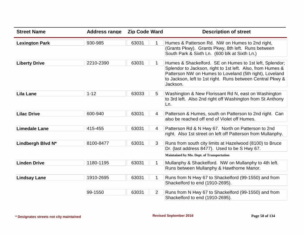
Street Name Address range Zip Code Ward Description of street
Lexington Park 930-985 63031 1 Humes & Patterson Rd. NW on Humes to 2nd right, (Grants Pkwy). Grants Pkwy, 8th left. Runs between South Park & Sixth Ln. (600 blk at Sixth Ln.)
Liberty Drive 2210-2390 63031 1 Humes & Shackelford. SE on Humes to 1st left, Splendor; Splendor to Jackson, right to 1st left. Also, from Humes & Patterson NW on Humes to Loveland (5th right), Loveland to Jackson, left to 1st right. Runs between Central Pkwy & Jackson.
Lila Lane 1-12 63033 5 Washington & New Florissant Rd N, east on Washington to 3rd left. Also 2nd right off Washington from St Anthony Ln.
Lilac Drive 600-940 63031 4 Patterson & Humes, south on Patterson to 2nd right. Can also be reached off end of Violet off Humes.
Limedale Lane 415-455 63031 4 Patterson Rd & N Hwy 67. North on Patterson to 2nd right. Also 1st street on left off Patterson from Mullanphy.
Lindbergh Blvd N* 8100-8477 63031 3 Runs from south city limits at Hazelwood (8100) to Bruce Dr. (last address 8477). Used to be S Hwy 67.
Maintained by Mo. Dept. of Transportation
Linden Drive 1180-1195 63031 1 Mullanphy & Shackelford. NW on Mullanphy to 4th left. Runs between Mullanphy & Hawthorne Manor.
Lindsay Lane 1910-2695 63031 1 Runs from N Hwy 67 to Shackelford (99-1550) and from Shackelford to end (1910-2695).
99-1550 63031 2 Runs from N Hwy 67 to Shackelford (99-1550) and from Shackelford to end (1910-2695).
* Designates streets not city maintained Page 58 of 134Revised September 2016
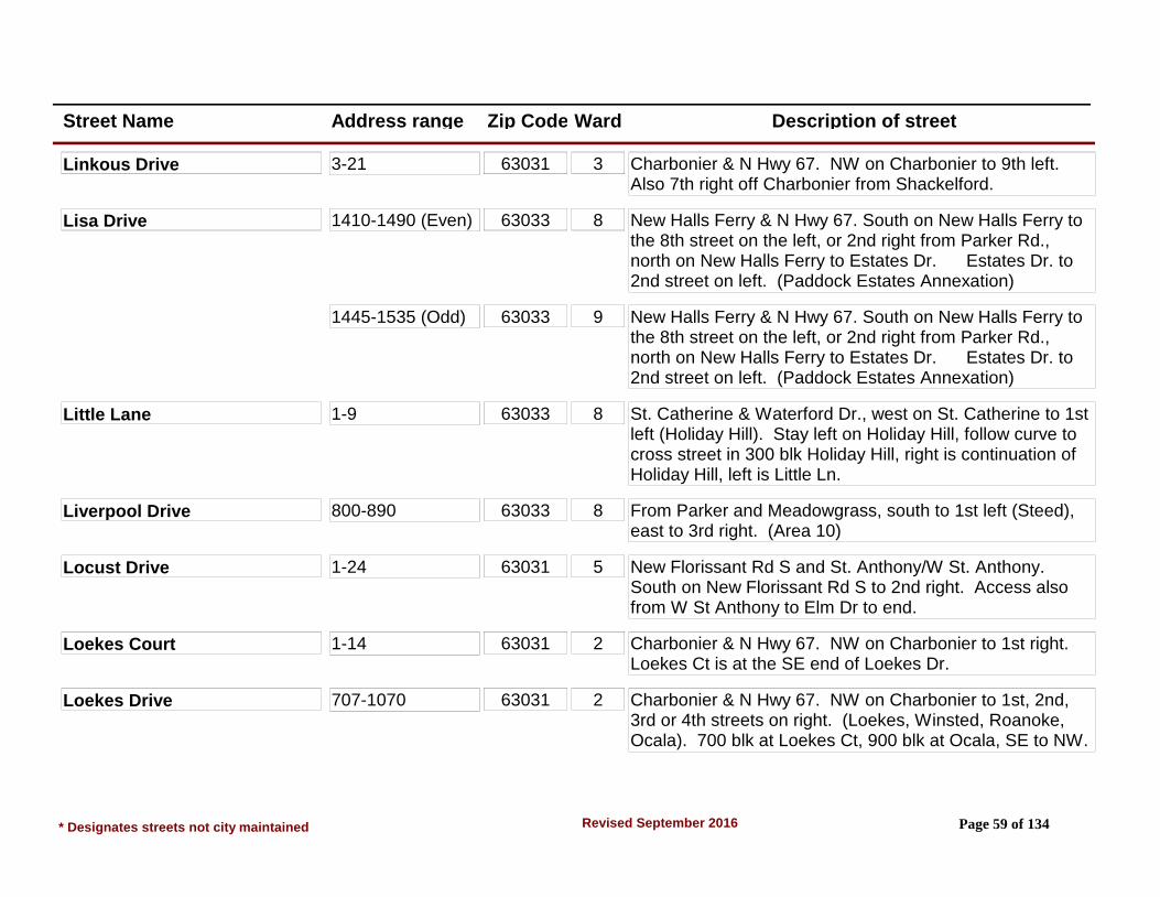
Street Name Address range Zip Code Ward Description of street
Linkous Drive 3-21 63031 3 Charbonier & N Hwy 67. NW on Charbonier to 9th left. Also 7th right off Charbonier from Shackelford.
Lisa Drive 1410-1490 (Even) 63033 8 New Halls Ferry & N Hwy 67. South on New Halls Ferry to the 8th street on the left, or 2nd right from Parker Rd., north on New Halls Ferry to Estates Dr. Estates Dr. to 2nd street on left. (Paddock Estates Annexation)
1445-1535 (Odd) 63033 9 New Halls Ferry & N Hwy 67. South on New Halls Ferry to the 8th street on the left, or 2nd right from Parker Rd., north on New Halls Ferry to Estates Dr. Estates Dr. to 2nd street on left. (Paddock Estates Annexation)
Little Lane 1-9 63033 8 St. Catherine & Waterford Dr., west on St. Catherine to 1st left (Holiday Hill). Stay left on Holiday Hill, follow curve to cross street in 300 blk Holiday Hill, right is continuation of Holiday Hill, left is Little Ln.
Liverpool Drive 800-890 63033 8 From Parker and Meadowgrass, south to 1st left (Steed), east to 3rd right. (Area 10)
Locust Drive 1-24 63031 5 New Florissant Rd S and St. Anthony/W St. Anthony. South on New Florissant Rd S to 2nd right. Access also from W St Anthony to Elm Dr to end.
Loekes Court 1-14 63031 2 Charbonier & N Hwy 67. NW on Charbonier to 1st right. Loekes Ct is at the SE end of Loekes Dr.
Loekes Drive 707-1070 63031 2 Charbonier & N Hwy 67. NW on Charbonier to 1st, 2nd, 3rd or 4th streets on right. (Loekes, Winsted, Roanoke, Ocala). 700 blk at Loekes Ct, 900 blk at Ocala, SE to NW.
* Designates streets not city maintained Page 59 of 134Revised September 2016

Street Name Address range Zip Code Ward Description of street
Longchamps Drive 3050-3150 63033 8 From Parker and Meadowgrass, south to 2nd street on the right, going west on north side of street; going west on south side of street ; 1st street on left, going east. (Area 10)
3095 & 3125 63033 8 From Parker and Meadowgrass, south to 2nd street on the right, going west on north side of street; going west on south side of street; 1st street on left, going east. (Area 10)
3190-3275 63033 8 From Parker and Meadowgrass, south to 2nd street on the right, going west on north side of street; going west on south side of street; 1st street on left, going east. (Area 10)
Longhenrich Drive 1-22 63031 2 Lindsay & N Hwy 67. NW on Lindsay to 1st street on right. 10th street on left off Lindsay from Shackelford.
Louise Court 1-16 63031 5 St. Ferdinand St & Washington St. South on St. Ferdinand to 1st street, (Harrison) right on Harrison to 1st left.
Love Lane 2040-2390 63031 4 Patterson & Humes. North on Patterson Rd to 3rd left (Central Pkwy), Central Pkwy to 1st left. From Shackelford & Humes: 5th left from Shackelford off Humes (Grants Pkwy) to 1st right (Madison) to 1st left.
Loveland Drive 1065, 1102, 1105, 1125 1300-1615, 2110 & 2265
63031 1 Mullanphy & Shackelford, Humes & Shackelford SE on either Mullanphy or Humes from Shackelford to 3rd street (1st cross street). 1100 blk of Loveland at Mullanphy, 1600 blk Loveland at 2015 Humes. Runs from Estes (35, 36 & 900 blk) to Sandy (2200 blk), SW to NE.
* Designates streets not city maintained Page 60 of 134Revised September 2016

Street Name Address range Zip Code Ward Description of street
Loveland Drive 35, 36, 925 & 1108
63031 2 Mullanphy & Shackelford, Humes & Shackelford SE on either Mullanphy or Humes from Shackelford to 3rd street (1st cross street). 1100 blk of Loveland at Mullanphy, 1600 blk Loveland at 2015 Humes. Runs from Estes (35, 36 & 900 blk) to Sandy (2200 blk), SW to NE.
Lowery Estates Ct 3-32 63031 5 From the intersection of West St. Anthony and Graham Road travel north to the fourth street on left (Lowery Estates Court).
Loyola Drive 604-885 63031 3 N Hwy 67 & Charbonier. South on N Hwy 67 to 4th or 8th street on right. Loyola is semi circle & has two intersections with N. Lindbergh. Also, semi circle is bisected by Manresa which is also off N. Lindbergh.
Lula Drive 410-585 63031 4 Patterson Rd & Humes Ln. North on Patterson to 7th right (Jana), right on Jana to 1st right.
Lynn Meadows Lane 2-220 63033 7 Washington & Dunn Rd. North on Washington to 1st right. Also runs into Derhake Rd 2nd street on right off Derhake from Washington. Meets 700 blk Derhake.
Madison Lane 1310-1575 (Split Street)
63031 1 Humes & Patterson Rd. NW on Humes to 1st, 2nd or 3rd right (Shirlene, Grants Pkwy & Collier) to 1st street, 620-1075 blks. Humes & Shackelford. SE on Humes to 1st or 2nd street on left (Splendor or Loveland) to 1st street, 1310-1575 Madison.
* Designates streets not city maintained Page 61 of 134Revised September 2016

Street Name Address range Zip Code Ward Description of street
Madison Lane 620-1075 (Split Street)
63031 4 Humes & Patterson Rd. NW on Humes to 1st, 2nd or 3rd right (Shirlene, Grants Pkwy & Collier) to 1st street, 620-1075 blks. Humes & Shackelford. SE on Humes to 1st or 2nd street on left (Splendor or Loveland) to 1st street, 1310-1575 Madison.
Mallard Lane 1220-1385 63031 1 Mullanphy & Shackelford. NW on Mullanphy to 5th right. 4th right past Lusher School on Mullanphy.
Manion Park Road 63031 5 Dunn & Graham Rd. North on Graham to 2nd street past electric signal (West St. Anthony & Graham) #15 is Park Address. Used to be named Christian Brothers Lane.
Manor Drive 3-38 63031 2 Lindsay Ln & N Hwy 67. NW on Lindsay to 6th right. Runs between Boulder and Lindsay. From Mullanphy take Greeley/Boulder then right to Manor. OR take Loveland to Boulder then left to Manor. (Shortcut from Lindsay to Mullanphy).
Man-O-War Drive 1480-1545 63033 6 Waterford & N Waterford. South on Waterford to 1st right; right on Narranganset to 3rd left, Man-O-War runs between Narranganset & Derby. Derby is 1st street north of Parker off Paddock Drive.
Manresa Lane 720-1190 63031 3 N Hwy 67 & Charbonier. South on N. Hwy 67 to 6th street on right, (Manresa). Runs between Campion & N. Lindbergh Blvd.
Manthorne Court 2442-2492 63031 2 Shackelford & Charbonier, northeast on Shackelford to 2nd left (Jenkee Dr.) to end of Jenkee Dr. (Blue Heron Dr.), left to 1st left (Manthorne Ct).
* Designates streets not city maintained Page 62 of 134Revised September 2016
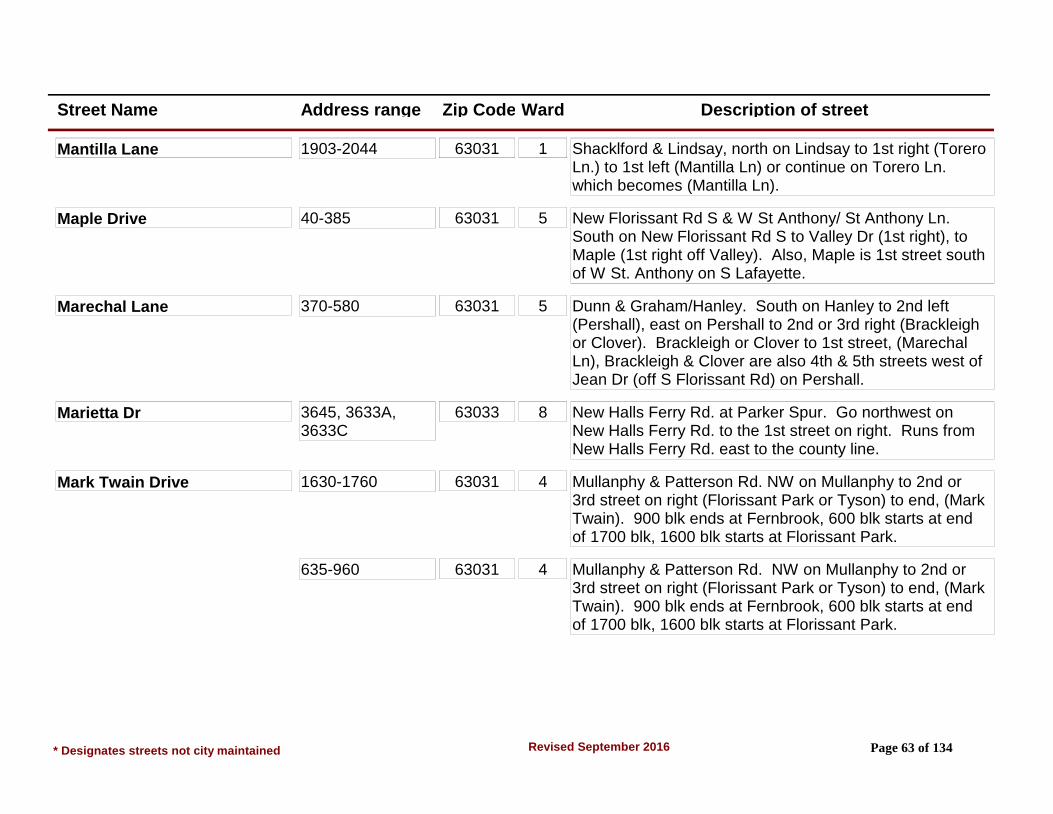
Street Name Address range Zip Code Ward Description of street
Mantilla Lane 1903-2044 63031 1 Shacklford & Lindsay, north on Lindsay to 1st right (Torero Ln.) to 1st left (Mantilla Ln) or continue on Torero Ln. which becomes (Mantilla Ln).
Maple Drive 40-385 63031 5 New Florissant Rd S & W St Anthony/ St Anthony Ln. South on New Florissant Rd S to Valley Dr (1st right), to Maple (1st right off Valley). Also, Maple is 1st street south of W St. Anthony on S Lafayette.
Marechal Lane 370-580 63031 5 Dunn & Graham/Hanley. South on Hanley to 2nd left (Pershall), east on Pershall to 2nd or 3rd right (Brackleigh or Clover). Brackleigh or Clover to 1st street, (Marechal Ln), Brackleigh & Clover are also 4th & 5th streets west of Jean Dr (off S Florissant Rd) on Pershall.
Marietta Dr 3645, 3633A, 3633C
63033 8 New Halls Ferry Rd. at Parker Spur. Go northwest on New Halls Ferry Rd. to the 1st street on right. Runs from New Halls Ferry Rd. east to the county line.
Mark Twain Drive 1630-1760 63031 4 Mullanphy & Patterson Rd. NW on Mullanphy to 2nd or 3rd street on right (Florissant Park or Tyson) to end, (Mark Twain). 900 blk ends at Fernbrook, 600 blk starts at end of 1700 blk, 1600 blk starts at Florissant Park.
635-960 63031 4 Mullanphy & Patterson Rd. NW on Mullanphy to 2nd or 3rd street on right (Florissant Park or Tyson) to end, (Mark Twain). 900 blk ends at Fernbrook, 600 blk starts at end of 1700 blk, 1600 blk starts at Florissant Park.
* Designates streets not city maintained Page 63 of 134Revised September 2016
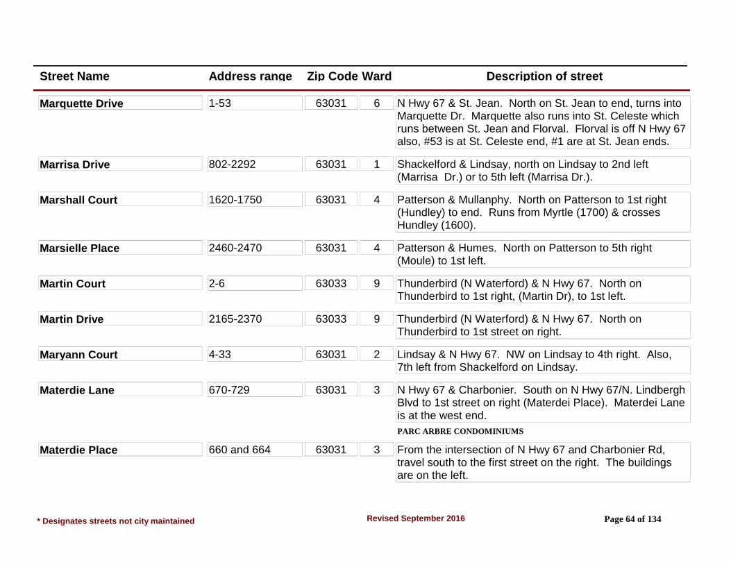
Street Name Address range Zip Code Ward Description of street
Marquette Drive 1-53 63031 6 N Hwy 67 & St. Jean. North on St. Jean to end, turns into Marquette Dr. Marquette also runs into St. Celeste which runs between St. Jean and Florval. Florval is off N Hwy 67 also, #53 is at St. Celeste end, #1 are at St. Jean ends.
Marrisa Drive 802-2292 63031 1 Shackelford & Lindsay, north on Lindsay to 2nd left (Marrisa Dr.) or to 5th left (Marrisa Dr.).
Marshall Court 1620-1750 63031 4 Patterson & Mullanphy. North on Patterson to 1st right (Hundley) to end. Runs from Myrtle (1700) & crosses Hundley (1600).
Marsielle Place 2460-2470 63031 4 Patterson & Humes. North on Patterson to 5th right (Moule) to 1st left.
Martin Court 2-6 63033 9 Thunderbird (N Waterford) & N Hwy 67. North on Thunderbird to 1st right, (Martin Dr), to 1st left.
Martin Drive 2165-2370 63033 9 Thunderbird (N Waterford) & N Hwy 67. North on Thunderbird to 1st street on right.
Maryann Court 4-33 63031 2 Lindsay & N Hwy 67. NW on Lindsay to 4th right. Also, 7th left from Shackelford on Lindsay.
Materdie Lane 670-729 63031 3 N Hwy 67 & Charbonier. South on N Hwy 67/N. Lindbergh Blvd to 1st street on right (Materdei Place). Materdei Lane is at the west end.
PARC ARBRE CONDOMINIUMS
Materdie Place 660 and 664 63031 3 From the intersection of N Hwy 67 and Charbonier Rd, travel south to the first street on the right. The buildings are on the left.
* Designates streets not city maintained Page 64 of 134Revised September 2016

Street Name Address range Zip Code Ward Description of street
McGrath Lane* 278, 281, 282 63031 5 St. Charles & Washington. 2nd street on right off St. Charles just before St. Charles turns into South St. Charles. St. Charles is street south from Washington.
*Not city maintained
McNulty Drive 2-34 63031 2 Lindsay & N Hwy 67. NW on Lindsay to 3rd left. Also, 9th right from Shackelford on Lindsay.
Meadow Court 2-6 63031 5 New Florissant Rd S & W St. Anthony/St. Anthony. South on New Florissant Rd S to 1st right (Valley) to 3rd right.
Meadowgrass Court 1120-1150 63033 8 From Waterford and Parker, east to 1st street on left. (Meadowgrass Dr), south to 1st street on left (Meadowgrass Ct). (Area 10)
Meadowgrass Drive 605-1170 63033 8 From Waterford and St. Catherine, east to 3rd left. From Waterford and Parker east to 1st street on right. Runs between St. Catherine and Parker Rds. (Area 10)
Meadowland Drive 3970-4090 63033 8 From Pohlman & Derhake Rds., go to second left , Birchview, to first right.
Meadowlark Drive 1020-1135 & 2000 63033 6 New Florissant Rd N & Parker Rd. South on New Florissant Rd N to 1st or 2nd left St. Michael or St. Joseph - to 3rd street. #2000 is at end new Bluefield.
Mendocina Court* 665-745 63031 3 Charbonier & N Hwy 67. South on Hwy 67 to 2nd street on right (Mescalero) to "Y" and bear left for Mendocina.
DELRADO APTS. - Not city maintained
Menke Place 2-200 63031 6 N Hwy 67 & St. Charles St. North on St. Charles to 1st left.
* Designates streets not city maintained Page 65 of 134Revised September 2016

Street Name Address range Zip Code Ward Description of street
Mercury Drive 2-47 63031 2 Lindsay & N Hwy 67. NW on Lindsay to 3rd right. Also, 8th left from Shackelford on Lindsay.
Merri Lane 1-18 63031 2 Lindsay & N Hwy 67. NW on Lindsay to 1st left. Also, 11th right from Shackelford on Lindsay.
Mescalero Court* 655-720 63031 3 Charbonier & N Hwy 67, south on Hwy 67 to 2nd street on right. Mescalero continues to right at "Y"
DELRADO APTS. - Not city maintained
Meserta Lane 3515-3775 63033 9 New Halls Ferry & N Hwy 67, south on New Halls Ferry to 4th left (Santiago) to the 3rd thru 7th streets on left. Barcelona, Valencia, Granada, Cordoba, Pyrenees all run into Merserta Ln. 3500 at Barcelona, 3700 at Pyrenees.
Milbank Drive 1370-1730 63031 7 Washington & Dunn, south on Washington/Elizabeth to 1st street on right past entrance to McCluer High School. From S Florissant Rd & Dunn; 1st left past entrance to McCluer High School on S. Florissant to Wadsworth, Wadsworth to Milbank.
Milbrook Lane 2-12 63033 8 Waterford & St. Catherine. South on Waterford to 1st left (Durwood) continue to curve to 1st right past curve. Durwood also runs into Kingsley 1 blk west of Paddlewheel.
Miller Drive 1405-1590 63031 2 Shackelford & Charbonier. NE on Shackelford to 3rd right. From Shackelford & Lindsay, SW on Shackelford to 2nd left.
* Designates streets not city maintained Page 66 of 134Revised September 2016

Street Name Address range Zip Code Ward Description of street
Millstone Drive 605-785 63033 8 From St. Catherine and Creststone, north to 1st street (Brookstone), left to curve in street. This begins Millstone Dr and runs north and south. (Area 10)
Mockingbird Lane 2300-2780 (Split Street)
63031 1 Mullanphy & Shackelford. NE on Shackelford to 4th left (Flamingo) to 1st right (Chickadee) to 1st left, (Mockingbird) 2300-2440. Also continue on Flamingo to 3rd right from Shackelford (Starling) to 1st left, (Mockingbird) 2500-2780.
Moellering Drive 1405-1570 63031 2 Shackelford & Lindsay. SW on Shackelford to 1st left. From Shackelford & Charbonier, NE on Shackelford to 4th right.
Mohan Drive 44-140 63033 9 New Halls Ferry & N Hwy 67. South on New Halls Ferry to 3rd street on right. Also, 3rd street on left from Parker Spur on New Halls Ferry Rd.
Mohican Lane 225-290 63033 7 St. Anthony & Waterford, west on St. Anthony to 1st left. From Waterford & Derhake North on Waterford to 2nd left (Cheyenne) to 1st right. Runs between Cheyenne & St. Anthony.
Monacella Court 1-9 63031 5 New Florissant Rd S & Dunn Rd, north on New Florissant Rd S to 1st street on left (Claire Dr), left to 1st street on left - (Monticella Ct.). Santa Cruz (1st street west of New Florissant on Dunn) also runs into Claire.
Monfort Drive 1870-2839 (Private Rd)
63033 9 New Halls Ferry Rd & N Hwy 67, south on New Halls Ferry Rd to 1st right - (Santiago) right to end. (Right is Monfort, left is Nottinghill Row).
ASPEN WOODS APTS. - Not city maintained
* Designates streets not city maintained Page 67 of 134Revised September 2016

Street Name Address range Zip Code Ward Description of street
Montclair Court 1-18 63033 7 Washington & Dunn. North on Washington to 1st right (Lynn Meadows) to 1st right (Capri) to 1st right.
Monterey Drive 205-370 63031 2 Lindsay & N Hwy 67. NW on Lindsay to 7th or 8th left (Florisota or Eldorado) left to 1st street. Eldorado & Florisota are 4th & 5th streets on right from Shackelford on Lindsay. Runs between Eldorado & Florisota.
Montezuma Drive 2301-2406 (Private Rd)
63031 2 Howdershell/Shackelford & Charbonier. SW on Howdershell to 1st right past JFK/Kock Park (Keeven Ln), right to end of Keeven. Left is Montezuma, right is SuCasa. Montezuma and SuCasa form Circle.
VILLA DEL CRESTA APTS. - Not city maintained
Morningside Drive 2520-2590 63031 4 Humes & Patterson Rd. NW on Humes to 2nd right (Grants Pkwy) to 4th or 5th right (Lexington Park or North Park) right to 1st street.
Morris Drive 2715-2825 63031 4 From Jana Dr & Patterson Rd Intersection, south on Jana Dr to 3rd street on left.
2826 (Area 6) 63031 4 From New Halls Ferry Rd & N. Hwy 67 Intersection northwest, west to 7th street on left (Patterson Rd) to 1st street on left (Shadow Rock Dr) to 4th street (Rancho Dr) to 2nd street on left (Rancho Dr) to 2nd street on right for 2826. Last house on left. NOTE: There is a barricade across steet at 2826. Also, from Jana Dr & Patterson Rd Intersection northeast to 1st street on right (Rancho Dr) to 2nd street on right.
* Designates streets not city maintained Page 68 of 134Revised September 2016

Street Name Address range Zip Code Ward Description of street
Moule Drive 205-595 63031 4 Patterson Rd & Humes Ln. North on Patterson Rd to 5th right. Moule is 1st street north of Central Pkwy on Patterson on right.
Mullan Drive No Addresses 63031 1 Mullanphy & Shackelford. SE on Mullanphy Ln to 1st left. 1st street SE of Mullanphy Gardens Shopping Center. Runs between Swallow & Mullanphy Rd crosses Flicker.
Mullanphy Court 2-6 63031 4 Mullanphy Rd & Patterson Rd. NW on Mullanphy Rd to 1st right. Also 7th left from Shackelford on Mullanphy Rd.
Mullanphy Gardens Shopping 1-33 (Private Rd) 63031 1 Mullanphy Rd & Shackelford. Shopping center is on west side of intersection Mullanphy & Shackelford. Rear of Shopping Center bounded by Mullen & Swallow.
*Not city maintained
Mullanphy Road 1805-2595 (Both Sides)
63031 1 Patterson Rd & N Hwy 67. North on Patterson Rd to 3rd left. (Electric Signal) Crosses Shackelford. Runs parallel to and between Lindsay Ln & Humes Ln. Ends at Mary Grove School/Convent of the Good Shepherd. Last address 2711 is highest address of structures in Mary Grove School complex. Also crosses Loveland.
525-955 (Odd Numbers)
63031 4 Patterson Rd & N Hwy 67. North on Patterson Rd to 3rd left. (Electric Signal) Crosses Shackelford. Runs parallel to and between Lindsay Ln & Humes Ln. Ends at Mary Grove School/Convent of the Good Shepherd. Last address 2711 is highest address of structures in Mary Grove School complex. Also crosses Loveland.
* Designates streets not city maintained Page 69 of 134Revised September 2016

Street Name Address range Zip Code Ward Description of street
Mullanphy Road 530-1000 (Even numbers)
63031 4 Patterson Rd & N Hwy 67. North on Patterson Rd to 3rd left. (Electric Signal) Crosses Shackelford. Runs parallel to and between Lindsay Ln & Humes Ln. Ends at Mary Grove School/Convent of the Good Shepherd. Last address 2711 is highest address of structures in Mary Grove School complex. Also crosses Loveland.
985, 995 & 1040-1600 (Both Sides)
63031 1 Patterson Rd & N Hwy 67. North on Patterson Rd to 3rd left. (Electric Signal) Crosses Shackelford. Runs parallel to and between Lindsay Ln & Humes Ln. Ends at Mary Grove School/Convent of the Good Shepherd. Last address 2711 is highest address of structures in Mary Grove School complex. Also crosses Loveland.
Mundy Drive 1040-1520 63031 3 Charbonier & N Hwy 67. NW on Charbonier to 7th, 8th, 9th street on left-(Glynn, Radford, Linkous), left to 1st street. Mundy is also 2nd street NE of Keeven on Radford.
Mustang Court 2-10 63033 9 N Waterford & Waterford, east on N Waterford to 3rd left (Bay Meadows). Left to 2nd right. Bay Meadows is also 12th street on left from N Hwy 67 on N. Waterford.
Myrtle Drive 405-515 63031 4 Patterson Rd & Mullanphy Rd. North on Patterson to 2nd right. Also 3rd left from Humes Ln on Patterson Rd (southbound).
Nancy Drive 4005, 4010, 4050 63033 9 New Halls Ferry & N Hwy 67. South on New Halls Ferry to 1st left, (Cross Keys Dr), Cross Keys Dr to 1st left, (Nancy Dr.)
Naomi Avenue 1640-1675 (Split Street)
63031 2 Charbonier & Shackelford. SE on Charbonier to 1st left (Paul Ave). Paul Ave to 1st right.
* Designates streets not city maintained Page 70 of 134Revised September 2016

Street Name Address range Zip Code Ward Description of street
Naomi Avenue 530-840 (Split Street)
63031 2 Charbonier & Shackelford. SE on Charbonier to 1st left (Paul Ave). Paul Ave to 1st right.
Naomi Drive 205-465 63031 3 Charbonier & Shackelford. SE on Charbonier to 5th right.
Narraganset Drive 2555-2800 63033 6 Waterford & North Waterford. South on Waterford to 1st right. Also turns into Hialeah Place at 2500 blk of Narraganset.
Nashua Drive 1345-1505 63033 6 Paddock & N Waterford, south on Paddock to 1st right. 1300 blk Nashua also runs into Arlington. (Arlington is 6th left off Parker from New Florissnat Rd N).
Navajo Lane 1285-1395 63033 8 Derhake & Waterford. East on Derhake to 1st left (Cheyenne), left to 2nd right - Navajo. From Waterford & St Anthony; south on Waterford to 1st left (Cheyenne) to 1st left.
New Florissant Road* (N) 100-385 (Both)
63031 5 Extends from southern City Limits, south of Interstate 270 to Carla Dr, north of N Hwy 67. In Florissant is New Florissant Rd South, south of Regina Court and New Florissant Road North, north of Regina Court. (Odd numbers above 1865 are in Calverton Park.) *City maintains only the part north of N Hwy 67. South of Hwy 67 is maintained by St. Louis Co. Dept of Highways.
Even & Odd
* Designates streets not city maintained Page 71 of 134Revised September 2016
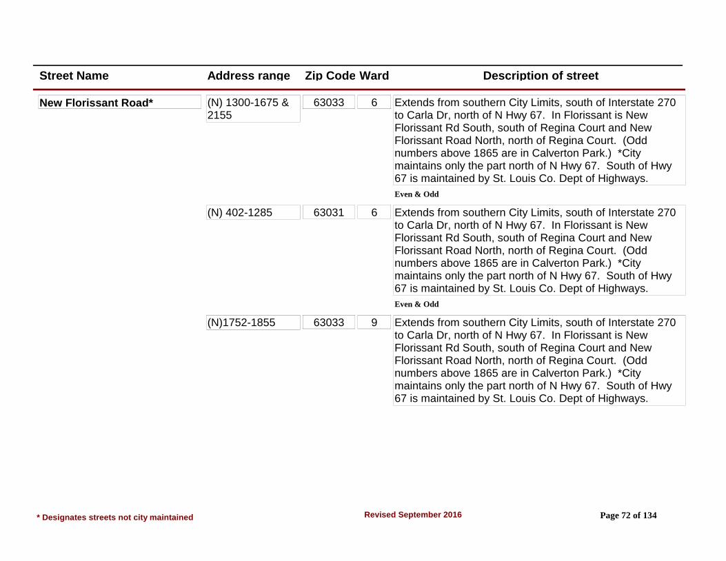
Street Name Address range Zip Code Ward Description of street
New Florissant Road* (N) 1300-1675 & 2155
63033 6 Extends from southern City Limits, south of Interstate 270 to Carla Dr, north of N Hwy 67. In Florissant is New Florissant Rd South, south of Regina Court and New Florissant Road North, north of Regina Court. (Odd numbers above 1865 are in Calverton Park.) *City maintains only the part north of N Hwy 67. South of Hwy 67 is maintained by St. Louis Co. Dept of Highways.
Even & Odd
(N) 402-1285 63031 6 Extends from southern City Limits, south of Interstate 270 to Carla Dr, north of N Hwy 67. In Florissant is New Florissant Rd South, south of Regina Court and New Florissant Road North, north of Regina Court. (Odd numbers above 1865 are in Calverton Park.) *City maintains only the part north of N Hwy 67. South of Hwy 67 is maintained by St. Louis Co. Dept of Highways.
Even & Odd
(N)1752-1855 63033 9 Extends from southern City Limits, south of Interstate 270 to Carla Dr, north of N Hwy 67. In Florissant is New Florissant Rd South, south of Regina Court and New Florissant Road North, north of Regina Court. (Odd numbers above 1865 are in Calverton Park.) *City maintains only the part north of N Hwy 67. South of Hwy 67 is maintained by St. Louis Co. Dept of Highways.
* Designates streets not city maintained Page 72 of 134Revised September 2016
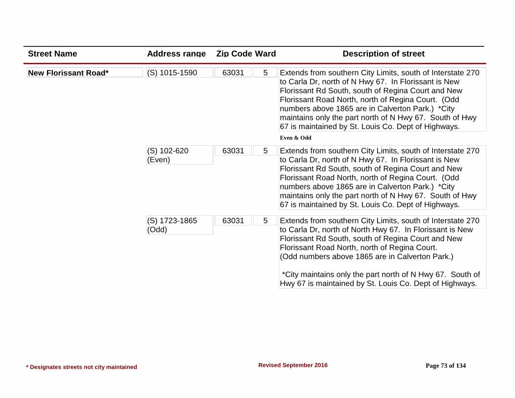
Street Name Address range Zip Code Ward Description of street
New Florissant Road* (S) 1015-1590 63031 5 Extends from southern City Limits, south of Interstate 270 to Carla Dr, north of N Hwy 67. In Florissant is New Florissant Rd South, south of Regina Court and New Florissant Road North, north of Regina Court. (Odd numbers above 1865 are in Calverton Park.) *City maintains only the part north of N Hwy 67. South of Hwy 67 is maintained by St. Louis Co. Dept of Highways.
Even & Odd
(S) 102-620 (Even)
63031 5 Extends from southern City Limits, south of Interstate 270 to Carla Dr, north of N Hwy 67. In Florissant is New Florissant Rd South, south of Regina Court and New Florissant Road North, north of Regina Court. (Odd numbers above 1865 are in Calverton Park.) *City maintains only the part north of N Hwy 67. South of Hwy 67 is maintained by St. Louis Co. Dept of Highways.
(S) 1723-1865 (Odd)
63031 5 Extends from southern City Limits, south of Interstate 270 to Carla Dr, north of North Hwy 67. In Florissant is New Florissant Rd South, south of Regina Court and New Florissant Road North, north of Regina Court. (Odd numbers above 1865 are in Calverton Park.)
*City maintains only the part north of N Hwy 67. South of Hwy 67 is maintained by St. Louis Co. Dept of Highways.
* Designates streets not city maintained Page 73 of 134Revised September 2016

Street Name Address range Zip Code Ward Description of street
New Florissant Road* (S) 1802-2120 (Even)
63031 7 Extends from southern City Limits, south of Interstate 270 to Carla Dr, north of N Hwy 67. In Florissant is New Florissant Rd South, south of Regina Court and New Florissant Road North, north of Regina Court. (Odd numbers above 1865 are in Calverton Park.)
*City maintains only the part north of N Hwy 67. South of Hwy 67 is maintained by St. Louis Co. Dept of Highways.
(S) 195-789 (Odd) 63031 5 Extends from southern City Limits, south of Interstate 270 to Carla Dr, north of N Hwy 67. In Florissant is New Florissant Rd South, south of Regina Court and New Florissant Road North, north of Regina Court. (Odd numbers above 1865 are in Calverton Park.) *City maintains only the part north of N Hwy 67. South of Hwy 67 is maintained by St. Louis Co. Dept of Highways.
(S) 350-620 63031 5 Extends from southern City Limits, south of Interstate 270 to Carla Dr, north of N Hwy 67. In Florissant is New Florissant Rd South, south of Regina Court and New Florissant Road North, north of Regina Court. (Odd numbers above 1865 are in Calverton Park.) *City maintains only the part north of N Hwy 67. South of Hwy 67 is maintained by St. Louis Co. Dept of Highways.
* Designates streets not city maintained Page 74 of 134Revised September 2016
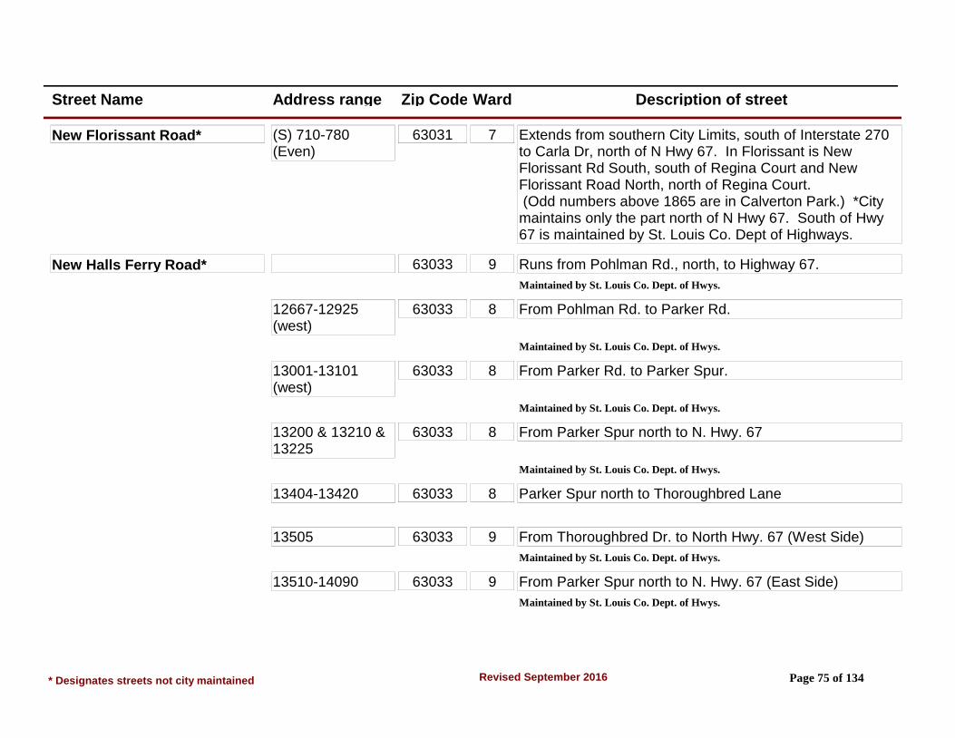
Street Name Address range Zip Code Ward Description of street
New Florissant Road* (S) 710-780 (Even)
63031 7 Extends from southern City Limits, south of Interstate 270 to Carla Dr, north of N Hwy 67. In Florissant is New Florissant Rd South, south of Regina Court and New Florissant Road North, north of Regina Court. (Odd numbers above 1865 are in Calverton Park.) *City maintains only the part north of N Hwy 67. South of Hwy 67 is maintained by St. Louis Co. Dept of Highways.
New Halls Ferry Road* 63033 9 Runs from Pohlman Rd., north, to Highway 67.
Maintained by St. Louis Co. Dept. of Hwys.
12667-12925 (west)
63033 8 From Pohlman Rd. to Parker Rd.
Maintained by St. Louis Co. Dept. of Hwys.
13001-13101 (west)
63033 8 From Parker Rd. to Parker Spur.
Maintained by St. Louis Co. Dept. of Hwys.
13200 & 13210 & 13225
63033 8 From Parker Spur north to N. Hwy. 67
Maintained by St. Louis Co. Dept. of Hwys.
13404-13420 63033 8 Parker Spur north to Thoroughbred Lane
13505 63033 9 From Thoroughbred Dr. to North Hwy. 67 (West Side)
Maintained by St. Louis Co. Dept. of Hwys.
13510-14090 63033 9 From Parker Spur north to N. Hwy. 67 (East Side)
Maintained by St. Louis Co. Dept. of Hwys.
* Designates streets not city maintained Page 75 of 134Revised September 2016

Street Name Address range Zip Code Ward Description of street
New Halls Ferry Road* 13585 63033 9 From Thoroughbred Dr. to North Hwy. 67 (West Side) New Halls Ferry School
Maintained by S. Louis Co. Dept. of Hwys.
13605-13709 63033 9 From Thoroughbred Dr. to North Hwy. 67 (West Side)
Maintained by St. Louis Co. Dept. of Hwys.
13775 63033 9 From Thoroughbred Dr. to North Hwy. 67 (West Side)
Maintained by St. Louis Co. Dept. of Hwys.
13885 63033 9 From Thoroughbred Dr. to North Hwy. 67 (West Side)ASPEN WOODS APARTMENTS
Maintained by St. Louis Co. Dept. of Hwys.
14001 63033 9 From Thoroughbred Dr. to North Hwy. 67 (West Side)SHOPPES AT CROSS KEYS
Maintained by St. Louis Co. Dept. of Hwys.
14065 & 14089 63033 9 From Thoroughbred Dr. to North Hwy. 67 (West Side)
Maintained by St. Louis Co. Dept. of Hwys.
14241-14255 63033 9 From North Highway 67 to Patterson Road (West Side)
Maintained by St. Louis Co. Dept. of Hwys.
14275 63033 9 Cross Keys Middle & Wedgewood Elementary Schools (This is Cougar Drive - a private drive).
Maintained by St. Louis Co. Dept. of Hwys.
14300 63033 9 From Parker Spur north to N. Hwy. 67 (East Side)
Maintained by St. Louis Co. Dept. of Hwys.
15245-15275 63031 4 Between Greenway Chase Drive and Patterson Drive.
Maintained by St. Louis Co. Dept. of Hwys.
* Designates streets not city maintained Page 76 of 134Revised September 2016

Street Name Address range Zip Code Ward Description of street
New Halls Ferry Road* 15505 63031 4 From Patterson Road & New Halls Ferry Road Intersection north to city limits.
Maintained by St. Louis Co. Dept. of Hwys.
3100-3107 63033 9 From Thoroughbred Dr. to North Hwy. 67 (West Side)Cross Keys Place
Maintained by St. Louis Co. Dept. of Hwys.
New Hope Court 5-49 63033 7 Washington & Derhake, north on Washington to 2nd right. Also 1st street on left south of St. Anthony on Washington.
Newgate Drive 3010-3160 63033 8 Waterford & St. Catherine. South on Waterford to 1st left (Durwood), to 1st right (Newgate). Also runs into 400 blk of Durwood which is 2nd street east of Waterford off Kingsley.
Night Drive 1210-1595 63031 1 Mullanphy & Shackelford. NW on Mullanphy to 7th right. Also crosses Flamingo, Mockingbird & Dove.
Norine Court 2-26 63031 3 Charbonier & N Hwy 67. NW on Charbonier to 6th left. From Shackelford on Charbonier; 10th street on right.
North Downs Drive 1755-2090 63033 9 Trotter Way & N Hwy 67. South on Trotter Way to Sorrel (1s left), Sorrel to 1st right 2000 blk of North Downs. Also runs into the 2700 blk of Delaware.
North Hwy 67* 1745-2063 (Even & Odd) & 2095
63033 9 Runs from Bruce Dr, 10 blk, to east city limits and into St. Louis Co. Unincorporated. Zykan dump is 3350 N 67. (St. Louis Co pocket addresses are: 1795, field east of 2175 thru 2505 Odd side, 2825 thru 3125 Odd side).
Maintained by Mo. Dept. of Transportation
* Designates streets not city maintained Page 77 of 134Revised September 2016

Street Name Address range Zip Code Ward Description of street
North Hwy 67* 2090-3433 (Even & Odd)
63033 9 Runs from Bruce Dr, 10 blk, to east city limits and into St. Louis Co. Unincorporated. Zykan dump is 3350 N 67. (St. Louis Co pocket addresses are: 1795, field east of 2175 thru 2505 Odd side, 2825 thru 3125 Odd side).
Maintained by Mo. Dept. of Transportation
410-840 (Even #'s)
63031 6 Runs from Bruce Dr, 10 blk, to east city limits and into St. Louis Co. Unincorporated. Zykan dump is 3350 North Highway 67. (St. Louis Co pocket addresses are: 1795, field east of 2175 thru 2505 Odd side, 2825 thru 3125 Odd side).
Maintained by Mo. Dept. of Transportation
425-855 (Odd #'s) 63031 2 Runs from Bruce Dr, 10 blk, to east city limits and into St. Louis Co. Unincorporated. Zykan dump is 3350 N 67. (St. Louis Co pocket addresses are: 1795, field east of 2175 thru 2505 Odd side, 2825 thru 3125 Odd side).
Maintained by Mo. Dept. of Transportation
5-375 63031 3 Runs from Bruce Dr, 10 blk, to east city limits and into St. Louis Co. Unincorporated. Zykan dump is 3350 N 67. (St. Louis Co pocket addresses are: 1795, field east of 2175 thru 2505 Odd side, 2825 thru 3125 Odd side).
Maintained by Mo. Dept. of Transportation
900-1685 (Even & Odd)
63031 6 Runs from Bruce Dr, 10 blk, to east city limits and into St. Louis Co. Unincorporated. Zykan dump is 3350 N 67. (St. Louis Co pocket addresses are: 1795, field east of 2175 thru 2505 Odd side, 2825 thru 3125 Odd side).
Maintained by Mo. Dept. of Transportation
* Designates streets not city maintained Page 78 of 134Revised September 2016
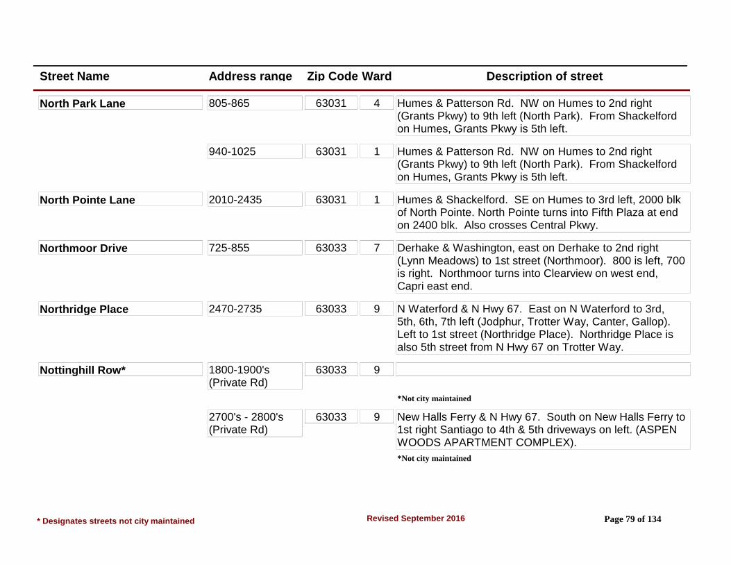
Street Name Address range Zip Code Ward Description of street
North Park Lane 805-865 63031 4 Humes & Patterson Rd. NW on Humes to 2nd right (Grants Pkwy) to 9th left (North Park). From Shackelford on Humes, Grants Pkwy is 5th left.
940-1025 63031 1 Humes & Patterson Rd. NW on Humes to 2nd right (Grants Pkwy) to 9th left (North Park). From Shackelford on Humes, Grants Pkwy is 5th left.
North Pointe Lane 2010-2435 63031 1 Humes & Shackelford. SE on Humes to 3rd left, 2000 blk of North Pointe. North Pointe turns into Fifth Plaza at end on 2400 blk. Also crosses Central Pkwy.
Northmoor Drive 725-855 63033 7 Derhake & Washington, east on Derhake to 2nd right (Lynn Meadows) to 1st street (Northmoor). 800 is left, 700 is right. Northmoor turns into Clearview on west end, Capri east end.
Northridge Place 2470-2735 63033 9 N Waterford & N Hwy 67. East on N Waterford to 3rd, 5th, 6th, 7th left (Jodphur, Trotter Way, Canter, Gallop). Left to 1st street (Northridge Place). Northridge Place is also 5th street from N Hwy 67 on Trotter Way.
Nottinghill Row* 1800-1900's (Private Rd)
63033 9
*Not city maintained
2700's - 2800's (Private Rd)
63033 9 New Halls Ferry & N Hwy 67. South on New Halls Ferry to 1st right Santiago to 4th & 5th driveways on left. (ASPEN WOODS APARTMENT COMPLEX).
*Not city maintained
* Designates streets not city maintained Page 79 of 134Revised September 2016

Street Name Address range Zip Code Ward Description of street
Oakwood Manor Drive 2320-2580 63031 1 Shackelford & Mullanphy. SW on Shackelford to 1st right (Teakwood Manor) to 3rd, 4th, or 5th street (Spruce, Cedar Place, Tamerlane) left to 1st street. From Shackelford & Charbonier, Teakwood Manor is 3rd left off Shackelford NE of Charbonier.
Ocala Place 1-2 63031 2 Charbonier & N Hwy 67. NW on Charbonier to 4th right. From Shackelford, Ocala is 2nd left off Charbonier.
Old Charbonier Road* 2800-3175 63031 2 Howdershell/Shackelford and Charbonier. Northwest on Charbonier to 2nd right (appears to be straight, since Charbonier turns sharply left) just past Bluff Park Dr. (2800 is County Water Company Plant.)
*Not city maintained
Old Florissant Road SEE ELIZABETH AVE, NORTH. (REDEDICATED STREET) SEE WASHINGTON STREET.
Old York Drive 1225-1280 63033 6 New Florissant Rd N & N Hwy 67. South on New Florissant Rd N to 2nd street on left.
Olvera Circle 13-24 63031 2 Lindsay Ln & N Hwy 67. NW on Lindsay to 7th right-Ronda) or 8th right (San Mateo). Ronda or San Mateo to end. San Mateo & Ronda are 3rd & 4th lefts from Shackelford on Charbonier.
Orangedale Lane 1500-1650 63031 4 Patterson Rd & N Hwy 67. North on Patterson to 1st (Lemondale) or 2nd (Limedale) street on right. Right to end. Limedale & Lemondale are also 1st & 2nd lefts from Mullanphy.
* Designates streets not city maintained Page 80 of 134Revised September 2016

Street Name Address range Zip Code Ward Description of street
Orchard Drive 1-24 63033 5 New Florissant Rd N & Washington St. East on Washington to 4th left. At the end Orchard bears off to the left. Addresses do not follow any logical sequence.
Oriole Drive 2125-2385 63033 9 Thunderbird/N Waterford & N Hwy 67. North on Thunderbird to 3rd street on the right. Runs between Thrush & Thunderbird.
Orleans Drive 2170-2460 63031 4 Patterson Rd & Humes Ln. North on Patterson Rd to 1st thru 5th streets on right (Wren, Falcon, Patterson Ln, Versailles, Moule). Right to 2nd street in each case is Orleans.
Ozment Drive 1045-1125 63033 7 South Waterford & Derhake. South on Waterford Dr S to 2nd street on left. Also the 5th right off S Waterford from Dunn Rd.
Pacer Court 2-6 63033 9 New Halls Ferry Rd & Parker Spur. North on New Halls Ferry to Hambletonian (electric signals) 3rd right. Hambletonian to Hollywood 2nd right. Hollywood to 1st left (Surrey Dr), Surrey Dr to 2nd Court on left. Hambletonian 7th left from 67.
Paddlewheel Drive 200-236 63033 8 St. Catherine & Waterford Dr. East on St Catherine to 2nd right. From St. Anthony & Waterford, east on St. Anthony to 3rd right (200-236) or 1st left (400-545).
400-545 63033 8 St. Catherine & Waterford Dr. East on St. Catherine to 2nd right. From St. Anthony & Waterford, east on St. Anthony to 3rd right (200-236) or 1st left (400-545).
* Designates streets not city maintained Page 81 of 134Revised September 2016

Street Name Address range Zip Code Ward Description of street
Paddock Drive 1300-1595 63033 6 Parker Rd & New Florissant Rd N. East on Parker to 8th street on left or 5th street on right. 1200 blk right, 1300 blk left. Runs into North Waterford 1st street east of N Hwy 67 (1500 blk). Runs into 2400 blk of St. Catherine, which is beginning of 500 blk Paddock.
565-1265 63033 6 Parker Rd & New Florissant Rd N. East on Parker to 8th street on left or 5th street on right. 1200 blk right, 1300 blk left. Runs into North Waterford 1st street east of N Hwy 67 (1500 blk). Runs into 2400 blk of St. Catherine, which is beginning of 500 blk Paddock.
Paddock Plaza Shopping Cent 1-19 (Plus 2200 N 67) (Private Rd)
63033 9 N Hwy 67 & N Waterford. Shopping Center which is located on the east side of intersection N Hwy 67 & N Waterford. Contains Main Florissant Post Office.
*Not city maintained
Palm Drive 2310-2450 63031 1 Humes Ln & Shackelford. SE on Humes to 2nd left (Loveland), Loveland to end (Sandy), right on Sandy which becomes Palm Dr. Central Pkwy crosses center of Palm, at north end Palm enters & becomes St. Louis County. Palm is also the 5th street NW of Patterson on Central Pkwy. (County addresses are: 2520 & higher).
2470-2510 63031 1 Humes Ln & Shackelford. SE on Humes to 2nd left (Loveland), Loveland to end (Sandy), right on Sandy which becomes Palm Dr. Central Pkwy crosses center of Palm, at north end Palm enters & becomes St. Louis County. Palm is also the 5th street NW of Patterson on Central Pkwy. (County addresses are: 2520 & higher).
* Designates streets not city maintained Page 82 of 134Revised September 2016

Street Name Address range Zip Code Ward Description of street
Palomino Lane 2305-2445 63033 6 N Waterford & N Hwy 67. East on N Waterford to 1st right (Paddock), Paddock to 1st left (Palomino). From Paddock & Parker, north on Paddock to 3rd right (Arlington) to end, (Palomino), or 4th right (Palomino).
Pamela Drive 1080-1300 63031 6 St Jean & N Hwy 67, north on St Jean to end and continue east on Marquette; Marquette to 1st left (Queens) to 1st cross street (Pamela). 1000 blk left; 1300 blk right.
Parakeet Lane 1220-1375 63031 1 Mullanphy Rd & Shackelford Rd. NW on Mullanphy to 4th right. Parakeet Ln is the 3rd street NW of Lusher School.
Parc Chateau Lane 3375-3690 63033 9 New Halls Ferry & N Hwy 67, south on New Halls Ferry to Santiago 4th street on left, east on Santiago to 3rd street which is 1st cross street (Aqueduct). Left (north) on Aqueduct to 2nd street (Parc Chateau).
Park Side Estates Ct 540-590 63031 2 Shackelford and Charbonier. Continue northwest on Charbonier Road to the first street on the right after Koch Plaza.
Parker Rd 2300-2302 63033 6 N Hwy 67 & Florissant Road. Take the 1st right onto New Florissant Rd N. and turn left onto Parker Rd at first light. Turn right onto Jay Russell Dr/Maloney Manor Dr. and into Life Care Centers.
*Not city maintained -Life Care Centers
2380-2540 (Even numbers)
63033 6 N Hwy 67 & Florissant Road. Take the 1st right onto New Florissant Rd N. and turn left onto Parker Rd at first light.
* Designates streets not city maintained Page 83 of 134Revised September 2016

Street Name Address range Zip Code Ward Description of street
Parker Road* 0 63033 From North Highway 67 south to 3rd left. Starts at New Florissant Road north, and runs east to New Halls Ferry Rd.
*Not city maintained
1705-2265 63033 6 New Florissant Rd North, east to Burning Tree.
*Not city maintained
2305-2797 (Odd numbers)
63033 6 Burning Tree east to Waterford.
*Not city maintained
2805-3225 (north side)
63033 9 Waterford Dr east to North Waterford.
*Not city maintained
3060-3750 (south side)
63033 Waterford Dr east to Derhake/New Halls Ferry Rd.
*Not city maintained
Parker Spur* 3335-3575 (north side)
63033 8 Runs from North Waterford on the west. East to New Halls Ferry Rd.
Maintained by St. Louis Co. Dept. of Trans.
3350 (south side) 63033 9 Runs from North Waterford on the west. East to New Halls Ferry Rd.
Maintained by St. Louis Co. Dept. of Trans.
Pastoral Court 1-11 63033 8 From St. Catherine/Greengrass Dr intersection. East to second street on right, Wheatfield Dr, South on Wheatfield Dr to first street on right (Area 12).
* Designates streets not city maintained Page 84 of 134Revised September 2016
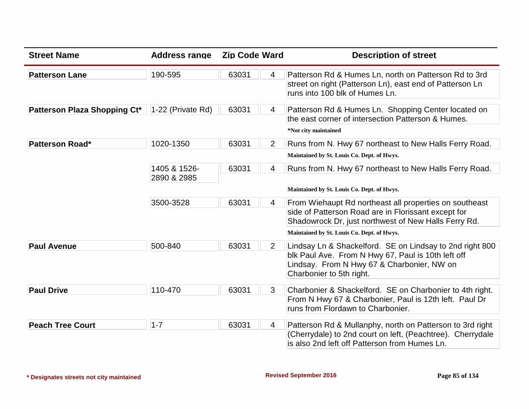
Street Name Address range Zip Code Ward Description of street
Patterson Lane 190-595 63031 4 Patterson Rd & Humes Ln, north on Patterson Rd to 3rd street on right (Patterson Ln), east end of Patterson Ln runs into 100 blk of Humes Ln.
Patterson Plaza Shopping Ct* 1-22 (Private Rd) 63031 4 Patterson Rd & Humes Ln. Shopping Center located on the east corner of intersection Patterson & Humes.
*Not city maintained
Patterson Road* 1020-1350 63031 2 Runs from N. Hwy 67 northeast to New Halls Ferry Road.
Maintained by St. Louis Co. Dept. of Hwys.
1405 & 1526-2890 & 2985
63031 4 Runs from N. Hwy 67 northeast to New Halls Ferry Road.
Maintained by St. Louis Co. Dept. of Hwys.
3500-3528 63031 4 From Wiehaupt Rd northeast all properties on southeast side of Patterson Road are in Florissant except for Shadowrock Dr, just northwest of New Halls Ferry Rd.
Maintained by St. Louis Co. Dept. of Hwys.
Paul Avenue 500-840 63031 2 Lindsay Ln & Shackelford. SE on Lindsay to 2nd right 800 blk Paul Ave. From N Hwy 67, Paul is 10th left off Lindsay. From N Hwy 67 & Charbonier, NW on Charbonier to 5th right.
Paul Drive 110-470 63031 3 Charbonier & Shackelford. SE on Charbonier to 4th right. From N Hwy 67 & Charbonier, Paul is 12th left. Paul Dr runs from Flordawn to Charbonier.
Peach Tree Court 1-7 63031 4 Patterson Rd & Mullanphy, north on Patterson to 3rd right (Cherrydale) to 2nd court on left, (Peachtree). Cherrydale is also 2nd left off Patterson from Humes Ln.
* Designates streets not city maintained Page 85 of 134Revised September 2016
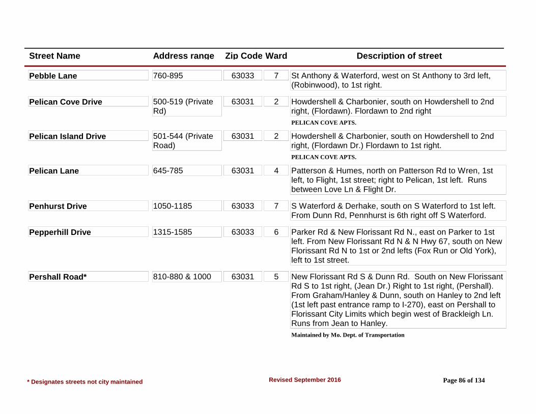
Street Name Address range Zip Code Ward Description of street
Pebble Lane 760-895 63033 7 St Anthony & Waterford, west on St Anthony to 3rd left, (Robinwood), to 1st right.
Pelican Cove Drive 500-519 (Private Rd)
63031 2 Howdershell & Charbonier, south on Howdershell to 2nd right, (Flordawn). Flordawn to 2nd right
PELICAN COVE APTS.
Pelican Island Drive 501-544 (Private Road)
63031 2 Howdershell & Charbonier, south on Howdershell to 2nd right, (Flordawn Dr.) Flordawn to 1st right.
PELICAN COVE APTS.
Pelican Lane 645-785 63031 4 Patterson & Humes, north on Patterson Rd to Wren, 1st left, to Flight, 1st street; right to Pelican, 1st left. Runs between Love Ln & Flight Dr.
Penhurst Drive 1050-1185 63033 7 S Waterford & Derhake, south on S Waterford to 1st left. From Dunn Rd, Pennhurst is 6th right off S Waterford.
Pepperhill Drive 1315-1585 63033 6 Parker Rd & New Florissant Rd N., east on Parker to 1st left. From New Florissant Rd N & N Hwy 67, south on New Florissant Rd N to 1st or 2nd lefts (Fox Run or Old York), left to 1st street.
Pershall Road* 810-880 & 1000 63031 5 New Florissant Rd S & Dunn Rd. South on New Florissant Rd S to 1st right, (Jean Dr.) Right to 1st right, (Pershall). From Graham/Hanley & Dunn, south on Hanley to 2nd left (1st left past entrance ramp to I-270), east on Pershall to Florissant City Limits which begin west of Brackleigh Ln. Runs from Jean to Hanley.
Maintained by Mo. Dept. of Transportation
* Designates streets not city maintained Page 86 of 134Revised September 2016

Street Name Address range Zip Code Ward Description of street
Pheasant Drive 2245-2435 & 2550-2585 (Split Street)
63031 1 Mullanphy & Shackelford. NW on Mullanphy to 3rd or 5th rights (Thrush or Mallard). Right to 1st street.
Mullanphy to Night Drive to 3rd right (2500 block).
Pimlico Drive 560-845 63033 6 St. Catherine & Waterford, west on St. Catherine to 2nd right. Pimlico is 6th left off St. Catherine from New Florissant Rd N. From Paddock & Parker, south on Paddock to 3rd right (Johnstown) to 1st left.
Plaza Duchesne Drive 1-2 63031 7 Dunn & New Florissant Rd S., east on Dunn to 1st left. 1st street east of Plaza Duchesne Shopping Center.
Pohlman Road 1925-2345 63033 8 From St. Anthony Ln/Derhake Rd intersection. East to New Halls Ferry Rd. - Only north side of the street. (Area 12)
Pomander Drive 3018-3028 (Private Rd)
63033 8 Waterford & St. Catherine. North on Waterford to 2nd driveway entrance to Waterford Square Apartments.
Pompano Lane 75-160 63031 2 Lindsay Ln & N Hwy 67. NW on Lindsay to 7th left (Florisota) to 1st right (Monterey) to 2nd left. From Lindsay & Shackelford, SE on Lindsay to 4th right (Eldorado) to 1st left (Monterey) to 1st right.
Pontchartrain Drive 2303-2584 63033 8 Derhake & St. Catherine, south on Derhake to 1st right (Salazar) to end, (Pontchartrain Dr) From Derhake & St. Anthony, north on Derhake to 1st left (Salazar) to end.
* Designates streets not city maintained Page 87 of 134Revised September 2016
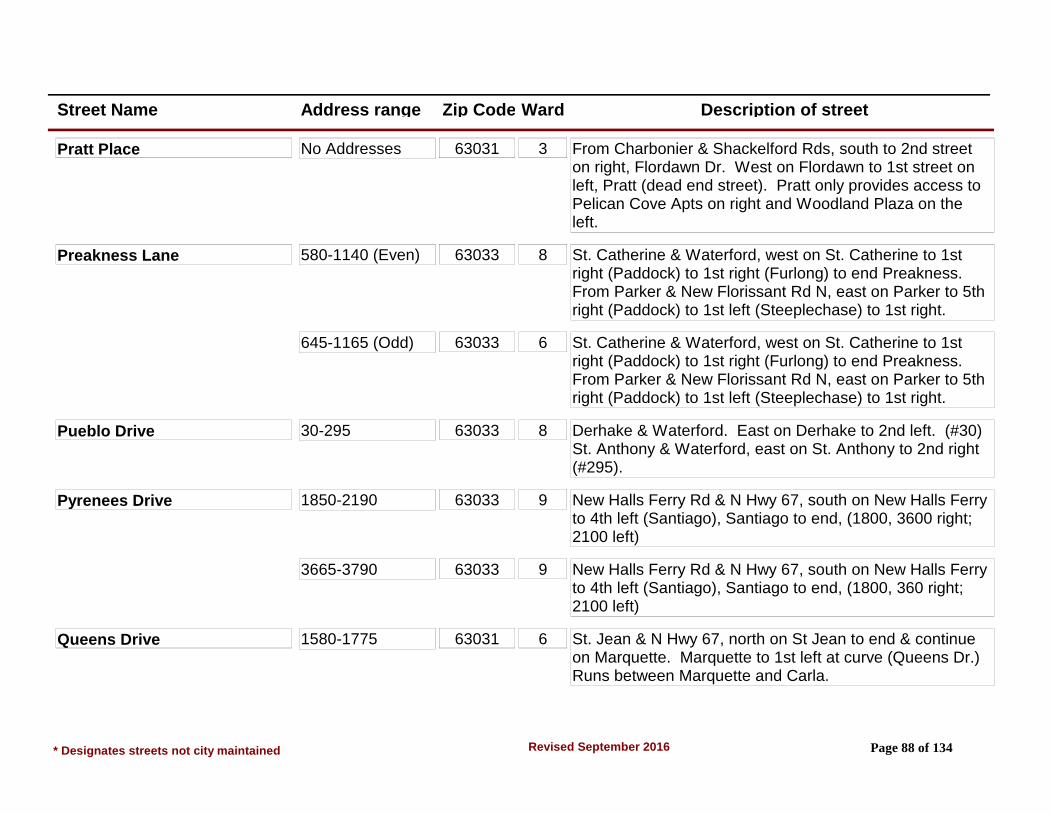
Street Name Address range Zip Code Ward Description of street
Pratt Place No Addresses 63031 3 From Charbonier & Shackelford Rds, south to 2nd street on right, Flordawn Dr. West on Flordawn to 1st street on left, Pratt (dead end street). Pratt only provides access to Pelican Cove Apts on right and Woodland Plaza on the left.
Preakness Lane 580-1140 (Even) 63033 8 St. Catherine & Waterford, west on St. Catherine to 1st right (Paddock) to 1st right (Furlong) to end Preakness. From Parker & New Florissant Rd N, east on Parker to 5th right (Paddock) to 1st left (Steeplechase) to 1st right.
645-1165 (Odd) 63033 6 St. Catherine & Waterford, west on St. Catherine to 1st right (Paddock) to 1st right (Furlong) to end Preakness. From Parker & New Florissant Rd N, east on Parker to 5th right (Paddock) to 1st left (Steeplechase) to 1st right.
Pueblo Drive 30-295 63033 8 Derhake & Waterford. East on Derhake to 2nd left. (#30) St. Anthony & Waterford, east on St. Anthony to 2nd right (#295).
Pyrenees Drive 1850-2190 63033 9 New Halls Ferry Rd & N Hwy 67, south on New Halls Ferry to 4th left (Santiago), Santiago to end, (1800, 3600 right; 2100 left)
3665-3790 63033 9 New Halls Ferry Rd & N Hwy 67, south on New Halls Ferry to 4th left (Santiago), Santiago to end, (1800, 360 right; 2100 left)
Queens Drive 1580-1775 63031 6 St. Jean & N Hwy 67, north on St Jean to end & continue on Marquette. Marquette to 1st left at curve (Queens Dr.) Runs between Marquette and Carla.
* Designates streets not city maintained Page 88 of 134Revised September 2016

Street Name Address range Zip Code Ward Description of street
Quick Drive 15-23 63031 5 St. Ferdinand & Washington St., south on St Ferdinand to 2nd street on right (Reeb Ln/Quick Dr) Bear left. Quick Dr addresses are Quick Dr. Apartment Complex to rear of Quick Plaza Shopping Center Complex.
Radcliffe Drive 2650-2855 63031 4 Patterson Rd & Humes Ln. North on Patterson to 5th left (Sherwood) to 2nd right (Radcliff). Also crosses Rancho which is 6th left north of Humes off Patterson.
Radford Drive 3-50 63031 3 Charbonier & N Hwy 67. NW on Charbonier to 8th left. From Shackelford & Charbonier, SE to 7th right. Radford also crosses Keeven Ln in the 1200-1300 blk Keeven.
Ramport Drive 1050-1155 63033 7 S Waterford & Dunn, north on S. Waterford to 3rd right. From Derhake on S Waterford, south to 4th street on left.
Rancho Lane (split street) 501-561 63031 4 From Jana Dr & Patterson Rd Intersection northeast on Patterson Rd to 1st street on right (Rancho Ln).
600-675 63031 4 From Jana Dr & Patterson Rd Intersection northeast on Patterson Rd to 1st street on let (Rancho Ln).
Ranchwood Drive 1450-1575 63031 1 Humes & Shackelford. SE on Humes to Loveland (2nd right), to Verlene (1st street), right to 1st street on left. Ranchwood runs between 1400 blk of Flamingo & 1400 Verlene.
Randell Court 1060-1185 63031 1 Mullanphy Rd & Shackelford. NW on Mullanphy to 1st left. Also, from Lindsay & Shackelford, NE on Shackelford to 1st street on left (Teakwood Manor) to 1st street.
* Designates streets not city maintained Page 89 of 134Revised September 2016

Street Name Address range Zip Code Ward Description of street
Raven Lane 360-485 63031 4 Humes Ln & Patterson Rd. SE on Humes to 1st left, (Rivoli), to 1st street on right. Runs from 300 Humes to 2000 Rivoli.
Raymond Drive 200-375 63031 3 Charbonier & Shackelford. SE on Charbonier to Albert (2nd right) to 1st street, (Bobbinray) to 1st right (Raymond).
Snow & ice removed by City
380-480 60331 3 Charbonier & Shackelford southeast on Charbonier to 1st right Raymond. Access only from Charbonier.
Snow & ice removed by City
Reckamp Drive 20-70 63033 9 New Halls Ferry & Parker Spur. North on New Halls Ferry to Mohan (3rd left) to Reckamp (1st left). Mohan is also 3rd street on right from N Hwy 67 on New Halls Ferry.
Redbird Drive 1305-1490 63031 1 Humes & Shackelford. SE on Humes to Loveland (2nd left), to Redbird (2nd left). Runs from Loveland to Madison.
Redwing Drive 650-795 63031 4 Patterson Rd & Humes. North on Patterson to Wren (1st left), left on Wren to Flight (1st street), right on Flight to Redwing (2nd left). Runs between Love Ln & Flight Dr.
Redwood Drive 1-28 63031 6 St. Jean & N Hwy 67, north on St. Jean to 2nd street. Runs between Marquette & St. Jean.
Reeb Lane* 1-190 (#1 not City Maintained)
63031 5 W Washington & N Hwy 67, east on W Washington to 2nd street on right, (St. Ferdinand) to 2nd street on right, (Reeb/Quick Dr). Bear right. NOTE: #1 Reeb is off S St Charles just before St Charles changes to S St Charles. All other addresses off St. Ferdinand.
* Designates streets not city maintained Page 90 of 134Revised September 2016

Street Name Address range Zip Code Ward Description of street
Regina Court 1-23 63031 5 New Florissant Rd N & Washington St., south on New Florissant Rd N to 2nd street on right. From St Anthony/W St Anthony & New Florissant Rd S, north on New Florissant Rd S to 2nd street on left (just past Bangert Park). NOTE: Regina Ct is the dividing line between North/South New Florissant.
Reighley Place 301-342 63031 5 New Florissant Rd N & St Anthony, north on New Florissant Rd N to 1st left. (Ord. 5914 street dedicated by City.)
Rexford Creek Court 2901-2932 63031 4 From Jana Dr & Patterson Rd Intersection northeast on Patterson Rd to 1st street on right (Baltic Dr). South on Baltic Dr to 3rd street on right (Rexford Creek Ct).
Ridge Drive 350-515 63033 6 New Florissant Rd N & St Catherine, east on St Catherine to 6th street on right, (Ridge Dr). OR Waterford Dr & St Anthony, west on St Anthony to 2nd right (St Edward) to 1st right (Allen) to 1st left, Ridge Dr.
Ridgelawn Court 1-28 63031 5 Graham Rd & W St Anthony, north on Graham to 3rd left (1st street north of Manion Park). From Washington & St Ferdinand, south on St Ferdinand/Graham, 3rd right. NOTE: #1 & #28 are Apartments.
Rissant Drive 2-43 63031 6 N Hwy 67 & New Florissant Rd N. SW on N Hwy 67 to Florval (2nd right), to St Celeste (1st left) to Rissant (1st right). Florval also turns into Rissant at North end.
Rivoli Place 2080-2385 63031 4 Humes & Patterson Rd, east on Humes to 1st street. Wren, Falcon, Patterson Ln, Versailles all cross Rivoli.
* Designates streets not city maintained Page 91 of 134Revised September 2016

Street Name Address range Zip Code Ward Description of street
Roan Circle 1-6 63033 9 New Halls Ferry Rd & Parker Spur, north on New Halls Ferry to Hambletonian (electric signal) 3rd right. Hambletonian to Hollywood 2nd right. Hollywood to 1st left (Surrey Dr), Surrey Dr to 1st court on left. (Hambletonian 7th left from Hwy 67).
Roanoke Place 1 & 2 63031 2 Charbonier & N Hwy 67. NW on Charbonier to 3rd right. Also 3rd street on left off Charbonier from Shackelford.
Robert Drive 2720-2785 63031 4 Patterson Rd & Humes, north on Patterson to Jana (7th right). Jana to Robert (2nd left). Jana is also 2nd left from Wiethaupt.
Robinwood Drive 750-1060 63033 7 St Anthony & Waterford, west on St Anthony to Robinwood (3rd street on left) 1000 blk. From Derhake & Washington, east on Derhake to Taney (1st left) to Robinwood (1st right).
Rockingham Drive 3305-3420 63033 9 New Halls Ferry Rd & Parker Spur, north on New Halls Ferry to 4th street on right. Also 6th left from N Hwy 67.
Rogers Lane 855-1095 (Split Street)
63033 7 South Waterford & Derhake, west on Derhake to Coteau Dr (1st left) to end. Right is 1000 Rogers. From Derhake & Washington, east on Derhake to Duquette (3rd right) to end. Runs between Coteau & Duquette. NOTE: #855 & #860 must be reached off Capri.
Ronda Drive 1-23 63031 2 Lindsay & N Hwy 67. NW on Lindsay to 7th right, Ronda. Lindsay Shackelford, SE on Lindsay to 4th left, Ronda.
* Designates streets not city maintained Page 92 of 134Revised September 2016

Street Name Address range Zip Code Ward Description of street
Rosetta Drive 602-905 63031 3 Charbonier & N Hwy 67. NW on Charbonier to 1st street on left. OR N Hwy 67 south to Florland. (3rd right). Right on Florland to Rosetta (1st right). NOTE: 735 & 755 which face Rosetta at Florland are Florland addresses.
627-649 Rosetta Drive - part of The Villas at the Commons. Access to the Villas is gained from either side of the Building at 635 Rosetta Drive.
rue St. Charles 444-840 63031 6 From Washington Street & St. Ferdinand Street Intersection west to 1st street on right (rue St. Charles) From Patterson Road & N. Hwy 67 Intersection northeast to 1st street on right (rue St. Charles).
811-817 63031 6 ST. DENIS APARTMENTS
Ruth Drive 20-200 63031 2 Patterson Rd & N Hwy 67, north on Patterson to Sally (1st left), left at end of Sally to Ruth. From Lindsay & Shackelford, SE on Lindsay to Longhenrich (10th street on left) to Ruth (1st right).
Ryan Drive 435-585 63031 4 Patterson Rd & Mullanphy, north on Patterson to Ryan (4th right). From Humes on Patterson south to 1st left.
Sackett Drive 80-150 63033 9 New Halls Ferry Rd & Parker Spur, north on New Halls Ferry to Mohan (3rd street on left) Mohan to Reckamp (1st left), Reckamp to end. Runs between Reckamp & Koch.
Saddle Drive 620-1150 63033 8 From Derhake and St. Catherine, west to 2nd right. Runs north to Steed. (Area 10)
* Designates streets not city maintained Page 93 of 134Revised September 2016

Street Name Address range Zip Code Ward Description of street
Saddlegate Court 1502-1599 63033 8 St Anthony & Waterford Dr; east on St Anthony, to Paddlewheel, turn right, will turn into Saddlegate Court.
Saddlespur Lane 1630-1740 63033 9 N Waterford & N Hwy 67. East on N Waterford to Saddlespur (2nd street on left). Saddlespur is 8th street on right off N Waterford from Waterford Dr.
Salazar Drive 3672 & 3691 63033 8 Derhake & St Catherine, south on Derhake to Salazar (1st right). OR Derhake & St Anthony. North on Derhake to Salazar (1st left).
Sally Drive 5-155 63031 2 Patterson Rd & N Hwy 67, north on Patterson to Sally (1st left) From Mullanphy south on Patterson, Sally is 2nd right.
San Mateo Drive 1-12, 25-38 63031 2 Lindsay & N Hwy 67. NW on Lindsay to 8th street on right. From Shackelford SE on Lindsay, San Mateo is 3rd left. NOTE: Olvera Circle addresses 13-24 are sequential with San Mateo addresses, and should not be confused as San Mateo addresses.
Sandy Drive 1230-1380 63031 1 Humes & Shackelford. SW on Humes to Loveland (2nd left), left (NE) on Loveland to end. Loveland is 5th street on right on Humes from Patterson.
Sansu Lane 1100-1140 63031 6 N Hwy 67 & New Florissant Rd N. SW on Hwy 67 to Florval (2nd right), north on Florval to Sansu (2nd left).
Santa Anita Court 1-7 63033 6 Parker & Waterford, west on Parker to Paddock (1st left), Paddock to Churchill Downs (1st right), to Santa Anita (1st right). From New Florissant Rd N, east on Parker, Paddock is 5th street on right.
* Designates streets not city maintained Page 94 of 134Revised September 2016

Street Name Address range Zip Code Ward Description of street
Santa Cruz Drive 1-17 63031 5 Dunn & New Florissant Rd S. west on Dunn to 1st street on right. OR north on New Florissant Rd S to 1st street on left, Clair Dr, to end.
Santiago Drive 3225-3785 63033 9 New Halls Ferry Rd & N Hwy 67, south on New Halls Ferry to 4th street on the left, OR 1st street on the right. Left is Residential
Santiago Drive* 2841-3190 (Private Rd)
63033 9 ASPEN WOODS APARTMENT COMPLEX.
*Not city maintained
Saratoga Court 1-5 63033 6 St Catherine & Waterford, west on St Catherine to 3rd right, (Jamaica) to (Saratoga Ct) 1st court/street on left. From New Florissant Rd North, east on St Catherine, Jamaica is 5th street on left.
Seminole Lane 1315-1395 63033 8 Derhake & Waterford. East on Derhake to Cheyenne or Pueblo (1st & 2nd streets on left) left to 1st street.
Seville Court 105-110 63033 9 Off north end of Seville Dr. From Seville Dr left to end. SEE SEVILLE DR BELOW
Seville Drive 3605-3785 63033 9 New Halls Ferry Rd & N Hwy 67, south on New Halls Ferry to Santiago (4th street on left). East on Santiago to Cordoba (6th left) or end (7th street - Pyrenees). Left on either Cordoba or Pyrenees. Cordoba ends at Seville Dr. Pyrenees changes to Seville Dr at north end.
* Designates streets not city maintained Page 95 of 134Revised September 2016
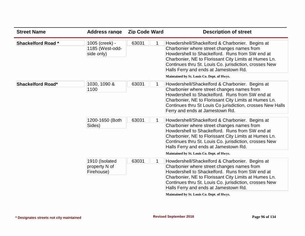
Street Name Address range Zip Code Ward Description of street
Shackelford Road * 1005 (creek) - 1185 (West-odd-side only)
63031 1 Howdershell/Shackelford & Charbonier. Begins at Charbonier where street changes names from Howdershell to Shackelford. Runs from SW end at Charbonier, NE to Florissant City Limits at Humes Ln. Continues thru St. Louis Co. jurisdiction, crosses New Halls Ferry and ends at Jamestown Rd.
Maintained by St. Louis Co. Dept. of Hwys.
Shackelford Road* 1030, 1090 & 1100
63031 1 Howdershell/Shackelford & Charbonier. Begins at Charbonier where street changes names from Howdershell to Shackelford. Runs from SW end at Charbonier, NE to Florissant City Limits at Humes Ln. Continues thru St Louis Co jurisdiction, crosses New Halls Ferry and ends at Jamestown Rd.
1200-1650 (Both Sides)
63031 1 Howdershell/Shackelford & Charbonier. Begins at Charbonier where street changes names from Howdershell to Shackelford. Runs from SW end at Charbonier, NE to Florissant City Limits at Humes Ln. Continues thru St. Louis Co. jurisdiction, crosses New Halls Ferry and ends at Jamestown Rd.
Maintained by St. Louis Co. Dept. of Hwys.
1910 (Isolated property N of Firehouse)
63031 1 Howdershell/Shackelford & Charbonier. Begins at Charbonier where street changes names from Howdershell to Shackelford. Runs from SW end at Charbonier, NE to Florissant City Limits at Humes Ln. Continues thru St. Louis Co. jurisdiction, crosses New Halls Ferry and ends at Jamestown Rd.
Maintained by St. Louis Co. Dept. of Hwys.
* Designates streets not city maintained Page 96 of 134Revised September 2016

Street Name Address range Zip Code Ward Description of street
Shackelford Road* 1940 (Isolated tract at west end of Lindsay)
63031 1 Howdershell/Shackelford & Charbonier. Begins at Charbonier where street changes names from Howdershell to Shackelford. Runs from SW end at Charbonier, NE to Florissant City Limits at Humes Ln. Continues thru St. Louis Co. jurisdiction, crosses New Halls Ferry and ends at Jamestown Rd.
Maintained by St. Louis Co. Dept. of Hwys.
520-850 (Both Sides)
63031 2 Howdershell/Shackelford & Charbonier. Begins at Charbonier where street changes names from Howdershell to Shackelford. Runs from SW end at Charbonier, NE to Florissant City Limits at Humes Ln. Continues thru St. Louis Co jurisdiction, crosses New Halls Ferry and ends at Jamestown Rd. Maintained by St. Louis Co. Dept. of Highways.
900-1160 (East -even-Side only)
63031 2 Howdershell/Shackelford & Charbonier. Begins at Charbonier where street changes names from Howdershell to Shackelford. Runs from SW end at Charbonier, NE to Florissant City Limits at Humes Ln. Continues thru St Louis Co jurisdiction, crosses New Halls Ferry and ends at Jamestown Rd.
Maintained by St. Louis Co. Dept. of Hwys.
Shadow Rock Drive 643-693 63031 4 From New Halls Ferry Rd & N. Hwy 67 Intersection northwest, west to 7th street on left (Patterson Rd) to 1st street on left (603-633), 1st street on right (north) (643-693). Also, from Jana Dr & Patterson Rd Intersection northeast to 4th street on right (south) and 7th street on left (north).
* Designates streets not city maintained Page 97 of 134Revised September 2016

Street Name Address range Zip Code Ward Description of street
Shadow Rock Drive (Split Stre 603-633 63031 4 From New Halls Ferry Rd N. Hwy 67 Intersection northwest, west to 7th street on left (Patterson Rd) to 1st street on left (603-633), 1st street on right (north) (643-693). Also, from Jana Dr & Patterson Rd Intersection northeast to 4th street on right (south) and 7th street on left (north).
Sharon Court 1-9 63031 2 Patterson Rd & N Hwy 67. Located at NW end of Sharon Dr.SEE SHARON DRIVE
Sharon Drive 1115-1190 63031 2 Patterson Rd & N Hwy 67, north on Patterson to Sally (1st street on left), Sally to end. Sharon Dr is right. Sally Dr is also 2nd street south of Mullanphy off Patterson Rd.
Shawnee Lane 25-175 63033 7 Derhake & Waterford, west on Derhake to Shawnee (1st right). From St. Anthony & Washington, east on St. Anthony to Countryside (5th street on right). Countryside turns into Cheyenne at left curve, Cheyenne to Shawnee (1st right).
Sherman Lane 930-1175 63031 1 Patterson & Humes. NW on Humes to Grants Pkwy (2nd right), Sherman (4th left). From Shackelford & Humes: SE on Humes to North Pointe (3rd street on left), to Sherman (3rd right).
Sherry Court 1-5 63031 4 Patterson & Mullanphy Rd. north on Patterson to Cherrydale (3rd right) to Sherry Ct (1st left). From Humes, Cherrydale is 2nd left off Patterson.
* Designates streets not city maintained Page 98 of 134Revised September 2016

Street Name Address range Zip Code Ward Description of street
Sherwood Drive 600-790 63031 4 Patterson Rd & Humes Ln. North on Patterson Rd to 5th street on left - Sherwood Dr. (Addresses 795 & higher are St. Louis Co).
Shirlene Drive 1800-2015 63031 4 Humes & Shackelford. SE on Humes to 6th left & 6th right. Humes & Patterson Rd. NW on Humes Ln to 1st right & 1st left.
Shirley Drive 2000-2085 63031 2 Shackelford & Charbonier. NE on Shackelford to 1st right. Lindsay & Shackelford. SW on Shackelford to 4th left. Access also off Jenkee 1st street SE of Shackelford.
560-580 63031 2 Shackelford & Charbonier. NE on Shackelford to 1st right. Lindsay & Shackelford. SW on Shackelford to 4th left. Access also off Jenkee 1st street SE of Shackelford.
Sir Christopher Lane* 3050-3193 (Private Rd)
63033 9 New Halls Ferry Rd & N Hwy 67. South on New Halls Ferry to Santiago (1st right, right on Santiago to 1st driveway or 2nd driveway on left. (ASPEN WOODS APARTMENTS)
*Not city maintained
Sixth Lane 2415-2490 63031 4 Patterson Rd & Humes. North on Patterson to Central Pkwy (3rd left) to 1st right. Runs from Central Pkwy (crosses Fifth Plaza) to Lexington Pk.
Skylark Drive 315-485 63031 4 Humes & Patterson Rd. SE on Humes to Rivoli (1st left) to Skylark (2nd right). Also 3rd street on left off Humes from Patterson Rd. Runs between Rivoli & 200 blk of Humes.
* Designates streets not city maintained Page 99 of 134Revised September 2016
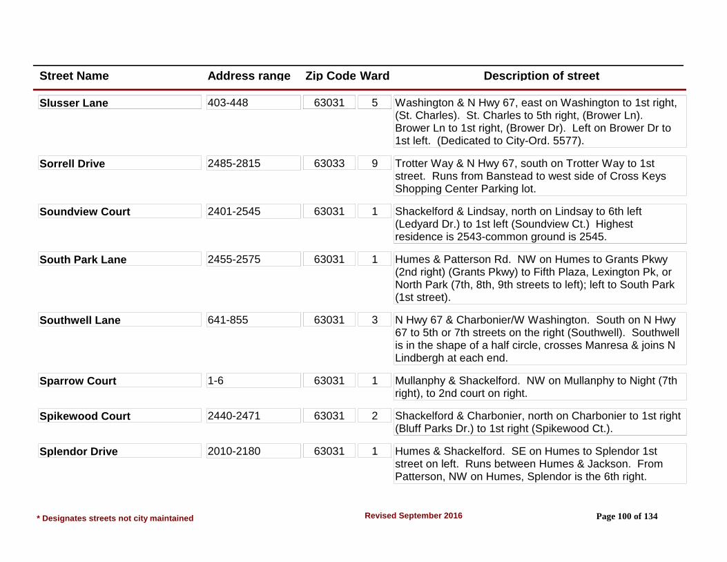
Street Name Address range Zip Code Ward Description of street
Slusser Lane 403-448 63031 5 Washington & N Hwy 67, east on Washington to 1st right, (St. Charles). St. Charles to 5th right, (Brower Ln). Brower Ln to 1st right, (Brower Dr). Left on Brower Dr to 1st left. (Dedicated to City-Ord. 5577).
Sorrell Drive 2485-2815 63033 9 Trotter Way & N Hwy 67, south on Trotter Way to 1st street. Runs from Banstead to west side of Cross Keys Shopping Center Parking lot.
Soundview Court 2401-2545 63031 1 Shackelford & Lindsay, north on Lindsay to 6th left (Ledyard Dr.) to 1st left (Soundview Ct.) Highest residence is 2543-common ground is 2545.
South Park Lane 2455-2575 63031 1 Humes & Patterson Rd. NW on Humes to Grants Pkwy (2nd right) (Grants Pkwy) to Fifth Plaza, Lexington Pk, or North Park (7th, 8th, 9th streets to left); left to South Park (1st street).
Southwell Lane 641-855 63031 3 N Hwy 67 & Charbonier/W Washington. South on N Hwy 67 to 5th or 7th streets on the right (Southwell). Southwell is in the shape of a half circle, crosses Manresa & joins N Lindbergh at each end.
Sparrow Court 1-6 63031 1 Mullanphy & Shackelford. NW on Mullanphy to Night (7th right), to 2nd court on right.
Spikewood Court 2440-2471 63031 2 Shackelford & Charbonier, north on Charbonier to 1st right (Bluff Parks Dr.) to 1st right (Spikewood Ct.).
Splendor Drive 2010-2180 63031 1 Humes & Shackelford. SE on Humes to Splendor 1st street on left. Runs between Humes & Jackson. From Patterson, NW on Humes, Splendor is the 6th right.
* Designates streets not city maintained Page 100 of 134Revised September 2016

Street Name Address range Zip Code Ward Description of street
Spring Drive 1-38 63031 5 New Florissant Rd S & St Anthony/W St. Anthony, south on New Florissant Rd S to 3rd & 4th streets on right. Spring is semi-circle that meets New Florissant Rd S at two locations. From Dunn Rd. Spring is 2nd & 3rd streets on left.
Springlet Court* 1530-1537 63033 7 Dunn & S Waterford Dr. East on Dunn Rd to 3rd left, (Summer Run) to 1st court on the left. (SUMMERWOOD CONDOS).
*Not city maintained
Springtide Court* 1505-1511 63033 7 Dunn & S Waterford Dr. East on Dunn Rd to 2nd left, (Summer Run) to 1st court on the right. (SUMMERWOOD CONDOS).
*Not city maintained
Springvalley Drive 1020-1425 63033 6 New Florissant Rd N & Parker Rd. East on Parker to Springvalley. 1000-1200 blks are 4th street on the right. 1300-1400 blks are 4th street on left. From Parker & Waterford; 1000-1200 is 2nd left, 1300-1400 is 5th right.
Springwood Place Court 400-436 63033 3 Charbonier & N Hwy 67. NW on Charbonier to 10th street on left. From Shackelford, SE on Charbonier to 6th right.
Spruce Drive 1050-1170 63031 1 Shackelford & Mullanphy. SW on Shackelford to Teakwood Manor (1st right), Teakwood Manor to 3rd street. Spruce connects & runs between the SE ends of Hawthorne Manor & Oakwood Manor.
* Designates streets not city maintained Page 101 of 134Revised September 2016

Street Name Address range Zip Code Ward Description of street
St. Albert Lane 10-95 63031 5 Washington & St. Ferdinand, east on Washington to St. Jean (2nd street), right to St. Marie (2nd street) left to St. Jacques (1st street), right on St. Jacques to 1st street on right. From S. Lafayette & W. St. Anthony, north on S. Lafayette to S. St. Jacques (1st left), S. St. Jacques to 1st street on left.
St. Alice Lane 15-75 #500 63031 5 Graham & W St. Anthony, north on Graham to St. Alice, 4th street on right. Also St. Edith turns into St. Alice at end.
St. Anthony 5-320 Both Sides 63031 5 Begns between 600-700 blks of New Florissant Road S., crosses Washington St. (300 & 400 blks), crosses Waterford Dr. (1100 blk) ends at Derhake Road. West of New Florissant Road S changes name to West St. Anthony Lane.
St. Anthony Cul-De-Sac 63031 6 Off of St. Anthony just east of Florissant Road.
St. Anthony Lane 408-700 Even Side
63033 7 Begins between 600-700 blks of New Florissant Road S., crosses Washington St. (300 & 400 blks), crosses Waterford Dr. (1100 blk) ends at Derhake Road. West of New Florissant Road S changes name to West St. Anthony Lane.
535-655 Odd Side 63033 5 Begins between 600-700 blks of New Florissant Road S., crosses Washington St. (300 & 400 blks), crosses Waterford Dr. (1100 blk) ends at Derhake Road. West of New Florissant Road S changes name to West St. Anthony Lane.
* Designates streets not city maintained Page 102 of 134Revised September 2016

Street Name Address range Zip Code Ward Description of street
St. Anthony Lane 695-1890 Both Sides
63033 8 Begins between 600-700 blks of New Florissant Road S., crosses Washington St. (300 & 400 blks), crosses Waterford Dr. (1100 blk) ends at Derhake Road. West of New Florissant Road S changes name to West St. Anthony Lane.
St. Anthony Lane W 15-390 W-E 63031 5 Begins in the 900 blk of Graham Rd, crosses S Lafayette (100-200 blk), ends at New Florissant Rd. S. changes names to St. Anthony Lane.
aka West St. Anthony Lane
St. Antoine Street 110-1400 (Split Street)
63031 6 New Florissant Road N & Parker Rd. South on New Florissant Road N. to St. Antoine, which is the 3rd street. Right is 400-1000, left is 1100-1400. 100 blk must be reached off of St. Ferdinand. There are no 200-300 blks.
St. Augusta Lane 125-245 63031 5 Lafayette & Washington. South on Lafayette to 3rd street (on left). From W St. Anthony, north on Lafayette to 5th street on the right.
St. Baptista Lane 125-210 63031 5 Lafayette & Washington, south on Lafayette to 4th street (on left). From W. St. Anthony north on Lafayette to 4th street on the right.
St. Benedict Lane 10-230 63033 5 St. Anthony & Washington, east on St. Anthony to St. Eugene (1st left) to St. Benedict (1st right). From St. Catherine & New Florissant Rd N, east on St. Catherine to St. Eugene (3rd street on right) to St. Benedict, 1st left.
* Designates streets not city maintained Page 103 of 134Revised September 2016

Street Name Address range Zip Code Ward Description of street
St. Bernadette Lane 1110-1450 63031 5 S Lafayette & Dunn Rd. North on S. Lafayette to St. Cornelius Lane (1st right) to 1st street on left. From W St. Anthony & Lafayette, south on Lafayette to Maple (1st street), left to St. Bernadette (1st right).
St. Bernard Drive 565-645 63033 6 St. Catherine & New Florissant Rd N. East on St. Catherine to St. Bernard, 4th street on left. From St. Catherine & Waterford, west on St. Catherine, 4th right.
St. Brendan Lane 600-1065 63031 5 W St. Anthony & Graham, east on W St. Anthony to 3rd left. OR north on Graham to St. Virgil (3rd right) to end. St. Virgil turns into St. Brendan, crosses St. Patrice & crosses W St. Anthony where it ends, 1 blk south of W St. Anthony.
St. Catherine 1140-1290 63033 6 New Florissant Rd. east to St. Bernard.(St. Catherine Street starts at St. Charles St., one street north of Washington, and runs east to Derhake.)
1330-1850 63033 5 New Florissant Rd. east to St. Bernard.(St. Catherine Street starts at St. Charles St., one street north of Washington, and runs east to Derhake.)
St. Catherine Street 102-1060 63031 6 St. Charles east to New Florissant Road, North.(St. Catherine Street starts at St. Charles St., one street north of Washington, and runs east to Derhake.)
1900-2490 63033 6 New Florissant Rd. east to St. Bernard.(St. Catherine Street starts at St. Charles St., one street north of Washington, and runs east to Derhake.)
* Designates streets not city maintained Page 104 of 134Revised September 2016

Street Name Address range Zip Code Ward Description of street
St. Catherine Street 2205-2425 (Odd addresses)
63033 6 St. Bernard east to Waterford.(St. Catherine Street starts at St. Charles St., one street north of Washington, and runs east to Derhake.)
2560-2800 (Even addresses)
63033 8 St. Bernard east to Waterford.(St. Catherine Street starts at St. Charles St., one street north of Washington, and runs east to Derhake.)
3000-3690 (south side)
63033 8 Waterford to Derhake Rd.(St. Catherine Street starts at St. Charles St., one street north ofWashington, and runs east to Derhake.)
3013-3195 (north side)
63033 8 Waterford Dr. to Paddlewheel.(St. Catherine Street starts at St. Charles St., one street north of Washington, and runs east to Derhake.)
3215-3695 (north side)
63033 8 Saddle Dr. to Derhake in new annexed Area 10.(St. Catherine Street starts at St. Charles St., one street north of Washington, and runs east to Derhake.)
St. Celeste Drive 1-50 63031 6 St. Jean & N Hwy 67, north on St. Jean to 1st right. Runs between St. Jean & Florval, crosses Marquette, Florval is off N Hwy 67 2nd street on right from New Florissant Rd N.
St. Charles Street 1085 & 1159 63031 6 From intersection of Patterson Road and N. Hwy. 67, northeast to 1st street on left.
St. Charles Street, North 1-212 & 310 and 1 - 1155
63031 5 From intersection of Washington & St. Ferdinand Streets west to 1st street on left.
* Designates streets not city maintained Page 105 of 134Revised September 2016
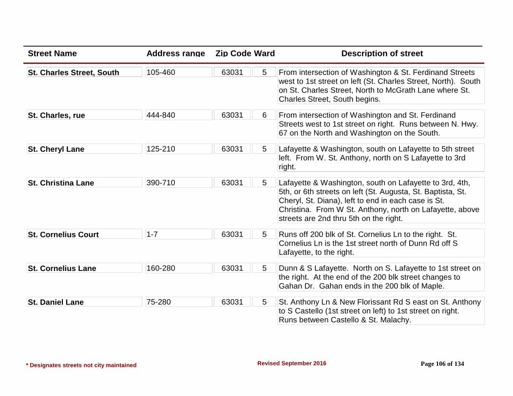
Street Name Address range Zip Code Ward Description of street
St. Charles Street, South 105-460 63031 5 From intersection of Washington & St. Ferdinand Streets west to 1st street on left (St. Charles Street, North). South on St. Charles Street, North to McGrath Lane where St. Charles Street, South begins.
St. Charles, rue 444-840 63031 6 From intersection of Washington and St. Ferdinand Streets west to 1st street on right. Runs between N. Hwy. 67 on the North and Washington on the South.
St. Cheryl Lane 125-210 63031 5 Lafayette & Washington, south on Lafayette to 5th street left. From W. St. Anthony, north on S Lafayette to 3rd right.
St. Christina Lane 390-710 63031 5 Lafayette & Washington, south on Lafayette to 3rd, 4th, 5th, or 6th streets on left (St. Augusta, St. Baptista, St. Cheryl, St. Diana), left to end in each case is St. Christina. From W St. Anthony, north on Lafayette, above streets are 2nd thru 5th on the right.
St. Cornelius Court 1-7 63031 5 Runs off 200 blk of St. Cornelius Ln to the right. St. Cornelius Ln is the 1st street north of Dunn Rd off S Lafayette, to the right.
St. Cornelius Lane 160-280 63031 5 Dunn & S Lafayette. North on S. Lafayette to 1st street on the right. At the end of the 200 blk street changes to Gahan Dr. Gahan ends in the 200 blk of Maple.
St. Daniel Lane 75-280 63031 5 St. Anthony Ln & New Florissant Rd S east on St. Anthony to S Castello (1st street on left) to 1st street on right. Runs between Castello & St. Malachy.
* Designates streets not city maintained Page 106 of 134Revised September 2016

Street Name Address range Zip Code Ward Description of street
St. Denis Street #20 (Cold Water Commons Park)
1305-1820 63033 6 St. Denis & N Hwy 67. Begins at N Hwy 67 & runs east. 100-200 blk at St. Ferdinand, 600-700 blk at Lafayette, 1000 blk at New Florissant Rd N. Skips 1100 blk, begins again with 1200 blk off Castello St. Bears to the right in the 1400-1500 blk & ends where the street ends where changes name to St. Loretto in the 1800 blk., 1100-1800 blks must be reached via Castello which is 1 blk to the east of New Florissant Rd N.
20-1290 63031 6 St. Denis & N Hwy 67. Begins N Hwy 67 & runs east. 100-200 blk at St. Ferdinand, 600-700 blk at Lafayette, 1000 blk at New Florissant Rd N. Skips 1100 blk, begins again with 1200 blk off Castello St. Bears to the right in the 1400-1500 blk & ends where the street ends where changes names to St. Loretto in the 1800 blk., 1100-1800 blks must be reached via Castello which is 1 blk to the east of New Florissant Rd N.
St. Denis Street (Split Street) #41 (1st apartment residence address)
63031 6
St. Diana Lane 125-250 63031 5 Lafayette & Washington, south on Lafayette to 6th left. From W St Anthony, north on Lafayette to 2nd street on right.
* Designates streets not city maintained Page 107 of 134Revised September 2016
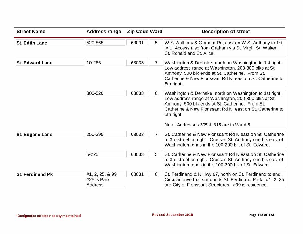
Street Name Address range Zip Code Ward Description of street
St. Edith Lane 520-865 63031 5 W St Anthony & Graham Rd, east on W St Anthony to 1st left. Access also from Graham via St. Virgil, St. Walter, St. Ronald and St. Alice.
St. Edward Lane 10-265 63033 7 Washington & Derhake, north on Washington to 1st right. Low address range at Washington, 200-300 blks at St. Anthony, 500 blk ends at St. Catherine. From St. Catherine & New Florissant Rd N, east on St. Catherine to 5th right.
300-520 63033 6 Washington & Derhake, north on Washington to 1st right. Low address range at Washington, 200-300 blks at St. Anthony, 500 blk ends at St. Catherine. From St. Catherine & New Florissant Rd N, east on St. Catherine to 5th right.
Note: Addresses 305 & 315 are in Ward 5
St. Eugene Lane 250-395 63033 7 St. Catherine & New Florissant Rd N east on St. Catherine to 3rd street on right. Crosses St. Anthony one blk east of Washington, ends in the 100-200 blk of St. Edward.
5-225 63033 5 St. Catherine & New Florissant Rd N east on St. Catherine to 3rd street on right. Crosses St. Anthony one blk east of Washington, ends in the 100-200 blk of St. Edward.
St. Ferdinand Pk #1, 2, 25, & 99 #25 is Park Address
63031 6 St. Ferdinand & N Hwy 67, north on St. Ferdinand to end. Circular drive that surrounds St. Ferdinand Park. #1, 2, 25 are City of Florissant Structures. #99 is residence.
* Designates streets not city maintained Page 108 of 134Revised September 2016

Street Name Address range Zip Code Ward Description of street
St. Ferdinand Street* 420-1190 63031 6 Graham Rd & Quick Dr. 100 blk of St. Ferdinand joins the 100 blk of Graham Rd near Quick Dr/Reed Ln. 1st residence (5&7) are to west side of Quick Dr & face St. Ferdinand. Runs south to north, crosses Washington, St. Denis, N Hwy 67 and ends at St. Ferdinand Park Dr.
Maintained by St. Louis Co. Dept. of Hwys.
5-396 63031 5 Graham Rd & Quick Dr. 100 blk of St. Ferdinand joins the 100 blk of Graham Rd near Quick Dr/Reeb Ln. 1st residence (5&7) are to west side of Quick Dr & face St. Ferdinand. Runs south to north, crosses Washington, St. Denis, N Hwy 67 and ends at St. Ferdinand Park Dr.
Maintained by St. Louis Co. Dept. of Hwys.
St. Florence Drive 1175-1260 63031 7 New Florissant Rd S & St. Anthony. South on New Florissant Rd S to Derhake (1st left), Derhake to St. Matthew (1st right) to St. Luke (1st left) to St. Florence (1st right). From Washington & Derhake, west on Derhake, stay left of island at St. Joan & continue east on St. Luke to St. Florence on left.
St. Florent Lane 110-215 63031 5 S Lafayette & W St. Anthony Ln south on S Lafayette to (St. Florent), 2nd street on left. From Dunn Rd, north on S Lafayette to 4th street on right.
St. Francois Street 1 & 50, 100-1295 63031 6 Begins at Old St. Ferdinand Shrine and runs from west to east, crosses St. Ferdinand St. (100-200 blks), crosses Lafayette St (600-700 blks St. Francois), crosses New Florissant Rd N (1000-1100 blks) ends at Van Asche Ct.
* Designates streets not city maintained Page 109 of 134Revised September 2016

Street Name Address range Zip Code Ward Description of street
St. Francois Street 1304-1890 63033 6 Begins at Old St. Ferdinand Shrine and runs from west to east, crosses St. Ferdinand St. (100-200 blks.), crosses Lafayette St (600-700 blks St. Francois), crosses New Florissant Rd N (1000-1100 blks) ends at Van Asche Ct.
St. Gabrielle Drive 580-640 63033 6 St. Catherine & New Florissant Rd N east on St. Catherine to St. Gabrielle, 3rd street on left. From Waterford Dr., west on St. Catherine to 5th right.
St. Genevieve Court 1-20 63031 7 Dunn & New Florissant Rd S east on Dunn to Plaza Duchesne Dr. (1st street on left), to S Duchesne. Right on S Duchesne to 1st street on right, St. Genevieve Ct.
St. George Court 1-19 63031 6 N Hwy 67 & Patterson Rd east on N Hwy 67 to 3rd street on right. St. George Ct is 1st street on right east of St. Ferdinand Street.
St. Gregory Drive 140-300 63031 7 New Florissant Rd S & St. Anthony. South on New Florissant Rd S to Derhake (1st left) to St. Matthew (1st right) to end. Street changes names to St. Gregory at end of St. Matthew. From Washington & Derhake, west on Derhake to St. Richard (1st left) to end. Runs between St. Richard & St. Matthew, crosses St. Joan and St. Florence.
St. Jacques Street 104-145 (Split Street)
63031 5 Runs from north end of S St. Jacques (100-200 blks) no 300 blk (Combs School), 400-600 blks, no 700 blk, (Sacred Heart Church & School), 800-1000 blks ends at 67. Runs parallel to & 2nd street west of Lafayette.
* Designates streets not city maintained Page 110 of 134Revised September 2016
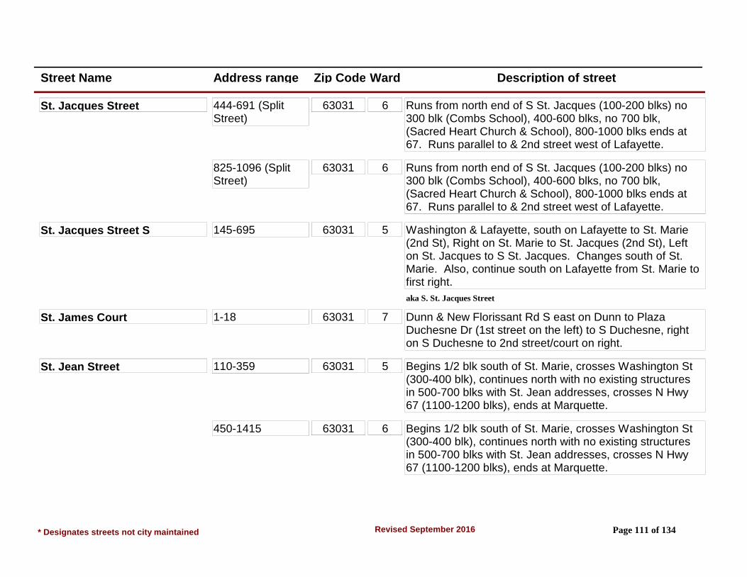
Street Name Address range Zip Code Ward Description of street
St. Jacques Street 444-691 (Split Street)
63031 6 Runs from north end of S St. Jacques (100-200 blks) no 300 blk (Combs School), 400-600 blks, no 700 blk, (Sacred Heart Church & School), 800-1000 blks ends at 67. Runs parallel to & 2nd street west of Lafayette.
825-1096 (Split Street)
63031 6 Runs from north end of S St. Jacques (100-200 blks) no 300 blk (Combs School), 400-600 blks, no 700 blk, (Sacred Heart Church & School), 800-1000 blks ends at 67. Runs parallel to & 2nd street west of Lafayette.
St. Jacques Street S 145-695 63031 5 Washington & Lafayette, south on Lafayette to St. Marie (2nd St), Right on St. Marie to St. Jacques (2nd St), Left on St. Jacques to S St. Jacques. Changes south of St. Marie. Also, continue south on Lafayette from St. Marie to first right.
aka S. St. Jacques Street
St. James Court 1-18 63031 7 Dunn & New Florissant Rd S east on Dunn to Plaza Duchesne Dr (1st street on the left) to S Duchesne, right on S Duchesne to 2nd street/court on right.
St. Jean Street 110-359 63031 5 Begins 1/2 blk south of St. Marie, crosses Washington St (300-400 blk), continues north with no existing structures in 500-700 blks with St. Jean addresses, crosses N Hwy 67 (1100-1200 blks), ends at Marquette.
450-1415 63031 6 Begins 1/2 blk south of St. Marie, crosses Washington St (300-400 blk), continues north with no existing structures in 500-700 blks with St. Jean addresses, crosses N Hwy 67 (1100-1200 blks), ends at Marquette.
* Designates streets not city maintained Page 111 of 134Revised September 2016

Street Name Address range Zip Code Ward Description of street
St. Joan Drive 1185-1250 63031 7 New Florissant Rd S & St. Anthony. South on New Florissant Rd S to Derhake (1st left), Derhake to St. Matthew (1st right), St. Matthew to St. Luke (1st left), St. Luke to St. Joan (2nd right). Runs between St. Gregory & St. Luke, & is 2nd street west of Washington off Derhake.
St. John Court 1-9 63031 7 New Florissant Rd S & St. Anthony. South on New Florissant Rd S to St. John, 2nd street on left. From Dunn Rd, north on New Florissant Rd S, St. John is 3rd street on right.
St. Joseph Street 1820-2210 63033 6 New Florissant Rd N & N Hwy 67. South on New Florissant Rd N to St. Joseph, 5th street which is also 2nd street south of Parker Rd off New Florissant N. Right is 1000-400; left is 1100-1300 & 1800-2200 blks. There are no 1400-1700 blks existing at this time.
404-1385 63031 6 New Florissant Rd N & N Hwy 67. South on New Florissant Rd N to St. Joseph, 5th street which is also 2nd street south of Parker Rd off New Florissant N. Right is 1000-400, left is 1100-1300 & 1800-2200 blks. There are no 1400-1700 blks existing at this time.
St. Judith Lane 700-750 63031 7 St. Anthony & New Florissant Rd S. East on St. Anthony to St. Judith, 1st street on left off Derhake from New Florissant Rd S.
St. Laurence Drive 1-34 63031 6 St. Jean & N Hwy 67, north on St. Jean to 3rd street. Runs from St. Jean to Marquette.
* Designates streets not city maintained Page 112 of 134Revised September 2016

Street Name Address range Zip Code Ward Description of street
St. Loretto Drive 1495-1715 63033 6 St. Catherine & New Florissant Rd N. East on St. Catherine to Castello or Aubuchon (1st & 2nd streets), left on Castello or Aubuchon to St. Denis (3rd street), right on St. Denis to 1400-1500 blk and bear left for St. Loretto. Meets St. Denis at east and west ends.
St. Louis Street 1310-2185 63033 6 Runs parallel to & 1st street north of St. Francois St. Begins at St. Ferdinand St. & runs east. Crosses Lafayette (600-700 blks), crosses New Florissant Rd N (1000-1100 blks), continues east & ends at Jamaica Place. Jamaica Pl is 3rd street on right off St. Catherine from Waterford Dr. NOTE: No 1500-1700 structures at this time.
140-1290 63031 6 Runs parallel to & 1st street north of St. Francois St. Begins at St. Ferdinand St. & runs east. Crosses Lafayette (600-700 blks), crosses New Florissant Rd N (1000-1100 blks), continues east & ends at Jamaica Place. Jamaica Pl is 3rd street on right off St. Catherine from Waterford Dr. NOTE: No 1500-1700 structures at this time.
St. Luke Drive 135-235 63031 7 New Florissant Rd S & St. Anthony. South on New Florissant Rd S to Derhake (1st left), to St. Matthew (1st right), to St. Luke (1st left). From Washington, west on Derhake to Island & continue straight (west) on St. Luke.
St. Madeleine Lane 90-215 63031 5 Lafayette & W St. Anthony, south on Lafayette to 3rd left. From Dunn, north on S Lafayette to 3rd street on right. Runs between St. Bernadette & S Lafayette.
* Designates streets not city maintained Page 113 of 134Revised September 2016
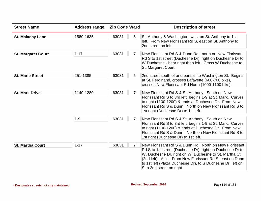
Street Name Address range Zip Code Ward Description of street
St. Malachy Lane 1580-1635 63031 5 St. Anthony & Washington, west on St. Anthony to 1st left. From New Florissant Rd S, east on St. Anthony to 2nd street on left.
St. Margaret Court 1-17 63031 7 New Florissant Rd S & Dunn Rd., north on New Florissant Rd S to 1st street (Duchesne Dr), right on Duchesne Dr to W Duchesne - bear right then left. Cross W Duchesne to St. Margaret Court.
St. Marie Street 251-1385 63031 5 2nd street south of and parallel to Washington St. Begins at St. Ferdinand, crosses Lafayette (600-700 blks), crosses New Florissant Rd North (1000-1100 blks).
St. Mark Drive 1140-1280 63031 7 New Florissant Rd S & St. Anthony. South on New Florissant Rd S to 3rd left, begins 1-9 at St. Mark. Curves to right (1100-1200) & ends at Duchesne Dr. From New Florissant Rd S & Dunn: North on New Florissant Rd S to 1st right (Duchesne Dr) to 1st left.
1-9 63031 7 New Florissant Rd S & St. Anthony. South on New Florissant Rd S to 3rd left, begins 1-9 at St. Mark. Curves to right (1100-1200) & ends at Duchesne Dr. From New Florissant Rd S & Dunn: North on New Florissant Rd S to 1st right (Duchesne Dr) to 1st left.
St. Martha Court 1-17 63031 7 New Florissant Rd S & Dunn Rd. North on New Florissant Rd S to 1st street (Duchesne Dr), right on Duchesne Dr to W. Duchesne Dr, right on W. Duchesne to St. Martha Ct (2nd left). Aslo: From New Florissant Rd S, east on Dunn to 1st left (Plaza Duchesne Dr), to S Duchesne Dr, left on S to 2nd street on right.
* Designates streets not city maintained Page 114 of 134Revised September 2016

Street Name Address range Zip Code Ward Description of street
St. Matthew Drive 1061-1265 63031 7 New Florissant Rd S & St. Anthony. South on New Florissant Rd S to 1st left (Derhake). Left on Derhake to St. Matthew, 1st street on right. Runs from Derhake to St. Gregory. NOTE: Address 1061 is out of sequence. Sits between 1065 & 1075 St. Matthew. 1065 is corner house Derhake & St. Matthew).
St. Maurice Lane 10-255 63031 5 S Lafayette & Dunn Rd. North on S. Lafayette to 2nd street. Runs west to east from St. Patrice to Gahan.
St. Michael Court 1-18 63031 7 Dunn & New Florissant Rd S. East on Dunn to 2nd left. From Washington, west on Dunn to 1st street on right.
St. Michael Street 1171-1265 63031 6 New Florissant Rd N & Parker Rd. South on New Florissant Rd N to 1st street - St. Michael St. Left is 1100-1400 blks. Right is unimproved 1000 blk with no structures/addresses.
1350-1485 63033 6 New Florissant Rd N & Parker Rd. South on New Florissant Rd N to 1st street - St. Michael St. Left is 1100-1400 blks. Right is unimproved 1000 blk with no structures/addresses.
St. Nicholas Lane 55-310 63031 7 St. Anthony & New Florissant Rd S. East on St. Anthony to St. Nicholas, 2nd street on right. From Washington, west on St. Anthony to 1st left. Joins St. Anthony at each end of St. Nicholas.
St. Patrice Lane 700-1260 63031 5 W St. Anthony & Graham Rd. East on W St. Anthony, 2nd street. Runs between St. Brendan & St. Maurice, crosses Maple.
* Designates streets not city maintained Page 115 of 134Revised September 2016

Street Name Address range Zip Code Ward Description of street
St. Patrick Lane 160-365 63031 5 New Florissant Rd S & W St. Anthony. West on W St. Anthony to 1st street on right. Runs into S Lafayette 1st street north of W St. Anthony. From Washington, south on Lafayette to 7th left.
St. Pierre Court 1-9 63031 6 St. Pierre Ct is in the 800 blk on the north side of St. Denis.
St. Pierre Street 110-175, 279 & 301 (Split Street)
63031 5 Runs parallel to & 1st street east of St. Ferdinand St. 100 blk begins 1 blk south of St. Marie. 200 blk does not exist. 300 blk begins at Harrison, continues north & ends at St. Denis in 700 blk. 800 blk is St. Pierre Ct., 800-1000 blks do not exist. 1100 blk begins & ends on north side of N Hwy 67.
502-795, 1150 & 1165 (Split Street)
63031 6 Runs parallel to & 1st street east of St. Ferdinand St. 100 blk begins 1 blk south of St. Marie. 200 blk does not exist. 300 blk begins at Harrison, continues north & ends at St. Denis in 700 blk. 800 blk is St. Pierre Ct., 800-1000 blks do not exist. 1100 blk begins & ends on north side of N Hwy 67.
St. Pius Court 2-6 63033 7 St. Anthony & Washington, east on St. Anthony to St. Eugene (1st street), right to 1st left. Located between 200-300 St. Eugene.
St. Regis Lane 75-295 63031 5 St. Anthony & Washington, west on St. Anthony to St. Malachy (1st right), St. Malachy to St. Regis, end of St. Malachy. Runs between St. Malachy & S Castello.
St. Richard Drive 1195-1260 63031 7 Derhake & Washington, west on Derhake to 1st left. From New Florissant Rd S, east on Derhake to 4th street.
* Designates streets not city maintained Page 116 of 134Revised September 2016

Street Name Address range Zip Code Ward Description of street
St. Ronald Lane 15-65 63031 5 Graham & W St. Anthony, north on Graham to 1st right. Runs between St. Edith & Graham Rd.
St. Rose Court 1-9 63031 5 W St. Anthony & S Lafayette, east on W St. Anthony to 1st street on right. From New Florissant Rd S, west on West St. Anthony to 2nd street on left.
St. Stephen Drive 1980-2125 63033 6 St. Catherine & New Florissant Rd N. East on St. Catherine to St. Gabrielle (3rd left) to St. Stephen (1st right).
St. Thomas Court 1-13 63031 7 New Florissant Rd S & Dunn, east on Dunn to Plaza Duchesne Dr (1st left) to S Duchesne (1st street) left to 1st right.
St. Virgil Lane 15-80 63031 5 Graham & W St. Anthony, north on Graham to 3rd right. From Reeb Ln, south on Graham to 3rd left.
St. Walter Lane 15-70 63031 5 Graham & W St. Anthony, north on Graham to 2nd right. From Reeb Ln, south on Graham to 4th left.
Stafford Lane 3125-3215 63033 8 From St. Catherine and Waterford, east to 2nd left (Gateswood Drive). North to 1st left.
3225 63033 8 From St. Catherine and Waterford, east to 2nd left (Gateswood Drive). North to 1st left.
650-695 63033 8 From St. Catherine and Waterford, east to 2nd left (Gateswood Drive). North to 1st left.
Stag Court 3980-4010 63033 8 From Pohlman Rd/Birchview Dr intersection. North to first street on right, Meadowland Dr, east to first street on right. (Area 12)
* Designates streets not city maintained Page 117 of 134Revised September 2016

Street Name Address range Zip Code Ward Description of street
Stallion Drive 1420-1525 63033 9 N Waterford & Waterford Dr. East on N Waterford to Bay Meadows (3rd left) to Stallion (1st right) OR continue to 2nd street east of Bay Meadows on N Waterford which is Stallion Dr. From N Waterford & Parker Spur, west on N Waterford to 6th street on right.
Starlet Drive 600-780 63031 4 Patterson Rd & Humes Ln. North on Patterson to 2nd left. Runs between Patterson Rd & Love Ln.
Starling Drive 1515-1590 63031 1 Shackelford & Mullanphy Rd. NE on Shackelford to Flamingo (4th left). Flamingo to 3rd right. From Humes, SW on Shackelford to Flamingo (1st right), to Starling (3rd right).
Steed Court 3220-3290 63033 8 From Parker and Meadowgrass Dr., south to 1st street (Steed Dr). Left to 1st street on right. (Area 10)
Steed Drive 3085-3120 (West) 63033 8 From Parker and Meadowgrass Dr., south to 1st street. Runs east and west. (Area 10)
3155-3375 (East) 63033 8 From Parker and Meadowgrass Dr., south to 1st street. Runs east and west. (Area 10)
Steeplechase Lane 2585-2725 63033 8 Parker & Waterford, west on Parker to Paddock (1st left). South on Paddock to Steeplechase (1st left). From New Florissant Rd N, east on Parker to Paddock (5th right), right to Steeplechase (1st left).
Stirrup Lane 2325-2585 63033 9 N Waterford & N Hwy 67, east on N Waterford to Turf (1st left) to end (changes name to Stirrup). At Trotter Way, east side is Delaware, west side is Stirrup.
* Designates streets not city maintained Page 118 of 134Revised September 2016
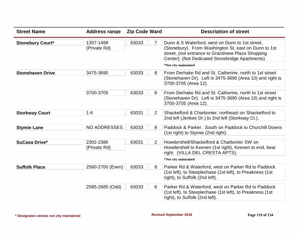
Street Name Address range Zip Code Ward Description of street
Stonebury Court* 1357-1499 (Private Rd)
63033 7 Dunn & S Waterford, west on Dunn to 1st street, (Stonebury). From Washington St, east on Dunn to 1st street, (not entrance to Grandview Plaza Shopping Center). (Not Dedicated Stonebridge Apartments)
*Not city maintained
Stonehaven Drive 3475-3690 63033 8 From Derhake Rd and St. Catherine, north to 1st street (Stonehaven Dr). Left is 3475-3690 (Area 10) and right is 3700-3705 (Area 12).
3700-3705 63033 8 From Derhake Rd and St. Catherine, north to 1st street (Stonehaven Dr). Left is 3475-3690 (Area 10) and right is 3700-3705 (Area 12).
Storkway Court 1-6 63031 2 Shackelford & Charbonier, northeast on Shackelford to 2nd left (Jenkee Dr.) to 2nd left (Storkway Ct.).
Stymie Lane NO ADDRESSES 63033 8 Paddock & Parker. South on Paddock to Churchill Downs (1st right) to Stymie (2nd right).
SuCasa Drive* 2302-2386 (Private Rd)
63031 2 Howdershell/Shackelford & Charbonier SW on Howdershell to Keeven (1st right), Keeven to end, bear right. (VILLA DEL CRESTA APTS).
*Not city maintained
Suffolk Place 2560-2700 (Even) 63033 8 Parker Rd & Waterford, west on Parker Rd to Paddock (1st left), to Steeplechase (1st left), to Preakness (1st right), to Suffolk (2nd left).
2585-2685 (Odd) 63033 6 Parker Rd & Waterford, west on Parker Rd to Paddock (1st left), to Steeplechase (1st left), to Preakness (1st right), to Suffolk (2nd left).
* Designates streets not city maintained Page 119 of 134Revised September 2016
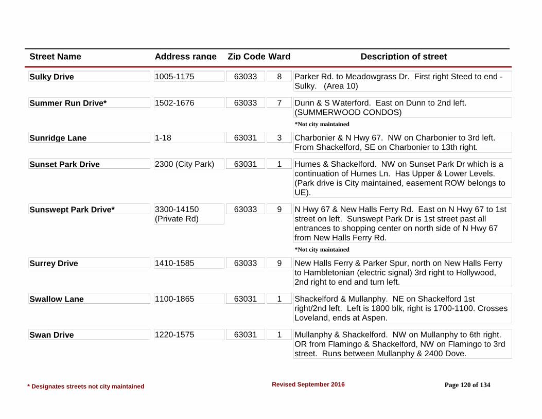
Street Name Address range Zip Code Ward Description of street
Sulky Drive 1005-1175 63033 8 Parker Rd. to Meadowgrass Dr. First right Steed to end - Sulky. (Area 10)
Summer Run Drive* 1502-1676 63033 7 Dunn & S Waterford. East on Dunn to 2nd left. (SUMMERWOOD CONDOS)
*Not city maintained
Sunridge Lane 1-18 63031 3 Charbonier & N Hwy 67. NW on Charbonier to 3rd left. From Shackelford, SE on Charbonier to 13th right.
Sunset Park Drive 2300 (City Park) 63031 1 Humes & Shackelford. NW on Sunset Park Dr which is a continuation of Humes Ln. Has Upper & Lower Levels. (Park drive is City maintained, easement ROW belongs to UE).
Sunswept Park Drive* 3300-14150 (Private Rd)
63033 9 N Hwy 67 & New Halls Ferry Rd. East on N Hwy 67 to 1st street on left. Sunswept Park Dr is 1st street past all entrances to shopping center on north side of N Hwy 67 from New Halls Ferry Rd.
*Not city maintained
Surrey Drive 1410-1585 63033 9 New Halls Ferry & Parker Spur, north on New Halls Ferry to Hambletonian (electric signal) 3rd right to Hollywood, 2nd right to end and turn left.
Swallow Lane 1100-1865 63031 1 Shackelford & Mullanphy. NE on Shackelford 1st right/2nd left. Left is 1800 blk, right is 1700-1100. Crosses Loveland, ends at Aspen.
Swan Drive 1220-1575 63031 1 Mullanphy & Shackelford. NW on Mullanphy to 6th right. OR from Flamingo & Shackelford, NW on Flamingo to 3rd street. Runs between Mullanphy & 2400 Dove.
* Designates streets not city maintained Page 120 of 134Revised September 2016
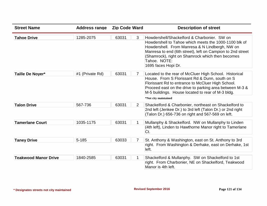
Street Name Address range Zip Code Ward Description of street
Tahoe Drive 1285-2075 63031 3 Howdershell/Shackelford & Charbonier. SW on Howdershell to Tahoe which meets the 1000-1100 blk of Howdershell. From Manresa & N Lindbergh, NW on Manresa to end (6th street), left on Campion to 2nd street (Shamrock), right on Shamrock which then becomes Tahoe. NOTE:1695 faces Hopi Dr.
Taille De Noyer* #1 (Private Rd) 63031 7 Located to the rear of McCluer High School. Historical House. From S Florissant Rd & Dunn, south on S Florissant Rd to entrance to McCluer High School. Proceed east on the drive to parking area between M-3 & M-5 buildings. House located to rear of M-3 bldg.
*Not city maintained
Talon Drive 567-736 63031 2 Shackelford & Charbonier, northeast on Shackelford to 2nd left (Jenkee Dr.) to 3rd left (Talon Dr.) or 2nd right (Talon Dr.) 656-736 on right and 567-569 on left.
Tamerlane Court 1035-1175 63031 1 Mullanphy & Shackelford. NW on Mullanphy to Linden (4th left), Linden to Hawthorne Manor right to Tamerlane Ct.
Taney Drive 5-185 63033 7 St. Anthony & Washington, east on St. Anthony to 3rd right. From Washington & Derhake, east on Derhake, 1st left.
Teakwood Manor Drive 1840-2585 63031 1 Shackelford & Mullanphy. SW on Shackelford to 1st right. From Charbonier, NE on Shackelford, Teakwood Manor is 4th left.
* Designates streets not city maintained Page 121 of 134Revised September 2016

Street Name Address range Zip Code Ward Description of street
Terry Court 1-7 63031 3 Charbonier & Shackelford. SE on Charbonier to 2nd right (Albert) to 1st right, (Bobbinray), to 1st right (Raymond), to 2nd left (Terry Ct.).
Thackery Court 2-15 63031 7 S Florissant Rd & Dunn, south on S Florissant to Wadsworth (1st left) to Thackery Ct (1st right).
Thistledown Drive 3760-3880 63033 8 From Greengrass Dr/Derhake Rd intersection, go east to first street on right, Greenberry. South on Greenberry to first street on left. Thistledown Dr runs between Greenberry Dr and Wheatfield Dr. (Area 12)
Thompson Drive 700-1195 63031 3 Charbonier & N Hwy 67. NW on Charbonier to Rosetta or Blanchette (1st & 4th left), left to Thompson which is 1st street. Access also off Charbonier via Sunridge or Floweridge which are 2nd & 3rd streets NW of N Hwy 67. Runs parallel to Keeven from Flora Ln to 1 blk SE of Rosetta. (ST. FERDINAND APTS & CHARBONIER MANOR APTS, PLUS RESIDENCES).
Thoroughbred Lane 1410-1625 63033 9 N Waterford & Parker Rd. West on N Waterford to Thoroughbred (5th right). From New Halls Ferry & Parker Spur, north on New Halls Ferry to 2nd left. From N Hwy 67, east on N Waterford. Thoroughbred is the 6th left past Waterford Dr.
Thrush Drive 2000-2100 63033 9 Thunderbird & N Hwy 67. North on Thunderbird to the 1st or 2nd right (Martin or Cardinal), right to end is Thrush Dr. Access off Oriole or Hummingbird which are also off east side of Thunderbird.
* Designates streets not city maintained Page 122 of 134Revised September 2016

Street Name Address range Zip Code Ward Description of street
Thrush Lane 1220-1425 63031 1 Mullanphy & Shackelford. NW on Mullanphy to 3rd right. From Shackelford & Humes, SW on Shackelford to Flamingo (1st right) to 2nd left.
Thunderbird Avenue 1740 63033 9 N Waterford & N Hwy 67, north on Thunderbird is continuation of N Waterford Dr. Thunderbird is the 1st street on the left east of New Florissant Rd N off N Hwy 67. (Higher addresses are St. Louis Co).
1800-2105 63033 9 N Waterford & N Hwy 67, north on Thunderbird is continuation of N Waterford Dr. Thunderbird is the 1st street on the left east of New Florissant Rd N off N Hwy 67. (Higher addresses are St. Louis Co).
Tina Drive 1430-1460 63033 8 New Halls Ferry & N Hwy 67. South on New Halls Ferry to the 8th street on the left, or, 2nd right from Parker Road, north on New Halls Ferry to Estates Dr. Estates to the 2nd street on the left, Lisa. Lisa to 1st street on the right, Fairway. Fairway to 2nd street on the right.
Tom Sawyer Drive 3240-3325 63033 8 St. Catherine & Waterford, east on St. Catherine to Paddlewheel (2nd street on right), right to Tom Sawyer (1st left). From Derhake, west on St. Catherine to 2nd left, to Tom Sawyer (1st left).
Torero Lane 800-1661 63031 2 Shackelford & Lindsay, north on Lindsay to 1st right or 1st left (Torero Ln). 800 block & 1600 block on left (Ward 2) and 900, 1000 and 1900 block on right (Ward 1).
910-1988 63031 1 Shackelford & Lindsay, north on Lindsay to 1st right or 1st left (Torero Ln). 800 block & 1600 block on left (Ward 2) and 900, 1000 and 1900 block on right (Ward 1).
* Designates streets not city maintained Page 123 of 134Revised September 2016

Street Name Address range Zip Code Ward Description of street
Tremont Drive 1450-1580 63033 9 New Halls Ferry & Parker Spur, north on New Halls Ferry to Hambletonian (electric signal 3rd street on right), east on Hambletonian to 1st right (Tremont). From N Hwy 67, south on New Halls Ferry, Hambletonian is 7th left.
3510-3705 63033 9 New Halls Ferry & Parker Spur, north on New Halls Ferry to Hambletonian (electric signal 3rd street on right), east on Hambletonian to 1st right (Tremont). From N Hwy 67, south on New Halls Ferry, Hambletonian is 7th left.
Trinity Lane 1-26 63031 5 Graham & W St. Anthony, north on Graham to 1st left. From Reeb Ln, south on Graham to 3rd right.
Trotter Way 1590-2070 63033 9 N Waterford & N Hwy 67. East on N Waterford to 5th left, OR east on N Hwy 67 to 1st right, Trotter Way is also 1st left off N Hwy 67 west of Halls Ferry Rd. Runs between N Hwy 67 & N Waterford.
Turf Lane 1640-1695 63033 9 N Waterford & N Hwy 67. East on N Waterford to 1st left. From Parker Rd, west on N Waterford to 19th street on right.
Tyson Court 1-5 63031 4 Mullanphy & Patterson Rd. NW on Mullanphy to 3rd right, (Tyson Dr), bear right at "Y" & continue on Tyson Dr to 1st street/court on left. Tyson Dr is also 5th left off Mullanphy SE of Shackelford.
Tyson Drive 1600-1745 63031 4 Mullanphy & Patterson Rd. NW on Mullanphy to 3rd right 1600-1700 Tyson OR 4th left -700-800 Tyson Dr. From Shackelford, SE on Mullanphy to 5th left 1600-1700, OR 5th right 700-800 Tyson.
* Designates streets not city maintained Page 124 of 134Revised September 2016

Street Name Address range Zip Code Ward Description of street
Tyson Drive 700-890 63031 4 Mullanphy & Patterson Rd. NW on Mullanphy to 3rd right 1600-1700 Tyson OR 4th left -700-800 Tyson Dr. From Shackelford, SE on Mullanphy to 5th left 1600-1700, OR 5th right 700-800 Tyson.
Valencia Drive 2015-2120 63033 9 New Halls Ferry & N Hwy 67. South on New Halls Ferry to Santiago (4th left); east on Santiago to 4th left. From Parker Spur north on New Halls Ferry to 6th right, Santiago to 4th left.
Valerie Court 1920, 1930, 1940, 1950, 1960
63033 7 Derhake & Washington, east on Derhake to 1st right, (Valerie Dr). Valerie Dr to Valerie Ct on right side of Valerie. Valerie Ct addresses are sequential with Valerie Dr.
Valerie Drive 1900-2070 63033 7 Derhake & Washington, east on Derhake to 1st right. From Waterford Dr, west on Derhake to 4th left.
Valley Drive 2-26 63031 5 New Florissant Rd S & W St. Anthony. South on New Florissant Rd S to 1st right. From Dunn Rd, north on New Florissant Rd S to 5th left.
Van Asche Court 590-645 63033 6 New Florissant Rd N & St. Catherine. North on New Florissant Rd N to St. Francois (1st right) to Van Asche Ct (3rd street) at end of St. Francois.
Venetia Court 2-6 63031 5 W Washington & N Hwy 67. East on W Washington to St. Charles St (2nd right), right on St. Charles to 100 blk of S St. Charles to 1st street/court on right.
* Designates streets not city maintained Page 125 of 134Revised September 2016

Street Name Address range Zip Code Ward Description of street
Verlene Drive 1020-1745 63031 1 Mullanphy & Shackelford. SE on Mullanphy to Loveland (2nd left) to Verlene (5th street). From Humes & Patterson, NW on Humes to Don Donna (4th left) or Loveland (5th left). Don Donna to 3rd street. Loveland to 1st street. Access also off Shackelford south on Flamingo to 1st left. 1700 blk is one blk SE of Shackelford, 1400 blk is at Loveland, 1100 at Don Donna.
Versailles Drive 210-595 63031 4 Patterson Rd & Humes Ln. North on Patterson to 4th right. 500 blk at Patterson Rd, 200 blk at east end at Moule.
Vesper Drive 1400-1585 63031 4 Mullanphy & Patterson Rd. NW on Mullanphy to 2nd left. From Shackelford, SE on Mullanphy to 7th right.
Violet Drive 1805-1930 63031 4 Humes & Patterson Rd. NW on Humes to 3rd left. From Shackelford, SE on Humes to 4th street on right. Access also off of Lilac which is 2nd right off Patterson Rd S of Humes Ln. Lilac ends at Violet.
Wadsworth Drive 1240-1480 63031 7 S Florissant Rd & Dunn Rd. South on S Florissant Rd to 1st left (Wadsworth). Runs west to east from S Florissant to Milbank.
Washington Street W 400-450 63031 5 Runs from NW end of Washington St at Coldwater Creek to N Hwy 67. On NW side of N Hwy 67 street becomes Charbonier Rd.
aka W. Washington Street
* Designates streets not city maintained Page 126 of 134Revised September 2016

Street Name Address range Zip Code Ward Description of street
Washington Street W 500 63031 3 Runs from NW end of Washington St at Coldwater Creek to N Hwy 67. On NW side of N Hwy 67 street becomes Charbonier Rd.
aka W. Washington Street
Washington Street* 63033 7 Begins on east side of Coldwater Creek, crosses St. Ferdinand St. (100-200 blk), crosses Lafayette (600-700 blk), crosses New Florissant Rd N (1000-1100 blk), changes direction in 1300 blk & runs N to S, crosses St. Anthony (1600-1700 blk), crosses Derhake (1800-1900 blk) ends at Dunn Rd with the 4500 blk. On the south side of I-270 changes name to North Elizabeth Ave.
*Maintained by St. Louis Co. Dept. of Hwys.
1305-1625 (E) 63033 5 Begins on east side of Coldwater Creek, crosses St. Ferdinand St. (100-200 blk), crosses Lafayette (600-700 blk), crosses New Florissant Rd N (1000-1100 blk), changes direction in 1300 blk & runs N to S, crosses St. Anthony (1600-1700 blk), crosses Derhake (1800-1900 blk) ends at Dunn Rd with the 4500 blk. On the south side of I-270 changes name to North Elizabeth Ave.
*Maintained by St. Louis Co. Dept. of Hwys.
1320-1570 (W) 63033 5 Begins on east side of Coldwater Creek, crosses St. Ferdinand St. (100-200 blk), crosses Lafayette (600-700 blk), crosses New Florissant Rd N (1000-1100 blk), changes direction in 1300 blk & runs N to S, crosses St. Anthony (1600-1700 blk), crosses Derhake (1800-1900 blk) ends at Dunn Rd with the 4500 blk. On the south side of I-270 changes name to North Elizabeth Ave.
*Maintained by St. Louis Co. Dept. of Hwys.
* Designates streets not city maintained Page 127 of 134Revised September 2016
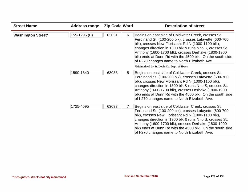
Street Name Address range Zip Code Ward Description of street
Washington Street* 155-1295 (E) 63031 6 Begins on east side of Coldwater Creek, crosses St. Ferdinand St. (100-200 blk), crosses Lafayette (600-700 blk), crosses New Florissant Rd N (1000-1100 blk), changes direction in 1300 blk & runs N to S, crosses St. Anthony (1600-1700 blk), crosses Derhake (1800-1900 blk) ends at Dunn Rd with the 4500 blk. On the south side of I-270 changes name to North Elizabeth Ave.
*Maintained by St. Louis Co. Dept. of Hwys.
1590-1640 63033 5 Begins on east side of Coldwater Creek, crosses St. Ferdinand St. (100-200 blk), crosses Lafayette (600-700 blk), crosses New Florissant Rd N (1000-1100 blk), changes direction in 1300 blk & runs N to S, crosses St. Anthony (1600-1700 blk), crosses Derhake (1800-1900 blk) ends at Dunn Rd with the 4500 blk. On the south side of I-270 changes name to North Elizabeth Ave.
1725-4595 63033 7 Begins on east side of Coldwater Creek, crosses St. Ferdinand St. (100-200 blk), crosses Lafayette (600-700 blk), crosses New Florissant Rd N (1000-1100 blk), changes direction in 1300 blk & runs N to S, crosses St. Anthony (1600-1700 blk), crosses Derhake (1800-1900 blk) ends at Dunn Rd with the 4500 blk. On the south side of I-270 changes name to North Elizabeth Ave.
* Designates streets not city maintained Page 128 of 134Revised September 2016
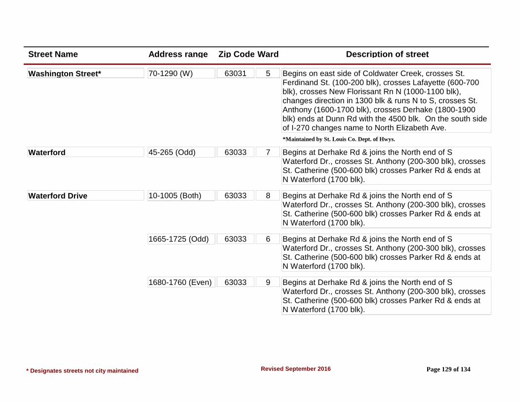
Street Name Address range Zip Code Ward Description of street
Washington Street* 70-1290 (W) 63031 5 Begins on east side of Coldwater Creek, crosses St. Ferdinand St. (100-200 blk), crosses Lafayette (600-700 blk), crosses New Florissant Rn N (1000-1100 blk), changes direction in 1300 blk & runs N to S, crosses St. Anthony (1600-1700 blk), crosses Derhake (1800-1900 blk) ends at Dunn Rd with the 4500 blk. On the south side of I-270 changes name to North Elizabeth Ave.
*Maintained by St. Louis Co. Dept. of Hwys.
Waterford 45-265 (Odd) 63033 7 Begins at Derhake Rd & joins the North end of S Waterford Dr., crosses St. Anthony (200-300 blk), crosses St. Catherine (500-600 blk) crosses Parker Rd & ends at N Waterford (1700 blk).
Waterford Drive 10-1005 (Both) 63033 8 Begins at Derhake Rd & joins the North end of S Waterford Dr., crosses St. Anthony (200-300 blk), crosses St. Catherine (500-600 blk) crosses Parker Rd & ends at N Waterford (1700 blk).
1665-1725 (Odd) 63033 6 Begins at Derhake Rd & joins the North end of S Waterford Dr., crosses St. Anthony (200-300 blk), crosses St. Catherine (500-600 blk) crosses Parker Rd & ends at N Waterford (1700 blk).
1680-1760 (Even) 63033 9 Begins at Derhake Rd & joins the North end of S Waterford Dr., crosses St. Anthony (200-300 blk), crosses St. Catherine (500-600 blk) crosses Parker Rd & ends at N Waterford (1700 blk).
* Designates streets not city maintained Page 129 of 134Revised September 2016

Street Name Address range Zip Code Ward Description of street
Waterford Drive N 2116-3250 63033 9 Runs from N Hwy 67 (2100 blk) to Parker Rd (3200 blk) west to east. North of N Hwy 67 street changes name to Thunderbird. Also crosses Trotter Way (2500 blk) & Waterford Dr (2700 blk).
aka N. Waterford
Waterford Drive S 1000-1507 63033 7 Begins at Derhake & joins south end of Waterford Dr. Runs south to Dunn Rd & ends. (1000 blk at Derhake, 1500 blk at Dunn Rd.).
aka S. Waterford
Westcott Drive 1-8 63031 5 St. Ferdinand & Washington, south on St. Ferdinand to Graham Rd continuation at Reeb Ln, 1st left past Reeb Ln. From W St. Anthony, north on Graham 5th steet on the right.
Weymouth Court 2-8 63031 4 From New Halls Ferry Rd & N. Hwy 67 Intersection northwest west to 7th street on left (Patterson Rd) to 1st street on left (Shadow Rock Dr) to 1st street on left. Also, from Jana Dr & Patterson Rd Intersection northeast to 5th street on right (Shadow Rock Dr) to 1st street on left.
Wheatfield Drive 2200-2460 63033 8 From Greengrass Dr/Derhake Rd intersection, go east to second street on right. Wheatfield runs between Greengrass Dr. and Pohlman Rd. (Area 12)
Whirlaway Drive 1470-1530 63033 6 Waterford & N Waterford, south on Waterford to 1st right (Narraganset), to 2nd left. From Paddock & Parker Rd, north on Paddock to Derby (1st right) to end.
Whitney Circle 1-9 63033 9 N Waterford & Parker Rd. West on N Waterford to 3rd right. From N Hwy 67, east on N Waterford to 17th left.
* Designates streets not city maintained Page 130 of 134Revised September 2016
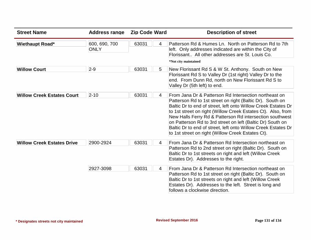
Street Name Address range Zip Code Ward Description of street
Wiethaupt Road* 600, 690, 700 ONLY
63031 4 Patterson Rd & Humes Ln. North on Patterson Rd to 7th left. Only addresses indicated are within the City of Florissant.. All other addresses are St. Louis Co.
*Not city maintained
Willow Court 2-9 63031 5 New Florissant Rd S & W St. Anthony. South on New Florissant Rd S to Valley Dr (1st right) Valley Dr to the end. From Dunn Rd, north on New Florissant Rd S to Valley Dr (5th left) to end.
Willow Creek Estates Court 2-10 63031 4 From Jana Dr & Patterson Rd Intersection northeast on Patterson Rd to 1st street on right (Baltic Dr). South on Baltic Dr to end of street, left onto Willow Creek Estates Dr to 1st street on right (Willow Creek Estates Ct). Also, from New Halls Ferry Rd & Patterson Rd intersection southwest on Patterson Rd to 3rd street on left (Baltic Dr) South on Baltic Dr to end of street, left onto Willow Creek Estates Dr to 1st street on right (Willow Creek Estates Ct).
Willow Creek Estates Drive 2900-2924 63031 4 From Jana Dr & Patterson Rd Intersection northeast on Patterson Rd to 2nd street on right (Baltic Dr). South on Baltic Dr to 1st streets on right and left (Willow Creek Estates Dr). Addresses to the right.
2927-3098 63031 4 From Jana Dr & Patterson Rd Intersection northeast on Patterson Rd to 1st street on right (Baltic Dr). South on Baltic Dr to 1st streets on right and left (Willow Creek Estates Dr). Addresses to the left. Street is long and follows a clockwise direction.
* Designates streets not city maintained Page 131 of 134Revised September 2016

Street Name Address range Zip Code Ward Description of street
Willow Mound Lane 2904-2940 63031 4 From Jana Dr & Patterson Rd Intersection northeast on Patterson Rd to 1st street on right (Baltic Dr). South on Baltic Dr to 2nd street on right (Willow Mound Ln).
Willow Wren Court* 1600-1615 (Private Rd)
63033 7 Dunn & S Waterford Dr. East on Dunn to Summer Run to the end, (Willow Falls), left on Willow Falls to Willow Wren (1st left).
*Not city maintained
Willowbrook Drive 1310-1470 63033 6 New Florissant Rd N & N Hwy 67. South on New Florissant Rd N to Fox Run (1st left), Fox Run to 2nd right. From Parker & New Florissant Rd N, east on Parker Rd to 2nd left.
Wilshire Drive 615-740 63033 8 St. Catherine & Waterford, east on St. Catherine to 1st street left & right. From Derhake, west on St. Catherine to the 5th right/3rd left.
Windsong Court 2-10 63031 2 Shackelford & Charbonier, northeast on Shackelford to 2nd left (Jenkee Dr.) to 1st left (Windsong Ct).
Winners Circle 2-12 63033 9 N Waterford & N Hwy 67, east on N Waterford to 4th left. From Parker Rd, west on N Waterford to 16th right. Winners Circle is 6th street west of Waterford Dr off N Waterford Dr also.
Winsted Place 1-2 63031 2 Charbonier & N Hwy 67. NW on Charbonier to 2nd right. From Shackelford, SE on Charbonier to 4th left.
* Designates streets not city maintained Page 132 of 134Revised September 2016

Street Name Address range Zip Code Ward Description of street
Woodcrest Dr 3800-4020 63033 8 New Halls Ferry & N Hwy 67. South on New Halls Ferry to the 8th street on the left, or, 2nd right from Parker Rd, north on New Halls Ferry to Estates Dr. Estates to the 2nd street on the left, Lisa Dr. Lisa to the first street on the right, Fairway. Fairway to 1st street on the right. (Paddock Estates Annexation)
Wooden Drive 901-1147 63033 7 S Waterford & Derhake, south on S Waterford to 1st right. From Dunn Rd, north on S Waterford to 1st left. Grandview Garden Apts.
Woodridge Lane 1725-2015 63033 6 N Hwy 67 & New Florissant Rd N. SW on N Hwy 67 to 1st right. OR North on Florissant Road N to 1st left.
Note: Address No. 1700 is in Ward 9
Wren Drive 245-615 63031 4 Patterson Rd & Humes Ln. North on Patterson Rd to 1st right & left. Left is 600 blk, right is 200-500 blks. Wren ends at Flight on the 600 blk side, ends at Humes on the 200 blk side.
Wycomb Drive 1000-1115 63033 7 Derhake & S Waterford Dr. East on Derhake to 1st right. From Dunn & S Waterford, north on S Waterford to Penhurst (6th right) to Wycomb (1st left).
Yaqui Drive 1240-2080 63031 3 Howdershell/Shackelford & Charbonier. SW on Howdershell to 1000-1100 blk Howdershell, left on Tahoe. SE on Tahoe to 1st right. Runs parallel to Tahoe & joins Tahoe in the 1200 & 2000 blks. Hopi crosses Yaqui & Tahoe in the 1600 blks. Runs SE to NW-low to high.
* Designates streets not city maintained Page 133 of 134Revised September 2016

Street Name Address range Zip Code Ward Description of street
Yearling Drive 1420-1625 63033 9 N Waterford & Parker Rd. West on N Waterford to 4th right. From N Hwy 67, east on N Waterford to 16th left.
Zurich Drive 1340-1680 63031 7 S Florissant Rd & Dunn Rd. South on S Florissant Rd to Wadsworth (1st left), Wadsworth to Argo (2nd right), Argo to end. From Washington/Elizabeth & Dunn, south on Elizabeth to Milbank (1st street past entrance to McCluer High School), right on Milbank to 1st left, LaGrange. LaGrange to end.
* Designates streets not city maintained Page 134 of 134Revised September 2016