city of carson active transportaion planpublichealth.lacounty.gov/place/docs/carson draft...
TRANSCRIPT

CITY OF CARSONACTIVE TRANSPORTAION PLAN
PART I: PEDESTRIAN MASTER PLANPART II: MASTER PLAN OF BIKEWAYS

C A R S O N PEDESTRIAN MASTER PLAN
CITY OF CARSON701 E Carson Street
Carson, California 90745
310.952.1761
June, 2015
CARSON PEDESTRIAN MASTER PLAN
iv
1
2
3
7
4
8
5
9
6
10
A
B
C
ACKNOWLEDGMENTS
This Plan represents the combined vision and goals of the Community Advisory Board that guided its development, as well as input from key stakeholders, community groups, and community members. Thank you to all for donating your time to this project.
CITY OF CARSON HEALTHY EATING
ACTIVE LIVING (HEAL) COMMUNITY
ADVISORY BOARD MEMBERS
Jim Dear, City of Carson
Louie Diaz, Planning Commission
Ray Aldridge, Carson Bicycle Coalition
Audrey Echnoz, Carson/Gardena YMCA
Kim Richards, Boys and Girls Club of Carson
Adam Duvendeck, StubHub Center
Katie Pandolfo, StubHub Center
Pilar Hoyos, Economic Development Commission
Chris Childers, Economic Development Commission
Cletis Reed III, Parks and Recreation Commission
Francisco Canche, Los Angeles Unified School District
Sweeney Mae Montinola, South Bay Pavillion
Lori Carter, Resident and business owner
Made possible with funding from the Centers for Disease Control and Prevention through the Los Angeles County Department of Public Health.
Louisa Franco, Department of Public Health
Dr, Paul Chung, University of California, Los Angeles
Dr. Burt Cowgill, University of California, Los Angeles
Lauren Grabowski, University of California, Los Angeles
Jacinta Elijah, University of California, Los Angeles
Lindsey Thompson, University of California, Los Angeles
Richard Garland, City of Carson
Reata Kulcsar, City of Carson
Scott Griffee, City of Carson
Saied Naaseh, City of Carson
C
v
1
2
3
7
4
8
5
9
6
10
A
B
1 INTRODUCTION.........................................................1-1A Vision of Active Transportation in Carson...........................................1-2
Planning Process Overview..................................................................................1-2
Goals........................................................................................................1-4
PUBLIC OUTREACH..................................................2-1Overview.........................................................................................................2-2
Public Workshops......................................................................................................2-2
Outreach Results.........................................................................................................2-2
PLANNING CONTEXT..............................................3-1Overview.........................................................................................................3-2
City of Carson General Plan................................................................................3-2
City of Carson Municipal Code.........................................................................3-4
Specific Plans..............................................................................................................3-6
Mobility Plans of Neighboring Communities..............................................3-6
GOALS, POLICIES, AND ACTIONS........................4-1Goals, Policies, and Actions.................................................................................4-2
EXISTING CONDITIONS..........................................5-1Existing ...........................................................................................................................5-2
Vehicle-Pedestrian Collision Data........................................................................5-2
Public Transit............................................................................................................5-4
PROPOSED PEDESTRIAN IMPROVEMENTS.....6-1Overview........................................................................................................6-2
Pedestrian-scale Lighting........................................................................................6-2
Sidewalks...........................................................................................6-4
Intersection Improvements...................................................................................6-6
Urban Canopy...........................................................................................................6-8
Neighborhood Access..........................................................................................6-10
TABLE OF CONTENTS
3
2
4
5
6
CARSON PEDESTRIAN MASTER PLAN

C
vi
1
2
3
7
4
8
5
9
6
10
A
B
CARSON PEDESTRIAN MASTER PLAN
PEDESTRIAN PROGRAMS.....................................7-15 E’s..................................................................................................................................7-2
FUNDING...................................................................8-1Overview........................................................................................................8-2
State Funding Programs.....................................................................................8-2
IMPLEMENTATION.....................................................9-1Overview........................................................................................................9-2
Cost Estimates..........................................................................................................9-2
DESIGN GUIDELINES.............................................10-1Overview.......................................................................................................10-2
Pedestrian Ways.....................................................................................................10-2
Furnishings..........................................................................................10-6
Lighting..........................................................................................................10-13
Green Infrastructure............................................................................................10-17
Signing...... . . . . . . . . . . . . . . . . . . . . . . . . . . . . . . . . . . . . . . . . . . . . . . . . . . . . . . . . . . . . . . . . . . . . . . . . . . . . . . . . . . .10-22
PUBLIC OUTREACH...................................................A-1Outreach Results.......................................................................................................A-2
Stakeholder Interview and Focus Groups .....................................................A-5
PEDESTRIAN ENVIORNMENTAL QUALITY INDEX
.........................................................................................B-1Pedestrian Enviornmental Quality Index.........................................................B-2
LOCATION LIST............................................................C-1Intersection Improvements....................................................................................C-2
7
8
9
10
A
B
C

vii
1
2
3
7
4
8
5
9
6
10
A
B
C
LIST OF FIGURES FIGURE 3.1 City of Carson General Plan Bus Routes................3-5
FIGURE 5.1 City of Carson, Pedestrian Collisions, 2010-2013...5-3
FIGURE 6.1 Pedestrian - Scale Lighting..............................................6-3
FIGURE 6.2 Sidewalk Gaps................................................................................6-5
FIGURE 6.3 Proposed Improvements...........................................................6-7
FIGURE 6.4 Vacant Tree-wells.........................................................................6-9
FIGURE 6.5 Cul-de-sac Locations (North)............................................6-10
FIGURE 6.6 Cul-de-sac Locations (South)...........................................6-11
FIGURE 10.1 Pedestrian-friendly Sidewalk Zone....................................10-2
FIGURE 10.2 Public Seating in Furniture Zone..................................10-4
FIGURE 10.3 Tree Grate........................................................................................10-4
FIGURE 10.4 Parklets...............................................................................................10-5
FIGURE 10.5 Public Seating..............................................................................10-6
FIGURE 10.6 Refused Receptacle....................................................................10-6
FIGURE 10.7 Bollards..............................................................................................10-7
FIGURE 10.8 Transit Shelter..............................................................................10-8
FIGURE 10.9 Sidewalk Bike Parking...........................................................10-9
FIGURE 10.10 Off-street Bike Parking...........................................................10-9
FIGURE 10.11 Sidewalk Dining.......................................................................10-11
FIGURE 10.12 Bike Share Station...............................................................10-12
FIGURE 10.13 Pedestrian-Scale Lighting (Top) Street Lighting (Bottom)..10-13
FIGURE 10.14 Light Fixture for Park Areas.....................................10-14
FIGURE 10.15 Pedstrian-Scale Lighting.....................................................10-14
FIGURE 10.16 Solar Light Fixture.............................................................10-15
FIGURE 10.17 Custom-Designed Lighting...............................................10-16
FIGURE 10.18 Catenary Lighting..................................................................10-16
FIGURE 10.19 Tree Plantings.........................................................................10-17
FIGURE 10.20 Small Tree in Planter......................................................10-18
FIGURE 10.21 Sedum Plant ......................................................................10-18
FIGURE 10.22 Tree Spacing in Pedestrian-Friendly Zone.......10-19
FIGURE 10.23 Parkway in Residential Street...................................10-19
FIGURE 10.24 Tree Wells.................................................................................10-20
FIGURE 10.25 Bioswale.......................................................................................10-21
FIGURE 10.26 Rain Garden in Parking Lot...................................10-21
FIGURE 10.27 Street Signs for All Roadway Users................10-23
FIGURE 10.28 Transit Service Information..........................................10-23
CARSON PEDESTRIAN MASTER PLAN

C
viii
1
2
3
7
4
8
5
9
6
10
A
B
CARSON PEDESTRIAN MASTER PLAN
LIST OF TABLES TABLE 9.1 Costs for Construction Items.............................................9-3
TABLE A.1 Prioritization Exercise...................................................................A-2
TABLE A.2 Policy Voting....................................................................................A-2
TABLE A.3 Walkability Map Exercise by Geographic Location/
Destination...........................................................................................A-3
TABLE A.4 Walkability Map Exercise by Topic...........................A-4
TABLE A.5 Lighting Map Exercise by Geographic Location/
Destination..........................................................................................A-5
TABLE B.1 PEQI 2.0 Indicators by Domain..............................B-3

CARSON PEDESTRIAN MASTER PLAN
INTRODUCTIONCHAPTER 1
CARSON PEDESTRIAN MASTER PLAN
1-2
1
2
3
7
4
8
5
9
6
10
A
B
C
“Active transportation” refers to non-motorized, human-powered
transportation—primarily walking and bicycling—but may also
include skateboarding, wheelchairs or any non-motorized means of
transportation. The City of Carson will support the community’s desire for
improved health, economic vitality, and quality of life by establishing a
complete, safe, and attractive bicycle, pedestrian and transit network that
will be accessible to users of all ages, abilities and backgrounds. Carson
community members will choose to walk, bike, or ride public transit for
routine tasks as part of a healthier lifestyle.
Carson’s active transportation network will provide connectivity to
key destinations in Carson including all neighborhoods, schools, parks,
employment centers, and churches; government offices including Carson
City Hall, the Carson Civic Center; commercial shopping centers such
as SouthBay Pavilion Mall and the Boulevards at South Bay; regional
attractions including California State University Dominguez Hills, and the
StubHub Center; and surrounding cities and communities.
In 2013, the Los Angeles County Department of Public Health awarded a
Healthy Eating Active Living (HEAL) grant to the UCLA/RAND Prevention
Research Center to partner with the City of Carson to develop an Active
Transportation Plan. In May 2013, the Carson City Council passed a
resolution (Council resolution: 13-054) authorizing work on an Active
Transportation Plan and the creation of a community advisory group to
guide the process. Work commenced in June 2013.
The Active Transportation Plan is organized into two parts: The Carson
Master Plan of Bikeways and the Carson Pedestrian Master Plan.
The Carson Master Plan of Bikeways includes a proposed bicycle network,
bicycle programs, design guidelines and an implementation plan.
The Carson Pedestrian Master Plan includes proposed improvements to
Carson’s streets and sidewalks, education and encouragement programs,
design guidelines, and an implementation plan.
The Pedestrian Master Plan is the result of a robust community
engagement process that relied on the model of community-based
participatory research (CBPR). CBPR is a partnership approach to research
that involves equal input and involvement from a cross section of
community participants including community members, organizational
PLANNING PROCESS OVERVIEW
A VISION OF ACTIVE TRANSPORTATION IN CARSON

CHAPTER 1 INTRODUCTION
1-3
1
2
3
7
4
8
5
9
6
10
A
B
C
representatives, and decision-makers in which all partners contribute
expertise and share decision-making and ownership. The goal of CBPR is to
increase knowledge and understanding and to integrate the knowledge
gained with interventions and policy and social change to improve the
health and quality of life of a community.
A HEAL Community Advisory Board with key leaders and stakeholders
was assembled to guide the development of the Active Transportation
Plan process. The HEAL Project Team convened the advisory board on a
quarterly basis to provide project updates and request input during the
planning process. The HEAL Project Manager and staff conducted one to
two hour interviews with community stakeholders, English and Spanish
focus groups, and distributed surveys to over 300 community members
to gather feedback. The HEAL Project Manager worked closely with two
students groups, the Mayor’s Task Force and a Youth Community Advisory
Board to conduct walking assessments to expand their knowledge of
Carson’s pedestrian environment before they provided input in mapping
exercises. Additionally, two public workshops were held, and HEAL staff
attended three community events to gather public input on the plan. The
Active Transportation Plan is the result of this input.
Members of the Carson community assist with the planning process at a community event.

CARSON PEDESTRIAN MASTER PLAN
1-4
1
2
3
7
4
8
5
9
6
10
A
B
C
The purpose of the Active Transportation Plan is to make Carson’s vision
a reality. Below is a list of measurable goals that will help support and
achieve this vision.
GOAL 1: CONNECTIVITY
Connect neighborhoods, parks, shopping centers, schools, employment
centers, bus stops, and regional destinations with a greater number and
broader range of pedestrian, bicycle and transit facility options.
GOAL 2: LIVABILITY
Design an active transportation network that is attractive and convenient.
GOAL 3: SAFETY
Improve safety for people walking and bicycling.
GOAL 4: HEALTH
Improve community health through increased opportunities for physical
activity and improved air quality.
GOAL 5: ECONOMIC DEVELOPMENT
Increase the number of residents that patronize local businesses by
improving biking, walking, and transit accessibility at key commercial
areas and business districts.
GOALS

CARSON PEDESTRIAN MASTER PLAN
PUBLIC OUTREACH
CHAPTER 2

2-2
1
2
3
7
4
8
5
9
6
10
CARSON PEDESTRIAN MASTER PLAN
A
B
C
In order to understand the active transportation needs of the Carson
community, the project team conducted a comprehensive community
engagement effort that included convening an advisory board of key
community leaders on a quarterly basis, monthly meetings with the May-
or’s student task force, seven one-hour stakeholder interviews, five two-
hour focus groups, outreach at community events and a questionnaire.
The engagement activities took place from August 2013 to May 2014. Ap-
proximately 500 people participated.
Two community workshops were held in Carson. The public was notified
via flyers distributed in parks and schools, Facebook postings and cable
advertisement.
Workshop 1
The first public workshop was held March 5, 2014 at Veterans Sports Com-
plex. It was held in conjunction with the 5,000 lb Weight Loss Challenge
Culmination Event to highlight the health focus of the active transporta-
tion Plan. Project team members, student volunteers and Councilmem-
ber attended. Despite heavy rain, approximately 25 community members
participated.
Workshop 2
The second public workshop was held on May 3, 2014 at the Carson Com-
munity Center. The Second Annual Tour de Carson was held in conjunc-
tion with this workshop to attract more participants interested in active
transportation and health. Project team members, student volunteers
and Councilmembers attended. Approximately 100 people participated.
Project team staff and volunteers also attended community events such
as, Red Ribbon Week, Tri-Carson, and the SouthBay Pavilion Health Fair, to
inform the public about the plan and solicit feedback.
Participants were asked to comment on their general travel behaviors
and thoughts on the pedestrian and bicycling environment.
PUBLIC WORKSHOPS
OVERVIEW
OUTREACH RESULTS

2-3
1
2
3
7
4
8
5
9
6
10
CHAPTER 2 PUBLIC OUTREACH
B
A
C
Identification and Key Issues
1. Pedestrian: The community provided mixed results about the pedes-
trian experience. Areas in the City that were identified as “good” to walk
in were around certain parks, including Veterans Park, around South Bay
Pavilion, and along streets that had greenery, shops, and less traffic. Ar-
eas that were identified as “bad” to walk in were areas that were dimly lit
or lacked lighting, streets with cracked or narrow sidewalks, and streets
without curb ramps. The community also cited concerns about safety
from vehicles and crime during the day and night.
2. Bike: Safety was the main biking concern for the community. Partici-
pants stated that lack of bike lanes discourages them from biking in the
City because of safety issues dealing with motor vehicles. Areas that par-
ticipants wanted lanes were on major streets, such as Carson Street and
Del Amo Boulevard, because they are wide enough to accommodate
bicyclists and motor vehicles. Participants were also concerned about
safety from bike thefts and agreed that having more bike racks would be
beneficial. Areas for suggested bike racks were around malls and grocery
stores. Some stated the lack of a bike culture also discouraged them from
biking more, and that more bicyclists on the road would provide encour-
agement.
3. Public Transit: The community identified inconsistency and infrequency
of buses as the main reasons why they are not using public transit. Par-
ticipants stated the lack of frequent buses made public transit inconve-
nient because too much time was spent traveling to and from destina-
tions, such as the mall, work, grocery stores, and schools. Safety while
waiting for the bus and while on the bus was also a concern. Participants
identified the hours of operations for buses as an issue because some bus
lines end their routes too early. Participants agreed that more knowledge
about bus routes, schedules and an easier system to navigate the bus
routes would encourage them to use public transit more.
4. Programming: Participants stated that there is a lack of awareness per-
taining to public events and workshops. Better awareness is needed to
educate the public about walking, biking and public transit opportunities
in Carson.
2-4
1
2
3
7
4
8
5
9
6
10
CARSON PEDESTRIAN MASTER PLAN
A
B
C
Community Priorities
1. Safety: Safety from vehicles, crime, and harassment is a major priority.
The City should enact infrastructure and non-infrastructure program-
ming to increase community safety. Infrastructure should include light-
ing, fixing sidewalks, widening sidewalks around schools, and adding bike
lanes. Non-infrastructure should include crossing guards around school
areas, more police surveillance of areas, such as the pedestrian bridge on
Figueroa Street, and safety workshops. People of all ages should feel safe
to walk, bike, and take public transportation in City of Carson.
2. Access and Destinations: City of Carson should increase access to des-
tinations in order to increase active transportation. Lack of destinations
nearby discourages people from walking and biking because it is incon-
venient and takes more time than traveling by car. Providing more desti-
nations, such as restaurants and shops, would encourage people to walk
more in their neighborhoods and around their work locations. Strategies
that make places, such as City Hall, schools, and employment areas, more
accessible can promote active transportation to these destinations.
3. Increased Awareness: Increasing community awareness of programs,
events, and workshops is a key strategy to promote active transportation.
Wider audiences can be met through advertisements in newspapers such
as the Daily Breeze and through the city website. Frequent sightings of
campaigns, posters, and flyers that promote walking and biking as a safe,
fun, and healthy activity can encourage families to participate in active
transportation. Program and infrastructure that promote safety, such as
bicycle safety workshops or signs alerting drivers to share the road, can
also increase awareness.
4. Wellness: Incorporating wellness into daily lives can promote a healthier
city. Educating the community, especially the youth, about the benefits
of active transportation can help create long-term healthy habits. Also in-
creased active transportation can help alleviate air quality problems and
asthma concerns.
2-5
1
2
3
7
4
8
5
9
6
10
CHAPTER 2 PUBLIC OUTREACH
B
A
C
Suggested Improvements
1. Lighting: Pedestrian lighting around schools, parks, malls, bus stops,
and along residential streets can increase feelings of safety and encour-
age more walking and biking.
2. Landscaping: More landscaping along streets can promote walking.
Plants, shade, and greenery gives people something to look at while walk-
ing along major streets. Exteriors of buildings and outdoor landscaping
should be maintained to increase walking and help businesses.
3. Monitoring: Visibility encourages people to walk because they feel saf-
er. More police surveillance around parks and the pedestrian bridge on
Figueroa Street can promote walking. Activities that bring people to the
parks at night, such as sports leagues, can also increase the sense of com-
munity safety and encourage more walking and biking.
4. Bicycle Lanes: Bicycle lanes around malls, schools, event venues, and
big streets will encourage more biking because people will feel safer. In-
creased bicyclists on the streets can promote a bike culture in City of Car-
son.
5. Incentives: Giveaways and contests can encourage active transporta-
tion. Giveaways can include pedometers or bicycle helmets. Carpooling
and public transportation incentives can also help.
CARSON PEDESTRIAN MASTER PLAN
PLANNING CONTEXT
CHAPTER 3

3-2
1
2
3
7
4
8
5
9
6
10
CARSON PEDESTRIAN MASTER PLAN
A
B
C
All approved planning documents must be consistent with existing City,
regional and state plans, policies and regulations. The following section
summarizes relevant documents.
LAND USE ELEMENT
The General Plan Land Use Element plays a central role in correlating all
land use issues into a set of coherent development policies. One of the
current issues that the land use element addresses is trying to develop a
balance of a mixture of facilities in order to meet the needs of the citizens
of Carson. The land use plan needs to provide for “Livable Communities”
that integrate a development theme, landscaping and buffering, quality
design, environmental protection, easy access to public transportation,
pedestrian access, and neighborhood safety.
TRANSPORTATION ELEMENT
The General Plan Transportation Element addresses the existing
and projected future circulation conditions in the City. It looks
at transportation through a multi-modal lens, addressing private
automobiles, inter-city and intra-city transit, trucks, bicycles, and
pedestrians. Additionally, it provides overviews of street classifications,
level of service, bicycle routes, transit facilities, and circulation forecasts
for the City of Carson.
CITY OF CARSON GENERAL PLAN
OVERVIEW

3-3
1
2
3
7
4
8
5
9
6
10
CHAPTER 3 PLANNING CONTEXT
A
B
C
AV
ALO
N B
LVD
WIL
MIN
GTO
N AVE
DEL AMO BLVD
223RD ST
405 FREEWAY
ALONDRA BLVD
BR
OA
DW
AY
FIGU
ER
OA
ST
LOMITA BLVD
CE
NTR
AL A
VE
WILM
ING
TON
AV
E
SA
NTA
FE
AV
E
ALA
ME
DA
ST
SEPULVEDA BLVDMA
IN S
T
AV
ALO
N B
LVD
CARSON ST
MA
IN S
T
FIG
UE
RO
A S
T
VICTORIA ST
405 FREEWAY
California State UniversityDominguez Hills
CarsonHighSchool
WhiteMiddleSchool
CarnegieMiddleSchool
CurtissMiddleSchool
DoloresStreetSchool
Del AmoElementary School
AmblerAvenueSchool
BonitaStreetSchool
232ndPlaceSchool
DominguezElementarySchool
AnnaleeAvenueSchool
RalphBuncheSchool
TowneAvenueElementarySchool
LeapwoodAvenueSchool
BroadacresAvenueSchool
CarsonStreetSchool
CaroldaleLearningCommunity
CatskillAvenueSchool
Victoria Golf Course
Victoria Park
ScottPark
DolphinPark
Carson Park
VeteransPark
StevensonPark
Hemingway Park
DelAmoPark
AndersonPark
CalasPark
DominguezPark
Carriage Crest Park
MillsPark
WalnutStr.Park
FriendshipPark
Perry S
tM
ini Park
City Hall
CommunityCenter
Sheriff's StationPost Office
Route ERoute DRoute G
Route A
Route H
Nor
th/S
outh
Shu
ttle
Route E
Route A
Route E
Rou
te H
Route A
Route F
Rou
te F
Rou
te G
Rou
te D
Route BRoute D
Route G
Route G
Rou
te F
Nor
th/S
outh
Shu
ttle
Nor
th/S
outh
Shu
ttle
North/South Shuttle
Rou
te C
Rou
te C
Route E
Route D
Rou
te B
Rou
te B
City Hall
CommunityCenter
Rou
te B
Rou
te F
Rou
te C
Rou
te D
Rou
te G
Route E
Rou
te E Route A
Route F
Carson Circuit andNorth/South
Shuttle Routes and Shelters
0 0.5 10.25
Miles
Z:\GISProjects\77\BusStops.mxd
:
Bus StopsCarson Circuit Bus Stops!(
Civic Buildings
Parks
Schools
Bus RoutesRoute A
Route B
Route C
Route D
Route E
Route F
Route G
Route H
North South Shuttle
FIGURE 3.1 CITY OF CARSON GENERAL PLAN BUS ROUTES

3-4
1
2
3
7
4
8
5
9
6
10
CARSON PEDESTRIAN MASTER PLAN
A
B
C
SAFETY ELEMENT
The General Plan Safety Element is used to identify and understand
potential hazards confronting the City of Carson. It includes policies that
address pedestrian safety in communities.
OPEN SPACE/CONSERVATION ELEMENT
The General Plan Open Space/Conservation Element provides policies
that promote environmental awareness and practices to protect key
natural features and resources. Due to scarcity of resources, the economic
health and quality of life of Carson residents are of key importance.
AIR QUALITY ELEMENT
The General Plan Air Quality Element is intended to protect the public’s
health and welfare by implementing measures that allow the South Coast
Air Basin to attain Federal and State air quality standards, which will move
the City towards a sustainable level of air quality. Air quality conditions
in Carson are influenced by many factors, including the topography,
climate, and numeral types of pollution producers. Stricter enforcement
of emission reduction rules, educating the public on pollution control
measures, and promoting the use of alternate fuel vehicles will assist in
the improvement of air quality in the region.
3-5
1
2
3
7
4
8
5
9
6
10
CHAPTER 3 PLANNING CONTEXT
A
B
C
CITY OF CARSON
GENERAL PLAN
ELEMENTS
GOALS POLICY AND
IMPLEMENTATION
MEASURES
LAND USE LU-6
LU-8
LU-13
LU-15
LU-6.3
LU-8.3
LU-13.6
LU-15.6
TRANSPORTATION TI-3
TI-4
TI-3.4
TI-4.1
TI-4.2
TI-4.3
SAFETY SAF-6 SAF-6.8
OPEN SPACE/CONSERVATION OSC-3 OSC-3.4
AIR QUALITY AQ-2
AQ-3
AQ-2.5
AQ-2.6
AQ-3.1
AQ-3.2
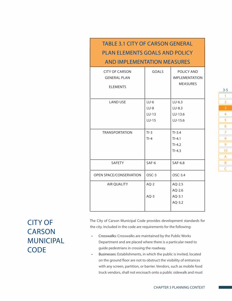
The City of Carson Municipal Code provides development standards for
the city. Included in the code are requirements for the following:
• Crosswalks: Crosswalks are maintained by the Public Works
Department and are placed where there is a particular need to
guide pedestrians in crossing the roadway.
• Businesses: Establishments, in which the public is invited, located
on the ground floor are not to obstruct the visibility of entrances
with any screen, partition, or barrier. Vendors, such as mobile food
truck vendors, shall not encroach onto a public sidewalk and must
CITY OF CARSON MUNICIPAL CODE
TABLE 3.1 CITY OF CARSON GENERAL
PLAN ELEMENTS GOALS AND POLICY
AND IMPLEMENTATION MEASURES
3-6
1
2
3
7
4
8
5
9
6
10
CARSON PEDESTRIAN MASTER PLAN
A
B
C
provide waste receptacles in the vicinity of the business.
• Public right-of-way: Litter, debris, and/or rubbish must be kept out
of sight in the public-right-of-way, including, but not limited to:
wrecked motor vehicles or equipment, trash, abandoned/broken
machinery. Structures that are visible from the public-right-of-way
must be properly maintained, such as removal of weeds and graffiti,
and repairing of broken porches and windows, as to not depreciate
aesthetic value.
• Sidewalks: Sidewalks are to remain clear of items that unreasonably
interfere with or impede the flow of pedestrian traffic. This includes:
news racks, landscaping, trash, and residential waste receptacles.
Concrete sidewalks shall not be less than five (5) feet wide for
residential developments along all frontages where residential
lots are adjacent to street right-of-way. Wheelchair ramps shall
be provided at every new corner where curbs and gutter are to
be. Furthermore, the Advisory Agency has the right to waive the
construction of sidewalks if they will not benefit the area.
• Trip Reduction Measures: Nonresidential development of fifty
thousand (50,000) square feet or more shall provide bike racks
and other secure bicycle parking, safe and convenient loading
zones for vanpool and carpool riders, designated pathways for
external pedestrian and bicyclist circulation to and from the
site, and convenient access to nearby transit station/stops where
appropriate.
• Zoning: Special requirements for commercial and mixed-use zones
provide landscaping, circulation, signage, and pedestrian-lighting
protocols.
Also included in the code are Design Guidelines and Sustainable
Standards. The guidelines are intended to promote a more sustainable
built environment through specific design and construction techniques.
The following guidelines are recommended for all projects within the
Mixed-Use – Carson Street Corridor District and Sepulveda Corridor
District:
• Creation of outdoor spaces to promote community, a sense of
place, pedestrian-friendly environments, and reduced automobile
usage.
• Enhanced paving at all driveways.
3-7
1
2
3
7
4
8
5
9
6
10
CHAPTER 3 PLANNING CONTEXT
A
B
C
• Pedestrian access connecting rear parking lots to street when
possible.
• Fountains and/or civic art, centrally located, in designated open
space areas for visual attraction, screening of traffic noise and
cooling effect.
• Primary ground floor building entrances placed in the front for
public right-of-way, where the main entrance is clearly identified
and directly accessible
There are eight specific plan areas within Carson. The Carson Street Master
Plan includes design guidelines and recommendations for pedestrian
realm amenities including textured crosswalks, benches, landscaping,
and wide sidewalks. Chapter 10 of the Pedestrian Master Plan includes
additional design guidelines for pedestrian amenities.
CITY OF LONG BEACH MOBILITY ELEMENT
The City of Long Beach prepared its Mobility Element of the General Plan
in July 2013 to establish the vision, goals, policies, and implementation
measures to improve the city’s local and regional transportation networks.
As a major population and employment hub and maritime port, Long
Beach’s Mobility Element plans for livable communities with safe and
attractive streets, increased access through active transportation and
multi-modal connectivity, compact transit-oriented development, and
dynamic neighborhoods and business communities.
The City of Carson borders the western portion of Long Beach. Some of
the City of Long Beach’s Mobility Element’s recommendations affecting
Carson City reflect regional plans for proposed bus rail transit (BRT),
improving pedestrian safety along Carson Street, and street redesign to
better accommodate pedestrians, bicyclists, and transit riders.
CITY OF LONG BEACH METRO BLUE LINE AND
PEDESTRIAN ACCESS IMPROVEMENT PLAN
In March 2011, the City of Long Beach released a Metro Blue Line and
Pedestrian Access Improvement Plan that evaluated the safety of
pedestrians and bicyclists and physical infrastructure at the Blue Line
Stations in the city. The Plan examined areas within a one-half mile radius
MOBILITY PLANS OF NEIGHBORING COMMUNITIES
SPECIFIC PLANS

3-8
1
2
3
7
4
8
5
9
6
10
CARSON PEDESTRIAN MASTER PLAN
A
B
C
of the stations for pedestrian access, and more than one-half mile radius
for bicycle access.
The station that concerns the City of Carson is the Del Amo Station
located on the most eastern part of Carson bordering northern Long
Beach (E Del Amo Boulevard and S Santa Fe Avenue). The Plan found that
the major issue near that station was the lack of a bicycle lane and an
obstructed/fragmented sidewalk on Del Amo Boulevard. Recommended
improvements include:
• Constructing a bicycle and pedestrian bridge over the Los Angeles
River.
• Striping a bicycle lane on Del Amo Boulevard.
• Improving sidewalk conditions.
• Installing high-visibility crosswalks and pedestrian-scale lighting.

CARSON PEDESTRIAN MASTER PLAN
GOALS, POLICIES, AND ACTIONS
CHAPTER 4

4-2
1
2
3
7
4
8
5
9
6
10
CARSON PEDESTRIAN MASTER PLAN
A
B
C
GOAL 1: CONNECTIVITY
Connect neighborhoods, parks, shopping centers, schools,
employment centers, bus stops, and regional destinations
with a greater number and broader range of pedestrian,
bicycle and transit options.
Policy 1.1: Create and maintain a citywide pedestrian network.• Construct the sidewalk, crosswalks, and pedestrian signals
recommended in the plan.
» Responsible parties: Planning Division, Public Works
» How to measure: Number of crosswalks, sidewalks and signals
completed per year.
• Coordinate with community members and local and regional
groups to increase stewardship of pedestrian facilities in terms of
regular maintenance.
» Responsible parties: Planning Division, Public Works
• Pursue a diverse array of funding sources for pedestrian
improvements, including federal, state, and local sources,
development agreements, and private funding.
» Responsible parties: Planning Division, Public Works
» How to measure: Number of grants applied for and number of
dollars received.
Policy 1.2: Assist neighborhoods that desire to improve pedestrian access to and from the neighborhood.• Identify potential easements and entryways and present to
homeowners’ associations.
» Responsible parties: Planning Division, Public Works
Policy 1.3: Where it is not feasible to provide a continuous pedestrian route due to topography, preexisting barriers, or other factors, there should be a safe alternate route that minimizes the distance a pedestrian has to go out of their way to reach his or her destination.• The City shall work to increase pedestrian access in areas impacted
by freeways including the 405 freeways and 110 freeway.
GOALS, POLICIES, AND ACTIONS
4-3
1
2
3
7
4
8
5
9
6
10
CHAPTER 4 GOALS, POLICIES, AND ACTIONS
A
B
C
» Responsible parties: Planning Division, Public Works
Policy 1.4: Improve and expand the multi-use trail system to increase walking for transportation and recreation.• Secure funding and construct the Dominguez Channel and Los
Angeles Department of Water and Power utility corridor multi-use
trails.
» Responsible parties: Planning Division, Public Works
» How to measure: Miles of multi-use trail constructed.
GOAL 2: LIVABILITY
Design an active transportation network that is attractive
and convenient to all users.
Policy 2.1 Expand the use of pedestrian-scale lighting.• Construct the prioritized pedestrian-scale lighting identified in the
plan
» Responsible party: Public Works
» How to measure: Number of pedestrian street lights installed.
• Apply for Safe Routes To School funding for both infrastructure
improvements and non-infrastructure programs
» Responsible parties: Planning Division, Public Works
» Timeline: The City will aim to submit at least one application
each funding cycle for the next 10 years
» How to measure: Grant dollars obtained per year
Policy 2.2: Improve pedestrian access for the disabled community.• Ensure all sidewalks are compliant with the Americans with
Disabilities Act.
» Responsible party: Planning Division
• Create and maintain a walkable zone on all streets to enable a clear
pedestrian path of travel.
» Responsible parties: Planning Division, Public Works
Policy 2.3: Establish and implement pedestrian design guidelines. • Adopt the pedestrian design guidelines in Chapter 10 as part of the
Active Transportation Plan.
» Responsible parties: Planning Division, Public Works
GOALS AT A GLANCE
1. Connect neighborhoods,
parks, shopping centers,
schools, employment
centers, bus stops, and
regional destinations
with a greater number
and broader range of
pedestrian, bicycle and
transit facility options.
2. Design an active
transportation network
that is attractive and
convenient to all users.
3. Improve safety for
pedestrians and all users.
4. Improve community
health through increased
opportunity for physical
activity and improved air
quality.

4-4
1
2
3
7
4
8
5
9
6
10
CARSON PEDESTRIAN MASTER PLAN
A
B
C
• Include pedestrian design guidelines as part of new development
and new specific plans.
» Responsible party: Planning Division
Policy 2.4: Support the dual benefits of green infrastructure (ie. trees and landscaping) and walkability• Develop standard practices that support tree planting and
sidewalk maintenance.
» Responsible parties: Public Works, Landscape & Building
Maintenance
• Define street-level landscaped areas that encourage walking and
minimize sidewalk obstruction.
» Responsible parties: Public Works, Landscape and Building
Maintenance
Policy 2.5: Conduct regular monitoring of pedestrian activity. • Conduct annual pedestrian counts by using volunteers and/or
electronic counters.
» Responsible parties: Planning Division, Public Works
» How to measure: Number of counts each year.
GOAL 3: SAFETY
Improve safety for pedestrians and all users.
Policy 3.1: Improve dangerous intersections.• Construct intersection improvements recommended in the
Pedestrian Master Plan: curb ramps, pedestrian countdown signals,
high visibility (continental) crosswalk markings with advance yield
lines, speed reduction measures.
» Responsible party: Public Works
» How to measure: Number of improvements implemented.
• Develop a Complete Streets Policy.
» Responsible parties: Planning Division, Public Works
Policy 3.2: Reduce vehicle speeding in neighborhoods.• Develop Neighborhood Traffic Management Plan of guidelines
for traffic control devices. Possible tools to address specific
neighborhood complaints include: speed humps (policy attached),
stop signs (policy per California MUTCD), radar speed feed-back
signs, warning signs, pavement markings, enforcement etc.

4-5
1
2
3
7
4
8
5
9
6
10
CHAPTER 4 GOALS, POLICIES, AND ACTIONS
A
B
C
• Implement speed-reduction enforcement programs including
signage and speed-trailers.
» Responsible party: Public Works
» How to measure: Number of programs implemented.
Policy 3.4: Promote education and enforcement to improve pedestrian safety across the city.• Implement education and enforcement programs recommended
in the Active Transportation Plan.
» Responsible parties: Planning Division, Public Works
» How to measure: Number of programs implemented.
GOAL 4: HEALTH
Improve community health through increased opportunities
for physical activity and improved air quality• Update School Travel Plans.
» Responsible parties: Public Works, Planning Division
» How to measure: Number of School Travel Plans updated.
• Implement encouragement programs recommended in the Active
Transportation Plan to create sustainable behavioral change.
» Responsible parties: Parks and Recreation, Planning Division

CARSON PEDESTRIAN MASTER PLAN
EXISTING CONDITIONS
CHAPTER 5

5-2
1
2
3
7
4
8
5
9
6
10
CARSON PEDESTRIAN MASTER PLAN
A
B
C
The City of Carson has a strong foundation for the development of a safe
and complete active transportation network. A Master Plan of Bikeways
that identifies a complete bicycle network and bicycle amenities was ap-
proved by City Council on August 6, 2014 (see Appendix A). The City of
Carson has numerous sidewalks and pedestrian amenities, as well as its
own local bus service and access to other local and regional transit ser-
vices. These existing bicycle, pedestrian, and public transit investments
can be developed into a complete active transportation network that is
safe and convenient for all users. The following section details the existing
pedestrian and transit conditions in Carson.
Figure 5.1, identifies the locations of vehicle-pedestrian collision in Car-
son from 2010-2013. During this time period, 128 vehicle-pedestrian col-
lisions occurred, resulting in 3 fatalities.
While vehicle-pedestrian collisions occur throughout Carson, a significant
number of collisions occurred on Central Avenue near the 91 freeway, on
Avalon Boulevard, at the intersection of Avalon Boulevard and Del Amo
Street, on Carson Street between Avalon Boulevard and Figueroa Street,
and 223rd Street between Main Street and Figueroa Street.
VEHICLE-PEDESTRIAN COLLISION DATA
EXISTING

5-3
1
2
3
7
4
8
5
9
6
10
CHAPTER 5 EXISTING CONDITIONS
A
B
C
!(
!(
!(
!(
!(
!(
!(
!(
!(
!(
!(
!(
!(
!(
!(
!(
!(
!(
!(!(
!(
!(
!(
!(
!(
!(!(
!(
!(
!(
!(
!(
!(
!(
!(
!(!(
!(
!(
!(
!(
!(
!(
!(
!(
!(
!(
!(
!(
!(!(
!(
!(!(
!(
!(
!(
!(!(
!( !(
!(
!(
!(
!(
!(
!(
!( !(
!(
!(
!(
!(!(
!(
!(
!(
!(
!(
!(
!(
!(
!(
!(
!(
!(
!(
!(
!(
!(
!(
!(!(
!(
!(
!(
!(
!(
!(
!(
!(
!(
!(
!(
!(
!(
!( !(
!(
!(
!(
!(
!(
!(
!(
!(
!(
!(
!(!(
!(
!(
!(
!(
!(
!(
MAIN
AVAL
ON
FIGU
EROA
223RD
CARSON
DEL AMO
ALAM
EDA
SEPULVEDA
VICTORIA
WILM
INGTO
N
BROA
DWAY
LOMITA
ALONDRA
CENT
RAL
Esri, HERE, DeLorme, MapmyIndia, © OpenStreetMap contributors,and the GIS user community
PEDESTRIAN COLLISIONS, 2010-2013
Legend
!( Vehicle-Pedestrian Collisions
!( Vehicle-Pedestian Collisions (Fatal)
FIGURE 5.1 CITY OF CARSON, PEDESTRIAN COLLISIONS, 2010-2013
5-4
1
2
3
7
4
8
5
9
6
10
CARSON PEDESTRIAN MASTER PLAN
A
B
C
CARSON CIRCUIT
The Carson Circuit is a local bus service, operated by the city of Carson,
which runs Monday through Saturday. The local transit line allows rid-
ers to connect with neighboring transit lines such as, Los Angeles Metro,
Long Beach Transit along with a few others.
LOS ANGELES COUNTY METROPOLITAN
TRANSPORTATION AUTHORITY (METRO)
Metro is the primary transit provider throughout Los Angeles County.
Metro operates two regional transit lines adjacent to Carson: the Silver
Line (Bus Rapid Transit), with stops at the Artesia Transit Center and the
Carson Street Station, and the Del Amo Blue Line Station. All three sta-
tions include park and ride lots and bicycle racks or lockers. These transit
lines connect Carson with the greater Los Angeles region.
Metro operates local bus service on a number of streets throughout Car-
son. These routes include Line 45 traveling north and south on Avalon
Blvd, Lines 52/352 traveling east and west on Victoria St, Line 53 Traveling
north and south on Central Ave with a transit stop located at Cal State
University Dominguez Hills, Line 130 traveling east and west on Victoria
St, 205 traveling north and south on Wilmington Ave and east and west
on Del Amo Blvd with transit stops located on Wilminton Ave and Del
Amo Blvd and Del Amo Blvd and Avalon Blvd and Line 246 traveling north
and south on Avalon Blvd with a transit stop located on Avalon Blvd and
Carson St.
OTHER TRANSIT SERVICES
Additional transit services are available in Carson. These services include:
• Gardena Municipal Bus Lines: Line 3 traveling east and west to and
from the South Bay Galleria and Compton Blue Line MLK Transit
Station with a transit stop located at Alondra Blvd and Avalon Blvd
• Long Beach Transit: Line 191 traveling North and South to and from
Downtown Long Beach and South and Bellflower with a transit
stop located at Santa Fe Ave And Del Amo Blvd (Del Amo Station);
and Line 192 traveling North and South to and from Downtown
Long Beach and Los Cerritos Center with a transit stop located at
Santa Fe Ave And Del Amo Blvd (Del Amo Station)
PUBLICTRANSIT

5-5
1
2
3
7
4
8
5
9
6
10
CHAPTER 5 EXISTING CONDITIONS
A
B
C
• Torrance Transit: Line 3 traveling east and west to andfrom Re-
dondo Beach Pier and Downtown Long Beach with transit stops
located at Carson St and Avalon Blvd and Main St and Sepulveda;
Rapid 3 traveling east and west to and from South Bay Galleria and
Downtown Long Beach Station with transit stops located at Carson
St and Main St, Carson St and Avalon Blvd, Avalon Blvd and 223rd
and Avalon and Sepulveda; Line 6 traveling east and west to and
from Carson / Hawthorne Hub and Artesia Station with a transit
stop at Victoria St and Avalon Blvd; line 7 traveling east and west
to and from Redondo Beach Pier and Sepulveda Blvd with a transit
stop located at Sepulveda Blvd and Avalon Blvd; and line 9 travel-
ing east and west to and from Del Amo Mall and Sepulveda Blvd
and Avalon Blvd with a transit stop located at Sepulveda Blvd and
Avalon Blvd

CARSON PEDESTRIAN MASTER PLAN
PROPOSED PEDESTRIAN IMPROVEMENTS
CHAPTER 6

6-2
1
2
3
7
4
8
5
9
6
10
CARSON PEDESTRIAN MASTER PLAN
A
B
C
Based on existing conditions data and community feedback, the following
pedestrian improvements are proposed to create a complete, safe, and
attractive pedestrian network.
Carson currently lacks any pedestrian scale lighting. The City is currently
working on creating a plan for installing pedestrian-scale lighting. This
Plan recommends prioritizing the installation of lighting near parks and
schools. See Figure 6.1 for Pedestrian - Scale Lighting
PEDESTRIAN-SCALE LIGHTING
OVERVIEW
6-3
1
2
3
7
4
8
5
9
6
10
CHAPTER 6 PROPOSED PEDESTRIAN IMPROVEMENTS
A
B
C
FIGURE 6.1 Pedestrian - Scale Lighting
AV
AL
ON
223RD
DEL AMO
FIG
UE
RO
A
ALA
ME
DA
213TH
SEPULVEDA
CE
NT
RA
L
CARSON
WIL
MIN
GT
ON
228TH
VICTORIA
MA
IN
220TH
LOMITA
UNIVERSITY
DO
LO
RE
S
GR
AC
E
ALONDRA
MO
NE
TA
WALNUTARTESIA
ALBERTONI
GARDENA
BO
NIT
A
BR
OA
DW
AY
192ND
234TH
SA
NTA
FE
214TH
DOMINGUEZ
WATSON CENTER
TURMONT
VE
RA
ACARUS
MA
RT
IN
168TH
WALNUT
CARSON
DOMINGUEZ
FIG
UE
RO
A
MA
IN
SA
NTA
FE
220TH 220TH
LOMITA
WIL
MIN
GT
ON
WIL
MIN
GT
ON
MA
IN
MA
IN
213TH
Copyright: ©2013 Esri, DeLorme, NAVTEQ
0 2 41Miles
$
AV
AL
ON
223RD
FIG
UE
RO
ADEL AMO
CARSON
ALA
ME
DA
213TH
SEPULVEDA
WIL
MIN
GT
ON
CE
NT
RA
L
228TH
VICTORIA
MA
IN
220TH
LOMITA
UNIVERSITY
DO
LO
RE
S
GR
AC
E
ALONDRA
MO
NE
TA
WALNUTARTESIA
ALBERTONI
GARDENA
BO
NIT
A
BR
OA
DW
AY
192ND
234TH
SA
NTA
FE
214TH
DOMINGUEZ
WATSON CENTER
TURMONT
VE
RA
ACARUS
MA
RT
IN
168TH
FIG
UE
RO
A
LOMITA
GR
AC
E
DO
LO
RE
S
MA
IN
WIL
MIN
GT
ON
MA
IN
SA
NTA
FE
MA
IN
WALNUT
220TH 220TH
213TH
Copyright: ©2013 Esri, DeLorme, NAVTEQ
$
South and West Side of Street Segments North and East Side of Street Segments
Pedestrian-scale Lighting*
LegendNone
*Carson currently lacks pedestrian-scale lighting.

6-4
1
2
3
7
4
8
5
9
6
10
CARSON PEDESTRIAN MASTER PLAN
A
B
C
SIDEWALKS The City has developed an extensive system of high quality sidewalks
along the majority of Carson’s main streets, commercial areas and
neighborhoods. The following areas should be prioritized for improving
sidewalk gaps. See Figure 6.2 Sidewalk Gaps.

6-5
1
2
3
7
4
8
5
9
6
10
CHAPTER 6 PROPOSED PEDESTRIAN IMPROVEMENTS
A
B
C
AV
AL
ON
223RD
DEL AMO
FIG
UE
RO
A
ALA
ME
DA
213TH
SEPULVEDA
CE
NT
RA
L
CARSON
WIL
MIN
GT
ON
228TH
VICTORIA
MA
IN
220TH
LOMITA
UNIVERSITY
DO
LO
RE
S
GR
AC
E
ALONDRA
MO
NE
TA
WALNUTARTESIA
ALBERTONI
GARDENA
BO
NIT
A
BR
OA
DW
AY
192ND
234TH
SA
NTA
FE
214TH
DOMINGUEZ
WATSON CENTER
TURMONT
VE
RA
ACARUS
MA
RT
IN
168TH
WALNUT
CARSON
DOMINGUEZ
FIG
UE
RO
A
MA
IN
SA
NTA
FE
220TH 220TH
LOMITA
WIL
MIN
GT
ON
WIL
MIN
GT
ON
MA
IN
MA
IN
213TH
Copyright: ©2013 Esri, DeLorme, NAVTEQ
$
AV
AL
ON
223RD
FIG
UE
RO
A
DEL AMO
CARSON
ALA
ME
DA
213TH
SEPULVEDA
WIL
MIN
GT
ON
CE
NT
RA
L
228TH
VICTORIA
MA
IN
220TH
LOMITA
UNIVERSITY
DO
LO
RE
S
GR
AC
E
ALONDRA
MO
NE
TA
WALNUTARTESIA
ALBERTONI
GARDENA
BO
NIT
A
BR
OA
DW
AY
192ND
234TH
SA
NTA
FE
214TH
DOMINGUEZ
WATSON CENTER
TURMONT
VE
RA
ACARUS
MA
RT
IN
168TH
FIG
UE
RO
A
LOMITA
GR
AC
E
DO
LO
RE
S
MA
IN
WIL
MIN
GT
ON
MA
IN
SA
NTA
FE
MA
IN
WALNUT
220TH 220TH
213TH
Copyright: ©2013 Esri, DeLorme, NAVTEQ
$
South and West side of street segments North and East side of street segments
Continuous Sidewalk
LegendContinous Sidewalk Non-continuous Sidewalk
FIGURE 6.2 Sidewalk Gaps

6-6
1
2
3
7
4
8
5
9
6
10
CARSON PEDESTRIAN MASTER PLAN
A
B
C
Approximately 80% of pedestrian collisions in Carson occur at
intersections. High-visibility crosswalks and pedestrian count-down
signals are proposed at all of Carson’s intersections with high collision
rates, high levels of pedestrian traffic, and near parks and schools. See
Figure 6.3 Proposed Improvements.
INTERSECTION IMPROVEMENTS

6-7
1
2
3
7
4
8
5
9
6
10
CHAPTER 6 PROPOSED PEDESTRIAN IMPROVEMENTS
A
B
C
DEL AMO BLVD
405 FREEWAY
FIGU
ER
OA
ST
405 FREEWAY
WIL
MIN
GTON
AVE
SAN
TAFE
AVE
223RD ST
FIGU
ERO
AST
CARSON ST
AVA
LON
BLV
D
MA
IN ST
SEPULVEDA BLVD
MA
IN ST
WILM
ING
TON
AVE
VICTORIA ST
AVALO
NBLV
D
BRO
ADW
AY
CE
NTR
AL A
VE
ALONDRA BLVD
ALAM
EDA
ST
Victoria Golf Course
Victoria Park
ScottPark
DolphinPark
Carson Park
VeteransPark
StevensonPark
DelAmoPark
AndersonPark
CalasPark
DominguezPark
Carriage Crest Park
MillsPark
WalnutStr.Park
FriendshipPark
Perry St
Mini P
ark
Hemingway Park
Reflections Mini Park
California State UniversityDominguez Hills
CarsonHighSchool
WhiteMiddleSchool
CarnegieMiddleSchool
CurtissMiddleSchool
DoloresStreetSchool
Del AmoElementary School
AmblerAvenueSchool
BonitaStreetSchool
232ndPlaceSchool
DominguezElementarySchool
AnnaleeAvenueSchool
RalphBuncheSchool
TowneAvenueElementarySchool
LeapwoodAvenueSchool
BroadacresAvenueSchool
CarsonStreetSchool
CaroldaleLearningCommunity
CatskillAvenueSchool
RanchoDominguezPreparatory
School
!(
!(!(!(
!(!(
!(!(
!(!(
!(!(
!(
!(!( !(
!( !(!(!(
!(!( !(!( !(!(!(!(!(!(!(
!(!(!(
!(!(
!(!(!( !(!(
!(
!(
!(
!(!(!(!(
!(
!( !( !(
!(!(
!(!(
!( !( !( !( !(!( !(
!( !( !( !( !(!(!( !(
!(!(!( !(
!(!(
!( !( !( !(!(
!( !( !(!(
!(!(
!(
!( !(
¾¾½¾¾½
¾¾½¾¾½
¾¾½
CARSON
COMPTON
LONG BEACH
LOS ANGELES
UNINCORPORATED LA COUNTY
GARDENA
Location Map of Proposed ImprovementsCity of Carson
Source: Carson GIS DatabaseNot to Scale
Schools
Parks
Intersection Improvements Proposed (for details see Appendix C for attachedlocation list)City Boundary
¾¾½ ¾¾½ Install Colored Bike Lane
!!!!
! !! ! Install Bike Shared Lane Markings
Freeways
FIGURE 6.3 PROPOSED IMPROVEMENTS

6-8
1
2
3
7
4
8
5
9
6
10
CARSON PEDESTRIAN MASTER PLAN
A
B
C
URBAN CANOPY
Trees and landscaping not only create a more attractive pedestrian
environment by providing shade and ornamentation, but also serve as
traffic-calming features on busy streets. Carson currently has a Master Tree
Plan and thousands of trees planted on main streets and neighborhoods;
however, there are currently hundreds of vacant tree wells in Carson. These
tree wells should be prioritized for new tree plantings and maintenance.
See Figure 6.4 Vacant tree wells.

6-9
1
2
3
7
4
8
5
9
6
10
CHAPTER 6 PROPOSED PEDESTRIAN IMPROVEMENTS
A
B
C
!! !
!!
!!!!!!!!!
!
! !
!!!
! !! ! ! !!!!!
!!!
!!!
!!
!
!!!!!!!!
!
!
!!
! ! !
!!!
!!!!
!!!!!
!!!!!!
!!!!
!
!!!
!!!!!!
!!!!!!!!
!
!!!
!
!!!!!!!!!
!!!
!!
!! ! ! !
!!!
!!
!!
!!!
!
!!!!!!!!!
!!
!!
!
!
!!
!
!!! ! ! !!! !! ! !!!!!
!
!!
!!!
!!! !
!!!
!!!
!
!!
!!!!
!
!!
!
! !
!!
! !!
!!
! !
!!
!!! ! !!!
!!! ! !!!!
!!!!!!!
!! !
!
!!!
!!!
!
!
!!
!!
!!!!
!!
!!!!
!!
!!!
!
!!!
!
!
!
!!!
!!!!!
!!!!
!!!
!!!!
!
!
!!
!!
!!!
!!!!!
!! !
!!!!!
!!!!!!!!!!!!!!!!!
!!
MAI
N
AVAL
ON
FIG
UER
OA
223RD
CARSON
DEL AMO
ALAM
EDA
SEPULVEDA
VICTORIA
WIL
MINGTO
N
BRO
ADW
AY
LOMITA
ALONDRA
CEN
TRAL
HAR
BOR
! Vacant Tree Wells
FIGURE 6.4 VACANT TREE-WELLS

6-10
1
2
3
7
4
8
5
9
6
10
CARSON PEDESTRIAN MASTER PLAN
A
B
C
FIGURE 6.5 CULS-DE-SAC LOCATIONS (NORTH)
NEIGHBORHOOD ACCESS
Culs-de-sac, fences, gates and walls can make walking and biking trips
significantly longer by removing through access. The City may assist
neighborhoods and homeowners that wish to identify easements or open
gates to provide greater access and connectivity. Potential connections
are identified in Figure 6.5 and 6.6 Culs-de-sac locations.
LM
LM
LM
LM LM LM
LM
LM LM
LM
LM
LM
LM
LM LM LM LM LM LM LM LM LM LM LM LM LM LM LM LM LM LM
LM
LM LM
GLADWICK
HA
IGLE
R
CO
LBE
CK
HILLFO
RD
TAJU
ATAH
AR
LAN
CLIV
ED
EN
AN
DM
AR
KG
UN
LOC
KK
EM
P
KAMM
AM
BLE
R
BO
NH
AM
WA
LL
SA
ND
LAK
E
KENBRIDGE
VICTORIA
WILM
ING
TON
WALNUT
GARDENA
DEL AMO
!(
LMLMLMLM
ALONDRA
UNIVERSITY
AVALO
N
CE
NTR
AL
GA
LWAY
AN
NA
LEE
TURMONT
GLADWICK
DU
NB
RO
OK
E
EN
SLO
WFA
RIM
AN
LEA
PW
OO
D
TILLMA
N
NO
RTH
WO
OD
BR
OA
DA
CR
ES
ED
DIN
GTO
N
KRAMER
SC
OB
EY
RE
INH
AR
T
BE
LSH
AW
AVA
LON
ISHID
A
VISALIA Gated
Doesn't Need Concrete
Needs Concrete
Open
Closed
CONCRETE & ACCESS
0 0.5 10.25Miles
Cul-de-sac Locations for Possible Pedestrian Access City of Carson
Date Saved: 05/27/15
6-11
1
2
3
7
4
8
5
9
6
10
CHAPTER 6 PROPOSED PEDESTRIAN IMPROVEMENTS
A
B
C
LM
LM
LM
LM
LM
LM LMLMLM
LM
LM
215TH PL
215TH
214TH
215TH
KIN
AR
D
CATSK
ILL
MA
RB
ELLA
227TH
213TH
FIGU
ERO
A
MA
IN
WIL
MIN
GTO
N
CARSON
223RD
222ND
RENTON
JOEL
0 0.5 10.25Miles
!(
LMLMLMLM
Gated
Doesn't Need Concrete
Needs ConcreteOpen
Closed
CONCRETE & ACCESS
Cul-de-sac Locations for Possible Pedestrian Access City of Carson
Date Saved: 05/27/15
FIGURE 6.6 CULS-DE-SAC LOCATIONS (SOUTH)

CARSON PEDESTRIAN MASTER PLAN
PEDESTRIAN PROGRAMS
CHAPTER 7
7-2
1
2
3
7
4
8
5
9
6
10
CARSON PEDESTRIAN MASTER PLAN
A
B
C
In order to encourage active transportation, the city should take a
comprehensive 5 E approach (Engineering, Enforcement, Education,
Encouragement, and Evaluation). Engineering (ie. new infrastructure and
design) should be paired with a non-infrastructure programs in order to
ensure that all users—pedestrians, cyclists, and motorists—understand
and are motivated to utilize new active transportation networks safely
and frequently.
The City will consider enacting the following programs.
COMMUNITY SUPPORT
The City should consider establishing an Active Transportation Coordinator
or assigning those duties to a staff person. A person can collaborate with
Carson organizations to implement programming in order to create long-
term sustainable change.
The following community members and organizations should be engaged
to support implementation of active transportation programs.
• HEAL Community Advisory Board members
• Carson Bicycle Coalition
• Parks and Recreation Volunteers
• Kaiser Permanente staff
• California State University Dominguez Hills students
• Students
• Teachers
• Principals
The Carson Master Plan of Bikeways provides an additional comprehensive
list of programs.
THE FIVE E’S

CARSON PEDESTRIAN MASTER PLAN
FUNDINGCHAPTER 8
8-2
1
2
3
7
4
8
5
9
6
10
CARSON PEDESTRIAN MASTER PLAN
A
B
C
In addition to the funding sources identified in the Master Plan of Bikeways,
the following funding sources should also be considered:
ACTIVE TRANSPORTATION PROGRAM
The Active Transportation Program (ATP) was created by Senate Bill
99 (Chapter 359, Statutes of 2013) and Assembly Bill 101 (Chapter
354, Statutes of 2013) to encourage increased use of active modes of
transportation, such as biking and walking. Funding from the Active
Transportation Program may be used to fund the development of bike,
pedestrian, safe routes to schools, or active transportation plans, as well
as implementation of bike and pedestrian infrastructure.
The ATP consolidates various transportation programs, including the
federal Transportation Alternatives Program, state Bicycle Transportation
Account, and federal and state Safe Routes to School programs into this
single program.
The goals of the program are:
• Increase the proportion of biking and walking trips,
• Increase safety for non-motorized users,
• Increase mobility for non-motorized users,
• Advance the efforts of regional agencies to achieve greenhouse gas
reduction goals,
• Enhance public health, including the reduction of childhood
obesity through the use of projects eligible for Safe Routes to
Schools Program funding,
• Ensure disadvantaged communities fully share in program benefits
(25% of program), and
• Provide a broad spectrum of projects to benefit many types of
active transportation users.
More info can be found at: http://www.catc.ca.gov/programs/ATP.htm
STATE FUNDING PROGRAMS
OVERVIEW
8-3
1
2
3
7
4
8
5
9
6
10
CHAPTER 8 FUNDING
A
B
C
STRATEGIC GROWTH COUNCIL SUSTAINABLE
COMMUNITIES GRANT
In September 2008, SB 732 was signed into law, creating the Strategic
Growth Council.
On behalf of the Strategic Growth Council (SGC), the Department of
Conservation manages competitive grants to cities, counties, and
designated regional agencies to develop and implement plans that reduce
greenhouse gas emissions and achieve other sustainability objectives.

CARSON PEDESTRIAN MASTER PLAN
IMPLEMENTATIONCHAPTER 9

9-2
1
2
3
7
4
8
5
9
6
10
CARSON PEDESTRIAN MASTER PLAN
A
B
C
This chapter provides planning-level cost estimates for the proposed
pedestrian improvements including:
• Pedestrian Countdown Signals
• Crosswalks
• Curb Ramps
• Sidewalks
• Trees/tree planting
The following cost estimates are for the highest priority pedestrian
improvements are included in the following table. The total estimated
cost is $476,080.
OVERVIEW
COSTESTIMATES

9-3
1
2
3
7
4
8
5
9
6
10
CHAPTER 9 IMPLEMENTATION
A
B
C
TABLE 9.1 COSTS FOR CONSTRUCTION ITEMS
DESCRIPTION QUANTITY UNITS UNIT COST TOTAL
GENERAL REQUIREMENTS
Mobilization/Demobilization 1 LS $5,000.00 $5,000
Traffic Control 1 LS $10,000.00 $10,000
TRAFFIC SIGNAL, SIGNING AND STRIPING
Furnish and Install Countdown Pedestrian Signal (LED Modules Only - See Apendix C for Attached Location List)
265 EA $600.00 $159,000
High Visibility Crosswalk 108 EA $600.00 $64,800
Install Pedestrian Push Button System 1 EA $2,500.00 $2,500
ROAD AND CONCRETE WORKS
Construct New ADA compliant PCC Curb Ramp including Detectable Warning Device (See Appendix C for Attached Location List)
41 EA $4,000.00 $164,000
Relocate signal and/or lighting systems, trees, grating and other affected utilities
1 LS $17,000.00 $17,000
Median Nose Cut 7 EA $1,500.00 $10,500
SUB-TOTAL $432,800
CONTINGENCIES (10%) $43,280
TOTAL $476,080
Note: Table excludes side walk cost estimate.

CARSON STREET DESIGN GUIDELINES
DESIGN GUIDELINES
CHAPTER 10

10-2
1
2
3
7
4
8
5
9
6
10
CARSON STREET DESIGN GUIDELINES
A
B
C
Identified in this chapter are the general design guidelines for pedestrian
ways, street furnishings, lighting, green infrastructure, and signage. The
City may have to amend its own street design guidelines in order to
implement certain facilities. Carson should take precaution and research
the newest street design guidelines and engineering treatments prior to
constructing a facility.
This section presents best practices for creating pedestrian ways.
SIDEWALK ZONE SYSTEM
The Sidewalk Zone System is widely used to create clear walking areas.
Each zone is a distinct sidewalk area; the four zones are:
Curb Zone
Curbed area between the sidewalk and vehicle ways; usually includes
drain inlets.
Furniture Zone
Area of the sidewalk where refuse receptacles, benches, utilities and other
objects are best placed.
Pedestrian Zone
Area of the sidewalk that should be clear for walking.
Frontage Zone
Area of the sidewalk that transitions to adjacent land uses; commonly
used for quasi-public activities, such as outdoor cafes and sidewalk sales.
Each zone has a specific, important function; omitting any zone
compromises the quality of the walking experience.
OVERVIEW
PEDESTRIAN WAYS
FIGURE 10.1 PEDESTRIAN FRIENDLY SIDEWALK ZONE
10-3
1
2
3
7
4
8
5
9
6
10
CHAPTER 10 DESIGN GUIDELINES
A
B
C
Using the Sidewalk Zone System makes it easier to meet basic ADA
requirements for a continuous, smooth and level sidewalk, free of
obstructions. Under the system, it is easier to place ramps correctly and
keep the sidewalk level across driveways. Following the system also
keeps all potential obstructions, such as utility poles, signs, trees, drinking
fountains and benches, in the furniture or frontage zones. The system also
places pedestrians further from traffic, increasing comfort and security.
The Pedestrian Right-Of-Way Accessibility Guidelines (PROWAG) offers
guidance on selecting the the right tools to increase accessibility.
RESIDENTIAL SIDEWALK CONTEXT
Sidewalks should be standard practice in residential neighborhoods. A well-
designed residential sidewalk suggests a minimum 5-foot unobstructed
width where feasible, allowing two people to walk comfortably side-by-
side. A residential sidewalk should also provide separation from the street.
if possible, a width of 6 to 8 feet is preferable.
Curb Zone
The curb zone in residential areas can vary between1 to 2 feet. Residential
areas with open drainage do not have curb zones. Where there is urban
drainage, the shoulder is often considered part of the curb zone.
Furniture Zone
The furniture zone is the area between the sidewalk and the curb or vehicle
way. It provides separation from traffic and improves the pedestrian
experience. In residential areas, this zone is often a planting strip for trees
or grass. Most trees require at least 6 feet of open space around the trunk
to reach maturity and maintain health. Utilities and other structures can
be located in the furniture zone when equipment cannot be set back.
Pedestrian Zone
The pedestrian zone is the unobstructed area for walking, usually 5 to 6
feet wide in residential areas.
10-4
1
2
3
7
4
8
5
9
6
10
CARSON STREET DESIGN GUIDELINES
A
B
C
COMMERCIAL SIDEWALK CONTEXT
Commercial sidewalks typically are used by many more people than
residential sidewalks, so the widest possible walkway should be provided
to create areas of social exchange and interaction.
Curb Zone
The curb zone in commercial areas can vary from 1 to 2 feet.
Furniture Zone
In commercial areas, the furniture zone is typically part of the paved
walkway. Any potential obstacles, such as benches, transit shelters, trash
cans, utilities, parking meters, and vending machines, should be placed
in the furniture zone. This zone should be at least 2 feet wide to provide
separation between pedestrians and vehicle traffic; widths of at least 5
to 6 feet are preferable to allow for tree placement and other uses. Tree
growth requires a minimum of 36 square feet around the base of the tree.
Pedestrian Zone
In commercial areas, the pedestrian zone should be a continuous,
unobstructed area for walking, at least 8 to 10 feet wide.
Frontage Zone
The minimum frontage zone in commercial areas is 1 to 2 feet. However,
a 5 to 10 foot frontage zone provides improved access to buildings and
allows space for sidewalk sales, café seating and other uses.
Commercial Tree Grate Placement
Tree grates should be placed immediately adjacent to the curb; spacing
will depend on the mature size of the selected tree species. Tree grates
should be at least 5 feet wide; 6-foot widths are preferable for most
trees. In extremely limited spaces where tree grates extend into the
pedestrian zone, they should be designed to prevent tripping hazards.
FIGURE 10.2 PUBLIC SEATING IN FURNITURE ZONE
FIGURE 10.3 TREE GRATE
COMMERCIAL SIDEWALK CONTEXT
Commercial sidewalks typically are used by many more people than
residential sidewalks, so the widest possible walkway should be provided
to create areas of social exchange and interaction.
Curb Zone
The curb zone in commercial areas can vary from 1 to 2 feet.
Furniture Zone
In commercial areas, the furniture zone is typically part of the paved
walkway. Any potential obstacles, such as benches, transit shelters, trash
cans, utilities, parking meters, and vending machines, should be placed
in the furniture zone. This zone should be at least 2 feet wide to provide
separation between pedestrians and vehicle traffic; widths of at least 5
to 6 feet are preferable to allow for tree placement and other uses. Tree
growth requires a minimum of 36 square feet around the base of the tree.
Pedestrian Zone
In commercial areas, the pedestrian zone should be a continuous,
unobstructed area for walking, at least 8 to 10 feet wide.
Frontage Zone
The minimum frontage zone in commercial areas is 1 to 2 feet. However,
a 5 to 10 foot frontage zone provides improved access to buildings and
allows space for sidewalk sales, café seating and other uses.
Commercial Tree Grate Placement
Tree grates should be placed immediately adjacent to the curb; spacing
will depend on the mature size of the selected tree species. Tree grates
should be at least 5 feet wide; 6-foot widths are preferable for most
trees. In extremely limited spaces where tree grates extend into the
pedestrian zone, they should be designed to prevent tripping hazards.

10-5
1
2
3
7
4
8
5
9
6
10
CHAPTER 10 DESIGN GUIDELINES
A
B
C
FIGURE 10.4 PARKLET
GOING THE DISTANCE
These practices build on the tools detailed above, offering
tested strategies to create more attractive, sustainable, user-
friendly pedestrian ways that promote walking and social
interaction. Facility descriptions and resources are provided.
SOCIAL STREET/HOME ZONES
Social streets and home zones are shared-use streets that encourage
pedestrian use of the entire travel way. Social streets in commercial areas
are not “pedestrian malls” because vehicular traffic is allowed; significant
traffic calming interventions and very low speed limits are used to allow
safe shared use by pedestrians and motorists. In many residential areas,
the natural street character lends itself to creation of a home zone. in these
areas, sidewalks are not needed because the roadway accommodates all
modes of traffic. In both social streets and home zones, speeds limits are
so low that walkers and cyclists can rely on eye contact to communicate
with drivers.
GREEN STREETS
Green streets incorporate environmentally-friendly infrastructure, such as
stormwater processing methods, rain gardens and drainage swales.
PARKLETS/PAVEMENT-TO-PARKS
There are a number of low-cost ways to improve pedestrian environments
and create pedestrian park spaces without major infrastructure
investment in curb replacement and drainage systems. Paved areas
of the street can be set off by bollards or planters and painted to mark
pedestrian park areas. “Parklets” also can be created by removing vehicle
lanes, repurposing parking spaces and tightening intersections.
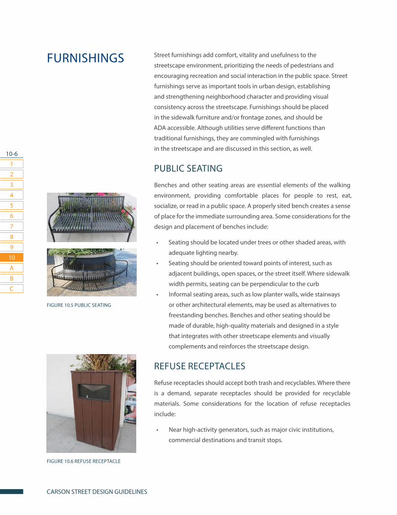
10-6
1
2
3
7
4
8
5
9
6
10
CARSON STREET DESIGN GUIDELINES
A
B
C
Street furnishings add comfort, vitality and usefulness to the
streetscape environment, prioritizing the needs of pedestrians and
encouraging recreation and social interaction in the public space. Street
furnishings serve as important tools in urban design, establishing
and strengthening neighborhood character and providing visual
consistency across the streetscape. Furnishings should be placed
in the sidewalk furniture and/or frontage zones, and should be
ADA accessible. Although utilities serve different functions than
traditional furnishings, they are commingled with furnishings
in the streetscape and are discussed in this section, as well.
PUBLIC SEATING
Benches and other seating areas are essential elements of the walking
environment, providing comfortable places for people to rest, eat,
socialize, or read in a public space. A properly sited bench creates a sense
of place for the immediate surrounding area. Some considerations for the
design and placement of benches include:
• Seating should be located under trees or other shaded areas, with
adequate lighting nearby.
• Seating should be oriented toward points of interest, such as
adjacent buildings, open spaces, or the street itself. Where sidewalk
width permits, seating can be perpendicular to the curb
• Informal seating areas, such as low planter walls, wide stairways
or other architectural elements, may be used as alternatives to
freestanding benches. Benches and other seating should be
made of durable, high-quality materials and designed in a style
that integrates with other streetscape elements and visually
complements and reinforces the streetscape design.
REFUSE RECEPTACLES
Refuse receptacles should accept both trash and recyclables. Where there
is a demand, separate receptacles should be provided for recyclable
materials. Some considerations for the location of refuse receptacles
include:
• Near high-activity generators, such as major civic institutions,
commercial destinations and transit stops.
FURNISHINGS
FIGURE 10.6 REFUSE RECEPTACLE
FIGURE 10.5 PUBLIC SEATING
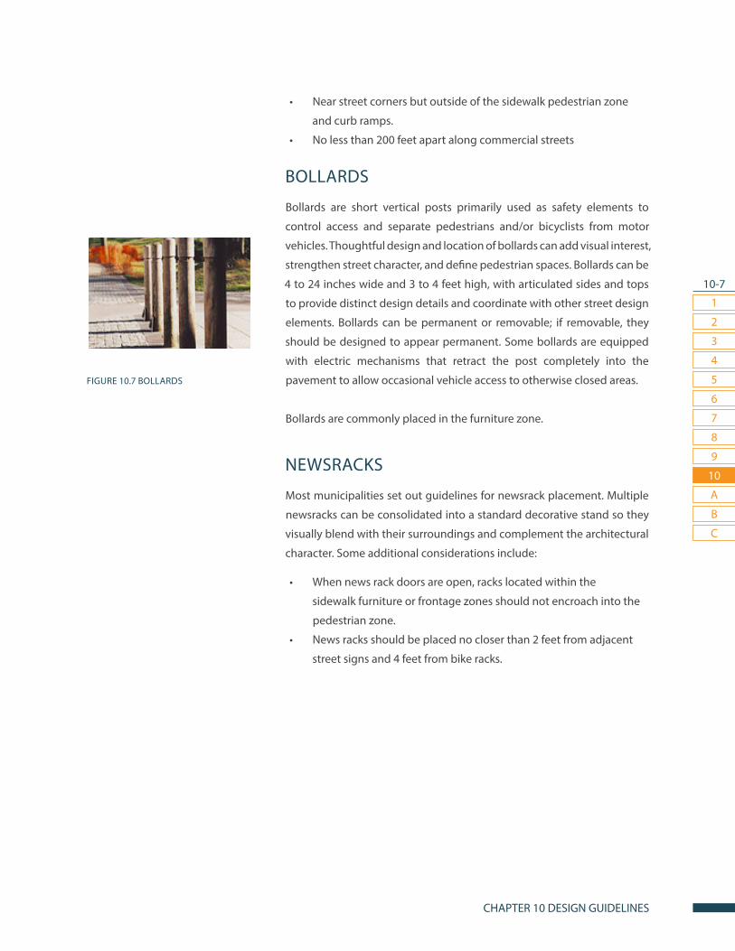
10-7
1
2
3
7
4
8
5
9
6
10
CHAPTER 10 DESIGN GUIDELINES
A
B
C
FIGURE 10.7 BOLLARDS
• Near street corners but outside of the sidewalk pedestrian zone
and curb ramps.
• No less than 200 feet apart along commercial streets
BOLLARDS
Bollards are short vertical posts primarily used as safety elements to
control access and separate pedestrians and/or bicyclists from motor
vehicles. Thoughtful design and location of bollards can add visual interest,
strengthen street character, and define pedestrian spaces. Bollards can be
4 to 24 inches wide and 3 to 4 feet high, with articulated sides and tops
to provide distinct design details and coordinate with other street design
elements. Bollards can be permanent or removable; if removable, they
should be designed to appear permanent. Some bollards are equipped
with electric mechanisms that retract the post completely into the
pavement to allow occasional vehicle access to otherwise closed areas.
Bollards are commonly placed in the furniture zone.
NEWSRACKS
Most municipalities set out guidelines for newsrack placement. Multiple
newsracks can be consolidated into a standard decorative stand so they
visually blend with their surroundings and complement the architectural
character. Some additional considerations include:
• When news rack doors are open, racks located within the
sidewalk furniture or frontage zones should not encroach into the
pedestrian zone.
• News racks should be placed no closer than 2 feet from adjacent
street signs and 4 feet from bike racks.
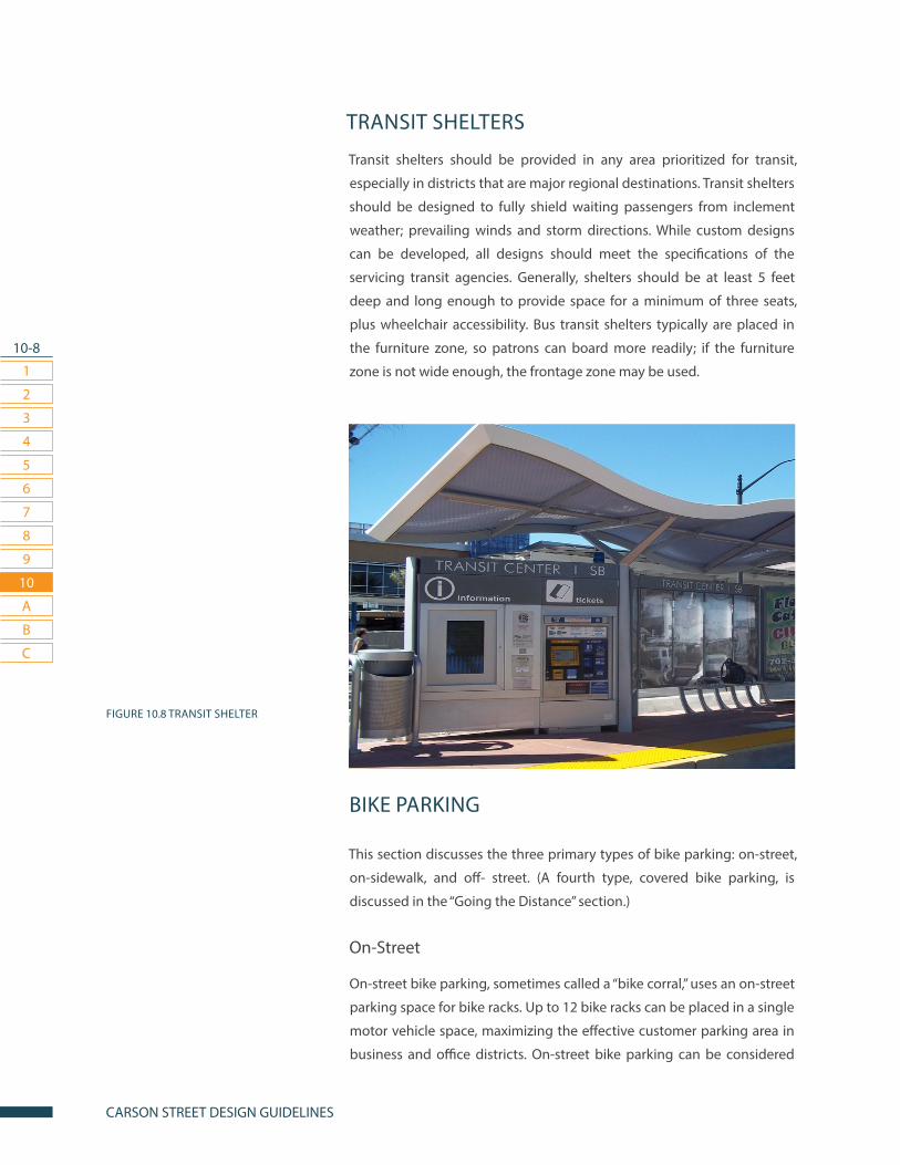
10-8
1
2
3
7
4
8
5
9
6
10
CARSON STREET DESIGN GUIDELINES
A
B
C
TRANSIT SHELTERS
Transit shelters should be provided in any area prioritized for transit,
especially in districts that are major regional destinations. Transit shelters
should be designed to fully shield waiting passengers from inclement
weather; prevailing winds and storm directions. While custom designs
can be developed, all designs should meet the specifications of the
servicing transit agencies. Generally, shelters should be at least 5 feet
deep and long enough to provide space for a minimum of three seats,
plus wheelchair accessibility. Bus transit shelters typically are placed in
the furniture zone, so patrons can board more readily; if the furniture
zone is not wide enough, the frontage zone may be used.
BIKE PARKING
This section discusses the three primary types of bike parking: on-street,
on-sidewalk, and off- street. (A fourth type, covered bike parking, is
discussed in the “Going the Distance” section.)
On-Street
On-street bike parking, sometimes called a “bike corral,” uses an on-street
parking space for bike racks. Up to 12 bike racks can be placed in a single
motor vehicle space, maximizing the effective customer parking area in
business and office districts. On-street bike parking can be considered
FIGURE 10.8 TRANSIT SHELTER
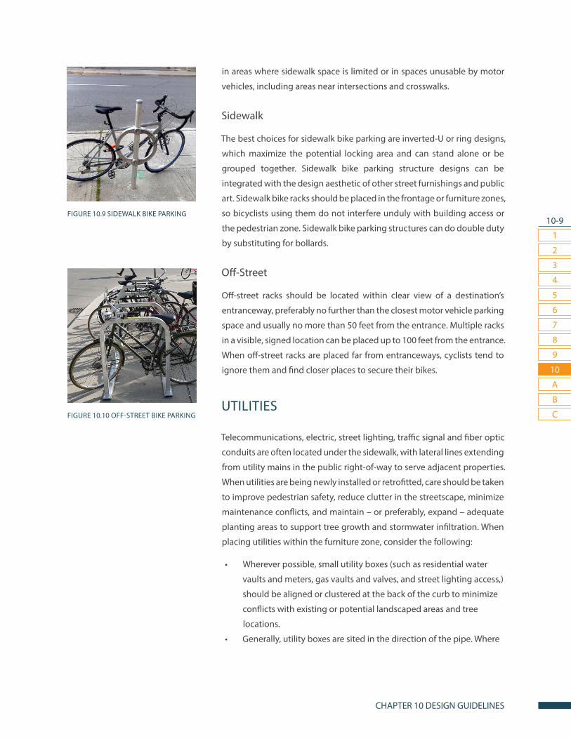
10-9
1
2
3
7
4
8
5
9
6
10
CHAPTER 10 DESIGN GUIDELINES
A
B
C
FIGURE 10.9 SIDEWALK BIKE PARKING
FIGURE 10.10 OFF-STREET BIKE PARKING
in areas where sidewalk space is limited or in spaces unusable by motor
vehicles, including areas near intersections and crosswalks.
Sidewalk
The best choices for sidewalk bike parking are inverted-U or ring designs,
which maximize the potential locking area and can stand alone or be
grouped together. Sidewalk bike parking structure designs can be
integrated with the design aesthetic of other street furnishings and public
art. Sidewalk bike racks should be placed in the frontage or furniture zones,
so bicyclists using them do not interfere unduly with building access or
the pedestrian zone. Sidewalk bike parking structures can do double duty
by substituting for bollards.
Off-Street
Off-street racks should be located within clear view of a destination’s
entranceway, preferably no further than the closest motor vehicle parking
space and usually no more than 50 feet from the entrance. Multiple racks
in a visible, signed location can be placed up to 100 feet from the entrance.
When off-street racks are placed far from entranceways, cyclists tend to
ignore them and find closer places to secure their bikes.
UTILITIES
Telecommunications, electric, street lighting, traffic signal and fiber optic
conduits are often located under the sidewalk, with lateral lines extending
from utility mains in the public right-of-way to serve adjacent properties.
When utilities are being newly installed or retrofitted, care should be taken
to improve pedestrian safety, reduce clutter in the streetscape, minimize
maintenance conflicts, and maintain – or preferably, expand – adequate
planting areas to support tree growth and stormwater infiltration. When
placing utilities within the furniture zone, consider the following:
• Wherever possible, small utility boxes (such as residential water
vaults and meters, gas vaults and valves, and street lighting access,)
should be aligned or clustered at the back of the curb to minimize
conflicts with existing or potential landscaped areas and tree
locations.
• Generally, utility boxes are sited in the direction of the pipe. Where
10-10
1
2
3
7
4
8
5
9
6
10
CARSON STREET DESIGN GUIDELINES
A
B
C
possible, utility boxes sited parallel with the curb should be in the
sidewalk furniture zone; vaults perpendicular to the curb should
be placed between existing or potential street trees or sidewalk
landscape locations, such as walkways to parking areas.
• Wherever possible, utility lateral lines should not run directly under
landscaped areas; instead, they should be placed under driveways
and walkways.
If necessary, utility access can be placed in the pedestrian realm under
slip-resistant covers that are flush with the pavement.
SURVEILLANCE CAMERAS AND
CRIME PREVENTION
In areas with high incidences of crime, it may be appropriate to consider
use of cameras to deter crime and maintain “eyes on the street.” Cameras
should be placed in a prominent, visible location to maximize video
capture, but should not become a visual nuisance. Surveillance cameras
can be attached to utility poles. Intersections with red-light cameras
visible from side.
This section presents practices for street furnishings that go beyond the
tools discussed above. These practices are typically be used in special
districts, such as civic centers, entertainment districts, transit areas,
shopping centers, or other areas deemed appropriate.
CUSTOM DESIGNED FURNISHINGS
Custom designs using high-quality materials and uniform aesthetics can
transform chairs, interpretive signage, bike racks and other furnishings
into functional art, maximizing their placemaking effects, especially in
special districts. Business groups and other private interests may serve
as partners in creating and installing distinctive custom-designed
furnishings. Custom furnishings can be used in addition to public art to
establish, reflect and promote district and neighborhood character.
GOING THE DISTANCE

10-11
1
2
3
7
4
8
5
9
6
10
CHAPTER 10 DESIGN GUIDELINES
A
B
C
SIDEWALK DINING
Outdoor café and restaurant seating adjacent to the sidewalk adds vitality
to the street environment and encourages economic development.
Ideally, tables and chairs should be placed in the sidewalk frontage or
furniture zones directly in front of the restaurant; if those spaces are
not adequate, dining areas can be slightly offset. Sidewalk dining areas
should not encroach into the pedestrian way. Since the public purpose of
allowing restaurants to have dining on the sidewalk is to stimulate activity
on the street, the city should consider prohibiting restaurants from fully
enclosing the dining area. Parklet cafes also can be used as sidewalk
dining. If sidewalk space is limited, parking spaces sometimes can be
transformed into outdoor dining areas.
COVERED BIKE PARKING
Covered bike parking addresses the long-term parking needs of bicyclists
who frequently park for eight or more hours, such as daily commuters and
bicycle tourists, and should be considered in transit-oriented areas and
other special districts. Covered bike parking options include bike lockers,
vertical bike parking, and bike parking structures.
FIGURE 10.11 SIDEWALK DINING

10-12
1
2
3
7
4
8
5
9
6
10
CARSON STREET DESIGN GUIDELINES
A
B
C
BIKE SHARE STATION
Bike share systems connect high-use destinations, such as transit stations,
public parks, tourism sites and job centers, and can be deployed with
bikeways to integrate transit, land use and economic development goals.
Stations can be located off-street where public access is provided; where
adequate space is available for a clear pedestrian way, bike share stations
also can be placed in the sidewalk furniture or frontage zones.
FIGURE 10.12 BIKE SHARE STATION
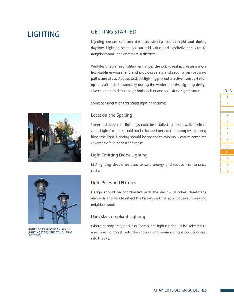
10-13
1
2
3
7
4
8
5
9
6
10
CHAPTER 10 DESIGN GUIDELINES
A
B
C
GETTING STARTED
Lighting creates safe and desirable streetscapes at night and during
daytime. Lighting selection can add value and aesthetic character to
neighborhoods and commercial districts.
Well-designed street lighting enhances the public realm, creates a more
hospitable environment, and provides safety and security on roadways,
paths, and alleys. Adequate street lighting promotes active transportation
options after dark, especially during the winter months. Lighting design
also can help to define neighborhoods or add to historic significance.
Some considerations for street lighting include:
Location and Spacing
Street and pedestrian lighting should be installed in the sidewalk furniture
zone. Light fixtures should not be located next to tree canopies that may
block the light. Lighting should be spaced to minimally assure complete
coverage of the pedestrian realm.
Light Emitting Diode Lighting
LED lighting should be used to save energy and reduce maintenance
costs.
Light Poles and Fixtures
Design should be coordinated with the design of other streetscape
elements and should reflect the history and character of the surrounding
neighborhood.
Dark-sky Compliant Lighting
Where appropriate, dark sky- compliant lighting should be selected to
maximize light cast onto the ground and minimize light pollution cast
into the sky.
LIGHTING
FIGURE 10.13 PEDSTRIAN-SCALE LIGHTING (TOP) STREET LIGHTING (BOTTOM)

10-14
1
2
3
7
4
8
5
9
6
10
CARSON STREET DESIGN GUIDELINES
A
B
C
Lighting for Safety
Lighting placement should prioritize illumination of public gathering
areas and public spaces, as well as areas with high incidences of index
crimes.
Carson currently lacks any pedestrian scale lighting. The City is currently
working on creating a plan for installing pedestrian-scale lighting. This
plan recommends prioritizing the installation of lighting installation near
parks and schools. (Fig. 10.15 Pedestrian-Scale Lighting).
PEDESTRIAN-SCALE LIGHTING
Pedestrian-scale lighting is essential for creating safe street environments.
Conventional street lighting, designed primarily to light the vehicle way,
often is inadequate for pedestrian needs, leaving unlit areas and dark
shadows on walkways. Pedestrian-scale lighting is especially important
during long winter nights. Pedestrian-scale lighting, approximately 12
to 17 feet in height, illuminates potential tripping hazards, helps to
deter crime, and makes pedestrians more visible to drivers. Pedestrian-
scale lighting also can illuminate bikeways near walking areas. Retrofits
of existing streetlights and new installations should provide lighting
on sidewalks and multi-use paths. Pedestrian-scale lighting should be
coordinated with building and property owners to include building-
mounted lighting for sidewalks, alleys, and paths where poles would
obstruct the pedestrian zone. Land use context should be considered to
achieve optimum lighting levels in pedestrian areas, and care must be
taken to avoid light trespass into the windows of nearby residential units.
Common examples of pedestrian- scale lighting include acorn, globe, and
lantern lamps.
FIGURE 10.14 LIGHT FIXTURE FOR PARK AREAS
FIGURE 10.15 PEDSTRIAN-SCALE LIGHTING

10-15
1
2
3
7
4
8
5
9
6
10
CHAPTER 10 DESIGN GUIDELINES
A
B
C
VEHICLE-SCALE LIGHTING
Vehicle-scale lighting is an important element in streetscapes. In certain
contexts, pedestrian-scale lighting is sufficient to provide adequate
lighting for safe and secure walking, bicycling and driving. On major
roadways, however, vehicle-scale lighting is needed to illuminate the
travel way. Vehicle-scale lighting should be located in the furnishing zone
and should never block the pedestrian way.
COMBINATION PEDESTRIAN &
VEHICLE-SCALE LIGHTING
In many settings, vehicle-scale lighting is sufficient to light the pedestrian
way. In some cases, however, street lighting can be supplemented with
pedestrian-scale lighting to create a better multimodal environment.
Where feasible, conventional streetlights can be retrofitted by hanging
a pedestrian-scale lighting arm from the existing pole at a height of 12
feet to 17 feet. If streetlight spacing is not adequate for pedestrian needs,
pedestrian-scale lights can be added between existing streetlight poles.
This section presents practices for lighting design that go
beyond the widely accepted tools listed above. Standards for
using these new technologies are in development and need
further testing, but limited applications are currently in use.
SOLAR/LED LIGHT FIXTURES
Solar and LED (light-emitting diode) fixtures are now readily available in
most street lamp designs. While the initial investment for these fixtures
is usually higher than for traditional technologies, total life-cycle cost
should be considered. For example, solar lighting may reduce the need
to lay costly new utility conduit. Wherever possible, solar light fixtures
should be used for new installations and retrofit projects. If solar is not
feasible, LED or other energy-efficient lighting technologies should be
used.
GOING THE DISTANCE
FIGURE 10.16 SOLAR LIGHT FIXTURE

10-16
1
2
3
7
4
8
5
9
6
10
CARSON STREET DESIGN GUIDELINES
A
B
C
IN-PAVEMENT LIGHTING
In-pavement lighting is one of many new technologies that can be used
to illuminate the streetscape. In-street lighting can include simple solar-
lamp bricks installed in walkways or crossings, as well as lights placed in
the travel way to further delineate bikeways, crosswalks, or vehicle lanes.
Examples of in-street lighting include flashing yellow in-roadway lights
used to supplement crosswalk markings, and internally illuminated yellow,
white, blue or red raised-pavement markers. Although in-street lighting
can increase safety in travel ways, they can be difficult to see in daylight
and should supplement, not replace, traditional pavement markings.
CUSTOM-DESIGNED LIGHTING
Custom lighting can be a unifying element of urban design, helping to
define a place and give it a unique identity. In districts with distinctive
characters, custom lighting designs should be considered to assure a
cohesive streetscape design aesthetic.
CATENARY LIGHTING
Catenary lighting is suspended from wires affixed to poles or buildings.
This lighting technique can reduce infrastructure costs, such as installation
of utility poles or underground conduit. Catenary lighting can be useful
in pedestrian priority areas and other areas designed for place making,
giving a ceiling to the “outdoor room” and reducing the need for light
poles that can clutter or obstruct the pedestrian way.
FIGURE 10.17 CUSTOM-DESIGNED
LIGHTING
FIGURE 10.18 CATENARY LIGHTING

10-17
1
2
3
7
4
8
5
9
6
10
CHAPTER 10 DESIGN GUIDELINES
A
B
C
GREEN INFRASTRUCTURE
Green infrastructure includes all trees, shrubs, and other understory
plantings on both public and private lands. Street trees and landscaping
are essential parts of the urbanized ecosystem, enhancing the comfort
and safety of people who live and travel along the street.
A healthy urban forest also is a powerful tool for streetwater management
and climate control. Leaves and branches catch and slow rain as it falls,
allowing it to soak into the ground instead of flowing into storm drains.
The plants themselves take up and store large quantities of water that
would otherwise further contribute to surface runoff. Part of this moisture
then returns to the air through evaporation to help cool the city.
TREE ROWS & PLANTINGS
Trees and other plantings are important elements along sidewalks. In
many urbanized settings, however, trees are planted in constricted,
unhealthy locations that limit their lifespan and usefulness. To thrive, street
trees must have adequate uncompacted soil, water, and air. The location
of underground and above ground utilities also must be considered
when planting trees and other landscape elements. This section provides
guidance for appropriate selecting, siting, planting, and care of street
trees.
Tree Selection Criteria
Tree selection for streetscapes should be based on climate, roadway
conditions and land use context, and should consider the mature
tree’s need for light, water, canopy space and root extension. Carson’s
Municipal Code Chapter 9: City Tree Preservation and Protection and
Carson’s Parkway Tree Master Plan contain guidelines detailing criteria for
tree selection and maintenance.
For streetscape design purposes, tree species can generally be grouped by
size to allow for initial roadway design placement. Standards for distance
between trees should be tied to the tree variety.
Design Requirements for Tree Selection:• SMALL TREES can thrive in planters and tree wells. They require a
FIGURE 10.19 TREE PLANTINGS

10-18
1
2
3
7
4
8
5
9
6
10
CARSON STREET DESIGN GUIDELINES
A
B
C
well or furnishing zone at least 4 feet wide, and can thrive with a
tree grate on a commercial/mixed-use sidewalk.
• MEDIUM TREES generally require a planting area at least 5 to 7 feet
wide; they may thrive in large tree wells. Medium trees also thrive
in residential tree lawns.
• LARGE TREES generally require a tree lawn but can thrive in a
planting area at least 7 to 10 feet wide. Large trees are a great
choice for residential areas with wide frontage zones and for
landscaped medians on roadways. Large trees include: Sycamore
and Oak.
• PLANTINGS Native grasses and other plants can help to protect
and restore soil conditions in urban environments. Native
plants generally have longer root systems and can help process
stormwater onsite. Native plantings can be a suitable alternative
to traditional lawns. Groundcover choices can include: Bluegrass,
Sedum, and other succulents.
In all cases, trees can be planted in oblong instead of square shaped
wells to fit them into fairly narrow furniture zones. Medians offer the
opportunity for the city to incorporate trees outside of the Street Tree list.
Additional Principles for Tree Selection and Placement:• Seek and reclaim space for trees. A surprising number of residual
spaces suitable for planting can be found on streets between areas
required for travel lanes and parking, such as traffic circles, medians,
channelization islands and curb extensions.
• Select the right tree for the space. In choosing a street tree,
consider what canopy, form, and height will maximize benefits over
the course of its life. Mature tree height should allow necessary
clearances below overhead electrical transmission lines and
prevent limbs from overhanging potentially sensitive structures,
such as flat roofs. In commercial areas where the visibility of façade-
mounted signs is a concern, choose species whose lowest branches
are at least 12 to 14 feet above the ground. Select trees with non-
aggressive root systems to avoid damaging paving and sidewalks.
• Start with good nursery stock and train it well. When installing
plant material, choose well-formed plants with complete single
leaders and check that boxed trees are not root-bound. Proper
watering and pruning every three to four years will allow trees
to mature and thrive for many years of service. For young trees,
watering and pruning should happen every year for the first three
FIGURE 10.21 SEDUM PLANT
FIGURE 10.20 SMALL TREE IN PLANTER
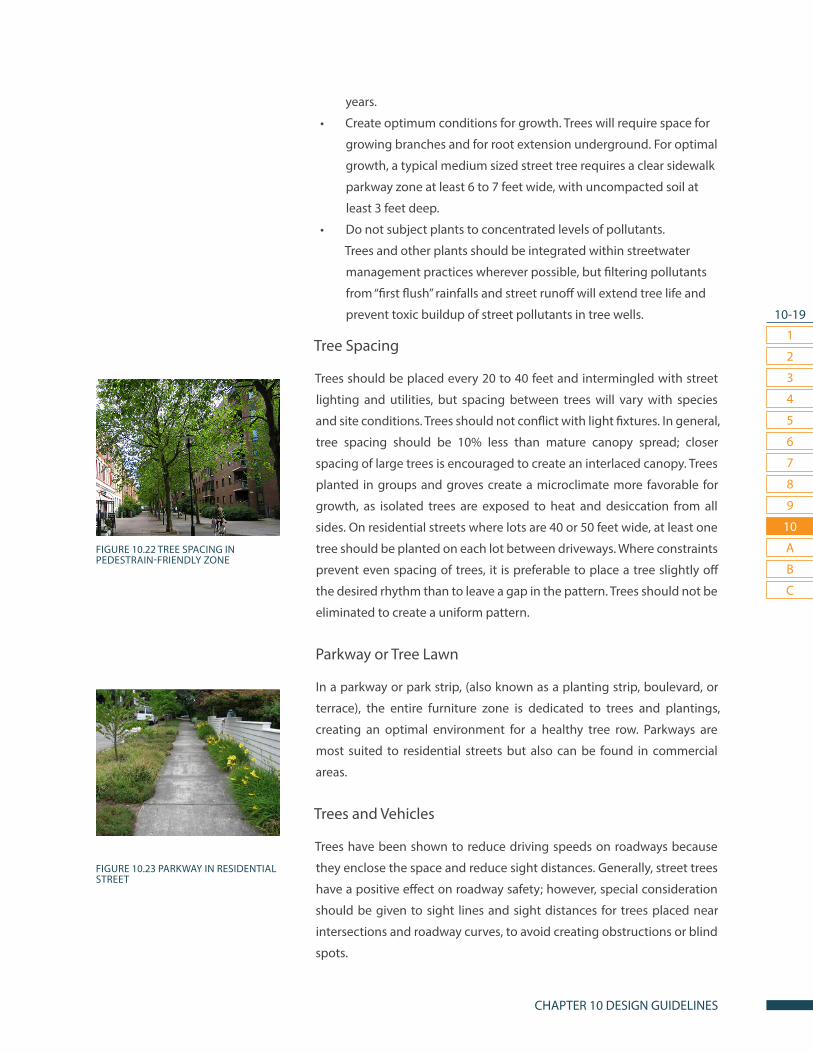
10-19
1
2
3
7
4
8
5
9
6
10
CHAPTER 10 DESIGN GUIDELINES
A
B
C
years.
• Create optimum conditions for growth. Trees will require space for
growing branches and for root extension underground. For optimal
growth, a typical medium sized street tree requires a clear sidewalk
parkway zone at least 6 to 7 feet wide, with uncompacted soil at
least 3 feet deep.
• Do not subject plants to concentrated levels of pollutants.
Trees and other plants should be integrated within streetwater
management practices wherever possible, but filtering pollutants
from “first flush” rainfalls and street runoff will extend tree life and
prevent toxic buildup of street pollutants in tree wells.
Tree Spacing
Trees should be placed every 20 to 40 feet and intermingled with street
lighting and utilities, but spacing between trees will vary with species
and site conditions. Trees should not conflict with light fixtures. In general,
tree spacing should be 10% less than mature canopy spread; closer
spacing of large trees is encouraged to create an interlaced canopy. Trees
planted in groups and groves create a microclimate more favorable for
growth, as isolated trees are exposed to heat and desiccation from all
sides. On residential streets where lots are 40 or 50 feet wide, at least one
tree should be planted on each lot between driveways. Where constraints
prevent even spacing of trees, it is preferable to place a tree slightly off
the desired rhythm than to leave a gap in the pattern. Trees should not be
eliminated to create a uniform pattern.
Parkway or Tree Lawn
In a parkway or park strip, (also known as a planting strip, boulevard, or
terrace), the entire furniture zone is dedicated to trees and plantings,
creating an optimal environment for a healthy tree row. Parkways are
most suited to residential streets but also can be found in commercial
areas.
Trees and Vehicles
Trees have been shown to reduce driving speeds on roadways because
they enclose the space and reduce sight distances. Generally, street trees
have a positive effect on roadway safety; however, special consideration
should be given to sight lines and sight distances for trees placed near
intersections and roadway curves, to avoid creating obstructions or blind
spots.
FIGURE 10.22 TREE SPACING IN PEDESTRAIN-FRIENDLY ZONE
FIGURE 10.23 PARKWAY IN RESIDENTIAL STREET

10-20
1
2
3
7
4
8
5
9
6
10
CARSON STREET DESIGN GUIDELINES
A
B
C
Tree Wells
Wells can be submerged into the sidewalk and used to create a tree row
where the entire length of the furniture zone cannot be dedicated to
green infrastructure. Wells should be at least 6 feet by 6 feet to allow room
for medium-sized trees to mature; larger wells that extend 20 feet to 40
feet in length can support larger tree varieties. Although wells may be
the best option to increase biomass and canopy cover in urbanized areas,
they provide a confined, compromised environment for trees, so extra
care must be taken to promote tree health. Tree grates and guards should
be used along streets with heavy pedestrian traffic. Hinged tree grates
can be used in parking lots. Tree grates must be chosen with adjustable
openings to allow for trunk growth. In less urban areas with lighter foot
traffic, mulch can be used instead of tree grates to protect tree bases,
especially in planters that range from 3 feet by 3 feet to 3 feet by 5 feet.
Landscape Medians
Landscape medians offer an opportunity to replace a non-functional
paved area with green space and expand the green infrastructure in
urbanized areas, increasing stormwater retention and CO2 absorption
on heavily trafficked corridors and mitigating some of the adverse
environmental effects of motor vehicle travel. Many medians 10 to 14 feet
wide are suitable for large trees. Other than trees, plantings should not
exceed 2 to 3 feet high. Landscape medians should not disrupt pedestrian
connectivity and must be designed to maintain pedestrian access to both
sides of the street with minimal pedestrian crossing delay.
FIGURE 10.24 TREE WELLS

10-21
1
2
3
7
4
8
5
9
6
10
CHAPTER 10 DESIGN GUIDELINES
A
B
C
GOING THE DISTANCE
This section presents practices for green infrastructure that go beyond
the tools listed above. These represent only a few of the many examples
of green infrastructure currently in use in urbanized settings to enhance
walkability, manage streetwater, create and extend green spaces and
promote placemaking. All these tools can be used in special districts.
BIOSWALES
By filtering and harvesting streetwater, sustainable management
practices such as bio-swales capture the benefits of stormwater and
other streetwater instead of treating it as a liability. A bio-swales is a
wide, shallow, relatively flat vegetated, or lined with river rock, ditch that
capture and filter rainfall and runoff from adjacent areas. As the captured
water moves slowly through the swale, particulates settle out and
contaminants are removed by vegetation. Swales can be located adjacent
to roadways, sidewalks, or parking areas and should be designed to work
in conjunction with the street slope to maximize slowing and filtration of
stormwater. Swale systems can be integrated into traffic calming devices,
such as chicanes and curb extensions, and also can be placed in landscape
medians. Roadway runoff can be directed into swales through flush
curbsor small, evenly spaced cuts in raised curbs. Vegetated swales can be
landscaped with native plants, or plants from similar climates.
URBAN RAIN GARDENS
Rain gardens are made of native plants and shrubs planted in highly
absorbent soil, sited in depressions with flat bottoms and gently sloping
sides. Unlike bio- swales, which slowly move water away from the street
area, rain gardens reduce or eliminate runoff by holding water in place,
filtering out pollutants and recharging the surrounding ground. Rain
gardens may have a footprint of any shape. Rain gardens are not ponds or
wetlands; runoff captured in a rain garden should drain into the ground
within 48 hours. Rain gardens may include overflow systems using pipes
or swales to carry away stormwater after very heavy rainfall. Rain gardens
may also be designed as dry stream beds.
FIGURE 10.25 BIOSWALE
FIGURE 10.26 RAIN GARDEN IN PARKING
LOT
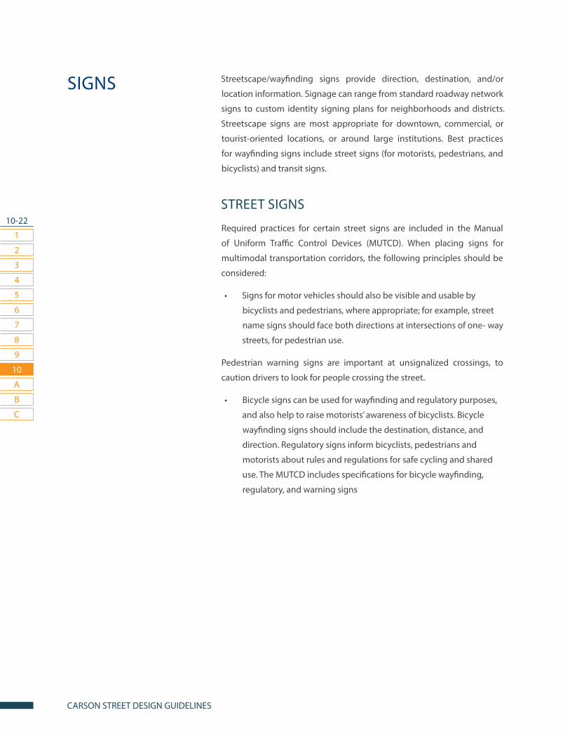
10-22
1
2
3
7
4
8
5
9
6
10
CARSON STREET DESIGN GUIDELINES
A
B
C
Streetscape/wayfinding signs provide direction, destination, and/or
location information. Signage can range from standard roadway network
signs to custom identity signing plans for neighborhoods and districts.
Streetscape signs are most appropriate for downtown, commercial, or
tourist-oriented locations, or around large institutions. Best practices
for wayfinding signs include street signs (for motorists, pedestrians, and
bicyclists) and transit signs.
STREET SIGNS
Required practices for certain street signs are included in the Manual
of Uniform Traffic Control Devices (MUTCD). When placing signs for
multimodal transportation corridors, the following principles should be
considered:
• Signs for motor vehicles should also be visible and usable by
bicyclists and pedestrians, where appropriate; for example, street
name signs should face both directions at intersections of one- way
streets, for pedestrian use.
Pedestrian warning signs are important at unsignalized crossings, to
caution drivers to look for people crossing the street.
• Bicycle signs can be used for wayfinding and regulatory purposes,
and also help to raise motorists’ awareness of bicyclists. Bicycle
wayfinding signs should include the destination, distance, and
direction. Regulatory signs inform bicyclists, pedestrians and
motorists about rules and regulations for safe cycling and shared
use. The MUTCD includes specifications for bicycle wayfinding,
regulatory, and warning signs
SIGNS

10-23
1
2
3
7
4
8
5
9
6
10
CHAPTER 10 DESIGN GUIDELINES
A
B
C
TRANSIT SIGNS
Transit system signs are needed to fully integrate transit into the roadway
network and to connect bicyclists, pedestrians and drivers into the
system. Signs are necessary to identify transfer points between service
lines and other types of transportation. Transit signs generally fall into
three categories: Station/Stop Identification, Service Information, and
Wayfinding.
STATION/STOP IDENTIFICATION
Transit stations and stops need to be clearly marked to show passengers
where to wait for service. Pedestrian crossing signs should always be
considered at transit stations and stops.
SERVICE INFORMATION
Transit stops and stations should include signs and maps showing
routes, schedules, and places served by the line. Newer technologies for
transportation demand management (TDM) include “bus-tracker,” “next
bus,” and “train-tracker” applications integrated into stations and bus
shelters.
WAYFINDING
Transit agencies should provide wayfinding signs inside the station, to
ease connections, as well as within a half-mile of each station. Transit
agencies can use wayfinding signs to increase connections to pedestrian
and bicycle networks.
Bicycle wayfinding signs should include major transit stations as
prominent destinations.
INTERPRETIVE SIGNS
Interpretive signs are designed to promote interaction and engagement
between people and streetscape environments. Interpretive signs can
identify a neighborhood’s name and gateways, announce important
events, or display environmental or historical information. Some useful
tools for interpretive signing include kiosks, sign stands, historical markers,
installations, and banners.
FIGURE 10.27 STREET SIGNS FOR ALL ROADWAY USERS
FIGURE 10.28 TRANSIT SERVICE INFORMATION

10-24
1
2
3
7
4
8
5
9
6
10
CARSON STREET DESIGN GUIDELINES
A
B
C
• Kiosks in public areas, often combined with gateway signs, can be
attractive, useful street features. Kiosks can be used to display maps,
bulletin boards, community announcements, and other important
information.
• Sign stands can be used for temporary purposes or in permanent
installations, such as neighborhood maps and informative displays.
Signs can be placed in vertical, poster-style stands or on floating
tables.
• Historical markers provide information about people, places,
events, or resources of local or national significance. Historical
markers can be placed on freestanding signs, wall plaques, or even
boulders.
• Installations of public art can include creatively designed
interpretive signs that can be informative elements of the
streetscape.
• Banners can be displayed on or hang from light poles. Banners can
be used as permanent neighborhood markers or rotated to note
seasons or significant events.

CARSON PEDESTRIAN MASTER PLAN
PUBLIC OUTREACHAPPENDIX A
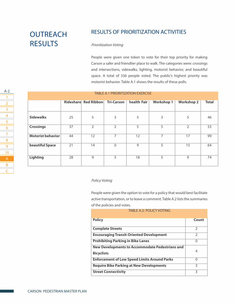
A-2
1
2
3
7
4
8
5
9
6
10
CARSON PEDESTRIAN MASTER PLAN
A
B
C
RESULTS OF PRIORITIZATION ACTIVITIES
Prioritization Voting
People were given one token to vote for their top priority for making
Carson a safer and friendlier place to walk. The categories were: crossings
and intersections, sidewalks, lighting, motorist behavior, and beautiful
space. A total of 336 people voted. The public’s highest priority was
motorist behavior. Table A.1 shows the results of these polls.
Policy Voting
People were given the option to vote for a policy that would best facilitate
active transportation, or to leave a comment. Table A.2 lists the summaries
of the policies and votes.
OUTREACH RESULTS
TABLE A.2: POLICY VOTING
Policy Count
Complete Streets 2
Encouraging Transit-Oriented Development 2
Prohibiting Parking in Bike Lanes 0
New Developments to Accommodate Pedestrians and
Bicyclists 4
Enforcement of Low Speed Limits Around Parks 0
Require Bike Parking at New Developments 3
Street Connectivity 3
TABLE A.1 PRIORITIZATION EXERCISE
Rideshare Red Ribbon Tri-Carson health Fair Workshop 1 Workshop 2 Total
Sidewalks 25 5 3 5 3 5 46
Crossings 37 2 2 5 5 2 53
Motorist behavior 44 12 7 12 7 17 99
beautiful Space 21 14 0 9 5 15 64
Lighting 28 9 5 18 5 9 74
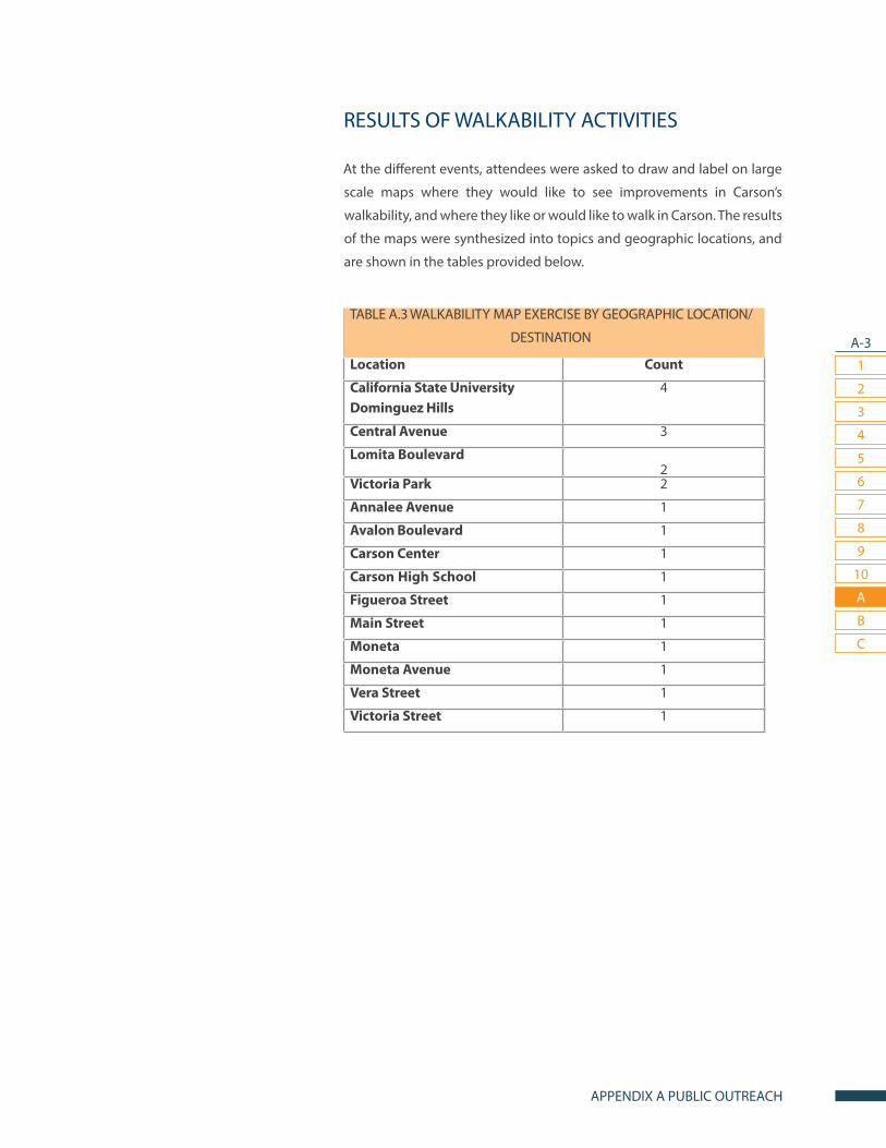
A-3
1
2
3
7
4
8
5
9
6
10
APPENDIX A PUBLIC OUTREACH
A
B
C
RESULTS OF WALKABILITY ACTIVITIES
At the different events, attendees were asked to draw and label on large
scale maps where they would like to see improvements in Carson’s
walkability, and where they like or would like to walk in Carson. The results
of the maps were synthesized into topics and geographic locations, and
are shown in the tables provided below.
TABLE A.3 WALKABILITY MAP EXERCISE BY GEOGRAPHIC LOCATION/
DESTINATION
Location Count
California State UniversityDominguez Hills
4
Central Avenue 3
Lomita Boulevard2
Victoria Park 2
Annalee Avenue 1
Avalon Boulevard 1
Carson Center 1
Carson High School 1
Figueroa Street 1
Main Street 1
Moneta 1
Moneta Avenue 1
Vera Street 1
Victoria Street 1

A-4
1
2
3
7
4
8
5
9
6
10
CARSON PEDESTRIAN MASTER PLAN
A
B
C
RESULTS OF STREET LIGHTING ACTIVITIES
At each event, large poster boards were displayed with maps asking
attendees to mark where they would like street lighting in Carson.
Attendees indicated where they would like to see more pedestrian
lighting in the City by drawing the locations on the map and writing their
concerns about lighting in those locations. The results are summarized
and provided in Table A.5.
TABLE A.4 WALKABILITY MAP EXERCISE by TOPIC
Topic Count
Uneven Sidewalk 5
Motorist Behavior 3Connectivity 2
Crosswalk 2
No Sidewalk 2
Crossing Guard 1
Landscaping 1
Pedestrian Bridge 1
Safety 1
School Patrol 1
Traffic Calming 1
Wider Sidewalk 1

A-5
1
2
3
7
4
8
5
9
6
10
APPENDIX A PUBLIC OUTREACH
A
B
CIn-depth one to two hour stakeholder interviews and focus groups were held to understand the active transportation needs of a diverse cross section of key community members. Participants included school admin-istrators, small and large business owners and leaders, students, parents, those with physical disabilities and people of all ages and backgrounds.
TABLE A.5 LIGHTING MAP EXERCISE by GEOGRAPHIC LOCATION/
DESTINATION
Topic Count
Parks 5
Schools 5
223rd Street and Figueroa Street 4
228th Street 3
213th Street 2
Del Amo Boulevard 2
Dominguez Channel 2
182nd Street 1
185th Street 1
220th Street 1
Avalon Boulevard 1
Carson Street 1
Central Avenue 1
Jefferson Street 1
Pedestrian Bridge 1
Residential Neighborhoods 1
Sepulveda Boulevard 1
STAKEHOLDER INTERVIEWS AND FOCUS GROUPS
CARSON PEDESTRIAN MASTER PLAN
PEDESTRIAN ENVIORNMENTAL QUALITY INDEX
APPENDIX B

B-2
1
2
3
7
4
8
5
9
6
10
CARSON PEDESTRIAN MASTER PLAN
A
B
C
PEQI OVERVIEW AND INDICATORS
The Pedestrian Environmental Quality Index (PEQI) version 2.0 was select-
ed as an appropriate walkability assessment tool for the Carson Active
Transportation Plan due to its focus on public health and its robust set of
indicators.
The San Francisco Department of Public Health (SFDPH) developed the
Pedestrian Environmental Quality Index (PEQI) as a tool to prioritize im-
provements in pedestrian infrastructure during the planning process.
The PEQI draws on published research and work from numerous cities to
assess how the physical environment impacts whether people walk in a
neighborhood.
The PEQI is an observational survey that quantifies street and intersection
factors empirically known to affect people’s travel behaviors and is orga-
nized into five categories: intersection safety, traffic volume, street design,
land use and perceived safety. Within these categories are 31 indicators
that reflect the quality of the built environment for pedestrians and com-
prise the survey used for data collection. SFDPH has aggregated these
indicators to create a weighted summary index, which can be reported
as an overall index. Table A.1 indicates how the PEQI 2.0 indicators fit into
the broader domains of pedestrian comfort and security.
SFDPH consulted national experts including city planners, independent
planning consultants, and pedestrian advocates to develop the indicator
weights and scores for each indicator category, based on survey respons-
es. The PEQI has been utilized by numerous agencies and community
groups in San Francisco and adapted for use in other cities nationwide.
PEDESTRIAN ENVIRONMENTAL QUALITY INDEX (PEQI)

B-3
1
2
3
7
4
8
5
9
6
10
APPENDIX B PEDESTRIAN ENVIORNMENTAL QUALITY INDEX
A
B
C
TABLE A.1 PEQI 2.0 INDICATORS BY DOMAIN
I. INTERSECTION SAFETY
II. TRAFFIC VOLUME
III. STREET DESIGN IV. LAND USE V. PERCEIVED SAFETY
Crosswalks
High visibility crosswalks
Intersection lighting
Traffic control
Pedestrian/
Countdown signal
Wait time
Crossing speed
Pedestrian refuge
island
Curb ramps
Intersection traffic
calming features
Pedestrian
engineering
countermeasures
Number of vehicle lanes
Posted speed
limit
Traffic volume
Street traffic
calming
features
Continuous sidewalk
Width of sidewalk
Width of throughway
Large sidewalk
obstructions
Sidewalk impediments
Trees
Driveway cuts
Presence of a buffer
Planters/gardens
Public seating
Public art/ historic sites
Retail use and public
places
Pedestrian scale lighting
Illegal graffiti
Litter
Empty space
PEQI ASSESSMENT PROCEDURES
As part of the planning process for the Active Transportation Plan, a team
of trained interns collected PEQI data on survey sheets for Carson’s pe-
destrian environment in August and September 2013. Primary streets and
neighborhoods within a quarter-mile radius of parks and schools were
prioritized for analysis.

CARSON PEDESTRIAN MASTER PLAN
LOCATION LISTAPPENDIX C
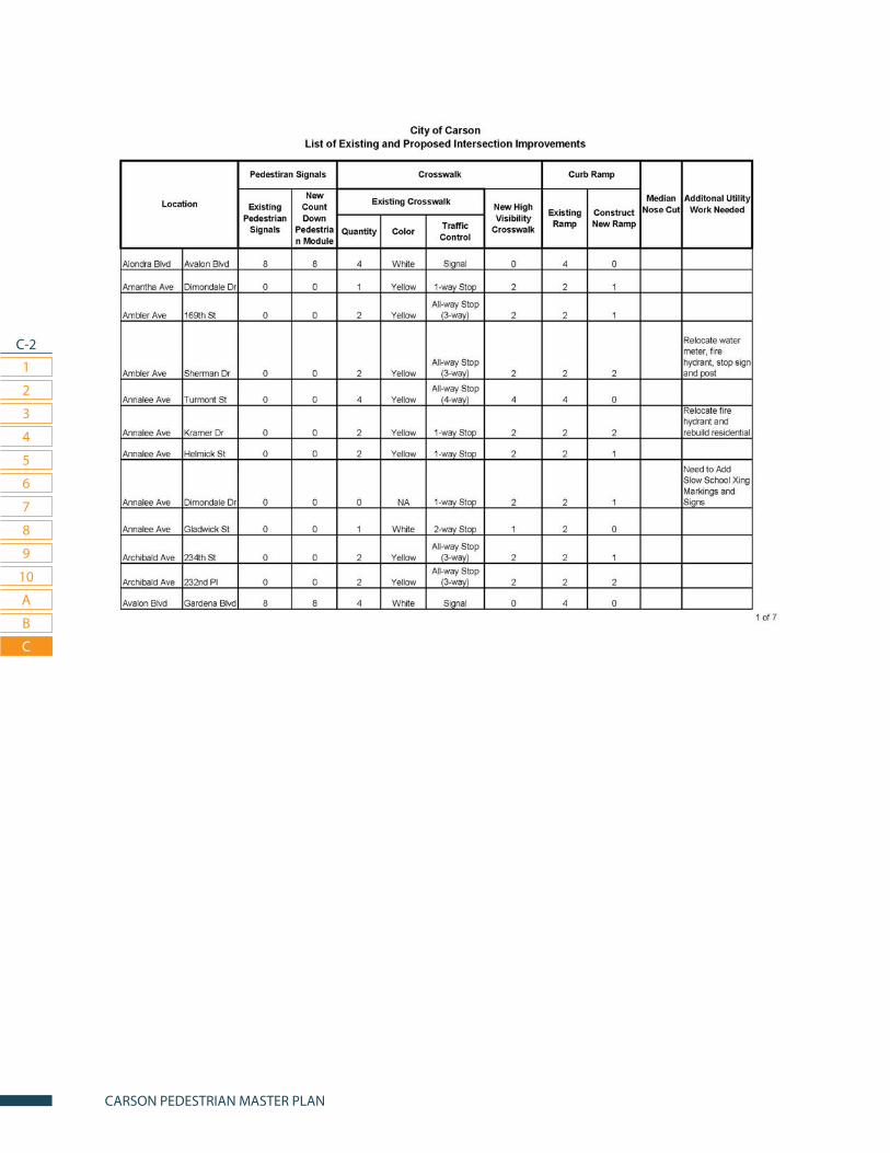
C-2
1
2
3
7
4
8
5
9
6
10
CARSON PEDESTRIAN MASTER PLAN
A
B
C

C-3
1
2
3
7
4
8
5
9
6
10
APPENDIX C LOCATION LIST
A
B
C

C-4
1
2
3
7
4
8
5
9
6
10
CARSON PEDESTRIAN MASTER PLAN
A
B
C
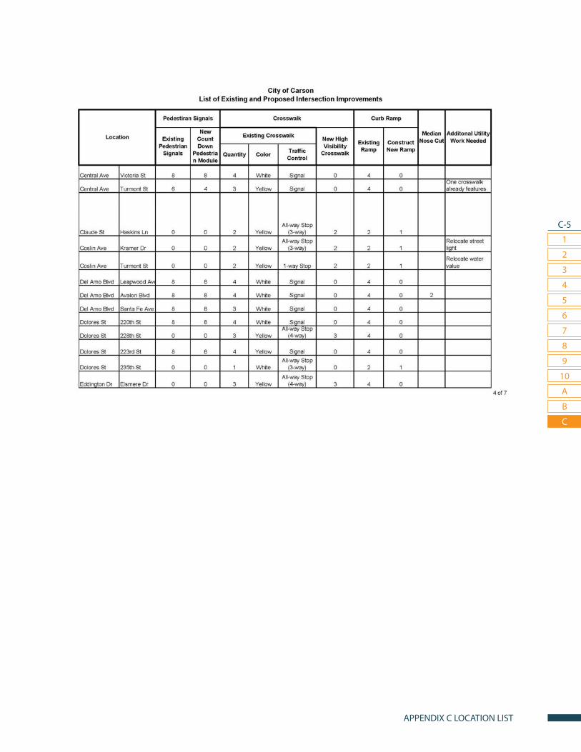
C-5
1
2
3
7
4
8
5
9
6
10
APPENDIX C LOCATION LIST
A
B
C
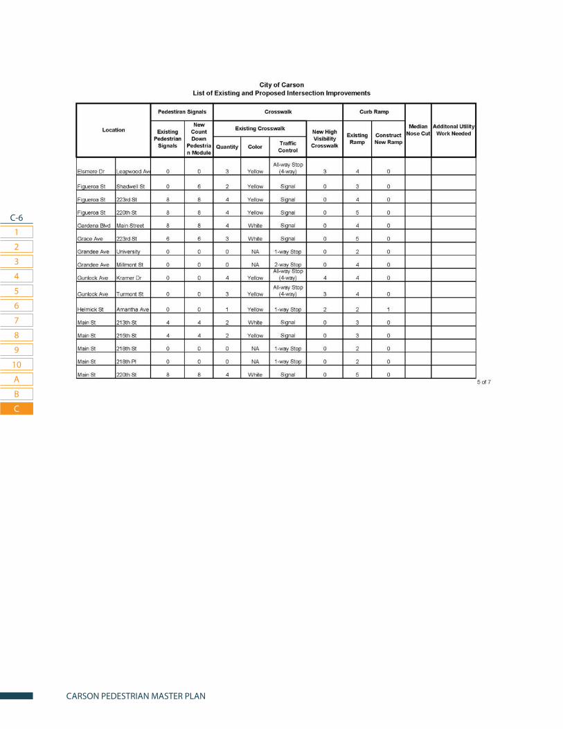
C-6
1
2
3
7
4
8
5
9
6
10
CARSON PEDESTRIAN MASTER PLAN
A
B
C
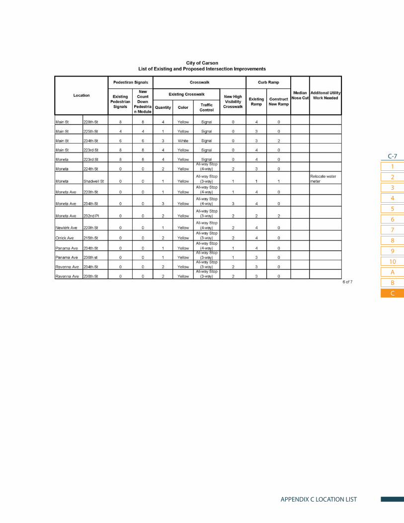
C-7
1
2
3
7
4
8
5
9
6
10
APPENDIX C LOCATION LIST
A
B
C

C-8
1
2
3
7
4
8
5
9
6
10
CARSON PEDESTRIAN MASTER PLAN
A
B
C