city of brookings, oregon brookings municipal code is current through ordinance 14-o-741, passed...
TRANSCRIPT

The Brookings Municipal Code is current through Ordinance 14-O-741, passed November 10, 2014.
City of Brookings, Oregon
Municipal Code Title 17
Land Development Code

The Brookings Municipal Code is current through Ordinance 14-O-741, passed November 10, 2014.
Title 17
LAND DEVELOPMENT CODE
Chapters: 17.01 General Provisions 17.04 Development Permit Procedures 17.08 Definitions 17.12 Establishment of Zoning Districts and Zoning Map 17.16 Suburban Residential (SR) District 17.20 Single-Family Residential (R-1) District 17.24 Two-Family Residential (R-2) District 17.28 Multiple-Family Residential (R-3) District 17.32 Manufactured Home Residential (R-MH) District 17.36 Professional Office (PO-1) District 17.40 Public Open Space (P/OS) District 17.44 Neighborhood Commercial (C-1) District 17.48 Shopping Center Commercial (C-2) District 17.52 General Commercial (C-3) District 17.56 Tourist Commercial (C-4) District 17.64 Industrial Park (I-P) District 17.68 General Industrial (M-2) District 17.70 Master Plan Development (MPD) District 17.72 Marine Activity (MA) District 17.76 Airport Approach (AA) Overlay Zone 17.80 Site Plan Approval 17.84 Public Hearings Notice Procedures 17.88 Sign Regulations 17.92 Off-Street Parking and Loading Regulations 17.94 Landscaping 17.100 Hazardous Building Site Protection Hillside Development Standards 17.104 Home Occupations 17.112 Repealed 17.116 Planned Community 17.120 Nonconforming Uses 17.124 Specific Standards Applying to Conditional Uses 17.126 Special Setback Provisions on Certain Streets 17.128 Interpretations and Exceptions 17.132 Variances 17.136 Conditional Use Permits 17.140 Legislative Text Amendments and Quasi-Judicial Comprehensive Plan Map and/or Zone
Changes 17.144 Annexations 17.148 Repealed 17.152 Appeal to City Council 17.156 Appeal to Planning Commission 17.160 Enforcement and Penalties 17.164 Wireless Telecommunication Facilities 17.168 Public Facilities Improvement Standards and Criteria for Utilities 17.170 Street Standards 17.171 Neighborhood Circulation Plans 17.172 Land Divisions 17.180 Workforce Housing

Brookings Municipal Code Chapter 17.01 GENERAL PROVISIONS
Page 3/180
The Brookings Municipal Code is current through Ordinance 14-O-741, passed November 10, 2014.
Chapter 17.01
GENERAL PROVISIONS
Sections: 17.01.010 Title. 17.01.020 Purpose. 17.01.030 Enactment and effect. 17.01.040 Compliance with code provisions.
17.01.010 Title. This document and its provisions shall be known as the “Land Development Code of the City of Brookings.” [Ord. 89-O-446 § 1.]
17.01.020 Purpose. The purpose of this code is to classify, designate and regulate the location, placement and use of buildings, structures, and land for residential, commercial, industrial or other uses in appropriate places and for said purpose to divide the city of Brookings into districts of such number, shape and area as may be deemed best suited to carry out these regulations and provide for their enforcement; to encourage the most appropriate use of land; to conserve and stabilize the value of property; to provide adequate open spaces for light and air and prevention of fires; to prevent undue concentrations of population; to lessen congestion of streets; to facilitate adequate provisions for community utilities such as transportation, water, sewer, schools, parks and other public requirements; and in general to promote the health, safety and welfare of the citizens and visitors of Brookings; all of which are in accordance with and in implementation of the comprehensive plan of the city of Brookings. [Ord. 89-O-446 § 1.]
17.01.030 Enactment and effect. This code is enacted and placed into effect as a result of its adoption by the city council of Brookings on the tenth day of April, 1989. [Ord. 89-O-446 § 1.]
17.01.040 Compliance with code provisions. No buildings or other structures shall be constructed, improved, or altered, enlarged or moved, nor shall any use or occupancy of premises within the city be commenced or changed, nor shall any condition of or upon real property be caused or maintained, after the effective date of this code except in conformity with conditions prescribed for each of the several zones established hereunder. It shall be unlawful for any person, firm or corporation to erect, construct, establish, move into, alter, enlarge or use, or cause to be used, any building, structure, improvement or use of premises located in any zone described in this code contrary to the provisions of this code. Where this code imposes greater restrictions than those imposed or required by other rules or regulations or ordinances, the provisions of this code shall control. This code shall apply to all actions which have not reached the following steps:
A. Site review: final approval by city staff or the planning commission;
B. Partitioning and subdivision: approval of preliminary (tentative) plat;
C. Planned unit developments: final approval by the planning commission;
D. Signs: final permit approval;
E. Variances and conditional use permits: approval by the planning commission;
F. Zone change: ordinance enactment. [Ord. 89-O-446 § 1.]

Brookings Municipal Code Chapter 17.04 DEVELOPMENT PERMIT PROCEDURES
Page 4/180
The Brookings Municipal Code is current through Ordinance 14-O-741, passed November 10, 2014.
Chapter 17.04
DEVELOPMENT PERMIT PROCEDURES1
Sections: 17.04.010 Purpose. 17.04.020 Development permit required. 17.04.030 Burden of proof. 17.04.040 Limitation on new applications. 17.04.050 Permit issuance, appeals of a city decision, and effective date of approval. 17.04.060 Lands in violation. 17.04.070 Exemptions from requirement to do improvements to public infrastructure. 17.04.080 Preapplication conference. 17.04.090 Process and decision.
17.04.010 Purpose. Development permits are issued to authorize the use and development of land consistent with the provisions of this code. [Ord. 10-O-654 § 2; Ord. 09-O-632 § 2; Ord. 08-O-600 § 2.]
17.04.020 Development permit required. No person shall engage in or cause the development of land for which a development permit has not been issued. Development permits shall be in a form prescribed by the city. Development permits are required for:
A. Building permits; and/or
B. Land use decisions; and/or
C. Development on a hazardous building site as found in Chapter 17.100 BMC; and/or
D. Other development requiring written authorization in this code.
Making an application for a development permit is described in BMC 17.80.030, site plan approval, or for hazardous building sites, Chapter 17.100 BMC. [Ord. 10-O-654 § 2; Ord. 09-O-632 § 2; Ord. 08-O-600 § 2.]
17.04.030 Burden of proof. In any land use decision, the burden of producing substantial evidence to demonstrate compliance with the applicable criteria is upon the applicant. If adequate evidence is not provided, the application must be denied. [Ord. 10-O-654 § 2; Ord. 09-O-632 § 2.]
17.04.040 Limitation on new applications. If a land use decision application is denied, said application shall not be eligible for resubmittal for one year from the date of said denial. In order to resubmit an application which has been denied within one year of the initial submittal, a new application affecting the same property must be, in the opinion of the planning director, substantially different from the application denied, or circumstances must have changed to an extent that further consideration is warranted. [Ord. 10-O-654 § 2; Ord. 09-O-632 § 2.]
17.04.050 Permit issuance, appeals of a city decision, and effective date of approval. Development permits shall be issued by the city manager or their designee according to the provisions of this code. Neither the city building official nor any other state or local official shall issue a permit for use, development or occupation of a structure which has not been approved according to this code.
An appeal of an administrative decision or a planning commission decision may be filed with the planning department no later than 15 days following the date of mailing (postmark date) of the notice of the final order, or 15 days following notification of the administrative decision.

Brookings Municipal Code Chapter 17.04 DEVELOPMENT PERMIT PROCEDURES
Page 5/180
The Brookings Municipal Code is current through Ordinance 14-O-741, passed November 10, 2014.
The effective date of approval in any land use decision under this code is the date upon which the decision is no longer appealable. [Ord. 10-O-661 § 2; Ord. 10-O-654 § 2; Ord. 09-O-632 § 2; Ord. 08-O-600 § 2. Formerly 17.04.030.]
17.04.060 Lands in violation. The city manager or their designee shall not issue a development permit for the partitioning, subdivision, development, or use of land that has been previously divided in violation of state or local codes then in effect, or divided in violation of this code subsequent to its adoption, or otherwise developed or used in violation of this code, regardless of whether the permit applicant created the violation, unless the violation can be rectified as part of the proposed development in a manner provided by this code. [Ord. 10-O-661 § 2; Ord. 10-O-654 § 2; Ord. 09-O-632 § 2; Ord. 08-O-600 § 2. Formerly 17.04.040.]
17.04.070 Exemptions from requirement to do improvements to public infrastructure. The developments and activities listed below are exempt from the requirements to do improvements to public infrastructure, but are nevertheless subject to the provisions of this code:
A. Remodel, addition, alteration, repair, or replacement of an existing residence for residential use, or siting of an accessory structure;
B. Remodel, alteration or repair to a commercial structure resulting in no greater impacts or intensity of use. [Ord. 10-O-661 § 2; Ord. 10-O-654 § 2; Ord. 09-O-632 § 2; Ord. 08-O-600 § 2. Formerly 17.04.050]
17.04.080 Preapplication conference. A. An applicant or the applicant’s authorized representative shall request the city manager or their designee to arrange a preapplication conference, unless the applicant and director agree that the conference is not needed. Such preapplication conference will be conducted by the site plan committee or, in the case of a subdivision, utilize the process found in BMC 17.172.070.
B. The purpose of the conference shall be to acquaint the applicant with the substantive and procedural requirements of this code, to provide for an exchange of information regarding applicable elements of the comprehensive plan and development code requirements, and to otherwise identify policies and regulations that create opportunities or pose significant constraints for the proposed development.
C. Any multiple-family project involving more than four dwelling units, a planned unit development, dwelling group, or rear lot development requires a rough sketch conceptual plan to be reviewed in the preapplication conference.
D. The applicant shall be provided with a written summary of the conference, including confirmation of the procedures to be used to process the application, a list of materials to be submitted, and the criteria and standards which may apply to the approval of the application. [Ord. 10-O-654 § 2; Ord. 09-O-632 § 2; Ord. 08-O-600 § 2. Formerly 17.04.060.]
17.04.090 Process and decision. The determination of completeness of an application shall comply with ORS 227.178. Specific regulations for completeness are found in various locations within this title, such as BMC 17.172.070 for subdivisions, Chapter 17.100 BMC for hazardous building sites, and BMC 17.80.050 through 17.80.070 for other applications. The final decision shall be rendered in compliance with the time limits stated in ORS 227.178. [Ord. 10-O-654 § 2; Ord. 09-O-632 § 2; Ord. 08-O-600 § 2. Formerly 17.04.070.]
1 Prior legislation: Ords. 89-O-446, 90-O-446.A, 92-O-446.K and 96-O-446.BB.

Brookings Municipal Code Chapter 17.08 DEFINITIONS
Page 6/180
The Brookings Municipal Code is current through Ordinance 14-O-741, passed November 10, 2014.
Chapter 17.08
DEFINITIONS
Sections: 17.08.001 Definitions – Generally. 17.08.010 A terms. 17.08.020 B terms. 17.08.030 C terms. 17.08.040 D terms. 17.08.050 E terms. 17.08.060 F terms. 17.08.070 G terms. 17.08.080 H terms. 17.08.090 I terms. 17.08.100 J terms. 17.08.110 K terms. 17.08.120 L terms. 17.08.130 M terms. 17.08.140 N terms. 17.08.150 O terms. 17.08.160 P terms. 17.08.170 Q terms. 17.08.180 R terms. 17.08.190 S terms. 17.08.200 T terms. 17.08.210 U terms. 17.08.220 V terms. 17.08.230 W terms. 17.08.240 X terms. 17.08.250 Y terms. 17.08.260 Z terms.
17.08.001 Definitions – Generally. Where words or phrases used in this code have specialized or technical meanings, definitions are provided. The word “shall” is mandatory and not permissive. All other words or phrases shall be interpreted as they are commonly defined in everyday usage. Some individual chapters have specific definitions relating to the standards being discussed therein. [Ord. 08-O-606 § 2; Ord. 89-O-446 § 1.]
17.08.010 A terms. “Abutting” means having a common boundary line, except where two or more lots or parcels adjoin only at a corner.
“Access” or “accessway” means the place, means or way by which pedestrians and vehicles have ingress and egress to a property or use.
“Accessory structure or use” means a use or structure incidental and subordinate to the main use of the property, and which is located on the same lot with the main one.
“Addition” means a structure that increases size of an existing building or structure on a lot or parcel.
“Adjacent” means to be near, close; for example, a commercial district across the street or highway from a residential district shall be considered as adjacent.
“Adjoining” means the same as “abutting.”

Brookings Municipal Code Chapter 17.08 DEFINITIONS
Page 7/180
The Brookings Municipal Code is current through Ordinance 14-O-741, passed November 10, 2014.
“Agriculture” means the use of the land for farming, dairying, pasturage, horticulture, floriculture, silviculture, viticulture, apiaries, and animal and poultry husbandry, and the necessary accessory uses for storing produce; provided, however, that the operation of any such accessory use shall be incidental to that of the normal agricultural activities; and provided further, that the above uses shall not include the operation of a feed lot or other commercial feeding of animals.
“Agriculture structures” means structures intended primarily or exclusively for support of agricultural functions and exemplified by, but not restricted to, barns, silos, water towers, windmills, greenhouses, and stables.
“Alley” means a public or private way not more than 30 feet wide affording only secondary means of access to abutting property.
“Alteration” means any structural change to a building or other structure.
“Altered” means structurally changed.
“Amendment” means a change in the wording, context or substance of this code or the comprehensive plan document, or a change in the zone boundaries or area district boundaries upon the zoning map or designations upon the comprehensive plan map.
“Animal hospital” means a place where animals or pets are given medical or surgical treatment. Use as a kennel shall be limited to short-time boarding and shall be only incidental to such hospital use.
“Antenna” means a device commonly in the form of a metal rod, wire panel or dish, for transmitting or receiving electromagnetic radiation and is typically mounted on a supporting tower, pole, mast or building.
“Apartment” means a dwelling unit in a multiple-family building or mixed-use structure.
“Architectural projections/features” means decorative extensions or other portions of a building that add no floor space or key structural value.
“Assessor” means the county assessor of Curry County. [Ord. 08-O-606 § 2; Ord. 91-O-446.F § 1; Ord. 89-O-446 § 1.]
17.08.020 B terms. “Basement” means a space wholly or partly underground, and having more than one-half of its height, measured from its floor to its ceiling, below the average adjoining finished grade; if the finished floor level directly above a basement is more than six feet above finished grade at any point, such space shall be considered a story.
“Bed and breakfast” means the rental of one or more rooms in an owner-occupied, single-family residence where a breakfast meal is served during the a.m. hours only.
“Building” means any structure built and maintained for the support, shelter or enclosure of persons, animals, or property of any kind.
“Building, main” means a building within which is conducted the principal use permitted on the lot or parcel, as provided in this code. [Ord. 08-O-606 § 2; Ord. 03-O-446.SS; Ord. 91-O-446.F § 1; Ord. 89-O-446 § 1.]
17.08.030 C terms. “City” means the city of Brookings, Oregon, as represented by the city manager or designated representative.
“City engineer” means the city engineer of the city of Brookings, Oregon.
“City manager” means the city manager of the city of Brookings, Oregon.
“Clinic” means a place for group medical services not involving overnight housing of patients.
“Club” means an association of persons (whether or not incorporated), religious or otherwise, for a common purpose, but not groups organized primarily to render a service carried as a business for profit.

Brookings Municipal Code Chapter 17.08 DEFINITIONS
Page 8/180
The Brookings Municipal Code is current through Ordinance 14-O-741, passed November 10, 2014.
“Code” means the city of Brookings land development code.
“Collocation” means the placement of two or more antenna systems or platforms by separate FCC license holders (“providers”) on a structure such as a tower, building, water tank or utility pole.
“Commercial service drive” means an accessway for a shopping center containing four or more businesses having common parking areas.
“Commission” or “planning commission” means the planning commission of the city of Brookings, Oregon.
“Comprehensive plan” means the comprehensive plan of the city of Brookings, Oregon.
“Condominiums” means a type of residential, commercial or industrial development offering individual ownership of units and common ownership of open spaces and other amenities and facilities, and regulated, in part, by state law (ORS 94.004 through 94.480).
“Construct” means to build, form, or erect by fitting parts together systematically. For the purposes of this code, “construct” shall also include the preparation of a site for building by the clearing of brush and grading of land for roads, driveways, utilities and foundations.
“Contiguous” means the same as “abutting.”
“Cottage industry” means a small-scale commercial operation conducted at a residence that is more intense than allowed in Chapter 17.104 BMC, Home Occupations, requiring a conditional use permit.
“Council, city” or “common council” means the city council of the city of Brookings, Oregon.
“Courtyard” means an open, unoccupied space of one lot or parcel on which a group of dwelling units face or front.
“Cul-de-sac” means a short street which has one end open to traffic and is terminated by a vehicular turn-around. [Ord. 14-O-722 § 2; Ord. 08-O-606 § 2; Ord. 06-O-572 § 1; Ord. 94-O-446.V § 2; Ord. 89-O-446 § 1.]
17.08.040 D terms. “Day care or nursery” means a school or child care center housing 17 or more children for no more than 12 hours a day, with or without compensation, including for board, supervision, and/or training provided at premises not the normal residence of the child.
“Dedicate” means to place in public ownership by the recording of a plat or by other conveyance.
“Density” means the total site area, minus the area dedicated to streets, divided by the total number of dwelling units.
“Development” means the alteration of improved or unimproved land, land use approvals, building permits activities regulated in Chapter 17.100 BMC, Hazardous Building Site Protection Hillside Development Standards, and other activities requiring written authorization in this code.
“Development permit” means a permit issued for a development which is in compliance with this code and the comprehensive plan.
“District” means a zoning district.
“Drainageway” means a natural or manmade watercourse which has the specific function of collecting natural stream water or storm runoff water from a point of higher elevation to a point of lower elevation and which conveys concentrations of water over the surface of the land.
“Dwelling group” means the integrated site design of a group of two or more dwelling units located on a lot or parcel in one ownership and having a yard or courtyard in common.
“Dwelling, multifamily” means a structure that contains three or more dwelling units.

Brookings Municipal Code Chapter 17.08 DEFINITIONS
Page 9/180
The Brookings Municipal Code is current through Ordinance 14-O-741, passed November 10, 2014.
“Dwelling, single-family” means a detached structure that contains one dwelling unit.
“Dwelling, two-family” or “duplex” means a structure that contains two dwelling units.
“Dwelling unit” means two or more rooms, used by one or more persons for living, sleeping, cooking and sanitation purposes, and having not more than one kitchen. [Ord. 08-O-606 § 2; Ord. 89-O-446 § 1.]
17.08.050 E terms. “Easement” means an interest in land owned by another that entitles its holder to a specific limited use or enjoyment.
“Enlargement of use” means to increase the physical area for, or the intensity of, the existing use and/or placing an additional use on a lot or parcel. [Ord. 08-O-606 § 2; Ord. 91-O-446.F § 1; Ord. 89-O-446 § 1.]
17.08.060 F terms. “Fence, sight-obscuring” means a fence, wall or nondeciduous planting arranged in such a way as to obstruct vision.
“Findings” means written statements of fact, conclusions and determinations based on evidence presented in relation to the decision approval criteria and accepted by the review body in support of a decision.
“Flag lot” means the same as “rear lot.”
“Floodplain, 100-year” means the land within the city subject to a one percent chance of flooding in any given year.
“Floodway” means that portion of a floodplain and river channel that is necessary to conduct the waters of the base flood without cumulatively raising the water level more than one foot.
“Floor area” means the area included in the surrounding walls of a building, or portion thereof, exclusive of cantilevered bay windows and courts.
Frontage. See definition for “Street, frontage.” [Ord. 08-O-606 § 2; Ord. 89-O-446 § 1.]
17.08.070 G terms. “Garage” or “carport” means a permanently constructed building with covered roof available for the parking of a motor vehicle.
“Grade (ground level)” means the average of the finished ground level at the center of all walls of the building. In case a wall is parallel to and within five feet of a sidewalk, the ground level shall be measured at the sidewalk.
“Guest house” means an accessory building no greater in size than 500 square feet and containing no kitchen or kitchen facilities that is designed, constructed, and used to provide temporary living accommodations for guests or for members of the same family as that occupying the main structure. [Ord. 08-O-606 § 2; Ord. 89-O-446 § 1.]
17.08.080 H terms. Height. See definition for “Structure, height of.”
“Home occupation” means a lawful occupation carried on within a dwelling or in an accessory building to a dwelling by members of the family occupying the dwelling, and which complies with the conditions of Chapter 17.104 BMC.
“Hotel/motel” means any building or portion thereof designed and used for temporary occupancy of individuals lodged with or without meals. [Ord. 08-O-606 § 2; Ord. 89-O-446 § 1.]
17.08.090 I terms. “Irregularly shaped parcel” means a lot or parcel that due to shape or frontage has property lines that do not fit the definition of front, side and rear lot lines making the lot depth and width difficult to determine. [Ord. 08-O-606 § 2.]
17.08.100 J terms. Reserved. [Ord. 08-O-606 § 2.]

Brookings Municipal Code Chapter 17.08 DEFINITIONS
Page 10/180
The Brookings Municipal Code is current through Ordinance 14-O-741, passed November 10, 2014.
17.08.110 K terms. “Kennel” means any premises where four or more dogs, cats or other small animals are boarded or bred, excluding those kenneled for medical or grooming purposes. [Ord. 08-O-606 § 2; Ord. 89-O-446 § 1.]
17.08.120 L terms. “Land division” means partitioning or subdividing a subject property.
“Livestock” means any domestic farm animal kept for sale or use. Keeping of livestock within the city requires a conditional use permit.
“Lot” means a single unit of land that is created by a subdivision of land.
“Lot area” means the total amount of land within the property lines bounding a lot or parcel.
“Lot, corner” means any lot having at least two contiguous sides abutting on one or more streets; provided, that the interior angle at the intersection of such two sides is less than 135 degrees.
“Lot coverage” means that percentage of the total lot area covered by structures.
“Lot depth” means the average distance measured from the front lot line to the rear lot line. For irregular-shaped parcels see definition for “irregularly shaped parcel.”
“Lot, interior” means a lot that is not a corner lot.
“Lot line” means any property line bounding a lot or parcel.
“Lot line adjustment” means the relocation of a common boundary, where an additional lot or parcel is not created.
“Lot line, front” means, in the case of an interior lot, the lot lines separating the lot from the street other than an alley. In the case of a corner lot, “front lot line” means the frontage from which the lot is accessed and addressed.
“Lot line, rear” means a lot line which is opposite and most distant from the front lot line. For an irregular-shaped lot, see definition for “irregularly shaped parcel.”
“Lot line, side” means any lot line not a front lot line or a rear lot line.
“Lot, through” means an interior lot having frontage on two parallel or approximately parallel streets other than alleys.
“Lot width” means the average horizontal distance between the side lot or the distance between the side lot lines within the buildable area (area of the lot less required setbacks). In the case of a corner lot, “lot width” shall mean the horizontal distance between the lot line adjacent to a street that does not provide access and the opposite lot line. For an irregular-shaped lot, see definition for “irregularly shaped parcel.” [Ord. 09-O-638 § 2; Ord. 08-O-606 § 2; Ord. 98-O-446.DD § 2; Ord. 89-O-446 § 1.]
17.08.130 M terms. “Maintain” means to keep in good order and repair at all times so that the structure, improvement, or required condition of approval does not constitute any danger or hazard to public safety or a visual blight, and carries out the purpose for which it was installed, constructed or required.
“Manufactured home” means a transportable, single-family dwelling intended for permanent occupancy conforming to the Manufactured Housing Construction and Safety Standards Code (also referred to as the HUD code).
“Manufactured home park” means a defined area under single ownership or control in which manufactured homes are used for human habitation, or in which spaces are improved, designed or offered for such purposes.
“Minor change” means a change to the design and/or conditions of approval of a planned unit development, conditional use permit, partition, or subdivision that does not significantly change the nature of the project or subdivision. [Ord. 08-O-606 § 2; Ord. 92-O-446.J § 2; Ord. 89-O-446 § 1.]

Brookings Municipal Code Chapter 17.08 DEFINITIONS
Page 11/180
The Brookings Municipal Code is current through Ordinance 14-O-741, passed November 10, 2014.
17.08.140 N terms. “Nonconforming structure or use” means a use of land or structure which lawfully existed at the time of the adoption of this code, or of any amendment thereto, but which presently does not conform with the regulations imposed by this code. [Ord. 08-O-606 § 2; Ord. 89-O-446 § 1.]
17.08.150 O terms. Reserved. [Ord. 08-O-606 § 2.]
17.08.160 P terms. “Parcel” means a single unit of land that is created by the partitioning process.
“Parcel, discrete” means a unit of land created by partitioning of the subject property as defined in ORS 92.010 and in compliance with all regulations in this code; or by deed or sales contract, if there were no applicable planning, zoning, or partitioning ordinances or regulations in effect at the time the parcel was created.
“Parking area, public” means an open area, other than a street or other public way, used for parking and available to the public whether for a fee, free, or as an accommodation for clients or customers.
“Parking space” means a permanently surfaced and marked area conforming to Chapter 17.92 BMC excluding paved area necessary for access.
“Partition” means creation of three or fewer parcels from the subject property, within the calendar year, and without the creation of a street.
“Permittee” means the person who is proposing to use or who is using the land pursuant to any permit.
“Person” means an individual, firm, co-partnership, joint venture, association, social club, fraternal organization, corporation, estate, trust, receiver, syndicate, the federal or state government, town, county, district or any other group or combination acting as an entity.
“Pets” means dogs, cats, rabbits, domesticated miniature species, or 10 or less poultry. Pets are allowed as an accessory permitted use in any zone.
“Planned community” (previously “planned unit development”) means a development that receives approval to allow a greater variety in relationships between buildings and open space. The standards for planned communities can be found in Chapter 17.116 BMC. The terms “planned community” and “planned unit development” are synonymous as used in this title.
“Plat” means the map or drawing on which the subdivider’s plan of subdivision is presented and which is submitted for approval and intended to be recorded in its approved final form. [Ord. 10-O-666 § 2; Ord. 09-O-638 § 2; Ord. 08-O-606 § 2; Ord. 91-O-446.F § 1; Ord. 89-O-446 § 1.]
17.08.170 Q terms. Reserved. [Ord. 08-O-606 § 2.]
17.08.180 R terms. “Rear lot” means a “flag” shaped lot or parcel with its buildable area set back some distance from a road and having a narrow strip of land on which the driveway provides access to a road.
“Reasonable hours of operation” means daylight hours all days of the week.
“Recreational vehicle” or “travel trailer” means a self-propelled or towable mobile unit used for temporary dwelling purposes by travelers.
“Recreational vehicle park” means a commercially developed lot upon which two or more recreational vehicles occupied for living or sleeping purposes are located, regardless of whether a fee is paid for such service or accommodations.

Brookings Municipal Code Chapter 17.08 DEFINITIONS
Page 12/180
The Brookings Municipal Code is current through Ordinance 14-O-741, passed November 10, 2014.
“Rent” means the consideration charged for the occupancy of space in a hotel/motel or short-term rental as defined in BMC 17.08.190, valued in money, goods, labor, credits, property or other consideration valued in money. [Ord. 08-O-606 § 2; Ord. 01-O-446.MM; Ord. 95-O-446.Y § 2; Ord. 89-O-446 § 1.]
17.08.190 S terms. “School, private” means an educational facility meeting federal, state, and local requirements and funded by means other than public monies. It does not include business colleges, nursery schools, dance schools, riding academies, or specialized trade or vocational schools.
“School, public” means an educational facility meeting federal, state, and local requirements and funded by public monies.
“Setback” means the minimum allowable horizontal distance from a given point or line of reference, such as a street right-of-way or property line, to the nearest vertical wall or other element of a building or structure as defined herein.
“Shopping center” means a group of four or more stores planned and designed for the site on which it is built, functioning as an integrated unit, with off-street parking and landscaped areas.
“Short-term rental” means a residential structure, either single-family, duplex, apartment or condominium, that is rented for lodging purposes for a period of less than 30 days.
“Sign” means any notice, advertisement, or communication, including the supporting structure, used as an outdoor display.
“Sign area” means the total amount of the square footage within the outside dimensions of the sign face. Size calculations for double-sided signs consider only the outside dimensions of one side.
“Site plan” means a plot plan, prepared to scale, showing accurate and complete dimensions of all of the existing and proposed structures, etc., as listed in BMC 17.80.030 for a specific parcel of land or development site.
“Site plan committee” means the committee as defined in BMC 17.80.020.
“Stealth characteristics” means the use of camouflage techniques to disguise or minimize the visual impact of a tower or antennas (i.e., located in conjunction with a church, steeple, stadium lighting, made to look like a tree or flagpole, etc.).
“Street, arterial” means a major street accommodating intra-community through traffic and trips of moderate length. Highway 101 is the only street identified as an arterial street in the City of Brookings Transportation System Plan (TSP).
“Street, collector” means a major street which transports traffic from local streets and neighborhoods to the arterial street system and is identified as such in the City of Brookings Transportation System Plan (TSP).
“Street, frontage” means a street that abuts a front lot line and from which the lot or parcel is accessed and addressed.
“Street, private” means a street that has not been dedicated to the city public purposes.
“Street, public” means a thoroughfare or right-of-way dedicated, deeded or condemned for use as such, other than an alley, which affords the principal means of access to abutting property including avenue, place, way, lane, drive, boulevard, highway, road and any other thoroughfare.
“Structural alteration” means any change in the supporting members of a building, such as a bearing wall, column, beam or girder, floor or ceiling joist, roof rafters, roof diaphragms, foundations, piles or retaining walls or similar components.
“Structure” means anything constructed or built, or any piece of work deliberately built up or composed of parts adjoining in some definite manner, which requires location on the ground or is attached to something having a location

Brookings Municipal Code Chapter 17.08 DEFINITIONS
Page 13/180
The Brookings Municipal Code is current through Ordinance 14-O-741, passed November 10, 2014.
on the ground, including swimming pools and covered patios, excepting outdoor areas such as paved areas, walks, tennis courts and similar recreation areas.
“Structure, height of” means the average of the vertical distance measured from the highest ridgeline of the roof to the finished grade at the center of all four sides of the structure.
“Subdivision” means a division of land creating four or more lots from the subject property, or creating three or fewer lots and the creation of a street. [Ord. 08-O-606 § 2; Ord. 01-O-446.MM; Ord. 89-O-446 § 1.]
17.08.200 T terms. “Tax lot” means a single unit of land shown on the Curry County assessor’s parcel map which is identified by a tax lot number and which may or may not be a discrete parcel.
“Townhouse” means a type of residential, commercial or industrial development offering individual ownership of units including a minimum of the land under the unit and common ownership of open spaces and other amenities and facilities, and regulated, in part, by state law (ORS 94.004 through 94.480). [Ord. 08-O-606 § 2; Ord. 89-O-446 § 1.]
17.08.210 U terms. “Use” means the purpose for which land and/or a structure is designed, arranged, or intended, or for which it is occupied or maintained. [Ord. 08-O-606 § 2; Ord. 89-O-446 § 1.]
17.08.220 V terms. “Vision obstruction” means objects limiting visibility for motorists, pedestrians, or bicyclists as defined in BMC 17.128.040. [Ord. 08-O-606 § 2; Ord. 89-O-446 § 1.]
17.08.230 W terms. “Water-dependent (WD)” means a use or activity which can be carried out only on, in or adjacent to water areas because the use requires access to the water body for waterborne transportation, recreation, energy production or source of water.
“Water-related (WR)” means uses which are not directly dependent upon access to a water body, but which provide goods or services that are directly associated with water-dependent land or waterway use, and which, if not located adjacent to water, would result in a public loss of quality in the goods or services offered.
“Wholesale” means the business of selling goods or merchandise to retailers or jobbers for resale to the ultimate consumer.
“Wireless telecommunication facility” means unmanned structures and equipment for the transmission and reception of radio frequency (RF) signals; usually consisting of an equipment shelter, cabinet or other enclosed structure containing electronic equipment, a support structure (tower), antennas or other transmission and reception devices.
“Wireless telecommunication provider” means a person or company in the business of offering telecommunications for a fee directly to the public, or to such classes of users as to be effectively available directly to the public, regardless of the facilities used.
“Wireless telecommunication tower” means a structure more than 10 feet tall, built primarily to support one or more telecommunication antennas.
“Wrecking yard” means an area used for the dismantling and/or wrecking of used motor vehicles, machinery, or trailers; or the storage or sale of dismantled, obsolete, or wrecked motor vehicles, machinery, or trailers or their parts; or the storage of inoperable vehicles. [Ord. 08-O-606 § 2; Ord. 89-O-446 § 1.]
17.08.240 X terms. Reserved. [Ord. 08-O-606 § 2.]
17.08.250 Y terms. “Yard” means the area defined by required setbacks.

Brookings Municipal Code Chapter 17.08 DEFINITIONS
Page 14/180
The Brookings Municipal Code is current through Ordinance 14-O-741, passed November 10, 2014.
“Yard, front” means an open space extending the full width of the lot between a building and the front lot line, unoccupied and unobstructed from the ground upward except as specified elsewhere in this code.
“Yard, rear” means an open space extending the full width of the lot or parcel between a building and the rear lot line, unoccupied and unobstructed from the ground upward except as specified elsewhere in this code.
“Yard, side” means an open space extending from the front yard to the rear yard between a structure and the nearest side lot line, unoccupied and unobstructed from the ground upward except as specified elsewhere in this code. [Ord. 08-O-606 § 2; Ord. 89-O-446 § 1.]
17.08.260 Z terms. Reserved. [Ord. 08-O-606 § 2.]

Brookings Municipal Code Chapter 17.12 ESTABLISHMENT OF ZONING DISTRICTS AND ZONING MAP
Page 15/180
The Brookings Municipal Code is current through Ordinance 14-O-741, passed November 10, 2014.
Chapter 17.12
ESTABLISHMENT OF ZONING DISTRICTS AND ZONING MAP
Sections: 17.12.010 Classification of zoning districts. 17.12.020 Application of regulations to districts generally. 17.12.030 Zoning map. 17.12.040 Interpretation of district boundaries.
17.12.010 Classification of zoning districts. For the purposes of this code, the city of Brookings is divided into zoning districts designated as follows:
Zoning Districts
Map Symbol and Abbreviated Designation
Suburban Residential SR
Single-Family Residential R-1
Two-Family Residential R-2
Multiple-Family Residential R-3
Mobile Home Residential R-MH
Professional Office PO-1
Public Open Space P/OS
Neighborhood Commercial C-1
Shopping Center Commercial C-2
General Commercial C-3
Tourist Commercial C-4
Industrial Park I-P
General Industrial M-2
Master Plan Development MPD
Marine Activities MA
Airport Approach Overlay AA
[Ord. 09-O-649 § 2; Ord. 96-O-446.BB § 3; Ord. 89-O-446 § 1.]
17.12.020 Application of regulations to districts generally. No structure shall be erected or altered, nor shall any use be allowed, in violation of the requirements of the district in which it is located, unless specifically provided for elsewhere in the code. [Ord. 09-O-649 § 2; Ord. 89-O-446 § 1.]
17.12.030 Zoning map. A. The location and the boundaries of the districts designated in BMC 17.12.010 are hereby established as shown on the map entitled “Zoning Map of the City of Brookings,” and hereafter referred to as the “zoning map.”
B. A copy of this map shall be maintained on file in the planning department and is hereby made a part of this code. Any revisions of said map, when an ordinance is duly entered, signed and filed with the city recorder as authorized by subsection (C) of this section, are a part of this code.

Brookings Municipal Code Chapter 17.12 ESTABLISHMENT OF ZONING DISTRICTS AND ZONING MAP
Page 16/180
The Brookings Municipal Code is current through Ordinance 14-O-741, passed November 10, 2014.
C. When the zoning of any area is changed by the city council in the manner prescribed by this code, the official zoning map shall be so revised that it accurately portrays said change and dated with the effective date of the adopting ordinance. [Ord. 09-O-649 § 2; Ord. 89-O-446 § 1.]
17.12.040 Interpretation of district boundaries. In making a determination where uncertainty exists as to boundaries of any of the aforesaid districts as shown on said zoning map, the following rules shall apply:
A. Where district boundaries are indicated as approximately following right-of-way line of streets, alleys or highways, such lines shall be construed to be such district boundaries.
B. Whenever any street, alley or other public way is vacated in the manner authorized by law, the zoning district adjoining each side of such street, alley or public way shall be automatically extended to the centerline of the former right-of-way and all of the area included in the vacation shall then and henceforth be subject to all regulations of the extended districts.
C. Where district boundaries are indicated as approximately following lot lines, such lot lines shall be construed to be said boundaries. If a district boundary divides a lot into two or more districts, the entire lot shall be placed in the district that accounts for the greater area of the lot by the adjustment of the district boundary; provided, that the boundary adjustment is for a distance of less than 20 feet. If an adjustment of more than 20 feet is required, the change in the district boundary shall be treated as an amendment. [Ord. 09-O-649 § 2; Ord. 89-O-446 § 1.]

Brookings Municipal Code Chapter 17.16 SUBURBAN RESIDENTIAL (SR) DISTRICT
Page 17/180
The Brookings Municipal Code is current through Ordinance 14-O-741, passed November 10, 2014.
Chapter 17.16
SUBURBAN RESIDENTIAL (SR) DISTRICT
Sections: 17.16.010 Purpose. 17.16.020 Permitted uses. 17.16.030 Accessory uses. 17.16.040 Conditional uses. 17.16.050 Minimum lot area and dwelling density. 17.16.060 Lot width and yard requirements. 17.16.070 Maximum structure height. 17.16.080 Maximum lot coverage. 17.16.090 Signs. 17.16.100 Parking. 17.16.110 Manufactured housing siting requirements. 17.16.120 Other required conditions.
17.16.010 Purpose. The purpose of the SR district is to stabilize and protect the suburban residential qualities of areas which, because of topography, level of service or other natural or developmental factors, are best suited to large lot sizes. [Ord. 08-O-609 § 2; Ord. 89-O-446 § 1.]
17.16.020 Permitted uses. The following uses are permitted:
A. Single-family dwellings. Dwellings must have a garage or carport constructed of like materials;
B. Subject to the siting requirements of BMC 17.16.110, a manufactured home as defined by ORS 446.003. [Ord. 08-O-609 § 2; Ord. 94-O-446.T § 2; Ord. 89-O-446 § 1.]
17.16.030 Accessory uses. The following accessory uses are permitted:
A. Guest houses, containing no kitchen or kitchen facilities and limited to no greater than 500 square feet in size. Guest houses may not be rented or otherwise conducted as a business.
B. Other accessory uses and accessory buildings and structures, such as noncommercial greenhouses, customarily appurtenant to a permitted use.
C. Home occupations, subject to the provisions of Chapter 17.104 BMC.
D. Boats, trailers, pick-up campers, motor homes and similar equipment may be stored, but not occupied, except as provided for temporary sleeping purposes in BMC 8.15.087, on a lot in an “R” district; provided, that:
1. Parking and storage shall be at least five feet from the front property line and at least three feet from a street and interior side or rear lot line; except, however, no storage shall be allowed within 20 feet of the corner along both property lines at a street corner;
2. All areas used for storage of such vehicle/equipment shall be paved or a graveled hard surface. [Ord. 08-O-609 § 2; Ord. 89-O-446 § 1.]
17.16.040 Conditional uses. The following conditional uses may be permitted subject to a conditional use permit:
Brookings Municipal Code Chapter 17.16 SUBURBAN RESIDENTIAL (SR) DISTRICT
Page 18/180
The Brookings Municipal Code is current through Ordinance 14-O-741, passed November 10, 2014.
A. Recreation uses and facilities, including country clubs, golf courses, and swimming clubs, but not including such intensive commercial recreation uses as a golf driving range, race track or amusement park;
B. Churches, subject to BMC 17.124.100;
C. Hospitals, and rest, nursing and convalescent homes, subject to BMC 17.124.100;
D. Public or private schools but not including a business, dancing, trade, technical or similar school, subject to BMC 17.124.011;
E. Nursery schools and day care facilities, subject to BMC 17.124.010;
F. Governmental structures or uses including parks and recreation facilities, fire stations, libraries, and museums, but not including storage or repair yards, warehouses or similar uses;
G. Riding academies and public stables, subject to BMC 17.124.070;
H. Cemeteries, mortuaries, crematories, mausoleums, and columbariums, subject to BMC 17.124.090;
I. Excavation and removal of sand, gravel, stone, soil or other earth products, subject to BMC 17.124.020 (commercial excavations);
J. Public and quasi-public halls, lodges and clubs, subject to BMC 17.124.120;
K. The keeping of horses, cattle, sheep and other livestock, subject to BMC 17.124.190;
L. Planned unit developments, including duplex or multifamily development, subject to provisions of Chapter 17.116 BMC;
M. Dwelling groups, subject to the provisions of BMC 17.124.180;
N. Utility substations or pumping stations, subject to BMC 17.124.030;
O. Bed and breakfast facilities, subject to the provisions of BMC 17.124.140;
P. Signs appurtenant to any conditional use and which do not comply with BMC 17.16.090;
Q. Agriculture;
R. Short-term rentals, subject to the provisions of BMC 17.124.170;
S. Poultry farms and eggeries, subject to the provisions of BMC 17.124.040;
T. Temporary living quarters for caretakers, subject to the provisions of BMC 17.124.200;
U. Cottage industries, subject to BMC 17.124.220. [Ord. 14-O-722 § 3; Ord. 08-O-609 § 2; Ord. 98-O-446.DD § 3; Ord. 95-O-446.X § 2; Ord. 93-O-446.L § 1; Ord. 89-O-446 § 1.]
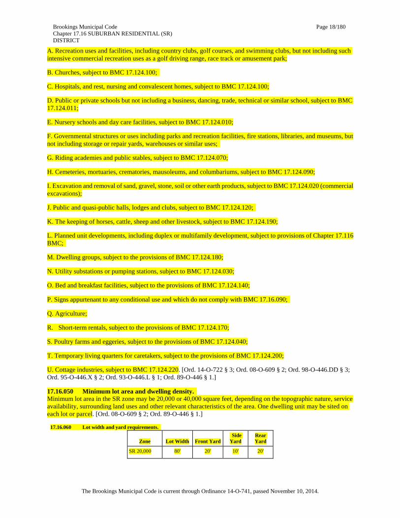
17.16.050 Minimum lot area and dwelling density. Minimum lot area in the SR zone may be 20,000 or 40,000 square feet, depending on the topographic nature, service availability, surrounding land uses and other relevant characteristics of the area. One dwelling unit may be sited on each lot or parcel. [Ord. 08-O-609 § 2; Ord. 89-O-446 § 1.]
17.16.060 Lot width and yard requirements.
Zone Lot Width Front Yard Side Yard
Rear Yard
SR 20,000 80' 20' 10' 20'

Brookings Municipal Code Chapter 17.16 SUBURBAN RESIDENTIAL (SR) DISTRICT
Page 19/180
The Brookings Municipal Code is current through Ordinance 14-O-741, passed November 10, 2014.
SR 40,000 100' 20' 10' 20'
Rear lots (flag lots), created pursuant to BMC 17.172.061, have setback requirements of 10 feet from all property lines. Any irregularly shaped parcel with minimal street frontage is also subject to the 10-foot setback from all property lines. [Ord. 08-O-609 § 2; Ord. 89-O-446 § 1.]
17.16.070 Maximum structure height. No structure shall be over 30 feet in height, except as provided in BMC 17.124.030 or 17.128.020. [Ord. 08-O-609 § 2; Ord. 98-O-446.DD § 3; Ord. 89-O-446 § 1.]
17.16.080 Maximum lot coverage. Maximum lot coverage by buildings and structures shall not exceed 35 percent of the total lot area. [Ord. 08-O-609 § 2; Ord. 89-O-446 § 1.]
17.16.090 Signs. Signs shall be permitted in accordance with Chapter 17.88 BMC. [Ord. 08-O-609 § 2; Ord. 89-O-446 § 1.]
17.16.100 Parking. Off-street parking shall be provided in accordance with Chapter 17.92 BMC. [Ord. 08-O-609 § 2; Ord. 89-O-446 § 1.]
17.16.110 Manufactured housing siting requirements. A. The manufactured home shall be multisectional and enclose a space of not less than 1,000 square feet.
B. The manufactured home shall be placed on a foundation that complies with the State of Oregon Manufactured Dwelling and Parks Specialty Code, Section 3-8.3, and skirted with masonry block or poured concrete.
C. The manufactured home shall have a pitched roof, except that no standard shall require a slope of greater than a nominal three feet in height for each 12 feet in width.
D. The manufactured home shall have exterior siding and roofing which in color, material and appearance is similar to the exterior siding and roofing material commonly used on residential dwellings within the community or which is comparable to the predominant materials used on surrounding dwellings as determined by the local permit approval authority.
E. The manufactured home shall have a garage or carport constructed of like materials. [Ord. 11-O-677 § 2; Ord. 10-O-655 § 2; Ord. 08-O-609 § 2; Ord. 94-O-446.T § 2; Ord. 89-O-446 § 1.]
17.16.120 Other required conditions. A. Site plan approval required as provided in Chapter 17.80 BMC.
B. No residential structure shall be located within the ocean coastal shorelands boundary nor the Chetco Estuary shorelands boundary as defined in the comprehensive plan.
C. Prior to any development activity on the property, the applicant must comply with BMC 17.100.030, General mitigation. [Ord. 08-O-609 § 2; Ord. 95-O-446.X § 2; Ord. 94-O-446.T § 2; Ord. 89-O-446 § 1. Formerly 17.16.130.]

Brookings Municipal Code Chapter 17.20 SINGLE-FAMILY RESIDENTIAL (R-1) DISTRICT
Page 20/180
The Brookings Municipal Code is current through Ordinance 14-O-741, passed November 10, 2014.
Chapter 17.20
SINGLE-FAMILY RESIDENTIAL (R-1) DISTRICT
Sections: 17.20.010 Purpose. 17.20.020 Permitted uses. 17.20.030 Accessory uses. 17.20.040 Conditional uses. 17.20.050 Minimum lot area and dwelling density. 17.20.060 Lot width, lot coverage and yard requirements. 17.20.070 Maximum building structure height. 17.20.080 Signs. 17.20.090 Parking. 17.20.100 Manufactured housing siting requirements. 17.20.110 Other required conditions.
17.20.010 Purpose. To promote and encourage a suitable environment for family living and to protect and stabilize the residential characteristics of the district, the R-1 district is intended to provide for single-family residential homes at urban standards. [Ord. 08-O-612 § 2; Ord. 89-O-446 § 1.]
17.20.020 Permitted uses. The following uses are permitted:
A. Single-family dwellings. Dwellings must have a garage or carport constructed of like materials;
B. Subject to the requirements of BMC 17.20.100, a manufactured home as defined by ORS 446.003. [Ord. 08-O-612 § 2; Ord. 94-O-446.T § 3; Ord. 89-O-446 § 1.]
17.20.030 Accessory uses. The following uses are permitted:
A. Guest houses containing no kitchen or kitchen facilities and limited to no greater than 500 square feet in size. Guest houses may not be rented or otherwise conducted as a business;
B. Home occupations, subject to the provisions of Chapter 17.104 BMC;
C. Other accessory uses and accessory buildings and structures, such as noncommercial greenhouses, customarily appurtenant to a permitted use;
D. Boats, trailers, pick-up campers, motor homes and similar equipment may be stored, but not occupied, except as provided for temporary sleeping purposes in BMC 8.15.087, on a lot in an “R” district; provided, that:
1. Parking and storage shall be at least five feet from the front property line and at least three feet from a street and interior side or rear lot line; except, however, no storage shall be allowed within 20 feet of the corner along both property lines at a street corner;
2. All areas used for storage of such vehicle/equipment shall be paved or a graveled hard surface. [Ord. 08-O-612 § 2; Ord. 89-O-446 § 1.]
17.20.040 Conditional uses. The following conditional uses may be permitted subject to a conditional use permit:
A. Recreation uses and facilities, including country clubs, golf courses, and swimming clubs, but not including such intensive commercial recreation uses as a golf driving range, race track or amusement park;

Brookings Municipal Code Chapter 17.20 SINGLE-FAMILY RESIDENTIAL (R-1) DISTRICT
Page 21/180
The Brookings Municipal Code is current through Ordinance 14-O-741, passed November 10, 2014.
B. Churches, subject to BMC 17.124.100;
C. Hospitals, rest, nursing and convalescent homes, subject to BMC 17.124.100;
D. Public or private schools, but not including a business, dancing, trade, technical or similar school, and subject to BMC 17.124.011;
E. Nursery schools and day care facilities, subject to BMC 17.124.010;
F. Governmental structures or uses including parks and recreation facilities, fire stations, libraries, and museums, but not including storage or repair yards, warehouses or similar uses;
G. Riding academies and public stables, subject to BMC 17.124.070;
H. Cemeteries, mortuaries, crematories, mausoleums, and columbariums, subject to BMC 17.124.090;
I. Excavation and removal of sand, gravel, stone, soil or other earth products, subject to BMC 17.124.020 (commercial excavations);
J. Public and quasi-public halls, lodges and clubs, subject to BMC 17.124.120;
K. The keeping of horses, cattle, sheep and other livestock, subject to BMC 17.124.190;
L. Planned unit developments, including duplex or multifamily development, subject to provisions of Chapter 17.116 BMC;
M. Utility substations or pumping stations, subject to BMC 17.124.030;
N. Bed and breakfast facilities, subject to the provisions of BMC 17.124.140;
O. Dwelling groups, subject to BMC 17.124.180;
P. Signs appurtenant to any conditional use and which do not comply with BMC 17.20.080;
Q. Short-term rentals pursuant to the provisions of BMC 17.124.170;
R. Poultry farms and eggeries, subject to the provisions of BMC 17.124.040;
S. Temporary living quarters for caretakers, subject to the provisions of BMC 17.124.200;
T. Cottage industries, subject to BMC 17.124.220. [Ord. 14-O-722 § 3; Ord. 08-O-612 § 2; Ord. 01-O-446.MM; Ord. 98-O-446.DD § 4; Ord. 95-O-446.Y § 2; Ord. 95-O-446.X § 3; Ord. 93-O-446.L § 2; Ord. 91-O-446.D § 1; Ord. 89-O-446 § 1.]
17.20.050 Minimum lot area and dwelling density. Minimum lot areas in the R-1 zone may be 6,000, 8,000, 10,000 or 12,000 square feet, depending upon site, public service and neighborhood characteristics. One dwelling unit may be sited on each lot or parcel. [Ord. 08-O-612 § 2; Ord. 89-O-446 § 1.]
17.20.060 Lot width, lot coverage and yard requirements.
Zone Lot
Width Front Yard
Side Yard
Rear Yard
Maximum Lot
Coverage
R-1-6 60' 20' 5'* 15' 40%
R-1-8 70' 20' 5'* 15' 40%
R-1-10 80' 20' 5'* 15' 40%

Brookings Municipal Code Chapter 17.20 SINGLE-FAMILY RESIDENTIAL (R-1) DISTRICT
Page 22/180
The Brookings Municipal Code is current through Ordinance 14-O-741, passed November 10, 2014.
R-1-12 90' 20' 5'* 15' 40%
* Provided, that the nonstreet side yards shall be increased by one-half foot for each foot by which the average building height exceeds 15 feet.
* Provided, that on an existing structure, proposed additional stories must meet the setbacks for the height of the structure.
Provided, however, that side yards abutting a street shall be a minimum of 15 feet in width.
Rear lots (flag lots) created pursuant to BMC 17.172.061 have setback requirements of 10 feet from all property lines. Any irregularly shaped parcel with minimal street frontage is also subject to the 10-foot setback from all property lines. [Ord. 10-O-659 § 2; Ord. 08-O-612 § 2; Ord. 03-O-446.SS; Ord. 90-O-446.B § 1; Ord. 89-O-446 § 1.]
17.20.070 Maximum building structure height. No structure shall be over 30 feet in height, except as provided in BMC 17.124.030 or 17.128.020. [Ord. 08-O-612 § 2; Ord. 98-O-446.DD § 4; Ord. 89-O-446 § 1.]
17.20.080 Signs. Signs shall be permitted in accordance with Chapter 17.88 BMC. [Ord. 08-O-612 § 2; Ord. 89-O-446 § 1.]
17.20.090 Parking. Off-street parking shall be provided in accordance with Chapter 17.92 BMC. [Ord. 08-O-612 § 2; Ord. 89-O-446 § 1.]
17.20.100 Manufactured housing siting requirements. A. The manufactured home shall be multisectional and enclose a space of not less than 1,000 square feet.
B. The manufactured home shall be placed on a foundation that complies with the State of Oregon Manufactured Dwelling and Parks Specialty Code, Section 3-8.3, and skirted with masonry block or poured concrete.
C. The manufactured home shall have a pitched roof, except that no standard shall require a slope of greater than a nominal three feet in height for each 12 feet in width.
D. The manufactured home shall have exterior siding and roofing which in color, material and appearance is similar to the exterior siding and roofing material commonly used on residential dwellings within the community or which is comparable to the predominant materials used on surrounding dwellings as determined by the local permit approval authority.
E. The manufactured home shall have a garage or carport constructed of like materials. [Ord. 11-O-677 § 2; Ord. 10-O-655 § 2; Ord. 08-O-612 § 2; Ord. 94-O-446.T § 3; Ord. 89-O-446 § 1.]
17.20.110 Other required conditions. A. Site plan approval required as provided in Chapter 17.80 BMC.
B. No residential structure shall be located within the ocean coastal shorelands boundary nor the Chetco Estuary shorelands boundary as defined in the comprehensive plan.
C. Prior to any development activity on the property, the applicant must comply with BMC 17.100.030, General mitigation. [Ord. 08-O-612 § 2; Ord. 94-O-446.T § 3; Ord. 89-O-446 § 1. Formerly 17.20.120.]

Brookings Municipal Code Chapter 17.24 TWO-FAMILY RESIDENTIAL (R-2) DISTRICT
Page 23/180
The Brookings Municipal Code is current through Ordinance 14-O-741, passed November 10, 2014.
Chapter 17.24
TWO-FAMILY RESIDENTIAL (R-2) DISTRICT
Sections: 17.24.010 Purpose. 17.24.020 Permitted uses. 17.24.030 Accessory uses. 17.24.040 Conditional uses. 17.24.050 Minimum lot area and dwelling density. 17.24.060 Lot width, lot coverage and yard requirements. 17.24.070 Maximum structure height. 17.24.080 Signs. 17.24.090 Parking. 17.24.100 Manufactured housing siting requirements. 17.24.110 Other required conditions.
17.24.010 Purpose. Promote and encourage a suitable environment for family living and to protect and stabilize the residential characteristics of R-2 and other neighborhoods by providing suitable areas for two-family dwellings. [Ord. 08-O-613 § 2; Ord. 89-O-446 § 1.]
17.24.020 Permitted uses. The following uses are permitted:
A. Single-family dwellings. Dwellings must have a garage or carport constructed of like materials;
B. Duplex or two-family dwellings. Dwellings must have a garage or carport for each dwelling unit constructed of like materials;
C. Subject to the requirements of BMC 17.24.100, a manufactured home as defined by ORS 446.003. [Ord. 08-O-613 § 2; Ord. 94-O-446.T § 4; Ord. 91-O-446.E § 1; Ord. 91-O-446.D § 3; Ord. 89-O-446 § 1.]
17.24.030 Accessory uses. The following accessory uses are permitted:
A. Guest houses containing no kitchen or kitchen facilities and limited to no greater than 500 square feet in size. Guest houses may not be rented or otherwise conducted as a business;
B. Other accessory uses and accessory buildings and structures, such as noncommercial greenhouses, customarily appurtenant to a permitted use;
C. Home occupations, subject to the provisions of Chapter 17.104 BMC;
D. Boats, trailers, pick-up campers, motor homes and similar equipment may be stored, but not occupied, except as provided for temporary sleeping purposes in BMC 8.15.087, on a lot in an “R” district; provided, that:
1. Parking and storage shall be at least five feet from the front property line and at least three feet from a street and interior side or rear lot line; except, however, no storage shall be allowed within 20 feet of the corner along both property lines at a street corner;
2. All areas used for storage of such vehicle/equipment shall be paved or a graveled hard surface. [Ord. 08-O-613 § 2; Ord. 89-O-446 § 1.]
17.24.040 Conditional uses. The following conditional uses may be permitted subject to a conditional use permit:

Brookings Municipal Code Chapter 17.24 TWO-FAMILY RESIDENTIAL (R-2) DISTRICT
Page 24/180
The Brookings Municipal Code is current through Ordinance 14-O-741, passed November 10, 2014.
A. Triplexes or three-family dwellings, provided the lot or parcel is a minimum of 7,500 square feet or more, subject to BMC 17.124.210;
B. Churches, subject to BMC 17.124.100;
C. Hospitals, and rest, nursing and convalescent homes, subject to BMC 17.124.100;
D. Public or private schools, but not including a business, dancing, trade, technical or similar school, subject to BMC 17.124.011;
E. Nursery schools and day care facilities, subject to BMC 17.124.010;
F. Governmental structures or uses including parks and recreation facilities, fire stations, libraries, and museums, but not including storage or repair yards, warehouses or similar uses;
G. Riding academies and public stables, subject to BMC 17.124.070;
H. Cemeteries, mortuaries, crematories, mausoleums, and columbariums, subject to BMC 17.124.090;
I. Off-street parking lots when contiguous to a less restrictive zoning district, subject to Chapter 17.92 BMC;
J. Excavation and removal of sand, gravel, stone, soil or other earth products, subject to BMC 17.124.020 (commercial excavation);
K. Public and quasi-public halls, lodges and clubs, subject to BMC 17.124.120;
L. Planned unit developments, including multifamily dwellings, subject to provisions of Chapter 17.116 BMC;
M. Bed and breakfast facilities, subject to the provisions of BMC 17.124.140;
N. Utility substations or pumping stations, subject to BMC 17.124.030;
O. Recreation uses and facilities, including country clubs, golf courses, and swimming clubs, but not including such intensive commercial recreation uses as a golf driving range, race track or amusement park;
P. Signs appurtenant to any conditional use and which do not comply with BMC 17.24.080;
Q. Dwelling groups, subject to BMC 17.124.180;
R. Short-term rentals pursuant to the provisions of BMC 17.124.170;
S. Poultry farms and eggeries, subject to the provisions of BMC 17.124.040;
T. Temporary living quarters for caretakers, subject to the provisions of BMC 17.124.200;
U. Cottage industries, subject to BMC 17.124.220. [Ord. 14-O-722 § 3; Ord. 08-O-613 § 2; Ord. 01-O-446.MM; Ord. 95-O-446.Y § 2; Ord. 95-O-446.X § 4; Ord. 93-O-446.L § 3; Ord. 91-O-446.D § 2; Ord. 89-O-446 § 1.]
17.24.050 Minimum lot area and dwelling density. The minimum lot area shall be 6,000 square feet. One duplex may be sited on each separate lot or parcel. [Ord. 08-O-613 § 2; Ord. 89-O-446 § 1.]
17.24.060 Lot width, lot coverage and yard requirements.
Lot Width Front Yard
Side Yard
Rear Yard
Maximum Lot Coverage
60' 20' 5'* 5'* 45%

Brookings Municipal Code Chapter 17.24 TWO-FAMILY RESIDENTIAL (R-2) DISTRICT
Page 25/180
The Brookings Municipal Code is current through Ordinance 14-O-741, passed November 10, 2014.
* Provided, that the side yards and rear yards shall be increased by one-half foot for each foot by which the average building height exceeds 15 feet.
* Provided, that on an existing structure, proposed additional stories must meet the setbacks for the height of the structure.
Provided, however, that side yards abutting a street shall be a minimum of 15 feet in width.
Rear lots (flag lots), created pursuant to BMC 17.172.061, have setback requirements of 10 feet from all property lines. Any irregularly shaped parcel with a minimal street frontage is also subject to the 10-foot setback from all property lines. [Ord. 10-O-659 § 2; Ord. 08-O-613 § 2; Ord. 03-O-446.SS; Ord. 89-O-446 § 1.]
17.24.070 Maximum structure height. No structure shall be over 30 feet in height, except as provided in BMC 17.124.030 or 17.128.020. [Ord. 08-O-613 § 2; Ord. 98-O-446.DD § 5; Ord. 89-O-446 § 1.]
17.24.080 Signs. Signs shall be permitted in accordance with Chapter 17.88 BMC. [Ord. 08-O-613 § 2; Ord. 89-O-446 § 1.]
17.24.090 Parking. Off-street parking shall be provided in accordance with Chapter 17.92 BMC. [Ord. 08-O-613 § 2; Ord. 89-O-446 § 1.]
17.24.100 Manufactured housing siting requirements. A. The manufactured home shall be multisectional and enclose a space of not less than 1,000 square feet.
B. The manufactured home shall be placed on a foundation that complies with the State of Oregon Manufactured Dwelling and Parks Specialty Code, Section 3-8.3, and skirted with masonry block or poured concrete.
C. The manufactured home shall have a pitched roof, except that no standard shall require a slope of greater than a nominal three feet in height for each 12 feet in width.
D. The manufactured home shall have exterior siding and roofing which in color, material and appearance is similar to the exterior siding and roofing material commonly used on residential dwellings within the community or which is comparable to the predominant materials used on surrounding dwellings as determined by the local permit approval authority.
E. The manufactured home shall have a garage or carport constructed of like materials. [Ord. 11-O-677 § 2; Ord. 10-O-655 § 2; Ord. 08-O-613 § 2; Ord. 91-O-446.E § 1; Ord. 89-O-446 § 1.]
17.24.110 Other required conditions. A. Site plan approval required as provided in Chapter 17.80 BMC.
B. No residential structure shall be located within the ocean coastal shorelands boundary nor the Chetco Estuary shorelands boundary as defined in the comprehensive plan.
C. Prior to any development activity on the property, the applicant must comply with BMC 17.100.030, General mitigation. [Ord. 08-O-613 § 2; Ord. 91-O-446.E § 1; Ord. 91-O-446.D § 2; Ord. 89-O-446 § 1. Formerly 17.24.120.]

Brookings Municipal Code Chapter 17.28 MULTIPLE-FAMILY RESIDENTIAL (R-3) DISTRICT
Page 26/180
The Brookings Municipal Code is current through Ordinance 14-O-741, passed November 10, 2014.
Chapter 17.28
MULTIPLE-FAMILY RESIDENTIAL (R-3) DISTRICT
Sections: 17.28.010 Purpose. 17.28.020 Permitted uses. 17.28.030 Accessory uses. 17.28.040 Conditional uses. 17.28.050 Minimum lot area and dwelling density. 17.28.060 Lot width, lot coverage and yard requirements. 17.28.070 Maximum building height. 17.28.080 Signs. 17.28.090 Parking. 17.28.100 Manufactured housing siting requirements. 17.28.110 Other required conditions.
17.28.010 Purpose. This district is designed to provide an environment suitable for higher density urban residential uses. The R-3 district is intended for residential uses, community services and appropriate professional business and service offices. [Ord. 08-O-614 § 2; Ord. 08-O-613 § 2; Ord. 89-O-446 § 1.]
17.28.020 Permitted uses. The following uses are permitted:
A. Two-family dwellings or duplexes. Dwelling must have a garage or carport for each dwelling unit constructed of like materials;
B. Multiple-family dwellings and apartment houses;
C. Single-family dwellings, provided the building permit applicant or the applicant’s spouse, parent, child or sibling purchased the property prior to August 13, 1998. Dwelling must have a garage or carport constructed of like materials. A single-family dwelling may include a manufactured home as defined by ORS 446.003, and subject to BMC 17.28.100;
D. Existing single-family dwellings. [Ord. 09-O-633 § 2; Ord. 08-O-614 § 2; Ord. 98-O-446.CC § 2; Ord. 94-O-446.T § 5; Ord. 89-O-446 § 1.]
17.28.030 Accessory uses. The following accessory uses are permitted:
A. Home occupations, subject to the provisions of Chapter 17.104 BMC;
B. Other accessory uses and accessory buildings and structures, such as noncommercial greenhouses, customarily appurtenant to a permitted use;
C. Boats, trailers, pick-up campers, motor homes and similar equipment may be stored, but not occupied, except as provided for temporary sleeping purposes in BMC 8.15.087, on a lot in an “R” district; provided, that:
1. Parking and storage shall be at least five feet from the front property line and at least three feet from a street and interior side or rear lot line; except, however, no storage shall be allowed within 20 feet of the corner along both property lines at a street corner;
2. All areas used for storage of such vehicle/equipment shall be paved or a graveled hard surface. [Ord. 08-O-614 § 2; Ord. 89-O-446 § 1.]

Brookings Municipal Code Chapter 17.28 MULTIPLE-FAMILY RESIDENTIAL (R-3) DISTRICT
Page 27/180
The Brookings Municipal Code is current through Ordinance 14-O-741, passed November 10, 2014.
17.28.040 Conditional uses. The following conditional uses may be permitted subject to a conditional use permit:
A. Recreation uses and facilities, including country clubs, golf courses, and swimming clubs, but not including such intensive commercial recreation uses as a golf driving range, race track or amusement park;
B. Churches, subject to BMC 17.124.100;
C. Off-street parking lots when contiguous to a less restrictive zoning district, subject to the provisions of Chapter 17.92 BMC;
D. Hospitals, and rest, nursing and convalescent homes, subject to BMC 17.124.100;
E. Public and private schools but not including a business, dancing, trade, technical or similar school, subject to BMC 17.124.011;
F. Nursery schools and day care facilities, subject to BMC 17.124.010;
G. Governmental structures or uses including parks and recreation facilities, fire stations, libraries, museums, but not including storage or repair yards, warehouses or similar uses;
H. Cemeteries, mortuaries, crematories, mausoleums, and columbariums, subject to BMC 17.124.090;
I. Riding academies and public stables, subject to BMC 17.124.070;
J. Excavation and removal of sand, gravel, stone, soil or other earth products, subject to BMC 17.124.020 (commercial excavation);
K. Public and quasi-public halls, lodges and clubs, subject to BMC 17.124.120;
L. Planned unit developments, subject to provisions of Chapter 17.116 BMC;
M. Utility substations or pumping stations, subject to BMC 17.124.030;
N. Bed and breakfast facilities, subject to the provisions of BMC 17.124.140;
O. Professional business and service offices;
P. Signs appurtenant to any conditional use and which do not comply with BMC 17.28.080;
Q. Poultry farms and eggeries, subject to the provisions of BMC 17.124.040;
R. Short-term rentals pursuant to the provisions of BMC 17.124.170;
S. Temporary living quarters for caretakers, subject to the provisions of BMC 17.124.200. [Ord. 08-O-614 § 2; Ord. 01-O-446.MM; Ord. 95-O-446.Y § 2; Ord. 93-O-446.L § 4; Ord. 89-O-446 § 1.]
17.28.050 Minimum lot area and dwelling density. The minimum lot area shall be 6,000 square feet for the first two dwelling units and for each additional dwelling unit, the lot area shall be increased by 1,500 square feet. [Ord. 08-O-614 § 2; Ord. 89-O-446 § 1.]
17.28.060 Lot width, lot coverage and yard requirements.
Lot Width Front Yard
Side Yard
Rear Yard
Maximum Lot Coverage
60' 10' 5'* 5'* 45%
* Provided, that the side yards and rear yards shall be increased by one-half foot for each foot by which the average building height exceeds 15 feet.

Brookings Municipal Code Chapter 17.28 MULTIPLE-FAMILY RESIDENTIAL (R-3) DISTRICT
Page 28/180
The Brookings Municipal Code is current through Ordinance 14-O-741, passed November 10, 2014.
* Provided, that on an existing structure, proposed additional stories must meet the setbacks for the height of the structure.
Provided, however, that side yards abutting a street shall be a minimum of 10 feet in width; and
A. Rear lots (flag lots) created pursuant to BMC 17.172.061 have setback requirements of 10 feet from all property lines. Any irregularly shaped parcel with minimal street frontage is also subject to the 10-foot setback from all property lines.
B. Special yards and distances between buildings shall be provided as follows:
1. An inner courtyard providing access to double-row dwelling units shall be a minimum of 20 feet in width;
2. Except for single-family dwellings on one lot, the minimum distance between residential buildings shall be twice the minimum side yard setback that would be required for the tallest building on the lot; provided, however, that in no case shall the distance be less than 10 feet. [Ord. 10-O-659 § 2; Ord. 08-O-614 § 2; Ord. 03-O-446.SS; Ord. 95-O-446.X § 5; Ord. 89-O-446 § 1.]
17.28.070 Maximum building height. No structure shall be over 40 feet in height, except as provided in BMC 17.124.030 or 17.128.020. [Ord. 08-O-614 § 2; Ord. 98-O-446.DD § 6; Ord. 89-O-446 § 1.]
17.28.080 Signs. Signs shall be permitted in accordance with Chapter 17.88 BMC. [Ord. 08-O-614 § 2; Ord. 89-O-446 § 1.]
17.28.090 Parking. Off-street parking shall be provided in accordance with Chapter 17.92 BMC. [Ord. 08-O-614 § 2; Ord. 89-O-446 § 1.]
17.28.100 Manufactured housing siting requirements. A. The manufactured home shall be multisectional and enclose a space of not less than 1,000 square feet.
B. The manufactured home shall be placed on a foundation that complies with the State of Oregon Manufactured Dwelling and Parks Specialty Code, Section 3-8.3, and skirted with masonry block or poured concrete.
C. The manufactured home shall have a pitched roof, except that no standard shall require a slope of greater than a nominal three feet in height for each 12 feet in width.
D. The manufactured home shall have exterior siding and roofing which in color, material and appearance is similar to the exterior siding and roofing material commonly used on residential dwellings within the community or which is comparable to the predominant materials used on surrounding dwellings as determined by the local permit approval authority.
E. The manufactured home shall have a garage or carport constructed of like materials. [Ord. 11-O-677 § 2; Ord. 10-O-655 § 2; Ord. 08-O-614 § 2; Ord. 94-O-446.T § 5; Ord. 89-O-446 § 1.]
17.28.110 Other required conditions. A. Site plan approval required as provided in Chapter 17.80 BMC.
B. No residential structure shall be located within the ocean coastal shorelands boundary nor the Chetco Estuary shorelands boundary as defined in the comprehensive plan.
C. Prior to any development activity on the property, the applicant must comply with BMC 17.100.030, General mitigation.
D. For multifamily dwellings, an area equal to at least 15 percent of the site area, inclusive of required setback yards, shall be devoted to usable open space recreation areas. This area must be cleared of brush or obstructions and not used for temporary or regular parking or vehicles.

Brookings Municipal Code Chapter 17.28 MULTIPLE-FAMILY RESIDENTIAL (R-3) DISTRICT
Page 29/180
The Brookings Municipal Code is current through Ordinance 14-O-741, passed November 10, 2014.
E. If commercial dumpsters are to be used, they shall be appropriately screened. [Ord. 08-O-614 § 2; Ord. 89-O-446 § 1.]

Brookings Municipal Code Chapter 17.32 MANUFACTURED HOME RESIDENTIAL (R-MH) DISTRICT
Page 30/180
The Brookings Municipal Code is current through Ordinance 14-O-741, passed November 10, 2014.
Chapter 17.32
MANUFACTURED HOME RESIDENTIAL (R-MH) DISTRICT
Sections: 17.32.010 Purpose. 17.32.020 Permitted uses. 17.32.030 Accessory uses. 17.32.040 Conditional uses. 17.32.050 Minimum lot area and dwelling density. 17.32.060 Lot width, lot coverage and yard requirements. 17.32.070 Maximum structure height. 17.32.080 Signs. 17.32.090 Parking. 17.32.100 Manufactured housing siting requirements. 17.32.110 Other required conditions.
17.32.010 Purpose. The purpose of the R-MH district is to recognize and provide for residential areas where manufactured homes built to state and federal construction and safety standards may locate in a suitable environment for family living, and to protect and stabilize the residential characteristics of the district. The intent of these district regulations is to encourage provision of alternative modest income housing opportunities in certain residential areas by permitting the use of certain manufactured homes therein, and to further recognize the trend toward homes of other than conventional construction. [Ord. 08-O-615 § 2; Ord. 89-O-446 § 1.]
17.32.020 Permitted uses. A. Single-family dwellings. Dwelling must have a garage or carport for each dwelling unit constructed of like materials;
B. Single-family manufactured or modular unit on an individual lot, subject to BMC 17.32.100. Dwelling must have a garage or carport for each dwelling unit constructed of like materials. [Ord. 08-O-615 § 2; Ord. 89-O-446 § 1.]
17.32.030 Accessory uses. The following uses are permitted:
A. Guest houses containing no kitchen or kitchen facilities and limited to no greater than 500 square feet in size. Guest houses may not be rented or otherwise conducted as a business;
B. Home occupations, subject to the provisions of Chapter 17.104 BMC;
C. Other accessory uses and accessory buildings and structures, such as noncommercial greenhouses, customarily appurtenant to a permitted use;
D. Boats, trailers, pick-up campers, motor homes and similar equipment may be stored, but not occupied, except as provided for temporary sleeping purposes in BMC 8.15.087, on a lot in an “R” district; provided, that:
1. Parking and storage shall be at least five feet from the front property line and at least three feet from a street and interior side or rear lot line, except however, no storage shall be allowed within 20 feet of the corner along both property lines at a street corner;
2. All areas used for storage of such vehicle/equipment shall be paved or a graveled hard surface. [Ord. 08-O-615 § 2; Ord. 89-O-446 § 1.]
17.32.040 Conditional uses. The following conditional uses may be permitted:

Brookings Municipal Code Chapter 17.32 MANUFACTURED HOME RESIDENTIAL (R-MH) DISTRICT
Page 31/180
The Brookings Municipal Code is current through Ordinance 14-O-741, passed November 10, 2014.
A. Recreation uses and facilities, including country clubs, golf courses, and swimming clubs, but not including such intensive commercial recreation uses as a golf driving range, race track or amusement park;
B. Churches, subject to BMC 17.124.100;
C. Hospitals, and rest, nursing and convalescent homes, subject to BMC 17.124.100;
D. Public or private schools, but not including a business, dancing, trade, technical or similar school, subject to BMC 17.124.011;
E. Nursery schools and day care facilities, subject to BMC 17.124.010;
F. Governmental structures or uses including parks and recreation facilities, fire stations, libraries, museums, but not including storage or repair yards, warehouses or similar uses;
G. Riding academies and public stables, subject to BMC 17.124.070;
H. Cemeteries, crematories, mausoleums, and columbariums, subject to BMC 17.124.090;
I. Excavation and removal of sand, gravel, stone, soil or other earth products, subject to BMC 17.124.020 (commercial excavations);
J. Public and quasi-public halls, lodges and clubs, subject to BMC 17.124.120;
K. The keeping of horses, cattle, sheep and other livestock, subject to BMC 17.124.190;
L. Planned unit developments, including duplex or multifamily development, subject to provisions of Chapter 17.116 BMC;
M. Dwelling groups, subject to BMC 17.124.180;
N. Utility substations or pumping stations, subject to BMC 17.124.030;
O. Bed and breakfast facilities, subject to the provisions of BMC 17.124.140;
P. Signs appurtenant to any conditional use and which do not comply with BMC 17.32.080;
Q. Manufactured home parks, subject to the provisions of BMC 17.124.160;
R. Short-term rentals pursuant to the provisions of BMC 17.124.170;
S. Poultry farms and eggeries, subject to the provisions of BMC 17.124.040;
T. Temporary living quarters for caretakers, subject to the provisions of BMC 17.124.200;
U. Cottage industries, subject to BMC 17.124.220. [Ord. 14-O-722 § 3; Ord. 08-O-615 § 2; Ord. 01-O-446.MM; Ord. 98-O-446.DD § 7; Ord. 95-O-446.Y § 2; Ord. 95-O-446.X § 6; Ord. 93-O-446.L § 5; Ord. 89-O-446 § 1.]
17.32.050 Minimum lot area and dwelling density. Minimum lot areas in the R-MH zone may be 6,000, 8,000, 10,000 or 12,000 square feet depending upon site, public service and neighborhood characteristics. One dwelling unit may be sited on each lot or parcel. [Ord. 08-O-615 § 2; Ord. 89-O-446 § 1.]
17.32.060 Lot width, lot coverage and yard requirements.
Zone Lot
Width Front Yard
Side Yard
Rear Yard
Maximum Lot
Coverage
R-MH-6 60' 20' 5'* 5'* 40%

Brookings Municipal Code Chapter 17.32 MANUFACTURED HOME RESIDENTIAL (R-MH) DISTRICT
Page 32/180
The Brookings Municipal Code is current through Ordinance 14-O-741, passed November 10, 2014.
R-MH-8 70' 20' 5'* 5'* 40%
R-MH-10 80' 20' 5'* 5'* 40%
R-MH-12 90' 20' 5'* 5'* 40%
* Provided, that the nonstreet side yards and rear yard shall be increased by one-half foot for each foot by which the building height exceeds 15 feet.
* Provided, that on an existing structure, proposed additional stories must meet the setbacks for the height of the structure.
Provided, however, that side yards abutting a street shall be a minimum of 15 feet in width; and
Rear lots (flag lots) created pursuant to BMC 17.172.061 have setback requirements of 10 feet from all property lines. Any irregularly shaped parcel with minimal street frontage is also subject to the 10-foot setback from all property lines. [Ord. 10-O-659 § 2; Ord. 08-O-615 § 2; Ord. 03-O-446.SS; Ord. 89-O-446 § 1.]
17.32.070 Maximum structure height. No structure shall be over 30 feet in height, except as provided in BMC 17.124.030 or 17.128.020. [Ord. 08-O-615 § 2; Ord. 98-O-446.DD § 7; Ord. 89-O-446 § 1.]
17.32.080 Signs. Signs shall be permitted in accordance with Chapter 17.88 BMC. [Ord. 08-O-615 § 2; Ord. 89-O-446 § 1.]
17.32.090 Parking. Off-street parking shall be provided in accordance with Chapter 17.92 BMC. [Ord. 08-O-615 § 2; Ord. 89-O-446 § 1.]
17.32.100 Manufactured housing siting requirements. A. The unit shall be a double-wide and not less than 24 feet in width; similar site-built building or structure connected or joined to the unit will be permitted.
B. The unit shall have a wood-shake or composition roof with a minimum roof slope of three inches in 12 inches with not less than 12-inch eaves.
C. The unit shall have skirting which is commonly allowed under the Uniform Building Code (Oregon State Structural Specialty Code). [Ord. 08-O-615 § 2.]
17.32.110 Other required conditions. A. No residential structure shall be located within the ocean coastal shorelands boundary nor the Chetco Estuary shorelands boundary as defined in the comprehensive plan.
B. Site plan approval required as provided in Chapter 17.80 BMC.
C. Prior to any development activity on the property, the applicant must comply with BMC 17.100.030, General mitigation. [Ord. 08-O-615 § 2; Ord. 89-O-446 § 1. Formerly 17.32.100.]

Brookings Municipal Code Chapter 17.36 PROFESSIONAL OFFICE (PO-1) DISTRICT
Page 33/180
The Brookings Municipal Code is current through Ordinance 14-O-741, passed November 10, 2014.
Chapter 17.36
PROFESSIONAL OFFICE (PO-1) DISTRICT
Sections: 17.36.010 Purpose. 17.36.020 Permitted uses. 17.36.030 Accessory uses. 17.36.040 Conditional uses. 17.36.050 Minimum lot area. 17.36.060 Lot width, lot coverage and yard requirements. 17.36.070 Maximum building height. 17.36.080 Signs. 17.36.090 Parking. 17.36.100 Other required conditions.
17.36.010 Purpose. This district is for the purpose of providing professional and business office uses in areas between residential and more intense commercial districts. This is considered a transition area and development in this district will be residential in character. Only ancillary retail sales are allowed in this district. [Ord. 10-O-657 § 2; Ord. 89-O-446 § 1.]
17.36.020 Permitted uses. A. Dwelling units, not on a ground floor.
B. Professional and business office uses, such as but not limited to:
1. Architect or designer;
2. Accountant;
3. Attorney;
4. Computer services;
5. Day care, nursery schools and kindergartens, subject to the provisions of BMC 17.124.010;
6. Dentist;
7. Engineer;
8. Insurance agent or adjustor;
9. Investment or management counselor;
10. Medical and dental offices, clinics and laboratories;
11. Nursing and convalescent homes;
12. Photographic studio, excluding retail sales of cameras, equipment, film or supplies;
13. Real estate office;
14. Surveyor;
15. Title and escrow offices;
16. Travel agencies;

Brookings Municipal Code Chapter 17.36 PROFESSIONAL OFFICE (PO-1) DISTRICT
Page 34/180
The Brookings Municipal Code is current through Ordinance 14-O-741, passed November 10, 2014.
17. Wholesale lumber broker office;
18. Bank or financial institute. [Ord. 10-O-657 § 2; Ord. 89-O-446 § 1.]
17.36.030 Accessory uses. The following accessory uses are permitted:
A. Offices incidental and necessary to the conduct of a permitted use;
B. Home occupations, subject to the provisions of Chapter 17.104 BMC;
C. Other accessory uses and accessory buildings and structures customarily appurtenant to a permitted use. [Ord. 10-O-657 § 2; Ord. 89-O-446 § 1.]
17.36.040 Conditional uses. The following conditional uses may be permitted subject to a conditional use permit:
A. Recreation uses and facilities, including country clubs, golf courses, swimming clubs, but not including such intensive commercial recreation uses as a golf driving range, race track or amusement park;
B. Churches, subject to BMC 17.124.100;
C. Off-street parking lots, subject to the provisions of Chapter 17.92 BMC;
D. Hospitals, subject to BMC 17.124.100;
E. Public and private schools, but not including a business, dance, trade, technical or similar school, subject to BMC 17.124.011;
F. Governmental structures or uses including parks and recreation facilities, fire stations, libraries, museums, but not including storage or repair yards, warehouses or similar uses;
G. Mortuaries and crematories in conjunction with a mortuary, subject to BMC 17.124.090;
H. Public and quasi-public halls, lodges and clubs, subject to BMC 17.124.120;
I. Planned community, subject to provisions of Chapter 17.116 BMC;
J. Utility substations or pumping stations, subject to BMC 17.124.030;
K. Signs appurtenant to any conditional use and which do not comply with BMC 17.36.080. [Ord. 10-O-657 § 2; Ord. 89-O-446 § 1.]
17.36.050 Minimum lot area. The minimum lot area shall be 6,000 square feet. [Ord. 10-O-657 § 2; Ord. 89-O-446 § 1.]
17.36.060 Lot width, lot coverage and yard requirements. A. The minimum lot width shall be at least 60 feet.
B. The minimum front yard shall be 10 feet.
C. The minimum side and rear yard shall be at least five feet except that the street side yard shall be a minimum of 10 feet. The side or rear yard shall be increased by one-half foot for each foot by which the building height exceeds 15 feet; provided, that on an existing structure, proposed additional stories must meet the setbacks for the height of the structure. [Ord. 10-O-665 § 2; Ord. 10-O-657 § 2; Ord. 89-O-446 § 1.]
17.36.070 Maximum building height. Maximum building height shall be 40 feet, except as provided in BMC 17.128.020. [Ord. 10-O-657 § 2; Ord. 98-O-446.DD § 8; Ord. 89-O-446 § 1.]

Brookings Municipal Code Chapter 17.36 PROFESSIONAL OFFICE (PO-1) DISTRICT
Page 35/180
The Brookings Municipal Code is current through Ordinance 14-O-741, passed November 10, 2014.
17.36.080 Signs. Signs shall be permitted in accordance with Chapter 17.88 BMC. [Ord. 10-O-657 § 2; Ord. 89-O-446 § 1.]
17.36.090 Parking. Off-street parking shall be provided in accordance with Chapter 17.92 BMC. [Ord. 10-O-657 § 2; Ord. 89-O-446 § 1.]
17.36.100 Other required conditions. A. Site plan approval required as provided in Chapter 17.80 BMC.
B. All business shall be conducted from a structure placed on a permanent foundation unless specifically exempted by the provisions of this or other city ordinances.
C. Prior to any development activity on the property, the applicant must comply with BMC 17.100.030, General mitigation.
D. Provide for the improvement of an existing dedicated alleyway which is intended to be used for egress and ingress, or backup space of off-street parking for the development.
E. Screen from view all roof-, wall- or ground-mounted mechanical equipment and devices, in addition to propane tanks.
F. Refuse receptacles or dumpsters shall be appropriately positioned, colored or screened to minimize visibility to vehicular traffic or pedestrians. [Ord. 10-O-657 § 2; Ord. 00-O-446.JJ § 2; Ord. 89-O-446 § 1.]

Brookings Municipal Code Chapter 17.40 PUBLIC OPEN SPACE (P/OS) DISTRICT
Page 36/180
The Brookings Municipal Code is current through Ordinance 14-O-741, passed November 10, 2014.
Chapter 17.40
PUBLIC OPEN SPACE (P/OS) DISTRICT
Sections: 17.40.010 Purpose. 17.40.020 Permitted uses. 17.40.030 Accessory uses. 17.40.040 Conditional uses. 17.40.050 Yard and height requirements. 17.40.060 Signs. 17.40.070 Parking. 17.40.080 Other required conditions.
17.40.010 Purpose. The purpose of this district is to recognize, preserve and enhance publicly owned recreation, open space, educational and cultural areas, facilities and services, to protect the natural and scenic resources, and to ensure adequate provision for open spaces consistent with the policies of the city. [Ord. 89-O-446 § 1.]
17.40.020 Permitted uses. The following uses are permitted:
A. Government structures including offices, fire stations, police stations;
B. Publicly owned parks and/or recreation facilities, including recreational parks, swimming pools, tennis courts, playgrounds, campgrounds, and picnic areas;
C. Community centers;
D. Public schools;
E. Public golf courses;
F. Public museums, art galleries, libraries and information centers;
G. Water-dependent or water-related uses only to be located within shorelands boundary;
H. Wireless communication facilities, pursuant to Chapter 17.164 BMC, in conjunction with an existing tower operated by a public entity;
I. Existing airport facilities including expansion and accessory uses intended for the convenience of airport customers such as restaurants, car rentals, or retail shops subject to Chapter 17.76 BMC, Airport Approach (AA) Overlay Zone. [Ord. 13-O-707 § 2; Ord. 99-O-446.GG § 2; Ord. 99-O-446.EE § 2; Ord. 89-O-446 § 1.]
17.40.030 Accessory uses. Accessory uses and facilities incidental and customarily appurtenant to a permitted use, including renovation, rehabilitation, replacement, repair, improvement and other similar construction and/or reconstruction activities of existing or new buildings and structures. [Ord. 89-O-446 § 1.]
17.40.040 Conditional uses. The following conditional uses may be permitted subject to a conditional use permit:
A. Utilities and services, including storage or repair yards, warehouses or similar uses totally enclosed within a building or contained within a minimum eight-foot-high, sight-obscuring fence;
B. Caretaker, night watchman or park host residence;

Brookings Municipal Code Chapter 17.40 PUBLIC OPEN SPACE (P/OS) DISTRICT
Page 37/180
The Brookings Municipal Code is current through Ordinance 14-O-741, passed November 10, 2014.
C. The use of a recreational vehicle (RV) for a caretaker, night watchman or park host residence in compliance with criteria below:
1. RV must be parked on a dust-free, asphaltic or concrete surface or other materials approved by the site plan committee.
2. Adequacy of sewer, water, and storm drainage must be reviewed and approved by the city.
3. RV must be sited in compliance with property line setbacks pursuant to BMC 17.40.050.
4. All storage must be entirely within an enclosed accessory structure except for items such as outdoor furniture.
5. Applicant shall subscribe to a scheduled waste collection service and provide garbage receptacles on the property.
6. Caretaker residences shall be limited to one per discrete parcel, unless otherwise approved by the planning commission. [Ord. 14-O-731 § 2; Ord. 01-O-446.LL § 2; Ord. 99-O-446.EE § 2; Ord. 93-O-446.P § 2; Ord. 89-O-446 § 1.]
17.40.050 Yard and height requirements. A. The minimum front yard shall be 20 feet.
B. The minimum side yard shall be 10 feet.
C. The minimum street side yard shall be 15 feet.
D. The minimum rear yard shall be 15 feet.
E. Maximum building height shall be 40 feet, except as provided in BMC 17.128.030. [Ord. 98-O-446.DD § 9; Ord. 89-O-446 § 1.]
17.40.060 Signs. Signs shall be permitted in accordance with Chapter 17.88 BMC. [Ord. 89-O-446 § 1.]
17.40.070 Parking. Off-street parking shall be provided in accordance with Chapter 17.92 BMC. [Ord. 89-O-446 § 1.]
17.40.080 Other required conditions. Site plan approval required as provided in Chapter 17.80 BMC. [Ord. 89-O-446 § 1.]

Brookings Municipal Code Chapter 17.44 NEIGHBORHOOD COMMERCIAL (C-1) DISTRICT
Page 38/180
The Brookings Municipal Code is current through Ordinance 14-O-741, passed November 10, 2014.
Chapter 17.44
NEIGHBORHOOD COMMERCIAL
(C-1) DISTRICT
Sections: 17.44.010 Purpose. 17.44.020 Permitted uses. 17.44.030 Accessory uses. 17.44.040 Conditional uses. 17.44.050 Yard, height and lot coverage requirements. 17.44.060 Signs. 17.44.070 Parking. 17.44.080 Other required conditions.
17.44.010 Purpose. This district is intended to provide for the location of small businesses and services in residential areas of the city. The businesses are intended to be limited in size and to hours of operation to serve the convenience retail needs of the neighborhood residents and to fit into the residential patterns of development without creating land use, architectural or traffic conflicts. New C-1 districts shall be so located to serve approximately 1,000 families within a one-half-mile radius where analysis of residential population demonstrates that such facilities are or will be required and shall be situated along a collector street. [Ord. 89-O-446 § 1.]
17.44.020 Permitted uses. The following uses are permitted:
A. Existing residential uses, without any increases in density;
B. Grocery stores, including garden supplies;
C. Barber and/or beauty shop. [Ord. 89-O-446 § 1.]
17.44.030 Accessory uses. Any uses, buildings or structures customarily appurtenant to a permitted use, such as incidental storage facilities are permitted. [Ord. 89-O-446 § 1.]
17.44.040 Conditional uses. The following conditional uses may be permitted subject to a conditional use permit:
A. Residential dwelling units not on the ground floor of a building;
B. Conversion of an existing dwelling unit to a permitted use;
C. Restaurants, including the sale of alcoholic beverages on the premises, but not including dancing or entertainment. [Ord. 89-O-446 § 1.]
17.44.050 Yard, height and lot coverage requirements. A. The minimum front yard shall be 20 feet, and said yard area shall be appropriately landscaped and maintained.
B. The minimum side and rear yard shall be 10 feet when abutting an “R” district and such side or rear yard shall be increased by one-half foot for each foot the building height exceeds 20 feet. Said yard area shall be appropriately landscaped and maintained.
C. Maximum building height shall be 30 feet, except as provided in BMC 17.128.030.
Brookings Municipal Code Chapter 17.44 NEIGHBORHOOD COMMERCIAL (C-1) DISTRICT
Page 39/180
The Brookings Municipal Code is current through Ordinance 14-O-741, passed November 10, 2014.
D. The maximum lot coverage by buildings and structures shall not exceed 35 percent of the total lot area. [Ord. 89-O-446 § 1.]
17.44.060 Signs. Signs shall be permitted in accordance with Chapter 17.88 BMC. [Ord. 89-O-446 § 1.]
17.44.070 Parking. Off-street parking shall be provided in accordance with Chapter 17.92 BMC. [Ord. 89-O-446 § 1.]
17.44.080 Other required conditions. A. Site plan approval required as provided in Chapter 17.80 BMC.
B. Except for off-street parking and loading facilities, all uses shall be conducted wholly within an enclosed building.
C. Items produced or wares and merchandise handled shall be limited to those sold at retail on the premises.
D. All businesses shall be conducted from a structure placed on a permanent foundation unless specifically exempted by the provisions of this or other city ordinances. [Ord. 00-O-446.JJ § 3; Ord. 89-O-446 § 1.]

Brookings Municipal Code Chapter 17.48 SHOPPING CENTER COMMERCIAL (C-2) DISTRICT
Page 40/180
The Brookings Municipal Code is current through Ordinance 14-O-741, passed November 10, 2014.
Chapter 17.48
SHOPPING CENTER COMMERCIAL
(C-2) DISTRICT
Sections: 17.48.010 Purpose. 17.48.020 Permitted uses. 17.48.030 Accessory uses. 17.48.040 Conditional uses. 17.48.050 Yard, height and lot coverage requirements. 17.48.060 Signs. 17.48.070 Parking. 17.48.080 Other required conditions.
17.48.010 Purpose. This district is intended to make provision within the city for larger concentrations of retailing and service commercial activities in the form of unified shopping centers planned and developed as an integrated unit. New C-2 districts shall have a minimum area of five acres, shall be situated along a major street and shall be so located where analysis of population demonstrates that such facilities are or will be required. [Ord. 89-O-446 § 1.]
17.48.020 Permitted uses. The following uses are permitted:
A. Any permitted use in the C-1 district, except residential uses;
B. Appliance sales (household), including minor repairs;
C. Art galleries, libraries, and reading rooms;
D. Artist supplies and picture framing;
E. Auto parts sales (new);
F. Banks and financial institutions;
G. Book or stationery stores;
H. Bicycle shops;
I. Clothes cleaning agencies;
J. Confectionery or delicatessens;
K. Dancing or music schools;
L. Drug stores;
M. Dry goods stores, millinery shops, dress shops;
N. Department stores;
O. Florist shops;
P. Food stores;

Brookings Municipal Code Chapter 17.48 SHOPPING CENTER COMMERCIAL (C-2) DISTRICT
Page 41/180
The Brookings Municipal Code is current through Ordinance 14-O-741, passed November 10, 2014.
Q. Furniture stores;
R. Garden supply stores;
S. Gift shops, notion or variety stores;
T. Hardware stores or paint stores;
U. Health food stores;
V. Hobby shops;
W. Home furnishings;
X. Jewelry stores;
Y. Laundry pick-up agencies, self-service laundries;
Z. Leather goods and luggage;
AA. Medical and dental clinics and offices;
BB. Musical instruments;
CC. Pet shops;
DD. Photographic supplies and studios;
EE. Professional and business offices;
FF. Radio and television broadcasting studios and facilities;
GG. Shoe stores, shoe repair shops;
HH. Sporting goods;
II. Toy stores;
JJ. Variety stores. [Ord. 89-O-446 § 1.]
17.48.030 Accessory uses. Any uses, buildings or structures customarily appurtenant to a permitted use, such as incidental storage facilities, are permitted. [Ord. 89-O-446 § 1.]
17.48.040 Conditional uses. The following conditional uses may be permitted subject to a conditional use permit:
A. Conversion of an existing dwelling unit to a permitted use;
B. Public buildings and public utility buildings and structures as may be appropriate to the C-2 district;
C. Commercial off-street parking lots or structures subject to the provisions of Chapter 17.92 BMC;
D. Buildings over 40 feet in height;
E. Restaurants, bars, cocktail lounges, including entertainment;
F. Dwelling units not on the ground floor of a building;
G. Hotels and motels;

Brookings Municipal Code Chapter 17.48 SHOPPING CENTER COMMERCIAL (C-2) DISTRICT
Page 42/180
The Brookings Municipal Code is current through Ordinance 14-O-741, passed November 10, 2014.
H. Motion picture theaters, other than drive-in theaters;
I. Car washes and other automobile services. [Ord. 89-O-446 § 1.]
17.48.050 Yard, height and lot coverage requirements. A. The front yard shall be a minimum of 20 feet, and said yard area shall be appropriately landscaped and maintained.
B. The minimum side or rear yard shall be 10 feet when abutting an “R” district and such side or rear yard shall be increased by one-half foot for each foot the building height exceeds 20 feet. Said yard area shall be appropriately landscaped and maintained.
C. No structures shall be over 40 feet in height except as allowed as a conditional use, and as provided in BMC 17.128.030.
D. The maximum lot coverage by buildings and structures shall not exceed 35 percent of the total lot area. [Ord. 89-O-446 § 1.]
17.48.060 Signs. Signs shall be permitted in accordance with Chapter 17.88 BMC. [Ord. 89-O-446 § 1.]
17.48.070 Parking. Off-street parking shall be provided in accordance with Chapter 17.92 BMC. [Ord. 89-O-446 § 1.]
17.48.080 Other required conditions. A. Site plan approval required as provided in Chapter 17.80 BMC.
B. Except for off-street parking and loading facilities, outdoor dining areas, gardens and nurseries, Christmas tree sales lots, all uses shall be conducted wholly within an enclosed building.
C. Items produced or wares and merchandise handled shall be limited to those sold at retail on the premises.
D. All business shall be conducted from a structure placed on a permanent foundation unless specifically exempted by the provisions of this or other city ordinances. [Ord. 00-O-446.JJ § 4; Ord. 89-O-446 § 1.]

Brookings Municipal Code Chapter 17.52 GENERAL COMMERCIAL (C-3) DISTRICT
Page 43/180
The Brookings Municipal Code is current through Ordinance 14-O-741, passed November 10, 2014.
Chapter 17.52
GENERAL COMMERCIAL (C-3) DISTRICT
Sections: 17.52.010 Purpose. 17.52.020 Permitted uses. 17.52.030 Accessory uses. 17.52.040 Conditional uses. 17.52.050 Maximum building height. 17.52.060 Signs. 17.52.070 Parking. 17.52.080 Other required conditions.
17.52.010 Purpose. This district is designed to stabilize, improve and protect the commercial characteristics of the general commercial area. The district is limited to commercial uses of less intensity than are found in an industrial zone. A pedestrian-friendly mixture of commercial and residential uses are to be promoted by the provisions found in this district. [Ord. 08-O-622 § 2; Ord. 89-O-446 § 1.]
17.52.020 Permitted uses. The following uses are permitted:
A. Existing residential uses, including additions, without any increase in the number of dwelling units;
B. One or more dwellings not on a ground floor;
C. Retail business and offices;
D. Business and technical schools, such as photography, art, music, theater, and dance schools and studios;
E. Restaurants, cafes, cocktail lounges, bars, and taverns, with or without entertainment;
F. Commercial recreational uses, such as bowling lanes, dance halls, pool halls, skating rinks, or theaters, not including drive-in theaters;
G. Printing, publishing and newspaper offices;
H. Light service shops, such as beauty salons, barbershops, pet grooming with no overnight boarding of animals, upholsterers, picture framing, tailoring, and appliance repair;
I. Places for public assembly, such as places of worship, meeting halls, auditoriums, community centers, lodges, clubs and fraternal organizations;
J. Public buildings, structures and uses as may be appropriate to the C-3 district including transportation terminals and facilities;
K. Commercial parking lots for passenger vehicles, subject to Chapter 17.92 BMC;
L. Museums, art galleries or similar facilities;
M. Hospitals and outpatient medical clinics;
N. Motels and hotels;
O. Automobile, boat, truck, or trailer sales, service or repair with display areas more than 20,000 square feet and less than 100,000 square feet; provided, that all repair shall be conducted entirely within an enclosed building;

Brookings Municipal Code Chapter 17.52 GENERAL COMMERCIAL (C-3) DISTRICT
Page 44/180
The Brookings Municipal Code is current through Ordinance 14-O-741, passed November 10, 2014.
P. Light manufacturing and fabricating of products without retail sales shall not be conducted on a ground floor facing the public street but may be conducted in a basement or on an upper floor. Light manufacturing and fabricating of products that are related to tourism, such as but not limited to micro-brewery, coffee roasting, cheese making/creamery, or glass blowing, is permitted on the ground floor facing the public street when conducted in conjunction with the retail sales of the product. All light manufacturing and fabricating of products shall not create noise above 45 dB, or create excessive odor, and all processing shall be completely contained in a closed system or vented into a filtering system to remove odor. [Ord. 14-O-727 § 2; Ord. 08-O-622 § 2; Ord. 03-O-446.NN; Ord. 93-O-446.L § 6; Ord. 89-O-446 § 1.]
17.52.030 Accessory uses. A. Any uses, buildings or structures customarily appurtenant to a permitted use, such as incidental storage facilities, are permitted.
B. Accessory Uses for Dwelling Units.
1. Home occupations, subject to the provisions of Chapter 17.104 BMC.
2. Other accessory uses and accessory buildings and structures, such as noncommercial greenhouses, customarily appurtenant to a permitted use. [Ord. 08-O-622 § 2; Ord. 93-O-446.P § 3; Ord. 89-O-446 § 1.]
17.52.040 Conditional uses. The following conditional uses may be permitted subject to a conditional use permit:
A. Automobile, boat, truck, or trailer sales, service or repair with display areas of 100,000 square feet or more; provided, that all repair shall be conducted entirely within an enclosed building;
B. Implement, machinery, and heavy equipment sales, service or repair; provided, that all repair shall be conducted entirely within an enclosed building;
C. Automobile service station, including automobile maintenance and repair, which shall be conducted entirely within an enclosed building;
D. Lumber or building materials sales and storage;
E. Contractors’ storage;
F. Veterinarians and animal hospitals, provided all business, service and kennels are entirely within an enclosed building subject to BMC 17.124.080;
G. Buildings over 40 feet in height;
H. Rental storage units, provided they are used exclusively for storage purposes;
I. Day care and nursery schools pursuant to BMC 17.124.010;
J. Short-term rentals pursuant to the provisions of BMC 17.124.170;
K. Mortuaries and crematories in conjunction with a mortuary and subject to BMC 17.124.090;
L. On-duty personnel living quarters, either conventional or manufactured dwelling unit, only in conjunction with ambulance services and/or fire departments;
M. Utility substations or pumping stations subject to BMC 17.124.030;
N. Light manufacturing and fabricating of products that is not related to tourism or tourism related products without sales is permitted on the ground floor facing the public street. The activity shall not create noise above 45 dB, or create excessive odor, and all processing shall be completely contained in a closed system or vented into a filtering system to

Brookings Municipal Code Chapter 17.52 GENERAL COMMERCIAL (C-3) DISTRICT
Page 45/180
The Brookings Municipal Code is current through Ordinance 14-O-741, passed November 10, 2014.
remove odor. [Ord. 14-O-727 § 3; Ord. 08-O-622 § 2; Ord. 01-O-446.MM; Ord. 00-O-446.II § 2; Ord. 92-O-446.H § 2; Ord. 89-O-446 § 1.]
17.52.050 Maximum building height. No structures shall be over 40 feet in height except as allowed as a conditional use, and as provided in BMC 17.128.030. [Ord. 08-O-622 § 2; Ord. 89-O-446 § 1.]
17.52.060 Signs. Signs shall be permitted in accordance with Chapter 17.88 BMC. [Ord. 08-O-622 § 2; Ord. 89-O-446 § 1.]
17.52.070 Parking. Off-street parking shall be provided in accordance with Chapter 17.92 BMC, except for the area described in BMC 17.92.030(A). [Ord. 08-O-622 § 2; Ord. 89-O-446 § 1.]
17.52.080 Other required conditions. A. Site plan approval required as provided in Chapter 17.80 BMC.
B. All businesses, services and processes shall be conducted entirely within a completely enclosed structure, except for conditional uses, outdoor dining areas, nurseries and garden shops, seasonal sales lots, outdoor equipment, outdoor furniture, dispensers, vehicle and boat sales, and bus stations. When outside storage is allowed as a conditional use, it must be enclosed within a six-foot high sight-obscuring fence. In addition, temporary sales of products allowed either as an outright permitted or a conditionally permitted use, for no more than seven consecutive days, may be conducted outside on private property. These sales may occur no more than four times during a calendar year. The seller must have a current city business license and required parking spaces must remain available for use by vehicles.
C. In any C-3 district directly across a street from or abutting any lot in a residential district, the parking and loading area shall be set back at least 10 feet from the street right-of-way or lot line and said area shall be appropriately landscaped to protect the character of said adjacent residential properties. Such landscaping shall be constructed and maintained in compliance with BMC 17.92.100(H).
D. All business shall be conducted from a structure placed on a permanent foundation unless specifically exempted by the provisions of this or other city ordinances.
E. Prior to any development activity on the property, the applicant must comply with BMC 17.100.030, General mitigation.
F. An accessway to a new proposed off-street parking area shall be improved from the public roadway to the parking area to a minimum width of 20 feet for two-way traffic. If the accessway is a one-way in or one-way out, it shall be a minimum width of 10 feet and have appropriate signage.
G. Provide for the improvement of an existing dedicated alleyway which is intended to be used for egress and ingress, or backup space of off-street parking for the development.
H. Screen from view all roof-, wall-, or ground-mounted mechanical equipment and devices, in addition to propane tanks.
I. Refuse receptacles or dumpsters shall be appropriately positioned, colored or screened to minimize visibility to vehicular traffic or pedestrians.
J. Automobile, boat, truck, or trailer sales;
1. Dealerships must have an on-site office.
2. Primary dealerships with an on-site office located in the downtown core area, as defined in BMC 17.92.030(A), may have one or more secondary sales/storage locations, without an on-site office, outside the downtown core area within the C-3 zone. [Ord. 08-O-622 § 2; Ord. 00-O-446.JJ § 5; Ord. 89-O-446 § 1.]

Brookings Municipal Code Chapter 17.56 TOURIST COMMERCIAL (C-4) DISTRICT
Page 46/180
The Brookings Municipal Code is current through Ordinance 14-O-741, passed November 10, 2014.
Chapter 17.56
TOURIST COMMERCIAL (C-4) DISTRICT
Sections: 17.56.010 Purpose. 17.56.020 Permitted uses. 17.56.030 Accessory uses. 17.56.040 Conditional uses. 17.56.050 Maximum building height. 17.56.060 Signs. 17.56.070 Parking. 17.56.080 Other required conditions.
17.56.010 Purpose. This district is intended to make provision for tourist commercial uses which serve the traveling public and which are appropriate to major thoroughfare or highway locations. The appearance of developments in this district will have a significant visual impact on the traveling public concerning community values and these regulations are intended to protect and enhance the appearance of these vital areas of the community to the benefit and success of the entire community as a major tourist center. [Ord. 10-O-651 § 2; Ord. 89-O-446 § 1.]
17.56.020 Permitted uses. The following uses are permitted:
A. Existing residential uses, including additions, without any increase in the number of dwelling units;
B. One or more dwellings not on a ground floor;
C. Automobile car wash;
D. Automobile service station, including automobile maintenance and repair which shall be conducted entirely within an enclosed building;
E. Commercial recreational uses such as bowling lanes, theaters, dance halls, pool halls, skating rinks;
F. Gift or souvenir shops;
G. Motels, hotels and convention centers;
H. Restaurants, cafes, cocktail lounges, bars, taverns with or without entertainment;
I. Barber and beauty shops;
J. Bus station, taxi stand;
K. Places for public assembly such as community centers, clubs, lodges, fraternal organizations and auditoriums;
L. Drug stores;
M. Laundromats;
N. Museums, art galleries, or similar facilities;
O. Professional or business offices;
P. Commercial off-street parking lots or structures subject to the provisions of Chapter 17.92 BMC;

Brookings Municipal Code Chapter 17.56 TOURIST COMMERCIAL (C-4) DISTRICT
Page 47/180
The Brookings Municipal Code is current through Ordinance 14-O-741, passed November 10, 2014.
Q. Banks and financial institutions;
R. Marinas or launching facilities;
S. Piers, docks and bulkheads;
T. Boat storage, maintenance and service;
U. Aquaculture and accessory facilities;
V. Light manufacturing and fabricating of products that is related to tourism, such as but not limited to micro-brewery, coffee roasting, cheese making/creamery, or glass blowing, is permitted when conducted in conjunction with the retail sales of the product. All light manufacturing and fabricating of products shall not create noise above 45 dB, or create excessive odor, and all processing shall be completely contained in a closed system or vented into a filtering system to remove odor. [Ord. 14-O-727 § 2; Ord. 10-O-651 § 2; Ord. 03-O-446.OO; Ord. 89-O-446 § 1.]
17.56.030 Accessory uses. A. Any uses, buildings or structures customarily appurtenant to a permitted use, such as incidental storage facilities and the like, are permitted.
B. Accessory uses for dwelling units.
1. Home occupations, subject to the provisions of Chapter 17.104 BMC.
2. Other accessory uses and accessory buildings and structures, such as noncommercial greenhouses, customarily appurtenant to a permitted use. [Ord. 10-O-651 § 2; Ord. 89-O-446 § 1.]
17.56.040 Conditional uses. The following conditional uses may be permitted subject to a conditional use permit:
A. Recreational vehicle park subject to BMC 17.124.150;
B. Convenience market, limited to 1,000 square feet of retail area;
C. Golf driving range, golf course, miniature golf course;
D. Public buildings and public utility buildings, structures and uses;
E. Rental storage units, provided they are used exclusively for storage purposes;
F. Buildings over 40 feet in height;
G. Utility substations or pumping stations subject to BMC 17.124.030;
H. Drive-in theater subject to BMC 17.124.130;
I. Short-term rentals pursuant to the provisions of BMC 17.124.170. [Ord. 10-O-651 § 2; Ord. 00-O-446.II § 3; Ord. 89-O-446 § 1.]
17.56.050 Maximum building height. No structures shall be over 40 feet in height except as provided in BMC 17.56.040(F) and 17.128.020. [Ord. 10-O-651 § 2; Ord. 89-O-446 § 1.]
17.56.060 Signs. Signs shall be permitted in accordance with Chapter 17.88 BMC. [Ord. 10-O-651 § 2; Ord. 89-O-446 § 1.]
17.56.070 Parking. Off-street parking shall be provided in accordance with Chapter 17.92 BMC. [Ord. 10-O-651 § 2; Ord. 89-O-446 § 1.]

Brookings Municipal Code Chapter 17.56 TOURIST COMMERCIAL (C-4) DISTRICT
Page 48/180
The Brookings Municipal Code is current through Ordinance 14-O-741, passed November 10, 2014.
17.56.080 Other required conditions. A. Site plan approval required as provided in Chapter 17.80 BMC.
B. In any C-4 district directly across a street from, or abutting any lot in a residential district, the parking and loading area shall be set back at least 10 feet from the property line and said area shall be landscaped in compliance with BMC 17.92.100(H).
C. All businesses shall be conducted from a structure placed on a permanent foundation unless specifically exempted by the provisions of this or other city ordinances.
D. Prior to any development activity on the property, the applicant must comply with BMC 17.100.030, General mitigation.
E. An accessway to a new proposed off-street parking area shall be improved from the public roadway to the parking area to a minimum width of 20 feet for two-way traffic. If the accessway is a one-way in or one-way out, it shall be a minimum width of 10 feet and have appropriate signage.
F. All businesses and services shall be conducted entirely within a completely enclosed structure, except for conditional uses, outdoor dining areas, seasonal sales lots, outdoor equipment, outdoor furniture, dispensers, boat storage and maintenance/service, and bus stations. In addition, temporary sales of products allowed either as an outright permitted or a conditionally permitted use, for not more than seven consecutive days, may be conducted outside on private property. These sales may occur no more than four times during a calendar year. The seller must have a current business license and required parking spaces must remain available for use by vehicles.
G. Screen from view all roof-, wall-, or ground-mounted mechanical equipment and devices, in addition to propane tanks.
H. Refuse receptacles or dumpsters shall be appropriately positioned, colored or screened to minimize visibility to vehicular traffic or pedestrians. [Ord. 10-O-651 § 2; Ord. 00-O-446.JJ § 6; Ord. 89-O-446 § 1.]

Brookings Municipal Code Chapter 17.64 INDUSTRIAL PARK (I-P) DISTRICT
Page 49/180
The Brookings Municipal Code is current through Ordinance 14-O-741, passed November 10, 2014.
Chapter 17.64
INDUSTRIAL PARK (I-P) DISTRICT
Sections: 17.64.010 Purpose. 17.64.020 Permitted uses. 17.64.030 Accessory uses. 17.64.040 Conditional uses. 17.64.050 Yard, height and lot coverage requirements. 17.64.060 Signs. 17.64.070 Parking. 17.64.080 Other required conditions.
17.64.010 Purpose. This district is designed to provide for a combination of wholesale, heavy commercial and light industrial uses in a manner that will have minimal impact on surrounding areas in relation to noise, odor, vibration, or visual nuisance, and to provide a suitable and stable environment for such uses. [Ord. 09-O-627 § 2; Ord. 93-O-446.M § 4; Ord. 89-O-446 § 1.]
17.64.020 Permitted uses. The following uses are permitted:
A. Any use listed as a conditional use in the C-3 district, with the exception of BMC 17.52.040(A), (G), (I) and (J);
B. Implement sales, service, repair and rental;
C. Wholesale businesses, storage, warehousing transfer companies and trucking companies;
D. Automobile, boat, truck, or trailer sales, service and repair with display areas more than 20,000 square feet and less than 100,000 square feet;
E. Public and quasi-public utility buildings and service yards;
F. Contractors’ offices and equipment storage yard or storage and rental of equipment commonly used by contractors;
G. Carpenter, electrical, plumbing, sheet metal, welding, electroplating, heating, sign shops, auto and furniture upholstery shops, printing, publishing and lithographing shops, painting and sandblasting;
H. Cold storage plants;
I. Bakery, creamery, soft drink bottling plant, laundry, dry cleaning, dyeing or rug cleaning;
J. Feed, seed and fuel stores;
K. Commercial parking lots, subject to Chapter 17.92 BMC;
L. Administrative, educational and other related activities and facilities in conjunction with a permitted use;
M. Light manufacturing, assembly, fabricating or packaging of products from previously prepared materials such as cloth, plastic, wood (not including saw, planing or lumber mills or molding plants), paper, cotton, precious or semi-precious metals or stone;
N. Manufacture of electric, electronic or optical instruments and devices;
O. Manufacture of food products, pharmaceutical and similar items, but not including the production of materials having significant potential for odor or the rendering of fats or oils;

Brookings Municipal Code Chapter 17.64 INDUSTRIAL PARK (I-P) DISTRICT
Page 50/180
The Brookings Municipal Code is current through Ordinance 14-O-741, passed November 10, 2014.
P. Retail sale of items offered for wholesale, retail sale of items produced by any permitted manufacturing use, lumber yards (including sales of ancillary hardware), and sales of heavy equipment and other similar heavy bulk items;
Q. Printing, publishing and book binding;
R. Rental storage units and similar type storage areas, provided they are used exclusively for storage purposes;
S. Day care facilities when associated with any permitted or conditional uses;
T. Existing residential uses, including additions, without any increase in the number of dwelling units. [Ord. 09-O-627 § 2; Ord. 00-O-446.II § 4; Ord. 94-O-446.R § 2; Ord. 93-O-446.M § 4; Ord. 89-O-446 § 1.]
17.64.030 Accessory uses. A. Any uses, buildings or structures customarily appurtenant to a permitted use, such as incidental storage facilities.
B. Accessory Uses for Dwelling Units.
1. Home occupations, subject to the provisions of Chapter 17.104 BMC.
2. Other accessory uses and accessory buildings and structures, such as noncommercial greenhouses, customarily appurtenant to a permitted use. [Ord. 09-O-627 § 2; Ord. 93-O-446.M § 4; Ord. 89-O-446 § 1.]
17.64.040 Conditional uses. The following uses may be permitted subject to a conditional use permit:
A. Service commercial uses such as banks, offices, restaurants, food services, bars, taverns or other convenience establishments designed to serve developed permitted uses;
B. Kennels and other animal boarding facilities, not abutting any residential district and subject to BMC 17.124.070;
C. Buildings over 40 feet in height;
D. Wireless communication facilities, pursuant to BMC 17.124.030 and Chapter 17.164 BMC;
E. Utility substations or pumping stations subject to BMC 17.124.030;
F. Short-term rentals in existing dwellings subject to BMC 17.124.170;
G. Automobile, boat, truck, or trailer sales, service or repair with display areas of 100,000 square feet or more;
H. Retail businesses. [Ord. 09-O-627 § 2; Ord. 99-O-446.GG § 3; Ord. 93-O-446.M § 4; Ord. 89-O-446 § 1.]
17.64.050 Yard, height and lot coverage requirements. A. The minimum front yard shall be 20 feet, and said area shall be landscaped in compliance with BMC 17.92.100(H).
B. The minimum side and rear yard setback shall be 10 feet when directly across the street or abutting a residential district and such side or rear yard shall be increased by one-half foot for each foot the building height exceeds 20 feet.
C. Maximum building height shall be 40 feet, except as allowed as a conditional use, and as provided in BMC 17.124.030.
D. The maximum lot coverage by buildings and structures shall not exceed 50 percent of the total lot area. [Ord. 09-O-627 § 2; Ord. 93-O-446.M § 4; Ord. 89-O-446 § 1.]
17.64.060 Signs. Signs shall be permitted in accordance with Chapter 17.88 BMC. [Ord. 09-O-627 § 2; Ord. 93-O-446.M § 4; Ord. 89-O-446 § 1.]

Brookings Municipal Code Chapter 17.64 INDUSTRIAL PARK (I-P) DISTRICT
Page 51/180
The Brookings Municipal Code is current through Ordinance 14-O-741, passed November 10, 2014.
17.64.070 Parking. Off-street parking shall be provided in accordance with Chapter 17.92 BMC. [Ord. 09-O-627 § 2; Ord. 93-O-446.M § 4; Ord. 89-O-446 § 1.]
17.64.080 Other required conditions. A. Site plan approval required as provided in Chapter 17.80 BMC.
B. All uses in this district shall be carried on entirely within an enclosed building, except for conditional uses, outdoor equipment, outdoor furniture, dispensers, vehicle and boat sales, and bus stations; provided, that outdoor storage may be permitted when enclosed by a six-foot-high, sight-obscuring fence, wall or landscaping. If the fence will be located in the front yard landscaped setback area, it must be set back at least 10 feet from the front property line.
C. In addition, temporary sales of products allowed either as a permitted or a conditionally permitted use, for no more than seven consecutive days, may be conducted outside on private property. These sales may occur no more than four times during a calendar year. The seller must have a current city business license and required parking spaces must remain available for use by vehicles.
D. Any use or portion thereof causing noise, vibration, or producing intense heat or glare shall be performed in such a manner as not to create a nuisance or hazard on adjacent property.
E. There shall be no emission of odorous, toxic, noxious matter, or dust in such quantities as to be readily detectable at any point along or outside property lines so as to produce a public nuisance or hazard.
F. Access points from a public road to properties in an I-P district shall be so located as to minimize traffic congestion and to avoid directing traffic onto local access streets of a primarily residential character.
G. Openings to structures on sides adjacent to or across the street from a residential district shall be prohibited if such access or openings will cause glare, excessive noise or other conditions such as to have adverse effects on property in the residential district.
H. All side or rear yards directly across the street from or abutting a lot in a residential district shall be landscaped in compliance with BMC 17.92.100(H).
I. All businesses shall be conducted from a structure anchored to a permanent foundation unless specifically exempted by the provisions of this title or other city ordinances.
J. Prior to any development activity on the property, the applicant must comply with BMC 17.100.030, General mitigation.
K. An accessway to a new proposed off-street parking area shall be improved from the public roadway to the parking area to a minimum width of 20 feet for two-way traffic. If the accessway is a one-way in or one-way out, it shall be a minimum width of 10 feet and have appropriate signage.
L. Provide for the improvement of an existing dedicated alleyway which is intended to be used for egress and ingress, or backup space of off-street parking for the development.
M. Screen from view all roof-, wall-, or ground-mounted mechanical equipment and devices, in addition to propane tanks.
N. Refuse receptacles or dumpsters shall be appropriately positioned, colored or screened to minimize visibility to vehicular traffic or pedestrians. [Ord. 09-O-627 § 2; Ord. 00-O-446.JJ § 7; Ord. 93-O-446.M § 4; Ord. 89-O-446 § 1.]

Brookings Municipal Code Chapter 17.68 GENERAL INDUSTRIAL (M-2) DISTRICT
Page 52/180
The Brookings Municipal Code is current through Ordinance 14-O-741, passed November 10, 2014.
Chapter 17.68
GENERAL INDUSTRIAL (M-2) DISTRICT
Sections: 17.68.010 Purpose. 17.68.020 Permitted uses. 17.68.030 Accessory uses. 17.68.040 Conditional uses. 17.68.050 Maximum building height. 17.68.060 Signs. 17.68.070 Parking. 17.68.080 Other required conditions.
17.68.010 Purpose. This district is intended to provide for the establishment of heavier commercial and industrial uses essential to the development of a balanced economic base, while minimizing conflicts with residential and light commercial uses. [Ord. 09-O-628 § 2; Ord. 89-O-446 § 1.]
17.68.020 Permitted uses. The following uses are permitted:
A. Any use permitted outright in the I-P district;
B. Any manufacturing, processing, repairing, research, assembling, wholesale or storage uses, excepting the manufacturing of explosives and the slaughtering of animals;
C. All types of automobile, motorcycle, truck and equipment sales, service, repair and rental;
D. Boat building, sales, service, repair and rental;
E. Dwelling for a caretaker or watchman employed on the premises. [Ord. 09-O-628 § 2; Ord. 96-O-446.BB § 4; Ord. 89-O-446 § 1.]
17.68.030 Accessory uses. A. Any uses, buildings or structures customarily appurtenant to a permitted use, such as incidental storage facilities and the like.
B. Accessory Uses for Dwelling Units.
1. Home occupations, subject to the provisions of Chapter 17.104 BMC.
2. Other accessory uses and accessory buildings and structures, such as noncommercial greenhouses. [Ord. 09-O-628 § 2; Ord. 89-O-446 § 1.]
17.68.040 Conditional uses. The following uses may be permitted subject to a conditional use permit:
A. Junk yards or wrecking yards;
B. Buildings over 40 feet in height;
C. Service commercial uses such as banks, offices, restaurants, cafes, refreshment stands, bars, taverns or other convenience establishments designed to serve developed permitted uses;
D. Commercial excavation and removal of sand, gravel, stone, loam, dirt or other earth products, subject to BMC 17.124.020;

Brookings Municipal Code Chapter 17.68 GENERAL INDUSTRIAL (M-2) DISTRICT
Page 53/180
The Brookings Municipal Code is current through Ordinance 14-O-741, passed November 10, 2014.
E. Abattoir (slaughterhouse);
F. Wireless communication facilities, pursuant to BMC 17.124.030 and Chapter 17.164 BMC. [Ord. 09-O-628 § 2; Ord. 99-O-446.GG § 4; Ord. 89-O-446 § 1.]
17.68.050 Maximum building height. No structure shall be over 40 feet in height, except as allowed as a conditional use, and as provided in BMC 17.128.030. [Ord. 09-O-628 § 2; Ord. 89-O-446 § 1.]
17.68.060 Signs. Signs shall be permitted in accordance with Chapter 17.88 BMC. [Ord. 09-O-628 § 2; Ord. 89-O-446 § 1.]
17.68.070 Parking. Off-street parking shall be provided in accordance with Chapter 17.92 BMC. [Ord. 09-O-628 § 2; Ord. 89-O-446 § 1.]
17.68.080 Other required conditions. A. Site plan approval required as provided in Chapter 17.80 BMC.
B. All business, service, repair, processing, storage or merchandise display on property abutting or across the street from a lot in a residential district shall be conducted wholly within an enclosed building unless screened from the residential district by means of a six-foot-high sight-obscuring fence, wall or landscaping, which shall be maintained.
C. Openings to structures on sides adjacent to or across the street from a residential district shall be prohibited if such access or openings will cause glare, excessive noise or other conditions such as to have adverse effects on property in the residential district.
D. In any M-2 district directly across a street from or abutting any lot in a residential district, the parking and loading area and outdoor display or storage areas shall be set back at least 10 feet from the street right-of-way or property line and said area shall be landscaped in compliance with BMC 17.92.100(H).
E. Access points from a public road to properties in an M-2 district shall be so located as to minimize traffic congestion and to avoid directing traffic onto local access streets.
F. Any use or portion thereof causing noise, vibration, or producing intense heat or glare shall be performed in such a manner as not to create a nuisance or hazard on adjacent property.
G. There shall be no emission of odorous, toxic, noxious matter, or dust in such quantities as to be readily detectable at any point along or outside property lines so as to produce a public nuisance or hazard.
H. Prior to any development activity on the property, the applicant must comply with BMC 17.100.030, General mitigation.
I. An accessway to a new proposed off-street parking area shall be improved from the public roadway to the parking area to a minimum width of 20 feet for two-way traffic. If the accessway is a one-way in or one-way out, it shall be a minimum width of 10 feet and have appropriate signage.
J. Provide for the improvement of an existing dedicated alleyway which is intended to be used for egress and ingress, or backup space of off-street parking for the development.
K. Screen from view all roof-, wall-, or ground-mounted mechanical equipment and devices, in addition to propane tanks, when adjacent to or across the street from a residential district.
L. Refuse receptacles or dumpsters shall be appropriately positioned, colored or screened to minimize visibility to vehicular traffic or pedestrians. [Ord. 09-O-628 § 2; Ord. 89-O-446 § 1.]

Brookings Municipal Code Chapter 17.70 MASTER PLAN DEVELOPMENT (MPD) DISTRICT
Page 54/180
The Brookings Municipal Code is current through Ordinance 14-O-741, passed November 10, 2014.
Chapter 17.70
MASTER PLAN DEVELOPMENT (MPD) DISTRICT1
Sections: 17.70.010 Purpose. 17.70.020 General provisions. 17.70.030 Allowed uses. 17.70.040 Master plan of development (MPoD) review procedures. 17.70.050 Acceptance of application. 17.70.060 Staff evaluation. 17.70.070 Review criteria. 17.70.080 Action by planning commission. 17.70.090 Action by the city council. 17.70.100 Notice of decision. 17.70.110 Effective date and assurance. 17.70.120 Effective period of master plan of development (MPoD) approval. 17.70.130 Modification of a master plan of development (MPoD). 17.70.140 Detailed development plan (DDP) review procedures. 17.70.150 Acceptance of application. 17.70.160 Staff evaluation. 17.70.170 Review criteria for determining compliance with master plan of development (MPoD). 17.70.180 Action by the planning commission. 17.70.190 Effective date. 17.70.200 Effective period of detailed development plan (DDP) approval. 17.70.210 Modification(s) of a detailed development plan (DDP). 17.70.220 Determining compliance.
17.70.010 Purpose. The master planned development (MPD) zone is a land use district. The MPD zone may be applied on sites that are 50 acres or greater in size. The MPD zone shall implement the MP comprehensive plan designation, which shall be placed on all land requiring a “master plan of development” in the Urban Growth Joint Management Agreement (JMA) adopted by the city and the county. Upon or subject to annexation into the city, the MPD comprehensive plan designation shall be applied to all land that is required to adopt a master plan of development (MPoD) in the urban growth boundary. In addition, the city may apply the MPD designation to other lands within the city.
The MPD zone is to be implemented through the approval of a MPoD that describes in detail, as outlined in this chapter, how the development of the property will occur and how the development will implement applicable goals and policies of the city’s comprehensive plan, and applicable provisions of the land development code. The MPoD will assess and minimize, to an acceptable level, the impacts of the development on the city’s services, infrastructure, transportation systems and neighboring properties. Best engineering practices for low impact development which preserve existing vegetation, topography, and natural drainage are encouraged. As the MPD zone is implemented through an approved MPoD, no development shall be allowed until applicable requirements of this chapter are met. Compliance with applicable plan goals and policies is deferred until the MPoD review.
Master planned development review procedures are established in this chapter for the following purposes:
A. Promote flexibility in design and permit diversification in location of structures;
B. Promote efficient use of land and energy and facilitate a more economical arrangement of buildings, circulation systems, land uses, and utilities;
C. Preserve to the greatest extent possible existing landscape features and amenities, and utilize such features in a harmonious fashion. Retention of existing mature trees and other vegetation is encouraged;

Brookings Municipal Code Chapter 17.70 MASTER PLAN DEVELOPMENT (MPD) DISTRICT
Page 55/180
The Brookings Municipal Code is current through Ordinance 14-O-741, passed November 10, 2014.
D. Provide for more usable and suitably located recreation facilities and other public and common facilities than would otherwise be provided under conventional land development procedures;
E. Combine and coordinate architectural styles, building forms and building relationships within the planned development;
F. Provide the applicant with reasonable assurance of ultimate approval before expenditure of complete design moneys, while providing the city with assurances that the project will retain the character envisioned at the time of approval;
G. Promote and encourage energy conservation; and
H. Provide greater compatibility with surrounding land uses than what may occur with a conventional project. [Ord. 10-O-652 § 2; Ord. 03-O-446.PP.]
17.70.020 General provisions. Development within a master planned development (MPD) zone is governed by the approval of a MPoD which can be developed in a single phase or in multiple phases. Prior to development a MPoD must be approved and prior to construction of any phase a detailed development plan (DDP) must be approved. On sites where a MPD designation exists on the city’s official zoning map the provisions of this chapter shall apply. The following procedure allows for planning commission review of a MPoD and DDP. An application to apply the MPD zone to specific properties may be submitted and reviewed concurrent with MPoD approval. The applicant may either select to process the development proposal under a DDP concurrent with approval of the MPoD or may request only approval of a MPoD in accordance with BMC 17.70.050 and later apply for a DDP for an individual phase or phases of the project. However, prior to issuing any building permits a DDP must be approved by the planning commission.
An applicant for MPoD approval may propose one or more alternative development standards for all or any specific areas within the plan boundaries, which supersede corresponding development regulations or standards otherwise applicable to the project area through existing regulations. Such alternative standards shall be clearly and specifically identified within the plan submittals, and shall include an explanation and/or drawings, which demonstrates that such alternative standards equally or better meet the purpose of the existing regulations.
Changes to zoning ordinances, policies, and standards adopted after the date of approval of the plan shall not apply to the development during the duration of the plan. [Ord. 10-O-652 § 2; Ord. 03-O-446.PP.]
17.70.030 Allowed uses. The following uses are allowed outright when they are included in an approved MPoD:
A. All uses allowed outright and conditionally in the R-1, R-2, and R-3 zones;
B. All uses allowed outright and conditionally in the C-1, C-2, C-3 and C-4 zones.
C. All uses allowed outright in the I-P and M-2 districts. [Ord. 10-O-652 § 2; Ord. 03-O-446.PP.]
17.70.040 Master plan of development (MPoD) review procedures. An application filed for a MPoD shall be reviewed in accordance with the following procedures:
A. Application Requirements. Applications shall be made by the owner, or authorized representative, on forms provided by the city. If the MPoD is to include land in more than one ownership, the application must be submitted jointly by all of the owners or persons having an interest in each of the separately owned properties to be included.
1. The application shall be accompanied by the following:
a. A narrative description of the project addressing the items listed in subsection (C) of this section;
b. Four sets of scaled black line drawings of the MPoD graphic(s), with sheet size not to exceed 30 inches by 42 inches. Where necessary, an overall plan with additional detail sheets may be submitted; and

Brookings Municipal Code Chapter 17.70 MASTER PLAN DEVELOPMENT (MPD) DISTRICT
Page 56/180
The Brookings Municipal Code is current through Ordinance 14-O-741, passed November 10, 2014.
c. One set of the graphics shall be reduced to fit on eight-and-one-half-inch by 11-inch sheets of paper. Graphics and related names/numbers must be legible on this sheet size.
B. Graphic Requirements. A MPoD shall include the following information where applicable:
1. Existing land use map (typically a topographic map that extends at least 300 feet beyond the site. The map includes existing building footprints and makes a distinction between single-family, multifamily, commercial and industrial uses, as well as other significant features such as roads, drainageways, parks, and schools);
2. Site plan(s) and other graphics drawn to scale and containing a sheet title, date, north arrow, and legend, placed in the same location on each sheet and containing the following:
a. Existing site conditions including contours at intervals not greater than five feet, watercourses, flood plains, and any unique natural features prepared by an engineer or surveyor licensed in the state of Oregon;
b. A geologic hazard report for any area containing or adjacent to a fault zone, sinkhole, unstable soils, steep slopes of 15 percent or greater, high water table, or other geologic hazard, as required in Chapter 17.100 BMC, Hazardous Building Sites;
c. Exterior boundary of the proposed MPoD and any interior lots/parcels related to proposed development phases or land divisions;
d. Land use areas designated for residential use within the MPoD shall be identified as such and indicate the type of residential use, the number of units within the area and resulting density;
e. General location and size of areas to be conveyed, dedicated, or reserved as common open spaces, such as public parks, recreational areas, school sites, or others;
f. Existing and proposed general vehicle and pedestrian circulation system including bikeways, sidewalks, off-street parking areas, street standards, and major points of access to public rights-of-way. Notations of proposed ownership (public or private) should be included where appropriate;
g. Existing and proposed preliminary utility systems including sanitary sewer, storm sewer, drainageways, water, electricity, and other non-municipal utilities, where appropriate. Staff will provide written information concerning existing infrastructure and adequacy to serve proposed development;
h. Show adjoining land areas within 150 feet of the subject property to indicate their relationships with the proposed development including land uses, lot lines, circulation systems, public facilities, and unique natural features of the landscape;
i. Location of natural resources, historic and cultural resources as identified on adopted city and county inventories.
C. Narrative Requirements. A written statement shall include the following information:
1. Statement of planning objectives to be achieved by the project. This statement should indicate a description of the character of the proposed development, and a discussion indicating how the application meets the review criteria in BMC 17.70.070.
2. Statement addressing how the project is in compliance with the applicable goals and policies of the comprehensive plan.
3. Quantitative data for the total concept development plan for the following where appropriate:
a. Total number and type of dwelling units;
b. Parcel size;

Brookings Municipal Code Chapter 17.70 MASTER PLAN DEVELOPMENT (MPD) DISTRICT
Page 57/180
The Brookings Municipal Code is current through Ordinance 14-O-741, passed November 10, 2014.
c. Proposed lot coverage of buildings and structures where known;
d. Gross densities per acre;
e. Approximate allocation and amount of open space (lands not designated for buildings or vehicle parking and maneuvering areas);
f. General type and location of land committed to nonresidential construction uses. The applicant may specify a list of allowable uses within the master plan area which may not include all uses allowed in the underlying zone.
4. General statement of intentions concerning timing, responsibilities, and assurances for all public and nonpublic improvements, such as irrigation, private roads and drives, landscape, and maintenance.
5. Statement describing project phasing, if proposed. Phases shall be:
a. Substantially and functionally self-contained and self-sustaining with regard to access, parking, utilities, open spaces, and similar physical features; capable of substantial occupancy, operation, and maintenance upon completion of construction and development;
b. Properly related to other services of the community as a whole and to those facilities and services yet to be provided; and
c. Provided with such temporary or permanent transitional features, buffers, or protective areas as may be required to prevent damage or detriment to any completed phases and to adjoining properties not in the MPoD.
d. Phasing plan including timing for construction and provision of dwelling units, parcel sizes and open space by phase.
6. Traffic impact study consistent with phasing plan. [Ord. 10-O-652 § 2; Ord. 03-O-446.PP.]
17.70.050 Acceptance of application. A. The city planner shall review the application in accordance with BMC 17.80.050, Site plan approval.
B. After an application is deemed complete, the city planner shall schedule a public hearing to be held by the planning commission. Notice of the hearing shall be provided in accordance with Chapter 17.84 BMC, Public Hearings Notice Procedures. [Ord. 10-O-652 § 2; Ord. 03-O-446.PP.]
17.70.060 Staff evaluation. The city planner shall prepare a report that evaluates whether the MPoD complies with the review criteria. The report shall also include a recommendation for approval or denial and a list of conditions for the planning commission to consider if an approval is granted. [Ord. 10-O-652 § 2; Ord. 03-O-446.PP.]
17.70.070 Review criteria. The planning commission shall approve an application for MPoD upon finding that the following approval criteria are met:
A. The proposed MPoD is consistent with the purposes identified in BMC 17.70.010 and the intent of the MPD zone;
B. If phases (stages) are proposed, the applicant must submit a timeline to the planning commission for their consideration. The applicant must then comply with the approved phasing timeline (BMC 17.70.120 describes the effective period of approval);
C. The proposed MPoD will demonstrate that adequate utilities and infrastructure are available or can reasonably be made available at each phase. The proposed MPoD will further demonstrate that existing utility services and water supplies for adjacent properties will not be negatively affected at each phase;

Brookings Municipal Code Chapter 17.70 MASTER PLAN DEVELOPMENT (MPD) DISTRICT
Page 58/180
The Brookings Municipal Code is current through Ordinance 14-O-741, passed November 10, 2014.
D. The proposed MPoD will demonstrate that the plan respects the physical characteristics of the site;
E. The applicant demonstrates that all deviations from the development standards are warranted and that such alternative standards equally or better meet the purpose of the existing regulations;
F. The circulation plan proposed in the MPoD will demonstrate that adequate transportation facilities are available, and the plan promotes the most economic, safe and efficient movement of traffic;
G. The proposed MPoD meets the applicable requirements of the urban growth boundary joint management agreement. [Ord. 10-O-652 § 2; Ord. 03-O-446.PP.]
17.70.080 Action by planning commission. The planning commission shall conduct a public hearing in accordance with BMC 17.84.040. Following the close of the hearing the planning commission shall recommend the approval, conditional approval or denial of the MPoD. The recommendation shall be reported to the city council in a council agenda report which includes findings that specify how the application has or has not complied with the above review criteria. [Ord. 10-O-652 § 2; Ord. 03-O-446.PP.]
17.70.090 Action by the city council. A. A public hearing will be scheduled before the city council.
B. At the conclusion of the public hearing, the council may grant approval of the MPoD, approval of the MPoD with conditions, or may, by motion, deny the granting of the MPoD. [Ord. 10-O-652 § 2; Ord. 03-O-446.PP.]
17.70.100 Notice of decision. The city planner shall provide the applicant with a notice of decision and final order in accordance with applicable legal requirements, that includes a written statement of the city council decision, a reference to findings leading to it, any conditions of approval, and appeal period deadline. A notice of decision shall also be mailed to persons who presented testimony orally or in writing at the public hearing. [Ord. 10-O-652 § 2; Ord. 03-O-446.PP.]
17.70.110 Effective date and assurance. The decision of the city council shall become effective 15 days from the postmark date on the mailing of the final order. Approval of the MPoD shall assure the applicant the right to proceed with the development in substantial conformity with the plan and approval of the DDP, subject to such modifications as may be authorized. Changes to zoning ordinances, policies and standards adopted after the date of approval of the plan shall not apply to the development during the duration of the plan. [Ord. 10-O-652 § 2; Ord. 03-O-446.PP.]
17.70.120 Effective period of master plan of development (MPoD) approval. If the applicant has not submitted a DDP for the planned development or the first phase within four years from the date of approval, the MPoD shall expire. The applicant has the opportunity to apply for an extension of time prior to the expiration of the approval. The planning commission may grant an extension if the applicant demonstrates there have been delays beyond his/her control such as:
A. Difficulty obtaining financing due to economic or market conditions;
B. Delays in obtaining required agency permits;
C. Lack of available contractors to perform needed work; or
D. Similar circumstances.
The commission may, at its discretion, extend the period for two additional years per extension, subject to applicable hearing and notice requirements. If, after the approval of the first DDP, substantial construction has not been started or at any time construction has lapsed for a period of three years, the MPoD will expire. Substantial construction in this case means obtaining all necessary permits required by governmental agencies to commence construction of any structures or needed infrastructure. BMC 17.70.200 describes the approval period for a DDP and requests for an extension of time. [Ord. 10-O-652 § 2; Ord. 03-O-446.PP.]

Brookings Municipal Code Chapter 17.70 MASTER PLAN DEVELOPMENT (MPD) DISTRICT
Page 59/180
The Brookings Municipal Code is current through Ordinance 14-O-741, passed November 10, 2014.
17.70.130 Modification of a master plan of development (MPoD). A modification to an approved MPoD is required when a proposed DDP does not meet the standards stated in BMC 17.70.170. An applicant may request a modification of an approved MPoD by submitting an application, appropriate fee, and supporting materials. The planning commission will conduct a public hearing to consider the modification. A modification may request a change to the plot plan/plat or to the conditions of approval. The request must be accompanied by:
A. A revised plot plan or plat showing the proposed changes and how they compare to the originally approved project; or
B. If the modification does not change the physical site plan of the project, a text explaining the desired change must be submitted.
C. The applicant must provide findings for the following criteria:
1. Address how the requested modification relates to the approved project and any impacts that will result.
2. Address any impacts to adjoining properties.
3. Address the effect on city services and facilities.
The planning commission will review the proposed modification based on the criteria in subsection (C) of this section.
In all modifications, review shall be limited to the area proposed for modification and the impacts attributed to the proposed change. [Ord. 10-O-652 § 2; Ord. 03-O-446.PP.]
17.70.140 Detailed development plan (DDP) review procedures. The applicant can request that each phase or a portion of a phase be reviewed in accordance with the DDP review procedures, so long as each detailed development plan is in substantial conformance with the MPoD. An application filed for a DDP shall address the applicable requirements specified in the approved MPoD for the subject property and include the following additional information.
A. Graphic Requirements. Must demonstrate the DDP is in substantial conformance with the approved graphic depiction of the MPoD for the subject property completed to a scale sufficient to clearly show all required data, on paper not to exceed 30 inches by 42 inches and shall include:
1. Topographic contours at two-foot minimum intervals for slopes under 20 percent and at five-foot minimum intervals for slopes at or greater than 20 percent. Where the slope exceeds 15 percent, compliance with the standards established in Chapter 17.100 BMC must be met;
2. For all buildings except single-family and duplex homes, the location of existing and proposed structures and other improvements, including maximum heights, building types, and gross density per acre (for residential developments) and location of fire hydrants, existing overhead lines in the abutting right-of-way, easements and walkways;
3. Typical architectural elevations of buildings and structures (which may be submitted on additional sheets) sufficient to indicate the architectural intent and character of the proposed development for all buildings except single-family and duplex residential;
4. Landscape plan also drawn to scale showing location of landscaped areas and other landscape features including walls and fences, and irrigation systems proposed to maintain plant materials. A list of trees and other plant materials to be used shall be provided. Forty percent of new trees and plants must be drought-resistant. The landscape plan must be in compliance with applicable sections of Chapter 17.94 BMC, Landscaping, and BMC 17.92.100, Development and maintenance standard for off-street parking areas;
5. Utilities plan indicating how sanitary sewer, storm sewer, natural drainages, and water systems will function and how negative impacts to existing sanitary sewers, storm sewers, drainage and water systems of adjacent properties will be avoided;

Brookings Municipal Code Chapter 17.70 MASTER PLAN DEVELOPMENT (MPD) DISTRICT
Page 60/180
The Brookings Municipal Code is current through Ordinance 14-O-741, passed November 10, 2014.
6. Circulation plan showing street, driveway, parking area, service area, loading area, pedestrian way, and bikeway improvements and their dimensions;
7. Location and dimensions of all areas to be conveyed, dedicated, or reserved as common open spaces, public parks, recreational areas, school sites, or other areas;
8. Exterior lighting plan indicating the location and direction of illumination. Lighting on streets proposed to be dedicated to the city must comply with standards found in the public works document, “General Engineering Requirements and Standard Specifications.”
B. Narrative Requirements. In addition to addressing the applicable conditions of approval in the final order of the approved MPoD for the subject property, the DDP shall include:
1. Proposals for setbacks or approximate building envelopes, lot areas where a concurrent land division is proposed and number of parking spaces to be provided (in ratio to gross floor area or number of units);
2. Updated statement outlining timing, responsibilities, and assurances for all public and nonpublic improvements such as irrigation, private roads and drives, landscape, and maintenance; identify any changes since approval of MPoD;
3. Statement addressing compatibility of proposed development to adjacent land uses relating to such items as architectural character, building type, and height of proposed structures;
4. Statement demonstrating consistency with adopted traffic impact study and the transportation plan.
C. Tentative Plat. If a DDP is to be partitioned or subdivided, a tentative plan or plat shall also be submitted as part of a MPoD or DDP submittal in accordance with Chapter 17.172 BMC, Land Divisions, to permit simultaneous review. [Ord. 10-O-652 § 2; Ord. 03-O-446.PP.]
17.70.150 Acceptance of application. A. The city planner shall review the application in accordance with BMC 17.80.050, Action of the site plan committee.
B. After an application is deemed complete, the city planner shall schedule a public hearing to be held by the planning commission. Notice of the hearing shall be provided in accordance with Chapter 17.84 BMC, Public Hearing Notice Proceedings. [Ord. 10-O-652 § 2; Ord. 03-O-446.PP.]
17.70.160 Staff evaluation. The city planner shall prepare a report that evaluates whether the DDP complies with the review criteria in BMC 17.70.170. The report should include a recommendation for approval or denial and a list of conditions for the planning commission to consider if an approval is granted. [Ord. 10-O-652 § 2; Ord. 03-O-446.PP.]
17.70.170 Review criteria for determining compliance with master plan of development (MPoD). A. Request for approval of a DDP shall be reviewed to determine whether it is in substantial conformance with the MPoD. The DDP shall be deemed to not be in substantial conformance with the MPoD if it results in any of the following types of changes from the MPoD:
1. Change in development density and/or intensity that results in a peak hour trip generation of greater than 10 percent of the total approved in the MPoD;
2. Reduction of more than 10 percent of the area reserved for common open space and/or usable open space from what was previously specified;
3. Reduction of specific setback requirements by more than 10 percent where previously specified;
4. Reduction of project amenities provided, such as recreational facilities;
5. Reduction of screening, and/or landscaping provisions by more than 10 percent from what was previously specified; and

Brookings Municipal Code Chapter 17.70 MASTER PLAN DEVELOPMENT (MPD) DISTRICT
Page 61/180
The Brookings Municipal Code is current through Ordinance 14-O-741, passed November 10, 2014.
6. If subdivision or partition, the application does not meet the applicable requirements of Chapter 17.172 BMC.
This list is not all-inclusive. The DDP must generally be in substantial conformance with the MPoD.
B. All deviations within the limits set by the criteria in subsection (A) of this section from those of the approved MPoD shall be justified and explained either in the required graphic or narrative materials.
C. If phases (stages) are proposed, the applicant must submit a timeline to the planning commission for their consideration. The applicant must then comply with the approved phasing timeline. (BMC 17.70.200 describes the effective period of approval.) [Ord. 10-O-652 § 2; Ord. 03-O-446.PP.]
17.70.180 Action by the planning commission. The planning commission may approve, conditionally approve, or deny the DDP. The planning commission’s decision shall include findings that specify how the DDP is or is not in substantial conformance with the MPoD. [Ord. 10-O-652 § 2; Ord. 03-O-446.PP.]
17.70.190 Effective date. The decision of the planning commission shall become effective 15 days from the postmark date on the mailing of the final order unless an appeal is filed. [Ord. 10-O-652 § 2; Ord. 03-O-446.PP.]
17.70.200 Effective period of detailed development plan (DDP) approval. A. Approval of a DDP shall be valid for a three-year period from the date of initial approval. If the applicant has not begun construction within this time frame, the approval shall expire. At its discretion and without a public hearing, the commission may extend the approval for a period not to exceed two additional years per extension.
B. If the planning commission has approved implementation of the DDP in phases, the approved timeline will apply. At its discretion and without a public hearing, the commission may extend the approval for a period not to exceed two additional years per extension. [Ord. 10-O-652 § 2; Ord. 03-O-446.PP.]
17.70.210 Modification(s) of a detailed development plan (DDP). A modification to an approved DDP is required when final building and/or construction plans are not in substantial conformance with the adopted DDP. An applicant may request a modification of an approved DDP by submitting an application, appropriate fee, and supporting materials. The planning commission will conduct a public hearing to consider the modification. A modification may request a change to the plot plan/plat or the conditions of approval. The request must be accompanied by:
A. A revised plot plan or plat showing the proposed changes and how they compare to the originally approved project; or
B. If the modification does not change the physical site plan of the project, a text explaining the desired change must be submitted.
C. The applicant must provide findings for the following criteria:
1. Address how the requested modification relates to the approved project and any impacts that will result.
2. Address any impacts to adjoining properties.
3. Address the effect on city services and facilities.
The planning commission will review the proposed modification based on the criteria in subsection (C) of this section.
In a modification, review shall be limited to the area proposed for modification and the impacts attributed to the proposed change. [Ord. 10-O-652 § 2; Ord. 03-O-446.PP.]
17.70.220 Determining compliance. A building permit or other site development permit request shall be in substantial compliance with the DDP and all modifications. [Ord. 10-O-652 § 2; Ord. 03-O-446.PP.]

Brookings Municipal Code Chapter 17.70 MASTER PLAN DEVELOPMENT (MPD) DISTRICT
Page 62/180
The Brookings Municipal Code is current through Ordinance 14-O-741, passed November 10, 2014.
1 Prior legislation: Ord. 03-O-557 § 1.

Brookings Municipal Code Chapter 17.72 MARINE ACTIVITY (MA) DISTRICT
Page 63/180
The Brookings Municipal Code is current through Ordinance 14-O-741, passed November 10, 2014.
Chapter 17.72
MARINE ACTIVITY (MA) DISTRICT
Sections: 17.72.010 Purpose. 17.72.020 Aquatic development (AD) shallow draft. 17.72.030 Water-dependent (WD) development subarea. 17.72.040 Public recreation (MR). 17.72.050 Priority dredge material disposal sites (DMD). 17.72.060 Shoreland and aquatic development standards – Chetco Estuary. 17.72.070 Additional standards and review procedures for conditional uses in the marine activity zone. 17.72.080 Development review procedure. 17.72.090 Technical findings.
17.72.010 Purpose. The marine activity zone is to provide areas at the Port of Brookings and along development shorelands of the Chetco River, for commercial, industrial and recreation activities that depend or are benefitted by a waterfront location, and to reserve such areas for those uses and the facilities and accommodations necessary to support the tourist and fishing industries.
Water surface areas will be designated for development, conservation or preservation (AD, AC, AN). Shorelands in the marine activity zone will be divided into subareas (WD, WR, MC, MR, DMD), to assure that a variety of economic activities, tourist facilities and active and passive recreation can occur along the Chetco, within the carrying capacity of existing shoreland and aquatic areas. Reference the maps marked attachments “A,” “B” and “C,” attached to the ordinance codified in this chapter, being made a part hereof.
Management units, their resource capability purpose, priorities, and permitted uses, within the Brookings city limits, are set out in BMC 17.72.020 through 17.72.060. [Ord. 89-O-446 § 1.]
17.72.020 Aquatic development (AD) shallow draft. A. Purpose of Management Units. To provide a shallow draft navigation system serving sites suitable for shoreland development, and to provide for more intense use or alteration of aquatic areas to serve water-dependent development, as consistent with the purposes of this shallow draft development estuary and goals of this estuary plan.
B. Priority activities in these areas will include:
1. Channel and jetty maintenance;
2. Water-dependent commercial;
3. Industrial;
4. Recreation activity at the Port of Brookings;
5. Navigation improvements;
6. Moorage and marinas;
7. Extraction and shipment of gravel.
C. Aquatic Development (AD). Uses permitted with standards include:
1. Maintenance dredging and dredge for water-dependent uses;
2. Piling and dolphin installation;

Brookings Municipal Code Chapter 17.72 MARINE ACTIVITY (MA) DISTRICT
Page 64/180
The Brookings Municipal Code is current through Ordinance 14-O-741, passed November 10, 2014.
3. Navigational aids;
4. Docks for industrial and commercial transshipment and for commercial and sport basins;
5. Dredged marinas and boat basins;
6. Jetty and dike construction and maintenance;
7. Active and passive restoration;
8. Aggregate extraction under existing permits;
9. Excavation to create new navigable water area;
10. Expansion of moorage areas serving water-dependent development;
11. Water storage areas for water-dependent uses.
D. Conditional Uses.
1. Fill of estuarine waters for water-dependent activity;
2. New gravel extraction sites. [Ord. 89-O-446 § 1.]
17.72.030 Water-dependent (WD) development subarea. A. Purpose. These subareas are reserved for priority water-dependent development that can make effective use of a waterside location. It is to be assumed that the activities listed here are allowed in WD subareas of the MA zone. Standards will be used to assure that development occurs in a manner consistent with the carrying capacity of the estuary and purposes of the management unit, BMC 17.72.060.
B. Uses Permitted with Standards. The following uses shall be permitted subject to standards pursuant to BMC 17.72.060:
1. Barge and other industrial docks, backup land and facilities supporting waterborne commerce;
2. Marineways;
3. Wharves and piers; marine facilities;
4. Seafood and other marine products receiving and processing;
5. Boat moorage, ramp, and launch facilities;
6. Cold storage, repair, and other direct services to water-dependent activity;
7. Dredge material disposal;
8. Navigational aids;
9. Excavation to create new water area;
10. Jetty and dike maintenance;
11. Shoreline stabilization (vegetation, riprap, bulkhead, retaining wall);
12. Fill of shoreland for water-dependent use or that cause no loss of shoreland available to WD use;
13. Utilities to serve water-dependent use or that cause no loss of shoreland available to WD use;

Brookings Municipal Code Chapter 17.72 MARINE ACTIVITY (MA) DISTRICT
Page 65/180
The Brookings Municipal Code is current through Ordinance 14-O-741, passed November 10, 2014.
14. Access roads necessary to water-dependent use;
15. Drydock facilities;
16. Temporary parking, boat trailer storage, RV parks that make no structural improvements that would preclude use of the site for WD use.
C. Conditional Uses. The following uses are permitted subject to receipt of a conditional use permit and standards listed in BMC 17.72.060:
1. Land transportation facilities not necessary for water-dependent use;
2. Low intensity recreation;
3. Construction of new dikes;
4. Offices providing services to water-dependent activity;
5. Activities not here listed that require water access for transportation, recreation, or as an energy or water source; or provide direct services to a water-dependent use and do not impede the marine industrial activity that is the priority use of these WD shorelands. [Ord. 89-O-446 § 1.]
17.72.040 Public recreation (MR). A. Purpose. The Chetco Estuary and adjacent beaches provide many areas of unique value and benefit as open space, for surf and jetty fishing, beach walking, swimming or just looking at the view. Within the marine activity zone, certain areas have been designated for these passive recreation uses, in areas safe from more intense port activity.
B. Uses Permitted with Standards. The following uses are permitted subject to standards pursuant to BMC 17.72.060:
1. Low intensity recreation;
2. Public parking for open use only, on the landward side of recreation areas;
3. Restoration (e.g., beach nourishment).
C. Conditional Uses. The following uses are permitted subject to receipt of a conditional use permit and standards listed in BMC 17.72.060:
1. Public restroom facilities if not provided in adjacent support area;
2. Stormwater outfalls, wastewater outfalls. [Ord. 89-O-446 § 1.]
17.72.050 Priority dredge material disposal sites (DMD). A. Purpose. The purpose of DMD subareas in marine activity zones is to protect essential DMD sites from incompatible and preemptive uses that could limit their ultimate use for deposit of dredge material, and thereby limit the Port of Brookings and the Corps of Engineers from maintaining a navigable channel in the Chetco.
B. For subareas designated DMD, the following standards shall apply.
1. Structural improvements (e.g., construction of buildings) or other alteration of topography that would preempt use os the site for the amount of DMD planned will be prohibited until such time as alternative sites providing equivalent capacity to meet five-year disposal needs (within convenient reach of planned dredging projects) have been identified; and these alternate sites have been protected by plan amendment. [Ord. 89-O-446 § 1.]
17.72.060 Shoreland and aquatic development standards – Chetco Estuary. A. These shoreland and aquatic standards are requirements that apply to all development in marine activity zones along the Chetco River. These standards are intended to establish the conditions under which activities permitted-with-standards and conditional uses are appropriate along the Chetco; to assure that property owners (both

Brookings Municipal Code Chapter 17.72 MARINE ACTIVITY (MA) DISTRICT
Page 66/180
The Brookings Municipal Code is current through Ordinance 14-O-741, passed November 10, 2014.
the Port of Brookings and private owners) know up-front the conditions under which they can expect development approval and to protect the unique economic, social and environmental values of the Chetco River Estuary.
B. Dock/Moorage/Port Facility Standards.
1. Moorage areas along the river or dike, as well as floating structures, will be constructed so as to minimize adverse effects on navigation, water currents, erosion, and accretion patterns, flushing characteristics, aquatic habitat and fishery resources.
2. Piers and floats shall extend no further out into the navigation channel than necessary to serve the activity planned. Size and shape of docks and piers will be limited to that necessary for the intended purpose.
3. New moorage areas excavated from existing shorelands will be constructed so as to cause a net increase in the water surface area of the river.
4. Multipurpose use of moorage, parking, cargo handling and storage facilities will be encouraged.
5. Design and construction measures will be identified that will minimize adverse impacts on adjacent natural and conservation areas to a level consistent with the resource capability and purpose of the affected management unit.
6. Facilities and locations for public viewing of the waterfront (e.g., walkways, seating, fishing areas) will be provided in areas where this use will not conflict with port or industrial operations.
7. Applicants proposing new marina facilities will present design and construction plans to minimize adverse impacts on water quality, navigation, sedimentation rates and patterns, aquatic habitat (e.g., intertidal structures or gravel beds that support algae growth), adjacent uses and aquatic areas.
8. Unless part of an approved fill project, materials extracted from aquatic areas shall be placed above mean higher high water in such a manner that water quality is not deteriorated during fish spawning and migratory seasons, and the floodways and water surface area of the estuary are not decreased.
9. Other policies in this section will also apply.
C. Pilings and Dolphins Standards.
1. Present design and construction plans that minimize adverse impacts on navigation, water circulation and transport, aquatic life, and habitat consistent with maintaining the cost effectiveness of the structure.
2. Demonstrate that the construction is the minimum necessary to accomplish the purpose.
D. Dike Standards.
1. The outside face of dikes shall be suitably protected to prevent erosion, and to maintain structural surface areas where silt and algae can accumulate during low water months.
2. New dike alignment and configuration shall not cause an increase in erosion or shoaling in adjacent areas or an appreciable increase in back-water elevation.
3. New diking of aquatic areas is subject to fill standards in subsection (K) of this section. New dikes for the purpose of flood protection will be placed on shorelands and not in aquatic areas.
E. Land Transportation and Utility Corridor Standards.
1. Land transportation and utility corridors will be located on WD, WR shoreland and aquatic areas only to serve WD, WR use or where no practical upland alternative exists.
2. Permanent parking will be located on the landward side of marine activity and developed property.
3. Roads and pedestrianways in the marine activity zone will assure convenient access to water-dependent uses.

Brookings Municipal Code Chapter 17.72 MARINE ACTIVITY (MA) DISTRICT
Page 67/180
The Brookings Municipal Code is current through Ordinance 14-O-741, passed November 10, 2014.
F. Restoration Standards.
1. Restoration of shallow gravel bars that accumulate algae, silt, and amphipod populations during the summer season will be encouraged, in areas where such shallow water will not conflict with navigation or approved gravel extraction projects.
2. Restoration or improvement of the natural river channel to serve sport fishing and recreation will be encouraged, within the conditions outlined in the dredging standards in subsection (I) of this section.
3. The above active restoration will be allowed only if it will contribute to the long-term environmental, economic, and social value of the estuary or will restore areas of heavy erosion or sedimentation, degraded fish and wildlife habitat, anadromous fish spawning areas, abandoned diked estuarine waters for fish harvest or for human recreation; and the project identifies original conditions to be restored, the cause of the loss or degradation, and the site and actions necessary to respond to the causes and to achieve the restoration objective.
G. Shoreline Stabilization Standards.
1. Identified riparian vegetation will be maintained within the shoreland boundary, except the disturbance essential to approved development projects.
2. All areas along the riverbank disturbed or newly created by construction activity will be revegetated or given structural protection necessary to prevent erosion. Natural materials and vegetation will be preferred, except in cases where the force of river currents or other characteristics make structural materials preferable.
3. Only clean, durable riprap will be used. All piling and lumber treated with creosote or other protective material will be completely dry before use in or near the waterway.
H. Gravel Extraction Standards.
1. The operator of a surface mine shall present to the local government one copy each of a state-approved surface mining plan and a reclamation plan before commencing operations.
2. Applicants for mining and mineral extraction projects shall demonstrate that the activity is sited, and designed, and will be operated and maintained to minimize adverse impacts on the following:
a. Aquatic life and habitat, including but not limited to the spawning, rearing and passage requirements of anadromous fish;
b. Bird and wildlife habitat;
c. Hydraulic characteristics, including but not limited to circulation and the alteration of local currents that may affect adjacent shoreline areas by causing erosion, accretion, or increased flooding;
d. Water quality.
3. Unless part of an approved fill project, the materials extracted from aquatic areas shall be placed above mean higher high water in such manner that sediment will not enter or return to the waterway.
4. Gravel extraction operators will be regulated by other appropriate standards in this title, such as shoreline stabilization, dike restoration.
5. Gravel extraction will be regulated in accord with the state removal/fill permit and Corps of Engineers permit processes, and except under special circumstances, will avoid the spawning period and upstream migration of import fish species (see inventory).
I. Dredging Standards.
1. Dredging in aquatic areas shall only be permitted if required for:

Brookings Municipal Code Chapter 17.72 MARINE ACTIVITY (MA) DISTRICT
Page 68/180
The Brookings Municipal Code is current through Ordinance 14-O-741, passed November 10, 2014.
a. Navigation or navigational access;
b. A permitted or conditional use that required an estuarine location;
c. An approved restoration project;
d. Mining/gravel extraction;
e. A permitted or conditionally permitted bridge footing excavation or utility foundation;
f. Maintenance of dikes, drainage ditches, or tidegates.
2. The above-mentioned dredging in aquatic areas shall be allowed only:
a. For the water-dependent uses outlined in the Chetco Estuary plan and this chapter that have been found to be important to the economic, social and environmental goals of the Brookings area;
b. When adverse impacts are minimized as outlined in this chapter;
c. When dredging is the minimum necessary to accomplish the purpose.
3. Erosion, sedimentation, increased flood hazard, and other undesirable changes in circulation shall be avoided in dredging and in the disposal of dredged materials. Tidal marshes, tidal flats, and other wetlands shall not be adversely affected.
4. The timing of dredging and disposal in aquatic areas shall be coordinated with state and federal resource agencies and/or will avoid the spawning period and upstream migration of important fish species to ensure adequate protection of estuarine resources (fish runs, spawning, benthic productivity, wildlife, etc.), and to minimize interference with commercial and recreational fishing activities.
5. Minor dredging of existing channels and drainageways will be limited to the amount necessary to maintain navigability and flow capacity (18 inches in the authorized channel and that necessary to serve small boat traffic upriver).
6. Adverse short-term effects of dredging and aquatic disposal such as turbidity, release of nutrients, heavy metals, sulfides, organic material or toxic substances, dissolved oxygen depletion, disruption of the food chain, loss of benthic productivity, and disturbance of fish runs and important localized biological communities shall be minimized on-site and in areas adjacent.
J. Dredge Material Disposal Standards.
1. Materials dredged from the Chetco are primarily fine silts and gravel for which there is a market demand, or which is valued for foundation material on shoreland development sites, or road construction. Standards listed here will regulate how dredged materials may be handled to maximize their value, and to minimize estuarine damage and public costs.
2. Priority dredge material disposal sites adequate to handle disposal needs of planned projects have been identified. DMD subareas adequate to handle five-year projected needs, in accord with these standards will be reserved for DMD use. Sites adequate to meet 20-year dredging needs will be identified and made part of long-term disposal plans.
3. Dredge material disposal will meet the following standards:
a. Dredging standards in subsection (I) of this section shall apply.
b. Dredge material shall not be disposed of or in an intertidal marsh or in estuarine waters unless part of an approved fill project.

Brookings Municipal Code Chapter 17.72 MARINE ACTIVITY (MA) DISTRICT
Page 69/180
The Brookings Municipal Code is current through Ordinance 14-O-741, passed November 10, 2014.
c. Ocean disposal of dredge materials shall be allowed, provided interference with sport and commercial fishing is minimized, and disposal is confined to designated disposal sites.
d. Disposal at approved gravel excavation sites will be allowed, to allow for marketing of dredge materials.
e. Disposal of dredge material on designated DMD sites and on shoreland development sites will be allowed under the following conditions:
i. Riparian vegetation standards in subsection (G) of this section shall apply.
ii. Disposal causes no limiting of the floodway and the minimum necessary limits on the capacity of the 100-year floodplain.
iii. Floodplain regulations in existence under city ordinances will apply.
iv. Surface runoff from disposal shall be controlled to protect water quality and to prevent sedimentation of adjacent water or wetlands.
f. Temporary stockpile on shoreland sites not intended for immediate development will be allowed, until such time as WD project is approved.
g. Disposal allowed by these standards will be stabilized by vegetation or other acceptable means, as necessary to prevent wind and water erosion.
h. The final height and slope after each use of a DMD site shall be such that:
i. The site does not slough and erode into adjacent areas or into the water.
ii. Interference with capacity of 100-year floodplain is minimized.
K. Fill Standards.
1. The water surface area of the Chetco Estuary is limited, and heavy stream flows between November and April may cause flooding conditions. Therefore, fill of estuarine waters will be limited by and permitted only if the following standards are met:
a. Essential to a water-dependent use that requires an estuarine location;
b. Essential to a permitted bridge footing or utility foundation;
c. An approved restoration project;
d. Navigational structures and improvements;
e. Approach to low water bridges;
f. Flood control structures or structural shoreline stabilization;
g. A public need is demonstrated, as defined by official city, county or state legislation;
h. No alternative upland locations exist.
2. A fill shall be the minimum necessary to accomplish the purpose.
3. Where existing public access is reduced, suitable public access as part of a development project shall be provided; however, project fill requirements shall not be expanded in order to provide public access.

Brookings Municipal Code Chapter 17.72 MARINE ACTIVITY (MA) DISTRICT
Page 70/180
The Brookings Municipal Code is current through Ordinance 14-O-741, passed November 10, 2014.
4. Approved fill projects will demonstrate how loss of water surface area will be mitigated by addition to the surface area or floodway, in the vicinity of the fill area, or by creation or restoration of an area of similar biological potential to ensure that the integrity of the estuarine ecosystem is maintained.
5. Any approved fills of intertidal areas will be subject to mitigation requirements of the Oregon Fill and Removal Law.
6. Fill activities in the aquatic conservation zone are permitted only as part of maintenance and protection of existing structures, and active restoration. [Ord. 89-O-446 § 1.]
17.72.070 Additional standards and review procedures for conditional uses in the marine activity zone. A. Purpose of the Conditional Use Review and Standards. To evaluate and allow for activities not listed as permitted-with-standards, but that are within the purposes of the management unit and the capacity of estuarine and economic resources, and the development review procedures, shoreland and aquatic development standards, and the public notice procedures shall apply.
B. Conditional uses shall meet the following additional requirements:
1. Proposed activity will be evaluated in terms of standards, technical findings, agency recommendations, and permit requirements referenced above, to determine if it is within the purposes of the management unit or zone and subarea where it is located, and within on-site and adjacent resource capabilities.
2. Proposals in aquatic subareas judged by administrative officials to have major expected impacts may be required to provide findings establishing that the cumulative effects of all phases of the project are within the resource capabilities of estuarine resources.
3. Federal environmental impact statement or impact assessment may substitute for these requirements if available at the time of development review. [Ord. 89-O-446 § 1.]
17.72.080 Development review procedure. A. Purpose. This section establishes a process for evaluating development proposals against various qualitative performance standards for certain estuarine and coastal shoreland areas. It is intended to increase predictability in the local decision-making process by informing the developer of the type of information to be provided, how the city or county will make the final decision, of third party technical expertise available, and of specific conditions to bring the proposed development into compliance with standards of this chapter.
B. Preapplication Conference. The applicant may request a preapplication conference that will be held within 10 working days of a request for such conference. The purpose of the conference shall be to acquaint the applicant with the substantive and procedural requirements of this chapter and the comprehensive plan, provide for an exchange of information that will be necessary to demonstrate that applicable standards have been met, to arrange such technical and design assistance as will aid the applicant, to indicate necessary state and/or federal permit requirements, and otherwise identify policies and ordinance requirements that create opportunities or pose constraints for the proposed development.
C. Application for Review.
1. The property owner or his/her representative may initiate a request for review and approval under this section by filing an application with the city manager.
2. Upon receipt of the request, the city manager shall prepare and deliver to the applicant within five working days a statement of whether the use or activity can be considered within the zoning district, whether it is permitted-with-standards or a conditional use, and if so, the following:
a. Specification of the relevant comprehensive plan policies, zoning and other ordinance standards and criteria;
b. Information to be supplied as listed in BMC 17.72.090;

Brookings Municipal Code Chapter 17.72 MARINE ACTIVITY (MA) DISTRICT
Page 71/180
The Brookings Municipal Code is current through Ordinance 14-O-741, passed November 10, 2014.
c. Relevant state and federal requirements.
3. A completed application shall be accompanied by the following:
a. Specific information that has been identified as pertinent to the standards to be met by the project relevant portions of BMC 17.72.090;
b. A set of findings that demonstrate compliance with the applicable policies and standards (BMC 17.72.060 and 17.72.070);
c. Maps, photographs, or other descriptive material showing how the siting, design, operation and maintenance chosen by the applicant meets the policies, standards, and requirements.
D. Public Notice. If a public notice is required by the proposal being reviewed, the following procedure will apply:
1. After receiving a completed application, the city manager shall mail and shall have published a public notice of intent to make a decision on the application. Notice shall include the following:
a. Description and location of the proposed development;
b. That applicable comprehensive plan policies and ordinance standards are available at the planning department;
c. That interested parties have 20 days to submit comments and information relevant to the proposed development, giving reasons why the proposed development should not be approved, and preparing modifications necessary for approval;
d. Notice that only those parties who comment in writing or testify at a public hearing if required, will receive first class mailed notice of the decision on the proposed development; and
e. Notice of the right of the procedure for appeal.
2. Public notice shall be sent to the following:
a. Property owners within 250 feet of the property line of the proposed development;
b. State and federal resource agencies with mandates and authorities for planning, permit issuance and resource decision-making, including the following:
i. Oregon Department of Fish and Wildlife;
ii. Oregon Division of State Lands;
iii. Oregon Department of Land Conservation and Development;
iv. Oregon Department of Economic Development;
v. U.S. Fish and Wildlife Service;
vi. National Marine Fisheries Service;
vii. Environmental Protection Agency;
viii. U.S. Army Corps of Engineers.
c. Any other person who has requested in writing to receive notice of proposed actions under this chapter.
E. Decision.

Brookings Municipal Code Chapter 17.72 MARINE ACTIVITY (MA) DISTRICT
Page 72/180
The Brookings Municipal Code is current through Ordinance 14-O-741, passed November 10, 2014.
1. Within 60 days of receiving a completed application, the planning commission shall approve, deny, or modify and approve the application. The decision shall be based on the application and the evidence and comments from interested parties. The decision shall provide findings of fact and conclusions that demonstrate that the applicable standards of BMC 17.72.070 have been met.
2. If the application is denied, the decision of subsection (E)(1) of this section shall also indicate, to the extent the evidence and date in the application will allow, whether or not the proposed development can be made to comply with the policies and standards in question, and what specific changes in the proposed development would be necessary.
3. The city manager shall notify the applicant and others entitled to notice of the disposition of the application. The notice shall indicate the effective date of the decision and describe the rights and procedures for appeal pursuant to Chapters 17.152 and 17.156 BMC. [Ord. 89-O-446 § 1.]
17.72.090 Technical findings. Following is a list of the technical information that may be requested to describe the nature of the ecosystem and the expected impacts of a proposed development or restoration project. At the time of application for development review, BMC 17.72.080, the city manager will identify specifically which, if any, for the following information will be needed to evaluate the proposal. In most cases, only a portion of this information will be necessary to measure conformance with each standard:
A. Aquatic life forms and habitat, including information on habitat type and use (e.g., rearing, spawning, feeding/resting area, migration route), species present, seasonal abundance, sediment type and characteristics, vegetation present. Type of alteration, including information detailing the extent of alteration (e.g., area measurement, depths to which alteration will extend, volumes of materials removed and/or placed as fill), impacted species (including threatened or endangered species), life stages and life cycles affected with regard to timing of the proposed alteration.
B. Shoreland life forms and habitat, including information on habitat type and use (e.g., feeding, resting or watering areas, flyways), species present, seasonal abundance, soil types and characteristics, vegetation present. Type of alteration, including information detailing the extent of alteration (e.g., area measurement, extent of grading and excavation, removal of riparian vegetation), impacted species (including threatened or endangered species), life stages and life cycles affected with regard to timing of the proposed alteration.
C. Water quality, including information on increases in sedimentation and turbidity, decreases in dissolved oxygen concentration, changes in biological and chemical oxygen demand, contaminated sediments, alteration of salinity regime, disruption of natural-occurring water temperatures, changes due to reduction, diversion of impoundment of water.
D. Hydraulic characteristics, including information on changes in water circulation patterns, shoaling patterns, potential or erosion or accretion in adjacent areas, changes in the floodplain, decreases in flushing capacity or decreases in rate of water flow from reduction or diversion or impoundment of water sources.
E. Air quality, including information on quantities or emissions of particulates, expected inorganic and organic airborne pollutants.
F. If individual single-purpose docks and piers are involved, the feasibility of using community docks and moorage facilities and other alternatives such as mooring buoys, dryland storage and launching ramps.
G. If a water-dependent or water-related use in a rural area, alternative shoreland as sites in urban and urbanizable areas.
1. If in a rural area and a use other than water-dependent, water-related, agriculture, forestry or single-family residential on an existing lot, alternative upland locations.
H. Public need and gain that warrant the proposed action and adverse impacts.
I. Existing and potential water-dependent use of the site and parcels adjacent to the site.

Brookings Municipal Code Chapter 17.72 MARINE ACTIVITY (MA) DISTRICT
Page 73/180
The Brookings Municipal Code is current through Ordinance 14-O-741, passed November 10, 2014.
J. Potential impacts may include environmental, social and economic impacts resulting from the items listed below.
1. Direct on-site and off-site, cause and effect impacts resulting from the principal development and occurring off-site. For example, changes in estuarine erosion/sedimentation rates and patterns caused by changes in water currents caused by the addition or removal of piling in the estuary.
2. The cumulative phases of multiphased development, to include mineral exploration and extraction.
3. The secondary “spin-off” developments that are customarily associated with and follow the principal development. For example, offshore oil and gas exploration and extraction requires onshore facilities such as platform and other equipment manufacturing, boat repair and moorage and housing. As another example, new residential communities in rural areas may spawn various retail commercial developments and new and upgraded transportation systems.
K. Methods to minimize impacts described in subsection (J) of this section. [Ord. 89-O-446 § 1.]

Brookings Municipal Code Chapter 17.76 AIRPORT APPROACH (AA) OVERLAY ZONE
Page 74/180
The Brookings Municipal Code is current through Ordinance 14-O-741, passed November 10, 2014.
Chapter 17.76
AIRPORT APPROACH (AA) OVERLAY ZONE
Sections: 17.76.010 Purpose. 17.76.020 Compliance. 17.76.030 Special definitions. 17.76.040 Permitted uses within the airport approach safety zone. 17.76.050 Conditional uses within the airport approach safety zone. 17.76.060 Procedures. 17.76.070 Limitations.
17.76.010 Purpose. This overlay zone, delineated by airport imaginary surfaces, applies to properties inside the city limits and within the airspace surrounding the Brookings State Airport. [Ord. 89-O-446 § 1.]
17.76.020 Compliance. In addition to complying with the provisions of the primary zoning district, uses and activities shall comply with the provisions of this overlay zone. In the event of any conflict between any provisions of this overlay zone and the primary zoning district, the more restrictive provision shall apply. [Ord. 89-O-446 § 1.]
17.76.030 Special definitions. A. “Airport imaginary surfaces” means those imaginary areas in space which are defined by the airport approach safety zone, transitional zones, horizontal zones, clear zone and conical surface as described in the Brookings State Airport Masterplan 1980-2000 on page 32 of that document and depicted on the plan and profile following page 32 (and as hereinafter may be amended), and in which any object extending above these imaginary surfaces is an obstruction.
B. “Airport approach safety zone” means a fan-shaped area centered on the extended runway centerline and extending 20 feet outward for each foot upward (20:1), 250 feet wide beginning 200 feet beyond the end of and at the same elevation as the runway and extending to horizontal distance of 5,000 feet along the extended runway centerline to a width of 1,250 feet.
C. “Transitional zones” extend one foot upward for each seven feet outward (7:1) beginning 125 feet on each side of the runway centerline (primary surface) which point is the same elevation as the runway surface, and from the sides of the approach surfaces thus extending upward to a height of 150 feet above the airport elevation (horizontal surface).
D. “Horizontal zone” means a horizontal plane 150 feet above the established airport elevation, the perimeter of which is constructed by swinging arcs of 5,000 feet from the center of each end of the primary surface of each runway and connecting the adjacent arcs by lines tangent to those arcs.
E. “Clear zone” extends 1,000 feet along the extended runway centerline from the end of the primary surface at a slope of 20:1 until it reaches a height of 50 feet above the established airport runway end elevations.
F. “Conical surface” extends one foot upward for each 20 feet outward (20:1) for 4,000 feet beginning at the edge of the horizontal surface (5,000 feet from the end of the runway at 150 feet above the airport elevation) and upward extending to a height of 350 feet above the airport elevation.
G. “Airport hazard” means any structure, tree or use of land which exceeds height limits established by the airport imaginary surfaces.
H. “Place of public assembly” means a structure or place which the public may enter for such purposes as deliberation, education, worship, shopping, entertainment, amusement, awaiting transportation or similar activity.
I. “Noise impact” means noise levels which exceed 55 Ldn. [Ord. 89-O-446 § 1.]

Brookings Municipal Code Chapter 17.76 AIRPORT APPROACH (AA) OVERLAY ZONE
Page 75/180
The Brookings Municipal Code is current through Ordinance 14-O-741, passed November 10, 2014.
17.76.040 Permitted uses within the airport approach safety zone. The following uses are permitted:
A. Farm use, excluding the raising and feeding of animals which would be adversely affected by aircraft passing overhead;
B. Landscape nursery, cemetery or recreation areas which do not include buildings or structures;
C. Roadways, parking areas and storage yards located in such a manner that vehicle lights will not make it difficult for pilots to distinguish between landing lights and vehicle lights or result in glare, or in any way impair visibility in the vicinity of the landing approach. Approach surfaces must clear these areas by a minimum of 15 feet;
D. Pipeline;
E. Underground utility wire;
F. Residential uses, and appurtenant accessory uses and structures, when authorized in the underlying zoning district; provided, the land owner signs and records in the deed and mortgage records of Curry County a hold harmless agreement, avigation and hazard easement and noise easement, and submits same to the airport sponsor and city planning department; and also provided, that the area is beyond where the 20:1 approach penetrates the horizontal surface at elevation 608 feet. [Ord. 89-O-446 § 1.]
17.76.050 Conditional uses within the airport approach safety zone. The following conditional uses may be permitted subject to a conditional use permit:
A. Commercial and industrial uses, when authorized in the primary zoning district, provided the use does not result in the following:
1. Creating electrical interference with navigational signals or radio communications between the airport and aircraft;
2. Making it difficult for pilots to distinguish between airport lights or others;
3. Impairing visibility;
4. Creating bird strike hazards;
5. Endangering or interfering with the landing, taking off or maneuvering of aircraft intending to use the airport;
6. Attracting large number of people;
B. Buildings and uses of a public works, public service or public utility nature. [Ord. 89-O-446 § 1.]
17.76.060 Procedures. An applicant seeking a conditional use under BMC 17.76.050 shall follow procedures set forth in the conditional use section of this code. Information accompanying the application shall also include the following:
A. Property boundary lines as they relate to the airport imaginary surfaces;
B. Location and height of all existing and proposed buildings, structures, utility lines and roads; and
C. A statement from the Oregon Aeronautics Division indicating that the proposed use will not interfere with operation of the landing facility. [Ord. 89-O-446 § 1.]
17.76.070 Limitations. A. To meet the standards and reporting requirements established in FAA regulations, Part 77, no structure shall penetrate into the airport imaginary surfaces as defined above under BMC 17.76.030.
B. No place of public assembly shall be permitted in the airport approach safety zone.

Brookings Municipal Code Chapter 17.76 AIRPORT APPROACH (AA) OVERLAY ZONE
Page 76/180
The Brookings Municipal Code is current through Ordinance 14-O-741, passed November 10, 2014.
C. No structure or building shall be allowed within the clear zone.
D. Whenever there is a conflict in height limitations prescribed by this overlay zone and the primary zoning district, the lowest height limitation fixed shall govern; provided, however, that the height limitations here imposed shall not apply to such structures customarily employed for aeronautical purposes.
E. No glare producing materials shall be used on the exterior of any structure location within the airport approach safety zone.
F. In noise sensitive areas (within 1,500 feet of an airport or within established noise contour boundaries of 55 Ldn and above for identified airports) where noise levels are a concern, a declaration of anticipated noise levels shall be attached to any building permit or development approval. In areas where the noise level is anticipated to be 55 Ldn and above, prior to issuance of a building permit for construction of noise sensitive land uses (real property normally used for sleeping or normally used as schools, churches, hospitals, or public libraries) the permit applicant shall be required to demonstrate that a noise abatement strategy will be incorporated into the building design which will achieve an indoor noise level equal to or less than 55 Ldn. The planning and building department will review building permits for noise-sensitive developments. [Ord. 89-O-446 § 1.]

Brookings Municipal Code Chapter 17.80 SITE PLAN APPROVAL
Page 77/180
The Brookings Municipal Code is current through Ordinance 14-O-741, passed November 10, 2014.
Chapter 17.80
SITE PLAN APPROVAL
Sections: 17.80.010 Purpose. 17.80.020 Site plan committee. 17.80.030 Application. 17.80.040 Improvement standards. 17.80.050 Action of the site plan committee. 17.80.060 Appeals. 17.80.070 Revisions. 17.80.080 Security and the secured improvement agreement process. 17.80.090 Warranty of public improvements.
17.80.010 Purpose. The purpose of site plan approval is to establish a review process ensuring that new development is in compliance with the objectives and requirements of the land development code and all other applicable city ordinances. [Ord. 06-O-446.VV; Ord. 89-O-446 § 1.]
17.80.020 Site plan committee. There is hereby created a site plan committee consisting of the city manager, public works director, planners, building official, fire chief or their designees, to carry out the duties set forth in this section. This committee shall have the authority to approve, disapprove or to approve with conditions, the site plans for all proposed new buildings or structures, or the expansion of existing structures. This committee shall also have the authority to review building permits and land use applications for completeness pursuant to the submittal requirements of the pertinent section of the land development code. [Ord. 06-O-446.VV; Ord. 93-O-446.N § 2; Ord. 89-O-446 § 1.]
17.80.030 Application. A. Building Permits. Before any building permit shall be issued, a plot plan for the total parcel or development site shall be prepared and submitted to the city, together with a permit clearance form, two full sets of construction plans, including elevations showing existing and proposed grade, and topographic details.
The plot plan for a building permit shall be drawn to scale and shall indicate the following:
1. Property lines with dimensions and a north arrow.
2. Locations of buildings and structures, existing and proposed, including dimensions, the height, front, rear and side yard setbacks of the proposed structures.
3. Location and layout of off-street parking and loading facilities.
4. Existing and proposed driveways and adjacent roads.
5. Location of any streams, drainages or wetlands.
6. Indications of exterior lighting standards and devices, if required.
7. Location and size of existing and proposed water and sewer lines.
8. For commercial structures, the location and size of exterior signs and outdoor advertising.
9. Location of any required landscaping.
10. Any other architectural or engineering data required to permit findings that the provisions of the land development code and other applicable requirements have been met.

Brookings Municipal Code Chapter 17.80 SITE PLAN APPROVAL
Page 78/180
The Brookings Municipal Code is current through Ordinance 14-O-741, passed November 10, 2014.
B. Land Use Applications. Materials to be submitted, including site plans, for land use applications are found in specific sections:
1. Chapter 17.70, Master Plan Development (MPD) District.
2. Chapter 17.116, Planned Community.
3. Chapter 17.132, Variances.
4. Chapter 17.136, Conditional Use Permits.
5. Chapter 17.144, Annexations.
6. Chapter 17.164, Wireless Telecommunication Facilities.
7. Chapter 17.172, Land Divisions. [Ord. 06-O-446.VV; Ord. 93-O-446.N § 2; Ord. 89-O-446 § 1.]
17.80.040 Improvement standards. The site plan committee in its review of projects subject to the provisions of this chapter shall apply the following standards and requirements in addition to those found in the applicable zoning district, and listed in Chapter 17.172 BMC. Developments and activities that are exempt from these requirements are listed in BMC 17.04.050.
A. For multiple-family residential development, an area equal to at least 15 percent of the site area, inclusive of required setback yards, shall be devoted to usable open space recreation areas. This area must be cleared of brush or obstructions and not used for temporary or regular parking of vehicles.
B. An accessway to a commercial or industrial off-street parking area shall be improved from the public roadway to the parking area to a minimum width of 20 feet for two-way traffic. If the accessway is a one-way in or one-way out, it shall be a minimum width of 10 feet and have appropriate signage.
C. Provide for the improvement of an existing dedicated alleyway which is intended to be used for egress and ingress, or backup space of off-street parking for the development.
D. Make provision for screening the visibility of roof-, wall- or ground-mounted mechanical equipment and devices, in addition to propane tanks in commercial and industrial zones. [Ord. 07-O-593; Ord. 06-O-446.VV; Ord. 93-O-446.P § 4; Ord. 89-O-446 § 1.]
17.80.050 Action of the site plan committee. Within 10 working days from the date of submission of an application containing required materials, the building official or city planner or their designee shall present the application to the site plan committee for determination. The site plan committee shall have 10 working days to approve the application and issue the building permit or, in the case of a land use application, forward it to the planning commission. If the application is denied or found to be incomplete, the applicant will be informed in writing. The decision of the committee shall be final unless appealed to the planning commission. [Ord. 06-O-446.VV; Ord. 89-O-446 § 1.]
17.80.060 Appeals. The applicant may appeal a decision of the site plan committee to the planning commission in the form prescribed by the city. Such appeal shall be filed with the city manager or his designee within 15 days of the decision of the site plan committee. The appeal shall be forwarded to the planning commission. The planning commission shall review the site plan and shall approve, approve with conditions, or disapprove the plan based upon the considerations listed in BMC 17.80.030, Application. [Ord. 06-O-446.VV; Ord. 89-O-446 § 1.]
17.80.070 Revisions. Revisions made by the applicant to an approved site plan shall be resubmitted for review and approval by the site plan committee. Where required site plan approval has been granted, it shall be unlawful for any person to cause or permit the proposed construction, alteration, improvement or use in any manner except in complete compliance with the approved site plan. [Ord. 06-O-446.VV; Ord. 89-O-446 § 1.]

Brookings Municipal Code Chapter 17.80 SITE PLAN APPROVAL
Page 79/180
The Brookings Municipal Code is current through Ordinance 14-O-741, passed November 10, 2014.
17.80.080 Security and the secured improvement agreement process. The ability to provide security in lieu of immediate installation of required public improvements is available for various development projects. The security guarantees that the required public improvements will be completed. The security provides the funds, as outlined in the secured improvement agreement, for the city to use if the applicant fails to complete installation of the required public improvements. The standards for security protect the public from additional expenditures. In general, security is accepted exclusively on a short-term basis to allow for certain events to occur, such as securing final plat approval of a partition or subdivision, while guaranteeing the work will be completed within an identified time frame.
A. Projects Eligible for Security. The city manager or designee can require the installation of public improvements for the following:
1. Tentative partition plan.
2. Tentative subdivision plan.
3. Conditional use permit.
4. Variance.
5. Master plan of development.
6. Detailed development plan.
7. Planned unit developments.
8. Building permits.
B. General Provisions.
1. Security is accepted for the following public improvements: final asphalt paving, street lights, street signs, and miscellaneous above ground elements that do not impact the overall integrity of the project. Public improvement costs are defined as the total value of all required improvements for a project. The applicant’s engineer determines the cost of the required improvements. The city will review the applicant’s engineer’s estimate of the cost of the improvements and has the right to determine the true value.
2. The applicant must pay the city’s actual processing costs. Actual costs will reflect and include all types of staff time and any consultant fees, including planning, engineering, geologic, archeological, public works, city administration and legal services, in accordance with the city’s adopted fee schedule.
3. The signing of a secured improvement agreement and the posting of a form of security identified in subsection (C) of this section may be accepted for public improvements identified in subsection (B)(1) of this section.
a. The applicant’s engineer shall provide an itemized estimate for review by the city to establish the cost of the required public improvements. An amount equal to 50 percent will be added to the cost for potential liability associated with the improvements.
b. A processing fee, as established by general resolution of the city council, is required and is not refundable.
c. The applicant shall sign a secured improvement agreement. If the applicant fails to install the required public improvements in the time frame indicated in the secured improvement agreement, the city shall use the security to perform the work.
C. The form of security shall be:
1. A surety bond executed by a surety company authorized to transact business in the state of Oregon.
2. An irrevocable standby letter of credit.

Brookings Municipal Code Chapter 17.80 SITE PLAN APPROVAL
Page 80/180
The Brookings Municipal Code is current through Ordinance 14-O-741, passed November 10, 2014.
3. An irrevocable security instrument acceptable to the city.
D. Criteria for Security. Security may be deposited in lieu of the final installation and final acceptance of public improvements identified in subsection (B) of this section, General Provisions. The applicant shall meet all of the following criteria:
1. Has not forfeited a form of security requiring the city to complete a project within the last seven years.
2. The applicant has paid all permit fees, engineering fees, and other required fees which are due and payable for the current project.
3. All other conditions of approval are complete except for those that cannot be completed until the installation of the secured improvements.
E. Issuance of Building Permits.
1. Building permits for the project will not be issued until the final plat has been recorded and received by the city. Any fire access or fire flow requirements must be in place and approved by the city fire chief prior to construction of any structure.
2. For those public improvements for which security has been allowed, construction of all remaining improvements shall be completed within a negotiated time frame not to exceed 12 months after the recording of the final plat. Occupancy of homes, businesses, dwellings, etc., shall not be permitted until all public improvements have been installed, tested, have received final acceptance by the city, a one-year warranty bond is completed, conditions of approval are completed, and final inspection of the homes, businesses, dwellings, private improvements, etc., have occurred.
F. Use of the Security and Secured Improvement Agreement.
1. At the time of installation of the required public improvements, the city shall authorize release to the applicant of any funds remaining after completion of the work. The improvements must be approved and accepted by the city. There will be no partial release of the security. The applicant must make the request for release of the security deposit in writing to the city.
If the applicant fails to install the required public improvements, the city shall use the security to complete the work.
2. Cost above and beyond the amount stated in the SIA will be charged to the applicant.
3. The applicant shall indemnify the city, mayor, council members, officers, boards, commissioners, employees, the city’s engineering consultant firm, and any agents of the city from claims of any nature arising or resulting from the performance of any acts required by the city to be done in accordance with the SIA.
4. The secured improvement agreement may be used to create a local improvement district for properties identified in the agreement.
a. At the time of installation of the deferred public improvements, if the cost is greater than the amount originally deposited plus accrued interest, the city may use the security and secured improvement agreement to create a local improvement district.
b. The formation and function of the local improvement district must comply with Chapter 3.15 BMC. [Ord. 06-O-446.VV; Ord. 89-O-446 § 1.]
17.80.090 Warranty of public improvements. A. When all public improvements have been inspected and accepted by the city, the applicant shall provide a one-year warranty bond in the amount equal to 10 percent of the value for the total public improvements for a period of one year. On hillside developments with slopes greater than 15 percent or other hazards as identified in Chapter 17.100

Brookings Municipal Code Chapter 17.80 SITE PLAN APPROVAL
Page 81/180
The Brookings Municipal Code is current through Ordinance 14-O-741, passed November 10, 2014.
BMC, the warranty bond shall be extended to five years, and the bond shall be 10 percent of the value of all public improvements. The warranty shall be in a form acceptable to the city.
B. The applicant’s engineer shall provide a detailed statement of the value of the completed improvements. The city reserves the right to determine the final value.
C. The form of warranty bond shall be:
1. A surety bond executed by a surety company authorized to transact business in the state of Oregon.
2. An irrevocable standby letter of credit.
3. An irrevocable security instrument acceptable to the city. [Ord. 06-O-446.VV]

Brookings Municipal Code Chapter 17.84 PUBLIC HEARINGS NOTICE PROCEDURES
Page 82/180
The Brookings Municipal Code is current through Ordinance 14-O-741, passed November 10, 2014.
Chapter 17.84
PUBLIC HEARINGS NOTICE PROCEDURES
Sections: 17.84.010 Purpose. 17.84.020 Need for a public hearing. 17.84.030 Preparation of the notice of public hearing. 17.84.040 Quasi-judicial hearings. 17.84.050 Legislative hearings. 17.84.060 Other.
17.84.010 Purpose. Various land use applications described in this code require a public hearing before the planning commission, or both the planning commission and the city council. There are two types of public hearings which may be involved in land use applications or amendments to this code. If the action involves a specific parcel or parcels of land, a quasi-judicial hearing is required. If the action does not involve a specific parcel of land, such as a wording change, the deletion, addition or change in a permitted use or conditional use within a zoning district, the hearing would be a legislative hearing. The notice of public hearing procedure is different for each type of hearing. [Ord. 93-O-446.O § 2; Ord. 89-O-446 § 1.]
17.84.020 Need for a public hearing. Land use actions involving a planned unit development, variance, conditional use permit, land development code amendments or comprehensive plan amendments, annexation, street vacations, appeals, partitions, and subdivisions require a public hearing before either the planning commission only or both the planning commission and the city council. The specific sections of this code that provide for these actions, indicate whether one or two public hearings are required. [Ord. 93-O-446.O § 2; Ord. 89-O-446 § 1.]
17.84.030 Preparation of the notice of public hearing. Upon the filing of an application for a land use action, land development code amendment or comprehensive plan amendment which requires a public hearing, the city manager or his designee shall prepare and file with the city recorder a notice of public hearing. Said notice shall contain a description of the real property and/or the section of the land development code or comprehensive plan which is the subject of the proposed application. The said description shall be sufficient to reasonably identify as to the property which is the subject of the proposed application. The notice shall specify the application requested, the time and place of the public hearing to be held thereon and indicate whether the public hearing shall be held before the planning commission or city council. [Ord. 93-O-446.O § 2; Ord. 89-O-446 § 1.]
17.84.040 Quasi-judicial hearings. The notice of public hearing for quasi-judicial hearings shall be published in a newspaper of general circulation in the city of Brookings. The notice and a map showing the location of the subject property will also be mailed to all property owners within 250 feet of the subject property. The city manager may specify a greater mailing radius if deemed appropriate.
A. If the land use application requires approval of the planning commission only, the notice will both appear in the local paper and be mailed at least 20 days prior to the hearing date.
B. If the application requires approval of both the planning commission and the city council, the notice will both appear in the local paper and be mailed at least 10 days prior to each hearing date. [Ord. 93-O-446.O § 2; Ord. 89-O-446 § 1.]
17.84.050 Legislative hearings. Legislative actions affecting this code or the comprehensive plan require a hearing before both the planning commission and the city council. The notice of public hearing for legislative hearings shall be published in a newspaper of general circulation in the city of Brookings at least 10 days prior to the date of each hearing. [Ord. 93-O-446.O § 2; Ord. 89-O-446 § 1.]

Brookings Municipal Code Chapter 17.84 PUBLIC HEARINGS NOTICE PROCEDURES
Page 83/180
The Brookings Municipal Code is current through Ordinance 14-O-741, passed November 10, 2014.
17.84.060 Other. In cases where it is not clear whether a quasi-judicial or legislative hearing is required, the quasi-judicial process shall be followed. [Ord. 93-O-446.O § 2; Ord. 89-O-446 § 1.]

Brookings Municipal Code Chapter 17.88 SIGN REGULATIONS
Page 84/180
The Brookings Municipal Code is current through Ordinance 14-O-741, passed November 10, 2014.
Chapter 17.88
SIGN REGULATIONS
Sections: 17.88.010 Purpose. 17.88.020 Definitions. 17.88.030 Application. 17.88.040 Exempt signs. 17.88.050 Signs expressly prohibited. 17.88.060 Residential districts. 17.88.070 Professional office (PO-1) district. 17.88.080 Public open space (P/OS) district. 17.88.090 Commercial (C-1, C-2, C-3, C-4) and industrial (I-P, M-2) districts. 17.88.100 General standards for signs in all zones. 17.88.110 Nonconforming signs. 17.88.120 Termination of signs by abandonment. 17.88.130 Appeals and variances.
17.88.010 Purpose. The purpose of this chapter is to integrate the advertising needs of the business community by means of outdoor signage, to provide for safe construction location, erection, and maintenance of signs and minimize adverse safety factors and ensure visibility for travelers on public streets and on private areas open to public travel.
A. Sign criteria and standards can enhance the economic vitality and contribute to the visual quality of the city of Brookings and prevent a proliferation of signs and sign clutter.
B. Well designed and constructed signs attract the eye, complement each other and draw attention to the building containing the businesses for which they are intended to advertise while considering the aesthetics of the community.
C. This chapter is intended to protect the health, safety, and welfare of the community.
The Brookings sign code is not intended to, and does not, restrict speech on the basis of its content, viewpoint or message. Any classification of signs in this chapter that permits speech by reason of the type of sign, identity of the sign user or otherwise, shall permit any type of speech on the sign. No part of this chapter shall be construed to favor commercial speech over noncommercial speech. To the extent any provision of this chapter is ambiguous, the term shall be interpreted to not regulate on the basis of speech content, and the interpretation resulting in the least restriction on the content of the sign message shall prevail. [Ord. 08-O-608 § 2; Ord. 89-O-446 § 1.]
17.88.020 Definitions. The following definitions apply to material and subjects addressed specifically within this chapter.
“Alter” means any changes excluding content, and including but not limited to size, shape, method of illumination, position, location, materials, construction, or supporting structure of a sign.
“Awning” means a temporary or movable shelter supported entirely from the exterior wall of a building and composed of nonrigid materials except for the supporting framework.
“Business” means a commercial or industrial enterprise.
“Business frontage” means a lineal front footage of a building or portion thereof devoted to a specific business or enterprise, and having an entrance/exit open to the general public.
“Canopy” means a nonmovable roof-like structure attached to a building.
Brookings Municipal Code Chapter 17.88 SIGN REGULATIONS
Page 85/180
The Brookings Municipal Code is current through Ordinance 14-O-741, passed November 10, 2014.
“Cloth sign” means sign printed on cloth, which may be authorized if it complies with applicable standards in this chapter and is fastened securely to the structure.
“Directional signs” are signs located on property to guide traffic.
“Freestanding sign” means a sign erected on a frame, mast or pole and not structurally attached to any building.
“Illegal sign” means a sign which is erected in violation of this chapter.
“Marquee” means a nonmovable roof-like structure which is self-draining.
“Nonconforming sign” means all signs existing on the effective date of this code and not conforming to the provisions of this chapter.
“Public right-of-way” means travel area dedicated, deeded or under control of a public agency, including but not limited to highways, public streets, bike paths, alleys and sidewalks.
“Public sign” means a sign erected by a public officer or employee in the performance of a public duty which shall include, but not be limited to, motorist, informational signs and warning lights, signs on public buildings and/or giving direction to public facilities. A sign erected, constructed, or placed within the public right-of-way or on public property by or with the approval of the governmental agency having authority over, control of, or ownership of the right-of-way or public property.
“Sandwich board sign” means a portable triangle or A-frame shaped sign that is typically hinged on the top.
“Sign” means any notice, advertisement, or communication, including the supporting structure, used as an outdoor display for the purpose of advertising the property or establishment, or any type of communication.
“Sign, area” means the total amount of square footage within the outside dimensions of a sign face. Size calculations for double-faced signs consider only the outside dimensions of one side.
“Sign, blinking or moving” means signs with messages, symbols, or characters that change at intervals. The message, symbols or characters may not change more frequently than every two seconds.
“Street frontage” means that portion of a street that abuts a front lot line and from which the lot or parcel is accessed and addressed.
“Wall graphics” include but are not limited to any mosaic, mural or painting or graphic art technique or combination or grouping of mosaics, murals, or paintings or graphic art techniques, applied, implanted or placed directly onto a wall or fence.
“Window sign” is a permanent sign painted on or attached to the inside of a window and is designed to be viewed principally from outside the business.
“Wind sign or device” means any sign or device in the nature of banners, flags, balloons, or other object fastened in such a manner as to move upon being subject to pressure by wind or breeze. [Ord. 08-O-608 § 2; Ord. 95-O-446.AA § 2; Ord. 89-O-446 § 1.]
17.88.030 Application. A. For all areas of the city, a sign permit must be obtained before any sign, except those specifically exempted, is erected, placed, painted, constructed, carved or otherwise given public exposure. Any alteration of an existing sign must also first obtain a permit (see definition of “alter”). The sign permit application may be filed as a part of a larger application or separately. Applications shall be filed with the city manager or their designee, on an appropriate form in a manner prescribed by the city, accompanied by a sign permit application fee in the amount established by general resolution of the city council. A sign permit shall be issued only after a determination by the city manager, or their designee, that the proposed sign is in compliance with all provisions of this chapter. All signs visible from Highway 101/Chetco Avenue are required to be reviewed and approved by Oregon Department of Transportation (ODOT). Staff will submit these applications to ODOT and advise the applicant of their decision.

Brookings Municipal Code Chapter 17.88 SIGN REGULATIONS
Page 86/180
The Brookings Municipal Code is current through Ordinance 14-O-741, passed November 10, 2014.
B. The following shall be submitted with each completed application:
1. Filing fee;
2. Plot plan, drawn to scale, of the lot, with dimensions, on which the sign is to be placed showing the location of the sign, the structure, with dimensions, and dimensions and locations of other existing signs on the property. If the sign is to be freestanding the plot plan must also show the distance from property lines and easements;
3. Engineering wind load data for freestanding, roof-mounted, and perpendicularly mounted signs exceeding five square feet in size;
4. A scale drawing of the sign and its support structure, indicating dimensions;
5. If the proposed sign is lighted or uses electricity for any purpose, evidence that the sign is listed as being approved by a licensed testing facility must be submitted with the application;
6. Proof of a current business license unless exempt;
7. The sign(s) authorized under a sign permit shall be installed within 90 days after the date of permit issuance. A 90-day extension can be requested by submitting a written statement explaining the need for additional time. [Ord. 11-O-683 § 2; Ord. 08-O-608 § 2; Ord. 96-O-446.BB § 5; Ord. 95-O-446.AA § 2; Ord. 89-O-446 § 1.]
17.88.040 Exempt signs. The following signs and devices shall not be subject to the provisions of this chapter:
A. Memorial tablets, cornerstones or similar plaques not exceeding six square feet;
B. Temporary signs displaying noncommercial messages for events, including but not limited to elections, public meetings or events of a general city-wide civic or public benefit. These signs shall not be displayed for more than 60 days prior to the beginning of the event and must be removed within seven days following the conclusion of the event;
C. Temporary, nonilluminated real estate or construction signs; provided, that said signs are removed within 15 days from sale, lease or rental of the property, or the completion of the construction project. The following standards shall apply to signs:
1. One unlighted temporary sign not exceeding 16 square feet in area shall be permitted for the lease, rental, or sale of property, or for the construction of a structure thereon in residential districts;
2. One unlighted temporary sign not exceeding 32 square feet in area shall be permitted for the lease, rental, or sale of property, or for the construction of a structure thereon in commercial and industrial districts;
3. One unlighted temporary sign not exceeding 32 square feet in area shall be permitted advertising a new subdivision on the property;
4. One unlighted temporary sign not exceeding 16 square feet in area advertising the finance company for a structure;
5. One unlighted temporary sign not exceeding 16 square feet in area advertising the finance company for a subdivision;
6. Additional signage may be requested by submitting an application pursuant to BMC 17.88.030(B) accompanied by the sign permit fee and a statement explaining the need for the additional signage to the site plan committee. The site plan committee decision may be appealed pursuant to BMC 17.80.060;
D. Temporary signs for new businesses, for a period not to exceed 30 days;
E. Deleted by Ord. 11-O-683;

Brookings Municipal Code Chapter 17.88 SIGN REGULATIONS
Page 87/180
The Brookings Municipal Code is current through Ordinance 14-O-741, passed November 10, 2014.
F. Small directional signs located on the property to guide traffic;
G. Signs placed by state or federal governments for the purpose of identifying public works projects or publicly funded and/or sponsored projects, designed to fulfill the requirements of state or federal funding agencies;
H. Deleted by Ord. 11-O-683;
I. Nameplates, provided they do not exceed 72 square inches;
J. Public signs;
K. Businesses which have more than one freestanding sign existing on the effective date of this code. Each sign must meet the size requirements as stated in the code. Signs which advertise a business no longer conducting or a product no longer sold on the premises where such sign is located shall not be exempted under this chapter;
L. Garage sale signs not to exceed four square feet in area and to be displayed only when the sale is open for a period not to exceed three consecutive days in duration with no more than three sales per calendar year;
M. Decorative banners and flags may be displayed and shall not exceed 100 square feet in area. Decorative banners and flags shall not include the use of text;
N. Local, state, or national flags;
O. Window signs;
P. Wall graphics, except that murals shall be reviewed by the public art committee and conform to general guidelines adopted by city council resolution. In the event the public art committee is unavailable to convene, the site plan committee will perform the needed review;
Q. Any change to the text of an existing sign structure (free standing or applied to the building) does not require a sign permit. This does not apply if the sign structure is altered or the location is changed.
R. Sandwich Board Signs. Sandwich board signs may be displayed in commercial zones on private property, and/or within city rights-of-way, and/or in rights-of-way under the city’s jurisdiction provided the following conditions are met:
1. Only one such sign shall be permitted for each business and shall not exceed two feet in width and four feet in height.
2. Each sign must be sufficiently weighted at the bottom to prevent toppling by wind.
3. Placement of sign must leave at least 36 inches of continuous unobstructed sidewalk area to provide accessibility for pedestrians, not be placed in parking spaces or parking areas, and be located outside of vehicular travel lanes.
4. Signs shall be displayed only at such times as the business they are intended to identify is open for business.
5. Any sign placed within a corner vision area located at the intersection of streets shall not exceed three feet in height. The corner vision area shall consist of a triangular area measured from the corner of the intersection property lines for a distance of 15 feet. The third side of the triangle is a line across the corner joining the nonintersecting ends of the other two sides. [Ord. 14-O-721 § 2; Ord. 11-O-683 §§ 3, 4; Ord. 08-O-621 § 2; Ord. 08-O-608 § 2; Ord. 01-O-446.KK § 2; Ord. 00-O-446.HH, § 2; Ord. 95-O-446.AA § 2; Ord. 89-O-446 § 1.]
17.88.050 Signs expressly prohibited. The following signs and devices are expressly prohibited:
A. Signs located on undeveloped property, except as provided in BMC 17.88.040.

Brookings Municipal Code Chapter 17.88 SIGN REGULATIONS
Page 88/180
The Brookings Municipal Code is current through Ordinance 14-O-741, passed November 10, 2014.
B. Vehicle signs, except for standard advertising identification markings which are permanently or magnetically attached to or printed on a business or commercial vehicle.
C. In no case shall any sign:
1. Be erected in a public easement or right-of-way;
2. Be erected so as to prevent free ingress to or egress from any door or window, or any other exit way required by the currently adopted edition of the Oregon State Structural Specialty Code and Fire and Life Safety Regulations;
3. Be attached to any public utility pole, or structure, light pole, lamp, lamp post, tree, fire hydrant, bridge, curb, sidewalk, or other surface located on public property;
4. Be attached to a standpipe, gutter drain, or fire escape, nor shall any sign be erected so as to impair access to the roof;
5. Be erected in any location where, by reason of its location, it will obstruct the view of any authorized traffic sign, signal, or other traffic control device. Nor may any sign, by reason of its shape, position or color, interfere with or be confused with any authorized traffic signal, sign or device. Further, no sign shall be erected in a location where it will obstruct vision of the public right-of-way to the vehicle operator during ingress to, egress from, or while traveling on, said public right-of-way. [Ord. 08-O-608 § 2; Ord. 01-O-446.KK § 2; Ord. 95-O-446.AA § 2; Ord. 89-O-446 § 1.]
17.88.060 Residential districts. Signs shall be permitted as follows:
A. Neighborhood Identification. One freestanding sign shall be permitted at each entry point of the development. Each neighborhood identification sign shall not exceed 32 square feet in area and shall be mounted in a planter or landscaped area.
B. Multiple-Family Residential and Conditional Uses. A maximum of two identifying signs, each of which shall not exceed more than 32 square feet, either attached to the building or freestanding, shall be permitted for multiple-family dwellings and conditional uses. If freestanding, the sign(s) shall be mounted in a planter or landscaped area.
C. See BMC 17.88.100, General standards for signs in all zones. [Ord. 08-O-608 § 2; Ord. 95-O-446.AA § 2; Ord. 89-O-454 § 8; Ord. 89-O-446 § 1.]
17.88.070 Professional office (PO-1) district. Signs shall be permitted as follows:
A. One identifying sign not exceeding 32 square feet for each street on which the building fronts, affixed to the building or freestanding. If freestanding, the sign shall be mounted in a planter or landscaped area.
B. One nonilluminated building directory not exceeding 16 square feet in area for each building containing four or more businesses.
C. See BMC 17.88.100, General standards for signs in all zones. [Ord. 08-O-608 § 2; Ord. 95-O-446.AA § 2; Ord. 89-O-446 § 1.]
17.88.080 Public open space (P/OS) district. Signs shall be permitted as follows:
A. Signs on public buildings or property are exempt pursuant to BMC 17.88.040(J).
B. Signs on other than public buildings must comply with BMC 17.88.070. [Ord. 08-O-608 § 2; Ord. 95-O-446.AA § 2; Ord. 89-O-446 § 1.]

Brookings Municipal Code Chapter 17.88 SIGN REGULATIONS
Page 89/180
The Brookings Municipal Code is current through Ordinance 14-O-741, passed November 10, 2014.
17.88.090 Commercial (C-1, C-2, C-3, C-4) and industrial (I-P, M-2) districts. A. Shopping center area – an area developed with four or more businesses having common parking area.
1. Freestanding or Roof-Mounted Sign. One for each street on which the buildings front identifying the shopping area and businesses shall be allowed. Each sign shall be limited to a total area of 200 square feet.
2. Attached individual business signs:
a. Shall be placed flat against a building; or
b. Attached to the front or bottom surface of a marquee, awning, or canopy; or
c. Attached to and extending perpendicular from the building;
d. The total aggregate area of attached signs for each building side shall not exceed two square feet for each lineal foot of business frontage.
B. Non-Shopping Center Areas (as Defined Above).
1. Freestanding or Roof-Mounted Sign. One for each street on which the building fronts, and limited to 75 square feet in total area, plus one square foot of additional sign for each lineal foot of business street frontage exceeding 75 feet, to a maximum sign allowed of 200 square feet.
2. Attached Sign.
a. Placed flat against a building; or
b. Attached to the front or bottom surface of a marquee, awning or canopy; or
c. Attached to and extending perpendicular from the building.
d. The total aggregate area of attached signs for each building side shall not exceed two square feet for each lineal foot of business frontage.
C. See BMC 17.88.100, General standards for signs in all zones. [Ord. 08-O-608 § 2; Ord. 96-O-446.BB § 5; Ord. 95-O-446.AA § 2; Ord. 89-O-446 § 1.]
17.88.100 General standards for signs in all zones. A. Light from all signs shall be directed away from residential areas.
B. No signs as provided in this section shall project into the public right-of-way to a distance closer than two feet from the face of curb or, in the case where no curb exists, no closer than two feet from the edge of pavement, and no such projecting signs shall be installed to a height of less than eight feet clearance from grade or top of sidewalk to the lowest point of said sign.
C. One permitted sign for each property may contain elements that may change (blinking or moving text, symbols, and/or characters) no more frequently than every two seconds. There is no time limit on changes to text for scrolling or crawling signs.
D. Signs must comply with the height limit for the zone in which they are located.
E. Each sign shall be maintained in good order and repair at all times so that it does not constitute any danger or hazard to public safety, or a visual blight, and is free of peeling paint, major cracks or loose and dangling materials. [Ord. 14-O-721 § 3; Ord. 08-O-608 § 2.]
17.88.110 Nonconforming signs. All signs existing on the effective date of this code and not conforming to the provisions of this chapter are hereby deemed lawful, nonconforming signs.

Brookings Municipal Code Chapter 17.88 SIGN REGULATIONS
Page 90/180
The Brookings Municipal Code is current through Ordinance 14-O-741, passed November 10, 2014.
A. No nonconforming sign shall be expanded or altered in any manner which would increase the degree of its nonconformity;
B. All nonconforming signs existing on the effective date of this code may remain in use under the following conditions:
1. Until the business for which it advertises has been abandoned in accordance with BMC 17.88.120;
2. The sign remains in good operating condition;
3. The sign may be repaired and maintained;
4. The sign is not currently, or likely to become, a hazard to traffic, pedestrians or property.
C. Termination of Nonconforming Signs.
1. Immediate Termination. Nonconforming signs which advertise a business no longer conducted where such sign is located shall be terminated within 60 days. Termination of the nonconformity shall consist of removal of the sign or its alteration to eliminate fully all nonconforming features.
2. Termination by Destruction. Any nonconforming sign destroyed by any means may only be replaced by a sign conforming to this code.
3. Required Termination of All Nonconforming Signs. Any nonconforming sign not terminated pursuant to any other provision of this code shall be terminated within five years following adoption of this code.
4. Required Termination Upon Change in Ownership. When property changes ownership any nonconforming sign must be terminated. [Ord. 08-O-608 § 2; Ord. 95-O-446.AA § 2; Ord. 89-O-446 § 1.]
17.88.120 Termination of signs by abandonment. A. Any sign advertising or relating to a business on the premises on which it is located, which business is discontinued for a period of 90 consecutive days, without any intent to resume, shall be presumed to be abandoned and all such signage shall be removed within 90 days. Any period of such noncontinuance caused by government actions, strikes, materials shortages, or acts of God, and without any contributing fault by the business or user, shall not be considered in calculating the length of discontinuance for purposes of this subsection.
B. An extension of time for removal of signage of an abandoned business, not to exceed an additional 90 days, may be granted by the site plan committee upon written request filed by the legal owner of the premises or the person in control of the business. [Ord. 08-O-608 § 2; Ord. 95-O-446.AA § 2; Ord. 89-O-446 § 1.]
17.88.130 Appeals and variances. Any applicant who is denied a sign permit because the proposed sign would not be in compliance with all the provisions of this code, or who has an existing sign which would be deemed a nonconforming sign under the provisions of this code, may file for a variance or appeal, pursuant to procedures set forth in Chapters 17.132 and 17.156 BMC. [Ord. 08-O-608 § 2; Ord. 95-O-446.AA § 2; Ord. 89-O-446 § 1.]

Brookings Municipal Code Chapter 17.92 OFF-STREET PARKING AND LOADING REGULATIONS
Page 91/180
The Brookings Municipal Code is current through Ordinance 14-O-741, passed November 10, 2014.
Chapter 17.92
OFF-STREET PARKING AND LOADING REGULATIONS
Sections: 17.92.010 Generally. 17.92.020 Off-street loading. 17.92.030 Off-street parking. 17.92.040 Number of spaces required. 17.92.050 Location of parking facilities. 17.92.060 Use of parking facilities. 17.92.070 More than one use. 17.92.080 Joint use of facilities. 17.92.090 Parking – Front yard. 17.92.100 Development and maintenance standards for off-street parking areas. 17.92.110 Handicapped parking. 17.92.120 Bicycle parking standards.
17.92.010 Generally. No development permit shall be issued until plans and evidence are presented to show how the off-street parking and loading requirements are to be fulfilled and that property is and will be available for the exclusive use as off-street parking and loading space, except for public and private parking areas that can be temporarily converted to public plazas. The subsequent use of the property for which the permit is issued shall be conditional upon the continuance and availability of the amount of parking and loading space required by this chapter. [Ord. 07-O-594; Ord. 89-O-446 § 1.]
17.92.020 Off-street loading. Every hospital, institution, hotel, commercial or industrial building hereafter erected or established having a gross floor area of 10,000 square feet or more shall provide and maintain at least one off-street loading space plus one additional off-street loading space for each additional 20,000 square feet of gross floor area. Any use requiring one-half or more of a loading space shall be deemed to require the full space. Each loading space shall be not less than 10 feet wide, 25 feet in length and 14 feet of vertical clearance. [Ord. 07-O-594; Ord. 89-O-446 § 1.]
17.92.030 Off-street parking. A. Off-street parking spaces shall be provided and maintained as set forth in this chapter for all uses in all zoning districts except that a portion of the central commercial (C-3) district, the downtown core area, is exempt from these regulations. This exempt area is defined as parcels including the first tier of lots on the north side of Highway 101 from Center Street to Oak Street, to the north side of Railroad Street and from Center Street on the west to Oak Street on the east. See Map 17.92.030-1. This exemption also includes the parcels fronting on Chetco Avenue between Pacific Street and Center Street.
B. The city council may enact an in lieu parking space construction fee when it is not possible to provide some or all of the required off-street parking. The funds shall be retained by the city and shall be used exclusively for the purpose of acquiring and developing public off-street parking facilities. The in lieu fee is set by resolution, when enacted.
C. Off-street parking spaces in areas other than the downtown core area within the city shall be provided at the time:
1. A new building is erected; or
2. A building existing on the effective date of this code is enlarged to the extent that parking requirements are increased in terms of units listed in BMC 17.92.040; or
3. The use is changed to another use with greater parking requirements.
D. When calculating parking requirements:
1. Any use requiring one-half or more of a parking space shall be deemed to require the full space.

Brookings Municipal Code Chapter 17.92 OFF-STREET PARKING AND LOADING REGULATIONS
Page 92/180
The Brookings Municipal Code is current through Ordinance 14-O-741, passed November 10, 2014.
2. Parking spaces provided to meet the requirements of this chapter shall not be reduced in size or number to an amount less than required by this code for the use occupying the building. The provision and maintenance of off-street parking space is a continuing obligation of the property owner.
3. Bicycle parking may substitute for required motor vehicle parking pursuant to the provisions of BMC 17.92.120 if:
a. The minimum required motor vehicle parking is more than 10 spaces;
b. No more than 10 percent of the required motor vehicle spaces is substituted with bicycle parking;
c. For every one bicycle parking space provided, the motor vehicle standard is reduced by one space; and
d. The use is not a new or existing residential use.
Existing motor vehicle parking may be converted to take advantage of this provision.

Brookings Municipal Code Chapter 17.92 OFF-STREET PARKING AND LOADING REGULATIONS
Page 93/180
The Brookings Municipal Code is current through Ordinance 14-O-741, passed November 10, 2014.
[Ord. 07-O-594; Ord. 89-O-446 § 1.]

Brookings Municipal Code Chapter 17.92 OFF-STREET PARKING AND LOADING REGULATIONS
Page 94/180
The Brookings Municipal Code is current through Ordinance 14-O-741, passed November 10, 2014.
17.92.040 Number of spaces required. The number of off-street parking spaces required shall be set forth in the following schedule:
Use Requirement
A. Residential
1. Single- and two-family dwelling
2 spaces per dwelling unit
2. Multiple-family dwelling containing 3 or more dwelling units
1-1/2 spaces per studio or 1 bedroom unit; units with more than 1 bedroom need 2 spaces
3. Mobile home park 2 spaces per dwelling plus 1 guest space per 5 units
B. Commercial-Residential
1. Recreational vehicle park 1 space per recreational vehicle space and 3 spaces for manager residence and guest parking
2. Hotel or motel 1 space per guest room or suite plus 1 additional space for the owner or manager plus 1 space per 10 rooms
3. Club; lodge Spaces to meet the combined requirements of the uses conducted such as hotel, restaurant, auditorium, etc.
C. Institutions
1. Welfare or correctional institution, convalescent hospital, nursing home, rest home, home for the aged, sanitarium, residential care facility, or similar institution
1 space per 5 beds for residents, patients or inmates
2. Hospital 3 spaces per 2 beds
D. Places of Public Assembly
1. Church, auditorium, gymnasium, community center, mortuary, or other place of public assembly
1 space per 4 seats or 8 feet of bench length in the main auditorium or, if no permanent seats are provided, 1 space per 75 square feet of floor area
2. Library, reading room, museum, art gallery
1 space per 400 square feet of customer service area
E. Schools
1. Preschool nursery, day nursery or kindergarten
2 spaces per teacher or adult supervisor
2. Elementary or junior high school
2 spaces per classroom and special instruction area
3. High school 8 spaces per classroom and special instruction area, or the requirement for a place of public assembly, whichever is the greater
4. College Parking needs based on a parking management plan for all uses contemplated for the entire campus

Brookings Municipal Code Chapter 17.92 OFF-STREET PARKING AND LOADING REGULATIONS
Page 95/180
The Brookings Municipal Code is current through Ordinance 14-O-741, passed November 10, 2014.
Use Requirement
F. Commercial Amusement
1. Stadium, arena, theater 1 space per 4 seats or 8 feet of bench length
2. Bowling lanes 6 spaces per lane
3. Dance hall, skating rink, pool hall or similar indoor facility
1 space per 100 square feet of total floor area
4. Miniature golf course 1-1/2 spaces per hole
5. Swimming pool 1 space per 75 square feet of swimming pool
6. Tennis, racquetball courts 2 spaces per court
7. Other outdoor recreation facilities
1 space per 500 square feet of land area
G. Commercial
1. Retail store, except as provided in subsection (G)(2) of this section
1 space per 400 square feet of area
2. Retail store exclusively handling bulky merchandise such as furniture and large appliances
1 space per 600 square feet of customer service floor area
3. Auto/vehicle/boat dealership 1 per 500 square feet of building
4. Vehicle/boat repair 1 space per 250 square feet of service bay area
5. Gas stations 1 space per employee
6. Service or repair shop, nonvehicle
1 space per 800 square feet of total floor area
7. Bank; office (except medical or dental)
1 space per 400 square feet of total floor area
8. Medical or dental clinic 1 space per 200 square feet of customer service area
9. Eating or drinking establishment
1 space per 4 seats or 1 space per 100 square feet of dining or drinking area, whichever is greater
10. Eating or drinking establishment, with drive-through
1 space per 4 seats or 1 space per 100 square feet of dining or drinking area, whichever is greater, and 5 spaces in drive-through queue
11. Open air market 1 space per 1,500 square feet of land area
H. Industrial
1. Storage warehouse; air, rail or trucking freight terminals
1 space per 1,000 square feet of storage floor area
2. Wholesale establishments 1 space per 700 square feet of customer service area
3. Manufacturing facility 1 space per employee and 1 space per company vehicle. Multi-shift uses must have spaces equal to 150 percent of the number of

Brookings Municipal Code Chapter 17.92 OFF-STREET PARKING AND LOADING REGULATIONS
Page 96/180
The Brookings Municipal Code is current through Ordinance 14-O-741, passed November 10, 2014.
Use Requirement
employees on the maximum shift
4. Contractor office/storage 1 space per 800 square feet of total floor area
I. Other uses not specifically listed above shall furnish parking as required by the site plan committee. In determining the off-street parking requirements for said uses, the committee shall use the above requirements as a general guide, and shall determine the minimum number of parking spaces required to avoid undue interference with the public use of streets and alleys
[Ord. 07-O-594; Ord. 89-O-446 § 1.]
17.92.050 Location of parking facilities. Off-street parking spaces for dwellings shall be located on the same lot with the dwelling. Other required parking spaces shall be located on the same parcel or on another parcel not further than 1,000 feet from the building or use they are intended to serve, measured in all directions from the outside boundaries of the subject parcel. The right to use the off-premises parking spaces must be approved after submittal of items as described in BMC 17.92.080. [Ord. 07-O-594; Ord. 89-O-446 § 1. Formerly 17.92.080.]
17.92.060 Use of parking facilities. Required spaces must be maintained and available for parking. Spaces may not be used for the parking of equipment, storage of goods, inoperable vehicles, or other items. [Ord. 07-O-594; Ord. 89-O-446 § 1. Formerly 17.92.070.]
17.92.070 More than one use. Where more than one use is included within any one building or on any single parcel, the parking requirements shall be the sum total of the requirements of the various uses; provided, however, where the operation of these different uses is such that the hours of operation or uses complement each other insofar as the parking demand is concerned, the site plan committee may authorize a reduction in these requirements. The right to joint use of the parking spaces may be approved after submittal of items as described in BMC 17.92.080. [Ord. 07-O-594; Ord. 89-O-446 § 1. Formerly 17.92.060.]
17.92.080 Joint use of facilities. The off-street parking requirements of two or more uses, structures or parcels of land may be satisfied by the same parking or loading space used jointly to the extent that it can be shown to the site plan committee by the owners or operators of the use, structures or parcels that their operations and parking needs do not overlap in point of time. The applicant(s) must submit the following in writing as part of a building permit or land use permit review:
A. The names and addresses of the uses and of the owners or tenants that are sharing the parking;
B. The location and number of parking spaces that are being shared;
C. The parking area must be within 1,000 feet of the use that it serves (that distance is measured in all directions from the outside boundary of the subject property);
D. An analysis showing that the peak parking times of the uses occur at different times and that the parking area will be large enough for the anticipated demands of all uses;
E. The right to joint use of the parking area must be described in a deed, lease, contract or other appropriate written document to establish the joint use for parking purposes. This agreement may restrict future changes to use of the property. This document must be recorded and a copy provided to the city. [Ord. 07-O-594; Ord. 89-O-446 § 1. Formerly 17.92.050.]

Brookings Municipal Code Chapter 17.92 OFF-STREET PARKING AND LOADING REGULATIONS
Page 97/180
The Brookings Municipal Code is current through Ordinance 14-O-741, passed November 10, 2014.
17.92.090 Parking – Front yard. Unless otherwise provided, required parking and loading spaces shall not be located in a required front yard, except in the case of single-family and duplex dwellings, but such space may be located within a required side or rear yard. [Ord. 07-O-594; Ord. 89-O-446 § 1.]
17.92.100 Development and maintenance standards for off-street parking areas. A. Access. Except for single-family dwellings, duplex dwellings, and groups of no more than two parking spaces, all other parking areas must be located and served by a driveway so there will be no backing movements or other maneuvering within a street or right-of-way other than an alley.
B. Screening. A commercial off-street parking area for more than five vehicles shall be effectively screened by a sight-obscuring fence, hedge or planting on each side which adjoins property situated in a residential zone or the premises of any school.
C. Lighting. Lighting shall be provided so that all facilities are thoroughly illuminated and visible from adjacent sidewalks during all hours of use. Any lighting used to illuminate the off-street parking areas shall be so arranged that it will not project light rays directly upon any adjoining property in a residential zone. Lighting for parking facilities shall be energy efficient type.
D. Surfacing. Areas used for parking and maneuvering of vehicles shall have dust-free, asphaltic or concrete surfaces, or other materials approved by the site plan committee. This surface must be maintained adequately for all weather use and adequately drained so as to avoid flow of water across sidewalks, and constructed to support use by solid waste vehicles and fire-fighting apparatus.
E. Vision Clearance. Commercial service drives shall have a rectangular vision clearance area measured from the intersection of the face of the curb or pavement edge of the driveway and the face of the curb or pavement edge of the street. This rectangular area shall be calculated by measuring 25 feet along the street frontage and 10 feet along the drive. Two “No Parking” signs, one on each side of the driveway, shall be installed at the point where the corner vision area ends adjacent to the back of the sidewalk or the edge of paving. Corner vision clearance requirements are found in BMC 17.128.040.

Brookings Municipal Code Chapter 17.92 OFF-STREET PARKING AND LOADING REGULATIONS
Page 98/180
The Brookings Municipal Code is current through Ordinance 14-O-741, passed November 10, 2014.

Brookings Municipal Code Chapter 17.92 OFF-STREET PARKING AND LOADING REGULATIONS
Page 99/180
The Brookings Municipal Code is current through Ordinance 14-O-741, passed November 10, 2014.
Commercial service drives in the downtown core area as depicted and described on Map 17.92.030-1 shall have a minimum vision clearance area formed by the intersection of the driveway centerline, the street right-of-way line, and straight lines connecting a point on the driveway 20 feet from their intersection and 15 feet in both directions along the property line. Corner vision clearance requirements are found in BMC 17.128.040.
F. Curbing and Wheel Stops. Parking spaces along the outer boundaries of a parking lot shall be contained by a curb or a bumper rail so placed to prevent a motor vehicle from extending over an adjacent property, or a street or sidewalk. Wheel stops shall be a minimum of four inches in height and width, and six feet in length, shall be firmly attached to the ground, and so constructed as to withstand normal wear. Wheel stops shall be provided where appropriate for all spaces abutting property lines, buildings, and landscaping, and no vehicle shall overhang a public right-of-way.
G. Marking. All spaces shall be clearly marked, and such marking shall be replaced regularly, to remain visible.
H. Landscaping. In all zones except SR, R-1, and R-2 zones, all parking facilities shall include landscaping to cover not less than seven percent of the area devoted to outdoor parking facilities, including any landscaping required in subsection (B) of this section. Said landscaping shall be distributed throughout the parking area, be provided with drip system or other conservation-type irrigation facilities and protective curbs or raised wood headers. It may consist of trees, plus shrubs, groundcover or related plant material. Parking facilities adjacent to streets must be screened from view by trees or plants a minimum of three feet in height. The landscape screening shall be a minimum of five feet in width from the property line and contain a minimum of one tree for each 60 feet of street frontage. No tree shall be planted within 20 feet of any street corner. At least 20 percent of plantings must be drought-resistant plants. As much as 30 percent of the landscaped area may be decorative rock or other hardscape materials. The landscape plan must be submitted at the time a development permit is requested.
I. Parking Layout and Design Criteria. All required parking areas shall be drawn to scale and designed in accordance with the following parking layout chart. The standard parking spaces shall be a minimum of nine feet in width, 20 feet in length, have eight feet of vertical clearance, and shall have a minimum 24-foot backup space except where parking is angled. Parking lots may have up to 30 percent of the spaces designated for compact cars. Compact car spaces must have signage stating they are reserved for small or compact cars only. A compact space measures eight feet in width by 17 feet in length. Backup space requirement remains the same as for a standard space. Standards for bicycle parking spaces within a parking lot are found in BMC 17.92.120.
Vehicle Parking Facility Diagrams

Brookings Municipal Code Chapter 17.92 OFF-STREET PARKING AND LOADING REGULATIONS
Page 100/180
The Brookings Municipal Code is current through Ordinance 14-O-741, passed November 10, 2014.
[Ord. 12-O-689 § 2; Ord. 07-O-594; Ord. 89-O-446 § 1.]
17.92.110 Handicapped parking. A. Handicapped parking shall be provided at the following rate:
Total Parking in Lot Minimum Required ADA
Spaces
1 to 25 1
26 to 50 2

Brookings Municipal Code Chapter 17.92 OFF-STREET PARKING AND LOADING REGULATIONS
Page 101/180
The Brookings Municipal Code is current through Ordinance 14-O-741, passed November 10, 2014.
Total Parking in Lot Minimum Required ADA
Spaces
51 to 75 3
76 to 100 4
101 to 150 5
151 to 200 6
201 to 300 7
301 to 400 8
401 to 500 9
501 to 1,000 2 percent of total
1,001 and above 20 plus 1 for each 100 over 1,000
B. Parking Spaces. Handicapped parking spaces shall be a minimum of nine feet in width and shall have an adjacent access aisle of six feet in width. A minimum of one and a ratio of one van space for each eight required accessible spaces shall be provided. A van space shall be a minimum of nine feet wide with an adjacent access aisle of eight feet. Parking access aisles shall be a part of the accessible route to the building or facility entrance. Two parking spaces for the handicapped may share a common access aisle. [Ord. 07-O-594; Ord. 03-O-446.QQ; Ord. 89-O-446 § 1.]
17.92.120 Bicycle parking standards. A. Location of Bicycle Parking Facilities. Bicycle parking facilities shall be located on-site in well-lit, secure locations within 50 feet of well-used entrances.
B. General Design Requirements for Bicycle Parking. All bicycle parking and maneuvering areas shall be constructed to the following minimum design standards:
1. Surfacing. Outdoor bicycle parking facilities shall be surfaced in the same manner as a motor vehicle parking area. This surface will be maintained in a smooth, durable and well-drained condition.
2. Parking Space Dimension Standard. Bicycle parking spaces shall be at least six feet in length, two feet in width and have eight feet of vertical clearance.
3. Bike Rack. The bike rack must be compatible with current style of bike locks.
4. Lighting. Lighting shall be provided in a bicycle parking area so that all facilities are thoroughly illuminated and visible from adjacent sidewalks or motor vehicle parking lots during all hours of use. Any lighting used to illuminate the off-street parking areas shall be so arranged that it will not project light rays directly upon any adjoining property in a residential zone.
5. Aisles. A five-foot aisle for bicycle maneuvering shall be provided and maintained beside or between each row of bicycle parking.
6. Signs. Where bicycle parking facilities are not directly visible from the public rights-of-way, entry and directional signs shall be provided to direct bicycles from the public rights-of-way to the bicycle parking facility.

Brookings Municipal Code Chapter 17.92 OFF-STREET PARKING AND LOADING REGULATIONS
Page 102/180
The Brookings Municipal Code is current through Ordinance 14-O-741, passed November 10, 2014.
Bicycle Parking Facilities Diagram
[Ord. 07-O-594.]

Brookings Municipal Code Chapter 17.94 LANDSCAPING
Page 103/180
The Brookings Municipal Code is current through Ordinance 14-O-741, passed November 10, 2014.
Chapter 17.94
LANDSCAPING
Sections: 17.94.010 Purpose. 17.94.020 Definitions. 17.94.030 Open space standards. 17.94.040 Recommendations with incentives. 17.94.050 Private trees.
17.94.010 Purpose. The purpose of this chapter is to encourage water conservation, reduce stormwater runoff, and maintain an attractive, livable community. The provisions in this chapter also are designed to minimize impacts to storm drainage facilities and serve to recharge the groundwater to better utilize our water resources. The component relating to the preservation or replacement of trees within the city is designed to preserve the beauty of the community and to protect the public health, safety, and welfare of the residents of the city of Brookings. As an important component of landscaping, the city encourages property owners to retain existing, mature trees or plant new trees. [Ord. 09-O-635 § 2.]
17.94.020 Definitions. “Drought-resistant plants” means plants requiring minimal watering to survive. A suggested list of drought-resistant plants, entitled “Water-wise Plants for Brookings,” is available at the planning department. Other drought-resistant plants may be used if documentation of their low water needs is provided.
“Impervious surface” means mainly artificial structures, such as pavements, rooftops, sidewalks, roads covered by impenetrable materials such as traditional asphalt and concrete.
“Pervious” means allowing absorption of water.
“Private trees” means trees located on private property. [Ord. 09-O-635 § 2.]
17.94.030 Open space standards. These requirements apply to new construction only. An open space plan, prepared by the property owner or their agent, must be submitted with an application for a building permit. The plan will be reviewed by the site plan committee to ensure compliance with the following:
A. Residential (SR, R-1, R-2, R-MH) Property. Install landscaping, or keep free of impervious surfaces, an area equal to at least 25 percent of the property. Easement areas may count as part of the open space plan if left as pervious surfaces. If landscaping is to be used, 40 percent of the plants must be drought-resistant. Must also comply with BMC 17.94.050.
B. Multifamily Residential (R-3) Property. Required to have 15 percent of the lot with usable open space recreation area per BMC 17.28.110, and seven percent of the required parking lot landscaped in compliance with BMC 17.92.100(H). If landscaping is proposed elsewhere on the property, the open space plan must have at least 40 percent drought-resistant plants. Must also comply with BMC 17.94.050.
C. Commercial and Industrial (C-1, C-2, C-3, C-4, IP, M-2) Property. Required to have seven percent of the required parking lot landscaped in compliance with BMC 17.92.100(H). Any required landscaping within setback areas must also be in compliance with BMC 17.92.100(H). Must also comply with BMC 17.94.050. [Ord. 09-O-635 § 2.]
17.94.040 Recommendations with incentives. A. These incentives are for new development. A refund equal to two percent of the water component of the system development charge will be given when the property owner implements any of the following. If both incentives are implemented, the refund will be four percent.

Brookings Municipal Code Chapter 17.94 LANDSCAPING
Page 104/180
The Brookings Municipal Code is current through Ordinance 14-O-741, passed November 10, 2014.
1. Increases by 50 percent or more the percentage of drought-resistant plants used in landscaping beyond the minimum requirement.
2. Installs a drip irrigation system or other water conservation-type irrigation system. This is not applicable to multifamily residential, commercial, and industrial properties.
B. A refund equal to two percent of the storm drain component of the system development charge will be given when the property owner implements any of the following. A two percent refund will be given for each incentive implemented.
1. Use of nonvegetation pervious materials in an area equal to an additional 25 percent of the subject property beyond any of the percentage requirements in BMC 17.94.030.
2. Uses low impact storm drainage techniques such as rain gardens, swales, permeable paving, rain barrel, cistern, or other approved method of reducing use of the city’s storm drain system.
3. Maintain or plant a minimum of two trees on parcels less than one-half acre or four trees on a parcel one acre or larger.
The refund will be given as a rebate after a certificate of occupancy is issued for the structure and installation of the proposed improvements, as listed above, are in place.
When a new building is a replacement structure and existing landscaping is in place, the applicant will not be required to comply with this chapter. [Ord. 09-O-635 § 2.]
17.94.050 Private trees. These standards apply to all properties in city limits.
A. Trees planted on private property that overhang the sidewalk and/or street shall be maintained by the property owner as follows:
1. So as not to obstruct the light from a street lamp.
2. To not obstruct the view of any adjacent street intersection, which means trees shall be pruned so there is a clear space of 13-1/2 feet above the street surface and eight feet above a sidewalk surface.
3. All dead, diseased or dangerous trees, broken or decayed limbs, or roots which constitute a hazard to the public shall be removed.
B. Failure of the property owner to maintain trees as described above shall be subject to penalties pursuant to Chapter 8.15 BMC, Nuisances.
C. The public works director, or designee, will determine when a tree is out of compliance as described in subsection (A) of this section. [Ord. 09-O-635 § 2.]

Brookings Municipal Code Chapter 17.100 HAZARDOUS BUILDING SITE PROTECTION HILLSIDE DEVELOPMENT STANDARDS*
Page 105/180
The Brookings Municipal Code is current through Ordinance 14-O-741, passed November 10, 2014.
Chapter 17.100
HAZARDOUS BUILDING SITE PROTECTION HILLSIDE DEVELOPMENT STANDARDS*
Sections: 17.100.010 Purpose. 17.100.020 Definitions. 17.100.030 General mitigation. 17.100.040 Decision authority of city manager or planning commission. 17.100.050 Authority to require site study. 17.100.060 Geologic report required. 17.100.070 Engineered plans required. 17.100.080 Enforcement.
* Prior legislation: Ords. 89-O-446, 94-O-446.V, 95-O-446.Z and 99-O-446.FF.
17.100.010 Purpose. A. The purpose of this chapter is to reduce the effects of flooding, erosion, landslides and siltation during all stages of development on all lots or parcels within the city and to reduce the hazards associated with construction on the steeper hillsides, beach fronts and/or wherever hazards are known or may exist. This chapter applies to all property within the city and the level of protection required is based on the steepness of slopes, relation to coastal bluffs and other known or hazardous conditions that may exist. This chapter is intended to advance the above purpose:
1. By requiring the study of such areas by a qualified professional as defined in BMC 17.100.020(D) and 17.100.070(B), prior to development, as defined in BMC 17.100.020(C).
2. By requiring special construction techniques to control dust, mud, water runoff, soil erosion, rock or sediment deposition during construction.
3. By establishing mechanisms for enforcement to ensure compliance with this code.
B. The policies and standards of this chapter are based upon the data contained in the Brookings Comprehensive Plan, Goal 7.
C. This chapter is not meant to regulate landscaping/gardening activities on an existing, developed property unless there will be a disturbance of greater than one-half acre in size, or involve terracing or similar activities. A property owner may apply to the site plan committee for authorization to conduct more intense landscaping/gardening activities if they exceed one-half acre in size. [Ord. 09-O-650 § 2; Ord. 07-O-582 § 2.]
17.100.020 Definitions. For the purposes of this chapter, the following definitions shall apply:
A. “Average slope” means the overall increase/ decrease in elevation over the area proposed for development or the subject property, expressed as a percentage based on the following formula: difference in elevation over horizontal distance.
B. “Determination of 15 Percent Slopes.” The applicant may be required to provide a topographic map prepared by a licensed engineer or surveyor. The topographic map shall contain lines drawn approximately perpendicular to the contours indicating the percent of slope. In some instances, the city engineer may accept a sketch and/or certificate prepared by a licensed individual indicating the average slope of the property.
1. If the average slopes are less than 15 percent, but the proposed development is on an area of 15 percent slopes, standards in BMC 17.100.030, 17.100.060 and 17.100.070 shall apply.

Brookings Municipal Code Chapter 17.100 HAZARDOUS BUILDING SITE PROTECTION HILLSIDE DEVELOPMENT STANDARDS*
Page 106/180
The Brookings Municipal Code is current through Ordinance 14-O-741, passed November 10, 2014.
2. If the average slopes are greater than 15 percent, but the development is proposed on an area of less than 15 percent slopes, a site-specific review of the proposal by the site plan committee shall determine if standards in BMC 17.100.060 and 17.100.070 apply.
C. “Development” means the alteration of improved or unimproved land, including but not limited to a land division, buildings or other structures, grading, filling or removal of vegetation.
D. “Geologic report” means a report prepared by a qualified professional geologic consultant – A geologist or engineering geologist working under their professional guidelines, and registered by the state of Oregon. The report would comply with “Guidelines for Preparing Engineering Geologic Reports in Oregon” as adopted by the Oregon State Board of Geologic Examiners and contain the following information:
1. The stability of the property and the suitability for the proposed type of construction in relation to the size of lot, including all existing and proposed new streets.
2. A statement of the need for engineered foundations or for site-specific studies to determine if engineered foundations are necessary.
3. A clear statement of all requirements or conditions on the proposed development that the qualified professional geologic consultant licensed in the state of Oregon has determined is necessary to mitigate the geological hazards that have been identified in the site investigation.
4. For oceanfront sites, see additional requirements in BMC 17.100.060(B)(2).
E. “Grading” means movement of earth for whatever reason including removal of the root systems for brush and trees.
F. “Hazardous sites” mean areas containing or adjacent to a fault zone, sinkhole, unstable soils, steep slopes, high water table, or other geologic hazards as discussed in BMC 17.100.010(A), purpose statement.
G. “Vegetation removal” means cutting of brush and trees. [Ord. 09-O-650 § 2; Ord. 07-O-582 § 2.]
17.100.030 General mitigation. Prior to development activity on any property, certain standards must be met to reduce building site hazards such as flooding, landslides, soil erosion, sediment deposition, etc. The following process is required:
A. When partitioning or subdividing, the requirements of BMC 17.100.070, including a determination of seasonal high water table level impact on development of the property, and ground water drainage mitigation design, if necessary, must be submitted with the application.
B. Prior to any site preparation, the applicant must provide a plan demonstrating that no property shall be disturbed, graded, excavated, filled or developed within the city so as to cause slides of mud, soil, rock, vegetative material or any eroded or depositional material to be deposited on the property of another. The plan shall also include the strategy for the minimal removal of vegetation cover, particularly tree cover, necessary for building placement or access. This plan shall be submitted to the site plan committee with a permit clearance form, requesting a building permit, or a land use permit application.
C. If site preparation will disturb an area greater than one acre in size, the property owner is required to contact the Department of Environmental Quality (DEQ) and comply with their erosion control requirements. The property owner must provide proof of meeting the DEQ’s requirements. This will satisfy the city’s erosion control requirements.
D. No grading or filling of more than 50 cubic yards can occur until a grading permit or building permit has been issued. Any amount of grading or filling in a hazardous site, as defined in BMC 17.100.020(F), or in a floodplain must have a grading permit. Grading plans must show compliance with the State of Oregon Structural Specialty Code. [Ord. 09-O-650 § 2; Ord. 07-O-582 § 2.]

Brookings Municipal Code Chapter 17.100 HAZARDOUS BUILDING SITE PROTECTION HILLSIDE DEVELOPMENT STANDARDS*
Page 107/180
The Brookings Municipal Code is current through Ordinance 14-O-741, passed November 10, 2014.
17.100.040 Decision authority of city manager or planning commission. A. The city manager, or his or her designee, shall review and approve or deny requests for building permits or grading permits within areas identified as hazardous sites.
B. The planning commission shall review and approve or deny land use applications proposed within areas identified as being hazardous sites and for all land divisions.
C. The planning commission may approve, approve with conditions or require changes or deny the proposal based upon the criteria or standards listed in BMC 17.100.050, 17.100.060, and 17.100.070. Planning commission decisions may be appealed to the city council as provided in Chapter 17.156 BMC. [Ord. 09-O-650 § 2; Ord. 07-O-582 § 2.]
17.100.050 Authority to require site study. A. The city manager or his or her designee shall require a site study by a qualified professional geologic consultant licensed in the state of Oregon prior to any disturbance on property, or the approval of a land use application, in hazardous sites, as defined in BMC 17.100.020(F).
B. If the report in subsection (A) of this section indicates additional information is needed, site-specific studies prepared by a qualified professional shall be required by the city manager or his or her designee, or the planning commission. [Ord. 09-O-650 § 2; Ord. 07-O-582 § 2.]
17.100.060 Geologic report required. Note: If minimal brush removal is needed to allow surveying and/or site study prior to applying for a permit, a plot plan and request must be submitted by the applicant describing the amount and location of vegetation removal. Brush and trees can only be cut off at ground level and stumps and roots shall not be removed. The city shall review and approve this plan prior to any removal of vegetation. Erosion control measures must be implemented for any disturbed areas.
Except as stated above, prior to any vegetation removal and/or development, as defined in BMC 17.100.020(C), a geologic report, as described in BMC 17.100.020(D), shall be required as follows:
A. When developing land within the city, the following provisions apply:
1. All lots and parcels with slopes of less than 15 percent shall provide erosion control measures pursuant to BMC 17.100.030.
2. On all lots and parcels that contain slopes of 15 percent or greater, or other identified hazards, but where development is proposed on an area away from these hazardous sites, only compliance with BMC 17.100.030 is required, unless other provisions of this section are required at the discretion of the site plan committee.
3. All lots and parcels with average slopes of 15 percent or greater, or other identified hazards, or on lots where the desired development is on a slope of 15 percent or greater, a geologic report and engineered plans in compliance with the provisions of BMC 17.100.070 are required prior to the removal of any vegetation or development on the property.
4. On lands that contain slopes of greater than 15 percent, all lots and parcels may be of the minimum lot size allowed by underlying zone, except larger lots may be required if the geologic survey of the property requires a larger lot or parcel to avoid hazardous areas or other conditions.
B. Development on properties adjacent to the Chetco River with slopes greater than 15 percent, or oceanfront, shall comply with the provisions of this section as follows:
1. A geologic report shall be provided prior to the following:
a. Partitioning or subdividing property.
b. Siting a new structure on a vacant lot.

Brookings Municipal Code Chapter 17.100 HAZARDOUS BUILDING SITE PROTECTION HILLSIDE DEVELOPMENT STANDARDS*
Page 108/180
The Brookings Municipal Code is current through Ordinance 14-O-741, passed November 10, 2014.
c. Constructing an addition to an existing structure on the water side or the side yard area.
d. Constructing a second floor on an existing structure.
e. Siting an accessory structure (garage, shop, etc.) on the water side or side yard area of an existing dwelling.
2. The geologic report shall contain the following information in addition to the requirements in BMC 17.100.020(D):
a. The stability of the bluff and its suitability for the proposed type of construction in relation to the size of lot proposed, including any required setback from the edge of the bluff necessary to accommodate a proposed structure for its projected lifetime. An assessment of the long-term response of the bluff toe, including undertaking assessments of the types of failure (e.g., slumps/landslides) that may be characteristic of the lithology that makes up the bluff. Assessments should be consistent with the methodology used by the Oregon Department of Geology and Mineral Industries to assess bluff erosion potential in its published coastal erosion studies of other Oregon coastal regions.
b. The need for engineered foundations or for site-specific studies to determine if engineered foundations are necessary.
c. A clear statement of all requirements or conditions on the proposed development that the qualified professional geologic consultant has determined is necessary to mitigate the geological hazards that have been identified in the site investigation.
3. A geologic report (unless the site plan committee determines conditions dictate otherwise) is not required when:
a. Remodeling within an existing intact structure; or
b. Siting an addition or accessory structure on the upland (furthest from the water) side of the existing dwelling. [Ord. 09-O-650 § 2; Ord. 07-O-582 § 2.]
17.100.070 Engineered plans required. A. No property shall be disturbed, graded, excavated, filled, stormwater drainage redirected or developed within the city so as to cause slides of mud, soil, rock, vegetative material or any eroded or depositional material to be deposited on the property of another.
B. The applicant shall submit plans prepared by an Oregon-licensed civil engineer prior to any site preparation, including vegetation removal, except as allowed for survey purposes in BMC 17.100.060. Note: On a lot or parcel with hazardous conditions as defined in BMC 17.100.020(F) and on any proposed partition or subdivision. At the discretion of the site plan committee, this requirement may be waived or modified on lots or parcels greater than one acre in size. The plans must be approved by the city and shall include the following information:
1. An erosion control plan showing the area to be denuded of vegetation, erosion control measures and implementation time table. Erosion and sedimentation caused by stormwater runoff shall be minimized by employing the following measures, or substitute measures deemed acceptable by the city manager or his or her qualified designee:
a. Only the minimal removal of vegetation cover, particularly tree cover, necessary for building placement or access shall be done. Removal of trees and brush for view enhancement can be a part of the grading plan if such an action does not increase the potential hazard and/or mitigation can be applied. The city shall observe this in the development of streets and building pads.
b. Measures for controlling runoff, such as silt fencing, hay bales, berms, holding ponds, terraces, ditches, hydroseeding or permanent cover, shall be used as required, particularly in areas having slopes of 15 percent

Brookings Municipal Code Chapter 17.100 HAZARDOUS BUILDING SITE PROTECTION HILLSIDE DEVELOPMENT STANDARDS*
Page 109/180
The Brookings Municipal Code is current through Ordinance 14-O-741, passed November 10, 2014.
or greater. The applicant shall contact the Oregon Department of Environmental Quality (DEQ) concerning the possible need for a 1200-C stormwater general permit.
2. Prior to any grading, a grading plan showing all cut-and-fill slopes associated with new or improved roads, driveways, and building pads, and all utility grading including water, sewer, electrical, telephone, and television cables. The grading plan shall include associated erosion control measures and implementation time table for the grading operation.
3. A drainage plan to control ground water and stormwater runoff.
a. All storm drainage shall be designed by a civil engineer and approved by the city. The storm drain facilities shall be designed for storms having a 25-year recurrence frequency. Stormwater shall be directed into drainage with capacity to be calculated in accordance with the city’s comprehensive plan for storm drainage development and Chapter 8.10 BMC, and address on-site and off-site impacts, so as not to flood adjacent or downstream property.
b. In all areas of the city, the city manager or his or her designee may require culverts or other drainage facilities, designed in accordance with the city’s comprehensive plan for storm drainage development and Chapter 8.10 BMC, to be installed as a condition of construction.
c. The plan must include a determination of seasonal high water table level impact on development of the property, and a ground water drainage mitigation design if necessary.
C. Developments which abut the coastal bluffs or coastal shoreland boundary, or direct surface water runoff over the bluffs or boundary, shall require any special impact mitigation measures as recommended in the geologic hazard report.
D. Filling of lowlands shall be done only where it is determined that the fill shall not cause flooding or damage to adjacent properties and where adequate drainage facilities are installed. This provision may be superseded when lowlands contain jurisdictional wetlands, where state wetland removal/fill permits would be required, or areas regulated by the city flood damage prevention ordinance, Chapter 15.15 BMC.
E. No work shall commence until the applicant has received written approval from the city and required permits have been issued.
F. The property owner/applicant is responsible for the work being done in conformance with the approved plans. If the approved plans were reviewed by the city engineer, the design engineer or authorized representative shall provide inspection reports and complete and sign a statement (“certification of project”) that the project was inspected and found to be in accordance with the approved plans. For all other engineered plans approved by the city, the property owner shall complete and sign a statement (“certification of project”) that the work performed on the subject property was completed in compliance with the approved plans. [Ord. 09-O-650 § 2; Ord. 07-O-582 § 2.]
17.100.080 Enforcement. A. The removal of vegetation, grading, construction, location, development or use of land or structures, contrary to the provisions of this chapter, ordinance or permit, or any conditions or limitations approved pursuant to this code, is a violation.
B. In addition to other remedies set forth in Chapter 17.160 BMC, and other remedies provided by ordinance or under state law, the city may institute appropriate action or proceedings to prevent, restrain, correct, abate or remove the unlawful location, erection, construction, development, maintenance, repair, alteration, occupancy or use of land or structures.
C. If the city manager determines that a violation of this chapter has occurred, the city shall provide written notice to the owner of the land and the developer, general agent, architect, builder, contractor or other person or entity who is known by the city to have participated in committing the violation, through a stop work order, to cease all further development until such time as the violation has been remedied. If development continues in disregard of notice from the city, the city may seek an injunction to stop further development until the violation has been remedied. The amount

Brookings Municipal Code Chapter 17.100 HAZARDOUS BUILDING SITE PROTECTION HILLSIDE DEVELOPMENT STANDARDS*
Page 110/180
The Brookings Municipal Code is current through Ordinance 14-O-741, passed November 10, 2014.
of time to remedy the violation shall depend upon the nature of the violation, the circumstance then existing and whether an emergency exists. Noncompliance within the time set by the city shall cause the city to take remedial steps to cure the violation and charge the costs, fees and expenses of such remedial action to the owner of the land. This shall include any expenses, costs and fees paid by the city to third persons for labor and materials to remedy the violation. Charges made under this subsection shall be a lien against the real property on which the violation arises and the city recorder is authorized to enter the amount of such charges immediately in the docket of city liens.
D. The owner of the land, and the developer, general agent, architect, builder, contractor or other person or entity who takes part in any violation of this chapter, shall be guilty of a violation.
E. The remedies set forth in this section are cumulative and not exhaustive of all remedies the city may exercise to prevent, correct or abate a violation under this section. [Ord. 09-O-650 § 2; Ord. 07-O-582 § 2.]

Brookings Municipal Code Chapter 17.104 HOME OCCUPATIONS
Page 111/180
The Brookings Municipal Code is current through Ordinance 14-O-741, passed November 10, 2014.
Chapter 17.104
HOME OCCUPATIONS
Sections: 17.104.010 Purpose and scope. 17.104.020 Permit required. 17.104.030 Criteria. 17.104.040 Exclusions. 17.104.050 Revocation. 17.104.060 Appeal. 17.104.070 Repealed.
17.104.010 Purpose and scope. The intent of the home occupation permit for residential zones is to provide for a limited cottage industry type activity which is conducted in such a manner that the residential character of the building and the neighborhood is preserved. “Home occupation” means any gainful occupation engaged in by an occupant of a dwelling unit, including handicrafts, laundering, seamstress, specially food items, catering, office of clergyman, bookkeeping, teaching of music, dancing and other instruction when limited to attendance of no more than five pupils at a time, and other like occupations. The permit shall not be transferable and the privileges it grants shall be limited to the person named in the permit and to the location and activity for which it is issued. [Ord. 09-O-629 § 2; Ord. 89-O-446 § 1.]
17.104.020 Permit required. The city manager or his designee shall issue a home occupation permit only if it is found that all of the following criteria are and will be met by the individual applicant. The permit may include conditions requiring periodic review and renewal, requiring the applicant to sign an acknowledgement of the conditions, or other conditions specifically dealing with the property use involved, where such conditions are found to be reasonably necessary to maintain the criteria herein listed. [Ord. 09-O-629 § 2; Ord. 89-O-446 § 1.]
17.104.030 Criteria. The home occupation proposal must conform to the following criteria:
A. The activity must be conducted entirely within the dwelling, garage, or accessory structure.
B. The activity must be conducted only by persons residing in the dwelling.
C. The outward residential appearance of all buildings must be preserved, and the use is clearly incidental and secondary to the use of the dwelling for residential purposes.
D. Not more than 50 percent of the floor area of the individual dwelling unit may be utilized for the intended purposes. Any part of a garage or accessory structure may be used provided off-street parking requirements are met.
E. No merchandising or sale of commodities may be conducted on the premises, except such as is produced by the occupants on the premises.
F. A sign may be maintained in conjunction with the home occupation activity, provided it is nonlighted, indicates only the name and trade of the property owner, and is no greater than two square feet in area.
G. The use requires no additional off-street parking spaces.
H. There shall be no emission of odorous, toxic, noxious matter nor any use causing electrical or telecommunication interference, vibration, noise, heat or glare in such quantities as to be readily detectable at any point along or outside property lines of a home occupation so as to produce a public nuisance or hazard.
I. Proof of a current business license unless exempt must be provided. [Ord. 09-O-629 § 2; Ord. 89-O-446 § 1.]

Brookings Municipal Code Chapter 17.104 HOME OCCUPATIONS
Page 112/180
The Brookings Municipal Code is current through Ordinance 14-O-741, passed November 10, 2014.
17.104.040 Exclusions. Home occupation permits shall not be issued for any of the following:
A. Beauty shops;
B. Barber shops;
C. Pet grooming;
D. Photo studios that use chemicals in their processes;
E. Headquarters for the assembly of employees for instruction or other purposes, including dispatch to other locations. [Ord. 09-O-629 § 2; Ord. 89-O-446 § 1.]
17.104.050 Revocation. The permit may be revoked by the city manager or his designee for a violation of any conditions listed in BMC 17.104.030. The permittee shall be given written notice of the intent to revoke, a list of reasons for revocation, and the remedies and appeal process. The city manager or his designee may elect to resolve the violation pursuant to Chapter 17.160 BMC. [Ord. 09-O-629 § 2; Ord. 89-O-446 § 1.]
17.104.060 Appeal. Any applicant, or affected property owner or resident has the right to appeal the administrative decision of the city manager or his designee to the planning commission in a manner as provided in Chapter 17.156 BMC. [Ord. 09-O-629 § 2; Ord. 89-O-446 § 1.]
17.104.070 Existing uses. Repealed by Ord. 09-O-629. [Ord. 89-O-446 § 1.]

Brookings Municipal Code Chapter 17.112 REAR LOT DEVELOPMENT
Page 113/180
The Brookings Municipal Code is current through Ordinance 14-O-741, passed November 10, 2014.
Chapter 17.112
REAR LOT DEVELOPMENT
(Repealed by Ord. 07-O-587)

Brookings Municipal Code Chapter 17.116 PLANNED COMMUNITY
Page 114/180
The Brookings Municipal Code is current through Ordinance 14-O-741, passed November 10, 2014.
Chapter 17.116
PLANNED COMMUNITY
Sections: 17.116.010 Purpose. 17.116.020 General requirements. 17.116.030 Application. 17.116.040 Standards for approval. 17.116.050 Variations to be authorized. 17.116.060 Subdivision regulations. 17.116.070 Planning commission action. 17.116.080 Violation of conditions. 17.116.090 Minor change. 17.116.100 Mapping.
17.116.010 Purpose. The purpose of planned community approval is to allow greater variety in the relationships between buildings and open spaces, while still ensuring compliance with the purpose and objectives of various zoning district regulations, as well as the intent of these land development sections. Allowing developers more freedom to design and construct projects, rather than strictly applying the provisions of this code, results in better harmony with site conditions, enhanced aesthetics, and greater economy. By encouraging innovative planning, this code also provides compatible mixed-use development, improved open space protection, greater transportation options, and more efficient use of land. Use of these provisions, however, is dependent upon submission of a complete and acceptable conceptual plan. Use also requires conformance to and compliance with the goals and objectives of the comprehensive plan. [Ord. 09-O-636 § 2; Ord. 89-O-446 § 1.]
17.116.020 General requirements. A. If a zone change is proposed, materials addressing criteria in Chapter 17.140 BMC must be submitted with the planned community application. Such planned community application shall not be used to justify or create unauthorized uses within the underlying zoning classification.
B. Requirements pertaining to area, density, yards or similar dimensions, standards and criteria of the underlying zoning classification within which the proposed planned community is to be situated shall be used as a guide in determining the proposal’s compliance with the purposes and intent of the land development code.
C. No planned community shall be approved in any residential district if the housing density of the proposed development will result in an intensity of land use greater than that permitted in the residential district. For this purpose, maximum density is calculated by dividing the total gross area of the subject property by the minimum lot area per dwelling unit prescribed for the zone. If a public or private street is platted as part of the planned community, the square footage used for the street must be subtracted from the gross area prior to calculating the density. [Ord. 09-O-636 § 2; Ord. 89-O-446 § 1. Formerly 17.116.030.]
17.116.030 Application. The owner or his authorized agent may make application for a planned community approval by filing forms provided by the planning department. The application shall be accompanied by the following:
A. A filing fee in an amount established by general resolution of the city council. No part of the filing fee is refundable.
B. An applicant shall submit an application form, appropriate fees, and seven copies of a preliminary site plan for review by the site plan committee pursuant to BMC 17.80.020. When cleared by the committee, the application will be scheduled for the next available planning commission hearing. The preliminary site plan shall be drawn to scale and include, but not be limited to, the following information:
1. Proposed use, location, dimensions and height of all buildings; proposed number of dwelling units, if any, to be located in each building;

Brookings Municipal Code Chapter 17.116 PLANNED COMMUNITY
Page 115/180
The Brookings Municipal Code is current through Ordinance 14-O-741, passed November 10, 2014.
2. Proposed circulation pattern including the location and width of streets, private drives, and sidewalks and/or pedestrian ways; the location of any curbs; the status of street ownership; and the location of parking areas and the number of spaces therein;
3. Proposed use and location of all open spaces, including a plan for landscaping and any other shared amenities to be provided;
4. Slope: contour map with contour intervals of five feet or less shall be provided. Sufficient lines should be drawn approximately perpendicular to the contours to indicate slopes throughout the project area;
5. Preliminary proposed grading and drainage pattern;
6. Proposed method and plan for provision of water, sewer, storm drainage facilities, fire hydrants, electrical facilities, cable television, mail box facilities, solid waste disposal and street lights;
7. On parent parcels containing slopes of 15 percent or greater, or other hazardous conditions, materials must be submitted pursuant to the provisions of Chapter 17.100 BMC, Hazardous Building Sites;
8. A determination of seasonal high water table impact on development of the property, and, if necessary, a ground water drainage mitigation design;
9. Such other pertinent information shall be included as may be considered necessary by the planning commission to make a determination that the contemplated arrangement or use makes it necessary and desirable to apply regulations and requirements differing from those ordinarily applicable under this code;
10. If a land division is proposed, the applicant must comply with any relevant provisions of Chapter 17.172 BMC, Land Divisions. [Ord. 09-O-636 § 2; Ord. 93-O-446.N § 3; Ord. 89-O-446 § 1. Formerly 17.116.040.]
17.116.040 Standards for approval. In granting approval for a planned community, the planning commission shall seek to determine, based upon evidence provided by the applicant, that:
A. The proposal conforms with the comprehensive plan and implementing ordinances of the city in terms of goals, policies, location and general development standards.
B. There are special physical conditions or objectives of development which the proposal will satisfy so that a departure from standard zoning district regulations can be warranted.
C. The project will satisfactorily take care of the traffic it generates, both on- and off-site, by means of adequate off-street parking, access points, and, if required, additional street right-of-way improvements.
D. That the proposed utility and drainage facilities are adequate for the population densities and type of development proposed and will not create major problems or impacts outside the boundaries of the proposed development site.
E. Any conditions of approval relating to the construction of the project after completion of the required infrastructure and recording of a plat, if proposed, must be made a part of a recorded covenants, conditions, and restrictions document. Enforcement of these matters will be the responsibility of the homeowners’ association of the subject property. [Ord. 09-O-636 § 2; Ord. 89-O-446 § 1. Formerly 17.116.060.]
17.116.050 Variations to be authorized. The planning commission may authorize variations to the standards for the zone in which the planned community is located relating to:
Individual site areas and dimensions;
Site coverage;
Yard requirements (setbacks);

Brookings Municipal Code Chapter 17.116 PLANNED COMMUNITY
Page 116/180
The Brookings Municipal Code is current through Ordinance 14-O-741, passed November 10, 2014.
Height of structures;
Distances between structures;
Off-street parking and loading facilities;
Street standards and access requirements; and
Landscaped areas.
To authorize any variations to the standards, the applicant must demonstrate by the design proposal that the objectives of the land development regulations of this chapter will be achieved. [Ord. 09-O-636 § 2; Ord. 89-O-446 § 1. Formerly 17.116.080.]
17.116.060 Subdivision regulations. When a planned community involves approval of a subdivision plat, the planning commission may initially grant preliminary approval of the application. The city will grant final approval when the applicant submits the final subdivision plat in the manner prescribed by the land division regulations, BMC 17.172.080. Building permits will not be issued for the planned community until the subdivision plat has been recorded. [Ord. 12-O-694 § 2; Ord. 09-O-636 § 2; Ord. 89-O-446 § 1. Formerly 17.116.090.]
17.116.070 Planning commission action. A. The planning commission may approve, approve with conditions, or deny an application as submitted. Any planned community as authorized shall be subject to all conditions imposed, and shall be exempted from the other provisions of this code only to the extent specified in said authorization.
B. Approval Periods.
1. Planned Community without Subdivision Plat. The applicant has two years from the date of approval to install any needed off-site and on-site infrastructure for the development. The city may grant a two-year extension of time. If phases (staging) are proposed, see subsection (B)(3) of this section.
2. Planned Community with Subdivision Plat. The applicant has two years from the date of approval to install the off-site and on-site infrastructure for the development and submit the final plat for approval. The city may grant a two-year extension of time. If phases (staging) are proposed, see subsection (B)(3) of this section.
3. Planned Community Proposed in Phases (Stages). The applicant must submit a timeline to the planning commission for their consideration. The applicant must comply with the approved phasing timeline.
C. In approving the conceptual master plan for the planned community, the planning commission may attach conditions it finds necessary to carry out the purposes of this chapter. These conditions may include, but are not limited to, the following:
1. Required setbacks;
2. Height of buildings;
3. Location and number of vehicular access points;
4. Establishing new streets, increasing the right-of-way or roadway width of existing streets, and, in general, improving the traffic circulation system;
5. Number of parking spaces;
6. Number, size, location, and lighting of signs;
7. Designating sites for open space and recreational development;

Brookings Municipal Code Chapter 17.116 PLANNED COMMUNITY
Page 117/180
The Brookings Municipal Code is current through Ordinance 14-O-741, passed November 10, 2014.
8. Additional fencing, screening, and landscaping. [Ord. 12-O-694 § 2; Ord. 09-O-636 § 2; Ord. 89-O-446 § 1. Formerly 17.116.070.]
17.116.080 Violation of conditions. Components of the development, subsequent to the completion of the infrastructure and the recording of the plat, if proposed, shall be included in the covenants, conditions, and restrictions (CC&Rs) to be enforced by the homeowners’ association. Ongoing maintenance for the components stated above shall be enforced by the homeowners’ association. Violations of any uses authorized by the final order will be resolved pursuant to Chapter 17.160 BMC. [Ord. 09-O-636 § 2; Ord. 89-O-446 § 1. Formerly 17.116.100.]
17.116.090 Minor change. The applicant may apply to the planning commission for a minor change to the site plan and/or conditions of approval of an approved planned community. The planning commission will hold a public hearing to consider the nature of the requested change, impacts the change may have on surrounding properties and/or on the remaining portion of the project, and the impact on the city’s services and facilities. The commission may approve or deny the minor change. If the change is approved it may be incorporated into the project. If it is denied the project remains as originally approved and the change cannot be incorporated. Applications for a minor change must be submitted with the following:
A. A filing fee in an amount established by general resolution of the city council. No part of the fee is refundable.
B. A site plan or revised subdivision map showing the proposed changes and how they compare to the originally approved project. If the change does not include the physical site plan of the project, a text explaining the desired change must be submitted.
C. A statement explaining how the proposed change relates to the approved project and any impacts it may have on the project and/or adjoining property holders and city services and facilities. [Ord. 09-O-636 § 2; Ord. 92-O-446.J § 3; Ord. 89-O-446 § 1. Formerly 17.116.110.]
17.116.100 Mapping. Within 30 days after the granting of a planned community permit, the symbol “PC” shall be indicated on the zoning map, in addition to the existing zoning designation, on the lot or lots affected by such permit. [Ord. 09-O-636 § 2; Ord. 92-O-446.J § 3; Ord. 89-O-446 § 1. Formerly 17.116.120.]

Brookings Municipal Code Chapter 17.120 NONCONFORMING USES
Page 118/180
The Brookings Municipal Code is current through Ordinance 14-O-741, passed November 10, 2014.
Chapter 17.120
NONCONFORMING USES
Sections: 17.120.010 Continuation of a nonconforming use. 17.120.020 Discontinuance of a nonconforming use. 17.120.030 Destruction of a nonconforming use or structure. 17.120.040 Completion of structure. 17.120.050 Enlargement or alteration of a nonconforming structure.
17.120.010 Continuation of a nonconforming use. A lawfully preexisting use of a structure or site, which does not conform to the regulations for the district in which it is located, shall be deemed to be a lawful, nonconforming use and may be continued, subject to the following regulations:
A. Routine maintenance and repairs may be performed on structures or sites.
B. No nonconforming structure shall be moved, altered, or enlarged unless required by law, allowed elsewhere in this code, or unless the moving, alteration or enlargement will result in the elimination of the nonconforming use.
C. No structure partially occupied by a nonconforming use shall be moved, altered or enlarged in such a way as to permit the enlargement of the space occupied by the nonconforming use. [Ord. 09-O-637 § 2; Ord. 89-O-446 § 1.]
17.120.020 Discontinuance of a nonconforming use. If a nonconforming use has been changed to a conforming use, or if the nonconforming use of a building, structure or premises is discontinued for the time period specified below, the said use shall be considered abandoned, and said building, structure or premises shall thereafter be used only for a use permitted as an allowed outright use or as a conditional use in the district in which it is located:
A. Residential uses in a commercial zoning district: five years, unless the building has been altered to the point that it is no longer suitable as a residence;
B. All other uses: two years. [Ord. 09-O-637 § 2; Ord. 90-O-446.B § 3; Ord. 89-O-446 § 1. Formerly 17.120.030.]
17.120.030 Destruction of a nonconforming use or structure. If a nonconforming residential or commercial structure is destroyed to any extent, by any cause beyond the owner’s control, it may be rebuilt or replaced by a structure that is no larger than the original structure. Time limits for this replacement shall comply with BMC 17.120.020. [Ord. 09-O-637 § 2; Ord. 90-O-446.B § 4; Ord. 89-O-446 § 1. Formerly 17.120.040.]
17.120.040 Completion of structure. Nothing contained in this code shall require any change in the plans, construction, alteration or designated use of a structure for which a valid permit exists unless work is discontinued and the building permit expires prior to completion. [Ord. 09-O-637 § 2; Ord. 89-O-446 § 1. Formerly 17.120.050.]
17.120.050 Enlargement or alteration of a nonconforming structure. Existing structures that do not conform to current standards, including but not limited to setbacks, coverage, and height requirements, can be expanded, but only if all new construction complies with current standards and does not increase the area out of compliance. [Ord. 09-O-637 § 2; Ord. 89-O-446 § 1. Formerly 17.120.060.]
Brookings Municipal Code Chapter 17.124 SPECIFIC STANDARDS APPLYING TO CONDITIONAL USES
Page 119/180
The Brookings Municipal Code is current through Ordinance 14-O-741, passed November 10, 2014.
Chapter 17.124
SPECIFIC STANDARDS APPLYING TO CONDITIONAL USES
Sections: 17.124.010 Day care or nursery schools. 17.124.011 Public or private schools. 17.124.020 Commercial excavation – Removal of earth products. 17.124.030 Utilities. 17.124.040 Poultry farms and eggeries. 17.124.070 Kennels, riding academies and public stables. 17.124.080 Animal hospitals and veterinary clinics. 17.124.090 Cemetery, crematory, mausoleum, columbarium. 17.124.100 Churches, hospitals, other religious or charitable institutions. 17.124.120 Community buildings, social halls, lodges, fraternal organizations, and clubs in an “R” district. 17.124.130 Drive-in theaters. 17.124.140 Bed and breakfast facilities. 17.124.150 Recreation vehicle parks. 17.124.160 Manufactured home parks. 17.124.170 Short-term rentals. 17.124.180 Dwelling groups. 17.124.190 Keeping of livestock. 17.124.200 Temporary living quarters for caretakers. 17.124.210 Multifamily dwelling standards in the R-2 zone. 17.124.220 Cottage industry.
17.124.010 Day care or nursery schools. A. Facilities for 17 or more children are subject to these provisions, and all state regulations and requirements. All preschool children residing in the dwelling which also serves as a day care or nursery facility shall be counted in the total number of children in such facility for purposes of calculating the category of such facility.
B. Day care or nursery school facilities located in any residential zone shall have a minimum site size of 10,000 square feet. Facilities located in the C-3 zone shall be located on lots of sufficient size to provide for required buildings, parking, pickup and drop off area, and outdoor play area.
C. All such facilities shall provide and thereafter maintain outdoor play areas with a minimum area of 75 square feet per child at total capacity and a sight-obscuring fence, wall or vegetative hedge of at least four feet but not more than six feet in height shall be provided, separating the play area from abutting lots with residential uses.
D. Adequate off-street parking and loading space shall be provided.
E. Must provide copies of any license/permit required by federal or state agencies to operate the school. [Ord. 08-O-616 § 2; Ord. 94-O-446.S § 2; Ord. 92-O-446.H § 3; Ord. 89-O-446 § 1.]
17.124.011 Public or private schools. Must provide copies of any license/permit required by federal or state agencies to operate the school. [Ord. 08-O-616 § 2.]
17.124.020 Commercial excavation – Removal of earth products. A. Before a conditional use permit for the commercial excavation and removal of earth products can be granted, plans and specifications showing the location of the premises, grading plan, existing and proposed drainage, proposed truck access, existing vegetation and plant material on the site, and details of proposed reclamation following excavation and removal of earth products relating to regrading and revegetation of the site shall be submitted to, and approved by, the planning commission.

Brookings Municipal Code Chapter 17.124 SPECIFIC STANDARDS APPLYING TO CONDITIONAL USES
Page 120/180
The Brookings Municipal Code is current through Ordinance 14-O-741, passed November 10, 2014.
B. Any deviation from the plans as approved by the planning commission will serve as grounds for revocation of the conditional use permit.
C. In reviewing the application, the commission may consider the most appropriate use of the land, distances from the property lines, the protection of pedestrians and vehicles, the prevention of the collection and stagnation of water at all stages of the operation, screening and/or berming of the excavation project site from adjoining properties, and the reclamation and rehabilitation of the land upon termination of the operation.
D. A bond may be required to ensure performance for reclamation of the project site following removal of such earth products.
E. Erosion control measures must be implemented. If the disturbance is greater than one acre in size, a permit from the Department of Environmental Quality (DEQ) is required. A copy of the approved DEQ permit must be provided to the city.
F. If any disturbance will be on slopes greater than 15 percent, the applicant must comply with Chapter 17.100 BMC, Hazardous Building Site Protection Hillside Development Standards.
G. Applicant must provide copies of any federal, state, or local permits/licenses required for this use. [Ord. 08-O-616 § 2; Ord. 89-O-446 § 1.]
17.124.030 Utilities. The erection, construction, alteration or maintenance by public utility or municipal or other governmental agencies of underground or overhead gas, electrical, steam or water transmission or distribution systems, collection, communication, supply or disposal systems, including poles, towers, wires, mains, drains, sewer, pipes, conduits, cables, fire alarm boxes, police call boxes, traffic signals, hydrants and other similar equipment and accessories in connection therewith, shall be permitted in any district. Utility transmission and distribution lines, poles and towers may exceed the height limits otherwise provided for in this code. Any proposed outside storage of equipment must be screened by a six-foot sight-obscuring fence or hedge. [Ord. 08-O-616 § 2; Ord. 89-O-446 § 1.]
17.124.040 Poultry farms and eggeries. Any building housing poultry, consisting of more than 10 chickens or other poultry, shall be located not less than 200 feet from every lot line. Odor, dust, noise, feathers, flies or drainage shall not be permitted to create or become a nuisance to surrounding property. [Ord. 08-O-616 § 2; Ord. 89-O-446 § 1.]
17.124.070 Kennels, riding academies and public stables. A. Kennels, riding academies, and public stables shall be located not less than 200 feet from any property line, shall provide automobile and truck ingress and egress, and shall also provide parking and loading spaces so designed as to minimize traffic hazards and congestion.
B. Applicants shall show that odor, dust, noise, and drainage shall not constitute a nuisance, hazard, or health problem to adjoining property or uses.
C. No animals shall be permitted to leave the property and wander at large. [Ord. 14-O-723 § 2; Ord. 08-O-616 § 2; Ord. 98-O-446.DD § 11; Ord. 89-O-446 § 1.]
17.124.080 Animal hospitals and veterinary clinics. A veterinary clinic or animal hospital shall not be located within 100 feet of a lot in any adjoining residential district, and the applicant shall show that adequate measures and controls shall be taken to prevent offensive noise and odor. This use does not allow boarding of animals unless they are being treated at the facility. [Ord. 08-O-616 § 2; Ord. 89-O-446 § 1.]
17.124.090 Cemetery, crematory, mausoleum, columbarium. A. A cemetery, crematory, mausoleum, or columbarium shall have its principal access on a street adequate to serve the use with ingress and egress so designed as to minimize traffic congestion. A traffic impact statement pursuant to BMC 17.170.090 may be required. Off-street parking spaces shall be provided pursuant to Chapter 17.92 BMC.

Brookings Municipal Code Chapter 17.124 SPECIFIC STANDARDS APPLYING TO CONDITIONAL USES
Page 121/180
The Brookings Municipal Code is current through Ordinance 14-O-741, passed November 10, 2014.
B. Cemeteries located within any “R” district or abutting an “R” district shall establish and maintain a landscape buffer five feet in width as well as a sight obscuring fence, hedge or planting to minimize the conflict with abutting residential use. No mortuary or crematorium can be within 100 feet of an adjacent street or within 200 feet of a residential lot.
C. All laws and regulations of the state of Oregon must be adhered to and copies of all required permits and licenses shall be provided to the city. [Ord. 14-O-723 § 2; Ord. 08-O-616 § 2; Ord. 89-O-446 § 1.]
17.124.100 Churches, hospitals, other religious or charitable institutions. In any “R” district, all such uses shall be located on a street adequate to serve the use. All off-street parking facilities shall be adequately screened from abutting property to reduce noise and other negative impacts. [Ord. 09-O-640 § 2; Ord. 08-O-616 § 2; Ord. 89-O-446 § 1.]
17.124.120 Community buildings, social halls, lodges, fraternal organizations, and clubs in an “R” district. In any “R” district, all such uses shall be located on a street adequate to serve the use. All off-street parking facilities shall be adequately screened from abutting property to reduce noise and other negative impacts. [Ord. 09-O-640 § 2; Ord. 08-O-616 § 2; Ord. 89-O-446 § 1.]
17.124.130 Drive-in theaters. Drive-in theaters shall be located on a street adequate to serve the use and be able to provide ingress and egress so designed as to minimize traffic congestion. The use shall be screened from an “R” district or dwelling so that any noise, lights, or signs shall not disturb residents. [Ord. 08-O-616 § 2; Ord. 89-O-446 § 1.]
17.124.140 Bed and breakfast facilities. “Bed and breakfast” means the rental of one or more rooms in an owner-occupied single-family residence where a breakfast meal is served during the a.m. hours only. All residences proposed for bed and breakfast accommodations shall provide one off-street parking space per rental unit in addition to two spaces for the owner. In terms of eligibility and acceptability, preference will be given by the planning commission to residences applying for bed and breakfast accommodations which display significant architectural or historic character and quality. [Ord. 08-O-616 § 2; Ord. 89-O-446 § 1.]
17.124.150 Recreation vehicle parks. Recreation vehicle parks are regulated by, and must comply with, health division and building code requirements. The following additional standards shall also apply:
A. The space provided for each recreation vehicle shall be not less than 800 square feet in area, exclusive of any space used for common areas, such as roadways, general use structures, walkways, parking spaces for other than recreation vehicles, and common open and landscaped areas.
B. Roadways, other than dedicated, public rights-of-way, shall not be less than 36 feet in width if parking is permitted on the margin of the roadway, or less than 28 feet in width if parking is not permitted on the edge of the roadway, shall be paved with asphaltic concrete, Portland cement concrete or similar impervious surface and designed to permit easy access to each recreation vehicle space. The roadway widths may be reduced for one-way travel lanes to a standard approved by the site plan committee.
C. Each recreation vehicle space shall be covered with crushed gravel or paved with asphalt, concrete or similar material and be designed to provide runoff of surface water. The part of the space which is not occupied by a recreation vehicle, not intended as an accessway to the recreation vehicle or part of an outdoor patio, need not be paved or covered with gravel provided the area is appropriately landscaped and thereafter maintained. One paved automobile parking space shall be located in the park equal to one space per recreation vehicle park and three spaces for the manager residence and guest parking.
D. There shall be provided trash receptacles for disposal of solid waste materials situated in convenient locations for the use of guests of the park and located in such a manner and be of such capacity that there is no uncovered accumulation of trash at any time. Such trash receptacles shall be screened from public view.

Brookings Municipal Code Chapter 17.124 SPECIFIC STANDARDS APPLYING TO CONDITIONAL USES
Page 122/180
The Brookings Municipal Code is current through Ordinance 14-O-741, passed November 10, 2014.
E. Recreation vehicle parks shall maintain a minimum 20-foot setback from any abutting public streets. Said setback area shall be appropriately landscaped and maintained and a sight-obscuring fence, hedge or wall of not less than six feet in height shall be located at least 10 feet within the required setback area. Except for the area abutting public streets as described above, the park shall be screened on all other sides by a sight-obscuring fence, hedge or wall of not less than six feet in height and said fence, hedge or wall may be located on the property line. [Ord. 08-O-616 § 2; Ord. 89-O-446 § 1.]
17.124.160 Manufactured home parks. Manufactured home parks are regulated by the Department of Commerce/building code provisions which contain rules establishing minimum safety standards for the design and construction of manufactured home parks. The following additional standards shall also apply:
A. Each space for a manufactured home shall contain not less than 3,000 square feet, exclusive of space provided for the common use of tenants, such as roadways, general use structures, guest parking, walkways and areas for recreation and landscaping purposes.
B. Roadways, other than dedicated, public rights-of-way, shall not be less than 36 feet in width if parking is permitted on the margin of the roadway, or less than 28 feet in width if parking is not permitted on the edge of the roadway, shall be paved with asphaltic concrete, Portland cement concrete or similar impervious surface and designed to permit easy access to each mobile home space. The roadway widths may be reduced for one-way travel lanes to a standard approved by the site plan committee.
C. The manufactured home park shall maintain a minimum 20-foot setback from any abutting public streets. Said setback area shall be appropriately landscaped and maintained and a sight-obscuring fence, hedge or wall of not less than six feet in height shall be located at least 10 feet within the required setback area. Except for the area abutting public streets as described above, the park shall be screened on all other sides by a sight-obscuring fence, hedge or wall of not less than six feet in height and said fence, hedge or wall may be located on the property line.
D. Each manufactured home situated within the manufactured home park shall be required to install and maintain rodent-proof skirting around the unit within 30 days of first locating within the park.
E. Two parking spaces must be provided for each space. [Ord. 08-O-616 § 2; Ord. 89-O-446 § 1.]
17.124.170 Short-term rentals. Any existing dwelling in any of the residential zones and in the general commercial (C-3) zone can be used for short-term rental purposes as set forth in that zone and pursuant to certain regulations as follows:
A. The property owner or holder shall obtain a business license from the city of Brookings and register the dwelling on a separate form.
B. A transient room tax will be applied pursuant to Chapter 3.10 BMC.
C. The property owner shall provide the name, address and telephone number of a local representative, either a property management business or an individual living within the Brookings urban growth boundary, who has the authority to make or have repairs made, resolve disputes and/or terminate occupancy if necessary.
D. Representative’s name and telephone number shall be posted within the dwelling.
E. Applicant shall subscribe to a scheduled waste collection service and provide garbage receptacles on the property. [Ord. 08-O-616 § 2; Ord. 01-O-446.MM.]
17.124.180 Dwelling groups. Dwelling groups shall be allowed on lots that cannot otherwise be divided and are less than four acres in size, subject to the following standards:
A. Density. The number of dwelling units allowed shall be established by dividing the total lot area by the minimum lot area of the underlying zone.

Brookings Municipal Code Chapter 17.124 SPECIFIC STANDARDS APPLYING TO CONDITIONAL USES
Page 123/180
The Brookings Municipal Code is current through Ordinance 14-O-741, passed November 10, 2014.
1. All residential buildings shall be the type of dwelling unit as allowed in the underlying zone.
2. Buildings may be clustered on the lot.
B. Setbacks. The distance between any principal buildings and the property line shall be not less than established in the zone in which the dwelling group is located. The minimum distance between residential buildings shall be twice the minimum side yard setback that would be required for the tallest building on the lot; provided, however, that in no case shall the distance be less than 10 feet. An inner courtyard providing access to double-row dwelling groups shall be a minimum of 20 feet in width.
C. Access. Every building containing a dwelling in the group shall be within 60 feet of an access driveway of at least 20 feet in width providing vehicular access from a public street. This 20-foot-wide driveway shall have “No Parking” signs installed along the entire length.
D. Neighborhood Character. The development of dwelling groups shall respect the character of both the neighborhood in which it is located and the properties adjacent to said dwelling group. Emphasis shall be placed on retention of neighborhood character and privacy of adjacent properties when reviewing dwelling groups.
E. All dwelling groups shall be subject to the review and approval of the site plan committee, as provided in Chapter 17.80 BMC.
F. Each dwelling unit must have two parking spaces provided within a garage or carport or on a paved surface adjacent to the dwelling. These parking spaces must be available for parking. Spaces may not be converted to habitable space, used for storage of goods, equipment, inoperable vehicles, or other items. [Ord. 08-O-616 § 2.]
17.124.190 Keeping of livestock. A. No horses, cattle, sheep, or other livestock shall be kept on a lot less than three acres in area. No more than two head may be kept on the first three acres; however, one additional animal may be kept for each acre over three acres.
B. All animals must be confined to an area on the property and said area of confinement shall not be located closer than 125 feet to a dwelling on any contiguous property. Barns, stables and other buildings and structures to house livestock shall not be located closer than 50 feet to any property line.
C. Odor, dust, noise, flies or drainage shall not be permitted to create or become a nuisance to surrounding property.
D. No horses, cattle, sheep, or other livestock shall be permitted to leave the property and wander at large. [Ord. 14-O-723 § 2; Ord. 08-O-616 § 2.]
17.124.200 Temporary living quarters for caretakers. Where it can be demonstrated that there is a need for a temporary caretaker of either property or individuals residing on the subject property, living quarters may be provided temporarily in the existing dwelling or an accessory structure. The following standards shall apply:
A. Detailed explanation of the need for a caretaker.
B. Plot plan indicating size, layout, and location of the proposed living quarters.
C. Kitchen facilities shall be limited to a sink, refrigerator, hot plate, and microwave.
D. The applicant shall sign an agreement to remove the kitchen facilities and no longer use the temporary living quarters as a separate dwelling once the need for a caretaker no longer exists.
E. A written request to the planning department must be submitted annually indicating there is an ongoing need for the caretakers’ living quarters. [Ord. 08-O-616 § 2.]

Brookings Municipal Code Chapter 17.124 SPECIFIC STANDARDS APPLYING TO CONDITIONAL USES
Page 124/180
The Brookings Municipal Code is current through Ordinance 14-O-741, passed November 10, 2014.
17.124.210 Multifamily dwelling standards in the R-2 zone. A. An area equal to at least 15 percent of the site area, inclusive of required setback yards, shall be devoted to usable open space recreation areas. This area must be cleared of brush or obstructions and not used for temporary or regular parking of vehicles.
B. If commercial dumpsters are to be used, they shall be appropriately screened. [Ord. 08-O-616 § 2.]
17.124.220 Cottage industry. A. A person residing in the dwelling shall be engaged in the operations of the cottage industry. The business may employ individuals not residing in the dwelling.
B. The operation of the cottage industry shall be conducted between the hours of 8:00 a.m. to 6:00 p.m. and during the normal work week of Monday through Friday, unless otherwise approved by the planning commission.
C. Materials and/or mechanical equipment not recognized as being part of the normal residence shall be screened from view of the street and adjacent residential parcels.
D. There shall be no retail sales of products or services not directly produced on the premises.
E. The activity shall not require or involve the use of heavy commercial or industrial vehicles with more than two axles and six tires for delivery of materials to or from the premises.
F. The exterior residential appearance of all structures shall be preserved, and the use is clearly secondary to the use of the dwelling for residential purposes.
G. Additional parking required for the activity shall be provided on the premises pursuant to Chapter 17.92 BMC and the activity shall not require on-street parking. The required two off-street parking spaces for each residential unit shall not be utilized for the cottage industry. The planning commission shall determine the appropriate parking requirements for uses not listed in Chapter 17.92 BMC.
H. There shall be no emission of odorous, toxic, noxious matter nor any use causing electrical or telecommunication interference, vibration, noise, heat or glare in such quantities as to be readily detectable at any point along or outside property lines so as to produce a public nuisance or hazard.
I. All cottage industries shall be evaluated to determine if additional system development charges (SDC) are applicable. All additional SDCs shall be paid to the city prior to operation of the cottage industry.
J. No more than 50 percent of the dwelling shall be used for the cottage industry. Any accessory structure may be used in conducting the activity. If the property contains a carport or garage it shall not be converted to create a nonconforming residence.
K. Manufacturing, processing, and similar operations shall be conducted entirely within a completely enclosed structure, unless otherwise approved by the planning commission.
L. Proof of a current city business license unless exempt shall be provided.
M. All state and federal laws and regulations must be adhered to and copies of all required permits and licenses shall be provided to the city. [Ord. 14-O-722 § 3.]

Brookings Municipal Code Chapter 17.126 SPECIAL SETBACK PROVISIONS ON CERTAIN STREETS
Page 125/180
The Brookings Municipal Code is current through Ordinance 14-O-741, passed November 10, 2014.
Chapter 17.126
SPECIAL SETBACK PROVISIONS ON CERTAIN STREETS
Sections: 17.126.010 Purpose and designation of streets. 17.126.020 Compliance required. 17.126.030 Variance procedure.
17.126.010 Purpose and designation of streets. Because of heavy or arterial traffic volume and congestion, existing or probable intensive or commercial development of abutting properties, substandard paving widths, the probability of inadequate sight distances, and other like conditions affecting traffic safety and light, air, and vision along streets, the city council finds that the public health, safety and welfare require that building setback lines, as hereinafter specified, be, and they are hereby, established on all properties abutting the following named streets and sections of streets. Where applicable, requirements set forth in this provision shall be in addition to the yard requirements specified for the zoning districts. Unless otherwise specified, the distances set forth shall be measured from the centerline and at right angles to the centerline of the street.
Street Distance
(Table Reserved)
[Ord. 89-O-446 § 1.]
17.126.020 Compliance required. It shall be unlawful for any person, firm, or corporation to construct, erect or locate any building or other structure within any setback lines as established in this chapter. [Ord. 89-O-446 § 1.]
17.126.030 Variance procedure. Where practical difficulties, unnecessary hardships, and results inconsistent with the general purposes of this code may result from the strict application of the provisions of this section, a variance may be granted pursuant to the provisions and procedures set forth in Chapter 17.132 BMC. [Ord. 89-O-446 § 1.]
Brookings Municipal Code Chapter 17.128 INTERPRETATIONS AND EXCEPTIONS
Page 126/180
The Brookings Municipal Code is current through Ordinance 14-O-741, passed November 10, 2014.
Chapter 17.128
INTERPRETATIONS AND EXCEPTIONS
Sections: 17.128.010 General exceptions to the lot size requirements. 17.128.020 Exception to height regulations. 17.128.030 Exception to yard requirements. 17.128.040 Vision obstruction and vision clearance area. 17.128.050 Access. 17.128.060 Authorization of similar uses. 17.128.070 Existing land restrictions.
17.128.010 General exceptions to the lot size requirements. A discrete parcel having an area less than that required for the zoning district in which the property is located may nevertheless be occupied by any use allowed in the district, subject to compliance with all other requirements of the district, including all yard requirements. Substandard lots within a platted, recorded subdivision which have been consolidated for taxing purposes remain discrete parcels unless a legal planning process to combine the parcels has been completed. [Ord. 08-O-617 § 2; Ord. 89-O-446 § 1.]
17.128.020 Exception to height regulations. Height limitations set forth elsewhere in this code shall not apply to:
A. Barns, silos, water towers and tanks, other farm buildings and structures, or outdoor theater screens, provided they are not less than 50 feet from every lot line.
B. Chimneys, church spires, belfries, cupolas, domes, smokestacks, flagpoles, grain elevators, cooling towers, monuments, fire hose towers, masts, aerials, antennas, elevator shafts, and other similar projections; and these are subject to minimum setback requirements, excluding setbacks based on height.
In no case shall the height of structures listed above exceed one and one-half times the height limitation set forth in the applicable zoning district, except as exempted in BMC 17.124.030. [Ord. 08-O-617 § 2; Ord. 89-O-446 § 1. Formerly 17.128.030.]
17.128.030 Exception to yard requirements. A. Projections into Required Yards. Certain architectural features may project into required yards or courtyards as follows:
1. Cornices, canopies, eaves, sills, or other similar architectural features, including bay windows if no floor area is involved, but these may not in any case extend more than 24 inches into any required yard area.
2. Fire escapes, open uncovered porches, balconies, decks, landing places, or outside stairways may not in any case extend more than 24 inches into any required side or rear yards, and not exceed six feet into any required front yard.
3. In the case of dwellings existing on the effective date of adoption of this code and which have a front yard setback at or less than that required by the applicable zoning district regulation, an enclosed covered entry porch may project into the required front yard not exceeding six feet and the enclosed porch may not exceed 36 square feet in area.
4. Any open porches, patios, stoops or decks not exceeding 30 inches in height may extend to within 18 inches of any lot line.
5. Fences, walls and hedges may be located within required yards up to the property line, except that such sight-obscuring fences, walls or hedges within a vision clearance area pursuant to BMC 17.128.040 shall not exceed three feet in height measured from the top of curb, or street centerline grade, whichever shall be lower.

Brookings Municipal Code Chapter 17.128 INTERPRETATIONS AND EXCEPTIONS
Page 127/180
The Brookings Municipal Code is current through Ordinance 14-O-741, passed November 10, 2014.
B. Exceptions to Front Yard Requirements. If there are dwellings on both abutting lots with front yards less than the required depth for the district, the front yard for the subject lot need not exceed the average front yard of the abutting dwellings. [Ord. 08-O-617 § 2; Ord. 89-O-454 § 1; Ord. 89-O-446 § 1. Formerly 17.128.040.]
17.128.040 Vision obstruction and vision clearance area. A. Nothing in this code shall be deemed to permit a sight obstruction within any required yard area along any street or at a street or alley intersection interfering with the view of operators of motor vehicles or pedestrians on streets or alleys to such an extent as to constitute a traffic hazard. Violations of these requirements will be subject to Chapter 17.160 BMC, Enforcement and Penalties.
B. Vision clearance areas shall be located on the corners of properties abutting the intersections of two or more streets and intersections of streets with alleys. A vision clearance area shall consist of a triangular area measured from the corner of the intersecting property lines for a distance specified in this regulation. The third side of the triangle is a line across the corner of the lot joining the nonintersecting ends of the other two sides. The following are minimum distances establishing the two sides of the triangle:
1. In a residential district the distance shall be 20 feet along each property line from the point of intersection of two or more streets. For the intersection of a street and an alley, measure 10 feet along the property line adjacent to both the street and alley.
2. In all commercial and industrial zones where yards are required, the distance shall be 15 feet along each property line from the point of intersection of two or more streets. At the intersection of a street and an alley, measure 10 feet along the property line adjacent to both the street and alley.
C. A vision clearance area shall contain no planting, fence, wall, structure, or temporary or permanent obstruction exceeding three feet in height, measured from the top of the curb, or street centerline grade, whichever shall be lower. Trees exceeding this height may be located in this area, provided all branches and foliage are removed to a height of eight feet above grade. [Ord. 08-O-617 § 2; Ord. 89-O-446 § 1. Formerly 17.128.050.]
17.128.050 Access. Except as permitted by other provisions of this code, no lot shall contain any building used in whole or in part for residential purposes unless said lot abuts a street, dedicated and improved as a public right-of-way, other than an alley, or an accepted private street, for a distance of at least 20 feet. Residential development is permitted on dedicated but unimproved streets; provided, that the applicant has signed and recorded a deferred improvement agreement. On all lots created after the date of this amendment, the frontage street is the street providing access to the lot or parcel. The lot or parcel must be addressed to that street. The site plan committee may require that driveway construction be completed and approved by the city prior to the recordation of a subdivision or partition plat. Secondary access may be allowed but cannot replace the primary access from the frontage street. [Ord. 08-O-617 § 2; Ord. 91-O-446.F § 2; Ord. 89-O-446 § 1. Formerly 17.128.060]
17.128.060 Authorization of similar uses. The site plan committee may make a determination that a use not specifically named in the allowed uses of a district shall be authorized if the use is of the same general type. [Ord. 08-O-617 § 2; Ord. 89-O-446 § 1. Formerly 17.128.070.]
17.128.070 Existing land restrictions. It is not intended by this code to interfere with or abrogate or annul any easements, covenants, or other agreements between parties; provided, however, that where this code imposes a greater restriction the provisions of this code shall govern. The city has no obligation to identify, investigate, or enforce any such covenants, conditions, or restrictions (CC&Rs). [Ord. 08-O-617 § 2; Ord. 89-O-446 § 1. Formerly 17.128.090.]

Brookings Municipal Code Chapter 17.132 VARIANCES
Page 128/180
The Brookings Municipal Code is current through Ordinance 14-O-741, passed November 10, 2014.
Chapter 17.132
VARIANCES
Sections: 17.132.010 Purpose. 17.132.020 Planning commission authority. 17.132.030 Applications. 17.132.040 Burden of proof. 17.132.050 Action by commission. 17.132.060 Appeal. 17.132.070 Effect. 17.132.080 Limitation on new application. 17.132.090 Violation of conditions. 17.132.100 Mapping. 17.132.110 Variance to run with the land.
17.132.010 Purpose. Where practical difficulties, unnecessary hardships and results inconsistent with the general purposes of this code may result from the strict application of certain provisions thereof, variance may be granted as provided in this chapter. This chapter may not be used to allow a use that is not in conformity with the uses specified in this code for the district in which the land is located. In granting a variance, the city may impose conditions similar to those provided for conditional uses to protect the best interests of the surrounding property, the neighborhood or the city as a whole. [Ord. 89-O-446 § 1.]
17.132.020 Planning commission authority. The planning commission shall have the authority to approve, approve with conditions or disapprove any proposed variance. The planning commission may, but shall not be required to, act upon the proposed variance at the meeting in which the applicable public hearing is held; provided, however, that disposition shall be made of the matter within 40 days of the date of the applicable public hearing; provided, further, that nothing shall prohibit the planning commission from, by motion, postponing disposition to definite time. [Ord. 89-O-446 § 1.]
17.132.030 Applications. The property owner or his authorized agent may make application for a variance from the provisions of this code by filing an application, on a land use application form, with the city manager or his designee for review by the site plan committee pursuant to BMC 17.80.030(B). Upon clearance from the site plan committee, the application will be scheduled for the next available planning commission hearing. Such application shall be accompanied by the following information:
A. A filing fee in the amount established by general resolution of the city council (no part of which is refundable);
B. A legal description of the property;
C. Plans and elevations necessary to show the proposed development;
D. A map (Curry County assessor’s plat) showing the subject property, surrounding properties and the names and addresses of current property owners within 250 feet of the subject property;
E. A statement, plans and supportive evidence that all of the following conditions exist:
1. Exceptional or extraordinary conditions applying to the property that do not apply generally to other properties in the same zone or vicinity, which conditions are a result of lot size or shape, topography or other circumstances over which the applicant has no control, and to which the applicant has not contributed;
2. The variance is necessary for the preservation of the property right of the applicant substantially the same as is possessed by owners of other property in the same zone or vicinity;
Brookings Municipal Code Chapter 17.132 VARIANCES
Page 129/180
The Brookings Municipal Code is current through Ordinance 14-O-741, passed November 10, 2014.
3. The authorization of the variance shall not be materially detrimental to the purpose of this code, be injurious to property in the same zone or vicinity in which the property is located or be otherwise detrimental to the objectives of any city development plan or policy;
4. The variance request is the minimum variance from the provisions and standards of this code which will alleviate the hardship. [Ord. 93-O-446.N § 4; Ord. 89-O-446 § 1.]
17.132.040 Burden of proof. In order for the planning commission to grant a variance, all the conditions and circumstances listed in BMC 17.132.030(A), (B), (C), (D), and (E) must be found to exist. The specific findings by the planning commission in granting a variance must be factual and supported by substantial evidence. The burden of producing substantial evidence to support the requisite findings is on the applicant seeking the variance from the provisions of this code. If no evidence is produced concerning any or all of the findings listed in BMC 17.132.030 (A), (B), (C), (D), and (E), the application must be denied based upon improper or inadequate findings. All evidence produced must be recited in the findings for approval of any variance application. [Ord. 93-O-446.N § 4; Ord. 89-O-446 § 1.]
17.132.050 Action by commission. A. Within 60 days after the filing of the application, a public hearing shall be held and the commission shall render its decision.
B. Where the planning commission is of the opinion that said proposed variance shall be granted, it shall, in open public meeting, by a majority of its members in attendance, enter a planning commission order granting the variance, which order shall include the specific findings of fact, conclusions and supportive evidence pertaining to each specific condition and circumstance that exists pursuant to BMC 17.132.030(A), (B), (C), (D), and (E).
C. Entry of Order. The chairman, or in his absence, the officer presiding over the planning commission meeting in which the above described order is enacted, shall forthwith sign the order and cause the same to be filed with the city recorder, the order shall be in full force and effect. An order denying the variance shall be entered and filed in a like manner, with the necessary findings, where the planning commission, based on the standards specified herein, determines that the variance should not be granted.
D. In granting a variance, the planning commission may impose such conditions or limitations as it deems reasonably necessary to serve the public purposes of this code. The variance shall not be effective if any such express condition is not fulfilled or is violated or if the activity of the applicant exceeds any express limitation in the variance. It shall be unlawful for any person to cause or permit the use of any property in violation of the express conditions or limitations of any variance granted with respect to such property. [Ord. 89-O-446 § 1.]
17.132.060 Appeal. Any applicant or any other interested person, firm, or corporation, within 15 days after the decision of the planning commission is filed with the city recorder, and appeal the same to the city council in the manner prescribed in Chapter 17.152 BMC. [Ord. 89-O-446 § 1.]
17.132.070 Effect. No building or zoning permit shall be issued in any case where a variance is required until 15 days after the decision of the planning commission is filed with the city recorder, and then only in accordance with the terms and conditions of said approval. An appeal from the action of the commission shall automatically stay the issuance of the building or other permit until such appeal has been completed and the council has acted thereon. In the event the council acts to grant said variance, the building or zoning permit may be issued immediately thereafter, in accordance with such terms and conditions as may have been imposed upon said variance. [Ord. 89-O-446 § 1.]
17.132.080 Limitation on new application. In the case where an application is denied by the planning commission, or denied by the city council on appeal from the planning commission, unless specifically stated to be without prejudice, it shall not be eligible for resubmittal for a period of one year from the date of said denial unless, in the opinion of the planning commission, new evidence is submitted or conditions have changed to an extent that further consideration is warranted. [Ord. 89-O-446 § 1.]

Brookings Municipal Code Chapter 17.132 VARIANCES
Page 130/180
The Brookings Municipal Code is current through Ordinance 14-O-741, passed November 10, 2014.
17.132.090 Violation of conditions. A. The planning commission, on its own motion, may revoke any variance for noncompliance with conditions set forth in the granting of said variance after first holding a public hearing and giving notice of such hearing as provided in BMC 17.132.050 through 17.132.070. The foregoing shall not be the exclusive remedy.
B. If an established time limit for development expires and no extension has been granted, the variance shall be considered void. [Ord. 89-O-446 § 1.]
17.132.100 Mapping. Within 30 days after the entry of the variance order, the permit application file number shall be indicated on the officially adopted zoning map on the lot or lots affected by such variance permit. [Ord. 89-O-446 § 1.]
17.132.110 Variance to run with the land. A variance granted pursuant to the provisions of this section shall run with the land and shall continue to be valid upon a change of ownership of the site or structure which was the subject of the application, except as otherwise provided in this section. [Ord. 89-O-446 § 1.]

Brookings Municipal Code Chapter 17.136 CONDITIONAL USE PERMITS
Page 131/180
The Brookings Municipal Code is current through Ordinance 14-O-741, passed November 10, 2014.
Chapter 17.136
CONDITIONAL USE PERMITS
Sections: 17.136.010 Purpose. 17.136.020 Planning commission authority. 17.136.030 Application. 17.136.040 Public hearings. 17.136.050 Action by the planning commission. 17.136.060 Burden of proof. 17.136.070 Final order. 17.136.080 Time limitation. 17.136.090 Appeal. 17.136.100 Effect of an appeal. 17.136.110 Violation of conditions. 17.136.120 Limitation on new applications. 17.136.130 Notification of action. 17.136.140 Minor change. 17.136.150 Use permit to run with the land.
17.136.010 Purpose. Each zone includes two categories of use:
A. Permitted Use. Those uses that are allowed outright.
B. Conditional Use. Those uses that require a land use decision process by the appropriate governing body. It is these uses that are the subject of this chapter. [Ord. 09-O-641 § 2; Ord. 89-O-446 § 1.]
17.136.020 Planning commission authority. The planning commission shall have the authority to approve, approve with conditions, deny or revoke conditional use permits subject to the provisions of this chapter. This applies to changes in use, expansion of site area, or alteration of structure or uses classified as conditional and existing prior to this code. [Ord. 09-O-641 § 2; Ord. 89-O-446 § 1.]
17.136.030 Application. The property owner or authorized agent may request a conditional use permit using a land use application form, which is then submitted to the planning department and reviewed by the site plan committee pursuant to BMC 17.80.030(B). After review by the site plan committee, the application will be scheduled for the next available planning commission hearing. Such application shall be accompanied by a statement and supportive evidence indicating the precise manner of conformance with each of the applicable provisions of this code together with any other data pertinent to the findings as listed in BMC 17.136.050(C) and any specific criteria applicable to the proposal as found in Chapter 17.124 BMC, Specific Standards Applying to Conditional Uses. The application shall be submitted with the appropriate filing fee. [Ord. 09-O-641 § 2; Ord. 93-O-446.N § 5; Ord. 89-O-446 § 1.]
17.136.040 Public hearings. Before a conditional use is permitted, the proposed conditional use shall be considered by the planning commission at a public hearing. Notice of said hearing shall be given as provided in Chapter 17.84 BMC. [Ord. 09-O-641 § 2; Ord. 96-O-446.BB § 6; Ord. 89-O-446 § 1.]
17.136.050 Action by the planning commission. A. A public hearing shall be held and the commission shall render its decision. The decision of the planning commission may be appealed to the city council.
B. The planning commission may approve, approve with conditions or deny the conditional use permit application. The decision shall be documented in a final order.
Brookings Municipal Code Chapter 17.136 CONDITIONAL USE PERMITS
Page 132/180
The Brookings Municipal Code is current through Ordinance 14-O-741, passed November 10, 2014.
C. Findings of Fact. In order to grant any conditional use, the planning commission must find, based upon factual evidence, provided by the applicant, that:
1. The site for the proposed use is adequate in size and shape to accommodate said use and all yards, spaces, walls and fences, parking, loading, landscaping and other features required by this code;
2. The site for the proposed use relates to streets and highways adequate in width and degree of improvement to handle the quantity and kind of vehicular traffic that would be generated by the proposed use;
3. The proposed use will have minimal adverse impact upon adjoining properties. In making this determination, the commission shall consider, but not be limited to, the proposed location of the improvements on the site, vehicular egress/ingress and internal circulation, pedestrian access, setbacks, height and bulk of buildings, walls and fences, landscaping, screening, exterior lighting and signing;
4. In areas designated as requiring preservation of historic, scenic or cultural attributes, proposed structures will be of a design complementary to the surrounding area;
5. The proposal is in compliance with the comprehensive plan.
D. Conditions of Approval. In permitting a conditional use, the planning commission may impose, in addition to regulations and standards expressly specified in this code, other conditions found necessary to protect the best interests of the surrounding property or neighborhood, or the city as a whole. These conditions may include, but not be limited to, the following:
1. Increasing required lot size, yard dimensions, open spaces or buffer areas;
2. Requiring fences, walls or landscape screening and/or buffering where necessary to reduce noise, glare and maintain the property in a character in keeping with the surrounding area;
3. Requiring landscaping and maintenance thereof;
4. Increasing street widths, controlling the location and number of vehicular access points to the property for ingress/egress;
5. Requiring means of pedestrian/bicycle access pathways to serve the property;
6. Increasing the number of off-street parking and loading spaces required; surfacing and proper drainage of parking areas;
7. Limiting size, location and number of signs;
8. Limiting the location, coverage or height of buildings because of obstruction to view and reduction of light and air to adjacent property;
9. Limiting or prohibiting openings in sides of buildings or structures;
10. Enclosing of storage areas and limitation of outside display and/or storage of merchandise;
11. Requiring maintenance of grounds;
12. Regulating noise, vibration, odors, etc.;
13. Regulating time for certain activities;
14. Establishing a time period within which the proposed use shall be developed;
15. Requiring a bond for removal of such use within a specified period of time;
16. Increasing the size, type or capacity of any or all utility services, facilities or appurtenances;

Brookings Municipal Code Chapter 17.136 CONDITIONAL USE PERMITS
Page 133/180
The Brookings Municipal Code is current through Ordinance 14-O-741, passed November 10, 2014.
17. Requiring any future enlargement or alteration of the use to be reviewed by the planning commission and new conditions imposed;
18. Requiring an applicant to record a deferred improvement agreement (DIA) to provide for sharing the cost of future development of streets, curbs, gutters, sidewalks, water, sanitary sewers, storm sewers or other necessary and essential public improvements to city standards. If the proposed use is no more intense a use than what exists presently, it is not lawful for the city to require improvements to the above-listed infrastructure;
19. Requiring site plan committee review and approval to accomplish the purposes and objectives of this code; and
20. Such other conditions as will make possible the development of the city in an orderly and efficient manner and in conformity with the intent and purposes set forth in this section. [Ord. 09-O-641 § 2; Ord. 89-O-446 § 1.]
17.136.060 Burden of proof. In any land use decision, the burden of producing substantial evidence to demonstrate compliance with the applicable criteria is upon the applicant. If adequate evidence is not provided, the application must be denied. [Ord. 09-O-641 § 2; Ord. 89-O-446 § 1.]
17.136.070 Final order. If the planning commission approves the conditional use permit, it shall be documented in a final order. The approval and appeal period shall begin from the postmarked date on the mailing of the final order to the applicant and participants. Denial of a conditional use permit shall also be documented in a final order. [Ord. 09-O-641 § 2; Ord. 89-O-446 § 1.]
17.136.080 Time limitation. A conditional use permit shall become void after two years following approval, or after such greater time as may be specified as a condition of approval, unless within that time the required building construction, alteration or enlargement has been commenced and diligently pursued or, if no such construction, alteration or enlargement is required, unless the permitted activity is being regularly conducted on the premises. The city may extend the period of time allowed to establish the conditional use for an additional period of one year, for good cause, if such extension request is submitted prior to expiration and subject to the requirements of this code. [Ord 12-O-693 § 2; Ord. 09-O-641 § 2; Ord. 89-O-446 § 1.]
17.136.090 Appeal. The applicant or any participant in the hearings for an application may, within 15 days after the decision (postmarked date on mailing of final order) of the planning commission, appeal the same to the city council in the form prescribed by the city. The appeal procedure shall be as set forth in Chapter 17.152 BMC. [Ord. 09-O-641 § 2; Ord. 89-O-446 § 1.]
17.136.100 Effect of an appeal. No permit shall be issued until 15 days after the decision of the planning commission (postmarked date on mailing of final order). An appeal of a planning commission decision shall automatically prevent (stay) the issuance of a permit until all opportunities for appeal have been exhausted. [Ord. 09-O-641 § 2; Ord. 89-O-446 § 1.]
17.136.110 Violation of conditions. It shall be unlawful for any person to violate any condition imposed by a conditional use permit. The planning commission may revoke any conditional use permit for noncompliance with conditions set forth in the granting of said permit after first holding a public hearing and giving notice of such hearing as provided in Chapter 17.84 BMC. The foregoing shall not be the exclusive remedy for a violation of conditions of approval. [Ord. 09-O-641 § 2; Ord. 96-O-446.BB § 6; Ord. 89-O-446 § 1.]
17.136.120 Limitation on new applications. When an application is denied by the planning commission, or denied by the city council on appeal from the planning commission, it shall not be eligible for resubmittal for a period of one year from the date of the denial. If, in the opinion of the planning director, new evidence is submitted or conditions have changed to an extent that further consideration

Brookings Municipal Code Chapter 17.136 CONDITIONAL USE PERMITS
Page 134/180
The Brookings Municipal Code is current through Ordinance 14-O-741, passed November 10, 2014.
is warranted, an application may be considered in less than one year from the first hearing. [Ord. 09-O-641 § 2; Ord. 89-O-446 § 1.]
17.136.130 Notification of action. The planning department shall mail a notice of the decision and/or copy of the final order to the applicant and participating parties within five days following the planning commission’s decision. [Ord. 09-O-641 § 2; Ord. 89-O-446 § 1.]
17.136.140 Minor change. A minor change to the approved conditional use permit may be allowed through the procedure set forth in BMC 17.116.090. [Ord. 09-O-641 § 2; Ord. 92-O-446.J § 4; Ord. 89-O-446 § 1. Formerly 17.136.150.]
17.136.150 Use permit to run with the land. A conditional use permit granted pursuant to the provisions of this chapter shall run with the land and shall continue to be valid upon a change of ownership of the site or structure which was the subject of the use permit application, unless revoked by the planning commission for violation of the conditions of approval. [Ord. 09-O-641 § 2; Ord. 92-O-446.J § 4; Ord. 89-O-446 § 1. Formerly 17.136.160.]

Brookings Municipal Code Chapter 17.140 LEGISLATIVE TEXT AMENDMENTS AND QUASI-JUDICIAL COMPREHENSIVE PLAN MAP AND/OR ZONE CHANGES
Page 135/180
The Brookings Municipal Code is current through Ordinance 14-O-741, passed November 10, 2014.
Chapter 17.140
LEGISLATIVE TEXT AMENDMENTS AND QUASI-JUDICIAL COMPREHENSIVE PLAN MAP
AND/OR ZONE CHANGES
Sections: 17.140.010 Procedure. 17.140.020 Proposed amendments. 17.140.030 Application for a citizen-initiated text amendment. 17.140.040 Application for a comprehensive plan map and/or zone change. 17.140.050 Qualified comprehensive plan map and/or zone change. 17.140.060 Action by the planning commission. 17.140.070 Action by the city council.
17.140.010 Procedure. The Brookings comprehensive plan and land development code may be amended by adopting revisions to reflect changes in the law, clarify language or procedures, correct mistakes, or to reflect changing community conditions. Amendments to the text follow legislative procedures.
This chapter also provides standards and procedures for quasi-judicial amendments to consider comprehensive plan map and/or zone changes for specific properties. [Ord. 09-O-631 § 2; Ord. 89-O-446 § 1.]
17.140.020 Proposed amendments. A. An amendment to the text of the comprehensive plan or land development code may be proposed as a legislative hearing by the city council, planning commission, planning director, or an individual.
B. A comprehensive plan map and/or zone change for specific properties may be initiated as a quasi-judicial hearing by a property owner or the city. [Ord. 09-O-631 § 2; Ord. 89-O-446 § 1.]
17.140.030 Application for a citizen-initiated text amendment. A text amendment proposed by a citizen will first be presented to the planning commission in the form of a written request.
A. If the planning commission believes there is merit to the request, the amendment will be considered city-initiated and no fee will be charged.
B. The planning commission will determine whether a workshop is needed prior to the hearing, depending on complexity of the matter.
C. Staff will prepare draft language for the amendment and this will be reviewed by the land development code (LDC) committee.
D. After review by the LDC committee, a workshop or hearing before the planning commission will be scheduled.
E. If the planning commission decides the city should not undertake the proposed text amendment, the citizen may take the request to the city council for consideration during the public comment portion of the council agenda. [Ord. 09-O-631 § 2.]
17.140.040 Application for a comprehensive plan map and/or zone change. The property owner, authorized agent, or the city may make application for a zone change amendment by filing an application with the planning department for review by the site plan committee pursuant to Chapter 17.80 BMC. After the site plan committee determines the application is complete, a quasi-judicial hearing before the planning commission will be scheduled. Such application shall be accompanied by the following information:
A. A completed land use permit application form.

Brookings Municipal Code Chapter 17.140 LEGISLATIVE TEXT AMENDMENTS AND QUASI-JUDICIAL COMPREHENSIVE PLAN MAP AND/OR ZONE CHANGES
Page 136/180
The Brookings Municipal Code is current through Ordinance 14-O-741, passed November 10, 2014.
B. A description of the subject property, the requested zoning designation, and the proposed uses.
C. Compatibility of the proposed zoning designation with the surrounding land uses.
D. Impacts on city services and streets serving the area.
E. Statement and supportive evidence indicating the manner in which the proposed zone change amendment is in conformance with the comprehensive plan for the city of Brookings, applicable provisions of this code, and any applicable statewide planning goals.
F. The application shall be accompanied by a nonrefundable filing fee in the amount established by general resolution of the city council. [Ord. 09-O-631 § 2; Ord. 93-O-446.N § 6; Ord. 89-O-446 § 1. Formerly 17.140.030.]
17.140.050 Qualified comprehensive plan map and/or zone change. A. When considering a comprehensive plan map and/or zone change, the planning commission and city council may qualify, or condition, a zone change such that:
1. The property may not be utilized for all the uses ordinarily permitted in a particular zone; or
2. The development of the site must conform to certain specified standards; or
3. Any combination of the above.
B. A qualified zone change shall be dependent on findings of fact including but not limited to the following:
1. Such limitations are deemed necessary to protect the best interests and ensure compatibility with the surrounding property or neighborhood; or
2. Such limitations are deemed necessary to protect public safety and the city’s best interests and/or infrastructure; or
3. Such limitations are deemed necessary to prevent or mitigate potential adverse environmental effects. [Ord. 09-O-631 § 2.]
17.140.060 Action by the planning commission. A. Upon filing of said application for an amendment as described in BMC 17.140.030 or 17.140.040, the matter shall be referred to the planning commission and a public hearing shall be held on the matter for which notice shall be given as provided in Chapter 17.84 BMC.
B. In the case of a text amendment, the planning commission shall review the draft language and make any revisions that are considered necessary. The planning commission shall recommend approval, qualified approval, or denial to the city council.
C. In the case of a comprehensive plan/zone change amendment, the planning commission shall recommend the approval, approval with conditions, or denial of the application to the city council.
D. In the case of a simple zone change amendment (changing from one residential zone to another residential zone, or from one commercial zone to another commercial zone), the planning commission is the decision-making body and may approve, approve with conditions, or deny the application.
E. If the proposed zone change is for property containing a mobile home park, notice shall also be provided to tenants of such mobile home park. The commission may recommend an alternate zoning designation for the area under consideration. [Ord. 09-O-631 § 2; Ord. 96-O-446.BB § 7; Ord. 89-O-446 § 1. Formerly 17.140.040.]
17.140.070 Action by the city council. A. Following the planning commission hearing and recommendation for a comprehensive plan/zone change, a hearing before city council shall be scheduled. Notice of said public hearing shall be given as provided in Chapter 17.84 BMC.

Brookings Municipal Code Chapter 17.140 LEGISLATIVE TEXT AMENDMENTS AND QUASI-JUDICIAL COMPREHENSIVE PLAN MAP AND/OR ZONE CHANGES
Page 137/180
The Brookings Municipal Code is current through Ordinance 14-O-741, passed November 10, 2014.
B. In the case of a text amendment, the council shall enact an ordinance approving or denying the amendment.
C. In the case of a zone change amendment, the council shall enact an ordinance to approve, approve with conditions, or deny the application.
D. The council may opt to remand the proposal to the planning commission for further review. A council remand shall communicate specific concerns and issues for the planning commission’s consideration. The commission shall reconsider the proposal at their next regularly scheduled meeting and report their findings and recommendations at the next regular meeting of the city council.
E. To adopt an ordinance for a zone change, findings must be made, and adopted as a part of said ordinance, that are adequate to support the amendment proposal. The findings must be factual and must be supported by substantial evidence submitted into the record. It must be found that the amendment complies with and conforms to the comprehensive plan goals, policies, generalized land use map, and any applicable statewide planning goals. [Ord. 09-O-631 § 2; Ord. 96-O-446.BB § 7; Ord. 94-O-446.W § 2; Ord. 89-O-446 § 1. Formerly 17.140.050.]

Brookings Municipal Code Chapter 17.144 ANNEXATIONS
Page 138/180
The Brookings Municipal Code is current through Ordinance 14-O-741, passed November 10, 2014.
Chapter 17.144
ANNEXATIONS
Sections: 17.144.010 Generally. 17.144.020 Application procedures. 17.144.030 Annexation impact analysis. 17.144.040 Zoning of annexed property. 17.144.050 Hearing process.
17.144.010 Generally. A proposal to annex territory to the city of Brookings shall be processed in accordance with the requirements contained herein; provided, that the proposal complies with the provisions of ORS 222.111 to 222.180 and ORS 222.840 to 222.915. [Ord. 10-O-658 § 2; Ord. 05-O-446.UU § 2; Ord. 89-O-446 § 1.]
17.144.020 Application procedures. An application for annexation may be filed with the city on a form prescribed by the city, accompanied by a filing fee in the amount established by general resolution of the city council. Said application shall contain the following information:
A. Vicinity map identifying the proposed area of annexation and existing city limits.
B. Assessor’s parcel maps of the proposed annexation area, which maps shall indicate and identify those parcels for which consents to annex have been signed by either electors and/or owners depending on which annexation process is used under the provisions of the ORS.
C. Consent to annex forms completed and signed by all property owners within the territory proposed to be annexed.
D. Legal metes and bounds, or lot and block description of the territory proposed to be annexed.
E. Specific information on each parcel within the territory proposed to be annexed as follows:
1. Current assessed valuation as shown on the Curry County assessor’s tax rolls.
2. Acreage.
3. Map and tax lot number.
4. Owners of record and/or registered electors residing on the premises of the subject parcel.
F. Addresses of all dwelling units and businesses within the territory proposed to be annexed.
G. Significant natural features within the area proposed for annexation including, but not limited to, streams, wetlands, slopes, and areas of geological significance.
H. Adjoining land uses.
I. Proposed land uses/development plan of the territory proposed to be annexed.
J. Written findings of fact prepared by the petitioner(s) or petitioner(s) representatives which address the following:
1. Existing land uses within the territory proposed to be annexed.
2. Existing zoning and comprehensive plan designations within the territory.
3. Existing improvements, such as water system, streets, sanitary sewer, and storm drainage.

Brookings Municipal Code Chapter 17.144 ANNEXATIONS
Page 139/180
The Brookings Municipal Code is current through Ordinance 14-O-741, passed November 10, 2014.
4. Proposed or existing local improvement districts within the territory proposed to be annexed.
5. Urban services needed and necessary to service the territory proposed to be annexed, including the availability of the same relative to capacity, condition and cost of extension and/or improvement to urban standards and an estimated timeline for any required improvements. City staff will provide written information regarding existing infrastructure and any improvements that would be necessary to serve the territory proposed to be annexed, as well as any other properties within the urban growth area that would also be served by these improvements in the future.
6. Compliance with all applicable goals and policies of the comprehensive plan.
7. Compliance with all of the items listed in BMC 17.144.030.
8. The burden of providing the findings is the responsibility of the applicant. [Ord. 10-O-672 § 1; Ord. 10-O-658 § 2; Ord. 05-O-446.UU § 2; Ord. 89-O-446 § 1.]
17.144.030 Annexation impact analysis. The following criteria shall apply to all annexation requests:
A. The proposed use for the site complies with the Brookings comprehensive plan and with the designation on the Brookings comprehensive plan map. If a redesignation of the plan map is requested concurrent with annexation, the uses allowed under the proposed designation must comply with the Brookings comprehensive plan.
B. An adequate level of urban services and infrastructure to accommodate anticipated future development either is available, or can reasonably be made available. An adequate level of urban services shall be defined as: municipal sanitary sewer, storm drainage, and water service meeting the requirements enumerated in the Brookings public facilities plan and the land development code for provision of these services. The adequacy of these services shall be considered in relation to annexation proposals. If any substandard infrastructure exists within the boundaries of the area proposed for annexation, the city may deny an annexation application.
C. Documentation of impacts on existing streets within the annexation area and adjacent transportation facilities by future development of the area. The adequacy of the transportation facilities shall be considered in relation to annexation proposals.
D. As development occurs within the annexed area new streets shall be constructed to the standards of the Brookings transportation system plan and land development code. While it is preferred that public streets located within the city limits be a part of the city-maintained street system, streets within the annexed area shall remain in the county’s jurisdiction until such time as they are improved to the city street standards. If the proposed annexation includes the transfer of county maintained roads to the city maintained street system, said streets located within the annexation area shall be improved to city standards prior to annexation approval, or the formation of a local improvement district to fund said street improvements shall accompany the annexation application.
E. Documentation of the availability and adequacy to serve the proposed annexation with police, fire, parks, and school facilities and services.
F. Improvements for needed infrastructure shall be secured by a funding mechanism that will place the economic burden on the territory proposed for annexation and not on the city of Brookings. [Ord. 10-O-658 § 2; Ord. 05-O-446.UU § 2; Ord. 91-O-446.G § 2; Ord. 89-O-446 § 1. Formerly 17.144.040.]
17.144.040 Zoning of annexed property. A request for a city zoning designation for the territory proposed to be annexed shall be considered at the time of the annexation proposal; however, the city council will ultimately determine the zoning to be applied. The zoning designation of annexed territory shall be specified in the annexation ordinance and shall become effective upon acceptance of the annexation by the Secretary of State. [Ord. 10-O-658 § 2; Ord. 05-O-446.UU § 2; Ord. 89-O-446 § 1. Formerly 17.144.050.]

Brookings Municipal Code Chapter 17.144 ANNEXATIONS
Page 140/180
The Brookings Municipal Code is current through Ordinance 14-O-741, passed November 10, 2014.
17.144.050 Hearing process. A. The planning commission will conduct a public hearing to consider the application request. The commission will review the materials submitted and analyze how the application relates to the criteria stipulated in BMC 17.144.030. A recommendation from the planning commission will be forwarded to the city council.
B. The city council will consider the planning commission’s recommendation and whether the application meets the appropriate criteria. The council will make a decision to approve or deny the requested annexation. [Ord. 10-O-658 § 2.]

Brookings Municipal Code Chapter 17.148 VACATIONS
Page 141/180
The Brookings Municipal Code is current through Ordinance 14-O-741, passed November 10, 2014.
Chapter 17.148
VACATIONS
(Repealed by Ord. 13-O-711)
Brookings Municipal Code Chapter 17.152 APPEAL TO CITY COUNCIL
Page 142/180
The Brookings Municipal Code is current through Ordinance 14-O-741, passed November 10, 2014.
Chapter 17.152
APPEAL TO CITY COUNCIL
Sections: 17.152.010 Generally. 17.152.020 Public hearings. 17.152.030 Appeal procedure. 17.152.040 Review by city council.
17.152.010 Generally. Any applicant or any other participant in a land use hearing may, within 15 days, appeal a decision of the planning commission to the city council. The appeal period begins from the postmark date on the mailing of the final order for the specific hearing. The appeal shall be made on forms provided by the planning department (available at office or on city webpage) and submitted to that department together with the appropriate fee. The appeal fee shall be paid by the appellant. The written request appealing the decision of the planning commission shall state specific reasons for the appeal based upon pertinent, applicable sections of this code. Upon receipt of the written request, staff shall prepare the required legal notice and council agenda report for the next available council meeting. [Ord. 09-O-645 § 2; Ord. 89-O-446 § 1.]
17.152.020 Public hearings. Notice of the public hearing shall be given as provided in Chapter 17.84 BMC. A decision concerning the appeal shall be given within 120 days of the date the original application was deemed complete unless such time limitations are extended with the consent of the applicant or as otherwise provided by Oregon Revised Statutes. [Ord. 09-O-645 § 2; Ord. 96-O-446.BB § 8; Ord. 89-O-446 § 1.]
17.152.030 Appeal procedure. The appeal is a de novo hearing (new hearing) and evidence or testimony not previously presented to the planning commission will be allowed. The city council shall, at the time of the public hearing, hear the applicant, if any, the appellant or their representative, a representative of the planning commission, if they chose to participate, any agency representative, and the public. If the council decides to modify or reverse the final order of the planning commission, the council may refer such matter back to the planning commission for a report and recommendation prior to the council taking final action. The final decision of the city council shall be a written final order which sets out the extent and conditions of the decision. The city council may uphold, modify or reverse the planning commission’s decision. [Ord. 09-O-645 § 2; Ord. 89-O-446 § 1.]
17.152.040 Review by city council. Within 15 days following the postmark date on the mailing of the final order of the planning commission decision, the city council may, on its own motion, initiate proceedings to review the action. The city council shall give notice of the time and place when the decision of the planning commission will be reviewed. Notice of hearing will be given in the manner prescribed in Chapter 17.84 BMC. [Ord. 09-O-645 § 2; Ord. 96-O-446.BB § 8; Ord. 89-O-446 § 1.]

Brookings Municipal Code Chapter 17.156 APPEAL TO PLANNING COMMISSION
Page 143/180
The Brookings Municipal Code is current through Ordinance 14-O-741, passed November 10, 2014.
Chapter 17.156
APPEAL TO PLANNING COMMISSION
Sections: 17.156.010 Generally. 17.156.020 Appeal procedure. 17.156.030 Public hearing.
17.156.010 Generally. In the event of an ambiguity in this title affecting enforcement, the planning commission shall have the power to hear and decide appeals from administrative interpretations and to declare the meaning and intent, and interpret the provisions of this code. In thus resolving ambiguities, being considered in this appeal, the planning commission shall so interpret this code as to carry out BMC 17.01.020 and the expressed purpose of the zoning district involved. [Ord. 09-O-646 § 2; Ord. 89-O-446 § 1.]
17.156.020 Appeal procedure. Any interested person may, within 15 days from the postmark date on the mailing of the decision of the site plan committee or administrative staff, file an appeal with the planning department on forms provided by that department (available at office or on city webpage) together with the appropriate fee. The written request appealing the decision shall state specific reasons for the appeal based upon pertinent, applicable sections of this code. Staff shall prepare the required legal notice and staff report for the next available planning commission meeting. [Ord. 09-O-646 § 2; Ord. 89-O-446 § 1.]
17.156.030 Public hearing. The planning commission shall, at the time of the public hearing, hear the appellant or their representative, city staff, any agency representative, and the public. The decision of the planning commission shall be documented in a written final order. Any participant in the hearing may, within 15 days after the postmark date on the mailing of the final order, appeal the decision to the city council as set forth in Chapter 17.152 BMC. [Ord. 09-O-646 § 2.]

Brookings Municipal Code Chapter 17.160 ENFORCEMENT AND PENALTIES
Page 144/180
The Brookings Municipal Code is current through Ordinance 14-O-741, passed November 10, 2014.
Chapter 17.160
ENFORCEMENT AND PENALTIES
Sections: 17.160.010 Enforcement. 17.160.020 Violations. 17.160.030 Penalties for violations.
17.160.010 Enforcement. Pursuant to Chapter 1.05 BMC. [Ord. 07-O-584 § 2; Ord. 89-O-446 § 1.]
17.160.020 Violations. Any building or structure set up, erected, constructed, altered, enlarged, converted, moved, or maintained contrary to the provisions of this code and any use of any land, building or premises established, conducted, operated or maintained contrary to provisions of this code shall be and the same is hereby declared a violation and a public nuisance. These public nuisances may be abated and removed pursuant to BMC 8.15.090, General abatement procedure. It is provided, however, nothing in this section requires the city to exhaust these administrative remedies prior to seeking equitable relief or damages in circuit court. [Ord. 07-O-584 § 2; Ord. 89-O-446 § 1.]
17.160.030 Penalties for violations. Pursuant to Chapter 1.05 BMC. [Ord. 07-O-584 § 2; Ord. 89-O-446 § 1.]

Brookings Municipal Code Chapter 17.164 WIRELESS TELECOMMUNICATION FACILITIES
Page 145/180
The Brookings Municipal Code is current through Ordinance 14-O-741, passed November 10, 2014.
Chapter 17.164
WIRELESS TELECOMMUNICATION FACILITIES
Sections: 17.164.010 Purpose. 17.164.020 Definitions. 17.164.030 Application. 17.164.040 Siting requirements. 17.164.050 Abandoned towers.
17.164.010 Purpose. The purpose of this section is to provide criteria to regulate the siting and operation of wireless telecommunication facilities within the city of Brookings, that meet the provisions of federal law and do not unreasonably discriminate among wireless telecommunication providers. [Ord. 99-O-446.GG § 1; Ord. 89-O-446 § 1.]
17.164.020 Definitions. A. “Antenna” means a device commonly in the form of a metal rod, wire panel or dish, for transmitting or receiving electromagnetic radiation. An antenna is typically mounted on a supporting tower, pole, mast or building.
B. “Collocation” means the placement of two or more antenna systems or platforms by separate FCC license holders (“providers”) on a structure such as a tower, building, water tank or utility pole.
C. “Stealth characteristics” means the use of camouflage techniques to disguise or minimize the visual impact of a tower or antennas (i.e., located in conjunction with a church, steeple, stadium lighting, made to look like a tree or flagpole, etc.)
D. “Wireless telecommunication” means the transmission, via radio frequency electromagnetic waves, between or among points specified by the user, of information of the user’s choosing, without change in the form or content of the information as sent and received.
E. “Wireless telecommunication facility” means an unmanned facility for the transmission and reception of radio frequency (RF) signals; usually consisting of an equipment shelter, cabinet or other enclosed structure containing electronic equipment, a support structure (tower), antennas or other, transmission and reception devices.
F. “Wireless telecommunication provider” means a person or company in the business of offering telecommunications for a fee directly to the public, or to such classes of users as to be effectively available directly to the public, regardless of the facilities used.
G. “Wireless telecommunication tower” means a structure more than 10 feet tall, built primarily to support one or more telecommunication antennas. [Ord. 99-O-446.GG § 1; Ord. 89-O-446 § 1.]
17.164.030 Application. An application for a wireless telecommunication tower shall be made and processed pursuant to Chapter 17.136 BMC, Conditional Use Permits, except when in the public open space zone as allowed in Chapter 17.40 BMC, Public Open Space (P/OS) District. [Ord. 99-O-446.GG § 1; Ord. 89-O-446 § 1.]
17.164.040 Siting requirements. A. Height. The maximum tower height shall not exceed 100 feet from the finished grade at the base of the tower.
B. Front, Side and Rear Yard Setbacks. Front and yard setbacks shall be determined by the underlying zone in which the tower is to be placed.
C. Construction. All new wireless telecommunication towers shall be of a lattice or monopole structure. Where possible new towers will be located in such a manner that they blend in with the background around them, using stealth characteristics. If the new wireless telecommunication facility is to be collocated on an existing tower, the

Brookings Municipal Code Chapter 17.164 WIRELESS TELECOMMUNICATION FACILITIES
Page 146/180
The Brookings Municipal Code is current through Ordinance 14-O-741, passed November 10, 2014.
design of any antenna(s), accessory structures or equipment shall, to the extent possible, use materials colors and textures that will match the existing tower structure to which the equipment of the collocating provider is being attached.
D. Collocation. New towers shall be constructed so as to allow at least two or more users to collocate on the facility. If collocation is not possible, all applications shall include findings which demonstrate why it is not possible.
E. Fencing and Security. For security purposes, towers and accessory facilities shall be enclosed by a minimum eight-foot sight-obscuring fence.
F. Lighting. No lighting shall be permitted on a tower except as required by the FAA.
G. Advertising/Signs. No advertising or signs of any type are to be placed on the tower at any time except those required or necessary for safety and warnings.
H. Landscaping. All sites shall be landscaped pursuant to the requirements of the underlying zone. Towers located in the P/OS (public open space) and I-P (industrial-park) zones will also include sight-obscuring landscaping around the security fence. The planning commission may require additional landscaping as a condition of approval. [Ord. 99-O-446.GG § 1; Ord. 89-O-446 § 1.]
17.164.050 Abandoned towers. A. Wireless telecommunication towers that do not have functioning antennas for a period of six months shall be considered to be abandoned and shall be removed by the operator within 60 days thereafter.
B. Upon written application, prior to the expiration of the six-month period, the planning commission may, in writing, grant a six-month time extension for reuse of the facility. Additional extensions beyond the first six-month extension may be granted by the planning commission subject to any conditions required to bring the project or facility into compliance with current regulation(s) and make it compatible with surrounding development. [Ord. 99-O-446.GG § 1; Ord. 89-O-446 § 1.]

Brookings Municipal Code Chapter 17.168 PUBLIC FACILITIES IMPROVEMENT STANDARDS AND CRITERIA FOR UTILITIES*
Page 147/180
The Brookings Municipal Code is current through Ordinance 14-O-741, passed November 10, 2014.
Chapter 17.168
PUBLIC FACILITIES IMPROVEMENT STANDARDS AND CRITERIA FOR UTILITIES*
Sections: 17.168.010 General on-site development standards and requirements. 17.168.020 Off-site development standards and requirements. 17.168.030 Easements. 17.168.040 Underground utilities. 17.168.050 Service extension. 17.168.060 Improvement plans.
* Prior legislation: Ords. 89-O-454, 91-O-446.C and 94-O-446.S.
17.168.010 General on-site development standards and requirements. “On-site” means utilities on the subject property. Unless otherwise provided by this code, all improvements shall be at the sole cost and expense of the developer, who shall provide, install or cause to be installed, including, but not limited to, the following:
A. Water mains and fire hydrants, sanitary sewer mains, storm drain mains and all associated equipment and easements required by the city.
B. Electrical, communication, and cable TV conduits or raceways and transformer bases.
C. Street light bases and stanchions.
D. Grading and erosion control and drainage plans pursuant to Chapter 17.100 BMC. [Ord. 07-O-596; Ord. 89-O-446 § 1. Formerly 16.05.010.]
17.168.020 Off-site development standards and requirements. “Off-site” means city utilities not on the subject property.
A. New single-family or duplex development on an existing lot may not be required to upgrade existing city water, sanitary sewer, or storm drain mains, unless deemed necessary by the site plan committee. The site plan committee will determine if up-sizing of utility infrastructure is needed to accommodate the proposed development and what funding mechanisms would be employed.
B. New multifamily or commercial development will be considered on a case-by-case basis. The site plan committee will determine if up-sizing of utility infrastructure is needed to accommodate the proposed development and what funding mechanisms would be employed. If the site plan committee allows deferment of the up-sizing, the deferred improvement agreement (DIA) process will be as described in BMC 17.170.070.
C. Land divisions will be handled as stated in subsection (B) of this section.
D. Conditional use permits will be dealt with as stated in subsection (B) of this section only if the approval of the application will result in more intense use of the subject property.
E. The site plan committee’s decision regarding required improvements to existing city infrastructure may be appealed to the planning commission.
F. If the original developer is required to install off-site improvements, future reimbursement may be applicable. The public works document, “General Engineering Requirements and Standard Specifications,” contains provisions for the reimbursement process. [Ord. 07-O-596.]
17.168.030 Easements. A. Public Utility Easements (PUE). All development including partitions, subdivisions, and planned communities shall provide a continuous five-foot PUE adjacent to the right-of-way on street frontages to be utilized for

Brookings Municipal Code Chapter 17.168 PUBLIC FACILITIES IMPROVEMENT STANDARDS AND CRITERIA FOR UTILITIES*
Page 148/180
The Brookings Municipal Code is current through Ordinance 14-O-741, passed November 10, 2014.
water-related equipment (meters, valves, etc.) and other utilities (electrical pedestals, street lights, telephone and other facilities).
B. Unless determined as unnecessary by the city, an easement dedicated to the city shall be placed over all water and sanitary sewer mains and storm drain facilities, including natural watercourses used for engineered drainage, located across private property or common areas. The width of the required easement will be determined at the time of review and approval of construction plans for the facility. [Ord. 07-O-596; Ord. 94-O-446.U § 4; Ord. 89-O-446 § 1. Formerly 16.05.030.]
17.168.040 Underground utilities. Primary utility lines, including, but not limited to, electricity, communications, street lighting and cable television, shall be required to be placed underground, whenever possible. Secondary utility lines must be undergrounded. All such service and facilities shall be located in a public utility easement or right-of-way with a junction box. The developer shall confer with each utility company to determine the necessary conduits and equipment, their location and installation requirements. All costs of such equipment and installation shall be at the developer’s cost or as agreed to between the developer and the utility provider. [Ord. 07-O-596; Ord. 89-O-446 § 1. Formerly 17.168.120.]
17.168.050 Service extension. A. Main Extension. Where no city utility mains presently exist, a condition of development permit approval will be provision of basic urban services (water, sanitary sewer, storm drainage and streets) along the full length of all portions of the subject property fronting a public right-of-way. Installation of services shall be according to the provisions of the city’s current edition of the Infrastructure Development Guidelines.
B. Lateral Extension. Laterals must be stubbed out to the property lines of any proposed new lots or parcels when mains are extended or street improvements are required and installed. The applicant may request an exemption from this requirement by providing site plan committee with documentation of extraordinary circumstances. [Ord. 14-O-741 § 1; Ord. 07-O-596; Ord. 89-O-446 § 1. Formerly 17.168.130.]
17.168.060 Improvement plans. The developer shall cause plans and specifications for all public improvements to be prepared by an engineer registered in the state of Oregon. A security deposit in the amount established by the city ordinance shall be collected by the city to cover the cost of plan review and inspections. [Ord. 07-O-596; Ord. 89-O-446 § 1. Formerly 17.168.170.]

Brookings Municipal Code Chapter 17.170 STREET STANDARDS
Page 149/180
The Brookings Municipal Code is current through Ordinance 14-O-741, passed November 10, 2014.
Chapter 17.170
STREET STANDARDS
Sections: 17.170.010 Purpose. 17.170.020 Definitions. 17.170.030 General development standards and requirements. 17.170.040 Secured improvement agreement. 17.170.050 Street construction standards. 17.170.060 Street standards. 17.170.070 Off-site street improvements, deferred. 17.170.080 Street names and signs. 17.170.090 Traffic impact statement or analysis. 17.170.100 Access management. 17.170.110 Bicycle and pedestrian development standards. 17.170.120 Residential driveway approaches.
17.170.010 Purpose. The purpose of this chapter is to provide a multi-modal circulation system within the city that preserves the flow of motorized traffic in terms of safety, capacity, functional classification, and level of service while at the same time providing and encouraging a safe and efficient bicycle and pedestrian system throughout the city. [Ord. 07-O-595.]
17.170.020 Definitions. The following definitions apply for the purpose of this chapter. Also see definitions in Chapter 17.08 BMC.
“Access” means a way or means of approach to provide pedestrian, bicycle, or motor vehicular entrance or exit to a property.
“Access classification” means a ranking system for roadways used to determine the appropriate degree of access management. Factors considered include functional classification, the appropriate local government’s adopted plan for the roadway, subdivision of abutting properties, and existing level of access control.
“Access management” means the process of providing and managing access to land development while preserving the regional flow of traffic in terms of safety, capacity, and speed.
“Bicycle facilities” is a general term denoting improvements and provisions made to accommodate or encourage bicycling, including parking facilities and all bikeways. Wherever bicycle facilities are provided, proper signage must be installed, including the use of “sharrows,” if appropriate.
“Bikeway” means any road, path, or way that is in some manner specifically open to bicycle travel, regardless of whether such facilities are designated for the exclusive use of bicycles or are shared with other transportation modes. The five types of bikeways are:
1. “Multi-use path” means a paved 10- to 12-foot-wide way that is physically separated from motorized vehicular traffic; typically shared with pedestrians, skaters, and other nonmotorized users.
2. “Bike lane” means a four- to six-foot-wide portion of the roadway that has been designated by permanent striping and pavement markings for the exclusive use of bicycles.
3. “Shoulder bikeway” means the paved shoulder of a roadway that is four feet or wider; typically shared with pedestrians in rural areas.
4. “Shared roadway” means a travel lane that is shared by bicyclists and motor vehicles. Designating a street as a “bicycle boulevard” or “sharrow” will require appropriate signage and modifications. These should only be considered on residential, low traffic volume, interconnected streets.

Brookings Municipal Code Chapter 17.170 STREET STANDARDS
Page 150/180
The Brookings Municipal Code is current through Ordinance 14-O-741, passed November 10, 2014.
5. “Multi-use trail” means an unpaved path that accommodates all-terrain bicycles; typically shared with pedestrians.
“Corner clearance” means the distance from an intersection of a public or private road to the nearest driveway or street measured from the closest edge of the pavement of the intersecting road to the closest edge of the pavement of the connection along the traveled way.
“Cross access” means a commercial or industrial service drive providing vehicular access between two or more contiguous sites so the driver need not enter the public street system.
“Frontage road” means a public or private drive which generally parallels a public street between the right-of-way and the front building setback line. The frontage road provides access to private properties while separating them from the arterial street.
“Functional area (intersection)” means that area beyond the physical intersection of two roads that comprises decision and maneuver distance, plus any required vehicle storage length.
“Functional classification” means a system used to group public roadways into classes according to their purpose in moving vehicles and providing access.
“Joint access (or shared access)” means a driveway connecting two or more contiguous sites to the public street system.
“Lot” means a parcel, tract, or area of land whose boundaries have been established by some legal instrument, which is recognized as a separate legal entity for purposes of transfer of title, has frontage upon a public or private street, and complies with the dimensional requirements of this code.
“Lot, corner” means any lot having at least two contiguous sides abutting upon one or more streets; provided, that the interior angle at the intersection of such two sides is less than 135 degrees.
“Lot depth” means the average distance measured from the front lot line to the rear lot line.
“Lot frontage” means that portion of a lot extending along a street right-of-way line.
“Nonconforming access features” means features of the property access that existed prior to the date of the ordinance codified in this chapter adopting and do not conform to the requirements of this chapter.
“Off-site improvements” means street facilities not on the subject property.
“On-site improvements” means street facilities installed on the subject property.
“Pedestrian facilities” is a general term denoting improvements and provisions made to accommodate or encourage walking, including sidewalks, accessways, crosswalks, ramps, paths, and trails.
“Plat” means an exact and detailed map of the subdivision of land.
“Private road” means a local access road that is built to city standards and that the city has not officially accepted for purposes of jurisdiction, or an existing local access road that was not constructed to city standards and was never intended to be dedicated to the public.
“Public road” means a road over which the public has a right of use that is a matter of public record.
“Reasonable access” means the minimum number of access points, direct or indirect, necessary to provide safe access to and from the roadway.
“Right-of-way” means land reserved, used, or to be used for a highway, street, alley, walkway, drainage facility, or other public purpose.

Brookings Municipal Code Chapter 17.170 STREET STANDARDS
Page 151/180
The Brookings Municipal Code is current through Ordinance 14-O-741, passed November 10, 2014.
“Significant change in trip generation” means a change in the use of the property, including land, structures or facilities, or an expansion of the size of the structures or facilities causing an increase in the trip generation of the property exceeding: (1) local – 10 percent more trip generation (either peak or daily) and 100 vehicles per day more than the existing use for all roads under local jurisdiction; or (2) state – 25 percent more trip generation (peak volume) and 100 vehicles per day more than the existing use for all roads under state jurisdiction.
“Stub-out (street stub)” means a portion of a street or cross access drive used as an extension to an abutting property that may be developed in the future.
“Through connector” means a short spur that provides through connectivity for bicycle circulation between adjoining streets, between abutting dead-end roads, through a multiple-family dwelling cluster, or through a park.
“Walkway” means a hard-surfaced area intended and suitable for pedestrians, including sidewalks and the surfaced portions of accessways. [Ord. 11-O-675 § 2; Ord. 07-O-595.]
17.170.030 General development standards and requirements. A. On-site improvements shall be provided, paid for and installed, or caused to be installed by the developer, including by way of example and not by way of limitation curbs and gutters, sidewalks and pedestrian walkways, street base course and wearing course materials, bridges, street signs, and traffic control devices.
B. Off-site improvement requirements are found in BMC 17.170.060.
C. If the original developer is required to construct off-site improvements, future reimbursement may be applicable. The public works document, “General Engineering Requirements and Standard Specifications,” contains provisions for the reimbursement process. [Ord. 07-O-595.]
17.170.040 Secured improvement agreement. The developer shall enter into a secured improvement agreement pursuant to the provisions of BMC 17.80.080, if requesting postponement for installation of public improvements. [Ord. 07-O-595.]
17.170.050 Street construction standards. The improvement plans shall comply with the standards and criteria set forth herein and with the specifications contained in the current public works document, “General Engineering Requirements and Standard Specifications.” Proposed construction of improvements not covered by the above document shall be reviewed for approval by the city. The materials and workmanship of said improvements shall be warranted as outlined in BMC 17.80.090. Other improvements may be required pursuant to Chapter 17.168 BMC. [Ord. 07-O-595.]
17.170.060 Street standards. A. All parcels of land subject to the issuance of a development permit shall be provided access to a public or private street as follows:
1. Street improvements are required along the street frontage of all newly created lots and of new development on an existing vacant lot. Improvements shall be to the standards as shown in Table 17.170.060 or as in an approved neighborhood circulation plan, planned unit development or master plan. Deferment of street improvements may be allowed when authorized by the site plan committee as described in BMC 17.170.070. Some development is exempt from street improvements as described in BMC 17.04.070.
2. Newly created lots must have access from the street on which they front.
3. Existing residential, commercial or industrial lots must take access from the street on which they front. Easement access is acceptable if no street frontage exists or topography or other circumstance, not in applicant’s control, prohibits access from the fronting street.
B. Street classification and location shall conform to the transportation systems plan, or to an adopted neighborhood circulation plan. Where street classification or location is not shown in the transportation systems plan, the arrangement of public streets shall provide for connectivity and alignment with existing streets in the surrounding area.

Brookings Municipal Code Chapter 17.170 STREET STANDARDS
Page 152/180
The Brookings Municipal Code is current through Ordinance 14-O-741, passed November 10, 2014.
C. Standard Minimum Right-of-Way and Roadway Width. Unless otherwise indicated in an adopted neighborhood circulation plan, planned unit development, or authorized by the planning commission as stated in subsection (C)(1) of this section, the street right-of-way and roadway widths shall not be less than the standard shown in Table 17.170.060. Additional width on hillside streets may be required in curves. The city engineer will determine when such additional width is required.
Table 17.170.060
Standard Minimum Right-of-Way and Roadway Width for New Streets – Guidance for Existing Streets
Type of Street** Minimum ROW
(Feet) Minimum Road
Surface Width (Feet) Pedestrian Improvements
State Highway Arterial1 84 70 5 – 12 feet, both sides
Residential Collector 50 36 10-foot multi-use path (in lieu of bike lanes and sidewalk)
Residential Local*** 42 28 5 feet, both sides
Residential (Local)*** Maximum of 12 dwelling units taking access6
38 24 5 feet, both sides
Residential (Local)*** Maximum of 8 dwelling units taking access and on-street parking available within 400 feet on this street2
29 20 5 feet, one side
Downtown Core Area1 (See Map 17.92.030-1)
50 36 5 – 8 feet, both sides
Residential One-Way Street2 34 20 5 feet, both sides
Half Street2, 5 1/2 of accepted standard
1/2 of accepted standard
5 feet, one side
Access Road Turn-Around See public works document “General Engineering Requirements and Standard
Specifications”
To be determined based on type of turn-around
Commercial/Industrial1 58 44 5 – 8 feet, both sides
Commercial One-Way Street 50 36 5 – 8 feet, both sides
Hillside Collector Street2, 3, 4, 9 27 20 4-foot paved shoulder, one side
Hillside Local Street2, 3, 4, 9 Maximum of 12 dwelling units taking access
23 20 None
Hillside One-Way Street2, 3, 4, 7, 9 23 16 4-foot paved shoulder, one side
Alley 20 20 None
The following standard is the minimum standard for existing streets. This standard can only be used when the street is serving a limited area and approved by the city council.
Must be approved by the city council in a local improvement district process2, 8
30 16 Proposal by applicants
** If bike lanes are proposed, an additional 10 feet of right-of-way will be needed.
*** See layout guidelines in “Neighborhood Street Design Guidelines” document. Low impact development techniques such as landscaped buffers, vegetated swales, parking pavers, etc., are encouraged.
1Sidewalks must be the maximum possible when adequate right-of-way is available.
2No parking on either side on pavement.
3Requires documentation that topographical constraints warrant use of hillside streets. Site plan committee approval required.

Brookings Municipal Code Chapter 17.170 STREET STANDARDS
Page 153/180
The Brookings Municipal Code is current through Ordinance 14-O-741, passed November 10, 2014.
4Alternative engineered design standards may be considered and right-of-way width may vary depending on topography.
5Only used when easement for second half width is secured on adjacent property. Must be approved by planning commission.
6Parking on one side only.
7Paved shoulder must be constructed to meet paved roadway standards.
8Parking facilities to be proposed by applicant.
9Curbs may be required, depending on city engineer’s recommendation.
1. The planning commission may accept a narrower right-of-way width and/or alternate construction standard than those set forth in Table 17.170.060 where it can be shown by the applicant, to the satisfaction of the commission and to the fire chief having jurisdiction, that the topography or the small number of lots served and the probable future traffic development are such that the proposal is justified.
2. Slope Easements. The planning commission may require a perpetual, unobstructed easement adjacent to a public right-of-way where the slope of the land is such that earth movements might damage a public right-of-way. Within this easement area, the natural vegetative cover shall not be disturbed.
3. In areas where a neighborhood circulation plan has been adopted, the right-of-way and roadway width can be constructed to the standards of Table 17.170.060 or at the standards of the adopted neighborhood circulation plan. Once a standard has been determined for any street segment, the remaining portion of the segment will be constructed at that standard at the discretion of the planning commission.
The existing collector streets listed below are not physically able to meet adopted collector standards as stated in Table 17.170.060. Any future improvements to these streets must meet the following standards. These streets are in the county’s jurisdiction as of the date of this revision. When the existing street pavement is equivalent to the city’s construction standards, the city will accept jurisdiction.

Brookings Municipal Code Chapter 17.170 STREET STANDARDS
Page 154/180
The Brookings Municipal Code is current through Ordinance 14-O-741, passed November 10, 2014.
Specific Standards for Certain Streets Right of Way (feet) Minimum Road Surface Width (feet) Sidewalk Improvements
Old County Rd.1, 2 As needed 20 ft. and 4 ft. paved shoulder one side adjacent to the north-bound travel lane
None
Parkview Dr.1, 2 As needed 20 ft. and multi-use path on the predominantly western side
None
North Bank Chetco River Rd.2 As needed Future improvements to match existing pavement
None
1. When applicant’s engineer demonstrates there are constraints that make this standard impracticable, the four-foot paved shoulder or multi-use path may be eliminated. The city must review and agree with the analysis prior to planning commission review.
2. Parking prohibited on paved shoulder.
Brookings Municipal Code Chapter 17.170 STREET STANDARDS
Page 155/180
The Brookings Municipal Code is current through Ordinance 14-O-741, passed November 10, 2014.
D. Bikeways. See BMC 17.170.020, Definitions, for descriptions of various bikeways. These provisions require consideration of bicycle circulation while providing for flexibility in street design. The city of Brookings encourages this mode of transportation.
1. Bicycle circulation must be considered on all new streets. Depending on street standard employed, a street must be designated as a shared roadway, or other type of bikeway as described in BMC 17.170.020.
2. Where sidewalks are required by street design standards, one 10-foot shared bicycle/ pedestrian pathway may be substituted for bike lanes and sidewalk on one side. If the street standard requires sidewalks on both sides, the 10-foot shared pathway on one side does not eliminate the required sidewalk on the opposite side, unless the planning commission eliminates that requirement.
E. Low Impact Designs. Use of low impact designs including permeable pavement and storm drainage system utilizing engineered bio-swales, or other techniques/best management practices reviewed and approved by the city, are encouraged and may be required in some areas. Additional right-of-way may be needed to accommodate the designs. A refund equal to a percentage of the storm drain component of the system development charge may be given by implementing these low impact techniques. See examples in the document titled “Portland Stormwater Manual.”
F. All development proposals, plan amendments or zone changes shall be in conformance with the adopted transportation systems plan.
G. Frontage Roads. When any parcels front on an arterial street, the planning commission may require the developer to dedicate and improve a frontage road at the front of the parcel to serve the resulting lot(s).
H. Planting Strips. When a lot borders an arterial street, the planning commission may require the developer to dedicate and improve a planting strip adjacent to said highway or arterial street.
I. Alleys. When any lots are proposed for commercial or industrial usage, alleys at least 20 feet in width may be required at the rear thereof with adequate ingress and egress for truck traffic unless alternative commitments for off-street service truck facilities without alleys are approved by the planning commission.
J. Street Alignment. As far as practical, streets other than minor streets shall be in alignment with existing streets by continuation of the centerline thereof. Staggered street alignment resulting in “T” intersections shall, wherever practical, leave a minimum distance of 200 feet between the centerlines of streets having approximately the same direction and otherwise shall not be less than 125 feet. In areas with an adopted neighborhood circulation plan, alignment shall conform to the adopted plan.
K. Future Extension of Streets. When necessary to give access to or permit a satisfactory future division or development of adjoining land, a public street shall be extended to the boundary of the development and the resulting dead-end street may be approved without a permanent turn-around provided a temporary turn-around is constructed in a manner approved by the city fire chief.
L. Street Intersection Angles. All streets within or abutting a development shall intersect one another at an angle as near to a right angle as is practicable in each specific case unless otherwise necessitated by topographical conditions or other pre-existing conditions and approved by the city.
M. Cul-de-Sacs. A cul-de-sac shall be as short as possible. Cul-de-sacs shall have a maximum length of 400 feet, although where unusual circumstances exist the planning commission may authorize a longer street. A cul-de-sac shall terminate with a turn-around as specified in Table 17.170.060, and a minimum corner radius of 20 feet is required at curb returns. In areas with an adopted neighborhood circulation plan, cul-de-sac length and design shall conform to the adopted plan.
N. Private Streets. A private street is permitted only if provisions are made to assure private responsibility for future maintenance. Unless otherwise specifically authorized as part of a street plan or adopted neighborhood circulation plan, a private street shall comply with the same standards as a public street. A street held for private use shall be distinguished from public streets and any reservations or restrictions relating to the private street shall be described in the land division documents and the deed records.
Brookings Municipal Code Chapter 17.170 STREET STANDARDS
Page 156/180
The Brookings Municipal Code is current through Ordinance 14-O-741, passed November 10, 2014.
O. Street Grades.
1. A collector shall not exceed 10 percent grade.
2. A local street shall not exceed 15 percent grade.
3. The planning commission may approve an alternative street grade standard if deemed appropriate and the fire chief is in agreement.
4. Streets are to follow the natural terrain whenever feasible. Travel ways, walkways, and parking areas are to be designed to parallel the natural contours of the site.
P. Fire Suppression Sprinkler Systems. If the driveway or street is deemed inaccessible for fire fighting purposes by the fire chief, any dwelling units must have an automatic fire suppression sprinkler system. Other structures may also be required to install sprinkler systems, at the discretion of the fire chief. [Ord. 11-O-675 § 2; Ord. 07-O-595.]
17.170.070 Off-site street improvements, deferred. Street improvements may include pavement, curbs, gutters, pavement markings, sidewalks, and storm drainage. These improvements may be deferred by the site plan committee. The site plan committee will consider street improvement requirements on a case-by-case basis utilizing the following information:
• The condition and standard of the existing, abutting street;
• The likelihood and timing of new improvements given existing development on parcels in the vicinity;
• Topographic constraints;
• Safety concerns;
• Other details specific to the subject property or vicinity.
A. When an entire street, or a segment of a street, is on the city’s capital improvement project list to be improved within the next five years, the property owner will be required to provide an engineer’s estimate of cost for street improvements to the frontage of the subject property. This estimate must be reviewed and approved by the city. These costs must be paid and these funds will be put into an account to be used when the project is initiated.
B. Deferred Street Improvements. When street improvements are deferred, the developer shall enter into a deferred improvement agreement for each lot fronting the street segment and record said agreement with the Curry County recorder’s office. Said agreement shall run with the land and require that the property owner agree to the performance of the work deferred by conformance with one of the following options:
1. Work Performed by Property Owner. The owner of the property subject to a deferred improvement agreement shall be responsible for performance of the work identified in said agreement and for obtaining contractors therefor. The owner shall cause satisfactory plans and specifications for the improvements to be prepared and to submit said plans and specifications to the city public works department for approval prior to commencement of the work to be done. Such work shall be done in accordance with city standards in effect at the time the improvement plans are submitted for approval. The owner agrees to make payments required by the city including, but not limited to, engineering deposits, permit fees and inspection fees. The owner shall obtain a permit to work in the right-of-way and notify the city public works department at least 48 hours prior to the start of work.
Prior to approval of improvement plans by the city, the owner may be required to execute and deliver to the city a security bond in an amount and form acceptable to the city, to be released by the city upon the city’s final acceptance of the work performed.
2. Recordation of a deferred improvement agreement shall be equivalent to consent to the establishment of a local improvement district. If the property owner does not complete the improvement pursuant to BMC 17.80.080(F), the city may do the work as a local improvement project following the procedures established by ordinance for

Brookings Municipal Code Chapter 17.170 STREET STANDARDS
Page 157/180
The Brookings Municipal Code is current through Ordinance 14-O-741, passed November 10, 2014.
such projects and assess the cost against the property specially benefited. Permission to enter onto the property of the owner is granted to the city or its contractor as may be necessary to construct such improvements.
3. Activation of Deferred Improvement Agreements. When the city determines the improvements must be constructed, the city shall notify affected property owners in writing. All or any portion of said improvement may be required at a specified time. Each affected owner shall participate on a pro rata basis of the cost of installation of the improvements. The city may require a local improvement district to be formed for a street or segment of a street involving all properties’ owners to participate when this street or segment has at least 50 percent of the properties subject to a deferred improvement agreement. As city funds are available, the city may participate in the expense of the project.
C. The site plan committee’s decision regarding required street improvements may be appealed to the planning commission. [Ord. 07-O-595.]
17.170.080 Street names and signs. A. The name of any public or private street shall not duplicate or be so similar as to be confused with the name of any existing street within the 97415 zip code area.
B. Street names and traffic control signs shall be installed by the applicant as required by the city.
C. An alley may be named if it has a paved surface and an unobstructed travel way between two streets.
D. Street names shall be approved by the planning commission. [Ord. 07-O-595.]
17.170.090 Traffic impact statement or analysis. A. Applicability. A traffic impact statement or analysis may be required by the city as necessary to determine a development impact on the adjacent street system. When required, the traffic impact statement or analysis shall be prepared by an engineer registered in the state of Oregon and submitted to the city prior to action on a project authorization for which the traffic impact statement or analysis was required.
B. The traffic impact statement or analysis is designed to identify the traffic impacts and potential problems which may be caused by a proposed use, and to identify all improvements required to ensure safe and efficient pedestrian and vehicular ingress to and egress from a proposed development, to maintain an adequate street capacity, and to eliminate hazardous conditions and situations. [Ord. 07-O-595.]
17.170.100 Access management. A. Access standards for the state highway are shown in the Oregon Highway Plan.
B. Special Transportation Areas (STA). Access to arterial streets located in the area designated as a special transportation area is less restrictive than in the Oregon Highway Plan.
C. Commercial Joint and Cross Access.
1. Adjacent commercial properties classified as major traffic generators shall be provided a cross access drive and pedestrian access to allow circulation between sites.
2. A system of joint use driveways and reciprocal access agreements shall be established wherever feasible and shall incorporate the following:
a. A continuous service drive or cross access corridor extending the entire length of each block served to provide for driveway separation consistent with the highway’s access management classification system if accessing the highway;
b. A design speed of 10 miles per hour and a maximum width of 20 feet to accommodate two-way travel aisles designated to accommodate automobiles, service vehicles, and loading vehicles;
c. Stub-outs and other design features to make it visually obvious that the abutting properties may be tied in to provide cross access via a service drive;

Brookings Municipal Code Chapter 17.170 STREET STANDARDS
Page 158/180
The Brookings Municipal Code is current through Ordinance 14-O-741, passed November 10, 2014.
d. A unified access and circulation system plan for coordinated or shared parking areas is encouraged.
3. Shared parking areas shall be permitted a reduction in required parking spaces if peak demands do not occur at the same time periods pursuant to BMC 17.92.080.
4. Pursuant to this section, property owners shall:
a. Record an easement with the deed allowing cross access to and from other properties served by the joint use driveways and cross access or service drive;
b. Record an agreement with the deed that remaining access rights along the roadway will be dedicated to the city and pre-existing driveways will be closed and eliminated after construction of the joint use driveway;
c. Record a joint maintenance agreement with the deed defining maintenance responsibilities of property owners.
D. Commercial Access Connection and Driveway Design.
1. Driveways shall meet the following standards:
a. If the driveway is a one-way-in or one-way-out drive, then the driveway shall be a minimum width of 10 feet and shall have appropriate signage designating the driveway as a one-way connection.
b. For two-way access, each lane shall have a minimum width of 10 feet.
2. Driveway approaches must be designed and located to provide an exiting vehicle with an unobstructed view. Construction of driveways along acceleration or deceleration lanes and tapers shall be avoided due to the potential for vehicular weaving conflicts.
3. The length of driveways shall be designed in accordance with the anticipated storage length for entering and exiting vehicles to prevent vehicles from backing into the flow of traffic on the public street or causing unsafe conflicts with on-site circulation.
E. Reverse Frontage.
1. Residentially zoned lots that front on more than one street shall be required to locate motor vehicle accesses on the street with the lower functional classification, or lower average daily traffic, if both facilities have the same functional classification. Where safety or other concerns exist, the city will have final authority to permit appropriate access.
2. When a residential subdivision is proposed that would abut an arterial, it shall be designed to provide through lots along the arterial with access from a frontage road or interior local road, unless otherwise constrained by topography. Access rights of these lots to the arterial shall be dedicated to the city and shown on the recorded plat. A berm or buffer yard may be required at the rear of through lots to buffer residences from traffic on the arterial. The berm or buffer yard shall not be located within the public right-of-way.
F. Connectivity.
1. The street system of proposed subdivisions shall be designed to connect with existing, proposed, and planned streets outside of the subdivision as provided in this section.
2. Wherever a proposed development abuts unplatted land or a future development phase of the same development, street stubs shall be provided to provide access to abutting properties or to logically extend the street system into the surrounding area. All street stubs shall be provided with a temporary turn-around unless specifically exempted by the site plan committee, and the restoration and extension of the street shall be the responsibility of any future developer of the abutting land.

Brookings Municipal Code Chapter 17.170 STREET STANDARDS
Page 159/180
The Brookings Municipal Code is current through Ordinance 14-O-741, passed November 10, 2014.
3. Collector and local residential access streets shall connect with surrounding streets to permit the convenient movement of traffic between residential neighborhoods or facilitate emergency access and evacuation. Connections shall be designed to avoid or minimize through traffic on local streets. Appropriate design and traffic control and traffic calming measures are the preferred means of discouraging through traffic.
4. When a public or private street intersects a state highway, the Oregon Highway Plan will be used to determine proper spacing and signal placement. [Ord. 12-O-696 § 2; Ord. 07-O-595.]
17.170.110 Bicycle and pedestrian development standards. New commercial and multifamily development will provide safe and convenient pedestrian and bicycle access and connections such as accessways, walkways, and transit facilities.
A. Internal pedestrian and bicycle circulation shall be provided in new commercial, office and multifamily residential developments through the clustering of buildings, construction of hard surface walkways, landscaping, accessways, or similar techniques.
B. Bikeways shall be required, where possible, along existing arterial and collector streets. Bikeways shall be required on proposed collector streets. [Ord. 07-O-595.]
17.170.120 Residential driveway approaches. A. Distance from Intersection. Driveway approaches shall be positioned from the intersection of a residential street a distance of no less than 20 feet and 100 feet for collector and arterial streets; provided, however, that such distances may be reduced by the city engineer where impractical due to lot configuration and/or width.
B. Number of Accesses Permitted. Access points to a public street shall be the minimum necessary to provide reasonable access while not inhibiting the safe traffic circulation and carrying capacity of the street. Each parcel or lot may have one access to the street unless an additional access is approved by the site plan committee.
C. Joint Access Encouraged. Common accessways at a property line shall be encouraged and in some instances may be required in order to reduce the number of access points to streets. Construction of common accessways shall be preceded by recording of joint access and maintenance easements. [Ord. 07-O-595.]

Brookings Municipal Code Chapter 17.171 NEIGHBORHOOD CIRCULATION PLANS
Page 160/180
The Brookings Municipal Code is current through Ordinance 14-O-741, passed November 10, 2014.
Chapter 17.171
NEIGHBORHOOD CIRCULATION PLANS
Sections: 17.171.010 Purpose. 17.171.020 Adoption of neighborhood circulation plan. 17.171.030 Dawson Tract neighborhood circulation plan standards.
17.171.010 Purpose. A neighborhood circulation plan may be created for a specific area in the city to address existing and proposed streets. The plan will provide for the optimum traffic flow considering the special limitations and opportunities present in the particular neighborhood. [Ord. 07-O-585.]
17.171.020 Adoption of neighborhood circulation plan. Neighborhood circulation plans may be developed for appropriate areas. Such plans shall identify the street classification, projected average daily traffic (ADT), existing condition, design criteria and right-of-way and roadway width of all existing and projected street systems within the neighborhood circulation plan area. Within an adopted neighborhood circulation plan, right-of-way and roadway widths can be either the standards of BMC 17.170.060 or the standards of the circulation plan; provided, that once a standard has been established for a street segment, the remainder of the street will be constructed at that standard. [Ord. 07-O-585.]
17.171.030 Dawson Tract neighborhood circulation plan standards. A. Dawson Tract Right-of-Way and Roadway Width Standards. Street right-of-way and roadway widths shall conform to the values shown in Table 17.171.030 or the standard right-of-way and road widths in Table 17.170.060. The Dawson Tract standards shall apply to all public and private streets in the Dawson Tract area, as defined in the Dawson Tract neighborhood circulation plan. Once a standard has been established by construction for any street segment, the remaining portion of the street shall be constructed at that standard.
B. Dawson Tract Neighborhood Circulation Plan Map. The neighborhood circulation plan map (see Map 17.171.030-1) is to be used in conjunction with the neighborhood circulation plan standards in Table 17.171.030. In the event of a conflict between the map and the table of standards, the table shall govern.
1. The neighborhood circulation plan offers alternative right-of-way and roadway widths for the main loop road of the Dawson Tract system (Dawson Road (North), Dawson Road (West), the Skyline/Passley connection, and Passley Road (see Table 17.171.030)). Pacific Heights (Dawson South), Shorewood Terrace, Ridgeway Street, and Skyline Drive are already developed to the standard minimum (see Table 17.171.030). North of Dawson Road North, Blueberry Drive (portion) and Holmes Court are also developed to the standard minimum.
2. For the area within the Dawson Road/Skyline/Passley loop, Type A and Type B cul-de-sac access streets are shown conceptually for single owner sites (see Map 17.171.030-3).
3. For the area north of Dawson Road North, a Holmes Drive/Blueberry Lane loop is anticipated. In addition, lane, place and private drive access shall be developed as required to serve future property divisions. Right-of-way and roadway widths, and location of these future streets, shall be approved by the planning commission as part of tentative plan approval. Approval shall be determined by the estimated average daily traffic (ADT) right-of-way and roadway widths shown in Table 17.171.030, Dawson Tract Right-of-Way and Roadway Width.
4. For “landlocked” tax lots located to the east of Passley Road, lane, place, and drive access in some combination will be required for service in order to further develop these sites, although no location is shown on the neighborhood circulation plan map. Access location, right-of-way, and roadway width shall be approved by the planning commission as part of tentative plan approval. Approval shall be determined by the estimated average daily traffic (ADT) right-of-way and roadway widths shown in Table 17.171.030, Dawson Tract Right-of-Way and Roadway Width.

Brookings Municipal Code Chapter 17.171 NEIGHBORHOOD CIRCULATION PLANS
Page 161/180
The Brookings Municipal Code is current through Ordinance 14-O-741, passed November 10, 2014.
Table 17.171.030 Dawson Tract Right-of-Way and Roadway Width
Street Name or Type Estimated ADT+ Right-of-Way Width (Feet)
Roadway (Curb Face to Curb Face) Width
(Feet)
Minimum Sidewalk Width
(Feet)
Curbs Square Curb (SC) Rolled Curb (RC)
Gutter (GT) Gravel Shoulder (GS)
Dawson Road (North•) 1,400 50 28* 4 – Both sides Park on north
SC/GT
Dawson Road (West•) 800 50 26** 4 – East side SC/GT
Pacific Heights•• 50 36 5 – Both sides SC/GT
Shorewood Terrace•• 50 36 5 – One side SC/GT
Skyline Drive•• 50 36 5 – Both sides SC/GT
Ridgeway Street•• 50 36 5 – Both sides SC/GT
Passley Road 800 50 26**/30* 4 – Both sides SC/GT
Skyline/Passley Connector 800 50 26**/30*/36 5 – Both sides SC/GT
Holmes/Blueberry Loop (Future)
Type A (cul-de-sac) 50 lot maximum 750 feet maximum length
400 45 24**/30* 4 – One side RC
Type B (cul-de-sac) 12 lot maximum 400 feet maximum length
100 45 20**/30* 4 – One side RC
Cul-de-sac radius or hammerhead dimensions
See Map 17.171.030-3
See Map 17.171.030-3
N/A One side
Private (private drive) 6 lot maximum
60 20*** N/A GS
• Existing, improved one side only.
•• Existing, improved both sides.
* Parking one side only. Lots serviced by no-parking side shall provide six off-street parking spaces in parking bays or on each lot. Add 1,500 square feet to minimum lot size. (See Map 17.171.030-2.)

Brookings Municipal Code Chapter 17.171 NEIGHBORHOOD CIRCULATION PLANS
Page 162/180
The Brookings Municipal Code is current through Ordinance 14-O-741, passed November 10, 2014.
** No on-street parking. All lots serviced by no-parking streets shall provide six off-street parking spaces in parking bays or on each lot. Add 1,500 square feet to minimum lot size. (See Map 17.171.030-2.)
*** For properties landlocked, or impacted by steep slopes, geological or soil hazards, or unusual parent parcel dimensions. No on-street parking permitted. Lots serviced by drives shall provide six off-street parking spaces in parking bays or on each lot. Add 1,500 square feet to minimum lot size. (See Map 17.171.030-2.)
+ ADT = Average daily traffic. (For mixed family/retirement area, computed at eight ADT per dwelling unit.)

Brookings Municipal Code Chapter 17.171 NEIGHBORHOOD CIRCULATION PLANS
Page 163/180
The Brookings Municipal Code is current through Ordinance 14-O-741, passed November 10, 2014.
Map 17.171.030-1 Dawson Tract Neighborhood Circulation Plan Map

Brookings Municipal Code Chapter 17.171 NEIGHBORHOOD CIRCULATION PLANS
Page 164/180
The Brookings Municipal Code is current through Ordinance 14-O-741, passed November 10, 2014.
Map 17.171.030-2 Dawson Tract Neighborhood Circulation Plan Parking Examples

Brookings Municipal Code Chapter 17.171 NEIGHBORHOOD CIRCULATION PLANS
Page 165/180
The Brookings Municipal Code is current through Ordinance 14-O-741, passed November 10, 2014.

Brookings Municipal Code Chapter 17.171 NEIGHBORHOOD CIRCULATION PLANS
Page 166/180
The Brookings Municipal Code is current through Ordinance 14-O-741, passed November 10, 2014.
Map 17.171.030-3 Dawson Tract Neighborhood Circulation Plan Turn-Around Options
for Type A and Type B Cul-de-Sacs
[Ord. 07-O-585.]

Brookings Municipal Code Chapter 17.172 LAND DIVISIONS
Page 167/180
The Brookings Municipal Code is current through Ordinance 14-O-741, passed November 10, 2014.
Chapter 17.172
LAND DIVISIONS
Sections: 17.172.010 Purpose. 17.172.020 Applicability. 17.172.030 Procedures. 17.172.040 Lot line adjustments and lot line vacations. 17.172.050 Lot design standards. 17.172.060 Partition. 17.172.061 Rear lot partitions (flag lots). 17.172.070 Subdivisions. 17.172.080 Final subdivision plat approval. 17.172.090 Subdivision replat.
17.172.010 Purpose. The purpose of this chapter is to provide procedures, standards and criteria for the processing and creation of lots or parcels for residential, commercial and industrial uses consistent with state statutes, and provisions and standards of this code. [Ord. 07-O-587 § 2; Ord. 89-O-446 § 1. Formerly 16.10.010.]
17.172.020 Applicability. The provisions of this chapter apply to all lands within the city limits which are proposed to be further divided into lots or parcels. [Ord. 07-O-587 § 2; Ord. 89-O-446 § 1. Formerly 16.10.020.]
17.172.030 Procedures. The following procedures are intended to expedite land divisions, and to ensure thorough public review and comment for land division which may have greater neighborhood impact to existing and future public facilities and services.
A. Preapplication Conference. Prior to submitting a preliminary map or plat for review, the applicant is encouraged to request a preapplication conference with city staff, unless the applicant and city manager, or his/her designee, agree that the conference is not needed.
Subdivision applications are required to have a preapplication conference conducted by the subdivision committee as stated in BMC 17.172.070(A).
1. The purpose of the conference is to acquaint the applicant with the substantive and procedural requirements of this section, to provide for an exchange of information regarding applicable elements of the comprehensive plan and development code requirements, and to otherwise identify policies and regulations that create opportunities or pose significant constraints for the proposed development. [Ord. 07-O-587 § 2; Ord. 89-O-446 § 1. Formerly 16.10.030.]
17.172.040 Lot line adjustments and lot line vacations. A complete application together with all required filing materials shall be submitted to the city manager or his/her designee prior to review of the request.
A. Lot Line Adjustment. A lot line adjustment alters a property line between two existing discrete parcels or lots.
1. Application and Submittal Requirements.
a. Completed application form and fee. All vested property owners of the parcels involved shall sign the application.
b. Two copies of a map of survey prepared by a surveyor licensed in the state of Oregon.

Brookings Municipal Code Chapter 17.172 LAND DIVISIONS
Page 168/180
The Brookings Municipal Code is current through Ordinance 14-O-741, passed November 10, 2014.
c. If there is any existing development on the subject properties it shall be shown on the map of survey to confirm that required setbacks and other zoning requirements are maintained for any proposed adjustment of property lines.
d. Current deeds with legal descriptions of each parcel associated with the proposed adjustment.
e. New legal description of each parcel after adjustment.
2. Criteria for Approval. The city manager or his/her designee shall approve, approve with conditions, or deny the request based upon the following criteria:
a. An additional lot is not created by the lot line adjustment.
b. An existing parcel is not reduced in size below the minimum lot size established by the applicable zoning district.
c. The adjusted lot configuration does not result in a substandard condition relative to all applicable site development standards of this code.
d. Failure to provide any information required by this code shall not constitute a waiver to any standards, criteria or requirements of this code.
3. Filing an Approved Lot Line Adjustment. Within 60 days of approval, the applicant shall file an approved map with the Curry County surveyor and record the resulting deed(s) with the new descriptions with the office of the clerk. If this process is not completed within 60 days from the date of approval, the approval becomes null and void. The city may consider and approve an extension if a written request and justification is submitted. The applicant shall provide a copy of the filed map and recorded deeds to the city planning department to complete the process.
4. Appeals. The final action of the city manager or his/her designee may be appealed pursuant to Chapter 17.156 BMC.
B. Lot Line Vacations. A lot line vacation removes a property line between two existing discrete parcels or lots.
1. Application and Submittal Requirements.
a. Completed application form and fee. All vested property owners of the parcels involved shall sign the application.
b. Two copies of a plot plan, drawn to scale, indicating the outside boundary of the entire area involved and the interior property line to be vacated.
c. Copies of the current deeds for the properties involved and the new description of the outside boundary of the entire new parcel as it is proposed.
2. Criteria for Approval. The city manager or his/her designee shall approve or deny the request based upon the following criteria:
a. Ownership of both parcels must be identical in order to combine into one parcel.
b. Property taxes must be current prior to recording the deed.
3. Finalizing Lot Line Vacation. Staff will send an approval letter with the plot plan and descriptions to the Curry County surveyor and to the Curry County assessor’s office to authorize updating of the assessor’s map and the recording of a deed for the newly created parcel. The applicant shall provide a copy of the recorded deed to the city planning department to complete the process. If this process is not completed within 60 days from the date of approval, the approval becomes null and void. The city may consider and approve an extension if a written request and justification is submitted.

Brookings Municipal Code Chapter 17.172 LAND DIVISIONS
Page 169/180
The Brookings Municipal Code is current through Ordinance 14-O-741, passed November 10, 2014.
4. Appeals. The final action of the city manager or his/her designee may be appealed pursuant to Chapter 17.156 BMC. [Ord. 07-O-587 § 2; Ord. 99-O-446.FF § 3; Ord. 89-O-454 § 4; Ord. 89-O-446 § 1. Formerly 16.10.040.]
17.172.050 Lot design standards. In any residential land division, lots and blocks shall conform to the following standards, in addition to the provisions of Chapters 17.16 through 17.32 BMC.
A. Lot Arrangement. The lot arrangement shall be such that there will be no foreseeable difficulties, for reason of topography or other condition, in securing building permits to build on all lots in compliance with the requirements of this code.
B. Lot Dimensions. The lot dimensions shall comply with the minimum standards of this code. If the proposed partitioning results in the creation of lots greater than twice the minimum lot size allowed, indicate by dashed lines whether future divisions and streets can be created.
C. Through Lots. Through (double frontage) lots shall be avoided except where necessary to provide separation of residential developments from streets of collector and arterial street status or to overcome specific disadvantages of topography and/or orientation. Access shall be limited to the residential street frontage wherever possible, as determined by the city.
D. Arterial Access. When driveway access from arterial or major collector streets is necessary for several adjoining lots, the review authority shall require that such lots be served by a combined access driveway in order to limit possible traffic hazards on such streets. The driveway shall be designed and arranged to prohibit vehicles from backing into traffic traveling on arterials. An access control strip may be required to be placed along all lots abutting arterial streets requiring access onto the lesser class street where possible.
E. Fire Protection. The fire marshal may require the installation of a fire hydrant where the length of an accessway would have a detrimental effect on fire-fighting capabilities.
F. Reciprocal Easements. Where a common drive is to be provided to serve more than one lot, a reciprocal easement which will ensure access rights shall be recorded with, and shown on, the approved final plat.
G. Rear Lot Partitions (Flag Lots). This configuration can only be used when the subject property cannot be subdivided or partitioned utilizing standard configurations. Standards for rear lot partitions are found in BMC 17.172.061. [Ord. 07-O-587 § 2; Ord. 89-O-446 § 1. Formerly 17.172.080.]
17.172.060 Partition. A partition is a land division creating three or fewer parcels and not creating a platted street.
A. The property owner or his authorized agent may request a partition by filing an application on a land use application form with appropriate fees with the city manager or his/her designee for review by the site plan committee pursuant to BMC 17.80.020. Upon determination by the site plan committee that the application is complete, the application will be scheduled for a planning commission hearing. Such application shall be accompanied by 10 copies of the preliminary partition plat and shall contain, but not be limited to, the following material:
1. A plat not smaller than 18 inches by 24 inches drawn in ink, prepared by a surveyor licensed in the state of Oregon.
2. North arrow, date of preparation, and scale (appropriate to the area involved and sufficient to show detail of the plan and related data at a standard engineering scale).
3. Name and address of each of the following: property owner(s), surveyor, and engineer.
4. Streets: names, locations, and pavement widths of adjoining rights-of-way.
5. Easements: locations, widths, and purpose of all existing and proposed easements.

Brookings Municipal Code Chapter 17.172 LAND DIVISIONS
Page 170/180
The Brookings Municipal Code is current through Ordinance 14-O-741, passed November 10, 2014.
6. Utilities: location and size of all existing and proposed storm drains, sanitary sewer mains, water mains, and above and below ground utilities.
7. Natural features: location and extent of creeks, streams, marshes, and wooded areas.
8. Flood areas: show location of the Federal Emergency Management Agency (FEMA) 100-year floodplain and other areas subject to ponding.
9. Slope: contour map with contour intervals of five feet or less shall be provided. Sufficient lines should be drawn approximately perpendicular to the contours to indicate slopes throughout the project area. This is to determine compliance with the provisions of Chapter 17.100 BMC, Hazardous Building Site Protection Hillside Development Standards. Elevations shall be referenced to the North American Vertical Datum of 1988 (NAVD 88).
10. Drainage: show direction of drainage.
11. Lot dimensions: existing and proposed lot lines and their bearings and dimensions.
12. Lot size: existing and proposed lot size in square feet and acreage.
13. Existing uses: location and outline of existing buildings on the property with distances in feet to new lot lines created by the proposed partition.
14. The approving authority (planning commission) certificate shall contain a statement that acknowledges compliance with all conditions of development permit and state statutes, and such compliance shall be certified by the signature of the chair of the planning commission affixed thereon.
B. Supplemental Materials to Be Supplied by the Applicant.
1. A copy of the most recent deed for the subject property.
2. A statement by the city finance director that all city liens and assessments on the property have been paid, or that the application has been made to the city to segregate assessments.
3. If the proposed partitioning results in the creation of lots greater than twice the minimum lot size allowed, indicate by dashed lines whether future divisions and streets can be created.
4. One copy of the preliminary partition plat shall have an access plan showing the location of driveways on the proposed parcels.
5. A determination of seasonal high water table impact on development of the property, and any necessary ground water drainage mitigation design.
6. One copy eight and one-half inches by 11 inches of the preliminary plat to be used for exhibit purposes.
C. Planning Commission Authority. The planning commission shall have the authority to approve, approve with conditions or deny the request, based upon the following criteria:
1. Conformance with the comprehensive plan, and applicable development standards of this code, and state and federal laws.
2. Development of any remainder of property under the same ownership, if any, can be accomplished in accordance with this code.
3. Adjoining property under separate ownership can either be developed or be provided access that will allow its development in accordance with this code.
4. The ability to take access from the frontage road pursuant to the provisions of BMC 17.128.060.

Brookings Municipal Code Chapter 17.172 LAND DIVISIONS
Page 171/180
The Brookings Municipal Code is current through Ordinance 14-O-741, passed November 10, 2014.
5. Conditions necessary to satisfy the intent of the land development code and comprehensive plan can be satisfied prior to final approval.
D. Final Plat Requirements.
1. Any changes or modifications resulting from preliminary plat review shall be incorporated and submitted as the minor partition final plat, along with additional supplementary information as required by conditions of approval.
2. The final plat shall conform to the requirements of Oregon Revised Statutes and Curry County surveyor. It must be prepared on archivable Mylar by a surveyor licensed in the state of Oregon.
E. Filing an approved final plat must be completed within one year from the date of preliminary approval. An extension of time may be granted, for good cause, by the city if such extension request is submitted prior to the expiration of the initial one-year period and provided such extension does not exceed one additional year. After obtaining all required approvals and signatures, the developer shall:
1. File the plat with the Curry County surveyor within 90 days of receiving approval and signature of the partition plat by the city of Brookings, and failure to file same within said time period shall render the approval null and void.
2. Within 10 days after filing the survey plat with the county surveyor, the owner/developer shall provide the city two copies of the survey plat.
F. Appeals. The final action of the planning commission may be appealed to the city council pursuant to Chapter 17.152 BMC. [Ord. 12-O-692 § 2; Ord. 07-O-587 § 2; Ord. 99-O-446.FF § 3; Ord. 93-O-446.N § 7; Ord. 91-O-446.F § 3; Ord. 89-O-454 §§ 5, 6, 7; Ord. 89-O-446 § 1. Formerly 17.172.050.]
17.172.061 Rear lot partitions (flag lots). Rear lot partitions (flag lots) are to be used only when the subject property cannot be subdivided or partitioned utilizing standard configurations.
A. The following criteria must be met before a lot is eligible to be developed under the provisions of this section:
1. Property must be less than four acres in area;
2. Property must be situated, dimensioned, or contain existing development that prevents using standard parcel configurations;
3. Minimum Area. Twice that required by the underlying zoning district and not including the area necessary for the accessway;
4. Minimum Width. Twenty feet greater than required by the applicable zoning district.
B. Development Standards. Provided the eligibility requirements are met, a partition may be approved subject to the following standards and criteria:
1. Front Lot.
a. Minimum lot width: the same as required by the applicable zoning district.
b. Minimum lot depth: 75 feet.
c. Setback requirements: same as required in the applicable zoning district.
2. Rear Lot.
a. Accessway minimum width: 20 feet.

Brookings Municipal Code Chapter 17.172 LAND DIVISIONS
Page 172/180
The Brookings Municipal Code is current through Ordinance 14-O-741, passed November 10, 2014.
b. Setback requirements: no building shall be erected within 10 feet of any property line on any proposed or existing lot with a rear lot configuration.
c. Minimum lot size: same as required by the applicable zoning district, not including the area of the accessway.
d. Maximum length of accessway: 200 feet.
e. Accessway shall be conveyed with ownership of the rear lot and shall be an integral part of the rear lot.
f. Accessway shall be improved to a permanent, dust-free surface of asphaltic concrete or portland cement.
3. The partitioning of the property pursuant to the rear lot standards shall be in accordance with BMC 17.172.060 and other applicable sections of this code.
4. No more than two lots shall be created to the rear of another lot which fronts on a street in a residential district. Tandem (side by side) accessways to rear lots are not allowed. [Ord. 07-O-587 § 2.]
17.172.070 Subdivisions. A subdivision is a division of land that includes creating a new street or any division creating four or more lots.
A. There is hereby created a subdivision committee consisting of the city manager, planning director, city engineer, building official, public works director, or their designees, and representatives from all affected utilities including, but not limited to, electrical power, communications and cable television, county surveyor, county planning department, State Highway Department, if the property is adjacent to a state highway, and the school district.
The purpose of the subdivision committee is to determine compliance with the objectives, standards, and criteria of the land development code and provisions contained herein, and to review all submitted preliminary plat requests for conformance with requirements thereof. Following submittal of the preliminary plat and requisite filing material, a meeting of the subdivision committee shall be convened to which the subdivider or his representative is invited to attend and participate.
Eighteen copies of the preliminary plat, containing information as listed in subsection (A)(1) of this section, shall be submitted by the applicant. Copies will be distributed to the subdivision committee which will be given 10 days to review the plat and submit comments to be included within the subdivision committee report. Following consultation and discussion, a report shall be prepared by the committee, which report shall include any deficiencies or missing information as noted by the subdivision committee.
Following the subdivision committee meeting, the applicant will submit the needed materials pursuant to the subdivision committee’s report. This submittal will be reviewed by the site plan committee to determine completeness of the application. Upon written clearance from the site plan committee, the application will be scheduled at planning commission hearing.
1. Plat Requirements. The application shall be accompanied by 18 copies of the plat, not less than 18 inches by 24 inches in size, drawn by a surveyor licensed in the state of Oregon and shall contain, but not be limited to, the following material:
a. North arrow, date of preparation, and scale (appropriate to the area involved and sufficient to show detail of the plan and related data at a standard engineering scale).
b. The plat must state both the proposed name of the subdivision and be titled “Preliminary Subdivision Plat.” The proposed subdivision name cannot duplicate or resemble the name of any other subdivision or partition in Curry County.
c. A surveyor’s certificate showing location by section, township, range, and legal metes and bounds description sufficient to define the location and exterior boundaries of the parent parcel.
d. Names and addresses of property owner(s), surveyor, and engineers.

Brookings Municipal Code Chapter 17.172 LAND DIVISIONS
Page 173/180
The Brookings Municipal Code is current through Ordinance 14-O-741, passed November 10, 2014.
e. A vicinity sketch shown on the plat map of a sufficient size to locate the project site.
f. Boundaries of the subject tract, drawn to scale, proposed blocks (if applicable), lot numbers, dimensions, and area in square feet and acreage.
g. Slope: contour map with contour intervals of five feet or less shall be provided. Sufficient lines should be drawn approximately perpendicular to the contours to indicate slopes throughout the project area. This is to determine compliance with the provisions of Chapter 17.100 BMC, Hazardous Building Site Protection Hillside Development Standards. Elevations shall be referenced to the North American Vertical Datum of 1988 (NAVD 88).
h. Streets existing: location, names, pavement widths, alleys and rights-of-way on, abutting and/or adjoining the tract.
i. Streets proposed: location, names, rights-of-way, pavement widths, radius of curves, grades, and proposed connectivity. The proposed name of a street in the subdivision shall be approved by the commission provided it is not the same as, similar to or pronounced the same as the name of an existing street in the same zip code area, unless the street is approved as a continuation of an existing street. A street name or number shall conform to the established pattern for the area. Streets that are proposed to be held for private use shall be distinguished from the public streets on the subdivision plat, and reservations and restrictions relating to the private streets are established.
j. Easements: locations, widths, and purpose of all existing and proposed easements on, adjoining and/or abutting the tract.
k. Pedestrian ways: location and widths of all proposed sidewalks and pedestrian facilities.
l. Natural features: location and direction of flow of all creeks, drainageways, and marshes.
m. Flood areas: location of Federal Emergency Management Agency (FEMA) 100-year floodplain and all other areas subject to seasonal ponding.
n. Utilities: location and size of all existing and proposed sanitary sewer mains, storm drain facilities, water mains, irrigation canals, and above and below ground utility installations on, abutting or pertinent to the tract.
o. Proposed streets, and utility improvements on the property.
p. Dedication: locations of all areas to be offered for dedication for public use, with the purpose, condition, or limitations of such reservations clearly indicated.
q. Existing improvements on the property with scaled location and present use of all existing structures.
r. Special setbacks: locations of special setback lines.
s. The following tabulated data:
i. Total site area (in acres and square feet).
ii. Total area designated for public or private rights-of-way.
iii. Net usable site area (in acres and square feet; subsection (A)(1)(s)(i) of this section minus subsection (A)(1)(s)(ii) of this section).
iv. Maximum dwelling units allowed (divide subsection (A)(1)(s)(iii) of this section by the density allowance of the zoning district within which the proposal is located).
v. Actual number of lots proposed for each phase of the proposed project development.

Brookings Municipal Code Chapter 17.172 LAND DIVISIONS
Page 174/180
The Brookings Municipal Code is current through Ordinance 14-O-741, passed November 10, 2014.
vi. Lot sizes: proposed lot sizes in square feet and acreage.
t. Any areas designated for phasing of the project development.
u. Zoning of property.
v. Plat must be stamped and signed by the responsible surveyor licensed in the state of Oregon.
2. Required Supplemental Materials.
a. A copy of the most recent deed for the subject property.
b. A determination of seasonal high water table impact on development of the property, and a ground water drainage mitigation design, if necessary.
c. If the proposed subdivision results in the creation of lots greater than twice the minimum lot size allowed, indicate by dashed lines how future divisions can be created or remainder lot must be deed restricted to prohibit further partitioning.
d. One copy of the subdivision plat shall have an access plan showing the location of driveways on the proposed lots.
e. On parent parcels containing slopes of 15 percent or greater or other hazardous conditions, a geologic report prepared by a geologist, geotechnical engineer or other qualified individual, licensed by the state of Oregon, shall be submitted. The report shall be prepared pursuant to the provisions of Chapter 17.100 BMC.
f. An engineered grading, stormwater drainage, and erosion control plan pursuant to the provisions of BMC 17.100.070.
g. Findings of Fact. The applicant shall provide written findings that demonstrate the proposed subdivision is in compliance with the criteria set forth in subsections (B)(1) through (7) of this section.
h. One copy eight and one-half inches by 11 inches of the preliminary plat to be used for exhibit purposes.
B. Planning Commission Authority. The planning commission shall have the authority to approve, approve with conditions, or deny the request, based upon the following criteria:
1. Conformance with the comprehensive plan, and applicable development standards of this code, and state and federal laws.
2. Development of any remainder of property under the same ownership, if any, can be accomplished in accordance with this code.
3. Adjoining property under separate ownership can either be developed or be provided access (connectivity) that will allow its development in accordance with this code.
4. The proposed name of the subdivision shall be approved by the commission, provided the name does not use a word which is the same as, similar to or pronounced the same as a word in the name of any other subdivision in Curry County, except for the words “town,” “city,” “place,” “court,” “addition,” or similar words unless the land platted is contiguous to and platted by the same applicant that platted the subdivision bearing that name, or unless the applicant files and records the consent of the party who platted the subdivision bearing that name and the block numbers continue those of the plat of the same name last filed.
5. The proposed name of a street in the subdivision shall be approved by the commission provided it is not the same as, similar to, or pronounced the same as the name of an existing street in the same zip code area, unless the street is approved as a continuation of an existing street. A street name or number shall conform to the established pattern for the area.

Brookings Municipal Code Chapter 17.172 LAND DIVISIONS
Page 175/180
The Brookings Municipal Code is current through Ordinance 14-O-741, passed November 10, 2014.
6. Streets that are proposed to be held for private use shall be distinguished from the public streets on the subdivision plat, and reservations and restrictions relating to the private streets are established.
7. If the developer intends to record and develop a subdivision granted preliminary plat approval in phases, the planning commission may authorize a total time schedule for platting all phases not to exceed 10 years, but the first phase and each subsequent phase must each be recorded within consecutive three-year periods.
C. Public Hearing. Before preliminary plat approval may be granted by the planning commission, the proposed preliminary plat shall be considered by the commission in a public hearing. Notice of said hearing shall be given as provided in Chapter 17.84 BMC.
D. Conditions. Conditions of approval may be attached to the preliminary plat approved by the planning commission, but only as required to comply with the applicable provisions of this code, the comprehensive plan, state statutes, or federal law. All conditions of approval shall be satisfied prior to final plat approval.
E. Appeals. The final action of the planning commission may be appealed as provided in Chapter 17.152 BMC.
F. Minor Change. A minor change to an unrecorded subdivision plat map may be allowed through the procedure set forth in BMC 17.116.090.
G. Expiration of Preliminary Plat. The applicant has two years from the date of approval to submit the final plat for approval. An extension of time may be granted, for good cause, by the city if such extension is submitted prior to expiration of the two-year period, and provided such extension not exceed two additional years. No further extensions may be authorized without resubmittal of a preliminary plat application to the planning commission. [Ord. 12-O-692 § 2; Ord. 07-O-587 § 2; Ord. 99-O-446.FF § 3; Ord. 96-O-446.BB § 9; Ord. 93-O-446.N § 7; Ord. 92-O-446.J § 5; Ord. 89-O-446 § 1. Formerly 17.172.060.]
17.172.080 Final subdivision plat approval. The form and content of a final plat shall be in accordance with the provisions of ORS Chapter 92.010 et seq., and in addition shall comply with all the provisions of this code. A complete application together with all required materials shall be submitted to the city manager or his/her designee prior to review of the request for final plat approval. Within 30 days of submission, the city manager or his/her designee shall determine whether the final plat substantially conforms to the approved preliminary plat, and conforms with the applicable requirements of this code. If it is found that the plat fails to conform, then the applicant shall be advised and afforded an opportunity to make corrections.
A. Final Plat Requirements. The plat must comply with ORS Chapter 92.010 et seq. The application shall be accompanied by two copies of the plat not less than 18 inches by 24 inches in size, prepared by a surveyor licensed in the state of Oregon and shall contain, but not be limited to, the following material:
1. North arrow, date of preparation, and scale (appropriate to the area involved and sufficient to show detail of the plan and related data at a standard engineering scale).
2. Names of the owner(s) and surveyor.
3. All monuments found or existing and set pertinent to the subdivision.
4. Existing streets: location, names, pavement widths, alleys, and rights-of-way on, abutting, and/or adjoining the tract.
5. New streets: location, names, rights-of-way, pavement widths, radius of curves, grades, and proposed connectivity. Streets that are proposed to be held for private use shall be distinguished from the public streets on the subdivision plat, and shall indicate reservations and restrictions relating to the private streets.
6. All easements shall be clearly labeled and identified and, if they are already easements of record, the plat must state that. The widths of the easements and the lengths, bearings of the lines, and sufficient titles thereon to definitely locate the easement with respect to the subdivision must be shown. If an easement, other than a right-of-way, is being dedicated by the plat, it shall be referred to in the certificate of dedication and its purpose and scope shall be adequately stated in said certificate.

Brookings Municipal Code Chapter 17.172 LAND DIVISIONS
Page 176/180
The Brookings Municipal Code is current through Ordinance 14-O-741, passed November 10, 2014.
7. Lot numbers beginning with the number “1” and continuing consecutively without omission or duplication throughout the subdivision.
8. Lot size: existing and proposed lot size in square feet and acreage.
9. Identification of land to be dedicated for any public purpose, or designated for any private purpose, to distinguish it from lots. The following phrasing shall be used when identifying open space areas:
a. “Common open space” shall be used to identify those areas created for the purpose of common ownership, enjoyment, and maintenance by an approved homeowners’ association group or listed as being held in common ownership, with appropriate deed restrictions and responsibilities, by owners of property within the subdivision.
b. “Public open space” shall be used when identifying those areas dedicated to the city of Brookings for open space purposes.
10. The following certificates which may be combined where appropriate:
a. A certificate signed and acknowledged by all parties having any proprietary interest in the land, consenting to the preparation and recording of the final plat.
b. A certificate signed and acknowledged as above, designating all areas shown on the final plat intended for private use.
c. A certificate conforming to ORS Chapter 92.010 et seq. with the seal and signature of the surveyor responsible for the survey and final plat.
d. A certificate signed by all parties having any proprietary interest in the land, dedicating to the public any streets, roads, public open space, bikeways, and pedestrian facilities.
e. A certificate signed by all parties having any proprietary interest in the land, dedicating to the public any utility infrastructure.
11. The Federal Emergency Management Agency (FEMA) 100-year floodplain, as applicable.
B. Supplementary Materials. At the time of filing for final plat approval, the applicant shall also file concurrent therewith the following:
1. Written confirmation from the city that all infrastructure has been installed, improved, and accepted by the city or that a satisfactory secured improvement agreement, as described in Chapter 17.80 BMC, has been provided and accepted by the city. The applicant must also provide a copy of the required warranty bond for the project.
2. A title report or subdivision guarantee by a title company doing business in Curry County, showing names of all persons whose consent is necessary for the preparation of said plat and for any dedication to the public use, and their interest therein, certified for the benefit and protection of the city that the persons therein named are all of the persons necessary to dedicate to the streets and other easements thereon. Said title report shall be dated no later than 15 days from the date of submittal.
3. A copy of proposed covenants, conditions, and restrictions (CC&Rs) if the CC&Rs contain a statement required as a condition of approval. This must be recorded simultaneously with the plat and the instrument number shown on the plat.
4. Such streets, offers of dedication, or other instruments as are required by the conditions of approval of the preliminary plat.
5. A statement that all applicable fees required by the city code have been paid.
6. A plan showing building setback lines, if any are to be made a part of the subdivision’s deed restrictions.

Brookings Municipal Code Chapter 17.172 LAND DIVISIONS
Page 177/180
The Brookings Municipal Code is current through Ordinance 14-O-741, passed November 10, 2014.
C. City Authority. The city shall approve or deny the request for final plat approval based upon the following criteria:
1. Substantial conformance with the approved preliminary plat.
2. Compliance with conditions of approval. The applicant must provide written documentation in the form of the final plat and other materials documenting that all required conditions of approval have been met.
D. Final Action. The city will provide written confirmation to the applicant concerning the approval or denial of the request.
E. Appeals. The final action of the city staff may be appealed as provided in Chapter 17.156 BMC.
F. Approval Signatures and Recording of Final Plat. Following review and approval of the final plat, the developer/owner shall, within six months of the date of final approval, take the following actions:
1. Obtain the signature of the chair of the planning commission and city staff certifying the final plat is approved by the city.
2. Obtain all other signatures required to be on the final plat as stated in ORS Chapter 92.010 et seq.
3. After all the necessary approvals and signatures have been obtained, the applicant shall forthwith file for record the approved final plat.
4. Within 10 days after recordation of the final plat, the developer/owner shall provide the city with two copies of the recorded plat.
G. Staff shall provide a copy of the final, approved subdivision plat to the planning commission at their next meeting. If a majority of the commission does not believe the plat is in substantial conformance with the preliminary approval, the commission chair will notify the city manager of this determination. [Ord. 12-O-692 § 2; Ord. 07-O-587 § 2; Ord. 94-O-446.W § 3; Ord. 89-O-446 § 1. Formerly 17.172.070.]
17.172.090 Subdivision replat. The act of replatting shall allow the reconfiguration of lots and public easements within a recorded plat. A replat shall comply with all applicable subdivision standards as found in BMC 17.172.070. Staff will advise the applicant concerning the required materials and criteria to be addressed based on the specific proposal. [Ord. 11-O-682 § 2.]

Brookings Municipal Code Chapter 17.180 WORKFORCE HOUSING
Page 178/180
The Brookings Municipal Code is current through Ordinance 14-O-741, passed November 10, 2014.
Chapter 17.180
WORKFORCE HOUSING
Sections: 17.180.010 Purpose. 17.180.020 Definitions. 17.180.030 Density bonus. 17.180.040 Accessory dwelling unit. 17.180.050 System development charge (SDC) deferrals.
17.180.010 Purpose. Affordable housing is needed within our community to provide for those individuals and households earning less than the median income as defined by the United States Department of Housing and Urban Development (HUD). The provisions of this chapter are intended to create flexibility, provide developer incentives and provide a means for developing affordable housing. [Ord. 08-O-620 § 2.]
17.180.020 Definitions. “Accessory dwelling unit (ADU)” means a separate dwelling unit contained within or detached from a single-family dwelling on a single lot, containing 1,000 square feet or less, excluding any garage area or accessory buildings, and sharing a driveway with the primary dwelling unless from an alley. A recreational vehicle cannot be used as an accessory dwelling unit.
“Accessory dwelling unit occupant” means the renter of the ADU.
“Affordable ownership unit” means housing with a mortgage payment that does not exceed 30 percent of the qualifying annual net income.
“Affordable rental unit” means that the rent charged for the dwelling unit does not exceed 23 percent of the qualifying annual net income.
“Qualifying annual income” means annual net income that does not exceed 80 percent for ownership and 60 percent for rentals of the area median income as determined by the United States Department of Housing and Urban Development (HUD). [Ord. 08-O-620 § 2.]
17.180.030 Density bonus. When applying to create a subdivision or planned unit development (PUD), the option of using a density bonus is available based on the following criteria:
Residential developments may devote 20 percent of the proposed lots to affordable housing pursuant to the following requirements:
A. In the following residential zones: SR, R-1, R-MH, a density bonus for up to 20 percent of the proposed lots would allow a minimum lot area for each dwelling unit of 4,000 square feet. No specific minimum lot width is required.
B. In the following residential zones: R-2, R-3, a density bonus for up to 20 percent of the proposed lots would allow a minimum lot area of 5,000 square feet for the first two dwelling units and for each additional unit the lot area shall increase by 1,000 square feet. No specific minimum lot width is required.
C. All other provisions and requirements of the zoning district shall apply.
D. Any lots created using the density bonus lesser square footage requirement must site a dwelling unit in compliance with one of the following options:
1. Affordable Housing for Purchase. Dwelling units designated as affordable housing available for purchase shall:

Brookings Municipal Code Chapter 17.180 WORKFORCE HOUSING
Page 179/180
The Brookings Municipal Code is current through Ordinance 14-O-741, passed November 10, 2014.
a. Only be sold to individuals or families whose annual net income does not exceed 80 percent of the area median income as determined by HUD; and
b. Have a mortgage payment not to exceed 30 percent of the monthly net income as outlined below:
i. Studio apartment: One-person qualifying monthly income;
ii. One bedroom: Two-person qualifying monthly income;
iii. Two bedrooms: Four-person qualifying monthly income;
iv. Three bedrooms: Six-person qualifying monthly income;
v. Four bedroom: Seven-person qualifying monthly income; and
c. Have a deed restriction signed and recorded establishing a period of affordability of not less than 15 years. In no event will a purchaser be required to sell the unit subject to this agreement for less than the purchase price plus any applicable closing costs and realtor fees. If an owner of a dwelling unit subject to this deed restriction decides to rent the unit, subsection (B) of this section is applicable.
2. Affordable Housing for Rent. Dwelling units designated as affordable housing available for rent shall:
a. Only be rented to individuals or families whose annual net income does not exceed 60 percent of the area median income as determined by HUD; and
b. Have the rent charged not exceed 23 percent of the qualifying family net income as outlined below:
i. Studio apartment: average of the one- and two-person qualifying monthly incomes;
ii. One bedroom: average of the two- and three-person qualifying monthly incomes;
iii. Two bedrooms: average of the three-, four-, and five-person qualifying monthly incomes;
iv. Three bedrooms: average of the four-, five-, six-, and seven-person qualifying monthly incomes;
v. Four bedrooms: average of the five-, six-, seven-, and eight-person qualifying monthly incomes; and
c. Have a deed restriction signed and recorded establishing a period of affordability of not less than 15 years.
d. An annual registration fee, set by resolution of the city council, must be paid and a copy of the current rental agreement provided to the city. Beginning January 1st of each year the city will conduct an annual review of registered affordable rentals to ensure compliance. Properties determined to be noncompliant shall be subject to abatement pursuant to BMC 8.15.090.
e. With any change of tenants new qualifying information must be provided to the city. [Ord. 08-O-620 § 2.]
17.180.040 Accessory dwelling unit. The site plan committee shall authorize an accessory dwelling unit (ADU) only if it is found that all of the following general requirements are and will be met by the applicant:
A. An ADU may be created within, or detached from, any single-family dwelling, whether existing or new, as an accessory use.
B. Only one ADU may be created per parcel accessory to the single-family dwelling.
C. Only the property owner may apply for an ADU. The property owner must occupy the primary dwelling as their primary residence. A “primary residence” shall be the residence where the owner is registered to vote, used as the primary residence for tax purposes, or with other proof that the residence is primary. The owner shall sign an affidavit

Brookings Municipal Code Chapter 17.180 WORKFORCE HOUSING
Page 180/180
The Brookings Municipal Code is current through Ordinance 14-O-741, passed November 10, 2014.
before a notary affirming that the owner occupies the primary dwelling. A deed restriction shall be recorded and a copy provided to the city declaring the accessory dwelling unit status of the subject property.
D. The rental of an ADU must comply with BMC 17.180.030(D)(2), Affordable Housing for Rent.
E. An owner may convert an ADU to another lawful accessory use. If the owner wishes to re-convert the space to a dwelling unit, it may only be used in compliance with the ADU requirements.
F. One off-street parking space shall be provided for the ADU in addition to the two off-street parking spaces required for the primary dwelling pursuant to Chapter 17.92 BMC.
G. ADUs shall contain 1,000 square feet or less.
H. All other applicable standards for the zone, including but not limited to setbacks, must be met with the exception of requiring a garage.
I. An annual ADU registration fee set by resolution of the city council must be paid. Upon sale of the property, the new owner shall be required to reregister the ADU.
J. If a garage or detached structure does not currently meet setbacks, it may not be converted to an ADU.
K. The owner of the property shall pay system development charges (SDC) for the additional dwelling unit and accept full responsibility for sewer and water bills.
L. Neither the ADU nor the primary dwelling may be used as a short-term rental.
M. Beginning January 1st of each year the city will conduct an annual review of registered ADUs to ensure compliance. Properties determined to be in noncompliance shall be subject to abatement pursuant to BMC 8.15.090. [Ord. 08-O-620 § 2.]
17.180.050 System development charge (SDC) deferrals. The city of Brookings will offer SDC deferrals to developers of housing projects that contain affordable units as defined in BMC 17.180.020 pursuant to the following requirements:
A. SDC deferrals will be offered for a period of two years at a zero percent interest rate. Developers utilizing this incentive will be required to sign a promissory note and system development charge deferral agreement with the city of Brookings. The SDC deferral agreement must be recorded and a copy provided to the city.
B. SDCs will be due in full or will need to be financed with the city of Brookings prior to transfer of ownership or at the end of the two-year deferral period.
C. The rental of a dwelling unit with an SDC deferral must comply with BMC 17.180.030(D)(2), Affordable Housing for Rent. [Ord. 08-O-620 § 2.]