churchfield stone ltd. establishing a conservation stone ... · stonepits quarry, benefield...
TRANSCRIPT

Stonepits Quarry, Benefield Transport Statement
1
Churchfield Stone Ltd.
Establishing a Conservation Stone Quarry Stonepits Quarry, Benefield
Transport Statement
November 2012

Stonepits Quarry, Benefield Transport Statement
2
QUALITY CONTROL
Project Details
Site Stonepits Quarry, Benefield Client Churchfield Stone Ltd.
Project Establishing a Conservation Stone Quarry
Name Position Date Prepared By Hilary Löfmark Consultant 11-10-12 Checked By Del Tester Director 12-10-12
Authorised By Del Tester Director 12-10-12
Status Revision Description Date Draft - 21-06-12 Issue 22-11-12
© DT Transport Planning
No part of this document may be reproduced by any means whatsoever without the prior permission in writing of DT Transport Planning Limited. DT Transport Planning Limited disclaims any responsibility to the Client or any third party in respect to matters that are outside of the scope of this report. This report has been prepared with reasonable skill, care and diligence within the terms of the contract with the
Client and taking account of manpower, resources and testing devoted to it by agreement with the Client. This report is confidential to the Client and DT Transport Planning Limited accepts no responsibility of any nature to third parties to whom this report or any part thereof is
made known. Any third party relies on the content of this report at their own risk.

Stonepits Quarry, Benefield Transport Statement
3
CONTENTS
1.0 Introduction
2.0 Policy Considerations 3.0 Existing Conditions
4.0 Development Proposals
5.0 Transport Impact
6.0 Summary and Conclusions
APPENDICES
A Site Location Plan B Bus Route Plan and Timetable C Traffic Count Data and location photograph D Site Layout Plan E Proposed Site Access Junction F Northamptonshire County Council Comments, 1 August 2012

Stonepits Quarry, Benefield Transport Statement
4
1.0 INTRODUCTION
1.1 DT Transport Planning Limited has been appointed by Churchfield Stone Ltd. to prepare
a Transport Statement in support of an application to establish a conservation stone
quarry to extract Blisworth Limestone, Blockstone and Flagstone products at Stonepits
Quarry, Benefield in Northamptonshire. A location plan is included at Appendix A.
1.2 The site is currently in agricultural use, and has an existing unmade access junction from
the A427 just north of Lower Benefield.
1.3 This Transport Statement summarises existing activities at the site, considers the
transport conditions in the area, the proposed development, trip generation and the
transport implications of the scheme.

Stonepits Quarry, Benefield Transport Statement
5
2.0 Policy Considerations
National Planning Policy Framework
2.1 The Government has recently published a review of national planning policy, set out in
the National Planning Policy Framework (NPPF). The document highlights the importance
of the planning system in supporting the delivery of economic growth:
‘To help achieve economic growth, local planning authorities should plan proactively to
meet the development needs of business and support an economy fit for the 21st century’
2.2 The NPPF also emphasises the need for sustainable development:
‘At the heart of the planning system is a presumption in favour of sustainable
development, which should be seen as a golden thread running through both plan making
and decision taking.’
2.3 A large proportion of the materials from the quarry will be transported to the nearby
Harley Way stone processing plant. This will result in a reduction in the number of
vehicles travelling to the Harley Way site from the existing quarry at Stamford in
Lincolnshire.
2.4 The NPPF recognises that minerals are essential to support economic growth, as they
are required to provide the infrastructure, buildings, and goods that the economy requires.
Thus it states that when determining planning applications, local planning authorities
should:
• Give great weight to the benefits of mineral extraction, including to the economy.
• Ensure…that there are no unacceptable adverse impacts on the natural and
historic environment, human health or aviation safety.
• Recognise the small-scale nature and impact of building and roofing stone
quarries and the need for a flexible approach to the potentially long duration of
planning permissions reflecting the intermittent or low rate of working at many
sites.

Stonepits Quarry, Benefield Transport Statement
6
Local Policies
2.5 The Northamptonshire Structure Plan is no longer used as the basis to determine
strategic land use planning in the area. This is determined by the North Northamptonshire
Joint Core Strategy and the Northamptonshire Minerals and Waste Core Strategy. The
Northamptonshire Minerals and Waste Core Strategy is the most relevant to the proposed
development.
Northamptonshire Minerals and Waste Development Framework Core Strategy
2.6 The Minerals and Waste Development Core Strategy was adopted on 20 May 2010. It
sets out the long-term land use planning strategy for minerals and waste development in
Northamptonshire to 2026. The document sets out 12 objectives. These include:
• Developing sustainable communities through the supply of minerals to the
construction industry, ensuring an adequate supply of minerals to build or reshape
the county’s communities.
• Sustainable minerals and waste development, through optimising the use of
resources and using only those that are really needed, using sustainable
alternatives where practical.
• Safeguarding Northamptonshire’s mineral resources, to ensure they are not
sterilised by other forms of development.
• Supporting the distinctive local identity through the supply of locally sourced
building materials and encouraging their use within the county.
• Safe and healthy communities – ensure minerals development does not damage
existing or planned amenity or cause health and safety difficulties.
2.7 The proposed development complies with both national and local policies, through the
provision of local mineral stone for use in the local area. It will provide economic benefits
to the local community through the provision of employment and building materials.
2.8 The proposal is for a small-scale quarry with extraction over a 17-year period. It is shown
in this report to have a minimal impact on local highway safety.

Stonepits Quarry, Benefield Transport Statement
7
2.9 The introduction of the quarry will result in a significant reduction in the number of heavy
goods vehicles being used to transport stone to the area from the existing quarry in
Stamford, Lincolnshire.

Stonepits Quarry, Benefield Transport Statement
8
3.0 EXISTING CONDITIONS
3.1 The site is located on the north western side of Lower Benefield, around 5.5km west of
Oundle in Peterborough. There is no formal access to the site at present, but there is an
unmade crossover providing access for agricultural vehicles from the A427 just north of
Lower Benefield.
3.2 The A427 is a single two-way carriageway road providing a link between Oundle and the
A605 to the east, and Corby to the west. It links the villages of Lower and Upper
Benefield; there are a series of bends in the road between the two villages. The existing
crossover access is located on the apex of a right hand bend on the A427, however
visibility is good as a result of the flat topography, road alignment and low hedges.
3.3 The A427 between Lower and Upper Benefield is a rural wide single two-way
carriageway road with a 60 mph speed limit, no footways or street lighting. The speed
limit reverts to 30mph on the approaches to Upper and Lower Benefield.
3.4 The nearest bus stops to the site are on the A427 in Lower Benefield around 400m south
east of the site access junction, there are also bus stops on the A427 in Upper Benefield
around 1km to the north of the site. These are served by bus route X4 operating an hourly
service between Peterborough, Corby, Kettering and Milton Keynes. Appendix B
contains the bus timetable and a bus route plan of Northamptonshire.
3.5 An automatic traffic counter was placed on the A427 just south of the existing agricultural
access between 10/06/2010 and 16/06/2010. Appendix C contains the traffic count data
and a photo showing the location of the traffic counter on the highway. The Department
for Transport publication ‘Guidance on Transport Assessment’ states that traffic counts
undertaken within the last three years should be used in a Transport Assessment. The
2010 survey data is therefore appropriate for use in this analysis. Table 1 summarises the
recorded weekday traffic flow volumes, while Table 2 summarises the 85th%ile speeds.
Eastbound Westbound 2-Way 0800-0900 112 108 220 1700-1800 103 108 111 0700-1900 1004 1020 2024
Table 1: A427 Lower Benefield Average Weekday Traffic Count Data, June 2010

Stonepits Quarry, Benefield Transport Statement
9
Monday Tuesday Wednesday Thursday Friday Eastbound 0800-0900 29.1 29.7 29.5 29.2 29.5 1700-1800 30.0 29.9 30.2 29.9 29.7 0700-1900 29.5 29.7 25.9 29.4 29.4 Westbound 0800-0900 30.7 31.6 32.7 33.0 30.5 1700-1800 33.4 34.0 32.7 33.0 32.9 0700-1900 32.4 32.1 32.2 32.0 31.7
Table 2: A427 Lower Benefield 85th 5%ile speeds (mph), June 2010
3.6 Table 2 shows that the eastbound peak hour 85th%ile speeds were around 30mph,
whereas westbound speeds were slightly higher between 30 and 34mph. Off-peak
speeds were slightly lower than peak hour speeds in both directions.

Stonepits Quarry, Benefield Transport Statement
10
4.0 DEVELOPMENT PROPOSALS
4.1 It is proposed to establish a conservation stone quarry to extract Blisworth Limestone,
blockstone and flagstone products. Appendix D contains the proposed site layout plan.
4.2 It is estimated that there is around 169,650 tonnes of Blisworth Limestone available at the
site. This will be recovered with an approximately 40% efficiency rate resulting in 67,860
tonnes of blockstone and flagstone for sale.
4.3 Around 50% of the wastage from the extraction of the blockstone will be used as walling
stone, resulting in 50,895 tonnes of walling stone cropped on site and transported off site
for sale.
4.4 The blockstone and flagstone will be transported from the site to the Churchfield Farm
Stone Processing Plant on Harley Way. The walling stone will be processed on site and
will be taken from the site directly to market.
4.5 It is anticipated that the materials would be extracted from the site over a period of 17
years with an extraction rate of 10,000 tonnes per year, using flatbed articulated goods
vehicles with a 20 tonne payload.
4.6 Excavation is likely to take place for around 8 months per year, although previously
excavated stone may be removed from the site throughout the year in accordance with
market demand.
4.7 The site will be open from 0700–1730 hours from Monday to Friday. A wheelwash will be
provided at the site to prevent debris being deposited on the highway and the initial 20m
section of the access will need to be constructed in a bound surface material.
4.8 Pre-application correspondence took place with Northamptonshire County Council
regarding the principles of the proposed access location and access form to serve the
site. It is proposed to upgrade the existing agricultural access on the A427 to provide
geometry suitable for goods vehicle movements. An area of carriageway either side of the
access point will be reconstructed to allow for use by additional heavy vehicles.

Stonepits Quarry, Benefield Transport Statement
11
4.9 A number of alternative site access locations were considered, but the only viable
alternative access location would be in Upper Benefield where it would impact on
residential amenity. Therefore in order to minimise the impact on the village of Upper
Benefield it was considered most appropriate to upgrade the existing access.
4.10 The proposed access junction was subject to those pre-application discussions and is
shown on drawing SK1 in Appendix E. The visibility splay to the north meets the required
215m standard commensurate with the derestricted nature of the road and exceeds the
requirement necessitated by the recorded speeds. The visibility splay to the south is
around 133 metres. Although this is less than is required for a derestricted road, the very
sharp bend in the road restricts vehicle speeds to less than 35mph as shown in Table 2.
In addition the speed limit reverts to 30mph just to the south of the visibility splay as the
road approaches Lower Benefield. We therefore consider that the visibility splay to the
south is appropriate.
4.11 The speed survey information was submitted to Northamptonshire County Council on 12th
July 2010. The data is summarised in Table 2 and is provided in Appendix C. The data
shows a seven-day average 24 hour 85th%ile speed of 32.37 mph (52.09 kph). With
reference to TD 9/93 these speeds would require a visibility splay ‘y’ distance of between
70 and 90m, and thus the proposed visibility splay to the south of 133 metres can be
considered to be appropriate.
4.12 Northamptonshire County Council have stated that a visibility splay of less than 215m by
4.5m is acceptable as the topography of the area provides visibility of 180m to the west
and 120m to the east for drivers exiting the site. Appendix F contains the comments
received from Northamptonshire County Council on 1 August 2012.
4.13 A 6 metre wide haul road with passing places will be provided between the site access
onto the A427 and the quarry. A maximum gradient of 1 in 40 will be provided for the first
30 metres of the haul route, as required by Northamptonshire County Council. The haul
road is shown in Appendix D.
4.14 Vehicles will be appropriately loaded and cleaned in order to ensure dust and debris is
not deposited on the local highway network.

Stonepits Quarry, Benefield Transport Statement
12
4.15 There are three public footpaths in the area of the site, MG17, MG18 and MG27. The
proposal will be designed to incorporate the routes of the existing footpaths into the
scheme.

Stonepits Quarry, Benefield Transport Statement
13
5.0 TRANSPORT IMPACT
5.1 It is estimated that 67,860 tonnes of blockstone and flagstone will be available at the site
and transported to the Harley Way Stone Processing Plant on 20 tonne flatbed heavy
goods vehicles. This will result in around 200 heavy goods vehicle loads, or 400 two-way
heavy goods vehicle trips per year, or less than two trips per day (two-way) (67,860
tonnes/20 tonne hgvs/17 years =200 loads per year).
5.2 In addition around 50,895 tonnes of 6 inch walling stone will be transported directly from
the site to market on 20 tonne flatbed heavy goods vehicles. This will result in around 150
heavy goods vehicle loads, or 300 two-way heavy goods vehicle trips per year (50,895
tonnes/20 tonne hgvs/17 years =150 loads per year).
5.3 The site will therefore generate around 350 heavy goods vehicle loads or 700 two-way
trips per year. If the site operates for 8 months or 36 weeks per year, then during the
eight month operational period this would result in an average of around 2 vehicle loads
or 4 vehicle trips per day (350 vehicle loads/36 weeks/5 days per week = 2 vehicle loads
per day). The traffic count data shown in Table 1 gives a 12 hour, two-way traffic flow of
2024 vehicles on the A427 adjacent to the site. The proposed development will result in a
0.20% daily increase in traffic on the A427. This level of trip generation is negligible and
will not be noticeable.
5.4 It is anticipated that the maximum anticipated peak in demand from the site during the
eight month period would require up to four vehicle loads per day to be taken from the
quarry (eight vehicle movements). This would result in an increase in traffic on the A427
of 0.40%. Any such peak would be offset by a reduction in movements from the quarry at
other times.
5.5 Churchfield Stone Ltd. currently imports stone to their Harley Way Processing Plant from
a quarry in Stamford in Lincolnshire. Once the Stonepits quarry is operational there will
be a significant reduction in the number of vehicles travelling from the Stamford quarry
site as they will use stone from the nearby Benefield Quarry instead. This will have a
positive impact on vehicle kilometres travelled and reduce carbon emissions, fully
compliant with the aims of national and local policy.
5.6 Northamptonshire County Council has requested that all vehicles turn left out of the site
to avoid the village of Oundle and various weight restrictions on the local road network.

Stonepits Quarry, Benefield Transport Statement
14
All vehicles will turn left with the exception of up to two vehicles per day travelling to the
nearby Harley Way processing plant located a short distance to the west of the site.
5.7 In addition, a routeing agreement is required to ensure vehicles from the quarry do not
use minor routes in the area. The preferred route to the A605 is therefore via Weldon, the
A427 onto the A43 and the A6116 and A14 to link to the A605 at Thrapston to travel
toward Peterborough.
Cumulative Impact
5.8 As a result of the recent introduction of a weight limit on Barnwell Road, and other weight
restrictions on local roads in the area, consideration has been given to the cumulative
impact of this proposal, the consented Harley Way Quarry in Oundle, and the Churchfield
Stone Processing Plant on the local road network. Heavy goods vehicles from these sites
are unable to travel through Oundle at present and therefore will turn left towards Weldon
on the A427.
5.9 At present there are a number of HGV movements on the network associated with the
inert filling of the Old Churchfield Quarry on Harley Way, however this work will be
completed prior to the Stonepits quarry becoming operational and have therefore been
excluded from the assessment.
5.10 Planning consent was obtained for a conservation stone quarry at Harley Way in January
2012 (Application 12/00001/MIN). The planning consent restricts traffic generation from
the site to a maximum of 70 two-way movements per week during the first year and 60
two-way movements per week during subsequent years. With a 5.5 day working week
this would result in a maximum of 13 two-way hgv trips per day.
5.11 Churchfield Stone Processing Plant is situated on the south eastern side of Harley Way
and is used to process block stone to produce building stone and floor tiles. From the
Transport Statement that was prepared for the development, it was forecast that the site
would generate up to 5 articulated vehicle trips and 10 truck and van trips per day.
5.12 The proposed Stonepits Quarry in Benefield will transport some of its materials directly to
the Harley way Stone Processing Plant on 20 tonne flatbed heavy goods vehicles.
Around 400 heavy goods vehicle trips (two-way) will make this journey per year, resulting
in around 8 heavy goods vehicle trips per week, or up to two trips per day.

Stonepits Quarry, Benefield Transport Statement
15
5.13 In addition to the blockstone and flagstone, 50,895 tonnes of walling stone will be
transported from the Stonepits Quarry on 20 tonne flatbed heavy goods vehicles. This will
result in around 300 two-way heavy goods vehicle trips per year, or up to two trips per
day. These vehicles will all turn left out of the site in accordance with the routing
agreement.
5.14 Table 3 summarises the daily heavy goods vehicle trips generated by the Stonepits
Quarry, the Harley Way Quarry and the Churchfield Stone Processing Plant on the A427
to the west of Harley Way. It has been assumed that all vehicles associated with the
Harley Way Quarry and the Churchfield Stone Processing Plant turn left towards Weldon
because of the weight restriction. The only trips turning right out of the Stonepits Quarry
are those travelling towards the Churchfield Stone Processing Plant.
Daily
Maximum Stonepits Quarry (travelling east) 2 Stonepits Quarry (travelling west) 4 Harley Way Quarry 13 Churchfield Stone Processing Plant 15 Total east of site access 30 Total west of site access 32
Table 3: HGVs on the A427 east of the site
5.15 Table 3 shows that the three schemes operating together will result in a total of 30 two-
way hgv trips on the A427 between Harley Way and the proposed Stonepits Quarry in
Benefield, and 32 trips to the west of the site access.
5.16 The automatic traffic counter recorded 2024 vehicle movements on the A427 at the
Stonepits site access location. This volume will include some trips from the Churchfield
Stone Processing Plant which is already operational, and also the inert filling of Old
Churchfield Quarry, which will be completed before the proposed Stonepits Quarry
becomes operational.
5.17 The 30 hgv trips associated with the three schemes represents less than 1.5% of trips on
the route at this location. This is within the daily variation in traffic flow on the link and
cannot be considered to be significant.

Stonepits Quarry, Benefield Transport Statement
16
6.0 SUMMARY AND CONCLUSIONS
6.1 DT Transport Planning has been appointed by Churchfield Stone Ltd to prepare this
Transport Statement in support of a planning application to establish a conservation stone
quarry in Lower Benefield, Northamptonshire. The site is currently in agricultural use.
6.2 The site is located on the A247 between Corby to the west and Oundle to the east. The
site is served by bus route X4 operating and hourly service between Peterborough and
Milton Keynes.
6.3 The proposed scheme will generate up to 700 vehicle trips per year for a 17-year period,
resulting in around two heavy goods vehicle trips per day. This level of trip generation will
not be noticeable and will have no impact on the operation of the local road network.
6.4 In view of the introduction of weight restrictions on the local roads in the area of the site,
an assessment has been undertaken of the cumulative impact of the Stonepits Quarry,
Harley Way Quarry and Churchfield Stone Processing Plant. The analysis has shown that
the three proposals result in a maximum of 30 additional heavy goods vehicle trips on the
A427 to the west of Harley Way. This represents less than 1.5% of trips on the route and
will not have a significant impact on the operation of the road network.
6.5 The proposed site access junction has been agreed with Northamptonshire County
Council with geometry and visibility splays appropriate to the type of road and the traffic
speed.
6.6 It can be concluded from the above that the local highway network can adequately and
safely accommodate the level of traffic generated by the development proposals. We
therefore consider that there are no highway or traffic reasons why planning permission
should not be granted.

Stonepits Quarry, Benefield Transport Statement
17

APPENDIX A


APPENDIX B

RR
UUTT LL AA NN DD
LL II NN CC OO LL NNSS
HHII RR
EE
CC AA
MMBB
RRII DD
GGEE
SSHH
II RREE
BB EE DD FF OO RR
DDSS
HHII R
REE
BB
UUCC KK II NN GG HH AA MM SS HH II RR EE
OOXX FF OO RR DD SS HH II RR EE
WWAA
RRWW
II CCKK SS HH
II RREE
MM II LLTT OO NNKK
EEYY
NNEE
SS
PP EE TT EE RR BB OO RR OO UU GG HH
LL EE II CC EE SS TT EE RR SS HH II RR EE
NORTHAMPTON
TOWCESTER
BRACKLEY
DAVENTRY
WELLINGBOROUGHRUSHDEN
HighamFerrers
96
200
200
500
81
499
81
81
8
500132
8
12
X7
X7
X7
18
303
303
302
X7
60
60
60
96
D1.D2.D3
406403
24
24.203206.X4
X4
20624X4
180
203
406
45
50
45
2B.50
34304
39
18.19
RCM
X7
62
39
X47
W8
2651
X4
W8
89
33
89
X4
X1.X4
403406
RF1
RF1
RF167
62
X4
D3
508
131.499500.508
T2A
131132
508
508
508
81.132200.449.500T1A.T2A.X81
86.87GTCM
89 289
289
90A
33.33A89.90.90A
297.X4
33.33AGTCM
10.65.200D1.D2.D3
G1
10.1296.LCM
LCMLCM
LCM
LCM
LCM60
18.67RR7.RR9
62
304
X46.X47
3445.W8
W8
43
W8
26.49
26
45
51
45.49.50206
206206
206
206
16.297X47
206.X1
406 203
24.403X46.X47
206
180
180
R4724.203.206404.R47.X4
180404
404
180.404
R47RF1
2B.8.16.18.1934.35.38.39.49
50.406.RCM
2B.8.1950.RF1.X1
67
RCMRCM
RCM
RCM
304
304
302303.RCM
304302.303
303
67
41
G1
60
302
302
302
R47R47
304
8
89
36
438
89
X7
6062
X4
86.289.X4
36
R47
180
404 R47 404
X4
16.206
19
200
67
1616
X4
8933
X433
8
18
39
39
X4.X46
T1A
89
34
RR7
RR7
RR7
RR9
RR9
203.297
X46.X47
X1
X4X47
X4
2651
5126
8
8
RF1
D3
D1D2
D1 D2D3
D3
D1 D2 D1 D2 D3
132
132
132131
X46
67
R47
8
X4
24
24
81
96
96
LCM
10
96
60
10
304
62
8
G1
8
8
508
508
180
180
180
8.33.33A.36.3839.41.43.60.62.8687.89.96.289.304
D1.D2.D3.G1GTCM.X7.X46.X47
G112
8500
132
8
33A
33A33A
G1
6565
10
10
10
10
81
X81
X8181.T1A
X81
X81
8181X81
X81
33A
3333A
D3
R47
404
1919
8
51
X46X47
X46
8989
X4
GTCM
T1A
T1A
81T1A
12
12
41
41
41
41
36
X4
43
50
50
50
50
67
67
67
67
35
35
35
38
38
38
38
38
terminating:
3636
8
8
90
90289
X490
90A
90A
89.9090A.X4
4343
43
434343
26
26
508
508 499
499
200
65
200
200
12
1212
12
60
87
87
87
8787 86
86289
86
8687
297
297
297
297
297
203.297
49
403406
403406
406
16
203
RR9
RR9
RF1
T2A
T2A
T2A
96
60
499
8
132131
969610
200
499
132131T1A
T1A
9090A
90A
34
34
60
60
10
10
10
10
10
10 96
10
X4
206
203
403
203
132 508
86
Great Harrowden
Althorp House
AynhoPark
CarpetbaggerAviationMuseum
Canons Ashby Houseand Gardens
ChicheleCollege
Cottesbrook Halland Gardens
DeenePark
EleanorCross
Holdenby House,Gardens &
Falconry Centre
Kelmarsh Halland Gardens
Kirby Hall
Lamport Halland Gardens
LyvedenNew Bield
Manor HouseMuseum
PrebendalManor House
RockinghamCastle
RookeryOpen Farm
Stoke BruerneCanal Museum
Rushden HistoricalTransport Society
RushtonTriangular
Lodge
SilverstoneCircuit
SulgraveManor
Stoke ParkPavilions
TowcesterRace Course
RockinghamMotor Speedway
WellingboroughHeritage Centre
WicksteedPark
BoughtonHouse
BrixworthCountryPark
SywellCountry
Park
Summer LeysNature Reserve
IrchesterCountry
Park
Fermyn WoodsCountry Park
BarnwellCountry
Park
Northamptonand Lamport
Railway
Hunsbury HillCountry Park
DaventryCountry Park
Coton ManorGardens
Grand Union
Canal
Gran
dUn
ion
Cana
l
to LondonMarylebone
to Oxford andLondon Paddington
toBirmingham
to London Euston
toBirmingham
to Nuneaton,the North-West
and Scotland
to Huntingdon
to LondonKing’s Cross
to Oakham
to Leicester
to Oakham
to Melton Mowbray
to Leicester
toBedford
to Bedford
to London St. Pancras
to Leicester
to Bicester
toBedford
toLeamington
Spa
to Bicester
CORBY(see above)
KETTERING(see above right)
KilsbyBarby
Crick
RUGBY
AshbySt. Ledgers
Braunston Welton
Norton
Staverton
Badby Newnham
Everdon
Fawsley
Charwelton
UpperBoddington
Hellidon
LowerCatesby
UpperCatesby
Byfield
Hinton Woodford Halse
Eydon
Lower BoddingtonRedhill
Chipping Warden
Edgcote
Aston Le Walls
Culworth
SulgraveThorpe Mandeville
Thenford
MiddletonCheney
Weston
MoretonPinkney
Canons Ashby
Adstone
Maidford
FarthingstonePreston Capes
Little Preston
Watford
LilbourneClay Coton
Yelvertoft
Elkington
Stanford on Avon
Winwick
WestHaddon
Warkworth
OverthorpeBANBURY
Upper Astrop
Kings Sutton
NewbottleCharlton
FarthinghoeHalse
BuckbyWharf
Long Buckby
Aynho
CroughtonEvenley
Hinton-in-the-hedges
Easton On The Hill
Collyweston
STAMFORD
Duddington
Wakerley
FineshadeAbbey
King’sCliffe
Harringworth
LaxtonBlatherwycke
Bulwick
Gretton
UPPINGHAMPETERBOROUGH
Woodnewton
Apethorpe
Nassington
Yarwell
Fotheringhay
Warmington
Southwick
TansorCotterstockGlapthorn
OUNDLE Ashton
Stoke Doyle
PolebrookLutton
Armston
Hemington Luddingtonin the Brook
Thurning
Barnwell
Wigsthorpe
Pilton
LilfordAchurch
ThorpeWaterville
Wadenhoe
AldwincleSudborough
Lowick
Thrapston
IslipSliptonTitchmarsh
GraftonUnderwood
Geddington
WeekleyWarkton
Twywell
Newton
LittleOakleyGreat
Oakley
Stanion
Brigstock
WeldonUpper Benefield
Lower Benefield
DeenethorpeDeeneKirby Hall
Rockingham
CottinghamMiddleton
East Carlton
Sutton BassettAshley
Pipewell
Rushton
GlendonHall
Dingley BramptonAsh
Stoke Albany Wilbarston
Braybrooke
MARKET HARBOROUGH
MarstonTrussell East
Farndon
Sibbertoft
SulbyClipston
GreatOxendon
Arthingworth
Kelmarsh
Naseby
Haselbech MaidwellDraughton
Welford
Thornby
ColdAshby
Guilsborough
Cottesbrooke
HollowellCoton
Creaton
TeetonRavensthorpe Spratton
HoldenbyEast Haddon
Desborough
RothwellHarrington
Orton
Loddington ThorpeMalsor
Great Cransley
Mawsley BroughtonBartonSeagrave
Burton LatimerIsham
Pytchley
Orlingbury
Hannington
Walgrave
Holcot
OldScaldwell
HangingHoughton
Lamport
Brixworth
Whilton
Brockhall Nobottle
AlthorpPark
Little Brington
Great Brington
Pitsford
Sywell
Ecton
Mears Ashby
Wilby
EarlsBarton
Great Doddington
LittleIrchester
KnustonIrchester
Wollaston
Hardwick
HilltopLittle Harrowden
Finedon
CranfordSt. Andrew
CranfordSt. John
WoodfordDenford
RingsteadGreat Addington
Clopton
Little Addington
Raunds
Stanwick Hargrave
ChelvestonCaldecott
Irthlingborough
NewtonBromswold
Strixton
Bozeat
Grendon
EastonMaudit
WhistonCogenhoe
CastleAshby
Denton
YardleyHastings
Harpole
Bugbrooke
UpperHeyford
LowerWeedon
Church StoweUpper Stowe
Nether Heyford
Dodford
Weedon Bec
Flore
LitchboroughGrimscote
PattishallFoster’s Booth
ColdHigham
EastcoteAstcote Blisworth
Quinton
Courteenhall
Roade
Piddington
OLNEYHartwell
AshtonStokeBruerne
Shutlanger
Alderton
Hulcote
TiffieldDuncote
GreensNorton
WoodBurcote
Paulerspury
Pury End
Blakesley
Woodend
WeedonLois
Bradden
Slapton
Abthorpe
Wappenham
Helmdon
Greatworth
MarstonSt. Lawrence
Crowfield
Radstone
Syresham
Silverstone Whittlebury
YardleyGobion
PotterspuryCosgrove
Old Stratford
DeanshangerWicken Passenham
MILTON KEYNES
Whitfield
Steane
Chacombe
BUCKINGHAM
Grafton Regis
Weston ByWelland
KETTERINGterminating:
CORBYterminating:
ChurchBrampton
Harlestone
Chapel Brampton
Boughton MoultonOverstone
Brafield-on-the-Green
LittleHoughton
GreatHoughton
BrackmillsKislingbury
Gayton
Rothersthorpe
Milton Malsor Collingtree
GrangePark
Hackleton
Horton
Great Easton
LittleStanion
Clifton
Onley
LowerShuckburgh
UpperShuckburgh
Napton OnThe Hill
Deddington
Somerton
Fritwell
WoottonHarrold
Bodicote
Catworth
Sharnbrook
Caldecott
Settlements within purpleshaded area served by
demand responsiveCountyConnect Service
Settlements within purpleshaded area served by
demand responsiveCountyConnect Service
Settlements within greenshaded area served by
demand responsiveShire CommunityTransport Service
Settlements within purpleshaded area served by
demand responsiveCountyConnect Service
Settlements within mauveshaded area served by
demand responsiveCallConnect Service
h
Northamptonshire bus services
Red (hourly service)
Blue (daily service)
Green (infrequent service)
Route terminus
Non bus road
Motorway
Railway line and station
County boundary
District boundary
Demand Responsive Service -CallConnect Services
Demand Responsive Service -CountyConnect Services
Places of interest/public buildingsMuseum
Castle
Monument
Parks/country gardens
Motor racing circuit
Racecourse
Tourist railway
Stately home/Other public building
Country parks
Library (Apply here for your concessionary bus pass)
Demand Responsive Service -Shire Community Services
60
500
206
X4
Key to Community Minibus Services
GTCM Gayton and Tiffield Community Minibus
LCM Lilbourne Community Minibus
RCM Rushton Community Minibus
0
0
1
1
2
2 3 4
3
5
Miles
Kms.
This map is reproduced from Ordnance Survey material with the permission ofOrdnance Survey on behalf of the Controller of Her Majesty’s Stationery Office
© Crown copyright. Unauthorised reproduction infringes Crown copyrightand may lead to prosecution or civil proceedings.
Northamptonshire County Council: Licence No. 100019331. Published 3/1/2012
public transport innorthamptonshirefrom 3 January 2012
Produced by 27.1.12 www.fwt.co.uk

Peterborough Queensgate bus stn bay 15
Warmington services
Oundle Market Place
Lower Benefield phone box
Upper Benefield Wheatsheaf
Weldon Londis store
Corby Business Academy
Corby Cardigan Arms
Corby rail station
Corby George Street stop A arr
same bus - no need to change
dep
Corby Gainsborough Road/Greenhill Rise
Corby Danesholme Road
Kettering Rockingham Rd/Neale Avenue
Kettering Eskdaill Street stop 8
Kettering Horsemarket stop 14
Wicksteed Park Pytchley Road (A509)
Kettering Parkway
Isham opp Monk & Minstrel
Wellingborough Church Street stop C
Wellingborough Northampton Road
Wilby Working Mens Club
Earls Barton Elizabeth Way/police house
Northampton Greyfriars bus stn bay 20 arr
same bus - no need to change
dep
Northampton Delapre Park Gates
Grange Park Saxon Avenue
Roade Hyde Road
Grafton Regis White Hart
Milton Keynes rail station stop 36
Central Milton Keynes stops H3 & B3
0625
0628
0631
0637
0647
0655
0700
0702
0705
0720
0727
0730
0735
0805
0610
0615
0620
0622
0625
0640
0645
0648
0653
0715
0725
0732
0740
0745
0749
0805
0815
0535
0540
0542
0545
0600
0605
0608
0616
0635
0640
0647
0655
0700
0704
0720
0730
0705
0721
0727
0734
0737
0743
!
0750
0752
0757
0805
0808
0811
0817
0827
0835
0840
0842
0845
0900
0907
0910
0915
0935
0940
0947
0955
1000
1004
1020
1030
1510
1526
1532
1539
1542
1548
!
1555
1557
1602
1605
1608
1611
1617
1627
1635
1640
1642
1645
1700
1707
1710
1715
1735
1740
1747
1755
1800
1804
1820
1830
59
12
14
19
35
38
41
47
57
05
10
12
15
30
37
40
45
05
10
26
32
39
42
48
!
55
57
02
05
08
11
17
27
35
40
42
45
00
07
10
15
35
40
47
55
00
04
20
30
0725
0728
0731
0737
0747
0755
0800
0802
0805
0820
0827
0830
0835
0905
0835
0838
0841
0847
0857
0905
0910
0912
0915
0930
0937
0940
0945
1005
0935
0938
0941
0947
0957
1005
1010
1012
1015
1030
1037
1040
1045
1105
0740
0811
0822
0829
0832
0838
!
0845
0847
0852
0905
0908
0911
0917
0927
0935
0940
0942
0945
1000
1007
1010
1015
1035
1040
1047
1055
1100
1104
1120
1130
0910
0926
0932
0939
0942
0948
!
0955
0957
1002
1005
1008
1011
1017
1027
1035
1040
1042
1045
1100
1107
1110
1115
1135
1140
1147
1155
1200
1204
1220
1230
0959
1012
1014
1019
1035
1038
1041
1047
1057
1105
1110
1112
1115
1130
1137
1140
1145
1205
0655
0658
0701
0707
0717
0725
0730
0732
0735
0750
0757
0800
0805
0835
0840
0847
0855
0900
0904
0920
0930
Pete
rboro
ugh
Kette
ring
Wel
lingb
orough
Nort
hampto
n
Milt
on Key
nes
Corby
1459
1512
1514
1519
1535
1538
1541
1547
1557
1605
1610
1612
1615
1630
1637
1640
1645
1705
Mondays to Saturdays except public holidays
journey in pink runs via Earls Barton Square, Ecton and Wellingborough Road (A4500) between Wilby and Northampton
at Elizabeth Way in Earls Barton, buses stop opp the police house
!"#$%&'()*+,$+&&$*&(-&'$!"#$#".'&+$/012/03
then
at
thes
e m
ins
pas
t ea
ch h
ou
r
un
til
journey in blue runs via Lynch Wood, Alwalton, and Elton - +&&$#".'&$45240$*&(-&'$!"#$!.**$%&'()*+
timetable continueson next page
Oundle
6"$7"89*:$;)'<$%#)=&#+>$<".#+$#&?.*(')"@+,$/0$7"@@&7'+$('$A"#B:$(@%$
Northampton. The connection is guaranteed, through fares are
available and passengers can stay on the bus which operates through.

Queensgate bus stn bay 15
Marriott Hotel
phone box
Wheatsheaf
George Street stop A arr
dep
Gainsborough Road/Greenhill Rise
Rockingham Rd/Neale Avenue
Eskdaill Street stop 8
Horsemarket stop 14
Pytchley Road (A509)
Monk & Minstrel
Church Street stop C
Northampton Road
Elizabeth Way/police house
opp Elizabeth Way
footbridge (A4500)
Little Billing Way
Greyfriars bus station
1709
1722
1724
1729
1735
1738
1741
1747
1757
1805
1810
1812
1815
1830
1837
1840
1845
!
1905
1610
!
1626
1632
1639
1642
1648
!
1655
1657
1702
1705
1708
1711
1717
1727
1735
1740
1742
1745
1800
1807
1810
1815
!
1835
1820
1830
1841
1842
1848
1851
1857
1903
1906
1912
!
1918
1920
1924
1925
1928
1931
1937
1951
1955
2000
2002
2005
2020
2025
2028
!
2033
2034
2037
2040
2042
2100
1855
1858
1901
1907
1923
1925
1925
1930
1941
1942
1948
1951
1957
2003
2006
2012
!
2018
2020
2024
2025
2028
2031
2037
2051
2055
2100
2102
2105
2120
2125
2128
!
2133
2134
2137
2140
2142
2200
2235
2238
2241
2247
2256
2259
2032
2042
2043
2049
2052
2058
2104
2107
2113
!
2119
2121
2124
2125
2128
2131
2137
2151
2155
2200
2202
2205
2220
2225
2228
!
2233
2234
2237
2240
2242
2300
2335
2338
2341
2347
2356
2359
1710
!
1726
1732
1739
1742
1748
!
1755
1757
1802
1805
1808
1811
1817
1827
1835
1840
1842
1845
1900
1907
1910
1915
!
1935
except public holidays
To comply with drivers’ hours
!"#$%&'()*+,-./-0)**"0'+-&'-1)!23-&*4-
Northampton. The connection is guar-
anteed, through fares are available and
passengers can stay on the bus which
operates through.
1604
1617
1619
1624
1635
1638
1641
1647
1657
1705
1710
1712
1715
1735
1742
1745
1750
!
1810timetable continues
on next page

Peterborough Queensgate bay 15
Lynch Wood Marriott Hotel
Alwalton layby
Elton Black Horse
Warmington services
Oundle Market Place
Lower Benefield phone box
Upper Benefield Wheatsheaf
Weldon Londis store
Corby Cardigan Arms
Corby rail station
Corby George Street stop A arr
same bus - no need to change
dep
Corby Gainsborough Road/Greenhill Rise
Corby Danesholme Road
Kettering Rockingham Rd/Neale Avenue
Kettering Eskdaill Street stop 8
Kettering Horsemarket stop 14
Wicksteed Park Pytchley Road (A509)
Kettering Parkway
Isham opp Monk & Minstrel
Wellingborough Church Street stop C
Wellingborough Northampton Road
Wilby Working Mens Club
Earls Barton Square
Earls Barton opp Elizabeth Way
Ecton Worlds End
Great Billing footbridge (A4500)
Northampton Academy Little Billing Way
Northampton Greyfriars bus stn bay 20 arr
same bus - no need to change
dep
Northampton Delapre Park Gates
Grange Park Saxon Avenue
Roade Hyde Road
Grafton Regis White Hart
Milton Keynes rail station stop 36
Central Milton Keynes stops H3 & B3
0857
0902
0905
0908
0911
0917
0927
0935
0940
0942
0945
1000
1007
1010
1015
1016
1019
1022
1024
1040
1045
1052
1057
1102
1106
1122
1130
0757
0802
0805
0808
0811
0817
0827
0835
0840
0842
0845
0900
0907
0910
0915
0916
0919
0922
0924
0940
0730
0735
0740
0742
0745
0800
0807
0810
0815
0816
0819
0822
0824
0840
0845
0852
0857
0902
0906
0922
0930
1157
1202
1205
1208
1211
1217
1227
1235
1240
1242
1245
1300
1307
1310
1315
1316
1319
1322
1324
1340
1757
1802
1805
1808
1811
1817
1827
1835
1840
1842
1845
1900
1907
1910
1915
1916
1919
1922
1924
1940
1005
1016
1017
1023
1026
1032
1039
1042
1048
1055
1057
1102
1105
1108
1111
1117
1127
1135
1140
1142
1145
1200
1207
1210
1215
1216
1219
1222
1224
1240
1245
1252
1257
1302
1306
1322
1330
1205
1216
1217
1223
1226
1232
1239
1242
1248
1255
1257
1302
1305
1308
1311
1317
1327
1335
1340
1342
1345
1400
1407
1410
1415
1416
1419
1422
1424
1440
1445
1452
1457
1502
1506
1522
1530
1405
1416
1417
1423
1426
1432
1439
1442
1448
1455
1457
1502
1505
1508
1511
1517
1527
1535
1540
1542
1545
1600
1607
1610
1615
1616
1619
1622
1624
1640
1645
1652
1657
1702
1706
1722
1730
1357
1402
1405
1408
1411
1417
1427
1435
1440
1442
1445
1500
1507
1510
1515
1516
1519
1522
1524
1540
1600
1602
1605
1608
1611
1617
1627
1635
1640
1642
1645
1700
1707
1710
1715
1716
1719
1722
1724
1740
0957
1002
1005
1008
1011
1017
1027
1035
1040
1042
1045
1100
1107
1110
1115
1116
1119
1122
1124
1140
1805
1816
1817
1823
1826
1832
1839
1842
1848
1855
1857
1902
1905
1908
1911
1917
1927
1935
1940
1942
1945
2000
2007
2010
2015
2016
2019
2022
2024
2040
1957
2002
2005
2008
2011
2017
2027
2029
2005
2016
2017
2023
2026
2032
2039
2042
2048
2055
2057
2102
2105
2108
2111
2117
2127
2129
2157
2202
2205
2208
2211
2217
2227
2229
1605
1616
1617
1623
1626
1632
1639
1642
1648
1655
1657
1702
1705
1708
1711
1717
1727
1735
1740
1742
1745
1800
1807
1810
1815
1816
1819
1822
1824
1840
1845
1852
1857
1902
1906
1922
1930
Sundays including some public holidays see separate information for Easter, Christmas & New Year bus times
!"#$"%&'(#)*+,#-.*/0.12#,"3.1#.043'5+*"617#89#$"660$+1#5+#:".;(#56-#
Northampton. The connection is guaranteed, through fares are
available and passengers can stay on the bus which operates through.

Central Milton Keynes stops B4 & H4
Milton Keynes rail station stop 37
Grafton Regis opp White Hart
Roade Hyde Road
Grange Park Saxon Avenue
Northampton opp Delapre Park gates
Northampton Greyfriars bus stn bay F arr
same bus - no need to change
dep
Earls Barton opp Elizabeth Way
Wilby Wilby Park
Wellingborough Northampton Road
Wellingborough Church Street stop D
Isham Monk & Minstrel
Kettering Retail Park
Wicksteed Park Pytchley Road (A509)
Kettering Horsemarket stop 10
Kettering Newland Street stop 1
Kettering Rockingham Rd/Neale Avenue
Corby Danesholme Road
Corby Gainsborough Road/Greenhill Rise
Corby George Street stop G arr
same bus - no need to change
dep
Corby rail station
Corby Cardigan Arms
Corby Business Academy
Weldon opp Londis store
Upper Benefield Wheatsheaf
Lower Benefield phone box
Oundle Market Place
Warmington services
Peterborough Queensgate bus station
Peterborough rail station
0600
0615
0620
0623
0630
0640
0643
0645
0655
0700
0703
0713
0716
0719
0722
0726
0728
!
0734
0741
0744
0755
0801
0827
0832
0600
0603
0613
0616
0619
0622
0626
0628
!
0634
0641
0644
0655
0701
0727
0732
0530
0533
0543
0546
0549
0552
0556
0558
!
0604
0611
0614
0625
0631
0642
0647
0745
0800
0805
0808
0815
0825
0828
0830
0840
0845
0848
0858
0901
0904
0907
0911
0913
!
0920
0927
0930
0940
0946
1002
15
30
35
38
45
55
58
00
10
15
18
28
31
34
42
47
49
58
50
58
14
20
24
31
40
45
00
05
08
15
25
28
30
40
45
48
58
01
04
07
11
13
!
20
27
30
40
46
02
0738
0755
0800
0803
0815
0825
0828
0830
0840
0845
0848
0858
0901
0904
0907
0911
0913
!
0920
0927
0930
0940
0946
1002
0815
0830
0835
0838
0845
0855
0858
0900
0910
0915
0918
0928
0931
0934
0942
0947
0949
0958
0915
0930
0935
0938
0945
0955
0958
1000
1010
1015
1018
1028
1031
1034
1042
1047
1049
1058
0735
0743
0759
0805
0809
0816
0835
0845
0900
0905
0908
0915
0925
0928
0930
0940
0945
0948
0958
1001
1004
1007
1011
1013
!
1020
1027
1030
1040
1046
1102
0850
0858
0914
0920
0924
0931
0940
0945
1000
1005
1008
1015
1025
1028
1030
1040
1045
1048
1058
1101
1104
1107
1111
1113
!
1120
1127
1130
1140
1146
1202
0700
0715
0720
0723
0730
0740
0743
0745
0755
0800
0803
0813
0816
0819
1350
1358
1414
1420
1424
1431
1440
1445
1500
1505
1508
1515
1525
1528
1530
1540
1545
1548
1558
1601
1604
1607
1611
1613
!
1620
1627
1630
1640
1646
1702
Mondays to Saturdays except public holidays
then
at
thes
e m
ins
pas
t ea
ch h
our
until
journey in blue runs via Elton, Alwalton, and Lynch Wood !"#$%"#&''"()*+,'-."-))"%$&*)"/01/2"')+3)*
timetable continueson next page
Mondays to Fridays only Saturdays only
Pete
rboro
ugh
Kette
ring
Wel
lingb
orough
Nort
hampto
n
Milt
on Key
nes
Corby
Oundle
4$"5$67'8"9,*:"(%,;)%-<":$&%-"%)=&'+*,$>-."?2"5$>>)5*-"+*"@$%A8"+>("
Northampton. The connection is guaranteed, through fares are
available and passengers can stay on the bus which operates through.

Mondays to Saturdays except public holidays
Central Milton Keynes stops B4 & H4
Milton Keynes rail station stop 37
Grafton Regis opp White Hart
Roade Hyde Road
Grange Park Saxon Avenue
Northampton opp Delapre Park gates
Northampton Greyfriars bus stn bay F arr
same bus - no need to change
dep
Northampton Academy Little Billing Way
Great Billing footbridge (A4500)
Ecton opp Worlds End
Earls Barton opp Elizabeth Way
Earls Barton Elizabeth Way/police house
Earls Barton Square
Wilby Wilby Park
Wellingborough Northampton Road
Wellingborough Church Street stop D
Isham Monk & Minstrel
Kettering Retail Park
Wicksteed Park Pytchley Road (A509)
Kettering Horsemarket stop10
Kettering Newland Street stop 1
Kettering Rockingham Rd/Neale Avenue
Corby Danesholme Road
Corby Gainsborough Road/Greenhill Rise
Corby George Street stop G arr
same bus - no need to change
dep
Corby rail station
Corby Cardigan Arms
Corby Business Academy
Weldon opp Londis store
Upper Benefield Wheatsheaf
Lower Benefield phone box
Oundle Market Place
Warmington services
Peterborough Queensgate bus station
1720
!
1735
!
1740
1743
1755
1805
1808
1810
1820
1825
1828
1838
1841
1845
1650
1658
1714
1720
1724
1731
1740
1750
!
1805
!
1810
1813
1825
1835
1838
1840
1850
1855
1858
1908
1911
1915
1922
1926
1928
!
1935
1942
1945
1955
2001
2029
1820
!
1835
!
1840
1843
1850
1900
1903
1905
1915
1920
1923
1933
1936
1939
1750
1758
1814
1820
1824
1831
1840
1850
!
1905
!
1910
1913
1920
1930
1933
1935
1945
1950
1953
2003
2006
2009
1905
1913
1929
1935
1939
1946
1955
2005
2020
2023
2026
!
2029
2030
2035
2038
2045
2055
2058
2100
2107
2110
2113
2123
2126
2129
1550
1558
1614
1620
1624
1631
1640
1650
!
1705
!
1710
1713
1725
1735
1738
1740
1750
1755
1758
1808
1811
1815
1822
1826
1828
!
1835
1842
1845
1855
1901
1917
1450
1458
1514
1520
1524
1531
1540
1545
!
1600
!
1605
1608
1620
1630
1633
1635
1645
1650
1653
1703
1706
1710
1717
1721
1723
!
1730
1737
1740
1750
1756
1812
For full details of buses between Northampton, Great Billing, Ecton, Earls Barton Square, !"#$%&'()&!*##"(+$,-,.+/0&1**&1*2'-'3*&#*'4*3&5,-&-,.3*1&678967:
1515
!
1530
!
1535
1538
1545
1555
1558
1600
1610
1615
1618
1628
1631
1634
1652
1657
1659
1708
2305
2320
2323
2326
!
2329
2330
2335
2338
2345
2355
2357
2359
0006
0008
2105
2120
2123
2126
!
2129
2130
2135
2138
2145
2155
2158
2200
2207
2210
2213
2223
2226
2229
2205
2220
2223
2226
!
2229
2230
2235
2238
2245
2255
2258
2300
2307
2310
2313
2323
2326
2329
1620
!
1635
!
1640
1643
1655
1705
1708
1710
1720
1725
1728
1738
1741
1745
journey in blue runs via Elton, Alwalton, and Lynch Wood ;&5,-&5.##&)*3'"#10&1**&-,.3*&<=9<7&#*'4*3
>,&?,@2#%&A"3/&)-"B*-1C&/,.-1&-*+.#'3",(10&67&?,((*?31&
'3&D,-$%&'()&E,-3/'@23,(F&>/*&?,((*?3",(&"1&+.'--
anteed, through fares are available and passengers can
stay on the bus which operates through.
timetable continueson next page

Central Milton Keynes stops B4 & H4
Milton Keynes rail station stop 37
Grafton Regis opp White Hart
Roade Hyde Road
Grange Park Saxon Avenue
Northampton opp Delapre Park gates
Northampton Greyfriars bus stn bay F arr
same bus - no need to change
dep
Northampton Academy Little Billing Way
Great Billing footbridge (A4500)
Ecton opp Worlds End
Earls Barton Elizabeth Way/police house
Earls Barton Square
Wilby Wilby Park
Wellingborough Northampton Road
Wellingborough Church Street stop D
Isham Monk & Minstrel
Kettering Retail Park
Wicksteed Park Pytchley Road (A509)
Kettering Horsemarket stop 10
Kettering Newland Street stop 1
Kettering Rockingham Rd/Neale Avenue
Corby Danesholme Road
Corby Gainsborough Road/Greenhill Rise
Corby George Street stop G arr
same bus - no need to change
dep
Corby rail station
Corby Cardigan Arms
Weldon opp Londis store
Upper Benefield Wheatsheaf
Lower Benefield phone box
Oundle Market Place
Warmington services
Elton Black Horse
Alwalton layby
Lynch Wood Norwich & Peterborough
Peterborough Queensgate bus station
Sundays including some public holidays see separate information for Easter, Christmas & New Year bus times
0815
0818
0828
0831
0834
0837
0841
0843
0850
0857
0900
0910
0916
0921
0927
0928
0942
0950
1000
1003
1005
1010
1015
1018
1028
1031
1034
1037
1041
1043
1050
1057
1100
1110
1116
1121
1127
1128
1142
1015
1023
1026
1029
1031
1033
1038
1041
1050
1100
1103
1105
1110
1115
1118
1128
1131
1134
1137
1141
1015
1023
1039
1045
1049
1056
1105
1115
1123
1126
1129
1131
1133
1138
1141
1150
1200
1203
1205
1210
1215
1218
1228
1231
1234
1237
1241
1243
1250
1257
1300
1310
1316
1321
1327
1328
1342
1215
1223
1226
1229
1231
1233
1238
1241
1250
1300
1303
1305
1310
1315
1318
1328
1331
1334
1337
1341
1215
1223
1239
1245
1249
1256
1305
1315
1323
1326
1329
1331
1333
1338
1341
1350
1400
1403
1405
1410
1415
1418
1428
1431
1434
1437
1441
1443
1450
1457
1500
1510
1516
1521
1527
1528
1542
1415
1423
1426
1429
1431
1433
1438
1441
1450
1500
1503
1505
1510
1515
1518
1528
1531
1534
1537
1541
1415
1423
1439
1445
1449
1456
1505
1515
1523
1526
1529
1531
1533
1538
1541
1550
1600
1603
1605
1610
1615
1618
1628
1631
1634
1637
1641
1643
1650
1657
1700
1710
1716
1721
1727
1728
1742
1615
1623
1626
1629
1631
1633
1638
1641
1650
1700
1703
1705
1710
1715
1718
1728
1731
1734
1737
1741
1615
1623
1639
1645
1649
1656
1705
1715
1723
1726
1729
1731
1733
1738
1741
1750
1800
1803
1805
1810
1815
1818
1828
1831
1834
1837
1841
1843
1850
1857
1900
1910
1916
1921
1927
1928
1942
1815
1823
1826
1829
1831
1833
1838
1841
1850
1900
1903
1905
1910
1915
1918
1928
1931
1934
1937
1941
1815
1823
1839
1845
1849
1856
1905
1915
1923
1926
1929
1931
1933
1938
1941
1950
2000
2003
2005
2010
2015
2018
2028
2031
2034
2037
2041
2015
2023
2026
2029
2031
2033
2038
2041
2050
2100
2103
2105
2110
2115
2118
2128
2131
2134
2137
2141
2015
2023
2039
2045
2049
2056
2105
2115
2123
2126
2129
2131
2133
2138
2141
2150
2200
2203
2205
2210
2213
!"#$"%&'(#)*+,#-.*/0.12#,"3.1#.043'5+*"617#89#$"660$+1#5+#:".;(#56-#
Northampton. The connection is guaranteed, through fares are
available and passengers can stay on the bus which operates through.

APPENDIX C


Site No: 14092001 Grid Reference: SP98836,88821A427 Lower Benefield (Fence Post)Speed Report-Limit 30 Mph Thu 10-Jun-10 Channel: Eastbound
Time Total 85th Mean Std. Bin 1 Bin 2 Bin 3 Bin 4 Bin 5 Bin 6 Bin 7 Bin 8 Bin 9 Bin 10 Bin 11 Bin 12Begin Vol. %ile Ave. Dev. <21Mph 21-<26 26-<31 31-<36 36-<41 41-<46 46-<51 51-<56 56-<61 61-<66 66-<71 =>71
00:00 5 - 28.5 1.6 0 0 5 0 0 0 0 0 0 0 0 001:00 1 - 28.5 - 0 0 1 0 0 0 0 0 0 0 0 002:00 1 - 28.5 - 0 0 1 0 0 0 0 0 0 0 0 003:00 2 - 26 3.5 0 1 1 0 0 0 0 0 0 0 0 004:00 1 - 23.5 - 0 1 0 0 0 0 0 0 0 0 0 005:00 6 - 23.5 1.6 0 6 0 0 0 0 0 0 0 0 0 006:00 58 30 27.1 2.8 0 17 40 1 0 0 0 0 0 0 0 007:00 117 30 26.7 3.2 0 48 63 6 0 0 0 0 0 0 0 008:00 92 29.2 25.5 3.2 2 52 37 1 0 0 0 0 0 0 0 009:00 52 28.9 25.3 3.1 1 31 20 0 0 0 0 0 0 0 0 010:00 62 29 25.2 3.4 3 34 25 0 0 0 0 0 0 0 0 011:00 78 28.3 24.7 3.2 3 52 23 0 0 0 0 0 0 0 0 012:00 79 28.2 24.6 3.2 4 53 22 0 0 0 0 0 0 0 0 013:00 67 28.5 24.7 3.5 4 43 19 1 0 0 0 0 0 0 0 014:00 69 29 25.2 3.4 3 39 27 0 0 0 0 0 0 0 0 015:00 88 29.1 25.4 3.1 2 50 36 0 0 0 0 0 0 0 0 016:00 84 29.7 26.5 3 1 32 51 0 0 0 0 0 0 0 0 017:00 101 29.9 26.5 3.2 0 44 53 4 0 0 0 0 0 0 0 018:00 52 29.8 26.4 3.4 1 22 27 2 0 0 0 0 0 0 0 019:00 48 30.1 27.1 3.4 0 16 30 1 1 0 0 0 0 0 0 020:00 17 30.9 27 4.1 0 8 6 3 0 0 0 0 0 0 0 021:00 23 29.9 26.7 3.7 1 7 14 1 0 0 0 0 0 0 0 022:00 13 29.5 26.6 2.9 0 5 8 0 0 0 0 0 0 0 0 023:00 4 - 28.5 4.2 0 1 2 1 0 0 0 0 0 0 0 0
12H,7-19 941 29.4 25.6 3.3 24 500 403 14 0 0 0 0 0 0 0 016H,6-22 1087 29.6 25.8 3.3 25 548 493 20 1 0 0 0 0 0 0 018H,6-24 1104 29.6 25.8 3.3 25 554 503 21 1 0 0 0 0 0 0 024H,0-24 1120 29.6 25.8 3.3 25 562 511 21 1 0 0 0 0 0 0 0
Am 07:00 - 00:00 - 11:00 11:00 07:00 07:00 - - - - - - - -Peak 117 - 28.5 - 3 52 63 6 - - - - - - - -
Pm 17:00 - 23:00 23:00 13:00 12:00 17:00 17:00 19:00 - - - - - - -Peak 101 - 28.5 4.2 4 53 53 4 1 - - - - - - -
K & M TRAFFIC SURVEYS Created at 12:20:45 on 23 Jun 2010

Site No: 14092001 Grid Reference: SP98836,88821A427 Lower Benefield (Fence Post)Speed Report-Limit 30 Mph Fri 11-Jun-10 Channel: Eastbound
Time Total 85th Mean Std. Bin 1 Bin 2 Bin 3 Bin 4 Bin 5 Bin 6 Bin 7 Bin 8 Bin 9 Bin 10 Bin 11 Bin 12Begin Vol. %ile Ave. Dev. <21Mph 21-<26 26-<31 31-<36 36-<41 41-<46 46-<51 51-<56 56-<61 61-<66 66-<71 =>71
00:00 7 - 27.8 2.4 0 1 6 0 0 0 0 0 0 0 0 001:00 2 - 33.5 1.8 0 0 0 2 0 0 0 0 0 0 0 002:00 2 - 22.7 8.3 1 0 1 0 0 0 0 0 0 0 0 003:00 3 - 26.8 5.9 0 2 0 1 0 0 0 0 0 0 0 004:00 4 - 24.8 2.8 0 3 1 0 0 0 0 0 0 0 0 005:00 10 29.9 27.3 4 1 0 9 0 0 0 0 0 0 0 0 006:00 58 29.8 26.7 3 1 18 39 0 0 0 0 0 0 0 0 007:00 116 29.6 26 3.2 2 54 59 1 0 0 0 0 0 0 0 008:00 115 29.5 25.7 3.6 6 51 57 1 0 0 0 0 0 0 0 009:00 77 29.1 25.2 3.6 3 47 24 3 0 0 0 0 0 0 0 010:00 76 29 25.1 3.5 3 46 25 2 0 0 0 0 0 0 0 011:00 67 28.6 24.9 3.2 2 44 20 1 0 0 0 0 0 0 0 012:00 78 29.3 25.7 3.4 1 44 32 0 1 0 0 0 0 0 0 013:00 69 29.2 25.4 3.5 3 37 28 1 0 0 0 0 0 0 0 014:00 106 29.5 25.5 3.7 4 60 37 5 0 0 0 0 0 0 0 015:00 100 29.5 25.9 3.1 1 50 48 1 0 0 0 0 0 0 0 016:00 87 28.9 25.3 2.8 0 55 32 0 0 0 0 0 0 0 0 017:00 101 29.7 26.1 3.2 0 52 45 4 0 0 0 0 0 0 0 018:00 64 29.2 25.6 3.9 2 37 23 0 2 0 0 0 0 0 0 019:00 44 29.4 25 4.4 5 21 16 2 0 0 0 0 0 0 0 020:00 32 29.8 26.3 3.4 0 16 14 2 0 0 0 0 0 0 0 021:00 28 28.9 25.5 3.2 0 18 9 1 0 0 0 0 0 0 0 022:00 13 28.6 25.4 2.9 0 8 5 0 0 0 0 0 0 0 0 023:00 10 30 27 3.7 0 4 5 1 0 0 0 0 0 0 0 0
12H,7-19 1056 29.4 25.6 3.4 27 577 430 19 3 0 0 0 0 0 0 016H,6-22 1218 29.5 25.6 3.4 33 650 508 24 3 0 0 0 0 0 0 018H,6-24 1241 29.5 25.6 3.4 33 662 518 25 3 0 0 0 0 0 0 024H,0-24 1269 29.5 25.7 3.4 35 668 535 28 3 0 0 0 0 0 0 0
Am 07:00 - 01:00 02:00 08:00 07:00 07:00 09:00 - - - - - - - -Peak 116 - 33.5 8.3 6 54 59 3 - - - - - - - -
Pm 14:00 23:00 23:00 19:00 19:00 14:00 15:00 14:00 18:00 - - - - - - -Peak 106 30 27 4.4 5 60 48 5 2 - - - - - - -
K & M TRAFFIC SURVEYS Created at 12:20:45 on 23 Jun 2010

Site No: 14092001 Grid Reference: SP98836,88821A427 Lower Benefield (Fence Post)Speed Report-Limit 30 Mph Sat 12-Jun-10 Channel: Eastbound
Time Total 85th Mean Std. Bin 1 Bin 2 Bin 3 Bin 4 Bin 5 Bin 6 Bin 7 Bin 8 Bin 9 Bin 10 Bin 11 Bin 12Begin Vol. %ile Ave. Dev. <21Mph 21-<26 26-<31 31-<36 36-<41 41-<46 46-<51 51-<56 56-<61 61-<66 66-<71 =>71
00:00 5 - 25.5 3.1 0 3 2 0 0 0 0 0 0 0 0 001:00 2 - 31 3.5 0 0 1 1 0 0 0 0 0 0 0 002:00 1 - 23.5 - 0 1 0 0 0 0 0 0 0 0 0 003:00 1 - 28.5 - 0 0 1 0 0 0 0 0 0 0 0 004:00 6 - 26 3.1 0 3 3 0 0 0 0 0 0 0 0 005:00 8 - 27.9 5.1 0 3 4 0 1 0 0 0 0 0 0 006:00 18 29.9 26.8 3.3 0 7 10 1 0 0 0 0 0 0 0 007:00 39 30 26.7 3.9 1 15 21 1 1 0 0 0 0 0 0 008:00 55 29.6 25.9 3.4 1 28 24 2 0 0 0 0 0 0 0 009:00 66 29.5 25.8 3.6 3 30 32 1 0 0 0 0 0 0 0 010:00 90 28.9 25.1 3.7 3 59 24 3 1 0 0 0 0 0 0 011:00 88 30 26.5 3.6 0 43 39 5 1 0 0 0 0 0 0 012:00 88 29.5 25.6 3.4 0 57 25 6 0 0 0 0 0 0 0 013:00 76 30 26.2 4 1 40 29 4 2 0 0 0 0 0 0 014:00 77 29.5 25.7 3.5 2 42 30 3 0 0 0 0 0 0 0 015:00 76 30.2 26.1 4 3 36 30 7 0 0 0 0 0 0 0 016:00 48 30 26.3 3.8 0 26 18 3 1 0 0 0 0 0 0 017:00 72 30 26.5 3.5 2 27 40 3 0 0 0 0 0 0 0 018:00 42 29.4 26 2.9 0 21 21 0 0 0 0 0 0 0 0 019:00 40 32.3 27.3 4.9 1 17 14 6 2 0 0 0 0 0 0 020:00 11 30.3 28.5 4.1 0 2 8 0 1 0 0 0 0 0 0 021:00 14 27.8 24.5 3.5 1 9 4 0 0 0 0 0 0 0 0 022:00 10 29.8 26.5 3.8 0 5 4 1 0 0 0 0 0 0 0 023:00 12 28.7 25 3.9 1 6 5 0 0 0 0 0 0 0 0 0
12H,7-19 817 29.8 26 3.6 16 424 333 38 6 0 0 0 0 0 0 016H,6-22 900 29.9 26.1 3.7 18 459 369 45 9 0 0 0 0 0 0 018H,6-24 922 29.9 26.1 3.7 19 470 378 46 9 0 0 0 0 0 0 024H,0-24 945 29.9 26.1 3.7 19 480 389 47 10 0 0 0 0 0 0 0
Am 10:00 - 01:00 - 10:00 10:00 11:00 11:00 11:00 - - - - - - -Peak 90 - 31 - 3 59 39 5 1 - - - - - - -
Pm 12:00 19:00 20:00 19:00 15:00 12:00 17:00 15:00 19:00 - - - - - - -Peak 88 32.3 28.5 4.9 3 57 40 7 2 - - - - - - -
K & M TRAFFIC SURVEYS Created at 12:20:45 on 23 Jun 2010

Site No: 14092001 Grid Reference: SP98836,88821A427 Lower Benefield (Fence Post)Speed Report-Limit 30 Mph Sun 13-Jun-10 Channel: Eastbound
Time Total 85th Mean Std. Bin 1 Bin 2 Bin 3 Bin 4 Bin 5 Bin 6 Bin 7 Bin 8 Bin 9 Bin 10 Bin 11 Bin 12Begin Vol. %ile Ave. Dev. <21Mph 21-<26 26-<31 31-<36 36-<41 41-<46 46-<51 51-<56 56-<61 61-<66 66-<71 =>71
00:00 13 29.2 26.2 4.6 0 8 4 0 1 0 0 0 0 0 0 001:00 1 - 28.5 - 0 0 1 0 0 0 0 0 0 0 0 002:00 0 - - - 0 0 0 0 0 0 0 0 0 0 0 003:00 3 - 28.5 5 0 1 1 1 0 0 0 0 0 0 0 004:00 4 - 28.5 7.1 0 2 1 0 1 0 0 0 0 0 0 005:00 1 - 23.5 - 0 1 0 0 0 0 0 0 0 0 0 006:00 8 - 27.9 3.5 0 2 5 1 0 0 0 0 0 0 0 007:00 12 29.4 26.4 3 0 5 7 0 0 0 0 0 0 0 0 008:00 28 29.3 25.3 4 2 14 11 1 0 0 0 0 0 0 0 009:00 38 29.9 25.8 4.1 2 19 14 3 0 0 0 0 0 0 0 010:00 54 29.3 25.5 3.4 1 32 19 2 0 0 0 0 0 0 0 011:00 64 29.7 25.9 3.7 2 31 28 3 0 0 0 0 0 0 0 012:00 64 29.2 25.3 3.7 3 36 23 2 0 0 0 0 0 0 0 013:00 82 30.1 26.4 3.5 0 40 36 6 0 0 0 0 0 0 0 014:00 56 28.5 25 3.1 1 38 16 1 0 0 0 0 0 0 0 015:00 80 30.8 26.8 4.7 3 34 32 9 1 1 0 0 0 0 0 016:00 67 32.8 27.4 6.4 5 26 23 7 2 4 0 0 0 0 0 017:00 39 30.3 27.3 4.9 0 17 18 1 2 1 0 0 0 0 0 018:00 32 30.4 25.9 4.5 2 16 10 4 0 0 0 0 0 0 0 019:00 20 29.1 25.4 3.5 1 10 9 0 0 0 0 0 0 0 0 020:00 21 33.3 27.5 6 0 12 4 3 1 1 0 0 0 0 0 021:00 7 - 22.5 2.9 1 6 0 0 0 0 0 0 0 0 0 022:00 7 - 24.7 4.5 1 3 3 0 0 0 0 0 0 0 0 023:00 4 - 24.8 2.8 0 3 1 0 0 0 0 0 0 0 0 0
12H,7-19 616 30.1 26.1 4.3 21 308 237 39 5 6 0 0 0 0 0 016H,6-22 672 30.1 26.2 4.3 23 338 255 43 6 7 0 0 0 0 0 018H,6-24 683 30.1 26.1 4.3 24 344 259 43 6 7 0 0 0 0 0 024H,0-24 705 30.1 26.2 4.3 24 356 266 44 8 7 0 0 0 0 0 0
Am 11:00 - - - 11:00 10:00 11:00 11:00 04:00 - - - - - - -Peak 64 - - - 2 32 28 3 1 - - - - - - -
Pm 13:00 - 20:00 16:00 16:00 13:00 13:00 15:00 17:00 16:00 - - - - - -Peak 82 - 27.5 6.4 5 40 36 9 2 4 - - - - - -
K & M TRAFFIC SURVEYS Created at 12:20:45 on 23 Jun 2010

Site No: 14092001 Grid Reference: SP98836,88821A427 Lower Benefield (Fence Post)Speed Report-Limit 30 Mph Mon 14-Jun-10 Channel: Eastbound
Time Total 85th Mean Std. Bin 1 Bin 2 Bin 3 Bin 4 Bin 5 Bin 6 Bin 7 Bin 8 Bin 9 Bin 10 Bin 11 Bin 12Begin Vol. %ile Ave. Dev. <21Mph 21-<26 26-<31 31-<36 36-<41 41-<46 46-<51 51-<56 56-<61 61-<66 66-<71 =>71
00:00 4 - 26 3.2 0 2 2 0 0 0 0 0 0 0 0 001:00 1 - 28.5 - 0 0 1 0 0 0 0 0 0 0 0 002:00 0 - - - 0 0 0 0 0 0 0 0 0 0 0 003:00 1 - 23.5 - 0 1 0 0 0 0 0 0 0 0 0 004:00 3 - 23.5 1.7 0 3 0 0 0 0 0 0 0 0 0 005:00 5 - 24.5 2.6 0 4 1 0 0 0 0 0 0 0 0 006:00 67 29.9 26.8 3.5 1 24 40 1 1 0 0 0 0 0 0 007:00 121 29.5 26.1 5.4 3 66 48 1 0 0 0 3 0 0 0 008:00 111 29.1 25.2 3.4 4 66 39 2 0 0 0 0 0 0 0 009:00 63 28.1 24.4 3.3 4 42 17 0 0 0 0 0 0 0 0 010:00 54 28.8 25.1 3.2 1 35 17 1 0 0 0 0 0 0 0 011:00 75 28.7 24.9 3.3 3 48 23 1 0 0 0 0 0 0 0 012:00 59 29.1 25.5 3.1 1 33 25 0 0 0 0 0 0 0 0 013:00 72 30.1 26 4.3 4 34 28 5 1 0 0 0 0 0 0 014:00 83 29.2 25.2 3.7 4 49 27 3 0 0 0 0 0 0 0 015:00 90 29.3 25.4 3.6 4 49 35 2 0 0 0 0 0 0 0 016:00 88 29.6 25.9 3.5 3 40 43 2 0 0 0 0 0 0 0 017:00 109 30 26.9 3.2 1 36 69 2 1 0 0 0 0 0 0 018:00 62 29.9 26.3 3.7 2 26 31 3 0 0 0 0 0 0 0 019:00 38 30.1 27.1 3.2 0 13 23 2 0 0 0 0 0 0 0 020:00 24 30.3 27 3.9 1 7 14 2 0 0 0 0 0 0 0 021:00 11 29.7 27.1 2.8 0 3 8 0 0 0 0 0 0 0 0 022:00 15 28.3 25.2 2.9 0 10 5 0 0 0 0 0 0 0 0 023:00 3 - 28.5 8.8 0 2 0 0 1 0 0 0 0 0 0 0
12H,7-19 987 29.5 25.7 3.8 34 524 402 22 2 0 0 3 0 0 0 016H,6-22 1127 29.6 25.8 3.8 36 571 487 27 3 0 0 3 0 0 0 018H,6-24 1145 29.6 25.8 3.8 36 583 492 27 4 0 0 3 0 0 0 024H,0-24 1159 29.6 25.8 3.8 36 593 496 27 4 0 0 3 0 0 0 0
Am 07:00 - - - 09:00 08:00 07:00 08:00 06:00 - - 07:00 - - - -Peak 121 - - - 4 66 48 2 1 - - 3 - - - -
Pm 17:00 - 23:00 23:00 15:00 15:00 17:00 13:00 23:00 - - - - - - -Peak 109 - 28.5 8.8 4 49 69 5 1 - - - - - - -
K & M TRAFFIC SURVEYS Created at 12:20:45 on 23 Jun 2010

Site No: 14092001 Grid Reference: SP98836,88821A427 Lower Benefield (Fence Post)Speed Report-Limit 30 Mph Tue 15-Jun-10 Channel: Eastbound
Time Total 85th Mean Std. Bin 1 Bin 2 Bin 3 Bin 4 Bin 5 Bin 6 Bin 7 Bin 8 Bin 9 Bin 10 Bin 11 Bin 12Begin Vol. %ile Ave. Dev. <21Mph 21-<26 26-<31 31-<36 36-<41 41-<46 46-<51 51-<56 56-<61 61-<66 66-<71 =>71
00:00 3 - 25.2 3.1 0 2 1 0 0 0 0 0 0 0 0 001:00 2 - 26 3.5 0 1 1 0 0 0 0 0 0 0 0 002:00 0 - - - 0 0 0 0 0 0 0 0 0 0 0 003:00 2 - 23.5 1.8 0 2 0 0 0 0 0 0 0 0 0 004:00 3 - 26.8 5.9 0 2 0 1 0 0 0 0 0 0 0 005:00 8 - 26 3.1 0 4 4 0 0 0 0 0 0 0 0 006:00 67 30 26.8 3.2 1 22 42 2 0 0 0 0 0 0 0 007:00 122 30.1 27.1 3.5 1 41 74 4 2 0 0 0 0 0 0 008:00 125 29.7 26.3 3 1 53 70 1 0 0 0 0 0 0 0 009:00 64 28 24.2 3.6 6 41 17 0 0 0 0 0 0 0 0 010:00 44 29.8 26.1 3.9 3 15 25 1 0 0 0 0 0 0 0 011:00 58 28.4 25.1 2.7 0 40 18 0 0 0 0 0 0 0 0 012:00 62 29.9 26.2 3.9 3 25 31 3 0 0 0 0 0 0 0 013:00 84 29.1 25.5 3.6 1 52 29 0 2 0 0 0 0 0 0 014:00 85 29 24.8 4.2 8 48 26 2 1 0 0 0 0 0 0 015:00 95 29.6 25.6 3.9 6 45 41 3 0 0 0 0 0 0 0 016:00 73 29.4 25.6 3.6 3 38 30 2 0 0 0 0 0 0 0 017:00 96 29.9 26.7 3 0 36 58 2 0 0 0 0 0 0 0 018:00 68 30.6 27.3 3.6 0 24 36 8 0 0 0 0 0 0 0 019:00 45 30.7 27.2 4.3 0 20 19 4 2 0 0 0 0 0 0 020:00 20 30.4 27.4 4 1 4 13 2 0 0 0 0 0 0 0 021:00 17 29.8 27.3 2.6 0 4 13 0 0 0 0 0 0 0 0 022:00 5 - 27.5 2.6 0 1 4 0 0 0 0 0 0 0 0 023:00 6 - 26.8 3 0 2 4 0 0 0 0 0 0 0 0 0
12H,7-19 976 29.7 26 3.6 32 458 455 26 5 0 0 0 0 0 0 016H,6-22 1125 29.8 26.1 3.6 34 508 542 34 7 0 0 0 0 0 0 018H,6-24 1136 29.8 26.1 3.6 34 511 550 34 7 0 0 0 0 0 0 024H,0-24 1154 29.8 26.1 3.6 34 522 556 35 7 0 0 0 0 0 0 0
Am 08:00 - - - 09:00 08:00 07:00 07:00 07:00 - - - - - - -Peak 125 - - - 6 53 74 4 2 - - - - - - -
Pm 17:00 - 22:00 19:00 14:00 13:00 17:00 18:00 19:00 - - - - - - -Peak 96 - 27.5 4.3 8 52 58 8 2 - - - - - - -
K & M TRAFFIC SURVEYS Created at 12:20:45 on 23 Jun 2010

Site No: 14092001 Grid Reference: SP98836,88821A427 Lower Benefield (Fence Post)Speed Report-Limit 30 Mph Wed 16-Jun-10 Channel: Eastbound
Time Total 85th Mean Std. Bin 1 Bin 2 Bin 3 Bin 4 Bin 5 Bin 6 Bin 7 Bin 8 Bin 9 Bin 10 Bin 11 Bin 12Begin Vol. %ile Ave. Dev. <21Mph 21-<26 26-<31 31-<36 36-<41 41-<46 46-<51 51-<56 56-<61 61-<66 66-<71 =>71
00:00 4 - 31 5.2 0 0 3 0 1 0 0 0 0 0 0 001:00 0 - - - 0 0 0 0 0 0 0 0 0 0 0 002:00 0 - - - 0 0 0 0 0 0 0 0 0 0 0 003:00 1 - 28.5 - 0 0 1 0 0 0 0 0 0 0 0 004:00 5 - 24.5 2.6 0 4 1 0 0 0 0 0 0 0 0 005:00 13 29 25.8 3 0 7 6 0 0 0 0 0 0 0 0 006:00 76 30.1 26.8 3.3 0 31 40 5 0 0 0 0 0 0 0 007:00 109 30 26.9 3 1 34 72 2 0 0 0 0 0 0 0 008:00 117 29.5 25.6 3.6 4 62 47 4 0 0 0 0 0 0 0 009:00 69 28.9 25.2 3.2 2 41 26 0 0 0 0 0 0 0 0 010:00 78 28.6 25 3.1 1 54 21 2 0 0 0 0 0 0 0 011:00 94 29.3 25.7 3.1 0 55 37 2 0 0 0 0 0 0 0 012:00 67 29.7 26.3 3.2 1 28 37 1 0 0 0 0 0 0 0 013:00 69 29.6 25.8 4 3 34 29 2 1 0 0 0 0 0 0 014:00 83 29.3 25.4 3.5 4 42 37 0 0 0 0 0 0 0 0 015:00 81 29.4 25.5 3.8 4 43 31 3 0 0 0 0 0 0 0 016:00 117 29.3 25.5 3.3 3 64 49 1 0 0 0 0 0 0 0 017:00 105 30.2 26.8 4.2 6 30 63 5 0 1 0 0 0 0 0 018:00 68 30 26.9 3.5 1 24 40 2 1 0 0 0 0 0 0 019:00 44 29.8 26 3.8 2 19 21 2 0 0 0 0 0 0 0 020:00 63 30.3 26.4 4.1 3 26 28 6 0 0 0 0 0 0 0 021:00 19 29.5 26.4 2.9 0 8 11 0 0 0 0 0 0 0 0 022:00 12 28.1 25.2 2.9 0 8 4 0 0 0 0 0 0 0 0 023:00 13 28.6 25.4 2.9 0 8 5 0 0 0 0 0 0 0 0 0
12H,7-19 1057 29.6 25.9 3.5 30 511 489 24 2 1 0 0 0 0 0 016H,6-22 1259 29.7 26 3.5 35 595 589 37 2 1 0 0 0 0 0 018H,6-24 1284 29.7 26 3.5 35 611 598 37 2 1 0 0 0 0 0 024H,0-24 1307 29.7 26 3.5 35 622 609 37 3 1 0 0 0 0 0 0
Am 08:00 - - - 08:00 08:00 07:00 06:00 00:00 - - - - - - -Peak 117 - - - 4 62 72 5 1 - - - - - - -
Pm 16:00 20:00 18:00 17:00 17:00 16:00 17:00 20:00 18:00 17:00 - - - - - -Peak 117 30.3 26.9 4.2 6 64 63 6 1 1 - - - - - -
K & M TRAFFIC SURVEYS Created at 12:20:45 on 23 Jun 2010
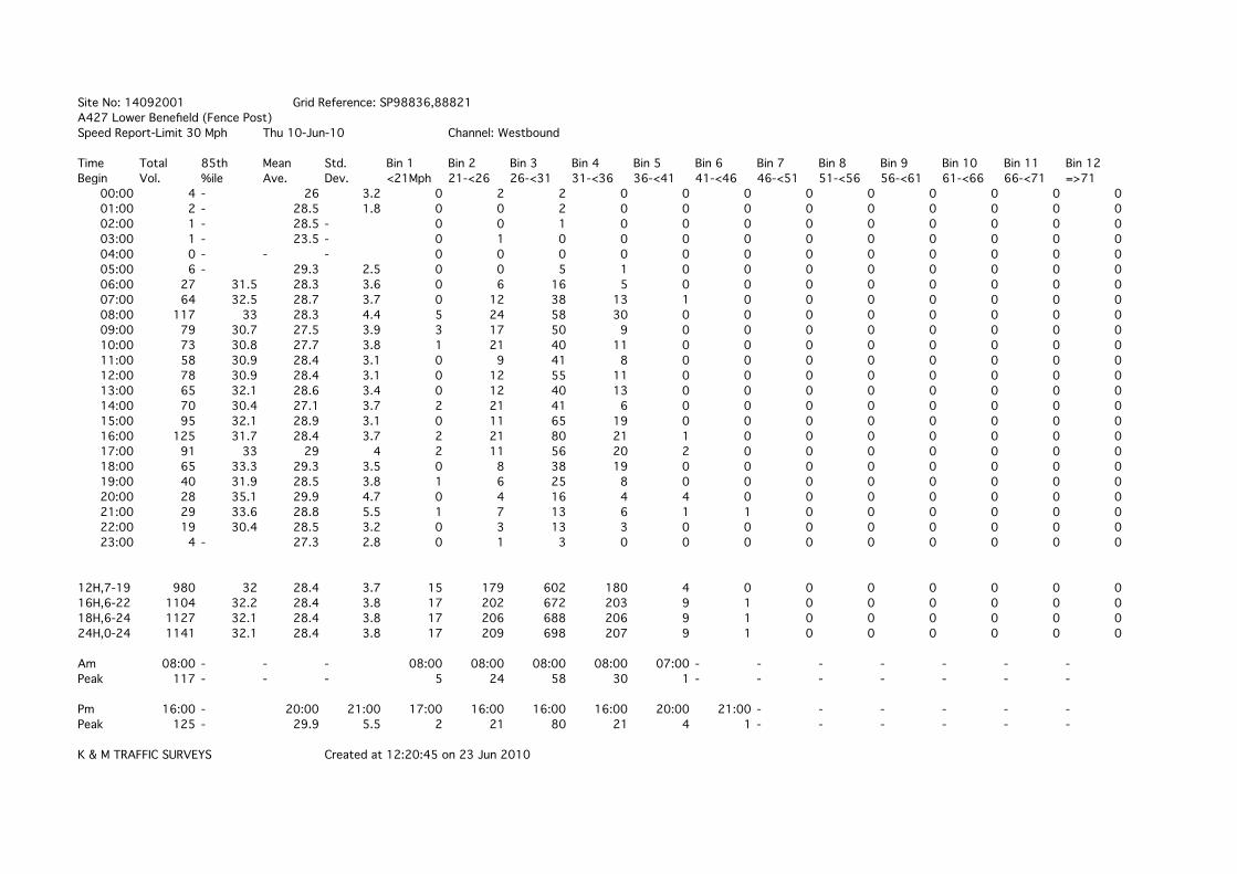
Site No: 14092001 Grid Reference: SP98836,88821A427 Lower Benefield (Fence Post)Speed Report-Limit 30 Mph Thu 10-Jun-10 Channel: Westbound
Time Total 85th Mean Std. Bin 1 Bin 2 Bin 3 Bin 4 Bin 5 Bin 6 Bin 7 Bin 8 Bin 9 Bin 10 Bin 11 Bin 12Begin Vol. %ile Ave. Dev. <21Mph 21-<26 26-<31 31-<36 36-<41 41-<46 46-<51 51-<56 56-<61 61-<66 66-<71 =>71
00:00 4 - 26 3.2 0 2 2 0 0 0 0 0 0 0 0 001:00 2 - 28.5 1.8 0 0 2 0 0 0 0 0 0 0 0 002:00 1 - 28.5 - 0 0 1 0 0 0 0 0 0 0 0 003:00 1 - 23.5 - 0 1 0 0 0 0 0 0 0 0 0 004:00 0 - - - 0 0 0 0 0 0 0 0 0 0 0 005:00 6 - 29.3 2.5 0 0 5 1 0 0 0 0 0 0 0 006:00 27 31.5 28.3 3.6 0 6 16 5 0 0 0 0 0 0 0 007:00 64 32.5 28.7 3.7 0 12 38 13 1 0 0 0 0 0 0 008:00 117 33 28.3 4.4 5 24 58 30 0 0 0 0 0 0 0 009:00 79 30.7 27.5 3.9 3 17 50 9 0 0 0 0 0 0 0 010:00 73 30.8 27.7 3.8 1 21 40 11 0 0 0 0 0 0 0 011:00 58 30.9 28.4 3.1 0 9 41 8 0 0 0 0 0 0 0 012:00 78 30.9 28.4 3.1 0 12 55 11 0 0 0 0 0 0 0 013:00 65 32.1 28.6 3.4 0 12 40 13 0 0 0 0 0 0 0 014:00 70 30.4 27.1 3.7 2 21 41 6 0 0 0 0 0 0 0 015:00 95 32.1 28.9 3.1 0 11 65 19 0 0 0 0 0 0 0 016:00 125 31.7 28.4 3.7 2 21 80 21 1 0 0 0 0 0 0 017:00 91 33 29 4 2 11 56 20 2 0 0 0 0 0 0 018:00 65 33.3 29.3 3.5 0 8 38 19 0 0 0 0 0 0 0 019:00 40 31.9 28.5 3.8 1 6 25 8 0 0 0 0 0 0 0 020:00 28 35.1 29.9 4.7 0 4 16 4 4 0 0 0 0 0 0 021:00 29 33.6 28.8 5.5 1 7 13 6 1 1 0 0 0 0 0 022:00 19 30.4 28.5 3.2 0 3 13 3 0 0 0 0 0 0 0 023:00 4 - 27.3 2.8 0 1 3 0 0 0 0 0 0 0 0 0
12H,7-19 980 32 28.4 3.7 15 179 602 180 4 0 0 0 0 0 0 016H,6-22 1104 32.2 28.4 3.8 17 202 672 203 9 1 0 0 0 0 0 018H,6-24 1127 32.1 28.4 3.8 17 206 688 206 9 1 0 0 0 0 0 024H,0-24 1141 32.1 28.4 3.8 17 209 698 207 9 1 0 0 0 0 0 0
Am 08:00 - - - 08:00 08:00 08:00 08:00 07:00 - - - - - - -Peak 117 - - - 5 24 58 30 1 - - - - - - -
Pm 16:00 - 20:00 21:00 17:00 16:00 16:00 16:00 20:00 21:00 - - - - - -Peak 125 - 29.9 5.5 2 21 80 21 4 1 - - - - - -
K & M TRAFFIC SURVEYS Created at 12:20:45 on 23 Jun 2010

Site No: 14092001 Grid Reference: SP98836,88821A427 Lower Benefield (Fence Post)Speed Report-Limit 30 Mph Fri 11-Jun-10 Channel: Westbound
Time Total 85th Mean Std. Bin 1 Bin 2 Bin 3 Bin 4 Bin 5 Bin 6 Bin 7 Bin 8 Bin 9 Bin 10 Bin 11 Bin 12Begin Vol. %ile Ave. Dev. <21Mph 21-<26 26-<31 31-<36 36-<41 41-<46 46-<51 51-<56 56-<61 61-<66 66-<71 =>71
00:00 6 - 27.7 2.5 0 1 5 0 0 0 0 0 0 0 0 001:00 0 - - - 0 0 0 0 0 0 0 0 0 0 0 002:00 1 - 33.5 - 0 0 0 1 0 0 0 0 0 0 0 003:00 1 - 33.5 - 0 0 0 1 0 0 0 0 0 0 0 004:00 1 - 28.5 - 0 0 1 0 0 0 0 0 0 0 0 005:00 11 33.3 29.9 3.5 0 1 6 4 0 0 0 0 0 0 0 006:00 20 32.5 29.5 3 0 1 14 5 0 0 0 0 0 0 0 007:00 74 32.4 28.6 3.5 0 14 44 16 0 0 0 0 0 0 0 008:00 102 30.5 27.2 3.6 1 34 57 10 0 0 0 0 0 0 0 009:00 82 30.8 27.4 3.7 1 26 44 11 0 0 0 0 0 0 0 010:00 81 31.9 28.4 3.8 0 18 48 13 2 0 0 0 0 0 0 011:00 88 31.8 28.6 3.5 0 16 56 15 1 0 0 0 0 0 0 012:00 99 32.3 28.5 3.6 0 21 57 21 0 0 0 0 0 0 0 013:00 85 30.5 27.6 3.6 1 22 54 7 1 0 0 0 0 0 0 014:00 143 30.8 27.8 3.9 3 34 87 17 2 0 0 0 0 0 0 015:00 86 32 28.6 3.8 0 18 52 13 3 0 0 0 0 0 0 016:00 112 30.8 27.7 3.8 0 36 61 13 2 0 0 0 0 0 0 017:00 89 32.9 29.2 3.3 0 10 57 22 0 0 0 0 0 0 0 018:00 59 34 30 3.6 0 5 32 21 1 0 0 0 0 0 0 019:00 43 32.7 28.8 4.5 1 7 26 6 3 0 0 0 0 0 0 020:00 32 30.6 29 3.3 0 3 24 4 1 0 0 0 0 0 0 021:00 26 33.6 29.5 4.3 0 4 15 5 2 0 0 0 0 0 0 022:00 14 31.7 28.5 3.7 0 3 8 3 0 0 0 0 0 0 0 023:00 16 32.4 27.6 4.4 0 7 5 4 0 0 0 0 0 0 0 0
12H,7-19 1100 31.7 28.2 3.7 6 254 649 179 12 0 0 0 0 0 0 016H,6-22 1221 31.8 28.3 3.7 7 269 728 199 18 0 0 0 0 0 0 018H,6-24 1251 31.9 28.3 3.7 7 279 741 206 18 0 0 0 0 0 0 024H,0-24 1271 31.9 28.3 3.7 7 281 753 212 18 0 0 0 0 0 0 0
Am 08:00 - - - 09:00 08:00 08:00 07:00 10:00 - - - - - - -Peak 102 - - - 1 34 57 16 2 - - - - - - -
Pm 14:00 18:00 18:00 19:00 14:00 16:00 14:00 17:00 19:00 - - - - - - -Peak 143 34 30 4.5 3 36 87 22 3 - - - - - - -
K & M TRAFFIC SURVEYS Created at 12:20:45 on 23 Jun 2010

Site No: 14092001 Grid Reference: SP98836,88821A427 Lower Benefield (Fence Post)Speed Report-Limit 30 Mph Sat 12-Jun-10 Channel: Westbound
Time Total 85th Mean Std. Bin 1 Bin 2 Bin 3 Bin 4 Bin 5 Bin 6 Bin 7 Bin 8 Bin 9 Bin 10 Bin 11 Bin 12Begin Vol. %ile Ave. Dev. <21Mph 21-<26 26-<31 31-<36 36-<41 41-<46 46-<51 51-<56 56-<61 61-<66 66-<71 =>71
00:00 3 - 28.5 5 0 1 1 1 0 0 0 0 0 0 0 001:00 5 - 29.5 4.4 0 1 2 2 0 0 0 0 0 0 0 002:00 3 - 28.5 1.7 0 0 3 0 0 0 0 0 0 0 0 003:00 2 - 31 3.5 0 0 1 1 0 0 0 0 0 0 0 004:00 2 - 26 3.5 0 1 1 0 0 0 0 0 0 0 0 005:00 7 - 32.1 4 0 0 3 3 1 0 0 0 0 0 0 006:00 10 31 29 3.2 0 1 7 2 0 0 0 0 0 0 0 007:00 26 31.6 27.5 4 0 10 11 5 0 0 0 0 0 0 0 008:00 51 33 29.2 3.6 0 7 31 12 1 0 0 0 0 0 0 009:00 92 32.7 27.6 5.1 8 19 44 20 1 0 0 0 0 0 0 010:00 79 32.7 28.5 4.1 2 15 44 17 1 0 0 0 0 0 0 011:00 103 30.9 28.1 3.7 1 22 66 12 2 0 0 0 0 0 0 012:00 93 33.2 29.6 3.6 1 5 63 22 1 1 0 0 0 0 0 013:00 84 33.5 29.5 3.6 0 10 50 22 2 0 0 0 0 0 0 014:00 86 33.2 29.5 3.8 1 6 58 17 4 0 0 0 0 0 0 015:00 69 34.4 30 4.1 0 9 34 22 4 0 0 0 0 0 0 016:00 76 33.3 28.9 4.3 2 12 42 18 2 0 0 0 0 0 0 017:00 51 31.9 28.7 3.6 1 6 34 10 0 0 0 0 0 0 0 018:00 45 33.9 29.3 4.6 0 11 18 15 0 1 0 0 0 0 0 019:00 34 33.8 28.7 5.1 1 8 16 6 3 0 0 0 0 0 0 020:00 26 31.6 28.1 4.2 1 5 15 5 0 0 0 0 0 0 0 021:00 19 30.2 27.7 2.9 0 4 14 1 0 0 0 0 0 0 0 022:00 14 33.4 29.2 4.1 0 3 6 5 0 0 0 0 0 0 0 023:00 19 29.7 26.4 3.4 0 9 9 1 0 0 0 0 0 0 0 0
12H,7-19 855 33.2 28.9 4.1 16 132 495 192 18 2 0 0 0 0 0 016H,6-22 944 33.1 28.8 4.1 18 150 547 206 21 2 0 0 0 0 0 018H,6-24 977 33.1 28.8 4.1 18 162 562 212 21 2 0 0 0 0 0 024H,0-24 999 33.1 28.8 4.1 18 165 573 219 22 2 0 0 0 0 0 0
Am 11:00 - 05:00 09:00 09:00 11:00 11:00 09:00 11:00 - - - - - - -Peak 103 - 32.1 5.1 8 22 66 20 2 - - - - - - -
Pm 12:00 15:00 15:00 19:00 16:00 16:00 12:00 15:00 15:00 18:00 - - - - - -Peak 93 34.4 30 5.1 2 12 63 22 4 1 - - - - - -
K & M TRAFFIC SURVEYS Created at 12:20:45 on 23 Jun 2010

Site No: 14092001 Grid Reference: SP98836,88821A427 Lower Benefield (Fence Post)Speed Report-Limit 30 Mph Sun 13-Jun-10 Channel: Westbound
Time Total 85th Mean Std. Bin 1 Bin 2 Bin 3 Bin 4 Bin 5 Bin 6 Bin 7 Bin 8 Bin 9 Bin 10 Bin 11 Bin 12Begin Vol. %ile Ave. Dev. <21Mph 21-<26 26-<31 31-<36 36-<41 41-<46 46-<51 51-<56 56-<61 61-<66 66-<71 =>71
00:00 10 31 28.5 4.9 0 3 5 1 1 0 0 0 0 0 0 001:00 2 - 31 3.5 0 0 1 1 0 0 0 0 0 0 0 002:00 1 - 28.5 - 0 0 1 0 0 0 0 0 0 0 0 003:00 1 - 28.5 - 0 0 1 0 0 0 0 0 0 0 0 004:00 1 - 28.5 - 0 0 1 0 0 0 0 0 0 0 0 005:00 4 - 31 3.2 0 0 2 2 0 0 0 0 0 0 0 006:00 3 - 31.8 3.1 0 0 1 2 0 0 0 0 0 0 0 007:00 10 33.5 29.5 4.2 0 2 4 4 0 0 0 0 0 0 0 008:00 15 38.1 31.5 6.1 0 2 7 2 3 1 0 0 0 0 0 009:00 24 31.9 26.6 5.5 3 7 9 5 0 0 0 0 0 0 0 010:00 56 30.6 27.6 4.2 3 10 37 5 1 0 0 0 0 0 0 011:00 72 31.7 28.1 3.8 1 17 41 13 0 0 0 0 0 0 0 012:00 97 33.3 28.7 4.2 1 22 48 24 2 0 0 0 0 0 0 013:00 68 31.2 28.5 3.6 1 9 47 10 1 0 0 0 0 0 0 014:00 66 31.3 28.1 3.5 0 16 39 11 0 0 0 0 0 0 0 015:00 66 32.8 29 3.7 0 10 41 13 2 0 0 0 0 0 0 016:00 56 35.7 30.9 4.9 0 5 29 14 6 2 0 0 0 0 0 017:00 36 32.3 29.1 3.2 0 4 24 8 0 0 0 0 0 0 0 018:00 35 30.3 27.2 3.4 0 12 20 3 0 0 0 0 0 0 0 019:00 27 31.5 28.3 3.6 0 6 16 5 0 0 0 0 0 0 0 020:00 25 33.3 29.1 4.2 0 5 13 6 1 0 0 0 0 0 0 021:00 15 29.9 26.4 4.2 1 5 8 1 0 0 0 0 0 0 0 022:00 8 - 28.5 4 0 2 4 2 0 0 0 0 0 0 0 023:00 1 - 28.5 - 0 0 1 0 0 0 0 0 0 0 0 0
12H,7-19 601 32.8 28.6 4.2 9 116 346 112 15 3 0 0 0 0 0 016H,6-22 671 32.7 28.6 4.1 10 132 384 126 16 3 0 0 0 0 0 018H,6-24 680 32.7 28.6 4.1 10 134 389 128 16 3 0 0 0 0 0 024H,0-24 699 32.8 28.6 4.1 10 137 400 132 17 3 0 0 0 0 0 0
Am 11:00 - 06:00 - 10:00 11:00 11:00 11:00 08:00 08:00 - - - - - -Peak 72 - 31.8 - 3 17 41 13 3 1 - - - - - -
Pm 12:00 - 16:00 - 21:00 12:00 12:00 12:00 16:00 16:00 - - - - - -Peak 97 - 30.9 - 1 22 48 24 6 2 - - - - - -
K & M TRAFFIC SURVEYS Created at 12:20:45 on 23 Jun 2010

Site No: 14092001 Grid Reference: SP98836,88821A427 Lower Benefield (Fence Post)Speed Report-Limit 30 Mph Mon 14-Jun-10 Channel: Westbound
Time Total 85th Mean Std. Bin 1 Bin 2 Bin 3 Bin 4 Bin 5 Bin 6 Bin 7 Bin 8 Bin 9 Bin 10 Bin 11 Bin 12Begin Vol. %ile Ave. Dev. <21Mph 21-<26 26-<31 31-<36 36-<41 41-<46 46-<51 51-<56 56-<61 61-<66 66-<71 =>71
00:00 3 - 26.8 5.9 0 2 0 1 0 0 0 0 0 0 0 001:00 3 - 28.5 5 0 1 1 1 0 0 0 0 0 0 0 002:00 3 - 26.8 3.1 0 1 2 0 0 0 0 0 0 0 0 003:00 0 - - - 0 0 0 0 0 0 0 0 0 0 0 004:00 1 - 33.5 - 0 0 0 1 0 0 0 0 0 0 0 005:00 6 - 30.2 4.3 0 0 5 0 1 0 0 0 0 0 0 006:00 24 30.1 27.7 2.8 0 5 18 1 0 0 0 0 0 0 0 007:00 60 30.7 27.8 3.6 0 17 34 9 0 0 0 0 0 0 0 008:00 102 30.7 27.7 3.5 0 29 61 11 1 0 0 0 0 0 0 009:00 68 30.5 27.8 3.1 0 15 47 6 0 0 0 0 0 0 0 010:00 54 32.1 28.8 3.3 0 8 35 11 0 0 0 0 0 0 0 011:00 70 31.4 28.2 3.8 2 11 45 12 0 0 0 0 0 0 0 012:00 61 31.7 28.5 3.6 0 12 38 10 1 0 0 0 0 0 0 013:00 80 32.5 29.2 3.1 0 7 55 18 0 0 0 0 0 0 0 014:00 69 31.8 28.3 3.9 2 11 43 13 0 0 0 0 0 0 0 015:00 86 32.4 28.3 3.8 0 22 46 17 1 0 0 0 0 0 0 016:00 121 33.5 29.6 3.4 0 12 72 36 1 0 0 0 0 0 0 017:00 119 33.4 29.3 3.6 0 15 71 31 2 0 0 0 0 0 0 018:00 73 33.4 29.6 3.5 0 6 47 18 2 0 0 0 0 0 0 019:00 37 31.8 28.7 3.9 1 4 25 6 1 0 0 0 0 0 0 020:00 28 33.9 29.8 4 0 4 14 9 1 0 0 0 0 0 0 021:00 20 34.1 29.3 4.9 0 5 9 4 2 0 0 0 0 0 0 022:00 14 32.8 28.1 4.4 0 5 5 4 0 0 0 0 0 0 0 023:00 1 - 33.5 - 0 0 0 1 0 0 0 0 0 0 0 0
12H,7-19 963 32.4 28.7 3.6 4 165 594 192 8 0 0 0 0 0 0 016H,6-22 1072 32.5 28.7 3.6 5 183 660 212 12 0 0 0 0 0 0 018H,6-24 1087 32.5 28.7 3.6 5 188 665 217 12 0 0 0 0 0 0 024H,0-24 1103 32.5 28.7 3.6 5 192 673 220 13 0 0 0 0 0 0 0
Am 08:00 - - - 11:00 08:00 08:00 11:00 08:00 - - - - - - -Peak 102 - - - 2 29 61 12 1 - - - - - - -
Pm 16:00 - 23:00 - 14:00 15:00 16:00 16:00 21:00 - - - - - - -Peak 121 - 33.5 - 2 22 72 36 2 - - - - - - -
K & M TRAFFIC SURVEYS Created at 12:20:45 on 23 Jun 2010

Site No: 14092001 Grid Reference: SP98836,88821A427 Lower Benefield (Fence Post)Speed Report-Limit 30 Mph Tue 15-Jun-10 Channel: Westbound
Time Total 85th Mean Std. Bin 1 Bin 2 Bin 3 Bin 4 Bin 5 Bin 6 Bin 7 Bin 8 Bin 9 Bin 10 Bin 11 Bin 12Begin Vol. %ile Ave. Dev. <21Mph 21-<26 26-<31 31-<36 36-<41 41-<46 46-<51 51-<56 56-<61 61-<66 66-<71 =>71
00:00 2 - 28.5 1.8 0 0 2 0 0 0 0 0 0 0 0 001:00 0 - - - 0 0 0 0 0 0 0 0 0 0 0 002:00 1 - 28.5 - 0 0 1 0 0 0 0 0 0 0 0 003:00 1 - 28.5 - 0 0 1 0 0 0 0 0 0 0 0 004:00 0 - - - 0 0 0 0 0 0 0 0 0 0 0 005:00 9 - 29.1 4.8 0 2 5 1 1 0 0 0 0 0 0 006:00 18 30.3 28.5 2.2 0 1 16 1 0 0 0 0 0 0 0 007:00 70 30.5 28.3 2.7 0 9 55 6 0 0 0 0 0 0 0 008:00 109 31.6 28.3 3.5 1 21 68 19 0 0 0 0 0 0 0 009:00 62 30.6 27.3 3.7 1 20 34 7 0 0 0 0 0 0 0 010:00 67 30.9 27.9 3.7 0 19 38 9 1 0 0 0 0 0 0 011:00 65 30.4 27.6 3.1 0 17 43 5 0 0 0 0 0 0 0 012:00 75 30.8 28 3.3 0 17 48 10 0 0 0 0 0 0 0 013:00 69 31.6 28 4.2 0 22 35 9 3 0 0 0 0 0 0 014:00 82 32.6 28.7 4.5 0 20 45 13 2 2 0 0 0 0 0 015:00 61 31.2 28.7 3.1 0 8 43 10 0 0 0 0 0 0 0 016:00 132 32.6 29.3 3.1 0 10 93 28 1 0 0 0 0 0 0 017:00 121 34 29.8 3.7 0 12 69 36 4 0 0 0 0 0 0 018:00 75 33.6 29.7 3.9 1 4 49 18 2 1 0 0 0 0 0 019:00 37 32.8 28.7 4.3 1 6 21 8 1 0 0 0 0 0 0 020:00 28 33.1 28.4 4.5 1 6 13 8 0 0 0 0 0 0 0 021:00 29 31.2 28.8 3 0 3 21 5 0 0 0 0 0 0 0 022:00 7 - 27.1 2.9 0 2 5 0 0 0 0 0 0 0 0 023:00 4 - 31 3.2 0 0 2 2 0 0 0 0 0 0 0 0
12H,7-19 988 32.1 28.6 3.7 3 179 620 170 13 3 0 0 0 0 0 016H,6-22 1100 32.1 28.6 3.7 5 195 691 192 14 3 0 0 0 0 0 018H,6-24 1111 32.1 28.6 3.7 5 197 698 194 14 3 0 0 0 0 0 024H,0-24 1124 32.1 28.6 3.7 5 199 707 195 15 3 0 0 0 0 0 0
Am 08:00 - - - 09:00 08:00 08:00 08:00 10:00 - - - - - - -Peak 109 - - - 1 21 68 19 1 - - - - - - -
Pm 16:00 - 23:00 14:00 20:00 13:00 16:00 17:00 17:00 14:00 - - - - - -Peak 132 - 31 4.5 1 22 93 36 4 2 - - - - - -
K & M TRAFFIC SURVEYS Created at 12:20:45 on 23 Jun 2010

Site No: 14092001 Grid Reference: SP98836,88821A427 Lower Benefield (Fence Post)Speed Report-Limit 30 Mph Wed 16-Jun-10 Channel: Westbound
Time Total 85th Mean Std. Bin 1 Bin 2 Bin 3 Bin 4 Bin 5 Bin 6 Bin 7 Bin 8 Bin 9 Bin 10 Bin 11 Bin 12Begin Vol. %ile Ave. Dev. <21Mph 21-<26 26-<31 31-<36 36-<41 41-<46 46-<51 51-<56 56-<61 61-<66 66-<71 =>71
00:00 0 - - - 0 0 0 0 0 0 0 0 0 0 0 001:00 1 - 28.5 - 0 0 1 0 0 0 0 0 0 0 0 002:00 0 - - - 0 0 0 0 0 0 0 0 0 0 0 003:00 1 - 28.5 - 0 0 1 0 0 0 0 0 0 0 0 004:00 1 - 23.5 - 0 1 0 0 0 0 0 0 0 0 0 005:00 7 - 28.5 3.2 0 1 5 1 0 0 0 0 0 0 0 006:00 23 32.7 29.8 2.7 0 0 17 6 0 0 0 0 0 0 0 007:00 69 31.5 28.1 4.1 2 14 41 11 1 0 0 0 0 0 0 008:00 108 32.7 28.8 3.7 0 19 65 22 2 0 0 0 0 0 0 009:00 72 31.3 28.2 3.7 0 18 42 11 1 0 0 0 0 0 0 010:00 79 30.9 27.8 3.8 2 18 48 11 0 0 0 0 0 0 0 011:00 85 30.6 27 3.9 1 34 40 9 1 0 0 0 0 0 0 012:00 59 32.9 28.3 4.2 1 15 28 15 0 0 0 0 0 0 0 013:00 80 31.2 27.8 3.9 2 19 46 13 0 0 0 0 0 0 0 014:00 97 31 27.5 3.9 1 33 48 15 0 0 0 0 0 0 0 015:00 79 30.8 27.6 3.9 3 17 49 10 0 0 0 0 0 0 0 016:00 128 32.5 29 3.5 0 16 84 27 0 1 0 0 0 0 0 017:00 117 32.7 28.8 3.8 4 10 76 27 0 0 0 0 0 0 0 018:00 96 33.7 29 4.6 5 11 49 30 1 0 0 0 0 0 0 019:00 35 30.3 28.1 2.7 0 5 28 2 0 0 0 0 0 0 0 020:00 29 33 28.8 4.2 1 4 16 8 0 0 0 0 0 0 0 021:00 25 31.8 28.3 3.7 0 6 14 5 0 0 0 0 0 0 0 022:00 9 - 26.3 3 0 4 5 0 0 0 0 0 0 0 0 023:00 10 32.7 28.5 4.3 0 3 4 3 0 0 0 0 0 0 0 0
12H,7-19 1069 32.2 28.2 3.9 21 224 616 201 6 1 0 0 0 0 0 016H,6-22 1181 32.2 28.3 3.9 22 239 691 222 6 1 0 0 0 0 0 018H,6-24 1200 32.1 28.3 3.9 22 246 700 225 6 1 0 0 0 0 0 024H,0-24 1210 32.1 28.3 3.9 22 248 707 226 6 1 0 0 0 0 0 0
Am 08:00 - - - 10:00 11:00 08:00 08:00 08:00 - - - - - - -Peak 108 - - - 2 34 65 22 2 - - - - - - -
Pm 16:00 - 16:00 18:00 18:00 14:00 16:00 18:00 18:00 16:00 - - - - - -Peak 128 - 29 4.6 5 33 84 30 1 1 - - - - - -
K & M TRAFFIC SURVEYS Created at 12:20:45 on 23 Jun 2010

APPENDIX D


APPENDIX E


APPENDIX F

Northamptonshire County Council
Development Control, Planning PO Box 163, County Hall Guildhall Road Northampton, NN1 1AX w. www.northamptonshire.gov.uk t. 01604 366119 f. 01604 366065 e. [email protected]
Dear Nathan, TOWN AND COUNTRY PLANNING (ENVIRONMENTAL IMPACT ASSESSMENT) (ENGLAND AND WALES) REGULATIONS 1999: REGULATION 10 SCOPING OPINION FOR PROPOSED CONSERVATION STONE QUARRY TO EXTRACT BLISWORTH LIMESTONE BLOCKSTONE, FLAGSTONE AND LARGE WALLING STONE AT STONEPITS QUARRY, BENEFIELD, OUNDLE, PE8 5AN I refer to your email dated 12 July 2012 and the accompanying scoping report. The scoping report has been the subject of consultation in accordance with the Environmental Impact Assessment (EIA) Regulations and copies of the responses received are attached for your information. Overall I can confirm that the approach that you are advocating in the scoping report is considered to be generally acceptable and appropriate and this is reflected in the nature of the consultation responses. You will note the specific points which have been made by the consultation bodies and you are required to have regard to these. In particular I would draw your attention to the following: Access, Highway Safety and Traffic Routing As discussed in the scoping report a full transport assessment would be expected to accompany any application for this proposal. Discussions have highlighted that traffic routing is an important issue to be addressed at the site. As you are aware, there are weight restrictions imposed on many of the roads around the proposed quarry site. An application would be required to identify a suitable route for the site traffic and address the potential impacts of these arrangements. Additionally, improvements to the site access and surrounding highway would be required to provide appropriate visibility splays and site access gradients as well as on-site signage. Full comments from the Highways Agency have also been attached for your information.
Mr Maddox GP Planning Limited The Stables Long Lane East Haddon Northampton NN6 8DU
Please ask for: Claire Spokes Tel: (01604) 366119 Our ref: 12/00003/SCO Your ref: Date: 12 September 2012

Cumulative Impacts The site is located in close proximity to a similar operation at Harley Way, Oundle therefore the EIA would be required to address the cumulative environmental and amenity impacts of having both sites operational; in particular the impacts of additional traffic movements on the highway network, including those proposed between the two sites. Public Rights of Way The site is located in close proximity to several Rights of Way. The EIA will require an assessment of the potential impacts on the Rights of Way close to the site and identify any mitigation measures required. Please have regard to potential enhancements to the Rights of Way network in association with this proposed development. Ecology/Biodiversity It is considered that ecology should be scoped in to the Environmental Impact Assessment. Detailed comments regarding ecological surveys and information have been provided by Natural England, the Wildlife Trust and Council’s Senior Environmental Planner. Any application should also address the Wildlife Trust’s comments regarding incorporation of Green Infrastructure and alternative restoration proposals. The potential for significant biodiversity enhancement at the site is also picked up in the response from Natural England and the Council’s Senior Environmental Planner. The EIA is required to address these responses which are attached for your information. Heritage Assets and Archaeology The site is located in close proximity to several heritage assets, including a Scheduled Ancient Monument, Grade II* listed building and a Conservation Area. The potential impacts on these assets should be assessed when bringing forward an application. Further guidance is contained within the attached response from English Heritage. The County’s Archaeology Advisor has advised a discussion to scope the required archaeological fieldwork is undertaken as soon as possible. Details can be found in the attached response. Landscape and Amenity Please refer to the comments of the Council’s Senior Environmental Planner and Natural England on this matter. In particular I note that the assessment of visual amenity should be undertaken using the most up-to-date published guidelines available. The Environmental Protection Officer and Planning Officer at East Northamptonshire Council has commented on the importance of assessments of potential air quality, dust and noise impacts from the proposed operations and additional traffic movements. The EIA should address these matters.

Flood Risk As identified in the Scoping Report, the Environment Agency has confirmed that the proposed site is located with flood zone 1, 2 and 3 and therefore a Flood Risk Assessment is required to be provided. Please refer to the Environment Agency’s letter for further guidance. Hydrology, Hydrogeology, Water Quality and Resources The Environment Agency has provided detailed guidance on information expected with regard to hydrology and hydrogeology and water quality/resources. Please refer to these comments directly. Planning Policy The Planning Policy Officer has advised that any forthcoming application is required to give a full explanation in the Planning Statement of how, as a non-allocated site, the proposals comply with Policy CMD4. Representation Responses A significant number of representations from local residents were received during the scoping consultation. . Redacted copies of these responses are attached for your information which include comments made about the environmental and amenity impacts of the proposed development. The EIA should take into account these comments. Please let me know if I can be of any further assistance. Yours sincerely
Claire Spokes Development Control Officer Encl: Responses from
1) Highway Authority 2) Natural England 3) Environmental Protection at ENC 4) Environment Agency 5) Planning at ENC 6) Wildlife Trust 7) NCC Senior Environmental Planner 8) English Heritage 9) NCC Archaeological Advisor 10) NCC Planning Policy 11) Redacted Representation Responses

Northamptonshire County Council
Development Management Engineer Riverside Housed Riverside Way Northampton NN1 5NX w. www.northamptonshire.gov.uk t. 01604 654331 f. 01604 654455 e. [email protected]
memo
Proposed Development: Conservation stone quarry at Stone Pits Quarry,
Benefield, Oundle Northamptonshire, PE8 5AN. Dear Claire. I refer to your scoping request dated 16th July and make the following observations:- That the site location grid reference 98826 88825 where the submitted speed survey report indicates that the section of highway is within a 30mph restricted speed limit, which would need to be addressed in the first instance to clarify the data received for appraisal.. In the first instance sight lines are to be formed either side of the site access for a distance of some 215.0m set back 4.5m from the channel line. However with the support of a revisited speed survey consideration can be given to reduce this need. I am aware from my site visit and the topography of the carriageway vertical and horizontal alignment vehicle visibility splays of 180.0m can be achieved in a Westerly direction and 120.0m can be achieved in a Easterly direction fro drivers emerging from the site onto the A427. Issues regarding the site access gradients to emerge onto the highway network where a maximum gradient of 1 in 40 shall be created for the first 30.0m from the channel line of the A427. The area of carriageway either side of the promoted access point would need to be reconstructed to introduce additional heavy traffic in this area. A routine agreement would need to be introduced to ensure that the vehicles turn left when leaving the site where the A427 Barnwell Road Oundle Bridge has an imposed weight restriction of 3.5 tonnes and the local road within Oundle have a 7.5m tonne weight restriction.
Continued....page 1 of 2........
To: Claire Spokes Your Ref 12/00003/SCO From: Terry Chapman NCC Ref: PL 4864 Date: 1st August 2012 cc:

Continued....page 2 of 2........
Therefore the only route available to connect to the A605 would be via Weldon A427 onto the A43 and utilising the A6116 and A14 to link to the A605 at Thrapston to allow drivers to travel towards Peterborough. A routine agreement, with appropriate road signs being erected within the curtilage of the site, to ensure that all drivers emerging from Stone Pit Quarry turn left onto the A427 to access the strategic County highway network. It will also be necessary to ensure that the minor route through to Brigstock from lower Benefield should not be used, where reduced widths and tight junctions would not be an alternative route to access the A6116.. A daily timed log shall be kept on an ongoing basis to record all vehicles attracted to the site and this log shall be maintained on an annual basis and be available for scrutiny at the request of the County Planning Authority. All operational vehicles arriving at and leaving the site shall be appropriately sealed so as to prevent material spillage, wind blow and dust nuisance. All operational vehicles leaving the site shall be cleansed of mud and all other debris to ensure that no material is deposited on the adopted highway, maintainable at public expense. Regarding the safe passage of pedestrian movement where the haul road will be created with the site bounded by the Red line noting that existing Public Rights of Way MG17, MG18 and MG27 are affected by the promoted development and trust that signing and measures are promoted to facilitate this need to maintain and protect the Rights of Way. . The advice is given without prejudice to the views which may be expressed by Northamptonshire County Council as Highway Authority, should an application be made.
Signed................T Chapman................
for Head of Transport, Highways and Infrastructure Northamptonshire County Council.

Swallows Tiles, Bookhurst Hill, Cranleigh, Surrey Transport Assessment
28