chuley road masterplan options report · pdf fileoptions report 2013 ... shop, learn, visit...
TRANSCRIPT

CHULEY ROAD MASTERPLAN
1
CHULEY ROAD MASTERPLANOPTIONS REPORT 2013
REP.BDP.002

2 JULY 2013

CHULEY ROAD MASTERPLAN
3
CONTENTS
1 introduction
2 background
3 vision ideas
4 spatial options
- land use
- spaces and routes
- parking
- flood mitigation
5 transport
6 consultation
Figure 1 - Aerial showing the masterplan site and wider context of Ashburton
AERIAL OF THE SITE
SITE BOUNDARY

4 JULY 2013
1introduction

CHULEY ROAD MASTERPLAN
5
INTRODUCTION
This report presents the Chuley Road Masterplan Vision and Options Study. It is intended as an interim update on progress and to obtain approval to proceed with presenting the first thoughts, ideas and options to the community.
The study presents the first ideas for the vision and objectives for the Chuley Road site and potential principles / options for the masterplan. Against each of the options or alternatives, we present an analysis based on technical feasibility, impact, viability, and the degree to which the vision/objectives are met.
Finally, recommendations are made for the next steps and specifically the proposed approach to consultation with the community and stakeholders.
MASTERPLAN STUDY BOUNDARY
Chul
ey R
oad
West Stre
et
Stonepark
Stonepark Crescent
Stat
ion
Yard
St Lawrence Lane Vealenia Terrace
Whistley Hill
Recreation
Ground
Parish Church
of St Andrew
A38
Rive
r Ash
Old
Totn
es R
oad
SITE BOUNDARY
Chul
ey R
oad
Stonepark
Stat
ion
Yard
Recreation Ground
Parish Church of St Andrew
A38
River A
shburn
SITE BOUNDARY

6 JULY 2013
2 background

CHULEY ROAD MASTERPLAN
7
The Baseline Report provides the full details of our initial investigations that have informed the ideas and options for the Chuley Road site. A number of the key messages are summarised in this section.
KEY CONSULTATION MESSAGES
A number of key themes came out of the initial stage of public and stakeholder consultation, and from our own investigations, that we would like to build upon to develop a shared vision for the site at Chuley Road:
• Ashburton is ‘a town for all reasons’ – it is a place where one can live, work, shop, learn, visit and enjoy.
• The Chuley Road site is the working heart of Ashburton - employment activities are important to the character and operation of the town.
• The functions of Ashburton are delicately balanced – Ashburton is currently performing well but there is a delicate balance between all the different functions as a place to live, work, shop, learn, visit and enjoy, with each activity complementing rather than competing.
• Ashburton is a sociable place with a strong community but existing community facilities, especially those for younger people and families, are in need of improvement.
• Ashburton is an historic town with a rich and interesting stannary and railway heritage, and there is lots of evidence of this on the Chuley Road site in the old railway buildings and Bulliver’s Way, the former railway line. However, these heritage assets are masked by the poor quality setting.
• Buildings, streets and places in Ashburton have a recognisable and special identity. The Chuley Road site has an important character as an industrial and historic employment area but many of the buildings, streets and spaces are of poor quality which detracts from the special character of the town.
• Ashburton is the ‘gateway to the National Park’, surrounded by and with views and connections to stunning hills, countryside and woody walks.
• TheChuleyRoadsitebenefitsfrom special environmental assets such as the River Ashburn, biodiversity, trees and woodlands, but these assets are hidden and coming under pressure; these natural resources should be enhanced. There are also issues with flood risk which should be alleviated.
• Ashburton relies on vehicle access but suffers from issues with congestion, pedestrian safety and a lack of parking availability. There is an opportunity for future development on the Chuley Road site to help alleviate problems.
senseof
place
PERSONAL
SOCIAL/CULTURAL
NATURALBUILT
WHAT GIVES ASHBURTON IT’S SENSE OF PLACE?

8 JULY 2013
SUMMARY OF SITE CONSTRAINTS
The Baseline Report presents the details of our findings for the existing strengths, weaknesses, issues and opportunities for the Chuley Road site.
While being in an exciting location in relation to the town and countryside, the site does have a wide range of constraints that will influence future development opportunities on the site and that have therefore shaped our thinking on options. In summary, these include:
• Land ownerships - the site is in a variety of different land ownerships and there are existing businesses on the site that should be protected.
• The lack of capacity of the local highways network to accommodate increases in traffic - the existing roads are narrow and constrained and future development must therefore not significantly increase movements on the network.
• Flood risk - almost all of the site falls within a zone of flood risk and there are certain areas that are of high risk.
• Infrastructure - there are a number pieces of major drainage infrastructure and utilities beneath the site that service the whole town. This would be extremely expensive to re-route and therefore constrains the amount and layout of development on certain sites.
• Scale - the existing scale of Ashburton constrains the scale of development that is appropriate on the site.
• Heritage - there are a number of heritage assets throughout the site that should be
preserved and the site is partially within a conservation area which again constrains the scale of development.
• There are trees and ecological features within the site and it is surrounded by sensitive countryside.
• There are existing residential properties in and around the site and their amenity must be protected.
West Stre
et Whistley Hill
KEY
Site boundary
Noise from A38
Flood risk zone (category 3)
Sun path
Building
Culvert
Existing site levels

CHULEY ROAD MASTERPLAN
9
LANDSCAPE & ECOLOGY
Stonepark
Stat
ion
Yard
Recreation Ground
Parish Church of St Andrew
A38
KEY
Site boundary
Scrub
River Ashburn
Amenity Green Space
Farmland
Grass
Woodland Tree Planting
Play Space
Churchyard
Building
Roadway
Hedgerows
Mature Trees
Tree Preservation Order (TPO)
TPO Group

10 JULY 2013
3 vision ideas

CHULEY ROAD MASTERPLAN
11
The key themes and messages given to us through consultation with the community and stakeholders can be translated into a series of clear objectives which form the emerging vision for the Chuley Road site. These are set out in the table below.
The following pages then illustrate the different type or style of place that Chuley Road could become. We propose to test the below vision and objectives with the community, and also the styles of place, to arrive at a shared vision.
CONSULTATION MESSAGE VISION - WHAT WILL CHULEY ROAD BECOME?
Ashburton is ‘a town for all reasons’ and the Chuley Road site is the working heart of the town
A A truly ‘mixed use’ place where a variety of different activities take place, including working, living and leisure
B A working place where existing businesses are supported and retained, and new employment opportunities are created
The functions of Ashburton are delicately balanced
C Activities on the Chuley Road site complement, connect with and support existing businesses and places in the town, including the town centre, neighbourhoods and Recreation Ground
D A series of activity nodes or destinations encourage people to circulate between the site and the town centre
Ashburton is a sociable place with a strong community
E A welcoming and accessible place that the whole community can enjoy
Ashburton has a rich and interesting history
F The site’s heritage is preserved and revealed by sensitive contemporary architecture
Ashburton has a recognisable and special identity
G A special place that reflects the character and quality of Ashburton
Ashburton is an important ‘gateway to the National Park’
H A place that connects with the surrounding countryside by creating strong pedestrian routes and green links through the site
Ashburtonbenefitsfromspecialenvironmental assets but these assets are hidden and coming under pressure
I The distinctive environmental qualities of the area are conserved and better revealed.
J Existing flooding issues and the risk of flooding are alleviated through the location and type of land uses, design of buildings and design of external spaces
Ashburton relies on vehicle access , but suffers from issues with congestion, pedestrian safety and a lack of parking availability
K Traffic movements to and from the site are eased
L A place that provides a safe and attractive environment for pedestrians
M The essential parking needs of future development are met on the site and parking issues in the town alleviated

12 JULY 2013
THE WORKING HEART OF ASHBURTON
We understand the role of Chuley Road as an important historic employment area, sometimes referred to as ‘the working heart of Ashburton’. It is a place that provides valuable local businesses and employment.
Supporting existing businesses and creating an environment where new businesses can thrive is a core objective for the Chuley Road vision. However, as shown by the adjacent images, the current nature of the light industrial businesses on the site produces a poor quality environment that detracts from the visual aesthetic of Chuley Road and Ashburton.
There is an exciting opportunity here to create new employment opportunities, within a high quality environment. Some thoughts on the type of place that might be achieved are presented on the following pages.

CHULEY ROAD MASTERPLAN
13

14 JULY 2013
WHAT TYPE OF PLACE WILL CHULEY ROAD BECOME?
IDEA 1 - AN INNOVATIVE COMMERCIAL qUARTER
The site could be transformed into an innovative commercial quarter, with a cluster of small businesses which draw on the existing character of Station Yard. It could be a place that provides modern and flexible business spaces, places for start up businesses, a food hall, restaurants and flexible events spaces where businesses can showcase their offer and invite the community and visitors to join in. The style would draw on the railway heritage, existing commerce and light industrial character to create a modern working and living environment. Some examples of similar places include:
ROUNDFOUNDRY, LEEDS
A former engineering works that has been transformed into a Media Centre, which provides office space for creative and digital media companies, as well as restaurants, bars and cafés set in a number of courtyards that try to retain as much of the character of the old foundry as is possible.
GOODS SHED, CANTERBURY
The Goods Shed opened in 2002 as a daily farmers market with on site restaurant using the local market produce. Its evolution to include a ‘food hall’ reaching further afield to stock a fuller, more complete shop – has in turn lead to a greater turnover of fresh local produce and more British Cottage industries being bought to the consumer.
PAINTWORKS, BRISTOL
Paintworks is a development on the South East side of Bristol, based on the renovation of former warehouses to form Bristol’s New Creative Quarter. Paintworks is now a thriving community of small to medium sized design and media businesses, with place to work, live, restaurants, bars and events spaces, and hotels.
BRUNEL’S OLD ENGINE SHED, BRISTOL
The passenger shed of one of the oldest train stations provides a venue for events such as food markets, functions and exhibitions and in doing so maintains the life of this majestic building into one that is used and appreciated by the community of Bristol.
WHAT IS IT ABOUT THE SITE THAT INSPIRES THIS IDEA?

CHULEY ROAD MASTERPLAN
15
Paintworks, Bristol
The Goods Shed, Canterbury
Round Foundary, Leeds
EXAMPLES OF CREATIVE COMMERCIAL qUARTERS
Brunel Old Station

16 JULY 2013
IDEA 2 - A GREEN COMMUNITY AND BUSINESS qUARTER
Building on the National Park location and countryside setting of the site, Chuley Road could become a sustainable living and working quarter providing a natural integration between Ashburton town centre and the surrounding rural hinterland. The place could reflect the special qualities of the National Park within natural, low carbon environment for live, work and play.
THE PARK, FINDHORN
A pioneering Scottish ecovillage since 1985. Findhorn is well-known for its courses and ecological, social, and spiritual information sources. There is information on eco-building, renewable energy, organic food production, ecovillage education and much more.
ACCORDIA, CAMBRIDGE
Accordia created a sustainable new residential living quarter on a brownfield site set within a natural park setting. The contemporary design reflects the changing aspirations of modern lifestyles whilst respecting the strong tradition of domestic architecture in Cambridge. Houses are centred on communal gardens and align streets with discreet parking where pedestrians and bicycles have been given priority.
HOCKERTON HOUSING, NEWARK
Hockerton Housing Project is a self-sufficient housing development. The houses are designed to fit seamlessly within their rural setting and to minimise the impact which they have upon the environment. The houses use high levels of installation to eliminate the need for heating systems and solar panels to generate their own energy.
WHAT IS IT ABOUT THE SITE THAT INSPIRES THIS IDEA?

CHULEY ROAD MASTERPLAN
17
The Park, Findhorn
The Park, Findhorn
Hockerton Housing, Newark
Accordia, Cambridge
EXAMPLES OF GREEN COMMUNITIES

18 JULY 2013
IDEA 3 - A RIVERSIDE DESTINATION
Water is a significant feature of the site for positive and negative reasons. Drawing on the asset of the River Ashburn and the associated flood plain, Chuley Road could become a unique visitor destination which promotes the waterside location in the design of development, spaces and in the environment created. The river would become a central focus rather than an incidental, addressed by new living and working spaces, and with parks and soft landscaping providing water features, flood mitigation and planting that thrives in wet environments.
ARKADIEN WINNENDEN, GERMANY
Transforming an old industrial factory site the Arkadien Winnenden provides a people friendly and climate adapted landscape. Flooding is managed throughout the development through a series of ponds, swales and sloping contours which are play areas when dry and flood retention areas during heavy downpours.
HAVEN HOUSING, NORFOLK BROADS
The haven Housing in the Norfolk Broads provides flood resistant homes in a contemporary style. The housing is designed to complement the riverside setting, breaking down the barrier and providing an interaction between land and water.
WHAT IS IT ABOUT THE SITE THAT INSPIRES THIS IDEA?

CHULEY ROAD MASTERPLAN
19
Arkadien Winnenden, Germany Arkadien Winnenden, Germany
Arkadien Winnenden, Germany
Arkadien Winnenden, Germany
Haven Housing, Norfolk Broads
Brunel’s Old Engine Shed Bristol
Brunel’s Old Engine Shed Bristol
EXAMPLES OF RIVERSIDE DESTINATIONS
Freiburg, Germany

20 JULY 2013
4 spatial options

CHULEY ROAD MASTERPLAN
21
On the basis of the draft vision and objectives, we have developed a series of options for the future development of the site. These options are appraised for their technical feasibility, impact, viability, and the degree to which they achieve the draft objectives.
Options or alternatives have been developed for the following:
• Landuses
• Vehicleaccess
• Spacesandroutes
• Parking
• Floodmitigation
The options are presented and appraised in the following pages.

22 JULY 2013
LAND USES
We have developed a number of ideas for the broad zoning of land uses within the site. There are four overarching layout ideas that show alternatives for the amounts of residential land, amounts of mixed use land, and amount and location of industrial employment uses. These spatial options are based on the assumption that a linear zone of parking is provided along the south eastern part of the site. It should be noted that any alteration to the parking location and form will have an implication for the land use zoning.
The options are presented on the following pages, with a commentary on the advantages and disadvantages. At the end of the section each option is scored against a variety of criteria.
OPTION 1
The adjacent diagram shows land use option 1 which maximises the provision of mixed use (employment, leisure, retail) and residential development. It comprises the following:
• Approximately 80 residential units
• Approximately 3900 m2 Gross Floor Area (GFA) of new mixed use floorspace
• Retention of existing commercial premises in Station Yard, and the listed building
• Alternative uses for the existing Auction House and Engine Shed
Key observations
• Maximising residential opportunities is critical to ensuring viability, incentivises landowners to implement the proposals, and improves the potential of meeting affordable housing need (or a proportion thereof ).
• Residential on site C creates a good quality
environment that reinforces the existing adjoining neighbourhood.
• Additional residential in close proximity to town centre supports the economy and reinforces day and night activity.
• Retains buildings of heritage significance and enhances their settings with sensitive new development and public spaces, and the removal of poorer quality buildings.
• Potential to establish a mixed use gateway and cluster of small and creative businesses in sites D and E, which is well related to and walkable from the town centre.
• The mixed activities can share parking with other uses, especially during the evening.
• Improvements to the conservation area and its setting by the removal of poorer quality
buildings and the creation of good quality buildings and public realm.
• Lower risk land uses (e.g. employment) within areas most vulnerable to flooding.
• Low noise generating ‘neighbourly’ activities are proposed.
However:
• A change of use would require the displacement of existing businesses and land assembly.
• Residential on site F would be less desirable due to location adjacent to A38.
• Affects the historic light industrial character of the site.
• Long stay parking vehicles travel through the length of the site for access.
KEY
Residential
Mixed use (employment, leisure, residential)
Green / community space
Parking
A
B
C
D
F
E
G
OPTION 1

CHULEY ROAD MASTERPLAN
23
OPTION 2
The adjacent diagram shows land use option 2 which retains the existing light industrial and commercial premises in the centre of the site, as well as providing new mixed use (employment, leisure, retail) and residential development. It comprises the following:
• Approximately 80 residential units
• Approximately 1320 m2 GFA new mixed use floorspace
• Retention of existing commercial premises in Station Yard, listed building, Umber Works, and the Engine Shed
• Retention of existing light industrial premises and parking in the centre of the site
• Alternative uses for the existing Auction House
Key observations
This option largely demonstrates the flexibility for the masterplan to provide for existing businesses in the north central part of the site to be retained. The observations in relation to residential uses are as per Option 1, in addition to:
• The area benefits from retention of the light industrial character of the site.
• A larger proportion of existing businesses and employment land are retained. Land assembly and relocation of existing businesses would not be required.
• The light industrial use has a relatively low vehicle movement generation relative to residential use.
However:
• Retention of existing industrial uses is likely to impact on the market appetite and desirability of the alternative uses proposed.
• Retention of industrial / employment uses in their current location limits the potential to create a modern business cluster that builds on existing creative businesses in Station Yard, and maximises use of the river and green links to the town centre.
• It also limits the potential to create a new public space or activity node within site D.
• The Old Engine Shed is retained but it’s setting continues to be compromised by the relationship to the light industrial businesses.
• Larger vehicles must use Chuley Road to access the light industrial businesses and turning space provided, thereby having a negative impact on local highways and neighbours.
KEY
Residential
Mixed use (employment, leisure, residential)
Light industrial
Green / community space
Parking
A
B
C
DF
E
G
OPTION 2

24 JULY 2013
OPTION 3
The adjacent diagram shows land use option 3 which relocates or provides new light industrial and commercial premises in the north east of the site, as well as providing new mixed use (employment, leisure, retail) and residential development. It comprises the following:
• Approximately 50 residential units
• Approximately 3900 m2 GFA new mixed use floorspace
• Retention of existing commercial premises in Station Yard and the listed building
• Relocation / re-provision of existing light industrial to site F
• Alternative uses for the existing Auction House (site B) and the Engine Shed
Key observations
This option largely addresses issues with the desirability of residential in site F, the loss of employment land and the loss of existing light industrial uses which contribute to the historic character of the area.
The key observations are as per Option 1 for residential on site C and mixed use environment on sites D and E, in addition to:
• Re-provides an element of the historic light industrial character of the site in an area where it is appropriately located adjacent to the A38 on the least desirable residential land.
• Maintains employment use of site F, which may also help to facilitate or unlock the proposals for mixed use development on site D.
• The light industrial use location and access point takes vehicles away from the main through route at a point close to the site entrance.
However:
• Provision of industrial uses is likely to impact on the market appetite and desirability of the adjacent residential premises.
• Larger vehicles must use Chuley Road to access the light industrial businesses and turning space provided, thereby having a negative impact on local highways and neighbours.
• May not provide the landowner with sufficient incentive to redevelop.
• Industrial development would not maximise the residential potential of the study area
given that the site is one of only two areas situated in an area of low flood risk, and the only site outside the flood plain.
KEY
Residential
Mixed use (employment, leisure, residential)
Light industrial
Green / community space
Parking
A
C
D
F
E
G
OPTION 3
B

CHULEY ROAD MASTERPLAN
25
OPTION 4
The adjacent diagram shows land use option 4 which relocates or provides new light industrial and commercial premises in the south central part of the site, as well as providing new mixed use (employment, leisure, retail) and residential development. It comprises the following:
• Approximately 80 residential units
• Approximately 3900 m2 GFA new mixed use floorspace
• Retention of existing commercial premises in Station Yard and the listed building
• Relocation / re-provision of existing light industrial to site C (re-using an existing building)
• Alternative uses for the existing Auction House and Engine Shed
Key observations
The key observations are as per Option 1 for the mixed use environment on sites D and E, and residential on site F, in addition to:
• Provides light industrial uses within existing commercial units on site C, thereby retaining a proportion of the existing employment use and maintaining the light industrial character of the area.
• Allows site F to be maximised for residential development on the only site outside the flood plain.
• Creates a mixed use environment to the south, thereby maintaining the mixed character of the site.
However:
• Provision of industrial uses is likely to impact on the market appetite and desirability of the adjacent residential premises on site C.
• Industrial development would not maximise the residential potential of site C given that the site is one of only two areas situated in an area of low flood risk.
• Larger vehicles must use Chuley Road to access the light industrial businesses and turning space provided, thereby having a negative impact on local highways and
neighbours.
• The light industrial use location, while using an existing building, reduces the amount of land available for parking.
• May not provide the landowner with sufficient incentive to redevelop.
KEY
Residential
Mixed use (employment, leisure, residential)
Light industrial
Green / community space
Parking
A
C
DF
E
G
OPTION 4
B

26 JULY 2013
MIXED USE SUB-OPTIONS
We have also developed different ideas for the mixed use zone which form sub-options. It should be noted that any alteration to the location and form of the mixed use zone will have an implication for other land uses.
(5) MIXED USE SUB OPTION A
The adjacent diagram shows mixed use sub option A (5) which provides:
• Approximately 75 residential units
• Approximately 4200 m2 GFA new mixed use floorspace
• Retention of existing commercial premises in Station Yard, and the listed building
• Alternative uses for the existing Auction House and Engine Shed
• Employment led mixed use on site B
Key observations
The key observations are as per Option 1 for the mixed use environment on sites D and E, in addition to:
• Provides a rich mix of uses and an invaluable opportunity to develop a cluster of small and innovative businesses, building on the success of existing businesses such as Greymatter.
• The commercial feasibility of developing new office in Ashburton is however challenging and it is important that mixed use developments are created that potentially include offices but also some high value generating uses such as retail, restaurants and residential to assist viability.
• Whilst Ashburton has a reasonably strong
daytime retail economy, and is busy with visitors and shoppers during most of the year, the town is significantly quieter during the evening hours. Encouraging more evening based businesses, such as restaurants and cultural facilities, will help to address this imbalance.
• The area potentially provides an attractive environment for restaurants and cafés, which would maximise the river front and green linkages providing a significantly improved impression and gateway to the town (especially in light of the location indicated for new town centre car parking).
However:
• The area is in a mix of ownerships and therefore site assembly could be complex and costly.
KEY
Residential
Mixed use (employment, leisure, residential)
Green / community space
Parking
A
B
C
D
F
E
G
OPTION 5
CHULEY ROAD MASTERPLAN
27
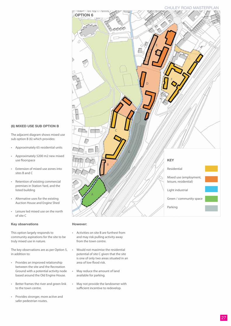
(6) MIXED USE SUB OPTION B
The adjacent diagram shows mixed use sub option B (6) which provides:
• Approximately 65 residential units
• Approximately 5200 m2 new mixed use floorspace
• Extension of mixed use zones into sites B and C
• Retention of existing commercial premises in Station Yard, and the listed building
• Alternative uses for the existing Auction House and Engine Shed
• Leisure led mixed use on the north of site C
Key observations
This option largely responds to community aspirations for the site to be truly mixed use in nature.
The key observations are as per Option 5, in addition to:
• Provides an improved relationship between the site and the Recreation Ground with a potential activity node based around the Old Engine House.
• Better frames the river and green link to the town centre.
• Provides stronger, more active and safer pedestrian routes.
However:
• Activities on site B are furthest from and may risk pulling activity away from the town centre.
• Would not maximise the residential potential of site C given that the site is one of only two areas situated in an area of low flood risk.
• May reduce the amount of land available for parking.
• May not provide the landowner with sufficient incentive to redevelop.
KEY
Residential
Mixed use (employment, leisure, residential)
Light industrial
Green / community space
Parking
A
B
C
DF
E
G
OPTION 6

28 JULY 2013
RETAIL SUB-OPTIONS
In considering the type of activities that will go into the mixed use zone, there are a number of alternatives. We envisage that the mixed use zone will retain existing businesses, provide space for new businesses and start ups, and living accommodation at upper floors. The main alternatives are for the use of the Station Garage site to the north which is at a key arrival point to the site and intersection with the town centre.
Based on the feedback from consultation our ideas for this part of the site are either for a small food store or restaurant / food hall similar to the Goods Shed in Canterbury. There is however also the potential for a small food store to be located on the site to the north east.
These alternatives can be combined with the four different land use options (e.g. different amounts of residential and light industrial). It should be noted that any alteration to the location of retail will have an implication for other land uses.
(7) RETAIL SUB-OPTION A
The adjacent diagram shows retail sub option A (7) which provides:
• Up to 80 residential units
• Approximately 3350 m2 GFA new mixed use floorspace
• Retention of existing commercial premises in Station Yard, and the listed building
• Small food store located on the Station Garage site E (circa 450m2 GFA)
• Allows for either residential or light industrial uses on site F
• Allows for either mixed use or light industrial businesses to be retained in the central site D
Key observations
This option addresses the commercial advice for the mixed use areas to include value generating uses, such as retail, and the message from many community respondents that there is a desire for a small foodstore in Ashburton.
• An anchor retail use on the Station Garage site will encourage foot fall along St Lawrence Lane and ultimately help to create a new retail circuit in the town. Ashburton’s independent retail offer is strong and should be preserved to ensure that Asburton retains its unique appeal but the town has a limited convenience offer. It is therefore likely that a reasonably large proportion of residents will travel out of Ashburton for their weekly grocery shop and the Chuley Road site provides an opportunity to create an appropriate sized convenience offer, which would not damage the town’s character and
disrupt the equilibrium of the independent shops.
However:
• While our commercial advisors believe Ashburton can support a small foodstore, there is the perception among parts of the community that it will impact on existing independent traders.
• Potential increase in vehicular movements to and from the site.
• There is limited space for parking directly associated with the foodstore.
A
B
C
D
F
E
G
OPTION 7
KEY
Mixed use (employment, leisure, residential)
Potential small food store

CHULEY ROAD MASTERPLAN
29
(8) RETAIL SUB-OPTION B
The adjacent diagram shows retail sub option B (8) which provides:
• Up to 50 residential units
• Approximately 3900m2 GFA new mixed use floorspace
• Retention of existing commercial premises in Station Yard, and the listed building
• Small food store located on site F (circa 450m2 GFA)
• Allows for either mixed use or light industrial businesses to be retained in the central site D
Key observations
The key observations are as per Option7, in addition to:
• Puts a value generating use on site where residential would be less desirable due to location adjacent to A38.
• There is space to provide a good amount of parking directly associated with the foodstore.
However:
• Location of retail is more peripheral to the town centre and there is therefore greater risk of negative impacts on existing businesses in the town centre, particularly if associated parking is overprovided.
• Retail development would not maximise the residential potential of the study area given that the site is one of only two areas situated in an area of low flood risk, and the only site outside the flood plain.
• May not provide the landowner with sufficient incentive to redevelop.
A
B
C
DF
E
G
OPTION 8
KEY
Mixed use (employment, leisure, residential)
Potential small food store
Residential
FD

30 JULY 2013
(9) RETAIL SUB-OPTION C
The adjacent diagram shows retail sub option C (9) which provides:
• Up to 80 residential units
• Approximately 2580 m2 GFA new mixed use floorspace
• Retention of existing commercial premises in Station Yard, and the listed building
• Small food store located on site E (circa 450m2 GFA)
• Allows for a food hall / restaurant use on the Station Garage site E
• Allows for either mixed use or light industrial businesses to be retained in the central site D
Key observations
The key observations are as per Option 7, in addition to:
• Allows for an alternative use of Station Garage, for example for a value generating food hall / restaurant use, alongside a small foodstore, which would create a vibrant mix of uses and an exciting gateway at the northern end of the site.
• There is space to provide a good amount of parking directly associated with the foodstore.
• Provides the landowner with greater incentive to redevelop.
However:
• While our commercial advisors believe Ashburton can support a small foodstore, there is the perception among parts of the community that it will impact on existing independent traders.
KEY
Mixed use (employment, leisure, residential)
Potential small food store
A
B
C
DF
E
G
OPTION 9

CHULEY ROAD MASTERPLAN
31
SPACES & ROUTES
In addition to options for the type and spatial arrangement of different land uses, there are also potential alternatives for the type, form and location of different spaces within the site.
The overarching objectives of the vision from section 3 are to provide:
• Activities on the Chuley Road site complement, connect with and support existing businesses and places in the town, including the existing town centre, neighbourhoods and Recreation Ground
• A place that connects with the surrounding countryside by creating strong pedestrian routes and green links through the site
The adjacent diagram illustrates how these objectives can be achieved by providing a strong network of pedestrian routes throughout the site, connecting to surrounding destinations and attractors.
In addition, there are overarching objectives in the vision to establish:
• A series of activity nodes or destinations encourage people to circulate between the site and the town centre
• A welcoming and accessible place that the whole community can enjoy
• New places where the community can meet and congregate
There is however competition for space within the masterplan area for the different land uses and also for additional car parking, which the community has identified as a key aspiration for the site. The following sub-options demonstrate alternatives for external spaces within the site.
KEY
Pedestrian routes
Existing attractors
Potential green space
Potential hard public space
Parking
OPTION 10
(10) SPACES SUB-OPTION A
The above diagram shows spaces sub-option A (10) which provides:
• A ‘gateway’ space in the north of the site
• A central public space associated with the Old Engine House
• A strip of long stay public car parking (circa 180 spaces) in the south of the site
• A green space to the far south
Key observations
This option addresses the request from the community to provide town centre car parking within the site, in what would be proposed as long stay provision.
• Provides a series of destinations throughout the site.
• Creates a high quality gateway announcing arrival to the site and connecting the mixed use zone to the town centre, encouraging pedestrians to circulate.
• Provides good connections to and improves accessibility of the Recreation Ground.
• Provides an improved setting for the Old Engine Shed.
• The green space to the south retains a buffer between the site and the countryside and could become a community managed space.
• Helps alleviate parking issues within the town by distributing long stay parking to the site.

32 JULY 2013
KEY
Pedestrian routes
Existing attractors
Potential green space
Potential hard public space
Parking
OPTION 11
(CONTINUED) However:
• The setting of the Engine Shed is affected by being surrounded to the south by car parking.
• The car parking results in the loss of Bulliver’s Way (the former railway line), the natural environment along this route and does not maximise the opportunity to create strong green linkages between the town centre (via the Recreation Ground) and the countryside.
• The car parking does not take advantage of the opportunity to make the River Ashburn a feature of the site.
(11) SPACES SUB-OPTION B
The adjacent diagram shows spaces sub-option A (11) which provides:
• A ‘gateway’ space in the north of the site
• A central public space associated with the Old Engine House
• Long stay public car parking (circa 70 spaces) in the centre of the site
• A green space to the far south of the site
Key observations
This option addresses the request from the community to provide town centre car parking within the site, but also the objectives of the vision to provide green linkages, preserve and better reveal heritage, and ensure the site is interconnected with the surroundings.
Key observations are as per option 9 in relation to the public spaces, in addition to the
following:
• The linear green space retains and better reveals the historic Bulliver’s Way and the River Ashburn, creating an attractive natural walking environment.
• The site seamlessly connects the town centre (via the Recreation Ground) to the wider countryside.
• Parking located in the north of the site limits vehicle movements through the remainder of the site.
• The linear green space provides a substantial increase to soft surfacing on the site, allowing infiltration of water into the ground and helping to avoid flooding. Natural features can be considered (such as Swales) which could further alleviate issues.
• The setting of the Old Engine Shed is substantially enhanced by the addition of the linear green space along Bulliver’s Way can be designed to form a heritage trail through to the Old Engine Shed and Station Garage, revealing the railway heritage of the site and providing a visitor attraction.
However:
• Parking in the north is less suitable for long term use and short term use would cause a substantial rise in vehicle movements to and through the site. It will also displace parking required for new developments.
• Parking in the north limits opportunities to improve the setting of the conservation area and listed buildings, and the ability to provide a good quality public space in this part of the site.

CHULEY ROAD MASTERPLAN
33
FLOOD MITIGATION
INTRODUCTION
The Baseline Report highlighted the fact that two main rivers cross the study area and almost all of the site falls within a zone of flood risk and there are certain areas that are of high risk.
A flood risk assessment (FRA) is being prepared in parallel with the masterplanning study. It is looking at the implications of a 1 in 100 year storm on the Chuley Road site.
The preliminary findings of the assessment are being used to inform the re development op-tions. In summary the key issues are
• Balland Stream culvert has limited capacity and is prone to blockage.
• During the 1 in 100 year event the River Ashburn breaks its banks upstream of the town centre resulting in overland flows which follow the topography of the valley bottom resulting in flooding to varying degrees of the Chuley Road site.
MITIGATION OPTIONS
A number of measures have been discussed with the FRA specialists and the Environment Agency (EA) to see how the masterplanning can help mitigate the risk. These are indicated on the adjoining diagram and can be summarised as follows:
Intercept overland flows from the town centre and find a way of getting them back into the riv-er. Either by regrading ground levels to deflect flows (not very practical given the constraint of existing streets and properties) or introducing drainage channels to capture flows and sink into drainage system (prone to blockage by debris).
Increase capacity of Balland stream culvert ei-ther by creating a new relief culvert or providing
a new open channel (EA preferred). Both these alternatives have a marked impact on develop-able area as does the line of the existing culvert.
Retain the existing bridge to the Tucker’s site as it creates a useful attenuation feature mitigating problems down stream.
Regrade the river channel profile to reduce flood risk either side of river.
Retain existing green space as it is prone to waterlogging, particularly from run off from Chuley Hill which crosses the site in the form of a stream course.
In addition to the above measures, the FRA is suggesting that development control can also alleviate risk ensuring susceptible land uses such as residential are not located in areas proned to flooding. It may be possible to include residen-tial above commercial premises in a mixed use
arrangement but consideration will need to be given to emergency access and egress.
A do nothing option needs further discussion as the the floodplain is already predominantly hardstanding and most of the problems are upstream of Chuley Road. Arguably these are town wide issues requiring a wider programme of mitigation measures which can only be ad-dressed with some central government funding.
In conclusion there is no doubt that flooding is a significant constraint on the masterplan. The existing infrastructure restricts where new de-velopment can go and the mitigation measures will clearly effect the nature, extent and viability of the redevelopment.
KEY
1. Intercept overland flow
2. New relief culvert option
3. New relief channel option
4. Retain Bridge
5. Increase capacity of river channel
6. Retain as green space

34 JULY 2013
SCORING OF SPATIAL OPTIONS
We have appraised the different land use and spatial options against a variety of criteria and have scored each option from 1 - 3 against each, based on the following:
1 - Performs poorly
2 - Acceptable
3 - Performs well
OPTION 1 OPTION 2
OPTION 3 OPTION 4 OPTION 5
OPTION 6 OPTION 7 OPTION 8
OPTION 9 OPTION 10 OPTION 11

CHULEY ROAD MASTERPLAN
35
1 2 3 4 5 6 7 8 9 10 11
Diversity of uses 2 3 3 3 2 3 2 2 3 2 2Number of dwellings 3 3 2 2 3 2 3 2 2 2 2Ability to deliver affordable housing 3 3 2 2 3 2 3 2 2 2 2Relationship of activities to the town centre 2 3 2 2 3 2 2 1 2 2 2Impact on employment land 1 2 2 2 1 2 3 2 2 2 2Impact on existing businesses 1 2 1 1 1 1 2 1 2 2 2
Quality of streets and spaces 3 1 2 2 3 3 2 2 2 2 3Impact on existing land use character 2 3 2 3 2 3 2 1 2 2 2Quality of arrival / gateway to the site 3 3 2 3 3 3 2 3 3 2 3Quality of residential environment 2 2 2 2 2 2 2 2 2 2 3Relationship to the Recreation Ground 2 2 2 2 2 3 2 2 2 2 3Relationship to the countryside 2 2 2 2 2 2 2 2 2 2 3Appropriateness of scale and density 3 3 3 3 3 3 3 2 2 3 3Amount of public and natural space 2 1 2 1 2 2 2 2 2 2 3Quality of pedestrian routes through the site 2 1 2 2 2 3 3 2 2 2 3Quality of nodes/ destinations 2 1 2 1 2 3 2 3 3 2 3
Impact on buildings of heritage significance 3 2 2 2 2 3 3 3 3 2 3Impact on setting of heritage buildings 1 1 2 1 2 3 2 3 2 2 3Impact on setting of the conservation area 3 2 2 3 3 3 3 3 3 3 3Impact on Bulliver’s Way 2 2 2 2 2 2 2 2 2 2 3Impact on the River Ashburn 2 2 2 2 3 2 2 2 2 2 3
Treatment of River Ashburn 2 2 2 2 3 2 2 2 2 2 3Location of uses vulnerable to flood risk 3 3 2 2 3 3 3 3 3 3 3Flood mitigation opportunities 2 2 2 2 2 2 2 2 2 2 3Noise impact of activities 3 1 2 1 3 3 2 2 2 2 2Impact on trees and soft landscaping 1 1 1 1 1 1 1 1 1 1 3Amount of hard surfacing 1 1 1 1 1 1 1 1 1 1 3
Maximises residential opportunities 3 2 1 2 3 1 3 3 3 3 3Commercial viability 3 3 1 2 3 1 2 1 2 3 1Impact on town centre economy (spend) 3 3 2 2 3 2 2 1 2 3 2Deliverability (land assembly) 1 3 1 1 1 1 1 1 1 1 1Market desire for new uses 3 1 2 1 3 2 3 3 3 3 1
Vehicle movements 2 1 2 1 2 2 2 2 2 2 3Vehicle accessibility 2 1 1 1 2 2 2 1 2 2 2Parking opportunities 3 3 3 2 3 3 2 3 2 3 1Impact on local highways / neighbours 2 1 1 1 2 2 1 1 1 2 3TOTAL SCORE (OUT OF 108) 80 72 67 65 83 80 78 71 76 77 90
Residential / industrial options Mixed use sub-options Retail sub-options Spaces sub-options
TRANSPORT
VIABILITY & DELIVERY
ENVIRONMENT
HERITAGE
TOWN PLANNING
URBAN DESIGN

36 JULY 2013
4 transport

CHULEY ROAD MASTERPLAN
37
SITE ACCESS - DESIGN PRINCIPLES
Northern site access
Future main site vehicle site access is possible from the north via the existing Vealenia Terrace / St Lawrence Lane junction. The junction would benefit from improvements to:
• ease traffic movements to / from the site.
• provide a better environment for pedestrians.
• provide a related improvement in the public realm at this point.
The principal northern site access constraint is the restricted capacity of the Woodland Road / Vealenia Terrace / St Lawrence Lane network, with narrow streets, one-way working, and kerbside parking meaning local congestion is a frequent occurrence, although vehicle flows are relatively modest in absolute terms.
An additional complication is the access route to the present sub-standard A38 junction via Whistley Hill, and the need to provide for drop-off access for Ashburton Primary School.
Southern site access
Some limited site access is possible via Stonepark and Chuley Hill (to the A38), though both have significant limitations in terms of capacity for traffic flow, convenience of access, and for Stonepark, likely adverse impacts on existing residents.
The notion of a new connection to the existing A38 slip roads to the south of the site is unlikely to prove practicable or deliverable to the south in terms of cost and likely timescale (planning and construction).
If an A38 site access were deliverable, very considerable concerns would need to be addressed regarding:
• likely site rat-running in accessing the A38 connection and passing through the site either north or south.
• the ability of the Vealenia Terrace / St Lawrence Lane / Woodland Road links to cater for that through traffic.
• the likely acceptability of forming another connection to Ashburton
town centre in addition to those already available.
Good standard A38 all movement access is presently available at the nearby Linhay junction (within 2 km), and Peartree junction (within) 1.5km, offering n/b and s/b access via the main local through route, the B3352.

38 JULY 2013
Significant constraints relating to physical constraints, planning, cost and acceptability limit the potential for substantially increasing site traffic movements over and above present levels. However, the potential land use mix emerging from the parallel design studies suggest land uses of a mix and scale largely comparable to present traffic flows. In moving forward such that the development complements the site and town’s movement network, we have adopted the following design principles:
Site Access - North
• The Vealenia Terrace / St Lawrence Lane junction will benefit from rationalisation and enhancement to raise the profile of the site entrance, provide efficient site access, and an enhanced pedestrian environment.
• Consideration should be given to the adoption of a one-way traffic flow system for Woodland Road / Vealenia Terrace / St Lawrence Lane – though recognising the access needs of Ashburton Primary School.
• If two-way operation is to continue on St Lawrence Lane, consideration should be given to the removal /relocation of present kerbside parking in order to smooth traffic flow on this important road link.
Site Access – South
• The present Chuley Hill access is beneficial and should remain as a secondary access providing an alternative route for connection to the strategic road network to the south – notwithstanding limitations of capacity on the convenience of that access.
• The notion of a new A38 access route is not regarded as feasible or necessary in relation to this site’s likely content or access
needs.
Site Access – Northwest (Stonepark)
A point of site access to the northwest is beneficial in helping to manage the movement demand between the main (northern) site access, and possible site access via Chuley Hill.
Access via Stonepark should be restricted in terms of vehicle numbers and likely vehicle types commensurate with the existing residential nature of Stonepark and it’s narrow carriageway width.
Though access between the main body of the site via Stonepark is beneficial for occasional / emergency use, it should be limited in such a way as to discourage use for general site-related traffic in order to minimise traffic flows on Stonepark.
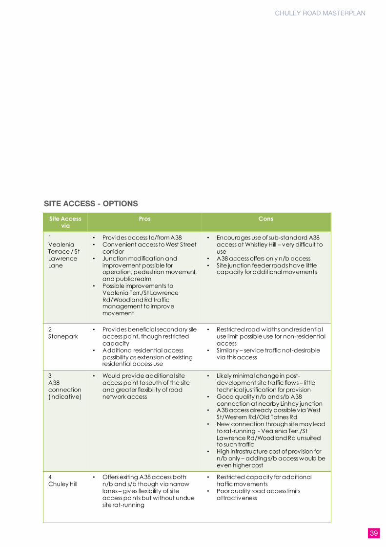
SITE ACCESS OPTIONS
CHULEY ROAD MASTERPLAN
39
Site Access via
Pros Cons
1Vealenia Terrace / St Lawrence Lane
• Provides access to/from A38• Convenient access to West Street
corridor• Junction modification and
improvement possible for operation, pedestrian movement, and public realm
• Possible improvements to Vealenia Terr./St Lawrence Rd/Woodland Rd traffic management to improve movement
• Encourages use of sub-standard A38 access at Whistley Hill – very difficult to use
• A38 access offers only n/b access• Site junction feeder roads have little
capacity for additional movements
2Stonepark
• Provides beneficial secondary site access point, though restricted capacity
• Additional residential access possibility as extension of existing residential access use
• Restricted road widths and residential use limit possible use for non-residential access
• Similarly – service traffic not-desirable via this access
3A38 connection (indicative)
• Would provide additional site access point to south of the site and greater flexibility of road network access
• Likely minimal change in post-development site traffic flows – little technical justification for provision
• Good quality n/b and s/b A38 connection at nearby Linhay junction
• A38 access already possible via West St/Western Rd/Old Totnes Rd
• New connection through site may lead to rat-running - Vealenia Terr./St Lawrence Rd/Woodland Rd unsuited to such traffic
• High infrastructure cost of provision for n/b only – adding s/b access would be even higher cost
4Chuley Hill
• Offers exiting A38 access both n/b and s/b though via narrow lanes – gives flexibility of site access points but without undue site rat-running
• Restricted capacity for additional traffic movements
• Poor quality road access limits attractiveness
SITE ACCESS - OPTIONS

40 JULY 2013
SITE ACCESS – TRAFFIC MANAGEMENT
Towncentresiteaccessandtrafficmanagement
Present investigations indicates a similar level of development related vehicular movement in comparison to present levels. However, present site access can be problematical as a result of present narrow road widths and vehicles parked at the kerbside.
The present 2-way use of St Lawrence Lane, along with kerbside parking causes frequent single-alternate line (‘SALT’) working for motorists as they wait for oncoming motorists using the remaining single vehicle width carriageway. The footways are narrow, which is of particular concern given this serving as a walking route to the school.
Vealenia Terrace provides 2-way movement to the A38 via Whistley Hill, but is of restricted width with barely room for two vehicles to pass, notably heavy goods vehicles. There is a narrow footway on one side only, which is subject to vehicular overrun. This is not ideal given it is a pedestrian route to the school.
Woodland Road is 1-way with kerbside parking prohibited – reflective of its own very restricted width, though highly comparable to the nature and single vehicle width of Vealenia Terrace, and to a lesser extent, St Lawrence Lane.
This suggests careful consideration of a continuation of the present 1-way working along Woodland Road, through into Vealenia Terrace and St Lawrence Lane creating a clockwise 1-way system (Site Access and Traffic Management Option A). This would rationalise access movements in the area and enable some reallocation of road space. Naturally though, such a change would rebalance movements too,
and some would be more satisfied than others with such a change.
Alternatively, Option B shows traffic management with St Lawrence Lane retained as 2-way, but Vealenia Terrace operating 1-way westbound. An initial consideration of the impacts of such a change are considered overleaf.
Overall, we may expect a net benefit to result from both Options, though further investigations will be required. Early indications suggest fewer access delays, possible road space reallocation for pedestrians and public realm use, and a general rationalisation making the best use of the restricted carriageway space available. There would though be ‘winners and losers’ in such a re-balancing, but the overall picture emerging is of a positive net benefit for the town and site access.

CHULEY ROAD MASTERPLAN
41
Option A – 1-Way Circulatory
Issue Pros Cons
Site Access • Site access movements less subject to delays as with St Lawrence Road ‘SALT’ delays
• Site access may be clearly signed on nearby roads
• Simplification of main site access junction in providing for fewer turning movements
• More site access traffic uses Woodland Rd than at present
• All St Lawrence Road access from town centre made via Woodland Road
• Main site access route quality
Residents’ access
• Residents may find access times similar is delays are fewer in comparison to present St Lawrence Rd SALT working
• Entails a longer access route for St Lawrence Road residents – though any residents’ kerbside parking may remain unaffected
School access • School access traffic may find access times similar is delays are fewer in comparison to present St Lawrence Rd SALT working
• School entry access not possible via St Lawrence Road
A38 access • A38 exit traffic movements unaffected – may find fewer movement delays through Vealenia Terrace and St Lawrence Road
• All A38 n/b entry access made via Woodland Road – not possible via St Lawrence Road
• All A38 n/b exit traffic made via Vealenia Terrace and St Lawrence Road
Public Realm • Access and road rationalisation enables possible road space reallocation for pedestrians and public realm use on St Lawrence Road and at site access junction
• None
Access and parking -general
• Fewer delays on Vealenia Road and St Lawrence Road
• Likely decrease in St Lawrence Rd traffic flows
• Likely to increase effective capacity of access routes and decrease delays overall
• Parking can remain on St Lawrence Road without unduly obstructing through movement
• Re-balancing of access movements – may be viewed locally as unnecessary change in accepted movement pattern
• General increase in movements on Woodland Road
Option A – 1-way circulatory- Woodland Rd remains 1-way s/b- Vealenia Terr. now 1-way w/b- St Lawrence Rd now 1-way n/b
New traffic management
Direction of traffic flow

42 JULY 2013
Option B – Partial 1-Way
Issue Pros Cons
Site Access • Two points of town centre site entry access
• St Lawrence Rd offers higher profile site access
• Site access remains as present – except for Vealenia Rd
• Vealenia Rd offers unobstructed access – fewer delays than 2-way
• Site access movements remain subject to delays - St Lawrence Road ‘SALT’ delays
• Site exit traffic wanting to exit via A38 at Whistley Hill has to divert via St Lawrence Rd
• N.B Would benefit greatly from relocation of kerbside parking on St Lawrence Rd to decrease access obstruction and delays
Residents’ access
• No change • Marginal loss of A38 Whistley Hill access convenience
School access • Reduction in conflicting vehicle movements at Woodland Rd / Vealenia Terr. / Whistley Hill junction
• No school access possible via St Lawrence Rd – Vealenia Terr.
A38 access • None • All A38 n/b entry access made via Woodland Road – not possible via St Lawrence Road / Vealenia Terr.
Public Realm • Access and road rationalisation enables possible road space reallocation for pedestrians and public realm use on St Lawrence Road and at site access junction
• Likely improvement in conditions on Vealenia Terr. Through removal of conflicting traffic movements
• None
Access and parking -general
• Simplification of St Lawrence Rd / Vealenia Terr. / Site access junction – reduction in conflicting movements
• Fewer delays on Vealenia Road
• Likely to increase effective capacity of access routes and decrease delays overall
• Diversion of A38 entry access movements from of St Lawrence Rd / Vealenia Terr. / Site access junction
Option B Partial 1-way- Woodland Rd remains 1-way s/b- Vealenia Terr. now 1-way w/b- St Lawrence Rd remains 2-way
New traffic management
Direction of traffic flow

CHULEY ROAD MASTERPLAN
43
DESIGN PRINCIPLES – PARKING
Chuley Road Development Parking
Where possible, land uses should seek to provide opportunities for sharing identified parking areas such that optimum use is made of those areas throughout the week.
Other than for the immediate site needs for short-stay parking provision, any wider development-related contribution to town centre parking availability should be in providing for long-stay parking in order that parking access movements through the site are minimised and spaces are ‘released’ from long-stay use within the town centre.
The site’s linear form and limited northwest-southeast access means that vehicle turning opportunities are at a premium, therefore opportunities should be sought to provide for turning vehicles within vehicular areas where possible, including parking areas.
Development related parking can be provided within discreet marked areas, and also along the site spine road, possibly making use of a Shared Space approach to design, mixing vehicle movement, parking, and pedestrian / cyclist movement – thus minimising marked parking ‘lots’.
Chuley Road site and Town Centre Parking
An objective of the masterplan is to achieve a net gain in parking supply through the masterplan development. Along with such a gain, there may be some associated negative outcomes including increased town centre traffic movements associated with those spaces, and the possibility that those spaces will be quickly filled attracting further and ‘new’ parking demand.
From initial examination of the parking supply, there appears to be significant potential to release capacity already lying within the town centre parking system through supply rationalisation. The masterplan should therefore recommend the design principle of encouraging a net increase in town centre parking availability, whereby provision of parking spaces within the site for town centre public use complement those in the wider town
centre, with all spaces optimised in terms of stay durations and location to increase the likelihood of a space being available for occupation to motorists.
The masterplan site is part of the wider town centre parking system and will continue to be so. As such, it should be considered in that context, with changes to demand and supply considered system-wide.
A comprehensive rationalisation of the parking system may include the following:
• The encouragement of shorter stays and -higher space turnover within the town centre on-street and off-street parking supply.
• Dedicated short-term (only) parking provided for within the town centre shopping area.
• Long-term parking provided for at remoter points within the town centre (possibly at the southern end of Chuley Road).
• Consideration of wider parking controls to encourage parking behaviours which support the town’s economy.
• A central masterplan objective is to contribute to an increase in the availability of parking spaces town centre-wide.
DESIGN PRINCIPLES – TRAFFIC IMPACT
TrafficImpact
The level of vehicular movement generated by the development will depend principally on the land use mix, and scale of development, and there will be an optimum development land use mix meeting masterplan objectives and minimising associated vehicular movement.
The masterplan should aim to match development to those constraints, recognising the level of present site movements and minimising increases.
‘Friendly’ land uses in the Chuley Road context will be those:
• encouraging occupants to stay within the site / Ashburton rather than travel further afield by car to meet their needs.
• low-medium vehicle trip generators such as residential use rather than higher generators such as medium/large foodstore retail.
• where the land use mix is complementary in terms of site arrival and departure profiles and car park sharing, e.g. office (daytime) and restaurant (evening) uses in order to minimise site generated movements and parking needs
• minimising HGV movements, which are problematical for the site in its current layout – the masterplan should seek to minimise the potential for such impacts in the future through sensitive land use planning and site layout.
Sustainable Movement
It is important to recognise that in this location, travel by car will continue to be important given the understandable constraints of travel by bus and rail.
Though the likelihood of encouraging significant travel mode shift is limited, the development may however minimise car-borne movement through sensitive site and land use planning to encourage occupants to remain on-site, and within Ashburton, accessing local amenities and destinations on foot or bicycle.
Accordingly, site design development should consider the incorporation of features including; live / work, car sharing, Car Club(s), rail minibus, remote working facilities, and a site layout encouraging walk and cycle links with the town.

44 JULY 2013
5 consultation

CHULEY ROAD MASTERPLAN
45
RECOMMENDATIONS
ORGANISING THE PEOPLES PANEL
The next steps for the project are to present our initial ideas and options to the community, inviting them to shape the proposals and help select preferred options for the masterplan.
Subject to approval from the client and steering group on the acceptability of the initial ideas set out in this study, we propose to hold a community ‘People’s Panel’ workshop on Wednesday 24th July at the Ashburton Town Hall.
There was a good amount of interest in the ‘People’s Panel’ expressed during the first stage of consultation, but we will need to quickly advertise and make arrangements for the session given that there is only just over two weeks.
We will contact local schools to invite a selection of young people to attend the workshops. We will also make further contact with local businesses so that they are well represented.
We will also prepare a series of exhibition panels that can be displayed at the Town Hall so that those who do not wish to be involved in the workshop can also see and comment on our emerging thoughts.
WORKSHOP ACTIVITIES
In the lead up to the People’s Panel session we will prepare a presentation and break out workshop exercises based on the ideas and options shown in this report. We will make the sessions as interesting and interactive as possible.
The session will start with an introduction to the team and project, followed by a presentation summarising our findings from the baseline analysis and also what the community told us during the first stage of consultation. This will set the scene, explain the site constraints and demonstrate that we are listening to feedback.
The types of exercises we will invite the community to take part in include the following. We will prepare worksheets to provide visuals, and plans to guide discussions:
• What type of place should Chuley Road become? An exercise to test whether the community agrees with the draft vision / objectives and to debate the ideas for the three styles/types of place. Participants would be asked to discuss and collectively respond to each of the objectives with a ‘yes’, ‘no’, or ‘maybe’ and suggest amendments.
• Testing the spatial options - There will be a number of exercises to test the spatial options with the community and help select a preferred option. This will involve reviewing and prioritising the key alternatives (e.g. commercial viability, parking vs open space, desire for a foodstore / food hall / flexible events space, light industrial vs modern and flexible businesses).
• We may also invite the groups to score the options, providing a similar scoring system to that we have produced to see where our views align or differ.
• Communitybenefits- A further exercise would be to invite the community to engage in further developing the details of aspects such as the preferred community uses or roles of specific spaces and buildings. This could include for example coming up with a proposal for the green space to the south, uses of the Old Engine Shed and Masonic Hall.