chidozie izuchukwu princeton dim hydrocarbon prospectivity ... · springer briefs in earth sciences...
TRANSCRIPT
S P R I N G E R B R I E F S I N E A R T H S C I E N C E S
Chidozie Izuchukwu Princeton Dim
Hydrocarbon Prospectivity in the Eastern Coastal Swamp Depo-belt of the Niger Delta Basin Stratigraphic Framework and Structural Styles


More information about this series at http://www.springer.com/series/8897
Chidozie Izuchukwu Princeton Dim
Hydrocarbon Prospectivityin the Eastern Coastal SwampDepo-belt of the Niger DeltaBasinStratigraphic Framework and Structural Styles
123
Chidozie Izuchukwu Princeton DimDepartment of Geology, Faculty of PhysicalSciences
University of NigeriaNsukka, Enugu StateNigeria
ISSN 2191-5369 ISSN 2191-5377 (electronic)SpringerBriefs in Earth SciencesISBN 978-3-319-44626-4 ISBN 978-3-319-44627-1 (eBook)DOI 10.1007/978-3-319-44627-1
Library of Congress Control Number: 2016948784
© The Author(s) 2017This work is subject to copyright. All rights are reserved by the Publisher, whether the whole or partof the material is concerned, specifically the rights of translation, reprinting, reuse of illustrations,recitation, broadcasting, reproduction on microfilms or in any other physical way, and transmissionor information storage and retrieval, electronic adaptation, computer software, or by similar or dissimilarmethodology now known or hereafter developed.The use of general descriptive names, registered names, trademarks, service marks, etc. in thispublication does not imply, even in the absence of a specific statement, that such names are exempt fromthe relevant protective laws and regulations and therefore free for general use.The publisher, the authors and the editors are safe to assume that the advice and information in thisbook are believed to be true and accurate at the date of publication. Neither the publisher nor theauthors or the editors give a warranty, express or implied, with respect to the material contained herein orfor any errors or omissions that may have been made.
Printed on acid-free paper
This Springer imprint is published by Springer NatureThe registered company is Springer International Publishing AGThe registered company address is: Gewerbestrasse 11, 6330 Cham, Switzerland

To Prof. K. Mosto Onuoha, Dr. BertramMaduka Ozumba and Dr. Ayonma WilfredMode for growing my interest in the field ofintegrated petroleum geosciences.
Acknowledgement
Special thanks to the managerial board, Geo-solutions, Exploration, Petrel/nDIGeo-Sign-IT Help Desk and University Liaison Teams of the Shell PetroleumDevelopment Company of Nigeria Limited, Port-Harcourt for the provision ofworkroom, dataset, technical support throughout the period of this research. Theinvaluable knowledge derived from colleagues and the tutorship and mentorshipof the team of lecturers at the Department of Geology, University of Nigeria,Nsukka is quite remarkable. This research work also benefitted from the technicalinputs of the editorial and marketing department of Springer publishing.
vii

Contents
1 General Introduction. . . . . . . . . . . . . . . . . . . . . . . . . . . . . . . . . . . . . . . 11.1 Introduction . . . . . . . . . . . . . . . . . . . . . . . . . . . . . . . . . . . . . . . . . . 11.2 Location of the Basin and the Study Area . . . . . . . . . . . . . . . . . . . 21.3 Literature Review . . . . . . . . . . . . . . . . . . . . . . . . . . . . . . . . . . . . . . 31.4 Aim and Objectives of Study . . . . . . . . . . . . . . . . . . . . . . . . . . . . . 5References. . . . . . . . . . . . . . . . . . . . . . . . . . . . . . . . . . . . . . . . . . . . . . . . 6
2 Geologic Framework . . . . . . . . . . . . . . . . . . . . . . . . . . . . . . . . . . . . . . . 92.1 Regional Tectonic Setting. . . . . . . . . . . . . . . . . . . . . . . . . . . . . . . . 92.2 Regional Stratigraphic Setting. . . . . . . . . . . . . . . . . . . . . . . . . . . . . 12
2.2.1 Akata Formation (Marine Shales) . . . . . . . . . . . . . . . . . . . . 122.2.2 Agbada Formation (Paralic Clastics) . . . . . . . . . . . . . . . . . . 122.2.3 Benin Formation (Continental Sands) . . . . . . . . . . . . . . . . . 13
2.3 Depobelts . . . . . . . . . . . . . . . . . . . . . . . . . . . . . . . . . . . . . . . . . . . . 13References. . . . . . . . . . . . . . . . . . . . . . . . . . . . . . . . . . . . . . . . . . . . . . . . 15
3 Methodology . . . . . . . . . . . . . . . . . . . . . . . . . . . . . . . . . . . . . . . . . . . . . 173.1 Dataset and Workflow . . . . . . . . . . . . . . . . . . . . . . . . . . . . . . . . . . 17
3.1.1 Data Quality and Software Resources . . . . . . . . . . . . . . . . . 183.2 Delineation of Lithofacies and Depositional Environments. . . . . . . 223.3 Stacking Patterns and Parasequences . . . . . . . . . . . . . . . . . . . . . . . 223.4 Key Stratigraphic Surfaces, Systems Tracts
and Depositional Sequences . . . . . . . . . . . . . . . . . . . . . . . . . . . . . . 243.5 Well Correlation . . . . . . . . . . . . . . . . . . . . . . . . . . . . . . . . . . . . . . . 27References. . . . . . . . . . . . . . . . . . . . . . . . . . . . . . . . . . . . . . . . . . . . . . . . 28
4 Data Interpretations and Results . . . . . . . . . . . . . . . . . . . . . . . . . . . . . 294.1 Lithofacies and Implication for Environments of Deposition . . . . . 29
4.1.1 Sandstone Facies . . . . . . . . . . . . . . . . . . . . . . . . . . . . . . . . . 294.1.2 Shaly-Sandstone Facies . . . . . . . . . . . . . . . . . . . . . . . . . . . . 304.1.3 Mudrock Facies. . . . . . . . . . . . . . . . . . . . . . . . . . . . . . . . . . 314.1.4 Heterolithic Facies. . . . . . . . . . . . . . . . . . . . . . . . . . . . . . . . 31
ix

4.2 Sequence Stratigraphic Interpretation . . . . . . . . . . . . . . . . . . . . . . . 314.2.1 Maximum Flooding Surface (MFS). . . . . . . . . . . . . . . . . . . 314.2.2 Sequence Boundary (SB) and Transgressive Surface
of Erosion (TSE)/Top of Lowstant (TLS) . . . . . . . . . . . . . . 334.2.3 Well Log Sequence Stratigraphic Correlation . . . . . . . . . . . 364.2.4 Systems Tracts and Depositional Sequences . . . . . . . . . . . . 39
4.3 Seismic, Semblance Cube/Time Slice Generation. . . . . . . . . . . . . . 464.3.1 Seismic Stratigraphic/Facies Interpretation . . . . . . . . . . . . . 47
4.4 Well to Seismic Integration . . . . . . . . . . . . . . . . . . . . . . . . . . . . . . 514.4.1 Fault Interpretation . . . . . . . . . . . . . . . . . . . . . . . . . . . . . . . 524.4.2 Horizon Interpretation . . . . . . . . . . . . . . . . . . . . . . . . . . . . . 524.4.3 Geologic Modelling . . . . . . . . . . . . . . . . . . . . . . . . . . . . . . 544.4.4 Time–Depth (T–Z) Conversion . . . . . . . . . . . . . . . . . . . . . . 54
4.5 Field Entrapment Structure Identification . . . . . . . . . . . . . . . . . . . . 574.6 Environments of Deposition (EOD) Interpretation . . . . . . . . . . . . . 584.7 Hydrocarbon Data Integration. . . . . . . . . . . . . . . . . . . . . . . . . . . . . 59References. . . . . . . . . . . . . . . . . . . . . . . . . . . . . . . . . . . . . . . . . . . . . . . . 59
5 Discussion . . . . . . . . . . . . . . . . . . . . . . . . . . . . . . . . . . . . . . . . . . . . . . . 615.1 Stratigraphic Framework. . . . . . . . . . . . . . . . . . . . . . . . . . . . . . . . . 615.2 Depositional Sequence and Environments of Deposition . . . . . . . . 625.3 Structural Framework . . . . . . . . . . . . . . . . . . . . . . . . . . . . . . . . . . . 635.4 Hydrocarbon Occurrence and Distribution/Trend . . . . . . . . . . . . . . 635.5 Hydrocarbon Leads and Implication for Exploration
and Production . . . . . . . . . . . . . . . . . . . . . . . . . . . . . . . . . . . . . . . . 64References. . . . . . . . . . . . . . . . . . . . . . . . . . . . . . . . . . . . . . . . . . . . . . . . 66
Summary . . . . . . . . . . . . . . . . . . . . . . . . . . . . . . . . . . . . . . . . . . . . . . . . . . . 69
Bibliography . . . . . . . . . . . . . . . . . . . . . . . . . . . . . . . . . . . . . . . . . . . . . . . . 71
x Contents
Abstract
Detailed studies have been carried out within the Middle to Late Miocene sequenceof the Niger Delta basin using well logs, biostratigraphic, paleobathymetric,hydrocarbon type/occurrence and seismic data integrated with sequence strati-graphic tool. This involved interpretation aimed at understanding the sequencestratigraphic framework and structural styles to better unravel possible hydrocarbonleads and prospects at the intermediate and deeper intervals of the Eastern CoastalSwamp depobelt of the onshore Niger Delta basin. Facies interpretations reveal theoccurrence of four lithofacies units; namely (a) sandstones facies, (b) shaly sand-stone facies, (c) mud-rock facies, and (d) heterolithic facies. Well log sequencestratigraphic interpretation and correlation across these fields indicates that tenmajor stratigraphic bounding surfaces, five each of sequence boundaries (SB) withages ranging from 13.1 Ma through 8.5 Ma and maximum flooding surfaces(MFS) with ages between 12.8 Ma and 7.4 Ma respectively, were identified andcorrelated. Four depositional sequences were delineated and stratigraphic flatteningat various ages (MFSs) indicates that there is a shift of the depo-center from north tosouth. Stacking patterns (progradational, retrogradational and aggradational) weredelineated and interpreted as lowstand systems tract (LST), highstand systems tract(HST) and transgressive systems tract (TST) using their bounding surfaces. Thealternation of the LST, HST and TST offers good reservoir sands and source/sealshales for hydrocarbon accumulation. Paleobathymetric maps show generally thatsediments were deposited within neritic through bathyal environments at differenttimes, aligning with the progradational pattern of deposition of the Niger Delta. Theenvironment of deposition spans through inner mid-shelf, shelf margin and slopemargin constituting incised valley and channel-filled deposits. Horizon and faultsthat were mapped and interpreted in seismic volume shows that the stratigraphyof the area were greatly influenced by structures as sediment deposits thickendown-dip of the down-thrown section of the bounding faults. Structural interpre-tations reveal the occurrence of back to back (horst block-trapezoid zone), collapsecrest structures, simple/faulted rollovers, regional foot walls/hanging walls andsub-detachment structures dominating within the mainly extensional zone and theseconstitute the major hydrocarbon traps in the area. The distribution of hydrocarbon
xi

types is such that gas is concentrated at the proximal end (northern section), oil andgas at the central part while oil predominates at the distal end (towards the southernpart). Generally, structural and stratigraphic framework has shown that indeed thereexist zones at intermediate and deeper intervals with booming amplitudes andwell-developed trapping mechanisms that have not been drilled. These form pos-sible hydrocarbon leads that should be subjected to further revalidation. Hence, anevaluation of lithofacies, depositional environment, stratigraphy, structures, reser-voirs, seals, hydrocarbon types and distribution is critical in hydrocarbonprospectivity at intermediate and deeper depths across the eastern Coastal Swampdepobelt of the Niger Delta.
Keywords Hydrocarbon prospectivity � Sequence stratigraphic framework �Structural styles � Coastal swamp depobelt � Niger delta basin
xii Abstract

Chapter 1General Introduction
1.1 Introduction
The Middle to Late Miocene sequence of the Niger Delta Basin can be said to beamong the most challenging targets for both stratigraphic and structural interpre-tation in petroleum exploration because of the tectono-sedimentological factorsinvolved in their deposition. The lithostratigraphic units (mainly the Akata, Agbadaand Benin Formations) of this basin are thick, complex sedimentary units depositedrapidly during high-frequency, fluvio-deltaic-eustatic sea level oscillations. Thesurface upon which they were deposited is underlain by thick, under-compactedunstable mobile shales of the Akata Formation; this loading has produced a com-plex series of gliding surfaces and depobelts. In these depobelts, deposition com-monly is controlled by large contemporaneous glide-plane extensional faults andfolds. The basin structure and stratigraphy have been controlled by the interplaybetween rates of sediment supply and subsidence (Doust and Omatsola 1990).Many of the sediments were deposited within neritic to bathyal water depths and arehighly variable in their patterns of deposition. Because of this complexity, the NigerDelta Basin remains highly attractive, but truly challenging in today’s expensivedeeper interval drilling.
The understanding of facies units, stratigraphic framework, structuralconfiguration/style, hydrocarbon type and distribution within the paralic sequenceof Middle to Late Miocene age across several fields in the Tertiary Niger Deltabasin fills, is expected to improve immensely with the application of the concept ofsequence stratigraphy. Recent developments in sequence stratigraphy (Posamentierand Allen 1999; Posamentier 2000; Catuneanu 2002; Catuneanu et al. 2005) offer amore definitive approach to stratigraphic interpretation of these strata. Greateremphasis on interpretation of well-log, biostratigraphic and paleobathymetricinformation, closely integrated with seismic data, increases the resolution for
© The Author(s) 2017C.I.P. Dim, Hydrocarbon Prospectivity in the Eastern Coastal Swamp Depo-beltof the Niger Delta Basin, SpringerBriefs in Earth Sciences,DOI 10.1007/978-3-319-44627-1_1
1

prediction of environment of deposition. This work presents the results of a regionalgeological mapping, correlation and interpretation, in which the aspects related tothe stratigraphic and structural framework of the siliciclastic sequences, and thesystem tracts, depositional sequences, reservoirs, seals, structural styles and trap-ping mechanisms are discussed, with the view of unravelling possible hydrocarbonleads and the existence of prospectivity within deeper depths across the study area.
1.2 Location of the Basin and the Study Area
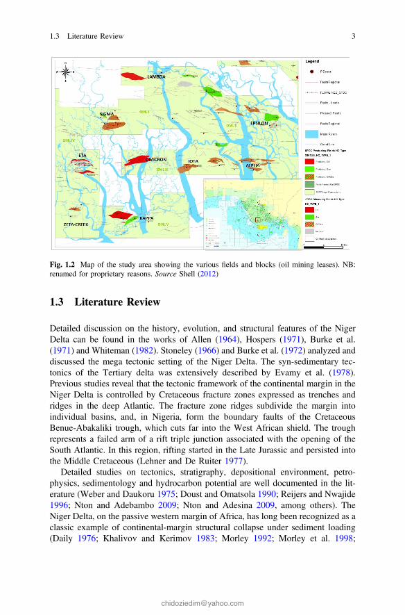
The Niger Delta Basin, situated at the apex of the Gulf of Guinea on the west coastof Africa, is one of the most prolific deltaic hydrocarbon provinces in the world(Fig. 1.1). The sedimentary basin occupies a total area of about 75,000 km2 and isat least 11 km deep in its deepest parts. The study area spans through five majoracreage/blocks/OMLs (oil mining lease), which for proprietary reasons are namedOMLs I, II, III, IV and V. These acreages/blocks lie on the onshore part of theEastern Coastal Swamp of the Niger Delta Basin. The field is between Latitudes 4°20′ 00″ N and 4° 50′ 00″ N and Longitudes 6° 30′ 00″ E and 7° 10′ 00″ E andcovers an area of approximately 3610 km2 (Fig. 1.2).
Fig. 1.1 Inset map of the Niger Delta basin in Africa and location map of the study area (redrectangle) showing relief and oil and gas concessions. Source Shell (2007)
2 1 General Introduction
1.3 Literature Review
Detailed discussion on the history, evolution, and structural features of the NigerDelta can be found in the works of Allen (1964), Hospers (1971), Burke et al.(1971) and Whiteman (1982). Stoneley (1966) and Burke et al. (1972) analyzed anddiscussed the mega tectonic setting of the Niger Delta. The syn-sedimentary tec-tonics of the Tertiary delta was extensively described by Evamy et al. (1978).Previous studies reveal that the tectonic framework of the continental margin in theNiger Delta is controlled by Cretaceous fracture zones expressed as trenches andridges in the deep Atlantic. The fracture zone ridges subdivide the margin intoindividual basins, and, in Nigeria, form the boundary faults of the CretaceousBenue-Abakaliki trough, which cuts far into the West African shield. The troughrepresents a failed arm of a rift triple junction associated with the opening of theSouth Atlantic. In this region, rifting started in the Late Jurassic and persisted intothe Middle Cretaceous (Lehner and De Ruiter 1977).
Detailed studies on tectonics, stratigraphy, depositional environment, petro-physics, sedimentology and hydrocarbon potential are well documented in the lit-erature (Weber and Daukoru 1975; Doust and Omatsola 1990; Reijers and Nwajide1996; Nton and Adebambo 2009; Nton and Adesina 2009, among others). TheNiger Delta, on the passive western margin of Africa, has long been recognized as aclassic example of continental-margin structural collapse under sediment loading(Daily 1976; Khalivov and Kerimov 1983; Morley 1992; Morley et al. 1998;
Fig. 1.2 Map of the study area showing the various fields and blocks (oil mining leases). NB:renamed for proprietary reasons. Source Shell (2012)
1.3 Literature Review 3
Rensbergen et al. 1999; Edwards 2000; Rensbergen and Morley 2000). The modernNiger Delta has distinctive basinward variations in structural style that define; (1) aninner extensional zone of listric growth faults beneath the outer shelf; (2) a trans-lational zone of diapirs and shale ridges beneath the upper slope; and (3) an outercompressional zone of imbricate toe-thrust structures beneath the lower slope(Hooper et al. 2002). These areas of contrasting structural style are linked on aregional scale by slow gravity collapse of this thick deltaic prism (Damuth 1994).
Although broad regional relationships between patterns of deposition anddeformation caused by structural collapse within the inner extensional zone of theNiger Delta have been proposed (Knox and Omatsola 1989), details ofhigh-frequency sequence development within this setting are less well documented.Most recent stratigraphic studies of the Niger Delta deposits based on modernthree-dimensional (3-D) seismic records have focused on relationships betweendepositional patterns within the compressional toe of this clastic wedge along thebase of the continental slope (Morgan 2004; Adeogba et al. 2005; Corredor et al.2005). Short and Stauble (1967) defined three formations within the 13,000 ft thickNiger Delta clastic wedge based on sand/shale ratios estimated from subsurfacewell logs: (i) basal, offshore-marine, and pro-delta shale of the Akata Formation;(ii) interbedded sandstone and shale of the dominantly deltaic Agbada Formation;and (iii) the capping sandy fluvial Benin Formation.
Previous sedimentological, biostratigraphical and sequence-stratigraphic studies(Ladipo et al. 1992; Stacher 1995; Reijers et al. 1997) revealed the combinedinfluence of eustatic cyclicity and local tectonics. Recent studies on the offshoreNiger Delta (Owajemi and Willis 2006; Magbagbeoloa and Willis 2007) demon-strate that these concepts are still valid but perhaps could benefit from the strati-graphic information and the new approaches presented here. Depositionalsequences as defined by Vail (1987) and consisting of strata bounded by uncon-formities and their lateral equivalents are only recognised in specific sectors of thedelta. In contrast, delta-wide genetic sequences as defined by Galloway (1989) andconsisting of strata bounded by maximum flooding surfaces within transgressiveshales are more readily identifiable in the Niger Delta. Individual sea-level cyclesare reflected in the Niger Delta in various sedimentary sequences. Interferences ofcycles with different periods result in megasequences that are chronostratigraphi-cally confined and sedimentologically characterised.
Sequence stratigraphic concepts are increasingly finding new and uniqueapplications in the regressive siliciclastic deposits of the Niger Delta. Haq et al.(1988) found that the most useful criteria for the recognition of sequence bound-aries in the acreage in the Niger Delta include truncation of underlying reflections,drape, dip discordance, or onlap of younger reflection over topography on sequenceboundary, contrasts in seismic attributes across the sequence boundary and thesequence termination of faults at the sequence boundary. Pacht and Hall (1993)applied the sequence stratigraphic concept to exploration in the offshore of theNiger Delta. Stacher (1994) revised the earlier SPDC Bio and Time-StratigraphicScheme and put the scheme in a sequence stratigraphic framework allowing cor-relation with Haq et al. (1988) sea level curve using the Harland et al. (1992) global
4 1 General Introduction
time scheme. Bowen et al. (1994) established an integrated geologic framework ofthe Niger Delta slope, by applying established sequence stratigraphic concepts, onthe newly acquired seismic data sets of the Niger Delta, coupled with biostarti-graphic data, from twenty-six (26) key wells.
Over the years, delta wide framework of Cretaceous chronostratigraphic sur-faces, and a sequence stratigraphic chart for the Niger Delta has been produced,using biostratigraphic data, obtained from several wells. Ozumba (1999) developeda sequence stratigraphic framework of the western Niger Delta, using foraminiferaand wire line log data obtained from four wells drilled in the coastal and centralswamp depobelts. He concluded that the late Miocene sequences were thicker thanthe middle Miocene sequences. Asseez (1976) reviewed the stratigraphy, sedi-mentation and structures of the Niger Delta. Merki (1972), described the structuralgeology of the Tertiary Niger Delta, which is on the overlap sequence that isdeformed by syn-sedimentary faulting and folding. Ekweozor and Daukoru (1984,1994) presented a detailed report on the petroleum geology and stratigraphy of theNiger Delta showing the relationship between depositional patterns, structures andstratigraphy and their influence on the oil generation in the Niger Delta basin (Knoxand Omatsola 1989).
This current work focuses on understanding the distribution of lithofacies,systems tracts, hydrocarbon type and establishing the stratigraphic framework andstructural configuration or styles within the paralic sequence of Middle to LateMiocene age across several fields in the Eastern Coastal Swamp of the TertiaryNiger Delta.
1.4 Aim and Objectives of Study
This research is aimed at integrating well logs, biostratigraphic, paleobathymetric,hydrocarbon type/occurrence and seismic data with sequence stratigraphic tools tobetter understand the structural and stratigraphic framework and hence unravelpossible hydrocarbon leads and the existence of prospectivity within intermediateand deeper intervals in the Eastern Coastal Swamp depobelt of the Niger Deltabasin.
The objectives of this research work involve:
(i) delineating and correlating of the lithofacies, key stratigraphic boundingsurfaces, systems tracts, depositional sequences across wells, to understandthe environment of deposition and the distribution of source, seal andreservoir rock presence in the study area,
(ii) mapping of the delineated stratigraphic surfaces (events/horizons) andstructures (faults) on seismic data to better establish the stratigraphic andstructural framework and understand the influence of structures on stratig-raphy, which will help in identifying possible hydrocarbon leads (especiallyat intermediate and deeper leads),
1.3 Literature Review 5

(iii) using available data on hydrocarbon occurrence at different intervals toestablish trends/distribution of hydrocarbon types (gas and/or oil) across thestudy area which are useful in influencing exploration and productiondecisions.
References
Adeogba, A. A., McHargue, T. R., & Graham, S. A. (2005). Transient fan architecture anddepositional controls from near-surface 3-D seismic data Niger Delta continental slope.American Association of Petroleum Geologists Bulletin, 89, 627–638.
Allen, J. R. L. (1964). The Nigerian continental margin; Bottom sediments, submarinemorphology and geological evolution. Marine Geology, 1, 289–332.
Asseez, L. O. (1976). Review of stratigraphic sedimentation and structure of the Niger Delta.Geology of Nigeria, 259–272.
Bowen, B. E., Hall, D. J., Rosen, R. N., & Shaffer, B. L. (1994). Sequence stratigraphic andstructural framework, southeast Niger delta shelf. Nigerian Association of PetroleumExplorationist Bulletin, 9(01), 51–58.
Burke, K., Dessauvagie, T. E., & Whiteman, A. J. (1971). Opening of the Gulf of Guineaand geological history of the Benue depression and Niger Delta. Nature Physical Science, 233,51–55.
Burke, K., Dessauvagie, T. F. J., & Whiteman, A. J. (1972). Geological history of the BenueValley and adjacent areas. In Proceedings of the 1st Conference on African geology, Ibadan,1970 (pp. 287–305). Ibadan, Nigeria: Ibadan University Press.
Catuneanu, O. (2002). Sequence stratigraphy of clastic systems: Concepts, merits and pitfalls.Journal of African Earth Sciences, 35, 1–43.
Catuneanu, O., Wopfner, H., Eriksson, P. G., Cairncross, B., Rubidge, B. S., Smith, R. M. H.,et al. (2005). The Karoo basins of south-central Africa. Journal of African Earth Sciences, 43,211–253.
Corredor, F., Shaw, J. H., & Billoti, F. (2005). Structural styles in the deep-water fold and thrustbelts of the Niger Delta. American Association of Petroleum Geologists Bulletin, 89, 753–780.
Daily, G. C. (1976). A possible mechanism relating progradation, growth faulting, clay diapirismand overthrusting in a regressive sequence of sediments. Bulletin of Canadian PetroleumGeology, 24, 92–116.
Damuth, J. E. (1994). Neogene gravity tectonics and depositional processes on the deep NigerDelta continental margin. Marine and Petroleum Geology, 11, 320–346.
Doust, H., & Omatsola, E. (1990). Niger delta. In J. D. Edwards and P. A. Santogrossi (Eds.),Divergent/passive margin basins (pp. 239–248). American Association of PetroleumGeologists Bulletin Memoir 48.
Edwards, M. B. (2000). Origin and significance of retrograde failed shelf margins; Tertiarynorthern Gulf Coast Basin. Transactions of the Gulf Coast Association, 50, 81–93.
Ekweozor, C. M., & Daukoru, E. M. (1984). Petroleum source-bed evaluation of Tertiary NigerDelta; Discussion and reply. American Association of Petroleum Geologists Bulletin, 68,387–394.
Ekweozor, C. M., & Daukoru, E. M. (1994). Northern delta depobelt portion of the Akata–Agbada(!) petroleum system, Niger Delta, Nigeria. In L. B. Magoon & W. G. Dow (Eds.), Thepetroleum system—from source to trap (pp. 599–613). American Association of PetroleumGeologists Memoir 60.
Evamy, B. D., Haremboure, J., Kamerling, P., Knaap, W. A., Molloy, F. A., & Rowlands, P. H.(1978). Hydrocarbon habitat of Tertiary Niger Delta. American Association of PetroleumGeologists Bulletin, 62, 1–39.
6 1 General Introduction
Galloway, W. E. (1989). Genetic stratigraphic sequences in basin analysis; I, Architecture andgenesis of flooding-surface bounded depositional units. American Association of PetroleumGeologists Bulletin, 73, 125–142.
Haq, B. U., Hardenbol, J., & Vail, P. R. (1988). Mesozoic and Cenozoic chronostratigraphy andcycles of sea-level change. In C. K. Wilgus et al. (Eds.), Sea-level changes: An integratedapproach (Vol. 42, pp. 71–108). Society of Economic Paleontologists and Mineralogists,Special Publication.
Harland, W. B., Scott, R. A., Aukland, K. A., & Snape, I. (1992). The Ny Friesland Orogen,Spitsbergen. Geological Magazine, 129, 679–707.
Hooper, R. J., Fitzsimmons, R. J., Grant, N., & Vendeville, B. C. (2002). The role of deformationin controlling depositional patterns in the south-central Niger Delta, west Africa. Journal ofStructural Geology, 24, 847–859.
Hospers, J. (1971). The geology of the Niger delta area, in the geology of the East Atlanticcontinental margin. Great Britain, Institute of Geological Science, Report, 70(16), 121–141.
Khalivov, N. Y., & Kerimov, A. A. (1983). Origin of mud volcanism and diapirism. InternationalGeological Review, 25, 877–881.
Knox, G. J., & Omatsola, E. M. (1989). Development of the Cenozoic Niger delta in terms of the“Escalator Regression” model and impact on hydrocarbon distribution. In Proceedings of theKNGMG Symposium on Coastal Lowlands, Geology and Geotechnology, 1987 (pp. 181–202).Dordrecht: Kluwer.
Ladipo, K. O., Nwajide, C. S., & Akande, S. O. (1992). Cretaceous and Paleogene sequences inthe Abakaliki and Anambra basins, south eastern Nigeria: A field guide. Port Harcourt:International Symposium on Geology of Deltas.
Lehner, P., & De Ruiter, P. A. C. (1977). Structural history of Atlantic margin of Africa. AmericanAssociation of Petroleum Geologists Bulletin, 61, 961–981.
Magbagbeola, O. A., & Willis, B. J. (2007). Sequence stratigraphy and syndepositionaldeformation of the Agbada formation, Robertkiri field, Niger Delta, Nigeria. AmericanAssociation of Petroleum Geologists Bulletin, 91(7), 945–958.
Merki, P. J. (1972). Structural geology of the Cenozoic Niger delta. In Proceedings of the 1stConference on African Geology (pp. 635–646). Ibadan University Press.
Morgan, R. (2004). Structural controls on the positioning of submarine channels on the lowerslopes of the Niger Delta. Geological Society (London) Memoir, 29, 45–51.
Morley, C. K. (1992). Notes on Neogene basin history of the western Alboran Sea and itsimplications for the tectonic evolution of the Rif-Betic orogenic belt. Journal of African EarthSciences, 14, 57–65.
Morley, C. K., Crevello, P., & Ahmad, Z. H. (1998). Shale tectonics and deformation associatedwith active diapirism: The Jerudong anticline, Brunei Darussalam. Journal of the GeologicalSociety (London), 155, 475–490.
Nton, M. E., & Adebambo, B. A. (2009). Petrophysical evaluation and depositional environmentsof reservoir sands of X-field, offshore Niger delta. Mineral Wealth, 150, 1–12.
Nton, M. E., & Adesina, A. D., (2009). Aspects of structures and depositional environment of sandbodies within Tomboy field, offshore western Niger Delta, Nigeria. RMZ—Materials andGeoenvironment, 56(3), 284–303.
Nwajide, C. S., & Reijers, T. J. A. (1996). Geology of the southern Anambra Basin. In T. J. A.Reijers (Ed.), selected chapters on Geology (pp. 133–148). Warri: SPDC.
Owoyemi, A. O., & Willis, B. J. (2006). Depositional patterns across syndepositional normalfaults, Niger Delta, Nigeria. Journal of Sedimentary Research, 76(1–2), 346–363.
Ozumba, B. M. (1999). Middle to Late Miocene sequence stratigraphy of the Western Niger Delta.Nigerian Association of Petroleum Explorationist Bulletin, 13 and 14(2), 176–192.
Pacht, J. A., & Hall D. J. (1993). Sequence stratigraphic approach to exploration in offshoreNigeria (Vol. 1, pp. 241–248). Offshore Technology Conference.
Posamentier, H. W. (2000). Seismic stratigraphy into the next millennium; a focus on 3D seismicdata. In American Association of Petroleum Geologists Annual Convention, New Orleans,Abstracts (Vol. 9, p. A118).
References 7
Posamentier, H. W., & Allen, G. P. (1999). Siliciclastic sequence stratigraphy: Concepts andapplications (Vol. 7, 210 pp.). Society of Economic Paleontologists and Mineralogists(SEPM), Concepts in Sedimentology and Paleontology.
Reijers, T. J. A., Petters, S. W., & Nwajide, C. S. (1997). The Niger Delta basin. In R. C. Selley(Ed.), Sedimentary basins of the world (Vol. 3, pp. 151–172). African basins, Amsterdam:Elsevier science.
Rensbergen, P. V., & Morley, C. K. (2000). 3D seismic study of a shale expulsion syncline at thebase of the Champion delta, offshore Brunei and its implications for the early structuralevolution of large delta systems. Marine and Petroleum Geology, 17, 861–872.
Rensbergen, P. V., Morley, C. K., Ang, D. W., Hoan, T. Q., & Lam, N. T. (1999). Structuralevolution of shale diapirs from reactive rise to mud volcanism: 3D seismic data from the Baramdelta, offshore Brunei Darussalam. Journal of the Geological Society (London), 156, 633–650.
Shell. (2007). Onshore to deep-water geologic integration, Niger Delta. In J. Ejedawe, F. Love, D.Steele, & Ladipo K (Eds.), Presentation pack of Shell Exploration and Production Limited,Port-Harcourt.
Shell. (2012). Oil and gas concession map of the Niger Delta basin. Port-Harcourt: ShellPetroleum Development Company Geomatics Department.
Short, K. C., & Stauble, A. J. (1967). Outline of geology of Niger Delta. American Association ofPetroleum Geologists Bulletin, 51, 761–779.
Stacher, P. (1994). Niger Delta hydrocarbon habitat. Nigerian Association of PetroleumExplorationists Bulletin, 9(10), 67–75.
Stacher, P. (1995). Present understanding of the Niger Delta hydrocarbon habitat. In M. N. Oti &G. Postma (Eds.), Geology of deltas (pp. 257–267). Rotterdam: A. A. Balkema.
Stoneley, R. (1966). The Niger delta region in the light of the theory of continental drift.Geological Magazine, 105, 385–397.
Vail, P. R. (1987). Seismic stratigraphy interpretation using sequence stratigraphy, part 1: Seismicstratigraphy interpretation procedure. In A. W. Bally (Ed.), Atlas of seismic stratigraphy.American Association of Petroleum Geologists.
Weber, K. J., & Daukoru, E. M. (1975). Petroleum geology of the Niger Delta. In Proceedings ofthe 9th World Petroleum Congress, Geology (Vol. 2, pp. 210–221). London: Applied SciencePublishers, Ltd.
Whiteman, A. (1982). Nigeria—Its petroleum geology, resources and potential (p. 394). London:Graham and Trotman.
8 1 General Introduction
Chapter 2Geologic Framework
2.1 Regional Tectonic Setting
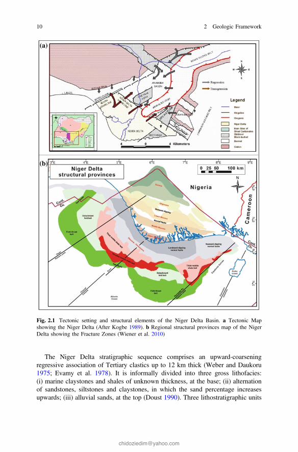
The Niger Delta basin is located at the southernmost extremity of the elongatedintracontinental Benue Trough. To the west, it is separated from the Dahomey (orBenin) basin by the Okitipupa basement high, and to the east it is bounded by theCameroun volcanic line. Its northern margin transects several older (Cretaceous)tectonic elements—the Anambra basin, Abakaliki basin, Afikpo syncline, and theCalabar Flank (Fig. 2.1a).
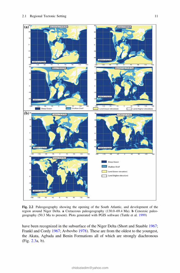
The evolution of the Niger delta is controlled by pre- and synsedimentary tec-tonics described by Evamy et al. (1978), Ejedawe (1981), Knox and Omatsola(1989) and Stacher (1995). The tectonic framework of the continental margin alongthe West Coast of equatorial Africa is controlled by Cretaceous fracture zonesexpressed as trenches and ridges in the deep Atlantic. The fracture zone ridges(Fig. 2.1b) subdivide the margin into individual basins, and, in Nigeria, form theboundary faults of the Cretaceous Benue-Abakaliki trough, which cuts far into theWest African shield. The trough represents a failed arm of a rift triple junctionassociated with the opening of the South Atlantic. Rifting started in the LateJurassic and persisted into the Middle Cretaceous (Lehner and De Ruiter 1977). Inthe Niger Delta region, rifting diminished altogether in the Late Cretaceous.Figure 2.2a, b show the gross paleogeography of the region as well as the relativeposition of the African and South American plates since rifting began.
After rifting ceased, gravity tectonics became the primary deformational process.For any given depobelt, gravity tectonics were completed before deposition of theBenin Formation and are expressed in complex structures, including shale diapirs,roll-over anticlines, collapsed growth fault crests, back-to-back features, and steeplydipping, closely spaced flank faults (Evamy et al. 1978; Xiao and Suppe 1992).These faults mostly offset different parts of the Agbada Formation and flatten intodetachment planes near the top of the Akata Formation.
© The Author(s) 2017C.I.P. Dim, Hydrocarbon Prospectivity in the Eastern Coastal Swamp Depo-beltof the Niger Delta Basin, SpringerBriefs in Earth Sciences,DOI 10.1007/978-3-319-44627-1_2
9
The Niger Delta stratigraphic sequence comprises an upward-coarseningregressive association of Tertiary clastics up to 12 km thick (Weber and Daukoru1975; Evamy et al. 1978). It is informally divided into three gross lithofacies:(i) marine claystones and shales of unknown thickness, at the base; (ii) alternationof sandstones, siltstones and claystones, in which the sand percentage increasesupwards; (iii) alluvial sands, at the top (Doust 1990). Three lithostratigraphic units
Fig. 2.1 Tectonic setting and structural elements of the Niger Delta Basin. a Tectonic Mapshowing the Niger Delta (After Kogbe 1989). b Regional structural provinces map of the NigerDelta showing the Fracture Zones (Wiener et al. 2010)
10 2 Geologic Framework
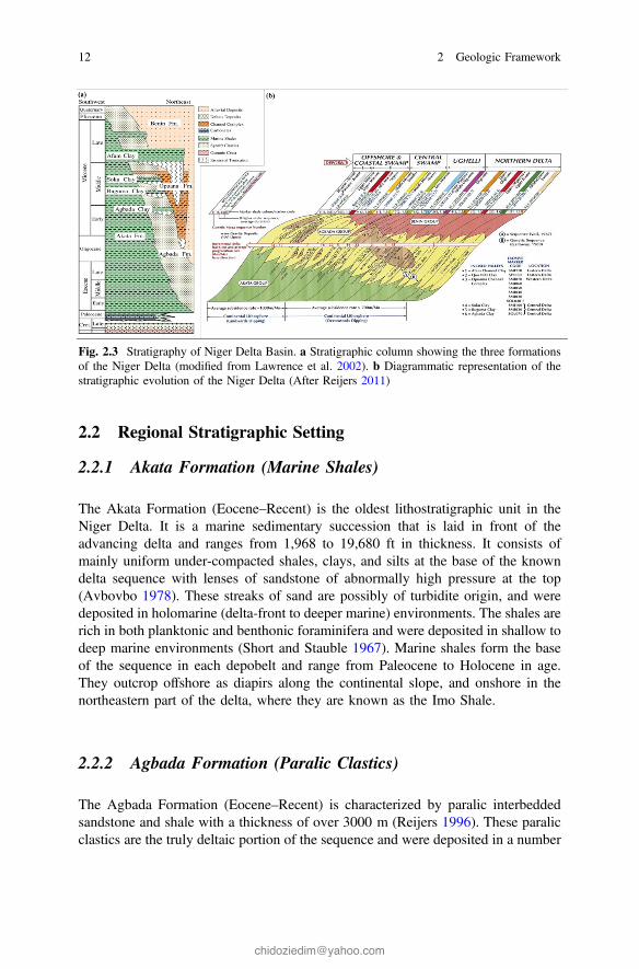
have been recognized in the subsurface of the Niger Delta (Short and Stauble 1967;Frankl and Cordy 1967; Avbovbo 1978). These are from the oldest to the youngest,the Akata, Agbada and Benin Formations all of which are strongly diachronous(Fig. 2.3a, b).
Fig. 2.2 Paleogeography showing the opening of the South Atlantic, and development of theregion around Niger Delta. a Cretaceous paleogeography (130.0–69.4 Ma). b Cenozoic paleo-geography (50.3 Ma to present). Plots generated with PGIS software (Tuttle et al. 1999)
2.1 Regional Tectonic Setting 11
2.2 Regional Stratigraphic Setting
2.2.1 Akata Formation (Marine Shales)
The Akata Formation (Eocene–Recent) is the oldest lithostratigraphic unit in theNiger Delta. It is a marine sedimentary succession that is laid in front of theadvancing delta and ranges from 1,968 to 19,680 ft in thickness. It consists ofmainly uniform under-compacted shales, clays, and silts at the base of the knowndelta sequence with lenses of sandstone of abnormally high pressure at the top(Avbovbo 1978). These streaks of sand are possibly of turbidite origin, and weredeposited in holomarine (delta-front to deeper marine) environments. The shales arerich in both planktonic and benthonic foraminifera and were deposited in shallow todeep marine environments (Short and Stauble 1967). Marine shales form the baseof the sequence in each depobelt and range from Paleocene to Holocene in age.They outcrop offshore as diapirs along the continental slope, and onshore in thenortheastern part of the delta, where they are known as the Imo Shale.
2.2.2 Agbada Formation (Paralic Clastics)
The Agbada Formation (Eocene–Recent) is characterized by paralic interbeddedsandstone and shale with a thickness of over 3000 m (Reijers 1996). These paralicclastics are the truly deltaic portion of the sequence and were deposited in a number
Fig. 2.3 Stratigraphy of Niger Delta Basin. a Stratigraphic column showing the three formationsof the Niger Delta (modified from Lawrence et al. 2002). b Diagrammatic representation of thestratigraphic evolution of the Niger Delta (After Reijers 2011)
12 2 Geologic Framework
of delta-front, delta-topset, and fluvio-deltaic environments. The top of AgbadaFormation is defined as the first occurrence of shale with marine fauna that coin-cides with the base of the continental-transitional lithofacies (Adesida and Ehirim1988). The base is a significant sandstone body that coincides with the top of theAkata Formation (Short and Stauble 1967). Some shales of the Agbada Formationwere thought to be the source rocks, however; Ejedawe et al. (1984) deduced thatthe main source rocks of the Niger Delta are the shales of the Akata Formation. TheAgbada Formation forms the hydrocarbon-prospective sequence in the Niger Delta.As with the marine shales, the paralic sequence is present in all depobelts, andranges in age from Eocene to Pleistocene. Most exploration wells in the Niger deltahave bottomed in this lithofacies.
2.2.3 Benin Formation (Continental Sands)
The Benin Formation is the youngest lithostratigraphic unit in the Niger Delta. It isMiocene—Recent in age with a minimum thickness of more than 6000 ft and madeup of continental sands and sandstones (>90 %) with few shale intercalations. Theshallowest part of the sequence is composed almost entirely of nonmarine sand. Thesands and sandstones are coarse-grained, sub-angular to well-rounded and are verypoorly sorted. It was deposited in alluvial or upper coastal plain environmentsfollowing a southward shift of deltaic deposition into a new depobelt. The oldestcontinental sands are probably Oligocene, although they lack fauna required to datethem directly. Offshore, they become thinner and disappear near the shelf edge.
2.3 Depobelts
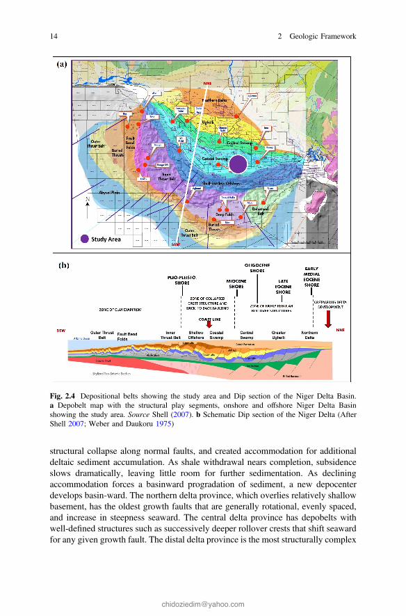
Deposition of the three formations occurred in each of five offlapping siliciclasticsedimentation cycles that comprise the Niger Delta (Fig. 2.4a, b). These cycles(depobelts) are 30–60 km wide, prograde southwestward 250 km over oceaniccrust into the Gulf of Guinea, and are defined by synsedimentary faulting thatoccurred in response to variable interplay of subsidence and sediment supply rates(Doust and Omatsola 1990; Stacher 1995). Depobelts become successively youngerbasinward, ranging in age from Eocene in the north to Pliocene offshore of thepresent shoreline. These depobelts are separate unit that corresponds to a break inregional dip of the delta and is bounded landward by growth faults and seaward bylarge counter-regional faults or the growth fault of the next seaward belt. Eachdepobelt contains a distinct shallowing-upward depositional cycle with its owntripartite assemblage of marine, paralic, and continental deposits.
Depobelts define a series of punctuations in the progradation of this deltaic sys-tem. As deltaic sediment loads increase, underlying delta front and prodelta marineshale begin to move upward and basin-ward. Mobilization of basal shale caused
2.2 Regional Stratigraphic Setting 13
structural collapse along normal faults, and created accommodation for additionaldeltaic sediment accumulation. As shale withdrawal nears completion, subsidenceslows dramatically, leaving little room for further sedimentation. As decliningaccommodation forces a basinward progradation of sediment, a new depocenterdevelops basin-ward. The northern delta province, which overlies relatively shallowbasement, has the oldest growth faults that are generally rotational, evenly spaced,and increase in steepness seaward. The central delta province has depobelts withwell-defined structures such as successively deeper rollover crests that shift seawardfor any given growth fault. The distal delta province is the most structurally complex
Fig. 2.4 Depositional belts showing the study area and Dip section of the Niger Delta Basin.a Depobelt map with the structural play segments, onshore and offshore Niger Delta Basinshowing the study area. Source Shell (2007). b Schematic Dip section of the Niger Delta (AfterShell 2007; Weber and Daukoru 1975)
14 2 Geologic Framework
due to internal gravity tectonics on the modern continental slope. The study area lieswithin the coastal swamp depobelt (Fig. 2.4a). It is described as shelf containedentities with respect to stratigraphy, structure building, and hydrocarbon distribution(Unukogbon et al. 2008).
References
Adesida, A., & Ehirim, B. O. (1988). Cenozoic Niger Delta: A guide to its lithosedimentaryanalysis (pp. 1–10). SPDC Exploration note 88.002 (Ref: on-shore wells).
Avbovbo, A. A. (1978). Tertiary lithostratigraphy of Niger Delta (pp. 96–200). Tulsa, OK:American Association of Petroleum Geologists Bulletin.
Doust, H. (1990). Petroleum geology of the Niger Delta. Geochemical Society, London, SpecialPublications, 50, 365.
Doust, H., & Omatsola, E. (1990). Niger Delta. In J. D. Edwards & P. A. Santogrossi (Eds.),Divergent/passive margin basins (p. 239–248). American Association of Petroleum GeologistsBulletin Memoir 48.
Ejedawe, J. E. (1981). Patterns of incidence of oil reserves in Niger delta basin. AmericanAssociation of Petroleum Geologists Bulletin, 65, 1574–1585.
Ejedawe, J. E., Coker, S. J. L., Lambert-Aikhionbare, D. O., Alofe, K. B., & Adoh, F. O. (1984).Evolution of oil-generative window and oil and gas occurrence in Tertiary Niger Delta Basin.American Association of Petroleum Geologists, 68, 1744–1751.
Evamy, B. D., Haremboure, J., Kamerling, P., Knaap, W. A., Molloy, F. A., & Rowlands, P. H.(1978). Hydrocarbon habitat of Tertiary Niger Delta. American Association of PetroleumGeologists Bulletin, 62, 1–39.
Frankl, E. J., & Cordy, E. A. (1967). The Niger Delta oil province: Recent developments onshoreand offshore. In Proceedings of the Seventh world petroleum congress (Vol. 2, pp. 195–209).Mexico.
Knox, G. J., & Omatsola, E. M. (1989). Development of the Cenozoic Niger delta in terms of the“Escalator Regression” model and impact on hydrocarbon distribution. In Proceedings of theKNGMG Symposium on Coastal Lowlands, Geology and Geotechnology, 1987 (pp. 181–202).Dordrecht: Kluwer.
Kogbe, C. A. (1989). The cretaceous paleocene sediments of southern Nigeria. In C. A. Kogbe(Ed.), Geology of Nigeria (pp. 320–325). Jos: Rock View Ltd.
Lawrence, S. R., Munday, S., & Bray, R. (2002). Regional geology and geophysics of the easternGulf of Guinea (Niger Delta to Rio Muni). The Leading Edge, 21, 1112–1117.
Lehner, P., & De Ruiter, P. A. C. (1977). Structural history of Atlantic margin of Africa. AmericanAssociation of Petroleum Geologists Bulletin, 61, 961–981.
Reijers, T. J. A. (1996). Selected Chapters on Geology: With notes on sedimentary geology,sequence stratigraphy and three case studies and a field guide (197 p.). Warri, Nigeria: S.P.D.C. Corporate Reprographic Services.
Reijers, T. R. A. (2011). Stratigraphy and sedimentology of the Niger Delta. Geologos, 17(3),133–162. doi:10.2478/v10118-011-0008-3
Shell. (2007). Onshore to deep-water geologic integration, Niger Delta. In J. Ejedawe, F. Love, D.Steele, & Ladipo K (Eds.), Presentation pack of Shell Exploration and Production Limited,Port-Harcourt.
Short, K. C., & Stauble, A. J. (1967). Outline of geology of Niger Delta. American Association ofPetroleum Geologists Bulletin, 51, 761–779.
Stacher, P. (1995). Present understanding of the Niger Delta hydrocarbon habitat. In M. N. Oti &G. Postma (Eds.), Geology of deltas (pp. 257–267). Rotterdam: A. A. Balkema.
2.3 Depobelts 15

Tuttle, W. L. M., Brownfield, E. M., & Charpentier, R. R. (1999). The Niger Delta PetroleumSystem. Chapter A: Tertiary Niger Delta (Akata-Agbada) Petroleum System, Niger DeltaProvince, Nigeria, Cameroon and Equatorial Guinea, Africa. U.S. Geolgical Survey, Open FileReport. 99-50-H.
Unukogbon, N. O., Asuen, G. O., & Emofurieta, W. O. (2008). Sequence stratigraphic appraisal:Coastal swamp depobelt in the Niger Delta Basin Nigeria. Global Journal of GeologicalSciences, 6(2), 129–137.
Weber, K. J., & Daukoru, E. M. (1975). Petroleum geology of the Niger Delta. In Proceedings ofthe 9th World Petroleum Congress, Geology (Vol. 2, pp. 210–221). London: Applied SciencePublishers, Ltd.
Wiener, R. W., Mann, M. G., Angelich, M. T., & Molyneux, J. B. (2010). Mobile shale in theNiger Delta: Characteristics, structure, and evolution. In L. Wood (Ed.), Shale tectonics(pp. 145–161). American Association of Petroleum Geologists Memoir 93.
Xiao, H., & Suppe, J. (1992). Origin of rollover. American Association of Petroleum GeologistsBulletin, 76, 509–229.
16 2 Geologic Framework