chevin trail a4 format - chevin forest parkchevinforest.co.uk/uploads/geology/chevin_trail_1.pdf ·...
TRANSCRIPT
Welcome to The Chevin Forest Park Geology Trail.With its distinctive topography and geology, The Chevinis a wonderful and safe place from which to explore andunderstand the underlying geology and subsequenterosion (by ice and water) of what is today known asLower Wharfedale.
In the centre of this leaflet is a geology trail which includes anumber of marker stones at which you can stop and read therelevant information about the geological features. The trail isdesigned to explain how the rocks and fossils of The Chevinwere formed and to show how the landscape of the area isrelated to the rock types and geological processes that havetaken place in the last 300 million years. There is moregeological information to be found on the interpretationboard at Surprise View.
There is also an audio trail available on the Friends ofChevin Forest website www.chevinforest.co.uk. This willtake you around the trail and give you additional informationon the rocks and the landscapes, with a fuller description ofthe views you can see on the trail.
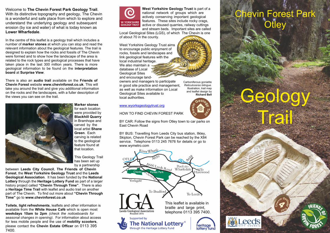
Marker stonesfor each locationwere provided byBlackhill Quarryin Bramhope andcarved by thelocal artist ShaneGreen. Eachcarving is relatedto the geologicalfeature found atthat location.
This Geology Trailhas been set upby a partnership
between Leeds City Council, The Friends of ChevinForest, the West Yorkshire Geology Trust and the LeedsGeological Association. It has been funded by the NationalLottery through the Heritage Lottery Fund as part of a largerhistory project called “Chevin Through Time”. There is alsoa Heritage Time Trail with leaflet and audio trail on anotherpart of The Chevin. To find out more about “Chevin ThroughTime” go to www.chevinforest.co.uk
Toilets, light refreshments, leaflets and other information isavailable from the White House Café which is open mostweekdays 10am to 2pm (check the noticeboards forseasonal changes in opening). For information about accessfor less mobile people and the use of mobility scooters,please contact the Chevin Estate Officer on 0113 3957400.
West Yorkshire Geology Trust is part of anational network of groups which areactively conserving important geologicalfeatures. These sites include rocky crags,active or disused quarries, railway cuttingsand stream beds. Important sites are called
Local Geological Sites (LGS), of which The Chevin is oneof about 70 in the county.
West Yorkshire Geology Trust aimsto encourage public enjoyment ofrocks, fossils and landscapes andlink geological features with thelocal industrial heritage.We also maintain adatabase of LocalGeological Sitesand encourage land-owners and managers to participatein good site practice and management,as well as make information on LocalGeological Sites available tolocal authorities.
www.wyorksgeologytrust.org
HOW TO FIND CHEVIN FOREST PARK
BY CAR: Follow the signs from Otley town to car parks onEast Chevin Road
BY BUS: Travelling from Leeds City bus station, Ilkley,Skipton, Chevin Forest Park can be reached by the X84service. Telephone 0113 245 7676 for details or go towww.wymetro.com
Chevin Forest ParkOtley
This leaflet is available inbraille and large print,telephone 0113 395 7400.
Carboniferous goniatiteReticuloceras bilingue.
Illustration, trail mapand leaflet design by
Richard Bell GeologyTrail
THE MISSING 280 MILLION YEARS
For the last 280 million years northern England hasbeen an upland area on a continent which has driftedvery slowly northwards. Vegetation flourished inwarm times and animal life developed, as reptiles,birds and mammals evolved. However, because anysediments and rocks have been eroded away, thereis very little evidence in this area to show whathappened since the late Carboniferous period untilthe onset of the ice ages 1.8 million years ago.
GLACIAL TIMES
During the last 30 million years global climate hasbeen cooling down, culminating in the developmentof huge ice-sheets in the last 1.8 million years.
Global temperature has fluctuated since then,resulting in many advances and retreats of ice sheetsover Northern Europe. Ice sheets grew in cold timesin high mountain areas and advanced into thelowlands. However, most of the evidence of early iceadvances has been obliterated by later events.
The last glacial stage, called the Devensian, was ata maximum about 17,000 years ago and ice coveredthe high ground in the Otley area. As temperaturesrose, ice melted and ice sheets became thinner. Thethickest ice was confined to valleys in the final stagesof the glacial period. It would have been possible tostand on The Chevin and look over glacial valleys,with ice moving down Wharfedale and Airedale andmeltwater streams filling the valley floors with glacialsands and gravels. The picture on the interpretationboard at Surprise View shows how the landscape ofWharfedale would have looked then.
By about 12,000 years ago, when the ice had meltedcompletely, it left behind deposits of glacial till(boulder clay), which was sometimes washed awayor modified by meltwater.
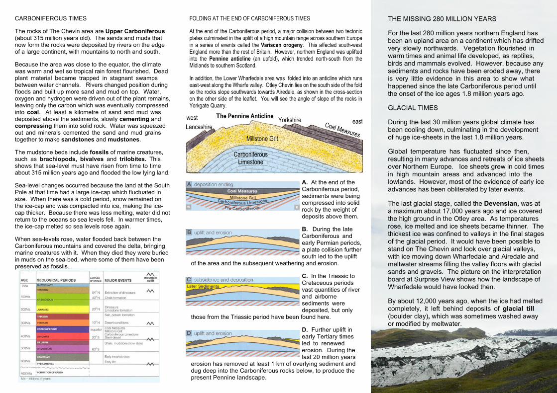
A. At the end of theCarboniferous period,sediments were beingcompressed into solidrock by the weight ofdeposits above them.
B. During the lateCarboniferous andearly Permian periods,a plate collision furthersouth led to the uplift
of the area and the subsequent weathering and erosion.
C. In the Triassic toCretaceous periodsvast quantities of riverand airbornesediments weredeposited, but only
those from the Triassic period have been found here.
D. Further uplift inearly Tertiary timesled to renewederosion. During thelast 20 million years
erosion has removed at least 1 km of overlying sediment anddug deep into the Carboniferous rocks below, to produce thepresent Pennine landscape.
CARBONIFEROUS TIMES
The rocks of The Chevin area are Upper Carboniferous(about 315 million years old). The sands and muds thatnow form the rocks were deposited by rivers on the edgeof a large continent, with mountains to north and south.
Because the area was close to the equator, the climatewas warm and wet so tropical rain forest flourished. Deadplant material became trapped in stagnant swampsbetween water channels. Rivers changed position duringfloods and built up more sand and mud on top. Water,oxygen and hydrogen were driven out of the plant remains,leaving only the carbon which was eventually compressedinto coal. At least a kilometre of sand and mud wasdeposited above the sediments, slowly cementing andcompressing them into solid rock. Water was squeezedout and minerals cemented the sand and mud grainstogether to make sandstones and mudstones.
The mudstone beds include fossils of marine creatures,such as brachiopods, bivalves and trilobites. Thisshows that sea-level must have risen from time to timeabout 315 million years ago and flooded the low lying land.
Sea-level changes occurred because the land at the SouthPole at that time had a large ice-cap which fluctuated insize. When there was a cold period, snow remained onthe ice-cap and was compacted into ice, making the ice-cap thicker. Because there was less melting, water did notreturn to the oceans so sea levels fell. In warmer times,the ice-cap melted so sea levels rose again.
When sea-levels rose, water flooded back between theCarboniferous mountains and covered the delta, bringingmarine creatures with it. When they died they were buriedin muds on the sea-bed, where some of them have beenpreserved as fossils.
Coal MeasuresMillstone Grit
CarboniferousLimestone
west eastLancashire
YorkshireThe Pennine Anticline
FOLDING AT THE END OF CARBONIFEROUS TIMES
At the end of the Carboniferous period, a major collision between two tectonicplates culminated in the uplift of a high mountain range across southern Europein a series of events called the Variscan orogeny. This affected south-westEngland more than the rest of Britain. However, northern England was upliftedinto the Pennine anticline (an upfold), which trended north-south from theMidlands to southern Scotland.
In addition, the Lower Wharfedale area was folded into an anticline which runseast-west along the Wharfe valley. Otley Chevin lies on the south side of the foldso the rocks slope southwards towards Airedale, as shown in the cross-sectionon the other side of the leaflet. You will see the angle of slope of the rocks inYorkgate Quarry.