chattanooga convention center april 23-25,...
TRANSCRIPT
Chattanooga Convention Center April 23-25, 2019

2019 TNGIC April 23 - 25
Chattanooga, TN
Table of Contents
Conference Agenda at a Glance ............................................................................. 3
Letter from the President………………………………………………………….………………………...4
Conference Center Layout ..................................................................................... 5
TNGIC Gold Sponsors ............................................................................................. 6
Exhibitor Sponsors and Exhibit Hall Layout……..…………………………………………………...7
Keynote Speaker Biography & Abstract .................................................................. 8
Map Gallery ........................................................................................................... 9
TNGIC Committees ................................................................................................10
TNGIC Booth ........................................................................................................ 11
TNGIC Board of Directors Nominees .................................................................... 13
Conference Agenda at a Glance
Tuesday, April 23, 2019 (Pre-Registration required)
8:00AM – 12:00PM QGIS – Randal Hale, North River Geographic Systems – Room 9 1:00PM – 4:00PM LIDAR – Paul Dudley, State of Tennessee STS – Room 1 1:00PM – 3:00PM ArcPro– Robert Rike, ESRI – Room 10 10:45AM TNGIC Annual Golf Scramble at Bear Trace at Harrison Bay State Park 2:45PM – 5:00PM Geocache Event – Meet at the Duncan-Parnell booth in Ballrooms H-J (pre-registration required)
Wednesday, April 24, 2019
7:00AM - 9:00AM Breakfast in Ballrooms H-J 8:00AM - 12:00PM Registration 8:00AM – 5:00PM Exhibitors Open – Ballrooms H-J 9:00AM - 9:30AM Opening Session & Board Nominees – Jason Duke, TNGIC President – Ballrooms E-F 9:30AM - 10:30AM Keynote Speaker – William Johnson, Carpe Geo Evangelist 10:30AM - 11:00AM Break – Ballrooms H-J
11:00AM – 11:30AM Dennis Pedersen, State of Tennessee GIS Coordination Update - Room 12 11:30AM – 12:00PM Robert Rike, ESRI – Room 12
12:00PM - 1:00PM Lunch – Ballrooms E-F 1:00PM - 2:30PM Presentations/Workshops – Rooms 3, 12, 13 - See Presentation Agenda 2:30PM - 3:00PM Break – Ballrooms H-J 3:30PM Deadline: Submit Board Member Ballots / Sign up for the Social Cornhole Tournament 3:00PM - 4:30PM Presentations/Workshops – Rooms 3, 12, 13 - See Presentation Agenda 5:00PM Deadline: Submit Map Gallery Viewer’s Choice @ TNGIC Booth ------------------------------------------------------------------------------------------------------------------------------------------------------------------------------------ 6:00PM - 9:00PM Social Event – The Turnbull Building, 1401 Fort Street
Thursday, April 25, 2019
7:00AM – 8:30AM Breakfast in Ballrooms H-J 7:00AM - 3:30AM Exhibitors Open 7:30AM - 10:00AM Registration 8:00AM – 10:00AM Presentations/Workshops – Rooms 3, 12, 13 - See Presentation Agenda 10:00AM - 10:30AM Break / Map Gallery Q & A in Map Gallery 10:30AM - 11:00AM TNGIC Business Meeting – Jason Duke, TNGIC President – Meeting Rooms 12 11:00AM - 11:30AM Regional Meetings:
East Region-Room 3 Middle Region-Room 12 West Region-Room 13
11:30AM – 12:30PM Lunch - Ballrooms E-F 12:30PM – 1:30PM GIS Champion, Map Gallery Awards, Golf and Geocache Winners – Ballroom E-F 1:30PM - 2:00PM Committee Meetings:
Communications/Web & Data – Room 3 Conference – Room 12 Education and Outreach – Room 13 Disaster Response – Ballroom E Professional Development & Training – Demo Theater
2:00PM - 2:30PM Break – Ballrooms H-J 2:30PM - 3:30PM Presentations/Workshops – Rooms 3, 12, 13- See Presentation Agenda 3:30PM - 4:00PM Closing Session, Door Prizes – Ballrooms E-F
TNGIC Community, Welcome to the 2019 TNGIC Conference! We are glad that you have joined hundreds of your fellow GIS Professionals to educate and prognosticate regarding GIS and how you are changing our world. TNGIC has been the driving force for GIS in the State since 1994 and all of you are the drivers, not the passengers. Don’t just attend sessions, but get out there and talk to vendors, vote for Board of Directors and a Map for Viewer’s Choice, and mingle with these jazzed-up GIS folks. If you are young or old, you have a role in steering this ship. Consider running for the BOD next year and be sure to attend a Committee Meeting or a Regional Meeting to volunteer to help. All of us are unpaid volunteers and for TNGIC to succeed, we need dedicated individuals who can team up to tackle the geographic issues we all face. I have enjoyed being your President for my 5th non-consecutive term and for serving on your Board of Directors for the past 20 years. TNGIC is a rewarding organization to serve and it truly belongs to us all. You can help us work to acquire LiDAR, serve data on our clearinghouse, plan Regional GIS Meetings for the Fall, work on the website and serve in various ways. Contact any of the Board of Directors or Committee Chairs to see how you can help. Thanks to Kristen Johnsey, our 2019 TNGIC Conference Coordinator, for planning this grand event for the Chattanooga Convention Center and thanks to her Conference Planning Committee and the Hamilton County GIS staff for hosting us. Chattanooga is a great city with so much to offer that you are sure to enjoy. From natural wonders, beautiful scenery, vibrant arts and great food, there is something for everyone to enjoy in Chattanooga.
Jason Duke TNGIC President
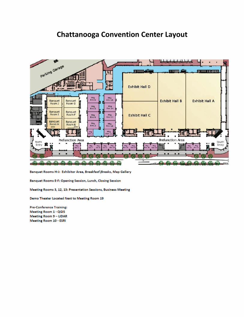
Chattanooga Convention Center Layout

2019 TNGIC GOLD SPONSORS

2019 Exhibitor Sponsors Applied Geographics Atlantic Continental Mapping Consultants CycloMedia Duncan-Parnell GEO Jobe GIS Consulting G-Squared HERE Technologies Infogroup KCI Technologies LIDARUSA Skytec S&ME Tennessee Geographic Alliance Tennessee Tech University University of Tennessee U.S. Census Bureau
Exhibit Hall Layout
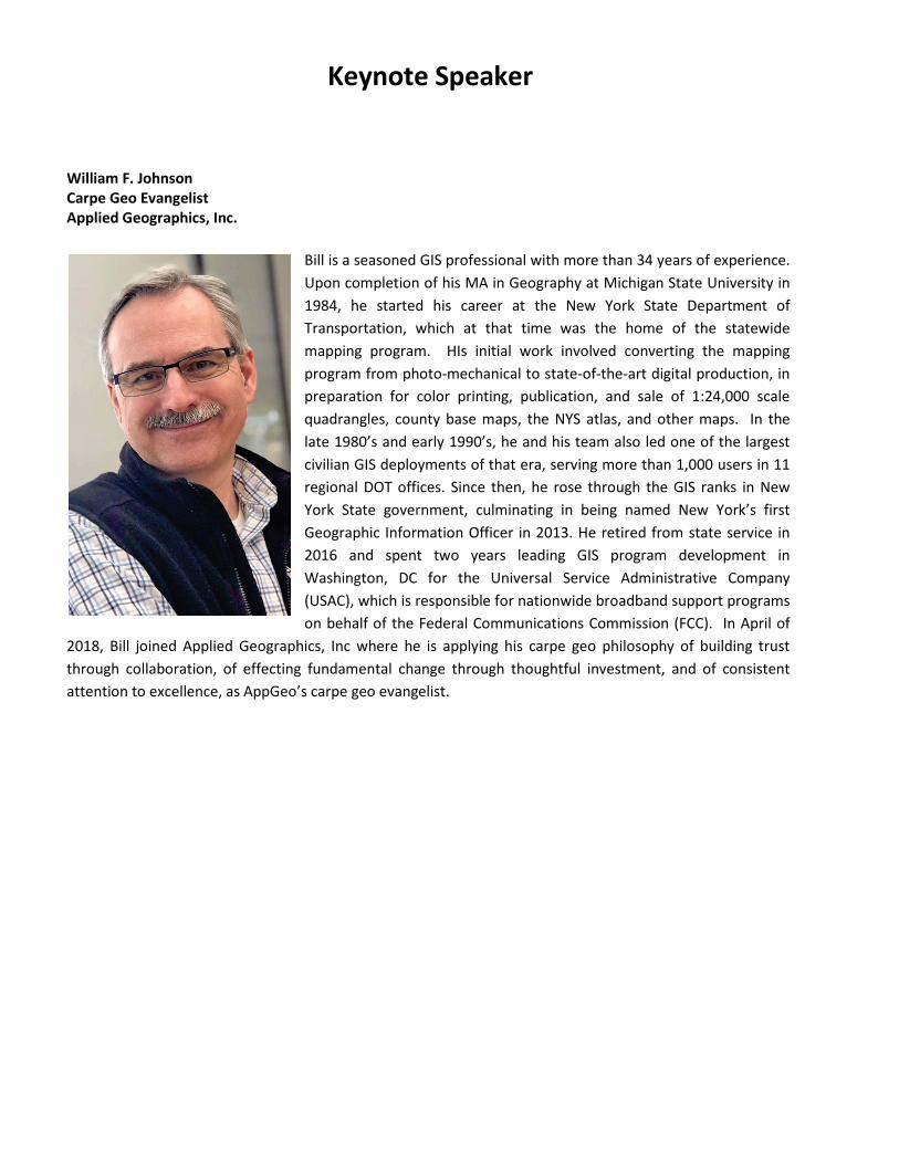
Keynote Speaker
William F. Johnson Carpe Geo Evangelist Applied Geographics, Inc.
Bill is a seasoned GIS professional with more than 34 years of experience. Upon completion of his MA in Geography at Michigan State University in 1984, he started his career at the New York State Department of Transportation, which at that time was the home of the statewide mapping program. HIs initial work involved converting the mapping program from photo-mechanical to state-of-the-art digital production, in preparation for color printing, publication, and sale of 1:24,000 scale quadrangles, county base maps, the NYS atlas, and other maps. In the late 1980’s and early 1990’s, he and his team also led one of the largest civilian GIS deployments of that era, serving more than 1,000 users in 11 regional DOT offices. Since then, he rose through the GIS ranks in New York State government, culminating in being named New York’s first Geographic Information Officer in 2013. He retired from state service in 2016 and spent two years leading GIS program development in Washington, DC for the Universal Service Administrative Company (USAC), which is responsible for nationwide broadband support programs on behalf of the Federal Communications Commission (FCC). In April of
2018, Bill joined Applied Geographics, Inc where he is applying his carpe geo philosophy of building trust through collaboration, of effecting fundamental change through thoughtful investment, and of consistent attention to excellence, as AppGeo’s carpe geo evangelist.
The 2019 TNGIC Annual GIS Conference Map Gallery
Map Judging and Awards Our map contest will feature awards in 5 categories: Best Cartographic Design - Awarded to the map that artistically employs the elements of cartography without compromising use and functionality. Maps will be judged on fundamental cartographic principles including figure ground representations, visual hierarchy, color selection, typography, symbology, overall aesthetic appearance, etc. Best Analysis - Awarded to the map that is best designed to display the results of spatial data analysis and presents the information in an unbiased way, allowing the viewer to extract their own conclusions, utilizing the map as a tool. Best Student Project – Awarded to the best overall student project. Submitted maps may be cartographic or analytically focused. Best Story Map – Awarded to the best ESRI Story Map using ArcGIS online. Story map entries will be judged before the conference. At this time this category will not be eligible for the Viewer’s Choice award. Viewer’s Choice – Award chosen by the attendees for the best overall poster. Please submit your Map Gallery Viewer’s Choice ballot at the TNGIC Booth by 5:00pm on Wednesday. Conference Proceedings • Maps are to be checked in at the conference registration table. • Authors will be available in the map gallery at a time designated in the conference agenda to answer questions about their map. • Award recipients will be announced during lunch of the second day of the conference Attention 4-H members: Enter the Tennessee 4-H GIS Contest, sponsored by TNGIC and UT Extension. Contact your local UT Extension 4-H agent for details.
TNGIC Committees
Thursday 1:30-2:00pm TNGIC Committees will meet to discuss plans for the upcoming year and to organize members who would like to help on a committee.
The Communication/Web & Data Committee produces the quarterly newsletter “TNGIC Today”, strives to improve the communication throughout TNGIC and facilitates data sharing and distribution throughout the geospatial community. The goal is to increase the connectivity of TNGIC members through a web presence and social media. This committee is responsible for creating and distributing information that includes, but not limited to lists of GIS related groups and sites, GIS job postings, and the web site content, promotion and maintenance. The Conference Planning Committee organizes, plans, and facilitates the TNGIC Annual GIS Conference. This committee handles all of the details and decisions that are required to make this a successful event for TNGIC members. The goal of the Education & Outreach Committee is to foster educational opportunities and promote awareness of TNGIC throughout the geospatial community. These opportunities include creating training classes and workshops, supporting TNGIC regional meetings, student outreach, and GIS day activities. The goal of the Disaster Response Committee is to gather, manage, and provide a database of GIS professionals across Tennessee to aid in the event of a disaster or emergency. A secure survey is used to collect individual’s contact information. The database is managed by the Disaster Response Committee and the TNGIC Board. This database is beneficial to emergency responders at various levels by providing an efficient source of locating GIS assistance and resources. The goal of the Professional Development and Training Committee is to promote professional development and foster educational opportunities and excellence for the TNGIC membership and the geospatial community. These opportunities may include conference, paper presentation and poster contest announcements, outreach and mentoring, scholarships to the TNGIC Annual Conference, training coordination, student involvement, and communication with GIS academia in Tennessee. Active members may earn a certificate of participation, at the discretion of the chair, which may be used toward GISP certification.
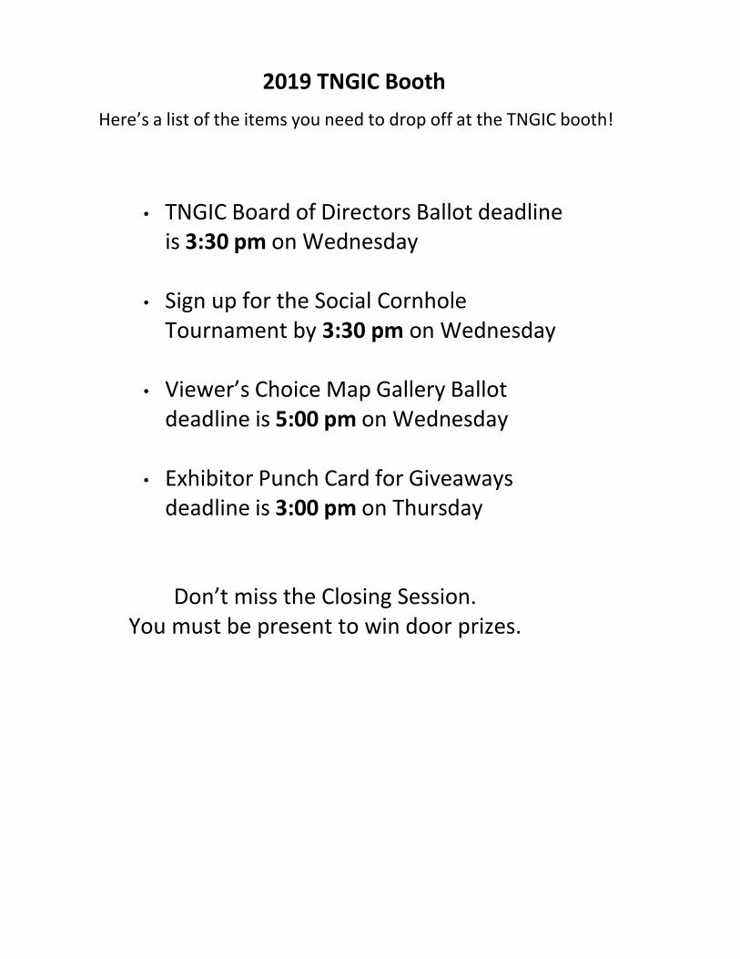
2019 TNGIC Booth Here’s a list of the items you need to drop off at the TNGIC booth!
• TNGIC Board of Directors Ballot deadline is 3:30 pm on Wednesday
• Sign up for the Social Cornhole Tournament by 3:30 pm on Wednesday
• Viewer’s Choice Map Gallery Ballot
deadline is 5:00 pm on Wednesday
• Exhibitor Punch Card for Giveaways deadline is 3:00 pm on Thursday
Don’t miss the Closing Session. You must be present to win door prizes.
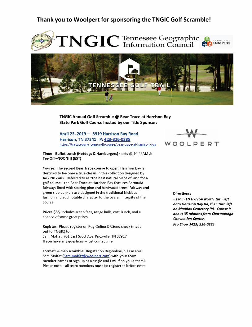
Thank you to Woolpert for sponsoring the TNGIC Golf Scramble!
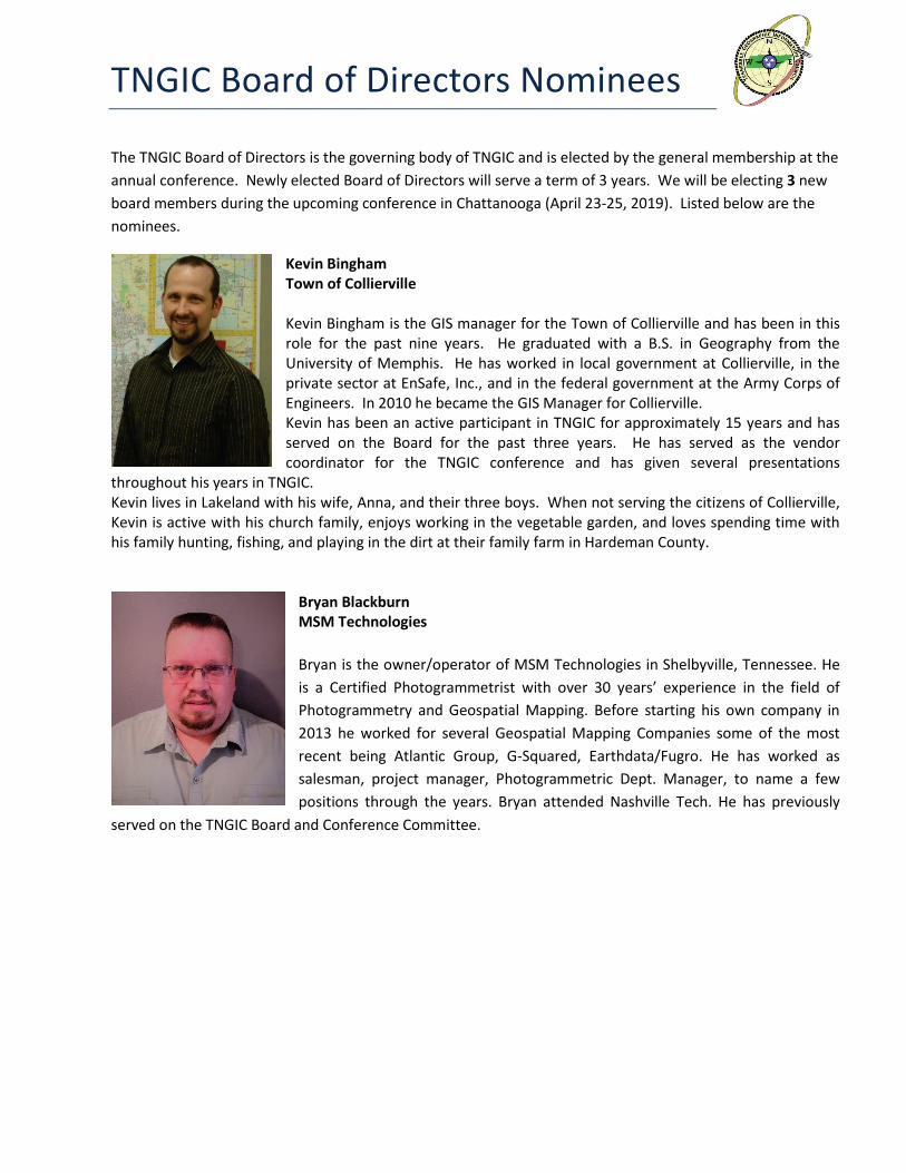
TNGIC Board of Directors Nominees
The TNGIC Board of Directors is the governing body of TNGIC and is elected by the general membership at the annual conference. Newly elected Board of Directors will serve a term of 3 years. We will be electing 3 new board members during the upcoming conference in Chattanooga (April 23-25, 2019). Listed below are the nominees.
Kevin Bingham Town of Collierville Kevin Bingham is the GIS manager for the Town of Collierville and has been in this role for the past nine years. He graduated with a B.S. in Geography from the University of Memphis. He has worked in local government at Collierville, in the private sector at EnSafe, Inc., and in the federal government at the Army Corps of Engineers. In 2010 he became the GIS Manager for Collierville. Kevin has been an active participant in TNGIC for approximately 15 years and has served on the Board for the past three years. He has served as the vendor coordinator for the TNGIC conference and has given several presentations
throughout his years in TNGIC. Kevin lives in Lakeland with his wife, Anna, and their three boys. When not serving the citizens of Collierville, Kevin is active with his church family, enjoys working in the vegetable garden, and loves spending time with his family hunting, fishing, and playing in the dirt at their family farm in Hardeman County.
Bryan Blackburn MSM Technologies Bryan is the owner/operator of MSM Technologies in Shelbyville, Tennessee. He is a Certified Photogrammetrist with over 30 years’ experience in the field of Photogrammetry and Geospatial Mapping. Before starting his own company in 2013 he worked for several Geospatial Mapping Companies some of the most recent being Atlantic Group, G-Squared, Earthdata/Fugro. He has worked as salesman, project manager, Photogrammetric Dept. Manager, to name a few positions through the years. Bryan attended Nashville Tech. He has previously
served on the TNGIC Board and Conference Committee.
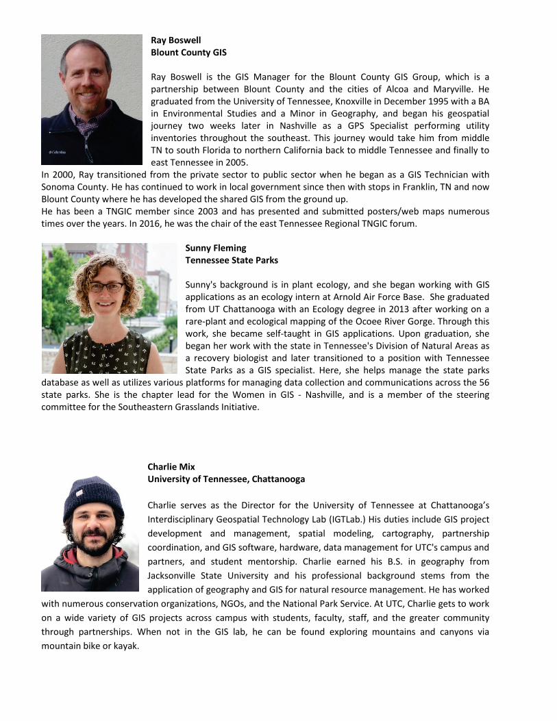
Ray Boswell Blount County GIS Ray Boswell is the GIS Manager for the Blount County GIS Group, which is a partnership between Blount County and the cities of Alcoa and Maryville. He graduated from the University of Tennessee, Knoxville in December 1995 with a BA in Environmental Studies and a Minor in Geography, and began his geospatial journey two weeks later in Nashville as a GPS Specialist performing utility inventories throughout the southeast. This journey would take him from middle TN to south Florida to northern California back to middle Tennessee and finally to east Tennessee in 2005.
In 2000, Ray transitioned from the private sector to public sector when he began as a GIS Technician with Sonoma County. He has continued to work in local government since then with stops in Franklin, TN and now Blount County where he has developed the shared GIS from the ground up. He has been a TNGIC member since 2003 and has presented and submitted posters/web maps numerous times over the years. In 2016, he was the chair of the east Tennessee Regional TNGIC forum.
Sunny Fleming Tennessee State Parks Sunny's background is in plant ecology, and she began working with GIS applications as an ecology intern at Arnold Air Force Base. She graduated from UT Chattanooga with an Ecology degree in 2013 after working on a rare-plant and ecological mapping of the Ocoee River Gorge. Through this work, she became self-taught in GIS applications. Upon graduation, she began her work with the state in Tennessee's Division of Natural Areas as a recovery biologist and later transitioned to a position with Tennessee State Parks as a GIS specialist. Here, she helps manage the state parks
database as well as utilizes various platforms for managing data collection and communications across the 56 state parks. She is the chapter lead for the Women in GIS - Nashville, and is a member of the steering committee for the Southeastern Grasslands Initiative.
Charlie Mix University of Tennessee, Chattanooga Charlie serves as the Director for the University of Tennessee at Chattanooga’s Interdisciplinary Geospatial Technology Lab (IGTLab.) His duties include GIS project development and management, spatial modeling, cartography, partnership coordination, and GIS software, hardware, data management for UTC's campus and partners, and student mentorship. Charlie earned his B.S. in geography from Jacksonville State University and his professional background stems from the application of geography and GIS for natural resource management. He has worked
with numerous conservation organizations, NGOs, and the National Park Service. At UTC, Charlie gets to work on a wide variety of GIS projects across campus with students, faculty, staff, and the greater community through partnerships. When not in the GIS lab, he can be found exploring mountains and canyons via mountain bike or kayak.

2016 TNGIC Conference Planning Committee The Conference Planning Committee is made up of individuals from Federal, State, and Local Government and private industry across Tennessee who volunteer their time and effort to make this a successful event. Without the hard work of all these individuals this conference would not have been possible. Please let them know their work is appreciated. Sincerely, Kristen Johnsey Conference Chair Conference Committee
Bill Avant Brant Sollis Bryan Blackburn Cliff Hoeffner Chris Rice David Light
Jason Duke Jason Shaneyfelt Kevin Bingham Kim McKinney Matt Lane Sam Moffat
Tripp Spear
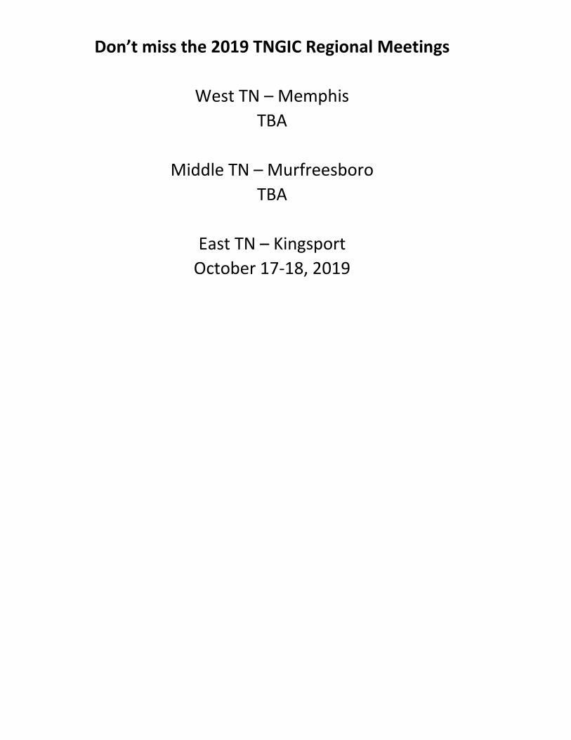
Don’t miss the 2019 TNGIC Regional Meetings
West TN – Memphis TBA
Middle TN – Murfreesboro
TBA
East TN – Kingsport October 17-18, 2019
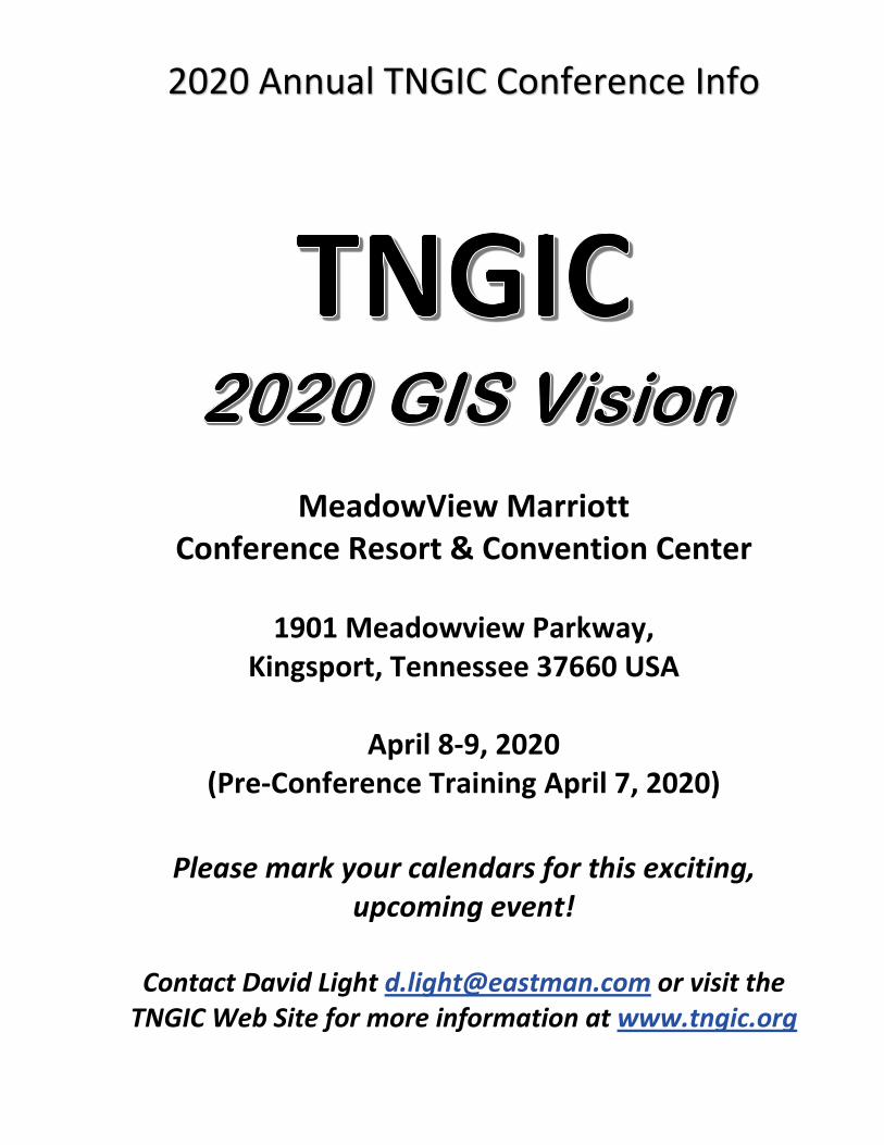
2020 Annual TNGIC Conference Info
MeadowView Marriott
Conference Resort & Convention Center
1901 Meadowview Parkway, Kingsport, Tennessee 37660 USA
April 8-9, 2020
(Pre-Conference Training April 7, 2020)
Please mark your calendars for this exciting, upcoming event!
Contact David Light [email protected] or visit the
TNGIC Web Site for more information at www.tngic.org
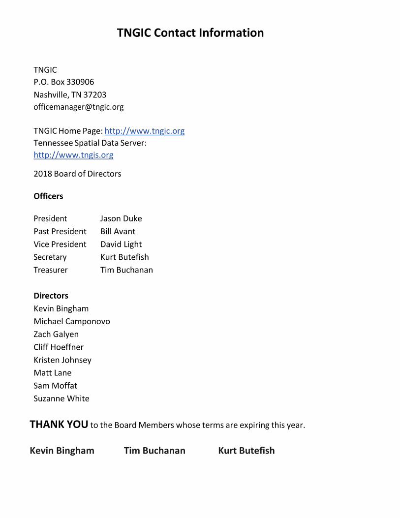
TNGIC Contact Information
TNGIC P.O. Box 330906 Nashville, TN 37203 [email protected]
TNGIC Home Page: http://www.tngic.org Tennessee Spatial Data Server: http://www.tngis.org
2018 Board of Directors Officers President Jason Duke Past President Bill Avant Vice President David Light Secretary Kurt Butefish Treasurer Tim Buchanan
Directors Kevin Bingham Michael Camponovo Zach Galyen Cliff Hoeffner Kristen Johnsey Matt Lane Sam Moffat Suzanne White
THANK YOU to the Board Members whose terms are expiring this year. Kevin Bingham Tim Buchanan Kurt Butefish
