characterizing the deep insular shelf coral reef habitat
TRANSCRIPT
ARTICLE IN PRESS
0278-4343/$ - se
doi:10.1016/j.csr
�Correspondifax: +1787 899
E-mail addre
rarmstrong@wh
Continental Shelf Research 26 (2006) 194–205
www.elsevier.com/locate/csr
Characterizing the deep insular shelf coral reef habitat of theHind Bank marine conservation district (US Virgin Islands)
using the Seabed autonomous underwater vehicle
Roy A. Armstronga,�, Hanumant Singhb, Juan Torresa, Richard S. Nemethc,Ali Canb, Chris Romanb, Ryan Eusticeb, Lauren Riggsd, Graciela Garcia-Molinera,e
aBio-optical Oceanography Laboratory, University of Puerto Rico, Mayaguez, PR 00681-9013, USAbDepartment of Applied Ocean Physics and Engineering, Woods Hole Oceanographic Institution, Woods Hole, MA 02543-1109, USA
cCenter for Marine and Environmental Studies, University of the Virgin Islands, St. Thomas, USVI 00802, USAdEconomics and Environmental Studies Program, Saint Mary’s College of Maryland, Saint Mary’s City, MD 20686, USA
eCaribbean Fishery Management Council, 268 Munoz Rivera Avenue, Suite 1108, San Juan, PR 00918, USA
Received 14 January 2005; received in revised form 24 October 2005; accepted 26 October 2005
Available online 4 January 2006
Abstract
The benthic communities of the deep insular shelf at the Hind Bank marine conservation district (MCD), an important
spawning aggregation site for groupers, were studied with the Seabed autonomous underwater vehicle (AUV) at depths
between 32 and 54m. Four digital phototransects provided data on benthic species composition and abundance of the
insular shelf off St. Thomas, US Virgin Islands. Within the western side of the MCD, well-developed coral reefs with 43%
mean living coral cover were found. The Montastrea annularis complex was dominant at all four sites between 33 and 47m,
the depth range where reefs were present. Maximum coral cover found was 70% at depths of 38–40m. Quantitative
determinations of sessile benthic populations, as well as the presence of motile megabenthic invertebrates and algae were
obtained. The Seabed AUV provided new quantitative and descriptive information of a unique coral reef habitat found
within this deeper insular shelf area.
r 2005 Elsevier Ltd. All rights reserved.
Keywords: Atlantic; US Virgin Islands; Coral reef; Deep hermatypic corals; AUV
1. Introduction
Shallow coral reefs in the tropical West AtlanticOcean have experienced living coral cover declinesof up to 80% in the last 30 yr (Gardner et al., 2003).
e front matter r 2005 Elsevier Ltd. All rights reserved
.2005.10.004
ng author. Tel.: +1 787 899 6875;
5500.
sses: [email protected],
oi.edu (R.A. Armstrong).
Pollution, sedimentation, hurricanes and coraldisease are all contributors to the decline in livingcoral cover. While numerous assessments of coralreef habitat have been conducted throughout thetropical western Atlantic and elsewhere usingSCUBA, there is limited information on the deeperreefs zones, up to 100m, which lie beyond the rangeof safe diving operations. Mapping and monitoringdeeper hermatypic (zooxanthellate) coral reefs isnecessary for selecting and protecting unique areas
.
ARTICLE IN PRESSR.A. Armstrong et al. / Continental Shelf Research 26 (2006) 194–205 195
of high-living coral cover, diversity and structuralcomplexity that could aid in the recovery of theshallower fish and benthic communities.
In the past, an evaluation of deep-water fishhabitats and abundance around Puerto Rico andthe US Virgin Islands, at depths ranging from about100–450m, was conducted using the Johnson-Sea-
Link II submersible (Nelson and Appeldoorn,1985). To this day, the upper insular slope reefs ofPuerto Rico and the Virgin Islands, found atintermediate depths (30–100m) remain largelyundescribed.
The Seabed autonomous underwater vehicle(AUV) is a new imaging platform designed forhigh-resolution optical and acoustic sensing (Singhet al., 2004). The Seabed was tested over the insularshelf slope off southwestern Puerto Rico in March2002 to a maximum depth of 125m (Armstronget al., 2002; Singh et al., 2004). This test diveestablished the potential of this new tool formapping and characterizing the upper insular slopecoral reef habitat.
During June 2003, we used the Seabed forimaging the benthic habitats of the shelf edge andupper insular slope of the Hind Bank marineconservation district (MCD), South of St. Thomas,US Virgin Islands. The MCD is a non-fishing areathat was established as per recommendation offishers, scientists and government officials in 1999,to conserve and manage representative samples ofmarine habitats and ecosystems and to maintainmarine biodiversity. The area was originally man-aged as a seasonal closure for the protection of thered hind (Epinephelus guttatus) spawning aggrega-tion on the eastern side of the MCD. The spawningaggregation primary site was described by Beets andFriedlander (1997). The dominant coral present wasflattened colonies of Montastrea annularis. Morerecently, a limited number of diver surveys at depthsof 38–39m were conducted by Nemeth et al. (2004).
Up to now, very little quantitative informationhas been available on the structure and compositionof the coral reefs at the MCD due to the depth ofthese reefs. The goal of this study was to character-ize the benthic community structure and biodiver-sity of these deeper insular shelf corals reefs. TheSeabed high-resolution color images were used todescribe the major components of the coral reefcommunity of the MCD, which includes corals,gorgonians, sponges, other macro-invertebrates andalgae, and to quantify living coral cover, speciesrichness, diversity and evenness.
2. Study area
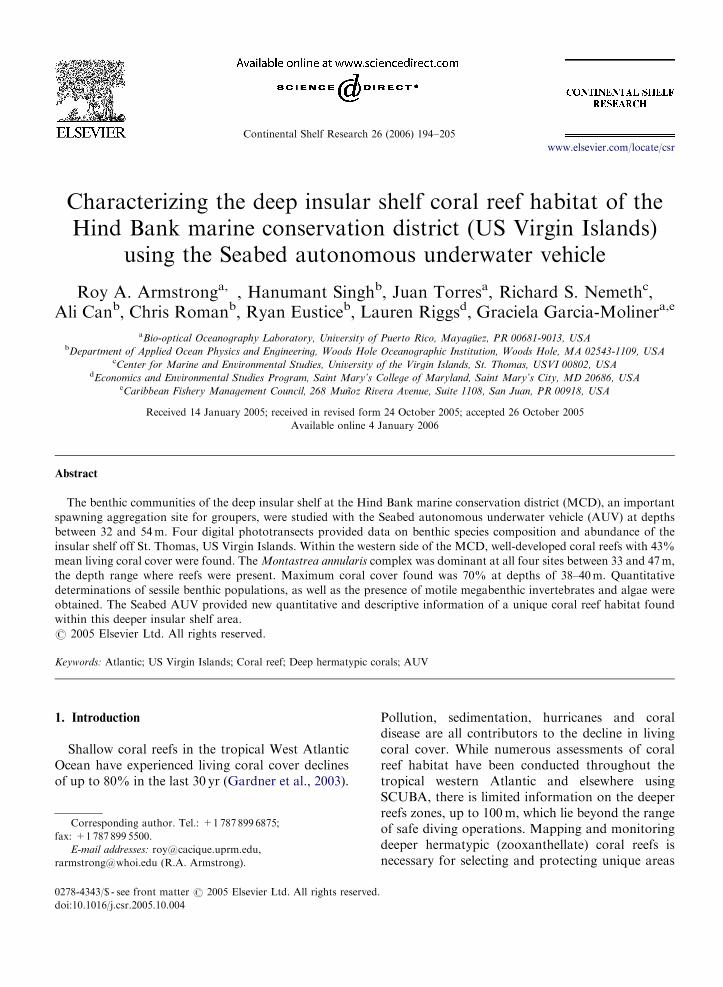
The Hind Bank MCD is located approximately12 km South of St. Thomas, US Virgin Islands, atthe shelf edge encompassing an area of approxi-mately 41 km2 (Fig. 1). According to the bathymetrymap of this area, depth ranges within the MCDfrom about 30m on the western part to more than430m off the shelf edge. Within the insular shelfarea of the MCD the maximum depth is approxi-mately 62m, with an average depth of 42m on theeastern half. Four, 1-km-long transects wereselected for the AUV surveys based on the knowndistribution of coral reef habitats and fish spawninggrounds provided by previous SCUBA assessments.The two transects on the western side of the MCDwere parallel to the shore over areas dominated bycoral reefs. The eastern transects were orientedperpendicular to shore at known fish spawning sites.
3. Materials and methods
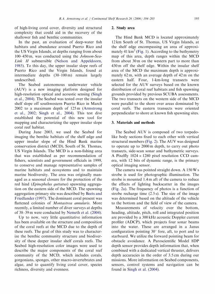
The Seabed AUV is composed of two torpedo-like body sections fixed to each other with verticalstructural members (Fig. 2). The AUV was designedto operate up to 2000m depth, to carry out phototransects, side-scan sonar and bathymetric surveys.A Pixelfly 1024� 1280 pixel resolution CCD cam-era, with 12 bits of dynamic range, is the primaryoptical imaging sensor.
The camera was pointed straight down. A 150Wsstrobe is used for photographic illumination. Thestrobe is mounted 1.4m aft of the camera to reducethe effects of lighting backscatter in the images(Fig. 2a). The frequency of photos is a function ofstrobe recharge time (2.5 s). The size of the imagewas determined based on the altitude of the vehicleto the bottom and the field of view of the camera.
Measurements of velocity over the bottom,heading, altitude, pitch, roll and integrated positionare provided by a 300 kHz acoustic Doppler currentprofiler (ADCP), which projects four sonar beamsinto the water. These are arranged in a Janusconfiguration pointing 301 fore, aft, to port and tostarboard. We utilize the forward pointing beam forobstacle avoidance. A Paroscientific Model 8DPdepth sensor provides depth information that, whencombined with a dedicated vertical thruster, deliversdepth accuracies in the order of 3.5 cm during ourmissions. More information on Seabed components,sensors, control systems and navigation can befound in Singh et al. (2004).
ARTICLE IN PRESS
Fig. 2. Seabed AUV: (A) schematic diagram of the major
components and (B) external view.
Fig. 1. Map of the Hind Bank MCD. The location of the MCD in relation to Puerto Rico and the US Virgin Islands is indicated by an
arrow. Corner coordinates are: (A) 18113.20N, 651060W; (B) 18113.20N, 641590W; (C) 18110.70N, 651060W; (D) 18111.80N, 641590W
(Federal Register 64 (213): 60132-60133; 4 November 1999) (50 CFR Part 622 y622.33 (b) (1)).
R.A. Armstrong et al. / Continental Shelf Research 26 (2006) 194–205196
The AUV, which runs at speeds between 0.3m/sto 1m/s, was programmed to run at minimum speedand to maintain a fixed distance from the bottom, toavoid collisions in case sudden changes in bottomrelief were encountered. The distribution of the fourthrusters, coupled with the passive stability of atwo-hulled vehicle with a large meta-centric height(Fig. 2b), allows the Seabed to survey close to thesea floor, even in very rugged terrain, and to followa greater than 451 slope. As opposed to most otherAUV’s, the Seabed was designed to be hovercapable, i.e., to be able to independently drive inthe X, Y and Z axes.
Each transect was approximately 1 km in lengthand produced over 500 images, each about 3.1mwide by 2.5m long, at the predetermined 4mdistance from the bottom. The exact depth of eachimage was determined by combining the depth ofthe AUV (measured with the Paroscientific sensor)with its altitude (measured by the ADCP). Theinitial position of the vehicle at launch is determinedby shipboard GPS with an accuracy of tens ofmeters.
Underwater imagery is typically characterized bylow contrast and low color fidelity. The nonlinearattenuation of the visible spectrum in seawatercauses parts of the visible spectrum to be preferen-tially attenuated. Thus most underwater imagestend to be saturated in the blue–green region. We
ARTICLE IN PRESSR.A. Armstrong et al. / Continental Shelf Research 26 (2006) 194–205 197
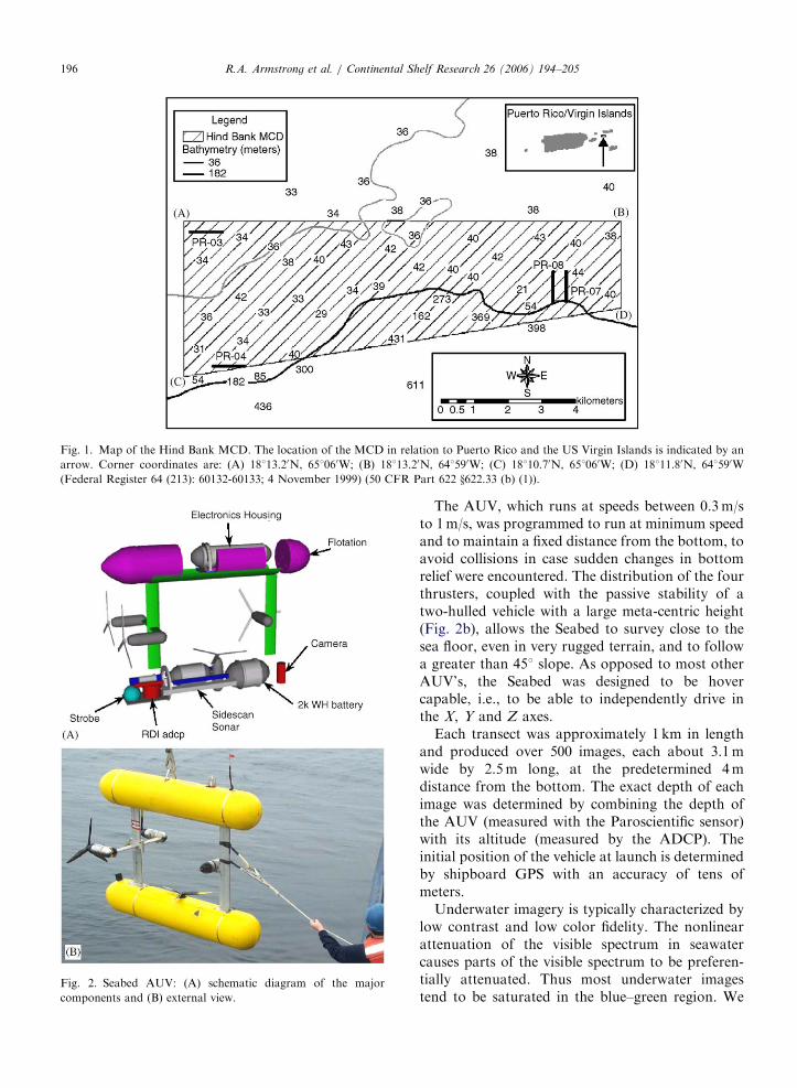
reprocessed the raw imagery to obtain threechannel, 1280� 1024� 12 bit RGB images. The 12bits of dynamic range provided by the camera thatis part of Seabed allow us to compensate and colorbalance the imagery, as shown in Fig. 3.
The enhanced benthic imagery was analyzed forpercent cover of living corals and other benthiccomponents using random points generated by thePoint Count for Coral Reefs software (P. Dustan,personal communication). The clearest, best qualityimages (50–70 per transect) were selected andindividually analyzed using 50 random points, andthe percent cover of corals, sponges, algae and baresubstrate was recorded. From images acquiredwithin coral reef areas the diversity index for coralswas calculated using the Shannon–Weaver diversityindex
H 0 ¼ �X
Pi ln Pi, (1)
where Pi ¼ ni=n and n ¼ total number of coralcolonies. Evenness was calculated using Pielou’s
Fig. 3. Reef at a depth of 40m at PR-04 before (A) and after
(B) color enhancement. Scale bar ¼ 1m.
evenness index
J ¼ H 0= ln Hmax, (2)
where Hmax ¼ total number coral species.
4. Results
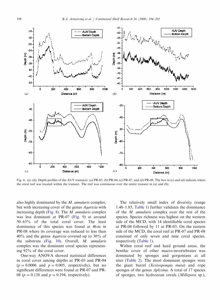
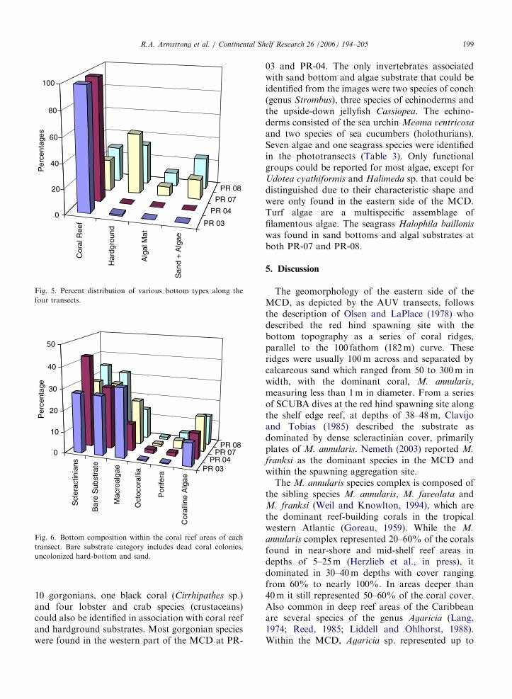
At the western side of the MCD, the reef at PR-03had a depth range from 33 to 42m (Fig. 4a) while,at PR-04, the reef extended from 36 to 41m in depth(Fig. 4b). Higher depths were found at the easternside of the MCD where the transect lines wereperpendicular to the coast and extended beyond theshelf edge. At PR-07 the reef was restricted to anarrow zone, 45 to 47m deep, in a transect thatexceeded 60m in depth (Fig. 4c). In a similar way, atPR-08, coral reefs were only present in the middle ofthe transect at depths from 41 to 46m (Fig. 4d). Inall cases, the AUV followed the bottom contourmaintaining a distance of approximately 4m fromthe bottom. In addition to depth, bottom composi-tion varied considerably between the East and theWest transects of the MCD. Transects PR-03 andPR-04 were mainly composed of coral reef areas(97% and 100%, respectively), whereas transectsPR-07 and PR-08 consisted of small coral reefpatches separated by hardground areas along withalgal mats, sand and sparse seagrasses (Fig. 5).Hardgrounds are low-relief areas where sedimentshave been lithified into rock. In these consolidatedsubstrates sparse sponges, gorgonians and algaemay be present. Algal mats are a dense layer ofalgae that blanket the bottom, while ‘‘sand’’ refersto substrates of unconsolidated calcium carbonategrains. Seagrasses were only present within the algalmats and sand bottom categories. Within the reefareas, coral cover at PR-04 was significantly higher(po0:05) than at the other three sites, with coralcover ranging from 29% to 43% (Fig. 6). Baresubstrate was the second most important category,in terms of percent cover within coral reefs areas,except for PR-03 where macro-algae was thedominant component. Macro-algae was character-ized by green, brown and red algae, while the baresubstrate category includes dead coral colonies,uncolonized hard-bottom and sand.
Within the scleractinian cover composition, theimage data analysis revealed dominance by M.
annularis complex at all transects, but particularly atPR-03 (Fig. 7) where the average cover of M.
annularis was about 90% and this dominance wasnearly constant with depth. At PR-04, the reef was
ARTICLE IN PRESS
Fig. 4. (a)–(d). Depth profiles of the AUV transects: (a) PR-03, (b) PR-04, (c) PR-07, and (d) PR-08. The box in (c) and (d) indicate where
the coral reef was located within the transect. The reef was continuous over the entire transect in (a) and (b).
R.A. Armstrong et al. / Continental Shelf Research 26 (2006) 194–205198
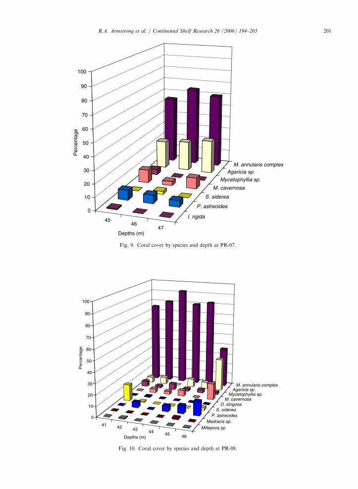
also highly dominated by the M. annularis complex,but with increasing cover of the genus Agaricia withincreasing depth (Fig. 8). The M. annularis complexwas less dominant at PR-07 (Fig. 9) at around50–63% of the total coral cover. The leastdominance of this species was found at 46m inPR-08 where its coverage was reduced to less than40% and the genus Agaricia covered up to 30% ofthe substrate (Fig. 10). Overall, M. annularis
complex was the dominant coral species represent-ing 92% of the coral cover.
One-way ANOVA showed statistical differencesin coral cover among depths at PR-03 and PR-04(p ¼ 0:0006 and p ¼ 0:005, respectively), but nosignificant differences were found at PR-07 and PR-08 (p ¼ 0:138 and p ¼ 0:194, respectively).
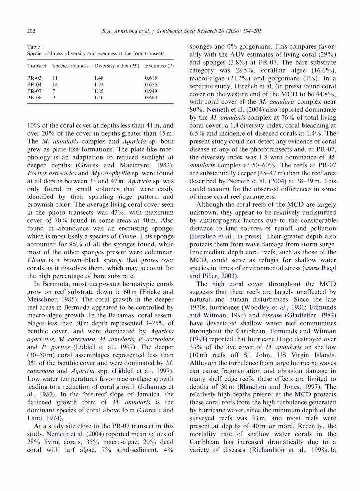
The relatively small index of diversity (range1.48–1.85, Table 1) further validates the dominanceof the M. annularis complex over the rest of thespecies. Species richness was highest on the westernside of the MCD, with 14 identifiable coral speciesat PR-04 followed by 11 at PR-03. On the easternside of the MCD, the coral reef at PR-07 and PR-08consisted of only seven and nine coral species,respectively (Table 1).
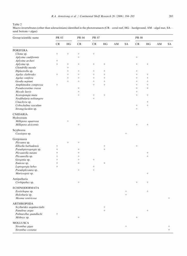
Within coral reef and hard ground areas, thebenthic cover of other macro-invertebrates wasdominated by sponges and gorgonians at allsites (Table 2). The most dominant sponges werethe giant barrel (Xestospongia muta) and ropesponges of the genus Aplysina. A total of 17 speciesof sponges, two hydrozoan corals (Millepora sp.),
ARTICLE IN PRESS
Cor
al R
eef
Har
dgro
und
Alg
al M
at
San
d +
Alg
ae
PR 03
PR 04
PR 07
PR 08
0
20
40
60
80
100
Per
cent
ages
Fig. 5. Percent distribution of various bottom types along the
four transects.
Scl
erac
tinia
ns
Bar
e S
ubst
rate
Mac
roal
gae
Oct
ocor
allia
Por
ifera
Cor
allin
e A
lgae
PR 03PR 04
PR 07PR 08
0
10
20
30
40
50
Per
cent
age
Fig. 6. Bottom composition within the coral reef areas of each
transect. Bare substrate category includes dead coral colonies,
uncolonized hard-bottom and sand.
R.A. Armstrong et al. / Continental Shelf Research 26 (2006) 194–205 199
10 gorgonians, one black coral (Cirrhipathes sp.)and four lobster and crab species (crustaceans)could also be identified in association with coral reefand hardground substrates. Most gorgonian specieswere found in the western part of the MCD at PR-
03 and PR-04. The only invertebrates associatedwith sand bottom and algae substrate that could beidentified from the images were two species of conch(genus Strombus), three species of echinoderms andthe upside-down jellyfish Cassiopea. The echino-derms consisted of the sea urchin Meoma ventricosa
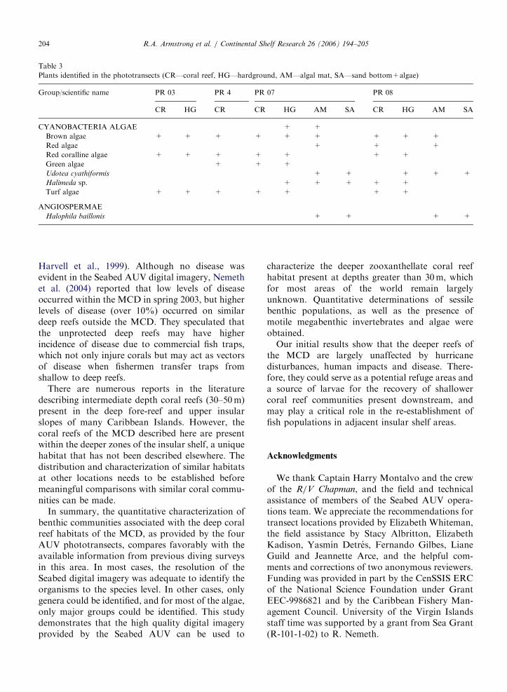
and two species of sea cucumbers (holothurians).Seven algae and one seagrass species were identifiedin the phototransects (Table 3). Only functionalgroups could be reported for most algae, except forUdotea cyathiformis and Halimeda sp. that could bedistinguished due to their characteristic shape andwere only found in the eastern side of the MCD.Turf algae are a multispecific assemblage offilamentous algae. The seagrass Halophila baillonis
was found in sand bottoms and algal substrates atboth PR-07 and PR-08.
5. Discussion
The geomorphology of the eastern side of theMCD, as depicted by the AUV transects, followsthe description of Olsen and LaPlace (1978) whodescribed the red hind spawning site with thebottom topography as a series of coral ridges,parallel to the 100 fathom (182m) curve. Theseridges were usually 100m across and separated bycalcareous sand which ranged from 50 to 300m inwidth, with the dominant coral, M. annularis,measuring less than 1m in diameter. From a seriesof SCUBA dives at the red hind spawning site alongthe shelf edge reef, at depths of 38–48m, Clavijoand Tobias (1985) described the substrate asdominated by dense scleractinian cover, primarilyplates of M. annularis. Nemeth (2003) reported M.
franksi as the dominant species in the MCD andwithin the spawning aggregation site.
The M. annularis species complex is composed ofthe sibling species M. annularis, M. faveolata andM. franksi (Weil and Knowlton, 1994), which arethe dominant reef-building corals in the tropicalwestern Atlantic (Goreau, 1959). While the M.
annularis complex represented 20–60% of the coralsfound in near-shore and mid-shelf reef areas indepths of 5–25m (Herzlieb et al., in press), itdominated in 30–40m depths with cover rangingfrom 60% to nearly 100%. In areas deeper than40m it still represented 50–60% of the coral cover.Also common in deep reef areas of the Caribbeanare several species of the genus Agaricia (Lang,1974; Reed, 1985; Liddell and Ohlhorst, 1988).Within the MCD, Agaricia sp. represented up to

ARTICLE IN PRESS
33 34 35 36 37 38 39 40 41 42L. cucullata
C. natansS. bournoni
P. poritesP. astreoides
S. sidereaD. strigosa
M. cavernosaMycetophyllia sp.
Agaricia sp.M. annularis complex
0
10
20
30
40
50
60
70
80
90
100
Per
cent
age
Depths (m)
Fig. 7. Coral cover by species and depth at PR-03.
36 37 38 39 40 41I. rigida
Madracis sp.Scolymia sp.
L. cucullataC. natans
S. bournoniP. porites
P. astreoidesS. siderea
D. strigosaM. cavernosa
Mycetophyllia sp.Agaricia sp.
M. annularis complex
0
10
20
30
40
50
60
70
80
90
100
Per
ceta
nge
Depths (m)
Fig. 8. Coral cover by species and depth at PR-04.
R.A. Armstrong et al. / Continental Shelf Research 26 (2006) 194–205200
ARTICLE IN PRESS
4546
47
I. rigida
P. astreoides
S. siderea
M. cavernosa
Mycetophyllia sp.
Agaricia sp.M. annularis complex
0
10
20
30
40
50
60
70
80
90
100P
erce
ntag
e
Depths (m)
Fig. 9. Coral cover by species and depth at PR-07.
41 42 43 44 45 46
Millepora sp.Madracis sp.
P. astreoidesS. siderea
D. strigosaM. cavernosa
Mycetophyllia sp.Agaricia sp.
M. annularis complex
0
10
20
30
40
50
60
70
80
90
100
Per
cent
age
Depths (m)
Fig. 10. Coral cover by species and depth at PR-08.
R.A. Armstrong et al. / Continental Shelf Research 26 (2006) 194–205 201
ARTICLE IN PRESS
Table 1
Species richness, diversity and evenness at the four transects
Transect Species richness Diversity index (H0) Evenness (J)
PR-03 11 1.48 0.615
PR-04 14 1.73 0.655
PR-07 7 1.85 0.949
PR-08 9 1.50 0.684
R.A. Armstrong et al. / Continental Shelf Research 26 (2006) 194–205202
10% of the coral cover at depths less than 41m, andover 20% of the cover in depths greater than 45m.The M. annularis complex and Agaricia sp. bothgrew as plate-like formations. The plate-like mor-phology is an adaptation to reduced sunlight atdeeper depths (Grauss and Macintyre, 1982).Porites astreoides and Mycetophyllia sp. were foundat all depths between 33 and 47m. Agaricia sp. wasonly found in small colonies that were easilyidentified by their spiraling ridge pattern andbrownish color. The average living coral cover seenin the photo transects was 43%, with maximumcover of 70% found in some areas at 40m. Alsofound in abundance was an encrusting sponge,which is most likely a species of Cliona. This spongeaccounted for 96% of all the sponges found, whilemost of the other sponges present were columnar.Cliona is a brown–black sponge that grows overcorals as it dissolves them, which may account forthe high percentage of bare substrate.
In Bermuda, most deep-water hermatypic coralsgrow on reef substrate down to 60m (Fricke andMeischner, 1985). The coral growth in the deeperreef areas in Bermuda appeared to be controlled bymacro-algae growth. In the Bahamas, coral assem-blages less than 30m depth represented 3–25% ofbenthic cover, and were dominated by Agaricia
agaricites, M. cavernosa, M. annularis, P. astreoides
and P. porites (Liddell et al., 1997). The deeper(30–50m) coral assemblages represented less than3% of the benthic cover and were dominated by M.
cavernosa and Agaricia spp. (Liddell et al., 1997).Low water temperatures favor macro-algae growthleading to a reduction of coral growth (Johannes etal., 1983). In the fore-reef slope of Jamaica, theflattened growth form of M. annularis is thedominant species of coral above 45m (Goreau andLand, 1974).
At a study site close to the PR-07 transect in thisstudy, Nemeth et al. (2004) reported mean values of28% living corals, 35% macro-algae, 20% deadcoral with turf algae, 7% sand/sediment, 4%
sponges and 0% gorgonians. This compares favor-ably with the AUV estimates of living coral (29%)and sponges (3.8%) at PR-07. The bare substratecategory was 28.5%, coralline algae (16.6%),macro-algae (21.2%) and gorgonians (1%). In aseparate study, Herzlieb et al. (in press) found coralcover on the western end of the MCD to be 44.8%,with coral cover of the M. annularis complex near80%. Nemeth et al. (2004) also reported dominanceby the M. annularis complex at 76% of total livingcoral cover, a 1.4 diversity index, coral bleaching at6.5% and incidence of diseased corals at 1.4%. Thepresent study could not detect any evidence of coraldisease in any of the phototransects and, at PR-07,the diversity index was 1.8 with dominance of M.
annularis complex at 50–60%. The reefs at PR-07are substantially deeper (45–47m) than the reef areadescribed by Nemeth et al. (2004) at 38–39m. Thiscould account for the observed differences in someof these coral reef parameters.
Although the coral reefs of the MCD are largelyunknown, they appear to be relatively undisturbedby anthropogenic factors due to the considerabledistance to land sources of runoff and pollution(Herzlieb et al., in press). Their greater depth alsoprotects them from wave damage from storm surge.Intermediate depth coral reefs, such as those of theMCD, could serve as refugia for shallow waterspecies in times of environmental stress (sensu Riegland Piller, 2003).
The high coral cover throughout the MCDsuggests that these reefs are largely unaffected bynatural and human disturbances. Since the late1970s, hurricanes (Woodley et al., 1981; Edmundsand Witman, 1991) and disease (Gladfelter, 1982)have devastated shallow water reef communitiesthroughout the Caribbean. Edmunds and Witman(1991) reported that hurricane Hugo destroyed over33% of the live cover of M. annularis on shallow(10m) reefs off St. John, US Virgin Islands.Although the turbulence from large hurricane wavescan cause fragmentation and abrasion damage inmany shelf edge reefs, these effects are limited todepths of 30m (Blanchon and Jones, 1997). Therelatively high depths present at the MCD protectsthese coral reefs from the high turbulence generatedby hurricane waves, since the minimum depth of thesurveyed reefs was 33m, and most reefs werepresent at depths of 40m or more. Recently, themortality rate of shallow water corals in theCaribbean has increased dramatically due to avariety of diseases (Richardson et al., 1998a, b;
ARTICLE IN PRESS
Table 2
Macro-invertebrates (other than scleractinians) identified in the phototransects (CR—coral reef, HG—hardground, AM—algal mat, SA—
sand bottom+algae)
Group/scientific name PR 03 PR 04 PR 07 PR 08
CR HG CR CR HG AM SA CR HG AM SA
PORIFERA
Cliona sp. + + + +
Aplysina cauliformis + +
Aplysina archeri +
Aplysina sp. + + + + + + +
Chondrilla nucula +
Diplastrella sp. + + + + +
Agelas clathrodes + + + + + + +
Agelas conifera + + + + + +
Geodia neptuni + + + + + +
Amphimedon compressa + + + + +
Pseudoceratina crassa + + +
Mycale laevis + +
Xestospongia muta + + + + +
Neofibularia nolitangere +
Cinachyra sp. +
Cribochalina vasculum + +
Strongylacidon sp. +
CNIDARIA
Hydrozoans
Millepora squarrosa +
Millepora alcicornis + + +
Scyphozoa
Cassiopea sp. +
Gorgonacea
Plexaura sp. + +
Ellisella barbadensis + + +
Pseudopterogorgia sp. + + +
Plexaurella nutans + + +
Plexaurella sp. + + +
Gorgonia sp. + + +
Eunicea sp. + + +
Leptogorgia hebes + +
Pseudoplexaura sp. + +
Muriceopsis sp. +
Antipatharia
Cirrhipathes sp. + + +
ECHINODERMATA
Eostichopus sp. + +
Holothuria sp. +
Meoma ventricosa +
ARTHROPODA
Scyllarides aequinoctialis +
Panulirus argus + +
Palinurellus guandlachi +
Mithrax sp. + +
MOLLUSCA
Strombus gigas + +
Strombus costatus +
R.A. Armstrong et al. / Continental Shelf Research 26 (2006) 194–205 203
ARTICLE IN PRESS
Table 3
Plants identified in the phototransects (CR—coral reef, HG—hardground, AM—algal mat, SA—sand bottom+algae)
Group/scientific name PR 03 PR 4 PR 07 PR 08
CR HG CR CR HG AM SA CR HG AM SA
CYANOBACTERIA ALGAE + +
Brown algae + + + + + + + + +
Red algae + + +
Red coralline algae + + + + + + +
Green algae + + +
Udotea cyathiformis + + + + +
Halimeda sp. + + + + +
Turf algae + + + + + + +
ANGIOSPERMAE
Halophila baillonis + + + +
R.A. Armstrong et al. / Continental Shelf Research 26 (2006) 194–205204
Harvell et al., 1999). Although no disease wasevident in the Seabed AUV digital imagery, Nemethet al. (2004) reported that low levels of diseaseoccurred within the MCD in spring 2003, but higherlevels of disease (over 10%) occurred on similardeep reefs outside the MCD. They speculated thatthe unprotected deep reefs may have higherincidence of disease due to commercial fish traps,which not only injure corals but may act as vectorsof disease when fishermen transfer traps fromshallow to deep reefs.
There are numerous reports in the literaturedescribing intermediate depth coral reefs (30–50m)present in the deep fore-reef and upper insularslopes of many Caribbean Islands. However, thecoral reefs of the MCD described here are presentwithin the deeper zones of the insular shelf, a uniquehabitat that has not been described elsewhere. Thedistribution and characterization of similar habitatsat other locations needs to be established beforemeaningful comparisons with similar coral commu-nities can be made.
In summary, the quantitative characterization ofbenthic communities associated with the deep coralreef habitats of the MCD, as provided by the fourAUV phototransects, compares favorably with theavailable information from previous diving surveysin this area. In most cases, the resolution of theSeabed digital imagery was adequate to identify theorganisms to the species level. In other cases, onlygenera could be identified, and for most of the algae,only major groups could be identified. This studydemonstrates that the high quality digital imageryprovided by the Seabed AUV can be used to
characterize the deeper zooxanthellate coral reefhabitat present at depths greater than 30m, whichfor most areas of the world remain largelyunknown. Quantitative determinations of sessilebenthic populations, as well as the presence ofmotile megabenthic invertebrates and algae wereobtained.
Our initial results show that the deeper reefs ofthe MCD are largely unaffected by hurricanedisturbances, human impacts and disease. There-fore, they could serve as a potential refuge areas anda source of larvae for the recovery of shallowercoral reef communities present downstream, andmay play a critical role in the re-establishment offish populations in adjacent insular shelf areas.
Acknowledgments
We thank Captain Harry Montalvo and the crewof the R/V Chapman, and the field and technicalassistance of members of the Seabed AUV opera-tions team. We appreciate the recommendations fortransect locations provided by Elizabeth Whiteman,the field assistance by Stacy Albritton, ElizabethKadison, Yasmın Detres, Fernando Gilbes, LianeGuild and Jeannette Arce, and the helpful com-ments and corrections of two anonymous reviewers.Funding was provided in part by the CenSSIS ERCof the National Science Foundation under GrantEEC-9986821 and by the Caribbean Fishery Man-agement Council. University of the Virgin Islandsstaff time was supported by a grant from Sea Grant(R-101-1-02) to R. Nemeth.
ARTICLE IN PRESSR.A. Armstrong et al. / Continental Shelf Research 26 (2006) 194–205 205
References
Armstrong, R.A., Singh, H., Torres, J., 2002. Benthic survey of
insular slope coral reefs using the Seabed AUV. Backscatter
13 (3), 22–25.
Beets, J., Friedlander, A., 1997. Evaluation of the spawning
aggregation closure for red hind (Epinephelus guttatus),
St. Thomas, US Virgin Islands. Report to the Caribbean
Fishery Management Council, San Juan, Puerto Rico, 17pp.
Blanchon, P., Jones, B., 1997. Hurricane control on shelf-edge
reef architecture around Grand Cayman. Sedimentology 44,
479–506.
Clavijo, I.E., Tobias, W.J., 1985. Virgin Islands commercial
fisheries research and development project (PL 88-309)
Project No. 2-411-R-1. Annual Report, 1 April 1984–31
March 1985, National Marine Fisheries Service, St. Peters-
burg, Florida, 22pp.
Edmunds, P.J., Witman, J.D., 1991. Effects of Hurricane Hugo
on the primary framework of a reef along the south shore of
St. John, US Virgin Islands. Marine Ecology Progress Series
78, 201–204.
Fricke, H., Meischner, D., 1985. Depth limits of Bermudan
scleractinian corals: a submersible survey. Marine Biology 88
(2), 175–187.
Gardner, T.A., Cote, I.M., Gill, J.A., Grant, A., Watkinson,
A.R., 2003. Long term region-wide declines in Caribbean
corals. Science 301, 958–960.
Gladfelter, W.G., 1982. White-band disease in Acropora palmata:
implications for the structure and growth of shallow reefs.
Bulletin of Marine Science 32, 639–643.
Goreau, T.F., 1959. The ecology of Jamaican reefs. I: species
composition and zonation. Ecology 40, 67–90.
Goreau, T.F., Land, L.S., 1974. Fore-reef morphology and
depositional processes, North Jamaica. In: Laporte, L.F.
(Ed.), Reefs in Time and Space. Society of Economic
Paleontologists and Mineralogists Special Publication No. 8.
Tulsa, Oklahoma, pp. 77–89.
Grauss, R.R., Macintyre, I.E., 1982. Variation in growth forms
of the reef coral Montastrea annularis: a quantitative
evaluation of growth response to light distribution using
computer simulation. In: Rutzler, K., Macintyre, I.G. (Eds.),
The Atlantic Barrier Reef Ecosystem at Carrie Bow Cay,
Belize I. Structure and Communities. Smithsonian Contribu-
tions in Marine Science 12. Smithsonian Institution Press,
Washington, DC, pp. 441–464.
Harvell, C.D., Kim, K., Burkholder, J.M., Colwell, R.R.,
Epstein, P.R., Grimes, D.J., Hofmann, E.E., Lipp, E.K.,
Osterhaus, A.D.M.E., Overstreet, R.M., Porter, J.W., Smith,
G.W., Vasta, G.R., 1999. Emerging marine diseases–climate
links and anthropogenic factors. Science 285, 1505–1510.
Herzlieb, S., Kadison, E., Blondeau, J., Nemeth, R.S. Compara-
tive assessment of coral reef systems located along the insular
platform of St. Thomas, US Virgin Islands and the relative
effects of natural and human impacts. Proceedings of tenth
International Coral Reef Symposium, Okinawa, Japan, in
press.
Johannes, R.E., Wiebe, W.J., Crossland, C.J., Rimmer, D.W.,
Smith, S.W., 1983. On the latitudinal limits of coral reef
growth. Marine Ecology Progress Series 11, 105–111.
Lang, J.C., 1974. Biological zonation at the base of a reef.
American Scientist 62, 272–281.
Liddell, W.D., Ohlhorst, S.L., 1988. Hard substrata
community patterns, 1–120m., North Jamaica. Palaios 3,
413–423.
Liddell, W.D., Avery, W.E., Ohlhorst, S.L., 1997. Patterns of
benthic community structure, 10–250m, The Bahamas.
Proceedings of eighth International Coral Reef Symposium,
Panama, vol. 1, pp. 437–442.
Nelson, W.R., Appeldoorn, R.S., 1985. A submersible survey of
the continental slope of Puerto Rico and the US Virgin
Islands, 1–23 October 1985. Cruise report, R/V Seward
Johnson, National Marine Fisheries Service, Pascagoula,
Mississippi Laboratories, 76pp.
Nemeth, R.S., 2003. Investigating movement patterns and
spawning habitat of red hind grouper in a newly established
marine fishery reserve in the US Virgin Islands. Final Project
Report for MARFIN (Award NA97FF0348), National
Marine Fisheries Service, 21pp.
Nemeth, R.S., Herzlieb, S., Kadison, E.S., Taylor, M., Rothen-
berger, P., Harold, S., Toller, W., 2004. Coral reef monitoring
in St. Croix and St. Thomas, United States Virgin Islands.
Final Report submitted to Department of Planning and
Natural Resources, US Virgin Islands, 79pp.
Olsen, D.A., LaPlace, J.A., 1978. A study of the Virgin
Island grouper fishery based on a breeding aggregation.
Proceedings of Gulf and Caribbean Fisheries Institute 31,
130–144.
Reed, J.K., 1985. Deepest distribution of Atlantic hermatypic
corals discovered in the Bahamas. Proceedings of fifth
International Coral Reef Congress, Tahiti, vol. 6, pp.
249–254.
Richardson, L.L., Goldberg, W.M., Carlton, R.G., Halas, J.C.,
1998a. Coral disease outbreak in the Florida Keys:
plague type II. Revista de Biologıa Tropical 46 (Supl. 5),
187–198.
Richardson, L.L., Goldberg, W.M., Kuta, K.G., Aronson, R.B.,
Smith, G.W., Ritchie, K.B., Halas, J.C., Feingold, J.S.,
Miller, S., 1998b. Florida’s mystery coral killer identified.
Nature 392, 557–558.
Riegl, B., Piller, W.E., 2003. Possible refugia for reefs in times of
environmental stress. International Journal of Earth Science
92, 520–531.
Singh, H., Armstrong, R.A., Gilbes, F., Eustice, R., Roman, C.,
Pizarro, O., Torres, J., 2004. Imaging coral I: imaging coral
habitats with the Seabed AUV. Subsurface Sensing Technol-
ogies and Applications 5 (1), 25–42.
Weil, E., Knowlton, N., 1994. A multi-character analysis of the
Caribbean coral Montastrea annularis (Ellis and Solander,
1786) and its two sibling species, M. faveolata (Ellis and
Solander, 1786) and M. franksi (Gregory, 1895). Bulletin of
Marine Science 55, 151–175.
Woodley, J.D., Chornesky, E.A., Clifford, P.A., Jackson, J.B.C.,
Kaufman, L.S., Knowlton, N., Lang, J.C., Pearson, M.P.,
Porter, J.W., Rooney, M.C., Rylaarsdam, K.W., Tunnicliffe,
V.J., Wahle, C.M., Wulff, J.L., Curtis, A.S.G., Dallmeyer,
M.D., Jupp, B.P., Koehl, M.A.R., Neigel, J., Sides, E.M.,
1981. Hurricane Allen’s impact on Jamaican coral reefs.
Science 214, 749–755.