characterization of topographic changes in geothermal ...2.1 wayang windu geothermal field the...
TRANSCRIPT

Proceedings World Geothermal Congress 2020
Reykjavik, Iceland, April 26 – May 2, 2020
1
Characterization of Topographic Changes in Geothermal Fields around
the South Bandung Basin, Indonesia
Panggea Ghiyats Sabrian1, Asep Saepuloh2, Katsuaki Koike1, and Mohamad Nur Heriawan3
1Graduate School of Engineering, Kyoto University, Japan.
2Faculty of Earth Sciences and Technology, Bandung of Institute Technology, Indonesia.
3Faculty of Mining and Petroleum Engineering, Bandung of Institute Technology, Indonesia.
Corresponding author: [email protected]
Keywords: ALOS PALSAR, Sentinel-1, reservoir, production and injection wells
ABSTRACT
Surface deformation is a common phenomenon in geothermal fields, because intensive fluids extraction and injections tend to cause
subsidence and uplift of ground surface, respectively. In this study, we used Interferometric Synthetic Aperture Radar (In-SAR)
technique to detect and characterize accurately topographic changes in geothermal fields around the Bandung Basin, West Java,
Indonesia in which many large fields are included such as Wayang Windu, Derajat, Patuha, and Kamojang. For this, two types of
SAR dataset with different wavelength, X band (about 3 cm) and L band (about 25 cm) were used. SAR can acquire Earth imagery
regardless of cloud cover and thick vegetation cover by long wavelength of microwave. The results clarified that the plate
subduction caused regional-scale, crustal deformation around the basin and local topographic changes occurred around the
production and injection wells. The effect of major faults on heterogeneity of the local changes was also revealed.
1. INTRODUCTION
As other types of fluid reservoirs including groundwater, oil, and gas, geothermal reservoirs can exhibit considerable amounts of
deformation when fluids are extracted or injected. The volume change of the reservoir fluid can either change pore/fracture pressure
and the production/injection of fluid can cause temperature change in the reservoir: deformation of the reservoir is induced by both
the phenomena. The most common occurrence of observed deformation around geothermal fields is ground subsidence due to fluid
extraction. However, ground uplifts caused by fluid injection to maintain pressure in geothermal system have been observed as
well.
The Java Island, Indonesia is mainly andesitic arc that hosts vapor-dominated (Raharjo et al., 2012) and transitional liquid vapor
dominated geothermal systems (Bogie et al., 2008). The latter type is called as hybrid system (Grant and Bixley, 2013). In the
former type, all the productive reservoirs are vapor dominated with much less than hydrostatic pressures, which are located over
liquid-dominated brine reservoirs.
One of the largely developed areas for geothermal power plants in Indonesia is in the Bandung volcanic basin, situated in West Java
Province, Java Island, under a tropical weather condition. Shallow parts of this basin are covered by the Tertiary and Quaternary
volcanic products and lacustrine deposits in the middle basin. Major geologic structures such as faults and lineaments are
distributed along N45ºE and N45ºW. Most these faults control the locations of geothermal areas. The southern part of Bandung
Basin has large geothermal potential, especially in Kamojang, Darajat, and Wayang Windu. These are trench-side volcanoes where
geothermal fields are concentrated within volcanic front side formed by the Pleistoce-Holocene volcanism towards the northeast,
backarc side (Setijadji, 2010). Therefore, monitoring the development of topographic changes in these three geothermal fields is
important to clarifying reservoir conditions and also, exploration of geothermal resource to be developed.
2. STUDIED GEOTHERMAL FIELDS
2.1 Wayang Windu Geothermal Field
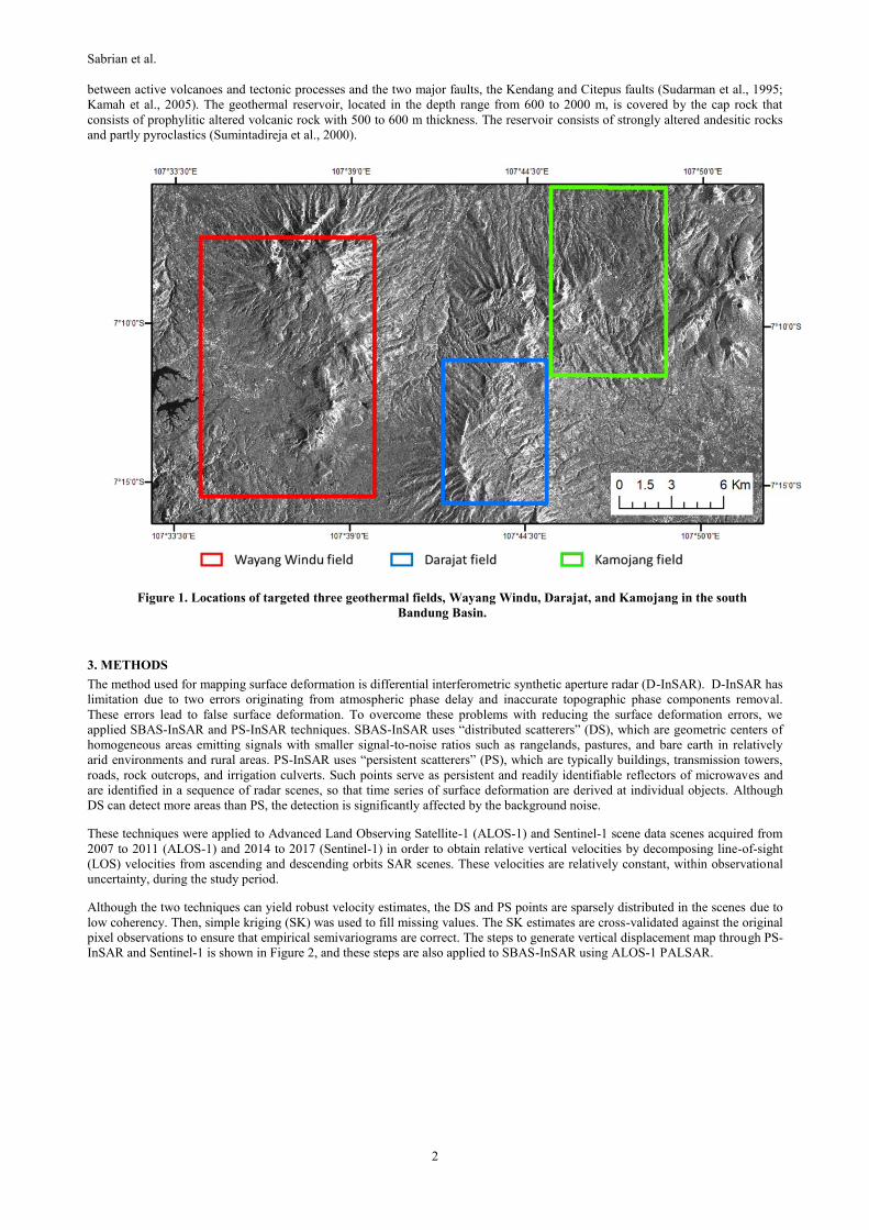
The Wayang Windu geothermal field (WWGF) is situated about 35 km south of Bandung city (Fig. 1) and known as a transitional
system between vapor- and liquid-dominated with four upwelling centers (Bogie et al., 2008), associated with andesitic
stratovolcano of the Sunda Volcanic Arc. The Sunda Arc is above the subduction zone of the India-Australia Plate beneath the
Eurasian Plate. This northward subduction nearly perpendicular to the arc front in Java and increasingly oblique towards Sumatra
(Hall, 2008). Geothermal power generation in WWGF started in 1999.
2.2 Darajat Geothermal Field
The Darajat Geothermal Field (DGF), situated 35 km southeast of Bandung city (Fig. 1), started geothermal power generation in
1994. DGF belongs to the Kendang volcanic complex extending from the northern tip of Sumatra to the Banda Arc through Java.
The Kendang volcanic complex is part of a Quaternary volcanic range extending from the Papandayan volcano in the southwest to
the Guntur volcano in the northeast. Two nearby fields, Kamojang geothermal field and WWGF are located in the northeast and
west of DGF, respectively. DGF is part of an old andesitic strato-volcano that has collapsed to the east and overlain by volcanic
materials deposited from younger eruptions (Rezeki et al., 2005).
2.3 Kamojang Geothermal Field
The Kamojang Geothermal Field (KGF) with 21 km2 and at 1400 to 1800 m above sea level, situated at 40 km from Bandung city
(Fig. 1), is a vapor-dominated system with geothermal power generation from 1994. KGF resulted from the complex interaction
Sabrian et al.
2
between active volcanoes and tectonic processes and the two major faults, the Kendang and Citepus faults (Sudarman et al., 1995;
Kamah et al., 2005). The geothermal reservoir, located in the depth range from 600 to 2000 m, is covered by the cap rock that
consists of prophylitic altered volcanic rock with 500 to 600 m thickness. The reservoir consists of strongly altered andesitic rocks
and partly pyroclastics (Sumintadireja et al., 2000).
Figure 1. Locations of targeted three geothermal fields, Wayang Windu, Darajat, and Kamojang in the south
Bandung Basin.
3. METHODS
The method used for mapping surface deformation is differential interferometric synthetic aperture radar (D-InSAR). D-InSAR has
limitation due to two errors originating from atmospheric phase delay and inaccurate topographic phase components removal.
These errors lead to false surface deformation. To overcome these problems with reducing the surface deformation errors, we
applied SBAS-InSAR and PS-InSAR techniques. SBAS-InSAR uses “distributed scatterers” (DS), which are geometric centers of
homogeneous areas emitting signals with smaller signal-to-noise ratios such as rangelands, pastures, and bare earth in relatively
arid environments and rural areas. PS-InSAR uses “persistent scatterers” (PS), which are typically buildings, transmission towers,
roads, rock outcrops, and irrigation culverts. Such points serve as persistent and readily identifiable reflectors of microwaves and
are identified in a sequence of radar scenes, so that time series of surface deformation are derived at individual objects. Although
DS can detect more areas than PS, the detection is significantly affected by the background noise.
These techniques were applied to Advanced Land Observing Satellite-1 (ALOS-1) and Sentinel-1 scene data scenes acquired from
2007 to 2011 (ALOS-1) and 2014 to 2017 (Sentinel-1) in order to obtain relative vertical velocities by decomposing line-of-sight
(LOS) velocities from ascending and descending orbits SAR scenes. These velocities are relatively constant, within observational
uncertainty, during the study period.
Although the two techniques can yield robust velocity estimates, the DS and PS points are sparsely distributed in the scenes due to
low coherency. Then, simple kriging (SK) was used to fill missing values. The SK estimates are cross-validated against the original
pixel observations to ensure that empirical semivariograms are correct. The steps to generate vertical displacement map through PS-
InSAR and Sentinel-1 is shown in Figure 2, and these steps are also applied to SBAS-InSAR using ALOS-1 PALSAR.

Sabrian et al.
3
Figure 2. Schematic steps to generate vertical displacement map through PS-InSAR and simple kriging.
Figure 3. Cross-validation between data observation from PS-InSAR results and simple kriging results, horizontal axis
original data and vertical axis prediction.
Schematic view of the interferometric synthetic aperture radar (InSAR). (Fuhrmann, 2019)
Sabrian et al.
4
4. RESULT AND DISCUSSION
We model the observed InSAR data to learn more about the mechanisms that cause the deformation. In the South Bandung Basin
area this a challenging problem because we observed signals from an interplay of natural and anthropogenic deformation in three
geothermal fields, Wayang-Windu, Darajat, and Kamojang. The kriged velocity fields by PS-InSAR are compared with the original
observations along with standard errors associated with the predictions as shown in Figure 3. The standard errors of the kriged
estimates generally are small for the ALOS-1 large for the Sentinel-1. This is depending on original data density, where the ALOS-
1 more higher than Sentinel-1 because ALOS-1 used SBAS which identify “DS” point, the other side Sentinel-1 used PS identify
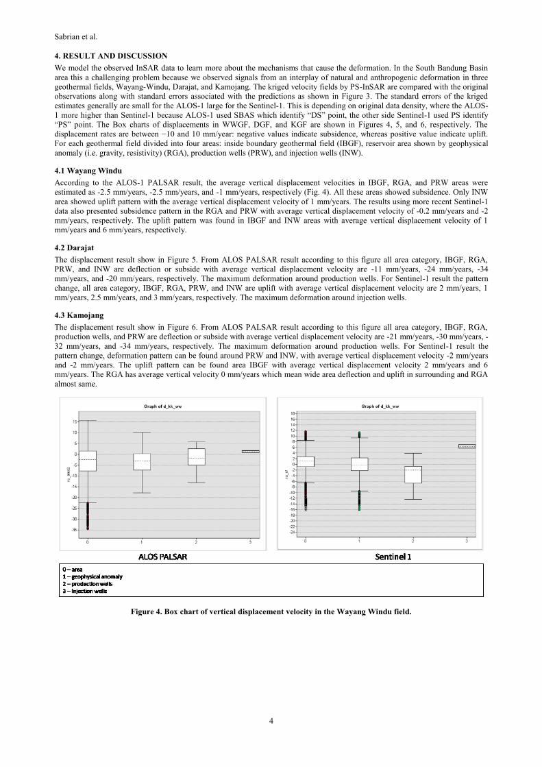
“PS” point. The Box charts of displacements in WWGF, DGF, and KGF are shown in Figures 4, 5, and 6, respectively. The
displacement rates are between −10 and 10 mm/year: negative values indicate subsidence, whereas positive value indicate uplift.
For each geothermal field divided into four areas: inside boundary geothermal field (IBGF), reservoir area shown by geophysical
anomaly (i.e. gravity, resistivity) (RGA), production wells (PRW), and injection wells (INW).
4.1 Wayang Windu
According to the ALOS-1 PALSAR result, the average vertical displacement velocities in IBGF, RGA, and PRW areas were
estimated as -2.5 mm/years, -2.5 mm/years, and -1 mm/years, respectively (Fig. 4). All these areas showed subsidence. Only INW
area showed uplift pattern with the average vertical displacement velocity of 1 mm/years. The results using more recent Sentinel-1
data also presented subsidence pattern in the RGA and PRW with average vertical displacement velocity of -0.2 mm/years and -2
mm/years, respectively. The uplift pattern was found in IBGF and INW areas with average vertical displacement velocity of 1
mm/years and 6 mm/years, respectively.
4.2 Darajat
The displacement result show in Figure 5. From ALOS PALSAR result according to this figure all area category, IBGF, RGA,
PRW, and INW are deflection or subside with average vertical displacement velocity are -11 mm/years, -24 mm/years, -34
mm/years, and -20 mm/years, respectively. The maximum deformation around production wells. For Sentinel-1 result the pattern
change, all area category, IBGF, RGA, PRW, and INW are uplift with average vertical displacement velocity are 2 mm/years, 1
mm/years, 2.5 mm/years, and 3 mm/years, respectively. The maximum deformation around injection wells.
4.3 Kamojang
The displacement result show in Figure 6. From ALOS PALSAR result according to this figure all area category, IBGF, RGA,
production wells, and PRW are deflection or subside with average vertical displacement velocity are -21 mm/years, -30 mm/years, -
32 mm/years, and -34 mm/years, respectively. The maximum deformation around production wells. For Sentinel-1 result the
pattern change, deformation pattern can be found around PRW and INW, with average vertical displacement velocity -2 mm/years
and -2 mm/years. The uplift pattern can be found area IBGF with average vertical displacement velocity 2 mm/years and 6
mm/years. The RGA has average vertical velocity 0 mm/years which mean wide area deflection and uplift in surrounding and RGA
almost same.
Figure 4. Box chart of vertical displacement velocity in the Wayang Windu field.

Sabrian et al.
5
Figure 5. Box chart of vertical displacement in the Darajat field.
Figure 6. Box chart of vertical displacement in the Kamojang field.
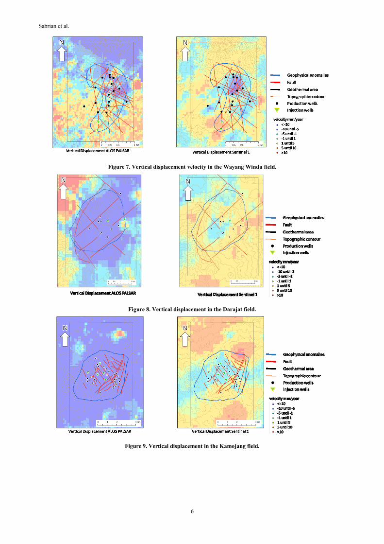
The difference patterns detected between ALOS-1 PALSAR and Centinel-1 are probably caused by three factors, difference of
microwave band for ALOS PALSAR L-band and Sentinel-1 C-band, different multi-temporal InSAR techniques: SBAS for ALOS-
1 PALSAR and PS for Sentinel-1, and different number of DS and PS points for kriging interpolation? In addition, change in the
deformation pattern may have naturally occurred in the study period. As shown in Figures 8, 9, and 10, the Sentinel-1 results
indicate that uplift pattern has increased recently common to the three geothermal fields. This feature is supported direct
observation by Marliyani (2016) which indicate uplift on southern Cimandiri fault.
The Topographic changes IBGF. Both the production and injection areas in KGF showed subsidence pattern opposite to the general
pattern, which may be caused by the proximity of the production and injection wells. For RGA which indicate geothermal reservoir
the pattern not so clear in WWGF and KGF, but in DGF deformation or subsidence pattern can be found around RGA and the
dimension almost same with RGA. This pattern may help us to identify geothermal reservoir.
Sabrian et al.
6
Figure 7. Vertical displacement velocity in the Wayang Windu field.
Figure 8. Vertical displacement in the Darajat field.
Figure 9. Vertical displacement in the Kamojang field.

Sabrian et al.
7
5. CONCLUSION
This study clarified the pattern and vertical displacement velocity of the topographic changes in the southern Bandung Basin for
two periods from 2007 to 2011 with ALOS-1 PALSAR dataset and from 2014 to 2017 with Sentinel-1 dataset. Two InSAR
techniques, SBAS-InSAR for ALOS-1 PALSAR and PS-InSAR for Sentinel-1 were used. Multi-Temporal InSAR technique, type
of band, and time can be affect the displacement pattern. Effectiveness of kriging was demonstrated for generating topographic
changes map over the scenes. Combining descending and ascending SAR images proved to be an effective approach for showing
topographic changes by extracting vertical displacement. General patterns were subsidence in PRW and uplift in injection wells,
and the positional relationship between the production and INW was revealed to affect the change pattern.
ACKNOWLEDGEMENT
The authors wish to express their gratitude to the Japan Science and Technology Agency (JST) and the Japan International
Cooperation Agency (JICA) for the support of this research as the Beneficial and Advanced Geothermal Use System (BAGUS)
Project in the framework of Science and Technology Research Partnership for Sustainable Development (SATREPS) Grant No.
JPMJSA1401 and Bandung Institute of Technology (ITB) for the collaboration.
REFERENCES
Bogie, I., Kusumah, Y. I., and Wisnandary, M. C.: Overview of the Wayang Windu geothermal field, West Java, Indonesia,
Geothermics, 37, (2008), 347-365.
Fuhrmann, T. and Garthwaite, M. C.: Resolving Three-Dimensional Surface Motion with InSAR: Constraints from Multi-
Geometry Data Fusion, Remote Sens. 11, (2019), 241.
Grant, M.A. and Bixley, P.F.: Geothermal Reservoir Engineering. 2nd Addition, Academic Press (2013).
Hall, R. and Smyth, H. R.: Cenozoic arc processes in Indonesia: Identification of the key influences on thestratigraphic record in
active volcanic arcs, The Geological Society of America, 436, (2008), 27–54.
Kamah, M. Y., Dwikorianto, T., Zuhro, A. A., Sunaryo, D., and Hasibuan, A.: The Productive Feed Zones Identified Based on
Spinner Data and Application in the Reservoir Potential Review of Kamojang Geothermal Area, Indonesia, Proceedings,
World Geothermal Congress 2005, Turkey, (2005).
Marliyani, G. I., Arrowsmith, J. R. and Whipple, K. X.: Characterization of slow slip rate faults in humid areas: Cimandiri fault
zone, Indonesia, J. Geophys. Res. Earth Surf., 121, (2016), 2287–2308
Raharjo, I.B., Allis, R.G., and Chapman D.S. Why Are the Only Volcano-Hosted Vapor-Dominated Geothermal Systems in West
Java, Indonesia, GRC Transactions, 36, (2012).
Setijadji, L.S.: Segmented Volcanic Arc and its Association with Geothermal Fields in Java Island, Indonesia. Proceedings, World
Geothermal Congress 2010, Bali, (2010).
Rejeki, S. Hadi, J., and Suhayati, I.: Porosity Study for Detail Reservoir Characterization in Darajat Geothermal Field, West Java,
Indonesia., Proceedings, World Geothermal Congress 2005, Turkey, (2005).
Sudarman, S., Boedihardi, M., Pudyastuti, K., Bardan: Kamojang Geothermal Field 10-year experience, Proceedings, World
Geothermal Congress 1995, Florence, (1995).
Sumintadireja, P., Sudarman, S., Mizunaga, H., Ushijima, K.: Misse-a-la-masse and gravity data survey at the Kamojang
Geothermal Field. Proceedings, World Geothermal Congress 2000, Kyushu (2000).