chapter onedocuments.worldbank.org/curated/en/548041520616305131/... · web viewthis assessment...
TRANSCRIPT
Federal Republic of Nigeria
THE NIGERIA EROSION AND WATERSHED MANAGEMENT PROJECT (NEWMAP)
Final Report of Environmental and Social Management Plan (ESMP) for Lemna/Federal Agriculture Gully Erosion Site in Calabar, Cross
River State
Submitted To
State Project Management Unit (SPMU), Calabar Cross River State
November, 2017
SFG1692 V40

TABLE OF CONTENTS
Table of Contents iList of Tables iiiList of Figures vList of Acronyms viUnits of Measure viiiList of ESMP Preparers ixExecutive Summary x
CHAPTER ONE 1INTRODUCTION 11.1 Background 11.2 Description of the Proposed Intervention 21.3 Rationale for ESMP 21.4 Rationale for the Study 31.5 Scope of Work 4
CHAPTER TWO 5INSTITUTIONAL AND LEGAL FRAMEWORK FOR ENVIRONMENTAL MANAGEMENT 52.1 Federal Policy, Legal, Regulatory and Administrative Frameworks 52.2 Institutional Framework 62.3 World Bank Safeguard Policies triggered by NEWMAP 72.4 Comparison between Nigeria EIA Guidelines and World Bank EA Guidelines 72.5 International Conventions and Agreements 9
CHAPTER THREE 11BIOPHYSICAL ENVIRONMENT 113.0 Introduction 113.1 Study Area/Description of Gully Site 113.2 Physical Environment 143.2.1 Climate and Meteorology 143.2.2 Topography 183.2.3 Geology 193.2.4 Soil 203.2.5 Surface Hydrology 263.2.6 Groundwater 263.3 Biological Environment 283.3.1 Ecosystem 283.3.2 Vegetation 283.3.3 Inventory of Economic Crops 303.3.4 Fauna and Wildlife Resources 31
CHAPTER FOUR 33SOCIO-ECONOMIC CHARACTERISTICS AND CONSULTATIONS WITH STAKEHOLDERS 33 4.1 Socio-Economic Survey Methodology 334.1.1 Data Collection and Sampling Methodology 334.2 Socio-Economic Characteristics of Respondents 34
i
4.3 Public and Private Assets within the Project Corridor 364.4 Housing Characteristics in the Project Area 374.5 Source of Energy 394.6 Grievance Redress Mechanisms 394.7 Other Concerns from Public Consultations, IDIs, FGDs and Community Meetings 40
CHAPTER FIVE 41ASSESSMENT OF POTENTIAL ADVERSE IMPACTS AND ANALYSIS OF ALTERNATIVES 415.1 Impact Assessment Methodology 415.1.1 Impact Identification 415.1.2 Impact Prediction 415.1.3 Impact Evaluation 425.1.4 Method for Determining Receptor Sensitivity 425.2 Positive Impacts Associated with the Proposed Rehabilitation of the Lemna/
Federal Agriculture Gully Erosion Site 435.3 Potential Adverse Impacts of the Proposed Project 445.3.1 Pre-Construction Phase 445.3.2 Construction Phase 445.3.3 Operations and Maintenance Phase 505.4 Project Alternatives 575.4.1 Site Alternatives 575.4.2 Project Development Alternatives 57
CHAPTER SIX 61ENVIRONMENTAL AND SOCIAL MANAGEMENT PLAN 616.0 Introduction 616.1 Mitigation Measures 616.1.1 Pre-construction Phase 616.1.2 Construction Phase 636.2 Institutional Arrangements, Responsibilities and Accountabilities 856.2.1 Pre-construction Phase 856.2.2 Construction Phase 866.2.3 Operational and Maintenance Phase 876.3 Training Programmes 886.4 Impact Mitigation Measures Control and Surveillance 896.5 Implementation Schedule 906.6 ESMP Costing and Cost Analysis 906.7 ESMP Disclosures 91
CHAPTER SEVEN 92SUMMARY, CONCLUSION AND RECOMMENDATIONS 92
REFERENCES AND BIBLIOGRAPHY 93
APPENDICES 94
ii

LIST OF TABLES
Table 2.1: Relevant Federal/State Policies, Legislation, Regulations and Guidelines 5Table 2.2: World Bank Safeguard Policies Triggered by NEWMAP and those triggered by
Lemna/Federal Agriculture gully erosion proposed project 7Table 2.3: International conventions, agreements and protocols to which Nigeria is
signatory and applicable to the Cross River State NEWMAP in the Lemna/Fed. Agric. Gully site 8
Table 3.1: Ambient Air Quality Results 16Table 3.2: Geographic Coordinates of the Air Quality Samples 17Table 3.3: Environmental Noise Levels for the Project Area 18Table 3.4: Physico-Chemical Properties of Top Soil (0 -15 cm) 21Table 3.5: Physico-Chemical Properties of Sub-Soils (15 -30 cm) 22Table 3.6: Geographic Coordinates of the Soil Samples 22Table 3.7: Basic and Heavy Metal Concentrations of the Top Soil (0–15 cm) 23Table 3.8: Basic and Heavy Metal Concentrations of the Sub-soil (15–30 cm) 23Table 3.9: Geographic Coordinates of the Surface Water Samples 25Table 3.10: Physico-Chemical Parameters of Surface Water Samples from the Project Area 25Table 3.11: Concentrations of Cations and Anions in Surface Water Samples 26Table 3.12: Heavy Metal Concentrations in Surface Water Samples 26Table 3.13: Comparison of the Borehole Ground Water Quality with the World Health
Organization (WHO) Standards for Potable Water 27Table 3.14: Geographic Coordinates of the Groundwater Samples 27Table 3.15: List of Crops and Fruits Planted in the Project Area 30Table 3.16: List of Economic Crops and Trees 30Table 3.17: List of Bird Species recognized in the Project Area 31Table 3.18: Butterfly Taxonomy in the Project Area 32Table 4.1: Details of the Sampling Methodology and the Questionnaires Administered 34Table 4.2: Socio-Economic Characteristics of Respondents 34Table 4.3: Public and Private Assets within the Project Corridor 36Table 4.4: Type of Materials in the Building and Tenure Systems 38Table 4.5: Source of Energy for Various Uses 39
Table 5.1: Probability of Occurrence, Consequence Severity, Likelihood Ranking and Risk Matrix 42
Table 5.2: Noise Emission Levels for Various Types of Construction Plant 46Table 5.3: Potential Impacts of Disruption to Public Utilities 47Table 5.4: Characterization and Evaluation of Potential Impacts Pre-Construction Phase 51Table 5.5: Characterization and Evaluation of Potential Impacts Environmental Impacts
in the Construction Phase 52Table 5.6: Characterization and Evaluation of Potential Impacts for the Biological
Impacts in the Construction Phase 53Table 5.7: Characterization and Evaluation of Potential Impacts for the Socioeconomic
Impacts during Construction Phase 54Table 5.8: Characterization and Evaluation of Potential Impacts for the Public Health
Impacts during the Construction Phase 55Table 5.9: Characterization and Evaluation of Potential Impacts for Operation Phase 56Table 5.10: Appraisal of Alternatives 59
iii
Table 6.1: Mitigation Measures for Pre-Construction Phase 62Table 6.2: Mitigation Measures for the Environmental Impacts in the Construction Phase 64Table 6.3: Mitigation Measures for the Biological Impacts in the Construction Phase 72Table 6.4: Mitigation Measures for the Socio-economic Impacts in the Construction Phase 74Table 6.5: Mitigation Measures for the Public Health Impacts in the Construction Phase 78Table 6.6: Mitigation Measures for Operation Phase 81Table 6.7: Institutional Capacity Strengthening Plan 89Table 6.8: Monitoring Programmes 89Table 6.9: ESMP Implementation Schedule 90Table 6.10: Cost Analysis of the Lemna/Federal Agriculture Gully Erosion ESMP
Implementation 91
iv

LIST OF FIGURES
Fig. 3.1: The image map of the Niger Delta indicating Cross River State and the
Lemna/Federal Agriculture gully erosion site 11
Fig. 3.2: Erosion and Watersheds of Calabar 12
Fig. 3.3: Lemna/Federal Agriculture gully erosion outlay with the road network and other
roads in the area 13
Fig. 3.4: Annual precipitation and temperature characteristics of the project area 15
Fig. 3.5: Monthly frequency of occurrence of sea breeze days 16
Fig. 3.6: Ambient Air/Noise Sampling Points. 17
Fig. 3.7: The Distribution of Noise Sampling Points in the Proposed Project Area 18
Fig. 3.8: Geology of Southeastern Nigeria with Constituent Formations 19
Fig. 3.9: The Calabar Flank and Associated Formations 20
Fig. 3.10: Textural Classification of Soil from the Project Area 21
Fig. 3.11: Soil Sampling Points 22
Fig. 3.12: Surface Water Sampling Points 25
Fig. 3.13: Groundwater Sampling Points 28
Plate 3.1: The Gully Erosion Alignment and Channel at Federal Agriculture Staff Quarters 14
Plate 3.2: Vegetation of the Project Area 29
v
LIST OF ACRONYMS
AIDS - Acquired Immuno-Deficiency SyndromeARAR - Applicable or Relevant and Appropriate RequirementsBAT - Best Available TechnologyBOD - Biochemical Oxygen DemandCBO - Community Based OrganizationsCITES - Convention on the Prevention of the international trade in Endangered
SpeciesCOD - Chemical Oxygen DemandCSOs - Chief Security OfficersDO - Dissolved OxygenEA - Environmental AssessmentEES - Environmental and Social SpecialistsEHS - Environmental, Health and SafetyEIA - Environmental Impact AssessmentEO - Environmental OfficerESIA - Environmental and Social Impact AssessmentEMS - Environmental Management SystemESMF - Environmental and Social Management FrameworkESMP - Environmental and Social Management PlanFEPA - Federal Environmental Protection AgencyFGD - Focus Group DiscussionFGN - Federal Government of NigeriaFI - Financial Intermediary FMEnv - Federal Ministry of EnvironmentFPMU - Federal Project Management UnitFRN - Federal Republic of NigeriaFRSC - Federal Road Safety CommissionGHGs - Greenhouse GasesGPS - Global Positioning SystemGRA - Government Reserved AreaH2S - Hydrogen SulphideHIV - Human Immuno-Deficiency Virus HND - Higher National DiplomaHSE - Health, Safety and EnvironmentIDI - In-Depth InterviewsITCZ - Inter Tropical Continental ZoneIUCN - International Union for Conservation of NatureKII - Key Informant InterviewsISO - International Standard OrganizationLGA - Local Government AreaMDAs - Ministries, Departments and AgenciesM&E - Monitoring and EvaluationMEPU - Ministry of Environment and Public UtilitiesMO - Memorandum of UnderstandingMSDS - Material Safety Data SheetNAP - National Agricultural PolicyND - Not Detected NEWMAP - Nigeria Erosion and Watershed Management Project
vi

NEP - National Policy of the EnvironmentNESREA - National Environmental Standards and Regulations Enforcement
AgencyNIWA - Nigeria Inland Waterways Authority NPC - National Population CommissionNS - Not SpecifiedNTU - Nephelometric Turbidity UnitOND - Ordinary National DiplomaOP - Operational PoliciesPAP - Project Affected PersonsPEM - Project Environmental ManagementPMU - Project Management UnitPPE - Personal Protective EquipmentPVC - Poly vinyl chloride RAP - Resettlement Action PlanSO - Social OfficerSOP - Standard Operation Procedures SPM - Suspended Particulate MatterSPMU - State Project Management UnitSTD - Sexually Transmitted DiseasesTC - Tropical ContinentalTDS - Total Dissolved SolidsTM - Tropical MaritimeToR - Terms of ReferenceTSS - Total Suspended SolidsUTM - Universal Travers MercatorVOC - Volatile Organic CompoundsWHO - World Health Organization
vii

UNITS OF MEASURE
0C - degree Centigrade0F - degree Fahrenheitcfu - colony forming unitsCO2 - carbon dioxidedB - decibelg - gramHa - Hectarehr/h - hourkg - kilogrammekm - kilometerL - litrem - metremax - maximummg - milligramms-1 - metre per second
viii
LIST OF ESMP PREPARERS
Shakirudeen Odunuga (Ph.D.) Project ManagerAjijola Abiodun (M.Sc.) Socio-economic SpecialistAdekunle Raji (M.Sc.) Baseline Data GatheringGbolahan Badru (M.Sc.) Report writing
ix
Executive Summary
ES 1 Background The Cross River State Government has received an advance on the proceeds of a credit through the World Bank Assisted Project on The Nigeria Erosion and Watershed Management Project (NEWMAP) to finance the age-long erosion malaise in the State through the intervention of prioritized gully erosion sites. Consequently, there is the need to assess the Environmental and Social Impacts of the intervention project by the Cross River NEWMAP. Considering the category of the proposed project and the population of the affected people, an Environmental and Social Management Plan (ESMP) is inevitable.
ES 2 Description of the Proposed InterventionThis assessment covers the proposed project activities financed by the World Bank NEWMAP in Calabar, Cross River State, Nigeria which was to rehabilitate the degraded lands and control erosion at Lemna/Federal Agriculture gully erosion site in Calabar, Cross River State. The project activities are to be carried out through civil works and biophysical cum bioengineering rehabilitation, such as land redevelopment, tree planting etc. Furthermore, the project activities will include: refilling part of the gully in order to rehabilitate existing roads by carrying out complete or partial reclamation on the gully; construction of collector drains along the main roads overlooking the intervention area in order to prevent further run off concentration along secondary roads; provision of proper interceptor drains to safely discharge water through chutes and stilling basins or baffled aprons (the transverse chutes are positioned at appropriate points adjacent the interceptor drains to prevent the occurrence of erosion next to the lined concrete channel); provision of concrete channels in infrastructure areas and check dams at suitable intervals at gully bed of the main gully; construction of a new rectangular channel in place of the existing damaged trapezoidal one, and provision of vegetation measures following construction of the engineering measures.
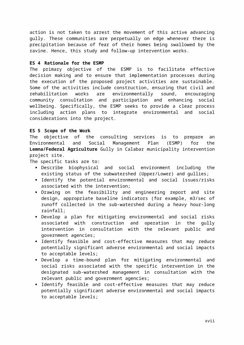
ES 3 Rationale for the NEWMAP InterventionThe Lemna/Federal Agriculture Gully in Calabar municipality have washed away a link road and destroyed several houses within the communities thereby making communication very difficult within the communities and insecurity during the rains have also increased. This increased runoff water volume and speed coupled with the geology of the area where the soil is erodible and can move with the slightest increase in moisture content, result in development of gullies, gorges, and ravines which have left most of this area devastated. Lemna/Federal Agriculture could be cut into fragments if action is not taken to arrest the movement of this active advancing gully. These communities are perpetually on edge whenever there is precipitation because of fear of their homes being swallowed by the ravine. Hence, this study and follow-up intervention works.
ES 4 Rationale for the ESMPThe primary objective of the ESMP is to facilitate effective decision making and to ensure that implementation processes during the execution of the proposed project activities are sustainable. Some of the activities include construction, ensuring that civil and rehabilitation works are environmentally sound, encouraging community consultation and participation and enhancing social wellbeing. Specifically, the ESMP seeks to provide a clear process including action plans to integrate environmental and social considerations into the project.
ES 5 Scope of the WorkThe objective of the consulting services is to prepare an Environmental and Social Management Plan (ESMP) for the Lemna/Federal Agriculture Gully in Calabar municipality intervention project site.The specific tasks are to:
Describe biophysical and social environment including the existing status of the subwatershed (Upper/Lower) and gullies;
Identify the potential environmental and social issues/risks associated with the intervention;
x

Drawing on the feasibility and engineering report and site design, appropriate baseline indicators (for example, m3/sec of runoff collected in the sub-watershed during a heavy hour-long rainfall;
Develop a plan for mitigating environmental and social risks associated with construction and operation in the gully intervention in consultation with the relevant public and government agencies;
Identify feasible and cost-effective measures that may reduce potentially significant adverse environmental and social impacts to acceptable levels;
Develop a time-bound plan for mitigating environmental and social risks associated with the specific intervention in the designated sub-watershed management in consultation with the relevant public and government agencies;
Identify feasible and cost-effective measures that may reduce potentially significant adverse environmental and social impacts to acceptable levels;
Identify monitoring objectives and specifies the type of monitoring, with linkages to the impacts assessed and the mitigation measures described above;
Provide a specific description of institutional arrangements: the agencies responsible for carrying out the mitigation and monitoring measures (e.g., for operation, supervision, enforcement, monitoring of implementation, remedial action, financing, reporting, and staff training) and the contractual arrangements for assuring the performance of each implementing agency;
Define technical assistance programs that could strengthen environmental management capability in the agencies responsible for implementation;
Provide an implementation schedule for measures that must be carried out as part of the project, showing phasing and coordination with overall project implementation plans; and
Provide the expected capital and recurrent cost estimates and sources of funds for implementing the ESMP and inform accordingly the design consultants so that these costs are duly taken into consideration in the designs.
ES 5 World Bank Safeguard PoliciesWith respect to the on-the-ground situation at Lemna/Federal Agriculture area, three World Bank safeguard policies are triggered. These are stated succinctly as follows;
1. Environmental Assessment (OP/OB/GP 4.01); this is triggered by civil works on recovery, repair and rehabilitation of existing roads and routes, construction of collector drains along main roads, and land acquisition economic and potentially physical displacement. This will be addressed by the requisite site-specific documents particularly ESMF, and ESMP prepared for NEWMAP.
2. Physical Cultural Heritage (OP 4.11); Civil works will most likely not be able to avoid some known and unknown cultural heritage sites that are located within the area. Issues regarding these will addressed as stated in the site specific ESMF and ESMP documents.
3. Involuntary Resettlement (OP/BP 4.12); the proposed activities will take place in residential and farming areas. To address these, RPF and a standalone RAP that spell out site specific issues will be utilised.
ES 6 Applicable International Conventions, Agreements and Protocols The followings are international conventions, agreements and protocols which Nigeria is a signatory to and applicable to the Cross River State NEWMAP in the Lemna/Federal Agric Gully site
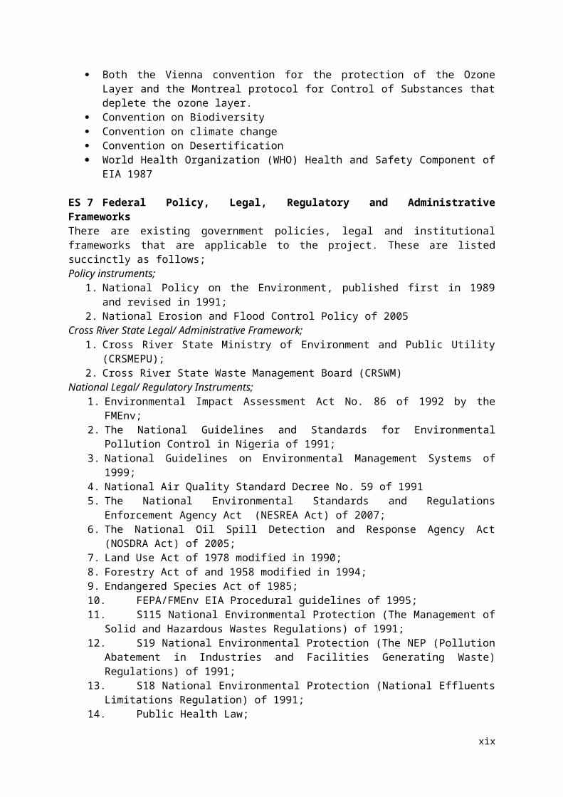
Both the Vienna convention for the protection of the Ozone Layer and the Montreal protocol for Control of Substances that deplete the ozone layer.
Convention on Biodiversity Convention on climate change Convention on Desertification World Health Organization (WHO) Health and Safety Component of EIA 1987
ES 7 Federal Policy, Legal, Regulatory and Administrative Frameworks
xi
There are existing government policies, legal and institutional frameworks that are applicable to the project. These are listed succinctly as follows;Policy instruments;
1. National Policy on the Environment, published first in 1989 and revised in 1991; 2. National Erosion and Flood Control Policy of 2005
Cross River State Legal/ Administrative Framework;1. Cross River State Ministry of Environment and Public Utility (CRSMEPU);2. Cross River State Waste Management Board (CRSWM)
National Legal/ Regulatory Instruments;1. Environmental Impact Assessment Act No. 86 of 1992 by the FMEnv;2. The National Guidelines and Standards for Environmental Pollution Control in Nigeria of
1991;3. National Guidelines on Environmental Management Systems of 1999;4. National Air Quality Standard Decree No. 59 of 19915. The National Environmental Standards and Regulations Enforcement Agency Act (NESREA
Act) of 2007;6. The National Oil Spill Detection and Response Agency Act (NOSDRA Act) of 2005;7. Land Use Act of 1978 modified in 1990;8. Forestry Act of and 1958 modified in 1994;9. Endangered Species Act of 1985;10. FEPA/FMEnv EIA Procedural guidelines of 1995;11. S115 National Environmental Protection (The Management of Solid and Hazardous Wastes
Regulations) of 1991;12. S19 National Environmental Protection (The NEP (Pollution Abatement in Industries and
Facilities Generating Waste) Regulations) of 1991;13. S18 National Environmental Protection (National Effluents Limitations Regulation) of 1991;14. Public Health Law;15. Environmental Sanitation Edits, Law and Enforcements;16. Workmen Component Act of 1987 revised in 2010.
ES 8 Institutional Framework The MDAs involved in the implementation of NEWMAP projects include those responsible
for planning, economy and finance, works, agriculture, water resources, forests, transport, power, emergency response, as well as those focused on climate and hydrological information or watershed/ basin regulation.
The Federal Ministry of Environment (FME) is the lead implementing agency for NEWMAP. The Federal Project Management Unit (FPMU) headed by a Federal Coordinator hosted by FMEnv is responsible for the overall coordination of the project.
The Cross River State Project Management Unit (Cross River-SPMU), headed by the State Coordinator and hosted by Cross River State Ministry of Environment and Public Utility, is responsible for project coordination in Cross River State, thus is directly responsible for the coordinating activities of the Lemna/Federal Agriculture Gully Erosion Site intervention including the implementation of this ESMP.
Both the federal and state levels coordinating units have environmental officer responsible for the mainstreaming of environmental issues into NEWMAP projects.
The Cross River State environmental officer is directly responsible for coordinating the implementation of this Lemna/Federal Agriculture Gully Erosion Site ESMP on behalf of the State Project Coordinator.
At the community level, the Lemna/Federal Agriculture Gully Erosion Site Monitoring Committee will effectively participate in ensuring full compliance during project implementation including civil work activities.
ES 9 Biophysical EnvironmentAn assessment of the biophysical environment of the study area covers general climate and meteorology, air quality and noise level, water and soil quality, geology, ecosystem, vegetation and
xii
flora and fauna resources. Most parameters measured were in conformity with local and international standards and mitigation measures were provided where environment will be affected. None of the plant species recorded is in the vulnerable category of the IUCN.
ES 10 Socio-Economic CharacteristicsThe gender distribution of the respondents reveals that there are more female (56%) respondents than male (44%). About 51.0% of the respondents falls between the age group of 18-45 years. 34.5% falls within the age bracket of 46–65 years while about 10.5% falls within the age bracket of 66 years and above. Ethnic group composition includes Ibiobio and Efik (50.0%), Ejagham and Bekwarra (15.0%), Ogoja and other tribes from Cross River State (15.0%). Yoruba (10.0%), Igbo and other groups constituted (10.0%). About 48.0% had secondary education, 42.0% had university degree only 10.0% had no formal education. The marital status of the respondents shows that 70% of them are married while 26.0% are single. The occupational structure of the respondents in this community is skewed mainly towards civil servants (45%). Average family size is 6. Specifically, about 80.0% of the respondents have lived in this community for more than 10 years. About 48 % of the respondents earn less than N50,000. 65% of the residents used the gully for waste dumps. Malaria is the dominant disease. 48% of the respondents sourced water from Cross River State Ministry of Water Resources and majority (91.0%) of the respondents claimed that they are aware of the proposed intervention in their community.
ES 11 Public Consultations and ConcernsThe main concerns and impact expressed by the stakeholders and residents of the project community concerning the gully rehabilitation works covered several aspects of the project. These were summarized as outcome of the public consultation events, the focus group discussions, and community meetings with key members of the community of the project. The summary of the concerns expressed during these gatherings are stated as follows; Accelerated increase in the expansion of the gully in recent time; Massive damage to lives and property especially during rainy season; Destruction of existing road and footpaths to connect nearby communities; Threats to the safety of all residents of all ages especially the vulnerable groups children, women
and the aged; Threats to means of livelihood particularly to farmers especially during rainy season; Previous rehabilitation measures have led to intensification of the gully expansion consequently
leading to development of new gullies that connects to the main gully. Local palliatives only work to reduce the velocity of the waters rushing downslope but did not
prevent the destructive potency of the gully. However, with respect to the proposed intervention, the expectations of the people during construction phase includes: Employment of the locals during the construction phase of the project; Adequate compensation to people whose property’s will be damaged due to the intervention.
Also, the communities assured total cooperation with the Cross River NEWMAP SPMU, contractors and consultants. They promised adequate security and protection of lives, properties and equipment and machineries during construction.
ES 12 Impacts of the Proposed Project ActivitiesPositive Social Impacts of the Proposed Project Activities Rehabilitation of degraded lands and their conversion into productive land Public Safety
xiii

Employment Opportunities Increase Value for Structural and Landed Properties
Positive Environmental Impacts of the Proposed Project Activities Minimization of Flood Activities Rehabilitation of degraded lands (Flood and Erosion Affected Lands) and their conversion into
productive land Reduction of disaster risks in the project area
Negative Environmental and Social Impacts Displacement of some petty traders from their source of livelihoods Expectations of Improvement in Livelihood Proposed Project Induced Development Impaired air quality Loss of Flora and Fauna Potential Noise Impact Surface and ground water pollution Disruption to Public Utilities Disruption of Public Access Occupational Health and Safety
ES 13 Analysis of Alternatives
Five alternatives were analyzed for the proposed project. These include; No action alternative, Delayed action alternative, Biological remediation only, Civil works alone and Civil and Bioengineering. No action alternative: this simply indicates that the condition of Lemna/Federal Agriculture will be left unattended to. Delayed action alternative will contribute no specific environmental safeguard benefit to the stakeholders and may aggravate human and materials losses. It has no short term benefit and existing losses may obliterate any long term gain. Biological remediation works alone will only offer short term environmental benefits with limited short term benefits. Civil works alone will lead to enhancement and correction of damaged infrastructure particularly drainage, roads and other civil facilities but will be limited in biological remediation works which will be left unaddressed. In the long run, the watershed management without biological and vegetal restoration will hamper its sustainability. The combination of the Civil and Bioengineering works will provide both short and long-term effectiveness for the watershed and will be sustainable. This option will be adopted for the proposed Lemna / Federal Agriculture gully intervention by Cross River State NEWMAP SPMU
ES 14 Environmental and Social Mitigation MeasuresEnvironmental and Social Mitigation Measures were prepared for all the identified impacts during pre-construction, construction and operational phases.
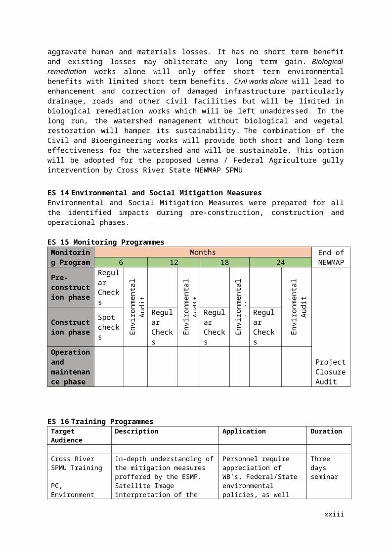
ES 15 Monitoring Programmes
Monitoring Program
Months End of NEWMA
P6 12 18 24Pre-construction phase
Regular Checks
Envi
ronm
enta
l A
udit
Envi
ronm
enta
l
Envi
ronm
enta
l
Envi
ronm
enta
l A
udit
Project Closure Audit
Construction phase
Spot checks
Regular Checks
Regular Checks
Regular Checks
xiv
Operation and maintenance phase
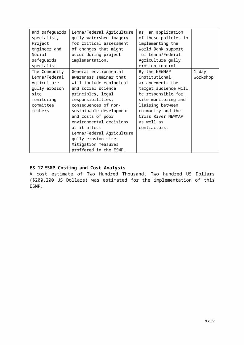
ES 16 Training ProgrammesTarget Audience Description Application Duration
Cross River SPMU Training
PC, Environment and safeguards specialist, Project engineer and Social safeguards specialist
In-depth understanding of the mitigation measures proffered by the ESMP. Satellite Image interpretation of the Lemna/Federal Agriculture gully watershed imagery for critical assessment of changes that might occur during project implementation.
Personnel require appreciation of WB’s, Federal/State environmental policies, as well as, an application of these policies in implementing the World Bank support for Lemna/Federal Agriculture gully erosion control.
Three days seminar
The CommunityLemna/Federal Agriculture gully erosion site monitoring committee members
General environmental awareness seminar that will include ecological and social science principles, legal responsibilities, consequences of non-sustainable development and costs of poor environmental decisions as it affect Lemna/Federal Agriculture gully erosion site. Mitigation measures proffered in the ESMP.
By the NEWMAP institutional arrangement, the target audience will be responsible for site monitoring and liaising between community and the Cross River NEWMAP as well as contractors.
1 day workshop
ES 17 ESMP Costing and Cost AnalysisA cost estimate of Two Hundred Thousand, Two hundred US Dollars ($200,200 US Dollars) was estimated for the implementation of this ESMP.
xv
CHAPTER ONE
INTRODUCTION1.1 BackgroundAlthough the scope of global environmental challenges is broad, yet some of these are local in impact (GEF, 2012). One typical example of these environmental problems is soil erosion and its concomitant complications. Nigeria is currently under the siege of enormous soil erosion problems (Ofomata, 1982; Ofomata, 2002). These come in the form of both sheet and gully erosion and they can be attributed to natural and anthropogenic (human) causes. Presently, over 6,000 km2 of the country’s land are affected by erosion out of which about 3,400 km2 are highly vulnerable. Soil erosion has a distressing effect on peoples’ lives, livelihood and destroys essential infrastructure for economic development. It also disconnects communities, destroys source of basic income and it could lead to destruction of landed investments. Annually, over $100 million worth of damages and destruction caused by gully erosion are been recorded in the country (Ashekoya, 2009). This presents a herculean challenge despite all the series of environmental development and sustainability by the government at the local, state and federal levels (Adger et al, 2003). Indeed, sustainable socioeconomic and environmental development becomes a challenge that needs an integration of social and scientific approach.
Recent appraisal of the situation in the country confirms that the measure of the problem surpasses wards, communities, local governments, up to the federal level. The extent of the disaster had led to the request of the Federal Government seeking assistance and strategic support of international development partners such as the World Bank. Consequently, the Federal Government of Nigeria (FGN) sought the support of the World Bank to tackle this age-long worsening problem of erosion and degraded watershed in seven southern states of Nigeria comprising Abia, Anambra, Cross Rivers, Ebonyi, Cross River, Enugu and Imo through an eight-year project titled “The Nigeria Erosion and Watershed Management Project henceforth referred to as NEWMAP” (NEWMAP, 2012a).
As one of the frontline beneficiaries of the NEMAP arrangement, Cross River State has taken a bold step towards finding lasting solution to this erosion malaise in the state which is emerging at various settlement within the Calabar capital city. This step resulted in the preparation of environmental and social management plan (ESMP) for the proposed intervention project at Lemna Federal Agriculture community. It is expected that this study will present all issues regarding the impacts on both the environment and people living within the area with a view to proffer series of management plans that will ensure sustainable life for the dwellers of the area (NEWMAP, 2012a; NEWMAP, 2012b; NEWMAP, 2012c).
This report therefore presents the Environmental and Social Management Plan (ESMP) of Lemna/Federal Agriculture Gully Erosion Site in Calabar Cross River State under the Cross River State Nigeria Erosion and Watershed Management Project Project Management Unit (Cross River NEWMAP-PMU). The assessment is site-specific consisting of a documented set of mitigation, monitoring, and institutional actions to be taken before and during implementation to eliminate adverse environmental and social impacts, offset them, or reduce them to acceptable levels. It also includes the measures needed to implement these actions, addressing the adequacy of the monitoring and institutional arrangements for the entire section watershed in the proposed intervention site.
1

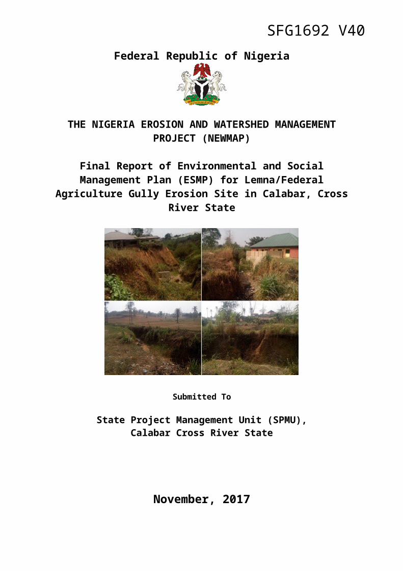
1.2 Description of the Proposed InterventionThe Lemna/Fed. Agriculture gully erosion site is in Calabar, Cross River State of Nigeria. Calabar is located within Latitudes 4° 78’ and 5° 09’ N and Longitudes 8° 15’ and 8° 26’ E and lies between the valleys of two rivers: the Great Qua River on the eastern side, and the Calabar River on the west. The watershed in Calabar is divided between these two rivers as shown in the watershed map of Calabar. The site is located about 7km north of Calabar Airport. The gully lies at coordinates Latitude 5° 0' 7.6" North of the equator and Longitude 8° 21' 44.96" East of the Greenwich Meridian. Its length runs at about 1.3km cutting through a golf course along the way and terminating into stable wetlands. Concentrated storm runoff is the probable cause of the gully development as well as human activities by improper provision of drainage structures especially in the outfall.The gully has a varying width from 2m in the downstream to 35m near the gully head with depths ranging from 2m to 12m. The bank walls are very steep slopes; almost nearly vertical in some areas. The surrounding tributary is sloping towards the gully at a slope between 5% - 15%, with a combination of residential development and vegetated area, especially along the golf course. The gully is actively expanding, especially at the head. It is however, estimated that the expected (indicative) labour requirements for pre-construction, construction, operation and maintenance phases will be about 10, 60 and 10 people respectively. The construction camp will be located at about 50 m away from gully edge.
1.3 Rationale for ESMPThe major developmental objective of the ESMP is to facilitate effective decision making and to ensure that implementation processes during the execution of the proposed project activities such as, construction, ensuring that civil and rehabilitation works are environmentally-sound, encouraging community consultation and participation, enhancing social wellbeing and are sustainable. Specifically, the ESMP seeks to provide a clear process including action plan to integrate environmental and social considerations into the NEWMAP project. The specific objectives of the ESMP are to:
Ensure the project is carried out in accordance with today’s sustainable development tenets;
Provide a structure/strategy for the integration of social and environmental consideration at all stages of the project planning, design, execution and operation of various sub-projects;
Ensure overall positive social and environmental impacts of sub-projects and avoid/minimize, and manage any potential adverse impacts;
Establish clear procedures and methodologies for incorporating environmental management requirements including stake holder engagement in the implementation of the project and all sub projects;
Provide guidelines to appropriate roles and responsibilities, and outline the necessary reporting procedures, for managing and monitoring environmental and social concerns of the program and sub-projects;
Determine the training, capacity building and technical assistance needed to successfully implement the provisions of the ESMP;
Comply with regulatory and policy requirements (local and international) that are applicable to the program and sub projects;
To assess the potential environmental and social impacts of the sub-projects (rehabilitation, extensions of or new constructions in gully erosion sites, livelihood adaption, etc.), whether positive or negative, and propose measures and plans to reduce or mitigate adverse environmental impacts and enhance the positive impacts of the project;
2
To identify potential environmental policies, legal and institutional framework pertaining to the project;
To establish clear directives and methodologies for the Environmental and Social Impact Assessment (ESIAs) as might be needed for specific sub-projects; and
Identify modalities for estimating and budgeting the costs for the implementation of the environmental Management Plan for the projects; and
To ascertain the agencies responsible for the implementation of the project’s Environmental Management Plans and the projects’ Monitoring & Evaluation (M&E).
This ESMP report will be used together with a separate report providing a Resettlement Action Plan (RAP) for the proposed gully rehabilitation project at Lemna/Federal Agriculture by the Cross River NEWMAP. In seeking to implement the proposed NEWMAP project, it is mandatory by the government of Nigeria to take into cognizance relevant state-owned laws, where the project will be executed and as well comply with all national and international environmental requirements in order to meet legal obligations and to ensure a sustainable project implementation.
1.4 Rationale for the StudyGenerally, Lemna/Federal Agriculture is a settled suburban residential area which forms an essential part of the Calabar metropolis. It was developed as settlements for staff of federal civil servants but dominated by the officials of the Federal Ministry of Agriculture and Rural Development (FMARD). Virtually all the buildings are designated for residential purposes. At the fringes of the community however is the quasi-urban settlements dominated by dominated by either rented occupier or owner-occupier or both basis. At the southern fringes is the extensive Calabar Golf Club (CGC) which abuts the Ebruku Barracks. These areas have been severely disconnected from each other owing to the gradual expansion of the gully outline. For instance, direct access to the CGC from Lemna/Federal Agriculture settlement has been cut off. The same is true for other adjoining settlements. Also, inner streets connecting one part of the settlement to another has been completely cut off by the ravenous ravine. It should be noted that the current spatial landscape and the extent of gully expansion has further put many lives and properties in huge danger. Due to its seasonal expansion particularly during the wet season, many buildings have been outlined as already gone.
Apart from the physical disconnection and destruction of public utilities and community infrastructures, livelihood of the local populace have been hampered. A good number of the local residents engage in subsistence agriculture which involve fruit cultivation, vegetables, and other crops. These are often sold via street hawking and domestic consumption. This practice has been grossly affected owing to the destruction of the backyard farm plots that were used as the piece of land for cultivating these crops and vegetables. By extension, source of income has either been completely halted.
Several business activities have severely affected by the expanding gully erosion in the entire watershed. Chief amongst these is the Lemna Nigeria Ltd whose premises has been washed off by the gully. Indeed, the gully head which is clearly visible connecting to the poorly designed drainage of the Murtala Mohammed Highway. This has hampered activities within a good part of the company. This is similar to other small-scale businesses within the gully outlay and flooding within the entire watershed particularly the lower sections.
It is therefore essential to conduct a study that will examine the impact of the pre-construction, construction and post-construction phases of the project on the sustenance of
3

livelihood and the sustainability of the entire environment. This is much key as the sustainable development goals (SDG) is been pursued.
1.5 Scope of WorkThe objective of the consulting services is to prepare an environmental and social management plan (ESMP) for the Lemna/Federal Agriculture gully erosion sub-project(s) in Calabar, Cross River State intervention site(s).
The specific tasks include the following: o Describe biophysical and social environment including the existing status of the sub-
watershed (Upper/Lower) and gullies; o Identify the potential environmental and social issues/risks associated with the
intervention; o Drawing on the feasibility and engineering report and site design, appropriate baseline
indicators (for example, m3/sec of runoff collected in the sub-watershed during a heavy hour-long rainfall);
o Develop a plan for mitigating environmental and social risks associated with construction and operation in the gully intervention in consultation with relevant public and government agencies;
o Identify feasible and cost-effective measures that may reduce potentially significant adverse environmental and social impacts to acceptable levels;
o Develop a time-bound plan for mitigating environmental and social risks associated with the specific intervention in the designated sub-watershed management in consultation with the relevant public and government agencies;
o Identify feasible and cost-effective measures that may reduce potentially significant adverse environmental and social impacts to acceptable levels;
o Identify monitoring objectives and specify the type of monitoring, with linkages to the impacts assessed and the mitigation measures described above;
o Provide a specific description of institutional arrangements: the agencies responsible for carrying out the mitigation and monitoring measures (e.g., for operation, supervision, enforcement, monitoring of implementation, remedial action, financing, reporting, and staff training) and the contractual arrangements for assuring the performance of each implementing agency;
o Define technical assistance programs that could strengthen environmental management capability in the agencies responsible for implementation;
o Provide an implementation schedule for measures that must be carried out as part of the project, showing phasing and coordination with overall project implementation plans; and
o Provide the expected capital and recurrent cost estimates and sources of funds for implementing the ESMP and inform accordingly the design consultants so that these costs are duly taken into consideration in the designs.
4
CHAPTER TWO
INSTITUTIONAL AND LEGAL FRAMEWORK FOR ENVIRONMENTAL MANAGEMENT
2.1 Federal Policy, Legal, Regulatory and Administrative FrameworksA number of national and local environmental guidelines are applicable to the operation of the NEWMAP. A summary of these are provided in Table 2.1.
Table 2.1: Relevant Federal/State Policies, Legislation, Regulations and Guidelines S/N Policy Instrument Year Provision1 National Policy on the
Environment1989 revised 1991 This describes the both the conceptual and theoretical framework and
strategies for archiving sustainable development in Nigeria2 National Erosion and
Flood Control Policy2005 This address the need to combat erosion in the country through the
procedure outline in the National Action Plan for Flood and Erosion and Technical Guidelines.
Cross River StateLegal/Regulatory Instrument
Year Provision
1 Cross River State Ministry of Environment and Public Utility (CRSMEPU)
Liaising with the Federal Ministry of Environment, FMEnv to achieve a healthy or better management of the environment. They are responsible for waste management, flood and erosion control, forest depletion and degradation and general environmental and atmospheric pollution
2 Cross River State Waste Management Board (CRSWM)
The compilation, transport, processing, recycling or disposal and monitoring of waste materials.
National1 Environmental Impact
Assessment Act No. 86, 1992 (FMEnv) This provides guidelines for regulating the activities of development
projects for which EIA is mandatory in Nigeria. The Act also stipulates the minimum content of an EIA as well as a schedule of projects that require mandatory EIAs
2 The National Guidelines and Standards for Environmental Pollution Control in Nigeria
1991 These represent the basic instrument for monitoring and controlling pollution in Nigeria
3 National Guidelines on Environmental Management Systems
(1999) This establishes the requirements for an Environmental Management System (EMS) in all organizations/facilities in Nigeria
4 National Air Quality Standard Decree No. 59 of
1991 This defines the levels of air pollutants that should not be exceeded in order to protect public health.
5 The National Environmental Standards and Regulations Enforcement Agency Act (NESREA Act)
2007 This makes provision for solid waste management and its administration and prescribes sanctions for offences or acts, which run contrary to proper and adequate waste disposal procedures and practices
6 The National Oil Spill Detection and Response Agency Act (NOSDRA ACT)
2005 This statutory regulation makes adequate regulations on waste emanating from oil production, exploration and its potential consequences to the environment
7 Land Use Act 1978Modified1990
This is the primary legal means to acquire land in the country. The Act vests all land comprised in the territory of each state in the federation in the governor of the State and requires that such land shall be held in trust and administered for the use and common benefit of all Nigerians in accordance with the provisions of this Act
8 Forestry Act of and 1958Modified1994
This provides for the preservation of forests and the setting up of forest reserves
9 Endangered Species Act 1985 This provides for conservation and management of wild life in Nigeria
5
and the protection of some of her endangered species from extinction as a result of over exploitation.
10 FEPA/ FMEnv. EIA Procedural guidelines
1995 These indicate the steps to be followed in the EIA process through project life cycle.
11 S115 National Environmental Protection (The Management of Solid and Hazardous Wastes Regulations)
1991 Regulate the collection, treatment, and disposal of solid and hazardous waste for municipal and industrial sources and give the comprehensive list of chemicals and chemical waste by toxicity categories
15 S19 National Environmental Protection (The NEP (Pollution Abatement in Industries and Facilities Generating Waste) Regulations)
1991 These are imposed restrictions on the release of toxic substances and requirements of Stipulated Monitoring of pollution to ensure that permissible limits are not exceeded.
16 S18 National Environmental Protection (National Effluents Limitations Regulation)
1991 This makes it mandatory for industrial facilities to install anti-pollution equipment. It also makes provision for further effluent treatment, prescribe maximum limit of effluent parameters allowed for discharge, and spells out penalties for contravention.
17 Public Health Law This deals with public health matters18 Environmental
Sanitation Edits, Law and Enforcements
This deal with the general environmental health and sanitation. Implementation and enforcement in the state.
19 Workmen Component Act
1987 Revised 2010
This provides for occupational health and safety
2.2 Institutional FrameworkNEWMAP involves many federal and state ministries, departments and agencies (MDAs), local governments, communities, and the civil society. This is because effective implementation of projects requires inter-ministerial and inter-state coordination, collaboration, and information sharing. Thus, each component, sub-component and activity is to be implemented through relevant federal and state MDAs. The various MDAs include those responsible for planning, economy and finance, works, agriculture, water resources, forests, transport, power, emergency response, as well as those focused on climate and hydrological information or watershed/ basin regulation. The investments for Lemna/Federal Agriculture Gully Erosion Site in Calabar, Cross River State is being made through the Cross River NEWMAP. However, the Cross River State has the primary responsibility for land management and land allocations of the project site.
The Federal Ministry of Environment (FMEnv) is the lead implementing agency for NEWMAP. The Federal Project Management Unit (FPMU) headed by a federal Coordinator hosted by FMEnv is responsible for the overall coordination. The Cross River State Project Management Unit (Cross River-SPMU) headed by the State Coordinator and hosted by the Cross River State Ministry of Environment and Public Utility is responsible for the coordination in Cross River State, thus, he is directly responsible for coordinating activities of the Lemna/Federal Agriculture Gully Erosion Site intervention, including the implementation of this ESMP. Both the federal and state levels coordinating units have environmental officers responsible for the mainstreaming of environmental issues into the NEWMAP projects. The Cross River State environmental officer is directly responsible for coordinating the implementation of this Lemna/Federal Agriculture Gully Erosion Site ESMP on behalf of the State Project Coordinator. At the community level, the Lemna/Federal Agriculture Gully Erosion Site Monitoring Committee will effectively participate in ensuring full compliance during project implementation including civil work activities.
6

2.3 World Bank Safeguard Policies Triggered by NEWMAP ProjectsThe environmental and social safeguard policies of the World Bank are the fulcrum of its support towards sustainable poverty reduction, particularly in developing countries. The main objective of these policies is to forestall and assuage needless damages to people and their respective environment in the process of development. These policies provide guidelines for the Bank and borrower staffs in the identification, preparation, and implementation of programmes and projects.
The environmental and social safeguard policies of the World Bank triggered by NEWMAP and the proposed rehabilitation project are described in Table 2.2 below. Likewise, the proposed Lemna/Federal Agriculture gully erosion site, Calabar Cross River State intervention project and the associated overall development of the watershed trigger five out of the World Bank safeguard policies as indicated in Table 2.2 below.
2.4 Comparison between Nigeria EIA Guidelines and World Bank EA Guidelines The Nigerian Environmental Impact Assessment Act (No. 86 of 1992) requires that all development projects be screened for their potential impacts. Based on the screening, a full, partial, or no Environmental impact assessment may be required. The guidelines issued in 1995 direct the screening process. According to these guidelines, there are a set of project categories: Category I projects necessitate a full EIA. Such projects include large-scale activities like
agriculture development on 500 hectares or more, land reclamation of 50 hectares or more, fisheries that establish land based aquaculture of 50 hectares or more, forestry projects that converts more than 50 hectares, etc.
Category II projects require only a partial EIA that focuses on mitigation and environmental planning measures, unless the project is located near an environmentally sensitive area, in which case a full EIA is required.
Category III projects are those considered to have “essentially beneficial impacts” on the environment and for which the Federal Ministry of the Environment will prepare an Environmental Impact Statement, but which do not need an EIA.
7
Table 2.2: World Bank Safeguard Policies Triggered by NEWMAP and those triggered by Lemna/Federal Agriculture gully erosion proposed projectS/N Safeguard
PoliciesSafeguards
Triggered by NEWMAP
Safeguards Triggered by Lemna/Federal
Agriculture gully erosion
Reason How Project Address Policy Requirements
1 Environmental Assessment (OP/OB/GP 4.01)
Yes Yes Project activities including: replenishing part of the gully to recover existing roads by carrying out complete or partial reclamation on the gully; construction of collector drains along the main roads overlooking the intervention area in order to prevent further run off concentration along secondary roads will have adverse effect on the environment. Also, the acquisition of land and resources for these activities will lead to economic and potentially physical displacement.
ESMF prepared for NEWMAP and site specific mitigation measures developed in the ESMP.
2 Natural Habitats (OP/BP 4.04)
Yes No The activities outlined above in project description do not require conversion of areas of natural habitats. The project is within urban and semi-urban environment.
NA
3 Pest Management (OP 4.09)
Yes No There is no likelihood use of pesticide during project implementation and operation. NA
4 Physical Cultural Heritage (OP 4.11)
Yes Yes Civil works, including excavations channelization will most likely not be able to avoid all cultural heritage sites as well as presently unknown sites that can be expected to be found in this area rich of cultural and historical values.
Site specific mitigation measures developed in the ESMP
5 Involuntary Resettlement (OP/BP 4.12)
Yes Yes The proposed activities will take place in residential and farming areas. RPF prepared for NEWMAP and a standalone RAP spells out site specific issues to be addressed and how
6 Forest (OP 4.36) Yes No Civil works will not extend to forest area but limited to the right of way for the gully rehabilitation.
NA
7 Safety of Dams (OP/BP 4.37)
Yes No The proposed project is not in any way linked to any known dam. NA
8 Projects on International Waterways (OP/BP/GP 7.50)
Yes No Water will not be sourced from international waterway and the catchment area does not discharge into such.
NA
NB: Where there is a gap of conflict between the National Law and World Bank OP 4.12, the higher standard shall prevail which in this case is the World Bank Policy
8
With regard to EA, the World Bank categorized projects into: Category A: These projects are those whose impacts are sensitive, diverse, and
unprecedentedly, felt beyond the immediate project environment and are potentially irreversible over the long term. Such projects require full EA.
Category B: These are projects that involve site specific and immediate project environment interactions. Specifically, they do not significantly affect human populations, alter natural systems and resources, consume much natural resources (e.g., ground water) or have adverse impacts that are not sensitive, diverse, unprecedented and are mostly reversible. Category B projects will require partial EA, and environmental and social action plans.
Category C: These are projects that are mostly benign in nature and are likely to have minimal or no adverse environmental impacts. Beyond screening, no further EA action is required, although some may require environmental and social action plans.
Category FI: A proposed project is classified as Category FI, if it provides funds through a financial intermediary to subprojects that may result in adverse environmental impacts. Here the financial intermediary is responsible for setting up an Environmental and Social Management Framework that supervises the establishment of EIAs in line with the World Bank System.
The World Bank Categorization (A, B, & C) corresponds in principle with the Nigeria EIA requirements of Category I, II and III as both use the level of impacts associated with a given project as triggers for the required environmental assessment. However, in the event of divergence between the two with regard to the proposed intervention on Lemna/Federal Agriculture Gully Erosion Site, the more stringent safeguard policy shall take precedence. Thus, for the Lemna/Federal Agriculture Gully Erosion Site intervention by NEWMAP in Cross River State, the Nigeria’s EIA requirements and World Bank operational procedures both apply and require: Early consideration of environmental and social issues (starting at the screening stage); Identification and early consultation with stakeholders; Prevention of adverse impacts through the consideration of feasible alternatives; and Incorporation of mitigation measures into planning and (engineering) design.
2.5 International Conventions and AgreementsTable 2.3 shows some of the international conventions, agreements and protocols to which Nigeria is signatory and applicable to the Cross River State NEWMAP in the Lemna/Fed. Agric. Gully site
Table 2.3: International conventions, agreements and protocols to which Nigeria is signatory and applicable to the Cross River State NEWMAP in the Lemna/Fed. Agric. Gully site
International conventions,
agreements and protocols
Applicable to NEWMAP
Applicable to Lemna/Fed. Agric Gully
Site
Applicability to project due to
How project address issues raised
Yes No Yes NoBoth the Vienna convention for the protection of the Ozone Layer and the Montreal protocol for Control of Substances that deplete the ozone
[ x ] [ ] [ x ] [ ] Civil works will extend to vegetated area. There will be reduction in urban tree taxonomy and biomass leading to reduction in carbon sink and release of ODS gasses.
ESMF prepared for NEWMAP and site specific mitigation measures developed in the ESMP. Provision for re-vegetation and other measures have been outline in the design and ESMP.
9
layer.Basel convention on the prevention of trans-boundary movement of hazardous wastes and their disposal.
[ ] [x] [ ] [ x] ESMF and ESMP do not identify the use and or generation of hazardous wastes in the project lifecycle.
NA
Convention on the prevention of the international trade in endangered species (CITES).
[ x ] [ ] [ ] [ X ] No endangered species(s) of any kind was identified in the project area.
NA
Convention on Biodiversity.
[ x ] [ ] [X ] [ ] Civil works will not extend to reserve forest area but may extend to some sub-urban vegetated area. This may disturb some biodiversity in the area.
ESMF prepared for NEWMAP and site specific mitigation measures developed in the ESMP. Bioremediation measures incorporated into the design of project.
Convention on climate change.
[ x ] [ ] [ x ] [ ] Proposed activities will results in both systemic and cumulative environmental change thereby contributing to sustained increase in temperature.
ESMF prepared for NEWMAP and site specific mitigation measures developed in the ESMP. Bioremediation measures incorporated into the design of project
Convention on Desertification.
[x] [ ] [ x ] [ ] Proposed activities may result in cutting down of trees.
Bioremediation measures incorporated into the design of project.
Convention on Persistent Organic Pollutants.
[ ] [X] [ ] [X] No organic pollutant will be used for activities design for the proposed project during it lifecycle.
NA
World Health Organization (WHO) Health and Safety Component of EIA, 1987.
[x] [ ] [ x ] [ ] Proposed activities may be injurious to man and the environment
ESMF prepared for NEWMAP and site specific mitigation measures developed in the ESMP.
10
CHAPTER THREE
BIOPHYSICAL ENVIRONMENT3.0 IntroductionThis chapter outlines the environmental and socioeconomic conditions under which the proposed project will be implemented. It entails the description of the prevailing environmental variables such as the physical environmental characteristics as well as the social baseline conditions. Relevant data on physical, biological, socioeconomic and cultural characteristics of the project area from studies, researches and governmental agencies within the project area formed the fulcrum of the environmental setting of the project area.
3.1 Study Area/Description of Gully SiteThe Lemna/Federal Agriculture gully erosion site is defined roughly by the massive watershed area which is expressed by latitudinal range from 501’12.66” N to 502’25.83” N and longitudinal range from 8020’14.62” E to 8022’27.81” E. It falls completely within the Calabar Municipality Local Government Area of Cross River State of Nigeria which is a key State within the Niger Delta region of Nigeria (Fig. 3.1). It is one of the 10 marked gully erosion sites in Calabar city known for their destructive potentials (Fig. 3.2).
Fig. 3.1: The image map of the Niger Delta indicating Cross River State and the Lemna/Federal Agriculture gully erosion site
11

Fig. 3.2: Erosion and Watersheds of Calabar
The gully is the collection route end of the massive runoff water generated across the watershed range which usually originates from the upper and terminates in the lower section with intensive storm flow. The Lemna/Federal Agriculture gully stretches from the source by
12
the Lemna junction towards the area that falls within the 7 km range of the Calabar Airport. It length of about 1.3 km runs across the Calabar Golf Course (CGC) with tributaries connecting through some parts of the settlement. These gully “fingers” are well enhanced by the seasonal heavy storm runoff and loose soil.
Fig. 3.3: Lemna/Federal Agriculture gully erosion outlay with the road network and other roads in the area
The main gully possesses varying dimensions with alternating heights and width along its length. The gully has a varying width from 2 m in the downstream to 35 m near the gully head with depths ranging from 2 m to 12 m. The bank walls are very steep slopes; almost nearly vertical in some areas. The surrounding tributary is sloping towards the gully at a slope between 5% - 15%, with a combination of residential development and vegetated area, especially along the golf course. The gully outline actually depicts the drainage outlay and by extension the storm-water direction in correlation with the land configuration and the length of water flow. Hence the active expansion of the gully particularly from the head.
The entire watershed depicts a quasi-rugged intertwining land slopes with lower watershed and upper sections. The Old Udukpani Road, Murtala Mohammed Highway and the Ndidem Usang Iso clearly frame the watershed which is entirely located in Ikot Effanga Mkpa (Fig. 3.3). Within the Ikot Effanga Mkpa community, settlements and places such as the Federal Agriculture Staff Quarters, Lemna Road axis, Cross River State Agric Road define the nature of the watershed. Specifically, the lower section is defined within the frontiers Lemna/Federal Agriculture to include communities and streets such as Water Intake, Golf View Estate, and the Federal Agriculture Staff Quarters. The upper section however is defined by areas including the People’s Club area, Ikot Effanga Mkpa community centre, and upper section of Old Udukpani Road leading to Government Primary and Secondary Schools, and State Agric.
13
Plate 3.1: The Gully Erosion Alignment and Channel at Federal Agriculture Staff Quarters
Since the gully expands along storm flow, it is unexpected to have such a winding albeit linear form. It takes its source from the drainage point constructed off the Murtala Mohammed Highway through the shallow drainage which gradually expands inland. It runs through the Federal Agriculture quarters with ‘fingers’ observed at the eastern end of Golf View Estate, and parts of Water Intake (Plate 3.1). Following the land slopes, it turns gently into central parts of the Calabar Golf Course cutting through key parts of the lush green course into the fringes of the inaccessible Ebruku Barracks of the Nigerian Army. This is also contributed by storm-water flow along the northeast and northern axis of the area. These are driven by mainly by the off-the-road runoffs from the Ndidem Usang Iso as well as local floodwaters emanating from concretised surfaces and buildings in the area.
Within the inaccessible areas, it runs towards the Margret Ekpo Airport with about 7 km towards the buffer of the airport. There are other interconnected tributaries of the gully connecting to the main gully course, thereby expanding the length, width and the level of destruction it impacts on the environment.
3.2 Physical Environment3.2.1 Climate and MeteorologyWeather and climate are two of the most common atmospheric parameters that can affect any location. Climate is the characteristic of atmospheric conditions measured over a long period of time (about 35 years); while weather describes the daily characteristic of various elements of climate. An understanding of the characteristics of weather and climate in an around the project area is important as it provides information on the prevailing atmospheric conditions in and around the study area for most part of the year which is essential for all proposed rehabilitation works and how the micro-climate might be affected.
3.2.1.1 Definite Climate and WeatherBased on geographic location, the project area is influenced by sub-equatorial climate. The temperature is moderately high and not fluctuating greatly. The maritime position of the city
14
of Calabar exercises considerable ameliorating influence on its climate. The mean temperature is about 250C with a range of about 80C. The annual rainfall exceeds 300 mm, most of which comes in the wet season from April to October. The relative humidity is high throughout the year, giving a mean annual figure of about 84%. (Thompson, 1975; Udo, 1975).
Climate in this area is influenced by two air masses namely the South-East trade wind and the North-East trade wind. The South-East trade wind is hot and humid as it blows from Atlantic Ocean and carries a lot of rain to most part of Cross River State. The North-East trade wind on the other hand is hot, dry and dusty because they originate from the Sahara Desert. The North-East trade wind prevail especially between the month of November and February and is often refers to as Harmattan. These two air masses are separated by a zone of discontinuity called Inter Tropical Convergence Zone (ITCZ). This zone moves north-south following the movement of the sun. This apparent movement of the ITCZ largely account for variations in weather and climate. The movement of these air masses results in the two weather seasons that is, the wet season from April to November, the dry season from December to March typical of the project area. (Wischmeier and Smith, 1978). Annual precipitation and temperature summary of the project area is graphical displayed in Fig. 3.4 below.
Janua
ry
Febru
aryMarc
hApril May
June Ju
ly
August
Septe
mber
October
Novembe
r
Decembe
r0
50
100
150
200
250
300
350
400
450
500
23
24
25
26
27
28
29
30
Temp (0C)
Months
Rai
nfal
l (m
m)
Fig. 3.4: Annual precipitation and temperature characteristics of the project area
3.2.1.2 Wind Speed and DirectionThe Lemna/Federal Agriculture gully erosion site is albeit indirectly connected to the Atlantic Ocean yet the spatial proximity to the massive continental waterbody to have considerable influence on the area (Soboyejo, 1975). The monthly frequency of occurrence of sea breeze which is an annual climatological phenomenon within the proposed project area is less than 40% within January, June to August and December (Fig. 3.5) (Abayomi et al., 2007). Also, the monthly variation of mean wind speed of the sea breeze in the project area shows that it has a minimum value of 1.5 ms-1 with a peak/maximum value of 2.0 ms-1. Annually, the wind velocity rises from about 1.64 ms-1 then fluctuates until it reaches the maximum value of about 2.0 ms-1 in June, then declines towards the end of the year. This therefore explains a seasonality pattern in wind speed. The wind pattern is average in dry season within the average of 1.64 ms-1 and peaks in wet season with a velocity of 1.78 ms-1. In all, the wind
15

direction reduces northwards with increasing distance away from the southwards and eastwards water body.
Fig. 3.5: Wind rose indicating the frequency of occurrence of sea breeze days (adapted from: NIMET & Abayomi et al., 2007)
3.2.1.3 Ambient Air QualityThe ambient air quality was computed through the of digitalized air quality equipment for NH3, S0x, C02, N0x, VOC and Volatile Organic Compounds (VOC) and Suspended Particulate Matter (SPM) were determined digitalized handheld air monitor (Microdust Pro Casella CEl-712). The equipment was pre-caliberated to suit the ambient environment and values were recorded in situ and stored in the mobile device.The SPM values recorded based on 8-hour daily measurements were low with an average of 0.164µg/m3 – 0.185µg/m3. The concentrations of noxious gases were equally low and in most cases below the detection level of the equipment as shown in Table 3.1. The values recorded revealed that the air quality is within the Federal Ministry of Environment (FMEnv) limits. The concentrations obtained for SO2 ranged from 0.00 to 0.10 ppm with a mean concentration of 0.077 ppm, 0.0 to 0.01 ppm for NH3 with mean of 0.0057 ppm, and 0.09 to 0.22 ppm for volatile organic carbon VOC, while 0.0 ppm CO were obtained.
Table 3.1: Ambient Air Quality Results S/N Sampling Code SPM
(µg/m3)SO2 NO2 NH3
(ppm)CO VOC
1 AQ1 0.169 0.09 0.0 0.01 0.0 0.222 AQ2 0.185 0.10 0.0 0.00 0.0 0.193 AQ3 0.172 0.09 0.0 0.00 0.0 0.204 AQ4 0.166 0.00 0.0 0.00 0.0 0.165 AQ5 0.164 0.09 0.0 0.01 0.0 0.096 AQ6 0.169 0.08 0.0 0.01 0.0 0.067 AQ7 0.184 0.09 0.0 0.01 0.0 0.14
FMEnv Limits 0.250 0.10 0.04-0.06 NS* 10.0 NS*
16
*(NS = Not Specified)Source: Fieldwork, February, 2017
Table 3.2: Geographic Coordinates of the Air Quality SamplesSampling code Easting NorthingAQ1 8021' 18.171" E 502'18.085" NAQ2 8020'56.571" E 502'04.928" NAQ3 8021'14.197" E 502'12.439" NAQ4 8021'34.138" E 502'15.660" NAQ5 8021'34.031" E 502'14.323" NAQ6 8021'23.208" E 502'15.694" NAQ7 8021'34.138" E 502'13.193" N
Fig. 3.6: Ambient Air/Noise Sampling Points
For all the sampling locations (AQ1 to AQ7), the ambient concentrations obtained for SO2
were all observed to be within the FMEnv value. Also, the observed reading for SPM, NO2, NH3 and VOC were all lower than the FMEnv regulatory limit of 250 for SPM, 0.10 for SO2, and 004-0.06 ppm for NO2 as shown in Table 3.1. The geographic coordinates of the air quality samples are tabulated in Table 3.2 and displayed in Fig. 3.6.
3.2.1.4 Ambient Noise LevelsThe ambient noise levels recorded in the project area ranged from 30.1 to 71.5 dB(A) with a mean value of 51.4 dB(A) based on the values recorded in situ using noise meter Pulsar Nova Model 42. The gadget is suitable for measurement of basic decibel levels including vehicular noise which was observed in the proposed project area. The values obtained were below the FMEnv recommended standard of 90 dB(A) for 8 hours exposure (see Table 3.3). Location of these noise level points are displayed in Fig. 3.7.
17

Table 3.3: Environmental Noise Levels for the Project Area S/n Sampling code Recorded noise level1 AQN1 67.92 AQN2 71.53 AQN3 60.24 AQN4 55.65 AQN5 43.26 AQN6 30.17 AQN7 31.3
FMEnv Limits 90.0Source: Fieldwork, February, 2017
Fig. 3.7: The Distribution of Noise Sampling Points in the Proposed Project Area
3.2.2 TopographyThe city of Calabar can be divided topographically into three main units, viz. the central plain, the western scarp, and the eastern scarp. The central plain is a gentle sloping to moderately undulating region, stretching roughly NNE-SSW and with elevation of 40-50 meters above sea level. The western scarp is the termination of the central plain with the Calabar river valley. Moreover, the eastern scarp is the termination of the central plain with Great Kwa river valley. The project area falls within the classification of the central plain with undulating local relief structure each with geomorphologically-separated drainage divides. Each drainage divide defines the watershed and its related topographic-geomorphologic functions. The average levitation at this scale is about 25 metres above sea level. The peak elevation atop the drainage divide is about 28 metres. The downstream of the watershed elevation recedes to about 5 metres above sea level. Elevation ranges at the watershed base correlates with hydromorphic structures and features such as spots of lacustrine wetlands, and a shallow river that runs towards the Great Kwa River. The topographic nature of the project set the tone for movement of running water from rain. Thus the sharp slope angle from the upper line.
18

3.2.3 GeologyThe geological formation of the project area is better understood within the framework of the stretched geological formation of the south-eastern Nigeria which shares to a great extent homogenous geological traits (Wright, 1966; Dessauvagie, 1972; Nyong, 1995). The south-eastern Nigeria is Precambrian geological formation. One of the most spectacular events in geologic history of the earth started in the Middle Jurassic (about 160 million years ago) and by early Cretaceous times climaxed in the break-up of the super-continent of Gondwanaland; which is referred to as Continental Drift. A key fallout of the continental drift is the separation of South American Plate separated from the African Plate leading to the opening of the South Atlantic Ocean. This event initiated the process of geological tectonism in southern Nigeria and eventually led to the development of the Benue Trough (Wright, 1966; Nyong, 1995). The emergence of the Benue Trough provided the structural control frame for subsequent geological advancement of south-eastern Nigeria (Dessauvagie, 1972).
In general, south-eastern Nigeria comprises of the following tectonic and structural elements: the Calabar Flank, Oban Massif, Obudu Massif, Southern Benue Trough, and part of the Niger Delta Miogeosyncline. The Southern Benue Trough further consists of the Abakaliki Anticlinorium, Afikpo Syncline, Ikom-Mamfe Embayment and Ogoja Sub-Basin (Egboka and Nwankwor, 1985). These structural elements control and dominate the geologic evolution, and litho-stratigraphic succession of South Eastern Nigeria (Fig. 3.8).
Fig. 3.8: Geology of Southeastern Nigeria with Constituent Formations (Source: Amah et.al., 2012)
19

The Calabar Flank forms the fulcrum of the geological characterization of the project area (Fig. 3.8). The Calabar Flank sedimentary basin extends from the southern margin of the Cross River to the boundary of Oban Basement complex further southwards to the Niger Delta. Here, sudden sediment thickening demarcates the Niger Delta Basin that formed as the latest of a series of basins in the Benue Trough, diagonally crossing Nigeria from the southwest to the northwest.
According to Ofoegbu, (1984), northwest-southern trending basement structures underlie the Calabar Flank and define the ltu High and the lkang Trough, thus relating the Calabar Flank to the South Atlantic Cretaceous marginal basins with similar horst-and-graben structures in Angola and Gabon. The sedimentary succession on the Calabar Flank is mostly of Cretaceous age, comprising ancient river-borne sandstone, the Awi Formation; and the overlying marine Odukpani Group of Albian to Late Cretaceous age (Fig. 3.9).
The Odukpani Group comprises the Mfamosing Limestone, the Ekenkpon Shale and the New Netim Marl, which are all exposed near the Odukpani local government area headquarters. The Nkporo Shale unconformably covers this. Tertiary marine shales and regressive sandstones overlie the Cretaceous succession. The total sediment thickness in the surfaces of the Calabar Flank is over 3500m.
Fig. 3.9: The Calabar Flank and Associated Formations (Source: Amah et al., 2012)
3.2.4 SoilThe type and nature of bedrock to a large extent influence the soil developed upon it. Also, it explains the bedrock and surficial geology as well as the topographic nature of the terrain. In the project area, there are generic soil classified based on international soil classification system as defined by textural hierarchy. This is depicted in Fig. 3.10. The soils formed on Coastal Plains
20
Sands range from Dystric Nitosol and Dystric Cambisol, to Dystric Acrisol are quite common in the project area. Texturally these include sands, loamy sands and sandy loam top soils with sandy clay loam to sandy clay sub-soils. The soils are generally very deep and well drained generally susceptible to erosive potency of precipitation in the area.
Fig. 3.10: Textural Classification of Soil from the Project Area (Source: UNDP 1995)
3.2.4.1 Physico-Chemical Characteristics of the Soils A systematic soil sampling approach was adopted for the physico-chemical traits of the soils of the proposed project area. Samples were collected across the soil profile and at watershed profile which recognize the watershed management basis as well as for guideline critical for civil and biological remediation works. Two sampling location were selected one each for the upper watershed (S3) another for the mid watershed zones (S4) while two sampling points were selected for the lower watershed zone (S1 and S2) representing the gully outlay. Collected samples across the soil profile include the top soil (0 – 15 cm), and sub soil (15 – 30 cm). These were collected using graduated soil auger. The collected samples were stored in foil and labelled using masking tape for easy analysis. The foil material possesses the characteristics to retain soil physical condition thereby preventing losses of measurable soil physical and chemical properties. These were taken to Laboratory for Chemical analysisat Department of Chemistry, University of Lagos as. The results of the physico-chemical analysis of the soils in the project area in Calabar are presented in Tables 3.4 and 3.5 for the two essential soil layers viz. topsoil and subsoil respectively. Fig. 3.11 and Table 3.6 show the geographic coordinates and the spatial distribution of the samples respectively.
Table 3.4: Physico-Chemical Properties of Top Soil (0 -15 cm)Sampling
PointpH PO4
3- Cl- NO3- CO3
2- SO42- THC O & G
(mg/kg)S1 5.3 6.4 16.0 0.74 0.003 3.0 ND 0.03S2 5.4 6.8 15.0 0.77 0.001 5.0 ND 0.03S3 5.3 6.9 15.0 0.76 0.001 4.0 ND 0.03S4 5.4 7.5 15.0 0.75 0.002 4.0 ND 0.01
Min. 5.3 6.4 15.0 0.74 0.001 3.0 - 0.01Max. 5.4 7.5 16.0 0.77 0.003 5.0 - 0.03Mean 5.4 6.9 15.0 0.76 0.002 4.0 - 0.03
Source: Fieldwork, February, 2017
21
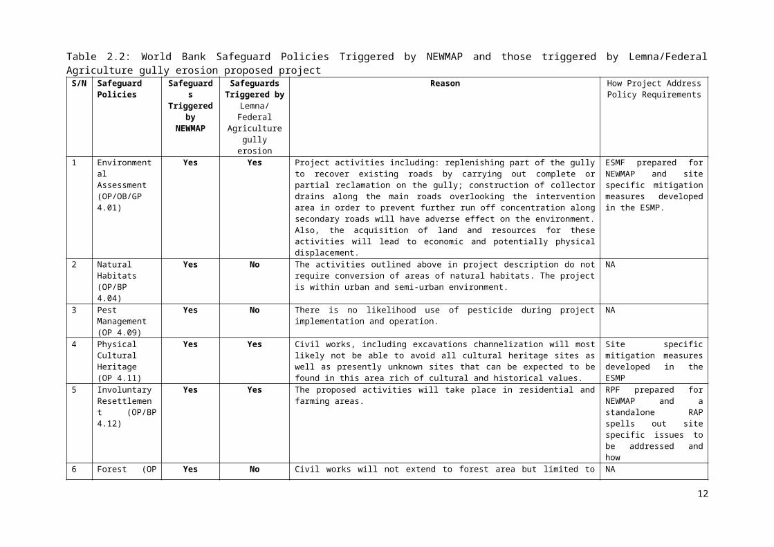
Table 3.5: Physico-Chemical Properties of Sub-Soils (15 -30 cm)Sampling
PointpH PO4
3- Cl- NO3- CO3
2- SO42- THC O & G
(mg/kg)S1 5.4 6.2 15.0 0.85 0.005 3.0 ND 0.02S2 5.4 6.5 14.0 0.92 0.001 4.0 ND 0.03S3 5.4 6.3 14.0 0.88 0.002 4.0 ND 0.03S4 5.5 6.9 15.0 0.86 ND 4.0 ND 0.02
Min. 5.4 6.2 14.0 0.85 0.000 3.0 - 0.02Max. 5.5 6.9 15.0 0.92 0.005 4.0 - 0.03Mean 5.425 6.475 14.5 0.878 0.002 3.75 - 0.025
Source: Fieldwork, February, 2017
Table 3.6: Geographic Coordinates of the Soil SamplesName Easting NorthingS1 8021’27.363” E 502’13.09” NS2 8021’33.701” E 502’11.891” NS3 8021’20.167” E 502’13.11” NS4 8020’47.059” E 502’14.889” N
Fig. 3.11: Soil Sampling Points
Soil pH: The pH values detected for soils in the study area ranged from 5.3 to 5.5 with a mean of 5.4 for the topsoils and 5.425 for the sub-soils. The overall average for top soil is 5.42 while 5.425 was detected for the subsoils. Therefore, the soil pH is moderately acidic indicating that the basic cations might have been leached away from the soil column by the high rainfall of the area.
Total Nitrogen: Soils in the study area have total nitrogen ranging from 0.74 to 0.77mg/kg with an average of 0.75mg/kg for the topsoils; and 0.85– 0.92mg/kg (mean, 0.878mg/kg) in the subsoils. Surface soils had a higher total nitrogen content compared to subsurface soils
22

and this may be attributed to the fact that nitrogen mineralisation occurs readily in the surface than in the subsurface soils.
Available Phosphorus: Surface soils in the study area have available-phosphorus values ranging from 6.4 to 7.5 mg/kg (mean of 6.9mg/kg) and subsoils have 6.2 to 6.9 mg/kg (average of 6.475mg/kg).
Sulphate: The topsoils of the study area have sulphate content ranging from 3.0 to 5.0mg/kg, with an average of 5.0mg/kg, and the sub soils have sulphate content ranging from 3.0 to 4.0mg/kg, with an average of 3.75mg/kg. The sulphate contents of the soils are considerably lower than 500mg/kg which is often regarded as the level beyond which the soils are said to be chemically aggressive.
3.2.4.2 Metal Content of the SoilsData obtained from the study area for the basic and heavy metal concentrations in the soil samples are presented in Tables 3.7 and 3.8, for the topsoils and subsoils respectively.
Table 3.7: Basic and Heavy Metal Concentrations of the Top Soil (0–15 cm) Sampling Locations
Heavy Metals (mg/kg) Basic Metals (mg/kg)
Cr Cu Cd Fe Ba Hg Ni Pb V Zn Ca2+ K+ Mg2+ Na+
S1 ND* 3.1 ND* 0.06 ND* ND* ND* ND* ND* 25.35 12.5 5.4 4.2 8.2
S2 ND* 2.6 ND* 0.02 ND* ND* ND* ND* ND* 24.26 11.2 5.3 3.6 11.1S3 ND* 2.8 ND* 0.02 ND* ND* ND* ND* ND* 24.27 11.5 4.5 3.8 10.2S4 ND* 2.9 ND* 0.04 ND* ND* ND* ND* ND* 23.56 10.5 4.2 3.4 12.2
Min. - 2.6 - 0.02 - - - - - 23.56 10.5 4.2 3.4 8.2Max. - 3.1 - 0.06 - - - - - 25.35 12.5 5.4 4.2 12.2Mean - 2.9 - 0.04 - - - - - 24.36 11.43 4.9 3.8 10.4
*ND- Not DetectedSource: Fieldwork, February, 2017
Table 3.8: Basic and Heavy Metal Concentrations of the Sub-soil (15–30 cm) Sampling Locations
Heavy Metals (mg/kg) Basic Metals (mg/kg)
Cr Cu
Cd Fe Ba Hg Ni Pb V Zn Ca2+ K+ Mg2+ Na+
S1 ND* 2.1 ND 0.05 ND* ND* ND* ND* ND* 25.12 10.5 5.1 3.2 8.5S2 ND* 2.6 ND 0.04 ND* ND* ND* ND* ND* 22.56 8.6 4.3 2.6 10.2S3 ND* 2.5 ND 0.04 ND* ND* ND* ND* ND* 22.50 8.2 4.6 2.7 8.6S4 ND* 2.5 ND 0.05 ND* ND* ND* ND* ND* 28.26 11.2 3.6 2.5 7.8Min. 0 2.1 0 0.04 0 0 0 0 0 22.56 8.6 3.6 2.5 7.8Max. 0 2.6 0 0.05 0 0 0 0 0 28.26 11.2 5.1 3.2 10.2Mean 0 2.4 0 0.05 0 0 0 0 0 24.61 9.6 4.4 2.7 8.8
*ND- Not Detected Source: Fieldwork, February, 2017
Basic Metals: The basic metals (K+, Na+, Ca2+, Mg2+) with the exception of Na are important plant nutrients. As shown in Tables above, it was observed that the basic metals were dominated by Na+, Ca2+, K+ and Mg2+. Mg2+ had a mean concentration of 3.8mg/kg for the topsoil and 2.74mg/kg for the subsoil; Na+ had a mean concentration of 10.4mg/kg for the topsoil and 8.81mg/kg for the subsoil; K+ had an average of 4.95mg/kg for top soil and
23
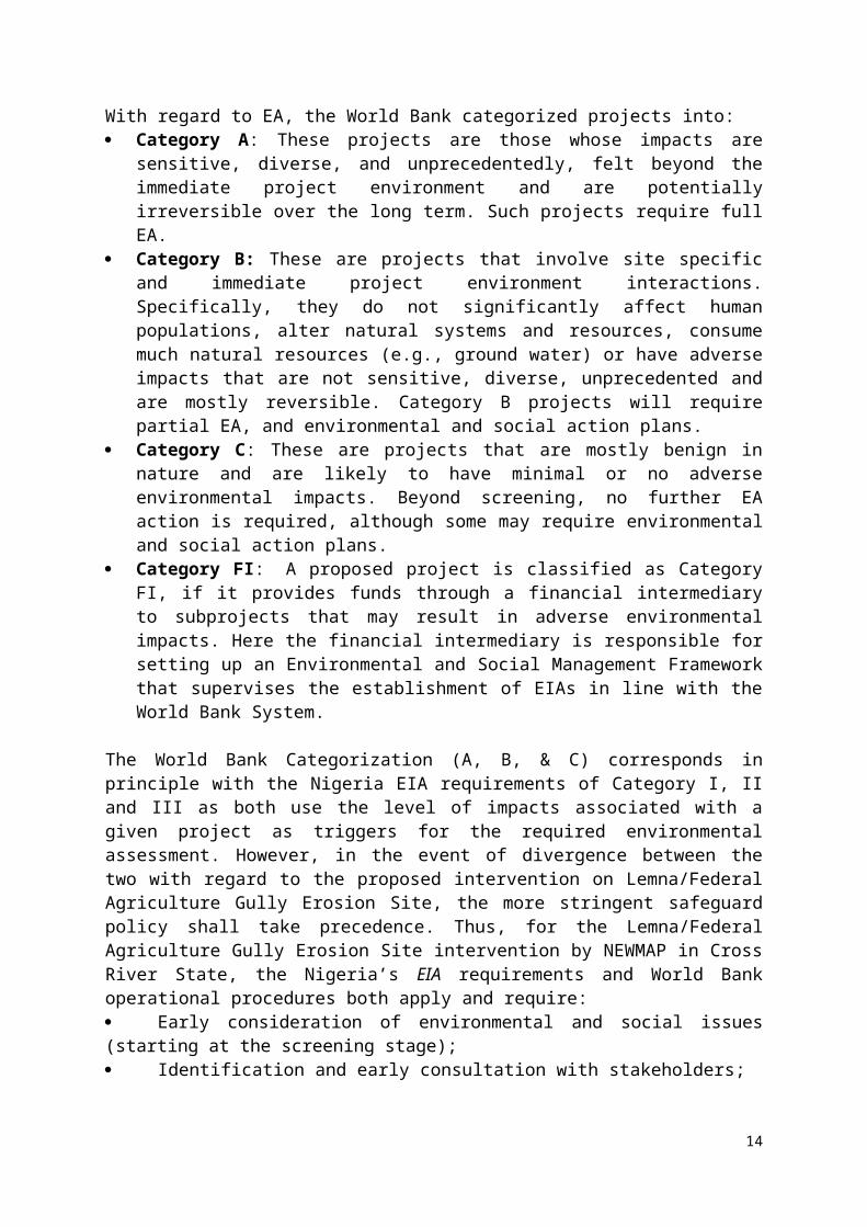
4.41mg/kg for subsoil. The mean concentration of Ca2+ for the topsoil was 11.43mg/kg and 9.6mg/kg for the subsoil.
Heavy Metals: Concentrations of the heavy metals investigated in the study area are presented in Tables 4.8 and 4.9 above. The most prominent metal detected in the soils collected from the study area was Zn, with a mean concentration of 24.36mg/kg for the top soil and 24.61mg/kg for the subsoil. Other heavy metals detected were Fe and Cu. The mean concentration of Fe was 0.04mg/kg for the top soil and 0.05mg/kg for the subsoil. Cu had a mean concentration of 2.91mg/kg for the topsoil and 2.41mg/kg for the subsoil. Ba, Pb, V, Ni, Hg were not detected. The values obtained for heavy metal concentrations were within the limits described as the normal range in unpolluted soils by Allen et al. (1974) and Alloway (1991).
3.2.5 Surface HydrologyThere are two major drainage systems in Calabar. These are the Calabar River system and the Great Kwa river system. These major hydrological features possess unique superficial water resources characteristics that influences the overall hydrological regime of the city in general and influence the Ikot Effanga Mkpa community in particular. Specifically, they exert considerable influence on the general hydrology of the area giving it a dual representation. The Lemna/Federal Agriculture gully erosion area is proximate to one of the tributaries of the Great Kwa River, hence, hydrological fluctuations and soil conditions which is dictated by the geology contributes immensely to the behaviour of ecosystems and biological life forms. Consequently, the sloppy nature of the project area coupled with the high drainage density; affect the action of water and the features created along its path. Also, the local micro-watershed characteristics of the project area is thereby influenced by its surficial hydrological characteristics. The surface water nature of the project area is typified by lacustrine wetland with seasonal/rain-fed running water. This water system runs across the depression which in turn feeds the river downslope and eventually connects the Great Kwa River.
3.2.5.1 Physico-Chemical Analysis of the Surface Water SamplesSurface water samples were collected from the water flowing along the channels that runs through the gully from the Murtala Mohammed Highway that traverses the proposed project area. These sample points mirror the watershed cross section of the study area. Three samples locations were collected with three samples collected at each location. The upper watershed zone was denoted SW3 location, mid and lower zones were denoted SW2 and SW1 respectively. The physic-chemical water samples were analysed on the field using in situ equipment YSI Pro Plus Multi-parameter.
The concentrations obtained for the physico-chemical parameters, the cations and anions and heavy metals are presented in Tables 3.10, 3.11 and 3.12. Table 3.9 shows the geographic coordinates of the samples while Fig. 3.12 displays the spatial distribution. Electrical conductivity varied between 279 to 332 S/cm with a mean concentration of 281.7S/cm, thus the surface water within the study area is essentially freshwater. The pH of the water samples ranged from 6.0 to 6.2 with a mean value of 6.1.
Variations in the TDS and TSS levels from one sampling station to the other ranged from 111.0 to 161.0 mg/l with an average of 134.7mg/l, and 90.5 to 128.0 mg/l with an average of 107.8mg/l respectively. The BOD and COD values ranged from 4.9 to 6.50 mg/l with an average concentration of 5.83mg/l and 7.50 to 12.50 mg/l with an average concentration of 9.83mg/l respectively.
24

Table 3.9: Geographic Coordinates of the Surface Water SamplesSampling code Easting NorthingSW1 8021'33.342" E 5002'4.49" NSW2 8021'31.762" E 5001'50.98" NSW3 8021'18.328" E 5002'15.951" N
Table 3.10: Physico-Chemical Parameters of Surface Water Samples from the Project Area Sample Code
pH Salinityppt
ECµS/cm
Alkali-nity
COD BOD DO TSS TDS THC Turbidity(NTU)
Total anions
mg/lSW1 6.2 0.19 332.0 41.0 12.40 6.0 2.49 126.0 160.0 ND 0.29 0.28SW2 6.2 0.14 281.0 26.0 9.50 6.60 2.76 105.0 132.0 ND 0.30 0.22SW3 6.0 0.15 232.0 28.0 7.40 4.80 2.32 91.5 110.0 ND 0.28 0.23Min 6 0.14 232 28 7.4 4.8 2.32 91.5 110 0 0.28 0.22Max 6.2 0.19 332 41 12.4 6.6 2.76 126 160 0 0.3 0.28Mean 6.1 0.16 281. 7 32.0 9.83 5.83 2.56 107.8 134. 7 0 0.29 0.24SD 0.1 0.02 49.1 6.9 2.52 0.83 0.21 18.9 25.1 0 0.01 0.03
Source: Fieldwork, February, 2017
Fig. 3.12: Surface Water Sampling Points
The cations and anions content of the sampled surface water are shown in Table 3.11. Sodium was the highest with an average value of 32.50mg/l, followed by magnesium with an average concentration of 14.7mg/l. Calcium and Potassium had average concentrations of 9.33mg/l and 0.009mg/l respectively. Chloride accounted for the bulk of the anions while mean nitrate and sulphate concentrations were below 1.00mg/l.
25

Table 3.11: Concentrations of Cations and Anions in Surface Water Samples Sample Code
NH3 Ca CN- Mg Na K NO3- Cl- SO4
- CO32- S2-
mg/l
SW1 ND 8.0 ND 19.0 37.54 0.002 0.10 95.0 0.38 ND ND
SW2 ND 8.0 ND 16.0 29.68 0.007 0.38 76.0 0.41 ND ND
SW3 ND 12.0 ND 8.0 29.88 0.016 0.17 76.0 0.36 ND ND
Min.0 8 0 8 29.68 0.002 0.10 76.0 0.36 0 0
Max.0 12 0 19 37.54 0.016 0.38 95.0 0.41 0 0
Mean0 9.33 0 14.7 32.50 0.009 0.22 82.67 0.39 0 0
SD0 2.31 0 6.11 4.54 0.008 0.15 11.55 0.02 0 0
Source: Fieldwork, February, 2017The heavy metals concentrations are presented in Table 4.10. In all the sampling locations, the individual and average concentrations of other heavy metals investigated were significantly lower than 1.00 mg/l and are therefore not considered polluted with respect to the heavy metals.
Table 3.12: Heavy Metal Concentrations in Surface Water Samples Sample Code
Ba Fe Cu Hg Cr Ni V Pb Zn Cdmg/l
SW1 ND 0.95 0.02 ND 0.01 0.04 ND ND 0.32 0.004SW2 ND 0.99 0.01 ND ND 0.02 ND ND 0.30 NDSW3 ND 0.95 0.03 ND 0.02 0.03 ND ND 0.33 NDMin 0 0.95 0.01 0 0 0.02 0 0 0.3 0Max 0 0.99 0.03 0 0.02 0.04 0 0 0.33 0.004Mean 0 0.96 0.02 0 0.01 0.03 0 0 0.32 0.001
Source: Fieldwork, February, 2017
3.2.6 GroundwaterGroundwater samples were collected using the baseline boreholes. This was adopted due to the availability of in situ groundwater devices as well as access to available groundwater sources. Existing boreholes were accessed based on direct and untreated water that are mainly used for domestic purposes as well as business such as car wash. These were sourced within the Federal Agriculture settlement and a car wash centre along Lemna Road. For all the four samples collected two samples one (GW3) was collected at the mid watershed zone while remaining were collected at the low watershed zone owing to availability of existing boreholes. YSI Pro Plus Multiparameter Instrument was used on the field and it produced 19 parameters outputs. The results are presented and analysed in the subsequent paragraphs.Groundwater temperatures in the project area ranged from 21.6oC to 28.4oC (mean 29.6oC). This range is normal for the region and is an indication of the physiographic conditions of the area. pH values (3.75 – 5.00, mean. 4.52) for the project area indicates that the water is strongly to moderately acidic. High Dissolved Oxygen (DO) (mean; 77.7%), high Eh (mean; 95.3 (mv), low chemical oxygen demand (COD) (0.1-0.45 mg/l) as well as low biological oxygen demand (BOD5) (0.6 – 1.8mg/l) indicated low respiratory activity and low organic matter.
26
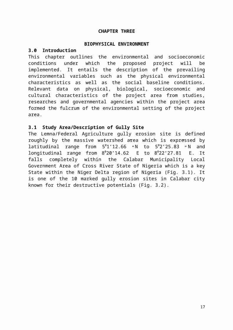
Values for TDS, TSS and conductivity are low and ranged from 12.6 – 24.5mg/l (mean; 18.4mg/l), 22.4 - 49.2mg/l (mean, 32.4mg/l), and 140.2 – 168µs/cm (mean, 147µs/cm) respectively. Low salinity (0.01 – 0.021%, mean, 0.02%) and low chloride (10.6–16.2mg/l, mean, 14.0mg/l) were also recorded in the study area. These low values are indicative of fresh water.
Turbidity values are high and ranged from 14.8 to 23.4 NTU, with a mean of 19.4 NTU. This could be attributed to the oxidation of ferrous ions in the water to produce insoluble residues. Values of sulphate (0.6-3.0 mg/l, mean; 1.73mg/l) phosphate (0.02 – 0.034 mg/l, mean, 0.027mg/l), Nitrate (2.0 – 3.6 mg/l, mean; 2.77mg/l) and nitrite (0.01 – 0.0 2mg/l, mean, 0.02mg./l) are low. Similarly, values obtained for ammonium (0.11 – 0.19mg/l, mean, 0.14mg/l) silicate (0.01 – 05mg/l, mean, 0.03mg/l) carbonate (6.2 – 12mg/l, mean, 8.78mg/l) as well as bicarbonate (14 – 21.6mg/l, mean, 17.3mg/l) are all within the WHO maximum permissible limits.
Values of the samples for sodium (15.2 – 28.4mg/l), mean, 21.70mg/l), calcium (14.8–20.6mg/l, mean, 18.4mg/l), potassium (17.6–30.6mg/l, mean, 19.7mg/l) and magnesium (12.6–25.4mg/l, mean, 18.2mg/l) were low and normal for fresh water.
The comparison of some of the parameters for the ground water with the World Health Organization (WHO) standard for potable water is presented in the Table 3.13. In general, most of the concentrations recorded fall within the acceptable limit. Fig. 3.13 displays the spatial distribution of the groundwater samples while Table 3.14 presents the location coordinates.
Table 3.13: Comparison of the Borehole Ground Water Quality with the World Health Organization (WHO) Standards for Potable Water
Parameter/Unit Borehole WHO LimitOdour Unobjectionable UnobjectionablepH 5.0 6.5-8.5Conductivity, (µS/cm) 148 2000Temperature, ( 0C) 29.6 <40Total Solids, (mg/l) 400Total Dissolved Solids, (mg/l) 18.4 -Total hardness, mg/l CaCO3 100Chloride, mg/l 14.0 200Nitrate, mg/l 2.76 50Sulphate, mg/l 1.74 200Phosphate, mg/l 0.028 -Calcium, mg/l 18.5 75Magnesium, mg/l 18.3 30Iron (total), mg/l 0.3Zinc, mg/l 0.0008 5.0Lead, mg/l 0.01 0.01Copper, mg/l 0.001 1Manganese, mg/l <0.001 0.1Oil and Grease, mg/l <1.00 NilTotal coliform count, MPN/100 ml Nil
Source: Fieldwork, February, 2017
Table 3.14: Geographic Coordinates of the Groundwater SamplesSampling code Easting Northing
27
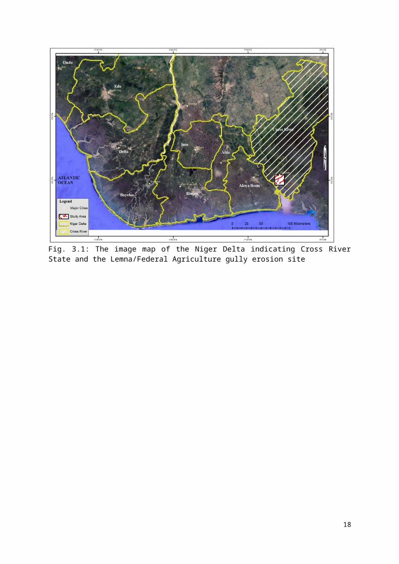
GW1 8021'24.779" E 5002'11.549" NGW2 8021'35.102" E 5002'7.526" NGW3 8021'20.015" E 5002'4.566" NGW4 8021'29.485" E 5002'10.714" N
Fig. 3.13: Groundwater Sampling Points
3.3 Biological Environment3.3.1 EcosystemThe ecology of the project area could be viewed from its surrounding landscape. As a suburb of the city of Calabar, it is influenced by the built nature of the landscape. However, the gully-affected area is a nexus of the natural landscape and the rain-fed subsistence agricultural activity (Olaniyan, 1975) cum plantation. Apart from the upper section of the watershed which is completely built, the lower section is partly cultivated and further down is semi-pristine. The semi-pristine ecosystem is a pointer to the disturbed natural ecosystem of the project area with disturbed forest strands and swathes of wetland proximate to the sinuous tributary of Kwa River. Within this milieu, a maze of palms can be observed with shrubs and herbaceous plants proximate to the wetlands bordering the tributary. In addition, there are flora life in form of plant regrowth and secondary formations such includes regrowth of grasses, shrubs and coastal marsh plants which are indicators of human alteration of the natural landscape to produce secondary ecological areas.
Overall, the observed ecology of the project area suggests a suburb landscape with nascent structures built along strands of farmlands and natural ecology. The farm plots located further down the gully suggests a dependence on the farm output for family survival. The derived forest observed behind the Ebruku Barracks a proxy information on the nature of the gully eroded areas prior to human occupation of the land. However, it suggests further of the nature of the dominant flora and fauna life form of the project area prior to human domination of the milieu.
28
3.3.2 VegetationVegetation is an integral part of the terrestrial environment. It performs several functions that are crucial to the sustenance of the environment. Some of these functions include:
i. Protection of the fragile soils from the erosive impacts of rains and wind.ii. Maintenance of soil fertility through continuous nutrient recycling.
iii. Conservation of water resources through shadingiv. Preservation of watersheds.v. Regulation of air and soil temperatures.
vi. Moisture balance.vii. Provision of habitat for countless terrestrial flora and fauna
viii. Purification of the environment through the carbon dioxide during photosynthesis and the release of oxygen for human and animal respiration.
ix. Aids in understanding the ecological nature and structure of the environment.x. It is a pointer to the historical past and a presents a model for safeguarding the future.
Vegetation in the study area consists of upland species (Plate 3.2). These semi-forested species bear canopy cover broad enough to shield the soil from direct exposure to running water during the observed heavy downpour hence curtailing soil erosion and gully formation.
Plate 3.2: Vegetation of the Project Area (Source: Fieldwork, February 2017)
3.3.2.1 Plant Characterization / IdentificationThe general physiognomy of the plants presently existing within the study area is secondary vegetation, resulting from agricultural/ development within the study area. A description of the observations made on the vegetation of the area is described below:
3.3.2.2 Plant physiognomyThe vegetal composition within the project area is generally of a disturbed ecological zone albeit with trees, annual herbs and perennial species. These include Elaeis guineensis, Alstonia boonei, Musanga cecropioides, Terminelia superb, Anthocleistra vogelii, Harungana madagascariensis, Pandanus candelabrum, Nypa fruiticans, Albizia zygia amongst several other species and botanical families. Table 3.15 enlists the crops and fruits that typified the project area.
29

Table 3.15: List of Crops and Fruits Planted in the Project AreaEnglish/Common name Botanical name
Banana Musa SppOil palm Elaeis GuineensisPlantain Musa ParadisiacaPineapple Ananas SativusMellon Cucumis MeloGarden eggs Solanum MelongenaMaize Zea MaysOkra Abelmoschus EsclentusCucumber Cucumis SativisFlutted pumpkin Teifairia occidentalisCocoyam Colocasia EsculentaYam Dioscerea SppCassava Manihot EsculentaSpinach Green vegetables
Source: Fieldwork, February, 2017
3.3.3 Inventory of Economic CropsThe prevalent economic crops in the general vicinity include Talinum triangulare (water leaf), Saccharum officinarum (sugarcane) Colocasia esculenta (cocoyam), Capsicum spp. (pepper), Lycopersicum esculetum (tomato), Manihot esculenta (cassava), Carica papaya (paw paw), Telfaria occidentales (Fluted pumpkin), Citrus spp. Magnifera indica (mango), Musa paradisiaca (plantain), M. sepientum (banana), Psidium guajava (guava), and Elaeis guineensis (oil palm) (See Table 3.16).
Table 3.16: List of Economic Crops and TreesCommon name(English/Traditional names) Botanical name
Bush mango Irvingia GaboneensisMahogany Etandrophragra SppMimosup Baillonelia ToxispermaIroko Melicia ExcelsaSmall leaf Piptadenistrum AfricanumAchi Brachystegia SppNative mango Mangifena IndicaSilk cotton tree Ciba PentandraUmbrella tree Musanga CecropoidesLocust bean Parkia SppSheanut Poga OleosaWild palms Elacis GuineensisNative Kola Cola AcuminataBitter Kola Cola NitidaNative pear Dacryodes EdullisAfang Gnetum AfriamumEditan Lasianthera AfricanumStar apple or Udara Chrysophyllum AlbidumHot leaf/seed Piper GuineensisPawpaw Carica PapayaGroundnut tree Ricinodendron LeudetiiWhite Afara Teminalia SuperbaMahogany Etandrophragma SppMimosup Baillonellia ToxispermaBread fruit Triculia AfricanumAtama Heinsia CrinataCeda Lovoa Trichiloides
30

Cane wood Pterocarpus OsunOpepe Nauclea DiderrichiiCedar Lovoa TrichiloidesEbony Diospyros SppSugar cane Saccharum Officinarum
Source: Fieldwork, February, 2017
3.3.4 Fauna and Wildlife Resources Available information on wildlife of the project area shows a degradation of wildlife and dominance of birds and butterfly species. Thus points to the possible migration of wild animals owing to human invasion of the area. Naturally, the area should have been a suitable habitat for wild animals such as wild rats, cats, Mona monkeys as well as other herbivores. Some of these animals might have migrated further down within the wetland to areas of ecological-fitting ambience.
List of birds observed in the project area are documented in Table 3.17 below with their respective status. It should be noted that some of these birds are rare while most are very common. The rare species such as the Little Egreatta and Hadada black kite are seasonal. Others such as the laughing dove, lesser stripe sparrow, mourning dove are very common in the area (Mackworth-Praed and Grant, 1973).
Available information on butterfly shows that there five taxonomical categories available in the project area. The Nymhalidae family has the highest specie compared to other butterfly species. Details of these are presented in Table 3.18. However, none of the plant species and bird species recorded is in the vulnerable category of the FMEnv and IUCN.
Table 3.17: List of Bird Species recognized in the Project AreaOrnithological/Scientific Name Common/English Name Status/Frequency of
observationEgretta garzetta Little Egretta Rare
Bostrycgia hagedash Hadada Black kite Rare Abundant
Milvis migrans migrans Hooded Vulture Common Common
Necrosyrtes monachus Common Buzzard Rare Common
Bueto bueto Helmeted Guinea Fowl Very rare
Numida meleagris Little Button Quail Very rare
Tunix sylvatica African Mourning dove Abundant
Streptopelia decipiens Laughing dove Abundant
Streptopelia selegalensis Lesser stripe swallow Abundant
Hirundo cucullata Village (Black headed) weaver Abundant
Ploceus cucullatus Compact weaver Abundant
Ploceus superciliosus Parasitic weaver Abundant
Source: Fieldwork, February, 2017
31
Table 3.18: Butterfly Taxonomy in the Project AreaN Family Genus/Specie1 Pieridae Leptosia medusa
Catopsilia florellaMylothris rhodopeMylothris chlorisColotis evippe
2 Nymhalidae Acraea eponina Précisoenone Hypolimnasmissippus Hypolimnassp Euriphene tademaEunica amulia Bybliaachellia
3 Lycaenidae Thermoniphas micylusZezeeria knyssnaSpindasis spSpindasis mozambica
4 Satyridae Ypthima doleta Bicycles asoctusYpthima spBematistes vestalis
5 Acraeidae Acraeidae(Source: Fieldwork, February 2017)
32

CHAPTER FOUR
SOCIO-ECONOMIC CHARACTERISTICS AND CONSULTATIONS WITH STAKEHOLDERS
4.1 Socio-Economic Survey MethodologyA socioeconomic assessment of the project area gives an insight into the social, cultural, and economic conditions of stakeholders including individuals, groups, communities and organizations through the administration of structured questionnaires for individuals and households and Focus Group Discussion (FGD) adopted at the overall community level. A blend of investigative methods, which includes the following, were used to acquire the socio-economic data: Review of existing data; Reconnaissance survey to identify the focal community (Ikot Effanga Mkpa) and the
likely adjoining communities that might be directly or indirectly affected and to inform the communities’ leaders and residents on proposed project;
Key Informant Interviews (KII) with community leaders of the focal community (property owners, women leaders, and youth leaders) as well as key investors in properties and assets;
Focus Group Discussions (FGDs) with stakeholders and project affected peoples (PAPs) in the focal community;
Field observations by consultants and interviewers using strategic instruments and devices to record and note observation and detections;
Scientific tools used during FGDs, specifically community mapping, and paired needs ranking and case studies formulation;
Structured questionnaire to collect baseline information and to gather the perception of the PAPs on the proposed project. A simple random sampling technique was used for the administration of the questionnaire and enumeration of the combination of the fundamental socio-economic characteristics;
Population estimation was based on the combinations of questionnaire survey and projection from 1991 and 2006 census figures by the National Population Commission (NPC);
In all, a total of 100 questionnaires were administered and all were returned.
4.1.1 Data Collection and Sampling Methodology Every project has its unique philosophy, output and the variables to be considered. In order to collect the requisite data for the study, an understanding of the environment is key. Based on these pre-conditions, the following have been drawn. Adequate representation of the relevant social groups in the study location for general
group discussion (FGD); Inclusion of groups and individuals with different demographic cum population
characteristics as well as socio-economic status; Participation of those with access to relevant information; Evidence of different type of livelihood activities; Inclusion of males and females where possible; and Inclusion of activities that connect land and the gully erosion.
It should be noted that the socioeconomic data collected for the study was based on the integration of these data collection strategies. Hence these were merged to form a universal sampling frame. The survey methodology designed is displayed in Table 4.1.
33

Table 4.1: Details of the Sampling Methodology and the Questionnaires Administered Categories of Stakeholders Sampled
Questionnaire Administered
Questionnaire Returned
FGD Town Hall Meeting
Direct Project Affected Persons (PAPs)
50 50 1
Key Stakeholders 10 10 1
Consultation with other members of the community
40 40
Total 100 100 2 1
4.2 Socio-Economic Characteristics of RespondentsKey socio-economic variables have been documented and are presented in Table 4.2. The variables considered include gender, age, ethnic group, literacy and communication, marital status, occupation, average family size, residency, income, social infrastructures (health and water provision) as well as prior knowledge of the project and resettlement plans.
Table 4.2: Socio-Economic Characteristics of RespondentsS/N Specific socio-
indicatorSocio-Economic FindingsIkot Effanga Mkpa Watershed (Lemna/Federal Agriculture Gully)
1 Gender The gender distribution of the respondents reveals that there are more female (56%) respondents than male (44%). A good number of these women own small-scale businesses, kiosks, shops, sells fruits etc. within the watershed. Some also cultivate the small-scale farm plot abutting the gully area. This indicates that more women are vulnerable and likely to be impacted either positively or negatively by the proposed project.
2 Age The age structure of the respondents in the study area is dominated by the active population. About 51.0% of the respondents falls between the age group of 18-45 years. 34.5% falls within the age bracket of 46–65 years of age while about 10.5% falls within the age bracket of 66 years and above. This shows that the community is dominated by vibrant population, which can constitute the workforce for the proposed project. Some of the women engage in petty food vendoring which may be a ready-made services to the construction workers during construction. Also, the youth constitutes a considerable number of the most dominant age-group indicating a ready active population for provision of labour force during the construction phase of the project.
3 Ethnic group The ethnicity of the respondents in this community is characterized by a high level of heterogeneity. But it is mainly dominated by the Ibiobio and Efik (Cross River) ethnic group (50.0%), Ejagham and Bekwarra (15.0%), Ogoja and other tribes from Cross River State (15.0%), Yoruba (10.0%), Igbo and other groups constituted (10.0%). This shows that the entire area is dominated by the people from the Cross River State.
4 Literacy level/Languages spoken
The level of literacy is relatively high in this community with about 48.0% of respondents indicating that they had at least secondary education. More than 42.0% had university degree while about 10.0% of the respondents had no formal education. This implies that the sensitization of the proposed intervention among members of the community will not be a problem. This is irrespective of their current occupation. They can all communicate fluently in English and the usage of Pidgin English could also be the most effective mechanism of general communication apart from the local languages.
5 Marital Status The marital status of the respondents shows that high proportion of them are married 70.0% while 26.0% are single. The widows/widowers constitute 5.0% of the respondent and they are mostly within the aged group of above 66 years. This explains that the complete family structure with head of household is intact.
34

6 Occupation The occupational structure of the respondents in this community is skewed mainly towards civil servants (45%) who are salary earners, traders and shop keepers constitute 15%, farmers, artisans and self-employed each constitute (10%), while 10% are unemployed. For clarity, the gully eroded area is dominated by civil servants hence it is not unexpected to have the number of civil servants recorded. Many of the youths particularly students believed their transient may change anytime hence prefer to be classified as unemployed.
7 Size of the Family
The family size of the respondents shows that 20.0% of them have 4 persons as the average family size, 45.0% has five persons per family while 20% and 10% of the respondents have 6 and 7 persons average family size respectively. The aggregated average family shows that 6 including the two parents is not uncommon in the area. This is by extension the socio-family nature of sub-urban settlements of Calabar city.
8 Length of residence/ Residential Status
The length of residence of the respondents varies. Specifically, about 80.0% of the respondents have lived in this community for more than 10 years while about 6.0% of the respondents have resided within the area between 6 – 9 years. 10.0% of the residents have only resided for 3–5 years’ experience while the remaining are new residents with about 2 years’ experience. This shows that majority of the respondents were born and brought up in the area and are well aware of the origin and development of the gully erosion and the level of destruction it impacted on the area. This also shows the validity of the information that will be supplied for the rehabilitation and other concomitant civil works by the Cross River NEWMAP SPMU.
9 Income Level of Respondents.
Three level of income earners are recognised in the area. The low income-earners at the base of income pyramid earn less than N50,000 (48%) in a month. The middle-income earners earn between N50,000 and N100,000 (32%). High-income earners constitute 20.0% of the area and earn above N100,000 in a month. These are the senior civil servants who occupy the Federal Agriculture Staff Quarters. Others in this category are business owners such as the Pounix Fish Farm along Water Intake and several others.
10 Waste Management Approaches
Four major ways were identified as the respondents’ medium of waste disposal. Most of the residents have adopted a means of turning the gully to dumpsite for series of wastes generated. 65% of them asserted the gully is used for waste dumps. 15% engages in waste burning especially at nighttime. A few (5%) patronize waste collators. Some also used the government designated waste dumps site (15%)
11 Health Status and Health Care Methods
It is expected for most residents to affirm that they are healthy. However, a further probe with respect to the impact of the gully, some responses were provided. Such that 67% of the respondents complained of malaria. This is mostly noticed amongst children. Typhoid fever (11%), whooping cough, (5%), cold (5%) and catarrh (12%). In terms of treatment of malady, 35.0% of the respondents treat their illnesses at hospitals/clinics while 50.0% do buy drugs from nearby chemist to treat their illnesses. And lastly, about 15.0% treat their illnesses using traditional medicine. However, majority (95.0%) of the respondents agreed that their health status cannot be affected by the activities of the proposed intervention.
12 Sources of Water in the Proposed Project Area
Even though there are various sources of water, respondents claimed that there four different sources of water known in the area. First is the water sourced from Cross River State Ministry of Water Resources. 480% of the respondents affirmed that they sourced water for domestic purposes via this means. 35% claimed that they rely on borehole water. 10% source water from hand-dug wells which are identified with each house. 7% claimed miscellaneous uses such as mixture of the earlier mentioned sources.
13 Rating the Standard of Living in the Proposed Project Area
About 45.0% of the respondents mentioned that their living condition is getting reduced as the gully is gradually crawling towards their property. This claim they emphasize is relative to closeness to the gully. This is because anyone whose property is progressively getting vulnerable will keep expenses of safeguarding his personal property. Hence expenses for personal and family upkeep are been diverted to securing the landed property. Out of the remaining proportion, 52% claimed that addressing the will restore the land and give them more sense of belonging.
35

14 Awareness of the Proposed Project
The majority (91.0%) of the respondents claimed that they are aware of the proposed intervention in their community while very few (9.0%) respondents claimed they are not aware. Many of the respondents, however, sees the continuous informal information they receive about the project as either academic or politically motivated. This is based on their experience of divergent studies and reports on the status of the gully. However, they are optimistic that the rehabilitation project come into fruition.
Source: Fieldwork, February, 2017
4.3 Public and Private Assets within the Project CorridorThe Lemna/Federal Agric gully erosion project is located within a township centre which is entirely residential with traces of other land uses such as subsistence farm plots, religious centres, commercial spots, private properties used for social functions and educational purposes, public primary and secondary schools. In this section, a presentation of these are displayed with respect to their classification, status and functionality as well as importance to the entire watershed. It should be noted however, that most of these are located within the mid and upper watershed section, only facilities of Lemna Nigeria Ltd is located right within the lower watershed axis of the study area. However, there is the Ebruku Army Barracks which is not accessible for enumeration and enlistment into this list and this institution falls within mid watershed section of the project area.
4.3.1 Educational Facilities
As presented in Table 4.3 below. There are 4 educational structures identified within the project watershed. 50% of these are privately-owned while one primary and secondary school are owned by the government. These public schools are located proximate to each other occupying a fairly large of land. Two private secondary schools were identified, these are Greenland Secondary School and Zenith Secondary both located along Murtala Mohammed Expressway. By implication, students of these schools can be affected during the construction phase of the project. However, there are no tertiary institutions or training institutes identified.
4.3.2 Religious Facilities
A total of 12 religious centres were identified within the gully watershed. Virtually all these are fully-built and functional with the only exception being The Presbyterian Church which is though not fully built but operational. It should be noted that these identified religious facilities are entirely churches. Mosques and places of traditional worship were not identified.
4.3.3 Other Facilities Identified
There is only one health facility identified – Ikot Effanga Mpka Primary Healthcare Centre. Other healthcare centre are located outside the gully watershed zone. There are series of facilities identified most of which are privately owned. Canaan FM (media house), Lemna Nigeria Limited (abandoned and not functional), Padelli Furniture, Pounix Fish Farm & Lodges are all privately owned establishments located within the mid-watershed zone of the gully. Also, these are located along Lemna Road which means their operations could be affected during the construction phase of the project. Along the Murtala Mohammed Expressway are two petrol stations whose patronage might be impacted during the construction phase of the project. There is the Cooperative Poultry Farm which is located off the Murtala Mohammed Expressway with possibility of minimal construction phase impact. Other facilities identified are utilities – transformers and telecommunication masts.
36

Table 4.3: Public and Private Assets within the Project CorridorS/N Name Type/Status Latitude
(Northings)Longitude (Eastings)
1 Lemna Nigeria Ltd Construction Industry/Abandoned
5°2'20.84" 8°21'24.89"
2 Govt Primary School Primary School/Functional 5° 2' 32.33" 8° 21' 17.25"3 Govt Secondary School Secondary School/Functional 5° 2' 31.09" 8° 21' 14.98"4 RCCG Church Religious/ Functional 5° 2' 32.04" 8° 21' 19.40"5 Warehouse Commercial/Functional 5° 2' 30.05" 8° 21' 17.84"6 Hotel Commercial/Not functional 5° 2' 26.99" 8° 21' 14.50"7 Empowered Christian Church Int’l Religious/ Functional 5° 2' 26.04" 8° 21' 16.84"8 New Covenant Church Religious/Functional 5° 2' 23.60" 8° 21' 12.19"9 Greenland Secondary School Educational/Functional 5° 2' 19.53" 8° 21' 17.00"10 Calabar Golf Course (CGC) Recreational/Functional 5° 1' 58.31" 8° 21' 31.05"11 Ikot Effanga Mkpa Community
Town HallSocial Facility/Functional 5° 2' 9.06" 8° 21' 1.75"
12 Ikot Effanga Mkpa Primary Healthcare Centre
Healthcare/Functional 5° 2' 8.71" 8° 21' 2.50"
13 City Gate Shopping Centre Shopping Centre/Functional 5° 2' 7.96" 8° 21' 2.95"14 RCCG Master’s Place Religious/Functional 5° 2' 8.15" 8° 21' 3.15"15 Deeper Life Bible Church Religious/Functional 5° 2' 6.49" 8° 21' 0.59"16 Zenith Secondary School Educational/Functional 5° 2' 5.41" 8° 20' 59.94"17 Sampet Filling Station Commercial/Functional 5° 2' 10.86" 8° 21' 11.01"18 Mount Zion Lighthouse Full Gospel
ChurchReligious/Functional 5° 2' 11.84" 8° 21' 10.22"
19 Masters Energy Filling Station Commercial/Functional 5° 2' 13.37" 8° 21' 12.85"20 People’s Club Hall Social/Functional 5° 2' 11.42" 8° 21' 17.08"21 The Temple of God Church Religious/Functional 5° 2' 9.86" 8° 21' 18.02"22 Ekan Okot Ebeye Women MPCS
(Poultry Farm)Commercial/Functional 5° 2' 8.33" 8° 21' 20.17"
23 The Rock Tabernacle Religious/Functional 5° 2' 11.98" 8° 21' 19.22"24 The Fullness of Christ Bible Church Religious/Functional 5° 2' 11.72" 8° 21' 21.85"25 The Presbyterian Church Religious/Under construction 5° 2' 17.644" 8° 21' 18.37"26 Padelli Furniture Commercial/Functional 5° 2' 15.21" 8° 21' 31.72"27 Pounix Fish Farm & Lodges Commercial/Functional 5° 2' 13.62" 8° 21' 32.79"28 Golf View Estate Real Estate/Functional 5° 2' 9.20" 8° 21' 37.15"29 Faro Table Water Depot Commercial/Not functional 5° 2' 38.49" 8° 21' 26.79"30 Mount Zion Gospel Church Religious/Functional 5° 2' 35.70" 8° 21' 27.02"31 Telecomm Mast Utility/Functional 5° 2' 35.21" 8° 21' 27.15"32 Femgain Nig Ltd (Filling Station) Commercial/Functional 5° 2' 34.72" 8° 21' 27.97"33 Cross River State Agric Office Administrative/Functional 5° 2' 28.49" 8° 21' 20.34"34 Canaan FM Private Commercial/Functional 5° 2' 10.827" 8° 21' 40.56"35 Community Health Organisation
(Ikot Effanga Mkpa)Community facility/Functional 5° 2' 9.13" 8° 21' 7.30"
36 Telecomm Mast Under construction/Not Functional
5° 2' 8.29" 8° 21' 11.82"
37 Assembly of God Religious/Functional 5° 2' 4.81" 8° 21' 13.61"
37
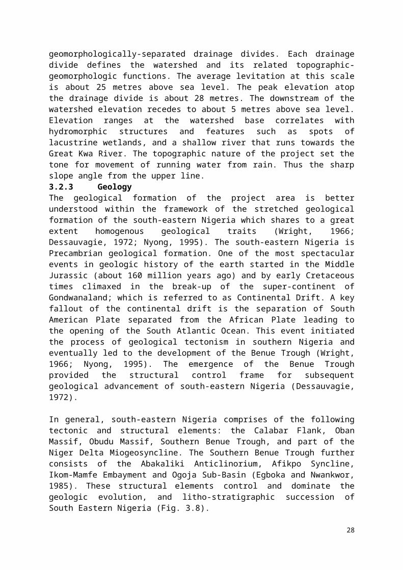
38 Apkaven Construction Ltd Construction Industry/Functional
5° 2' 9.82" 8° 21' 9.64"
39 Electric Transformer Public Utility/Functional 5° 2' 13.47" 8° 21' 14.44"40 Federal Ministry of Agriculture Federal Ministry/Functional 5° 2' 13.67" 8° 21' 15.39"41 The Church of Christ Religious/Functional 5° 2' 13.99" 8° 21' 10.81"42 St Luke Catholic Church Religious/Functional 5° 2' 9.42" 8° 21' 2.37"43 Electric Transformer Utility/Functional 5° 2' 7.98" 8° 20' 57.69"44 The Apostolic Church Religious/Functional 5° 2' 7.89" 8° 20' 57.69"45 Telecom Mast Utility/Functional 5° 2' 10.56" 8° 20' 55.94"
Source: Fieldwork, February, 2017.
4.4 Housing Characteristics in the Project AreaThis has to do with the description of the materials used for the construction of houses in the proposed project area at the Lemna/Federal Agriculture gully erosion site and the entire watershed located at Ikot Effanga Mkpa community in Calabar. This measure focuses on the essential socioeconomic parameters, essentially for determining the standard of living, which is used to correlate employment status and income structure. The higher the quality of materials used in the construction of the buildings, ceteris paribus, the higher the standard of living and the quality of life of a household. The distribution of housing materials used for the construction of the different sections of the building and the tenure systems of land and building is shown in Table 4.4.
As shown in Table 4.3, most of buildings in the project communities are made of cement block (90.0%) while a few are made of plastered mud (10.0%). Roofing materials are made of corrugated roofing (60.0%), aluminum (20.0%) and asbestos (20.0%) while concrete (70.0%), tiles (25.0%) and earthen (5.0%) make the building floor materials. The toilet facilities in the communities comprise of pit latrine (22.0%) and water closest (68.0%). Most of the buildings contain more than three rooms (90.0%) and are personally owned by the in-scope households. Table 4.4: Type of Materials in the Building and Tenure Systems
Building Section Materials Proportion (%)Wall Materials Plastered Mud 10.0
Cement block 90.0
Total 100.0
Roofing Corrugated roofing 60.0
Aluminium 20.0
Asbestos 20.0
Tiles 0.0
Others 0.0
Total 100.0
Floor Materials Earthen 5.0
Concretes 70.0
Tiles 25.0
Others 0.0
38
Total 100.0
Number of Rooms 1-2 Rooms 10.0
3-4 Rooms 90.0
Others 0.0
Total 100.0
Toilet Facility Pit Latrine 35.0
Water Closet 65.0
Outside Dwelling 0.0
None 0.0
Total 100.0
Tenure of Housing Owned 40.0Rented 60.0
Occupied for free 0.0
Others 0.0
Total 100.0
Tenure of Land Owned 100.0Rented 0.0
Occupied for free 0.0
Others 0.0
Total 100.0Source: Fieldwork, February, 2017.4.5 Source of EnergyAvailability and utilization of energy for domestic and commercial usage are from two areas i.e. lighting and cooking. Typically, energy is a key household service necessary for socioeconomic assessment. Table 4.5 shows the ranking of the source of energy used for lighting and cooking by the residents of the proposed project area. In all, most of the residents rely on the use of the public electricity from PHCN (50.0%) and generator (20.0%) and kerosene lantern (25.0%). Other sources include rechargeable lamp, torchlight and candle 5.0% of the sample frame.
The main source of energy for cooking in the project area based on ranking and choice is kerosene stove (45), LPG (domestic cooking gas) (33.0%) and firewood (15.0%). Electricity is rarely used for cooking (7.0%) as shown in the Table 4.4.
Table 4.5: Source of Energy for Various Uses
Energy SourceLighting Cooking Lighting Cooking
Percentage Distribution Ranking Distribution
Electricity 50.0 7.0 1 4
Generator 20.0 0.0 3 --
Kerosene 25.0 45.0 2 1
39

Fire Wood/Residual/Saw dust 0.0 15.0 -- 3
Gas 0.0 33.0 -- 2
Coal/Charcoal 0.0 0.0 -- --
Others 5.0 0.0 --
Total 100.0 100.0
Source: Fieldwork, February, 2017.
4.6 Grievance Redress MechanismsCross River NEWMAP has been implementing its Stakeholders’ Engagement Plan since the inception of the Project invention. This includes the following major considerations:
identification of Project stakeholders; summary of past consultation efforts; planned consultation efforts to prepare for construction activities; stakeholder engagement during construction; stakeholder engagement during operations; resources for stakeholder engagement; and, monitoring and reporting on stakeholder engagement formation of the site monitoring committees particularly the Lemna/Federal
Agriculture Gully Erosion Site Monitoring Committee
In coordination with its Stakeholder Engagement Plan, Cross River NEWMAP will develop and implement a Grievance Procedure that will include the following components:
anyone may contact the Project, in person, by email, or by telephone to submit a grievance;
contacts about grievances may be by the affected person(s) or through an agreed local liaison committee;
all complaints will be documented by Cross River NEWMAP and tracked to resolution, and information on the status will be available to the person making the complaint;
Cross River NEWMAP will investigate the complaint, using technical assistance if necessary, and determine the response including, if applicable, proposed actions;
Cross River NEWMAP will inform the person making the complaint, either verbally or in writing, of NEWMAP response and proposed actions (if any);
Prior to construction, Cross River NEWMAP will work with stakeholders to develop a binding arbitration system for resolving complaints;
The grievance mechanism will inform complainants of their options if the complaint cannot be resolved;
Cross River NEWMAP will strive to investigate and resolve complaints promptly; There will be no cost to the person presenting the complaint; All complaints will be treated with appropriate confidentiality; Complaints will be investigated and resolved without retribution to the complainant or
other persons; and, Project personnel, especially those who have contact with the public, will be
briefed/trained about the grievance procedure, including who to contact within the Cross River NEWMAP or the Cross River Government about a complaint.
40
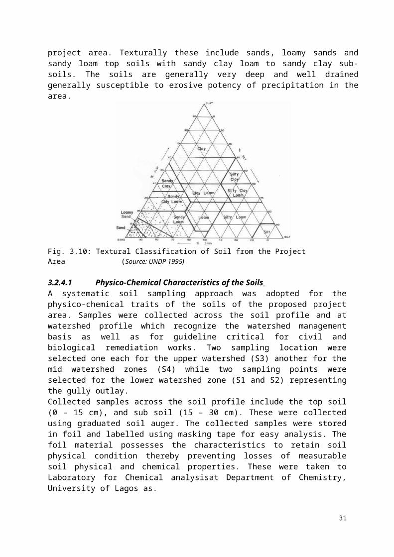
4.7 Other Concerns from Public Consultations, IDIs, FGDs and Community Meetings
The main concerns and impact expressed by the stakeholders and residents of the project community concerning the gully rehabilitation works covered several aspects of the project. These were summarized as outcome of the public consultation events, the focus group discussions, and community meetings with key members of the community of the project (The minutes of meeting are shown in Appendix VII). The summary of the concerns expressed during these gatherings are stated as follows; Accelerated increase in the expansion of the gully in recent time; Massive damage to lives and property especially during rainy season; Destruction of existing road and footpaths to connect nearby communities; Threats to the safety of all residents of all ages especially the vulnerable groups
children, women and the aged; Threats to means of livelihood particularly to farmers especially during rainy season; Previous rehabilitation measures have led to intensification of the gully expansion
consequently leading to development of new gullies that connects to the main gully. Local palliatives only work to reduce the velocity of the waters rushing downslope
but did not prevent the destructive potency of the gully. However, with respect to the proposed intervention, the expectations of the people during construction phase includes
Employment of the locals during the construction phase of the project; Adequate compensation to people whose property’s will be damaged due to the
intervention.
Also, the communities assured total cooperation with the Cross River NEWMAP SPMU, contractors and consultants. They promised adequate security and protection of lives, properties and equipment and machineries during construction.
41

CHAPTER FIVE
ASSESSMENT OF POTENTIAL ADVERSE IMPACTS AND ANALYSIS OF ALTERNATIVES
5.1 Impact Assessment MethodologyA combination of methods was employed in assessing the impacts and included the use of checklists, matrix, public consultation, professional experience and judgment. The phases of impacts assessment include:
i. Impact Identification: to specify the impacts associated with each phase of the project activities;
ii. Impact Prediction: to forecast the nature, magnitude, extent and duration of the impacts;
iii. Impact Evaluation – to determine the significance of the impacts
5.1.1 Impact IdentificationA checklist based on in-depth understanding of the local environment, existing baseline information and the key project activities were used to develop a checklist of potential impacts of the project. The following were appraised:
The source and/or the cause of the problem (project activity/environment aspect), The receptor of the impact (environment component i.e. existing ecological and
socioeconomic condition of the project environment), The way in which the effect is transmitted from the source to the receptor (pathway);
and The potential consequences (environmental impact)
5.1.2 Impact PredictionIn order to further qualify the impacts of the various project activities on the environment, identified impacts were characterized based on the nature, duration and reversibility of impacts as follows:
Beneficial Impacts – these are impacts that have positive and beneficial effects Adverse Impacts – these are impacts that have negative and untoward effects Direct Impacts – these are impacts that are most obvious and are directly related to the
proposed project and can be connected to the action that caused them Indirect Impacts – these are secondary impacts that occur later in time or further away
from the impact source Cumulative Impacts – typically occur from the incremental impact of an action when
combined with impacts from projects that have been undertaken recently or would be carried out in the near future
Reversible Impacts – these are impacts over which the components involved have the ability to recover after the disturbances caused by the impact
Irreversible Impacts – these are impacts whose effects are such that the environmental component cannot be returned to its original state even after adequate mitigation measures are applied
Residual Impacts – these are impacts that their effects remain after mitigation measures have been applied
42
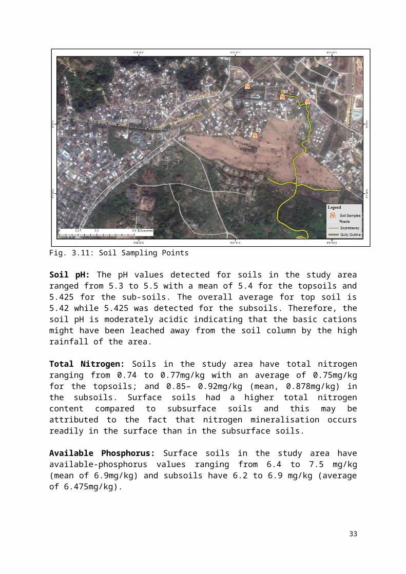
Short Term Impacts – these are impacts that have their effects remain over a short period of time and are removed after the application of mitigation measures
Long Term Impacts – these are impacts that have their effects remain over a long period of time, even after the application of mitigation measures.
5.1.3 Impact EvaluationThe third stage in the assessment procedure involved the evaluation of the concerns, issues and impacts identified. This was based on the Risk Assessment Matrix (RAM). The risk of the impacts occurring was analyzed by determining the consequence/severity of the impacts and the probability of occurrence. The severity of the consequences was determined using a consequence Severity Table and the probability of an impact resulting from a pathway was determined with a Likelihood Ranking Table. The RAM in Table 5.1 was then used to determine the level of risk and the significance or otherwise of the impacts. The results of the impact identification, characterization and evaluation exercise are presented in Tables 5.4 to 5.9.Table 5.1 Probability of Occurrence, Consequence Severity, Likelihood Ranking and Risk Matrix
.
5.1.4 Method for Determining Receptor Sensitivity (i) Biological/Ecological Receptors
43
Probability AttributesCertain Impacts that can reasonably be expected to occur during the projectLikely Impacts that are likely to occur during the projectPossible Impacts that might occur sometime during the projectUnlikely Impacts that can reasonably be expected NOT to occur during the projectRare Impacts that are unlikely to occur except in exceptional circumstances
Severity AttributesNegligible No detectable environmental and socio-economic impactMarginal Minimum environmental and socio-economic impact. Localized reversible habitat loss or minimal long
term effects on habitat species or media/public health and safety
Critical Significant environmental and socio-economic harm. Significant widespread and persistent changes in species, habitat and media (e.g. widespread habitat degradation/public health and safety)
Catastrophic Detrimental environmental and socio-economic impact. Loss of a significant portion of a valued species or effective ecosystem function on a landscape scale/injury and death is possible
SeverityProbability Negligible Marginal Critical CatastrophicCertainLikelyPossibleUnlikelyRare
LowMediumHighExtreme
Impact Rating
Low Risk: No response plans will be needed for these risks Medium Risk: Actions may be required to control acceptable risk High Risk: Adequate action and management attention are required to control risk.
There is need for some response planning for these risks Extreme Risk: Significant additional action and high priority management
attention will be required to control risk. There is need for an in-depth response plans for these risks.

• Resilience (to the identified stressor): This ranges from species or community unaffected or marginally affected, to probability of species undergoing moderate but sustainable change which stabilises under constant presence of impact source, with ecological functionality maintained; and to probability for substantial loss of ecological functionality (e.g. loss of species in key groups, substantially lower abundance and diversity).
• Presence: Routine, regular or reliably predictable presence of any species which is, in reverse order, a unique, threatened or protected species, to regionally rare or largely confined to project area or sensitive to disturbances; and to a species which is none of the above and is therefore assessed at the community level only.
(ii) Human Receptor Presence: This ranges from people being uncommon in the study area of anticipated
impact; to people being present some of the time (e.g. commercial property); to people being permanently present (e.g. residential property) in the area of anticipated impact.
Resilience (to the identified stressor): This ranges from people being least vulnerable to change or disturbance (i.e. ambient conditions (air quality, noise)) are well below applicable legislation and international guidance); to quite vulnerable to change or disturbance (i.e. ambient conditions (air quality, noise) are below adopted standards)); and to the most vulnerable groups (i.e. ambient conditions (air quality, noise) are at or above adopted standards)).
Impact significance, as a function of event magnitude and receptor sensitivity was subsequently ranked as “Negligible”, “Minor”, “Moderate” or “Major”. Any impact classified as “major” is considered to be significant and where the impact is negative, requires additional mitigation. Impacts of negligible, minor or moderate significance are considered as being mitigated as far as practicable and necessary, and therefore, do not warrants further mitigation.
5.2 Positive Impacts Associated with the Proposed Rehabilitation of the Lemna/Federal Agriculture Gully Erosion Site The rehabilitation of the gully site is envisioned to have a wide range of positive environmental and social impacts. This will not only enhance the environmental outlook of the area; it will also lead to enhancement of the living standards of the project affected persons. Some of the key beneficial impacts identified with the project include:
Restoration and rehabilitation of the erosion hazard in the project community; Mending and renovation of the watershed and curtailing of the gully expansion; Provision of proper and well-designed road drainage systems that will channel
floodwaters without leading to gully expansion; Provision of employment opportunities for both skilled and unskilled workers Encourage community development programmes and building a sense of communal
living via establishment of a local community gully erosion monitoring group. Diversification of sources of livelihood via training in capacity building and care for
the immediate environment Reduction of mortality rate by enhancement of living condition for project affected
persons and the entire community of Lemna/Federal Agriculture Promotion of afforestation programme (with all its benefits) Minimization of flooding and damaging impacts of uncontrolled flash floods running
through erosive soils that enhance gully/ravine formation
44
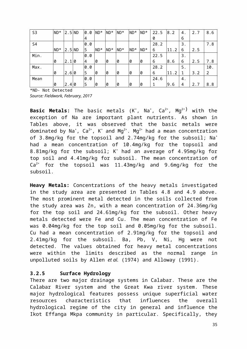
Reduced fear perception of loss of property, destruction of farmlands and livelihoods, inhabitation and ancestral origins of the communities and destruction of public infrastructures particularly high-cost and regional ones such as airports.
Safeguard of community existence as well as securing cultural facilities and amenities
5.3 Potential Adverse Impacts of the Proposed ProjectThe identified prospective negative impacts were established on the basis of whether they occur during the pre-construction, construction or operation phase in the subsequent sections. This is necessary to facilitate the implementation of the mitigation measures that are outlined in the ESMP.
5.3.1 Pre-Construction Phase5.3.1.1 Social ImpactsDisplacement of People: The proposed project will lead to the displacement of people within the gully alignment leading to demolition of their properties. For proper documentation, these areas will have to be acquired by the Cross River NEWMAP-SPMU via the state policy of land acquisition, which should, however, recognize the mutual agreement with the affected landowners. This will affect buildings of different uses, mostly residential in areas such as the Federal Agric Staff Quarters, Lemna Roads, parts of Water Intake and parts of lands belonging to Golf View Estate where some of the gully fingers emerge to join the main gully channel. The issue of displacement and resettlement is being handled by RAP.
Expectations of Improvement in Livelihood: These are associated with expectations of the residents of the community particularly youths of the Ikot Effanga Mkpa community where the gully watershed lies. Within this community information about the rehabilitation project has raised the hopes of the youths as well as residents on the probable general improvement in their lives as well as living in a better after the completion of the project. The residents also anticipated a rise in trading activities, particularly for the roadside traders, shop owners and other miniature produce sellers are anticipating improvement in sales by the project kickoff. This awareness is also based on the provision of employment opportunities to the teeming youths of the community. It should be noted that delay in project implementation may have serious negative impacts and affect the level of cooperation with contractors and consultants when the project actually starts.
5.3.1.2 Environmental ImpactsEnvironmental impacts including flooding and general land degradation during pre-construction may arise when local efforts to combat the gully menace become reduced in anticipation of proposed NEWMAP intervention. Also, the current outline may become expanded and the currently assessed gully fingers may further enlarged leading to loss of land, properties, and possibly human lives. It will also put the environment in a sensitive fashion making the area environmentally unfit for habitation.
5.3.2 Construction PhaseA critical requirement with the level of construction anticipated in the project area is the Right of Way (ROW). Vegetation will be cleared from sites, large drains will be constructed and other related constructions will be erected. In all, the activities will include channelization, excavating, filling, scooping of earth material, compacting, concretization and other related activities. These activities during the construction phase will intensify and the environment will
45
be disturbed and affected. Broadly, key undesirable impacts of the development are probable to include the followings.
5.3.2.1 Environmental ImpactsImpacts on Flora and Fauna (Biological): Plant life irrespective of size and magnitude of living footprints will be adversely impacted during construction phase. At this phase, the site will be cleared and this will affect grasses and shrubs at their natural growing stages. Also, flowering plants and crops within the identified small-sized farmlands that have been taken over by the gully as well as newly developed gully strips will be severely cleared for construction and redevelopment purposes. It was observed during the field study that some of the residents are using a part of the gully alignment for cultivation of different crops such as mango, maize, and other annual and perennial crops. During the construction phase, these crops will be cleared and farming and related activities will be completely halted.
More importantly, at the aggregated level, trees and grasses define the nature of the ecosystem and the overall ecological structure of any bisosystems, including the natural vegetation. Any alteration of the ecological structure at the unit level will affect the ecological system, function, and productivity. The clearing of the vegetation at this phase of the project will lead to a change in changing the taxonomy of the vegetation from mixture of tropical rainforest to partial woodland zone within a zone of high rainfall mount. The chances of swift ecological succession at this phase will be greatly reduced by the movement of vehicles and heavy-duty machineries. Also, exposure of the plant surfaces to dust particularly during the transportation of materials will destroy them as such could impair the ability of the plants to produce their foods from solar energy (i.e. obstruction of the photosynthesis process)
Impacts on Fauna: The survival of animals particularly domesticated and wild life will be adverse affected at the construction phase of the project. Birds and alpinism animals will be affected in addition to life forms that are attached to the soil of the project area. Animals in high densities that have built adaptation mechanisms and those living naturally in the gully area will be displaced from their natural habitats. It was observed during the field survey that further down the gully erosion alignment, there are birds that live on trees. These birds will be displaced thus; a mitigation strategy of planting trees with soft shallow roots will reduce the extent of migration of these birds.
Livestock and wildlife will also be negatively affected. Residents of the watershed rear animals such as dogs, goats, and other domesticated animals while some keep poultry birds. Such animals feed on the luxuriant grasses and shrubs of the gully site as source of food. With the commencement of the project, the rearing of animals and poultry will be restricted within the sphere of the construction activities. Wild animals that feed on fruits and leaves of the vegetation within the project area will be restricted from feeding owing to the intensive construction activities. This will impair their natural food sources and by extension their survival.
Water Quality: Impact on water resources is critical to the project area. The watershed structure of the Lemna/Federal Agriculture gully shows a drainage pattern of interconnected gully that indirectly links a river further down the basin. Therefore, a point source of water pollution from the construction could lead to severe impact on the surface (turbidity, physico-chemical content (BOD, COD), sedimentation, and pH). The groundwater resources of the project area could also be impacted if liquid pollutant material finds its way through
46

infiltration and percolation into the groundwater. In addition, earthworks during construction might release suspended particles in the water (TSS), which could have detrimental effect on aquatic organisms. Some of the residents rely on hand-dug wells for water source and the chances of seepage of liquid construction waste into subterranean layers contaminating the groundwater is possible. Thus, physical and chemical properties of the groundwater could be affected by construction activities.
However, the critical concern is the impact of the construction activities on the hydrological functions of shallow water bodies such as wetlands in the area. Sources of waste-related point source and non-point pollution of water bodies could include:i. Wastewater containing high suspended solids;ii. Oil residues and industrial fluids from the washing of plant and vehicles that spilled
into nearby water body and seeped into groundwater;iii. Spilt fuel oil around fuel storage tanks that seeped into groundwater and nearby
stream; andiv. Waste oil, grease and de-greasing solvents from vehicle and plant servicing.
Soil/Land Excavation and Construction of Camp Sites: The nature of the gully erosion will require some form of land excavations and other land clearance. This could stimulate further land degradation if poorly managed or executed in an unsustainable manner. Since the soil structure of the area is loose, large construction of camp sites and siting of depots could affect soil layers of that spot reducing the productivity of the soil. This could impair the survival of microorganism and destroy the natural outlay of the soil.
Noise: During the construction, tolerable/acceptable human noise levels can be momentarily exceeded due to the operation of lorries and heavy-duty equipment in the working zone of the gully erosion site. Typical noise emissions for plant and equipment likely to be deployed in the Lemna/Federal Agriculture gully erosion rehabilitation works are listed in Table 5.2. However, the figures fell short of day international standards for all the equipment at 5 metres distance and most of the equipment at 20 meters distance for typical day noise level by World Bank General EHS Guidelines.
Table 5.2: Noise Emission Levels for Various Types of Construction Plant
Type of PlantDistance between Plant and
ObserverInternational
Standard
5 m 20 m 50 m Day NightLoader 90 78 70 75 55Grader 90 78 70 75 55Vibration roller 86 74 66 75 55Bulldozer 86 74 66 75 55Generator 98 86 78 75 55Impact drill 87 75 67 75 55Concrete mixer 91 79 71 70 55Concrete pump 85 70 62 70 55
Pneumatic hammer 84 86 78 75 55Note: Figures in dB(A)
Vibration: At the construction phase of the project when heavy-duty machineries will be on-site, numerous disturbances relating to ground movement and vibrations will occur and this will affect people and structures located within the vicinity of the project. Although this tends to diminish with increasing distance away from the project site, it will lead to different levels
47
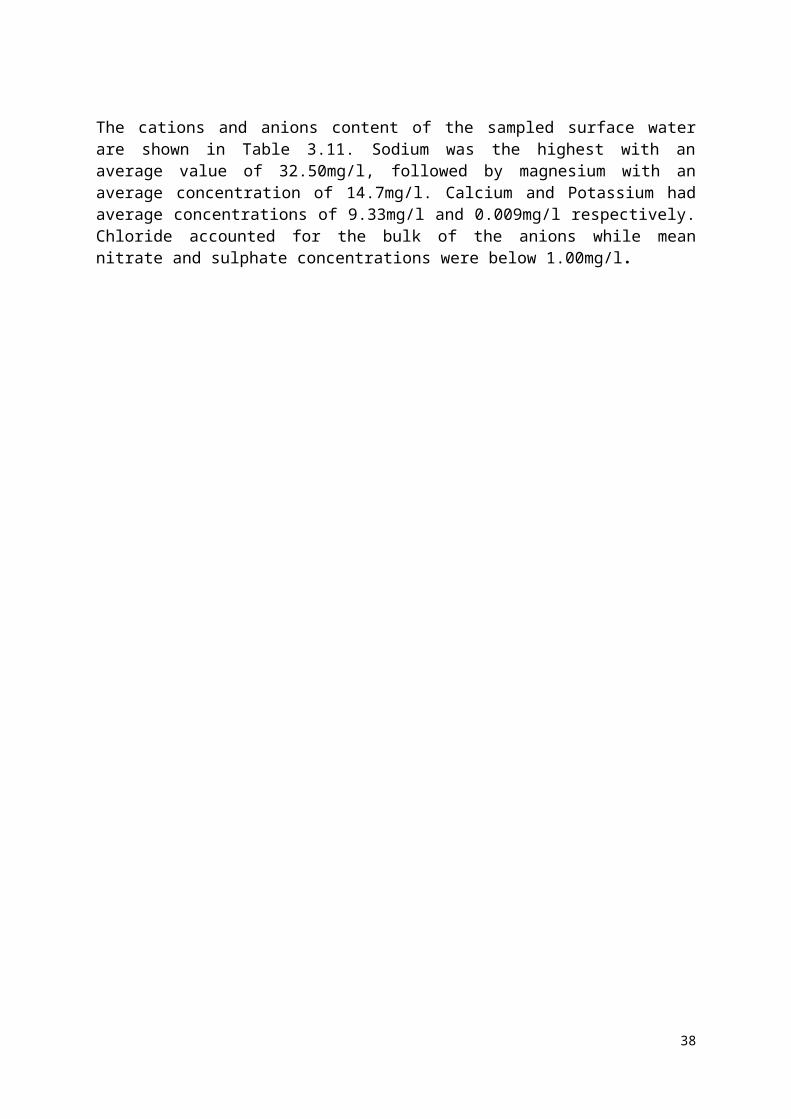
of discomfort for the community residents across ages. Vibration can also lead to the collapse of gully side thereby causing injury to workers and destroying the machineries.
Air Quality: Project undertakings such as vegetation clearing, earth excavations, provision of laterite for filling, leveling, grading, etc. will impact adversely on air quality due to generation of dusts and gaseous emissions from heavy trucks/machineries. The volume of traffic, proximity and vehicle type and pollutant emissions may have negative health and environmental impacts. The particulate matter that could be released into the air could impair visibility and settlement of plant photosynthetic surface (leaves). Exhaust fumes from heavy-duty machineries and equipment may contain gaseous hydrocarbons and noxious oxides such as C0x, N0x, S0x which may have damaging effect on the environment including nearby plants and animals. Further, gaseous discharges from and dust particles from vegetation clearing, excavations and heavy-duty vehicles/machineries could affect proper functioning of the human lungs.
Disruption to Public Utilities: During the installation of new infrastructure, it is very possible though avoidable to damage existing utilities/infrastructures such as service cables and electrical lines or temporarily interrupt supplies to users of such facilities. The levels of potential impacts arising from disruption damage to public utilities are summarised in Table 5.3. Table 5.3: Potential Impacts of Disruption to Public Utilities
Utility Nature of Impact Severity
High Voltage Electricity Cables
Interruption of Supply Severe production loss and public inconvenience
Personal Injury Likely death of operator
Cost of Repair/Delay to Works Very severe
Medium VoltageElectricityCables
Interruption of Supply Severe production loss and public inconveniencePersonal Injury Probable death of or serious injury to operator
Cost of Repair/Delay to Works Severe
Low Voltage Electricity Cables
Interruption of Supply Localised but severe public inconvenience
Personal Injury Possible serious injury to operator
Cost of Repair/Delay to Works Minor production loss. Short public inconvenience
Local Water Networks
Interruption of Supply Localised but significant public inconvenience
Personal Injury Unlikely
Cost of Repair/Delay to Works Minor
TelecomCables
Interruption of SupplyExtreme disruption to national and internationalTelecommunications
Personal Injury UnlikelyCost of Repair/Delay to Works Very Severe
Land Slide: Due to the nature and morphology of the gully site, landslide will pose serious environmental threat during construction. In this case, landslide includes a wide range of ground movements, such as rock-falls, deep failure of slopes and shallow debris flows. Although the action of gravity may likely be the primary driving force due to the fact that the base materials down deep the gully have been eroded, vibration from machinery and traffic during construction can also trigger land slide.
Rock Cave in: This includes rock breakage, rock collapse inward or downward, rock-fall under the weight of overhead materials such as heavy duty vehicles, filling laterite and other constructional materials. Overland flow and heavy rainfall can however, also cause the gully
48

landscape to cave in during construction. Rock cave in leads to exposure of hidden degraded and often time intensify the nature of work on site.
Mudflow/Flooding: Construction activities, especially during the wet season can result in mudflow that will arise from not only the gully debris materials but also from imported materials to be used for gully land rehabilitation. If proper care and sound environmental mitigation measures are not put in place, it may even result in mass-wasting of the already tilting overhead materials at the gully head or gully sides. Besides, flooding is a phenomenon that has caused untold hardship on the residents of the Lemna/Federal Agriculture gully watershed and may therefore pose a serious challenge to construction activities through washing away of construction materials and make construction work a nightmare for the workers.
Waste: Construction activities generally generate wastes, which may include excavated soil and other materials from site. Other sources include water used in construction, washing of equipment, and other cleaning activities. Also, there will be loss of the existing under growth during the clearing of the gully erosion alignment in readiness for the construction and related engineering works. There will also be solid waste generated from excavation works. Some of the excavated soil could however be reused as backfill while the rest could be disposed of at government approved designated areas. Solid topsoil wastes from the sites will be the main form of solid waste. Other solid wastes will include metallic pieces, wooden planks, and stone debris.
Adverse Land Use Changes: This is usually connected to the period of resettlement and the need to extend the project area of activity or construction influence. The possibility of this is assessed based on the likelihood of people feeling deprived of the use of land for either economic activity or traditional or indigenous purposes such as cultural or social purposes. Since the Lemna/Federal Agriculture areas has low sociocultural artefacts and sites land use changes within the period of construction could be reduced to land issues with residents for socioeconomic activities only.
Channelization of Floodwaters: Channelization in this context implies any developmental activity on river systems that re-directs the natural course of a river/stream in other to alter its velocity as well the amount of water flowing into it. This process if not properly managed can cause future gully erosion and will have severe impacts on the sustainable development of the community.
Topographic Alterations: At specific stages of the construction, there are possibilities of excavations, removal of soils and other earth materials. This could lead to the alteration of the topography of some parts of the project area, thereby impacting on the general landscape.
Increased Sedimentation and Runoff: One of the most obvious challenges anticipated in the Lemna/Federal Agriculture gully erosion site is the possibility of increased sedimentation and high runoff from rainfall that is intensified by construction activities. In this scenario, sediments can significantly affect surface waters and floodplains with silts and pollutants such as heavy metals, hydrocarbons and toxic substances. The eroded sediments can adversely affect the aquatic ecosystem and can even increase the risk of flooding and eutrophication in the area.
5.3.2.2 Social Impacts
49

Most of the impacts on social life along the gully erosion alignment will happen during the construction period.
Human Displacement: In general, the civil works, bioengineering activities and other intensive watershed management activities could adversely impinge on human lives and consequently leading to human displacement due to the nature of the area. In the event of this, the provisions of the Resettlement Action Plan (RAP) will have to be implemented to alleviate the experiences of the affected parties. However, the RAP report will provide detail information on resettlement issues.
Employment: This is the most important component of the construction phase that will positively affect the socioeconomic life of the project area owing to the diversity of service opportunities the project will yield. However, the influx and migration of people of different professions, including the local artisans and labourers may result in indirect adverse impact on the project area. This will bring indirect implications as well, which may include increase in the level of crime rates, rent and property values as well as prostitution and spread of diseases. Also, consumption of alcohol among the working crew may affect the local population negatively through increase in violence and abuse of local women.
Migrant Workers’ Influx Impact: The possibility of the engineering firm appointed to carryout high intense rehabilitation work as well as bioengineering engagements will involve movement of a few migrant workers into the community. Although a critical aspect of the project is the employment of locals in the labour force, some of the professional cadre staff of the company will move in to the site. If not properly managed with the locals, this could lead to conflict of interest between the engineer and the local community. When such do not occur, the possibility of consumption of alcohol could amongst these staff members could lead to violence, abuse of women, diffusion of diseases, social abuse etc. cannot be ruled out.
Traffic and Transportation Impact: The inner ring roads such as connecting streets such as People’s Club Road, Lemna Road, Water Intake, as well as other inner streets in Ikot Effanga Mkpa community in Calabar will be heavily impacted on during the construction phase. This would be as a result of the concentration of socioeconomic activities with movement of people, goods and services. In other words, the nature of traffic diversion and movement of heavy-duty trucks and heavy-duty machinery will impact the threshold traffic and movement pattern of the project area. The overall impact upon the community would be the difficulty of accessibility to free traffic flow and delay in journey hours. Murtala Mohammed Highway, Old Udukpani Road and Ndidem Usang Iso which ate the major expressways and link roads into the area will not be spared.
Aesthetics: Generally, environmental aesthetics will be affected during the construction phase. This may result mainly from construction and civil works that could lead to a re-shaping of the aesthetical form of the community.
Accident / Safety Issues: This is one of the potential inevitable occurrences during the construction phase of any project for all construction sites are inherently unsafe and for those employed on the project the risks are varied and widespread. Movement of workers, materials, equipment, goods and commodities could lead to accidents. In order to curtail the frequency of occurrence or to prevent accidents, specific measures should be put in place.
50

During the construction phase, also, the work will involve the use of sharp objects that are injurious, noisy and heavy machinery that will generate dust thereby creating unsafe and uncomfortable environment. A safety officer would have to be at the construction site during the construction phase, at all times. Safety issues are therefore essential to all workers to keep to the principle of “safety first” in their execution of devoted responsibilities. Workers must wear safety gears like gumboots, helmets, safety belts (harness), dust masks and approved welding glasses for welders. Other safety precautions are stipulated in the Health and Safety guidelines. World Bank/IFC Environmental, Health and Safety Guidelines particularly the sections of the Toll Roads and Construction Materials Extraction.
Disruption of Public Access: In addition to the general disruption of communications, rehabilitation works of the gully might result in the temporary loss of access to public and private properties as work progresses past individual property entrances. This will be most serious when crossing roads and in front of public building and emergency service centres.
Gender Issues: Women would be adversely affected by the proposed project, especially in the area of loss of their retail shops and farmlands. In essence, their source of livelihood will be adversely affected. There is therefore the need to train them in alternative skills for them to survive in the absence of their businesses. The women, also, requested that they should be allowed to offer cutlery services to the construction workers in the form of food vending.
Public Health Issues: There will also be an increased risk for the spreading of sexually transmitted diseases such as HIV/AIDS in the project area. The influx of people, particularly workers from other areas could also stimulate the propensity to record such health challenges. Thus, social vices, which affect the health status of the community, could increase within the period of the construction phase of the project. Other significant health concerns associated with new projects include shortage of facilities like toilets and catering facilities for construction workers. All these if not properly mitigated could lead to spread of disease. Water-Borne Diseases: These could arise owing to the poor environmental sanitation and poor hygiene and health consciousness of the workers. Diseases such as cholera, dysentery, amoebiasis, salmonellosis, etc. could develop as a result of overstretching of existing facilities. Malaria: Pools of stagnant water in an area of high water footprint could stimulate the required breeding ground for mosquitoes, which transmit malaria. During construction activities, these pools could be created and eventually malaria related disease could be triggered in the area.
Sports and Recreation: The CGC will be severely affected during this phase. Albeit the game of golf is mainly accessibly to the high-income earners, the rehabilitation works will cover a section of the golf course and redevelopment and enhancements of the course through bioengineering will impair the playing of the game. Golfers and their cabbies, management of the CGC will have their activities impaired during the construction phase. Other recreational activities connected to the game of golf will also be affected adversely.
5.3.3 Operations and Maintenance PhaseAt this operation and maintenance phase, there are series of activities that will impair the environment across different scales. Maintenance and repairs could stimulate issues such as air quality impairment, noise, water quality, traffic and transportation, occupational health and safety issues, amongst several others.
51

5.3.3.1 Environment ImpactsMaintenance works: During the maintenance works, the topography of the project area might be affected. Maintenance works coupled with increased vehicular traffic in the area might intensify to an adverse extent and create an undulating rough terrain, thus reducing the road transportation capacity. The soil of the study area is very rich for agricultural activities hence the local communities might convert some of the right-of-way areas to agricultural use which might affect the engineering design and the overall design of the project works. This might lead to failure of the project during maintenance. Air Quality and Noise: Air quality issues will arise owing to increased vehicular traffic in the project area stimulated by the rehabilitated gully eroded areas. Dust particles and other potentially injurious particles will be released to the environment which could prevent visibility and affect the general environmental outlook of the project area. Noise is a likely phenomenon that can be related to the increased traffic, air quality issues and the machineries that will be used for maintenance. It is anticipated that improved condition of the project area will attract heavy traffic as the rehabilitation works will lead to inward movement of people. Thus, number of vehicles will increase and the facilities that will be used for the maintenance of the structures put in place will also generate noise in the area. These activities could increase the ambient decibel levels beyond permissible limits.
Water Quality Issues: Water quality issues could arise from runoff from the Lemna/Federal Agriculture–Access Road, community solid wastes, and agricultural wastes are usually dumped in the gully and if this practice continued after rehabilitation, it will impair the surface water quality. The catchment characteristics of the gully show that it connects a river further down at the lower watershed.
5.3.3.2 Social ImpactsTraffic and Transportation: At this phase, intense traffic is expected. The Murtala Mohammed Highway and Old Udukpani Road are busy access routes that connects Calabar city to other cities and local government areas in Cross River and by extension to other parts of Nigeria. Traffic and road transportation level at the operation / maintenance phase will increase thus cases of logjams, and bottlenecks might be recorded. Other local roads within the project area will be affected particularly street route ways and inner access roads.
Occupation Health and Safety: Individual users, maintenance workers and other stakeholders might be exposed to accidents especially road accident at this stage of the project. The condition of work is also very essential to be considered, working under stringent environmental hazards, exposure to insects, carnivorous animals and other unsafe working conditions are possible scenarios.
Table 5.4: Characterization and Evaluation of Potential Impacts Pre-Construction Phase
S/N Project Activities
Potential Environmental
and Social Impact
Impact Qualification Risk Impact Category
Dir
ect
Indi
rect
Rev
ersi
ble
Irre
vers
ible
Cum
ulat
ive
Lon
g te
rm
Shor
t ter
m
Ben
efic
ial
Adv
erse
Res
idua
l
Prob
abili
ty
Seve
rity
1 Displacement Conflict from the X X X X X Possi- Catastrophic Extreme
52

of people members of the community to vacate areas allocated for the project.
ble
2 Expectations of Improvement in Livelihood
Pessimistic Community perception can disrupt the proposed project activities
X X X X Possi-ble
Marginal Low
53

Table 5.5: Characterization and Evaluation of Potential Impacts Environmental Impacts in the Construction Phase
S/N Project Activities
Potential Environmental and
Social Impact
Impact Qualification Risk Impact Category
Dir
ect
Indi
rect
Rev
ersi
ble
Irre
vers
ible
Cum
ulat
ive
Lon
g te
rm
Shor
t ter
m
Ben
efic
ial
Adv
erse
Res
idua
l
Prob
abili
ty
Seve
rity
1 Channelization, concretization, excavating, levelling, compacting, filling, scooping of earth material and other related activities
Channel Bank Failure X X X X Possible Marginal High
2 Rock material cave in during construction.
X X X X Possible Marginal High
3 Mudflow X X X X Possible Marginal High
4 Soil impacts on activities such as excavating, grading, levelling, compacting etc.
X X X X Possible Marginal High
5 In situ waste management
X X X X Possible Negligible Low
6 Land use Conflicts if any
X X X X Likely Marginal High
7 Channelization of flood waters
X X X X Possible Marginal High
54

S/N Project Activities
Potential Environmental and
Social Impact
Impact Qualification Risk Impact Category
Dir
ect
Indi
rect
Rev
ersi
ble
Irre
vers
ible
Cum
ulat
ive
Lon
g te
rm
Shor
t ter
m
Ben
efic
ial
Adv
erse
Res
idua
l
Prob
abili
ty
Seve
rity
8 Topographic alterations and other civil works for remediation purposes
X X X X Likely Marginal High
9 Air Quality Issues (Dust)
X X X X Possible Marginal High
10 Water Quality Concerns
X X X X Possible Marginal High
11 Air Quality (Noise) X X X X Possible Marginal High
Table 5.6: Characterization and Evaluation of Potential Impacts for the Biological Impacts in the Construction Phase
S/N Project Activities
Potential Environmental and
Social Impact
Impact Qualification Risk Impact Category
Dir
ect
Indi
rect
Rev
ersi
ble
Irre
vers
ible
Cum
ulat
ive
Lon
g te
rm
Shor
t ter
m
Ben
efic
ial
Adv
erse
Res
idua
l
Prob
abili
ty
Seve
rity
1 Clearing of vegetation
Impact on flora and fauna
X X X X Certain Critical High
2 Impact on Wildlife X X X X Possible Marginal High
55

Table 5.7: Characterization and Evaluation of Potential Impacts for the Socioeconomic Impacts during Construction Phase
S/N Project Activities
Potential Environmental and
Social Impact
Impact Qualification Risk Impact Category
Dir
ect
Indi
rect
Rev
ersi
ble
Irre
vers
ible
Cum
ulat
ive
Lon
g te
rm
Shor
t ter
m
Ben
efic
ial
Adv
erse
Res
idua
l
Prob
abili
ty
Seve
rity
1 Mobility of machineries and materials
Traffic and transportation Impact
X X X X Certain Marginal High
2 Accidents and Road Crashes
X X X X Possible Critical High
3 Employment Opportunities
X X X X Possible Marginal High
4 Human displacement X X X X Possible Critical High
5 Aesthetics X X X X Possible Negligible Low
6 Shrines and Cultural sites
X X X X Possible Marginal High
56

Table 5.8: Characterization and Evaluation of Potential Impacts for the Public Health Impacts during the Construction Phase
S/N Project Activities
Potential Environmental and
Social Impact
Impact Qualification Risk Impact Category
Dir
ect
Indi
rect
Rev
ersi
ble
Irre
vers
ible
Cum
ulat
ive
Lon
g te
rm
Shor
t ter
m
Ben
efic
ial
Adv
erse
Res
idua
l
Prob
abili
ty
Seve
rity
1 Sexual Activities HIV/AIDS and STDs X X X X Possible Marginal High
2 Domestic Water Usage
Water-borne diseases X X X X Possible Marginal High
3 Increase mosquito vector breeding sites
Malaria Issues X X X X Likely Critical High
4 Sports and Recreation
Reduced sporting activities may increase
X X X X Possible Negligible Low
57
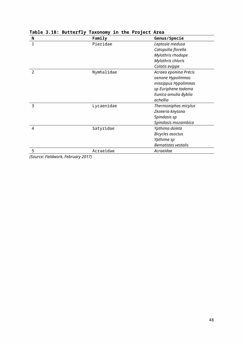
Table 5.9: Characterization and Evaluation of Potential Impacts for Operation PhaseS/N Project Activities Potential
Environmental and Social
Impact
Impact Qualification Risk Impact Category
Dir
ect
Indi
rect
Rev
ersi
ble
Irre
vers
ible
Cum
ulat
ive
Lon
g te
rm
Shor
t ter
m
Ben
efic
ial
Adv
erse
Res
idua
l
Prob
abili
ty
Seve
rity
1 General maintenance operations
regular inspection desiltation and
clearance of drains., Repair of damaged
engineering structure, training of operators, maintenance of
equipment used, sanitation and waste
management system
General maintenance operations
X X X X Possible Marginal Low
2 Air quality Air quality Issues
X X X X Possible Marginal Low
3 Noise and vibration Noise and vibration Issues
X X X X Possible Marginal High
4 Water quality Water Quality issues
X X X X Possible Marginal High
5 Traffic and transport Traffic and transportation Issues
X X X X Possible Marginal High
6 Health and Safety Health and safety Issues
X X X X Possible Marginal High
7 Sand Mining in rehabilitated channel.
Sand Mining in rehabilitated channel.
X X X X Possible Marginal High
58

5.4 Project Alternatives5.4.1 Site AlternativesThe proposed project is site-specific. The intervention project has been triggered as a result of the poor conditions of the project area.
5.4.1.1 Technology Options It is the goal of the Cross River NEWMAP-SPMU to ensure that the design and operation of the proposed project is compatible with the project area. For the anticipated restoration and rehabilitation of the entire project area, all elements of the watershed with the environmental and social components have been examined and these shall be considered. This approach will ensure that germane components of the natural and human environment such as soil, public infrastructure, social and community infrastructures and facilities that are impaired by the gully erosion developed, improved and rehabilitated better than previous status as needed.The mechanics of such rehabilitation works and associated enhancements will involve intensive civil works across the broad spectrum of the affected areas and the areas traversed by the emerging gully fingers. Thus, physical construction works and biotechnological approaches will be adopted in restoring and enhancing affected areas as envisioned by the Cross River NEWMAP SPMU. The designed options will be drafted and designed to ensure that fundamental aspects of the environment are captured in order for the best selection of project assessment.
5.4.2 Project Development AlternativesThere are various ways gully erosion can be treated; the vital approach is finding the treatment option that best suits the environment and the possible project affected persons, which includes the landholders as well as those with small-scale subsistence farmers whose livelihoods is directly connected to the land. The idea is that the rehabilitation of the gully should not leave the area worse than it already is. Various considerations can be ascertained as critical to selecting the best choice of rehabilitation alternatives. These can be based on the following;
1. The nature of the land prior to the development of the gully;2. Current activities taking place on the land;3. The extent of damage caused by the gully erosion;4. The climatological history of the environment;5. The nature of the biophysical environment;6. The impact of the various project works options on the land; and7. Consideration of the request of the project affected persons concerning the gully
rehabilitation that is best suited to their land. Based on these variables, the probable options suitable for the Lemna/Federal Agric settlement in Ikot Effanga Mkpa is discussed as follows. 5.4.2.1 No-Action AlternativeThe assumption underlying this alternative centers on the notion that there will be no alteration to the existing condition at the proposed Ikot Effanga Mkpa watershed of the city of Calabar. It means the gully erosion site will be left rehabilitated without any form of rehabilitation.
Specifically, the prevailing erosion status of the area will be left untouched, unaddressed and without any civil work or any engineering construction work. The flooding and erosion areas will be left to persist without any attempt to address the environmental challenge. Consequently, the conditions at the proposed project site and its alignment and threshold will
59
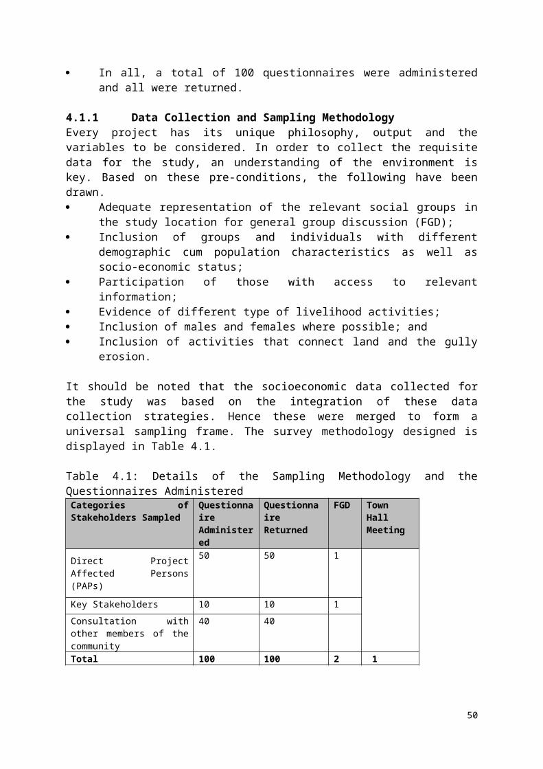
worsen. This will certainly aggravate the magnitude of destruction of houses, farmlands, roads and road infrastructures, public facilities, educational facilities etc. With this no-action alternative, the gully erosion outline will develop more fingers thereby spreading to include residential sections of the Ebruku Barracks. Flooding and flood-related damages will persevere unchecked and uncontrolled. Other environmental and social effects such as more damages to inner roads and possible destruction and damages to roads such as the Lemna Road and the Murtala Mohammed Highway. Consequently, more traffic will be diverted to Old Udukpani Road, parts of Ndidem Usang Iso highway. In the long run, this will lead to risk and dangers from the high currents of floodwaters, high cost of transportation, destruction of top soil, exposure of flora and fauna to devastating imprints of erosion, loss of land and landed properties, and likely surface and groundwater pollution. As a result of these effects, the “No-Action” alternative is not recommended for this project.
5.4.2.2 Delayed-Action and Right-Away Action AlternativesThe delayed-action alternative and right-away action alternatives anticipated the rehabilitation of the Lemna/Federal Agriculture gully erosion site located within the Ikot Effanga Mkpa community. Unfortunately, the earlier action adopted a delayed tactic which resulted into further damages and degradation of the watershed. Inflation and other economic forces may cause monumental changes in the cost of materials thereby increasing the financial burden of the rehabilitation. The later (right-away action) proactively ensures immediate attention to address the issues and benefit from both short-term and long-term effectiveness.
5.4.2.3 Use of Civil Works, Bioengineering and Technological MethodsFor the anticipated rehabilitation of the Lemna/Federal Agriculture gully erosion at Ikot Effanga Mkpa community, all elements of the watershed along with the environmental and social components should be considered. This approach will ensure that the relevant components of the natural and human environment under the threat and risk of destruction such as soil, public infrastructure, social and community infrastructures and facilities will be secured in the area.
The procedure for the rehabilitation works and associated enhancements will involve intensive civil works across the broad spectrum of the affected gully eroded areas as well as high-risk areas. Consequently, construction works, bioengineering and technological approaches will be adopted in restoring and enhancing affected areas according to the goals of the Cross River NEWMAP-SPMU. Adverse impacts of these activities will be highly reduced in such a way that the benefits outweigh the demerits as necessary.
In short, the merits of the combined Civil Works and Bioengineering Technology in the Right-away Alternative outweigh the No-Action Alternative and it is, thus, recommended. The two scenarios are presented in Table 5.10. As shown in the table, it can be summarized that the Civil Work alternative is better than the No-Action alternative even though the cost implication of the former would be much more than it is for the latter. The civil work, bioengineering and technological alternative will provide the solution that the Cross River State NEWMAP sought while the No-Action alternative will undoubtedly aggravate the gully erosion problem being experienced in the area.
60

Table 5.10: Appraisal of Alternatives Criteria Project Alternatives
No Action Delayed Action Right Away Action Biological works alone Civil works a lone The Civil works (Biological & the
construction of Hard Structures)
General Safeguard of Environment and Human Health (General protection mechanisms)
This will not benefit the concerned stakeholders and community residents considering the observed level of destruction the flood has had on the area. Properties and public infrastructures have been severely affected and this has led to loss of lives and landed properties, land degradation, loss of farmlands and produce, etc. Adopting this alternative will not benefit Project Affected People and the environment in general.
This will not benefit the concerned stakeholders and community residents. The damage may become cataclysmic and the level of human and material losses may be well beyond repair.
This will be the right step to safeguard the environment and human wellbeing from further degradation
The remediation of the biological life forms will lead to improvement of life, properties will be partially secured, lives saved, resources recovered, transportation facilities may be enhanced on short term and general restoration of livelihood. It will benefit the Project Affected People and the residents on the short term.
The implementation of this proposed project will lead to improvement of life. Properties will be secured, lives saved, resources recovered, transportation facilities will be enhanced on the long term and general restoration of livelihood. It will benefit the Project Affected People and the residents but the biological organisms of the ecosystem may be permanently removed
The rehabilitation of the gully degraded environment coupled with remediation of the biological life form will lead to improvement of life. Properties will be secured, lives saved, resources recovered, transportation facilities enhanced and general restoration of livelihood on both short and long term. It will benefit the Project Affected People and the residents. Also, the ecosystem of the environment will be restored.
Short-Term Usefulness
No-Action alternative does not add any specific input to the stated criteria.
Delayed action will contribute nothing to short – term usefulness.
This will be immediate derivable benefits and a sustained long term benefit will be achieved.
The timeline for the biological works is long term. Nevertheless, the benefits derivable are still better than a No-Action and Delayed-Action alternatives.
The timeline for the civil work is long term. Nevertheless, the benefits derivable are still better than a No-Action and Delayed-Action alternatives
The timeline for the civil and biological works are long term. Nevertheless, the benefits derivable are still better than a No-Action and Delayed-Action alternatives
61

Long-Term Effectiveness and Permanence
This option does not meet the long-term effectiveness and permanence criteria.
Already incurred damages may obliterate the gains from long-term effectiveness
This option perfectly meets both the long-term and short-term effectiveness and permanence criteria.
The biological works alone will provide long-term effectiveness for the watershed but may not be sustainable without the civil works.
The Civil works alone will provide long-term use for the watershed but may not be sustainable without the biological works
The combination of the Civil and Bioengineering works will provide both short and long-term effectiveness for the watershed and will be sustainable.
62

CHAPTER SIX
ENVIRONMENTAL AND SOCIAL MANAGEMENT PLAN
6.0 Introduction This chapter discusses the essentials of the environmental and social management plan. It presents, enlists and discusses the configuration for mitigation procedures taken to address the adverse impacts identified in Chapter Five. It also outlines the institutional responsibilities and accountabilities that will ensure that all the provisions are effected under strict organization. Further, the cost implication of addressing all the identified avenues was documented. 6.1 Mitigation MeasuresThe mitigation measures outlined in this report are structured to curtail the observed adverse environmental and social impacts itemized in the previous chapter. The arrangement of the mitigation measures will follow the pattern of the evolvement of the NEWMAP intervention programme for the rehabilitation of the gully-eroded areas of the project area, Lemna/Federal Agriculture gully erosion site in particular. These are presented in the subsequent subsections.
6.1.1 Pre-Construction PhaseAt the pre-construction phase, the mitigation measures stated are to resolve the adverse effects of the project prior to the commencement of civil works. In particular, this phase covers the preliminary works that predates the construction and developmental works in the Project area. Essentially, there are two critical issues that might be of cogent significance; land acquisition and community perception of the project. Each of these is discussed and presented as follows.
Land Acquisition: It is essential to acquire land particularly in along the gully alignment. In addition, this will cover the legally binding Right-of-Way (ROW) for civil construction features such as large drains along the gully lines. To mitigate this activity, comprehensive actions must be taken; these are stated in Table 6.1. Community Perception of the Project: It is a normal for the host community of the proposed project to have divergent perceptions about the authenticity of the proposed NEWMAP rehabilitation project. Inability to manage this may give the project a negative impression from the community. This could be based on the perceived negligent attitude to project by officials or previous experience in the community. In order to resolve this challenge, there are germane steps to be taken as mitigation measures to checkmate any doubt about the legitimacy and authenticity of the project. These measures are itemised in Table 6.1.
63
Table 6.1: Mitigation Measures for Pre-Construction PhaseS/N
Environmental and social
impact source
Potential Impacts
Mitigation measures Monitoring Responsibility Cost (US$) estimate
Parameters Where/How Frequency Implementation Monitoring 1 Land
acquisition challenges
Land acquisition could lead to cumulative issues disturbance from local landowners and community groups
1. The RAP report should form the structure for mitigation measures.
1. All issues should be settled prior to the commencement of civil works.
Based on the provisions of the RAP document
As the case arises
Cross River NEWMAP-
SPMU Lemna/Federal Agriculture Gully Erosion Site Monitoring Committee RAP (Resettlement Action Plan) Consultant
0
2 Community perception of the project
Adverse perception about the project
1. Proper sensitization of the entire community on the critical aspects of the project. 2. Executive members of the local gully erosion site monitoring committee should be contacted to act as local information dissemination base for the project. 3. Members of the community should also be contacted on the need to support the project as well as the merits should be communicated. 4. The community should be engaged using English, Ibibio, Efik, Ejagham, Ogoja, and Pidgin English languages in order to cover all areas as much as possible. 5. Prospects and challenges of the project should be discussed in order to find a common ground for resolving emerging issues. 6. Posters, notices and signboards should be erected at strategic and vantage points to pass information to locals.
1. This should be extended to the pre-construction and construction phases.
At least twice Cross River NEWMAP-SPMU
Lemna/Federal Agriculture Gully Erosion Site Monitoring Committee
Community Based Organisations
2,650
Total 2,650
64
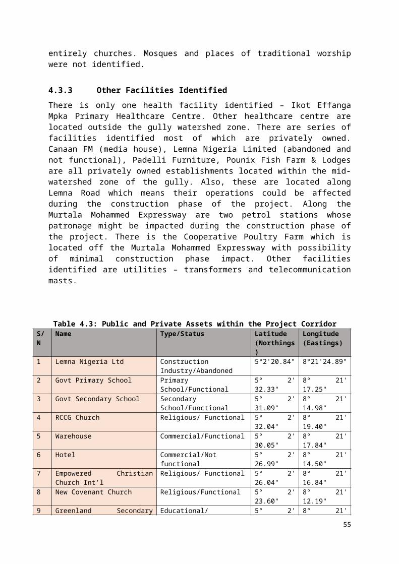
6.1.2 Construction PhaseCivil work is anticipated to have various environmental and social impacts. Such impacts are expected to traverse different aspects of the environmental as well as social and cultural components of the project area. As required several governmental MDAs (State Ministries, Departments and Agencies) will be involved in the follow up process of the mitigation process. This is because the construction will involve virtually every aspects of the environment. it will affect the socioeconomic and cultural components therefore; it is essential to consider all governmental MDAs to resolve issues that are tied to their areas of legal jurisdiction.
6.1.2.1 Potential Negative Environmental Impact Table 6.2 shows the mitigation measures for the environmental impacts in the construction phase.
65

Table 6.2: Mitigation Measures for the Environmental Impacts in the Construction Phase
S/N Environmental and social impact source Potential Impact
Mitigation measure Monitoring Responsibility Cost (US$)
estimateParameters Where/how Frequency Implementation Monitoring
1 Land slide
1. Due to the sloppy nature of some parts of the area, rock falls due to moving water could occur.1. Machinery vibration could trigger landslide.2. Weaken soil accumulates could move downslope as soon as earthshaking equipment are installed
1. Keep heavy duty machinery and filling material at about 30 meters away from gully channels2. Avoid Machines that can cause vibration3. Construction work should carefully stabilize overburden before further works4. Lower the over hand before using excavator with a long boom or extended boom of at least 25 meters5. Use manual efforts to reduce overburden
1. Daily observation of the key provisions 2. Examination of the construction sites before and after work3. Safety tapes should be used as guide for safety measures
Daily
Site EngineerCross River NEWMAP
Ministry of Environment 1,800
2 Rock cave in / Vibration
1. Rock breakage, rock collapse inward or downward, rock-fall under the weight of overhead materials such as heavy duty vehicles, filling laterite and other constructional materials could injure one of the workers2. Heavy downpour
1. Keep heavy duty machinery and filling material at about 30 meters away from gully channels2. Avoid Machines that can cause vibration3. Lower the overhand before using excavators with a long
1. Daily observation of the key provisions 2. Examination of the construction sites before and after work3. Safety tapes should be used as guide for safety measures
Daily Site EngineerCross River NEWMAPMinistry of Environment and Public Utilities
Ministry of Environment
1,450
66
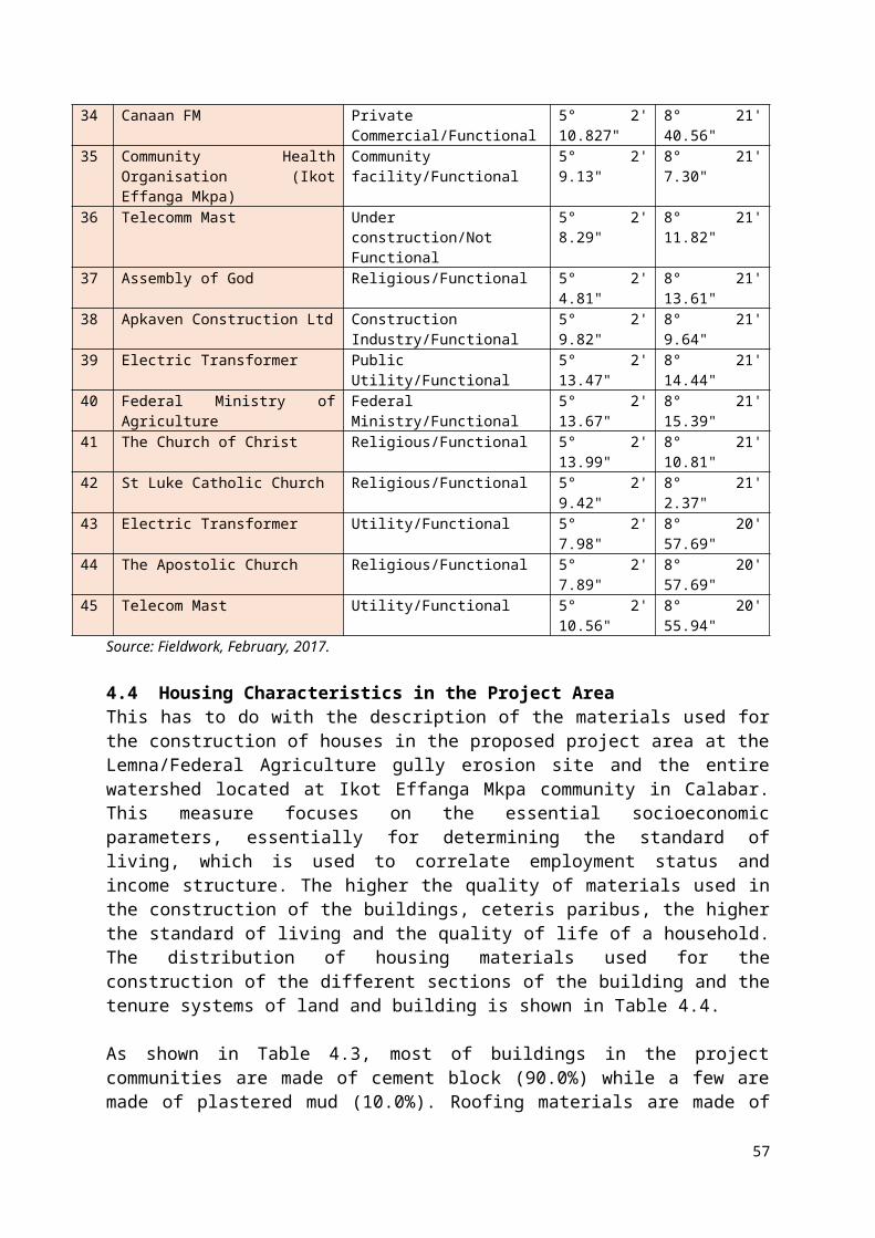
S/N Environmental and social impact source Potential Impact Mitigation measure Monitoring Responsibility Cost
(US$) estimate
Parameters Where/how Frequency Implementation Monitoring
could trigger gulley widening and lead to further expansion causing further rock cave in3. Project time could be extended as a result of this development apart from equipment damage and even injury to workers on the field.
boom or extended boom of at least 25 meters4. Construction work should carefully stabilize overburden before further works5. Use manual efforts to reduce overburdenEnsure filling materials are adequately compacted during gully stabilization activities
3 Mudflow
Wet season working condition could be worsened by mudflow affecting concretization process and works leading to worktime extension on site. It could lead to injury of workers in slippery suface proximate to the gully walls. Such could affect worker’s psyche hence limiting work progress Could lead to wastage of civil materials through washing away of construction materials.
1. If possible limit construction activities to dry season
2. Proper channelization of runoff through drainage before actual gully work
3. Temporary shoulder must be hydrologically stable so that it is not wash away if it rains
4. Temporary ballast and
5. Wicker work put in place
The site condition should be examined before and after civil works on daily basis.
Daily
Cross River NEWMAPMinistry of Environment and Public Utilities
Ministry of Environment 1,900
4 Soil impact from construction activities such as excavating,
Could lead to further land degradation if poorly managed.
1. Erosion control measures such as water bars, gabions, straw
The civil works site should be examined daily for this.
Daily Site EngineerCross River NEWMAP-
Ministry of Environment
1,250
67

S/N Environmental and social impact source Potential Impact Mitigation measure Monitoring Responsibility Cost
(US$) estimate
Parameters Where/how Frequency Implementation Monitoring
grading, leveling, compacting etc.
Large camp construction could weaken the already loosed soil. Microorganisms could be negatively impacted as a result of destruction of edaphic habitats. Could lead to soil outlay destruction and plant life that rely on the soil will be exterminated.
bales, and re-vegetation should be implemented during and after construction phases. 2. Planting of forest trees should be in accordance with the native trees3. Localised environmental designs should be implemented.
SPMU Cross River Ministry of Environment and Public Utilities
5 Waste and waste management
Poor environmental management and outlook as a result of lack of proper cleaning of the construction and worker’s wastes generated during the course of the project.
Disease incidence could result from improper waste handling and management
Absence of proper waste management mechanism could lead to wastage of man hours
Poor hygiene condition as a result of puerile management of wastewater from construction activities.
1. Designated sites are selected for waste management.2. Measures should be taken to ensure that waste is handled in an adequate manner.2. Cover of waste bins and other waste collection materials.3. Cover dumped waste as quickly as possible.4. Construction waste could be recycled and reuse, this option should be given top priority for proper in situ waste management.5. Ensure liquid wastes are properly disposed of.
1. Ensure that waste bins are located within designated areas.2. Bins must be disposed regularly3. Liquid waste must be handled carefully.
Daily
Site EngineerCross River NEWMAP-SPMU Cross River Ministry of Environment and Public Utilities
Ministry of Environment 1,600
6 Land use issues arising from displaced individual and
Disturbance of work progress Lack of job
1. Recommendations of RAP report should be followed.
The details of town planning should guide this.
Three months before
Cross River NEWMAP-SPMU
Cross River Ministry of Lands and
1,850
68

S/N Environmental and social impact source Potential Impact Mitigation measure Monitoring Responsibility Cost
(US$) estimate
Parameters Where/how Frequency Implementation Monitoring
members of the community during the construction phase of the project
confidence on the path of workers Destruction of working equipment by concerned interests/groups Could lead to violence if not well managed
2. The necessary world Bank safeguard policy should be implemented based on the impact of such land use issues.
actual construction
Cross River Ministry of Land and Survey
Survey
7 Channelization of flood waters
Improper channelization could trigger another gully erosion.
It could also lead to displacement of activities that relied on such water that is channeled such as farmlands along the water course
Poorly managed channelization could also affect the natural ecosystem harboring hydro-biological life within the water.
1. Ensure adequate free flow of storm water in drains such that it does not obstruct construction activities.2. Where necessary, divert the water to safe environment where it could be utilized for other purposes.3. Watershed and bioengineering techniques of using trees as ecological buffer should be implemented for the gully site due to the fragile nature of the environment.
1. The site condition must be established with respect to this. 2. Ecofriendly and localized re-vegetation methods must be adopted.
This should be set prior to the commencement of civil work on the gully site.
The EngineerCross River NEWMAP-SPMU
Cross River Ministry of Environment and Public Utilities
1,700
8 Topographic alterations due to the construction and other civil works including borrow pit created at the source of sand for gully remediation purposes
Topographic alteration could trigger off gully erosion is another area if the sand source is not well investigated to be gully-proof.
Disastrous burrow pits could be created.
If poorly managed could lead destruction of
1. The construction works such as road grading, filling of large holes should be carried out with respect to local topography and hydrology.2. Old drainage systems should be maintained, if needed, new ones should
1. the topography of the site must be established prior to commencement of civil works.2. Measures to be taken with safeguard officer of SPMU
Before actual civil work on the gully site
The site EngineerCross River NEWMAP-SPMU
Cross River Ministry of Environment and Public Utilities
1,700
69

S/N Environmental and social impact source Potential Impact Mitigation measure Monitoring Responsibility Cost
(US$) estimate
Parameters Where/how Frequency Implementation Monitoring
existing human activities in the area prior to the sand souring
be constructed.3. Ensure that site-specific plans are designed with respect tom local topography.4. Remediation materials used for construction should be sourced from government-approved sites.
9 Air quality (Dust) Sand particles released into the air could impair proper breathing. It could also lead to blindness. It could lead to respiratory challenges and hindrances It could also affect plants, animals and microorganisms It might increase travel time of commuters that ply affected road
1. Use of breathing protection masks for employees and other task-specific personnel.2. Protective equipment during constructionRouting water sprinkling to minimize dust during construction.3. Use of dust suppression method to minimize airborne particulate matter that may result from the construction activities.4. Provide (PPE).5. Reduce travel distances by placing constructions campsites close to work areas.6. Ensure that vehicles and other equipment are regularly inspected and schedule maintenance if need be. 7. Also, ensure that
Regular check for adherence to safety concerns.Ensure that road signs are placed along the road corridors.Ensure that speed limits are strictly adhere to.Ensure that vehicles are in good condition so as not to pollute the environment when driven along the roads.6. Ensure that motorists adhere to stipulated speed limits.
Daily Site EngineerCross River NEWMAP-SPMU
Cross River Ministry of Environment and Public Utilities
1,850
70
S/N Environmental and social impact source Potential Impact Mitigation measure Monitoring Responsibility Cost
(US$) estimate
Parameters Where/how Frequency Implementation Monitoring vehicles and machineries comply with international standards for exhaust emission.8. Maintenance of engines and exhaust gas checks to minimize exhaust emissions.
10 Water quality Surface water pollution Destruction of hydro-
biological life in the surface water systems
Water related illnesses could occur
It could affect crops and plant that are proximate to pollution point source
It could hamper inherent water quality of the area.
It could affect water-dependent agricultural and constructional activities such as car wash and the water intake within the gully erosion area.
Some of the contaminants could percolate to impair the borehole hence it could affect residence direct dependence on such water source for domestic use
1. Mobile toilet facilities, which will be provided for the workforce be maintained, emptied daily and disposed of at approved sites.2. Sewage can be composted in compost bin (mixtures of sewage, straws and hays), which can be feed to soils as source of manure for the community, thus, recycling of sewage waste.3. The Contractor should ensure that proper storage facilities are provided at worksites. They should be leak proof and fitted round with bunds to prevent leakage into the water streams.4. Development and implementation of proper Waste Management Plans (WMPs) by the
.1. Water quality parameters must be determined at regular intervals during the construction phase
Daily Site EngineerCross River NEWMAP-SPMU
Cross River Ministry of Environment and Public Utilities
1,950
71

S/N Environmental and social impact source Potential Impact Mitigation measure Monitoring Responsibility Cost
(US$) estimate
Parameters Where/how Frequency Implementation Monitoring Contractor (s).
11 Air Quality (Noise)
It could affect hearing ability.
It could also affect the proper functioning of the brain as regards sound detection
It could lead to either total or partial deafness if poorly managed
1. If Possible ensure the construction is limited to day time.
2. Use ear guards where necessary
3. Noise instructions should be placed proximate to noise-generating activities
Noiseless equipment must be given high priority
Daily
Site EngineerCross River NEWMAP-SPMU
Cross River Ministry of Environment and Public Utilities
1,700
12Increased sedimentation and runoff
It could hamper construction works progress It could affect workers’pysche as regards their working environment and the time taken to address sedimentation issues Increased runoff could sometimes leads to stoppage of workers especially when the flow at a ranging velocity which is characteristic of the project area
1. Identify sensitive areas in order to protect surface water and prevent non-point source 2. Ensure that the stipulated water flow and safe environment designs are adhered to in the construction. 3. High flow of water during rain should be controlled using the stipulated construction guidelines pollution.
Rainfall hydrograph of the site must be studies to understand the rainfall patterns
During storm rainfall
The site engineerCross River NEWMAP-SPMU
Cross River Ministry of Environment and Public Utilities
1,350
13 Disruption to Public Utilities
Public utilities such as electric poles could be destroyed.
The gully erosion area also traverses the major water pipeline into the Federal Agric Staff Quarters community hence this could be destroyed if the pipeline route is not defined.
Old telecommunication lines could also be
1. Identify public utilities that might be impacted.2. Liaise with appropriate authority in charge of the utility (e.g., PHCN, water board) Ensure appropriate measure is taken to safeguard the utility by the concern agency
Physical inspection and enumeration of affected utilities
Before construction
Site EngineerCross River NEWMAP
Cross River Ministry of Environment and Public Utilities
700
72

S/N Environmental and social impact source Potential Impact Mitigation measure Monitoring Responsibility Cost
(US$) estimate
Parameters Where/how Frequency Implementation Monitoring destroyed if proper care is not taken to ascertain their locations in the area
Total 20,800
73

6.1.2.2 Biological Impact
Table 6.3: Mitigation Measures for the Biological Impacts in the Construction PhaseS/N Environmental
and social impact source
Potential Impact Mitigation measures Monitoring Responsibility Cost (US$)Parameters Where/how Frequency Implementation Monitoring
1 Impact on flora and fauna
Destruction of indigenous plants and animals
Migration of animals and birds as well as ornithological resource and indicators from the primate imprints
Destruction of existing ecosystems and food chain for microorganisms
Destruction of micro-habitat
1. Identify any Site of Special Scientific Interest.2. Co-operate with relevant MDAs such as the Federal Department of Livestock, Privately-owned wildlife conservation parks, Zoos and Zoological departments of Universities, for the housing of possible animals that may be relocated as a result of the construction.3. Ensure that affected flora species are transferred and raised in available nurseries.
1. Ensure regular environmental assessment with interest on the flora and fauna of the project area. 2. Ensure consistent checks on the management of waste.
3. The use of chemicals that will adversely affect the localised flora and fauna should be discouraged or totally avoided.
Monthly The EngineerCross River NEWMAP-SPMU
Cross River Ministry of Environment and Public UtilitiesEnvironment (FMEnv)NESREA
3,350
2 Impact on wild life
Animals in the wild will either migrate to safer and more peaceful abode
Such wild life could become more easy to be killed by wild life hunters
Wild birds will migrate further down the forest after the Ebruku Barracks and close to the Margret Ekpo Airport for safety
1. Ensuring that all the necessary World Bank safeguard policies on wild animals and their related habitats are addressed and strictly adhered to such policies include OP 4.04 and OP 4.36 on Natural Resources and Forest respectively. 2. Wild life Departments and Forest Management Department of the Cross River Ministries in charge of forest management should be liaised with in order to provide greenhouse habitats for animal
1. Ensure consistent checks on the adherence to safety regulation;2. Ensure regular cleaning and clearing of the environment.3. Apply localised World Bank safeguard policies with knowledge and contributions of stakeholders. 4. Local trees should form the fundamentals of afforestation plans. 5. Wildlife areas should be created in an
Monthly The EngineerThe ContractorCross River NEWMAP-SPMU Federal NEWMAP-SPMU, Cross River
Cross River Ministry of Environment and Public UtilitiesFederal Ministry Environment (FMEnv)NESREA
2,200
74
S/N Environmental and social impact
source
Potential Impact Mitigation measures Monitoring Responsibility Cost (US$)Parameters Where/how Frequency Implementation Monitoring
species until new habitats are provided. 3. Afforestation practices should be encouraged 4. Sustainable forest management practices should be adopted. 5. Wildlife reservation areas for birds and other migratory animals should be created within their various natural niches to avoid extinction of scarce species.
undisturbed zone so as to avoid forced migration of wild animals.
Total 5,550
75

Table 6.4: Mitigation Measures for the Socio-economic Impacts in the Construction PhaseS/N Environmental
and social impact source
Potential Impacts Mitigation Measure Monitoring Responsibility Cost (US$)
estimateParameters Where/how Frequency Implementation Monitoring
1 Traffic and transportation impact / Accessibility
Heavy traffic generation during the movement of heavy duty equipment onto site could lead to traffic logjam at the Murtala mohammed Expressway, Udukpani Road and Lemna Road
More manhours will be wasted on the roads
Traffic diversion could also lead to increased travel time for motorists
Accidents of different proportions is very possible particularly owing to the narrow nature of the roads already destroyed by the expanding gully.
Damaged heavy duty trucks along the road could trigger road closures and traffic diverted to roads of less traffic
School children could be affected as the major roads are connecting routes for high school students
1. A good traffic management plan should be designed and implemented with respect to safety rules, speed limits, use of road signs and traffic warnings, guidance on the need to drive within speed limits as construction activities are on-going and heavy duty equipment are moving, etc. 2. The local community and road users should also be sensitized of the need to concur to these rules.3. Well designated area for storages, work depots, campsites, and work sites should be clearly marked for proper identification. These should also be located in vantage areas that will not disrupt movement of vehicles. 4. Information on probable road closure in some cases should be made public via the local media – radio and television. In addition, large billboards and signage should be erected in strategic locations indicating the road closure. 5. All requisite road signs are put in place and detours made possible in specific areas to divert traffic. 6. Ensuring that all road signs are put in place and detours made possible to divert traffic.7. In case of total road closure to
1. Implement the traffic management plan with respect to local traffic management strategy.2. Information on road speed should be placed strategically along the road. 3. Information on road safety should be written in local language and English for ease of communication. 4. Clear road diversion tapes and other information tactics should be used and devised to avert traffic logjam.
From the commencement of the project
The ContractorCross River NEWMAP-SPMU
Cross River Ministry of Transportation
2,850
76

pedestrians, alternative footpaths should be provided for community residents. 8. The contractor should liaise with state transportation and traffic maintenance agency as well as Federal Government agencies such as the Federal Road Safety Commission (FRSC) throughout the construction phase to ensure that traffic safety is maintained and ensured during the period.9. Those that were to suffer temporary restriction to their property should be well informed on time and alternative arrangement should be provided as mitigation measures
2 Accidents / Safety
Accidents could lead to temporary or permanent injury if poorly managed
It is often said that accident can be prevented if proper prior safety measures are executed, the absence of such could be deleterious
1. All workers should be sensitised and monitored on the need to keep the first rule of civil and construction works which is safety first.2. Ensure that workers are provided with health and safety equipment such as High visibility vest, safety helmets, earplugs, safety glasses, and safety boots and, stress on the need to use them always.3. Ensure that proper signs and barriers are put up within the project location sites. 4. Standard Operating Procedure (SOP) should be applied during the project activities to all workers. 5. On site safety officer should be engaged to monitor the compliance
1. Sensitization should be carried in clear terms and all workers should understand safety rules and regulations. 2. Signs and safety information should be written in local language and English for ease of comprehension. 3. The Standard Operating Procedure (SOP) should be summarised and placed along strategy points on site for proper guidance.4. Workers should be
From the commencement of the project
The ContractorCross River NEWMAP-SPMU
Cross River Ministry of Transportation and Environment
2,500
77

of workers to safety rules.6. Proper safety signs and information signage should be placed at strategic locations within the site.7. Working hours should be stipulated and kept to avoid stress and poor health management
allowed to work smarty and not late in order to avert accidents owing to fatigue.
3 Employment Social employment agreement not implemented could lead to employment crises
Agreement on specified service provision with the locals should be documented and parties concerned signed to serve as checks and balances
Community’s openness should not be taken for granted as weak
1. Ensure that individuals from the project community are given priority to reduce in any socioeconomic rife from local youths. 2. Public consultation will be implemented to address any situation of wrong notion created by members of the communities.3. The campsite for workers should be located remotely away from the community particularly away from familiar kin who might not allow construction activities to progress based on project timeline.4. Contractors and Project managers should ensure that the workers are prohibited from patronising prostitutes and the use of alcohol and drugs within the site areas.
1. Selection of locals as part of the workforce should be based on merit and not any inclinations or any prior suggestions. 2. Clear-cut information on the need for full cooperation of the community should be implemented to avoid confusion. 3. Proper on site work duties and safety precautions are taken during civil works by all workers on site.
From the commencement of the project
The ContractorCross River NEWMAP-SPMU
Cross River Ministry of Transportation and Environment
1,400
Human displacement / Gender Issues
Gender sensitive environment such as the project area should be handled with care otherwise crises could occur.
Displacement issues should be restricted to the provisions of the
1. World Bank OP 4.12 addressing involuntary resettlement will be applied for this impact in the affected areas of the project area. 2. Compensatory activities should be established based on replacement value or market value of the affected property 3. In order to be provided a sense
1. The voluntary resettlement document (RAP) should be implemented with respect to concerned stakeholders. 2. Employment of PAPs should be based
From the commencement of the project
The EngineerCross River NEWMAP-SPMU
Cross River Ministries of Land, Physical Planning and Urban Development
1,100
78
RAP document
of inclusion the affected person could be employed based on experience, qualification and fitness for the position.4. Local women who whose livelihoods have been impacted by the construction activities should be allowed to offer cutlery services to the construction workers
on merit and not feeling of compassion which may not lead to job satisfaction. 3. Displacement issues should be ironed out with local community members and parties concerned. 4.All issues of resettlement / compensation are being addressed in RAP
Aesthetics Environmental aesthetics not taken paramount could lead to deterioration of the environment
1. Proper use of engineering practice should be adopted with the best available construction technology which recognises the need to keep local aesthetics. 2. Further, an engineering expert in the field of aesthetics should be employed as part of the team to ensure that environmentally friendly approach is adopted.
1. The use of best technology with environmental safety should be given top priority. 2. The provisions on wild life and flora and fauna should be integrated with the environmental aesthetics in order to have a synchronized provision for the environment
From the commencement of the project
The EngineerCross River NEWMAP-SPMU
Cross River Ministries of Land, Physical Planning and Urban Development.
1,750
TOTAL 9,600
79
Table 6.5: Mitigation Measures for the Public Health Impacts in the Construction PhaseS/N Environment
al and social impact source
Potential Impact Mitigation Measures Monitoring Responsibility Cost (US$)
estimateParameters Where/how Frequency Implementation Monitoring
1 HIV/AIDS and STDs
It could lead to delay of work progress if found out amongst workers
It could also lead to segregation amongst the work team if any occurrence is poorly managed
If the case of occurrence is poorly managed it could lead to calls for removal of the team from site by the locals
1. Effort will be made to enlighten the employees on HIV/AIDS and STD awareness programme in each of the project areas. 2. Other activities will include treating other sexually transmitted diseases, distributing condoms, and providing counseling, screening, and support services for employees.3. Medical examinations should be performed on new employee and repeated regularly throughout the term of employment.4. The contractor should have operating procedures that control unsafe behaviours amongst personnel especially considering the fact that there will huge influxes of workers and the likely spread of STD’s due to possible sexual interactions between workers and members of the project affected communities.5. Initiate assistance for those already infected or at risk, and conduct community awareness training.
1. Public health enlightenment and counseling sessions should be conducted using local and English languages. 2. Medical examinations for employees should be conducted periodically to ascertain medical fitness for the job. 3. Work safety relations with health of workers should form a key aspect of monitoring workers’ health attitude. 4. Assistance for workers infected should be instantaneous as soon as it is detected. 5. Counselling should be timely and periodic for all members of workforce.
Prior to the commencement of the civil works
The EngineerCross River NEWMAP-SPMU
Cross River Ministry of Health
2,750
80

6. Support local Blood Transfusion Service in any health facility located within the project area, to enable them commence HIV screening for all donors.
2 Water-borne diseases
It could lead to slow pace of work if not properly managed.
Poor health consciousness of the workforce could lead to transfer of such illness which are mostly communicable
Poor hygience could lead to manifestation of traces of water-borne diseases.
Lack of safe and clean water on site could impact adverse on the health status of workers
1. Provision of proper human waste disposal facilities for the construction workers.2. Good sanitation including proper waste disposal at its operation and residential accommodations.3. Participate in environmental sanitation initiatives in communities where its workers are domiciled.4. Avoid any deterioration in public health and environmental sanitation as a result of the project.5. Participate on improvement of community sanitation and public health through the community development programmes.6. Involvement of NGOs and civil societies in waste management and healthcare activities.
1. Safety of the environment should be the priority of all including the members of the workforce. 2. The environment should be kept clean and safe. 3. Ensure that waste are dumped at designated sites. 4. Ensure that wastes are not dumped in any waterlogged area, within the gully or along the river.
Daily The EngineerCross River NEWMAP-SPMU
Cross River Ministry of Health
1,650
3 Malaria Poor management of worker’s health could result into malaria
Lack of proper rest could also manifest Malaria
Poor management of initial symptoms could lead to full-
1. Poor environmental sanitation habits by members of the contractor’s workforce.2. Movement of waste into the watershed3. Proper reservoir operation, engage in disease
1. Ensure that the environment is clean and safe. This should be the priority of all including the members of the workforce. 2. Regular sanitation
During the civil worksDaily
The EngineerCross River NEWMAP-SPMU
Cross River Ministry of Health
2,650
81

blown malaria and consequently leading to loss of manhours
surveillance and insecticide sprays to prevent the proliferation of the disease vector; conduct routine medical check-ups and development of medical facilities. 4. Government programmes to improve existing medical and health services in the local communities should be supported as much as possible by the Project. This includes Mosquito control programmes such as the distribution of insecticide treated nets to affected community members.5. Provision of good sanitation including proper waste disposal at its operation and residential accommodations.6. Participate in environmental sanitation initiatives in communities where its workers are domiciled.7. Maintenance of good drainage at construction areas to avoid creation of stagnant water bodies.
and cleaning of the workplaces where water is being used.3. Ensure that waste are dumped at designated sites. 4. Devoid from usage of dirty water for personal use. Clean water must be used for all construction operations. 5. Workers’ residence should be clean and safe.
Total 7,050
82
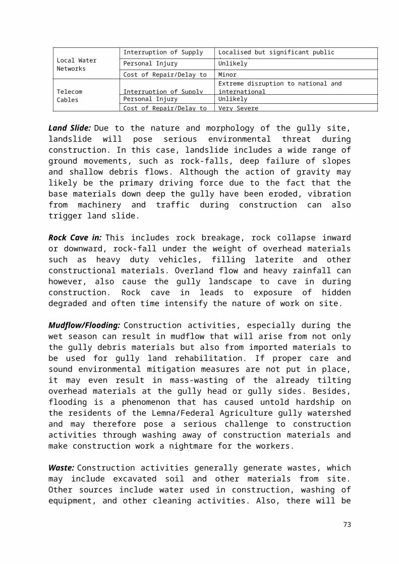
Table 6.6: Mitigation Measures for Operation PhaseS/N Environmental
and social impact source
Potential Impact Mitigation measures Monitoring Responsibility Cost (US$)
estimateParameters Where/how Frequency Implementation Monitoring
1 General maintenance operations
Maintenance of the rehabilitated and remediated gully outlay could expose NEWMAP and Ministry officials to danger from motorists plying the connecting routes to the area
Poor regularity of check could lead to micro-damages which could be costly to fix
1. Indiscriminate activities of the residents and others members of the community such as indiscriminate waste dumps should be outlawed. 2. Maintenance operations should be designed according to environmental safety guidelines of the Cross River Environmental Protection Agency and Federal Ministry of Environment. 3. Regular checks should be conducted by constituted authorities to ascertain the environmental quality prior to and after maintenance operations.
1. The community should engage in safe and clean environment. 2. Ensure that wastes are dumped in designated waste dumps. 3. Environmental checks should be consistent and orderly.
Weekly Cross River Ministry of Environment Forestry Transport Works and
Infrastructure
Cross River Ministry of Environment Forestry Transport Works and
Infrastructure
2,850
2 Air quality Dust is likely to increase as the industries that are shut down as a result of the gully erosion could resume production activities.
Also air pollution from such companies could impair air quality
1. Periodic checks on ambient environmental quality particularly air 2. Vehicles without road worthiness should not be permitted to use the road in such.3. Traffic control measures should be put in place to curb road-based air pollutant effects4. Regular checks on the nature of the road should be conducted with respect to air quality parameters.
1. Regular check for adherence to safety concerns.2. Ensure that all areas have trees planted along the road corridors.3. Ensure that road signs are placed along the road corridors.4. Ensure that speed limits are strictly adhere to.5. Ensure that vehicles are in good condition so as not to pollute the environment when driven along the roads.
Monthly Cross River Ministry of Environment Forestry
Cross River Ministry of Environment
2,750
83

6. Ensure that motorists adhere to stipulated speed limits.
3 Noise Increased traffic activity could increase noise impact
This could further affect one’s hearing ability as a resident of the rehabilitated area
1. Speed limits signboards should be placed at strategic locations along the Lemna/Federal Agriculture Road for the use of motorists and road users. 2. Safety information should be placed at specific locations to convey road safety information to motorists3. The local road transportation officials should be empowered to checkmate the activities of careless motorists.
1. Limit the usage of heavy-duty machines to essential works2. Ministry officials should vet the environmental noise impacts of the machines3. On-site movement heavy equipment should be minimized4. Environmental safety should be ensured
Monthly Cross River Ministry of Environment Forestry Transport Works and
Infrastructure
Cross River Ministry of Environment
2,550
4 Water quality issues
Poor waste management and dumping of waste within the rehabilitated drainages could affect surface water users downstream
Farmers who rely on water from the channel could be expose to water pollution
1. Ensure that waste dumps are not situated proximate to the project area to avoid water pollution cases. 2. Wastewater and sewage should be channelled appropriately according to safety guidelines. 3. Solid waste should not be dumped indiscriminately along the rehabilitated alignment.
1. Ensure that proper waste management practices are adhere to;2. Adherence to the principles of safe and clean environment should be taken paramount;3. Road users should be made to observe the mitigation measures.4. A clean and safe environment principle should be the guideline for all workers and on site members. 5. Safety of the environment should be paramount for all concerned during the construction phase.
Monthly Cross River Ministry of Environment Forestry
Cross River Ministry of Environment
2,950
84

5 Traffic and transportation
Increased traffic after rehabilitation works to lead to traffic logjams
Motorists are the risk of road accidents
Passers-by are also at the risk of being hit by careless motorists
1. Ensure free flow of traffic2. Ensure that road infrastructures that will ensure that the rehabilitated alignment is kept free and safe from accidents such as speed limit regulations, street lighting systems, road marks, etc are provided. 3. Road furniture are provided are designated bus stops and terminals along the Lemna/Federal Agriculture–Access Road. 4. Ensure that traffic officials are strategically positioned at specific junctions to provide safety guidelines and ensure free flow of traffic within the project area.
1. Implement the traffic management plan with respect to local traffic management strategy.2. Information on road speed should be placed strategically along the road. 3. Information on road safety should be written in local language and English for ease of communication. 4. Clear road diversion tapes and other information tactics should be used and devised to avert traffic logjam.
Cross River Ministry of Transport Works and
Infrastructure
Cross River Ministry of Transport
2,850
6 Health and safety
Susceptibility to health and safety challenges and dangers is high at this phase of the project
Accidents could occur at any time
1. Maintenance workers are expected to imbibe the workplace safety rules via proper sensitisation procedures prior to maintenance works.2. Ensure that workers utilise safety tools such as safety boots, safety helmets, and other essential safety wears on-site. 3. Ensure that first aid tools for minor injuries are treated prior to being forwarded to a medical centre for proper treatment. 4. Ensure that workers are the best state of health during
1. Sensitization should be carried in clear terms and all workers should understand safety rules and regulations. 2. Signs and safety information should be written in local language and English for ease of comprehension. 3. The Standard Operating Procedure (SOP) should be summarised and placed along strategy points on site for proper guidance.4. Workers should be allowed to work smarty and not late in order to
Weekly Cross River Ministry of Environment Transport Works and
Infrastructure
Cross River Ministry of Environment
2,850
85
work hours any reported case(s) of ill health should be referred to a nearby medical centre.5. Ensure that a Health, Safety and Environment (HSE) officer is available prior to and during maintenance works.
avert accidents owing to fatigue.
7 Sand Mining at Excavation site
Poor mining could lead to mudflow/landslide during heavy downpour at sloppy hilly sides
Exposure to dust particles could lead to vision impairment
1. Ensure Mining is done at Government approved site
2. Proper decommissioning should be ensured
3. Solid waste should not be dumped indiscriminately
1 Before construction and at the end of construction before final clearance is given to contractor
As the operation calls
Cross River Ministry of Environment Transport Works and
Infrastructure
Cross River Ministry of Environment
2,650
Total 19,450
86

6.2 Institutional Arrangements, Responsibilities and Accountabilities Well-defined roles and responsibilities and adequate institutional arrangements are central to the effective implementation of the stipulated environmental and social safeguard measures outlined in the current ESMP. Accordingly, details of institutional arrangements and the roles and responsibilities of the various institutions in the implementation of the current ESMP are discussed below.
6.2.1 Pre-construction Phase6.2.1.1 Key AgenciesThe Key Agencies with major roles in the implementation of the ESMP during the pre-construction phase are: The Contractor; The Federal NEWMAP-SPMU; The Cross River NEWMAP-SPMU; Cross River Ministries, Departments and Agencies (Information, Human Capital Development, Land, Finance, Physical Planning and Urban Development, and
Agriculture); Community Based Organisations (CBOs); The Lemna/Federal Agriculture Gully Erosion Site Monitoring Committee; The RAP (Resettlement Action Plan) Consultant; and
6.2.1.2 Role of the Involved AgenciesThe main responsibility for monitoring and reporting on the implementation of the ESMP lies with the Contractor. At the preparation stage, ground works and preparatory meetings and consultations were being conducted with the Lemna/Federal Agriculture Gully Erosion Site Monitoring Committee, Community Based Organisations (CBOs) as well as with members of the concerned communities in the project area. The contractor will liaise with the Cross River NEWMAP-SPMU on the issues raised in order to find a balance in responding to the issues to meet international safeguard polices of the World Bank. These issues will be communicated to Cross River Ministries with their respective departments and agencies (MDAs) for prompt action on issues raised. In cases of displacement of people due to the land properties along the gully alignment the provisions of the RAP will be implemented. It is anticipated that RAP consultant would have consulted widely prior to the submission of the final report to Cross River NEWMAP-SPMU.The implementation of the issues raised will be managed based on the Federal NEWMAP-SPMU in conjunction with the Cross River NEWMAP-SPMU.
6.2.1.3 Reporting and Follow-Up The follow-up process is duty-based. First, the Environmental and Social Specialists (ESS) must prepare and document monthly and incident reports that would be submitted to the Cross River NEWMAP project coordinator for comments, observations, and recommendations. Then, the Cross River NEWMAP-SPMU would send feedback to the Engineer through the contractor or directly when urgent action is required. In essence, checking and reporting on the implementation of follow-up action will also be part of the duties of the ESS.
The Contractor in conjunction with the Site Engineer should prepare and submit monthly reports on the implementation of the ESMP to the Cross River NEWMAP-SPMU. The ESS officers who will advise the project management unit accordingly will vet this report. In case of any discrepancy on environmental issues, the project coordinator should convene Project
87

Environmental Management (PEM) meeting to discuss and instruct on the way forward. The Site Engineer and the Contractor must participate in the meetings. Wherever possible, representatives of Federal NEWMAP-PMU should also be invited to such meetings. Also, serious accidents (involving lost time, evacuation to a hospital, or a fatality) should be reported immediately to the SPMU, who will in turn inform the World Bank through the FPMU.
6.2.2 Construction Phase6.2.2.1 Key Agencies
The Key Agencies with major roles in the implementation of the ESMP during construction works are:
The Engineer; The Contractor; Cross River NEWMAP-SPMU; Federal NEWMAP-SPMU; Cross River Ministries, Departments and Agencies (Works and Infrastructure,
Environment, Agriculture, and Forestry); Environmental Officers of the Federal NEWMAP-SPMU; Environmental Officers of Cross River NEWMAP-SPMU; Federal Ministry of Environment (FMEnv), NESREA;
In addition to the key agencies, the Cross River Government through the MDAs will also have a role in general oversight of ESMP implementation.
6.2.2.2 Role of Involved AgenciesThe main responsibility for monitoring and reporting on the implementation of the ESMP lies with the Engineer; therefore, the Engineer through its Environmental and Social Specialist (ESS) will be responsible for regular supervision and reporting on ESMP implementation. The Engineer’s ESS will have access to a team of experts in different fields (water, soil, social consultant etc.) in order to ensure sufficient capacity to oversee implementation of ESMP.
The implementation of the ESMP will be managed by the Cross River NEWMAP-SPMU through the Environment Officers and (EO) that will be primarily responsible for daily inspection and monitoring of ESMP implementation.The Cross River Ministries of Works and Infrastructure, Environment, Agriculture, and Forestry will monitor ESMP implementation on the fundamentals of the internal mechanisms and policies as established by laws guiding their operations. These institutions may conduct announced and unannounced site visits with representatives of Federal NEWMAP-SPMU. The reports of the findings should be forwarded to the World Bank.The Federal Ministry of Environment (FMEnv) and NESREA should also send Environment Officers and officials monitoring ESMP projects under the Federal NEWMAP approved projects to observe the level of implementation of the provisions of the ESMP. At the local level, the Cross River Ministry of Environment can also pay visits to the project site to observe and monitor the level of compliance to the provisions of the ESMP.
6.2.2.3 Reporting and Follow-UpThe follow-up process is duty-based. First, the Environmental Officer (EO) in conjunction with the Social/Livelihood Officer (SO) will prepare and document monthly and incident reports that will be submitted to the Cross River NEWMAP project coordinator for comments, observations, and recommendations. Then, the Cross River NEWMAP-SPMU
88
will send feedback to the Engineer through the consultant(s) or directly when urgent action is required. In essence, checking and reporting on the implementation of follow-up action will also be part of the duties of the EO and SO.The contractor in conjunction with the Site Engineer will prepare and submit monthly reports of the implementation of the ESMP to the Cross River NEWMAP-SPMU. The EO and SO officers who will advise the project management unit accordingly will vet this report. In case of any discrepancy on environmental issues, the project coordinator will convene Project Environmental Management (PEM) meeting to discuss and instruct on the way forward. The Engineer and the Contractor will participate in the meetings. Wherever possible, representatives of World Bank and Federal NEWMAP-SPMU will also be invited to such meetings.
6.2.3 Operational and Maintenance PhaseIt must be stated that the mitigation and monitoring activities will not be the sole responsibility of Cross River NEWMAP or Federal NEWMAP during the operational phase. The Cross River NEWMAP in conjunction with the Federal NEMWAP as the managing entity of the rehabilitated Lemna/Federal Agriculture gully erosion site has the responsibility to consider these measures, and to bring them/the latter to the attention of other government agencies for their action as appropriate.
6.2.3.1 Key AgenciesDuring the operational phase, the key institutions to which Cross River NEWMAP will enter into collaborative relations are Cross River Ministries which include: Environment; Forestry; Transport; Works and Infrastructure; and Police.Likewise, at the construction phase the Local government administrative council during the operational phase will have a role in general oversight of ESMP implementation and in ESMP updating.
6.2.3.2 Role of Involved AgenciesThe responsibilities of the institutions having a role in the process of the operation of the rehabilitated Lemna/Federal Agriculture Gully erosion monitoring are stated as follows. The Monitoring and Supervision Unit of the Cross River Ministry of Environment
will conduct regular visits to the site to examine and verify how the gully erosion site is operated and maintained. Several components such as water, soil, flora and fauna of the environment, waste management, noise and vibration, air and water quality and others will be monitored. This will be conducted within the legal and administrative capacity of the Ministry of Environment through their respective departments, and agencies.
The Cross River Ministry of Forestry will be conducting regular inspections to check the compliance of the site operators with afforestation plans which should be in concordance with international standards.
The Ministry of Transport will check the nature of vehicular traffic and road transportation pattern in the area with respect to transportation safety and vehicular controls. This will be conducted with respect to safety of road users and the residents of the community.
89

The Ministry of Works and Infrastructure will conduct regular checks on the nature of infrastructure provided within the duration of the project and the period of assessment. The approach will be conducted in such a way to provide a mechanism for prompt response and rehabilitation of any of the provided infrastructures within the gully erosion alignment.
The Police should ensure that crimes and criminal activities are reduced to the barest minimum in order to avoid wrong attachment of such events to the rehabilitation of the gully.
6.2.3.3 Local Level ESMP Institutional and Implementation arrangementsAt the local level, NEWMAP ESMF vested the overall implementation of the ESMP on the Site Monitoring Committee. The committee, has mentioned earlier, represent the interest of the community in the entire process of the proposed project. The Lemna/Federal Agriculture Gully Erosion Site Monitoring Committee has already been constituted by Cross River NEWMAP and the committee forms a critical mass of source of information and community liaison during the field activity for the preparation of this ESMP. The committee has several sub-committees including women wing and environmental sub-committee.
However, considering the diverse background of the committee members and the need for adequate knowledge on the environmental procedure of the proposed project, the committee and sub-committee members need further capacity building on environmental and social issues on implementation of the ESMP at all stages of project implementation. Consequently, capacity strengthening and sensitization of the Lemna/Federal Agriculture Gully Erosion Site Monitoring Committee and the Environmental sub-committee members is critical to successful implementation of this ESMP. The content of the training should include but not limited to (i) Role of community during construction and post contraction (ii) Sustainable practice to ensure gully stabilization (iii) Implementation of the ESMP at the local level. The details of training programme are shown in section 6.3.
6.3. Training ProgrammesThe Cross River NEWMAP will develop, implement, and track training programmes at both SPMU and community levels. Table 6.8 described the institutional capacity strengthening plan that Cross River NEWMAP should followed at both the SPMU and community levels. The programme should include but not limited to: Safeguards training for the entire SPMU on World Bank safeguards policies triggered
by the NEWMAP; GIS and Image Interpretation training for the safeguards officers. This is to enhance
the officers’ capability to interpret and analyses gully site imagery that will be delivered alongside the ESMP as contained in the TOR;
Training of SPMU on Implementation of all emergency response procedures as identified in the Emergency Response and Incident Management Plan; and
Training on Health, Environment, Safety, and Security Management Plan for SPMU. Community training on general environmental awareness and Lemna/Federal
Agriculture ESMP mitigation measures.However, to build the capacity of both the SPMU and the community, Cross River NEWMAP should develop, implement, and track training programmes
90

91

Table 6.7: Institutional Capacity Strengthening PlanTarget Audience Description Application Duration Cost
Estimate
Cross River SPMU Training
PC, Environment and safeguards specialist, Project engineer and Social safeguards specialist
In-depth understanding of the mitigation measures proffered by the ESMP. Satellite Image interpretation of the Lemna/Federal Agriculture gully watershed imagery for critical assessment of changes that might occur during project implementation.
Personnel require appreciation of WB’s, Federal/State environmental policies, as well as, an application of these policies in implementing the World Bank support for Lemna/Federal Agriculture gully erosion control.
Three days seminar
37,000
The CommunityLemna/Federal Agriculture gully erosion site monitoring committee members
General environmental awareness seminar that will include ecological and social science principles, legal responsibilities, consequences of non-sustainable development and costs of poor environmental decisions as it affects Lemna/Federal Agriculture gully erosion site. Mitigation measures proffered in the ESMP.
By the NEWMAP institutional arrangement, the target audience will be responsible for site monitoring and liaising between community and the Cross River NEWMAP as well as contractors.
1 day workshop
46,000
6.4 Impact Mitigation Measures Control and SurveillanceHigh level control and surveillance of the mitigation measures will be ensured by both Cross River State Ministry of Environment and the Federal Ministry of Environment. There will be both scheduled and unscheduled visit of these ministries to the site during construction and operations. Also, Cross River NEWMAP-SPMU will ensure quality assurance on the mitigation measures during construction. To strengthen the impact mitigation measures, periodic environmental impact audit every 6 (six) months will be ensured during construction (Table 6.8). Table 6.8 Monitoring Programmes
Monitoring Program
Months End of NEWMAP6 12 18 24
Pre-construction phase
Regular Checks
Envi
ronm
enta
l Aud
it
Envi
ronm
enta
l Aud
it
Envi
ronm
enta
l Aud
it
Envi
ronm
enta
l Aud
it
Project Closure Audit
Construction phase Spot checks
Regular ChecksRegular Checks
Regular Checks
Operation and maintenance phase
92

6.5 Implementation ScheduleThe implementation schedule is necessary to give a clear-cut direction on the timeline of implementation of the stipulated mitigation measures. It is expected that each of the stated measures should be time-based for proper implementation and apt monitoring. Table 6.9 documents the schedule for the mitigation measures with respective time lapse.
Table 6.9: ESMP Implementation Schedules/n Mitigation measures Mitigation timeline Cost estimate1. Pre-construction phase
I. Acquisition of landA month (4 weeks) prior to initiation of construction activities
II. Community perception of the project
Six weeks before the commencement of construction activities
2,650
2. Construction phase 1. Environmental impacts (including landslide, rock cave-in, mudflow/flooding, soil impact, in situ waste, land use, channelization of floodwaters, topographic alterations, air quality, water quality, and increased sedimentation)
All through the duration of the construction period
20,800
2. Biological impacts particularly impact on flora & fauna and wildlife.
All through the duration of the construction period
5,500
3. Socioeconomic impacts including traffic and transportation, accident, employment, human displacement, and aesthetics.
All through the duration of the construction period
9,900
4. Public health & safety impacts including HIV/AIDS & STDs, water-borne diseases, malaria, drug use and alcohol.
All through the duration of the construction period
7,050
3. Operation and maintenance phaseAir quality, noise and vibration, water quality, traffic & transportation, and health & safety
All through the duration of the operation & maintenance period
19,450
6.6 ESMP Costing and Cost AnalysisThe cost analysis presented in this section is designed for each of the identified mitigation measures to be effective and efficiently implemented. It is designed specifically for each of the activity itemised for each of the phases of the gully rehabilitation project. Thus, it covers the preconstruction phase, the construction phase as well as the maintenance and operation phase mitigation measures. Hence, the cost is designed for a global spread across the stated measures. Table 6.10 presents the synoptic details of the ESMP costing.
93
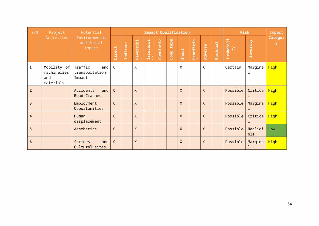
Table 6.10: Cost Analysis of the Lemna/Federal Agriculture Gully Erosion ESMP ImplementationS/N Fundamental ESMP Activities Cost Estimate ($)
1 Pre-construction phaseI. Acquisition of land
II. Community perception of the project-
2,650Subtotal 2,650
2 Construction phase(a) Environmental impacts including landslide, rock cave-in,
mudflow/flooding, soil impact, in situ waste, land use, channelization of floodwaters, topographic alterations, air quality, water quality, and increased sedimentation.
(b) Biological impacts particularly impacts on flora & fauna and wildlife.(c) Socioeconomic impacts including traffic and transportation, accident,
employment, human displacement, and aesthetics. (d) Public health impacts with respect to HIV/AIDS & STDs, water-borne
diseases, malaria.
20,800
5,500
9,9007,050
Subtotal 43,250
3 Operation and maintenance phase 19,450
ESMP Project Phase Total 62,700
4 Institutional Capacity Strengthening ProgrammeSPMU 37,000Community 46,000Sub total 83,000
Monitoring and Evaluation Plan 54,500
Grand Total 200,200
6.7 ESMP DisclosuresAfter review and clearance by the World Bank, the ESMP will be disclosed at the FMEnv, Cross River State Ministry of Environment and host LGA offices. The purpose will be to inform stakeholders about the project activities; impacts anticipated and proposed environmental management actions as well as to obtained the certificate of conformity from the Federal Ministry of Environment
94
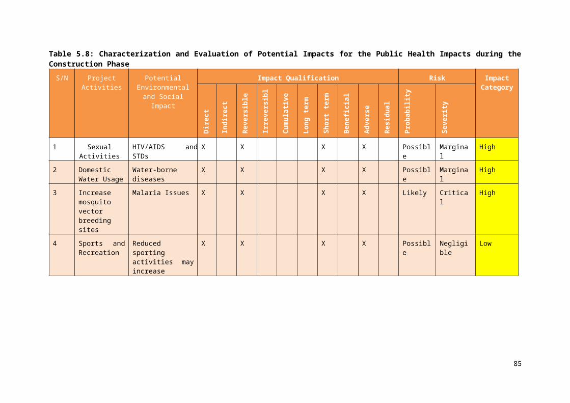
CHAPTER SEVEN
SUMMARY, CONCLUSION AND RECOMMENDATIONS
The study has provided a clear procedure including action plans that is critical to incorporation of environmental and social respects into the proposed rehabilitation project at Lemna/Federal Agriculture gully erosion site located in Calabar, Cross River, Nigeria. It measures the basic biophysical and social baseline information of the proposed project site, identifies sensitive environmental parameters that may be impacted on at the various phases of the project development and provides the necessary mitigation measures for such identified impacts. However, since the development objective of NEWMAP is to restore degraded lands and reduce longer-term erosion vulnerability in targeted areas, the ESMP for the proposed project adequately provides the guidelines for achieving the NEWMAP objectives without compromising the tangible and intangible human and environmental values with the project area.
The study has established that most residents in the area are a mixture of civil servants and petty traders with small-scale small holder agriculturists as well as other service-based urban workers. During the data gathering process, participants generally appraised their living standard and socio-economic status as “average” which is typical of a suburban milieu.An examination of the ground situation showed that the nature and extent of expansion of the gully erosion has increased the vulnerability of lives and properties along the different gully tributaries. This shows the extent of complexity of the gully formation of the area. The project works will positively and otherwise impacts on human lives, flora, fauna and the general environment where civil and other works activities will take place.
The project community has also significantly spelt out their desires for the project, calling for better drainage system and access road to enhance their socio-economic life. Thus, the proposed Lemna/Federal Agriculture gully rehabilitation project is a welcomed development by the affected community and is therefore recommended for execution by this ESMP. To enhance the benefits of the proposed intervention by Cross River NEWMAP at all phases of project execution, the mitigation measures provided in the ESMP should be strictly adhered to. This document is therefore prepared as a tool of understanding the ground situation of the Lemna/Federal Agriculture community as well as the entire watershed located in Ikot Effanga Mkpa community. This will be useful to ensure that the baseline, mitigation measures and the respective plans are put in place to ensure that the gully eroded area is restored and improved.
95

REFERENCES AND BIBLIOGRAPHYAdato, M., and R. Meinzen-Dick. (2007). Agricultural Research, Livelihoods, and Poverty. Studies of
Economic and Social Impacts in Six Countries. Baltimore, MD: The Johns Hopkins University Press for IFPRI (International Food Policy Research Institute).
Adger, W.N.; Brown, K.; Fairbrass, J.; Jordan, A.; Paavola, J.; Rosendo, S.; Seyfang, G. (2003). Governance for Sustainability: towards a 'thick' analysis of environmental Decision making. In: Environment and Planning A. vol. 35, pp. 1095-1110.
Ashekoya, T. (2009): Summary of the report on the assessment of gully erosion in affected areas in Southern States of Nigeria. Available at www.frcn.radionigeria.net Abuja.
Bates, D. (2002). Environmental refugees? Classifying human migration caused by environmental change. In; Population and Environment, 23(5), Springer, The Netherlands.
Bell, G. (2000). Geological Hazards. McGraw- Hill Publishers, New York, Berkes, F. (2007): Understanding Uncertainty and Reducing Vulnerability: Lessons from Resilience Thinking. In: Natural Hazards. vol. 41, pp. 283-295.
Dessauvagie, T. F. J. (1972). Geological history of the Benue valley and adjacent areas. In: T.F.J. Dessauvagie and A.J. Whiteman (eds.) African Geology, University of Ibadan Press, pg. 187-206
Egboka, B. C. E.; Nwankwor, G. I. (1985): The hydrogeological and geotechnical parameters as agents for gully type erosion in the Rain-Forest Belt of Nigeria. In: Journal of African Earth Sciences, vol. 3, No. 4, 47-425.
Egboka, B.C.E.; Okpoko, E.I.(1984): Gully erosion in the Agulu-Nanka region of Anambra State, Nigeria. Proceedings of the Harare Symposium, Publication number 144, July, 1984.
FEPA (1991): National Environmental Protection (effluent Limitation) Regulations. Federal Environmental Protection Agency, Nigeria.
Global Environment Facility (GEF) (2012). Investing In Our Planet for Nigeria Erosion and Watershed Management Project: World Bank Document
Isiuwa, S. (2008). Disasters affect Nigeria’s Growth. Leadership Newspapers. October 30, p.17. Kogbe C. A. (1989). Geology of Nigeria. Jos: Rock View Publ. Co.Murat, R. C. (1972). Stratigraphy and paleogeography of the Cretaceous and Lower Tertiary in
southern Nigeria, In: A. J. (eds), African Geology, University of Ibadan Press Nigeria. Pp 251–266.
NEWMAP (2012a). Environmental and Social Management Framework (ESMF) for Nigeria Erosion and Watershed Management Project: World Bank Document
NEWMAP (2012b). Resettlement Policy Framework (RPF) for Nigeria Erosion and Watershed Management Project: World Bank Document
NEWMAP (2012c). Project Appraisal Document (PAD) for Nigeria Erosion and Watershed Management Project: World Bank Document
NEWMAP (2012d). Project Implementation Manual (PIM) for Nigeria Erosion and Watershed Management Project: World Bank Document
Nur, M. A., Onuoha, K. M. & Ofoegbu, C. O. (1994). Spectral analysis of aeromagnetic data over the middle Benue trough, Nigeria. Journal of Mining and Geology vol. 30, No. 2, pg. 211-217.
Nwajide, S.C. and Hoque, M. (1979). Gullying processes in south-eastern Nigeria. The Nigerian Field Journal. 44(2), 64-74
Ofoegbu, C. O. (1984). Interpretation of aeromagnetic anomalies over the lower and middle Benue trough, Nigeria. Journal of Mining and Geology vol. 30 No. 2 pg. 211-217.
Ofomata, G. E. K. (1985). Soil erosion in Nigeria: the views of a geomorphologist. University of Nigeria Inaugural Lecture Series No.7.
Ofomata, G. E. K. (2002). Soils and soil erosion. In: Ofomata, G. E. K (Ed): A survey of the Igbo nation. Africana First Publishers Ltd, Onitsha. pp 99-116.
Olaniyan, C. I. O. (1975). An introduction to West Africa Animal Ecology. 2nd ed. Heinemann Educational Books Ltd. London and Ibadan
Thompson, B. W. (1975). Africa; The climatic background – Studies in the development of African resources. Oxford University Press. Ibadan
Udo, R. K. (1971). Geographic Regions of Nigeria. Heinemann Publishers, Ibadan. United States Geological Survey (USGS) (2010): Landslides-facts
96
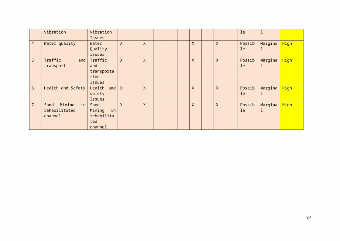
APPENDIX I
NEWMAP
Environmental and Social Management Plan (ESMP) for Lemna/Federal Agriculture Gully Erosion Site in Calabar, Cross River State.
Dear Respondent,
Thank you for taking the time to complete the following survey. The purpose of this survey is to gain valuable insight on proposed NEWMAP intervention at Lemna/Federal Agriculture Gully Erosion Site in Calabar, Cross River State. This provides you the opportunity to contribute to the environmental and social components of the project implementation.
NOTE:
Please read each question carefully. Your answers are completely confidential and will be included only in summaries where individual answers cannot be identified. Unless otherwise instructed, please tick appropriate answer category that best describes your opinion. It will take approximately 20 minutes to complete this questionnaire.
Settlement/Community: ………………………… State…………………../L.G.A: …….……………………
Name of Interviewer: ……..…………….…………… Date: ..……………..……………
Coordinates: Northing ………………………… Easting …………………………………
Survey Location: (a) Major Urban (b) Other Urban (c) Rural
SECTION A: Household data
1. Gender of Respondent: (a) Male (b) Female
2. Age: (a) Below 18 yrs (b) 18-45 yrs (c) 46-65 yrs (d) Above 65 yrs
3. Marital Status: (a) Single (b) Married (d) Divorced/Separated (e) Widowed
4. Occupation: (a) Famer (b) Daily Labourer (c) Trading & Shop Keeping (d) Artisans
(e) Employed (salary) (f) Self Employed (g) Social Support (h) unemployed (i) Others specify……………………
5. Residential Status: (a) Permanent Resident (b) Back Home (Returnee) (c) Non Resident, Visiting
6. Ethnic Group: (a) Efik (b) Ejagham (c) Bekwarra (d) Ibibio (e) Yoruba (f) Hausa (g) Igbo (h) Other, specify………………………..
7. Religion: (a) Islam (b) Christianity (c) Traditional
8. Relationship to Household Head (HH): (a) Self (b) Spouse (c) Child (d) Parent
(e) Other, specify…...
9. Size of the HH ……………………………
No. of Adults (Above 18) Men Women
No. of Children (below 18) Boys Girls
10. How long have you been living in this area? (a) 0-2 yrs (b) 3-5 yrs (c) 6-9 yrs
(d) 10 yrs and Above
11. If non-resident, please state your actual location: ……………. (Location/LGA/State)
97

12. Education: (a) No formal education (b) Primary School (c) Secondary School
(d) Tertiary (Excluding University) (e) University Graduate (f) University Post Graduate
Education of young household member
12.1 Does anyone in your household currently attend school (If no, skip to 2)
A Yes b No
8.2. What level of education are they? (Place name)
School Category Number
a Primary b Junior High
c Senior High/ Tech/ Voc d Post-Secondary
12.3. How long does it take to get to school?
(Note response to each school accessed)
a <5 mins b 5-15 mins
c 15-30 mins d 30-60 mins
e 60+ mins
12.4. What method of transport is used to get to school?
(Note response to each school accessed)
a Foot b Bicycle
c Mini bus d Taxi
e Private Car f Okada
g Tri-cycle
13. Are you in anyway affected by the Lemna/Federal Agriculture Gully Erosion?
(a) yes (b) no
14. If question 13 is yes, how (a) damage to Agric/farmland (b) Damage to building/property
(c) loss of landed / Building property (d) Damage to household utensils/personal belonging
(e) economic loss due to inability to access or operate means of livelihoods (f) others specify………
15. Do Lemna/Federal Agriculture Gully Erosion Site prevent children from going to school?
(a) Yes (b) No
16. If question 15 is yes, how regular is the occurrence? (a) Often (b) frequently (c) rarely
SECTION B: Health Status
1. Is your present state of health affected in any way by Lemna/Federal Agriculture Gully Erosion Site?
(a) Yes (b) No
2. If yes, in what way?(a) Skin diseases (b) Cough (c) Catarrh (d) Malaria (e)Water-borne diseases (f) Other, Specify……………………
3. Does the prevalence / occurrence of the disease(s) become severe during flood periods (a) Yes (b) No
4. How do you manage your health conditions when sick? (a) Attend hospital/clinic (b) Buys drugs from nearby chemist (c) Traditional medicine (d) None (e) Others Specify………………………….
5. If you do attend hospital/clinic, when last did you visit one? (a) last six months (b) last one year (c) last five years (d) more than five years ago (e) Never visited one.
6. Please tick one or more of the under-mentioned ailment/sickness, you suffer from most accordingly?
98
Degree Ailment Always Sparingly Seldom Never Degree Ailment Always Sparingly Seldom Never
Whooping Cough Rheumatism
Tuberculosis Rashes
Asthma Eczema
Dysentery Ringworm
Diarrhoea Eye pains
Cholera Cataract
Pile Glaucoma
Hypertension Typhoid fever
Congestive health problem Malaria
PneumoniaSickle cell anaemia
Sexually transmitted Epilepsy
6. Do you think your health condition will be affected by the proposed intervention at Lemna/Federal Agriculture Gully Erosion Site? (a) Yes (b) No
7. If yes, how? (a) Contamination of ground water (b) Contamination of surface water (c) Provide breading site for disease vectors (d) Noise/air pollution (e) Others, specify:……………………………………
8. Please suggest how this can be averted during construction and implementation……………………………………………………………………………………….
SECTION C. Standard of Living / Socio-Economic Activities
1. Assets
1.1 Do you have any of the following items Item Quantity Item Quantitya. radio / tape recorder
k. bedsb. television l. furniture setc. DVD player m. fand. telephone (land line)
n. computere. mobile phone o. generatorf. stove p. mosquito netsg. fridge q. insect screensh. hunting trap r. other (specify)
1.2 What sort of transport does your family ownItem Quantity Item Quantitya. bicycle f. car b. motorcycle/okada g. truck c. canoe h. taxid. boat i. buse. tri-cycle j. other (specify)
99
1.3 What mode of transport do you frequently useItem Quantity Item Quantitya. bicycle f. car b. motorcycle/okada g. truck c. canoe h. taxid. boat i. buse. tri-cycle j. other (specify)
1.4 What sort of housing does your household live in?a. Construction material - Walls Plastered mud c. Number of rooms 1-2
Cement blocks 3-4Other (specify) Other (specify)
b. Construction material - roofing Corrugated roofing d. Other structures on plot
Animal PenAluminium GranaryAsbestors ShopsTile KiosksOther (specify) Other (specify)
e. Construction material - floor EarthenConcretesTilesOther (specify)
f. Toilet Facility Pit latrineWater closet Toilet facility outside dwellingPier latrineOther (specify)None
g. Tenure of housing OwnedRentedOccupied rent freeOther
h. Tenure of land OwnedRentedOccupied rent freeLease holdOthers specify
2. Indicate household refuse disposal for solid waste? (Multiple options) (a) Depositing refuse at backyard of the house (b) Dumping in water body (c) Dumping in community refuse/garbage pit/dumpsite
(d) Burning after gathering together (e) Waste collector (f) Other specify………
2.0 Household Services2.1 Rank in order of availability and usability the source(s) of lighting for the household? (please use 1,
2,...in hierarchical order with 1 indicating the most available and used source)(a) PHCN
(b) Generator
(c) Lantern
(d) Candle
(e) Palm Oil Lamp
(f) Torchlight Battery
(g) Wood
(h) Kerosene
(i) Gas
100
2.2 Using the method in 2.1, indicate major source of energy for cooking?
(a) Fire Wood
(b) Coal (c) Kerosene
(d) Electricity
(e) Animal dropping
(f) Gas (g) Crop Residue/saw dust
Others
3.0 Sources of Waterfor drinking for cooking for bathing and washing
a. Well Yes No Yes No Yes Nob. Borehole Yes No Yes No Yes Noc. Water pump Yes No Yes No Yes Nod. Community tap Yes No Yes No Yes Noe. Piped water outside
dwellingYes No Yes No Yes No
f. River Yes No Yes No Yes Noh. Rain harvesting Yes No Yes No Yes Noi. Water vendor Yes No Yes No Yes Noj. Tanked water Yes No Yes No Yes Nok. Other (specify) Yes No Yes No Yes No
4.0 Income
State your main income per month N
4.1 Remittances
1. Does anyone in the family who lives elsewhere send money to you? 1 Yes 2 No2. If yes, how much (per month) N
5.0 Other Income
1. Do you have other income streams Yes No
2. If yes, please specify the amount? N6. Total Income
1 What is the total household monthly income (all activities)? N
7. In your opinion, how has the standard of living of your household changed over the previous three years?
(a) Same (b) Better (c) Worse
8. Is the option in 7 propelled by the Gully Erosion problem (a) Yes (b) No
9. If 8 is yes, do you think the proposed intervention will improve the situation? (a) Yes (b) No
10. If 9 is yes specify how the project will improve the situation ………………………11. How do you ensure gender equity in the community? (a) Women are elected in public office (b)
Females are given equal opportunity and access to education and employment (c) Quotas on genders are ensures in leadership of community based organizations (d) Others specify…………………………………………...
SECTION D: Resources/ Cultural Property
1. Please indicate the environmental problems which your settlement/community experiences and whose cause can be linked to Lemna/Federal Agriculture Gully Erosion?
(a) Soil infertility (b) Poor drainage system (c) Bad road (d) Bad lands
(e) Environmental degradation (f) Degraded land (i) Destruction of infrastructures
101
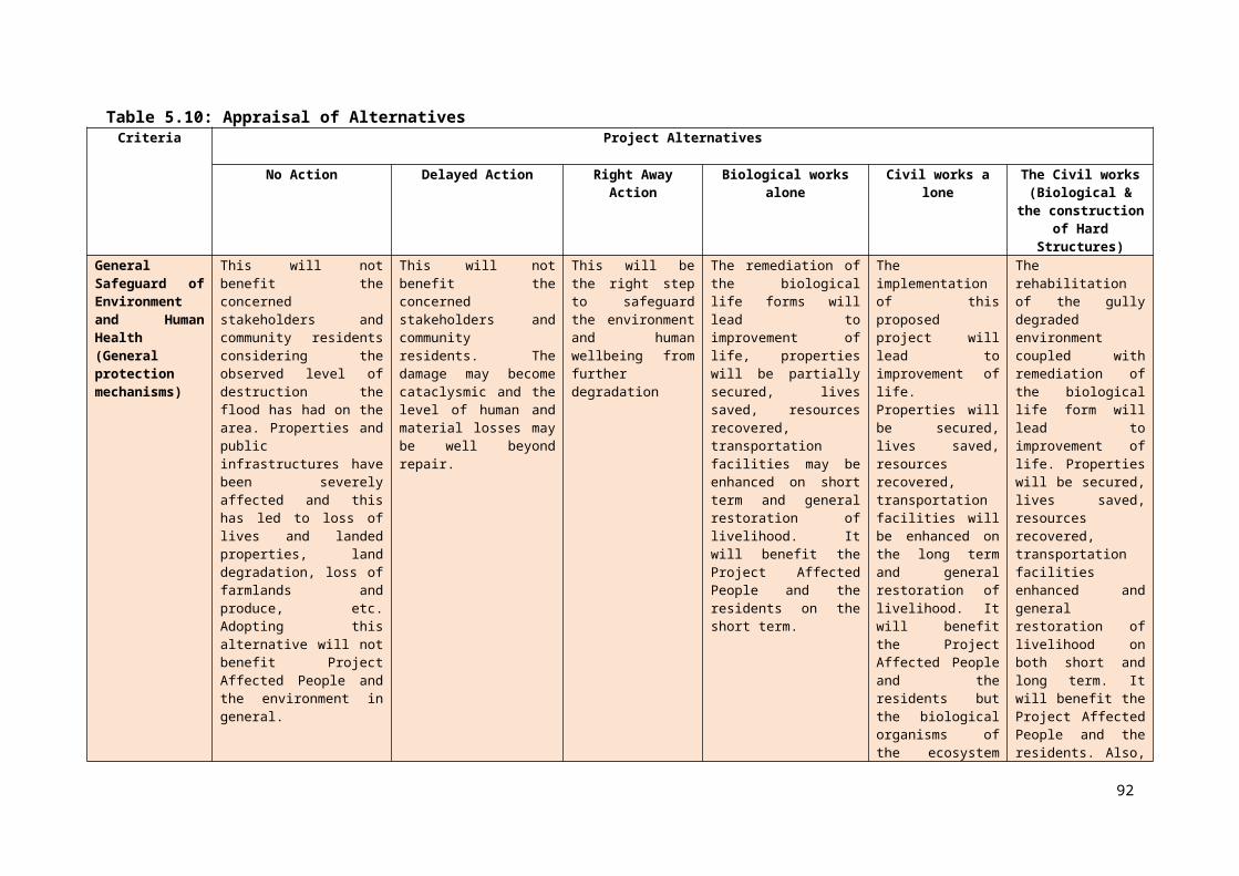
(j) Others (specify) …………………………..2. Please indicate the environmental problems which your settlement/community would likely experience
and whose cause can be linked to the proposed intervention project during construction? (a) Soil infertility (b) Poor drainage system (c) Bad road (d) Low visibility (e) Erosion Problems (f) Flooding (g) Environmental degradation (g) Destruction of infrastructures (h) Encroachment of land properties (i) Pollution (air, surface water, ground water, noise) (j) Others (specify) ………………………….
3. Please indicate the environmental problems which your settlement/community would likely experience and whose cause can be linked to the proposed intervention project during operation? (a) Soil infertility
(b) Poor drainage system (c) Bad road (d) Low visibility (e) Erosion Problems (f) Flooding
(g) Environmental degradation (h) Destruction of infrastructures (i) encroachment of land properties
(j) Pollution (air, surface water, ground water, noise) (k) Others (specify) …………………………..
4. Do you think the proposed intervention project will affect any valued resource/cultural/archaeological property in your area? (a) Yes (b) No
5. If yes mention the name(s) of the valued resource/cultural/archaeological property …………………………
6. How will valued resource/cultural/archaeological property be affected? (a) Displacement of such valued cultural properties (b) Vandalisation of sacred items/locations (c) Possible theft of sacred/archaeological items (d) Others, specify: ……………………………
SECTION E: Intervention Project Activities Impact Evaluation1. Are you aware of the proposed intervention by NEWMAP on Lemna/Federal Agriculture Gully
Erosion (a) Yes (b) No2. If yes, from which source (a) Community meetings (b) Media (TV, Radio, Newspaper, Internet)
(c) Others specify…………………………….3. Do you think the project can cause restiveness in your community? (a) Yes (b) No
If 3 is yes how will the proposed intervention result in restiveness? (a) Disrespect of norms and culture by contractors (b) loss of farmland / Property (c) Possible theft of sacred/archaeological items
(d) Local people not employed during construction (e) Others, specify: ……………………………
5. How will the proposed intervention project impact on your livelihood and environment?
Positive impacts Negative impacts
(a)
(b)
(c)
(d)
(e)
(f)
6. Can you name some of the animals and other habitat within the gully erosion catchment that may be affected by the proposed intervention project? ………………………………………………………………………
7. What do you expect from the activities of NEWMAP intervention? (a) Employment of Locals during construction (b) Compensation for those whose properties will be affected (c) Capacity building for maintenance during implementation (d) Community input into final engineering design (e) Others please specify……………………..
102

8. Are there any other issue(s) of concerned as regards the intervention project in your area, please state clearly? ……………………...…………………………………………………………………………
APPENDIX II
Table 1: Stakeholders Consultation Minutes Drafted Following the Discussion at Mr Nwaneri’s Quarter at Federal Agriculture, Ikot Effanga Mkpa Community, Calabar Cross River State
Items Description
Name of Project Affected Community:
Federal Agriculture, Calabar Municipality, Cross River State
Date: 23/02/2017
Attendance: Dr. Shakirudeen Odunuga (ESMP Consultant Team Leader) Raji, S. A. OluwaSeun (ESMP Consultant Team Member) Mr Henry Onwe (Cross River State NEWMAP, Social Livelihood Officer) Sir Donatus Etta (Cross River State NEWMAP, Environmental Officer) Elder Edwin D Nnumola (Community Member) Mrs Irene A. Odidi (Community Member) Elder Effiom Bassey (Community Member) Elder Umoh John (Community Member) Elder Etim E. Orok (Community Member) Elder Obani Chikezie (Community Member) Rev Lucas Oriuwa (Community Member) Kenneth Sunday Udo (Community Member) Asuquo Edem Okpong (Community Member) Effiong Joshua Okon (Community Member) Okon Blessing Joshua (Community Member) Gift Joshua Okon (Community Member) Elder Edet Okon (Community Member) Ekpo Archibong E. (Community Member) Mrs Luci Nwaneri (Community Member) Edet Ekpeyong Etim (Community Member) Ita Edet (Community Member) Sis Justina Effiong Udo (Community Member) Effoing Orok Etim (Community Member) Nwaneri Benard O. (Community Member)
Venue: Mr Nwaneri’s Premises (Federal Agriculture Staff Quarters, Ikot Effanga Mkpa Community, Calabar Municipality)
Language of Communication:
Pidgin English, English and Ibibio
Opening Remarks: Mr Henry Onwe the Cross River State Social Livelihood Officer did a brief introduction. He welcomed the members of the community to the using English, Pidgin English and Ibibio languages switching as the case demands. He briefed community about the essence of the ESMP which is a second important document that must be made available prior to the commencement of civil works to rehabilitate the aspect affected by the gully. Thus, he explained the overall purpose of the ESMP and urged the community to cooperate with the ESMP team and provide all the necessary information that will speed up the process of completion of the document as at when due. He hand over to Sir Donatus Etta who is the Cross River State NEWMAP Environment Officer to explain the details of the ESMP.
103

Sir Etta explained that the ESMP is a tool yet a document that will be used to guide day-to-day activities of the engineers on-site to be conscious of the environment and maintenance and sustenance of the quality of the environment to prevent pollution or destruction of the existing life. He also explained that the document will contain the socioeconomics of the community as well and the entire watershed that contributes water to the gully. He explained that this is necessary to also examine the possible impacts the project will have on the entire community in terms of social influences and way of rectifying any adverse effect will be documented. He admonished the community to supply these information and work to assist in the completion of the document in time. He then handed over to the ESMP team leader and consultant Dr Odunuga to do a brief introduction of his team and the details of their workplan in the community.
The ESMP consultant (Dr Odunuga) introduced his team thereafter elaborated on the crux of the ESMP particularly the administration of the questionnaire. He assured the participants of the assurance that all details will be used but treated with anonymity. He added that samples of the environment quality such as surface water, groundwater and air will be collected at various points. On the work plan, he explained that the team will be moving from street to street to administer questionnaire and take photographs of interests with additional information being recorded as necessary. He concluded by soliciting for the support and cooperation of all the members of the community to work towards the success of the exercise.
Dr Odunuga further stated all issues should be made clear at this stage so that they can factored into the main ESMP report. He stated that issues of land disputes, social challenges, protection of sacred sites and antiquities along the gully, as well other things should be stated. Of key interest is the issue of community needs and ways in which the community can be co-opted into the project was also stated. Further, what are the safety measures that the community can help put in place for the engineers during the construction works, such as safety of equipment, tractors, bulldozers, safety of onsite materials, etc. were stated because these issues could affect delivery period of the project. These were tabled for the community to respond.
Questions from the consultant and the response from the community members:
Perception of the community about the project
The community is fully aware of the project based on the previous RAP that was conducted a few months prior to the ESMP team’s visit. Hence, there is existing mechanism of information exchange between NEWMAP and the community. This is also extended to the youth body of Ikot Effanga Mkpa community who also claimed a good knowledge of the project.
Safety and Security assured during the Civil & Engineering Works
The chairman of the Federal Agriculture Staff Quarters Association Elder Edwin Nnumola affirmed that security is guaranteed during the construction phase of the project. He stated that although there are no guest houses in the community, there are hotels that can be used as temporary accommodation points by the workers employed. He stated also further tents and camps can be built within the community that spaces required will be provided as at when the need arises. He also stated the youths in the community are available for different kinds of jobs. He said the school leavers are available in good numbers who can works as both semi-skilled and unskilled labour. In terms of the skilled labour, he stated that welders and other engineers can be employed within the Ikot Effanga Mkpa community at large.
What are the perspectives of the Youth Body of Ikot Effanga Mkpa Community to the issues raised?
104

The Vice President of the youth body stated that youths are fully prepared and are throwing their weight behind the project in full. He stated that security is guaranteed that the youths are very peaceful. He gave the assurance that “safety first” is the guarantee the youths are pledging to the projects. He stated that even though there are no guest houses or hotels in the area yet, there are yet hotels in the adjoining areas in Calabar metropolis that can accommodate people. He affirmed that the youths are available for employment stating that there are several graduates whose educational experience can be of great value to the project. He emphasised the youths will love to be involve that it will also boost the community socially apart of economic employment that it will provide in the immediate time. He said further that the contractors can have a memorandum of understanding with the community to have a good percentage mix between employment of locals and other brought from outside the area such as 60/40 or 50/50. He claimed that the community is aware of local content importance in project management hence his suggestion.
Response from Mr John Umoh an elder in the community on the security and labour mix for the success of the project.
He appreciates the thoughtfulness and details of the project provided by the ESMP team leader. He started that the engineer should work with the youth as the social engineers of the community and that the elder would love it if the youths can be fully engaged during the construction phase of the project. He added that the community at large is very peaceful, hence cases of conflicts will not arise.
The question of assessing impact of heavy equipment moving within the community that could affect the foundation of building because the area is close up and the issue of accessibility
The ESMP Environment Officer Sir Donatus Etta responded very remarkably that the assessment of impact is the duty of the ESMP. Therefore, the community should be ready to offer full support to the ESMP team. He stated further that the main thrust of the ESMP exercise is to provide comprehensive foreseen and unforeseen impacts that could hamper the project and properties within the gully buffer.
Mr Henry Onwe gave a comprehensive response in addendum to the previous response. He stated that apart from ESMP, there is the RAP document which was the first fieldwork that was conducted in the area not along ago. He stated that issues of buildings that could be affected by heavy-duty equipment have been incorporated into the RAP study through the buffer zone that was drawn up. He stated that such buildings have been marked either for outright demolition or for the owner to relocate prior to the civil works or both. He added that compensation plans have been drawn up that are consistent with international best practices. Hence PAPs have no issues since they have been covered. He stated further that the compensation plan also entails taking care of vulnerable persons such as the aged, physically challenged, widows and those whose direct livelihood may be affected by the project. he mentioned that the NEWMAP project is world bank sponsored as a development partner with the federal government of Nigeria, therefore the idea is to ensure that they area is rehabilitated and enhanced better than the way it was. He mentioned that people living within the gully outlay will also be trained in several jobs so that they can earn a living after being displaced. Hence empowerment is a germane aspect of the NEWMAP project for all PAPs. In addition, he gave the assurance the that Cross River State NEWMAP will ensure that best interest of the people particularly the youths will be ensure during the screening of the civil engineering consultants. He mentioned that the wages that will be paid will be commensurate with the global best practices and as at the current market value. He affirmed that cheating and any form of corruption will not be accommodated and that the people can be rest assurance of both governmental
105
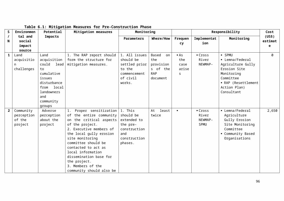
and ministerial support during these phases.
Queries and Concerns Any other claims and concerns
None.
APPENDIX III
RAW ATTENDANCE SHEET
106

107
APPENDIX IV
Stakeholder’s consultation with the PAPs, community members and the youth association of Ikot Effanga Mpka with Cross River State NEWMAP Social Livelihood Officer addressing the PAPs (Source: Fieldwork, February 2017)
A Field officer engaging of the PAP a Staff of Federal Agriculture whose property is currently threatened by the expanding gully (Source: Fieldwork, February 2017)
108

Gender-sensitive: FGD/stakeholders consultation with Female’s Youth Group (Source: Fieldwork, February 2017)
Group picture of the participants after stakeholder’s consultation (Source: February 2017)
109

110
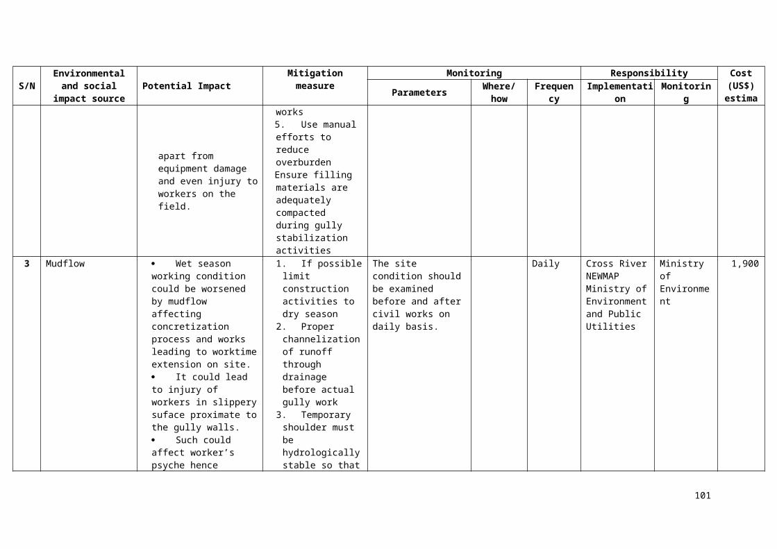
APPENDIX V: Indicative Environmental Code of Conduct and Clauses for Contractors
1. In addition to these general conditions, the Contractor shall comply with any specific Environmental Management Plan (EMP) in the Lemna Fed. Agric Site Environmental and Social Management Plan (ESMP). The Contractor shall inform himself about such an EMP, and prepare his work strategy and plan to fully take into account relevant provisions of that EMP. If the Contractor fails to implement the approved EMP after written instruction by the Supervising Environmental Officer (EO) to fulfill his obligation within the requested time, the Owner reserves the right to arrange through the EO for execution of the missing action by a third party on account of the Contractor.2. Notwithstanding the Contractor’s obligation under the above clause, the Contractor shall implement all measures necessary to avoid undesirable adverse environmental and social impacts wherever possible, restore work sites to acceptable standards, and abide by any environmental performance requirements specified in an EMP. In general, these measures shall include but not be limited to:
(a) Minimize the effect of dust on the surrounding environment resulting from earth mixing sites, asphalt mixing sites, dispersing coal ashes, vibrating equipment, temporary access infrastructure such as roads, etc. to ensure safety, health and the protection of workers and communities living in the vicinity dust producing activities.(b) Ensure that noise levels emanating from machinery, vehicles and noisy construction activities (e.g. excavation, blasting) are kept at a minimum for the safety, health and protection of workers within the vicinity of high noise levels and nearby communities.(c) Ensure that existing water flow regimes in rivers, streams and other natural or irrigation channels is maintained and/or re-established where they are disrupted due to works being carried out.(d) Prevent bitumen, oils, lubricants and waste water used or produced during the execution of works from entering into rivers, streams, irrigation channels and other natural water bodies/reservoirs, and also ensure that stagnant water in uncovered burrow pits is treated in the best way to avoid creating possible breeding grounds for mosquitoes.(e) Prevent and minimize the impacts of quarrying, earth burrowing, piling and building of temporary construction camps and access infrastructure such as roads on the biophysical environment including protected areas and arable lands; local communities and their settlements. In as much as possible restore/rehabilitate all sites to acceptable standards.(f) Upon discovery of ancient heritage, relics or anything that might or believed to be of archaeological or historical importance during the execution of works, immediately report such findings to the SE so that the appropriate authorities may be expeditiously contacted for fulfilment of the measures aimed at protecting such historical or archaeological resources.
(g) Discourage construction workers from engaging in the exploitation of natural resources such as hunting, fishing, collection of forest products or any other activity that might have a negative impact on the social and economic welfare of the local communities.
(h) Implement soil erosion control measures in order to avoid surface run off and prevents siltation, etc.(i) Ensure that garbage, sanitation and drinking water facilities are provided in construction workers camps.(j) Ensure that, in as much as possible, local materials are used to avoid importation of foreign material and long distance transportation.
(k) Ensure public safety, and meet traffic safety requirements for the operation of work to avoid accidents.3. The Contractor shall indicate the period within which he/she shall maintain status on site after completion of civil works to ensure that significant adverse impacts arising from such works have been appropriately addressed.4. The Contractor shall adhere to the proposed activity implementation schedule and the monitoring plan / strategy to ensure effective feedback of monitoring information to project management so that impact management can be implemented properly, and if necessary, adapt to changing and unforeseen conditions.5. Besides the regular inspection of the sites by the Cross River State NEWMAP and other supervising agencies for adherence to the contract conditions and specifications, the Owner may appoint an Inspector to oversee the compliance with these environmental conditions and any proposed mitigation measures. State environmental authorities may carry out similar inspection duties. In all cases, as directed by the EO, the Contractor shall comply with directives from such inspectors to implement measures required to ensure the adequacy rehabilitation measures carried out on the bio-physical environment and compensation for socio-economic disruption resulting from implementation of any works.
Worksite/Campsite Waste Management6. All vessels (drums, containers, bags, etc.) containing oil/fuel/surfacing materials and other hazardous chemicals shall be bonded in order to contain spillage. All waste containers, litter and any other waste generated during the construction shall be collected and disposed-off at designated disposal sites in line with applicable government waste management regulations.
7. All drainage and effluent from storage areas, workshops and camp sites shall be captured and treated
111
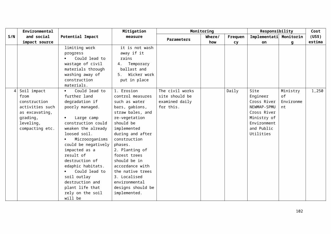
APPENDIX V: Indicative Environmental Code of Conduct and Clauses for Contractorsbefore being discharged into the drainage system in line with applicable government water pollution control regulations.
8. Used oil from maintenance shall be collected and disposed-off appropriately at designated sites or be re-used or sold for re-use locally.9. Entry of runoff to the site shall be restricted by constructing diversion channels or holding structures
such as banks, drains, dams, etc. to reduce the potential of soil erosion and water pollution.10. Construction waste shall not be left in stockpiles along the infrastructure such as road, but removed and reused or disposed of on a daily basis. 11. If disposal sites for clean spoil are necessary, they shall be located in areas, approved by the SE, of low land use value and where they will not result in material being easily washed into drainage channels. Whenever possible, spoil materials should be placed in low-lying areas and should be compacted and planted with species indigenous to the locality.
Material Excavation and Deposit12. The Contractor shall obtain appropriate licenses/permits from relevant authorities to operate quarries or
burrow areas.13. The location of quarries and burrow areas shall be subject to approval by relevant local and national
authorities, including traditional authorities if the land on which the quarry or burrow areas fall in traditional land.New extraction sites:
a) Shall not be located in the vicinity of settlement areas, cultural sites, wetlands or any other valued ecosystem component, or on high or steep ground or in areas of high scenic value, and shall not be located less than 1km from such areas.
b) Shall not be located adjacent to stream channels wherever possible to avoid siltation of river channels. Where they are located near water sources, burrow pits and perimeter drains shall surround quarry sites.
c) Shall not be located in archaeological areas. Excavations in the vicinity of such areas shall proceed with great care and shall be done in the presence of government authorities having a mandate for their protection.
d) Shall not be located in forest reserves. However, where there are no other alternatives, permission shall be obtained from the appropriate authorities and an environmental impact study shall be conducted.
e) Shall be easily rehabilitated. Areas with minimal vegetation cover such as flat and bare ground, or areas covered with grass only or covered with shrubs less than 1.5m in height, are preferred.f) Shall have clearly demarcated and marked boundaries to minimize vegetation clearing.
15. Vegetation clearing shall be restricted to the area required for safe operation of construction work. Vegetation clearing shall not be done more than two months in advance of operations.
16. Stockpile areas shall be located in areas where trees can act as buffers to prevent dust pollution. Perimeter drains shall be built around stockpile areas. Sediment and other pollutant traps shall be located at drainage exits from workings.17. The Contractor shall deposit any excess material in accordance with the principles of the general
conditions, and any applicable EMP, in areas approved by local authorities and/or the SE.18. Areas for depositing hazardous materials such as contaminated liquid and solid materials shall be approved
by the SE and appropriate local and/or national authorities before the commencement of work. Use of existing, approved sites shall be preferred over the establishment of new sites.
Rehabilitation and Soil Erosion Prevention19. To the extent practicable, the Contractor shall rehabilitate the site progressively so that the rate of
rehabilitation is similar to the rate of construction.20. Always remove and retain topsoil for subsequent rehabilitation. Soils shall not be stripped when they
are wet as this can lead to soil compaction and loss of structure.21. Topsoil shall not be stored in large heaps. Low mounds of no more than 1 to 2m high are recommended.22. Re-vegetate stockpiles to protect the soil from erosion, discourage weeds and maintain an active population of beneficial soil microbes.23. Locate stockpiles where they will not be disturbed by future construction activities.24. To the extent practicable, reinstate natural drainage patterns where they have been altered or impaired.25. Remove toxic materials and dispose of them in designated sites. Backfill excavated areas with soils or
overburden that is free of foreign material that could pollute groundwater and soil.26. Identify potentially toxic overburden and screen with suitable material to prevent mobilization of toxins.27. Ensure reshaped land is formed so as to be inherently stable, adequately drained and suitable for the
desired long-term land use, and allow natural regeneration of vegetation.28. Minimize the long-term visual impact by creating landforms that are compatible with the adjacent landscape.
112
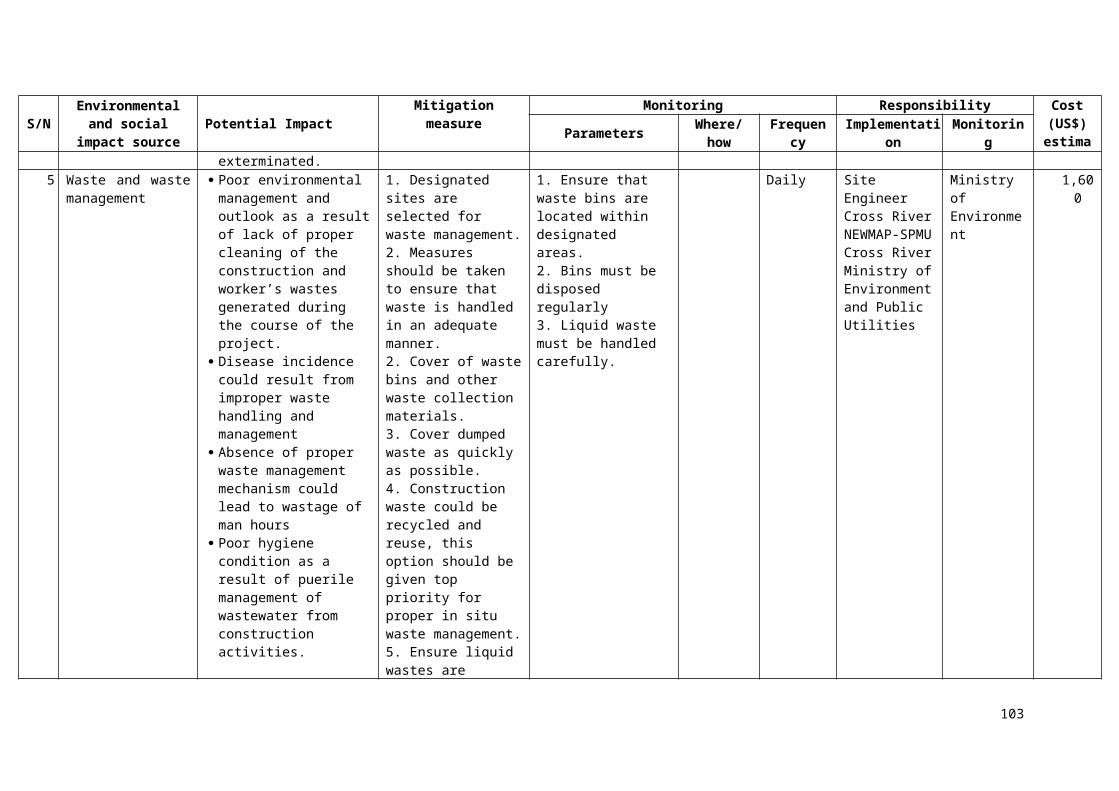
APPENDIX V: Indicative Environmental Code of Conduct and Clauses for Contractors29. Minimize erosion by wind and water both during and after the process of reinstatement.30. Compacted surfaces shall be deep ripped to relieve compaction unless subsurface conditions dictate
otherwise.31. Revegetate with plant species that will control erosion, provide vegetative diversity and, through
succession, contribute to a resilient ecosystem. The choice of plant species for rehabilitation shall be done in consultation with local research institutions, forest department and the local people.
Water Resources Management32. The Contractor shall at all costs avoid conflicting with water demands of local communities.33. Abstraction of both surface and underground water shall only be done with the consultation of the local
community and after obtaining a permit from the relevant Water Authority.34. Abstraction of water from wetlands shall be avoided. Where necessary, authority has to be obtained
from relevant authorities.35. Temporary damming of streams and rivers shall be done in such a way avoids disrupting water supplies
to communities downstream, and maintains the ecological balance of the river system.36. No construction water containing spoils or site effluent, especially cement and oil, shall be allowed to
flow into natural water drainage courses.37. Wash water from washing out of equipment shall not be discharged into water courses or infrastructure such as road drains.38. Site spoils and temporary stockpiles shall be located away from the drainage system, and surface run
off shall be directed away from stockpiles to prevent erosion.Traffic Management39. Location of access infrastructure such as roads/detours shall be done in consultation with the local community especially in important or sensitive environments. Access infrastructure such as roads shall not traverse wetland areas.40. Upon the completion of civil works, all access infrastructure such as roads shall be ripped and rehabilitated.41. Access infrastructure such as roads shall be sprinkled with water at least five times a day in settled areas, and three times in unsettled areas, to suppress dust emissions.Blasting42. Blasting activities shall not take place less than 2km from settlement areas, cultural sites, or wetlands
without the permission of the SE.43. Blasting activities shall be done during working hours, and local communities shall be consulted on the
proposed blasting times.44. Noise levels reaching the communities from blasting activities shall not exceed 90 decibels.
Disposal of Unusable Elements45. Unusable materials and construction elements such as electro-mechanical equipment, pipes,
accessories and demolished structures will be disposed of in a manner approved by the SE. The Contractor has to agree with the SE which elements are to be surrendered to the Client’s premises, which will be recycled or reused, and which will be disposed of at approved landfill sites.46. As far as possible, abandoned pipelines shall remain in place. Where for any reason no alternative
alignment for the new pipeline is possible, the old pipes shall be safely removed and stored at a safe place to be agreed upon with the SE and the local authorities concerned.
47. AC-pipes as well as broken parts thereof have to be treated as hazardous material and disposed of as specified above.
48. Unsuitable and demolished elements shall be dismantled to a size fitting on ordinary trucks for transport.
Health and Safety49. In advance of the construction work, the Contractor shall mount an awareness and hygiene campaign.
Workers and local residents shall be sensitized on health risks particularly of AIDS.50. Adequate infrastructure such as road signs to warn pedestrians and motorists of construction activities, diversions, etc. shall be provided at appropriate points.51. Construction vehicles shall not exceed maximum speed limit of 40km per hour.
Repair of Private Property52. Should the Contractor, deliberately or accidentally, damage private property, he shall repair the property
to the owner’s satisfaction and at his own cost. For each repair, the Contractor shall obtain from the owner a certificate that the damage has been made good satisfactorily in order to indemnify the Client
113
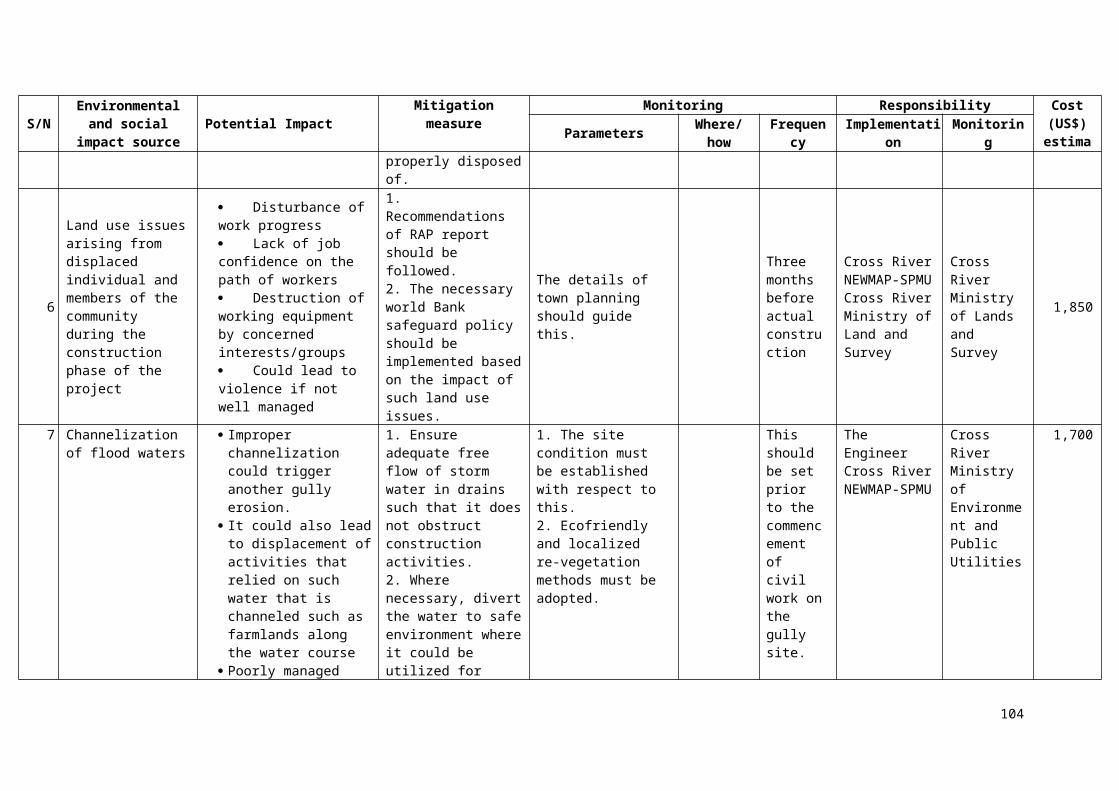
APPENDIX V: Indicative Environmental Code of Conduct and Clauses for Contractorsfrom subsequent claims.
53. In cases where compensation for inconveniences, damage of crops etc. are claimed by the owner, the Client has to be informed by the Contractor through the SE. This compensation is in general settled under the responsibility of the Client before signing the Contract. In unforeseeable cases, the respective administrative entities of the Client will take care of compensation.
Contractor’s Environment, Health and Safety Management Plan (EHS-MP)54. Within 6 weeks of signing the Contract, the Contractor shall prepare an EHS-MP to ensure the adequate management of the health, safety, environmental and social aspects of the works, including implementation of the requirements of these general conditions and any specific requirements of an EMP for the works. The Contractor’s EHS-MP will serve two main purposes:
For the Contractor, for internal purposes, to ensure that all measures are in place for adequate EHS management, and as an operational manual for his staff.
For the Client, supported where necessary by a SE, to ensure that the Contractor is fully prepared for the adequate management of the EHS aspects of the project, and as a basis for monitoring of the Contractor’s EHS performance.
The Contractor’s EHS-MP shall provide at least: a description of procedures and methods for complying with these general environmental management
conditions, and any specific conditions specified in an EMP; a description of specific mitigation measures that will be implemented in order to minimize adverse impacts; a description of all planned monitoring activities (e.g. sediment discharges from burrow areas) and the
reporting thereof; and the internal organizational, management and reporting mechanisms put in place for such.
56. The Contractor’s EHS-MP will be reviewed and approved by the Client before start of the works. This review should demonstrate if the Contractor’s EHS-MP covers all of the identified impacts, and has defined appropriate measures to counteract any potential impacts.
EHS Reporting57. The Contractor shall prepare bi-weekly progress reports to the SE on compliance with these general conditions, the project EMP if any, and his own EHS-MP. An example format for a Contractor EHS report is portrayed in Annex 6. It is expected that the Contractor’s reports will include information on:
EHS management actions/measures taken, including approvals sought from local or national authorities; Problems encountered in relation to EHS aspects (incidents, including delays, cost consequences, etc. as a
result thereof); Lack of compliance with contract requirements on the part of the Contractor; Changes of assumptions, conditions, measures, designs and actual works in relation to EHS aspects; and Observations, concerns raised and/or decisions taken with regard to EHS management during site meetings.
58. It is advisable that reporting of significant EHS incidents be done “as soon as practicable”. Such incident reporting shall therefore be done individually. Also, it is advisable that the Contractor keep his own records on health, safety and welfare of persons, and damage to property. It is advisable to include such records, as well as copies of incident reports, as Annexes to the bi-weekly reports. A sample format for an incident notification is shown below. Details of EHS performance will be reported to the Client through the SE’s reports to the Client.
Training of Contractor’s Personnel59. The Contractor shall provide sufficient training to his own personnel to ensure that they are all aware of the relevant aspects of these general conditions, any project EMP, and his own EHS-MP, and are able to fulfil their expected roles and functions. Specific training should be provided to those employees that have particular responsibilities associated with the implementation of the EHS-MP. General topics should be:
EHS in general (working procedures); emergency procedures; and social and cultural aspects (awareness raising on social issues).
Cost of Compliance60. It is expected that compliance with these conditions is already part of standard good workmanship and state of art as generally required under this Contract. The item “Compliance with Environmental Management Conditions” in the Bill of Quantities covers this cost. No other payments will be made to the Contractor for compliance with any request to avoid and/or mitigate an avoidable EHS impact.
114
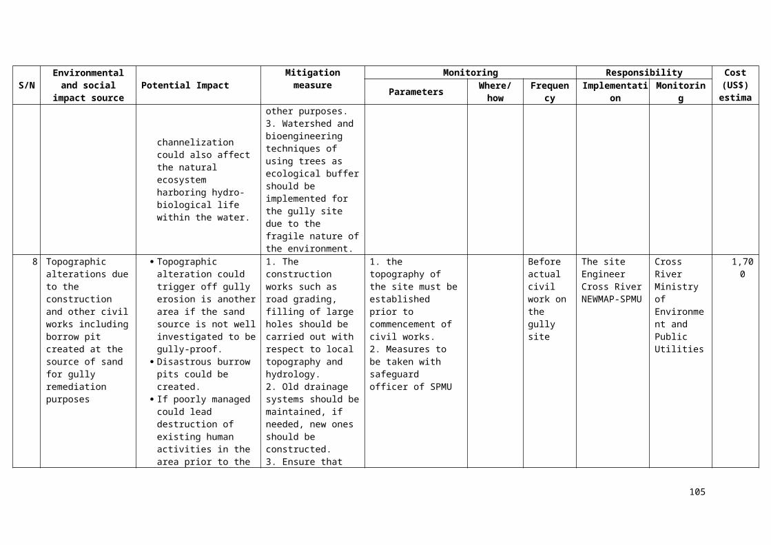
APPENDIX V: Indicative Environmental Code of Conduct and Clauses for Contractors
3. Example Format: EHS Report
Contract: Period of reporting:EHS Management Actions/Measures:Summarize EHS management actions/measures taken during period of reporting, including planning and management activities (e.g. risk and impact assessments), EHS training, specific design and work measures taken, etc.EHS incidents:Report on any problems encountered in relation to EHS aspects, including its consequences (delays, costs) and corrective measures taken. Include relevant incident reports.EHS compliance:Report on compliance with Contract EHS conditions, including any cases of non-compliance.Changes:Report on any changes of assumptions, conditions, measures, designs and actual works in relation to EHS aspects.Concerns and observations:Report on any observations, concerns raised and/or decisions taken with regard to EHS management during site meetings and visits.
Signature (Name, Title Date):Contractor Representative
EHS Incident Notification
Provide within 24 hrs to the Supervising Engineer
Originators Reference No:.........................................................................................................
Date of Incident:................................................................. Time:........................
Location of incident:...................................................................................................................
Name of Person(s) involved:.......................................................................................................
Employing Company:....................................................................................................................
Type of Incident:............................................................................................................................
Description of Incident:Where, when, what, how, who, operation in progress at the time (only factual)
Immediate Action:Immediate remedial action and actions taken to prevent reoccurrence or escalation
Signature (Name, Title, Date):.....................................................................................................Contractor Representative
115