chapter v: planning and land use regulations · pdf file · 2016-03-15minnetrista...
TRANSCRIPT
Minnetrista City Code Chapter V – Planning and Land Use Page 1 of 285
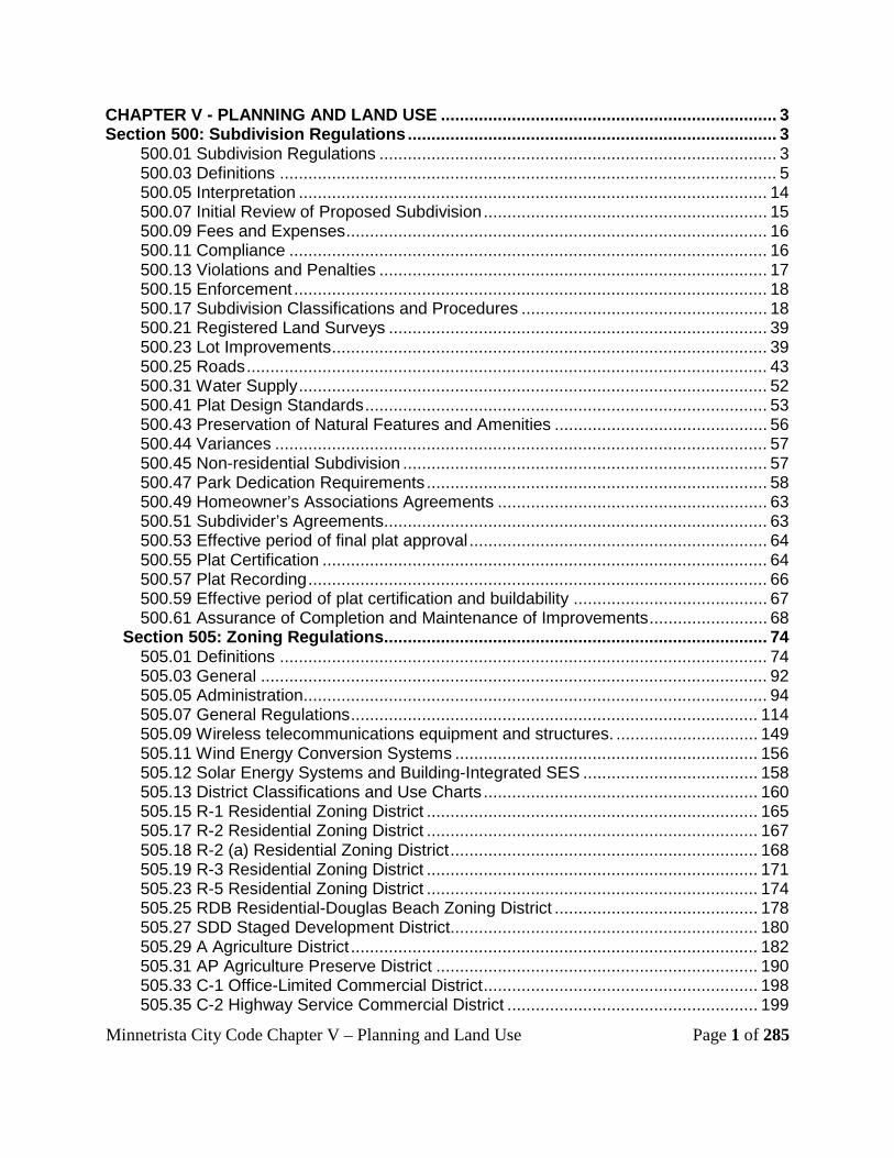
16TCHAPTER V - PLANNING AND LAND USE16T ....................................................................... 3 16TSection 500: Subdivision Regulations16T .............................................................................. 3
16T500.01 Subdivision Regulations 16T .................................................................................... 3 16T500.03 Definitions 16T ......................................................................................................... 5 16T500.05 Interpretation16T ................................................................................................... 14 16T500.07 Initial Review of Proposed Subdivision16T ............................................................ 15 16T500.09 Fees and Expenses 16T ......................................................................................... 16 16T500.11 Compliance16T ..................................................................................................... 16 16T500.13 Violations and Penalties 16T .................................................................................. 17 16T500.15 Enforcement16T .................................................................................................... 18 16T500.17 Subdivision Classifications and Procedures 16T .................................................... 18 16T500.21 Registered Land Surveys 16T ................................................................................ 39 16T500.23 Lot Improvements 16T ............................................................................................ 39 16T500.25 Roads 16T .............................................................................................................. 43 16T500.31 Water Supply16T ................................................................................................... 52 16T500.41 Plat Design Standards 16T ..................................................................................... 53 16T500.43 Preservation of Natural Features and Amenities 16T ............................................. 56 16T500.44 Variances 16T ........................................................................................................ 57 16T500.45 Non-residential Subdivision16T ............................................................................. 57 16T500.47 Park Dedication Requirements 16T ........................................................................ 58 16T500.49 Homeowner’s Associations Agreements16T ......................................................... 63 16T500.51 Subdivider’s Agreements 16T ................................................................................. 63 16T500.53 Effective period of final plat approval16T ............................................................... 64 16T500.55 Plat Certification16T .............................................................................................. 64 16T500.57 Plat Recording16T ................................................................................................. 66 16T500.59 Effective period of plat certification and buildability16T ......................................... 67 16T500.61 Assurance of Completion and Maintenance of Improvements16T ......................... 68
16TSection 505: Zoning Regulations16T ................................................................................. 74 16T505.01 Definitions 16T ....................................................................................................... 74 16T505.03 General16T ........................................................................................................... 92 16T505.05 Administration16T .................................................................................................. 94 16T505.07 General Regulations 16T ...................................................................................... 114 16T505.09 Wireless telecommunications equipment and structures.16T .............................. 149 16T505.11 Wind Energy Conversion Systems16T ................................................................ 156 16T505.12 Solar Energy Systems and Building-Integrated SES 16T ..................................... 158 16T505.13 District Classifications and Use Charts 16T .......................................................... 160 16T505.15 R-1 Residential Zoning District 16T ...................................................................... 165 16T505.17 R-2 Residential Zoning District 16T ...................................................................... 167 16T505.18 R-2 (a) Residential Zoning District 16T ................................................................. 168 16T505.19 R-3 Residential Zoning District 16T ...................................................................... 171 16T505.23 R-5 Residential Zoning District 16T ...................................................................... 174 16T505.25 RDB Residential-Douglas Beach Zoning District16T ........................................... 178 16T505.27 SDD Staged Development District16T ................................................................. 180 16T505.29 A Agriculture District16T ...................................................................................... 182 16T505.31 AP Agriculture Preserve District 16T .................................................................... 190 16T505.33 C-1 Office-Limited Commercial District16T .......................................................... 198 16T505.35 C-2 Highway Service Commercial District 16T ..................................................... 199
Minnetrista City Code Chapter V – Planning and Land Use Page 2 of 285
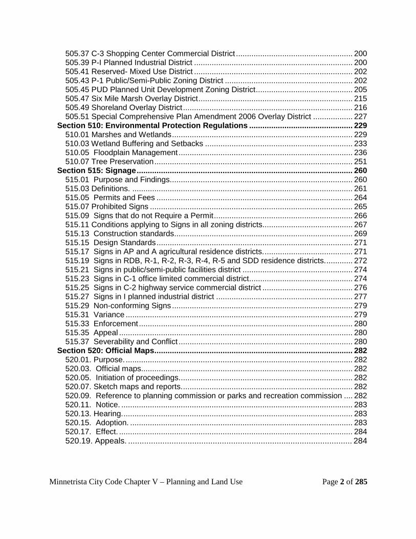
16T505.37 C-3 Shopping Center Commercial District 16T ..................................................... 200 16T505.39 P-I Planned Industrial District 16T ........................................................................ 200 16T505.41 Reserved- Mixed Use District 16T ........................................................................ 202 16T505.43 P-1 Public/Semi-Public Zoning District 16T .......................................................... 202 16T505.45 PUD Planned Unit Development Zoning District16T ............................................ 205 16T505.47 Six Mile Marsh Overlay District 16T ...................................................................... 215 16T505.49 Shoreland Overlay District 16T ............................................................................. 216 16T505.51 Special Comprehensive Plan Amendment 2006 Overlay District 16T .................. 227
16TSection 510: Environmental Protection Regulations16T ............................................... 229 16T510.01 Marshes and Wetlands 16T .................................................................................. 229 16T510.03 Wetland Buffering and Setbacks 16T ................................................................... 233 16T510.05 Floodplain Management16T ............................................................................... 236 16T510.07 Tree Preservation16T .......................................................................................... 251
16TSection 515: Signage16T .................................................................................................. 260 16T515.01 Purpose and Findings. 16T .................................................................................. 260 16T515.03 Definitions. 16T .................................................................................................... 261 16T515.05 Permits and Fees 16T ......................................................................................... 264 16T515.07 Prohibited Signs 16T ............................................................................................ 265 16T515.09 Signs that do not Require a Permit16T ............................................................... 266 16T515.11 Conditions applying to Signs in all zoning districts 16T......................................... 267 16T515.13 Construction standards 16T ................................................................................. 269 16T515.15 Design Standards 16T ......................................................................................... 271 16T515.17 Signs in AP and A agricultural residence districts.16T ........................................ 271 16T515.19 Signs in RDB, R-1, R-2, R-3, R-4, R-5 and SDD residence districts.16T ............ 272 16T515.21 Signs in public/semi-public facilities district16T .................................................. 274 16T515.23 Signs in C-1 office limited commercial district16T ............................................... 274 16T515.25 Signs in C-2 highway service commercial district 16T ......................................... 276 16T515.27 Signs in I planned industrial district 16T .............................................................. 277 16T515.29 Non-conforming Signs 16T .................................................................................. 279 16T515.31 Variance16T ....................................................................................................... 279 16T515.33 Enforcement16T ................................................................................................. 280 16T515.35 Appeal .......................................................................................................... 280 16T515.37 Severability and Conflict 16T ............................................................................... 280
16TSection 520: Official Maps16T .......................................................................................... 282 16T520.01. Purpose. 16T ....................................................................................................... 282 16T520.03. Official maps.16T ............................................................................................... 282 16T520.05. Initiation of proceedings. 16T .............................................................................. 282 16T520.07. Sketch maps and reports. 16T ............................................................................. 282 16T520.09. Reference to planning commission or parks and recreation commission 16T .... 282 16T520.11. Notice. 16T ......................................................................................................... 283 16T520.13. Hearing. 16T ........................................................................................................ 283 16T520.15. Adoption. 16T ..................................................................................................... 283 16T520.17. Effect.16T .......................................................................................................... 284 16T520.19. Appeals.16T .................................................................................................. 284

Minnetrista City Code Chapter V – Planning and Land Use Page 3 of 285
CHAPTER V - PLANNING AND LAND USE
Section 500: Subdivision Regulations 500.01 Subdivision Regulations
Subdivision 1. UAuthorityU. Pursuant to the powers and jurisdictions vested through Minnesota Statutes, chapters 412 and 462, and other applicable laws, statutes, ordinances and regulations of the state, the city does hereby exercise the power and authority to review, approve, and disapprove subdivisions of land within the corporate limits of the city. By the same authority, the city does exercise the power and authority to pass and approve the development of subdivisions of land already recorded in the county recorder's office if such subdivisions are entirely or partially undeveloped.
Subd. 2. UPolicy. (a) It is the policy of the city to consider the subdivision of land and the
subsequent development of subdivided land as subject to the control of the city pursuant to the official comprehensive municipal plan of the city and this section for the orderly, planned, efficient, and economical development of the city.
(b) Land to be subdivided will be of such character that it can be used safely
for building purposes without danger to health or peril from fire, flood, or other menace. Land will not be subdivided until available public and private facilities and improvements exist and proper provision has been made for drainage, water, sewerage, and capital improvements such as schools, parks, recreation facilities, transportation facilities and other public improvements.
(c) The existing and proposed public and private improvements will conform
to and be properly related to the proposals shown in the comprehensive municipal plan of the city and it is intended that this section will supplement and facilitate the enforcement of the provisions and standards contained in the building codes, zoning codes, on-site sewage treatment codes and comprehensive municipal plan of the city.
Subd. 3. UPurposeU. This section is adopted for the following purposes: (a) To protect and provide for the public health, safety, and general welfare of
the city and to prevent harm to the public health, safety and general welfare;
(b) To guide the future growth and development of the city in accordance with
the comprehensive municipal plan;

Minnetrista City Code Chapter V – Planning and Land Use Page 4 of 285
(c) To provide for adequate light, air, and privacy, to secure safety from fire,
flood, and other danger, and to prevent overcrowding of the land and undue congestion of population;
(d) To protect the character and the social and economic stability of all parts
of the city and to encourage the orderly and beneficial development of all parts of the city;
(e) To protect and conserve the value of land throughout the city and the
value of structures and other improvements upon the land, and to minimize the conflicts among the uses of land;
(f) To guide public and private policy and action in order to provide adequate
and efficient transportation, water, sewerage, schools, parks, playgrounds, recreation and other public requirements and facilities;
(g) To provide the most beneficial relationship between the uses of land and
buildings and the circulation of traffic throughout the city having particular regard to the avoidance of congestion in the streets and highways, and the pedestrian traffic movements appropriate to the various uses of land and buildings, and to provide for the proper location and width of streets and building lines;
(h) To establish reasonable standards of design and procedures for
subdivisions and resubdivisions, in order to further the orderly layout and use of land; and to ensure proper legal descriptions and monumenting of subdivided land;
(i) To ensure that public and private facilities are available and will have a
sufficient capacity to serve the proposed subdivision; (j) To prevent the pollution of air, streams, ponds, wetlands, Lake
Minnetonka and other bodies of water; to assure the adequacy of drainage facilities; to safeguard the water table; and to encourage the wise use and management of natural resources throughout the city to prevent their misuse, abuse and overuse and in order to preserve the integrity, stability, and beauty of the community and the value of the land.
Subd. 4. UScope. This section applies to all subdivisions of land located within the corporate limits
of the city. Subd. 5. UBuilding permitsU.

Minnetrista City Code Chapter V – Planning and Land Use Page 5 of 285
No certificate of occupancy or building permit will be issued for the construction of a structure on lots or tracts pertaining to the subdivisions that violate provisions of this section.
500.03 Definitions The following words, terms and phrases, when used in this section, will have the
meanings ascribed to them in this subsection, except where the context clearly indicates a different meaning:
Alley means a public or private right-of-way primarily designed to serve as
secondary access to the side or rear of those lots whose principal frontage is on some other street.
Applicant means any subdivider or subdivider’s agent. Block means a tract of land bounded by streets, or by a combination of streets
and public parks, cemeteries, rights-of-way, exterior boundaries of the subdivision, shorelines of waterways, outlots or boundary lines of municipalities.
Bond means any form of security including a cash deposit, surety bond, warranty
bond, penalty bond, collateral, property, or instrument of credit. Building means any structure or any part thereof built for the support, shelter or
enclosure of persons, animals, chattels or movable property of any kind. Building site line means a line on the preliminary plat which delineates the dry
buildable land of any lot upon which a structure may be constructed, which land meets all of the setback requirements of the zoning regulations adopted by the city.
Comprehensive municipal plan means a compilation of policy statements, goals,
standards, and maps and recommendations for their execution, prepared and adopted by the city for guiding the physical, social and economic development, both private and public, of the city and its environs and to protect the public health, safety and welfare, and may include, but is not limited to, the following:
(a) Statements of policies, goals and standards; (b) "Land use plan" which means a compilation of policy statements, goals,
standards, and maps and action programs for guiding the future development of private and public property. The term includes a plan designating types of uses for the entire city as well as a specialized plan showing specific areas or specific types of land uses, such as residential, commercial, industrial, public or semipublic uses or any compilation of such uses;

Minnetrista City Code Chapter V – Planning and Land Use Page 6 of 285
(c) "Transportation plan" which means a compilation of policy
statements, goals, standards, maps and action programs for guiding the future development of the various modes of transportation of the city and its environs such as streets and highways, public transit, railroads, air transportation, trucking and water transportation, and includes a major thoroughfare plan;
(d) "Community facilities plan" which means a compilation of policy
statements, goals, standards, maps and action programs for guiding the future development of the public or semipublic facilities of the city such as recreational, educational and cultural facilities;
(e) "Capital improvement program" which means an itemized program
setting forth the schedule and details of specific contemplated public improvements by fiscal year, together with their estimated cost, the justification for each improvement, the impact that such improvements will have on the current operating expense of the city, and such other information on capital improvements as may be pertinent;
(f) "Official map" which means a map adopted in accordance with
Minnesota Statutes, section 462.359 showing existing streets, proposed future streets, the area needed for widening of existing streets and area for other necessary public land and facilities such as parks;
(g) "Surface water management plan" which means a compilation of
policy statements, goals, standards, maps and action programs for guiding the future hydrological and hydraulic development of the watersheds and subwatersheds, water storage areas, drainageways, floodways and filtration systems of the city to control surfaced water runoff, flood hazards, flood damage and general water quality within the city and its environs including lakes, streams, wetlands, marshes, natural watercourses and storm sewer systems or facilities;
(h) "Comprehensive sewer plan" which means a compilation of policy
statements, goals, standards, maps and action programs for the preservation and best use of waters and other natural resources of the city, for the prevention, control and abatement of water pollution in the city, and for the efficient and economic collection, treatment and disposal of sewage in the city.

Minnetrista City Code Chapter V – Planning and Land Use Page 7 of 285
Construction plan means the maps or drawings, accompanying a subdivision, showing the specific location and design of required public or private improvements to be installed in the subdivision in accordance with the requirements of the city or this section as a condition of the approval of the subdivision.
Cul-de-sac means a local street with only one outlet and having an
appropriate terminal for the safe and convenient reversal of traffic movement.
Density means the number of building sites per acre. Design standards means the specification to the subdivider for preparation
of preliminary and final plats, including, but not limited to the optimum, minimum or maximum dimensions of such items as rights-of-way, blocks, easements and lots, public and private improvements.
Drainfield area, possible means land area occurring within the property lines of a parcel or lot not serviced by the public sanitary sewer system; such land area excludes: flood plains as defined in section 510.05; all land below the ordinary high water level of "public waters" and "wetlands" as defined in Minnesota Statutes, section 103G.005; the "flood plain and wetlands conservation area" as defined in section 510.01; minimum setbacks required of on-site sewer treatment systems, as prescribed in section 505.49, subd. 8. Land meeting the definition of possible drainfield area indicates a likelihood that an on-site sewer treatment system may function properly on the subject land, but it is not a guarantee. (See the following definitions: ordinary high water level, slope.)
Dry buildable land means the land area occurring within the property lines
of a parcel or lot, excluding: drainageways; flood plains as defined in section 510.05; all land below the ordinary high water level of "public waters" and "wetlands" as defined in Minnesota Statutes, section 103G.005; the "flood plain and wetlands conservation area" as defined in section 510.01; slopes thirty percent or greater; and required principal and accessory structure setbacks, whichever are applicable.
Any slope with at least a 50 foot horizontal run located in a shoreland
district, as established in the zoning section 505.49, subd. 6; that is greater than twelve percent but less than thirty percent is a conditionally buildable slope and may be considered dry buildable land only if the particular slope meets the criteria prescribed in section 505.07, subd 6.
Any slope with at least a 50 foot horizontal run not located within a
shoreland district that is greater than eighteen percent but less than thirty percent is a conditionally buildable slope and may be considered dry buildable land only if the particular slope meets the criteria prescribed in section 505.07, subd. 6.

Minnetrista City Code Chapter V – Planning and Land Use Page 8 of 285
(See the following definitions: ordinary high water level, slope, conditionally buildable slope.)
Easement means authorization by a property owner for the use by
another, and for a specified purpose, of any designated part of owner’s property. Escrow means a deposit of cash with the city.
Flexible zoning includes, but is not limited to, all special or conditional use
permits, variances, planned unit development and rezoning. Grade means the slope of a road, street, or other public way, site or
topography specified in percentage terms.
Health and environmental sanitation officer means the agency and/or person designated by the city to administer the health and environmental sanitation regulations of the city.
Improvements means any building, structure, drainage ditch, dam,
roadway, parkway, sidewalk, pedestrian way, trees, shrubs, lawn, off-street parking area, sewer and water utilities, or other facility.
Improvements, lot means any improvement on the lot. Improvements, private means any improvement, required by this section,
which improvement the city or subdivider will construct at subdivider's expense and for which the city will not assume any responsibility for its maintenance and operation and which will not be dedicated to the city.
Improvements, public means any improvement, required by this section,
which improvement the city or subdivider will construct at subdivider's expense and for which the city will ultimately assume the responsibility for its maintenance and operation upon issuance of the certificate of satisfactory completion.
Lot means a tract, plot or portion of a subdivision or other parcel or land
intended as a unit for the purpose, whether immediate or future, of transfer of ownership or for building development. Every platted lot will be a buildable lot or an outlot.
Lot area, minimum means the minimum area requirement for each
proposed lot as prescribed in the zoning regulations adopted by the city. Each proposed lot to be serviced by the public sanitary sewer system
must have a contiguous area of dry buildable land equal to at least thirty percent of the minimum required lot area for that use district.

Minnetrista City Code Chapter V – Planning and Land Use Page 9 of 285
Each proposed lot to be serviced by an on-site sewer treatment system rather than the public sanitary sewer system must have the following:
(a) A contiguous area of dry buildable land equal to 10,000 square feet
for a principal structure; such 10,000 square feet must include an area measuring at least 60 feet by 125 feet;
(b) A contiguous area of dry buildable land equal to 2,000 square feet
for an accessory structure; such 2,000 square feet need not be immediately adjacent to the principal structure building site but must be accessible over the subject lot;
(c) 14,000 square feet of contiguous possible drainfield area; such
14,000 square feet will be located such that it will reasonably service the principal structure for which the drainfield is intended; such 14,000 square feet of possible drainfield area may be situated so as to have two separated sites of at least 7,000 square feet of contiguous area each.
Any area of the proposed lot that meets the definitions of both dry
buildable land and possible drainfield area may be used to meet the minimum requirements of either, but may not be used to satisfy the minimum requirements of both.
Public and private rights-of-way, or vehicular or pedestrian easements
may not be used in order to meet any portion of the minimum lot area requirements. This right-of-way and easement provision will not apply to subdivisions in the AP-agriculture preservation and A-agriculture zoning districts.
Lot, buildable means a lot or combination of lots or outlots which meet all
of the requirements of the zoning regulations of the city and this section for the intended purpose.
Lot, corner means a lot situated at the intersection of two streets, the
interior angle of such intersection not exceeding 135 degrees. Lot, outlot means a lot which is intended only for public or private
roadways, open space or other use, which use must be restricted by the appropriate easement and which use must be approved by the city at the time of final plat approval. The use of the outlot will thereafter be restricted by the appropriate restrictive covenant or open space easement.
Lot, width means the shortest dimension between opposite lot lines
measured at all of those points as required by the zoning regulations adopted by the city and this section.
Minnetrista City Code Chapter V – Planning and Land Use Page 10 of 285
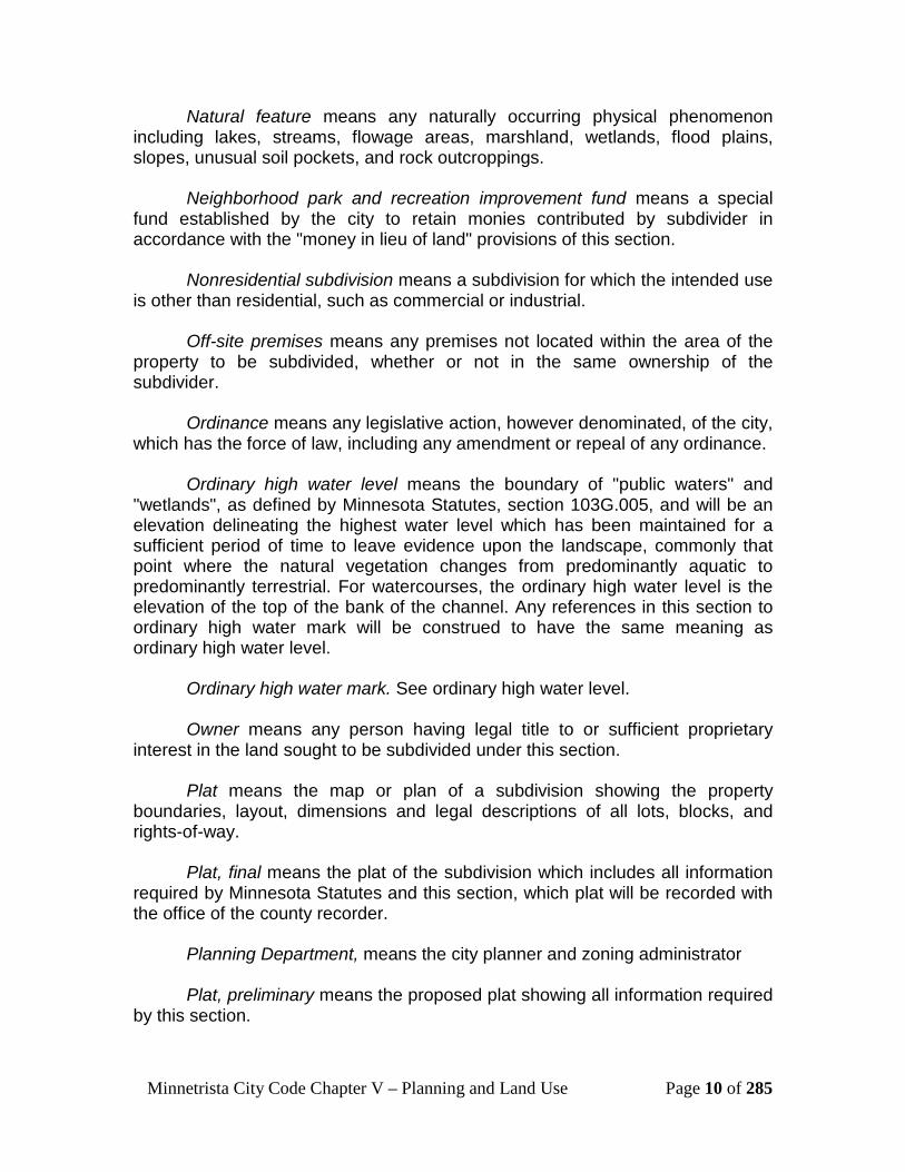
Natural feature means any naturally occurring physical phenomenon including lakes, streams, flowage areas, marshland, wetlands, flood plains, slopes, unusual soil pockets, and rock outcroppings.
Neighborhood park and recreation improvement fund means a special fund established by the city to retain monies contributed by subdivider in accordance with the "money in lieu of land" provisions of this section.
Nonresidential subdivision means a subdivision for which the intended use
is other than residential, such as commercial or industrial. Off-site premises means any premises not located within the area of the
property to be subdivided, whether or not in the same ownership of the subdivider.
Ordinance means any legislative action, however denominated, of the city,
which has the force of law, including any amendment or repeal of any ordinance. Ordinary high water level means the boundary of "public waters" and
"wetlands", as defined by Minnesota Statutes, section 103G.005, and will be an elevation delineating the highest water level which has been maintained for a sufficient period of time to leave evidence upon the landscape, commonly that point where the natural vegetation changes from predominantly aquatic to predominantly terrestrial. For watercourses, the ordinary high water level is the elevation of the top of the bank of the channel. Any references in this section to ordinary high water mark will be construed to have the same meaning as ordinary high water level.
Ordinary high water mark. See ordinary high water level. Owner means any person having legal title to or sufficient proprietary
interest in the land sought to be subdivided under this section. Plat means the map or plan of a subdivision showing the property
boundaries, layout, dimensions and legal descriptions of all lots, blocks, and rights-of-way.
Plat, final means the plat of the subdivision which includes all information
required by Minnesota Statutes and this section, which plat will be recorded with the office of the county recorder.
Planning Department, means the city planner and zoning administrator Plat, preliminary means the proposed plat showing all information required
by this section.

Minnetrista City Code Chapter V – Planning and Land Use Page 11 of 285
Platting authority means the city council pursuant to Minnesota Statutes, section 462.358.
Property line means the boundary lines enclosing a lot, parcel or tract of
land. Regardless of the legal description, the property line to be used for purposes of compliance with the city zoning regulations and this section will be the ordinary high-water mark of any lakeshore, the edge of the right-of-way or the edge of any public or private roadway.
Public hearing means a hearing to be held by the platting authority to allow for public review and input relating to the proposed subdivision.
Public information hearing means discretionary hearing to be held by the planning commission to allow for public review and input relating to the proposed subdivision. This meeting will not constitute the "public hearing" by the platting authority pursuant to Minnesota Statutes, section 462.358.
Registered engineer means an engineer properly licensed and registered
in the state. Registered land surveyor means a land surveyor properly licensed and
registered in the state. Resubdivision means a change in a recorded final plat if such change
affects any street layout on such plat, or any lot line. Right-of-way means a strip of land occupied or intended to be occupied by
an alley, street, crosswalk, railroad, public or private roadway or easement, electric transmission line, oil or gas pipeline, water main, sanitary or storm sewer main, or for another special use.
Roadway means any street, highway, road, lane, way, trail, or any other
area used for vehicular traffic. Roadway right-of-way width means the distance between property lines
measured at right angles to the centerline of the roadway. Sale or lease means any immediate or future transfer of ownership, or any
possessory interest in land, including contract of sale, lease, device, intestate succession, of an interest in a tract of land or part thereof, whether by metes and bounds, deed, contract, plat, map, judicial decree or other written instrument. Lease of land for agricultural purposes, which land does not include the use of or future construction of a building is excluded.
Same ownership means ownership by the same person, corporation, firm,
entity, partnership, or unincorporated association; or ownership by different corporations, firms, partnerships, entities or unincorporated associations, in
Minnetrista City Code Chapter V – Planning and Land Use Page 12 of 285
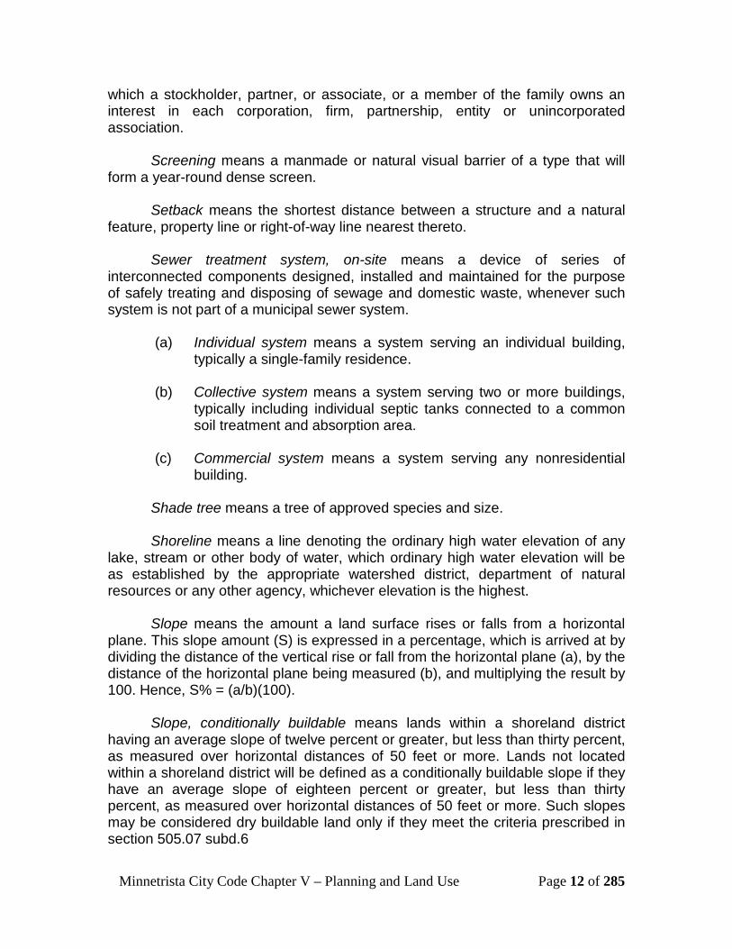
which a stockholder, partner, or associate, or a member of the family owns an interest in each corporation, firm, partnership, entity or unincorporated association.
Screening means a manmade or natural visual barrier of a type that will
form a year-round dense screen. Setback means the shortest distance between a structure and a natural
feature, property line or right-of-way line nearest thereto.
Sewer treatment system, on-site means a device of series of interconnected components designed, installed and maintained for the purpose of safely treating and disposing of sewage and domestic waste, whenever such system is not part of a municipal sewer system.
(a) Individual system means a system serving an individual building,
typically a single-family residence. (b) Collective system means a system serving two or more buildings,
typically including individual septic tanks connected to a common soil treatment and absorption area.
(c) Commercial system means a system serving any nonresidential
building.
Shade tree means a tree of approved species and size. Shoreline means a line denoting the ordinary high water elevation of any
lake, stream or other body of water, which ordinary high water elevation will be as established by the appropriate watershed district, department of natural resources or any other agency, whichever elevation is the highest.
Slope means the amount a land surface rises or falls from a horizontal
plane. This slope amount (S) is expressed in a percentage, which is arrived at by dividing the distance of the vertical rise or fall from the horizontal plane (a), by the distance of the horizontal plane being measured (b), and multiplying the result by 100. Hence, S% = (a/b)(100).
Slope, conditionally buildable means lands within a shoreland district having an average slope of twelve percent or greater, but less than thirty percent, as measured over horizontal distances of 50 feet or more. Lands not located within a shoreland district will be defined as a conditionally buildable slope if they have an average slope of eighteen percent or greater, but less than thirty percent, as measured over horizontal distances of 50 feet or more. Such slopes may be considered dry buildable land only if they meet the criteria prescribed in section 505.07 subd.6
Minnetrista City Code Chapter V – Planning and Land Use Page 13 of 285
Structure means anything or part thereof which is built, constructed or
erected, an edifice or building of any kind, or any piece of work artificially built or composed of parts joined together in some definite manner, which requires a location on, below or above the ground.
Subdivider means any person who: (a) Has an interest in land, who causes it, directly or indirectly to be
divided into a subdivision; or (b) Directly or indirectly, sells, leases, or develops or offers to sell,
lease, or develop, or advertises for sale, lease, or development, any interest, lot, parcel, site, unit or plot in a subdivision; or
(c) Engages directly or through an agent in the business of selling,
leasing, developing, or offering for sale, lease or development a subdivision or any interest, lot, parcel, site, unit or plot in a subdivision; or
(d) Is directly or indirectly controlled by or under direct, or indirect
common control with any of the foregoing.
Subdivider's agent means any person who represents, or acts for or on behalf of, a subdivider in selling, leasing or developing, or offering to sell, lease, or develop any interest, lot, parcel, unit, site or plot in a subdivision.
Subdivision means any land, vacant or improved, which is divided or
proposed to be divided into two or more lots, parcels, sites, units, plots, or interests for the purpose of offer, sale, lease or development, either on the installment plan or upon any and all other plans, terms, and conditions, including resubdivision. "Subdivision" includes the division or development of residential and nonresidential zoned land, whether by deed, contract for deed, purchase agreement, metes and bounds description, registered land survey, replatting, easements for private or public purposes, lot rearrangements, division of any land previously combined for tax purposes, devise, intestacy, lease, map, plat, judicial decree, or other recorded or nonrecorded instrument.
Temporary improvement means improvements built and maintained by a
subdivider during construction of the subdivision. Tract or subject tract means the parcel or parcels of land comprising all
the contiguous land owned or controlled by the subdivider and included in whole or part in the subdivision.

Minnetrista City Code Chapter V – Planning and Land Use Page 14 of 285
Variance means a deviation or variation from the standards of this ordinance.
Water system (individual) means a water system which may include
supply, treatment and distribution which serves only one (1) lot (e.g., private well).
Water system (private community) means a water system which may
include supply, treatment and distribution facilities, established by a subdivider to serve two or more lots, which system is independent from the public water system.
Water system (public) means a water system which may include supply,
treatment and distribution facilities owned and maintained by the city. Zoning administrator means the officer as appointed by the city to
administer and enforce this section and to assist administratively the city council and planning commission.
500.05 Interpretation
Subdivision 1. UMinimum standardsU. In their interpretation and application, the provisions of this section will be
held to be the minimum requirements for the promotion of the public health, safety and general welfare and prevention of harm to the public health, safety and general welfare.
Subd. 2. UConflict with public provisionsU. This section is not intended to interfere with, abrogate, or annul any other
ordinance, rule or regulation, statute, or other provision of law. Where any provision of this section imposes restrictions different from those imposed by any other provision of this section or any other ordinance, rule or regulation, statute or other provision of law, whichever provisions are more restrictive or impose higher standards will control.
Subd. 3. UConflict with private provisionsU. This section is not intended to abrogate any easement, covenant or any
other private agreement or restrictions, provided that where the provisions of this section are more restrictive or impose higher standards or regulations than such easement, covenant, or other private agreement or restriction, the requirements of this section will govern. Where the provisions of the easement, covenant, or private agreement or restriction impose duties and obligations more restrictive, or higher standards than the requirements of this section, or the determinations of the city in approving a subdivision or in enforcing this section, and such private provisions are not inconsistent with this section or determinations thereunder,
Minnetrista City Code Chapter V – Planning and Land Use Page 15 of 285
then such private provisions will be operative and supplemental to this section and determinations made thereunder. The city will not enforce private provisions.
Subd. 4. USaving provisionU. This section will not be construed as abating any action now pending
under, or by virtue of, prior existing subdivision regulations, or as discontinuing, abating, modifying, or altering any penalty accruing or about to accrue, or as affecting the liability of any person, firm, or corporation, or as waiving any right of the city under any section or provision existing at the time of adoption of this section, or as vacating or annulling any rights obtained by any person by lawful action of the city except as will be expressly provided for in this section.
Subd. 5. UAmendments of other codes and regulationsU. Whenever the provisions of this section refer to the comprehensive
municipal plan, zoning code or other ordinances, codes, regulations or laws, it will be deemed to refer to those plans, codes, ordinances and regulations as amended as of that point in time. In the event of an amendment during the application for a subdivision, then that subdivision relies on the ordinances in effect at the time of application.
Subd. 6. UInterpretation of certain wordsU. In this section, the word "used" or "occupied" as applied to any land or
building will be construed to include the words "intended, arranged, or designed to be used or occupied."
500.07 Initial Review of Proposed Subdivision
Subdivision 1. UInitial staff reviewU. Any person proposing subdivision of land within the city will meet with the
planning department to review briefly the proposed subdivision, to obtain a copy of this section and receive advice concerning platting requirements, required submittals, fees and schedules. The planning department will classify the proposed subdivision.
Subd. 2. UCompliance with zoning regulationsU. Every plat will conform to existing zoning regulations and subdivision
regulations applicable at the time of final plat approval. Variances will not be approved to increase the overall subdivision density above the minimum lot area requirements of the applicable zoning district and this section.

Minnetrista City Code Chapter V – Planning and Land Use Page 16 of 285
500.09 Fees and Expenses
Subdivision 1. The subdivider will pay all city fees required by resolution and will further
reimburse the city for all the reasonable expenses it incurs in regard to the review and approval of the subdivision and improvements including, but not limited to, direct city payroll and overhead, costs, fees paid to consultants and other professionals, and the costs of printing, mailing and supplies. The city administrator will determine the estimated escrow amounts to cover these estimated expenses.
Subd. 2. An escrow deposit will be made at the time of application for final
subdivision approval. Within 60 days after the city engineer has executed the certificate of satisfactory completion, the city will remit to subdivider any amounts remaining after the city has charged against the escrow account all expenses incurred by the city for the above services. In the event that the charges incurred by the city exceed the escrow amount, the subdivider will pay to the city the excess within 30 days after receipt of a statement therefore.
500.11 Compliance
Subdivision 1. No land which first requires an approved subdivision may be sold and no
land will be subdivided within the corporate limits of the city until the subdivider has obtained approval of the subdivision and the approved final plat is filed with the county recorder's office.
Subd. 2. No building permit or certificate of occupancy will be issued for any parcel
or lot of land which was created by subdivision and not in conformity with the provisions of this section and no excavation of land or construction of any public or private improvements will take place or be commenced except in conformity with this section.
Subd. 3. No subdivision will be entitled to be recorded in the county recorder's
office or have any validity until the subdivision has been prepared, approved, and acknowledged in the manner prescribed by this section. The office of the county recorder will not file or accept for filing any subdivision of land unless it is accompanied by a certified copy of the resolution of the city approving the subdivision.

Minnetrista City Code Chapter V – Planning and Land Use Page 17 of 285
Subd. 4. Regulation of the subdivision of land and the attachment of reasonable
conditions to the subdivision of land is an exercise of valid police power delegated by the state to this city. The subdivider has the duty of compliance with reasonable conditions laid down by the city for design, dedication, improvement and restrictive use of the land so as to conform to the physical and economical development of the city and the city's comprehensive municipal plan and to the safety and general welfare of the future lot owners in the subdivision and of the community at large.
500.13 Violations and Penalties
Subdivision 1. No subdivider or subdivider's agent, of any lot or parcel of land located in
a proposed subdivision will transfer or sell any such parcel or lot before the subdivision has been approved by the city, in accordance with the provisions of this section, and filed with the county recorder's office.
Subd. 2. The subdivision of any lot or any parcel of land for the purpose of sale,
transfer or lease by use of metes and bounds description, deed, contract for deed, purchase agreement, registered land survey or easement, will not be permitted except after full compliance with this section.
Subd. 3. Notwithstanding any language herein to the contrary, a subdivider may
execute a purchase agreement which provides for the sale of a proposed lot or parcel, which lot or parcel will not legally exist until after full compliance with this section, as long as the purchase agreement provides that in the event the city does not approve the subdivision, all earnest money paid will be refunded to the purchaser.
Subd. 4. Any subdivider or subdivider's agent who sells or transfers a lot in violation
of this section will be guilty of a misdemeanor. Subd. 5. Any subdivider or subdivider's agent who fails to comply with, or violates
any of the provisions of this section will be guilty of a misdemeanor. The city may withhold, revoke or deny any permits, approvals or any action required or if there is a violation of this section. Each week during which violation exists will constitute a separate violation. The city may apply to the district court for injunctive relief for violation of this section.

Minnetrista City Code Chapter V – Planning and Land Use Page 18 of 285
Subd. 6. Any subdivider or subdivider's agent who conveys a lot or parcel in
violation of this section will forfeit and pay to the city a penalty of not less than $100 for each lot or parcel so conveyed. Appropriate actions and proceedings may be taken by law or in equity to prevent any violation of this section, to prevent unlawful construction, to recover damages, to restrain, correct or abate a violation, to prevent illegal occupancy of a building, structure or premises, and these remedies will be in addition to the penalties described above.
500.15 Enforcement It will be the duty of the planning department to enforce this section and to
bring to the attention of the city prosecuting attorney any violations or lack of compliance herewith.
500.17 Subdivision Classifications and Procedures
Subdivision 1. Simple Subdivision (a) A simple subdivision is the transfer of property for the purpose of
combining with an adjoining property and which does not result in a new buildable lot. Such transfer must occur between two parcels which meet all zoning requirements, both before and after the subdivision, without need for approval of a variance.
(b) Application form. The following items shall be submitted in order for an application to be considered complete:
(1) A completed land use application form and payment of
associated fee; (2) Current title evidence satisfactory to the City shall be
provided by the applicant. (3) A survey by a registered land surveyor of the lots or tracts to
be subdivided. The survey will, at the discretion of the planning department, show the location of all proposed lot lines, existing lot lines, existing and proposed structures that affect the subdivision, road right-of-ways and any additional information as found necessary.
(4) Certification that there are no delinquent property taxes, special assessments, penalties, interest due on the parcel and municipal utility fees due on the parcel.
(5) Additionally, simple subdivisions requiring a variance are required to submit a written response to the variance review criteria.

Minnetrista City Code Chapter V – Planning and Land Use Page 19 of 285
(6) Legal descriptions of the proposed new lot lines, and a copy of the quit claim deed, if applicable;
(c) Council action. Following the review of a simple subdivision
application by the planning department of the lot, or lots to be subdivided, the planning department will cause the application to be placed upon the agenda of the city council for the next regular meeting following such review. The planning department will transmit to the city council the application and all materials related thereto, with a staff recommendation concerning the application. Action on this application will be taken within the timelines set forth by Minnesota Statute 462.358.
Subd. 2. Expedited Subdivisions (a) A subdivision or lot combination which divides or combines an area or
tract of land into one or two parcels when such area or tract of land exists as a unit or contiguous units of land under single ownership and meets the following criteria:
1) The subdivision results in no more than two buildable lots;
2) The subdivision results in buildable lots where each resulting lot meets applicable zone classification lot size and each lot has at least the minimum zone classification frontage on an improved public road;
3) The subdivision may be a division of property previously
combined for tax purposes;
4) The subdivision does not involve the vacation or dedication of any public roadways;
5) The subdivision does not involve the extension of municipal
utilities, and; 6) The subdivision does not involve any flexible zoning application. (b) The applicant shall submit the following information to be considered a complete application for expedited subdivision review:
(1) A complete land use application form and payment of associated fee;
Minnetrista City Code Chapter V – Planning and Land Use Page 20 of 285
(2) Current title evidence satisfactory to the City shall be provided by the applicant.
(3) A survey by a registered land surveyor of the lots or tracts to
be subdivided or combined. The survey will, at the discretion of the planning department, show the location of all proposed lot lines, existing lot lines, existing and proposed structures that affect the subdivision, road right-of-ways and any additional information as found necessary;
(4) Certification that there are no delinquent property taxes,
special assessments, penalties, interest due on the parcel and municipal utility fees due on the parcel;
(5) In areas served by public sewer and/or water, plans showing
the existing service ties and the proposed connection sizes and locations. Copies will be provided if the plan size exceeds eight and one-half (8 1/2) by 14 inches;
(6) A proposed utility plan, if applicable;
(7) A soil survey and report by the Hennepin Soil and Water Conservation District (if requested by the city);
(8) A soil erosion and sedimentation control plan, if applicable; (9) A vegetation preservation and protection plan, if applicable;
(10) Where the subdivider is the owner or intends to attempt to
acquire the property adjacent to that property which is being proposed for the subdivision, the planning department may require that the subdivider submit a sketch plan of the remainder of the property so as to show the possible relationships between the proposed subdivision and any future subdivision. In any event, all subdivisions will be shown to relate well with existing or potential adjacent subdivisions;
(11) Any additional information requested by the planning
commission, planning department or city council. (c) After reviewing and discussing the application, the planning department will prepare a report for planning commission, parks commission, and City Council. The City Council shall approve or deny the expedited subdivision, based on compliance with the provisions of this

Minnetrista City Code Chapter V – Planning and Land Use Page 21 of 285
chapter. The city shall take action on this application within the time frame specified in Minnesota Statute 462.358.
Subd. 3. Class I and Class II Subdivisions (a) A class I subdivision is a subdivision which results in no more than
three buildable lots where each resulting lot meets or exceeds ten acres (435,600 square feet) of land, and each lot has at least 300 feet of frontage on a public road which has been accepted and opened by the city and/or no flexible zoning application or extension of municipal utilities is involved.
(b) A class II subdivision is a subdivision which results in no more than
three buildable lots, which do not meet the acreages criteria of a Class I subdivision; and the subdivision does not involve the vacation or dedication of any public roadways , the extension of any municipal utilities, or any flexible zoning application.
(c) Procedure for Class I and Class II subdivisions: 1) The planning department and parks commission shall
review all preliminary plat applications for Class I and II subdivisions and make a recommendation for approval or denial to the city council.
2) The planning commission shall conduct a public hearing, in
accordance with state statute, review the proposed plat, and formulate a recommendation for approval or denial to the city council.
3) The city council shall review all preliminary plat applications,
and approve a resolution approving or denying the preliminary plat. Approval will allow the applicant to move forward to the final plat.
4) The city council shall review the final plat to ensure
compliance with the approved preliminary plat
(d) Submittal requirements for preliminary plat. All Class I and Class II subdivisions shall be completed by submittal of a plat. The following information is required for a preliminary plat application for a Class I or Class II subdivision to be considered complete:
(1) A completed and signed land use application form and
payment of applicable fee;
(2) Copies of the preliminary plat as required by the planning department that includes the proposed lot lines, lot sizes,

Minnetrista City Code Chapter V – Planning and Land Use Page 22 of 285
impervious surface percentages, and adequate building envelopes, as specifically outlined in subdivision 4 (d);
(3) Certificate of survey of the property;
(4) In areas not served by public sewer, an on-site sewage treatment site evaluation report for each lot indicating a primary and secondary septic system site, and a copy of the current compliance inspection report for each existing on-site system;
(5) Submittal of title evidence satisfactory to the city;
(6) Any additional information requested by the planning commission, planning department or city council;
(e) Submittal requirements for final plat. The following information is required for a final plat application for a Class I or II subdivision to be considered complete:
1) A completed and signed land use application form with the associated fee;
2) One original and two copies signed by the grantor(s), of any
required drainage, utility, access, open space, conservation or other easement not specified on a plat in the standard form as provided by the city. Any other form or changes to the standard form must be approved by the city attorney prior to filing the final plat application;
3) One original and two copies, signed by the grantor(s), of any
warranty deed dedicating required land to the city or other governmental jurisdiction;
4) Provide a listing of contact information including name(s),
address(es) and phone number(s) of the owner of record, authorized agents or representatives, engineer, surveyor, and any other relevant associates;
(5) List the following site data: address, current zoning, parcel
size in acres and square feet, property identification number(s) (PID), and current legal description(s);
6) Provide a final listing of general information including: the
plat name; the number of lots being created; and final area calculations for gross land area, wetland areas, wetland
Minnetrista City Code Chapter V – Planning and Land Use Page 23 of 285
buffers, right-of-way dedications, conservation areas, and proposed public and private parks;
7) Calculate the final density of the project; 8) Provide a final description of the parks and/or open space
areas being dedicated or cash in-lieu amount;
9) Two sets of the final plat on mylar. Record plat drawings will
be prepared by a registered land surveyor in accordance with applicable state statutes and county regulations and will be submitted in the form of at least two plastic film reproducible copies, and copies as required by planning department. A reduced size plastic film of the final plat, is also required. Original signatures and certifications will be provided on the mounted and reproducible copies for the owner, those possessing any other property interest, the professional engineer (if applicable) and the registered surveyor. Spaces for certification by the city will be provided as set forth in section 500.55, subdivision 6. Applicants may elect to submit these initially, or consent to working with the city attorney and submitting such after review (in case changes are necessary).
Subd. 4. Class III Subdivision (a) A class III subdivision is any subdivision not classified as any other
type of subdivision, which includes any subdivision that results in more than three buildable lots, or involves the vacation or dedication of any public roadway, the extension of any municipal utilities, or any flexible zoning application.
(b) Procedure for a Class III subdivision
1) The sketch plan is an initial presentation of the applicant’s intention and serves as the basis for conceptual discussion between the city and the applicant. The purpose of the review is to allow staff, the park and planning commissions, and the city council an opportunity to guide the applicant as to what is generally expected by the city, and to alert an applicant to potential problems with the proposal. This feedback can then be used by an applicant to make an informed decision on whether to proceed with a formal preliminary application. The sketch plan review does not require any formal approval or denial from the city council.

Minnetrista City Code Chapter V – Planning and Land Use Page 24 of 285
2) Preliminary Plat staff review. All Class III subdivisions must be completed by submittal of a plat. The planning department will coordinate the review of preliminary plat by all appropriate city staff persons and governmental agencies. Staff will notify by mail—at a minimum—property owners within 500 feet that a public hearing will be held regarding the proposed preliminary plat.
3) Referral to other agencies. The planning department will
contact other government agencies or jurisdictions as appropriate to seek staff assistance, information, and comments.
4) Parks and recreation commission review. The park and recreation commission will study the proposed development and recommend action to the city council with regard to land dedication, trail easement dedication, cash in-lieu, park and trail development, and/or the provision of open space or greenway areas. The park and recreation commission is required to provide information to the applicant as to how the subdivision relates to the Park, Trail, and Open Space Plan and provide a recommendation to the city council.
5) Planning commission review. At the advertised time and
place, the planning commission will hold a public hearing which will constitute the platting authority public hearing as required by Minnesota Statutes. Notice of the hearing will consist of the time and place thereof, the address of the property and a brief description of the proposal including applicant’s name, number of lots proposed, and the proposed use thereof, and will be published in the official newspaper at least ten days prior to the meeting. Written notification of said meeting must be mailed at least ten days prior to all owners of land set forth on the property owner's list within 500 feet of the boundary of the property in question. The recommendations of the city staff and governmental agencies will be clearly addressed to the planning commission. At the discretion of the planning commission, the public hearing may be closed or may be held open for additional information. The planning commission will recommend approval, conditionally approve or disapprove of the preliminary plat for city council consideration.
6) Preliminary plat city council review. The city council should
approve, conditionally approve or disapprove the preliminary plat within the time deadlines established by Minnesota
Minnetrista City Code Chapter V – Planning and Land Use Page 25 of 285
statutes. Particular attention will be given to the record developed by the planning commission study of the proposal and to the recommendation of the park and recreation commission and city staff. The city council may accept an extension to the state mandated review deadline if offered by the applicant and desired by the council.
7) City council resolution. The action for approval or denial shall
be in form of a resolution and sent to the applicant upon approval. The city council will consider if the preliminary plat is consistent with the following:
i) The plat is consistent with the comprehensive plan or
other similar plan; ii) The plat does conform with existing zoning and
subdivision regulations, and other applicable city code provisions or laws;
iii) The plat does not create conflict with existing easements;
iv) Adequate public infrastructure, including, but not limited to, roads, utilities, storm water systems, emergency services, schools, exist to support the additional development potential created by the plat;
v) The additional development created by the plat does
not increase traffic levels beyond the capacity of existing roads;
vi) The lots to be platted are configured to accommodate
the proposed development to ensure compliance with zoning regulations, including, but not limited to the residential building design standards under subsection 505.07 subd.12;
vii) The plat is designed to mitigate potential negative impacts upon the environment, including, but not limited to, topography; steep slopes; trees; vegetation; naturally occurring lakes, ponds, rivers and streams; susceptibility of the site to erosion and sedimentation; drainage; susceptibility of the site to flooding; and stormwater storage needs; and

Minnetrista City Code Chapter V – Planning and Land Use Page 26 of 285
viii) The plat is not detrimental to the health, safety, or general welfare of the public.
8) Grading prior to final plat approval. Subsequent to
preliminary plat approval by the city council, the applicant may apply for an excavation permit from the city and upon receipt of such permit may commence construction to the grades and elevations required by the approved preliminary plat. The permit must be reviewed in accordance with the excavation/fill permit requirements, and may not be issued until the grading plans are approved by the city engineer and other appropriate agencies.
9) Failure to file a complete final plat application within 180
days of preliminary plat approval will be construed as formal withdrawal of the proposed subdivision, unless an extension is requested in written form prior to the deadline of the expiration of the preliminary plat. Renewal of any proposed subdivision after this deadline will require a new sketch plan application including application form, material submittals and fee payments.
10) Final plat staff review.
i) The planning department will review the final plat application for conformity with the zoning regulations of the city and this section and with the conditions and requirements of preliminary plat approval, and will certify the status of same to the city council. The final plat must be consistent with the preliminary plat approval.
ii) The city attorney and city engineer will review the
record plat drawing, easements, deeds, covenants, agreements and other documents for proper legal form, proper representation and complete execution by all required parties, all to uphold the interests of the city, and will certify the approval of the above to the city council.
11) City council review. The city council will approve or
disapprove all final plat applications by resolution which will set forth in detail any conditions to which the approval is subject, or reasons for disapproval. No vested rights shall accrue to any plat by reason of preliminary or final plat
Minnetrista City Code Chapter V – Planning and Land Use Page 27 of 285
approval, except as established by statute. All requirements, conditions, or regulations adopted by the city applicable to the subdivision or to all subdivisions generally shall be deemed a condition for any subdivision approval or issuance of building permits for lots in a previously approved subdivision.
12) Development Agreement. In a development agreement, the city council will stipulate the period of time when the letter of credit shall be filed and the required improvements installed. In no event shall the period of time stipulated by the city council for completion of required improvements exceed two years from the date of the final resolution. The development agreement shall be signed and returned to the city, along with payments of all applicable development fees, submission of the letter of credit, and submission of any other legal documents or requirements as specified in the development agreement or final plat resolution. Upon receipt of these required submissions, the signed mylars and development agreement shall be released for recording. One copy of the final plat resolution shall be returned to the applicant.
(c) Submittal requirements for Sketch Plan. The following information is required in order for a sketch plan application
to be considered complete:
(1) A completed and signed land use application and payment of the associated fee;
(2) A location map;
(3) A copy of a current title evidence to verify ownership;
(4) A sketch plan that adequately describes the proposed
subdivision in such a way as to show compliance with this section;
(5) Original, certified boundary survey of the site; (6) List of contact information including name(s), address(es)
and phone number(s) of: the owner of record, authorized agents or representatives, engineer, surveyor, and any other relevant associates;
Minnetrista City Code Chapter V – Planning and Land Use Page 28 of 285
(7) List the following site data: Address, current zoning, parcel size in acres and square feet, property identification number(s) (PID), and current legal description(s);
(8) Provide the number of proposed lots, the estimated density
of the over all development, and any variances being requested;
(9) Any additional information requested by the planning
department or planning commission;
(d) Submittal requirements for Preliminary Plat.
The preliminary plat is the second stage of the subdivision review process. During this stage, the subdivider details the proposals and the city details the platting requirements. All basic platting determinations are made before the city council will pass on the preliminary plat. The applicant must be prepared to address or correct all problems, concerns, violations or pertinent comments included in the recommendations made as part of the sketch plan review. The following items must be submitted in order for a preliminary plat application to be considered complete:
(1) A completed and signed land use application with the
associated fee;
(2) A written narrative providing information on the proposal.
Separate answers shall be provided for each of the following:
a. Provide a listing of contact information including name(s), address(es) and phone number(s) of: the owner of record, authorized agents or representatives, engineer, surveyor, and any other relevant associates;
b. List the following site data: Address, current zoning,
parcel size in acres and square feet, property identification number(s) (PID), and current legal description(s);
c. Provide a listing of general information including: the
proposed name of the subdivision; the number of proposed lots; and area calculations for gross land area, wetland areas, wetland buffers, right-of-way dedications, conservation areas, and proposed public and private parks;

Minnetrista City Code Chapter V – Planning and Land Use Page 29 of 285
d. Calculate the proposed density of the project; e. Provide an explanation of how issues have been
addressed in light of the Sketch Plan Review;
(3) A preliminary plat. At a minimum, the preliminary plat illustrating the nature and type of proposed development must show:
a. Administrative information (including identification of
the drawing as a “Preliminary Plat,” the proposed name of the subdivision, contact information for the developer and individual preparing the plan, signature of the surveyor certifying the document, date of plan preparation or revision, and a graphic scale and true north arrow);
b. Area calculations for gross land area, wetland areas,
wetland buffers, right-of-way dedications, conservation areas, and proposed public and private parks;
c. Indication of the existing zoning district(s); d. Layout of proposed lots with future lot and block
numbers. The perimeter boundary line of the subdivision should be distinguishable from the other property lines. Denote outlots planned for public dedication and/or open space (schools, parks, etc.);
e. Area calculations for each parcel; f. Proposed setbacks on each lot (forming the building
pad) and calculated buildable area; g. Proposed hardcover allowance per lot; h. Existing contours at intervals of two feet. Contours
must extend a minimum of 200 feet beyond the plat boundary
i. Delineation of wetlands and/or watercourses over the
property and within 200 feet of the perimeter of the plat boundary
j. Delineation of the ordinary high water levels of all
water bodies;

Minnetrista City Code Chapter V – Planning and Land Use Page 30 of 285
k. Delineation of the shoreland district boundary (if
applicable); l. Location, width, and names of existing and proposed
streets within and immediately adjacent to the plat boundary;
m. Easements and rights-of-way within or adjacent to the
plat boundary;
o. Proposed sidewalks and trails; p. Proposed parking areas; q. Proposed parks, common areas, and preservation
easements (indicate public vs. private if applicable). r. Drainage and utility easements;
(4) A preliminary grading, drainage, and erosion control plan. At
a minimum the plan must show:
a. Proposed lot lines, rights-of-ways, wetlands, and watercourses;
b. Drainage and utility easements; c. Grading plan in sufficient detail to show existing
and/or proposed contours for the entire development using two-foot contour lines;
d. Indicate drainage patterns and locations of drainage
facilities (show approximate area and volume); e. Location of above ground obstructions to water flow; f. Stormwater/drainage calculations providing the before
and after runoff calculations and any proposed ponding areas;
g. Indicate the base flood elevation level and delineate
the floodways and/or flood fringe areas; h. Any emergency overflow devices and elevations;

Minnetrista City Code Chapter V – Planning and Land Use Page 31 of 285
i. Show any proposed modifications to wetlands and
mitigation areas; j. Sedimentation and erosion control plan. n. The location and orientation of proposed buildings;
(5) A preliminary utility plan. At a minimum the plan must show:
a. Location and dimension of all existing utilities within and immediately adjacent to the subdivision including sewer, water, gas, electric, phone, cable TV, utility poles, or other above or underground facilities;
b. Proposed utilities plan including sewer, water, gas,
electric, phone, cable TV, utility poles, or other above or underground facilities;
c. Denote the existing service tie locations and the
proposed connection sizes.
(6) A preliminary street and storm water plan. At a minimum the plan must show:
a. Center line profile of proposed streets. All lots shall
abut on a public street. All streets, alleys, and private roadways must tie in effectively with the city’s existing street system and incorporate any planned streets identified by the comprehensive plan. Outlots created for the preservation of natural areas (not intended for use) and outlots intended for private access only are exempt from this requirement;
b. Typical cross section of proposed street
improvements; c. Location and proposed number of on-street parking
spaces; d. Location and number of off-street parking spaces
(guest, handicapped, bicycle, motorcycle, etc.) including typical dimensions of each;
Minnetrista City Code Chapter V – Planning and Land Use Page 32 of 285
e. Location of existing and proposed sidewalks and trails;
f. Location and dimensions of proposed storm water
systems, including invert elevations for all manholes, catch basins, outlets, etc.;
g. Storm sewer calculations and drainage area maps to
verify the size of pipes and spacing of catch basins.
(7) A preliminary soils, signage, and lighting plan. At a minimum the plan documents must show:
a. Location of soil testing sites corresponding to a soils
report for streets, sidewalks, utility, and other public corridors;
b. Proposed location for sign posts and a notation of
sign(s) to be placed on the post (addresses, traffic control, warning, etc.);
c. Table indicating the name of required signs (example:
Games Drive, Turtle Road, Halsted Ave, stop signs, children at play signs, etc.) and the number of each sign needed for the development. Signs are required to be double sided (excluding traffic control signs designed to be seen from only one direction);
d. Proposed location for permanent entrance monument,
temporary area identification signs, and applicable easements for such;
e. Location of temporary model homes, sales facilities,
and/or construction facilities.
(8) A preliminary tree preservation and planting plan. This plan must be submitted in the format required by city code.
(9) Wetland delineation report (if applicable). (10) Proposed restrictive covenants.
(11) Homeowners Association land and facilities. In the event
certain land areas or structures are provided within a subdivision for private recreational use or as service facilities,

Minnetrista City Code Chapter V – Planning and Land Use Page 33 of 285
the owner of such land and buildings shall enter into an agreement with the city to assure continued operation and maintenance to a predetermined reasonable standard. These common areas shall be placed under the ownership of one of the following, depending upon which is most appropriate:
(i) Landlord or developer control;
(ii) Homeowner’s association, provided all of the following conditions are met:
a. The homeowner's association must be established prior to any sale;
b. Membership must be mandatory for each owner, and any successive buyer;
c. The open space restrictions must be permanent, not for a given period of years;
d. The association must be responsible for liability insurance, local taxes, and the maintenance of residential and other facilities;
e. Landowners must pay their pro rata share of the cost and the assessment levied by the association that can become a lien on the property in accordance with state law;
f. The association must be able to adjust the assessment to meet changed needs.
(12) Architectural renderings of buildings (depicting the look,
materials, and elevations of proposed structures) and typical floor plans.
(13) Three sets of labels listing the names and addresses of
all property owners within 1,000 feet of the subject property. Labels shall be obtained from Hennepin County.
(14) Title evidence, as satisfactory to the city; (15) Other. An applicant may submit any additional information
as required by staff, or that may explain the proposed development.

Minnetrista City Code Chapter V – Planning and Land Use Page 34 of 285
(e) Final Plat Submittal Requirements for Class III subdivisions. The
following information shall be submitted in order for an application to be considered complete:
(1) A completed and signed land use application with the associated fee;
(2) One original and two copies signed by the grantor(s), of any required drainage, utility, road, access, open space conservation or other easement in the standard form as provided by the city if not explicitly dedicated on the plat. Any other form or changes to the standard form must be approved by the city attorney prior to filing the final plat application;
(3) One original and two copies, signed by the grantor(s), of any
warranty deed dedicating required land to the city or other governmental jurisdiction;
(4) One original and two copies of any private covenant,
homeowner's association agreement or other private restrictions intended to be filed in the chain of title of the property at the time the final plat is recorded;
(5) A developer's agreement including the complete construction plans and specifications, performance and warranty bonds, payment of all applicable development fees, and any other documents required as part of the developer’s agreement will be submitted.
(6) A written narrative. A narrative should be submitted providing
information on the proposal, and explaining how the plan will meet the purpose and intent of subdivision regulations. Separate answers shall be provided for each of the following:
a. Provide a listing of contact information including
name(s), address(es) and phone number(s) of the owner of record, authorized agents or representatives, engineer, surveyor, and any other relevant associates;
b. List the following site data: address, current zoning,
parcel size in acres and square feet, property identification number(s) (PID), and current legal description(s);

Minnetrista City Code Chapter V – Planning and Land Use Page 35 of 285
c. Provide a final listing of general information including: the plat name; the number of lots being created; and final area calculations for gross land area, wetland areas, wetland buffers, right-of-way dedications, conservation areas, and proposed public and private parks;
d. Calculate the final density of the project;
e. Provide a final description of the parks and/or open
space areas being dedicated. Provide a breakdown on the ownership and maintenance of said areas;
(7) a certificate of survey of the property
(8) Two sets of the final plat on mylar. Record plat drawings will be prepared by a registered land surveyor in accordance with applicable state statutes and county regulations and will be submitted in the form of at least two plastic film reproducible copies, and copies as required by planning department. A reduced size plastic film of the final plat, is also required. Original signatures and certifications will be provided on the mounted and reproducible copies for the owner, those possessing any other property interest, the professional engineer (if applicable) and the registered surveyor. Spaces for certification by the city will be provided as set forth in section 500.55, subdivision 6. Applicants may elect to submit these initially, or consent to working with the city attorney and submitting such after review (in case changes are necessary).
(9) Final plat plan set. The final plat plan set shall include the following:
a. Administrative information (including the proposed
name of the subdivision, contact information for the developer and individual preparing the plan, signature of the surveyor certifying the document, date of plan preparation or revision, and a graphic scale and true north arrow);
b. Final area calculations for gross land area, wetland
areas, wetland buffers, right-of-way dedications, conservation areas, and proposed public and private parks;

Minnetrista City Code Chapter V – Planning and Land Use Page 36 of 285
c. Indication of the underlying zoning district(s); d. Layout of final lots with lot and block numbers. The
perimeter boundary line of the subdivision should be distinguishable from the other property lines. Denote outlots planned for public dedication and/or open space (schools, parks, etc.);
e. Final area calculations for each parcel; f. Setbacks on each lot and calculated buildable area; g. Hardcover allowance per lot; h. Existing contours at intervals of two feet. Contours
must extend a minimum of 200 feet beyond the boundary of the parcel(s) in question;
i. Delineation of wetlands and/or watercourses over the
property and within 200 feet of the perimeter of the subdivision parcel;
j. Delineation of the ordinary high water levels of all
water bodies; k. Location, width, and names of existing and proposed
streets within and immediately adjacent to the subdivision parcel;
l. Easements and rights-of-way within or adjacent to the
subdivision parcel(s); m. The location and orientation of proposed buildings; n. Final locations for sidewalks and trails; o. Final configurations of parking areas; p. Final layout of parks, common areas, and preservation
easements (indicate public vs. private if applicable).
(10) A final grading, drainage, & erosion control plan. At a minimum the plan should show:
a. Final lot lines, rights-of-ways, wetlands, and
watercourses per the final PUD plan;
Minnetrista City Code Chapter V – Planning and Land Use Page 37 of 285
b. Drainage and utility easements per the final PUD plan; c. Final grading plan in sufficient detail to show existing
and/or proposed contours for the entire development using two-foot contour lines;
d. Indicate drainage patterns and locations of drainage
facilities (show approximate area and volume); e. Location of above ground obstructions to water flow; f. Final stormwater/drainage calculations providing the
before and after runoff calculations and any proposed ponding areas;
g. Indicate the base flood elevation level and delineate
the floodways and/or flood fringe areas; h. Any emergency overflow devices and elevations; i. Planned modifications to wetlands and mitigation
areas; j. Sedimentation and erosion control plan.
(11) A final utility plan. At a minimum the plan should show:
a. Location and dimension of all existing utilities within and immediately adjacent to the subdivision including sewer, water, gas, electric, phone, cable TV, utility poles, or other above or underground facilities;
b. Proposed utilities plan including sewer, water, gas,
electric, phone, cable TV, utility poles, or other above or underground facilities;
c. Denote the existing service tie locations and the
proposed connection sizes.
(12) A final street and storm water plan. At a minimum the plan should show:
a. Center line profile of proposed streets; b. Typical cross section of street improvements;

Minnetrista City Code Chapter V – Planning and Land Use Page 38 of 285
c. Location and number of on-street parking spaces; d. Location and number of off-street parking spaces
(guest, handicapped, bicycle, motorcycle, etc.) including typical dimensions of each;
e. Location of sidewalks and trails; f. Location and dimensions of storm water systems,
including invert elevations for all manholes, catch basins, outlets, etc.
g. Storm sewer calculations and drainage area maps to
verify the size of pipes and spacing of catch basins.
(13) A final soils, signage, and lighting plan. At a minimum the plan should show:
a. Location of soil testing sites corresponding to a soils
report for streets, sidewalks, utility, and other public corridors;
b. Locations of sign posts and a notation of sign(s) to be
placed on the post (addresses, traffic control, warning, etc.);
c. Table indicating the name of required signs (example:
Games Drive, Turtle Road, Halsted Ave, stop signs, children at play signs, etc.) and the number of each sign needed for the development. Signs are required to have double frontage (excluding traffic control signs designed to be seen from only one direction);
d. Location(s) of permanent entrance monument(s),
temporary area identification signs, and applicable easements for such;
e. Location of temporary model homes, sales facilities,
and/or construction facilities.
(14) A final tree preservation and planting plan. This plan must be submitted in the format required by city code.
(15) An updated/finalized wetland delineation report (if
applicable).

Minnetrista City Code Chapter V – Planning and Land Use Page 39 of 285
(16) Final architectural renderings of buildings (depicting the look,
materials, and elevations of proposed structures) and typical floor plans.
(17) Tax information. Verification that taxes are paid in full for the
year in which the plat will be filed.
500.21 Registered Land Surveys Subdivision 1. UPurpose U. Pursuant to Minnesota Statutes, section 508.47, subdivision 6, the
purpose of registered land surveys is to "simplify the description of the registered land in connection with its transfer. Land conveyed by reference to a registered land survey will be deemed to be conveyed by metes and bounds." Before filing any registered land survey in the office of the county recorder, all such surveys will be approved in the manner required for the approval of subdivision plats, including the provision of mounted and reproducible copies and endorsement by the city.
Subd. 2. URegistered land surveys for final plat reviewU. Registered land surveys will be accepted for final plat review subject to the
following conditions:
(a) Registered land surveys may be submitted in lieu of record plats for Class I and Class II subdivisions;
(b) Registered land surveys may be required for Class I subdivisions
by resolution of the city council or by order of the district court (Minnesota Statutes, section 507.48, subdivision 2);
(c) Registered land surveys will not be accepted for expedited or Class
III subdivisions which must be submitted in the form of record plat drawings;
(d) All parcels of land shown on registered land surveys will be clearly
identified by letter designation.
500.23 Lot Improvements All public and/or private improvements required by the city to be
completed by the subdivider prior to final plat approval, will be fully completed and will have had a certificate of satisfactory completion issued by the city

Minnetrista City Code Chapter V – Planning and Land Use Page 40 of 285
engineer prior to endorsement of the final plat by the city. All public and/or private improvements required by the city to be completed by the subdivider after final plat approval will be fully set forth in a subdivider's agreement to be executed prior to final plat approval.
Subdivision 1. ULetter of credit to include lot improvementU. The letter of credit will include an amount to guarantee completion of all
requirements contained in this subsection including, but not limited to, soil preservation, final grading, lot drainage, lawn-grass seeding, removal of debris and waste, fencing, and all other lot improvements required by the city council.
Subd. 2. ULot arrangementU. The lot arrangement will be such that there will be no foreseeable
difficulties for reasons of topography or other conditions, in securing building permits to build on all lots in compliance with the zoning regulations of the city and in providing driveway access to buildings on such lots from an approved street.
Subd. 3. ULot dimensionsU. Lot dimensions will comply with the minimum standards of the zoning
regulations of the city. Where lots are more than double the minimum required area for the zoning district, the city may require that such lots be arranged so as to allow further subdivision and the opening of future streets where they would be necessary to serve such potential lots, all in compliance with the zoning regulations of the city. In general, side lot lines will be at right angles to street lines (or radial to curving street lines) unless a variation from this rule will give a better street or lot plan. Dimensions of corner lots will be large enough to allow for erection of buildings, observing the minimum front yard setback from both streets. Depth and width of properties reserved or laid out for business, commercial, or industrial purposes will be adequate to provide for the off-street parking and loading facilities required for the type of use and development contemplated, as established in the zoning regulations of the city.
Subd. 4. UMinimum lot areaU. The minimum area requirement for each proposed lot will be as prescribed
in the zoning regulations of the city. Each proposed lot to be serviced by the public sanitary sewer system
must have a contiguous area of dry buildable land equal to at least thirty percent of the minimum required lot area for that use district.
Each proposed lot to be serviced by an on-site sewer treatment system
must have:

Minnetrista City Code Chapter V – Planning and Land Use Page 41 of 285
(a) A contiguous area of dry buildable land equal to 10,000 square feet for a principal structure; such 10,000 square feet must include an area measuring at least 60 by 125 feet;
(b) A contiguous area of dry buildable land equal to 2,000 square feet
for an accessory structure; such 2,000 square feet need not be immediately adjacent to the principal structure building site but must be accessible over the subject lot;
(c) 14,000 square feet of contiguous possible drainfield area; such
14,000 square feet will be located such that it will reasonably service the principal structure for which the drainfield is intended; such 14,000 square feet of possible drainfield area may be situated so as to have two separated sites of at least 7,000 square feet of contiguous area each; and
(d) A septic site evaluation report must be completed by an evaluator
licensed by the state. Any area of the proposed lot that meets the definitions of both dry
buildable land and possible drainfield area may be used to meet the minimum requirements of either, but may not be used to satisfy the minimum requirements of both.
Public and private rights-of-way, or vehicular or pedestrian easements
may not be used in order to meet any portion of the minimum lot area requirements. This right-of-way and easement provision will not apply to subdivisions in the AP-agriculture preservation zoning districts.
Subd. 5. ULakeshore lotsU. The granting of any easements which purport to grant access to a lake to
any person for any uses, including but not limited to docking, mooring, swimming, and launching of boats is prohibited, except as allowed by chapter VI.
Subd. 6. UDouble frontage lots and access to lotsU. (a) Double frontage and reversed frontage lots must be avoided except
where necessary to provide separation of residential development from traffic arterials or to overcome specific disadvantages of topography and orientation.
(b) Lots must not, in general, derive access exclusively from an arterial
roadway. Where driveway access from any arterial roadway may be necessary for several adjoining lots, the city council may require that such lots be served by a combined access drive in order to limit possible traffic hazard on such roadway. Where possible,
Minnetrista City Code Chapter V – Planning and Land Use Page 42 of 285
driveways must be designed and arranged so as to avoid requiring vehicles to back into traffic on any arterial roadway.
Subd. 7. USoil preservation, grading and seedingU. (a) No certificate of occupancy will be issued until final grading has
been completed in accordance with the approved final plat and the lot precovered with soil with an average depth of at least six inches which will contain no particles over two inches in diameter over the entire area of the lot, except that portion covered by buildings or included in streets, or where the grade has not been changed or natural vegetation seriously damaged. All public and private improvements will be in accordance with the Minnetrista Engineering Standards and any amendments or new standards adopted thereto.
(b) Lawn-grass seed will be sown at not less than four pounds to each
1,000 square feet of land area. In the spring, the seed will be sown between March 15 and May 15; and in the fall, the seed will be sown between August 15 and September 30 on any disturbed areas. The seed will consist of a maximum of ten percent rye grass by weight and a minimum of ninety percent of permanent bluegrass and/or fescue grass by weight. All seed will have been tested for germination within one year of the date of seeding, and the date of testing will be on the label containing the seed analysis. All lots will be seeded from the roadside edge of the unpaved right-of-way back to a distance of 25 feet behind the principal residence on the lot. No certificate of occupancy will be issued until respreading of soil and seeding of lawn has been completed; except that between October 1 and March 15, and between May 15 and August 15, the applicant must submit an agreement in writing signed by the subdivider and the property owner, with a copy to the planning department, that respreading of soil and seeding of lawn will be done during the immediately following planting season as set forth in this section, and leave a cash escrow for performance in such amount as will be determined by the planning department. Sod may be used to comply with any requirement of seeding set forth herein.
(c) Lots will be laid out so as to provide positive drainage away from all
buildings and individual lot drainage will be coordinated with the general storm drainage pattern for the area. Drainage will be designed so as to avoid concentration of storm drainage water from each lot to adjacent lots.
Subd. 8. UDebris and wasteU. No cut trees, timber, debris, earth, rocks, stones, soil, junk, rubbish, or any
other waste materials of any kind will be buried in any land, or left or deposited

Minnetrista City Code Chapter V – Planning and Land Use Page 43 of 285
on any lot or street at the time of the issuance of a certificate of occupancy on a subdivision. No such material will be left or deposited in any area of the subdivision at the time of expiration of the performance bond or dedication of public improvements, whichever occurs first.
Subd. 9. UFencingU. Each subdivider will be required to furnish and install fences wherever the
city council determines that a hazardous condition may exist. The fences must be constructed according to standards established by the city engineer. No certificate of occupancy will be issued until the fence improvements have been duly installed.
Subd. 10. UBodies of water and watercoursesU. If a tract being subdivided contains a water body, marsh, wetlands, or a
portion thereof, lot lines must be so drawn as to distribute the entire ownership of those areas among the fee owners of adjacent lots. The city council may approve an alternative plan whereby the ownership of and responsibility for safe maintenance of those areas is so placed that it will not become the city’s responsibility. Where a watercourse separates the buildable lot area of a lot from the street by which it has access, provisions will be made for installation of a culvert or other structure, of design approved by the city engineer.
500.25 Roads
Subdivision 1. Public Roads Public streets and roads will be required to be platted, constructed and
dedicated to the city when required by the city council consistent with the recommendations of the planning commission and the city staff and the established city practices and design standards. Public roads must be completed and issued a certificate of satisfactory completion by the city engineer prior to final plat approval or, when specifically authorized by the city council, will be subject to the conditions of a subdivider's agreement to be executed prior to final plat approval.
Subd. 2. Private Roads (a) Dedication to the public. Dedication of all roadways to the public is the
clear and definite preference of the city council. If, however, the construction of a private roadway would better preserve and protect sensitive environmental features, the city council may require or allow private roadways in any zoning district.
(b) Private roadways in the AP & A zoning districts. The city council may allow or require private roadways in the AP and A zoning districts, if the city council finds that:

Minnetrista City Code Chapter V – Planning and Land Use Page 44 of 285
(1) The property is being developed to the maximum density allowed by the zoning regulations of the city and the comprehensive plan;
(2) There is no existing or potential need for through streets to
provide for adequate traffic development patterns; (3) The proposed subdivision will not result in the landlocking of
proposed lots or the continued landlocking of existing lots which lie adjacent to the proposed subdivision; and
(4) The proposed private roadway will be adequately maintained
by private means in such a manner as to assure continued safe and quality access for pedestrians, bicyclists, utilities and vehicles, including emergency service and maintenance vehicles.
(b) Private roadways must meet the following conditions:
(1) The subdivider must identify the private roadway on the final plat as a separate outlot at least 50 feet in width if it is a through street;
(2) The subdivider must identify the private roadway on the final
plat as a separate outlot at least 50 feet in width if it is not a through street;
(3) The subdivider will provide for a permanent homeowner’s
association with a road maintenance agreement in order to ensure ownership and maintenance of the roadway outlot;
(4) The proposed private roadway will be adequately maintained
by private means in such a manner as to assure continued safe and quality access for pedestrians, bicyclists, utilities and vehicles, including emergency service and maintenance vehicles;
(5) The ownership of the roadway outlot will be perpetually
vested in the homeowner’s association; (6) The subdivider must construct the private roadway in
accordance with city standards and specifications; (7) The subdivider must file the necessary bonds with the city to
assure proper construction and satisfactory condition of the private roadway;

Minnetrista City Code Chapter V – Planning and Land Use Page 45 of 285
(8) The proposed lots which will be served by the private roadway must meet all of the minimum requirements of the zoning regulations of the city;
(9) The subdivider will dedicate underlying public roadway and
utility easement over the roadway outlot to the city in a form acceptable to the city;
(10) The subdivider will establish on-street parking restrictions on
the private roadway, in a form acceptable to the city, including the installation of necessary signage; and
(11) The subdivider will file the necessary documents, in a form
acceptable to the city, in the title of all proposed lots which will be served by the private roadway, specifically stating that the city has no obligation, now or in the future, to provide services to that roadway.
Subd. 3. Road Design Standards (a) Generally. In order to provide for roads of suitable location, width, and
improvement to accommodate prospective traffic and afford satisfactory access to police, firefighting, snow removal, sanitation, and road maintenance equipment, and to coordinate roads so as to compose a convenient system and avoid undue hardships to adjoining properties, the design standards for roads in this part are required and the construction of all public and private improvements will be in accordance with the Minnetrista Engineering Standards and any amendments or new standards adopted thereto.
(b) Road surfacing and improvements. After sewer and water utilities have been installed by the subdivider, the subdivider will construct all road pavement, shoulders, drainage improvements and structures, curbs, cul-de-sacs, and sidewalks in conformance with all construction standards, and specifications adopted by the city or city engineer and will be incorporated into the construction plans required to be submitted to the subdivider for final plat approval.
The subdivider will construct roadways in the AP, A, SDD, RDB, R-1, R-2,
R-3, R-4, R-5, C-1, C-2, C-3, I and Planned Unit Development zoning districts to be paved standards, at subdivider’s expense, in accordance with engineering standards.
(c) Roadway classification. All roadways must be classified as one or more of the following:
Minnetrista City Code Chapter V – Planning and Land Use Page 46 of 285
(1) Principal arterial, which is a roadway intended to connect urban subregions with one another, connect urban and rural service areas with metro centers, to connect outstate cities;
(2) Roadway, private, which is any roadway for which the city or
other political subdivision will not be responsible for its maintenance and operation;
(3) Roadway, public, which is any roadway for which the city or
other political subdivision is or expects to be responsible for its maintenance and operation;
(4) Intermediate arterial, which is a roadway intended to connect
two or more subregions; provide secondary connections outstate. It complements principal arterials in high volume corridors;
(5) Minor arterial, which is a roadway intended to connect
adjacent subregions and activity centers within subregions; (6) Collector, which is a roadway intended to connect
neighborhoods within and between subregions; (7) Local, which is a roadway intended to connect blocks within
neighborhoods and specific activities within homogeneous land use areas;
(8) Parkway, which is a local roadway intended to provide low
speed and low volume vehicular or bicycle access to or through recreational areas, parks, lakeshore;
(9) Roadway, deadend, which is a roadway with only one
vehicular-traffic outlet. (d) Right-of-way specifications.
(1) The minimum right-of-way widths must be as follows:
(i) For principal arterial, intermediate arterial and minor
arterials, as recommended by the city’s comprehensive transportation plan;
(ii) For collectors, 80 feet;
(iii) For locals, 60 feet; (iv) For parkways, 100 feet;

Minnetrista City Code Chapter V – Planning and Land Use Page 47 of 285
(v) For cul-de-sacs, 60 feet;
(vi) Private roadways must be placed in a 50-foot wide outlot and built to public road standards, in conformance with specifications or engineering standards adopted by the city council.
(2) Rights-of-way needed for future roadways in the opinion of
the city must be provided.
(3) Right-of-way widths or additional widths must be provided in existing rights-of-way in excess of the standards designated in this section due to topography, additional width is necessary to provide adequate earth slopes. Such slopes will be in excess of three to one.
(e) Railroads and limited access roadways. Railroad rights-of-way and
limited access roadways where so located as to affect the subdivision of adjoining lands must be treated as follows:
(1) In resident districts a buffer strip at least 25 feet in
depth in addition to the normal depth of the lot required in the district will be provided adjacent to the railroad right-of-way or limited access roadway. This strip will be platted as an outlot;
(2) In districts zoned for business, commercial, or industrial uses
the nearest street extending parallel or approximately parallel to the railroad will be at a sufficient distance therefrom to ensure suitable depth of commercial or industrial sites;
(3) Streets parallel to the railroad when intersecting a street
which crosses the railroad at grade will be at a distance of at least 150 feet from the railroad right-of-way. Such distance will be determined with due consideration of the minimum distance required for future separation of grades by means of appropriate approach gradients;
(4) Streets crossing the railroads will be avoided.
(f) Intersections.
(1) Streets will be laid out so as to intersect as nearly as
possible at right angles. A proposed intersection of two new streets at an angle of less than 75 degrees will not be acceptable. An oblique street should be curved approaching an intersection and
Minnetrista City Code Chapter V – Planning and Land Use Page 48 of 285
should be approximately at right angles for at least 100 feet therefrom. Not more than two streets will intersect at any one point unless specifically approved by the city.
(2) Proposed new intersections along one side of an existing
street will coincide with any existing intersections on the opposite side of such street. Intersection jogs with centerline offsets of less than 150 feet will not be permitted, except where the intersected street has separated dual drives without median breaks at either intersection. Where streets intersect major streets, their alignment will be continuous. Intersection of major streets will be at least 800 feet apart.
(3) The minimum curb radius at the intersection of two local
streets will be at least 20 feet. The minimum curb radius at an intersection involving a collector street will be at least 30 feet. Alley intersections and abrupt changes in alignment within a block will have the corners cut off in accordance with standard engineering practice to permit safe vehicular movement.
(4) Intersections will be designed with a flat grade of at least 100
feet. In hilly or rolling areas, at the approach to the flat grade of the intersection, a leveling area will be provided having not greater than a two percent rate of change of vertical curvation for a distance of 100 feet, measured from the nearest point of the flat grade as provided for herein.
(5) Where any street intersection will involve earth banks or
existing vegetation inside any lot corner that would create a traffic hazard by limiting visibility, the subdivider will cut such ground and/or vegetation (including trees) in connection with the grading of the right-of-way to the extent deemed necessary by the city to provide an adequate sight distance.
(6) The cross-slopes of all streets, including intersections, will
be two and a half percent or less.
Subd. 4. Road dedication and reservations (a) Street systems in new subdivisions must be laid out so as to
eliminate or avoid new perimeter half-streets. Where an existing half-street is adjacent to a new subdivision, the other half of the street will be improved and dedicated by the subdivider. The city may authorize a new perimeter street where the subdivider improves and dedicates the entire required street right-of-way width within subdivider’s own subdivision boundaries.

Minnetrista City Code Chapter V – Planning and Land Use Page 49 of 285
(b) Where a subdivision borders an existing narrow road or when the comprehensive municipal plan or some other agency indicates plans for realignment, improvement or widening a road that would require use of some of the land in the subdivision, the subdivider will be required to improve and dedicate at subdivider’s expense such areas for widening, improving or realignment of such roads. Such frontage roads and streets will be improved and dedicated by the subdivider at subdivider’s own expense to the full width as required by this section.
(c) Land reserved for any road purposes may not be countered in
satisfying yard or area requirements of the zoning regulations of the city whether the land is to be dedicated to the city in fee simple or an easement is granted to the city.
Subd. 5. On-site roads (a) Scope. This subsection applies to on-site roadways in subdivisions. (b) Grading and improvement plan. Roadways must be graded and
improved and conform to the city’s construction standards and specifications and must be approved as to design and specifications by the city engineer, in accordance with the construction plans required to be submitted prior to final plat approval.
(c) Topography and arrangement.
(1) Roadways must be related appropriately to the topography. Roadways will be curved wherever possible to avoid conformity of lot appearance. All roadways will be arranged so as to obtain as many as possible of the building sites at, or above, the grades of the streets. Grades of streets will conform as closely as possible to the original topography. A combination of steep grades and curves will be avoided. Specific standards are contained in the design standards of this section.
(2) All streets will be properly integrated with the existing and
proposed system of thoroughfares and dedicated right-of-way as established in the comprehensive municipal plan.
(3) All thoroughfares will be properly related to specific traffic
generators such as industries, business districts, schools, churches, and shopping centers; to population densities; and to the pattern of existing and proposed land uses.
(4) Roadways will be laid out to conform as much as possible to
the topography, to discourage use by through traffic, to permit
Minnetrista City Code Chapter V – Planning and Land Use Page 50 of 285
efficient drainage and utility systems, and to require the minimum number of roadways necessary to provide convenient and safe access to property.
(5) The gridiron roadway pattern need not necessarily be
adhered to, and the use of curvilinear roadways or U-shaped roadways will be encouraged where such use will result in a more desirable layout.
(6) Through streets are preferred by the city and will be required
in the majority of cases. Cul-de-sacs may be considered, if environmental and topographic conditions so merit. Through streets will be extended to the boundary lines of the tract to be subdivided or, if the adjacent property is undeveloped and the roadway must temporarily be a dead-end roadway, the right-of-way will be extended to the property line and a temporary cul-de-sac will be dedicated and constructed.
(7) In business and industrial developments, the roadways and
other accessways will be planned in connection with the grouping of buildings, location of rail facilities, and the provision of alleys, truck loading and maneuvering areas, and walks and parking areas so as to minimize conflict or movement between the various types of traffic, including pedestrian.
(d) Access to primary arterials. Where a subdivision borders on or
contains an existing or proposed arterial, the city may require that access to such roadways be limited by one of the following means:
(1) The subdivision of lots so as to back onto the arterials and
front onto a parallel local or collector roadway. No access will be provided from the arterial, and screening must be provided in a strip of land along the rear property line of such lots;
(2) A series of cul-de-sacs, U-shaped streets, or short loops
entered from and designed generally at right angles to such a parallel street, with the rear lines of their terminal lots backing onto the arterial;
(3) A marginal access or service road separated from the
arterial by a planting or grass strip and having access thereto at suitable points.
(e) Road names and street addresses. The sketch plan as submitted will
not indicate any names upon proposed streets. The city must name all roads at

Minnetrista City Code Chapter V – Planning and Land Use Page 51 of 285
the time of preliminary plat approval and assign street addresses. The local postmaster must be consulted by the planning department. Names must be sufficiently different in sound and in spelling from other road names in the city so as not to cause confusion. A road which is or is planned as a continuation of an existing road must bear the same name.
(f) Road regulatory signs.
(1) The subdivider must deposit with the city at the time of final subdivision approval the sum of money as determined by the city engineer for each road sign and the installation cost thereof. The city will install all road signs before issuance of certificates of occupancy for any residence on the streets approved.
(2) The city will place signs at all intersections within or abutting
the subdivision, the type and location of which to be approved by the city engineer.
(g) Street lights. Installation of street lights will be required in the
following zoning districts: R1, R2, R3, R4, R5, Urban Planned Unit Developments, and Commercial/Industrial districts.
(h) Reserve strips. The creation of reserve strips will not be permitted adjacent to a proposed street in such a manner as to deny access from adjacent property to such street.
(i) Construction of roads and dead-end roads.
(1) The arrangement of roadways must provide for the continuation of roadways between adjacent properties when such continuation is necessary for convenient movement of traffic, effective fire protection, for efficient provision of utilities, and where such continuation is in accordance with the city comprehensive municipal plan. If the adjacent property is undeveloped and the roadways must be temporarily dead-end roadways, the right-of-way will be extended to the property line. The city may limit the length of temporary dead-end roadways in accordance with the design standards of this section.
(2) Where a roadway does not extend to the boundary of the
subdivision and its continuation is not required by the city for access to adjoining property, its terminus will normally not be nearer to such boundary than fifty feet. However, the city may require the reservation of appropriate easement to accommodate drainage facilities, pedestrian traffic or utilities. A cul-de-sac must be provided at the end of a permanent dead-end roadway in

Minnetrista City Code Chapter V – Planning and Land Use Page 52 of 285
accordance with the city's construction standards and specifications.
Subd.6. Off-site roads (a) Access to improved public roadways. No subdivision will be approved
unless the area to be subdivided will have adequate access from an existing publicly dedicated and opened roadway. Such roadway must be suitably improved as required by the city, the state or county. In the event the public roadway, including but not limited to existing bridges, drainage structures, lighting, shoulders, base, pavement, alignment or site distance, is not suitable to handle the proposed additional vehicular traffic from the subdivision, the subdivider at subdivider’s expense will be responsible for first improving the public roadway to a standard acceptable to the city, to ensure that the health, safety and welfare of the citizens presently using the roadway and in the future will be protected and will not be adversely affected by the increased use of the roadway caused by the subdivision. This improvement must be accomplished prior to final plat approval unless the city agrees and the subdivider provides a suitable letter of credit to complete the improvements in the subdivider's agreement.
(b) Access to improved public roadways over existing private roadways. Wherever the area to be subdivided is to utilize an existing private roadway in order to gain access to the public roadway, such private roadway will be suitably improved as provided in this subsection for public roadways.
500.31 Water Supply Subdivision 1. UGeneral requirementsU.
(a) Necessary action will be taken by the subdivider to extend or create a water-supply district for the purpose of providing a water-supply system capable of providing domestic water use and fire protection. All lots in new subdivisions within the municipal urban service area will be connected to the city's water system.
(b) Where a public water main is accessible, the subdivider will install adequate water facilities (including fire hydrants) subject to the specifications of the state or city. All water mains will be at least six inches in diameter or as deemed necessary by the city engineer for future service of water.
(c) Water main extensions must be approved by the city.
(d) To facilitate the above, the location of all fire hydrants and all water supply improvements and all improvements proposed to be served, must be shown on the preliminary plat, and the cost of
Minnetrista City Code Chapter V – Planning and Land Use Page 53 of 285
installing same must be included in the performance bond to be furnished by the subdivider.
Subd. 2. UIndividual wells and central water systemsU.
(a) In the discretion of the city, if a public water system is not available, individual wells may be used or a central water system provided in such manner that an adequate supply of potable water will be available to every lot in the subdivision. Water samples must be submitted to the state health department for its approval, and individual wells and central water systems must be approved by the appropriate health authorities. Orders of approval must be submitted to the planning department.
(b) If the city requires that a connection to a public water main be eventually provided as a condition to approval of an individual well or central water system, the subdivider must make arrangements for future water service at the time the plat received final approval. Performance or cash bonds may be required to ensure compliance.
Subd. 3. UFire hydrantsU. Where required, fire hydrants will be located within 225 feet of any
structure and will be approved by the city. To eliminate future street openings, all underground utilities for fire hydrants, together with the fire hydrants themselves and all other supply improvements must be installed before any final paving of a street shown on the plat.
500.41 Plat Design Standards Subdivision 1. UConformance to applicable rules and regulationsU. In addition to the requirements established herein, all final plats will
comply with the following laws, rules and regulations: (a) All applicable statutory provisions; (b) The city zoning ordinances, building and housing codes, and all
other applicable laws of the appropriate jurisdictions; (c) The rules of the state and county highway department if the
subdivision or any lot contained therein abuts a state or county highway or connecting street;
(d) The standards and regulations adopted by the city engineer and all
boards, commissions, agencies, and officials of the city;
Minnetrista City Code Chapter V – Planning and Land Use Page 54 of 285
(e) All pertinent standards contained within the planning guides published by the Metropolitan Council, Lake Minnetonka Conservation District, Minnehaha Creek Watershed District, Pioneer Sarah Creek Watershed District, Department of Natural Resources, or any other public entity having jurisdiction over the land.
Subd. 2. UPlats straddling municipal and school district boundariesU. Whenever access to the subdivision is required across land in another
local government, the city council may request assurance from the city attorney that access is legally established, and from the city engineer that the access road is adequately improved, or that a letter of credit has been duly executed and is sufficient in amount to assure the construction of the access road. In general, lot lines should be laid out so as not to cross municipal and school district boundary lines.
Subd. 3. UMonumentsU. The applicant will place permanent reference monuments in the
subdivision as required by state law.
Subd. 4. UCharacter of the landU. Land which the city council finds to be unsuitable for subdivision or
development due to flooding, improper drainage, steep slopes, soil conditions, rock formations, adverse earth formations or topography, utility easements, or other features which will reasonably be harmful to the safety, health, and general welfare of the present or future inhabitants of the subdivision and/or its surrounding areas, will not be subdivided or developed unless adequate methods are formulated by the developer and approved by the city council, upon recommendation of the city engineer, to solve the problems created by the unsuitable land conditions. Such land will be set aside for uses as will not involve such a danger.
Subd. 5. UConditionally buildable slopes Conditionally buildable slopes, as defined, may be used to meet the
minimum required amount of dry buildable land for any proposed lot only if the following provisions are satisfied:
(a) If the conditionally buildable slope is not to be disturbed by construction, or otherwise directly effected, but the proposed lot must include any portion of a conditionally buildable slope area to meet the minimum dry buildable land area requirement, then the city's standard slope preservation easement, available at the city offices, must be fully executed and submitted at the time of final plat application. This easement must encumber all conditionally buildable slopes on the subject property.

Minnetrista City Code Chapter V – Planning and Land Use Page 55 of 285
(b) If the conditionally buildable slopes are to be disturbed by: any subdivision improvement; or a building project; or if the only useable building site on a proposed lot is located on a conditionally buildable slope; or if the conditionally buildable slope will be otherwise directly effected; then the following conditions must be satisfied:
(1) The city's standard slope preservation easement,
available at the city offices, must be fully executed and submitted at the time of final plat application. This easement must encumber all conditionally buildable slopes on the subject property.
(2) A vegetation plan satisfactory to the city engineer and
city council must be submitted for the subject property at the time of final plat application. This vegetation plan is to include at least the following: property lines drawn to scale; scaled location and size of any existing or proposed buildings; existing topography at a contour interval sufficiently detailed to define the topography over the entire conditionally buildable slope; within 50 feet of a potential or proposed construction site each tree over four inches in diameter at a height of six feet above grade must be located to scale; the location of dense undergrowth and bushes; the location of any existing exposed soil; and the location of any proposed vegetation removal.
(3) No clear cutting will be permitted. (4) An erosion and sedimentation plan satisfactory to the
city council and city engineer must be submitted at the time of final plat application. This erosion and sedimentation plan must include at least the following: contour lines that extend a minimum of 100 feet off-site, or sufficient to show on- and off-site drainage; the site's property lines must be shown in true location with respect to topographic information; the location of proposed excavations and fills, of on-site storage of soil and other earth material, and of on-site disposal; the quantity of soil or earth material in cubic yards to be excavated, filled, stored or otherwise utilized on-site; the proposed location of any utility trenching; the location of all proposed and required erosion and sediment control measures; the location of proposed final surface runoff.
(5) All erosion and sediment control techniques employed
must be in accordance with the slope protection section of
Minnetrista City Code Chapter V – Planning and Land Use Page 56 of 285
the Erosion and Sediment Control Manual, 1989, by Hennepin Conservation District, and/or must be approved by the city engineer prior to final plat approval.
(6) Slope stability information satisfactory to the city
engineer and city council must be submitted at the time of final plat application.
(7) If the proposed subdivision includes any lot which will
not be serviced by the public sanitary sewer system, and a potential or proposed on-site septic system drainfield site is located within 50 feet of the toe of any conditionally buildable slope, then at the time of final plat application such information must be submitted as required by the city engineer to complete a review of the drainfield's effect upon the stability of the slope.
(8) Prior to final plat approval or the issuance of any
permits, a hold harmless agreement must be executed, which must indemnify the city, its officials, agents, and employees from any and all action due to events resulting from construction upon or use of any conditionally buildable slope.
Subd. 6. USubdivision nameU. The proposed name of the subdivision will not duplicate, or too closely
approximate phonetically, the name of any other subdivision in the area covered by this section. The city council will have final authority to approve the name of the subdivision which will be determined at preliminary plat.
Subd. 7. UGeneral construction standards and specificationsU. The construction of all public and private improvements will be in
accordance with the Minnetrista Engineering Standards and any amendments or new standards adopted thereto.
500.43 Preservation of Natural Features and Amenities Subdivision 1. UGenerallyU. Existing features which would add value to residential development or to
the city as a whole, such as trees, as herein defined, watercourses and falls, beaches, historic spots, and similar irreplaceable assets, will be preserved in the design of the subdivision. No trees will be removed from any subdivision nor any change of grade of the land effected until approval of the preliminary plat has been granted. All trees on the plat required to be retained will be preserved, and all trees where required will be welled and protected against change of grade. The vegetation map will show the number and location of existing trees, as

Minnetrista City Code Chapter V – Planning and Land Use Page 57 of 285
required by this section and will further indicate all those marked for retention, and the location of all proposed shade trees required along the street side of each lot as required by this section.
Subd. 2. UShade trees planted by subdividerU. (a) As a requirement of subdivision approval, the city may require that
subdivider plant shade trees on the property of the subdivision. Such trees are to be planted within five feet of the right-of-way of the road or roads within and abutting the subdivision, or, at the discretion of the city, within the right-of-way of such roads. One tree will be planted for every 40 feet of frontage along each road unless the city council, upon recommendation of the city engineer, will grant a waiver. Such waiver will be granted only if there are trees growing along such right-of-way or on the abutting property which in the opinion of the city council comply with this section.
(b) New trees to be provided pursuant to this section will be approved
by the city engineer and will be planted in accordance with the specifications of the city engineer. Such trees will have a minimum trunk diameter (measured 12 inches above ground level) of not less than two inches. Only oak, honey locust, hard maples, or other long-lived shade trees, acceptable to the city engineer and to the city council, will be planted.
500.44 Variances Subdivision 1. The planning commission may recommend, and the city council may
approve, a variance from the requirements of this ordinance. A variance may be granted in accordance with Section 505.05 Subd. 9.
500.45 Non-residential Subdivision Subdivision 1. UGenerallyU.
(a) If a proposed subdivision includes land that is zoned for commercial
or industrial purposes, the layout of the subdivision with respect to such land will make such provision as the city council may require.
(b) A nonresidential subdivision will also be subject to all the requirements
of the site plan approval set forth in the zoning regulations of the city. Site plan approval and nonresidential subdivision plat approval may proceed simultaneously at the discretion of the city council. A nonresidential subdivision will be subject to all the requirements of this

Minnetrista City Code Chapter V – Planning and Land Use Page 58 of 285
section as well as such additional standards required by the city council, and will conform to the proposed land use and standards established in the comprehensive municipal plan, and the zoning regulations of the city.
Subd. 2. UStandardsU. In addition to the principals and standards in this section, which are
appropriate to the planning of all subdivisions, in the case of nonresidential subdivision, the subdivider will demonstrate to the satisfaction of the city council that the street, parcel, and block pattern proposed is specifically adapted to the uses anticipated and takes into account other uses in the vicinity. The following principles and standards will be observed:
(a) Proposed industrial parcels will be suitable in area and dimensions
to the types of industrial development anticipated; (b) Street rights-of-way and pavement will be adequate to
accommodate the type and volume of traffic anticipated to be generated thereupon;
(c) Special requirements may be imposed by the city with respect to
street, curb, gutter, and sidewalk design and construction; (d) Special requirements may be imposed by the city with respect to
the installation of public utilities, including water, sewer, and stormwater drainage;
(e) Every effort will be made to protect adjacent residential areas from
potential nuisance from a proposed commercial or industrial subdivision, including the provision of extra depth in parcels backing up on existing or potential residential development and provisions for a permanently landscaped buffer strip when necessary;
(f) Streets carrying nonresidential traffic, especially truck traffic, will not
normally be extended to the boundaries of adjacent existing or potential residential areas.
500.47 Park Dedication Requirements Subdivision 1. URequiredU. Pursuant to Minnesota Statutes, section
462.358, subd. 2b, the city requires all subdividers to dedicate to the city or preserve for public use as parks, recreational facilities, playgrounds, trails, open space or areas of natural and environmental significance a reasonable portion of the buildable land of the subdivision. For the purposes of this section, a “subdivider” means any party separating an area, parcel, or tract of land under

Minnetrista City Code Chapter V – Planning and Land Use Page 59 of 285
single ownership into two or more parcels, tracts, lots, or long-term leasehold interests. The city council, at its discretion, may elect to require in lieu of land an equivalent cash payment based on the fair market value of the buildable land no later than the time of final subdivision approval. Any cash payment shall be placed in a special fund and used only for the purposes for which it was obtained, including the acquisition and development or improvement of the public park system or debt retirement in connection with land previously acquired. The form of contribution (cash or land, or any combination thereof) shall be decided by the city council based upon need and conformance with the comprehensive plan and the park plan therein. For purposes of this section, “buildable land” means the gross acreage of all property in the subdivision excluding wetlands designated by federal or state agencies, areas below the 100-year ordinary high water elevations and arterial streets and roadways.
[Revised 02/04/2008, Ordinance 319]
Subd. 2. UAdministrative proceduresU. The city council shall establish the administrative procedures deemed necessary to implement the provisions of this section, including all those required by Minnesota Statute, section 462.358.
[Revised 02/04/2008, Ordinance 319]
Subd. 3. UDedicated land requirementsU. Any land dedicated to the public as a requirement of this section shall be reasonably useable for one or more of the public purposes for which it is acquired. Factors used in evaluating the utility of the area proposed to be dedicated shall include size, shape, topography, drainage, geology, tree cover, access and location.
Subd. 4. UStandards for determinationU. The parks and recreation commission may from time to time recommend changes to the standards and guidelines established by this section for determining which portion of each subdivision should reasonably be required for public dedication. Such standards and guidelines may take into consideration the zoning classification to be assigned to the buildable land, the particular use proposed for such land, amenities to be provided and factors of density and site development as proposed by the subdivider.
[Revised 02/04/2008, Ordinance 319]
Subd. 5. UParks and recreation commission recommendationU. For each subdivision, the parks and recreation commission shall recommend to the city council the total area and location of the land that should be dedicated within the subdivision for public use.
Subd. 6. UArea of dedicated landU. Subdividers shall be required to dedicate to the city for use as parks, recreational facilities, playgrounds, trails, open space, or areas of natural and environmental significance the percentage of the buildable land of the subdivision or the equivalent fair market value in cash as set out below:

Minnetrista City Code Chapter V – Planning and Land Use Page 60 of 285
(a) Residential.
The greater of:
(1) proposed dwelling units per acre, or (2) the zoned density
At Least But less than Percentage of buildable
land or equivalent market value in cash to be dedicated
0 1.0 5 1 2 10 2 3 11 3 4 12 4 5 13 5 6 14 6 7 15
(b) For commercial and industrial subdivisions, the subdivider shall, at
the discretion of the city council, dedicate five percent of the buildable land area of the subdivision or an equivalent amount of cash in lieu.
(c) UMaximum paymentsU. In no event shall the cash in lieu payment
exceed $25,000 per residential lot. [Revised 02/04/2008, Ordinance 319]
Subd. 7. UExemption for newly created lots with an existing dwelling or
structure.
For residential subdivisions on which a dwelling unit currently exists, the required dedication shall not apply to the resulting lot containing the existing home. For commercial and industrial subdivisions on which there is an existing permitted or conditionally permitted use, the required dedication shall not apply to the resulting lot containing the existing use.
Subd. 8. UFuture subdivisionsU. Any land which is further subdivided shall be subject to the park dedication requirements in effect at the time of such additional subdivision. Previously subdivided property from which a park dedication has been received, being resubdivided with the same number of lots, is exempt from park dedication requirements. If, as a result of resubdividing the property, the number of lots is increased, then the park dedication or per-lot cash fee must apply only to the net increase of lots. In no event shall the city be liable for any repayment because of a subsequent reduction in the required park dedication.
[Revised 02/04/2008, Ordinance 319]

Minnetrista City Code Chapter V – Planning and Land Use Page 61 of 285
Subd. 9. UCash contribution in lieu of landsU.
(a) In subdivisions in which the amount of land to be dedicated to the
public is less than the amount required in Section 500.47, subdivision 6, the city council shall require a cash contribution by the subdivider in lieu of dedication of the additional land. The amount of cash to be contributed shall be based upon the fair market value of the equivalent land that would otherwise have been dedicated.
(b) For purposes of this section, the fair market value means the value
of the land at a time no later than final subdivision approval, determined in accordance with the following: (1) The planning department shall make a recommendation to
the city council regarding the fair market value of the land, after consultation with the subdivider.
(2) The city council, after reviewing the planning department’s
recommendation, may agree with the planning department or the subdivider, as to the fair market value. If agreement is not reached in this matter, the fair market value shall be determined in accordance with one of the following:
a. Fair market value as determined by the city council
based upon a current appraisal submitted to the city by the subdivider at its expense. The appraisal shall be made by appraiser who is a member of SREA or MAI, or an equivalent real estate appraisal society; or
b. If the city council disputes such appraisal, it may
obtain a second appraisal of the land by a qualified real estate appraiser whom the city council selects, which appraisal may be accepted by the city as being an accurate appraisal of fair market value. The cost of the second appraisal shall be paid by the subdivider.
Subd. 10. ULands designated for public use on official map or
comprehensive land use plan.U Where a proposed park, recreational facility, playground, trail, open space, or area of natural and environmental significance that has been indicated in the comprehensive plan or park plan is located in whole or in part within a proposed subdivision, such proposed public site shall be designated as such and shall be dedicated to the city by the subdivider.

Minnetrista City Code Chapter V – Planning and Land Use Page 62 of 285
Subd. 11. UDensity and open space requirementsU. Land area dedicated for public use under this section may not be used to calculate the density requirements of the subdivision. Additionally, land dedicated under this section shall be in addition to, and not in lieu of, open space requirements of the zoning ordinance and standard development easements. At the discretion of the city council, land set aside through conservation easements may be accepted, in whole or in part, as a dedication if deemed to be of public benefit in achieving goals established by the comprehensive plan and park plan.
[Revised 02/04/2008, Ordinance 319] Subd. 12. UCredit for private open spaceU. Where private open space for
park and recreation purposes is provided in a proposed subdivision and such space is to be privately owned and maintained by the future residents of the subdivision, such areas may be used for credit at the discretion of the city council against the requirement of dedication for public purposes, provided the city council finds it is in the public interest to do so and that the following standards are met:
(a) Yards, court areas, setbacks and other open space required to be
maintained by the zoning ordinance shall not be included in the computation of such private open space;
(b) The private ownership and maintenance of the open space is
adequately provided for by written agreement; (c) The private open space is restricted for park and recreation
purposes by recorded covenants which run with the land in favor of the future owners of property within the subdivision and which cannot be modified without the written consent of the city council;
(d) The proposed private open space is reasonably adaptable for use
for park and recreation purposes, taking into consideration such factors as size, shape, topography, geology, drainage, access, and location of the private open space land; and
(e) The facilities proposed for the open space are in substantial
accordance with the provisions of the recreational element of the comprehensive plan, or park plan, and are approved by the city council.
Under no circumstance SsS, however, shall such credit for private facilities exceed 25 percent of the amount required to be dedicated to the public under this section.
Subd. 13. UFunding, accounting, budgeting, expenditure of cash in lieu of
landsU. All cash contributions received from subdividers in lieu of land dedicationSsS

Minnetrista City Code Chapter V – Planning and Land Use Page 63 of 285
shall be deposited into a separate fund to be used for the purposes for which the cash was obtained, including acquisition of land, the development or improvement of existing public sites, or for debt retirement in connection with land previously acquired. The city council shall establish separate budgeting and accounting procedures to oversee said fund.
[Revised 02/04/2008, Ordinance 319]
500.49 Homeowner’s Associations Agreements The city council may, upon recommendation of the planning commission
and/or city staff require the subdivider to create a viable homeowner's association, acceptable to the city which will be responsible for the ownership and maintenance of among other things: common facilities, private roads, private sewer and water lines, open space, pathways, storm drainage ways, and storm drainage ponds, and any improvements which are not to be accepted by the city for public ownership and maintenance. Such maintenance will include, among other things, repair, replacement when necessary, snow removal, grass cutting, weed control, clean-up of trash and debris, mosquito control, odor control, silt removal from storm drainage ponds and drainage ways, and grading and surfacing of private roads. If a reasonable maintenance standard is not maintained by the homeowner's association, the city will have the right to take corrective action it deems appropriate to protect the health, safety and welfare of the public and to assess against said homeowner's association and/or the land in the subdivision for all costs incurred therefor. Such corrective action will not change the status of a private improvement. When a homeowner's association agreement is required by the city, or whenever a subdivider intends to create a homeowner's association, the form and content of the association agreement must be approved by the city prior to final plat approval. Any proposed homeowner's association agreement may be required to include the standard provisions which are available from the city. The subdivider will submit three copies of the executed association agreement, bylaws and articles of incorporation for incorporated associations to the city attorney for review.
500.51 Subdivider’s Agreements The city council may, upon recommendation of the planning commission
and/or city staff, require the subdivider to execute a subdivider’s agreement prior to final plat approval. The subdivider’s agreement will set forth in the standard city form those improvements required to be completed as a condition of subdivision approval, the party responsible for the installation and maintenance of the improvements, and the method of payment of the installation and maintenance costs.

Minnetrista City Code Chapter V – Planning and Land Use Page 64 of 285
500.53 Effective period of final plat approval (a) The intent of the subdivision approval process is that final approval
will be granted only upon satisfactory completion of all requirements by the subdivider, in which case plat certification and recording will follow without delay. Whenever a final plat is disapproved, or approved with modifications or conditions, the subdivider will have 180 days to file an amended final plat including the required changes, alterations or additions, to provide any additional documents, agreements or letter of credit and to pay any required fees or charges, all as set forth in the resolution of final plat approval or disapproval.
(b) Failure of the subdivider to complete any or all requirements within
this time period will constitute a formal withdrawal of the proposed subdivision. Renewal of any proposed subdivision after this deadline but within 360 days of final approval or disapproval will require a new preliminary plat application including application form, material submittals and fee payment. Renewal of any proposed subdivision one year or more after a final approval or disapproval will require a complete subdivision review beginning with the sketch plan and including new applications, material submittals and fee payments, unless otherwise extended by the city council.
500.55 Plat Certification Subdivision 1. UScopeU. Except as otherwise stated, this subsection applies to plat certification and
recording. Subd. 2. UPurposeU. Plat certification is the final stage of the subdivision review process.
Certification of plat approval by the city is required for legal recording of the subdivision in the county recorder's office, which recording is required by state statutes and this section for legal transfer of property ownership or interest.
Subd. 3. UGeneral requirementsU. The legal documents, including record plat drawings, easements,
agreements, deeds and letters of credit, are reviewed for completeness and conformity with the city council conceptual approval or resolution of final plat approval. Whenever the resolution or conceptual approval of the final plat requires changes, alterations or additions to these documents, the subdivider must complete those requirements and supply corrected or completed

Minnetrista City Code Chapter V – Planning and Land Use Page 65 of 285
documents to the planning department within 180 days of the date the resolution was adopted.
Subd. 4. UPrerequisitesU. The mayor and city administrator will not sign or certify any subdivision
plat or survey unless the plat or survey has been reviewed according to this section and until the city council adopts a resolution of final plat approval. Certification by the city administrator is evidence that all requirements of the resolution of final plat approval have been completed by the subdivider.
Subd. 5. UDocuments required U.
(a) The documents provided by the subdivider for final plat certification will be the same documents certified by the city staff unless changes, alterations or additions are required by the resolution of final plat approval in which case corrected documents will be supplied by the subdivider.
(b) Documents to be certified by the city are as follows:
(1) Certificate of survey for Class I subdivisions; (2) Two plastic film reproducible copies of the record plat
drawing for expedited, Class II and Class III subdivisions;
(3) Resolution of final plat approval, three copies provided by the city.
(c) Additional documents to be recorded with the plat are as follows:
(1) One original signed by the grantor, or any required
drainage, utility, road, access, open space, conservation or other easement in the standard form as provided by the city;
(2) One original signed by the grantor, of any warranty
deed dedicating required land to the city or other governmental jurisdiction;
(3) One original copy of any private covenant,
homeowner's association agreement or other private restriction intended to be filed in the chain of title of the property at the time the final plat is recorded.
Subd. 6. UStaff certificationU.

Minnetrista City Code Chapter V – Planning and Land Use Page 66 of 285
(a) The planning department, city attorney, city engineer and city finance director must each review the final legal documents and status of each subdivision proposal.
(b) Whenever the resolution of final plat approval requires changes,
alterations or additions prior to final plat certification, upon receipt of all corrected documents, the planning department must refer the revised documents to the affected staff for their review and recertification.
Subd. 7. UOfficial plat certificationU. Upon receipt of the final staff certifications, the city administrator will
determine that there has been final staff approval and will thereafter present the final plat drawings and resolution of final plat approval for the endorsement thereon of the signature of the mayor, or the acting mayor presiding in the absence of the mayor. Upon endorsement by the mayor, the city administrator will attest to the mayor's signature and the final city approval of the plat by endorsing the signature and affixing the seal of the city on each drawing and the resolution of final plat approval.
500.57 Plat Recording
Subdivision 1. UDate of platting procedure completionU. The platting procedure will be completed by the city within 30 days of the
signing of the final plat by the mayor and the city administrator.
Subd. 2. UDocuments to be filed with county recorderU. The city will file the following documents with the county recorder's office:
(a) The record plat drawings, one plastic film reproducible copy if
abstract property; two plastic film reproducible copies if Torrens property;
(b) The resolution of final plat approval, one original copy; (c) One original copy of all required drainage, utility, road, access,
open space conservation or other easement; (d) One original copy of any required warranty deed dedicating land to
the city or other governmental jurisdiction; (e) One original copy of any private covenant or homeowner's
association agreement required by the city as a condition of final plat approval.

Minnetrista City Code Chapter V – Planning and Land Use Page 67 of 285
Subd. 3. UDocuments returned to the subdividerU. The city must return the following documents to the subdivider:
(a) The resolution of final plat approval, one certified copy; (b) One copy of all other easements, deeds, covenants or agreements
filed by the city concurrent with the filing of the final plat.
Subd. 4. UFiling by the subdividerU. Should the city for any reason fail to file the certified plat and/or any of the
required easements, deeds or agreements within the 30 day period, the subdivider may individually file any or all such plats, easements, deeds or agreements if said filing occurs within 180 days of the date of final plat certification.
Subd. 5. UDetailed drawingsU. All detailed drawings, maps, preliminary plats, utilities maps, soil erosion
and sedimentation control plans, vegetation and protection plan and contour maps will be in a form similar to the standard forms available from the city.
Subd. 6. UFinal acceptance of improvementsU. Final acceptance of all improvements and release of letter of credit will be
as and when set forth in the subdivider's agreement and this section. Final acceptance of all public improvements for which the city will thereafter be responsible will be by separate resolution of the city. The approval and certification by the city of a subdivision plat and/or the acceptance and recording of any easement or deed will not be deemed to constitute or imply acceptance by the city of any streets, roads, easements or parts shown on the plat or identified by easement or deed.
500.59 Effective period of plat certification and buildability
Plat certification by the mayor and city administrator is evidence that all the requirements of this section and of the resolution of final plat approval have been completed by the subdivider. Final plat certification will authorize transfer and use of the land consistent with the provisions of chapters IV and zoning regulations of the city in effect at the time of final plat approval. The city does not guarantee or warrant that any lot created by approved subdivision is buildable or usable in any way, and the city does not guarantee or warrant the continued enforcement of the existence of chapter IV or zoning regulations or this section. Consistent with the procedures established by state statute, this section, chapter IV and the zoning regulations are subject to change and amendment, which possible future change may adversely affect the transfer or use of any lot or tract

Minnetrista City Code Chapter V – Planning and Land Use Page 68 of 285
created by a subdivision approved under the provisions of this section. The fact of city council approval, certification and filing of any subdivision does not grant any vested rights to the owner of any such subdivided property.
500.61 Assurance of Completion and Maintenance of Improvements
Subdivision 1. UCompletion of required improvementsU. Before the mayor and city administrator sign a final plat, the subdivider will
complete or agree to complete at subdivider’s cost all of the required public or private improvements as required in this section and as specified in the resolution approving the final plat and in the subdivider's agreement, and in the case of public improvements, to dedicate same to the city, free and clear of all liens and encumbrances on the property and public improvements thus dedicated.
Subd. 2. ULetter of credit U. The city may waive the requirement that the subdivider complete certain
public and private improvements and dedicate certain public improvements prior to the signing of the final plat, and that, as an alternative, require the subdivider to provide a letter of credit at the time of the application for the final plat approval in an amount estimated by the city engineer as sufficient to secure to the city the satisfactory construction, installation, and where appropriate, dedication of the incomplete portion of the required private and public improvement. The amount of the letter of credit will be equal to one and one-half times the amount above estimated. Such letter of credit will comply with all statutory requirements and be satisfactory to the city attorney as to form and manner of execution. The letter of credit will be irrevocable and allow the city to receive payments from the issuer of the letter of credit in an amount sufficient to complete the improvements or repair or replace any defective workmanship or materials. The period within which the required public and private improvements must be completed will be specified by the city in the resolution approving the final subdivision plat or in the subdivider's agreement and will be incorporated in the letter of credit and will not exceed two years from date of final plat approval. The city may, upon proof of difficulty, extend the completion date set forth in such letter of credit for a maximum period of one additional year. The city may at any time during the period of such letter of credit accept a substitution of principal or sureties on the letter of credit.
Subd. 3. UTemporary improvementsU. The subdivider will build and pay for all costs of temporary improvements
required by the city and will maintain same for the period specified by the city. Prior to construction of any temporary facility or improvement, subdivider will file with the city a separate suitable letter of credit for temporary facilities, which letter of credit will insure that the temporary facilities will be properly constructed, maintained and removed.

Minnetrista City Code Chapter V – Planning and Land Use Page 69 of 285
Subd. 4. UCost of improvementsU. All required public and private improvements will be made by the
subdivider, at subdivider’s expense, without reimbursement by the city.
Subd. 5. UGovernmental unitsU. Governmental units to which these letters of credit and contract provisions
apply may file in lieu of a contract or letter of credit a certified resolution or ordinance of that governmental unit agreeing to comply with the provisions of this section.
Subd. 6. UFailure to complete required improvementsU. For subdivisions for which no letter of credit has been posted, if the
improvements are not completed with the period specified by the city in the resolution approving the final plat, the approval will be deemed to have expired. In those cases where a letter of credit has been posted and required improvements have not been installed within the term of such letter of credit and resolution approving the final plat, the city may thereupon declare the developer in default and draw down on the letter of credit and require that all improvements be installed regardless of the extent of the building development at the time that the letter of credit is declared to be in default. Moreover, the city may withhold building permits and certificates of occupancy for lots in the subdivision until the required improvements have been installed. In the event that the city undertakes the installation of the required private improvements, the city by doing so, will not undertake the subsequent maintenance of those private improvements.
Subd. 7. UAcceptance of dedication offersU. Acceptance of formal offers of dedication of streets, public areas,
easements and parks for which the city thereafter will be responsible, will be by resolution of the city. Acceptance of deeds and easements granting to the city open space, drainage and conservation easements, underlying public road easements, utility easements, will be by resolution approval of the final subdivision plats, which acceptance will not be deemed to constitute or imply acceptance of a formal dedication of those properties for which the city thereafter would be responsible. The approval by the city of a final plat will not be deemed to constitute or imply acceptance by the city of any streets, easement or park shown on said plat. The city may require said plat to be endorsed with appropriate notes to this effect.
Subd. 8. UInspectionsU. The city may inspect required public and private improvements during
construction. The applicant will pay to the city an inspection fee of three percent of the estimated cost of the required improvements, which fee will be paid to the city prior to the signing of the resolution approving the final plat. If the city finds upon inspection that any of the required improvements have not been constructed in accordance with the city's construction standards and

Minnetrista City Code Chapter V – Planning and Land Use Page 70 of 285
specifications, the subdivider will be responsible for completing the improvements and no building permits or certificates of occupancy will be issued until the required improvements have been completed by the subdivider. Wherever the cost of improvements is covered by a letter of credit, the subdivider and the company providing the letter of credit will remain liable for completing the improvements according to specifications.
Subd. 9. URelease of letter of creditU. The city will not accept dedication of required improvements, nor release
nor reduce the amount of the letter of credit, until the city engineer has submitted a certificate stating that all required improvements have been satisfactorily completed and until the subdivider's engineer or surveyor has certified to the city engineer, through submission of detailed "as-built" construction drawing and survey plat of the subdivision, indicating location, dimensions, materials, and other information required by the city council or city engineer, that the layout of the line and grade of all required improvements is in accordance with construction plans for the subdivision. The city may require that a title insurance policy be furnished to and approved by the city attorney indicating that the required public improvements are free and clear of any and all liens and encumbrances. Upon such approval and recommendation, the city may thereafter accept the public improvements for dedication in accordance with the established procedure.
Subd. 10. UReduction of letter of creditU. The amount of a letter of credit may be reduced upon actual dedication of
public improvements or upon satisfactory completion of the private improvement and then only to the ratio that the improvement bears to the total required improvements for the plat. In no event will a letter of credit be reduced below twenty-five percent of the principal amount until satisfactory completion of all required improvements.
Subd. 11. UEscrow deposits for lot improvementsU. (a) Whenever, by reason of the season of the year, any lot
improvements required by this section cannot be performed, the planning department may, nevertheless, issue a certificate of occupancy, provided there is no danger to health, safety, or general welfare upon accepting a cash escrow deposit in an amount to be determined by the city engineer for the cost of the lot improvements. The performance bond covering such lot improvements will remain in full force and effect.
(b) All required lot improvements for which escrow monies have been
accepted by the planning department at the time of issuance of a certificate of occupancy will be installed within a period of nine months from the date of deposit and issuance of the certificate of occupancy. In the event that the lot improvements have not been

Minnetrista City Code Chapter V – Planning and Land Use Page 71 of 285
properly installed, at the end of the time period the planning department will give two weeks' written notice to the escrower requiring escrower to install same, and in the event that same are not installed properly, the planning department may request the city council to authorize the city to proceed to contract out the work.
for the installation of the necessary lot improvements in a sum not to exceed the amount of the escrow deposit. At the time of the issuance of the certificate of occupancy for which escrow monies are being deposited with the planning department, the escrower will obtain and file with the planning department prior to obtaining the certificate of occupancy a notarized statement from the purchaser or purchasers of the premises authorizing the planning department to install the improvements at the end of the nine month period in the event that the same have not been duly installed by the escrower.
Subd. 12. UMaintenance of required improvementsU. (a) The subdivider will be required to maintain all private improvements
and individual lot improvements and provide for snow removal on streets and sidewalks until acceptance of said private improvements by a subsequent lot owner or homeowner's association. The subdivider will be required to maintain all public improvements and provide for snow removal on streets and sidewalks until acceptance of the public improvements by resolution by the city. If there are any certificates of occupancy upon a street not already dedicated to and accepted by the city, the city may on twelve hours' notice plow the street or effect emergency repairs and charge the cost thereof to the subdivider and if the subdivider fails to pay those amounts within ten days of a receipt thereof, the city may declare a portion of the letter of credit to be due and owing and to charge those monies against that portion of the letter of credit.
(b) The subdivider will be required to file a warranty bond with the city,
prior to the issuance of the certificate of satisfactory completion, in an amount considered adequate by the city engineer and in a form satisfactory to the city attorney in order to insure the satisfactory condition of the required public and/or private improvements, including all lot improvements on the individual subdivided lots for a period of one year after the date of the issuance of the certificate of satisfactory completion.
Subd. 13. UDeferral of required improvementsU. (a) The city may defer at the time of the approval of the final plat,
subject to appropriate conditions, the installation of any or all such
Minnetrista City Code Chapter V – Planning and Land Use Page 72 of 285
public or private improvements as, in its judgment, are not requisite in the interest of the public health, safety and general welfare, or which are inappropriate because of the inadequacy or lack of connecting public or private improvements.
(b) Whenever it is deemed necessary by the city to defer the
construction of any public or private improvements required herein because of incompatible grades, future planning, inadequate or lack of connecting public or private improvements, or for other reasons, the subdivider will pay his estimated share of the cost of the future improvements to the city prior to the signing of the final plat, or the subdivider may post a letter of credit insuring completion of the improvements upon demand of the city.
Subd. 14. UIssuance of building permits and certificates of occupancyU. (a) When public and/or private improvements are required for a
subdivision, building permits and certificates of occupancy may be issued subject only to the approval of the city council and will be provided for in the subdivider's agreement.
(b) Building permits will not be issued to any lot which lot has access
only onto proposed public or private street unless such street has been improved to the point so that it is adequate as determined by the city engineer, for vehicular access by the prospective occupant, by police and fire department and emergency vehicles.
(c) In no case will a certificate of occupancy be issued to any building
on any lot in the subdivision, which lot has access only on a new public or private street until a certificate of satisfactory completion has been issued for that public or private street. Allowances other than provided in this section must be approved by the city council and be documented within the subdivider’s agreement.
Subd. 15. UConsumer protection legislation and conflicts of interest
statutesU. (a) No building permit or certificate of occupancy will be granted or
issued if the subdivider will have violated any federal, state, or local law pertaining to consumer protection of real estate land sales, promotion, or practices, or any applicable conflicts-of-interest legislation with respect to the lot or parcel of land which is the subject of the permit or certificate, until so ordered by a court of competent jurisdiction.
(b) With respect to the lot or parcel of land, in the event a building
permit or certificate of occupancy has been granted or issued, it will

Minnetrista City Code Chapter V – Planning and Land Use Page 73 of 285
be subject to a revocation by the city until so ordered otherwise by a court of competent jurisdiction.
(c) Any violation of a federal, state, or local consumer protection law
(including but not limited to: Postal Reorganization Act of 1970; the Federal Trade Commission Act of 1970; Interstate Land Sales Full Disclosure Act; the Truth in Lending Act; the Uniform Commercial Credit Code; state "Blue Sky" laws; state subdivision disclosures acts) or conflicts of interest statute, law, or ordinance will be deemed a violation of this section and subject to all of the penalties and proceedings as set forth herein.

Minnetrista City Code Chapter V – Planning and Land Use Page 74 of 285
Section 505: Zoning Regulations 505.01 Definitions
The following words and terms, wherever they occur in this section, are defined as follows:
Agricultural service establishment means activities primarily engaged in
performing agricultural animal husbandry or horticultural services on a fee or contract basis including sorting, grading and packing fruits and vegetables for the grower; agricultural produce milling and processing; horticultural services; fruit picking; grain cleaning, drying and storage; veterinary services; the operation of game reserves; temporary or seasonal road side stands for the sale of agricultural produce grown on the lot.
Airport (landing strip, heliport, or aircraft stop) means any premises used, or intended to be used, for the landing and take-off of aircraft; and any appurtenant areas used, or intended to be used, for aircraft services, together with all buildings and structures thereon.
Alley means a narrow thoroughfare upon which the rear of premises
generally abuts or upon which service entrances of buildings abut, and which is not generally used as a thoroughfare by both pedestrians and vehicles, or which is not used for general traffic circulation, or which is not in excess of 30 feet in width at its intersection with a street.
Apartment means a room or suit of rooms located in a one or two family
structure or a multiple dwelling, which includes a bath and kitchen accommodations and is intended or designed for use as an independent residence by a single family or individual.
Auto repair, major means engine rebuilding or major reconditioning of worn
or damaged motor vehicles or trailers; collision service including body, frame, or fender straightening or repair; and overall painting of vehicles.
Auto repair, minor means incidental repairs, replacement of parts, and motor
service to automobiles, but not including any operation specified under "auto repair, major".
Automobile court or motel means a combination or group of two or more
detached, semi-detached or connected permanent dwellings occupying a building site integrally owned and used as a unit to furnish overnight transient living accommodations.
Automobile service station means any building or premises used for the
dispensing or sale of automobile fuels, lubricating oil or grease, tires, batteries, or

Minnetrista City Code Chapter V – Planning and Land Use Page 75 of 285
minor automobile accessories or services including the installation of tires, batteries and minor accessories; minor automobile repairs; and greasing or washing of individual automobiles. When sales, service and repairs as detailed here are offered as incidental to the conduct of a public garage, the premises will be classified as a public garage. "Automobile service stations" will not include the sale or storage of junkers, as defined herein; will not include premises offering major automobile repairs, automobile wrecking, automobile sales or automobile laundries. In connection with automobile service stations, fuels offered for sale will be stored only in underground tanks located wholly within the lot lines.
Automobile wash means a building, or portion thereof, containing facilities for
washing more than two automobiles, using production line methods with a steam cleaning device or other mechanical devices.
Automobile wrecking means the dismantling or wrecking of used motor
vehicles or trailers, or the storage, sale or dumping of dismantled, partially dismantled, or wrecked vehicles or their parts. (See junkyard)
Basement means a story having part, but more than one-half its height,
below the average level of the adjoining finished grade. A basement is counted as a story for the purpose of height regulations, if subdivided and used for business or dwelling purposes.
Billboard. See signs, advertising. Block means a tract of land bounded by streets, or a combination of streets
and public parks, cemeteries, railroad rights-of-way, shorelines, waterways, or boundary lines of the corporate limits of the city.
Bluff means a topographic feature such as a hill, cliff, or embankment having
the following characteristics (an area with an average slope of less than eighteen percent over a distance for 50 feet or more will not be considered part of the bluff):
(a) Part or all of the feature is located in a shoreland area; (b) The slope rises at least 25 feet above the ordinary high water level
of the water body; (c) The grade of the slope along a horizontal distance of at least 50
feet averages thirty percent or greater. (d) The slope must drain toward the water body.
Bluff impact zone means a bluff and land located within 20 feet from the top
of a bluff.

Minnetrista City Code Chapter V – Planning and Land Use Page 76 of 285
Board means the board of appeals and adjustments. Boardinghouse means a building, other than a hotel, where for
compensation and by prearrangement for definite periods, meals, or lodging and meals, are provided for three or more non-transient persons, but not exceeding ten persons.
Broadcasting antenna, radio and television means commercial or public
broadcasting towers over 200 feet in height, or more than one tower in each installation of any height, or accessory use noncommercial towers of any height, if not located on the same lot or parcel as the principal use.
Buildable area means the space remaining on a lot after the minimum
setback and open space requirements of this section have been met. Building means anything constructed or erected having a roof supported by
columns or walls. When separated by division walls without openings, each portion of such building will be deemed a separate building.
Building, accessory means a subordinate building or structure on the same
lot, or part of the main building, exclusively occupied by or devoted to a use incidental to the main use.
Building, detached means a building surrounded by open space, located in
the same zoning lot as one or more other buildings. Building, farm means any building other than the dwelling which is
exclusively used in farming operation including but not limited to, barns, graineries, silos, farm implement storage buildings, and milk houses. Private and commercial indoor riding arenas or commercial stables will not be considered farm buildings.
Building height means the vertical distance measured from the average
elevation of the finished grade along the front of the building to the highest point of the roof surface in a flat roof, to the deck line of mansard roofs, and to the mean height level between eaves and ridge of gable, hip and gambrel roofs.
Building inspector means the building inspector provided for in Chapter IV. Building-Integrated solar energy system means an active solar energy
system that is an integral part of a principal or accessory structure, rather than an separate mechanical device, replacing or substituting for an architectural or structural component of the building. Building-integrated solar energy systems include, but are not limited to, photovoltaic or hot water solar energy systems that

Minnetrista City Code Chapter V – Planning and Land Use Page 77 of 285
are contained within the building’s roofing materials, windows, skylights, or awnings. [Added 07/20/2015, Ordinance 431]
Building line means an imaginary line separating buildable area and required
yards. Building line setback means the distance between the building line and the
property line. Building, principal means the main building on a lot in which the intended
allowable use of the property is conducted. Building, unit group means two or more buildings, other than dwellings,
grouped upon a lot and held under one ownership, such as universities, hospitals, institutions and industrial plants.
Bulk is the term used to indicate the size and setbacks of buildings or
structures and location of same with respect to one another and includes the following:
(a) Size and height of buildings; (b) Location of exterior walls at all levels in relation to lot lines, streets,
and other buildings; (c) Gross floor area of buildings in relation to lot area (floor area ratio); (d) All open spaces allocated to buildings; and (e) Amount of lot area per dwelling unit.
Bulk materials means uncontained solid matter, such as powder, grain,
stone, sand, or sulfur that has a tendency to become airborne. Canopy or marquee means any roof-like structure projecting over the
entrance to a building. City means the city of Minnetrista. Clear-cutting means the removal of an entire stand of trees. Commissioner means the commissioner of the department of natural
resources. Comprehensive plan means a compilation of policy statements, goals,
standards and maps for guiding the physical, social and economic development,

Minnetrista City Code Chapter V – Planning and Land Use Page 78 of 285
both private and public, of the city and its environs, and may include, but is not limited to, the following: statements of policies, goals, standards, and a land use plan, a community facilities plan, a transportation plan, and recommendations for plan execution. A comprehensive plan represents the recommendations of the planning commission and city council for the future development of the community.
Conditional uses means uses which are generally appropriate in a specified
district but require special planning considerations in each instance, and which may be acceptable in some circumstances and totally unacceptable in others.
Cooperative (Housing) means a multiple family dwelling owned and
maintained by the residents and subject to the provisions of MS 290.09 and 290.13. The entire structure and real property is under common ownership as contrasted to a condominium dwelling where individual units are under separate individual occupant ownership.
Corner lot. See "lot, corner". Curb level means the level of the established curb in front of the building
measured at the center of such front. Where a building faces on more than one street, the curb level will be the average of the levels of the curbs at the center of the front of each street. Where no curb elevation has been established, the city engineer will establish such curb levels.
Decibel means a unit of measurement of the intensity of sound level. Displacement, vibration means the amount of motion involved in a vibration. Drainage system means any natural or artificial feature or structure used for
the conveyance, drainage, or storage of surface and/or underground water, including but not limited to streams, rivers, creeks, ditches, channels, canals, conduits, gullies, ravines, washes, lakes, culverts, drainage tile, bridges, or water storage basins.
Drainfield area, possible means land area occurring within the property
lines of a parcel or lot not serviced by the public sanitary sewer system; such land area excludes: flood plains as defined in section 510.05; all land below the ordinary high water level of "public waters" and "wetlands" as defined in Minnesota Statutes, section 103G.005; the "flood plain and wetlands conservation area" as defined in section 510.01; minimum setbacks required of on-site sewer treatment systems, as prescribed in section 505.49, subd. 8. Land meeting the definition of possible drainfield area indicates a likelihood that an on-site sewer treatment system may function properly on the subject land, but it is not a guarantee. (See the following definitions: ordinary high water level, slope.)

Minnetrista City Code Chapter V – Planning and Land Use Page 79 of 285
Driveway means a private road or path which is wholly located on the lot which it services and which affords vehicle access to a public road.
Dry buildable land means the land area occurring within the property lines
of a parcel or lot, excluding: drainageways; flood plains as defined in section 510.05; all land below the ordinary high water level of "public waters" and "wetlands" as defined in Minnesota Statutes, section 103G.005; the "flood plain and wetlands conservation area" as defined in section 510.01; slopes thirty percent or greater; and required principal and accessory structure setbacks, whichever are applicable.
Any slope with at least a 50 foot horizontal run located in a shoreland district, as established in the zoning section 505.49, subd. 6; that is greater than twelve percent but less than thirty percent is a conditionally buildable slope and may be considered dry buildable land only if the particular slope meets the criteria prescribed in section 505.07, subd 6.
Any slope with at least a 50 foot horizontal run not located within a
shoreland district that is greater than eighteen percent but less than thirty percent is a conditionally buildable slope and may be considered dry buildable land only if the particular slope meets the criteria prescribed in section 505.07, subd. 6.
(See the following definitions: ordinary high water level, slope,
conditionally buildable slope.)
Dwelling means a building or portion thereof designed or used exclusively for residential occupancy, including one family, two family, and multiple family dwelling units, but not including hotels, motels, boarding or lodging houses, trailer houses, mobile homes or manufactured single-family dwellings.
Dwelling unit means one or more rooms in a dwelling or apartment hotel
designed for occupancy by one family for living purposes and having separate permanently installed cooking and sanitary facilities.
Dwelling, attached (group or townhouse) means a dwelling joined to one or
more other dwellings by a party wall or walls. [Revised 02/04/2008, Ordinance 319] Dwelling, detached means a dwelling not attached to another dwelling or
structure or is entirely surrounded by open space. Dwelling, multiple family means a building designed with three or more
dwelling units exclusively for occupancy by three or more families living independently of each other, but sharing hallways and main entrances and exits. This definition shall not include converted dwellings or attached dwellings (party-wall type) as defined herein.

Minnetrista City Code Chapter V – Planning and Land Use Page 80 of 285
[Revised 02/04/2008, Ordinance 319] Dwelling, single family means a detached dwelling designed exclusively for
occupancy by one family only. Dwelling, two family means a dwelling designed exclusively for occupancy
by two families living independently of each other. Exotic species means a plant species that is not native to Minnesota. The list
of exotic species maintained by the Department of Natural Resources will be exempt from the prohibition of clear cutting and removal of natural vegetation.
Family means any number of individuals related by blood, legal adoption or
marriage, or three or less unrelated individuals living together on the premises or in a single housekeeping unit, as distinguished from a group occupying a boarding house, lodging house or hotel as herein described.
Farm, crop means an area of more than one acre which is used for the
growing of the usual farm crops such as vegetables, fruit trees, and grain, and for the packing or storing of the products produced on the premises, but not including the raising of laboratory animals such as mice, rats, rabbits or farm animals.
Farm winery means a winery operated by the owner of a Minnesota farm and producing table, sparkling, or fortified wines from grapes, grape juice, other fruit bases, or honey with a majority of the ingredients grown or produced in Minnesota, which may or may not include on-site wine manufacturing and retail sales of such manufactured product, and subject to state requirements regarding liquor licensing.
Feedlot, agricultural means an enclosure for the purpose of feeding poultry or livestock, not an accessory use incidental to a farming operation.
Floor area means the sum of the gross horizontal areas of the several floors
of the building, measured from the exterior faces of the exterior walls. Floor area, livable means the floor area of dwelling excluding all areas
occupied by basements, garages, porches, attics, stairways, storage, utility and heating rooms.
Floor area ratio (F.A.R.) means the floor area of the building or buildings on
a zoning lot divided by the area of such zoning lot, or, in the case of planned unit developments, by the net size area. The floor area ratio requirements will determine the maximum floor area allowable for the building or buildings, including both principal and accessory buildings, in direct ratio to the gross area of the zoning lot.
Minnetrista City Code Chapter V – Planning and Land Use Page 81 of 285
Footcandle means a unit of illumination intensity. Footprint means the base outline of any constructed, immovable item which
is built, becomes part of, is placed upon, or is affixed to real estate for the shelter, enclosure, or use by persons, animals, chattels or property of any kind excluding any protrusions, cantilevered structures, which is governed by the following characteristics:
(a) Is permanently affixed to the land; and, (b) Has one or more floors and a roof and those areas that are open,
unroofed platforms extending from a structure.
Frequency means an index of the pitch of the resulting sound based upon the number of oscillations per second in a sound wave.
Frontage means that part of a lot fronting on one side of a street between the
side lot lines or between a street right-of-way and a side lot line. Garage, private means an accessory building designed or used for the
storage of not more than four motor-driven vehicles owned and used by the occupants of the dwelling unit to which it is accessory.
Garage, public means any building, except a private garage, used for the
storage or care of motor-driven vehicles, or a building where any such vehicles are equipped for operation, are repaired, or are kept for remuneration, hire, or sale.
Garage, truck means a building used or intended to be used for the storage
of motor trucks, truck trailers, tractors, and commercial vehicles exceeding one and one-half tons capacity.
General development district means a shoreland overlay district for lakes
and streams which are presently developed and may be needed for higher density development in the future.
Grade, street means the elevation of the established street in front of the
building measured at the center of such front. Where no street grade has been established, the city engineer will establish such street grade or its equivalent for the purpose of this section.
Ground-Mounted solar energy system means a freestanding solar energy system mounted to the ground by the use of stabilizers or similar apparatuses. [Added 07/20/2015, Ordinance 431]
Guest apartment means an apartment that is located within the structure of

Minnetrista City Code Chapter V – Planning and Land Use Page 82 of 285
the principal residence on the property which is used by the occupants residing in the primary residence, their nonpaying guests or their domestic service employees that work on the premises. [Revised 03/16/2009, Ordinance 315]
Guest home means a detached accessory dwelling which is used by the occupants residing in the primary residence on the property, their nonpaying guests or their domestic service employees that work on the premises. [Revised 03/16/2009, Ordinance 315]
High rise building means any structure having more than four stories. Historic site means a structure or area of land or water of historic,
archaeological, paleontological, or architectural value which has been designated as an historic site in the federal register of historical landmarks, the Minnesota Historical Society, or by a local government.
Home occupation (without CUP) means an occupation which is clearly
secondary to the principal use and does not change the nature of the principal use. The occupation will meet all of the following factors:
(a) It will have no exterior evidence of the occupation. (b) A vehicle with dual purpose--business and personal transportation
that is parked or stored within an enclosed structure. (c) No significant increase in traffic or demand for parking. (d) No significant increase in levels of noise, air or other pollution. (e) No exterior signage. (f) No persons employed in the business who do not reside in the
dwelling. (g) Meets the requirements of section 505.07, subdivision 10.
Home occupation (with CUP) means an occupation which is clearly
secondary to the principal use and does not change the nature of the principal use. It may have a minimal exterior indication of the business use. The occupation will have one or more of the following factors:
(a) A vehicle with permanent or temporary signage used for the
business that is not parked or stored within an enclosed structure. (b) A vehicle with dual purpose--business and personal transportation
that is not parked or stored within an enclosed structure.

Minnetrista City Code Chapter V – Planning and Land Use Page 83 of 285
(c) Meets the requirements of section 505.07, subdivision 7.
Horticulture means the use of land for the growing or production for income,
of fruits, vegetables, flowers, nursery stock, and trees, including forestry, ornamental plants and trees, and cultured sod.
Hotel means a building in which there are more than ten sleeping rooms
usually occupied singly and temporarily by individuals who are lodged with or without meals and where no provision is made for cooking in any individual room or apartment.
Interim Use means a temporary use of property until a particular date, until
the occurrence of a particular event, or until zoning regulations no longer permit it.
Irrigation system means any structure or equipment, mechanized or other,
used to supply water for commercial agriculture or horticulture, including but not limited to wells, pumps, motors, pipes, culverts, gates, ditches, tanks, ponds, and reservoirs.
Junkyard means land or buildings where waste, discarded or salvaged
materials are bought, sold, stored, exchanged, cleaned, packed, disassembled or handled on a commercial basis including but not limited to, scrap metal, rags, paper, hides, rubber products, glass products, lumber products and products resulting from the wrecking of automobiles or other vehicles.
Kennel (commercial or hobby) means any structure or premises on which
four or more domestic animals over six months of age are kept. Lake shore setback means the mean horizontal distance between the
natural ordinary high water mark on the lake shore and the allowable building line.
Loading space means that portion of a lot or plot designed to serve the
purpose of loading or unloading all types of vehicles. Lot means a parcel or portion of land of at least sufficient size to meet
minimum zoning requirements for use, coverage and area, and to provide such yards and other open spaces as are herein required. Lots shall have frontage on an improved public or private street.
Lot, base means lots meeting all specifications in the zoning district prior to
being subdivided for attached dwellings.
Minnetrista City Code Chapter V – Planning and Land Use Page 84 of 285
Lot, corner means a lot located at the intersection of two streets or a lot bounded on two sides by a curving street two chords of which form an angle of 120 degrees or less measured on the lot side.
Lot coverage means the area of the lot occupied by impervious material,
including but not limited to, decks with one-fourth inch spacing or less; decks with surface underneath that is impervious; concrete or paver patios; bituminous patios; rocks with plastic liner; courts (sport and tennis); sand boxes with liners; roofs; structures; paved driveways; driveway surfaces (crushed bituminous, concrete, gravel, pavers, or other rock); landscape beds with linings; and concrete or paver sidewalks. Exceptions include the following topics: wood decks with one-fourth inch spacing or more with pervious material underneath the deck, wood chip sidewalks; retaining walls; and swimming pools, excluding any and all necessary aprons, provided that an engineered rain garden is installed. The specifications, size and location of the rain garden will be subject to the review and approval of the City Engineer. Pavers that are specifically engineered to be pervious will receive a 50 percent exemption from any hardcover/impervious surface lot coverage calculation, subject to the review and approval of the City Engineer. Pavers will not be incorporated into the impervious lot coverage calculations for projects on properties with existing homes so long as they are completed no later than May 1, 2010. At that time, pavers will be incorporated into the impervious lot coverage calculations.
[Revised 08/03/2015, Ordinance 432] Lot depth means the mean horizontal distance between the front and rear lot
lines. Lot, double frontage means a lot having frontage on two non-intersecting
streets. Lot, interior means a lot other than a corner lot. Lot line, front means the boundary of a lot abutting a street or right-of-way.
On a corner lot, the shortest street lot line will be considered the front lot line. Lot line, rear means the lot line or lot lines most nearly parallel to and most
remote from the front lot line. If the rear lot line is less than 10 feet in length, or if the lot forms a point at the rear, the rear lot line shall be a line 10 feet in length within the lot, parallel to and at the maximum distance from the front lot line.
Lot of record means any lot for which a deed or registered land survey has
been recorded in the office of the register of deeds or the register of titles for Hennepin County, Minnesota, prior to the effective date of this section, after approval by the city council if required.
Lot, unit means lots created from the subdivisions of a base lot.

Minnetrista City Code Chapter V – Planning and Land Use Page 85 of 285
Lot width means the horizontal distance between the side lot lines measured
at right angles to the lot depth at the established front building line. Manufactured single-family dwelling means a structure, not affixed to or part
of real estate, transportable in one or more sections, which in a traveling mode is eight body feet or more in width, or 40 body feet, or more in length, or, when erected on site, is 320 or more square feet, and which is built on a permanent chassis and designed to be used as a single-family dwelling with or without a permanent foundation when connected to required utilities, and includes the plumbing, heating, air conditioning, and electrical systems contained in it, except for accessory manufactured single-family dwellings and temporary manufactured single-family dwellings, as defined herein. A manufactured single-family dwelling will be construed to remain a manufactured single-family dwelling, subject to all regulations applying thereto, whether or not wheels, axles, hitch, or other appurtenances of mobility are removed and regardless of the nature of the foundation provided. A manufactured single-family dwelling will not be construed to be a travel trailer or other form of recreational vehicle.
Manufactured single-family dwelling, accessory means a manufactured
single-family dwelling which is accessory to an existing dwelling on a lot and which may only be occupied by the owners of the lot, members of the owner's family, or persons employed on the premises who are engaged in commercial agriculture activities on that lot.
Manufactured single-family dwelling, temporary means a manufactured
single-family dwelling which is used for a period not to exceed nine months, while a dwelling is being constructed on the same lot.
Mobile home has the same meaning as manufactured single-family dwelling. Mobile home park means a parcel of land under single ownership which has
been planned and improved for the placement of mobile homes for non-transient use.
Model home means a home which is similar to others in a development and
which is open to public inspection for the purpose of selling said other homes. Module manufactured or pre-fabricated home means a non-mobile housing
unit that is basically fabricated at a central factory and transported to a building site where final installations are made, permanently affixing the module to the site. A modular home will be congruous to a one family dwelling.
Motel. See automobile court.

Minnetrista City Code Chapter V – Planning and Land Use Page 86 of 285
Municipal water and sewer systems means utility systems serving a group of buildings, lots, or an area of the city, with the design and construction of such utility systems as approved by the city engineer.
Nameplate means a sign indicating the name and/or the address of a
building, or the name of an occupant thereof and/or the practice of a permitted occupation therein.
Natural environment district means a shoreland overlay district for lakes and
streams which are presently undeveloped and will be protected by balancing general public use and low density development.
Net developable acres means the gross area of a lot being developed less
area identified as wetlands, wetland buffers, bluffs, bluff impact zones, right-of-way dedicated for arterial roadways, and other land guided for non residential use.
Nonconforming use means any legal structure or legal use existing upon the
effective date of the adoption of this section and which does not conform to the provisions of this section may be continued for a certain period of time subject to the conditions of section 505.05 subd.11.
Ordinary high water level means the boundary of "public waters" and
"wetlands", as defined by Minnesota Statutes, section 103G.005, and will be an elevation delineating the highest water level which has been maintained for a sufficient period of time to leave evidence upon the landscape, commonly that point where the natural vegetation changes from predominantly aquatic to predominantly terrestrial. For watercourses, the ordinary high water level is the elevation of the top of the bank of the channel. Any references in this section to ordinary high water mark will be construed to have the same meaning as ordinary high water level.
Ordinary high water mark. See ordinary high water level. Parking space means a land area of not less than 180 square feet, exclusive
of driveways and aisles, of such shape and dimensions and so prepared as to be usable for the parking of a motor vehicle, and so located as to be readily accessible to a public street or alley.
Performance standard means a criterion established to control
environmental effects such as, but not limited to: odor, smoke, toxic or noxious matter, vibration, fire and explosive hazard, glare, run-off or generated by or inherent in, uses of land or building.
Person includes a corporation, a partnership, an unincorporated association
of persons such as a club, and an owner.
Minnetrista City Code Chapter V – Planning and Land Use Page 87 of 285
Planned unit development means a tract of land developed as a unit rather
than as individual development wherein two or more buildings may be located in relationship to each other rather than to lot lines with regard to use, location and in accordance with definite requirements as well as provisions agreed to between the city and developers.
Plot means a tract, other than one unit of a recorded plat or subdivision
occupied and used or intended to be occupied and used as a building site and improved or intended to be improved by the erection thereon of a building and accessory building and having a frontage upon a public street or highway and including as a minimum such open spaces as required under this section.
Poultry facility means a confined area or structure used for raising, feeding,
breeding or holding chickens, turkeys, and other poultry for eventual sale or the production of eggs, which is not incidental to normal farming operations.
Protected waters means any waters of the state as defined in Minnesota
Statutes, section 103G.005. However, no lake, pond or flowage of less than ten acres in size and no river or stream having a total drainage area less than two square miles will be regulated for the purposes of these regulations.
Public access means an area owned and/or operated by a governmental
entity for the launching and retrieval of water craft from the public waters, or other recreational activities adjacent to public waters.
Public open space means any publicly owned open area, including but not
limited to the following: parks, playgrounds, school sites, parkways and streets. Public utility means any person, firm, corporation, municipal department, or
board fully authorized to furnish and furnishing under municipal regulation to the public, electricity, gas, steam, communication services, telegraph services, transportation, or water.
Quadraminiums mean single structures which contain four subdivided
dwelling units all of which have individually separate entrances from the exterior of the structure.
Quarter-quarter section means the northeast, northwest, southwest, or
southeast quarter of a quarter section delineated by the United States government system of land survey and which is exactly or nearly 40 acres in size, including roads.
Railroad right-of-way means a strip of land with tracks and auxiliary facilities
for track operation but not including depots, loading platforms, station, train sheds, warehouses, car shops, locomotive shops, or water towers.

Minnetrista City Code Chapter V – Planning and Land Use Page 88 of 285
Recreational development district means a shoreland overlay district capable
of absorbing additional development and recreational use, but not intended to sustain any more than a medium density of either.
Rest home, convalescent home or nursing home means a private home for
the care of children or the aged or infirm, or a place of rest for those suffering bodily disorders, but not containing equipment for surgical care or for treatment of disease or injury.
Roof-Mounted solar energy system means a solar energy system that is
mounted to the roof using brackets, stands or other apparatuses. [Added 07/20/2015, Ordinance 431]
School means a building or group of buildings which make up an institution
for the teaching of children and/or teens. This includes – but is not limited to – public, private, or charter institutions.
Seasonal event means a gathering of person’s incidental to providing a
specific service defined in the agricultural service establishment definition during a specified time period.
Semi-public uses means uses owned by private or private nonprofit
organizations which are open to some but not all of the public such as: denominational cemeteries, private schools, clubs, lodges, recreation facilities and churches.
Setback or setback line means the mean horizontal distance between the
property line or street right-of-way and the line of the structure or the allowable building line as defined by the yard regulations of this section.
Shopping center-community center means a retail center designed for the
purpose of retailing and providing a wide range of goods and services of both the "convenience" and the "shoppers or durable" nature such as apparel, furniture and banking and financial services, for a trade area comprised of several residential areas.
Shopping center-neighborhood center means a retail center designed for the
purpose of retailing "convenience" goods such as foods and drugs and providing personal services such as barber shops and laundry stations for the accommodation of the basic day-to-day shopping or service needs of persons living or working within the nearby area.
Shopping center-regional center means a retail center designed to serve a
trade area of several communities and to provide a depth of "convenience" and "shoppers and durable" goods and service comparable to that found in the central business districts of Minneapolis and St. Paul.

Minnetrista City Code Chapter V – Planning and Land Use Page 89 of 285
Shoreland means any land located within the following distances from
protected waters:
(a) 1,000 feet from the ordinary high water mark of a lake, pond, or flowage; and
(b) 300 feet from a river or stream, or the landward extent of a
floodplain on such rivers or streams, whichever is greater. The practical limits of shorelands may be less than the statutory limits where such limits are designated by natural drainage divides at lesser distances, as shown on the official zoning map of the city.
Shore impact zone means land located between the ordinary high water
level of a public water and a line parallel to it at a setback of 50 percent of the structure setback. For parcels with permitted agricultural land uses, the shore impact zone means land located within 50 feet of the identified ordinary high water level of a public water.
Slope means the amount a land surface rises or falls from a horizontal plane.
This slope amount (S) is expressed in a percentage, which is arrived at by dividing the distance of the vertical rise or fall from the horizontal plane (a), by the horizontal distance (b), and multiplying the result by 100. Hence, S% = (a/b)(100).
Slope conditionally buildable means lands within a shoreland district having
an average slope of twelve percent or greater, but less than thirty percent, as measured over horizontal distance of 50 feet or more. Lands not located within a shoreland district will be defined as a conditionally buildable slope if they have an average slope of eighteen percent or greater, but less than thirty percent, as measured over horizontal distances of 50 feet or more. Such slopes may be considered dry buildable land only if they meet the criteria prescribed in section 505.07, subdivision 6.
Solar energy system (SES) means a device or structural design feature, a
substantial purpose of which is to provide daylight for interior lighting or provide for the collection, storage, and distribution of solar energy for space heating or cooling, electricity generation, or water heating. [Added 07/20/2015, Ordinance 431]
Story means that portion of a building included between the surface of any
floor and the surface of the floor next above it, or, if there is no such floor above, the space between such floor and the ceiling next above it.
Story, half means a space under a sloping roof which has the line of
intersection of roof decking and wall face not more than three feet above the top level, and in which space not more than two-thirds of the floor area is finished off

Minnetrista City Code Chapter V – Planning and Land Use Page 90 of 285
for use. A half-story containing independent apartment or living quarters will be counted as a full story.
Street, public means a thoroughfare which affords a principal means of
access to abutting property and which has been accepted by the city as a public street.
Structural alterations means any change in the supporting members of a
building such as bearing walls, columns, beams, or girders, or any substantial changes in the roof and exterior walls.
Structure means anything constructed or erected, the use of which requires
permanent location on the ground or attachment to something having a permanent location on the ground. When a structure is divided into separate parts by an unpierced wall, each part will be deemed a separate structure.
Subdivision means the division of a parcel of land into two or more lots or
parcels, any of which resultant parcel has frontage on a public right-of-way, for the purpose of transfer of ownership or building development, or, if a new street is involved, any division of a parcel of land. The term includes resubdivision and, when appropriate to the context, will relate to the process of subdividing or to the land subdivided.
Toe of bluff means the point on a bluff where there is, as visually observed, a
clearly identifiable break in the slope, from gentler to steeper above. If no break in the slope is apparent, the toe of bluff will be determined to be lower end of a 50 foot segment, measured on the ground, with an average slope exceeding eighteen percent.
Top of bluff means the point on a bluff where there is, as visually observed, a
clearly identifiable break in the slope from steeper to gentler slope above. If no break in the slope is apparent, the top of the bluff will be determined to be the higher point of a 50 foot segment with an average slope exceeding 18 percent.
Townhouse means a single structure consisting of three or more dwelling
units contiguous to each other only by the sharing of common side wall(s), each such unit having a separate primary entrance to the exterior of the building at or near grade level. Townhomes may include individual front loading garages, or shared side loading parking areas.
Trailer house has the same meaning as manufactured single-family dwelling. Use means the purpose for which land or premises or a building thereon is
designated, arranged or intended, or for which it is or may be occupied or maintained.

Minnetrista City Code Chapter V – Planning and Land Use Page 91 of 285
Use, accessory means a use subordinate to the principal use on a lot and exclusively used for purposes incidental to those of the principal use.
Use, permitted means a use which may be lawfully established in a
particular district, provided it conforms with all requirements, regulations, and performance standards of such district.
Use, principal means the main use of land for an activity which is an
allowable use of the zoning district in which the land is located. Variance means a modification or variation of the provisions of this section,
as applied to a specific piece of property.
Wind Energy Conversion System (WECS) – The equipment that converts and then stores or transfers energy from the wind into usable forms of energy. This equipment includes any base, blade, foundation, generator, nacelle, rotor, tower, transformer, vane, wire, inverter, or other component used in the system.
Yard means an open space on the same lot with a building or structure,
which is unoccupied and unobstructed from its lowest level to the sky, except as otherwise permitted in this section.
Yard, front means a yard extending across the front of a lot between the side
yard lines and lying between the front street line of the lot or right-of-way and the required front yard setback line, which front yard will be provided on both street frontages of corner lots and double frontage lots. A lakeshore lot will not be considered as having a front yard, but rather will be considered as having a lakeshore yard on one side of the building and a rear yard on the other side of the building.
Yard, lakeshore means a yard lying between the natural ordinary highwater
mark on the lakeshore and the required lakeshore setback line, for the full width of the lot.
Yard, rear means a yard lying between the required rear yard setback line
and rear line of the lot, for the full width of the lot. On a lakeshore lot, the rear yard will be the yard which fronts on the street lying between the street line of the lot and the required rear yard setback line.
Yard, side means a yard on the same lot with a building between the side
yard setback line and the side line of the lot and extending from the front or lakeshore lot line to the rear yard.
Zero lot line means the reduction of side yard setback requirements to zero,
permitting the placement of a structure near or adjacent to the side yard lot line.
Minnetrista City Code Chapter V – Planning and Land Use Page 92 of 285
With zero lot line, no portion of the structure or accessory appurtenance shall project over the lot line.
Zoning administrator means the person authorized to administer and enforce
this section. Zoning districts means areas of the city designated for specific uses with
specific requirements for use or development.
Zoning map means the map or maps incorporated into this section as a part thereof designating the zoning districts
505.03 General Subdivision 1. UPurpose and intentU.
The purpose and intent of this section is: (a) To promote the general public health, safety, morals, comfort and
general welfare of the inhabitants of the city; (b) To promote the character and preserve and enhance the stability of
properties and areas within the city; (c) To divide the city into zones or districts as to the use, location,
construction, reconstruction, alteration and use of land and structures for residence, business and industrial purposes;
(d) To provide adequate light, air, privacy and safety; (e) To prevent the overcrowding of land, undue concentration of
population; (f) To promote the proper use of land and structures; (g) To fix reasonable standards to which buildings, structures and land
will conform for the benefit of all; (h) To prohibit the use of buildings, structures and lands that are
incompatible with the intended use or development of lands within the specified zones;
(i) To promote the safe, rapid and efficient movement of people and
goods; (j) To facilitate the provision of public services;

Minnetrista City Code Chapter V – Planning and Land Use Page 93 of 285
(k) To limit congestion in the public streets and protect the public
health and welfare by providing for the off-street parking of vehicles and vehicle loading areas;
(l) To protect against fire, explosion, panic, noxious fumes, offensive
noise, vibration, dust, odor, heat, glare, other pollution and hazards in the interest of the public health, comfort and general welfare;
(m) And to define and limit the powers and duties of the administrative
officers and bodies provided for herein. Subd. 2. UScopeU. From and after the effective date of this section, the use of all land and
every building or portion of a building erected, altered with respect to height and area, added to or relocated, and every use within a building or use accessory thereto, in the city will be in conformity with the provisions of this section.
Subd. 3. UInterpretationU. The provisions of this section are the minimum requirements for the
promotion of the public health, safety, morals, convenience and general welfare. Where the provisions of this section impose greater restrictions than those of any statute, other ordinance or regulation, the provisions of this section will be controlling. Where the provisions of any statute, other ordinance or regulation impose greater restrictions than this section, the provisions of such statute, other ordinance or regulation will be controlling.
Subd. 4. UPrivate agreementsU. This section does not abrogate any easement, covenant, or any other
private agreement where such is legally enforceable provided that where the regulations of this section are more restrictive (or impose higher standards or requirements) than such easements, covenants, or other private agreements, the requirements of this section will govern.
Subd. 5. USeverabilityU. Should any provision of this section be declared by a court of competent
jurisdiction to be invalid, such decision will not affect the validity of this section as a whole or any part thereof other than part so declared to be invalid.
Subd. 6. USection a continuation of existing zoning ordinance; effective
dates not altered or establishedU. This section is a codification of the zoning ordinance. The adoption of this
code is not intended to establish or alter any effective date for the purpose of administration and enforcement of this section, it being the intent of the city council that this section be interpreted as a continuation of the zoning ordinance. In this section "the effective date of this section," or the "date of adoption of this

Minnetrista City Code Chapter V – Planning and Land Use Page 94 of 285
section" or similar phrases are to be interpreted as if the zoning ordinance had not been codified.
Subd. 7. URules of construction.U The language set forth in the text of this section will be interpreted in
accordance with the following rules of construction: (a) Words used in the present tense will include the future; words in the
singular will include the plural, and the plural the singular.
(b) "Person" will include an individual, association, syndicate, organization, partnership, trust company, corporation or any other legal entity.
(c) "May" is to be construed as being permissive. (d) "Lot" will include the words "plot", "piece" and "parcel". (e) "Used for" will include the phrases "arranged for", "designed for", "intended for", "maintained for" and "occupied for". (f) "Will" is to be construed as being mandatory and not discretionary. 505.05 Administration
Subdivision 1. Zoning Administrator The office of zoning administrator is hereby established. The city council may appoint as many persons as it deems necessary to carry out the duties of the office, which duties will include the following:
(a) Issue certificates of occupancy and maintain records thereof; (b) Periodically inspect buildings, structures, and uses of land to determine compliance with the terms of this section;
(c) Notify, in writing, any person responsible for violating a provision of this section, indicating the nature of the violation and ordering the action necessary to correct it; (d) Order discontinuance of illegal use of land, buildings or structures; order removal of illegal buildings, structures, additions, alterations; order discontinuance of illegal work being done; or take any other action authorized by this section to ensure compliance with or to prevent violation of its provisions, including cooperation with the city attorney in the prosecution of complaints;
Minnetrista City Code Chapter V – Planning and Land Use Page 95 of 285
(e) Maintain permanent and current records of the zoning ordinance, including all maps, amendments, conditional uses, and variances; (f) Maintain a current file of all permits, all certificates, and all copies of notices of violation, discontinuance, or removal for such time as necessary to ensure a continuous compliance with the provisions of this section and, on request, provide information to any person having a proprietary or tenancy interest in any specific property; (g) Provide clerical and technical assistance to the planning commission and board of appeals and adjustments; (h) Submit each month to the planning commission an itemized summary of certificates and permits granted and other significant activity of the preceding month; (i) Receive, file and forward to the board of appeals and adjustments or planning commission all applications for conditional use permits, variances or amendments.
Subd. 2. Board of Appeals and Adjustment A board of appeals and adjustments is hereby established which will consist of all the members of the planning commission and will have the following power and duties:
(a) To review and hold public hearings on all applications for variances and to make recommendations on said applications to the city council; (b) To hear and decide appeals from any order, requirement, decision, or determination made by the zoning administrator or any other administrative officer of the city in the enforcement of this section; (c) To hear and decide appeals by landowners who have been denied building permits due to the location of their land within an area governed by an official map duly adopted and filed by the city.
Subd. 3. Appeal from Administrative Decisions (a) Time for appeal. An appeal may be taken to the board of appeals and adjustments by any person aggrieved by any order, requirement, decision or determination made by the zoning
Minnetrista City Code Chapter V – Planning and Land Use Page 96 of 285
administrator or any other administrative office of the city in the enforcement of this section. Such an appeal will be made by written notice to the zoning administrator within 20 days of the order, requirement, decision or determination, will be accompanied by an administrative fee as prescribed by the city fee schedule and will specifically describe the facts involved and the basis for appeal.
(b) Proceedings. Upon receipt of a notice of appeal, the zoning administrator will transmit the notice to the board of appeals and adjustments, together with all papers constituting a record upon which the action appealed was taken and will set a time and place for a hearing on the appeal. Such time will not be less than ten and not more than 30 days after receipt of the notice. Due notice of the hearing will be given to the parties.
(c) Decision and review. Within a reasonable time after the
hearing, the board will make its order deciding the matter and serve a copy of such order upon the applicant by mail. The applicant may within 30 days file with the city administrator on appeal to the council from the decision of the board.
Subd. 4. Public Hearings (a) Public hearings regarding zoning matters may be held within the corporate limits of the city by order of the city council, planning commission or board of appeals and adjustments whenever said bodies deem such hearings necessary or when required by this section.
(b) Notice of a public hearing will be given by publication at least once in the official newspaper of the city, not less than ten days and not more than 30 days prior to the hearing, stating the time, place and purpose of the hearing together with a description of property affected. Not less than ten days nor more than 30 days prior to said hearing a copy of said notice will be mailed by the city administrator or zoning administrator to the owner or owners of the property affected and to the owner or owners of property within 500 feet of the property affected. When the property affected is larger than ten acres, the city council may waive the requirement of mailed notice, but if notice is waived, then said notice must be published at least twice in the official newspaper.
(c) For the purpose of giving mailed notice, the person responsible for the mailing the notice may use any appropriate records to determine the names and addresses of owners. Proof of
Minnetrista City Code Chapter V – Planning and Land Use Page 97 of 285
mailing of notice will be made by affidavit of the person mailing same and will be made a part of the proceedings.
(d) The failure to give mailed notice to individual property owners, or defects in the notice will not invalidate the proceedings, provided a bona fide attempt to comply has been made.
Subd. 5. Amendments (a) Generally. This section may be amended by a two-thirds vote of the city council whenever the public necessity and convenience and the general welfare require such amendment.
(b) Initiation of proceedings. Proceedings for amendment of this section will be initiated by:
(1) A petition of the owner or owners of the actual
property, the zoning of which is proposed to be changed; (2) A recommendation of the planning commission; or (3) Action of the city council.
(c) Application. Proceedings for amendment which are initiated by the petition of the owner or owners of the property will be filed with the zoning administrator. All applications will be accompanied by an administrative fee as prescribed in the city’s fee schedule and will include the following information:
(1) The name and address of the applicant or applicants;
(2) A description of the area proposed to be rezoned; the names and addresses of all owners of property lying within such area and a description of the property owned by each;
(3) The present zone classification of the area and the proposed zone classification;
(4) A description of the present use of each separately owned tract within the area, and the intended use of any tract of land therein;
(5) A site plan showing the location and extent of the proposed building, parking, loading, access drives, landscaping and any other improvements;

Minnetrista City Code Chapter V – Planning and Land Use Page 98 of 285
(6) A statement of how the rezoning would fit in with the general zoning pattern of the neighborhood, and the zoning plan of the entire city;
(7) A map showing the property to be rezoned, and the present zoning of the surrounding area for at least a distance of 500 feet, including the street pattern of such area, together with the names and addresses of the owners of the lands in each area.
(d) Referral to planning commission. Except in the case of initial recommendation by the planning commission, any proposed change will be submitted to the planning commission and its recommendation thereon will be submitted to the city council, before further proceedings are taken. Prior to making a recommendation, the planning commission may hold whatever public hearings it deems advisable in the manner provided in section 505.05, subdivision 4. If no recommendation is transmitted by the planning commission within 60 days after referral of the proposed change to the planning commission, the city council may take action without further awaiting such recommendation.
(e) Issuance. Upon receipt of the report of the planning commission, or at any time after 60 days from the submission thereof to the planning commission without a recommendation as allowed in subdivision 4 above the city council will consider the proposed amendment.
The city council will hold at least one public hearing on the proposed amendment in the manner provided in section 505.05, subdivision 4. After such hearings, the city council may vote upon the adoption of any proposed amendment or it may refer it back to the planning commission for further consideration. In considering the proposed amendment, due allowance will be made for existing conditions, for the conservation of property values, for the direction of building development to the best advantage of the entire city, and for the uses to which the property affected is being devoted at the time. No change will be recommended unless it is required of the public good, is in the interest of the public health, safety, and welfare, and is compatible with the comprehensive plan of the city.
(f) Denial. The proposed amendment may be denied by motion of the city council and such motion will constitute a finding and determination by the city council that the conditions required for approval do not exist.
Minnetrista City Code Chapter V – Planning and Land Use Page 99 of 285
Subd. 6. Site Plan Review (a) The following shall require site plan review by the planning commission and city council: all new uses and developments within the public/semi-public facilities zoning district; all new uses or major changes to existing uses in any zoning district that do not require any other type of land use application; all non-residential subdivisions, and any multi-family residential building design plans. A “major change” shall be defined as any modification which increases the size of the building(s) on the site or the use by more than twenty-five percent. Any change to an existing use that does not require any other type of land use application and does not meet the definition of a “major change” under this section shall require an administrative site plan review by city staff. City staff has the discretion in these instances to require that the application be reviewed by the planning commission and city council.
(b) The owner or developer shall submit an application for site
plan review to the city planning department. The application shall be accompanied by the following information and documentation to the extent that it is not otherwise required by another land use application being made by the applicant for the same site at the same time:
(1) the street address and legal description of the
property;
(2) the applicant’s name, address, telephone number and interest in the property;
(3) the owner’s name, address and telephone number if
different from the applicant and the owner’s signed consent to the filing of the application;
(4) the zoning classification, zoning district boundaries
and present use of the property;
(5) a survey showing property boundaries; existing improvements, including utilities, drainage tiles and wells; topography of the site and area within one hundred feet of the property’s boundaries at two foot contour intervals; existing trees and other significant vegetation; easements of record, including the dimensions thereof; and wetlands;
(6) a site plan of the proposed improvements showing all
buildings, including details of loading docks, parking

Minnetrista City Code Chapter V – Planning and Land Use Page 100 of 285
areas, driveways, access points, berms, easements and adjacent public or private streets;
(7) floor plans and building elevations, including a list of
building materials, showing a sketch or computer-generated image of proposed buildings as viewed from surrounding properties;
(8) a site plan of existing uses on property adjacent to the
site, and within 100 feet of the property line, showing the locations of any buildings, including loading docks, entrances, and other significant features and illustrating sight lines to proposed uses;
(9) a proposed grading plan at two foot contour intervals;
(10) a landscaping plan;
(11) a drainage and storm water plan;
(12) a utility plan;
(13) a sign plan;
(14) a lighting plan;
(15) a table of all proposed uses by type and square
footage, including estimated water and sanitary sewer usage;
(16) a schedule of staging or timing of development; and
(17) an application fee.
Upon receipt of an application for a site plan review, the planning department shall determine whether the application is complete. If the application is not complete, the planning department shall notify the applicant in writing that the application is not complete and shall specify the additional documentation or information that the applicant will be required to submit before the application will be considered complete. When the application is complete and if the application is not to be administratively reviewed by city staff, the planning department shall refer the matter to the planning commission for review.

Minnetrista City Code Chapter V – Planning and Land Use Page 101 of 285
(c) The planning commission shall review the proposed site plan on the basis of the information and documentation submitted by the applicant and any other information available to it. The review may occur separately or in conjunction with any other city hearing or review required under state statute, the city code or any other applicable law or regulation regarding the same property or development and occurring at the same time. The planning commission shall review the proposed site plan to determine whether it is consistent with the requirements of the city code, including the applicable performance standards and the purpose of the zoning district in which the property is located. Following the review, the planning commission shall recommend to the city council that the site plan be approved, approved with conditions or denied.
(d) The city council shall consider the recommendations of the planning commission after receipt of its report and may consider any additional information or conduct such additional review as it determines would serve the public interest. The city council shall make its decision to approve, approve with conditions or deny the site plan. The city council may condition its approval in any manner it deems reasonably necessary in order to promote the public health, safety or welfare, to achieve compliance with applicable laws and regulations, or to accomplish the purposes of the zoning district in which the property is located. In the event that no permits have been issued and no work has commenced on the site and one year has passed from the date of final action by the city council, the site plan approval by the city council shall expire. At that time, the approval granted by the city council shall be null and void and no permits may be issued. An extension, not to exceed one additional year, to the expiration date may be granted by the city council for good cause upon a written request by the applicant.
(e) An application to amend an approved site plan shall be reviewed under this section in the same manner as an initial application for a site plan review except that any change, addition or expansion which qualifies as a minor change by the planning department may be administratively reviewed and approved by city staff. A “minor change” shall generally include only those modifications which do not increase the size of the building or the use by more than twenty-five percent. However, in these instances, city staff has the discretion to require that the application be reviewed by the planning commission and city council. [Added 03/03/2008, Ordinance 321]

Minnetrista City Code Chapter V – Planning and Land Use Page 102 of 285
Subd. 7. Conditional Use Permits (a) Intent. It is the intent of the city in establishing general and specific criteria for conditional uses that such uses by subject to careful evaluation to ensure that their location, size, and design are consistent with the standards, purposes, and procedures of this section and the comprehensive plan. The planning commission may recommend and the city council may impose conditions on such uses in order to effect the purpose of this section.
The city council may grant conditional use permits when such permits are authorized by this section and may impose conditions and safeguards in such permits to protect the health, safety and welfare of the community and assure harmony with the comprehensive plan of the city.
(b) Criteria. In acting upon an application for a conditional use permit, the city will consider the effect of the proposed use upon the health, safety, and general welfare of the city including but not limited to the factors of noise, glare, odor, electrical interference, vibration, dust, and other nuisances; fire and safety hazards; existing and anticipated traffic conditions; parking facilities on adjacent streets and land; the effect on surrounding properties, including valuation, aesthetics and scenic views, land uses, character and integrity of the neighborhood; consistency with the city’s comprehensive plan; impact on governmental facilities and services, including roads, sanitary sewer, water and police and fire; effect on sensitive environmental features including lakes, surface and underground water supply and quality, wetlands, slopes, flood plains and soils; and other factors as found relevant by the city. The city may also consider whether the proposed use complies or is likely to comply in the future with all standards and requirements set out in other regulations or ordinances of the city or other governmental bodies having jurisdiction over the city. In permitting a new conditional use or the alteration of an existing conditional use, the city may impose, in addition to the standards and requirements expressly specified by this section, additional conditions which it considers necessary to protect the best interest of the surrounding area or the community as a whole.
(c) Applications. Applications for conditional use permits will be made by the owner or owners of the property and will be filed with the zoning administrator. All applications will be accompanied by an administrative fee as prescribed in the city’s fee schedule and will include the following information:
(1) A description of the proposed use;

Minnetrista City Code Chapter V – Planning and Land Use Page 103 of 285
(2) A legal description of the property, including property identification number;
(3) A site plan showing the location and extent of the proposed building, parking, loading, access drives, landscaping and any other improvements;
(4) A map or plot showing the property in question and all property within 500 feet of the boundaries of the property in question;
(5) The names and addresses of the owners of record of all property within 500 feet of the boundaries of the property in question;
(6) Any other information required by the zoning administrator, planning commission or city council.
(d) Referral to planning commission. Before any conditional use permit may be granted, the application therefore will be referred to the planning commission for study and for its recommendation to the city council for the granting of such conditional use permit and the conditions thereof, if any, or for the denial of such conditional use permit, based upon the standards set out in subdivision 2 above.
The planning commission may hold one or more hearings on the application in the manner provided in section 505.05, subdivision 4. If a public hearing is not held, a notice describing the property and the request must be mailed to the adjacent property owners at least seven days before the planning commission meeting. Failure of the property owners to receive the notice will not invalidate the proceedings. (e) Issuance. Upon receipt of the recommendation of the planning commission, the city council will consider the application and may hold whatever public hearing it deems advisable in the manner provided in section 505.05, subdivision 4. In considering applications for conditional use permits under this section, the city council will consider the recommendations and advice of the planning commission and the standards set out in section 505.05 subdivision 7(b) above and may grant or deny the permit and may impose conditions and safeguards therein. The permit is valid for one year from date of issuance unless otherwise specified in the resolution of approval and will be automatically renewed each year

Minnetrista City Code Chapter V – Planning and Land Use Page 104 of 285
unless objections or complaints are received from neighboring property owners or city council or city staff requests review of it.
(f) Denial. An application for a conditional use permit may be denied by motion of the city council and such motion will constitute a finding and determination by the city council that the conditions required for approval do not exist.
(g) Action without planning commission recommendation. If no recommendation is transmitted by the planning commission within 60 days after referral of the application for conditional use permit to the commission, the city council may take action without further awaiting such recommendation.
(h) Inspection and revocation. The city may at any time inspect the conditionally permitted use to determine if the applicant is strictly adhering to the conditional use permit and the conditions thereof. If it is found that the permit and the conditions of the permit are not being adhered to, the applicant will be notified in writing by the city and given ten days to come into strict compliance. If compliance is not achieved after that ten-day period, the city council will hold a public hearing to consider the matter and may revoke the conditional use permit.
(i) Vested rights. No conditional use permits will confer upon any person or to the benefit of any property any vested right to that use, but the use will remain subject to such regulations or conditions of that permit as the city and other regulatory authorities will find necessary from time to time in the public interest.
Subd. 8. Interim Use Permit (a) Purpose. The purpose of this ordinance is to allow interim
uses under specific and regulated conditions. Interim uses may be allowed by permit if the following conditions are met:
(1) the use conforms to the zoning regulations;
(2) the date or event that will terminate the use can be
identified with certainty;
(3) permission of the use will not impose additional costs on the public if it is necessary for the public to take the property in the future; and
(4) the user agrees to any conditions that the city council deems appropriate for permission of the use.

Minnetrista City Code Chapter V – Planning and Land Use Page 105 of 285
(b) Application. The applicant shall submit an application for an interim use permit to the city planner. The application shall be accompanied by the following information and documentation:
(1) legal description of the property;
(2) identification of the owner and user, if different;
(3) site plan, including location of all buildings, driveways,
parking areas, restroom facilities, septic systems, drain fields, wetlands and easements;
(4) sign plan; (5) lighting plan; (6) names of each owner of property situated wholly or
partly within 1500 feet of the property to which the interim use relates;
(7) statement of the date or event terminating the use;
(8) application fee as set forth in the city’s fee schedule; and
(9) such other information as the city deems necessary or
desirable.
(c) City Staff Review. Upon receipt of an application for an interim use permit, the city planner shall review the material submitted and determine whether the application is complete. If the application is not complete, the city planner shall notify the applicant in writing and shall specify the additional documentation or information that the applicant will be required to submit before the application will be considered complete. When the application is complete, the city planner shall refer the matter to the planning commission for review and public hearing.
(d) Planning Commission Review; Public Hearing.
(1) The planning commission shall review the proposed
interim use permit on the basis of the information and documentation submitted by the applicant and any other information available to it. The planning commission shall hold a public hearing on the proposed interim use. Notice of the time, place and purpose of the hearing shall be published in the city’s official newspaper at least 10 days prior to the date of the hearing. Notice shall

Minnetrista City Code Chapter V – Planning and Land Use Page 106 of 285
also be mailed at least 10 days prior to the hearing to each owner of affected property and property situated wholly or partly within 1500 feet of the property to which the interim use relates.
(2) The planning commission shall review the
proposed interim use to determine whether it is consistent with the requirements of this ordinance. Following the public hearing, the planning commission shall recommend that the interim use be approved with conditions or denied. The planning commission shall forward its recommendation to the city council along with a list of suggested conditions if it recommends approval of the permit.
(e) City Council Review; Amendment.
(1) The city council shall consider the report of the city planner and the recommendation of the planning commission and may consider any additional information or conduct such additional review as it determines would serve the public interest. The city council shall approve with conditions or deny the interim use permit. The city council shall condition its approval in any manner it deems reasonably necessary in order to promote public health, safety or welfare and to achieve compliance with this ordinance. The city council may require the applicant to enter into an agreement including such provisions as it deems reasonably required to ensure compliance with this ordinance and the terms and conditions of the city’s approval.
(2) An application to amend an approved interim
use permit shall be reviewed under this section in the same manner as an initial application for an interim use permit.
(f) Termination. An interim use shall terminate upon the date or the
occurrence of the event established in the permit or upon such other condition specified by the city. Notwithstanding anything herein to the contrary, an interim use may be terminated by a change in zoning regulations applicable to the use or land upon which it is located.
Subd. 9. Variances
Pursuant to Minn. Stat. Sec. 462.357, subd. 6, as it may be amended from time to time, the City, may issue variances from the

Minnetrista City Code Chapter V – Planning and Land Use Page 107 of 285
provisions of this zoning code. A variance is a modification or variation of the provisions of this zoning code as applied to a specific piece of property.
(a) A variance is only permitted when it is in harmony with the
general purposes and intent of this ordinance and when the variance is consistent with the comprehensive plan. A variance may be granted when the applicant establishes that there are practical difficulties in complying with this ordinance. Practical difficulties, as used in connection with the granting of a variance, means that the property owner proposes to use the property in a reasonable manner not permitted by this ordinance, the plight of the landowner is due to circumstances unique to the property not created by the landowner, and the variance, if granted, would not alter the essential character of the locality. Economic considerations alone do not constitute practical difficulties. Practical difficulties include, but are not limited to, inadequate access to direct sunlight for solar energy systems.
(b) Variances shall be granted for earth sheltered construction as defined in Minn. Stat., section 216C.06, subdivision 14, when in harmony with the ordinance. The city may not permit as a variance any use that is not allowed under the zoning ordinance for property in the zone where the affected person’s land is located. The city may permit as a variance the temporary use of a one family dwelling as a two family dwelling. The city may impose conditions in the granting of a variance. A condition must be directly related to and must bear a rough proportionality to the impact created by the variance.
(c) An application for any such variance will be submitted in
writing by the applicant. The application will state fully the grounds and all of the facts to justify the granting of a variance.
(d) Supporting data. No variance will be issued unless the
applicant, in support of the application, submits engineering data, surveys, site plans and other information as the city may require in order to determine the effects of such development on the affected land and water areas.
(e) Fee. All applications for variances will be accompanied by a
fee in the amount prescribed by ordinance. Subd. 10. UDetermination of Substantially Similar Use U
Any landowner may request a determination by the city council that a use not included in this section is substantially similar to a use classified as permitted, conditional or accessory. An application for such a determination will be filed with the zoning administrator who will refer it to the planning commission. The planning commission will consider the application and will file its
Minnetrista City Code Chapter V – Planning and Land Use Page 108 of 285
recommendations with the city council. If the city council determines that the use is substantially similar to a use included in these regulations, such use will thereafter be permitted whenever the similar listed use is authorized.
Subd. 11. Non-Conforming Uses and Structures (a) Non-conforming uses and structures. Any legal structure or
legal use existing upon the effective date of the adoption of this section and which does not conform to the provisions of this section may be continued for a certain period of time subject to the following conditions:
(1) A nonconforming use or dwelling will not be expanded, enlarged, or extended to occupy a greater height or area of land except in conformity with the provisions of this section;
(2) If a nonconforming use is discontinued for a period of
one year, further use of the property will conform to this section;
(3) If a nonconforming use or structure is replaced by another use or structure, the new use or structure will conform to this section;
(4) If a nonconforming structure is destroyed by any
cause to an extent exceeding fifty percent of its fair market value, as indicated by the records of the county assessor, the use of the same thereafter will conform to this section;
(5) Normal maintenance of a building or other structure
containing or related to a lawful nonconforming use is permitted, including necessary nonstructural repairs and incidental alterations which do not extend or intensify the nonconforming use. Nothing in this section will prevent the placing of a structure in a safe condition after it has been declared unsafe by the building inspector of the city;
(6) Alterations may be made to a residential building
containing nonconforming residential units when they improve the livability of such units, provided that such alterations do not increase the number of dwelling units in the building. Such alterations will not change the amortization period set forth in clause (g) below;
(7) Nonconforming structures and uses will be
discontinued within a reasonable period of amortization of the building. A reasonable period of amortization will be construed to begin after the date of adoption of this section and will be

Minnetrista City Code Chapter V – Planning and Land Use Page 109 of 285
considered to be 40 years for buildings of ordinary wood construction, 50 years for buildings of wood and masonry construction, and 60 years for buildings of fireproof construction.
(b) Nonconforming junkyards. No commercial junkyard may
continue as a nonconforming use for more than one year after the effective date of this section except that a commercial junkyard may continue as a nonconforming use in an industrial district if within that period it is completely enclosed within a building, fence, screen planting or other device of such height so as to screen completely the operations of the commercial junkyard. Plans of such a building or device will be approved by the city planning commission and the city council before it is erected or put into place.
(c) Lots of record.
(1) A lot of record existing upon the effective date of this section in the R-1, R-2, R-3, R-4, or R-5 residence zoning districts, which does not meet the requirements of this section as to area or width, may be utilized for one single-family detached dwelling or manufactured single-family dwelling, provided the measurements of such area and width are at least one-half of the requirements of this section, but the use of said lot of record will not be extended or more intensively developed unless the lot is combined with one or more abutting lots or portions thereof so as to create a lot meeting the requirements of this section.
(2) A lot of record existing upon the effective date of this
section in the R-2(DB) Douglas Beach single-family residence district, which does not meet the requirements of this section as to area or width, may be utilized for one single-family detached dwelling or manufactured single-family dwelling, provided the measurements of the width are at least 40 feet at the front yard setback line, rear yard setback line, and lakeshore yard setback line, but the use of said lot of record will not be extended or more intensively developed unless the lot is combined with one or more abutting lots or portions thereof so as to create a lot meeting the requirements of this section.
(3) A lot of record existing upon the effective date of this
section in the RA-agriculture residence zoning district which does not meet the requirements of this section as to lot area, width, or dry buildable land as prescribed below, may be utilized for one single-family detached dwelling, or one manufactured single-family dwelling, or agricultural uses, provided that:

Minnetrista City Code Chapter V – Planning and Land Use Page 110 of 285
(i) The measurements of such lot area and width are at least one-half of the requirements of this section;
(ii) The lot of record has a contiguous area of dry
buildable land equal to 10,000 square feet for a principal structure; such 10,000 square feet must include an area measuring at least 60 feet by 125 feet;
(iii) The lot of record has a contiguous area of dry
buildable land equal to 2,000 square feet for an accessory structure; such 2,000 square feet need not be immediately adjacent to the principal structure building site but must be accessible over the subject lot;
(iv) The lot of record has 14,000 square feet of
contiguous possible drainfield area; such 14,000 square feet will be located such that it will reasonably service the principal structure for which the drainfield is intended; such 14,000 square feet of possible drainfield area may be situated so as to have two separated sites of at least 7,000 square feet of contiguous area each;
(v) Any area of the lot of record that meets the
definitions of both dry buildable land and possible drainfield area may be used to meet the minimum requirements of either, but may not be used to satisfy the minimum requirements of both; and
(vi) Public and private rights-of-way, or vehicular or
pedestrian easements may not be used in order to meet any portion of the minimum lot area, lot width, dry buildable land requirements or possible drainfield area requirements.
(4) A lot of record existing upon the effective date of this section in the AP-agriculture preservation or A-agriculture zoning districts which does not meet the requirements of this section as to lot area, width, or dry buildable land as prescribed below, may be utilized for commercial agriculture, horticulture, farm buildings and accessory uses. It may also be utilized for one single-family detached dwelling or manufactured single-family dwelling provided that:
(i) The lot of record has a contiguous area of dry
buildable land equal to 10,000 square feet for a principal structure; such 10,000 square feet must include an area measuring at least 60 feet by 125 feet;

Minnetrista City Code Chapter V – Planning and Land Use Page 111 of 285
(ii) The lot of record has a contiguous area of dry
buildable land equal to 2,000 square feet for an accessory structure; such 2,000 square feet need not be immediately adjacent to the principal structure building site but must be accessible over the subject lot;
(iii) The lot of record has 14,000 square feet of
contiguous possible drainfield area; such 14,000 square feet will be located such that it will reasonably service the principal structure for which the drainfield is intended; such 14,000 square feet of possible drainfield area may be situated so as to have two separated sites of at least 7,000 square feet of contiguous area each;
(iv) Any area of the lot of record that meets the
definitions of both dry buildable land and possible drainfield area may be used to meet the minimum requirements of either, but may not be used to satisfy the minimum requirements of both; and
(v) The lot of record meets all pertinent
requirements of section 505.05 subd.11 (c)
(d) Nonconforming signs.
(1) Nonconforming signs existing at the effective date of this section or subsequent changes in this section will be discontinued within a reasonable period of amortization of the sign. The amortization period will be determined by the city council based upon the age, type, value, condition and degree of nonconformity of the sign, but in no case will the amortization period be greater than three years.
(2) Lessees, owners, or owners of property having
nonconforming advertising signs existing at the effective date of this section will within 90 days file for a conditional sign use permit unless they have a valid special use permit obtained prior to the passage of this section. If they have a special use permit, they must apply for a conditional sign use permit before the expiration of the special use permit. If after the above time periods, an application for a conditional sign use permit has not been filed, the sign will be assumed abandoned, and the city zoning administrator will then order its removal after first giving 30 days' written notice to the last known lessee, or owner of property. The cost for such sign removal will be levied against the owner of the property.

Minnetrista City Code Chapter V – Planning and Land Use Page 112 of 285
(3) Business signs on the premises of a nonconforming
building or use may be continued as long as the building or use continues as a nonconforming use, but such signs will not be increased in number, area, height, or illumination.
(4) No sign erected before the passage of this section will
be rebuilt, altered or moved to a new location without being brought into compliance with the requirements of this section.
Subd. 12. Abandonment of Conditional Use or Variance (a) Abandonment. Whenever within one year after the granting of a conditional use permit or a variance the owner or occupant will not have substantially completed the erection or alteration of a building or structure described, then the permit or variance will become null and void unless a petition for extension of time in which to complete the proposed construction of alterations has been granted.
(b) Extension of time. A petition to extend time of a conditional use permit or variance will be in writing and filed with the zoning administrator more than 20 days before the expiration of one year from the date the permit or variance was approved. It will state facts showing a good faith attempt to use the permit or variance, and will state the additional time requested to complete the construction or alteration. Such petition will be presented to the board of appeals and adjustments for hearing and decision in the same manner as the original request.
In determining whether the petitioner has made a good faith attempt to use the permit or variance, the board may consider such factors as the design, size, expense and type of the proposed construction or alteration.
(c) Two-year period. It will be within the power of the planning commission or board of appeals and adjustments, at the time of granting the original request for a conditional use permit or variance, to grant a two-year period for the substantial construction of the building or structure, but such two-year period may not thereafter be extended.

Minnetrista City Code Chapter V – Planning and Land Use Page 113 of 285
Subd. 13. Building Permit and Certificate of Occupancy (a) No building permit or other permit pertaining to the use of land or buildings will be issued unless such building is designed and arranged to conform to the provisions of this section.
(b) No land will be occupied or used and no building hereafter erected, reconstructed or structurally altered will be occupied or used, in whole or in part, for any purpose whatsoever, until a certificate of occupancy has been issued by the city, stating that the building and the use appears to comply with all of the provisions of this section applicable to the building or premises of the use in the zoning district in which it is to be located.
Subd. 14. Violations No person will use or occupy any lands or premises within the city contrary to the terms of this section, or in any manner violate the terms thereof or the terms of any condition imposed under its authority, and any person so doing, upon conviction, will be guilty of a misdemeanor.
Subd. 15. Administrative fees (a) Permit charges. No person will be issued a permit pursuant to this section until each applicant will have paid to the administrator the fixed and additional costs incurred by the city in reviewing the application as provided for in this section.
(b) Fixed administrative costs. Each applicant will be charged the fixed fee specifically provided in this section or in duly enacted resolutions of this city as required to cover the costs incurred by the city in administratively processing, reviewing and issuing, if granted, each of the above permits.
(c) Variable additional costs. Each applicant will be charged an amount equal to the additional costs incurred by the city in processing and reviewing each application for each of the above permits including, but not limited to, engineering, legal and planning consultant costs when authorized by the city council.
(d) Initial payment. At the time of making application for each of the above permits, each applicant will pay the fixed fee as described in subsection (b) plus a deposit for the costs described in subsection (c) which will equal the city administrator's estimate of the additional costs the city will incur in processing and reviewing the applicant's particular permit application if such an estimate can be made.

Minnetrista City Code Chapter V – Planning and Land Use Page 114 of 285
(e) Payment of costs. If no estimate of costs can be made by the administrator, the applicant will receive a monthly statement of costs incurred by the city which will be payable 15 days after receipt by the applicant. Failure to pay such costs will result in a suspension of action on the application. If a payment of estimated costs has been made, such payment will be a credit against such statements until the sum is exhausted in which event the excess will be due upon receipt of the statement. Any unused portion of the deposit will be refunded upon final action on the application. No permits will be issued until an applicant will make payment in full of costs billed to him.
(f) Unpaid costs. The city council will certify all unpaid costs described in subsection (c) to the Hennepin County Auditor who will enter them upon the tax records as a lien upon such land to be collected in the same manner as other real estate taxes are collected.
505.07 General Regulations
Subdivision 1. Area Regulations No lot area will be so reduced or diminished that the lot area, yards or
other open spaces will be smaller than prescribed by this section, nor will the density of population be increased in any manner except in conformity with the area regulations as hereinafter provided.
Subd. 2. Areas Under Water All areas within the corporate limits of the city which are under water and
not shown as included within any zone will be subject to all of the regulations of the zone which immediately adjoins the water area. If the water area adjoins two or more zones, the boundaries of each zone will be construed to extend into the water area in a straight line until they meet the other district at a half-way point.
Subd. 3. Removal of soil, sand or other material The use of land for the removal of topsoil, sand or gravel, and other
material from the land is not permitted in any zone except as regulated by Chapter 4 of this code.

Minnetrista City Code Chapter V – Planning and Land Use Page 115 of 285
Subd. 4. Yard Landscaping All required yards shall either be open landscaped and green areas or be left in a natural state, except as provided by section 505.07, subdivision 11 (f). If any yards are to be landscaped, they shall be landscaped attractively with lawn, trees, shrubs, and similar vegetation within one year after issuance of the certificate of occupancy. All areas shall be properly maintained in a sightly and well-kept condition. Yards in business or industrial districts or adjoining residence districts shall be landscaped with planting buffer screens. Plans for such screens shall be submitted as a part of the application for building permit for allowed uses, and shall be subject to acceptance by the Zoning Administrator for intent and purpose. Screening required as part of a proposed subdivision or conditional use permit shall be reviewed in conjunction with the applicable review process. All yard landscaping shall be installed as a part of the initial construction.
Subd. 5. Height Regulations (a) Where the average slope of a lot within proposed building lines is greater than one foot rise or fall in seven feet of horizontal distance, one additional story will be permitted on the downhill side of any building.
(b) A building may be allowed to exceed the maximum height requirement called for by this code if a conditional use permit is issued which successfully addresses the following criteria: (1) The architectural appearance of the building shall not
be so dissimilar to the existing neighboring buildings as to cause impairments in property values or constitute a blighting influence within a reasonable distance of the lot.
(2) For each additional one foot in allowable, actual, roof height as calculated by the Building Code, which is above the maximum building height allowed by the respective zoning district; front and side yard setback requirements shall be increased by one foot.
(3) The construction does not limit solar access to abutting and/or neighboring properties.
(4) The provisions of section 505.05, subdivision 7, Conditional Uses, are considered and satisfactorily met.
(c) Height limitations set forth elsewhere in this section may be increased by conditional use permit when applied to the following:
(1) Church spires, belfries, or domes;
(2) Water towers;

Minnetrista City Code Chapter V – Planning and Land Use Page 116 of 285
(3) Flagpoles; (4) Agricultural structures in AP and A districts;
(5) Radio towers and antennas exceeding 25 feet for use by licensed amateur radio operators in residential districts and planned unit developments.
(d) Height limitations set forth in the R-3, R-4, R-5, C-1, C-2, and I districts may be increased by conditional use permit to a greater height for items specified in section 505.07, subdivision 5(c)(1)-(4) above, provided the following conditions are met:
(1) The building or portion thereof with increased height shall not be adjacent to nor closer than 300 feet to any lot in any AP, A, RDB, R-1 or R-2 residence districts;
(2) Where an increase in the height limitation is allowed under this section, the building or portion thereof will be set back from all side and rear lot lines an additional distance of one foot for every one foot that the building exceeds the height limitation of the district in which it is located;
(3) The building or portion thereof with increased height will be set back from front yard lines an additional distance of one foot for every one foot that it exceeds 45 feet;
(4) A site plan of the proposed building will be submitted along with the application for conditional use permit as regulated in paragraph (2) above;
(5) The provisions of clauses (2), (3) and (4) above may be waived by the city council, in whole or in part, upon a finding that such a waiver would not have a deleterious effect upon surrounding properties.
(e) Radio towers and antennas approved under paragraph (c)(5) above are subject to the following additional requirements:
(1) In addition to submitting the information required by section 505.07, subdivision 5, an application for approval of radio towers and antennas subject to section 505.07, subdivision 5(c) shall include the following:

Minnetrista City Code Chapter V – Planning and Land Use Page 117 of 285
a. A certified survey acceptable to the city which illustrates the relative size and visibility of the radio tower or antenna from adjoining property.
b. A sketch to illustrate the construction details
and construction materials. c. A written statement indicating that the structure
is suitable for the purposes for which the applicant is licensed by the Federal Communication Commission ("FCC") and documentation as necessary to support this determination.
d. A copy of an FCC Amateur Radio License.
e. Other information as may be reasonably required by the city.
(2) In addition to the factors listed under section 505.07, subdivision 5, the city shall consider the following in determining whether to issue a conditional use permit for a radio tower and antenna subject to section 505.07, subdivision 5(c) of this subdivision:
a. The suitability of structure placement and design for amateur communications.
b. The appropriateness of the structure design.
c. The recommended hours of operation for those times when the structure will be extended to more than 25 feet above grade.
d. Maintenance requirements. e. The distance of the structure from adjoining
property lines.
f. Other conditions as reasonable and necessary to prevent the structure or its use from becoming a nuisance to surrounding property owners.
(3) No part of any tower or antenna will be designed, constructed, located, or maintained within a setback required by the zoning ordinance for a principal or accessory structure for the zoning district for which the antenna or
Minnetrista City Code Chapter V – Planning and Land Use Page 118 of 285
tower is located. The setback for the structure will be equal to the total height of the structure so that the structure does not create a potential hazard, should it collapse.
(4) The city may reasonably require placement of the structure at a different location on the proposed site in order to minimize the visual impact of the structure, taking into account the effect of structure placement on communications.
(5) If the proposed height of the tower and antenna exceeds 25 feet, the applicant must demonstrate why the use of a retractable, crank-up tower would not be adequate.
(6) The structure will comply with all applicable building, electrical, fire codes, and manufacturing standards.
(7) The applicant must provide any additional information reasonably required by the city's building inspector.
(8) No person will erect more than one antenna or tower on a residential parcel within the city.
(9) Structures may not be artificially lighted unless required by law or by a governmental agency to protect the public's health and safety. No signage or advertising is permitted on the tower or antennas.
(10) The structure will be screened by vegetation to the extent practicable.
(11) The yard in which the structure is located must be enclosed by a fence between four and six feet in height, with a self-latching and locked gate; or an anti-climbing device must be present around the base of the structure to discourage climbing by unauthorized persons.
(12) The conditional use permit is invalidated if property ownership changes.
(13) All obsolete or unused structures must be removed by the property owner within two months of cessation of operations.
(14) Any person erecting an antenna or tower within the city will show proof of liability insurance covering personal
Minnetrista City Code Chapter V – Planning and Land Use Page 119 of 285
injury or property damage in the event that such damage is caused by the structure.
(15) The applicant will agree to indemnify the city, its officers and personnel against any claim, demand, damages, actions or cause of action and from any fees, costs, disbursements or expenses of defending the same.
(16) The applicant will agree to utilize the procedures established by the FCC to resolve any complaints received relating to interference allegedly caused by the structure.
(17) The provisions of clauses (1)-(16) above may be waived by the city council, in whole or in part, upon a finding that such a waiver would not have a harmful effect upon surrounding properties.
(18) In order to protect the public welfare, the city may limit the number of radio antennas and towers to be approved by the city within a specified geographic area on a determination that the number of antennas and towers approved are sufficient to reasonably accommodate amateur communications.
Subd. 6. Conditionally Buildable Slopes Conditionally buildable slopes, as defined in section 505.01, may be used to meet the minimum required amount of dry buildable land for a parcel or lot of record only if the following provisions are satisfied:
(a) If the conditionally buildable slope is not to be disturbed by construction, or otherwise directly affected, but the parcel or lot of record must include any conditionally buildable slope area to meet the minimum dry buildable land area requirement, then the city's standard slope preservation easement, available at the city offices, must be fully executed and submitted at the time of permit application. This easement must encumber all conditionally buildable slopes on the subject property.
(b) If the conditionally buildable slopes are to be disturbed by any building or construction project, or otherwise directly affected, then the following conditions must be satisfied:
(1) The city's standard slope preservation easement, available at the city offices, must be fully executed and submitted at the time of permit application. This easement

Minnetrista City Code Chapter V – Planning and Land Use Page 120 of 285
must encumber all conditionally buildable slopes on the subject property.
(2) A vegetation plan satisfactory to the city engineer or city council must be submitted at the time of permit application. The vegetation plan is to include at least the following: property lines drawn to scale, scaled location and size of any existing or proposed buildings; existing topography at a contour interval sufficiently detailed to define the topography over the entire conditionally buildable slope; within 50 feet of a potential or proposed construction-site each tree over four inches in diameter at a height of six feet above grade must be located to scale; the location of dense undergrowth and bushes; the location of any existing exposed soil; and the location of any proposed vegetation removal.
(3) No clear cutting will be permitted.
(4) An erosion and sedimentation plan satisfactory to the city engineer or city council must be submitted at the time of permit application. This erosion and sedimentation plan must include at least the following: contour lines that extend a minimum of 100 feet off-site, or sufficient to show on- and off-site drainage; the site's property lines must be shown in true location with respect to topographic information; the locations of proposed excavations and fills, of on-site storage of soil and other earth material, and of on-site disposal; the quantity of soil or earth material in cubic yards to be excavated, filled, stored or otherwise utilized on-site; the proposed location of any utility trenching; the location of all proposed and required erosion and sediment control measures; the location of proposed final surface runoff.
(5) All erosion and sediment control techniques employed must be in accordance with the slope protection section of the Erosion and Sediment Control Manual, 1989, by Hennepin Conservation District, and/or must be approved by the city engineer prior to issuance of any permit.
(6) Slope stability information satisfactory to the city engineer or city council must be submitted at the time of permit application.
(7) If the parcel or lot of record is not serviced by the public sanitary sewer system, and a potential or proposed

Minnetrista City Code Chapter V – Planning and Land Use Page 121 of 285
on-site septic system drainfield site is located within 50 feet of the toe of any conditionally buildable slope, then at the time of permit application such information will be submitted as required by the city engineer to complete a review of the drainfields effect upon the stability of the slope.
Subd. 7. Storage of Materials (a) In all business and industrial districts, open storage of materials in any required front, side or rear yard is prohibited. Any other outside storage will be located or screened with an adequate buffer so as not to be visible from any residence districts.
(b) In the RDB, R-1, R-2, R-3, R-4, and R-5 residence districts outside storage of materials existing on or after the date of the adoption of this chapter shall be screened. Screening shall be by means of planting buffer screens and/or constructing fencing to height of at least five feet so that the materials are not visible from other properties, public and private streets and lakes, providing that the height and setbacks of the screening shall comply with section 505.07, subdivision 8 (c) 5.
(c) Materials to be screened will include, but will not be limited to, machinery, automobile and vehicular parts, snowplows, tires, railroad ties, pallets, and construction materials which are not being used on the lot on which they are stored or which are being used on the lot but have been stored on the lot for a period exceeding nine months. Materials to be screened will not include trailers of less than 30 feet in length, vehicles, boats, and snowmobiles which are properly licensed and are in operable condition; firewood; lawn furniture; and construction materials which are being used on the lot for a period not to exceed nine months. Materials will not include refuse, sewage, waste, garbage, rubbish, poisonous or injurious substances; dangerous unguarded machinery or equipment; old, unlicensed, wrecked or junked vehicles or machinery; or junk, waste, or other debris; or other nuisances which will be prohibited.
Subd. 8. Setbacks (a) Front yard setbacks.
(1) When more than 25 percent of the frontage on the
side of the street between intersections is occupied by structures having setbacks from street rights-of-way of a greater or lesser amount than hereinafter required, the average setback of all existing structures between the intersections will be maintained by all new or relocated structures.
Minnetrista City Code Chapter V – Planning and Land Use Page 122 of 285
(2) In the event a structure is to be built where there is
such an established setback different from that required hereinafter and there are existing structures on both sides of the said new structure, the front setback will not be required to be greater than that which would be established by connecting a straight line between the forward most portions of the first adjacent structure on each side.
(b) Riparian view shed protection. To preserve the view sheds of adjacent riparian property owners,
the least restrictive of the following shall establish a secondary lakeshore setback (under no circumstances shall this requirement create a setback less than that which is established within the underlying zoning district);
(1) A line which is drawn between the two closest riparian principal structures on either side (at the forward most protrusion ** toward the water) of a proposed building addition or new structure; or
(2) The average setback of the two adjacent, riparian,
principal structures on either side of a proposed building addition or new structure. For purposes of calculating the average, begin measuring at the forward most protrusion** toward the water.
**protrusion will include any part of the principal structure, such as decks, part of the dwelling unit, porches. Protrusion will not include cement slabs, detached buildings and detached garages.
For purposes of applying clauses (1) and (2), if the adjacent
riparian principal structures are greater than 200 feet from the structure in question, these sections will not apply.
(c) Exceptions to yard regulations. Measurements for yard regulations will be taken from the nearest point of the wall of a building to a lot line in question, subject to the following qualifications:
(1) Cornices, canopies, or eaves may extend into:
(i) The required minimum front yard a distance not exceeding four feet, six inches;
(ii) Into one-third of the required minimum side
yard in the R-2(DB) Douglas Beach single-family resident district.

Minnetrista City Code Chapter V – Planning and Land Use Page 123 of 285
(iii) The required minimum side yard a distance not
exceeding 18 inches, inclusive of rain gutters and other such appurtenances, in zoning districts other than the R-2(DB) district.
(2) Fire escapes may extend into any required yard a distance not exceeding four feet, six inches;
(3) A landing place or uncovered porch may extend into the required front yard a distance not exceeding six feet, if the landing place or porch has its floor no higher than the entrance floor of the building. An open railing may be placed around such place;
(4) The architectural features enumerated in clause (c) above, may also extend into any side or rear yard to the same extend, except that:
(i) No porch, terrace, or outside stairway will project into the required side yard;
(ii) In the R-2(DB) Douglas Beach single-family residence district, a setback from the side lot lines of at least ten feet on one side and six feet on the other side will be maintained;
(5) A wall or fence or hedge not to exceed six feet in height may occupy part of the required front, side, or rear yard. A wall or fence or hedge not to exceed four feet in height may occupy part of the required lakeshore yard provided the wall or fence or hedge does not extend closer that ten feet toward the ordinary high water line. Retaining walls are allowable in all yards;
(6) On double frontage lots, the required front yard will be provided on both streets;
(7) The required front yard of a corner lot will not contain any wall, fence, or other structure, tree, shrub, or other growth which may cause danger to traffic on a street or public road by obscuring the view;
(8) The required front yard of a corner lot will be unobstructed above a height of three feet in a triangular area, two sides of which are the lines running along the side

Minnetrista City Code Chapter V – Planning and Land Use Page 124 of 285
street lines between the street intersection and a point 20 feet from the intersection and the third side of which is the line between the latter two points;
(9) Except in the R-2(DB) Douglas Beach single-family residence district, in determining the depth of a rear or side yard for any building where the rear or side yard opens into an alley, driveway easement or joint driveway, one-half the width of the alley, driveway easement or joint driveway, but not exceeding ten feet, may be considered as a portion of the rear or side yard subject to the following qualifications:
(i) The depth of any rear or side yard will not be
reduced to less than 15 feet by the application of this exception;
(ii) If the door of any garage or building, used for
storage of automobiles, trucks, boats, machinery or similar vehicles opens toward an alley, driveway easement or joint driveway, the building will not be erected or established closer to the rear or side lot line, than a distance of 25 feet;
(10) The minimum required front yard for nonconforming structures in the A-agriculture and AP-agriculture preservation zoning districts will be the front yard setback of that nonconforming structure as of the date of the adoption of this section, providing that the minimum required front yard, in such a case, will be no less than 35 feet.
(11) The minimum required front yard for a new farm
building on a lot on which there already is a nonconforming farm building will be the front yard setback of the nearest nonconforming farm building on that same lot as of the date of the adoption of this section, providing that the minimum required front yard, in such a case, will be no less than 50 feet.
Subd. 9. Accessory Structures and Uses (a) The following uses are permitted in residential and agricultural zoning districts as accessory uses, subject to the terms listed herein and subject to the regulations set forth in the residential zoning districts:
(1) accessory structures (2) guest apartments

Minnetrista City Code Chapter V – Planning and Land Use Page 125 of 285
(3) guest homes smaller than 1,000 square feet of gross floor area are allowed in the A, AP, and R-1 zoning districts
(4) home occupations, subject to the regulations in this section
(5) privately-owned recreational facilities on a single-family lot (including, but not limited to, pools, tennis courts, playhouses) (6) Building-integrated solar energy systems and solar energy systems, with the exception that solar energy systems are permitted uses in the Agricultural Preserve district. In all other residential and agricultural zoning districts, solar energy systems are a conditional use permit provided that there is a principal use to which the system is accessory. [Added 07/20/2015, Ordinance 431]
(b) No accessory structure will be allowed to exist or be constructed on any lot that does not contain a principal structure to which it is accessory, unless an accessory home agreement is entered into and approved by city council.
(c) Percentage of required rear yard occupied. No accessory structure will occupy more than thirty percent of a required rear yard.
(d) Swimming Pools. Where noncommercial swimming pools are constructed as accessory structures in residence districts, a four-foot high safety fence with self-closing and self-latching gates or an automatic pool cover is required, except in the AP-agriculture preservation and A-agriculture zoning districts. The automatic pool cover shall meet the standards of F1346-91 of the American Society of Testing and Materials (ASTM), as such standards may be modified, superseded or replaced by ASTM. Fences shall be identified on the survey and submitted with the building permit application. It shall be the responsibility of the building permit applicant and property owner to submit materials ensuring compliance with the ASTM standards for an automatic pool cover prior to the issuance of a building permit. Compliance with the ASTM standards shall be shown with the building permit application for the pool. Any person violating this ordinance shall be guilty of a misdemeanor. [Revised 02/04/2008, Ordinance 319]
(d) Air conditioning units and electric generators. All air conditioning units excluding window units and generators shall meet the required building setback from lot lines.

Minnetrista City Code Chapter V – Planning and Land Use Page 126 of 285
(e) Attached accessory structures. If an accessory structure is attached to the principal structure, it will be made structurally a part of the principal structure and will comply in all respects with the requirements of this section applicable to the principal structure.
(f) Detached accessory structures. No detached accessory structure of any size shall be located in any lakeshore yard, exceed the height of the principal structure, or be closer than ten feet to the principal structure. An exception to the lakeshore setback will be made if the structure is 120 square feet in size or less AND is used entirely for the storage of boating equipment, lawn maintenance supplies, lawn furniture, or other similar uses.
(g) Guest homes. Where permitted by this code, guest homes shall be subject to the following requirements:
(1) The lot must contain an existing conforming single-family dwelling unit.
(2) The guest home must be completely detached from the primary residence.
(3) The guest home must conform to accessory structure setbacks, lot coverage and all other requirements set forth by the city code that are applicable to primary residential dwellings in the zoning district in which the property is located. (4) The height of the guest home must not exceed 25
feet. (5) The roof pitch, architectural design, and exterior
materials and colors of the guest home shall be consistent with the primary residence, and the appearance of the guest home shall be that of a single-family dwelling unit. (6) The driveway to the primary residence must be used
to access the guest home. No additional driveway or curb cut will be permitted. (7) A guest home may have an attached garage. The
attached garage shall count towards the total allowed square footage of the guest home with the exception for guest homes that are located in agricultural zoning districts.

Minnetrista City Code Chapter V – Planning and Land Use Page 127 of 285
(8) The guest home shall have a separate address from the primary residence. (9) The guest home must be served by the same
electrical, water, and gas meters that serve the primary residence. A separate individual sewage treatment system is permitted if required by the county or other permitting authority. (10) Any riparian rights belong to the primary residence on
the property. No additional boat slips will be permitted for the guest home. (11) No guest home shall be sold or conveyed separate
from the primary residence. (12) A conditional use permit is required for guest homes
that have a gross floor area of more than 1,000 square feet or square footage that is 30 percent or more of the primary residence’s footprint, whichever is less.
(h) Guest apartments. Where permitted by this code, guest apartments shall be subject to the following requirements:
(1) There shall be at least one access door to the guest
apartment from within the principal residence, and such door shall be the primary access to the apartment. (2) The driveway to the primary residence must be used
to access the guest apartment. No additional driveway or curb cut will be permitted. (3) Any riparian rights belong to the primary residence on
the property. No additional boat slips will be permitted for the guest apartment. (4) The rental of a guest apartment is prohibited. No
guest a partment shall be conveyed separate from the primary residence.
(5) The guest apartment and the primary residence must
have the same address. (6) The guest apartment must be served by the same electrical, water and gas meters that serve the primary residence.

Minnetrista City Code Chapter V – Planning and Land Use Page 128 of 285
Subd. 10. Home Occupations (a) Definitions.
Day care facilities means a facility licensed by the state or county, public
or private, which, for gain or otherwise, regularly provides care of one or more children on a regular basis, for periods of less than 24 hours per day, in a place other than the child's own home.
Family means any number of individuals related by blood, legal adoption
or marriage, or three or less unrelated individuals living together on the premises or in a single housekeeping unit, as distinguished from a group occupying a boarding house, lodging house or hotel as herein described.
Gross vehicle weight (GVW) means the combined weight of a vehicle and
its load. Home occupation means any gainful occupation or profession engaged in
by the legal resident of a dwelling, at or from the dwelling, or from an accessory building. All home occupations belong to one of the following four categories:
(1) Not allowed;
(2) Allowed home occupation--A business that meets all requirements and standards of city code that does not require a permit;
(3) Specially permitted home occupation--A business that meets all
requirements and standards of city code and requires an administrative permit;
(4) Conditional home occupation--A business that meets all
requirements and standards of city code and requires approval by the city council.
(b) Application. All home occupations will meet the requirements and standards established by this section.
(c) Exempted home occupations. Day care home facilities that are licensed by the state are considered allowed home occupations, and must only comply with the general standards as outlined in (d) below.
(d) General standards for all home occupations. All home occupations within the city will comply with the following general provisions:

Minnetrista City Code Chapter V – Planning and Land Use Page 129 of 285
(1) All home occupations will comply with the provisions
of the city code; (2) The number of employees will be limited to one
person in addition to family;
(3) Excluding exempted home occupations; the area within a dwelling/accessory structure used by a home occupation will not exceed twenty percent of the dwelling's livable floor area, or 20 percent of any accessory structure. Accessory structures in agricultural or agricultural preserve zoning districts are not subject to this requirement; (4) All home occupations will be clearly incidental and secondary to the residential use of the premises; (5) On-site sales will be prohibited, except those incidental to services provided by the home occupation. Sales events such as Tupperware, cosmetics, or other nonscheduled product sales will be exempt from this provision; (6) The area used for the home occupation will meet all applicable fire and building codes; (7) No home occupation will require internal or external alterations or involve construction features not customarily found in dwellings except where required to comply with local and state fire and police recommendations; (8) Only one sign will be permitted for attachment to the entrance of the dwelling or, in the case of a rural home occupation, it may be attached to an accessory structure. Such sign will be non-illuminated and meet all respective sign regulations as outlined by the city code; (9) Other than the allowed sign, there will be no exterior evidence visible from public roads or adjacent parcels of the home occupation, including but not limited to storage of material, equipment, supplies, garbage dumpsters; (10) Unless granted by permit, vehicles associated with the home occupation will be limited to one vehicle not to exceed 12,000 gross vehicle weight (GVW). The vehicle will be parked in a garage, or screened, or parked 200 feet from
Minnetrista City Code Chapter V – Planning and Land Use Page 130 of 285
the right-of-way if the name of the home occupation or advertising appears on the vehicle; (11) Unusual parking and traffic patterns will not be generated beyond that which is reasonable and normally found in the neighborhood, and in no case will customer vehicles be parked on public or private roads (exempted business customers may park on-street for the purposes of pick-up/drop-off only, for a period not to exceed ten minutes); and, (12) Adequate off-street parking based on the number of customers per day will be provided and be screened on all sides.
(e) Allowed home occupations. A home occupation meeting all of the requirements of (d) above as well as the following criteria will be an allowed home occupation and may be conducted without a permit:
(1) No customer visits to the premises will be permitted;
(2) No deliveries other than those routinely made in a residential district (U.S. Mail, United Parcel Service, etc.) will be permitted;
(3) An allowed home occupation will not include work staging areas or employees reporting to the home occupation site to receive work assignments and working elsewhere.
Complaints made to the city regarding allowed home occupations
will be reviewed by the city council at the next available meeting.
(f) Special home occupation-administrative permit. This permit may be issued by the city staff based upon proof of compliance with the provisions of this section. Application for the permit will be submitted to the city with an associated fee as established by the city council. Prior to issuance of the permit, a notice of intent will be sent to all property owners within 500 feet of the applicant's property. The notice will request that written comments be forwarded to the city within 10 days of the date of the notice. If no objections are raised, the permit will be issued upon expiration of the comment period. If objections are received, the issue will be noticed and public hearing held at the next available planning commission meeting. The planning commission will forward a
Minnetrista City Code Chapter V – Planning and Land Use Page 131 of 285
recommendation to the city council for review at the next available council meeting to allow or deny the permit.
A home occupation meeting all of the requirements of (d) above as
well as the following criteria will be a special home occupation and may be eligible for an administrative permit:
(1) Services may be provided to customers on site provided no more than two additional parking stalls are necessary for customer parking and the spaces will be provided on the lot. The home occupation will not add more than 10 daily, nonresidential vehicle trips to or from the property;
(2) Vehicles associated with the home occupation will be
limited to one vehicle not to exceed 26,000 gross vehicle weight (GVW). The vehicle will be parked in a garage, or screened, or parked 200 feet from the right-of-way if the name of the home occupation or advertising appears on the vehicle. These larger vehicles may be allowed after consideration of the vehicle size in relation to the intended use, the road surface, the character of the neighborhood, number of vehicle trips, and any other relevant matters;
(3) A special home occupation will not include work staging
areas or employees reporting to the home occupation site to receive work assignments and working elsewhere;
(4) Site visits, deliveries, etc. are limited to the hours of 7:00
a.m. to 7:00 p.m.
Complaints made to the city regarding special home occupations will be reviewed by the city council at the next available meeting.
(5) Conditional home occupation--C.U.P. required. A home
occupation not meeting all of the requirements in (e) or (f) may be a conditional home occupation provided a conditional use permit (CUP) is issued by the city council. A conditional use permit will be processed pursuant to section 505.05, subdivision 7 of this code.

Minnetrista City Code Chapter V – Planning and Land Use Page 132 of 285
Subd. 11. Off-Street Parking (a) Scope. Off-street parking and loading regulations will apply to all
buildings and uses of land established after the effective date of this section.
(b) Required site plan. Any application for a building permit or for a
certificate of occupancy will include a site plan or plot plan drawn to scale and dimensioned showing off-street parking and loading space to be provided in compliance with this section.
(c) Minimum size. Each parking space will contain a minimum area
of not less than 300 square feet including access drives, a width of not less than ten feet and a depth of not less than 20 feet. Each space will be adequately served by access drives. All loading spaces will be sufficient to meet the requirements of each use and will provide adequate space for storage and maneuvering of the vehicles it is designed to serve.
(d) Reduction and use of space. Off-street parking facilities existing
at the effective date of this section will not subsequently be reduced to an amount less than that required under this section for a similar new building or use. Off-street parking facilities provided to comply with the provisions of this section will not subsequently be reduced below the requirements of this section. Such required parking or loading space will not be used for storage of goods or for storage vehicles that are inoperable or for sale or rent.
(e) Computing requirements. In computing the number of parking spaces required, the following rules will apply:
(1) Floor space will mean the gross floor area of the specific
use; (2) Where fractional spaces result, the parking spaces required
will be construed to be the nearest whole number.
(f) Yards. Off-street parking and loading facilities will be subject to the front yard, side yard and rear yard regulations for the use district in which the parking is located, except that:
(1) In any of the residence districts parking or loading space may be located within 15 feet of any property line;
(2) In a C-1 district no parking or loading space will be
located within 20 feet of any property line;

Minnetrista City Code Chapter V – Planning and Land Use Page 133 of 285
(3) In a C-2 district no parking or loading space will be located within 15 feet of any property line nor will any parking space be located within 30 feet of any residence district;
(4) In a C-3 district no parking or loading space will be located within 20 feet of any property line;
(5) In an I-1 district, no parking or loading space will be located in any front yard or in any side yard or rear yard that abuts any of the residence district, and in no instance will parking or loading space be located within 15 feet of a side or rear property line, except for railroad loading areas, except in the case of parking space which abuts parking space on the adjoining property in which case no setback will be required.
(g) Buffer fences and planting screens. Off-street parking and loading areas in, near or adjoining residence districts, except areas serving single-family dwellings, will be screened by a buffer fence of adequate design or a planting buffer screen. Plans of such screen or fence will be submitted for approval as a part of the required site or plot plan and such fence or landscaping will be installed as part of the initial construction.
(h) Access.
(1) Parking and loading space shall have adequate access from a public right-of-way.
(2) The number and width of access drives shall be so located as to minimize traffic congestion and abnormal traffic hazard, and no driveway in the R-4, R-5 districts or in any business and industrial district shall be closer than 50 feet to any right-of-way line of a street intersection. In the RDB, R-1, R-2, and R-3 districts the minimum distance shall be 20 feet.
(3) In C-1, C-2 and C-3 districts, direct access will be provided to an arterial as shown on the adopted city transportation plan or to a related service road.
(i) Location of parking facilities. Required off-street parking space will be provided either on the same lot or adjacent lots as the principal building or use is located.
Minnetrista City Code Chapter V – Planning and Land Use Page 134 of 285
(j) Combined facilities. Combined or joint parking facilities may be provided for one or more buildings or uses provided that the total number of spaces will be determined as provided in subdivision 13 below.
(k) Construction and maintenance.
(1) In R-3, R-4 and R-5 districts, and all business and industrial districts, parking areas and access drives will be covered with a dust-free all-weather surface with proper surface drainage as required by the city engineer.
(2) The operator of the principal building or use will maintain parking and loading areas, access drives, and yard areas in a neat and adequate manner.
(l) Lighting. Light of parking and loading spaces will be indirect or diffused and will not be directed upon the public right-of-way and nearby or adjacent properties. (m) Truck or Bus Parking in Residence Districts. Off-street parking of trucks or buses with a gross weight of more than four and one-half tons, except for deliveries and unloading will be prohibited in all residence districts except AP-agriculture preservation and A-agriculture zoning districts.
(n) Required number of off-street parking spaces.
(1) Off-street parking areas of sufficient size to provide parking for patrons, customers, suppliers, visitors, and employees will be provided on the premises of each use. Table 1 designates the minimum number of parking and loading spaces that are required to be provided and maintained at the time any new use or structure is occupied, or any existing use or structure is enlarged or increased in capacity.
(2) For uses not specifically listed in this section, uses for which a specific number of spaces have not been defined or for joint parking facilities serving two or more different uses, the planning commission will determine the number of spaces to be required by utilizing the requirements of the most similar use listed below.
(3) SCHEDULE OF REQUIRED OFF-STREET PARKING AND LOADING SPACES

Minnetrista City Code Chapter V – Planning and Land Use Page 135 of 285
Number of Parking Spaces Required Per Unit of
Measurement Number of Loading Spaces Required Per Size of
Structure in Square Feet Use of Use Category No. Unit Floor Area Number Residential Total Garage Dwellings, 1 & 2 family -- None 2.0 1.0 All new dwelling units -- None Townhouses 2.5 2.0 Dwelling Dwellings, multi-family (except elderly)
1.5 1.0 Dwelling unit -- 1
Dwellings, multi-family which are specifically designed & occupied exclusively by persons 60 years of age or older
0.8 Dwelling unit -- 1
Motels, hotels 1.0 Sleeping unit Under 20,000 1 20,000 to 50,000 2 50,000 to 100,000 3 Educational, Cultural & Institutional Churches, auditoriums & other places of assembly
1.0 4 seats Under 100,000 1
Over 100,000 2 Elementary & nursery schools
2.0 Classroom -- 1
Hospitals, convalescence or nursing homes
1.0 Four beds Under 10,000 1
+1.0 2 employees 10,000 to 50,000 2 Each part of 50,000 over
50,000 1 additional
Junior & senior high schools
1.0 Two employees plus -- 1
1.0 Ten students or 1.0 Each 5 seats in
auditorium, stadium, etc. (whichever is larger)
Public libraries, art galleries, museums, etc.
1.0 300 sq. ft. floor area -- 1
Commercial (except in B-2 District) Automobile or machinery sales
+6.0 500 sq. ft. of floor area over 1,000
Less than 5,000 0
Bowling alley 5.0 Per alley Car wash, machine 25.0 5.0 Lane in excess of 1 Clinics 1.0 200 sq. ft. floor area 5,000 to 10,000 1 Funeral homes 1.0 Five seats Furniture & appliance stores
1.0 600 sq. ft. floor area 10,000 to 20,000 2
Offices, banks & public administration
1.0 200 sq. ft. floor area 20,000 to 40,000 3
Use of Use Category No. Unit Floor Area Number Restaurants, night clubs, clubs over 1,000 sq. ft.
1.0 75 sq. ft. floor area 40,000 to 70,000 4

Minnetrista City Code Chapter V – Planning and Land Use Page 136 of 285
Number of Parking Spaces Required Per Unit of Measurement
Number of Loading Spaces Required Per Size of Structure in Square Feet
Retail stores over 2,000 sq. ft.
1.0 150 sq. ft. floor area Each part of 50,000 over 70,000
1 additional
Service garages and manual car wash
4.0 Stall Shopping center 1.0 100 sq. ft. floor area All other commercial 1.0 300 sq. ft. floor area Industrial, warehousing, wholesaling
1.0 Two employees of the largest shift or 2,000 sq. ft. of floor area, whichever is greater
Under 10,000 1
10,000 to 20,000 2 20,000 to 40,000 3 40,000 to 70,000 4 70,000 to 110,000 5 Each part of 50,000 over
110,000 1 additional
Subd. 12. Residential Building Design Standards (a) Purpose. The standards in this section are intended to promote
variety, diversity, lifestyle (rural, suburban and lakeshore) and means for pedestrian movements in residential development in keeping with the character of the city. No building permit, as referenced in subsection 400.03 of this code, will be issued by the city unless the requirements of this subsection have been met.
(b) Housing model variety. The following standards apply to single-family detached dwelling units, two-family dwellings and townhouses.
(1) Any new development of ten or more single-family
detached, single-family attached in groups of two, or two-family detached dwelling units will have at least four different types of housing models (i.e. ramblers, split, colonial, victorian, bungalows, craftsman, contemporary and et cetera).
(2) Each housing model will have at least three variations
with differing characteristics which clearly and obviously distinguish it from the other housing models, including different floor plans, exterior materials, roof lines, garage placement, and/or building face.
(3) The requirements provided in clauses (a) and (b)
above will not apply to a building permit for new structures or expansions of single-family or two-family dwellings on lots created pursuant to the zoning district and land use regulations in effect on or before June 17, 2002.

Minnetrista City Code Chapter V – Planning and Land Use Page 137 of 285
(4) Except for planned unit developments and cluster
developments, the requirements provided in clauses (a) and (b) above will not apply to a building permit of single-family or two-family dwellings on land located within the Agriculture Preservation district and Agriculture district created pursuant to the zoning district and land use regulations.
(c) Relationship of dwellings to streets and parking. The following standards apply to all residential buildings.
(1) Orientation to a connecting walkway. Every front facade with a primary entrance to a dwelling unit shall face the adjacent street to the extent reasonably practicable, with no primary entrance more than three hundred (300) feet from a street pedestrian way/trail or sidewalk.
(2) If a multiple-family building has more than one front facade, and if one of the front facades faces and opens directly onto a street pedestrian way/trail or sidewalk, the primary entrances located on the other front facade(s) need not face a street pedestrian way/trail, sidewalk or connecting walkway.
(d) Garage doors. The following standards apply to single-family detached dwelling units, two-family dwellings and townhouses. To prevent residential streetscapes from being dominated by protruding garage doors, and to allow the active, visually interesting features of the house to dominate the streetscape, the following standards shall apply:
(1) Street-facing garage doors must be recessed behind
either the front facade of the ground floor living area portion of the dwelling or a covered porch (measuring at least six feet by eight feet) by at least four feet. Any street-facing garage doors that are recessed behind a covered porch may not protrude forward from the front facade of the living area portion of the dwelling by more than eight feet.
(2) Garage doors may be located on another side of the
dwelling ("side- or rear-loaded") provided that the side of the garage facing the front street has windows or other architectural details that mimic the features of the living portion of the dwelling.

Minnetrista City Code Chapter V – Planning and Land Use Page 138 of 285
(3) Garages will not comprise more than 55 percent of the ground floor street-facing linear building frontage. This standard is based on a measurement of the entire garage structure, and not on a measurement of the garage door or doors only. Alleys and corner lots are exempt from this standard.
(4) The requirements provided in subparagraphs (a)
through (c) above shall not apply to a building permit for expansions of single-family or two-family dwellings on lots created pursuant to the zone district and land use regulations in effect on or before June 17, 2002.
(5) Except for planned unit developments and cluster
developments, the requirements provided in subparagraphs (1) through (3) above shall not apply to a building permit for new structures or expansions of single-family or two-family dwellings on land located within the Agriculture preservation district and Agriculture district created pursuant to the zoning district and land use regulations.
(e) Rear walls of multiple family garages. The following standards apply to multiple family dwellings. To add visual interest and avoid the effect of a long blank wall with no relation to human size, accessibility needs or internal divisions within the building, the following standards for minimum wall articulation will apply:
(1) Perimeter garages.
(i) Length. Any garage located with its rear wall along the perimeter of the property and within 65 feet of a public right-of-way or the property line of the development site will not exceed 55 feet in length. A minimum of seven feet of landscaping must be provided between any two such perimeter garages. (ii) Articulation. No rear garage wall that faces a street or adjacent development will exceed 30 feet in length without including at least one of the following in at least two locations:
a. Change in wall plane of at least six inches, b. Change in material or masonry pattern, c. Change in roof plane, d. Windows,

Minnetrista City Code Chapter V – Planning and Land Use Page 139 of 285
e. Doorways, f. False door or window openings defined by
frames, sills and lintels, or g. An equivalent vertical element that subdivides
the wall into proportions related to human scale and/or the internal divisions within the building.
(2) All garages.
(i) Access doors. Rear doorways will be provided as
reasonably necessary to allow direct access to living units without requiring people to walk around the garage to access their living units.
(ii) Articulation. At a minimum, a vertical trim detail that
subdivides the overall siding pattern will be provided at intervals not to exceed two internal parking stalls (approximately 20 to 24 feet). In addition, the articulation described in clause (1) (ii) above is encouraged but will not be required.
(f) Design standards for multiple family dwellings containing six or more dwelling units. Each multiple family building containing six or more dwelling units will feature a variety of massing proportions, wall plane proportions, roof proportions and other characteristics similar in scale to those of single-family detached dwelling units, so that such larger buildings can be aesthetically integrated into a lower density neighborhood. The following specific standards will also apply to such multiple family dwellings:
(1) Roofs. Each multiple family building will feature a combination of primary and secondary roofs. Primary roofs will be articulated by at least one of the following elements:
(i) Changes in plane and elevation. (ii) Dormers, gables or clerestories. (iii) Transitions to secondary roofs over entrances,
garages, porches, bay windows.
(2) Facades and walls. Each multiple family dwelling will be articulated with projections, recesses, covered doorways, balconies, covered box or bay windows or other similar
Minnetrista City Code Chapter V – Planning and Land Use Page 140 of 285
features, dividing large facades and walls into human-scaled proportions similar to the adjacent single-family dwellings, and will not have repetitive, monotonous, undifferentiated wall planes. Each multiple family building will feature walls that are articulated by at least two of any of the following elements within every 36 foot length of the facade:
(i) Recesses, projections or significant offsets in the wall plane.
(ii) Distinct individualized entrances with functional porches or patios.
(iii) Chimneys made of masonry, or other
contrasting material that projects from the wall plan. (iv) Balconies.
(v) Covered bay or box windows.
(3) Variation among repeated buildings. For any development containing at least 24 and not more than 48 dwelling units, there will be at least two distinctly different building designs. For any such development containing more than 48 dwelling units, there will be at least three distinctly different building designs. For all developments, there will be no more than two similar buildings placed next to each other along a street or major walkway spine.
Distinctly different building designs will provide significant variation in footprint size and shape, architectural elevations and entrance features, within a coordinated overall theme of roof forms, massing proportions and other characteristics. To meet this standard such variation will not consist solely of different combinations of the same building features.
(4) Color. Each multiple family building will feature a broad array of colors, including earth tones, muted natural colors found in the surrounding landscape or other colors consistent with the adjacent neighborhood. For all developments, there will be no more than two similarly-colored structures placed next to each other along a street or major walkway spine.
(5) Garages. No street-facing facade will contain more than three garage bays.

Minnetrista City Code Chapter V – Planning and Land Use Page 141 of 285
(g) An applicant for approval of a residential development containing ten or more units must, prior to final plat or other plan approval, submit the following:
(1) Colored illustrative Site Plan showing all buildings,
driveways, parking areas, access points and adjacent public or private streets;
(2) Colored architectural rendering / perspective sketch; (3) Colored building elevations with dimensions (1/8”
scale minimum); (4) Partial, Enlarged, Colored Building Elevation (1/2”
scale minimum); (5) Samples of exterior colors and materials (6) Building floor plans;
(7) Colored building elevations showing proposed buildings as viewed from surrounding properties;
(8) Plan with dimensions depicting proposed garages; (9) Landscape Plan; and
(10) Other items required by the city council to ensure compliance with this subsection.
The above-listed items shall be subject to the review process set forth in section 505.05, subd. 6. (h) Waiver.
(1) An applicant subject to this subsection may request a waiver of the requirements in this subsection. A waiver request must be in writing to city staff and must include information responding to the following factors for the city council’s consideration:
(i) The nature and significance of the waiver;
(ii) Whether the waiver is the minimum necessary to overcome the practical difficulty;
(iii) Whether the protection of environmental and
other sensitive features have been addressed;
(iv) The effect on adjacent properties;
(v) Whether the waiver will enhance or impair good planning for the area; and

Minnetrista City Code Chapter V – Planning and Land Use Page 142 of 285
(vi) Such other factors as the council deems relevant under the circumstances.
(2) Financial considerations alone shall not be sufficient
to justify a waiver. (3) The city council may grant a waiver from any
requirements of this subsection based upon its review of the information submitted by the owner or developer and if the council determines that:
(i) The configuration of the lot or other existing
physical condition of the lot makes the application of these standards impractical; or
(ii) The proposed design otherwise substantially
meets the intent of this code to line streets with active living spaces, create pedestrian-oriented streetscapes and provide variety and visual interest in the exterior design of residential buildings.
(4) In granting a waiver, the city council may impose such conditions or requirements as it deems reasonably necessary to protect the public health, safety or welfare.
Subd. 13. UMixed-use, Institutional and Commercial Design Standards.
(a) UPurpose.U These standards are intended to promote the design of an urban environment that is built to human scale to encourage functional street fronts and other connecting walkways that accommodate pedestrians as the first priority, while also accommodating vehicular movement. No building permit, as referenced in subsection 400.03 of this code, will be issued by the city unless the requirements of this subsection have been met.
(b) Relationship of buildings to streets, walkways and parking.
(1) Orientation to a connecting walkway. At least one main
entrance of any commercial or mixed-use building will face and open directly onto a connecting walkway with pedestrian frontage. Any building which has only vehicle bays and/or service doors for intermittent/infrequent nonpublic access to equipment, storage or similar rooms (e.g. self-serve car washes and self-serve mini-storage warehouses) will be exempt from this standard. See Figure 10.

Minnetrista City Code Chapter V – Planning and Land Use Page 143 of 285
(2) Orientation to build-to lines for streetfront buildings. Build-to lines based on a consistent relationship of buildings to the street sidewalk will be established by development projects for new buildings and, to the extent reasonably feasible, by development projects for additions or modifications of existing buildings, in order to form visually continuous, pedestrian-oriented streetfronts with no vehicle use area between building faces and the street.
(i) To establish "build-to" lines, buildings will be
located and designed to align or approximately align with any previously established building/sidewalk relationships that are consistent with this standard. Accordingly, at least 30 percent of the total length of the building along the street will be extended to the build-to line area. If a parcel, lot or tract has multiple streets, then the building will be built to at least two of them according to b. through d. below, i.e. to a street corner. If there is a choice of two or more corners, then the building will be built to the corner that is projected to have the most pedestrian activity associated with the building.
(ii) Buildings will be located no more than 15 feet
from the right-of-way of an adjoining street if the street is smaller than a collector or has on-street parking.
(iii) Buildings will be located at least ten and no
more than 25 feet behind the street right-of-way of an adjoining street that is larger than a collector that does not have on-street parking.
(iv) Exceptions to the build-to line standards will be
permitted:
a. In order to form an outdoor space such as a plaza, courtyard, patio or garden between a building and the sidewalk. Such a larger front yard area will have landscaping, low walls, fencing or railings, a tree canopy and/or other similar site improvements along the sidewalk designed for pedestrian interest, comfort and visual continuity.
b. If the building is adjacent to a collector
street, and the city has determined that an

Minnetrista City Code Chapter V – Planning and Land Use Page 144 of 285
alternative to the street sidewalk better serves the purpose of connecting commercial destinations due to one or more of the following constraints:
1. High volume and/or speed of
traffic on the adjacent street(s) 2. Landform 3. An established pattern of existing buildings that makes a pedestrian-
oriented streetfront infeasible
Such an alternative to the street sidewalk must include a connecting walkway(s) and may include internal walkways or other directly connecting outdoor spaces such as plazas, courtyards, squares or gardens.
c. In the case of large retail
establishments, supermarkets or other anchor-tenant buildings that face internal connecting walkways with pedestrian frontage in a development that includes additional outlying buildings adjacent to the street(s).
d. If a larger or otherwise noncompliant
front yard area is required by the city to continue an established drainage channel or access drive, or other easement.
(c) Variation in massing. A single, large, dominant building mass will be avoided in new buildings and, to the extent reasonably feasible, in development projects involving changes to the mass of existing buildings.
(1) Horizontal masses will not exceed a height:width ratio of 1:3 without substantial variation in massing that includes a change in height and a projecting or recessed elements.
(2) Changes in mass will be related to entrances, the integral structure and/or the organization of interior spaces and activities and not merely for cosmetic effect. False fronts

Minnetrista City Code Chapter V – Planning and Land Use Page 145 of 285
or parapets create an insubstantial appearance and are prohibited.
(d) Character and image. In new buildings and, to the extent reasonably feasible, in development projects involving changes to existing building walls, facades or awnings (as applicable), the following standards will apply:
(1) USite-specific design.U Building design will contribute to
the uniqueness of a zone district, and/or the Minnetrista community with predominant materials, elements, features, color range and activity areas tailored specifically to the site and its context. In the case of a multiple building development, each individual building will include predominant characteristics shared by all buildings in the development so that the development forms a cohesive place within the zone district or community. A standardized prototype design will be modified if necessary to meet the provisions of this code.
(2) UFacade treatmentU. Minimum wall articulation. Building
bays will be a maximum of 30 feet in width. Bays will be visually established by architectural features such as columns, ribs or pilasters, piers and fenestration pattern. In order to add architectural interest and variety and avoid the effect of a single, long or massive wall with no relation to human size, the following additional standards will apply:
(i) No wall that faces a street or connecting
walkway will have a blank, uninterrupted length exceeding 30 feet without including at least two of the following: change in plane, change in texture or masonry pattern, windows, treillage with vines, or an equivalent element that subdivides the wall into human scale proportions.
(ii) Side or rear walls that face walkways may
include false windows defined by frames, sills and lintels, or similarly proportioned modulations of the wall, only when actual doors and windows are not feasible because of the nature of the use of the building.
(iii) All sides of the building will include materials
and design characteristics consistent with those on

Minnetrista City Code Chapter V – Planning and Land Use Page 146 of 285
the front. Use of inferior or lesser quality materials for side or rear facades will be prohibited.
(3) UFacades.U Facades that face streets or connecting
pedestrian frontage will be subdivided and proportioned using features such as windows, entrances, arcades, arbors, awnings, treillage with vines, along no less than 50 percent of the facade.
(4) UEntrances.U Primary building entrances will be clearly
defined and recessed or framed by a sheltering element such as an awning, arcade or portico in order to provide shelter from the summer sun and winter weather.
(5) UAwnings. U Awnings will be no longer than a single
storefront. (6) UBase and top treatments. U All facades will have:
(i) A recognizable "base" consisting of (but
not limited to):
a. Thicker walls, ledges or sills; b. Integrally textured materials such as
stone or other masonry; c. Integrally colored and patterned
materials such as smooth-finished stone or tile;
d. Lighter or darker colored materials,
mullions or panels; or e. Planters.
(ii) A recognizable "top" consisting of (but not limited to):
a. Cornice treatments, other than just
colored "stripes" or "bands," with integrally textured materials such as stone or other masonry or differently colored materials;

Minnetrista City Code Chapter V – Planning and Land Use Page 147 of 285
b. Sloping roof with overhangs and brackets;
c. Stepped parapets. (7) UEncroachments.U Special architectural features, such
as bay windows, decorative roofs and entry features may project up to three feet into street rights-of-way, provided that they are not less than nine feet above the sidewalk. Trellises, canopies and fabric awnings may project up to five feet into front setbacks and public rights-of-way, provided that they are not less than eight feet above the sidewalk. No such improvements will encroach into alley rights-of-way.
Subd. 14. UPerformance standards in nonresidential districts.
(a) UIntentU. It is the intent of this subdivision to provide that commercial, industrial and related activities will be established and maintained with proper appearance from streets and adjoining properties and to provide that such use will be a good neighbor to adjoining properties by the control of the items regulated in this section.
(b) UStandardsU.
(1) ULandscapingU. All required yards will either be
open landscaped and green areas or be left in a natural state. If any yards are to be landscaped, they will be landscaped attractively with lawn, trees, shrubs, and similar vegetation within one year after issuance of the certificate of occupancy. All areas will be properly maintained in a sightly and well-kept condition. Yards adjoining all residence districts will be landscaped with buffer planting screens. Plans of such screens will be submitted for approval as a part of the site plan and installed prior to issuance of a certificate of occupancy for any tract in the district.
(2) UGlare U. Whether direct or reflected glare, such
as from floodlights or high temperature processes and as differentiated from general illumination, will not be visible at any property line.

Minnetrista City Code Chapter V – Planning and Land Use Page 148 of 285
(3) UExterior lightingU. Any lights used for exterior illumination will direct light away from adjoining properties.
(4) UVibrationU. Vibration will not be discernible at
any property line to the human sense of feeling for three minutes or more duration in any one hour. Vibration of any kind will not produce at any time an acceleration of more than 0.1 gravities or will result in any combination of amplitudes and frequencies beyond the "safe" range of Table VII United States Bureau of Mines Bulletin No. 442, Seismic Effects of Quarry Blasting, on any structure. The methods and equations of said Bulletin No. 442 will be used to compute all values for the enforcement of this provision. Said bulletin is incorporated herein by reference.
(5) UOdors, smoke, dust, fumes, water and waste U.
The design, construction and performance of all nonresidential uses will be in conformance with city, county and state standards and regulations.
(c) UComplianceU. In order to ensure compliance with the
performance standards set forth above, the city council may require the owner or operator of any use to have made such investigations and tests as may be required to show adherence to the performance standards. Such investigation and tests as are required to be made will be carried out by an independent testing organization as may be selected by the city. The costs incurred in such investigation or testing will be ordered by the owner or operator and shared equally by the owner or operator and the city unless the investigation and tests disclose noncompliance with the performance standards; in which situation the investigation and testing will be paid by the owner or operator.
Sub.15. Dwellings and manufactured single-family dwellings (a) All dwellings and manufactured single-family dwellings constructed or established after the adoption of this section will meet the following criteria, except for manufactured single-family dwellings in mobile home parks.
(1) The dwelling and manufactured single-family dwelling will be placed on and secured to a permanent foundation of concrete, masonry, or treated wood;

Minnetrista City Code Chapter V – Planning and Land Use Page 149 of 285
(2) The dwelling and manufactured single-family dwelling will have a minimum length and width of 20 feet at all points, providing that such measurements will not include overhangs and other projections beyond the principal exterior walls;
(3) The dwelling and manufactured single-family dwelling will include an attached or detached private garage on the lot;
(4) The dwelling will comply with the state building code and the manufactured single-family dwelling will comply with Minnesota Statutes, sections 327.31 to 327.35.
505.09 Wireless telecommunications equipment and structures.
Subdivision 1. UPurpose and intentU. The purpose of this section is to establish reasonable and balanced
regulations for the siting and screening of wireless telecommunications equipment in order to accommodate the growth of wireless telecommunication systems within the city while protecting the public against any adverse impacts on the city’s aesthetic resources and public welfare.
The regulations and requirements of this section are intended to:
(a) Provide for the appropriate location and development of communication towers to serve the residents and businesses in the city;
(b) Minimize adverse visual effects of towers through careful design, siting, and vegetative screening;
(c) Avoid potential damage to adjacent properties from tower failure through engineering and careful siting of tower structures;
(d) Maximize use of any new or existing telecommunication tower to reduce the number of towers needed;
(e) Provide for utilization of public land, buildings, and structures for wireless telecommunications whenever possible;
(f) Require wireless telecommunication service towers must be a monopole design unless an alternative design would blend better with the surrounding environment.

Minnetrista City Code Chapter V – Planning and Land Use Page 150 of 285
Subd. 2. UDefinitionsU.
Antenna means a device used to transmit and/or receive radio or electromagnetic waves.
Monopole is a self-supporting single pole to which at least one antenna may be attached.
Public utility means any person, firm, corporation, municipal department, or board fully authorized to furnish and furnishing under municipal regulation to the public, electricity, gas, steam, communication services, telegraph services, transportation, or water. For the purpose of this section, commercial wireless telecommunication services will not be considered an "essential public service and utility structure and use" and are defined separately.
Tower means any ground or roof mounted pole, spire, structure, or combination thereof taller than 15 feet, including supporting lines, cables, wires, braces, and masts, intended primarily for the purpose of mounting an antenna, meteorological device, or similar apparatus above grade (except amateur radio antennas).
Wireless telecommunication services means licensed commercial wireless telecommunication services including cellular, personal telecommunication services (PCS), specialized mobilized radio (SMR), enhanced specialized mobilized radio (ESMR), paging, and similar services that are marketed to the general public.
Subd. 3. UConditional use permitU.
(a) No person will erect a tower, antenna, accessory structure or attach an antenna to an existing structure (section 505.05, subdivision 7(e)) regulates amateur radio antennas) without first obtaining a conditional use permit in any zoning district. Procedures for obtaining a conditional use permit are the same as outlined in section 505.05, subdivision 7. For purposes of enforcing and interpreting the requirements of this section, the terms "monopole", "tower", "antenna", and "wireless telecommunication services" are interchangeable.
(b) Erecting a tower, antenna, accessory structure or attaching an antenna to an existing structure on a city owned parcel requires the approval of City Council through the negotiation of a lease agreement. A Conditional Use Permit is not required.

Minnetrista City Code Chapter V – Planning and Land Use Page 151 of 285
(c) In addition to the information required in section 505.05, subdivision 7, applications for towers and antennas will include documentation by the applicant to the satisfaction of the city council that the telecommunications equipment planned for the proposed tower cannot be accommodated on an existing or approved tower or commercial building within a two and one-half mile radius, transcending municipal borders, of the proposed tower due to one or more of the following factors:
(1) The planned equipment would exceed the structural
capacity of the existing or approved tower or commercial building;
(2) The planned equipment would cause interference with
other existing or planned equipment at the tower or building;
(3) Existing or approved towers and commercial buildings, transcending municipal borders, within a two and one-half mile radius cannot accommodate the planned equipment at the height necessary to function reasonably.
The applicant will also submit a report from a qualified and licensed professional engineer that provides the following:
(4) Describes the tower height and design, including a
cross section and elevation; (5) Documents the height above grade for all potential
mounting positions for co-located antennas and the minimum separation distances between antennas;
(6) Describes the tower's capacity, including the number
and type of antennas that it can accommodate; (7) Demonstrates the tower's compliance with all
applicable structural and electrical standards and includes an engineer's stamp and registration number.
Subd. 4. UApproval by FAA and FCCU. The applicant is responsible for receiving approvals from the Federal Aviation Administration (“FAA”), Federal Communications Commission (“FCC”), and any appropriate state review authority stating that the proposed tower complies with regulations administered by that agency or that the tower is exempt from those regulations. Subd. 5. UHazard U.

Minnetrista City Code Chapter V – Planning and Land Use Page 152 of 285
An applicant will provide sufficient information throughout the application process to the city to indicate that the construction, installation, and maintenance of the antenna and tower will not create safety hazard or damage to the property of other persons. Subd. 6. UExceptionsU. Conditional use permits are not required for:
(a) Adjustment, repair, or replacement of the elements of an antenna array affixed to a tower or antenna, provided that replacement does not reduce any safety factor. This type of adjustment, repair, or replacement will conform in all respects to this section.
(b) Antennas or towers erected for ten days or less for test
purposes or for emergency communications. Temporary antennas will be removed within 48 hours following the termination of testing or emergency communications needs.
Subd. 7. UStructure locationU.
(a) When selecting freestanding sites, the following preferences
will be followed and are stated in order of preference: (1) City owned land/structures (with the exception of
neighborhood parks) (2) Industrial districts (3) Commercial/business districts (4) Community athletic complexes (5) Public schools (b) UResidential districtsU. Antennas, towers, and monopoles are
prohibited in the RDB, R-1, R-2, R-3, and residential planned unit developments. The city council may consider placing antennas on existing structures in the RDB, R-1, R-2, R-3, and residential planned unit development districts.
(c) UAP, A and staged development districtsU. Antennas, towers,
and monopoles are prohibited in the agricultural preserve, agricultural, and staged development districts. The city council may consider placing antennas on existing structures in the agricultural preserve, agricultural, and staged development districts.

Minnetrista City Code Chapter V – Planning and Land Use Page 153 of 285
Subd. 8. UConstruction requirements and area, setback, and height
restrictionsU.
(a) All antennas, towers and accessory structures will comply with all applicable provisions of this code, this section and state building and electrical codes.
(b) No part of any tower or antenna will be constructed, located, or maintained at any time, permanently or temporarily, in or upon any required tower setback area.
(c) Antennas and towers shall not be erected in any zoning district in violation of the following restrictions:
(1) Monopoles, antennas, and towers must not exceed 200 feet in height. All towers, monopoles, and base of monopoles will be located at least the height of the monopole plus 25 feet from all property lines. The monopole, tower, and base will be located a minimum of 500 feet from any residential dwelling. Co-located monopoles will be subject to all setback and height provisions.
(2) Monopoles will be constructed of, or treated with, corrosive resistant material.
(3) Structures exclusive of antennas that serve to increase off-site visibility are prohibited.
(4) Monopole locations will provide the maximum amount of screening possible for off-site views of the facility.
(5) Construction of all wireless telecommunication structures shall comply with all City Tree Preservation and Reforestation requirements.
(6) The base of the monopole and any accessory structures will be landscaped. Accessory structures will be designed to be architecturally compatible with the existing structure on the site.
(7) The monopole will be of a color (such as light blue) that will minimize visibility. No advertising or identification visible off-site will be placed on the monopole or antennas.

Minnetrista City Code Chapter V – Planning and Land Use Page 154 of 285
(8) Antennas placed on the monopole will be subject to state and federal regulations pertaining to nonionizing radiation and other health hazards related to such facilities. The cost of verification of compliance will be borne by the conditional use permit holder of the monopole.
(9) All wireless telecommunication structures will be provided with security fencing.
(10) Antennas located on existing structures will not extend more than 20 feet above the structure to which they are attached. Transmitting, receiving, and switching equipment will be housed within an existing structure whenever possible. If a new equipment building is necessary for transmitting, receiving, and switching equipment, it will meet the setback requirements of the zoning district and will be landscaped where appropriate.
(11) Any monopole will be designed to hold a minimum of four wireless communication carriers.
(12) Guy wires are prohibited.
Subd. 9. USize of utilitiesU. With the exception of necessary electronic or telephone service and connection lines approved by the city, no part of any antenna or tower nor any lines, cable, equipment, wires or braces in connection with either will at any time extend across or over any part of the right-of-way, public street, highway, sidewalk, or property line. Subd. 10. UGroundingU. Antennas and towers will be grounded for protection against a direct strike by lightning to the latest lightening evasion practices and will comply with electrical wiring statutes, regulations, and standards.
Subd. 11. ULights and other attachmentsU. No antenna or tower will have affixed or attached to it in any way except
during time of repair or installation any lights, reflectors, flashers, daytime strobes or steady nighttime red lights or other illuminations devices except as required by the FAA or the FCC, or the city. No tower or antenna will have constructed thereon, or constructed thereto, in any way, any platform, catwalk, crow's nest or like structure, except during periods of construction or repair.
Subd. 12. URemoval of abandoned or damaged towers, antennas,
monopolesU.

Minnetrista City Code Chapter V – Planning and Land Use Page 155 of 285
Any tower and/or antenna which is not used for six successive months will be deemed abandoned and will be removed in the same manner and pursuant to the same procedures as for dangerous or unsafe structures established by Minnesota Statutes, section 463.16 et. seq.
Subd. 13. UAccessory utility buildingsU. All utility buildings and structures accessory to a tower may not exceed
one story in height and 400 square feet in size, and will be architecturally designed to blend in with the surrounding environment and meet the minimum setback requirements of the underlying zoning district. The use of compatible materials, such as wood, brick, or stucco, is required for accessory buildings. Equipment located on the roof of an existing building will be screened from the public view with building materials identical to or compatible with existing materials. In no case will wooden fencing be used as a rooftop equipment screen.
Subd. 14. UInterference with public safety telecommunicationsU. No new or existing telecommunications service will interfere with public
safety telecommunications. Subd. 15. UExisting telecommunication antennas and monopolesU. Antennas and towers in residential districts and in existence as of
February 12, 2000 which do not conform or comply with this section are subject to the following provisions:
(a) Towers may continue in use for the purpose now used and as now
existing but may not be replaced or structurally altered without complying in all respects with this section.
(b) If a nonconforming antenna, monopole, tower and accessory
building is destroyed by any cause to an extent exceeding 50 percent of its fair market value as indicated by the records of the county assessor, the use of the same thereafter will conform to this section.
Subd. 16. UAdditional conditionsU. In permitting a new telecommunication structure or the alteration of an
existing structure, the city may impose, in addition to the standards and requirements expressly specified by this section, additional conditions which it considers necessary to protect the best interest of the surrounding area and the city as a whole.

Minnetrista City Code Chapter V – Planning and Land Use Page 156 of 285
505.11 Wind Energy Conversion Systems
Subdivision 1. UPurpose. U The intent of this ordinance is to allow reasonable construction of wind
turbines and to set forth zoning standards in order to protect surrounding properties from adverse effects. The city of Minnetrista recognizes that using wind turbines and other alternative sources for energy production is a re-emerging technology that provides an alternative to traditional sources of power, which will continue to increase in its share of energy production as non-renewable sources increase in costs. Furthermore, the city seeks to support and encourage such alternatives as providing greener options in the provision of energy.
Subd 2. UPermit Requirements. WECS shall be permitted in accordance with the use chart outlined in
section 505.13 of this code. Additionally, all WECS shall be subject to building and electrical permitting in accordance with City Code and State Statute. The application for a WECS will be considered in accordance with the additional conditional use permit criteria set forth in Section 505.05, subdivision 7 of the city code. The city council reserves the right to add reasonable conditions with regard to aesthetics, height, setbacks, and location, per the terms of the conditional use permit.
Subd 3. UStandards. All WECS shall be subject to the following requirements:
a) Location. A WECS shall only be permitted in accordance with
section 505.13 of this code. A WECS will not be permitted in any shoreland overlay district.
b) Setbacks. A WECS shall be located from all property lines,
above ground utility lines, and public or private streets a minimum of the height of the proposed tower or 50 feet, whichever is greater. The base of the tower shall not exceed 150 square feet, and the setback shall be measured from the center of the base.
c) Height. A WECS shall be a maximum of 150 feet in height, as
measured from the base of the tower to the peak of the highest turbine blade. The pole cannot exceed 120 feet in height, as measured from the base to the hub of the tower, not including the turbine portion of the tower.

Minnetrista City Code Chapter V – Planning and Land Use Page 157 of 285
d) Scale. There shall be no more than one WECS per parcel, and
such a parcel must be least 10 acres in size. A principal structure must be located on the parcel where the WECS is proposed.
e) Aesthetics. All wind turbines shall be constructed in a lattice or
monopole design, and shall be painted and kept in good aesthetic condition at all times. The applicant shall demonstrate through project site planning and proposed mitigation that the WECS visual impacts will be minimized to the extent possible for surrounding neighbors and the community. This may include buffering, turbine design or appearance, or site selection. The WECS shall not be artificially lit, unless required by the Federal Aviation Administration, and shall contain no signage of any sort. Clearing of natural vegetation shall be limited to that which requires construction, operation, and maintenance of the WECS.
f) Design and Construction Specifications. A WECS must be
designed and constructed in accordance with the following requirements:
1) It must be designed to resist two times the wind uplift
calculated pursuant to the International Building Code as adopted by the city and shall have a professional engineer’s certification.
2) The WECS tower and footings must be design
engineered by a licensed structural engineer and approved by the City building official at the time of building permit submittals.
3) All WECS shall be equipped with an automatic
overspeed control device as part of their design. 4) Bald arcs created by a WECS shall be a minimum of 30
feet above ground level. 5) WECS should be adequately grounded for protection
against a direct strike by lightning and shall comply with all federal regulations, state statutes, regulations, and standards, as well as city codes.
6) Effective measures shall be taken to prevent public
interference and to place the tower in a substantially non-

Minnetrista City Code Chapter V – Planning and Land Use Page 158 of 285
climbable condition. The tower shall be secured in such a manner that unauthorized persona are not able to access it in order to climb it.
7) Wind turbines towers shall not have attached to it any
sign, or illumination, except when required by federal and state statutes, regulations, and standards as well as city code.
8) The WECS must comply with Minnesota Rules 7030
governing noise.
The City Council reserves the right to add reasonable conditions with regard to aesthetics, height, setbacks, and location, per the terms of the conditional use permit.
Subd 4. UAbandonmentU. A WECS that is not in proper working order or has ceased functioning for
a period of more than six months or has not been maintained must be deconstructed and removed from the property. Any person who fails to deconstruct and remove a non-functioning WECS shall be guilty of a misdemeanor. The city may require a surety or letter of credit at the time of construction of the WECS to ensure proper deconstruction and removal at such a time that the WECS is no longer in proper working order.
505.12 Solar Energy Systems and Building-Integrated Solar Energy Systems
Subdivision 1. UPurpose.U The intent of this section is to allow reasonable construction of solar
energy systems and to set forth performance standards in order to protect surrounding properties from any adverse effects. The city recognizes that using solar energy systems, building integrated solar energy systems and other alternative sources for energy production is a re-emerging technology that provides an alternative to traditional sources of power, which will continue to increase in its share of energy production as non-renewable sources increase in costs. Furthermore, the city seeks to support and encourage such alternatives by providing greener options in the provision of energy.
Subd. 2. UPermit Requirements. All solar energy systems and building integrated solar energy systems are
subject to any and all applicable federal, state and local laws and regulations. A building permit must be obtained from the city for any solar energy system or building integrated solar energy system prior to installation. In certain zoning districts, a conditional use permit is required for solar energy systems. In that

Minnetrista City Code Chapter V – Planning and Land Use Page 159 of 285
event, the conditional use permit application will be considered in accordance with the general conditional use permit relations set forth in section 505.05, subdivision 7 of this code. The city council reserves the right to add additional reasonable conditions to the conditional use permit with respect to aesthetics, height, setbacks, and location.
Subd. 3. UPerformance Standards. All Solar energy systems shall be subject to the following performance
standards, regardless of whether or not a conditional use permit is required.
(a) Location. Ground-mounted solar energy systems shall be limited to the side and rear yards. On double frontage lots, solar energy systems must be located in the larger of the two front yards.
(b) Height. (1) Roof-mounted solar energy system. A roof-mounted solar
energy system must not exceed the height requirement in the applicable zoning district for the structure on which it is mounted.
(2) Ground-mounted solar energy system. A ground-mounted solar energy system must not exceed the height requirement in the applicable zoning district for an accessory structure when oriented at maximum tilt.
(c) Setbacks. A ground-mounted solar energy system must meet the setbacks required for an accessory structure in the applicable zoning district when oriented at minimum tilt. A roof-mounted solar system must comply with all structure setback requirements in the applicable zoning district and must not extend beyond the exterior perimeter of the structure on which the system is mounted.
(d) Coverage. The total square footage of a ground-mounted solar energy system when oriented at minimum tilt will be included in the property’s impervious surface calculation.
(e) Screening. A ground-mounted solar energy system must be screened from view to the extent possible without reducing its efficiency. Screening may include, but is not limited to, walls, fences, or landscaping.
(f) Aesthetics. A roof-mounted solar energy system should match the structure to which it is mounted to the maximum extent possible. A ground-mounted solar energy system should match the principal structure to the maximum extent possible.
(g) Feeder Lines. The electrical collection system for a solar energy system must be placed underground within the boundaries of the property. A collection system may be

Minnetrista City Code Chapter V – Planning and Land Use Page 160 of 285
placed overhead if it is near a substation or a point of interconnection to the electric grid.
Subd. 4. UAbandonment. A solar energy system that is not in proper working order, has ceased functioning for a period of more than six months or has not been maintained must be deconstructed and removed from the property. A demolition permit is required for the removal of the solar energy system. Any person who fails to deconstruct and remove a non-functioning solar energy system is guilty of a misdemeanor. The city may require a surety or letter of credit be provided to the city at the time of construction of the solar energy system in order to ensure proper deconstruction and removal at such a time that the solar energy is no longer in proper working order.
[Added 0/20/2015, Ordinance 431] 505.13 District Classifications and Use Charts
Subdivision 1. UIntent.U In order to classify, regulate, and restrict the location of trade and
industry, and the location of buildings designated for specific uses; to regulate and limit the height and bulk of buildings hereafter erected or altered; to regulate and limit the intensity of the use of the lot areas and to regulate and determine the areas of yards, recreation and open space within and surrounding such buildings, the city is hereby divided into zoning districts according to the City of Minnetrista Zoning Map.
Subd. 2. UZoning Districts and Zoning MapU. The location and boundaries of the districts established by the following
sections are hereby set forth in a map known as the "City of Minnetrista Zoning Map". Said map and all notations, references, and data shown thereon are hereby incorporated by reference into this section and will be as much a part of it as if all were fully described herein. It shall be the responsibility of the zoning administrator to maintain said map, and amendments thereto will be recorded on said map within 30 days after official publication of amendments. The official zoning map will be kept on file in the city hall.
Subd. 3. UBoundary lines. U Wherever any uncertainty exists as to the boundary of any zoning district
as shown on the zoning map incorporated herein, the following rules must apply: (a) Where district boundary lines are indicated as following streets,
alleys, railroads, or similar rights-of-way, they will be construed as following the centerlines thereof;

Minnetrista City Code Chapter V – Planning and Land Use Page 161 of 285
(b) Where district boundary lines are indicated as approximately following lot lines or section lines, such lines will be construed to be such boundaries;
(c) Where a lot held in one ownership, and of record at the effective
date of this section, is divided by a district boundary line, the entire lot will be construed to be within the less restricted district; provided that this construction will not apply if it increases the area of the less restricted portion of the lot by more than twenty percent;
(d) Where figures are shown on the zoning map between a street or
property line and a district boundary line, they indicate that the district boundary line runs parallel to the street line or property line at a distance therefrom equivalent to the number of feet so indicated, unless otherwise indicated.
Subd. 4 Allowable uses. The uses allowed in the residence districts are listed within each district. The uses listed below are allowable in nonresidence districts provided they comply with the performance standards set forth in this section. Non-residence districts shall be known as:
C-1 – Office limited business district; C-2 – Highway service business district; C-3 – Shopping center business district; I – Planned industrial district. P- Public/Semi-Public district
Legend: P means permitted uses; C means conditional uses; A means accessory uses; A/C means an accessory use that is conditional; and No indication means not permitted
Districts
C-1 C-2 C-3 I

Minnetrista City Code Chapter V – Planning and Land Use Page 162 of 285
Accessory buildings and uses customarily incident to the permitted or conditional uses allowed in the district
A/C A/C A/C A/C
Artist studios such as photo, dancing, music, decorating
C P P
Auto, marine and machinery: sales, minor service, parts, repair, wash, rental
C C
Auto repair, major C Bottling establishments P Building material sales and storage P Camera and photographic supplies manufacturing
P
Cartage, express, freight terminals C Cartography and bookbinding P Clinics, medical offices P P P Colleges, universities, junior colleges and vocational schools (public and private)
C C C
Commercial recreation such as bowling alleys, billiard halls, miniature golf, etc. C C
Commercial use not conducted in an enclosed yard or building
C C C
Drive-in restaurants, similar uses providing goods, and services to patrons in autos
C
Day nurseries with at least 50 square feet of outside play space per pupil, enclosed with five-foot high fence
C C
Dry cleaning and laundry establishments with no more than four employees for cleaning or pressing
P P
Dry cleaning and laundry collection stations, and self service P P P
Electric light and power generating stations
P
Electrical service shops P Engraving, printing and publishing P Equipment rental P Financial institutions P P Green housesS: S; nurseries P Hospitals C Industrial use not conducted within an enclosed yard or building
C
Jewelry manufacture P Laboratories--medical, dental P P P Any manufacturing, production, processing, cleaning, storage, servicing, repair, and testing of materials, goods, or products similar to those listed in as permitted uses which conform with the performance standards set forth for the planned industrial district
C
Mortuaries, funeral homes, monument sales
C P P
Motel, hotel or apartment hotel C C

Minnetrista City Code Chapter V – Planning and Land Use Page 163 of 285
Nursing homes and similar care facilities
C C
Public utilities (including public utility buildings, water storage facilities, wells, and sewer and water pumping facilities)
C C C
Offices: administrative, executive, professional, medical, research, without merchandising services
P P P P
Offices: (as above) with merchandising services
C P P P
Off-sale liquor stores P P Off-street parking and loading as regulated in section 505.07 subd. 11
A A A A
Personal service and repair establishments such as barber and beauty shops, shoe repair, etc.
P P
Pet and animal shop, clinics, taxidermists P P
Plumbing and heatingS-- Sshowrooms and shops P Printing, publishing and related distribution agencies P P
Private clubs and lodges C C P Religious or philanthropic institutions C C Restaurants, night clubs, etc. C C P Retail shops and stores (excluding autos, boats, machinery, etc.) such as apparel, appliance, beverage, book, carpet, drugs, furniture, grocer, hardware, jewelry, paint, tobacco, sporting goods
P
Solar energy systems (SES) A/C A/C A/C A/C Storage, warehousing or wholesaling business
P
Telecommunications facilities C Theatres (indoor only) C P Transit stations and park and ride lots (public and private)
C C C
Vending machines for ice, milk, etc. C C
P-1 Accessory buildings and uses customarily incident to the permitted or conditional uses allowed in the district.
A
Athletic fields
P
Building-Integrated solar energy systems A Cemeteries, mausoleums, columbariums
C
Colleges, universities, junior colleges and vocational schools (public and private)
C

Minnetrista City Code Chapter V – Planning and Land Use Page 164 of 285
Community centers (public)
C
Conservatories/greenhouses (public)
C
Concession stands
A
Dormitories (public and private)
A
Garages
A
Government buildings and public safety facilities (including law enforcement and fire protection)
P
Information kiosks
A
Libraries
C
Public utilities (including public utility buildings, water storage facilities, wells, and sewer and water pumping facilities)
P
Museums
C
Nursing homes and similar care facilities
C
Outdoor storage (large vehicles and equipment)
C
Parking lots (but not including parking ramps)
A
Parks P
Schools (high schools, middle schools, junior highs, elementary schools, K-12)
C
Solar energy systems (SES)
A/C
Telecommunications facilities on a public antennae support structure
P
Transit stations and park and ride lots (public and private)
C
Wind Energy Conversion Systems (WECS) C/P (Permitted on city-owned parcels, and by CUP on all other parcels)
[Revised 07/20/2015, Ordinance 431]

Minnetrista City Code Chapter V – Planning and Land Use Page 165 of 285
505.15 R-1 Residential Zoning District Subdivision 1. UIntent
This district is intended to preserve, create and enhance areas for low density single-family dwelling development as an extension of existing residential areas and to allow low density development in areas indicated as such in the comprehensive plan where public utilities are available. In general, this district is intended to meet overall density goals of a minimum of 2 units per net acre, however, the city reserves the right to approve developments at a lower density when unique natural features exist that are not conducive to such densities. Unique circumstances include regionally significant woodlands or historic areas or environmental considerations such as steep slopes, shoreland preservation, or floodplain protection.
Subd. 2. ULot area, depth, width, coverage, setbacks, height standards
Minimum Lot Area (sq. ft) 14,500 Density Range (units per net acre) 2 to 3 Minimum Lot Depth (ft) 120 Minimum Lot Width (ft) (measured at OHW, if applicable and building setback line)
90
MaximumImpervious Surface Coverage (%) 35 Front Yard Setback (ft)*
- principal structure - detached accessory structures or other uses
35 50
Side Yard Setback (ft) - principal structure (including attached accessory structures) - detached, accessory structures > or = 1,000 sq. ft - detached, accessory structures < 1, 000 sq. ft - other uses abutting residences - other uses
15 30 10 45 10
Non-Lakeshore Rear Yard Setback (ft) - principal structure - detached accessory structures or uses - other uses
25 10 40
Lakeshore Rear Yard (Streetside) Setback (ft) - principal structure - detached accessory structures or uses - other uses
35 50 50
Maximum Building Height (ft/stories)** - principal structure - accessory Structure
35/3 25/2
Maximum Driveway Width (measured at right-of-way) 24 Public Sewer Required? Yes Minimum Floor Area Per Dwelling (sq.ft per 2/3 bedrooms)
960/1040 above grade
See General Regulations (Section 505.05)

Minnetrista City Code Chapter V – Planning and Land Use Page 166 of 285
* See general setback provisions (Section 505.05 subd. 8) ** See general height regulations (Section 505.05 subd. 5)
Subd 2. UPermitted Uses The following uses are permitted in this zoning district. Omission from this
list or the list described in subdivision 3 means that the use is prohibited.. a) Single family, detached dwellings (including manufactured or modular
homes) b) Golf Courses and club houses (excepting independent and commercial
mini golf courses and driving ranges) c) Historic sites d) Parks and recreational trails and paths e) Public utility buildings f) Religious or other similar assembly uses, with the approval of a site
plan g) State licensed residential facility or housing with services
establishment serving six or fewer persons, as defined and regulated by state statute
h) State licensed day care facility serving 12 or fewer persons, as defined and regulated by state statute
i) Group family day care facility licensed under Minnesota Rules to serve 14 or fewer children, as defined and regulated by state statute
j) Temporary real estate offices or model homes associated with new development
USubd 3. Conditional Uses a) Accessory structures exceeding 1,000 square feet b) Cemeteries or mausoleums c) Guest homes have a gross floor area exceeding 1,000 square feet or
square footage that is 30 percent or more of the primary residence’s footprint, whichever is less
d) Home occupations, if required in accordance with Section 505.07 subd.10)
e) Libraries and museums f) Recreation facilities owned in common (including, but not limited to
homeowner’s association, country club) unless a site plan is already required
g) Schools h) Ground-mounted solar energy systems (must be a principal use to
which the system is accessory) [Added 07/20/2015, Ordinance 431]

Minnetrista City Code Chapter V – Planning and Land Use Page 167 of 285
505.17 R-2 Residential Zoning District Subdivision 1.UIntent
This district is intended to accommodate the low-medium and medium density land use designation for those parcels guided as such in the 2006 Comprehensive Plan Amendment, as indicated on page 2-8 of the 2030 Comprehensive Plan.
Subd. 2. ULot area, depth, width, coverage, setbacks, height standards:
Minimum net density 2 units per acre Maximum net density 3.5 units per acre Minimum Lot Area (sq. ft) 11,000 square feet Lot Depth (ft) 100 feet Lot Width (ft) (measured at OHW and building setback line)
75 feet
Maximum Lot Coverage-all impervious (%) 35 Lakeshore Structure Setback (ft) * 75 Front Yard Setback (ft)
- principal structure - detached accessory structures or other uses**
30 50
Side Yard Setback (ft) - principal structure (including attached accessory structures) - detached, accessory structures > or = 1,000 sq. ft - detached, accessory structures < 1, 000 sq. ft - other uses
10 Allowed only with CUP 2010
Non-Lakeshore Rear Yard Setback (ft) - principal structure - detached accessory structures or uses - other uses
25 10 30
Lakeshore Rear Yard (Streetside) Setback (ft) - principal structure - detached accessory structures or uses
20 40
Maximum Building Height (ft/stories)*** - principal structure - accessory structure
35/3 20/1
Maximum Driveway Width (measured at right-of-way) 18 Public Sewer Required? Yes Minimum Floor Area Per Dwelling (sq. ft for 2/3 bedrooms)
960/1040
See General Regulations for additional standards (Section 505.07) * see Section 505.07 subd. 8 for information on setbacks ** see Section 505.07 subd. 9 for information on acc. structures *** see Section 505.07 subd. 5 for information on height

Minnetrista City Code Chapter V – Planning and Land Use Page 168 of 285
Subd 2. UPermitted Uses The following uses are permitted in this zoning district. Omission from this
list or the list described in subdivision 3 implies that the use is prohibited. a) Single family, detached dwellings b) Two-family structures c) Historical sites such as cemeteries and other buildings, as designated
by City Council or the State Historic Preservation Office d) Public utilities e) Government buildings f) Public recreational trails and parks g) Religious or other similar assembly uses, with the approval of a site
plan h) State licensed residential facility or housing with services
establishment serving six or fewer persons, as defined and regulated by state statute
i) State licensed day care facility serving 12 or fewer persons, as defined and regulated by state statute
j) Group family day care facility licensed under Minnesota Rules to serve 14 or fewer children, as defined and regulated by state statute
Subd 3. UConditional Uses a) Libraries b) Country clubhouses or other private clubhouses c) Schools or other similar institutions d) Units that do not meet square footage regulations as prescribed in
sub.1 e) Nursing homes and similar care facilities within the allowable density
and structures allowed f) Ground-mounted solar energy systems (must be a principal use to
which the system is accessory) [Added 07/20/2015, Ordinance 431] g) Other similar uses, as deemed appropriate by city council
505.18 R-2 (a) Residential Zoning District Subdivision 1.UIntent
This district is intended to accommodate the low-medium density land use designation for those newly guided parcels (those not included in the 2006 amendment) as indicated in the 2030 Comprehensive Plan.
Subd. 2. ULot area, depth, width, coverage, setbacks, and height standards:

Minnetrista City Code Chapter V – Planning and Land Use Page 169 of 285
Minimum net density 3 units per acre Maximum net density 3.5 units per acre Minimum Lot Area (sq. ft) 9,500 square feet Lot Depth (ft) 100 feet Lot Width (ft) (measured at OHW and building setback line)
70 feet
Maximum Lot Coverage-all impervious (%) 45 Lakeshore Structure Setback (ft) 75 Front Yard Setback (ft)*
- principal structure - detached accessory structures or other uses**
30 50
Side Yard Setback (ft) - principal structure (including attached accessory structures) - detached, accessory structures > or = 1,000 sq. ft - detached, accessory structures < 1, 000 sq. ft - other uses
10 Allowed only with CUP 10 10
Non-Lakeshore Rear Yard Setback (ft) - principal structure - detached accessory structures or uses - other uses
25 10 30
Lakeshore Rear Yard (Streetside) Setback (ft) - principal structure - detached accessory structures or uses
20 40
Maximum Building Height (ft/stories)*** - principal structure - accessory structure
35/3 20/1
Maximum Driveway Width (measured at right-of-way) 20 Public Sewer Required? Yes Minimum Floor Area Per Dwelling (sq. ft for 2/3 bedrooms)
960/1040
See General Regulations for additional standards (Section 505.07) * see Section 505.07 subd. 8 for information on setbacks ** see Section 505.07 subd. 9 for information on acc. structures *** see Section 505.07 subd. 5 for information on height
Subd 2. UPermitted Uses The following uses are permitted in this zoning district. Omission from this
list or the list described in subdivision 3 means that the use is prohibited. a. Single family, detached dwellings b. Historical sites such as cemeteries and other buildings, as
designated by City Council or the State Historic Preservation Office c. Public utilities d. Government buildings e. Public recreational trails and parks f. Religious or other similar assembly uses, with the approval of a site
plan

Minnetrista City Code Chapter V – Planning and Land Use Page 170 of 285
g. State licensed residential facility or housing with services establishment serving six or fewer persons, as defined and regulated by state statute
h. State licensed day care facility serving 12 or fewer persons, as defined and regulated by state statute
i. Group family day care facility licensed under Minnesota Rules to serve 14 or fewer children, as defined and regulated by state statute
Subd 3. UConditional Uses a) Libraries b) Country clubhouses or other private clubhouses c) Schools or other similar institutions d) Units that do not meet square footage regulations as prescribed in
sub.1 e) Nursing homes and similar care facilities within the allowable
density and structures allowed f) Ground-mounted solar energy systems (must be a principal use to
which the system is accessory) [Added 07/20/2015, Ordinance 431] g) Other similar uses, as deemed appropriate by city council Subd. 4. UPerformance Standards
(a) Buffering. A minimum 20 foot landscaped buffer is required on the
common property line of any development within this zoning district. This buffer shall include full landscaping including a combination of deciduous and coniferous plantings, and where feasible, a berm appropriate in height to the surrounding landscape.
(b)Accessory buildings. Exteriors of accessory buildings shall have the
same exterior finish and general architectural design as the main structure.
(c) Trails and Sidewalks. Bituminous trails or concrete sidewalks may be
required on both sides of all public streets within the zoning district, and shall connect with any nearby trails or sidewalks adjacent to subject property. Each building shall be connected by sidewalk or trail.
(d) Landscaping Requirements. A landscaping plan must be included
with any development plan in the zoning district, which includes a minimum of one tree and two shrubs per dwelling unit or one tree and two shrubs per 30 lineal feet of development boundary, whichever is greater. A mixture of trees shall be incorporated into the development, and no species of tree shall consist of any more than
Minnetrista City Code Chapter V – Planning and Land Use Page 171 of 285
25% of the development. A mixture of deciduous and coniferous trees shall be planted. All landscaping must follow the standards in 505.07 subd. 4.
(e) Architectural requirements. All buildings constructed in this zoning district shall comply with section 505.07 subd. 12 of city code for design standards. For pictorial demonstrations of the intent of the architectural
guidelines, refer to The Metropolitan Design Center’s suburban density sheets. A copy of the most recent version can be found at city hall.
(f) Streetscape. All roads shall consist of appropriate streetscape,
including the installation of street trees in accordance with this chapter and the inclusion of sidewalks and trails, outlined in this section.
505.19 R-3 Residential Zoning District Subdivision 1.UIntent
This district is intended to create areas that allow a broader range of housing types and styles, and enhance transitional residential areas between lower and higher densities in areas served by public utilities. These include medium density townhomes, small scale multi-family residences, and a mixture of housing styles and types
Subd. 2. ULot area, depth, width, coverage, setbacks, height standards:
Minimum net density 5 units per acre Maximum net density 8 units per acre Maximum Lot Coverage-total impervious (%) 45 Lakeshore Structure Setback (ft) * 75 Front Yard Setback (ft)
- principal structure - detached accessory structures or other uses**
25 50
Side Yard Setback (ft) - principal structure (including attached accessory structures) - other uses
20 30
Non-Lakeshore Rear Yard Setback (ft) - principal structure - other uses
20 30
Lakeshore Rear Yard(Streetside) Setback (ft)
Minnetrista City Code Chapter V – Planning and Land Use Page 172 of 285
- principal structure - other uses
25 50
Maximum Building Height (ft/stories)*** - principal structure - accessory structure
35/2 20/1
Public Sewer Required? Yes Minimum Floor Area Per Dwelling Unit (sq. ft for 2/3 bedrooms)
960/1040
See General Regulations for additional standards (Section 505.05) See General Regulations for additional standards (Section 505.07) * see Section 505.07 subd. 8 for information on setbacks ** see Section 505.07 subd. 9 for information on acc. structures *** see Section 505.07 subd. 5 for information on height
Subd. 2. UPermitted Uses The following uses are permitted in this zoning district. Omission from this
list or the list described in subdivision 3 implies that the use is prohibited. a) Single family, detached dwellings b) Two-family dwellings c) Townhomes d) Low-scale multi-family dwellings with up to 10 units e) Historical sites such as cemeteries and other buildings, as
designated by City Council or the State Historic Preservation Office f) Public utilities g) Government buildings h) Public recreational trails and parks i) Religious or other similar assembly uses, with the approval of a site
plan
Subd. 3. UConditional Uses a) Libraries b) Country clubhouses or other private clubhouses c) Schools or other similar institutions d) Units that do not meet square footage regulations as prescribed in
sub.1 e) Nursing homes and similar care facilities f) State licensed day care facility serving from 13 to 16 persons, as
defined and regulated by state statute g) Ground-mounted solar energy systems (must be a principal use to
which the system is accessory) [Added 07/20/2015, Ordinance 431] h) Other similar uses, as deemed appropriate by city council
Minnetrista City Code Chapter V – Planning and Land Use Page 173 of 285
Subd. 4. UPerformance Standards
(a) The performance standards for any multi-family housing shall match that of the R-5 zoning district;
(b) Buffering. A minimum 20 foot landscaped buffer is required on the
common property line of any development within this zoning district. This buffer shall include full landscaping including a combination of deciduous and coniferous plantings, and where feasible, a berm appropriate in height to the surrounding landscape.
(c) Accessory buildings. Exteriors of accessory buildings shall have the
same exterior finish and general architectural design as the main structure.
(d) Trails and Sidewalks. Bituminous trails or concrete sidewalks are
required on both sides of all public streets within the zoning district, and shall connect with any nearby trails or sidewalks adjacent to subject property. Each building shall be connected by sidewalk or trail.
(e) Landscaping Requirements. A landscaping plan must be included
with any development plan in this zoning district, which includes a minimum of one tree and two shrubs per dwelling unit or one tree and two shrubs per 30 lineal feet of development boundary, whichever is greater. A mixture of trees shall be incorporated in the development, and no single species of tree shall consist of any more than 25% of the trees in the development. A mixture of deciduous and coniferous trees shall be planted.
(i) Recreation and open space. Multiple family residential projects will
contain or have access to an adequate amount of land for park, recreation or local open space use, exclusive of drainage, stormwater management or wetland areas, based on the park dedication requirements set forth by the park commission recommendation and city council action.
(j) Architectural requirements. All buildings constructed in this zoning district shall comply with section 505.07 subd. 12 of city code for design standards. The city encourages the use of a variety of architectural features and details in the development of multi-family housing.
For pictorial demonstrations of the intent of the architectural
guidelines, refer to The Metropolitan Design Center’s suburban density sheets. A copy of the most recent version can be found at city hall.
Minnetrista City Code Chapter V – Planning and Land Use Page 174 of 285
(k) Streetscape. All roads shall consist of appropriate streetscape,
including the installation of street trees in accordance with this chapter and the inclusion of sidewalks and trails, outlined in this section. Furthermore, all roads shall be properly lighted with streetlights that are approved by city council. All public and private streets shall meet the city code with regard to width and right-of-way requirements.
(l) Access. All developments shall consist of a minimum of one public
road that transects, is adjacent, or abuts the development. Driveway access from public roads shall be discouraged for back-to-back townhome units.
(m) Common buildings. All buildings intended as clubhouses, pool-
houses, permanent lease or sales offices, storage buildings, or any other structure intended for common use shall be reviewed through the site plan review process specified in this chapter. These buildings shall be of a consistent scale and architectural style of residential structures on the property.
505.23 R-5 Residential Zoning District
Subdivision 1.U Intent This district is intended to create, preserve and enhance areas for multi-
family use at higher densities. This district is intended to accommodate multi-family dwelling units and/or townhomes. Where possible or feasible, a mix of housing types is permitted. The standards set forth in this district are meant to be interpreted as the minimum standards within this district. The city would emphasize the importance of flexibility for the city and developer to work together to achieve mutually beneficial outcomes that exceed these standards.
Subd 2. UPermitted Uses The following uses are permitted in this zoning district. Omission from this
list or the list described in subdivision 3 implies that the use is restricted. Other uses shall only be considered through the processing of a rezoning to Planned Unit Development or other appropriate district.
a) Multiple Family Dwellings b) Quad homes c) Townhomes d) Two-family dwellings e) Single family, detached dwellings f) Historical sites g) Public utilities and other government buildings

Minnetrista City Code Chapter V – Planning and Land Use Page 175 of 285
h) Public recreational trails and parks i) Retail, neighborhood level, not to exceed 30,000 square
feet, when developed as mixed use (shall require site plan submittal in accordance with this chapter)
Subd 3. UConditional Uses
a) Hospitals or clinics b) Libraries c) Retail, neighborhood level, not associated with mixed use
(not to exceed 30,000 square feet) d) Religious or other similar assembly uses e) Country clubhouses or other private clubhouses f) Schools or other similar institutions g) Smaller unit types than otherwise permitted by this section h) Nursing homes and similar care facilities i) Ground-mounted solar energy systems (must be a
principal use to which the system is accessory) [Added 07/20/2015, Ordinance 431]
j) Other uses, as deemed appropriate by city council
Subd. 4. ULot standards:
Minimum Net Density 8 units per acre Maximum Site Impervious Surface Coverage 50% Lakeshore Structure Setback (ft) 75 feet Structure Setback from development boundary Parking Setback from development boundary
40 feet 20 feet
Maximum Building Height - principal structure (as measured from average
grade) - detached, accessory structure
3 stories or 45 feet, whichever is less 1 story
Public Sewer Required? Yes See General Regulations (Section 505.05)
Subd. 5. UPerformance Standards (a) Unit Size. Living units classified as multiple dwelling shall have
the following minimum floor areas per unit, unless otherwise permitted by conditional use:
1) Efficiency units- 500 square feet 2) One bedroom units- 700 square feet 3) Two bedroom units- 900 square feet 4) More than two bedroom units- an additional 150
square feet for each additional bedroom.
(b) Parking. All multiple family dwelling units shall provide a minimum of one parking space per efficiency and one bedroom unit, and two

Minnetrista City Code Chapter V – Planning and Land Use Page 176 of 285
spaces for every unit 2 or more bedrooms in size. Additionally, the development plan shall accommodate an appropriate area for guest parking needs.
(c) Buffering. A minimum 20 foot landscaped buffer is required on the common property line of any development within this zoning district. This buffer shall include full landscaping including a combination of deciduous and coniferous plantings, and where feasible, a berm appropriate in height to the surrounding landscape.
(d) Garbage Receptacles. Except with buildings of eight or fewer units, any storage of trash or garbage shall be completely enclosed by walls and roof and such receptacle shall match the exterior façade of the residential buildings.
(e)Accessory buildings. Exteriors of accessory buildings shall have the
same exterior finish and general architectural design as the main structure.
(f)Rooftop equipment. If present, rooftop equipment such as HVAC
systems and other mechanical systems shall be adequately screened from all adjacent properties.
(g) Trails and Sidewalks. Bituminous trails or concrete sidewalks are
required on both sides of all public streets within the zoning district, and shall connect with any nearby trails or sidewalks adjacent to subject property. Each building shall be connected by sidewalk or trail.
(h) Landscaping Requirements. A landscaping plan must be included
with any development plan in the R-5 zoning district, which includes a minimum of one tree and two shrubs per dwelling unit or one tree and two shrubs per 30 lineal feet of development boundary. A mixture of trees shall be incorporated into the development, and no species of tree shall consist of any more than 25% of the development. A mixture of deciduous and coniferous trees shall be planted.
(i) Recreation and open space. Multiple family residential projects will
contain an adequate amount of land for park, recreation or local open space use, exclusive of drainage, stormwater management or wetland areas, based on the park dedication requirements set forth by the park commission recommendation and city council action.

Minnetrista City Code Chapter V – Planning and Land Use Page 177 of 285
(j) Architectural requirements. The city encourages the use of a variety
of architectural features and details in the development of multi-family housing. The following minimum architectural standards are required:
(i) No more than 50% of the exterior of any building may utilize vinyl
materials; (ii) A combination of at least three of the following elements must be
utilized: 1. the use of brick or stone; 2. useable front porches or balconies; 3. a variety of roof lines; 4. façade articulations or undulations; 5. the use of varied color in materials; 6. other architectural features deemed appropriate by
city council For pictorial demonstrations of the intent of the architectural
guidelines, refer to The Metropolitan Design Center’s suburban density sheets. A copy of the most recent version can be found at city hall.
(iii) Garage facades shall not consist of more than 75% of any
face of the building façade. (k) Streetscape. All roads shall consist of appropriate streetscape,
including the installation of street trees in accordance with this chapter and the inclusion of sidewalks and trails, outlined in this section. Furthermore, all roads shall be properly lighted with streetlights that are approved by city council. All public and private streets shall meet this section with regard to width and right-of-way requirements.
(l) Access. All developments should obtain access from a public
roadway, in accordance with the applicable regulating authority. All developments shall consist of a minimum of one public road that transects, is adjacent, or abuts the development. Driveway access from public roads shall be discouraged for back-to-back townhome units.
(m) Common buildings. All buildings intended as clubhouses, pool-
houses, permanent lease or sales offices, storage buildings, or any other structure intended for common use shall be reviewed through the site plan review process specified in this chapter. These
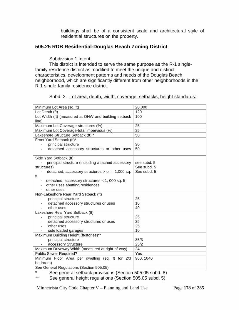
Minnetrista City Code Chapter V – Planning and Land Use Page 178 of 285
buildings shall be of a consistent scale and architectural style of residential structures on the property.
505.25 RDB Residential-Douglas Beach Zoning District
Subdivision 1.UIntent This district is intended to serve the same purpose as the R-1 single-
family residence district as modified to meet the unique and distinct characteristics, development patterns and needs of the Douglas Beach neighborhood, which are significantly different from other neighborhoods in the R-1 single-family residence district.
Subd. 2. ULot area, depth, width, coverage, setbacks, height standards:
Minimum Lot Area (sq. ft) 20,000 Lot Depth (ft) 120 Lot Width (ft) (measured at OHW and building setback line)
100
Maximum Lot Coverage-structures (%) 25 Maximum Lot Coverage-total impervious (%) 35 Lakeshore Structure Setback (ft) * 50 Front Yard Setback (ft)*
- principal structure - detached accessory structures or other uses
30 50
Side Yard Setback (ft) - principal structure (including attached accessory structures) - detached, accessory structures > or = 1,000 sq. ft - detached, accessory structures < 1, 000 sq. ft - other uses abutting residences - other uses
see subd. 5 See subd. 5 See subd. 5
Non-Lakeshore Rear Yard Setback (ft) - principal structure - detached accessory structures or uses - other uses
25 10 40
Lakeshore Rear Yard Setback (ft) - principal structure - detached accessory structures or uses - other uses - side loaded garages
25 25 25 10
Maximum Building Height (ft/stories)** - principal structure - accessory Structure
35/3 25/2
Maximum Driveway Width (measured at right-of-way) 24 Public Sewer Required? Yes Minimum Floor Area per dwelling (sq. ft for 2/3 bedroom)
960, 1040
See General Regulations (Section 505.05) * See general setback provisions (Section 505.05 subd. 8) ** See general height regulations (Section 505.05 subd. 5)

Minnetrista City Code Chapter V – Planning and Land Use Page 179 of 285
Subd 3. UPermitted Uses The following uses are permitted in this zoning district. Omission from this
list or the list described in subdivision 3 means that the use is prohibited. b. Single family, detached dwellings (including
manufactured or modular homes) c. Historic sites d. Parks and recreational trails and paths e. Public utility buildings f. Religious or other similar assembly uses, with the
approval of a site plan State licensed residential facility or housing with services establishment serving six or fewer persons, as defined and regulated by state statute
j. State licensed day care facility serving 12 or fewer persons, as defined and regulated by state statute
k. Group family day care facility licensed under Minnesota Rules to serve 14 or fewer children, as defined and regulated by state statute
Subd 4. UConditional Uses
a. Accessory structures exceeding 1,000 square feet b. Cemeteries or mausoleums c. Guest homes have a gross floor area exceeding 1,000 square feet
or square footage that is 30 percent or more of the primary residence’s footprint, whichever is less
d. Home occupations, if required in accordance with Section 505.07 subd.10)
e. Libraries and museums f. Recreation facilities owned in common (including, but not limited to
homeowner’s association, country club) unless a site plan is already required
g. Schools h. Ground-mounted solar energy systems (must be a principal use to
which the system is accessory) [Added 07/20/2015, Ordinance 431]
Subd. 5. Special Provisions (a) On lots which have a width of less than 55 feet, measured at
the street line, the side yard shall be no less than 10 feet on one side and six feet on the other side. On lots which have a width of at least 55 feet, but less than 70 feet, measured at the street line, the total of the side yards shall be no less than 30 percent of the width of the lot, with the side yard being 10 feet on one side and the remainder of the 30 percent on the other side.

Minnetrista City Code Chapter V – Planning and Land Use Page 180 of 285
On lots which have a width of at least 70 feet, but less than 100 feet, measured at the street line, the sum of both side yards shall be no less than 30 percent of the width of the lot, but in no case shall a side yard on either side be less than 10 feet. On lots which have a width which equals or exceeds 100 feet, measured at the street line, the minimum side yard shall be 15 feet on each side. Accessory structures shall be aligned with the principal structure so that the accessory structure shall maintain the minimum setback of 10 feet on the same side or sides of the lot that the principal structure maintains the minimum setback of 10 feet.
505.27 SDD Staged Development District
Subdivision 1U Intent This district is intended to address future planning issues for areas which
are designated to become urbanized within the comprehensive plan staged growth boundaries. A minimum lot size of 10 acres in this district will retain these lands in larger tracts pending the proper timing for the economical provision of sewer, water, streets, parks, storm drainage, and other public utilities and services so that orderly development can occur.
Subd. 2. ULot area, depth, width, coverage, setbacks, height standards:
Minimum Lot Area (sq. ft) 10 acres Lot Depth (ft) 200 Lot Width (ft) (measured at OHW and building setback line)
300
Maximum Lot Coverage-total impervious (%) 25 Lakeshore Structure Setback (ft) * 75 Front Yard Setback (ft)
- principal structure - detached accessory structures or other uses
35 50
Side Yard Setback (ft) - principal structure (including attached accessory structures) - detached, accessory structures > or = 1,000 sq. ft - detached, accessory structures < 1, 000 sq. ft - other uses abutting residences - other uses
15 30 (requires CUP) 10 45 10
Non-Lakeshore Rear Yard Setback (ft) - principal structure - detached accessory structures or uses
25 10

Minnetrista City Code Chapter V – Planning and Land Use Page 181 of 285
- other uses 40 Lakeshore Rear Yard (Street Side) Setback (ft)
- principal structure - detached accessory structures or uses - other uses
35 50 50
Maximum Building Height (ft/stories)** - principal structure - accessory structure
35/3 25/2
Maximum Driveway Width (measured at right-of-way) 24 Public Sewer Required? No Minimum Floor Area per dwelling (sq. ft for 2, 3 bedrooms)
960, 1040
See General Regulations (Section 505.05) * See general setback provisions (Section 505.05 subd. 8) ** See general height regulations (Section 505.05 subd. 5)
Subd 3. UPermitted Uses The following uses are permitted in this zoning district. Omission from this
list or the list described in subdivision 3 means that the use is prohibited. a. Single family, detached dwellings (including manufactured or modular
homes) b. Golf Courses and club houses (excepting independent and commercial
mini golf courses and driving ranges) c. Historic sites d. Parks and recreational trails and paths e. Public utility buildings f. Religious or other similar assembly uses, with the approval of a site
plan g. State licensed residential facility or housing with services
establishment serving six or fewer persons, as defined and regulated by state statute
h. State licensed day care facility serving 12 or fewer persons, as defined and regulated by state statute
i. Group family day care facility licensed under Minnesota Rules to serve 14 or fewer children, as defined and regulated by state statute
j. Commercial agriculture and horticulture, including drainage and irrigation systems
k. Stables, limited private
Subd 4. UConditional Uses a. Accessory structures exceeding 1,000 square feet b. Cemeteries or mausoleums c. Guest homes have a gross floor area exceeding 1,000 square feet or
square footage that is 30 percent or more of the primary residence’s footprint, whichever is less
d. Home occupations, if required in accordance with Section 505.07 subd.10)

Minnetrista City Code Chapter V – Planning and Land Use Page 182 of 285
e. Libraries and museums f. Recreation facilities owned in common (including, but not limited to
homeowner’s association, country club) unless a site plan is already required
g. Schools h. Ground-mounted solar energy systems (must be a principal use to
which the system is accessory) [Added 07/20/2015, Ordinance 431]
Subd. 5. Special Provisions (a) Any accessory structures in excess of 1000 sq ft within the
SDD zoning district shall require a conditional use permit. (b) Future development in the SDD District. If a parcel is proposed to be subdivided, the applicant must provide a plan on a certified survey identifying future home locations and street connections as if the property is zoned R-2, single-family.
A lot of record existing on the effective date of this section that is less than ten acres in size will be considered a nonconforming lot subject to the conditions and requirements of section 505.05, subdivision 11 (c).
505.29 A Agriculture District
Subdivision 1.U Intent This district is intended:
(1) To include those areas appropriate for small scale rural activities which will not conflict with existing agricultural activities;
(2) To protect such areas and activities from
encroachment by nonagricultural uses, structures, or activities;
(3) To prohibit those uses and densities which would
require the premature extension of urban public facilities and services;
(4) To promote logical and orderly development in the
best interest of the health, safety, and welfare of the citizens of the city;
(5) To protect and maintain the open space for the
creation of an attractive living environment;

Minnetrista City Code Chapter V – Planning and Land Use Page 183 of 285
(6) To protect, preserve, and maintain, the unique rural
lifestyle;
Subd. 2. ULot area, depth, width, coverage, setbacks, height standards:
Minimum Lot Area (sq. ft) 10 acres Lot Depth (ft) 200 Lot Width (ft) (measured at OHW and building setback line)
300
Maximum Lot Coverage-total impervious (%) 25 Lakeshore Structure Setback (ft) * 75 Front Yard Setback (ft)*
- principal structure - detached accessory structures or other uses
50 60
Side Yard Setback (ft) - principal structure (including attached accessory structures) - detached, accessory structures > or = 1,000 sq. ft - detached, accessory structures < 1, 000 sq. ft - other uses abutting residences - other uses
15 30 10 45 10
Non-Lakeshore Rear Yard Setback (ft) - principal structure - detached accessory structures or uses - other uses
50 10 50
Lakeshore Rear Yard (Streetside) Setback (ft) - principal structure - detached accessory structures or uses - other uses
90 100 100
Maximum Building Height (ft/stories)** - principal structure - accessory Structure
35/3 35/2
Maximum Driveway Width (measured at right-of-way) 24 Public Sewer Required? no Minimum Floor Area per dwelling (sq. ft per 2,3 bedrooms)
960, 1040
See General Regulations (Section 505.05) * See general setback provisions (Section 505.05 subd. 8) ** See general height regulations (Section 505.05 subd. 5)
Subd 3. UPermitted Uses The following uses are permitted in this zoning district. Omission from this
list or the list described in subdivision 3 and 4 means that the use is prohibited. a. Single family, detached dwellings (including manufactured or modular
homes) b. Accessory or farm buildings of any size c. Golf Courses and club houses (excepting independent and commercial
mini golf courses and driving ranges) d. Historic sites
Minnetrista City Code Chapter V – Planning and Land Use Page 184 of 285
e. Parks and recreational trails and paths f. Public utility buildings g. Religious or other similar assembly uses, with the approval of a site
plan h. State licensed residential facility or housing with services
establishment serving six or fewer persons, as defined and regulated by state statute
i. State licensed day care facility serving 12 or fewer persons, as defined and regulated by state statute
j. Group family day care facility licensed under Minnesota Rules to serve 14 or fewer children, as defined and regulated by state statute
k. Commercial agriculture and horticulture, including drainage and irrigation systems
l. Stables, limited private
Subd 4. UConditional Uses a. Agricultural feedlots and poultry facilities b. Agricultural service establishments c. Farm Winery d. Cemeteries or mausoleums e. Guest homes have a gross floor area exceeding 1,000 square feet or
square footage that is 30 percent or more of the primary residence’s footprint, whichever is less
f. Home occupations, if required in accordance with Section 505.07 subd.10)
g. Libraries and museums h. Recreation facilities owned in common (including, but not limited to
homeowner’s association, country club) unless a site plan is already required
i. Schools j. Keeping of non-domestic animals, in accordance with Section 1110 k. Stables, commercial, limited commercial, or private l. Ground-mounted solar energy systems (must be a principal use to
which the system is accessory) [Added 07/20/2015, Ordinance 431] USubd. 5 Interim Uses a. Agricultural entertainment b. Any other use, as deemed appropriate by city council
Subd. 6. Special regulations
(a) UAgricultural feed lots and poultry facilitiesU.
(1) The applicant must submit a map or aerial photo indicating dimensions of feedlot and poultry facility and showing all

Minnetrista City Code Chapter V – Planning and Land Use Page 185 of 285
existing homes, buildings, lakes, ponds, water courses, wetlands, dry runs, rock outcropping, roads, wells, and general contours within 500 feet of the feedlot.
(2) The applicant must submit a description of the geological
conditions, soil types, and ground water elevations, including proof that the water table is at least ten feet below the ground at the lowest contour elevation within 500 feet of the feedlot.
(3) The applicant must submit a plan indicating operation
procedures, location and specifications of proposed animal waste treatment facilities, land area for the disposal of waste, and the quantity and type of effluent to be discharged from or on the lot.
(4) Should the land indicated as a disposal site not be owned by
the applicant, a lease must be submitted indicating that the applicant has the right to dispose of waste on said land.
(5) No feedlot will be located within 1,000 feet of the normal high
water mark of a lake, pond, wetlands, river or stream. (6) No feedlot will be located within the flood plains. (7) No feedlot will be located within 1,000 feet of a public park. (8) No feedlot will be located within one-half mile of ten or more
dwellings.
(b) UAgricultural service establishmentsU. All agricultural service establishments will be located 300 feet from any driveway or adjacent property owners and at least 500 feet from any single-family dwelling of an adjacent property owner.
(c) UConditional use standards for public schools or equivalent private schools in A-agriculture district U. In addition to general standards specified in section 505.05 subd. 7, the following additional standards apply to the conditional use permits for public schools or equivalent private schools. Such schools:
(1) Must be services by public sewer and water facilities; (2) Located with direct access to a collector or arterial street as
identified in the comprehensive plan;
Minnetrista City Code Chapter V – Planning and Land Use Page 186 of 285
(3) Minimum lots size and building setbacks for “other uses” in
the A-agriculture zoning district shall be met; (4) Parking areas shall adhere to off street parking and loading
requirements called for by code; (5) Bus drop-off and pick-up areas must be located outside of
the public right-of-way and be designed to enhance vehicular and pedestrian safety;
(6) Recreational areas designed for group sports activities set
back a minimum of 50 feet from residential property with adequate screening to protect neighboring properties from noise and adverse visual impacts;
(7) No more than 25 percent of the site to be covered with
impervious surface and the remainder to be suitably landscaped;
(8) Exterior lighting must be designed and installed so that the
globe is recessed and enclosed on all sides except the bottom and no direct light is cast on adjacent residential property or rights-of-way;
(9) Roof top or outside mechanical equipment must be screened
from view from adjacent properties and rights-of-way; (10) Any exterior storage must be screened from view with an
opaque material architecturally compatible with the building; (11) The city council may require compliance with any other
conditions, restrictions, or limitations it deems to be reasonably necessary to protect the residential character of the neighborhood; and
(12) The proposed school shall be registered with the State of
Minnesota.
(d) Interim use in A-agriculture district.
(1) Within the A-agriculture district, the following use shall be permitted by interim use permit:
a. Agricultural entertainment, which shall include events
or activities conducted or held on private property by
Minnetrista City Code Chapter V – Planning and Land Use Page 187 of 285
the property owner or the owner’s lessee, either private or open to the general public, with an estimated attendance of 75 people or more.
b. For purposes of this section, “events” and “activities”
have the following meanings: i. Events: planned parties, celebrations,
concerts, conferences, or similar occasions with reservation of a particular space at the property for a single-occurrence gathering, including but not limited to weddings, wedding receptions, private parties or similar family or social functions.
ii. Activities: ongoing occurrences at the property
which are open to the general public, including but not limited to tractor pulled hayrides; guided nature walks, petting barn yards, school-age tour groups or similar family or social functions.
(2) Standards. The following standards apply to interim use
permits for agricultural entertainment:
a. The property proposed to be used for agricultural entertainment must be located with direct access to a collector or arterial street as identified in the comprehensive plan;
b. The property owner may be required to improve the
traffic intersection located nearest to the property with additional turning lanes, street lights, traffic controls, traffic signs and such other measures as the city deems necessary to safely control traffic traveling to and from the property;
c. The property must have at least two points of
unobstructed emergency vehicle access to each building or permanent or temporary structure;
d. Minimum lot size and building setbacks for “other
uses” in the A-agriculture zoning district must be met;

Minnetrista City Code Chapter V – Planning and Land Use Page 188 of 285
e. All parking must occur on-site but not on the primary or alternate septic sites or on any green area; must be on an improved surface, such as class five gravel or pavement; and must be set back at least 30 feet from all property lines;
f. No more than 25 percent of the site may be covered
with impervious surface and the remainder shall be suitably landscaped;
g. All requirements of section 405 of the city code must
be met;
h. Exterior lighting must be designed and installed so that the light source is recessed and enclosed on all sides except the bottom so that no light is cast directly or indirectly on any other property and so that the light source cannot be seen from adjacent property;
i. Roof top or outside mechanical equipment and any
exterior storage must be screened from view from adjacent properties and rights-of-way with an opaque material architecturally compatible with the building(s);
j. Trash containers must be located inside or screened
in an acceptable manner;
k. No outdoor speakers may be used. All live music, including but not limited to bands and disc jockeys as well as stereos, juke boxes or other equipment, shall be conducted inside a permanent or temporary structure and the property owners shall take all necessary steps to contain the noise produced by all such devises within the permanent or temporary structure;
l. The number of persons who may attend an event
featuring live music shall be determined by the city council after considering the impact on adjacent properties;
m. All requirements of the fire code and fire marshal
must be met;

Minnetrista City Code Chapter V – Planning and Land Use Page 189 of 285
n. All requirements of chapter 1200 of the city code must be met;
o. Discharge of firearms, including blanks, shall not be
allowed on the property;
p. The hours of operation and the number of permitted employees will be determined by the city council after consideration of the impact on adjacent properties;
q. Events are limited to twice weekly and only during
the months of May through December;
r. The city may require the property owner to utilize the services of a licensed security officer or peace officer at any event or activity;
s. The city may require inspections of the property in
order to investigate complaints;
t. Food consumed on site must be prepared in accordance with all applicable state and county codes and regulations;
u. The property owner must take reasonable steps to
prevent trespassing on adjacent properties by employees, contractors or patrons;
v. There must be identified and acceptable primary
and alternate well and septic sites on the property which are sized for the maximum anticipated usage of the property;
w. All animal feed and bedding must be stored within
an enclosed building;
x. Manure must be properly stored while on site. Manure must be disposed of at an off-site location at least every six months by means of a method approved by the city and the Minnesota Pollution Control Agency, and
y. The city council may require compliance with any
other conditions, restrictions, or limitations it deems to be reasonably necessary to protect the health,

Minnetrista City Code Chapter V – Planning and Land Use Page 190 of 285
safety or welfare of the surrounding properties and the community and may require the applicant to enter into an agreement to ensure compliance with the conditions.
505.31 AP Agriculture Preserve District
Subdivision 1.U Intent This district is intended:
(1) To include those areas where it is necessary and desirable to preserve, promote, maintain, and enhance the use of the land for long-term agricultural purposes;
(2) To protect such areas from encroachment by nonagricultural
uses, structures, or activities; (3) To prohibit those uses and densities which would require the
premature extension of urban public facilities and services; (4) To promote logical and orderly development in the best
interest of the health, safety, and welfare of the citizens of the city;
(5) To protect and maintain the open space for the creation of
an attractive living environment; (6) To protect, preserve, and maintain, the unique rural lifestyle.
Subd. 2. ULot area, depth, width, coverage, setbacks, height standards:
Minimum Lot Area (sq. ft) 40 acres Lot Depth (ft) 200 Lot Width (ft) (measured at OHW and building setback line) 300 Maximum Lot Coverage (%) 25 Lakeshore Structure Setback (ft) * 75 Front Yard Setback (ft)*
- principal structure - detached accessory structures or other uses
50 60
Side Yard Setback (ft) - principal structure (including attached accessory structures) - detached, accessory structures > or = 1,000 sq. ft - detached, accessory structures < 1, 000 sq. ft - other uses abutting residences - other uses
15 30 10 45 10
Non-Lakeshore Rear Yard Setback (ft)
Minnetrista City Code Chapter V – Planning and Land Use Page 191 of 285
- principal structure - detached accessory structures or uses - other uses
50 10 50
Lakeshore Rear Yard (Streetside) Setback (ft) - principal structure - detached accessory structures or uses - other uses
90 100 100
Maximum Building Height (ft/stories)** - principal structure - accessory Structure
35/3 35/2
Maximum Driveway Width (measured at right-of-way) 24 Public Sewer Required? no Minimum Floor Area (per dwelling unit) 960, 1040 See General Regulations (Section 505.05) * See general setback provisions (Section 505.05 subd. 8) ** See general height regulations (Section 505.05 subd. 5)
Subd 3. UPermitted Uses The following uses are permitted in this zoning district. Omission from this
list or the list described in subdivision 4 or 5 means that the use is prohibited. a. Single family, detached dwellings (including manufactured or modular
homes) b. Accessory or farm buildings of any size c. Historic sites d. Parks and recreational trails and paths e. Public utility buildings f. Religious or other similar assembly uses, with the approval of a site
plan g. State licensed residential facility or housing with services
establishment serving six or fewer persons, as defined and regulated by state statute
h. State licensed day care facility serving 12 or fewer persons, as defined and regulated by state statute
i. Group family day care facility licensed under Minnesota Rules to serve 14 or fewer children, as defined and regulated by state statute
j. Commercial agriculture and horticulture, including drainage and irrigation systems
k. Stables, limited private l. Air Strips m. Solar energy systems [Added 07/20/2015, Ordinance 431]
Subd 4. UConditional Uses a. Agricultural feedlots and poultry facilities b. Agricultural service establishments c. Farm Winery d. Golf Courses and club houses (excepting independent and commercial
mini golf courses and driving ranges) e. Cemeteries or mausoleums
Minnetrista City Code Chapter V – Planning and Land Use Page 192 of 285
f. Guest homes have a gross floor area exceeding 1,000 square feet or square footage that is 30 percent or more of the primary residence’s footprint, whichever is less
g. Home occupations, if required in accordance with Section 505.07 subd.10)
h. Recreation facilities owned in common (including, but not limited to homeowner’s association, country club) unless a site plan is already required
i. Schools j. Keeping of non-domestic animals, in accordance with Section 1110 k. Stables, commercial, limited commercial, or private USubd. 5 Interim Uses c. Agricultural entertainment d. Any other use, as deemed appropriate by city council
Subd. 6. Performance Standards UParcels formerly zoned as Residential Agricultural (RA)U. Lots formerly
known zoned RA may continue to adhere to former RA setbacks.
Subd. 7 Special Provisions
(a) UAgricultural feed lots and poultry facilitiesU.
(1) The applicant must submit a map or aerial photo indicating dimensions of feedlot and poultry facility and showing all existing homes, buildings, lakes, ponds, water courses, wetlands, dry runs, rock outcropping, roads, wells, and general contours within 500 feet of the feedlot.
(2) The applicant must submit a description of the geological
conditions, soil types, and ground water elevations, including proof that the water table is at least ten feet below the ground at the lowest contour elevation within 500 feet of the feedlot.
(3) The applicant must submit a plan indicating operation
procedures, location and specifications of proposed animal waste treatment facilities, land area for the disposal of waste, and the quantity and type of effluent to be discharged from or on the lot.

Minnetrista City Code Chapter V – Planning and Land Use Page 193 of 285
(4) Should the land indicated as a disposal site not be owned by the applicant, a lease must be submitted indicating that the applicant has the right to dispose of waste on said land.
(5) No feedlot will be located within 1,000 feet of the normal high
water mark of a lake, pond, wetlands, river or stream. (6) No feedlot will be located within the flood plains. (7) No feedlot will be located within 1,000 feet of a public park. (8) No feedlot will be located within one-half mile of ten or more
dwellings.
(b) UAgricultural service establishmentsU. All agricultural service establishments will be located 300 feet from any driveway or adjacent property owners and at least 500 feet from any single-family dwelling of an adjacent property owner.
(c) UDwellings in AP-agriculture preservation district U.
(1) All dwellings will meet the following criteria:
a. The driveway serving the lot will be separated from adjacent driveways on the same side of the road by the following distances, depending upon the road type:
i. Minor street, 100 feet; ii. Collector street, 300 feet; iii. Arterial street, 500 feet; iv. The minimum distance from intersection of two
or more of the above streets will be 100 feet;
b. The lot on which the dwelling is located will have adequate soil and water conditions to permit a well and two on-site sewer disposal system sites;
c. The dwelling will not be in an area classified as
wetlands or flood plains;

Minnetrista City Code Chapter V – Planning and Land Use Page 194 of 285
d. The dwelling will be located so as to have frontage on an existing public road;
(2) The minimum lot size for one single-family dwelling will be 40 acres of land, which land cannot be encumbered by an open space easement as set forth hereinafter. Each dwelling will be located on a separately subdivided lot and must meet the requirements of this section and subdivision 4 above;
(3) One single-family dwelling may be allowed by conditional
use permit on a separately subdivided lot of two acres of land providing that it meets the requirements of this subdivision;; and that the subdivider will first grant to the city an open space easement over an additional 38 acres of land, in a form acceptable to the city attorney, to ensure that the additional 38 acres of land is thereafter restricted to agricultural uses, specifically excluding any residential uses, dwellings, or other uses involving structures which are not incidental to commercial agricultural uses, so as not to defeat the intent and purpose of this section. The additional 38 acres of land to be so restricted will not contain any dwelling or non-farm building and will not have been already restricted by an open space easement.
(4) An additional single-family dwelling may be allowed by
conditional use permits on one or more separately subdivided two-acre lots, on a lot of 40 acres or more which already contains a dwelling, providing that it meets the requirements of this subdivision; subdivision 4 above and applicable provisions of section 500; and that for each such two-acre lot, the subdivider must first grant to the city an open space easement over an additional 40 acres of land, in a form acceptable to the city attorney, to ensure that the additional 40 acres of land is thereafter restricted to agricultural uses, specifically excluding any residential uses, dwellings or other uses involving structures which are not incidental to commercial agriculture so as not to defeat the purpose of this section. The additional 40 acres of land to be so restricted will not contain any residential dwelling or non-farm buildings and will not have been already restricted by an open space easement.
(5) The two acre lot will have at least 200 feet of frontage on a
publicly dedicated and maintained street and will have

Minnetrista City Code Chapter V – Planning and Land Use Page 195 of 285
adequate buildable area so as to not require a variance to any section of the city code.
(d) UTen acre lots and cluster dwellings in AP agriculture preserve
district U. Upon the request of an owner to change the zoning on the owner's property, the city council will consider changing the AP Agricultural Preserve District to A Agriculture District if the property is located east of County Road 92.
(1) UPurposeU. The purpose of these regulations is to allow, in
certain instances, ten acre lots and to provide guidance, criteria, and incentive for residential cluster development in the agricultural preserve district east of County Road 92. These regulations do not apply in any other zoning district.
(2) UDefinitionsU.
Agricultural use means the use of land for the growing and/or production of field crops such as barley, soybeans, corn, hay, oats, potatoes, rye, sorghum, or sunflowers. Cluster development is a single-family residential development in which single-family dwellings are grouped on a portion of land with a significant amount of a site reserved as open space. Conservation easement means a legal agreement creating an interest in real property created in a manner to impose limitations or affirmative obligations regarding the use of property including the retention, protection, and maintenance of open space. Open space/usable open space use means land, which is preserved through the use of restrictive deed covenants, public dedications, or other methods. Developments within the agricultural preserve district must maintain fifty percent of its overall site acreage as open space. A minimum of one-half of the open space required by this section must be useable. Useable open space must comply with all the following criteria:
a. Land area will be above the 100-year flood plain elevation;

Minnetrista City Code Chapter V – Planning and Land Use Page 196 of 285
b. Land area will be above the ordinary highwater level of "public waters" and "wetlands" as defined by Minnesota Statutes 103G.005;
c. Land area will not contain hydric soils, surface or
subsurface hydrology, and hydrophytic vegetation; d. Land area that satisfies criterion a, b, c, and e in this
section, in lieu of easements, may be owned by a homeowners association; and
e. Area required by this district is in addition to (not in
lieu of) any public parkland dedication.
(3) UTwo optionsU. Instead of requiring lots in the agriculture preserve district to be 40 acres the city council will consider the following two options for lot sizes east of County Road 92.
a. UTen acre lotsU--The council may all allow lots with a
minimum of 10 acres
i. Depth, width, coverage, and setbacks will be as set forth in the agriculture district.
b. UCluster development lotsU--For property located in the
agricultural preserve district east of County Road 92, the city council may allow single-family dwelling development at an overall density of six unit per 40 acres (One unit per 6.66 acres) provided all the following criteria are met:
i. A maximum overall density of one single-family
dwelling unit per 6.66 acres must be maintained.
ii. A minimum of 50 percent of the development
must be preserved as open space. iii. The preliminary plat must show a primary and
secondary individual sewage treatment site for each dwelling unit and must be supported with soil tests that demonstrate compliance with Hennepin County Ordinance Number 19.

Minnetrista City Code Chapter V – Planning and Land Use Page 197 of 285
iv. Lots within the cluster development will not be less than 2.5 acres nor more than five acres.
v. All lots within the cluster development must be
served by a single, city street which meets the following standards:
• Must have a minimum width of 24 feet.
• Must be designed, properly graded and
improved with a base of Class 5 materials. A bituminous surface suitable for carrying the anticipated traffic load/volume is required.
vi. Open space must be designated in the
development as one or more outlots and must be owned by a homeowners association.
vii. Open spaces will be protected by the
placement of a conservation easement over them.
viii. Open space will be in a contiguous, connected
configuration including or adjacent to existing natural areas or parks.
ix. Open space in long narrow corridors in back
yards does not qualify as open space for conservation easements.
x. The homeowners association will maintain the
open space so that it is free of noxious weeds, litter, or debris.
xi. A minimum of 50 percent of the open space
must be usable. Wetlands, streams, lakes, ponds, and lands within the 100-year flood plain elevation are not considered usable for purposes of this section.
xii. Residential properties must be buffered from
incompatible uses with buffer areas aesthetically and functionally designed to minimize land use conflicts.
Minnetrista City Code Chapter V – Planning and Land Use Page 198 of 285
xiii. A subdividers agreement must be entered into with the city.
(4) ULot area, depth, width, coverage, setbacksU. Lot area, depth,
width, coverage, and setbacks will be subject to review and approval of the city council. However, lot area will not be less than 2.5 acres nor more than five acres.
(5) UHomeowners association criteriaU. A homeowners association
will be established to permanently maintain all preserved open space. Homeowners association agreements will include the following:
a. Legal description of the common lands or facilities. b. Membership in the association is mandatory for all
purchasers of homes in the development and their successors.
c. Restrictions placed upon the use and enjoyment of
the lands or facilities including the persons or entities entitled to enforce the restrictions.
d. A mechanism for resolving disputes among the
owners or association members. e. Provide standards for scheduled maintenance of open
spaces. f. A mechanism to assess and enforce the common
expenses for the land or facilities including upkeep and maintenance expenses, real estate taxes, and insurance premiums.
g. The conditions and timing of the transfer of ownership
and control of land or facilities to the association. h. Any proposed change in the articles of association or
incorporation will require the prior written approval of the city.
505.33 C-1 Office-Limited Commercial District
Subdivision 1 UIntent This district is related to and may reasonably adjoin high density or other
residential districts for the location and development of administrative office
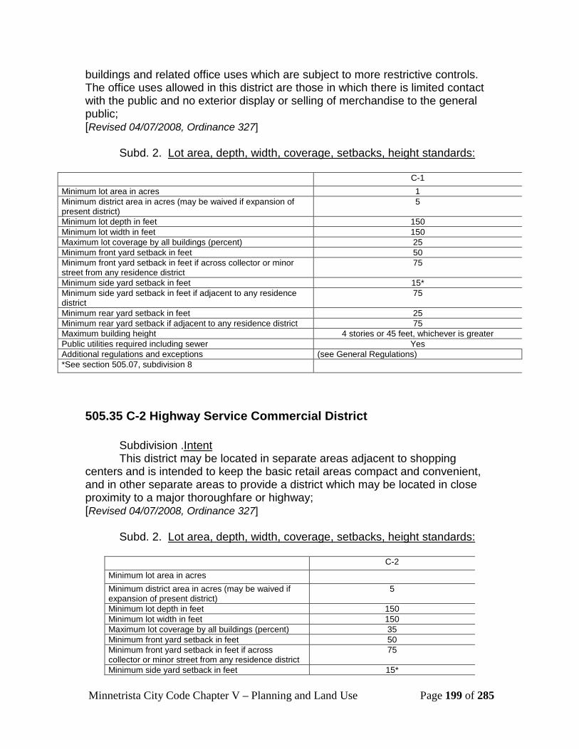
Minnetrista City Code Chapter V – Planning and Land Use Page 199 of 285
buildings and related office uses which are subject to more restrictive controls. The office uses allowed in this district are those in which there is limited contact with the public and no exterior display or selling of merchandise to the general public; [Revised 04/07/2008, Ordinance 327]
Subd. 2. ULot area, depth, width, coverage, setbacks, height standards:
C-1 Minimum lot area in acres 1 Minimum district area in acres (may be waived if expansion of present district)
5
Minimum lot depth in feet 150 Minimum lot width in feet 150 Maximum lot coverage by all buildings (percent) 25 Minimum front yard setback in feet 50 Minimum front yard setback in feet if across collector or minor street from any residence district
75
Minimum side yard setback in feet 15* Minimum side yard setback in feet if adjacent to any residence district
75
Minimum rear yard setback in feet 25 Minimum rear yard setback if adjacent to any residence district 75 Maximum building height 4 stories or 45 feet, whichever is greater Public utilities required including sewer Yes Additional regulations and exceptions (see General Regulations) *See section 505.07, subdivision 8
505.35 C-2 Highway Service Commercial District
Subdivision .UIntent This district may be located in separate areas adjacent to shopping
centers and is intended to keep the basic retail areas compact and convenient, and in other separate areas to provide a district which may be located in close proximity to a major thoroughfare or highway; [Revised 04/07/2008, Ordinance 327]
Subd. 2. ULot area, depth, width, coverage, setbacks, height standards:
C-2 Minimum lot area in acres Minimum district area in acres (may be waived if expansion of present district)
5
Minimum lot depth in feet 150 Minimum lot width in feet 150 Maximum lot coverage by all buildings (percent) 35 Minimum front yard setback in feet 50 Minimum front yard setback in feet if across collector or minor street from any residence district
75
Minimum side yard setback in feet 15*

Minnetrista City Code Chapter V – Planning and Land Use Page 200 of 285
Minimum side yard setback in feet if adjacent to any residence district
75
Minimum rear yard setback in feet 25 Minimum rear yard setback if adjacent to any residence district
75
Maximum building height 2 stories or 35 feet, whichever is greater Public utilities required including sewer Yes Additional regulations and exceptions (see General Regulations) *See section 505.07, subdivision 8
505.37 C-3 Shopping Center Commercial District
Subdivision 1.U Intent This district may be applied to land in single ownership or unified control
for the purpose of developing a planned commercial center with a unified and organized arrangement of buildings and service facilities at key locations which are suitable for such use and which are centrally located within the residential area they are intended to serve. [Revised 04/07/2008, Ordinance 327]
Subd. 2. ULot area, depth, width, coverage, setbacks, height standard Us: C-3 Minimum lot area in acres Minimum district area in acres (may be waived if expansion of present district)
5
Minimum lot depth in feet 200 Minimum lot width in feet 200 Maximum lot coverage by all buildings (percent) 25 Minimum front yard setback in feet 50 Minimum front yard setback in feet if across collector or minor street from any residence district
75
Minimum side yard setback in feet 35 Minimum side yard setback in feet if adjacent to any residence district
75
Minimum rear yard setback in feet 35 Minimum rear yard setback if adjacent to any residence district
75
Maximum building height 2 stories or 35 feet, whichever is greater Public utilities required including sewer Yes Additional regulations and exceptions (see General Regulations) *See section 505.07, subdivision 8
505.39 P-I Planned Industrial District Subdivision 1. UIntent This district is established to accomplish the general purpose of this
section and the comprehensive plan and the following specific purposes:

Minnetrista City Code Chapter V – Planning and Land Use Page 201 of 285
(1) To provide employment opportunities;
(2) To group industrial uses in locations accessible to rail and highways, so that the movement of raw materials, finished products and employees can be carried on efficiently in an unobstrusive manner;
(a) Limitation. It is recognized that, while the city
is predominately residential in character, industrial uses are an important part of the city land use pattern. The regulations for this district are intended to encourage individual development that is compatible with surrounding or abutting land uses. To accomplish this compatibility, development in the planned industrial district:
(i) Is limited to administrative, wholesaling,
manufacturing, and related uses that can be carried on in an unobtrusive manner;
(ii) Must provide suitable open spaces,
landscaping and parking area; and
(iii) Must establish a high standard of appearance and controls for external effects such as noise, smoke, and congestion.
[Revised 04/07/2008, Ordinance 327]
Subd. 2. ULot area, depth, width, coverage, setbacks, height standard Us I Minimum lot area in acres 2 Minimum district area in acres (may be waived if expansion of present district)
20
Minimum lot depth in feet 150 Minimum lot width in feet 150 Maximum lot coverage by all buildings (percent) 35 Minimum front yard setback in feet 50 Minimum front yard setback in feet if across collector or minor street from any residence district
75
Minimum side yard setback in feet 25 Minimum side yard setback in feet if adjacent to any residence district
75
Minimum rear yard setback in feet 35 Minimum rear yard setback if adjacent to any residence district
75
Maximum building height 4 stories or 45 feet, whichever is greater
Public utilities required including sewer Yes Additional regulations and exceptions (see General Regulations) *See section 505.07, subdivision 8

Minnetrista City Code Chapter V – Planning and Land Use Page 202 of 285
505.41 Reserved- Mixed Use District
505.43 P-1 Public/Semi-Public Zoning District
Subdivision 1. UIntent U This district is established to provide for governmental facilities,
educational institutions and facilities, community service institutions and facilities, health care facilities and recreational facilities. See use chart located in Section 505.13 for permitted, conditional, and restricted uses in this district.
Subd. 2. ULot area, depth, width, coverage, setbacks and height.U
P-1
Minimum lot area in acres None
Minimum district area in acres
None
Minimum lot depth in feet None
Minimum lot width in feet None
Maximum lot coverage by all buildings (percent)
40
Minimum front yard setback in feet (improvements)
30
Minimum side yard setback in feet (improvements)
25
Minimum side yard setback in feet if adjacent to any residence district (improvements)
75
Minimum rear yard setback in feet (improvements)
20
Minimum rear yard setback if adjacent to any residence district (improvements)
75
Maximum building height
4 stories or less, but shall not exceed 45 feet in height If adjacent to a residence district, must be 2 stories or less and shall not exceed 35 feet in height.
Additional regulations and exceptions
(see subdivisions 3 and 4 below and other applicable provisions of the city code)

Minnetrista City Code Chapter V – Planning and Land Use Page 203 of 285
Subd. 3. UAdministrative procedure for development in the public/semi-public facilities district.
(a) All new uses and developments within the public/semi-public facilities district shall require site plan review prior to issuance of any permits. If a proposed use is a conditional use, a conditional use permit must be applied for pursuant to Section 505.05, subdivision 7 of the city code.
Subd. 4. UPerformance standards in the public/semi-public facilities district U.
(a) UIntentU. It is the intent of this subdivision to provide that public/semi-public facilities and related activities will be established and maintained with proper appearance from streets and adjoining properties and to provide that such use will be a good neighbor to adjoining properties by the control of the items regulated in this section.
(b) UStandardsU.
(1) ULandscapingU. All required yards shall either be landscaped or left in a natural state. If a yard is to be landscaped, it shall be landscaped attractively using grass, trees, shrubs, and similar vegetation. Landscaping shall be completed within one year after the issuance of the certificate of occupancy. All areas on the property shall be maintained in a sightly and well-kept condition. Yards adjoining residence districts must include a landscaped buffer for screening purposes. Landscaping plans for buffers shall be submitted to the city for approval as part of the site plan application and installed prior to the issuance of a certificate of occupancy. Landscaping required by this subdivision shall be in addition to the tree preservation requirements of section 510.07 of city code.
(2) UGlare and HeatU. Any use requiring an operation producing an intense heat or light transmission shall be performed with the necessary shielding to prevent such heat or light from being detectable at the lot line of the site.
(3) UExterior lightingU. All exterior lighting shall be designed and arranged so as not to direct any illumination upon or into any contiguous residential districts. No exterior lighting shall be arranged and designed so as to create direct viewing angles of the illumination source by pedestrian or vehicular traffic in the public right-of-way. Lenses, deflectors, shields,
Minnetrista City Code Chapter V – Planning and Land Use Page 204 of 285
louvers and prismatic control devices shall be used so as to eliminate nuisance and hazardous lighting. Lighting fixtures for outdoor sports and recreational facilities that adjoin residential uses shall be designed to eliminate reflected glare and spill light from the bottom one-third of the reflector and to shield the view of the arc tube from the residential property.
(4) UNoise U. Noise shall be muffled or otherwise controlled so as not to become a nuisance. Noise levels shall be regulated by the standards set forth by the Minnesota Rules.
(5) UVibrationsU. Vibrations must not be discernable at any property line to the human sense of feeling for three minutes or more in duration in any one hour. Vibration of any kind will not produce an acceleration of more than 0.1 gravities or will result in any combination of amplitudes and frequencies beyond the “safe” range of Table VII United States Bureau of Mines Bulletin No. 442, Seismic Effects of Quarry Blasting, on any structure. The methods and equations of said Bulletin No. 442 will be used to compute all values for the enforcement of this provision. Said Bulletin is incorporated herein by reference.
(6) UOdors, smoke, dust, fumes, water and wasteU. The design, construction and performance of all public/semi-public facilities uses will be in conformance with all applicable laws and regulations. (7) Rules pertaining specifically to city parklands, city-owned land, and other city-controlled parks, trails, or open spaces:
i) Closed daily from 10 p.m. to 7 a.m.; ii) Alcoholic beverages are prohibited, unless in
specified areas; iii) Dogs must be leashed or under verbal control
at all times; iv) Pet waste must be removed immediately; v) No littering; vi) No motorized vehicles allowed, except
vehicles in designated parking areas and governmental vehicles;
vii) Swimming or other recreational activities shall not be conducted on or in city stormwater ponds or basins.

Minnetrista City Code Chapter V – Planning and Land Use Page 205 of 285
(8) Any person violating any provision of Section 505.43 subdivision 4 (7) shall be guilty of a misdemeanor and shall be punished in accordance with section 609.03 of Minnesota Statutes, as amended.
(c) UComplianceU.
In order to ensure compliance with the performance standards and rules set forth above, the city council may require the owner or operator of any use to make such investigations and tests as may be required to show adherence to the performance standards. Such investigation and tests that are required to be made must be carried out by an independent testing organization which will be selected by the city. The costs incurred in such investigation or testing must be ordered by the owner or operator and will be shared equally by the owner or operator and the city unless the investigation and tests disclose noncompliance with the performance standards; in which situation the investigation and testing costs shall be paid by the owner or operator. [Added 03/03/2008, Ordinance 320]
505.45 PUD Planned Unit Development Zoning District
Subdivision 1. UPurpose The purpose of the Planned Unit Development (PUD) zoning district is to
provide greater flexibility in the development of neighborhoods and non-residential areas in order to maximize public values and achieve more creative development outcomes while remaining economically viable and marketable. This is achieved by undertaking a collaborative process that results in a development outcome exceeding that which is typically achievable through the conventional zoning district. If a development proposal does not demonstrate significant public value benefits above and beyond those achievable under a conventional zoning district, the City reserves the right to deny the PUD rezoning and direct the developer to re-apply under the standard applicable zoning district.
Subd. 2. UDefinitions Conventional development is defined as a development proposal that
meets the minimum requirement of the City’s ordinances regulating development.
Open space means land or common areas reserved for parks, walking paths or other natural uses.
Open space, useable means open space which will be publicly or privately owned and maintained by a homeowners association, excluding wetlands designated by federal or state agencies, areas below the 100-year ordinary high water elevations (OHW) and streets and roadways.
[Revised 02/04/2008, Ordinance 319]

Minnetrista City Code Chapter V – Planning and Land Use Page 206 of 285
Life-cycle housing refers to the range of housing options that meet people's preferences and circumstances at all of life's stages. Such options include both rental and for-purchase homes that are affordable for low and median-income buyers and for the move-up market.
Public values collaborative development is a process that results in a
development plan in which clearly defined public values are achieved in exchange for greater flexibility on conventional development requirements.
Subd. 3. UReflection on the official zoning mapU PUD provisions provide an optional method of regulating land use which
permits flexibility in the uses allowed and other regulating provisions.26T In some circumstances, however, rules and regulations governing the underlying zoning district may apply within the PUD. As such, a 26Tpproval of a PUD and execution of a PUD agreement shall require the property in question be rezoned to PUD, but the denotation on the official zoning map shall also illustrate the underlying zoning district. Once a PUD has been granted and is in effect for a parcel, no building permit shall be issued for that parcel which is not in conformance with the approved PUD plan, the building code, and with all other applicable city code provisions.
All PUD rezonings approved prior to the effective date of this section shall retain their zoning classifications of PUD, and shall continue to be governed by the ordinance and resolutions which created these areas.
Subd. 4. UAppropriate Use of the PUD rezoningU A rezoning to PUD may be requested for any residential or commercially
zoned area. PUDs are prohibited in the industrial districts. (a) Rezonings to PUD will not be considered for areas less than 8
acres of land in single ownership or control, except in the following circumstances:
(1) Natural features of the land are such that development under
standard zoning regulations would not be appropriate in order to conserve such features;
(2) The land is intended to be developed in accordance with a
prior PUD adjacent to or across the street from the subject property; or
(3) The PUD process is desirable to ensure compatibility and
careful consideration of the effect of a development on surrounding land uses.

Minnetrista City Code Chapter V – Planning and Land Use Page 207 of 285
(b) Application for a PUD may be made only by the owner of the land involved in the PUD application, or an option/contract holder provided the application is accompanied by fully executed agreements or documents from the owner in a form acceptable to the city.
Subd. 5. UPermitted usesU. Uses within a PUD shall be governed by the ordinance establishing the
PUD and by the conditions, if any, imposed by the city in the approval process. If a specific use is not established or addressed by a PUD ordinance, said use shall be governed by the underlying zoning district regulations designated by the comprehensive plan.
Subd 6. UExpectations of a development seeking a rezoning to PUD The provisions of this section are intended to achieve the following public
values within a PUD zoning district and associated subdivision: (a) Maintain the sense of open space character of the community.
Open space shall be of a size, shape, location, and usability for its proposed purpose. Whenever possible, common open space shall be linked to the open space areas of surrounding developments;
(b) Preserve natural open spaces for their aesthetic and ecological
values and provide buffering between developments and adjacent roadways; (c) Maximize the use of ecologically-based approaches to stormwater
management, restore or enhance on-site ecological systems, and protect off-site ecological systems including the application of Low Impact Development (LID) practices;
(d) Provide high-quality park, open space, and trail opportunities that
meet or exceed the provisions of the Parks, Trails, and Open Space Plan; (e) Minimize the extent of the development footprint and impervious
surfaces to the extent possible to reduce initial infrastructure costs and long-term maintenance and operational costs;
(f) Ensure long-term stewardship of natural resources for all lands set
aside as parks, open spaces, and other forms of conservation lands; (g) Provide a convenient and efficient multi-modal transportation
system to service the daily needs of residents at peak and non-peak use levels, where possible;

Minnetrista City Code Chapter V – Planning and Land Use Page 208 of 285
(h) Foster economic and cultural diversity by providing a complementary mix of lifecycle housing;
(i) Encourage conservation of energy and other resources to enhance
the prospects for creating a sustainable community; (j) Promote aesthetically-pleasing design and high quality construction
consistent with the community’s desired sense of place and quality of life expectations and harmonious with the natural setting. A PUD shall strive to creatively integrate multiple structure types and land uses in a harmonious plan that preserves, enhances, and protects natural features. The integrated design shall include elements such as building orientation and materials, utilities, parking areas, traffic and pedestrian circulation, and open spaces. A PUD which only involves one building or housing type, such as all detached or all attached units, shall not necessarily be considered as inconsistent with the stated purposes and objectives of this section and shall not be the sole basis for denial or approval. Architectural style of buildings shall not be the sole basis for denial or approval of a plan. However, the overall appearance and compatibility of individual buildings to other site elements or to surrounding development will be primary considerations in the review stages of the planning commission and city council;
Subd. 7. UAreas of Flexibility (a) The City shall consider an increase in the number of overall units
and associated reductions in lot width and size, if the PUD provides substantially more site amenities and public values, as outlined in subdivision 6, than could be achieved in a conventional residential development for the applicable zoning district;
(b) The City shall consider a decrease in the amount of road width
required or right-of-way requirements if the PUD provides substantially more site amenities, as outlined in subdivision 6, than are found in a conventional residential development for the applicable zoning district. Specifications and standards for streets, utilities, and other public facilities shall be at the discretion of city council and must protect the health, safety, comfort, aesthetics, economic viability, and general welfare of the city.
(c) The City shall consider flexibility with regard to lot size, width, and
depth when reviewing a PUD rezoning request. Specifications and standards for lots shall be at the discretion of city council, and shall encourage a desirable living environment which assists in achieving the goals set out for PUDs.
(d) The City shall consider flexibility in the phasing of a PUD
development. Changes to the proposed staging or timing of a PUD may be
Minnetrista City Code Chapter V – Planning and Land Use Page 209 of 285
approved by the city council when necessary, or on the showing of good cause by the developer.
Subd. 8. UPUD Procedure U All requests for rezoning to Planned Unit Development shall follow the steps outlined below.
(a) Collaborative process and project goal setting 1) The applicant shall meet with the city staff for a pre-application conference prior to submittal of a concept to the city. The primary purpose of the conference is to allow the applicant and staff an opportunity to review the comprehensive plan and to make a preliminary determination if the proposal is conducive to a PUD rezoning.
2) City staff and the applicant shall work together to
schedule a concurrent work session with policymakers of the city (planning commission, parks commission, and city council) to discuss the public values on the site, using the established public values in subdivision 6 of this section as a guideline. The result of this meeting will be a public values statement.
3) At an appropriate point during the process, the applicant shall hold a neighborhood meeting. The city and all owners or property within 1,000 feet of the PUD (or a larger area as determined by the city) shall be given notice of the meeting. The purpose of the meeting is to inform the neighborhood of the proposed PUD, discuss the concepts and basis for the plan being developed and to obtain information and suggestions from the neighborhood.
4) The applicant shall be responsible for the costs incurred by the city for attorney, engineering, or other consultant fees during these pre-application activities.
(b) PUD Concept Plan Review
1) Prior to formal application to the city, the applicant shall prepare an Informal concept plan and present it to the planning and parks commission and city council at a concurrent work session, as scheduled by staff. The purpose of this meeting is to determine if all parties are on a common track and if the development reflects the stated public values;

Minnetrista City Code Chapter V – Planning and Land Use Page 210 of 285
2) Formal application shall be made to the city, and a thorough review and staff report with a recommendation shall be forwarded to the Planning and Parks Commission; 3) The parks commission shall review the PUD rezoning request, and make a recommendation with regard to the park layout, amount of land dedicated (or cash in-lieu), and the proposed park and trail improvements within the concept plan; 4) The planning commission shall review the PUD rezoning request, and make a recommendation to the City Council with regard to the plat layout, design, density, deviations, and achieved public values of the concept plan; 5) The Council shall consider the recommendations of the parks and planning commissions and provide feedback with regard to the proposed deviations, proposed public values, and any other aspect of the application. The Council shall make a motion that the applicant move forward with the rezoning request, or direct the applicant to submit under the conventional zoning districts. 6) Inter-agency partnerships. After the City policymakers have reviewed and commented on the Concept PUD plan, city staff shall meet with other agencies, as applicable, to explore opportunities of partnership to enhance the stated public values.
(c) PUD Rezoning Review
1) The planning department shall review an application for a rezoning to PUD in conjunction with a preliminary plat application under the subdivision regulations. Staff will utilize the criteria established in subdivision 6 of this section as well as the public values statement to formulate a recommendation regarding the rezoning to the planning commission and city council. Staff shall draft a proposed ordinance to rezone the subject property and present it to the planning commission and city council;
2) The planning commission shall hold a public hearing and consider the application’s consistency with the intent and purpose of the PUD and comprehensive plan goals. The planning commission shall make recommendations to the city council on the merit, needed changes, and suggested conditions of the proposed rezoning and PUD plan;
3) In approving or denying the ordinance to rezone the subject property to PUD, the city council shall make findings on the following:

Minnetrista City Code Chapter V – Planning and Land Use Page 211 of 285
(i) The PUD plan is consistent with the city’s comprehensive plan;
(ii) The PUD plan is tailored to the specific characteristics
of the site and achieves a higher quality of site planning and greater public benefits than would be achieved under conventional provisions of the ordinance;
(iii) The PUD plan preserves and enhances natural features and open spaces;
(iv) The PUD plan maintains or improves the efficiency of public streets, utilities, and other public services;
(v) The PUD plan results in development compatible with existing adjacent and future guided land uses;
(vi) How the PUD plan addresses the purpose and intent
of the PUD rezoning, as stated in subdivision 1 of this section.
4) Duration of a PUD rezoning action. A final plat that conforms with the preliminary plat and associated PUD rezoning ordinance shall be submitted within 180 days of approval of the ordinance and preliminary plat approval, unless otherwise extended by the city council. If the applicant fails to submit a final plat application or extension request within this time period, the zoning shall revert back to the underlying zoning district through a rezoning ordinance adopted by the city council.
Subd. 9 USubmittal Requirements (a) Pre-application process. A site analysis shall be submitted in anticipation of the pre-application activities, including the following information:
1) Location of wooded areas or significant features
(environmental, historical, cultural) of the parcel; 2) Indicate the base flood elevation level and show the general
location of floodways and/or flood fringe areas; 3) Delineation of the ordinary high water levels of all water
bodies; 4) Delineation of the shoreland district boundary (if applicable);
Minnetrista City Code Chapter V – Planning and Land Use Page 212 of 285
5) A plan, including detailed information regarding the layout of
the lots and outlots, the proposed parks, trails, open space, and other common areas, and a yield plan which indicates how the plat would be designed under conventional zoning standards;
(b) Concept PUD Plan. An applicant should submit the following information for the formal Concept PUD plan to be considered complete:
1) A completed land use application and payment of applicable fees;
2) A PUD Concept Plan, including detailed information regarding
the layout of the lots and outlots, the proposed parks, trails, open space, and other common areas, and a yield plan which indicates how the plat would be designed under conventional zoning standards;
3) A written narrative which outlines how the plan will meet the
purpose of the PUD rezoning, how the plan addresses the public values, as stated in subdivision 6 and in the public values statement, and what deviations from code are being requested;
4) An updated site analysis, as outlined above;
5) Any other additional information as required by staff.
(c) PUD Rezoning Plan. The following information shall be submitted in order to for an application to be considered complete:
1) A completed land use application and payment of applicable fees; 2) A completed preliminary plat application, as outlined in the
subdivision regulations section of this chapter;
3) A PUD Rezoning Plan, including detailed information regarding the layout of the lots and outlots, the proposed parks, trails, open space, and other common areas, and a yield plan which indicates how the plat would be designed under conventional zoning standards;
Minnetrista City Code Chapter V – Planning and Land Use Page 213 of 285
4) A written narrative which outlines how the plan will meet the
purpose of the PUD rezoning, how the plan addresses the public values, as stated in subdivision 6 and in the public values statement, and what deviations from code are being requested;
5) An updated site analysis, as outlined above; 6) If it is proposed to develop a project over a timeframe
exceeding two years, the applicant may request preliminary approval of a master PUD plan for an entire project to be completed in phases;
7) Three sets of labels listing the names and addresses of all
property owners within 1,000 feet of the subject property. Labels shall be obtained from Hennepin County;
8) Any other additional information, as requested by staff
Subd. 10. UDevelopment agreementU. Upon approval of the PUD plan and the Final Plat, the city and applicant
shall work together to prepare a development agreement which references all PUD plans, specifies permitted uses, allowable densities, development phasing, required improvements, completion dates for improvements, the required letter of credit, all required development fees, escrows, and warranties, and any other information deemed necessary by the city.
Subd. 11. UPUD Plan amendments U. Approved PUD Plans may need to be amended from time to time as a
result of unforeseen circumstances, overlooked opportunities, or requests from a developer. At such a time, the applicant shall make an application to the city for a PUD amendment. All such amendments will be processed as one of the following:
(a) Administrative amendment. The city planner may approve minor changes in the location, placement, and height of buildings if such changes are required by engineering or other circumstances not foreseen at the time the final plat and plan were approved, provided the changes are minor and conform to the review criteria applied by the planning commission and city council. Under no circumstances shall an administrative amendment allow additional stories to buildings, additional lots, or changes to designated uses or open space established as part of the PUD.

Minnetrista City Code Chapter V – Planning and Land Use Page 214 of 285
(b) PUD adjustment. In circumstances where an adjustment to the number or size of lots, proposed additional stories, or changes uses or open space, an adjustment to a PUD may be made through review and approval by the city council with or without referral to the planning commission. To qualify for this review, the minor adjustment shall not:
1) Eliminate, diminish or be disruptive to the preservation and
protection of sensitive site features. 2) Eliminate, diminish or compromise the high quality of site
planning, design, landscaping or building materials. 3) Alter significantly the location of buildings, parking areas or
roads. 4) Increase or decrease the number of residential dwelling units
by more than five percent. 5) Increase the gross floor area of non-residential buildings by
more than three percent or increase the gross floor area of any individual building by more than five percent (residential lots not guided for specific structure sizes are excluded from this requirement).
6) Increase the number of stories of any building. 7) Decrease the amount of open space or alter it in such a way
as to change its original design or intended function or use. 8) Create non-compliance with any special condition attached
to the approval of the final PUD plan. (c) PUD Plan amendment. Any change not qualifying for an
administrative amendment or a PUD adjustment shall require a PUD amendment. An application to amend a PUD shall be administered in the same manner as that required for an initial PUD beginning at preliminary plan. If such an amendment involves changing a plat that has been through final plat approval, a new final plat application must be made, per Section 500.19 subdivision 3(g).
Subd. 12. 26TUCancellation U.26T A PUD shall only be cancelled and revoked upon the city council adopting
an ordinance rescinding the ordinance approving the PUD. In any event, it shall not be necessary for the council to find the creation of a PUD district was in error.

Minnetrista City Code Chapter V – Planning and Land Use Page 215 of 285
Subd. 13. 26TUAdministrationU. 26TIn general, the following rules shall apply to all PUDs:
(a) No requirement outlined in the PUD process shall restrict the city council from taking action on an application if necessary to meet state mandated time deadlines;
(b) The city may require that PUD plans be certified at the time of submittal and/or upon completion of construction;
(c) No building permit shall be granted for any building on land for which a PUD plan is in the process of review, unless the proposed building is allowed under the existing zoning and will not impact, influence, or interfere with the proposed PUD plan;
(d) In the event any real property in the approved PUD agreement is conveyed in total, or in part, the buyers thereof shall be bound by the provisions of the approved final PUD plan constituting a part thereof; provided, however, that nothing herein shall be construed to create non-conforming lots, building sites, buildings or uses by virtue of any such conveyance of a lot, building site, building or part of the development created pursuant to and in conformance with the approved PUD.
505.47 Six Mile Marsh Overlay District Subdivision 1. UAffected propertiesU. This section shall affect properties within the identified Six Mile Marsh
Protection Zone established by ordinance 274. Subd. 2. UProtection from future developmentU. The city recognizes that limiting development along Six Mile Marsh is
critical to realizing the purposes outlined in section 600.01 of this code. For those purposes, lots within the Six Mile Marsh protection zone legally in existence on June 6, 2003, will be subject to the following:
(a) No subdivision will result in more than one riparian lot with legal
access to the marsh; (b) Legal access to a permitted dock on the riparian lot will be provided
for inland parcels which are assigned rights to watercraft storage;

Minnetrista City Code Chapter V – Planning and Land Use Page 216 of 285
(c) If an outlot is created to coordinate marsh access, the outlot and dock must be owned and maintained by a homeowner’s association.
Subd. 3. UProtection from overuseU. The city recognizes that limiting use of Six Mile Marsh is critical to
realizing the purposes outlined in section 600.01 of this code. Furthermore, while a general channel exists within the marsh, continual changes in water level and wetland vegetation dictate that uses which may be appropriate given current conditions may be inappropriate as those conditions change. Given this fact and the city’s stated goal of protecting Six Mile Marsh, lots with legal riparian access within the Six mile Marsh protection zone legally in existence on June 6, 2003, are subject to the following:
(a) Only one dock or mooring area is allowed;
(b) No dock or mooring areas may be constructed or established which
provides space for or are used for mooring or docking of more than two watercraft;
(c) Subsequent subdivision of any legal lot on Sox Mile Marsh must
required that watercraft storage right on the single dock be assigned to individual lots, and a yearly multiple dock license be obtained in accordance with provisions in chapter VI of this code.
505.49 Shoreland Overlay District
Subdivision 1. UStatutory authorization U. This section is adopted pursuant to the authorization and policies
contained in Minnesota Statutes, Chapter 103F, Minnesota Regulations, Parts 6120.2500-6120.3900.
Subd. 2. UPurposeU. The uncontrolled use of shorelands of the city affects the public health,
safety and general welfare not only by contributing to pollution of public waters, but also by impairing the local tax base. Therefore, it is in the best interests of the public health, safety and welfare to provide for the wise development of shorelands of public waters. The legislature of Minnesota has delegated responsibility to the municipalities of the state to regulate the subdivision, use and development of the shorelands of public waters and thus preserve and enhance the quality of surface waters, preserve the economic and natural environmental values of shorelands, and provide for the wise utilization of waters and related land resources, and to protect these areas from encroachment by commercial and industrial establishments.

Minnetrista City Code Chapter V – Planning and Land Use Page 217 of 285
Subd. 3. UConflict with pre-existing zoning regulationsU. The shoreland district will be considered an overlay zoning district to all
existing land use regulations of the community. The uses permitted in subdivision 7 below will be permitted only if not prohibited by any established, underlying zoning district. The requirements of this section will apply in addition to other legally established regulations of the community and where this section imposes greater restrictions, the provisions of this section will apply.
Subd. 4. UNotification proceduresU.
(a) Copies of all notices of any public hearings to consider variances, amendments, or conditional uses under local shoreland management controls must be sent to the DNR commissioner or the commissioner’s designated representative, and be postmarked at least ten days before the hearings. Notices of hearings to consider proposed subdivisions/plats must include copies of the subdivision/plat.
(b) A copy of approved amendments and subdivisions/plats, and final
decisions granting variances or conditional uses under local shoreland management controls must be sent to the DNR commissioner or the commissioner’s designated representative and postmarked within ten days of final action.
Subd. 5. UShoreland classificationU.
(a) In order to guide the wise development and utilization of shoreland,
certain protected waters in the city have been given a shoreland management classification.
(b) These protected waters of the city have been classified by the
commissioner of natural resources as follows:
(1) Natural Environment Lakes DNR I.D. # Ox Yoke Lake 27-178P Saunders Lake 27-185P Mud Lake 27-186P Stone Lake 10-56P Unnamed Lake 27-183W (2) Recreational Development
Lakes
Long Lake 27-179P Dutch Lake 27-181P Whaletail Lake 27-184P (3) General Development Lakes Lake Minnetonka 27-133P

Minnetrista City Code Chapter V – Planning and Land Use Page 218 of 285
(4) Tributary Streams Legal Description Six Mile Creek T117, R24, Secs 27, 28, 29, 32, 33,
34 Deer Creek T117, R24, Secs 4, 5, 8, 9, 16 Pioneer Creek T117, R24, Secs 5, 6 Painter Creek T117, R24, Secs 1, 11, 12
Subd. 6. UShoreland district established.U The shorelands designated in subdivision 5 above are hereby designated
as a shoreland district. The map attached to Ordinance No. 268 is designated as the official shoreland zoning map of the city. Final determination of the exact location of land use district boundaries shall be made by the zoning administrator, subject to appeal to the board of appeals and adjustments as provided in section 505.05, subdivision 2.
Subd. 7. UAllowable usesU.
(a) UPermitted usesU. The permitted uses listed in the underlying zoning district shall be permitted in the shoreland overlay district as well, with the following additions and modifications:
(1) No wetlands will be drained to facilitate cultivation of shoreland
areas;
(2) Parks, waysides and golf courses may not maintain overnight camping facilities;
(3) Permitted are aerial or underground utility line crossings
such as electrical, telephone, telegraph, or gas lines, which provide essential services to other permitted uses.
(b) UConditional usesU. The conditional uses listed in the underlying
zoning district shall be conditionally permitted in the shoreland overlay district as well.
(c) UProhibited usesU. Any uses which are not permitted or conditional
uses are prohibited.
Subd. 8. ULot area, width, setbacks, coverage. U The following standards shall apply to all shorelands of the protected
waters listed in subdivision 5 above except where superseded by the flood plain district as defined in Section 510.05, or where the standards of the underlying zoning district are more restrictive, and then the more restrictive provisions will prevail:

Minnetrista City Code Chapter V – Planning and Land Use Page 219 of 285
(a) UUnsewered areasU. All land not served by municipal sanitary sewer within a designated shoreland district shall be subject to the following requirements:
Natural Environment
Waters Recreational Development
Waters/Tributary Streams
General Development Waters
Lot area (sq. ft.) 130,680 130,680 130,680 Top Bluff 30 30 30 Structure setback from ordinary high water mark (ft)
200 100 75
Structure setback from federal, state, or county right-of-way
50
50 50
Structure setback from municipal or private right-of-way
35 35 35
Road and parking area setback from ordinary high water mark
Same as structure setback, when feasible, but in all instances at least 50 feet.
Maximum lot area covered by impervious surface (%)
25 25 25
Sewage system setback from ordinary high water mark (ft.)
150 75 50
(b) USewered areasU. Land served by municipal sanitary sewer within a
designated shoreland district shall be subject to the following requirements:
Natural Environment
Waters Recreational Development
Waters/Tributary Streams
General Development Waters
Lot area (sq. ft.) waterfront lots 40,000 20,000 23,000 other lots 20,000 20,000 23,000 Minimum Lot Width at building setback and OHW (ft)
100 100 100
Top Bluff 30 30 30 Structures setback from ordinary high water mark (ft.)
150 75 75
Structure setback from federal, state or county right-of-way
50 50 50
Structure setback from municipal or private right-of-way
35 35 35

Minnetrista City Code Chapter V – Planning and Land Use Page 220 of 285
Road and parking area setback from ordinary high water mark
Same as structure setback, when feasible, but in all instances at least 50 feet.
Maximum lot area covered by impervious surface (%)
25 25 25
Lot width at both the lakeshore building setback line and at the OHW shall be equal to or greater than the minimum required rear yard lot width for the underlying zoning district.
Subd. 9. USubstandard lotsU. Lots of record in the office of the Hennepin County Register of Deeds (or
registrar of titles) prior to May 5, 1986 which do not meet the requirements of subdivision 8 above may be allowed as building sites provided:
(a) Such use is permitted in the shoreland district; (b) The lot is in separate ownership from abutting lands; and (c) All other sanitary and dimensional requirements of this section are
complied with insofar as practical. Subd. 10. UBluff and shore impact zonesU. Structures and accessory facilities, except stairways and landings, must not be placed within bluff or shore impact zones unless specifically allowed by this code.
Subd. 11. URoads, parking areas, and impervious surfacesU. Roads, parking areas and impervious surfaces in shoreland districts shall
be located to retard runoff to surface waters in accordance with the following criteria:
(a) Where feasible and practical, all roads, parking areas and
impervious surfaces shall meet the setback requirements established for structures in subdivision 8 above.
(b) In no instance will impervious surfaces be placed less than 50 feet
from the ordinary high water mark. (c) Natural vegetation or other natural materials will be used to screen
parking areas when viewed from the water. (d) When constructed facilities are used for storm water management,
documentation must be provided by a qualified individual that they are designed and installed consistent with the field office technical guide of the local soil and water conservation districts.

Minnetrista City Code Chapter V – Planning and Land Use Page 221 of 285
(e) Newly constructed storm water outfalls to public waters must provide for filtering or settling of suspended solids and skimming of surface debris before discharge.
(f) Public and private watercraft access ramps, approach roads, and
access-related parking areas may be placed within shore impact zones provided the vegetative screening and erosion control conditions of this subpart are met.
Subd. 12. UDock exceptions to structure setback requirementsU. Structural setback requirements from the ordinary high water mark in
shoreland districts shall not apply to docks. Location of docks shall be controlled by applicable state and local regulations.
Subd. 13. UShoreland alterationsU. Natural vegetation in shoreland areas shall be preserved to the maximum
extent possible in order to prevent erosion into public waters, fix nutrients, preserve shoreland aesthetics, preserve historic values, prevent bank slumping, and protect fish and wildlife habitat. To achieve these goals, all shoreland alterations shall be subject to the following:
(a) Clear cutting and removal of natural vegetation is prohibited,
subject to the allowances and penalties outlined by this section. (b) Natural vegetation shall be restored to the maximum extent
possible in conjunction with any approved project. Subd. 14. UAllowable vegetation alterationsU. (a) UAgricultural usesU. General cultivation, farming, grazing, nurseries,
horticulture, truck farming, sod farming, and wild crop harvesting may be allowed if steep slopes and shore and bluff impact zones are maintained in permanent vegetation or operated under an approved conservation plan (Resource Management Systems) consistent with the field office technical guides of the local soil and water conservation districts or the United States Soil Conservation Service, as provided by a qualified individual or agency.
(b) UTimber harvestingU. Vegetation alteration involving the harvesting of
timber and associated reforestation shall be allowed provided such be conducted consistent with the provisions of the Minnesota Nonpoint Source Pollution Assessment-Forestry and the provisions of Water Quality in Forest Management “Best Management Practices in Minnesota.”

Minnetrista City Code Chapter V – Planning and Land Use Page 222 of 285
(c) UPublic projectsU. Vegetation alterations necessary for the construction of structures, sewage treatment systems, roads, parking areas, and other public projects with plans approved by the city shall be allowed.
(d) UPrivate projectsU. Grading and filling or any other substantial
alteration of the natural topography in shoreland areas shall be subject to the requirements of the applicable State regulations, city code, policy requirements, and to the following standards:
(1) The smallest amount of bare ground shall be exposed for the
least amount of time feasible, as determined by the city.
(2) Temporary ground cover shall be used, and permanent vegetative cover shall be provided.
(3) Methods to prevent erosion and to trap sediment shall be
employed consistent with the city’s policies and regulations.
(4) Fill shall be stabilized to accepted engineering standards as verified by the city engineer.
(5) In shore and bluff impact zones and on steep slopes, limited
clearing of trees and shrubs and cutting, pruning, and trimming of trees is allowed to provide a view to the water from the principal dwelling site and to accommodate the placement of stairways and landings, picnic areas, access paths, livestock watering areas, beach and water craft access areas, provided that: a. The screening of structures, vehicles, or other facilities
as viewed from the water - assuming summer, leaf-on conditions - is not substantially reduced;
b. Along rivers, existing shading of water surfaces is preserved;
c. A clearing, if created, shall be limited to a strip 30
percent of lot width or 30 feet, whichever is lesser, parallel to the shoreline and extending inward within the shore and bluff impact zones;
d. Removal of exotic species of plants is permitted.
Removal of clusters of vegetation that contain both native and exotic species is prohibited. If the exotic species removal results in disturbance of the soil or

Minnetrista City Code Chapter V – Planning and Land Use Page 223 of 285
areas of bare soil, the disturbed areas shall be replanted with native species;
e. The above provisions are not applicable to the
removal of trees, limbs, or branches that are dead, diseased, or pose safety hazards;
f. Natural vegetation shall be restored insofar as feasible
after any construction project is completed to retard surface runoff and soil erosion.
Subd. 15. UViolations to vegetation alteration codesU. Violation of this section shall be subject to any and all penalties
established by this code, and shall be rectified in the following manner: (a) Upon notification of the violation, the violating party shall
immediately erect silt fencing and/or any other erosion control measures deemed necessary by the city to prevent sediment run-off. The city shall have the authority to take corrective action to prevent immanent sediment run-off if the violating party refuses or fails to do so in a timely manner. The violating party shall be responsible for the cost of any and all work performed by the city.
(b) Within 14 days of notification, the violating party shall submit to the
city a replanting plan for the disturbed area subject to the following:
(1) If the illegal vegetation alteration resulted in disturbance to soil stability, said plan shall document the types of natural vegetation to be planted throughout the disturbed area;
(2) If the illegal vegetation alteration included clearing trees in a
manner inconsistent with code, the replanting plan shall incorporate replacement trees in the areas outside the allowed clearing area. The number of trees to be replaced shall be equal to the estimated number of trees illegally removed;
(3) The plan shall indicate all erosion control measures to
remain in place until such a time as the newly planted vegetation can protect the slope.
(c) The replanting plan shall be reviewed by city staff who reserves the
right to make any necessary changes to ensure proper restoration of the disturbed area (this includes but is not limited to changes to types of seed being planted, species of replacement trees, etc.).
Minnetrista City Code Chapter V – Planning and Land Use Page 224 of 285
(d) Within 14 days of administratively approving the restoration plan, the violating party shall implement the plan and complete all restoration work.
(e) Failure of the violating party to meet any of the above deadlines
shall be a misdemeanor and shall also subject the violating party to civil and/or administrative assessment for costs and damages caused by the violation.
Subd. 16. UPlanned unit developments within shoreland districtsU. Planned Unit developments within shoreland districts must follow the
criteria, procedures, and application requirements set forth in Section 505.45 of this chapter. Additionally, the following criteria must be followed:
(a) Central sewage facilities will be installed which meet applicable
standards of the Minnesota Pollution Control Agency or the PUD is connected to a municipal sanitary sewer;
(c) Open space is preserved through the use of restrictive deed
covenants, public dedications, permanent easement, or other equally effective or permanent means. PUD's within the shoreland district must maintain 50 percent of its overall site acreage as open space. Open space areas should contain areas with physical characteristics unsuitable for development in their natural states, or historical sites. Open Space may include recreational facilities, subsurface sewage treatment system, water-oriented accessory structures or other similar facilities.
(d) A minimum of 70% of the shore impact zone, based on normal
structure setbacks, must be preserved in their natural vegetative state. Invasive species are permitted to be removed, with the submittal of a vegetation management plan;
(d) The following procedures and standards to determine the suitable density of a development in the shoreland district shall be utilized:
(1) The shoreland overlay district shall be divided into tiers by
locating a line approximately parallel to a line that identifies the ordinary high water level at the following intervals, proceeding landward, per the DNR chart:
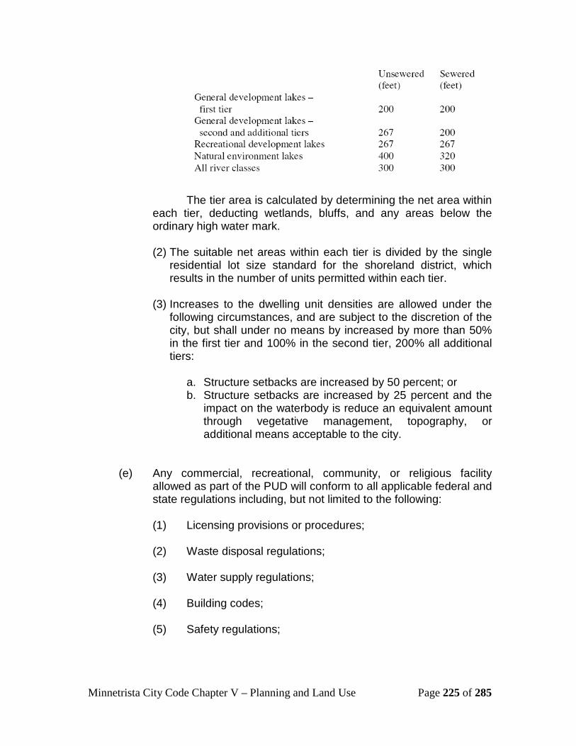
Minnetrista City Code Chapter V – Planning and Land Use Page 225 of 285
The tier area is calculated by determining the net area within
each tier, deducting wetlands, bluffs, and any areas below the ordinary high water mark.
(2) The suitable net areas within each tier is divided by the single
residential lot size standard for the shoreland district, which results in the number of units permitted within each tier.
(3) Increases to the dwelling unit densities are allowed under the
following circumstances, and are subject to the discretion of the city, but shall under no means by increased by more than 50% in the first tier and 100% in the second tier, 200% all additional tiers:
a. Structure setbacks are increased by 50 percent; or b. Structure setbacks are increased by 25 percent and the
impact on the waterbody is reduce an equivalent amount through vegetative management, topography, or additional means acceptable to the city.
(e) Any commercial, recreational, community, or religious facility
allowed as part of the PUD will conform to all applicable federal and state regulations including, but not limited to the following:
(1) Licensing provisions or procedures; (2) Waste disposal regulations; (3) Water supply regulations; (4) Building codes; (5) Safety regulations;

Minnetrista City Code Chapter V – Planning and Land Use Page 226 of 285
(6) Regulations concerning the appropriation and use of protected waters as defined in Minnesota Statutes, section 103G.005; and
(7) Applicable regulations of the Minnesota Environmental
Quality Board.
(f) The final plan for a PUD will contain no major alterations unless approved in writing by the developer, the city and the commissioner of the department of natural resources;
(g) There are centralized shoreline recreation facilities such as
beaches, docks and boat launching facilities. Evaluation of suitability must include consideration of land slope, water depth, vegetation, soils, depth to groundwater and bedrock, or other relevant factors. The number of spaces provide for continuous beaching, mooring, or docking of watercraft must not exceed one for each allowable dwelling unit or site in the first tier (notwithstanding existing mooring sites in an existing commercially used harbor). Launching ramp facilities, including a small dock for loading and unloading equipment, may be provided for use by occupants of dwelling units or sites located in other tiers.
Subd. 17. UStairways, lifts, and landingsU. Stairways and lifts are the preferred alternative to major topographic
alterations for achieving access up and down bluffs and steep slopes to shore areas. Stairways and lifts shall not be subject to setback requirements provided the following design requirements are met:
(a) Stairways and lifts must not exceed four feet in width on residential lots. Wider stairways may be used for commercial properties, public open-space recreational properties, and planned unit developments;
(b) Landings for stairways and lifts on residential lots must not exceed
32 square feet in area; (c) Canopies or roofs are not allowed on stairways, lifts, or landings; (d) Stairways, lifts, and landings may be either constructed above the
ground on posts or pilings, or placed into the ground, provided they are designed and built in a manner that ensures control of soil erosion;

Minnetrista City Code Chapter V – Planning and Land Use Page 227 of 285
(e) Stairways, lifts, and landings must be located in the most visually inconspicuous portions of lots, as viewed from the surface of the public water assuming summer, leaf-on conditions, whenever practical; and
(f) Facilities such as ramps, lifts, or mobility paths for physically
handicapped persons are also allowed for achieving access to shore areas, provided that the dimensional and performance standards in clauses (a) to (e) above are met.
505.51 Special Comprehensive Plan Amendment 2006 Overlay District Subdivision 1.U Purpose The purpose of this overlay district is to identify certain parcels within the city that are subject to a set of specific density and unit number guidelines for development, as originally set forth by the 2006 Comprehensive Plan Amendment (2006 CPA), and appearing in subsequent revisions/updates of the Minnetrista Comprehensive Plan. These parcels are identified on the Official Zoning Map of the city. Subd 2. UUses Permitted The permitted, accessory and conditional uses in the 2006 CPA overlay district are the same as those authorized in the associated underlying zoning district of each parcel or development site. Subd. 3. UConflict with pre-existing zoning regulationsU. When there is conflict between the underlying zoning district and the development standards set forth in this section, the standards in this section shall apply. The city and applicant shall make a reasonable attempt to reconcile these discrepancies through subdivision and/or building design. Subd. 4. UPermitted densities and minimum number of new housing units The following development sites are subject to the listed minimum number of residential units, in accordance with the 2006 CPA (and subsequent updates or amendments) reviewed and approved by the Metropolitan Council. It is the responsibility of the city to ensure the minimum number of units is accommodated through subdivision review, unless otherwise amended and agreed to by the Metropolitan Council: Development Site Reference Name
Associated PIDs Minimum No. of Units Required
Minimum Net Density (du/acre)
Halstead Pointe 2211724430002 9 2

Minnetrista City Code Chapter V – Planning and Land Use Page 228 of 285
Development Site Reference Name
Associated PIDs Minimum No. of Units Required
Minimum Net Density (du/acre)
2211724430003 2211724430004
Cardinal Cove 2nd 2211724430042 9 2.5 Park Cove Upper 2711724310002
3411724210004 3411724210005 3411724240001 3411724120001 3411724140003 3411724140002
292 1.5
Park Cove Lower 3411724340004 3411724420002 3411724430001
648 4
7170 Hwy 7 3411724330002 131 5 Thorson/Smith Halstead View
2711724230167 6 1.5
Former Diercks Property
1411724110002 31 2
Gulso Property (Dutch Lake Knoll)
1411724110003 37 2
Wallace Estate 1211724220027 16 2 Multiple Properties (Red Oak Area- 44.6 acres of these parcels)
1211724140004 1211724140003 1211724110002 1211724110001 1211724110003 1211724110008 1211724120003 1211724120005 1211724120007 1211724120006 1211724110005 1211724110006
89 2
If an individual parcel within a development site is developed separately, it must develop with the minimum number of dwelling units equal to its proportionate share, based on acreage, of the number of dwelling units assigned to the development site.

Minnetrista City Code Chapter V – Planning and Land Use Page 229 of 285
Section 510: Environmental Protection Regulations 510.01 Marshes and Wetlands
Subdivision 1. UPolicyU.
(a) It is in the public interest to protect against uncoordinated and unplanned land development which affects marshes, swamps, wetlands, drainage ways, lakes and watercourses within the city, which development, if allowed to continue, will result in loss and damage to public and private improvements through inundation by flood waters and subsequent expensive construction of storm sewers and other public projects, in the permanent destruction of these natural resources, loss of water retention facilities, open space and wildlife habitats, and impairment of public and private water supplies. The objectives of this section are to permit and encourage a coordinated land and water management program and the retention of open land uses which will locate permanent structures and artificial obstructions so as to not obstruct the passage of waters nor destroy the natural public water areas, marshes and wetlands within the city. The council has in mind its statutory obligation to adopt a flood plain ordinance pursuant to Minnesota Statutes chapter 103, the proposed regulations and model ordinances of the Lake Minnetonka Conservation District and the particular watershed district, the open space policies of the metropolitan council and its guidelines encouraging protection of marshes, wetlands and the flood plain area, and the public interest in preventing irreparable destruction of valuable natural resources as expressed by numerous persons.
(b) In addition to these general purposes, the specific intent of this section is to:
(1) Reduce danger to health by protecting surface and ground water supplies from the impairment which results from incompatible land uses by providing safe and sanitary drainage;
(2) Reduce the financial burdens imposed both on this city and
on communities within the watershed districts and the individuals therein by frequent floods and overflow of water on lands;
(3) Permit and encourage planned development land uses
which will not impede the flow of flood water or cause danger to life or property;
Minnetrista City Code Chapter V – Planning and Land Use Page 230 of 285
(4) Permit and encourage land uses compatible with the preservation of the natural vegetation and marshes which are a principal factor in the maintenance of constant rates of water flow through the year and which sustain many species of wildlife and plant growth;
(5) Avoid fast runoff of surface waters from developed areas to
prevent pollutional materials such as animal feces, motor oils, paper, sand, salt and other debris, garbage and foreign materials from being carried directly into the nearest natural stream, lake or other public waters;
(6) Encourage a suitable system of ponding areas to permit the
temporary withholding of rapid water runoff which presently contributes to downstream flooding and general water pollution giving preference to areas which contribute to groundwater infiltration and recharge, thereby reducing the need for public projects to contain, store and control such runoff;
(7) Provide sufficient land area to carry abnormal flows of storm
water in periods of heavy precipitation, and to prevent needless expenditures of public funds for storm sewers and flood protection devices which proper planning could have avoided;
(8) Prevent the development of structures in areas unfit for
human usage by reason of danger from flooding, unsanitary conditions or other hazards;
(9) Prevent the placement of artificial obstructions which restrict
the right of public passage and use of the bed, bank and water of any creeks, marshes or watercourses within the city.
Subd. 2. UDefinitionsU.
The following words, terms and phrases, when used in this section, will
have the meanings ascribed to them in this section, except where the context clearly indicates a different meaning:
Artificial obstruction means any obstruction which is not a natural
obstruction. Flood plain means the land area adjacent to a watercourse, drainage way
or creek which has been or may be covered by flood waters.

Minnetrista City Code Chapter V – Planning and Land Use Page 231 of 285
Natural obstruction means any rock, tree, gravel or analogous natural
matter that is an obstruction and has been located within the flood plain by a nonhuman cause.
Obstruction means any dam, wall, wharf, embankment, levee, dike, pile,
abutment, projection, excavation, bridge, conduit, pole, culvert, building, wire, fence, fill, other structure or matter in, along, across or projecting into the flood plain and wetlands conservation area.
Protected area means the area defined and established in section 510.01. Subd. 3.UDefinition and establishment of protected areaU.
The flood plain and wetlands conservation area within the city is defined
and established to be the low areas and flood plain adjoining and including any watercourse or drainage way or body of water subject to periodic flooding or overflow; and those areas designated and shown as marsh, wooded marsh, submerged marsh, inundation area, intermittent lake or intermittent streams by the United States Department of the Interior, through the Geological Survey on maps and supporting data designated as Mound Quadrangle, Minnesota, (7.5 minute series, (1958)) and Watertown Quadrangle Minnesota (7.5 minute series, (1981)). Those maps are hereby made a part of this section and two copies thereof will remain on file in the office of the city administrator for public inspection. For purposes of defining the application of this map to any specific area, the maps, data and other available source material for this survey will be on file in the office of the city administrator and will be proof of the intended limits of the flood plain and wetlands conservation area. Any change in the flood plain and wetlands conservation area as may from time to time be determined to be proper will be reflected on those maps.
Subd. 4. UDevelopment prohibitedU.
No filling, grading, dredging, excavation or construction will be allowed within the flood plain and wetlands conservation area; nor on lands abutting, adjoining or affecting such area if such activity properly upon those adjacent areas is incompatible with the policies expressed in this section and the preservation of those wetlands in their natural state; nor will land within the protected area be used in determining minimum area requirements for building sites except as provided in section 510.01, subd. 11.
Subd. 5. UPermitU.
To specifically further define the specific boundaries of the flood plain and
wetlands conservation area as described in the official maps thereof, and to insure the policies in this section are implemented, any persons undertaking

Minnetrista City Code Chapter V – Planning and Land Use Page 232 of 285
improvements to or on any land abutting or adjacent to the protected area will, prior to commencing the work, obtain a permit therefore from the city. Approval may be expressly given in conjunction with other permits applied for, but no approval will be implied from the grant of such permits nor from the necessity to apply for a permit as described herein. The granting of a permit will in no way affect the owner's responsibility to obtain the approval required by any other statute, ordinance or regulation of any state agency or any subdivision thereof.
Subd. 6. UPublic nuisance U. Any filling, alteration, construction or artificial obstruction of the flood plain
and wetlands conservation area is declared to be and to constitute a public nuisance unless a permit to construct and maintain the obstruction has been obtained in the manner provided herein.
Subd. 7. ULand development and plattingU.
No part of any lot within the flood plain and wetlands conservation area
will be platted for residential occupancy or for other uses which will increase the danger to health, life, property or the public welfare. Whenever a portion of the flood plain and wetlands conservation area is located within or adjoins a land area that is being subdivided, the subdivider will dedicate an adequate easement over the land within the protected area and along each side of such area for the purpose of improving or protecting the area for drainage or other purposes expressed in this section and other recreational uses, as determined by the council. Public or private streets, driveways, drainage openings and culverts will not be constructed unless the design thereof has been approved by the city, and such structures will be designed so as not to restrict the flow of water.
Subd. 8. UCredits under other ordinancesU.
When land to be developed is within the Municipal Utility Service Area (MUSA) and contains flood plains or wetlands, the owner will receive credit for flood plains or wetlands for purposes of complying with the city’s land development and zoning regulations relating to land use density, open space, building unit to land area ratios or other similar requirements, with the exception of park dedication, in an amount equal to but not to exceed the amount of land that qualifies for development. This section shall not apply to open space requirements for planned unit developments.
[Revised 02/04/2008, Ordinance 319] Subd. 9. USpecial assessmentsU.
The land area in the flood plain and wetlands conservation area which is
not to be developed and which is dedicated as an easement will not be subject to special assessments to defray the cost of other municipal improvement projects,

Minnetrista City Code Chapter V – Planning and Land Use Page 233 of 285
including but not limited to trunk sanitary sewer and water mains and storm sewer improvements.
Subd. 10. URemoval of artificial obstructionsU.
If an artificial obstruction is found after investigation by the city, an order will be issued to the owner, following ten days' written notice and hearing thereon, for removal within a reasonable time as may be prescribed by the condition and type of artificial obstruction. If the owner will fail to remove the artificial obstruction or if the owner cannot be found or determined, the city will have the power to make or cause such removal to be made, the cost of which will be borne by the owner or specially assessed against the lands in the same manner as prescribed by law for the levy of special assessments for municipal improvements notwithstanding section 510.01 subd. 9. The special assessment will be certified to the county auditor for collection in the same manner as the ad valorem real property tax of the city.
Subd. 11. URecovery of wetland enforcement costsU.
Reasonable and necessary costs including but not limited to consulting fees incurred by the city as a result of wetland violations under M.S. § 103G.2242 will be billed directly to the responsible party. If the responsible party is different from the property owner, the city will notify the property owner of the charges. If the responsible party or property owner does not pay the applicable charges, the city may assess any unpaid fees to the respective property or recover the unpaid fees by any other legal means.
510.03 Wetland Buffering and Setbacks Subdivision 1. UPurpose U. The purpose of this section is to protect the wetlands and maintain
buffering around wetlands to ensure the quality and functionality of the natural resources within the city. Wetlands maintain water quality, serve to reduce flooding and erosion, act as sources of food and habitat for a variety of fish and wildlife and are an integral part of the community’s natural landscape. The city has adopted the Wetland Conservation Act and Shoreland Management Ordinance to further protect the natural resources in the city. When applying this section, if in conflict with other ordinances, the more restrictive requirement applies. In an effort to avoid overlapping or conflicting regulations, this section shall defer to the Minnehaha Creek Watershed District rules for wetland buffering in areas of the city included in that watershed district.
Subd. 2. UAreas affected U. Any property which contains a wetland as identified by the U.S. Fish and
Wildlife Service maps; contains soils, vegetation, or hydrology that define a
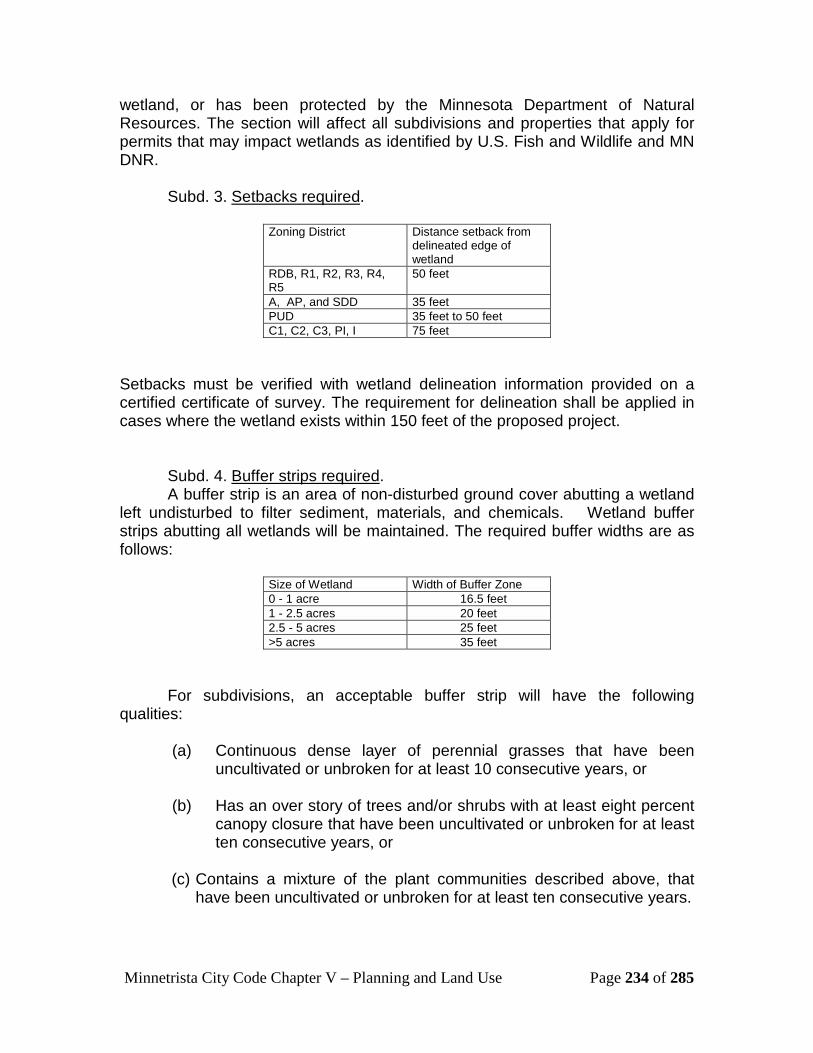
Minnetrista City Code Chapter V – Planning and Land Use Page 234 of 285
wetland, or has been protected by the Minnesota Department of Natural Resources. The section will affect all subdivisions and properties that apply for permits that may impact wetlands as identified by U.S. Fish and Wildlife and MN DNR.
Subd. 3. USetbacks requiredU.
Zoning District Distance setback from delineated edge of wetland
RDB, R1, R2, R3, R4, R5
50 feet
A, AP, and SDD 35 feet PUD 35 feet to 50 feet C1, C2, C3, PI, I 75 feet
Setbacks must be verified with wetland delineation information provided on a certified certificate of survey. The requirement for delineation shall be applied in cases where the wetland exists within 150 feet of the proposed project.
Subd. 4. UBuffer strips required U. A buffer strip is an area of non-disturbed ground cover abutting a wetland
left undisturbed to filter sediment, materials, and chemicals. Wetland buffer strips abutting all wetlands will be maintained. The required buffer widths are as follows:
Size of Wetland Width of Buffer Zone 0 - 1 acre 16.5 feet 1 - 2.5 acres 20 feet 2.5 - 5 acres 25 feet >5 acres 35 feet
For subdivisions, an acceptable buffer strip will have the following qualities:
(a) Continuous dense layer of perennial grasses that have been
uncultivated or unbroken for at least 10 consecutive years, or (b) Has an over story of trees and/or shrubs with at least eight percent
canopy closure that have been uncultivated or unbroken for at least ten consecutive years, or
(c) Contains a mixture of the plant communities described above, that
have been uncultivated or unbroken for at least ten consecutive years.

Minnetrista City Code Chapter V – Planning and Land Use Page 235 of 285
(d) If none of these qualities are in existence, establishment of a buffer is required, in accordance with subd. 6.
Subd. 5. UUnacceptable buffer stripsU. A buffer strip is unacceptable if:
(a) It is composed of undesirable plant species (including, but not
limited to reed canary grass, common buckthorn, purple loosestrife, leafy spurge and noxious weeds, or any other undesirable species as determined by a natural resource specialist), or
(b) It is lacking a layer of organic thatch or duff, or (c) It has topography that tends to channelize the flow of surface runoff, or (d) For some other reason it is unlikely to retain nutrients and sediment.
Subd. 6. UBuffer areasU. Buffer areas not meeting the criteria in subd. 5 must be planted and
maintained according to each of the following:
(a) Buffer zones will be planted with a seed mix containing 100 percent perennial native plant species, except for a one-time planting of an annual nurse or cover crop such as oats or rye.
(b) The seed mix to be used will consist of at least 12 pounds pure live
seed (PLS) per acre of native prairie grass seed and five pounds PLS per acre of native forbs. Native prairie grass and native form mixes will contain no fewer than four and five species respectively.
(c) The annual nurse or cover crop will be applied at rate of 20 pounds
per acre. (d) Native shrubs may be substituted for forms. Such shrubs may be
bare root seedling and will be planted at a rate of 60 plants per acre. Shrubs will be distributed so as to provide a natural appearance and will not be planted in rows.
(e) Native prairie grasses and forms will be planted by a qualified
contractor. (f) No fertilizer will be used in establishing new buffer zones, except on
highly disturbed sites when deemed necessary to establish

Minnetrista City Code Chapter V – Planning and Land Use Page 236 of 285
acceptable buffer vegetation and then limited to amounts indicated by an accredited soil testing laboratory.
(g) All seeded areas will be mulched immediately with clean straw at a
rate of one and one-half tons per acre. Mulch will be anchored. (h) Buffer zones (both natural and created), will be protected by silt
fence during construction and the fence will remain in place until the area crop is established.
510.05 Floodplain Management Subdivision 1. UDefinitionsU.
Accessory use or structure means a use or structure on the same lot with,
and of a nature customarily incidental and subordinate to, the principal use or structure.
Basement means any area of a structure, including crawl spaces, having its floor or base subgrade (below ground level) on all four sides, regardless of the depth of excavation below ground level.
Flood fringe means that portion of the flood plain outside of the floodway.
Flood plain means the channel or beds proper and the areas adjoining a wetland, lake or watercourse that have been or hereafter may be covered by the regional flood. Flood plain areas within the city of Minnetrista shall encompass all areas designated as Zone A, Zone AE, Zone AO, or Zone AH on the Flood Insurance Rate Map adopted in section 510.05 of this ordinance.
Floodway means the bed of a wetland or lake and the channel of a watercourse and those portions of the adjoining flood plain that are reasonably required to carry or store the regional flood discharge.
Lowest floor means the lowest floor of the lowest enclosed area (including basement).
Manufactured home means a structure, transportable in one or more sections, which is built on a permanent chassis and is designed for use with or without a permanent foundation when attached to the required utilities. The term “manufactured home” does not include the term “recreational vehicle.”
Obstruction means any dam, wall, wharf, embankment, levee, dike, pile, abutment, projection, excavation, dredged spoil, channel modification, culvert, building, wire, fence, stockpile, refuse, fill, structure, stockpile of sand or gravel or other material, or matter in, along, across, or projecting into any channel, watercourse, lake bed, or regulatory flood plain which may impede, retard, or

Minnetrista City Code Chapter V – Planning and Land Use Page 237 of 285
change the direction of flow, either in itself or by catching or collecting debris carried by floodwater.
Recreational vehicle means a vehicle that is built on a single chassis, is 400 square feet or less when measured at the largest projection, is designed to be self-propelled or permanently towable by a light duty truck, and is designed primarily not for use as a permanent dwelling but as temporary living quarters for recreational, camping, travel, or seasonal use. For the purposes of this section, the term recreational vehicle shall be synonymous with the term travel trailer/travel vehicle.
Regional Flood means a flood which is representative of large floods known to have occurred generally in Minnesota and reasonably characteristics of what can be expected to occur on an average frequency in magnitude of the 100-year recurrence interval. Regional flood is synonymous with the term "base flood" used on the Flood Insurance Rate Map.
Regulatory flood protection elevation means the regulatory flood protection elevation shall be an elevation no lower than one foot above the elevation of the regional flood plus any increases in flood elevation caused by encroachments on the flood plain that result from designation of a floodway.
Structure means anything constructed or erected on the ground or attached to the ground or on-site utilities, including, but not limited to, buildings, factories, sheds, detached garages, cabins, manufactured homes, travel trailers/vehicles not meeting the exemption criteria specified in section 510.05 subd. 14 (a) and other similar items.
Substantial damage means damage of any origin sustained by a structure where the cost of restoring the structure to its before damaged condition would equal or exceed 50 percent of the market value of the structure before the damage occurred.
Substantial improvement means any reconstruction, rehabilitation (including normal maintenance and repair), repair after damage, addition, or other improvement of a structure within any consecutive 365-day period, the cost of which equals or exceeds 50 percent of the market value of the structure before the “start of construction” of the improvement. This term includes structures that have incurred “substantial damage,” regardless of the actual repair work performed. The term does not, however, include either:
(a) Any project for improvement of a structure to correct existing violations of state or local health, sanitary, or safety code specifications which have been identified by the local code enforcement official and which are the minimum necessary to assure safe living conditions.

Minnetrista City Code Chapter V – Planning and Land Use Page 238 of 285
(e) Any alteration of an “historic structure,” provided that the alteration
will not preclude the structure’s continued designation as an “historic structure.” For the purpose of this section, “historic structure” shall be as defined in Code of Federal Regulations, Part 59.1.
Subd. 2. UStatutory authorization, findings of fact, and purpose. (a). Statutory Authorization. The Legislature of the State of Minnesota
has, in Minnesota Statutes Chapters 103F and Chapter 462 delegated the authority to local governmental units to adopt regulations designed to minimize flood losses. Minnesota Statute, Chapter 103F further stipulates that communities subject to recurrent flooding must participate and maintain eligibility in the National Flood Insurance Program.
(b). Statement of purpose. The purpose of this section is to maintain the community's eligibility in the National Flood Insurance Program and to minimize potential losses due to periodic flooding including loss of life, loss of property, health and safety hazards, disruption of commerce and governmental services, extraordinary public expenditures for flood protection and relief, and impairment of the tax base, all of which adversely affect the public health, safety and general welfare.
(c). Warning of disclaimer of liability. This section does not imply that areas outside of the flood plain district or land uses permitted within such districts will be free from flooding and flood damages. This section shall not create liability on the part of the city or any officer or employee thereof for any flood damages that result from reliance on this ordinance or any administrative decisions lawfully made thereunder.
(d). National flood insurance program compliance. This section is adopted to comply with the rules and regulations of the National Flood Insurance Program codified as 44 Code of Federal Regulations Parts 59 -78, as amended, so as to maintain the Community’s eligibility in the National Flood Insurance Program.
Subd. 3. UGeneral provisions. (a). Adoption of flood insurance study and flood insurance rate map. The
Flood Insurance Study, Volume 1 of 2 and Volume 2 of 2, Hennepin County, Minnesota, All Jurisdictions and the Flood Insurance Rate Map panels numbered 27053C0257E, 27053C0259E, 27053C0270E, 27053C0276E, 27053C0280E, 27053C0283E, 27053C0284E, 27053C0285E, 27053C0287E, 27053C0290E, 27053C0291E, 27053C0292E, and 27053C0295E for the city of Minnetrista, dated September 2, 2004, as developed by the Federal Emergency Management Agency, are hereby adopted by reference as the Official Flood Plain Zoning District Map and made a part of this section.

Minnetrista City Code Chapter V – Planning and Land Use Page 239 of 285
(b). Lands to which section applies. This section shall apply to all lands designated as flood plain within the jurisdiction of the city. Flood plain areas within the city shall encompass all areas designated as Zone A, Zone AE, Zone AO, or Zone AH as shown on the Flood Insurance Rate Map adopted in section 510.05 of this section.
Subd. 4. UInterpretationU. The boundaries of the flood plain district shall be determined by scaling
distances on the Official Flood Plain Zoning District Map. Where interpretation is needed as to the exact location of the boundaries of the flood plain district, the zoning administrator shall make the necessary interpretation based on the ground elevations that existed on the site at the time the community adopted its initial floodplain regulations and the regional (100-year) flood profile, if available. If 100-year flood elevations are not available, the community shall:
(a) Require a flood plain evaluation consistent with Section 510.05,
Subd. 5 of this ordinance to determine a 100-year flood elevation for the site; or
(b) Base its decision on available hydraulic/hydrologic or site elevation
survey data which demonstrates the likelihood the site is within or outside of the flood plain.
Subd. 5. UConflict with pre-existing zoning regulations and general
complianceU.
(a) The flood plain district as overlay zoning district. The flood plain zoning district shall be considered an overlay zoning district to all existing land use regulations of the community. The uses permitted in subsections 510.05 subd. 6 shall be permitted only if not prohibited by any established, underlying zoning district. The requirements of this section shall apply in addition to other legally established regulations of the community and where this section imposes greater restrictions, the provisions of this section shall apply.
(b) Compliance. No new structure or land shall hereafter be used and no structure shall be constructed, located, extended, converted, repaired, maintained, or structurally altered without full compliance with the terms of this section and other applicable regulations which apply to uses within the jurisdiction of this section. Within the floodway and flood fringe, all uses not listed as permitted uses in subsection 510.05 subd. 6 shall be prohibited. In addition, a caution is provided here that:
(1) New manufactured homes, replacement manufactured homes and certain recreational vehicles are subject to the general provisions of this section and specifically subsections 510.05 subd. 6 and 510.05 subd 15;
Minnetrista City Code Chapter V – Planning and Land Use Page 240 of 285
(2) Modifications, repair and maintenance, additions, structural alterations or repair after damage to existing nonconforming structures and nonconforming uses of structures or land are regulated by the general provisions of this section and specifically subsection 510.05 subd. 12; and
(3) As-built elevations for elevated structures must be certified by elevation surveys as stated in subsection 510.05 subd. 9.
Subd. 6. UPermitted uses, standards, and floodplain evaluation criteria. (a) Permitted uses in the flood plain. The following uses of land are
permitted uses in the flood plain district:
(1) Any use of land which does not involve a structure, a fence, an addition to the outside dimensions to an existing structure (including a fence) or an obstruction to flood flows such as fill, excavation, or storage of materials or equipment.
(2) Any use of land involving the construction of new structures, a fence, the placement or replacement of manufactured homes, the addition to the outside dimensions of an existing structure (including a fence) or obstructions such as fill or storage of materials or equipment, provided these activities are located in the flood fringe portion of the flood plain. These uses shall be subject to the development standards in subection 510.05, subd. 6 (b) and the flood plain evaluation criteria in subection 510.05, subd. 6 (c) for determining floodway and flood fringe boundaries.
(3) Recreational vehicles are regulated by subsection 510.05
subd. 15
(b) Standards for flood plain permitted uses.
(1) Fill shall be properly compacted and the slopes shall be properly protected by the use of riprap, vegetative cover or other acceptable method. The Federal Emergency Management Agency (FEMA) has established criteria for removing the special flood hazard area designation for certain structures properly elevated on fill above the 100-year flood elevation - FEMA's requirements incorporate specific fill compaction and side slope protection standards for multi-structure or multi-lot developments. These standards should be investigated prior to the initiation of site preparation if a change of special flood hazard area designation will be requested.

Minnetrista City Code Chapter V – Planning and Land Use Page 241 of 285
(2) Storage of materials and equipment:
(i) The storage or processing of materials that are, in time of flooding, flammable, explosive, or potentially injurious to human, animal, or plant life is prohibited.
(ii) Storage of other materials or equipment may be allowed if readily removable from the area within the time available after a flood warning or if placed on fill to the regulatory flood protection elevation.
(3) No use shall be permitted which will adversely affect the capacity of the channels or floodways of any tributary to the main stream, or of any drainage ditch, or any other drainage facility or system.
(4) All structures, including accessory structures, additions to existing structures and manufactured homes, shall be constructed on fill so that the lowest floor, including basement floor, is at or above the regulatory flood protection elevation. The finished fill elevation must be no lower than one foot below the regulatory flood protection elevation and shall extend at such elevation at least 15 feet beyond the limits of the structure constructed thereon.
(5) All uses. Uses that do not have vehicular access at or above an elevation not more than two feet below the regulatory flood protection elevation to lands outside of the flood plain shall not be permitted unless granted a variance by the Board of Adjustment. In granting a variance, the Board of Adjustment shall specify limitations on the period of use or occupancy of the use and only after determining that adequate flood warning time and local emergency response and recovery procedures exist.
(6) Commercial and manufacturing uses. Accessory land uses, such as yards, railroad tracks, and parking lots may be at elevations lower than the regulatory flood protection elevation. However, a permit for such facilities to be used by the employees or the general public shall not be granted in the absence of a flood warning system that provides adequate time for evacuation if the area would be inundated to a depth and velocity such that when multiplying the depth (in feet) times velocity (in feet per second) the product number exceeds four upon occurrence of the regional flood.
(7) On-site sewage treatment and water supply systems. Where public utilities are not provided:

Minnetrista City Code Chapter V – Planning and Land Use Page 242 of 285
(i) On-site water supply systems must be designed to minimize or eliminate infiltration of flood waters into the systems; and
(ii) New or replacement on-site sewage treatment systems must be designed to minimize or eliminate infiltration of flood waters into the systems and discharges from the systems into flood waters and they shall not be subject to impairment or contamination during times of flooding. Any sewage treatment system designed in accordance with the state's current statewide standards for on-site sewage treatment systems shall be determined to be in compliance with this section.
(8) All manufactured homes must be securely anchored to an adequately anchored foundation system that resists flotation, collapse and lateral movement. Methods of anchoring may include, but are not to be limited to, use of over-the-top or frame ties to ground anchors. This requirement is in addition to applicable state or local anchoring requirements for resisting wind forces.
(c) Flood plain evaluation.
(1) Upon receipt of an application for a permit for a use or other approval within the flood plain district, the applicant shall be required to furnish such of the following information as is deemed necessary by the zoning administrator for the determination of the regulatory flood protection elevation and whether the proposed use is within the floodway or flood fringe.
(i) A typical valley cross-section(s) showing the channel of the stream, elevation of land areas adjoining each side of the channel, cross-sectional areas to be occupied by the proposed development, and high water information.
(ii) Plan (surface view) showing elevations or contours of the ground, pertinent structure, fill, or storage elevations, the size, location, and spatial arrangement of all proposed and existing structures on the site, and the location and elevations of streets.
(iii) Photographs showing existing land uses, vegetation upstream and downstream, and soil types.

Minnetrista City Code Chapter V – Planning and Land Use Page 243 of 285
(iv) Profile showing the slope of the bottom of the channel or flow line of the stream for at least 500 feet in either direction from the proposed development.
(2) The applicant shall be responsible to submit one copy of the above information to a designated engineer or other expert person or agency for technical assistance in determining whether the proposed use is in the floodway or flood fringe and to determine the regulatory flood protection elevation. Procedures consistent with Minnesota Regulations 1983, Parts 6120.5000 - 6120.6200 and 44 Code of Federal Regulations Part 65 shall be followed in this expert evaluation. The designated engineer or expert is strongly encouraged to discuss the proposed technical evaluation methodology with the respective Department of Natural Resources’ Area Hydrologist prior to commencing the analysis. The designated engineer or expert shall:
(i) Estimate the peak discharge of the regional flood.
(ii) Calculate the water surface profile of the regional flood based upon a hydraulic analysis of the stream channel and overbank areas.
(iii) Compute the floodway necessary to convey or store the regional flood without increasing flood stages more than 0.5 foot. A lesser stage increase than .5 foot shall be required if, as a result of the additional stage increase, increased flood damages would result. An equal degree of encroachment on both sides of the stream within the reach shall be assumed in computing floodway boundaries.
(3) The zoning administrator shall present the technical evaluation and
findings of the designated engineer or expert to the governing body. The governing body must formally accept the technical evaluation and the recommended floodway and/or flood fringe district boundary or deny the permit application. The governing body, prior to official action, may submit the application and all supporting data and analyses to the Federal Emergency Management Agency, the Department of Natural Resources or the planning commission for review and comment. Once the floodway and flood fringe district boundaries have been determined, the governing body shall refer the matter back to the zoning administrator who shall process the permit application consistent with the applicable provisions of this ordinance.
Subd. 7. UUtilities, railroads, and bridges in the floodplain district.

Minnetrista City Code Chapter V – Planning and Land Use Page 244 of 285
All utilities and transportation facilities, including railroad tracks, roads and bridges, shall be constructed in accordance with state flood plain management standards contained in Minnesota Rules 1983 Parts 6120.5000 - 6120.6200.
Subd. 8. USubdivisionsU. (a) No land shall be subdivided and no manufactured home park shall be developed or expanded where the site is determined to be unsuitable by the city council for reason of flooding, inadequate drainage, water supply or sewage treatment facilities. The city council shall review the subdivision/development proposal to insure that each lot or parcel contains sufficient area outside of the floodway for fill placement for elevating structures, sewage systems and related activities.
(b) In the flood plain district, applicants for subdivision approval or development of a manufactured home park or manufactured home park expansion shall provide the information required in subsection 510.05, Subd. 6 (c). The zoning administrator shall evaluate the proposed subdivision or mobile home park development in accordance with the standards established in subsections 510.05, subd. 6, and 510.05 subd.7.
(c) For all subdivisions in the flood plain, the floodway and flood fringe boundaries, the regulatory flood protection elevation and the required elevation of all access roads shall be clearly labeled on all required subdivision drawings and platting documents.
(d) Removal of special flood hazard area designation. The Federal Emergency Management Agency (FEMA) has established criteria for removing the special flood hazard area designation for certain structures properly elevated on fill above the 100-year flood elevation. FEMA's requirements incorporate specific fill compaction and side slope protection standards for multi-structure or multi-lot developments. These standards should be investigated prior to the initiation of site preparation if a change of special flood hazard area designation will be requested.
Subd. 9. UAdministration U.
(a) Permit required. A permit issued by the city council/building
inspector shall be secured prior to the erection, addition, modification, rehabilitation (including normal maintenance and repair), or alteration of any building or structure or portion thereof; prior to the use or change of use of a building, structure, or land; prior to the construction of a dam, fence, or on-site septic system, prior to the change or extension of a nonconforming use, prior to the repair of a structure that has been

Minnetrista City Code Chapter V – Planning and Land Use Page 245 of 285
damaged by flood, fire, tornado, or any other source, and prior to the placement of fill, excavation of materials or the storage of materials or equipment within the flood plain.
(b) State and federal permits. Prior to granting a permit or
processing an application for a variance, the zoning administrator shall determine that the applicant has obtained all necessary state and federal permits.
(c) Certification of lowest floor elevations. The applicant shall be
required to submit certification by a registered professional engineer, registered architect, or registered land surveyor that the finished fill and building elevations were accomplished in compliance with the provisions of this ordinance. The building inspector and zoning administrator shall maintain a record of the elevation of the lowest floor (including basement) for all new structures and alterations or additions to existing structures in the flood plain district.
(d) Notifications for watercourse alterations. The zoning
administrator shall notify, in riverine situations, adjacent communities and the commissioner of the Department of Natural Resources prior to the community authorizing any alteration or relocation of a watercourse. If the applicant has applied for a permit to work in the beds of public waters pursuant to Minnesota Statute, Chapter 103G, this shall suffice as adequate notice to the commissioner of Natural Resources. A copy of said notification shall also be submitted to the Chicago Regional Office of the Federal Emergency Management Agency (FEMA).
(e) Notification to FEMA when physical changes increase or
decrease the 100-year flood elevation. As soon as is practicable, but not later than six months after the date such supporting information becomes available, the zoning administrator shall notify the Chicago Regional Office of FEMA of the changes by submitting a copy of said technical or scientific data.
Subd. 10. UVariances.
(a) A variance means a modification of a specific permitted
development standard required in an official control including this section to allow an alternative development standard not stated as acceptable in the official control, but only as applied to a particular property for the purpose of alleviating a hardship, practical difficulty or unique circumstance as defined and elaborated upon in a community's respective planning and zoning enabling legislation and this ordinance.

Minnetrista City Code Chapter V – Planning and Land Use Page 246 of 285
(b) The Board of Adjustment may authorize upon appeal in specific cases such relief or variance from the terms of this section as will not be contrary to the public interest and only for those circumstances such as hardship, practical difficulties or circumstances unique to the property under consideration, as provided for in the respective enabling legislation for planning and zoning for cities or counties as appropriate. In the granting of such variance, the Board of Adjustment shall clearly identify in writing the specific conditions that existed consistent with the criteria specified in this section, any other zoning regulations of the community, and the criteria specified in the respective enabling legislation which justified the granting of the variance. The following additional variance criteria of the Federal Emergency Management Agency must be satisfied:
(1) Variances shall not be issued by a community within any designated regulatory floodway if any increase in flood levels during the base flood discharge would result.
(2) Variances shall only be issued by a community upon:
(i) a showing of good and sufficient cause,
(ii) a determination that failure to grant the variance would result in exceptional hardship to the applicant, and
(iii) a determination that the granting of a variance will not result in increased flood heights, additional threats to public safety, extraordinary public expense, create nuisances, cause fraud on or victimization of the public, or conflict with existing local laws or ordinances.
(3) Variances shall only be issued upon a determination that the variance is the minimum necessary, considering the flood hazard, to afford relief.
(c) Variances from the provisions of this section may be authorized where the Board of Adjustment has determined the variance will not be contrary to the public interest and the spirit and intent of this section. No variance shall allow in any district a use prohibited in that district or permit a lower degree of flood protection then the regulatory flood protection elevation. Variances may be used to modify permissible methods of flood protection.
(d) The Board of Adjustment shall submit by mail to the commissioner of Natural Resources a copy of the application for
Minnetrista City Code Chapter V – Planning and Land Use Page 247 of 285
proposed variance sufficiently in advance so that the commissioner will receive at least ten days’ notice of the hearing. A copy of all decisions granting a variance shall be forwarded by mail to the commissioner of Natural Resources within 10 days of such action.
(e) Appeals. Appeals from any decision of the Board of Adjustment may be made, and as specified in this community's official controls and also Minnesota Statutes.
(f) Flood insurance notice and record keeping. The zoning administrator shall notify the applicant for a variance that:
(1) The issuance of a variance to construct a structure below the base flood level will result in increased premium rates for flood insurance up to amounts as high as $25 for $100 of insurance coverage; and
(2) Such construction below the 100-year or regional flood level increases risks to life and property. Such notification shall be maintained with a record of all variance actions. This community shall maintain a record of all variance actions, including justification for their issuance, and report such variances issued in its annual or biennial report submitted to the administrator of the National Flood Insurance Program.
Subd 11. UNonconformities.
A structure or the use of a structure or premises which was lawful before
the adoption or amendment of this section but which is not in conformity with the provisions of this section may be continued subject to the following conditions. Historic structures, as defined in Code of Federal Regulations, Part 59.1, shall be subject to the provisions of clauses (a), (b), (c), and (d) of this subsection.
(a) No such use shall be expanded, changed, enlarged, or altered in a way which increases its nonconformity.
(b) A structural alteration within the inside dimensions of a
nonconforming use or structure is permissible provided it utilizes flood resistant materials so as not to result in increasing the flood damage potential of that use or structure. A structural addition to a structure must be elevated to the regulatory flood protection elevation in accordance with subsection 510.05, subd. 6 b(v).

Minnetrista City Code Chapter V – Planning and Land Use Page 248 of 285
(c) The cost of all structural alterations or additions both inside and outside of a structure to any nonconforming structure over the life of the structure shall not exceed 50 percent of the market value of the structure unless the conditions of this section are satisfied. The cost of all structural alterations and additions constructed since the adoption of the community's initial flood plain controls must be calculated into today's current cost which will include all costs such as construction materials and a reasonable cost placed on all manpower or labor. If the current cost of all previous and proposed alterations and additions exceeds 50 percent of the current market value of the structure, then the structure must meet the standards of subsection 510.05 subd. 6 for new structures.
(d) If any nonconforming use of a structure or land or nonconforming
structure is substantially damaged, as defined by section 510.05, it shall not be reconstructed except in conformity with the provisions of this section. The city council may issue a permit for reconstruction if the use is located outside the floodway and, upon reconstruction, is adequately elevated on fill in conformity with the provisions of this section.
(e) If a substantial improvement occurs, as defined in section 510.05,
from any combination of a building addition to the outside dimensions of the existing building or a rehabilitation, reconstruction, alteration, or other improvement to the inside dimensions of an existing nonconforming building, then the building addition (as required by clause (b) above) and the existing nonconforming building must meet the requirements of subsection 510.05 subd. 6 for new structures, depending upon whether the structure is in the floodway or flood fringe, respectively.
Subd. 12. UPenalties for violation.
A violation of the provisions of this section or failure to comply with any of
its requirements (including violations of conditions and safeguards established in connection with grants of variance) shall constitute a misdemeanor.
(a) In responding to a suspected violation, the zoning administrator may utilize the full array of enforcement actions available to it including but not limited to prosecution and fines, injunctions, after-the-fact permits, orders for corrective measures or a request to the National Flood Insurance Program for denial of flood insurance availability to the guilty party. The city must act in good faith to enforce these official controls and to correct violations to the extent possible so as not to jeopardize its eligibility in the National Flood Insurance Program.
Minnetrista City Code Chapter V – Planning and Land Use Page 249 of 285
(b) When a violation is either discovered by or brought to the attention
of the zoning administrator, the zoning administrator shall immediately investigate the situation and document the nature and extent of the violation of the official control. As soon as is reasonably possible, this information will be submitted to the appropriate Department of Natural Resources' and Federal Emergency Management Agency Regional Office along with the community's plan of action to correct the violation to the degree possible.
(c) The zoning administrator shall notify the suspected party of the
requirements of this section and all other official controls and the nature and extent of the suspected violation of these controls. If the structure and/or use are under construction or development, the zoning administrator may order the construction or development immediately halted until a proper permit or approval is granted by the community. If the construction or development is already completed, then the zoning administrator may either:
(1) issue an order identifying the corrective actions that must be
made within a specified time period to bring the use or structure into compliance with the official controls, or
(2) notify the responsible party to apply for an after-the-fact
permit/development approval within a specified period of time not to exceed 30-days.
(d) If the responsible party does not appropriately respond to the
zoning administrator within the specified period of time, each additional day that lapses shall constitute an additional violation of this section and shall be prosecuted accordingly. The zoning administrator shall also upon the lapse of the specified response period notify the landowner to restore the land to the condition that existed prior to the violation of this section.
Subd 13. UAmendments.
All amendments to this section, including revisions to the official flood
plain zoning district map, shall be submitted to and approved by the commissioner of Natural Resources prior to adoption. The flood plain designation on the official flood plain zoning district map shall not be removed unless the area is filled to an elevation at or above the regulatory flood protection elevation and is contiguous to lands outside of the flood plain. Changes in the official zoning map must meet the Federal Emergency Management Agency's (FEMA) Technical Conditions and Criteria and must receive prior FEMA approval
Minnetrista City Code Chapter V – Planning and Land Use Page 250 of 285
before adoption. The commissioner of Natural Resources must be given 10 days’ written notice of all hearings to consider an amendment to this section and said notice shall include a draft of the ordinance amendment or technical study under consideration.
Subd. 14. UTravel trailers and travel vehicles.
Recreational vehicles that do not meet the exemption criteria specified in subdivision 1 below shall be subject to the provisions of this section and as specifically spelled out below.
(a) Exemption. Recreational vehicles are exempt from the provisions of this section if they are placed in any of the areas listed in subdivision 2 below and further they meet the following criteria:
(1) Have current licenses required for highway use.
(2) Are highway ready meaning on wheels or the internal
jacking system, are attached to the site only by quick disconnect type utilities commonly used in campgrounds and recreational vehicle parks and the recreational vehicle has no permanent structural type additions attached to it.
(3) The recreational vehicle and associated use must be permissible in any pre-existing, underlying zoning use district.
(b) Areas exempted for placement of recreational vehicles.
(1) Individual lots or parcels of record. (2) Existing commercial recreational vehicle parks or campgrounds.
(3) Existing condominium type associations.
(c) Recreational vehicles exempted in subdivision 14 (a) above lose this exemption when development occurs on the parcel exceeding $500 for a structural addition to the recreational vehicle or exceeding $500 for an accessory structure such as a garage or storage building. The recreational vehicle and all additions and accessory structures will then be treated as a new structure and shall be subject to the elevation requirements and the use of land restrictions specified in subsection 510.05 subd. 5. There shall be no development or improvement on the parcel or attachment to the

Minnetrista City Code Chapter V – Planning and Land Use Page 251 of 285
recreation vehicle that hinders the removal of the recreational vehicle to a flood-free location should flooding occur.
(d) New commercial recreational vehicle parks or campgrounds and new residential type subdivisions and condominium associations and the expansion of any existing similar use exceeding five units or dwelling sites shall be subject to the following:
(1) Any new or replacement recreational vehicle will be allowed in the floodway or flood fringe districts provided said recreational vehicle and its contents are placed on fill above the regulatory flood protection elevation determined in accordance with the provisions of subsection 510.05, subdivision 5 (c) and proper elevated road access to the site exist in accordance with subsection 510.05 subdivision 5. No fill placed in the floodway to meet the requirements of this section shall increase flood stages of the 100-year or regional flood.
(2) All new or replacement recreational vehicles not meeting the criteria of subsection 510.05, subd. 13 (d) 1 may, as an alternative, be allowed if in accordance with the following provisions. The applicant must submit an emergency plan for the safe evacuation of all vehicles and people during the 100 year flood. Said plan shall be prepared by a registered engineer or other qualified individual, shall demonstrate that adequate time and personnel exist to carry out the evacuation, and shall demonstrate that the provisions of subsection 510.05 subd. 13, (a) 1 and 2 will be met. All attendant sewage and water facilities for new or replacement recreational vehicles must be protected or constructed so as to not be impaired or contaminated during times of flooding in accordance with subsection 510.05 subdivision 5 (b) 7.
510.07 Tree Preservation
Subdivision 1. UPurpose.U The city intends to maintain trees throughout the community. This section establishes the policies, regulations, and standards necessary to ensure the future of the community forest during the development process. The city council recognizes the ecological, economic, and amenity value and benefit of trees, forests, and natural vegetation in the city. While the destruction of a single tree may not have a significant environmental impact, the city recognizes that tree

Minnetrista City Code Chapter V – Planning and Land Use Page 252 of 285
destruction has a cumulative impact that causes severe environmental degradation and deterioration of the quality of life in the city.
Subd 2. UAffected areas. U
This section shall apply to the following:
(a) All subdivisions resulting in five or more units, lots, parcels, tracts or long-term leaseholds regardless of the particular zoning district.
(b) All planned unit developments, except to the extent that allowances
are made under the planned unit development provisions of city code.
Subd. 3 UDefinitions.U
The following words, terms and phrases, when used in this section, shall
have the meanings ascribed to them in this section, except where the context clearly indicates a different meaning:
Caliper inches. The diameter of a tree which is measured in inches at a point 4.5 feet above the ground.
Drip Line. The farthest distance away from the trunk of a tree that rain or dew will fall to the ground from the Tree’s leaves or branches.
Forestry Specialist. A landscape architect, certified tree inspector or certified forester or arborist.
Healthy Tree. Any tree which: 1) is not found to have a systemic disease
such as Dutch Elm Disease, Oak Wilt or any other disease recognized by the Minnesota Department of Agriculture; 2) has less than 50 percent of its circumference girdled; 3) does not exhibit “flagging” on more than 30 percent of its crown area; 4) does not pose a hazard to public safety; and 5) does not suffer from any other condition which threatens its viability.
Ideal Planting Season. Specific times of the year in which coniferous and deciduous trees are allowed to be planted to meet the requirements of a tree preservation plan. Ideal Planting Seasons for deciduous trees shall be from April 7 P
thP to June 1P
stP in the spring, and from October 10P
thP to November 15 P
thP in the fall.
Ideal planting seasons for coniferous trees shall be from April 7P
thP to May 17P
thP in
the springS, S and from August 25P
thP to September 15P
thP in the fall.
Impacted Tree. Any tree impacted by construction activity or weather
conditions such that the tree has been deemed likely to die by a Forestry Specialist. Impacts can include but are not limited to grading changes affecting a

Minnetrista City Code Chapter V – Planning and Land Use Page 253 of 285
Tree’s root system, mechanical injuries to the trunkSsS of a tree, compaction of soil and other threats to continued viability.
Replacement Tree. Any tree installed in response to the removal of a significant tree as required by this section.
Significant Tree. A structurally sound and healthy deciduous tree measuring six caliper inches or greater, or a structurally sound and healthy coniferous tree measuring four Caliper Inches or greater.
Significant Tree, especially. An especially significant tree is defined as a
large, desirable species of tree that is healthy and strong. The Council may find especially significant trees based on the tree inventory, consultation with a forestry specialist, or defined as a tree larger than 16 caliper inches for a sugar maple and American basswood, larger than 20 caliper inches for bur, white, red, or pin oak.
Tree. A woody plant which at maturity is greater than 13 feet in height and has a more or less definite crown.
Trees to be Protected. The identified 70 percent or more of existing significant trees intended for protection.
Trees to be Removed. The entire list of trees planned for removal within a tree preservation plan or trees identified for removal in conjunction with a permitted activity.
Unplanned Removal. Any impacted tree or tree removed that was intended for preservation according to a tree preservation plan that is not approved in advance of the removal.
Unit. A separate dwelling unit intended for residential occupancy by one
person or household.
Subd 4. UProtection from development.U
(a) Subdivisions and planned unit developments affected by this section are required to protect all significant trees that are not needed to be removed to allow the reasonable development of the property. At a minimum, 70 percent of the total caliper inches of significant trees on the property shall be protected. If the caliper inches of the trees to be removed is greater than the allowed 30 percent, the required replacement trees shall be one caliper inch for each caliper inch removed beyond the allowed 30 percent.

Minnetrista City Code Chapter V – Planning and Land Use Page 254 of 285
(b) If it is determined by the city that certain, especially significant trees should be preserved, as defined herein, the developer shall be given double credit towards the preservation of these trees, provided additional measures are taken to protect these trees from compaction and root severing through the design of the plat, proper tree save fencing, and custom grading efforts.
Subd. 5. URemoval of dead, diseased, or invasive species trees.
(a) Diseased trees on the property that pose a threat to surrounding trees shall not be considered significant trees and shall be removed and disposed of by the applicant. The removal and disposal of diseased trees must comply with any applicable city code and state statute requirements.
(b) Dead trees shall not be considered significant trees but may be required by City staff to remain on the property for wildlife habitat purposes. Dead trees that are diseased which pose a threat to surrounding trees shall be removed and disposed of by the applicant. The removal and disposal of diseased dead trees must comply with any applicable city code and state statute requirements.
(c) Invasive species of trees (as defined by the Minnesota Department of Natural Resources) shall not be considered significant trees and shall be removed and disposed of by the applicant.
Subd. 6. UTree Inventory required U.
All subdivisions and planned unit developments affected by this section
are required to submit a tree inventory to the city for review and approval as part of the development process. All tree inventories shall be prepared by a Forestry Specialist and shall include the following information:
(a) A page depicting the location of all significant trees on the property. Each significant tree shall be labeled with a unique identification number.
(b) A page depicting the percent of trees to be protected as part of the development. The trees to be removed shall be clearly distinguishable from the trees to be protected. Proposed lot lines, building pads, driveways, streets, easements, and any areas in which tree disruption is expected shall be shown on this page.
(c) A page depicting all required plantings including:

Minnetrista City Code Chapter V – Planning and Land Use Page 255 of 285
(1) the shade trees to be planted by the applicant (if required by the city code or standards) for the development showing the general location and number of shade tree plantings, and identifying areas in which existing trees can be used to meet the shade tree requirement. The final placement of shade trees shall be determined by city staff;
(2) the locations and sizes of any required replacement trees (if required by city code or standards); and
(3) the location of any required landscape plantings (if required by city code or standards).
(d) A page depicting the final tree design for each lot that shows the trees to be protected and any required replacement trees.
(e) A page with a matrix that lists the unique identification number for each significant tree, the tree’s species or common name, the proposed lot and block on which the tree resides, the size of the tree in caliper inches, and an indication as to whether the tree is intended for removal or preservation. The matrix should be sorted by lot and block, and conclude with a tabulation of the following:
(1) total number of significant trees on the site; (2) total number of caliper inches of trees on the site; (3) total number of trees to be removed; (4) total number of caliper inches of trees to be removed; (5) total number of trees to be protected; (6) total number of caliper inches of trees to be protected; (7) a calculation of the percentage of trees to be removed; and (8) if the percentage of trees to be removed is greater than 30 percent, the number of caliper inches which exceeds the 30 percent removal allowance.
(f) If the percentage of trees to be removed is greater than 30 percent as calculated in (e)(8) above, a second matrix shall be provided which sorts the significant trees by caliper inch and

Minnetrista City Code Chapter V – Planning and Land Use Page 256 of 285
identifies all trees for which replacement trees are required (in accordance with section 510.07 subd. 8 of this code). This matrix should conclude with a tabulation of the following:
(1) Total number of caliper inches for which replacement trees are required;
(2) Calculation of the required caliper inches of trees to be replaced and shown as required replacement trees within the tree preservation plan.
Subd. 7. UTree Inventory updates.U
Tree inventories may need to be updated due to changes in grading plans,
construction-related events, or the passage of significant amount of time between the initial inventory and the submittal of preliminary or final plat application. Tree inventory updates shall include the following information:
(a) All significant trees on the site shall be re-examined by a Forestry Specialist. The tree inventory must identify all impacted trees. Impacted trees shall be identified as trees to be removed on the updated tree inventory;
(b) Updated tree inventories shall be subject to the same requirements and submitted in the same format as the original tree inventory required by this section;
(d) If an updated tree inventory indicates that trees actually removed exceeded the planned trees to be removed as previously approved by the city, the applicant shall be required to provide additional replacement trees;
(e) If the revised inventory indicates fewer trees have been removed than originally stated in the tree preservation plan, the applicant shall receive a credit for the additional caliper inches of trees that were preserved. The credit may only be used towards planned future removal of trees on the property. Under no circumstances may this credit be used to eliminate required plantings for the development that are required by other city code provisions or standards (i.e., shade trees), nor may the creditSsS be used to avoid the applicant’s existing obligations to ongoing or completed construction (i.e., expected replacement trees required in conjunction with a building permit).
Subd. 8. UProtection during development.U
Minnetrista City Code Chapter V – Planning and Land Use Page 257 of 285
Both the applicant and the builder shall be responsible for all trees on an individual lot until the as-built survey is approved,, and for the trees on the remainder of the property until all public improvements are accepted regardless of whether the applicant is constructing the homes within the subdivision or planned unit development or is selling the proposed lots to individual builders.
Subd. 9. UProtection timeline.U Trees identified on the tree preservation plan shall be protected by the
applicant throughout the development process. Upon approval of an as-built survey indicating the location of existing and newly planted trees, the city’s enforcement of the tree preservation plan shall cease. For lots and outlots that are not intended to be built upon, the tree preservation work shall be reviewed and accepted from the applicant upon acceptance of the required improvements. For developments containing homeowners’ associations, the homeowners’ association shall be responsible for further enforcement of the preservation of significant trees and this obligation shall be reflected in the homeowners’ association’s declaration.
Subd. 10. UReplacement Tree Rate RequirementsU Planned and unplanned removal of trees shall be subject to the following
requirements:
(a) Caliper inches planned for removal beyond the allowed 30 percent shall be subject to a required replacement as defined in this section. For every caliper inch of trees to be removed beyond the allowed 30 percent, replacement trees shall be required at a rate of one caliper inch for every one caliper inch of trees lost.
(b) In the event a tree to be preserved is later identified for removal in conjunction with an activity authorized by the city, the replacement trees shall be required at a rate of one caliper Inch for every one caliper inch of trees lost.
(c) If a tree to be preserved is subject to unplanned removal, the replacement trees shall be required at a rate of two caliper inches for every one caliper inch of trees lost.
(d) Tree replacement required under this ordinance shall be in addition to shade tree or other plantings required by other code provisions.
(e) Alternatives to Tree Replacement:
(1)In cases in which it can be demonstrated that a property cannot accommodate additional trees on site and replacement trees are required, the city council, at its sole

Minnetrista City Code Chapter V – Planning and Land Use Page 258 of 285
discretion, may also allow an applicant to contribute $100.00 per Caliper Inch city’s Tree Replacement and Environmental Enhancement Fund.
(2) In the case of unplanned tree removal, the City Planner, or his or her designees, may allow an applicant to contribute $100.00 per caliper inch of unplanned tree removal to the City’s Tree Replacement and Environmental Enhancement Fund. (3) The City may use the funds paid to the Tree Replacement and Environmental Enhancement Fund for the following activities:
i. Planting additional trees on public property; ii. Conducting environmental enhancement projects
on public or private property. Projects include: a. Invasive species eradication and native
planting restoration; b. Projects associated with the maintenance
and monitoring of the city’s conservation easements;
c. Other city-sponsored/initiated activities regarding tree planting or environmental enhancements;
d. Other environmental enhancements, as approved by City Council.
Subd. 11. UReplacement Tree type RequirementsU Replacement trees shall be subject to the following requirements:
(a) Deciduous Trees: must be no less than two caliper inches;
(b) Coniferous trees: must be no less than six feet in height; (c) Replacement Trees shall be a species similar to those trees which
were removed. However, the replacement tree must be one of the following species: American Arborvitae, American Linden, Balsam Fir, Black Hills Spruce, Black Walnut, Bur Oak, Canadian Hemlock, Flowering Crabapple, Douglas Fir, Hackberry, Hawthorn, Honeylocust, Ironwood, Kentucky Coffeetree, Littleleaf Linden, Mountain Ash, Northern Catalpa, Norway Pine, Pin Oak, Red Pine, Redmond Linden, Red Maple, Red Oak, River Birch, Shagbark Hickory, Silver Maple, Sugar Maple, Swamp White Oak, Tamarack, White Fir, White Oak, White Pine, White Spruce. The city council may consider approving additional permitted Tree species upon the
Minnetrista City Code Chapter V – Planning and Land Use Page 259 of 285
request of the applicant. The applicant shall utilize a variety of species, and one species shall not consist of more than 25 percent of a replacement schedule.
Subd. 12.U Security for Tree preservation and Replacement Trees.U To ensure tree preservation and that replacement tree efforts are
successful, the following are required:
(a) Applicants subject to this section maybe required to provide the city with a financial security consisting of a letter of credit, cash, or escrow, in favor of the city, in an amount of 150 percent of the estimated cost of the tree replacement and any required landscaping work.
(b) All replacement trees, required shade trees and landscaping shall be planted during the ideal planting season unless otherwise authorized by city staff. Upon completion of planting, the applicant shall submit to the city a useable inventory of the trees planted.
(c) All trees, required shade trees and landscaping material planted shall be warranted by the applicant through two complete growing seasons. During this time, the city shall inspect the trees and landscaping material in order to ensure that they are healthy and do not need to be replaced. If any tree or landscaping material needs to be replaced, the city shall notify the applicant in writing. If the applicant does not replace the trees or landscaping material within the specified time in the notice, the city may replace them and draw from the financial security for its expenses incurred in performing the work.
(d) If trees are declared to be healthy trees by the city upon inspection and any required landscaping material is also healthy, the applicant may request a reduction to the financial security, provided that adequate funds remain equal to 150 percent of the cost to complete any remaining work.

Minnetrista City Code Chapter V – Planning and Land Use Page 260 of 285
Section 515: Signage 515.01 Purpose and Findings.
Subdivision 1. UPurpose.
(a) To protect and promote the public, health, safety and general welfare of the city through the establishment of comprehensive regulations governing the erection, dimensions, display and use of signs.
(b) To maintain and enhance the aesthetic environment and the
city’s ability to attract sources of economic development and growth.
(c) To minimize the possible adverse effect of signs on nearby
public and private property. (d) To enable the fair and consistent enforcement of these sign
restrictions. (e) To provide for the safety of the traveling public by limiting the
distractions, hazards and obstructions caused by signs.
Subd. 2 UFindingsU:
(a) Signs have a direct impact on, and a relationship to, the image of the city.
(b) The manners of installation, the locations and maintenance
of signs affect the public health, safety, welfare and aesthetics of the city.
(c) Signs are important to the identification of businesses and
institutions throughout the city. (d) The safety of motorists, cyclists, pedestrians and other users
of public streets and property is affected by the number, size, location and appearance of signs that unduly divert the attention of drivers, including signs that have motion or movement or dynamic displays.
(e) Installation of signs that are suspended from, projecting
over, or placed on the tops of buildings, walks or other structures may constitute a hazard during periods of high

Minnetrista City Code Chapter V – Planning and Land Use Page 261 of 285
winds and an obstacle to effective fire fighting and other emergency services.
(f) Uncontrolled and unlimited signs adversely impact the image
and aesthetic attractiveness of the city and, thereby can undermine property values and growth.
(g) Uncontrolled and unlimited signs, particularly temporary
signs, which are commonly located within or adjacent to public right-of-way, or are located at driveway or street intersections, result in roadside clutter and obstruction of views of oncoming traffic. This creates a hazard to drivers and pedestrians.
[Revised 04/21/2008, Ordinance 322] 515.03 Definitions.
The following words, terms and phrases, when used in this section, will have the following meaning:
Abandoned Sign: A Sign located on a property which is vacant or unoccupied
for a period of 180 days; or Sign which is damaged, in disrepair, or vandalized and not repaired within 180 days.
Address Sign: A Sign which identifies only the address of the premises or
portion thereof on which it is located.
Alteration: Any structural change, excluding routine maintenance or changing the text of an existing Sign. S
Auxiliary Sign: A freestanding Sign located on a parcel that relates to the
building on the parcel.
Banner Sign: Any Temporary Sign made of paper, plastic or fabric or similar material that is mounted by one or more of its edges to a building.
Bench Sign: Any Sign which is attached to a bench. Billboard: A Sign on which lettered, figured, or pictorial matter is displayed
that has an area of 100 square feet or more.
Dynamic Display: Any characteristic of a Sign that appears to have movement or that appears to change, caused by any method other than physically removing and replacing the Sign or its components, whether the apparent movement or change is in the display, the Sign structure itself, or any other component of the

Minnetrista City Code Chapter V – Planning and Land Use Page 262 of 285
Sign. This includes a display that incorporates a technology or method allowing the Sign face to change the image without having to physically or mechanically replace the Sign face or its components. This also includes any rotating, revolving, moving, flashing, blinking or animated display or structural element and any display that incorporates rotating panels, LED lights, manipulated through digital input, “digital ink” or any other method of technology that allows the Sign face to present a series of images or displays.
Display Surface Area: The entire area within a single, continuous perimeter
enclosing the extreme limits of the actual Sign surface. It does not include any structural elements outside the limits of such Sign and not forming an integral part of the display. Only one side of a double-faced or V-type Sign structure will be used in computing total surface.
Government Sign: Any Sign erected by a government agency in the public right-of-way.
Illuminated Sign: Any Sign which is illuminated by an artificial light source. Incidental Sign: A Sign, generally informational, that has a purpose secondary
to the use of the lot on which it is located, such as “no parking,” “entrance,” “loading only,” “telephone,” and other similar directives.
Inflatable Sign: Any Sign which utilizes air or helium as the primary support
for the Sign structure.
Menu Board: A permanent Sign used for placing orders at a drive-through restaurant.
Monument Sign: A freestanding Sign that is attached to the ground by means of a freestanding support structure, solid from grade to the top of the Sign structure and is typically encased or supported by masonry materials.
Off-premise Sign: A commercial speech Sign which directs the attention of the public to a business that is not on the same premises where such business Sign is located.
Pennant: Any lightweight plastic, fabric or other material that is suspended
from a rope, wire, pole or string and is designed to move in the wind. Portable Sign: A Sign designed to move from one location to another that is
not permanently attached to the ground or any other surface. Pylon Sign: A Sign erected on a post or posts, or freestanding shafts, walls
or piers which is solidly affixed to the ground and not attached to a building.

Minnetrista City Code Chapter V – Planning and Land Use Page 263 of 285
Roof Sign: A Sign erected upon the roof of a structure to which it is affixed or
a Sign painted on the roof of a structure. Sign: Any letter, word, symbol, device, poster, picture, statuary, reading
matter or representation in the nature of an advertisement, announcement, message, or visual communication, whether painted, posted, printed, affixed, or constructed which is displayed outdoors for informational or communicative purposes.
Swinging Sign: Any Sign designed to be swayed, rocked, or so moved by wind or other natural phenomenon.
Temporary Sign: Any Sign that is erected or displayed for a limited period of
time, is not illuminated and not of a permanent nature, including Banner Signs. Vehicle Sign: Any Sign exceeding 10 square feet in Display Surface Area
that is mounted, painted, placed, affixed or attached to a trailer, watercraft, truck, automobile or other form of motor vehicle that is parked so that the Sign is discernable from a public street or right-of-way as a means of communication. The vehicle upon which the Sign is affixed must function primarily as a means to display the Sign rather than as a transportation device, as determined by consideration of any combination of the following factors: a) the absence of a current, lawful license plate affixed to the vehicle on which the Sign is displayed; b) the vehicle on which the Sign is displayed is inoperable; c) the vehicle on which the Sign is displayed is not parked in a lawful or authorized location or is on blocks or other supports or is parked in a manner that is not in conformity with the identified parking space on the lot; d) the vehicle displaying the Sign remains parked on the premises after normal business hours when customers and employees are not normally present on the premises; or e) the vehicle remains parked in the same vicinity on the property in a location which maximizes its visibility from the public street or right-of-way on a regular basis.
Wall Sign: Any Sign attached parallel to, but within six inches of, a wall,
painted on the wall surface of, or erected and confined within the limits of an outside wall of any building or structure, which is supported by such wall or building, and which displays only one Sign surface. Wall Signs that are illuminated must be backlit.
Window Sign: A Sign attached to, placed upon, or painted on the interior of a window that is visible from the exterior of the building, including Signs that are placed on the backs of shelving units or similar structures or on interior walls where the Sign is located that are less than seven feet from the window’s surface. [Revised 04/21/2008, Ordinance 322]

Minnetrista City Code Chapter V – Planning and Land Use Page 264 of 285
515.05 Permits and Fees
Subdivision 1. Sign Permit Required. Except as permitted by this section, no Sign shall be erected, constructed, altered, rebuilt or relocated until a permit has been issued by the city.
Subd. 2. General information.
(a) All Signs requiring a permit will be required to pay an application fee as specified by the city fee schedule.
(b) In addition to the sign permitSsS, an electrical permit must be obtained
for Illuminated Signs or Signs with Dynamic Displays. (c) Except as otherwise stated herein, permits will be valid for the life
of the Sign. [Revised 04/21/2008, Ordinance 322]
Subd. 3. Application. Application for a permit must be made on the forms
provided by the city and filed with the zoning administrator and must be accompanied by the following:
(a) The name, address, and telephone number of the applicant. (b) The name, address, and telephone number of the person or entity
erecting the Sign, if not the applicant, or the name of the person on whose property the Sign is to be located, if not the applicant’s.
(c) Letter from owner of property where the Sign is to be located giving
the owner’s written permission to have said Sign erected on the owner’s property.
(d) A site plan drawn to scale showing the location of lot lines, all
existing and proposed structures, parking areas, existing and proposed Signs and any other physical features.
(e) Detailed dimensional drawing of the proposed Sign including
height, description of the Sign structure, materials to be used, including colors and method of attachment to the building, if applicable.
(f) Payment in full for required application fee, as set by the city’s fee
ordinance. (g) Copies of stress sheets and calculations indicating that the Sign is

Minnetrista City Code Chapter V – Planning and Land Use Page 265 of 285
properly designed for dead load and wind pressure in any direction. (h) A statement as to whether the Sign will be illuminated or not, or if
the Sign will contain a Dynamic Display. (i) A statement as to whether the Sign will be single-faced, double-
faced or multi-faced. (j) Such other information as the city shall require to show compliance
with this section and all other applicable laws, ordinances and regulations. [Revised 04/21/2008, Ordinance 322]
Subd. 4. Inspections. All signs requiring a permit shall be subject to initial
inspections to determine whether the Sign conforms to the provisions of this section, the permit application and other applicable laws, ordinances and regulations, including, but not limited to the Sign’s location, size, footings, structural design, materials used.
[Revised 04/21/2008, Ordinance 322]
Subd. 5. Permit Issuance. Upon the filing of a complete permit application, the zoning administrator shall review the application materials submitted. If the proposed sign complies with this section and other applicable laws, ordinances and regulations, the zoning administrator shall issue a permit for the Sign.
[Revised 04/21/2008, Ordinance 322]
515.07 Prohibited Signs Subdivision 1. The following types of Signs are prohibited within the city:
(a) Signs within public right-of-way or easements, except Government
Signs. (b) Swinging Signs (except temporary signs that are specifically
permitted in Section 515.09). (c) Signs painted, attached, or in any manner affixed to trees, rocks, or
similar natural surfaces, or attached to public utility poles, bridges, towers not including public water storage facilities, or similar public structures.
(d) Signs located closer than six feet horizontally or 12 feet vertically
from overhead electrical conductors.
Minnetrista City Code Chapter V – Planning and Land Use Page 266 of 285
(e) Bench Signs. (f) Billboards. (g) Inflatable Signs. (h) Roof Signs. (i) Abandoned Signs. (j) Vehicle Signs. (k) Off-premises Signs. (l) Portable Signs (except temporary signs that are specifically
permitted in Section 515.09). (m) Pennants.
[Revised 04/21/2008, Ordinance 322] 515.09 Signs that do not Require a Permit The following types of Signs are allowed without a permit in all zoning districts:
(a) Government Signs. (b) Signs located within a business, office, mall or other enclosed area
that cannot be seen from the outside.
(c) Incidental Signs.
(d) One Sign smaller than five square feet in Display Surface Area may be posted on any parcel of land, except that such Sign may not be an Off-premises Sign and may not be illuminated.
(e) Signs permitted by Minnesota Statutes Section 211B.045.
(f) Address Signs.
(1) One Address Sign per principal building shall be permitted
and required. The Display Surface Area shall not exceed two square feet per dwelling, or six square feet for non-residential buildings.
(2) Address numbers shall have a minimum height of three
inches and be clearly visible from the point of access to the

Minnetrista City Code Chapter V – Planning and Land Use Page 267 of 285
dwelling or building. (3) Address Signs may be illuminated, but shall not contain any
Dynamic Displays.
(g) Flags. (1) No flag on a flag pole shall exceed 40 square feet in area. (2) No single property shall fly more than three flags at one time. (3) Flagpoles shall not exceed 35 feet in height. (4) Wall-mounted flags shall be limited to one flag per property
and shall not exceed 20 square feet in area.
(h) Handicapped parking Signs.
(i) One Sign per street entrance is permitted upon a construction site. Such Sign shall not exceed six square feet in Display Surface Area and six feet in height above grade. Said Sign must not be erected before issuance of a building permit or remain after issuance of a certificate of occupancy.
[Revised 04/21/2008, Ordinance 322] 515.11 Conditions applying to Signs in all zoning districts
(a) No Sign shall be erected which will obstruct a driver’s view of pedestrian, bicyclist, equestrian, or motor vehicle traffic.
(b) No Sign shall be erected which by reason of position, shape or
color, would detract from or otherwise interfere with the proper functioning of a traffic-control sign or signal.
(c) No Sign shall be erected that resembles any official marker erected
by a governmental agency except Government Signs.
(d) No Sign shall be permitted to obstruct any window, door, fire escape, stairway, or opening intended to provide light, air, ingress or egress for any building.
(e) All Signs except those designated in this section and Address
Signs mounted on mail boxes and point of access entrances shall be set back a minimum of 10 feet from the street, roadway, or property line abutting a state highway right-of-way and from all adjacent property lines.

Minnetrista City Code Chapter V – Planning and Land Use Page 268 of 285
(f) No Sign shall project higher than 20 feet above the grade at the
place where the Sign is located, if freestanding, or above the height of the building to which it is attached.
(g) No Sign shall be erected or maintained on private property without
written permission from the owner.
(h) No Signs erected on private property shall project over public property.
(i) All Signs shall be maintained in good state of repair and free of
rust, corrosion, loose or flaking paint, worn or damaged materials, rotted wooden members and loose or missing parts.
(j) Where a Sign is illuminated, the source of light shall not be directed
upon any part of a residence or into any residential district and the light source must also be shielded. All Signs installed after the effective date of this section that will have illumination by means other than natural light must be equipped with a mechanism that automatically adjusts the brightness in response to ambient conditions. These Signs must also be equipped with a means to immediately turn off the display or lighting if it malfunctions, and the Sign owner or operator must immediately turn off the Sign or lighting when notified by the city that it is not complying with the standards of this section.
(k) All Signs shall incorporate materials and colors which are
compatible with the building upon which the Sign is located. “Compatible” meansS Smaterials which are consistent with the principal architectural features and colors of the building(s) being identified. All Signs must be of good quality, and must be designed to include attractive and tasteful colors and design elements. The layout of the Sign must give the Sign a neat and orderly appearance.
(l) Any Sign Alteration will require an amended Sign permit. (m) With the exception of Address Signs, every line of copy and
graphics on a Sign visible from a road must be at least seven inches in height if the road has a speed limit of 25 to 34 miles per hour, nine inches if the road has a speed limit of 35 to 44 miles per hour, 12 inches if the road has a speed limit of 45 to 54 miles per hour and 15 inches if the road has a speed limit of 44 miles per hour or more.
Minnetrista City Code Chapter V – Planning and Land Use Page 269 of 285
(n) The owner of any Sign which is otherwise allowed by this section may substitute non-commercial copy in lieu of any other commercial or non-commercial copy. This substitution of copy may be made without any additional approval or permitting by the city. The purpose of this provision is to prevent any inadvertent favoring of commercial speech over non-commercial speech, or favoring of any particular non-commercial message over any other non-commercial message. This provision prevails over any other more specific provision to the contrary. [Revised 04/21/2008, Ordinance 322]
515.13 Construction standards
Subdivision 1. Generally. The supports for all Signs or Sign structures shall be placed in or upon private property and shall be securely built, constructed and erected in conformance with the requirements of this section and all other applicable laws, ordinances and regulations.
Subd. 2. Materials. Materials for construction of Signs and Sign structures shall be of the quality and grade as specified for buildings in the State Building Code.
Subd. 3. Signs Requiring Electricity.
(a) Signs requiring electricity shall meet the requirements specified by
the National Electric Code, as adopted and amended by the city.
(b) The enclosed shell of Signs requiring electricity must be watertight, excepting that service holes fitted with covers must be provided into each compartment of such Signs.
(c) Every Sign requiring electricity must have painted on the Sign the
name of the Sign erector and the date of erection. Such name and date must be of sufficient size and contrast to be readable from a reasonable distance. Failure to provide such name and date will be grounds for rejection of the Sign by the building inspector.
(d) Electrical service to the Sign must be underground.
Subd. 4. Dynamic Displays. Dynamic Displays on Signs are allowed subject to the following conditions:
(a) Dynamic Displays are allowed only on Monument Signs in non-
residential zoning districts. Dynamic Displays may occupy no more than 35 percent of the actual copy and graphic area of the Sign. The remainder of the Sign must not have the capability to have a

Minnetrista City Code Chapter V – Planning and Land Use Page 270 of 285
Dynamic Display even if it is not being used. Only one contiguous Dynamic Display area is allowed on a Sign face;
(b) A Dynamic Display must not change or move more often than once
every five minutes, except for changes that are necessary to correct date, time or temperature information. A display of date, time or temperature information is considered to be the one allowed Dynamic Display when activated and may not be included as a component of any other Dynamic Display at the same time. A display of date, time or temperature must remain activated for at least five minutes before changing to a different Dynamic Display, but the date, time or temperature information itself may change no more than once every three seconds for the purposes of updating the information;
(c) The images and messages displayed on a Dynamic Display must
be static, and the transition from one static display to another must be instantaneous and without any special effects;
(d) The images and messages displayed on a Dynamic Display must
be complete in themselves, without continuation in content to the next image or message or to any other Sign;
(e) Every line of copy and graphics in a Dynamic Display must meet
the font size requirements of Section 405.11 above. If there is insufficient room for copy and graphics meeting these requirements, then no Dynamic Display is permitted;
(f) Dynamic Displays must be designed and equipped to freeze the
device in one position if a malfunction occurs. The display must also be equipped with a means to immediately discontinue the display if it malfunctions and the Sign owner must immediately stop the Dynamic Display when notified by the city that it is not complying with the standards of this section;
(g) Dynamic Displays existing on the effective date of this section must
comply with the operational standards listed above. An existing Dynamic Display that does not meet the structural requirements as stated above may continue as a non-conforming Sign subject to Section 405.31. An existing Dynamic Display that cannot meet minimum font size requirements as stated in Section 405.11 must use the largest size possible for one line of copy to fit in the available space.
Subd. 5. Maintenance and Repair. All Signs shall be maintained in good
state of repair and free from rust, corrosion, loose or flaking paint, worn or

Minnetrista City Code Chapter V – Planning and Land Use Page 271 of 285
damaged materials, rotted wooden members and loose or missing parts. Signs shall not remain in a defaced state. A Sign or Sign structure that is not being maintained or is unsafe as determined by the zoning administrator shall be repaired or removed by the owner of the property or building on which it is erected upon receiving notification by the city. [Revised 04/21/2008, Ordinance 322] 515.15 Design Standards All Signs shall be designed and constructed in a uniform manner and, to the extent possible, as an integral part of the building’s architecture to which it relates.
(a) Multi-tenant commercial and industrial buildings must have uniform
signage that is architecturally compatible to the corresponding building. Properties that require site plan review under the city code must provide the city with a comprehensive Sign plan that shows all proposed Signs within the development at the time of submittal of the site plan review application materials.
(b) Any symbols, pictures, illustrations, or decorations (anything other
than wording) shall not occupy more than 15 percent of the Sign’s Display Surface Area.
(c) A free standing Sign or Sign structure shall be constructed so that if
the faces are not back to back, the angle separating the faces shall be no more than 45 degrees unless the Display Surface Area of both faces does not exceed the maximum allowable Display Surface Area for that district.
(d) All Signs shall be architecturally compatible with the building and be
constructed of compatible materials. [Revised 04/21/2008, Ordinance 322]
515.17 Signs in AP and A agricultural residence districts. Subdivision 1. The following Signs are permitted upon obtaining a Sign permit:
(a) Monument Signs: Up to two Monument Signs are permitted at each entrance to a residential subdivision if approved by the city council as part of a comprehensive sign plan for the subdivision. No individual Monument Sign may exceed 24 square feet in Display Surface Area nor be six feet above grade in height. Lighting shall be downcast and shielded. Dynamic Displays are not permitted.
Minnetrista City Code Chapter V – Planning and Land Use Page 272 of 285
(b) Home occupation Signs: A Sign permit shall be reviewed by the city council in conjunction with a conditional use permit for a home occupation. Such Signs shall not exceed two square feet in area nor six feet above grade in height.
(c) Temporary Signs on Residential Project Sites. No more than one
Temporary Sign per street frontage may be erected on the site of a residential subdivision or project that has more than 10 dwelling units. These Temporary Signs are subject to the following requirements:
(1) The total number must not exceed two per project, even if
the project has more than two street frontages; (2) Shall only be located along streets that provide primary
access to the project site; (3) Must be set back at least 10 feet from any property line;
(4) Must be firmly anchored into the ground;
(5) Must not be located closer than 100 feet from an existing
residential dwelling unit or other building which is not a part of the project;
(6) Must not be located closer than 100 feet from any other Sign
located on the same side of the street;
(7) The Display Surface Area shall not exceed 32 square feet;
(8) The height shall not exceed 10 feet above grade;
(9) Must be removed when units in the project are 75 percent sold or leased, or after two years from the date of the sign permit, whichever occurs first; and
(10) Must not be illuminated.
(d) Auxiliary Signs. Three Auxiliary Signs shall be permitted for each
parcel that does not contain a dwelling. Each Auxiliary Sign shall not exceed two feet in Display Surface Area nor three feet in height.
[Revised 04/21/2008, Ordinance 322]
515.19 Signs in RDB, R-1, R-2, R-3, R-4, R-5 and SDD residence districts.
Minnetrista City Code Chapter V – Planning and Land Use Page 273 of 285
Subdivision 1. The following Signs are permitted upon obtaining a Sign permit:
(a) Monument Signs: Up to two Monument Signs are permitted at each entrance to a residential subdivision if approved by the city council as part of a comprehensive sign plan for the subdivision. No individual Monument Sign may exceed 24 square feet in Display Surface Area nor be six feet above grade in height. Lighting shall be downcast and shielded. Dynamic Displays are not permitted.
(b) Home occupation Signs: A Sign permit shall be reviewed by the
city council in conjunction with a conditional use permit for a home occupation. Such Sign shall not exceed four square feet in area nor six feet above grade in height.
(c) Temporary Signs on Residential Project Sites. No more than one
Temporary Sign per street frontage may be erected on the site of a residential subdivision or project that has more than 10 dwelling units. These Temporary Signs are subject to the following requirements:
(1) The total number must not exceed two per project, even if
the project has more than two street frontages; (2) Shall only be located along streets that provide primary
access to the project site; (3) Must be set back at least 10 feet from any property line;
(4) Must be firmly anchored into the ground;
(5) Must not be located closer than 100 feet from an existing
residential dwelling unit or other building which is not a part of the project;
(6) Must not be located closer than 100 feet from any other Sign
located on the same side of the street;
(7) The Display Surface Area shall not exceed 32 square feet;
(8) The height shall not exceed 10 feet above grade;
(9) Must be removed when units in the project are 75 percent sold or leased, or after two years from the date of the sign permit, whichever occurs first; and

Minnetrista City Code Chapter V – Planning and Land Use Page 274 of 285
(10) Must not be illuminated.
(d) Auxiliary Signs. Three Auxiliary Signs shall be permitted for each parcel that does not contain a dwelling. Each Auxiliary Sign shall not exceed two feet in Display Surface Area nor three feet in height.
[Revised 04/21/2008, Ordinance 322]
515.21 Signs in public/semi-public facilities district
Subdivision 1. The following Signs are permitted upon obtaining a Sign permit:
(a) Monument Signs: One Monument Sign is permitted at each street entrance to the site. No sign may exceed 50 square feet in Display Surface Area. No Sign may exceed 12 feet in height above grade. The Sign may be illuminated and may contain a Dynamic Display. The ground area around the base of each Sign must be landscaped with shrubs and landscaping in a surface area equal to at least 50 percent of the Sign’s Display Surface Area. Landscaping materials shall be selected that will withstand the environmental conditions of the site and provide seasonal interest.
(b) Wall Signs: One Wall Sign is permitted. The Sign must not exceed
15 percent of the building face area or 80 square feet, whichever is greater. An additional Wall Sign shall be permitted for corner lots. Wall Signs shall not be located on any wall that faces an adjacent residential district where there is no intervening public street. Under no circumstances shall any Wall Sign project above the roof of the building on which it is mounted.
(c) Temporary Signs: Two Temporary Signs are permitted. No Sign
permit for a Temporary Sign shall be issued by the city for a duration of more than 10 calendar days at one time or for more than a total of 30 days in a calendar year. The total Display Surface Area for all Temporary Signs located on a parcel at any one time shall not exceed 35 square feet.
(d) Auxiliary Signs. Three Auxiliary Signs shall be permitted for each
parcel. Each Auxiliary Sign shall not exceed two feet in Display Surface Area nor three feet in height.
[Revised 04/21/2008, Ordinance 322] 515.23 Signs in C-1 office limited commercial district
Subdivision 1. The following Signs are permitted upon obtaining a Sign
permit:

Minnetrista City Code Chapter V – Planning and Land Use Page 275 of 285
(a) Monument Signs: Monument Signs: One Monument Sign is
permitted at each street entrance to the site. No Sign may exceed 50 square feet in Display Surface Area. Sites with multi-tenant buildings shall be allowed 120 square feet in Display Surface Area for each Sign, provided that no single tenant has more than 50 square feet of Display Surface Area on each Sign. No Sign may exceed 12 feet in height above grade. The Sign may be illuminated and may contain a Dynamic Display. The ground area around the base of each Sign must be landscaped with shrubs and landscaping in a surface area equal to at least 50 percent of the Sign’s Display Surface Area. Landscaping materials shall be selected that will withstand the environmental conditions of the site and provide seasonal interest.
(b) Wall Signs: One Wall Sign for each business shall be permitted. An
additional Wall Sign shall be permitted for businesses on corner lots. In multi-tenant buildings where individual tenant entrances do not front on a public street, Wall Signs for the tenants may be located on the entrance façade of the building. Wall Signs shall not be located on any wall that faces an adjacent residential district where there is no intervening public street. Under no circumstances shall any Wall Sign project above the roof of the building on which it is mounted. The total Display Surface Area for Wall Signs on a site shall not exceed the following:
Maximum
Percentage of Wall Sign in relation to
UBuilding Face Area
Building
Face Area
Uin Square
Feet
Maximum
Total Square
UFootage of all Wall
Signs 15 0-600 90 13 601-
1,200 156
11 1,201-1,800
198
9 1,801-2,400
216
7 2,401-3,200
250
5 3,201+ 250 (c) Auxiliary Signs. Three Auxiliary Signs shall be permitted for each
parcel. Each Auxiliary Sign shall not exceed two feet in Display Surface Area or three feet in height.

Minnetrista City Code Chapter V – Planning and Land Use Page 276 of 285
[Revised 04/21/2008, Ordinance 322] 515.25 Signs in C-2 highway service commercial district
Subdivision 1. The following Signs are permitted upon obtaining a Sign permit:
(a) Monument Signs: One Monument Sign is permitted at each street
entrance to a shopping center. No Sign may exceed 50 square feet in Display Surface Area. Sites with multi-tenant buildings shall be allowed 120 square feet in Display Surface Area for each Sign, provided that no single tenant has more than 50 square feet of Display Surface Area on each Sign. No Sign may exceed 12 feet in height above grade. The Sign may be illuminated and may contain a Dynamic Display. The ground area around the base of each Sign must be landscaped with shrubs and landscaping in a surface area equal to at least 50 percent of the Sign’s Display Surface Area. Landscaping materials shall be selected that will withstand the environmental conditions of the site and provide seasonal interest.
(b) Temporary Signs: Two Temporary Signs are permitted.
Temporary Signs must be attached to the principal structure. No Sign permit for a Temporary Sign shall be issued by the city for a duration of more than 10 calendar days at one time or for more than a total of 30 days in a calendar year. The total Display Surface Area for all Temporary Signs located on a parcel at any one time shall not exceed 35 square feet.
(c) Wall Signs: One Wall Sign for each business shall be permitted. An
additional Wall Sign shall be permitted for businesses on corner lots. In multi-tenant buildings where individual tenant entrances do not front on a public street, Wall Signs for the tenants may be located on the entrance façade of the building. Wall Signs shall not be located on any wall that faces an adjacent residential district where there is no intervening public street. Under no circumstances shall any Wall Sign project above the roof of the building on which it is mounted. The total Display Surface Area for Wall Signs on a site shall not exceed the following:
Maximum
Percentage of Wall Sign in
relation to UBuilding
Face Area
Building
Face Area
Uin Square
Feet
Maximum Total
Display Surface Area for all Wall
USigns (in square

Minnetrista City Code Chapter V – Planning and Land Use Page 277 of 285
feet) 15 0-600 90 13 601-
1,200 156
11 1,201-1,800
198
9 1,801-2,400
216
7 2,401-3,200
250
5 3,201+ 250
(d) Window Signs. Window Signs shall not cover more than 50 percent of the total window area for that face of the building in which they are located. In no case shall the total Window Sign Display Surface Area exceed the permitted Wall Sign Display Surface Area. Buildings that have less than 32 square feet of window area are exempt from Window Sign Display Surface Area restrictions.
(e) Menu Board Signs. One Menu Board Sign per restaurant use that
has a drive-through facility is permitted. Such Sign shall not exceed 45 square feet in Display Surface Area and shall not be greater than eight feet in height.
(f) Auxiliary Signs. Three Auxiliary Signs shall be permitted for each
parcel. Each Auxiliary Sign shall not exceed two feet in Display Surface Area nor three feet in height.
[Revised 04/21/2008, Ordinance 322] 515.27 Signs in I planned industrial district
Subdivision 1. The following Signs are permitted upon obtaining a Sign permit:
(a) Monument Signs: One Monument Sign is permitted at each street entrance to the site. No Sign may exceed 50 square feet in Display Surface Area. No Sign may exceed 12 feet in height above grade. The Sign may be illuminated and may contain a Digital Display. The ground area around the base of each Sign must be landscaped with shrubs and landscaping in a surface area equal to at least 50 percent of the Sign’s Display Surface Area. Landscaping materials shall be selected that will withstand the environmental conditions of the site and provide seasonal interest.
(b) Temporary Signs: Two Temporary Signs are permitted. No Sign
permit for a Temporary Sign shall be issued by the city for a
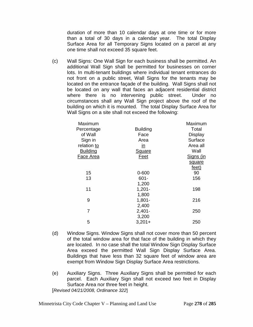
Minnetrista City Code Chapter V – Planning and Land Use Page 278 of 285
duration of more than 10 calendar days at one time or for more than a total of 30 days in a calendar year. The total Display Surface Area for all Temporary Signs located on a parcel at any one time shall not exceed 35 square feet.
(c) Wall Signs: One Wall Sign for each business shall be permitted. An
additional Wall Sign shall be permitted for businesses on corner lots. In multi-tenant buildings where individual tenant entrances do not front on a public street, Wall Signs for the tenants may be located on the entrance façade of the building. Wall Signs shall not be located on any wall that faces an adjacent residential district where there is no intervening public street. Under no circumstances shall any Wall Sign project above the roof of the building on which it is mounted. The total Display Surface Area for Wall Signs on a site shall not exceed the following:
Maximum
Percentage of Wall Sign in
relation Uto Building
Face Area
Building
Face Area
Uin Square
Feet
Maximum Total
Display Surface Area all
Wall USigns (in square feet)
15 0-600 90 13 601-
1,200 156
11 1,201-1,800
198
9 1,801-2,400
216
7 2,401-3,200
250
5 3,201+ 250 (d) Window Signs. Window Signs shall not cover more than 50 percent
of the total window area for that face of the building in which they are located. In no case shall the total Window Sign Display Surface Area exceed the permitted Wall Sign Display Surface Area. Buildings that have less than 32 square feet of window area are exempt from Window Sign Display Surface Area restrictions.
(e) Auxiliary Signs. Three Auxiliary Signs shall be permitted for each
parcel. Each Auxiliary Sign shall not exceed two feet in Display Surface Area nor three feet in height.
[Revised 04/21/2008, Ordinance 322]

Minnetrista City Code Chapter V – Planning and Land Use Page 279 of 285
515.29 Non-conforming Signs Any Sign legally existing at the time of the passage of this section that does not conform to the provisions of this section shall be considered a legal non-conforming Sign and may be continued through repair, replacement, restoration, maintenance, or improvement, but not including expansion. “Expansion” shall be defined as any structural alteration, change or addition that is made outside of the original Sign structure, Display Surface Area or design.
(a) Nothing in this section shall prevent the return to a safe condition of
a Sign structure that has been declared to be unsafe by the zoning administrator or building official.
(b) When any legal non-conforming Sign is discontinued for a period of
more than one year, or is changed to a conforming Sign, any future Sign shall be in conformity with the provisions of this section.
(c) Any legal non-conforming Sign shall be removed and shall not be
repaired, replaced or rebuilt if it is damaged by fire or other similar peril to the extent of greater than 50 percent of its market value at the time of destruction and no conditional Sign permit or building permit (if applicable) has been applied for within 180 days of the date of destruction. The city’s building official shall be responsible for making the determination of whether a non-conforming Sign has been destroyed greater than 50 percent of its market value at the time of the destruction. In making this determination, the building official shall consider the market value of the entire Sign at the time prior to the destruction and the replacement value of the existing Sign. In the event a building permit or conditional Sign permit is applied for within 180 days of the date of destruction and the Sign did not withstand damage greater than 50 percent of its market value at the time of the destruction, the city may impose reasonable conditions upon the building permit and conditional Sign permit in order to mitigate any newly created impact on adjacent properties.
(d) A lawful non-conforming Sign shall not be changed to a similar non-
conforming Sign or to a more restrictive non-conforming Sign. [Revised 04/21/2008, Ordinance 322]
515.31 Variance
Where the city finds that extraordinary hardships or practical difficulties may result from strict compliance with this section, other than the procedural provisions, and the purposes of this section may be served to a greater extent by an alternative proposal, the city council may approve variances to this section, subject to the variance standards and requirements set forth in Section 505.05,

Minnetrista City Code Chapter V – Planning and Land Use Page 280 of 285
subdivision 7 of the city code. An application for any such variance must be submitted to the zoning administrator in writing at the time of submittal of the sign permit application. The application must fully state the grounds and all of the facts to justify the granting of the variance. [Revised 04/21/2008, Ordinance 322] 515.33 Enforcement
Subdivision 1. Notice. Any person who violates any provision of this section shall receive a notice of the violation by hand delivery or mail indicating that he or she must correct the violation within seven days of the date of the notice.
Subd. 2. Penalties. Any person convicted of violating this section shall be guilty of a misdemeanor and shall be subject to a fine or imprisonment as specified by state statute. Each day in which a violation continues to occur shall constitute a separate offense. Violation of any provision of this section shall also be grounds for revocation of the sign permit by the city. [Revised 04/21/2008, Ordinance 322] 515.35 Appeal
An applicant whose Sign permit has been denied or permitee whose Sign permit has been revoked may appeal the decision of the zoning administrator to the city council, provided that he or she files written notice of the appeal with the zoning administrator within 15 days’ notice of its decision. Such appeal shall be considered by the city council at its next regularly scheduled meeting held after the city’s receipt of the written notice of the appeal, provided that the notice of appeal is received by the city a minimum of 20 full business days before the meeting. The city council shall conduct an appeal hearing and allow the applicant and any of his or her witnesses to address the council and to submit additional information. The city council shall make its final determination on the appeal no more than 30 business days after the appeal hearing. The city council shall notify the applicant of its decision and provide reasons for the decision.S [Revised 04/21/2008, Ordinance 322] 515.37 Severability and Conflict
This section and its parts are declared to be severable. If any section, subsection, clause, sentence, word, provision or portion of this section is declared invalid or unconstitutional by a court of competent jurisdiction, this decision shall not affect the validity of this section as a whole. All parts of this section not declared invalid or unconstitutional shall remain in full force and effect as if such portion so declared or adjudged unconstitutional or invalid was not originally part of this section, even if the surviving parts of the section result in greater restrictions after the unconstitutional or invalid provisions are stricken. If any part of this section is found to be in conflict with any other provision of this

Minnetrista City Code Chapter V – Planning and Land Use Page 281 of 285
section or any other provision of the city code or other applicable law or regulation, the most restrictive or highest standard shall prevail. If any part of this section is explicitly prohibited by federal or state law, that part shall not be enforced. [Revised 04/21/2008, Ordinance 322]
Minnetrista City Code Chapter V – Planning and Land Use Page 282 of 285
Section 520: Official Maps 520.01. Purpose.
Land that is needed for future streets, parks, utilities and other necessary public facilities and services, is frequently diverted to nonpublic uses which could have been located on other lands without hardship or inconvenience to the owners. When this occurs, public uses of land may be denied or may be obtained only at prohibitive costs or at the expense of dislocating the owners and occupants of the land. Identification on an official map of land needed for future public uses permits both the public and private property owners to adjust their building plans equitably and conveniently before investments are made which would otherwise make such adjustments difficult to accomplish. It is the purpose of this section to provide a uniform procedure for the proper use of official maps as authorized by law.
520.03. Official maps. Definition. In this section "official map," means a map adopted in
accordance with this section showing existing streets, proposed future streets, and the area needed for widening of existing streets of the city; existing and proposed parks and trails and areas necessary for their proper development; existing and proposed utilities; and the location of existing and future land and facilities within the city. An official map may cover the entire city or any portion of the city.
520.05. Initiation of proceedings. Proceedings for adoption, amendment or repeal of an official map or any
part thereof, may be initiated by a recommendation of the planning commission or the parks and recreation commission, action by the city council on its own initiative, request of an outside governmental body, or a petition of the owners of the affected properties. The fee to be charged to file a petition will be as established by resolution.
520.07. Sketch maps and reports. Every proposal or request for an official map or its amendment or repeal,
however initiated, will be accompanied by a sketch map or plat showing the lands proposed to be included and the public purpose to be served. The council may request a report of the city engineer as to the feasibility of any construction involved.
520.09. Reference to planning commission or parks and recreation commission.
Except when proceedings have been initiated by recommendation of the planning commission or the parks and recreation commission, every proposed official map or change in the map will be referred to the planning commission and/or the parks and recreation commission for advice and recommendations

Minnetrista City Code Chapter V – Planning and Land Use Page 283 of 285
thereon, and such recommendations will be submitted to the city council within 120 days after reference to the planning commission and/or parks and recreation commission along with the report of the commission on the effect of the proposal on the city comprehensive plan. If no recommendations are received from the planning commission and/or parks and recreation commission within 120 days after reference of the proposal to the commission by the council, the council may take such action as it may deem proper upon the proposal without further action by the planning commission and/or parks and recreation commission.
520.11. Notice. Upon receiving the recommendations of the planning commission and/or
parks and recreation commission, or after 120 days from the submission of the proposal to the planning commission and/or parks and recreation commission without recommendations from those commissions, the council will call a public hearing on the proposal. The notice of time, place, purpose of the hearing and a description of the property to be included in the official map will be published in the official newspaper at least ten days prior to the date of the hearing. At least ten days prior to the date of the hearing, the city administrator will also mail a copy of the notice to each owner of land situated within or abutting the boundaries of the official map. For purposes of this notice, the owner will be determined by the records of the county auditor and the notice will be addressed to the last known address as shown by the auditor's records. Failure to serve any such notice will not invalidate the proceedings.
520.13. Hearing. At the time and place specified in the notice, the council will hear evidence
and arguments concerning the proposal. The hearing may be continued from time to time. Upon closing of the public hearing, the council may vote on the proposal. 12T520.15. Adoption12T.
Official maps will be prepared in sufficient detail to permit the establishment of future acquisition lines on the ground. In unplatted areas a minimum of a centerline survey will be made prior to the preparation of the final draft of the official map. The accuracy of the future acquisition lines shown on the official map will be attested to by a registered land surveyor. The official map or an amendment or repeal of a previous official map, will be adopted in ordinance form by a majority vote of the city council. The ordinance will include a legal description of the area included in the official map. A certified copy of the official map together with an attached copy of the ordinance, will be filed with the county recorder.

Minnetrista City Code Chapter V – Planning and Land Use Page 284 of 285
520.17. Effect. USubdivision 1. After an official map has been adopted and filed, the issuance of building
permits by the city will be subject to the provisions of this section. The building inspector will deny every application for a permit to construct a new building or structure or expand an existing building or structure within an area designated on the official map. Whenever any street is widened, improved, or any new street is opened, any park or trail is acquired or developed, any land is acquired or developed for utilities, or any interest in lands for other public purposes is acquired by the city, the city will not be required in such proceedings to pay for any building or structure placed without a permit or in violation of conditions of a permit within the limits of the mapped street, park or trail or outside of any building line or building envelope that may have been established upon the existing street, park or trail, or within any area thus identified for utilities or other public purposes. The adoption of an official map does not give the city any right, title, or interest in areas identified for public purposes thereon, but the adoption of the map does authorize the city to acquire such interest without paying compensation for buildings or structures erected in such areas without a permit or a violation of the conditions of a permit.
USubd. 2. After an official map has been adopted and filed, the approval of
subdivisions by the city will be subject to the provisions of this section. The city council may deny a proposed subdivision or a portion thereof which lies within any area designated on the official map for streets, parks or trails, utilities, or other public purposes.
12T520.19. Appeals 12T.
USubdivision 1. Whenever a building permit or subdivision is denied pursuant to this
section, the city council may, upon appeal filed with it by the owner of the land and after receiving the advice and recommendations of the planning commission and/or parks and recreation commission, grant a permit for building or approve a subdivision or apportion thereof in an area designated on the official map for a street, park or trail, utilities or any public purpose in any case in which the council finds, upon evidence in the arguments presented to it by the applicant:
(a) That the entire property of the applicant, of which the area
designated for public purposes forms a part, cannot yield a reasonable return to the owner unless such a permit is granted; and
Minnetrista City Code Chapter V – Planning and Land Use Page 285 of 285
(b) That balancing the interest of the city in preserving the integrity of the official map and of the city comprehensive plan and the interest of the property owner in the use of the owner’s property and in the benefits of ownership, the granting of such permit or approval of such subdivision or portion thereof, is required by considerations of justice and equity.
USubd. 2. Failure of the planning commission and/or parks and recreation
commission to report on the appeal within 120 days after referral of the matter to it, is deemed to mean that there is no recommendation and advice from the planning commission and/or parks and recreation commission. The city council will hold a public hearing upon the appeal after notice of the hearing has been published in the official newspaper once at least ten days before the hearing. If the city council authorizes issuance of a permit or approval of a subdivision or portion thereof, it will specify the exact location, ground area, height, and other details as to the extent and character of the building for which the permit is granted or for which a building permit may be granted in a subdivision. If the city council so authorizes issuance of a permit, or approval of a subdivision or portion thereof, the council will have six months from the date of the decision to institute proceedings to acquire such land or interest therein and if no proceedings are started within that time, the building inspector will issue the permit if the application otherwise conforms to all local ordinances.