chapter iv initial environmental assessment 4.1 general...
TRANSCRIPT
4-1
CHAPTER IV INITIAL ENVIRONMENTAL ASSESSMENT
4.1 General
The initial environmental assessment of the Phase I was carried out to assess the environmental issues and problems that may arise in the implementation of the proposed schemes.
The Inception Report presented the various development options for the Metro Manila water supply that were preliminarily worked out at the most initial stage by combining water resources development in the Agos River Basin and water conveyance plans for Metro Manila. On the basis of the preliminary formulated plans, an Initial Environmental Examination (IEE) survey was carried out by subletting to a local environmental survey firm.
While the IEE survey was continued from May to July 2001, the Study has formulated additional development options and determined finally the promising development option through a comparison study as explained in the succeeding Chapter V. In particular, new water conveyance routes were identified in the latter part of the Phase I Study through more detailed engineering study.
In the present Master Plan Study, the outcomes of the initial environmental assessment was duly reflected in determining the optimum development plans as discussed in the respective Chapters of this Report.
4.2 Environmental Legal Framework Relevant to the Project
4.2.1 Environmental Legal Framework in the Philippines
The Philippines Environmental Impact Statement (EIS) system was formally established by virtue of the Presidential Decree (PD) No. 1586 issued in June 1978, after the policy on the EIS was first set forth through the issuance of the PD 1151 in June 1977, otherwise known as the “Philippine Environmental Policy”. The PD 1151 categorized environmentally critical projects (ECPs) and projects within environmentally critical areas (ECAs) as the projects which require the submission of an EIS.
The EIS system covers the ECPs and the projects located in the ECAs. The ECPs and ECAs were more clearly defined in Presidential Proclamation (PP) No. 2146, series of 1981, as follows:
• ECPs are heavy industries, resource extractive industries and infrastructure projects that have a high potential for negative environmental impacts;
• ECAs are areas considered ecologically sensitive and other areas declared by the President as environmentally critical.
The Department of Environment and Natural Resources (DENR) is the Government organization responsible for execution of the EIS System. The DENR’s basic policy

4-2
for the implementation of the Philippine EIS system is to retain and maintain a rational and orderly balance between socio-economic growth and environmental protection.
After the issuance of the aforesaid PP 2146, the EIS System has been refined several times so far in order to make it a more effective planning, management, and regulatory tool in addressing environmental problems. The latest attempt on refinement thereof was made by DENR through the issuance of the DENR Administrative Order (DAO) No. 37 in 1996 to further streamline the EIS system and strengthen the processes for its implementation. In consonance with the aforesaid DENR’s basic policy, DAO 37 seeks to address the following objectives:
• Ensure that environmental considerations are incorporated at the earliest possible stage of project development;
• Further streamline the current procedures in the conduct of the Environmental Impact Assessment (EIA) in order to improve its effectiveness as a planning, regulatory and management tool; and
• Enhance maximum public participation in the EIA process to validate the social acceptability of the project or undertaking so as to ensure the fullest consideration of the environmental impact of such project or undertaking.
All projects or undertakings falling within the category of ECP or projects located within ECA are required to secure an Environmental Compliance Certificate (ECC) prior to the start of construction and operation. The ECC is a document issued by the DENR, certifying that the proposed project will not cause significant negative environmental impacts. The proponent(s) who wish to implement a project categorized as an ECP must prepare an Environmental Impact Statement (EIS) based on the result of Environmental Impact Assessment (EIA). To get an ECC, the EIS has to be submitted to the DENR to be reviewed and validated by the Environmental Impact Assessment Review Committee (EIARC).
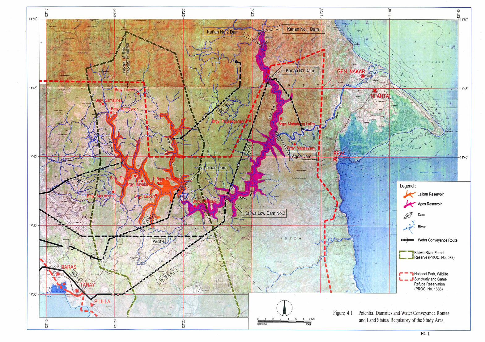
The five (5) dam projects identified in the Agos River Basin, namely Laiban Dam, Agos Dam, Kanan No.1 Dam, Kanan No.2 Dam and Kanan B1 Dam, are all categorized as the ECP. Further, as shown in Figure 4.1, the proposed project area falls in the national park, wildlife sanctuary and game refuge reserve area, which is categorized as the ECA. Accordingly, it is essential to carry out the EIA for the priority project selected for the feasibility study in the next study stage, in order to get an ECC from the DENR.
4.2.2 Environmental Regulatory Standards and Other Laws Relevant to the Study
(1) Water Quality Standards
PD No. 1152 of 1988, otherwise known as the Philippine Environment Code, prescribes management guidelines aimed to protect and improve the quality of Philippine water resources through classification of Philippine waters, establishment of water quality standards, protection and improvement of the quality of Philippine water resources and responsibilities for surveillance and mitigation of pollution incidents.

4-3
Within the framework of PD 1152, the DENR DAO 34 specified the water quality classification and water beneficial usage for each of surface water and coastal water. With regard to surface water, the water quality is classified into 5 categories, namely Class AA, Class A, Class B, Class C and Class D, out of which the water rated at Class AA and Class A are judged to be suitable for municipal water supply as follows:
Fresh Surface Waters Suitable for Water Supply (Rivers, Lakes, Reservoirs, etc.)
Classification Beneficial Use
Class AA Public Water Supply Class I. This class is intended primarily for waters having watersheds which are uninhabited and otherwise protected and which require only approved disinfection in water to meet the Philippine National Standards for Drinking Water (PNSDW)
Class A Public Water Supply Class II. For sources of water supply that will require complete treatment (coagulation, sedimentation, filtration and disinfection) in order to meet the PNSDW.
In 1993, the Department of Health (DOH) issued an updated version of the Philippine National Standards for Drinking Water (PNSDW 1993: DOH Administrative Order No. 26-A, Series of 1994), by revising the 1978 version, to guide the waterworks officials, developers and operators of water supply systems, health and sanitation authorities and the general public. The PNSDW 1993 is shown in Appendix G3 of Supporting Report Part-G in Volume III.
(2) Laws Related to Protected Areas
The Proclamation No.1636 declares as National Park, Wildlife Sanctuary and Game Preserve a certain parcel of the land of the public domain embraced and situated in the Provinces of Bulacan, Rizal, Laguna and Quezon, Island of Luzon. Some portions of the Study Area are covered by the protective areas stipulated in this Proclamation as shown in Figure 4.1. The activities prohibited within the protected areas include the following:
(a) Hunting, wounding, taking or killing of wild animals or birds and/or the destruction of any vegetation or any act causing disturbances to the habitat of the wildlife protected,
(b) Mutilating, defacing or destroying objects of natural beauty, or objects of interest to cultural communities (of scenic value); damaging and leaving roads and trails in a damaged condition, and
(c) Constructing or maintaining any kind of structure, fence or enclosures, and conducting any business enterprise without a permit.
The National Integrated Protected Areas Act (Republic Act No. 7586 of 1992) provides for the establishment and management of national integrated protected areas system to ensure the protection, sustainable development, and rehabilitation of protected areas for the conservation of biological diversity and enjoyment. It also points out the necessity to formulate a site specific management plan through addressing the following points:
4-4
(a) Promoting the adoption and implementation of innovative management techniques, such as management zones, buffer zones for multiple use and protection, habitat conservation and rehabilitation, biodiversity management, community organizing, socio-economic and scientific researches, site-specific policy development, pest management and fire control,
(b) Providing for the protection of indigenous cultural community domains and interests and for the rights of tenured migrants, and
(c) Creating closer coordination between and among the DENR, local government, the private sector, and the general public.
(3) Act on Priority of Sectoral Water Appropriation
The Republic Act No. 2152 provides the priority of preference when the waters of any source of supply are not sufficient for the service of all water use sectors desiring the use of the same, and when priority of appropriation can not be established, the order of preference shall be as follows:
• Domestic purposes,
• Agricultural purposes or power development for agricultural purposes,
• Industrial purposes,
• Ponds for fisheries, and
• Mining purposes or milling connected with mining purposes
The Act gives the first priority to the domestic sector on water appropriation as stated above. In reality, the 1987-1988 El Nino phenomenon caused the problems of sectoral water appropriation on existing Angat Multipurpose Dam. During those critical dry periods, the farmers were not able to cultivate paddy fields downstream of Angat Dam because of insufficient water supply from the dam, while it was operated almost exclusively for water supply to Metro Manila as well as the associated hydropower generation.
4.2.3 Legal Framework for Resettlement and Indigenous People
In the Philippines, there are many laws governing the protections of the right of the citizens who would be displaced by development projects planned and executed by both the government and the public sectors. Besides, some laws specify to protect all the rights of the indigenous cultural communities (ICCs) and the indigenous peoples (IPs) within the framework of national unity and development. Laws, executive orders, administrative orders relevant to the resettlement issue are, among others, as follows:

4-5
Laws, Executive and Administrative Orders Relevant to Resettlement Issue
EO, RA, AO Provisions, Description and Definition Executive Order 1035 Procedures and guidelines for the expeditious acquisition by the
Government or private real properties or rights thereon for infrastructure and other government development projects.
Republic Act 6389 Disturbance compensation to agricultural lessees equivalent to five times the average gross harvest in the last five years
Republic Act No. 7279 amended by RA 8368 (1997)
Disturbance compensation in case it would be given as compensation to relocatees and resettlers brought about by infrastructure and other development projects.
Administrative Order No. 50 (1999)
Execution of fair compensation estimated based on the zonal value of the land plus 10%. If this fail, the government agency will initiate expropriation with due consideration of various provisions set forth in the Order.
DAR Administrative Order No.1, Series of 1999
Rules governing the conversion of agricultural lands to residential, industrial, institutional and other non-agricultural purposes.
The Republic Act No.8371, otherwise called “Indigenous People Rights Act of 1997”, recognizes the importance and rights of indigenous cultural communities/ indigenous peoples (ICCs/IPs) to preserve their culture. It emphasizes the indigenous concept of ownership that "sustains the view that ancestral domains and all resources found therein shall serve as material basis of their cultural integrity." The rights of ownership and possessions of ICCs/IPs to their ancestral domains shall include lands, bodies of water traditionally and actually occupied by ICCs/IPs, sacred places, traditional hunting and fishing grounds, and all improvements made by them at any time within the domains.
The Act further provides conditions when relocation of IPs is considered necessary. Said relocation should take place only with the free and prior consent of the concerned IPs under the following conditions:
• Relocation to a site, which shall, in all possible cases, be of equal quality and legal status as what previously occupied, and which shall be suitable to provide for their present needs and future development,
• Security of tenure over lands to which they will be resettled or relocated, and
• Compensation for loss, injury or damage caused as a consequence of such relocation or replacement.
4.3 Environmental Survey Works Carried Out in First Field Investigation Period
4.3.1 Site Reconnaissance
During the 1st Field Investigation period, the site reconnaissance was conducted by the Environmental Expert of the JICA Study Team for the water resources development sites as well as water conveyance routes envisaged at the initial stage of the Master Plan Study. The site reconnaissance was performed only for the Kaliwa River Basin and the Agos Mainstream basin, since there was a difficulty of conducting the reconnaissance in the Kanan basin due to the security problems that prevailed during the period. Instead, the Study used the secondary data that were available from the previous environmental report on the Kanan B1 damsite.

4-6
In carrying out the site reconnaissance on the Kaliwa River and Agos Mainstream, a total of 11 observation points (or stations) were visited. The site reconnaissance clarified the existing site conditions at each of the observation points and in its surrounding area from socio-environmental points of view. In addition, the Environmental Expert also reconnoitered the proposed water conveyance routes.
4.3.2 Review of Previous Studies and Meeting with Agencies and Communities Concerned
(1) Review of Previous Environmental Studies
The Environmental Expert and Resettlement Expert of the JICA Study Team made a thorough review of various project reports and documents prepared earlier by MWSS, DENR, JICA, NPC and other agencies related to the water resources development in the Agos River Basin. Main findings from this review study are described in succeeding Sections.
(2) Meeting with Government Agencies and Communities
Interviews with key informants were conducted to obtain opinions and concerns regarding the development project proposed in this Study through the following activities:
• Meeting with Tanay LGU Officials
• Attendance to Barangay Magsaysay Council Meeting, Infanta, Quezon
• Meeting with Infanta LGU Officials
Major findings from these discussions are also contained in the succeeding Sections.
4.3.3 Initial Environmental Examination (IEE)
In the First Field Investigation, the Initial Environmental Examination (IEE) was carried out by the local environmental survey firm on a contract basis under the supervision of the JICA Study Team. The IEE is to identify the natural and social environmental problems and issues on each of the candidate schemes for water resources development in the Agos River basin and water conveyance for Metro Manila that were conceived at the initial stage of this Master Plan Study. The IEE survey works included the following scope of works:
• Collection of baseline data,
• Field investigation including the conduct of "hearing" survey in the three concerned municipalities of Tanay (Rizal), Infanta and Gen. Nakar (Quezon) and Barangay Daraitan (Tanay),
• Identification of natural and social environmental problems and issues,
• Screening and scoping of environmental items for each of the schemes, and
• Preparation of the IEE Report
Brief outline of the results of the IEE survey is described in Subsection 4.4.2 below and the details in Supporting Reports Part-G and Part-H in Volume III.

4-7
4.4 Overview of Environmental Conditions in the Study Area
4.4.1 General Environmental Conditions
The existing environmental conditions vary widely for each of the sub-watersheds: the Kaliwa watershed, the Kanan watershed, and the watershed of the Agos river mainstream. This conspicuously varies with the biological, social and economic features of the area. In general, Kaliwa watershed is experiencing great pressure on its natural vegetation. Settlements and farmlands have replaced its forest areas. High level of water pollution is imminent if uncontrolled development is pursued. On the other hand, Kanan watershed is still covered with thick primary growth forest. Because of its rugged terrain, human intrusion is quite difficult. However, to protect this important habitat of endangered species of wildlife, illegal logging needs to be controlled. The watershed of the Agos river mainstream is also experiencing the same problems as that of the two watersheds: encroachment of human activities to its forested area, and illegal logging.
Table 4.1 outlines the general environmental conditions of three river basins, where five water source development schemes are contemplated.
4.4.2 Findings from IEE Survey
The following provides a description of the findings from the IEE survey with regard to the general environmental condition of the Agos river basin.
The basin is fed by two major watersheds: the Kanan and Kaliwa. The Kanan watershed has a mountainous terrain with elevations ranging from 100 to 200 m above sea level (masl) in the river valley and up to approximately 1000 masl at the ridges’ summits. The slopes are predominantly covered by primary forest and few "kaingin" farms (slash and burn farming) are found along the river. The thick-forested area is still a habitat of rare and endangered species such as the birds of prey (Pithecophaga jeferryie)1, the Philippine deer, and other species. Its drainage area is approximately 393 km2 with the river valley generally steep winding with several rapids throughout its length.
The topography of Kaliwa Watershed is generally rolling with slopes varying from 8% to 50%. Two sub-watersheds feed the Kaliwa River: Limutan in Quezon Province and Lenatin in Rizal Province. Limutan is mainly characterized by thick vegetation, while cultivated areas and tracks of grassland predominate the vegetation cover of Lenatin.
The study area for water resources development schemes covers 17 rural Barangays in the municipalities of Tanay (Rizal), and Infanta and Gen. Nakar (Quezon). For water conveyance schemes, the study area covers the municipalities of Infanta and General Nakar (Quezon), Tanay, Morong, Teresa, Taytay and Angono (Rizal), and the cities of Antipolo and Metro Manila2.
1 No sighting has been observed during the EIA Study. 2 The waterway facilities are to be located in the municipalities of Tanay (Tunnel #1), Morong, Teresa, Taytay and the city of Antipolo, all in the province of Rizal as per Feasibility Study (F/S) stage.
4-8
Varying degrees of physical, biological and socio-economic impacts are expected to occur as a result of the different development schemes. Four major issues identified with water resource development schemes were (i) downstream flow and sediment reduction/change in flow regime, (ii) impact on precious and indigenous species, (iii) resettlement of the affected residents and (iv) impact on indigenous people. The downstream flow reduction/change in flow regime is considered as trade-off of the project; allocating the water resource particularly for domestic supply for the “public good”, out-weighs the negative impact on resource use in the basin. It was recommended that appropriate compensation must be provided to the affected sector of society.
Resettlement issues include the number of households to be affected and the selection of resettlement site. In terms of impact magnitude, Laiban Dam is the most serious, followed by Agos Dam, Kanan B1 Dam, Kanan No.1/No.2 Dams and Kaliwa Low Dam. Likewise, the indigenous peoples, particularly the Dumagats willbe affected by any of the five schemes. It was recommended that specific program must be formulated to lessen the cultural impact of the project to this particular group.
Moderate impacts identified were:
• Modification of aquatic ecosystem: through temporary increase in turbidity and nutrient loading in the aquatic ecosystems; migratory pattern of catadromous species such as the Anguilla (eel) and Macrobrachium (prawns); attraction of species that are normally hosts of water-borne diseases. Negative impact of fish migration would be mitigated with provision of fish stairs and ladders on the design of the dams.3
• Improvement of land transportation: improve the flow of traffic and delivery of basic goods and services; also perceived to worsen illegal logging activities in the area. Mitigating measure is the formulation of a watershed management plan that can provide alternative livelihood activities such as agro-forestry.
• Increased waste/discharges production during project construction: waste generated by construction workers, if not properly disposed, can result in health and sanitation problems. Measure to mitigate the problem is by proper coordination with the contractors and the workers to ensure proper waste disposal.
• Air pollution; exhaust fumes and odors: earthwork during project construction will increase dust particle levels in the air coupled with the operation of construction machinery that will also increase carbon monoxide levels. Mitigation measure identified is by maintaining moist environment in work sites to minimize suspension of dust particles.
• Noise pollution: increased noise levels in the area due to operation of construction machinery and vehicles.
3 No fish stairs and ladders are to be constructed since these migratory species can still enter the river system but will be limited to the lower reaches.

4-9
The IEE study indicated that the Kaliwa Low Dam, Kanan No.1 and 2, as well as Kanan B1 will have relatively high social acceptability compared to the other two schemes considering all the above identified issues. However, the LGU of General Nakar has plans to utilize Kanan river as source for hydroelectric power generation. As such, an agreement between MWSS and the LGU will have to be worked out, if Kanan Dam is developed for water supply purpose.
For water conveyance schemes, the major environmental issue identified is the disturbance of wildlife due to blasting and quarrying. Vibrations on the ground willalso affect ground-dwelling wildlife species, although temporary. The highly mobile wildlife can move to other undisturbed areas.
The significant social issues for the water conveyance schemes are acquisition of right-of-way (ROW) and disruption of community services and facilities along congested route during construction. Acquisition of ROW is identified as the most serious in Laiban-Pantay-Taytay waterway associated with the Laiban Dam scheme, involving middle-class subdivisions in Morong, Teresa, Antipolo City and Taytay. On one hand, Kaliwa-Abyodo-Angono4 waterway associated with Kaliwa Low Dam and Agos dam is predicted to have the least social and environmental effects, in view of longer tunnel and lesser pipeline length. It was recommended that, for both the waterways, resettlement plans and provision of adequate financial compensation packages and support mechanisms must be addressed.
4.5 Environmental Features Particular to Each River Basin
4.5.1 Kaliwa River Basin
Kaliwa river basin can be divided in two areas: one is upper-middle basin, which corresponds to the drainage area of Laiban Dam and the other the river reach downstream from Laiban Dam site.
(1) Laiban Dam Drainage Area
Several previous surveys identified the potential problems in the Laiban reservoir area.
(a) Manila Water Supply III Project (Appendix E, Environmental Studies), Presidential Inter-Agency Committee for the Re-Study of the Marikina River Project, Electrowatt Engineering Services, Ltd., et al, December 1979
Various impacts of the proposed dam construction were presented using the suggested format by the then National Environmental Protection Council (NEPC) of the Ministry of Human Settlements for the preparation of Initial Environmental Examination (IEE) report.
Among others, high negative cultural impacts are predicted to occur, particularly on the life styles and population density. Change in land use features such as the inundation of the reservoir area is likewise expected.
4 The proposed facilities have been re-aligned and referred to as Kaliwa-Taytay Waterway in the F/S.

4-10
Impoundment will also affect the water quality especially in view of existence of a number of agro-industrial farms in the watershed. However, it was noted that there would be no unfavorable effect foreseen on the present fish population. Also, the vegetation types to be affected are those of poorer ecological quality and the displaced fauna will be able to re-establish themselves in the immediate surroundings of the project site.
On the socio-cultural aspect, the proposed action was predicted to cause involuntary changes in the present lifestyle of the people due to resettlement. Their living conditions, beliefs, norms, standards will greatly change in accordance with their new environment.
(b) Laiban Dam Project, MWSS, 1986
The MWSS undertook an environmental impact assessment of the proposed Manila Water Supply Project III in 1986. The Environmental Impact Statement (EIS) Report conformed to the requirements of the NEPC in applying for the Environmental Compliance Certificate (ECC).
The 1986 EIS identified environmental impacts of all components of the proposed development, including the dam, reservoir, pipelines, tunnels, hydroelectric plant, water treatment plant, water storage basins and pump stations. Impacts predicted ranged from low negative to high positive environmental impacts. Similar to the IEE conducted in 1979, the proposed project was predicted to have high impacts on mineral resources, soils and occurrence of erosion.
NEPC issued an ECC to Metropolitan Waterworks and Sewerage System (MWSS) for the Manila Water Supply Project III in August 1986. The ECC specified nine conditions that include biological controls for malaria and other insect-related diseases, epidemiological monitoring, seismic monitoring, livelihood assistance for displaced minorities, resettlement management, implementation of specified sludge disposal methods, submission of contingency plans, application of soil erosion controls, and adoption of air, water and noise impact mitigation measures during the construction phase.
(c) Kaliwa Watershed Rehabilitation and Management Plan, Province of Rizal and Quezon, Forest Management Bureau and Resources, Environment and Economic Center for Studies, Inc. (REECS), December 1999
A Plan/Study to develop and manage the Kaliwa watershed was prepared in 1999, in recognition of the paramount importance to mitigate the adverse impacts of the water crisis in the country. Its primary objective was to organize, mobilize and capacitate the watershed stakeholders to become active partners of the Forest Management Bureau (FMB) in implementing re-vegetation and sustainable management strategies transforming the watershed as a productive area.
The Study identified the existing problems in the Kaliwa watershed: i.e.,

4-11
illegal timber poaching, continuous grazing, illegal gathering of fuelwood, kaingin making and forest fires.
Uncontrolled illegal logging in Kaliwa watershed led to forest denudation. It was reported that the old growth forest (primary growth of dipterocarp trees) has been depleted to a mere 9% of the watershed's original forest cover within 20 years time (27,600ha. in 1979 to only 2,479ha. in 1999). Destruction of forest cover results in loss of wildlife habitats, and consequently diminishing biodiversity and wildlife. The DENR-FMB through its Water Resources Development Project/Watershed Management Improvement Component has drawn out a watershed development and management plan for the Kaliwa catchment basin. One of the Plan's objectives is "to formulate strategies to rehabilitate, manage and restore the productive and protective functions of the Kaliwa Watershed".
(d) Laiban Dam Project, Final Report on Environmental Appraisal of Project, GHD, Ltd. et al, July 2000
This environmental appraisal in July 2000 was conducted to re-examine the potential environmental impacts of the proposed water supply project. The appraisal presented the scope of EIS and findings as well as the conditions of ECC issued in 1986 for the project. Due to the lapse in time and modifications to the project, the ECC is considered to be no longer valid. A new ECC should therefore be obtained and the existing EIS need to be updated. During this stage, the DENR required preparation of a new EIS to allow proper assessment of the environmental impact of the proposed development.
The appraisal also provides the identification and assessment of environmental issues. Recommended actions followed every status of existing physical, biological and human environment presented in the 1986 EIS. Current geological study, description of topography, mineral resources, current analyses of water samples, more detailed study on the species of fish, terrestrial vertebrate, description of the location of the main population centers, extent of land ownership and presence of indigenous cultural communities or indigenous people within the watershed are among the recommended actions enumerated in this Appraisal.
The appraisal further recommended action to update the anticipated environmental impacts and mitigation measures listed in the 1986 EIS, among which include the provision for active protection of the watershed from illegal activities which may degrade the quality of water in the reservoir, implementation of surface water protection strategies during construction and operation of the dam and other project components such as protection of surface waterways from sediments in runoff water, inclusion of Barangays Pintung Bocawe and Daraitan in the relocation census, as residents of these Barangays may need to be relocated, archaeological artifacts survey in the affected areas and identification of requirements of grave sites in areas to be flooded or disturbed regarding relocation of the graves.

4-12
(2) Barangay Daraitan Area
Barangay Daraitan, located some 5 km downstream from Laiban Dam site, is a local center in the Kaliwa mid-reach area. There exist 617 households with a population of about 3,200.
Barangay Daraitan is one of the communities that will mostly be affected by the development of the Agos Dam, if the reservoir water level is higher than around EL.160 m.5 The Barangay is part of the Kaliwa Watershed that was classified as a forest reserve under Proclamation No. 573 on 26 June 1969 and also within the declared National Park and Wildlife Sanctuary under Proclamation No. 1636 of 18 April 1977.
Under the law, the DENR-Provincial Environment and Natural Resource Office (PENRO) of Rizal represented by the Community Environment and Natural Resources Office (CENRO) of Antipolo City has the jurisdiction of the area, in both administration and management, but with close coordination with the local government unit (LGU) of Tanay. Based on the municipal plan, the designated dominant land use of Barangay Daraitan is forest protection/development, agriculture and human settlement. A small portion of the Barangay, Sitio Tinipak, is planned for eco-tourism development. Tinipak is about an hour’s walk along a footpath on the left bank of Kaliwa River (facing downstream). Its major attractions are large limestone outcrops, pristine water and cool, invigorating climate.
At present, the LGU of Tanay is actively promoting Barangay Daraitan as one of the major tourist spots in Tanay. The area has a very high potential for tourism development as an outdoor recreation and ecological destination project. Furthermore, Daraitan River was adjudged as the "cleanest river" of the province in 2000.
The Municipality of General Nakar in Quezon Province has a pending boundary dispute with Tanay, Rizal and the area being disputed is Barangay Daraitan. At present, Tanay assumes political and administrative jurisdiction over the Barangay.
Diarrhea, intestinal parasitism and skin diseases are among the notifiable water- related diseases in Tanay. Lately, there has been no blood test that proved positive for malaria. A midwife is assigned to Barangay Daraitan to cater to the health services needs of the population but her schedule is irregular. Water vector diseases associated with dam construction are malaria, filariasis, and dengue or H-fever. The control and prevention of these diseases and the prevention of introduced water-based diseases, e.g., schistosomiasis should be taken into account including the provision of sanitary latrines and promotion of proper hygienic practices.
Indigenous peoples (IPs) in Barangay Daraitan are the Dumagats and Remontados. The latter are half-breds as a result of intermarriage between Dumagats and lowlanders. Sitio Magata has the highest percentage of IPs with 90% of its population belonging to this group. During the feasibility study stage, a census of the
5 As per F/S, the optimum FSL is at EL.159 m, hence, the residential area of Brgy. Daraitan will not be submerged.

4-13
indigenous peoples (IPs) who would be affected by the proposed development shall be conducted in consonance with the Indigenous Peoples Right Act of 1997 (R.A. No. 8371- Part II, Section 4 of the Implementing Rules and Regulations).
Observation of natural environments around Barangay Daraitan revealed the following findings:
Riverine Ecosystem
Observed river uses in this area are for washing of clothes, bathing and navigation of illegally cut logs or aptly termed "small-scale community logging" being practiced by the residents for lack of alternative livelihoods. Log ponds for storing these logs prior to transport by land can also be observed.
Dense mats of filamentous blue-green algae are also observed in this area. Agricultural inputs, e.g., fertilizers to ricelands upstream of Kaliwa River and domestic wastewater from settlements (7 Barangays in the Laiban reservoir area) can be major sources of organic pollution load of the river.
Major species of fish caught in the Kaliwa river in this reach are: tilapia (Tilapia sp.), carp (Cyprinus sp.), catfish (Clarias) and mudfish (Ophiocephalus). Fishing activities are usually done during dry season when there are no strong currents. From an interview with a fisherman, it was reported that migratory species of fish such as eel (Anguilla sp.) and mullet (Mugli sp.) reach this area.6
Sapang Bukas river (Sabalanasasin River in the NAMRIA 1:50,000 map), a right tributary of Kaliwa River, joins at Barangay Daraitan. One of the tributaries that feed Sapang Bukas is Sampaloc River. This river traverses the populated area of Barangay Sampaloc and the military camp of Camp Capinpin. These areas are possible sources of organic pollution. In the over-all development strategy of the Municipality of Tanay, Barangay Sampaloc has been designated as the next major urban center and an agro-forestry processing center. With its role, additional pollution load to its ecosystem is to be generated.
Terrestrial Ecosystem
Patches of upland agricultural areas planted to corn (Zea mais) in steep/hilly areas were observed. This agricultural practice often results to soil erosion and the eventual siltation of the river. Natural vegetation can still be found in the hills consisting mostly of shrubs/brushes and secondary growth forest. Cogon grasses (Imperata sp.) have supplanted natural vegetation where shifting cultivation or remnants of overlogged areas have previously existed.
Grasses (parang type) are the land dominant vegetation within the vicinity of the area. Soil erosion is observed in rolling and hilly areas where population pressure for housing is being experienced. Application of appropriate control measures, e.g., vegetatively or mechanically, can minimize further soil losses and reduce siltation of waterways.
6 Refer to Footnote 3.
4-14
An eagle (Pithecophaga jeferryie), a bird of prey, was seen flying, an indication of a balance ecosystem. The Philippine eagle is listed as rare and endangered specie by the PAWB/DENR and the International Union for the Conservation of Nature and Natural Resources.
(2) Kaliwa River Lower Reach
The area downstream from Barangay Daraitan falls in the reservoir area created by Kaliwa Low Dam (FSL 125 m) and Agos Dam (FSL 159 m). The former will submerge the river valleys up to a point of downstream part of the Daraitan limestone gorge and the latter up to a point just downstream of Barangay Daraitan.
Observations in the field have revealed the following natural conditions in this river valley area.
Riverine Ecosystem
The blue green algae still pre-dominates the river water and, in areas where there are no algae, the water is clear. Bathing and washing of clothes of residents living nearby are observed. The vegetation on both sides of the banks serves as filter to eroded soils.
Limestone outcrops in the riverbed have been quarried/mined using power drills as manifested in the drilled blocks left behind. Mining has already been stopped due to the issuance of the DENR-DAO No. 34, series of 1993.
There is Tinipak Spring along the riverbank. The spring is the source of drinking water for the residents of Daraitan during water shortage/drought. It has an estimated catchment area of 42 km2. Another unnamed spring is also located in the vicinity. The site of the proposed eco-tourism development of the LGU is upstream of this spring.
The dried-up portion (occurs during summer only) of the riverbed is covered by weeds: cogon (Imperata cylindrica) and talahib (Saccharum spontaneum). The economic importance of these species is for roof thatches and for pasture grass.
Seven fishermen were observed spear fishing. Species caught were carp (Cyprinus),tilapia (Tilapia) and mudfish (Ophicephalus).
Terrestrial Ecosystem
Fruit tree farms for citrus production and mixed orchard land dominate the land use of the flat and gently rolling areas. At the hillside, grazing and "kaingin" (slash and burn farming) making in the reproduction brush and grassland areas can be observed. Some of the species found are anabiong (Trema orientalis), tibig (Ficus nota), and takip-asin (Macaranga tanarius). The importance of these species is mostly for ecological diversity.
Bamboo plants (Bambusa sp.) along the river bend are present and control the erosion of the banks. Thick secondary forest is observed at the ridges of the hills/mountains. The source of income of some families in this area is gathering of rattan poles, a forest product from the Kanan watershed.
4-15
The ridge and mid-level of the mountains are covered by residual forest composed of dipterocarps, non-dipterocarps, and lesser-known species. This vegetation cover is still home to some migratory and permanent endangered faunal species: Philippine eagle (Pithecophaga jeferryii), deer (Cervus marianus), wild pig (Sus philippinensis),monitor lizard (Varanus salvator) and kalaw (Buceros hydrocorax). These species are important components in the stability and productivity of the ecosystem.
Vegetation type in the steep slopes of the mountains is of residual forest, composed mostly of dipterocarps such as white lauan (Shorea contorta), tanguile (Shorea polysperma), bagtikan (Parashorea malaanonan), and guijo (Shorea guiso). These species are used for timber.
Patches of introduced species such as ipil-ipil (Leucaena leucocephala), mahogany (Swietenia macrophylla) and yemane (Gmelina arboea) are found on the banks. About a kilometer from the Tinipak spring is a commercial fruit tree farm planted to mangoes (Mangifera indica).
4.5.2 Kanan River Basin
Field reconnaissance of the Kanan river basin was not possible due to uncertainty of the security situation during the survey period. In the Kanan basin, an environmental survey was carried out for the Kanan B1 hydroelectric project in 1994. The following are the main findings in that survey, which will be common problems foreseen for the other projects proposed in the Kanan basin.
Results of the study revealed that there were five critical environmental issues: construction hazards, resistance to the project, fear of dam failure, loss of income from illegal logging, and inundation of settlements and food source areas of 25 Dumagats families.7
Construction hazards may be due to blasting and hauling of spoils that could affect the health and safety of workers and nearby residents. The Study recommended environmental protection measures that include the use of proper blasting techniques, containment of spoils and the construction of check dams and silt control devices.
During the “Awareness and Perception on the Project” survey conducted for the Study, a substantial proportion of residents of the affected Barangays did not favor the project. Major reasons for the resistance to the project include fear of dam failure, prohibition of access to forest products, which are their main source of livelihood, and alleged insincerity of government agency in compensating the affected community for losses due to construction of project facilities. To address such issue, the Study recommended a concrete demonstration of intent to honor commitments regarding compensation for losses due to project and the immediate and extensive implementation of communication strategy.
The Study also revealed that 90 % of the total income derived from forest-based income was from illegal logging. Once operational, the dam will present a physical
7 During the EIA Study, due to improved security condition that time, the settlements in the Kanan basin were surveyed and identical environmental issues were identified.
4-16
barrier thus logging will be significantly affected and river navigation of the logged timber will be impaired. The catchment area upstream of the dam will be protected from logging. The Study recommended development of livelihood programs in order to mitigate or offset such impact. The program will include training component that will prepare the affected community in alternative livelihood schemes and will provide seed money to start micro enterprises.
The economic losses to the 25 Dumagats families living or cultivating in the potential dam area include those arising from the inundation of their makeshift houses and crops and improvements. A resettlement plan and payment packages were proposed to mitigate and offset this impact.
On the other hand, the Study presented the predicted economic and social benefits of the Kanan B1 Project. These benefits include watershed protection, mandatory payments and benefits, improvement of agricultural production and other positive externalities on local economy and environment.
The Study concluded that there were no significant hazards that may endanger the environment provided that the proposed environmental protection measures will be effectively implemented during the different phases of the project. Benefits of the project will be more than enough to offset the economic and social costs to the affected people and the environment.
4.5.3 Agos River Basin
Agos river basin described herein means the area of some upstream from the Kaliwa-Kanan confluence and the river reaches downstream from the proposed Agos Dam site. Observation on the field revealed the following natural conditions:
Riverine Ecosystem
Agos River functions as navigational route, fishery ground and sources of domestic water (bathing, washing and livestock raising) and agricultural water. Fish caught are ayungin (Hypothalmicthys), banaks (Elops sp.), gurami (Trichogaster sp), tilapia (Tilapia), goby (Gobiidae), hito (Clarias sp.), eel (Anguilla sp) and other economically important species. Prawns (Macrobrachium) and freshwater shrimps (Palaemon) are also caught in marketable quantities.
Prawns (local name: ulang) and eel (local name: palos) are considered as catadromous species, i.e., adults migrating to river mouths to mate and lay their eggs and the young migrating upstream to grow.
The presence of benthos from the two orders of insect larvae (Trichoptera and Ephemeroptera) is an indicator of well-aerated water and a manifestation of good water quality. Filamentous blue-green algae are also found at the edge of the river where flow is sluggish. The quantity is smaller compared to the upstream portion of Kaliwa River.
Terrestrial Ecosystem
Extensive logging at the Kanan River watershed as indicated in the amount of logs being transported at the confluence posed a serious threat to the primary (old growth)

4-17
forest in the upper reach. Although the existing natural vegetation is enduring pressure from the unabated logging operation, the watershed still harbors high species diversity.
Nine (9) flora immediately threatened or vulnerable species were listed. These include: trees of premium timber, almaciga (Agathis philippinenses) and bago (Gnetum gnemon), rattan (Calamus sp.); and rare species, Dorystephania luzoniensis(an orchid) and Podochilus intricatus.
Likewise, a number of fauna rare and endangered species were observed: horned forest frog (Platymantis cornutus), Philippine bullfrog (Rana magna), Philippine bent-toed gecko (Crytodactylus philippinicus), Philippine trogon (Harpactes ardens),rufous hornbill (Buceros hydrocorax), tarictic hornbill (Penelopides panini), white- winged flying fox (Ptenochirus jagori) and Philippine deer (Cervus marianus).
At the confluence itself, hardwood forest still remains along the steep slopes, while along the riverbanks of both Kanan and Agos rivers, cash crops such as coconuts (Cocus nucifera), bananas and other fruit trees were commonly observed.
The main settlement of Barangay Pagsangahan, Gen. Nakar, Quezon is situated on the lower portions of Kaliwa and Kanan rivers (west side of the rivers). It lies on a gently sloping area cultivated to coconuts and fruit trees. In areas where steep slopes exist, old growth forest predominates.
Barangay Pagsangahan has a total of 483 households based on the 2000 census. The Barangay has 5 big upland Sitios. Only the Barangay proper (main settlement) with around 60 houses is located near the bank of Kaliwa River. At the Barangay proper, there is a primary school, a Barangay health station and a church. All these structures are made of concrete materials with GI roofing.
4.5.4 Agos Lower Basin
The area is located in the lower most reaches of the Agos River, forming a vast alluvial plain where municipal towns of Infanta and General Nakar are situated. Southern part of the plain consists of agricultural land, fishpond, swampland and mangrove forest.
Riverine Ecosytem
In the reaches downstream from the Kaliwa-Kanan confluence, the Agos River is primarily used for navigation and irrigation. Other than the gravel road (passable only during summer) that runs parallel with the river in Barangay Magsaysay, Infanta, the transport of goods and farm products to and from the upland communities/ settlements, including forest products is being done in Agos River. Also, the Agos River Irrigation System of NIA supplies irrigation water to 1,280 ha of farmlands with a flow requirement of 2.4 m3/s or about 3% of the average flow of the river.
Other beneficial water uses of Agos River are for fisheries and domestic uses such as bathing, washing and livestock raising. Sand quarrying is also practiced.

4-18
Terrestrial Ecosystem
Along the banks are built-up areas of the riverine Barangays of Infanta, namely; Magsaysay, Banugao, Catambungan, Ilog, Pilaway, and Pinaglapatan and of Gen. Nakar; Mahabang Lalim, Batangan, Maigang, Minahan Sur, and Anoling. Portions of some of these Barangays are covered by Proclamation No. 1636. Because these areas have already been settled and/or farmed, an application to DENR for micro- zonation was submitted to determine which portion of the protected area should be preserved for their environmental values.
The current land uses of these Barangays include riceland, orchards and settlements.
4.5.5 Coastal Areas of Infanta/General Nakar
The coastal zone of Infanta/General Nakar comprises of three distinct ecosystems: i) the sand dunes at the estuary, ii) the coastal mangrove area, and iii) the area near coastal waters which is usually inundated one or more times in any given year.
Estuarine Ecosystem
A notable sub-system within the shoreland is the sand dune system at the Agos River mouth that provides special habitats for crustaceans and shellfish as well as support for the shoreline. The formation of such sand dunes is a result of continuous deposition of sand from the Agos River directly affecting Barangay Pinaglapatan and other nearby Barangays in the Infanta plain. The river carries an appreciable volume of sand and soil. Data from the Banugao Gauging Station in the Agos River estimated an average yield of sediment load of 557 m3/km2/year (estimate in 1981 JICA study). As a result, sand and gravel quarrying are regular economic activities in the area.
The beach type grass predominates the vegetation in these dry sandy beaches. A few stumps of mangrove trees are observed indicative that the area has been heavily logged-over.
Coastal Mangrove Ecosystem
The municipality of Infanta has a large tidal flat covering the coastal Barangays of the northern part of Lamon Bay, namely: Silangan, Tudturan, Maypulot, Antikin, Cawayanin, Balobo, Langgas, Alitas, Anibong, Binonoan, Amolongin, Pulo and Bacong. Barangay Silangan has a large tract of riceland on its western side, while its eastern side has thick vegetation of mangrove forest. The rest of the Barangays basically exhibits a swampland ecosystem with thick nipa palm (Nypas fruticans)and mangrove cover as one approach seaward. Small streams and creeks that traverse these Barangays drain into Lamon Bay.
Agos River does not drain directly into this swampland/mangrove area. However, during Agos River overflow, floodwaters reach this area. Sediments carried by the floodwater provide additional nutrients in the area, which adds to the productivity of the ecosystem.
Swamplands/mangrove ecosystem provides shellfish, crustaceans breeding and nursery ground as well as food source for fish and other marine organisms. This

4-19
ecosystem also acts as a buffer to wave action of in-coming waves: the mangrove fringe acts as a sediment trap that slows out-flowing waters, thereby allowing sediments to settle down.
The most parts of the mangrove forest nearest the land area seem to be affected by population pressure. Rapid encroachment/conversion of these mangrove areas was considered severe as observed (base reference: NAMRIA map and interviews). Development includes conversion to riceland, cocoland, fishpond and housing.
Conversion of mangroves into fishpond should be controlled partly because the preservation of mangroves as spawning ground for many fish species determine to a great extent the viability of municipal and near-shore fisheries. The other reason is the existence of nipa palm-based livelihood activities. These include small-scale distilleries producing nipa liquor ("lambanog"), vinegar and palm juice tappers. Nipa shingles are also produced by some families and are additional sources of income.
Nearshore Coastal Ecosystem
The nearshore coastal Barangays facing Polillo Strait are: Boboin, Libjo, Bantilan, Abiawin, Binolasan and Dinahican. These areas are usually inundated when there is high tide coupled with heavy rains and strong winds.
The shoreline is characterized by sandy beaches and in between residential and resort developments are patches of beach-type grasses and coconut plantations. At the right side of the national road facing seaward, the low-lying areas are planted to rice and interspersed with nipa palms.
At Barangay Dinahican, the Philippine Fisheries Development Authority (PFDA) has recently completed the municipal fishing port. The PFDA has programmed the construction in Infanta because the fishing ground in the area is one of the very few fishing grounds in the Philippines considered as unexploited. The fishing area consists of Polillo Strait, Lamon Bay and its offshore waters, the Philippine Sea/Pacific Ocean. Infanta also supports extensive brackish-water fisheries.
4.6 Resettlement Issues
4.6.1 General
In considering the schemes for water resources development, the displacement of people is unavoidable. Thus, it follows that the single most important social criterion in weighing the alternative schemes would be the number of people to be displaced by the planned water resources development. The number of displaced people has a direct effect on resettlement and compensation costs, not to mention the intangible social repercussions related to actual displacement such as, but not limited to, loss of assets, livelihood, changes in lifestyle, economic and social stress, cultural disturbance and erosion, and other physical traumas. Of the five water resources schemes, there are two schemes where potential displacement is inevitable: the Laiban and the Agos Dams.
4-20
4.6.2 Resettlement Requirement of Respective Development Schemes
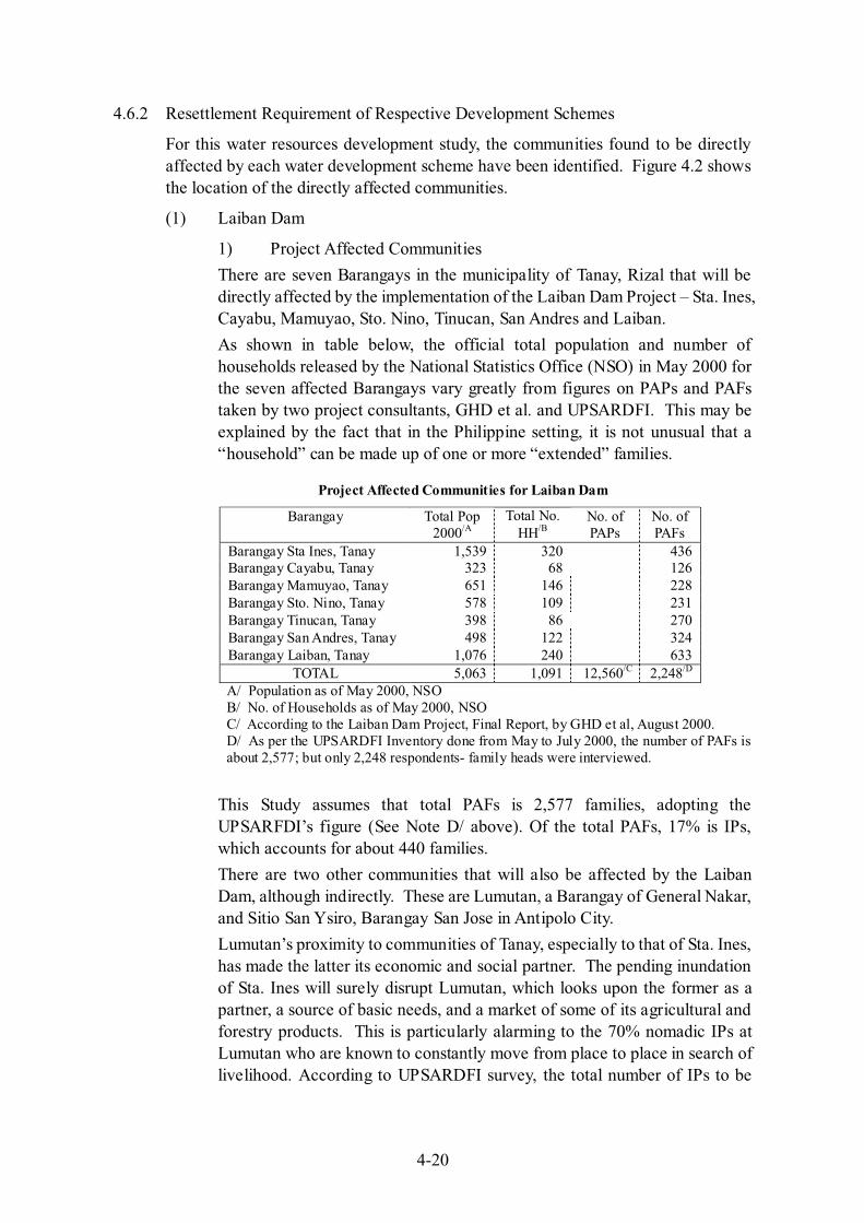
For this water resources development study, the communities found to be directly affected by each water development scheme have been identified. Figure 4.2 shows the location of the directly affected communities.
(1) Laiban Dam
1) Project Affected Communities
There are seven Barangays in the municipality of Tanay, Rizal that will be directly affected by the implementation of the Laiban Dam Project – Sta. Ines, Cayabu, Mamuyao, Sto. Nino, Tinucan, San Andres and Laiban.
As shown in table below, the official total population and number of households released by the National Statistics Office (NSO) in May 2000 for the seven affected Barangays vary greatly from figures on PAPs and PAFs taken by two project consultants, GHD et al. and UPSARDFI. This may be explained by the fact that in the Philippine setting, it is not unusual that a “household” can be made up of one or more “extended” families.
Project Affected Communities for Laiban Dam
Barangay Total Pop 2000/A
Total No. HH/B
No. of PAPs
No. of PAFs
Barangay Sta Ines, Tanay 1,539 320 436 Barangay Cayabu, Tanay 323 68 126 Barangay Mamuyao, Tanay 651 146 228 Barangay Sto. Nino, Tanay 578 109 231 Barangay Tinucan, Tanay 398 86 270 Barangay San Andres, Tanay 498 122 324 Barangay Laiban, Tanay 1,076 240 633
TOTAL 5,063 1,091 12,560/C 2,248/D
A/ Population as of May 2000, NSO B/ No. of Households as of May 2000, NSO C/ According to the Laiban Dam Project, Final Report, by GHD et al, August 2000. D/ As per the UPSARDFI Inventory done from May to July 2000, the number of PAFs is about 2,577; but only 2,248 respondents- family heads were interviewed.
This Study assumes that total PAFs is 2,577 families, adopting the UPSARFDI’s figure (See Note D/ above). Of the total PAFs, 17% is IPs, which accounts for about 440 families.
There are two other communities that will also be affected by the Laiban Dam, although indirectly. These are Lumutan, a Barangay of General Nakar, and Sitio San Ysiro, Barangay San Jose in Antipolo City.
Lumutan’s proximity to communities of Tanay, especially to that of Sta. Ines, has made the latter its economic and social partner. The pending inundation of Sta. Ines will surely disrupt Lumutan, which looks upon the former as a partner, a source of basic needs, and a market of some of its agricultural and forestry products. This is particularly alarming to the 70% nomadic IPs at Lumutan who are known to constantly move from place to place in search of livelihood. According to UPSARDFI survey, the total number of IPs to be
4-21
affected is 607, which infers the number of IP PAFs in Lumutan to be around 170 families, deducting 440 IPs in seven Barangays in the reservoir area.
San Ysiro, on the other hand, is the official resettlement site of the PAFs that would be relocated from the seven upland Barangays. It is located in a valley east of Metro Manila and can be reached via the Marcos Highway through a 14 km access road. According to the UPSARDFI survey (2000), there live 501 families in San Ysiro. These people may also be a part of PAFs once the relocation project is implemented in the San Ysiro area.
Including the PAFs in San Ysiro, the total number of PAFs is deemed to be 3,078 (2,577+501).
2) Socio-Economic Description
Among the19 Barangays in Tanay, 10 are classified as rural, possessing a land area of 28,789 hectares; while the other nine, with a land area of 4,668 hectares, are urban. The communities directly affected by the Laiban Dam are rural (mountain) Barangays. Most of these Barangays can be reached by motor vehicle during the dry season; but are accessible only through the use of bancas during the rainy months.
Close to 48% of Tanay’s land area, or 15,658 hectares, is devoted to agriculture. The seven affected Barangays are the major producers of citrus, mango, banana and other fruit trees. Mango production alone accounts for 1,145 hectares. Other agricultural activities include livestock, poultry and fish production.
The UPSARDFI survey revealed that the occupation of 38% of the household heads (2,248 interviewed) is in agriculture, forestry and fishing. Around 35% is unemployed; while the rest work in the service industries, on clerical jobs, professional and technical jobs, and as laborers. About half earn incomes in the region of PhP 5,000; around 30% earn from PhP 5,000 to 10,000. Close to 13% has an earning capacity up to PhP 20,000; while the rest claimed to earn more than that.
(2) Agos Dam
1) Project Affected Communities
In the present study, the Full Supply Level (FSL) of the Agos reservoir is proposed to be EL.159 m, where the corresponding dam crest elevation is EL.164 m. It is assumed that all the housings situated below EL.164 m willbe relocated, in consideration of rise of water level above FSL during flood period.8
Exact altitude of Barangay Daraitan has not been known.9 According to 1/5,000 map prepared by NPC in 1980, a large part of Daraitan village is
8 Based on the F/S, crest level of Agos Dam is set at EL. 165.3 m. 9 The detailed topographic maps produced in the F/S indicated that Brgy. Daraitan will not be submerged, since most of the residential area is over EL. 159 m in ground elevation. The F/S also proposes to provide flood dikes along the left bank of the Kaliwa River to protect lower lands from flooding.

4-22
higher than EL.160 m, while NAMRIA 1/50,000 map shows it to be around EL.150 m. On one hand, EDCOP carried out vertical control survey during the pre-feasibility study and found the altitude of Daraitan area to be as follows:
• El. 169.5 m: Located at intersection of main roads at the center of Barangay Daraitan. It can be described to be the average elevation of Daraitan central community.
• EL. 159.0 m: Located at Daraitan ferry terminal
• EL. 164.8 m: Flood marks located at Daraitan ferry terminal, reported to be the highest flood level experienced at the location
If the EDCOP survey is correct, average altitude of Barangay Daraitan is around EL.169 m and the majority will be free from inundation. Further, there may be a possibility that the lower areas can be protected from inundation by constructing river bunds. Nevertheless, for a conservative estimate at this study stage, partial area of Barangay Daraitan as well as lower area of some Sitios in the downstream reaches will be submerged by the Agos reservoir. The number of households affected is assumed to be around 300, which corresponds to about 40 % of total households in the nearby Barangays/Sitios (768 households).10
If a higher dam is planned (say, FSL 195 m, which is deemed to be the maximum exploitable reservoir development scale at Agos Dam), entire areas of the following Barangays/Sitios would be affected:
Project Affected Communities for Agos Dam at Elevation 195m
Barangay and/or Sitio No. of PAPs
No. of PAFs
Barangay Daraitan, Tanay/A 3,202 617 Sitio Queborosa, Barangay Magsaysay, Infanta/B 150 30 Sitio Binaladobol, Barangay Magsaysay, Infanta/C 100 20 Sitio Kimatangan, Barangay Magsaysay, Infanta 30 6 Sitio Kakawayan, Barangay Magsaysay, Infanta 50 10 Sitio Bagkoy, Barangay Pagsangahan, General Nakar 98 20 Sitio Nigu, Barangay Pagsangahan, General Nakar 50 10 Sitio Yokyok, Barangay Pagsangahan, General Nakar 98 20 Sitio Querosep, Barangay Pagsangahan, General Nakar 74 15 Sitio Kawayan, Barangay Pagsangahan, General Nakar 98 10 Sitio Madulas, Barangay Pagsangahan, General Nakar 98 10 Sitio Pangatloan, Barangay Mahabang Lalim, General Nakar Undeter-
mined Undeter-mined
TOTAL 4,048 768 A/ May 2000 NSO Census. B/ As per Kagawad of Sitio Queborosa, JICA Study Team Reconnaissance Report, June
2001.C/ For the rest of the Sitios in this Table, PAF estimates came from key informants from
the area.
10 Refer to Footnote 9.

4-23
Site reconnaissance by helicopter indicated that there maybe a few clusters of households that may be directly affected by the Afterbay Weir of the Agos Dam. 11 The number, however, cannot be determined yet; but will be ascertained if this study proceeds to the feasibility stage.
2) Socio-Economic Description
Barangay Daraitan, Tanay
Barangay Daraitan, with a total population of 3,202, comprising 617 households, makes up 4.1% of the entire municipal population of Tanay based on the May 2000 NSO Census. The Barangay has a growth rate of 4.94% and an average family size of 5-6 members.
The majority of the residents in Barangay proper belong to the middle income class, thus are better off than the nearby Barangays. This is also evident in the number of concrete houses in the area. They own at least a 400 sq.m. residential land, plus farm lots granted under the Comprehensive Agrarian Reform Program. The monthly income of each household ranges from PhP 4,000 to 20,000; while the average monthly expenditure is from PhP 2,000 to 5,000.
About 80% of the population depend on agriculture as the source of livelihood; while the rest depend on occasional and regular employment. Farm lots range on the average from 2 to 5 hectares. Major agricultural products include citrus (dalanghita) and mango. In Tanay, citrus has the highest production yield, about 71,300 ton, most of which is produced in Daraitan. Minor agricultural products include vegetables, root crops and palay, normally grown in kaingin areas. A few households are engaged in charcoal making, or pag-uuling. Others are into livestock raising, including cows, carabaos, pigs and goats. Women keep themselves busy by accepting sewing, laundering and weeding jobs.
Major social services available in Daraitan include the following: two health centers staffed by a nurse and midwife at least once a week; a primary and a secondary school; road networks accessible by big trucks or four-wheel drive vehicles through a six km rough road; transportation services through jeepneys available thrice daily; water supply managed by the Barangay; and electricity supplied by three private operators at a rate of PhP 350 per month.
Daraitan is also the host of three of the major tourist spots in Tanay, which are being prepared for ecotourism development. These are the Daraitan Church Ruins, the Tinipak and Daraitan Caves, and the Daraitan River, a place of worship for the Dumagats and Remontados.
Barangay Magsaysay, Infanta (4 Sitios)12
There are four Sitios in Magsaysay that would directly be affected by the
11 The EIA Study has identify 12 households, however, the development of the Agos Afterbay Weir has been shelved in the F/S. 12 The EIA Study indicated a total of 9 sitios in Brgy. Magsaysay that would be directly affected by the Agos Dam, with 78 PAFs or 360 PAPs.

4-24
Agos Dam – Queborosa, Binaladobol, Kimatangan and Kakawayan, with about 660 PAPs or 66 households.
Sitio Queborosa is located downstream of Barangay Daraitan. It can be reached from Daraitan by foot in two to three hours; through Magsaysay in four hours, or from Barangay Santiago, Sta. Maria, Laguna in three hours.
In Sitio Queborosa, 75% of the population depends on agriculture for their livelihood; while the remaining 25% depend on other sources such as logging and hunting. The major agricultural crops are fruit trees such as citrus (dalanghita), mango, guyabano, coconut, as well as vegetables and root crops. The annual income of each household ranges from PhP 5,000 to 10,000. It can be assumed that the other three Sitios may be similarly situated. Around 30% of the population in Queborosa is Remontados.
The school in Queborosa, with a capacity of 50 pupils had closed down three years ago because no teacher had been assigned there. Thus, students have to go to Daraitan, Saksay (Infanta) and General Nakar for educational requirements.
A midwife visits the rest of the Sitios only once a month since accessibility is only along foot trails. There is no electricity. Domestic water sources are springs. The river is normally used for bathing and washing.
Barangay Pagsangahan, General Nakar (6 Sitios)13
There are six Sitios in Pagsangahan that would be directly affected by the Agos Dam – Bagkoy, Nigu, Yokyok, Querosep, Kawayan, and Madulas. The approximate population count in these Sitios is 516 PAPs or about 85 households.
Pagsangahan is a long narrow Barangay along the west side of the Kanan River. Access to this Barangay is through a banca ride along the river. Navigation becomes difficult during summer months when the river water level is low; thereby hampering the mobility of the residents. There are no roads except for foot trails that link some of the Sitios.
An uneven area distribution among the 19 Barangays in General Nakar exists, with Pagsangahan accounting for close to 37% of the total land area of the municipality. General Nakar is the largest municipality in the province of Quezon, and one of the biggest in the country, but about 40% of its vast areas are reserve. About 42% belong to the national park; while 18% belongs to the Dumagat Ancestral Domain.
Barangay Mahabang Lalim, General Nakar (1 Sitio)14
So far, Sitio Pangatloan has been identified as a Sitio directly affected by Agos Dam; however the number of PAFs in this Sitio still needs to be determined.
13 Likewise, the EIA Study identified 9 sitios in Brgy. Pagsangahan that would be directly affected by the Agos Dam, with 93 PAFs or 498 PAPs. 14 In the same Study, only Sitio Pangatloan is to be directly affected with 3 PAFs or 28 PAPs.
4-25
3) Resettlement Issues
The implementation of Agos Dam at FSL 159 m would mean the displacement and subsequent resettlement of about 300 PAFs.15 But, should the Agos Dam be at an elevation of 195 m, there is the certainty of the inundation of the whole of Barangay Daraitan, including four Sitios in Barangay Magsaysay, six Sitios in Barangay Pagsangahan, and a Sitio in Barangay Mahabang Lalim, where around 768 families (4,048 PAPs) are foreseen to be displaced. In both instances, resettlement is, therefore, considered large scale, that is, when applying the definition of the World Bank and JBIC.
The immediate action would, therefore, be to design a comprehensive and feasible resettlement action plan (RAP) for the displaced PAFs. Also, an attempt should be made to formulate the Agos Dam plan to avoid submerging Barangay Daraitan.16
The hearing survey conducted in Barangay Daraitan revealed that the residents are not only hesitant but are also resistant to the idea of leaving the Barangay for any project-related development. This obstinacy stems from the negative perceptions and observations of what had happened to the neighboring Tanay communities when the Laiban Dam’s implementation was suspended.
4) Indigenous People The hearing survey gave conflicting numbers of IPs in Daraitan; but the IP chieftain maintains the number of IPs in Daraitan to being around 200, with a family size of 6-7 members. There are about 30 Remontado families who have settled in Daraitan. The Remontados are no longer nomadic, as the Dumagats generally are, although still depending on the forest for livelihood. They also consider the Daraitan River as a sacred place of worship. Around 500 “Espiritistas”, a cult whose belief centers on the spirit world, gather by the river during Holy Week from various places.
The IPs of Sitio Queborosa are also mostly Remontados, or half-Dumagats. However, those found in the other Sitios of Barangay Magsaysay (Infanta) and Barangay Pagsangahan (General Nakar) are a mix between Remontados and full Dumagats. The loss of tribal grounds and culture among the Remontados and Dumagats will result to cultural erosion due to limited access to their ancestral domain and resources.
The project shall consider a proper plan for the resettlement of IPs who inhabit the project-affected areas, in accordance with the provisions of the Indigenous Peoples Act of 1997.
15 The Agos Dam according to the EIA Study would displace a total of 174 PAFs or 886 PAPs. The Project, including the waterway facilities would involve a total of 396 PAFS or 1,956 PAPS.
16 In the F/S, the Agos Dam was designed in full consideration of this factor.
4-26
(3) Kaliwa Low Dam
There are two schemes under the Kaliwa Low Dam – one using the Kaliwa Low Dam as a temporary structure (FSL 125 m) in tandem with the implementation of Agos Dam and another utilizing the Kaliwa Low Dam as a permanent structure with FSL 133 m, plus four meters for freeboard. 17 Under both scenarios, there is no resettlement issue, as the dam height is seen not to directly affect any community.
(4) Kanan B1 Dam
The community directly affected by the proposed implementation of the Kanan B1 Dam is Sitio Lagmak of Barangay Pagsangahan, General Nakar. According to the EIA of Kanan B1, there are around 25 Dumagat families within the area of the proposed dam’s reservoir who stand to lose a part of their ancestral domain, their hunting and foraging area, including access to resources for their daily subsistence.
(5) Kanan No.1 and Kanan No.2 Dams
No firm information is available with regard to the number of PAFs in the reservoir area of the Kanan No.1 Dam (FSL 300 m) and Kanan No.2 Dam (FSL 310 m). NAMRIA 1:50,000 map shows a settlement area in the upper reach of the Kanan mainstream, which is situated at altitude ranging from EL. 240 m to 280 m. The map indicates the existence of a number of housings, paddy fields (about 15 ha on map) and scrubland in relatively mild-sloped area (about 30 ha). On a basis of “order-of magnitude” estimate, it is tentatively assumed that there would be at least 100 PAFs in the area (subject to confirmation in further study).18
(6) Kanan Low Dam
This scheme is proposed in the Development Scenario E (See Chapter V). The dam is located in the middle reach of the Kanan River, about 1 km downstream of Kanan B1 damsite. Since the scheme is a low dam construction in isolated area, it is foreseen that there will be no settlements to be relocated.
(7) Laiban Low Dam
This scheme is proposed in the Development Scenario H. Preliminary design contemplates that full supply level (FSL) is 203.0 m and the dam crest elevation 213.3 m. Construction work will require to relocate about 100 housings presently residing on the right bank of the damsite. Further, it is estimated that reservoir will inundate a few settlements including a village located just upstream of the Limutan- Lenatin confluence. The number of relocation is conservatively estimated to be around 100. Therefore, the total number of PAFs is roughly 200.
(8) Water Conveyance Schemes
The water conveyance schemes, in general, will pass through both urban and rural areas. These urban areas are generally low-middle to upper-middle class
17 The scheme of Kaliwa Low Dam-Agos Dam was selected in the F/S. 18 The EIA confirmed the existence of these housings but are considered as temporary structures. These are
primarily used only as “resting” place during the dry season when some agricultural activities are taking place in the area.

4-27
subdivisions or self-contained villages; sometimes densely populated residential, commercial and institutional lands. The rural areas are the agricultural lands, grass and shrub lands, hills and mountain slopes.
The water conveyance schemes, therefore, will have address the right of way (ROW) issues and its attendant sub-issues in the highly urbanized areas. The right of way for the water conveyance pipelines sees its greatest and gravest social impact when displacement of residents and dislocation of commercial and industrial establishments become inevitable. Another social impact is the disruption of the way of life of the people, institutions and businesses. In either traversing or running parallel to busy road nets, the laying of conveyance pipelines will add to traffic congestion, thereby producing more distress to the already harassed commuters. The social acceptability of the said plan would have to be worked on.
An attempt was made to count the number of housings to be relocated on aerial photographs of 1:30,000 scale (1995) and/or 1:15,000 scale (1999-2000).
1) Laiban-Pantay-Taytay Waterway
This waterway is to convey water from Laiban reservoir to Taytay service reservoir (associated with Development Scenarios A and F). Total length is 23.8 km, consisting of 14.0 km of tunnel portion (3 tunnels), 9.2 km of pipeline portion (2 pipelines), and powerhouse and water treatment plant in the remaining length. (See Section 6.1 of Chapter VI for details)
The estimated number of buildings to be relocated is roughly 330 small buildings (presumably, residential and commercial uses) and 20 relatively large buildings (presumably, agricultural and industrial facilities such as factories, livestock firms and greenhouses).
2) Kaliwa-Abuyod-Angono Waterway19
This waterway is to convey water from Kaliwa Low Dam to Angono service reservoir (associated with Development Scenarios B, C, D, E and G). Total length is 39.0 km, consisting of 34.1 km of tunnel portion (2 tunnels), 3.5 km of pipeline portion (1 pipeline), and powerhouse and water treatment plant in the remaining length. The pipeline length is shortest among the three conveyance waterway plans (Waterways 1)-3)).
The estimated number of buildings to be relocated is roughly 50 small buildings and 10 relatively large buildings.
Note: In the subsequent feasibility study, the number of affected households was identified to be about 220.
3) Laiban-Tanay-Angono Waterway
This waterway is to convey water from Laiban Low Dam to Angono service reservoir (associated with Development Scenario H). Total length is 33.4 km, consisting of 24.2 km of tunnel portion (3 tunnels), 9.2 km of pipeline portion
19 Refer to Footnote 4. The Kaliwa –Taytay Waterway will convey water from Kaliwa Low Dam to Taytay service reservoir. The total number of PAFs is 222 or 1,070. Based on the F/S, this is the preferred waterway scheme.

4-28
(1 pipeline), and powerhouse and water treatment plant in the remaining length.
The estimated number of buildings to be relocated is roughly 70 small buildings and 50 relatively large buildings.
4) Kanan-Laiban Transbasin Tunnel
This waterway is to transfer water from the reservoir of Kanan No.2 Dam to Laiban reservoir through a transbasin tunnel of 14.5 km long, which is included in the plans of Development Scenarios A, D, F and H. The tunnel is laid out in forest area in its entire length. There will be no PAFs directly affected by construction of the tunnel.
The tunnel construction involves the construction of access road from the Laiban Dam to the tunnel inlet for about 40 km in length. This may require the relocation of housings. It is assumed that number of relocation will not be more than 20 housings.
5) Kanan-Kaliwa Transbasin Tunnel
This waterway is to transfer water from Kanan Low Dam to Kaliwa Low Dam through a transbasin tunnel of 16.2 km long, which is included in the plan of Development Scenario E. The tunnel is laid out in forest area in its entire length. There will be no PAFs directly affected by construction of the tunnel.
Nevertheless, for a conservative estimate, it is assumed that there will be about 10 housings to be relocated due to construction of access roads to the tunnel inlet and outlet.
4.6.3 Proposed Resettlement Plans
(1) Laiban Dam
The implementation of the Laiban Dam will mean restarting a resettlement process that had started in 1982, or some 20 years ago. Conditions then and now have changed dramatically. The passage of time brought in changing thrusts and priorities that put the Laiban Dam either in the limelight or in the back burner. This shift in the priorities of the MWSS transformed the attitude of the project-affected communities and their families to a negative or combatant stance to the project.
While it may seem that the problems and issues on the Laiban Dam have remained constant through the years, its severity has intensified. To be re-formulated is a new “Resettlement Action Plan for the Laiban Dam Project” that must find social, cultural, economic and political acceptability from all identified stakeholders, particularly those adversely affected. It should be a detailed plan, complete with a schedule/timetable, and budget requirements.
The following are the issues to be tackled for solving this long outstanding issue:
1) Number of PAFs
The actual number and classification of the PAFs in the seven Barangays, including those in San Ysiro are presently unknown. The last two

4-29
studies/surveys, GHD study and UPSARFDI survey (both in 2000), did not indicate nor provide the actual number and/or classification of PAFs.
It is equally basic and important, at this point, that a totally new survey/inventory must be undertaken to ascertain the actual number and classification of PAFs in the seven affected Barangays, including those in San Ysiro, and in other resettlement sites to be officially designated. The conduct of and the procedures for the new survey/inventory must be similar to the manner it was originally undertaken, with 100% enumeration. This means that the survey activities can only be resumed after a series of dialogues with the PAFs has been successfully conducted.
The new survey/inventory must use the original inventory as the take-off point, since it was the very basis of the compensation paid out by the MWSS to some of the identified relocatees. What we are simply saying here is that there must be a distinction between the original relocatees and the additional ones; and these additional ones must be inventoried and classified, as well. It is proposed that the survey/inventory and classification of the additional PAFs be completed within one year.
2) Price of Land
The price of land at the Kaliwa watershed has steadily been going up, thereby increasing land acquisition costs for the Laiban Dam project.
Land acquisition costs must not only be updated using actual values for the year 2001; but must also be completed at the earliest possible time. In doing so, MWSS can secure the area from further incursions of illegal settlers or squatters.
3) Relocation Sites
As far as the surveys to date suggest, the relocation sites at San Ysiro, Antipolo and Famy, Laguna could not accommodate all of the original and additional relocatees from the seven Barangays. Additional resettlement sites must be found and/or acquired, taking into consideration the wishes of the PAFs.
The site development activities at San Ysiro have not been completed; while in Famy, these have not even started. Site development at San Ysiro must be continued to make it suitable for actual resettlement. The feasibility of site development in Famy must be looked into; if not, alternative resettlement sites within Tanay should be proposed.
4) Compensation Plan
The current compensation plan seems to be no longer acceptable to the PAFs. There is a need to update compensation plan but this must be done together with PAFs. The UPSARDFI survey shows that almost all (97%) of the respondents believed that the compensation given was insufficient. Also, the respondents preferred to be compensated through the lump sum method.
4-30
The four issues enumerated above are inter-related. They were brought up by the relocatees during the course of the UPSARDFI study. According to the UPSARDFI survey, 76% of the respondents want to be resettled in Tanay, a logical choice politically, culturally and socially. Being in the same municipality would also allow for a better chance of being accepted by and integrating with the host community. Thus, serious efforts must be exerted by MWSS in locating other resettlement sites such as Palayang Bayan in Tanay, often mentioned by the relocatees.
A strategy being offered here is for MWSS to look for and acquire several small sites within Tanay, which would become “satellite resettlement sites” to San Ysiro. Each site could be made to accommodate the PAFs of one project-affected Barangay. In so doing, several other problems could be addressed: that of looking for one big site to accommodate all the PAFs, which, at this time is difficult to find; that of socio-cultural integration of the a big number of relocatees with an often-hostile host community and vice versa; that of massive dislocation impacts on the socio-economic, socio-cultural lives of the PAFs.
By having “satellite resettlement sites,” the entire resettlement process can be broken down into technically and financially manageable packages. It could also have a positive impact on the PAFs, as they could be resettled together with their own co-Barangay members, thereby reducing sudden changes in lifestyles, cultural disturbance, and the stress that often accompanies relocation.
(2) Agos Dam20
The immediate action in mitigating the impact of displacement of PAFs for Agos Dam at FSL 159 m, would be to design a comprehensive and feasible resettlement action plan (RAP) for the displaced residents within the dam reservoir using the guidelines for involuntary resettlement of the World Bank and JBIC. The displacement of Dumagats and Remontados must also be addressed according to the provisions of the Indigenous People Rights Act of 1997.
The feasibility of relocating the 300 PAFs on higher ground, but still within the reservoir’s watershed area, may be a viable option worth studying. This would mitigate the impact of dislocation because the resettlement site would still be within the same familiar confines. Some of the PAFs may also be utilized as “watershed protectors” around the dam’s reservoir. Barangay Daraitan also stands to benefit in terms of better mobility for its residents, if the reservoir water level is at EL. 159 m, as the Barangay’s ferry terminal has the same elevation.
(3) Kanan B1 Dam
The Kanan B1 would displace around 25 Dumagat PAFs. Their displacement is governed by Sections 6-8 of Rule IV of the Indigenous People Rights Act of 1997, where a Socio-Cultural Impact Statement must be complied with and submitted to the IP community and the NCIP.
20 The EIA Study prepared a Resettlement Plan (RP) to cover the 174 PAFs of the Agos Dam/Reservoir and the 222 PAFs of the waterway facilities.

4-31
(4) Kanan No.1 and No.2 Dams
People residing at a settlement in the upper watershed would presumably be Dumagat PAFs (subject to confirmation in further study). In such case, a procedure same as for the Kanan B1 Dam will be effected for the Kanan No.1 and No.2 Dams as well.
(5) Identified Social Impacts Related to Dam Schemes
(a) Impact on IPs, Historical Sites and Cultural Heritage and Their Mitigation
The five dam schemes will bring about certain destruction of cultural heritage and historical sites, a change in lifestyle and limited access to ancestral domain and resources for the ICCs/IPs. While the inundation of a pre-World War II foundation of an early Dumagat house, the identified historical site at Tigbak along the Kanan River, and the “Tinipak” and limestone caves along the Kaliwa River may be irreversible; these historical sites may be well documented for the future Dumagat generations. The Dumagat burial grounds must be relocated at another site.
A series of consultations with the Dumagat chieftains and their people, as well as with the half-Dumagats or Remontados must be undertaken, to assess the full extent of their cultural erosion and socio-economic dislocation. This will also provide the best opportunity in planning together with the affected IPs how to better mitigate the limited access to ancestral domain and resources that the dam project will bring.
(b) Changes in Lifestyle and Conflicts among Local Residents and Their Mitigation
There are three countermeasures suggested to lessen the impact of the displacement of and conflicts among the PAPs/PAFs.
First would be to make the resettlement planning process as participatory as it can be, where all the stakeholders can provide vital inputs into the plan itself, not merely limited to resettlement site selection. Second would be to set up structures or institutional arrangements, and a mechanism aimed at providing income generating and livelihood opportunities to the PAPs/PAFs in coordination and partnership with NGOs, the private sector and the government. Third, in conjunction with the participatory and community development (CD) processes, should be the implementation of a strategic communications plan (SCP).21
The SCP is different from an Information-Education and Communications (IEC) program, or a Public Relations (PR) Plan, or even mere information dissemination, in that it focuses on clearly identified targets, and designs a communications package around these targets, rather than use mass media communication methods. The crafted SCP provides timely, accurate and relevant information strategically directed to the target public,
21 Likewise, a SCP has been prepared in the EIA Study.

4-32
communicating to them the benefits of the development project, as well as the adverse effects, in a manner and language that is best understood and accepted by them. Part of the aims of the SCP is to counter disinformation and/or misinformation, which is to be floated by elements that would want to oppose the project or would like to use the PAPs for their own ends.
(6) Social Impacts of Water Conveyance Schemes and Their Mitigation
Any of the conveyance schemes will have to deal with right of way issues that are very likely to dislocate residents in both rural and urbanized areas; commercial and industrial businesses and establishments along busy roadways.
The Resettlement Action Plan to be formulated for the selected priority water development scheme must include a sub-section for those who would be displaced by the water conveyance pipelines. A social acceptability plan must be prepared; and for the traffic congestion that may result in laying pipelines along well-traveled highways, alternate routes must be presented. The SCP must also contain a specific campaign plan for affected motorists, residents, institutions, and businesses.
(7) Resettlement and Compensation Cost22
Cost of relocating the PAFs consists of the cost of site development and cost of compensation for lands and improvements presently owned by the PAFs. Table 4.2 gives a preliminary estimate of the relocation and compensation costs.
4.7 Summary of Environmental and Resettlement Problems by Scheme
Sections 4.4 to 4.6 above identified potential environmental and resettlement problems foreseen for development schemes under consideration. Table 4.3 summarizes the main items of the findings.
22 An updated resettlement and compensation cost was prepared in the EIA Study for the preferred development schemes. A total of about PhP 2 billion is required for the Resettlement Plan.

Table 4.1 Environmental Conditions of the Study Area, Agos River Basin (1/4)
Laiban Dam Kaliwa Low Dam 2 Kanan 1/Kanan 2 Kanan B1 Agos Dam Resource Environment Kaliwa Watershed Kanan Watershed Agos (Mainstream) Watershed
Land Area covered by the watershed, to which Kaliwa River locates, is 473 km2. and is part of the Sierra Madre Mountain Range. The river system of Kaliwa River watershed traverses Barangays Sta. Ines, Cayabu, Mamuyao, Sto. Niño, Tinukan, San Andres, Laiban and Daraitan in Tanay, Rizal and Barangay Lumutan in General Nakar, Quezon. The different geologic units found in Kaliwa Watershed consist of alluvium in the downstream areas, pyroclastic volcanic, clastic-volcanic rocks and limestones in the upland. High rate of sediment yield due to deforestation.
Area covered by the watershed, to which Kanan River locates, is about 393 km2.Portion of the area is categorized as National Park or watershed reserve. Kanan River traverses Barangay Pagsangahan, General Nakar, Quezon. Major geologic units in the Kanan watershed belong to Tignoan and Kanan Formations. Active sedimentation occurs along parts of the Kanan River. Erosion is mainly from run-off during rainfall.
Area covered by the watershed of the Agos mainstream downstream of the Kaliwa-Kanan confluence is about 74 km2.Agos River traverses Barangays Mahabang Lalim, Batangan, Maigang, Minahan Sur and Anoling in General Nakar and Barangays Magsaysay, Banugao, Catambungan, Ilog, Pilaway, Pinaglapatan and Boboin in Infanta. Tignoan Foundation underlies Agos River. Alluvial deposits also fill the floodplains of the river. Sedimentation is most active on the coastal part of the Agos River.
P H
YSI
CA
L
Water Total mean monthly discharge is 23.4 m3/sec for the Laiban Dam and 27.9 m3/sec for Kaliwa Low Dam 2. Some parts of Kaliwa River are used for navigational purposes. Households used the river for fishery. It is also used for bathing, washing and livestock raising. Water quality analysis undertaken in 2001 revealed that the following parameters exceeded DENR criteria for Class A waters: - Phosphate (0.28 mg/l); - Turbidity (25 NTU)
Total mean monthly discharge is 54.0 m3/sec for Kanan 1 and 54.6 m3/sec for Kanan 2. The whole stretch of Kanan River is commonly used for navigation. Households used the river for fishery. It is also used for bathing, washing and livestock raising. Water quality analysis undertaken in 2001 revealed that the following parameters exceeded DENR criteria for Class A waters: - Nitrate (1.06 mg/l)
Agos River is mainly used for irrigation. It supplies irrigation requirement of 23 barangays in General Nakar and Infanta. It is also used for navigation, bathing, washing, livestock raising, fishery, and quarrying. Water quality analysis undertaken in 2001 revealed that the following parameters exceeded DENR criteria for Class A waters: - Phosphate (0.2 mg/l); - Turbidity ((43 NTU)
T4 –1
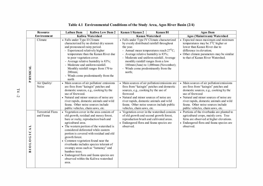
Table 4.1 Environmental Conditions of the Study Area, Agos River Basin (2/4)
Laiban Dam Kaliwa Low Dam 2 Kanan 1/Kanan 2 Kanan B1 Agos Dam Resource Environment Kaliwa Watershed Kanan Watershed Agos (Mainstream) Watershed
Climate Falls under Type II Climate characterized by no distinct dry season and pronounced rainy period. - Experienced relatively higher
temperature than the Kanan River due to poor vegetation cover.
- Average relative humidity is 83%; - Moderate and uniform rainfall.
Monthly rainfall ranges from 170 to 200mm;
- Winds come predominantly from the north
Falls under Type IV Climate characterized by evenly distributed rainfall throughout the year. - Annual mean temperatures reach 27OC; - Average relative humidity is 83%; - Moderate and uniform rainfall. Average
monthly rainfall ranges from a low 160mm (June) to 1,000mm (November);
- Winds come predominantly from the north;
Expected mean maximum and minimum temperatures may be 3OC higher or lower than Kanan River due to difference in elevation; Other climate parameters may be similar to that of Kanan River Watershed.
P H
YSI
CA
L
Air Quality/ Noise
Main sources of air pollution/ emissions are fires from “kaingin” patches and domestic sources, e.g., cooking by the use of firewood. Natural and minor sources of noise are river rapids, domestic animals and wild fauna. Other noise sources include public vehicles, chain saws, etc.
Main sources of air pollution/emissions are fires from “kaingin” patches and domestic sources, e.g., cooking by the use of firewood Natural and minor sources of noise are river rapids, domestic animals and wild fauna. Other noise sources include public vehicles, chain saws, etc.
Main sources of air pollution/emissions are fires from “kaingin” patches and domestic sources, e.g., cooking by the use of firewood Natural and minor sources of noise are river rapids, domestic animals and wild fauna. Other noise sources include public vehicles, chain saws, etc.
B I
O L
O G
I C
A L
Terrestrial Flora and Fauna
Vegetation cover in the area consists of old growth, residual and mossy forest, bare or rocky, reproduction bush and agricultural area. The western portion of the watershed is considered deforested while eastern portion is covered with residual and old growth forest. Common vegetation found near the riverbanks includes species tolerant of swampy areas such as “lumanay” and bamboo trees. Endangered flora and fauna species are observed within the Kaliwa watershed area.
Vegetation cover in the watershed consists of old growth and second growth forest, reproduction brush and cultivated areas. Endangered flora and fauna species are observed.
Portions of the riverbanks are planted to agricultural crops, mainly corn. Tree ferns are observed at higher elevations. Endangered flora and fauna species are observed.
T4 –2
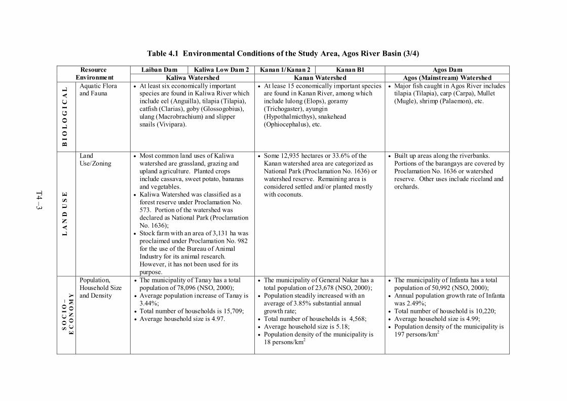
Table 4.1 Environmental Conditions of the Study Area, Agos River Basin (3/4)
Laiban Dam Kaliwa Low Dam 2 Kanan 1/Kanan 2 Kanan B1 Agos Dam Resource Environment Kaliwa Watershed Kanan Watershed Agos (Mainstream) Watershed
B I
O L
O G
I C
A L
Aquatic Flora and Fauna
At least six economically important species are found in Kaliwa River which include eel (Anguilla), tilapia (Tilapia), catfish (Clarias), goby (Glossogobius), ulang (Macrobrachium) and slipper snails (Vivipara).
At lease 15 economically important species are found in Kanan River, among which include lulong (Elops), goramy (Trichogaster), ayungin (Hypothalmicthys), snakehead (Ophiocephalus), etc.
Major fish caught in Agos River includes tilapia (Tilapia), carp (Carpa), Mullet (Mugle), shrimp (Palaemon), etc.
L A
N D
U S
E
Land Use/Zoning
Most common land uses of Kaliwa watershed are grassland, grazing and upland agriculture. Planted crops include cassava, sweet potato, bananas and vegetables. Kaliwa Watershed was classified as a forest reserve under Proclamation No. 573. Portion of the watershed was declared as National Park (Proclamation No. 1636); Stock farm with an area of 3,131 ha was proclaimed under Proclamation No. 982 for the use of the Bureau of Animal Industry for its animal research. However, it has not been used for its purpose.
Some 12,935 hectares or 33.6% of the Kanan watershed area are categorized as National Park (Proclamation No. 1636) or watershed reserve. Remaining area is considered settled and/or planted mostly with coconuts.
Built up areas along the riverbanks. Portions of the barangays are covered by Proclamation No. 1636 or watershed reserve. Other uses include riceland and orchards.
S O
C I
O –
E
C O
N O
M Y
Population, Household Size and Density
The municipality of Tanay has a total population of 78,096 (NSO, 2000); Average population increase of Tanay is 3.44%; Total number of households is 15,709; Average household size is 4.97.
The municipality of General Nakar has a total population of 23,678 (NSO, 2000); Population steadily increased with an average of 3.85% substantial annual growth rate; Total number of households is 4,568; Average household size is 5.18; Population density of the municipality is 18 persons/km2
The municipality of Infanta has a total population of 50,992 (NSO, 2000); Annual population growth rate of Infanta was 2.49%; Total number of household is 10,220; Average household size is 4.99; Population density of the municipality is 197 persons/km2
T4 –3

Table 4.1 Environmental Conditions of the Study Area, Agos River Basin (4/4)
Laiban Dam Kaliwa Low Dam 2 Kanan 1/Kanan 2 Kanan B1 Agos Dam Resource Environment Kaliwa Watershed Kanan Watershed Agos (Mainstream) Watershed
Sources of Income
Major sources of income in Tanay include fishing (63.45%), forestry (32.35%) and agriculture/farming (4.2%).
Major sources of income in General Nakar include agriculture/farming (70.9%), forestry (21.17%) and fishing (7.9%).
Major sources of income in Infanta include agriculture/farming (42%), forestry (26.7%) and fishing (5.3%).
Infrastructure and Public Utilities
Almost half of the households in Tanay are served by the Tanay Water District. Tanay has a total of 185km road network. National and provincial roads are made of either concrete or gravel while most municipal roads are of concrete. MERALCO provides 24 hours of electricity to the households of Tanay
General Nakar is served by the Infanta-General Nakar Water District; General Nakar has a total road network of 63km; Only 5% of the roads are concrete. Only 9 of the 19 barangays in General Nakar are provided with electricity by the QUEZELCO.
Infanta is served by the Infanta-General Nakar Water District; Infanta has more than 80km of road network; All national and provincial roads are made of gravel. Most of municipal roads are made of concrete while barangay roads are of gravel and earthfill; Electricity in Infanta is also provided by QUEZELCO. All 36 barangays of the municipality are now served by the power supply cooperative.
S O
C I
O –
E C
O N
O M
Y
Health & Education
Leading causes of morbidity in Tanay include acute respiratory infection, diarrhea, parasitism, vitamin deficiency and influenza; Leading causes of mortality include Pneumonia, disease of the heart, PTB, cancer and accidents/wounds. Tanay has one physician, one dentist, two nurses, 11 midwives and one sanitary inspectors. Tanay has 22 elementary, five secondary and three tertiary schools.
Leading causes of morbidity in General Nakar include upper respitatory infection, skin problems, pneumonia, wounds and gastroenteritis; Leading causes of mortality include PTB, CVA, senility, pneumonia and cancer. General Nakar has one physician, three nurses, 17 midwives, one dentist and one sanitary inspector. General Nakar has 27 primary, five secondary and two pre-schools;
Leading causes of morbidity in Infanta include acute respiratory infection, vitamin deficiency, parasitism, skin diseases and musculo-skeletal disease; Leading causes of mortality include CVA, degenerative disease, pneumonia, PTB and cancer; A rural health unit in Infanta is manned by one doctor, one nurse, one medical technologist, nine midwives, one nursing aide and one sanitary inspector. Infanta has six pre-schools and five high schools.
T4 –4

Table 4.2 Preliminary Estimate of Resettlement and Compensation Cost (1/3)
1. Laiban Dam
Cost of Resettlement and Compensation for Laiban Dam
Description Unit Site 1 Site 2 Total
Number of Families to be Relocated PAF 1,640/A 1,438 3,078/F
Required Area of Relocation Site @ 2 hectare per PAF
hectares 4,424/B 2,876 7,300
Cost of Site Development @ 0.28 PhP M per ha.
PhP M 980/C 805.3 1,785.3
Cost of Compensation (land/improvements)@ 0.50 PhP M per PAF for Sites 1 and 2
PhP M 814.20/D 629.0/E 1,443.2
A/ Available home lots as per subdivision plan at San Ysiro.
B/ Area reserved under Proclamation No. 2480 (including Forest Reserve Area of 872 hectares).
C/ Original cost of P710 M (1996 cost) updated for CY 2001.
D/ Cost of remaining lands to be acquired (P803 M) plus cost of remaining unpaid settlers (P11.20M).
E/ Cost of compensation for the additional PAFs to be relocated is about 1,258.
F/ Number of PAFs as per latest inventory by UPSARDFI conducted from May-July 2000 is as follows: 2,577 in the seven directly affected Barangays, and 501 in San Ysiro.
2. Agos Dam
Resettlement and Compensation Cost for Agos Dam (FSL 159 m) A/
Unit Site 1/B Site 1/C Total D/
Number of Families to be Relocated PAF 81 93 174Required Area of Relocation Site @ 0.37 hectare per PAF in Site 1 and 0.43 ha per PAF in Site 2
hectares 29.88 40.39 70.27
Cost of Site Development @ 8.70 PhP M per ha. in Site 1 and 7.44 PhP M per ha. in Site 2
PhP M 260.00 301.00 561.00
Cost of Compensation (land/improvements) @ 0.045 PhP M per PAF
PhP M 3.64 4.18 7.82
A/ Modified to reflect the result of the EIA Study carried out in the F/S stage.
B/ Relocation Site at Brgy. Magsaysay
C/ Relocation Site at Brgy. Mahabang Lalim
D/Excludes replacement cost for public/communal structures @ 1.60 PhP M and cost of Strategic Communication Plan@ 6.90 PhP M.
Resettlement and Compensation for Agos Dam (FSL 195 m)
Description Unit Site 1/A Site 2/B Site 3/C Total
Number of Families to be Relocated PAF 617 66 85 768 Required Area of Relocation Site @ 2 hectares per PAF
hectares 1,234 132 170 1,536
Cost of Site Development @ 0.28 PhP M per hectare
PhP M 340.46 36.42 46.90 423.78
Cost of Compensation (land and improvements) @ 0.85 PhP M per PAF for Site 1; and 0.50 PhP M per PAF for Sites 2 and 3.
PhP M 524.45 33.00 42.50 599.95
A/ Relocation Site 1 will be within Tanay.
B/ Relocation Site 2 will be within Brgy Magsaysay, Infanta, Quezon.
C/ Relocation Site 3 will be within Brgy Pagsangahan, General Nakar, Quezon.
T4-5

Table 4.2 Preliminary Estimate of Resettlement and Compensation Cost (2/3)
3. Kanan B1 and Kanan No.1/No.2 Dams Resettlement and Compensation Cost for Kanan B1 and Kanan No.1/No.2 Dams
Description Unit Kanan B1 Kanan No.1/No.2
Number of Families to be Relocated PAF 25 100Required Area of Relocation Site @ 2 hectare per PAF hectares 50 200Cost of Site Development @ 0.28 PhP M per ha. PhP M 14.0 56.0Cost of Compensation (land/improvements) @ 0.50 PhP M per PAF
PhP M 12.5 50.0
Note: Relocation site will be the vicinity of affected village
4. Low Dam Schemes (Kaliwa, Kanan and Laiban Low Dams) Resettlement and Compensation Cost for Kaliwa, Kanan and Laiban Low Dams
Description Unit Kaliwa Low Dam
Kanan Low Dam
Laiban Low Dam
Number of Families to be Relocated PAF None None 200 Required Area of Relocation Site @ 2 hectare per PAF
hectares - - 400
Cost of Site Development @ 0.28 PhP M per ha. PhP M - - 112.0 Cost of Compensation (land/improvements) @ 0.50 PhP M per PAF
PhP M - - 100.0
Note: No relocation of households foreseen for Kaliwa and Kanan Low Dams
Relocation site for Laiban Low Dam will be the vicinity of affected village
5. Conveyance Waterways Resettlement and Compensation Cost for Conveyance Waterways A/
Description Unit Waterway - 1
Waterway- 2
Waterway - 3
Number of Housings to be Relocated: - Residential/Commercial Housings - Factories/Warehouses
PAF No.
33020
5010
7050
For Residential/Commercial Housings:
Required Area of Relocation Site @ 2 hectare per
PAF
hectares 660 100 140
Cost of Site Development @ 0.50 PhP M per ha. PhP M 330.0 50.0 70.0
Cost of Compensation (land/improvements) @ 4.22
PhP M per PAF
PhP M 495.0 75.0 105.0
For Factories/Warehouses:
Cost of Compensation @ 5.00 PhP M per No. PhP M 100.0 50.0 250.0
Note: Waterway-1: Laiban-Pantay-Taytay Waterway Waterway-2: Kaliwa-Abyodo-Angono Waterway (Kaliwa-Taytay Waterway) Waterway-3: Laiban-Tanay-Angono Waterway
Relocation Site will be the vicinity of affected village A/ Costing for the Kaliwa-Taytay Waterway is presented in the Feasibility Study Report.
T4-6

Table 4.2 Preliminary Estimate of Resettlement and Compensation Cost (3/3)
6. Transbasin Tunnels Resettlement and Compensation Cost for Transbasin Tunnels
Description Unit Transbasin Tunnel-1
Transbasin Tunnel-2
Number of Families to be Relocated PAF 20 10Required Area of Relocation Site @ 2 hectare per PAF hectares 40 20Cost of Site Development @ 0.28 PhP M per ha. PhP M 11.2 5.6Cost of Compensation (land/improvements) @ 0.50 PhP M per PAF
PhP M 10.0 5.0
Note: Transbasin Tunnel-1: Kanan-Laiban Transbasin Tunnel Transbasin Tunnel-2: Kanan-Kaliwa Transbasin Tunnel
Relocation Site will be the vicinity of affected village
T4-7

Table 4.3 Summary of Environmental and Resettlement Issues by Development Scheme - Major Items (1/2)
Scheme River Environment Natural Environment Sociological Aspects including Resettlement
Laiban Dam (FSL 270m)
- Need for watershed management to reduce sediment yield, which will raise the sediment level at intake site
- Reduction of day season flow in the downstream reaches due to water transfer to Metro Manila
- Possible water pollution due to agro-industries in the upper basin
- Relocation of about 3,000 families, which is a major factor causing delay in implementation of the project
- People of San Ysilo not welcome relocatees from 7 Barangays
- Impact to livelihood of Indigenous people (IP) in Barangay Lumutan, due to disconnection of local economy with 7 Barangays that will be unundated
Kaliwa Low Dam (FSL 133 m)
- Need for watershed management to reduce sediment yield, which will raise the sediment level at intake site
- Protection of rare and endangered species, such as Philippine eagle, Philippine deer, etc.
- Possible water pollution due to agro- industries in the upper basin
- Inundation of Tinipak/limestone caves and IPs worship places
Agos Dam 1/
(FSL 159m) - Need for watershed management in Kaliwa
river basin to reduce sediment deposit in reservoir
- Reduction of sediment release, which may cause lowering of downstream riverbed level and change of morphology of lower alluvial plain
- Decrease of dry season flow in downstream reaches
- Reduction of flood flow in downstream reaches
- Protection of rare and endangered species, such as Philippine eagle, Philippine deer, etc.
- Possible water pollution due to agro-industries in the upper Kaliwa basin
- Obstruction to migration of catandromous species, such as prawns, eels
- Relocation of 174 families in Brgys. Magsaysay, Mahabang Lalim and Pagsangahan is required
- People of these barangays are oppose to inundation of their village
- Inundation of Tinipak/limestone caves, IPs worship places in Kaliwa basin and Ips cultural sites, such as Tigbak, 12 burial site, in Kanan basin
- People have fears for safety of dam - Dam will be a barrier for log transportation
(impairment to illegal logging)
Kanan B1 Dam (FSL 195m)
- Protection of rare nad endangered species, such as Philippine eagle, Philippine deer. etc.
- Relocation of 25 IP families - Inundation of Ips cultural sites, such as Tigbak,
12 burial site - People have fears for safety of dam
1/ Updated to reflect the findings of the EIA Study.
T4–8
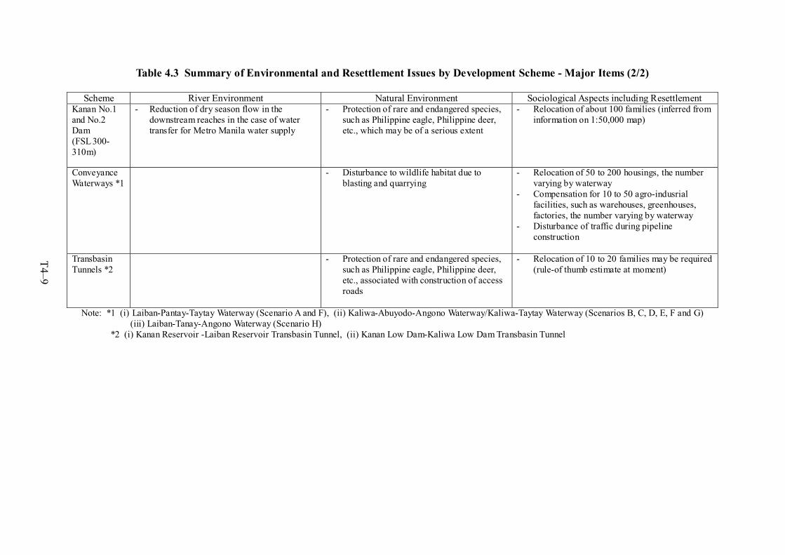
Table 4.3 Summary of Environmental and Resettlement Issues by Development Scheme - Major Items (2/2)
Scheme River Environment Natural Environment Sociological Aspects including Resettlement Kanan No.1 and No.2 Dam (FSL 300- 310m)
- Reduction of dry season flow in the downstream reaches in the case of water transfer for Metro Manila water supply
- Protection of rare and endangered species, such as Philippine eagle, Philippine deer, etc., which may be of a serious extent
- Relocation of about 100 families (inferred from information on 1:50,000 map)
ConveyanceWaterways *1
- Disturbance to wildlife habitat due to blasting and quarrying
- Relocation of 50 to 200 housings, the number varying by waterway
- Compensation for 10 to 50 agro-indusrial facilities, such as warehouses, greenhouses, factories, the number varying by waterway
- Disturbance of traffic during pipeline construction
Transbasin Tunnels *2
- Protection of rare and endangered species, such as Philippine eagle, Philippine deer, etc., associated with construction of access roads
- Relocation of 10 to 20 families may be required (rule-of thumb estimate at moment)
Note: *1 (i) Laiban-Pantay-Taytay Waterway (Scenario A and F), (ii) Kaliwa-Abuyodo-Angono Waterway/Kaliwa-Taytay Waterway (Scenarios B, C, D, E, F and G) (iii) Laiban-Tanay-Angono Waterway (Scenario H)
*2 (i) Kanan Reservoir -Laiban Reservoir Transbasin Tunnel, (ii) Kanan Low Dam-Kaliwa Low Dam Transbasin Tunnel
T4–9