chapter 9 the rock coast of the usa - university of...
TRANSCRIPT

Geological Society, London, Memoirs
doi: 10.1144/M40.9 2014, v.40; p137-154.Geological Society, London, Memoirs
Hampton, Joseph Kelly and Adam P. YoungCheryl J. Hapke, Peter N. Adams, Jonathan Allan, Andrew Ashton, Gary B. Griggs, Monty A. Chapter 9 The rock coast of the USA
serviceEmail alerting to receive free e-mail alerts when new articles cite this article hereclick
requestPermission to seek permission to re-use all or part of this article hereclick
SubscribeCollection
to subscribe to Geological Society, London, Memoirs or the Lyellhereclick
Notes
© The Geological Society of London 2014
by guest on July 28, 2014http://mem.lyellcollection.org/Downloaded from by guest on July 28, 2014http://mem.lyellcollection.org/Downloaded from

Chapter 9
The rock coast of the USA
CHERYL J. HAPKE1*, PETER N. ADAMS2, JONATHAN ALLAN3, ANDREW ASHTON4, GARY B. GRIGGS5,
MONTY A. HAMPTON6, JOSEPH KELLY7 & ADAM P. YOUNG8
1US Geological Survey, St Petersburg Coastal and Marine Science Center, 600 Fourth St South, St Petersburg, FL 33701, USA2Department of Geological Sciences, University of Florida, 241 Williamson Hall, Gainesville, FL 32611, USA
3Oregon Department of Geology and Mineral Industries, Coastal Field Office, Newport, OR 97365, USA4Woods Hole Oceanographic Institution, 360 Woods Hole Rd, Woods Hole, MA 02543, USA
5Institute of Marine Sciences, University of California Santa Cruz, Santa Cruz, CA 90560, USA6Emeritus, US Geological Survey, Pacific Coastal and Marine Science Center, 345 Middlefield Rd., Menlo Park, CA 94025, USA
7Department of Earth Sciences, University of Maine, Orono, ME 04469-5790, USA8Scripps Institution of Oceanography, University of California San Diego, 9500 Gillman Dr., La Jolla, CA 92093, USA
*Corresponding author (e-mail: [email protected])
Abstract: The coastline of the USA is vast and comprises a variety of landform types including barrier islands, mainland beaches, softbluffed coastlines and hard rocky coasts. The majority of the bluffed and rocky coasts are found in the northeastern part of the country(New England) and along the Pacific coast. Rocky and bluffed landform types are commonly interspersed along the coastline and occur asa result of relative lowering of sea level from tectonic or isostatic forcing, which can occur on timescales ranging from instantaneous tomillenia. Recent research on sea cliffs in the contiguous USA has focused on a broad range of topics from documenting erosion rates toidentifying processes and controls on morphology to prediction modelling. This chapter provides a detailed synthesis of recent andseminal research on rocky coast geomorphology along open-ocean coasts of the continental United States (USA).
The ocean coastline of the USA, excluding possessions andterritories, is nearly 20 000 km in length (National Oceanic &Atmospheric Administration 1975) and has a highly variable geo-morphology. The majority of the East Coast and Gulf of Mexicocoastline is dominated by low-relief barrier islands and dune-backed beach systems. However, significant portions of the westcoast, as well as New England, parts of the Mid-Atlantic, Alaskaand Hawaii comprise hard-rock coastline or soft-rock (bluffed)coast (Fig. 9.1). Soft-rock bluffs also occur along the estuarinecoasts of Puget Sound in Washington State and Chesapeake Bayin Maryland, and are a dominant landform type along the coastlineof the Great Lakes (also see Chapter 8: The rock coast of Canada(Trenhaile 2014)). In this contribution, we limit our presentationof USA rocky coast geomorphology to open-ocean coastlines ofthe continental USA that evolve as a function of the interplaybetween hydrodynamic and terrestrial processes, and geology.The expansive coastline of Alaska, as well as Hawaii and the USTerritories (e.g. Puerto Rico, American Samoa, etc.) are excludedfrom this synthesis. The reader is referred to Chapter 16 (The rockcoasts of polar and sub-polar regions (Hansom et al. 2014) andChapter 15 (The rock coasts of oceanic islands (Woodroffe2014)) for information on the rocky shores of these regions.
The open-ocean coastal cliffs and bluffs of New England and theUS west coast, herein referred to as sea cliffs regardless of thematerial properties, occur where the coastal environment com-prises elevated land, which most commonly occurs owing to tec-tonic (e.g. California, Oregon) or isostatic (e.g. New England)uplift (Hampton & Griggs 2004). The geomorphology can varydramatically from steep, high-relief (as high as 1500 m) coastalslopes such as Big Sur in central California and most of the north-ern California coast to moderate-relief marine terraces (southernCalifornia) and glacial bluffs (New England) to rocky headlandswith sea stacks and sea arches (Pacific NW).
The morphology of a sea cliff-forming rock mass is governedby the timing and magnitude of the oceanographic and terrestrial
processes acting upon it as well as the physical properties of thematerial. Sea cliffs shaped dominantly by oceanographic pro-cesses have a steep, sharp-crested profile, whereas those shapedprimarily by terrestrial (or subaerial) processes tend to have asmooth profile, characterized by a rounded cliff-top edge andtalus deposits protecting the base (Emery & Kuhn 1982). Regard-less of the interplay of oceanographic and terrestrial processes,the material strength, as dictated primarily by lithology, struc-ture and degree of weathering, exerts significant control on theresulting sea cliff morphology. For example, in southern Califor-nia, Benumof & Griggs (1999) found that ‘intrinsic’, or mate-rial, properties were more strongly correlated to rates of seacliff retreat than ‘extrinsic’, or wave, forcing. Similarly, Hapke(2005) showed that coastal landslide volume and occurrence inhigh relief coastal slopes in central California correlate to thephysical strength of the slope-forming material, and Collins &Sitar (2009) showed that changes in material strength over justa few hundred metres governs the style and mechanism of seacliff failure.
The erosion of sea cliffs is highly episodic in both time andspace, a combination of the physical and morphological propertiesand the balance of the processes driving retreat. Along tectonicallyactive margins like the west coast, differential erosion is related tothe juxtaposition of varying lithologies as well as spatially discon-tinuous zones of weakness associated with faults, fractures andshear zones. Although the US New England coast is presently apassive continental margin, spatial variations in lithology and geo-logical structure within the crystalline bedrock influence the notonly the rate of sea cliff retreat but the shape and orientation ofthe coastline. Rates of retreat are especially high (.1.0 m a21)in areas where the sea cliffs are composed of soft glaciallyderived material (Kelley 2004).
In addition to spatial variations in material properties, waveclimate and weather patterns vary temporally and influence theepisodicity of sea cliff erosion. Periods of increased storminess,
From: Kennedy, D. M., Stephenson, W. J. & Naylor, L. A. (eds) 2014. Rock Coast Geomorphology: A Global Synthesis.Geological Society, London, Memoirs, 40, 137–154. http://dx.doi.org/10.1144/M40.9
# The Geological Society of London 2014. Publishing disclaimer: www.geolsoc.org.uk/pub_ethics
by guest on July 28, 2014http://mem.lyellcollection.org/Downloaded from

in the form of both higher energy waves and increased rainfall,such as are associated with El Nino seasons on the west coastand strong extratropical (nor’easter) storms in New England, areoften associated with higher rates of sea cliff retreat (Hapke &Richmond 2002).
Human activities increasingly influence sea cliff retreat andevolution on intermediate timescales (years to decades), althoughthe extent of the influence is difficult to evaluate. For example,rates of sea cliff retreat may be directly or indirectly affected byengineering structures. Structures such as seawalls or revetmentscan directly protect a cliff base from wave energy, thus slowingmarine erosion of a sea cliff. Structures such as jetties thatimpound sand may increase beach width and elevation on theirupcoast side but reduce it on the downcoast side. This can indi-rectly affect cliff retreat by artificially increasing or decreasing aprotective beach. Numerous other activities from the dammingof rivers, to agricultural and domestic irrigation on the uplandside of sea cliffs to beach nourishment can all have varying andindirect impacts on the evolution of sea cliffs.
Below we present a synthesis of the current state of knowledgeof rocky and bluff coast geomorphology and general processes ofsea cliff evolution for four geographic subdivisions of the conti-nental US coast: New England, the Pacific NW, north and cen-tral California, and southern California (Fig. 9.1). Each sectionprovides an overview of the regional setting, geology and mor-phology, and erosion rates and processes, in the context of boththe established knowledge base and the most recent scientific con-tributions that are furthering our understanding of sea cliff evol-ution and rocky coast geomorphology in the USA. This chapterincludes a section that synthesizes the most recent advances inour understanding of sea cliff processes, prediction and geo-morphic evolution conducted by researchers along the US coast.
New England and New York
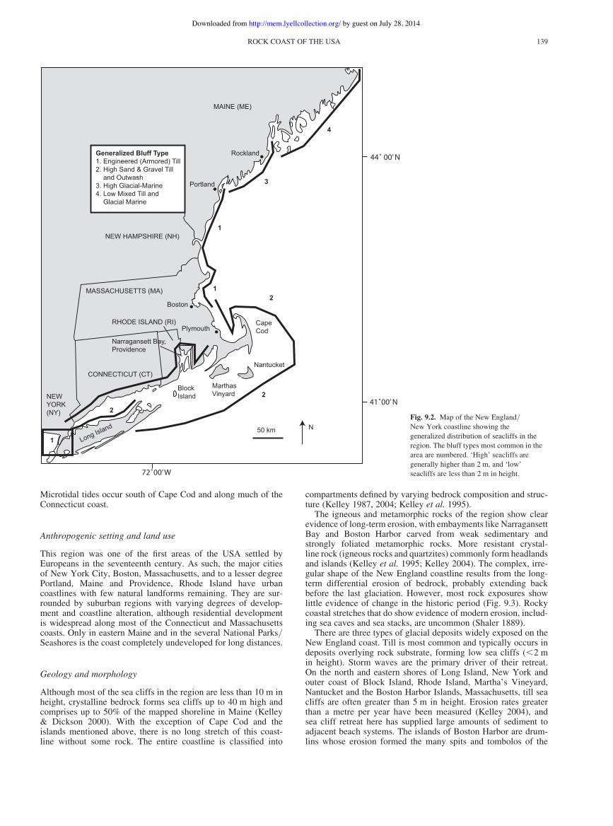
Rocky coastline and sea cliffs are common along the New Englandand northern Mid-Atlantic coast, but are largely absent anywhereelse along the eastern seaboard. The sea cliffs occur non-continuously along the coast from the Canada–Maine border inthe north to the eastern tip of Long Island, New York (Fig. 9.2).In the northern portion New England and New York share acommon history of Palaeozoic bedrock formation and Pleistoceneglaciation (Fig. 9.2). Although Cape Cod and the nearby islands ofMartha’s Vineyard and Nantucket, MA, Block Island, RI, andLong Island, NY are glacial in origin and lack bedrock on thecoast, the remainder of the New England coastline is formed of amixture of bedrock and glaciogenic outcrops (Johnson 1925).
Climate and oceanographic setting
Winds in this region are generally from the southerly quadrants insummer, with prevailing winds out of the WNW in spring, autumnand winter (Hill et al. 2004; Hughes et al. 2007). Major storms,generally extratropical (nor’easter) systems, occur in winter withstorm waves out of the east and NE. Because of the highly irregularnature of the coastline, some locations like coastal Connecticut, thenorth shore of Long Island, Rhode Island and many embaymentson the Maine coast are sheltered and fetch limited during nor’ea-ster storms.
Owing to the large variation in tidal range, macrotidal (.6 m) tomicrotidal (,2 m), wave access to sea cliffs in New Englandvaries substantially. The largest tides are in eastern Maine andrange from 3 to 7 m (FitzGerald & Van Heteren 1999). SW ofRockland, Maine, the tidal range decreases to around 2–3 m.
KILOMETRES
KILOMETRES KILOMETRES KILOMETRES
Fig. 9.1. Map showing the general distribution of seacliffs in the continental USA and the location of the individual regions discussed in the text.
C. J. HAPKE ET AL.138
by guest on July 28, 2014http://mem.lyellcollection.org/Downloaded from
Microtidal tides occur south of Cape Cod and along much of theConnecticut coast.
Anthropogenic setting and land use
This region was one of the first areas of the USA settled byEuropeans in the seventeenth century. As such, the major citiesof New York City, Boston, Massachusetts, and to a lesser degreePortland, Maine and Providence, Rhode Island have urbancoastlines with few natural landforms remaining. They are sur-rounded by suburban regions with varying degrees of develop-ment and coastline alteration, although residential developmentis widespread along most of the Connecticut and Massachusettscoasts. Only in eastern Maine and in the several National Parks/Seashores is the coast completely undeveloped for long distances.
Geology and morphology
Although most of the sea cliffs in the region are less than 10 m inheight, crystalline bedrock forms sea cliffs up to 40 m high andcomprises up to 50% of the mapped shoreline in Maine (Kelley& Dickson 2000). With the exception of Cape Cod and theislands mentioned above, there is no long stretch of this coast-line without some rock. The entire coastline is classified into
compartments defined by varying bedrock composition and struc-ture (Kelley 1987, 2004; Kelley et al. 1995).
The igneous and metamorphic rocks of the region show clearevidence of long-term erosion, with embayments like NarragansettBay and Boston Harbor carved from weak sedimentary andstrongly foliated metamorphic rocks. More resistant crystal-line rock (igneous rocks and quartzites) commonly form headlandsand islands (Kelley et al. 1995; Kelley 2004). The complex, irre-gular shape of the New England coastline results from the long-term differential erosion of bedrock, probably extending backbefore the last glaciation. However, most rock exposures showlittle evidence of change in the historic period (Fig. 9.3). Rockycoastal stretches that do show evidence of modern erosion, includ-ing sea caves and sea stacks, are uncommon (Shaler 1889).
There are three types of glacial deposits widely exposed on theNew England coast. Till is most common and typically occurs indeposits overlying rock substrate, forming low sea cliffs (,2 min height). Storm waves are the primary driver of their retreat.On the north and eastern shores of Long Island, New York andouter coast of Block Island, Rhode Island, Martha’s Vineyard,Nantucket and the Boston Harbor Islands, Massachusetts, till seacliffs are often greater than 5 m in height. Erosion rates greaterthan a metre per year have been measured (Kelley 2004), andsea cliff retreat here has supplied large amounts of sediment toadjacent beach systems. The islands of Boston Harbor are drum-lins whose erosion formed the many spits and tombolos of the
Long Island
BlockIsland
MarthasVinyard
Nantucket
CapeCod
Boston
MAINE (ME)
RHODE ISLAND (RI)
CONNECTICUT (CT)
Rockland
NEWYORK(NY)
50 km N
Plymouth
Portland
1
2
Generalized Bluff Type1. Engineered (Armored) Till2. High Sand & Gravel Till and Outwash3. High Glacial-Marine4. Low Mixed Till and Glacial Marine
2
21
1
3
4
Narragansett Bay,Providence
MASSACHUSETTS (MA)
NEW HAMPSHIRE (NH)
72˚00’ W
41˚00’ N
44˚ 00’ N
Fig. 9.2. Map of the New England/New York coastline showing the
generalized distribution of seacliffs in theregion. The bluff types most common in thearea are numbered. ‘High’ seacliffs are
generally higher than 2 m, and ‘low’seacliffs are less than 2 m in height.
ROCK COAST OF THE USA 139
by guest on July 28, 2014http://mem.lyellcollection.org/Downloaded from

area (Himmelstoss et al. 2006; Hughes et al. 2007, Rosen & Fitz-Gerald 2009). Himmelstoss et al. (2006) developed a concep-tual model for their erosion in which wave processes initiate seacliff retreat. Sea cliffs are initially eroded rapidly by waves andlarge quantities of sand and gravel remain to form a beach thatprotects the bluff. Once the soft sea cliffs are no longer subjectedto regular wave activity, rain- and frost-induced erosion thendominate. A separate model of beach behaviour adjacent to erod-ing drumlins was developed earlier by Boyd et al. (1987).
For till sea cliffs in sheltered areas, erosion results in the dis-persal of fine sediment with a lag deposit of gravel and sandoften left behind on tidal flats (Kelley 2004). Erosion rates oftill sea cliffs are low in the absence of large waves and shelteredtill sea cliffs are often stable for decades (Kelley & Dickson2000). In a study of three eroding archaeological sites in tillin Acadia National Park, Kelley & Kelley (2007) measured
negligible retreat where even decimetre-sized cobbles did notmove in several years.
Large sea cliffs formed from glacial outwash sand and gravelare common on the islands of Martha’s Vineyard and Nantucket,as well as along much of the shoreline of Cape Cod and areas tothe north (Figs 9.2 & 9.4a). The sea cliffs are commonly over30 m in height and supply sand to nearby beaches. Homeownersin Massachusetts are generally prevented from armouring seacliffs to protect cliff-top properties (Fig. 9.4a) to ensure that thesediment supply to beaches from sea cliff erosion is maintained.Much of the outer coast of Cape Cod is in the Cape Cod NationalSeashore, where sea cliffs up to 30 m in height are allowed toerode and naturally provide sediment to the littoral system.
Glacial-marine muddy deposits that form low (1–2 m) sea cliffsare common along the Maine coast. The soft sea cliffs retreatrapidly, and as a result have generally been eroded away from
Fig. 9.3. Photographs of Portland HeadLight from 1898 (at low tide) and 2011
(at high tide). Arrows point to identicallocations in each picture and underscore the
generally slow erosion rates for theregional bedrock.
C. J. HAPKE ET AL.140
by guest on July 28, 2014http://mem.lyellcollection.org/Downloaded from

exposed shoreline and are no longer actively eroding from marineprocesses (Kelley 1987, 2004). They are common in more shel-tered settings along highly indented portions of the coast. Blufferosion hazard maps for property damage mitigation were recentlypublished (Kelley & Dickson 2000; Raineault et al. 2005; MaineGeological Survey 2012). An investigation of the characteristicsand properties of unstable sea cliffs demonstrates that, even inprotected settings, the sites most likely to experience erosionhave at least 2 km of unrestricted fetch and face south, the directionof prevailing swell (Keblinsky 2003).
Erosion rates and processes
The long-term erosion rate of sea cliffs in New England is typi-cally ,0.5 m a21 although many are relatively stable in theshort term (years). Sunamura (1983) showed that the cycle ofsea cliff retreat is periods of episodic erosion followed bylonger intervals of quasi-stability. For glacial till or outwash sea
cliffs, this occurs when a beach shelters the bluff face frommost wave attack. Where sea cliffs are composed of fine (silt toclay) material, a protective salt marsh may develop on erodedsea cliff material (Kelley et al. 1988). Once waves have planedoff the slumped material, halophytic grasses colonize the newland. In the absence of a new sediment source, the wetlanderodes. Eventually a new slump is initiated when the protectionprovided by the marsh is reduced. Although large landslides areoften anthropogenically stabilized (Berry et al. 1996), slump plat-forms topped by thin marsh deposits exist and testify to pasterosion events.
Pacific NW
The Pacific Northwest (PNW) coasts of Oregon and Washington(Fig 9.6) are some of the most dynamic coastal landscapes inNorth America. The Washington coastline is 4296 km in length
Fig. 9.4. Large-scale bluff erosionlocations: (a) While Cliffs, near Plymouth,
MA, are greater than 30 m in height andcomposed of sandy outwash. The arrowpoints to picnic table for scale. The erosion
rate here is around 0.5 m a21 (MA CZM,2012); (b) Rockland landslide of April 16,
1996. Arrow points to person for scale; ruinsof two houses are visible on left. The muddysediment from this event slid more than
100 m onto the tidal flat.
ROCK COAST OF THE USA 141
by guest on July 28, 2014http://mem.lyellcollection.org/Downloaded from

and can be broadly divided into three segments: the SW Washing-ton coast that extends from the Columbia River north to PointGrenville, the NW coast of the Olympic Peninsula, and theeastern coast that extends south of the Canadian border downinto the straits and islands of Puget Sound (Schwartz & Terich2010). By far the bulk of the coastline (length c. 3400 km) reflectsthe numerous islands within Puget Sound (Shipman 2008). In con-trast, the Oregon coast is 588 km long from the Columbia River tothe California border. The coastal geomorphology of this land-scape reflects myriad landforms that range from plunging seacliffs to rocky shorelines and shore platforms, wide and narrowsandy beaches backed by both dunes and sea cliffs and graveland cobble beaches backed by sea cliffs. The sea cliffs androcky coastlines are discontinuous and may be separated bybarrier spits, estuaries, lagoons and river deltas (Komar 1997;Shipman 2008). The majority of the Oregon coast comprises seacliffs (58%). The open-coast of Washington is approximately22% sea cliffs, and a large (undocumented) proportion of thePuget Sound shoreline comprises sea cliffs.
Climate and oceanographic setting
The dominant processes that drive the erosion of PNW coastalcliffs include waves, varying tides, the presence of rip embay-ments, periodic occurrences of El Ninos that serve to locallyraise the mean sea-level, and precipitation (Komar 2004; Allanet al. 2009). The mean tidal range in the PNW is 2 m. Of particularimportance, the PNW coast is exposed to one of the most extremewave climates in the world, owing its long fetches and the strengthof the extratropical storms that develop and track across the NorthPacific. These storms exhibit a strong seasonal cycle producing thehighest waves and high mean water levels in the winter, while thesummer is dominated by low waves and lower water levels (Rug-giero et al. 2010; Komar et al. 2011). The cause of the variations inocean water levels along the PNW coast is largely ocean upwel-ling, which brings cold dense water to the surface, and owing tothe Coriolis effect and ocean currents, this water is directed land-ward where it depresses sea level. In the winter this process breaksdown, resulting in warming of the ocean, which raises the meansea-level. This seasonal variation in water levels is c. 0.24 m, butincreases to as much as 0.6 m during an El Nino, essentiallyraising the mean shoreline elevation, enabling waves to breakcloser to the cliff toe.
Anthropogenic setting and land use
Unlike many other parts of the continental US coast, populationpressure on the PNW coast is relatively low and is largely confinedto small coastal towns separated by large tracts of coast with littleto no development. The bulk of these developments are concen-trated on the central to northern Oregon coast, the SW Washingtoncoast (south of Point Grenville), and within Puget Sound. On thecliffed shores of the central Oregon coast (Fig 9.5), betweenNewport and Lincoln City, homes are perched precariously closeto the edge of the cliffs (Fig. 9.6), and in some areas the erosionhas become acute, requiring various forms of coastal engineering(commonly riprap) to mitigate the problem, and in a few casesthe landward removal of the homes. In other areas, critical infra-structure such as major transportation routes track close to thecoast and in several areas erosion of the cliffs has resulted inexpensive remediation.
Geology and morphology
The geology of the PNW coast reflects four broadly contrastinggeological provinces. Pleistocene glaciation and associated depos-its in the Puget Sound region have left an imprint on the underlying
folded and faulted Cenozoic formations that dominate the OlympicPeninsula. South of the Olympic Peninsula, a melange character-izes much of the coast down to Point Grenville (Schwartz &Terich 2010) and moderately faulted Cenozoic sediments com-prise the central to northern Oregon coast (Schlicker et al. 1973).The southern Oregon coast is underlain by a sheared melange(Beaulieu & Hughes 1976).
Along much of the south-central Oregon coast and to the north,elevated Pleistocene shore platforms with overlying terrace sanddeposits are cut into the Coast Range. Formation of the terracescan be attributed to the uplift of the Coast Range in concert withvarying sea level during the Pleistocene (Orr et al. 1992). Dunesand is draped over the marine terraces in central Oregon as aresult of advancing dune sheets during sea-level rise beginning8000 years ago (Peterson et al. 2007). A typical sea cliff sequencethus consists of Cenozoic rocks at the base that may be somewhat
Fig. 9.5. The Pacific NW coast of Oregon and Washington. Bold black linesdenote the locations of cliffs and rocky shores. Numbers indicate the regionaldistribution of geomorphic coastal features: plunging cliffs (1,4 & 6), rocky
shorelines and shore platforms (1, 3 & 6), wide and narrow sandy beachesbacked by both dunes (2, 4 & 5) and cliffs (3 & 4), gravel and cobble beaches
backed by cliffs (1, 6 & 7), barrier spits (2, 4 & 5), estuaries (1–6), lagoons (7)and river deltas.
C. J. HAPKE ET AL.142
by guest on July 28, 2014http://mem.lyellcollection.org/Downloaded from

resistant to wave attack and subaerial processes, capped by a layerof Pleistocene sandstone or Holocene dune sands (Komar 2004).Because of the dramatic ocean vistas gained from the nearlylevel terraces, many communities are now situated along theedge of the terraces (Fig. 9.6).
The majority of cliffs on the central to northern Oregon coast(sections 3 and 4 in Fig. 9.5) have low to moderately high relief(10–20 m), formed from erosion into marine terraces. Muchhigher cliffs tend to be associated with the major headlands andreach heights up to 120 m. Mean cliff slopes are c. 438 (+148),with the steepest slopes reaching 858 and more commonly associ-ated with headlands composed of resistant lithologies. In mostcases, the cliffs are fronted by wide, dissipative surf zones, andlow sloping medium sand beaches (e.g. Newport), while a fewcliffed sections are fronted by steep, narrow, mixed sand andgravel beaches (e.g. Gleneden Beach, located just south of Lin-coln City). Of these, the latter beach type is the most dynamic,
experiencing significant shoreline movement (up to 45 m) in thewinter that is largely a function of the seasonal exchange of beachsediments often related to the development of rip embayments,which serve to locally lower the beach elevation by up to 3.5 m(typical seasonal beach elevation changes are about 1–2 m),which enables large winter waves to break close to shore, expend-ing their energy directly at the toe of the cliff (Fig. 9.7). In someareas, beach sand may be completely removed, exposing the under-lying shore platform. On the northern Oregon coast at CannonBeach, sea cliffs are protected by dissipative sand beaches thatare backed by a veneer of gravel (shingle to cobble). These cliffsare mostly stable, evidenced by highly vegetated seaward slopes,or have experienced erosion in the past (evidenced by the pres-ence of coastal engineering structures) and are now highly vege-tated. As noted previously, the typical stratigraphic profilereflects Cenozoic sediments in the bottom section of the cliff withPleistocene sand on top. Owing to the considerable variation in
Fig. 9.6. Homes perched along the cliff topat Roads End, Lincoln City, Oregon with
evidence of local bluff collapse in centre ofphotograph. Dark banding in the upper
terrace face reflects groundwater seepagedown through the terrace sediments, where itcomes into contact with the less permeable
Cenozoic sediments. Note the recent slumpfailure in mid photo (photograph by
E. Harris, DOGAMI, 2011).
Fig. 9.7. The development of a rip embayment in early November 2006 at Gleneden Beach on the central Oregon coast directly contributed to the loss of up to
9 m of cliff erosion during a single weekend storm. (a) View from the cliff top looking northward. The presence of the rip embayment is highlighted. Note the truck inthe bottom left corner endeavouring to construct a gravel road so that riprap could be placed at the toe of the cliff to protect several homes. (b) View from the beachlooking south showing waves impacting directly at the toe of the bluff.
ROCK COAST OF THE USA 143
by guest on July 28, 2014http://mem.lyellcollection.org/Downloaded from

the alongshore geomorphology of the coast, the degree to whichthese two predominant units make up the cliff varies considerably.
On the southern Oregon coast, the cliffy shorelines are char-acterized by moderately high relief (bluff heights on the orderof 20–30 m), with the highest elevations again reflecting thelocations of prominent headlands. The coastline is chiefly hardrock sea cliffs interspersed with small pocket beaches compris-ing sand or sand and gravel with clasts up to boulder size. Theslope of the cliffs vary from c. 34 to 458 in both Quaternarymarine terrace sediment and sheared Mesozoic sedimentary andmetamorphic rocks, while near-vertical slopes are achieved onhard rock that characterize many of the headlands.
The Pacific coast of the Olympic Peninsula is considered to beone of the great scenic coasts of the world. Differential erosion ofthe Cenozoic sediments and volcanic rocks has resulted in the for-mation of dramatic stacks, arches, sea caves and high cliffs. Accord-ing to Schwartz & Terich (2010), long-term erosion of this coast isclearly evident owing to the numerous stacks and islands locatedwithin a few kilometres of the shore. Very little quantitative infor-mation is presently available on the cliffed shorelines of theWashington coast, including Puget Sound (Shipman 2008).
Erosion rates and processes
Analyses of the rates and patterns of cliff retreat on the Oregoncoast are well documented in several reports and conference pub-lications for a variety of different geological units and sites. Inmost cases, estimates of cliff retreat are derived from comparisonsof the position of the cliff-top edges (and to a lesser extent the toe)as interpreted from aerial photography and in a few cases Real-time Kinematic-Differential Global Positioning System (RTK-DGPS) surveys (Priest & Allan 2004; Priest et al. 2004; Witteret al. 2007, 2009; Olsen et al. 2012; Allan & Stimely 2013).Erosion rates vary significantly between the different geologicalunits and spatially along the coast. The highest long-termerosion rates (20–67 cm a21) are observed on the southernOregon coast at Nesika Beach, where the cliffs are eroding intohighly fractured Jurassic melange. Cliff erosion rates on thecentral Oregon coast are lower (6–21 cm a21) compared withthe south coast, and are largely due to the predominance of widesandy beaches that buffer the sea cliffs from erosion, combinedwith sedimentary rock cliffs that are generally more resistant toerosion than the shattered melange at Nesika Beach. Movingnorthward, the erosion rates further decrease and are lowest inthe far north (Komar et al. 2011).
Whereas the patterns and rates of cliff erosion are controlled inlarge part by the geology of the coast, another important factor isthe buffering capacity of the beach at the cliff toe (Komar2004). As a general rule, wide beaches with high beach/clifftoe juncture elevations tend to be the most stable, exhibiting lowerosion rates, while cliffs fronted by narrow beaches tend toexperience significantly higher rates of erosion. While the vari-ation in the buffering capacity of the fronting beach is controlledlargely by the seasonal cycle in waves and water levels, highlyfocused lowering of the beach periodically occurs owing tothe development of rip embayments, or as a result of ‘hotspot’erosion caused by the alongshore displacement of sand duringEl Nino climate events (Allan et al. 2003). The latter event hasbeen shown to cause the mean shoreline to retreat by an additional10–20 m in the southern ends of the littoral cells, enabling wavesto directly attack the backshore and, hence, the cliff toe.
Similarly, the pattern and rates of cliff erosion may also beincreased owing to exposure to moisture-laden storms from thewest in the winter, the so-called ‘pineapple express’. Forexample, the Pacific coast experiences an average annual rainfallof about 2000 mm (Schwartz & Terich 2010), with peak rainfalloccurring in mid- to late winter, coincident with those dayswhen high waves and higher than normal sea levels occur along
the coast. The occurrence of precipitation, particularly if sustained,results in active erosion down the cliff face (rain wash), ground-water seepage in the sea cliffs that can result in piping andslump failures (Komar 2004), plus high groundwater pressurethat promotes large bedrock slides.
Central and northern California
The central and northern California coast extends from PointConception in the south to the Oregon border in the north, a dis-tance of about 1000 km (Fig. 9.8). The majority of this coast ofthis distance consists of rocky coastline that is dominated tectoni-cally by transform motion with minor convergence along the SanAndreas Fault south of Cape Mendocino, and subduction motionto the north. Uplifted terraces and steep mountains, both typicallyfronted by coastal cliffs, dominate the geomorphology. Processesthat modify the coastline include waves, rainfall and runoff, andmass movements such as landslides and rockfalls (Griggs &Patsch 2004; Hampton et al. 2004). For the last 18 000 yearsthe shoreline has advanced landward as a consequence of postgla-cial global warming and net sea-level rise (Kearney 2001; Griggs& Patsch 2004). As a result, the coastline of central and northernCalifornia comprises largely erosional landforms such as steepsea cliffs, rocky headlands and sea stacks.
Anthropogenic setting and land use
Land use and population density vary substantially within northernand central California. Along the steep coastal slopes that are morecharacteristic of northern California, private development andpublic infrastructure are less common than along the lower-reliefsea cliffs and marine terraces that are typical of the central Cali-fornia coast. Development pressures historically have been rela-tively high and land use on the flat, elevated marine terracesranges from moderately dense communities to agriculture. Inboth cases, runoff and increased irrigation for crops and landscap-ing may cause an acceleration of sea cliff erosion rates by wettingthe cliff-forming materials. Along most of the developed stretchesof coast, seawalls, revetments and riprap are common along thebase of the eroding sea cliffs.
Climate and oceanographic setting
The weather along California’s coast, including storms, precipi-tation and waves, is directly related to the changing seasonal pat-terns of oceanic and atmospheric circulation within and abovethe North Pacific Ocean (Griggs 2010). Perhaps the most importantfactor affecting what happens along the coast is the behaviour ofone large mass of air, the North Pacific High, which varies insize, strength and relative atmospheric pressure from year toyear. How far north or offshore it reaches, as well as how farinland it migrates over western North America, influences Cali-fornia’s coastal climate, affecting storm track direction andlocation, and therefore precipitation distribution, as well as thewave energy that reaches the coastline. Periodic El Nino eventsare also important in shaping the California coastline. During ElNino years, the trade winds across the Pacific reverse direction,resulting in eastward flow of warmer surface waters and elevatedwater levels. Storms are also more frequent and of greater intensityduring El Nino years. The increased storminess in conjunctionwith the elevated water levels results in increased wave heightsand inundation along the coast. Powerful storms usually approachfrom the NW and, particularly along California’s northern coast,may generate 8–10 m high waves offshore.
C. J. HAPKE ET AL.144
by guest on July 28, 2014http://mem.lyellcollection.org/Downloaded from

Geology and morphology
The rugged stretches of California’s central and north coast typi-cally are underlain by resistant lithologies that include graniteand the Franciscan Formation, a melange or chaotic and foldedmixture of sedimentary and volcanic rocks (Alt & Hyndman 2000).These rocks tend to be relatively resistant to erosion and formmany of central and northern California’s coastal headlands(Griggs & Patsch 2004; Griggs 2010). Examples include TrinidadHead and Point Reyes (Fig. 9.9). Continuing south along the coast,Point Sur and Point San Luis are volcanic or metavolcanic rocks.The granite tends to erode slowly, but because of the sheared andbroken-up nature of the Franciscan, these steep cliffs may besubject to large-scale, episodic mass movement through landslid-ing and slumping, as along the Sonoma and Big Sur coastlines.
California’s coast north of Point Conception can be brokendown into: (a) steep coastal mountains and cliffs with hundreds
of metres of relief (Fig. 9.9); (b) uplifted marine terraces and seacliffs from 10 to 100 m high (Fig. 9.10); and (c) coastal lowlandswith beaches, sand dunes, estuaries and lagoons. The majority ofthe northern and central California coast consists of activelyeroding coastal cliffs that include (a) and (b). Most of the high-relief, steep cliffs are located in northern California and includeareas such as the Marin Headlands just north of San Francisco’sGolden Gate, and along the Big Sur Coast south of Monterey(Fig. 9.8).
The low- to moderate-height sea cliffs, which are more commonin central than northern California, typically are eroded intouplifted marine terraces and provide clear evidence of a tectoni-cally rising coast slowly being removed by wave attack (Lajoieet al. 1986). The flat terraces were formed by wave erosion inthe surf zone and provide a record of the oscillations in globalsea level superimposed upon a gradually rising coastline. Mostof the terraces and their fronting sea cliffs, which characterize
0 9045 Miles
Trinidad Head
Eureka
Cape Mendocino
Pt. Arena
Pt. ReyesSan Francisco
Pacifica
Santa Cruz
MontereyPt. Pinos
Pt. Sur
Pt. San Luis
Pt. Conception
Legend
P a c i f i c O c e a n
C a l i f o r n i a
Low Bluff / Terrace
Steep Cliff / Mountain
42° 00’ N
40° 00’ N
38° 00’ N
36° 00’ N
124º 00’ W 122º 00’ W 120º 00’ W
N
150 Kilometres20 50 1000
Fig. 9.8. Location map showing the generaldistribution of rocky coast landforms along
the north and central coast of California.Two types of rocky coast geomorphology
occur in this region: low bluff and marineterraces (dashed line) and steep, high reliefcoastal slopes (solid line).
ROCK COAST OF THE USA 145
by guest on July 28, 2014http://mem.lyellcollection.org/Downloaded from

much of the coastline along the central coast, and portions of thenorth coast, have been eroded into relatively weak Neogenesedimentary rocks, typically sandstones, mudstones and shales.The lower relief cliffs typically consist of a more resistant lowerbedrock portion capped by a few to 10 m of unconsolidatedterrace deposits, which vary from beach and dune sand to ter-restrial soils and range in size from cobbles to clay and silt(Griggs & Patsch 2004). Shore platforms often front these lowcliffs, and are particularly well developed where the bedrock iswell-bedded sedimentary rock that has a low seaward dip angle(Fig. 9.10).
Erosion rates and processes
Coastal cliffs, as a result of their tectonic setting, lithologicaland structural framework, and recent geological history, varywidely in central and northern California in their height and
morphology (Griggs & Patsch 2004; Hapke & Reid 2007).Although sea cliffs are primarily a product of marine erosion, sub-aerial or terrestrial processes such as landslides, slumps, rockfallsand surface runoff can be equally important in the evolution andshaping of the exposed landforms at any particular location, andtypically, both are involved. Earthquake-induced cliff failure,while infrequent, can also be a cause of cliff failure (Griggs &Scholar 1997; Hapke & Richmond 2002). In addition to the ero-sional processes mentioned above, groundwater saturation andseepage, as well as stress-release fracturing have been docu-mented in northern California sea cliffs, particularly those inweakly lithified sediments (Hampton et al. 1999; Hampton 2002;Collins & Sitar 2008, 2009, 2011). The most severe wave attackof the sea cliffs occurs during the winter storm season, typicallyfrom late autumn to early spring, when waves are largest andbeaches are narrow.
Most of the published rates of coastal erosion for the central andnorthern California coast as well as descriptions of individual
Fig. 9.10. Low sea cliffs and shoreplatforms eroded into an uplifted marineterrace in the Santa Cruz area of central
California (copyright # 2002–2010Kenneth & Gabrielle Adelman, California
Coastal Records Project,www.californiacoastline.org).
Fig. 9.9. Steep rock cliffs of the Marin
Headlands, north of the Golden Gate(copyright # 2002–2010 Kenneth &
Gabrielle Adelman, CaliforniaCoastal Records Project,www.californiacoastline.org).
C. J. HAPKE ET AL.146
by guest on July 28, 2014http://mem.lyellcollection.org/Downloaded from

geographic areas and their erosional processes and issues havebeen summarized by Griggs et al. (2005). Hapke & Reid (2007)provide a regional quantification of long-term sea cliff erosionrates and Hapke et al. (2009) correlate rates of shoreline changeand sea cliff retreat.
In general, weaker sedimentary rocks such as sandstones, silt-stones, mudstones and shales that make up much of central andnorthern California’s coastline erode at average rates of about10–30 cm a21. However, the failures generally occur episodi-cally. Unconsolidated or poorly consolidated materials such asterrace deposits, alluvium or older dunes may erode a metre ormore annually. In contrast, erosion of the granitic rock thatmakes up some of the more resistant headlands such as the Mon-terey Peninsula has been negligible over the past 50–100 years(Hapke & Reid 2007; Griggs 2010).
As in other regions, the steepness or profile of a sea cliff oftenprovides a good general indication of the dominance of eithermarine or terrestrial erosional processes in northern and centralCalifornia (Emery & Kuhn 1982). Where there is no beach oronly a very narrow beach, waves are able to attack the base ofthe sea cliff during the winter months and perhaps during mosthigh tides as well. The essentially unprotected cliffs are usuallyvery steep or vertical by virtue of wave attack at the base of thecliff and subsequent collapse or failure of the overlying material.Steep sea cliffs, therefore, are generally a reliable indicator ofthe long-term dominance of marine erosional processes over ter-restrial processes. Where beaches are very wide year round,waves may rarely reach the back beach cliff or bluff. Terrestrialor subaerial processes such as rainfall-induced runoff or seepage,slumping or sliding dominate, leading to a degraded or subduedcliff profile, which slopes more gently toward the beach or shore-line (Emery & Kuhn 1982). Collins (2004) and Collins & Sitar(2004) documented the timing and volumes of individual failuresover several storm seasons. They found that weakly lithifiedsandy bluffs in the study area failed through both wave action atthe base of the bluff and through rainfall seepage along the blufftop, providing evidence of short-term sea cliff evolution by bothterrestrial and marine processes. Microseismic forcing is anotherprocess that ultimately may induce sea cliff failure. Adams et al.(2002, 2005) used seismometers to document microseismic sea
cliff shaking in response to changing wave climate, and identifieda potential rock-fatigue mechanism linking cyclical wave loadingand sea cliff strain.
The northern and central California coast is dominated by high-relief rocky coast and low to moderate relief sea cliffs. A combi-nation of marine and terrestrial processes drives the retreat of thesea cliffs and the relative balance of the forcing is spatially andtemporally variable. The northern California coast is sparselypopulated, and sea cliff erosion and coastal landslides rarelyreceive substantial attention. However, in many locations alongthe central California coast, development along the top of the seacliffs is widespread and homes and other human infrastructureare periodically threatened. Coastal erosion and pressure for miti-gation will probably increase with predicted climate change scen-arios, including an increase in the rate of sea-level rise (NationalResearch Council 2012).
Southern California
The southern California coast extends 485 km from Point Con-ception to the Mexican border (Fig. 9.11). Four major cliff sectionscomprise about 60% of the coast (Orme 1991) and the cliff tops areoften developed with structures as well as critical infrastructuresuch as power plants, railways, military installations and high-ways. Coastal cliff erosion and retreat threaten this development,and seawalls or other mitigation strategies are commonly used toprevent erosion (Fig. 9.12). Cliff-backed beaches are frequentlyused for recreation, and coastal landslides are also a publichazard, having caused several deaths in recent years.
Anthropogenic setting and land use
The coastal region of southern California is highly urbanized.Urbanization and development of the region has altered the coast-line and coastal processes through the construction of jetties, ports,harbours and upland dams (Inman 1976; Flick 1993; Griggs et al.2005). River damming (Willis & Griggs 2003; Slagel & Griggs2008), watershed development, urbanization (Warrick & Rubin
117°0'0"W118°30'0"W120°0'0"W
34°30'0"N
33°0'0"N
PointConception
Mexico
SouthernCalifornia
Channel Islands
San Andreas Fault
Los AngelesBasin
SantaMonica Mts.
1
2
3
4
0 30 60 Kilometress
VenturaBasin
N
Santa Barbara
Ventura
Los Angeles
San Diego
Fig. 9.11. Map of the southern Californiabight, four main coastal cliff sections (blacklines), and the San Andreas Fault (dashed
line).
ROCK COAST OF THE USA 147
by guest on July 28, 2014http://mem.lyellcollection.org/Downloaded from

2007) and coastal armouring (Runyan & Griggs 2003; Young &Ashford 2006b) have significantly reduced the natural beach sedi-ment supply in some areas.
Climate and oceanographic setting
The southern California semi-arid Mediterranean climate ischaracterized by dry summers and occasionally wet winters,with most rainfall occurring from November to March. Annualcoastal precipitation increases towards the north and variesbetween about 10 and 120 cm. Rainfall in the region tends to beepisodic and several centimetres of rain often fall over a fewdays. Strong El Nino winter events are associated with elevatedprecipitation, wave heights and sea levels, causing increasedcoastal erosion, flooding and damage (Flick 1998; Storlazzi &Griggs 2000; Storlazzi et al. 2000), and influence sea clifferosion rates in the region.
The coast encompasses the southern California bight, whichtrends east–west in the Santa Barbara area and north–south inthe San Diego area (Fig. 9.11). The sea cliffs are exposed to wavesgenerated by local winds and distant storms in both Northernand Southern hemispheres. During winter, swell from the NorthPacific and Gulf of Alaska is most energetic, whereas swell fromthe South Pacific dominates in summer. Waves reaching southernCalifornia sea cliffs undergo complex transformations, and theinteractions of approaching waves with the offshore ChannelIslands (Fig. 9.11), as well as changing shoreline orientations,create strong alongshore variations in wave height. The seasonalcycle delivers maximum wave energy to the coast in winter. Thetide range is about 2 m.
Geology and morphology
The region is seismically active and contains numerous faultzones, most notably the San Andreas Fault dividing the NorthAmerican and Pacific plates. Past fault motion produced severalcoastal mountain ranges and a series of uplifted marine terracesalong much of the coastline. In general, coastal cliffs cut into theuplifted marine terraces exist along the southern California
coastline, except where low-lying basins reach the coast andwhere rivers discharge into the sea through wetland lagoon areas.
The majority of the Southern California cliffs are low relief;however, high-relief steep cliffs also exist. The cliffs are gen-erally 20–30 m in height but are as high as 100 m in San Diegoand have a range of slopes, from vertical to about 308. The cliffsare usually fronted by a submerged wave-cut platform coveredby a thin veneer of beach sand and sometimes cobble. Thebeaches, which can sometimes act as a buffer to cliff erosion,are narrow and occasionally stripped of sediment during largewinter storms.
The cliffs are generally composed of two geological units: alower unit of more resistant lithified Cenozoic mudstone, shale,sandstone and siltstone, and an upper unit of weakly lithifiedQuaternary terrace deposits (Griggs et al. 2005). Low-reliefcliffs composed of alluvium or terrace deposits are also commonwhere the lower unit is occasionally absent. Cliff profiles differalong the southern California coast and are related to the relativeimportance of marine and subaerial processes, cliff compositionand phases of the profile evolution (Emery & Kuhn 1982).
The four main cliff sections shown in Figure 9.11 are semicon-tinuous and occasionally broken by coastal lagoons, small streamsand ravines. In many areas the cliff composition and geologicalconditions (e.g. cliff resistance to erosion) change gradually along-shore and form a relatively straight cliff line. Alternatively, insome locations such as Point Loma and La Jolla, geological con-ditions vary alongshore at a range of scales, contributing to vari-ation of erosion rates and resulting in a more complex shorelinecontaining sea caves, arches, blow holes and surge channels(Kennedy 1973; Shepard & Kuhn 1983).
Erosion rates and processes
The cliffs in southern California are subject to multiple marineand subaerial erosive processes, as elsewhere, which interactwith site-specific local geology to produce temporally and spatiallyvariable retreat. Wave action at the cliff base causes steepeningand occasional undercutting, resulting in cliff instability (Young& Ashford 2008). Heavy rainfall (Young et al. 2009), groundwater(Turner 1981; Norris & Back 1990), concentrated surface runoff
Fig. 9.12. Oblique photograph of coastal cliffs, threatened cliff top development and engineered cliff erosion protection (left side, lower cliff seawall and upper cliff
slope reconstruction) in Solana Beach, southern California (copyright # 2002–2010 Kenneth & Gabrielle Adelman, California Coastal Records Project,www.californiacoastline.org).
C. J. HAPKE ET AL.148
by guest on July 28, 2014http://mem.lyellcollection.org/Downloaded from

(Kuhn & Shepard 1984), earthquakes (Orme 1991) and bioerosion(Engstrom 2006) have also been linked to coastal landslidesand cliff erosion in the region. Benumof & Griggs (1999) foundlong-term cliff retreat rates correlated with intact rock strength,and the retreat rates were inversely related to nearshore wavepower (Benumof et al. 2000).
Mass movements most often occur through rockfalls, shallowslides, topples and debris flows; however, large-scale, complexdeep-seated landslides also occur (Orme 1991). Large cliff failuresare episodic and site-specific, while other processes such as subaer-ial weathering occur continuously. In locations where the cliffscontain coarse grain sediment, the eroded cliff material providesbeach sediment (Limber et al. 2008; Young et al. 2010) and cancontribute significantly to the overall littoral budget (Young &Ashford 2006a).
Recent research in San Diego (Young et al. 2011) suggests thatcumulative distributions of coastal landslide failure parame-ters (area, mean retreat, maximum retreat, and length) follow aninverse power-law distribution for medium to large events, sim-ilar to inland landsliding. Additionally, Young et al. (2011)found that small and medium slides tended to reoccur preferen-tially (relative to randomly) near previous small and mediumslides, forming short-term hot spots, while large slides were lesslikely to reoccur near previous large slides.
Cliff erosion and retreat in the region is well documented,notably in the San Diego and Santa Barbara areas. Qualitativeobservations of cliff erosion date back at least as far as the1850s, when historical records note railway damage caused bycoastal landslides (Orme 1991), and cliff undercutting by waveaction in San Pedro (Engstrom 2006). Further historical evidencewas described in 1889 by a US Coast and Geodetic survey,which noted ‘new erosion during each winter storm’.
Mean long-term cliff retreat rates range from about 5 to20 cm a21; however, rates of 180 cm a21 have been documented(Hapke et al. 2009). The rates of cliff retreat and erosion canvary by an order of magnitude for the same locale (Everts 1990).Large differences in the retreat rates are caused by episodic cliffretreat coupled with end-point retreat rate estimates, the datasources used and varying amounts of cliff protection.
Eroding sea cliffs and development are common features alongthe southern California coast. Marine and subaerial processes actover various timescales to erode the cliffs; however, their rela-tive importance is locally uncertain and is site-specific. In somecases, anthropogenic influences have accelerated the cliff ero-sion. Effectively managing the southern California coast willbecome increasing challenging as coastal population and sea-levels continue to rise and natural beach sediment sources arereduced by damming of rivers and building of coastal structures.
Rocky coast geomorphic process, prediction
and evolution
Observations of coastal cliffs from throughout the continentalUSA provide a significant knowledge base to characterize thegeomorphic processes that lead to cliff evolution over a widerange of coastlines. The understanding of processes combined withmeasurement allows for the development of both meso-term (yearsto decades) predictive models and long-term (centuries to millen-nia) evolutionary models. The state-of-knowledge and most recentresearch on rocky coast process, prediction and evolution, witha focus on work conducted in the USA, is presented below.
Processes of sea cliff failure and retreat
The fundamental requirement for sea cliffs to exist is the presenceof elevated land, which most commonly arises from tectonic(e.g. California, Oregon) or isostatic (e.g. New England) uplift
(Hampton & Griggs 2004). The oceanic and terrestrial processesthat act on the uplifted rock mass will have different geomor-phic effects, which depend on the timing and magnitude of theprocesses themselves, as well as the properties of the substrate.Considering process alone, cliff formation that is dominatedby oceanic processes results in a steep, sharp-crested profile,whereas cliff formation that is dominated by terrestrial (or subaer-ial) processes results in typically smoother profiles, characterizedby rounded cliff-top edge and substantial talus at the base(Emery & Kuhn 1982). Considering substrate alone, a granite rockmass of homogeneous rock strength, for example, may respond toa particular wave field by forming the shape of a smooth, protrud-ing headland, whereas a sedimentary unit consisting of inter-bedded sands and shales, that exhibit a range of degrees ofinduration, might evolve toward a complex, jagged, cliff shapein response to the same wave field. The factors contributing tosea cliff retreat are categorized by Hampton & Griggs (2004), asbelonging to either ‘exposure’ or ‘susceptibility’ classes, to rep-resent influence by process and substrate, respectively.
Herein, we briefly identify the most influential processes respon-sible for sea cliff retreat, arguably the primary control on the geo-morphic evolution of rocky coasts. We organize the specificprocesses into two general categories: (a) those processes thatact to prepare the cliff for failure and (b) those processes that acti-vate the failure itself. We purposely avoid a discussion of sea-levelrise and fall, although we acknowledge that relative sea-levelchange determines, in large part, the vertical location on thesea cliff where specific processes operate. Detailed descriptionsof these processes are presented by Trenhaile (1987), Davidson-Arnott (2010) and Masselink et al. (2011). It should be notedthat, along the world’s rocky coasts, the numerous combinationsof timing and magnitudes of these processes, operating over arange of cliff materials, are responsible for the specific appearanceof any particular cliffed coast.
Processes of preparation for failure
Abrasion. Sea cliff failure is facilitated when a basal notch devel-ops and grows, extending an unsupported, cantilevered mass ofcliff material, which eventually becomes unstable and collapses.The basal notch grows through the process of abrasion, which uti-lizes beach sediment (or rocky material from an earlier failure) astools entrained by orbital and turbulent motions associated withbreaking and broken waves at the cliff base. Laboratory exper-iments by Sunamura (1992) revealed positive and negative feed-backs in the abrasion of the basal notch of a sea cliff. Withretreat, more eroded material is available for use as tools forfurther abrasion accelerating retreat, but as the notch grows (andthe cliff-fronting beach grows), more energy is dissipated, whichslows retreat.
Physical and chemical weathering. Sea cliffs in regions thatwitness temperature variations whose span includes 0 8C aresubject to physical weathering associated with the expansion andcontraction of water during freezing and thawing, respectively(also see Chapters 8: The rock coast of Canada (Trenhaile 2014)and 16 (The rock coasts of polar and sub-polar regions (Hansomet al. 2014)). Frozen water in fractured cliff rock within the inter-tidal zone can be thawed by tidal action, which can work to frac-ture the cliff material on a semidiurnal cycle, providing anothermechanism of preparation for failure (Trenhaile & Mercan1984). Salt has a similar effect in permeable cliff rock, as salt crys-tals grow upon evaporation of wetted rock surfaces and the crys-tals undergo thermal expansion with daily solar heating cycles.Depending on the cliff material lithology, chemical reactions canwork to dissolve cliff rock until chemical equilibrium is achieved.When wetting/drying is combined with freezing/thawing, a
ROCK COAST OF THE USA 149
by guest on July 28, 2014http://mem.lyellcollection.org/Downloaded from

process entitled water-layer levelling can significantly lowerexposed bedrock platforms (Matsukura & Matsuoka 1991).
Hydraulic cracking. Fractured cliff bedrock can witness dramatic,rapid increases in air pressure within cracks exposed to waveaction from a combination of dynamic and hydrostatic com-ponents. Time series measurements of water surface elevationand pressure head variation have verified this link betweenwaves and pressure force (Hansom et al. 2008). The result ofthese rapid pressure fluctuations is a fracturing of the cliff rockthrough crack propagation at the pre-existing crack tips, illustrat-ing another mechanism by which sea cliffs are prepared forinstantaneous failure.
Flexing fatigue. Another potentially influential mechanism ofcliff rock preparation for failure is flexural fatigue from cyclicalwave loading. Recent studies along the California coast haveshown that sea cliff rock experiences appreciable shear, and longi-tudinal strain, within a characteristic length scale of approximately30 m adjacent to, and inland of, the sea cliff edge (Adams et al.2005; Young et al. 2011). For a site experiencing an averagewave period of 10 s, the sea cliff will experience c. 3 millionflexing cycles annually. The strain associated with each flexingcycle works to fatigue cliff rock, propagating crack tips to fur-ther prepare the sea cliff for failure by one of the specific mechan-isms described below.
Processes of failure
Wave quarrying. After the cliff face has been subjected to oneor more of the fracturing mechanisms mentioned above, an effi-cient means of cliff material erosion occurs through quarrying.Through this process, fractured blocks are removed by directwave impact. Although, this is an efficient technology for expos-ing fresh, unweathered cliff face, the quarried block remainsas talus at the base of the cliff, requiring other mechanisms toremove the eroded material from the system. Naylor et al.(2010) provide an overview of recent studies investigating theeffects of wave quarrying.
Cantilevered failure. When a basal notch has developed in seacliff, the cantilevered rock mass is vulnerable to collapse. Thespecific mechanism of failure can originate from tensile crack-ing wherein the rock mass succumbs to a normal stress, whosemaximum is at the cliff top. Alternatively, failure can occuralong a vertical plane, upon which the maximum shear stress islocated exactly half-way down the vertical plane. A concisedescription of cantilevered block failure of sea cliffs is providedby Hampton (2002) and Young & Ashford (2008). Both failuremechanisms result in a talus pile at the sea cliff base, which temp-orarily armours the cliff against further retreat, until the failedmaterial has been comminuted and removed by nearshore currents.
Earthquake/seismic. The episodic nature of sea cliff retreatowes its origin, in part, to the temporal distribution of triggeringmechanisms. Once a sea cliff face has been prepared for erosion,through weathering or hydraulic cracking as mentioned above,an exogenic factor, such as seismicity, can shake the materialloose. Griggs & Plant (1998) and Hapke & Richmond (2002)investigated cliff retreat in response to a notable earthquake incentral California, and found that failure signatures were signifi-cantly different from those arising from storm waves. It shouldbe acknowledged, however, that the efficacy of a seismic eventis tied to the recent weathering and failure history, owing to thetime required for preparation of cliff material for failure throughweathering and fracture.
Groundwater saturation. Lastly, terrestrial processes exert sig-nificant influence on the failure of sea cliffs as groundwater satur-ation of cliff material can cause a failure threshold to be exceeded.Replacement of air by water in cliff material porosity can causedriving stresses to overcome resisting stresses leading to failure.A recent study by Young et al. (2009) found that rainfall contrib-uted significantly to sea cliff failure, and its effects were amplifiedduring times of highly energetic wave activity.
Prediction of sea cliff failure
A fundamental motivation for expanding our scientific knowledgeof rocky coast geomorphology and processes is to develop predic-tive models that can translate as decision-support tools for coastalmanagement and planning. Numerous predictive models havebeen developed on rocky coastlines worldwide to address issuesof both long-term response to sea-level rise and shorter-termresponse to storms, including both process-based and numericalmodels (Walkden & Dickson 2008; Trenhaile 2010, 2011;Walkden & Hall 2011; Brooks et al. 2012). However, in theUSA, the development of process-based sea cliff responsemodels that are applicable to management timescales (storms todecades) has been limited.
A variety of approaches and models have been developed alongcoastlines of the USA that seek to predict sea cliff retreat overa variety of time and spatial scales. The approach that isimplemented in a given case is generally driven by the intendedapplication of the results and the temporal and spatial scalesover which the model is to be applied. Most of the models devel-oped for prediction of sea cliff retreat along the US coast haveas a goal the identification of erosion hazard or vulnerabilityzones. The most simple forecast approach is the projection oflinear regression rates to a future position, such as Priest (1999)along the Oregon coast and Moore et al. (1999) for portions ofthe California coast. A geometric model based on a modifiedBruun Rule (Bruun 1962) was developed by Bray & Hooke(1997) to predict sea cliff response to increased sea level, anda similar approach was more recently incorporated into a coastalhazard assessment for the California coast (Revell et al. 2011).Empirical models include Ruggiero et al. (2001), who developeda model that combines a long-term water-level record with seacliff basal elevation to identify erosion hazard zones in Oregon,and Collins et al. (2007) who correlate detailed observations ofsea cliff failure with precipitation and wave run-up to identifysea cliff failure thresholds.
Other data-driven approaches for management-scale predic-tion of sea cliff response to storms and sea-level rise include stat-istical and probabilistic models. Lee et al. (2001) concludedthat statistical models are not amenable to forecasts of sea cliffretreat because retreat events are not independent. Probabilisticmodels are well suited in that they can account for the spatialand temporal uncertainty associated with sea cliff retreat pro-cesses. A recently approach developed by Hapke & Plant (2010)utilizes Bayesian statistics to forecast event probabilities usingobservational data along sections of the California coast. Themultiparameter approach incorporated sea cliff morphology, aterm that describes relative material strength and prior behav-iour and is driven by predictions of wave impact. The Bayesiannetwork predicted the most likely outcome of cliff failure witha high degree of confidence. In terms of ranked probabilities,the method accurately predicted the correct outcome (locationand amount of cliff erosion) in 70–90% of the study areas. Themodel was also highly successful in correctly predicting areasexpected to have very high erosion events. The Bayesian approachis well suited to the prediction of cliff retreat owing to its abil-ity to include prior (e.g. historic) information and to address thecomplexity of the feedback mechanisms inherent in cliff failureprocesses.
C. J. HAPKE ET AL.150
by guest on July 28, 2014http://mem.lyellcollection.org/Downloaded from

Geomorphic evolution of sea cliffs
Models (either numerical or theoretical) of rocky coast evolu-tion fit within two general categories: those that attempt topredict changes over management timescales (,100 years) andthose applied to questions of constituent formative processes thatoccur over centuries to millenia. In general, fewer of thesemodels exist for rocky coasts compared with sedimentary environ-ments, in part owing to the myriad potential processes of sea clifferosion and the difficulties inherent in determining change ratesand parameterizing process rates and dependencies. Manystudies have focused on understanding the controls on the for-mation and shape of rocky profiles (e.g. Cinque et al. 1995; Tren-haile 2000, 2005). Anderson et al. (1999) apply a model cliffretreat and downwearing to investigate the formation and preser-vation of marine terraces, such as those found along the SantaCruz coast, over the late Quaternary. Models of shorter-termchange can focus on individual or seasonal events, as investigatedby Wilcock et al. (1998) and Collins & Sitar (2011) and applied tocoastal bluffs in the Chesapeake Bay, Maryland. Vandamme et al.(2012) apply particle models to investigate the mechanisms ofevent-scale bluff collapse.
Other model approaches investigate the potential effect ofincreased sea-level rise rates over the coming centuries on coastalcliff recession rates (Trenhaile 2010; Trenhaile 2011). Walkden &Dickson (2008), applying the SCAPE model (Walkden & Hall2005), present a relationship suggesting that coastal recessionrate on soft rock coasts should increase with increasing sea-levelrise as the square root of the ratio of the sea-level rise rates.Ashton et al. (2011) use a simple modelling approach to reproducethis result, and suggest a more general framework cliffed coastbehaviour based on the sensitivity of coastal recession to sea-levelrise. On one hand are ‘no feedback’ coasts, where coastal recessionis unaffected by sea-level rise. These would generally be steep,coasts lacking platforms or cliffs dominated by weathering. Con-trastingly, an ‘instant response’ mode of behaviour requires thatthe combined profile maintains its shape – the predictions fromthis response mirror that of the Bruun rule. Along generally sedi-ment-rich coasts, such as sandy bluffs, the concept of a steady-state coastal shape may be appropriate, as applied by Bray &Hooke (1997). However, if the coast is primarily rocky withlittle sediment cover, Ashton et al. (2011) argue that applicationof the Bruun rule is likely to be incorrect as there is limitedreason to believe that the shape of a rocky coast profile remainsconstant over time. Between these end members are ‘negativefeedback’ coasts, where sea-level rise increases the rate of clifferosion, but at a diminishing rate (i.e. with an exponent less thanone). Brooks & Spencer (2012) apply these concepts, suggestingthat the negative feedback relationship best represents observedcentennial-scale erosion rates along the Suffolk coast of the UK.
Studies have also begun to investigate the plan-view evolu-tion of rocky coasts. As alongshore transport of littoral sedimentlinks the cross-shore (profile) components of the coastal system,these studies focus on coupling profile behaviour alongshorethough sediment transport processes. Sediment produced by clifferosion that would otherwise bulwark a cliff can be removed byalongshore sediment transport; likewise, transport gradients couldresult in local beach growth from external sediment sources.Dickson et al. (2007) study this behaviour using the SCAPEmodel applied to centennial-scale cliff erosion predictions.
Along the US coast, the influence of lithology on coastal evol-ution is not limited to its cliffed coasts. Although much of theUS east coast consists of sandy beaches and barrier islands, theseactive sedimentary features are often underlain by lithifieddeposits that affect their evolution. Rocky coasts need not havecliffs. Valvo et al. (2006) demonstrate how, in the case wherethe coast remains covered with a veneer of sediment, alongshorevariability in the production of compatible sediment (more sothan differential weathering rates) can control shoreline
curvature and short-term variability. More recently, Limber &Murray (2011) developed an exploratory model of beach andsea cliff evolution demonstrating that lithological variability isnot necessary to develop a coast with alternating beaches andheadlands. They assume a relationship, generally applicableto abrasion-dominated environments, whereby wide beachesprotect the cliff, and narrow beaches lack ‘tools’ for erosion (Suna-mura 1976). Consequently, sea cliff recession is maximized forsome intermediate beach width. Feedbacks between sea clifferosion and beach sediment, when coupled alongshore, resultin development of steady states of alternating beaches and head-lands; the proportion of these elements can be predicted from thecliff sediment production rate and an assumed superimposederosion rate.
Summary
The coastal geomorphology of the continental USA is among themost variable in the world, ranging from low-lying barrierislands and marsh coastlines to high-relief rocky and bluffedcoasts. Along the New England portion of the US east coast, seacliffs formed in hard, resistant rock and soft, easily erodibleglacial deposits are common. The majority of the sea cliffs ofthe USA are on the Pacific coast, and occur intermittently fromSan Diego, CA in the south to the Olympic Peninsula in northernWashington State. The occurrence of sea cliffs on the west coast isa result of active tectonic processes which episodically elevatethe land surface relative to the local sea levels. Although wavescombined with terrestrial processes are the primary drivers ofsea cliff retreat, these vary considerably in the regions presentedin this synthesis. Adding to the large variation in sea cliff geo-morphology and rates of retreat is the highly variable geologyalong the coastline. Areas of hard, resistant rock may form head-lands but also may be highly susceptible to erosive forces wherethe cliff-forming material is highly fractured or jointed. In addi-tion, the characteristics of the coast fronting sea cliffs, such aswide v. narrow beaches or the presence of shore platforms, contrib-ute to the variable morphology and erosion hazard. This synthesisprovides a review of recent research along the rocky coasts ofthe USA and explores how the growing knowledge base contrib-utes to our ability to predict future vulnerabilities and to betterunderstand the processes that drive coastal cliff retreat.
References
Adams, P. N., Anderson, R. S. & Revenaugh, J. 2002. Microseismicmeasurement of wave energy delivery to a rocky coast. Geology,30, 895–898.
Adams, P. N., Storlazzi, C. D. & Anderson, R. S. 2005. Nearshorewave-induced cyclical strain of sea cliffs: a possible fatigue mechan-ism. Journal of Geophysical Research, 110, F02002, 19, http://dx.doi.org/10.1029/2004JF000217.
Allan, J. C. & Stimely, L. 2013. Oregon beach shoreline mappingand analysis program: quantifying short to long-term beach andshoreline changes in the Gold Beach, Nesika, and Netarts LittoralCells. Oregon Department of Geology and Mineral IndustriesOpen-file-report O-13-07.
Allan, J. C., Komar, P. D. & Priest, G. R. 2003. Shoreline variability onthe high-energy Oregon coast and its usefulness in erosion-hazardassessments. In: Byrnes, M. R., Crowell, M. & Fowler, C. (eds)Shoreline Mapping and Change Analysis: Technical Considerationsand Management Implications. Journal of Coastal Research,special issue 38, 83–105.
Allan, J. C., Witter, R. C., Ruggiero, P. & Hawkes, A. D. 2009.Coastal geomorphology, hazards, and management issues along thePacific Northwest coast of Oregon and Washington. In: O’Connor,J. E., Dorsey, R. J. & Madin, I. P. (eds) Volcanoes to Vineyards:Geologic Field Trips through the Dynamic Landscape of the
ROCK COAST OF THE USA 151
by guest on July 28, 2014http://mem.lyellcollection.org/Downloaded from

Pacific Northwest. Geological Society of America, Boulder, CO,Field Guides, 15, 495–519.
Alt, D. & Hyndman, D. W. 2000. Roadside Geology of Northern andCentral California. Mountain Press, Missoula, MN.
Anderson, R. S., Densmore, A. L. & Ellis, M. A. 1999. The generationand degradation of marine terraces. Basin Research, 11, 7–19.
Ashton, A. D., Walkden, M. J. A. & Dickson, M. E. 2011. Equilibriumresponses of cliffed coasts to changes in the rate of sea level rise.Marine Geology, 284, 217–229.
Beaulieu, J. D. & Hughes, P. W. 1976. Land use Geology of WesternCurry County, Oregon. Oregon Department of Geology andMineral Industries, Portland, OR.
Benumof, B. T. & Griggs, G. B. 1999. The dependence of seacliff erosionrates on cliff material properties and physical processes: San DiegoCounty, California. Shore & Beach, 67, 29–41.
Benumof, B. T., Storlazzi, C. D., Seymour, R. J. & Griggs, G. B.2000. The relationship between incident wave energy and seaclifferosion rates: San Diego County, California. Journal of CoastalResearch, 16, 1162–1178.
Berry, H. N., Dickson, S. D. et al. 1996. The April 1996 Rockland land-slide. Maine Geological Survey open-file report 98-18.
Boyd, R., Bowen, A. J. & Hall, R. K. 1987. An evolutionary model fortransgressive sedimentation on the eastern shore of Nova Scotia. In:FitzGerald, D. M. & Rosen, P. S. (eds) Glaciated Coasts. Aca-demic Press, San Diego, CA, 87–114.
Bray, M. J. & Hooke, J. M. 1997. Prediction of soft-cliff retreat withaccelerating sea-level rise. Journal of Coastal Research, 13,453–467.
Brooks, S. M. & Spencer, T. 2012. Shoreline retreat and sediment releasein response to accelerating sea level rise: measuring and modellingcliffline dynamics on the Suffolk Coast, UK. Global and PlanetaryChange, 80–81, 165–179.
Brooks, S. M., Spencer, T. & Boreham, S. 2012. Deriving mechanismsand thresholds for cliff retreat in soft-rock cliffs under changing cli-mates: rapidly retreating cliffs of the Suffolk coast, UK. Geomorphol-ogy, 153–154, 48–60.
Bruun, P. 1962. Sea level rise as a cause of shore erosion. Journal of theWaterways and Harbors Division, 88, 117–130.
Cinque, A., De Pippo, T. & Romano, P. 1995. Coastal slope terracing andrelative sea-level changes: deduction based on computer simulations.Earth Surface Processes and Landforms, 20, 87–103.
Collins, B. D. 2004. Failure Mechanics of Weakly Lithified Sand CoastalBluff Deposits. PhD dissertation, University of California, Berkeley.
Collins, B. D. & Sitar, N. 2004. Application of high resolution 3D Laserscanning to slope stability studies. In: Proceedings of the 39th Sym-posium on Engineering Geology and Geotechnical Engineering,Butte, MN, 79–92.
Collins, B. D. & Sitar, N. 2008. Processes of coastal bluff erosion inweakly Lithified Sands, Pacifica, California, USA. Geomorphology,97, 483–501.
Collins, B. D. & Sitar, N. 2009. Geotechnical properties of cementedsands in steep slopes. Journal of Geotechnical and GeoenvironmentalEngineering, 135, 1359–1366.
Collins, B. D. & Sitar, N. 2011. Stability of steep slopes in cementedsands. Journal of Geotechnical and Geoenvironmental Engineering,137, 43–51.
Collins, B. D., Kayen, R. & Sitar, N. 2007. Process-based empiricalprediction of landslides in weakly Lithified coastal cliffs, SanFrancisco, California, USA. In: McInnes, R., Jakeways, J., Fair-bank, H. & Mathie, E. (eds) Proceedings of the International Con-ference on Landslides and Climate Change, Isle of Wight, May,175–184.
Davidson-Arnott, R. 2010. Introduction to Coastal Processes and Geo-morphology. Cambridge University Press, Cambridge.
Dickson, M. E., Walkden, M. J. A. & Hall, J. W. 2007. Systemicimpacts of climate change on an eroding coastal region over thetwenty-first century. Climatic Change, 84, 141–166.
Emery, K. O. & Kuhn, G. G. 1982. Sea cliffs: their processes, profiles,and classifications. Geological Society of America Bulletin, 93,644–654.
Engstrom, W. N. 2006. Nineteenth century coastal geomorphology ofsouthern California. Journal of Coastal Research, 22, 847–861.
Everts, C. H. 1990. Sediment budget report Oceanside Littoral Cell.Coast of California Storm and Tidal Wave Study 90-2, US ArmyCorp of Engineers, Los Angeles District.
FitzGerald, D. M. & Van Heteren, S. 1999. Classification of paragla-cial barrier systems: New England, USA. Sedimentology, 46,1083–1108.
Flick, R. E. 1993. The myth and reality of southern California beaches.Shore & Beach, July, 3–13.
Flick, R. E. 1998. Comparison of California tides, storm surges, andmean seal level during the El Nino winters of 1982–83 and 1997–98. Shore & Beach, July, 7–11.
Griggs, G. B. 2010. Introduction to California’s Beaches and Coast. Uni-versity of California Press, Berkeley.
Griggs, G. B. & Patsch, K. B. 2004. California’s coastal cliffs and bluffs.In: Hampton, M. A. & Griggs, G. B. (eds) Formation, Evolution,and Stability of Coastal Cliffs – Status and Trends. US GeologicalSurvey, Reston, VA, Professional Papers, 1693, 53–64.
Griggs, G. B. & Plant, N. G. 1998. Coastal-bluff failures in NorthernMonterey Bay induced by the earthquake. In: Keefer, D. K. (ed.)The Loma Prieta, California, Earthquake of October 17, 1989 –Landslides. US Geological Survey, Reston, VA, ProfessionalPapers, 1551-C, 33–50.
Griggs, G. B. & Scholar, D. 1997. Coastal erosion caused byearthquake-induced slope failure. Shore and Beach, 65, 2–7.
Griggs, G. B., Patsch, K. B. & Savoy, L. E. 2005. Living with theChanging California Coast. University of California Press,Berkely, CA.
Hampton, M. A. 2002. Gravitational failure of sea cliffs in weakly lithi-fied sediment. Environmental & Engineering Geoscience, 8,175–191.
Hampton, M. A. & Griggs, G. B. 2004. Formation, Evolution, and Stab-ility of Coastal Cliffs – Status and Trends. US Geological Survey,Reston, VA, Professional Papers, 1693.
Hampton, M. A., Dingler, J. R., Sallenger, A. H., Jr. & Richmond, B.M. 1999. Storm-related change of the northern San Mateo Countycoast, California. In: Proceedings, Coastal Sediments 99. AmericanSociety of Civil Engineers, Reston, VA.
Hampton, M. A., Griggs, G. B. et al. 2004. Processes that govern theformation and evolution of coastal cliffs. In: Hampton, M. A. &Griggs, G. B. (eds) Formation, Evolution, and Stability of CoastalCliffs – Status and Trends. US Geological Survey, Reston, VA, Pro-fessional Papers, 1693, 7–38.
Hansom, J. D., Forbes, D. L. & Etienne, S. 2014. The rock coastsof polar and sub-polar regions. In: Kennedy, D. M., Stephenson,W. J. & Naylor, L. A. (eds) Rock Coast Geomorphology: A Glo-bal Synthesis. Geological Society, London, Memoirs, 40, 263–281.http://dx.doi.org/10.1144/M40.16
Hansom, J., Barltrop, N. & Hall, A. 2008. Modelling the processes ofcliff-top erosion and deposition under extreme storm waves. MarineGeology, 253, 36–50.
Hapke, C. J. 2005. Estimated material yield from coastal landslides basedon historical digital terrain modeling, Big Sur, California. EarthSurface Landforms and Processes, 30, 679–697.
Hapke, C. J. & Plant, N. G. 2010. Predicting coastal cliff erosion using aBayesian Probabilistic model. Marine Geology, 278, 140–149.
Hapke, C. J. & Reid, D. 2007. National Assessment of Shoreline Change,Part 4: Historical Coastal Cliff Retreat Along the California Coast.United States Geological Survey. Open-file report 2007-1133.
Hapke, C. J. & Richmond, B. 2002. The impact of climatic and seis-mic events on the short-term evolution of seacliffs based on 3-D map-ping: northern Monterey Bay, California. Marine Geology, 187,259–278.
Hapke, C. J., Reid, D. & Richmond, B. 2009. Rates and trends of coastalchange in California and the regional behavior of the beach and cliffsystem. Journal of Coastal Research, 25, 603–615.
Hill, H., Kelley, J. T., Belknap, D. F. & Dickson, S. M. 2004. TheEffects of storms and storm-generated currents on the sand beachesin southern Maine. Marine Geology, 210, 149–168.
Himmelstoss, E. A., FitzGerald, D. M., Rosen, P. S. & Allen, J. R.2006. Bluff evolution along coastal drumlins: Boston HarborIslands, Massachusetts. Journal of Coastal Research, 22,1230–1240.
C. J. HAPKE ET AL.152
by guest on July 28, 2014http://mem.lyellcollection.org/Downloaded from

Hughes, Z. J., FitzGerald, D. M., Howes, N. C. & Rosen, P. S. 2007.The impact of natural waves and ferry wakes on bluff erosion andbeach morphology in Boston Harbor, USA. Journal of CoastalResearch Special Issue, 50, 497–501.
Inman, D. L. 1976. Man’s Impact on the California Coastal Zone.Summary Report to California Department of Navigation andOcean Development: Sacramento, CA.
Johnson, D. 1925. The New England-Acadian Shoreline. John Wiley andSons, New York.
Kearney, M. S. 2001. Late Holocene sea level variations. In: Douglas,B. C., Kearney, M. S. & Leatherman, S. P. (eds) Sea Level Rise:History and Consequences. Academic Press, San Diego, CA.
Keblinsky, C. C. 2003. The Characteristics that Control the Stability ofEroding Bluffs in Coastal Maine. MS thesis, University of Maine.
Kelley, J. T. 1987. An inventory of environments and classification ofMaine’s Estuarine Coastline. In: Rosen, P. & FitzGerald, D.(eds) A Treatise on Glaciated Coastlines. Academic Press, SanDiego, CA, 151–176.
Kelley, J. T. 2004. Coastal bluffs of New England. In: Hampton, M. A.& Griggs, G. B. (eds) Coastal Cliff Erosion – Status and Trends. USGeological Survey, Reston, VA, Professional Papers, 1693, 95–106.
Kelley, J. T. & Dickson, S. M. 2000. Low-cost bluff stability mapping incoastal maine: providing geological hazard mapping without alarm-ing the public. Enviromental Geoscience, 7, 46–56.
Kelley, J. T. & Kelley, A. R. 2007. Acadia National Park BluffManagement Plan: 2005–2006. Unpublished report prepared forthe National Park Service at Acadia National Park.
Kelley, J. T., Belknap, D. F., Jacobson, G. L. & Jacobson, H. A. 1988.The morphology and origin of salt marshes along the glaciated coastof Maine. Journal of Coastal Research, 4, 649–665.
Kelley, J. T., Kelley, A. R. & Apollonio, S. 1995. Landforms of theGulf of Maine. In: Conkling, P. (ed.) From Cape Cod to the Bayof Fundy: An Environmental Atlas of the Gulf of Maine. MIT Press,Cambridge, MA, 19–39.
Kennedy, M. P. 1973. Sea-cliff erosion at Sunset Cliffs, San Diego. Cali-fornia Geology, February, 27–31.
Komar, P. D. 1997. The Pacific Northwest Coast: Living with the Shores ofOregon and Washington. Duke University Press, Durham, NC.
Komar, P. D. 2004. Oregon’s coastal cliffs: processes and erosion impacts.In: Hampton, M. A. & Griggs, G. B. (eds) Coastal Cliff Erosion –Status and Trends. US Geological Survey, Reston, VA, ProfessionalPapers, 1693, 65–80.
Komar, P. D., Allan, J. C. & Ruggiero, P. 2011. Sea level variationsalong the U.S. Pacific Northwest Coast: tectonic and climate controls.Journal of Coastal Research, 27, 808–823.
Kuhn, G. G. & Shepard, F. P. 1984. Sea Cliffs, Beaches, and CoastalValleys of San Diego County: Some Amazing Histories and Some Hor-rifying Implications. University of California Press, Berkeley, CA.
Lajoie, K. R., Ponti, D. J., Powell, C. L., Mathieson, S. A. & Woj-cicki, A. M. 1986. Emergent marine strandlines and associatedsediments, coastal California; a record of Quaternary sea level fluctu-ations, vertical tectonic movements, climatic changes, and coastalprocesses. In: Morrison, R. B. (ed.) The Geology of NorthAmerica, Quaternary Nonglacial Geology: Conterminous U.S. Geo-logical Society of America, Boulder, CO, K-2, 190–214.
Lee, E. M., Hall, J. W. & Meadowcroft, I. C. 2001. Coastal cliffrecession: the use of probabilistic prediction methods. Geomor-phology, 40, 253–269.
Limber, P. W. & Murray, A. B. 2011. Beach and sea-cliff dynamics as adriver of long-term rocky coastline evolution and stability. Geology,39, 1147–1150.
Limber, P. W., Patsch, K. B. & Griggs, G. B. 2008. Coastal sedimentbudgets and littoral cutoff diameter: a grain size threshold for quanti-fying active sediment inputs. Journal of Coastal Research, 24,122–133.
MAINE GEOLOGICAL SURVEY 2012. Coastal bluff website, http://www.maine.gov/doc/nrimc/mgs/mapuse/series/descrip-bluff.htm
Masselink, G., Hughes, M. G. & Knight, J. 2011. Introduction toCoastal Processes & Geomorphology. Hodder Education, London.
Matsukura, Y. & Matsuoka, M. 1991. Rates of Taphoni weathering onuplifted shore platforms in Nojima-Zaki, Boso Peninsula, Japan.Earth Surface Processes and Landforms, 16, 51–56.
Moore, L. J., Benumof, B. T. & Griggs, G. B. 1999. Coastal erosionhazards in Santa Cruz and San Diego Counties, California. In:Crowell, M. & Leatherman, S. P. (eds) Coastal ErosionMapping and Management. Journal of Coastal Research, SpecialIssue, 28, 121–139.
NATIONAL OCEANIC AND ATMOSPHERIC ADMINISTRATION 1975. The Coast-line of the United States. US Government Printing Office, Washing-ton, DC.
NATIONAL RESEARCH COUNCIL 2012. Sea-Level Rise for the Coasts of Cali-fornia, Oregon and Washington: Past, Present and Future. NationalAcademies Press, Washington, DC.
Naylor, L., Stephenson, W. & Trenhaile, A. 2010. ScienceDirect.com – Geomorphology – Rock coast geomorphology: recentadvances and future research directions. Geomorphology, 114, 3–11.
Norris, R. M. & Back, W. 1990. Erosion of seacliffs by groundwater. In:Higgins, C. G. & Coates, D. R. (eds) Groundwater Geomorphology;the Role of Subsurface Water in Earth-Surface Processes and Land-forms. Geological Society of America, Boulder, CO, Special Papers,252, 283–290.
Olsen, M. J., Allan, J. C. & Priest, G. R. 2012. Johnson Creek landslidemovement and erosion quantification through 3D laser scanning. In:Geo-Congress: State of the Art and Practice in Geotechnical Engin-eering. United States Army Corps of Engineers, Oakland, CA.
Orme, A. R. 1991. Mass movements and seacliff retreat along the southernCalifornia coast. Bulletin of the Southern California Academy ofScience, 90, 58–79.
Orr, E. L., Orr, W. N. & Baldwin, E. M. 1992. Geology of Oregon.Kendall/Hunt, Dubuque, IA.
Peterson, C. D., Stock, E., Price, D. M., Hart, R., Reckendorf, F.,Erlandson, J. M. & Hostetler, S. W. 2007. Ages, distributions,and origins of upland coastal dune sheets in Oregon, USA. Geomor-phology, 91, 80–102.
Priest, G. R. 1999. Coastal shoreline change study Northern and CentralLincoln County, Oregon. In: Crowell, M. & Leatherman, S. P.(eds) Coastal Erosion Mapping and Management. Journal ofCoastal Research, Special Issue, 28, 140–157.
Priest, G. R. & Allan, J. C. 2004. Evaluation of Coastal Erosion HazardZones along Dune and Bluff Backed Shorelines in Lincoln County,Oregon. Cascade Head to Seal Rock. Oregon Department ofGeology and Mineral Industries. Open file report O-04-09.
Priest, G. R., Allan, J. C. & Sonnevil, R. 2004. Evaluation ofCoastal Erosion Hazard Zones from Sisters Rocks to North GoldBeach, Curry County, Oregon. Oregon Department of Geology andMineral Industries. Open file report O-04-20.
Raineault, N. A., Miller, C. E., Ferland, K. A., Labelle, A. T.,Dickson, S. M. & Kelley, J. T. 2005. Coastal bluffs in the WinterHarbor Quadrangle, Maine. Maine Geological Survey. Open-filemap 05-23.
Revell, D. L., Battalio, R., Spear, B., Ruggiero, P. & Vandever, J.2011. A methodology for predicting future coastal hazards due tosea-level rise on the California Coast. Climate Change, 109(suppl.1), S251–S276.
Rosen, P. S. & FitzGerald, D. M. 2009. The drowning of BostonHarbor and development of the shoreline. In: Penna, A. &Wright, C. (eds) Remaking Boston: An Environmental History ofthe City and its Surroundings. University of Pittsburgh Press, Pitts-burgh, PA, 19–32.
Ruggiero, P., Komar, P. D., McDougal, W. G., Marra, J. J. & Beach,R. A. 2001. Wave runup, extreme water levels and the erosion of prop-erties backing beaches. Journal of Coastal Research, 17, 407–419.
Ruggiero, P., Komar, P. D. & Allan, J. C. 2010. Increasing waveheights and extreme value projections: the wave climate of the U.S.Pacific Northwest. Coastal Engineering, 57, 539–552.
Runyan, K. & Griggs, G. B. 2003. The effect of armoring seacliffs on thenatural sand supply to the beaches of California. Journal of CoastalResearch, 19, 336–347.
Schlicker, H., Deacon, R., Beaulieu, J. & Olcott, G. 1973. Environ-mental Geology of Lincoln County. Oregon Department of Geologyand Mineral Industries Bulletin B-081.
Schwartz, M. & Terich, T. 2010. Washington. In: Bird, E. C. F. (ed.)Encyclopedia of the World’s Coastal Landforms, Volume 1. SpringerReference, Dordrecht, 15–31.
ROCK COAST OF THE USA 153
by guest on July 28, 2014http://mem.lyellcollection.org/Downloaded from

Shaler, N. S. 1889. The geology of the Island of Mt. Desert, Maine.Extract from the Annual Report of the Director, 1886, 1887.
Shepard, F. P. & Kuhn, G. G. 1983. History of sea arches and remnantstacks of La Jolla, California, and their bearing on similar featureselsewhere. Marine Geology, 51, 139–161.
Shipman, H. 2008. A Geomorphic Classification of Puget Sound Near-shore Landforms. Puget Sound Nearshore Partnership Report,2008-01.
Slagel, M. J. & Griggs, G. B. 2008. Cumulative losses of sand to theCalifornia coast by Dam Impoundment. Journal of CoastalResearch, 24, 571–584.
Storlazzi, C. D. & Griggs, G. B. 2000. Influence of El Nino-Southern Oscillation (ENSO) events of the evolution of central Cali-fornia’s shoreline. Geological Society of America Bulletin, 112,236–249.
Storlazzi, C. D., Willis, C. M. & Griggs, G. B. 2000. Compara-tive impacts of the 1982–83 and 1997–98 El Nino winters onthe central California coast. Journal of Coastal Research, 16,1022–1036.
Sunamura, T. 1976. Feedback relationship in wave erosion of laboratoryrocky coast. Journal of Geology, 84, 427–437.
Sunamura, T. 1992. Geomorphology of Rocky Coasts. John Wiley &Sons, New York.
Sunamura, T. 1983. Processes of seacliff and platform erosion. In:Komar, P. D. (ed.) CRC Handbook of Coastal Processes andErosion. CRC Press, Boca Raton, FL.
Trenhaile, A. 2011. Predicting the response of hard and soft rock coaststo changes in sea level and wave height. Climatic Change, 109,599–615.
Trenhaile, A. S. 1987. Geomorphology of Rock Coasts. Oxford Univer-sity Press, New York.
Trenhaile, A. S. 2000. Modeling the development of wave-cut shoreplatforms. Marine Geology, 166, 163–178.
Trenhaile, A. S. 2005. Modelling the effect of waves, weathering andbeach development on shore platform development. Earth SurfaceProcesses and Landforms, 30, 613–634.
Trenhaile, A. S. 2010. Modeling cohesive clay coast evolution andresponse to climate change. Marine Geology, 277, 11–20.
Trenhaile, A. S. 2014. The rock coast of Canada. In: Kennedy, D. M.,Stephenson, W. J. & Naylor, L. A. (eds) Rock Coast Geomorphol-ogy: A Global Synthesis. Geological Society, London, Memoirs, 40,125–136. http://dx.doi.org/10.1144/M40.8
Trenhaile, A. S. & Mercan, D. W. 1984. Frost weathering and the sat-uration of coastal rocks. Earth Surface Processes and Landforms, 9,321–331.
Turner, R. J. 1981. Ground Water Conditions in Encinitas, California,as they Relate to Sea Cliff Stability. MS thesis, California State Uni-versity, Fullerton, CA.
Valvo, L. M., Murray, A. B. & Ashton, A. D. 2006. How does under-lying geology affect coastline change? An initial modeling investi-gation. Journal of Geophysical Research-Earth Surface, 111,http://dx.doi.org/10.1029/2005JF000340
Vandamme, J., Zou, Q. & Ellis, E. 2012. Novel particle method for mod-elling the episodic collapse of soft coastal bluffs. Geomorphology,138, 295–305.
Walkden, M. & Dickson, M. 2008. Equilibrium erosion of soft rockshores with a shallow or absent beach under increased sea levelrise. Marine Geology, 251, 75–84.
Walkden, M. J. A. & Hall, J. W. 2005. A predictive mesoscale model ofthe erosion and profile development of soft rock shores. CoastalEngineering, 52, 535–563.
Walkden, M. J. A. & Hall, J. W. 2011. A mesoscale predictive model ofthe evolution and management of a soft rock coast. Journal of CoastalResearch, 27, 529–543.
Warrick, J. A. & Rubin, D. M. 2007. Suspended-sediment rating curveresponse to urbanization and wildfire, Santa Ana River, California.Journal of Geophysical Research, 112, FO2018.
Wilcock, P. R., Miller, D. S., Shea, R. H. & Kerkin, R. T. 1998. Fre-quency of effective wave activity and the recession of coastal bluffs:calvert cliffs, Maryland. Journal of Coastal Research, 14, 256–268.
Willis, C. M. & Griggs, G. B. 2003. Reductions in fluvial sedimentdischarge by coastal dams in California and implications for beachsustainability. The Journal of Geology, 111, 167–182.
Witter, R. C., Allan, J. C. & Priest, G. R. 2007. Evaluation of CoastalErosion Hazard Zones Along Dune and Bluff Backed Shorelines:Southern Lincoln County, Oregon: Seal Rock to Cape Perpetua.Open-file-report O-07-03, Oregon Department of Geology andMineral Industries, Portland, OR.
Witter, R. C., Horning, T. & Allan, J. C. 2009. Coastal ErosionHazard Zones in Southern Clatsop County, Oregon: Seaside toCape Falcon. Open-file.
Woodroffe, C. D. 2014. The rock coasts of oceanic islands. In: Kennedy,D. M., Stephenson, W. J. & Naylor, L. A. (eds) Rock Coast Geo-morphology: A Global Synthesis. Geological Society, London,Memoirs, 40, 247–261. http://dx.doi.org/10.1144/M40.15
Young, A. P. & Ashford, S. A. 2006a. Application of airborneLIDAR for seacliff volumetric change and beach–sediment budgetcontributions. Journal of Coastal Research, 22, 307–318.
Young, A. P. & Ashford, S. A. 2006b. Performance evaluation of seaclifferosion control methods. Shore & Beach, 74, 16–24.
Young, A. P. & Ashford, S. A. 2008. Instability investigation of canti-levered seacliffs. Earth Surface Processes and Landforms, 33,1661–1677.
Young, A. P., Guza, R. T., Flick, R. E., O’Reilly, W. C. & Gutierrez,R. 2009. Rain, waves, & short-term seacliff evolution. MarineGeology, 267, 1–7.
Young, A. P., Raymond, J. H., Sorenson, J., Johnstone, E. A., Dris-coll, N. W., Flick, R. E. & Guza, R. T. 2010. Coarse sedimentyields from seacliff erosion in the Oceanside Littoral Cell. Journalof Coastal Research, 26, 580–585.
Young, A. P., Adams, P. N., O’Reilly, W. C., Flick, R. E. & Guza, R. T.2011. Coastal cliff ground motions from local ocean swell and infra-gravity waves in southern California. Journal of GeophysicalResearch, 116, http://dx.doi.org/10.1029/2011JC007175
C. J. HAPKE ET AL.154
by guest on July 28, 2014http://mem.lyellcollection.org/Downloaded from