chapter 9 – fish and wildlife - watershed councils
TRANSCRIPT

Chapter 9 – Fish and Wildlife
Contents
Introduction........................................................................................................................ 9-1 Data Sources....................................................................................................................... 9-1 Fish Species in the Mid-Willamette Basin...................................................................... 9-1
Salmonids.................................................................................................................... 9-2 Other Native Fish Species......................................................................................... 9-7 Non-native Fish Species............................................................................................ 9-8
Documentation of Fish Presence ..................................................................................... 9-9 Methods..................................................................................................................... 9-10 Pringle Creek ............................................................................................................ 9-10 Glenn and Gibson Creeks ....................................................................................... 9-13 Claggett Creek .......................................................................................................... 9-14 Mill Creek.................................................................................................................. 9-15
Barriers to Fish Passage and Notes on Fish Habitat................................................... 9-20 Methods..................................................................................................................... 9-21 City of Salem Fish Passage Survey........................................................................ 9-21 Watershed Summaries of Fish Presence and Fish Habitat Conditions............ 9-23
Wildlife And Plants......................................................................................................... 9-33 Data Gaps ......................................................................................................................... 9-37 Summary........................................................................................................................... 9-38 Recommendations ........................................................................................................... 9-40 References......................................................................................................................... 9-41

9 – Fish and Wildlife
List of Figures and Tables and Maps
FIGURES
Figure 9-1: The Salmon Life Cycle Figure 9-2: Fish Barrier Inventory for the Pringle Creek Basin Figure 9-3: Fish Barrier Inventory for the Glenn-Gibson Basin Figure 9-4: Fish Barrier Inventory for Upper Claggett Creek Figure 9-5: Fish Barrier Inventory for Mill Creek Figure 9-6: Fish Barrier Inventory for Battle Creek
TABLES
Table 9-1: Listed Fish Species Found in the Mid-Willamette Basin Table 9-2: Summary of Life History Pattern for Salmonids Found in the
Mid-Willamette Basin Table 9-3: Introduced Species Found in the Willamette River Basin Table 9-4: Fish Presence and Relative Abundance in Pringle Creek at
Bush’s Pasture Park, 2000 Table 9-5: Fish Presence and Relative Abundance in Pringle Creek at
Bush’s Pasture Park and Fairview, May 2000 Table 9-6: Pringle Creek Fish Carcass Survey for April 3, 2000. Table 9-7: 1993-1996 Fish data for Claggett Creek at Dearborn Blvd. Table 9-8: Summary of Fall Chinook Redd Counts in Mill Creek, 1970-1994 Table 9-9: Mill Creek Fish Kill Assessment, April 1 and 2, 1991 Table 9-10: Summary of Results for Fish Passage Survey Table 9-11: Habitat Evaluation on Sections of Pringle Creek Table 9-12: Habitat Evaluation on Sections of Glenn and Gibson Creeks Table 9-13: Habitat Evaluation on Sections of Claggett Creek Table 9-14: Priority Culverts in Mill Creek Watershed

Table 9-15: Habitat Evaluation on Sections of Mill Creek Table 9-16: Summary of Federally Listed Plant and Animal Species that
Historically or Currently Exist in Salem Area Watersheds Table 9-17: Birds Seen in the Curly’s Dairy Wetland and Adjoining Field
Since July 1996
MAPS Map 9-1: Fish Species Distribution for the Pringle Creek Watershed Map 9-2: Fish Species Distribution for the Glenn-Gibson Watershed Map 9-3: Fish Species Distribution for the Claggett Creek Watershed Map 9-4: Fish Species Distribution for the Mill Creek Watershed Map 9-5: Pringle Creek Basin Barrier Sites Map 9-6: Glenn-Gibson Basin Barrier Sites Map 9-7: Glenn-Gibson Basin Barrier Sites Map 9-8: Upper Claggett Basin Barrier Sites Map 9-9: Mill Creek Basin Barrier Sites Map 9-10: Mill Creek Basin Barrier Sites Map 9-11: Battle Creek Basin Barrier Sites Map 9-12: Culvert Inventory of the Mill Creek Basin Map 9-13 Barriers to Fish Passage: Marion County Culvert Locations (1) Map 9-14 Barriers to Fish Passage: Marion County Culvert Locations (2) Map 9-15 Barriers to Fish Passage: Marion County Culvert Locations (3) Map 9-16 Barriers to Fish Passage: Marion County Culvert Locations (4) Map 9-17 Barriers to Fish Passage: Marion County Culvert Locations (5)

Fish and Wildlife 9-1
Fish and Wildlife
Introduction
his chapter of the watershed assessment will discuss fish presence, fish habitat and known migration
barriers in the Pringle, Glenn-Gibson, Claggett and Mill Creek watersheds. A brief discussion on the presence of wildlife and plant species in the Salem-Keizer area is also included at the end of the chapter. Data Sources
Data was collected from Oregon Department of Fish and Wildlife (ODFW), United States Geological Survey (USGS), United States Fish and Wildlife Service (USFWS), Oregon Natural Heritage Program (ONHP), National Oceanic Atmospheric Administration (NOAA), the City of Salem, Marion County Public Works, Marion Soil and Water Conservation District (MSWCD), Willamette Restoration Initiative (WRI), the Mill Creek Watershed Taskforce, Water Work Consulting, and McNary High School. Fish Species in the Mid-Willamette Basin
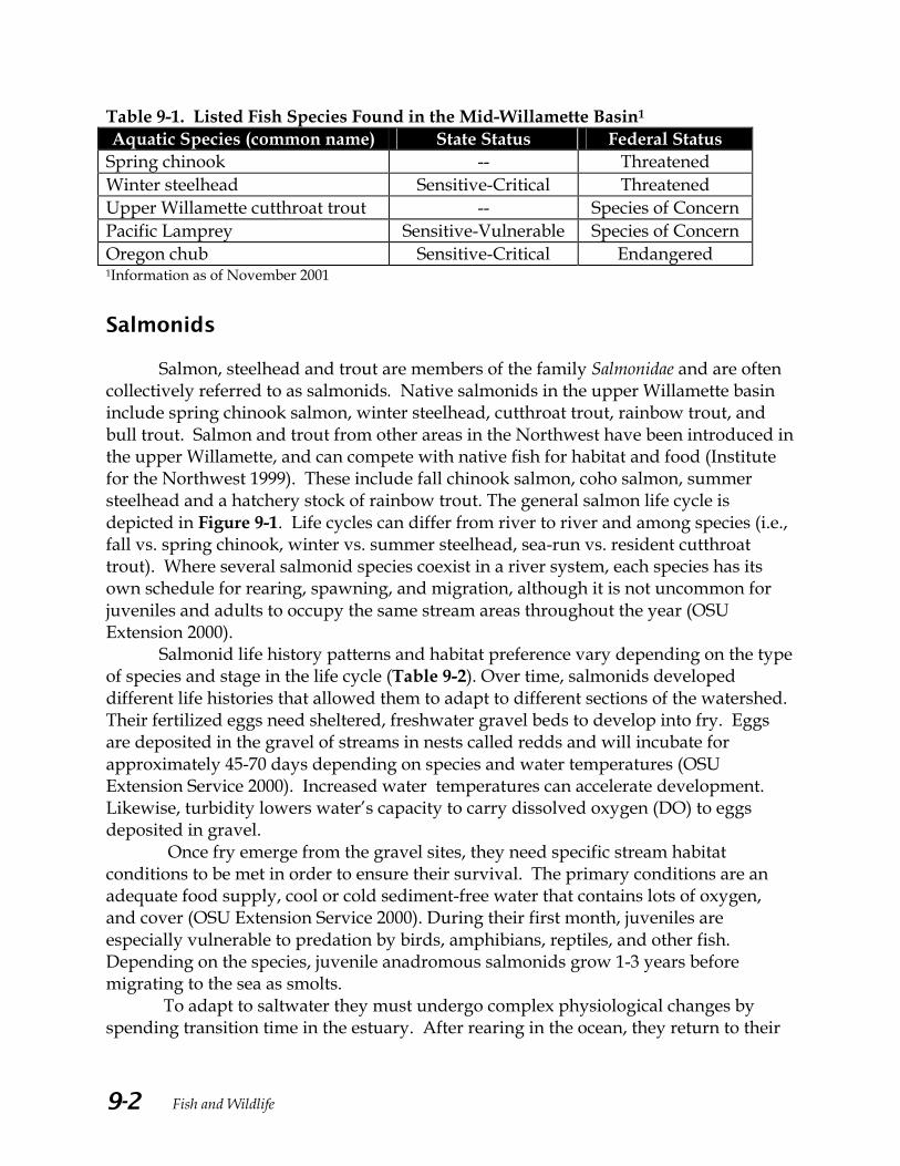
Five current and/or potential “sensitive” fish species are found in the Mid-Willamette Basin (Table 9-1). The species are considered sensitive either because they face some known level of challenge to their continued population levels or existing information on the condition of their population is limited.
T Intercouncil Watershed Assessment Committee Questions/ Issues 1) What is the distribution and
abundance of species (not just fish)? • Past and present?
2) Where is fish habitat and
what is its condition? 3) What are the fish passage
restrictions? And where are the restrictions needed?
Fish and Wildlife 9-2
Table 9-1. Listed Fish Species Found in the Mid-Willamette Basin1 Aquatic Species (common name) State Status Federal Status
Spring chinook -- Threatened Winter steelhead Sensitive-Critical Threatened Upper Willamette cutthroat trout -- Species of Concern Pacific Lamprey Sensitive-Vulnerable Species of Concern Oregon chub Sensitive-Critical Endangered 1Information as of November 2001
Salmonids
Salmon, steelhead and trout are members of the family Salmonidae and are often collectively referred to as salmonids. Native salmonids in the upper Willamette basin include spring chinook salmon, winter steelhead, cutthroat trout, rainbow trout, and bull trout. Salmon and trout from other areas in the Northwest have been introduced in the upper Willamette, and can compete with native fish for habitat and food (Institute for the Northwest 1999). These include fall chinook salmon, coho salmon, summer steelhead and a hatchery stock of rainbow trout. The general salmon life cycle is depicted in Figure 9-1. Life cycles can differ from river to river and among species (i.e., fall vs. spring chinook, winter vs. summer steelhead, sea-run vs. resident cutthroat trout). Where several salmonid species coexist in a river system, each species has its own schedule for rearing, spawning, and migration, although it is not uncommon for juveniles and adults to occupy the same stream areas throughout the year (OSU Extension 2000).
Salmonid life history patterns and habitat preference vary depending on the type of species and stage in the life cycle (Table 9-2). Over time, salmonids developed different life histories that allowed them to adapt to different sections of the watershed. Their fertilized eggs need sheltered, freshwater gravel beds to develop into fry. Eggs are deposited in the gravel of streams in nests called redds and will incubate for approximately 45-70 days depending on species and water temperatures (OSU Extension Service 2000). Increased water temperatures can accelerate development. Likewise, turbidity lowers water’s capacity to carry dissolved oxygen (DO) to eggs deposited in gravel.
Once fry emerge from the gravel sites, they need specific stream habitat conditions to be met in order to ensure their survival. The primary conditions are an adequate food supply, cool or cold sediment-free water that contains lots of oxygen, and cover (OSU Extension Service 2000). During their first month, juveniles are especially vulnerable to predation by birds, amphibians, reptiles, and other fish. Depending on the species, juvenile anadromous salmonids grow 1-3 years before migrating to the sea as smolts.
To adapt to saltwater they must undergo complex physiological changes by spending transition time in the estuary. After rearing in the ocean, they return to their

Fish and Wildlife 9-3
natal stream to spawn and then die. Their corpses nourish the habitat, which serves to support the next generation of salmonids. Because these fish travel across the landscape and into many different environments, many factors contribute to their mortality. Figure 9-1. The Salmon Life Cycle.
Source: Portland Multnomah Progress Board (2000)

Fish and Wildlife 9-4
Table 9-2. Summary of Life History Pattern for Salmonids Found in the Mid-Willamette Basin
Species Juveniles Adult s Spawning
Fall Chinook
Emerge from gravel in winter (February – March). Stay in stream about 90 days. Migrate into estuary or lower main stem river by spring (April-June). Spend next 3-4 months in estuary, and then migrate to ocean with fall rains.
Migrate early July - September.
Return from ocean in late August and September. Spawn late September – early October in Willamette. Prefer main river channels and low gradient tributaries. Spawn once then die. • Not native; introduced
through result of hatchery program in N. Santiam River and Mill Creek.
Spring Chinook
Emerge from gravel in late winter or early spring. Juveniles will rear up to one year or longer in basin; juveniles can migrate year- round in basin. Out-migration to ocean occurs in spring and, to a lesser extent, fall. Life history more variable than fall chinook.
Migrate April – September. Return to rivers in the spring and early summer, then spend summer in deep pools.
Spawn late August – October in Willamette. Spawn once and then die.
• Native to upper Willamette and Santiam basin.
Winter Steelhead
Juveniles emerge by late spring/early summer. First year, live in riffles / edges of stream channels and pools. • Affected by low water
conditions. Spend 2-3 yrs. in a stream then migrate to ocean during the spring. • Long freshwater residence
makes them vulnerable to degraded habitat.
Return from the ocean December-April, allowing them to move into headwaters during winter flows. • Prefer faster-moving
water, a stream gradient > 5%, and a stream channel containing large woody debris
Spawn February- June. About 30% of adults survive and spawn again. • Native to upper
Willamette and Santiam basin.
.
Summer Steelhead
Juvenile life history is similar to that of winter fish.
Enter river systems from April-August. Need deep, cool pools to reside in until they spawn.
Spawn January-February.
• Not native; introduced through result of hatchery program in the Santiam basin
Cutthroat Trout
Highly variable: Juveniles typically emerge anytime from late winter to July. Juveniles migrate downstream fall through spring. Peak migration in fall and spring.
Highly variable: Typically, migrate upstream in the fall, winter and spring.
Spawn in fall, winter and spring (depending on life history pattern). • Native to upper
Willamette and Salem area streams.

Fish and Wildlife 9-5
Chinook Salmon Both spring and fall chinook salmon live in the upper Willamette basin. Spring chinook are the only salmon native to the basin while the fall chinook are the result of past hatchery introductions. Although hatchery fall chinook are no longer released in the upper Willamette basin, the population is able to sustain itself at a much reduced level through natural production. Typically, fall chinook adult migration in the Willamette occurs from August through October and spawning September through early October. Compared to the habitat preferences of other salmonids, chinook prefer deeper water and larger gravel substrate (Johnson and O’Neil 2000).
In March 1999, upper Willamette River spring chinook was listed as “Threatened” under the federal Endangered Species Act (ESA) by the National Marine Fisheries Service (NMFS). Historically, spring chinook were able to clear the Willamette Falls migration barrier during higher flows (Collins 1951) and are a native anadromous fish in the upper Willamette River. Adult spring chinook migrate into the Willamette Basin from April to September. They spawn in the larger rivers and tributaries between August and October. Although there is no spawning observed in Salem, juveniles will rear either seasonally or year-round in some of the area’s streams. A decline in the numbers of these fish is attributed to several factors, including the loss of, or reduction in, available habitat due to habitat destruction and the construction of migration barriers such as dams on the Santiam River. Researchers believe that the status of local chinook salmon populations depends on both the restoration of the valley floor streams and headwater spawning areas. According to Jim Martin, former ODFW fish specialist, the recovery of spring chinook appears unlikely without protecting productive spawning habitats and reconnecting the fish to their headwater streams (Martin 2001).
Although spawning occurs far upstream of the Salem area, juvenile spring chinook can migrate within the basin at a very early age. Spring chinook fry and fingerlings only a few months or even weeks old, have been documented as moving downstream from spawning areas to rear in the larger rivers, including the Willamette. Out-migration from the basin to the ocean as smolts occurs primarily during the spring and, to a lesser extent, the fall (Galovich pers. comm). Steelhead trout
In the Upper Willamette River, winter steelhead trout are considered “sensitive/critical” by ODFW, and as of March 1999, NMFS listed this species as “Threatened” under the Federal ESA. In the Pacific Northwest, winter steelhead enter fresh water between November and mid-May. Summer steelhead enter fresh water between mid-May and October.
Fish and Wildlife 9-6
Winter steelhead
Winter steelhead prefer faster- moving water, higher-gradient east slope streams flowing from the western Cascades, and a stream channel containing large woody debris. Like spring chinook, winter steelhead are native above the Willamette Falls. Steelhead are considered by many to have the greatest diversity of life history patterns of any Pacific salmonid species (Busby et al. 1996). Spawning occurs from February through June and juveniles typically rear in freshwater from one to two years. Winter steelhead return to rivers between December and April, after staying approximately one to three years in the ocean. Winter flows enable these fish to move into headwater streams. A recent document prepared by the Willamette Restoration Initiative reports that approximately 60 percent of wild winter steelhead in the Willamette are produced from the Santiam sub-basins (Institute for the Northwest 1999). The report also indicates that steelhead populations are in decline for both the North and South Santiam Rivers. NMFS concludes that these particular species of salmonids are at risk of extinction primarily due to such human activities as over-fishing, past and ongoing habitat destruction, hydropower development, hatchery practices and degraded water quality (NMFS 2000). Summer steelhead
Summer steelhead need deep, cool pools to reside in until spawning in January-February. Historically, summer steelhead were stocked in the North and South Santiam. The hatchery program is mitigation for fishing opportunity lost when historic native winter steelhead habitat was severely reduced by construction of dams on the North and South Santiam. The first successful returns to the upper Willamette occurred in the early 1970’s. The program is ongoing, with summer steelhead smolts being released into the North and South Santiam. The returning adults provide a sport fishery in the spring, summer, and fall. Cutthroat Trout
Three subspecies of cutthroat trout are documented in Oregon, but only one, the coastal cutthroat trout, occurs in the Willamette Valley. Although it has no legal ramifications, the ODFW refers to Coastal cutthroat existing in the upper Willamette as a “Stock of Concern.” This status reflects ODFW’s concern for the fish’s population trend and thus, they give cutthroat and issues that may affect their habitat additional attention. Unlike those in the lower Willamette and Columbia, upper Willamette cutthroat are not anadromous. The Salem area supports two varieties of cutthroat

Fish and Wildlife 9-7
resident trout that reside in a stream or stream reach throughout their entire lives and fluvial cutthroat that migrate between streams or stream systems. (Galovich 2001).
Resident cutthroat trout populations appear to be stable but are most likely lower in abundance than historic levels due to habitat loss (ODFW 1997). Fluvial cutthroat are also widely distributed throughout the upper Willamette but are prevented from accessing waters that lie above migration barriers. Their life history is highly variable; spawning and migration have been observed several months of the year. Upstream migration to spawning areas, however, typically occurs during the fall, winter and spring. Spawning can take place from late fall through late spring. Much like the anadromous steelhead, juveniles will then rear for about two years before beginning their downstream migration. Some juveniles are also reported to move downstream during the winter months and into flood plain tributaries to over-winter (Johnson and O’Neil 2000). Wetland habitats associated with streams support Willamette River cutthroat trout populations (OSU Extension Service 2001). Other Native Fish Species
In addition to those listed above, there are many other species of fish native to the Salem area and Mid-Willamette basin. These include lamprey, chub, northern pikeminnow, peamouth, chiselmouth, sculpin, redside shiner, dace, largescale sucker, and sticklebacks (ODFW 2000; ONHP 2000). While some of these fish prey upon salmonids, others serve as an important food source. Many can be somewhat tolerant of poorer water quality conditions, such as high water temperature and low dissolved oxygen. Pacific Lamprey
The National Marine Fisheries Service (NMFS) considers Willamette River Basin Pacific lamprey a “Species of Concern” under the Federal ESA. Lampreys are commonly referred to as “eels” and considered one of the most primitive of the living fishes. Similar to salmon, Pacific lamprey live most of their adult life in the ocean and then return to rivers to spawn and die. The spawning migration usually starts in late fall and continues into late spring. Spawning occurs in riffle areas where the current is swift. Eggs are laid in small dug out gravel cavities then hatch into blind larva called ammocoetes. The larvas live for several years in mud or sand bottom pools and filter- feed on microorganisms in the water. In the ocean, adult lampreys are parasitic and feed on the body fluids of a host fish.

Fish and Wildlife 9-8
Oregon Chub
In 1993, the USFWS listed the Oregon chub as a federally “Endangered” species under the ESA. A recovery plan was approved in 1998 (USFWS 1998). Once widely distributed in the Willamette Valley, this non-game, “minnow-like” species now only occupies about two percent of its original territory. Oregon Chub prefer floodplain habitat and were historically found in sloughs, beaver ponds, oxbows and side channels located in the Willamette Valley. Much of this habitat has been degraded as a result of stream channel modifications, introduction of non-native fish species, runoff from pesticides and diversions. These practices have led to an increase in predation and limited availability of zooplankton, their primary food source.
Oregon Chub spawn in May and June in warm shallow water with vegetative cover. The ODFW rearing pond at Aumsville is fed by Mill Creek and provides habitat for this listed species. There are 24 populations that exist in many tributaries of the mainstem Willamette River. Twelve of these documented populations contain fewer than 100 individuals and are a primary focus of the 1998 Recovery Plan. Through reintroductions and/or habitat enhancement, the plan expects to establish new populations (Institute for the Northwest 1999). Non-native Fish Species
A 1997 U.S. Geological Survey claims that approximately 54 species of fish are present in the Willamette Basin. About half (48 percent) are introduced. As a general rule, species richness tends to increase from high elevation, steep gradient, cold-water headwaters areas to the larger, low elevation, low gradient, warm water main stem channels (USGS 1997). Warm-water fish such as bass, catfish, and sunfish typically dominate the low elevation reaches of the major rivers of the Willamette Valley (Table 9-3). The Willamette River is presently dominated by non-native fish species. In mountain streams there is better representation of native species (USGS 1997). Many warm-water fish are found in the Salem area. Exotic species can compete with and prey upon native fish.

Fish and Wildlife 9-9
Table 9-3. Introduced species found in the Willamette River Basin Bullhead catfishes Black, Brown, Yellow, Channel Herrings American shad Minnows Goldfish, Common carp, Tench Perches Yellow perch, Walleye Sunfishes Pumpkinseed, Warmouth Bluegill, Redear sunfish, Largemouth bass, Smallmouth Bass, White crappie, Black crappie Topminnows Banded killifish Salmon and Trout Fall Chinook
Source: USGS (1997) Documentation of Fish Presence
Information on fish presence and fish habitat were compiled from several sources including City of Salem, ODFW, ODSL, Water Work Consulting, and McNary High School. Although a great deal of information has been gathered over the years, there has not been an effort to document seasonal changes in species distribution or to identify local population trends in most of the streams. A sampling effort continuous throughout the year in a given stream would be necessary to provide such information. Many times this is not feasible or cost-effective. Instead, biologists often rely on data that has been collected in similar systems and extrapolate their findings to streams that are physically, geographically and biologically similar. This technique was used to some extent when trying to determine historic populations of fish species. In other words, we took some educated guesses when data was lacking.
The lower reaches of Pringle Creek and Mill Creek are considered “essential indigenous anadromous salmonid habitat.” Essential Salmonid Habitat is defined as the habitat necessary to prevent the depletion of native salmon species, in this case spring chinook salmon and winter steelhead, during their life history stages of spawning and rearing. The designation applies only to those species that have been listed as Sensitive, Threatened or Endangered by a state or federal authority. Rivers and creeks that have this designation receive special attention by state regulatory agencies and are protected by state law and administrative rule (ODSL 2001).

Fish and Wildlife 9-10
Methods
A variety of methods has been used to gather information on fish distribution in the Salem area. Depending on the location and intent of the sampling, methods have included the use of nets (seining), electrofishing, snorkeling, the operation of fish traps and visual surveys such as those used to inventory spawning salmon. Few efforts have attempted to systematically survey an entire area at any one time. More often, the sampling has been driven by the need to inventory a single species, investigate habitat issues, or respond to spill events.
The most comprehensive effort to date was conducted by the City of Salem (City of Salem 1999). The City contracted with the Oregon Department of Fish & Wildlife to look at fish presence and distribution in all Salem area streams in April and May. The study was conducted in the spring or at times when, due to water quality and fish life history, salmonids would most likely be encountered. Fish distribution survey maps were created for the Pringle, Glenn-Gibson, Claggett, and Mill Creek watersheds.
With the exception of annual redd counts by ODFW in Mill Creek, sampling efforts conducted by both public agencies and private consultants in local streams are small in scope. Results of these sampling efforts are presented in the following watershed summaries. Pringle Creek
The 1999 City of Salem Fish Distribution Survey concentrates on four tributaries within the Pringle Creek watershed (Map 9-1). Salmon were not found in any of the 21 sample sites in the Pringle Creek tributaries. This should not imply that salmon or steelhead do not use the stream throughout the year as ODFW has mentioned that one-time sampling does not allow the City to either map distribution of fish or determine upstream limits of fish usage (Taylor, 2002). Resident cutthroat trout were found at the mouth of Clark Creek, Pringle Creek’s West Fork, West Middle Fork and up into the East Fork headwaters. Although the observation crew noted trout fry in Clark Creek they did not observe a distribution of trout upstream of Commercial Street. Low numbers of lamprey were distributed in the main tributaries of Pringle Creek, although a more recent survey has indicated otherwise (Hunt 2000). A high abundance of sculpin, dace, and shiners were widely distributed throughout the watershed. No fish were found in the headwaters of the West Middle Fork and some parts of the East Fork appeared dry or stagnant.
Two separate fish surveys in the spring of 2000 provide additional documentation of cutthroat trout, lamprey, sculpin, and shiners in portions of the Pringle Creek system. A survey conducted by the Oregon Governor’s School documented several species of fish, but no salmonids in the summer of 2000 (Table 9-4) (City of Salem 2000). In contrast, three adult and one juvenile cutthroat trout were
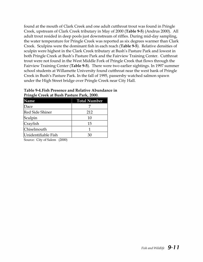
Fish and Wildlife 9-11
found at the mouth of Clark Creek and one adult cutthroat trout was found in Pringle Creek, upstream of Clark Creek tributary in May of 2000 (Table 9-5) (Andrus 2000). All adult trout resided in deep pools just downstream of riffles. During mid-day sampling, the water temperature for Pringle Creek was reported as six degrees warmer than Clark Creek. Sculpins were the dominant fish in each reach (Table 9-5). Relative densities of sculpin were highest in the Clark Creek tributary at Bush’s Pasture Park and lowest in both Pringle Creek at Bush’s Pasture Park and the Fairview Training Center. Cutthroat trout were not found in the West Middle Fork of Pringle Creek that flows through the Fairview Training Center (Table 9-5). There were two earlier sightings. In 1997 summer school students at Willamette University found cutthroat near the west bank of Pringle Creek in Bush’s Pasture Park. In the fall of 1995, passersby watched salmon spawn under the High Street bridge over Pringle Creek near City Hall. Table 9-4. Fish Presence and Relative Abundance in Pringle Creek at Bush Pasture Park, 2000. Name Total Number Dace 7 Red Side Shiner 212 Sculpin 10 Crayfish 15 Chiselmouth 1 Unidentifiable Fish 30 Source: City of Salem (2000)

Fish and Wildlife 9-12
Table 9-5. Fish Presence and Relative Abundance in Pringle Creek at Bush’s Pasture Park and Fairview, May 2000.
Stream Reach Reach
Length (ft.) #
Sculpin # Cutthroat
Trout
# Redside Shiners
# Lamprey
# Dace
# Crawfish
Pringle Cr., Bush Park, downstream of footbridge, west
1 85 19 0 0 1 0 0
Pringle Cr., Bush Park downstream of footbridge, east
2 55 12 0 1 0 0 1
Pringle Cr., Bush Park, upstream of footbridge, west
3 70 15 0 0 1 1 1
Pringle Cr., Bush Park, upstream of Clark Trib., west
4 70 9 1 1 0 0 7
Clark Trib., Bush Park, upstream of Pringle Cr.
5 75 33 4 0 0 0 0
Pringle Trib., Fairview, big bend to bridge
6 232 22 0 10 0 0 3
Pringle Trib., Fairview, bridge to middle school fence
7 447 45 0 25 0 0 8
Source: Andrus (2000)
In the summer of 1996 and spring of 2000, toxic spills resulted in two separate fish kills in Pringle Creek. ODFW surveyed several miles of stream flowing from the Fairview/Hillcrest District to Bush’s Pasture Park. The fish species impacted in the 1996 spill included cottids, dace, adult and juvenile lamprey, redside shiners, threespine sticklebacks and crayfish (Hunt 1996). On April 3, 2000, several fish species were reported killed, including nine juvenile steelhead trout (Hunt 2000) (Table 9-6). Investigators determined that SumcoUSA (formerly Mitsubishi Silicon America) was the source of both spills. An evaluation reported that on March 29, 2000 groundwater “impacted” by sulfuric acid was inadvertently discharged to the SumcoUSA stormwater retention pond and then released into the West Middle Fork (WMF) of Pringle Creek (MSA 2000). All information compiled for the SumcoUSA evaluation indicates that no acute or chronic impacts to the physical water quality or the biological resources in the WMF Pringle Creek resulted from the sulfate release (MSA 2000). The ODFW survey concluded that based on varying stages of decomposition of the fish bodies, more than one cause for the fish kill was possible. Additional reports about the March 2000 spill speculate that inappropriate pesticide use may have been a factor, since several miles of railroad tracks run parallel to the Middle Fork of Pringle Creek. The railroad right-of-way is sprayed annually for weeds.

Fish and Wildlife 9-13
Table 9-6. Pringle Creek Fish Carcass Survey for April 3, 2000. Species Found Total Redside shiner 865 Cottid (spp.) 2,533 Speckled dace 62 Large-scaled sucker (adult) 5 Large-scaled sucker (juvenile) 7 Pacific lamprey (adult) 36 Pacific lamprey (ammocoetes) 2,464 Brook lamprey 21 Northern pikeminnow 2 Cutthroat trout 20 Steelhead (juvenile) 9 Hatchery rainbow legals 2 Hatchery rainbow brood trout 2 Crayfish 11 Source: ODFW (2000) Glenn and Gibson Creeks
The Glenn-Gibson watershed is located on the west slope of the Willamette River. Glenn and Gibson creeks flow through the hilly terrain of West Salem. Gibson Creek flows into Glenn Creek near the Salemtowne Golf Course. Glenn Creek then flows across the Willamette River floodplain through intensively farmed land. ODFW did not locate any chinook or steelhead during the 1999 City of Salem Fish Distribution Survey, but cutthroat trout were found throughout the watershed (Map 9-2). Cutthroat trout were more widely distributed in the Glenn-Gibson watershed than the other three watersheds. According to ODFW, sampling prior to the construction of the fish ladder extension at the Salemtowne Pond documented the presence of juvenile winter steelhead in lower Glenn Creek.
Eight sample sites were located on Glenn Creek and its tributaries. Cutthroat trout were observed at all sample sites with the exception of the Michigan Swale tributary, located in the northern portion of the watershed just below Wallace Road (Map 9-2). No fish species were found at this location.
Nine sample sites were located on Gibson Creek and its tributaries. Cutthroat trout were observed in the North Fork of Gibson Creek downstream of a pond located near Brush College Brook. Likewise, cutthroat trout were found in South Gibson Creek up to a point just upstream from its confluence with Eagle Crest Swale. The upstream limit of fish species was not determined in this stream. Yet, ODFW assumes that if suitable habitat exists that is not being blocked by a natural barrier, that fish

Fish and Wildlife 9-14
presence/distribution continues upstream. “A conservative method to address this issue is to assume that fish use this area and that it is necessary to protect the upstream habitat” (Taylor, 2002).
Cutthroat trout were observed at both sample sites on Winslow Creek. The upper limit of cutthroat distribution appears to occur at a pond west of the intersection of Orchard Heights Rd. NW and 36th Ave, where the ODFW crew noted splash boards at the outlet of a pond. Through personal communication with local landowners, the crew found that there were perch and bass in the pond. No sampling was conducted in Dahlia Swale, Brush College Swale, or Emerald Swale because of dry conditions at the time of the survey. Claggett Creek
Claggett Creek flows over flat terrain in east Salem and Keizer. It empties into Clear Lake just west of Wheatland Road and flows into the Willamette River at the north end of Windsor Island. Historical information about the fish community in Claggett Creek is scarce. Several landowners along Claggett Creek do remember fishing for or seeing trout in Claggett Creek when they were kids.
During the 1999 survey, ODFW did not observe any salmon, trout, or lamprey at any sample points in Claggett Creek (Map 9-3). ODFW states “Claggett Creek provides habitat to cutthroat trout and very likely seasonal habitat for spring Chinook salmon and winter steelhead as evidenced by previous ODFW sampling efforts (Taylor, 2002). The fish kill of July 1992 resulted in the observation that Labish Ditch provides habitat for cutthroat trout (Taylor, 2002). Unlike the three other sub-basins, three-spine stickleback fish were observed in the 1999 City of Salem Fish Distribution Survey. This species was also documented by McNary High School students from 1993-1996 (Table 9-7). Sticklebacks typically prefer slow moving, backwater streams, which allow them to easily establish their nests (Runyon pers. comm.).
Table 9-7. Fish presence and Relative Abundance in Claggett Creek at Dearborn Blvd, 1993-1996. Species Total Dace 3 Pumpkin Seed 3 Shiner 6 Sculpin 5 Mosquito 6 Stickleback 180 Source: McNary High School (1993-1996)

Fish and Wildlife 9-15
Two additional sample sites in the Claggett Creek watershed were located in Labish Ditch; the first site was located near the ditch’s confluence with Claggett Creek and the second site was located just downstream of Portland Road. Redside shiners, sculpin, and speckled dace were the dominant fish species observed. Upstream of Portland Road, the ODFW survey crew noted that the ditch was slow-moving, warm and filled with thigh-deep mud. During the survey, a local resident mentioned historical accounts of trout in this basin. The 1992 fish kill resulted in documentation of cutthroat trout in Labish Ditch (Galovich 2002). Mill Creek
It is documented that in the late 1970s, Mill Creek had minor runs of winter steelhead and some spring chinook (Mill Creek Watershed Task Force 1983). Cutthroat trout are considered native to the system. According to the drainage study, Mill Creek also contained squawfish, suckers, shiners, dace, cottids (sculpin), and other species. Hatchery-raised rainbow trout from Cascades Gateway Park were also present.
The 1999 City of Salem Fish Distribution Survey sampled points on Mill Creek, the Mill Race, Shelton Ditch, Battle Creek tributaries, and the headwaters of Mill Creek (Map 9-4). As for “sensitive” species, the survey crew did find cutthroat trout and lamprey in the tributaries located in the western and upper eastern portions of the watershed. The lower reach of Mill Creek in the City of Salem contains several in-stream structures for salmonids, including rock weirs and large woody debris. The structures were placed in the stream by ODFW and North Salem High School in 1989, 1990 and 1991.
Other fish species found in the lower reaches of Mill Creek at the Summer and Center Street crossings include sculpin, speckled dace, redside shiners, and suckers. The observers reported that the water level was too high to effectively electroshock at this location, so it is possible that some species were missed. ODFW states “The Mill Race currently provides habitat to winter steelhead, summer steelhead, spring Chinook, cutthroat trout and will continue to provide habitat to cold water species in the Mill Race until a screen is constructed at the confluence of the Mill Race and Mill Creek” (Taylor, 2002). The fish screen is planned for the fiscal year of 2003-2004.
The Mill Race is a diversion from Mill Creek that runs through downtown to supply power to Mission Mill located at 14th Street and Mill Street. Sculpin, northern pikeminnow, and redside shiners were recorded at this sample site.
Shelton Ditch is another waterway that diverts water from Mill Creek into Pringle Creek. Sculpin, redside shiners, dace, and suckers were observed at two sample sites along the Ditch. Battle Creek is a major tributary to Mill Creek. Cutthroat trout were observed at all sample sites along the mainstem of Battle Creek. Dace, suckers and shiners were observed where Commercial Street crosses Battle Creek. Sculpin and pumpkinseed sunfish were located at Rees Hill Road and Elmhurst Ave. In the Powell Creek tributary, trout were observed in the lowest reach, located downstream of Sunnyside
Fish and Wildlife 9-16
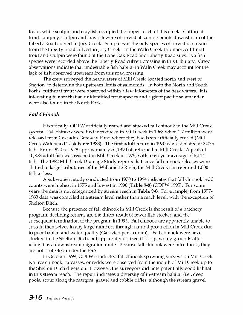
Road, while sculpin and crayfish occupied the upper reach of this creek. Cutthroat trout, lamprey, sculpin and crayfish were observed at sample points downstream of the Liberty Road culvert in Jory Creek. Sculpin was the only species observed upstream from the Liberty Road culvert in Jory Creek. In the Waln Creek tributary, cutthroat trout and sculpin were found at the Lone Oak Road and Liberty Road sites. No fish species were recorded above the Liberty Road culvert crossing in this tributary. Crew observations indicate that undesirable fish habitat in Waln Creek may account for the lack of fish observed upstream from this road crossing.
The crew surveyed the headwaters of Mill Creek, located north and west of Stayton, to determine the upstream limits of salmonids. In both the North and South Forks, cutthroat trout were observed within a few kilometers of the headwaters. It is interesting to note that an unidentified trout species and a giant pacific salamander were also found in the North Fork. Fall Chinook
Historically, ODFW artificially reared and stocked fall chinook in the Mill Creek system. Fall chinook were first introduced in Mill Creek in 1968 when 1.7 million were released from Cascades Gateway Pond where they had been artificially reared (Mill Creek Watershed Task Force 1983). The first adult return in 1970 was estimated at 3,075 fish. From 1970 to 1979 approximately 51,139 fish returned to Mill Creek. A peak of 10,873 adult fish was reached in Mill Creek in 1975, with a ten-year average of 5,114 fish. The 1982 Mill Creek Drainage Study reports that since fall chinook releases were shifted to larger tributaries of the Willamette River, the Mill Creek run reported 1,000 fish or less.
A subsequent study conducted from 1970 to 1994 indicates that fall chinook redd counts were highest in 1975 and lowest in 1990 (Table 9-8) (ODFW 1995). For some years the data is not categorized by stream reach in Table 9-8. For example, from 1977-1983 data was compiled at a stream level rather than a reach level, with the exception of Shelton Ditch.
Because the presence of fall chinook in Mill Creek is the result of a hatchery program, declining returns are the direct result of fewer fish stocked and the subsequent termination of the program in 1995. Fall chinook are apparently unable to sustain themselves in any large numbers through natural production in Mill Creek due to poor habitat and water quality (Galovich pers. comm). Fall chinook were never stocked in the Shelton Ditch, but apparently utilized it for spawning grounds after using it as a downstream migration route. Because fall chinook were introduced, they are not protected under the ESA.
In October 1999, ODFW conducted fall chinook spawning surveys on Mill Creek. No live chinook, carcasses, or redds were observed from the mouth of Mill Creek up to the Shelton Ditch diversion. However, the surveyors did note potentially good habitat in this stream reach. The report indicates a diversity of in-stream habitat (i.e., deep pools, scour along the margins, gravel and cobble riffles, although the stream gravel

Fish and Wildlife 9-17
near the penitentiary was highly embedded with silt and sand), adequate riparian cover and no passage problems other than the ladder at the Duck Inn. These habitat features suggest good holding and hiding habitat for salmonids (ODFW 1999). Trout and a variety of non-game species were also recorded in this reach. As part of the same survey, two fish biologists floated from Turner bridge (located 1/3 mile south of Kuebler Road) downstream to the Willamette River and surveyed approximately six miles of stream. Two redds were found on a gravel bar in the reach between Turner bridge and the Shelton Ditch diversion near I-5.

Fish and Wildlife 9-18
Table 9-8. Summary of Fall Chinook Redd Counts in Mill Creek, 1970-1994.
River Miles
Total Miles
Site 1: Shelton Ditch 0.0-3.2 3.2 Site 2: Mouth to 19th St. Bridge 0.0-2.2 2.2 Site 3: 19th St. Bridge to Cascades Gateway Park Bridge 2.2-4.8 2.6 Site 4: Cascades Gateway Park Bridge to Turner Fire Station Bridge 4.8-10.3 5.5 Site 5: Turner Fire Station Bridge to Aumsville Park Bridge 10.3-15.4 5.1 Site 6: Aumsville Park Bridge to Junction of North Santiam River (Mill Creek joins the N. Santiam via the Salem Ditch) 15.4-22.0 6.6 Total: 25.2 Year1 Site 12 Site 2 Site 3 Site 4 Site 5 Site 6 Total 19703 961 1971 600 1972 186 119 180 462 366 41 1,354 1973 1,992 1974 1,990 1975 2,819 1976 1,656 1977 265 1,410 1978 230 1,261 1979 87 305 1980 133 214 1981 247 357 1982 137 183 1983 126 173 1984 304 *4 42 31 * * 377 1985 * * * * * * * 1986 209 * 80 73 0 4 366 1987 61 * 70 16 8 2 157 1988 47 * 50 136 159 * 392 1989 38 * 130 31 15 * 214 1990 105 1991 83 * 44 72 38 * 237 1992 155 * 81 152 175 * 563 1993 144 * 77 186 273 * 680 1994 22 * 27 79 91 * 219 Total 2,474 119 781 1,238 1,125 47 18,585

Fish and Wildlife 9-19
__________________________________________________
1 Counts given by stream reach for: 1972, 1984, 1986-1989 and 1991-1994. All other years only give total count for Mill Creek up to its confluence with the North Santiam River. 2 Shelton Ditch counts kept separate but included in totals for 1972 and 1977-1983. 3 1970 was the first year of adult returns. 4 * Indicates no surveys were conducted along reach. Source: ODFW (1995) Carcass Surveys
In the fall of 1989 Mill Creek experienced a gasoline spill west of the Kuebler Boulevard Mill Creek crossing, downstream from the dam site. Reports indicate a pipeline was ruptured at a construction site, spilling gasoline into the creek. The Oregon Department of Fish and Wildlife’s initial assessment estimated a complete kill of all aquatic life along a seven-mile reach of Mill Creek and three miles of Shelton Ditch. The fish mortalities totaled over 400 fall chinook, 200-300 juvenile trout/steelhead and numerous non-game species (Wetherbee 1989).
In spring of 1991, the Deluxe Quality Ice Cream Company was responsible for ammonia vapor entering into a city storm drain. A carcass survey along 2.1 miles of Mill Creek resulted in a count of 75 dead salmonids (ODFW 1991). Two thirds of those species were approximately six to ten inch rainbow and steelhead trout (Table 9-9). When a fish kill occurs along a waterway, ODFW staff survey selected sites in the affected area and count dead fish by species. The sampling totals are multiplied according to a formula to estimate total fish kill impacts for the waterbody. Table 9-9. Mill Creek Fish Kill Assessment, April 1 and 2, 1991.
Sample Site Distance/ft. Cutthroat Rainbow/ Steelhead Chinook CSU SQ
Red Shiners CRC Dace
Mouth to Front St. 280' 0 1 0 61 0 0 16 0
Liberty St. 250' 0 0 0 21 0 1 0 0
Church St. 100' 0 0 0 2 0 0 0 0
Cottage St. 100' 0 0 0 12 0 0 0 0
Winter to Capitol St. 900' 0 3 2 108 5 11 1 20
14th St. to RR 900' 0 1 0 19 1 7 0 4
Chemeketa St. 75' 0 1 0 13 0 0 0 0
18th St. 130' 0 1 1 10 4 17 0 0
Center St. 250' 2 5 2 68 35 70 0 25
Court St. 100' 0 2 0 13 3 30 0 0
Totals 3,085' 2 14 5 327 48 136 17 49
Expanded Totals 11,088' 7 50 18 1,175 172 489 61 176 Source: ODFW (1991)
Fish and Wildlife 9-20
Barriers to Fish Passage and Notes on Fish Habitat
Structures or conditions that obstruct, interfere with or harm migrating fish are classified as fish passage barriers. A basin-wide migration barrier survey is important since adult and juvenile migrating salmon and other fish move extensively upstream and downstream to seek food, shelter, better water quality, and spawning habitat. Fish passage problems in the Mid-Willamette include: (1) culvert barriers at road crossings; (2) delay or poor function at fish ladders; (3) dams, other impoundment or water control structures without fish ladders; (4) sections of stream that have been piped or put underground; and (5) unfavorable water quality or other habitat conditions.
Structures can create a migration barrier for fish in a variety of ways. First, a culvert can increase water velocities so that the current is too fast for the fish to overcome. Second, the water depth in a culvert may be too low to provide a sufficient swimming depth for fish. In addition, the height between culvert outlet and water surface may be too great a distance, making it impossible for a fish to jump from the stream into the culvert and continue swimming upstream. Another barrier to fish passage are shallow pools at the base of the culvert that do not give fish room to maneuver and jump. Note, any of these factors listed may not be a barrier to adults while they are barriers to juveniles (Fromm, 2003).
As of March 16, 1999, the National Marine Fisheries Service (NMFS) designated spring chinook and winter steelhead as threatened under the Endangered Species Act (ESA). ESA section 4 (d) rules covering threatened salmon in the upper Willamette were adopted in July 2000. The 4(d) rules took effect on September 9, 2000 for winter steelhead and January 9, 2001 for spring chinook (City of Salem 2001). The 4(d) rule expands the protective shield, making it illegal for individuals, businesses and the local and state governments that regulate them to kill or hurt salmon or steelhead, or to harm important salmonid habitat (see sidebar). Because violations of “take” prohibitions may result in civil or criminal penalties, Marion County and the City of Salem initiated independent surveys to assess structures and conditions on fish-sensitive streams that may prevent proper fish passage. The Marion County survey primarily evaluated road crossings along public rights-of-way, thus excluding infrastructure such as private roads and dams. The City of Salem’s Fish Passage Survey included both public and private facilities. Culvert inventory maps for Pringle, Glenn-Gibson, Claggett, and Mill Creek basins are used to identify which structures are not “fish-friendly.”
4(d)rule: This rule prohibits anyone from “taking” a listed salmon or steelhead, except in cases where the “take” is associated with an approved program (NMFS 2000). To “take” means to “harass, harm, pursue, hunt, shoot, wound, kill, trap, capture, or collect” the listed species. To “harm” means modifying or degrading habitat where it actually kills or injures a pro-tected species by signifi-cantly impairing its ability to breed, spawn, rear, migrate, feed, or shelter.

Fish and Wildlife 9-21
Methods
Data was collected and/or compiled by the City of Salem, ODFW, and Marion County. Both Marion County and the City of Salem incorporated ODFW guidelines to develop their own set of criteria. ODFW classified culverts as either high, medium, or low priority for repair based on whether a culvert was a “partial or complete barrier, the fish species impacted, and the quality/amount of habitat upstream from the culvert.” (Thorburn pers. comm.). Data collected using ODFW guidelines includes culvert location, size, height of outlet drop, culvert slope, type of culvert, priority level and specific comments for some sites. As a result of the culvert survey, Marion County prioritized culverts on a county-wide scale for replacement or retrofit to improve fish passage. It is important to recognize that the area surveyed influences the priority ranking. While Marion County may rank specific culverts as lower priorities, the City of Salem may rate these same culverts as high priority projects their city limits (Galovich 2002). City of Salem Fish Passage Survey
In 2001, the City of Salem conducted a fish passage survey within the urban growth boundary (City of Salem 2001). The citywide fish passage survey studied 167 culverts, 60 dams/weirs and 46 bridges. Approximately 40% of the culverts and 77% of the dams/weirs were found to be barriers. No bridges were determined to be barriers (Table 9-10). The survey included both public and private facilities. Table 9-10. Summary of Results for Fish Passage Survey Culverts Bridges Dams
Basin Total Passable Juvenile Barriers
Adult & Juvenile Barriers Total Passable
Juvenile Barriers
Adult & Juvenile Barriers Total Passable
Juvenile Barriers
Adult & Juvenile Barriers
Pringle Creek 73 38 7 28 14 14 0 0 31 5 2 24 Mill Creek 0 0 0 0 41 41 0 0 5 3 1 1 Battle Creek 28 20 1 7 3 3 0 0 2 0 0 2 Glenn/Gibson 31 22 3 6 2 2 0 0 12 0 0 12 Croisan 18 11 1 6 2 2 0 0 6 0 0 6 Pettyjohn 8 3 2 3 0 0 0 0 0 0 0 0 Upper Claggett 7 4 2 1 2 2 0 0 0 0 0 0 Little Pudding 4 3 0 1 0 0 0 0 0 0 0 0 Source: City of Salem (2001).
The City also collected some general information on habitat during the fish passage survey. Information on fish habitat was rated using a scale developed from Clackamas County habitat descriptions. The scale ranges from 0 (highly developed) to 10 (pristine). The detailed habitat descriptions are as follows.

Fish and Wildlife 9-22
1. 0-1 Habitat. Highly degraded habitat: concrete streambed or bank, no riparian corridor, high sedimentation in creek bed, no gravel evident. Invasive species, if present, dominate stream bank vegetation, little to no fish cover or protection, little to no shading of creek. Highly landscaped or unnatural stream banks (lawn and unnatural vegetation) will not qualify as valuable riparian corridor.
2. 2-5 Habitat. Degraded habitat: sparse riparian corridor, non-native or invasive
vegetation present (blackberry, teasel, Scotch Broom), light shading of creek and little fish protection. Sedimentation evident in streambed, but some gravel is evident.
3. 5-8 Habitat. Average to good habitat: riparian corridor consists of some mature
trees, some native, and some non-native. Shading from trees partially keeps invasive vegetation out of riparian corridor. Sedimentation is evident, but about equals the clean gravel in streambed. Development outside of a 50-foot buffer of creek banks.
4. 8-9 Habitat. High quality habitat: strong riparian corridor consists of mostly
mature trees and shrubs, with very little invasive species in corridor. Creek about 80 percent shaded by mature trees, very little sedimentation, much clean gravel. Development impacts outside of a 100-foot buffer zone.
5. 10 Habitat. Very high quality habitat: basically undisturbed. Riparian corridor
consists only of mature trees and shrubs, no invasive species present. No sedimentation evident in creek-bed and creek is 90 percent + shaded. Development impacts outside of a 200-foot buffer.
Information collected during this survey is only a rough estimate of habitat quality.
This information will be used in conjunction with other more intensive surveys to evaluate fish habitat throughout Salem’s drainage basins. This information will be used to prioritize the removal and/or replacement of fish passage barriers in key areas (Mauldin pers. comm.).

Fish and Wildlife 9-23
Watershed Summaries of Fish Presence and Fish Habitat Conditions
Barriers to fish passage and associated fish habitat are summarized by watershed below. Information provided is from several sources including City of Salem, Marion County Public Works and ODFW. Pringle Creek Barriers
The Pringle Creek watershed, which lies entirely within Salem’s urban growth boundary, includes over ten miles of waterways. According to the City of Salem’s Fish Passage Survey, 48% of the 73 culverts surveyed were classified as barriers. Thirty-one dams/weirs were surveyed, of which 77% were found to be barriers. No bridges surveyed were classified as barriers (Figure 9-2). The identified barriers for the Pringle Creek basin are shown on Map 9-5. Culverts that serve as barriers to adult and juvenile fish are located at the mouth of Clark Creek, along the Middle Fork of Pringle Creek and at the confluence of the East Fork of Pringle Creek. The main stem of Pringle Creek appears free of barriers until the street crossing north of Madrona. The city survey crew noted that rock has been placed in the creek at this location, which creates a barrier to all fish, except perhaps during high flow conditions. Figure 9-2. Fish Barrier Inventory for the Pringle Creek Basin.
Source: City of Salem (2001).

Fish and Wildlife 9-24
Fish barrier information for Pringle Creek was also collected during the 1999 City of Salem Fish Distribution Survey. The crew noted a small impassable barrier downstream from the Commercial Street Bridge, which they suggest is an upstream migration barrier for cutthroat trout. In the Clark Creek tributary the survey crew noted that the long, steep culvert under Commercial Street appeared to be a fish passage barrier for all fish species. In the East Fork Pringle Creek tributary, the crew did observe check dams (water or grade control structures) right below the Kuebler Blvd. crossing, which may effect upstream migration for salmon and trout. Habitat
While conducting the 2001 survey, the city crew evaluated habitat adjacent to culverts in the Pringle Creek watershed (Table 9-11). According to this survey, a significant portion of the Clark Creek basin has been channelized and covered as an underground waterway for hydraulic purposes. The free-flowing areas have some areas of good cover and creek bed habitat. Much of this creek is small, has relatively low flows, and may not be suitable for significant adult fish populations (City of Salem 2001).
Pringle Creek aquatic habitat conditions vary. The upper reaches are mainly developed and received a lower rating. There is spawning and year-round rearing habitat for cutthroat in upper Pringle Creek. The downstream areas near Bush’s Pasture Park has good quality habitat (City of Salem 2001).

Fish and Wildlife 9-25
Table 9-11. Habitat Evaluation on Sections of Pringle Creek. Habitat Location / Rating Range
Notes
Convergence of Clark/Pringle: 2.5 or less Much of this area is channelized, has little cover, and poor streambed quality. Residential areas influence the waterway.
Hoyt Street to 12th Street:: 5 Relatively good habitat.
12th Street to 13th Street: 3 Little canopy. Upstream until Summer Street:: 3.5 to 4 Some good cover, though much of this
creek bed has an unnatural channelized bottom.
Above Summer Street:: 2 to 2.5 Habitat is poor. It’s steep and rocky and sections are channelized.
Clark Creek
Upper part of the waterway: 2.5 to 3.5
The pristine nature of the creek had been altered due to residential development.
Mouth of the Willamette to railroad: 4.5 to 6 Significant flow, some canopy cover, most of creek bed graveled.
As creek parallels railroad tracks: 2.5 to 3.5 Canopy cover decreases, invasive species increase.
As creek leaves railroad tracks: 3 to 4.5 Canopy increases, areas of better habitat.
Upstream of Commercial Street:: 2 to 3.5 Development and channeling of waterway increases.
Pringle Creek
Woodmansee Park: 4 Only this area had a rating higher than 4.
Upstream from RR to Strong Rd.: 3 to 3.5 Channelized and canopy is light. Above Strong Rd. to Battle Cr. Rd.: 3.5 to 4 Flow becomes light, nutria in dams
back up water and create pools for aquatic life and passage barrier. Some canopy and fish cover.
West Middle Fork Pringle Creek
Above Battle Creek Road: 2.5 Less favorable due to lack of cover and low flows.
Middle Fork Pringle Creek
Area parallel to railroad tracks: 2.5 to 3.5 Channelized waterway with significant infestation of non-native brush. Creek canopy is limited. Flow is reduced due to culvert blockage.
Oxford Street to McGilchrist St.: 4 to 4.5 Some canopy and good streambed gravel.
Above McGilchrist St. to RR tracks: 3 to 4 Cover is limited. Upstream to I-5: 2.5 to 3 Habitat is poor due to channelization,
lack of canopy, and invasive brush.
East Fork Pringle Creek
Above I-5: 2 to 3 Little cover, canopy, or flow. Appears to have low fish habitat quality.
Source: City of Salem (2001)

Fish and Wildlife 9-26
Glenn and Gibson Creeks Barriers
The Glenn-Gibson watershed includes over nine miles of waterways within the Salem urban growth boundary. Thirty culverts were surveyed in the Glenn-Gibson basin, of which 27% were classified as barriers. All twelve dams/weirs surveyed were classified as barriers. The two bridges surveyed were classified as passable by fish (Figure 9-3). The identified barriers for the Glenn-Gibson basin (south) are shown on Map 9-6. Culverts that serve as barriers to adult and juvenile fish are found towards the headwaters of Glenn Creek and on the Turnage Brook tributary entering into the Willamette River. Barriers caused by dams and weirs are found in several places along the main stem of Glenn Creek. Fig. 9-3. Fish Barrier Inventory for Glenn-Gibson.
Source: City of Salem (2001)
The identified barriers for the Glenn-Gibson basin (north) are shown on Map 9-7. Gibson Creek does not appear to have many fish passage barriers. Fish barriers impassable by both adults and juveniles are found at the mouth of Willark Brook.
Fish barrier information in the Glenn-Gibson basin was also reported in the 1999 City of Salem Fish Distribution Survey. In the Michigan Swale tributary, the crew noted a stand pipe located approximately 0.2 miles upstream from the main stem of Glenn Creek. No fish were found at this site. Along the Winslow Creek tributary, the

Fish and Wildlife 9-27
surveyors observed splash boards at the outlet of the pond that may be a possible upstream barrier.
Neither the Fish Passage Survey nor 1999 City of Salem Fish Distribution Survey mention the barrier attributed to the Salemtowne pond, located where the mouth of Gibson Creek enters Glenn Creek. A fish ladder was installed to help aid adult fish passage. According to ODFW, the ladder is functioning as designed. It is intended to provide passage only for adult trout, not juvenile fish, during high flow. In other words, the ladder was designed for upstream migration of trout in fall, winter and spring. To bring the ladder up to the standard that would allow for juvenile passage entails much more work in and below the existing ladder to reduce the approach and jump heights (Galovich pers. comm.). This would add significant cost and affect downstream habitat, since it would require removing mature vegetation cover and disturbing in-stream habitat and channel stability. ODFW has documented adult cutthroat at and above the ladder and juvenile steelhead were documented in lower Glenn Creek prior to the construction of the ladder. Habitat
Whil e conducting the 2001 Fish Passage Survey, the city crew evaluated habitat adjacent to culverts in the Glenn-Gibson basin (Table 9-12). Glenn Creek travels through agricultural land with several irrigation diversions as it flows onto the Willamette River floodplain. This pattern of use can alter stream flows and affect habitat quality in the lower reaches of Glenn Creek. Overall, Gibson Creek has some good canopy and good fish cover (City of Salem 2001). Table 9-12. Habitat Evaluation on Sections of Glenn and Gibson Creeks.
Habitat Location / Rating Range
Notes
Upstream of Wallace Rd. to Glenn Creek Rd: 4 to 5.5
Some canopy and fish cover.
Glenn Creek
Above Glenn Creek Rd: 3 to 4 Decrease in flows, canopy and fish cover.
Salem urban growth boundary to Doaks Ferry Road: 4.5 to 6
Some good canopy and good fish cover.
Gibson Creek
Above this area: 3 to 4 Flow decreases.
Source: City of Salem (2001)
Additional habitat data was provided by ODFW at a Glenn-Gibson Watershed Council meeting in August of 2001. According to ODFW, Glenn and Gibson Creeks are good cutthroat trout habitat, but the creeks do not provide adequate spawning grounds for chinook or steelhead due to shallow water and a lack of gravels in the stream. However, juvenile steelhead do use the lower reaches of Glenn Creek for winter refuge

Fish and Wildlife 9-28
and rearing. It is probable that juvenile chinook also use the lower reach of Glenn Creek for the same purposes. Since chinook and steelhead use this system only as seasonal rearing, rather than spawning habitat, juvenile fish would be less likely to migrate up into those areas. Gradient appears to be somewhat of a deterrent to juvenile upstream migration (Galovich, 2002). Claggett Creek Barriers
The City of Salem’s Fish Passage Survey focused on the upper Claggett Creek basin from Salem Parkway to Fisher Road. The total drainage area for Claggett Creek is approximately twenty miles and the upper Claggett basin includes 8.1 miles of waterways within the City of Salem’s urban growth boundary. The survey was performed approximately on the lower two miles of the upper portion of Claggett Creek. No survey information was collected for Claggett Creek within Keizer city limits. The crew found few culverts, dams, and bridges to survey (Figure 9-4). The barriers identified for the Upper Claggett basin are shown on Map 9-8. Three culverts were classified as barriers. Fig. 9-4. Fish Barrier Inventory for Upper Claggett Creek.
Source: City of Salem (2001)
Fish and Wildlife 9-29
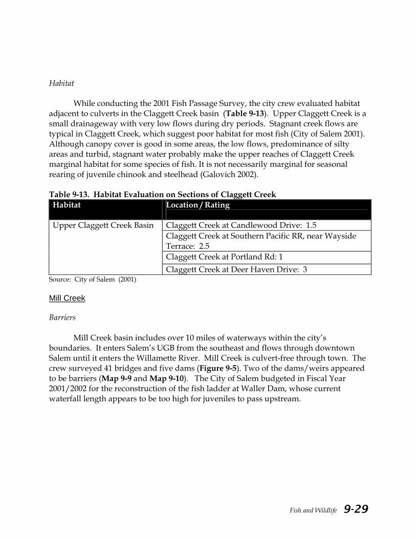
Habitat
While conducting the 2001 Fish Passage Survey, the city crew evaluated habitat adjacent to culverts in the Claggett Creek basin (Table 9-13). Upper Claggett Creek is a small drainageway with very low flows during dry periods. Stagnant creek flows are typical in Claggett Creek, which suggest poor habitat for most fish (City of Salem 2001). Although canopy cover is good in some areas, the low flows, predominance of silty areas and turbid, stagnant water probably make the upper reaches of Claggett Creek marginal habitat for some species of fish. It is not necessarily marginal for seasonal rearing of juvenile chinook and steelhead (Galovich 2002). Table 9-13. Habitat Evaluation on Sections of Claggett Creek Habitat Location / Rating
Claggett Creek at Candlewood Drive: 1.5 Claggett Creek at Southern Pacific RR, near Wayside Terrace: 2.5 Claggett Creek at Portland Rd: 1
Upper Claggett Creek Basin
Claggett Creek at Deer Haven Drive: 3 Source: City of Salem (2001) Mill Creek Barriers
Mill Creek basin includes over 10 miles of waterways within the city’s boundaries. It enters Salem’s UGB from the southeast and flows through downtown Salem until it enters the Willamette River. Mill Creek is culvert-free through town. The crew surveyed 41 bridges and five dams (Figure 9-5). Two of the dams/weirs appeared to be barriers (Map 9-9 and Map 9-10). The City of Salem budgeted in Fiscal Year 2001/2002 for the reconstruction of the fish ladder at Waller Dam, whose current waterfall length appears to be too high for juveniles to pass upstream.

Fish and Wildlife 9-30
Figure 9-5. Fish Barrier Inventory for Mill Creek
Source: City of Salem (2001)
The second barrier near Kuebler Blvd. is an irrigation dam with another fish ladder. This was an adult and juvenile barrier due to jump height and lack of pool depth. The survey indicates that many adult fish may not be able to clear the waterfall. During the growing season, the Santiam Water Control District (SWCD) operates the irrigation dam. The SWCD has the irrigation dam in place from April/ early May to the end of September/early October (Trosi pers. comm.). The City of Salem recommends that the ladders located at both dams should receive further study (Mauldin pers. comm.). Ultimately, it would be the SWCD’s responsibility to have the fish ladder at their irrigation diversion evaluated for adequate passage.
Battle Creek is a tributary to Mill Creek. The Battle Creek basin includes over 7.5 miles of waterways within the Salem urban growth boundary, including the tributaries of Waln, Jory and Powe1l Creeks. According to the survey, all dams and 29% of the culverts are fish barriers (Figure 9-6). Two passage barriers to Battle Creek were observed near I-5. (Map 9-11). No barriers were found on the Jory Creek passage. Weir barriers were identified near the downstream end of the Waln Creek tributary and on the Sunnyside Road crossing at Powell Creek.

Fish and Wildlife 9-31
Figure 9-6. Fish Barrier Inventory for Battle Creek
Source: City of Salem (2001)
ODFW noted a fish passage barrier at the confluence of the Mill Race and Pringle Creek while conducting the 1999 City of Salem Fish Distribution Survey (City of Salem 1999). No barriers or fish screens were present on the upstream end of the Race at the time of the survey, thus indicating that fish could access the Mill Race from Mill Creek. A recent article indicates that there are many obstacles to safe fish passage on the Mill Race, including the turbine at Mission Mill and piping that leads to the final concrete drop into Pringle Creek (Geniesse 2000). ODFW has recommended that the Mill Race be screened to prevent fish from accessing the system (Galovich pers. comm.). The City of Salem has also proposed screening the Mill Race. The project is scheduled for 2003 (Downs pers. comm.).
ODFW noted a private pond on Powell Creek upstream from Elkins Way while conducting the Fish Distribution Survey in 1999. They observed a two-plus meter drop that would most likely be an upstream migration barrier for all species at this location. Additional observations were made in the Waln Creek tributary at Liberty Road. The crew reported the Liberty Road culvert does not appear to be an upstream migration barrier and attributed passage problems to undesirable habitat conditions.
Marion County consulted with ODFW to identify and prioritize culvert barriers in the Mill Creek watershed. ODFW rated all the culverts in Marion County as either medium or low priority based on criteria discussed in the Methods section of this chapter. In March and April 1999, the Pavement Management section inspected all the culverts in Marion County earlier identified as medium priority and field-verified all the ODFW data (Map 9-12). Of the 17 culverts surveyed in the Mill Creek basin, six priority culverts in Battle, McKinney, and Simpson Creek sub-basins were identified

Fish and Wildlife 9-32
(Table 9-14). Since outlet jump is the most obvious constraint to fish passage, Table 9-14 is sorted according to the jump at the outlet. Suitable jump heights vary among salmonid species and between adults and juveniles. Six inches or less is recommended for trout and juvenile anadromous species. ODFW recommends jumps of 12 inches or less for adult salmon.
Marion County Public Works has replaced two 0f six priority culverts as of April 2003. (Thorburn pers. comm.). Additional culvert repairs include clearing out debris at the outlet or the inlet, creating deeper outlet pools and fixing fences that collect debris in the channel (Maps 9-13 to 9-17). Habitat
While conducting the 2001 Fish Passage Survey, the city crew evaluated habitat adjacent to culverts in the Mill Creek Basin (Table 9-15). Habitat in Mill Creek, from its mouth at the Willamette River up to 21st Street, received a good rating. Shelton Ditch scored relatively well for providing adequate shade and flow. Canopy and fish cover varied for Battle, Waln and Powell Creeks. Flows in Waln Creek above Lone Oak Road, and in Powell Creek above Sunnyside Road, appear to be too low to support significant populations of fish (City of Salem 2001).

Fish and Wildlife
Table 14. Priority Culverts in Mill Creek Watershed, Marion County, OR.1,2
Road Name Named Body OFFSET Rise/Height Span/Width Length Cover Depth Slope(%) Skew(0) Shape X-sec
# of Culverts Condition Date Insp. Comments STREAM SLOPE OUTLET POOL Desc. Baffl
Priority #
Inlet (ft) Outlet
(ft) (in) (in) (ft) (ft) Inlet (0) Outlet (0) Length (ft) Depth (in)
Drop to
Pool (in)
4 10 7 44 62 3 1.0 0 Arch 1 G-Good 4/7/99 N/C 1 3 6 10 12 SMALL ROCKS 2 SUNNYSIDE
RD BATTLE CK * - 200 * same as stream - - - - - * * * 10 6 -
17 10 48 48 51 5 0.5 5 Circular 1 G-Good 4/8/99 GPS OUTLET/CL 2 3 12 24 6 INVISIBLE 4 BROWNELL
RD SIMPSON CK
* - 200 * 0.5 - - - - - * * * 12 6 -
11 7 48 48 37 2 0.5 5 Circular 1 G-Good 4/8/99 INLET
BLOCKED BY FENCE ETC
2 3 20 24 0 INVISIBLE 5 SIMPSON RD UNNAMED
* - 200 * 0.5 - - - - - * * * 10 6 -
11 15 36 36 66 1 0.3 30 Circular 2 G-Good 4/8/99 OUTLET
BLOCKED BY FENCE
3 3 5 12 12 ROCKS 6 SHERMAN
RD UNNAMED
* - 200 * 0.5 - - - - - * * * 10 6 -
9 4 40 40 37 2 2.0 5 Circular 2 G-Good 4/9/99
INLET BLOCKED BY
FENCE/DEBRIS ROCKS BLOCK
OUTLET
4 5 6 6 0 ROCKS/SAND 13 PARRISH
GAP RD RODGERS
CK
* - 200 * 0.5 - - - - - * * * 10 6 -
8 8 48 48 39 3 2.0 0 Circular 1 P-Poor 4/9/99 ADDITIONAL JUMP 20FT UPSTREAM
4 3 20 24 0 INVISIBLE 20 HUNSACKER
RD MCKINNEY
CK
* - 200 * 0.5 - - - - - * * * 10 6 -
Source: Marion County Public Works Culvert Survey (1999). 1 Table modified from original version. ODFW classified culverts as either high, medium, or low priority for repair based on whether a culvert was a “partial or complete barrier, the fish species impacted, and the quality/amount of habitat upstream from the culvert.” Because the outlet jump is the most obvious constraint to fish passage, Table 10 is sorted according to the jump at the outlet. 2 Numbers in bold represent culverts that do not follow the specifications for adequate fish passage. Un-shaded rows show existing conditions. Shaded rows indicate desired conditions or conditions that would be necessary for safe fish passage.
Fish and Wildlife 9-33
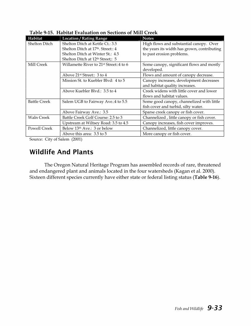
Table 9-15. Habitat Evaluation on Sections of Mill Creek Habitat Location / Rating Range Notes Shelton Ditch
Shelton Ditch at Kettle Ct.: 3.5 Shelton Ditch at 17th. Street:: 4 Shelton Ditch at Winter St.: 4.5 Shelton Ditch at 12th Street;: 5
High flows and substantial canopy. Over the years its width has grown, contributing to past erosion problems.
Willamette River to 21st Street::4 to 6 Some canopy, significant flows and mostly developed.
Above 21st Street:: 3 to 4 Flows and amount of canopy decrease. Mission St. to Kuebler Blvd: 4 to 5 Canopy increases, development decreases
and habitat quality increases.
Mill Creek
Above Kuebler Blvd.: 3.5 to 4
Creek widens with little cover and lower flows and habitat values.
Salem UGB to Fairway Ave.:4 to 5.5 Some good canopy, channelized with little fish cover and turbid, silty water.
Battle Creek
Above Fairway Ave.: 3.5 Sparse creek canopy or fish cover. Battle Creek Golf Course: 2.5 to 3 Channelized , little canopy or fish cover. Waln Creek
Upstream at Wiltsey Road: 3.5 to 4.5 Canopy increases, fish cover improves. Below 13th Ave.: 3 or below Channelized, little canopy cover. Powell Creek Above this area: 3.5 to 5 More canopy or fish cover.
Source: City of Salem (2001) Wildlife And Plants
The Oregon Natural Heritage Program has assembled records of rare, threatened and endangered plant and animals located in the four watersheds (Kagan et al. 2000). Sixteen different species currently have either state or federal listing status (Table 9-16).

Fish and Wildlife 9-34
Table 9-16. Summary of Federally and State Listed Plant and Animal Species that Historically or Currently Exist in Salem Area Watersheds. Common Name Location Habitat Information Population Status ODFW Status USFWS Status Notes
Bald Eagle W. of Windsor Island Breeding site Listed threatened Listed threatened 1998 nesting failure Oregon Spotted Frog Aumsville, along Mill Creek Low, emergent marsh One female collected Sensitive critical Candidate Last collected in 1937 Painted turtle Mill Creek near Salem Privately owned Sensitive critical Species recorded by Alan
St. John in 1984. Finney-Eagan Lake Privately owned In 1991 one turtle
observed; 1988 three turtles observed; 1963 75 turtles observed
Sensitive critical Species observed by Lyle Wilhemi. Source: Charlie Bruce, ODFW.
Northwestern Pond Turtle Finney-Eagan Lake Oxbow Lake In 1993 one turtle observed; 1991 one turtle observed
Sensitive critical Species of concern Source: Holland, D.C. 1994. Draft Report on the Western Pond Turtle Project. Unpubl. Rept. For ODFW.
Oregon Giant Earthworm At or near Salem Privately owned Single specimen collected in 1903
Species of concern
Bradshaw's Lomatium Salem Dry soil on riverbank, managed area on Willamette River Greenway
Listed endangered Listed endangered Source: USFWS Endangered Species Herbarium Card File. ca. 1979. Assumed extirpated.
Sublimity Shallow, rocky, vernally wet soils in drainage channels over basalt bedrock.
About 120 plants, in flower. Geese grazing causing low growth and lowered reproduction. Very unusual habitat for these species.
Listed endangered Listed endangered Sublimity grassland is managed by The Nature Conservancy.
White-Topped Aster Aumsville Area of natural vegetation, surrounded by cultivated fields in Oak Savannah and Stayton silt loam
Four patches seen of about 50 shoots each; plants not vigorous
Listed threatened Species of concern Considerable grazing disturbance in the past suggested by abundance of introduced species.
Salem Gravelly soil Listed threatened Species of concern Collected by Piper in 1918. Area now likely developed and plant extirpated.
Willamette Valley Daisy Salem, various locations Gravelly pasture(Nelson 1916); Open ground in Bush's Pasture (Thompson, 1927).
Listed endangered Listed endangered Herbarium Collections: Johnson, C. 1890.
Sublimity Red fescue grassland- moist site, soils are mix of allluvial silts and fluvial clays; Flat area with very dense fern cover; Privately owned
Approximately 20 plants seen in flower, in small fern prairie area
Listed endangered Listed endangered Sublimity grassland is managed by The Nature Conservancy.

Fish and Wildlife 9-35
Common Name
Location
Habitat Information
Population Size
ODFW Status
USFWS Status
Notes
Willamette Valley Daisy N.W. of Sublimity In gravel of road; Associated with grasses; County-owned
76 plants on site, 12 in vegetative state, 60 in flower and 4 in fruit; Elevation of 450-50 ft.
Listed endangered Listed endangered 1991 BLM Sighting Report; M. Woodbridge, Observer; Collection made and housed at OSU.
Howellia Mission Bottom, near Salem 1977 sighting; recent attempts to relocate this plant here have failed.
Listed threatened Source: Bluhm, Wilbur. Bluhm 1977 sighting. Area is now largely developed and plant extirpated at site. Reported in 1978 USFWS Endangered Species Report, Siddall et al.
Near Salem; Painter's Woods, bog and pond one mile north of Salem
Stagnant pond in shaded woods
Listed threatened Herbarium Collections: Thompson Collections; housed at several herbaria in Oregon. This site is now developed and plant extirpated
Kincaid’s Lupine S.W. Salem Roadside, dry hills First observed in 1884, last observed in 1916
Listed threatened Listed threatened Peck Collections
Nelson's Sidalcea Salem - (in approximately 11 areas) Grasslands, Dayton silt loam soil type, clay, roadside ditch, wet meadow, managed lawn, weedy woods edge and alongside freeway; City, state and privately owned
See annual observations: ONHP 2000 Report
Listed threatened Listed threatened Major threats and disturbances are: spraying, mowing, ditching, recreationalists and bulldozers from housing development projects.
Tall Bugbane Joryville Park near Battle Creek, South of Salem
Cut banks and moist forested slopes; With few hardwoods present; County-owned
32 plants; in leaf and bud; 10% immature; 90% mature; 10-100 sq. meter area
Critical Species of concern 1994 ONHP Plant Sightings Report; Richard Brainerd, reporter.
Peacock Larkspur Salem - Mill Creek In flower Listed endangered Species of concern Herbarium Collections Willamette Valley Larkspur Aumsville-Turner on Mill Creek Crowded by weedy
species and large thicket of Rosa; County owned
Approximately 20 individuals on both sides of fence; all flowering
Critical Rosa may eventually crowd out WV Larkspur
Shaggy Horkelia Turner Critical Species of concern Nelson Collection Salem and six miles S.E. of Salem Critical Species of concern Clemens Collection Golden Indian Paintbrush Salem Wet pasture Listed endangered Listed threatened Nelson Herbarium
Collection Salem Wet meadow, damp open
ground Listed endangered Listed threatened Peck Collection
Source: Oregon Natural Heritage Program (2000)

Fish and Wildlife 9-36
Bird Use in the Claggett Creek Watershed Curly’s Dairy Wetland is a wetland mitigation site located along Labish Ditch in northeast Keizer. It is just north of Rock Ledge Drive. A list of birds that use this emergent marsh and surrounding fallow fields has been compiled (Table 9-17). The list is a good example of the bird communities associated with wetlands and open grasslands/brushy fields in the four watersheds. Table 9-17. Birds Seen in the Curly’s Dairy Wetland and Adjoining Field Since July 1996 Water Birds Field (Grassland and Shrubland Birds)
Great Blue Heron House Finch Red-winged blackbird House Sparrow Canada Goose Tree Swallow Mallard American Goldfinch Green-backed Heron Barn Swallow Pied-billed Grebe Rufous Hummingbird Common Merganser Downy Woodpecker Bank Swallow Scrub Jay Belted Kingfisher Turkey Vulture Great White Egret Black-headed Grosbeak Hooded Merganser Black-capped Chickadee Greater White-fronted Goose Rock Dove American Coot Golden Eagle Bufflehead Brewer’s Blackbird Cinnamon Teal Swainson’s Hawk Ruby-crowned Kinglet White-throated Sparrow American Robin Northern Flicker Oregon Junco Rufous-sided Towhee Mourning Dove Killdeer Cooper’s Hawk Cedar Waxwing Ring-necked Pheasant Yellow-rumped Warbler
Source: Daniels (pers. comm.)

Fish and Wildlife 9-37
Bird Use in the Mill Creek Watershed
Shorebird use has been observed in the Aumsville area. According to a recent study in winter of 2000, as many as 10-12,000 Dunlin, including multiply radio-marked birds, have been observed during aerial and ground surveys of the Aumsville sewage pond complex (Sanzenbacher pers. comm.; Haig pers. comm.). Large groups of Dunlin use the pond each winter starting in late February/early March. It appears that the majority of birds roost at the site during daylight hours and depart in large groups (250+ birds) at dusk, moving into flooded/wet agriculture fields. One local destination site in 2000 was a set of fields directly north of the Hunsaker Rd./Marion Rd. intersection. Large numbers of shorebirds were also observed traveling south to the Santiam River and then following the river channel downstream. The destination of radio-marked birds included fields near Stutzman Drive, south of Highway 20, and fields southeast and adjacent to the Highway 34/I-5 junction. These birds remained in the fields for the night and then frequently made a return trip to the Aumsville ponds the following morning.
It’s not clear why these birds will travel such great distances every day. One interpretation may be that the shorebirds only use the Aumsville area as a roosting site (Sanzenbacher pers. comm.) Other habitat needs, such as foraging areas, must be satisfied elsewhere in the surrounding landscape. The Aumsville sewage ponds appear to be an important roost site during late winter months and a potential explanation for the extensive distances that individuals travel to/from sites is that preferred foraging areas occur in other areas (e.g., further south).
Shorebird foraging habitat is generally unvegetated, or with short vegetation areas having exposed saturated/wet soils. Wetland restoration efforts in the Willamette Valley often focus on waterfowl such as ducks and geese. The characteristics of these restored sites (deep water with tall, standing vegetation) may exclude shorebird use. Thus, restoration efforts should attempt to provide a range of habitats, including areas of open, shallow water and exposed saturated soils. Shorebirds don’t swim and their legs aren’t very long (Dunlin legs are 1-2 inches), so deeper water excludes many/most shorebirds. It’s best if ponds at restored sites include both deep and shallow waters. The addition of roosting islands in the wetlands would also benefit shorebirds. Data Gaps
1. Habitat conditions for the fish-bearing streams in the Salem area watersheds. 2. (Information on pools, riffles, substrate condition, riparian vegetation and large
woody debris.) 3. Historical and seasonal fish distribution information specific to the Salem area
watersheds. Current information is limited to periodic surveys instead of year- round sampling.

Fish and Wildlife 9-38
4. Fish passage barrier (i.e. dams, weirs) information outside of the Salem urban growth boundary. Specifically, lack of data for the City of Keizer, which corresponds to portions of the Claggett Creek watershed.
5. Information on species other than aquatic wildlife and plants is limited. Summary
Both natural factors and human activities contribute to the availability and quality of aquatic and terrestrial habitats found in the Mid-Willamette basin. Competitive pressures from introduced species, and loss and degradation of available habitat have all contributed to declines in several native fish species in the four watersheds.
Habitat loss and degradation include construction of migration barriers, removal of riparian vegetation, reduction in large woody debris in stream channels, loss of side channel habitats due to channelization, alteration of low flows due to water use and alteration of high flows due to urbanization. Many of these degradations also lower stream water quality by increasing stream temperatures, sediment loads and pollution and decreasing dissolved oxygen.
Chinook salmon have been documented in Pringle, Glenn-Gibson, Claggett and Mill Creeks. Native cutthroat trout appear to be widely distributed. Though their use of Claggett Creek is less well documented, all of the Salem-Keizer area watersheds should be managed for steelhead habitat. Sculpin, crayfish and redside shiners are also found in all four watersheds. Mill Creek is considered “essential salmonid habitat” by the Division of State Lands. Pringle Creek has the same designation from its mouth upstream to its intersection with Cross Street.
In some of these waters, fish may move in and out multiple times during a season. ODFW finds that anadromous fish use lower elevation or valley floor streams as seasonal rearing habitat. Anadromous fish may move from the Willamette and into and out of streams like Mill Creek, Claggett Creek or Glenn Creek several times during the fall winter and spring depending on flow conditions (Galovich 2002). Hence, when a particular survey does not indicate the presence of a species, it does not necessarily mean the species does not use the creek during its life cycle. In light of this, the local creeks can be considered important habitat for salmonids.
Recent studies in the four watersheds indicate that fish passage problems in the Salem area include culverts, dams, inadequate fish ladders, water diversions, unfavorable water quality (e.g., thermal barriers), and other poor habitat conditions. A City of Salem fish passage survey documented 167 culverts, 60 dams/weirs and 46 bridges. Approximately 40% of the culverts and 77% of the dams/weirs were found to be barriers. Pringle Creek has many small weirs that may pose problems for fish passage. The Glenn-Gibson watershed has many impoundments in its streams that restrict fish passage. Most of Claggett Creek was not surveyed for fish passage barriers. Culverts restricting fish passage have been prioritized by Marion County Public Works and are currently being replaced or retrofitted in order to provide adequate passage.
Fish and Wildlife 9-39
A rough survey of fish habitat in the four watersheds was conducted in
conjunction with the fish passage survey. On a scale of 1 to 10, with ten being the best habitat, fish habitat ranked from a high of six in a reach of Gibson Creek to a low of one in the upper reaches of Claggett Creek. A more thorough and intensive survey is needed to adequately assess fish habitat quality in local streams.
In addition, records indicate that sixteen plant and animal species in the Salem area are federally or state listed due to declining populations.
Further information gathered at the watershed level, including fish presence, distribution, habitat conditions, and the status of wildlife and plant species, will provide a better understanding of how to best care for the species dispersed throughout the four watersheds.

Fish and Wildlife 9-40
Recommendations All Basins
1. Conduct a fish habitat survey to determine the condition of suitable spawning, rearing and holding habitat. Protect areas that have suitable habitat and develop restoration plans for areas in which the habitat is degraded.
2. Support the City of Salem’s Stream Biomonitoring project that collects detailed
information on stream morphology, vegetation, invertebrates and other parameters. Analyze biomonitoring data collected in all creeks and make information available to the public.
3. Conduct more comprehensive fish surveys. Collect data year around, especially
during times when fish are migrating, rearing, and spawning. Identify fish species using both perennial and seasonal streams for rearing, spawning, and refuge.
4. Prioritize and set timetables for culverts and other passage barriers for
replacement or retrofit within the City of Salem’s urban growth boundary. 5. Prioritize and set timetables to remove check dams and weirs that are no longer
in use. 6. Support regular programs that remove trash in streams that may be fish passage
barriers. 7. Monitor the use of pesticides along or near streams. Support IPM and “Salmon
Safe”TM procedures on public lands. 8. Gather and share information on the condition of “sensitive” species found in
the watersheds, especially their location, population status and survival challenges. Provide protection for “sensitive” species using a combination of land acquisition, conservation easements, public outreach and education, and local regulation.
9. Determine sites where sewer lines and streams intersect and high bacterial
levels are present.

Fish and Wildlife 9-41
References Andrus, Chip. 2000. Pringle Creek Sampling. Water Work Consulting. Salem, OR. Busby, P., T. Wainwright, G. Bryant, L. Lierheimer, R. Waples, F. Waknitz, I.
Lagomarsino. 1996. Status Review of West Coast Steelhead from Washington,Oregon, and California. National Oceanic Atmospheric Administration-Northwest Fisheries Science Center Tech Memo-27. U.S. Department of Commerce. http://www.nwfsc.noaa.gov/pubs/tm/tm27/intro.htm
City of Salem. 1999. City of Salem Fish Distribution Survey. Salem, OR. City of Salem. 2000. Pringle Creek Fish Survey. Salem, OR. City of Salem. 2001. City of Salem Fish Passage Survey. Salem, OR. Collins, L. 1951. The Cultural Position of the Kalapuya in the Pacific Northwest.
Unpublished Master’s Thesis. University of Oregon. Eugene, OR. Daniels, Beth. Claggett Creek Watershed Council member. 2001. Personal
communication. Salem, OR. Downs, Steve. Engineer, City of Salem Public Works Department. 2001. Personal
communication. Salem, OR. Galovich, Gary. Fish Biologist, Oregon Department of Fish and Wildlife. 2001. Personal
communication. Salem, OR. Galovich, Gary. Fish Biologist, Oregon Department of Fish and Wildlife. 2002. Personal
communication. Salem, OR. Galovich, Gary. 2001. Fish Biologist, Oregon Department of Fish and Wildlife. Speaker
at OSU Extension Office Master Watersheds Stewards Program. Salem, OR. Geniesse, S. 2000. “Fish Safety in Mill Race.” in The Fish Rapper Newsletter, vol. 1 #2,
Fall 2000. Greater Salem-Keizer Area Watershed Councils. Salem, OR. Copy at Marion Soil and Water Conservation District. Salem, OR.
Haig, Susan. Wildlife Ecologist and Professor, Oregon State University. Corvallis, OR.
2001. Personal communication. Salem, OR. Hunt, W. 1996. Fish Kill in Pringle Creek. Oregon Department of Fish and Wildlife.
Salem, OR.

Fish and Wildlife 9-42
Hunt, W. 2000. Fish Kill in Pringle Creek (Again). Oregon Department of Fish and
Wildlife. Salem, OR. Institute for the Northwest. 1999. Restoring The Willamette Basin: Issues and Challenges.
Prepared for the Willamette Restoration Initiative. Salem, OR. Copy at Marion Soil and Water Conservation District. Salem, OR.
Johnson, D., and T. O’Neil. 2000. Special Addition Technical Report. in Wildlife-
Habitat Relationships in Oregon and Washington. Washington Department of Fish and Wildlife. Olympia, WA. http://www.wa.gov/wdfw/hab/salmonwild/
Kagan, Jimmy, J. Christy, M. Murray and J. Titus. 2000. Classification of Natural
Vegetation of Oregon. Oregon Natural Heritage Program—Oregon State University Institute for Natural Resources. Corvallis, OR.
McNary High School. 1993-1996. Fish Data for Claggett Creek. Adopt-A-Stream
Program. City of Salem Community Development Department. Marion County Public Works Department. 1999. Marion County Culvert Survey. Salem,
OR. Martin, Jim. Former Principal Executive Manager, Oregon Department of Fish and
Wildlife. 2001. Speaker at conference, “Salmon Passage Past the Dams.” Oregon State University. Corvallis, OR.
Mauldin, Frank. Former Director, City of Salem Public Works Department. 2001.
Personal communication. Salem, OR. Mill Creek Watershed Task Force. 1983. Mill Creek Drainage Study. Salem, OR. Copy at
Marion Soil and Water Conservation District. Salem, OR. Mitsubishi Silicon America (MSA). 2000. Natural Resources Evaluation of Sulfuric Acid
Release to the West Middle Fork of Pringle Creek. Salem, OR. (now Sumco USA). National Marine Fisheries Service (NMFS). 2000. A Citizen’s Guide to the 4(d) Rule For
Threatened Salmon and Steelhead on the West Coast. U.S. National Oceanic and Atmospheric Administration. http://www.nwr.noaa.gov/1salmon/salmesa/stlhesum.htm
Oregon Department of Fish and Wildlife (ODFW). 1991. Mill Creek Fish Kill
Investigation Report. Salem, OR.
Fish and Wildlife 9-43
Oregon Department of Fish and Wildlife. 1995. Summary of Mill Creek Fall Chinook Redd Counts, 1970-1994. Salem, OR.
Oregon Department of Fish and Wildlife. 1997. “Oregon’s Coastal Cutthroat Trout.”
Backgrounder Newsletter. http://www.dfw.state.or.us/ODFWhtml/InfoCntrFish/InfoCntrFish.html
Oregon Department of Fish and Wildlife. 1999. 1999 Mill Creek Fall Chinook Spawning
Survey. Salem, OR. Oregon Department of Fish and Wildlife. 2000. Listed Species of Fish In Oregon.
http://www.dfw.state.or.us/ODFWhtml/InfoCntrFish/InfoCntrFish.html Oregon Division of State Lands (ODSL). 2001. Essential Indigenous Anadromous Salmonid
Habitat. http://www.oregonstatelands.us/esshabitat.html Oregon State University (OSU) Extension Service. 2000. Watershed Stewardship Learning
Guide. Corvallis, OR. Portland Multnomah Progress Board. 2000. SalmonRestoration in an Urban Watershed:
Johnson Creek, Oregon – Conditions, Programs and Challenges. Portland, OR. Copy at Marion Soil and Water Conservation District. Salem, OR.
Runyon, John. President, BioSystems, Inc. of Eugene, OR. 2001. Personal
communication. Salem, OR. Sanzenbacher, Peter. Research Biologist, U.S. Geological Survey. 2001. Personal
communication. Salem, OR. Thorburn, Matt. Environmental Specialist, Marion County Public Works Department.
2001. Personal communication. Salem, OR. Trosi, Larry. Distirct Manager, Santiam Water Control District. 2001. Personal
communication. Salem, OR. Wetherbee, J. 1989. Gasoline Spill in Mill Creek. Oregon Department of Fish and
Wildlife. Salem OR. U.S. Fish and Wildlife Service (USFWS). 1998. Oregon Chub (Oregonichthys crameri)
Recovery Plan. Portland, OR.

Fish and Wildlife 9-44
U.S. Geological Survey (USGS). 1997. Summary of Information on Aquatic Biota and Their Habitats in the Willamette Basin, Oregon, through 1995. USGS Water Resources Investigations Report 97-4023. Portland, OR.