chapter 8: historic resources
TRANSCRIPT

8-1
Chapter 8: Historic Resources
A. INTRODUCTION This chapter analyzes the potential of the Proposed Actions to impact historic resources, which include both archaeological and architectural resources. The Proposed Actions would result in the rezoning of the approximately 35-acre Project Area, which was predominantly developed in the early 20th century and contains a number of notable, undesignated historic structures. Several of these resources are located in the Academic Mixed-Use Area (Subdistrict A), the 17 acres to be redeveloped by Columbia. To understand fully historic issues and to prepare a comprehensive historic resources analysis, Columbia has consulted with the New York State Office of Parks, Recreation and Historic Preservation (OPRHP) and the New York City Landmarks Preservation Commission (LPC).
The historic resources analysis has been prepared in accordance with City Environmental Quality Review (CEQR), the State Environmental Quality Review Act (SEQRA), and the New York State Historic Preservation Act of 1980 (SHPA). These laws and regulations require that City and State agencies, respectively, consider the impacts of their actions on historic properties. This technical analysis follows the guidance of the 2001 CEQR Technical Manual.
The CEQR Technical Manual recommends that an analysis of archaeological resources be undertaken for actions that would result in any in-ground disturbance. It also recommends that an architectural resources assessment be performed if a proposed action would result in any of the following (even if no known architectural resources are located nearby): new construction; physical alteration of any building; change in scale, visual context, or visual setting of any building, structure, object, or landscape feature; or screening or elimination of publicly accessible views. Since the Proposed Actions may result in some of these conditions, a full analysis for archaeological and architectural resources under CEQR and SEQRA was undertaken.
ARCHAEOLOGICAL RESOURCES
Archaeological resources are physical remains, usually buried, of past activities on a site. They can include remains from Native American people who used or occupied a site, including tools, refuse from tool-making activities, habitation sites, etc. These resources are also referred to as “precontact,” since they were deposited before Native Americans’ contact with European settlers. Archaeological resources can also include remains from activities that occurred during the historic period (beginning with European colonization of the New York area in the 17th century) and that include European contact with Native Americans, as well as battle sites, foundations, wells, and privies. Cemeteries are also considered archaeological resources.
On sites where later development occurred, archaeological resources may have been disturbed or destroyed by grading, excavation, and infrastructure installation and improvements. However, some resources do survive in an urban environment. Deposits may have been protected either by being paved over or by having a building with a shallow foundation constructed above them. In both scenarios, archaeological deposits may have been sealed beneath the surface, protected from further disturbance.

Proposed Manhattanville in West Harlem Rezoning and Academic Mixed-Use Development FEIS
8-2
ARCHITECTURAL RESOURCES
Architectural resources are defined as properties or districts listed on the State and National Registers of Historic Places (S/NR) or determined eligible for such listing; National Historic Landmarks (NHLs); New York City Landmarks (NYCLs) and Historic Districts; and properties that have been found by LPC to appear eligible for designation, considered for designation (“heard”) by LPC at a public hearing, or calendared for consideration at such a hearing (these are “pending” NYCLs).
Study areas for architectural resources are determined based on the area of potential effect (APE) for construction-period impacts, such as ground-borne vibrations, and on the APE for visual or contextual effects, which is usually a larger area. In accordance with both CEQR and SEQRA guidelines, the architectural resources analysis identifies all architectural resources that have been designated or determined to meet the eligibility requirements for local, state, or national designation. This analysis assesses potential project impacts on architectural resources.
B. PRINCIPAL CONCLUSIONS Consultation with OPRHP and LPC was conducted to determine whether the Project Area may contain archaeological resources. As per OPRHP’s and LPC’s recommendations, an archaeological study was prepared for the Project Area. The Project Area was determined not to be sensitive for archaeological resources (see LPC comments dated September 23, 2004, and OPRHP letter dated June 6, 2005, in Appendix D.2). Therefore, the Proposed Actions would not have adverse impacts on archaeological resources, and no further consideration of such resources is required for the Proposed Actions.
PROJECT AREA
As part of its initial planning efforts for this project, Columbia has incorporated one of the area’s most significant architectural resources—the former Warren Nash Service Station building—into the Academic Mixed-Use Development. Alterations to the former Warren Nash Service Station building as part of the Proposed Actions would be undertaken in consultation with OPRHP. To guide the conversion of the former Warren Nash Service Station building, which would be retained in the Academic Mixed-Use Area and adaptively reused, a Preservation Approach has been prepared and was submitted to OPRHP for review on October 18, 2007. Columbia would implement the approved Preservation Approach to avoid any adverse impacts on the former Warren Nash Service Station.
Also in the Academic Mixed-Use Area, Columbia is currently renovating the Studebaker Building for administrative office space, renovation which is proceeding and will proceed irrespective of whether the Proposed Actions are approved. This renovation has proceeded in consultation with OPRHP. Though consultation with OPRHP was initially informal, since the renovation of the Studebaker Building was proceeding as-of-right, Columbia subsequently applied for financing from the Dormitory Authority of the State of New York (DASNY). In connection with that financing, OPRHP has reviewed the proposed modifications to the building and has determined that the Proposed Project would have no adverse impacts on the Studebaker Building. Columbia has also discussed the proposed modifications with LPC.
A construction protection plan (CPP) has been prepared to avoid adverse construction-related impacts on architectural resources located within 90 feet of the proposed Academic Mixed-Use Development in the Academic Mixed-Use Area of the Project Area (see Appendix D.3). The

Chapter 8: Historic Resources
8-3
CPP was submitted to LPC and OPRHP for review on November 6, 2007. The protection measures contained in the CPP were approved by LPC on November 8, 2007 and by OPRHP on November 14, 2007 (see Appendix D.2). The approved CPP would be implemented prior to any demolition or construction activities commencing in Subdistrict A as part of the Proposed Actions. Structures outside Subdistrict A would be protected by the New York City Department of Buildings (DOB)’s Technical Policy and Procedure Notice (TPPN) #10/88. In addition, to avoid any adverse impacts on the 125th Street IRT Station and the Manhattan Valley IRT viaduct from the proposed replacement of the two non-historic escalators with escalators of a larger capacity. Columbia University, in coordination with MTA/NYCT, would submit drawings to OPRHP for their review depicting how the new escalators connect to the historic material of the station and, if applicable, the viaduct structure. In addition, a CPP would be developed among MTA/NYCT, Columbia University, and OPRHP to avoid construction-related impacts.
As part of the Proposed Actions, a study to evaluate the feasibility of reusing the former Sheffield Farms Stable at 3229 Broadway in the Academic Mixed-Use Area was prepared and submitted to OPRHP for review on October 15, 2007. The study, contained in Appendix D.4, concluded that the former Sheffield Farms Stable does not meet the requirements for an academic research facility due to its small size and floor plates, lack of infrastructure, incompatible floor-to-floor heights, and restrictive column spacing. Retaining all or portions of the building for academic research would require that significant alterations be made to the building, and would impact the proposed program of the Jerome L. Greene Science Center and the proposed below-grade support space planned beneath the buildings. In a letter dated November 14, 2007, OPRHP concurred that it is not appropriate to retain just a portion of the former Sheffield Farms Stable or just its façade, and requested that further study be undertaken to determine if it is feasible to retain the former Sheffield Farms Stable in the Academic Mixed-Use Development Area, and specifically if the Jerome L. Greene Science Center could be built on the north side of West 129th Street south of the former Sheffield Farms Stable (see Appendix D.2). In response to OPRHP’s request, a further analysis was conducted and it was determined that such alternative is not feasible. See Chapter 24, “Alternatives,” Measures that would partially mitigate the significant adverse impact resulting from the demolition of the building for the initial (2015) phase of development are described in Chapter 23, “Mitigation.” Consultation among OPRHP, ESDC, and Columbia will continue. Redevelopment by 2030 would result in the removal of the West Market Diner in the Academic Mixed-Use Area. Columbia would relocate the West Market Diner’s 1948 dining car to a new site in the Project Area or study area and consult with OPRHP regarding its relocation and rehabilitation. The 1948 dining car was designed as a movable structure and the other portions of the diner retain little historic integrity (see Appendix D.2). As determined in consultation with OPRHP, moving the 1948 dining car and rehabilitating it would not result in significant adverse impacts.
STUDY AREA
The Proposed Actions are not expected to have any significant adverse impacts on architectural resources outside the Project Area. These resources are located more than 90 feet from the Project Area and, therefore, outside the area of potential physical impacts. The Proposed Actions would also not block significant views of any resource, significantly alter the visual setting of any resource, or introduce incompatible contextual elements to any resource’s setting in the study area.

Proposed Manhattanville in West Harlem Rezoning and Academic Mixed-Use Development FEIS
8-4
C. METHODOLOGY
ARCHAEOLOGICAL RESOURCES
LPC’s Guidelines for Archaeological Work in New York City outline specific steps to determine whether the Proposed Actions could affect areas of archaeological sensitivity. The first step in this process is an initial review conducted by LPC of the City tax lots that would be excavated as a result of the Proposed Actions. If LPC has archaeological concerns, a Stage 1A documentary study is typically prepared to assess the archaeological sensitivity of the affected areas and to determine whether further archaeological evaluation is required.
LPC has conducted an initial review of the Project Area and has delineated an archaeological study area for the Proposed Actions. LPC’s review was based on historic maps and existing subsurface information, including borings logs, undertaken in the Project Area.1 LPC determined that only two lots in the study area were potentially archaeologically sensitive. LPC recommended that the two lots (623 West 130th Street on Block 1997, Lot 17, and 3268–3278 Broadway on Block 1986, Lot 30), identified as potentially archaeologically sensitive for historic-period archaeological resources, be carried forward for additional documentary research. LPC did not identify any sites within the Project Area as sensitive for precontact (Native American) resources. In comments dated October 7, 2004, OPRHP concurred with LPC’s findings. Copies of all correspondence are included in Appendix D.2.
A Stage 1A documentary study report was prepared for the two sites to evaluate their potential to contain archaeological resources (see Appendix D.1).2 To accomplish this goal, documentary research was undertaken, including the review of property conveyance records, city directories, land tract reports, tax assessments, historic maps and atlases, and other historical and existing subsurface information. The report was sent to the New York State Historic Preservation Office (SHPO) and LPC for their review.
The conclusions and recommendations of the Stage 1A documentary report are presented below in “Existing Conditions.”
ARCHITECTURAL RESOURCES
In general, potential impacts on architectural resources can include both direct physical impacts and indirect impacts. Direct impacts include demolition of a resource and alterations to a resource that cause it to become a different visual entity. A resource could also be damaged from vibration (e.g., from construction blasting or pile driving), and additional damage from adjacent construction could occur from falling objects, subsidence, collapse, or construction machinery. Adjacent construction is defined as any construction activity that would occur within 90 feet of an architectural resource, as defined in the DOB’s Technical Policy and Procedure Notice (TPPN) #10/88.3
1 Summary of Available Historic and Subsurface Data, University Master Plan, New York, N.Y., Mueser
Rutledge Consulting Engineers, March 7, 2003. 2 Cemetery and Domestic Site Documentary Study, Manhattanville Rezoning in West Harlem, prepared by
Historical Perspectives, Inc., August 2004. 3 TPPN #10/88 was issued by DOB on June 6, 1988, to supplement Building Code regulations with regard to
historic structures. TPPN #10/88 outlines procedures for the avoidance of damage to historic structures

Chapter 8: Historic Resources
8-5
Indirect impacts are contextual or visual impacts that could result from project construction or operation. As described in the CEQR Technical Manual, indirect impacts could result from blocking significant public views of a resource; isolating a resource from its setting or relationship to the streetscape; altering the setting of a resource; introducing incompatible visual, audible, or atmospheric elements to a resource’s setting; or introducing shadows over a historic landscape or an architectural resource with sun-sensitive features that contribute to that resource’s significance, such as a church with notable stained glass windows.
Significant adverse direct or indirect impacts can occur if a project would cause a change in the quality of a property that qualifies it for listing on the S/NR or for designation as an NYCL. To assess the potential impacts of the Proposed Actions, an inventory of historic architectural resources in areas that could be affected was compiled based on the methodology described below. The existing setting of each historic resource, including its visual prominence and significance in publicly accessible views, whether it has sun-sensitive features, and its visual and architectural relationship to other historic resources, was taken into consideration for this analysis.
ARCHITECTURAL RESOURCES STUDY AREA
The first step in assessing impacts was to define the study area. To account for potential physical, visual, and contextual impacts due to the development of the Academic Mixed-Use Area and potential development in Subdistricts B, C, and the Other Areas, the study area is defined as the Project Area, as well as the surrounding area bounded by West 137th Street to the north, LaSalle Street to the south, Amsterdam Avenue to the east, and the Hudson River to the west (see Figure 8-1). LPC and OPRHP have concurred with this definition of the study area (letters dated August 24, 2004, and October 7, 2004, respectively).
CRITERIA AND REGULATIONS
Once the study area was determined, an inventory of officially recognized architectural resources in the study area was compiled (“Architectural Resources”).
Criteria for inclusion on the National Register are listed in the Code of Federal Regulations, Title 36, Part 63. LPC and OPRHP have adopted these criteria for use in identifying architectural resources for CEQR and SEQRA review. Following these criteria, districts, sites, buildings, structures, and objects are eligible for the National Register if they possess integrity of location, design, setting, materials, workmanship, feeling and association, and:
• Are associated with events that have made a significant contribution to the broad patterns of history;
• Are associated with significant people; • Embody distinctive characteristics of a type, period, or method of construction, represent the
work of a master, possess high artistic value, or represent a significant and distinguishable entity whose components may lack individual distinction; or
• May yield [archaeological] information important in prehistory or history.
Properties that are less than 50 years old are ordinarily not eligible, unless they have achieved exceptional significance. Determinations of eligibility are made by OPRHP.
resulting from adjacent construction, defined as construction within a lateral distance of 90 feet from the historic resource.

WaterfrontArea
“Subdistrict”B
Other Area
Mixed-Use Development
Area “Subdistrict”
C
Other Area
WaterfrontArea
“Subdistrict”B
Academic Mixed-Use Area
“Subdistrict” A
Other Area
Mixed-Use Development
Area “Subdistrict”
C
WaterfrontArea
“Subdistrict”B
Academic Mixed-Use Area
“Subdistrict” A
Figure 8-1 Historic Resources
10.22.07
MANHATTANVILLE IN WEST HARLEM REZONING AND ACADEMIC MIXED-USE DEVELOPMENT
N
SCALE
0 500 FEET
31323334
25 3526 3627 3728 3829 3930 40
1
11
2
12
3
13
23
25
4
14
24
5
15
6
16
7
17
8
18
9
19
10
20
21
22
Project Area Boundary
Subdistrict Boundary
Study Area Boundary
2015 Academic Mixed-Use Development Area
Historic Resource(Corresponds to Table 8-1)
Historic Viaduct Structure
Scenic Landmarks (Resources 22 and 23)
Riverside Drive/ West 135th-136th StreetsHistoric District (Resource No. 24)
Tiemann Estate Historic District (Resource No. 25)
Upper Broadway Historic District (Resource No. 26)
1

Proposed Manhattanville in West Harlem Rezoning and Academic Mixed-Use Development FEIS
8-6
In addition, LPC designates historically significant properties or areas in New York City as NYCLs and/or Historic Districts, following the criteria provided in the Local Laws of the City of New York, New York City Charter, Administrative Code, Title 25, Chapter 3. Buildings, properties, or objects are eligible for landmark status when they are at least 30 years old. Landmarks have a special character, or special historical or aesthetic interest, or value as part of the development, heritage, or cultural characteristics of the City, State, or nation. There are four types of landmarks: individual landmarks, interior landmarks, scenic landmarks, and historic districts.
In addition to identifying architectural resources officially recognized in the APE, an inventory was compiled of other buildings that could warrant recognition as architectural resources (i.e., properties that could be eligible for S/NR listing or NYCL designation) in compliance with CEQR and SEQRA guidelines (“Potential Architectural Resources”). For this project, potential architectural resources were those that appeared to meet one or more of the National Register criteria (described above). These were identified based on: site visits undertaken with OPRHP, LPC, and with Manhattanville’s local historian, Eric K. Washington; a review of Community Board 9’s 197-a Plan; field surveys of the study area; and by using historical sources, including local repositories, libraries, and materials prepared by a studio project of Columbia University’s Graduate School of Architecture, Planning and Preservation (GSAPP) in 1998.1 The inventory, which included photographs and historical documentation of each resource, was submitted to OPRHP and LPC for their evaluations and determinations of eligibility. OPRHP determined that 18 properties in the study area, including structures identified in the 197-a Plan which were reviewed by OPRHP, meet criteria for S/NR listing on October 7, 2004. LPC determined that eight of the 18 resources, including structures identified in the 197-a Plan reviewed by LPC, may warrant designation as NYCLs on October 2, 2004 (see Appendix D).
Once the historic resources in the study area were identified, the Proposed Actions were assessed for both direct physical impacts and indirect contextual impacts (as described above) on architectural resources.
D. EXISTING CONDITIONS
HISTORICAL BACKGROUND
The Manhattan Valley, in which the Project Area is located, was one of the first areas of Manhattan to be settled after Henry Hudson discovered the sandy beach and gently sloped valley that allowed easy entry between the island’s shoreline bluffs to and from its interior. That valley, which the Dutch called the “Hollow Way” when they began to inhabit the area in 1639, is now West 125th Street. In 1658, the Dutch established the village of Nieuw Haarlem (New Harlem) along the Harlem River at present-day East 125th Street. By 1703, two main thoroughfares had been directed into Harlem: Manhattan Street (now 125th Street), which followed the geological fault line, and Bloomingdale Road (now Old Broadway), which was based on an old Native American trail meandering north–south up the length of the island, and which connected New Harlem with New York (so named after the British took over in 1664) in Lower Manhattan.
1 Site visits of the Project Area were undertaken with OPRHP on August 18, 2004, and with LPC on October
7, 2004. Eric K.Washington, author of “Manhattanville: Old Heart of Harlem (2002),” GSAPP, “A Preservation Plan for Hamilton Heights/Manhattanville,” 1998.

Chapter 8: Historic Resources
8-7
The Manhattanville section of New Harlem became an incorporated village in 1806, with development facilitated by the establishment of a stage line from the Bowery into Manhattanville that same year. The village was organized around a street grid that followed the natural topography of the area. It was laid out between 1806 and 1810 by three influential landowners in the area: Jacob Schieffelin, John Lawrence, and Thomas Buckley, after whom the streets were named. The village developed with a commercial waterfront, supported by stables, warehouses, icehouses, and factories centered on Manhattan Street, which became a major transportation corridor for the movement of people, produce, and raw materials, linking Kingsbridge Road (now St. Nicholas Avenue) to the Hudson River. The center of daily village life, however, including churches, houses, shops, etc., was established near the intersection of Manhattan Street and Old Broadway, high above the waterfront. Outside the village, the area remained rural, with estates eventually giving way to large charitable institutions.
The village of Manhattanville began to be absorbed into the borough of Manhattan toward the middle of the 19th century. Condemnation and street improvements based on the rectilinear grid proposed in 1811 by the New York State Commissioner’s Plan reached as far north as Manhattanville in 1836, although highly developed streets such as Manhattan and Lawrence Streets were allowed to remain. Most of the winding Bloomingdale Road was replaced by the Grand Boulevard, or Broadway, a wide street that traversed Manhattan north–south in a straight line. In the early to mid-19th century, transportation improvements spurred industrial growth, and the Manhattanville waterfront reflected the area’s convergence of commerce and transportation. Around the docks, trade, commerce, transportation, construction, and manufacturing dominated. Both a passenger rail station for the New York Central and Hudson River Railroad and a ferry terminal providing access to New Jersey were located at West 130th Street. Remnants of tracks for the cable cars that ran on Manhattan (125th) Street, operated by the Third Avenue Railway Company, are still embedded in the cobblestones on Twelfth Avenue. Cable car service had commenced on the crosstown line, known as the Harlem-Manhattanville line for the two villages it connected, in 1886.1 Dairies and meatpacking business, attracted by easy access to a West Side rail line and river transportation for their perishable products, moved into the area at the turn of the 20th century. These companies included Sheffield Farms (its building is now Columbia’s Prentis Hall, and its associated stable is at 3229 Broadway) and the McDermott-Bunger Dairy, which were established on West 125th Street. By the end of the first decade of the 20th century, Sheffield Farms and the Borden Condensed Milk Company (which later converted an existing building in the Project Area, the Studebaker Building, into a dairy processing plant) dominated the New York City dairy market.2 An immigrant and working-class community grew around Manhattan Street.
The waterfront also offered recreational opportunities. Excursion boats of the Hudson River Day Line made Manhattanville a port of call. A pier used for recreation, a covered but open facility used for dancing, classes, or listening to band concerts, was also located here and considered an important part of the New York City parks system.
The construction of the IRT subway system, including the Broadway viaduct over the Manhattan Valley, in the first decade of the 20th century effectively linked Manhattanville to the rest of the island and transformed the village into the urban area it is today. The anticipation of the subway system fostered a development boom, largely composed of tenement houses built to attract
1 Mary Habstritt, Third Avenue Railway System: Historical Background, October 15, 2007. 2 Habstritt, October 15, 2007

Proposed Manhattanville in West Harlem Rezoning and Academic Mixed-Use Development FEIS
8-8
residents from overcrowded tenements farther south in Manhattan. The population of Manhattanville increased by 40 percent between 1905 and 1915, with mostly immigrants of European descent moving into the area. Many well-preserved tenements and apartment buildings built during this time are located north of West 135th Street and south of West 125th Street.
During the 1920s, transportation access made Manhattanville an excellent choice for automobile service facilities. Auto-related uses, including the former Chevrolet service station (built in 1918), the Glidden Buick Company service station (built in 1920) on Broadway, the prominent six-story Studebaker Building on West 131st Street west of Broadway (built in 1923), and the Warren Nash Service Station (built in 1927), also on Broadway, gave the area the name “Automobile Row.” The construction of the George Washington Bridge (1927) and Henry Hudson Parkway (1934) strengthened the automobile service industries located in this area. Also in the 1920s, the West Side Improvement Project was implemented to enhance rail and vehicular transportation along the West Side, including the removal of dangerous at-grade crossings. In addition to adding over 32 acres to Riverside Park and creating the West Side Highway, the New York Central tracks were rebuilt as an underground cut through Riverside Park and were raised onto a viaduct between West 123rd Street and West 137th Street. Meat, dairy, and other industries along the elevated freight line built elevators to transport the freight from the elevated rails to the freight houses and industries located along the west side of Twelfth Avenue. However, the stock market crash of 1929, followed by the Great Depression, signaled the end of strong residential and commercial growth in Manhattanville. Although curtailed by the outbreak of World War II, automotive storage and service has remained in the area. During the war, African-Americans from the South seeking industrial jobs settled in the area.
Urban renewal efforts in the 1950s and 1960s resulted in the development of large residential projects, including the General Grant and Manhattanville Houses, which furthered the “towers-in-the park” approach applied by earlier urban renewal projects in the Lower East Side, though on a larger scale. During this time, ferry service ended, the recreational pier closed, and the waterfront piers and docks vanished. Trucking largely superseded water and rail transportation, so that Manhattanville’s location in a valley with access to the waterfront was no longer particularly advantageous. In 1991, the Metropolitan Transportation Authority (MTA) Manhattanville Bus Depot opened on the site of the 1918 Bronx Surface Transit Operating Authority Depot on the block bounded by Broadway, Twelfth Avenue, and West 132nd and West 133rd Streets. The area’s prospect, lying well below the elevation of Broadway, flanked by steep bluffs to the north and south, and contained by four viaducts—three on the west (rail, highway, and Riverside Drive) and one on the east (IRT No. 1 train)—has effectively isolated it from the heart of the Harlem neighborhood.
ARCHAEOLOGICAL RESOURCES
The conclusions of the documentary (Stage 1A) report prepared for Block 1997, Lot 17, and Block 1986, Lot 30, are summarized below. The report was accepted by LPC in comments dated September 23, 2004. It was also accepted by OPRHP on June 6, 2005.
BLOCK 1997, LOT 17/623 WEST 130TH STREET
This site was identified by LPC as potentially sensitive for 19th century residential resources. It is roughly centered on the north side of West 130th Street between Broadway and Twelfth Avenue.
In 1878, a three-story brick dwelling was built on the site. The building measured approximately 20 by 30 feet, with a rear yard. This dwelling stood on the site until 1985, when it was demolished and the lot was paved for parking. As early as 1879, fire hydrants were located at either end of

Chapter 8: Historic Resources
8-9
Block 1997 on West 130th Street, indicating the provision of City water to the block. A hydrant was in place directly in front of the building by 1884. Public utilities were likely placed within West 130th Street in anticipation of the development of the eastern end of Block 1997, which began in the late 1870s. Therefore, with the provision of water and sewer services, it is unlikely that the residents at the building on Lot 17 would have required a separate cistern, well, or privy, in which cultural material may later have been deposited. In the unlikely event that a rear yard shaft feature was built in association with the construction of the dwelling in 1878, there would only have been a six-year time frame between that construction and installation of the hydrant directly in front of the property, a very short time for the potential use of a shaft site.
Consequently, the site has a low sensitivity for historic resources, and no further analysis of the site is warranted.
BLOCK 1986, LOT 30/3268–3278 BROADWAY
This site was identified by LPC as potentially sensitive for residential resources and a burial ground. It is located in the middle of the block bounded by Broadway, Old Broadway, and West 132nd and West 131st Streets.
As of 1852, a historic map shows that the site was part of an estate. It was subsequently used by Manhattan College and the Church of the Annunciation, which were both built in 1853. The site was formerly on a bedrock outcrop set approximately 15 feet above street level. A level area, which encompassed both a portion of the Church of the Annunciation’s churchyard and Manhattan College’s courtyard, which historic photographs indicate as a manicured garden, was located on the flat portion of the outcrop. Manhattan College reused two of the estate buildings and then razed them in conjunction with the construction of a brick multi-storied academic building. Sometime after 1926, the brick building was demolished and the exposed bedrock blasted so that the area aligned with street level.
As the only level area on the site, this is the only location where a burial ground may have been located. However, the New York State Rural Cemetery Act of 1847—which encouraged the establishment of suburban cemeteries in Brooklyn and Queens—and the moratorium passed in 1851 prohibiting the establishment of new cemeteries in Manhattan makes this very unlikely. The Church of the Annunciation was built two years after the 1851 law restricting new cemeteries went into effect. In any case, the level area was the site of a courtyard connected with Manhattan College, not a burial ground. Furthermore, the bedrock outcrop has been leveled, also eliminating the potential for any resources associated with the estate that predated Manhattan College. Only a small section, midblock, on the western part of Block 1986 is above street level; the majority of Lot 30 is presently at street level.
Therefore, the site has a low sensitivity for residential resources and human remains, and no further analysis of the site is warranted.
ARCHITECTURAL RESOURCES
PROJECT AREA
There are 10 architectural resources located in the Project Area (see Table 8-1 and Figure 8-1). Of these resources, six are located in the Academic Mixed-Use Area, two are in Subdistrict B, one is in Subdistrict C, and one is in the Other Area east of Broadway. Two of these—the Manhattan Valley IRT (No. 1 train) viaduct and the 125th Street IRT Subway Station—were

Proposed Manhattanville in West Harlem Rezoning and Academic Mixed-Use Development FEIS
8-10
previously known architectural resources. The other eight were determined by OPRHP (October 7, 2004) and/or LPC (October 2, 2004) to meet eligibility criteria for listing on the S/NR and/or designation as NYCLs, respectively, as part of their review of the Proposed Actions. Subsequent to the determination of S/NR eligibility, the former Sheffield Farms Stable at 3229 Broadway (No. 5 on Table 8-1) has been listed on the S/NR. In addition, the Claremont Theater building at 3320 Broadway has been designated as an NYCL.
Table 8-1Architectural Resources in the Project Area and Study Area
Ref. No.1 Name Address
Block/ Lot S/NR
S/NR-Eligible NYCL
NYCL-Eligible
Project Area 1 Manhattan Valley IRT viaduct Broadway from West 122nd to
West 135th Streets N/A X X
2 125th Street IRT Subway Station Broadway and West 125th Street N/A X 3 Studebaker Building 615 West 131st Street 1998/17 X2 X3 4 Former Warren Nash Service Station
building 3280 Broadway 1986/65 X2
5 Former Sheffield Farms Stable 3229 Broadway 1996/34 X2,4 6 West Market Diner 659 West 131st Street 1998/1 X2 7 Riverside Drive viaduct Above Twelfth Avenue N/A X2 8 Former New York Central Railroad
Substation No. 11 2350–2362 Twelfth Avenue/700 West 134th Street
2005/9 X2
9 Former Lee Brothers Storage Building 571 Riverside Drive 2001/1 X2 X3 10 Claremont Theater building 3320 Broadway 1988/1 X2 X
Study Area 11 Former Sheffield Farms Dairy 632 West 125th Street 1995/44 X2 X3 12 Whitestone Apartments 45 Tiemann Place 1995/16 X2 13 Two six-story apartment buildings 189 and 191 Claremont Avenue 1994/66, 69 X2 14 Former McDermott-Bunger Dairy 527–535 West 125th Street 1982/10 X2 15 New York Public Library, George Bruce
Branch 518 West 125th Street 1980/22 X2 X3
16 St. Mary’s P.E. Church, Parish House and Sunday School
517–523 W. 126th Street 1983/11 X X
17 Speyer School 514 West 126th Street 1982/36 X 18 Old Broadway Synagogue 15 Old Broadway 1982/49 X 19 Former Engine Co. 37 509 West 126th Street 1983/20 X2 X3 20 P.S. 43, Manhattanville Junior High
School 509 West 129th Street 1933/37 X2
21 Seven five-story residential buildings 505–517 West 135th Street 1988/ various X2 22 Riverside Park and Riverside Drive
Scenic Landmark West 72nd to West 129th Streets 1897/1 X X
23 Riverside Park and Riverside Drive Scenic Landmark North
North of West 135th Street 2101/55 X2 X3
24 Riverside Drive/West 135th–136th Streets Historic District
See Table 8-2 See Table 8-2 X2 X3
25 Tiemann Estate Historic District
Tiemann Place and West of Broadway
Various X5
26 Upper Broadway Historic District
Broadway north of West 135th Street
Various X
Notes: 1 Corresponds to Figure 8-1 2 S/NR eligibility determinations made by OPRHP on October 7, 2004. 3 NYCL eligibility determinations made by LPC on October 2, 2004. 4 This property has subsequently been listed on the S/NR. 5 Eligibility determination made by OPRHP on June 20, 2006. N/A: Not applicable SR: New York State Register of Historic Places. NR: National Register of Historic Places. S/NR Eligible: Site has been found eligible for listing on the New York State and National Registers of Historic Places. NYCL: New York City Landmark. NYCL Eligible: LPC has determined that the site appears eligible for NYCL designation. Pending NYCL: Site has been calendared for a public hearing or heard for designation by LPC.

Chapter 8: Historic Resources
8-11
Subdistrict A/Academic Mixed-Use Area The Manhattan Valley IRT viaduct (S/NR, NYCL) extends along Broadway between West 122nd and West 135th Streets (see No. 1 in Figures 8-1 and 8-2). The viaduct is composed of three distinct structures. Masonry approaches, constructed of rough-faced granite piers with brick infill, are located at the southern and northern ends of the viaduct, between West 122nd and LaSalle Streets, and between West 133rd and West 135th Streets. The viaduct structure between West 122nd and West 133rd Streets is composed of steel towers spanned by plate girders. A central, double-hinged parabolic braced arch spans over West 125th Street.
The viaduct was built by the Interborough Rapid Transit (IRT) Company in 1900-1904 as a component of New York’s first subway system. It was designed by William Barclay Parsons, who was the chief engineer of the Rapid Transit System. The original IRT line, known as Contract 1, ran from City Hall to Grand Central Terminal, where it then turned west and ran up Broadway to the Bronx. In 1902, Contract 2 extended the subway south from City Hall into Brooklyn. The 125th Street IRT Subway Station structure (S/NR), centered above the arch, is constructed of steel beams and wooden sheathing (see No. 2 in Figures 8-1 and 8-3). A wooden canopy, supported on steel trusses, overhangs the platforms. The station has been altered since it was built, including the addition of new escalators. Supported in part by funding from Columbia University, the MTA New York City Transit (NYCT) recently renovated the station as part of a capital improvement project that also involved the renovation of the stations at 103rd, 110th, and 116th Streets.
The Studebaker Building (S/NR-eligible, NYCL-eligible), located at 615 West 131st Street, occupies a 175-foot-wide through lot between West 131st and West 132nd Streets (see No. 3 in Figure 8-1 and Figure 8-4). It is a large, six-story reinforced concrete building clad in brick. Designed in the Moderne style, it features a central tower that is prominently visible in views east from Twelfth Avenue. Terra-cotta is used to accentuate the roofline and ground floor of the building. The original Studebaker logo is visible on the parapet at the southwest corner of the building. The building has factory-style multi-paned windows on its north, south, and west façades; the east façade is a blank stuccoed party wall.
The building was designed by the Cincinnati firm W.S. Ferguson for the Studebaker Corporation as an automobile service station in 1923. It was later used as a sales and service headquarters for the Studebaker Corporation. The Studebaker Building was one of a number of auto-related uses that were built in the Manhattanville area before World War II, giving the area the name “Automobile Row.” These included automobile showrooms, finishing plants, and service centers. The building is currently being renovated for use as office space by Columbia University.
The former Warren Nash Service Station building (S/NR-eligible) is a six-story reinforced concrete structure that occupies the north end of the block bounded by Broadway, Old Broadway, and West 131st and West 133rd Streets (see No. 4 in Figures 8-1 and 8-5). It was built as an automobile service station in 1927 to the designs of Frank S. Parker. Originally serving as a maintenance building for the Warren-Nash Motor Corporation, the structure at 3280 Broadway contained the company’s wholesale and executive offices by 1929, in addition to maintenance facilities and automobile showrooms. Claimed to be the largest service station in the world at the time it was constructed, it filled the full block originally bounded by Broadway, Old Broadway, West 133rd, and West 132nd Streets. Warren-Nash (later Nash Motors) continued to occupy the building until at least 1941. The building has been altered through the replacement of its windows on Broadway, West 133rd Street, and Old Broadway, and by the sealing of the majority of the windows on its south façade.

11.2.06
MANHATTANVILLE IN WEST HARLEM REZONING AND ACADEMIC MIXED-USE DEVELOPMENT
1aView east on West 125th Street
1bView north on Broadway
Figure 8-2Manhattan Valley IRT Viaduct
Historic Resources in the Project Area

11.2.06
MANHATTANVILLE IN WEST HARLEM REZONING AND ACADEMIC MIXED-USE DEVELOPMENT
2125th Street IRT Subway Station. View north at platform level
Figure 8-3125th Street IRT Subway Station
Historic Resources in the Project Area

11.2.06
MANHATTANVILLE IN WEST HARLEM REZONING AND ACADEMIC MIXED-USE DEVELOPMENT
3aView southeast on West 132nd Street
View northeast on West 131st Street 3b
Figure 8-4Studebaker Building
Historic Resources in the Project Area

8.2.06
MANHATTANVILLE IN WEST HARLEM REZONING AND ACADEMIC MIXED-USE DEVELOPMENT Historic Resources in the Project Area
Former Warren Nash Service Center Building, 3280 Broadway 4
5Former Stable, 3229 Broadway
Historic Resources in the Project AreaFigure 8-5
Proposed Manhattanville in West Harlem Rezoning and Academic Mixed-Use Development FEIS
8-12
In addition to representing Manhattanville’s “Automobile Row” history, the building was also used as one of the laboratories for the Manhattan Project, which developed the atom bomb. From at least 1943 to 1945, the building was occupied by Columbia University’s Special Alloy Materials (SAM) Laboratory, which was involved in the research and development for the gaseous diffusion process for enriching uranium, which ultimately led to the development of the atom bomb.
The former Sheffield Farms Stable (S/NR) at 3229 Broadway was designed in 1909 by Frank A. Rooke (see No. 5 in Figures 8-1 and 8-5). The six-story building is clad in brick and stone, and it is designed primarily in the Renaissance Revival style, with what appear to be some Art Deco-style details at the second story and at the base and tops of the pilasters on the upper floors. A slate roof overhangs the central three bays, supported on a stone modillioned cornice. Stone is used to create rusticated pilasters, while stone shields frame the roof. The windows appear to be replacement modern aluminum, and all windows on the west façade have been sealed.
The building was erected by the Sheffield Farms-Slawson-Decker Company. Sheffield Farms was once a large milk processor and distributor in New York City. The company was incorporated in 1902, and shortly thereafter it built a large number of buildings throughout the City. This building served as a stable for Sheffield Farms, in association with the milk plant completed in 1909 at 632 West 125th Street (now Columbia University’s Prentis Hall). Frank Rooke designed a number of other buildings for Sheffield Farms, including the milk plant at 632 West 125th Street, a creamery at 524 and 528 West 57th Street, and a bottling plant at 1051 Webster Avenue in the Bronx. The building is currently occupied by a moving and storage company, and retains some original stable features, including wood and concrete horse ramps.
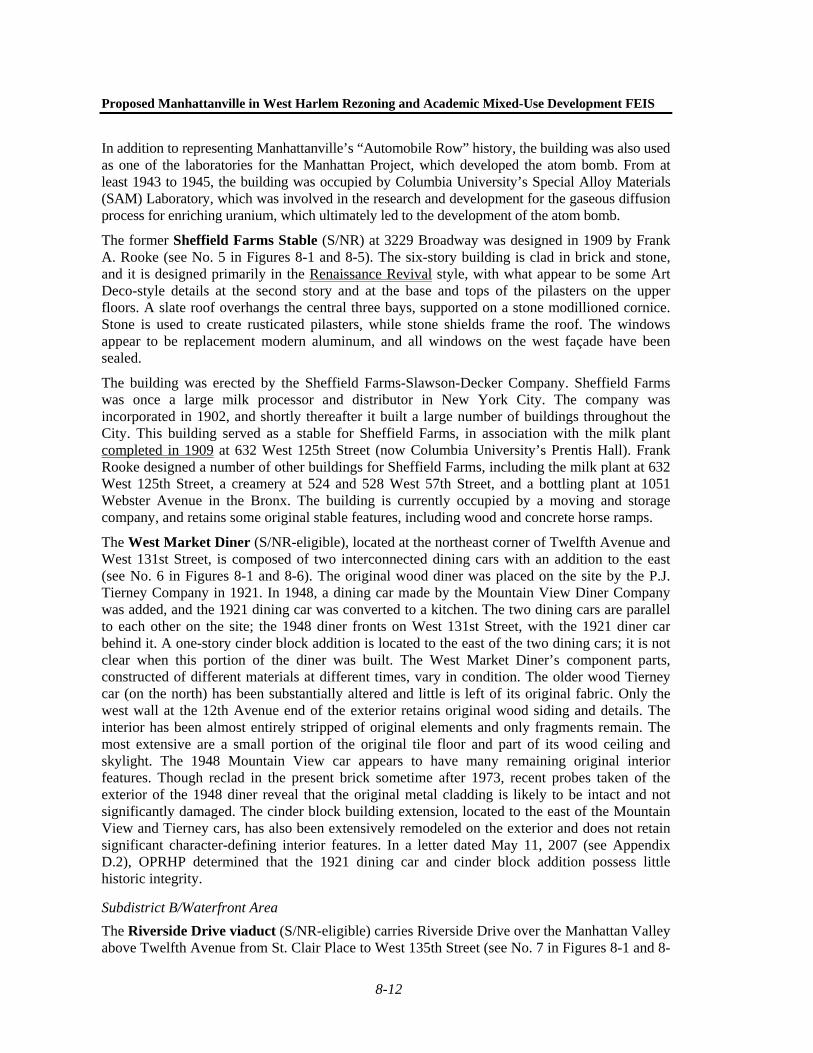
The West Market Diner (S/NR-eligible), located at the northeast corner of Twelfth Avenue and West 131st Street, is composed of two interconnected dining cars with an addition to the east (see No. 6 in Figures 8-1 and 8-6). The original wood diner was placed on the site by the P.J. Tierney Company in 1921. In 1948, a dining car made by the Mountain View Diner Company was added, and the 1921 dining car was converted to a kitchen. The two dining cars are parallel to each other on the site; the 1948 diner fronts on West 131st Street, with the 1921 diner car behind it. A one-story cinder block addition is located to the east of the two dining cars; it is not clear when this portion of the diner was built. The West Market Diner’s component parts, constructed of different materials at different times, vary in condition. The older wood Tierney car (on the north) has been substantially altered and little is left of its original fabric. Only the west wall at the 12th Avenue end of the exterior retains original wood siding and details. The interior has been almost entirely stripped of original elements and only fragments remain. The most extensive are a small portion of the original tile floor and part of its wood ceiling and skylight. The 1948 Mountain View car appears to have many remaining original interior features. Though reclad in the present brick sometime after 1973, recent probes taken of the exterior of the 1948 diner reveal that the original metal cladding is likely to be intact and not significantly damaged. The cinder block building extension, located to the east of the Mountain View and Tierney cars, has also been extensively remodeled on the exterior and does not retain significant character-defining interior features. In a letter dated May 11, 2007 (see Appendix D.2), OPRHP determined that the 1921 dining car and cinder block addition possess little historic integrity.
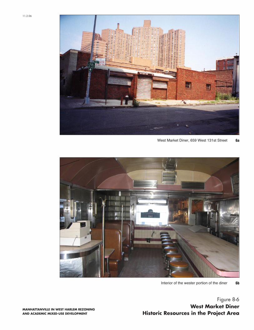
Subdistrict B/Waterfront Area The Riverside Drive viaduct (S/NR-eligible) carries Riverside Drive over the Manhattan Valley above Twelfth Avenue from St. Clair Place to West 135th Street (see No. 7 in Figures 8-1 and 8-
11.2.06
MANHATTANVILLE IN WEST HARLEM REZONING AND ACADEMIC MIXED-USE DEVELOPMENT
West Market Diner, 659 West 131st Street 6a
6bInterior of the wester portion of the diner
Figure 8-6West Market Diner
Historic Resources in the Project Area

Chapter 8: Historic Resources
8-13
7). Completed in 1901 to the designs of engineer F. Stewart Williamson, its construction was a major engineering feat. The viaduct is supported on 130-foot steel girders and arches with a larger arch spanning over West 125th Street. It stands 80 feet tall, with 26 bays of filigreed steel arches. The Riverside Drive roadway was designed with several viewing balconies that contain benches and decorative lampposts. During the 1980s, portions of the viaduct were rebuilt, including almost the full replacement of the girders supporting the roadbed.
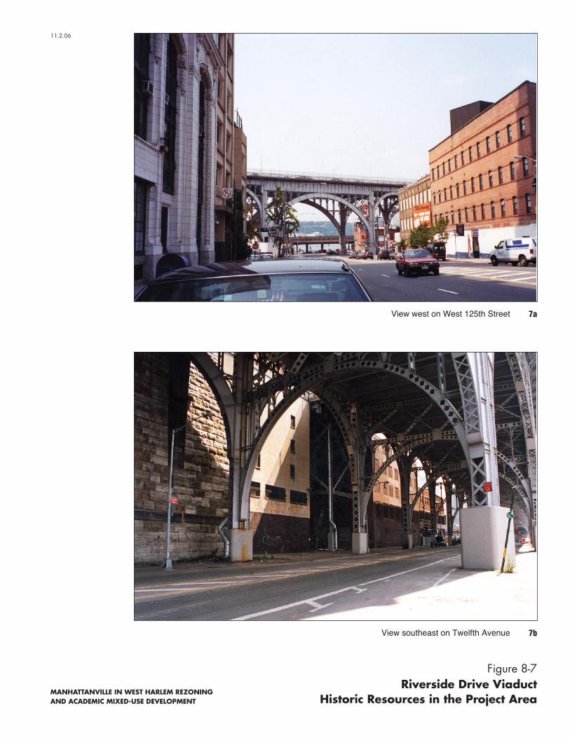
The three-story former New York Central Railroad Substation No. 11 (S/NR-eligible), located at 2350–2362 Twelfth Avenue, was built in 1931 for the New York Central Railroad as part of the electrification of the tracks along the Hudson River used by the New York Central Railroad (see No. 8 in Figures 8-1 and 8-8). This structure is one of many substations that were constructed in New York City during the early 20th century to supply power to a growing network of subways and train lines. These substations were generally constructed to receive high-voltage current from a large generating station and distribute it with a lower voltage. It is currently used as a storage facility.
Although the design and layout of substations varied, all were rectangular with open interiors that were devoted to machinery. Large window openings—as found on No. 11, though they are boarded-up—were often constructed to provide natural light for workers. Windows were usually operable, allowing ventilation for the heat that was generated by the substation’s machinery. The architectural design of most substations reflects the popular style during their period of construction. Substation No. 11 employs simple Art Deco detailing, such as the full height pilasters that flank the center bay, decorative stone coping, and tall, narrow windows on the building’s front (north) façade.
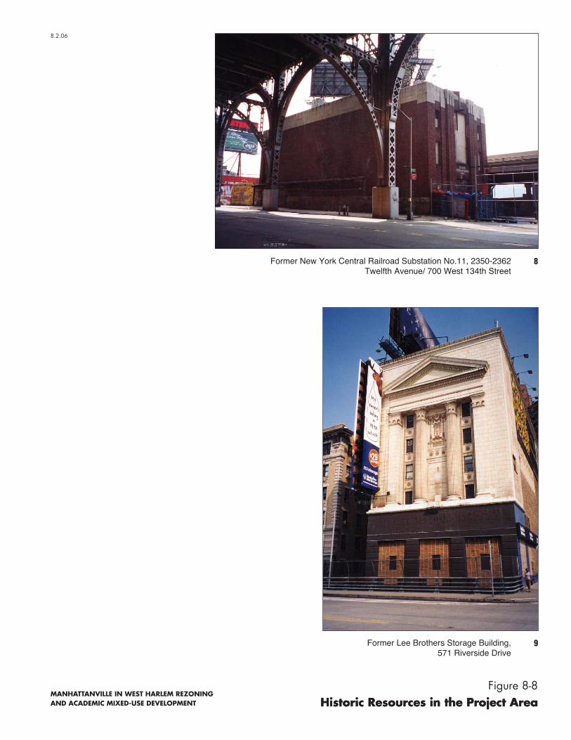
Subdistrict C/Mixed-Use Development Area The former Lee Brothers Storage Building (S/NR-eligible, NYCL-eligible) at 571 Riverside Drive was built in 1927 and designed by George Kingsley, a Chicago architect (see No. 9 in Figures 8-1 and 8-8). Designed as a storage facility, the former Lee Brothers Storage Building stands approximately 14 stories tall. About half of the building is visible above the Riverside Drive viaduct, with the remainder below. The upper portion of the building facing Riverside Drive is an ornate neoclassical composition in terra-cotta. A pedimented and columned temple front is punctuated by several small windows. Details include medallions, swags, borders, and a central composition featuring an urn. The striking façade was manufactured by Northwest Terra-Cotta, a Chicago company. A contrasting “base” of black stone (or terra-cotta) bears the inscription “LEE BROTHERS INC.”
The portion of the building below the viaduct is functional rather than ornate, built of concrete with rectangular window openings (see Figure 8-6). The building continues today to serve as a storage warehouse.
Other Areas The former Claremont Theater building (S/NR-eligible, NYCL [in part]) is a two- and three-story terra-cotta and brick-clad building designed by Gaetan Ajello in the Italian Renaissance style (see No. 10 in Figures 8-1 and 8-9). Occupying the east blockfront on Broadway between West 134th and West 135th Streets, it was erected by the Wayside Realty Co., Inc. in 1914 to house a two-story theater, a dance hall on the second floor of the building, a roof garden, and stores on Broadway. The theater was a very early example of a New York City movie theater; Thomas Edison is reputed to have screened his On the Stroke of Twelve at the theater in 1915.
11.2.06
MANHATTANVILLE IN WEST HARLEM REZONING AND ACADEMIC MIXED-USE DEVELOPMENT
7aView west on West 125th Street
7bView southeast on Twelfth Avenue
Figure 8-7Riverside Drive Viaduct
Historic Resources in the Project Area
8.2.06
MANHATTANVILLE IN WEST HARLEM REZONING AND ACADEMIC MIXED-USE DEVELOPMENT Historic Resources in the Project Area
8Former New York Central Railroad Substation No.11, 2350-2362 Twelfth Avenue/ 700 West 134th Street
9Former Lee Brothers Storage Building,571 Riverside Drive
Historic Resources in the Project AreaFigure 8-8

11.2.06
MANHATTANVILLE IN WEST HARLEM REZONING AND ACADEMIC MIXED-USE DEVELOPMENT
10Claremont Theater Building, 3338 Broadway
Figure 8-9Claremont Theater Building
Historic Resources in the Project Area

Proposed Manhattanville in West Harlem Rezoning and Academic Mixed-Use Development FEIS
8-14
Only the original two-story 1914 portion of the building on the southeast corner of West 135th Street and Broadway is an NYCL.
The northwest corner of the building has a chamfered corner, resulting in three façades at the intersection of Broadway and West 135th Street. White terra-cotta detailing includes a combination of shields, swags, finials, pilasters, and moldings. A movie camera detail is depicted in a shield at the cornice. The upper-story fenestration includes palazzo-inspired groupings of arched window openings with slender columns. Little of its original interior is believed to have survived intact, largely as a result of its many subsequent uses over time, which included an auto showroom and roller rink. The three-story brick-clad portion to the south of the theater is an addition from circa 1939 and is not an NYCL; the portion of the building south of the theater was originally one and two stories. It is currently occupied by a variety of commercial uses, including a furniture store.
OPRHP has received a request from the Henry Hudson Task Force for an evaluation of the S/NR eligibility of the Henry Hudson Parkway, a portion of which is located in the Project Area. The review of eligibility is under review by OPRHP.1
STUDY AREA
There are 16 architectural resources located in the study area (see Table 8-1 and Figure 8-1). Of these resources, four—St. Mary’s Protestant Episcopal Church, Speyer School, Old Broadway Synagogue, and Riverside Park and Riverside Drive Scenic Landmark—were previously known architectural resources. Ten resources, including a historic district north of West 135th Street, were determined by OPRHP (October 7, 2004) and/or LPC (October 2, 2004) to meet eligibility criteria for listing on the S/NR and/or designation as NYCLs, respectively, as part of their review of the Proposed Project. OPRHP determined that the Tiemann Estate Historic District is eligible for listing on the S/NR on June 20, 2006, based on information submitted by the West Harlem Community Preservation Organization. In addition, OPRHP determined that the Upper Broadway Historic District, a linear corridor following both sides of Broadway beginning on the north side of West 135th Street extending to West 165th Street, is eligible for listing on the S/NR.
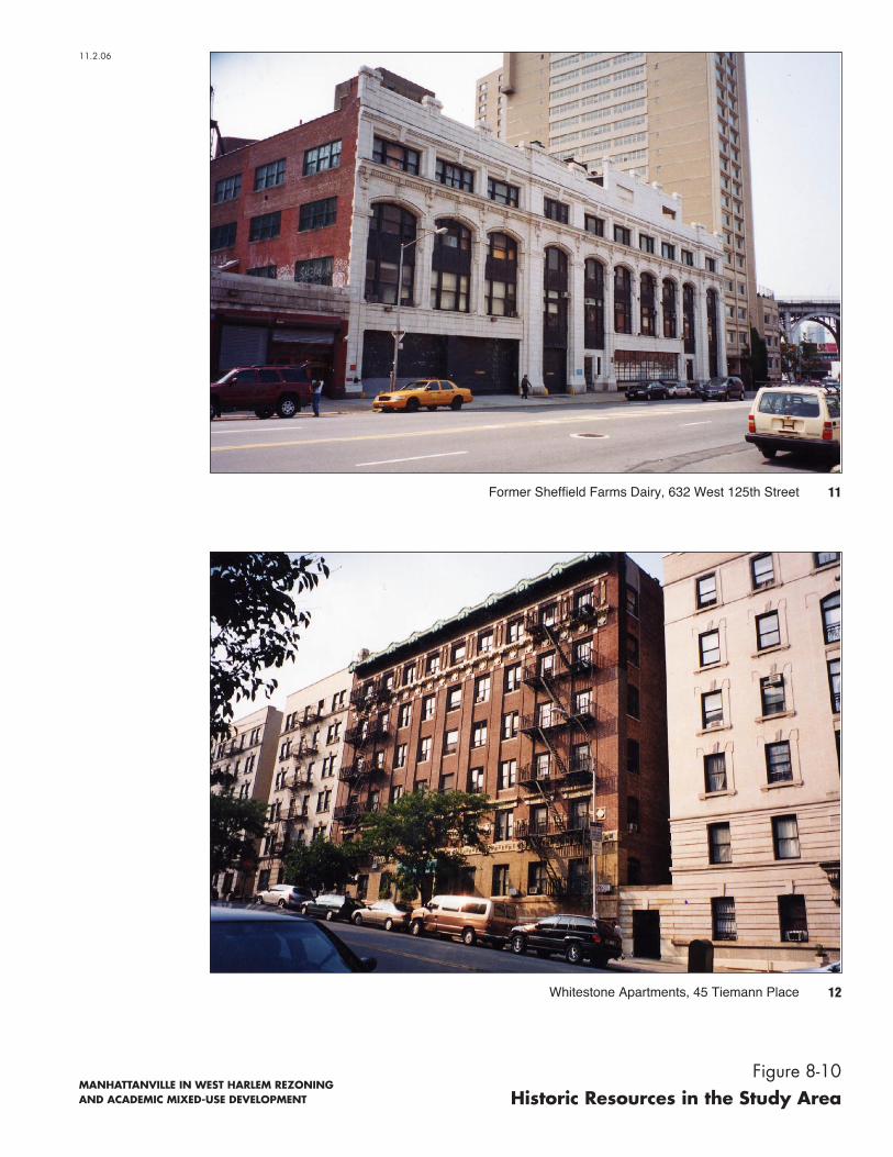
Prentis Hall (S/NR-eligible, NYCL-eligible), formerly the Sheffield Farms Dairy, is a five-story building at 632 West 125th Street (see No. 11 in Figures 8-1 and 8-10). In 1907, the Sheffield Farms-Slawson-Decker Company commissioned Frank A. Rooke to design a facility to house sanitary pasteurization and bottling facilities for the production of milk that was delivered throughout the Upper West Side and Harlem. Built in 1909, the Sheffield Farms Dairy was about 135 feet wide; a three-bay addition to the west was built in 1934. The building is clad in glazed white terra-cotta; the color may have been chosen to symbolize the dairy’s sanitary and hygienic conditions. The façade has classical ornament, including a dentillated string course above the third story, an egg-and-dart string course above the fourth story, and fasces framing the two triple-story openings (the central and westernmost openings) and the arches of the flanking windows. A showroom with a Guastavino tile vaulted ceiling, still extant, allowed the public to see the milk being processed.
Sheffield Farms was a large milk manufacturer in New York City in the early 20th century. Shortly after it was incorporated in 1902, it built a large number of plants throughout the City.
1 Personal correspondence with Kathleen Howe, OPRHP, October 16, 2007.
11.2.06
MANHATTANVILLE IN WEST HARLEM REZONING AND ACADEMIC MIXED-USE DEVELOPMENT
11Former Sheffield Farms Dairy, 632 West 125th Street
12Whitestone Apartments, 45 Tiemann Place
Figure 8-10Historic Resources in the Study Area

Chapter 8: Historic Resources
8-15
Frank Rooke designed a number of these buildings, including a stable at 3229 Broadway in the Academic Mixed-Use Area (now occupied by a storage company), a creamery at 532 and 528 West 57th Street (which the new building on West 125th Street was designed to augment), and a bottling plant at 1051 Webster Avenue in the Bronx. The building, now Prentis Hall, is owned by Columbia University. Acquired by Columbia in 1949, the building housed the University’s Heat Transfer Facility, an electrical laboratory that tested the safety of nuclear fuel assemblies. The laboratory was closed in 2003, and Prentis Hall is presently used for various School of the Arts programs, including visual arts studios, film/video production spaces, electronic music department, Columbia Arts Initiative, and the Center for Jazz studios. The ground floor is used as a workshop studio for the proposed Manhattanville in West Harlem Rezoning and Academic Mixed-Use Development project.
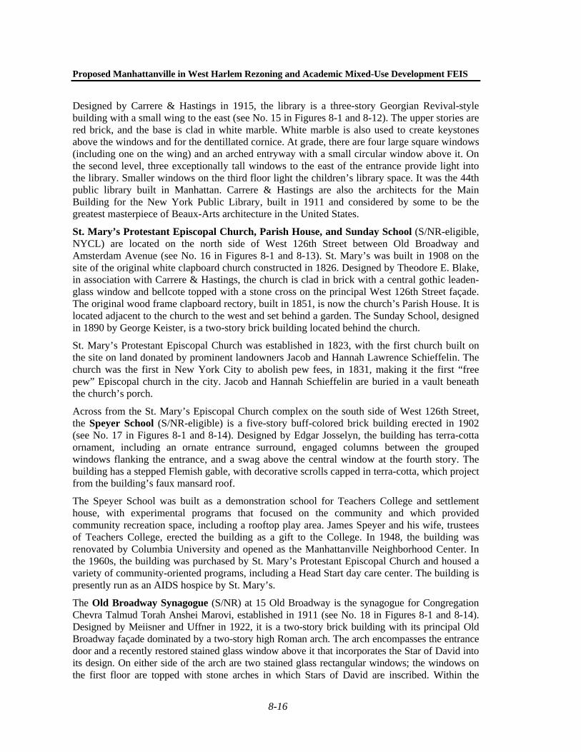
On the north side of Tiemann Place between Broadway and Riverside Drive, the Whitestone Apartments (S/NR-eligible) is a six-story brick building built in 1909 (see No. 12 in Figures 8-1 and 8-10). It was designed by Emery Roth in a stylized Classical Revival style. Corbelling is used to create piers between the window bays, with belt courses of multi-hued terra-cotta in diamond and Greek key patterns extending across the façade above the first, fifth, and sixth stories. The building is capped by an ornate copper cornice. Roth was a prolific apartment house architect who designed a large number of buildings throughout New York City, including Bancroft Hall at Teachers College, the San Remo Apartments at 145 Central Park West, and the Eldorado Apartments at 300 Central Park West. His successor firm, Emery Roth & Sons, continues to this day.
The two six-story apartment buildings (S/NR-eligible) at 189 and 191 Claremont Avenue south of Tiemann Place were designed by Denby & Nute in 1906 (see No. 13 in Figures 8-1 and 8-11). The buildings were likely erected as speculative apartment houses following completion of the IRT subway, completed in 1904. The buildings present a façade that is undistinguishable as two separate buildings with the exception of two arched entrances. The buildings are clad in dark red brick, with burned headers used to create patterns across the façades. The buildings are set on smooth limestone bases. The building entrances, which are arched and capped by shields, provide recessed entryways. These are enclosed with ornate wrought iron doors. The building at 189 Claremont Avenue has rectangular windows flanking the central entry at the ground floor, while at 191 Claremont Avenue the corresponding windows are arched. The buildings’ sixth (attic) stories are clad in brick and limestone, which form a geometric pattern of diamonds and squares between the windows. The buildings are capped by pressed-metal dentillated and bracketed cornices.
Between Broadway and Amsterdam Avenue at 527–535 West 125th Street, the former McDermott-Bunger Dairy (S/NR-eligible) is a three-story stone and brick-clad building designed by Joseph H. McGuire/Sass & Smallheiser in 1904 (see No. 14 in Figures 8-1 and 8-11). The main block of the building is flanked by one-story walls with large doorways that provided passageways for horses and carriages. The building is designed in a restrained Classical style, with simple ornament including stone rustication and keystones above the windows at the ground floor, and corbelling at the parapet. The building reflects the industrial development of Manhattanville, which included the establishment of dairies, such as McDermott-Bunger and Sheffield Farms, attracted by the easy access to rail and river transportation that Manhattanville provided for their perishable products. By 1929, the McDermott-Bunger Dairy was operated by Sheffield Farms. The building is currently occupied by a charitable institution and other commercial uses.
On the south side of West 125th Street between Broadway and Amsterdam Avenue is the George Bruce Branch of the New York Public Library (S/NR-eligible, NYCL-eligible).

11.2.06
MANHATTANVILLE IN WEST HARLEM REZONING AND ACADEMIC MIXED-USE DEVELOPMENT
13Apartment Buildings at 189 and 191 Claremont Avenue
14Former McDermott - Bunger Dairy, 527-535 West 125th Street
Figure 8-11Historic Resources in the Study Area
Proposed Manhattanville in West Harlem Rezoning and Academic Mixed-Use Development FEIS
8-16
Designed by Carrere & Hastings in 1915, the library is a three-story Georgian Revival-style building with a small wing to the east (see No. 15 in Figures 8-1 and 8-12). The upper stories are red brick, and the base is clad in white marble. White marble is also used to create keystones above the windows and for the dentillated cornice. At grade, there are four large square windows (including one on the wing) and an arched entryway with a small circular window above it. On the second level, three exceptionally tall windows to the east of the entrance provide light into the library. Smaller windows on the third floor light the children’s library space. It was the 44th public library built in Manhattan. Carrere & Hastings are also the architects for the Main Building for the New York Public Library, built in 1911 and considered by some to be the greatest masterpiece of Beaux-Arts architecture in the United States.
St. Mary’s Protestant Episcopal Church, Parish House, and Sunday School (S/NR-eligible, NYCL) are located on the north side of West 126th Street between Old Broadway and Amsterdam Avenue (see No. 16 in Figures 8-1 and 8-13). St. Mary’s was built in 1908 on the site of the original white clapboard church constructed in 1826. Designed by Theodore E. Blake, in association with Carrere & Hastings, the church is clad in brick with a central gothic leaden-glass window and bellcote topped with a stone cross on the principal West 126th Street façade. The original wood frame clapboard rectory, built in 1851, is now the church’s Parish House. It is located adjacent to the church to the west and set behind a garden. The Sunday School, designed in 1890 by George Keister, is a two-story brick building located behind the church.
St. Mary’s Protestant Episcopal Church was established in 1823, with the first church built on the site on land donated by prominent landowners Jacob and Hannah Lawrence Schieffelin. The church was the first in New York City to abolish pew fees, in 1831, making it the first “free pew” Episcopal church in the city. Jacob and Hannah Schieffelin are buried in a vault beneath the church’s porch.
Across from the St. Mary’s Episcopal Church complex on the south side of West 126th Street, the Speyer School (S/NR-eligible) is a five-story buff-colored brick building erected in 1902 (see No. 17 in Figures 8-1 and 8-14). Designed by Edgar Josselyn, the building has terra-cotta ornament, including an ornate entrance surround, engaged columns between the grouped windows flanking the entrance, and a swag above the central window at the fourth story. The building has a stepped Flemish gable, with decorative scrolls capped in terra-cotta, which project from the building’s faux mansard roof.
The Speyer School was built as a demonstration school for Teachers College and settlement house, with experimental programs that focused on the community and which provided community recreation space, including a rooftop play area. James Speyer and his wife, trustees of Teachers College, erected the building as a gift to the College. In 1948, the building was renovated by Columbia University and opened as the Manhattanville Neighborhood Center. In the 1960s, the building was purchased by St. Mary’s Protestant Episcopal Church and housed a variety of community-oriented programs, including a Head Start day care center. The building is presently run as an AIDS hospice by St. Mary’s.
The Old Broadway Synagogue (S/NR) at 15 Old Broadway is the synagogue for Congregation Chevra Talmud Torah Anshei Marovi, established in 1911 (see No. 18 in Figures 8-1 and 8-14). Designed by Meiisner and Uffner in 1922, it is a two-story brick building with its principal Old Broadway façade dominated by a two-story high Roman arch. The arch encompasses the entrance door and a recently restored stained glass window above it that incorporates the Star of David into its design. On either side of the arch are two stained glass rectangular windows; the windows on the first floor are topped with stone arches in which Stars of David are inscribed. Within the

15New York Public Library, George Bruce Branch, 518 West 125th Street
11.2.04
New York Public Library, George Bruce Branch Historic Resources in the Study Area
Figure 8-12
MANHATTANVILLE REZONING IN WEST HARLEMAND ACADEMIC MIXED-USE DEVELOPMENT

8.2.06
MANHATTANVILLE IN WEST HARLEM REZONING AND ACADEMIC MIXED-USE DEVELOPMENT
16aSt. Mary’s Protestant Episcopal Church, 517 West 126th Street
16bSt. Mary’s Protestant Episcopal Church Rectory, 523 West 126th Street
Figure 8-13St. Mary’s Protestant Episcopal Church Complex
Historic Resources in the Study Area

8.2.06
MANHATTANVILLE IN WEST HARLEM REZONING AND ACADEMIC MIXED-USE DEVELOPMENT
18Old Broadway Synagogue, 15 Old Broadway17Speyer School, 514 West 126th Street
Figure 8-14Historic Resources in the Study Area

Chapter 8: Historic Resources
8-17
building, the main sanctuary is two stories high, with balconies located on the north, south, and west walls. The building is an excellent example of vernacular synagogue architecture, typically found on the Lower East Side of Manhattan. It is currently still in use as a synagogue.
Former Engine Company No. 37 (S/NR-eligible, NYCL-eligible) is located near Amsterdam Avenue at 509 West 126th Street (see No. 19 in Figures 8-1 and 8-15). The former firehouse was designed in 1881 by Napoleon LeBrun, who served as the New York City Fire Department (FDNY)’s chief architect from 1880 to 1895. The three-story building is designed in the Romanesque Revival style with an ornamental main façade, typical of firehouses of the period. Although the tripartite ground-floor entrance has been enclosed with concrete block, fluted pilasters and decorative shields frame the openings at the base. The red brick walls of the firehouse are embellished with bands of brownstone, and a decorative basket-weave pattern of stonework is located just below the modillioned cornice. Window openings on the second and third floors have been partially enclosed, and new windows have been installed. In his position as chief architect for FDNY, LeBrun designed many firehouses. The firehouse is a relatively intact example of a late 19th century urban firehouse built in New York City and one of the earliest designed by LeBrun.
Public School 43, the Manhattanville Junior High School (S/NR-eligible), is a four-story, L-shaped building located at the northwest corner of Amsterdam Avenue and West 129th Street (see No. 20 in Figures 8-1 and 8-15). It was designed by Walter C. Martin, Superintendent of School Buildings at the Board of Education, and built between 1932 and 1937. It is clad in red brick, with Gothic Revival and Medieval-style elements, including a central tower element on West 129th Street, and crenellation and limestone pinnacles at the parapets. The main entrance, set within a pointed arch, is located within the tower in a limestone enframement. The school replaced an earlier four-story brick building that was built in installments between 1854 and 1905.
The seven five-story residential buildings (S/NR-eligible) at 505–517 West 135th Street, between Broadway and Amsterdam Avenue, were designed by George Frederick Pelham and built in 1906 (see No. 21 in Figures 8-1 and 8-16). They are clad in buff brick with classical stone and terra-cotta ornament, including banding at the ground floor to echo rustication, string courses, and curved and flat pediments above the windows. The buildings’ entrances are porticos supported by paired ionic columns and capped by stone balustrades. The buildings have modillioned sheet-metal cornices. The buildings are an intact group of “flats” that reflect the housing boom generated by construction of the IRT subway in 1904. Pelham, who designed numerous residential buildings, is considered one of the most prolific apartment house architects in New York City.
The Riverside Park and Riverside Drive Scenic Landmark (S/NR, NYCL) takes in the areas of Riverside Park and Riverside Drive between West 72nd Street and St. Clair Place (see No. 22 in Figures 8-1 and 8-17). Riverside Park was originally laid out in 1870. Frederick Law Olmsted, who designed Central Park and Prospect Park, was asked by the New York City Parks Department in 1873 to formally draw up plans for the park and drive. Olmsted’s design made use of the natural topography of the site, including the design of Riverside Drive as a curving road lined with trees, and the hillside on which the park was built was landscaped with winding paths and mature trees. The park and drive were built to the New York Central Railroad’s tracks in 1875–1880. Additions to the park during the late 1930s—including playgrounds and paths built atop the railroad parks at the time of the construction of the Henry Hudson Parkway under Parks Commissioner Robert Moses—were designed by Clifton Lloyd. Also as part of the West Side Improvement Project, the New York Central tracks were covered and over 32 additional acres created. The covered tracks are a contributing element to the S/NR listing, and the roofing over of the railroad tracks can be viewed in terms of the natural growth and development of the park.

8.2.06
MANHATTANVILLE IN WEST HARLEM REZONING AND ACADEMIC MIXED-USE DEVELOPMENT
19Former Engine Co. No. 37, 509 West 126th Street
20Public School 43/ Manhattanville Junior High School, 509 West 129th Street
Figure 8-15Historic Resources in the Study Area

11.2.06
MANHATTANVILLE IN WEST HARLEM REZONING AND ACADEMIC MIXED-USE DEVELOPMENT
21Residential Buildings at 505-517 West 135th Street
Figure 8-16Residential Buildings at
505-517 West 135th Street Historic Resources in the Study Area
Residential Buildings at 505-517 West 135th Street

MANHATTANVILLE IN WEST HARLEM REZONING AND ACADEMIC MIXED-USE DEVELOPMENT
Figure 8-17
View east at approximately Tiemann Place 22a
View south from Tiemann Place 22b
Riverside Park and Riverside Drive Scenic Landmark
Historic Resources in the Study Area
12.9.04

Proposed Manhattanville in West Harlem Rezoning and Academic Mixed-Use Development FEIS
8-18
In 1897, plans were approved to extend Riverside Drive north to Dyckman Street. Civil engineer F. Stuart Williamson was retained to extend the drive and park north of St. Clair Place, where Riverside Drive terminated. As part of this northern extension, the Riverside Drive viaduct (S/NR-eligible, see description above in “Project Area”), also designed by Williamson, was constructed between West 129th and West 135th Streets to carry the road over the Manhattanville Valley. The viaduct was completed in 1902, and construction of the extended Riverside Drive began in 1903 under two contracts. By 1909, the Riverside Drive extension was only completed to West 151st Street, as construction was stopped in this area due to legal disputes with property owners. As a result, Riverside Drive was open to traffic from West 72nd Street to West 145th Street. Beyond the gap at West 151st Street, the roadway was completed to West 158th Street, in accordance with the original plans. By this time, plans called for building the drive through Spuyten Duyvil up to Yonkers and beyond. After years of delay, the section of Riverside Drive between West 145th and West 158th Streets opened in 1911. In conjunction with the construction of Riverside Drive, Riverside Park was extended north commencing at West 135th Street.
Within the study area, the Riverside Drive and Riverside Park Scenic Landmark North (S/NR-eligible, NYCL-eligible) consists of Riverside Drive and Riverside Park between West 135th and West 137th Streets (see No. 23 in Figures 8-1 and 8-18). A high granite retaining wall buttresses Riverside Drive at West 135th Street, where the steel Riverside Drive viaduct turns east to meet the elevated land north of West 135th Street. Within this wall, stairs provide a pedestrian connection from Twelfth Avenue to Riverside Drive. The adjoining Riverside Park is on a steep grade that slopes down to the Hudson River. It is designed with winding paths and cooling shade trees that follow the natural terrain of the area. The extension of Riverside Drive creates a scenic, winding roadway that extends along the Upper West Side of Manhattan and celebrates the natural beauty of the Hudson River bluffs.
The blocks between Riverside and Broadway and between West 134th and West 136th Streets contain a homogeneous group of buildings in terms of their height, style, and materials. With the exception of the removal of some cornices and window replacement, the buildings in the Riverside Drive/West 135th–136th Streets Historic District (S/NR-eligible, NYCL-eligible) constitute an intact group of residential buildings, or “flats,” built between 1906 and 1909 that exemplify the housing boom that took place as a result of the construction of the IRT subway system (see Table 8-2, No. 24 in Figure 8-1, as well as Figures 8-19, 8-20, and 8-21). The majority of the buildings were built by real estate firms and designed by architects who were prolific designers at that time. Due to their location on the bluffs overlooking the Hudson River, many of the buildings were marketed as “high-class” dwellings, with the views advertised as one of the buildings’ main amenities. Typically adorned with elaborate stone and terra-cotta ornament, the buildings were designed to appeal to the upper middle-class rental market.
The buildings are five and six stories tall, with their upper stories clad in brick. The bases of the buildings are typically clad in stone, or stone banding is used to create rustication at the ground floor, such as at the buildings at 610–618 and 607–629 West 136th Street (see Figure 8-20). A number of the buildings, including 575 Riverside Drive and 610–618 and 607–629 West 135th Street, have exterior courts, where there are fire escapes with decorative wrought-iron balconies (see Figures 8-19 and 8-21). The buildings have classical ornament, typically of limestone and terra-cotta, that is applied to the upper stories, including garlands and swags, keystones, quoins, brackets, shields, and cartouches. The buildings, with some exceptions (634 West 135th Street and 587 Riverside Drive), are capped by modillioned and bracketed cornices.

11.2.06
MANHATTANVILLE IN WEST HARLEM REZONING AND ACADEMIC MIXED-USE DEVELOPMENT
Riverside Park, view south from West 137th Street
View south of Riverside Park stairs from Riverside Drive
Figure 8-18Riverside Drive and
Riverside Park Scenic Landmark North Historic Resources in the Study Area

MANHATTANVILLE IN WEST HARLEM REZONING AND ACADEMIC MIXED-USE DEVELOPMENT
View of the southeast corner of Riverside Drive and West 135th Street (575 Riverside Drive)
View from Riverside Drive of the south side of West 135th Street (626--630 and 634 West 135th Street). 602-622 West 135th Street are not included in the historic district boundaries
Figure 8-19Riverside Drive/135th and
136th Streets Historic DistrictHistoric Resources in the Study Area
11.12.06

11.2.06
MANHATTANVILLE IN WEST HARLEM REZONING AND ACADEMIC MIXED-USE DEVELOPMENT
View of the northeast corner of Riverside Drive and West 135th Street (583 Riverside Drive), north side of 135th Street (609-633 West 135th Street), and 587 Riverside Drive
View from Riverside Drive of the south side of west 136th street. 622, 626, and 630-636 West 136th Street are non-contributing properties
Figure 8-20Riverside Drive/135th and
136th Streets Historic DistrictHistoric Resources in the Study Area

11.2.06
MANHATTANVILLE IN WEST HARLEM REZONING AND ACADEMIC MIXED-USE DEVELOPMENT
View of 610-618 West 136th Street
View from Riverside Drive of the north side of West 136th Street (590 Riversisde Drive and 607-629 West 136th Street)
Figure 8-21Riverside Drive/135th and
136th Streets Historic DistrictHistoric Resources in the Study Area

Chapter 8: Historic Resources
8-19
Table 8-2Contributing Properties in the Riverside Drive/West 135th–136th Streets
Historic District
Description Address Block/
Lot Date Built Architect
Six-story brick flats 575 Riverside Drive and 634 West 135th Street (two buildings)
2001/6058 1908 Bernstein & Bernstein
Six-story brick flats 626–630 West 135th Street 2001/55 1906 Neville & Bagge Five- and six-story brick flats
583 Riverside Drive and 621, 625, and 629 West 135th Street (four buildings)
2002/2, 11, 14, 17
1906 Neville & Bagge
Five-story brick flats 601–619 West 135th Street (five buildings)
2002/19, 21, 22, 24, 26
1906 William C. Summerfield
Six-story brick flats 587 Riverside Drive 2002/ 101 1907 Schwartz & Gross
Six-story brick flats 590 Riverside Drive 2002/69 1909 Schwartz & Gross
Five-story New Law tenements
610–618 and 607–629 West 136th Street (nine buildings)
2002/39, 40, 41, 73, 75, 77, 79, 89, 91
1906 Emery Roth
Six-story brick flats 601 West 136th Street 2002/42 1907 Neville & Bagge Note: The historic district contains three non-contributing properties: 622, 626, and 630–636 West 136th Street
(Block 2002, Lots 93, 95, and 97).
The architects, including Neville & Bagge, Schwartz & Gross, and Emery Roth, designed numerous buildings in Harlem and throughout New York City in the first decades of the 20th century. Neville & Bagge and Schwartz & Gross were among the most prolific designers to work in New York City.
Three buildings—622, 626, and 630–636 West 136th Street—do not appear to meet criteria for listing on the National Register due to alterations (see Figure 8-20). 622 and 626 West 136th Street (Block 2002, Lots 93 and 95) have had their cornices removed and parapets substantially rebuilt. 630–636 West 136th Street (Block 2002, Lot 97) was built at a later date and has had its ground-floor façade reclad. It is also not clear if the parapets of the building are original or if they have been rebuilt following the removal of a cornice.
The Tiemann Estate Historic District (S/NR-eligible) extends south from the Project Area, encompassing the buildings on the north and south sides of Tiemann Place, as well as properties between Riverside Drive and Broadway south of Tiemann Place (see No. 25 in Figures 8-1 and 8-22). The district contains 47 residential buildings, including the Whitestone Apartments (Resource No. 12) and the two six-story apartment buildings at 189 and 191 Claremont Avenue (Resource No. 13), which were built as part of the real estate boom that followed the opening of the Broadway IRT subway in 1904. The buildings were designed by many of the city’s leading apartment building architects at the time, including Denby & Nute, Charles B. Meyer, Neville & Bagge, George Frederick Pelham, Schwartz & Gross, and Emery Roth, among others. The district is also associated with important historic figures both of local and national prominence, including tenor Eugene Clarke; novelist F. Scott Fitzgerald; John Peale Bishop, a poet and essayist of Vanity Fair; and abstract artist Ilya Bolotowsky.

8.2.06
MANHATTANVILLE IN WEST HARLEM REZONING AND ACADEMIC MIXED-USE DEVELOPMENT
View to Tiemann Place on Claremont Avenue from Lasalle Street
View of the southeast corner of Claremont Avenue and Lasalle Street
Figure 8-22Tiemann Estate Historic District
Historic Resources in the Study Area
Proposed Manhattanville in West Harlem Rezoning and Academic Mixed-Use Development FEIS
8-20
The Upper Broadway Historic District (S/NR-eligible) includes Broadway and the buildings lining it on either side from the north side of West 135th Street to the south side of West 165th Street (see No. 26 in Figures 8-1 and 8-23). The district contains approximately 135 buildings and a central mall that separates traffic on Broadway. The district was largely developed as a result of the opening of the IRT Broadway subway line in 1904, which spurred development in the area, and contains apartment buildings designed in the Italian Renaissance, French Renaissance, and Beaux-Arts styles. Many of the buildings have been altered through the removal of their cornices and alterations to the storefronts, and OPRHP has not made determinations of contributing and non-contributing buildings.
Two blocks of this historic district, from West 135th Street to 137th Street, are in the study area. Within this area are six apartment buildings fronting on Broadway (including one at 3361 Broadway, also included in the Riverside Drive/West 135th-136th Streets Historic District). These are six- and seven-story buildings and are clad in brick with stone and terra-cotta ornament; the two apartment buildings on the west side of Broadway between West 135th and West 136th Streets have had their cornices removed. Lining the east side of Hamilton Place between West 136th and West 137th Streets, also included in the S/NR-eligible boundaries, are one- and two-story commercial buildings.
As described above, OPRHP is reviewing whether the West Side Highway meets criteria for listing on the S/NR. A portion of the West Side Highway is located in the study area.
E. 2015 FUTURE WITHOUT THE PROPOSED ACTIONS
ARCHAEOLOGICAL RESOURCES
Since the Project Area has been determined to be not archaeologically sensitive, no archaeological resources will be disturbed.
ARCHITECTURAL RESOURCES
In the future, the status of historic resources could change. S/NR-eligible architectural resources could be listed on the Registers, and properties found eligible or pending designation as NYCLs could be designated. It is also possible, given the Proposed Actions’ completion years of 2015 and 2030, that additional sites could be identified as architectural resources in this time frame.
Changes to the historic resources identified above or to their settings could occur irrespective of the Proposed Actions. Future projects could also affect the settings of architectural resources. It is possible that some architectural resources in the Project Area could deteriorate, while others could be restored. In addition, future projects could accidentally damage architectural resources through adjacent construction.
Historic resources that are listed on the S/NR or that have been found eligible for listing are given a measure of protection under Section 106 of the National Historic Preservation Act from the effects of projects sponsored, assisted, or approved by federal agencies. Although preservation is not mandated, federal agencies must attempt to avoid adverse effects on such resources through a notice, review, and consultation process. Properties listed on the Registers are similarly protected against effects resulting from projects sponsored, assisted, or approved by State agencies under SHPA. However, private owners of properties eligible for, or even listed on, the Registers using private funds can alter or demolish their properties without such a review process. Privately owned properties that are NYCLs, in New York City Historic Districts, or
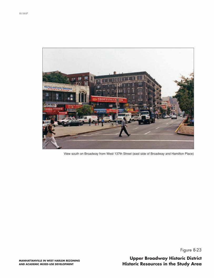
MANHATTANVILLE IN WEST HARLEM REZONING AND ACADEMIC MIXED-USE DEVELOPMENT
View south on Broadway from West 137th Street (east side of Broadway and Hamilton Place)
Figure 8-23
Upper Broadway Historic District Historic Resources in the Study Area
10.18.07
Chapter 8: Historic Resources
8-21
pending designation as NYCLs are protected under the New York City Landmarks Law, which requires LPC review and approval before any alteration or demolition permits can be issued, regardless of whether the project is publicly or privately funded. Publicly owned resources are also subject to review by LPC before the start of a project. However, LPC’s role in projects sponsored by other City or State agencies generally is advisory only.
The New York City Building Code provides some measures of protection for all properties against accidental damage from adjacent construction by requiring that all buildings, lots, and service facilities adjacent to foundation and earthwork areas be protected and supported. While these regulations serve to protect all structures adjacent to construction areas, they do not afford special consideration for historic structures.
NO BUILD PROJECTS
As described in Chapter 3, “Land Use, Zoning, and Public Policy,” there are a number of projects planned for completion by 2015 in the study area. Two of these No Build projects may affect Prentis Hall. Columbia University plans to reopen an existing 125th Street entrance at 560 Riverside Drive and renovate the existing building’s lobby. Columbia University also expects to develop a new academic building at the southwest corner of Broadway and West 125th Street. In addition to the proximity of this development to Prentis Hall, this site is located contiguous to two buildings located in the Tiemann Estate Historic District, the Whitestone Apartments at 45 Tiemann Place, and the apartment building at 39-31 Tiemann Place, located at the northwest corner of Broadway and Tiemann Place. Columbia University will take appropriate measures to protect Prentis Hall (located between the site at 560 Riverside Drive and the southwest corner of Broadway and West 125th Street) and the two buildings in the Tiemann Estate Historic district from the adjacent construction, including adhering to DOB controls governing the protection of adjacent properties from accidental construction damage. In addition, Columbia is currently converting the Studebaker Building (No. 3 in Figure 8-1) on West 131st Street to administrative uses for the University, renovation which is proceeding and will proceed irrespective of whether the Proposed Actions are approved. This involves retrofitting the interior, replacing the building’s windows (which are currently in poor condition), and creating a new street level entrance on West 131st Street. This renovation has proceeded in consultation with OPRHP. Though consultation with OPRHP was initially informal, since the renovation of the Studebaker Building was proceeding as-of-right, Columbia subsequently applied for financing from DASNY. In connection with that financing, OPRHP has reviewed the proposed modifications to the building and has determined that the Proposed Project would have no adverse impacts on the Studebaker Building. Columbia has also discussed the proposed modifications with LPC.
Without the Proposed Actions, it is anticipated that Columbia will create new office space in two locations in the Project Area. The former Warren Nash Service Station building at 3280 Broadway (No. 4 in Figure 8-1) will be retrofitted for office space (as compared with academic space, as proposed in the Proposed Actions), and a new building to include a secondary school and office space will be built on Broadway directly south of the former Warren Nash Service Station building. Columbia will consult with a preservation consultant regarding the renovations to the former Warren Nash Service Station building and will take all appropriate measures to protect the building during construction of the adjacent office building to the south. Since much of the former Warren Nash Service Station building’s south façade is blank and windowless, construction of a new building adjoining the former Warren Nash Service Station building to the south is not expected to significantly alter views to the building’s significant features.

Proposed Manhattanville in West Harlem Rezoning and Academic Mixed-Use Development FEIS
8-22
In addition, without the Proposed Actions, it is conservatively assumed that two rezonings proposed by separate applicants for several parcels in the Project Area will be approved and implemented. A rezoning from M1-2 to C6-2, proposed by Tuck-it-Away Associates, L.P., includes the site of the Claremont Theater building at 3320 Broadway (No. 10 in Figure 8-1). The original 1914 portion of the Claremont Theater site was designated as an NYCL by LPC on June 6, 2006. The residential reasonable worst-case development scenario identified by the applicant proposes to rehabilitate this portion of the building, and any alterations to that site would require a Certificate of Appropriateness from LPC. A transfer of development rights from that site to two other sites (the non-landmarked portion of 3320 Broadway and 3300 Broadway) to create 12- and 20-story buildings, respectively, would also require a Special Permit from the City Planning Commission (CPC).
A rezoning application and EAS have also been submitted for one other site in the Project Area—3229 Broadway, between West 129th and West 130th Streets—by Hudson North American. This site is also proposed to be rezoned from the existing M1-2 to C6-2. The EAS for this application was submitted in July 2007. A Positive Declaration was issued by CPC, determining that an environmental impact statement will be required. A reasonable worst-case development scenario is identified by the applicant in the EAS in which the existing building would be converted to residential and retail uses and new residential development would be constructed above. In comments dated June 22, 2007, LPC found that the construction of four additional stories on the building would constitute a significant adverse impact.
There are no other projects under construction or planned for completion by 2015 that will directly affect any other architectural resources in the APE.
F. 2015 FUTURE WITH THE PROPOSED ACTIONS
ARCHAEOLOGICAL RESOURCES
As described above in “Existing Conditions,” the Project Area has been determined to be not sensitive for archaeological resources. Therefore, the Proposed Actions would have no impact on archaeological resources.
ARCHITECTURAL RESOURCES
DIRECT (PHYSICAL) IMPACTS
Potential Impacts of the Academic Mixed-Use Development Potential Impacts on Architectural Resources in the Project Area
The portion of the Academic Mixed-Use Development assumed to occur by 2015 (the “2015 development area”) would directly affect one architectural resource, the former Sheffield Farms Stable at 3229 Broadway (No. 5 in Figure 8-1). The Proposed Actions would develop academic research buildings along the west side of Broadway. The proposed academic research building—the Jerome L. Greene Science Center—on Site 2 (on the west side of Broadway between West 129th and West 130th Streets)1 would be located on the site of the former Sheffield Farms Stable at 3229 Broadway. A feasibility study was undertaken to determine: (1) if the physical
1 See Figure 2-1 in Chapter 2 for location and numbering of the development sites.

Chapter 8: Historic Resources
8-23
characteristics of the building, presently at 3229 Broadway, allow for conversion to academic research use; (2) if alterations to convert the building would impact its historic character; and (3) whether retaining the building would allow Columbia University to meet its academic research space needs. The study and further analysis responding to a comment from OPRHP conclude that it is not feasible to retain and reuse the former Sheffield Farms Stable (see Chapter 24).
Demolition of this historic resource would constitute a significant adverse impact on architectural resources. Measures that would partially mitigate this adverse impact are described in Chapter 23.
Construction of the Academic Mixed-Use Development has the potential to result in inadvertent physical impacts on nearby architectural resources. The West Market Diner (see Figure No. 6 in Figure 8-1) is located across West 131st Street, a 60-foot-wide street, from the proposed site of the building containing the School of International and Public Affairs and housing for graduate students, faculty, and other Columbia employees on Site 7. The Manhattan Valley IRT viaduct, the 125th Street IRT Subway Station, and the Riverside Drive viaduct are within 90 feet of the 2015 development area (see Nos. 1, 2, and 7, respectively, in Figure 8-1). To avoid any construction-related impacts on these four resources, including ground-borne vibration, falling debris, and accidental damage from heavy machinery, a CPP has been developed. The protection measures contained in the CPP were approved by LPC on November 8, 2007 and by OPRHP on November 14, 2007 (see Appendix D.2) The approved CPP would be implemented by a professional engineer before any demolition, excavation, and construction (see Appendix D.3). The CPP follows the guidelines set forth in section 523 of the CEQR Technical Manual, including conforming with LPC’s New York City Landmarks Preservation Commission Guidelines for Construction Adjacent to a Historic Landmark and Protection Programs for Landmark Buildings. The CPP also complies with the procedures set forth in DOB’s Technical Policy and Procedure Notice (TPPN) #10/88.
Other historic resources in the Project Area are more than 90 feet from the 2015 Development Area. Therefore, they are outside the area of potential project-related physical impacts.
Chapter 18, “Transit and Pedestrians,” has identified potential adverse transit impacts on the 125th Street IRT Subway Station due to a lack of capacity at the station to accommodate the projected numbers of users. Mitigation would involve replacing the existing escalators with larger capacity escalators. Since the existing escalators are not contributing historic features, having replaced original circulation elements, their removal and replacement with new escalators would not adversely impact the historic character or integrity of the station or the Manhattan Valley IRT viaduct. As described in Chapter 23, OPRHP would be consulted with respect to how the new escalators connect to the historic material of the station and the viaduct, if applicable, to avoid any adverse impacts on the 125th Street IRT Subway Station and the Manhattan Valley IRT viaduct. A CPP would also be prepared to avoid any inadvertent construction-related impacts on these historic structures.
Potential Impacts on Architectural Resources in the Study Area
The initial phase of development is not expected to have adverse physical impacts on any of the architectural resources in the portions of the study area outside the Project Area, as they are all located more than 90 feet from the 2015 development area. The closest resource to the 2015 development area is Prentis Hall (see No. 11 in Figure 8-1), which is located across West 125th Street, an approximately 100-foot-wide street. As such, it is outside the area of potential physical impacts.

Proposed Manhattanville in West Harlem Rezoning and Academic Mixed-Use Development FEIS
8-24
Potential Impacts of Development in Subdistrict B1 and the Other Area East of Broadway Potential Impacts on Architectural Resources in the Project Area
As described in Chapter 2, “Procedural and Analytical Framework,” six sites are conservatively projected for development in Subdistrict B, and two sites are projected for development in the Other Area east of Broadway.2 None of these sites are controlled by Columbia University. The sites in Subdistrict B are within 90 feet of the Riverside Drive viaduct. Two of these projected development sites—Sites 21 and 22 (see Figure 2-2 of Chapter 2)—are also adjacent (to the south and east, respectively) to former New York Central Railroad Substation No. 11 (see No. 8 in Figure 8-1 and Figure 8-7). Sites 24 and 25 in the other Area east of Broadway are within 90 feet of the Claremont Theater building (see No. 10 in Figure 8-1), with Site 24 adjacent to this historic resource. As such, it is possible that the Riverside Drive viaduct, former New York Central Railroad Substation No. 11, and the Claremont Theater building could be adversely affected through construction-related activities. DOB’s TPPN #10/88 would provide protection measures for these structures should construction occur on the adjacent potential development sites. Therefore, the potential for construction period damage to these resources would be eliminated, and no adverse impacts are anticipated.
Potential Impacts on Architectural Resources in the Study Area
Architectural resources in the study area are not expected to be directly affected by the redevelopment of sites in Subdistrict B and the Other Area east of Broadway. The closest architectural resource to these projected development sites is a six-story residential building at 575 Riverside Drive, located within the Riverside Drive/West 135th–136th Streets Historic District (see No. 23 in Figure 8-1 and Figure 8-18). This resource is located across Twelfth Avenue/Riverside Drive from projected development Site 25 in Subdistrict B. Twelfth Avenue is approximately 100 feet wide. In addition, this resource is located on a bluff above Twelfth Avenue, increasing the distance to the projected development site. Therefore, 575 Riverside Drive is outside the area of potential adverse physical impacts, and no such impacts are anticipated to occur on this architectural resource as a result of the Proposed Actions.
INDIRECT (CONTEXTUAL) IMPACTS
Academic Mixed-Use Development Potential Impacts on Architectural Resources in the Project Area
As described above in “Methodology,” contextual impacts may occur to architectural resources under certain conditions. Impacts may be considered significantly adverse if they would cause a 1 CPC is contemplating certain modifications to Subdistrict B. The proposed modifications would rezone
Subdistrict B to a modified M1-2 light manufacturing district to support light manufacturing and retail uses. It is anticipated that this modification would not result in any projected development sites in Subdistrict B. The proposed modifications are more fully described in Chapter 29, “Modifications to the Proposed Actions.” Chapter 29 also analyzes the potential environmental impacts that could result from the proposed modifications.
2 No projected development sites have been identified in Subdistrict C, which contains the former Lee Brothers Storage Building. As described in greater detail in Chapter 1, “Project Description,” the reasonable worst-case development scenario has identified six sites, based on size, current utilization and land use, and opportunity for assemblages, that would be most likely to be redeveloped over time assuming the proposed land use zoning controls.
Chapter 8: Historic Resources
8-25
change in the quality of an architectural resource that qualifies it for listing on the S/NR or for designation as an NYCL. As described above, the demolition of the former Sheffield Farms Stable at 3229 Broadway would constitute such a change.
The 2015 development would not result in any additional significant adverse contextual impacts on architectural resources in the Project Area. First, the Proposed Actions would not eliminate or substantially obstruct publicly accessible views of architectural resources. All resources would remain visible in view corridors on public streets.
Second, the Proposed Actions would not alter the relationship of the resources to the streetscape, since all streets would remain open and each resource’s relationship with the street would remain unchanged.
Finally, the Proposed Actions would not introduce incompatible visual, audible, or atmospheric elements to any resource’s setting. As described more fully in Chapter 1 and Chapter 9, “Urban Design and Visual Resources,” by 2015 the Proposed Actions would replace the parking lots and one- to four-story undistinguished industrial buildings in the Academic Mixed-Use Area with an open space (the Small Square) on the north side of West 129th Street, three academic buildings, one academic research building, and a new mixed-use building containing academic space and housing for graduate students, faculty, and other Columbia employees. For the most part, the new buildings would have large floor plates comparable to two Project Area resources: the Studebaker Building, which fills a 175-foot-wide lot, and the former Warren Nash Service Station building, which occupies a large, irregularly shaped lot that was once its own city block (see Nos. 3 and 4, respectively, in Figure 8-1). However, the academic building on Site 3 would have a smaller footprint comparable to that of many apartment buildings in the study area. All the architectural resources already exist in a built context that includes both small and short industrial buildings and tall residential buildings, such as the 20-story, approximately 170-foot-tall Manhattanville Houses east of Broadway, the 11- to 35-story Riverside Park Community apartment buildings with towers that range in height from 200 to 350 feet north of West 133rd Street, and the two 26-story, approximately 190-foot-tall towers at 560 Riverside Drive. Therefore, while the heights of the proposed buildings—ranging from seven to 20 stories, or 80 to 320 feet including mechanical—would be taller than the existing structures in the Project Area, they would not be incompatible with buildings in the study area.
In addition, the resources (except for the West Market Diner, which was unsympathetically reclad in brick in the 1970s, as shown in Figure 8-5) have distinct architectural designs that do not relate architecturally to the buildings that would be demolished in the Academic Mixed-Use Area. Therefore, the removal of the existing non-historic buildings in the Project Area would not affect the historic and distinguishing characteristics of the Studebaker Building and the former Warren Nash Service Station building. It is expected that these important historic buildings would remain prominently visible on the urban landscape due their distinguished early 20th-century façades and massings. The proposed Academic-Mixed-Use Development would not detract from their historical significance as contributing to the history of industrial development in Manhattanville and New York City. Therefore, the Academic Mixed-Use Development would not adversely affect these resources.
Potential Impacts on Architectural Resources in the Study Area
The projected 2015 development would not result in significant adverse contextual impacts on architectural resources in portions of the study area outside the Project Area. The architectural resources, except Prentis Hall and the Tiemann Estate Historic District, are separated from the 2015 development area by physical and visual barriers (such as the Manhattan Valley IRT viaduct and fully developed blocks) or are too far away to be adversely affected by the new

Proposed Manhattanville in West Harlem Rezoning and Academic Mixed-Use Development FEIS
8-26
development. Therefore, the proposed 2015 development would not block significant publicly accessible views to architectural resources or alter any resource’s relationship to the streetscape. Though it is anticipated that the tops of the taller buildings in the Academic Mixed-Use Area would be visible from some of the resources east of Broadway and from the northern end of Riverside Park at St. Clair Place, these architectural resources currently exist in a built context of short and tall buildings. Therefore, while development by 2015 would result in new buildings that would have large footprints and range in height from seven to 20 stories, or 80 to 320 feet including mechanical, the Academic Mixed-Use Development would not introduce incompatible visual elements or otherwise adversely affect an architectural resource’s setting.
Prentis Hall and the northern portion of the Tiemann Estate Historic District, including the Whitestone Apartments, are located on the block south of West 125th Street and, therefore, are closer to the 2015 development area (see Nos. 11, 12, and 25, respectively, in Figure 8-1). Redevelopment of the 2015 development area would change the setting of Prentis Hall, located directly across West 125th Street (see Figure 8-10). However, there is no meaningful architectural relationship between Prentis Hall, a classically detailed terra-cotta building, and the gas stations, parking lots, and auto-related and storage buildings in the 2015 development area. Furthermore, the principal public views of Prentis Hall on West 125th Street and from the elevated 125th Street IRT Subway Station platforms would remain unobstructed. In addition, the paved Small Square proposed in front of the academic building on Site 3 would provide new and expansive views south to Prentis Hall. Therefore, the demolition of the buildings in the 2015 development area and replacement with a group of community facilities buildings that are designed in a cohesive architectural vocabulary and open space would not result in significant adverse contextual impacts on this architectural resource.
The principal façades of the Whitestone Apartments and other buildings in the Tiemann Estate Historic District fronting on the north side of Tiemann Place face south (see Figure 8-9). The rear of the Whitestone Apartments and adjoining building at the northwest corner of Broadway and Tiemann Place (39-31 Tiemann Place) abut a McDonald’s restaurant and its parking lot at the southwest corner of Broadway and West 125th Street (see Nos. 12 and 25 in Figure 8-1). Since it is projected that Columbia University will complete an approximately 172,000-gross-square-foot (gsf) as-of-right development on the site of the McDonald’s restaurant by 2010, there will be no visual relationship between these historic resources and the Academic Mixed-Use Development, since this new development will intervene. In addition, intervening buildings—560 Riverside Drive and Prentis Hall on the south side of 125th Street—create both a physical and visual barrier to the other buildings on Tiemann Place and to areas to the south. Due to the lack of a visual relationship between the Project Area and the buildings in the Tiemann Estate Historic District, the Proposed Actions would have no significant adverse contextual impacts on this historic and architectural resource.
Potential Development in Subdistrict B1 and the Other Area East of Broadway Potential Impacts on Architectural Resources in the Project Area
No significant adverse contextual impacts on architectural resources are anticipated to occur as a result of the projected 2015 development.
1 As described earlier, CPC is contemplating certain modifications to Subdistrict B that would not result in
any projected development sites in Subdistrict B. The proposed modifications are more fully described in Chapter 29, “Modifications to the Proposed Actions.”

Chapter 8: Historic Resources
8-27
The six projected development sites in Subdistrict B are expected to be developed with one- and two-story commercial buildings, which would be limited by zoning to a height of either two stories or 60 feet, whichever is less, except for the southernmost block between St. Clair Place and West 125th Street, Marginal Street, and Twelfth Avenue, which would have a height limitation of 130 feet. Development, which would occur within existing blocks and at a height below that of the Riverside Drive viaduct (an 80-foot-tall structure), would retain the existing public view corridors to the Riverside Drive viaduct on Twelfth Avenue, the east–west side streets, and from the bluffs north of West 134th Street. As described in Chapter 9, the height and bulk of projected new development would not be significantly different than existing structures. Therefore, the proposed rezoning would not introduce incompatible visual elements that would adversely alter the Riverside Drive viaduct’s setting.
As described above in “Direct Impacts,” two of the projected development sites, Sites 23 and 24, are adjacent to former New York Central Railroad Substation No. 11. Site 23, to the south, contains a small one-story automotive repair business. Site 24 is vacant and located under the Henry Hudson Parkway overpass. Site 25 is located across West 134th Street from the former substation and contains a small warehouse and paved open areas. None of these sites contain structures that relate architecturally or historically to this architectural resource. In addition, the south façade of the resource is unadorned, and the west façade of the building is obstructed by the highway overpass. Therefore, development of Sites 23 and 24 with one- and two-story buildings would not block significant views to this resource or otherwise adversely affect its setting. Redevelopment of Site 25 north of the substation would also not affect views to this resource, since the former West 134th Street separates the two sites and views of the principal (north) façade of the substation would remain visible (see Figure 8-7).
Therefore, redevelopment of sites in Subdistrict B would not result in significant adverse contextual impacts on the Riverside Drive viaduct and former New York Central Railroad Substation No. 11. It would also not result in significant adverse contextual impacts on the architectural resources located east of Twelfth Avenue, since there is little visual relationship between these resources and the west side of Twelfth Avenue due to the presence of the Riverside Drive viaduct.
Potential Impacts on Architectural Resources in the Study Area
As described above, the projected 2015 development in Subdistrict B would be limited to either two stories or 60 feet, except for the southernmost block between St. Clair Place and West 125th Street, Marginal Street, and Twelfth Avenue, which would have a height limitation of 130 feet. Development of such a relatively low height would not be visible within the Riverside Drive/West 135th–136th Streets Historic District, since this historic district is located on a high bluff and separated from Subdistrict B by Riverside Drive. It would also not obstruct views west to the Hudson River from Riverside Drive. The new development would not be visible in views from the northern end of Riverside Park at St. Claire Place, since development would occur beneath the height of the Riverside Drive viaduct. The 11- to 35-story Riverside Park Community apartment complex, which occupies the majority of the superblock bounded by Broadway, Twelfth Avenue, and West 133rd and West 135th Streets, obstructs views between the Project Area south of West 133rd Street and the resources located north of West 135th Street. Therefore, proposed redevelopment of sites in Subdistrict B would not cause significant adverse contextual impacts on architectural and scenic resources in the study area due to its limited visibility.
In the Other Area east of Broadway, it is assumed that the buildings on Sites 24 and 25 could be altered to allow for redevelopment. Due to intervening buildings between these projected development sites and the seven residential buildings at 505–517 West 135th Street (see No. 21

Proposed Manhattanville in West Harlem Rezoning and Academic Mixed-Use Development FEIS
8-28
in Figure 8-1 and Figure 8-15) and the Riverside Drive/West 135th–136th Streets Historic District (see No. 24 in Figure 8-1 and Figures 8-18 through 8-20), no adverse contextual impacts are anticipated to these resources as a result of the Proposed Actions. No adverse contextual impacts are expected to occur to the Upper Broadway Historic District. The closest building in the district, the apartment building at the northeast corner of Broadway and West 135th Street, is located across West 135th Street, a 100-foot-wide street, from Sites 24 and 25. As such, any alterations to the buildings on Sites 24 and 25 would not obstruct views to this historic building or otherwise adversely affect the historic Broadway Corridor.
Overall, the proposed redevelopment of the Other Area east of Broadway would not introduce incompatible visual elements to the setting of nearby architectural resources. It would also not block public views of any architectural resources. Therefore, the projected redevelopment of the Other Area east of Broadway would not cause any significant adverse contextual impacts on architectural resources in the study area.
G. 2030 FUTURE WITHOUT THE PROPOSED ACTIONS
ARCHAEOLOGICAL RESOURCES
There are no specific projects planned for completion by 2030 in the Project Area. In any case, the Project Area has been determined to be not sensitive for archaeological resources.
ARCHITECTURAL RESOURCES
There are no projects planned for completion by 2030 in the APE for architectural resources. Therefore, no changes to architectural resources are anticipated in the future with the Proposed Actions by the 2030 analysis year.
H. 2030 FUTURE WITH THE PROPOSED ACTIONS
ARCHAEOLOGICAL RESOURCES
As described above in “Existing Conditions,” the Project Area has been determined to be not sensitive for archaeological resources. Therefore, the Proposed Actions would have no impact on archaeological resources.
ARCHITECTURAL RESOURCES
DIRECT (PHYSICAL) IMPACTS
Academic Mixed-Use Development Potential Impacts on Architectural Resources in the Project Area
In addition to the former Sheffield Farms Stable at 3229 Broadway, described above, the full build-out of the Proposed Actions would directly affect the West Market Diner (No. 6 in Figure 8-1) and the former Warren Nash Service Station building (No. 4 in Figure 8-1). The Proposed Actions would remove the West Market Diner at 659 West 131st Street on Site 10 and replace it with an academic building. Columbia would relocate the West Market Diner’s 1948 dining car to a new site in the Project Area or study area and would consult with OPRHP regarding its relocation and rehabilitation. The 1948 dining car was designed to be relocated as needed, and

Chapter 8: Historic Resources
8-29
the other portions of the diner possess little historic integrity (the 1921 dining car and the cinder block addition to the east; see “Existing Conditions”). Therefore, in consultation with OPRHP, it has been determined that relocating the 1948 dining car and rehabilitating it would not result in significant adverse impacts (see Appendix D.2).
The former Warren Nash Service Station building would be adaptively reused for academic space. The interior is expected to require retrofitting, and it is also possible that changes to the exterior, such as new street-level access, would be required. To preserve the significant elements of this architectural resource and avoid adverse impacts, Columbia University has developed a Preservation Approach which has been submitted to OPRHP for review The approved plan would be implemented prior to any alterations being made to the building as part of the Proposed Actions. In addition, the former Warren Nash Service Station building is included in the CPP developed for the Proposed Actions to avoid adverse construction-related impacts from development on the adjoining parcel to the south (Site 15) and from development of Site 17 across West 133rd Street, a 60-foot-wide street.
Full build-out of the Academic Mixed-Use Development would occur within 90 feet of the Studebaker Building, the Manhattan Valley IRT viaduct, the 125th Street IRT Subway Station, the Riverside Drive viaduct, and the Claremont Theater building. As described above, these resources are included in the CPP, and construction of the full development would follow the procedures detailed in that plan. The Academic Mixed-Use Development would not have adverse physical impacts on the other architectural resources in the Project Area—the former New York Central Railroad Substation No. 11 and the former Lee Brothers Storage Building, which are located more than 90 feet from the Academic Mixed-Use Area.
Potential Impacts on Architectural Resources in the Study Area
The architectural resources in the study area are located more than 90 feet from the Academic Mixed-Use Area. Therefore, they are outside the area of potential physical impacts, and no such impacts on these architectural resources are expected to occur as a result of the Proposed Actions.
Potential Development in Subdistrict B and the Other Area East of Broadway
The redevelopment of sites in Subdistrict B and the Other Area east of Broadway are assumed to have occurred by 2015. No additional development is projected for the 2030 analysis year. Therefore, there is no potential for any additional physical impacts than those described above for 2015.
INDIRECT (CONTEXTUAL) IMPACTS
Academic Mixed-Use Development Potential Impacts on Architectural Resources in the Project Area
Full build-out of the Academic Mixed-Use Development would result in a university area with up to 17 new buildings and two open spaces. (See Figure 1-13 for the Illustrative Site Plan, and Chapter 1 for details of proposed uses.) This section describes the potential contextual impacts on the Project Area’s architectural resources.
The Studebaker Building. The new university area would alter the setting of the Studebaker Building. The Proposed Actions would replace the mostly one- to four-story automotive repair buildings, storage facilities, and parking lots on the blocks surrounding the Studebaker Building with academic, academic research, and recreational buildings ranging in height from seven to 20 stories, or 80 to 320 feet including mechanical. Immediately to the west of the Studebaker

Proposed Manhattanville in West Harlem Rezoning and Academic Mixed-Use Development FEIS
8-30
Building would be a 50-foot-wide midblock open area (see Figure 1-11 of Chapter 1, and Figure 8-24). To the east, a new academic research building would be erected on Site 8, immediately adjacent to the Studebaker Building’s east and blank party wall. The block to the north currently occupied by the MTA Manhattanville Bus Depot (which would be rebuilt below grade on-site) would be redeveloped with a number of buildings up to a height of approximately 320 feet, including mechanical space. Since the Studebaker Building has little architectural relationship with the 1991 bus depot and mostly small undistinguished industrial buildings, their replacement with new structures of height comparable to existing tall buildings in the study area would not adversely affect the Studebaker Building’s setting. Furthermore, the proposed design seeks to maintain the Studebaker Building’s relationship with the streetscape. The proposed zoning text for the Academic Mixed-Use Area would waive the mandatory setbacks at grade for the West 131st/West 132nd Street block to preserve the streetwall established by the Studebaker Building. Therefore, the Proposed Actions would not adversely alter the setting of the Studebaker Building.
In addition, public views of the Studebaker Building on West 131st and West 132nd Streets would remain unobstructed, as these streets would remain open to traffic and pedestrians. However, views southeast from Twelfth Avenue and West 132nd Street and views northeast from Twelfth Avenue and West 131st Street would presumably be blocked by the new development, which could be built to a height of up to approximately 270 feet, including mechanical space. This is because the west façade of the Studebaker Building is currently prominently visible in views southeast due to the adjoining open yard of the Con Edison cooling station (see Figure 8-3). The lower floors of the Studebaker Building are blocked in views northeast from West 131st Street and Twelfth Avenue by an adjacent two-story parking garage, though the upper floors are visible (see No. 3b, Figure 8-4). The new development on Sites 9 and 10 west of the Studebaker Building is also expected to obstruct direct views of the resource from the Riverside Drive viaduct, though the building and its tower would still be visible at an angle from the north and south. However, the proposed new midblock open area, which would extend just west of the Studebaker Building and also traverse the block to the north, would provide new publicly accessible views of this architectural resource. The 40,000-sf open space (the Square) to be built on the block between Broadway, Twelfth Avenue, and West 130th and West 131st Streets, and the proposed Small Square, to the south between West 129th and West 130th Streets, would provide new unobstructed public views of the Studebaker Building, where currently there are no such views (see Figure 8-25). This would be a positive impact. Views west from Broadway would largely remain unaffected, since a four-story building that occupies the west Broadway frontage on the block and the sloping topography to the Hudson River currently limit most views to the Studebaker Building from Broadway. Therefore, the Proposed Actions would block some views across private property to the Studebaker Building but not otherwise eliminate significant views from public city streets. Further, the Proposed Actions would create new publicly accessible locations from which to view this resource.
The Former Warren Nash Service Station Building. The development of the new university area would alter the former Warren Nash Service Station building’s setting by replacing mostly older low-rise structures and a paved lot directly to the south with taller contemporary buildings. However, as described above, this resource already exists in a context of short and tall buildings (the Manhattanville Houses are located across Old Broadway, and the Riverside Park Community apartments are diagonally across Broadway to the northwest [see Figure 8-1]). In addition, the resource’s relationship with the streetscape—namely, its location at the north end of a block with three street façades—would remain unchanged, as would its relationship with Broadway and the Manhattan Valley IRT viaduct.
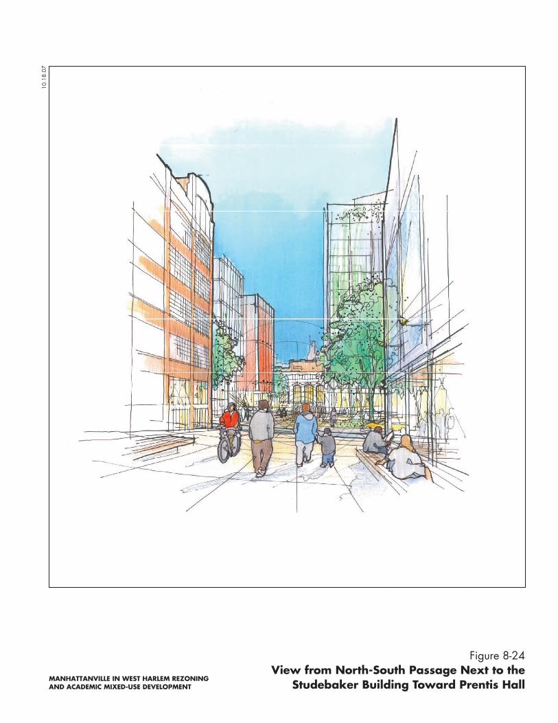
Figure 8-24View from North-South Passage Next to the
Studebaker Building Toward Prentis Hall
10.1
8.07
MANHATTANVILLE IN WEST HARLEM REZONING AND ACADEMIC MIXED-USE DEVELOPMENT

Figure 8-25View from Open Space Between
West 129th and West 130th StreetsToward Studebaker Tower
10.1
8.07
MANHATTANVILLE IN WEST HARLEM REZONING AND ACADEMIC MIXED-USE DEVELOPMENT

Chapter 8: Historic Resources
8-31
The Academic Mixed-Use Development—more specifically, the academic research buildings planned along Broadway—would result in buildings of up to 270 to 320 feet tall, including mechanical space, in the immediate vicinity of the former Warren Nash Service Station building. The academic research building immediately to the south on Site 15 would obstruct northern views of this resource’s south façade. This façade, which is prominently visible in existing views north on Broadway due to a paved lot that immediately adjoins it, is primarily a blank façade with windows that appear to have been blocked up (see Figure 8-5). Since the building’s primary western (Broadway) façade and secondary north and east façades would remain unobstructed and its south façade is unornamented and altered through window sealing, development of the Academic Mixed-Use Development south of this architectural resource would not result in any significant adverse contextual impacts. Development of the academic research buildings across Broadway (Site 11) and West 133rd Street (Site 17) from the former Warren Nash Service Station building would also not result in any significant adverse contextual impacts. These streets would continue to provide publicly accessible views of this historic resource. Views south on Broadway are in context with the fully developed blockfronts to the north, which obstruct views. Views east from the west side of Broadway are in context with the Manhattan Valley IRT viaduct. Development of the academic research buildings west and north of the former Warren Nash Service Station building would not obstruct additional views.
Other Architectural Resources. The full build-out of the Academic Mixed-Use Development would not adversely affect the context of the Riverside Drive viaduct and former New York Central Railroad Substation No. 11 in Subdistrict B. The new buildings are expected to extend above the height of the viaduct, as do other existing buildings in the Project Area, such as the former Lee Brothers Storage Building. The new development would not obstruct publicly accessible views to the viaduct that currently exist on the east–west cross streets or on Twelfth Avenue.
Development south of West 133rd Street and east of Twelfth Avenue would not affect views to the former New York Central Railroad Substation No. 11. As described above, the former New York Central Railroad Substation No. 11’s principal façade faces north. Development in the Academic Mixed-Use Area would be south of this resource and east of the Riverside Drive viaduct, which forms a physical and visual barrier between areas east and west of Twelfth Avenue. Therefore, the Proposed Actions would not result in any significant adverse contextual impacts on the architectural resources located in Subdistrict B.
The academic research building proposed on Site 17 would be located across West 134th Street from the Claremont Theater building, in the Other Area east of Broadway. Site 17 is presently occupied by a three-story building. Development on Site 17 would result in a taller building with a larger footprint. However, it would not block views of the Claremont Theater that are not already obstructed by the existing three-story building on the site. Furthermore, the primary terra-cotta façade of the Claremont Theater is located at the chamfered corner of Broadway and West 135th Street, which faces north/northwest away from Site 17 (which is located to the south). Views of this decorative portion of the façade would remain unchanged in views south on Broadway, views north on Broadway in proximity to West 135th Street, and on West 135th Street. Therefore, development of the proposed academic research building on Site 17 would not result in any significant adverse visual or contextual impacts to the Claremont Theater.
There would be little visual relationship between the former Lee Brothers Storage Building in Subdistrict C and the Academic Mixed-Use Development. The principal façade of this historic structure faces west, above the Riverside Drive viaduct (see Figure 8-8). It is also separated from the Academic Mixed-Use Development by several three- to seven-story buildings south of West 134th

Proposed Manhattanville in West Harlem Rezoning and Academic Mixed-Use Development FEIS
8-32
Street, which largely negate any visual relationship between this historic resources and the Academic Mixed-Use Area (see Figure 8-1). Therefore, the Academic Mixed-Use Development would not result in significant adverse contextual impacts on architectural resources in the Project Area.
Potential Impacts on Architectural Resources in the Study Area
The retention and adaptive reuse of the former Warren Nash Service Station building would preserve one of Manhattanville’s most significant architectural and historic resources. In addition, the full development of the Academic Mixed-Use Development buildings would result in a new collection of larger and taller buildings that would transform the built and historic context of the Project Area from one of primarily low-rise auto related and storage buildings to a coherently articulated campus of larger and taller buildings.
However, as described above, there is little visual relationship between the architectural resources in the study area and the Academic Mixed-Use Area, with the exception of Prentis Hall. In addition, the Riverside Park Community apartment complex obstructs views between the Project Area south of West 133rd Street and the resources north of West 135th Street. The full build-out would complete the Academic Mixed-Use Development north of West 130th Street and add to the number of new buildings that may be visible in the distance from historic resources in the study area.
Due to the lack of a significant architectural or visual relationship between the Project Area and the study area’s architectural resources due to physical barriers and distance, the new development would not adversely affect the setting of historic resources in the study area, either by isolating them or affecting their relationship with the streetscape. The new buildings would also not obstruct any significant publicly accessible views to architectural resources. In fact, the full build-out of the Academic Mixed-Use Development would provide a physical and visual corridor of open space between West 133rd Street and West 125th Street. In addition to providing new views through the Project Area of the Studebaker Building (discussed above), the proposed open spaces would create new locations to view another of Manhattanville’s important historic resources, Prentis Hall (see Figure 8-24). Further, the historic resources that have sun-sensitive features—the Old Broadway Synagogue (see Figure 8-14) and St. Mary’s Protestant Episcopal Church and its garden (see Figure 8-13)—are located south and east of the Project Area, and therefore, are outside the area of any potential incremental project shadows (see Figure 7-2 of Chapter 7, “Shadows”). For these reasons, the Academic Mixed-Use Development would not have any significant adverse contextual impacts on architectural resources in the study area.
Potential Development in Subdistrict B and the Other Area East of Broadway Potential Impacts on Architectural Resources in the Project Area
No additional development is projected for the 2030 analysis year, and, therefore, there is no potential for any additional contextual impacts than those described above for 2015.
Potential Impacts on Architectural Resources in the Study Area
The full build-out, consisting of the 2015 and 2030 development, would contribute to the grouping of tall buildings that could be developed as a result of the Proposed Actions by 2030. However, as discussed above, neither the Academic Mixed-Use Development nor the development that could occur in Subdistrict B and the Other Area east of Broadway would result in impacts that would change the quality of an architectural resource that qualifies it for listing on the S/NR or for designation as an NYCL. Overall, the Proposed Actions would have no significant adverse impacts on architectural resources in the study area.