chapter 6a: florida forever work plan, 2017 annual...
TRANSCRIPT
2017 South Florida Environmental Report – Volume II Chapter 6A
6A-1
Chapter 6A: Florida Forever Work Plan,
2017 Annual Update Ray Palmer
Contributors: Linda Schindeler, Maretza LeDonne, David Colangelo, and Marcy Zehnder
SECTION 6A-1: INTRODUCTION As required by Section 373.199, Florida Statutes (F.S.), this chapter has been prepared by the South
Florida Water Management District (SFWMD or District) as an annual update of the Florida Forever Work Plan. This 2017 update presents projects eligible for funding under the Florida Forever Act (Section 259.105, F.S.) as well as projects eligible for state acquisition monies from the appropriate account or trust fund under Section 373.139(3)(c), F.S., and reports associated changes since the March 1, 2016, submission of the 2016 South Florida Environmental Report – Volume II, Chapter 6.
The 2017 Florida Forever Work Plan update summarizes acquisitions that occurred in Fiscal Year 2015-2016 (October 1, 2015–September 30, 2016), along with the status of land acquisition for eligible projects, noting for each the number of acres acquired and acres still to be acquired, as of September 30, 2016. This update is intended to be used in conjunction with portions of the 2017 South Florida Environmental Report – Volume I that have additional information on systemwide and regional projects. Detailed project descriptions and supporting information are provided in the South Florida Environmental Report Consolidated Project Database, available on the District’s website at www.sfwmd.gov/sfer. The Five-Year Capital Improvements Plan, Chapter 4 of this volume, includes projected five-year capital expenditures for eligible Florida Forever Work Plan projects. The Capital Improvements Plan includes projected expenditures for (1) basic construction costs including design, engineering, permits, inspections, and site development; (2) other project costs including land acquisition and associated costs, surveys, and facility acquisition; and (3) estimated changes in operation and maintenance costs for those projects that will be owned and capitalized as fixed assets by the District.
The 2017 Florida Forever Work Plan update is organized as follows:
• Section 6A-1 provides the introduction and summary of changes to the eligible list of projects.
• Section 6A-2 highlights land acquisition activity for the reporting cycle.
• Section 6A-3 provides a brief overview of Florida Forever Work Plan regions and presents the status of land acquisitions for eligible projects within each region. Table 6A-2 applies to the Kissimmee River Restoration Project; Tables 6A-3 to 6A-10 apply to Comprehensive Everglades Restoration Plan projects, unless otherwise noted; and Table 6A-11 applies to Northern Everglades and Estuaries Protection Program projects.
2017 South Florida Environmental Report – Volume II Chapter 6A
6A-2
• Section 6A-4 provides major plan/program highlights of Comprehensive Everglades Restoration Plan, Florida Forever/Save Our Rivers, and Northern Everglades and Estuaries Protection Program, respectively.
• Section 6A-5 provides an update on surplus land activities for the reporting cycle.
• Section 6A-6 lists eligible Florida Forever Program projects.
• Section 6A-7 lists Florida Forever Program goals and performance measures.
The 2017 Florida Forever Work Plan update identifies a total of 46 eligible projects, which include Comprehensive Everglades Restoration Plan, Florida Forever/Save Our Rivers, Northern Everglades and Estuaries Protection Program, and other related projects. No projects were modified during this reporting year.
2017 South Florida Environmental Report – Volume II Chapter 6A
6A-3
SECTION 6A-2: LAND ACQUISITION HIGHLIGHTS
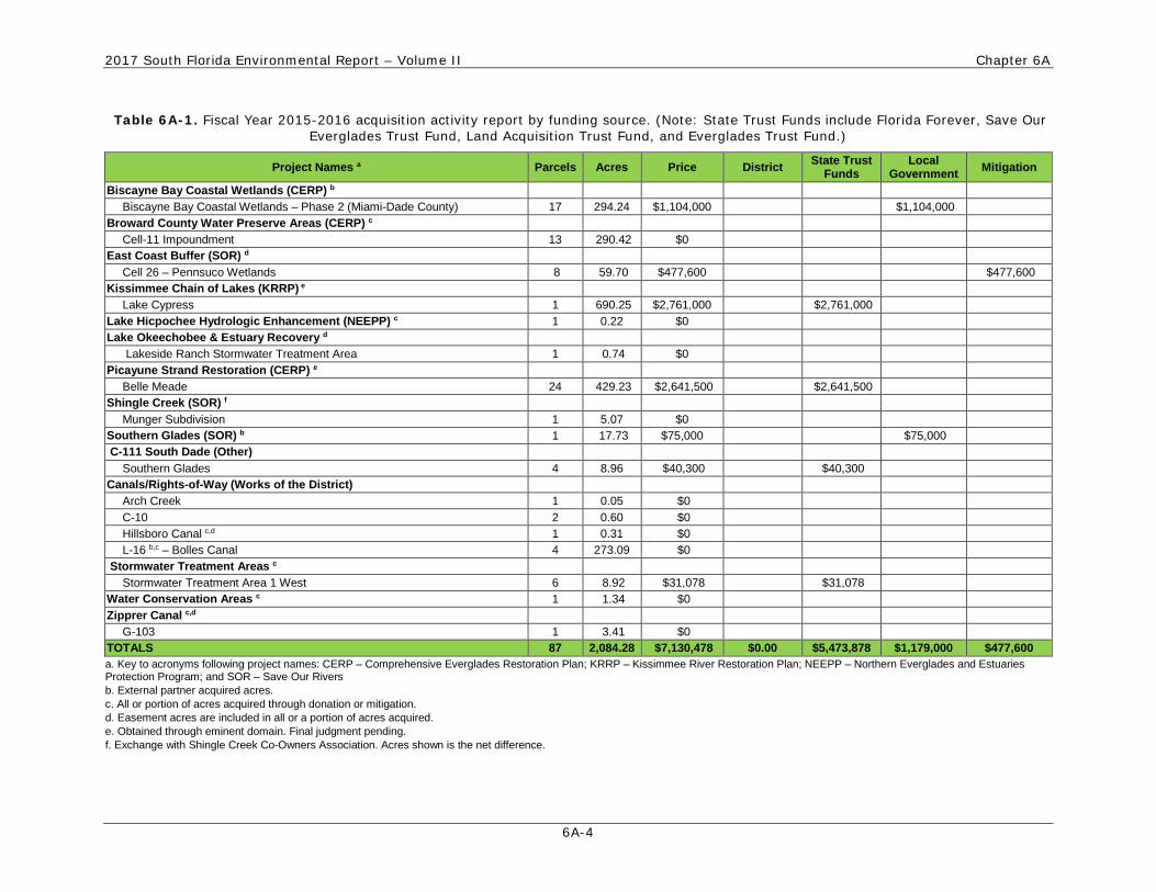
LAND ACQUISITION ACTIVITY REPORT In Fiscal Year 2015-2016, the District obtained 2,084.28 acres of land interests through donations,
mitigation, and expenditures totaling $7,130,478. Acquisitions were made using District, state, and local government funds.
FISCAL YEAR 2015-2016: LAND ACQUISITION HIGHLIGHTS Land acquisition highlights for Fiscal Year 2015-2016 are as follows:
• A total of 429.23 acres of land were acquired for the Picayune Strand – Belle Meade Project, a Comprehensive Everglades Restoration Plan project, at a cost of $2,641,500.
• A total of 8.96 acres were acquired for the C-111 South Dade Project at a cost of $40,300.
• A total of 0.22 acres of land were donated to the District for the Lake Hicpochee Hydrologic Enhancement, a Northern Everglades and Estuaries Protection Program project.
• A total of 290.42 acres were donated to the District from the City of Weston and Indian Trace Development District for the Broward County Water Preserve Areas project.
• A total of 8.92 acres were acquired for the Stormwater Treatment Area 1 West Project at a cost of $31,078.
• A total of 59.7 acres were acquired for the East Coast Buffer/Cell 26 – Pennsuco Wetlands Project at a cost of $477,600.
• A total of 690.25 acres were acquired for the Kissimmee Chain of Lakes/Lake Cypress Project at a cost of $2,761,000. (Note: This property was acquired by eminent domain and the acquisition cost shown is for the order of taking. This amount may change when the final judgment is filed.)
• A net amount of 5.07 acres were acquired, at no additional cost, in the Shingle Creek Project pursuant to an exchange.
• A total of 279.54 acres were obtained through mitigation, donation, and exchanges, at no cost, for Works of the District, water conservation areas, and other projects.
• Miami-Dade County, the external project partner, acquired 294.24 acres of land for the Biscayne Bay Coastal Wetlands Project at a cost of $1,104,000, and 17.73 acres of land for the Southern Glades Project at a cost of $75,000.
Table 6A-1 provides additional details regarding the lands acquired by project and funding source.
2017 South Florida Environmental Report – Volume II Chapter 6A
6A-4
Table 6A-1. Fiscal Year 2015-2016 acquisition activity report by funding source. (Note: State Trust Funds include Florida Forever, Save Our Everglades Trust Fund, Land Acquisition Trust Fund, and Everglades Trust Fund.)
Project Names a Parcels Acres Price District State Trust Funds
Local Government Mitigation
Biscayne Bay Coastal Wetlands (CERP) b Biscayne Bay Coastal Wetlands – Phase 2 (Miami-Dade County) 17 294.24 $1,104,000 $1,104,000
Broward County Water Preserve Areas (CERP) c Cell-11 Impoundment 13 290.42 $0
East Coast Buffer (SOR) d Cell 26 – Pennsuco Wetlands 8 59.70 $477,600 $477,600
Kissimmee Chain of Lakes (KRRP) e Lake Cypress 1 690.25 $2,761,000 $2,761,000
Lake Hicpochee Hydrologic Enhancement (NEEPP) c 1 0.22 $0 Lake Okeechobee & Estuary Recovery d
Lakeside Ranch Stormwater Treatment Area 1 0.74 $0 Picayune Strand Restoration (CERP) e
Belle Meade 24 429.23 $2,641,500 $2,641,500 Shingle Creek (SOR) f
Munger Subdivision 1 5.07 $0 Southern Glades (SOR) b 1 17.73 $75,000 $75,000 C-111 South Dade (Other)
Southern Glades 4 8.96 $40,300 $40,300 Canals/Rights-of-Way (Works of the District)
Arch Creek 1 0.05 $0 C-10 2 0.60 $0 Hillsboro Canal c,d 1 0.31 $0 L-16 b,c – Bolles Canal 4 273.09 $0
Stormwater Treatment Areas c Stormwater Treatment Area 1 West 6 8.92 $31,078 $31,078
Water Conservation Areas c 1 1.34 $0 Zipprer Canal c,d
G-103 1 3.41 $0 TOTALS 87 2,084.28 $7,130,478 $0.00 $5,473,878 $1,179,000 $477,600 a. Key to acronyms following project names: CERP – Comprehensive Everglades Restoration Plan; KRRP – Kissimmee River Restoration Plan; NEEPP – Northern Everglades and Estuaries Protection Program; and SOR – Save Our Rivers b. External partner acquired acres. c. All or portion of acres acquired through donation or mitigation. d. Easement acres are included in all or a portion of acres acquired. e. Obtained through eminent domain. Final judgment pending. f. Exchange with Shingle Creek Co-Owners Association. Acres shown is the net difference.
2017 South Florida Environmental Report – Volume II Chapter 6A
6A-5
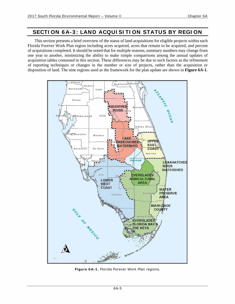
SECTION 6A-3: LAND ACQUISITION STATUS BY REGION
This section presents a brief overview of the status of land acquisitions for eligible projects within each Florida Forever Work Plan region including acres acquired, acres that remain to be acquired, and percent of acquisitions completed. It should be noted that for multiple reasons, summary numbers may change from one year to another, minimizing the ability to make simple comparisons among the annual updates of acquisition tables contained in this section. These differences may be due to such factors as the refinement of reporting techniques or changes in the number or size of projects, rather than the acquisition or disposition of land. The nine regions used as the framework for the plan update are shown in Figure 6A-1.
Figure 6A-1. Florida Forever Work Plan regions.

2017 South Florida Environmental Report – Volume II Chapter 6A
6A-6
LAND ACQUISITIONS FOR THE KISSIMMEE RIVER Land acquisition is almost complete for the Kissimmee River Restoration Project. Over 100,000 acres
have been acquired, with approximately 1,049 acres in the process of complex settlement negotiations or condemnation to complete acquisition of remaining land needed for the backfilling of the Kissimmee River Restoration Project Lower Kissimmee Basin components, and preparing for changes to the elevation regulation schedule in the Upper Kissimmee Basin. In summary, the Kissimmee River Restoration Project land acquisition processes are nearing completion. Project certification and credit requests are expected to be processed throughout Fiscal Year 2016-2017 and into future years. Table 6A-2 quantifies the acreage needed versus acreage obtained within the Kissimmee River region under the real estate acquisition plan as of September 30, 2016.
Table 6A-2. Kissimmee River Restoration Plan real estate acquisitions.
Component Acres Required
Acres Acquired
Remaining Acres
Percent Acquired
Kissimmee River Restoration Plan - Upper Kissimmee Basin a 36,522 36,208 314 100%
Kissimmee River Restoration Plan - Lower Kissimmee Basin a,b,c,d 63,843 63,108 735 99%
Total 100,365 99,316 1,049 99%
a. The Lower Kissimmee Basin components are required for the backfilling of areas of the Kissimmee River Restoration Project. According to project records, as of September 30, 2016, approximately 99 percent of the land has been acquired; 735 acres remain outstanding. b. Chandler Slough acres are within the authorized Kissimmee River Restoration Project boundary; however, the land is not required for backfilling. Thus the Chandler Slough acreage is not included in the total acres required. c. The acres acquired total no longer includes 429 acres of state-owned lands over which the District is to receive an easement at no cost, as previously reported. d. A correction was made to the total acres from the previous report to remove a mitigation property that is not considered a part of the Lower Kissimmee Basin.
LAND ACQUISITIONS FOR THE LAKE OKEECHOBEE WATERSHED Table 6A-3 quantifies the acreage needed versus acreage obtained within the Lake Okeechobee
Watershed region under the current real estate acquisition plan as of September 30, 2016.
Table 6A-3. Lake Okeechobee Watershed region real estate acquisitions.
Component Acres Required
Acres Acquired
Remaining Acres
Percent Acquired
North Lake Okeechobee Storage Reservoir 10,273 0 10,273 0%
Taylor Creek/Nubbin Slough Storage and Treatment Area 6,557 6,557 0 100%
Lake Okeechobee Watershed Quality Treatment Facilities 16,610 4,963 11,647 30%
Lake Okeechobee Tributary Sediment Dredging 320 0 320 0%
Total 33,760 11,520 22,240 34%

2017 South Florida Environmental Report – Volume II Chapter 6A
6A-7
LAND ACQUISITIONS FOR THE LOWER WEST COAST Table 6A-4 quantifies the acreage needed versus acreage obtained within the Lower West Coast region
under the current real estate acquisition plan as of September 30, 2016.
Table 6A-4. Lower West Coast region real estate acquisitions.
Component Acres Required Acres Acquired
Remaining Acres
Percent Acquired
Caloosahatchee Watershed 9,493 1,921 7,572 20%
Caloosahatchee River (C-43) West Basin Storage Reservoir 10,507 10,507 0 100%
Big Cypress/L-28 Interceptor Modifications 1,900 0 1,900 0%
Picayune Strand Restoration (Southern Golden Gate Estates) 55,051 55,051 0 100%
Picayune Strand Restoration – Fakahatchee Strand a 1,865 1,826 39 98%
Picayune Strand Restoration – Belle Meade 10,153 9,846 307 97%
Picayune Strand Restoration – Manatee Mitigation 26 26 0 100%
Total 88,995 79,177 9,818 89%
a. Acreage adjustment due to project boundary change.

2017 South Florida Environmental Report – Volume II Chapter 6A
6A-8
LAND ACQUISITIONS FOR THE UPPER EAST COAST Table 6A-5 quantifies the acreage needed versus acreage obtained within the Upper East Coast region
under the current real estate acquisition plan as of September 30, 2016.
Table 6A-5. Upper East Coast region real estate acquisitions.
Component Acres Required
Acres Acquired
Remaining Acres
Percent Acquired
C-44 Reservoir 4,461 4,461 0 100%
C-44 West Stormwater Treatment Area 3,225 3,225 0 100%
C-44 East Stormwater Treatment Area 4,518 4,518 0 100%
Pal-Mar Complex – Natural Water Storage and Treatment Area – C-44 Basin 11,954 1,841 10,113 15%
C-23/24 North Reservoir 2,442 2,442 0 100%
C-23/24 South Reservoir 6,271 4,849 1,422 77%
C-23/C-24 Stormwater Treatment Area a 2,562 2,473 89 97%
C-25 Reservoir and Stormwater Treatment Area 904 0 904 0%
Allapattah Complex 42,348 21,865 20,483 52%
Pal-Mar Complex Natural Water Storage and Treatment Area – South Fork Basin 4,842 4,842 0 100%
Pal-Mar Complex Natural Water Storage and Treatment Area – Halpatiokee Park 347 347 0 100%
Cypress Creek Complex 28,704 1,233 27,471 4%
Cypress Creek Complex (Public-owned Lands) b 3,935 3,935 0 100%
Muck Remediation and Artificial Habitat 640 0 640 0%
North Fork Floodplain Restoration 1,995 475 1,520 24%
North Fork Floodplain Restoration (Public-owned Lands) b 1,094 4 1,090 0.41%
Total 120,242 56,510 63,732 47%
a. Acreage changed due to cancellation of a potential surplus. Surplus acres (16.71) added back into the original project. b. Public-owned land within the project. St. Lucie County has acquired 3,935 acres within the Cypress Creek Complex. A letter of agreement will be required to use public-owned lands for the project.
2017 South Florida Environmental Report – Volume II Chapter 6A
6A-9
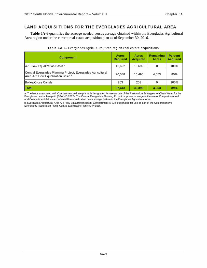
LAND ACQUISITIONS FOR THE EVERGLADES AGRICULTURAL AREA Table 6A-6 quantifies the acreage needed versus acreage obtained within the Everglades Agricultural
Area region under the current real estate acquisition plan as of September 30, 2016.
Table 6A-6. Everglades Agricultural Area region real estate acquisitions.
Component Acres Required
Acres Acquired
Remaining Acres
Percent Acquired
A-1 Flow Equalization Basin a 16,692 16,692 0 100%
Central Everglades Planning Project, Everglades Agricultural Area A-2 Flow Equalization Basin b
20,548 16,495 4,053 80%
Bolles/Cross Canals 203 203 0 100%
Total 37,443 33,390 4,053 89%
a. The lands associated with Compartment A-1 are primarily designated for use as part of the Restoration Strategies for Clean Water for the Everglades central flow path (SFWMD 2012). The Central Everglades Planning Project proposes to integrate the use of Compartment A-1 and Compartment A-2 as a combined flow equalization basin storage feature in the Everglades Agricultural Area. b. Everglades Agricultural Area A-2 Flow Equalization Basin, Compartment A-2, is designated for use as part of the Comprehensive Everglades Restoration Plan’s Central Everglades Planning Project.

2017 South Florida Environmental Report – Volume II Chapter 6A
6A-10
LAND ACQUISITIONS FOR THE EVERGLADES, FLORIDA BAY, AND FLORIDA KEYS
Table 6A-7 quantifies the acreage needed versus acreage obtained within the Everglades, Florida Bay, and Florida Keys region under the real estate acquisition plan as of September 30, 2016.
Table 6A-7. Everglades, Florida Bay, and Florida Keys region real estate acquisitions.
Component Acres Required
Acres Acquired
Remaining Acres
Percent Acquired
Central Everglades Planning Project, Eastern Tamiami Trail 27 0 27 0%
Central Everglades Planning Project, Part 1, North New River Improvements (S-34 to C-6) 918 0 918 0%
Central Everglades Planning Project, Water Conservation Area 3 Decompartmentalization and Sheetflow Enhancement – Phase 2 28 0 28 0%
Central Everglades Planning Project, L-31N (L-30) Seepage Management 391 391 0 100%
Central Everglades Planning Project, S-356 Structure 3,556 0 3,556 0%
Everglades National Park, Bird Drive 3,996 1,399 2,597 35%
Everglades National Park, Dade-Broward Levee and Canal 990 651 339 66%
C-111 Spreader Canal Eastern – Phase 2 (Miami-Dade External Partner) a
3,893 3,893 0 100%
C-111 Spreader Canal Eastern – Phase 2 (Public-owned Lands) b 4,220 1 4,219 0.02%
C-111 Spreader Canal Eastern – Phase 2 Remaining 20,612 16,296 4,316 79%
C-111 Spreader Canal Western – Frog Pond & Aerojet 3,431 3,431 0 100%
C-111 Spreader Canal Western (Miami-Dade External Partner) c 129 129 0 100%
C-111 Spreader Canal Western (Public-owned Lands) b 5,687 0 5,687 0%
C-111 Spreader Canal Western – Operations 12,403 11,881 522 96%
C-111 South Dade Project c 41,289 40,780 509 99%
L-31N (L-30) Seepage Management Pilot 91 91 0 100%
Total 101,661 78,943 22,718 78% a. Miami-Dade County, as an external partner, has acquired 4,022 acres. b. Public-owned lands include land owned by Florida Power & Light. A letter of agreement will be required to use public-owned lands for the project. c. Approximately 29,187 acres overlap the C-111 South Dade and C-111 Spreader Canal projects; these are not duplicated in this table.
2017 South Florida Environmental Report – Volume II Chapter 6A
6A-11
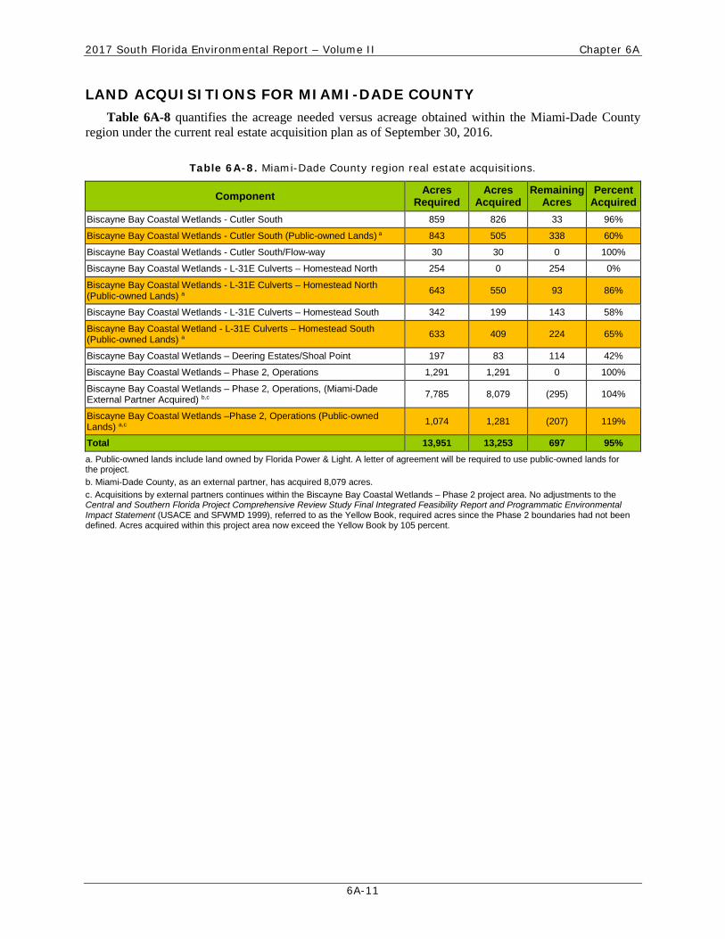
LAND ACQUISITIONS FOR MIAMI-DADE COUNTY Table 6A-8 quantifies the acreage needed versus acreage obtained within the Miami-Dade County
region under the current real estate acquisition plan as of September 30, 2016.
Table 6A-8. Miami-Dade County region real estate acquisitions.
Component Acres Required
Acres Acquired
Remaining Acres
Percent Acquired
Biscayne Bay Coastal Wetlands - Cutler South 859 826 33 96%
Biscayne Bay Coastal Wetlands - Cutler South (Public-owned Lands) a 843 505 338 60%
Biscayne Bay Coastal Wetlands - Cutler South/Flow-way 30 30 0 100%
Biscayne Bay Coastal Wetlands - L-31E Culverts – Homestead North 254 0 254 0%
Biscayne Bay Coastal Wetlands - L-31E Culverts – Homestead North (Public-owned Lands) a 643 550 93 86%
Biscayne Bay Coastal Wetlands - L-31E Culverts – Homestead South 342 199 143 58%
Biscayne Bay Coastal Wetland - L-31E Culverts – Homestead South (Public-owned Lands) a 633 409 224 65%
Biscayne Bay Coastal Wetlands – Deering Estates/Shoal Point 197 83 114 42%
Biscayne Bay Coastal Wetlands – Phase 2, Operations 1,291 1,291 0 100%
Biscayne Bay Coastal Wetlands – Phase 2, Operations, (Miami-Dade External Partner Acquired) b,c 7,785 8,079 (295) 104%
Biscayne Bay Coastal Wetlands –Phase 2, Operations (Public-owned Lands) a,c 1,074 1,281 (207) 119%
Total 13,951 13,253 697 95% a. Public-owned lands include land owned by Florida Power & Light. A letter of agreement will be required to use public-owned lands for the project. b. Miami-Dade County, as an external partner, has acquired 8,079 acres. c. Acquisitions by external partners continues within the Biscayne Bay Coastal Wetlands – Phase 2 project area. No adjustments to the Central and Southern Florida Project Comprehensive Review Study Final Integrated Feasibility Report and Programmatic Environmental Impact Statement (USACE and SFWMD 1999), referred to as the Yellow Book, required acres since the Phase 2 boundaries had not been defined. Acres acquired within this project area now exceed the Yellow Book by 105 percent.
2017 South Florida Environmental Report – Volume II Chapter 6A
6A-12
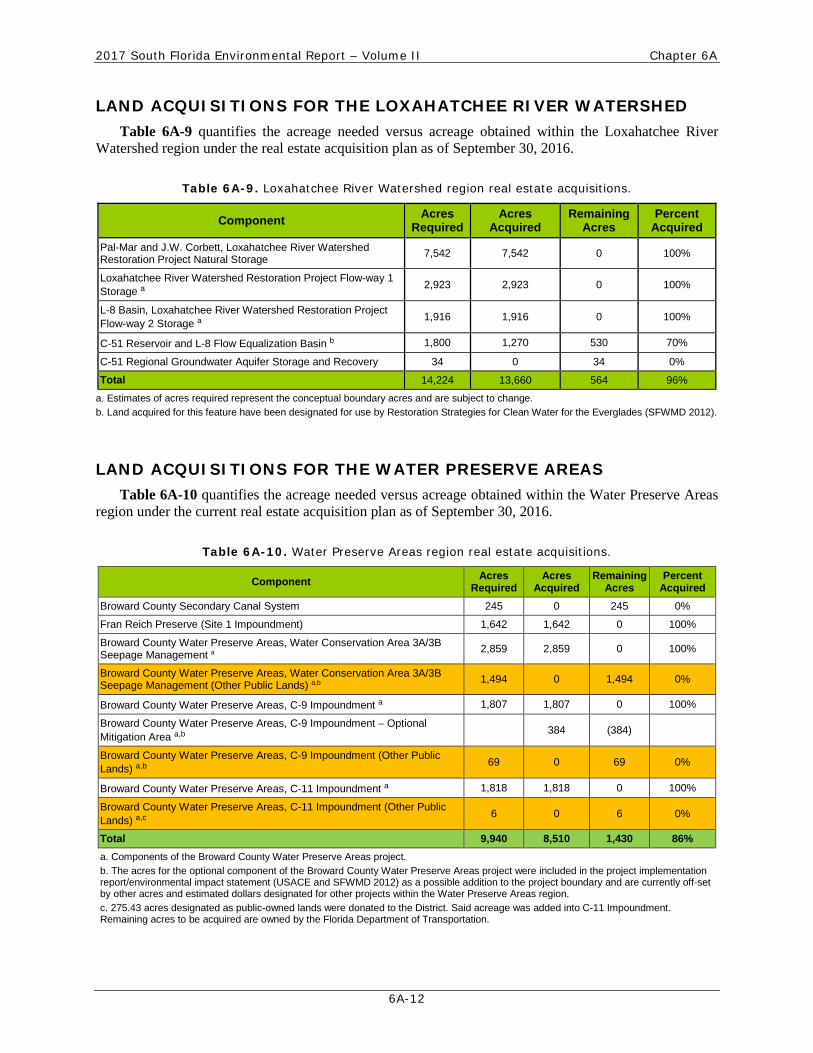
LAND ACQUISITIONS FOR THE LOXAHATCHEE RIVER WATERSHED Table 6A-9 quantifies the acreage needed versus acreage obtained within the Loxahatchee River
Watershed region under the real estate acquisition plan as of September 30, 2016.
Table 6A-9. Loxahatchee River Watershed region real estate acquisitions.
Component Acres Required
Acres Acquired
Remaining Acres
Percent Acquired
Pal-Mar and J.W. Corbett, Loxahatchee River Watershed Restoration Project Natural Storage 7,542 7,542 0 100%
Loxahatchee River Watershed Restoration Project Flow-way 1 Storage a
2,923 2,923 0 100%
L-8 Basin, Loxahatchee River Watershed Restoration Project Flow-way 2 Storage a
1,916 1,916 0 100%
C-51 Reservoir and L-8 Flow Equalization Basin b 1,800 1,270 530 70%
C-51 Regional Groundwater Aquifer Storage and Recovery 34 0 34 0%
Total 14,224 13,660 564 96%
a. Estimates of acres required represent the conceptual boundary acres and are subject to change. b. Land acquired for this feature have been designated for use by Restoration Strategies for Clean Water for the Everglades (SFWMD 2012).
LAND ACQUISITIONS FOR THE WATER PRESERVE AREAS Table 6A-10 quantifies the acreage needed versus acreage obtained within the Water Preserve Areas
region under the current real estate acquisition plan as of September 30, 2016.
Table 6A-10. Water Preserve Areas region real estate acquisitions.
Component Acres Required
Acres Acquired
Remaining Acres
Percent Acquired
Broward County Secondary Canal System 245 0 245 0%
Fran Reich Preserve (Site 1 Impoundment) 1,642 1,642 0 100%
Broward County Water Preserve Areas, Water Conservation Area 3A/3B Seepage Management a 2,859 2,859 0 100%
Broward County Water Preserve Areas, Water Conservation Area 3A/3B Seepage Management (Other Public Lands) a,b 1,494 0 1,494 0%
Broward County Water Preserve Areas, C-9 Impoundment a 1,807 1,807 0 100%
Broward County Water Preserve Areas, C-9 Impoundment – Optional Mitigation Area a,b
384 (384)
Broward County Water Preserve Areas, C-9 Impoundment (Other Public Lands) a,b
69 0 69 0%
Broward County Water Preserve Areas, C-11 Impoundment a 1,818 1,818 0 100%
Broward County Water Preserve Areas, C-11 Impoundment (Other Public Lands) a,c
6 0 6 0%
Total 9,940 8,510 1,430 86% a. Components of the Broward County Water Preserve Areas project. b. The acres for the optional component of the Broward County Water Preserve Areas project were included in the project implementation report/environmental impact statement (USACE and SFWMD 2012) as a possible addition to the project boundary and are currently off-set by other acres and estimated dollars designated for other projects within the Water Preserve Areas region. c. 275.43 acres designated as public-owned lands were donated to the District. Said acreage was added into C-11 Impoundment. Remaining acres to be acquired are owned by the Florida Department of Transportation.

2017 South Florida Environmental Report – Volume II Chapter 6A
6A-13
SECTION 6A-4: MAJOR PLAN/PROGRAM HIGHLIGHTS
COMPREHENSIVE EVERGLADES RESTORATION PLAN As of September 30, 2016, a total of 261,388 acres (64 percent) of land needed to implement the
Comprehensive Everglades Restoration Plan were acquired. A total of 1,013.89 acres were acquired in Fiscal Year 2015-2016 for Comprehensive Everglades Restoration Plan projects at a cost of $3,745,500. Acquisitions include the following: 429.23 acres acquired for the Picayune Strand Restoration – Belle Meade Project at a cost of $2,641,500; 294.24 acres acquired by Miami-Dade County at a cost of $1,104,000; and 290.42 acres that were obtained for Comprehensive Everglades Restoration Plan projects through mitigation and donation. Additional information on the progress of Comprehensive Everglades Restoration Plan implementation is available in the Appendix 1-4: Comprehensive Everglades Restoration Plan Annual Report – 470 Report in the 2017 South Florida Environmental Report –Volume I.
FLORIDA FOREVER/SAVE OUR RIVERS PROJECTS As of September 30, 2016, there are 35 Florida Forever/Save Our Rivers projects totaling nearly
1.5 million required acres of land, of which 1.2 million acres of real estate interests have been acquired, approximately 46 percent in fee and 54 percent in easement.
The C-111 South Dade Project boundary includes 29,127 acres associated with the Southern Glades, 5,274 acres associated with the Frog Pond, and 6,000 acres associated with L-31N, Rocky Glades. All are Florida Forever/Save Our Rivers projects for the purpose of Everglades restoration and flood protection.
In addition, 690.25 acres were added to the Lake Cypress component of the Kissimmee River Restoration Project.
NORTHERN EVERGLADES AND ESTUARIES PROTECTION PROGRAM In 2007, the Florida legislature expanded the Lake Okeechobee Protection Act to include protection of
the Lake Okeechobee Watershed and the Caloosahatchee and St. Lucie Rivers estuaries, known as the Northern Everglades and Estuaries Protection Program (Section 373.4595, F.S.). Funding for land acquisition and construction for Northern Everglades and Estuaries Protection Program was provided for under the Florida Forever Act (Section 259.105, F.S.). Table 6A-11 quantifies the acreage needed versus obtained for this program’s projects as of September 30, 2016. Additional information on the progress of program implementation is available in the 2017 South Florida Environmental Report –Volume I, Chapters 8A, 8B, and 8C.
Table 6A-11. Northern Everglades and Estuaries Protection Program. a
Component Acres Required
Acres Acquired
Remaining Acres
Percent Acquired
Caloosahatchee River Basin Water Quality Treatment and Testing Facility 1,766.40 1,766.40 0 100%
Lake Hicpochee Hydrologic Enhancement 807 807 0 100%
Lake Okeechobee Protection Plan 174 174 0 100%
Lemkin Creek Water Storage and Treatment Facility – Phase 1 b 151 151 0 100%
Total 2,766 2,766 0 100%
a. Portions of Gagbee, Inc., Lakeside Ranch, Brandy Ranch, and Taylor Creek/Grassy Island acquisitions are reported as potential Comprehensive Everglades Restoration Plan project surplus land within the Lake Okeechobee Watershed Region (see Table 6A-3) and are being designated for use by the Northern Everglades and Estuaries Protection Program projects. b. Lemkin Creek Storage and Treatment Facility – Phase 1 Project has been incorporated into the Northern Everglades and Estuaries Protection Program.
2017 South Florida Environmental Report – Volume II Chapter 6A
6A-14
SECTION 6A.5: SURPLUS LAND
SURPLUS LANDS REPORT The District acquires land for flood protection, water supply, water management, ecosystem restoration,
and the conservation and protection of water resources. The District may sell or exchange surplus lands, including easements and other legal interests in real property, not required for present or future use. Surplus transactions are processed in accordance with Chapters 373.056, 373.089, and 373.096, F.S., and District rules, policies, and procedures.
Lands used by the District in an exchange or surplus transaction were determined, by a formal District routing and approval process, not necessary for any identified project. As further justification, some of these lands were acquired as remainder parcels, that is, portion of lands acquired outside approved project boundaries. The District uses exchange of surplus lands in lieu of cash to avoid costly condemnation proceedings and as further incentive for landowners.
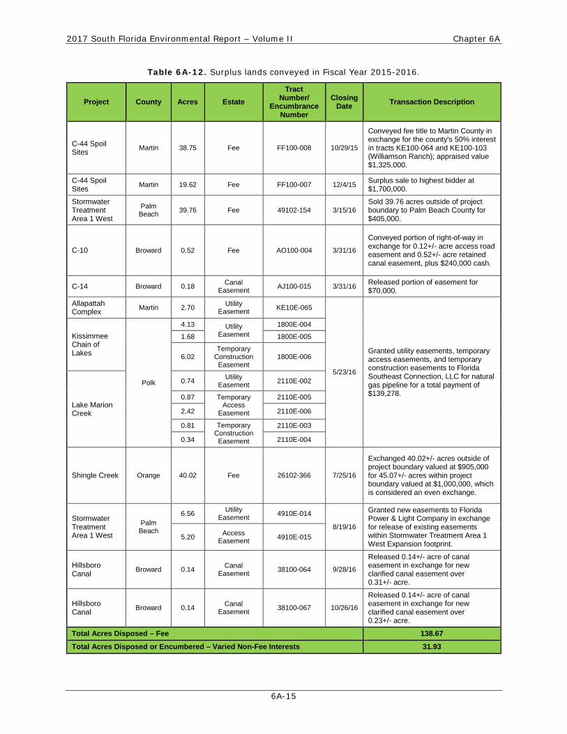
During Fiscal Year 2015-2016, the District conveyed a total of 170.60 acres of real estate interests, 138.67 acres in fee simple, and 31.93 acres in non-fee interests. Table 6A-12 summarizes the real estate interests conveyed in Fiscal Year 2015-2016 as part of exchange or disposal transactions.
2017 South Florida Environmental Report – Volume II Chapter 6A
6A-15
Table 6A-12. Surplus lands conveyed in Fiscal Year 2015-2016.
Project County Acres Estate Tract
Number/ Encumbrance
Number
Closing Date Transaction Description
C-44 Spoil Sites Martin 38.75 Fee FF100-008 10/29/15
Conveyed fee title to Martin County in exchange for the county's 50% interest in tracts KE100-064 and KE100-103 (Williamson Ranch); appraised value $1,325,000.
C-44 Spoil Sites Martin 19.62 Fee FF100-007 12/4/15 Surplus sale to highest bidder at
$1,700,000.
Stormwater Treatment Area 1 West
Palm Beach 39.76 Fee 49102-154 3/15/16
Sold 39.76 acres outside of project boundary to Palm Beach County for $405,000.
C-10 Broward 0.52 Fee AO100-004 3/31/16
Conveyed portion of right-of-way in exchange for 0.12+/- acre access road easement and 0.52+/- acre retained canal easement, plus $240,000 cash.
C-14 Broward 0.18 Canal Easement AJ100-015 3/31/16 Released portion of easement for
$70,000.
Allapattah Complex Martin 2.70 Utility
Easement KE10E-065
5/23/16
Granted utility easements, temporary access easements, and temporary construction easements to Florida Southeast Connection, LLC for natural gas pipeline for a total payment of $139,278.
Kissimmee Chain of Lakes
Polk
4.13 Utility Easement
1800E-004
1.68 1800E-005
6.02 Temporary
Construction Easement
1800E-006
Lake Marion Creek
0.74 Utility Easement 2110E-002
0.87 Temporary Access
Easement
2110E-005
2.42 2110E-006
0.81 Temporary Construction Easement
2110E-003
0.34 2110E-004
Shingle Creek Orange 40.02 Fee 26102-366 7/25/16
Exchanged 40.02+/- acres outside of project boundary valued at $905,000 for 45.07+/- acres within project boundary valued at $1,000,000, which is considered an even exchange.
Stormwater Treatment Area 1 West
Palm Beach
6.56 Utility Easement 4910E-014
8/19/16
Granted new easements to Florida Power & Light Company in exchange for release of existing easements within Stormwater Treatment Area 1 West Expansion footprint.
5.20 Access Easement 4910E-015
Hillsboro Canal Broward 0.14 Canal
Easement 38100-064 9/28/16
Released 0.14+/- acre of canal easement in exchange for new clarified canal easement over 0.31+/- acre.
Hillsboro Canal Broward 0.14 Canal
Easement 38100-067 10/26/16
Released 0.14+/- acre of canal easement in exchange for new clarified canal easement over 0.23+/- acre.
Total Acres Disposed – Fee 138.67
Total Acres Disposed or Encumbered – Varied Non-Fee Interests 31.93
2017 South Florida Environmental Report – Volume II Chapter 6A
6A-16
LAND ASSESSMENT PROCESS In September 2013, the first phase of the SFWMD land assessment was completed—a review of
approximately 750,000 acres of fee-owned lands in which the District has full or shared ownership rights. A total of 21,357 acres of land were recommended and approved for further evaluation as potential surplus or exchange.
The next phase of the assessment process is an ongoing progress. It involves conducting a complete review of each property identified for further evaluation. During this phase, some of the lands will be recommended for alternative uses by the District while others will be recommended for sale or exchange.

2017 South Florida Environmental Report – Volume II Chapter 6A
6A-17
SECTION 6A.6: FLORIDA FOREVER LIST OF ELIGIBLE PROJECTS
Projects eligible for funding under the Florida Forever Act (Section 259.105, F.S.) as well as projects eligible for state acquisition monies from the appropriate account or trust fund under Section 373.139(3)(c), F.S., during the Fiscal Year 2015-2016 through Fiscal Year 2018-2019 period are listed in this section. Detailed project descriptions and supporting information are provided in the South Florida Environmental Report Consolidated Project Database, available on the District’s website at www.sfwmd.gov/sfer.
COMPREHENSIVE EVERGLADES RESTORATION PLAN PROJECTS Information on Comprehensive Everglades Restoration Plan projects is included for each of the projects
on the Comprehensive Everglades Restoration Plan website at www.evergladesrestoration.gov. If available, the approved planning documents, as well as in-progress reports, are available on this website. The following two subcategories summarize all eligible Comprehensive Everglades Restoration Plan projects.
Full-Scale Comprehensive Everglades Restoration Plan Projects
• Big Cypress - L-28 Interceptor Modifications
• Bird Drive Recharge Area, as part of Everglades National Park Seepage Management
• Biscayne Bay Coastal Wetlands
• Broward County Water Preserve Areas
• Broward County Secondary Canal System
• Caloosahatchee (C-43) West Basin Storage Reservoir and Aquifer Storage and Recovery – Part 1
• C-44 Reservoir and Stormwater Treatment Area Adjacent Land (part of Indian River Lagoon – South)
• C-111 Spreader Canal
• Central Everglades Planning Project (considers Everglades Agricultural Area Storage Reservoirs, Phases 1 and 2; Flow to Northwest and Central Water Conservation Area 3A; Water Conservation Area 3 Decompartmentalization and Sheetflow Enhancement; and Everglades National Park Seepage Management)
• Everglades Agricultural Area Storage Reservoir, Phases 1 and 2
• Everglades National Park Seepage Management
• Fran Reich Preserve/Site 1 Impoundment
• Flow to Northwest and Central Water Conservation Area 3A
• Indian River Lagoon - South
• Lake Okeechobee Watershed
• Loxahatchee River Watershed Restoration 1
1 Formerly known as North Palm Beach County – Part 1.
2017 South Florida Environmental Report – Volume II Chapter 6A
6A-18
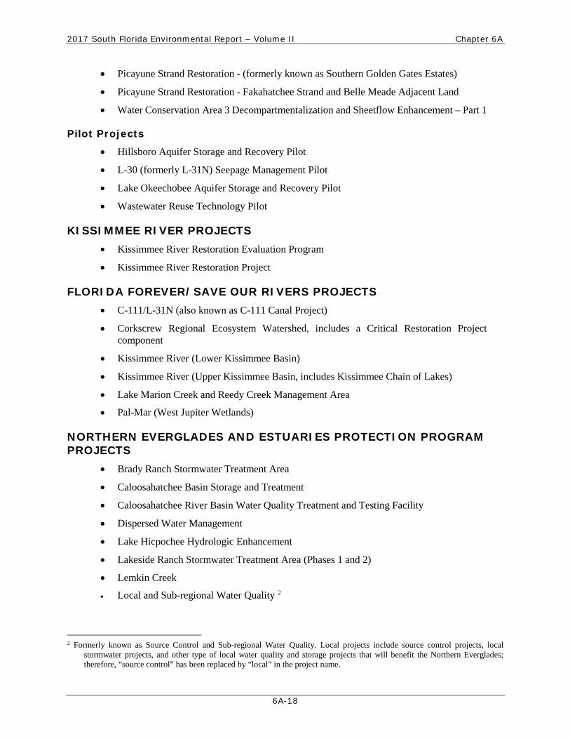
• Picayune Strand Restoration - (formerly known as Southern Golden Gates Estates)
• Picayune Strand Restoration - Fakahatchee Strand and Belle Meade Adjacent Land
• Water Conservation Area 3 Decompartmentalization and Sheetflow Enhancement – Part 1
Pilot Projects
• Hillsboro Aquifer Storage and Recovery Pilot
• L-30 (formerly L-31N) Seepage Management Pilot
• Lake Okeechobee Aquifer Storage and Recovery Pilot
• Wastewater Reuse Technology Pilot
KISSIMMEE RIVER PROJECTS • Kissimmee River Restoration Evaluation Program
• Kissimmee River Restoration Project
FLORIDA FOREVER/SAVE OUR RIVERS PROJECTS • C-111/L-31N (also known as C-111 Canal Project)
• Corkscrew Regional Ecosystem Watershed, includes a Critical Restoration Project component
• Kissimmee River (Lower Kissimmee Basin)
• Kissimmee River (Upper Kissimmee Basin, includes Kissimmee Chain of Lakes)
• Lake Marion Creek and Reedy Creek Management Area
• Pal-Mar (West Jupiter Wetlands)
NORTHERN EVERGLADES AND ESTUARIES PROTECTION PROGRAM PROJECTS
• Brady Ranch Stormwater Treatment Area
• Caloosahatchee Basin Storage and Treatment
• Caloosahatchee River Basin Water Quality Treatment and Testing Facility
• Dispersed Water Management
• Lake Hicpochee Hydrologic Enhancement
• Lakeside Ranch Stormwater Treatment Area (Phases 1 and 2)
• Lemkin Creek
• Local and Sub-regional Water Quality 2
2 Formerly known as Source Control and Sub-regional Water Quality. Local projects include source control projects, local
stormwater projects, and other type of local water quality and storage projects that will benefit the Northern Everglades; therefore, “source control” has been replaced by “local” in the project name.
2017 South Florida Environmental Report – Volume II Chapter 6A
6A-19
• Rio St. Lucie Stormwater Quality - Sediment Nutrients
• Spanish Creek/Four Corners
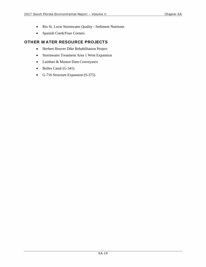
OTHER WATER RESOURCE PROJECTS • Herbert Hoover Dike Rehabilitation Project
• Stormwater Treatment Area 1 West Expansion
• Lainhart & Masten Dam Conveyance
• Bolles Canal (G-341)
• G-716 Structure Expansion (S-375)
2017 South Florida Environmental Report – Volume II Chapter 6A
6A-20
SECTION 6A-7: FLORIDA FOREVER GOALS AND PERFORMANCE MEASURES
This section presents the Florida Forever goals and performance measures that apply to all Florida water management districts and to the Florida Department of Environmental Protection. When the goals and performance measures for the Florida Forever Program were developed in collaboration with the Florida Forever Advisory Council, it was envisioned that these criteria would serve as a guide to land acquisition using Florida Forever funds.
While the District’s funds are expected to be used to acquire land, the final footprints of projects may not be known when land is acquired. This is especially true for many Comprehensive Everglades Restoration Plan projects, for which exact locations are not yet available. Given this uncertainty, the Florida Forever goals and performance measures provide guidelines for acquisition managers as purchases are made. As land managers identify tracts for individual projects, the specific goals and performance measures the tracts satisfy must be identified.
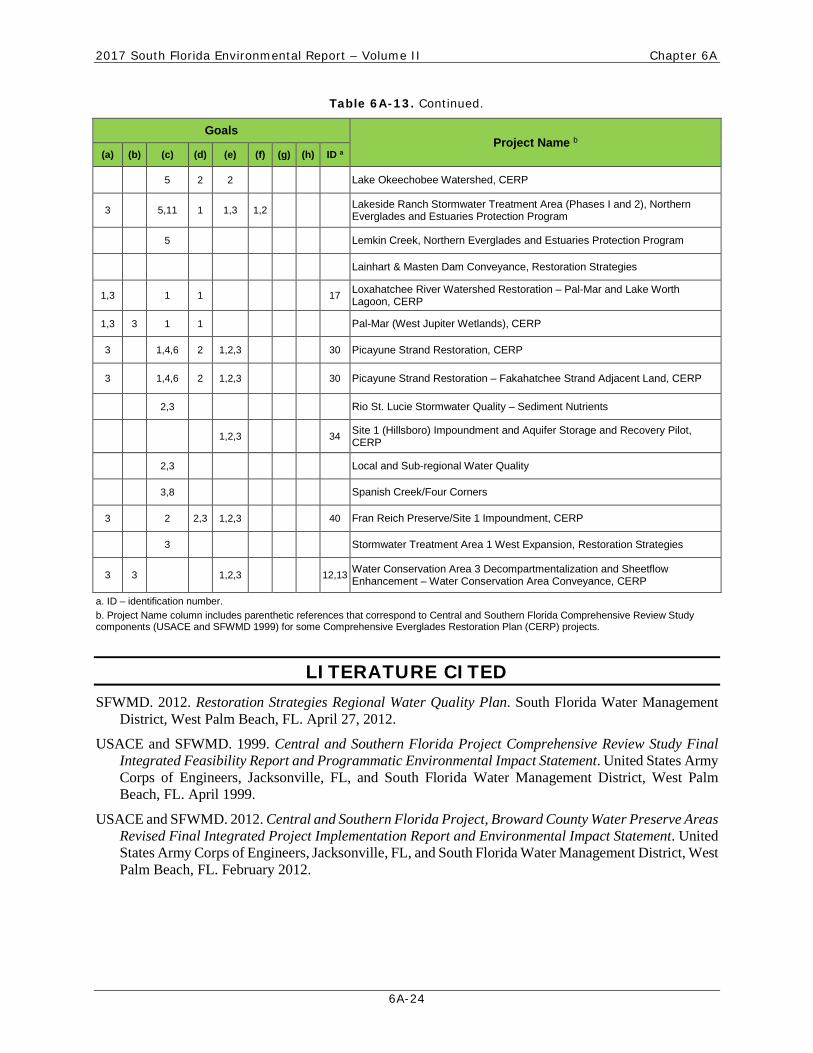
To aid in this process, Table 6A-13 summarizes how each of the projects satisfies one or more Florida Forever goals and performance measures. As land managers acquire land for specific projects, this supporting information will aid in ensuring that future lands satisfy the requirements of the Florida Forever Program. The Florida Forever Program goals and performance measures specified in Section 259.105(5) a-h, F.S., are outlined below and cross-referenced in Table 6A-13.
It is the intent of the Legislature that projects or acquisitions funded pursuant to paragraphs (3) (a) and (b) contribute to the achievement of the following goals, which shall be evaluated in accordance with specific criteria and numeric performance measures developed pursuant s. 259.035(4):
(a) Enhance the coordination and completion of land acquisition projects, as measured by:
1. The number of acres acquired through the state’s land acquisition programs that contribute to the enhancement of essential natural resources, ecosystem service parcels, and connecting linkage corridors as identified and developed by the best available scientific analysis;
2. The number of acres protected through the use of alternatives to fee simple acquisition; or
3. The number of shared acquisition projects among Florida Forever funding partners and partners with other funding sources, including local governments and the federal government.
(b) Increase the protection of Florida’s biodiversity at the species, natural community, and landscape levels, as measured by:
1. The number of acres acquired of significant strategic habitat conservation areas;
2. The number of acres acquired of highest priority conservation areas for Florida’s rarest species;
3. The number of acres acquired of significant landscapes, landscape linkages, and conservation corridors, giving priority to completing linkages;
4. The number of acres acquired of under-represented native ecosystems;

2017 South Florida Environmental Report – Volume II Chapter 6A
6A-21
5. The number of landscape-sized protection areas of at least 50,000 acres that exhibit a mosaic of predominantly intact or restorable natural communities established through new acquisition projects, or augmentations to previous projects; or
6. The percentage increase in the number of occurrences of imperiled species on publicly managed conservation areas.
(c) Protect, restore, and maintain the quality and natural functions of land, water, and wetland systems of the state, as measured by:
1. The number of acres of publicly owned land identified as needing restoration, acres undergoing restoration, enhancement, and management, acres with restoration activities completed, and acres managed to maintain such restored or enhanced conditions; the number of acres which represent actual or potential imperiled species habitat; the number of acres which are available pursuant to a management plan to restore, enhance, repopulate, and manage imperiled species habitat; and the number of acres of imperiled species habitat managed, restored, enhance, repopulated, or acquired;
2. The percentage of water segments that fully meet, partially meet, or do not meet their designated uses as reported in the Department of Environmental Protection’s State Water Quality Assessment 305(b) Report;
3. The percentage completion of targeted capital improvements in surface water improvement and management plans created under Section 373.453(2), F.S., regional or master stormwater management system plans, or other adopted restoration plans;
4. The number of acres acquired that protect natural floodplain functions;
5. The number of acres acquired that protect surface waters of the state;
6. The number of acres identified for acquisition to minimize damage from flooding and the percentage of those acres acquired;
7. The number of acres acquired that protect fragile coastal resources;
8. The number of acres of functional wetland systems protected;
9. The percentage of miles of critically eroding beaches contiguous with public lands that are restored or protected from further erosion;
10. The percentage of public lakes and rivers in which invasive, non-native aquatic plants are under maintenance control; or
11. The number of acres of public conservation lands in which upland invasive, exotic plants are under maintenance control.
(d) Ensure that sufficient quantities of water are available to meet the current and future needs of natural systems and the citizens of the state, as measured by:
1. The number of acres acquired which provide retention and storage of surface water in naturally occurring storage areas, such as lakes and wetlands, consistent with the maintenance of water resources or water supplies and consistent with district water supply plans;
2017 South Florida Environmental Report – Volume II Chapter 6A
6A-22
2. The quantity of water made available through the water resource development component of a district water supply plan for which a water management district is responsible; or
3. The number of acres acquired of groundwater recharge areas critical to springs, sinks, aquifers, other natural systems or water supply.
(e) Increase natural resource-based public recreational and educational opportunities, as measured by:
1. The number of acres acquired that are available for natural resource-based public recreation or education;
2. The miles of trails that are available for public recreation, giving priority to those that provide significant connections including those that will assist in completing the Florida National Scenic Trail; or
3. The number of new resource-based recreation facilities, by type, made available on public land.
(f) Preserve significant archaeological or historic sites, as measured by:
1. The increase in the number of and percentage of historic and archaeological properties listed in the Florida Master Site File or National Register of Historic Places which are protected or preserved for public use; or
2. The increase in the number and percentage of historic and archaeological properties that are in state ownership.
(g) Increase the amount of forestland available for sustainable management of natural resources, as measured by:
1. The number of acres acquired that are available for sustainable forest management;
2. The number of acres of state owned forestland managed for economic return in accordance with current best management practices;
3. The number of acres of forestland acquired that will serve to maintain natural groundwater recharge functions; or
4. The percentage and number of acres identified for restoration actually restored by reforestation.
(h) Increase the amount of open space available in urban areas, as measured by:
1. The percentage of local governments that participate in land acquisition programs and acquire open space in urban cores; or
2. The percentage and number of acres of purchases of open space within urban service areas.
2017 South Florida Environmental Report – Volume II Chapter 6A
6A-23
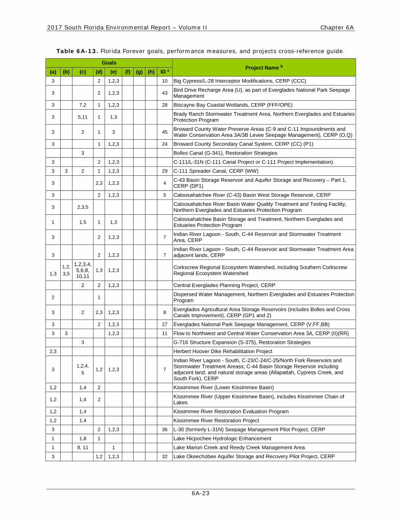
Table 6A-13. Florida Forever goals, performance measures, and projects cross-reference guide.
Goals Project Name b
(a) (b) (c) (d) (e) (f) (g) (h) ID a 3 2 1,2,3 10 Big Cypress/L-28 Interceptor Modifications, CERP (CCC)
3 2 1,2,3 43 Bird Drive Recharge Area (U), as part of Everglades National Park Seepage Management
3 7,2 1 1,2,3 28 Biscayne Bay Coastal Wetlands, CERP (FFF/OPE)
3 5,11 1 1,3 Brady Ranch Stormwater Treatment Area, Northern Everglades and Estuaries Protection Program
3 2 1 3 45 Broward County Water Preserve Areas (C-9 and C-11 Impoundments and Water Conservation Area 3A/3B Levee Seepage Management), CERP (O,Q)
3 1 1,2,3 24 Broward County Secondary Canal System, CERP (CC) (P1)
3 Bolles Canal (G-341), Restoration Strategies
3 2 1,2,3 C-111/L-31N (C-111 Canal Project or C-111 Project Implementation)
3 3 2 1 1,2,3 29 C-111 Spreader Canal, CERP (WW)
3 2,3 1,2,3 4 C-43 Basin Storage Reservoir and Aquifer Storage and Recovery – Part 1, CERP (DP1)
3 2 1,2,3 5 Caloosahatchee River (C-43) Basin West Storage Reservoir, CERP
3 2,3,5 Caloosahatchee River Basin Water Quality Treatment and Testing Facility, Northern Everglades and Estuaries Protection Program
1 1,5 1 1,3 Caloosahatchee Basin Storage and Treatment, Northern Everglades and Estuaries Protection Program
3 2 1,2,3 7 Indian River Lagoon - South, C-44 Reservoir and Stormwater Treatment Area, CERP
3
2
1,2,3
7 Indian River Lagoon - South, C-44 Reservoir and Stormwater Treatment Area adjacent lands, CERP
1,3
1,2, 3,5
1,2,3,4,5,6,8, 10,11
1,3 1,2,3 Corkscrew Regional Ecosystem Watershed, including Southern Corkscrew Regional Ecosystem Watershed
2 2 1,2,3 Central Everglades Planning Project, CERP
2 1 Dispersed Water Management, Northern Everglades and Estuaries Protection Program
3 2 2,3 1,2,3 8 Everglades Agricultural Area Storage Reservoirs (includes Bolles and Cross Canals Improvement), CERP (GP1 and 2)
3 2 1,2,3 27 Everglades National Park Seepage Management, CERP (V,FF,BB)
3 3 1,2,3 11 Flow to Northwest and Central Water Conservation Area 3A, CERP (II)(RR)
3 G-716 Structure Expansion (S-375), Restoration Strategies
2,3 Herbert Hoover Dike Rehabilitation Project
3 1,2,4,
5 1,2 1,2,3 7
Indian River Lagoon - South, C-23/C-24/C-25/North Fork Reservoirs and Stormwater Treatment Areass; C-44 Basin Storage Reservoir including adjacent land; and natural storage areas (Allapattah, Cypress Creek, and South Fork), CERP
1,2 1,4 2 Kissimmee River (Lower Kissimmee Basin)
1,2 1,4 2 Kissimmee River (Upper Kissimmee Basin), includes Kissimmee Chain of Lakes
1,2 1,4 Kissimmee River Restoration Evaluation Program
1,2 1,4 Kissimmee River Restoration Project
3 2 1,2,3 36 L-30 (formerly L-31N) Seepage Management Pilot Project, CERP
1 1,8 1 Lake Hicpochee Hydrologic Enhancement
1 8, 11 1 Lake Marion Creek and Reedy Creek Management Area
3 1,2 1,2,3 32 Lake Okeechobee Aquifer Storage and Recovery Pilot Project, CERP
2017 South Florida Environmental Report – Volume II Chapter 6A
6A-24
Table 6A-13. Continued.
Goals Project Name b
(a) (b) (c) (d) (e) (f) (g) (h) ID a
5 2 2 Lake Okeechobee Watershed, CERP
3 5,11 1 1,3 1,2 Lakeside Ranch Stormwater Treatment Area (Phases I and 2), Northern Everglades and Estuaries Protection Program
5 Lemkin Creek, Northern Everglades and Estuaries Protection Program
Lainhart & Masten Dam Conveyance, Restoration Strategies
1,3 1 1 17 Loxahatchee River Watershed Restoration – Pal-Mar and Lake Worth Lagoon, CERP
1,3 3 1 1 Pal-Mar (West Jupiter Wetlands), CERP
3 1,4,6 2 1,2,3 30 Picayune Strand Restoration, CERP
3 1,4,6 2 1,2,3 30 Picayune Strand Restoration – Fakahatchee Strand Adjacent Land, CERP
2,3 Rio St. Lucie Stormwater Quality – Sediment Nutrients
1,2,3 34 Site 1 (Hillsboro) Impoundment and Aquifer Storage and Recovery Pilot, CERP
2,3 Local and Sub-regional Water Quality
3,8 Spanish Creek/Four Corners
3 2 2,3 1,2,3 40 Fran Reich Preserve/Site 1 Impoundment, CERP
3 Stormwater Treatment Area 1 West Expansion, Restoration Strategies
3 3 1,2,3 12,13 Water Conservation Area 3 Decompartmentalization and Sheetflow Enhancement – Water Conservation Area Conveyance, CERP
a. ID – identification number. b. Project Name column includes parenthetic references that correspond to Central and Southern Florida Comprehensive Review Study components (USACE and SFWMD 1999) for some Comprehensive Everglades Restoration Plan (CERP) projects.
LITERATURE CITED SFWMD. 2012. Restoration Strategies Regional Water Quality Plan. South Florida Water Management
District, West Palm Beach, FL. April 27, 2012.
USACE and SFWMD. 1999. Central and Southern Florida Project Comprehensive Review Study Final Integrated Feasibility Report and Programmatic Environmental Impact Statement. United States Army Corps of Engineers, Jacksonville, FL, and South Florida Water Management District, West Palm Beach, FL. April 1999.
USACE and SFWMD. 2012. Central and Southern Florida Project, Broward County Water Preserve Areas Revised Final Integrated Project Implementation Report and Environmental Impact Statement. United States Army Corps of Engineers, Jacksonville, FL, and South Florida Water Management District, West Palm Beach, FL. February 2012.