chapter 6.0 alternatives analysis - california
TRANSCRIPT

San Juan Creek and Western San Mateo Creek Watersheds SAMP Draft Environmental Impact Statement
R:\Projects\RMV\J011\EIS\6.0 Alt Analysis-Nov2005.doc 6-1 Chapter 6.0
Alternatives Analysis
CHAPTER 6.0 ALTERNATIVES ANALYSIS
6.1 INTRODUCTION
Chapter 5.0 of this EIS addressed 5 No Action Alternatives (“A” Alternatives) and 12 Development/Open Space Alternatives (“B” Alternatives). The selection of alternatives to be carried forward for further review is based on legal mandates for the “A” Alternatives and, for the “B” Alternatives, on the extent to which each of the open space/development alternatives addresses the Purposes in Chapter 3.0 of this EIS and the SAMP Tenets and the Watershed Planning Principles. It also reflects a review of the cumulative databases and studies (including biologic, hydrologic, and geomorphic data and studies), relevant state and local laws, regulations and guidelines, public testimony, and the characteristics of the respective alternatives. Two programmatic alternatives (A-4 and A-5) and three open space/development alternatives (B-8, B-10 Modified, and B-12) are addressed in Chapter 6.0. The USACE in cooperation with the NCCP/SAMP Working Group has determined that these alternatives represent a reasonable range of SAMP alternatives in accordance with federal laws.
Chapter 1.0 described the federal action that is the subject of this SAMP EIS, namely;
Adoption of three permitting procedures for residential, commercial, industrial, recreational, infrastructure, and maintenance needs within the SAMP Study Area.
Chapter 1.0 further notes that this EIS includes an alternatives evaluation for the proposed permitting procedures and associated mitigation, including the Aquatic Resources Conservation Program (ARCP). As reviewed in Chapter 1.0, the SAMP is a planning and policy document and serves as both: (a) a framework for the alternatives evaluation and (b) a potential mitigation framework for the proposed permitting procedures. With respect to its evaluation functions, the SAMP provides information for assessing aquatic resources at a watershed-scale in order to evaluate proposed permitting procedures and to formulate avoidance, minimization, and mitigation measures required under the Section 404 (b)(1) Guidelines.
The analysis in this chapter focuses on alternative open space/development configurations within the RMV Planning Area to assess whether one or more of the alternatives, or a modified version of one or more alternatives, can feasibly attain the SAMP goals set forth in subchapter 1.1 and the SAMP “Purpose” discussed in subchapter 3.1. If one or more of the proposed alternatives is determined to be capable of feasibly attaining the SAMP goals and purposes, these alternatives can be assessed in the required Section 404 (b)(1) Guidelines analysis (see Chapter 8.0) and provide a potential avoidance, minimization, and mitigation framework under the Section 404(b)(1) Guidelines. No data is available regarding potential projects which may be proposed by future SAMP participants through the LOP Procedures outside the RMV Planning Area. These potential projects will be subject to future NEPA and Section 404 (b)(1) Guidelines review at the time applications are received by the USACE.
Because the identification of SAMP alternatives is an important element of the Section 404 (b)(1) Guidelines analysis, the emphasis in this chapter is on biological resources and physical processes (hydrology/geomorphology) relating to the SAMP Purpose and Need statement, the overall SAMP goals, and the watershed planning perspective that is central to the SAMP. In particular, this chapter analyzes the “A” and “B” Alternatives in terms of their ability to provide for the three main elements of an Aquatic Resources Conservation Program: Aquatic Resources Preservation, Restoration, and Management, consistent with the SAMP goals and Purpose and

San Juan Creek and Western San Mateo Creek Watersheds SAMP Draft Environmental Impact Statement
R:\Projects\RMV\J011\EIS\6.0 Alt Analysis-Nov2005.doc 6-2 Chapter 6.0
Alternatives Analysis
Need Statement (Chapters 1.0 and 3.0, respectively). Aquatic resources protection considerations are reviewed with respect to aquatic resources mapped in conjunction with the jurisdictional delineation under Section 404 of the Clean Water Act, SAMP technical studies, and the NCCP/MSAA/HCP GIS database, including the CDFG delineation. Aquatic resources restoration considerations are reviewed in relation to the ability of each alternative to protect and provide land and water areas identified for potential restoration. Aquatic resources management is assessed in relation to the Aquatic Resources Adaptive Management Program summarized in Chapter 1.0 and reviewed in Chapter 5.0, including the ability to fund management measures such as the long-term Invasive Species Control Plan.
As indicated in Chapter 2.0, the alternatives analyses used in Chapter 6.0 uses the ERDC alternatives analysis and the SAMP Tenets in consideration of the findings from the Watershed Planning Principles and additional aquatic species planning considerations from the Southern Planning Guidelines and the Watershed Planning Principles, as well as other studies referenced in Chapter 1.0. The SAMP is a planning and policy document and the selection of one or more SAMP alternatives for further consideration in Chapter 8.0 does not result in authorization of fill into Waters of the U.S. If one or more alternatives can achieve the SAMP Purpose, the alternative(s) will be further analyzed in Chapter 8.0 in conjunction with the analysis of compliance of the proposed permitting procedures with the Section 404 (b)(1) Guidelines, including avoidance, minimization, and mitigation under an Aquatic Resources Conservation Program. This EIS is intended to evaluate the SAMP process, evaluate the Clean Water Act Section 404 permitting procedures within specified areas where future activities would be allowed to occur, and identify aquatic areas to be preserved, restored, enhanced, and managed over the long-term pursuant to the final Aquatic Resources Conservation Program.
It should be noted that for the B-12 Alternative, an overstated impact analysis is discussed in this chapter for development proposed in Planning Areas 4 and 8 and for the orchards proposed in Planning Areas 6 and 7. The final footprint of future development/orchards within these planning areas is undefined at this time because the precise location of future development/orchards is not known. In order to provide an analysis of possible impacts to vegetation communities and species, the impacts in Planning Area 4 are assumed to affect a larger “impact area” of approximately 1,127 acres and the impacts for Planning Area 8 are assumed to affect a larger “impact area” of approximately 1,349 acres. The impact areas in Planning Areas 6 and 7 are approximately 249 acres and 182 acres, respectively. Therefore, the total impact area for Alternative B-12 is approximately 7,788 acres (Figure 5-13). It should be emphasized that this impact analysis overstates the possible impacts to vegetation communities and species because, ultimately, Rancho Mission Viejo is limited to developing a maximum of 550 acres in Planning Area 4, 500 acres in Planning Area 8, and a total of 50 acres of orchards in either/or Planning Area 6 and 7, as well as all necessary supporting infrastructure in addition to the proposed development in the other planning areas as previously addressed in Chapter 5.0. It should be noted that the configuration of the 500 acres of development in Planning Area 8 is required to take into consideration the findings of five years of arroyo toad telemetry studies in conjunction with minimizing impacts, as required by the USACE Special Conditions.
Regarding the SMWD Proposed Project, no alternatives to the maintenance of existing facilities are proposed because none are feasible (existing facilities must be maintained in their current location). The future storage facilities/reservoirs are alternatives; there is a need for two domestic reservoirs and one non-domestic storage reservoir. Because all but one of the sites are located within the impact assessment area for the B-10 Modified and B-12 Alternatives, and would, therefore, not result in additional impacts beyond those analyzed for these RMV Planning Area alternatives; only the site in Upper Chiquita is reviewed specifically as a part of

San Juan Creek and Western San Mateo Creek Watersheds SAMP Draft Environmental Impact Statement
R:\Projects\RMV\J011\EIS\6.0 Alt Analysis-Nov2005.doc 6-3 Chapter 6.0
Alternatives Analysis
the SMW Proposed Project. The proposed SMWD Upper Chiquita reservoir site is addressed in Chapter 8.0. Alternatives A-4 and A-5 are addressed in Chapter 6.0, as applicable.
6.2 BIOLOGICAL RESOURCES
6.2.1 WETLAND AND RIPARIAN HABITATS
6.2.1.1 Thresholds of Significance
For the purposes of this EIS, an alternative would be considered to have a significant impact on wetland and riparian habitats if it would result in a:
• Substantial effect, either directly or indirectly on wetlands and/or riparian habitats within USACE jurisdiction.
• Net loss of hydrology, water quality, or habitat integrity.
• Conflict with the SAMP Tenets
• Inconsistency with aquatic species considerations from Southern Planning Guidelines and the Watershed Planning Principles
6.2.1.2 Impacts to and Conservation of USACE Jurisdiction and Riparian Habitats
This chapter focuses on a quantified summary of potential impacts and conservation by vegetation types to provide information that is used in subsequent subchapters to address consistency with the SAMP Tenets (subchapter 6.2.4) ,Southern Planning Guidelines, and the Watershed Planning Principles (subchapter 6.4) as they relate to wetlands/riparian habitats.
Table 6-1 identifies potential impacts to wetland and riparian habitats associated with each proposed “B” alternative. It is important to note that, due to the complexity of preparing infrastructure plans for such a range of alternatives, the impacts analysis provided in this chapter does not include impacts related to the construction and maintenance of infrastructure such as new water and sewer lines, lift stations, pump stations, reservoirs, etc. The exclusion of infrastructure impacts from the landscape-level alternatives’ impact analyses does not affect the conclusions set forth in this chapter because infrastructure impacts comprise a small component of each alternative. However, the consistency of circulation systems associated with each alternative with the Watershed Planning Principles is provided in this chapter. For those alternatives under consideration for compliance with Section 404(b)(1), infrastructure impacts are quantified in Chapter 8.0 of this EIS.
State and federal jurisdictional delineations of the RMV Planning Area were prepared by GLA (2004) (Appendix E3). It should be noted that the GLA delineation did not include the entire SAMP Study Area or the RMV Planning Area for all of the alternatives, but was focused on the proposed development areas within the RMV Planning Area and associated major arterials that connect the development areas within the RMV Planning Area. The delineation determined that the maximal extent of potential development contains 267.12 acres that are within the jurisdiction of the USACE, of which 158.92 acres are considered jurisdictional wetland Table 4.1.2-4). The delineation also determined that the potential development areas contain 398.14 acres within the jurisdiction of the CDFG, of which 368.40 acres consist of vegetated

San Juan Creek and Western San Mateo Creek Watersheds SAMP Draft Environmental Impact Statement
R:\Projects\RMV\J011\EIS\6.0 Alt Analysis-Nov2005.doc 6-4 Chapter 6.0
Alternatives Analysis
riparian habitat.1 Jurisdictional areas typically include all vegetation types listed in Table 6-2 with exception of isolated waters such as vernal pools and slope wetlands. Based on the ERDC data for typical riparian vegetation communities, as noted in Chapter 4.0, existing setting for riparian and wetland resources, there are an estimated 9,287.6 acres of aquatic habitats within the SAMP Study Area of which 3,222.2 acres are probable USACE jurisdiction. In the RMV Planning Area, there are 2,299.7 acres of riparian/wetland habitats of which 857.1 acres are probable USACE jurisdiction. Therefore, the delineated resources that may be affected by development represent a small portion of the resources within both the SAMP Study Area and the RMV Planning Area.
TABLE 6-1 SUMMARY OF IMPACTS TO USACE JURISDICTIONAL AREAS
AND CDFG RIPARIAN HABITATS BY ALTERNATIVE
Jurisdictional Areas
Alternative Wetlands
(acres) Waters of the U.S.
(acres) Total USACE
(acres) B-8 7.70 16.95 24.65 B-10 Modified 9.14 31.91 41.05 B-12a. 9.39 31.39 40.78
CDFG Riparian Habitats
Alternative Riparian (acres)
Unvegetated (acres)
Total CDFG (acres) Unresolvedb.
B-8 56.6 7.65 64.25 78.98 B-10 Modified 109.83 16.02 125.85 79.00 B-12a. 115.96 17.74 133.70 79.26 a. Note: as previously discussed this represents an overstated case impact analysis and ultimate impacts will be less
due to the limitations on development in Planning Areas 4 and 8, and orchards in Planning Areas 6 and 7. b. Total area for features being proposed as non-jurisdictional for which CDFG has not yet made their final
determination. Source: GLA 2004
Alternatives B-8, B-10 Modified, and B-12 (under the overstated impact scenario) result in impacts of 7.70 acres of wetlands and 16.95 acres of waters, 9.14 acres of wetlands and 31.91 acres of waters and 9.39 acres of wetlands and 31.39 acres of waters respectively. With respect to the 857.1 acres of probable USACE jurisdiction in the RMV Planning Area, Alternatives B-8, B-10 Modified, and B-12 avoid 97 percent, 95 percent, and 95 percent of USACE jurisdiction, respectively. To the extent that Rancho Mission Viejo could permit the B-10 Modified Alternative on a project-by-project basis as with A-4 Alternative, Alternative A-4 would result in the same impacts as the B-10 Modified. Alternative A-5 would not impact USACE jurisdiction. A qualitative or descriptive overview of the impacts for each wetland or riparian habitat type is provided in Tables 6-2 and Table 6-3 and is addressed in greater detail in Chapter 8.0 where the impacts are evaluated for consistency with Section 404(b)(1) for those alternatives carried forward. In addition, impacts to state and federally listed and unlisted aquatic species that potentially occupy these habitats are addressed in Chapter 6.0.
1 An additional 91.70 acres have been evaluated in the field, including 55.88 acres of cattail marsh and 35.82 acres
of open water, for which Rancho Mission Viejo and CDFG have not reached concurrence relative to their jurisdictional status (i.e., unresolved features). These unresolved features are located within Trampas Canyon (Planning Area 5) of the RMV Planning Area and consist of the ONIS artificial tailings facility and other mining related facilities. GLA noted that these features do not meet the definition of a streambed or lake under the Fish and Game Code at the time of project implementation (GLA 2004).

San Juan Creek and Western San Mateo Creek Watersheds SAMP Draft Environmental Impact Statement
R:\Projects\RMV\J011\EIS\6.0 Alt Analysis-Nov2005.doc 6-5 Chapter 6.0
Alternatives Analysis
TABLE 6-2 SUMMARY OF IMPACTS TO USACE JURISDICTIONAL WETLANDS BY
HABITAT TYPE BY ALTERNATIVE
Habitat Type B-8 B-10
Modified B-12a. Alkali Meadow (5.2) 0.23 0.56 0.44 Seasonal Pond (5.3) 0.13 0.75 0.76 Coastal Freshwater Marsh (6.4) 1.19 1.18 1.18 Riparian Herb (7.1) 0.01 0.03 0.03 Southern Willow Scrub (7.2) 0.66 0.82 1.16 Mule fat Scrub (7.3) 0.00 0.33 0.34 Sycamore Riparian Woodland (7.4) 0.01 0.00 0.00 Arroyo Willow Forest (7.6) 5.47 5.48 5.48 Total 7.70 9.14 9.39 a. As previously discussed this represents an overstated impact analysis and
ultimate impacts will be less due to the limitations on development in Planning Areas 4 and 8, and orchards in Planning Areas 6 and 7
Please note that USACE and CDFG jurisdiction are not entirely coincident with each other. Therefore, there are seasonal ponds and freshwater marsh habitat (generally occurring in isolated ponds/depressions) that are reported above but not to the same extent identified in Table 6-3. It should be noted that oak riparian woodland is identified in Table 6-3 but not in Table 6-2 for the same reason.
TABLE 6-3 SUMMARY OF IMPACTS TO CDFG RIPARIAN HABITATS BY ALTERNATIVE
Habitat Type B-8 B-10
Modified B-12a. Alkali Meadow (5.2) 0.68 1.17 1.29
Seasonal Pond (5.3) 0.00 0.64 0.64
Coastal Freshwater Marsh (6.4) 0.54 0.54 0.54
Riparian Herb (7.1) 1.46 1.46 1.46
Southern Willow Scrub (7.2) 4.38 10.23 11.73
Mule fat Scrub (7.3) 7.48 12.52 17.72
Sycamore Riparian Woodland (7.4) 5.91 9.25 9.27
Oak Riparian Woodland (7.5) 16.06 53.64 52.29
Arroyo Willow Forest (7.6) 20.11 20.26 21.02
Total 56.63 109.83 115.96 a. As previously discussed this represents an overstated impact analysis and
ultimate impacts will be less due to the limitations on development in Planning Areas 4 and 8, and orchards in Planning Areas 6 and 7.
Impacts to Alkali Meadow
Alkali meadow consists of variety low-growing herbaceous species. On the RMV Planning Area, the composition varies according to the hydrology and distribution. Species typically identified include saltgrass (Distichlis spicata), Mexican rush (Juncus mexicanus), wrinkled rush (Juncus rugulosus), clustered field sedge (Carex praegracilis), alkali ryegrass (Leymus triticoides),

San Juan Creek and Western San Mateo Creek Watersheds SAMP Draft Environmental Impact Statement
R:\Projects\RMV\J011\EIS\6.0 Alt Analysis-Nov2005.doc 6-6 Chapter 6.0
Alternatives Analysis
creeping spikerush (Eleocharis macrostachya), and deergrass (Muhlenbergia rigens). Impacts to USACE jurisdictional alkali meadow are limited, ranging from a low of 0.23 acre for the B-8 Alternative to a high of 0.56 acre for the B-10 Modified Alternative. The B-12 Alternative would impact 0.44 acre of alkali meadow under the overstated impact scenario. As identified in Table 6-3, impacts to CDFG jurisdictional alkali meadow range from a low of 0.68 acre for the B-8 Alternative to a high of 1.29 for the B-12 Alternative (under the overstated impact analysis scenario).
Impacts to Seasonal Pond
Seasonal pond habitat generally consists of stock ponds created as part of the ranching operation on the RMV Planning Area and typically exhibit minimal habitat value. In most instances, these areas are dominated by non-native or ruderal (mostly herbaceous) wetland/riparian species such as swamp timothy (Crypsis vaginiflora), cocklebur (Xanthium strumarium), Rabbitsfoot grass (Polypogon monspeliensis), Spanish sunflower (Pulicaria paludosa), and occasional individuals of mule fat (Baccharis salicifolia) or willow (Salix spp.). Impacts to USACE jurisdictional seasonal pond would be 0.13, 0.75, and 0.76 acre for Alternatives B-8, B-10 Modified, and B-12 (under the overstated impact scenario), respectively. Impacts to CDFG jurisdictional seasonal pond are no impact, 0.64 acre for Alternatives B-10 Modified and B-12 (under the overstated impact scenario).
Impacts to Coastal Freshwater Marsh
Areas of coastal freshwater marsh typically are subject to long-term (in some cases year-round) inundation or saturation. These areas typically exhibit low diversity and are dominated by herbaceous monocots including southern cattail (Typha domingensis), California bulrush (Scirpus californicus), hardstem bulrush (Scirpus acutus), and Olney’s bulrush (Scirpus americanus). Impacts to USACE jurisdictional freshwater marsh are 1.19 acre for Alternative B-8 and 1.18 for Alternative B-10 Modified and B-12 (under an overstated impact scenario). Impacts to CDFG jurisdictional freshwater marsh are 0.54 acre for all alternatives.
Impacts to Riparian Herb
Riparian herb habitat is typically associated with low gradient channels that exhibit seasonal flows or in some instances additional water from agricultural sources or other source of artificial irrigation. Many of the species are non-native and include cocklebur, Rabbitsfoot grass, Spanish sunflower, Mexican sprangletop (Leptochloa uninervia), water bentgrass (Agrostis viridis), and barnyard grass (Echinochloa crus-galli). Impacts to USACE jurisdictional riparian herb are 0.01 acre for Alternative B-8 and 0.03 for Alternatives B-10 Modified and B-12 (under an overstated impact scenario). Impacts to CDFG jurisdictional herb are 1.46 acres for all alternatives.
Impacts to Southern Willow Scrub
Southern willow scrub is associated with a variety of drainage types. However, typically this habitat is most common among low-gradient 3rd order streams or larger that exhibit seasonal surface water or associated groundwater (sometimes at depth of up to 30 feet) that supports the plants during the dry season. Dominant species include arroyo willow (Salix lasiolepis), red willow (Salix laevigeta), sandbar willow (Salix exigua), and mule fat. Impacts to USACE jurisdictional southern willow scrub are 0.66 acre for Alternative B-8, 0.82 acre for Alternative B-10 Modified, and 1.16 acres for Alternative B-12 (under the overstated impact scenario). Impacts to CDFG jurisdictional southern willow scrub are 4.38 acres for

San Juan Creek and Western San Mateo Creek Watersheds SAMP Draft Environmental Impact Statement
R:\Projects\RMV\J011\EIS\6.0 Alt Analysis-Nov2005.doc 6-7 Chapter 6.0
Alternatives Analysis
Alternative B-8, 10.23 acres for Alternative B-10 Modified, and 11.73 acres for Alternative B-12 (under the overstated impact scenario).
Impacts to Mule Fat Scrub
Mule fat scrub is associated with a variety of drainage types from 1st order high gradient drainages to low-gradient 3rd order streams or larger. Hydrologic regime varies accordingly, from ephemeral to intermittent. This community is typically dominated by almost pure stands of mule fat with an occasional mix of arroyo willow, red willow, or sandbar willow. Impacts to USACE jurisdictional mule fat scrub range from no impacts (Alternative B-8) to 0.33 acre (Alternative B-10 Modified) to 0.34 acre (Alternative B-12 under the overstated impact scenario). Impacts to CDFG jurisdictional mule fat scrub are 7.48 acres (Alternative B-8), 12.52 acres (Alternative B-10 Modified), and 17.72 acres (Alternative B-12 under the overstated scenario).
Impacts to Sycamore Riparian Woodland
Like mule fat scrub, sycamore woodland is associated with a variety of drainage types from 2nd order high gradient drainages to low-gradient 3rd order streams or larger. Hydrologic regime varies accordingly, from ephemeral to intermittent; groundwater, sometimes at great depth (i.e., 30 feet or more), likely supports the sycamores. This community is typically dominated by western sycamore (Platanus racemosa), coast live oak (Quercus agrifolia), and Mexican elderberry (Sambucus mexicana) with understory components of mule fat. On terraces outside of USACE jurisdiction, upland scrub and non-native grasses dominate the understory. Impacts to USACE jurisdictional sycamore riparian woodland are 0.01 acre for Alternative B-8 and none for Alternatives B-10 Modified and B-12. Impacts to CDFG jurisdictional sycamore riparian woodland are 5.91 acres for Alternative B-8, 9.25 acres for Alternative B-10 Modified, and 9.27 acres for Alternative B-12 (under the overstated impact scenario).
Impacts to Coast Live Oak Riparian Forest
Like sycamore woodland, coast live oak riparian forest is associated with a variety of drainage types from 2nd order high gradient drainages to low-gradient 3rd order streams or larger. Hydrologic regime varies accordingly, from ephemeral to intermittent. This community is typically dominated by coast live oak and may include scattered individuals of western sycamore and Mexican elderberry. Understory components include mule fat and herbaceous species such as clustered field sedge where there is shallow subsurface seasonal water. On terraces outside of USACE jurisdiction, upland scrub and non-native grasses dominate the understory. Impacts to CDFG jurisdictional coast live oak riparian forest are 16.06 acres (Alternative B-8), 53.64 acres (Alternative B-10 Modified), and 52.29 acres (Alternative B-12 under the overstated impact scenario). No USACE jurisdictional coast live oak forest would be impacted by the proposed alternatives because USACE jurisdiction does not extend to this vegetation community within the RMV Planning Area.
Impacts to Arroyo Willow Forest
Arroyo willow scrub is associated with a variety of drainage types. However, typically this habitat is most common among lower gradient higher order streams that exhibit intermittent or perennial flows (at least in some years) and/or associated groundwater (sometimes at depth of up to 30 feet) that supports the plants during the dry season. Dominant species include arroyo willow, red willow, sandbar willow, and mule fat. Impacts to USACE jurisdictional arroyo willow are 5.47 acres for Alternative B-8 and 5.48 acres for Alternative B-10 Modified and Alternative B-12 (under the overstated impact scenario). Impacts to CDFG jurisdictional arroyo willow forest

San Juan Creek and Western San Mateo Creek Watersheds SAMP Draft Environmental Impact Statement
R:\Projects\RMV\J011\EIS\6.0 Alt Analysis-Nov2005.doc 6-8 Chapter 6.0
Alternatives Analysis
are 20.11 acres for Alternative B-8, 20.26 acres for Alternative B-10 Modified, and 21.02 acres for Alternative B-12 (under the overstated impact scenario).
Protection of Riparian Habitats
Using the ERDC database as the data source, Table 6-4 sets forth the protected riparian habitats within the SAMP Study Area. The table summarizes: (a) riparian vegetation protected by means of previously conserved open space (e.g., County parks, local conservancies) and alternative permitting mechanisms; and (b) riparian habitat proposed to be conserved under each of the three “B” Alternatives under review for the RMV Planning Area. Of the 8,729.5 acres of natural riparian habitat in the SAMP Study Area, Alternatives B-8, B-10 Modified, and B-12 would protect 8,100.7 acres, 7,848.9 acres, and 7,851.5 acres, respectively. Of the 3,222.3 acres of probable USACE jurisdiction, Alternatives B-8, B-10 Modified, and B-12 would protect 2,522.6 acres, 2,515.2 acres, and 2,514.5 acres, respectively.
TABLE 6-4 SUMMARY OF RIPARIAN AREAS PROTECTED IN SAMP STUDY AREA
Protected by:
Riparian Habitat SAMP Study
Area Total (ac.) Alternative
B-8 Alternative
B-10 Modified Alternative
B-12 Bigcone Spruce-Canyon Live Oak Forest
477.7 477.7 477.7 477.7
Canyon Live Oak Forest 195.0 195.0 195.0 195.0 Canyon Live Oak Ravine Forest 243.9 243.9 243.9 243.9 Coast Live Oak Forest 239.5 226.6 166.8 171.0 Coast Live Oak Woodland 851.1 812.0 797.4 781.5 Coastal Freshwater Marsh 141.3 103.9 103.9 103.9 Intermittent Rivers and Streams 304.6 304.6 304.6 304.6 Mule fat Scrub 778.7 709.7 693.0 703.0 Open Water 345.0 239.4 238.5 238.8 Perennial Rivers and Streams 112.3 107.8 107.8 107.8 Riparian Herb 22.1 14.9 14.9 14.9 Salix exigua 1.9 1.9 1.9 1.9 Southern Arroyo Willow Forest 307.7 202.8 202.7 201.8 Southern Coast Live Oak Riparian Forest
3,018.6 2,882.4 2,730.5 2,737.1
Southern Coastal Salt Marsh 0.2 0.2 0.2 0.2 Southern Sycamore Riparian Woodland
619.9 611.7 605.1 603.8
Southern Willow Scrub 727.8 624.2 623.0 622.5 White Alder Riparian Forest 342.1 342.1 342.1 342.1 Total 8,729.5 8,100.7 7,848.9 7,851.5
Table 6-5 sets forth the conserved riparian habitat in the RMV Planning Area. From the tables, it can be seen that the B-8 Alternative would result in the most protected riparian habitats within the overall SAMP Study Area and most conserved within the RMV Planning Area. Alternatives B-10 Modified and B-12 (under the overstated impact scenario) would protect/conserve approximately the same amount of riparian habitats. Of the 2,174.3 acres of natural riparian habitat within the RMV Planning Area, Alternatives B-8, B-10 Modified, and B-12 would conserve 1,943.0 acres, 1,691.2 acres, and 1,693.7 acres respectively. Of the 857.1 acres of

San Juan Creek and Western San Mateo Creek Watersheds SAMP Draft Environmental Impact Statement
R:\Projects\RMV\J011\EIS\6.0 Alt Analysis-Nov2005.doc 6-9 Chapter 6.0
Alternatives Analysis
probable USACE jurisdiction, Alternatives B-8, B-10 Modified, and B-12 would conserve 763.8 acres, 756.3 acres, and 755.6 acres, respectively.
TABLE 6-5 SUMMARY OF RIPARIAN AREAS CONSERVED IN RMV PLANNING AREA
Conserved by:
Riparian Habitat
RMV Planning Area Total
(Acres) Alternative B-8 Alternative B-10
Modified Alternative B-12a.
Canyon Live Oak Ravine Forest 0.3 0.3 0.3 0.3
Coast Live Oak Forest 131.9 118.9 59.1 63.3
Coast Live Oak Woodland 160.3 128.1 113.5 97.6
Coastal Freshwater Marsh 104.2 75.9 75.9 75.9
Intermittent Rivers and Streams 92.0 92.0 92.0 92.0
Mule fat Scrub 410.4 404.5 387.8 397.8
Open Water 53.5 16.8 15.9 16.2
Perennial Rivers and Streams 0.8 0.8 0.8 0.8
Riparian Herb 8.0 5.1 5.1 5.1
Salix exigua 1.3 1.3 1.3 1.3
Southern Arroyo Willow Forest 144.8 132.8 132.6 131.8
Southern Coast Live Oak Riparian Forest
854.3 769.1 617.2 623.7
Southern Sycamore Riparian Woodland
125.8 123.3 116.7 115.3
Southern Willow Scrub 84.8 72.3 71.1 70.7
White Alder Riparian Forest 1.9 1.9 1.9 1.9
Total 2,174.3 1,943.0 1,691.2 1,693.7 a. Alternative B-12 has a conservative estimate of protection in Planning Areas 4 and 8. Those two planning areas encompass
104.1 acres of habitat consisting of (39.7 acres of coast live oak forest, 4.4 acres of coast live oak woodland, 5.7 acres of mule fat scrub, 48.5 acres of southern coast live oak riparian forest, and 5.8 acres of sycamore woodland.
6.2.2 LISTED AND SPECIAL STATUS AQUATIC SPECIES
6.2.2.1 Thresholds of Significance
For the purposes of this EIS, an alternative would be considered to have a significant impact on listed and special status aquatic species if it would result in a:
• Substantial adverse effect, either directly or through habitat modifications, on any species that is state- or federally-listed as Threatened or Endangered occupying riparian and/or wetlands habitats or otherwise cause impacts within the purview of USACE jurisdiction and statutory responsibility.
• Substantial adverse effect, either directly or through habitat modifications, on any species identified as a candidate for listing, sensitive, rare, or otherwise special status plant or animal species in local or regional plans, policies, or regulations, or by the CDFG or USFWS where such impacts are within the purview of USACE jurisdiction and statutory responsibility.

San Juan Creek and Western San Mateo Creek Watersheds SAMP Draft Environmental Impact Statement
R:\Projects\RMV\J011\EIS\6.0 Alt Analysis-Nov2005.doc 6-10 Chapter 6.0
Alternatives Analysis
• Substantial interference with the movement of any native resident or migratory fish or wildlife species or with established native resident or migratory wildlife corridors, or impede the use of native wildlife nursery sites where such impacts are within the purview of USACE jurisdiction and statutory responsibility.
Table 6-6 sets forth potential impacts to listed and special status aquatic (i.e., occupying wetland and/or riparian habitats) species associated with each alternative. It is important to note that, due to the complexity of preparing infrastructure plans for such a range of alternatives, the impacts analysis provided in Chapter 6.0 does not include impacts related to the construction and maintenance of infrastructure (e.g., new water and sewer lines, lift stations, pump stations, roadways, and reservoirs). The exclusion of infrastructure impacts from the landscape-level alternatives’ impact analyses does not affect the conclusions set forth in Chapter 6.0 because infrastructure impacts comprise a small component of each alternative. However, the consistency of circulation systems associated with each alternative with the Watershed Planning Principles is provided in Chapter 6.0. For those alternatives under consideration for compliance with Section 404(b)(1), circulation and infrastructure impacts are quantified in Chapter 8.0. Impacts to species are reviewed prior to application of avoidance and minimization measures and where feasible and necessary, mitigation measures. Avoidance, minimization, and mitigation measures are discussed in the context of the Section 404(b)(1) analysis in Chapter 8.0. The sensitive aquatic species known or expected to occur within the RMV Planning Area, reviewed in Chapter 4.0, are summarized in Table 6-6 to provide a broad overview of the “B” Alternatives and include: (1) state- or federally-listed as Threatened or Endangered Aquatic Species and (2) special status aquatic species. Impacts to common aquatic species are also discussed. To the extent that RMV could permit the B-10 Modified Alternative on a project-by-project basis as the A-4 Alternative, the Alternative A-4 would result in the same impacts as the B-10 Modified. Alternative A-5 would not impact USACE jurisdiction or listed species. As described in Section 4, CDFG jurisdiction was defined functionally to include riparian habitat, therefore, because Alternative A-5 avoids both USACE and CDFG jurisdiction, the habitat supporting special status or common aquatic species would not be impacted.
6.2.2.2 Impacts to State- or Federally-listed Threatened or Endangered Aquatic Species
San Diego Fairy Shrimp
All the vernal pool complexes supporting San Diego fairy shrimp on Chiquita Ridge and along Radio Tower Road, including their contributing hydrological sources would be avoided per County mitigation requirements set forth in GPA/ZC EIR 589. Mitigation Measure 4.9-35 states: “Prior to issuance of a grading permit for Planning Area 5, the Project Applicant shall demonstrate to the satisfaction of the County’s Director of Planning Services Department or his/her designee that all vernal pools in the Trampas Sub-basin have been avoided.”
Riverside Fairy Shrimp
All the vernal pool complexes supporting Riverside fairy shrimp on Chiquita Ridge and along Radio Tower Road, including their contributing hydrological sources would be avoided per County mitigation requirements set forth in GPA/ZC EIR 589. Mitigation Measure 4.9-35 states: “Prior to issuance of a grading permit for Planning Area 5, the Project Applicant shall demonstrate to the satisfaction of the County’s Director of Planning Services Department or his/her designee that all vernal pools in the Trampas Sub-basin have been avoided.”

San Juan Creek and Western San Mateo Creek Watersheds SAMP Draft Environmental Impact Statement
R:\Projects\RMV\J011\EIS\6.0 Alt Analysis-Nov2005.doc 6-11 Chapter 6.0
Alternatives Analysis
TABLE 6-6 SENSITIVE AQUATIC SPECIES IMPACTS BY ALTERNATIVE
Impacts (locations)
Species
RMV Planning
Area (locations)
Alternative B-8
Alternative B-10 Modified
Alternative B-12a.
Wildlife Arroyo Toad see text 0 0 0 Cooper's Hawk 23 1 5 4 Least Bell's Vireo 31 0 0 0 Long-eared Owl 4 0 0 0 Riverside Fairy Shrimp 2 1 1 1 San Diego Fairy Shrimp 3 1 1 1 Southwestern Pond Turtle 12 2 2 3 Southwestern Willow Flycatcher 6 0 0 0 Two-striped Garter Snake 7 0 1 0 Western Spadefoot Toad 15 5 5 5 White-tailed Kite 14 1 2 2 Yellow Warbler 17 0 0 0 Yellow-breasted Chat 75 7 10 8 Plants Beaked Spikerush
Locations 2 0 1 0 Individuals 1,501 0 1 0
Coulter’s Saltbush Locations 34 0 4 9 Individuals 3,086 0 9 565
Fish’s Milkwort Locations 1 0 0 0 Individuals 5 0 0 0
Mud Nama Locations 3 2 2 2 Individuals 9,850 9,500 9,500 9,500
Salt Spring Checkbloom Locations 3 1 3 3 Individuals 1,503 3 532 532
Southern Tarplant Locations 38 0 11 11 Individuals 146,067 0 23,751 12,386
Upright Burhead Locations 1 0 0 0 Individuals 1 0 0 0
a. As previously discussed this represents an overstated impact analysis and ultimate impacts will be less due to the limitations on development in Planning Areas 4 and 8, and orchards in Planning Areas 6 and 7.

San Juan Creek and Western San Mateo Creek Watersheds SAMP Draft Environmental Impact Statement
R:\Projects\RMV\J011\EIS\6.0 Alt Analysis-Nov2005.doc 6-12 Chapter 6.0
Alternatives Analysis
Arroyo Toad
All of the alternatives would retain all of the arroyo toad breeding sites along floodplains and creek bottoms, including major and important populations in key locations in San Juan Creek, lower Gabino Creek, lower Cristianitos Creek, and Talega Creek.
Regarding the use of upland areas for foraging and over-wintering, arroyo toad activity in San Juan Creek largely is confined to the flood prone areas of the creek (Ramirez, 2003) in which no development would occur under any alternative scenario. For lower Gabino Creek, lower Cristianitos Creek, and Talega Creek, the 80-foot contour cited in the 2001 critical habitat designation (which has been incorporated by reference into the final critical habitat designation and corrected to 82-feet or 25 meters [Federal Register 70 19563]) was used as a planning guideline for siting development that would avoid and minimize impacts to upland foraging and estivation habitat. According to the 2001 critical habitat designation for the arroyo toad:
The width of the upland component of critical habitat varies based on topography. The habitat widens in broad alluvial valleys and narrows in places where streams run through constricted canyons or between surrounding hills” (Federal Register 66 9420)
Although the upland habitat use patterns of this species are poorly understood, activity probably is concentrated in the alluvial flats (areas created when sediments from the stream are deposited) and sandy terraces found in valley bottoms of currently active drainages (Service 1999, Griffin et al. 1999, Sweet in litt., 1999, Ramirez 2000, Holland and Sisk 2000)” (Id. 9415)
The 80-foot contour was cited in the 2001 designation of critical habitat for the arroyo toad because studies had consistently shown that the majority of toad activity adjacent to breeding areas is in areas below 80 feet above the stream courses and that areas below 80 feet “were most likely to contain primary constituent upland habitat elements that are essential to arroyo toads.” (Federal Register 66 9420) That is, where stream courses are bound by steep slopes, toads tend to limit their activity to areas near the stream course. Where breeding areas are bound by flatter terrain, toads may move much farther from the stream course. Because the breeding areas in Talega and Gabino Canyons are bound by steep slopes that rise more than 80 feet above the stream courses, it was appropriate to use the 80-foot contour as a planning guideline for siting development that would avoid and minimize impacts to upland foraging and estivation habitat.
Development adjacent to the Talega toad populations under the B-10 Modified Alternative would be above the 80-foot contour. The development footprint adjacent to the Talega toad population under the B-12 Alternative would be established in coordination with CDFG and USFWS with input from the environmental community after five years of arroyo toad telemetry studies to determine upland habitat use. No impacts to the Talega toad population are anticipated to result from the development of 500 acres within this sub-basin. For the lower Gabino and lower Cristianitos populations, the B-10 Modified Alternative development would occur above the referenced 80-foot contour. The implementation of 50 acres of orchards provided for by the B-12 Alternative within the Cristianitos Sub-basin in the locations depicted on Figure 2-3 is not anticipated to result in impacts to the Cristianitos toad population as these areas are outside of the occupied toad habitat. No impacts to these populations would occur under the B-8 Alternative as this alternative does not propose development in the Cristianitos or Talega Sub-basins. Potential indirect effects from the Alternatives B-10 Modified and B-12 include hydrologic conditions of concern such as changes in rates of erosion or sedimentation and the generation of pollutants of concern such as heavy metals or pesticides. These potential impacts

San Juan Creek and Western San Mateo Creek Watersheds SAMP Draft Environmental Impact Statement
R:\Projects\RMV\J011\EIS\6.0 Alt Analysis-Nov2005.doc 6-13 Chapter 6.0
Alternatives Analysis
are discussed later in this chapter. For the broader stream course of San Juan Creek, development setbacks were developed based on field studies (Ramirez 2000) for B-10 Modified Alternative and input by the USACE and USFWS for the B-12 Alternative.
Southwestern Willow Flycatcher
The alternatives would have no effect on habitat known to be occupied by the southwestern willow flycatcher. No significant impacts are anticipated.
Least Bell’s Vireo
None of the alternatives would result in direct impacts to least Bell’s vireo locations.
American Peregrine Falcon
The loss of foraging habitat (primarily wetland/riparian areas) associated with the alternatives would contribute to the ongoing regional and local loss of foraging habitat for the American peregrine falcon. However, due to the limited impacts resulting from the alternatives compared to the amount of similar foraging habitat available in the region and within the open space associated with the alternatives, specifically the Aquatic Resources Conservation Areas, the loss of habitat in the SAMP Study Area is not likely to adversely affect the American peregrine falcon. Therefore, there would be no significant effect on foraging habitat for this species.
Southern Steelhead
Southern steelhead habitat considerations within the San Juan Watershed and the western portion of the San Mateo Watersheds are discussed in the report titled Geomorphic and Hydrologic Needs of Aquatic and Riparian Endangered Species: San Juan and Western San Mateo Watersheds is provided in Appendix G.
The following information regarding the potential habitat information is from Appendix G.
The habitat requirements of southern steelhead are similar to those of more northern steelhead stock. However, Higgins (1991) suspected that southern steelhead have greater physiological tolerances of warmer and more variable conditions commonly encountered in southern California streams.
1. Major streams in southern California originate in the coastal mountains and often cross broad alluvial areas before flowing into the sea. Low-elevation alluvial flats are characterized by intermittent, warm surface waters with fluctuating temperatures, making them inhospitable as spawning areas for southern steelhead. Historically, these areas may have been important to steelhead for spawning and rearing in wet years when temperatures remained low late into the year. Today, only the higher elevation headwaters that are characterized by perennial flow are the primary spawning and rearing areas for steelhead (Moyle et al. 1995). CDFG (2000) reported that the best habitat for steelhead is considered to be within the Cleveland National Forest from the upper San Mateo Creek gauging station to a point approximately 4 km (2.5 mi) upstream (there is no hydrologic connection between this area and the sub-basins within the study area).
Many historic steelhead spawning areas have been degraded by excessive sedimentation from upstream agricultural runoff, surface water impoundments or

San Juan Creek and Western San Mateo Creek Watersheds SAMP Draft Environmental Impact Statement
R:\Projects\RMV\J011\EIS\6.0 Alt Analysis-Nov2005.doc 6-14 Chapter 6.0
Alternatives Analysis
diversions, or groundwater pumping that consequently increases infiltration and storage and leaves reaches of the streambed dry (Moyle et al. 1995). Individually, the production capability of small coastal streams such as San Mateo Creek may be relatively small compared to large, perennial river systems, but collectively they provide a means to ensure a greater diversity of subpopulations, and for range expansion and recovery after drought or other perturbations have reduced population numbers. Thus, utilization of these habitats increases the likelihood of the long-term persistence of the metapopulation and is even more critical now that habitat of many southern California streams has become severely impacted or eliminated due to water development and adverse land-use practices.
Southern steelhead typically migrate as two-year-old juveniles from freshwater to the ocean and then reside in marine waters from two to three years before returning to their natal, freshwater stream to spawn as four- to five-year-olds (National Marine Fisheries Service 1997). This behavior of anadromy separates this species from the commonly occurring freshwater rainbow trout.
Information from PCR et al, 2002 and other information regarding steelhead within San Mateo Creek and San Juan Creek are summarized below:
San Mateo Creek. San Mateo Creek Watershed historically supported steelhead runs from the creek mouth up to 8 miles upstream. At one time, San Mateo Creek was an important steelhead producing stream to the extent that it supported significant local fisheries of both juveniles and adults (Hubbs, 1946). Through the late 1940s, steelhead populations likely exceeded 10,000 individuals and adults as large as 20 pounds were observed. A February 2000 report prepared by CDFG for the National Marine Fisheries Service entitled Steelhead Rainbow Trout in San Mateo Creek, San Diego County, describes changes in habitat conditions since the 1940s as follows: There were fewer observations of juvenile steelhead/rainbow trout in San Mateo Creek after 1950. Trout were found from the lagoon to the headwaters at Los Alamos Canyon during a Department survey on September 1, 1979. Woelfel (1991) reported anecdotes of juvenile steelhead/rainbow trout presence in pools in the upper drainage during the early 1980s, and of a few steelhead adults captured by a local resident in the lower creek in 1986. However, no juvenile steelhead/rainbow trout were found in San Mateo Creek by Woelfel during surveys in 1987 and 1988.
The San Mateo Creek steelhead population was probably reduced periodically by natural episodes of sediment input from within the watershed. However, increased groundwater extraction in the lower creek area since the mid-1940s (including on the part of MCB Camp Pendleton) is responsible, both directly and indirectly, for the inability of steelhead to use the system as they have historically (Lang et al. 1998). Riparian vegetation has been lost, the stream channel width has increased, and surficial flow has been eliminated during most years. Thus, the migration corridor for immigrating adult steelhead and emigrating smolts has become very unreliable. Recent human-caused fires farther upstream resulted in large sediment inputs which filled in pools and the lagoon, both of which are important rearing habitats for juvenile steelhead. Fish faunal surveys in San Mateo Creek in 1995, 1996, and 1997 failed to find steelhead (Lang et al. 1998).
Lower San Mateo Creek (within MCB Camp Pendleton) contains runs, low gradient riffles, mid-channel pools, and lateral scour pools associated with bedrock throughout the drainage network (Lang et al. 1998). Suitable spawning and rearing habitat occurs on San Mateo Creek downstream of the SAMP Study Area and in Devil Canyon located within the Cleveland National Forest (Lang et al. 1998), in an area with granitic bedrock that sustains springs and base flows

San Juan Creek and Western San Mateo Creek Watersheds SAMP Draft Environmental Impact Statement
R:\Projects\RMV\J011\EIS\6.0 Alt Analysis-Nov2005.doc 6-15 Chapter 6.0
Alternatives Analysis
more effectively than other terrains in the San Mateo Creek Watershed. Between March 3 and September 3, 1999, CDFG biologists observed 78 steelhead trout in San Mateo Creek. The majority of these observations occurred in the reach between the upper gauging station and the confluence with Devil Canyon Creek. Four steelhead trout were observed in San Mateo Creek above the confluence with Devil Canyon Creek, one of which was observed 2.5 miles above the confluence. Four steelhead trout were observed in Devil Canyon Creek (CDFG 2000). CDFG did not conduct mark-and-recapture studies, so the precise population size cannot be estimated; however, it is believed to be quite low (CDFG 2000). The best habitat for steelhead is considered to be from the upper gauging station to a point approximately 2.5 miles upstream, as this area typically contains numerous perennial pools connected by surficial flow (CDFG 2000).
Nehlsen et al. (1991) classified the San Mateo Creek steelhead population as extinct. Although conditions in the lower creek system, as described above, render the stream conducive to anadromy on a less frequent basis than it was prior to extensive groundwater pumping and development, it is recognized that the upstream spawning and rearing areas are functional for steelhead production, and that they are still used when sufficient flow allows passage of immigrating adults.
Cristianitos, Gabino, La Paz, and Talega Creeks are the main tributaries within the western portion of the watershed that are within in the SAMP and NCCP/MSAA/HCP study areas. None of these creeks has historically supported or currently supports steelhead runs (Lang et al. 1998). Furthermore, sub-basins in the upper, western portion of San Mateo Creek, such as Gabino and La Paz, are underlain by bedrock formations that yield low amounts of base flow. The dry nature of these sub-basins combined with their steep slope (which promotes rapid runoff) makes it unlikely that they can retain flow late enough into the summer to support steelhead spawning.
San Juan Creek. The CDFG has performed some fieldwork focused on the presence of native fish (including arroyo chub and three-spine stickleback) in the San Juan Creek Watershed in recent years. No southern steelhead individuals were found during these surveys.
The potential presence of southern steelhead has been documented in the Arroyo Trabuco, a tributary to San Juan Creek, south of the I-5 underpass, which is approximately 31,680 feet (6 miles) from the SAMP Study Area boundary (CDFG, November 25, 2003 letter to the National Oceanic and Atmospheric Administration). The CDFG letter acknowledges the barrier of the I-5 underpass as a “complete barrier to upstream migration of steelhead” at this location. The USACE’s understands that genetic studies are currently underway to confirm the initial identification of steelhead in the Arroyo Trabuco; however the results of these studies are not available. Steelhead have not been documented in San Juan Creek within the SAMP Study Area limits during decades of various biological surveys along San Juan Creek, including surveys specifically designed to detect fish species. In addition, there is no anecdotal information from fishing records within San Juan Creek in the RMV Planning Area for the steelhead.
On September 2, 2005, the National Oceanic and Atmospheric Administration published a final rule for the designation of critical habitat for seven Evolutionary Significant Units (ESUs) of Pacific Salmon and Steelhead in California (Federal Register 70 170). According to the final rule, several watershed units (490121, 490122, 490125, 490126 and 490128) including Trabuco, Upper Trabuco, Middle Trabuco, Upper San Juan, Mid upper San Juan and Middle San Juan “were determined to be unoccupied” (Federal Register 70 179) and as a result of this determination several miles of Trabuco and San Juan creeks were removed from the proposed critical habitat designation. Therefore, no critical habitat for the steelhead is designated within

San Juan Creek and Western San Mateo Creek Watersheds SAMP Draft Environmental Impact Statement
R:\Projects\RMV\J011\EIS\6.0 Alt Analysis-Nov2005.doc 6-16 Chapter 6.0
Alternatives Analysis
the RMV Planning Area; however, critical habitat is designated in the SAMP Study Area on lower San Juan and lower Arroyo Trabuco.
None of the alternatives would hinder the species survival and recovery in the southern portion of the Evolutionary Significant Units’ (ESUs) range for steelhead. Each alternative proposes a circulation system that would result in a bridge structure across San Juan Creek in new two locations. Limited modifications to San Juan Creek in the form of bridge piers for these crossings would occur; however, these modifications are not anticipated to impede potential fish passage through the RMV Planning Area to the upper watershed. Fish passage downstream of the RMV Planning Area is questionable as, as noted above, CDFG regards the barrier of the I-5 underpass as a “complete barrier to upstream migration of steelhead.” Therefore, this barrier (the I-5 underpass) would require modification to provide for potential fish passage. It is the USACE’s understanding that Trout Unlimited has applied for a state grant to examine the feasibility of a fish ladder at the I-5 underpass. The remaining potential issue with regard to fish passage is the existing RMV Planning Area earthen/pipe crossing of San Juan Creek (known as “Cow Camp Crossing”) which CDFG and the National Marine Fisheries Service (John O’Brien, CDFG and Stan Glowacki, NMFS, pers com) have noted may pose difficulties for potential fish passage. This issue is addressed in greater detail in Chapter 8.0 for those alternatives carried forward for further review. Potential benefits to steelhead which would result from the Aquatic Resources Conservation Program include proposed restoration/management actions such as invasives species control Arundo donax (removal and bullfrog control).
6.2.2.3 Impacts to Special Status Aquatic Species
Cooper's Hawk
Impacts to Cooper’s hawk nest locations vary from 5 locations out of 23 total RMV Planning Area nest locations associated with the B-10 Modified alternative, 4 locations associated with the B-12 Alternative, and 1 location associated with the B-8 Alternative. Impacts to suitable riparian habitat vary from a high of approximately 116 acres for the B-12 Alternative (under the overstated impact analysis scenario) to a low of 57 acres for the B-8 Alternative. The loss of a foraging/nesting habitat and historic nesting locations would contribute to the ongoing regional and local loss of habitat for the Cooper’s hawk, however such losses are not considered significant in light of the conserved nest locations and foraging/nesting habitat.
Long-eared Owl
A habitat-based analysis of loss and conservation of long-eared owl habitat is difficult because of this species’ apparent sensitivity to urban development and scientists’ lack of understanding of the causal factors that may contribute to this sensitivity (e.g., human harassment of nest sites, loss of foraging habitat); the observed correlation between urban development and nest abandonment does not identify causal factors. A blanket criterion that assumes loss of all viable nest sites within 3,280 feet of any urban development may be too general to be meaningful because it does not take into consideration causal factors and does not include the potentially mitigating effects of steep terrains and elevation differences. Because of a lack of the necessary information, developing a valid habitat suitability index or population viability model for this species for the purpose of this EIS is not considered feasible.
In Bloom’s (1994) study of the biology and status of the long-eared owl in coastal southern California, Bloom noted that he had never found an active long-eared owl nest within 3,280 feet of a residential street and he therefore considered any historic nest sites within this distance to be abandoned. It is important to understand that Bloom’s observation just notes a correlation

San Juan Creek and Western San Mateo Creek Watersheds SAMP Draft Environmental Impact Statement
R:\Projects\RMV\J011\EIS\6.0 Alt Analysis-Nov2005.doc 6-17 Chapter 6.0
Alternatives Analysis
and does not identify the direct cause(s) of these abandonments. There are four historic long-eared owl nest sites on the RMV Planning Area: one just south of Sulphur Canyon, one in middle Gabino Canyon, one in lower La Paz Canyon, and one in lower Cristianitos Canyon at the southern boundary of the RMV Planning Area. Perhaps because Ortega Highway is parallel to San Juan Creek, no long-eared owl nesting sites are known from this area. A fifth nest site is located in Talega Canyon on MCB Camp Pendleton just south of the RMV Planning Area and southeast of the RMV Proposed Project’s Planning Area 8; this nest site is included in this alternatives analysis.
Using the 3,280-foot criterion following Bloom (1994), two of the four historic nest sites on the RMV Planning Area are considered abandoned; the Cristianitos site is adjacent to existing Talega residential development and the Sulphur Canyon site is about 2,000 feet south of existing residential development in Coto de Caza. The remaining two nest sites on the RMV Planning Area considered “active” under Bloom’s criterion are in middle Gabino Canyon and lower La Paz Canyon. The nest site in Talega Canyon on MCB Camp Pendleton is considered active. Under all of the alternative scenarios, the lower La Paz Canyon site would be considered protected using Bloom’s criterion.
The middle Gabino site would be 3,220 feet and 2,290 feet, respectively, south of the estate lots assumed under the B-10 Modified Alternative. Under the B-10 Modified Alternative, the 3,22-foot distance does not meet the 3,280-foot criterion, however, the effect of implementation of ten estate lots is not be considered as severe an impact as conventional residential development and the nesting site may remain active.
Alternatives B-10 Modified and B-12 propose development in Talega Canyon. Under the B-10 Modified Alternative, the Talega Canyon nest site is 3,565 feet from proposed estate residential development in the eastern portion of Planning Area 8 and 5,610 feet from proposed conventional residential development in the western part of Planning Area 8. Also, this nesting site would be separated from proposed development on the mesa in Planning Area 8 by an approximately 400 foot change in elevation, providing some additional physical separation between the nest site and development. Therefore, the site is expected to remain active. While the exact footprint of development with the Talega Sub-basin under the B-12 Alternative has not been defined, the prior discussion would apply to the entire planning area and therefore represents an overstated impact scenario. No significant impacts to the long eared owl would occur with the proposed alternatives.
White-tailed Kite
There are 14 historic nest site locations for white-tailed kites recorded on the RMV Planning Area. The alternatives would impact one (B-8 Alternative) or two historic (B-10 Modified and B-12 Alternatives) nest site locations. Depending on the alternative, loss of potential foraging and nesting riparian habitat varies from a high of 116 acres associated with the B-12 Alternative (under the overstated impact analysis scenario) to a low of 57 acres associated with the B-8 Alternative. However, such losses are not considered significant because this species does not have nesting fidelity, and because of the conserved nest locations and conserved riparian foraging/nesting habitat. Further, state law prohibits the take of active nests.
Tricolored Blackbird
Three locations of breeding/foraging areas for the tricolored blackbird occur on the RMV Planning Area: the “Narrows” area of Chiquita Canyon, the “Riverside Cement” colony in Lower Cristianitos and Lower Gabino Canyons, and at the mouth of Verdugo Canyon. The B-10

San Juan Creek and Western San Mateo Creek Watersheds SAMP Draft Environmental Impact Statement
R:\Projects\RMV\J011\EIS\6.0 Alt Analysis-Nov2005.doc 6-18 Chapter 6.0
Alternatives Analysis
Modified Alternative would result in impacts to the Chiquita “Narrows” area; this impact is not considered significant due to its limited extent. Alternatives B-8 and B-12 would not impact the tri-colored blackbird.
Yellow-breasted Chat
Seventy-five locations of the yellow-breasted chat occur on the RMV Planning Area. The B-8, B-10 Modified, and B-12 Alternatives would impact 7, 10, and 8 known locations of yellow-breasted chats, respectively. The loss of potential riparian habitat for this species varies from a high of approximately 116 acres with the B-12 Alternative (under the overstated impact analysis scenario) to a low of approximately 57 acres with the B-8 Alternative. However, this loss is not considered significant in light of the conserved riparian habitat within both the RMV Planning Area and the overall SAMP Study Area.
Yellow Warbler
Seventeen locations of the yellow warbler occur on the RMV Planning Area. The B-8, B-10 Modified, and B-12 Alternatives would not impact known locations of yellow warblers. The loss of potential riparian habitat for this species varies from a high of approximately 116 acres with the B-12 Alternative (under the overstated impact analysis scenario) to a low of approximately 57 acres with the B-8 Alternative. This loss is not considered significant because of the conserved riparian habitat in both the RMV Planning Area and the overall SAMP Study Area.
Western Spadefoot Toad
The proposed alternatives would impact 5 of the 15 known locations of spadefoot toads on the RMV Planning Area. All of the alternatives would impact the locations associated within Planning Areas 1 (2 locations) and 5 (3 locations). Alternatives B-10 Modified and B-12 would impact the location in Planning Area 4. Impacts to western spadefoot toad are considered significant.
Southwestern Pond Turtle
The proposed alternatives would impact between 2 and 3 of the 12 known locations of spadefoot toads on the RMV Planning Area. Impacts to the two locations of the southwestern pond turtle next to the Color Spot Nursery associated with all alternatives are not considered significant because these locations are already degraded by nursery operations. For the B-12 Alternative, one location is within the area identified as potential orchard. However, the pond turtle location would be avoided and no significant impacts to southwestern pond turtle would occur because the wetland land habitat would be avoided.
Two-Striped Garter Snake
Seven locations occur in the RMV Planning Area. One location would be impacted by the B-10 Modified Alternative. The alternatives would directly impact riparian habitat that provide habitat for the two-striped garter snake. Loss of potential riparian habitat for this species varies from a high of approximately 116 acres with the B-12 Alternative (under the overstated impact analysis scenario) to a low of approximately 57 acres with the B-8 Alternative. The impacts to suitable habitat for these species are considered less than significant because of the amount of habitat loss relative to the availability of habitat for these species in the region and the amount of potential habitat that would be conserved and managed as part of the proposed Aquatic Resources Conservation Programs.

San Juan Creek and Western San Mateo Creek Watersheds SAMP Draft Environmental Impact Statement
R:\Projects\RMV\J011\EIS\6.0 Alt Analysis-Nov2005.doc 6-19 Chapter 6.0
Alternatives Analysis
Arroyo Chub
Within the RMV Planning Area, arroyo chub habitat in San Juan Creek and Cañada Gobernadora would be subject to temporary alteration or diversion to accommodate grading and construction for the circulation system of the associated with the RMV Planning Area development alternatives. These activities would result in indirect impacts. Suitable habitat for the arroyo chub in Cañada Gobernadora is approximately 3,280 feet (1,000 meters) upstream of the potential impact areas and would not be affected by construction activities. Construction along or across San Juan Creek could potentially impact the quality of the natural habitats supporting the arroyo chub. Factors that could potentially impact these areas include: (a) the blockage or diversion of water flow in San Juan Creek, (b) increased siltation from grading or movement of construction equipment, and (c) degradation of water quality by the disturbance of anaerobic (low oxygen) sediments. Because most of the high quality habitat areas are upstream of the RMV Planning Area in Caspers Wilderness Park (including Bell Canyon) and extending into the Cleveland National Forest, the potential impacts would not be considered substantial.
Finally, as discussed for the steelhead, fish passage through the existing RMV Planning Area’s earthen/pipe crossing of San Juan Creek (known as “Cow Camp Crossing”), which CDFG and NFMS have noted, may pose difficulties for potential fish passage. This issue is examined in greater detail in Chapter 8.0 of this EIS. Potential benefits to arroyo chub, which would result from the Aquatic Resources Conservation Program include proposed restoration/management actions such as invasive species control including giant reed removal and bullfrog control.
Coulter’s Saltbush
Thirty-four locations totaling 3,086 individuals are known on the RMV Planning Area. Alternative B-8 would not result in impacts to Coulter’s saltbush. Alternatives B-10 Modified and B-12 would result in impacts to 4 locations and 9 individuals and 9 location and 565 individuals, respectively. These limited impacts are not considered significant.
Southern Tarplant
A total of 39 locations totaling 145,067 individuals of southern tarplant are known on the RMV Planning Area. Alternative B-8 would not impact the southern tarplant. Alternatives B-10 Modified and B-12 would impact 11 locations and 23,726 individuals and 11 locations and 2,311 individuals, respectively. The impacts resulting from implementation of Alternatives B-10 Modified and B-12 would be considered significant.
Salt Spring Checkerbloom
One location, including three individuals of Salt Spring checkerbloom in Gobernadora Canyon, would be impacted by Alternative B-8. Alternatives B-10 Modified and B-12 would impact all 3 locations on RMV and 532 individuals (one population would be partially impacted). Impacts to the single location in Gobernadora Canyon would be considered less than significant because of the limited number of individuals impacted. The B-10 Modified and B-12 Alternatives would result in significant impacts to this species.
Mud Nama
Two locations, containing a large number of this species (9,500 individuals) would be impacted by all of the alternatives. This is considered a significant impact.

San Juan Creek and Western San Mateo Creek Watersheds SAMP Draft Environmental Impact Statement
R:\Projects\RMV\J011\EIS\6.0 Alt Analysis-Nov2005.doc 6-20 Chapter 6.0
Alternatives Analysis
Beaked Spikerush
Impacts to beaked spikerush on the RMV Planning Area would result from implementation of the B-10 Modified Alternative (one location and one individual). This very limited impact is considered less than significant. Neither the B-8 Alternative nor the B-12 Alternative would impact beaked spikerush locations.
Upright Burhead
The one location of upright burhead on the RMV Planning Area would not be impacted by the alternatives. Therefore, there would be no significant impact on this species.
Fish’s Milkwort
The one location of Fish’s milkwort on the RMV Planning Area would not be impacted by any of the alternatives.
6.2.2.4 Impacts to Common Aquatic Species
Mountain Lion
While not an aquatic dependant species, this species is reviewed here because of its use of riparian corridors for movement throughout its home range. The mountain lion is considered a planning species in that it can function as a surrogate for other smaller species which use the same habitats for either movement habitat or live in habitat. Grassland, scrub, chaparral, riparian, and woodland communities are potential habitat for mountain lion. Riparian areas are particularly favored as movement corridors. Under all alternative scenarios, potential foraging habitat for the mountain lion would be impacted. The B-8 Alternative would result in the least impacts to potential habitat and the B-10 Modified Alternative would result in the most impacts. This loss, combined with habitat fragmentation associated with development and roads would reduce and restrict the use of the RMV Planning Area by the mountain lion compared to existing conditions. The cumulative loss of habitat in the RMV Planning Area could contribute to a decline in the population, but is highly unlikely to be the cause of it dropping below unsustainable levels within the context of the landscape-level conservation issues for the mountain lion. Based on population viability modeling by Beier (1993), the Santa Ana Mountains lion population the inhabits 275,158 acres currently in protected open space (including Cleveland National Forest, MCB Camp Pendleton, and Caspers Wilderness Park) is “demographically unstable” and at a high risk of extinction.2 Beier states that “A movement corridor allowing immigration from the adjacent population and intra-range corridors would greatly enhance the prognosis” for this population.” Beier concludes that, “If a wildlife movement corridor is available to allow immigration of up to three males and one female per decade an area as small as 600-1,600 km2…can support a cougar population without significant extinction risk in 100 years.” The movement corridor Beier refers to is at the eastern extent of the Santa Ana Mountains range and connects to the Palomar Range. Even without including the RMV Planning Area as part of protected land uses for the viability analysis, Beier concludes that with a functional connection to the Palomar Range, the extinction risk for the Santa Ana Mountain lion population would not be significant. However, given the critical importance of the eastern movement corridor for conserving this population, conservation of the entire RMV Planning Area (22,815 acres) would only increase the protected suitable habitat by 8 percent and would not be enough to significantly reduce the risk of extirpation of this population. Therefore, the key to 2 Beier. P. 1993. Determining minimum habitat areas and habitat corridors for cougars. Conservation Biology 7:94-
108.

San Juan Creek and Western San Mateo Creek Watersheds SAMP Draft Environmental Impact Statement
R:\Projects\RMV\J011\EIS\6.0 Alt Analysis-Nov2005.doc 6-21 Chapter 6.0
Alternatives Analysis
sustaining the Santa Ana Mountains lion population is not conserving the RMV Planning Area, but functionally connecting the Santa Ana Mountains to the Palomar Mountains.
Nonetheless, the proposed conservation of open space in large habitat blocks under each of the alternatives would provide additional protected “live-in” habitat mountain lion habitat and important habitat linkages and movement corridors linking to Caspers Wilderness Park, the Cleveland National Forest, and MCB Camp Pendleton. Of all the alternatives, the B-8 Alternative would be the least restrictive to mountain lion movement. The B-12 Alternative may be restrictive in the San Juan Watershed, but would not be in the San Mateo Watershed. Although the risk of vehicle collisions may increase with additional traffic and roads, these impacts would be minimized to the extent possible by the siting and design of roads to protect linkages and movement corridors, as outlined in General Policy 4 described in Section 3 of the NCCP Planning Guidelines and Minimization/Avoidance Measures 4.9-22 and 4.9-23 in Final GPA EIR 589/ZC which provide guidelines for the design of bridges and culverts to accommodate wildlife movement, including mountain lion. Although box culverts may not be as desirable as bridge overpasses for wildlife movement because they are more constricted, there is evidence that mountain lions (Beier 1995; Beier and Barrett 1993) as well as mule deer, bobcats, and smaller species (Haas and Crooks 1999; Dudek 1995) will use culverts with dimensions of at least the minimum specified 15 x 15 feet.3,4,5,6 All proposed road crossings of the major identified movement corridors for the mountain lion, as identified by Beier and Barrett (1993) and Michael Brandman Associates (Michael Brandman Associates 1996),7 during SR-241 South studies would be bridge structures that exceed the design standards stated above.
Regarding mountain lions’ willingness to use identified movement corridors, dispersing mountain lions apparently are quite flexible in finding travel routes, although it is preferable to maintain movement corridors in known travel routes (Foster and Humphrey 1995). Beier (1995) recommends that corridor widths designed for mountain lions should be more than 328 feet wide if the total distance to be spanned is less than 2,600 feet and greater than 1,312 feet wide for distances of (3,280 to 22,966 feet). All important movement corridors for mountain lion identified in the SAMP Study Area (i.e., linkages C, D, G, H, I, J, L, M, O, P, and Q) as identified in the Southern Planning Guidelines and the Watershed Planning Principles would exceed these minimum standards under the B-8 and B-12 Alternatives. The B-10 Modified Alternative includes a 300-foot-wide setback from the edge of the 100-year floodplain which provides a minimum 1,100-foot wide corridor for a distance of 5,150 linear feet. This corridor would not meet the standards recommended by Beier. By comparison, the B-12 Alternative provides the Beier recommended 1,312-foot-wide (400 meter) corridor setbacks between Planning Area 3 and 4.
American Bittern, Least Bittern, and White-Faced Ibis
The alternatives would directly impact wetland communities that provide potential habitat for the American bittern, least bittern, and white-faced ibis. The B-8 Alternative would result in approximately 7.7 acres, the B-10 Modified would result in 8.9 acres, and the B-12 Alternative 3 Beier, P. 1995. Dispersal of juvenile cougars in fragmented habitat. Journal of Wildlife Management 59:228-237. 4 Beier, P. and R.H. Barrett. 1993. The Cougar in the Santa Ana Mountain Range, California. Final Report, Orange
County Cooperative Mountain Lion Study. 104 pp + Appendices. 5 Haas, C. and K. Crooks. 1999. Carnivore Abundance and Distribution throughout the Puente/Chino Hills.
Prepared for The Mountains Recreation and Conservation Authority and State of California Department of Transportation. 64 pp. + Appendices
6 Dudek. 1995. Southern Subregion NCCP Wildlife Corridor Survey. Prepared for the Santa Margarita Company. 7 Michael Brandman Associates 1996. Draft Natural Environmental Study for Foothill Transportation Corridor-
South. Prepared for the Orange County Foothill Transportation Corridor Agencies.

San Juan Creek and Western San Mateo Creek Watersheds SAMP Draft Environmental Impact Statement
R:\Projects\RMV\J011\EIS\6.0 Alt Analysis-Nov2005.doc 6-22 Chapter 6.0
Alternatives Analysis
would result in 9.4 acres of lost wetland communities potentially supporting these species. The impacts to suitable habitat for these species is considered less than significant because the loss of potential habitat would not substantially reduce populations of these species in the SAMP Study Area or throughout their distribution in southern California.
California Gull, Osprey, American White Pelican, and Double-Crested Cormorant
The alternatives would directly impact the open water communities that provide potential habitat for the California gull, osprey, American white pelican, and double-crested cormorant. The ONIS mining facility (Planning Area 5) is the largest permanent largest open water body within the RMV Planning Area and under all alternatives this water body would be impacted. It should be noted that closure of the mine would eliminate this water body. Impacts to suitable habitat for these species is considered less than significant because the loss of potential habitat would not substantially reduce populations of these species in the SAMP Study Area or throughout their distribution in southern California.
Summer Tanager
The alternatives would directly impact woodland and riparian communities that provide potential habitat for the summer tanager. The B-10 Modified Alternative would result in the highest impacts to potential habitat for these species; while the B-8 Alternative would result in the least (Tables 6-3 and 6-4). Impacts to suitable habitat for these species is considered less than significant because the loss of potential habitat would not significantly reduce populations of this species in the SAMP Study Area or throughout their distribution in southern California.
Purple Martin and Red-Breasted Sapsucker
The RMV Planning Area proposed development alternatives would directly impact woodland and riparian communities that provide potential habitat for the purple martin and red-breasted sapsucker. The B-10 Modified Alternative would result in the highest impacts to potential habitat for these species, while the B-8 Alternative would result in the least. The impacts to suitable habitat for these species is considered less than significant because the loss of potential habitat would not significantly reduce populations southern California of these species in the SAMP Study Area or throughout their distribution in.
Partially Armored Threespine Stickleback
Within the RMV Planning Area, San Juan Creek and Cañada Gobernadora would be subject to temporary alteration or diversion to accommodate grading and construction for the development alternatives’ circulation system; this would result in indirect impacts. Suitable habitat for the stickleback in Cañada Gobernadora is approximately 3,280 feet (1,000 meters) upstream of the potential impact areas and would not be affected by construction activities. Construction along or across San Juan Creek could potentially impact the quality of the natural habitats supporting the stickleback. Factors that could potentially impact these areas include: (a) the blockage or diversion of water flow in San Juan Creek, (b) increased siltation from grading or movement of construction equipment, and (c) the degradation of water quality by the disturbance of anaerobic (low oxygen) sediments. Because most of the high quality habitat areas are upstream of RMV Planning Area in Caspers Wilderness Park (including Bell Canyon) and extending into the Cleveland National Forest, the potential impacts would not be considered substantial.
Finally, as discussed for the steelhead, fish passage through the existing RMV Planning Area’s earthen/pipe crossing of San Juan Creek (known as “Cow Camp Crossing”), which CDFG and

San Juan Creek and Western San Mateo Creek Watersheds SAMP Draft Environmental Impact Statement
R:\Projects\RMV\J011\EIS\6.0 Alt Analysis-Nov2005.doc 6-23 Chapter 6.0
Alternatives Analysis
NFMS have noted, may pose difficulties for potential fish passage. This issue is addressed in greater detail in Chapter 8.0 of this EIS. Potential benefits to the stickleback which would result from the Aquatic Resources Conservation Program include proposed restoration/management actions such as invasive species control including giant reed removal and bullfrog control.
6.2.3 FUNCTIONAL ASSESSMENT
One of the objectives of the Clean Water Act is to “maintain the chemical, physical, and biological integrity of the Nation’s water.” Historically, the USACE promoted this policy through maximizing avoidance of aquatic resources, minimization of adverse effects, and compensation of any unavoidable impacts through creation, restoration, and/or enhancement using area of impact as the unit of measure. As part of the SAMP, an alternate way of determining impacts involves using the landscape-level functional assessment, as described in subchapter 4.1.2.4, to measure the loss in functional integrity. In reference to baseline riparian conditions as summarized in subchapters 4.1.2.4, 4.2.2, 4.2.3, and 4.2.4, impact assessment using the landscape-level functional assessment measures the loss of functional integrity units rather than the loss of area (Appendix E-4). Functional integrity unit is the product of area and the integrity index score for the affected area. For a 2-acre riparian area achieving a functional integrity index score of 0.9 for hydrologic and 0.5 for habitat integrity, the riparian area would have 1.8 hydrologic integrity units and 1.0 habitat integrity units. Assessing impacts through the loss of integrity units based on the landscape-level functional assessment considers both direct and indirect impacts, something not achievable by measuring impacts solely on area.
The landscape-level functional analysis measures loss of integrity units for hydrologic, water quality, and habitat integrity. For the analysis assessing impacts using the landscape-level functional assessment, the loss of integrity units was determined caused by the direct loss of aquatic resources and caused by the direct loss of aquatic resources and changes to the surrounding landscape (e.g., increase in the amount of runoff-inducing impervious cover, removal of buffer zones, increased cover of pollutant-generating land covers, etc.). Similar to the analysis measuring the loss in area of wetland or riparian resource, the significance of an alternative for the landscape-level functional analysis is assessed after consideration of compensatory mitigation with net loss in functions indicating a significant impact occurred.
The loss of integrity units arising from direct impacts and from changes in the landscape would require different mitigation measures. The loss of integrity units from direct impacts would require actual replacement of lost functions and acres. This would involve measures such as wetland creation and restoration, removal of invasive exotic vegetation, and long-term management of aquatic resources. The loss of integrity units from landscape changes are the result of indirect impacts due to alterations in flow of water, pollutant generation, and buffers outside of the riparian area. These types of losses can be minimized through appropriate minimization measures to control indirect effects on hydrology, water quality, and habitat. Although the landscape-level functional assessment cannot explicitly calculate the ecosystem benefits from these types of minimization measures, implementation of appropriate minimization measures to levels similar to pre-project levels would satisfactorily minimize for indirect impacts to aquatic resources.
6.2.3.1 B-8 Alternative
In terms of direct impacts to riparian ecosystem integrity and as identified on Table 6-7, the B-8 Alternative would result in the lowest amount of impacts to hydrologic, water quality, and habitat integrity of the three reviewed alternatives. Implementation of this alternative would result in the

San Juan Creek and Western San Mateo Creek Watersheds SAMP Draft Environmental Impact Statement
R:\Projects\RMV\J011\EIS\6.0 Alt Analysis-Nov2005.doc 6-24 Chapter 6.0
Alternatives Analysis
direct loss of 26.1 hydrologic integrity units, 21.1 water quality integrity units, and 18.1 habitat integrity units. The direct loss of these integrity units without any compensation is significant.
TABLE 6-7 LOSS OF INTEGRITY UNITS FROM DIRECT IMPACTS TO RIPARIAN
REACHES
Alternative Hydrology Water Quality Habitat B-8 26.1 21.1 18.1 B-10 Modified 45.1 37.3 33.6 B-12 41.2 34.0 31.3
In terms of all impacts to riparian ecosystem integrity arising from direct impacts to riparian areas and changes in the surrounding landscape and as identified in Table 6-8, the B-8 Alternative would result in the lowest amount of impacts to hydrologic, water quality, and habitat integrity of the three reviewed alternatives. Implementation of this alternative would result in the loss of 177.5 hydrologic integrity units, 115.7 water quality integrity units, and 57.6 habitat integrity units. The loss of these integrity units without any compensation or minimization is significant.
TABLE 6-8 LOSS OF INTEGRITY UNITS FROM DIRECT IMPACTS TO RIPARIAN
REACHES AND INDIRECT IMPACTS FROM CHANGES TO THE SURROUNDING LANDSCAPE
Alternative Hydrology Water Quality Habitat
B-8 177.5 115.7 57.6
B-10 Modified 273.0 208.7 134.5
B -12 263.7 200.0 128.1
6.2.3.2 B-10 Modified Alternative
In terms of direct impacts to riparian ecosystem integrity, the B-10 Modified Alternative would result in the most impacts to hydrologic, water quality, and habitat integrity of the three reviewed alternatives. Implementation of this alternative would result in the loss of 45.1 hydrologic integrity units, 37.3 water quality integrity units, and 33.6 habitat integrity units (Table 6-7). The direct loss of these integrity units without any compensation is significant.
In terms of all impacts to riparian ecosystem integrity arising from direct impacts to riparian areas and changes in the surrounding landscape, the B-10 Modified Alternative would result in the greatest amount of impacts to hydrologic, water quality, and habitat integrity of the three reviewed alternatives. Implementation of this alternative would result in the loss of 273.0 hydrologic integrity units, 208.7 water quality integrity units, and 134.5 habitat integrity units (Table 6-8). The loss of these integrity units without any compensation or minimization is significant.
6.2.3.3 B-12 Alternative
A separate analysis evaluating impacts to functional integrity was not performed for the B-12 Alternative. Because the B-12 Alternative assumes an overstated impact scenario, particularly

San Juan Creek and Western San Mateo Creek Watersheds SAMP Draft Environmental Impact Statement
R:\Projects\RMV\J011\EIS\6.0 Alt Analysis-Nov2005.doc 6-25 Chapter 6.0
Alternatives Analysis
for Planning Areas 4 and 8, it was not possible to precisely determine the impacts. Assuming the maximum impacts possible under the overstated scenario, the impacts would be similar to B-10 Modified Alternative with the exception of avoided areas under the B-12 Alternative for portions of Planning Area 2 and the entirety of Planning Areas 6 and 7. The impacts from the 25 acres of orchards and the proposed relocated Rancho Mission Viejo headquarters under the B-12 Alternative will avoid all wetlands, resulting in little discernible impacts to functional integrity of the riparian ecosystem. The results of the B-10 Modified Alternative without impacts to Planning Areas 6 and 7 are a good approximation for impacts under the B-12 Alternative.
In terms of direct impacts to riparian ecosystem integrity, the B-12 Alternative would result in an intermediate amount of impacts to hydrologic, water quality, and habitat integrity compared to the B-8 Alternative and the B-10 Modified Alternative. Implementation of this alternative would result in the loss of 41.2 hydrologic integrity units, 34.0 water quality integrity units, and 31.3 habitat integrity units. Because the B-12 Alternative is an overstated impact scenario, the actual amount of impacts would decrease as impact limits are determined for Planning Area 4 and Planning Are 8 in accordance with the acreage limits described in the project description.
In terms of all impacts to riparian ecosystem integrity arising from direct impacts to riparian areas and changes in the surrounding landscape, the B-12 Alternative would result in an intermediate amount of impacts to hydrologic, water quality, and habitat integrity compared to the B-8 and B-10 Modified Alternatives. Implementation of this alternative would result in the loss of 263.7 hydrologic integrity units, 200.0 water quality integrity units, and 128.1 habitat integrity units (Table 6-8). The loss of these integrity units without any compensation or minimization is significant.
6.2.4 CONSISTENCY WITH SAMP TENETS
This section of Chapter 6.0 examines the consistency of the alternatives with the SAMP Tenets developed by the USACE for the San Juan Creek and Western San Mateo Creek Watersheds SAMP. The SAMP Tenets are as follows:
(1) No net loss of acreage and functions of Waters of the U.S. and Waters of the State
(2) Maintain/restore riparian ecosystem integrity
(3) Protect headwaters
(4) Maintain/protect/restore riparian corridors
(5) Maintain and/or restore floodplain connection
(6) Maintain and/or restore sediment sources and transport equilibrium
(7) Maintain adequate buffer for the protection of riparian corridors
(8) Protect riparian areas and associated habitats of listed and sensitive species
Four consistency finding categories are used in this section and elsewhere in this chapter as follows:

San Juan Creek and Western San Mateo Creek Watersheds SAMP Draft Environmental Impact Statement
R:\Projects\RMV\J011\EIS\6.0 Alt Analysis-Nov2005.doc 6-26 Chapter 6.0
Alternatives Analysis
1. Consistent means that the alternative would be fully consistent with the SAMP Tenet and would require no modification of the alternative. A finding of consistency would not be identified as a significant impact.
2. Could be consistent means that the alternative is not fully consistent with the SAMP Tenet, but would be consistent if the specified conditions or performance criteria are implemented. A finding of "could be" consistent would be identified as a potentially significant impact. Additional avoidance and minimization measures would need to be identified to reduce the identified impact to a level of less than significant.
3. Not consistent means that the alternative would not be consistent with one or more substantive provisions of a particular SAMP Tenet. A finding of "not" consistent would be identified as a significant impact for which mitigation would need to be set forth to reduce the identified impacts to a level of less than significant.
4. Not applicable means that the SAMP Tenet would not be relevant.
6.2.4.1 Alternative A-4
As described in Chapter 5.0, under this alternative, a SAMP would not be prepared. Instead of a SAMP, an applicant would submit for individual Section 404 permits or coverage under the existing Nationwide Permit Program for incremental project-by-project approvals. Because a SAMP would not be prepared under this alternative scenario and the applicant would apply for Section 404 permits incrementally over time as necessary, an analysis of the consistency of this alternative with the SAMP Tenets fashioned for a broader watershed scale is not warranted. This alternative is discussed later in this chapter in the context of the SAMP goals set forth in subchapter 1.1 and the SAMP “Purpose” set forth in subchapter 3.1.
6.2.4.2 Alternative A-5
As described in Chapter 5.0, the Alternative A-5 scenario obviates the need for a SAMP and permits under Section 404 by avoiding regulated Waters of the U.S, including wetlands, as required by Section 404 and NEPA. Therefore, it would not necessary to apply the SAMP Tenets to Alternative A-5 because no SAMP would be prepared under this alternative. However, a brief analysis of this alternative in relation to the SAMP Tenets illustrates that, while the A-5 Alternative would avoid regulated waters, it would not necessarily achieve larger watershed protection goals. Under Alternative A-5, there would be a net loss of acreage and functions (SAMP Tenet 1) through indirect effects such as lack of ecologically meaningful buffers and continuous riparian corridors (SAMP Tenet 4 and 7), decreased sediment production through development of sandy areas (SAMP Tenet 6), and development within headwater areas (SAMP Tenet 3). This alternative is also discussed later in this chapter in the context of the SAMP goals set forth in subchapter 1.1 and the SAMP “Purpose” set forth in subchapter 3.1.
6.2.4.3 Alternative B-8
SAMP Tenet 1: No Net loss of Acreage and Functions of Waters of the U.S./Waters of the State
Alternative B-8 has been designed to protect all the major riparian/wetlands systems throughout the RMV Planning Area. Therefore, the impacts to regulated Waters of the U.S. for this alternative would be less than the other “B” Alternatives: 7.7 acres of wetlands and 16.95 acres of Waters of the U.S. With respect to net acreage of Waters of the U.S., Alternative B-8 would

San Juan Creek and Western San Mateo Creek Watersheds SAMP Draft Environmental Impact Statement
R:\Projects\RMV\J011\EIS\6.0 Alt Analysis-Nov2005.doc 6-27 Chapter 6.0
Alternatives Analysis
need to provide mitigation in the form of new restoration/creation of wetlands acreage equal to the loss of wetlands and non-wetlands waters associated with proposed development. Mitigation for these impacts is discussed conceptually in the Aquatic Resources Restoration Plan (Appendix F2) in potential habitat creation/restoration areas including GERA, Gobernadora Canyon, Gobernadora Canyon/Fertile Crescent, Sulphur Canyon, Chiquita Creek between the “Narrows” and the SMWD wastewater treatment facility, Chiquita Canyon between SMWD wastewater treatment facility, and Cow Camp Road. Stream restoration opportunities are identified within Gobernadora at the knickpoint, Chiquita Creek between the “Narrows” and the SMWD wastewater treatment facility, and upper Gabino Creek. Because of the limited amount of regulated waters that would be affected by this alternative, no net loss of acreage is considered achievable by this alternative.
This alternative would impact 56.6 acres of CDFG riparian habitat that would be addressed through the NCCP/MSAA/HCP.
Further analysis would be required to determine whether this alternative can maintain long-term function, particularly with regard to its ability to implement measures such as long-term control of invasive species (e.g., giant reed, tamarisk, and pampas grass) that presently impact aquatic resources.
SAMP Tenet 2: Maintain/Restore Riparian Ecosystem Integrity
With its focus on protecting the major canyon systems as well as the mainstem creeks, Alternative B-8 addresses the protection aspect of this tenet within all of the major creek systems.
SAMP Tenet 3: Protect Headwaters
Each of the mainstem headwaters areas not already urbanized is proposed to be protected as a part of Alternative B-8. The headwaters area of Trampas Creek is proposed for development, but this area has previously been significantly altered by existing mining operations. Proposed development would be required to include BMPs for stormwater flows. Tributary headwaters in the Gobernadora Sub-basin would be affected by this alternative.
SAMP Tenet 4: Maintain/Protect/Restore Riparian Corridors
All major riparian corridors within the RMV Planning Area would be protected under this alternative scenario. Further analysis would be required to determine whether Alternative B-8 could restore aquatic resources areas that are impacted under existing conditions (e.g., Gobernadora Creek, invasive species in San Juan Creek)
SAMP Tenet 5: Maintain/and or/Restore Floodplain Connection
Alternative B-8 would maintain all existing areas of floodplain connection. Further analysis would be required to determine whether this alternative could provide for the recommended restoration of the historic floodplain connection above the knickpoint in the Gobernadora Creek Sub-basin. Where longer term terrains/hydrology processes are responsible for areas with existing loss of floodplain connection (e.g., Chiquita Canyon at the “Narrows” and lower Gobernadora Creek below the knickpoint), Alternative B-8 does not propose any actions that would be contrary to such processes.

San Juan Creek and Western San Mateo Creek Watersheds SAMP Draft Environmental Impact Statement
R:\Projects\RMV\J011\EIS\6.0 Alt Analysis-Nov2005.doc 6-28 Chapter 6.0
Alternatives Analysis
SAMP Tenet 6: Maintain and/or Restore Sediment Sources and Transport Equilibrium
Alternative B-8 proposes to protect all of the major sources of coarse sediment in order to assure the continued generation of such sediments important for riparian/wetlands habitat systems.
SAMP Tenet 7: Maintain Adequate Buffer for the Protection of Riparian Corridors
All major riparian corridors would be adequately buffered from development bubbles including Chiquita, Gobernadora, San Juan, Verdugo, Cristianitos, Talega, La Paz, and Gabino Creeks. No development is proposed in the Chiquita, Verdugo, Cristianitos, La Paz, Gabino, or Talega Sub-basins. Therefore, all riparian corridors associated with these creeks would be protected under the B-8 Alternative. Development is proposed along San Juan Creek. However, the development is limited in extent and would not act as an impediment to wildlife movement, including large mammals such as mountain lions, and would not preclude watershed-to-watershed movement by less mobile species such as the arroyo toad.
SAMP Tenet 8: Protect Riparian Areas and Associated Habitats of Listed and Sensitive Species
Riparian areas associated with listed species, other planning and sensitive species are proposed to be protected under this alternative.
Conclusion
On an overall basis, the B-8 Alternative is consistent with the SAMP Tenets. This alternative is not expected to result in significant impacts.
6.2.4.4 Alternative B-10 Modified
SAMP Tenet 1: No Net Loss of Acreage and Functions of Waters of the U.S./Waters of the State
The B-10 Modified Alternative has been designed to protect the major riparian/wetlands systems. Specifically, land uses associated with the B-10 Modified Alternative (i.e., residential, commercial) would avoid direct impacts to all mainstem creeks other than those associated with infrastructure (e.g., road crossings, drainage outfalls).
With regard to net acreage of Waters of the U.S./Waters of the State, the B-10 Modified Alternative would need to provide mitigation in the form of new restoration/creation of wetlands acreage equal to the loss of 9.1 acres of wetlands and 31.9 non-wetlands waters due to development. Potential mitigation for these impacts to maintain acreage and function in the locations noted in the SAMP Tenet 1 analysis for Alternative B-8 is reviewed in the Aquatic Resources Restoration Plan (Appendix F2).
Approximately 110 acres of CDFG riparian habitat would be affected by this alternative that would be addressed through the NCCP/MSAA/HCP.
The B-10 Modified Alternative is consistent with this tenet.

San Juan Creek and Western San Mateo Creek Watersheds SAMP Draft Environmental Impact Statement
R:\Projects\RMV\J011\EIS\6.0 Alt Analysis-Nov2005.doc 6-29 Chapter 6.0
Alternatives Analysis
SAMP Tenet 2: Maintain/Restore Riparian Ecosystem Integrity
With its focus on protecting (as noted above) and, where feasible and beneficial, restoring as compensatory mitigation each of the major canyon systems as well as mainstem creeks, the B-10 Modified Alternative addresses this tenet.
SAMP Tenet 3: Protect Headwaters
Each of the mainstem headwaters areas not already urbanized or otherwise altered as a result of resource extraction or agricultural activities would be protected and/or restored, with the exception of a limited area in the headwaters area of the Cristianitos Sub-basin. The ten estate lots proposed to be located in the Gabino Sub-basin would not impact the headwaters. The headwaters area of Trampas Creek is proposed for development, but this area is has been significantly altered by existing mining operations. Impacts to tributaries in the Gobernadora Sub-basin would occur under this alternative.
With the exception of impacts to a small portion of the headwaters of Cristianitos Creek and impacts to minor tributaries of Gobernadora Creek, the B-10 Modified Alternative is consistent with this tenet.
SAMP Tenet 4: Maintain/Protect/Restore Riparian Corridors
All major riparian corridors would be protected including Chiquita, Gobernadora, San Juan (with a possible exception as explained below), Verdugo, Cristianitos (with a possible exception as explained below), Talega, La Paz, and Gabino Creeks. Regarding San Juan Creek, the B-10 Modified Alternative would provide for 300 foot setbacks in Planning Areas 3 and 4. However, these setbacks do not achieve the 1,312-foot-wide (400 meter) recommendations of Beier for large mammal (e.g., mountain lion) movement. Regarding Cristianitos Creek, while development in Planning Area 6 would be limited, the aquatic species movement corridors in this area may not be sufficient to support the movement (over long time periods) of less mobile species aquatic species such as the arroyo toad from the San Juan Creek Watershed to the San Mateo Creek Watershed.
With the exceptions noted for portions of San Juan Creek and a portion of Cristianitos Creek, the B-10 Modified Alternative is consistent with this tenet.
SAMP Tenet 5: Maintain/and or/Restore Floodplain Connection
The B-10 Modified Alternative would maintain all existing areas of floodplain connection. The B-10 Modified Alternative would provide for the recommended restoration of the meander in Gobernadora Creek, thereby helping restore historic floodplain connection. Where longer term terrains/hydrology processes are responsible for areas with existing loss of floodplain connection (e.g., Chiquita Canyon at the “Narrows” and lower Gobernadora Creek below the knickpoint), the B-10 Modified Alternative does not propose any actions that would be contrary to such processes. The B-10 Modified Alternative is consistent with this tenet.
SAMP Tenet 6: Maintain and/or Restore Sediment Sources and Transport Equilibrium
The B-10 Modified Alternative would: (a) protect all of the major sources of coarse sediment in order to assure the continued generation and transport of such sediments important for riparian/wetlands habitat systems (see Watershed Planning Principles consistency analyses), and (b) focus development on areas generating fine sediments in order to reduce the runoff of

San Juan Creek and Western San Mateo Creek Watersheds SAMP Draft Environmental Impact Statement
R:\Projects\RMV\J011\EIS\6.0 Alt Analysis-Nov2005.doc 6-30 Chapter 6.0
Alternatives Analysis
fine sediments that can cause deleterious impacts on riparian/wetlands habitats and associated species (see also the discussion in the Watershed Planning Principles consistency analysis). The B-10 Modified Alternative is consistent with all of the vegetation restoration recommendations for areas with clay soils, including Sulphur Canyon, Upper Cristianitos Canyon, and Upper Gabino Canyon.
SAMP Tenet 7: Maintain Adequate Buffer for the Protection of Riparian Corridors
Under the B-10 Modified Alternative, most major riparian corridors would be adequately buffered from development. Major riparian corridors within the RMV Planning Area can be defined as Chiquita Creek, Gobernadora Creek, San Juan Creek, Verdugo Creek, Cristianitos Creek, Gabino Creek, La Paz Creek, and Talega Creek and would be protected in the following manner:
• Development in Planning Area 2 below the SMWD wastewater treatment plant would be set back a minimum of 350 feet to over 750 feet from Chiquita Creek. Above the wastewater treatment plant, development would be focused on ridge tops away from the creek. The golf course proposed for Planning Area 2 would have a setback ranging from a minimum of 50 feet to over 200 feet from Chiquita Creek.
• Development in Planning Area 3 would have a setback ranging from 180 to 1,000 feet from Gobernadora Creek which is confined to the western edge of the sub-basin below the knickpoint. A 300-foot-wide setback from the 100-year floodplain of San Juan Creek would buffer Planning Area 3 on the South and Planning Area 4 on the north/west from San Juan Creek. As noted above, this setback would not meet the recommendations by Beier for mountain lion movement along San Juan Creek.
• Verdugo Canyon would not be directly impacted by the proposed Planning Area 4 development thereby protecting the Verdugo Creek riparian corridor and its associated coarse sediments.
• No development is proposed in the La Paz Sub-basin under Alternative B-10 Modified; therefore, La Paz Creek would be protected.
• The ten estate lots proposed in the Gabino Sub-basin would be located over 1,000 feet from the western edge of Gabino Creek, and no development is proposed on the east side of Gabino Creek. Therefore, Gabino Creek would be protected.
• Cristianitos Creek would be buffered through the implementation of minimization measures which call for a minimum setback of 200 feet from the creek and an average setback of 500 feet for the proposed golf course. The golf course would provide a further buffer between residential uses and Cristianitos Creek. As noted above, development in Planning Area 6 may impact, on a long-term basis, watershed-to-watershed connectivity for less mobile aquatic species.
• Development in the Talega Sub-basin is centered on the current Northrop Grumman test site above the Talega Creek riparian corridor. On the southwestern edge of Planning Area 8 to the southern middle of Planning Area 8, the setback from Talega Creek for development would range from 1,000 to 1,650 feet to the creek and 80 to 280 feet above the creek. From the southern middle of Planning Area 8 to the southeastern edge of Planning Area 8, the setback range for development would be 1,875 to 3,350 feet from the creek with an elevation range of 280 to 500 feet above the creek.

San Juan Creek and Western San Mateo Creek Watersheds SAMP Draft Environmental Impact Statement
R:\Projects\RMV\J011\EIS\6.0 Alt Analysis-Nov2005.doc 6-31 Chapter 6.0
Alternatives Analysis
With the exceptions noted for portions of San Juan Creek and a portion of Cristianitos Creek, the B-10 Modified Alternative is consistent with this tenet.
SAMP Tenet 8: Protect Riparian Areas and Associated Habitats of Listed and Sensitive Species
As reviewed above for SAMP Tenet 1, regarding listed species, other planning and sensitive species associated with aquatic/riparian habitats (arroyo toad, least Bell’s vireo, southwestern willow flycatcher, Cooper’s hawk, tricolored blackbird, white-tailed kite, yellow warbler, yellow-breasted chat, western spadefoot toad and southwestern pond turtle), the B-10 Modified Alternative would protect these species within the proposed permanent open space associated with this alternative.
Conclusion
On an overall basis, the B-10 Modified Alternative is consistent with the SAMP Tenets with the two noted exceptions: (1) the dimension of the San Juan Creek wildlife movement corridor and (2) potential headwaters/wildlife movement impacts in Planning Area 6. Therefore, except for the two noted exceptions, the B-10 Modified Alternative is consistent with the SAMP Tenets. This alternative is not expected to result in significant impacts.
6.2.4.5 Alternative B-12
SAMP Tenet 1: No Net Loss of Acreage and Functions of Waters of the U.S./Waters of the State
The B-12 Alternative has been designed to protect the major riparian/wetlands systems, particularly those in the San Mateo Watershed and mainstem creeks in the San Juan Watershed. Specifically, land uses associated with the B-12 Alternative (i.e., residential, commercial) would avoid direct impacts to all mainstem creeks other than those associated with infrastructure (e.g., road crossings, drainage outfalls).
With regard to net acreage of Waters of the U.S./Waters of the State, the B-12 Alternative would need to provide mitigation in the form of new restoration/creation of wetlands acreage equal to the loss of 9.4 acres of wetlands and 31.3 acres of non-wetlands waters due to proposed development. Note that these impacts are calculated on the overstated impact analysis as described earlier and the ultimate development or orchard configuration for Planning Areas 4, 6, 7 and 8 will likely reduce these impacts and by association reduce the amount of mitigation required. Mitigation for these impacts is discussed conceptually in the Aquatic Resources Restoration Plan (Appendix F2). Because of the limited amount of Waters of the U.S. acreage impacted by Alternative B-12, it is anticipated that suitable compensatory mitigation sites could be identified.
Approximately 116 acres of CDFG riparian habitat would be affected by this alternative that would be addressed by the NCCP/MSAA/HCP. Again, as noted above, this represents an overstated analysis.
The B-12 Alternative is consistent with this tenet.

San Juan Creek and Western San Mateo Creek Watersheds SAMP Draft Environmental Impact Statement
R:\Projects\RMV\J011\EIS\6.0 Alt Analysis-Nov2005.doc 6-32 Chapter 6.0
Alternatives Analysis
SAMP Tenet 2: Maintain/Restore Riparian Ecosystem Integrity
Given its focus on protecting the major canyon systems as well as the mainstem creeks, Alternative B-12 addresses the protection aspect of this tenet within all of the major creek systems. The restoration aspect of this tenet related to impacts caused by development proposed under this alternative would be addressed through the identification of compensatory mitigation noted above.
SAMP Tenet 3: Protect Headwaters
Each of the mainstem headwaters areas not already urbanized or otherwise altered would be protected under this B-12 Alternative scenario. The headwaters area of Trampas Creek is proposed for development, but this area is currently significantly altered due to existing mining operations. Tributaries within Gobernadora Sub-basin would be affected by this alternative. Overall, the B-12 Alternative is consistent with this tenet because all major headwaters would be protected.
SAMP Tenet 4: Maintain/Protect/Restore Riparian Corridors
All major riparian corridors would be protected including Chiquita, Gobernadora, San Juan, Verdugo, Cristianitos, Talega, La Paz, and Gabino Creeks. Regarding San Juan Creek, the B-12 Alternative provides for the 1,312-foot-wide (400 meter) recommendations of Beier for large mammal (e.g., mountain lion) movement via setbacks associated with Planning Areas 3 and 4. Restoration would be addressed through the implementation of the Aquatic Resources Restoration Plan.
SAMP Tenet 5: Maintain/and or/Restore Floodplain Connection
The B-12 Alternative would maintain all existing areas of floodplain connection. The B-12 Alternative could provide for the recommended restoration of the meander in Gobernadora Creek, thereby helping restore historic floodplain connection. Where longer term terrains/hydrology processes are responsible for areas with existing loss of floodplain connection (e.g., Chiquita Canyon at the “Narrows” and lower Gobernadora Creek below the knick point), the B-12 Alternative does not propose any actions that would be contrary to such processes.
SAMP Tenet 6: Maintain and/or Restore Sediment Sources and Transport Equilibrium
The B-12 Alternative would: (a) protect all of the major sources of coarse sediment in order to assure the continued generation of such sediments important for riparian/wetlands habitat systems (see Watershed Planning Principles consistency analysis) and (b) focus development on areas generating fine sediments in order to reduce the runoff of fine sediments that can cause deleterious impacts on riparian/wetlands habitats and associated species.
SAMP Tenet 7: Maintain Adequate Buffer for the Protection of Riparian Corridors
Under the B-12 Alternative, most major riparian corridors would be adequately buffered from development. Major riparian corridors within the RMV Planning Area can be defined as Chiquita Creek, Gobernadora Creek, San Juan Creek, Verdugo Creek, Cristianitos Creek, Gabino Creek, La Paz Creek, and Talega Creek and would be protected in the following manner:

San Juan Creek and Western San Mateo Creek Watersheds SAMP Draft Environmental Impact Statement
R:\Projects\RMV\J011\EIS\6.0 Alt Analysis-Nov2005.doc 6-33 Chapter 6.0
Alternatives Analysis
• Development in Planning Area 2 below the SMWD wastewater treatment plant would be set back from a minimum of 225 feet to over 500 feet from centerline of Chiquita Creek.
• Development in Planning Area 3 would have a 656-foot-wide (200 meter) setback to buffer northerly San Juan Creek. When combined with the 656-foot-wide (200 meter) setback for Planning Area 4, a 1,312-foot-wide (400 meter) corridor as recommended by Beier would be provided for mountain lion movement along San Juan Creek.
• Verdugo Creek Canyon would not be directly impacted by the proposed Planning Area 4 development, thereby protecting the Verdugo Creek riparian corridor and its associated coarse sediments.
• No development is proposed in the Gabino, or La Paz Sub-basins under the B-12 Alternative; therefore, Gabino Creek, and La Paz Creek would be protected. Very limited development (50 acres of citrus orchard and a 25-acre Rancho Mission Viejo headquarters) is proposed for the Cristianitos Sub-basin and neither use is anticipated to result in significant impacts to this sub-basin.
• Based on the overstated impact analysis boundary for Planning Area 8, the setback for development from Talega Creek would range from 1,000 to 1,650 feet to the creek and has an elevation range of 80 to 280 feet above the creek. From the southern middle of Planning Area 8 to the southeastern edge of Planning Area 8, the setback range for development would be 1,875 to 3,350 feet from the creek with an elevation range of 280 to 500 feet above the creek. As noted previously, development in the Talega Sub-basin is limited to 500 acres; therefore, further protection of the Talega Creek riparian corridor is anticipated.
The B-12 Alternative is consistent with this tenet.
SAMP Tenet 8: Protect Riparian Areas and Associated Habitats of Listed and Sensitive Species
As reviewed above for SAMP Tenet 1, riparian areas associated with listed species, other planning and sensitive species would be protected. Regarding listed species and planning species associated with aquatic/riparian habitats (arroyo toad, least Bell’s vireo, southwestern willow flycatcher, Cooper’s hawk, tricolored blackbird, white-tailed kite, yellow warbler, yellow-breasted chat, western spadefoot toad, and southwestern pond turtle), the B-12 Alternative would protect these species.
Conclusion
On an overall basis, B-12 Alternative is consistent with the SAMP Tenets. This alternative is not expected to result in significant impacts.
6.2.4.6 Conclusion Regarding Alternatives’ Consistency with SAMP Tenets
Alternatives B-8, B-10 Modified, and B-12 are generally consistent with the SAMP Tenets with exceptions as follows: Alternative B-8 slightly conflicts with SAMP Tenet 8 because of some impacts to sensitive aquatic species. Alternative B-10 Modified conflicts in varying degrees with SAMP Tenet 3, 4, 7, and 8 because of constraints in the size of the San Juan Creek riparian corridor, impacts to headwaters areas of Cristianitos Creek, lack of appropriate buffers along San Juan Creek and impacts to sensitive aquatic species. Alternative B-12 slightly conflicts with

San Juan Creek and Western San Mateo Creek Watersheds SAMP Draft Environmental Impact Statement
R:\Projects\RMV\J011\EIS\6.0 Alt Analysis-Nov2005.doc 6-34 Chapter 6.0
Alternatives Analysis
SAMP 8 due to some impacts to sensitive species that are less than that for Alternative B-10 Modified, but greater than that for Alternative B-8.
6.2.5 AQUATIC SPECIES CONSIDERATIONS FROM THE WATERSHED PLANNING PRINCIPLES
As described in subchapter 4.1.3, Biological Resources, “planning species” for the Coordinated Planning Process were selected as representative of the wildland habitats in the SAMP Study Area. Whereas the SAMP Tenets discuss broad landscape- and ecosystem-based approaches to wetland and riparian habitat impact assessment, the SAMP Tenets have limits with respect to discussing impacts to individual species and their ecology. Discussion of the planning species allows for analysis of biological endpoints not addressed by the SAMP Tenets. The purpose of these species is to act as “surrogates” for species with similar habitat requirements. Twelve wetland and/or riparian dependent species were selected to address the habitat needs of a broad range of aquatic species. These twelve species are: arroyo toad, least Bell’s vireo, Southwestern willow flycatcher, Cooper’s hawk, tri-colored blackbird, white-tailed kite, yellow warbler, yellow-breasted chat, western spadefoot toad, southwestern pond turtle, Riverside fairy shrimp, and San Diego fairy shrimp. As described in subchapter 4.1.3, the Watershed Planning Principles make recommendations which apply to the physical process and conditions that support these aquatic species. It is therefore appropriate to examine the consistency of the alternatives with these recommendations. As noted previously, Alternatives A-4 and A-5 would not involve the preparation of a SAMP and changes to the available Section 404 permits for the SAMP Study Area, therefore neither alternative is addressed. Similar to the SAMP Tenet analysis, four consistency finding categories are used for this section as follows:
1. Consistent means that the alternative would be fully consistent with the Watershed Planning Principles and would require no modification of the alternative. A finding of consistency would not be identified as a significant impact.
2. Could be consistent means that the alternative is not fully consistent with the sub-basin recommendation, but would be consistent if the specified conditions or performance criteria are implemented. A finding of "could be" consistent would be identified as a potentially significant impact. Additional avoidance and minimization measures would need to be identified to reduce the identified impact to a level of less than significant.
3. Not consistent means that the alternative would not be consistent with one or more substantive provisions of a particular Watershed Planning Principle. A finding of "not" consistent would be identified as a significant impact for which mitigation would need to be set forth to reduce the identified impacts to a level of less than significant.
4. Not applicable means that the Watershed Planning Principle would not be relevant to, or necessary in, the sub-basin.
The total number and percent of consistent determinations are noted for each alternative. The number of conflicts (i.e., findings of “not consistent”) and potential conflicts (i.e., “could be consistent” for which modifications to the Alternative would have to be made in order for the alternative to become consistent) are also stated for each alternative, both in number and percentages. Note that not all totals among alternatives are equal because of instances where the Watershed Planning Principle was not applicable to the sub-basin and not included in the total. The analysis then draws a conclusion as to the most significant conflicts for each alternative and makes a statement of the degree (high, medium, or low) of overall consistency. An alternative that has a high degree of consistency has relatively few absolute conflicts and

San Juan Creek and Western San Mateo Creek Watersheds SAMP Draft Environmental Impact Statement
R:\Projects\RMV\J011\EIS\6.0 Alt Analysis-Nov2005.doc 6-35 Chapter 6.0
Alternatives Analysis
few potential conflicts whereas the opposite would be true for alternatives with a low degree of consistency. For alternatives with a medium degree of consistency, the number of absolute conflicts provides additional insight into the overall performance of the particular alternative.
6.2.5.1 Alternative B-8
Alternative B-8 has low consistency with the Watershed Planning Principles for the 12 planning species for which they are directly relevant (i.e., aquatic/riparian species). Overall, the B-8 Alternative is 43 percent consistent with the Watershed Planning Principles, 27 percent not consistent, and 30 percent “could be consistent.” This is considered a potentially significant impact. The consistency findings have a wide range of 0 percent consistent for the Riverside and San Diego fairy shrimp to 64 percent consistent for the arroyo toad. The “could be consistent” findings are complementary to the “consistent” findings, with a range of 29 percent for the arroyo toad (which has the highest consistency finding) to 67 percent for the willow flycatcher (which, with the exception of the fairy shrimp, has the lowest consistency finding).
Alternative B-8 is 64 percent consistent for the arroyo toad, 29 percent “could be consistent,” and 7 percent not consistent. Alternative B-8 could be consistent with Watershed Planning Principles 25, 27, 30, and 33. Principle 25 recommends protecting the Cristianitos headwaters through restoration of native vegetation to reduce generation of fine sediments. Principle 27 pertains to stabilizing Cristianitos Creek. Principle 30 recommends protecting the upper Gabino headwaters through restoring existing gullies using a combination of slope stabilization, grazing management, and native vegetation restoration. Principle 33 recommends focusing development on clay soils in the lower portion of the area to reduce the generation of fine sediments. Under Alternative B-8, implementation of these recommendations could be consistent if additional funding were identified to implement the Aquatic Resources Adaptive Management Program.
Alternative B-8 is 47 percent consistent for the least Bell’s vireo, 40 percent “could be consistent,” and 13 percent not consistent. For the southwestern willow flycatcher, the B-8 Alternative is 17 percent consistent, 67 percent “could be consistent,” and 17 percent is not consistent. Alternative B-8 is not consistent for both the vireo and willow flycatcher with Principle 10, which recommends a development setback from the Gobernadora valley floor, because the proposed development would occur at the edge of the valley floor in a few places and in the alluvial side canyons. The B-8 Alternative also is not consistent for the least Bell’s vireo with Principle 26, which recommends siting development in Cristianitos Canyon on clayey soils to reduce the generation of fine sediments. Because no development is assumed in the Cristianitos Sub-basin under Alternative B-8, the generation of fine sediments from erodible clay soils would continue without some other kind of remediation action. The B-8 Alternative could be consistent with Principles 9 and 12 through 14 for both the least Bell’s vireo and willow flycatcher. These Watershed Planning Principles address the protection of Gobernadora Creek and associated riparian and wetland habitats, including protecting natural creek meander (Principle 9), creating natural treatment systems (Principle 12), addressing excessive sediment from upstream development (Principle 13), and addressing existing channel incision (Principle 14). In addition, the B-8 Alternative could be consistent with Principles 25 and 27 for the least Bell’s vireo, which recommend protecting the Cristianitos headwaters through restoration (Principle 25) and stream stabilization of the creek (Principle 27). Alternative B-8 could be consistent with these Principles if additional funding were identified to implement the Aquatic Resources Adaptive Management Program.

San Juan Creek and Western San Mateo Creek Watersheds SAMP Draft Environmental Impact Statement
R:\Projects\RMV\J011\EIS\6.0 Alt Analysis-Nov2005.doc 6-36 Chapter 6.0
Alternatives Analysis
The B-8 Alternative is 100 percent “not consistent” for the Riverside and San Diego fairy shrimp because the Radio Tower Road vernal pool supporting the two species would be impacted in the proposed Trampas Canyon development area (Principle 19).
For the non-listed planning species, Alternative B-8 is not consistent with Principles 10 and 26, as described above for the least Bell’s vireo, Cooper’s hawk, white-tailed kite, yellow warbler, and yellow-breasted chat. For the tricolored blackbird, Alternative B-8 is not consistent with Principle 10. For the spadefoot toad and pond turtle, this alternative is not consistent with Principle 26. The B-8 Alternative is not consistent with Principle 19 for the spadefoot toad regarding the Radio Tower Road vernal pool in the proposed Trampas Canyon development area. This alternative could be consistent with Principles 9, 13, 14, 25, and 27, as described above for the least Bell’s vireo, Cooper’s hawk, white-tailed kite, yellow warbler, and yellow-breasted chat. For the spadefoot toad and pond turtle, the B-8 Alternative could be consistent with Principles 25, 27, 30, and 33. Principles 30 and 33 are described above for the arroyo toad. For the southwestern pond turtle, the B-8 Alternative could be consistent with Principles 25, 30, and 31. Principle 31 recommends modification of grazing management in upper Gabino Canyon to support restoration and vegetation management in the headwaters. Under Alternative B-8, implementation of these recommendations could be consistent if additional funding were identified to implement the Aquatic Resources Adaptive Management Program.
Although the B-8 Alternative has low consistency with the Watershed Planning Principles compared to Alternatives B-9, B-10 Modified, and B-11, adequate funding to implement the Aquatic Resources Adaptive Management Program would allow Alternative B-8 to achieve a much higher consistency (73 percent) with the Principles. However, adequate funding cannot be ensured at this time.
6.2.5.2 Alternative B-10 Modified
Alternative B-10 Modified has medium-high consistency with the Watershed Planning Principles for the 12 planning species for which they are directly relevant (i.e., aquatic/riparian species). Overall, the B-10 Modified Alternative is 82 percent consistent with the Watershed Planning Principles, 10 percent not consistent, and 9 percent “could be consistent” for the planning species, resulting in few significant or potentially significant impacts. The consistency findings are tightly distributed, with a low of 73 percent for the least Bell’s vireo, yellow-breasted chat, and yellow warbler to 100 percent consistent for the Riverside and San Diego fairy shrimp.
The B-10 Modified Alternative is 79 percent consistent for the arroyo toad, 14 percent “could be consistent,” and 7 percent not consistent. The two “could be consistent” findings are for Principle 30 and 36. Principle 30 recommends protecting Gabino headwaters through restoration of existing gullies using a combination of slope stabilization, grazing management, and native grassland and/or scrub revegetation. This Principle “could be consistent” because implementation of the short-term stabilization effort mentioned in the Grazing Management Plan would likely be feasible under this alternative as this approach is designed to be a low-cost temporary solution. The location of ten estates in Upper Gabino combined with the overall development acreage associated with this alternative make implementation of a long-term solution to the erosion in Upper Gabino feasible. Principle 36 calls for the maintenance of hydrologic and sediment transport processes to protect the integrity of arroyo toad breeding habitat in lower Gabino Creek. Alternative B-10 Modified is a “could be consistent” with this Principle due to the upgrade of Cristianitos Road that would need to comply with the recommended action for this Principle. Upgrading existing Cristianitos Road to County standards would require removal of the existing at-grade Arizona style (pipe and concrete)

San Juan Creek and Western San Mateo Creek Watersheds SAMP Draft Environmental Impact Statement
R:\Projects\RMV\J011\EIS\6.0 Alt Analysis-Nov2005.doc 6-37 Chapter 6.0
Alternatives Analysis
crossing of Gabino Creek and the construction of a box culvert in the same general location, which would improve habitat quality for the toad.
The B-10 Modified Alternative is 73 percent consistent for the least Bell’s vireo, 13 percent “could be consistent,” and 13 percent not consistent. For the southwestern willow flycatcher, Alternative B-10 Modified is 83 percent consistent and 17 percent not consistent. Alternative B-10 Modified is not consistent for both the vireo and willow flycatcher with Principle 10, which recommends a setback of development from the valley floor in Gobernadora and concentration of development on Class D soils in order to emulate current hydrologic patterns, because the proposed development area is situated along the edge of the valley floor. Alternative B-10 Modified also is not consistent with Principle 25, which recommends protection of the Cristianitos headwaters by implementing native vegetation restoration to reduce generation of fine sediments. Alternative B-10 Modified would not be consistent with this Principle because the proposed development pattern of low density estate residential, golf course, and golf residential would preclude full implementation of the restoration program. The B-10 Modified Alternative is a “could be consistent” for the vireo for Principles 35 and 36 which both refer to protection of riparian habitat in lower Gabino Creek. These Principles could be consistent because the upgrade of Cristianitos Creek across lower Gabino Creek would have to meet these recommendations and County standards. Upgrading existing Cristianitos Road to County standards would require the removal of the existing at-grade Arizona style (pipe and concrete) crossing of Gabino Creek and construction of a box culvert in the same general location.
For the Riverside and San Diego fairy shrimp, the B-10 Modified Alternative is 100 percent consistent because the Radio Tower Road vernal pool supporting the two species in the Trampas Canyon subunit would be protected through implementation of site-specific avoidance measures.
For the non-listed planning species, the B-10 Modified Alternative is not consistent with Principle 10 for the Cooper’s hawk, tricolored blackbird, white-tailed kite, yellow warbler, and yellow-breasted chat. The B-10 Modified Alternative is not consistent with Principle 25 for the western spadefoot toad, southwestern pond turtle, yellow warbler, yellow-breasted chat, white-tailed kite, and Cooper’s hawk. Alternative B-10 Modified is a “could be consistent” with Principles 35 and 36 for Cooper’s hawk, white-tailed kite, yellow warbler, and yellow-breasted chat. Principle 35 recommends limited development and other uses in Blind Canyon to areas away from the major oak woodlands, which provide suitable habitat for these species. Proposed development under the B-10 Modified Alternative scenario would focus on the grazed mesa and away from oak woodlands in Blind Canyon. Both Principles 35 and 36 also refer to protection of riparian habitat in lower Gabino Creek. For the western spadefoot toad and southwestern pond turtle, Alternative B-10 Modified is a “could be consistent” with Principle 30, as described above, and is also a “could be consistent” with Principle 36 for western spadefoot.
Overall, the B-10 Modified Alternative has medium-high (82 percent) consistency with the Watershed Planning Principles.
6.2.5.3 Alternative B-12
Alternative B-12 is highly consistent with the Watershed Planning Principles for the 12 planning species for which they are directly relevant (i.e., aquatic/riparian species). Overall, the B-12 Alternative is 90 percent consistent, 7 percent not consistent, and 3 percent “could be consistent” for the planning species, resulting a very few significant or potentially significant impacts. The consistency findings are tightly distributed, with a low of 78 percent consistent for the tricolored blackbird to a high of 100 percent consistent for the southwestern pond turtle and

San Juan Creek and Western San Mateo Creek Watersheds SAMP Draft Environmental Impact Statement
R:\Projects\RMV\J011\EIS\6.0 Alt Analysis-Nov2005.doc 6-38 Chapter 6.0
Alternatives Analysis
the Riverside and San Diego fairy shrimp, assuming implementation of avoidance measures to avoid impacts to the shrimp in the Radio Tower vernal pools in the proposed Trampas development area.
The B-12 Alternative is 93 percent consistent for the arroyo toad and 7 percent not consistent. The single “not consistent” is Principle 33 which recommends focusing development on clayey soils and terrains in the lower portion of the Gabino and Blind Canyons Sub-basins thereby helping to reduce generation of fine sediments and associated turbidity in downstream areas that support the toad. The reason for a “not consistent” determination is that no development is proposed in the lower portion of this sub-basin sedimentation and turbidity is not addressed. For the same reason, Alternative B-12 is not consistent with this Principle for the western spadefoot toad.
Alternative B-12 is 87 percent consistent for the least Bell’s vireo and 7 percent not consistent. For the southwestern willow flycatcher, Alternative B-12 is 83 percent consistent and 17 percent not consistent. Alternative B-12 is not consistent for both the least Bell’s vireo and willow flycatcher with Principle 10 because the proposed development area is situated along the edge of the valley floor. Principle 10 recommends a setback of development from the valley floor in Gobernadora and concentration of development on Class D soils in order to emulate current hydrologic patterns. For the non-listed planning species, the B-12 Alternative is not consistent with Principle 10 for the Cooper’s hawk, tricolored blackbird, white-tailed kite, yellow warbler, and yellow-breasted chat for the reasons described above for the least Bell’s vireo and flycatcher. Alternative B-12 could be consistent with Principle 35 for Cooper’s hawk, white-tailed kite, yellow warbler, and yellow-breasted chat. Principle 35 recommends limiting development and other uses in Blind Canyon to areas away from the major oak woodlands which provide suitable habitat for these species. Proposed development under the B-12 Alternative could impact the oak woodlands in Blind Canyon, depending on the final configuration of the 500 acres.
Overall, Alternative B-12 has very high (90 percent) consistency with the Watershed Planning Principles.
6.2.5.4 Alternative A-4
As described in Chapter 5.0, under this alternative, a SAMP would not be prepared. Instead of a SAMP, an applicant would submit for individual Section 404 permits or coverage under the existing Nationwide Permit Program for incremental project-by-project approvals. Because a SAMP would not be prepared under this alternative scenario and the applicant would apply for Section 404 permits incrementally over time as necessary, an analysis of the consistency of this alternative with the Watershed Planning Principles applicable to aquatic species is not warranted. This alternative is discussed later in this chapter in the context of the SAMP goals set forth in subchapter 1.1 and the SAMP “Purpose” set forth in subchapter 3.1.
6.2.5.5 Alternative A-5
As described in Chapter 5.0, the Alternative A-5 scenario obviates the need for a SAMP and permits under Section 404 by avoiding regulated Waters of the U.S, including wetlands, as required by Section 404 and NEPA. Therefore, it would not necessary to apply the Watershed Planning Principles applicable to aquatic species to Alternative A-5 because no SAMP would be prepared under this alternative. This alternative is also discussed later in this chapter in the context of the SAMP goals set forth in subchapter 1.1 and the SAMP “Purpose” set forth in subchapter 3.1.

San Juan Creek and Western San Mateo Creek Watersheds SAMP Draft Environmental Impact Statement
R:\Projects\RMV\J011\EIS\6.0 Alt Analysis-Nov2005.doc 6-39 Chapter 6.0
Alternatives Analysis
6.2.6 MAJOR UPLAND VEGETATION COMMUNITIES AND LISTED NON-AQUATIC SPECIES
6.2.6.1 Thresholds of Significance
For the purposes of this EIS, an alternative would be considered to have a significant impact on biological resources if it would result in a:
• Substantial adverse effect, either directly or through habitat modifications, on any species identified as a candidate for listing, sensitive, rare, or otherwise special status plant or animal species in local or regional plans, policies, or regulations, or by the CDFG or USFWS where such impacts are within the purview of USACE jurisdiction and statutory responsibility.
• Significant interference with the movement of any native resident or migratory fish or wildlife species or with established native resident or migratory wildlife corridors, or impede the use of native wildlife nursery sites where such impacts are within the purview of USACE jurisdiction and statutory responsibility.
The following analyses of major upland vegetation communities and listed non-aquatic species addresses all of the major vegetation communities within the geographic areas encompassed by the RMV Planning Area. Conservation under the different alternatives and potential impacts to areas of particular concern for the SAMP planning process are discussed in the prior subchapter addressing the riparian/wetlands major vegetation community which encompasses both USACE jurisdictional areas and other riparian habitats.
6.2.6.2 Impacts to Major Upland Vegetation Communities
Tables 6-9 and 6-10 set forth a summary of potential impacts to: a) major upland vegetation communities and b) listed non-aquatic species, respectively, associated with each proposed alternative for the RMV Planning Area (for more detailed background information please refer to GPA/ZC EIR 589). Because of the complexity of preparing infrastructure plans for a wide range of alternatives, the impacts analysis provided in this chapter does not include impacts related to the construction and maintenance of infrastructure such as new water and sewer lines, lift stations, pump stations, and reservoirs. The exclusion of infrastructure impacts from the landscape-level alternatives’ impact analyses does not affect the conclusions set forth in Chapter 6.0 because infrastructure impacts are a small component of each alternative. However, the consistency of circulation systems associated with each alternative with the Watershed Planning Principles is provided in Chapter 6.0. For those alternatives under consideration for compliance with Section 404(b)(1), circulation and infrastructure impacts are quantified in Chapter 8.0. To the extent that RMV could permit the B-10 Modified Alternative on a project-by-project basis as the A-4 Alternative, the Alternative A-4 would result in the same impacts as the B-10 Modified. Alternative A-5 would not impact habitat occupied by upland listed species. Because Alternative A-5 is based on the GPA/ZC approved development footprint (i.e., B-10 Modified), overall this alternative would also have fewer impacts to upland habitats than the B-10 Modified as a result of the avoidance of habitat occupied by listed species within the Planning Areas.

San Juan Creek and Western San Mateo Creek Watersheds SAMP Draft Environmental Impact Statement
R:\Projects\RMV\J011\EIS\6.0 Alt Analysis-Nov2005.doc 6-40 Chapter 6.0
Alternatives Analysis
TABLE 6-9 UPLAND VEGETATION COMMUNITY/LAND COVER IMPACTS BY
ALTERNATIVE
Impacts (acres) Vegetation/Land
Cover RMV Planning Area
(acres) B-8 B-10 Modified B-12 Agriculture 2,630 737 1,565 1,431 Alkali Meadow 38 1 2 2 Chaparral 3,854 482 1,101 1,099 Developed 486 213 350 375.4 Disturbed 474 234 260 254 Forest 848 242 442 444 Grassland 4,967 704 1,625 1,828 Cliff & Rock 6.8 5 5 5 Coastal Sage Scrub 7,636 885 2,072 2,063 Woodland 342 51 87 100 As previously discussed this represents an overstated impact analysis and ultimate impacts will be less due to the limitations on development in planning areas 4 and 8, and orchards in Planning Areas 6 and 7. Grassland Impacts
The alternatives would result in impacts on grasslands that vary from a low of approximately 704 acres associated with the B-8 Alternative to a high of approximately 1,828 acres associated with the B-12 Alternative under the overstated impact scenario. Although annual grasslands are considered to have relatively low biological value when compared to native vegetation communities, they do provide habitat for grassland species. Impacts on annual grasslands would be considered potentially significant because of the amount that would be impacted. Native grasslands are considered a sensitive vegetation community due to their limited distribution and their potential to support sensitive plant species. The B-8 Alternative would result in the least impacts to grasslands, while the B-12 Alternative would result in the most impacts to grasslands under the overstated impact scenario. Impacts to grasslands are considered significant.
Coastal Sage Scrub Impacts
The alternatives would result in impacts on coastal sage scrub that vary from a low of approximately 885 acres associated with the B-8 Alternative to a high of approximately 2,072 acres associated with the B-10 Modified Alternative. Coastal sage scrub is considered a sensitive plant community due to its limited distribution and its potential to support sensitive plant and wildlife species such as the endangered California gnatcatcher. The B-8 Alternative would result in the least impacts to coastal sage scrub, while the B-10 Modified Alternative would result in the most impacts to coastal sage scrub. Impacts to coastal sage scrub are considered significant.
Woodland and Forest Impacts
The alternatives would result in impacts on woodlands and forests that vary from a low of approximately 51 acres of woodland impact and 242 acres of forest impact associated with the B-8 Alternative to a high of approximately 100 acres of woodland and 444 acres of forest associated with the B-12 Alternative under the overstated impact scenario. Woodlands and forests are considered sensitive vegetation communities because of their limited distribution and

San Juan Creek and Western San Mateo Creek Watersheds SAMP Draft Environmental Impact Statement
R:\Projects\RMV\J011\EIS\6.0 Alt Analysis-Nov2005.doc 6-41 Chapter 6.0
Alternatives Analysis
because they provide high quality wildlife habitat. The B-8 Alternative would result in the least impacts to woodlands and forest, while the B-12 Alternative would result in the most impacts under the overstated impact scenario. These impacts are considered significant.
Chaparral Impacts
The alternatives would result in impacts on chaparral that vary from a low of approximately 482 acres associated with the B-8 Alternative to a high of approximately 1,101 acres associated with the B-10 Modified Alternative. Chaparral is a high quality vegetation community, but is considered relatively common in the project region. The B-8 Alternative would result in the least impacts to chaparral, while the B-10 Modified Alternative would result in the most impacts. These impacts are not considered significant.
Cliff and Rock Impacts
The alternatives would result in the same impacts to cliff and rock (approximately 5 acres). Cliff and rock is a native community that is considered relatively uncommon in the project region. Impacts on cliff and rock would be considered significant.
Non-habitat Land Cover Impacts
The alternatives would result in impacts on agricultural areas that vary from a low of approximately 737 acres associated with the B-8 Alternative to a high of approximately 1,565 acres associated with the B-10 Modified Alternative. Although agriculture is considered of relatively low biological value when compared to native vegetation communities, it does provide habitat for grassland species and foraging raptors. The B-8 Alternative would result in the least impacts to agricultural areas, while the B-10 Modified Alternative would result in the most impacts. Impacts on agriculture would be considered adverse, but less than significant due to the relatively low biological value of this community.
The alternatives would result in impacts on disturbed land covers that vary from a low of approximately 234 acres associated with the B-8 Alternative to a high of approximately 260 acres associated with the B-10 Modified Alternative. These land covers provide little to no habitat value to native wildlife species, therefore impacts to disturbed land covers are not considered significant.
6.2.6.3 Impacts to Listed Non-Aquatic Species
Subchapter 4.2.3, Biological Resources, discusses the sensitive wildlife and plant species with potential to occur in the SAMP Study Area. This subchapter provides a quantitative overview of proposed conservation and potential impacts on non-listed aquatic species within the RMV Planning Area. Impacts to species are reviewed prior to application of avoidance and minimization measures and where feasible and necessary, mitigation measures. Avoidance, minimization, and mitigation measures are discussed in the context of the Section 404(b)(1) analysis in Chapter 8.0. The sensitive species known or expected to occur within the SAMP Study Area reviewed in Chapter 4.0 are summarized in Table 6-10 to provide a broad overview of the “B” Alternatives and state- or federally-listed as Threatened or Endangered Non-Aquatic Species. The analysis that follows the table provides brief summary overviews for these species.

San Juan Creek and Western San Mateo Creek Watersheds SAMP Draft Environmental Impact Statement
R:\Projects\RMV\J011\EIS\6.0 Alt Analysis-Nov2005.doc 6-42 Chapter 6.0
Alternatives Analysis
TABLE 6-10 NON-AQUATIC LISTED SPECIES IMPACTS BY PROJECT ALTERNATIVES
Impact (acres)
Species
RMV Planning
Area (acres) B-8 B-10
Modified B-12 California Gnatcatcher (locations) 243 20 71 66 Thread-leaved Brodiaea
Locations 30 0 11 20 Individuals 9,314 0 428 2,311
As previously discussed this represents an overstated impact analysis and ultimate impacts will be less due to the limitations on development in Planning Areas 4 and 8, and orchards in Planning Areas 6 and 7.
Thread-leaved Brodiaea
The B-8 Alternative would not result in any impacts to brodiaea. The B-10 Modified Alternative would impact 11 locations that total 428 individuals. The B-12 Alternative would result in the impacts to 20 locations and 2311 individuals under the overstated impact scenario. Impacts to brodiaea are considered significant.
California Gnatcatcher
The alternatives would result in impacts to locations of California gnatcatchers which vary from a high of 71 locations for the B-10 Modified Alternative to a low of 20 locations for the B-8 Alternative. The B-12 Alternative would impact 66 locations under the overstated impact scenario. These impacts are considered individually significant but because the B-8, B-10 Modified, and B-12 Alternatives are consistent with 80 percent protection standard set forth in the Southern Subregion NCCP Southern Planning Guidelines with respect to the major population/key location identified in the Southern Planning Guidelines for the gnatcatcher, the individual impacts to gnatcatcher sites are not considered cumulatively significant. The B-10 Modified would have some potential impacts to the connectivity between populations in the San Juan Watershed and those in the San Mateo Watershed in Planning Areas 6 and 7. Such potential connectivity impacts are avoided under the B-12 Alternative which emphasizes the protection of these connections with protection of a 5,000-foot-wide movement corridor between the San Juan and San Mateo Watersheds and major open space connectivity through Planning Areas 6 and 7 and along the lower Cristianitos Creek riparian corridor, in conjunction with the already protected Donna O’Neill Land Conservancy. The B-8 Alternative would not result in impacts to the major population in Chiquita Canyon and connectivity between populations would be unaffected due to the limited development provided under this alternative.
6.2.7 INDIRECT IMPACTS TO BIOLOGICAL RESOURCES RESULTING FROM THE PROPOSED ALTERNATIVES
6.2.7.1 Short-term Indirect Impacts
Noise Impacts
Noise levels in the RMV Planning Area would increase significantly over present levels during construction of any of the alternatives. During construction, temporary noise impacts have the potential to disrupt foraging, nesting, roosting, and denning activities for a variety of wildlife species. Depending on the alternative, this increase would occur across the entire RMV

San Juan Creek and Western San Mateo Creek Watersheds SAMP Draft Environmental Impact Statement
R:\Projects\RMV\J011\EIS\6.0 Alt Analysis-Nov2005.doc 6-43 Chapter 6.0
Alternatives Analysis
Planning Area or be more limited. For example, increases would be most noticeable across the entire RMV Planning Area under the B-10 Modified Alternative and less so under the B-8 and B-12 Alternatives, particularly in the San Mateo Watershed. These impacts are considered adverse, but not significant for most wildlife species because the alternatives would not impact a substantial population of unlisted wildlife species in the region. However, nesting raptors and other sensitive bird species would potentially incur temporary short-term impacts from construction noise if present in the vicinity of proposed development in the RMV Planning Area, and may be temporarily displaced due to these disturbances. This short-term impact is considered significant.
Construction Impacts
Grading activities would disturb soils and result in the accumulation of dust on the surface of the leaves of trees, shrubs, and herbs. Grading activities would also result in an accumulation of trash and debris. Grading activities may result in the accidental disturbance of native vegetation. Construction impacts are considered a temporarily significant impact.
6.2.7.2 Long-term Indirect Effects
Noise
Noise would also increase over present levels with implementation of the alternatives. Depending on the alternative, this increase would occur across the entire RMV Planning Area or be more limited. For example increases would be most noticeable across the entire RMV Planning Area under the B-10 Modified Alternative and less so under the B-8 and B-12 Alternatives, particularly in the San Mateo Watershed. The chronic (permanent) noise increase would be considered adverse but less than significant because of the substantial amount of open space and vegetation communities within that open space preserved by each alternative.
Invasive Exotic Species
Implementation of any of the alternatives would include landscaping adjacent to proposed development areas. The landscaping has the potential to include planting ornamental species that can be invasive (e.g., Japanese honeysuckle [Lonicera japonica], fan palm [Washingtonia spp.], Peruvian pepper tree [Schinus molle], and pampas grass [Cortaderia jubata]). Seeds from invasive species may escape to natural areas and degrade the native vegetation.
The alternatives have the potential to increase the existing population of invasive invertebrate/vertebrate species on the RMV Planning Area or introduce new invasive species to previously undisturbed areas. Three invasive invertebrate species are known to occur within the SAMP Study Area including Argentine ant (Linepithema humile), red imported fire ant (Solenopsis invicta), and crayfish (Procambrus spp.). These species pose direct and indirect threats to native species at the urban-natural interface, including direct predation of native vertebrates and competition/displacement of important invertebrate prey of native species. Populations of vertebrate species including introduced fishes, bullfrog, brown-headed cowbird, European starling, opossums, and feral mesopredators such as cats and dogs also have the potential to become problematic within the natural open space areas adjacent to proposed development. These species can be an important factor in the decline of native wildlife populations in the SAMP Study Area. Impacts from invasive species are considered potentially significant.

San Juan Creek and Western San Mateo Creek Watersheds SAMP Draft Environmental Impact Statement
R:\Projects\RMV\J011\EIS\6.0 Alt Analysis-Nov2005.doc 6-44 Chapter 6.0
Alternatives Analysis
Water Quality
Additional impacts to the biological resources in the RMV Planning Area could occur as a result of changes in water quality resulting from implementation of one of the proposed alternatives. Runoff from the development areas and associated arterials containing pesticides, herbicides, petroleum products, and other residues and the improper disposal of petroleum and chemical products from construction equipment have the potential to adversely affect the water quality within the RMV Planning Area and, in turn, affect populations of aquatic species. Of particular concern in regards to pollutants, is the effect pollutants, borne by runoff, may have on listed species proximate to the proposed development areas/roadways that live in wet environments (creeks) or require wet environments for an important part of their life cycle (reproduction). Pollutants would potentially affect various sensitive fish, amphibian, and reptiles within the SAMP Study Area. This impact is considered potentially significant.
Lighting
Lighting in development areas associated with the proposed alternatives could result in indirect effects on the behavioral patterns of nocturnal and crepuscular (i.e., active at dawn and dusk) wildlife adjacent to these areas. Of greatest concern is the effect on small ground-dwelling animals that use the darkness to hide from predators, and the effect on owls, which are specialized night foragers relying on the darkness for cover. These impacts would be considered potentially significant because the RMV Planning Area is primarily undeveloped. Depending on species sensitivity and the proximity of species use areas to development areas, lighting impacts could be significant.
Human Activity
The increase in human activity would increase the disturbance of natural open space adjacent to development associated with the proposed alternatives. Human disturbance could disrupt normal foraging and breeding behavior of wildlife remaining in the area adjacent to the development, diminishing the value of the habitat. Wildlife stressed by noise may vacate the natural open space adjacent to the development, leaving only wildlife tolerant of human activity. This increased disturbance is called an “edge effect.” This impact would be potentially significant because it could result in degradation of habitat.
6.3 WATERSHED-SCALE PHYSICAL PROCESSES AND CONDITIONS
6.3.1 THRESHOLDS OF SIGNIFICANCE
For the purposes of this EIS, the alternative would be considered to have a significant impact on watershed scale physical processes and conditions if it would:
• Significantly increase or decrease low flow estimates where high groundwater elevations are considered important.
• Significantly alter the existing drainage pattern of the site or area, including alteration of the course of a stream or river, in a manner that would cause significant erosion or siltation.
• Significantly increase the frequencies and duration of channel adjusting flows.

San Juan Creek and Western San Mateo Creek Watersheds SAMP Draft Environmental Impact Statement
R:\Projects\RMV\J011\EIS\6.0 Alt Analysis-Nov2005.doc 6-45 Chapter 6.0
Alternatives Analysis
• Significantly deplete groundwater supplies or interfere significantly with groundwater recharge that would cause a net deficit in aquifer volumes or lowering of the local groundwater table.
• Require the construction of new storm water drainage facilities or expansion of existing facilities where the construction would cause significant environmental effects.
• Conflict with applicable watershed-scale Watershed Planning Principles applicable to aquatic species and associated habitats (this factor includes any potential significant adverse effect on any aquatic/riparian habitat identified in local or regional plans, policies, regulations, or by the CDFG or USFWS including the aforementioned Principles).
6.3.2 HYDROLOGY, GEOMORPHOLOGY, TERRAINS, AND WATER QUALITY: CONSISTENCY WITH THE WATERSHED PLANNING PRINCIPLES
This section of Chapter 6.0 is a consistency analysis of the proposed alternatives with the Watershed Planning Principles (i.e., those conditions applicable to the larger watershed scale). The Watershed Planning Principles are contained in Appendix B2. Each Baseline Principle consists of a primary principle which is numbered and one or more secondary or sub-principles which are italicized for clarity. For example,
Primary principle:
Principle 1: Recognize and account for the hydrologic response of different terrains at the sub-basin and watershed scale.
Secondary or sub-principle:
Land use/resource planning (hereafter Planning) should recognize the characteristics of each of the terrains found within the planning area; (1) “sandy” terrains, (2) “silty/sandy” terrains; (3) “clayey” terrains; and (4) “crystalline terrains” terrains.
A brief consistency analysis for each of the “B” Alternatives is provided under each Principle, including a conclusion of either “Consistent,” “Not Consistent,” “Partially Consistent” (the latter indicating different consistency conclusions for particular sub-basins) or “Questionable” (where presently irresolvable factors make it not feasible to make a consistency determination at this time). Because neither the A-4 Alternative nor the A-5 Alternative was formulated to address the purposes and goals of the SAMP, this consistency review addresses only the alternatives formulated to address the Watershed Planning Principles, namely the “B” Alternatives, are addressed in this subsection (see discussion of the A-4 and A-5 Alternatives under the SAMP Tenets consistency review).
Several of the principles prescribe methods for impact assessment. In the case of these principles, the following consistency review summarizes the methods used to respond to this type of principle.

San Juan Creek and Western San Mateo Creek Watersheds SAMP Draft Environmental Impact Statement
R:\Projects\RMV\J011\EIS\6.0 Alt Analysis-Nov2005.doc 6-46 Chapter 6.0
Alternatives Analysis
6.3.2.1 Geomorphology/Terrains
Principle 1: Recognize and account for the hydrologic response of different terrains at the sub-basin and watershed scale.
Land use/resource planning (hereafter Planning) should recognize the characteristics of each of the terrains found within the planning area: “sandy” terrains; (2) “silty/sandy” terrains; (3) “clayey” terrains; and (4) “crystalline” terrains. Please refer to Figure 4.1.1-3.
Sandy Terrains
Planning in sandy terrains should provide for setbacks from the mainstem channel in order to retain the infiltration capacity of the valley floor and protect the integrity of the mainstem channels and corridors. Planning should avoid the addition of significant impervious surfaces to major tributary side canyons and swales to the extent feasible. Planning should direct significant new impervious surfaces to areas characterized by relatively high runoff rates/low infiltration rates under existing conditions.
The B-8 Alternative, B-10 Modified Alternative, and B-12 Alternative are consistent with this principle. Except for development in minor side-canyons in the Gobernadora Sub-basin, the B-8 Alternative is consistent with this principle as it provides setbacks from the mainstem channels to retain infiltration capacity of the valley floor in canyons with sandy terrains. Except for development in one canyon in Lower Chiquita and in minor side-canyons in the Gobernadora Sub-basin, the B-10 Modified and B-12 Alternatives also provide setbacks from the mainstem channels to retain infiltration capacity of the valley floor in canyons with sandy terrains and thus are consistent with this principle.
Sandy Terrains
Drainage from new impervious surfaces should, where feasible, be directed to major tributary side canyons for infiltration/detention. Drainage into major side canyons and swales must be accompanied by adequate detention/infiltration addressing the particular characteristics of sandy terrains.
The B-8, B-10 Modified, and B-12 Alternatives are consistent with this principle. As reviewed in the WQMP (Appendix D), these alternatives provide drainage strategies consistent with this Principle as drainage is directed to major tributary side canyons for infiltration/detention through the combined control system discussed further below under Hydrology.
Clayey Terrains
Planning in clayey terrains should attempt, to the maximum extent feasible, to emulate the runoff/infiltration characteristics of clayey terrains and to correct any existing erosion in clayey terrains contributing to downstream turbidity impacts.
The B-10 Modified and B-12 Alternatives are consistent with this Principle As reviewed in the WQMP (Appendix D) and Geomorphology Factors Affecting Sediment Generation and Transport under Pre-and Post-Urbanization Conditions at Rancho Mission Viejo and in the San Juan And San Mateo Watersheds, Orange County, California, Balance Hydrologics, 2005 (see Appendix H), these alternatives generally concentrate development in areas with clayey or hardpan terrains that, under existing conditions, are characterized by relatively high runoff rates

San Juan Creek and Western San Mateo Creek Watersheds SAMP Draft Environmental Impact Statement
R:\Projects\RMV\J011\EIS\6.0 Alt Analysis-Nov2005.doc 6-47 Chapter 6.0
Alternatives Analysis
and thus impervious surface runoff would be comparable to existing conditions. Both alternatives have the capability of restoring existing erosion in clayed terrains.
The consistency of the B-8 Alternative with this Principle is questionable. Under this alternative, the limited development is concentrated in areas with clayey or hardpan terrains; therefore, impervious surface runoff would be comparable to existing conditions. However, given the very limited development and other demands for long-term management funding, it has not been demonstrated that the B-8 Alternative could generate funding to address existing erosion conditions in clayey terrains through restoration actions.
Clayey Terrains
Restoration of native grasslands may be a strategy for existing grazing lands in headwaters and other appropriate areas to reduce surface erosion, increase stormwater infiltration and reduce downstream turbidity.
The B-10 Modified and B-12 Alternatives are consistent with this Principle. The B-10 Modified and B-12 Alternatives are consistent with this Principle as under the approved GPA/ZC Adaptive Management Program potential native grassland restoration areas are identified and the amount of development proposed under these alternatives can generate sufficient funding to support implementation of the GPA/ZC Adaptive Management Program.
The consistency of the B-8 Alternative with this Principle is questionable. Under this alternative the approved GPA Adaptive Management Program potential native grassland restoration areas are identified. However, given the very limited development and other demands for long-term management funding, it has not been demonstrated that the B-8 Alternative could generate funding to implement the restoration actions.
Crystalline Terrains
Planning in crystalline terrains should provide for the protection of sources of coarse sediments (e.g., Verdugo Canyon).
The B-8 Alternative, B-10 Modified Alternative, and B-12 Alternative are consistent with this Principle. The B-8 Alternative avoids all crystalline terrains and is therefore consistent with this Principle. Alternatives B-10 Modified and B-12 avoid all crystalline terrains except a minor portion of the Verdugo Canyon Sub-basin outside Verdugo Canyon. Overall, these alternatives are consistent.
6.3.2.2 Hydrology
Principle 2: Emulate, to the extent feasible, the existing runoff and infiltration patterns in consideration of specific terrains, soil types and ground cover.
Planning should consider existing rainfall infiltration and runoff processes in the context of terrains, land use, ground cover, soil types (e.g., sandy soils with high infiltration vs. clays soils with high runoff), basin size and shape, natural zones of high runoff (e.g., hard-pan caps), and natural infiltration areas (e.g., sandy swales)
The above Principle is an “impact assessment principle.” As reviewed in Chapter 3 of the WQMP (Appendix D of this EIS):

San Juan Creek and Western San Mateo Creek Watersheds SAMP Draft Environmental Impact Statement
R:\Projects\RMV\J011\EIS\6.0 Alt Analysis-Nov2005.doc 6-48 Chapter 6.0
Alternatives Analysis
“The USEPA Storm Water Management Model (SWMM) was used to estimate the effects of the proposed development on the hydrologic balance. SWMM is a public domain model that is widely used for modeling hydrologic and hydraulic processes affecting runoff from urban and natural drainages. The model can simulate all aspects of the urban hydrologic cycle, including rainfall, surface and subsurface runoff, flow routing through the drainage network, storage, and treatment. The model is particularly appropriate for analyzing post development flow duration because the model takes into account the effects of precipitation, topography, land use, soils, and vegetation on surface runoff, infiltration, evapotranspiration, and groundwater recharge.
The model incorporates a continuous soil moisture accounting algorithm which requires soil properties to model infiltration and vegetation type to model evapotranspiration. Soils information was obtained from the US Department of Agriculture Soil Survey of Orange County and Western Par of Riverside County, California (1978) and also the hardpan areas mapped by Morton. More recent information on hardpan areas was provided by Balance Hydrologics. Evapotranspiration estimates utilized vegetation typing based on the PWA Codes contained in the Baseline Hydrologic Conditions Report (PCR et al. 2002). Reference evapotranspiration rates were obtained from the California Irrigation Management Information System (CIMIS) website (CIMIS 2003).”
Alternatives B-10 Modified include the results of the above modeling program and indicate the capability of emulating existing stormwater flow conditions. For the B-8 and B-12 Alternatives, the modeling for the B-10 Modified Alternative applies equally to proposed development areas that are comparable to this Alternative.
Planning should recognize and account for the inherent characteristics of each sub-basin’s channel network as it relates to the particular terrains and infiltration/runoff characteristics of the sub-basin.
This is an “impact assessment principle.” The WQMP (Appendix D) addressed the inherent characteristics of each sub-basin’s channel network in relation to particular terrains and infiltration/runoff characteristics identified in the sub-basin Planning Recommendations of the Watershed Planning Principles. Additionally, the following methodology summarized in the WQMP was employed in the impact analyses:
“A detailed description of the hydrologic model, data sources and values, and calibration results is provided in Appendix A (of the WQMP).
In this application, PC-SWMM Version 4 was applied to each sub-basin to model the hydrologic response of the sub-basin under existing and proposed land use conditions, and to assess the hydrologic effectiveness of the proposed BMPs. Each sub-basin was divided into catchments to account for changes in topography, soils, and land use. For example, the Cañada Chiquita Sub-basin was divided into 18 catchments.”
Alternatives B-8, B-10 Modified, and B-12 are generally consistent with this Principle.
Principle 3: Address potential effects of future land use changes on hydrology.
Planning should address the following hydrologic considerations under future land use scenarios: (1) potential increases in dry season streamflow and wet season baseflow between storms; (2) changes in the magnitude, frequency, and duration of annually expected flow events (1-2 year events); (3) changes in hydrologic response to major episodic storm events; [sub-part

San Juan Creek and Western San Mateo Creek Watersheds SAMP Draft Environmental Impact Statement
R:\Projects\RMV\J011\EIS\6.0 Alt Analysis-Nov2005.doc 6-49 Chapter 6.0
Alternatives Analysis
(4) involving “potential changes in sediment supply” is addressed under Geomorphology/Terrains and Sediment Sources, Storage and Transport]…(5) changes in the infiltration of surface/soil water to groundwater.
This Principle is an “impacts assessment principle” that identifies key hydrologic considerations for impact assessment and associated minimization/mitigation measures. Each of the four elements of Principle 3 cited at the introduction to this subsection is addressed by the components of the WQMP summarized below.
According to the WQMP (unquoted sections are paraphrased for brevity):
“HYDROLOGIC MODELING
The [SWMM] model was applied in a continuous mode in which the model is driven with a continuous record of rainfall. The record extended for 53 years, from Water Year (WY) 1949 to WY 1998. The model was run for the entire 53 year period; a wet period of 17 years (WY 1978-1983 and 1991-2001); and a dry period of 36 years (WY 19459-1077 and 1984-1990). The model incorporates a continuous soil moisture accounting algorithm which requires soil properties to model infiltration and vegetation type to model evapotranspiration. The model also incorporated the effects of anticipated landscape irrigation on the water balance based on water usage projections in the Santa Margarita Water District Landscape Irrigation Usage Analysis.
Once calibrated for specific sub-basins, the SWMM model was used to model all aspects of the hydrologic cycle (e.g., rainfall, runoff, stream flow, evaporation, infiltration, percolation, and groundwater discharge) over the 53 year period of rainfall records. The output from the model includes continuous stream flow hydrographs for storm events at any location in the sub-basin; continuous stream flow hydrographs for dry weather base flows; the amount of precipitation infiltrated within each modeled catchment; and a continuous estimation of evapotranspiration losses due to plants within each modeled catchment. This output was then used to project, by month, the volume of storm runoff, groundwater flows, and evapotranspiration.
Runoff volumes and flows were predicted for pre-development or existing condition, post-development condition without BMPs, and post-development with BMPs condition. The latter scenario involved evaluating the effectiveness of the flow and water quality management facilities, and trying to optimize the performance of these facilities.
WATER BALANCE AND FLOW DURATION ANALYSIS
The effect of development on modifying the hydrologic regime within the riparian corridors and the subsequent effect on sediment transport and habitat are “hydrologic conditions of concern” [the term used in the County of Orange MS4 Permit/DAMP and San Diego RWQCB Model SUSMP to embrace the analytic/regulatory framework for addressing potentially significant changes in post-development hydrology and the term applied throughout the WQMP]. This effect was analyzed by comparing pre-versus-post development monthly water balance and flow duration.
Water Balance Analysis
The ultimate goal of the WQMP is to manage the overall balance, termed “water balance,” of all the hydrologic components of the water cycle. The water balance

San Juan Creek and Western San Mateo Creek Watersheds SAMP Draft Environmental Impact Statement
R:\Projects\RMV\J011\EIS\6.0 Alt Analysis-Nov2005.doc 6-50 Chapter 6.0
Alternatives Analysis
concept is a useful accounting tool for evaluating and controlling the effects of land use changes on hydrology. A water balance, like a checkbook balance, is intended to show the balance between the “deposits,” which include precipitation and irrigation, and “withdrawals” which include: (1) infiltration into the soils, (2) evapotranspiration, and (3) water which runs off the surface of the land. This latter withdrawal is called surface runoff and occurs during storm events or wet weather conditions. The water balance is a monthly accounting of how precipitation and irrigation water become distributed among (a) surface runoff, (b) groundwater infiltration that contributes to baseflows in streams or deep groundwater recharge, and (c) evapotranspiration.
Water that infiltrates into the ground ultimately moves down gradient and can contribute to stream flows. The contribution of groundwater flow provides for flow in streams when it is not raining, and [is] often referred to as "baseflow." In semi-arid areas, the water balance varies dramatically from season to season, and from stream to stream. In streams where the groundwater storage is sufficient to sustain stream flows throughout the year, the streams are referred to as perennial. In streams sustained by aquifers with limited storage volume, the baseflows are limited to the wet season and the streams are called intermittent or ephemeral streams. In the San Juan and San Mateo Watersheds, both types of streams exist, and the distinction is carefully preserved in the impact analysis.
A key element in the evaluation of impacts for the proposed alternatives is modeling changes to the water balance caused by development and implementation of BMPs. Important inputs and outputs that were assessed include precipitation, landscape irrigation, infiltration, groundwater discharge and baseflows, and evapotranspiration. Historical dry and wet cycles over a period of years or decades have an important effect on the water balance, and thus the water balance analyses were conducted for dry and wet cycles within the variable rainfall record. In semi-arid areas, the variability in the water balance between wet and dry cycles is important to characterize when defining the baseline conditions.
Flow Duration Analysis
The impacts of urbanization on hydrology include increased runoff volumes, peak flow rates, and the duration of flows, especially modest flows less than the 10-year event. Yet it is these more frequent, modest flows that can have the most effect on long-term channel morphology (Leopold 1997). The effect of changes in flow on stream geomorphology is a cumulative one; therefore the magnitude of flows (volume and flow rate), how often the flows occur (the frequency), and for how long (the duration) are all important. Managing the frequency and duration of flows is referred to herein as "flow duration matching" and refers to matching the post-development flow duration conditions with pre-development conditions. This matching is achieved through appropriate sizing of a flow duration basin and design of the outlet structure. In order to achieve flow duration matching, "excess flows," defined as the difference in runoff volume between the post-development without controls condition and the pre-development condition, must be captured and either infiltrated, stored and recycled, or diverted to a less sensitive stream or stream reach.
The flow duration analyses were conducted for the 53-year continuous rainfall record and the dry and wet cycles within that record as described above.

San Juan Creek and Western San Mateo Creek Watersheds SAMP Draft Environmental Impact Statement
R:\Projects\RMV\J011\EIS\6.0 Alt Analysis-Nov2005.doc 6-51 Chapter 6.0
Alternatives Analysis
COMBINED FLOW AND WATER QUALITY CONTROL SYSTEM
In order to achieve flow duration matching, address the water balance and provide for water quality treatment, a combined flow and water quality control system (term combined control system) will be utilized.
Combined Control System Components
The proposed combined control system will include one or more of the following components, each of which provides an important function to the system (Figure 3-5 of the WQMP):
• Flow Duration Control and Water Quality Treatment (FD/WQ) Basin
• Infiltration Basin
• Bioinfiltration Swale
• Storage Facility for Non-Potable Water Supply
• Diversion Conduit to Export Excess Flows out of the sub-basin
The flow duration control and water quality treatment basin provides the initial flow and water quality treatment control functions to the system. The remaining components address the excess flows, alone or in combination with each other, generated during wet weather…”
Thus, each of the four elements of Principle 3 cited at the introduction to this subsection is addressed by the components of the WQMP summarized above and as further elaborated in the WQMP. The WQMP presents a flow management strategy for each sub-basin and presents the impact analysis in applying the particular flow-management strategies to post-development conditions (with the Combined Control System Components, as applicable, serving as mitigation BMPs). The consistency review under Principle 5 below provides additional discussion.
The WQMP analyses have been prepared for the B-10 Modified Alternative, with qualitative analyses based on the former B-4 and B-9 Alternatives. Based on this analysis, generally, Alternatives B-8, B-10 Modified, and B-12 have a demonstrated capability of being consistent with the Watershed Planning Principles underlying this Principle (see analyses of “hydrologic conditions of concern” in the WQMP).
Principle 4: Minimize alterations of the timing of peak flows of each sub-basin relative to the mainstem creeks.
Planning should address the relationship between the timing of peak flows of each sub-basin in relation to peak flows through and along the mainstem creeks. Instances where the relative timing of peak flows from tributary sub-basins coincides with those of the mainstem channel may result in amplification of flow rates, volumes and associated sediment transport. Therefore, management of the timing of peak flows important to safeguard downstream areas from the effects of increased frequency of high flows and sediment yields. The goal should be to not adversely alter the runoff interactions between the sub-basins and mainstem creeks in relation to peak flow characteristics identified in the Baseline Conditions Report.

San Juan Creek and Western San Mateo Creek Watersheds SAMP Draft Environmental Impact Statement
R:\Projects\RMV\J011\EIS\6.0 Alt Analysis-Nov2005.doc 6-52 Chapter 6.0
Alternatives Analysis
This Principle is “impact assessment principle” and was addressed for the “B” Alternatives as summarized below.
To address County Flood Control planning and management considerations, a HEC-1 analysis was completed for the pre- and post-project 2-, 5-, and 100-year events. HEC-1 was used to determine the comparative effects of the “B” Alternatives in relation to pre-project conditions. These analyses are in addition to the SWMM modeling prepared for the WQMP. Potential impacts on the timing of peak flows have been analyzed and would be addressed through the use of the combined control system. Commensurate with the level of entitlement being sought, the specific location and design of future flood control facilities are not identified. Rather, mitigation in terms of volume storage requirements and measures to assure that the timing of peak flows is not significantly altered from pre-development conditions is proposed where significant flood-related impacts are identified. While the general locations of facilities are identified, the specific location and design of future flood control facilities would be identified through subsequent levels of entitlement, specifically at the area plan approval stage; accordingly, the specific measures required to address and manage the timing of peak flows consistent with this policy would be provided for at the area plan approval stage through an Addendum or other appropriate CEQA review.
The B-8, B-10 Modified, and B-12 Alternatives are consistent with the peak flow timing policy set forth in this Principle due to flow control measures reviewed in the WQMP (Appendix D) and overall distribution of land uses.
Principle 5: Maintain and/or restore the inherent geomorphic structure of major tributaries and their floodplains.
Land use and restoration should be planned in the context of the nature of the mainstem channel and its associated floodplains, flow characteristics, terraces and important surface and sub-surface drainage systems. Land planning should consider channel form (e.g., well-defined single channel, meandering channel, braided channel system) in relation to governing physical processes in the sub-basin, including terrains and groundwater. To the extent possible, the role of long-term geologic processes needs to be differentiated from localized processes influenced by specific land uses.
The WQMP (Appendix D) presents flow control and water quality control strategies in response to the geographic-specific conditions found in each sub-basin. In this way, the role of long-term geologic processes identified in other planning documents has been differentiated from localized processes influenced by specific land uses. The introduction to the WQMP summarizes the manner in which the above concerns have been addressed in the WQMP:
“WATER QUALITY MANAGEMENT PLAN ELEMENTS
In order to address considerations of terrains and hydrologic conditions of concern, Section 4.2 through 4.9 rely on and address information set forth in the Baseline Conditions Report (PCR et al, 2002) and the Draft Watershed and Sub-basin Planning Principles (NCCP/SAMP Working Group, 2003a). The Geomorphology/Terrains; Hydrology; Sediment Sources, Storage and Transport; Groundwater Hydrology; and Water Quality Principles from the Draft Watershed and Sub-Basin Planning Principles have been employed. Additionally, the sub-basin “Planning Considerations” and Planning Recommendations” have been addressed and employed in formulating flow control and water quality control strategies in response to the geographic-specific conditions found in each sub-basin. The sub-basin specific elements include site

San Juan Creek and Western San Mateo Creek Watersheds SAMP Draft Environmental Impact Statement
R:\Projects\RMV\J011\EIS\6.0 Alt Analysis-Nov2005.doc 6-53 Chapter 6.0
Alternatives Analysis
assessment, planning considerations, and combined control system conceptual design, and are presented in Section 4.2 through 4.9 of [of the WQMP].”
Within each sub-basin, the WQMP presents flow control strategies prepared both with respect to specific portions of the sub-basin using the “catchment” level of analysis and with respect to overall characteristics of the sub-basin (e.g., see the discussion of the proposed flow management planning for specific development areas). The particular characteristics of each sub-basin’s surface and sub-surface drainage systems have been taken into account in each strategy analysis and relate governing physical processes in the sub-basin, including terrains and groundwater, to channel form. For instance, the ground infiltration and surface flow management prescriptions for the Gobernadora Sub-basin differ considerably from those for the Chiquita Sub-basin even though the two subbasins adjoin one another and both flow into San Juan Creek. Similarly, the management of “excess flows,” takes into account the nature of San Juan Creek and overall goals of supplementing groundwater recharge in the San Juan Creek aquifers.
The WQMP evaluates the impacts of the proposed alternatives on pollutants of concern and hydrologic conditions of concern at a sub-basin level of analysis taking into account the WQMP elements. The cumulative impacts analysis further analyzes the cumulative implications of sub-basin flow management strategies on the large mainstem creeks (San Juan Creek and lower Cristianitos/San Mateo Creek) both within the RMV Planning Area and downstream of the SAMP Study Area.
Generally, Alternatives B-8, B-10 Modified, and B-12 address the goals stated in this planning principle (see discussion of B-10 Modified Alternative under the heading of “hydrologic conditions of concern in WQMP Chapter 5) and thus are consistent with this Principle. Because the B-8 and B-12 Alternative’s planning areas are coterminous with the comparable planning areas under Alternatives B-10 Modified, both B-8 and B-10 Modified Alternatives are also consistent with this planning principle.
Planning should consider the role of longer-term wet/dry cycles and how such cycles influence hydrologic conditions.
This Principle is a “impact assessment principle.” As reviewed previously under Planning Principle 3, both the water balance and flow duration analyses specifically address longer-term wet/dry cycles and how such cycles influence hydrologic conditions such as base flow and stream geomorphology. For instance, the flow control strategies and annual water balance analyses for each sub-basin are addressed in Chapter 5 of the WQMP under three climatic scenarios (All Years, Dry Years, and Wet Years) under pre-development conditions and post-development conditions with Project Design Features (PDFs). Thus, because climate cycle influences on hydrologic conditions have specifically been accounted for in the WQMP methodologies, all of the “B” Alternatives are consistent with this Principle.
The role of major episodic storm events in transporting sediment, re-organizing channel/ floodplain structure, and re-generating riparian plant communities should also be considered.
The B-8 Alternative, B-10 Modified Alternative, and B-12 Alternative are consistent with this Principle. The role of major episodic storm events in transporting sediment, re-organizing channel/ floodplain structure, and re-generating riparian plant communities has been considered and incorporated into the design of Alternative B-10 Modified and B-12. The B-10 Modified and B-12 Alternatives avoid all mainstem channels and geomorphically-active floodplain surfaces,

San Juan Creek and Western San Mateo Creek Watersheds SAMP Draft Environmental Impact Statement
R:\Projects\RMV\J011\EIS\6.0 Alt Analysis-Nov2005.doc 6-54 Chapter 6.0
Alternatives Analysis
where episodic adjustments occur (Appendix H). With less development than the B-10 Modified and B-12 the B-8 Alternative is consistent with this Principle.
6.3.2.3 Sediment Sources, Storage and Transport
Principle 6: Maintain coarse sediment yields, storage and transport processes.
Planning should take into account the volume and grain size of sediment generation occurring within the terrains specific to each sub-basin. In general, sandy and crystalline terrains will produce coarse sediments that may be important for downstream channel structure and habitat. Clayey terrains will produce fine sediments that may be associated with increased turbidity in downstream areas.
The B-8 Alternative, B-10 Modified Alternative, and B-12 Alternative are consistent with this Principle. Please refer to Figure 6-1. The manner and extent to which all the alternatives protect sources of coarse sediments in sandy and crystalline terrains is reviewed under Geomorphology/Terrains–Principle 1. The manner in which the B-8, B-10 Modified, and B-12 Alternatives concentrate development in clayey trains, with the effect of reducing yields of fine sediments, is also reviewed under Geomorphology/Terrains–Principle 1. The WQMP (Appendix D) analyses of “hydrologic conditions of concern” and indicates that overall existing coarse sediment production would be maintained. An extensive discussion of these factors and the manner in which sediment size considerations have been taken into account.
Planning should maintain sediment transport and storage processes between hillslope, tributaries, sub-basin channels, and mainstem creeks.
The B-8 Alternative, B-10 Modified Alternative, and B-12 Alternative are consistent with this Principle. Alternatives B-8, B-10 Modified, and B-12 avoid the sandy and crystalline terrains that protect moderate and substantial sources of coarse sediments. Further, each source of coarse sediments–the sandy terrains in Chiquita and Gobernadora Sub-basins and the crystalline terrains in Verdugo Canyon, middle Gabino and La Paz Canyon–is avoided in such a way that sediment transport and storage processes between hillslope, tributaries, sub-basin channels, and mainstem creeks are protected by means of maintaining physical contiguity in these areas and through avoidance of structures that would impede sediment movement in tributaries and in mainstem creeks. An extensive discussion of sediment transport and storage processes factors and the manner in which these processes have been taken into account is addressed (Appendix H).
Planning should maintain the geomorphic characteristics of streambeds, including maintaining the supply and transport of sediment types that are important to aquatic habitat systems (e.g., sand, gravel, cobbles).
The B-8 Alternative, B-10 Modified Alternative, and B-12 Alternative are consistent with this Principle. The above summary addressed the manner and extent to which the B-8, B-10 Modified, and B-12 Alternatives protect sources of coarse sediments that are important to aquatic habitat systems (also see the consistency analyses for the Watershed Planning Principles). The WQMP (Appendix D) presents flow management strategies addressing the sub-basin planning considerations and policies directed toward maintaining the geomorphic characteristics of streambeds. An extensive discussion of sediment types and processes important to aquatic habitat systems is provided and indicates consistency with this Principle.

San Juan Creek and Western San Mateo Creek Watersheds SAMP Draft Environmental Impact Statement
R:\Projects\RMV\J011\EIS\6.0 Alt Analysis-Nov2005.doc 6-55 Chapter 6.0
Alternatives Analysis
Planning should maintain significant sediment transport and storage processes in: (a) central San Juan Creek which transports coarse sediments from the upper San Juan watershed, Bell Canyon and Verdugo Canyon to downstream areas; and (b) middle and lower Gabino Creek and Cristianitos Creek downstream of the Gabino/Upper Cristianitos confluence containing areas with coarse texture channel beds and over-bank terraces supporting important aquatic habitats.
The B-8 Alternative, B-10 Modified Alternative, and B-12 Alternative are consistent with this Principle. The B-8 Alternative does not impact sediment transport processes. The Balance Sediment Report analyses indicate consistency for the B-10 Modified and B-12 Alternatives with respect to this Principle.
Planning should assure that major new detrimental sources (or sinks) of sediment are not created. New sources can result from either causing new locations for sediment generation or mobilizing sediment through accelerating existing erosional areas or initiating sedimentation from recently inactive areas such as landslides. Particular attention must be paid to avoiding creating new sources of in-channel sediment.
The manner in which the “B” Alternatives address existing sources of erosion in clay soils has been reviewed previously under Principle 1. The manner in which each of the “B” Alternatives does or does not focus development in areas with clay soils, thereby reducing potential future generation of fine sediments, has also been reviewed previously. The extent to which the different “B” Alternatives avoid sandy soils and thereby avoid generating new sources of erosion has also been reviewed previously under Principle 1. The WQMP review strategies for the B-10 Modified Alternative directed toward achieving “flow duration matching” under the post-development “water balance” scenarios under average, wet and dry cycle rainfall conditions, which strategies are designed to protect stream geomorphology and avoid generating new sources of erosion; as noted previously, where there is congruence among development areas under the B-10 Modified and B-12 Alternatives, the WQMP analyses would apply to the other “B” Alternatives.
The B-8 Alternative is consistent with this Principle. The B-8 Alternative avoids developing in areas that would result in conflicts with this Principle.
The B-10 Modified and B-12 Alternatives are consistent with this Principle. As addressed in the WQMP, the combined control system measures would satisfy this Principle for the B-10 Modified and B-12 Alternatives (Appendix D). The Balance Sediment Report further confirms consistency with this Principle (Appendix H).
Planning should attempt, to the extent feasible, to address existing sources of sediment, deficits of sediments, that may be detrimental to the streams systems. Such sources may include increased fine sediment yields from upper Cristianitos Creek and upper Gabino Creek.
The consistency of the Alternative B-8 with this Principle is questionable. Due to limited development areas generating ongoing management and restoration revenues and the considerable costs of landform stabilization measures needed to address existing excess sources of fine sediments in the San Mateo Watershed, the ability of the B-8 Alternative to address this Principle is questionable.
The B-10 Modified and B-12 Alternatives are consistent with this Principle. These alternatives have the ability to generate funds sufficient to address necessary landform restoration.

San Juan Creek and Western San Mateo Creek Watersheds SAMP Draft Environmental Impact Statement
R:\Projects\RMV\J011\EIS\6.0 Alt Analysis-Nov2005.doc 6-56 Chapter 6.0
Alternatives Analysis
6.3.2.4 Groundwater Hydrology
Principle 7: Utilize infiltration properties of sandy terrains for groundwater recharge and to offset potential increases in surface runoff and adverse effects to water quality.
Land planning should take advantage of the infiltration opportunities associated with sandy terrains to offset potential effects of changes in surface runoff and water quality associated with existing and future land uses and groundwater extractions.
Infiltration opportunities are most prevalent in sub-basins with sandy terrains, namely the valley floor and side canyons in the Chiquita and Gobernadora Sub-basins. The B-8 Alternative is consistent with this Principle. The B-8 Alternative assumes no development in the Chiquita Sub-basin; therefore, no increases in surface runoff and changes to water quality would occur. Existing infiltration and groundwater recharge would continue. In the Gobernadora Sub-basin the B-8 Alternative would allow limited development in the smaller side canyons of the sub-basin.
The B-10 Modified and B-12 Alternatives are consistent with this Principle. The B-12 Alternative assumes limited development in Chiquita Canyon in middle Chiquita Canyon; therefore, existing infiltration would continue. Alternative B-10 Modified would site development on the ridges of Middle Chiquita and uses the side canyons for infiltration. Although Alternatives B-10 Modified and B-12 allow limited development in smaller side canyons of the Gobernadora Sub-basin and also allow development in one side canyon of the lower Chiquita Sub-basin, as reviewed in the WQMP, Alternatives B-10 Modified and B-12 have taken advantage of the infiltration capacities of these sandy terrains and provide for monitoring.
Principle 8: Protect existing groundwater recharge areas supporting slope wetlands and riparian zones; and maximize groundwater recharge of alluvial aquifers to the extent consistent with aquifer capacity and habitat management goals.
Planning should take into account and provide for the differences in character and function of groundwater recharge areas in specific sub-basins.
The influence of terrains on recharge areas is discussed under Principles 1, 2, and 5.
The WQMP sets forth “hydrologic conditions of concern” in accordance with the Orange County DAMP and Orange County/San Diego Regional Water Quality Control Board MS4 permit. Two of the identified conditions of concern are: (1) decreased infiltration and groundwater recharge and (2) changed base flow.
The B-8 Alternative, B-10 Modified Alternative, and B-12 Alternative are consistent with this Principle. Although impacting a portion of the Gobernadora groundwater recharge area, the B-6 Alternative would avoid the Chiquadora Ridge and Sulphur Canyon areas that contribute to groundwater recharge while providing opportunities for increasing groundwater recharge in San Juan Creek. The WQMP analyzes and includes measures for the B-10 Modified Alternative for addressing high groundwater levels and for increasing flows to San Juan Creek to increase groundwater recharge. The measures identified in the WQMP analyses for the B-10 Modified Alternative, including monitoring and adaptive management, would apply to all three alternatives.
Planning should explore opportunities to utilize urban-generated runoff that has been treated in natural water quality systems for aquifer recharge.

San Juan Creek and Western San Mateo Creek Watersheds SAMP Draft Environmental Impact Statement
R:\Projects\RMV\J011\EIS\6.0 Alt Analysis-Nov2005.doc 6-57 Chapter 6.0
Alternatives Analysis
The B-8 Alternative, B-10 Modified Alternative, and B-12 Alternative are consistent with this Principle. As noted below under “Water Quality,” the combined control systems proposed for each sub-basin provide for aquifer recharge where such recharge may be beneficial. For example, recharge of the San Juan Creek aquifer may benefit the arroyo toad.
Planning should anticipate the need to maintain infiltration and groundwater recharge in the main valleys of Chiquita and Gobernadora Sub-basins and their wide and sandy tributaries in order to maintain groundwater levels important for sustaining creek flows and associated wetlands and riparian habitats.
The preceding analyses addressing the first principle under Principle 7 apply equally to this Principle.
Planning should protect the relationship between subsurface water and the slope wetlands.
The B-8 Alternative, B-10 Modified Alternative, and B-12 Alternative are consistent with this Principle. Site design BMPs have been incorporated into the WQMP (Appendix D) which seek to address recommendations contained in the Southern Planning Guidelines and the Watershed Planning Principles regarding the avoidance of slope wetlands within the SAMP Study Area. For those slope wetlands which are avoided by the different Alternatives, the recharge area for the slope wetland is also considered as part of the avoidance.
6.3.2.5 Water Quality
Principle 9: Protect water quality by using a variety of strategies, with particular emphasis on natural treatment systems such as water quality wetlands, swales and infiltration areas and application of Best Management Practices within development areas to assure comprehensive water quality treatment prior to the discharge of urban runoff into the Habitat Reserve.
Planning should account for the range of pollutant loadings and filtration functions associated with the specific terrains of each sub-basin.
The WQMP (Appendix D) analyzes potential development impacts and proposed water quality minimization/mitigation measures addressing pollutant loadings associated with specific terrains including TSS (total suspended solids), phosphorus, and nutrients. Although the modeling assumptions use information from the Los Angeles County database as a conservative baseline, the analysis of each sub-basin includes specific information regarding sub-basin geology and additional baseline information from Wildermuth’s in-stream data and the Baseline Conditions Report to assess the modeling results. These strategies would be employed under the “B” Alternatives where feasible. With regard to the filtration functions associated with the specific terrains of each sub-basin, the WQMP identifies different flow management/water quality treatment strategies deriving in significant part from the infiltration characteristics of the soils/geology within each sub-basin.
The B-8 Alternative, B-10 Modified Alternative, and B-12 Alternative are consistent with this Principle. Alternative B-10 Modified is reviewed extensively in the WQMP (Appendix D) at the sub-basin level in order to provide different flow management/water quality treatment strategies for pollutant loadings that are responsive to differences in terrains/infiltration capacities within each sub-basin. The B-8 and B-12 Alternatives proposed development areas are coterminous with development areas identified in the B-10 Modified Alternative and are, therefore, fully addressed in the corresponding sub-basin strategies and impact analyses in the WQMP.

San Juan Creek and Western San Mateo Creek Watersheds SAMP Draft Environmental Impact Statement
R:\Projects\RMV\J011\EIS\6.0 Alt Analysis-Nov2005.doc 6-58 Chapter 6.0
Alternatives Analysis
Planning should provide for water quality treatment prior to the discharge of stormwater runoff into native or restored habitat areas or shallow groundwater systems. To the maximum extent feasible, water quality management for future land-use scenarios should rely on the use of “natural treatment systems” such as water quality wetlands, swales and infiltration areas described in Management Measures 6B and 6C of the State Nonpoint Source Plan. These systems should address both dissolved and particulate-bound pollutants. Where feasible, such natural treatment systems should maintain existing hydrologic patterns, including infiltration of treated waters into groundwater systems, and should not displace existing significant habitat. Natural treatment system should be capable of treating dry season nuisance flows, non-storm wet season flows and 1-2 year storms.
All dry season non-storm wet season flows and 1- to 2-year stormwater flows in accordance with County DAMP requirements would receive water quality treatment prior to the discharge of stormwater runoff into native or restored habitat areas or to groundwater systems. Three components of the Combined Control System provide important water quality functions using natural treatment system approaches: (1) Flow Duration Control and Water Quality Treatment (FD/WQ) Basin; (2) Infiltration Basin; and (3) Bioinfiltration Swale. The flow duration control and water quality treatment basin provides the initial flow and water quality treatment control functions to the system. Depending on whether infiltration is an element of flow duration management and water quality treatment, additional water quality treatment control would also be provided in the infiltration basin and bioinfiltration swale components of the Combined Control System. Water quality/flow management strategies are reviewed in the WQMP and pollutant loadings minimization/mitigation and impact analyses are provided in the WQMP.
The B-8 Alternative, B-10 Modified Alternative, and B-12 Alternative are consistent with this Principle. Alternative B-10 Modified is reviewed extensively in the WQMP at the sub-basin level in order to provide different flow management/water quality treatment strategies for pollutant loadings that are responsive to differences in terrains/infiltration capacities within each sub-basin. The impact assessments in the WQMP demonstrate compliance with applicable water quality standards. The B-8 and B-12 Alternative’s proposed development areas are coterminous with development areas identified for Alternatives B-10 Modified and, therefore, are fully addressed in the corresponding sub-basin strategies and impact analyses in the WQMP (Appendix D).
Planning should consider restoration of upland vegetation and riparian habitat as a strategy, where appropriate, to reduce loadings from uplands, and increase assimilation of pollutants.
The B-8 Alternative, B-10 Modified Alternative, and B-12 Alternative are consistent with this Principle. Each of these alternatives would avoid coastal sage scrub and native grasslands areas identified for potential restoration (except on Blind Canyon mesa in the case of the B-10 Modified and depending on the final development configuration, the B-12 Alternative).
Planning should consider infiltration in conjunction with created wetlands and recharge ponds as another strategy to assimilate and transform pollutants as near to the source as possible. Such systems should protect existing shallow aquifers.
The ability of each alternative to employ infiltration strategies was discussed previously. As described above, the WQMP proposes a combined control system to achieve flow duration matching, address the water balance and provide for water quality treatment for each sub-basin where development is proposed, thus treating “pollutants of concern” as close to the source as possible. Pre- and post-project pollutant loadings are reviewed extensively in the WQMP.

San Juan Creek and Western San Mateo Creek Watersheds SAMP Draft Environmental Impact Statement
R:\Projects\RMV\J011\EIS\6.0 Alt Analysis-Nov2005.doc 6-59 Chapter 6.0
Alternatives Analysis
Comprehensive groundwater monitoring is included as part of the combined control system adaptive management program.
Planning should assess the need for changing agricultural practices to reduce nutrients loading consistent with applicable water quality requirements.
The B-10 Modified and B-12 Alternatives are consistent with this Principle. Although agricultural uses would continue under all alternatives, urban land uses would dominate in the San Juan Watershed for the B-10 Modified and B-12 Alternatives and to a lesser degree Alternative B-8. Thus the potential pollutants would be more urban in nature and include fine sediment, nutrients, trace metals, pathogens, hydrocarbons, pesticides, and trash and debris. Strategies and specific measures to reduce the excess generation of fine sediments would reduce non-agricultural sources of nutrients that, in combination with agricultural Best Management Practices to manage herbicides and pesticides over time, would reduce nutrient loadings compared with existing conditions.
The consistency of the B-8 Alternative with this Principle is questionable. Extensive areas would remain available for continuing and new agricultural uses under the B-8 Alternative. No changes in agricultural practices are included in the alternative. Additionally, it has not been demonstrated that the B-8 Alternative would be able to generate sufficient funding to undertake recommended restoration and landform stabilization in areas that currently generate fine sediments in clayed terrains, the primary source of nutrients under existing conditions.
Dry season and stormwater discharges under future land use scenarios should achieve appropriate levels of treatment for nutrients, metals, pathogens and other potential pollutants. Stormwater discharges should address the policies established by the San Diego Regional Water Quality Control Board and the County of Orange for purposes of preparing a Jurisdictional Urban Runoff Management Program pursuant to the Regional Board’s Stormwater Program. Areas that contain aquatic habitats supporting sensitive aquatic species should receive particular attention and meet appropriate water quality requirements.
In conformance with the Orange County DAMP and Orange County/San Diego Regional Quality Control Board MS4 permit, the WQMP identifies “pollutants of concern” that are anticipated or potentially could be generated by a proposed project, based on the proposed land uses and past land uses that have been identified by regulatory agencies as potentially impairing beneficial uses in the receiving water bodies or that could adversely affect receiving water quality or endangered species. These “pollutants of concern” include fine sediment, nutrients, trace metals, pathogens, hydrocarbons, pesticides and trash and debris. The WQMP (Appendix D of this EIS) reviews the combined control system elements, including size, required for each sub-basin where development is proposed. The WQMP discusses pre-and post project pollutants loadings quantitatively and qualitatively relative to the standards set forth in the San Diego Basin Plan and the California Toxics Rule as applicable.
The B-8 Alternative, B-10 Modified Alternative, and B-12 Alternative are consistent with this Principle. As reviewed above, Alternative B-10 Modified is reviewed extensively in the WQMP at the sub-basin level in order to provide different flow management/water quality treatment strategies for pollutant loadings that are responsive to differences in terrains/infiltration capacities within each sub-basin; the WQMP provides an extensive review of pollutant loadings following treatment in relation to Orange County DAMP/San Diego RWQCB requirements, the California Toxics Rule, and other applicable water quality standards. The B-8 and B-12 Alternatives’ proposed development areas are coterminous with the proposed development

San Juan Creek and Western San Mateo Creek Watersheds SAMP Draft Environmental Impact Statement
R:\Projects\RMV\J011\EIS\6.0 Alt Analysis-Nov2005.doc 6-60 Chapter 6.0
Alternatives Analysis
areas identified for the B-10 Modified Alternative and, therefore, are fully addressed in the corresponding sub-basin strategies and impact analyses in the WQMP.
6.3.3 GEOLOGY
6.3.3.1 Thresholds of Significance
For the purposes of this EIS, impacts would be considered significant if the alternative would:
• Expose people or structures to major geologic hazards (e.g., earthquakes, expansive soils, liquefaction, subsidence, unique geologic feature, or landslides/mudslides) and/or permit development in areas of unsuitable geologic conditions.
• Result in substantial erosion or the loss of topsoil associated with grading activities.
All of the alternatives reviewed in this chapter have geologic impacts in common, (i.e., location within a seismically active region and expected ground shaking). Therefore these common impacts are stated here to avoid repetition and the individual discussion of alternatives is comparative in nature (i.e., notes where impacts are more or less than another alternative).
6.3.3.2 Seismic Ground Shaking Impacts
There are no known active or potentially active faults that cross the RMV Planning Area and the RMV Planning Area is not located in an Alquist-Priolo Earthquake Fault Zone. Ground rupture is not expected. The RMV Planning Area, as with most of southern California, is located in a seismically active region and ground shaking is expected.
6.3.3.3 Slope Stability Impacts
Review of Seismic Hazards Maps of the RMV Planning Area (source: California Geological Survey) indicates that portions of the RMV Planning Area are within a zone of required investigation for earthquake-induced landslides. Areas with a zone of required investigation does not conclude that a landslide is present but include “areas where previous occurrence of landslide movement or local topographic, geological, geotechnical and subsurface water conditions indicate a potential for permanent ground displacement…” This is considered a potentially significant impact prior to the implementation of remediation.
6.3.3.4 Compressible and Expansive Soils
Collapsible and/or compressible soils are located throughout the RMV Planning Area under all alternative development scenarios. Surficial deposits, including native soil, colluvium, perched soil, portions of the terrace deposits, landslide debris, and weathered portions of bedrock, are considered collapsible or compressible. Removal and compaction of all collapsible or compressible soils would be required in areas proposed for development.
Expansive soils are also present in most of the planning areas, particularly within the surficial units. Some of the finer-grained units in the Sespe Formation, upper beds of the Santiago Formation, and the finer-grained units in the Williams and Ladd formations are moderately expansive. Some of the beds of the Monterey Formation are expansive, particularly those with bentonite content, as well as in the Silverado Formation, especially those with high clay content. The lower beds of the Santiago Formation, the San Onofre Breccia, and Topanga Formation generally have low expansion potential. Significant impacts associated with the presence of

San Juan Creek and Western San Mateo Creek Watersheds SAMP Draft Environmental Impact Statement
R:\Projects\RMV\J011\EIS\6.0 Alt Analysis-Nov2005.doc 6-61 Chapter 6.0
Alternatives Analysis
expansive soils in areas proposed for development can be remediated with proper foundation design.
Many of the areas proposed for development within the RMV Planning Area also contain isolated areas of undocumented fill material. Most of this fill material is located along ranch roads, in isolated areas, and in some tributary canyons of the RMV Planning Area. Areas of undocumented fill would need to be removed to expose stable, dense native materials and replaced with engineered fill in areas proposed for development.
6.3.3.5 Erosion
All surficial units are highly susceptible to erosion with the exception of the terrace deposits and perched soil horizon that caps some of the ridges in Planning Areas 2 (for those alternatives that propose development in Planning Area 2) and Planning Area 3 of the RMV Planning Area. Terrace deposits have a low to moderate erosion potential, with sand lenses and unconsolidated beds more likely to be subject to erosion. Perched soil horizons are clay-rich and have a low erosion potential and low permeability. Bedrock of the Monterey, Capistrano, Trabuco, and Silverado formations has high erosion potential. Bedrock of the Sespe Formation has a moderate to high erosion potential because of the friable nature of the material. The Pleasants Sandstone member of the Williams Formation has a moderate erosion potential; the Schulz Ranch member of the formation has a high erosion potential. The upper beds of the Santiago Formation have high erosion potential; the lower beds of the Santiago Formation have low erosion potential. The Holz Shale member of the Ladd Formation has high erosion potential; the Baker Canyon member of this formation has very low erosion potential. Bedrock of the San Onofre Breccia and Topanga Formation has moderately low erosion potential. Areas of moderate to high erosion potential would be subject to potentially significant erosion. This is considered a significant impact. Erodibility can be mitigated during grading using conventional grading techniques such as slope stabilization and construction of drainage devices.
6.3.3.6 Groundwater and Liquefaction
Liquefaction is an earthquake-induced effect that may cause damage to structures. Liquefaction usually occurs in a cohesionless soil with a high groundwater table, where ground shaking causes the soil to liquefy. Cohesionless soils are generally sandy, coarse-grained, unconsolidated soils with little or no clay content.
As depicted on Figure 6-2, portions of all areas proposed for development are within a seismic hazard zone of required investigation for liquefaction and therefore susceptible to liquefaction. A location within a zone of required investigation for liquefaction is not equivalent to the presence of a liquefaction hazard requiring mitigation; it notes that investigation is required.
The Seismic Hazards Mapping Act requires a site-specific geotechnical investigation to evaluate areas delineated as potential liquefaction hazards, and to determine specific mitigation measures for each of these hazards. These investigations would be performed at the grading plan stage of development. Measures to reduce the potential for liquefaction can be achieved using conventional grading techniques. These methods may include removal and recompaction of soils. Alternate methods may include deep dynamic compaction, dewatering, and stone columns.

San Juan Creek and Western San Mateo Creek Watersheds SAMP Draft Environmental Impact Statement
R:\Projects\RMV\J011\EIS\6.0 Alt Analysis-Nov2005.doc 6-62 Chapter 6.0
Alternatives Analysis
Alternative B-8
Implementation of Alternative B-8 would encounter geotechnical constraints as discussed above, however on a much reduced scale. The reduction is associated with a reduction in proposed development when compared to other alternatives.
Alternative B-10 Modified
Alternative B-10 Modified would encounter geotechnical constraints as discussed above. Compared to the alternatives with less proposed development area (i.e., the B-8 Alternative), this alternative would encounter more geotechnical constraints.
Alternative B-12
Implementation of Alternative B-12 would encounter geotechnical constraints as discussed above, however on a reduced scale compared with the B-10 Modified Alternative. This reduction is associated with reduced proposed development associated with this alternative in Planning Area 2 (no development in middle Chiquita Canyon), Planning Area 6, and Planning Area 7 when compared to the B-10 Modified Alternatives.
Alternative A-4
If Rancho Mission Viejo were to permit the B-10 Modified on a project-by-project basis for the A-4 Alternative, this alternative would also encounter the geotechnical constraints described above.
Alternative A-5
Implementation of the A-5 Alternative would encounter the geotechnical constraints discussed above.
6.4 SUB-BASIN SCALE PHYSICAL PROCESSES AND CONDITIONS
6.4.1 THRESHOLDS OF SIGNIFICANCE
For the purposes of this EIS, the alternative would be considered to have a significant impact on sub-basin scale physical processes and conditions if it would result in a:
• Conflict with applicable sub-basin scale Watershed Planning Principles applicable to aquatic species and associated habitats (this factor includes any potential significant adverse effect on any aquatic/riparian habitat identified in local or regional plans, policies, regulations, or by the CDFG or USFWS including the aforementioned principles).
6.4.2 CONSISTENCY WITH WATERSHED PLANNING PRINCIPLES: SUB-BASIN SCALE CONDITIONS
Due to the wide-range of sub-basin planning considerations and recommendations set forth in the Watershed Planning Principles, it is important to understand how the specific sub-basin Planning Principles apply to individual alternatives, and how they comparatively relate to each alternative. A matrix approach has been selected as the most effective and “user-friendly” means of presenting a comparative analysis of the different alternatives in a comparative

San Juan Creek and Western San Mateo Creek Watersheds SAMP Draft Environmental Impact Statement
R:\Projects\RMV\J011\EIS\6.0 Alt Analysis-Nov2005.doc 6-63 Chapter 6.0
Alternatives Analysis
context. Table 6-11 presents a matrix that provides “SAMP Watershed and Sub-Basin Planning Principles Consistency Findings.” Specific recommendations are set forth for each sub-basin as described in the Watershed Planning Principles, followed by a “consistency analysis” for each alternative that is presented side-by-side in relation to the specific recommendation. In this way, each of the recommendations for a particular sub-basin is presented sequentially in the left hand column of the Consistency Matrix both in the context of the sub-basin and in relation to each of the alternatives. The table is accompanied in the text by narrative summaries of the findings.
Accompanying the tables, a narrative summary of consistency determinations is provided for each of the “B” Alternatives and Alternative A-5. The same four consistency finding categories are used for this analysis as previously described: “consistent,” “could be consistent,” “not consistent,” and “not applicable.”
It is important to note that, due to the complexity of preparing infrastructure plans for such a range of alternatives, the impacts analysis provided in Chapter 6.0 does not include impacts related to the construction and maintenance of infrastructure such as new water and sewer lines, lift stations, pump stations, reservoirs, etc. The exclusion of infrastructure impacts from the landscape-level alternatives’ impact analyses does not affect the conclusions set forth in Chapter 6.0 because infrastructure impacts comprise a small component of each alternative. However, the consistency of circulation systems associated with each alternative with the Watershed Planning Principles is provided in Chapter 6.0. For those alternatives carried forward for consideration under Section 404(b)(1), circulation and infrastructure impacts are quantified in Chapter 8.0.
The following is a summary of the consistency analysis as set forth in Table 6-11.
6.4.2.1 Alternative A-5
Alternative A-5 is 29 percent (12/41 total) consistent with the Watershed Planning Principles. Modifications would be necessary to address 5 principles (5, 6, 16, 20, and 23). Alternative A-5 is 59 percent (24/41 total) not consistent with the Watershed Planning Principles.
For the A-5 Alternative, “Could be Consistent” findings (the types of modifications necessary to address Principles 5, 6, 16, 20 and 23) are all related to the treatment of water quality and storm flow management. Given the low intensity of proposed development associated with the A-5 Alternative and the requirements contained in the County of Orange/San Diego RWQCB MS4 permit, these modifications are considered feasible. Alternative A-5 is 59 percent not consistent with the Planning Principles, a low degree of consistency. This significant number of inconsistencies is a result of the purpose of the A-5 Alternative as a No Project/No SAMP Alternative and the land configuration required to avoid jurisdictional areas and listed species (e.g., limited buffers, habitat fragmentation, and impacts on sources of coarse sediments).
6.4.2.2 Alternative B-8
Alternative B-8 is 62 percent (20/32 total) consistent with the Watershed Planning Principles and 3 percent not consistent. Modifications would be necessary to the B-8 Alternative to achieve consistency with Principles 7, 9, 13, 14, 25, 27, 30, and 31.

San Juan Creek and Western San Mateo Creek Watersheds SAMP Draft Environmental Impact Statement
R:\Projects\RMV\J011\EIS\6.0 Alt Analysis-Nov2005.doc 6-64 Chapter 6.0
Alternatives Analysis
TABLE 6-11 SAMP WATERSHED AND SUB-BASIN PLANNING PRINCIPLES CONSISTENCY FINDINGS
ALTERNATIVES
PLANNING PRINCIPLES A-5 B-8 B-10 Modified B-12 SAN JUAN CREEK WATERSHED Chiquita Canyon Sub-basin 1. Consistent with the SAMP
Tenets, protect the headwaters of Upper Chiquita Canyon.
Consistent. A-5 would be consistent because Upper Chiquita Canyon north of Oso Parkway was conserved as mitigation for the FTC-N segment between Oso Parkway and Antonio Parkway.
Consistent. B-8 would be consistent because Upper Chiquita Canyon north of Oso Parkway was conserved as mitigation for the FTC-N segment between Oso Parkway and Antonio Parkway.
Consistent. B-10 Modified would be consistent because Upper Chiquita Canyon north of Oso Parkway was conserved as mitigation for the FTC-N segment between Oso Parkway and Antonio Parkway.
Consistent. B-12 would be consistent because Upper Chiquita Canyon north of Oso Parkway was conserved as mitigation for the FTC-N segment between Oso Parkway and Antonio Parkway.
2. Avoid creating impervious surfaces in the sandy soils of the canyon floor. To the extent feasible, land uses in the major side canyons should be limited to primarily pervious surfaces in order to maintain infiltration.
Not consistent. A-5 would not be consistent because development would occur in the side canyons in Chiquita Canyon.
Consistent. B-8 would be consistent because it proposes no development within the Chiquita sub-basin north of San Juan Creek.
Consistent. B-10 Modified would be consistent because it would avoid creating impervious surfaces in the valley floor throughout the sub-basin and in the major side canyons above the treatment plant. The major side canyon below the treatment plant would be impacted. Uses proposed in the valley floor and major side canyons above the treatment plant would be pervious including golf course and habitat protection.
Consistent. B-12 would be consistent because no development would occur in the sandy soils in the main canyon floor throughout the sub-basin and therefore no impervious surfaces would occur in this location. Limited development would occur north of the treatment plant and the majority of the side canyon above the treatment plant would be avoided. Development would occur below the treatment plant under this alternative, and the major side canyon would be impacted.
3. Emulate existing terrains/hydrology and sediment transport processes by locating development on the ridges, which under present conditions have higher runoff rates and direct surface runoff flows to the permeable substrate of the major side canyons and along the valley floor.
Not consistent. A-5 would not be consistent because development would occur in the major side canyons.
Not Applicable. B-8 proposes no development within the Chiquita sub-basin north of San Juan Creek therefore existing terrains/hydrology and sediment transport processes would continue.
Consistent. B-10 Modified would be consistent because it would locate development on the ridges thus emulating existing terrains and hydrology and implementation of the WQMP would emulate existing sediment transport processes.
Consistent. B-12 would be consistent because development south of the treatment plant is concentrated on the ridges thus emulating existing terrains and hydrology and implementation of the WQMP would emulate existing sediment transport processes.

San Juan Creek and Western San Mateo Creek Watersheds SAMP Draft Environmental Impact Statement
TABLE 6-11 (Continued)
SAMP WATERSHED AND SUB-BASIN PLANNING PRINCIPLES CONSISTENCY FINDINGS
R:\Projects\RMV\J011\EIS\6.0 Alt Analysis-Nov2005.doc 6-65 Chapter 6.0
Alternatives Analysis
ALTERNATIVES PLANNING PRINCIPLES A-5 B-8 B-10 Modified B-12
4. Promote stormwater surface flow connectivity between the major side canyons and the main stream channel to maintain transient surface channel connections that occur following extreme rainfall events, without significantly changing connections during small storms.
Not consistent. A-5 would not be consistent because development would impact the side canyons and the valley floor would disrupt surface flow connectivity between the major side canyons and the main stream channel
Consistent. B-12 would be consistent because it proposes no development within the Chiquita sub-basin north of San Juan Creek.
Consistent. B-10 Modified would be consistent through golf course uses and implementation of the WQMP which promotes stormwater connectivity between the majority of major side canyons and the main stem channel
Consistent. B-12 would be consistent through implementation of the WQMP which promotes stormwater connectivity between the majority of major side canyons, particularly north of the treatment plant and below Tesoro High School, and the main stem channel
5. Identify natural treatment systems for water quality treatment and stormwater detention that would be appropriate in the sandy soils of the major side canyons and the valley floor.
Could be consistent. A-5 could be consistent by siting or providing low density development to allow for water quality treatment and stormwater detention in the sandy soils of the major side canyons and the valley floor.
Not Applicable. B-8 proposes no development within the Chiquita sub-basin north of San Juan Creek therefore no water quality treatment would be necessary.
Consistent. B-10 Modified would be consistent because the Water Quality Management Plan identifies natural treatment systems and stormwater detention appropriate for the sandy soils in the major side canyons and the valley floor that would be implemented by this alternative.
Consistent. B-12 would be consistent because the Water Quality Management Plan identifies natural treatment systems and stormwater detention appropriate for the sandy soils in the major side canyons and the valley floor that would be implemented by this alternative.
6. Maintain groundwater recharge to the shallow subsurface water system to sustain flows to Chiquita Creek.
Could be consistent A-5 could be consistent by placing groundwater re-charge systems in the side canyons and along the valley floor.
Consistent. B-8 would be consistent because it proposes no development within the Chiquita sub-basin north of San Juan Creek, and therefore existing groundwater recharge would be maintained in the sub-basin.
Consistent. B-10 Modified would be consistent because stormwater flows would be directed to the major side canyons and detention areas along the valley floor as provided for in the Water Quality Management Plan Groundwater recharge would be maintained to Chiquita Creek under this alternative.
Consistent. B-12 would be consistent because existing groundwater recharge would be maintained north of the treatment plant under this alternative. South of the treatment plant, groundwater recharge would be maintained via protection of the valley floor below the treatment plant and implementation of the Water Quality Management Plan Groundwater recharge would be maintained to Chiquita Creek under this alternative.

San Juan Creek and Western San Mateo Creek Watersheds SAMP Draft Environmental Impact Statement
TABLE 6-11 (Continued)
SAMP WATERSHED AND SUB-BASIN PLANNING PRINCIPLES CONSISTENCY FINDINGS
R:\Projects\RMV\J011\EIS\6.0 Alt Analysis-Nov2005.doc 6-66 Chapter 6.0
Alternatives Analysis
ALTERNATIVES PLANNING PRINCIPLES A-5 B-8 B-10 Modified B-12
7. Address existing areas of channel incision that result from primarily localized processes/land use practices, as contrasted with terrace-forming valley-deepening areas that are primarily a result of long-term geologic conditions. Site-by-site geomorphic analysis will be undertaken to define these areas.
Not consistent. A-5 would not be consistent because it does not include an Adaptive Management Program and thus would not provide for addressing areas of existing channel incision.
Could be consistent. B-8 could be consistent if an additional funding source is identified to implement the Adaptive Management Program, including the Habitat Restoration Plan component.
Consistent. B-10 Modified would be consistent because it proposes implementation of an Adaptive Management Program which includes a Habitat Restoration Plan to address localized headcuts.
Consistent. B-12 would be consistent because it proposes implementation of an Adaptive Management Program which includes a Habitat Restoration Plan to address localized headcuts.
8. To the maximum extent practical, avoid direct impacts to the slope wetlands and maintain primary recharge characteristics that support these wetlands
Consistent. A-5 would be consistent because as a wetlands avoidance alternative, it would avoid direct impacts on slope wetlands. Deep subsurface recharge areas would not be affected by development under this Alternative.
Consistent. B-6 would be consistent because it proposes no development within the Chiquita sub-basin north of San Juan Creek.
Not consistent. B-10 Modified would not be consistent because it would impact slope wetlands north of the treatment plant and east of the creek. Slope wetlands south of the treatment plant and west of the creek would be protected. With regard to maintaining the primary recharge characteristics that support these wetlands, project grading will not intersect the primary groundwater movement formations. Given existing hardpan soils, future landscape irrigation and the protection of a significant portion of Chiquadora Ridge, recharge would be maintained into the deep groundwater system supporting the slope wetlands.
Consistent. B-12 would be consistent because it would it would avoid all but two of the slope wetlands in Chiquita Canyon. One small and the edge of a large slope wetland below the treatment plant would be impacted. With regard to maintaining the primary recharge characteristics that support these wetlands, project grading will not intersect the primary groundwater movement formations. Given existing hardpan soils, future landscape irrigation and the protection of a significant portion of Chiquadora Ridge, recharge would be maintained into the deep groundwater system supporting the slope wetlands.

San Juan Creek and Western San Mateo Creek Watersheds SAMP Draft Environmental Impact Statement
TABLE 6-11 (Continued)
SAMP WATERSHED AND SUB-BASIN PLANNING PRINCIPLES CONSISTENCY FINDINGS
R:\Projects\RMV\J011\EIS\6.0 Alt Analysis-Nov2005.doc 6-67 Chapter 6.0
Alternatives Analysis
ALTERNATIVES PLANNING PRINCIPLES A-5 B-8 B-10 Modified B-12
Gobernadora Canyon Sub-basin and Central San Juan Subunit North of San Juan Creek 9. Protect Cañada Gobernadora
valley floor above the knickpoint to provide for creek meandering (as occurred historically) and for restoration of riparian processes and habitat.
Consistent. A-5 would not be consistent because it would protect the valley floor above the knickpoint.
Could be consistent. B-8 would protect the valley floor above the knickpoint. B-8 could be consistent if an additional funding source is identified to implement the Adaptive Management Program, including the Habitat Restoration Plan component.
Consistent. B-10 Modified would be consistent because it would protect the valley floor above the knickpoint, allowing for restoration of creek meander and riparian processes and habitat.
Consistent. B-12 would be consistent because it would protect the valley floor above the knickpoint, allowing for restoration of creek meandering and riparian processes.
10. In order to emulate current hydrologic patterns, development areas should be set back from the valley floor and focus on areas that presently manifest Class D soils runoff characteristics, including those areas with existing hardpan caps.
Not consistent. A-5 would not be consistent because although it proposes development generally set back from the valley floor and located primarily on class C and D soils, a portion of the “development bubble” would allow development to the edge of the valley floor in a few locations and would allow for development in the alluvial side canyons.
Not consistent. B-8 would not be consistent because although it proposes development generally set back from the valley floor and located primarily on class C and D soils, a portion of the “development bubble” would allow development to the edge of the valley floor in a few locations and would allow for development in the alluvial side canyons.
Not consistent. B-10 Modified would not be consistent because although it proposes development generally set back from the valley floor and located primarily on class C and D soils, a portion of the “development bubble” would allow development to the edge of the valley floor in a few locations and would allow for development in the alluvial side canyons.
Not consistent. B-12 would not be consistent because although it proposes development generally set back from the valley floor and located primarily on class C and D soils, a portion of the “development bubble” would allow development to the edge of the valley floor.
11. Deep alluvial deposits that function as important infiltration/recharge areas underlie the valley floor and adjacent tributary swales. At the same time, any changes in future stormwater flows to these areas may need to be accompanied by groundwater management due to limited infiltration capacity resulting from high groundwater levels.
Consistent. A-5 would be consistent because it would provide for the ability to implement groundwater management.
Consistent. B-8 would be consistent because it would provide for the ability to implement groundwater management. Management of water quality would occur in compliance with the Water Quality Management Plan.
Consistent. B-10 Modified would be consistent because it would include special groundwater management provisions for Gobernadora as part of the Water Quality Management Plan “conditions of concern” element.
Consistent. B-12 would be consistent because it would include special groundwater management provisions for Gobernadora as part of the Water Quality Management Plan “conditions of concern” element.

San Juan Creek and Western San Mateo Creek Watersheds SAMP Draft Environmental Impact Statement
TABLE 6-11 (Continued)
SAMP WATERSHED AND SUB-BASIN PLANNING PRINCIPLES CONSISTENCY FINDINGS
R:\Projects\RMV\J011\EIS\6.0 Alt Analysis-Nov2005.doc 6-68 Chapter 6.0
Alternatives Analysis
ALTERNATIVES PLANNING PRINCIPLES A-5 B-8 B-10 Modified B-12
12. Given the size of the valley floor, there are opportunities for creating natural treatment systems to treat potential existing and future urban runoff from the Gobernadora sub-basin, as well as provide opportunities for expanded wetlands habitat areas.
Not consistent. A-5 would not be consistent because while it could provide for natural treatment systems, it does not propose an Adaptive Management Program including a Habitat Restoration Plan.
Consistent. B-8 would be consistent because it would provide for the use of tributary side canyons for stormwater and water quality management. Opportunities for expanded wetlands habitat areas would be preserved above the knickpoint.
Consistent. B-10 Modified would be consistent because it would provide for the use of tributary side canyons for stormwater and water quality management. Opportunities for expanded wetlands habitat areas would be preserved above the knickpoint.
Consistent. B-12 would be consistent because it would provide for the use of tributary side canyons for stormwater and water quality management. Opportunities for expanded wetlands habitat areas would be preserved above the knickpoint
13. Sediment management and creek restoration activities may be necessary in lower Gobernadora Canyon to address the present excessive sediment input from upstream urbanized areas. The increased sediment resulting from upstream construction will likely be moving through the system for a prolonged period. Eventually, sediment loads may decrease due to buildout of the upper watershed. Consequently, floodplain restoration should account for both the existing and potential future sediment regimes.
Not consistent. A-5 would not be consistent because the Adaptive Management Program including the Habitat Restoration Plan would not be implanted under the A-5 Alternative.
Could be consistent. B-8 could be consistent if an additional funding source is identified to implement the Adaptive Management Program, including the Habitat Restoration Plan component.
Consistent. B-10 Modified would be consistent because this alternative provides for implementation of the Aquatic Resources Restoration Plan which identifies potential restoration actions for Sulphur Canyon and Gobernadora Creek. In addition, this alternative proposes implementation of the Gobernadora Multipurpose Basin to address upstream flow and sediment generation.
Consistent. B-12 would be consistent because this alternative provides for implementation of the Aquatic Resources Restoration Plan which identifies potential restoration actions for Sulphur Canyon and Gobernadora Creek. In addition, this alternative proposes implementation of the Gobernadora Multipurpose Basin to address upstream flow and sediment generation.
14. Existing channel incision that has isolated the creek from the floodplain in some areas should be addressed as part of the restoration effort.
Not consistent. A-5 would not be consistent because the Adaptive Management Program including the Habitat Restoration Plan would not be implanted under the A-5 Alternative.
Could be consistent. B-8 could be consistent if an additional funding source is identified to implement the Adaptive Management Program, including the Habitat Restoration Plan component.
Consistent. B-10 Modified would be consistent because this alternative provides for implementation of the Aquatic Resources Restoration Plan which identifies potential restoration actions for Sulphur Canyon and Gobernadora Creek. In addition, this alternative proposes implementation of the
Consistent. B-12 would be consistent because this alternative provides for implementation of the Aquatic Resources Restoration Plan which identifies potential restoration actions for Sulphur Canyon and Gobernadora Creek. In addition, this alternative proposes implementation of the

San Juan Creek and Western San Mateo Creek Watersheds SAMP Draft Environmental Impact Statement
TABLE 6-11 (Continued)
SAMP WATERSHED AND SUB-BASIN PLANNING PRINCIPLES CONSISTENCY FINDINGS
R:\Projects\RMV\J011\EIS\6.0 Alt Analysis-Nov2005.doc 6-69 Chapter 6.0
Alternatives Analysis
ALTERNATIVES PLANNING PRINCIPLES A-5 B-8 B-10 Modified B-12
Gobernadora Multipurpose Basin to address upstream flow and sediment generation.
Gobernadora Multipurpose Basin to address upstream flow and sediment generation
15. Protect the GERA and, to the extent feasible, minimize impacts to major riparian areas consistent with the overall restoration and management plan.
Consistent. A-5 would be consistent because it would avoid impacts to jurisdictional riparian areas including GERA and the “fertile crescent.”
Consistent. B-8 would be consistent because it would protect GERA, and other major upstream and downstream riparian areas, except in the “fertile crescent” area.
Consistent. B-10 Modified would be consistent because it would protect GERA, and other major upstream and downstream riparian areas, except in the “fertile crescent” area.
Consistent. B-12 would be consistent because it would avoid impacts to GERA and other upstream and downstream riparian areas, although it would impact the “fertile crescent” area.
16. In order to help maintain the sediment transport functions of the central reach of San Juan Creek, the timing of peak flows in Cañada Gobernadora at the confluence with San Juan Creek should be managed to emulate existing conditions and avoid coincident peaks flows with San Juan Creek.
Could be consistent. A-5 could be consistent because development could provide for the management of peak flows.
Consistent. B-8 would be consistent because under the Water Quality Management Plan new development would be required to regulate the timing of peak flows in order to avoid coincident peak flows with San Juan Creek
Consistent. B-10 Modified would be consistent because under the Water Quality Management Plan new development would be required to regulate the timing of peak flows in order to avoid coincident peak flows with San Juan Creek.
Consistent. B-12 would be consistent because under the Water Quality Management Plan new development would be required to regulate the timing of peak flows in order to avoid coincident peak flows with San Juan Creek
Trampas Canyon Subunit and Central San Juan Subunit South of San Juan Creek 17. Trampas Canyon is suitable
for development Consistent. A-5 would be consistent because it proposes development in Trampas Canyon.
Consistent. B-8 would be consistent because it proposes development in Trampas Canyon.
Consistent. B-10 Modified would be consistent because it proposes development in Trampas Canyon.
Consistent. B-12 would be consistent because it proposes development in Trampas Canyon.
18. Focus development in Trampas Canyon in disturbed and adjacent areas with low to moderate hydrologic, water quality and habitat integrity function and value.
Not consistent. A-5 would not be consistent because it proposes development outside of Trampas Canyon.
Consistent. B-8 would be consistent because it would confine development to Trampas Canyon.
Consistent. B-10 Modified would be consistent because it would confine development to Trampas Canyon.
Consistent. B-12 would be consistent because it would confine development to Trampas Canyon.

San Juan Creek and Western San Mateo Creek Watersheds SAMP Draft Environmental Impact Statement
TABLE 6-11 (Continued)
SAMP WATERSHED AND SUB-BASIN PLANNING PRINCIPLES CONSISTENCY FINDINGS
R:\Projects\RMV\J011\EIS\6.0 Alt Analysis-Nov2005.doc 6-70 Chapter 6.0
Alternatives Analysis
ALTERNATIVES PLANNING PRINCIPLES A-5 B-8 B-10 Modified B-12
19. The area along Radio Tower Road should be protected because it contains a diversity of wetland types and endangered fairy shrimp in close proximity to one another, thereby increasing the heterogeneity of the landscape from an aquatic resources perspective.
Consistent. A-5 would be consistent because it would avoid the area along Radio Tower Road and protect the diversity of wetland types and the fairy shrimp.
Not consistent. B-8 would not be consistent because it would it would impact one area of vernal pools that support fairy shrimp. Avoidance of the vernal pool is not feasible because of the reduced development acreage available under this alternative.
Consistent. B-10 Modified would be consistent because it would avoid the area along Radio Tower Road and protect the diversity of wetland types and the fairy shrimp through implementation of avoidance measures.
Consistent. B-12 would be consistent because it would avoid the area along Radio Tower Road and protect the diversity of wetland types and the fairy shrimp through implementation of avoidance measures.
Verdugo Canyon Sub-basin 20. Stormwater flows from
Trampas Creek into San Juan Creek should be managed to provide flows comparable to existing conditions.
Could be consistent. A-5 could be consistent, because although not be obligated to maintain stormwater flows into San Juan Creek, it likely would do so as part of its overall stormwater system.
Not Applicable. B-8 proposes no development within the Verdugo sub-basin therefore development related stormwater flow management would not be necessary.
Consistent. B-10 Modified would be consistent because it would maintain flows comparable to existing conditions in conjunction with its stormwater and dry season flows management system per the Water Quality Management Plan.
Consistent. B-12 would be consistent because it would maintain flows comparable to existing conditions in conjunction with its stormwater and dry season flows management system per the Water Quality Management Plan.
21. Development with impervious surfaces should be limited in extent in order to protect the generation and transport of sediment to downstream areas, and to protect Verdugo Canyon from excessive erosion.
Not consistent. A-5 would not be consistent because although it proposes limited development in Verdugo Canyon, a collector road to connect with development in upper Gabino Canyon may be required, thus potentially affecting sediment processes.
Consistent. B-8 would be consistent because it proposes no development in the Verdugo sub-basin.
Not Consistent. B-10 Modified would not be consistent because development within the Verdugo sub-basin is extensive, although within Verdugo Canyon itself there would be virtually no development that would adversely affect the generation and transport of coarse sediments.
Consistent. B-12 would be consistent because development within the Verdugo sub-basin is limited to 550 acres. SMWD proposes an uncovered storage reservoir south of the mainstem canyon. In Verdugo Canyon itself there would be virtually no development that would adversely affect the generation and transport of coarse sediments.
22. Development should be set back from significant riparian vegetation within the relatively narrow and geologically confined floodplain.
Not Consistent. A-5 would not be consistent substantial buffers from significant riparian vegetation would not be provided under this alternative.
Not Applicable B-8 proposes no development in the Verdugo sub-basin.
Consistent. B-10 Modified would be consistent because it would avoid l riparian vegetation within the mainstem of Verdugo Canyon.
Consistent. B-12 would be consistent because it would avoid riparian vegetation within the mainstem of Verdugo Canyon.
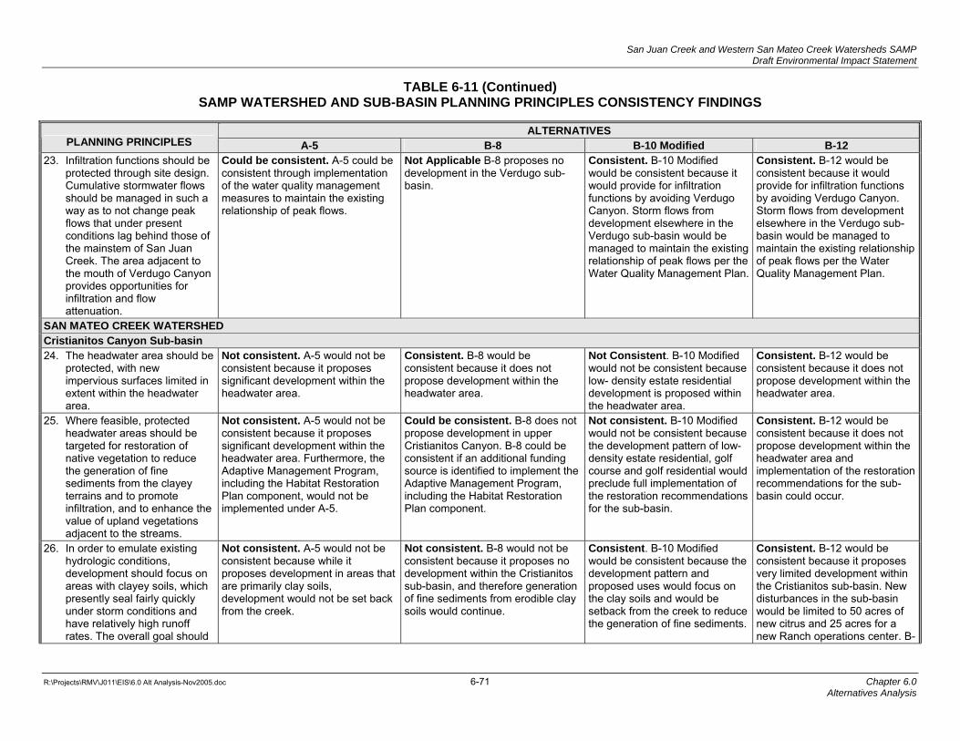
San Juan Creek and Western San Mateo Creek Watersheds SAMP Draft Environmental Impact Statement
TABLE 6-11 (Continued)
SAMP WATERSHED AND SUB-BASIN PLANNING PRINCIPLES CONSISTENCY FINDINGS
R:\Projects\RMV\J011\EIS\6.0 Alt Analysis-Nov2005.doc 6-71 Chapter 6.0
Alternatives Analysis
ALTERNATIVES PLANNING PRINCIPLES A-5 B-8 B-10 Modified B-12
23. Infiltration functions should be protected through site design. Cumulative stormwater flows should be managed in such a way as to not change peak flows that under present conditions lag behind those of the mainstem of San Juan Creek. The area adjacent to the mouth of Verdugo Canyon provides opportunities for infiltration and flow attenuation.
Could be consistent. A-5 could be consistent through implementation of the water quality management measures to maintain the existing relationship of peak flows.
Not Applicable B-8 proposes no development in the Verdugo sub-basin.
Consistent. B-10 Modified would be consistent because it would provide for infiltration functions by avoiding Verdugo Canyon. Storm flows from development elsewhere in the Verdugo sub-basin would be managed to maintain the existing relationship of peak flows per the Water Quality Management Plan.
Consistent. B-12 would be consistent because it would provide for infiltration functions by avoiding Verdugo Canyon. Storm flows from development elsewhere in the Verdugo sub-basin would be managed to maintain the existing relationship of peak flows per the Water Quality Management Plan.
SAN MATEO CREEK WATERSHED Cristianitos Canyon Sub-basin 24. The headwater area should be
protected, with new impervious surfaces limited in extent within the headwater area.
Not consistent. A-5 would not be consistent because it proposes significant development within the headwater area.
Consistent. B-8 would be consistent because it does not propose development within the headwater area.
Not Consistent. B-10 Modified would not be consistent because low- density estate residential development is proposed within the headwater area.
Consistent. B-12 would be consistent because it does not propose development within the headwater area.
25. Where feasible, protected headwater areas should be targeted for restoration of native vegetation to reduce the generation of fine sediments from the clayey terrains and to promote infiltration, and to enhance the value of upland vegetations adjacent to the streams.
Not consistent. A-5 would not be consistent because it proposes significant development within the headwater area. Furthermore, the Adaptive Management Program, including the Habitat Restoration Plan component, would not be implemented under A-5.
Could be consistent. B-8 does not propose development in upper Cristianitos Canyon. B-8 could be consistent if an additional funding source is identified to implement the Adaptive Management Program, including the Habitat Restoration Plan component.
Not consistent. B-10 Modified would not be consistent because the development pattern of low-density estate residential, golf course and golf residential would preclude full implementation of the restoration recommendations for the sub-basin.
Consistent. B-12 would be consistent because it does not propose development within the headwater area and implementation of the restoration recommendations for the sub-basin could occur.
26. In order to emulate existing hydrologic conditions, development should focus on areas with clayey soils, which presently seal fairly quickly under storm conditions and have relatively high runoff rates. The overall goal should
Not consistent. A-5 would not be consistent because while it proposes development in areas that are primarily clay soils, development would not be set back from the creek.
Not consistent. B-8 would not be consistent because it proposes no development within the Cristianitos sub-basin, and therefore generation of fine sediments from erodible clay soils would continue.
Consistent. B-10 Modified would be consistent because the development pattern and proposed uses would focus on the clay soils and would be setback from the creek to reduce the generation of fine sediments.
Consistent. B-12 would be consistent because it proposes very limited development within the Cristianitos sub-basin. New disturbances in the sub-basin would be limited to 50 acres of new citrus and 25 acres for a new Ranch operations center. B-

San Juan Creek and Western San Mateo Creek Watersheds SAMP Draft Environmental Impact Statement
TABLE 6-11 (Continued)
SAMP WATERSHED AND SUB-BASIN PLANNING PRINCIPLES CONSISTENCY FINDINGS
R:\Projects\RMV\J011\EIS\6.0 Alt Analysis-Nov2005.doc 6-72 Chapter 6.0
Alternatives Analysis
ALTERNATIVES PLANNING PRINCIPLES A-5 B-8 B-10 Modified B-12 be to reduce the generation of fine sediments compared with existing conditions to reduce turbidity effects and other adverse impacts of fine sediments on downstream aquatic resources. Development in the middle and lower reach areas should be set back from the creek and should be located in higher areas to the east of the creek where existing erosion could be concurrently addressed.
12 proposes a Habitat Restoration Plan component of the Adaptive Management Program that would help reduce the generation of fine sediments.
27. Stream stabilization opportunities should be examined in Cristianitos Creek (above the confluence with Gabino Creek) in the context of longer-term geologic processes.
Not consistent. A-5 would not be consistent because substantial development would occur east of the creek and in the headwater area and thus stream stabilization opportunities would not likely be able to be addressed. Furthermore, no Adaptive Management Program or Habitat Restoration Plan is proposed under A-5.
Could be consistent. B-8 could be consistent if an additional funding source is identified to implement the Adaptive Management Program, including the Habitat Restoration Plan component.
Consistent. B-10 Modified would be consistent because it proposes a development pattern and type of development that would provide for stream stabilization opportunities. In addition, B-10 Modified would implement the Habitat Restoration Plan component of the Adaptive Management Program which includes stream stabilization in Cristianitos Creek.
Consistent. B-12 would be consistent because it proposes very limited development in the Cristianitos sub-basin. New citrus and the Ranch operations center would be sited so as not to preclude stream stabilization opportunities. In addition, B-12 would implement the Habitat Restoration Plan component of the Adaptive Management Program which includes stream stabilization in Cristianitos Creek.
28. The alkali wetlands within the middle portion of the sub-basin should be protected in conjunction with protection of the overall riparian system.
Consistent. A-5 would be consistent because it would avoid all wetlands and thus would avoid the alkali wetlands.
Consistent. B-8 would be consistent because it proposes no development in the Cristianitos sub-basin and therefore would avoid the alkali wetlands and overall riparian system.
Consistent. B-10 Modified would be consistent because it avoids wetland/riparian vegetation, including the alkali wetlands associated with Cristianitos Creek.
Consistent. B-12 would be consistent because it proposes very limited development in the Cristianitos sub-basin. New citrus and the Ranch operations center would be sited to avoid the alkali wetlands and overall riparian system.

San Juan Creek and Western San Mateo Creek Watersheds SAMP Draft Environmental Impact Statement
TABLE 6-11 (Continued)
SAMP WATERSHED AND SUB-BASIN PLANNING PRINCIPLES CONSISTENCY FINDINGS
R:\Projects\RMV\J011\EIS\6.0 Alt Analysis-Nov2005.doc 6-73 Chapter 6.0
Alternatives Analysis
ALTERNATIVES PLANNING PRINCIPLES A-5 B-8 B-10 Modified B-12
Gabino and Blind Canyons Sub-basin 29. Limit new impervious surfaces
in the headwater area to locations that will not adversely impact runoff patterns.
Not consistent. A-5 would not be consistent because it proposes development in the headwaters area in Upper Gabino.
Consistent. B-8 would be consistent because it proposes no development in the Gabino sub-basin.
Consistent. B-10 Modified would be consistent because it proposes only 10 estate lots within the western portion of the Upper Gabino Subunit of the Gabino sub-basin and would have minimal impact on runoff patterns.
Consistent. B-12 would be consistent because it proposes no development in the Gabino sub-basin.
30. Protect the headwaters through restoration of existing gullies using a combination of slope stabilization, grazing management, and native grasslands and/or scrub restoration. To the extent feasible, restore native grasses to reduce sediment generation and promote infiltration of stormwater.
Not consistent. A-5 would not be consistent because it proposes development in areas shown for CSS/VGL enhancement and restoration and no Adaptive Management Program is proposed.
Could be consistent. B-8 could be consistent because it proposes no development in sub-basin. For B-8 to be consistent, an additional funding source would have to be identified to implement the Adaptive Management Program, including the Habitat Restoration Plan component.
Consistent. B-10 Modified would be consistent because through implementation of the Habitat Restoration Plan component of the Adaptive Management Program, fine sediment yields would be decreased.
Consistent. B-12 would be consistent because through implementation of the Habitat Restoration Plan component of the Adaptive Management Program, fine sediment yields would be decreased.
31. Modify grazing management in the upper portion of the sub-basin to support restoration and vegetation management in the headwater areas.
Not consistent. Under A-5, this recommendation would not be consistent because there would be no grazing in Upper Gabino due to development.
Could be consistent. B-8 could be consistent if an additional funding source was identified to implement the Adaptive Management Program.
Consistent. B-10 Modified would be consistent because it would implement the Adaptive Management Program and the Grazing Management Plan.
Consistent. B-12 would be consistent because it would implement the Adaptive Management Program and the Grazing Management Plan.
32. Minimize impacts to the steep side canyons in the middle portion of the sub-basin by limiting new impervious surfaces.
Not consistent. A-5 would not be consistent because it would allow development in the middle portion of the sub-basin.
Consistent. B-8 would be consistent because no development in Middle Gabino is proposed.
Consistent. B-10 Modified would be consistent because no development in Middle Gabino is proposed.
Consistent. B-12 would be consistent because no development in Middle Gabino is proposed.
33. To the extent feasible, focus development in clayey soils & terrains in the lower portions of the sub-basin, where it could serve to reduce the generation of fine sediments and associated turbidity.
Not consistent. A-5 would not be consistent because it would allow development in each of the three major reaches in the Gabino sub-basin. In addition, no Adaptive Management Program is proposed under A-5.
Not Consistent. B-8 proposes no development in upper Gabino Canyon that could serve to reduce the generation of fine sediments and associated turbidity.
Consistent. B-10 Modified would be consistent because, it focuses development on clayey soils and terrains to address the generation of fine sediments.
Not Consistent. B-12 proposes no development in upper Gabino Canyon that could serve to reduce the generation of fine sediments and associated turbidity.

San Juan Creek and Western San Mateo Creek Watersheds SAMP Draft Environmental Impact Statement
TABLE 6-11 (Continued)
SAMP WATERSHED AND SUB-BASIN PLANNING PRINCIPLES CONSISTENCY FINDINGS
R:\Projects\RMV\J011\EIS\6.0 Alt Analysis-Nov2005.doc 6-74 Chapter 6.0
Alternatives Analysis
ALTERNATIVES PLANNING PRINCIPLES A-5 B-8 B-10 Modified B-12
34. To the extent feasible, utilize the side canyon currently degraded by past mining activities for natural water quality treatment systems.
Consistent. A-5 would be consistent because it would allow for use of the degraded side-canyon for natural water quality treatment systems.
Not applicable. B-8 proposes no development in the Gabino sub-basin, therefore water quality treatment facilities would be unnecessary.
Consistent. B-10 Modified would be consistent because it would allow for use of the degraded side-canyon for natural water quality treatment systems through implementation of the Water Quality Management Plan.
Not applicable. B-12 proposes no development in the Gabino Creek portion of the Gabino and Blind Canyons subunit and therefore water treatment facilities would not be necessary.
35. In the lower reach of the creek, protect significant riparian vegetation along the south side of the creek and on proximate side canyon slopes. Limit development and other uses in Blind Canyon to the grazed areas on the mesa and away from the major oak woodlands in Blind Canyon. Direct to and treat stormwater runoff in areas that will not contribute to appreciable increases in water delivery/flow to the oak woodlands in the lower portion of the sub-basin.
Not consistent. A-5 would not be consistent because it would allow development along the south side of the creek and on proximate side canyon slopes. A-5 would provide for comprehensive water quality treatment through water quality management measures.
Consistent. B-8 would be consistent because it proposes no development within the Gabino sub-basin.
Could be consistent. B-10 Modified could be consistent if expansion of Cristianitos Road across lower Gabino Creek would avoid significant riparian vegetation. Otherwise B-10 Modified would be consistent because no development is proposed along the south side of the Gabino Creek. Development would be focused on the grazed areas on the mesa and away from the major oak woodlands in Blind Canyon. Runoff from the Blind Canyon subunit would be managed through implementation of the Water Quality Management Plan.
Could be consistent. B-12 could be consistent because development in PA 8 is limited to a maximum of 500 acres, but the development footprint has not been determined. Development could be sited to avoid major oak woodlands in Blind Canyon. It would avoid riparian vegetation in lower Gabino Creek and it would manage any runoff from the Blind Canyon subunit through implementation of Water Quality Management Plan.
36. Protect the integrity of arroyo toad populations in lower Gabino Creek by maintaining hydrologic and sediment delivery processes, including maintaining the flow characteristics of episodic events in the sub-basin. Utilize natural water quality treatment systems to manage and treat runoff from any new land uses in areas adjacent to the lower creek.
Not consistent. A-5 would not be consistent because although it would be primarily low-density estate development, the amount of land area that could be developed in the sub-basin is so substantial that maintaining hydrologic and sediment delivery processes would be very difficult. However, due to the low-density character of development, A-5 could utilize natural water quality treatment systems consistent with the second part of the recommendation. A-5
Consistent. B-8 would be consistent because it proposes no development within the Gabino sub-basin and existing hydrologic and sediment delivery processes would be maintained.
Could be consistent. B-10 Modified could be consistent if a substantial bridge or box culvert creek crossing is designed and constructed in association with the expansion of Cristianitos Road to avoid arroyo toad breeding habitat and streamcourse morphology. Development in the Gabino and Blind Canyon subunit would be focused on the grazed areas on the mesa and runoff from Blind Canyon would be managed
Consistent. B-12 would be consistent because no development is proposed along Gabino Creek. Development in PA 8 is limited to a maximum of 500 acres, but the development footprint has not been determined. Any development in the Blind Canyon subunit would be focused on the grazed areas on the mesa and runoff from Blind Canyon would be managed through implementation of the Water Quality Management

San Juan Creek and Western San Mateo Creek Watersheds SAMP Draft Environmental Impact Statement
TABLE 6-11 (Continued)
SAMP WATERSHED AND SUB-BASIN PLANNING PRINCIPLES CONSISTENCY FINDINGS
R:\Projects\RMV\J011\EIS\6.0 Alt Analysis-Nov2005.doc 6-75 Chapter 6.0
Alternatives Analysis
ALTERNATIVES PLANNING PRINCIPLES A-5 B-8 B-10 Modified B-12
would not provide for comprehensive water quality treatment, although compliance with the County DAMP would be necessary.
through implementation of the Water Quality Management Plan.
Plan.
La Paz Canyon Sub-basin 37. Development should be
limited in extent in order to protect the generation and transport of coarse sediment to downstream areas. Note: The avoidance of impacts in this sub-basin is extremely important because: (1) La Paz canyon provides a very important source of cobbles that contribute to downstream arroyo toad breeding habitat (in conjunction with coarse sediments generated within the middle reach of Gabino Canyon) both within the planning area and in the stream system outside the planning area, and (2) episodic storm events occurring within the La Paz Canyon watershed will not be altered in any way, thereby contributing important streamcourse processes for arroyo toad and other aquatic species both within the planning area and downstream of the planning area. Therefore, the protection of the La Paz basin physical processes is an important element in overall consistency
Consistent. A-5 would be consistent because it proposes no development in this sub-basin.
Consistent. B-8 would be consistent because it proposes no development in this sub-basin.
Consistent. B-10 Modified would be consistent because it proposes no development in this sub-basin.
Consistent. B-12 would be consistent because it proposes no development in this sub-basin.

San Juan Creek and Western San Mateo Creek Watersheds SAMP Draft Environmental Impact Statement
TABLE 6-11 (Continued)
SAMP WATERSHED AND SUB-BASIN PLANNING PRINCIPLES CONSISTENCY FINDINGS
R:\Projects\RMV\J011\EIS\6.0 Alt Analysis-Nov2005.doc 6-76 Chapter 6.0
Alternatives Analysis
ALTERNATIVES PLANNING PRINCIPLES A-5 B-8 B-10 Modified B-12 of the NCCP/HCP with the Watershed Planning Principles.
38. Development should be set back from riparian vegetation within the relatively narrow and geologically confined riparian zone.
Consistent. A-5 would be consistent because it proposes no development in this sub-basin.
Consistent. B-8 would be consistent because it proposes no development in this sub-basin.
Consistent. B-10 Modified would be consistent because it proposes no development in this sub-basin.
Consistent. B-12 would be consistent because it proposes no development in this sub-basin.
Talega Canyon Sub-basin 39. To the extent feasible, major
stormwater flows from development areas should emulate current runoff patterns. Runoff during the dry season and high frequency/low magnitude storms (generally 1-2 year storm events) should be routed through natural water quality treatment systems and, where feasible, encouraged to flow generally away from arroyo toad habitat in Talega Canyon and toward Blind Canyon.
Not consistent. A-5 would not be consistent because of extensive development on side slopes on the ridge above the creek (where Northrop Grumman facilities are currently located). Thus, A-5 would not be able to feasibly route flows back up and over the ridge for much of the development area.
Not Applicable. B-8 proposes no development within the Talega sub-basin, therefore development related runoff management would not be necessary.
Consistent. B-10 Modified would be consistent because under B-10 Modified, the hydrology section of the Water Quality Management Plan indicates that routing both dry season flows and 1-2 year storm flows in excess of existing conditions toward Blind Canyon would occur, and current runoff patterns would be emulated..
Consistent. B-12 would be consistent because the hydrology section of the Water Quality Management Plan indicates that with the implementation of Best Management Practices for the future 500 acres of development, current runoff patterns would be emulated.
40. Development should focus on the ridge tops to avoid the canyon bottoms and preserve the steeper slopes. To the extent practical, development should generally be in the area of the existing Northrop Grumman facilities and adjacent ridges to the east/northeast.
Not consistent. A-5 would not be consistent because it proposes development on the side slopes as well as the top of the ridges.
Not Applicable. B-8 proposes no development within the Talega sub-basin therefore development related runoff management would not be necessary.
Not consistent. B-10 Modified would not be consistent because although it proposes development on the ridge tops within the Talega sub-basin to avoid the canyon bottom consistent with the recommendation, it also proposes development within the Blind sub-basin on both ridge tops and the canyon bottom, inconsistent with the recommendation. Development would largely be located on the
Could be consistent. B-12 could be consistent because development in PA 8 is limited to a maximum of 500 acres, but the development footprint has not been determined. It could be consistent because it proposes development on the ridge tops within the Talega sub-basin to avoid the canyon bottom consistent with the recommendation, but any development within the Blind sub-basin on both ridge tops and

San Juan Creek and Western San Mateo Creek Watersheds SAMP Draft Environmental Impact Statement
TABLE 6-11 (Continued)
SAMP WATERSHED AND SUB-BASIN PLANNING PRINCIPLES CONSISTENCY FINDINGS
R:\Projects\RMV\J011\EIS\6.0 Alt Analysis-Nov2005.doc 6-77 Chapter 6.0
Alternatives Analysis
ALTERNATIVES PLANNING PRINCIPLES A-5 B-8 B-10 Modified B-12
existing Northrop Grumman uses and the area to the east/northeast, although a portion of the development area would extend south of the existing Northrop Grumman facilities.
the canyon bottom, would be inconsistent with the recommendation. It is anticipated that development would largely be located on the existing Northrop Grumman uses and the area to the east/northeast, although a portion of the development area could extend south of the existing Northrop Grumman facilities.
41. The timing of peak flows should emulate the timing of flows under existing conditions.
Consistent. A-5 likely would be consistent because given the low density nature of development, the timing of peak flows could be managed in order to be consistent because it would implement flow management measures.
Not Applicable. B-8 proposes no development within the Talega sub-basin therefore peak flow management would not be necessary.
Consistent. B-10 Modified would be consistent because the Water Quality Management Plan indicates that the timing of peak flows will emulate existing conditions consistent with the recommendation through the implementation of Best Management Practices.
Consistent. B-12 would be consistent because the Water Quality Management Plan indicates that the timing of peak flows will emulate existing conditions consistent with the recommendation through the implementation of Best Management Practices.

San Juan Creek and Western San Mateo Creek Watersheds SAMP Draft Environmental Impact Statement
R:\Projects\RMV\J011\EIS\6.0 Alt Analysis-Nov2005.doc 6-78 Chapter 6.0
Alternatives Analysis
For the “could be consistent” findings, Principles 7, 9, 13, 14, 25, 27, 30, and 31 identify funding to support implementation of the Aquatic Resources Adaptive Management Program, including implementation of the Aquatic Resources Restoration Plan (Appendix F2), long-term control of invasive species, and stabilization/restoration of areas generating fine sediments in the San Mateo Creek Watershed. The availability of funds for implementation of the Aquatic Resources Adaptive Management Program as a result of the limited regulatory “nexus” under the B-8 Alternative cannot be determined at this time. Therefore, to ensure adequate funding is considered speculative. The inability to ensure funding of the Aquatic Resources Adaptive Management Program is significant in terms of overall aquatic resource conservation area design and long-term function. Additional feasibility considerations relating to funding required to assure the long-term protection of aquatic resources are reviewed in the following section.
For the “not consistent” findings, the three conflicts associated with the B-8 Alternative relate to proposed development in the valley floor and alluvial side canyons in the Gobernadora Sub-basin (Principle 10), the impact on a vernal pool supporting fairy shrimp on the Radio Tower Road mesa (Principle 19), and the continued generation of fine sediments from erodible clay soils in the Cristianitos Sub-basin (Principle 26) and in the Gabino Sub-basin (Principle 33). The lack of consistency with Principle 10 regarding the valley floor and alluvial side canyons in Gobernadora is common to all alternatives and is not a significant reserve design issue. Avoidance of the vernal pool supporting fairy shrimp on the portion of Radio Tower Road mesa within the Trampas Canyon proposed development area is not considered feasible because of the reduced available development acreage under this alternative scenario. The continued generation of fine sediments in the Cristianitos and Gabino Sub-basins if restoration is not undertaken is a potentially significant aquatic resource conservation area design as it may affect downstream resources.
6.4.2.3 Alternative B-10 Modified
Alternative B-10 Modified is 80 percent (33/40 total) consistent with the Watershed Planning Principles. Revisions to the B-10 Modified Alternative would be necessary to achieve consistency with Principles 35 and 36. Alternative B-10 Modified would conflict with six (15 percent) of the Principles (8, 10, 19, 21, 25, and 40).
With regard to “could be consistent” findings, consistency with Principles 35 and 36 could be attained by design and construction of a collector road over Cristianitos Creek that would avoid significant riparian habitat, arroyo toad breeding habitat, and avoid altering stream course morphology. Upgrading existing Cristianitos Road to County standards would require the removal of the existing at-grade Arizona style (pipe and concrete) crossing of Gabino Creek and construction of a box culvert in the same general location, which would improve habitat quality for the arroyo toad.
For the “not consistent” findings, Alternative B-10 Modified conflicts with recommendations in the Chiquita, Gobernadora, Trampas, Cristianitos, and Blind Canyon Sub-basins, including (1) impacts to slope wetlands north of the treatment plant in Chiquita; (2) impacts in the Gobernadora Sub-basin where development is proposed in the alluvial side canyons and the valley floor in a few locations, even though proposed development would generally avoid the valley floor and would be set back on Chiquadora Ridge; (3) impacts to one area of vernal pools in the Trampas Canyon Sub-basin that support the Riverside and San Diego fairy shrimp; (4) impacts in the Cristianitos Sub-basin that would preclude full implementation of the restoration recommendations; (5) impacts to the Verdugo Sub-basin; and (6) impacts in Planning Area 8 (Northrop Grumman) concentrated in the Blind Canyon Sub-basin on both

San Juan Creek and Western San Mateo Creek Watersheds SAMP Draft Environmental Impact Statement
R:\Projects\RMV\J011\EIS\6.0 Alt Analysis-Nov2005.doc 6-79 Chapter 6.0
Alternatives Analysis
ridges and the valley bottom in order to avoid the vast majority of the San Mateo Watershed in the planning area.
Overall, Alternative B-10 Modified achieves a high (80 percent) degree of consistency with the Watershed Planning Principles and has limited conflicts (12 percent) and limited significant impacts.
6.4.2.4 Alternative B-12
Alternative B-12 is 90 percent (36/40 total) consistent with the Watershed Planning Principles. Modifications to the B-12 Alternative would be necessary to achieve consistency with Principles 35 and 40. Alternative B-12 would conflict with 2 (5 percent) of the Principles (10 and 33).
With regard to “could be consistent” findings, Principle 35 relates to the protection of oak woodlands in Blind Canyon. The final configuration of development within PA 8 is undetermined at this time therefore no final consistency finding can be made, although the final development configuration could avoid the oak woodlands. Principle 40 recommends that development in the Talega Sub-basin focus on the ridge tops and avoid the steeper side slopes, similar to Principle 35 a could be consistent determination is made pending the final configuration of Planning Area 8.
For the “not consistent” findings, Alternative B-12 primarily conflicts with recommendations in the Chiquita, Gobernadora, and Blind Sub-basins for protecting side canyons. According to the design of this alternative:
• Chiquita Sub-basin. Under the B-12 Alternative, limited development is assumed in middle Chiquita Canyon. Overall, development is focused on the ridges and away from the side canyons above the treatment plant. However, in order to achieve this level of avoidance (including avoidance of the main valley floor), all development would be concentrated mainly south of the treatment plant, resulting in impacts to one major side canyon.
• Gabino Sub-basin. B-12 proposed no development in the Gabino sub-basin that could serve to reduce the generation of fine sediments and associated turbidity.
Overall, Alternative B-12 achieves a high degree (36 of 40) of consistency with the Watershed Planning Principles and has limited conflicts (2 total) and therefore limited significant impacts. As noted above, each of the three main conflict areas result from concentrating development in a few side canyons in order to avoid most of the other planning area side canyons and all of the major canyon valley floors and associated stream courses.
6.4.2.5 Circulation Systems Consistency Analysis
Each of the “B” Alternatives analyzed in this chapter requires an overall circulation system to support potential development areas. The conceptual circulations systems for Alternatives B-8, B-10 Modified, and B-12 are depicted in Figures 6-3, 6-4, and 6-5, respectively. Alternative A-5 would use the existing ranch road network; therefore, no consistency analysis is required for this alternative. To identify the potential impacts of the alternative circulation systems on the proposed permanent open space for each of the alternatives, this subchapter analyzes the circulation systems with regard to the sub-basin Watershed Planning Principles.

San Juan Creek and Western San Mateo Creek Watersheds SAMP Draft Environmental Impact Statement
R:\Projects\RMV\J011\EIS\6.0 Alt Analysis-Nov2005.doc 6-80 Chapter 6.0
Alternatives Analysis
Those portions of the circulation systems located outside the proposed development areas RMV Planning Area were reviewed for consistency with the specific Watershed Planning Principles applicable to each sub-basin. For the portions of the circulation systems located within proposed development areas of the RMV Planning Area, the potential impacts are already assumed in the development area impact and therefore do not require separate analysis.
Because the SAMP does not provide an evaluation framework for analyzing impacts to Waters of the U.S for the SOCTIIP and because the alternative circulation systems have been designed to serve the alternative development areas without the need for the SOCTIIP, the analysis for Alternatives B-8 and B-12 is limited to the circulation element features which are proposed to be authorized in conjunction with each alternative. Biological impacts associated with the alternative SOCTIIP alignments on the alternatives are addressed in the cumulative impacts chapter of this EIS. For Alternative B-10 Modified, the analysis assumes that the SOCTIIP project would be constructed as depicted on the Master Plan of Arterial Highways (MPAH) and, as a result, this alternative has assumed construction of the SOCTIIP as part of the circulation system. Therefore, for this alternative, the MPAH SOCTIIP alignment is reviewed for consistency, along with other circulation facilities, as described below.
The review of the different circulation systems reflects two different assumptions: (1) MPAH modifications proposed or identified in conjunction with the different alternatives; and (2) the circulation elements shown on the existing MPAH (with the exception of the SOCTIIP for the reasons previously noted, other than for Alternative B-10 Modified). These circulation system assumptions are used for each sub-basin consistency review in this chapter.
San Juan Creek Watershed
Chiquita Sub-Basin
B-8 Alternative Circulation System Consistency Review. The level of development proposed under the B-8 Alternative would not necessitate the construction of the Crown Valley Parkway extension shown on the MPAH. Consistency review of this facility is therefore not required.
Because no development is proposed in the Chiquita Sub-basin, Chiquita Canyon Road would not be constructed and therefore habitat linkage E would be unaffected.
The arterial extension of Cristianitos Road/F Street crossing over from the Gobernadora development area to Oso Parkway would be required. Because of the increased habitat connectivity within the Chiquita Sub-basin under Alternative B-8, no significant connectivity impacts are anticipated.
The B-8 Alternative proposes one major change to the existing MPAH within the Chiquita Sub-basin: the addition of major east-west arterial (Cow Camp Road) north of San Juan Creek. This modification would require the construction of a bridge over Chiquita Creek. This MPAH change would have the following consistency implications:
• The construction of Cow Camp Road north of San Juan Creek would require a bridge crossing over Chiquita Creek, but generally would avoid the valley floor and biological resources.
• Construction of a major arterial on the north side of San Juan Creek is anticipated to reduce traffic on existing Ortega Highway as set forth in GPA/ZC EIR 589. The reduction

San Juan Creek and Western San Mateo Creek Watersheds SAMP Draft Environmental Impact Statement
R:\Projects\RMV\J011\EIS\6.0 Alt Analysis-Nov2005.doc 6-81 Chapter 6.0
Alternatives Analysis
of traffic on Ortega Highway would reduce vehicle impacts on animal species and potentially further recovery efforts for the arroyo toad.
Alternative B-10 Modified Circulation System Consistency Review. Under Alternative B-10 Modified scenario, the SOCTIIP MPAH alignment is assumed to be constructed within the Chiquita Sub-basin. This SOCTIIP alignment is the same as that proposed for Cristianitos Road/F Street under the B-8 and B-12 Alternatives; therefore, some of the same consistency issues would occur, namely impacts to linkages D and E. Avian wildlife movement would not be impacted. In the event the SOCTIIP is not constructed, Cristianitos Road/F Street would be extended from the proposed Gobernadora development area to Oso Parkway as proposed for the other alternatives.
As with the other alternatives, the Crown Valley Parkway extension would not be constructed as a part of the B-10 Modified Alternative.
Similar to the other “B” Alternatives, Alternative B-10 Modified also proposes the construction of Cow Camp Road. Therefore, the consistency analysis described above for Alternative B-8 would also apply to Alternative B-10 Modified.
Chiquita Canyon Road to the east of the SMWD treatment plant would impact ground-dwelling wildlife movement in linkage E.
Widening of Ortega Highway between La Pata and the western boundary of the RMV Planning Area would result in temporary construction related impacts to San Juan Creek (linkage J) and permanent impacts associated with the placement of additional bridge piers. However, such impacts are not anticipated to impede wildlife movement along linkage J. Similar impacts would occur from the widening of the Antonio/La Pata bridge over San Juan Creek; these impacts are also not anticipated to impede wildlife movement.
B-12 Alternative Circulation System Consistency Review. The B-12 Alternative proposes one major change to the existing MPAH within the Chiquita Sub-basin: the addition of major east-west arterial (Cow Camp Road) north of San Juan Creek. Therefore, the consistency analysis described above for Alternative B-8 and Alternative B-10 Modified would also apply to Alternative B-12.
The level of development proposed under the B-12 Alternative, particularly the limited development in the Chiquita Sub-basin, would not necessitate the construction of the Crown Valley Parkway extension shown on the MPAH. Consistency review of this facility is therefore not required for this alternative.
The arterial extension (Cristianitos Road/F Street) from the Gobernadora development area to Oso Parkway would have limited impacts on linkage D due to the lack of development in middle Chiquita Canyon. Avian wildlife movement would not be impacted.
Widening of Ortega Highway between La Pata and the western boundary of the RMV Planning Area would result in temporary construction related impacts to San Juan Creek (linkage J) and permanent impacts associated with the placement of additional bridge piers. However, such impacts are not anticipated to impede wildlife movement along linkage J. Similar impacts would occur from the widening of the Antonio/La Pata bridge over San Juan Creek; these impacts are also not anticipated to impede wildlife movement.

San Juan Creek and Western San Mateo Creek Watersheds SAMP Draft Environmental Impact Statement
R:\Projects\RMV\J011\EIS\6.0 Alt Analysis-Nov2005.doc 6-82 Chapter 6.0
Alternatives Analysis
Gobernadora Sub-basin
B-8 Alternative Circulation System Consistency Review. Cristianitos Road/F Street would extend from the proposed Gobernadora development area to Oso Parkway. This road is proposed to be elevated above the valley floor and, if the creek is bridged and is constructed in such a way as to allow for the recommended creek meander restoration program, the arterial road would be consistent with the sub-basin recommendations. The road has been aligned to avoid impacting Sulphur Canyon and thus would be consistent with the Sulphur Canyon restoration recommendations. The B-8 Alternative Circulation System would be consistent with the sub-basin recommendations.
B-10 Modified Circulation System Consistency Review. The B-10 Modified Alternative assumes that the SOCTIIP project would be constructed in the MPAH alignment. In order to be consistent with the sub-basin recommendations, the SOCTIIP would have to be elevated above the valley floor, bridge Gobernadora Creek, and be constructed to allow for implementation of the Gobernadora Creek Restoration Plan recommendations. The MPAH alignment would avoid impacting Sulphur Canyon and would be consistent with the Sulphur Canyon restoration recommendations that are also an element of the Aquatic Resources Habitat Restoration Plan. In the event the SOCTIIP is not constructed, Cristianitos Road/F Street would be extended from the Gobernadora development area to Oso Parkway as proposed for the other alternatives.
B-12 Alternative Circulation System Consistency Review. The B-12 Alternative shows Cristianitos Road/F Street extending from the proposed Gobernadora development area to Oso Parkway. This road is proposed to be elevated above the valley floor and, if the creek is bridged and the road is constructed in such a way as to allow for the recommended creek meander restoration program, the arterial road would be consistent with the sub-basin recommendations. The road has been aligned to avoid impacting Sulphur Canyon and thus would be consistent with the Sulphur Canyon restoration recommendation. The B-12 Circulation System would be consistent with the sub-basin recommendations.
Trampas and Central San Juan Sub-basin
All of the “B” Alternatives propose the same arterial crossing of San Juan Creek and would have the same physical impacts, including permanent impacts resulting from placement of piers in the creek and temporary impacts associated with construction of Cristianitos Road/F Street. In addition to the arterial crossing, the B-10 Modified Alternative also assumes construction of the SOCTIIP in the MPAH alignment. This would require a second crossing of San Juan Creek. Impacts from SOCTIIP generally would be similar to those of the arterial crossing (i.e., temporary construction impacts and permanent impacts associated with the placement of piers).
Measures to reduce impacts to arroyo toad breeding habitat would be implemented during construction of the bridge, such as toad exclusion fencing, minimal to no construction activity during the breeding season, sediment control measures, and biological monitoring. Existing hydrology would be maintained with construction of the bridge.
Verdugo Sub-basin
B-8 Alternative Circulation System Consistency Analysis. Because no development is proposed in Verdugo Canyon, the B-8 Alternative would be consistent with the recommendations.

San Juan Creek and Western San Mateo Creek Watersheds SAMP Draft Environmental Impact Statement
R:\Projects\RMV\J011\EIS\6.0 Alt Analysis-Nov2005.doc 6-83 Chapter 6.0
Alternatives Analysis
B-10 Modified Alternative Circulation System Consistency Analysis. Verdugo Road would provide access to proposed development within the Verdugo Sub-basin. This two-lane collector within Planning Area 4 would connect to Cow Camp Road near Caspers Wilderness Park. No consistency issues would occur with this road because it would avoid Verdugo Canyon and its source of coarse sediments. Outside of Planning Area 4, a combination of existing Verdugo Road and existing ranch roads would provide access to the ten proposed estate lots in upper Gabino Canyon. A waiver from County subdivision access requirements would be necessary for this type of access. Consistency with the sub-basin recommendations is dependent upon receipt of this waiver.
B-12 Alternative Circulation System Consistency Review. The B-12 Alternative proposes that development in the Verdugo Sub-basin, (but outside of Verdugo Canyon) be accessed via Cow Camp Road and Ortega Highway near Caspers Wilderness Park. No consistency issues would occur with this road as it would avoid the canyon and its source of coarse sediments.
San Mateo Creek Watershed
Cristianitos Sub-basin
B-8 Alternative Circulation System Consistency Analysis. Under the B-8 Alternative, existing Cristianitos Road, a two-lane private ranch access road, would remain in its existing condition. Therefore, the B-8 Alternative circulation system would be consistent with the sub-basin recommendations.
B-10 Modified Alternative Circulation System Consistency Analysis. The B-10 Modified Alternative circulation system in the Cristianitos Sub-basin proposes using a combination of existing, but upgraded Cristianitos Road and other ranch roads, in addition to the SOCTIIP, to access the proposed development in Cristianitos Canyon and Cristianitos Meadows. Upgrading the ranch roads would (1) avoid the headwaters of Cristianitos Creek, (2) preserve the opportunity to implement the coastal sage scrub/valley needlegrass grassland restoration recommendations, (3) avoid the alkali wetlands/creek riparian areas, and (4) preserve stream stabilization opportunities. Therefore, these upgraded roads would be consistent with the sub-basin recommendations.
The MPAH alignment for the SOCTIIP in the Cristianitos Sub-basin would conflict with the restoration recommendations for the sub-basin, and may impact the alkali wetlands and the headwaters of Cristianitos Creek. The MPAH alignment for the SOCTIIP also would impact habitat linkage N that has been identified as an important dispersal linkage for the California gnatcatcher. The SOCTIIP would not be consistent with the sub-basin recommendations.
B-12 Alternative Circulation System Consistency Review. Under the B-12 Alternative, existing Cristianitos Road, a two-lane private ranch access road, would remain in its existing condition. Therefore, the B-12 Alternative circulation system would be consistent with the sub-basin recommendations.
Gabino and Blind Canyons Sub-basin
B-8 Alternatives Circulation System Consistency Review. Because the B-8 Alternative does not propose development in the San Mateo Creek Watershed, this alternative would not create any potential circulation system impact considerations. This alternative would be consistent with the sub-basin recommendations.

San Juan Creek and Western San Mateo Creek Watersheds SAMP Draft Environmental Impact Statement
R:\Projects\RMV\J011\EIS\6.0 Alt Analysis-Nov2005.doc 6-84 Chapter 6.0
Alternatives Analysis
B-10 Modified Alternative Circulation Consistency Analysis. The B-10 Modified Alternative proposes to upgrade the existing Cristianitos Road to County standards and assumes construction of the SOCTIIP in the MPAH alignment. Regarding the upgrade of Cristianitos Road, the consistency analysis described above for the Cristianitos Sub-basin would apply.
The SOCTIIP would likely result in temporary construction impacts and permanent impacts to Gabino Creek associated with placement of bridge piers in Gabino Creek.
B-12 Alternative Circulation System Consistency Review. Under the B-12 Alternative, existing Cristianitos Road, a two-lane private ranch access road, would remain in its existing condition. Therefore, the B-12 Alternative circulation system would be consistent with the sub-basin recommendations.
La Paz Sub-Basin
B-8, B-10 Modified, and B-12 Alternatives Circulation System Consistency Review. Alternatives B-8, B-10 Modified, and B-12 do not assume development within the La Paz Sub-basin and therefore would be consistent with the sub-basin recommendations.
Talega Sub-Basin
B-8 Alternative Circulation System Consistency Review. Because the B-8 Alternative does not propose development in the San Mateo Creek Watershed, this alternative would not create any potential circulation system impact considerations. This alternative would be consistent with the sub-basin recommendations.
B-10 Modified Alternative Circulation System Consistency Review. The B-10 Modified Alternative circulation system proposes construction of a bridge over Cristianitos Creek connecting Avenida Pico to existing Cristianitos Road. Internal residential streets would also be constructed in the Talega Sub-basin. Construction of a bridge over Cristianitos Creek would not affect dry season and stormwater flows and thus would not cause any potential conflicts with the recommendations for this sub-basin.
B-12 Alternative Circulation System Consistency Review. Access to proposed development in the Talega Sub-basin under the B-12 Alternative would be via the construction of a bridge over Cristianitos Creek connecting existing Avenida Pico to existing Cristianitos Road. Internal residential streets would also be constructed in the Talega Sub-basin. Temporary impacts to Cristianitos Creek resulting from construction of this bridge would occur, as would permanent impacts associated with the placement of piers in Cristianitos Creek to support the bridge structure. Long-term north-south wildlife movement along Cristianitos Creek would be unaffected by the bridge. Measures to reduce impacts to arroyo toad breeding habitat would be implemented during construction of the bridge, such as toad exclusion fencing, minimal to no construction activity during the breeding season, sediment control measures, and biological monitoring. Existing hydrology would be maintained with construction of the bridge. The B-12 Alternative circulation system could be consistent with the sub-basin recommendations.
Other Planning Area
B-8 Alternative Circulation System Consistency Review. Because the B-8 Alternative does not propose development in the “Other Planning Area,” this alternative would not create any potential circulation system impact. This alternative would be consistent with the recommendations.

San Juan Creek and Western San Mateo Creek Watersheds SAMP Draft Environmental Impact Statement
R:\Projects\RMV\J011\EIS\6.0 Alt Analysis-Nov2005.doc 6-85 Chapter 6.0
Alternatives Analysis
B-10 Modified Alternative Circulation System Consistency Review. Within the Other Planning Area, the B-10 Modified Alternative proposes the same Cristianitos Road Bridge and upgrades as discussed above for the Talega Sub-basin. However, in addition to the Cristianitos Road Bridge, the B-10 Modified Alternative also assumes that the SOCTIIP would be constructed in the MPAH alignment. The Far East alignment would impact habitat linkage N, potentially affecting gnatcatcher connectivity from northerly sub-basins, particularly the Cristianitos Sub-basin, to populations in lower Cristianitos Creek/San Mateo Creek on MCB Camp Pendleton. Breeding and foraging habitat and movement opportunities within the Cristianitos stream course and adjacent alluvial terraces for the arroyo toad may be affected by the Far East alignment. The east-west habitat linkage O from Gabino Creek to the confluence with Cristianitos Creek to protect wildlife movement from Gabino Canyon and the Donna O’Neill Conservancy may be impacted by construction of the SOCTIIP in the Far East alignment. The SOCTIIP in the Far East alignment would not be consistent with the sub-basin Planning Recommendations.
B-12 Alternative Circulation System Consistency Review. The B-12 Alternative circulation system proposes construction of a bridge over Cristianitos Creek connecting existing Avenida Pico to existing Cristianitos Road within the Other Planning Area. Temporary impacts to Cristianitos Creek resulting from construction of this bridge would occur, as would permanent impacts associated with the placement of piers in Cristianitos Creek to support the bridge structure. Long-term north-south wildlife movement along Cristianitos Creek would be unaffected by the bridge. Measures to reduce impacts to arroyo toad breeding habitat would be implemented during construction of the bridge, such as toad exclusion fencing, minimal to no construction activity during the breeding season, sediment control measures, and biological monitoring. Existing hydrology would be maintained with construction of the bridge. The B-12 Alternative circulation system could be consistent with the sub-basin recommendations.
6.5 ALTERNATIVES REJECTED FROM FURTHER CONSIDERATION IN CHAPTER 8.0 UNDER CLEAN WATER ACT SECTION 404(b)(1)
Subchapters 6.1, 6.2, and 6.3 provided detailed analyses of the consistency of each of the “B” Alternatives selected for further review with the SAMP Tenets and the Watershed Planning Principles. The following presents overviews and summaries of consistency with the SAMP Tenets and Watershed Planning Principles, and provides recommendations as to whether an alternative should be considered in the Chapter 8.0 Section 404(b)(1) Guidelines Consistency Review or should be removed from further consideration. This subchapter also reviews the ability of the No Project Alternatives, Alternative A-4 and Alternative A-5, to meet the SAMP Purposes and Goals as set forth in Chapter 3.0.
Substantial aquatic habitat resource areas have been protected under a variety of actions that preceded the SAMP process. These aquatic resource protection areas include: Bell Canyon, Lucas Canyon and San Juan Creek within Caspers Wilderness Park, virtually all of the riparian habitat within Arroyo Trabuco, GERA in the Gobernadora Sub-basin, riparian habitat in upper Chiquita and the Donna O’Neill Land Conservancy, and vernal pools in the Ladera Land Conservancy. These protected areas are assumed to provide a significant component of resources that could be protected in conjunction with the Aquatic Resources Conservation Program for the RMV Planning Area. Consequently, the following analyses focus primarily on three “B” Alternatives (Alternatives B-8, B-10 Modified, and B-12) and two “A” Alternatives (Alternatives A-4 and A-5) that address the RMV Planning Area. The RMV Planning Area comprises the vast majority of the private landholdings that provide SAMP/Aquatic Resources Conservation Program planning opportunities.

San Juan Creek and Western San Mateo Creek Watersheds SAMP Draft Environmental Impact Statement
R:\Projects\RMV\J011\EIS\6.0 Alt Analysis-Nov2005.doc 6-86 Chapter 6.0
Alternatives Analysis
6.5.1 ALTERNATIVE A-4: NO PERMITTING PROCEDURES/NO SAMP
The No Project/No SAMP Alternative assumes that development in the RMV Planning Area, the Foothill-Trabuco Specific Plan Area and other potential developable areas within the SAMP Study Area would proceed on a project-by-project approach and that the SAMP Tenets and the Watershed Planning Principles would not be applicable.
Under the No Project/No SAMP Alternative, there would be no SAMP watershed plan. For the RMV Planning Area, Rancho Mission Viejo and the Santa Margarita Water District would likely proceed with a series of large-area Section 404 permits (e.g., one for each of the proposed development planning areas and associated infrastructure, phased over 15 to 25 years) whose exact configuration and timing would be influenced by the extension of infrastructure facilities and market demand. For illustrative purposes, Rancho Mission Viejo and Santa Margarita Water District could request USACE Section 404 permitting for each of the proposed development areas and associated infrastructure for Planning Areas 1 through 9 of the County approved B-10 Modified (approved by the County of Orange as part of the Ranch Plan in November 2004). However, such a request would not be assured because, as stated above, development would be driven by the availability of infrastructure and market demand. If development did proceed on a planning area by planning area basis on the RMV Planning Area, the USACE Section 404 permitting could proceed in a manner comparable to the USACE Section 404 permit for other large development projects, such as the 4,000-acre Ladera project. Development in the Foothill-Trabuco Specific Plan Area and other potentially developable areas would proceed in the same manner as with past development: on a project-by-project, permit-by-permit basis.
Under the No Project/No SAMP Alternative, potential development areas would address the requirements of the Section 404(b)(1) Guidelines whenever impacts to wetlands are involved. Without a SAMP program and Watershed Planning Principles, areas such as the side canyons of Chiquita Canyon and flat areas in Gobernadora Canyon above the “knickpoint” could be developed because these areas are not within USACE jurisdiction.
6.5.1.1 Essential Elements of Alternative A-4
Alternative A-4 would be distinguished by the following significant elements:
• About 15,132 acres (66 percent) of the RMV Planning Area would be in dedicated open space subject to County General Plan and zoning requirements and about 7,683 acres (33 percent) of the RMV Planning Area could potentially be developed under this alternative.
• About 1,533 acres of the Foothill/Trabuco Specific Plan Area would be in open space and about 2,344 acres could be developed under the current County General Plan designations.
• Future development would be subject to incremental project-by-project application of state and federal regulatory program requirements and would be required to minimize and mitigate impacts on threatened and endangered species and on streambed resources at the project level.
• Future regulatory decisions would not be based on the SAMP Tenets or Watershed Planning Principles.

San Juan Creek and Western San Mateo Creek Watersheds SAMP Draft Environmental Impact Statement
R:\Projects\RMV\J011\EIS\6.0 Alt Analysis-Nov2005.doc 6-87 Chapter 6.0
Alternatives Analysis
• Open space provided within the RMV Planning Area and on other private and public lands, in accordance with regulatory requirements, would be dedicated incrementally over 15 to 30 years as part of agency actions on each separate permit application.
• The potential restoration of Gobernadora Creek above the “knickpoint” in the Gobernadora Sub-basin would not be implemented.
• Open space/protected habitat ultimately provided in the subregion would include the regional parks, non-profit lands, and conservation easements previously set aside and future open space dedicated in increments to offset impacts from future projects, but subregional Aquatic Resources Conservation Areas would not be in place to provide a subregional planning and implementation framework.
6.5.1.2 Consistency with SAMP Purposes and Goals
Allowing Reasonable Economic Activities and Development
As discussed above, for illustrative purposes, Rancho Mission Viejo could permit on a project-by-project basis the County approved project: the B-10 Modified. However, while under a no SAMP scenario, Rancho Mission Viejo could apply for permits under the current Nationwide Permit Program or as necessary for an Individual Permit, there are no long-term assurances that Rancho Mission Viejo would in fact be permitted to develop the B-10 Modified as approved. The lack of long-term assurances regarding the ability to develop the B-10 Modified as approved would not meet Rancho Mission Viejo’s objectives as set forth in subchapter 3.1.1.2. Rancho Mission Viejo’s need is to have a development/open space plan approved that has the capability of providing the financial resources necessary for the landowner to offset the level of risk inherent in the long-term master plan development, the loss of investment opportunities, and the commitment of land and financial resources necessary to provide for the large-scale protection of many valuable resources, including required dedications for the SAMP. Because development approvals and open space dedications are linked, under a no SAMP scenario, there are no assurances that the open space dedications contemplated under the B-10 Modified would occur. Therefore, there are no assurances that the aquatic resources protection goals of the SAMP would be achieved.
Ability to Formulate the Three Elements of an Aquatic Resources Conservation Program
Aquatic Resources Conservation Program Element One: Protection of Aquatic Resources
If, as noted previously, Rancho Mission Viejo chose to permit the County-approved B-10 Modified Alternative on a planning area by planning area basis, under the current permitting procedures (i.e., individual permits and/or nationwide permits), the USACE would only regulate impacts to Waters of U.S. With no SAMP to provide the backdrop to consider landscape-level processes, the USACE would not give consideration to habitat connectivity, upland-wetland interfaces, and upstream-downstream riverine processes as provided for by either the SAMP Tenets or the Watershed Planning Principles. It is unlikely under a no SAMP scenario that all aquatic resources protected through the B-10 Modified would become Aquatic Resource Conservation Areas. Consistent with U.S. Supreme Court case law (Dolan v. City of Tigard, (1994) 512 U.S. 374), mitigation would need to be roughly proportional to impacts and could not be committed in advance of each permit application. While extensive riparian areas would be protected under an A-4 Alternative (1,691.2 acres in the RMV Planning Area; see Table 6-5),

San Juan Creek and Western San Mateo Creek Watersheds SAMP Draft Environmental Impact Statement
R:\Projects\RMV\J011\EIS\6.0 Alt Analysis-Nov2005.doc 6-88 Chapter 6.0
Alternatives Analysis
these areas would not be designated Aquatic Resource Conservation Areas and would not be managed in accordance with a SAMP Aquatic Resources Conservation Program.
Aquatic Resources Conservation Program Element One: Protection of Listed and Unlisted Aquatic Species
Listed Aquatic Species. While impacts to aquatic species and aquatic ecosystems are required to be analyzed under the Section 404(b)(1) Guidelines, limits on discharge requirements apply only to listed species. Aquatic listed species found within the SAMP Study Area are the least Bell’s vireo, southwestern willow flycatcher, arroyo toad, Riverside fairy shrimp, and San Diego fairy shrimp. Regarding the Riverside and San Diego fairy shrimp, the vernal pool habitats that support these species are not subject to USACE Section 404 jurisdiction. Given the extent of habitat protection for the remaining listed aquatic species and the limited development impacts associated with Alternative A-4 (assuming for illustrative purposes that Rancho Mission Viejo requests permits on a project-by-project basis, the impacts set forth in Tables 6-1, 6-2, and 6-6 for the B-10 Modified would apply), impacts on these species would be largely avoided with additional minimization requirements (e.g., for bridges across stream courses) and mitigation requirements offsetting all remaining impacts in accordance with the County requirements.
Unlisted Aquatic Species. Absent a SAMP, protection, restoration, and management for unlisted aquatic species would primarily be governed by state law under CEQA. Although CEQA mitigation requirements would have to be met for sensitive species, comprehensive protection, restoration, and management for aquatic species required by the SAMP Tenets and Southern Planning Guidelines and the Watershed Planning Principles would not be required. A coordinated, comprehensive program for protection, restoration, and management of aquatic resources in the SAMP Study Area would not occur.
Aquatic Resources Conservation Program Element Two: Long-Term Comprehensive Aquatic Resource Restoration Program
In contrast with the proposed permitting procedures/SAMP Aquatic Resources Conservation Program alternatives analyzed in this chapter, comprehensive long-term aquatic resource actions within Aquatic Resources Conservation Areas committed as partial mitigation for impacts on Waters of the U.S. and aquatic listed species would be more difficult to achieve because any management/restoration actions would be resolved as project-by-project Section 404 permits were processed. Some larger restoration projects require funding that may span the timeframe of several individual projects and associated permitting actions under the no SAMP alternative, such that implementation of the restoration project may not occur on a comprehensive basis. Under a project-by-project scenario, the success of such a restoration project cannot be assured. Consistent with U.S. Supreme Court case law (Dolan v. City of Tigard, (1994) 512 U.S. 374), funding for management/restoration would need to be roughly proportional to impacts and could not be committed in advance of each permit application. By comparison, under the proposed permitting procedures, a comprehensive restoration and management program would provide for and include a comprehensive prioritization of enhancement restoration areas and specific restoration measures to address pre-existing conditions currently impacting significant aquatic resource areas, consistent with the corresponding elements of the Aquatic Resources Conservation Program described in Chapters 1.0 and 5.0 of this EIS.

San Juan Creek and Western San Mateo Creek Watersheds SAMP Draft Environmental Impact Statement
R:\Projects\RMV\J011\EIS\6.0 Alt Analysis-Nov2005.doc 6-89 Chapter 6.0
Alternatives Analysis
Aquatic Resources Conservation Program Element Three: Comprehensive Long-Term Management of Aquatic Resources
The proposed permitting procedures/SAMP Aquatic Resources Conservation Program alternatives include extensive adaptive management and monitoring commitments, along with funding requirements to implement those commitments. Because of the incremental nature of Alternative A-4 (a No Permitting Procedures/No SAMP Aquatic Resources Conservation Program alternative), it is not possible to determine whether a comprehensive management program could be formulated on a project-by-project basis. The USFWS has noted significant differences between management pursuant to Section 7 consultations and management under comprehensive resource programs such as large-scale HCPs. According to the final rule for critical habitat for the arroyo toad:
“Typically HCPs provide greater conservation benefits to a covered species by assuring the long-term protection and management of a covered species and its habitat, and funding for such management through the standards found in the 5-Point Policy for HCPs (64 FR 35242), the HCP No Surprises regulation (63 FR 8859) and relevant regulations governing the issuance and implementation of HCPs, such as those requiring the permittee to minimize and mitigate the taking to the maximum extent practicable. However, such assurances are typically not provided in connection with Federal projects subject to Section 7 consultations which, in contrast to activities on non-federal lands covered by HCPs, often do not commit to long-term special management or protections. Therefore, a consultation unrelated to an HCP typically does not accord the lands it covers the extensive benefits an HCP provides.” (70 FR 19571)
The USACE has noted a similar lack of long-term management commitments under incremental USACE permits. It is this lack of comprehensive management that has provided a major impetus for undertaking the SAMP (many of the Section 7 consultations cited above arise in conjunction with USACE Section 404 permits). As noted in the Purpose Statement in Chapter 3.0, “The broad objectives of the SAMP are to allow for comprehensive management of aquatic resource and to increase regulatory predictability for development and infrastructure projects that would impact aquatic resources.”
6.5.1.3 Conclusion Regarding the Ability of Alternative A-4 to Meet the Goals of the SAMP
Although significant aquatic resource protection could be achieved on private lands through incremental USACE permitting of the County approved B-10 Modified Alternative, comprehensive aquatic resource management per a SAMP Aquatic Resources Conservation Program would not be undertaken because such commitments are generally lacking in incremental USACE Section 404 permits, including those subject to Section 7 consultations. Similarly, larger scale aquatic resource restoration would not be undertaken, but rather only mitigation for impacts to Waters of the U.S. would occur. Restoration actions involving a comprehensive watershed-wide approach to pre-existing conditions such as giant reed in Arroyo Trabuco and in San Juan Creek would not have a mitigation nexus with incremental USACE Section 404 permits. The USACE could require project by project invasive species control as mitigation, as it has done in the past. However, such efforts would be expected to have limited success because effective invasive species control generally requires comprehensive areawide efforts over a long time period in order to assure overall benefits to aquatic resources in contrast with project-by-project invasive species control mitigation efforts that are often of small scale and very localized. Therefore, Alternative A-4 is not recommended

San Juan Creek and Western San Mateo Creek Watersheds SAMP Draft Environmental Impact Statement
R:\Projects\RMV\J011\EIS\6.0 Alt Analysis-Nov2005.doc 6-90 Chapter 6.0
Alternatives Analysis
for further consideration in Chapters 7.0 and 8.0 other than serving as a No SAMP alternative for comparison purposes.
6.5.2 ALTERNATIVE A-5: NO IMPACTS ON CLEAN WATER ACT/STATE JURISDICTIONAL AREAS/NO TAKE OF LISTED SPECIES ALTERNATIVE
Alternative A-5 (Figure 5-1) is intended to achieve no impact to federally regulated Waters of the U.S., including wetlands and to state-regulated wetlands and streams, in order to obviate the need for preparing a SAMP or the MSAA component of the NCCP/MSAA/HCP. This alternative also assumes no NCCP/MSAA/HCP because the absence of Take of listed species negates the need for preparing an HCP and eliminates an important incentive for participating in the NCCP/MSAA/HCP. Because this alternative can be implemented without impacts on the occupied habitat of listed species and without the need for federal permits, there would be no basis for future Section 7 consultations (a recent 9th Circuit decision has held that the standard for Take under FESA Section 7 is identical to the standard for Take under FESA Section 9, with the consequence that No Take under Section 9 would constitute No Take under Section 7). As such, any critical habitat ”adverse modification” requirements derived from Section 7 of FESA would not be invoked.
With regard to land use assumptions, implementation of Alternative A-5 would have lower densities than the B-10 Modified Alternative. The Foothill/Trabuco Specific Plan area would be governed by existing County requirements but no assessment has been made as to how much development could occur under Alternative A-5). With regard to the RMV Planning Area, it is assumed that the number of estate lots would be a maximum of 3,000 lots (assuming that a portion of the undevelopable portion of the lot would extend into open space areas and that other avoidance areas such as in Planning Area 3 would be included within the development envelope as community open space amenity areas (e.g., Rancho Santa Lucia in Carmel Valley, Monterey County). Because Alternative A-5 would have reduced resource impacts, open space dedication requirements are expected to also be reduced. However, some intensification could occur in areas where larger roads could be constructed without requiring a USACE Section 404 permit or impacting listed species habitat. Given land values in Orange County and the demand for estate lots with high natural lands aesthetic resource values (e.g., the Shady Canyon development in the City of Irvine), this estate lot program is considered economically feasible.
6.5.2.1 Essential Elements of Alternative A-5
The following summarizes essential elements of the A-5 Alternative:
• About 14,815 acres (65 percent) of the RMV Planning Area would be in of open space and about 8,000 acres (35 percent) of the RMV Planning Area could potentially be developed under Alternative A-5.
• New development would be limited to those portions of the RMV Planning Area that are not occupied by state or federally listed species. The Foothill/Trabuco Specific Plan Area and other potentially developable areas within the SAMP Study Area would not be included in Alternative A-5 unless the applicable landowners were to agree to total avoidance of any listed species occupied habitat (as well as wetlands and other agency jurisdictional areas reviewed below) located outside areas currently designated as open space on the adopted plan or in previously committed open space areas.
• New development would avoid impacts to wetlands regulated under state and federal laws.

San Juan Creek and Western San Mateo Creek Watersheds SAMP Draft Environmental Impact Statement
R:\Projects\RMV\J011\EIS\6.0 Alt Analysis-Nov2005.doc 6-91 Chapter 6.0
Alternatives Analysis
• Wetland and non-wetland Waters of the U.S., regulated by the USACE under Clean Water Act Section 404 and non-wetland jurisdictional areas regulated by the state under Fish and Game Code Section 1600 et seq., would be avoided.
• The ability to avoid temporary impacts to wetlands and impacts to all ephemeral drainages and non-wetland waters regulated by state/federal agencies would need to be confirmed on a site-specific basis as development occurred in the RMV Planning Area.
• As noted above, approximately 14,815 acres (65 percent) of the RMV Planning Area would be open space but would not be required under FESA, CESA, USACE Section 404, or Fish and Game Code Section 1600 et seq. to be committed to a public or non-profit management program because of the absence of impacts on listed species. Other requirements pursuant to CEQA review or the Subdivision Map Act could result in some open space dedications but would not likely be extensive if overall development density were to be low-density, estate types of development. The configuration of open space would be dictated by avoidance requirements applied to habitat actually occupied by listed species rather than Aquatic Resources Conservation Areas design considerations. Therefore, Alternative A-5 would not be a feasible means of achieving SAMP aquatic resource protection, restoration, or management planning considerations.
• As noted above, approximately 8,000 acres could potentially be developed. Assuming low density estate development in most areas, access to residential and other uses would be provided through the use of the existing ranch road network with surfacing limited to existing road widths; the potential development areas depicted on the map for Alternative A-5 (Figure 5-1) are all served by existing Rancho Mission Viejo ranch roads.
6.5.2.2 Consistency with SAMP Purposes and Goals
Allowing Reasonable Economic Activities and Development
Given the land values associated with estate housing, the A-5 Alternative is potentially economically feasible for Rancho Mission Viejo. This alternative would provide up to 3,000 estate units thereby providing a substantial economic return and much lower infrastructure costs than the A-4 and the “B” Alternatives. However, this alternative falls far short of the 14,000 residential units incorporated into the B-10 Modified Alternative approved by the County of Orange in November 2004 in furtherance of the County’s OCP-2004 housing goals. Further, with almost all of the units expected to be estate units, this alternative would not provide a wide range of housing opportunities and would conflict with housing goals reflected in OCP-2004 and the GPA/ZC approval of the B-10 Modified Alternative in November 2004.
Ability to Formulate the Three Elements of an Aquatic Resources Conservation Program
Aquatic Resources Conservation Program Element One: Protection of Aquatic Resources, including Listed Aquatic Species
Avoidance of Aquatic Resource Areas. Direct impacts to USACE jurisdictional areas would be avoided, thereby avoiding impacts to all resources located within these areas. Direct impacts to habitat occupied by species listed at the state and federal levels and to CDFG jurisdictional streambeds would also be avoided. As described previously, under Alternative A-5, there would be a net loss of acreage and functions (SAMP Tenet 1) through indirect effects such as lack of ecologically meaningful buffers (SAMP Tenet 7), decreased sediment production through

San Juan Creek and Western San Mateo Creek Watersheds SAMP Draft Environmental Impact Statement
R:\Projects\RMV\J011\EIS\6.0 Alt Analysis-Nov2005.doc 6-92 Chapter 6.0
Alternatives Analysis
development of sandy areas (SAMP Tenet 6), and development within headwater areas (SAMP Tenet 3).
As noted previously, no regulatory approvals would be required under USACE Section 404, CDFG Fish and Game Code Section 1600 et seq., CESA Section 2081, and FESA Sections 7 and 9 (including no critical habitat consultation under Section 7). In contrast with land dedications that might be required as mitigation for USACE Section 404 permits, state streambed alteration agreements, and/or CESA/FESA Incidental Take permits, no commitment to Aquatic Resources Conservation Areas would be required because there would be no impacts to mitigate.
Some dedications could be required through the local government entitlement process for large lot subdivisions, but, due to the generally low density nature of anticipated development (as noted, few areas could accommodate higher density development without resulting in USACE Section 404 jurisdictional impacts, Take, or streambed alterations), the open space dedications would be expected to be limited. Because any dedicated lands would not likely be amalgamated in large blocks of open space, it is unlikely that a governmental entity would accept the open space areas for purposes of public agency management. Instead, most open space areas would probably be included as part of community association managed open space (e.g., Nellie Gale, Shady Canyon, Coto de Caza, and many of the San Clemente and San Juan Capistrano open space areas associated with master plan approvals). Without a large-scale Aquatic Resource Conservation Area on the RMV Planning Area, it is unlikely that a functional Aquatic Resource Conservation Area would be assembled for the SAMP Study Area.
Avoidance of Listed Aquatic Species. By definition, Alternative A-5 would not require state or federal Take permits or authorizations. It should be noted that this alternative would provide protection for avian listed species, the arroyo toad, and other listed species because it would direct avoid impacts to occupied coastal sage scrub, jurisdictional wetland and riparian areas, and certain clay soil areas supporting listed species. Indirect effects such as habitat fragmentation, encroachment and the introduction of feral species would still occur under this alternative.
Avoidance of Unlisted Aquatic Species. Virtually all wetlands and riparian resource areas would not be impacted through avoidance of USACE and CDFG jurisdictional areas (see summary of jurisdictional evaluation methodology keyed to functional attributes of riparian areas in Chapter 3.0).
The protection of listed species and associated habitat and state jurisdictional streambeds would be accomplished by avoidance and minimization of impacts, not by active management or an ongoing AMP. By avoiding/minimizing impacts to habitats occupied by state and federally listed species and avoiding/minimizing impacts to wetlands and streambeds, the habitats of listed species would be protected through conservation easements, community association CC&Rs, dedications, etc. required at the local government level to assure responsibility for areas that are not developed. However, such protective mechanisms may not address potential indirect effects, such as those noted above, which could affect unlisted aquatic species.
Given the total amount of open space under Alternative A-5, it could be expected that habitat areas of unlisted species would be protected indirectly as part of community associations’ open space and would be located outside the planned development areas. However, habitat would not be actively managed for species benefit purposes. Many habitat areas of unlisted aquatic species would be avoided. However, due to the absence of a nexus requiring open space

San Juan Creek and Western San Mateo Creek Watersheds SAMP Draft Environmental Impact Statement
R:\Projects\RMV\J011\EIS\6.0 Alt Analysis-Nov2005.doc 6-93 Chapter 6.0
Alternatives Analysis
dedications, these areas could be considered for development under a future entitlement request, including the need for a General Plan amendment.
Aquatic Resources Conservation Program Element Two: Long-Term Comprehensive Aquatic Resource Restoration Program
Because the implementation of Alternative A-5 would not impact aquatic resources, no aquatic resource restoration would be required. Potential long-term impacts caused by the expansion of invasive plant species would not be addressed. Invasive plants such as giant reed, pampas grass and, tamarisk are found in the RMV Planning Area and are a potentially severe threat to arroyo toad habitat and to other listed aquatic/riparian species in San Juan Creek and downstream of the RMV Planning Area in the San Mateo Creek Watershed. Several restoration actions proposed under the Aquatic Resources Conservation Program restoration element involve pre-existing conditions including giant reed in Arroyo Trabuco, San Juan Creek, and in the San Mateo Watershed and excessive surface and groundwater flows from existing development upstream of Gobernadora Creek habitats that are severely impacting these habitats. However, because these conditions presently exist, the presence of invasive plant species and existing flow conditions in the Gobernadora Creek Sub-basin would have no causal relationship to any new development (i.e., no “nexus”) and would likely need to be addressed through public resources and funding in the absence of a SAMP.
Aquatic Resources Conservation Program Element Three: Comprehensive Long-Term Management of Aquatic Resources
Under the A-5 Alternative, an Aquatic Resources Adaptive Management Plan component of the Aquatic Resources Conservation Program could not be formulated and undertaken on a long-term basis to provide management for aquatic resources on the RMV Planning Area or on County lands. The absence of a regulatory nexus would preclude the USACE from providing for long-term management of aquatic resources, as described in Chapters 1.0 and 5.0 for the Aquatic Resources Conservation Program. Although some degree of management might be undertaken by community associations or a master community association (e.g., such as the Marblehead Coastal project in the City of San Clemente), such an association or associations would be under no obligation under USACE Section 404, CESA/FESA, or Fish and Game Section 1600 et seq., to undertake long-term adaptive management of different habitat types. As an example of the consequences of not implementing an Aquatic Resources Adaptive Management Plan, extensive invasive upland and riparian plant species have been documented within the subregional planning area. The inability to plan and carry out a comprehensive invasive species eradication program on a long-term basis is expected to have negative long-term species implications for aquatic species both within and downstream of the RMV Planning Area associated with giant reed, pampas grass, and tamarisk expansion.
6.5.2.3 Conclusion Regarding the Ability of the A-5 Alternative to Meet the Goals of the SAMP
Although Alternative A-5 may be economically feasible for Rancho Mission Viejo and potentially for landowners within the Foothill/Trabuco Specific Plan Area, it does not meet the Purposes and goals identified in Chapters 1.0 and 3.0, particularly those stated by the County regarding the provision of needed housing both in terms of dwelling units and range of housing types. Significant aquatic resource areas would be avoided, but because of the absence of impacts creating a regulatory nexus justifying land and water areas dedications, open space areas outside of proposed development areas may not have permanent use restrictions. As a consequence, while these areas would be “avoided,” they would not be protected because

San Juan Creek and Western San Mateo Creek Watersheds SAMP Draft Environmental Impact Statement
R:\Projects\RMV\J011\EIS\6.0 Alt Analysis-Nov2005.doc 6-94 Chapter 6.0
Alternatives Analysis
future land use entitlements could be requested by a private landowner. Given the low density of housing and the County’s overall housing goals reflected in OCP 2004, such a scenario could occur. As previously noted, comprehensive aquatic resource restoration would not be undertaken. Additionally, two areas important to maintaining and restoring long-term hydrologic/terrains resources–the side canyons of middle Chiquita and the non-wetlands areas adjoining Gobernadora Creek–would not be protected under this alternative scenario. Finally, there would be no regulatory basis for establishing a comprehensive ARAMP (reviewed in Chapter 5.0). For these reasons, this alternative is not carried forward for further review in Chapters 7.0 and 8.0 other than to serve as a No SAMP Alternative for comparison purposes.
6.5.3 ALTERNATIVE B-8
6.5.3.1 Major Aquatic Resources Protection Features
In comparison with the B-10 Modified and B-12 Alternatives, the B-8 Alternative proposes to maximize the open space within the RMV Planning Area and to correspondingly reduce potential development to three planning areas (Figure 5-9). Alternative B-8 identifies Chiquita Canyon, Verdugo Canyon, and the entire RMV Planning Area portion of the San Mateo Creek Watershed as open space. All of the habitat linkages and wildlife movement corridors identified in the Southern Planning Guidelines and the Watershed Planning Principles would be protected. By reducing the size and number of the proposed development areas (compared to the other “B” Alternatives), the B-8 Alternative correspondingly reduces the regulatory “nexus” basis for open space dedications and increases the open space that would have to be acquired with public funds. Because the B-8 Alternative’s emphasis is on maximizing open space with only limited contributions to County housing needs and related objectives, Alternative B-8 does not balance resource conservation and housing needs.
Aquatic resources considerations under the B-8 Alternative include the following:
• The majority of the significant aquatic resources found on the RMV Planning Area would be protected through the designation of approximately 19,135 acres (84 percent) of the RMV Planning Area as permanent open space.
• The 19,135 acres of the RMV Planning Area proposed for permanent open space would result in approximately 47,660 acres (54 percent) of protected open space within the subregion including regional parks, non-profit lands, and conservation easement open space already set aside, but not including 40,000 acres in the Cleveland National Forest.
• A large block of habitat totaling about 12,950 acres of unfragmented habitat would be retained in the southeastern portion of the RMV Planning Area.
With regard to the San Juan Creek Watershed, Chiquita Canyon is proposed to be protected in its entirety. Verdugo Canyon is also proposed to be protected in its entirety in order to maintain sources of coarse sediment for San Juan Creek and to maximize the Canyon’s habitat linkage function connecting San Juan Creek to the Cleveland National Forest and to portions of Gabino Canyon. The proposed Ortega Gateway and Trampas Canyon development areas are the only development locations proposed in areas to the south of San Juan Creek. Alternative B-8 emphasizes preserving all planning areas within the San Mateo Creek Watershed.

San Juan Creek and Western San Mateo Creek Watersheds SAMP Draft Environmental Impact Statement
R:\Projects\RMV\J011\EIS\6.0 Alt Analysis-Nov2005.doc 6-95 Chapter 6.0
Alternatives Analysis
6.5.3.2 Consistency with SAMP Purposes and Goals
Allowing Reasonable Economic Activities and Development
Although the B-8 Alternative maximizes the protection of aquatic resources, the B-8 Alternative would not address County housing goals in a manner comparable to the other ”B” Alternatives. The B-8 Alternative would likely allow for 8,400 units of housing compared with approximately 14,000 units of housing under the other “B” Alternatives and, given the limited land area available for housing development, would likely not provide for as great a range of housing opportunities as the other “B” Alternatives. In addition to not meeting the County housing goals, the B-8 would not meet Rancho Mission Viejo’s objectives as set forth in subchapter 3.1.1.2 which identifies that Rancho Mission Viejo’s need is to have a development/open space plan approved that has the capability of providing the financial resources necessary for the landowner to offset the level of risk inherent in the long-term master plan development, the loss of investment opportunities, and the commitment of land and financial resources necessary to provide for the large-scale protection of many valuable resources, including required dedications for the SAMP.
Summary of Issues Raised in the Reviews of the Consistency of the B-8 Alternative with the SAMP Tenets and Watershed Planning Principles
Except for constraints on Linkage K south of Trampas Canyon common to all of the “B” Alternatives, Alternative B-8 would achieve consistency with most of the landscape-level and sub-basin guidelines. This level of consistency would be achieved primarily through the proposed preservation of 84 percent of the RMV Planning Area in conjunction with already protected open space.
Economic Feasibility of Assuring the Long-Term Protection of Aquatic Resources
With regard to the assemblage of Aquatic Resource Conservation Areas on the RMV Planning Area, the B-8 Alternative would provide an open space-to-dedication ratio in excess of 5 to 1 that includes both aquatic resources and upland resources. As reviewed in GPA/ZC EIR 589, Appendix C, there are two large-scale land areas considered to be generally comparable to the RMV Planning Area with regard to resources and involvement in the NCCP program. The Newport Coast in Orange County (part of the County of Orange Central and Coastal NCCP/HCP) and Otay Ranch in the Chula Vista Subarea Plan area of San Diego County (part of the San Diego City and County MSCP program) made open space dedications at 62 percent of total private lands and 66 percent of total private lands, respectively. Under the Newport Coast and Otay Ranch plans, the ratio of open space to development is approximately 2 to 1. Like the RMV Planning Area, these two areas are under very stringent environmental regulations (the Newport Coast area is subject to the California Coastal Act of 1976 as well as the NCCP, and Otay Ranch is subject to the NCCP) and contain lands with very high natural resource values. To the extent that reasonable economic development requires a balancing of developmental needs and environmental protection, the B-8 Alternative requirement of a 5:1 open space to development dedication ratio for the RMV Planning Area is substantially greater than that of similar planning programs involving comparable aquatic and upland resources. Although the B-8 Alternative provides considerable “avoidance” of aquatic resources, it does not provide for the acquisition of conservation easements necessary to assure the permanent protection of aquatic resources in the dedication areas that would be provided by this alternative.

San Juan Creek and Western San Mateo Creek Watersheds SAMP Draft Environmental Impact Statement
R:\Projects\RMV\J011\EIS\6.0 Alt Analysis-Nov2005.doc 6-96 Chapter 6.0
Alternatives Analysis
Chapter 3.0 of this EIS sets forth the Purposes of the SAMP, one of which is to allow reasonable economic activities and development. The term reasonable is evaluated in consideration of the no federal action alternative (i.e., Alternative A-5), project needs of the SAMP participants, and the SAMP Tenets. While Alternative B-8 would achieve many of the SAMP Tenets, this alternative would not achieve Rancho Mission Viejo’s project needs as a SAMP participant because of the limited amount of development that would be permitted. Because alternatives carried forward for review in Chapter 8.0 must be reasonable, the B-8 Alternative does not meet the test of constituting a practicable alternative.
Long-Term Aquatic Resources Habitat Restoration and Management
The SAMP Tenets include restoration and management goals. Because implementation of the B-8 Alternative would result in less development than any of the other “B” Alternatives, the restoration and management components of an Aquatic Resources Conservation Program for the B-8 Alternative would probably not be as extensive from a monitoring perspective. However, aquatic resources are currently impacted by invasive species that require comprehensive, long-term control measures (e.g., giant reed infestation emanating from upstream open space areas). Aquatic habitat conditions in areas such as Gobernadora Creek that provide habitat for listed aquatic species are currently being impacted by urban runoff and stormwater flows from previously urbanized areas and would benefit from enhancement/restoration actions in furtherance of the SAMP purposes. Such considerations exist independently of the level of development proposed under particular “B” Alternatives. Therefore, while some long-term monitoring costs under the B-8 Alternative are expected to be less than for the other “B” Alternatives, other costs related to management (e.g., monitoring and management for invasive plant and animal species) are expected to be as high or higher than for the other “B” Alternatives because of the larger proposed habitat protection areas requiring oversight. While mitigation required under the Section 404(b)(1) Guidelines for 3,680 acres of development could address some of these management/restoration needs of aquatic resources, it is unlikely that mitigation funding from such limited development areas could address all existing and future needs of aquatic resources in an approximately 19,000-acre open space area.
Theoretically, funding for management of an aquatic ecosystem conservation program can come from any number of sources such as compensatory mitigation required with issued permits, restoration and ecosystem management grants, or as part of local agency budgets. For the SAMP Study Area, neither governmental nor non-governmental agencies are able to donate sufficient funds for management of the aquatic ecosystem. Governmental agencies, such as the County of Orange, do not have the financial standing to altruistically contribute funds for managing aquatic ecosystem restoration and preservation projects for an entire watershed. Another source of funds may be restoration and ecosystem management grants. Even though there are select projects having received funds or are seeking funds for ecosystem restoration and management (e.g., Upper Newport Bay), the whole effort is piecemeal, not comprehensive, or too small to result in development and implementation of a comprehensive, adaptively managed aquatic resource conservation plan. Ultimately, there are no guarantees that there would be sufficient amount of grants to allow for the development of a comprehensive aquatic resources conservation plan within the RMV Planning Area portion of the SAMP Study Area, which is by far the vast majority of presently private landholdings within the SAMP Study Area, particularly when there are so many ecosystem restoration management organizations throughout the state competing for the same pool of money (e.g., Ahmanson Ranch or Playa Del Rey). Having considered these other sources, the most likely source of monies to develop and implement a comprehensive aquatic resource conservation plan would arise out of permit requirements for those projects authorized to impact aquatic resources. Recipients of permits

San Juan Creek and Western San Mateo Creek Watersheds SAMP Draft Environmental Impact Statement
R:\Projects\RMV\J011\EIS\6.0 Alt Analysis-Nov2005.doc 6-97 Chapter 6.0
Alternatives Analysis
can be required to contribute funds towards management of these systems at a rate commensurate with the magnitude of impact to the aquatic ecosystem.
Opportunities exist for providing recovery actions for aquatic species such as the arroyo toad and least Bell’s vireo in the San Juan Creek Watershed through habitat restoration and invasive species control while actions to address existing areas of erosion in clay soils within the San Mateo Creek Watershed would benefit the arroyo toad. With considerably fewer residential units and opportunities for other types of development, the B-8 Alternative would have reduced management funding capability when compared to the other alternatives. As a consequence, it is likely that the B-8 Alternative would not implement several significant aspects of long-term monitoring, restoration, and adaptive management program essential for maintaining aquatic resource functions and values over the long term.
The importance of the potential inability to implement an effective AMP within the subregion is underscored by the comments provided by Drs. Noon and Murphy in their written comments to the County. Noon and Murphy state that:
…common threats in southern California such as wildfire, invasive species, and extreme weather events have emphasized that reserve management may be even more important to the success of conservation than reserve extent. Coping with environmental change, both natural and human-caused, is the single greatest challenge facing conservation planners in the new millennium – one that we believe can be met only by using adaptive management (page 1, October 2004 letter)
Conclusions Regarding Consistency with SAMP Purposes and Goals
The B-8 Alternative does not meet the overall SAMP purpose of allowing reasonable economic activities and development due to the limited acreage provided for such activities and the reduced number of dwelling units and resulting limited range of housing opportunities that could be constructed on this limited development acreage. The B-8 Alternative could not implement the three elements of an Aquatic Resources Conservation Program: (1) Aquatic Resources Preservation, (2) Aquatic Resources Restoration, and (3) Aquatic Resources Management. While substantial avoidance of impacts on aquatic resources would be achieved by the B-8 Alternative, it does not reasonably provide assurances of permanent protection of many of the aquatic resources found in the SAMP Study Area due to the need to obtain acquisition funding for large areas that could not reasonably be required as dedication mitigation for development impacts. Additionally, the B-8 Alternative would not provide assurances for implementing invasive species control and restoration actions to the extent provided by other “B” Alternatives. Given these considerations and the limited development areas, the B-8 Alternative is not a feasible alternative because it does not meet the overall SAMP purpose of allowing reasonable economic development and establishing an Aquatic Resource Conservation Program. For the reasons stated in this chapter, Alternative B-8 is removed from further consideration as a potential LEDPA under the Section 404(b)(1) Guidelines review in Chapter 8.0.

San Juan Creek and Western San Mateo Creek Watersheds SAMP Draft Environmental Impact Statement
R:\Projects\RMV\J011\EIS\6.0 Alt Analysis-Nov2005.doc 6-98 Chapter 6.0
Alternatives Analysis
6.6 ALTERNATIVES CARRIED FORWARD FOR FURTHER CONSIDERATION IN CHAPTER 8.0 UNDER CLEAN WATER ACT SECTION 404(b)(1)
6.6.1 ALTERNATIVE B-10 MODIFIED
6.6.1.1 Major Aquatic Resources Protection Features
Alternative B-10 Modified was formulated by the County of Orange to provide an alternative responsive to the SAMP Tenets, Southern Planning Guidelines, and the Watershed Planning Principles. In formulating the B-10 Modified Alternative, the County attempted to provide for balanced development/protection that would allow the B-10 Modified Alternative’s open space to be assembled solely through development dedications. Because of all the avoidance and minimization measures incorporated in the development of Alternative B-10 Modified, the proposed developments would avoid 95 percent of probable USACE jurisdiction within the RMV Planning Area.
Aquatic resource considerations under the B-10 Modified Alternative include the following:
• Aquatic Resources Protected within the San Juan Creek Watershed:
− Protection of Chiquita Creek for its entire length and the entirety of Chiquita Ridge west of the creek;
− Protection of contiguous habitat located south of San Juan Creek that would provide connectivity between the western portion of the planning area and Chiquita Canyon and San Juan Creek;
− Protection of the Gobernadora Creek floodplain from San Juan Creek north to the point where it exits the Coto de Caza planned community;
− Provision of extensive habitat connectivity from Upper and Middle Chiquita Canyon across Sulphur Canyon/Chiquadora Ridge through the Gobernadora Creek floodplain, across Upper Gobernadora through a 2,000- to 2,500-foot-wide wildlife movement corridor to the Caspers Wilderness Park portion of the proposed Habitat Reserve;
− Protection of the mesa area west of Trampas Canyon and south of San Juan Creek (i.e., the Radio Tower Road area) supporting vernal pool species, including Riverside and San Diego fairy shrimp, while also serving as a major north-south connectivity corridor;
− Protection of all of the San Juan Creek 100-year floodplain within the RMV Planning Area; and
− Protection of all of the mainstem creek and associated drainage within Verdugo Canyon.
• Aquatic Resources Protected within the San Mateo Creek Watershed:
− Protection of the vast majority of the Gabino Canyon Sub-basin, with the exception of 10, 2-acre estate lot in upper Gabino Canyon west of the creek and the development area proposed within the Blind Canyon subunit;

San Juan Creek and Western San Mateo Creek Watersheds SAMP Draft Environmental Impact Statement
R:\Projects\RMV\J011\EIS\6.0 Alt Analysis-Nov2005.doc 6-99 Chapter 6.0
Alternatives Analysis
− Protection of all of the La Paz Canyon Sub-basin on the RMV Planning Area;
− Protection of most of the Cristianitos Creek Sub-basin, with limited development in upper Cristianitos, including a golf course; and
− Protection of the lower Cristianitos Creek floodplain and the Talega Creek floodplain to the RMV Planning Area property line.
A major feature of the B-10 Modified Alternative is the use of a Planning Reserve designation in three significant areas on the RMV Planning Area. The following is the description of the Planning Reserve designation as stated in the Ranch Plan GPA/ZC EIR 589:
The Planning Reserve designation covers certain areas containing sensitive natural resources that would not be proposed for development until later phases of the project and/or until specified pre-conditions to development have been satisfied. Three distinct Planning Reserve areas have been identified for the B-10 Modified Alternative: (1) Planning Reserve A–the northern portion of Planning Area 2 (Chiquita); (2) Planning Reserve B–the entirety of Planning Areas 6 and 7 (Cristianitos); and Planning Reserve C–Planning Area 8.
…The precise footprint of development within each Planning Reserve would be identified as part of the more detailed planning efforts to be carried out in the future and would consider the guidelines and principles applicable to those areas. (Ranch Plan GPA/ZC EIR 589, p. 5-72)
For purposes of the analysis of the land uses allowable under the B-10 Modified with the Southern Subregion NCCP Guidelines Southern Planning Guidelines and the Watershed Planning Principles, the NCCP/MSAA/HCP uses the same maximum development acreage, density/intensity of development and development bubble locations employed in the GPA/ZC EIR 589.
In any event, as with the applicant’s proposed project [i.e., the Ranch Plan GPA] and other development alternatives, any required federal and state permits (including those needed to allow take of listed species, or to authorize impacts on jurisdictional waters and/or streambeds) would need to be obtained prior to the commencement of development activities within the affected area, including the Planning Reserve areas.” (Ranch Plan GPA/ZC draft EIR, Final Response to Comments at pp. 5-18 to 5-19 [as modified by the County Board of Supervisors on November 8th, 2004]; bracketed text is intended to provide clarification).
A total of 15,132 acres (66 percent) of the RMV Planning Area would be committed to permanent open space protection through a series of phased dedications of conservation easements. The proposed designation of 15,132 acres of the RMV Planning Area as protected open space would be a central element of the overall open space system that would total about 44,962 acres in the SAMP Study Area. Habitat functions would likely benefit from a potential reduction in traffic on Ortega Highway due to the expected shift of traffic to the Cow Camp Road to be built north of San Juan Creek.
The B-10 Modified Alternative’s open space would create four large blocks of habitat that are both connected with one another and with other large scale protected habitat areas:

San Juan Creek and Western San Mateo Creek Watersheds SAMP Draft Environmental Impact Statement
R:\Projects\RMV\J011\EIS\6.0 Alt Analysis-Nov2005.doc 6-100 Chapter 6.0
Alternatives Analysis
• The eastern and northern portions of the proposed Open Space connect with other previously protected open space areas to comprise a large contiguous habitat block containing 21,870 acres encompassing portions of both the San Mateo Creek and San Juan Creek Watersheds and extending westward to include that portion of the San Juan Creek corridor located between the East Ortega and Trampas proposed development areas;
• A 3,230-acre block of habitat within the Chiquita Sub-basin extending from the Upper Chiquita Canyon conservation easement area in the northern portion of the sub-basin to San Juan Creek and connecting with the Riley Wilderness Park, through Sulphur Canyon to Gobernadora Creek and to Caspers Wilderness Park via an open space corridor at the northern edge of the proposed Gobernadora/Central San Juan development area;
• A 4,250-acre block of habitat starting at San Juan Creek and extending through the Radio Tower Road area to the immediate west of the Trampas development area; and
• A 1,830-acre block of habitat in Arroyo Trabuco, connecting with the Chiquita Canyon habitat block through Habitat Linkage B and extending to the Foothill-Trabuco Specific Plan Area to the north and to the Cleveland National Forest to the east.
6.6.1.2 Consistency with SAMP Purposes and Goals
Allowing Reasonable Economic Activities and Development
In approving the B-10 Modified as the County preferred alternative for the GPA/ZC project, the County determined that Alternative B-10 Modified would address County housing goals. In addition, the County also determined that the B-10 Modified Alternative met other County goals such as preservation of open space and natural resources. The B-10 Modified would also meet the Rancho Mission Viejo’s objectives as set forth in subchapter 3.1.1.2 which states that Rancho Mission Viejo’s need is to have a development/open space plan approved that has the capability of providing the financial resources necessary for the landowner to offset the level of risk inherent in the long-term master plan development, the loss of investment opportunities, and the commitment of land and financial resources necessary to provide for the large-scale protection of many valuable resources, including required dedications for the SAMP. The B-10 Modified Alternative, therefore, allows reasonable economic activities and development consistent with the SAMP overall project purpose.
Summary of Issues Raised in the Reviews of the Consistency of the B-10 Modified Alternative with the SAMP Tenets and Watershed Planning Principles
The B-10 Modified Alternative is consistent with the SAMP Tenets and the Watershed Planning Principles, with the exception of the potential fragmentation caused by the two small development areas in Planning Area 6 (Cristianitos Meadows), the width of the San Juan Creek wildlife movement corridor, habitat linkage connectivity between the San Juan Creek Watershed and the San Mateo Creek Watershed (including both the presence of development in Planning Area 6 and the extent of development in Planning Area 4), and impacts to regulated wetlands and Waters of the U.S. Although the B-10 Modified Alternative’s proposed development areas in Planning Area 6 have been sited to allow wildlife movement areas between the two small development areas, the USACE raised questions on the GPA/ZC EIR 589 as to whether the width of these areas would functionally connect the San Juan Creek and San Mateo Creek Watersheds to allow for less mobile aquatic species such as the arroyo toad to interbreed

San Juan Creek and Western San Mateo Creek Watersheds SAMP Draft Environmental Impact Statement
R:\Projects\RMV\J011\EIS\6.0 Alt Analysis-Nov2005.doc 6-101 Chapter 6.0
Alternatives Analysis
among separated populations. With regard to the San Juan Creek wildlife movement corridor, the USACE has stated a goal of achieving a minimum 400-meter-wide movement corridor for mountain lion movement between Planning Areas 3 and 4 located on the north and south side of San Juan Creek. Except for these two areas of concern, major tenet/guidelines/principles consistency would be achieved with respect to the protection of aquatic habitats planning species, wetlands/riparian vegetation communities, habitat blocks, connectivity, species diversity, significant hydrologic and geomorphic processes, and water quality.
Economic Feasibility of Assuring the Long-Term Protection of Aquatic Resources
The B-10 Modified Alternative would provide long-term protection of higher value aquatic resource areas within the RMV Planning Area and reasonable development that would provide for funding for long-term protection through a phased dedication program as conditions of development. Open space proposed as a part of this alternative, in conjunction with previously committed open space areas located within the SAMP Study Area, would meet the aquatic resources habitat protection provisions of the SAMP Tenets, Southern Planning Guidelines, and the Watershed Planning Principles.
Long-Term Aquatic Resources Restoration and Management
Regarding the overall aquatic resources restoration and management elements of an Aquatic Resources Conservation Program, Alternative B-10 Modified generally is consistent with and would help carry out the comprehensive Invasive Species Control Plan important to the protection, enhancement, and restoration of aquatic resources. Alternative B-10 Modified would protect the recommended coastal sage scrub restoration areas in Chiquita Canyon. Within the Gobernadora Sub-basin and Sulphur Canyon associated coastal sage scrub/grassland restoration areas would be protected, contributing to a reduction in the generation of fine sediments and increased stormwater infiltration which help enhance headwaters hydrologic and geomorphic processes affecting Gobernadora Creek. Importantly, Alternative B-10 Modified is consistent with the restoration recommended for Gobernadora Creek as reviewed in the Aquatic Resources Adaptive Management Plan. Native grasslands restoration and enhancement areas recommended in the Southern Planning Guidelines and the Watershed Planning Principles for Narrow Canyon within the Chiquita Sub-basin and Upper Cristianitos Canyon would be protected for restoration and management purposes, helping reduce the generation of fine sediments and increase stormwater infiltration thereby enhancing hydrologic and geomorphic processes affecting Chiquita Creek and Cristianitos Creek. However, as in the case of the B-12 Alternative, (assuming an overstated analysis as described previously), native grasslands restoration areas recommended for Blind Canyon Mesa would likely be largely precluded by proposed development. The B-10 Modified Alternative’s open space configuration is consistent with the coastal sage scrub/valley needlegrass grasslands restoration/enhancement areas identified in Upper Gabino Canyon, benefiting hydrologic and geomorphic processes affecting Gabino Creek. As reviewed previously, the B-10 Modified Alternative would provide the opportunity for important soils stabilization actions in Cristianitos Canyon and potential funding for major soils stabilization in Upper Gabino.
Conclusions Regarding Consistency with SAMP Goals and Purposes
Alternative B-10 Modified generally meets the SAMP Goals and Purposes as described above, with areas of continuing concern raised by the USACE noted below:

San Juan Creek and Western San Mateo Creek Watersheds SAMP Draft Environmental Impact Statement
R:\Projects\RMV\J011\EIS\6.0 Alt Analysis-Nov2005.doc 6-102 Chapter 6.0
Alternatives Analysis
• adequacy of setbacks from San Juan Creek for protection large mammal movement, particularly where the San Juan Creek corridor is less than 1,312 feet in width (see discussion under SAMP Tenet 4);
• riparian/wildlife corridor in Cristianitos in proposed Planning Area 6 may not be sufficient to support the movement of less mobile aquatic species from the San Juan Creek watershed to the San Mateo Creek Watershed;
• the small development proposed for Planning Area 6 also occurs within the headwaters of Cristianitos Creek and is in conflict with SAMP Tenet 3;
The B-10 Modified Alternative is generally consistent with the SAMP Tenets, Southern Planning Guidelines, and the Watershed Planning Principles (with the noted exceptions immediately above). Taken together with already protected open space in the SAMP Study Area, the B-10 Modified Alternative’s open space would protect a very large block of habitat containing sensitive aquatic species and would provide connectivity with large-scale protected habitat areas in close proximity to these lands both within the planning area and in adjoining areas such as the Cleveland National Forest, San Mateo Wilderness, and San Mateo Creek within MCB Camp Pendleton.
Given the degree of consistency of the B-10 Modified Alternative with the SAMP Tenets and the Watershed Planning Principles, Alternative B-10 Modified is retained for further consideration as the LEDPA for analysis in the Section 404(b)(1) Guidelines review in Chapter 8.0.
6.6.2 ALTERNATIVE B-12
6.6.2.1 Major Aquatic Resources Protection Features
Alternative B-12 is one of the alternatives that were prepared after completion of the Southern Planning Guidelines and the Watershed Planning Principles (Figure 5-13). Alternative B-12 is designed to address the sub-basin-level Southern Planning Guidelines and the Watershed Planning Principles, in addition to the watershed scale SAMP Tenets. This alternative is based on input from the USACE, CDFG, USFWS, the environmental community and the general public. Alternative B-12 focuses on protecting aquatic resources associated with: (1) the Chiquita Sub-basin, by protecting Chiquita Canyon above the treatment plant and west of Chiquita Creek; (2) Verdugo Canyon; (3) Sulphur Canyon and Gobernadora Creek; (4) wildlife movement along San Juan Creek; (5) habitat linkage connectivity between the San Juan Watershed and the San Mateo Watershed; and (6) the vast majority of the San Mateo Creek Watershed ( by concentrating development in and near areas with existing development (e.g., Northrup Grumman) or areas disturbed by historic activities (e.g., Ford-Philco lease). Because of all the avoidance and minimization measures incorporated in the development of Alternative B-12, the developments under an overstated impact scenario avoided 95 percent of probable USACE jurisdiction within the RMV Planning Area.
This alternative also concentrates development in San Juan Creek Watershed in areas with lower resource values while continuing to protect high resource value areas. Due to the longer term timeframe for development planning in Planning Areas 4 and 8, it is not possible at this time to identify which portions of each Planning Area would be potentially impacted by the maximum amount of development allowed within these two planning areas. Although the amount of development acreage allowed under the B-12 Alternative in Planning Areas 4 and 8 is considerably smaller than the size of the respective planning areas, the consistency analyses in this chapter and in Chapter 8 address a “overstated scenario” of development of the entirety

San Juan Creek and Western San Mateo Creek Watersheds SAMP Draft Environmental Impact Statement
R:\Projects\RMV\J011\EIS\6.0 Alt Analysis-Nov2005.doc 6-103 Chapter 6.0
Alternatives Analysis
of the two planning areas. The consistency analyses for these two planning areas under the B-12 Alternative would therefore result in a considerably greater level of potential impact than would actually occur.
Specific aquatic resource protection features of the B-12 Alternative include:
• The proposed B-12 Alternative’s open space would protect habitat and species in and adjacent to the major side canyons in the Chiquita Sub-basin in middle Chiquita above the SMWD treatment plant and below Tesoro High School; and drainage areas west of Chiquita Creek.
• Gobernadora Creek would be protected, including areas recommended for restoration.
• Verdugo Canyon riparian resources and terrains generating coarse sediments would be protected.
• The San Juan Creek floodplain and associated riparian habitats would be protected with a substantial movement corridor comprised of: (a) a habitat linkage 400 meters in width from the northern portion of the RMV Planning Area to Chiquita Creek and (b) a habitat linkage connecting San Juan Creek to the San Mateo Watershed through a 5,000-foot-wide block of protected riparian and upland habitat.
• A large block of aquatic resources habitats and associated species in the San Mateo Creek Watershed in the Cristianitos, La Paz, and Gabino Sub-basins comprising 95 percent of the RMV Planning Area of the San Mateo Watershed would be protected.
Specific aquatic resource considerations under the B-12 Alternative include the following:
• Aquatic Resources Protected Within the San Juan Creek Watershed
− Chiquita Creek for its entire length, the entirety of Chiquita Ridge west of the creek and the adjacent uplands from the SMWD wastewater treatment facility to the headwaters of Chiquita Creek (except for Tesoro High School and a small development area to the south of the high school);
− Substantial contiguous habitat located south of San Juan Creek that would provide connectivity between the western portion of the planning area and Chiquita Canyon and San Juan Creek, as well as connectivity with the San Mateo Watershed;
− The Gobernadora Creek floodplain from San Juan Creek north to the point where it exits the Coto de Caza planned community;
− Extensive habitat connectivity from Upper and Middle Chiquita Canyon across Sulphur Canyon/Chiquadora Ridge through the Gobernadora Creek floodplain, across Upper Gobernadora through a 2,000- to 2,500-foot-wide wildlife movement corridor to Caspers Wilderness Park;
− The mesa area west of Trampas Canyon and south of San Juan Creek (i.e., the Radio Tower Road area) containing important vernal pool habitats;
− All of the San Juan Creek 100-year floodplain within the RMV Planning Area and associated riparian habitat areas; and
San Juan Creek and Western San Mateo Creek Watersheds SAMP Draft Environmental Impact Statement
R:\Projects\RMV\J011\EIS\6.0 Alt Analysis-Nov2005.doc 6-104 Chapter 6.0
Alternatives Analysis
− All of the mainstem creek and associated drainage within Verdugo Canyon.
• Aquatic Resources Protected within the San Mateo Creek Watershed
− Cristianitos Creek is a relatively rapidly evolving creek system influenced by adjacent clay soils that connects important aquatic/riparian systems in Cristianitos Canyon, Gabino Canyon, and La Paz Canyon with Talega Creek, and downstream habitats located outside the RMV Planning Area;
− Gabino Creek is a creek system that contains three distinctive geomorphic reaches and that forms confluences with La Paz Creek in its middle reach and with Cristianitos Creek in its lower reach;
− La Paz Creek is a creek system that links Gabino Canyon to large-scale federal open space areas to the north (Cleveland National Forest) and east (San Mateo Wilderness and MCB Camp Pendleton) and that provides a source of cobbles and other coarse sediments important for downstream habitat systems;
− Talega Creek is a major creek system with a very large population of arroyo toads, with part of the creek and canyon system located on the RMV Planning Area and the remainder located on MCB Camp Pendleton property; and
− All of the La Paz Canyon Sub-basin on the RMV Planning Area providing for riparian habitat connectivity both within the SAMP Study Area and with habitat systems in adjoining areas to the north and east.
Overall, 16,942 acres of the RMV Planning Area would be committed to open space through phased dedications. The B-12 Alternative would create three large blocks of habitat that are both connected with one another and with three other large-scale protected habitat areas:
• The eastern and northern open space areas would connect with other previously protected open space areas to comprise a large, contiguous habitat block. This habitat block extends westward to include that portion of the San Juan Creek corridor located between the East Ortega and Trampas development areas;
• A western block, extending from the Chiquita Canyon conservation easement area in the northern portion of the Chiquita Canyon Sub-basin to San Juan Creek and connecting with adjacent portions of Chiquadora Ridge, the Riley Wilderness Park, Gobernadora Creek, and to Caspers Wilderness Park via an open space corridor at the northern edge of the proposed Gobernadora/Central San Juan development area; and
• The Arroyo Trabuco habitat block, connecting with the Chiquita Canyon habitat block through Habitat Linkage B and extending to the Foothill-Trabuco Specific Plan area to the north and to the Cleveland National Forest to the east.
6.6.2.2 Consistency with SAMP Purposes and Goals
Allowing Reasonable Economic Activities and Development
Because B-12 Alternative provides for the same number of dwelling units as the B-10 Modified Alternative, the B-12 Alternative would also address County housing goals. Because this alternative increases the amount of protected open space over that provided by the B-10

San Juan Creek and Western San Mateo Creek Watersheds SAMP Draft Environmental Impact Statement
R:\Projects\RMV\J011\EIS\6.0 Alt Analysis-Nov2005.doc 6-105 Chapter 6.0
Alternatives Analysis
Modified Alternative, the B-12 Alternative would also meet other County goals such as preservation of open space and natural resources. In addition to meeting the County housing goals, the B-12 Alternative would meet Rancho Mission Viejo’s objectives as set forth in subchapter 3.1.1.2 which states that Rancho Mission Viejo’ need is to have a development/open space plan approved that has the capability of providing the financial resources necessary for the landowner to offset the level of risk inherent in the long-term master plan development, the loss of investment opportunities, and the commitment of land and financial resources necessary to provide for the large-scale protection of many valuable resources, including required dedications for the SAMP. Rancho Mission Viejo has indicated that the B-12 Alternative has the economic capability of meeting its central economic goal. The B-12 Alternative, therefore, allows reasonable economic activities and development consistent with the SAMP overall project purpose.
Summary of Issues Raised in the Reviews of the Consistency of the B-12 Alternative with the SAMP Tenets and Watershed Planning Principles
Alternative B-12’s aquatic resources protection, restoration, and management features are consistent with the SAMP Tenets, as well as providing high levels of consistency with the Watershed Planning Principles reviewed previously in this chapter. Major principles consistency is achieved with respect to the protection of aquatic resources, riparian corridors, listed and unlisted aquatic species, riparian ecosystem integrity, connectivity between watersheds, species diversity, significant hydrologic and geomorphic processes, and water quality. Limited Impacts to regulated wetlands and Waters of the U.S. would occur with Alternative B-12.
Economic Feasibility of Assuring the Long-Term Protection of Aquatic Resources
The B-12 Alternative would provide long-term protection of higher value aquatic resource areas within the RMV Planning Area without any need for public or non-profit acquisition funding. Open space proposed as a part of this alternative, in conjunction with previously committed open space areas located within the SAMP Study Area, would meet the aquatic resources habitat protection provisions of the SAMP Tenets, the Southern Planning Guidelines, and the Watershed Planning Principles.
Long-Term Aquatic Resources Restoration and Management
Regarding aquatic resources restoration and adaptive management, Alternative B-12 generally is consistent with and helps carry out the comprehensive Invasive Species Control Plan. Within the Gobernadora Sub-basin, Sulphur Canyon and associated coastal sage scrub recommended restoration areas would be protected as a means of providing watershed runoff enhancement for Gobernadora Creek. Alternative B-12 would protect land areas and potentially could provide funding resources for the Gobernadora Creek restoration recommendations. Native grasslands restoration and enhancement areas recommended in the Southern Planning Guidelines and the Watershed Planning Principles for Narrow Canyon within the Chiquita Sub-basin and Upper Cristianitos Canyon would be protected, with attendant benefits for the enhancement of runoff management (reduced generation of fine sediments and increased infiltration of stormwater) to the creek systems. However, native grasslands restoration areas recommended for Blind Canyon Mesa pursuant to the GPA/ZC Adaptive Management Program would potentially be limited or precluded by development based on an overstated analysis. The recommended coastal sage scrub/valley needlegrass grasslands restoration/enhancement areas benefiting Gabino Creek riparian habitat areas would be protected under the B-12 Alternative.

San Juan Creek and Western San Mateo Creek Watersheds SAMP Draft Environmental Impact Statement
R:\Projects\RMV\J011\EIS\6.0 Alt Analysis-Nov2005.doc 6-106 Chapter 6.0
Alternatives Analysis
The B-12 Alternative would provide the opportunity for important soils stabilization actions in Cristianitos Canyon and Upper Gabino. Both areas contain large land areas manifesting ongoing erosion in areas characterized by clay soils. This erosion has resulted from past clay mining actions (in the case of Cristianitos Canyon) and local roads (some of which serve development located outside the planning area) in the case of Upper Gabino.
Conclusions Regarding Consistency with SAMP Goals and Purposes
The key features of B-12 Alternative that address the issues raised by the USACE in reviewing the B Alternatives are as follows:
• No development would occur in Planning Area 6 resulting in a 5,000-foot-wide movement corridor between the San Juan and San Mateo Watersheds (a smaller development envelope in Planning Area 4 under the B-12 Alternative, compared with the B-10 Modified Alternative, might further increase the dimension of this corridor);
• The width of the wildlife movement corridor along San Juan Creek would be a minimum of 1,312 feet between Planning Areas 3 and 4 (certain limited non-pervious uses would be allowed within the 1,312-foot-wide wildlife movement area); and
• Provision of funding for restoration and management of aquatic resources, thereby assuring the long-term protection of ARCAs on the RMV Planning Area resulting from a phased dedication program.
In addition to these considerations, this alternative would address concerns expressed by the environmental community and other members of the general public regarding development within the RMV Planning Area, particularly those concerns related to the overall level of development within the San Mateo Watershed in Planning Areas 6, 7, and 8 including development adjacent or draining to Cristianitos Creek and the level of development within middle Chiquita Canyon.
Given the degree of consistency of the B-12 Alternative with the SAMP Tenets and the Watershed Planning Principles, Alternative B-12 is proposed to be retained for further consideration as the LEDPA consistent with the SAMP goals and purposes for analysis in the Section 404(b)(1) Guidelines review in Chapter 8.0.
6.7 SUMMARY OF SAMP ALTERNATIVES CONSIDERATIONS
The B-10 Modified Alternative and the B-12 Alternative embody aquatic resources protection, restoration, and management features that achieve a high degree of consistency (with the exceptions as noted) with the SAMP Tenets, with the Watershed Planning Principles, and with aquatic species considerations in the Southern Planning Guidelines. The B-8 Alternative also achieves a higher degree of consistency with these tenets, principles, and considerations. However, the B-8 Alternative would provide for such limited development that the feasibility of implementing the B-8 Alternative is so unlikely that it is not a reasonable SAMP Alternative in that the level of development does not meet the needs of the local landowner in terms of size (units, area, etc.) and the level of development does not meet housing needs identified by the local agency regulating land-use and population growth. As a consequence, the B-8 would not provide the economic basis for carrying out a phased dedication program for the protection of aquatic resources and associated adaptive management measures necessary to assure the long term values and functions of protected aquatic resources.

San Juan Creek and Western San Mateo Creek Watersheds SAMP Draft Environmental Impact Statement
R:\Projects\RMV\J011\EIS\6.0 Alt Analysis-Nov2005.doc 6-107 Chapter 6.0
Alternatives Analysis
The B-10 Modified Alternative was approved by the County of Orange as the GPA/ZC project. In approving the B-10 Modified Alternative, the County of Orange stated its intent to assure GPA/ZC, NCCP/MSAA/HCP, and SAMP consistency. Equally important, the County stated its intent to further efforts toward closure on the development/open space dedication/acquisition issues by establishing the “Planning Reserve” designation as a GPA/ZC “bridge” between the County’s land use program and SAMP aquatic resources protection goals. The County further stated its commitment to work with all planning participants to attempt to reach agreement on an overall basis.
The USACE has indicated specific concerns regarding the open space/development configuration of the B-10 Modified Alternative as it relates to the SAMP goals and purposes. These concerns, reviewed above under the discussion of the B-10 Modified Alternative, focus on the adequacy of the width of the wildlife movement corridor along San Juan Creek and the potential impediments to long-term wildlife movement between the San Juan and San Mateo Watersheds created by development that would be allowed in Planning Area 6 under the B-10 Modified Alternative. Of particular concern to the USACE is the Planning Reserve designation over Planning Area 6 in view of connectivity concerns between the San Juan Watershed and the San Mateo Watershed for less mobile aquatic species such as the arroyo toad. Consequently, the USACE is proposing that Alternative B-12 should be reviewed in Chapter 8.0, along with the review of Alternative B-10 Modified.