chapter 5, environmental justice
TRANSCRIPT

June 2021 Utah Department of Transportation 5-1
Chapter 5: Environmental Justice
5.1 Introduction This chapter describes the existing conditions of low-income and/or minority populations in the environmental justice impact analysis area and the expected impacts to these populations from the project alternatives.
Environmental justice is a term used to describe the fair and equitable treatment of minority and low-income people with regard to federally funded projects and activities. Fair treatment means that no minority and/or low-income population should be forced to shoulder a dispropor-tionately high share of negative environmental effects. Fair treatment also includes meaningful involvement and opportunities for minority and low-income people to participate in the decision-making process.
Environmental Justice Impact Analysis Area. The environmental justice impact analysis area is focused on an area within 0.25 mile of State Route (S.R.) 210 from Fort Union Boulevard to the town of Alta and includes the proposed mobility hubs at the gravel pit and the park-and-ride lot at 9400 South and Highland Drive. This is the area that, based on the traffic evaluation (see Chapter 7, Traffic and Transportation), would likely experience most of the project-related impacts from construction and changes in traffic patterns and access. The traffic evaluation shows that most changes in travel patterns would occur close to the project alternatives. These changes could affect how environmental justice communities use transportation to access schools, recreation resources, and community service providers. In addition, the environmental justice analysis evaluates how tolling could affect all users (local, regional, and national) of S.R. 210.
5.2 Regulatory Setting
5.2.1 Executive Order 12898 on Environmental Justice Executive Order 12898, Federal Actions to Address Environmental Justice in Minority Populations and Low-income Populations, was signed by President Bill Clinton on February 11, 1994. The executive order directs federal agencies to take the appropriate and necessary steps to identify and address disproportionately high and adverse effects of federal projects on the health or environment of minority and low-income populations to the greatest extent practicable and permitted by law.
The Executive Order also directs each federal agency to develop an agency-wide environmental justice strategy, which must address data-collection requirements, public participation, and other issues. The Executive Order reinforces Title VI of the
What is the environmental justice impact analysis area?
The environmental justice impact analysis area is focused on an area within 0.25 mile of S.R. 210 from Fort Union Boulevard to the town of Alta and includes the proposed mobility hubs at the gravel pit and the park-and-ride lot at 9400 South and Highland Drive.
What is environmental justice?
Environmental justice is a term used to describe the fair and equitable treatment of minority and low-income people with regard to federally funded projects and activities.

June 2021 5-2 Utah Department of Transportation
Civil Rights Act of 1964, which states, “No person in the United States shall, on the ground of race, color, or national origin, be excluded from participation in, be denied the benefits of, or be subjected to discrimination under any program or activity receiving federal financial assistance.” This analysis has been completed in compliance with Title VI of the 1964 Civil Rights Act and Executive Order 12898.
5.2.2 Implementation of Executive Order 12898 To address the presidential Executive Order, the U.S. Department of Transportation issued its own environmental justice order in April 1997. This order was updated in May 2012. On June 14, 2012, the Federal Highway Administration (FHWA) issued Order 6640.23a, which established FHWA’s policies and procedures for complying with its obligations under the Executive Order (FHWA 2012). In Order 6640.23a, FHWA defines low-income and minority populations as follows:
A minority is any person belonging to any of the following five groups: Black, Hispanic or Latino, Asian American, Native Hawaiian and other Pacific Islander, and American Indian and Alaskan Native.
A minority population is any readily identifiable groups of minority persons who live in geographic proximity, and, if circumstances warrant, geographically dispersed or transient persons (such as migrant workers or Native Americans) who will be similarly affected by a proposed FHWA program, policy, or activity.
Low-income means a household or median income at or below the poverty thresholds defined by the U.S. Department of Health and Human Services.
A low-income population is any readily identifiable group of low-income persons who live in geographic proximity, and, if circumstances warrant, geographically dispersed or transient persons who would be similarly affected by a proposed FHWA program, policy, or activity.
In December 2011, FHWA issued guidance for addressing environmental justice under the National Environmental Policy Act (NEPA) (FHWA 2011). This Environmental Impact Statement (EIS) used the guidance to evaluate environmental justice populations. FHWA does not provide specific thresholds or percentages for identifying environmental justice populations but instead suggests using local U.S. Census data and other available information to identify environmental justice populations for each project.
The Council on Environmental Quality (CEQ) oversees compliance with the Executive Order and provides guidance on its implementation (CEQ 1997). CEQ recommends using an appropriate geographic scale for the demographic data used in the analysis and contacting entities that could have more local or recent data. Also, CEQ notes that, due to cultural distinctions among environmental justice populations, a project could have different effects on different populations.
FHWA’s Order 6640.23a provides direction for determining whether low-income and minority populations are present and for determining whether those populations would experience disproportionately high and adverse impacts as a result of a project. It also provides direction regarding the findings that would need to be made if the project would cause disproportionately high and adverse impacts to low-income and/or minority populations.

June 2021 Utah Department of Transportation 5-3
5.3 Affected Environment
5.3.1 Methodology The following data sources support the environmental justice analysis:
U.S. Census Bureau, Summary File, 2015–2019 American Community Survey (ACS): provides income and minority data at the census block group level for Salt Lake County (U.S. Census Bureau 2020)
National Center for Education Statistics (see Sections 5.3.4.1.2 and 5.3.4.2.2, Student Data)
The ACS is conducted every year; however, the most recent information concerning minority and low income data is from 2019 estimates. Information regarding low-income and minority students was collected from the National Center for Education Statistics for the 2017–2018 school year.
The Utah Department of Transportation (UDOT) compared data obtained from census block groups in the environmental justice impact analysis area to the overall average percentage of minority and low-income populations in Salt Lake County to determine whether higher percentages of minority and low-income populations would be affected by the project alternatives. Additionally, UDOT contacted Cottonwood Heights City, Sandy City, and the Town of Alta to help identify any concentrations of low-income and minority populations.
5.3.2 Public Outreach UDOT conducted extensive general public outreach for the S.R. 210 Project starting in March 2018. The public outreach process was structured and implemented to ensure that all relevant factors were considered, factors including the affected community’s concerns and issues related to the project’s purpose and need, alignment and engineering solutions, social impacts, environmental impacts, economic effects, and other topics of concern to the community.
Several methods for engagement were used to provide multiple avenues for receiving public guidance. Specific activities included meetings with key stakeholder groups, public open-house meetings, community and city council presentations, press releases and informational flyers, and other web and online engagement.
These efforts were focused on the overall environmental justice impact analysis area and allowed UDOT to better understand the concerns of local residents as well as the demographics of the area. More information regarding these public outreach efforts is included in Chapter 27, Public and Agency Consultation and Coordination. Public outreach will continue through the development of the EIS and future construction phases. During the outreach efforts, UDOT did not identify any community facilities that are of unique importance to minority and/or low-income populations in the impact analysis area.
What are census tracts, blocks, and block groups?
Census data are reported for larger geographic areas called census tracts and smaller areas within the census tracts called blocks. A block group is a cluster of census blocks having the same first digit of their four-digit identifying numbers within a census tract. The block group is the smallest geographic unit for which the U.S. Census Bureau tabulates 100% data.

June 2021 5-4 Utah Department of Transportation
5.3.3 Other Outreach UDOT contacted and interviewed representatives from Cottonwood Heights City, Sandy City, and the Town of Alta. These communities did not identify low-income or minority areas, service providers, or housing near the proposed alternative improvements.
5.3.4 Environmental Justice Populations
5.3.4.1 Low-income Populations
5.3.4.1.1 Census Data
According to FHWA (2012), a “low-income” person is defined as “a person whose household income is at or below the [U.S.] Department of Health and Human Services poverty guidelines.” To analyze low-income populations, UDOT reviewed ACS 2015–2019 5-year estimate data.
The 2020 ACS 5-year estimates indicate that, of the eight block groups in the environmental justice impact analysis area that contain residents, none has a higher percentage of low-income individuals than the Salt Lake County average (8.8%) (Table 5.3-1). Overall, the majority of the households in the impact analysis area are above the poverty level.
Table 5.3-1. Low-income Population by Block Group
Area
Total Households
Households below Federal Poverty Level
Number Percent of Total
Utah 977,313 94,430 9.7%
Salt Lake County 374,820 33,141 8.8%
Alta (town) 83 2 2.4%
Cottonwood Heights 12,937 700 5.4%
Sandy 31,388 1,718 5.5%
Block group 1 in census tract 1101.02 371 2 0.5%
Block group 2 in census tract 1101.02 606 0 0.0%
Block group 3 in census tract 1101.02 595 18 3.0%
Block group 3 in census tract 1110.02 516 0 0.0%
Block group 1 in census tract 1113.02 690 35 5.1%
Block group 4 in census tract 1113.02 424 36 8.5%
Block group 1 in census tract 1113.04 460 0 0.0%
Block group 2 in census tract 1113.04 817 27 3.3%
All block groups in analysis area 4,479 118 2.6%
Source: U.S. Census Bureau 2020, 2015–2019 5-Year Estimates, Table B17017: Poverty Status in the Past 12 Months by Household Type by Age of Householder

June 2021 Utah Department of Transportation 5-5
Figure 5.3-1 shows the location of the block group (block group 4 in census tract 1113.02) that has the highest percentage of low-income households in the environmental justice impact analysis area, which is still lower than the Salt Lake County average. This block group is located on the west side of S.R. 210 in an area bounded by the following routes: Fort Union Boulevard to the north, 3500 East to the east, Bengal Boulevard to the south, and Silver Fork Drive to the west. This block group is about 0.20 mile west of S.R. 210.
In addition to reviewing the census data, UDOT asked Cottonwood Heights City staff about low-income populations, housing, and providers. The city staff did not identify any concentrations of low-income populations, and no low-income housing or providers are present in the impact analysis area (Cottonwood Heights City 2018).
Data for low-income households were also analyzed for the four block groups adjacent to the park-and-ride lot at 9400 South and Highland Drive. Of these four block groups, the one with the highest percentage of low-income households had a percentage of 5.8%, which is below the Salt Lake County average of 8.8% but slightly above the city of Sandy average of 5.5%.
5.3.4.1.2 Student Data
Students are eligible for reduced-price lunches when their parents’ income is 185% or less of the U.S. Department of Health and Human Services’ poverty guidelines, and they are eligible for free lunch when their parents’ income is 130% or less of these guidelines. The average percentage of students receiving reduced-price or free lunches in Salt Lake County is 41% (NCES 2019). At one school (Goldminer’s Daughter in the town of Alta) within 0.25 mile of the environmental justice impact analysis area, no students receive free or reduced-price lunches, so the school does not offer food services. The Goldminer’s Daughter school is for grades 1 through 8 and reported a total of eight students. The school is located in a room of the Goldminer’s Daughter Lodge and is operated as a satellite of Granite Elementary.
Although other schools are greater than 0.5 mile from S.R. 210 (Canyon View Elementary, Granite Elementary, and Butler Junior High), they would have students from the impact analysis area. However, all of the schools reported a percentage of students receiving free or reduced-price lunches that was lower than the Salt Lake County average of 41% (Canyon View Elementary at 25%, Granite Elementary at 16%, and Butler Junior High at 33%).
5.3.4.1.3 Recreation Use
During the scoping process and other public involvement opportunities provided to the public, no recreation areas were identified by the public, local city officials, or the U.S. Department of Agriculture (USDA) Forest Service that were noted as being more popular with low-income populations than with the general population.

June 2021 5-6 Utah Department of Transportation
Figure 5.3-1. Low-income Households by Block Group
June 2021 Utah Department of Transportation 5-7
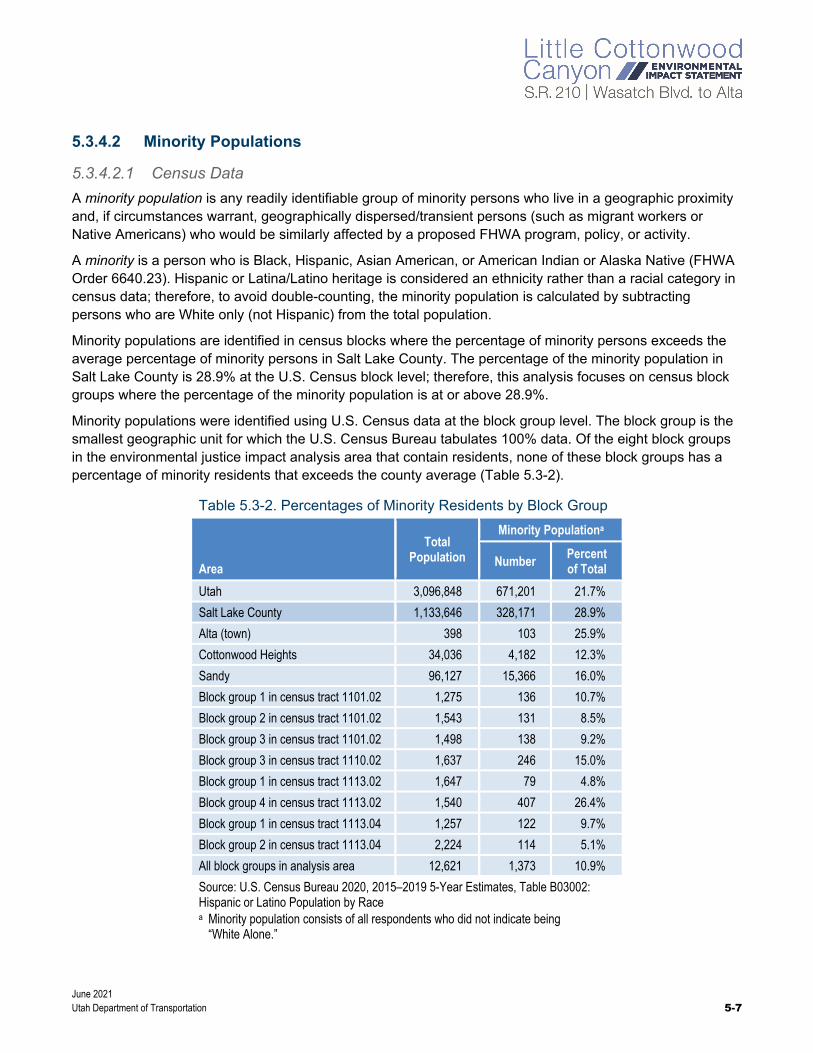
5.3.4.2 Minority Populations
5.3.4.2.1 Census Data
A minority population is any readily identifiable group of minority persons who live in a geographic proximity and, if circumstances warrant, geographically dispersed/transient persons (such as migrant workers or Native Americans) who would be similarly affected by a proposed FHWA program, policy, or activity.
A minority is a person who is Black, Hispanic, Asian American, or American Indian or Alaska Native (FHWA Order 6640.23). Hispanic or Latina/Latino heritage is considered an ethnicity rather than a racial category in census data; therefore, to avoid double-counting, the minority population is calculated by subtracting persons who are White only (not Hispanic) from the total population.
Minority populations are identified in census blocks where the percentage of minority persons exceeds the average percentage of minority persons in Salt Lake County. The percentage of the minority population in Salt Lake County is 28.9% at the U.S. Census block level; therefore, this analysis focuses on census block groups where the percentage of the minority population is at or above 28.9%.
Minority populations were identified using U.S. Census data at the block group level. The block group is the smallest geographic unit for which the U.S. Census Bureau tabulates 100% data. Of the eight block groups in the environmental justice impact analysis area that contain residents, none of these block groups has a percentage of minority residents that exceeds the county average (Table 5.3-2).
Table 5.3-2. Percentages of Minority Residents by Block Group
Area
Total Population
Minority Populationa
Number Percent of Total
Utah 3,096,848 671,201 21.7%
Salt Lake County 1,133,646 328,171 28.9%
Alta (town) 398 103 25.9%
Cottonwood Heights 34,036 4,182 12.3%
Sandy 96,127 15,366 16.0%
Block group 1 in census tract 1101.02 1,275 136 10.7%
Block group 2 in census tract 1101.02 1,543 131 8.5%
Block group 3 in census tract 1101.02 1,498 138 9.2%
Block group 3 in census tract 1110.02 1,637 246 15.0%
Block group 1 in census tract 1113.02 1,647 79 4.8%
Block group 4 in census tract 1113.02 1,540 407 26.4%
Block group 1 in census tract 1113.04 1,257 122 9.7%
Block group 2 in census tract 1113.04 2,224 114 5.1%
All block groups in analysis area 12,621 1,373 10.9%
Source: U.S. Census Bureau 2020, 2015–2019 5-Year Estimates, Table B03002: Hispanic or Latino Population by Race a Minority population consists of all respondents who did not indicate being
“White Alone.”

June 2021 5-8 Utah Department of Transportation
In addition to reviewing the census data, UDOT asked Cottonwood Heights City staff about minority populations, providers, and gathering places. The city staff did not identify any concentrations of minority populations or providers or gathering places in the environmental justice impact analysis area (Cottonwood Heights City 2018).
Figure 5.3-2 shows the location of the block group (block group 4 in census tract 1113.02) that has the highest percentage of minority residents in the environmental justice analysis area, which is still lower than the Salt Lake County average.
Data regarding minority populations were also analyzed for the four census block groups adjacent to the park-and-ride lot at 9400 South and Highland Drive. Of these four block groups, the one with the highest minority population had a percentage of 14.5%, which is below the Salt Lake County and city of Sandy averages of 28.9% and 16.0%, respectively.
5.3.4.2.2 Student Data
The percentage of minorities in Salt Lake County is 27.9%. Goldminer’s Daughter in the town of Alta is the only school in the environmental justice impact analysis area. The school reported a minority population of 25%, which is close to the Salt Lake County average of 27.9%. Although other schools are greater than 0.5 mile from S.R. 210 (Canyon View Elementary, Granite Elementary, and Butler Junior High), they would have students from the impact analysis area. However, all of the schools reported a percentage of minority students lower than the Salt Lake County average of 27.9% (Canyon View Elementary at 7%, Granite Elementary at 8%, and Butler Junior High at 19%).
5.3.4.2.3 Recreation Use
During the scoping process and other public involvement opportunities provided to the public, no recreation areas were identified that were noted as being more popular with minority populations than with the general population.

June 2021 Utah Department of Transportation 5-9
Figure 5.3-2. Minority Populations by Block Group

June 2021 5-10 Utah Department of Transportation
5.4 Environmental Consequences and Mitigation Measures
5.4.1 Methodology The objective of this analysis is to determine whether the effects of the project alternatives on minority and low-income populations would be disproportionately high and adverse. FHWA Order 6640.23a defines a disproportionately high and adverse effect as one that is “predominately [sic] borne by a minority population and/or low-income population; or will be suffered by the minority population and/or low-income population and is appreciably more severe or greater in magnitude than the adverse effect that will be suffered by the non-minority population and/or non-low-income population.”
To determine whether the effects of the project alternatives on environmental justice populations would be disproportionately high and adverse, UDOT reviewed each resource analyzed in this EIS to determine whether changes to these resources as a result of the project could affect people. The USDA Forest Service manages the Uinta-Wasatch-Cache National Forest for multiple uses including natural resource protection and providing recreation opportunities for the public. For this reason, this analysis also considers impacts to people in the impact analysis area as well as the public in general. The resources for which changes would most likely affect the general population are the social environment (community character and community cohesion), recreation, property acquisitions and relocations, economics, transportation access, pedestrian and cyclist resources, air quality, and noise.
UDOT reviewed the effects that the project alternatives would have on each of these resources. If impacts were identified, UDOT examined the location, extent, and severity of the impacts to determine whether the impacts would be disproportionately high and adverse to minority and low-income populations.
The environmental justice analysis included the consideration of Title VI of the Civil Rights Act of 1964. Based on the analysis, no person would be excluded from participation in, be denied the benefits of, or be subjected to discrimination.
5.4.2 No-Action Alternative This section describes the impacts to environmental justice populations from the No-Action Alternative in the Wasatch Boulevard segment of S.R. 210, in the segment of S.R. 210 from North Little Cottonwood Road to the town of Alta, at the gravel pit, and at the park-and-ride lot at 9400 South and Highland Drive.
With the No-Action Alternative, there would be no improvements to S.R. 210 or the development of mobility hubs, so no disproportionately high and adverse human health or environmental effects to low-income or minority populations would occur as a result of direct construction or operation of the S.R. 210 Project. Without the improvements to S.R. 210, travel delay, congestion, and safety would not be improved. This delay, congestion, and lack of safety improvements would affect all populations that use S.R. 210, including low-income and minority populations.

June 2021 Utah Department of Transportation 5-11
5.4.3 Enhanced Bus Service Alternative This section describes the impacts to environmental justice populations from the Enhanced Bus Service Alternative, which includes improvements to the Wasatch Boulevard segment of S.R. 210, two mobility hubs, avalanche mitigation alternatives, trailhead parking alternatives, and the No Winter Parking Alternative.
5.4.3.1 S.R. 210 – Wasatch Boulevard
This section describes the impacts to environmental justice populations from the Imbalanced-lane Alternative and the Five-lane Alternative, which would both widen the Wasatch Boulevard segment of S.R. 210.
5.4.3.1.1 Imbalanced-lane Alternative
Based on the census data and information from public officials, UDOT did not identify any census tracts in the environmental justice impact analysis area with minority or low-income populations above the county averages. UDOT did not identify any community service providers, gathering places, or low-income housing in the impact analysis area. In addition, no schools with a greater percentage of students receiving free or reduced-priced lunches than the Salt Lake County average were identified. The census tract (1113.02) with the highest percentage of minority and low-income populations, which has a percentage that is still lower than the Salt Lake County average, is located about 0.20 mile west of Wasatch Boulevard. Because of the distance from S.R. 210, improvements with the Imbalanced-lane Alternative would not affect this census tract except for improving congestion levels and associated travel times for the residents who use S.R. 210.
Based on the analysis, the Imbalanced-lane Alternative would not cause disproportionately high and adverse effects on any minority or low-income populations in accordance with the provisions of Executive Order 12898 and FHWA Order 6640.23a. No further environmental justice analysis is required for this alternative.
5.4.3.1.2 Five-lane Alternative
The impacts to low-income and minority populations from the Five-lane Alternative would be the same as from the Imbalanced-lane Alternative.
5.4.3.2 S.R. 210 – North Little Cottonwood Road to Alta
5.4.3.2.1 Impacts from Tolling on Upper-canyon Users (Ski Resorts and Adjacent Areas)
With the Enhanced Bus Service Alternative, per-person travel time to the ski resorts would improve from 80 to 85 minutes with the No-Action Alternative to 45 to 50 minutes. The reduction in travel time would benefit all populations including minority and low-income populations that recreate in Little Cottonwood Canyon in the winter. In addition, the Enhanced Bus Service Alternative would provide frequent bus service from a mobility hub. The travel time and convenience would be the same as using a personal vehicle, thereby providing efficient access to the ski resorts for all populations. The bus service would be direct from the mobility hub to the ski resorts.
As part of the Enhanced Bus Service Alternative, a toll or a ban on single-occupant vehicles (a travel demand management strategy) would be implemented to incentivize bus use and reduce personal vehicle

June 2021 5-12 Utah Department of Transportation
use on S.R. 210 in Little Cottonwood Canyon. Currently, bus service is provided free for season ski pass holders and resort employees or for $5 per trip. Similar to existing conditions, the enhanced bus service cost would need to be substantially less than a toll in order to make the service an attractive alternative to personal vehicle use. The proposed toll rate during the peak travel times could range between $20 and $30, which many skiers might see as a financial burden. However, because the Enhanced Bus Service Alternative would include a low-cost, convenient alternative to paying the toll and would provide the same travel time as a personal vehicle, it would not have an adverse impact to any populations.
Overall, the Enhanced Bus Service Alternative would provide a substantial travel time benefit to all skiers and employees at the resorts. The bus service could be used by backcountry skiers as well, but the backcountry skiers would need to start their trips into the backcountry from the bus stops at the ski resorts.
The travel demand management strategy of a ban on single-occupant vehicles would eliminate these vehicles from Little Cottonwood Canyon during peak travel periods (7 AM to 10 AM) and would require the single occupants to instead use the enhanced bus service or carpool in order to access the ski resorts. For low-income populations, this strategy would not have a disproportionately high and adverse effect on those wanting to recreate in the lower canyon since they could take a low-cost bus trip, carpool, or wait to recreate after the peak periods.
Because the Enhanced Bus Service Alternative would provide convenient access to all populations and would provide a low-cost alternative to paying a toll or to single-occupant vehicle restrictions, the alternative would not cause disproportionately high and adverse effects on any minority or low-income populations in accordance with the provisions of Executive Order 12898 and FHWA Order 6640.23a. No further environmental justice analysis is required for travelers to the ski resorts or the upper portions of Little Cottonwood Canyon.
5.4.3.2.2 Impacts from Tolling on Lower-canyon Users
During the winter, the lower portion of Little Cottonwood Canyon (below Snowbird Entry 1 and outside the ski resorts) is used by recreationists to snowshoe, backcountry ski, ice climb, hike, and rock climb. With the Enhanced Bus Service Alternative, there would be no bus stops in the lower canyon (below the ski resorts) at trailheads for members of environmental justice populations as an alternative to paying a toll. Increasing the number of bus stops to address the small percentage of wintertime lower-canyon users would slow the bus service for the vast majority of users, thereby making the service less attractive as an alternative to paying a toll. Thus lower-canyon users would have no option to access recreation without using their personal vehicle and paying a toll, which would be an adverse impact to low-income populations. Practicable measures to avoid or reduce the potential adverse effects on lower-canyon users would include:
Place the toll gantry immediately prior to Snowbird Entry 1. This would allow low-income populations wanting to recreate outside the ski resorts in the lower portions of Little Cottonwood Canyon to avoid having to pay the toll.
Have the toll in effect only during the morning peak period (7 AM to 10 AM), which would allow low-income populations to avoid paying the toll by recreating after 10 AM.
With the implementation of either of these mitigation measures, UDOT would reduce the adverse effects of the toll on low-income populations for those wanting to recreate in the lower portions of Little Cottonwood Canyon. Therefore, with the proposed mitigation measures, tolling would not cause disproportionately high

June 2021 Utah Department of Transportation 5-13
and adverse effects on any minority or low-income populations in accordance with the provisions of Executive Order 12898 and FHWA Order 6640.23a. No further environmental justice analysis is required for travelers wanting to recreate in the lower portions of Little Cottonwood Canyon.
The travel demand management strategy of a ban on single-occupant vehicles would eliminate these vehicles from Little Cottonwood Canyon during peak travel periods (7 AM to 10 AM) and would require the single occupants to instead use the enhanced bus service in order to access the ski resorts. For low-income populations, this strategy would not have a disproportionately high and adverse effect for those wanting to recreate in the lower canyon since they could carpool or wait to recreate after the peak periods, similar to other lower-canyon users.
5.4.3.3 Mobility Hubs Alternative
The Enhanced Bus Service Alternative includes two mobility hubs: a mobility hub at the gravel pit and a mobility hub at the park-and-ride lot at 9400 South and Highland Drive.
5.4.3.3.1 Gravel Pit
Based on the census data and information from public officials, UDOT did not identify any census tracts in the environmental justice impact analysis area with minority or low-income populations above the county averages. UDOT did not identify any community service providers, gathering places, or low-income housing in the impact analysis area.
The census tract (1113.02) with the highest percentage of minority and low-income populations, which has a percentage that is still lower than the Salt Lake County average, is located about 0.5 mile southwest of the gravel pit. Because of the distance from the gravel pit, the improvements associated with this mobility hub would not affect this census tract.
The gravel pit mobility hub could provide a beneficial impact to all populations by providing a convenient access to transit as an alternative to using personal vehicles to travel to the ski resorts in Little Cottonwood Canyon. The mobility hub would also allow users to connect with other bus routes across the Salt Lake Valley, thereby providing an option for those people who want to recreate in the winter and do not have personal vehicles.
Based on the analysis, the mobility hub at the gravel pit would not cause disproportionately high and adverse effects on any minority or low-income populations in accordance with the provisions of Executive Order 12898 and FHWA Order 6640.23a. No further environmental justice analysis is required for this element of the Mobility Hubs Alternative.
5.4.3.3.2 9400 South and Highland Drive
Based on the census data and information from public officials, no low-minority or low-income populations above the county averages were identified within the four block groups adjacent to the 9400 South and Highland Drive park-and-ride lot. The park-and-ride lot is currently used for providing ski bus access. With the Enhanced Bus Service Alternative, it would continue to be used as a park-and-ride lot but with greater
What is a mobility hub?
A mobility hub is a location where users can transfer from their personal vehicle to a bus.
What is the gravel pit?
The gravel pit is an existing aggregate (gravel) mine located on the east side of Wasatch Boulevard between 6200 South and Fort Union Boulevard.

June 2021 5-14 Utah Department of Transportation
bus frequency and a parking structure. The improved mobility hub would provide a benefit for those wanting to ski and not use their personal vehicles.
Based on the analysis, the mobility hub at 9400 South and Highland Drive would not cause disproportionately high and adverse effects on any minority or low-income populations in accordance with the provisions of Executive Order 12898 and FHWA Order 6640.23a. No further environmental justice analysis is required for this element of the Mobility Hubs Alternative.
5.4.3.4 Avalanche Mitigation Alternatives
The Enhanced Bus Service Alternative includes two alternatives for avalanche mitigation: the Snow Sheds with Berms Alternative and the Show Sheds with Realigned Road Alternative.
5.4.3.4.1 Snow Sheds with Berms Alternative
There are no low-income or minority populations near the proposed snow sheds. During the summer construction of the snow sheds, travel delays could temporarily affect people wishing to recreate at the ski resorts or in the upper parts of Little Cottonwood Canyon. No recreation areas were identified that were noted as being more popular with low-income or minority populations. Travel delays would equally impact all populations wanting to recreate. Operation of the snow sheds would provide a benefit to canyon users during the winter by improving avalanche hazard safety and reducing travel delays of those wanting to recreate in the winter.
Based on the analysis, the Snow Sheds with Berms Alternative would not cause disproportionately high and adverse effects on any minority or low-income populations in accordance with the provisions of Executive Order 12898 and FHWA Order 6640.23a. No further environmental justice analysis is required for this alternative.
5.4.3.4.2 Snow Sheds with Realigned Road Alternative
The environmental justice impacts from the Snow Sheds with Realigned Road Alternative would be the same as those from the Snow Sheds with Berms Alternative.
5.4.3.5 Trailhead Parking Alternatives
The Enhanced Bus Service Alternative includes three alternatives to address trailhead parking:
Trailhead Improvements and No S.R. 210 Roadside Parking within ¼ Mile of Trailheads Alternative
Trailhead Improvements and No Roadside Parking from S.R. 209/S.R. 210 Intersection to Snowbird Entry 1 Alternative
No Trailhead Improvements and No Roadside Parking from S.R. 209/S.R. 210 Intersection to Snowbird Entry 1 Alternative

June 2021 Utah Department of Transportation 5-15
5.4.3.5.1 Trailhead Improvements and No S.R. 210 Roadside Parking within ¼ Mile of Trailheads Alternative
The purpose of this alternative is to reduce safety conflicts among pedestrians, cyclists, and vehicles by eliminating roadside parking around trailheads. Eliminating roadside parking could reduce recreation access, which would not affect one group more than another. Therefore, improving trailhead parking would not cause disproportionately high and adverse effects on any minority or low-income populations in accordance with the provisions of Executive Order 12898 and FHWA Order 6640.23a. No further environmental justice analysis is required for this alternative.
5.4.3.5.2 Trailhead Improvements and No Roadside Parking from S.R. 209/S.R. 210 Intersection to Snowbird Entry 1 Alternative
The environmental justice impacts from this alternative would be the same as from the Trailhead Improvements and No S.R. 210 Roadside Parking within ¼ Mile of Trailheads Alternative.
5.4.3.5.3 No Trailhead Improvements and No Roadside Parking from S.R. 209/S.R. 210 Intersection to Snowbird Entry 1 Alternative
The environmental justice impacts from this alternative would be the same as from the Trailhead Improvements and No S.R. 210 Roadside Parking within ¼ Mile of Trailheads Alternative.
5.4.3.6 No Winter Parking Alternative
The No Winter Parking Alternative would eliminate about 230 parking spaces adjacent to the ski resorts along S.R. 210. To compensate for the loss of roadside parking, the Enhanced Bus Service Alternative would provide convenient parking and bus access from the Salt Lake Valley to the ski resorts. All populations equally use the roadside parking when the free ski resort parking at Alta and Snowbird is no longer available or to avoid the congestion delays that occur when exiting the ski resort parking lots at the end of the day. There is no benefit to low-income or minority populations to use the roadside parking given that the resort parking is free and given that roadside parking could be seen as a disadvantage since it requires walking greater distances with ski gear to access the resorts. In addition, parking on the roadside presents a safety risk because of the conflicts of moving vehicles mixing with pedestrians.
Overall, the Enhanced Bus Service Alternative would provide direct access from a mobility hub to the ski resorts, which could be considered a benefit. Based on the analysis, eliminating winter roadside parking would not cause disproportionately high and adverse effects on any minority or low-income populations in accordance with the provisions of Executive Order 12898 and FHWA Order 6640.23a. No further environmental justice analysis is required for this alternative.

June 2021 5-16 Utah Department of Transportation
5.4.4 Enhanced Bus Service in Peak-period Shoulder Lane Alternative This section describes the impacts to environmental justice populations from the Enhanced Bus Service in Peak-period Shoulder Lane Alternative, which includes improvements to the Wasatch Boulevard segment of S.R. 210, improvements to the segment of S.R. 210 from North Little Cottonwood Road to the town of Alta, two mobility hubs, avalanche mitigation alternatives, trailhead parking alternatives, and the No Winter Parking Alternative.
5.4.4.1 S.R. 210 – Wasatch Boulevard
The impacts from the Imbalanced-lane Alternative and the Five-lane Alternative to environmental justice populations would be the same as with the Enhanced Bus Service Alternative.
5.4.4.2 S.R. 210 – North Little Cottonwood Road to Alta
With the Enhanced Bus Service in Peak-period Shoulder Lane Alternative, per-person travel time to the ski resorts would improve from 80 to 85 minutes with the No-Action Alternative to 35 to 40 minutes. The reduction in travel time would benefit all populations including minority and low-income populations that recreate in Little Cottonwood Canyon in the winter. In addition, the Enhanced Bus Service in in Peak-period Shoulder Lane Alternative would provide the same frequent bus service as the Enhanced Bus Service Alternative but with faster travel times (10 to 15 minutes faster) because buses would be operating in their own dedicated lane. Bus travel times overall would be slightly faster compared to using a personal vehicle.
The tolling and single-occupant-vehicle management strategies would be the same as with the Enhanced Bus Service Alternative. Therefore, the overall impact to environmental justice populations from the Enhanced Bus Service in Peak-period Shoulder Lane Alternative would be the same as from the Enhanced Bus Service Alternative since both alternatives would include the same frequency in bus service, along with tolling or a ban on single-occupant vehicles to incentivize bus use. Therefore, the impact to environmental justice populations from the Enhanced Bus Service in Peak-period Shoulder Lane Alternative would be the same as from the Enhanced Bus Service Alternative.
The Enhanced Bus Service in Peak-period Shoulder Lane Alternative would increase the impervious surface area of S.R. 210 and associated stormwater runoff into Little Cottonwood Canyon. The additional impervious surfaces would have de minimis impacts to Little Cottonwood Creek and the overall watershed as a primary drinking water source and thus would not impact drinking water quality for low-income or minority populations or the overall population. In addition, UDOT does not expect that the water infrastructure would need to be improved based on the de minimis impacts. Therefore, this alternative would not require capital or operational improvements to the drinking water supply that could then increase water user rates and thereby affect low-income populations. See Chapter 12, Water Resources, for more information regarding the expected impacts to the Little Cottonwood Canyon watershed including Little Cottonwood Creek as a drinking water source.
Overall, the Enhanced Bus Service in Peak-period Shoulder Lane Alternative would not cause disproportionately high and adverse effects on any minority or low-income populations in accordance with the provisions of Executive Order 12898 and FHWA Order 6640.23a. No further environmental justice analysis is required.

June 2021 Utah Department of Transportation 5-17
5.4.4.3 Mobility Hubs Alternative
The impacts from the mobility hubs to environmental justice populations would be the same as with the Enhanced Bus Service Alternative.
5.4.4.4 Avalanche Mitigation Alternatives
The impacts from the avalanche mitigation alternatives to environmental justice populations would be the same as with the Enhanced Bus Service Alternative.
5.4.4.5 Trailhead Parking Alternatives
The impacts from the trailhead parking alternatives to environmental justice populations would be the same as with the Enhanced Bus Service Alternative.
5.4.4.6 No Winter Parking Alternative
The impacts from the No Winter Parking Alternative to environmental justice populations would be the same as with the Enhanced Bus Service Alternative.
5.4.5 Gondola Alternative A (Starting at Canyon Entrance) This section describes the impacts to environmental justice populations from Gondola Alternative A, which includes a gondola alignment from the entrance to Little Cottonwood Canyon to the Snowbird and Alta ski resorts, improvements to the Wasatch Boulevard segment of S.R. 210, two mobility hubs, avalanche mitigation alternatives, trailhead parking alternatives, and the No Winter Parking Alternative.
5.4.5.1 S.R. 210 – Wasatch Boulevard
The impacts from the Imbalanced-lane Alternative and the Five-lane Alternative to environmental justice populations would be the same as with the Enhanced Bus Service Alternative.
5.4.5.2 S.R. 210 – North Little Cottonwood Road to Alta
Based on the census data and information from public officials, there are no census tracts in the environmental justice impact analysis area within 0.25 mile of the Gondola Alternative A alignment with minority or low-income populations above the county averages. With Gondola Alternative A, per-person travel time to the ski resorts would improve from 80 to 85 minutes with the No-Action Alternative to 45 to 50 minutes (which includes the average travel time for both vehicles and the gondola). The per-person travel time for the gondola service alone would be between 60 to 65 minutes. The reduction in travel time would benefit all populations including minority and low-income populations that recreate in Little Cottonwood Canyon in the winter.
As with the enhanced bus service alternatives, Gondola Alternative A would require a toll or a ban on single-occupant vehicles to incentivize gondola use and reduce personal vehicle use on S.R. 210 in Little Cottonwood Canyon. The tolling and single-occupant-vehicle management strategies would be the same as with the Enhanced Bus Service Alternative. The cost of the gondola ride would be priced similarly to the bus ride to make it a low-cost alternative to using a personal vehicle and paying a toll. The yearly operations and

June 2021 5-18 Utah Department of Transportation
maintenance cost of the gondola system is lower than that for either enhanced bus service alternative, which would allow a similar low-cost fare as a bus ride. Overall, the impacts to environmental justice populations from Gondola Alternative A from tolling or a ban on single-occupant vehicles would be the same as from the Enhanced Bus Service Alternative. Therefore, the impacts to environmental justice populations from Gondola Alternative A would be the same as from the Enhanced Bus Service Alternative.
The impacts to environmental justice populations from changes to water quality would be the same as from the Enhanced Bus Service in Peak-period Shoulder Lane Alternative.
Overall, Gondola Alternative A would not cause disproportionately high and adverse effects on any minority or low-income populations in accordance with the provisions of Executive Order 12898 and FHWA Order 6640.23a. No further environmental justice analysis is required.
5.4.5.3 Mobility Hubs Alternative
The impacts from the mobility hubs to environmental justice populations would be the same as with the Enhanced Bus Service Alternative.
5.4.5.4 Avalanche Mitigation Alternatives
The impacts from the avalanche mitigation alternatives would be the same as with the Enhanced Bus Service Alternative.
5.4.5.5 Trailhead Parking Alternatives
The impacts from the trailhead parking alternatives to environmental justice populations would be the same as with the Enhanced Bus Service Alternative.
5.4.5.6 No Winter Parking Alternative
The impacts from the No Winter Parking Alternative to environmental justice populations would be the same as with the Enhanced Bus Service Alternative.

June 2021 Utah Department of Transportation 5-19
5.4.6 Gondola Alternative B (Starting at La Caille) This section describes the impacts to environmental justice populations from Gondola Alternative B, which includes a gondola alignment from La Caille to the Snowbird and Alta ski resorts, improvements to the Wasatch Boulevard segment of S.R. 210, two mobility hubs, avalanche mitigation alternatives, trailhead parking alternatives, and the No Winter Parking Alternative.
5.4.6.1 S.R. 210 – Wasatch Boulevard
The impacts from the Imbalanced-lane Alternative and the Five-lane Alternative to environmental justice populations would be the same as with the Enhanced Bus Service Alternative.
5.4.6.1 S.R. 210 – North Little Cottonwood Road to Alta
The environmental justice impacts from Gondola Alternative B would be the same as from Gondola Alternative A. Overall, Gondola Alternative B would not cause disproportionately high and adverse effects on any minority or low-income populations in accordance with the provisions of Executive Order 12898 and FHWA Order 6640.23a. No further environmental justice analysis is required.
5.4.6.1 Mobility Hubs Alternative
The impacts from the mobility hubs to environmental justice populations would be the same as with the Enhanced Bus Service Alternative.
5.4.6.2 Avalanche Mitigation Alternatives
The impacts from the avalanche mitigation alternatives to environmental justice populations would be the same as with the Enhanced Bus Service Alternative.
5.4.6.3 Trailhead Parking Alternatives
The impacts from the trailhead parking alternatives to environmental justice populations would be the same as with the Enhanced Bus Service Alternative.
5.4.6.4 No Winter Parking Alternative
The impacts from the No Winter Parking Alternative to environmental justice populations would be the same as with the Enhanced Bus Service Alternative.

June 2021 5-20 Utah Department of Transportation
5.4.7 Cog Rail Alternative (Starting at La Caille) This section describes the impacts to environmental justice populations from the Cog Rail Alternative, which includes a cog rail alignment from La Caille to the Snowbird and Alta ski resorts, improvements to the Wasatch Boulevard segment of S.R. 210, improvements to the segment of S.R. 210 on North Little Cottonwood Road, two mobility hubs, avalanche mitigation alternatives, trailhead parking alternatives, and the No Winter Parking Alternative.
5.4.7.1 S.R. 210 – Wasatch Boulevard
The impacts from the Imbalanced-lane Alternative and the Five-lane Alternative to environmental justice populations would be the same as with the Enhanced Bus Service Alternative.
5.4.7.2 S.R. 210 – North Little Cottonwood Road to Alta
Based on the census data and information from public officials, there are no census tracts in the environmental justice impact analysis area within 0.25 mile of the Cog Rail Alternative alignment with minority or low-income populations above the county averages. With the Cog Rail Alternative, per-person travel time to the ski resorts would improve from 80 to 85 minutes with the No-Action Alternative to 45 to 50 minutes (which includes the average travel time for both vehicles and the cog rail). The per-person travel time for the cog rail service alone would be between 55 to 60 minutes. The reduction in travel time would benefit all populations including minority and low-income populations that recreate in Little Cottonwood Canyon in the winter.
As with the enhanced bus service alternatives, the Cog Rail Alternative would require a toll or a ban on single-occupant vehicles to incentivize cog rail use and reduce personal vehicle use on S.R. 210 in Little Cottonwood Canyon. The tolling and single-occupant-vehicle management strategies would be the same as with the Enhanced Bus Service Alternative. The cost of the cog rail ride would be priced similarly to the bus ride to make it a low-cost alternative to using a personal vehicle and paying a toll. The yearly operations and maintenance cost of the cog rail system would be lower than that for either enhanced bus service alternative, which would allow a similar low-cost fare as a bus ride.
Overall, the impacts to environmental justice populations from the Cog Rail Alternative from tolling or a ban on single-occupant vehicles would be the same as from the Enhanced Bus Service Alternative. Therefore, the impact to environmental justice populations from the Cog Rail Alternative would be the same as from the Enhanced Bus Service Alternative.
The impacts to environmental justice populations from changes to water quality would be the same as for the Enhanced Bus Service in Peak-period Shoulder Lane Alternative.
Overall, the Cog Rail Alternative would not cause disproportionately high and adverse effects on any minority or low-income populations in accordance with the provisions of Executive Order 12898 and FHWA Order 6640.23a. No further environmental justice analysis is required.
5.4.7.3 Mobility Hubs Alternative
The impacts from the mobility hubs to environmental justice populations would be the same as with the Enhanced Bus Service Alternative.

June 2021 Utah Department of Transportation 5-21
5.4.7.4 Avalanche Mitigation Alternatives
The impacts from the avalanche mitigation alternatives to environmental justice populations would be the same as with the Enhanced Bus Service Alternative.
5.4.7.5 Trailhead Parking Alternatives
The impacts from the trailhead parking alternatives to environmental justice populations would be the same as with the Enhanced Bus Service Alternative.
5.4.7.6 No Winter Parking Alternative
The impacts from the No Winter Parking Alternative to environmental justice populations would be the same as with the Enhanced Bus Service Alternative.
5.4.8 Mitigation Measures With all alternatives, paying a toll would cause an adverse impact to low-income populations wanting to recreate during the winter in the lower canyon (below the ski resorts). Practicable measures to avoid or reduce the potential adverse effects to low-income populations will include one or a combination of the following measures:
Place the toll gantry immediately prior to Snowbird Entry 1. This would allow low-income populations wanting to recreate outside the ski resorts in the lower portions of Little Cottonwood Canyon to avoid having to pay the toll.
Have the toll in effect only during the morning peak period (7 AM to 10 AM), which would allow low-income populations to avoid paying the toll by recreating after 10 AM.

June 2021 5-22 Utah Department of Transportation
5.5 References [CEQ] Council on Environmental Quality
1997 Environmental Justice: Guidance under the National Environmental Policy Act. December 10.
Cottonwood Heights City
2018 Personal communication between Matt Taylor, Cottonwood Heights City, and Vince Izzo, HDR, regarding low-income and minority populations. December 11.
[FHWA] Federal Highway Administration
2011 Guidance on Environmental Justice and NEPA. December.
2012 FHWA Actions to Address Environmental Justice in Minority Populations and Low-Income Populations. FHWA Order 6640.23a. https://www.fhwa.dot.gov/legsregs/directives/orders/664023a.cfm. June 14.
[NCES] National Center for Education Statistics
2019 Low-income and minority school enrollment data. https://nces.ed.gov/ccd/schoolsearch/. Accessed February 17, 2020.
U.S. Census Bureau
2020 American Community Survey. www.census.gov/programs-surveys/acs. Accessed February 17, 2021.