chapter 5 airport climatology alberta - nav canadanavcanada.ca/en/media/publications/local...
TRANSCRIPT
169
Chapter 5
Airport Climatology
Alberta
(a) Calgary
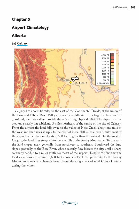
Calgary lies about 40 miles to the east of the Continental Divide, at the union ofthe Bow and Elbow River Valleys, in southern Alberta. In a large treeless tract ofgrassland, the river valleys provide the only strong physical relief. The airport is situ-ated on a nearly flat tableland, 3 miles northeast of the centre of the city of Calgary.From the airport the land falls away to the valley of Nose Creek, about one mile tothe west and then rises sharply to the crest of Nose Hill, a little over 3 miles west ofthe airport, which has an elevation 500 feet higher than the airfield. To the west ofCalgary, the land rises steeply into the foothills of the Rocky Mountains. To the east,the land slopes away, generally from northwest to southeast. Southward the landslopes gradually to the Bow River, whose easterly flow bisects the city, until a sharpsoutherly bend, 3 to 4 miles south-southeast of the airport. Despite the fact that thelocal elevations are around 3,600 feet above sea level, the proximity to the RockyMountains allows it to benefit from the moderating effect of mild Chinook windsduring the winter.
CALGARY 0 SEA LEVEL
300 FT
600 FT
1000 FT
1500 FT
2000 FT
3000 FT
5000 FT
7000 FT
10,000 FT
LAKP-Prairies
PRAIRIE-E05 11/12/05 9:12 PM Page 169
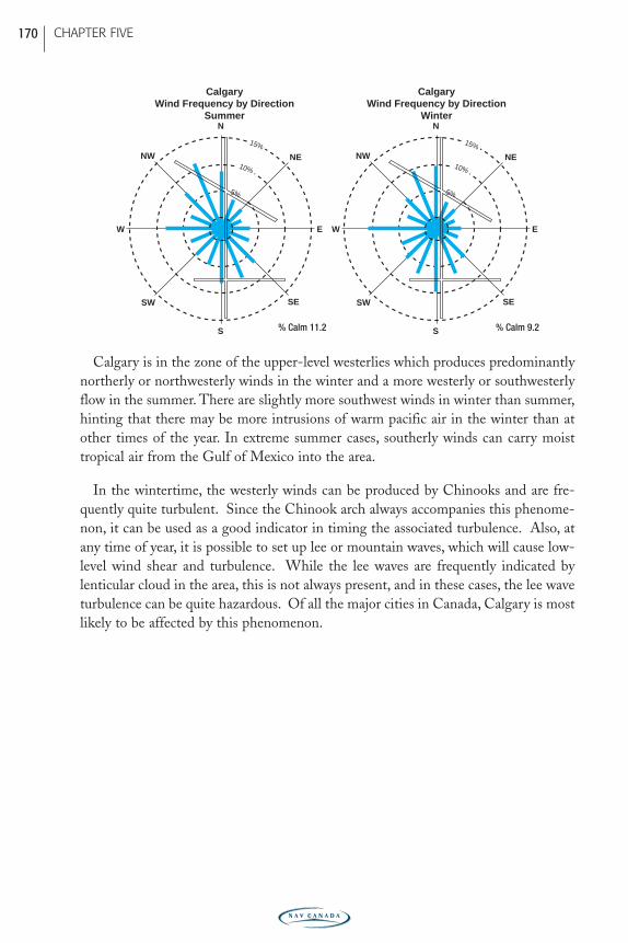
Calgary is in the zone of the upper-level westerlies which produces predominantlynortherly or northwesterly winds in the winter and a more westerly or southwesterlyflow in the summer. There are slightly more southwest winds in winter than summer,hinting that there may be more intrusions of warm pacific air in the winter than atother times of the year. In extreme summer cases, southerly winds can carry moisttropical air from the Gulf of Mexico into the area.
In the wintertime, the westerly winds can be produced by Chinooks and are fre-quently quite turbulent. Since the Chinook arch always accompanies this phenome-non, it can be used as a good indicator in timing the associated turbulence. Also, atany time of year, it is possible to set up lee or mountain waves, which will cause low-level wind shear and turbulence. While the lee waves are frequently indicated bylenticular cloud in the area, this is not always present, and in these cases, the lee waveturbulence can be quite hazardous. Of all the major cities in Canada, Calgary is mostlikely to be affected by this phenomenon.
N
S
SW
NENW
SE
W E
N
S
SW
NENW
SE
W E
15%
10%
5%
15%
10%
5%
CalgaryWind Frequency by Direction
Winter
CalgaryWind Frequency by Direction
Summer
% Calm 11.2 % Calm 9.2
CHAPTER FIVE 170
PRAIRIE-E05 11/12/05 9:12 PM Page 170
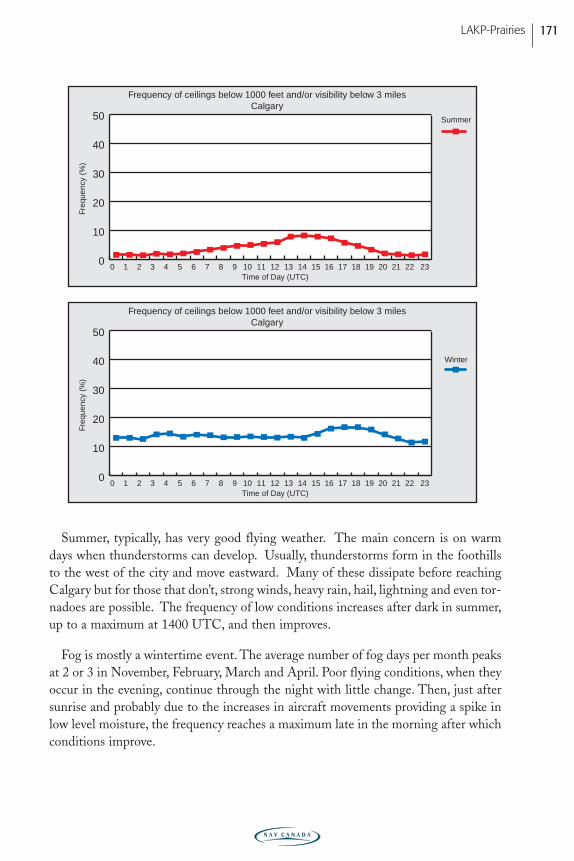
Summer, typically, has very good flying weather. The main concern is on warmdays when thunderstorms can develop. Usually, thunderstorms form in the foothillsto the west of the city and move eastward. Many of these dissipate before reachingCalgary but for those that don’t, strong winds, heavy rain, hail, lightning and even tor-nadoes are possible. The frequency of low conditions increases after dark in summer,up to a maximum at 1400 UTC, and then improves.
Fog is mostly a wintertime event. The average number of fog days per month peaksat 2 or 3 in November, February, March and April. Poor flying conditions, when theyoccur in the evening, continue through the night with little change. Then, just aftersunrise and probably due to the increases in aircraft movements providing a spike inlow level moisture, the frequency reaches a maximum late in the morning after whichconditions improve.
Freq
uenc
y (%
)
0 1 2 3 4 5 6 7 8 9 10 11 12 13 14 15 16 17 18 19 20 21 22 230
10
20
30
40
50
Winter
Time of Day (UTC)
Freq
uenc
y (%
)
Frequency of ceilings below 1000 feet and/or visibility below 3 milesCalgary
Frequency of ceilings below 1000 feet and/or visibility below 3 milesCalgary
0 1 2 3 4 5 6 7 8 9 10 11 12 13 14 15 16 17 18 19 20 21 22 230
10
20
30
40
50 Summer
Time of Day (UTC)
LAKP-Prairies 171
PRAIRIE-E05 11/12/05 9:12 PM Page 171
(b) Edmonton International
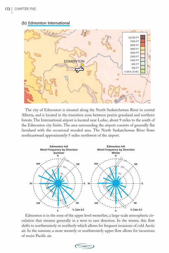
The city of Edmonton is situated along the North Saskatchewan River in centralAlberta, and is located in the transition zone between prairie grassland and northernforests. The International airport is located near Leduc, about 9 miles to the south ofthe Edmonton city limits. The area surrounding the airport consists of generally flatfarmland with the occasional wooded area. The North Saskatchewan River flowsnortheastward approximately 5 miles northwest of the airport.
Edmonton is in the zone of the upper level westerlies, a large-scale atmospheric cir-culation that streams generally in a west to east direction. In the winter, this flowshifts to northwesterly or northerly which allows for frequent invasions of cold Arcticair. In the summer, a more westerly or southwesterly upper flow allows for incursionsof moist Pacific air.
N
S
SW
NENW
SE
W E
N
S
SW
NENW
SE
W E
15%
10%
5%
15%
10%
5%
Edmonton IntlWind Frequency by Direction
Winter
Edmonton IntlWind Frequency by Direction
Summer
% Calm 8.0 % Calm 9.0
EDMONTON
0 SEA LEVEL
300 FT
600 FT
1000 FT
1500 FT
2000 FT
3000 FT
5000 FT
7000 FT
10,000 FT
CHAPTER FIVE 172
PRAIRIE-E05 11/12/05 9:12 PM Page 172
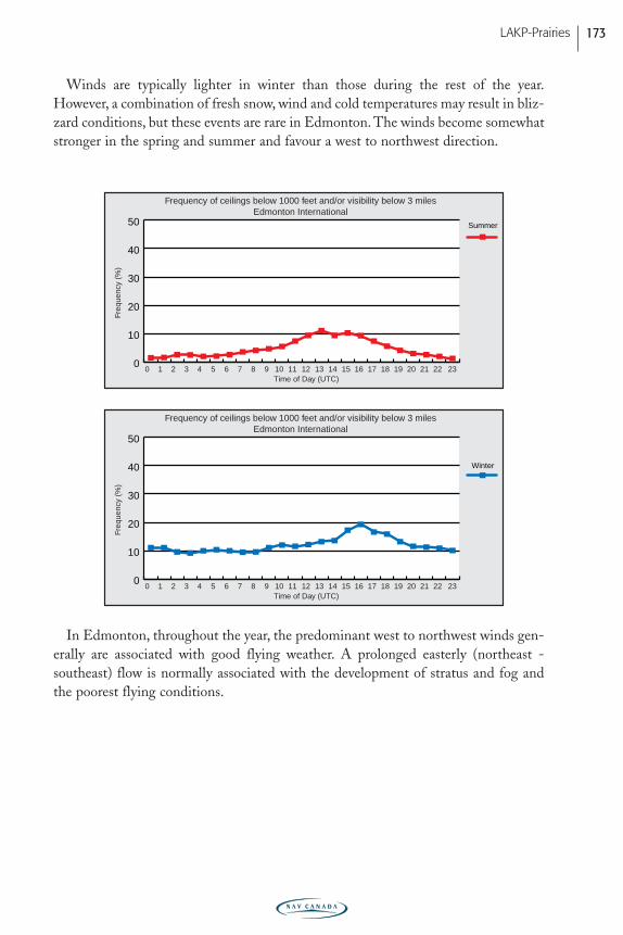
Winds are typically lighter in winter than those during the rest of the year.However, a combination of fresh snow, wind and cold temperatures may result in bliz-zard conditions, but these events are rare in Edmonton. The winds become somewhatstronger in the spring and summer and favour a west to northwest direction.
In Edmonton, throughout the year, the predominant west to northwest winds gen-erally are associated with good flying weather. A prolonged easterly (northeast -southeast) flow is normally associated with the development of stratus and fog andthe poorest flying conditions.
Freq
uenc
y (%
)
0 1 2 3 4 5 6 7 8 9 10 11 12 13 14 15 16 17 18 19 20 21 22 230
10
20
30
40
50
Winter
Time of Day (UTC)
Freq
uenc
y (%
)
0 1 2 3 4 5 6 7 8 9 10 11 12 13 14 15 16 17 18 19 20 21 22 230
10
20
30
40
50 Summer
Time of Day (UTC)
Frequency of ceilings below 1000 feet and/or visibility below 3 milesEdmonton International
Frequency of ceilings below 1000 feet and/or visibility below 3 milesEdmonton International
LAKP-Prairies 173
PRAIRIE-E05 11/12/05 9:12 PM Page 173
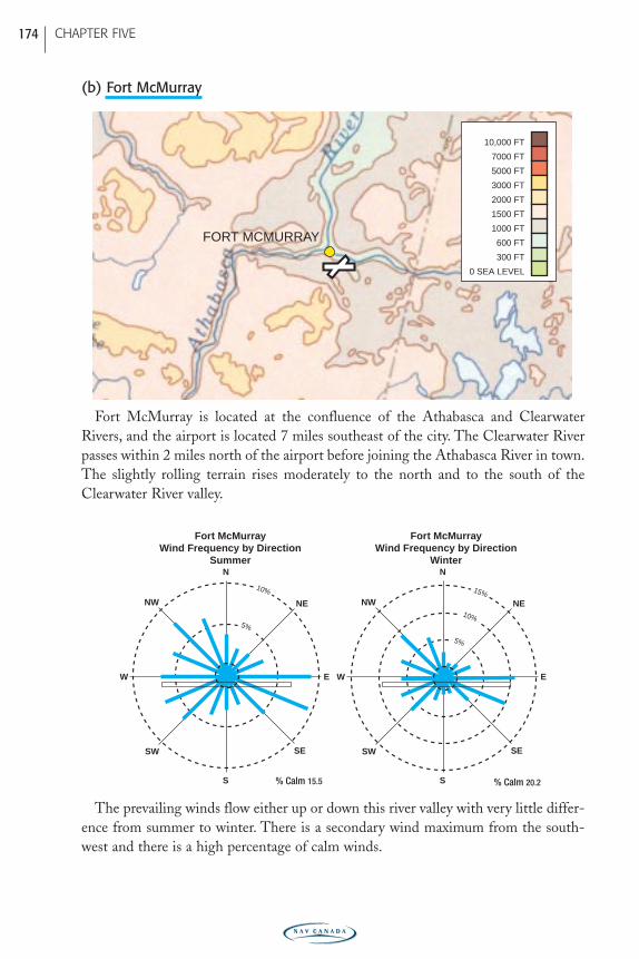
(b) Fort McMurray
Fort McMurray is located at the confluence of the Athabasca and ClearwaterRivers, and the airport is located 7 miles southeast of the city. The Clearwater Riverpasses within 2 miles north of the airport before joining the Athabasca River in town.The slightly rolling terrain rises moderately to the north and to the south of theClearwater River valley.
The prevailing winds flow either up or down this river valley with very little differ-ence from summer to winter. There is a secondary wind maximum from the south-west and there is a high percentage of calm winds.
N
S
SW
NENW
SE
W E
N
S
SW
NENW
SE
W E
15%
10%
5%
10%
5%
Fort McMurrayWind Frequency by Direction
Winter
Fort McMurrayWind Frequency by Direction
Summer
% Calm 15.5 % Calm 20.2
FORT MCMURRAY
0 SEA LEVEL
300 FT
600 FT
1000 FT
1500 FT
2000 FT
3000 FT
5000 FT
7000 FT
10,000 FT
CHAPTER FIVE 174
PRAIRIE-E05 11/12/05 9:12 PM Page 174
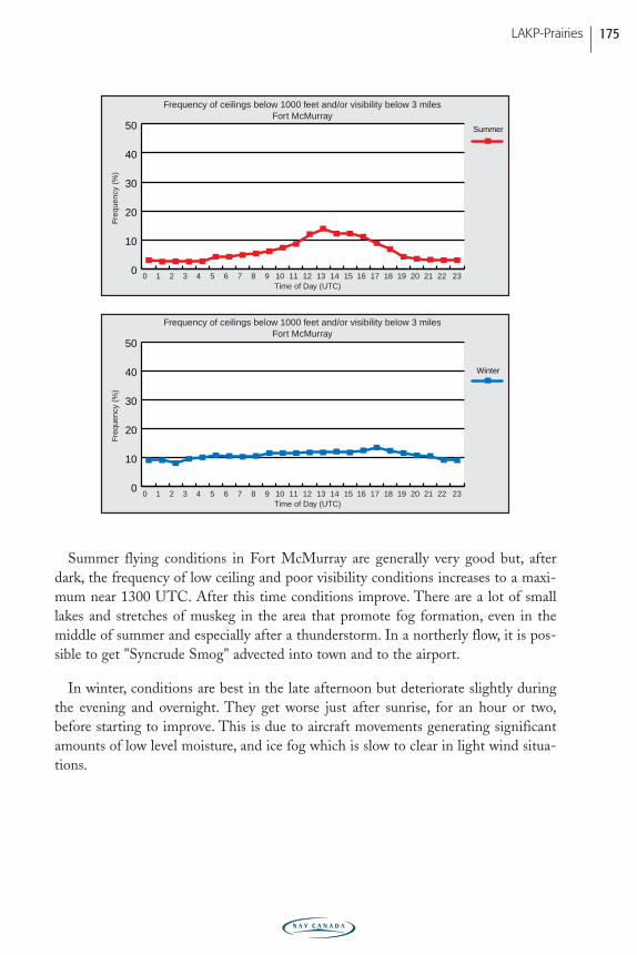
Summer flying conditions in Fort McMurray are generally very good but, afterdark, the frequency of low ceiling and poor visibility conditions increases to a maxi-mum near 1300 UTC. After this time conditions improve. There are a lot of smalllakes and stretches of muskeg in the area that promote fog formation, even in themiddle of summer and especially after a thunderstorm. In a northerly flow, it is pos-sible to get "Syncrude Smog" advected into town and to the airport.
In winter, conditions are best in the late afternoon but deteriorate slightly duringthe evening and overnight. They get worse just after sunrise, for an hour or two,before starting to improve. This is due to aircraft movements generating significantamounts of low level moisture, and ice fog which is slow to clear in light wind situa-tions.
Freq
uenc
y (%
)
0 1 2 3 4 5 6 7 8 9 10 11 12 13 14 15 16 17 18 19 20 21 22 230
10
20
30
40
50
Winter
Time of Day (UTC)
Freq
uenc
y (%
)
0 1 2 3 4 5 6 7 8 9 10 11 12 13 14 15 16 17 18 19 20 21 22 230
10
20
30
40
50 Summer
Time of Day (UTC)
Frequency of ceilings below 1000 feet and/or visibility below 3 milesFort McMurray
Frequency of ceilings below 1000 feet and/or visibility below 3 milesFort McMurray
LAKP-Prairies 175
PRAIRIE-E05 11/12/05 9:12 PM Page 175
(c) Grande Prairie
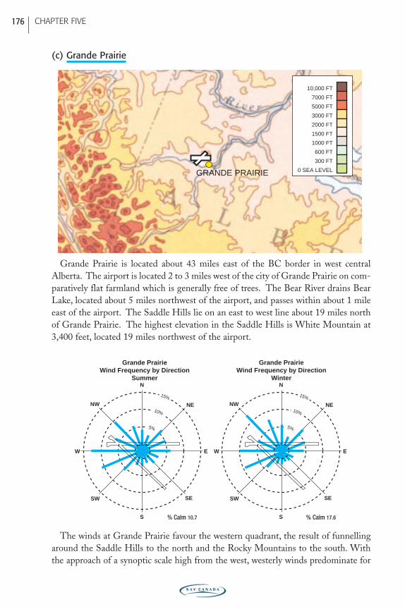
Grande Prairie is located about 43 miles east of the BC border in west centralAlberta. The airport is located 2 to 3 miles west of the city of Grande Prairie on com-paratively flat farmland which is generally free of trees. The Bear River drains BearLake, located about 5 miles northwest of the airport, and passes within about 1 mileeast of the airport. The Saddle Hills lie on an east to west line about 19 miles northof Grande Prairie. The highest elevation in the Saddle Hills is White Mountain at3,400 feet, located 19 miles northwest of the airport.
The winds at Grande Prairie favour the western quadrant, the result of funnellingaround the Saddle Hills to the north and the Rocky Mountains to the south. Withthe approach of a synoptic scale high from the west, westerly winds predominate for
N
S
SW
NENW
SE
W E
N
S
SW
NENW
SE
W E
15%
10%
5%
15%
10%
5%
Grande PrairieWind Frequency by Direction
Winter
Grande PrairieWind Frequency by Direction
Summer
% Calm 10.7 % Calm 17.6
GRANDE PRAIRIE 0 SEA LEVEL
300 FT
600 FT
1000 FT
1500 FT
2000 FT
3000 FT
5000 FT
7000 FT
10,000 FT
CHAPTER FIVE 176
PRAIRIE-E05 11/12/05 9:12 PM Page 176
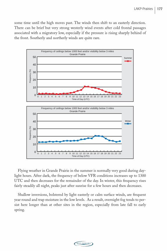
some time until the high moves past. The winds then shift to an easterly direction.There can be brief but very strong westerly wind events after cold frontal passagesassociated with a migratory low, especially if the pressure is rising sharply behind ofthe front. Southerly and northerly winds are quite rare.
Flying weather in Grande Prairie in the summer is normally very good during day-light hours. After dark, the frequency of below VFR conditions increases up to 1300UTC and then decreases for the remainder of the day. In winter, this frequency risesfairly steadily all night, peaks just after sunrise for a few hours and then decreases.
Shallow inversions, bolstered by light easterly or calm surface winds, are frequentyear round and trap moisture in the low levels. As a result, overnight fog tends to per-sist here longer than at other sites in the region, especially from late fall to earlyspring.
Freq
uenc
y (%
)
0 1 2 3 4 5 6 7 8 9 10 11 12 13 14 15 16 17 18 19 20 21 22 230
10
20
30
40
50
Winter
Time of Day (UTC)
Freq
uenc
y (%
)
0 1 2 3 4 5 6 7 8 9 10 11 12 13 14 15 16 17 18 19 20 21 22 230
10
20
30
40
50 Summer
Time of Day (UTC)
Frequency of ceilings below 1000 feet and/or visibility below 3 milesGrande Prairie
Frequency of ceilings below 1000 feet and/or visibility below 3 milesGrande Prairie
LAKP-Prairies 177
PRAIRIE-E05 11/12/05 9:12 PM Page 177
(d) High Level
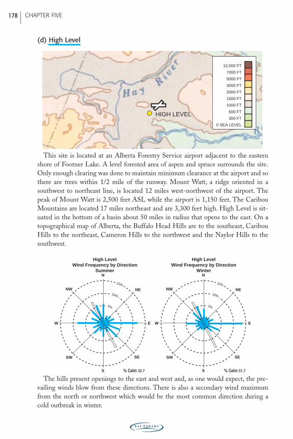
This site is located at an Alberta Forestry Service airport adjacent to the easternshore of Footner Lake. A level forested area of aspen and spruce surrounds the site.Only enough clearing was done to maintain minimum clearance at the airport and sothere are trees within 1/2 mile of the runway. Mount Watt, a ridge oriented in asouthwest to northeast line, is located 12 miles west-northwest of the airport. Thepeak of Mount Watt is 2,500 feet ASL while the airport is 1,150 feet. The CaribouMountains are located 17 miles northeast and are 3,300 feet high. High Level is sit-uated in the bottom of a basin about 50 miles in radius that opens to the east. On atopographical map of Alberta, the Buffalo Head Hills are to the southeast, CaribouHills to the northeast, Cameron Hills to the northwest and the Naylor Hills to thesouthwest.
The hills present openings to the east and west and, as one would expect, the pre-vailing winds blow from these directions. There is also a secondary wind maximumfrom the north or northwest which would be the most common direction during acold outbreak in winter.
N
S
SW
NENW
SE
W E
N
S
SW
NENW
SE
W E
15%
10%
5%
15%
10%
5%
High LevelWind Frequency by Direction
Winter
High LevelWind Frequency by Direction
Summer
% Calm 32.7 % Calm 51.7
HIGH LEVEL
0 SEA LEVEL
300 FT
600 FT
1000 FT
1500 FT
2000 FT
3000 FT
5000 FT
7000 FT
10,000 FT
CHAPTER FIVE 178
PRAIRIE-E05 11/12/05 9:12 PM Page 178
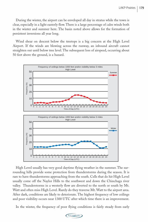
During the winter, the airport can be enveloped all day in stratus while the town isclear, especially in a light easterly flow. There is a large percentage of calm winds bothin the winter and summer here. The basin noted above allows for the formation ofpersistent inversions all year long.
Wind shear on descent below the treetops is a big concern at the High LevelAirport. If the winds are blowing across the runway, an inbound aircraft cannotstraighten out until below tree level. The subsequent loss of airspeed, occurring about50 feet above the ground, is a hazard.
High Level usually has very good daytime flying weather in the summer. The sur-rounding hills provide some protection from thunderstorms during the season. It israre to have thunderstorms approaching from the south. Cells that do hit High Levelusually come off the Naylor Hills to the southwest and down the Chinchaga river valley. Thunderstorms in a westerly flow are diverted to the north or south by Mt.Watt and often miss High Level. Rarely do they traverse Mt. Watt to the airport area.After dark, conditions are likely to deteriorate. The highest frequency of low ceilingsand poor visibility occurs near 1300 UTC after which time there is an improvement.
In the winter, the frequency of poor flying conditions is fairly steady from early
Freq
uenc
y (%
)
0 1 2 3 4 5 6 7 8 9 10 11 12 13 14 15 16 17 18 19 20 21 22 230
10
20
30
40
50
Winter
Time of Day (UTC)
Freq
uenc
y (%
)
0 1 2 3 4 5 6 7 8 9 10 11 12 13 14 15 16 17 18 19 20 21 22 230
10
20
30
40
50 Summer
Time of Day (UTC)
Frequency of ceilings below 1000 feet and/or visibility below 3 milesHigh Level
Frequency of ceilings below 1000 feet and/or visibility below 3 milesHigh Level
LAKP-Prairies 179
PRAIRIE-E05 11/12/05 9:12 PM Page 179
evening through the overnight period, but near sunrise, conditions deteriorate. Theworst weather usually occurs between 1500 and 1900 UTC before improvement earlyin the afternoon.
(e) Lethbridge
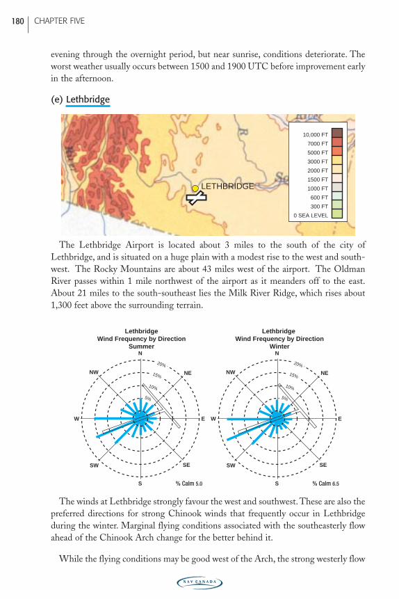
The Lethbridge Airport is located about 3 miles to the south of the city ofLethbridge, and is situated on a huge plain with a modest rise to the west and south-west. The Rocky Mountains are about 43 miles west of the airport. The OldmanRiver passes within 1 mile northwest of the airport as it meanders off to the east.About 21 miles to the south-southeast lies the Milk River Ridge, which rises about1,300 feet above the surrounding terrain.
The winds at Lethbridge strongly favour the west and southwest. These are also thepreferred directions for strong Chinook winds that frequently occur in Lethbridgeduring the winter. Marginal flying conditions associated with the southeasterly flowahead of the Chinook Arch change for the better behind it.
While the flying conditions may be good west of the Arch, the strong westerly flow
N
S
SW
NENW
SE
W E
N
S
SW
NENW
SE
W E
Lethbridge Wind Frequency by Direction
Winter
LethbridgeWind Frequency by Direction
Summer
15%
20%
10%
5%
15%
20%
10%
5%
% Calm 5.0 % Calm 6.5
LETHBRIDGE
0 SEA LEVEL
300 FT
600 FT
1000 FT
1500 FT
2000 FT
3000 FT
5000 FT
7000 FT
10,000 FT
CHAPTER FIVE 180
PRAIRIE-E05 11/12/05 9:12 PM Page 180
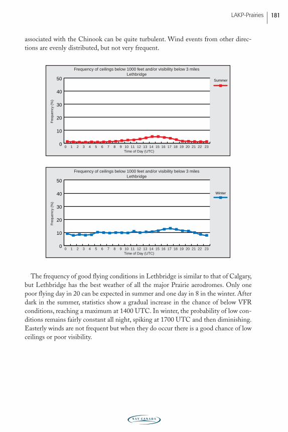
associated with the Chinook can be quite turbulent. Wind events from other direc-tions are evenly distributed, but not very frequent.
The frequency of good flying conditions in Lethbridge is similar to that of Calgary,but Lethbridge has the best weather of all the major Prairie aerodromes. Only onepoor flying day in 20 can be expected in summer and one day in 8 in the winter. Afterdark in the summer, statistics show a gradual increase in the chance of below VFRconditions, reaching a maximum at 1400 UTC. In winter, the probability of low con-ditions remains fairly constant all night, spiking at 1700 UTC and then diminishing.Easterly winds are not frequent but when they do occur there is a good chance of lowceilings or poor visibility.
Freq
uenc
y (%
)
0 1 2 3 4 5 6 7 8 9 10 11 12 13 14 15 16 17 18 19 20 21 22 230
10
20
30
40
50
Winter
Time of Day (UTC)
Freq
uenc
y (%
)
0 1 2 3 4 5 6 7 8 9 10 11 12 13 14 15 16 17 18 19 20 21 22 230
10
20
30
40
50 Summer
Time of Day (UTC)
Frequency of ceilings below 1000 feet and/or visibility below 3 milesLethbridge
Frequency of ceilings below 1000 feet and/or visibility below 3 milesLethbridge
LAKP-Prairies 181
PRAIRIE-E05 11/12/05 9:12 PM Page 181
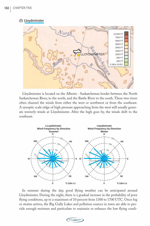
(f) Lloydminster
Lloydminster is located on the Alberta - Saskatchewan border between the NorthSaskatchewan River, to the north, and the Battle River to the south. These two riversoften channel the winds from either the west or northwest or from the southeast.A synoptic scale ridge of high pressure approaching from the west will usually gener-ate westerly winds at Lloydminster. After the high goes by, the winds shift to thesoutheast.
In summer during the day, good flying weather can be anticipated aroundLloydminster. During the night, there is a gradual increase in the probability of poorflying conditions, up to a maximum of 10 percent from 1300 to 1700 UTC. Once fogor stratus arrives, the Big Gully Lakes and pollution sources in town are able to pro-vide enough moisture and particulate to maintain or enhance the low flying condi-
N
S
SW
NENW
SE
W E
N
S
SW
NENW
SE
W E
15%
10%
5%
15%
10%
5%
LloydminsterWind Frequency by Direction
Winter
LLoydminster Wind Frequency by Direction
Summer
% Calm 5.5 % Calm 5.6
LLOYDMINSTER
0 SEA LEVEL
300 FT
600 FT
1000 FT
1500 FT
2000 FT
3000 FT
5000 FT
7000 FT
10,000 FT
CHAPTER FIVE 182
PRAIRIE-E05 11/12/05 9:12 PM Page 182
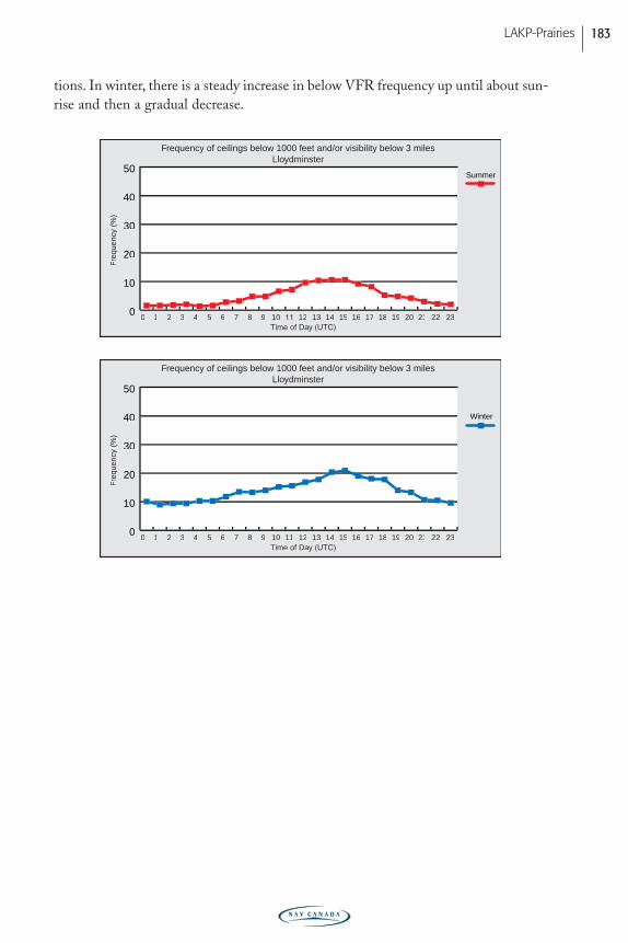
tions. In winter, there is a steady increase in below VFR frequency up until about sun-rise and then a gradual decrease.
Freq
uenc
y (%
)
0 1 2 3 4 5 6 7 8 9 10 11 12 13 14 15 16 17 18 19 20 21 22 230
10
20
30
40
50
Time of Da
Freq
uenc
y (%
)
0 1 2 3 4 5 6 7 8 9 10 12 13 14 15 16 17 18 19 20 21 22 230
10
20
30
40
50
Winter
Summer
Frequency of ceilings below 1000 feet and/or visibility below 3 milesLloydminster
Frequency of ceilings below 1000 feet and/or visibility below 3 milesLloydminster
LAKP-Prairies 183
PRAIRIE-E05 11/12/05 9:12 PM Page 183
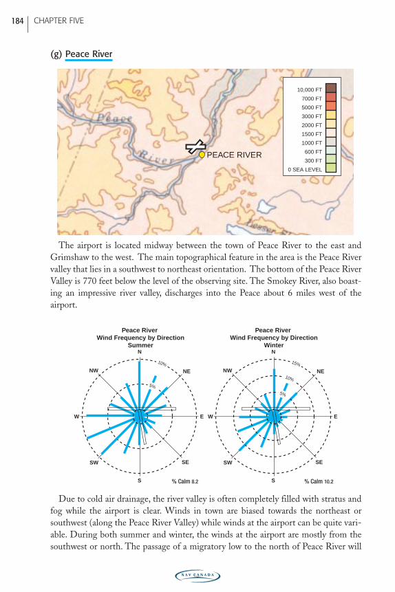
(g) Peace River
The airport is located midway between the town of Peace River to the east andGrimshaw to the west. The main topographical feature in the area is the Peace Rivervalley that lies in a southwest to northeast orientation. The bottom of the Peace RiverValley is 770 feet below the level of the observing site. The Smokey River, also boast-ing an impressive river valley, discharges into the Peace about 6 miles west of the airport.
Due to cold air drainage, the river valley is often completely filled with stratus andfog while the airport is clear. Winds in town are biased towards the northeast orsouthwest (along the Peace River Valley) while winds at the airport can be quite vari-able. During both summer and winter, the winds at the airport are mostly from thesouthwest or north. The passage of a migratory low to the north of Peace River will
N
S
SW
NENW
SE
W E
N
S
SW
NENW
SE
W E
Peace River Wind Frequency by Direction
Winter
Peace River Wind Frequency by Direction
Summer
10%
5%
15%
10%
5%
% Calm 8.2 % Calm 10.2
PEACE RIVER
0 SEA LEVEL
300 FT
600 FT
1000 FT
1500 FT
2000 FT
3000 FT
5000 FT
7000 FT
10,000 FT
CHAPTER FIVE 184
PRAIRIE-E05 11/12/05 9:12 PM Page 184
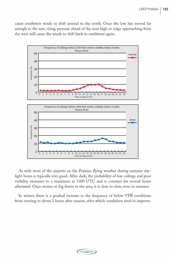
cause southwest winds to shift around to the north. Once the low has moved farenough to the east, rising pressure ahead of the next high or ridge approaching fromthe west will cause the winds to shift back to southwest again.
As with most of the airports on the Prairies, flying weather during summer day-light hours is typically very good. After dark, the probability of low ceilings and poorvisibility increases to a maximum at 1300 UTC and is constant for several hoursafterward. Once stratus or fog forms in the area, it is slow to clear, even in summer.
In winter, there is a gradual increase in the frequency of below VFR conditionsfrom evening to about 2 hours after sunrise, after which conditions tend to improve.
Freq
uenc
y (%
)
0 1 2 3 4 5 6 7 8 9 10 11 12 13 14 15 16 17 18 19 20 21 22 230
10
20
30
40
50
Winter
Time of Day (UTC)
Freq
uenc
y (%
)
0 1 2 3 4 5 6 7 8 9 10 11 12 13 14 15 16 17 18 19 20 21 22 230
10
20
30
40
50 Summer
Time of Day (UTC)
Frequency of ceilings below 1000 feet and/or visibility below 3 milesPeace River
Frequency of ceilings below 1000 feet and/or visibility below 3 milesPeace River
LAKP-Prairies 185
PRAIRIE-E05 11/12/05 9:12 PM Page 185
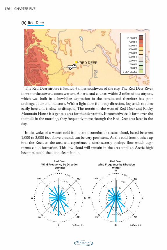
(h) Red Deer
The Red Deer airport is located 6 miles southwest of the city. The Red Deer Riverflows northeastward across western Alberta and courses within 3 miles of the airport,which was built in a bowl-like depression in the terrain and therefore has poordrainage of air and moisture. With a light flow from any direction, fog tends to formeasily here and is slow to dissipate. The terrain to the west of Red Deer and RockyMountain House is a genesis area for thunderstorms. If convective cells form over thefoothills in the morning, they frequently move through the Red Deer area later in theday.
In the wake of a winter cold front, stratocumulus or stratus cloud, based between1,000 to 3,000 feet above ground, can be very persistent. As the cold front pushes upinto the Rockies, the area will experience a northeasterly upslope flow which aug-ments cloud formation. This low cloud will remain in the area until an Arctic highbecomes established and clears it out.
N
S
SW
NENW
SE
W E
N
S
SW
NENW
SE
W E
15%
10%
5%
15%
10%
5%
Red Deer Wind Frequency by Direction
Winter
Red Deer Wind Frequency by Direction
Summer
% Calm 7.2 % Calm 8.6
RED DEER
0 SEA LEVEL
300 FT
600 FT
1000 FT
1500 FT
2000 FT
3000 FT
5000 FT
7000 FT
10,000 FT
CHAPTER FIVE 186
PRAIRIE-E05 11/12/05 9:12 PM Page 186
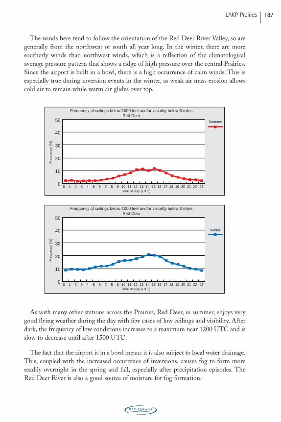
The winds here tend to follow the orientation of the Red Deer River Valley, so aregenerally from the northwest or south all year long. In the winter, there are moresoutherly winds than northwest winds, which is a reflection of the climatologicalaverage pressure pattern that shows a ridge of high pressure over the central Prairies.Since the airport is built in a bowl, there is a high occurrence of calm winds. This isespecially true during inversion events in the winter, as weak air mass erosion allowscold air to remain while warm air glides over top.
As with many other stations across the Prairies, Red Deer, in summer, enjoys verygood flying weather during the day with few cases of low ceilings and visibility. Afterdark, the frequency of low conditions increases to a maximum near 1200 UTC and isslow to decrease until after 1500 UTC.
The fact that the airport is in a bowl means it is also subject to local water drainage.This, coupled with the increased occurrence of inversions, causes fog to form morereadily overnight in the spring and fall, especially after precipitation episodes. TheRed Deer River is also a good source of moisture for fog formation.
Freq
uenc
y (%
)
0 1 2 3 4 5 6 7 8 9 10 11 12 13 14 15 16 17 18 19 20 21 22 230
10
20
30
40
50
Winter
Time of Day (UTC)
Freq
uenc
y (%
)
0 1 2 3 4 5 6 7 8 9 10 11 12 13 14 15 16 17 18 19 20 21 22 230
10
20
30
40
50 Summer
Time of Day (UTC)
Frequency of ceilings below 1000 feet and/or visibility below 3 milesRed Deer
Frequency of ceilings below 1000 feet and/or visibility below 3 milesRed Deer
LAKP-Prairies 187
PRAIRIE-E05 11/12/05 9:12 PM Page 187
Saskatchewan
(a) La Ronge
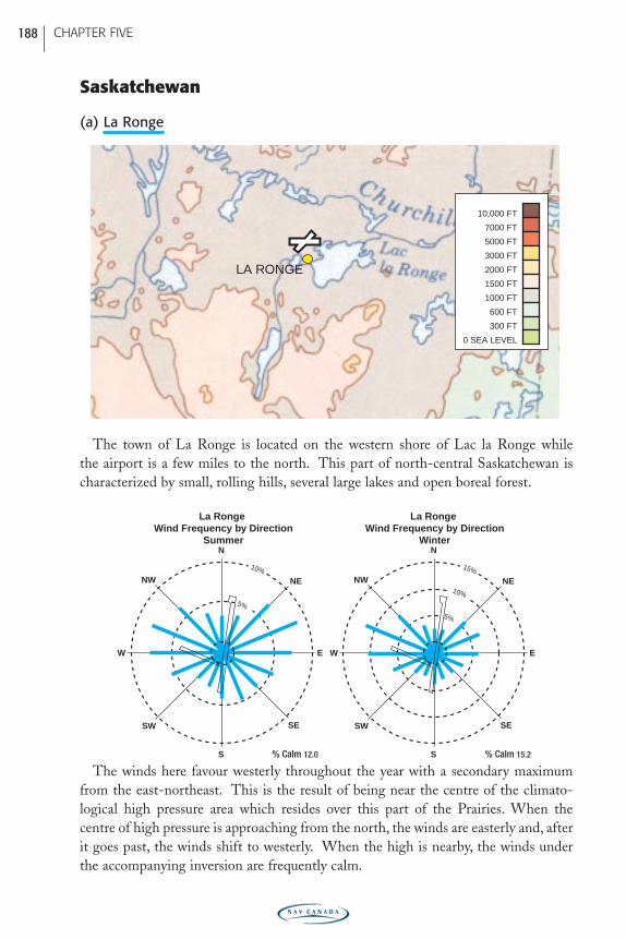
The town of La Ronge is located on the western shore of Lac la Ronge while the airport is a few miles to the north. This part of north-central Saskatchewan ischaracterized by small, rolling hills, several large lakes and open boreal forest.
The winds here favour westerly throughout the year with a secondary maximumfrom the east-northeast. This is the result of being near the centre of the climato-logical high pressure area which resides over this part of the Prairies. When the centre of high pressure is approaching from the north, the winds are easterly and, afterit goes past, the winds shift to westerly. When the high is nearby, the winds underthe accompanying inversion are frequently calm.
N
S
SW
NENW
SE
W E
N
S
SW
NENW
SE
W E
La Ronge Wind Frequency by Direction
Winter
La Ronge Wind Frequency by Direction
Summer
10%
5%
15%
10%
5%
% Calm 12.0 % Calm 15.2
LA RONGE
0 SEA LEVEL
300 FT
600 FT
1000 FT
1500 FT
2000 FT
3000 FT
5000 FT
7000 FT
10,000 FT
CHAPTER FIVE 188
PRAIRIE-E05 11/12/05 9:12 PM Page 188
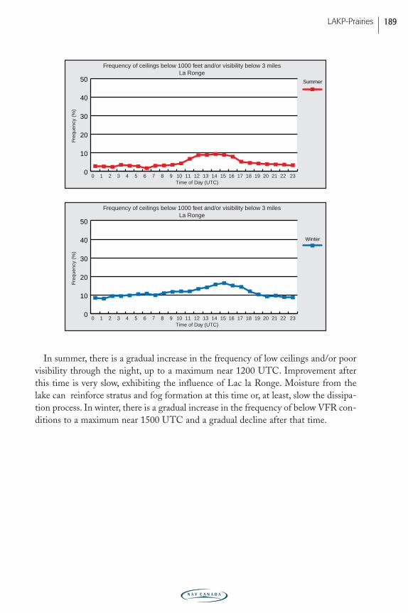
In summer, there is a gradual increase in the frequency of low ceilings and/or poorvisibility through the night, up to a maximum near 1200 UTC. Improvement afterthis time is very slow, exhibiting the influence of Lac la Ronge. Moisture from thelake can reinforce stratus and fog formation at this time or, at least, slow the dissipa-tion process. In winter, there is a gradual increase in the frequency of below VFR con-ditions to a maximum near 1500 UTC and a gradual decline after that time.
Freq
uenc
y (%
)
0 1 2 3 4 5 6 7 8 9 10 11 12 13 14 15 16 17 18 19 20 21 22 230
10
20
30
40
50
Winter
Time of Day (UTC)
Freq
uenc
y (%
)
0 1 2 3 4 5 6 7 8 9 10 11 12 13 14 15 16 17 18 19 20 21 22 230
10
20
30
40
50 Summer
Time of Day (UTC)
Frequency of ceilings below 1000 feet and/or visibility below 3 milesLa Ronge
Frequency of ceilings below 1000 feet and/or visibility below 3 milesLa Ronge
LAKP-Prairies 189
PRAIRIE-E05 11/12/05 9:12 PM Page 189
(b) Prince Albert
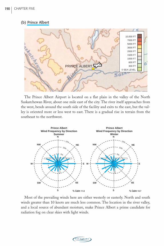
The Prince Albert Airport is located on a flat plain in the valley of the NorthSaskatchewan River, about one mile east of the city. The river itself approaches fromthe west, bends around the south side of the facility and exits to the east, but the val-ley is oriented more or less west to east. There is a gradual rise in terrain from thesoutheast to the northwest.
Most of the prevailing winds here are either westerly or easterly. North and southwinds greater than 10 knots are much less common. The location in the river valley,and a local source of abundant moisture, make Prince Albert a prime candidate forradiation fog on clear skies with light winds.
N
S
SW
NENW
SE
W E
N
S
SW
NENW
SE
W E
15%
10%
5%
15%
10%
5%
Prince AlbertWind Frequency by Direction
Winter
Prince AlbertWind Frequency by Direction
Summer
% Calm 11.8 % Calm 14.7
PRINCE ALBERT0 SEA LEVEL
300 FT
600 FT
1000 FT
1500 FT
2000 FT
3000 FT
5000 FT
7000 FT
10,000 FT
CHAPTER FIVE 190
PRAIRIE-E05 11/12/05 9:12 PM Page 190
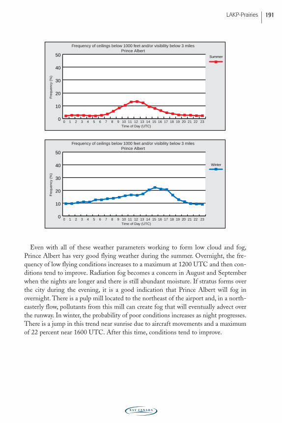
Even with all of these weather parameters working to form low cloud and fog,Prince Albert has very good flying weather during the summer. Overnight, the fre-quency of low flying conditions increases to a maximum at 1200 UTC and then con-ditions tend to improve. Radiation fog becomes a concern in August and Septemberwhen the nights are longer and there is still abundant moisture. If stratus forms overthe city during the evening, it is a good indication that Prince Albert will fog inovernight. There is a pulp mill located to the northeast of the airport and, in a north-easterly flow, pollutants from this mill can create fog that will eventually advect overthe runway. In winter, the probability of poor conditions increases as night progresses.There is a jump in this trend near sunrise due to aircraft movements and a maximumof 22 percent near 1600 UTC. After this time, conditions tend to improve.
Freq
uenc
y (%
)
0 1 2 3 4 5 6 7 8 9 10 11 12 13 14 15 16 17 18 19 20 21 22 230
10
20
30
40
50
Winter
Time of Day (UTC)
Freq
uenc
y (%
)
0 1 2 3 4 5 6 7 8 9 10 11 12 13 14 15 16 17 18 19 20 21 22 230
10
20
30
40
50 Summer
Time of Day (UTC)
Frequency of ceilings below 1000 feet and/or visibility below 3 milesPrince Albert
Frequency of ceilings below 1000 feet and/or visibility below 3 milesPrince Albert
LAKP-Prairies 191
PRAIRIE-E05 11/12/05 9:12 PM Page 191
(c) Regina
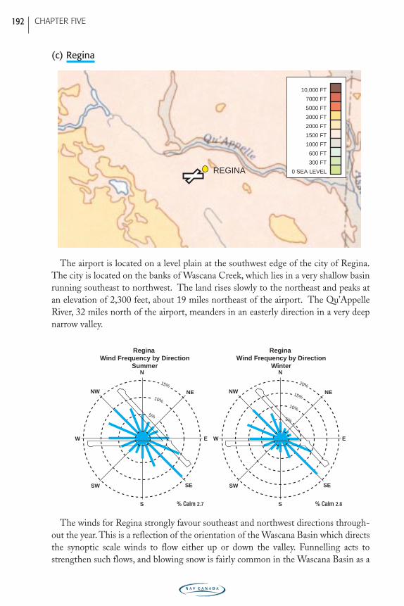
The airport is located on a level plain at the southwest edge of the city of Regina.The city is located on the banks of Wascana Creek, which lies in a very shallow basinrunning southeast to northwest. The land rises slowly to the northeast and peaks atan elevation of 2,300 feet, about 19 miles northeast of the airport. The Qu’AppelleRiver, 32 miles north of the airport, meanders in an easterly direction in a very deepnarrow valley.
The winds for Regina strongly favour southeast and northwest directions through-out the year. This is a reflection of the orientation of the Wascana Basin which directsthe synoptic scale winds to flow either up or down the valley. Funnelling acts tostrengthen such flows, and blowing snow is fairly common in the Wascana Basin as a
N
S
SW
NENW
SE
W E
N
S
SW
NENW
SE
W E
15%
10%
5%
20%
15%
10%
Regina Wind Frequency by Direction
Winter
Regina Wind Frequency by Direction
Summer
5%
% Calm 2.7 % Calm 2.8
REGINA 0 SEA LEVEL
300 FT
600 FT
1000 FT
1500 FT
2000 FT
3000 FT
5000 FT
7000 FT
10,000 FT
CHAPTER FIVE 192
PRAIRIE-E05 11/12/05 9:12 PM Page 192
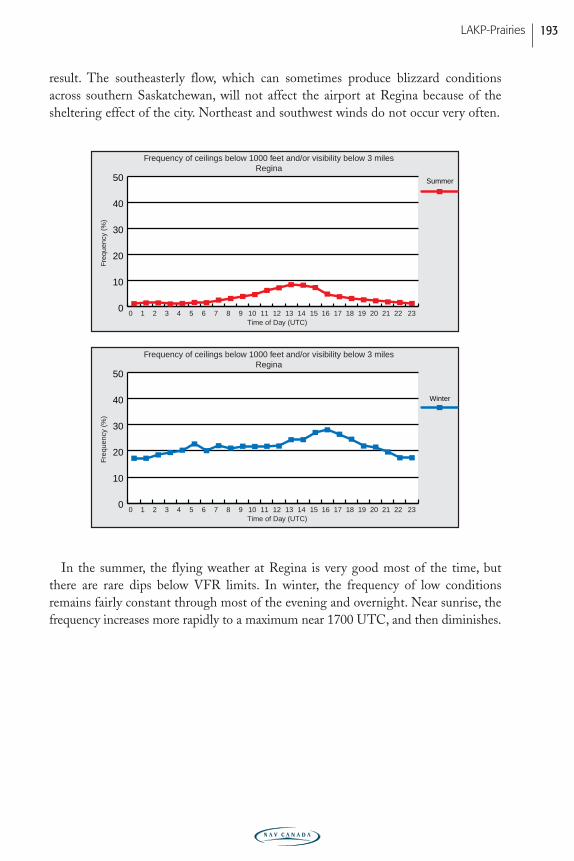
result. The southeasterly flow, which can sometimes produce blizzard conditionsacross southern Saskatchewan, will not affect the airport at Regina because of thesheltering effect of the city. Northeast and southwest winds do not occur very often.
In the summer, the flying weather at Regina is very good most of the time, butthere are rare dips below VFR limits. In winter, the frequency of low conditionsremains fairly constant through most of the evening and overnight. Near sunrise, thefrequency increases more rapidly to a maximum near 1700 UTC, and then diminishes.
Freq
uenc
y (%
)
0 1 2 3 4 5 6 7 8 9 10 11 12 13 14 15 16 17 18 19 20 21 22 230
10
20
30
40
50
Winter
Time of Day (UTC)
Freq
uenc
y (%
)
0 1 2 3 4 5 6 7 8 9 10 11 12 13 14 15 16 17 18 19 20 21 22 230
10
20
30
40
50 Summer
Time of Day (UTC)
Frequency of ceilings below 1000 feet and/or visibility below 3 milesRegina
Frequency of ceilings below 1000 feet and/or visibility below 3 milesRegina
LAKP-Prairies 193
PRAIRIE-E05 11/12/05 9:12 PM Page 193
(d) Saskatoon
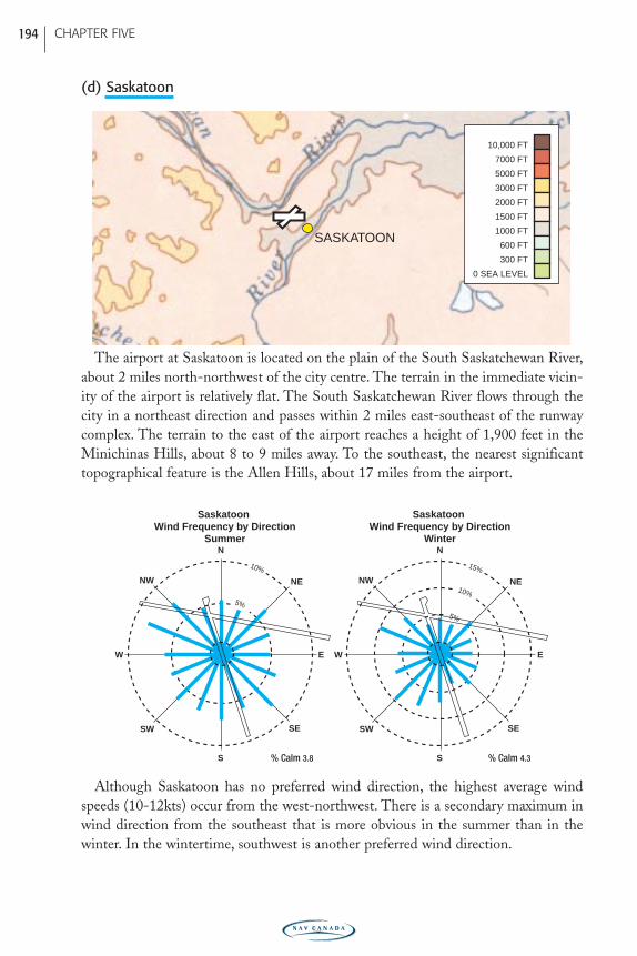
The airport at Saskatoon is located on the plain of the South Saskatchewan River,about 2 miles north-northwest of the city centre. The terrain in the immediate vicin-ity of the airport is relatively flat. The South Saskatchewan River flows through thecity in a northeast direction and passes within 2 miles east-southeast of the runwaycomplex. The terrain to the east of the airport reaches a height of 1,900 feet in theMinichinas Hills, about 8 to 9 miles away. To the southeast, the nearest significanttopographical feature is the Allen Hills, about 17 miles from the airport.
Although Saskatoon has no preferred wind direction, the highest average windspeeds (10-12kts) occur from the west-northwest. There is a secondary maximum inwind direction from the southeast that is more obvious in the summer than in thewinter. In the wintertime, southwest is another preferred wind direction.
N
S
SW
NENW
SE
W E
N
S
SW
NENW
SE
W E
10%
5%
15%
10%
5%
Saskatoon Wind Frequency by Direction
Winter
Saskatoon Wind Frequency by Direction
Summer
% Calm 3.8 % Calm 4.3
SASKATOON
0 SEA LEVEL
300 FT
600 FT
1000 FT
1500 FT
2000 FT
3000 FT
5000 FT
7000 FT
10,000 FT
CHAPTER FIVE 194
PRAIRIE-E05 11/12/05 9:12 PM Page 194
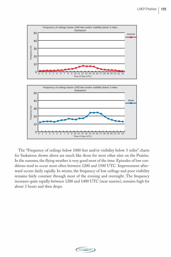
The “Frequency of ceilings below 1000 feet and/or visibility below 3 miles” chartsfor Saskatoon shown above are much like those for most other sites on the Prairies.In the summer, the flying weather is very good most of the time. Episodes of low con-ditions tend to occur most often between 1200 and 1500 UTC. Improvement after-ward occurs fairly rapidly. In winter, the frequency of low ceilings and poor visibilityremains fairly constant through most of the evening and overnight. The frequencyincreases quite rapidly between 1200 and 1400 UTC (near sunrise), remains high forabout 3 hours and then drops.
Freq
uenc
y (%
)
0 1 2 3 4 5 6 7 8 9 10 11 12 13 14 15 16 17 18 19 20 21 22 230
10
20
30
40
50
Winter
Time of Day (UTC)
Freq
uenc
y (%
)
0 1 2 3 4 5 6 7 8 9 10 11 12 13 14 15 16 17 18 19 20 21 22 230
10
20
30
40
50 Summer
Time of Day (UTC)
Frequency of ceilings below 1000 feet and/or visibility below 3 milesSaskatoon
Frequency of ceilings below 1000 feet and/or visibility below 3 milesSaskatoon
LAKP-Prairies 195
PRAIRIE-E05 11/12/05 9:12 PM Page 195
Manitoba
(a) Brandon
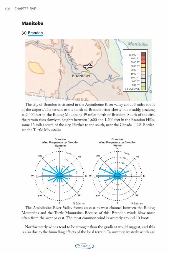
The city of Brandon is situated in the Assiniboine River valley about 3 miles southof the airport. The terrain to the north of Brandon rises slowly but steadily, peakingat 2,400 feet in the Riding Mountains 49 miles north of Brandon. South of the city,the terrain rises slowly to heights between 1,600 and 1,700 feet in the Brandon Hills,some 13 miles south of the city. Further to the south, near the Canada - U.S. Border,are the Turtle Mountains.
The Assiniboine River Valley forms an east to west channel between the RidingMountains and the Turtle Mountains. Because of this, Brandon winds blow mostoften from the west or east. The most common wind is westerly around 10 knots.
Northwesterly winds tend to be stronger than the gradient would suggest, and thisis also due to the funnelling effects of the local terrain. In summer, westerly winds are
N
S
SW
NENW
SE
W E
N
S
SW
NENW
SE
W E
15%
10%
5%
20%
15%
10%
5%
Brandon Wind Frequency by Direction
Winter
Brandon Wind Frequency by Direction
Summer
% Calm 7.5 % Calm 9.0
BRANDON
0 SEA LEVEL
300 FT
600 FT
1000 FT
1500 FT
2000 FT
3000 FT
5000 FT
7000 FT
10,000 FT
CHAPTER FIVE 196
PRAIRIE-E05 11/12/05 9:12 PM Page 196
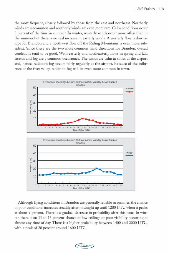
the most frequent, closely followed by those from the east and northeast. Northerlywinds are uncommon and southerly winds are even more rare. Calm conditions occur8 percent of the time in summer. In winter, westerly winds occur more often than inthe summer but there is no real increase in easterly winds. A westerly flow is downs-lope for Brandon and a northwest flow off the Riding Mountains is even more sub-sident. Since these are the two most common wind directions for Brandon, overallconditions tend to be good. With easterly and northeasterly flows in spring and fall,stratus and fog are a common occurrence. The winds are calm at times at the airportand, hence, radiation fog occurs fairly regularly at the airport. Because of the influ-ence of the river valley, radiation fog will be even more common in town.
Although flying conditions in Brandon are generally reliable in summer, the chanceof poor conditions increases steadily after midnight up until 1200 UTC when it peaksat about 9 percent. There is a gradual decrease in probability after this time. In win-ter, there is an 11 to 13 percent chance of low ceilings or poor visibility occurring atalmost any time of day. There is a higher probability between 1400 and 2000 UTC,with a peak of 20 percent around 1600 UTC.
Freq
uenc
y (%
)
0 1 2 3 4 5 6 7 8 9 10 11 12 13 14 15 16 17 18 19 20 21 22 230
10
20
30
40
50
Winter
Time of Day (UTC)
Freq
uenc
y (%
)
0 1 2 3 4 5 6 7 8 9 10 11 12 13 14 15 16 17 18 19 20 21 22 230
10
20
30
40
50 Summer
Time of Day (UTC)
Frequency of ceilings below 1000 feet and/or visibility below 3 milesBrandon
Frequency of ceilings below 1000 feet and/or visibility below 3 milesBrandon
LAKP-Prairies 197
PRAIRIE-E05 11/12/05 9:12 PM Page 197
A typical start for fog dispersal in summer is 1300 UTC, while in winter, dissipa-tion commences around 1700 UTC. The increase in aircraft movement near sunrise,and the delay in sunrise itself, form the best explanation of this phenomenon.
(b) Churchill
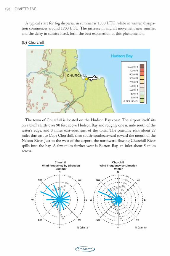
The town of Churchill is located on the Hudson Bay coast. The airport itself sitson a bluff a little over 90 feet above Hudson Bay and roughly one n. mile south of thewater’s edge, and 3 miles east-southeast of the town. The coastline runs about 27miles due east to Cape Churchill, then south-southeastward toward the mouth of theNelson River. Just to the west of the airport, the northward flowing Churchill Riverspills into the bay. A few miles further west is Button Bay, an inlet about 5 milesacross.
N
S
SW
NENW
SE
W E
N
S
SW
NENW
SE
W E
15%
10%
5%
Churchill Wind Frequency by Direction
Winter
Churchill Wind Frequency by Direction
Summer
30%25%
20%15%
10%5%
% Calm 1.5 % Calm 1.5
CHURCHILL
0 SEA LEVEL
300 FT
600 FT
1000 FT
1500 FT
2000 FT
3000 FT
5000 FT
7000 FT
10,000 FT
CHAPTER FIVE 198
PRAIRIE-E05 11/12/05 9:12 PM Page 198
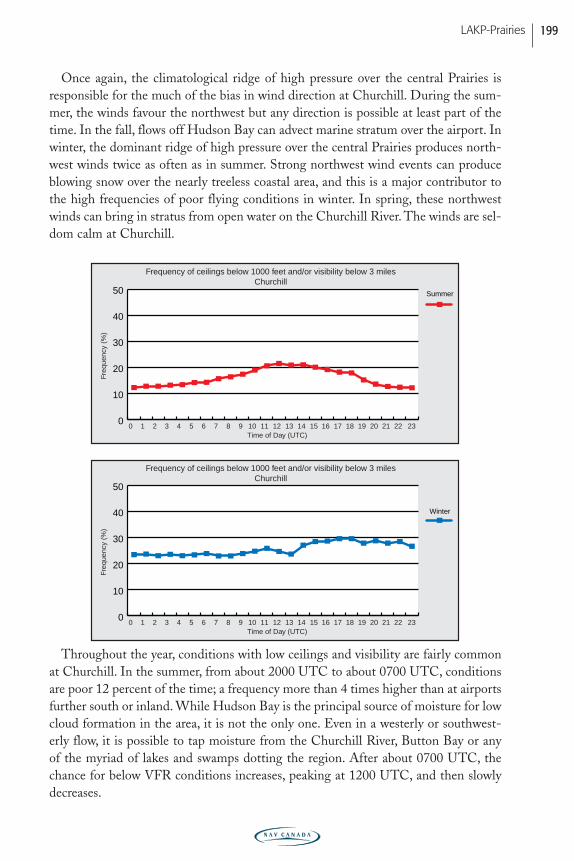
Once again, the climatological ridge of high pressure over the central Prairies isresponsible for the much of the bias in wind direction at Churchill. During the sum-mer, the winds favour the northwest but any direction is possible at least part of thetime. In the fall, flows off Hudson Bay can advect marine stratum over the airport. Inwinter, the dominant ridge of high pressure over the central Prairies produces north-west winds twice as often as in summer. Strong northwest wind events can produceblowing snow over the nearly treeless coastal area, and this is a major contributor tothe high frequencies of poor flying conditions in winter. In spring, these northwestwinds can bring in stratus from open water on the Churchill River. The winds are sel-dom calm at Churchill.
Throughout the year, conditions with low ceilings and visibility are fairly commonat Churchill. In the summer, from about 2000 UTC to about 0700 UTC, conditionsare poor 12 percent of the time; a frequency more than 4 times higher than at airportsfurther south or inland. While Hudson Bay is the principal source of moisture for lowcloud formation in the area, it is not the only one. Even in a westerly or southwest-erly flow, it is possible to tap moisture from the Churchill River, Button Bay or anyof the myriad of lakes and swamps dotting the region. After about 0700 UTC, thechance for below VFR conditions increases, peaking at 1200 UTC, and then slowlydecreases.
Freq
uenc
y (%
)
0 1 2 3 4 5 6 7 8 9 10 11 12 13 14 15 16 17 18 19 20 21 22 230
10
20
30
40
50
Winter
Time of Day (UTC)
Freq
uenc
y (%
)
0 1 2 3 4 5 6 7 8 9 10 11 12 13 14 15 16 17 18 19 20 21 22 230
10
20
30
40
50 Summer
Time of Day (UTC)
Frequency of ceilings below 1000 feet and/or visibility below 3 milesChurchill
Frequency of ceilings below 1000 feet and/or visibility below 3 milesChurchill
LAKP-Prairies 199
PRAIRIE-E05 11/12/05 9:12 PM Page 199
Again, in a northwesterly flow in spring, open water at the mouth of the ChurchillRiver can produce a good deal of stratus. If the temperature is just below zero, freez-ing drizzle is a good possibility. If the winds shift from northwesterly to northerly,then the stratus drifts southward past the airport. In the fall, any wind direction fromthe northwest through northeast to the southeast can produce stratus as this flow is,for the most part, directly off the bay.
The likelihood of below VFR conditions in winter at Churchill is the greatest forany major site on the Prairies by far. During the night, poor flying weather occurs 24percent of the time, which is nearly one day in four. Interestingly, the frequencyincreases to almost 30 percent in the morning and remains at that level throughoutthe day. This trend is opposite to that normally seen at other sites on the Prairies.Hence, if weather conditions are marginal or poor in the morning at Churchill in thewinter, they very likely will remain poor or get worse through the afternoon andevening.
(c) Dauphin
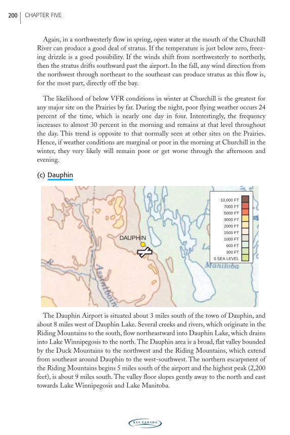
The Dauphin Airport is situated about 3 miles south of the town of Dauphin, andabout 8 miles west of Dauphin Lake. Several creeks and rivers, which originate in theRiding Mountains to the south, flow northeastward into Dauphin Lake, which drainsinto Lake Winnipegosis to the north. The Dauphin area is a broad, flat valley boundedby the Duck Mountains to the northwest and the Riding Mountains, which extendfrom southeast around Dauphin to the west-southwest. The northern escarpment ofthe Riding Mountains begins 5 miles south of the airport and the highest peak (2,200feet), is about 9 miles south. The valley floor slopes gently away to the north and easttowards Lake Winnipegosis and Lake Manitoba.
DAUPHIN
0 SEA LEVEL
300 FT
600 FT
1000 FT
1500 FT
2000 FT
3000 FT
5000 FT
7000 FT
10,000 FT
CHAPTER FIVE 200
PRAIRIE-E05 11/12/05 9:12 PM Page 200
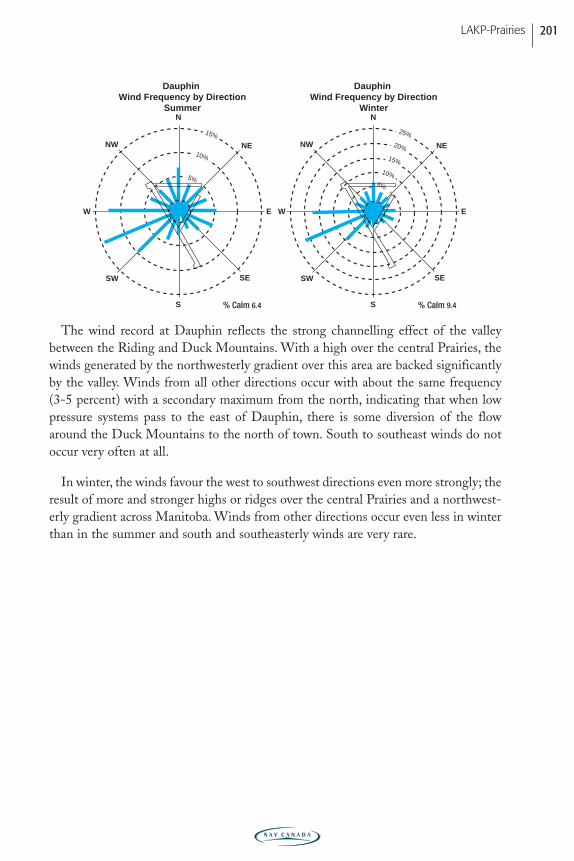
The wind record at Dauphin reflects the strong channelling effect of the valleybetween the Riding and Duck Mountains. With a high over the central Prairies, thewinds generated by the northwesterly gradient over this area are backed significantlyby the valley. Winds from all other directions occur with about the same frequency(3-5 percent) with a secondary maximum from the north, indicating that when lowpressure systems pass to the east of Dauphin, there is some diversion of the flowaround the Duck Mountains to the north of town. South to southeast winds do notoccur very often at all.
In winter, the winds favour the west to southwest directions even more strongly; theresult of more and stronger highs or ridges over the central Prairies and a northwest-erly gradient across Manitoba. Winds from other directions occur even less in winterthan in the summer and south and southeasterly winds are very rare.
N
S
SW
NENW
SE
W E
N
S
SW
NENW
SE
W E
15%
10%
5%
15%
Dauphin Wind Frequency by Direction
Summer
Dauphin Wind Frequency by Direction
Winter
25%
20%
15%
10%
5%
% Calm 6.4 % Calm 9.4
LAKP-Prairies 201
PRAIRIE-E05 11/12/05 9:12 PM Page 201
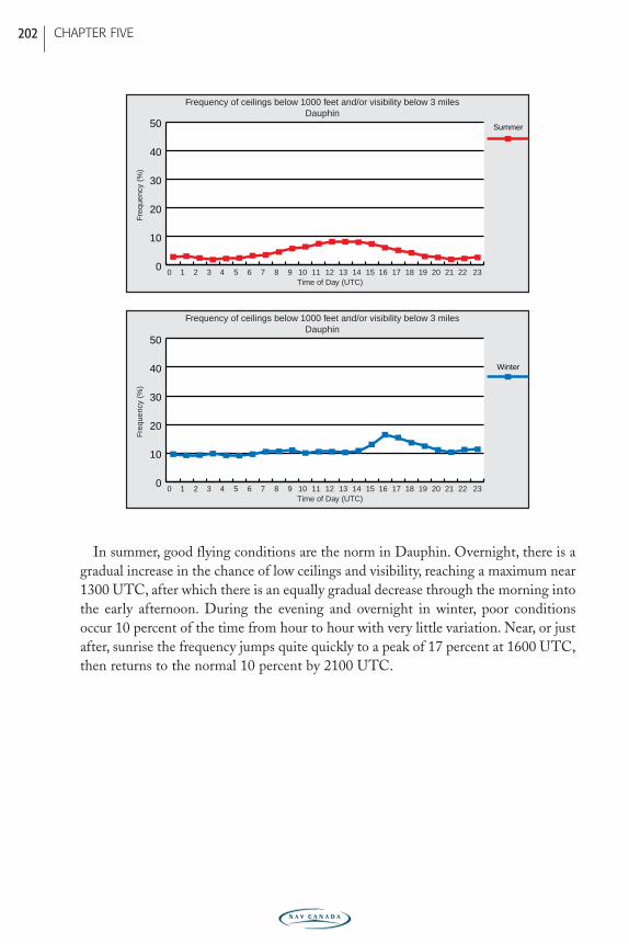
In summer, good flying conditions are the norm in Dauphin. Overnight, there is agradual increase in the chance of low ceilings and visibility, reaching a maximum near1300 UTC, after which there is an equally gradual decrease through the morning intothe early afternoon. During the evening and overnight in winter, poor conditionsoccur 10 percent of the time from hour to hour with very little variation. Near, or justafter, sunrise the frequency jumps quite quickly to a peak of 17 percent at 1600 UTC,then returns to the normal 10 percent by 2100 UTC.
Freq
uenc
y (%
)
0 1 2 3 4 5 6 7 8 9 10 11 12 13 14 15 16 17 18 19 20 21 22 230
10
20
30
40
50
Winter
Time of Day (UTC)
Freq
uenc
y (%
)
0 1 2 3 4 5 6 7 8 9 10 11 12 13 14 15 16 17 18 19 20 21 22 230
10
20
30
40
50 Summer
Time of Day (UTC)
Frequency of ceilings below 1000 feet and/or visibility below 3 milesDauphin
Frequency of ceilings below 1000 feet and/or visibility below 3 milesDauphin
CHAPTER FIVE 202
PRAIRIE-E05 11/12/05 9:12 PM Page 202
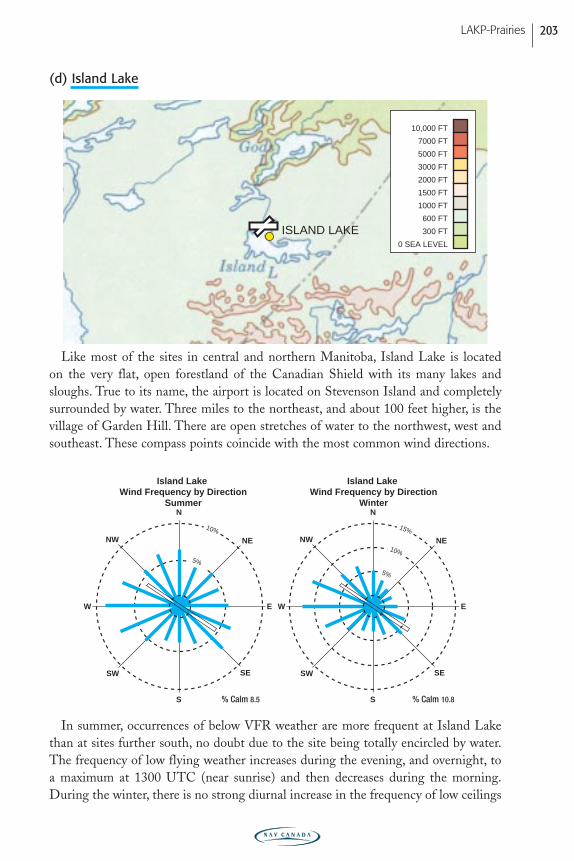
(d) Island Lake
Like most of the sites in central and northern Manitoba, Island Lake is located on the very flat, open forestland of the Canadian Shield with its many lakes andsloughs. True to its name, the airport is located on Stevenson Island and completelysurrounded by water. Three miles to the northeast, and about 100 feet higher, is thevillage of Garden Hill. There are open stretches of water to the northwest, west andsoutheast. These compass points coincide with the most common wind directions.
In summer, occurrences of below VFR weather are more frequent at Island Lakethan at sites further south, no doubt due to the site being totally encircled by water.The frequency of low flying weather increases during the evening, and overnight, toa maximum at 1300 UTC (near sunrise) and then decreases during the morning.During the winter, there is no strong diurnal increase in the frequency of low ceilings
N
S
SW
NENW
SE
W E
N
S
SW
NENW
SE
W E
10%
5%
15%
10%
5%
Island Lake Wind Frequency by Direction
Winter
Island Lake Wind Frequency by Direction
Summer
% Calm 8.5 % Calm 10.8
ISLAND LAKE0 SEA LEVEL
300 FT
600 FT
1000 FT
1500 FT
2000 FT
3000 FT
5000 FT
7000 FT
10,000 FT
LAKP-Prairies 203
PRAIRIE-E05 11/12/05 9:12 PM Page 203
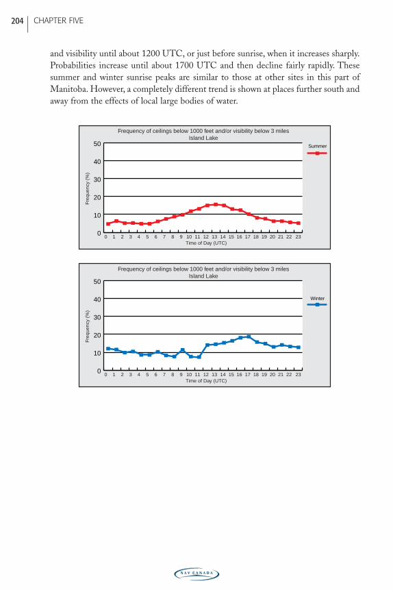
and visibility until about 1200 UTC, or just before sunrise, when it increases sharply.Probabilities increase until about 1700 UTC and then decline fairly rapidly. Thesesummer and winter sunrise peaks are similar to those at other sites in this part ofManitoba. However, a completely different trend is shown at places further south andaway from the effects of local large bodies of water.
Freq
uenc
y (%
)
0 1 2 3 4 5 6 7 8 9 10 11 12 13 14 15 16 17 18 19 20 21 22 230
10
20
30
40
50
Winter
Time of Day (UTC)
Freq
uenc
y (%
)
0 1 2 3 4 5 6 7 8 9 10 11 12 13 14 15 16 17 18 19 20 21 22 230
10
20
30
40
50 Summer
Time of Day (UTC)
Frequency of ceilings below 1000 feet and/or visibility below 3 milesIsland Lake
Frequency of ceilings below 1000 feet and/or visibility below 3 milesIsland Lake
CHAPTER FIVE 204
PRAIRIE-E05 11/12/05 9:12 PM Page 204
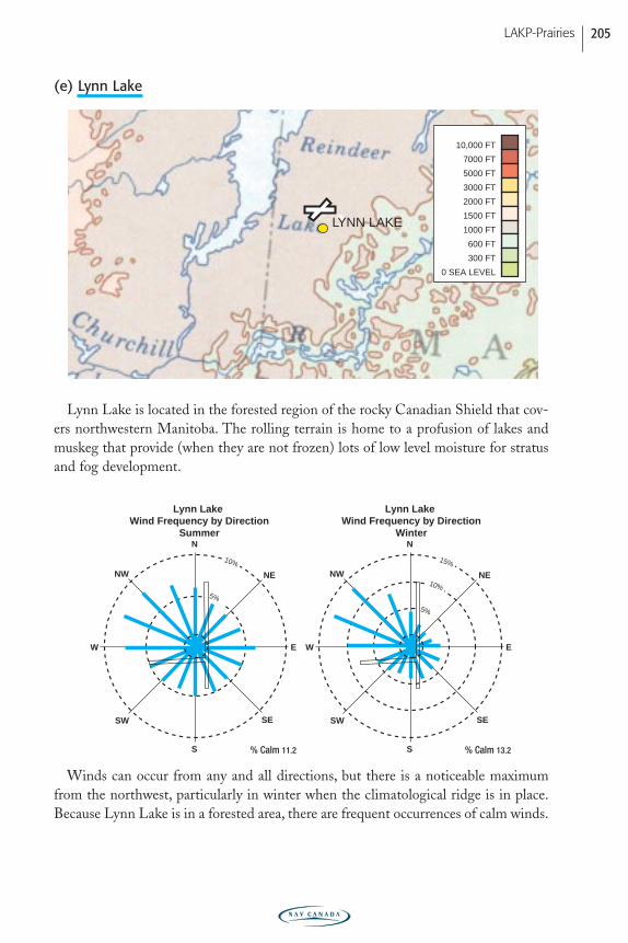
(e) Lynn Lake
Lynn Lake is located in the forested region of the rocky Canadian Shield that cov-ers northwestern Manitoba. The rolling terrain is home to a profusion of lakes andmuskeg that provide (when they are not frozen) lots of low level moisture for stratusand fog development.
Winds can occur from any and all directions, but there is a noticeable maximumfrom the northwest, particularly in winter when the climatological ridge is in place.Because Lynn Lake is in a forested area, there are frequent occurrences of calm winds.
N
S
SW
NENW
SE
W E
N
S
SW
NENW
SE
W E
10%
5%
15%
10%
5%
Lynn Lake Wind Frequency by Direction
Winter
Lynn Lake Wind Frequency by Direction
Summer
% Calm 11.2 % Calm 13.2
LYNN LAKE
0 SEA LEVEL
300 FT
600 FT
1000 FT
1500 FT
2000 FT
3000 FT
5000 FT
7000 FT
10,000 FT
LAKP-Prairies 205
PRAIRIE-E05 11/12/05 9:12 PM Page 205
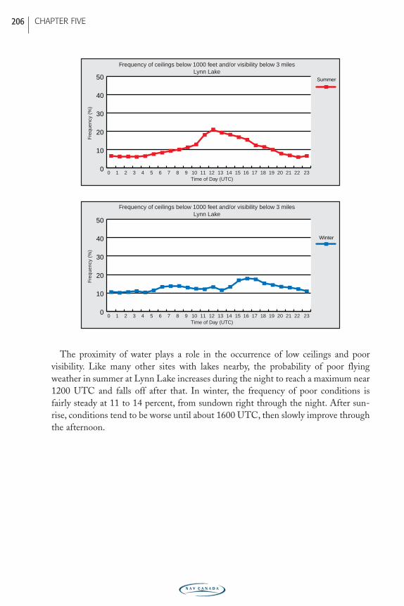
The proximity of water plays a role in the occurrence of low ceilings and poor visibility. Like many other sites with lakes nearby, the probability of poor flyingweather in summer at Lynn Lake increases during the night to reach a maximum near1200 UTC and falls off after that. In winter, the frequency of poor conditions is fairly steady at 11 to 14 percent, from sundown right through the night. After sun-rise, conditions tend to be worse until about 1600 UTC, then slowly improve throughthe afternoon.
Freq
uenc
y (%
)
0 1 2 3 4 5 6 7 8 9 10 11 12 13 14 15 16 17 18 19 20 21 22 230
10
20
30
40
50
Winter
Time of Day (UTC)
Freq
uenc
y (%
)
0 1 2 3 4 5 6 7 8 9 10 11 12 13 14 15 16 17 18 19 20 21 22 230
10
20
30
40
50 Summer
Time of Day (UTC)
Frequency of ceilings below 1000 feet and/or visibility below 3 milesLynn Lake
Frequency of ceilings below 1000 feet and/or visibility below 3 milesLynn Lake
CHAPTER FIVE 206
PRAIRIE-E05 11/12/05 9:12 PM Page 206
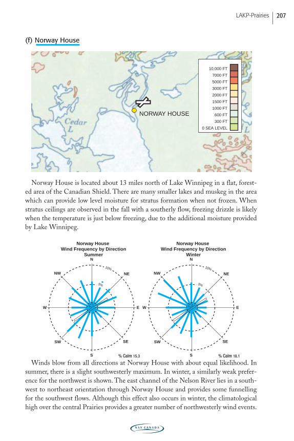
(f) Norway House
Norway House is located about 13 miles north of Lake Winnipeg in a flat, forest-ed area of the Canadian Shield. There are many smaller lakes and muskeg in the areawhich can provide low level moisture for stratus formation when not frozen. Whenstratus ceilings are observed in the fall with a southerly flow, freezing drizzle is likelywhen the temperature is just below freezing, due to the additional moisture providedby Lake Winnipeg.
Winds blow from all directions at Norway House with about equal likelihood. Insummer, there is a slight southwesterly maximum. In winter, a similarly weak prefer-ence for the northwest is shown. The east channel of the Nelson River lies in a south-west to northeast orientation through Norway House and provides some funnellingfor the southwest flows. Although this effect also occurs in winter, the climatologicalhigh over the central Prairies provides a greater number of northwesterly wind events.
N
S
SW
NENW
SE
W E
N
S
SW
NENW
SE
W E
10%
Norway House Wind Frequency by Direction
Summer
10%
5%
Norway House Wind Frequency by Direction
Winter
5%
% Calm 15.3 % Calm 18.1
NORWAY HOUSE
0 SEA LEVEL
300 FT
600 FT
1000 FT
1500 FT
2000 FT
3000 FT
5000 FT
7000 FT
10,000 FT
LAKP-Prairies 207
PRAIRIE-E05 11/12/05 9:12 PM Page 207
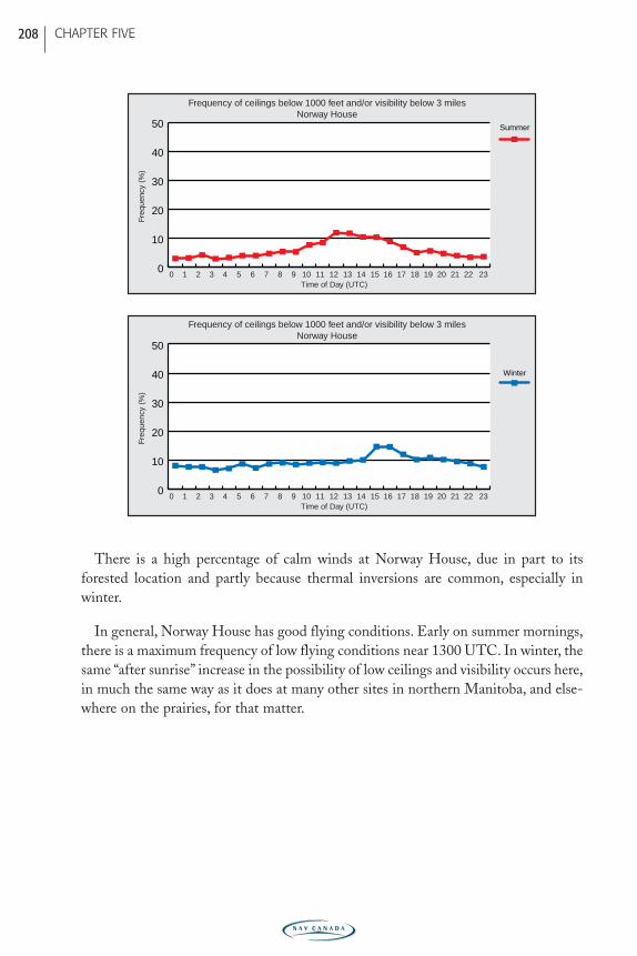
There is a high percentage of calm winds at Norway House, due in part to itsforested location and partly because thermal inversions are common, especially inwinter.
In general, Norway House has good flying conditions. Early on summer mornings,there is a maximum frequency of low flying conditions near 1300 UTC. In winter, thesame “after sunrise” increase in the possibility of low ceilings and visibility occurs here,in much the same way as it does at many other sites in northern Manitoba, and else-where on the prairies, for that matter.
Freq
uenc
y (%
)
0 1 2 3 4 5 6 7 8 9 10 11 12 13 14 15 16 17 18 19 20 21 22 230
10
20
30
40
50
Winter
Time of Day (UTC)
Freq
uenc
y (%
)
0 1 2 3 4 5 6 7 8 9 10 11 12 13 14 15 16 17 18 19 20 21 22 230
10
20
30
40
50 Summer
Time of Day (UTC)
Frequency of ceilings below 1000 feet and/or visibility below 3 milesNorway House
Frequency of ceilings below 1000 feet and/or visibility below 3 milesNorway House
CHAPTER FIVE 208
PRAIRIE-E05 11/12/05 9:12 PM Page 208
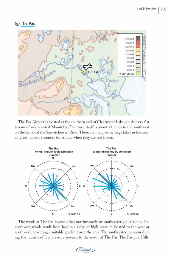
(g) The Pas
The Pas Airport is located at the southern end of Clearwater Lake, on the very flatterrain of west-central Manitoba. The town itself is about 13 miles to the southweston the banks of the Saskatchewan River. There are many other large lakes in the area,all great moisture sources for stratus when they are not frozen.
The winds at The Pas favour either northwesterly or southeasterly directions. Thenorthwest winds result from having a ridge of high pressure located to the west ornorthwest, providing a suitable gradient over the area. The southeasterlies occur dur-ing the transits of low pressure systems to the south of The Pas. The Pasquia Hills,
15%
10%
5%
15%
10%
5%
The Pas Wind Frequency by Direction
Winter
The Pas Wind Frequency by Direction
SummerN
S
SW
NENW
SE
W E
N
S
SW
NENW
SE
W E
% Calm 7.8 % Calm 8.8
THE PAS 0 SEA LEVEL
300 FT
600 FT
1000 FT
1500 FT
2000 FT
3000 FT
5000 FT
7000 FT
10,000 FT
LAKP-Prairies 209
PRAIRIE-E05 11/12/05 9:12 PM Page 209
part of the Manitoba Escarpment, rising 1,500 feet above the surrounding terrain 46miles southwest of The Pas, probably play some part in producing this northwest tosoutheast preference in wind direction. Another topographic feature that may play arole is a prominent terminal moraine left by the most recent ice age. The Pas Moraineextends southeastward from west of Clear Lake, arcs between Cedar Lake and LakeWinnipegosis, and extends out into Lake Winnipeg forming Long Point.
There is a stronger northwesterly maximum in winter, the result of having highpressure most often to the west (the climatological ridge) during this season.
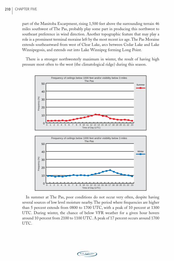
In summer at The Pas, poor conditions do not occur very often, despite having several sources of low level moisture nearby. The period where frequencies are higherthan 5 percent extends from 0800 to 1700 UTC, with a peak of 10 percent at 1300UTC. During winter, the chance of below VFR weather for a given hour hoversaround 10 percent from 2100 to 1100 UTC. A peak of 17 percent occurs around 1700UTC.
Freq
uenc
y (%
)
0 1 2 3 4 5 6 7 8 9 10 11 12 13 14 15 16 17 18 19 20 21 22 230
10
20
30
40
50
Winter
Time of Day (UTC)
Freq
uenc
y (%
)
0 1 2 3 4 5 6 7 8 9 10 11 12 13 14 15 16 17 18 19 20 21 22 230
10
20
30
40
50 Summer
Time of Day (UTC)
Frequency of ceilings below 1000 feet and/or visibility below 3 milesThe Pas
Frequency of ceilings below 1000 feet and/or visibility below 3 milesThe Pas
CHAPTER FIVE 210
PRAIRIE-E05 11/12/05 9:12 PM Page 210
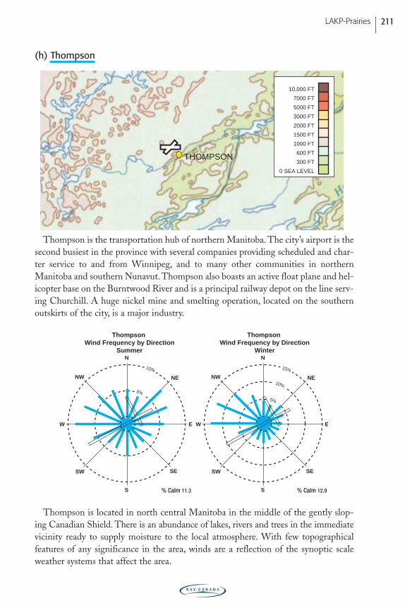
(h) Thompson
Thompson is the transportation hub of northern Manitoba. The city’s airport is thesecond busiest in the province with several companies providing scheduled and char-ter service to and from Winnipeg, and to many other communities in northernManitoba and southern Nunavut. Thompson also boasts an active float plane and hel-icopter base on the Burntwood River and is a principal railway depot on the line serv-ing Churchill. A huge nickel mine and smelting operation, located on the southernoutskirts of the city, is a major industry.
Thompson is located in north central Manitoba in the middle of the gently slop-ing Canadian Shield. There is an abundance of lakes, rivers and trees in the immediatevicinity ready to supply moisture to the local atmosphere. With few topographicalfeatures of any significance in the area, winds are a reflection of the synoptic scaleweather systems that affect the area.
N
S
SW
NENW
SE
W E
N
S
SW
NENW
SE
W E
15%
10%
5%
10%
5%
Thompson Wind Frequency by Direction
Winter
Thompson Wind Frequency by Direction
Summer
% Calm 11.3 % Calm 12.9
THOMPSON
0 SEA LEVEL
300 FT
600 FT
1000 FT
1500 FT
2000 FT
3000 FT
5000 FT
7000 FT
10,000 FT
LAKP-Prairies 211
PRAIRIE-E05 11/12/05 9:12 PM Page 211
In the summer, there is an equal likelihood of having high pressure to the west gen-erating a west or northwest flow as there is of having an east to northeasterly flowassociated with low pressure to the south. During winter, the more common occur-rence of a stronger high over the central Prairies produces a west to northwesterlymaximum in the wind climatology.
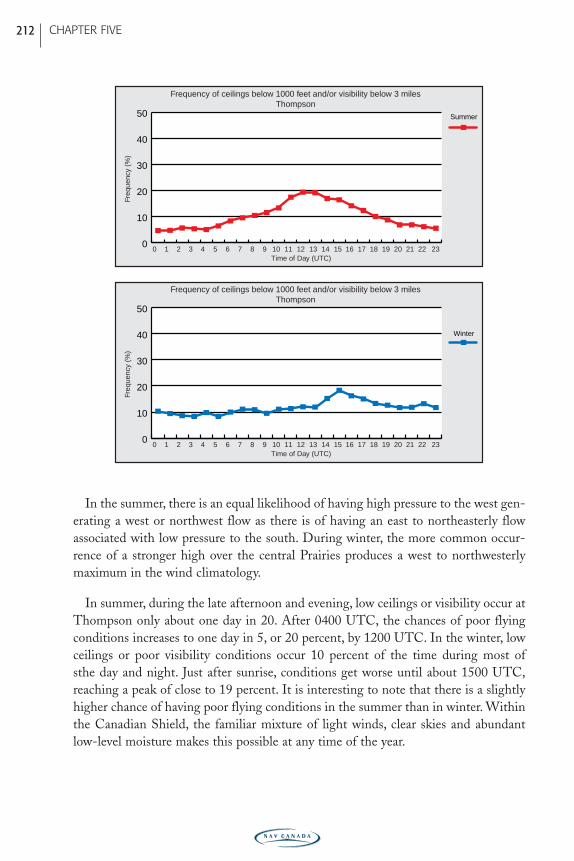
In summer, during the late afternoon and evening, low ceilings or visibility occur atThompson only about one day in 20. After 0400 UTC, the chances of poor flyingconditions increases to one day in 5, or 20 percent, by 1200 UTC. In the winter, lowceilings or poor visibility conditions occur 10 percent of the time during most of sthe day and night. Just after sunrise, conditions get worse until about 1500 UTC,reaching a peak of close to 19 percent. It is interesting to note that there is a slightlyhigher chance of having poor flying conditions in the summer than in winter. Withinthe Canadian Shield, the familiar mixture of light winds, clear skies and abundantlow-level moisture makes this possible at any time of the year.
Freq
uenc
y (%
)
0 1 2 3 4 5 6 7 8 9 10 11 12 13 14 15 16 17 18 19 20 21 22 230
10
20
30
40
50
Winter
Time of Day (UTC)
Freq
uenc
y (%
)
0 1 2 3 4 5 6 7 8 9 10 11 12 13 14 15 16 17 18 19 20 21 22 230
10
20
30
40
50 Summer
Time of Day (UTC)
Frequency of ceilings below 1000 feet and/or visibility below 3 milesThompson
Frequency of ceilings below 1000 feet and/or visibility below 3 milesThompson
CHAPTER FIVE 212
PRAIRIE-E05 11/12/05 9:12 PM Page 212
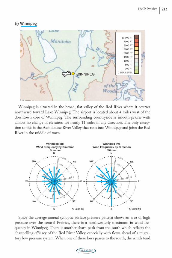
(i) Winnipeg
Winnipeg is situated in the broad, flat valley of the Red River where it coursesnorthward toward Lake Winnipeg. The airport is located about 4 miles west of thedowntown core of Winnipeg. The surrounding countryside is smooth prairie withalmost no change in elevation for nearly 11 miles in any direction. The only excep-tion to this is the Assiniboine River Valley that runs into Winnipeg and joins the RedRiver in the middle of town.
Since the average annual synoptic surface pressure pattern shows an area of highpressure over the central Prairies, there is a northwesterly maximum in wind fre-quency in Winnipeg. There is another sharp peak from the south which reflects thechannelling efficacy of the Red River Valley, especially with flows ahead of a migra-tory low pressure system. When one of these lows passes to the south, the winds tend
N
S
SW
NENW
SE
W E
N
S
SW
NENW
SE
W E
15%
10%
15%
10%
5%
Winnipeg Intl Wind Frequency by Direction
Winter
Winnipeg Intl Wind Frequency by Direction
Summer
5%
% Calm 3.0 % Calm 2.9
WINNIPEG0 SEA LEVEL
300 FT
600 FT
1000 FT
1500 FT
2000 FT
3000 FT
5000 FT
7000 FT
10,000 FT
LAKP-Prairies 213
PRAIRIE-E05 11/12/05 9:12 PM Page 213
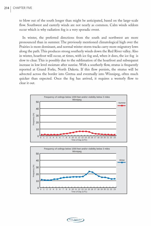
to blow out of the south longer than might be anticipated, based on the large-scaleflow. Southwest and easterly winds are not nearly as common. Calm winds seldomoccur which is why radiation fog is a very sporadic event.
In winter, the preferred directions from the south and northwest are more pronounced than in summer. The previously mentioned climatological high over thePrairies is more dominant, and normal winter storm tracks carry more migratory lowsalong the path. This produces strong southerly winds down the Red River valley. Alsoin winter, hoarfrost will occur, at times, with ice fog and, when it does, the ice fog isslow to clear. This is possibly due to the sublimation of the hoarfrost and subsequentincrease in low level moisture after sunrise. With a southerly flow, stratus is frequentlyreported at Grand Forks, North Dakota. If this flow persists, the stratus will beadvected across the border into Gretna and eventually into Winnipeg, often muchquicker than expected. Once the fog has arrived, it requires a westerly flow to clear it out.
Freq
uenc
y (%
)
0 1 2 3 4 5 6 7 8 9 10 11 12 13 14 15 16 17 18 19 20 21 22 230
10
20
30
40
50
Winter
Time of Day (UTC)
Freq
uenc
y (%
)
0 1 2 3 4 5 6 7 8 9 10 11 12 13 14 15 16 17 18 19 20 21 22 230
10
20
30
40
50 Summer
Time of Day (UTC)
Frequency of ceilings below 1000 feet and/or visibility below 3 milesWinnipeg
Frequency of ceilings below 1000 feet and/or visibility below 3 milesWinnipeg
CHAPTER FIVE 214
PRAIRIE-E05 11/12/05 9:12 PM Page 214
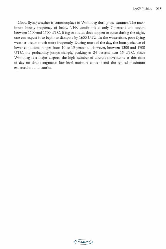
Good flying weather is commonplace in Winnipeg during the summer. The max-imum hourly frequency of below VFR conditions is only 7 percent and occursbetween 1100 and 1500 UTC. If fog or stratus does happen to occur during the night,one can expect it to begin to dissipate by 1600 UTC. In the wintertime, poor flyingweather occurs much more frequently. During most of the day, the hourly chance oflower conditions ranges from 10 to 15 percent. However, between 1300 and 1900UTC, the probability jumps sharply, peaking at 24 percent near 15 UTC. SinceWinnipeg is a major airport, the high number of aircraft movements at this time of day no doubt augments low level moisture content and the typical maximumexpected around sunrise.
LAKP-Prairies 215
PRAIRIE-E05 11/12/05 9:12 PM Page 215

216
PRAIRIE-E05 11/12/05 9:12 PM Page 216
Glossary of Weather Terms
anabatic wind - a local wind which blows up a slope heated by sunshine.
advection - the horizontal transportation of air or atmospheric properties.
air density - the mass density of air expressed as weight per unit volume.
air mass - an extensive body of air with uniform conditions of moisture and tem-perature in the horizontal.
albedo – the ratio of the amount of electromagnetic radiation reflected by a body tothe amount incident on it, commonly expressed as a percentage.
anticyclone - an area of high atmospheric pressure which has a closed circulationthat is anticyclonic (clockwise) in the Northern Hemisphere.
blizzard - A blizzard, in general, is a winter storm with winds exceeding 40 km/h,with visibility reduced by falling or blowing snow to less than one kilometre,with high windchill values and lasting for at least three hours. All regional defi-nitions contain the same wind speed and visibility criteria but differ in therequired duration and have a temperature criterion.
cat’s paw – a cat paw-like, ripple signature on water given by strong downdrafts oroutflow winds. A good indication of turbulence and wind shear.
ceiling - either (a) the height above the surface of the base of the lowest layer ofclouds or obscuring phenomena (i.e. smoke) that hides more than half of thesky; (b) the vertical visibility into an obstruction to vision (i.e. fog).
chinook - a warm dry wind blowing down the slopes of the Rocky Mountains andover the adjacent plains.
clear air turbulence (CAT) - turbulence in the free atmosphere not related to con-vective activity. It can occur in cloud and is caused by wind shear.
clear icing - generally, the formation of a layer or mass of ice which is relativelytransparent because of its homogeneous structure and smaller number and sizeof air spaces; synonymous with glaze.
climate - the statistical collection of long-term (usually decades) weather condi-tions at a point; may be expressed in a variety of ways.
cold front - the leading edge of an advancing cold air mass.
convection - atmospheric motions that are predominately vertical, resulting in thevertical transport and mixing of atmospheric properties.
convergence - a condition that exists when the distribution of winds in a given areais such that there is a net horizontal inflow of air into the area; the effect is tocreate lift.
cumuliform - a term descriptive of all convective clouds exhibiting vertical develop-ment.
LAKP-Prairies 217
PRAIRIE-E05 11/12/05 9:12 PM Page 217
cyclone - an area of low atmospheric pressure which has a circulation that iscyclonic (counterclockwise) in the Northern Hemisphere.
deepening - a decrease in the central pressure of a pressure system; usually appliedto a low. Indicates a development of the low.
deformation zone - An area in the atmosphere where winds converge along oneaxis and diverge along another. Where the winds converge, the air is forcedupward and it is in these areas where deformation zones (or axes of deforma-tion as they are sometimes referred to) can produce clouds and precipitation.
disturbance - applied loosely: (a) any small-sized low pressure system; (b) an areawhere the weather, wind, and air pressure show signs of cyclonic development;(c) any deviation in flow or pressure that is associated with a disturbed state inthe weather; and (d) any individual circulatory system within the primary circu-lation of the atmosphere.
divergence - a condition that exists when the distribution of winds in a given area issuch that there is a net horizontal outflow of air from the area.
downdraft - a small scale downward current of air; observed on the lee side of largeobjects that restrict the smooth flow of air or in or near precipitation areasassociated with cumuliform clouds.
downburst - an exceptionally strong downdraft beneath a thunderstorm usuallyaccompanied by a deluge of precipitation.
filling - an increase in the central pressure of a pressure system; applied to a low.
Föhn wind (foehn wind)- A warm dry wind on the lee side of a mountain range,whose temperature is increased as the wind descends down the slope. It is created when air flows downhill from a high elevation, raising the temperatureby adiabatic compression.
front - a surface, interface or transition zone of discontinuity between two adjacentair masses of different densities.
Fujita Scale – a scale used to rate the intensity of a tornado by examining the dam-age caused by the tornado after it has passed over a man-made structure(see Table 1).
GLOSSARY 218
PRAIRIE-E05 11/12/05 9:13 PM Page 218
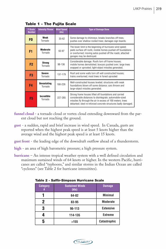
funnel cloud - a tornado cloud or vortex cloud extending downward from the par-ent cloud but not reaching the ground.
gust - a sudden, rapid and brief increase in wind speed. In Canada, gusts arereported when the highest peak speed is at least 5 knots higher than the average wind and the highest peak speed is at least 15 knots.
gust front - the leading edge of the downdraft outflow ahead of a thunderstorm.
high - an area of high barometric pressure; a high pressure system.
hurricane – An intense tropical weather system with a well defined circulation andmaximum sustained winds of 64 knots or higher. In the western Pacific, hurri-canes are called “typhoons,” and similar storms in the Indian Ocean are called“cyclones” (see Table 2 for hurricane intensitites).
Category#
Sustained Winds(kts)
Damage
12345
Minimal
Moderate
Extensive
Extreme
Catastrophic
64-82
83-95
96-113
114-135
>155
Table 2 - Saffir-Simpson Hurricane Scale
227-285
FO
Table 1 - The Fujita ScaleF-Scale Number
Intensity Phrase Wind Speed (kts)
Type of Damage Done
WeakTornado
35-62 Some damage to chimneys; breaks branches off trees; pushes over shallow-rooted trees; damages sign boards.
Roof and some walls torn off well constructed houses; trains overturned; most trees in forest uprooted
The lower limit is the beginning of hurricane wind speed; peels surface off roofs; mobile homes pushed off foundations or overturned; moving autos pushed off the roads; attached garages may be destroyed.
Moderate TornadoF1 63-97
Considerable damage. Roofs torn off frame houses; mobile homes demolished; boxcars pushed over; large trees snapped or uprooted; light-object missiles generated.
Strong Tornado 98-136 F2
Severe Tornado
137-179 F3
Well-constructed houses leveled; structures with weak foundations blown off some distance; cars thrown and large-object missiles generated.
Devastating Tornado
180-226 F4
Strong frame houses lifted off foundations and carried considerable distances to disintegrate; automobile-sized missiles fly through the air in excess of 100 meters; trees debarked; steel re-inforced concrete structures badly damaged.
Incredible TornadoF5
LAKP-Prairies 219
PRAIRIE-E05 11/12/05 9:13 PM Page 219
icing - in general, any deposit of ice forming on an object.
instability - a state of the atmosphere where the vertical distribution of temperatureis such that a parcel displaced from its initial position will continue to ascend.
inversion - an increase of temperature with height - a reversal of the normaldecrease of temperature with height.
isothermal layer - equal or constant temperature with height.
jet stream - a quasi-horizontal stream of wind concentrated within a narrow band;generally located just below the tropopause.
katabatic wind - downslope gravitational flow of colder, denser air beneath thewarmer, lighter air. Also known as “drainage wind” or “mountain breeze”.Strength can vary from gentle to extremely violent winds.
knot - a unit of speed equal to one nautical mile per hour.
lapse rate - the rate of change of an atmospheric variable (usually temperature) withheight.
lee wave - any stationary wave disturbance caused by a barrier in a fluid flow; alsocalled mountain wave or standing wave.
lightning - any and all forms of visible electrical discharge produced by a thunder-storm.
low - an area of low barometric pressure; a low pressure system.
meridional flow – airflow in the direction of the geographic meridians, i.e. south-north or north-south flow.
meteorology - the science of the atmosphere.
mixed icing - the formation of a white or milky and opaque layer of ice thatdemonstrates an appearance that is a composite of rime and clear icing.
occluded front - a front that is no longer in contact with the surface.
orographic - of, pertaining to, or caused by forced uplift of air over high ground.
outflow - generally, a condition where air is flowing from the interior land areathrough mountain passes, valleys and inlets onto the coastal areas; used mostcommonly in winter when cold Arctic air spreads onto the coastal area andadjoining sea.
overrunning - a condition when warm air overtakes or is lifted by colder denser air.
parcel - a small volume of air, small enough to contain uniform distribution ofmeteorological properties, and large enough to remain relatively self-containedand respond to all meteorological processes.
GLOSSARY 220
PRAIRIE-E05 11/12/05 9:13 PM Page 220
plow wind - usually associated with the spreading out of a downburst from a thun-derstorm; a strong, straight-line wind in advance of a thunderstorm that oftenresults in severe damage.
precipitation - any and all forms of water particles, whether liquid or solid, that fallfrom the atmosphere and reach the surface.
quasi-stationary front - a front that is stationary or nearly so; commonly called sta-tionary front.
ridge - an elongated area of relatively high atmospheric pressure; also called ridgeline.
rime icing - the formation of a white or milky and opaque granular deposit of iceformed by the rapid freezing of supercooled water droplets.
saturation - the condition in the atmosphere where actual water vapour present isthe maximum possible at the existing temperature.
shower - precipitation from cumuliform cloud; characterized by suddenness ofbeginning and ending, by rapid changes in intensity, and usually by rapidchange in the appearance of the sky.
squall - essentially gusts of longer duration. In Canada, a squall is reported whenthe wind increases by at least 15 knots over the average speed for a duration ofat least 2 minutes and the wind reaches a speed of at least 20 knots.
squall line - a non-frontal line or narrow band of active thunderstorms.
stability - a state of the atmosphere where the vertical distribution of temperatureis such that a parcel will resist displacement from its initial position.
stratiform - term descriptive of clouds of extensive horizontal development; flat,lacking definition.
stratosphere - the atmospheric layer above the tropopause; characterized by slightincrease in temperature from base to top, very stable, low moisture content andabsence of cloud.
subsidence - the downward motion of air over a large area resulting in dynamicheating.
supercooled water - liquid water at temperatures below freezing.
thunderstorm - a local storm invariably produced by a cumulonimbus cloud, andalways accompanied by lightning and thunder.
tornado - a violently rotating column of air, shaped from a cumulonimbus cloud,and nearly always observed as “funnel-shaped;” other names are cyclone andtwister.
LAKP-Prairies 221
PRAIRIE-E05 11/12/05 9:13 PM Page 221
tropopause - the transition zone between the troposphere and the stratosphere;characterized by an abrupt change in lapse rate.
troposphere - the portion of the earth’s atmosphere from the surface to thetropopause; characterized by decreasing temperature with height and apprecia-ble water vapour. Often referred to as the weather layer.
trough - an elongated area of relatively low atmospheric pressure; also called troughline.
trowal - a trough of warm air aloft; related to occluded front.
turbulence - any irregular or disturbed flow in the atmosphere.
updraft - a localized upward current of air.
upper front - any frontal zone which is not manifested at the surface.
virga - water or ice particles falling from a cloud, usually in wisps or streaks, andevaporating completely before reaching the ground.
warm front - the trailing edge of retreating cold air.
weather - the instantaneous conditions or short term changes of atmospheric condi-tions at a point; as opposed to climate.
wind - air in motion relative to the earth’s surface; normally horizontal motion.
wind direction - the direction from which the wind is blowing.
wind speed - rate of wind movement expressed as distance per unit time.
wind shear - the rate of change of wind direction and/or speed per unit distance;conventionally expressed as vertical and horizontal wind shear.
zonal wind - a west wind; conventionally used to describe large-scale flow that isneither cyclonic or anticyclonic; also called zonal flow.
GLOSSARY 222
PRAIRIE-E05 11/12/05 9:13 PM Page 222
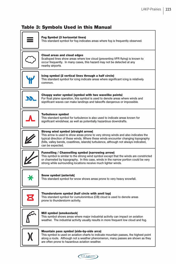
LAKP-Prairies 223
Fog Symbol (3 horizontal lines)This standard symbol for fog indicates areas where fog is frequently observed.
Table 3: Symbols Used in this Manual
Cloud areas and cloud edgesScalloped lines show areas where low cloud (preventing VFR flying) is known tooccur frequently. In many cases, this hazard may not be detected at anynearby airports.
Icing symbol (2 vertical lines through a half circle)This standard symbol for icing indicate areas where significant icing is relativelycommon.
Choppy water symbol (symbol with two wavelike points)For float plane operation, this symbol is used to denote areas where winds andsignificant waves can make landings and takeoffs dangerous or impossible.
Turbulence symbolThis standard symbol for turbulence is also used to indicate areas known for significant windshear, as well as potentially hazardous downdrafts.
Strong wind symbol (straight arrow)This arrow is used to show areas prone to very strong winds and also indicates thetypical direction of these winds. Where these winds encounter changing topography(hills, valley bends, coastlines, islands) turbulence, although not always indicated,can be expected.
Funnelling / Channelling symbol (narrowing arrow)This symbol is similar to the strong wind symbol except that the winds are constrictedor channeled by topography. In this case, winds in the narrow portion could be very strong while surrounding locations receive much lighter winds.
Snow symbol (asterisk)This standard symbol for snow shows areas prone to very heavy snowfall.
Thunderstorm symbol (half circle with anvil top)This standard symbol for cumulonimbus (CB) cloud is used to denote areasprone to thunderstorm activity.
Mill symbol (smokestack)This symbol shows areas where major industrial activity can impact on aviationweather. The industrial activity usually results in more frequent low cloud and fog.
Mountain pass symbol (side-by-side arcs)This symbol is used on aviation charts to indicate mountain passes, the highest pointalong a route. Although not a weather phenomenon, many passes are shown as theyare often prone to hazardous aviation weather.
PRAIRIE-E05 11/12/05 9:13 PM Page 223
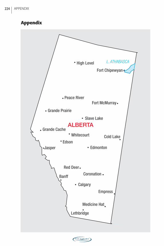
Appendix
APPENDIX 224
• •
• •
• •
• •
•
•
•
•
•
•
•
•
•
•
•
Banff
Calgary
Cold Lake
EdmontonEdson
Empress
Fort Chipewyan
Fort McMurray
Grande Cache
Grande Prairie
High Level
Jasper
Lethbridge
Medicine Hat
Peace River
Red Deer
Slave Lake
Whitecourt
Coronation
L. ATHABASCA
ALBERTA
PRAIRIE-E05 11/12/05 9:13 PM Page 224
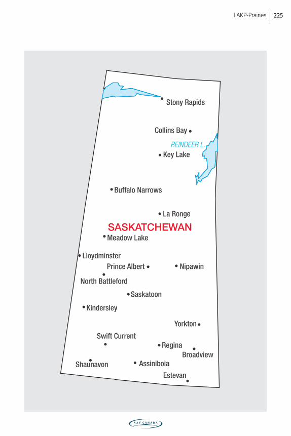
LAKP-Prairies 225
REINDEER L.
•
•
•
•
•
•
•
•
•
•
•
• •
•
•
•
•
•
•
AssiniboiaBroadview
Buffalo Narrows
Collins Bay
Estevan
Key Lake
Kindersley
La Ronge
Lloydminster
Meadow Lake
Nipawin
North Battleford
Prince Albert
Regina
Saskatoon
Shaunavon
Stony Rapids
Swift Current
Yorkton
SASKATCHEWAN
PRAIRIE-E05 11/12/05 9:13 PM Page 225
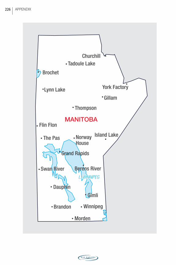
•
•
•
•
•
•
•
•
•
• •
•
•
•
•
•
•
Berens River
Brandon
Brochet
Churchill
Dauphin
Flin Flon
Gillam
Gimli
Island Lake
Lynn Lake
Morden
NorwayHouse
Tadoule Lake
The Pas
Thompson
Winnipeg
York Factory
•
•
Grand Rapids
Swan River
L. WINNIPEGL. WINNIPEGL. WINNIPEG
MANITOBA
APPENDIX 226
PRAIRIE-E05 11/12/05 9:13 PM Page 226
LAKP-Prairies 227
ALB
ER
TA
SA
SK
ATC
HE
WA
NM
AN
ITO
BAM
ap In
dex
• •
• •
• •
•
•
•
•
•
•
• •
•
Banf
f
Calg
ary
Cold
Lak
e
Edm
onto
nFort
Chi
pew
yan
Fort
McM
urra
y
Gran
de P
rairi
e
High
Lev
el
Jasp
er
Leth
brid
geMed
icin
e Ha
t
Peac
e Ri
ver
Red
Deer
Slav
e La
ke
Whi
teco
urt
•
• •
•
• •
•
•
•
•
•
•
Este
van
Key
Lake
La R
onge
Lloy
dmin
sterMea
dow
Lak
e
Nort
h Ba
ttlef
ord
Prin
ce A
lber
t
Regi
na
Sask
atoo
n
Ston
y Ra
pids
Swift
Cur
rent
York
ton
•
•
•
•
•
•
• •
•
•
•
•
Bran
don
Chur
chill
Daup
hin
Flin
Flo
n
Gilla
m
Isla
nd L
ake
Lynn
Lak
e
Norw
ayHo
use
The
Pas
Thom
pson
Win
nipe
g
York
Fac
tory
•
•
Gran
d Ra
pids
Swan
Riv
er
89
138
136
164
162
158
161
155
156
153
151
150
148
147
145
134
132
130
128
114
116
122
124
126
120
118
86
83
9381
9279
78
7696
98
99
101
103
Num
bers
indi
cate
pag
es
PRAIRIE-E05 11/12/05 9:13 PM Page 227

The Weather
of
The Canadian Prairies
Graphic Area Forecast 32
11/08/05
PRAIRIE-E05 11/12/05 9:09 PM Page 2