chapter 4 right of entry, property, prescriptive easements
TRANSCRIPT
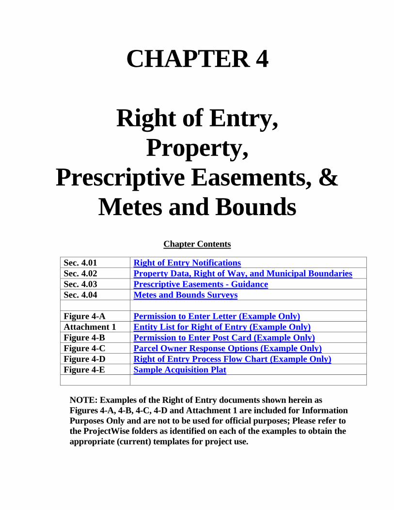
CHAPTER 4
Right of Entry, Property,
Prescriptive Easements, & Metes and Bounds
Chapter Contents
Sec. 4.01 Right of Entry Notifications Sec. 4.02 Property Data, Right of Way, and Municipal Boundaries Sec. 4.03 Prescriptive Easements - Guidance Sec. 4.04 Metes and Bounds Surveys Figure 4-A Permission to Enter Letter (Example Only) Attachment 1 Entity List for Right of Entry (Example Only) Figure 4-B Permission to Enter Post Card (Example Only) Figure 4-C Parcel Owner Response Options (Example Only) Figure 4-D Right of Entry Process Flow Chart (Example Only) Figure 4-E Sample Acquisition Plat
NOTE: Examples of the Right of Entry documents shown herein as Figures 4-A, 4-B, 4-C, 4-D and Attachment 1 are included for Information Purposes Only and are not to be used for official purposes; Please refer to the ProjectWise folders as identified on each of the examples to obtain the appropriate (current) templates for project use.
4-1
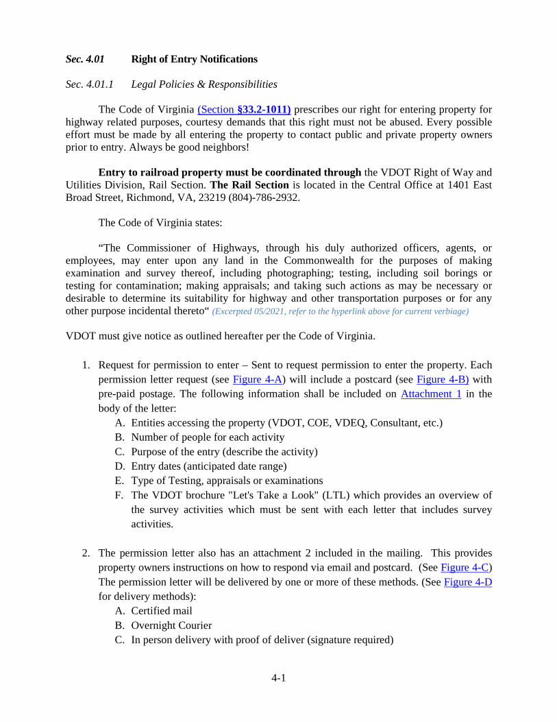
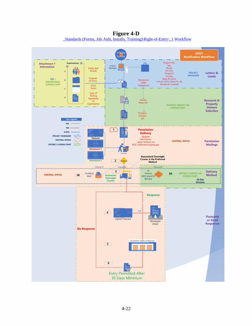
Sec. 4.01 Right of Entry Notifications Sec. 4.01.1 Legal Policies & Responsibilities The Code of Virginia (Section §33.2-1011) prescribes our right for entering property for highway related purposes, courtesy demands that this right must not be abused. Every possible effort must be made by all entering the property to contact public and private property owners prior to entry. Always be good neighbors! Entry to railroad property must be coordinated through the VDOT Right of Way and Utilities Division, Rail Section. The Rail Section is located in the Central Office at 1401 East Broad Street, Richmond, VA, 23219 (804)-786-2932. The Code of Virginia states:
“The Commissioner of Highways, through his duly authorized officers, agents, or employees, may enter upon any land in the Commonwealth for the purposes of making examination and survey thereof, including photographing; testing, including soil borings or testing for contamination; making appraisals; and taking such actions as may be necessary or desirable to determine its suitability for highway and other transportation purposes or for any other purpose incidental thereto“ (Excerpted 05/2021, refer to the hyperlink above for current verbiage) VDOT must give notice as outlined hereafter per the Code of Virginia.
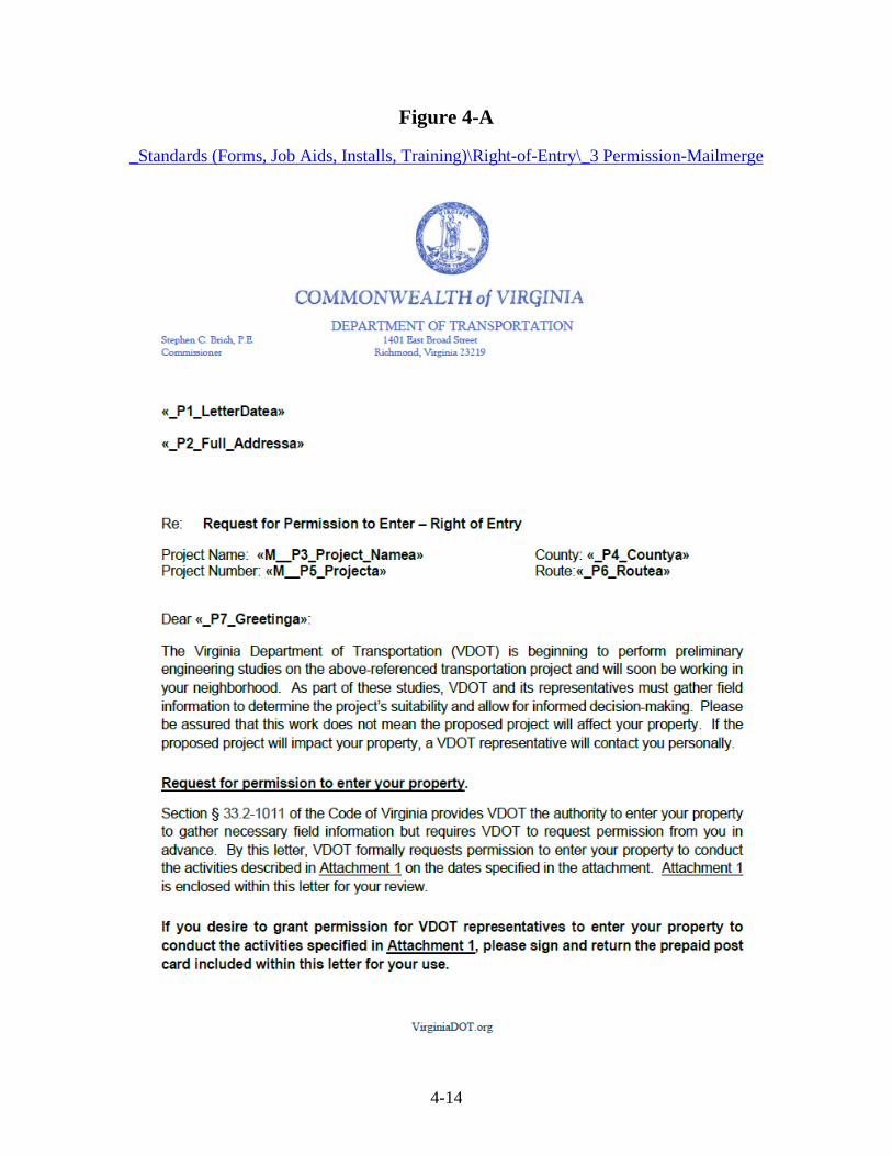
1. Request for permission to enter – Sent to request permission to enter the property. Each
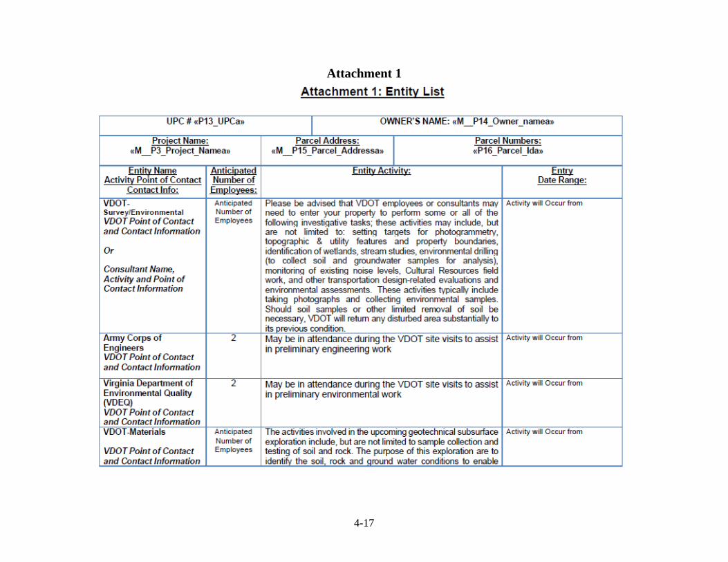
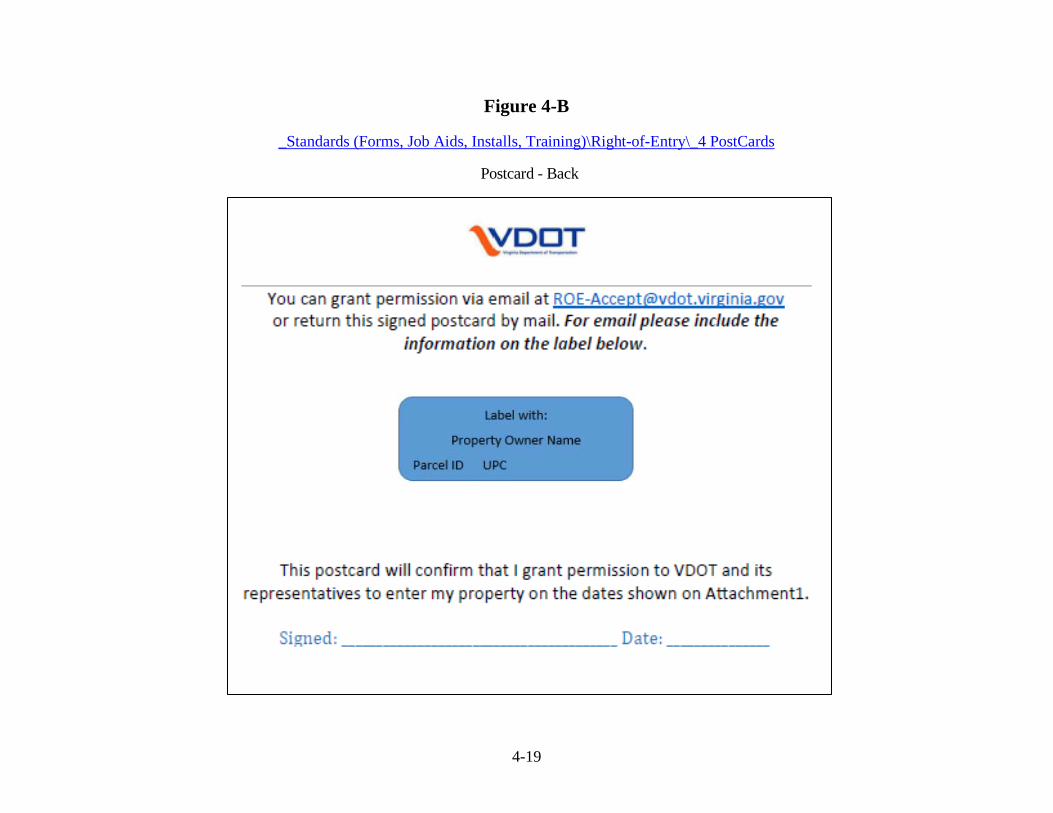
permission letter request (see Figure 4-A) will include a postcard (see Figure 4-B) with pre-paid postage. The following information shall be included on Attachment 1 in the body of the letter:
A. Entities accessing the property (VDOT, COE, VDEQ, Consultant, etc.) B. Number of people for each activity C. Purpose of the entry (describe the activity) D. Entry dates (anticipated date range) E. Type of Testing, appraisals or examinations F. The VDOT brochure "Let's Take a Look" (LTL) which provides an overview of
the survey activities which must be sent with each letter that includes survey activities.
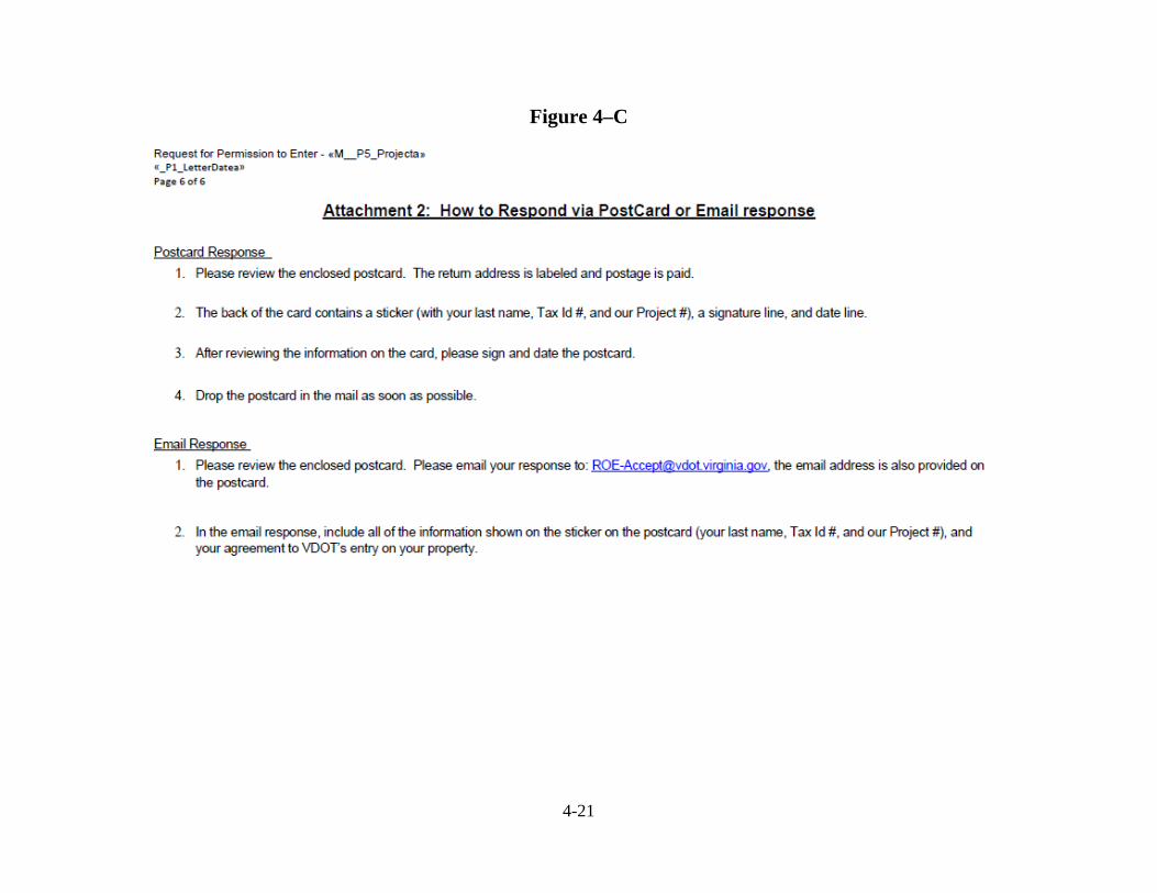
2. The permission letter also has an attachment 2 included in the mailing. This provides property owners instructions on how to respond via email and postcard. (See Figure 4-C) The permission letter will be delivered by one or more of these methods. (See Figure 4-D for delivery methods):
A. Certified mail B. Overnight Courier C. In person delivery with proof of deliver (signature required)
4-2
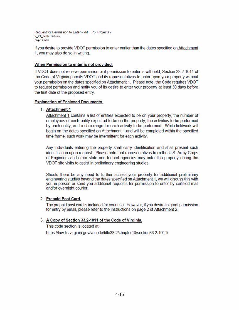
3. When the property owner confirms permission by postcard return (signed) or in-person
signature, or by return email, no further action is necessary for the time period specified in Attachment 1 of the letter. ProjectWise files must be updated to track which property owners have granted permission.
4. If permission to enter is not received by post card, email, in person signature or other acceptable means within 30 days, the code allows VDOT entry for the performance of the tasks indicated on Attachment 1.
The standard permission right of entry (ROE-P) shall be prepared for each owner indicating each parcel by address and/or tax id number. These letters will be used statewide to ensure uniformity under Section 33.2-1011 of the Code of Virginia. The standard permission letter shall NOT be modified unless permission is received from the Division administrator. This permission letter is a Department standard for entry for Environmental, Location and Design and Materials Divisions. No other letters are permitted.
Detailed Instructions and the Templates for these letters shown below can be found in ProjectWise in the following directory: PW\Documents\_Standards (Forms, Job Aids, Installs, Training)\Right of Entry\
If the task is going to exceed the duration indicated on the ROE Permission letter, another letter shall to be sent 30 days prior to the end of the original letters date range unless the property owner is contacted and provides written permission for time extension. Right of Entry Letters are NOT required for the following:
• Operations on existing VDOT easements (including prescriptive, permanent, drainage, utility and slope) or within existing fee right of way. Be Good Neighbors, inform and communicate!
• Emergency Operations
• Donated – Rural Rustic – if agreements are signed.
Time Extensions A time extension may be obtained by:
i. Providing a new copy of the permission letter with the new extended dates on attachment 1 to the property owner in person. If unable to meet in person then you must follow the new right of entry process as outlined above in number 1.
ii. Obtaining a signed copy of the postcard with a copy of the attachment 1 attached from the property owner for the Departments records documenting the extension.
4-3
All notifications must follow the steps outlined in Sec. 4.01.1 directly above and the attached workflow. The Location and Design notification work flow is attached as an example for other divisions. Figure 4-D Each Division will need to modify the L&D workflow for their use to show who is responsible for each part of the process. Sec. 4.01.2 Notification Documentation Policies Office
Prior to any fieldwork involving private/public property, the VDOT personnel or Consultants shall review the county real estate maps for the purpose of completing the provided excel list of all property owners to be affected by the proposed survey.
All property owner master information spreadsheets (POL-Master) shall be saved to the
following folder location for each project:
..\UPC#\Project Documents\Survey\Research A blank POL-MASTER (PROPERTY OWNER LIST) excel file is provided in the folder for
new projects along with ROE-P template letters for mail merge. This spreadsheet is mandatory and must be filled out for all projects so notifications can be tracked. Other divisions may make a copy of this spreadsheet for their use and will provide Survey a link to their copy so the master file can be updated once completed. (See PW\Documents\_Standards (Forms, Job Aids, Installs, Training)\Right of Entry\_2-Property Owner List\POL-Master-June-2021.xlsm)
For older projects, these files can be found in ProjectWise: _Standards (Forms, Job Aids, Installs, Training)\Right of Entry Additional instructions are provided for the POL-master and mailmerge in the
directories.
Copy the documents to the appropriate project folder as needed
All ROE letters for L&D shall be saved to the following folder location for each project: ..\UPC#\Project Documents\Survey\Right of Entry
Field
In making surveys of any nature, survey party personnel usually are the first agents or representatives of the Department to encounter private property owners. Since first impressions often are lasting ones, it is of utmost importance that all contacts with private/public property owners be handled with integrity and in a courteous and business-like manner. There can be no reasonable excuse for the failure to make these contacts as outlined herein, particularly when the owner lives on the property or in the vicinity.
4-4
All Survey Parties, internal or Consultant, shall keep extra copies of the ROE letter,
postcards and brochures in their vehicles while making the location survey. These should be provided to property owners and/or tenants who may have not received one or who want another ROE letter and brochure. Sec. 4.01.3 Property Owner Documentation
A ProjectWise link to the Property Owner List shall be furnished to the Resident Engineer and/or Project Manager. This will enable the Resident Engineer and/or Project Manager to be better prepared to handle inquiries that may be made as the survey progresses.
Any returned letters from the postal service shall be saved, indicated on the master list as returned, and communicated to the appropriate field personnel. The Project Manager and Survey Manager are responsible for determining if additional efforts are required to contact the land owner. Sec. 4.02 Property Data, Right of Way, and Municipal Boundaries <sbd(UPC#)> Existing fee right of way, property lines, limited access, municipal boundaries, public/private easements and prescriptive easements will be shown on all survey deliverables. It is imperative that all VDOT right of way and easements are shown when performing boundary surveys. When the Department is requesting consultants to develop/determine and recover right of way, all easements and right of way shown on existing VDOT plans shall be shown and included in the final dgn deliverables for any project. The only two exceptions are (i) if it is verified that VDOT never acquired the easement or (ii) you have received an exception in writing from the State GeoSpatial Program Manager prior to executing the task order. Sec. 4.02.1 Property <sbd(UPC#)> & <spo(UPC#)> Research All pertinent data from court records, such as subdivision plans, tract plans, deed book descriptions, etc., should be carefully copied, reviewed and checked for legibility when copies are made from the records. Chain of title researched shall be documented.
All owner information shall be input in an excel property owner list file. A blank
PROPERTY OWNER LIST excel file is provided in the folder (..\UPC#\Project Documents\Survey\Research). For new projects fill out all pertinent information on the Property Owners Deed Info tab only. The RW sheet tab is used to populate the RW data sheet later in project development after RW parcel numbers are assigned. The mail merge tab is setup to create the ROE letters. Instructions are included in the spreadsheet.
The following pieces of information shall be obtained per parcel: < > - denotes ProjectWise file location
4-5
1. Tax or GPIN Map <.. \Project Documents\Survey\Research\GIS Tax Maps > 2. Tax or GPIN Card <..\Project Documents\Survey\Research\GIS Tax Maps > 3. Most recent deed <..\Project Documents\Survey\Research\Deed-Plats > 4. Most recent plat <..\Project Documents\Survey\Research\Deed-Plats > 5. Zoning <..\Project Documents\Survey\Research\GIS Tax Maps > 6. Title (if available) <.\UPC\Project Documents\Survey\Research\Title> 7. Easements <..\Project Documents\Survey\Research\Deeds-Plats > 8. Proffers, zoning restrictions <..\Project Documents\Survey\Research\Deeds-Plats >
Property ties shall be sufficient to establish departing lot lines based on record
information, field evidence and the professional standard of care for route surveys. All found property corners (monuments, stones, iron pins, trees, fence corners, etc.) shall be located from the traverse baseline and will be referenced to the final construction centerline/baseline by station and right angle offset after utility field inspection (UFI). Both station and offset shall be shown to the nearest one-hundredth foot (0.01 ft).
Property lines shall have a bearing based on the VDOT project datum and be shown in the sbd(UPC#) file. The recorded deed or plat bearing, and distance will be shown in parenthesis. When different plat bearings and distances are encountered on the same line of adjacent properties, both bearings and distances will be shown with care given to the placement of these bearings and distances on the appropriate side of the property line. The names of all property owners shall be shown as recorded in the deed book, with the deed book and page number, plat book & page number, tax map or GPIN #, and acreage (x.xxx) or square footage (x,xxx) and shown in the spo(UPC#) file. Acreage shown on the R/W Data Sheet will be shown in the units described in the recorded deed. Where acreage or square footage is not recorded none is to be calculated, and a note, in parenthesis, will so state. When subdivided land is encountered, prints of the subdivision, as well as the names and addresses of the effected owners should be secured. Using the prints, an accurate tie at a minimum of three points on the subdivision should be made. It will not be necessary to tie each individual lot.
In the case of small lots that are not part of a subdivision, the entire lot should be shown so that it can be determined how much of the lot will remain after the right of way is secured. The bearings (plat or survey) and distance on all property lines between corners, which fall within the proposed right of way, must be shown. Easement Research
Easement research shall be performed on each parcel within the project limits based on visible field evidence, a 100-year records search, and coordination with SUE consultants if used for designation.
All easement research notes shall be scanned to a pdf file per parcel. The easement deeds
will be provided in a PDF file and will be saved to the following ProjectWise project folder:

4-6
..\UPC\Project Documents\Survey\Research\Deed-Plats Easement Deed PDF files shall be named based on tax map/gpin number: Example: tm34-50-###.pdf. ### is easement type. Easement research notes shall be named based on the tax map/gpin number: Example: tm34-50-Esmt-Research.pdf. Once obtained, internal or consultant staff will review, plot, and label all easements that
are applicable to the parcel to the project limits. The sbd(UPC#) file shall be used to map the easements and annotated with the pertinent deed book and page. Easements dedicated by means of subdivision plat should be shown per the recorded plat but it is important to note that many developers will grant utility providers specific rights of easement after the subdivision plat is recorded. These latter utility easements may not be limited to or constrained by the bounds of the platted easements and may also contain additional terms and conditions of use.
Any plottable & non-plottable easements that affect the parcel shall be documented in the
easement research notes per parcel. This file shall be attached to the parcel tax map/gpin number text in the spo(UPC#) for each parcel. To attach, select the appropriate tax map/gpin text, right click, and select add link. Special Properties/Total Takes
Complete metes and bounds descriptions are required for the acquisition of land owned by U.S. Government, State Agencies, National Forest Service, Railroad Companies, Power Companies (Dominion VA Power) and total takes. Metes and bounds descriptions will be provided to the Right of Way Division with plats on these parcels. Any legal description written will commence at the nearest offset point with the lowest stationing off the construction centerline thence clockwise around the parcel.
When a metes and bounds survey is required, the survey party will make sufficient ties of
the existing corners to the survey baseline and will reference to the final construction centerline/baseline by station and right-angle offset. When property belonging to any agency of the United States Government is crossed by the centerline, the distance from the centerline crossing to the nearest tract corner measured along the Government's property line will be obtained. Sec. 4.02.2 Right of Way, Proffers, Limited Access, & Easements <sbd(UPC#)> All existing fee simple dedications, donation right of ways, limited access and easements will be shown on plans. Right of way monumentation locations shall be secured by use of total station. Right of way ties shall be sufficient to establish right of way based on record information, field evidence and the professional standard of care for route surveys. Label and show the existing right of way and easements. Right of way labels shall include a reference to the old project or record source.
4-7
Courthouse and old project file research are critical to establishing the fee right of way and easements. Plans are available on ProjectWise and from the Plan Library (See PW\Documents\Plan File Room\) at Central Office. If old plans show existing right of way and existing easements, no further research is needed to “prove” the old plans. If the old plans show right of way or easement areas to be acquired, the right of way data sheet shall be checked as the research is performed to verify the acquisitions were actually completed. The local planning offices will be checked to determine if any right of way proffers exist or dedications to local governing bodies. Prescriptive or statutory right of way easements are to be shown on the plans but will not be shown or labeled as existing fee right of way. See Sec. 4.03 for guidance on Prescriptive easements A note will be placed in the survey file indicating which parcels are affected by the prescriptive easement. Property lines will be extended into the prescriptive easement to their terminus according to record data or the center of the traveled way. These lot lines will not be connected along the center of the traveled way, unless described by metes and bounds in the deed of record. Limited Access Existing limited access will be shown on all plans. On all surveys where limited access right of way is proposed or anticipated, properties that will be landlocked due to the control of access are to be so noted at the time the location and width of the proposed right of way is determined. This should be addressed with the Survey Report. Sec. 4.02.3 Municipal Boundaries <sbd(UPC#)> The names of all cities, towns, villages (whether incorporated or unincorporated) must be shown. Accurate tie-ins must be made for all corporate limits, county or state lines, etc., showing stations and angular ties. When a project encompasses two or more cities or counties the city/county lines must be shown depicting the border. The appropriate names should be on each side of the boundary line. If a project is only located in one county or city, the Title Block description will suffice. Sec. 4.03 Prescriptive Easements – Guidance Note: This guidance language has been redrafted from a guidance document entitled: “Property lines along public roads without recorded fee simple right of way” provided to the Virginia Department of Transportation by the Department of Professional and Occupational Regulation (APELSCIDLA Board). The Department is publishing this guidance at their request and appreciates the collaborative effort to clarify this topic for the survey community.
4-8
Sec. 4.03.1 History
The roads in VDOT Secondary System of the State Highways are often referred to a “Byrd Act Roads”. This is a misnomer and generally refers to roads not dedicated in fee simple. Nothing within the act guides the surveyor on how to delineate the existing roads. The Byrd Act is legislation from Virginia Acts of Assembly, VA 1932, which provided relief to counties for road construction and maintenance. It created the Secondary System of Highways, and passed whatever title and interests in public roads, held by participating counties to the Commonwealth. However, in 1943, almost all roads were by common use, prescriptive. Counties generally held no title interests to the roads at the time. The main points accomplished in this act are:
o Created Secondary System of Highways. o Relieved counties of duties of control, supervision, management, and jurisdiction. o Limits on taxation and various methods of funding roadways. o Directed State Highway Commission (SHC) to make maps of highways and future
expenditures. o Directed inventory of maintenance equipment. o Vested the State Highway Commissioner with the powers of Eminent Domain for
purposes of secondary system, and authorized county Boards of Supervisors to act to do the same.
o Retained authority of counties for the establishment of new roads for the secondary system.
o Authorized SHC to direct counties to maintain roadways at a specified standard, and directed funding supplement.
o Allowed counties to opt out of the Secondary System: Arlington and Henrico counties remain out of the system.
Prescriptive easements arise from continuous use of a particular area for a particular
purpose for a requisite period with knowledge and acquiescence of the owners. These easements are thought vested in the public interest for purpose and right of passage over the way.
4-9
The Code of Virginia offers the following: § 33.2-105 - Evidence as to existence of a public highway.
”When a way has been worked by highway officials as a public highway and is used by the public as such, proof of these facts shall be prima facie evidence that the same is a public highway. And when a way has been regularly or periodically worked by highway officials as a public highway and used by the public as such continuously for a period of 20 years, proof of these facts shall be conclusive evidence that the same is a public highway. In all such cases, the center of the general line of passage, conforming to the ancient landmarks where such exist, shall be presumed to be the center of the way and in the absence of proof to the contrary, the width shall be presumed to be 30 feet.
Nothing contained in this section shall be construed to convert into a public highway a way of which the use by the public has been or is permissive and the work thereon by the highway officials has been or is done under permission of the owner of the servient tenement.
Code 1950, § 33-98; 1970, c. 322, § 33.1-184; 2014, c. 805.” The excerpt above is current as of April 23, 2014 and is included herein for informational purposes only and is subject to change by legislative process; please use the link(s) to the Code of Virginia for § 33.2-105 to obtain the latest verbiage. Sec. 4.03.2 Retracement
Solving any boundary retracement problem requires two elements: the written intention of the parties and the physical evidence that documents or witnesses the written intention. What is the surveyor to do when the road is a prescriptive right? This guidance document highlights the generally acceptable practices for surveys along prescriptive roads. There are many of these roads in Virginia. No Recorded Fee Simple Right of Way
These roads are often described as prescriptive right of way or prescriptive easements. The minimum width is 30’ by code. There may be cases where the width is wider in some instances due to the maintenance of the highway.
Based on the recorded descriptions the surveyor shall determine when the road is the controlling monument, as in this example, “along the Ox Road, the following courses, N 27 ½ ° W, 9 Poles.” Generally, calls for the center of the road, along the road, or similar phrases indicate the monument is controlling. In those cases, the center of the road is the boundary.
When there is evidence of an old road scar or the current road having been in a different location, a determination of whether to use the current road or the old road location shall be made based on the preponderance of the evidence and information that can be obtained. The property line shall be established using the center of one road location or the other.
Under no circumstance shall the property line be established as 15’ from the center of the road without recorded fee simple dedication for public road purposes.
4-10
No Recorded Fee Simple Right of Way – Previous Surveys
Surveyors often retrace property boundaries abutting public roads with no recorded fee simple right of way where a previous survey has mistakenly established the property line as being 15’ off the center of the road creating a strip.
Surveying after someone has placed monuments 15’ from the centerline of the traveled way along a prescriptive easement road can raise questions. Did they intend to sever the 15’ strip? Did they record a plat of survey, and metes and bounds description where they reference those as an offset to the centerline? Do we treat found, called for, iron pipe or other called for monument, along the sidelines as offsets to the true corners?
Under closer inspection of the chain of title for the property, we often find no mention of intention to dedicate fee simple right of way. The property likely passed multiple conveyances using such description which patently severs the subject property from the area of the prescriptive easement. How then is best to handle the severed strip and the property fronting the road?
A. Ambiguous Descriptions Provided there is no affirmative fee simple dedication on record, accepted rules of law for
reconstruction of intent, namely that a “called for” natural monument overrides an artificial monument, thus center of traveled way overrides the iron pipes set 15’ from the centerline if the deed calls the road as the boundary.
In absence of a “clearly and expressly reserved legal title,” (Smith v. Smith, 622 A.2d 642 (1993)) assume the grantor conveyed the full bundle of rights they held, not intending to hold back a strip. Inconsistencies and uncertainties are "resolved in favor of the grantee as long as such a construction does not violate any apparent intention of the parties to the transaction." Rohner v. Niemann, 380 A.2d at 552. (Id.) and “a conveyance of title to adjacent property served by an easement is presumed to pass title to the center line of the easement.” 12 Am.Jur.2d Boundaries §§ 22, 38, 54 and 55 (1964). (Id.) Unless there is evidence to the contrary, the assumption shall be made that the intent was not to sever or create a parcel 15’ wide along the road.
Further, the assumption shall be made that the “grantor is presumed to intend to convey the largest bundle of rights he or she possesses”, (Smith v. Smith citing 23 Am.Jur.2d Deeds § 335 (1983)); the survey shall go to the center of the center of the road or old property line location as described previously.
B. Certain & Complete
A metes and bounds description clearly indicates a property not including the road, and is whole and complete upon its face. “Where the description in a deed is not ambiguous, but certain and complete, there is no occasion to resort to extrinsic evidence to ascertain the intent of the parties as to the land intended to be conveyed,” (Ault v. Clark, 112 N.E. 843 (1916)).
4-11
Assume the strip may not have conveyed. The preferred solution is cleaning the chain of title. This may be the most advantageous solution when working toward a fee simple dedication for expanding the road. Cleaning the title of uncertainties by using eminent domain condemnation on the severed strip, allowing any interested parties to come forward yet, still gaining fee simple title for the City, County, Town, or Commonwealth. This solution should be undertaken in consultation with the governing municipality.
These parcels shall be clearly labeled and identified in the VDOT deliverables <sbd(UPC#)> and identified to Right of Way as soon as possible.
Subdivision Right of Way
As a point of law, dedication of platted streets conveys in fee simple to the municipality after 1946 when the (state) Subdivision Code authorized the action of automatically conveying fee of rights of way of duly approved subdivisions to the municipality.
§ 15.2-2265 Recordation of approved plat as transfer of streets, termination of easements and rights of way, etc. (in part)
“The recordation of an approved plat shall operate to transfer, in fee simple, to the respective localities in which the land lies the portion of the premises platted as is on the plat set apart for streets, alleys or other public use and to transfer to the locality any easement indicated on the plat to create a public right of passage over the land. The recordation of such plat shall operate to transfer to the locality, or to such association or public authority as the locality may provide, such easements shown on the plat for the conveyance of stormwater, domestic water and sewage, including the installation and maintenance of any facilities utilized for such purposes, as the locality may require.” The excerpt above is current as of April 6, 2005 and is included herein for informational purposes only and is subject to change by legislative process; please use the link(s) to the Code of Virginia for § 15.2-2265 to obtain the latest verbiage. Note: The subdivision narrative must include language dedicating the right of way to the governing municipality and be signed/accepted by the municipality. Statements like: Dedicated to public use, Future right of way, public road, etc., labeled on the plat do not meet the necessary standard for dedication alone. Areas labeled as such without the dedication statement or deeded dedication shall be clearly labeled and identified in the VDOT deliverables <sbd(UPC#)> and identified to Right of Way as soon as possible.
4-12
References (Sec. 4.03 only): Ault v. Clark, 112 N.E. 843 (1916) Code of Virginia, 2018, Title 15.2. Counties, Cities and Towns, Chapter 22. Planning, Subdivision of Land and Zoning, § 15.2-2265. Recordation of approved plat as transfer of streets, termination of easements and rights of way, etc. Retrieved from: https://law.lis.virginia.gov/vacode/title15.2/chapter22/ Code of Virginia, 2018, Title 33.2. Highways and Other Surface Transportation Systems Chapter 1. Definitions and General Provisions, § 33.2-105. Evidence as to existence of a public highway. Retrieved from: https://law.lis.virginia.gov/vacode/title33.2/chapter1/section33.2-105/ Smith v. Smith, 622 A.2d 642 (1993) Spainhour v. Huffman, 237 Va. 340, 377 S.E.2d. 615; 1989 Va. Virginia Administrative Code, 2018, Title 18. Professional and Occupational Licensing, Agency 10. Board for Architects, Professional Engineers, Land Surveyors, Certified Interior Designers and Landscape Architects, Chapter 20. 18VAC10-20-370. Minimum Standards and Procedures for Land Boundary Surveying Practice. 2018, Retrieved from: https://law.lis.virginia.gov/admincode/title18/agency10/chapter20/section370/ Ward v. Harper, 234 Va. 68, 70, 360 S.E.2d 179, 181 (1987). Note: The Virginia Board for Architects, Professional Engineers, Land Surveyors, Certified Interior Designers, and Landscape Architects (APELSCIDLA Board) released a “Guidance Document: Property lines along public roads without recorded fee simple right of way”, Adopted July 15, 2020, Effective December 1, 2020. Said Guidance Document restates and/or clarifies much of the information provided herein in the entirety of Sec. 4.03. The document can be viewed or downloaded by visiting https://townhall.virginia.gov/L/GetFile.cfm?File=C:\TownHall\docroot\GuidanceDocs\222\GDoc_DPOR_6903_v4.pdf
4-13
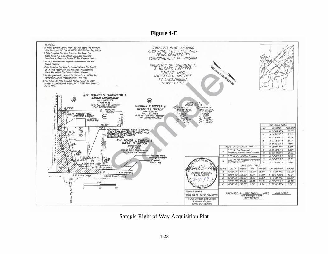
Sec. 4.04 Metes and Bounds Surveys A metes and bounds survey will be required on parcels of land to be purchased for use as District or Residency offices or Maintenance Area Headquarters and may be requested by other State Agencies. When the acquisition of land involves property owned by U.S. Government, State Agencies, National Forest Services, Railroad Companies, and Power Companies (Dominion VA Power), a metes and bounds survey is required. See Section 4.02.1 and the Right of Way Manual of Instructions Sections 5.6.6-5.6.9. These surveys will be prepared by computer-aided drafting techniques (CADD). Each sheet must contain a title block, filled out completely. The title block will contain the following information: county name, magisterial district, the name of the Survey Party Manager or Consultant, date of survey, scale bar, the proposed use of the parcel of land and the name of the person or persons from whom it is to be acquired. The survey must be tied into the construction centerline or baseline of adjoining or nearby projects and the existing right of way, whether owned in fee or as an easement or dedication, shall be shown. Directions and distances to nearby towns as well as the adjacent route and project should be shown. Measure the angles and compute the bearings to the nearest second and measure distances between transit points to the nearest one-hundredth foot (0.01-ft). The survey plat shall show all pertinent features such as streams, wooded areas, swamps, roads, buildings, fences, etc. The owner names and property lines of all adjoining properties must be shown. The bearing and length of each course should be shown on the inside of the ‘lot’ line and recorded bearings and length, if any, should be shown in parenthesis on the outside of the ‘lot’ line (Figure 4-E). When a part of the boundary line is a curve, the central angle (or delta), length of chord, chord bearing, length of curve and radius of the curve must be shown in the CADD file. Areas greater than or equal to 1 acre will be shown in acres to 3 decimal places (x.xxx). Areas less than 1 acre will be shown in square feet to the nearest square foot. A closed-loop traverse shall be completed in the field around the perimeter of the boundary. All angles and distances shall be entered, in sequence, into a Coordinate Geometry program. The "Compass rule" method of adjustment may be used and a least squares adjustment is also acceptable. The output data from the computer will be in two sections. The first section will contain the data just as it was entered from the field book, or data collector, and will give the bearing of the error, the length of the error and the ratio of the error. The second section will show the closed, adjusted data with the area of the traverse in acres and square feet. The adjusted traverse must have a zero error of closure in order to receive the correct area from the computer. However, the metes and bounds shown on the CADD file should be that of the closed data provided the error of closure does not exceed one in ten thousand (1:10,000) for a rural area survey or one in twenty thousand (1:20,000) for an urban area survey. Should the closure exceed the permissible amount, sufficient field checks should be made to correct any discrepancies. A copy of both sections of the output form must be uploaded to the appropriate ProjectWise folder and an email sent to the Central Office GeoSpatial Survey Support group at [email protected], along with the CADD files and a legal description. Any legal description written will commence at the nearest offset point with the lowest stationing off the construction centerline thence clockwise around the parcel. If the construction centerline is not available, an easily identified, unique point will be chosen as a point of beginning and the courses will run in a clockwise direction.
4-14
Figure 4-A
_Standards (Forms, Job Aids, Installs, Training)\Right-of-Entry\_3 Permission-Mailmerge
4-15
4-16
4-17
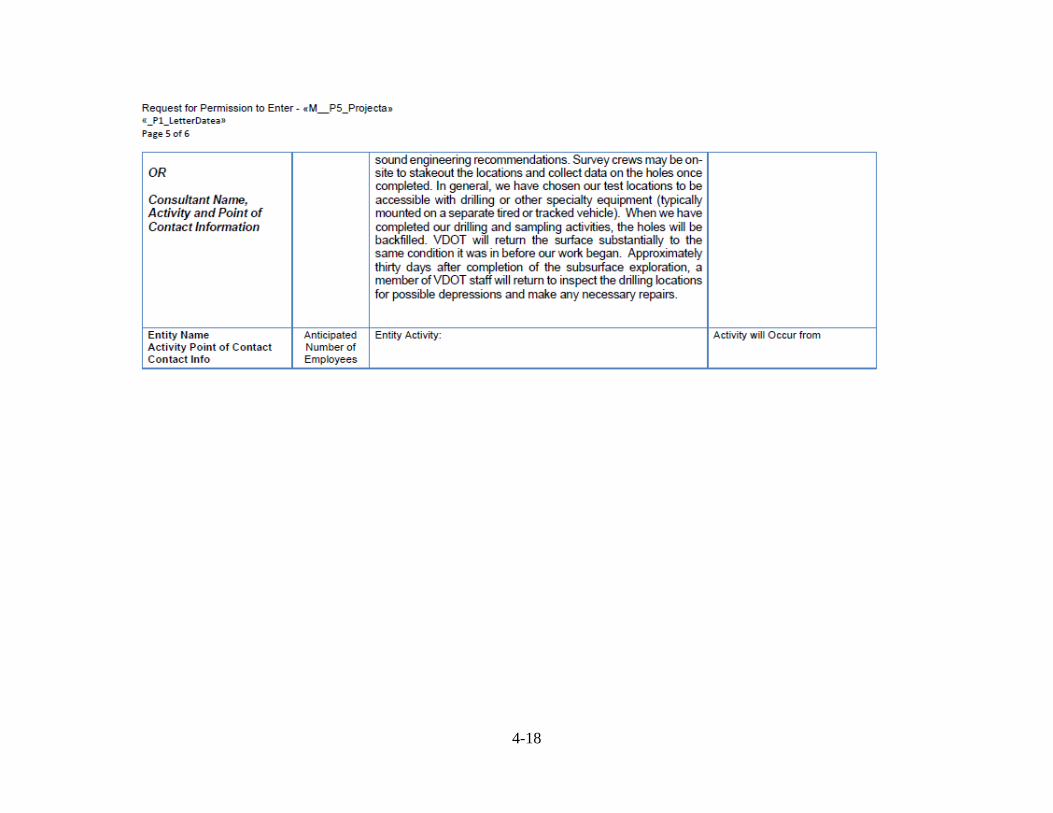
Attachment 1
4-18
4-19
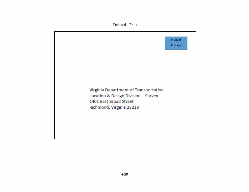
Figure 4-B
_Standards (Forms, Job Aids, Installs, Training)\Right-of-Entry\_4 PostCards
Postcard - Back
4-20
Postcard – Front
4-21
Figure 4–C
4-22
Figure 4-D _Standards (Forms, Job Aids, Installs, Training)\Right-of-Entry\_1 Workflow
4-23
Figure 4-E
Sample Right of Way Acquisition Plat