chapter 4. banua or negara? the culture of land in south...
TRANSCRIPT

Chapter 4. Banua or Negara? TheCulture of Land in South Bali
Graeme MacRae
Land has always been a critical resource in the successive political economies ofsouth Bali, and not surprisingly, it has also been deeply embedded in a richmatrix of cultural meanings. 1 This ,was evident to the earliest foreignobservers—‘There is a … correlation of the … people with … the land’(Covarrubias 1994: 11, see also pp. 59, 84)—and has remained so until relativelyrecently. In the past generation, however, land has been relocated substantiallyfrom this matrix of meaning into something increasingly resembling the universalcapitalist commodity hidden in the misleading term ‘real estate’, with all theattendant emptying-out of traditional meaning. This has happened primarilythrough its massive revaluation and inflation as a primary resource in an economydominated by tourism as well as systematic attempts by the National Government,aided and abetted by foreign agencies, to ‘free’ it from the bonds of traditionalforms of tenure and make it available to the widest possible market.
This process has been further aided at a more subtle psycho-cultural levelby the phenomenological effects of various technologies that have progressivelydiluted and obscured the once-powerful and awe-inspiring daily (and particularlynightly) experience of landscape. Roads have connected places, such as themountains or distant kingdoms, once awesome for their sheer remoteness. Motorvehicles have reduced distances of days to a matter of hours and theiromnipresent noise, smell and sheer mechanical power have annulled much ofthe direct sensory experience of landscape, which was integral to the knowledgeof previous generations. Kerosene lamps, battery-powered torches and morerecently electric lighting penetrate the veil of darkness that once obscured thesekala (natural world), allowing people to glimpse the niskala (supernaturalworld) beyond. Radio, television and electronic amplification have pushed asidethe sounds of bamboo rustling in the wind, the fading notes of a distant gamelanor even the stately creak of an ancient Dutch bicycle. People born since about1970 have little or no experience of the landscape unmediated by thesetechnologies, and when I ask them for directions they reply in terms of gasstations and hotels rather than waringin trees or temples.
I have discussed elsewhere some political-economic aspects of land in southBali (MacRae 2003). The purpose of this chapter is to consider the matrix ofmeaning and customary practices in which land was and to some extent still isembedded. As with the political-economic dimension, from which they can neverbe entirely separated, these occur in the context of concrete historical processes.
83

The land has always been there, a primary element of human experience, andsuccessive cultural and political orders have made their own sense and inscribedtheir own meanings on it. Some recent transformations of these have been touchedon above, but the primary axis around which this discussion revolves is theextent to which ‘traditional’ ideas and practices to do with land might usefullybe seen in terms of ancient, pre-Indic forms, common to a degree throughoutthe Austronesian world and evident especially in the Bali Aga forms describedby Reuter (this volume).
The Cultural Landscape of South BaliThe south-central quarter of Bali is a wedge of land, sloping down and out fromthe central mountains, steeply at first, then flattening onto a coastal plain severalkilometres wide. The soil is predominantly volcanic ash (paras), fertile and soft,allowing the rivers flowing down from the mountains to cut deep gorges, dividingthe land into long tapering radial strips. In these gorges are remnants of theoriginal rainforest that once covered most of the island while the strips between,some little more than ridges, others relatively flat and a kilometre or more wide,are terraced, irrigated and planted with rice and secondary crops such as sweetpotato, interspersed with rows of coconut palms.
This landscape is divided, in traditional Balinese thinking, into two primarycategories: wild forest (alas or [BI] hutan) and land that has been brought intohuman cultivation and ritual order (Boon 1977: 99). 2 Alas is inhabited by allmanner of unseen (niskala) beings that are potentially disruptive and evendangerous to human life. When it is occupied by humans, the forest is cut, socialand spatial institutions are established and ritual processes initiated to maintainharmony between human and niskala inhabitants. 3
A well-known origin story in this part of Bali concerns Rsi Markandeya, aholy man from East Java, who came, with followers, to establish a communityin the wilderness of Bali. They began cutting (marabas) forest by the River Wosat Campuan near Ubud, but were attacked by wild animals and diseases and theexpedition was abandoned. Back in Java, Markandeya, received supernaturaladvice that he had neglected to establish the proper ritual relationships withthe niskala inhabitants of the place. He tried again, this time taking appropriateritual precautions, the most important of which was the burial of five elementalmetals (panca datu) in the soil of the new land. This time he was to be rewardedwith success. They cleared the forest, divided the land into dry and irrigatedfields and established the primary institutions of social, ritual and economicorganisation—banjar, desa and subak. 4 Banjar is the local communityorganisation oriented to essential social tasks, especially the disposal of the dead.Subak is the organisation responsible for the collective management of irrigationwater, essential to material subsistence. Desa is the organisation responsible for
84
Sharing the Earth, Dividing the Land
the maintenance of ritual harmony between human and niskala communities ina particular spatial/ecological zone. 5
While it can be argued that banjar is the primary secular social unit(Guermonprez 1991), desa is the primary spatial and ritual unit (commonly, butsomewhat misleadingly, translated as ‘village’)—binding local community tolocal landscape through collective responsibility to local deities. 6 Land isunderstood to belong to these deities. Humans occupy and use it on what maybe described as a leasehold basis, perpetual but subject to the regular performanceof collective ritual obligations. It is the desa, rather than individuals, which isparty to this arrangement with the gods, and individual households maintaintheir right to occupy desa land (tanah ayahan desa) by contributing to collectiveritual obligations (Boon 1977: 100-2; Covarrubias 1994: 59,84; Reuter 2002b;Stuart-Fox 2002: 42-4; Warren 1993: 38-42). These obligations take the primaryform of maintaining two (or more) main temples and performing in them regularceremonies, which the various deities associated with the desa are invited tovisit and are then plied with offerings of music, dance, food, flowers, incenseand sacrificial animals.
The two main temples are the pura puseh (‘navel’, ‘centre’ or ‘origin’ temple)and the pura dalem (temple of the ‘great deity’ of death). The pura puseh isassociated with the origins of the desa, in the form of founding ancestors andlife-giving water from the mountains, and is located ideally and usually towardsthe uphill (kaja) end of the desa territory. It usually contains, in its middlecourtyard (jaba tengah), a pavilion known as bale agung (great pavilion), in whichall the gods of the desa assemble periodically. The pura dalem is associated withthe spirits of the dead, but not yet fully purified and deified members of thedesa. It is located ideally and usually near the graveyard and cremation ground(setra) at the downhill (kelod) end of the desa territory. 7
The walled compounds (pekarangan) occupied by households of the desa arestrung along either side of the uphill-downhill road (and sometimes parallelsecondary streets) between these two temples. Each house yard is occupied bya household (or set of related households) in perpetuity but subject to prescribedcontributions to collective ritual (ayahan, literally ‘work’). Such land (pekarangandesa or karang ayahan desa) might not be bought or sold. 8 Spatially, each houseyard replicates the fundamental uphill-downhill orientation of the desa itself. 9
Desa are bounded laterally (east-west in this part of Bali) by the untamed spaceof the parallel river gorges and in the uphill-downhill direction by a neutralzone of cultivated land, which is owned by individuals and managed by subak.
85
Banua or Negara? The Culture of Land in South Bali

Figure 1: Typical Desa layouts
Land TenureWhile household land is held in trust by the desa, articulating the ritual-economicrelationship between humans and gods, there are also other kinds of collectivelyheld land. Laba pura is productive land reserved for the material support ofparticular temples. Many desa and temples also have land (tanah bukti) reservedfor the support of desa officials (klian, bendesa) or temple priests (pemangku).Streets, pathways and other public spaces including setra are collective propertyand are maintained by banjar, as are local community halls (bale banjar).
86
Sharing the Earth, Dividing the Land

Productive land, on the other hand, is generally privately owned, a rightestablished initially by clearing and cultivation, later by capture andredistribution by local rulers and currently by sale and purchase.
Across this mosaic of desa and agricultural land are overlaid the historicaldesigns and ambitions of a series of ruling elites, many of them descended fromnoble warriors of the Hindu-Javanese empire of Majapahit whose forces invadedBali in the 14th century. They brought with them more hierarchical modes ofsocial and political organization, which were also inscribed onto the landscape.A proportion of desa in this part of Bali thus have, superimposed on thelinear/axial spatial organisation described above, a centric, mandala form, focusedon a central crossroads, where rulers built puri (palaces), markets and temples.In most of these desa, the bale agung has been relocated to a pura desa in thiscentral complex. 10
As well as appropriating and reconfiguring the ritual (or niskala) landscapeof desa, new or invading puri took control of substantial areas of productiveland, which they allowed their subject populations to continue to cultivatethrough various arrangements. The most distinctive and widely used in thispart of Bali was a system known as pecatu or tanah ayahan puri, by which landwas made available to farmers for their subsistence in exchange not for a portionof the crop but for certain services to the puri. The nature of pecatu has been thesubject of considerable debate since the attempts of the first Dutch administratorsto make sense of it (Gunning and van der Heiden 1926; de Kat Angelino 1921).Thedebate essentially concerns the extent to which it was a system of forced labour,of patronage or a variation on traditional desa obligations (Boon 1977: 56; Geertz1980: 176; Hobart et al 1996: 55; Schulte-Nordholt 1996: 60; Warren 1993: 63).It is my impression that the divergence of interpretations probably reflects asmuch local differences of practice and terminology as it does the relativecorrectness of the authors. What is significant here is that it is a system in whichrights to productive land are exchanged for labour obligations. As a result, justas residential land was occupied subject to ritual obligations to the gods via thedesa, use of much productive land became increasingly subject to correspondingobligations to puri. 11
Trans-local OrganisationIt is unclear what, if any forms of socio-spatial organisation larger than desaexisted in this part of Bali before or independent of the multiplication andexpansion of puri in the 18th century. On the one hand it is reasonable to expectthat ‘ritual domains’ along the lines of the Bali Aga banua described by Reuter(this volume) might have existed, but on the other, the evidence of local oralhistory suggests that the settlement of much of the area coincided with ratherthan predated puri expansion.
87
Banua or Negara? The Culture of Land in South Bali

The anthropological record is also somewhat ambiguous on this subject.While the Dutch scholarly colonial orthodoxy that ‘the village forms a closed,self-contained unit’ (Goris 1984: 79) has long since fallen from favour, subsequentwriters continued to take for granted the village as the natural unit of analysis.12
This focus has been at the expense of recognising modes of organisation beyondand between villages. The existence of such modes of organisation is, however,evident in the literature. This evidence includes:
1. Seasonal migrations of barong and performing art troupes between villagesand/or temples (Lansing 1983; Mead 1970).
2. The formation of links between villages through temples (Bateson 1970;Boon 1977: 100).
3. Groups of ‘mother-daughter’ villages in East Karangasem andBatur-Kintamani areas (Boon 1997: 104-5; Covarrubias 1994: 58, Goris 1969:107-8, 1984: 96, Stuart-Fox 2002: 49-51).
4. Royal patronage of local temples and systems of ‘state temples’ at central,uphill and seaward extremities of kingdoms.
5. The travels of Rsi Markandeya (Howe 1980: 13, Stuart-Fox 2002: 261-3) orother mytho-historical connections (Boon 1977: 100).
6. Market networks (Hobart 1979: 69-74).
Despite such widespread evidence, the implications have not been pursuedsystematically with the exceptions of Lansing’s (1991) work on water temples,Schulte-Nordholt’s (1988a, 1991a,1991b) on pre-colonial state temples, andReuter’s (1998, 2002a) more recent work on Bali Aga banua. None of these referto the ordinary villages and temples of south Bali. Recent ethnographic evidence,however, indicates traces of banua-like forms, especially the further one movesuphill from the puri centres of Ubud, Tegallalang and Payangan, towards themore unequivocally Bali Aga areas documented by Reuter. 13
For example, Desa Sebatu, according to local tradition never subject to puricontrol, is the centre of a network of some five desa linked by reciprocal ritualties. They are not, however, referred to as a named collective entity. The ritualcycle in these desa is, as in mountain banua, tied to the old lunar calendar (sasih)rather than the Hindu-Javanese one (wuku). On the other hand, they utilise theservices of Brahman high priests (pendeta) in some of their rituals, which isevidence of influence from the Majapahit lowlands.
In nearby Pujung (Talepud), Leo Howe (1980: 13-27) reports a similar blendof lowland and highland customs, as well as local oral traditions including aversion of the Rsi Markandeya story, which link Talepud to nearby desa.Unfortunately, he gives little detail of contemporary practices of trans-desaorganisation. According to my inquiries in Pujung in 1996, however, it is thecentre of a group of nine ritually linked desa but these are not referred to as abanua. Pendeta do not officiate at temple rituals here and the ritual cycle is tied
88
Sharing the Earth, Dividing the Land

neither to the lunar nor wuku calendars, but to the local cycle of the traditionalrice crop. The form and seating arrangements of desa meetings likewise appearto be a fusion of elements characteristic of mountain and lowland forms. Localopinion, however, sees it more as the transplantation of the forms of their villageof origin in Karangasem (East Bali), forms that are themselves more consistentwith those Reuter characterises as Bali Aga.
Immediately downhill of Pujung and Sebatu are a number of small desa (e.g,Kebon, Tangkup, Cebok), which have no bale agung of their own but share thatof the older village from which they originated (e.g, Kedisan)—a mode ofrelationship consistent with processes of linkage in both the mountains and EastBali (Reuter 2002: 38-41; Stuart-Fox 2002: 46-51). At roughly the same elevationand a couple of ridge/valley systems to the west, near Payangan, is yet anothergroup of eight desa, linked to a shared temple, known as Pura Banua, in DesaBukian. Unlike the category of Bali Aga temples of the same name (pura banua),this Pura Banua is not understood as the centre of a ritual domain so much as aregional temple with a unique history. According to local oral narratives, itsorigin lies not in a ritual alliance but a defensive one, at the time of the Payanganwars of 1843, with the temple being a place of assembly in times of crisis.However, the term and metaphor of banua was chosen, which suggests familiaritywith the concept, and, as Reuter (2002: 80) notes, this area is one of the fewpuri-dominated areas with strong ritual links to Bali Aga temples. 14
The evidence of all of these examples consists merely of traces of variouskinds, and there is no evidence of systematic organisation or a sense of collectiveidentity as in the mountain banua. David Stuart-Fox (2002: 46-51), writing ofsimilar but different groupings of villages further east in Bali, reminds us,however, that no matter how ancient and timeless they may appear, all thesegroupings of villages are the result of concrete historical processes. I wouldsuggest furthermore that it is to these processes that we need look if we are tounderstand their contemporary forms; a point to which we will return later.
If we look further downhill, where the political and ritual dominance of puriincreases there is progressively less evidence of such forms or of ‘ritual domains’(banua) other than pre-colonial ‘kingdoms’ (negara). This would suggest thatbanua are either a form distinctive to the mountain regions for some reason, orthat they have been eliminated or obscured in the areas subject to Majapahitpuri domination. There remains, however, the evidence listed above, even inrelatively downhill areas, of elements of inter-desa organisation, articulatedthrough links between temples. Are they negara or banua or something else?The remainder of this paper considers this question by summarising andexamining my own ethnographic evidence of a more substantial network oflinkages in the upper Wos Valley.
89
Banua or Negara? The Culture of Land in South Bali

The ‘Ritual Domain’ of the Wos ValleyVillage temples … are linked together in a given area by hereditary ties orbecause of allegiance to a princely house or to that of a Brahmana high priest.Thus to the head temple on the day of its yearly festival will come the membersand the priests from a number of tributary temples round about, bearing theirgods in procession, accompanied by their gamelan orchestras, with spears andbanners and all ceremonial regalia, and bringing also the Barong and the Rangda.(Jane Belo 1949: 40)
At Campuan, in the gorge just west of Ubud, above a fork in the River Wos, isthe temple Pura Gunung Lebah. The name means literally ‘low mountain’, ‘belowthe mountain’ or ‘the mountain below’. It is held in local lore to be especiallysacred but it does not fit unambiguously into the conventional scheme of localtemples. It is specific neither to desa nor to any one clearly defined group. Theayahan is performed by a group of subak around Ubud and the people of BanjarTaman Kelod, working on behalf of Puri Ubud. 15 Its major palingih(sitting-places for visiting deities) are two pagoda-like towers (meru)—aseven-tiered one for the resident deity of Gunung Lebah and a five-tiered onefor Bhatari Sri Batur (the goddess of Mt/Lake Batur).
At the beginning of anniversary ceremonies (odalan), processions arrive fromUbud and from a circle of villages approximately centred on the temple. Thesepeople bring their barong (gods in the form of large animal puppets) and othersacred objects, most of which were made, donated by, or in some other wayconnected to the puri. In explaining their relationship with the temple, theyrefer to these connections and also to Rsi Markandeya and his travel up the WosValley.
Pura Gunung Lebah has a range of associations and meanings, constituted indifferent ways. It is (a) the pura masceti (regional irrigation temple) for a groupof subak, (b) a royal temple of the puri, and is associated (c) with a group ofvillages, including Ubud, and their barong, (d) with the travels of RsiMarkandeya, (e) with the Wos Valley as far as Taro, and is finally (f) a visitingplace (pasimpangan) for the goddess of Mt/Lake Batur. These connections arearticulated through the temple but are not organised around a single consistentset of ideas. They are constituted variously through more or less defined groupsof people, through the static form of land and the dynamic of flowing water andthrough hazily remembered mythologies and the regular visits of gods. 16
90
Sharing the Earth, Dividing the Land

Figure 2: The Pura Gunung Lebah network
Many of the desa connected to Pura Gunung Lebah are themselves linked insimilar ways to others around Ubud and eventually to others all the way up theWos Valley. The net result of these linkages may be described as a network ofvillages and temples within a more or less defined region. This network takesthe form not of a single grid but of several imperfectly overlapping onesconstituted variously in the dimensions of topography, hydrology, irrigation,mythology, history, barong migrations and temple connections. The followingsections summarise these ‘layers’ of linkage.
91
Banua or Negara? The Culture of Land in South Bali
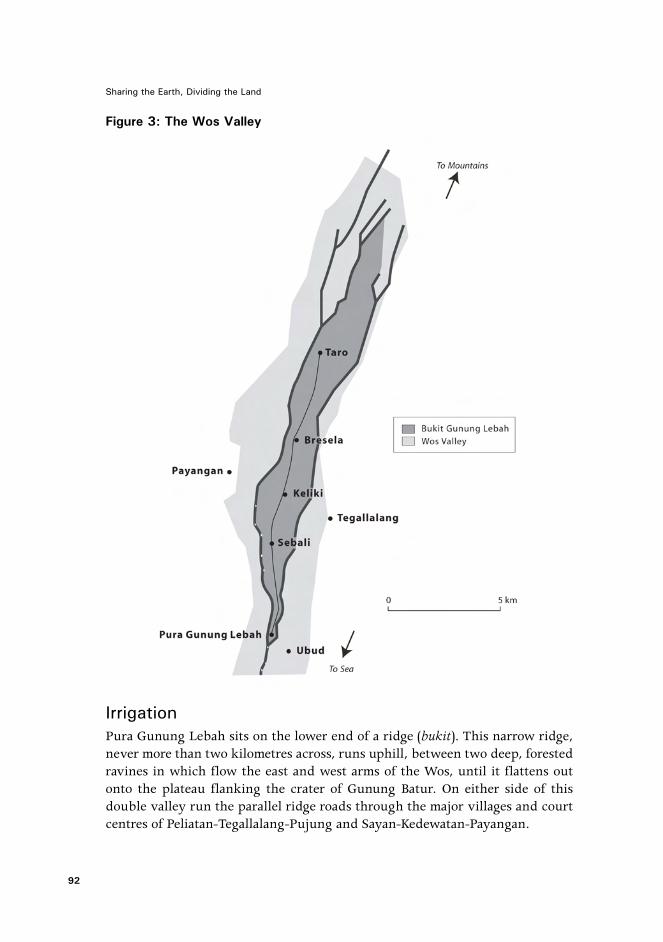
Figure 3: The Wos Valley
IrrigationPura Gunung Lebah sits on the lower end of a ridge (bukit). This narrow ridge,never more than two kilometres across, runs uphill, between two deep, forestedravines in which flow the east and west arms of the Wos, until it flattens outonto the plateau flanking the crater of Gunung Batur. On either side of thisdouble valley run the parallel ridge roads through the major villages and courtcentres of Peliatan-Tegallalang-Pujung and Sayan-Kedewatan-Payangan.
92
Sharing the Earth, Dividing the Land

Figure 4: The Upper Wos Valley: irrigation
Along the central ridge are a series of villages strung along a narrow road.The gradient is gentle and easily traversed and the distances between settlementsare generally no more than a kilometre. The intermediate sawah (irrigated ricefields) are traditionally worked by families of both, or even other, villages, andthere are few obstacles to up-down-bukit travel. Irrigation and sawah ownershiptend to cross village boundaries and collective maintenance and management ofthe irrigation system necessitates a degree of cooperation between upstream-downstream neighbours.
93
Banua or Negara? The Culture of Land in South Bali

Figure 5: The Upper Wos Valley: Rsi Markandeya’s journey
Balinese irrigation is gravity-fed and flows from mountain lakes and springs.Because of the depth of the river gorges, water is channelled from sources farupstream of the fields it irrigates and can be used only within the valley in whichit originates. This basic hydrological form configures irrigation, like the landitself, into a set of long, narrow systems that depend on cooperation betweenupstream and downstream users of the system. 17
Within the Wos Valley, the rice fields along the bukit from Bankiangsidem toabove Taro are irrigated from dams on the two inner arms of the Wos. Althoughthese subak are within the area associated with Pura Gunung Lebah, they donot relate to it as their pura masceti. Conversely, the primary congregation ofthe temple in its function as pura masceti are subak, which are physically located
94
Sharing the Earth, Dividing the Land

outside the bukit but draw their water from a dam on the Wos. Land andirrigation are separated ritually and the area served by Pura Gunung Lebah inits function as an irrigation temple does not correspond physically with the areawith which it is connected in other ways.
Rsi MarkandeyaThroughout the Wos Valley, the Markandeya story is trundled out routinely inresponse to questions about the foundation of local villages and temples. Thedetails vary and village people frequently refer to Puri Ubud or to publishedversions for the ‘complete’ or ‘correct’ story. 18
Although not all the places mentioned in these stories are confined, even inthe most parochial versions, to the bukit, the story serves to identify the polesof Campuan and Taro and an axis between them and to identify these with thefoundations of Balinese civilisation. To its inhabitants, this area is known bysuch names as Ujung Taro, Bukit Taro, Gunung Taro, Gunung Raung or BukitGunung Lebah and is replete with material evidence of Rsi Markandeya’sexploits, mostly in the form of temples.
The Migratory Habits of BarongBarong, ‘at once the most familiar and the most obscure’ figures in Balinesetradition (Spies and de Zoete 1973: 93) are known to everyone but understoodonly in contradictory ways by relatively few people. 19 They are essentiallycreatures of place, associated with desa and their territories, which they patrolseasonally to prevent the entry of unwanted influences. As Mead (1970) observed,they are subject also to a season of migration during which they might wanderpromiscuously performing as their will or habit takes them. They also practicea third, more regulated kind of migration: mutual visiting, along with othersacred objects (pretima), at temple ceremonies. It is through these visits thatcontemporary ritual links between villages in the Wos Valley are most readilytraced.
For example, at the odalan of Pura Jemeng in Sebali, in addition to threebarong from local temples, others are (usually) brought from Keliki, Lungsiakan,Ubud and Bentuyung. Likewise, reciprocally, the resident barong at Pura Jemengattends odalan at the home temples of all these barong and at Pura Gunung Lebah.Keliki is immediately up-bukit of Sebali, with which it has close historical links.Some of these barong also travel, along with others from the area, to Pura SabangDahat, on the lonely plateau above Puakan. Every Manis Galungan, many barong,mostly from Bukit Taro/Gunung Lebah, present themselves at this temple andreport to other local temples before making their own ways back down thebukit.20 For the month after Galungan, reciprocal visiting continues betweenbarong in the area.
95
Banua or Negara? The Culture of Land in South Bali

Figure 6: The Upper Wos Valley: barong migrations
Most other desa have similar networks of related villages and temples which,can be traced by the travels of their barong. Taken together, the dominant patternof connection is along the kaja-kelod axis within the bukit, but there are alsosome trans-bukit links to Ubud and others to apparently random templeselsewhere.
96
Sharing the Earth, Dividing the Land

Figure 7: The Upper Wos Valley: bale agung orientations
Bale Agung and Reversals of OrientationA bale agung (lit: ‘great pavilion’) is a raised pavilion in which the gods associatedwith a village assemble. In old-style villages, it was oriented along the centralkaja-kelod axis in the centre of the village and was large enough for living village
97
Banua or Negara? The Culture of Land in South Bali

members to occupy together with their deified ancestors at monthly meetings.21
In new-style villages, it is large enough only for the gods and is situated in themiddle courtyard (jaba tengah) of one of the village temples. In either case, it islinear in form and oriented kaja-kelod. 22 Furthermore, it is directional, havinga head (ulu), which may consist of an enclosed timber cabinet containing sacredobjects, a seat, or a (usually painted or carved) timber panel. The most importantofferings are placed at this end and in old-style bale senior members of the villagesit at this end. In the majority of bale, this head is oriented, like the heads ofother entities of higher status or purity, kaja, uphill. 23
The bale agung that forms part of the Pura Agung Gunung Raung complexin Taro, widely believed to be the longest and the oldest in Bali, is oriented inthe opposite direction, with its head downhill, towards the sea! So also are thebale agung of Sebali/Bankiangsidem, Keliki Kawan, Keliki/Yehtengah, Kelusaand Bresela. This is an extraordinary reversal of convention, affecting themajority of bale within the bukit, although there are significant exceptions. 24
So, while within the area of Bukit Taro-Gunung Lebah there is a dominant patternof reversal of normal orientation of bale agung there are also sufficient exceptionsand anomalies to cast doubt on any easy generalisation.
Local explanations of this pattern of reversal are confusing but reflect a certainlogical consistency. 25 Bale agung in this area, associated with Rsi Markandeyaand Gunung Raung, are oriented not to the central mountains but to GunungLebah, which is the pusat (BI: centre), puseh (navel, origin) or puncak (peak,summit) of this area. When I pointed out to local people that ‘Gunung’ Lebahseemed to me to be at the lowest rather than the highest point of the bukit, I wasreferred to the mystery contained in the name ‘Gunung Lebah’: the low mountainor the mountain at the bottom.
On what grounds can Gunung Lebah be described as a puncak? Accordingto some, because Rsi Markandeya appeared first at Campuan and then travelledkaja along the bukit this was the pusat and therefore also the puncak. 26 Thereis, however, sufficient uncertainty and contradiction in accounts of the directionof his travels that this explanation seems incomplete at best.
More philosophically sophisticated exegeses, by priests and princes, invokedthe principle of the unity of high and low, mountain and sea, Brahma and Visnu.Just as the waters may be seen flowing from the mountains down to the sea,they also return, unseen to the mountain lakes (Schulte-Nordholt 1991: 157).The orientation to Gunung Lebah thus reflects the reversal at a niskala level ofordinary sekala orientation. 27 A further variation of this explanation was thatthe location of Gunung Lebah is at the central point on the whole mountain-seaaxis and was thus the pusat or puncak of the whole (inherently reversible) system.
98
Sharing the Earth, Dividing the Land

Figure 8: Upper Wos Valley: Puri Ubud patronage
Logically unsatisfying as these explanations might be, the point in each caseis clearly that within the boundaries of Bukit Gunung Lebah, ordinary sekalatopography is in certain respects subordinate to a localised niskala topographyof which Gunung Lebah is a peak or summit.
99
Banua or Negara? The Culture of Land in South Bali

Puri UbudThroughout my inquiries, wherever bale agung were oriented kelod, whereverRsi Markandeya was said to have been, wherever barong were linked, andespecially throughout Bukit Gunung Lebah, there was evidence of the patronageand influence of Puri Ubud. This involvement took forms such as renovation oftemples, support of local dance/music groups, advising on matters of traditionand providing rationalised interpretations of local mythical history. In return,the puri were deferred to on matters of tradition and invited to ceremonies inlocal pura. They also called on such villages to provide ritual labour orperformances at Ubud temples or puri.
Local people speak of this relationship as an appropriate continuation of longtradition. Members of the puri regard it as their hereditary obligation: leadership,guidance of the community and protection and sponsorship of traditional culturalforms. The geographical spread of this involvement does not, however,correspond with any precision to the area controlled by the puri in pre-colonialtimes.
Puri Ubud also assume a central position in the network through theircontrolling role at Pura Gunung Lebah. It is not uncommon for local puri to takeover responsibility for pura masceti within their area of politico-ritual jurisdiction(Lansing 1991: 131). Pura Gunung Lebah is, like other irrigation temples, avisiting place (pasimpangan) of Pura Batur, whose principal deity has jurisdictionover all water flowing through this part of Bali (Lansing 1991: 74). Althoughthe puri (and the local subak) have links with this temple, other aspects of thenetwork described however do not extend directly to Batur.
Networks and LayersSuch are the more obvious dimensions or ‘layers’ of interconnection betweenplaces in this landscape. They are mutually connected by virtue of a degree ofoverlap, spatial and conceptual, hinging around the axis of Bukit Taro/GunungLebah. This overlap, however, is less than perfect and exceptions and anomaliesabound.
It is perhaps timely at this point to remember two things. The first is that,as James Fox (1993: 23) reminds us, the ‘symbolic orders’ of Austronesian spacetend to be ‘multiple’ and are ‘constantly created and recreated’ though ritualpractice. The second is that these ‘networks’ and ‘layers’ are, unlike the mountainbanua recorded by Reuter, not local categories of speech and thought, much lessinstitutions of systematic practice, but abstractions created from my observationsof a corpus of local practices and stories, which establish relationships betweenplaces and institutions. The analytical question would thus appear to be whetherthese systems and their correspondences are coincidence, figments of anoverheated anthropological imagination, manifestations of normal Austronesian
100
Sharing the Earth, Dividing the Land

symbolic pluralism, residues of Austronesian banua or 19th-century negara, orwhether they reflect an order of some other kind.
Knowledgeable local people with whom I discussed my work recognised thedirection of my inquiries but were unable (or perhaps unwilling) to formulateit in any clearer terms. I sought therefore to ‘explain’ my findings by referenceto some underlying order at a further level of abstraction. Neither Lansing’s‘systems’ of ‘water temples’ nor any other structural logics provided this. Everycase has its own explanation, unique and sometimes seemingly quixotic. Theselocal explanations are instructive: when I inquired about relationships betweenvillages, temples or barong, I was frequently answered with vague reference toRsi Markandeya or Gunung Lebah or simply the self-evident ‘ada hubungan’(there is a relationship). If I pressed the matter harder, there was usually someonewho could provide an explanation specific to the case in question. Suchexplanation inevitably took the form not of logical structural relationship butof a story relating specific mytho-historical causes: barong made from wood fromthe same tree, a king who had received divine inspiration at this spot and hadfounded a temple that the local village looked after on his behalf. Things aresaid (and seen) to be the way they are ‘because’ of the story of their origin.Likewise, the exceptions to the dominant pattern of reverse-oriented bale agungdiscussed above are all explained not by logical default to the status quo but byreference to their specific historical origins. This led me to look more seriouslyat the historical processes at work (and seen to be at work) in the area. 28
Negara and BanuaWhat are known in the historical literature as ‘kingdoms’, to Balinese as kerajaanand to some writers (Geertz 1983; Schulte-Nordholt 1996) as negara, were indeeda form of trans-desa politico-ritual organisation, albeit imposed from the topdown and fluid and unstable at the best of times. They were, however, basedon an (at least implicit) ideology of ‘ritual domains’. This ideology is re-packagedin Indic political-religious thought, embedded architecturally in the forms ofcentric mandala village plans and linguistically in terms such as jagat(‘world/universe’) and bhumi, but what gives such legitimating power to thisideology is the fact that it resonates with older Balinese ideas of what I call niskalalandscape. These seem to me to be not unlike the ideas embedded in the banuaof highland Bali: ‘sacred landscapes inscribed by a continuing history of humanaction and re-inscribed through narrative and ritual performances’ (Reuter, thisvolume). Let us consider briefly the history of Negara Ubud in this light.
Negara UbudIn the orthodox history of Bali, Ubud was a minor puri, at best secondary to theeight subdued by the Dutch and subsequently immortalised as modernadministrative districts (kabupaten). 29 In fact, at the time of the Dutch takeover,
101
Banua or Negara? The Culture of Land in South Bali

the ruler (punggawa) of Ubud was arguably the most powerful person in thispart of Bali (A. Agung 1991: 134; Mahaudiana 1968: 97; Vickers 1989: 75, 140).Together with his allies, he controlled a vast tract of land between the RiversAyung and Petanu, from the coast at Ketewel to near Taro in the mountains.
Puri Ubud’s claim to this area was, and still is, made firstly on the basis ofdescent from the former kingdom of Sukawati, which, from the early 18thcentury held nominal jurisdiction over the entire land between the Ayung andPakerisan rivers, from the sea to Mt Batur (G. Agung 1983; Sanggra 1971). Thisjurisdiction was based not on conquest or physical occupation, but ontransactions with the invisible custodians of this territory: it was, in other words,essentially a niskala domain rather than a political one. 30 Because of thesubsequent dissolution of Sukawati and absorption of its scattered satellite puriinto the emergent kingdom of Gianyar in the late 18th century, the Sukawatidescendants had to wait more than a century and resort to warfare to reclaimtheir inheritance in political or sekala form.
This occurred in a confused series of rebellions within and wars betweenkingdoms towards the end of the 19th century. In the midst of this turmoil, thePrince of Ubud and his neighbouring relatives combined forces to take controlof much of this territory in 1891 (A. Agung 1991; G. Agung 1983; Mahaudiana1968: 82-85; Sanggra 1971). The details of the subsequent redistribution of landare not entirely clear but Ubud, as the strongest (if not senior) partner in thealliance, gained control of the western half of the Wos Valley from the sea toaround Bresela. 31 This formed the basis of an area over which Puri Ubud heldpower until Gianyar came under Dutch protection in 1900 and, even after this,a residue of political-economic and moral-spiritual authority, which is by nomeans defunct today.
The ruler of Ubud played an important role in the King of Gianyar’s decisionto place the kingdom under Dutch protection, and throughout the colonial periodmembers of Puri Ubud successfully cultivated relationships of mutual benefitwith the Dutch (Hilbery 1979; Schulte-Nordholt 1996: 200; Vickers 1989: 140).They also cultivated relationships with other foreigners, which were to providethe contacts, reputation and skills on which the tourist industry wassubsequently built (MacRae 1992; Vickers 1989: 140-2). Although the relationshipbetween puri and people remained close, with puri members assuming activeroles in government (dinas) and customary (adat) institutions, internal tensionswithin the puri (Hilbery 1979: 12-15), followed by the political and economicinstability of the years from 1940 until 1965 (Bagus 1991; Robinson 1988; Hilbery1979: 2; Vickers 1989: 146-73), diverted the interest and resources of the puriaway from matters of tradition, especially in areas remote from Ubud. By thetime tourism began again in the late 1960s, Ubud was poor and divided and the
102
Sharing the Earth, Dividing the Land

puri’s relationship with the further reaches of its former kingdom was at a lowebb.
Figure 9: Ubud territory in the late 19th century
During the 1970s and ’80s, as Ubud prospered through tourism, the puriprospered too through extensive sales of land and development of its own tourisminterests. Unlike other puri which concentrated on politics and business (C.Geertz 1963: ch.4; Hanna 1976: 122-8), Puri Ubud sought also to re-establish
103
Banua or Negara? The Culture of Land in South Bali
their role as guides and guardians of local tradition as well as taking prominentpositions in the local administration (MacRae 1999).
Outside Ubud, where such avenues were not open to them, especially in areassuch as Bukit Gunung Lebah, which is part of another administrative district,Puri Ubud reverted to the old standby of royal patronage to reclaim theirkingdom. During the 1960s, Ck. Agung Sukawati involved himself in therestoration of temples and pretima (sacred objects) all over Bali (Hilbery 1979).Upon his death, this mantle was taken up by his nephew, Ck. Agung Suyasa,who, since the late 1980s, has embarked on a program of sponsorship of ritualand culture around Ubud, up the Wos Valley and in other places. This programis based on restoration of temples, organising of and contributing to ceremonies,renovation of dance and music troupes and especially barong as well asresearching and interpreting local history and tradition. Much of the evidenceof niskala landscape and negara recorded above are in fact the fruits of thisprogramme.
So while the history of Negara Ubud is at one level a conventionallypolitico-military one, it has at various crucial points been built and rebuilt onideas of sacred landscape—successive political domains have been built onunderlying assumptions of a ritual domain.
The Network as a System of KnowledgeIt is the program of sponsorship by the puri that today draws together the diverselayers into what I have described as a network: a barong sponsored here, a templerestored there, a ceremony organised or an interpretation of the Rsi Markandeyastory somewhere else. Some of these establish or reinforce direct links betweenvillages and temples, all increase a sense of common ‘shelter under the umbrella(payung)’ of the puri.
This umbrella is, however, just one more image local people use to talk aboutan aspect (layer) of what I have been labouring to systematise into a network.What the puri are doing is systematising this same something but with anassurance that obviates any need to name it as such. Rather than a tangiblenetwork that can be plotted unambiguously on a map, what they are reallyworking with is a set of ideas dispersed among a diverse corpus of practices andstories, a proto-theory of regional identity, a system of local knowledge integratedwith the forms of ritual practice and narrative. It was the systematic nature ofthese ideas that people recognised when I spoke to them about my project andit is this basis of recognition also which provides the cultural material that thepuri are recycling, developing and ordering.
104
Sharing the Earth, Dividing the Land

Negara or Banua?The conclusions I have drawn previously from this evidence have tended toemphasise the way in which the puri has utilised this niskala landscape as asymbolic resource in a contemporary political economy dominated by tourism(MacRae 1997, 1998, 1999), namely by reconstructing, inventing (Hobsbawmand Ranger 1983) or imagining (Anderson 1991) a neo-negara, a new kingdomconstructed in symbolic terms, through material practices of temple constructionand ritual sponsorship. Seen through the lens of comparative Austronesianethnography, however, it is instructive to consider the ways and extent to whichthis is built on foundations of appropriated local and inter-local organisationwhich predate and appear to exist independently of the puri and resonate withideas more common to the Austronesian than the Indic world. 32
Firstly, the idea that the landscape has, as well as its physical aspect, a subtle,inner magico-ritual aspect is common in India as well as throughout theAustronesian world. Some aspects of this landscape, however, take forms eithermore Indic or more Austronesian. Secondly, while sacred mountains are (literally)central to Indic sacred landscape, the primary level of spatial organisation inBali—the linear uphill-downhill axis—corresponds directly to a well-documentedAustronesian pattern as do the practices of orienting buildings and theircomponent elements to this axis (Fox 1993: 14-15). The centric, mandala-typedesa forms on the other hand, are unknown elsewhere in the Austronesian worldand are in fact found in villages clearly dominated by puri of Hindu-Javanesedescent. Thirdly, despite the absence of clear trans-desa levels of organisationsuch as the banua of the mountains, there is considerable evidence of anembryonic, residual or perhaps simply different form of inter-linkage betweendesa, articulated especially through temples. Fourthly, the programs ofnegara-building carried out by puri, while referring to aspects of Indic kingship,are based on mobilising relationships with and ideas about land, which arecongruent with Austronesian ones in general and Bali Aga ones in particular.
Twentieth-Century TransformationsIt was residues of some of the kerajaan of the 19th century that formed the basisof the considerable inequalities of land tenure that have continued in Bali to thepresent day. While some raja lost considerable amounts to the Dutch, otherswere able to retain and even consolidate their holdings (Mortimer 1972; Utrecht1969). This inequality, combined with population increase, led to intensifiedcompetition for scarce productive land and facilitated systems of crop-sharingthat favoured the interests of the landowners over those of their tenants. Dutchtaxation policies placed considerable hardship on small farmers, which wasintensified by the fall of commodity prices during the Great Depression. As aresult, many farmers lost some or all of their land, further exacerbating existinginequalities. During the first decade of independence, in the 1950s, access to
105
Banua or Negara? The Culture of Land in South Bali
productive land was one of the burning political issues throughout Indonesiaand was a major factor in the rise of the Communist Party (PKI), which lobbiedstrongly for a program of land reform. This was initiated in the early 1960s butlandlords were able to retain significant amounts of land, by using strategies ofobstruction and evasion (MacRae 1997: 383-5). The destruction of the PKI in themassacres of 1965-6 put an end to any further land reform program, althoughthe original process has continued, slowly and incrementally, until the present(MacRae 1997: 386-7).
The primary piece of legislation (UUPA 1960) on which land reform was basedalso provides a set of legal tools for extricating land from the constraints oftraditional collective tenure and enabling privatisation and alienation of landthrough a process of registration of title (sertipikat) in a manner essentially similarto Western models of private ownership.
Since then the economy has been transformed by tourism and associatedexport industries and the value of land has escalated exponentially (MacRae1997: 70-8). People have come to think increasingly of land in terms of itsexchange rather than use value, or ritual value. A generation ago it wasconsidered highly inauspicious to sell rice fields, let alone convert them tonon-agricultural use. Now owners of farm land regularly sell or convert land.The decline in incomes from farming has made this increasingly attractive,especially in major urban and tourist centres where often the least productivebut strategically located land fetches astronomical prices. Others have lost theirland as a result of compulsory acquisition for hotel construction. Thiscommodification of land has led to new forms of wealth, but also to landlessnessand poverty. The process has been aided and abetted by government programsproviding the legal basis and moral encouragement to register land underindividual, alienable title (sertipikat)—ostensibly to protect people from thedepredations of former landlords, but simultaneously facilitating the sale andpurchase of such land. Tanah pekarangan desa is also subject to registration inthis way, but to date no one, in Ubud at least, has dared to sell such land. Thereare, however, partial exceptions and stories of it having happened elsewhere.
ConclusionWhile the rituals of desa and bhumi linking people, land and gods continue ona scale not dreamt of by previous generations, the very land to which they referis being steadily registered, subdivided, alienated and sold, often to foreigners.Austronesian ideas and practices of land belonging to the gods and of collectiveritual responsibilities, transformed but reinforced by Indo-Javanese ideas andpractices are now again being transformed but this time also eroded by thereplacement of collective adat stewardship with private individualised ownership,commodification of the value of land and the transformation of thephenomenological experience of land by new technologies. Likewise the residual
106
Sharing the Earth, Dividing the Land

banua-like forms in this part of Bali are being progressively appropriated byprocesses of aristocratic control and harnessed to struggles for power in thetourism-dominated economy. While the land is being carved up; the ideologiesembodied in ritual perpetuate the belief that the earth is still being shared.
ReferencesAgung, A.A.G. 1989. Bali Pada Abad XIX. Yogyakarta: Gadjah Mada University
Press.
Agung, G. 1981. ‘Babad Dalem Sukawati.’ Typewritten manuscript in latin scriptof Balinese, in possession of Puri Kaleran Sukawati.
Agung A. 1983. ‘Sejarah Awal berdiri dan Berkembngnya puri Agung &penataran Agung Tegallalang.’ Photocopied typewritten Indonesianmanuscript.
Anderson, B. 1991. Imagined Communities: Reflections on the origins and spreadof nationalism. London: Verso.
Bagus, G.N. 1991. ‘Bali in the 1950s: The role of the Pemuda Pejung in BalinesePolitical Process.’ In H. Geertz (ed.), State and Society in Bali. Leiden:KITLV Press.
Bateson, G. 1970. ‘An old temple and a new myth.’ In J. Belo (ed.), TraditionalBalinese Culture, New York: Columbia University Press.
Barnes, R.H. 1974. Kedang: a study of the collective thought of an eastern Indonesianpeople. Oxford: Clarendon.
Belo, J. 1953. Bali: Temple festival. Seattle and London, Washington: Universityof Washington Press.
Boon, J. 1977. The Anthropological Romance of Bali. Cambridge, London, NewYork, Melbourne: Cambridge University Press.
Budihardjo, E. 1986. Architectural Conservation in Bali. Yogyakarta: Gadjah MadaUniversity Press.
Covarrubias, M. 1994. Island of Bali. New York: Knopf.
Creese, H. 1991. ‘Balinese Babad as Historical Sources: a reinterpretation of thefall of Gelgel.’ Bijdragen tot de Taal-, Land-, en Volkenkunde, 147. pp.179-210.
Davies, P. 1991. ‘The Historian in Bali.’ Meanjin, 1 (1991). pp. 63-80.
Fox, J.J. (ed.) 1993. Inside Austronesian Houses: Perspectives on domestic designsfor living. Canberra: Research School of Pacific and Asian Studies, TheAustralian National University.
107
Banua or Negara? The Culture of Land in South Bali

Fox, J.J. (ed.) 1997. The Poetic Power of Place: Comparative perspectives on Aus-tronesian Ideas of Locality. Canberra: Research School of Pacific andAsian Studies, The Australian National University.
Geertz, C. 1959. ‘Form and Variation in Balinese Village Structure.’ AmericanAnthropologist, 61. pp. 991-1012.
Geertz, C. 1980. Negara: the theatre state in nineteenth century Bali. Princeton:Princeton University Press.
Goris, R. 1969. ‘The Decennial Festival in the Village of Selat.’ In J. van Baal etal. (eds), Bali: Further Studies in Life, Thought and Ritual, The Hague:Van Hoeve.
Goris, R. 1984 (1960). ‘The Religious Character of the village community.’ InSwellengrebel (ed.), Bali: Studies in Life, Thought and Ritual, Dordrecht:Foris Publications.
Grader, C.J. 1969. ‘Pura Meduwe Karang at Kubutumbuhan.’ In J. van Baal etal. (eds), Bali: Further Studies in Life, Thought and Ritual, The Hague:Van Hoeve.
Guermonprez, J.F. 1990. ‘On the Elusive Balinese Village: Hierarchy and valuesversus political models.’ Review of Indonesian and Malaysian Affairs.24. pp. 55-89.
Gunning, H. and A. van der Heiden. 1926. ‘Het Petjataoe-en Anstveldenprobleemin Zuid-Bali.’ Tijdschrift voor Indische Taal-, Land-en Volkenkunde, 66.pp. 329-94.
Hanna, W.A. 1976. Bali Profile. New York: American Universities Field Staff.
Hilbery, R. 1979. ‘Reminiscences of a Balinese Prince.’ S.E. Asia Paper No. 14.Honolulu: University of Hawai’i Press.
Hobart, A., U. Ramseyer and A. Leemann. 1996. The Peoples of Bali. Oxford,Cambridge (Mass.): Blackwell.
Hobart, M. 1979. ‘A Balinese Village and its Field of Social Relations.’ Unpub-lished PhD thesis, School of Oriental and African Studies, London.
Hobsbawm, E. and T. Ranger. 1983. The Invention of Tradition. Cambridge, NewYork: Cambridge University Press.
Howe, L. 1980. ‘Pujung: The foundations of Balinese Culture.’ Unpublished PhDthesis, University of Edinburgh, Edinburgh.
Howe, L. 1983. ‘An Introduction to the cultural study of traditional BalineseArchitecture.’ Archipel, 26. pp. 137-58.
de Kat Angelino, P. 1921. ‘De Robans en Parekans op Bali.’ Kolonial Tijdschrift,10. pp. 590-608.
108
Sharing the Earth, Dividing the Land
Lansing, J.S. 1991. Priests and Programmers. Princeton: Princeton UniversityPress.
MacRae, G.S. 1992. ‘Tourism and Balinese Culture.’ Unpublished M.Phil. thesis.University of Auckland, Auckland.
MacRae, G.S. 1997. ‘Economy, Ritual and History in a Balinese Tourist Town.’Unpublished PhD thesis. University of Auckland, Auckland.
MacRae, G.S. 1999. ‘Acting Global, Thinking Local in a Balinese Tourist Town.’In R. Rubinstein and L. Connor (eds), Staying Local in the Global Village:Bali in the Twentieth Century, Honolulu: University of Hawai’i Press.
MacRae, G.S. 2003. ‘The Value of Land in Bali: Land-tenure, land reform andcommodification.’ In T.A. Reuter (ed.), Inequality, Crisis and SocialChange in Indonesia: The muted worlds of Bali, London, New York:Routledge-Curzon Press.
Mahaudiana. 1968. Babad Manggis Gianyar. Gianyar: Thaman.
Mead, M. 1970. ‘The Strolling Players in the Mountains of Bali.’ In J. Belo (ed.),Traditional Balinese Culture, New York: Columbia University Press.
Mortimer, R.A. 1972. The Indonesian Communist Party and Land Reform 1959-1965. Melbourne: Centre for South-East Asian Studies, Monash Univer-sity.
Reuter, T.A. 1998. ‘The Banua of Pura Pucak Penulisan: A Ritual Domain in theHighlands of Bali.’ Review of Indonesian and Malaysian Affairs, 32 (1).Pp. 55-109.
Reuter, T.A. 2002a. Custodians of the Sacred Mountains: Culture and society inthe highlands of Bali. Honolulu: University of Hawai’i Press.
Reuter, T.A. 2002b. The House of Our Ancestors: Precedence and Dualism inHighland Balinese Society. Leiden: KITLV Press.
Robinson, G. 1995. The Dark Side of Paradise: Political violence in Bali. Ithaca,London: Cornell University Press.
Sanggra, M. 1971. Babad Timbul Sukawati. Sukawati: Yayasan Loka-PhalaBudhaya (photocopied typewritten manuscript).
Schulte-Nordholt, H. 1991. ‘Temple and Authority in South Bali, 1900-1980.’In H. Geertz (ed.), State and Society in Bali: historical, textual and anthro-pological approaches, Leiden: KITLV Press.
Schulte-Nordholt, H. 1996. The Spell of Power: a history of Balinese Politics 1650-1940. Leiden: KITLV Press.
Schwartz, H.J.E.F. 1906. ‘Aanteekeningen Omtrent het Landschap Gianjar 1.’Tijdschrift voor het Binnenlands Bestuur, 1901-1906. pp. 166-89.
109
Banua or Negara? The Culture of Land in South Bali
Stuart-Fox, D. 2002. Pura Besakih: temple, religion and society in Bali. Leiden:KITLV Press.
Utrecht, E. 1969. ‘Land Reform in Indonesia.’ Bulletin of Indonesian EconomicStudies 3. pp. 71-88.
Ubud. 1983. ‘Monografi Kelurahan Ubud, tahun 1983-1984.’ Typewritten manu-script. LKMD, Ubud.
UUPA. 1960. Undang-Undang No. 5 Tahun 1960 tentang Peraturan Dasar Pokok-pokok Agraria. Government of the Republic of Indonesia.
Valeri, V. 1991. ‘Afterword.’ In J.S. Lansing, Priests and Programmers, Princeton:Princeton University Press.
Vickers, A. 1989. Bali: A paradise created. Ringwood: Penguin Books.
Warren, C. 1993. Adat and Dinas: Balinese communities in the Indonesian state.Oxford, Singapore, New York: Oxford University Press.
Waterson, R. 1997. The Living House: An anthropology of architecture in South-East Asia London: Thames and Hudson.
Wiener, M. 1995. Visible and Invisible Realms: power, magic and colonial conquestin Bali. Chicago, London: Chicago University Press.
de Zoete, B. and W. Spies. 1973. Dance and Drama in Bali. Kuala Lumpur: OxfordUniversity Press.
ENDNOTES1 For a discussion of the political economy of land in south Bali, see MacRae (2003).2 Translations are Balinese unless indicated as Indonesian (Bahasa Indonesia, BI).3 The model presented here is based on understanding developed in the course of field researchconducted in and around Ubud predominantly in 1993-94, 1996, and shorter visits in 1998 and 1999.This research is documented in detail in my PhD thesis (1997) and partially in previously publishedarticles (1999, 2003).4 Amongst the parade of great holy men, bearers of culture and religion from Java and beyond, whodominate early Balinese mytho-history, there is no mention (in English at least) of Markandeya untilHowe (1980). He appears in old Indian texts and, according to Stuart-Fox (2002: 261) in old Javaneseones, but he has become widely known in Bali only in recent times. In the past couple of decades, aseries of published versions of the story have appeared. Several of these refer to a ‘Lontar MarkandeyaPurana’, but Stuart-Fox was unable to locate any such original manuscript. One is said also to exist inthe possession of Puri Ubud. In some cases, local oral versions have also been written and stored inprivate collections. For a more detailed discussion see MacRae (1997: 233).5 For variations on this formulation, see Boon (1977: 94) and Geertz (1959).6 The relationship is, as Guermonprez (1990) argues, more complex than this, and he offers asophisticated, if contestable interpretation of it, but for the present purpose a ‘social vs. ritual’ issufficient. For other interpretations, see Geertz (1959: 991), Stuart-Fox (2002: 31-4) and Warren (1993:21-2).7 The well-known kahyangan tiga (three temples) model, is an ideological construct of relatively recentinvention. It entered Western discourse in 1935 (Goris 1960: 80-90) and has been recycled ever sincewith varying degrees of (mis) understanding and dogmatism in local, popular and academic forms.Empirically, however, it is—in this part of Bali at least—the exception rather than the rule (see alsoStuart-Fox 2002: 23-4).
110
Sharing the Earth, Dividing the Land

8 This terminology, and the arrangements they refer to, varies somewhat in different parts of Bali(Stuart-Fox 2002: 43; Warren 1993: 39).9 For descriptions of Balinese house yard layouts see Budihardjo (1986: 60-4), Covarrubias (1994: 90),Howe (1983) and MacRae (1997: 185-7).10 Obvious examples of such desa include Ubud, Tegallalang and Payangan, but there are also lessobvious ones such as Kedisan, Kebon and Sayan. For a detailed account of the establishment of such a‘royal centre’, see Schulte-Nordholt (1991).11 The landholding practices of Puri Ubud were something of an exception to this pattern, with themajority of land retained by the puri and sharecropped by local farmers, a system that has been ofconsiderable commercial advantage to the puri in the tourism-driven inflation of land values duringthe late 20th century. For a detailed discussion of Ubud land tenure, see MacRae (2003).12 See, for example, Covarrubias (1994), C. Geertz (1959), Guermonprez (1990), Hobart (1979),Schulte-Nordholt (1991) and Warren (1991).13 Evidence presented here, unless referenced otherwise, is from my own fieldwork in Ubud and theareas immediately uphill during the years 1993-99.14 Reuter (2002a) mentions a network of five villages around a temple, which is also called Pura Banua,located in the nearby village of Margatengah. Temples known as Pura Banua are not in fact uncommonin Bali. There is one in the Besakih complex (Stuart-Fox 2002: 400-1), and Grader (1969: 134-41)documented several in North Bali, which he believed to be associated primarily with dry-field agriculturalritual.15 Puri means ‘palace’ or ‘noble house’ in the English multiple sense of a building, a family and asociopolitical institution. Puri Ubud refers here to a cluster of some 40 households descended from thepre-colonial rulers of Ubud and who still occupy a prominent role in the public life of Ubud. I referhere to ‘the puri’ as if it were a single monolithic institution. In fact, this is far from the case and internaldifferences within the puri are an important part of the wider picture. For the purposes of this paper,however, I use it as a convenient shorthand for the collective interests of a cluster of related householdsdescended from the original Puri Ubud.16 James Fox (1993: 23), citing Roy Ellen and Clifford Sather, reminds us that the ‘symbolic orders’ ofAustronesian space tend to be ‘multiple’ and ‘constantly created and recreated in ritual.’17 Liefrinck (1969) and Lansing (1991) describe this system in some detail.18 Knowledge of the elements of the story is widespread in this area, especially among men of all ages.Confidence in retelling it and knowledge of details is surprisingly rare and is limited to a few, usuallyolder men, not necessarily priests or leaders but with acknowledged expertise in matters of religionand history. These are precisely the people who tend to be least fluent in Bahasa Indonesia, so the factthat I initially worked entirely in this language probably left me with an impression of less knowledgethan there actually is.19 Barong are, in a material sense, giant puppets animated by men inside them. The most common formsrepresent animals, usually tigers or a vaguely leonine species of mythical beast known as ket(et), possiblydescended from the dragons indigenous to the Far East (Belo 1949: 32-3) and related to similar creatureselsewhere in Indonesia. In niskala terms, they are a kind of deity resident periodically in this materialbody and/or the bodies of the men animating it. For a more detailed discussion, see MacRae (1997:235-40).20 Manis Galungan is an important day in the 210-day cycle of the Balinese calender and the beginningof the 35-day month during which most barong customarily make their travels.21 The old/new terminology refers to differences first noted by Dutch scholars between the physicalforms and social organisation of the Bali Aga villages found mostly in the mountains and those in thecourt-dominated lowland areas. In fact, many villages in the area discussed here display combinationsof elements of the two ideal types. For recent discussions of this classification, see C. Geertz (1980),Guermonprez (1992), Lansing (1977: 217) and Warren (1991: 18).22 There are around Bedulu and reportedly in Karangasem also a number of Bale Agung orientedeast-west, the logic of which I have not yet investigated.23 On the term ulu and its significance, see Howe (1980: 59).24 The exceptions consist of bale within the bukit, which are oriented conventionally or split intosections oriented each way. In all cases there are specific historical reasons for the difference. Theanomalies consist of bale outside the bukit, such as those at Payangan and in a group of villages east of
111
Banua or Negara? The Culture of Land in South Bali

Tegallalang, which are oriented downhill. The explanations of these are more complex and are beyondthe scope of this essay.25 These explanations were obtained from a wide range of local people in the villages concerned andwere subsequently supplemented by the more impartial opinions of people of acknowledged expertisein Ubud and other places.26 Michael Vischer has suggested (personal communication) similarities to materials from further eastin the archipelago, where orientation to a ‘point of origin’ is common and cultural ideas are frequentlyexpressed in the form of ‘couplets’ conjoining mutually contradictory concepts. See also Barnes (1974:78-80) and Valeri (1991: 136-8) on this subject.27 Pura Sang Hyang Tegal, a large temple dedicated to dry and wet agriculture and to Brahma andWisnu, located between Taro and Puakan, and recently renovated by Puri Ubud, is also associated withthis concept. A similar concept is embodied in the construction of mountain bale agung, said to represent‘divine unity and the passage ... through the circle of life, afterlife and rebirth’ (Reuter 1996: 156).28 The subject of ‘history’ in Bali is inherently problematic (see Bateson 1970 [1937]; Creese 1991; Davies1991; Grader 1960: 163; Hobart 1979: 35; Schulte-Nordholt 1992; Vickers 1986, 1990; Wiener 1995:76-96) and beyond the scope of this essay. I am concerned here less with verification of factual accuracythan with the use of history as a charter explaining and legitimating the present. The accounts I presenthere are assembled from the published material referred to in the text, most of which repeats, in moresystematic form, oral accounts of people in and around Ubud.29 I speak of orthodox history advisedly. History in Bali is no less contestable than anywhere else.There is, however, a broad consensus as to the overall outline, of which the various versions of theBabad Dalem are the primary source, aristocratic recitations the second and academic interpretationsthe third layer. These layers have become an orthodoxy enshrined in common knowledge, touristguidebooks and academic publications.30 For details of these transactions see MacRae (1997: 271-83.31 Evidence of this division of territory can be found in Controleur Schwartz’s report of 1900—themoment at which Gianyar came under Dutch protection. There is no reason to suppose that this representsany Dutch rearrangement. Local oral history, patterns of land ownership that survived even the landreform of 1961, and patterns of royal sponsorship of temples all confirm this picture.32 It is perhaps appropriate to acknowledge, somewhat belatedly, that Thomas Reuter has long soughtto remind me of how my material looked from the vantage point of the mountains of the Bali Aga andcomparative Austronesian ethnology, and that Mark Mosko has likewise recognised this aspect of mymaterial and urged me to develop it.
112
Sharing the Earth, Dividing the Land