chapter 330, land development - nj
TRANSCRIPT

Township of Vernon PC/CodeBook for Windows
1
Chapter 330, LAND DEVELOPMENT
[HISTORY: Adopted by the Township Council of the Township of Vernon 12-22-1997 by Ord. No. 97-16. Amendments noted where applicable.]
GENERAL REFERENCES
Abandoned properties and unfit buildings -- See Ch. 130. Affordable housing -- See Ch. 133.
Body art establishments -- See Ch. 165. Uniform construction codes -- See Ch. 205.
Emergency housing -- See Ch. 231. Right to farm -- See Ch. 240.
Farmland and open space preservation -- See Ch. 244. Fees and escrows -- See Ch. 250. Fire prevention -- See Ch. 263.
Flood damage prevention -- See Ch. 275. Heliports -- See Ch. 308.
Nuclear-free zone -- See Ch. 369. Performance guaranties -- See Ch. 434.
Soil erosion and sediment control -- See Ch. 478. Soil removal -- See Ch. 483.
Board of Adjustment rules and regulations -- See Ch. A600.
ARTICLE I, Title and Purpose
§ 330-1. Short title.
This chapter shall be known as the "Comprehensive Land Development Subcode of the Township of Vernon" (hereinafter "subcode").
§ 330-2. Purpose.
It is the intent and purpose of this chapter: A. To regulate development and provide zoning regulations for the Township of Vernon
pursuant to the Municipal Land Use Law, N.J.S.A. 40:55D-1 et seq., as interpreted by decisional law.
B. To implement and give effect to the goals and objectives of the Master Plan for the Township of Vernon, adopted December 27, 1995.
C. To give municipal effect to the purposes of the Municipal Land Use Law, N.J.S.A. 40:55D-1 et seq., which purposes are as follows:
(1) To encourage municipal action to guide the appropriate use or development of all lands in this state, in a manner which will promote the public health, safety, morals, and general welfare;

Township of Vernon PC/CodeBook for Windows
2
(2) To secure safety from fire, flood, panic and other natural and man-made disasters;
(3) To provide adequate light, air and open space;
(4) To ensure that the development of the municipality does not conflict with the development and general welfare of neighboring municipalities, the county and the state as a whole;
(5) To promote the establishment of appropriate population densities and concentrations that will contribute to the well-being of persons, neighborhoods, communities and regions and preservation of the environment;
(6) To encourage the appropriate and efficient expenditure of public funds by the coordination of public development with land use policies;
(7) To provide sufficient space in appropriate locations for a variety of agricultural, residential, recreational, commercial and industrial uses and open space, both public and private, according to their respective environmental requirements in order to meet the needs of all New Jersey citizens;
(8) To encourage the location and design of transportation routes which will promote the free flow of traffic while discouraging location of such facilities and routes which result in congestion or blight;
(9) To promote a desirable visual environment through creative development techniques and good civic design and arrangements;
(10) To promote the conservation of historic sites and districts, open space, energy resources and valuable natural resources in the state and to prevent urban sprawl and degradation of the environment through improper use of land;
(11) To encourage planned unit developments which incorporate the best features of design and relate the type, design and layout of residential, commercial, industrial and recreational development of the particular site;
(12) To encourage senior citizen community housing construction;
(13) To encourage coordination of the various public and private procedures and activities shaping land development with a view of lessening the cost of such development and to the more efficient use of land;
(14) To promote utilization of renewable energy sources; and
(15) To promote the maximum practicable recovery and recycling of recyclable materials from municipal solid waste through the use of planning practices designed to incorporate the State Recycling Plan goals and to complement municipal recycling programs.
D. To preserve the features of the natural environment and to enhance the quality and character of the man-made environment in the Township of Vernon.

Township of Vernon PC/CodeBook for Windows
3
E. To foster economic development and investment in appropriate locations and districts in the Township of Vernon.
F. To preserve farmlands and historic landmarks in the Township of Vernon.
G. To offer the citizens of Vernon Township the best opportunities and protections associated with modern zoning and land use planning, while making the municipal review and approval process more responsive to their needs and expectations.
§ 330-3. Source; nature of authority; relief.
This chapter is adopted pursuant to the delegation of power and authority provided in the Municipal Land Use Law, N.J.S.A. 40:55D-1 et seq. Unless otherwise clearly appearing to be a regulation solely and exclusively adopted pursuant to Article 6 of the Municipal Land Use Law with respect to subdivisions and site plans, each provision of this chapter shall be construed and treated as a regulation of the "Zoning Ordinance" as contemplated in N.J.S.A. 40:55D-65. The title of Article VI shall not be construed as an indication that only the contents of that article comprise the Zoning Ordinance; instead, this entire chapter shall comprise the Zoning Ordinance unless component provisions in Articles VI, VII and VIII are clearly regulations concerning only subdivision and site plan standards. Departures from any component provisions of the Zoning Ordinance shall be by variance, pursuant to N.J.S.A. 40:55D-70 and § 330-55. Departures from any component provisions of Article VI, VII or VIII which are solely and exclusively regulations concerning standards of subdivision or site plan approval shall be by exception pursuant to N.J.S.A. 40:55D-51.
ARTICLE II, Language and Definitions
§ 330-4. Interpretations of this chapter.
This chapter shall be interpreted with primary regard to the fundamental purposes(s) for which the provisions herein were adopted. The sense of any regulation contained herein is to be gathered from its object, the nature of its subject matter, the context of its setting, the degree to which the provision serves to implement the Master Plan, and the reading of the provisions contained herein in pari materia. Where a literal reading will lead to a result not in accord with the essential purpose and design of this chapter, the spirit of this chapter will control the letter. Wherever it is apparent that the drafters of this chapter or the governing body did not consider or contemplate a specific situation, the circumstances shall be interpreted consonant with the probable intent of the drafters and governing body had they anticipated the situation at hand. Specific provisions in this chapter shall take precedence over general provisions. To the greatest practicable extent, the provisions contained herein, particularly when dealing with the same subject matter, shall be read or construed together as forming one regulation. This chapter is to receive a reasonable construction and be liberally construed in favor of the Township of Vernon. This chapter shall be given reasonable application to serve the apparent purpose of this

Township of Vernon PC/CodeBook for Windows
4
chapter. The plain meaning of the language contained herein shall be construed according to the ordinary meanings of the words and phrases contained herein.
§ 330-5. Definitions.
As used in this chapter, the following terms shall have the meanings indicated: ACCESSORY BUILDING -- See "building, accessory." ACCESSORY STRUCTURE -- A structure detached from a principal building located on the same lot and customarily incident and subordinate to the principal building or use. ACCESSORY USE -- A use of land or of a building or portion thereof customarily incident and subordinate to the principal use of the land or building and located on the same lot containing the principal use. ACRE -- A measure of land area containing 43,560 square feet. ADDITION A. A structure added to the original structure at some time after the completion of the
original;
B. An extension or increase in floor area or height of a building or structure.
ADJOINING LOT OR LAND -- A lot or parcel of land that shares all or part of a common lot line with another lot or parcel of land. ADMINISTRATIVE OFFICER -- The Clerk of the municipality unless a different municipal official or officials are designated by ordinance or statute. ADVERSE IMPACT -- A condition or effect that creates, imposes, aggravates, or leads to inadequate, impractical, unsafe, or unhealthy conditions on a site proposed for development or on off-tract property or facilities by objective and common analysis. AESTHETIC -- The perception of artistic elements or elements in the natural or created environment that are pleasing to the eye by objective and common analysis. AGRICULTURE -- The production, keeping, or maintenance, for sale, lease, or personal use, of plants and animals useful to man, including but not limited to forages and sod crops; grains and seed crops; dairy animals and dairy products; poultry and poultry products; livestock, including beef cattle, sheep, swine, horses, ponies, mules, or goats or any mutations or hybrids thereof, including the breeding and grazing of any or all of such animals; bees and apiary products; fur animals, trees and forest products; fruits of all kinds, including grapes, nuts, and berries; vegetables; nursery, floral, ornamental, and greenhouse products; or lands devoted to a soil conservation or forestry management program. In the event that this definition shall deviate from the meaning of this term as defined under state law, the definition by law shall control. AGRICULTURAL USE -- When considered in terms of land use, means land devoted to the activities described in N.J.S.A. 54:4-23.3. [Amended 12-13-1999 by Ord. No. 99-27] AIR POLLUTION -- The presence of contaminants in the air in concentrations beyond the normal dispensive ability of the air and that interfere directly or indirectly with health, safety, or comfort, or with the full use and enjoyment of property. AISLE -- The traveled way by which cars enter and depart parking spaces. ALLEY -- A service road that provides a secondary means of access to lots. ALTERATION -- Any exchange or rearrangement in the supporting members of an existing building, such as bearing walls, columns, beams, girders, or interior partitions, as

Township of Vernon PC/CodeBook for Windows
5
well as any change in doors, windows, means of ingress or egress, or any enlargement to or diminution of a building or structure, whether horizontally or vertically, or the moving of a building or structure from one location to another. AMENITY -- A natural or created feature that enhances the aesthetic quality, visual appeal of, or makes more attractive or satisfying a particular property, place, or area. AMUSEMENT PARK -- A facility, primarily outdoors, that may include structures and buildings, where there are various devices for entertainment, including rides, booths for the conduct of games or sale of items, buildings for shows and entertainment, and restaurants and souvenir sales. ANIMAL HOSPITAL -- See "veterinary hospital." ANIMAL KENNEL -- See "kennel." ANTENNA -- Any exterior transmitting or receiving device mounted on a tower, building or structure, and used in communications that radiate or capture electromagnetic waves, digital signals, analogue signals, radio frequencies (excluding radar signals), wireless telecommunications signals or other communication signals. Excepted from this definition are antennas used exclusively by ham radio operators or other residential users. [Added 5-8-2000 by Ord. No. 00-17] ANTIQUE SHOP -- A business enterprise dealing in the buying and selling of antiques. APPLICANT -- A developer submitting an application for development. APPLICATION FOR DEVELOPMENT -- The application form and all accompanying documents required by ordinance for approval of a subdivision plat, site plan, planned development, conditional use, zoning variance or direction of the issuance of a permit pursuant to Section 25 or Section 27 of P.L. 1975, c. 291 (N.J.S.A. 40:55D-34 or N.J.S.A. 40:55D-36). APPROVING AUTHORITY -- The Planning Board or Zoning Board of Adjustment of the Township of Vernon. [Amended 5-8-2000 by Ord. No. 00-17] APPURTENANCES -- The visible, functional, or ornamental objects accessory to and part of buildings. AQUIFER -- A geologic formation that contains a potentially usable supply of potable water. AQUIFER RECHARGE AREA -- The outcropping part of the aquifer through which water enters. AQUIFER RECHARGE AREAS -- The areas of Vernon Township that have been identified by the New Jersey Department of Environmental Protection or other governmental authority as being vital to the potable water supply of the community and/or surrounding region. An aquifer recharge area for the purposes of this definition is considered to be the exposed outcropping or ground-level area above an aquifer that has been determined to contain substantial volumes of water within unconsolidated subsurface sand and gravel deposits. ARCHAEOLOGICAL SITE -- Land or water areas that show evidence of artifacts of human, plant, or animal activity, usually dating from periods of which only vestiges remain. ARTERIAL STREET -- A higher-order, interregional road in the street hierarchy; which conveys traffic between centers and should be excluded from residential areas. ARTS CENTER -- A structure or complex of structures for housing the visual and/or performing arts.

Township of Vernon PC/CodeBook for Windows
6
AUTOMOBILE SERVICE STATION -- Any building, land area, or other premises, or portion thereof, used for the retail dispensing or sales of vehicle fuels, servicing and repair of automobiles, and including as an accessory use the sale and installation of lubricants, tires, batteries, and similar vehicle accessories. AVERAGE SETBACK -- The mean setback from a street right-of-way of buildings on both sides of a lot. BANK -- A place or office where money is kept, deposited, saved, paid out, lent, borrowed, issued or exchanged. BASEMENT -- That portion of a building which is partly below and partly above grade, and having a least one-half its height above grade. BED-AND-BREAKFAST -- An establishment in a private dwelling that supplies temporary accommodations, including breakfast, to overnight guests for compensation. BOARD OF ADJUSTMENT -- The board established pursuant to Section 56 of P.L. 1975, c. 291 (N.J.S.A. 40:55D-69). BOARDING STABLE -- A structure designed for the feeding, housing, and exercising of horses not owned by the owner of the premises and for which the owner of the premises receives compensation. BOAT -- See "large boat." BOTANICAL GARDENS -- A place in which plant collections are grown for display and scientific study, and which may include a herbarium, laboratory, museum and teaching or training facilities. BUILDABLE AREA -- The area of a lot remaining after the minimum yard and open space requirements of this chapter have been met. BUILDING -- A combination of materials to form a construction adapted to permanent, temporary, or continuous occupancy and having a roof. BUILDING, ACCESSORY -- A subordinate building on the same lot as the principal or main building or use. BUILDING, PRINCIPAL -- A building in which is conducted the principal use of the lot on which it is located. BUILDING COVERAGE -- The ratio of the horizontal area measured from the exterior surface of the exterior walls of the ground floor of all principal and accessory buildings on a lot to the total area of the lot. BUILDING HEIGHT -- The vertical distance from the average elevation of the finished grade at the front of the building to the top of the highest roof beams on a flat, curved or shed roof, the deck level of a mansard roof, and the average distance between the eaves and the ridge level for gable, hip, and gambrel roofs. (See § 330-175, Height exceptions.) BUILDING LINE -- A line drawn as closely parallel as possible to the street line and touching that part of a building closest to the street. BUILT ENVIRONMENT -- Artificially created fixed elements, such as buildings, structures, devices and surfaces, that together create the physical character of an area. BUS SHELTER -- A small, roofed structure, usually having three walls, located near or adjacent to a street and designed primarily for the protection and convenience of bus passengers. (See "school bus shelter.") BUSINESS SERVICES -- Establishments primarily engaged in rendering services to business establishments on a fee or contract basis, such as advertising and mailing, building maintenance, employment services, management and consulting services,

Township of Vernon PC/CodeBook for Windows
7
protective services, equipment rental and leasing, commercial research development and testing, photo finishing, and personal supply services. (See "retail services.") CABLE TELEVISION COMPANY -- A cable television company as defined pursuant to Section 3 of P.L. 1972, c. 186 (N.J.S.A. 48:5A-3). CALIPER -- The diameter of a tree trunk measured in inches, four feet above ground level. CAMPER -- Any person who occupies a campsite. (N.J.A.C. 8:22-1.2.) CAMPGROUND, PROPRIETARY -- Any real property designed and used for the purpose of camping and associated recreational uses under a condominium or cooperative form of ownership. CAMPGROUND, PUBLIC -- A plot of ground upon which two or more campsites are located, established, or maintained for occupancy by camping units of the general public as temporary living quarters for children or adults, or both, for a total of 15 days or more in any calendar year, for recreation, education, or vacation purposes. (N.J.A.C. 8:22-1.2.) CAMPING UNIT -- Any tent or recreational vehicle which is capable of being temporarily located on a campsite; or a cabin, lean-to, or similar structure established or maintained and operated in a public campground. The term "camping unit" does not include a unit kept on land occupied by the owner or any camping unit which is unoccupied and which is kept at a public campground for storage purposes only. (N.J.A.C. 8:22-1.2.) CAMPING VEHICLE -- See "recreational vehicle." CAMPSITE -- Any plot of ground within a public campground which is intended for the exclusive occupation by a camping unit or units. (N.J.A.C. 8:22-1.2.) CAPITAL IMPROVEMENT -- A governmental acquisition of real property or major construction project. CARTWAY -- The actual road surface area from curbline to curbline which may include travel lanes, parking lanes, and deceleration and acceleration lanes. Where there are no curbs, the cartway is that portion between the edges of the paved, or hard surface, width. CELLAR -- A portion of the building partly underground, having one-half or more than one-half of its height below the average grade of the building. CHANGE OF USE -- Any use that substantially differs from the previous use of a building or land. CHILD-CARE CENTER -- An establishment providing for the care, supervision, and protection of children. CHURCH -- A building or structure, or group of buildings or structures, that by design and construction is primarily intended for conducting organized religious services and associated accessory uses. See "place of worship." CIRCULATION -- Systems, structures and physical improvements for the movement of people, goods, water, air, sewage or power by such means as streets, highways, railways, waterways, towers, airways, pipes and conduits, and the handling of people and goods by such means as terminals, stations, warehouses, and other storage buildings or transshipment points. CLEAR-CUTTING -- The large-scale, indiscriminate removal of trees, shrubs, and undergrowth with the intention of preparing real property for nonagricultural development purposes. CLUB -- A group of people organized for a common purpose to pursue common goals,

Township of Vernon PC/CodeBook for Windows
8
interests, or activities, and usually characterized by certain membership qualifications, payment of fees and dues, regular meetings, and a constitution and bylaws. CLUBHOUSE -- A building occupied by a club for its purposes and activities. CLUSTER -- A development design technique that concentrates buildings on a part of the site to allow the remaining land to be used for recreation, common open space, and preservation of environmentally sensitive features. CLUSTER SUBDIVISION -- A form of development that permits a reduction in lot area and bulk requirements, provided there is no increase in the number of lots permitted under a conventional subdivision or increase in the overall density of development, and the remaining land area is devoted to open space, active recreation, preservation of environmentally sensitive areas, or agriculture. COLLOCATION -- The use of a common wireless telecommunications tower or a common structure, by two or more telecommunications license holders or unlicensed holders nevertheless regulated by the Federal Communications Commission or by one telecommunications license holder for more than one type of communications technology and/or the placement of a wireless telecommunications tower on a structure owned or operated by a utility or other public entity. [Added 5-8-2000 by Ord. No. 00-17] COMMERCIAL FARM [Amended 12-13-1999 by Ord. No. 99-27] A. A farm management unit of no less than five acres producing agricultural or
horticultural products worth $2,500 or more annually, and satisfying the eligibility criteria for differential property taxation pursuant to the Farmland Assessment Act of 1964, P.L. 1964, c. 48 (N.J.S.A. 54:4-23.1 et seq.); or
B. A farm management unit less than five acres, producing agricultural or horticultural products worth $50,000 or more annually and otherwise satisfying the eligibility criteria for differential property taxation pursuant to the Farmland Assessment Act of 1964, P.L. 1964, c. 48 (N.J.S.A. 54:4-23.1 et seq.).
COMMERCIAL RECREATION -- Facilities of an active recreational nature such as riding academy, golf course, tennis club or ski area operated for profit and open to the public. COMMERCIAL USE -- An activity involving the sale of goods or services carried out for profit. COMMON OPEN SPACE -- An open space area within or related to a site designated as a development, and designed and intended for the use or enjoyment of residents and owners of the development. Common open space may contain such complementary structures and improvements as are necessary and appropriate for the use or enjoyment of residents and owners of the development. COMMON SEWERS -- Sewerage systems wherein all uses on the property dispose of sewage into a common facility. COMMON WATER -- A water system wherein all water users on the property obtain their drinking water from a central well, or wells, or public water supply system. COMMUNITY ASSOCIATION -- A homeowners' association organized to own, maintain, and operate common facilities and to enhance and protect their common interests. COMMUNITY RESIDENCES FOR THE DEVELOPMENTALLY DISABLED (CRDD) -- A residential facility, licensed by the state, providing food, shelter, and

Township of Vernon PC/CodeBook for Windows
9
personal guidance, with supervision, to developmentally disabled or mentally ill persons who require assistance, temporarily or permanently, in order to live in the community and shall include group homes, halfway houses, intermediate care facilities, supervised apartment living arrangements, and hostels. COMPLETE APPLICATION -- An application form completed as specified by ordinance and the rules and regulations of the governmental agency and all accompanying documents required by ordinance for approval of the application. CONCEPT PLAN -- An informal review of a plan for development that carries no vesting rights or obligations on any party. CONDITIONAL USE -- A use permitted in a particular zoning district only upon a showing that such use in a specified location will comply with the conditions and standards for the location or operation of such use as contained in this chapter, and upon the issuance of an authorization therefor by the Planning Board. CONFERENCE CENTER -- A facility used for conferences and seminars, with accommodations for sleeping, food preparation and eating, recreation, entertainment, resource facilities, and meeting rooms. CONFERENCE ROOM -- An accessory use in an enclosed space designed, furnished and equipped to accommodate conferences or meetings. CONSERVATION AREA -- An environmentally sensitive area with characteristics such as steep slopes, wetlands, floodplains, high water tables, forest areas, endangered species habitat, dunes, or areas of significant biological productivity or uniqueness that have been designated for protection from any activity that would significantly alter their ecological integrity, balance, or character. CONSOLIDATION -- The removal of lot lines between contiguous parcels. CONVENIENCE STORE -- Any retail establishment offering the sale of prepackaged food products, household items, newspapers and magazines, sandwiches and other freshly prepared foods, such as salads, for off-site consumption. CONVENTIONAL DEVELOPMENT -- Development other than planned development. CONVERSION -- A change in the use of land or a structure. COUNTRY CLUB -- Land area and buildings containing such features as golf courses, tennis courts, playfields, beaches, recreational facilities, a clubhouse, and other customary accessory uses, open only to members and their guests. COUNTY MASTER PLAN -- A composite of the Master Plan for the physical development of the county in which the municipality is located, with the accompanying maps, plats, charts and descriptive and explanatory matter adopted by the County Planning Board pursuant to N.J.S.A. 40:27-2 and 40:27-4. COUNTY PLANNING BOARD -- The County Planning Board, as defined in Section 1 of P.L. 1968, c. 285 (N.J.S.A. 40:27-6.1), of the county in which the land or development is located. CRITICAL AREA -- An area with one or more of the following environmental characteristics: steep slopes; floodplain; soils classified as having high water tables; soils classified as highly erodible, subject to erosion, or highly acidic; land incapable of meeting percolation requirements; land formerly used for landfill operations or hazardous industrial use; fault areas; stream corridors; estuaries; mature stands of native vegetation; aquifer recharge and discharge areas; wetlands and wetland transition areas; and habitats of endangered species. (Synonymous with "environmental sensitive area.")

Township of Vernon PC/CodeBook for Windows
10
CUL-DE-SAC -- A street with a single means of ingress and egress and having a turnaround, the design of which may vary. CULVERT -- A closed or open conduit designed for the purpose of conveying an open channel watercourse under a road, highway, pedestrian walk, railroad embankment, or other type of overhead structure. CURB -- A stone, concrete, or other improved boundary marking the end of the roadway or paved area. DAYS -- Calendar days unless otherwise specified. DEDICATION -- An appropriation of land to some public use made by the owner and accepted for such use by or on behalf of the public. DENSITY -- The permitted number of dwelling units per gross area of land to be developed. DESIGN ENGINEER -- A person professionally qualified and duly licensed to perform engineering services that may include but not necessarily be limited to development of project requirements, creation and development of project design, and preparation of drawings and specifications. DESIGN FLOOD -- The magnitude of a flooding event that a facility is designed to accommodate. This event can also be used as the basis of a water surface elevation, or the delineation of a floodway and flood hazard area. DESIGN PROFESSIONAL -- A person professionally qualified and duly licensed to perform engineering or other professional design services that may include but not necessarily be limited to development of project requirements, creation and development of project design, and preparation of drawings and specifications. DETENTION BASIN (POND) -- A stormwater management basin or alternative structure designed to temporarily detain stormwater runoff. DEVELOPER -- The legal or beneficial owner or owners of a lot or of any land proposed to be included in a proposed development, including the holder of an option or contract to purchase, or other person having an enforceable proprietary interest in such land. DEVELOPMENT -- The division of a parcel of land into two or more parcels, the construction, reconstruction, conversion, structural alteration, relocation, or enlargement of any building or other structure, or of any mining, excavation or landfill, and any use or change in the use of any building or other structure, or land or extension of use of land, for which permission may be required pursuant to this chapter and prevailing law. DEVELOPMENT REGULATION -- A zoning ordinance, subdivision ordinance, site plan ordinance, official map ordinance or other municipal regulation of the use and development of land, or amendment thereto adopted and filed pursuant to this chapter and prevailing law. DISABLED VEHICLE -- (Reserved) DIVIDED STREET -- A street having an island or other barrier separating opposing moving lanes. DOCK -- Any platform, including a floating raft, designed and used to support boating or swimming activities, or for viewing the scenic vistas associated with a lake or other water body. DRAINAGE -- The removal of surface water or groundwater from land by drains, grading or other means and includes control of runoff during and after construction or

Township of Vernon PC/CodeBook for Windows
11
development to minimize erosion and sedimentation, to assure the adequacy of existing and proposed culverts and bridges, to induce water recharge into the ground where practical, to lessen nonpoint pollution, to maintain the integrity of stream channels for their biological functions as well as for drainage, and the means necessary for water supply preservation or prevention or alleviation of flooding. DRAINAGE FACILITY -- Any component of the drainage system. DRAINAGE SYSTEM -- Natural and man-made components that contain, convey, absorb, store, treat, or dispose of surface water runoff or groundwater. DRIVEWAY -- A paved or unpaved area used for ingress and egress of vehicles and allowing access from a street to a building or other structure or facility. [Amended 12-13-1999 by Ord. No. 99-27] DWELLING -- A building or portion thereof that is used exclusively for human habitation. DWELLING, SINGLE-FAMILY DETACHED -- A building containing one dwelling unit that is not attached to any other dwelling by any means and is surrounded by open space or yards. DWELLING UNIT -- One or more rooms, designed, occupied, or intended for occupancy as a separate living quarter, with cooking, sleeping and sanitary facilities provided within the dwelling unit for the exclusive use of a single family maintaining a household. EASEMENT -- A right to use the land of another for a specific purpose. EASEMENT, CONSERVATION -- The grant of a property right stipulating that the described land will remain in its natural state and precluding future or additional development. EASEMENT, DRAINAGE -- Land required for the installation of stormwater sewers or drainage ditches and/or required for the preservation or maintenance of a natural stream or watercourse or other drainage facility. ELEVATION A. A vertical distance above or below a fixed reference level;
B. A fully dimensioned drawing of the front, rear, or side of a building showing features such as windows, doors, and relationship of grade to floor level.
EMERGENCY SERVICES -- (Reserved) ENDANGERED SPECIES -- Wildlife species whose prospects for survival are in immediate danger because of a loss or change in habitat, over exploitation, predation, competition, disease, disturbance, or contamination and designated as such by a governmental agency. ENLARGEMENT -- An increase in the size of an existing structure or use, including physical size of the property, building, parking and other improvements. ENVIRONMENTAL COMMISSION -- A municipal advisory body created pursuant to P.L. 1968, c. 245 (N.J.S.A. 40:56A-1 et seq.). ENVIRONMENTAL IMPACT STATEMENT (EIS) -- A statement of the effect of proposed development, and other major private or governmental action, on the natural and built environment. ENVIRONMENTALLY SENSITIVE AREAS -- An area with one or more of the following environmental characteristics: (Synonymous with "critical areas.")

Township of Vernon PC/CodeBook for Windows
12
A. Steep slopes;
B. Floodplain;
C. Soils classified as having high water tables;
D. Soils classified as highly erodible, subject to erosion, or highly acidic;
E. Land incapable of meeting percolation requirements;
F. Land formerly used for landfill operations or hazardous industrial use;
G. Fault areas;
H. Stream corridors;
I. Estuaries;
J. Mature stands of native vegetation;
K. Aquifer recharge and discharge areas;
L. Wetlands and wetland transition areas;
M. Habitats of endangered species.
EROSION -- The detachment and movement of soil or rock fragments by water, wind, ice and gravity. ESTABLISHMENT -- An economic unit, generally at a single physical location, where business is conducted or services or industrial operations are performed. EXCAVATION -- Removal or recovery by any means whatsoever of soil, rock, mineral, mineral substances, or organic substances, other than vegetation, from water or land, on or beneath the surface thereof, or beneath the land surface, whether exposed or submerged. EXCEPTION -- Permission to depart from the design standards in this chapter. EXECUTIVE TRAINING CENTERS -- See "conference center." EXTENSION -- An increase in the amount of existing floor area beyond the exterior wall. FAMILY -- A group of individuals, whether related or unrelated by blood, marriage, adoption or guardianship, living together in a dwelling unit as a single housekeeping unit under a common housekeeping management plan based on an intentionally structured relationship providing organization and stability, including but not limited to arrangements involving foster children placed with a family by the Division of Youth and Family Services or a duly incorporated child care agency, and contemplated in N.J.S.A. 40:55D-66.1. FARM (or FARMLAND) -- A parcel of land used for agriculture and agricultural activities. (See "agriculture" and "agricultural use.") FARMSTAND -- A structure for the display and sale of farm products. FENCE -- An artificially constructed barrier of any material or combination of materials erected to enclose, screen or separate land areas. FILL -- Sand, gravel, earth, or other materials of any composition whatsoever placed or

Township of Vernon PC/CodeBook for Windows
13
deposited in or upon the land. FINAL APPROVAL -- The official action of the Planning Board taken on a preliminary approved major subdivision or site plan after all conditions, engineering plans and other requirements have been completed or fulfilled and the required improvements have been installed or guaranties properly posted for their completion, or approval conditioned upon the posting of such guaranties. FINAL PLAT -- The final map of all, or a portion, of a subdivision which is presented for final approval. FINANCIAL OFFICE -- An office where monetary advice, resources, products and affairs, including but not limited to securities brokerage, are managed or accomplished. FLOOD -- The temporary overflowing of water onto land that is usually devoid of surface water. FLOOD FRINGE AREA -- That portion of the flood hazard area outside of the floodway based on total area inundated during the regulatory base flood plus 25% of the regulatory base flood discharge. FLOOD HAZARD AREA -- The floodplain consisting of the floodway and the flood fringe area. FLOODPLAIN -- The channel and the relatively flat area adjoining the channel of a natural stream or river that has been or may be covered by floodwater. FLOODWAY -- The channel of a natural stream or river and portions of the floodplain adjoining the channel, which are reasonably required to carry and discharge the floodwater or flood flow of any natural stream or river. FLOOR AREA, GROSS -- The sum of the gross horizontal areas of the several floors of the building from the exterior face of exterior walls, or from the center line of a wall separating two buildings, but excluding any space where the floor-to-ceiling height is less than six feet. FLOOR AREA, NET -- The total of all floor areas of the building, excluding stairwells and elevator shafts, equipment rooms, interior vehicular parking or loading, and all floors below the first or ground floor, except when used or intended to be used for human habitation or service to the public. Where net floor area cannot be precisely identified, it shall be presumed to mean gross floor area minus 15%. FLOOR AREA RATIO -- The sum of the area of all floors of buildings or structures compared to the total area of the site. FOREST -- Areas of stands of trees, the majority of which are greater than 12 inches' caliper, covering an area greater than 1/4 acre; or groves of mature trees without regard to minimum area and caliper consisting of substantial numbers of individual specimens, or creating the visual impression of a forest as defined irrespective of the numbers and kinds of individual specimens. FORESTRY -- Establishments primarily engaged in the operation of timber tracts, tree farms, forests nurseries, the gathering of forest products or performing forest services. FRATERNAL ORGANIZATION -- A group of people formally organized for a common cultural, religious or entertainment interest, involving regular meetings, rituals or ceremonies, and formal written membership requirements. FRONTAGE -- That side of a lot abutting a street at and along the front lot line. FUNERAL HOME -- A place where the dead are prepared for burial or cremation and where visitation to pay final respects and joining in prayer or other suitable services and

Township of Vernon PC/CodeBook for Windows
14
ceremonies is invited. GALLERY -- A building or room for the exhibition and sale or brokerage of art. GARAGE -- A deck, building, or parking structure, or part thereof, used or intended to be used for the parking and storage of vehicles. GARAGE, PRIVATE -- A building that is accessory to the principal building and in which no occupation, business or service for profit is carried on, but used primarily for vehicle storage. GARAGE, PUBLIC -- A structure or portion thereof other than a private-customer and/or employee garage or private residential garage, used primarily for the parking and storage of vehicles and available to the general public. GARAGE, REPAIR -- Any building, premises and land upon which a business, service or industry involving the maintenance, service and repair of vehicles is conducted or rendered, but excluding auto body and painting establishments. GENERAL DEVELOPMENT PLAN -- A comprehensive plan for the development of a planned development, as provided in Section 4 of P.L. 1987, c. 129 (N.J.S.A. 40:55D-45.2). GOLF COURSE, MINIATURE -- A recreational facility patterned after the game of golf, but involving only the putting stroke. GOLF COURSE, EXECUTIVE -- A tract of land devoted to the playing of the game of golf and improved with tees, fairways, greens and hazards and which may include clubhouses, maintenance buildings, pro shops, shelters and other similar support facilities normally associated with a golf course, and which shall be at least 3,000 yards in length for 18 holes and designed according to the standards of the National Golf Foundation or other prevailing organization exercising authority or design regulation in the game of golf. GOLF COURSE, PAR 3 -- A tract of land devoted to the playing of the game of golf and improved with tees, fairways, greens and hazards and which may include clubhouses, maintenance buildings, pro shops, shelters and other similar support facilities normally associated with a golf course, and which shall be at least 2,000 yards in length for 18 holes and designed according to the standards of the National Golf Foundation or other prevailing organization exercising authority or design regulation in the game of golf. GOLF COURSE, REGULATION -- A tract of land for playing golf and improved with tees, fairways, greens and hazards and which may include clubhouses, maintenance buildings, pro shops, shelters and other similar support facilities normally associated with a golf course and which shall have, in the case of a nine-hole course, at least 3,000 yards in length and, in the case of an eighteen-hole course, at least 6,000 yards in length. GOVERNING BODY -- The chief legislative body of the Township. GOVERNMENTAL AGENCY -- Any department, commission, independent agency, or instrumentality of the United States, of a state, county, incorporated or unincorporated municipality, township, authority, district, or other governmental unit. GRADE -- The inclination of a sloping surface, usually expressed in percentage terms. GRADED AREA -- As it pertains to streets, land adjacent and parallel to the cartway within the right-of-way which must be flattened or leveled to the same width and cross-slope as the sidewalk if a sidewalk had been required at that location. GRANITE BLOCK CURB -- A curb constructed of rectangular-shaped stone or granite blocks, placed vertically in a concrete foundation, and also known as Belgian block curb.

Township of Vernon PC/CodeBook for Windows
15
GREENWAY A. A linear open space established along either a natural corridor, such as a stream
valley or ridgeline, or over land along a scenic road or other route;
B. Any natural or landscaped course for pedestrian or bicycle passage;
C. An open space connector linking park areas, natural reserves, cultural features, or historic sites with each other and with populated areas.
GROUND COVER -- Grasses or other plants and landscaping grown or placed to keep soil from being blown or washed away. GROUNDWATER -- The supply of freshwater under the surface in an aquifer or geologic formation that forms the natural reservoir for potable water. GUARANTIES -- Cash, letters of credit, bonds or similar financial instruments deposited with the Township to assure that required improvements will be constructed, installed or maintained. GUIDE RAIL -- A safety barrier designed to protect motor vehicles from hazardous areas. GUTTER -- The shallow channel set along the curb or the paved edge of a road for purposes of catching and carrying off runoff water. HABITABLE FLOOR AREA -- The total floor area of all the habitable rooms in a dwelling unit. HABITABLE ROOM -- Any room in a dwelling unit other than a kitchen, bathroom, closet, pantry, hallway, cellar, storage space, garage and basement recreation room. HABITAT -- The sum total of all the environmental factors of a specific place that is occupied by an organism, population, or a community. HAZARDOUS USE -- A building or structure or any portion thereof that is used for the storage, manufacture, or processing of highly combustible or explosive products or materials, which are likely to burn with extreme rapidity or which may produce poisonous fumes or explosions; for storage or manufacturing that involves highly corrosive, toxic or noxious alkalies, acids, or other liquids or chemicals producing flame, fume, poisonous, irritant, or corrosive gases; and for the storage or processing of any materials producing explosive mixtures of dust or that result in the division of matter into fine particles subject to spontaneous ignition. HEALTH CARE FACILITY -- A facility or institution, whether public or private, principally engaged in providing services for health maintenance and the treatment of mental or physical conditions. HEALTH CLUB -- An establishment that provides facilities for aerobic exercises, running and jogging, exercise equipment, game courts, swimming facilities, saunas, showers, massage rooms and lockers. HEALTH SERVICES -- Health care facilities as well as establishments providing support to the medical profession and patients, such as medical and dental laboratories, blood banks, and miscellaneous types of medical supplies and services. HEIGHT (when referring to a tower or lawful structure) -- The distance measured from the lowest finished grade of the parcel to the highest point on the tower or other structure, including the base pad and any antennas. The height of the tower shall not include a lightning rod. [Amended 5-8-2000 by Ord. No. 00-17] HISTORIC DISTRICT -- One or more historic sites and intervening or surrounding

Township of Vernon PC/CodeBook for Windows
16
property significantly affecting or affected by the quality and character of the historic site or sites. HISTORIC SITE -- Any real property, man-made structure, natural object or configuration or any portion or group of the foregoing of historical, archaeological, cultural, scenic or architectural significance. HOME OCCUPATION -- Any activity carried out for gain by a resident and conducted as a reasonable, customary, incidental and accessory use in the residents' dwelling unit. HOME PROFESSIONAL OFFICE -- Partial office use of a single-family detached dwelling by a practitioner of a recognized profession, including but not limited to attorneys, engineers, architects, medical practitioners, planning consultants, insurance agents, accountants and similar professionals offering a service for a fee. HOMEOWNERS' ASSOCIATION -- A community association other than a condominium association, that is organized in a development in which individual owners share interests and responsibilities for costs and upkeep for common open space or facilities. HOTEL -- A facility offering transient lodging accommodations to the general public and providing additional services, such as restaurants, meeting rooms, entertainment, and recreational facilities. HOUSEHOLD -- A family living together in a single dwelling unit, with common access to and common use of all living and eating areas and all areas and facilities for the preparation and serving of food within the dwelling unit. IMPERVIOUS COVERAGE -- The area of a lot covered by impervious surface. IMPERVIOUS SURFACE -- A surface that has been compacted or covered with a layer of material so that it is highly resistant to infiltration by water. IMPOUNDMENT -- A body of water, such as a pond, confined by a dam, dike, flood gate, or other barrier. IMPROVED PUBLIC STREET -- For subdivision or site plan purposes, any street which complies in width and construction with municipal standards. IMPROVEMENT -- Any permanent structure that becomes part of, placed upon or is affixed to land. INDIVIDUAL SUBSURFACE SEWAGE DISPOSAL SYSTEM -- A system for disposal of sanitary sewage into the ground which is designed and constructed to treat sanitary sewage in a manner that will retain most of the settleable solids in a septic tank, and to discharge the liquid effluent to a disposal field. The term "system" is equivalent in meaning. INHERENTLY BENEFICIAL USE -- A use which clearly and unequivocally serves the public good according to New Jersey law and which is recognized as such by the upper courts of New Jersey. INN -- A commercial facility for the housing and feeding of transient guests in a building which was formerly a residence or which is akin to a residence in scale and function. INSTITUTIONAL USE -- A nonprofit, religious, or public use, such as a library, public or private school, hospital, or government-owned or -operated building, structure, or land use for public purpose. INTERESTED PARTY A. In a criminal or quasicriminal proceeding, any citizen of the State of New Jersey; and

Township of Vernon PC/CodeBook for Windows
17
B. In the case of a civil proceeding in any court or in an administrative proceeding before a municipal agency, any person, whether residing within or without the municipality, whose right to use, acquire, or enjoy property is or may be affected by any action taken under this act, or whose rights to use, acquire, or enjoy property under this act, or under any other law of this state or of the United States have been denied, violated or infringed by an action or a failure to act under this act.
ISOLATED LOT -- An undeveloped substandard lot in separate ownership from surrounding properties. JUNK -- (Reserved) JUNKYARD -- Any area, lot, land, parcel, building or structure or part thereof used for the storage, collection, processing, purchase, sale, salvage, or disposal of junk, including but not limited to wastepaper, rags, scrap metal or other scrap or discarded or abandoned goods, materials, machinery or one or more unregistered/inoperable/substantially disabled vehicle, or any other solid or bulk waste.iEN KENNEL -- A commercial establishment in which dogs or domesticated animals are housed, groomed, bred, boarded, trained, or sold for a fee or compensation. KIOSK -- A freestanding structure upon which directories, notices, announcements, posters and/or temporary information are posted. LAKE -- An inland water body fed by springs or surrounding runoff and impounded naturally or by a dam, dike, flood gate or other barrier. LAKE COMMUNITY DEVELOPMENT -- A development of housing surrounding a lake comprising at least two acres in surface area. LAND -- Real property, including improvements and fixtures on, above or below the surface. LANDMARK -- Any site, building, structure, or natural feature that has visual, historic, or cultural significance. LANDSCAPE A. An expanse of natural scenery; or
B. Lawns, trees, plants, and other natural materials, such as rock and woodchips, and decorative features, including sculpture, patterned walks, fountains and pools.
LANDSCAPE PLAN -- A component of a development plan on which is shown proposed landscape species (such as number, spacing, size at time of planting, and planting details); proposals for protection of existing vegetation during and after construction; proposed treatment of hard and soft surfaces; proposed decorative features; grade changes; buffers and screening devices; and any other information that can reasonably be required in order that an informed decision can be made by the approving authority. LARGE BOAT -- Any boat measuring at least 8 1/2 feet in width and at least 20 feet in length. [Amended 12-13-1999 by Ord. No. 99-27] LEVEL OF SERVICE -- The description of traffic conditions along a given roadway or at a particular intersection. LIGHT INDUSTRY -- Industrial economic activity involving the production of small or light goods utilizing small amounts of raw materials and machines and/or equipment which cause no steady or significant noise levels beyond the property lines, produce no

Township of Vernon PC/CodeBook for Windows
18
air pollution, glare or degradation of water quality or routine heavy truck traffic, and involve no inherently hazardous use or activity. For purposes of this chapter, "light industry" shall also mean laboratories and research facilities. LIGHTING PLAN -- An iso-footcandle diagram or diagrams showing existing and/or proposed levels of illumination produced in accordance with standards contained in the IES Lighting Handbook, as amended, or similar prevailing standard. LIMESTONE -- A carbonate sedimentary rock consisting chiefly of calcium carbonate, or any rock consisting of at least 80% calcium or magnesium carbonate. LOCAL UTILITY -- Any sewerage authority created pursuant to the Sewerage Authorities Law, P.L. 1946, c. 138 (N.J.S.A. 40:14A-1 et seq.); any utilities authority created pursuant to the Municipal and County Utilities Authorities Law, P.L. 1957, c. 183 (N.J.S.A. 40:14B-1 et seq.); or any utility, authority, commission, special district or other corporate entity not regulated by the Board of Regulatory Commissioners under Title 48 of the Revised Statutes that provides gas, electricity, heat, power, water or sewer service to the Township or the residents thereof. LODGE -- A building or group of buildings under single management containing both rooms and dwelling units available for temporary rental to transient guests. LOT -- A designated parcel, tract or area of land established by a plat or otherwise as permitted by law and to be used, developed or built upon as a unit LOT AREA -- The total area contained within the lot lines. LOT, CORNER -- A lot or parcel of land abutting upon two or more streets at their intersection or upon two parts of the same street forming an interior angle of less than 135°. LOT COVERAGE -- Impervious coverage as defined in this chapter. LOT LINE -- A line of record bounding a lot that separates one lot from another lot or from a right-of-way. LOT, SUBSTANDARD -- A parcel of land that has less than the minimum area or minimum dimensions required in the zone in which the lot is located. LOT AVERAGING -- A form of development of contiguous tracts of land which are in the same ownership and which permit a reduction in individual lot areas and bulk requirements, provided that the remaining land area is devoted to open space, agriculture or preservation of environmentally sensitive areas. [Amended 12-13-1999 by Ord. No. 99-27] LOT DEPTH -- The average distance measured from the front lot line to the rear lot line. Where the front and rear lot lines are not parallel, "lot depth" means the distance measured by drawing several evenly separated lines from the front to rear lot lines, at right angles to the front lot line to the extent possible, and averaging the length of such lines. LOT FRONTAGE -- The length of the front lot line measured between the side lot lines. LOT, THROUGH -- A lot that fronts upon two parallel streets or that fronts upon two streets that do not intersect at the boundaries of the lot. [Added 1-28-2002 by Ord. No. 02-04] LOT WIDTH -- The horizontal distance between side lot lines measured at setback points on each side lot line an equal distance back from the front lot line and/or right-of-way line. MAINTENANCE GUARANTY -- Any security which may be accepted by a

Township of Vernon PC/CodeBook for Windows
19
municipality for the maintenance of any improvements required by this act, including but not limited to surety bonds, letters of credit under the circumstances specified in Section 16 of P.L. 1991, c. 256 (N.J.S.A. 40:55D-53.5), and cash. MAJOR SUBDIVISION -- Any subdivision not classified as a minor subdivision. MASTER PLAN -- A composite of one or more written or graphic proposals for the development of the municipality as set forth in and adopted pursuant to Section 19 of P.L. 1975 c. 291 (N.J.S.A. 40:55D-28). MINIMUM IMPROVABLE AREA -- The minimum two-dimensional space within which a structure and associated improvements are permitted to be built on a lot and that is defined by minimum yard setbacks and an absence of environmental constraints, including wetlands, floodplains and steep slopes. [Amended 12-13-1999 by Ord. No. 99-27] MAYOR -- The chief executive of the municipality, whatever his official designation may be, except that in the case of municipalities governed by municipal council and municipal manager the term "Mayor" shall not mean the "municipal manager" but shall mean the mayor of such municipality. MINOR SITE PLAN -- The development plan of a single lot which proposes new development within the scope of development specifically permitted under § 330-50 of this chapter and contains the information reasonably required in order to make an informed determination as to whether the requirements established by this chapter for approval of a minor site plan have been met. [Amended 1-28-2002 by Ord. No. 02-04] MINOR SUBDIVISION -- A subdivision or resubdivision of land for the creation of not more than three lots including the remainder, provided that such subdivision does not involve a planned development; any new street; extension of any off-tract improvements, the cost of which is to be prorated pursuant to this chapter; a parcel of land that was the subject of a minor subdivision approval within five years prior to the submission of the current application. [Amended 12-13-1999 by Ord. No. 99-27] MOTEL -- An establishment providing sleeping accommodations with a majority of all rooms having direct access to the outside without the necessity of passing through the main lobby of the building. MOUNTAIN RESORT -- A planned commercial development in which a ski area, golf course, recreational facilities, retail sales and/or services, art centers, open air activities, restaurants, galleries, office uses, commercial recreation, hotels or lodges, and other recreational and/or commercial uses, in any approved combination thereof, would establish a resort or resort-oriented community, or both, operated as a single entity under a common theme. The mountain resort shall contain components consisting of a mountain retreat, residential village, and resort village. [Added 11-15-2001 by Ord. No. 01-26] MOUNTAIN RETREAT -- A component of a mountain resort, including hotels or lodges; accessory commercial uses located in such hotels or lodges, townhouses, duplexes, and/or other vacation-type units; recreational uses; and/or conservation uses. [Added 11-15-2001 by Ord. No. 01-26] MUNICIPALITY -- The Township of Vernon. MUNICIPAL AGENCY -- The Planning Board or Zoning Board of Adjustment, or the governing body when acting pursuant to this chapter and any agency which is created by or responsible to the Township when such agency is acting pursuant to this chapter or

Township of Vernon PC/CodeBook for Windows
20
prevailing law. MUNICIPAL RESIDENT -- A person who is domiciled in the municipality. [Added 12-13-1999 by Ord. No. 99-27] NATURE PRESERVE -- An area in which human activity is limited to hiking and walking trails with activities of similar impact and which is restricted by conservation easement. NOISE -- Any undesired audible sound. NOISE POLLUTION -- Continuous or episodic excessive noise in the human environment. NONCONFORMING LOT -- A lot, the area, dimension or location of which was lawful prior to the adoption, revision or amendment of a zoning ordinance, but fails to conform to the requirements of the zoning district in which it is located by reason of such adoption, revision or amendment. NONCONFORMING STRUCTURE -- A structure, the size, dimension or location of which was lawful prior to the adoption, revision or amendment of a zoning ordinance, but which fails to conform to the requirements of the zoning district in which it is located by reasons of such adoption, revision or amendment. NONCONFORMING USE -- A use or activity which was lawful prior to the adoption, revision or amendment of a zoning ordinance, but which fails to conform to the requirements of the zoning district in which it is located by reasons of such adoption, revision or amendment. NUISANCE -- An interference with the enjoyment and use of property. NUISANCE ELEMENT -- Any environmental pollutant, such as smoke, odors, liquid wastes, solid wastes, radiation, noise, vibration, glare, or heat. NURSERY -- Land and/or greenhouses used to raise flowers, shrubs and plants for sale, and which may include landscaping and gardening supplies. NURSERY SCHOOL -- See "child-care center." NURSING HOME -- See "residential health care facility." OFFICE -- A room or group of rooms used for conducting the administrative affairs of a business, profession, service, industry, or government and generally furnished with desks, tables, files, communication and electronic equipment. OFFICE BUILDING -- A building containing offices used primarily for conducting the affairs of businesses, professions, services, industry, or government, or like activity, and may include ancillary services for office work, such as a restaurant, coffee shop, newspaper or candy stand, and child-care facilities. OFFICIAL COUNTY MAP -- The map, with changes and additions thereto, adopted and established, from time to time, by resolution of the Board of Chosen Freeholders of the county pursuant to N.J.S.A. 40:27-5. OFFICIAL MAP -- A map adopted by ordinance pursuant to Article 5 of P.L. 1975, c. 291 (N.J.S.A. 40:55D-32). OFF SITE -- Located outside the lot lines of the lot in question but within the property (of which the lot is a part) which is the subject of a development application or the closest half of the street or right-of-way abutting the property of which the lot is a part. [Amended 12-13-1999 by Ord. No. 99-27] OFF-SITE IMPROVEMENT -- Improvement required to be made off site as a result of an application for development and including, but not limited to, road widening and

Township of Vernon PC/CodeBook for Windows
21
upgrading, stormwater facilities, and traffic circulation improvements. OFF-STREET PARKING SPACE -- A storage area for a motor vehicle that is directly accessible to an access aisle and that is not located within a dedicated street right-of-way. OFF TRACT -- Not located on the property which is the subject of a development application nor on the closest half of an abutting street or right-of-way. [Amended 12-13-1999 by Ord. No. 99-27] OFF-TRACT IMPROVEMENT -- Improvement required to be made off tract as a result of an application for development. ON SITE -- Located on the lot in question and excluding any abutting street or right-of-way. [Amended 12-13-1999 by Ord. No. 99-27] ON-STREET PARKING SPACE -- A storage area for a motor vehicle that is located within a dedicated street right-of-way. ON TRACT -- Located on the property which is the subject of a development application or on the closest half of an abutting street or right-of-way. [Amended 12-13-1999 by Ord. No. 99-27] OPEN SPACE -- Any parcel or area of land or water essentially unimproved and set aside, dedicated, designated or reserved for public or private use or enjoyment or for the use and enjoyment of owners and occupants of land adjoining or neighboring such open space; provided that such areas may be improved with only those buildings, structures, streets and off-street parking and other improvements that are designed to be incidental to the natural openness of the land. OPEN-SPACE RATIO -- The total area of open space divided by the total site area in which the open space is located. OUTDOOR STORAGE -- The keeping in an unenclosed area of any goods, junk, material, merchandise, or vehicles in the same place for more than 24 hours. OWNER -- An individual, firm, association, partnership, company, corporation or other entity having sufficient proprietary interest in the land sought to be developed to commence and maintain proceedings to develop the same under this chapter. PARKING SPACE -- A space for the parking of a motor vehicle within a public or private parking area. PARTIAL DESTRUCTION -- A building or structure that, because of fire, flood, explosion or other calamity, requires the rebuilding of less than half of its floor area. PARTY IMMEDIATELY CONCERNED -- For purposes of notice, any applicant for development, the owners of the subject property and all owners of property and government agencies entitled to notice under Section 7.1 of P.L. 1975, c. 291 (N.J.S.A. 40:55D-12). PAVEMENT A. A created surface, such as asphalt, brick, concrete or stone, placed on the land to
facilitate passage;
B. That part of a street having an improvement surface.
PEDESTRIAN GENERATOR -- A development which will realize high facility usage by persons arriving on foot. PERCOLATION TEST ("PERC TEST") -- A test designed to determine the availability of ground to absorb water and used in determining the suitability of a soil for drainage or for the use of a septic system.
Township of Vernon PC/CodeBook for Windows
22
PERFORMANCE GUARANTY -- Any security, which may be accepted by a municipality, including but not limited to surety bonds, letters of credit under the circumstances specified in Section 16 of P.L. 1991, c. 256 (N.J.S.A. 40:55D-53.5), and cash. PERFORMANCE STANDARDS -- See "standards of performance." PERMEABILITY TEST -- A test designed to determine the rate at which water moves through a unit area of soil or rock material at hydraulic gradient of one, determined as prescribed in N.J.A.C. 7:9A-6.2, 6.3, 6.5 or 6.6. [Added 12-13-1999 by Ord. No. 99-27] PERSONAL SERVICE ESTABLISHMENT -- An establishment primarily engaged in providing services involving the care of a person or his or her personal goods or apparel, including but not limited to beauty shops, barber shops, laundries, cleaners, funeral homes, and clothing rental operations. PLACE OF WORSHIP -- A church, synagogue, temple or other facility that is used for prayer and religious services by and for persons of similar beliefs; a special purpose building that is architecturally designed and particularly adapted for the primary use of conducting regular, formal religious services by a religious congregation; a group of such buildings or structures that, by design and construction, is primarily intended for conducting organized religious services and associated accessory uses. See "church." PLANNED ADULT COMMUNITY -- A residential community provided for permanent residents aged 55 years or over in which the residential property and the residential-related open space, recreational facilities and common area are all owned by a mutual nonprofit corporation or corporations established pursuant to the laws of the State of New Jersey and also governed by Section 213 of Title 11 of the National Housing Act (or provisions of a substantially similar or comparable nature) or by individuals, condominium associations or other entities, all of which shall have rules and regulations controlling the development, operation and maintenance in conformance with this chapter. PLANNED COMMERCIAL DEVELOPMENT -- An area of a minimum contiguous size as specified by this chapter to be developed according to a plan as a single entity containing one or more structures with appurtenant common areas to accommodate commercial or office uses or both and any residential and other uses incidental to the predominant use as may be permitted by this chapter. PLANNED DEVELOPMENT -- Planned unit development, planned unit residential development, residential cluster, planned commercial development or planned industrial development. [Amended 12-13-1999 by Ord. No. 99-27] PLANNED INDUSTRIAL DEVELOPMENT -- An area of a minimum contiguous size as specified by this chapter to be developed according to a plan as a single entity containing one or more structures with appurtenant common areas to accommodate industrial uses and any other uses incidental to the predominant use as may be permitted by this chapter. PLANNED UNIT DEVELOPMENT -- An area with a specified minimum contiguous acreage of 10 acres or more to be developed as a single entity according to a plan, containing one or more residential clusters of planned unit residential developments and one or more public, quasi-public, commercial or industrial areas in such ranges of ratios of nonresidential uses to residential uses as shall be specified in this chapter. PLANNED UNIT RESIDENTIAL DEVELOPMENT -- An area with a specified

Township of Vernon PC/CodeBook for Windows
23
minimum contiguous acreage of five acres or more to be developed as a single entity according to a plan containing one or more residential clusters, which may include appropriate commercial or public or quasi-public uses all primarily for the benefit of the residential development. PLANNING BOARD -- The municipal Planning Board established pursuant to Section 14 of P.L. 1975, c. 291 (N.J.S.A. 40:55D-23). PLAT -- A map or maps of a subdivision or site plan. PLAT, SKETCH -- A concept or informal map of a proposed subdivision or site plan of sufficient accuracy to be used for the purpose of discussion and classification. PLAYGROUND -- An active recreation area with a variety of facilities, including equipment for younger children as well as court and field games. PLOT A. A single unit parcel of land;
B. A parcel of land that can be identified in reference to a recorded plat or map.
PREEXISTING TOWERS and PREEXISTING ANTENNAS -- Any tower or antenna for which a building permit has been properly issued prior to the effective date of this chapter, including permitted towers or antennas that have not yet been constructed so long as such approval is current and not expired. [Added 5-8-2000 by Ord. No. 00-17] PRELIMINARY APPROVAL -- The conferral of certain rights pursuant to Sections 34, 36 and 37 of P.L. 1975, c. 291 (N.J.S.A. 40:55D-46, N.J.S.A. 40:55D-48 and N.J.S.A. 40:55D-49) prior to development approval after specific fundamental elements of a development plan have been agreed upon by the Planning Board and the applicant. PRELIMINARY FLOOR PLANS AND ELEVATIONS -- Architectural drawings prepared during early and introductory stages of the design of a project illustrating, in a schematic form, its scope, scale and relationship to its site and immediate environs. PREMISES -- A lot, parcel, tract or plot of land, together with the buildings and structures thereon. PRINCIPAL BUILDING -- See "building, principal." PRINCIPAL USE -- The primary or predominant use of any lot or parcel. PRIVATE LAKE COMMUNITY -- A community of one or more neighborhoods within an identifiable area surrounding one or more lakes, sharing a common residential and social purpose pursuant to a charter, bylaws and other regulations, and in which the rights to the use of the lake(s) and other common areas are exclusive to member residents and their invitees, and which is controlled and managed by a community association as defined in this article. PRIVATE LEASEHOLD LAKE COMMUNITY -- A residential lake community in which the land is not in fee simple ownership in connection with a structure (for example, the Lake Pochung and Laurel Lake communities). Such uses may include existing single-family detached homes, clubhouses and public and private recreational facilities. [Added 12-13-1999 by Ord. No. 99-27] PROFESSIONAL OFFICE -- The office of a member of a recognized profession maintained for the conduct of that profession. PROJECT -- A development with necessary site improvements on a particular parcel of land. PROPERTY -- A lot, parcel, or tract of land together with the building and structures

Township of Vernon PC/CodeBook for Windows
24
located thereon. PUBLIC AREAS A. Public parks, playgrounds, trails, paths and other recreational areas;
B. Other public open spaces;
C. Scenic and historic sites; and
D. Sites for schools and other public buildings and structures.
PUBLIC DEVELOPMENT PROPOSAL -- A master plan, capital improvement program or other proposal for land development adopted by the appropriate public body, or any amendment thereto. PUBLIC DRAINAGEWAY -- The land reserved or dedicated for the installation of stormwater sewers or drainage ditches, or required along a natural stream or watercourse for preserving the biological as well as drainage function of the channel and provided for the flow of water to safeguard the public against flood damage, sedimentation and erosion and to assure the adequacy of existing and proposed culverts and bridges, to induce water recharge into the ground where practical, and to lessen nonpoint pollution. PUBLIC OPEN SPACE -- An open space area conveyed or otherwise dedicated to a municipality, municipal agency, board of education, state or county agency, or other public body for recreational or conservational uses. PUBLIC UTILITY -- Any public utility regulated by the Board of Regulatory Commissioners and defined pursuant to N.J.S.A. 48:2-13. PUBLIC UTILITY FACILITIES -- Buildings, structures, and facilities, including generating and switching stations, poles, lines, pipes, pumping stations, repeaters, antennas, transmitters and receivers, valves and all buildings and structures relating to the furnishing of utility services, such as electric, gas, telephone, water, sewer, and public transit, to the public. QUORUM -- The majority of the full authorized membership of a municipal agency. RACQUET SPORTS FACILITY -- A facility for court games played with a racquet and ball and played indoors or outdoors on various surfaces. RECHARGE -- The replenishment of water in an aquifer. RECREATION, ACTIVE -- Leisure time activities commonly of a structured nature and ordinarily involving more than one person, requiring equipment and taking place at prescribed places, sites, or fields. RECREATION, PASSIVE -- Activities that involve relatively inactive or less energetic activities, such as walking, sitting, picnicking, board and table games, and simple appreciation of the environs. RECREATION FACILITY -- A place designed and equipped for the conduct of sports and leisure time activities. RECREATION FACILITY, ACTIVE -- A commercial recreation facility offering action rides and similar activities to the public, but specifically excluding amusement parks and rides typically associated therewith. RECREATION FACILITY, COMMERCIAL -- A recreation facility operated as a business and opened to the public for a fee. RECREATION FACILITY, PERSONAL -- A recreation facility provided as an accessory use on the same lot as the principal permitted use and designed to be used
Township of Vernon PC/CodeBook for Windows
25
primarily by the occupants of the principal use and their guests. RECREATION FACILITY, PRIVATE -- A recreation facility operated by a nonprofit, private organization and open only to bona fide members and guests of such organization. RECREATION FACILITY, PUBLIC -- A recreation facility opened to the general public owned and operated by a governmental agency, quasi-governmental agency, or other organization on behalf of the governmental agency or the general public. RECREATIONAL DEVELOPMENT -- A residential development planned, maintained, operated and integrated with a major recreation facility, such as a golf course, ski area or lake. RECREATIONAL VEHICLE -- A vehicular-type unit primarily designed as temporary living quarters for recreational camping or travel use, and as otherwise defined in N.J.A.C. 8:22-1.2. RESEARCH LABORATORY -- An establishment engaged in the experimentation, testing and development of products. RESIDENCE -- A home, abode, or place where an individual is actually living at a specific point in time. RESIDENTIAL ACCESS STREET -- The lowest order, other than rural street type, of residential street (see "street hierarchy"). Provides frontage for access to private lots and carries traffic having destination or origin on the street itself. Designed to carry traffic at slowest speed. RESIDENTIAL APPEARANCE -- A building structure having the appearance of a single-family residence, generally similar to single-family residences Classes 15 through 20, inclusive, as depicted in the Real Property Appraisal Manual for New Jersey Assessor, 3rd Edition, issued by the local property and public utility branch, Division of Taxation, Department of the Treasury, State of New Jersey. RESIDENTIAL CLUSTER -- An area to be developed as a single entity according to a plan containing residential housing units which have a common or public open space area as an appurtenance. RESIDENTIAL HEALTH CARE FACILITY -- A private or public facility or institution, principally engaged in providing services for health maintenance, diagnosis or treatment of human disease, pain, injury, deformity or physical condition, including, but not limited to, a general hospital, special hospital, mental hospital, public health center, diagnostic center, treatment center, rehabilitation center, extended care facility, skilled nursing home, nursing home, intermediate care facility, tuberculosis hospital, chronic disease hospital, maternity hospital, outpatient clinic, dispensary, home health care agency, boarding home or other home for sheltered care and bioanalytical laboratory or central services facility serving one or more such institutions but excluding institutions that provide healing solely by prayer. RESIDENTIAL MAJOR COLLECTOR -- The highest order of residential street (see "street hierarchy"). Conducts and distributes traffic between lower-order residential streets and higher-order streets (arterials and expressways). RESIDENTIAL MINOR COLLECTOR -- Middle order of residential streets (see "street hierarchy"). Provides frontage for access to lots, and carries traffic to and from adjoining residential access streets. RESIDENTIAL NEIGHBORHOOD STREET -- A type of residential access street conforming to traditional subdivision street design, which provides access to building lots

Township of Vernon PC/CodeBook for Windows
26
fronting on a street and provides parking on both sides of street (see "street hierarchy"). RESIDENTIAL VILLAGE -- A component of a mountain resort, including townhouses, duplexes, and/or other vacation-type units, which is designed to complement a resort village, and is located within a reasonable walking distance of a resort village. [Added 11-15-2001 by Ord. No. 01-26] RESORT -- A facility for transient guests where the primary attraction generally involves recreational facilities, features or activities. (See "resort-oriented community.") RESORT-ORIENTED COMMUNITY -- A centrally managed facility which provides resort-oriented housing; full service lodging; dining or cooking facilities; and on-site recreational amenities for overnight guests or members. A resort-oriented community shall include an organized program of activities such as hunting, fishing, nature study, arts and crafts, skiing, snowmobiling, boating, horseback riding, and hiking. The community may also include corporate or religious retreats or conference facilities. [Amended 12-13-1999 by Ord. No. 99-27] RESORT-ORIENTED HOUSING -- Housing associated with a resort-oriented community and may include single-family dwellings, single-family attached (duplex) dwellings, townhouses, and cabins. [Added 12-13-1999 by Ord. No. 99-27] RESORT UNIT -- A designated facility for lodging of guests in a mountain resort, whether located in a hotel, lodge, townhouse, duplex, or other vacation-type unit. [Added 11-15-2001 by Ord. No. 01-26] RESORT VILLAGE -- A component of a mountain resort in which there is located various commercial uses, such as bakeries; banks and financial institutions; barber and beauty shops; bicycle and sports-related rentals, sales and service; child-care facilities; cocktail lounges and bars; conference centers; delicatessens; drugstores and pharmacies; galleries; grocery and convenience stores; health clubs; hotels or lodges; indoor recreation uses (e.g., amusements and arcades); liquor stores; miniature golf; nightclubs; offices; restaurants; ski resort support services (e.g., gondolas, resort sales and operation centers, skier information services, transit center, lift ticket offices, event areas); spas; theaters; and/or other commercial, retail, service, and recreational uses normally associated with a resort. [Added 11-15-2001 by Ord. No. 01-26] RESTAURANT -- An establishment where food and drink are prepared, served, and consumed primarily within the principal building, excluding fast-food and take-out restaurants. [Amended 12-13-1999 by Ord. No. 99-27] RESTAURANT, FAST-FOOD -- A business establishment whose principal business is the sale of preprepared or rapidly prepared food directly to the customer and that is ready for consumption either within the restaurant building, in cars on the premises or off the premises. [Added 12-13-1999 by Ord. No. 99-27] RESTAURANT, TAKE-OUT -- An eating establishment where food and drink are prepared and served and which may be consumed either within the principal building or can be picked up for consumption off the premises, but does not include drive-through window service. [Added 12-13-1999 by Ord. No. 99-27] RESUBDIVISION A. The further division or relocation of lot lines of any lot or lots within a subdivision
previously made and approved or recorded according to law; or
B. The alteration of any streets or the establishment of any new streets within any subdivision previously made and approved or recorded according to law, but does not

Township of Vernon PC/CodeBook for Windows
27
include conveyances so as to combine existing lots by deed or other instrument.
RETAIL SALES -- Establishments engaged in selling goods or merchandise to the general public for personal or household consumption and without necessarily rendering services incidental to the sale of such goods. RETAIL SALES, OUTDOOR -- The display and sale of products and services outside of a building or structure, including garden and landscaping supplies, flowers, shrubs, plants, produce, farm equipment, building and construction materials and boats, but excluding new or used vehicles. RETAIL SERVICES -- Establishments predominately providing services or entertainment as opposed to, but not necessarily exclusive of, products, as where a product is consumed or used in the service. RETENTION BASIN -- A stormwater management basin designed to retain some water on a permanent basis. RIDING ACADEMY -- An establishment where horses are boarded and cared for and where instruction in riding, jumping and showing is offered and where horses may be hired for riding. RIGHT-OF-WAY -- A strip of land occupied or intended to be occupied by a street, crosswalk, railroad, road, electric transmission line, gas pipeline, water main, sanitary or storm sewer main, shade tree, or for another special use. RIGHT-OF-WAY LINES -- The lines forming the boundaries of a right-of-way. RURAL -- As it pertains to streets, when density is one dwelling unit per acre or lower, a road primarily serving as access to abutting building lots, which has no on-street parking, and lot-to-street access is designed so vehicles do not back out of lots onto the street (see "street hierarchy"). SATELLITE EARTH STATION ANTENNA -- A parabolic or dish-shaped antenna or any other apparatus or device that is designed for the purpose of receiving radio waves. SCENIC AREA -- An open area, the natural features of which are visually significant or geologically or botanically unique. SCENIC CORRIDOR -- An area visible from a highway, waterway, railway, or major hiking, biking or equestrian trail that provides vistas over water, across expanses of land, such as farmlands, woodlands or coastal wetlands, or from mountaintops or ridges. SCHOOL -- Any building or part thereof which is designed, constructed, or used for education or instruction in any branch of knowledge. SCHOOL, ELEMENTARY -- Any school licensed by the state and that meets the state requirements for elementary education. SCHOOL, PAROCHIAL -- A school supported and controlled by a church or religious organization. (See "school, private.") SCHOOL, PRIVATE -- Any building or group of buildings, the use of which meets state requirements for elementary, secondary, or higher education and which use does not secure the major part of its funding from any governmental agency. SCHOOL BUS SHELTER -- A bus shelter as defined herein, but devoted exclusively to the protection and convenience of school bus passengers. (See "bus shelter.") SCREENING A. A method of visually shielding or obscuring one abutting or nearby structure or use
from another by fencing, walls, berms, or densely planted vegetation;

Township of Vernon PC/CodeBook for Windows
28
B. The removal of relatively coarse floating and/or suspended solids by straining through racks or screens.
SEDIMENTATION -- The deposition of soil that has been transported from its site of origin by water, ice, wind, gravity and other natural means as a product of erosion. SEPTIC SYSTEM -- An underground system with a septic tank used for the decomposition of domestic wastes. SETBACK -- The distance between a building or structure and any side or rear lot line; in front yards, "setback" means the distance between a building or structure and the right-of-way line. SETBACK, ADJUSTED -- A setback requirement which is enlarged as a result of a proposed or claimed right-of-way width pursuant to an official map, or the duly adopted circulation or traffic plan of State of New Jersey, County of Sussex or Township of Vernon. SETBACK LINE -- A line established as parallel as possible to a corresponding right-of-way line or lot line, drawn in such a manner as to touch the nearest part of a corresponding building or structure. SETBACK, MINIMUM -- The minimum allowable distance between a building wall or part of a structure and a corresponding right-of-way line or lot line. SEWER -- Any pipe conduit used to collect and carry away sewage or stormwater runoff from the generating source to treatment plants or receiving streams. SHADE TREE -- A tree, usually deciduous, planted primarily for overhead canopy. SHARED DRIVEWAY -- A single driveway serving two or more adjoining lots. SHELTERED CARE FACILITIES -- A profit or nonprofit boarding home, rest home or other home for the sheltered care of adult persons which, in addition to providing food and shelter to four or more persons unrelated to the proprietor, also provides personal care or service beyond food, shelter and laundry. SHOPPING CENTER -- A group of commercial establishments planned, constructed and managed as a total entity, with customer and employee parking provided on site, provision for goods deliveries separated from customer access, utilizing aesthetic considerations, protection from the elements, and landscaping and signage in accordance with this chapter and an approved plan. SHOPPING MALL -- A shopping center with stores on both sides of an enclosed or open pedestrian walkway. SIGHT TRIANGLE -- A triangular-shaped portion of land established at street intersections in which nothing is erected, placed, planted, or allowed to grow in such a manner as to limit or obstruct the sight distance of motorists entering or leaving the intersection. SIGN -- Any object, device, display or structure or part thereof, situated outdoors or indoors, which is used to advertise, identify, display, direct or attract attention to an object, person, institution, organization, business, product, service, event, or location by any means, including words, letters, figures, designs, symbols, fixtures, colors, illumination or projected images, but excluding the American flag or other governmental flags, window displays, athletic scoreboards on school premises, or official announcements and signs of government. SIGN, ANIMATED OR MOVING -- Any sign or part of a sign that changes physical position or light intensity by movement or rotation or that gives the visual impression of

Township of Vernon PC/CodeBook for Windows
29
such movement or rotation. SIGN, AWNING OR CANOPY -- A sign that is mounted, painted, or attached to an awning, canopy, or marquee that is otherwise permitted by this chapter. SIGN, BILLBOARD -- A sign that directs attention to a business, commodity, service, or entertainment conducted, sold, or offered at a location other than the premises on which the sign is located. SIGN, BUSINESS -- A sign that directs attention to a business or profession conducted, or to a commodity or service owned, offered, or manufactured, or to an entertainment offered on the premises where the sign is located. SIGN, CONSTRUCTION -- A temporary sign erected on the premises on which construction is taking place during the period of such construction, indicating the names of the architects, engineers, landscape architects, contractors or similar artisans, and the owners, financial supporters, sponsors and similar individuals or firms having a role or interest in the construction project. SIGN, DIRECTIONAL -- A sign limited to directional messages, principally for pedestrian or vehicular traffic, such as but not limited to "one-way," "entrance" and "exit." SIGN, DIRECTORY -- A sign listing the tenants or occupants of a building or group of buildings and that may indicate their respective professions or business activities. SIGN, EXTERNALLY ILLUMINATED -- A sign lighted by or exposed to artificial lighting by light(s) directed toward such sign. SIGN, FACE -- The area or display surface used for the message. SIGN, FLASHING -- Any directly or indirectly illuminated sign that exhibits changing natural or artificial light or color effects by any means whatsoever such as, but not limited to, intermittent lighting. SIGN, FREESTANDING -- Any nonmovable sign not affixed to a building, but excluding ground signs. SIGN, GROUND -- Any sign, other than a freestanding or pole sign, in which the entire bottom of the sign is or is nearly in contact with the ground and is independent of any other structure. SIGN, IDENTIFICATION -- A sign giving the nature, logo, trademark, or other identifying symbol, address, or any combination of the name, symbol and address of a building, business, development, or establishment on the premises where it is located. SIGN, INFORMATIONAL -- An on-site sign commonly associated with, but not limited to, information and directions necessary or convenient for visitors coming on the property, including signs, marking entrances and exits, parking areas, circulation direction, rest rooms, and pickup and delivery areas. SIGN, INTERNALLY ILLUMINATED -- A sign lighted by or exposed to artificial lighting by lights within such sign. SIGN, MEMORIAL -- A sign, tablet, or plaque memorializing a person, event, structure, or site. SIGN, NAMEPLATE -- A sign located on the premises giving the name or address, or both, of the owner or occupant of the building or premises. SIGN, POLE -- A sign that is mounted on a freestanding pole, post or other support so that the bottom edge of the sign is six feet or more above grade. SIGN, POLITICAL -- A temporary sign announcing or supporting political candidates,

Township of Vernon PC/CodeBook for Windows
30
parties or issues in connection with any national, state or local election. SIGN, PORTABLE -- A sign that is not permanent, affixed to a building, structure, or the ground. SIGN, PRIVATE SALE OR EVENT -- A temporary sign advertising private sales of personal property, such as "house sale," "garage sale," "rummage sale" and the like, and private not-for-profit events, such as picnics, carnivals, bazaars, game nights, art fairs, craft shows, and Christmas tree sales. SIGN, PROJECTING OR SHINGLE -- A sign that is wholly or partly dependent upon a building for support and that projects more than 12 inches from such building. SIGN, REAL ESTATE -- A sign pertaining to the sale or lease of the premises, or a portion of the premises, on which the sign is located. SIGN, TEMPORARY -- A sign or advertising display constructed of cloth, canvas, fabric, plywood, paper, or other light material and designed or intended to be displayed for a short period of time. SIGN, WALL -- A sign fastened to or painted on the wall of a building or structure in such a manner that the wall becomes the supporting structure for, or forms the background surface of, the sign and that does not project more than 12 inches from such building or structure. SITE -- Any plot or parcel of land or combination of contiguous lots or parcels of land. SITE IMPROVEMENTS -- Any construction work on or improvement in connection with residential development limited to streets, roads, parking facilities, sidewalks, drainage structures and utilities. SITE PLAN -- A development plan of one or more lots on which is shown: A. The existing and proposed conditions of the lot, including but not necessarily limited
to topography, vegetation, drainage, floodplains, marshes and waterways;
B. The location of all existing and proposed buildings, drives, parking spaces, walkways, means of ingress and egress, drainage facilities, utility services, landscaping, structures and signs, lighting, screening devices; and
C. Any other information that may be reasonably required in order to make an informed determination pursuant to an ordinance requiring review and approval of site plans by the Planning Board.
SITE PLAN, MAJOR -- Any site plan not classified as a minor site plan. SKI AREA -- An area developed for snow skiing, with trails and lifts, and including ski rental and sale, instruction, and eating facilities. SKI RESORT -- A ski area that also includes sales, rental, and service of related equipment and accessories, eating places, residences, hotels/motels or similar accommodations. SPECIALTY FOOD STORE -- A retail store specializing in a specific type or class of foods, such as an appetizer store, bakery, butcher, delicatessen, fish market, gourmet shop, or health food store. SPECIALTY SHOPPING CENTER -- A shopping center, the shops of which cater to a specific market and are linked together by an architectural, historical or geographic theme, or by a commonality of goods and services, consisting mainly of small shops with distinctive merchandise. STABLE -- A structure that is used for the shelter and care of horses and cattle.

Township of Vernon PC/CodeBook for Windows
31
STABILIZATION -- As it pertains to streets, the ability of a surface to resist deformation from imposed loads. Stabilization can be accomplished by adequate thicknesses of asphalt base and surface course, dense graded aggregates, cement treated soil aggregates, or concrete or precast masonry units set on a base course. STABILIZED BASE COURSE (BITUMINOUS) -- Stabilized base course or asphalt concrete base consists of soil aggregate and bituminous material uniformly mixed and placed on a previously prepared surface. STABILIZED EARTH -- Earth or soil, strengthened usually by the mixing of cement or lime with the original material to achieve increased strength, thereby reducing shrinkage and movement. STABILIZED TURF -- Established, mowable vegetation. STEALTH TECHNOLOGY -- Man-made trees, clock towers, bell steeples, light poles and similar alternative design mounting structures that camouflage or conceal the presence of antennas or towers. [Added 5-8-2000 by Ord. No. 00-17] STEEP SLOPE -- A land area where the slope exceeds 15%. [Amended 12-13-1999 by Ord. No. 99-27] STANDARDS OF PERFORMANCE or PERFORMANCE STANDARDS -- Standards: A. Adopted by this chapter pursuant to Subsection 52d (N.J.S.A. 40:55D-65d) regulating
noise levels, glare, earthborn or sonic vibrations, heat, electronic or atomic radiation, noxious odors, toxic matters, explosive and inflammable matters, smoke and airborne particles, waste discharge, screening of unsightly objects or conditions and such other similar matters as may be reasonably required by the Township; or
B. Required by applicable federal or state laws or municipal ordinances.
STORMWATER DETENTION -- A provision for temporary storage of stormwater runoff, and the controlled release of such runoff during and after a flood or storm. STORMWATER MANAGEMENT MEASURES -- A broad term for structural and nonstructural control of stormwater runoff and nonpoint pollution. STORMWATER RETENTION -- A provision for the permanent storage of a fixed volume of water. STORY -- That portion of a building included between the surface of any floor and the surface of the next floor above it, or if there be no floor above it, then the space between any floor and the ceiling next above it. For purposes of this chapter, any basement having 50% or more of the surface area of the front wall located above grade shall be considered a story. In addition to the above, a basement located in a nonresidential building shall be considered a story unless the basement is and remains unfinished and unutilized except for storage or utility purposes. [Amended 12-13-1999 by Ord. No. 99-27] STORY, HALF -- A partial story under a gable, hip or gavel roof, the wall plates of which on at least two opposite exterior walls are not more than four feet above the floor of such story. STREAM -- A watercourse having a source and terminus, banks, and channel through which waters flow at least periodically. STREAM CORRIDOR -- Any river, stream, pond, lake, or wetland, together with adjacent upland areas, that supports protective bands of vegetation that line the waters' edge. STREET -- Any street, avenue, boulevard, road, parkway, viaduct, drive or other way

Township of Vernon PC/CodeBook for Windows
32
which is an existing state, county or municipal roadway; or which is shown upon a plat heretofore approved pursuant to law; or which is approved by official action as provided by this act; or which is shown on a plat duly filed and recorded in the office of the county recording officer prior to the appointment of a Planning Board and the grant to such Board of the power to review plats; and includes the land between the street lines, whether improved or unimproved, and may comprise pavement, shoulders, gutters, curbs, sidewalks, parking areas and other areas within the street lines. STREET FURNITURE -- (Reserved) STREET HARDWARE -- The mechanical and utility systems within a street right-of-way such as hydrants, manhole covers, traffic lights and signs, utility poles and lines, parking meters, and the like. STREET HIERARCHY -- The conceptual arrangement of streets based upon function. A hierarchical approach to street design classifies streets according to function, from high-traffic arterial roads to streets whose function is residential access. STREET, LOOP -- A street that has its only ingress and egress at two points on the same street. STRUCTURE A. A combination of materials to form a construction for occupancy, use or
ornamentation whether installed on, above or below the surface of a parcel of land.
B. The following shall be exceptions to the definition of "structure" as presently defined in this section: [Added 5-8-2000 by Ord. No. 00-12]
(1) Wells and well lines.
(2) Utilities, including lines and poles.
(3) Driveways.
(4) Subsurface portions of septic systems and related subsurface components.
(5) Heating oil tanks, 1,000 gallons or less, located within 10 feet of the principal structure and in conformance with applicable UCC regulations.
(6) Propane tanks used for the heating of the principal structure, 500 gallons or less, located within 10 feet of the principal structure and in conformance with applicable UCC regulations.
(7) Stormwater leaders which enter underground drainage facilities.
STUB STREET -- A street which is to be extended when the adjacent property is developed. STUDIO -- The workshop of an artist, sculptor, photographer, musician, or craftsman. SUBDIVISION A. The division of a lot, tract or parcel of land into two or more lots, tracts, parcels or
other divisions of land for sale or development.
B. The following shall not be considered "subdivisions" within the meaning of this chapter, if no new streets are created:

Township of Vernon PC/CodeBook for Windows
33
(1) Divisions of land found by the Planning Board or Subdivision Committee thereof appointed by the Chairman to be for agricultural purposes where all resulting parcels are five acres or larger in size;
(2) Division of property by testamentary or intestate provisions;
(3) Divisions of property upon court order, including but not limited to judgments of foreclosure;
(4) Consolidation of existing lots by deed or other recorded instrument; and
(5) The conveyance of one or more adjoining lots, tracts, or parcels of land, owned by the same person or persons and all of which are found and certified by the administrative officer to conform to the requirements of the municipal development regulations and are shown and designated as separate lots, tracts or parcels on the tax map or atlas of the municipality.
C. The term "subdivision" shall also include the term "resubdivision."
SUBGRADE -- The prepared surface upon which pavements and shoulders are constructed. SUPERMARKET -- A retail establishment primarily selling food as well as other convenience and household goods on a broad basis. SURFACE COURSE -- The placement of the asphalt concrete material on a previously prepared base course. SWALE -- A low-lying or depressed land area commonly wet or moist, which can function as an intermittent drainageway. TEMPORARY OUTDOOR ACTIVITY -- An event or happening that is carried out primarily out of doors at a scheduled time or for a fixed period of time not to exceed 15 days per year, including flea markets, fireworks and other displays, public speeches or performances, seasonal sales, swap markets, group picnics, concerts and kiosks, and for which a permit or license may be necessary. [Amended 1-28-2002 by Ord. No. 02-04] TEMPORARY STRUCTURE -- A structure without any foundation or footings and that is removed when the designated time period, activity, or use for which the temporary structure was erected has ceased. TEMPORARY USE -- A use established for a limited duration with the intent to discontinue such use upon the expiration of the time period. TENNIS COURT -- An improved area for playing regulation tennis. THEATER -- A building or part of a building devoted to showing motion pictures or for dramatic, dance, musical, or other live performances. THEME PARK -- An entertainment or amusement facility built around a single theme that may be historical, architectural, or cultural. THREATENED SPECIES -- Wildlife species which may become endangered if conditions surrounding them begin to or continue to deteriorate and are so designated by a governmental agency. TOPSOIL A. The natural, undisturbed surface layer of soil having more organic matter than
subsequent layers, a pH of 5.0 to 7.5, and suitable for satisfactory growth and maintenance of permanent, locally adapted vegetation.

Township of Vernon PC/CodeBook for Windows
34
B. Where the original surface layer has been removed, the reapplication of soil material used to cover an area so as to improve soil conditions for establishment and maintenance of adapted vegetation. The reapplied material must be friable, loamy soil reasonably free of debris, objectionable weeds, and stones; have a natural pH of 5.0 to 7.5; have an organic matter content greater than 2.00%; and contain no toxic substances which may be harmful to plant growth.
TOT-LOT -- An improved and equipped play area for small children usually up to elementary school age. TOURISM -- The attracting and serving of people visiting the Township of Vernon for recreation and vacations. TOWNHOUSE -- A one-family dwelling in a row of at least three such units in which each unit has its own front and rear access to the outside, no unit is located over another unit, and each unit is separated from any other unit by one or more vertical common fire-resistant walls. TRACT -- An area, parcel, site, piece of land, or property that is the subject of a development application. TRAFFIC GENERATOR -- A use in the Township of Vernon that is likely to attract into the Township substantial vehicular or pedestrian traffic. TRAFFIC IMPACT STUDY -- A report analyzing anticipated roadway conditions with and without an applicant's development. TRAILER -- A structure standing on wheels, towed or hauled by another vehicle, and used for short-term human occupancy, carrying of materials, goods, or objects, or as a temporary office. TRANSCRIPT -- A typed or printed verbatim record of the proceedings or reproduction thereof. TRANSIENT GUEST -- A person who stays and is the recipient of hospitality in a hotel, lodge, inn or bed-and-breakfast on a brief, short-lived, impermanent basis, generally less than 14 days. TRAVELED WAY -- The portion of a cartway used for vehicular travel. USE -- The purpose or activity for which land or buildings are designed, arranged, or intended or for which land or buildings are occupied or maintained. VARIANCE -- Permission to depart from the literal requirements of a zoning ordinance pursuant to Section 47 and Subsections 29.2b, 57c and 57d (N.J.S.A. 40:55D-40b, N.J.S.A. 40:55D-70c, N.J.S.A. 40:55D-70d) of the Municipal Land Use Law. VETERINARY HOSPITAL -- A place where animals are given medical care, and the boarding of animals is limited to short-term care incident to the hospital use. VISTA -- A unique and scenic view to or from a particular point, including but not limited to mountains, lakes, farmlands, historic sites and settlements, pastures, groves, glens, and similar features. VISUAL RESOURCE LANDS -- Lands broadly comprising a scenic area or scenic corridor, or involving one or more component features such as but not limited to those described in § 330-87. WAIVER -- Permission to depart from the requirements of this chapter with respect to the submission of required maps or documents. (See "exception.") WALL -- The vertical exterior surface of the building. WATERCOURSE -- Any natural or artificial stream, river, creek, ditch, channel, canal,

Township of Vernon PC/CodeBook for Windows
35
conduit, culvert, drain, waterway, gully, ravine, or wash in which water flows in a definite direction or course, either continuously or intermittently, and has a definite channel, bed, and banks and includes any area adjacent thereto subject to inundation of reason of overflow or floodwater. WATER QUALITY MANAGEMENT PLAN -- The identification and strategies, polices, and procedures for managing water quality and wastewater treatment and disposal in a subject area. WATERFRONT PROPERTY -- A property that has frontage on a water body. WETLANDS, FRESHWATER -- An area that is inundated or saturated by surface water or groundwater at a frequency and duration sufficient to support, and that under normal circumstances does support, a prevalence of vegetation typically adapted for life in saturated soil conditions, and which is regulated by the New Jersey Department of Environmental Protection. WILDLIFE HABITAT -- Land identifiable as or set aside for animal habitation. WIRELESS TELECOMMUNICATIONS FACILITY -- All the structures or uses serving the wireless telecommunications site, such as towers, equipment sheds, telecommunications antennas and fences. [Added 5-8-2000 by Ord. No. 00-17] WIRELESS TELECOMMUNICATIONS SITE -- The enclosed area in which a tower and its appurtenances are located. [Added 5-8-2000 by Ord. No. 00-17] WIRELESS TELECOMMUNICATIONS TOWER ("TOWER") -- A freestanding or guyed, vertical structure designed to support one or more wireless telecommunications antennas. This definition shall not apply to amateur or ham radio towers. [Added 5-8-2000 by Ord. No. 00-17] WOODLANDS, MATURE -- A forested area containing deciduous and/or evergreen specimens of which the majority are considered mature by prevailing forestry standards or as otherwise established by a recognized forestry expert. YARD -- An open space extending between the closest point of any building and the nearest lot line or right-of-way line, and which is unoccupied and unobstructed from the ground upward except as may be specifically provided in this chapter. YARD, FRONT -- The area extending across the full width of the lot between the right-of-way line and the building. YARD, REAR -- An open space extending across the full width of the lot between the rear lot line and the building. YARD, SIDE -- An open space extending from the front yard to the rear yard and lying between a side lot line and the closest point of the building. ZONING PERMIT -- A document signed by the administrative officer: A. Which is required by ordinance as a condition precedent to the commencement of a
use or the erection, construction, reconstruction, alteration, conversion or installation of a structure or building; and
B. Which acknowledges that such use, structure or building complies with the provisions of the municipal zoning ordinance or variance therefrom duly authorized by a municipal agency pursuant to Sections 47 and 57 (N.J.S.A. 40:55D-60, N.J.S.A. 40:55D-70) of the Municipal Land Use Law.
ZOOLOGICAL GARDEN -- A place where animals are kept for viewing by the public in a setting akin to a botanical garden, and which may include indoor spaces for animals

Township of Vernon PC/CodeBook for Windows
36
and public gathering, viewing, food consumption and associated retail sales.
ARTICLE III, Planning Board
§ 330-6. Continuation of Planning Board.
The Planning Board, as heretofore established, shall be and is hereby continued.
§ 330-7. Planning Board membership; terms.
A. There shall be a nine-member Planning Board, the membership of which shall consist of the following four classes:
(1) Class I: the Mayor or the Mayor's designee in the absence of the Mayor;
(2) Class II: one of the officials of the Township other than a member of the governing body, to be appointed by the Mayor; provided that if there be an Environmental Commission, the member of the Environmental Commission who is also a member of the Planning Board as required by N.J.S.A. 40:56A-1 shall be deemed to be the Class II Planning Board member for purposes of this section in the event that there be among the Class IV or alternate members of the Planning Board both a member of the Zoning Board of Adjustment and a member of the Board of Education; [Amended 12-27-1999 by Ord. No. 99-31]
(3) Class III: A member of the governing body to be appointed by it;
(4) Class IV: other citizens of the Township, to be appointed by the Township Council. [Amended 12-27-1999 by Ord. No. 99-31]
(a) The members of Class IV shall hold no other municipal office, position or employment except that one such member may be a member of the Zoning Board of Adjustment or Historic Preservation Commission. Not more than one member of the Board of Education may be a Class IV member of the Planning Board. If and while there is an Environmental Commission, the member of the Environmental Commission who is also a member of the Planning Board as required by N.J.S.A. 40:56A-1 shall be a Class IV Planning Board member, unless there be among the Class IV or alternate members of the Planning Board both a member of the Zoning Board of Adjustment or Historic Preservation Commission and a member of the Board of Education, in which case the member common to the Planning Board and Environmental Commission shall be deemed a Class II member of the Planning Board. For the purpose of this section, membership on a Township board or commission whose function is advisory in nature, and the establishment of which is discretionary and not required by statute, shall not be considered the holding of municipal office.
B. The term of the member composing Class I shall correspond to such member's

Township of Vernon PC/CodeBook for Windows
37
official tenure. If such member is the Mayor's designee in the absence of the Mayor, the designee shall serve at the pleasure of the Mayor during the Mayor's official tenure. The terms of the members composing Class II and Class III shall be for one year or terminate at the completion of their respective terms of office, whichever occurs first, except for a Class II member who is also a member of the Environmental Commission. The term of a Class II or Class IV member who is also a member of the Environmental Commission shall be for three years or terminate at the completion of his term of office as a member of the Environmental Commission, whichever occurs first. The term of a Class IV member who is also a member of the Board of Adjustment or Board of Education shall terminate whenever he is no longer a member of such other body or at the completion of his Class IV term, whichever occurs first. To the greatest practicable extent, the expiration of the terms of all Class IV members shall be distributed so that concurrent term expirations are avoided, provided that the initial Class IV term for no member shall exceed four years. After the establishment of the Board's membership as aforesaid, the Class IV term of each member shall be four years. If a vacancy in any class shall occur otherwise than by expiration of the Planning Board term, it shall be filled by appointment, as above provided, for the unexpired term.
C. No member of the Planning Board shall be permitted to act on any matter in which he or she has, either directly or indirectly, any personal or financial interest. Any member other than a Class I member, after a public hearing if requested, may be removed by the governing body for cause.
D. The term of appointment of any class of member of the Board appointed pursuant to this section shall commence on January 1, 1998.
E. The Mayor may appoint a designee to serve at his pleasure, provided a letter of appointment is filed with the Township Clerk. Any person appointed shall serve until a letter of appointment of another person is filed with the Township Clerk.
F. All members of the Board, except the Class II member, shall be municipal residents. [Added 12-13-1999 by Ord. No. 99-27]
§ 330-8. Alternate members.
A. There shall be two alternate members of the Planning Board, both of whom shall be municipal residents. Alternate members shall be appointed by the appointing authority for Class IV members and shall meet the qualifications of Class IV members. Alternate members shall be designated at the time of appointment as "Alternate No. 1" and "Alternate No. 2." The terms of the alternate members shall be for two years, except that the terms of the alternate members shall be such that the term of not more than one alternate member shall expire in any one year; provided, however, that in no instance shall the terms of the alternate members first appointed exceed two years. A vacancy occurring otherwise than by expiration of term shall be filled by the appointing authority for the unexpired term only. [Amended 12-13-1999 by Ord. No. 99-27]

Township of Vernon PC/CodeBook for Windows
38
B. No alternate member shall be permitted to act on any matter in which he or she has, either directly or indirectly, any personal or financial interest. An alternate member may, after public hearing if requested, be removed by the governing body for cause.
C. Alternate members may participate in all matters but may not vote except in the absence or disqualification of a regular member of any class. A vote shall not be delayed in order that a regular member may vote instead of an alternate member. In the event that a choice must be made as to which alternate member is to vote, Alternate No. 1 shall vote. [Amended 12-13-1999 by Ord. No. 99-27]
§ 330-9. Lack of quorum; substitute members.
If the Planning Board lacks a quorum because any of its regular or alternate members is prohibited from acting on a matter due to the member's personal or financial interest therein, regular members of the Board of Adjustment shall be called upon to serve, for that matter, as temporary members of the Planning Board in order of seniority of continuous service to the Board of Adjustment until there are the minimum number of members necessary to constitute a quorum to act upon the matter without any personal or financial interests therein, whether direct or indirect. If a choice has to be made between regular members of equal seniority, the Chairman of the Board of Adjustment shall make the choice.
§ 330-10. Organization of Planning Board; offices; expenses. [Amended 12-13-1999 by Ord. No. 99-27]
The Planning Board shall elect a Chairman and Vice Chairman from the members of Class IV, and select a Secretary who may or may not be a member of the Planning Board or a municipal employee, and create and fill such other offices as established by ordinance. An alternate member shall not serve as Chairman or Vice Chairman of the Planning Board. The Board shall have legal counsel pursuant to contract at a fixed rate of compensation, who shall be an attorney at law of the State of New Jersey, other than the Municipal Attorney, and who shall be qualified to serve the Planning Board pursuant to Section 1:1-3 of the Rules and Regulations of the Planning Board adopted pursuant to N.J.S.A. 40:55D-8, as amended. The Board may also appoint a licensed professional engineer in the State of New Jersey in accordance with Section 1:1-4 of the Rules and Regulations of the Planning Board, who need not be the Township Engineer. The Board may also appoint or engage a licensed professional planner in the State of New Jersey pursuant to Section 1:1-5 of the Rules. The Board may also employ, contract for and fix the compensation of other staff and services as it may deem necessary, not exceeding, exclusive of gifts or grants, the amount appropriated by the governing body for its use. The governing body shall make provision in its budget and appropriate funds for the expenses of the Planning Board.
§ 330-11. Powers.
A. The Planning Board shall follow the provisions of this Code and the Municipal Land

Township of Vernon PC/CodeBook for Windows
39
Use Law, and shall accordingly exercise its powers in regard to:
(1) The Master Plan;
(2) Subdivision control and site plan review;
(3) The Official Map, if there be one;
(4) The Zoning Ordinance;
(5) Conditional uses;
(6) Capital improvements program;
(7) Variances and certain building permits in conjunction with subdivision, site plan and conditional use approval.
B. The Planning Board may:
(1) Participate in the review of programs or plans required by state or federal law or regulation;
(2) Assemble data on a continuing basis as part of a continuous planning process; and
(3) Perform such other advisory duties as are assigned to it by ordinance or resolution of the governing body for the aid and assistance of the governing body or other agencies or officers.
C. Whenever the proposed development requires approval of a subdivision, site plan or conditional use, but not a variance pursuant to Subsection d of N.J.S.A. 40:55D-70, the Planning Board shall have the power to grant to the same extent and subject to the same restrictions as the Board of Adjustment:
(1) Variances pursuant to N.J.S.A. 40:55D-70c;
(2) Direction pursuant to N.J.S.A. 40:55D-34 for issuance of a permit for a building or a structure in the bed of a mapped street or a public drainageway, flood control basin or public area reserved pursuant to N.J.S.A. 40:55D-32; and
(3) Direction pursuant to N.J.S.A. 40:55D-36 for issuance of a permit for a building or structure not related to a street.
D. Whenever relief is requested pursuant to this section, notice of the hearing on the application for development shall include reference to the request for a variance, or direction for issuance of a permit, as the case may be. The developer may elect to submit a separate application requesting approval of the variance or direction of the issuance of a permit and a subsequent application for any required approval of a subdivision, site plan or conditional use. The separate approval of the variance or direction of the issuance of a permit shall be conditioned upon grant of all required subsequent approvals by the Planning Board. No such subsequent approval shall be granted unless the approval can be granted without substantial detriment to the public

Township of Vernon PC/CodeBook for Windows
40
good and without substantial impairment of the intent and purpose of the zone plan and Zoning Ordinance.
E. The Planning Board shall have referral power whenever a development regulation, revision or amendment thereto is proposed. Prior to the adoption of any such regulation, revision or amendment, the Planning Board shall receive a true copy of the same as introduced by the governing body, and shall make and transmit to the governing body, within 35 days after referral, a report including identification of any provisions in the proposed regulation, revision or amendment which are inconsistent with the Master Plan, and any recommendations concerning these inconsistencies and any other matters as the Board deems appropriate. The governing body, when considering the adoption of such regulation, revision or amendment, shall review the report of the Planning Board and may disapprove or change any recommendation by a vote of a majority of its full authorized membership and shall record in its minutes the reasons for not following such recommendations. The failure of the Planning Board to transmit its report within the thirty-five-day period provided herein shall relieve the governing body from the requirements of this subsection. Nothing in this subsection shall be construed as diminishing the application of the provisions of N.J.S.A. 40:55D-32 if there be an Official Map, or Subsection a of N.J.S.A. 40:55D-62 to any zoning ordinance or any amendment or revision thereto.
F. The governing body may by ordinance provide for the reference of any matter or class of matters to the Planning Board before final action thereon by the governing body or municipal officer having final authority thereon except for any matter under the jurisdiction of the Board of Adjustment. Whenever the Planning Board shall have made a recommendation regarding a matter authorized by this subsection to another municipal body, such recommendation may be rejected only by a majority of the full authorized membership of such other body.
§ 330-12. Citizen Advisory Committee; copies of applications for Environmental Commission.
A. The Planning Board may be assisted in its duties by a Citizens' Advisory Committee, which shall have no power to vote or take other action required of the Board, and which shall be appointed and serve at the pleasure of the Mayor.
B. If the Environmental Commission has prepared and submitted to the Planning Board and to the Board of Adjustment an index of the natural resources of the Township of Vernon, the Planning Board shall make available to the Environmental Commission an informational copy of every application for development submitted to the Board. Failure of the Planning Board to make such informational copy available to the Environmental Commission shall not invalidate any hearing or proceeding.
§ 330-13. Capital improvement program.
A. The Planning Board may be authorized by the governing body from time to time to

Township of Vernon PC/CodeBook for Windows
41
prepare a program of municipal capital improvement projects projected over a term of at least six years, and amendments thereto. Such program may encompass major projects being currently undertaken or future projects to be undertaken, with federal, state, county and other public funds or under federal, state or county supervision. The first year of such programs shall, upon adoption by the governing body, constitute the capital budget as required by N.J.S.A. 40A:4-43 et seq. The program shall classify projects in regard to the urgency and need for realization, and shall recommend a time sequence for implementation. The program may also contain the estimated cost of each project and indicate probable operating and maintenance costs and probable revenues, if any, as well as existing sources of funds or the need for additional sources of funds for the implementation and operation of each project. The program shall, as far as possible, be based on existing information in the possession of the departments and agencies of the Township and shall take into account public facility needs indicated by the perspective development shown in the Master Plan or as permitted by other land use controls contained in this Code.
(1) In preparing such program, the Planning Board shall confer, in a manner deemed appropriate by the Board, with the Mayor, the Chief Financial Officer, and other Township officials and agencies as well as the school board.
(2) Any such programs shall include an estimate of the displacement of persons and establishments caused by each recommended project.
B. In addition to any of the requirements in Subsection A of this section, whenever the Planning Board is authorized and directed to prepare a capital improvements program, every Township department, authority or agency shall, upon request of the Planning Board, transmit to the Board a statement of all capital projects proposed to be undertaken by such department, authority or agency, during the term of the program, for study, advice and recommendation by the Planning Board.
C. Whenever the Planning Board has prepared a capital improvement program as aforesaid, it shall recommend such program to the governing body which may adopt such program with any modification approved by affirmative vote of a majority of the full authorized membership of the governing body and with the reasons for said modification recorded in its minutes.
D. Whenever the Planning Board shall have adopted any portion of the Master Plan, the governing body or other public agency having jurisdiction over the subject matter, before taking action necessitating the expenditure of any public funds, incidental to the location, character or extent of such project, shall refer the action involving such specific project to the Planning Board for review and recommendation in conjunction with such Master Plan and shall not act thereon, without such recommendation or until 45 days have elapsed after such reference without receiving such recommendation. This requirement shall apply to action by a housing, parking, highway, special district, or other authority, redevelopment agency, school board or other similar public agency, state, county or municipal.

Township of Vernon PC/CodeBook for Windows
42
ARTICLE IV, Zoning Board of Adjustment
§ 330-14. Continuation of Zoning Board of Adjustment; membership; organization; terms; expenses.
A. The Zoning Board of Adjustment, as heretofore established, shall be and is hereby continued.
B. The Board of Adjustment shall consist of seven regular members and two alternate members. The members of the Board of Adjustment shall be appointed by the governing body. All regular members and any alternate members shall be municipal residents. Alternate members shall be designated at the time of appointment by the authority appointing them as "Alternate No. 1" and "Alternate No. 2." The term of each regular member shall be four years, and the term of each alternate member shall be two years, provided that nothing herein shall affect the term of any present regular or alternate member of the Board of Adjustment. No member may hold any elective office or position under the Township. [Amended 12-13-1999 by Ord. No. 99-27]
C. No member of the Board of Adjustment shall be permitted to act on any matter in which he or she has, either directly or indirectly, any personal or financial interest. A member may, after public hearing if requested, be removed by the governing body for cause. A vacancy occurring otherwise than by expiration of term shall be filled for the unexpired term only.
D. The Board of Adjustment shall elect a Chairman and Vice Chairman from its regular members, and select a Secretary who may or may not be a member of the Board of Adjustment or a municipal employee. [Amended 12-13-1999 by Ord. No. 99-27]
E. Alternate members may participate in all matters but may not vote except in the absence or disqualification of a regular member. Participation of alternate members shall not be deemed to increase the size of the Zoning Board of Adjustment. A vote shall not be delayed in order that a regular member may vote instead of an alternate member. In the event that a choice must be made as to which alternate member is to vote, Alternate No. 1 shall vote. [Amended 12-13-1999 by Ord. No. 99-27iiEN]
F. The Board of Adjustment may employ, or contract for, and fix the compensation of legal counsel, other than the Municipal Attorney, and experts and other staff and services as it shall deem necessary, not exceeding, exclusive of gifts or grants, the amount appropriated by the governing body for its use.
§ 330-15. Lack of quorum; substitute members.
If the Board of Adjustment lacks a quorum because any of its regular or alternate members is prohibited by N.J.S.A. 40:55D-69 from acting on a matter due to the member's personal or financial interest therein, Class IV members of the Planning Board shall be called upon to serve, for that matter only, as temporary members of the Board of Adjustment. The Class IV members of the Planning Board shall be called upon to serve

Township of Vernon PC/CodeBook for Windows
43
in order of seniority of continuous service to the Planning Board until there are the minimum number of members necessary to constitute a quorum to act upon the matter without any personal or financial interest therein, whether direct or indirect. If a choice has to be made between Class IV members of equal seniority, the Chairman of the Planning Board shall make the choice.
§ 330-16. Powers.
The Board of Adjustment shall have the power to: A. Hear and decide appeals where it is alleged by the appellant that there is error in any
order, requirement, decision or refusal made by an administrative officer based on, or made in the enforcement of, the Zoning Ordinance.
B. Hear and decide requests for interpretation of the Zoning Map or Ordinance, or for decisions upon other special questions upon which the Board is authorized to pass by any Zoning or Official Map Ordinance in accordance with this chapter and the Municipal Land Use Law.
C. Variances.
(1) Where, by reason of exceptional narrowness, shallowness or shape of a specific piece of property, or by reason of exceptional topographic conditions or physical features uniquely affecting a specific piece of property, or by reason of an extraordinary and exceptional situation uniquely affecting a specific piece of property or the structures lawfully existing thereon, the strict application of any zoning regulation would result in peculiar and exceptional practical difficulties to, or exceptional and undue hardship upon the developer of such property, grant, upon an application or an appeal relating to such property, a variance from such strict application of such regulation so as to relieve such difficulties or hardship;
(2) Where, in an application or appeal relating to a specific piece of property, the purposes of zoning would be advanced by a deviation from the Zoning Ordinance requirements and the benefits of the deviation would substantially outweigh any detriment, grant a variance to allow departure from such regulations; provided, however, that no variance from those departures enumerated in Subsection D of this section shall be granted under this subsection; and provided further that the proposed development does not require approval by the Planning Board of a subdivision, site plan or conditional use in conjunction with which the Planning Board has power to review a request for a variance pursuant to N.J.S.A. 40:55D-60a.
D. In particular cases and for special reasons, grant of a variance to allow departure from zoning regulations to permit a use or principal structure in a district restricted against such use or principal structure; an expansion of a nonconforming use; deviation from a specification or standard pursuant to N.J.S.A. 40:55D-67 pertaining solely to a conditional use; an increase in the permitted floor area ratio as defined in N.J.S.A. 40:55D-4; an increase in the permitted density as defined in N.J.S.A. 40:55D-4, except as applied to the required lot area for a lot or lots for detached one- or two-

Township of Vernon PC/CodeBook for Windows
44
dwelling-unit buildings, which lot or lots are either an isolated undersized lot or lots resulting from a minor subdivision; or a height of a principal structure which exceeds by 10 feet or 10% the maximum height permitted in the district for a principal structure. A variance under this subsection shall be granted only by affirmative vote of at least five members.
E. If an application for development requests one or more variances, but not a variance for a purpose enumerated in Subsection D of this section, the decision on the requested variance or variances shall be rendered under Subsection C of this section.
F. No variance or other relief may be granted under the terms of this section unless such variance or other relief can be granted without substantial detriment to the public good and will not substantially impair the intent and the purpose of the zone plan and Zoning Ordinance.
§ 330-17. Appellate and other powers.
The Board of Adjustment shall have original and/or appellate powers to: A. Direct issuance of a permit pursuant to N.J.S.A. 40:55D-34 for a building or structure
in the bed of a mapped street or public drainageway, flood control basin or public area reserved pursuant to N.J.S.A. 40:55D-32;
B. Direct issuance of a permit pursuant to N.J.S.A. 40:55D-36 for a building or structure not related to a street;
C. Hear appeals taken by any interested party affected by any decision of an administrative officer of the Township based on or made in the enforcement of the Zoning Ordinance or Official Map; provided, however, that nothing herein contained shall be construed as to require a developer to file an application for development with the Board of Adjustment for action under any of its powers without prior application to an administrative officer; and
D. Hear appeals, pursuant to N.J.S.A. 40:55D-70a, concerning the question of error in any order, requirement, decision or refusal made by the administrative officer pursuant to a report submitted by the Historic Preservation Commission in accordance with Article X.
E. Grant, to the same extent and subject to the same restrictions as the Planning Board, subdivision or site plan approval or conditional use approval whenever the proposed development requires approval by the Board of Adjustment of the variance pursuant to Subsection d of N.J.S.A. 40:55D-70.
§ 330-18. Annual report.
The Board of Adjustment shall, at least once a year, review its decisions on applications and appeals for variances and prepare and adopt by resolution a report of its findings on Zoning Ordinance provisions which were the subject of variance requests and its

Township of Vernon PC/CodeBook for Windows
45
recommendations for Zoning Ordinance amendment or revision, if any. The Board shall send copies of the report and resolution to the governing body and Planning Board.
ARTICLE V, Procedures and General Provisions
§ 330-19. Preapplication; concept plan; informal review; complete application.
A. Purpose. The purpose of this article is to establish the procedure for Planning Board review and action on applications for subdivisions and/or site plans. The procedure is intended to provide orderly and expeditious processing of such applications and encourage early dialogue between the Board and the developer for the purpose of the constructive exchange of ideas.
B. Preapplication. For the purpose of expediting applications and reducing subdivision and site plan design and development costs, the developer may and is encouraged to request a preapplication conference and/or concept plan in accordance with the following requirements:
(1) Preapplication conference.
(a) At the request of the applicant, the Planning Board shall authorize a preapplication conference. The purpose of this conference is to:
[1] Acquaint the applicant with the substantive and procedural requirements of the Subdivision and Site Plan Ordinance;
[2] Provide for an exchange of information regarding the proposed development plan and applicable elements of the Master Plan, Zoning Ordinance and other development requirements;
[3] Advise the applicant of any public sources of information that may aid the application;
[4] Otherwise identify policies and regulations that create opportunities or pose significant constraints for the proposed development;
[5] Review any proposed concept plans and consider opportunities to increase development benefits and mitigate undesirable project consequences;
[6] Allow input into the planning and design of the project.
(b) The preapplication conference allows the applicant to meet with appropriate municipal representatives. These individuals, who shall be designated by the Mayor and governing body, or by the Planning Board, may include:
[1] Planning Board and/or Township Engineer;
[2] Township Planner;
Township of Vernon PC/CodeBook for Windows
46
[3] Zoning Officer;
[4] Committees or representative(s) from the Planning Board or the Board of Adjustment;
[5] Representatives from the Environmental Commission, Historic Preservation Commission, and other commissions, as deemed appropriate.
(c) Applicants seeking a preapplication conference shall submit a written request to the Land Use Administrator. The conference will occur within 14 days of receipt of the written request.iiiEN
(d) The applicant shall not be required to pay an application fee for the preapplication conference; however, an escrow deposit may be necessary to cover the fees of Board or municipal consultants whose attendance and review is appropriate. If requested by the applicant, a brief written summary of the preapplication conference will be provided within 14 working days after the conference.
(e) The applicant shall not be bound by the determination of the preapplication conference, nor shall the Planning Board or subdivision and site plan committee be bound by any such review.
(2) Concept plan.
(a) In addition or as an alternative to the preapplication conference at the request of the applicant, the Board or the subdivision and site plan committee shall grant an informal review of a concept plan for a development for which the applicant intends to prepare and submit an application for development.
[1] The purpose of the concept plan is to provide the Board or subdivision and site plan committee an opportunity to guide the applicant in the formative stages of subdivision and site plan, and foster dialogue to achieve a better planning result than might have occurred in the absence of such dialogue.
[2] Applicants seeking concept plan informal review shall submit the items stipulated in Schedule ____ of this chapter 10 days before the concept plan meeting. These items provide the developer and Planning Board or subdivision and site plan committee with an opportunity to discuss the development proposal in its formative stages.
(b) At the request of the applicant, a brief written summary of the concept plan review will be provided within 14 working days after the final meeting.
(c) The applicant may be charged reasonable administrative fees for concept plan review. The amount of any administrative fees for such informal review shall be a credit toward fees for review of the application for development. An escrow deposit may be necessary to cover review by Board or municipal

Township of Vernon PC/CodeBook for Windows
47
consultants.
(d) The applicant shall not be bound by any concept plan for which review is requested, nor shall the Planning Board or subdivision and site plan committee be bound by any such review.
C. Application.
(1) Content. An application for development shall include the items specified in Article XVII which constitutes a checklist of items to be submitted for subdivision and site plan review. A copy of this checklist shall be completed by the applicant and submitted with the application form.
(2) Complete application. The completeness of an application shall be determined in accordance with the provisions of § 330-21H.
§ 330-20. Meetings.
A. The Planning Board and Zoning Board of Adjustment shall conduct their business in public meetings unless otherwise provided herein and permitted by law. The time and place for regular meetings shall be fixed by rules adopted pursuant to N.J.S.A. 40:55D-8. Regular meetings shall be scheduled not less than once a month and shall be held as scheduled unless canceled for lack of applications for development to process. Special meetings may be provided at the call of the Chairman or on the request of any two of the members of the Board, which shall be held on notice to its members and the public in accordance with this chapter. No action shall be taken at any meeting without a quorum being present. All actions shall be taken by a majority vote of the members of the Board present at the meeting except as otherwise required by law. Failure of a motion to receive the number of votes required to approve an application for development shall be deemed an action denying the application.
B. All regular meetings and all special meetings shall be open to the public. Notice of all such meetings shall be given in accordance with this chapter. The Board may convene an executive session for the purpose of discussing and studying any matters to come before it, and such session shall not be deemed a regular or special meeting within the meaning of this chapter.
C. Minutes of every regular or special meeting shall be kept and shall include the names of the persons appearing and addressing the Board and of the persons appearing by attorney, the action taken by the Board, the findings, if any, made by it and reasons therefor. Once adopted the minutes shall thereafter be made available for public inspection during normal business hours at the office of the administrative officer. Any interested party, for a fee charged pursuant to this chapter, may obtain a reproduction of the minutes, once adopted, for his or her use.
§ 330-21. Hearings; decisions; complete application.

Township of Vernon PC/CodeBook for Windows
48
A. The Board shall hold a hearing on each application for development. The Planning Board shall hold a hearing on the adoption, revisions or amendment of the Master Plan.
B. Hearings shall be conducted in accordance with the rules of the Board. Any maps and documents for which approval is sought at hearing shall be on file and available for public inspection at least 10 days before the date of the hearing during normal business hours in the office of the administrative officer. The applicant may produce other documents, records, or testimony at the hearing to substantiate or clarify or supplement previously filed maps and documents. However, the Board shall be under no obligation to proceed upon maps and documents for which approval is sought, including revised maps, received less than five working days prior to the hearing or a continued date thereof, in order that the Board and its professionals, as well as the public, shall have a fair and reasonable opportunity to review the same prior to the hearing or continued hearing thereon.
C. All persons giving testimony at a hearing shall be duly sworn by the Board Attorney or, in the absence of the Board Attorney, the Chairman or his or her designee. The presiding officer shall have the power to issue subpoenas to compel the attendance of witnesses and the production of relevant evidence, including witnesses and documents presented by the parties, and the provisions of the County and Municipal Investigations Law, N.J.S.A. 2A:67A-1 et seq., shall apply. All interested parties shall have the right of cross-examination of witnesses involved in an application for development, which rights shall be exercised through an attorney or directly, and subject to the discretion of the presiding officer, and to reasonable limitations as to time and number of witnesses. Technical rules of evidence shall not be applicable to the hearing, but the Board may exclude irrelevant, immaterial or unduly repetitious evidence.
D. The Board shall provide for the verbatim recording of the proceedings by either stenographer, mechanical or electronic means. The Board shall furnish a transcript, or duplicate recording in lieu thereof, on request, to any interested party at the expense of such party. The Board, in furnishing a transcript of the proceedings or tape to an interested party, shall not charge such interested party more than the actual cost of preparing the transcript or tape. Transcripts shall be certified in writing by the transcriber to be accurate. [Amended 12-13-1999 by Ord. No. 99-27]
E. The Board shall reduce to writing each decision on any application for development. Such decision shall include findings of fact and conclusions based thereon. The Board shall provide the findings and conclusions through the following means:
(1) A resolution adopted at a meeting held within the time period provided in this chapter for action by the Board on the application for development; or
(2) A memorializing resolution adopted at a meeting held not later than 45 days after the date of the meeting at which the Board voted to grant or deny approval. Only the members of the Board who voted for the action taken may vote on the memorializing resolution, and the vote of a majority of such members present at the meeting at which the resolution is presented for adoption shall be sufficient

Township of Vernon PC/CodeBook for Windows
49
to adopt the resolution. If only one member who voted for the action attends the meeting at which the resolution is presented for adoption, the resolution may be adopted upon the vote of that member. An action denying the application for failure of a motion to receive the number of votes required to approve the same shall be memorialized by resolution as provided above, with those members voting against the motion for approval being the members eligible to vote on the memorializing resolution of operative denial. The vote on a memorializing resolution shall be deemed to be a memorialization of the action of the Board and not to be an action of the Board; however, the date of the adoption of the memorializing resolution shall constitute the date of the decision for purposes of the mailings, filings, and publications required by Subsections F and G of this section. [Amended 12-13-1999 by Ord. No. 99-27]
F. A copy of the decision shall be mailed by the Board within 10 days of the date of decision to the applicant or, if represented, then to his attorney, without separate charge, and to all who request a copy of the decision, for a reasonable fee. A copy of the decision shall also be filed by the Board in the office of the administrative officer. The administrative officer shall make a copy of such filed decision available to any interested party for the fee established therefor pursuant to this chapter, and shall make the same available for public inspection during reasonable office hours.
G. Publication of decision.
(1) A brief notice of the decision shall be published in the official newspaper of the Township, if there be one, or in a newspaper of general circulation in the Township. Such publication shall be arranged by the Secretary of the Board or the administrative officer if other than the Secretary. Any applicant may also arrange for such publication. The Township may make a reasonable charge for its publication.
(2) The period of time in which an appeal of the decision may be made shall run from the first publication of the decision, whether arranged by the municipality or the applicant
H. No hearing need be convened by the Board in the absence of a complete application for development as certified by the Board or its authorized committee or designee. In the event that an application has not been certified as complete within 45 days of the date of its submission, the application shall nevertheless be deemed complete upon the expiration of the forty-five-day period for purposes of commencing the applicable time period, unless the application lacks information indicated on the approved checklist which has been provided to the applicant, and the Board, or its authorized committee or designee, has notified the applicant, in writing, of the deficiencies in the application within 45 days of submission of the application. If waivers are sought with respect to one or more of the submission requirements, the applicant must request the same, in which event the Board or its authorized committee or designee shall grant or deny the request within 45 days.
I. Nothing herein shall be construed as diminishing the applicant's obligation to prove in the application process that he is entitled to approval of the application. The Board
Township of Vernon PC/CodeBook for Windows
50
may subsequently require correction of any information found to be in error and submission of additional information not specified in this chapter or any revisions in the accompanying documents, as are reasonably necessary to make an informed decision as to whether the requirements necessary for approval of the application for development have been met. However, the application shall not be deemed incomplete for lack of any such additional information or any revisions in the accompanying documents so required by the Board.
J. Appearances, order of presentation, reports, continuances, board-employed or other expert witnesses, viewing by the Board of evidence and exhibits, letters and petitions and burden of proof shall be proffered or proceeded upon, as the case may be, in accordance with the rules of the Board.
K. If, at the time set for hearing, a verbatim record cannot be made for good reason, as where recording equipment is inoperable, the Board shall, if time is not a factor, continue the hearing to another date. However, if time is a factor, and if all interested parties present agree, the Board may proceed with the hearing on the understanding that in the event of an appeal or further review, an agreed statement of facts will be supplied to the reviewing body. In the absence of such agreement, where time is a factor, the Board shall be entitled to deny the relief sought in order to prevent a statutory approval by reason of the Board's failure to make a decision within the required time.
L. The Board, on its own motion, may dismiss any action without prejudice if neither the applicant nor anyone on his or her behalf appears at the time set for the hearing of said application. Further, the Board, on its own motion, may dismiss, without prejudice, any application for failure to comply with its rules. Any applicant may, at any time before the commencement of the hearing, voluntarily withdraw his or her application, in which case the application shall be dismissed without prejudice. The Board shall have the power to impose reasonable terms and conditions on the dismissal of any application.
M. If, during the pendency of an application, an ordinance amendment is adopted which affects the application, such amendment shall control the decision of the Board. If the adoption of an ordinance prohibits the proposed use, the Planning Board's jurisdiction shall be terminated, and the applicant shall be transferred to the jurisdiction of the Zoning Board of Adjustment.
§ 330-22. Voting.
A. A member of the Board who has been absent for one or more of the meetings in which a hearing was held, or was not a member of the municipal agency at that time, shall be eligible to vote on the matter upon which the hearing was conducted, notwithstanding an absence from one or more of the meetings; provided, however, that such Board member certifies in writing to the Board that he or she has read a transcript or listened to a recording of the hearing from which he or she was absent or was not a member. [Amended 12-13-1999 by Ord. No. 99-27]

Township of Vernon PC/CodeBook for Windows
51
B. All voting on an application for development shall result from a motion and a second, together with an opportunity for discussion thereon. All votes shall be taken by roll call, and the vote and name of the member casting the vote shall be recorded in the minutes. Unless otherwise provided in this chapter or by law, any action may be authorized by a majority vote of the members present at such meeting.
C. An abstention shall be regarded as an assent to the vote of the majority and as otherwise provided in the rules of the Board. A disqualified member shall not be counted as an abstention and shall, instead, remove himself or herself from the panel and not be involved in the consideration of the application. A tie vote shall defeat an application; abstentions shall not be construed to approve an application.
§ 330-23. Decisionmaking.
A. Each application shall be decided strictly on the basis of the facts adduced at the hearing and as contained in the maps and other documents comprising the record for which approval is sought. The facts adduced at the hearing, all testimony and all evidence on which the Board makes its decision must be part of the record, and the Board's decision must include findings of facts from the record on which it made its decision and conclusions on the points of law pertaining thereto. The Board's decision must be reached at a public meeting, and the Board's vote on the making of its decision and the adoption of its resolution must be taken at a public meeting.
B. The Board shall have the discretionary power to grant relief other than the precise relief or portion thereof sought by the applicant, provided that any interested party shall have received reasonable notice of the fact that such relief might be sought and granted.
C. The Board may decide to reserve decision on a matter after the hearing is completed and may make its decision at the next meeting, provided that the required or extended period within which to decide the application will not expire prior to the next succeeding meeting.
D. The Board may authorize the Board Attorney to prepare a resolution for consideration at the next meeting, provided the prevailing time limitation will not expire prior to such meeting. Any action to authorize the preparation of such a resolution shall not be construed as the making of a decision or action on the application, but shall be only an indication of an intention to act upon an application in a certain manner. The Board shall not be bound by such measure.
E. Any resolution prepared by the Board Attorney and transmitted to the Board for consideration at its next meeting shall be considered a privileged document between the Attorney and the Board and shall not become a matter of public record until such time as it is determined by the Board and its Attorney that the resolution properly memorializes and reflects the decision of the Board in the final work product of the Attorney. The Board and the Attorney may consent to a waiver of this requirement for good cause shown and expressed by the applicant or interested parties at or before the time of decision.

Township of Vernon PC/CodeBook for Windows
52
§ 330-24. Power to rehear, modify or vacate decisions.
A. In the event that it appears to the Board on reasonable grounds that an applicant or witness has not been truthful, or that a mistake has been made, and such circumstances bear on facts which are essential in the granting of the relief sought by the applicant and were relied upon by the Board taking action, then, upon discovery of such misrepresentation, fraud or mistake, the Board may rehear the matter, either on application of an interested party or on its own motion when unusual circumstances so require in the interests of justice. In such event, the Board may, upon notice directed to the applicant and all other interested parties, require the applicant to appear before it for the purpose of explaining the testimony previously given at the hearing. At such subsequent hearing, it may be determined whether or not the testimony as given at the original hearing was, in fact, false or mistaken. Mistake or fraud in proceedings, left uncured, shall constitute grounds for a rescission.
B. At any time after the adoption of a resolution of memorialization, any person having an interest in such decision may move the Board for an order relaxing, vacating or modifying any term or condition of said decision by filing with the Board a request in the form of a letter setting forth the reasons therefor and the grounds relied upon. If the nature, extent, scope or consequence of the proposed change would be substantial in any manner or respect, a hearing shall be set and the movant shall give notice of such hearing in the same form and manner as otherwise required in the case of the original application. The Board, on its own motion, may, in a proper case, similarly order all parties in interest to show cause at the time and place fixed in the notice why the terms or provisions of any decision ought not to be vacated or modified.
§ 330-25. Notice of applications.
Notice pursuant to Subsections A, B, D, E, F, G and H of this section shall be given by the applicant unless a particular Township official is hereafter so designated by ordinance; provided that nothing contained herein shall prevent the applicant from giving such notice if he or she so desires. Notice pursuant to the said subsections shall be given at least 10 days prior to the date of the hearing. A. Public notice of a hearing shall be given for an extension of approvals for five or
more years under Subsection d of Section 37 of P.L. 1975, c. 291 (N.J.S.A. 40:55D-49) and Subsection b of Section 40 of P.L. 1975, c. 291 (N.J.S.A. 40:55D-52) for modification or elimination of a significant condition or conditions in a memorializing resolution in any situation wherein the application for development for which the memorializing resolution is proposed for adoption required public notice, and for any other applications for development with the following exceptions: minor site plan review as defined in this chapter, minor subdivisions as defined in this chapter or final approval pursuant to Article VI of this chapter. Public notice shall be given for appeals of determinations of administrative officers pursuant to Subsection a of Section 57 of P.L. 1975, c. 291 (N.J.S.A. 40:55D-70), and for requests for interpretation pursuant to Subsection b of Section 57 of P.L. 1975, c. 291 (N.J.S.A. 40:55D-70). Public notice shall also be given in the event that relief is requested pursuant to N.J.S.A. 40:55D-60 or 40:55D-76 as part of an application for

Township of Vernon PC/CodeBook for Windows
53
development otherwise excepted herein from public notice. Public notice shall be given by publication in the official newspaper of the Township, if there be one, or in a newspaper of general circulation in the Township. [Amended 12-13-1999 by Ord. No. 99-27]
B. Notice of a hearing requiring public notice pursuant to Subsection A of this section shall be given to the owners of all real property as shown on the current tax duplicate, located in the state and within 200 feet in all directions of the property which is the subject of such hearing; provided that this requirement shall be deemed satisfied by notice to the condominium association, in the case of any unit owner whose unit has a unit above or below it; or horizontal property regime, in the case of any co-owner whose apartment has an apartment above or below it. Notice shall be given by serving a copy thereof on the property owner as shown on the said current tax duplicate, or his agent in charge of the property; or by mailing a copy thereof by certified mail to the property owner at his address as shown on the said current tax duplicate. Notice to a partnership owner may be made by service upon any partner. Notice to a corporate owner may be made by service upon its president, a vice president, secretary or other person authorized by appointment or by law to accept service on behalf of the corporation. Notice to a condominium association, horizontal property regime, community trust or homeowners' association, because of its ownership of common elements or areas located within 200 feet of the property which is the subject of the hearing, may be made in the same manner as to a corporation without further notice to unit owners, co-owners, or homeowners on account of such common elements or areas.
C. Upon the written request of an applicant, the administrative officer shall, within seven days, make and certify a list from said current tax duplicates of names and addresses of owners to whom the applicant is required to give notice pursuant to Subsection B of this section. In addition, the administrative officer shall include on the list the names, addresses and positions of those persons who, not less than seven days prior to the date on which the applicant requested the list, have registered to receive notice pursuant to Subsection H of this section. The applicant shall be entitled to rely upon the information contained in such list, and failure to give notice to any owner or to any public utility, cable television company, or local utility not on the list shall not invalidate any hearing or proceeding. A sum not to exceed $0.25 per name or $10, whichever is greater, may be charged for such list.
D. Notice of hearings on applications for development involving property located within 200 feet of an adjoining municipality shall be given by personal service or certified mail to the clerk of such municipality.
E. Notice shall be given by personal service or certified mail to the Sussex County Planning Board of a hearing on an application for development of property adjacent to an existing county road or proposed road shown on the Official County Map or on the County Master Plan, adjoining other county land or situated within 200 feet of a municipal boundary.
F. Notice shall be given by personal service or certified mail to the Commissioner of

Township of Vernon PC/CodeBook for Windows
54
Transportation of a hearing on an application for development of property adjacent to a state highway.
G. Notice shall be given by personal service or certified mail to the State Planning Commission of a hearing on an application for development of property which exceeds 150 acres or 500 dwelling units. The notice shall include a copy of any maps or documents required to be on file with the Municipal Clerk pursuant to Subsection b of N.J.S.A. 40:55D-10.
H. Notice of hearings on applications for approval of a major subdivision or site plan not defined as a minor site plan requiring public notice pursuant to Subsection A of this section shall be given, in the case of a public utility, cable television company or local utility which possesses a right-of-way or easement within the Township and which has registered with the Township in accordance with N.J.S.A. 40:55D-12.1, by:
(1) Serving a copy of the notice on the person whose name appears on the registration form on behalf of the public utility, cable television company or local utility; or
(2) Mailing a copy thereof by certified mail to the person whose name appears on the registration form at the address shown on that form.
I. The applicant shall file an affidavit of proof of service with the board holding the hearing on the application for development in the event that the applicant is required to give notice pursuant to this section.
J. Notice pursuant to Subsections D, E, F, G and H of this section shall not be deemed to be required unless public notice pursuant to Subsection A and notice pursuant to Subsection B of this section are required.
§ 330-26. Notice of applications to public utilities, cable television companies and local utilities.
A. Every public utility, cable television company and local utility interested in receiving notice pursuant to Subsection h of N.J.S.A. 40:55D-12 may register with the Township. Such registration shall remain in effect until revoked by the public utility, cable television company, or local utility or by its successor in interest.
B. The Township Clerk shall adopt a registration form and shall maintain a record of all public utilities, cable television companies, and local utilities which have registered with the Township pursuant to Subsection A of this section. The registration form shall include the name of the public utility, cable television company or local utility and the name, address and position of the person to whom notice shall be forwarded, as required pursuant to Subsection h of N.J.S.A. 40:55D-12. The information contained therein shall be made available to any applicant, as provided in Subsection c of N.J.S.A. 40:55D-12.
C. A registration fee of $10 shall be paid by any public utility, cable television company or local utility which registers to receive notice pursuant to Subsection A of this

Township of Vernon PC/CodeBook for Windows
55
section.
§ 330-27. Special circumstances involving notice.
A. Notice concerning the adoption, revision or amendment of the Master Plan shall be given in accordance with N.J.S.A. 40:55D-13.
B. Notice concerning the adoption, revision or amendment of a development regulation involving property situated within 200 feet of an adjoining municipality shall be given in accordance with N.J.S.A. 40:55D-15.
C. Notice concerning hearings on the adoption, revision or amendment of any development regulation, municipal capital improvement program or municipal official map shall be given to the Sussex County Planning Board in accordance with N.J.S.A. 40:55D-15b.
D. Notice of a hearing on an amendment to the Zoning Ordinance proposing a change to the classification or boundaries of the zoning district, exclusive of classification or boundary changes recommended in a periodic general reexamination of the Master Plan by the Planning Board, shall be given by the Township Clerk in accordance with N.J.S.A. 40:55D-62.1. The Clerk shall execute affidavits of proof of service of the notices required pursuant thereto, and shall keep the affidavits on file along with proof of publication of the notice of the required public hearing on the proposed Zoning Ordinance change. Costs of the notice provision shall be the responsibility of the proponent of the amendment.
§ 330-28. Exclusive authority of Planning Board and Board of Adjustment.
Any power expressly authorized by this chapter and the Municipal Land Use LawivEN to be exercised by either the Planning Board or the Board of Adjustment shall not be exercised by the other board or any other body, except as otherwise provided in this chapter and the said law.
§ 330-29. Tolling of running of period of approval.
In the event that, during the period of approval heretofore or hereafter granted to an application for development, the developer is barred or prevented, directly or indirectly, from proceeding with the development otherwise permitted under such approval by a legal action instituted by any state agency, political subdivision or other party to protect the public health and welfare or by a directive or order issued by any state agency, political subdivision or court of competent jurisdiction to protect the public health or welfare, and the developer is otherwise ready, willing and able to proceed with said development, the running of the period of approval shall be suspended for the period of time said legal action is pending or such directive or order is in effect.
§ 330-30. Conditional approvals.
Township of Vernon PC/CodeBook for Windows
56
A. In the event that a developer submits an application for development proposing a development that is barred or prevented, directly or indirectly, by a legal action instituted by any state agency, political subdivision or other party to protect the public health and welfare or by a directive or order issued by any state agency, political subdivision or court of competent jurisdiction to protect the public health and welfare, the Board shall process such application for development in accordance with the development regulations contained in this chapter, and, if such application complies with the said regulations, the Board shall approve such application conditioned on removal of such legal barrier to development.
B. In the event that development proposed by an application for development requires an approval by a governmental agency other than the Board, the Board shall, in appropriate instances, condition its approval upon the subsequent approval of such governmental agency; provided that the Board shall make a decision on any application for development within the time period provided by this chapter and by law or within an extension of such period as has been agreed to by the applicant, unless the Board is prevented or relieved from so acting by the operation of law. The Secretary of the Board shall monitor the performance of all such conditions.
§ 330-31. Term of variance.
Any variance granted pursuant to N.J.S.A. 40:55D-70 pursuant to the Board of Adjustment's powers, or by the Planning Board pursuant to its ancillary powers under N.J.S.A. 40:55D-60 where a separate or bifurcated application has been made to the Planning Board for a variance subject to subsequent application for any required approval of a subdivision, site plan or conditional use, shall expire one year from the date of adoption of the resolution granting such variance unless an appropriate building permit has been obtained in connection therewith or as otherwise permitted or required by law. In the event that the Board of Adjustment, pursuant to its powers under N.J.S.A. 40:55D-76, or the Planning Board, pursuant to its powers under N.J.S.A. 40:55D-25, shall have granted subdivision, site plan or conditional use approval either predicated on a variance pursuant to Subsection d of N.J.S.A. 40:55D-70 or involving ancillary variances contemplated in N.J.S.A. 40:55D-60, or as otherwise permitted by law, and provided that such approval has been granted concurrently with or not later than one year after approval of the subject variance, then, in that event, the term of any such variance shall be coterminus and coextensive with the period of protection conferred upon the applicant pursuant to such concurrent or subsequent approval.
§ 330-32. Application by corporations or partnerships; list of certain stockholders required.
A corporation or partnership applying to either Board for permission to subdivide a parcel of land into six or more lots, or applying for a variance to construct a multiple dwelling of 25 or more family units, or for approval of a site to be used for commercial purposes, shall list the names and addresses of all stockholders or individual partners owning at least 10% of its stock of any class or at least 10% of the interest in the

Township of Vernon PC/CodeBook for Windows
57
partnership, as the case may be.
§ 330-33. Disclosure of 10% ownership interest of corporation or partnership.
If a corporation or partnership owns 10% or more of the stock of the corporation, or 10% or greater interest in a partnership, subject to disclosure pursuant to § 330-32, that corporation or partnership shall list the names and addresses of its stockholders holding 10% or more of its stock or of 10% or greater interest in the partnership, as the case may be, and this requirement shall be followed by every corporate stockholder or partner in a partnership, until the names and addresses of the noncorporate stockholders and individual partners, exceeding the ten-percent ownership criterion established hereinabove, have been listed.
§ 330-34. Failure to comply with disclosure requirements; fine. vEN
No application of any corporation or partnership which does not comply with §§ 330-32 and 330-33 shall be approved by the respective board. Any corporation or partnership which conceals the names of the stockholders owning 10% or more of its stock, or of the individual partners owning a ten-percent or greater interest in the partnership, as the case may be, shall be subject to a fine of $1,000 to $10,000 which shall be recovered in the name of the Township in any court of record in the state in a summary manner pursuant to the Penalty Enforcement Law of 1999, N.J.S.A. 2A:58-10 et seq.
§ 330-35. Time periods.
A. The period within which a board must decide an application shall commence as of the date of certification of completeness and, if not certified as being complete within 45 days, then on such date as the application is deemed to be complete by operation of law; provided that nothing herein shall be construed to disallow an extension pursuant to Subsection C of this section.
B. The Secretaries to the Board of Adjustment and Planning Board shall monitor the status of all pending applications, keep a record thereof, and keep each Board advised accordingly.
C. The Board may seek, and an applicant may grant, consent to an extension of time on the record or in writing. If an applicant fails to appear and the period within which to decide the application will expire prior to the next regularly scheduled meeting of the Board, such application will be dismissed without prejudice. It shall not be necessary to obtain the consent of any objector to an application in order that an application be extended.
D. The time for action by the Board of Adjustment shall be as follows:
(1) On variance applications: 120 days after certification or the deeming of completeness, or within such further time as may be consented to by the applicant.

Township of Vernon PC/CodeBook for Windows
58
(2) On applications for site plan approval or subdivision approval if such application was filed simultaneously with the application for a use variance: 120 days.
(3) On subdivision and site plan applications filed separately after a use variance application: as provided under Subsection E of this section.
E. The time for action by the Planning Board on site plan, subdivision, conditional use and general development plan applications shall be as follows:
(1) Where simultaneous application for a site plan, subdivision or conditional use and for a variance is made: 120 days.
(2) On an application for subdivision of 10 or fewer lots: 45 days.
(3) On an application for subdivision of more than 10 lots: 95 days.
(4) On a minor site plan or minor subdivision: 45 days.
(5) On a site plan involving 10 acres of land or less and 10 or fewer dwelling units: 45 days.
(6) On a site plan involving more than 10 acres or more than 10 dwelling units: 95 days.
(7) On a conditional use application: 95 days.
(8) On a general development plan: 95 days.
ARTICLE VI, Subdivision and Site Plan Review and Approval
§ 330-36. Grant of power; referral of proposed ordinance; County Planning Board approval.
A. There shall be no subdivision of lands nor land development associated with subdivision or site plans unless such subdivision or a site plan shall have been approved by resolution of the Planning Board, and such resolution shall be a condition for the issuance of a permit for any development, except that subdivision or individual lot applications for detached one- or two-dwelling-unit buildings shall be exempt from site plan review and approval. A resolution of the Zoning Board of Adjustment shall substitute for that of the Planning Board whenever the Board of Adjustment has jurisdiction over a subdivision or a site plan pursuant to N.J.S.A. 40:55D-76b.
B. Prior to the hearing on adoption of an ordinance providing for Planning Board approval of either subdivisions or site plans or both or any amendment thereto, the governing body shall refer any such proposed ordinance or amendment thereto to the Planning Board pursuant to N.J.S.A. 40:55D-26a.
Township of Vernon PC/CodeBook for Windows
59
C. Each application for subdivision approval, where required pursuant to N.J.S.A. 40:27-6.3, and each application for site plan approval, where required pursuant to N.J.S.A. 40:27-6.6, shall be submitted by the applicant to the Sussex County Planning Board for review or approval, as required by the aforesaid sections, and the Township Planning Board shall condition any approval that it grants upon timely receipt of a favorable report on the application by the County Planning Board or approval by the County Planning Board by its failure to report thereon within the required time period. The Planning Board and/or governing body shall have the right to offer comment on the review, approval and report(s) of the county, either partly or entirely, and join with or depart from the position of the applicant with respect thereto.
§ 330-37. General requirements.
A. All applications for development as defined in this chapter shall be submitted and proceeded upon in accordance with the provisions of this chapter, including standards for preliminary and final approval and provisions for processing of final approval by stages or sections of development.
B. The layout and arrangement of any subdivision or land development shall be consistent with and satisfy the requirements of Article XI of this chapter.
C. All streets in a subdivision or land development shall be of sufficient width and suitable grade and shall be suitably located to accommodate prospective traffic and to provide access for fire-fighting and emergency equipment to buildings, and coordinated so as to compose a convenient system consistent with the circulation element of the Master Plan and the Official Map, if there be one, and so oriented as to permit, consistent with the reasonable utilization of land, the buildings constructed thereon to maximize solar gain; provided that no street of a width greater than 50 feet within right-of-way lines shall be required unless said street constitutes an extension of an existing street of the greater width or already has been shown on the Master Plan at the greater width, or already has been shown in greater width on the Official Map, if there be one. All streets in a residential development shall satisfy the requirements for residential development contained in Article VIII.
D. Every subdivision and land development shall make provision for adequate water supply, drainage, shade trees, sewerage facilities and other utilities as are necessary for essential services to residents and occupants.
E. In the event that area within a subdivision or land development is to be reserved for public use pursuant to N.J.S.A. 40:55D-44, such area shall be of suitable size, shape and location for its intended purpose.
F. In any application involving planned development or residential cluster development, adequate and suitable provision shall be made for the setting aside of open space for the use and benefit of the residents of such development.
G. Any land subject to flooding pursuant to N.J.S.A. 40:55D-65(e) shall only be developed in accordance with state and Township regulations concerning

Township of Vernon PC/CodeBook for Windows
60
development of lands that are subject to flooding, and all such development shall be designed to avoid danger to life or property.viEN
H. Soils shall be conserved to the greatest practicable extent and protected from erosion by wind or water or from excessive disturbance by excavation or grading. Soils shall be protected and conserved in accordance with prevailing standards and, where appropriate, subject to the review and approval of the Sussex County Soil Conservation District.
I. All land development shall be undertaken and be subject to conformity with any Township Recycling Ordinance.viiEN
J. All development adjacent to or otherwise involving New Jersey State Highway Route 94 shall conform with the State Highway Access Management Code adopted by the Commissioner of Transportation under Section 3 of the State Highway Access Management Act, N.J.S.A. 27:7-91. Any development adjacent to or involving a county road within the Township shall conform with the Access Management Code adopted by the County of Sussex, N.J.S.A. 27:16-1. Land development adjacent to or involving an existing or proposed municipal street shall conform with any municipal access management code adopted pursuant to N.J.S.A. 40:67-1.
K. Any proposed development which shall be adjacent or proximate to, or otherwise involve, potable water supply reservoirs shall include adequate and suitable protections for such potable water supply from pollution or other degradation of water quality resulting from the development, or other uses of surrounding land areas. All such provisions shall be in accordance with any siting, performance, or other standards or guidelines adopted therefor by the Department of Environmental Protection.
L. Any stormwater detention facilities proposed in connection with land development shall conform with prevailing public safety regulations of the Township of Vernon, the County of Sussex and the State of New Jersey, and as otherwise reflected in stormwater management plans and stormwater management ordinances adopted pursuant to N.J.S.A. 40:55D-93 et seq.
M. In the event that proposed land development involves new multifamily housing, provision shall be made for the inclusion of facilities for the collection or storage of source-separated recyclable materials in conformity the model ordinance promulgated by the Department of Environmental Protection and Department of Community Affairs pursuant to N.J.S.A. 13:1E-99.13a.
N. No plan shall be approved nor any land developed unless adequate and suitable provision has been made for grading, improvement and construction of streets or drives or for any required walkways, curbs, gutters, streetlights, shade trees, fire hydrants and water, and drainage and sewerage facilities and other improvements as shall be found necessary. All such development designs and activities shall conform with the standards contained in this chapter. However, the absence of one or more specific standard(s) in these respects shall not relieve the applicant from making adequate and suitable provision(s) therefor by prevailing standards of engineering and

Township of Vernon PC/CodeBook for Windows
61
planning. Such facilities shall be completed either prior to final approval of a subdivision or site plan, or subsequent thereto by the posting of performance guaranties pursuant to this article and chapter.
O. All subdivisions and site plans shall conform to the applicable provisions of Article XI, Zoning.
P. The performance of any land development pursuant to subdivision or site plan approval shall be in substantial accordance with the final development plan, provided that the Planning Board may permit a deviation from the final plan if caused by change of conditions beyond the control of the developer since the date of final approval, and the deviation would not substantially alter the character of the development or substantially impair the intent and purpose of the Master Plan, the Zoning Ordinance or this chapter.
§ 330-38. Additional development requirements and options.
A. Provision shall be made for off-tract water, sewer, drainage, and street improvements which are necessitated by a subdivision or land development, subject to the provisions of N.J.S.A. 40:55D-42. As a condition to approval of a subdivision or site plan, a developer may be required by the Planning Board to pay his pro rata share of the cost of providing reasonable and necessary street improvements and water, sewerage and drainage facilities, and easements therefor, located outside the property limits of the subdivision or development, but necessitated or required by construction or improvements within such subdivision or development. A determination of the proportionate pro rata amount of the cost of such facilities that shall be borne by the developer shall be determined in accordance with the standards contained in Article IX of this chapter or as otherwise provided by law, and shall not be altered subsequent to preliminary approval.
B. As a development option, and where permitted subject to the Zoning Ordinance, the developer may propose a planned development. In exercising such option, a developer shall demonstrate creativity in development and economy in the use of lands as well as the layout and design of the proposed planned development. To encourage and exploit greater creativity, flexibility and economy, a developer may seek, and the Planning Board shall be authorized to grant, general development plan approval upon mutual agreement between the applicant and the Planning Board on the basic scheme of a planned development, and otherwise in accordance with the provisions of this chapter for general development plans.
C. Any common open space resulting from the application of standards for density or intensity of land use shall be set aside for the use and benefit of the owners or residents in such development subject to §§ 330-201 and 330-202 of Article XI.
D. The Planning Board shall be and is hereby authorized to allow for a greater concentration of density or intensity of land use within a section or sections of development, whether it be earlier, later or simultaneous in the development, than in others; such greater concentration of density or intensity of land use for any section to

Township of Vernon PC/CodeBook for Windows
62
be developed shall be offset by a smaller concentration in any completed prior stage or by an appropriate reservation of common open space on the remaining land by grant of easement or by covenant in favor of the Township; provided that such reservation shall, as far as practicable, defer the precise location of common open space until an application for final approval is filed, so that flexibility of development can be maintained. viiiEN
E. In the case of a development which proposes construction over a period of years, the applicant shall make adequate and suitable provision for the protection of the interests of the public and of the residents, occupants and owners of the proposed development in the total completion of the development.
F. As a condition of Planning Board approval, the applicant shall submit proof that no taxes or assessments for local improvements are due or delinquent on the property for which any subdivision, site plan or planned development application is made.
G. The developer may seek and the Planning Board may approve the varying, within a conventional subdivision, of lot areas and dimensions, and yards and setbacks otherwise required by Township development regulations in such a way that the average lot areas and dimensions, yards and setbacks within the subdivision conform to the conventional norms of the Township development regulations; provided that such standards shall be appropriate to the type of development permitted.
H. All site plan applications shall make adequate and suitable provision for the following:
(1) Preservation of existing natural resources on the site;
(2) Safe and efficient vehicular and pedestrian circulation, parking and loading;
(3) Screening, landscaping and location of structures;
(4) Exterior lighting as necessary for safety reasons, as well as provision for streetlighting;
(5) Conservation of energy and use of renewable energy sources; and
(6) Recycling of designated recyclable materials.
§ 330-39. Reservation of public areas.
A. If the Master Plan, as amended, (or the Official Map, if and when there be one) provides for the reservation of designated streets, public drainageways, flood control basins, or public areas within the proposed development, then, before a subdivision or site plan shall be approved, the developer shall show on a plan or plan, in locations and sizes suitable to their intended uses, such streets, ways, basins or areas as the Planning Board may require. The Planning Board may reserve the location and extent of such streets, ways, basins or areas shown on the plat or plan for a period of one year after the approval of the final plat or plan, or within such further time as may be

Township of Vernon PC/CodeBook for Windows
63
agreed to by the developer. Unless during such period or extension thereof the Township shall have entered into a contract to purchase or institute condemnation proceedings according to law for the fee or a lesser interest in the land comprising such streets, ways, basins, or areas, the developer shall not be bound by such reservations shown on the plat or plan and may proceed to use such land for private use in accordance with applicable development regulations. The provisions of this section shall not apply to streets and roads, flood control basins, or public drainageways necessitated by the subdivision or land development and required for final approval.
B. The developer shall be entitled to just compensation for actual loss found to be caused by such temporary reservation and deprivation of use. In such instance, unless a lesser amount has previously been mutually agreed upon, just compensation shall be deemed to be the fair market value of an option to purchase the land reserved for the period of reservation; provided that determination of such fair market value shall include, but not be limited to, consideration of the real property tax as apportioned to the land reserved and prorated for the period of reservation. The developer shall be compensated for the reasonable increased cost of legal, engineering, or other professional services incurred in connection with obtaining subdivision approval or site plan approval, as the case may be, caused by the reservation.
§ 330-40. Planned developments.
As and where permitted pursuant to this chapter and, specifically, Article XI, the following shall be established prior to approval of any planned development: A. That departures by the proposed development from zoning regulations otherwise
applicable to the subject property conform to the Zoning Ordinance standards pursuant to N.J.S.A. 40:55D-65c and Article XI of this chapter;
B. That the proposals for maintenance and conservation of the common open space are reliable, and the amount, location and purpose of the common open space are adequate and suitable;
C. That provisions through the physical design of the proposed development for public services, control over vehicular and pedestrian traffic, and the amenities of light and air, recreation, and visual enjoyment are adequate and suitable;
D. That the proposed planned development will not have an unreasonably adverse impact upon the area in which it is proposed to be established;
E. In the case of a proposed development which contemplates construction over a period of years, that the terms and conditions intended to protect the interests of the public and of the residents, occupants and owners of the proposed development in the total completion of the development are adequate and suitable.
§ 330-41. General development plan; duration.

Township of Vernon PC/CodeBook for Windows
64
General development plans shall be permitted in accordance with Article XI and this section. A. The general development plan shall set forth the permitted number of dwelling units,
the amount of nonresidential floor space, the residential density and the nonresidential floor area ratio for the planned development, in its entirety, according to a schedule which sets forth the timing of the various sections of the development. The planned development shall be developed in accordance with the general development plan approved by the Planning Board notwithstanding any provision of N.J.S.A. 40:55D-1 et seq., or an ordinance or regulation adopted pursuant thereto after the effective date of the approval.
B. The term of the effect of the general development plan approval shall be determined by the Planning Board using the guidelines set forth in Subsection C of this section, except that the term of the effect of the approval shall not exceed 20 years from the date upon which the developer receives final approval of the first section of the planned development pursuant to N.J.S.A. 40:55D-1 et seq., and this article, and/or Article XI.
C. In making its determination regarding the duration of the effect of approval of the development plan, the Planning Board shall consider the number of dwelling units or amount of nonresidential floor area to be constructed, prevailing economic conditions, the timing schedule to be followed in completing the development and the likelihood of its fulfillment, the developer's capability of completing the proposed development, and the contents of the general development plan and any conditions which the Planning Board attaches to the approval thereof.
§ 330-42. General development plan contents.
A general development plan may include, but not be limited to, the following: A. A general land use plan at a scale specified by ordinance indicating the tract area and
general locations of the land uses to be included in the planned development. The total number of dwelling units and amount of nonresidential floor area to be provided and proposed land area to be devoted to residential and nonresidential use shall be set forth. In addition, the proposed types of nonresidential uses to be included in the planned development shall be set forth, and the land area to be occupied by each proposed use shall be estimated. The density and intensity of use of the entire planned development shall be set forth, and a residential density and a nonresidential floor area ratio shall be provided.
B. A circulation plan showing the general location and types of transportation facilities, including facilities for pedestrian access within the planned development and any proposed improvements to the existing transportation system outside the planned development.
C. An open space plan showing the proposed land area and general location of parks and any other land areas to be set aside for conservation and recreational purposes and a general description of improvements proposed to be made thereon, including a plan

Township of Vernon PC/CodeBook for Windows
65
for the operation and maintenance of parks and recreational lands.
D. A utility plan indicating the need for and showing the proposed location of sewage and water lines, any drainage facilities necessitated by the physical characteristics of the site, proposed methods for handling solid waste disposal and a plan for the operation and maintenance of proposed utilities.
E. A stormwater management plan setting forth the proposed method of controlling and managing stormwater on the site.
F. An environmental inventory including a general description of the vegetation, soils, topography, geology, surface hydrology, climate and cultural resources of the site, existing man-made structures or features and the probable impact of the development on the environmental attributes of the site.
G. A community facility plan indicating the scope and type of supporting community facilities which may include, but not be limited to, educational or cultural facilities, historic sites, libraries, hospitals, firehouses and police stations.
H. A housing plan outlining the number of housing units to be provided and the extent to which any housing obligation assigned to the municipality pursuant to N.J.S.A. 52:27D-301 et al. will be fulfilled by the development.
I. A local service plan indicating those public services which the applicant proposes to provide and which may include, but not be limited to, water, sewer, cable and solid waste disposal.
J. A fiscal report describing the anticipated demand on municipal services to be generated by the planned development and any other financial impacts to be faced by municipality or school districts as a result of the completion of the planned development. The fiscal report shall also include a detailed projection of property tax revenues which will accrue to the county, municipality and school district according to the timing schedule provided under Subsection K of this section, and following the completion of the planned development in its entirety.
K. A proposed timing schedule in the case of a planned development whose construction is contemplated over a period of years, including any terms or conditions which are intended to protect the interests of the public and of the residents who occupy any section of the planned development prior to the completion of the development in its entirety.
L. A municipal development agreement, which shall mean a written agreement between a municipality and a developer relating to the planned development.
§ 330-43. General development plan approval procedure.
A. Any developer of a parcel of land greater than 100 acres in size for which the developer is seeking approval of a planned development pursuant to N.J.S.A. 40:55D-1 et seq. may submit a general development plan to the Planning Board prior to the

Township of Vernon PC/CodeBook for Windows
66
granting of preliminary approval of that development by the Planning Board pursuant to N.J.S.A. 40:55D-46.
B. The Planning Board shall grant or deny general development plan approval within 95 days after submission of a complete application to the administrative officer, or within such further time as may be consented to by the applicant. Failure of the Planning Board to act within the period prescribed shall constitute general development plan approval of the planned development.
C. The granting by the Planning Board of an approval of a general development plan for a planned development shall not constitute a preliminary or final approval as set forth in N.J.A.C. 5:93-8.12(d). [Added 6-12-2000 by Ord. No. 00-15]
§ 330-44. General development plan; timing schedule; modification.
In the event that the developer seeks to modify the proposed timing schedule, such modification shall require the approval of the Planning Board. The Planning Board shall, in deciding whether or not to grant approval of the modification, take into consideration prevailing economic and market conditions, anticipated and actual needs for residential units and nonresidential space within the municipality and the region, and the availability and capacity of public facilities to accommodate the proposed development.
§ 330-45. General development plan hearing on modifications required.
The developer shall be required to gain the prior approval of the Planning Board if, after approval of the general plan, the developer wishes to make any variation in the location of land uses within the planned development or to increase the density of residential development or the floor area ratio of nonresidential development in any section of the planned development.
§ 330-46. General development plan on modifications not required.
A. Except as provided hereunder, once a general development plan has been approved by the Planning Board, it may be amended or revised only upon application by the developer approved by the Planning Board.
B. A developer, without violating the terms of the approval pursuant to this act, may, in undertaking any section of the planned development, reduce the number of residential units or amount of nonresidential floor space by no more than 15% or reduce the residential density or nonresidential floor area ratio by no more than 15%; provided, however, that a developer may not reduce the number of residential units to be provided pursuant to N.J.S.A. 52:27D-301 et al. without prior municipal approval.
§ 330-47. General development plan certification upon completion; failure to complete or comply; termination of approval.

Township of Vernon PC/CodeBook for Windows
67
A. Upon the completion of each section of the development as set forth in the approved general development plan, the developer shall notify the administrative officer, by certified mail, as evidence that the developer is fulfilling his obligations under the approved plan. For the purpose of this section, "completion" of any section of the development shall mean that the developer has acquired a certificate of occupancy for every residential unit or every nonresidential structure, as set forth in the approved general development plan and pursuant to N.J.S.A. 52:27D-133. If the Township does not receive such notification at the completion of any section of the development, the Township shall notify the developer, by certified mail, in order to determine whether or not the terms of the approved plan are being complied with.
B. If a developer does not complete any section of the development within eight months of the date provided for in the approved plan, or if at any time the Township has cause to believe that the developer is not fulfilling his obligations pursuant to the approved plan, the Township shall notify the developer, by certified mail, and the developer shall have 10 days within which to give evidence that he is fulfilling his obligations pursuant to the approved plan. The Township thereafter shall conduct a hearing to determine whether or not the developer is in violation of the approved plan. If, after such a hearing, the Township finds good cause to terminate the approval, it shall provide written notice of same to the developer and the approval shall be terminated 30 days thereafter.
C. In the event that a developer who has general development plan approval does not apply for preliminary approval for the planned development which is the subject of that general development plan approval within five years of the date upon which the general development plan has been approved by the Planning Board, the Township shall have cause to terminate the approval.
§ 330-48. General development plan; satisfactory completion.
In the event that a development which is the subject of an approved general development plan is completed before the end of the term of the approval, the approval shall terminate with the completion of the development. For the purposes of this section, a development shall be considered complete on the date upon which a certificate of occupancy has been issued for the final residential or nonresidential structure in the last section of the development in accordance with the timing schedule set forth in the approved general development plan and the developer has fulfilled all of his obligations pursuant to the approval.
§ 330-49. Procedure for preliminary site plan approval.
A. The developer shall submit to the administrative officer a site plan and such other information as is reasonably necessary to make an informed decision as to whether the requirements necessary for preliminary site plan approval have been met; provided that minor site plans shall not be subject to this section. The site plan and any engineering documents to be submitted shall be required in tentative form for discussing purposes for preliminary approval. Preliminary architectural plans and

Township of Vernon PC/CodeBook for Windows
68
elevations shall be required and shall be sufficient for preliminary review.
B. If the Planning Board requires or the developer seeks any substantial amendment in the layout of improvements proposed by the developer that have been the subject of a hearing, an amended application for development shall be submitted and proceeded upon, as in the case of the original application for development. The Planning Board shall, if the proposed development complies with this article and chapter, grant preliminary site plan approval.
C. Upon the submission to the administrative officer of a complete application for a site plan which involves 10 acres of land or less, and 10 dwelling units or less, the Planning Board shall grant or deny approval within 45 days of the date of such submission or within such further time as may be consented to by the developer. Upon the submission of a complete application for a site plan which involves more than 10 acres, or more than 10 dwelling units, the Planning Board shall grant or deny preliminary approval within 95 days of the date of such submission or within such further time as may be consented to by the developer. Otherwise, the Planning Board shall be deemed to have granted preliminary approval to the site plan.
D. If any substantial modification is proposed or required after preliminary approval has been granted, an application for such a modification shall be submitted and proceeded upon as in the case of the original application for development. The applicant may apply for modification approval either independently of or concurrently with an application for final approval. In either case, notice pursuant to §§ 330-25 and 330-26 shall be required and shall state the nature of the proposed modification. A "substantial modification" shall mean one which increases density of development; increases the square footage of buildings; proposes a different use; would result in increased adverse impact upon properties in the immediate area with respect to factors such as, but not limited to, noise, glare, and increased drainage runoff; or materially changes a required element of the development plan. Any modification which decreases the number of proposed lots, dwelling units, number of square feet, density or intensity of use shall not be considered a substantial modification so long as there is no proposed change of use and no additional variances or exceptions are required.
E. The Planning Board may grant preliminary approval subject to conditions; provided, however, that the Planning Board shall specify the time for performance of such conditions and shall not grant approval subject to subsequent submission of additional planning information fundamental to an essential element of the development plan and an informed decision thereon. In the event that development requires the subsequent approval of one or more governmental agencies other than the Planning Board, the Planning Board shall, prior to approval, determine the basic planning feasibility of any fundamental element of the development plan that is otherwise subject to the jurisdiction and powers of such other agency or agencies.
§ 330-50. Minor site plan.

Township of Vernon PC/CodeBook for Windows
69
A. A minor site plan as defined in this chapter shall not require notice or public hearing, but shall instead be proceeded upon by the Site Plan Committee of the Planning Board, which Committee shall, where appropriate, report to the Planning Board that the application for development conforms to the definition of minor site plan and requires no further review by the Planning Board. Such report shall be then adopted as the basis for an approval to be reflected in a memorializing resolution of the Planning Board. Minor site plan approval thus memorialized shall be deemed final approval of the site plan by the Board, provided that the Board or subcommittee may condition such approval on terms ensuring the provision of improvements pursuant to N.J.S.A. 40:55D-38, 40:55D-39, 40:55D-41 and 40:55D-53.
B. Minor site plan approval shall be granted or denied within 45 days of the date of submission of a complete application to the administrative officer, or within such further time as may be consented to by the applicant. Failure of the Planning Board to act within the period prescribed shall constitute minor site plan approval.
C. Whenever review or approval of the application by the Sussex County Planning Board is required by N.J.S.A. 40:27-6.6, the Township Planning Board shall condition any approval that it grants upon timely receipt of favorable report on the application by the County Planning Board or approval by the County Planning Board by its failure to report thereon within the required time period.
D. The zoning requirements and general terms and conditions, whether conditional or otherwise, upon which minor site plan approval was granted shall not be changed for a period of two years after the date of minor site plan approval. The Planning Board shall grant an extension of this period for a period determined by the Board but not exceeding one year from what would otherwise be the expiration date, if the developer proves to the reasonable satisfaction of the Board that the developer was barred or prevented, directly or indirectly, from proceeding with the development because of delays in obtaining legally required approvals from other governmental entities and that the developer applied promptly for and diligently pursued the approvals. A developer shall apply for this extension before what would otherwise be the expiration date, or the 91st day after the date on which the developer receives the last of the legally required approvals from the other governmental entities, whichever occurs later.
E. A minor site plan shall not involve a planned development or any new street or extension of any off-tract improvement, which is to be prorated pursuant to this chapter; involves no variances; does not involve any substantial detrimental impacts either on-site or off-site, and poses no detriment to public health, safety or welfare. [Added 1-28-2002 by Ord. No. 02-04]
F. A change of use or alteration to existing commercial properties. A minor site plan application shall not be required for the alteration of an existing commercial property, or a change of use to a use permitted in Schedule A of this chapterixEN and which does not exceed the following limitations: [Added 1-28-2002 by Ord. No. 02-04]
(1) A change in use and/or alterations involving no building construction other than

Township of Vernon PC/CodeBook for Windows
70
interior modification or interior structural alteration.
(2) Minor exterior or structural changes, such as entry enclosures, porticos and other structural appurtenances, including roof appurtenances.
(3) Building additions not exceeding 500 square feet in building coverage or 25% of existing building coverage, whichever is greater, and accessory structures not exceeding 500 square feet in lot coverage, provided that the same do not invade upon any required parking area, setback area or otherwise violate any requirements of this chapter.
(4) Requires no additional off-street parking and includes no change in the type, location, and lighting of any signage, except for a change in lettering.
§ 330-51. Procedure for preliminary major subdivision.
A. The developer shall submit to the administrative officer a plat and such other information as is reasonably necessary to make an informed decision as to whether the requirements necessary for preliminary approval have been met; provided that minor subdivisions pursuant to § 330-25 of this article shall not be subject to this section. The plat and any other engineering documents to be submitted shall be required in tentative form for discussion purposes for preliminary approval.
B. If the Planning Board requires or the developer seeks any substantial amendment in the layout of improvements proposed by the developer that have been the subject of a hearing, an amended application shall be submitted and proceeded upon, as in the case of the original application for development. The Planning Board shall, if the proposed subdivision complies with the ordinance and this act, grant preliminary approval to the subdivision.
C. Upon the submission to the administrative officer of a complete application for a subdivision of 10 or fewer lots, the Planning Board shall grant or deny preliminary approval within 45 days of the date of such submission or within such further time as may be consented to by the developer. Upon the submission of a complete application for a subdivision of more than 10 lots, the Planning Board shall grant or deny preliminary approval within 95 days of the date of such submission or within such further time as may be consented to by the developer. Otherwise, the Planning Board shall be deemed to have granted preliminary approval to the subdivision.
D. If any substantial modification is proposed or required after preliminary approval has been granted, an application for such a modification shall be submitted and proceeded upon as in the case of the original application for development. The applicant may apply for modification approval either independently of or concurrently with an application for final approval. In either case, notice pursuant to §§ 330-25 and 330-26 shall be required and shall state the nature of the proposed modification. A "substantial modification" shall mean one which increases density of development; increases the square footage of buildings; proposes a different use; would result in increased adverse impact upon properties in the immediate area with respect to

Township of Vernon PC/CodeBook for Windows
71
factors such as, but not limited to, noise, glare, and increased drainage runoff; or materially changes a required element of the development plan. Any modification which decreases the number of proposed lots, dwelling units, number of square feet, density or intensity of use shall not be considered a substantial modification so long as there is no proposed change of use and no additional variances or exceptions are required.
E. The Planning Board may grant preliminary approval subject to conditions; provided, however, that the Planning Board shall specify the time for performance of such conditions and shall not grant approval subject to subsequent submission of additional planning information fundamental to an essential element of the development plan and an informed decision thereon. In the event that development requires the subsequent approval of one or more governmental agencies other than the Planning Board, the Planning Board shall, prior to approval, determine the basic planning feasibility of any fundamental element of the development plan that is otherwise subject to the jurisdiction and powers of such other agency or agencies.
§ 330-52. Minor subdivision.
A. A minor subdivision as defined in this chapter shall not require notice or public hearing, but shall instead be proceeded upon by the Subdivision Committee of the Planning Board, which Committee shall, where appropriate, report to the Planning Board that the application for development conforms to the definition of minor subdivision and requires no further review by the Planning Board. Such report shall be then adopted as the basis for an approval to be reflected in a memorializing resolution of the Planning Board. Minor subdivision approval thus memorialized shall be deemed final approval of the subdivision by the Board, provided that the Board or Subcommittee may condition such approval on terms ensuring the provision of improvements pursuant to N.J.S.A. 40:55D-38, 40:55D-39, 40:55D-41 and 40:55D-53.
B. Minor subdivision approval shall be granted or denied within 45 days of the date of submission of a complete application to the administrative officer, or within such further time as may be consented to by the applicant. Failure of the Planning Board to act within the period prescribed shall constitute minor subdivision approval, and a certificate of the administrative officer as to the failure of the Planning Board to act shall be issued on request of the applicant; and it shall be sufficient in lieu of the written endorsement or other evidence of approval, herein required, and shall be so accepted by the county recording officer for purposes of filing subdivision plats.
C. Whenever review or approval of the application by the County Planning Board is required by N.J.S.A. 40:27-6.3, the Township Planning Board shall condition any approval that it grants upon timely receipt of a favorable report on the application by the County Planning Board or approval by the County Planning Board by its failure to report thereon within the required time period.
D. Except as provided in Subsection F of this section, approval of a minor subdivision

Township of Vernon PC/CodeBook for Windows
72
shall expire 190 days from the date on which the resolution of municipal approval is adopted unless, within such period, a plat in conformity with such approval and the provisions of the Map Filing Law, N.J.S.A. 46:23-9.9 et seq., or a deed clearly describing the approved minor subdivision is filed by the developer with the county recording officer, the Township Engineer and the Township Tax Assessor. Any such plat or deed accepted for such filing shall have been signed by the Chairman and Secretary of the Planning Board. In reviewing the application for development for a proposed minor subdivision, the Planning Board may accept a plat not in conformity with the Map Filing Law, N.J.S.A. 46:23-9.9 et seq.; provided that if the developer chooses to file the minor subdivision as provided herein by plat rather than deed, such plat shall conform with the provisions of said act.
E. The zoning requirements and general terms and conditions, whether conditional or otherwise, upon which minor subdivision approval was granted, shall not be changed for a period of two years after the date on which the resolution of minor subdivision approval is adopted, provided that the approved minor subdivision shall have been duly recorded as provided in this section.
F. The Planning Board may extend the one-hundred-ninety-day period for filing a minor subdivision plat or deed pursuant to Subsection D of this section if the developer proves to the reasonable satisfaction of the Planning Board that the developer was barred or prevented, directly or indirectly, from filing because of delays in obtaining legally required approvals from other governmental or quasi-governmental entities and the developer applied promptly for and diligently pursued the required approvals. The length of the extension shall be equal to the period of delay caused by the wait for the required approvals, as determined by the Planning Board. The developer may apply for the extension either before or after what would otherwise be the expiration date.
G. The Planning Board shall grant an extension of minor subdivision approval for a period determined by the Board but not exceeding one year from what would otherwise be the expiration date, if the developer proves to the reasonable satisfaction of the Board that the developer was barred or prevented, directly or indirectly, from proceeding with the development because of delays in obtaining legally required approvals from other governmental entities and that the developer applied promptly for and diligently pursued the required approvals. A developer shall apply for the extension before what would otherwise be the expiration date of minor subdivision approval or the 91st day after the developer receives the last legally required approval from other governmental entities, whichever occurs later.
§ 330-53. Effect of preliminary approval.
Preliminary approval of a major subdivision pursuant to N.J.S.A. 40:55D-48 or of a site plan pursuant to N.J.S.A. 40:55D-46 shall, except as provided in Subsection D of this section, confer upon the applicant the following rights for a three-year period from the date on which the resolution of preliminary approval is adopted: A. That the general terms and conditions on which preliminary approval was granted

Township of Vernon PC/CodeBook for Windows
73
shall not be changed, including but not limited to use requirements; layout and design standards for streets, curbs and sidewalks; lot size; yard dimensions and off-tract improvements; and, in the case of a site plan, any requirements peculiar to site plan approval pursuant to N.J.S.A. 40:55D-41; except that nothing herein shall be construed to prevent the Township from modifying by ordinance such general terms and conditions of preliminary approval as relate to public health and safety.
B. That the applicant may submit for final approval on or before the expiration date of preliminary approval the whole or a section or sections of the preliminary subdivision plat or site plan, as the case may be.
C. That the applicant may apply for and the Planning Board may grant extensions on such preliminary approval for additional periods of at least one year but not to exceed a total extension of two years, provided that, if the design standards have been revised by ordinance, such revised standards may govern.
D. In the case of a subdivision of or site plan for an area of 50 acres or more, the Planning Board may grant the rights referred to in Subsections A, B, and C of this section for such period of time, longer than three years, as shall be determined by the Planning Board to be reasonable taking into consideration the number of dwelling units and nonresidential floor area permissible under preliminary approval, economic conditions, and the comprehensiveness of the development. The applicant may apply for thereafter and the Planning Board may thereafter grant an extension to preliminary approval for such additional period of time as shall be determined by the Planning Board to be reasonable taking into consideration the number of dwelling units and nonresidential floor area permissible under preliminary approval, and the potential number of dwelling units and nonresidential floor area of the section or sections awaiting final approval, economic conditions and the comprehensiveness of the development; provided that if the design standards have been revised, such revised standards may govern.
E. Whenever the Planning Board grants an extension of preliminary approval pursuant to Subsection C or D of this section and preliminary approval has expired before the date on which the extension is granted, the extension shall begin on what would otherwise be the expiration date. The developer may apply for the extension either before or after what would otherwise be the expiration date.
F. The Planning Board shall grant an extension of preliminary approval for a period determined by the Board but not exceeding one year from what would otherwise be the expiration date, if the developer proves to the reasonable satisfaction of the Board that the developer was barred or prevented, directly or indirectly, from proceeding with the development because of delays in obtaining legally required approvals from other government entities and that the developer applied promptly for and diligently pursued the required approvals. A developer shall apply for the extension before what would otherwise be the expiration date of preliminary approval or the 91st day after the developer receives the last legally required approval from other governmental entities, whichever occurs later. An extension granted pursuant to this subsection shall not preclude the Planning Board from granting an extension pursuant to

Township of Vernon PC/CodeBook for Windows
74
Subsection C or D of this section.
§ 330-54. Final approval of site plans and major subdivisions.
A. The Planning Board shall grant final approval if the detailed drawings, specifications and estimates of the application for final approval conform to the standards established by ordinance for final approval, the conditions of preliminary approval, and, in the case of a major subdivision, the standards prescribed by the Map Filing Law, N.J.S.A. 46:23-9.9 et seq.; provided that, in the case of a planned unit development, planned unit residential development or residential cluster, the Planning Board may permit minimal deviations from the conditions of preliminary approval necessitated by change of conditions beyond the control of the developer since the date of preliminary approval without the developer being required to submit another application for development for preliminary approval.
B. Final approval shall be granted or denied within 45 days after submission of a complete application to the administrative officer, or within such further time as may be consented to by the applicant. Failure of the Planning Board to act within the period prescribed shall constitute final approval, and a certificate of the administrative officer as to the failure of the Planning Board to act shall be issued on request of the applicant, and it shall be sufficient in lieu of the written endorsement or other evidence of approval, herein required, and shall be so accepted by the county recording officer for purposes of filing subdivision plats.
C. Whenever review or approval of the application by the County Planning Board is required by N.J.S.A. 40:27-6.3, in the case of a subdivision, or N.J.S.A. 40:27-6.6, in the case of a site plan, the Township Planning Board shall condition any approval that it grants upon timely receipt of a favorable report on the application by the County Planning Board or approval by the County Planning Board by its failure to report thereon within the required time period.
D. The Planning Board may grant final approval subject to conditions to be formed prior or subsequent to development or a particular stage or section of development; provided, however, that the Planning Board shall specify the time for performance of such conditions and shall not grant approval subject to subsequent submission of additional information fundamental to an essential element of the development plan and an informed decision thereon. In the event that development requires subsequent approval of one or more governmental agencies other than the Planning Board, the Planning Board shall, prior to approval, determine the basic feasibility of any fundamental element of the development plan that is otherwise subject to the jurisdiction and powers of such other agency or agencies.
§ 330-55. Exceptions in application of subdivision or site plan regulation; simultaneous review and approval; consolidated applications.
A. The Planning Board when acting upon applications for preliminary or minor

Township of Vernon PC/CodeBook for Windows
75
subdivision approval shall have the power to grant such exceptions from the requirements for subdivision approval as may be reasonable and within the general purpose and intent of the provisions for subdivision review and approval of this chapter, if the literal enforcement of one or more provisions of this chapter is impracticable or will exact undue hardship because of peculiar conditions pertaining to the land in question.
B. The Planning Board when acting upon applications for preliminary site plan approval shall have the power to grant such exceptions from the requirements for site plan approval as may be reasonable and within the general purpose and intent of the provisions for site plan review and approval of this chapter, if the literal enforcement of one or more provisions of this chapter is impracticable or will exact undue hardship because of peculiar conditions pertaining to the land in question.
C. The Planning Board shall have the power to review and approve or deny conditional uses or site plans simultaneously with review for subdivision approval without the developer being required to make further application to the Planning Board, or the Planning Board being required to hold further hearings. The longest time period for action by the Planning Board, whether it be for subdivision, conditional use or site plan approval, shall apply. Whenever approval of a conditional use is requested by the developer pursuant to this subsection, notice of the hearing on the plat shall include reference to the request for such conditional use.
D. Consolidated application. The applicant may file a consolidated application for final approval without having made prior application for preliminary approval by submitting a single application for final approval that includes the information required for preliminary approval together with the information required for final approval. The applicant may also file for consolidated disposition of certain elements, stages or sections of the development plan and obtain final approval thereon; provided, however, that preliminary approval shall have been granted as to the remaining elements, stages or sections of the development plan, and provided that adequate terms, conditions and guaranties have been established to insure the completion of the development or the restoration of the site or tract, or portion thereof, to the extent of disturbance. A consolidated application shall be proceeded upon in accordance with the procedure for preliminary approval pursuant to § 330-49 or 330-51. Approval of a consolidated application shall confer the rights provided under § 330-56.
§ 330-56. Effect of final approval of site plans and major subdivisions.
A. The zoning requirements applicable to the preliminary approval first granted and all other rights conferred upon the developer pursuant to N.J.S.A. 40:55D-49, whether conditionally or otherwise, shall not be changed for a period for two years after the date on which the resolution of final approval is adopted; provided that, in the case of a major subdivision, the rights conferred by this section shall expire if the plat has not been duly recorded within the time period provided in N.J.S.A. 40:55D-54. If the developer has followed the standards prescribed for final approval, and in the case of

Township of Vernon PC/CodeBook for Windows
76
a subdivision, has duly recorded the plat as required in N.J.S.A. 40:55D-54, the Planning Board may extend such period of protection for extensions of one year but not to exceed three extensions. Notwithstanding any other provisions of this act, the granting of final approval terminates the time period of preliminary approval pursuant to N.J.S.A. 40:55D-49 for the section granted final approval.
B. In the case of a subdivision or site plan for a planned development of 50 acres or more, conventional subdivision or site plan for 150 acres or more, or site plan for development of a nonresidential floor area of 200,000 square feet or more, the Planning Board may grant the rights referred to in Subsection A of this section for such period of time, longer than two years, as shall be determined by the Planning Board to be reasonable taking into consideration the number of dwelling units and nonresidential floor area permissible under final approval, economic conditions, and the comprehensiveness of the development. The developer may apply for thereafter, and the Planning Board may thereafter grant, an extension of final approval for such additional period of time as shall be determined by the Planning Board to be reasonable taking into consideration the number of dwelling units and nonresidential floor area permissible under final approval, the number of dwelling units and nonresidential floor area remaining to be developed, economic conditions and the comprehensiveness of the development.
C. Whenever the Planning Board grants an extension of final approval pursuant to Subsection A or B of this section and final approval has expired before the date on which the extension is granted, the extension shall begin on what would otherwise be the expiration date. The developer may apply for the extension either before or after what would otherwise be the expiration date.
D. The Planning Board shall grant an extension of final approval for a period determined by the Board but not exceeding one year from what would otherwise be the expiration date, if the developer proves to the reasonable satisfaction of the Board that the developer was barred or prevented, directly or indirectly, from proceeding with the development because of delays in obtaining legally required approvals from other governmental entities and that the developer applied promptly for and diligently pursued these approvals. A developer shall apply for the extension before what would otherwise be the expiration date of final approval or the 91st day after the developer receives the last legally required approval from other governmental entities, whichever occurs later. An extension granted pursuant to this subsection shall not preclude the Planning Board from granting an extension pursuant to Subsection A or B of this section.
§ 330-57. Guaranties required; surety; release.
A. Before recording of final subdivision plats or as a condition of final site plan approval or as a condition to the issuance of a zoning permit pursuant to N.J.S.A. 40:55D-65, the governing body may require and shall accept in accordance with the standards of this chapter for the purpose of assuring the installation and maintenance of on-tract improvements:

Township of Vernon PC/CodeBook for Windows
77
(1) The furnishing of a performance guaranty in favor of the Township in an amount not to exceed 120% of the cost of installation, which cost shall be determined by the Township Engineer according to the method of calculation set forth in N.J.S.A. 40:55D-53.4, for improvements which the approving authority may deem necessary or appropriate, including streets, grading, pavement, gutters, curbs, sidewalks, streetlighting, shade trees, surveyor's monuments, as shown on the final map and required by the Map Filing Law, N.J.S.A. 46:23-9.9 et seq., water mains, culverts, storm sewers, sanitary sewers or other means of sewage disposal, drainage structures, erosion control and sedimentation control devices, public improvements of open space and, in the case of site plans only, other on-site improvements and landscaping. The Township Engineer shall prepare an itemized cost estimate of the improvements covered by the performance guaranty, which itemized cost estimate shall be appended to each performance guaranty posted by the obligor.
(2) Provision for a maintenance guaranty to be posted with the governing body for a period not to exceed two years after final acceptance of the improvement, in an amount not to exceed 15% of the cost of the improvement, which cost shall be determined by the Township Engineer according to the method of calculation set forth in N.J.S.A. 40:55D-53.4. In the event that other governmental agencies or public utilities automatically will own the utilities to be installed or the improvements are covered by a performance or maintenance guaranty to another governmental agency, no performance or maintenance guaranty, as the case may be, shall be required by the Township for such utilities or improvements.
B. The time allowed for installation of the improvements for which the performance guaranty has been provided may be extended by the governing body by resolution As a condition or as part of any such extension, the amount of any performance guaranty shall be increased or reduced, as the case may be, to an amount not to exceed 120% of the cost of the installation, which cost shall be determined by the Township Engineer according to the method of calculation set forth in N.J.S.A. 40:55D-53.4 as of the time of the passage of the resolution.
C. If the required improvements are not completed or corrected in accordance with the performance guaranty, the obligor and surety, if any, shall be liable thereon to the Township for the reasonable cost of the improvements not completed or corrected and the Township may, either prior to or after receipt of the proceeds thereof, complete such improvements. Such completion or correction of improvements shall be subject to the public bidding requirements of the Local Public Contracts Law, N.J.S.A. 40A:11-1 et seq.
D. List of uncompleted or unsatisfactory improvements; inspection.
(1) Upon substantial completion of all required street improvements (except for the top course) and appurtenant utility improvements, and the connection of same to the public system, the obligor may request of the governing body in writing, by certified mail addressed in care of the Township Clerk, that the Township Engineer prepare, in accordance with the itemized cost estimate prepared by the

Township of Vernon PC/CodeBook for Windows
78
Township Engineer and appended to the performance guaranty pursuant to Subsection A of this section, a list of all uncompleted or unsatisfactory completed improvements. If such a request is made, the obligor shall send a copy of the request to the Township Engineer. The request shall indicate which improvements have been completed and which improvements remain uncompleted in the judgment of the obligor. Thereupon the Township Engineer shall inspect all improvements covered by the obligor's request and shall file a detailed list and report, in writing, with the governing body, and shall simultaneously send a copy thereof to the obligor not later than 45 days after receipt of the obligor's request.
(2) The list prepared by the Township Engineer shall state, in detail, with respect to each improvement determined to be incomplete or unsatisfactory, the nature and extent of the incompleteness of each incomplete improvement or the nature and extent of, and remedy for, the unsatisfactory state of each completed improvement determined to be unsatisfactory. The report prepared by the Township Engineer shall identify each improvement determined to be complete and satisfactory together with a recommendation as to the amount of reduction to be made in the performance guaranty relating to the completed and satisfactory improvement, in accordance with the itemized cost estimate prepared by the Township Engineer and appended to the performance guaranty pursuant to Subsection A of this section.
E. Approval or rejection of improvements.
(1) The governing body, by resolution, shall either approve the improvements determined to be complete and satisfactory by the Township Engineer, or reject any or all of these improvements upon the establishment in the resolution of cause for rejection, and shall approve and authorize the amount of reduction to be made in the performance guaranty relating to the improvements accepted, in accordance with the itemized cost estimate prepared by the Township Engineer and appended to the performance guaranty pursuant to Subsection A of this section. This resolution shall be adopted not later than 45 days after receipt of the list and report prepared by the Township Engineer. Upon adoption of the resolution by the governing body, the obligor shall be released from all liability pursuant to its performance guaranty, with respect to those approved improvements, except for that portion adequately sufficient to secure completion or correction of the improvements not yet approved; provided that 30% of the amount of the performance guaranty posted may be retained to ensure completion of all acceptability of all improvements.
(2) If the Township Engineer fails to send or provide the list and report as requested by the obligor pursuant to Subsection D of this section within 45 days from receipt of the request, the obligor may apply to court in a summary manner for an order compelling the Township Engineer to provide the list and report within a stated time, and the cost of applying to the court, including reasonable attorney's fees, may be awarded to the prevailing party. If the governing body fails to approve or reject the improvements determined by the Township Engineer to be

Township of Vernon PC/CodeBook for Windows
79
complete and satisfactory or reduce the performance guaranty for the complete and satisfactory improvements within 45 days from the receipt of the Township Engineer's list and report, the obligor may apply to the court, in a summary manner for an order compelling, within a stated time, approval of the complete and satisfactory improvements and approval of a reduction in the performance guaranty for the approvable complete and satisfactory improvements in accordance with the itemized cost estimate prepared by the Township Engineer and appended to the performance guaranty pursuant to Subsection A of this section; and the cost of applying to the court, including reasonable attorney's fees, may be awarded to the prevailing party.
(3) In the event that the obligor has made a cash deposit with the Township or approving authority as part of the performance guaranty, then any partial reduction granted in the performance guaranty pursuant to this subsection shall be applied to the cash deposit in the same proportion as the original cash deposit bears to the full amount of the performance guaranty.
F. If any portion of the required improvements is rejected, the approving authority may require the obligor to complete or correct such improvements, and, upon completion or correction, the same procedure of notification, as set forth in this section, shall be followed.
G. Nothing herein, however, shall be construed to limit the right of the obligor to contest by legal proceedings any determination of the governing body or the Township Engineer.
H. The obligor shall reimburse the Township for all reasonable inspection fees paid to the Township Engineer for the foregoing inspection of improvements; provided that the Township may require of the developer a deposit for the inspection fees in an amount not to exceed, except for extraordinary circumstances, the greater of $500 or 5% of the cost of improvements, which cost shall be determined pursuant to N.J.S.A. 40:55D-53.4. For those developments for which the reasonably anticipated fees are less than $10,000, fees may, at the option of the developer, be paid in two installments. The initial amount deposited by a developer shall be 50% of the reasonably anticipated fees. When the balance on deposit drops to 10% of the reasonably anticipated fees because the amount deposited by the developer has been reduced by the amount paid to the Township Engineer for inspection, the developer shall deposit the remaining 50% of the anticipated inspection fees. For those developments for which the reasonably anticipated fees are $10,000 or greater, fees may, at the option of the developer, be paid in four installments. The initial amount deposited by a developer shall be 25% of the reasonably anticipated fees. When the balance on deposit drops to 10% of the reasonably anticipated fees because the amount deposited by the developer has been reduced by the amount paid to the Township Engineer for inspection, the developer shall make additional deposits of 25% of the reasonably anticipated fees. The Township Engineer shall not perform any inspection if sufficient funds to pay for those inspections are not on deposit.
I. In the event that final approval is by stages or sections of development, the provisions

Township of Vernon PC/CodeBook for Windows
80
of this section shall be applied by stage or section.
J. To the extent that any of the improvements have been dedicated to the Township on the subdivision plat or site plan, the governing body shall be deemed, upon the release of any performance guaranty required pursuant to Subsection A of this section, to accept dedication for public use of streets or roads and any other improvements made thereon according to site plans and subdivision plats approved by the approving authority, provided that such improvements have been inspected and have received final approval by the Township Engineer.
§ 330-58. Maintenance guaranty limitations.
No maintenance guaranty required pursuant to N.J.S.A. 40:55D-53 need be in cash, nor need more than 10% of a performance guaranty pursuant to that section be in cash. A developer may, however, provide at his option some or all of a maintenance guaranty in cash, or more than 10% of a performance guaranty in cash.
§ 330-59. Performance guaranty acceptance.
The approving authority shall, for the purposes of N.J.S.A. 40:55D-53, accept a performance guaranty or maintenance guaranty which is an irrevocable letter of credit if it: A. Constitutes an unconditional payment obligation of the issuer running solely to the
municipality for an express initial period of time in the amount determined pursuant to N.J.S.A. 40:55D-53.
B. Is issued by a banking or savings institution authorized to do and doing business in this state;
C. Is for a period of time at least one year; and
D. Permits the Township to draw upon the letter of credit if the obligor fails to furnish another letter of credit which complies with the provisions of this section 30 days or more in advance of the expiration date of the letter of credit or such longer period in advance thereof as is stated in the letter of credit.
§ 330-60. Appeal procedure for disputed guaranty amounts.
The cost of the installation of improvements for the purposes of N.J.S.A. 40:55D-53 shall be estimated by the Township Engineer based on documented construction costs for public improvements prevailing in the general area of the Township. The developer may appeal the Township Engineer's estimate to the governing body. The governing body shall decide the appeal within 45 days of receipt of the appeal in writing by the Township Clerk. After the developer posts a guaranty with the Township based on the cost of the installation of improvements as determined by the governing body, he may institute legal action within one year of the posting in order to preserve the right to a judicial determination as to the fairness and reasonableness of the amount of the guaranty.

Township of Vernon PC/CodeBook for Windows
81
§ 330-61. Acceptance of certain public utilities.
If the Planning Board includes, as a condition of approval of an application for development pursuant to N.J.S.A. 40:55D-1 et seq., the installation of streetlighting on a dedicated public street connected to a public utility, then upon notification in writing by the developer to the Planning Board and governing body that the streetlighting on a dedicated public street has been installed and accepted for service by the public utility and that certificates of occupancy have been issued for at least 50% of the dwelling units and 50% of the floor area of the nonresidential uses on the dedicated public street or portion thereof indicated by section pursuant to N.J.S.A. 40:55D-38, the Township shall, within 30 days following receipt of the notification, make appropriate arrangements with the public utility for, and assume the payment of, the costs of the streetlighting on the dedicated public street on a continuing basis. Compliance by the Township with the provisions of this section shall not be deemed to constitute acceptance of the street by the Township.
§ 330-62. Recording of final approval of major subdivision; filing of all subdivision plats.
A. Final approval of a major subdivision shall expire 95 days from the date of signing of the plats unless within such period the plat shall have been duly filed by the developer with the county recording officer. The Planning Board may for good cause shown extend the period of recording for an additional period not to exceed 190 days from the date of signing of the plat. The Planning Board may extend the ninety-five-day or one-hundred-ninety-day period if the developer proves to the reasonable satisfaction of the Planning Board that the developer was barred or prevented, directly or indirectly, from filing because of delays in obtaining legally required approvals from other governmental or quasigovernmental entities; and that the developer applied promptly for and diligently pursued the required approvals. The length of the extension shall be equal to the period of delay caused by the wait for the required approvals, as determined by the Planning Board. The developer may apply for an extension either before or after the original expiration date.
B. No subdivision plat shall be accepted for filing by the county recording officer until it has been approved by the Planning Board as indicated on the instrument by the signature of the Chairman and Secretary of the Planning Board or a certificate has been issued pursuant to N.J.S.A. 40:55D-47, 40:55D-50, 40:55D-56, 40:55D-61, 40:55D-67, or 40:55D-76. The signatures of the Chairman and Secretary of the Planning Board shall not be affixed until the developer has posted the guaranties required pursuant to N.J.S.A. 40:55D-53. If the county recording officer records any plat without such approval, such recording shall be deemed null and void, and upon request of the Township, the plat shall be expunged from the official records.
C. It shall be the duty of the county recording officer to notify the Planning Board in writing within seven days of the filing of any plat, identifying such instrument by its title, date of filing, and official number.

Township of Vernon PC/CodeBook for Windows
82
§ 330-63. Selling before approval; violations and penalties; suit by Township.
A. If, before final subdivision approval has been granted, any person transfers or sells or agrees to transfer or sell, except pursuant to an agreement expressly conditioned on final subdivision approval, as owner or agent, any land which forms a part of a subdivision for which municipal approval is required by ordinance pursuant to this chapter, such person shall be subject to a penalty not to exceed $1,000, and each lot disposition so made may be deemed a separate violation.
B. In addition to the foregoing, the Township may institute and maintain a civil action:
(1) For injunctive relief; and
(2) To set aside and invalidate any conveyance made to such a contract of sale if a certificate of compliance has not been issued in accordance with N.J.S.A. 40:55D-56.
C. In any such action, the transferee, purchaser or grantee shall be entitled to a lien upon the portion of the land, from which the subdivision was made that remains in the possession of the developer or his assigns or successors, to secure the return of any deposits made or purchase price paid, and also, a reasonable search fee, survey expense and title closing expense, if any. Any such action must be brought within two years after the date of the recording of the instrument of transfer, sale or conveyance of said land or within six years, if unrecorded.
§ 330-64. Certificates as to approval of subdivision of land.
A. The prospective purchaser, prospective mortgagee, or any other person interested in any land which forms part of a subdivision, or which formed part of such a subdivision three years preceding the effective date of this act, may apply in writing to the administrative officer of the municipality, for the issuance of a certificate certifying whether or not such subdivision has been approved by the Planning Board. Such application shall contain a diagram showing the location and dimension of the land to be covered by the certificate and the name of the owner thereof.
B. The administrative officer shall make and issue such certificate within 15 days after the receipt of such written application and the fees therefor. Said officer shall keep a duplicate copy of each certificate, consecutively numbered, including a statement of the fee charged, in a binder as a permanent record of his or her office.
C. Each such certificate shall be designated a "certificate as to approval of subdivision of land," and shall certify:
(1) Whether there exists in the Township a duly established Planning Board and whether there is an ordinance controlling subdivision of land adopted under the authority of this act.
(2) Whether the subdivision, as it relates to the land shown in said application, has been approved by the Planning Board, and, if so, the date of such approval and

Township of Vernon PC/CodeBook for Windows
83
any extensions and terms thereof, showing that subdivision of which the lands are a part is a validly existing subdivision.
(3) Whether such subdivision, if the same has not been approved, is statutorily exempt from the requirement of approval as provided in N.J.S.A. 40:55D-1 et seq.
D. The administrative officer shall be entitled to demand and receive for such certificate issued a reasonable fee not in excess of those provided in N.J.S.A. 54:5-14 and 54:5-15. The fees so collected by such official shall be paid to the Township.
§ 330-65. Right of owner of land covered by certificate as to approval of subdivision of land.
A. Any person who shall acquire for a valuable consideration an interest in the lands covered by "certificate as to approval of a subdivision of land" in reliance upon the information therein contained shall hold such interest free of any right, remedy or action which could be prosecuted or maintained by the Township pursuant to the provisions of N.J.S.A. 40:55D-55.
B. If the administrative officer designated to issue any such certificate fails to issue the same within 15 days after receipt of an application and fees therefor, any person acquiring an interest in the lands described in such application shall hold such interest free of any right, remedy or action which could be prosecuted or maintained by the Township pursuant to N.J.S.A. 40:55D-55.
C. Any such application addressed to the Clerk of the Township shall be deemed to be addressed to the proper designated officer, and the Township shall be bound thereby to the same extent as though the same was addressed to the designated official.
§ 330-66. Condominiums and cooperative structures and uses.
This article and all development regulations pursuant hereto and to this chapter shall be construed and applied with reference to the nature and use of a condominium or cooperative structures or uses without regard to the form of ownership. No development regulation shall establish any requirement concerning the use, location, placement or construction of buildings or other improvements for condominiums or cooperative structures or uses unless such requirement shall be equally applicable to all buildings and improvements of the same kind not then or thereafter under the condominium or cooperative corporate form of ownership. No approval pursuant to this chapter shall be required as a condition precedent to the recording of a condominium master deed or the sale of any unit therein unless such approval shall also be required for the use or development of lands described in the master deed in the same manner had such lands not been under the condominium form of ownership.

Township of Vernon PC/CodeBook for Windows
84
ARTICLE VII, Design and Development Principles and Standards
§ 330-67. Consistency with purpose.
Design of every site plan, subdivision and planned development shall be consistent with the purposes of this chapter, as provided in § 330-2, particularly, but without limitation, as follows: A. Every design shall, to the greatest practicable extent, preserve the features of the
natural environment and enhance the quality and character of the man-made environment in the Township of Vernon.
B. Any design involving farmlands shall, to the greatest practicable extent, protect and preserve the integrity and viability of a working farm, or, where the farm is no longer actively worked or viable and will be replaced by other development, then, in that event, every practicable effort shall be made to preserve the visual environment of the farm by reasonable concentration and arrangement of buildings and other improvements, and preservation of open fields, through the employment of the design devices provided in this article and chapter.
C. Where a development will be proximate to or associated with, or otherwise involve, an historic landmark, such development shall be designed to be in accord with or complementary of the prevailing historic and architectural character of such landmark.
D. Every nonresidential development project shall be designed to foster economic development and investment in and around the subject property, and shall be designed to be of long-range economic utility to the citizenry.
E. Each project shall be designed to promote the public health, safety, morals and general welfare.
F. All development shall be designed to protect occupants and all others from fire, flood, panic and other natural and man-made disasters.
G. Each development project shall be designed to contribute to the well-being of persons, neighborhoods and communities within the Township, the Township generally, and the surrounding region.
H. Every development shall be designed to protect the environment and shall be designed in strict accordance with prevailing environmental laws of the state and federal governments.
I. The location and design of transportation routes shall promote the free flow of traffic and shall prevent congestion or blight.
J. Each development project shall be designed to enhance the visual elements of the built environment. Creative development techniques are specifically favored, particularly to the extent that they are designed or employed to enhance the natural and desirable man-made environments of the Township.

Township of Vernon PC/CodeBook for Windows
85
K. All development shall be designed to promote the preservation of historic sites, landmarks, and districts as aforesaid, as well as open space, energy resources and valuable natural resources.
L. All development shall be designed to prevent sprawl and degradation of the environment through improper use of land. Without limitation hereto, "strip" development for commercial or other purposes is specifically disfavored.
M. All development shall promote the utilization of renewable energy resources and shall promote the maximum practicable recovery and recycling of recyclable materials.
§ 330-68. Basic design principles.
In the design and review of all projects, the following principles shall apply: A. Data gathering and site analysis. The characteristics of each site shall be assessed on a
site-specific basis and in the context of the conditions of such site. Such assessment shall include but not be limited to an analysis of geology and soils; topography; climate; ecology; existing vegetation; structures; road networks; visual features; past and present use of the site; historic landmarks; and potential scenic vistas.
B. Subdivision and site design.
(1) Every design of a subdivision, site plan or planned development shall be based upon data and analysis performed pursuant to Subsection A of this section. Improvements shall be located to the greatest practicable extent to preserve the natural features of the site or tract, to preserve and protect the areas of environmental sensitivity, and to minimize negative impacts upon and alterations of natural features. All development shall be based on consideration of the goals, objectives and policies of the 1995 Master Plan, as amended.
(2) All streets, lots, parking areas, buildings and units shall be designed and arranged to reduce unnecessary impervious coverage, and to mitigate adverse effects of shadow, noise, odor, traffic, transportation, drainage and utilities on neighboring properties.
(3) All storm drainage facilities shall be designed as an integral part of the development, and such design shall be arranged to use as much of natural drainage patterns as possible so long as doing so is a matter of best engineering and environmental practice.
(4) Site and tract development shall be designed to reduce cut and fill, to avoid flooding, to avoid adverse impact upon groundwater supplies and aquifer recharges, to be suitably served by infrastructure elements, including, but not limited to, sewage disposal installations, and to be provided with adequate access.
C. Residential development. Residential development shall be designed in accordance with Article VIII and pursuant to Article XI. Cluster development involving either contiguous or noncontiguous parcels is specifically encouraged and shall be

Township of Vernon PC/CodeBook for Windows
86
undertaken in the absence of compelling reasons to the contrary. Consideration shall be given to topography, privacy, building height, building orientation, drainage and aesthetics in the placement of all units. All residential units shall be provided with adequate private outdoor space, and all single-family residential properties shall be provided with useful yards, particularly but not limited to rear yards.
D. Commercial and industrial development design. Commercial and industrial projects shall be designed generally according to the same principles governing design of residential developments. Buildings shall be located to minimize disturbance, to avoid environmentally sensitive areas and to respect surrounding land uses.
E. Circulation systems. The circulation system shall be designed to permit the safe, efficient and orderly movement of traffic. Street and other circulation systems shall be designed to meet the present and future needs of the citizenry, and shall have a simple and logical pattern. Circulation systems shall be designed to respect natural features and topography and to present an attractive streetscape. Streets shall be designed in accordance with the hierarchical system. In appropriate instances, pedestrian walkways and bikeways may be located apart and away from the road system but shall generally be required to be roughly parallel to the street pattern for reasons of safety. However, in appropriate instances, and particularly to preserve topographical and natural features or to provide visual interest, pedestrian walkways and bikeways need not be parallel to the street, provided that the same will not be unsafe. Whenever walkways or bikeways are designed, the same shall be designed to follow or make use of scenic routes and vistas, and to afford access to points of interest.
F. Landscape design.
(1) Landscaping shall be provided or preserved in all public or common areas, on recreation sites, adjacent to or surrounding buildings, and to provide suitable screening for parking areas and buffers as provided in this article. Parking areas shall be designed to include natural-appearing landscaped islands, preferably in a random and natural-appearing pattern, provided that safety is not compromised. Landscaping shall be designed to provide windbreaks for winter winds and summer cooling for buildings, streets and parking.
(2) Plants and other landscaping materials shall be selected to best serve the intended function, and all such materials shall be appropriate for local soil conditions, water availability and the environment.
(3) Landscaping shall be varied in amount and species or by material, yet shall be consistent with, or complementary of, the type of development and the indigenous species and materials of Vernon. Site entrances shall be accented with special landscaping treatment.
(4) Wherever practicable, shade trees and other trees and vegetation shall be clustered at critical points rather than in a straight line at predetermined intervals along streets, unless there are compelling design and visual factors suggesting a contrary approach.

Township of Vernon PC/CodeBook for Windows
87
(5) Consideration shall be given to the future growth of shrubs and other vegetation so that the same will not block sight distances nor, when planted at and along building foundations, block out building windows.
G. Building design. The architecture of buildings shall be consistent with the principles contained in § 330-69 and shall be consistent with the provisions of § 330-204.
§ 330-69. Architectural principles.
A. Creative architectural design is favored. However, to the greatest practicable extent, such creativity shall be effected to foster and complement a sense of order and organization in the built environment instead of disjointed and haphazard development. Every developer shall seek to design buildings in a manner which is consistent with or complementary of the prevailing and desirable patterns in a particular community or neighborhood of Vernon. For instance, lakestyle architecture shall be expected in the PLC Private Lake Community Districts. Alpine or similar suitable architectural styles are encouraged in mountainous sites associated with ski areas and ski resorts. Traditional architecture is encouraged in locations involving or proximate to historic landmarks and/or older patterns and examples of architecture or the rural landscape, as where farmhouses of the Colonial, Victorian or other traditional style or period have emerged and have been established.
B. The following criteria shall be considered:
(1) Promotion of harmony of design.
(a) The design character of a desirable existing development shall be preserved, and desirable visual patterns of the Township shall be protected. All architecture shall be designed to promote harmony in the visual relationships and transitions between new and older buildings. New buildings shall be made sympathetic to the scale, form and proportion of older development. Consideration shall be given to repeating existing building lines and surface treatment, and requiring some uniformity of detail, scale, or proportion, textures, materials, color and building form; provided, however, that this provision shall not be construed to limit creativity, invention and innovation consistent with the spirit of these provisions.
(b) The use of unusual shapes, color and other characteristics which cause new buildings to call excessive attention to themselves and create a stark or distinct disharmony shall be avoided, except to the extent that such structures are intended to invite distinct architectural appreciation and be of broad public significance, as where a public building is proposed to have special significance and to stand alone as a work of architecture. [Amended 12-13-1999 by Ord. No. 99-27]
(c) All new buildings shall strengthen the particular design features of their locale by, for example, framing scenic views, defining and inviting the use of open spaces, or continuing particular and desirable design features or

Township of Vernon PC/CodeBook for Windows
88
statements.
(d) Without limitation to specific height and bulk requirements contained in this chapter, the height and bulk of new buildings shall be related to the prevailing scale of development to avoid overwhelming or dominating the same.
(e) The rhythm of structural mass to voids, such as windows and entries, of a front facade, shall relate to rhythms established in adjacent buildings, if the rhythms of such adjacent buildings are aesthetically pleasing.
(f) If several storefronts are to be located in one building or are to be developed on lots where zero lot lines are permitted or required, such storefronts shall be unified in overall design treatment, particularly as to the design of windows and door openings, and the use of materials and colors. All storefronts shall include display windows with a sill height of not more than two feet from grade. Strip-mall development is prohibited. Commercial buildings containing separate stores or spaces shall be designed with architectural relief and interesting facade treatment to suggest the creation of separate spaces instead of repeated spaces of the same visual appearance.
(g) All building additions shall be designed to reflect the existing building in terms of scale, materials, fenestration and color. A change in scale may require a transitional design element between the addition and the existing building. Facade renovations should include as few different materials as possible.
(h) Adjacent buildings of different architectural styles shall be made compatible by use of unifying materials, repetition of certain plant varieties, screens, and sight breaks. Where different architectural styles are proposed among buildings, good cause shall be shown that doing so is designed to lend architectural interest and is preferable to construction of buildings sharing more elements in common.
(2) Promotion, creativity and diversity of design.
(a) The criteria contained in this section shall not be construed to restrict imagination, innovation or variety. These criteria shall be construed to promote creativity in an ordered context to give strong visual appeal to the built environment.
(b) Monotony of design in single or multiple building projects shall be avoided. Variation of detail, form, and siting shall be used to provide visual interest.
(c) Architectural evaluation of the appearance of the project by the Board shall be based on the quality of its design in relationship to surroundings.
(3) Specific criteria regarding architectural design.
(a) Where large structures are required, massing and blank walls shall be

Township of Vernon PC/CodeBook for Windows
89
avoided as much as possible and, where necessary, relieved by variation and architectural relief and details. Excessively expansive blank walls are prohibited. No building shall measure longer than 80 feet on any plane. Building offsets shall be provided along each building wall to relieve the visual effect of a single long wall. Roof lines shall also be varied. An individual building shall use a combination of story heights to provide further visual relief. Building designs should incorporate details such as masonry chimneys, cupolas, dormers, and similar features of architectural appeal.
(b) A human scale shall be achieved at ground level, at entryways, and along street frontages through the use of such elements as windows at appropriate sill heights, doors, columns and canopies.
(c) Mechanical equipment or other utility hardware on roofs, the ground, or buildings shall be screened from public view with materials harmonious with the building, or they shall be so located so as not to be visible from any public ways.
(d) Building components, such as windows, doors, eaves and parapets, shall be in proportion to one another.
(e) Roof shape and material shall be architecturally compatible with the rest of the building and shall reflect surrounding patterns. Unless necessary pursuant to construction, architectural, engineering or safety standards, flat roofs shall be prohibited. Mansard roofs are discouraged except to soften or otherwise improve the appearance of a predominantly flat roof. Gable, hip, and gambrel roofs are favored.
(f) Materials shall be selected for suitability to the type of buildings and the design in which they are to be used. Buildings shall have the same materials, or those that are architecturally harmonious, used for all building walls and other exterior building components wholly or partly visible from public ways. Materials shall be of durable quality and shall complement the rural and natural qualities of Vernon Township.
(g) Colors shall be selected to be harmonious. Only compatible accent colors shall be used. Building colors should reflect earth tones or historical colors. Accent or complementary colors, harmonizing with the main color, may be used for trim, awnings and other accents. Metal awnings are prohibited.
(h) Facade renovations shall not destroy or cover original details on a building of historic or architectural interest.
(i) In renovation projects, prevailing natural materials and themes shall be retained. Facades of natural materials such as stone, wood siding and brick shall not be covered with artificial siding or panels except for good cause shown. If an original material is or appears most appropriate on a facade, such material, if available, shall be used for renovations and additions. Roof cornices shall be retained, repaired, replaced or added where appropriate.

Township of Vernon PC/CodeBook for Windows
90
When replacing windows on a facade, windows and window trim of the same size and character of the original shall be used.
(j) Signs shall be designed in accordance with § 330-180 and shall complement the architectural style and scale of the building. To the greatest practicable extent, a sign shall be designed as an integral element of the building and site to which it principally relates. As an architectural element, a sign shall reflect the period or style of architecture of the building and shall be in harmony with the building's character and use. No sign shall interfere with architectural lines and details. Each sign shall be compatible with signs on adjoining premises and shall not compete for attention. The number of graphic elements on a sign shall be held to the minimum needed to convey the sign's principal message and shall be composed in proportion to the area of the sign face.
(k) Exterior lighting shall be designed to enhance the building design and the adjoining landscape. Lighting features and fixtures shall be of a design and size compatible with the building and adjacent areas.
(l) The choice of materials, together with the types of finished and other protective elements and measures, shall be conducive to easy maintenance and upkeep. Materials and finishes shall be selected for their durability and wear as well as for their beauty. Proper measures and devices shall be incorporated for protection against the elements, neglect, damage, and abuse. Provisions for washing and cleaning of buildings and structures, and control of dirt and refuse, shall be included in the design. Configurations that tend to catch and accumulate debris, leaves, trash, dirt, and rubbish shall be avoided.
§ 330-70. Design standards of general application.
A. Site design shall insure the preservation of undeveloped open space to an extent consistent with the reasonable utilization of land. Site design shall specifically protect unique and/or environmentally sensitive areas, including wetlands, significant trees and woodlands, floodplains, steep slopes, habitats of endangered species and historically significant structures and sites, particularly when designated as landmarks.
B. Where conventional subdivision developments appear appropriate or necessary, the same shall nevertheless be subject to variable lot areas and dimensions, yards, and setbacks for the purpose of encouraging and promoting flexibility, economy and environmental soundness and layout and design; provided that the average lot areas and dimensions, yards, and setbacks within the development shall conform to the minimum requirements of Article XI, and provided that such standards shall be appropriate to the type of development permitted.
C. All residential development shall comply with the requirements of Article VIII. Without limitation thereto, all residential lots shall front on residential access or subcollector streets. The road system for residential subdivisions shall be designed to

Township of Vernon PC/CodeBook for Windows
91
serve the needs of the neighborhood and to discourage use by through traffic.
D. Every lot and site shall have access to it that is sufficient to afford a reasonable means of ingress or egress for emergency vehicles as well as for all those likely to need or desire access to the property to the extent of its intended use.
E. To an extent consistent with the reasonable utilization of land, site design shall promote the conservation of energy and the use of planning practices designed to reduce energy consumption and to provide for maximum utilization of renewable energy resources.
§ 330-71. Design of open space and recreation areas.
A. Open space, whether contiguous or noncontiguous, shall be required in connection with all planned developments and residential cluster developments. Undeveloped or passive open space shall be designed to preserve important site amenities, natural features, historical landmarks, and environmentally sensitive areas. Developed or active open space areas shall be designed to provide active recreational facilities to serve the residents of the development. The establishment and maintenance of open space shall comply with §§ 330-201 and 330-202.
B. A percentage of the tract proposed for development shall be set aside for developed and undeveloped open space. Two and one-half acres per 1,000 persons of developed open space shall be created, plus 20% of the total development area for undeveloped/passive open space, adjusted, as appropriate, for conditions such as population density, existing municipal facilities, topography, socioeconomic characteristics of the prospective population, and other appropriate site-specific factors. When open space is set aside to protect environmentally sensitive features, the set aside shall correspond to the same notwithstanding the fact that such set aside may exceed that which is otherwise provided herein. The area of each parcel of open space designed for active recreational purposes shall be of such minimum dimensions as to be functionally usable. In no event shall contiguous area of any such parcel be less than five acres.
C. Open space parcels shall be convenient to the dwelling units they are intended to service, but shall also be sited with sensitivity to surrounding development. Environmentally sensitive areas need not (and perhaps should not, based upon individual circumstances) be convenient to high levels of pedestrian traffic.
(1) The Planning Board may require the improvement of open space parcels, including the installation of recreational facilities, taking into consideration the character of the open space land, the estimated age and recreation needs of persons likely to reside in the development, proximity of municipal recreation facilities, and the cost of the recreation facilities.
(2) Undeveloped open space, as a general principle, shall be left in its natural state. With the permission of the Planning Board, a developer may make certain improvements such as the cutting of trails for walking or jogging, or the

Township of Vernon PC/CodeBook for Windows
92
provision of picnic areas and the like. The Planning Board may require a developer to make other improvements or take other measures, such as removal of dead or diseased trees and thinning of trees or other vegetation, to encourage more desirable growth, and, where appropriate, grading and seeding.
D. Open space shall be conserved, owned and maintained pursuant to §§ 330-201 and 330-202.
§ 330-72. Landscape design.
A. Landscaping shall be provided as an integral part of any site plan or subdivision design. Landscaping shall be conceived in a total pattern throughout the site, integrating the various elements of site design, preserving and enhancing the particular identity of the site, and creating a pleasing site character. Wherever possible and appropriate, existing natural features and vegetation shall be preserved in an effort to preserve the rural natural qualities of the Township's landscape. However, this provision shall not be construed to relieve the developer of responsibility in connection with the installation of necessary or suitable landscaping. Landscaping may include plant materials such as trees, shrubs, ground cover, perennials and annuals, and other materials such as rocks, water, sculpture, art, walls, fences and certain other man-made materials, provided that the same are of a distinct and high order of architectural quality.
B. Except in applications for minor approvals, a landscape plan prepared by a certified landscape architect in the State of New Jersey shall be submitted with each application. Each such plan shall identify existing and proposed trees, shrubs, ground cover, natural features such as rock outcroppings, and other landscaping elements. The plan shall show where all such plantings exist or are proposed, together with planting or construction details. When existing natural growth is proposed to remain, the plan shall include notes and details as appropriate thereto and explain the proposed methods to protect existing trees and growth during and after construction. At a minimum, all landscape plans shall include the following:
(1) A layout of the entire site indicating the location and area of all open space, existing vegetation, structures, vehicular and pedestrian circulation systems and general physical features.
(2) Planting plan indicating topography and existing physical features, as well as plants shown to scale at mature size, with appropriate symbols and/or abbreviation labels for each plant type.
(3) Plant list, including symbol and/or abbreviation, botanical name, common name, quantity, size at time of planting, root condition and spacing.
(4) Site details and written specifications required for the installation of the plantings, including trees, shrub planting pits, berms, seeding mixture or sod specifications, topsoil, mulch, fertilizer and proposed soil stabilization.

Township of Vernon PC/CodeBook for Windows
93
C. Site protection and general planting requirements.
(1) Topsoil preservation. The topsoil moved during the course of construction shall be redistributed on all regraded surfaces so as to provide at least four inches of even cover to all disturbed areas of the development and shall be stabilized by seeding or planting.
(2) Removal of debris. All stumps and other tree parts, litter, brush, weeds, excess or scrap building materials, or other debris shall be removed from the site and disposed of in accordance with prevailing laws. No tree stumps, portions of tree trunks or limbs shall be buried anywhere in the development. All dead or dying trees, standard or fallen, shall be removed from the site. If trees and limbs are reduced to chips, they may, subject to approval of the Board or the Board's Engineer, be used as mulch in landscaped areas.
(3) Protection of existing plantings. Every practicable effort shall be made to save fine and other indigenous specimens whenever possible. No material of temporary soil deposits shall be placed within four feet of shrubs or 10 feet of trees designated to be retained in the development plan. Protective barriers or tree wells shall be installed around each plant and/or group of plants that are to remain on the site. Barriers shall not be supported by the plants they are protecting, but shall be self-supporting. Such barriers shall be at least four feet in height and shall be constructed of a durable material, and shall remain until construction is completed. Snow fences and silt fences are examples of acceptable barriers.
(4) Slope plantings. Landscaping of the area of all cuts and fills and/or terraces shall be sufficient to prevent erosion, and all roadway slopes steeper than one foot vertically to three feet horizontally shall be planted with ground cover appropriate for the purpose and soil conditions, water availability and prevailing environmental conditions.
(5) Conformance with plan. In residential developments, besides screening and street trees as required, additional plantings or landscaping elements shall be required throughout the subdivision where necessary for climate control, privacy or for aesthetic reasons in accordance with the landscaping plan approved by the Planning Board. In nonresidential developments, all areas of the site not occupied by buildings and required improvements shall be landscaped by the planting of grass or other ground cover, shrubs, and trees as part of the landscaping plan approved by the Planning Board.
(6) Plant specifications. [Amended 12-13-1999 by Ord. No. 99-27]
(a) All plant materials shall be equal to or better than the requirements of the "American Standard for Nursery Stock," latest edition, as published by the American Association of Nurserymen (hereafter referred to as "AAN Standards"). All plants shall be typical of their species and variety, shall have a normal habit of growth, and shall be first quality, sound, vigorous, well-branched and with healthy, well-furnished root systems. They shall be free of

Township of Vernon PC/CodeBook for Windows
94
disease, insect pests and mechanical injuries.
(b) All plants shall be nursery grown and shall have been grown under the same climatic conditions as the location of this project for at least two years before planting. Neither heeled-in plants nor plants from cold storage will be accepted.
(c) All plant material shall be dug, balled and burlapped (B&B) container stock or bare root in accordance with AAN Standards.
(7) Plant species. The plant species selected should be hardy for the climatic zone in which Vernon Township is located, and shall be appropriate in terms of function and size. Street trees, shrubs and other plant material shall be selected from those recommended. [Amended 12-13-1999 by Ord. No. 99-27xEN]
(8) Sight distance; obstructions. No plantings shall be planted, maintained or neglected so as to impair sight distance or cause an obstruction with respect to the use or maintenance of a street. [Added 12-13-1999 by Ord. No. 99-27]
(9) Plant sizes. All plant materials shall conform to the measurements specified below: [Added 12-13-1999 by Ord. No. 99-27]
(a) Caliper measurements shall be taken six inches above grade for trees under four-inch caliper and 12 inches above grade for trees four inches in caliper and over.
(b) Minimum branching height for all shade trees shall be six feet.
(c) Minimum size for deciduous trees shall be three-and-one-half-inch to four-inch caliper, 15 to 17 feet in height.
(d) Minimum size for ornamental trees shall be two-inch to two-and-one-half-inch caliper, eight to 10 feet in height.
(e) Minimum size for evergreen trees shall be six to seven feet in height.
(f) Minimum size for shrubs shall be, in general, 18 to 24 inches in height or spread, except that a larger size may be required when deemed appropriate by the Board.
(10) Plant names. Plant names used in the Plant Schedule shall be identified in accordance with Hortus Third, by L.H. Bailey, latest edition. [Added 12-13-1999 by Ord. No. 99-27]
(11) Installation. Plant material shall be installed, pruned, staked and mulched in accordance with accepted horticultural practices. [Added 12-13-1999 by Ord. No. 99-27]
(12) Maintenance. [Added 12-13-1999 by Ord. No. 99-27]
(a) All landscaping, buffering, and screening shall be maintained in healthy condition. Failure to maintain or to replace dead or diseased material shall

Township of Vernon PC/CodeBook for Windows
95
constitute a zoning violation and shall be subject to the penalty provisions set forth in § 330-215 of this chapter.
(b) The developer shall replace dead or dying plants noted during the first year during the next growing season. The developer/owner shall replace dead or dying plants noted after the first year during the next growing season.
D. Design objectives and standards.
(1) General objectives. All areas of the site to be developed shall be landscaped with appropriate grasses, trees, shrubbery and other appropriate plant material, except that naturally appearing landscape elements shall remain and be preserved, and environmentally sensitive areas shall not be disturbed for the sake of landscaping in strict accordance with this article. Landscaping shall be designed and implemented in accordance with the highest standards and best practices of landscape architecture, and shall be both functional and aesthetically pleasing. Plantings shall generally be of a simple palette of hardy, deciduous and evergreen species appropriate to the particular site. Informal massings of plant materials are encouraged rather than single specimen plantings. Designs which reflect indigenous patterns and local examples of the natural environment are favored. [Amended 12-13-1999 by Ord. No. 99-27xiEN]
(2) Shade trees. A minimum of one deciduous shade tree shall be provided for each 1,000 square feet of open space within the project site. Such trees shall have a minimum of 3 1/2 inches to four inches in caliper and 12 feet to 14 feet in installed height. The arrangement of trees shall be designed in conformance with the most imaginative prevailing principles of landscape architecture.
(3) Function. In developing a landscape plan, every effort shall be made to include some usable open space for the benefit and enjoyment of occupants, employees or visitors, including appropriate seating and picnic areas. Suitable forms of recreational amenities are encouraged. Consideration shall be given to the size of the building, lot, number of employees and other related factors when designing a landscape plan to fulfill the requirements of this subsection.
(4) Entry experience. Every landscaping design shall provide a pleasant entry experience for pedestrians, providing the appropriate scale of planting and paving materials as well as directional signs and markings to aid pedestrians in identifying the building's entrance.
(5) Size. In order for landscaped open space to effectively fulfill its purpose and to facilitate maintenance, such space shall have a minimum dimension of 10 feet in any direction.
(6) Existing vegetation. All site plans shall indicate existing vegetation with more than a six-inch caliper. Efforts shall be made to preserve existing trees by individual or grouped stand or as an effective buffer along edges of development. All buildings shall be sited to preserve the maximum number of trees on the site.
(7) Ground cover. Vegetative ground cover is encouraged under most circumstances

Township of Vernon PC/CodeBook for Windows
96
in order to retard weed growth, minimize soil temperature fluctuations, increase water penetration into the soil, prevent water evaporation in dry weather, and to provide contrast in color and texture as well as other aesthetic advantages. Decorative stones are specifically discouraged as a ground cover.
(8) Screening. Screening shall generally be of densely planted evergreens for the purpose of concealing from view the area behind such evergreens. Fencing may be used as a screen when the same is architecturally, functionally and aesthetically an integral part of the design theme and elements of the principal building and other structures on the site. All loading areas, tanks, electrical and mechanical equipment and outdoor storage areas shall be screened. All evergreen trees planted for purposes of screening shall be planted in a compact pattern designed to provide an effective screen and shall have a height of at least six feet. However, spacing shall be sufficient to insure the health of individual trees. Landscaping in conjunction with earthen berms or decorative fencing is acceptable, provided neither a berm nor a fence is of disproportionate height or mass. Where buffering and screening are required pursuant to this subsection and Subsection F(3), both subsections shall apply to a practicable and effective extent.
(9) Location. The location of all plantings and other landscape materials shall not interfere with other site improvements, including but not limited to underground utilities, light fixtures, utility poles, paved areas, and other structures, both on site and adjacent thereto. No planting or other landscape material shall be allowed to affect vehicular safety or control.
(10) Height and size requirements. All shade trees shall not be less than 3 1/2 inches to four inches in caliper, 12 feet to 14 feet in height at the time of planting. All ornamental trees shall not be less than six feet in height at the time of planting. All evergreen trees shall not be less than six feet in height at the time of planting. All shrubs shall be not less than two feet in height at the time of planting.
E. Street trees.
(1) Location. Street trees shall be installed on both sides of all streets in accordance with the approved landscape plan. Trees shall either be massed or clustered at critical points or spaced evenly along the street, or both, as and where appropriate.
(2) Spacing. When trees are planted at predetermined intervals along streets, spacing shall depend on tree size. Generally trees expected to reach a height of 40 or more feet shall be planted at intervals of 50 to 75 feet. Trees of an expected height of 30 to 40 feet shall be planted at intervals of 40 to 50 feet. Small trees shall be planted at intervals of 30 to 40 feet. When spacing intervals exceed 40 feet, small ornamental trees should be spaced between the larger trees. If a street canopy effect is desired by the Planning Board, trees may be planted closer together, following the recommendations of the certified landscape architect. All trees shall be planted so as not to interfere with utilities, roadways, sidewalks, site easements, or streetlights. Tree location, landscaping design and spacing

Township of Vernon PC/CodeBook for Windows
97
plan shall all be approved by the Planning Board as part of the landscape plan.
(3) Tree type. Tree types may vary depending on overall effect desired if and as recommended by the certified landscape architect. In the absence of such recommendation, however, all street trees shall be the same kind on the street, except to achieve special effects acceptable to the Planning Board.
(4) Planting specifications. All trees shall have a caliper of 3 1/2 to four inches and shall be nursery grown, of substantially uniform size and shape, and have straight trunks. Trees shall be properly planted and staked, and provision shall be made by the applicant for regular watering and maintenance until they are established. Dead or dying trees shall be replaced by the applicant during the next planting season.
F. Buffers.
(1) Function and materials. Buffering shall provide a year-round visual transition or screen in order to minimize adverse impacts from the site on an adjacent property or from adjacent areas. Buffering shall generally consist of dense-growth evergreens. Under special circumstances, subject strictly to the requirements of the Planning Board, fencing, berms, rocks, mounds, or combinations thereof may be designed to achieve a buffering effect.
(2) When required. Buffering shall be required when topographical or other barriers do not provide reasonable screening and when the Planning Board determines that there is a need to shield the site from adjacent properties and to minimize adverse impacts such as incompatible land uses, noise, glaring light, and traffic. In small-lot developments, when building design and siting do not provide privacy, the Planning Board may require landscaping, fences, or walls to insure privacy and screen dwelling units.
(3) Dimensional requirements. Where more-intensive land uses abut less-intensive uses, a buffer strip of a width of not less than 10 feet shall be designed and maintained. The length of such strip shall be designed to fulfill the function identified in Subsection F(1) of this section. Parking areas, garbage collection and utility areas, and loading and unloading areas shall be buffered around their perimeter by a buffer strip having a minimum width of 10 feet. Where residential subdivisions abut higher-order streets such as collectors or arterials, lots should front on lower-order streets, and a landscaped buffer area shall be provided along the roadway. The buffer strip shall be a minimum of 35 feet wide but not to exceed 10% of any single lot area. For reasons of public health, safety or welfare, these requirements may be reasonably increased by the Planning Board. Trees and shrubs shall be required in such in instances. This subsection shall not apply in the TC Districts.
(4) Design. Arrangement of plantings in buffers shall provide maximum protection to adjacent properties and avoid damage to existing plant material. The plantings may be arranged in parallel, serpentine, or staggered rows. If planting berms are used, the minimum top width shall be four feet, and the maximum side slope

Township of Vernon PC/CodeBook for Windows
98
shall be 2:1. No berm shall be so high in height or mass as to be disproportionate to the characteristics of its setting.
(5) Planting specifications. Plant materials shall be sufficiently large and planted in such a fashion that a screen at least eight feet in height shall be produced within three growing seasons. All plantings shall be installed according to accepted horticultural standards.
(6) Maintenance. Plantings shall be watered regularly and in a manner appropriate for the specific plant species through the first growing season, and dead or dying plants shall be replaced by the developer during the next planting season. No buildings, structures, storage of materials or parking shall be permitted within the buffer area. Buffer areas shall be maintained and kept free of all debris, rubbish, weeds, and tall grass.
(7) Basic standards. In the absence of more specific standards contained herein, the following buffer requirements shall apply unless it is shown or apparent to the Planning Board that an alternative arrangement is more suitable:
(a) Along the side and rear lot lines of all commercial, industrial and other nonresidential uses: 10 feet.
(b) Along the front lot line of all commercial, industrial and other nonresidential uses: 20 feet.
(c) Along the rear lot lines of nonresidential uses that abut residential zones and uses: 50 feet.
(d) Along the front lot lines of multifamily residential uses: 50 feet.
(8) Buffers need not be added cumulatively to setback requirements; a buffer area shall instead be an overlay of a required setback.
G. Parking lot landscaping.
(1) Amount required. In parking lots, at least 15% of the interior parking area shall be landscaped with plantings, and one tree for each 10 spaces shall be installed. Parking lot street frontage screening and perimeter screening shall be a minimum of 10 feet wide. Planting required within the parking lot shall be exclusive of other planting requirements. Planting islands and landscaping areas within a parking area shall, to the greatest practicable extent, be randomly located so as to lend visual interest and avoid a sense of parking area expanse. The Planning Board may require additional parking space or snow disposal areas or easements to insure that this section is adequately reconciled with effective parking requirements following significant snow events.
(2) Isolated locations. Landscaping shall be located in protected or isolated areas, such as along walkways, in center islands, at the end of bays or between parking stalls. All landscaping in parking areas and on street frontage shall be placed so that it will not obstruct sight distance.

Township of Vernon PC/CodeBook for Windows
99
(3) Plant type. A mixture of hardy flowering and/or decorative evergreen and deciduous trees shall be planted; the area between trees shall be planted with shrubs or ground cover or covered with mulch.
(4) All open parking areas containing six or more parking spaces shall be effectively screened by densely planted compact evergreen hedge not less than six feet in height with respect to all sites where such parking adjoins any property situated in a residential district, and where otherwise needed to insure privacy for residential properties. Parking areas shall be arranged and designed so as to prevent damage to or intrusion into existing vegetated areas. Planting areas shall be incorporated between rows of stalls and trees; flowers and shrubbery shall be grown therein and properly maintained.
(5) Off-street parking shall be generally screened from public view and from adjacent properties in all nonresidential zones. A combination of earth berms and evergreens and deciduous plantings is acceptable under appropriate circumstances. The use of planting islands within the parking lot to relieve visual monotony of a paving surface and to channel traffic flow shall be required, consistent with § 330-68F.
(6) A minimum of one shade tree shall be provided per 10 parking stalls or one shade tree per 3,000 square feet of parking area, whichever is greater, and shall be distributed evenly throughout the parking area. Such trees shall have a minimum of 3 1/2 inches to four inches in caliper and an installed height of 12 feet to 14 feet. Wherever possible, at the intersection of four ninety-degree parking stalls or in other unused areas not affecting parking stall utility, maneuverability or adequate door-swing, a shade tree shall be installed and protected by curbing, planter structure or other suitable means to avoid possible damage by vehicles. Such protective device structure shall not interfere with vehicles entering or exiting a parking stall or aisle.
H. Paving materials, walls and fences as elements of landscaping.
(1) Paving materials. Paving for pedestrian ways may be of man-made or natural material, such as stone or some combination thereof. Surface paving must produce a firm and level surface to facilitate passage and stabilize the surface. Surface paving must be naturally decorative and provide visual interest, and be of suitable material, texture and color. Asphalt paving of pedestrian ways is prohibited. Cobblestones, stone block and pavers made of slate, concrete or natural stone are preferred. Concrete walkways are acceptable. An appealing combination of materials is also acceptable. Clay brick should be avoided for its propensity to become slippery under freezing conditions.
(2) Walls and fences.
(a) Walls and fences may be utilized as elements of a landscaping plan in order to prevent trespassing, create privacy, provide screening or retain earth. Walls shall be designed to become an attractive special feature, and may be constructed out of materials such as brick, stone (rough cut, flagstone, or

Township of Vernon PC/CodeBook for Windows
100
ledge), fieldstones laid in a drywall, or other material or pattern designed to reflect the rural nature of Vernon Township.
(b) Fences shall be of wooden or simulated wood material, and be of picket, basket-weave, lattice, split-rail, panel, woven or similar design or construction. Wooden fences may be left to weather naturally, stained, and/or painted; provided, however, that painted fencing shall be repainted as necessary. Chain link fences are discouraged except in necessary and appropriate circumstances. If a chain link fence must be used, it shall be of dark green or black color, and its visibility obscured to a significant extent by plantings or vines. Plastic slats or other inserts in chain link fences are prohibited.
(c) To the greatest practicable extent, walls and fences shall be designed to be consistent with the traditions of rural Vernon, as where stone walls separate farmlands and fields.
(d) In all cases, walls and fences must complement the character of the site and the architectural design of the buildings. All fences and walls shall be suited to the nature of the project.
(e) All fence and wall designs are subject to § 330-178.
I. Street furniture.
(1) Street furniture such as, but not limited to, trash receptacles, benches, phone booths, fountains, planters, kiosks, lighting fixtures, and street hardware shall be located and sized in accordance with their functional need and aesthetic potential.
(2) Street furniture elements shall be compatible in form, material and finish. Styles shall be coordinated with the existing or proposed site architecture.
(3) Selection of street furniture shall take into consideration the durability, maintenance and long-term cost of the same. All street furniture shall be of safe design and construction.
(4) Street furniture in the TC Town Center District shall conform with the requirements of § 330-184B and Appendix _____.
(5) Disparate components of street furniture which create a sense of clutter and disharmony shall be prohibited. Street furniture components shall be coordinated with each other and their setting. All items shall be compatible in form, material, and finish. Strong, simple shapes, preferably of native materials and natural finishes, shall be used. Street furniture shall be designed to withstand the effects of the elements, including sun, wind, moisture, frost and ice.
§ 330-73. Street design.

Township of Vernon PC/CodeBook for Windows
101
A. The regulations contained herein shall have general application and are not to be construed to supplant or supersede the requirements of Article VIII or any requirements contained in this chapter of a more specific nature. Street design may also be subject to certain requirements contained in Appendix (Reserved) to the extent the same are not supplanted or superseded by provisions contained in Article VIII.
B. The arrangement of all new streets shall be such as to provide for appropriate extension of existing streets wherever possible.
C. No subdivision showing reserve strips controlling access to streets shall be approved except where the control and disposal of land comprising such strips has been placed in the governing body under such terms and conditions as may be approved by the Planning Board.
D. Subdivisions that adjoin or include existing streets but do not conform to the width requirements of this chapter shall propose a dedication of such additional widths as are necessary as to either one or both sides of any such street. If the subdivision involves only one side of an existing street, then half of the required width shall be dedicated.
E. When connecting street lines deflect from each other at any point by more than 10° but not more than 45°, they shall be connected by a curb with a radius of not less than 100 feet.
F. Any horizontal curves or changes of direction other than in an intersection shall have a minimum radius of 100 feet.
G. If a dead-end proposed street is to be of a temporary nature, a turnaround shall be provided and provisions made for future extension of the street and reversion of the excess right-of-way for annexation to the adjoining respective properties.
H. No street shall have a name which will duplicate or so nearly duplicate the name of an existing street as to be confused with the same. The extension of any existing street shall bear the same name as the existing street.
I. All subdivision streets and driveways, whether or not they connect with streets or roads accepted or maintained by the Township, shall be constructed in compliance with the provisions of this chapter, including appendixes hereto, particularly Appendix _____ ("Streets and Sidewalks") and Appendix _____ ("Driveways and Road Openings"), except to the extent that the same are in conflict with Article VIII, in which event the provisions of Article VIII shall apply to the extent of conflict.
J. Any major subdivision fronting on an arterial or collector roadway shall be designed so as to limit direct access to such roadway. Access to the lots contained in the proposed subdivision shall be accomplished by internal road network constructed to Township standards.
§ 330-74. Blocks and lots.

Township of Vernon PC/CodeBook for Windows
102
Unless otherwise provided under Article VIII: A. Block length, width and acreage shall be sufficient to accommodate the size lot or lots
required in the respective zoning district and to provide for convenient access, circulation, control and traffic safety.
B. Blocks over 1,000 feet long in residential districts are discouraged; if such length is necessary as a result of the particular characteristics of the tract, pedestrian crosswalks and/or bikeways between lots may be required by the Planning Board in locations deemed necessary, and shall be at least eight feet wide and be relatively straight from street to street. In nonresidential districts and with respect to nonresidential uses, block lengths shall be sufficient to meet yard area and yard requirements for such uses and to provide proper street access and circulation patterns.
C. Lot requirements shall be generally as follows:
(1) Lot dimensions and area shall not be less than the requirements provided in under Schedule BxiiEN and/or the requirements for respective conditional uses pursuant to the respective uses regulated in § 330-189.
(2) Insofar as is practicable, side lot lines shall be either at right angles or radial to street lines, except where a different design would appear more suitable from a planning and/or design perspective.
(3) Each lot must abut and front upon an approved street which is sufficiently improved and maintained to allow for access by emergency vehicles. In the case where a lot fronts on a street with less than a fifty-foot right-of-way, sufficient additional right-of-way shall be dedicated to provide for same, measuring 25 feet from the center line of such street unless the Planning Board shall determine that such width is unnecessary or inappropriate.
(4) Through lots are discouraged as a matter of planning, except that the same may be permitted to have frontage on two streets as follows:
(a) Where the length of the lot between those streets is such that the future division of the lot into two lots is improbable; and
(b) Access shall be to the street with the lower traffic function; and the portion of the lot abutting the other street shall be clearly labeled on the plat and in any deed that street access to such secondary street is prohibited.
(5) Where extra width has been dedicated for widening of existing streets, lots shall begin at such extra-width line, and all setbacks shall be measured from such line.
(6) Where there is a question as to the suitability of a lot or lots for their intended use due to factors such as rock formation, flood conditions or similar circumstance, the Board may, after adequate investigation, withhold approval of such lots in the absence of good cause shown to the contrary. This provision shall not be construed to curtail the Board's discretion and power with respect to the requirements and criteria of § 330-83.

Township of Vernon PC/CodeBook for Windows
103
(7) No permit for the erection of any building or structure shall be issued unless the lot abuts a street giving access to such proposed building or structure. Such street shall be an existing state, county or municipal street or highway; a street shown upon a plat approved by the Planning Board; or a street on a plat duly filed in the office of the County Recording Officer prior to the passage of this chapter or its predecessor ordinances or any prior law which required prior approval of plats by a governing body or an agency of the Township. Before any such permit shall be issued, such street shall have been certified to be suitably improved to the satisfaction of the governing body, or such suitable improvement shall have been assured by means of a performance guaranty, in accordance with standards and specifications for road improvements pursuant to this chapter. Where the enforcement of this subsection would entail practical difficulty or unnecessary hardship, or where the circumstances of the case do not require the building or structure to be related to a street, the Board may, upon application or appeal, vary the application of this subsection and direct the issuance of a permit subject to conditions that will provide adequate access for fire-fighting equipment, ambulances and other emergency vehicles necessary for the protection of health and safety and that will protect any future street layout shown on the general circulation plan element of the Master Plan.
§ 330-75. Basic on-site pavement and curbing requirements.
A. Residential. Single-family detached residential lots shall have driveways paved for at least the first 25 feet from the edge of street pavement at driveway opening, or the edge of the existing traveled way, whichever is greater. Pavement material shall be bituminous concrete or pavement pavers of concrete block or natural stone.
B. Nonresidential. Parking and loading spaces and required access driveways and aisles for all nonresidential uses and sites shall be surfaced with a dustless, durable, all-weather pavement adequately graded and drained, subject to the approval of the Planning Board. Unless otherwise approved by the Planning Board, paving material shall be bituminous concrete or pavement pavers of concrete block or natural stone. Drainage facilities shall be designed in accordance with prevailing engineering practice as approved by the Board Engineer. All parking lots with more than 10 spaces shall have granite block curbing around the perimeter and surrounding all planting areas within the interior of the lot unless otherwise acceptable to and approved by the Planning Board.
§ 330-76. Design of parking areas.
A. Parking area design shall be pursuant to an analysis of traffic patterns as applied to anticipated ingress and egress, as well as analysis of the internal system of vehicular and pedestrian movement, so as to avoid congestion, provide for the safety of pedestrians going to and from buildings, and separate truck traffic from pedestrian traffic and passenger vehicle traffic. Truck loading and unloading areas shall be provided to allow the transfer of goods and products without interference with

Township of Vernon PC/CodeBook for Windows
104
pedestrian or vehicular traffic or vehicle parking.
B. Each off-street parking space shall be designed to measure not less than 10 feet wide and not less than 18 feet deep. Spaces for handicap parking shall be a minimum of 12 feet wide and shall be located in the closest possible proximity to the building being served. Handicap parking shall be otherwise provided in accordance with the requirements of the Americans with Disabilities Act.
C. Access aisles and drives for off-street parking areas shall be a minimum of 24 feet in width.
D. Off-street loading spaces shall be a minimum of 12 feet in width and 40 feet in length, with a minimum of 15 feet of vertical clearance.
E. Individual parking or loading spaces shall be served by interior driveways and shall be designed for vehicle access without requiring the moving of any other vehicle. Spaces shall not have direct access from public streets or major interior drives and roads.
§ 330-77. Minimum parking requirements.
The number of parking spaces required for each use shall be as provided in Appendix _____. References to "square feet" as a measure of required parking shall be construed to refer to gross floor area of proposed buildings. Where a particular project contains more than one use, the minimum parking requirements shall be the sum of the component parts of use.
§ 330-78. Stormwater and sanitary sewage disposal designs.
A. Unless otherwise provided pursuant to Subsection B of this section, stormwater and sanitary sewage disposal systems associated with commercial, industrial or other nonresidential development shall be designed in accordance with the standards contained in Article VIII notwithstanding the title of that article. Any conflict between the provisions of this section and those of Article VIII shall be resolved by supersession of Article VIII.
B. (Reserved)
C. All developments shall be provided with necessary and appropriate systems to adequately provide for the control of stormwater runoff, the collection and treatment of sanitary sewage and the storage and distribution of potable water supplies. Where available, all such services shall be connected to an improved public utility system.
D. Drainage.
(1) Stormwater drainage systems shall be adequate to carry off stormwater and natural drainage water which originates not only within the lot, site or tract boundaries, but beyond the lot, site or tract boundaries in their current state of development. No stormwater runoff or natural drainage water shall be so

Township of Vernon PC/CodeBook for Windows
105
diverted as to overload existing drainage systems or create flooding or the need for additional drainage structures on other private properties or public lands without proper and approved provisions being made for such conditions. No drainage shall be allowed to flow over sidewalks, and/or through curb drains for the purpose of disposing of sump pump and/or roof leader runoff; such facilities must find an outlet into a watercourse or drainage system of sufficient capacity.
(2) Storm sewers, open channels, bridges and culverts shall be designed for minimum flow capacities as follow:
Systems Design Capacity
(years) Collection 25 Culverts under 1/2 square mile drainage area 100 Detention systems over 1/2 square mile drainage area 100
(3) All materials used in the construction of storm sewers, bridges, and other drainage structures shall be in accordance with specifications of the "Standard Specifications for Road and Bridge Construction of the New Jersey Highway Department," current edition, and any supplements, addenda and modifications thereto unless otherwise specified in this chapter pursuant to Article VIII or as may otherwise be provided by superseding governmental standard, either local or state.
(4) All lots, sites and tracts shall be graded to secure proper drainage away from buildings. All drainage systems shall insure the prevention of stormwater collection in pools or other authorized concentrations in flow, and, to the extent practicable, water shall not flow across adjacent property lines.
(5) Whenever approval by a governmental agency other than the Planning Board is required in connection with a drainage system such as but not limited to the County of Sussex, State of New Jersey Department of Environmental Protection, the approval of such agency or agencies shall be obtained and all terms and conditions thereof performed. The Planning Board may require such approval and/or performance as a condition precedent to development.
(6) Wherever required, appropriate or indicated with respect to a plan for development, a drainage easement shall be provided to the Township or other public or private property owner, as and where appropriate, where a tract, lot or site is traversed or to be traversed by a watercourse, surface or underground drainageway or drainage system, channel or stream. Such easement shall conform substantially with the lines of such watercourse and, in any event, shall meet any minimum widths and locations as may be provided in the Master Plan and/or this chapter. Such easement shall be expressed on an approved plat or plan as follows: "Drainage easement granted for the purposes provided and expressed in the Comprehensive Land Development Subcode of the Township of Vernon."

Township of Vernon PC/CodeBook for Windows
106
E. Sewage disposal.
(1) If a sewage treatment and distribution is accessible, the developer shall construct facilities in such a manner as to provide adequate sewerage within the development to transport all sewage from each lot, site and tract to said collection and treatment system.
(2) Any sanitary sewer collection system shall be adequate to handle all present and probable future development. Alignments outside streets shall require easements subject to the review and approval by the Planning Board Attorney and Engineer and, thereafter, Municipal Attorney and Engineer if such alignment involves municipal lands or interests.
(3) Any treatment plant and collection system, including individual subsurface sewage disposal systems, shall be design in accordance with the requirements of NJDEP and/or the Vernon Township Department of Health and Human Services.
§ 330-79. Potable water supply and fire protection designs.
A. All proposed on-site wells shall be subject to testing, inspection and approval of the Vernon Township Department of Health and Human Services.
B. Where a proposed lot, site, building or use is to be served by a public water supply system or can be reasonably served by an existing system, said supply shall have been installed in and tested and all required fire hydrants or fire connections shall have been installed and tested and approved by the Fire Official in accordance with prevailing standards, including but not limited to fire insurance rating organization standards. When in the opinion of the Planning Board a public water supply system is accessible for a proposed development, each lot or site shall be provided with water supply by such system. All facilities for such system shall be installed pursuant to and in accordance with Article VIII and any other ordinances or regulations of the Township of Vernon or State of New Jersey.
C. In the event that a public water supply system does not appear available to supply the proposed subdivision or other development presently but nevertheless appears likely to become available, a developer may be required to construct a private water supply system within the development in such a manner that an adequate supply of potable water will become available to each lot within the subdivision and so that such system can be incorporated within the extended public system when and if the same shall become available.
D. Where streams or ponds exist, or are proposed on lands to be developed, facilities shall be provided to draft water for fire-fighting purposes. This requirement shall include access to a public street suitable for use by fire-fighting equipment and construction of or improvements to ponds, dams, or similar on-site or off-site development where feasible. As possible and appropriate, fire hydrants shall be installed where essential water supply systems exists. Hydrants shall be of the type approved by the Township of Vernon in accordance with the standards of Fire

Township of Vernon PC/CodeBook for Windows
107
Insurance Rating Organization of New Jersey and shall be placed and installed in accordance with the standards of the Township and the reasonable requirements of the Fire Subcode Official. Such installation shall be subject to the inspection and approval of the Planning Board Engineer and, where appropriate, the Township Engineer.
§ 330-80. Lighting. [Amended 12-13-1999 by Ord. No. 99-27]
A. A lighting plan prepared by a qualified individual shall be provided with major subdivision and site plan applications. The lighting plan shall show limits of the isolux/isocandela trace where the minimum footcandles occur and shall be in compliance with minimum illumination levels in Subsection C(5). Dimensioned manufacturer's light details and specifications, including footcandle distributions, shall be provided.
B. Streetlighting of a type supplied by a local utility and of a type and number approved by the Planning Board or Township Engineer shall be provided where deemed necessary for safety purposes. Wherever electric utility installations are required to be underground, the applicant shall provide for underground service for streetlighting.
C. Design.
(1) The fixture spacing, illumination type, mounting height, wattage, and photometric pattern shall be shown and calculated for each type of fixture used. The lighting for off-street parking shall be designed to direct light downward towards the parking areas. Shield or cutoffs when necessary shall be installed to prevent spillover of light onto residential areas and public streets.
(2) Any outdoor lighting such as building or sidewalk illumination, driveways with no adjacent parking, the lighting of signs and ornamental lighting, shall be shown on the lighting plan, in the form of manufacturer's details and specifications to allow a determination of effects upon adjacent properties, traffic safety and sky-glow.
(3) Illumination shall be designed to minimize undesirable off-site effects. Lighting shall be designed to respect and protect the use and enjoyment of neighboring properties and in such a manner as to avoid distraction of motorists. The intensity of all light sources proposed in connection with the development, together with all proposed light shielding and similar features, shall be subject to Planning Board approval.
(4) Light intensity shall not exceed 0.3 footcandle along any property line and shall be arranged and shielded to reflect the light away from adjoining streets or properties. This regulation shall not apply to lights that are used solely for the illumination of entrances or exits or driveways leading to a parking lot.
(5) Lighting shall be provided by fixtures with a mounting height not more than 25 feet or the height of a building, whichever is less, unless said standard is located

Township of Vernon PC/CodeBook for Windows
108
within 250 feet of a residential zone, in which case the mounting height shall not exceed 15 feet. Mounting height shall be measured from the ground level to the center line of the light source. Light source other than pedestrian walkway lighting shall be spaced at a distance not to exceed five times the mounting height.
(6) Minimum levels of illumination (lux/footcandles).
Zone Pedestrian
Walkway Parking Areas
Streets
R-1 4/0.4 5/0.5 4/0.4 R-2 4/0.4 5/0.5 4/0.4 R-3 4/0.4 5/0.5 4/0.4 R-4 4/0.4 5/0.5 4/0.4 PLC 4/0.4 5/0.5 4/0.4 C-1 10/0.9 16/1.5 13/1.2 C-2 10/0.9 16/1.5 13/1.2 C-3 6/0.6 16/1.5 6/0.6 CR 6/0.6 16/1.5 6/0.6 SR 4/0.4 5/0.5 4/0.4 LI 4/0.4 11/1.0 6/0.6 AET 6/0.6 16/1.5 6/0.6 CON 6/0.6 16/1.5 6/0.6 TC 10/0.9 20/2.0 13/1.2 The uses in the following table shall be illuminated at the levels of the stated
zone regardless of the zone the use is located in. Use Per Zone Agriculture/farm R-1 Arts center CR Banks, savings and financial
offices C-1
Bath house/rest rooms CR Beaches CR Bed-and-breakfast R-1 Boarding stable CR Child care center C-1 Club CR Clubhouse CR Country club CR Dock CR Farmstand/produce CR Golf course CR

Township of Vernon PC/CodeBook for Windows
109
Health club CR Health services C-2 Inn CR Institutional use C-1 Multifamily age-restricted
housing CR
Nature preserve R-1 Nursery C-3 Office C-3 Place of worship C-3 Planned adult community CR Professional office C-3 Resort-oriented housing CR Restaurant C-1 Retail sales C-1 Retail sales, outdoor C-1 Riding academy/stables CR Specialty food store C-1 Specialty shopping center C-2 Studio C-1 Theater CR Theme park C-1 Veterinary hospital C-3 Covered Parking Facilities Day Night General parking and pedestrian
access 54/5 54/5
Ramps and corners 110/10 54/5 Entrance areas 540/50 54/5 Lux/footcandles. The levels shown are measured in lux/footcandles. The
minimum standards are based on the level of light that will be available fornew lamps and clean luminaries. When by test or other means it has beendetermined that less than 80% of the light specified in the minimum standards is attained, or a significant number of burnouts are evident, the owner shall benotified and he will have 30 days in which to correct the lighting level to theminimum standards.
(7) Freestanding lights at the perimeter of parking lots shall be aligned with parking
stall striping and located a minimum of 2 1/2 feet from the edge of curb. Exposed concrete pedestrian or bollard light foundations shall not exceed two inches above grade or four incites above grade when located within a lawn area.
(8) The style of any light or light standard within nonresidential and multifamily

Township of Vernon PC/CodeBook for Windows
110
developments shall be consistent with the architectural style for the principal building and, where appropriate, the architectural character of the surrounding area.
(9) No outdoor floodlight or spotlight and no light beam or emission from any light, whether indoors or outdoors, shall be directed toward any point off the premises.
(10) The following types of outdoor lighting are prohibited: any search light, flashing light, blinking light, moving light, rotating light, oscillating light, shuttered light or similar device, strobe light, fluttering light or any other light of which the intensity and color is not maintained constant, as perceived by the human eye, when in use.
(11) The Planning Board shall have the power to reduce or eliminate streetlighting where prevailing conditions, including but not limited to visual resource lands, lands in the AET Districts, open and rural locations, and the like, warrant the same. In residential subdivisions, streetlighting shall be limited to ornamental lamppost lighting unless utility standards are necessary or appropriate under Subsection A.
§ 330-81. Sight distance design; sight triangles.
A. Sight triangles shall be required at each quadrant of an intersection of streets. The area within such sight triangles shall either be dedicated as part of the street right-of-way or maintained as part of the obligation of the ownership of the lot adjoining such street or streets, and which shall be set aside on a respective plat or plan as a sight triangle easement.
B. Within a sight triangle, no grading, planting or structure shall be erected and maintained more than 30 inches above center line grade of either intersecting street or driveway or lower than eight feet above their center lines, including utility poles, but excluding street name signs and official traffic regulation signs. Where any street or driveway intersection involves earthen berms or vegetation, including trees, the developer shall trim such vegetation and trees as well as establish proper excavation and grading to provide the sight triangle.
C. The sight triangle shall be that area bounded by the intersecting street lines and a straight line which connects sight points located on each of the two intersecting street lines the following distances away from the intersecting street lines:
(1) Arterial streets at 130 feet.
(2) Collector streets at 60 feet.
(3) Primary and secondary local streets at 35 feet.
D. Where the intersecting streets are both arterial, both collectors or one arterial and one collector, two overlapping sight triangles shall be required, formed by connecting the sight points noted above with a sight point 35 feet with respect to the intersecting
Township of Vernon PC/CodeBook for Windows
111
street. Classification of existing and proposed streets shall be by those shown on the Master Plan, this chapter, or as designated by the Planning Board at the time of the application for approval of a new street not included therein.
E. A sight triangle easement dedication shall be expressed on the plat or plan as follows: "Sight triangle easement subject to grading, plant and construction restrictions as provided pursuant to the Vernon Township Comprehensive Land Development Subcode." Portions of a lot set aside for a sight triangle may be calculated and determining the lot area and may be included in establishing the minimum setbacks required by Article XI, Schedule B.xiiiEN
§ 330-82. Soil erosion and sediment control; cuts and fills; site disturbance.
A. No building permit shall be issued in connection with any application requiring either site plan or major subdivision approval until a soil erosion and sediment control plan has been reviewed and approved by the Sussex County Soil Conservation District. A copy of the approved plan shall be forwarded to the Planning Board Secretary for verification. Planning Board approval shall be conditioned upon the timely receipt of such verification.
B. Design standards for soil erosion and sediment control shall be those as are currently promulgated by the Sussex County Soil Conservation District.
C. Where reasonable and appropriate, the Planning Board may require the submission and approval of a soil erosion and sediment control plan in connection with a minor site plan or minor subdivision approval when it is apparent that disturbance may or will be similar to or the same as that which would make approval of such a plan appropriate. Even under circumstances where Sussex County Soil Conservation District approval is unnecessary, standards and guidelines of the district shall be followed whenever significant site disturbance is to be undertaken.
D. Cuts and fills; retaining walls. (Reserved)
§ 330-83. Environmentally sensitive areas; minimum improvable area.
A. Rationale and purpose.
(1) Certain lands are not suitable for development, particularly residential development. Such lands include floodplains and flood hazard areas; wetlands; lands having a seasonal high-water table at surface or at less than 3.5 feet below the surface; streams, brooks, rivers and their corridors; ponds, lakes and any open water which is predominately a nonflowing and/or otherwise impounded body of water with a mean depth of four feet and a surface area greater than 1/2 acre; slopes of 15% grade or greater and involving but not limited to Rockaway very stony loam (PpE) and Rockaway steep outcrop (RvE); slopes less than 15% but predominately involving unsuitable soils such as Rockaway gravelly loam (RoC); other land characteristics commonly known to be unsuitable for

Township of Vernon PC/CodeBook for Windows
112
conventional development measures and which are environmentally sensitive; lands subject to shallow depth to bedrock (3.5 feet or less); and lands overlying known or suspected faults, fractures, slides, sinkholes or subsidence locations; or lands underlain by carbonate bedrock and which, pursuant to the application of § 330-84, appear substantially subject to negative development impacts or consequences despite reasonable remediation measures. All such lands, together with buffer areas if required herein, shall be and are hereby known as "environmentally sensitive areas" ("ESAs") and shall not be disturbed in residential development except as and only to the extent permitted by the Planning Board. It is the expectation of the Township that the protections of this section, together with minimum lot sizes as provided pursuant to Article XI and Schedule B thereto,xivEN will prevent the disturbance and development of ESAs to the benefit of the Township's citizenry and natural environment.
(2) It is also the purpose of this section to insure that no lot be created and no site be developed for residential purposes pursuant or subject to this chapter which does not provide reasonably ample contiguous land to form an envelope in which to locate a principal building, permitted accessory buildings and structures, a private well and subsurface sewage disposal systems, yards sufficient in size for normal use and enjoyment, and which is otherwise suitable and reasonably improvable for its intended purposes.
B. Prohibition against disturbance and development. No ESA as described in Subsection A of this section shall be disturbed, improved or developed in any manner for residential use without the express approval of the Planning Board for good cause shown or without the approval of New Jersey Department of Environmental Protection or other governmental agency in connection with such agency's jurisdiction and powers concerning one or more of the subjects of this section; nor shall any buffer area as prescribed and required herein be disturbed, improved or developed as aforesaid.
C. ESA buffers. In addition to yard setbacks and buffers as otherwise required pursuant to this chapter, the following categories of ESAs shall be protected by adjacent and/or perimeter buffers to the extent shown in the following table:
Table 7.1 ESA Category Buffer Width/Depth
(feet) Floodplains; flood hazard areas 25 Seasonal high-water table 25 River, stream, brook corridors 60 Lakes, ponds, open waters 50 Steep slopes (15% or more) 25 Faults, fractures, subsidence, etc. 50 Unremediated carbonate bedrock 50 D. In designing a lot or lots, or a site for development, any lot or site proposed for

Township of Vernon PC/CodeBook for Windows
113
development which would fail to satisfy the requirements of this section shall not be approved, disturbed, improved or developed. Such lot or lands expected to be developed shall instead be annexed to and become contiguous with such adjacent lands to such an extent as shall appear necessary and appropriate to establish a lot which satisfies this section and chapter. Alternatively, the developer may and is encouraged to conserve such lot or lands in accordance with Subsection G of this section or as otherwise determined by the Planning Board. xvEN
E. Conservation of fault areas or areas underlain by certain carbonate bedrock formations. Lands known and expected to be subject to faults, subsidence, sinkholes, or underlain by carbonate bedrock formations, the conditions of which cannot be reasonably remediated, shall not be disturbed or developed.
F. Conservation of certain soils and slopes.
(1) Except as may be provided herein, disturbance of any soils and slope conditions classified in this section as an ESA shall be and is hereby prohibited, subject to the following limits of disturbance as applied to the area of the respective feature on the lot: (Reserved).
(2) Nothing herein contained, however, shall be construed to prohibit the use of any such soil or slope conditions for agriculture, grazing, horticulture, forestry, wild crop harvesting, and outdoor recreation uses or activities, provided the same are permissible pursuant to all other governmental laws and regulations, including other provisions of this chapter.
G. Conservation easements. The Planning Board may require that a conservation easement or other protective or restrictive covenant be conveyed to enforce this section, as contemplated in § 330-200 or as otherwise appearing appropriate.
H. Minimum improvable area.
(1) Every residential lot or site to be hereafter developed, redeveloped or further developed shall, in addition to the other regulations contained in this section, be subject to the requirement that such lot or site can and will produce a minimum improvable area in accordance with Table 7.2. For purposes of construing this subsection, "minimum improvable area" shall mean that contiguous area produced by and which satisfies all setback and bulk requirements of this chapter, and which is not constrained or intruded upon by one or more environmentally sensitive features or components of an ESA as provided in this section, together with such other contiguous land areas as are necessary for useful yards, accessory uses, structures and appurtenances as are normally incident to the principal use and structure, subject to the pertinent limitations of this chapter, including but not limited to maximum building and lot coverage. Wherever a building or improvement envelope shall be created by application of the requirements contained in Schedule B to Article XI,xviEN a minimum improvable area within the same, together with any other areas needed as aforesaid, shall be established as an environmentally suitable and sufficient area to insure the utility of the lot or site for its intended purpose.

Township of Vernon PC/CodeBook for Windows
114
Table 7.2 Zone Minimum Improvable Area R-1 10,000 R-2 9,000 R-3 7,000 R-4 6,000 PLC 6,000 CR 6,000
(2) Improvable area thus produced shall be a contiguous area where the principal and accessory buildings, structures, appurtenances, and yards for active open space use can be suitably located and developed.
I. Orientation and arrangement of buildings and site improvements. Insofar as is reasonably possible given anticipated construction or permanent access for ingress/egress or utility service, improvements and site disturbance shall be limited to the improvable area. All buildings and improvements proposed for development on a lot or site subject to this section shall be oriented and arranged to satisfy this section.
J. Site intensity ratios; floor area ratios; minimum open space areas (active and passive); maximum disturbance. (Reserved)
§ 330-84. Design for sites underlain by carbonate bedrock; Carbonate Area Overlay Districts.
A. Purpose and scope.
(1) Areas within the Township are underlain by carbonate bedrock such as limestone and dolomite. The solution of this bedrock causes surface depressions, open drainage passages, and the development of irregular, subsurface rock topography known as "karst." These conditions make such areas unstable and susceptible to subsidence and surface collapse. As a result, the alteration of drainage patterns in these areas by the placement of impervious coverage, grade changes, or increased loads from site improvements can lead to land subsidence and sinkholes. Fractures or solution openings and fissures in limestone formations may lead to public or private water supplies, making those sources especially susceptible to groundwater contamination. Contamination of water sources can occur from solid and liquid wastes, contaminated surface water, septic system effluent, or other hazardous substances moving through fractures or solution openings and fissures within the rock.
(2) Carbonate aquifers are an important source of groundwater in the Township. Vernon relies on a clean supply of subsurface water to protect and promote the public health, welfare and economic and social development. Therefore, the purposes of enacting this section are to protect and preserve sensitive and valuable potable groundwater resources and to reduce the frequency of structural

Township of Vernon PC/CodeBook for Windows
115
damage to public and private improvements by sinkhole collapse or subsidence in areas of limestone geology, thus protecting the public health, safety and welfare and insuring orderly development within the Township.
B. Definitions: For the purposes of this section, the following definitions shall apply. In the absence of a definition herein, a term shall be defined as provided in Article II.
BEDDING -- The arrangement of a sedimentary rock in layers of varying thickness and character. BEDROCK -- Rock that underlies soil or other unconsolidated material. CARBONATE AREA OVERLAY DISTRICT (CAOD) -- The overlay zoning district comprising of carbonate rock areas and the carbonate drainage areas. CARBONATE DRAINAGE AREA -- A watershed area which directly drains into a Carbonate Rock Overlay District. CARBONATE ROCK -- Rock consisting chiefly of calcium and magnesium carbonates. CAVE -- A natural opening of a size permitting human exploration and extending into a region of little or no natural light. CLOSED DEPRESSION -- A shallow, dish-shaped hollow on the land surface which, in areas of limestone geology, may be indicative of old sinkholes or incipient collapse. COLLAPSE SINKHOLE -- A sinkhole caused by the collapse of the roof of a bedrock cavern. DISAPPEARING STREAM -- A stream that enters the subsurface through a sinkhole or other entrance. DISSOLUTION -- A space or cavity in or between rocks, formed by the solution of part of the rock material. DOLINE -- See "sinkhole." FAULT -- A surface or zone of rock fracture along which there has been noticeable differential movement. FISSURE -- An extensive crack, break, or fracture in the rock. GEOTECHNICAL INVESTIGATION PROGRAM -- A program which identifies the geologic nature of the bedrock materials underlying the site and provides solutions directed at preserving water quality and assuring the safety of any planned facility or improvement built over carbonate rocks. JOINT -- A fracture in rock generally more or less vertical or transverse to bedding, along which no appreciable movement has occurred. KARST -- A type of topography that is formed over limestone or dolomite by dissolving or solution of the carbonate rocks, characterized by sinkholes, closed depressions, caves, solution channels, internal drainage, and irregular bedrock surfaces. LIMESTONE -- A carbonate sedimentary rock consisting chiefly of calcium carbonate. Limestone is commonly used as a general term for that class of rocks which consists of at least 80% calcium or magnesium carbonate. In this section the term "limestone" shall be used generically to refer to carbonate rocks, limestone formations and Precambrian marbles. LINEATION -- Any straight line or alignment of natural features seen on an aerial photograph or any geographically referenced source. Although some lineations may be geologically controlled, ground-based geologic investigations are necessary to define their existence and significance.

Township of Vernon PC/CodeBook for Windows
116
MARBLE -- A metamorphic rock consisting chiefly of crystallized limestone or dolomite. OUTCROP -- An exposure of bedrock projecting through the ground surface. PINNACLE -- An irregular rock projection often buried beneath the ground surface. SHEAR ZONE -- A zone in which shearing has occurred on a large scale so that the rock is crushed and brecciated (broken). SINKHOLE (DOLINE) -- A localized land subsidence, generally a funnel-shaped or steep-sided depression, caused by the dissolution of underlying carbonate rocks or the subsidence of the land surface into a subterranean passage, cavity or cave. Sinkholes are formed by the underground removal of soil and rock material. SOIL -- The material found in the surface layer of the earth's crust which may be moved by a space or shovel. SOLUTIONED CARBONATES -- Carbonate rocks that have had cavities formed, fractures widened, and passages in the rock created through the dissolution of the rock by the passage of surface water. SOLUTION CHANNEL -- A tubular or planar channel formed by solution in carbonate rock terrains, usually along joints and bedding planes. Such openings are the main water carrier in carbonate rocks. SOLUTION SINKHOLE -- A depression formed from the slow dissolution of bedrock. SPRING -- A place where water naturally flows from rock or soil upon the land or body of surface water. SUBSIDENCE SINKHOLE -- Sinkhole formed by the downward settlement of unconsolidated overburden into openings in the underlying, soluble bedrock. SURFACE RUNOFF -- The part of the precipitation that passes over the surface of the soil. VOID -- An opening in the soil or rock materials. C. Applicability. The provisions of this section shall be applicable to development
activities in the Carbonate Area Overlay District requiring, pursuant to this chapter, subdivision or site plan approval, building permits, zoning permits, and related septic systems and wastewater disposal systems requiring state permits or treatment works approvals. This section shall also be applicable to the installation of wells, site improvements, pond construction (except for agricultural purposes), filling of any sinkhole, or any other activity which could be affected by the presence of limestone geology on or near the site, and which is associated with development pursuant to this chapter.
D. Carbonate Area Overlay District (CAOD).
(1) The Carbonate Area Overlay District shall be and is hereby identified as such upon the Vernon Township Zoning Map as and where deemed appropriate by the governing body. The district is constituted as an overlay to the zoning districts heretofore established by the Zoning Map and may encompass all or portions of more than one existing zoning district. Regulation of the CAOD shall be in addition to those requirements regulating the existing zoning district.
(2) The Carbonate Area Overlay District contains areas known as the "carbonate rock area" and the "carbonate drainage area." The carbonate rock area (CRA) is composed of those areas of the municipality underlain by limestone or carbonate

Township of Vernon PC/CodeBook for Windows
117
rocks. The geologic mapping utilized to prepare the CRD overlay boundary is derived from New Jersey Geologic Survey and United States Geological Survey maps. These maps are interpretations developed from available field observations and subsurface data; additional unmapped areas of limestone rocks may exist in the Township of Vernon. Therefore, the provisions of this section may be applied to any development which, in the opinion of the approving authority, is located in an area underlain by limestone. The CRA map shall be updated as information is developed through the application of this section.
(3) A carbonate drainage area (CDA) consists of all lands which drain surface water into a carbonate rock area (CRA). Changes in the quantity, quality and rate of discharge of surface water runoff from lands upslope of carbonate rock areas can adversely affect the CRA. Therefore, development activities in the CDA which may alter the surface drainage patterns or affect the water quality or increase runoff into a CRA shall be subject to the requirements of this section.
E. Design and performance standards for CRA. The following standards shall be applicable to development activities occurring in a CRA:
(1) The location of all sinkholes, disappearing streams, or other karst features identified during the geotechnical investigation program and shown on documents submitted under the Phase I and/or Phase II checklist shall be drawn on all final plans or plats. The plans or plats shall also note any site remediation techniques utilized to stabilize any solution channels or subsidence karst features. All subdivision deeds shall contain the following wording: "Block _____, Lot _____ is underlain by limestone formations." Limestone formations are susceptible to surface collapse (or sinkholes) and subsidence caused by the physical erosion and chemical alteration of the soil and bedrock.
(2) The design and construction of the improvements listed in Appendix _____ (Reserved) shall be accomplished so as to minimize, to the greatest practicable extent, the development of future sinkholes or other karst hazards and the pollution of surface water and groundwater resources. The following guidelines shall be observed:
(a) Carbonate formations present complex design and engineering challenges. For example, design and engineering solutions which may be appropriate for a single-family dwelling may not work for an office building. As a result, the provisions of Appendix _____ were developed to provide an outline of design concerns which apply to different construction activities. Appendix _____ also provides rudimentary suggestions as to current engineering and geotechnical procedures and minimum standards that might be useful to those applying this section. None of the items is intended to preclude the application of judgment, innovation and experience. Appendix _____ represents the best technical judgment available at this time. As the Township gains experience with this section and local geologic conditions, both the level of review and the scope of Appendix _____ should be evaluated.

Township of Vernon PC/CodeBook for Windows
118
(b) A number of testing procedures are presented in Appendix _____.
[1] These include direct methods, such as site reconnaissance, test pits, test probes and test borings. Direct methods are essentially those procedures which allow the investigator to physically see or sample some of the geotechnical parameters of the site. Direct methods can provide an accurate picture of known site locations. It is then necessary to extrapolate these known data points to the entire site.
[2] Indirect methods include the use of such items as aerial photography, satellite imagery and geophysical procedures. With geophysical procedures one records some earth properties and attempts to correlate each property with more specific site characteristics, such as rock properties or depths. Indirect methods must be used with great care because of the complex nature of karst sites. Indirect methods may not detect small variations in the carbonate bedrock features which may be of great significance to the project design.
(c) Direct methods testing involves the following:
[1] Site reconnaissance. An on-site reconnaissance, by a person with knowledge of local geology, is important to develop an understanding of the site constraints. Prior to conducting on-site reconnaissance, field personnel should review aerial photography to look for the presence of such features as photo lineaments, vegetation changes and depression areas. Black and white aerial photographs, when viewed in a stereo image, can reveal such features as sinkholes, closed surface depressions, lineaments and bedrock pinnacles. Older aerial photographs are a valuable resource to document changes in the land forms or karst features which have occurred on the site over time.
[2] Test pits. Test pits are a simple, inexpensive way to view the overburden materials and the condition and variability of the carbonate rock surface. Test pits are backhoe excavations generally to the depth of the bedrock or limitation of backhoe.
[3] Test probes. These generally consist of advancing a steel bit into the ground by an air-percussion machine. Essentially a large, mobile jack-hammer is used. Depth of normal penetration is usually less than 50 feet. The cuttings are blown out of the hole and examined. Although quite disturbed, these cuttings yield a sample of the materials penetrated. The amount of air injected and return of cuttings at the surface can indicate the presence of fractures and cavities. The rate of speed of the advance of the probe provides a qualitative estimate of the competency of the material encountered. Backfilling with a fluid cement grout and recording the volume of materials placed in the drill hole (of known dimension) can also yield a measure of the size of openings encountered in the subsurface during the downward progress of the probe.

Township of Vernon PC/CodeBook for Windows
119
[4] Test borings. Test borings can yield virtually complete and undisturbed soil and rock samples. These provide visual evidence of fractures, weathering, fracture fillings and even the vertical dimensions of cavities. A measure of the drilling fluid losses can also indicate the volume and nature of any soil or rock cavities encountered. Backfilling with a fluid cement grout and recording the volume of materials placed in the drill hole (of known dimension) can also yield a measure of the size of openings encountered in the subsurface during the downward progress of the probe.
(d) Indirect methods testing involves the following:
[1] Aerial photography. This is the simplest indirect technique, particularly when photos taken over a long time period are analyzed. Open depressions, bedrock exposures, vegetation and moisture changes over time can be detected on either black and white or color photographs. Piles of rock or small groups of brush or trees in otherwise open fields can indicate active sinkholes or rock pinnacles breaking the ground surface. Images defined at wave lengths over than visible light can be as useful as, or even more useful than, conventional aerial photographs. These images are generally available from satellite mapping work.
[2] Geophysical procedures.
[a] Various geophysical investigation techniques which can be used in karst terrains include ground-penetrating radar, electrical conductivity, electrical resistivity, magnetic field, very low frequency measurement (ELF), gravity field recording and seismic velocity measurements. In general, none of these methods has the ability to discriminate all fractures and small cavities. The data provides information on the variation in underground conditions which should be interpreted by a person trained in geophysics.
[b] These procedures are used to identify zones of variation across a site. Areas showing variation are then targeted for additional direct testing procedures. Geophysical procedures should not be used as the only method of verifying underground conditions. Information gathered with geophysical procedures is useful when extrapolating directly measured data.
[c] The variability in physical properties and the solutioned nature of most carbonate rock sites require an increase in the number of sites analyzed and the use of several investigation methods to provide a reliable interpretation of the subsurface conditions.
F. Procedures and submission requirements for development in the Carbonate Area Overlay Districts.
(1) All applicants for development approval shall undertake a geotechnical

Township of Vernon PC/CodeBook for Windows
120
investigation program. Projects located in a CDA or CRA shall complete the Phase I checklist. Submission of a Phase II checklist shall be subject to the recommendation of the municipal geotechnical consultant (GTC).
(2) The geotechnical investigation program shall be prepared by a professional engineer or geologist with experience in karst terrains. The municipality's geotechnical consultant (GTC) shall be similarly qualified.
(3) The geotechnical investigation program shall identify the geologic nature of the materials underlying the site.
(4) The geologic investigation report shall evaluate site information gathered during the geotechnical investigation and provide recommendations for the planning, engineering design, and construction techniques to be utilized. All design recommendations shall minimize, to the greatest extent practical, impacts upon water quality and structural hazards associated with limestone formations.
(5) In the case of applications for site plans or subdivisions located in a Carbonate Area Overlay District., the geologic investigation program may be completed and filed prior to a formal application for preliminary approval.
(6) After the submission of the information required in the Phase I checklist, the authorized approval authority may grant a waiver from the requirement of part or all of the geotechnical investigation and report requirements under this section upon appropriate recommendation of the municipal geotechnical consultant.
G. Geotechnical investigation program process. For all properties located in the CAOD, a comprehensive geologic investigation program shall be conducted by the applicant. The purpose of this program is to provide the approving authority with sufficient data to define the nature of existing geologic conditions that may affect or be affected by construction and land use activities on the site. Specifically, the investigations shall yield information which shall demonstrate that the proposed development will identify any existing geologic conditions for which appropriate site design and/or engineering solutions may be necessary to minimize any adverse environmental impacts caused by the project. A geotechnical investigation program involves the following:
(1) Completion of the Phase I checklist by the applicant and review by the municipal GTC; action on completeness by approving authority.
(2) Completion of the Phase II checklist and proposed geotechnical investigation program by the applicant; review by the municipal GTC and action on completeness by approving authority; issuance of permit to undertake on-site testing.
(3) Applicant undertakes on-site geotechnical investigation program under observation by the municipal GTC.
(4) Submission of a geologic investigation report and site recommendation by the applicant.

Township of Vernon PC/CodeBook for Windows
121
(5) GTC review, report and final recommendation forwarded to the approving authority.
(6) Approving authority acts on the geotechnical aspects of the proposed project.
H. Geotechnical investigation program time limitations.
(1) An investigation program shall be commenced by completing the Phase I checklist. The Phase I checklist shall be submitted to the approval authority and shall be reviewed by the GTC. A report from the GTC shall be rendered to the approving authority within 30 days of the submission by the applicant of the Phase I checklist. The approving authority shall rule on the completeness of the checklist within 30 days of the receipt of the GTC completeness report. The GTC's report shall either recommend that the Phase II checklist be prepared and submitted, or in the alternative, that portions or all of the requirements of the Phase II checklist be waived.
(2) If the Phase II checklist is required, it shall be submitted to the approving authority and shall be reviewed by the GTC for completeness. A completeness report shall be made to the approving authority within 30 days of the submission by applicant of the Phase II checklist. The approving authority shall rule on the completeness of the checklist within 30 days of the receipt of the GTC's completeness report. The GTC's completeness report shall also advise the applicant as to whether any proposed testing methodology is prohibited because of the potential danger the methodology may pose to the integrity of the site or the health, safety and welfare of the community. If the GTC recommends the disapproval of the testing program, the recommendation shall include suggestions on alternate methodology which would provide the requisite data. The GTC may also recommend waiver of some or all of the required investigation in appropriate cases pursuant to this section.
(3) At the applicant's option, both the Phase I and/or the Phase II checklist may be submitted simultaneously, in which case the GTC shall submit a completeness report to the approving authority within 30 days of submission of the checklists by the applicant. The approving authority shall act on the completeness report within 30 days of submission of the GTC's report.
(4) After the Phase I and Phase II checklists have been deemed complete by the approving authority and the GTC has advised that the testing methodology poses no danger to the integrity of the site or to the health, safety and welfare of the community, a permit shall be issued to the applicant authorizing the commencement of the testing procedure.
I. On-site investigation protocol.
(1) Any on-site investigations and tests undertaken pursuant to this section shall not begin until the applicant has received a permit therefor. The applicant shall also be responsible for providing, at least 15 days prior to commencement of any testing procedures, written notice of same to the Township Clerk, which notice

Township of Vernon PC/CodeBook for Windows
122
shall be transmitted by certified mail, return receipt requested, or served personally. All site investigations shall be properly closed in accordance with N.J.A.C. 7:9-9.1 et seq.
(2) The proposed development site shall be subject to inspection by the GTC or designated municipal inspectors at any time. All testing data and results shall be made available to municipal officials and inspectors on reasonable demand.
(3) All samples taken shall be properly preserved and shall be available for examination by the Township upon request until final action is taken by the approving authority on the application.
J. Geotechnical investigation report requirements.
(1) At the completion of the field investigation, a formal site investigation report shall be submitted and shall include the following information gathered during the testing protocol: logs of all borings; test pits; probes, including evidence of cavities; loss of drilling fluid circulation during drilling; voids and similar cavities encountered; type of drilling or excavation technique employed; drawings of monitoring or observation wells as installed; times and dates of explorations and tests; reports of chemical analyzes; on-site surface and ground water; names of individuals conducting tests if other than the professional engineer referred to in the checklist; analytical methods used on soils, water samples, and rock samples; a one-inch equals 100 feet scale topographic map of the site (at a contour interval of two feet) locating all test pits, borings, wells, seismic or electromagnetic conductivity or other geophysical surveys and analysis of the groundwater, including any potentiometric maps constructed from site data or aquifer tests with rate and direction of flow; a geologic interpretation of the observed subsurface conditions, including soil and rock type, jointing (size and spacing), faulting, voids, fracturing, grain size, and sinkhole formation.
(2) The report shall define the extent of geotechnical findings at the site in relation to the planning development or land use. The engineering solutions proposed to minimize environmental and structural impacts for the useful life of the project, as well as during construction, must be clearly detailed.
K. Municipal review of geotechnical investigation report.
(1) Within 45 days of submission of the geotechnical investigation report by the applicant, the GTC shall review and prepare a completeness report for submission to the approving authority. During the GTC's review of the geotechnical investigation report for proposed development, the GTC shall consider the data, formal reports, maps, drawings and related submission materials and shall advise the approving authority whether or not the applicant has provided the Township with:
(a) Sufficient design, construction and operational information to insure that the proposed development of the tract or site will not have an adverse impact on the health, safety and welfare of the community;

Township of Vernon PC/CodeBook for Windows
123
(b) Proof that the proposed method of development of the tract will minimize any adverse effects on the quality of surface or subsurface water, and will not alter the character of surface and/or subsurface water flow in a manner detrimental to known on-site or off-site conditions;
(c) Specific details insuring that design concepts and construction and operational procedures intended to protect surface and subsurface waters will be properly implemented;
(d) Specific details on inspection procedures to be followed during construction and after project completion.
(2) The approving authority shall, within 45 days of the receipt of the report from the geotechnical consultant, approve or disapprove the proposed geotechnical aspects of the development plan and associated construction techniques. In the event the approving authority denies the proposed development plan and associated construction procedures, the approving authority shall state in the resolution its reasons for disapproval.
L. Reevaluation. In certain situations, a specific geologic hazard may not be identified while the geologic investigation program is underway and may be discovered during or after construction. In such cases the applicant shall:
(1) Report the occurrence of the hazard to the Township Clerk within 24 hours of discovery;
(2) Halt construction activities which would impact the geologic hazard;
(3) Prepare a report on the geologic hazard which analyzes the impact of the hazard and details a remediation plan for review and approval by the GTC;
(4) After obtaining approval from the Township, perform necessary remediation of the hazard to prevent or minimize damage to buildings, structures, utilities, driveways, parking areas, roadways, and other site improvements, and to minimize pollution of the groundwater;
(5) Repair any damage to improvements and restore ground cover and landscaping;
(6) In those cases where the hazard cannot be repaired without adversely affecting the site plan or subdivision, the applicant shall file an amended application for a site plan or subdivision approval in compliance with the provisions of this chapter.
M. Compliance and enforcement.
(1) Compliance with this section is required prior to the granting of development approval, unless the applicant is exempted from the provisions of this section requirements in this chapter have been waived.
(2) Failure to comply with any of the requirements in this section may result in the issuance of a stop-work order, revocation of building permits, or denial of

Township of Vernon PC/CodeBook for Windows
124
certificates of occupancy. Remedial and corrective measures may be mandated if the appropriate construction and site planning techniques, as outlined in the applicant's approved geotechnical report, are not followed and result in actions which adversely impact karst features.
N. Carbonate Area Overlay District data distribution. On-site geologic information collected through the provisions of this chapter represents important resource data. Copies of the final geologic investigation report and all maps and accompanying data shall be submitted to the Department of Health and Human Services, the Township Clerk, and the Planning Board Secretary. The Township shall develop a catalogue system of all available municipally generated geologic reports. This file shall be accessible to the public during normal working hours.
O. Application and escrow review fees. For any project in the CAOD requiring a submission, there shall be an application fee and a review deposit pursuant to Article IX.
§ 330-85. Analysis and design concerning environmental and community impact; environmental impact statements.
A. Rationale and purpose.
(1) Vernon's natural environment is its most important physical resource. Appreciation of the environment's natural features is a matter of vital interest and attraction to the Township's citizenry and visitors, and the impact of development on the environment must therefore be accorded close scrutiny. Moreover, since Vernon's economic base is heavily dependent upon outdoor recreation and related tourism, environmental impact analysis is intrinsic to broad community impact, including fiscal impact.
(2) The 1995 Master Plan, particularly in its Conservation Plan Element, contemplates improved standards for analysis of environmental impact. It is the purpose of this section to implement the same.
B. Procedure and methodology.
(1) Except in connection with applications classified as minor, the effect of every development proposal on the natural and built (or otherwise man-made) environment shall be studied by a qualified expert or experts engaged by the applicant, who shall prepare a report of findings, analysis and conclusions to be known as an "environmental impact statement" (hereinafter "EIS") for submission to the Planning Board and the Environmental Commission. The Environmental Commission shall have 30 days in which to review the same, make a report thereon and submit its report to the Planning Board, with a copy to be supplied simultaneously to the applicant. The Commission's report shall consider the sufficiency of the EIS with particularity and advise the Planning Board as to which elements of the EIS, if any, are deficient in information and/or proposed mitigation. The Planning Board shall consider such report when

Township of Vernon PC/CodeBook for Windows
125
deciding which elements of an EIS, if any, should be waived at the request of the applicant, or which elements should be further studied and explained. At a minimum, the Commission's report shall comprise a checklist of the submission requirements and standards of this section. Each such submission requirement shall be subject to the following assessment code:
"S" Sufficient "D" Deficient "O" Omitted "X" Not applicable
(2) If time and resources available to the Commission permit, the Commission shall provide a summary statement as to why one or more submissions, if any, are deficient. The Commission shall similarly indicate which items found to be omitted, if any, are acceptably omitted given the scope and/or nature of the application notwithstanding its classification. The Planning Board shall consider the Commission's report in these respects when considering the merits of a requested waiver in any such respect.
C. Waiver criteria. No submission requirement in the form of a required element of an EIS shall be waived in the absence of a written, site-specific justification therefor, so certified by the preparer(s). A separate justification shall be articulated for each element or subject of waiver request; provided, however, that a justification for more than one element or subject of waiver request may be made in a summary manner if and to the extent appearing appropriate. Such justification shall include the reason(s) why, in the opinion of the preparer based upon the particulars of the specific property and/or the scope or nature of the application, submission of one or more required elements would be unnecessary, inappropriate, or inapplicable to an informed decision concerning the projected environmental impact of the development. No waiver shall be granted without a showing that the environment would not be at significant risk as a result of such waiver. No waiver shall be unreasonably withheld when it is apparent, evident or obvious that the subject(s) of the proposed waiver need not be examined under this section in order to reach an informed decision.
D. Content and quality of submission.
(1) Every EIS shall contain a complete project description, including property location and general characteristics, purpose and scope of development, proposed improvements and facilities, and a summary statement of site or tract conditions concerning the natural and man-made environments, together with a summary analysis of projected project impact on the same.
(2) Every EIS shall be a product of site specific findings, analysis and conclusions. All sources, authorities, maps, reports, plans, documents, studies and similar materials on which the EIS relies shall be current, of recognized value and quality, and fully disclosed. Whenever practicable, a copy of such materials shall be supplied as an appendix. The preparer(s) of the EIS shall be a recognized and

Township of Vernon PC/CodeBook for Windows
126
qualified person(s) to make such reports, such as a professional engineer with environmental training and experience, or an environmental scientist. No preparer shall purport to offer findings, analysis or conclusions as to matters, subjects or elements as to which the preparer is unqualified except to summarize and distill the findings, analysis and conclusions of qualified persons or source materials to the extent of the preparer's qualifications. Utilization of expert analysis in special disciplines such as soil science, geology and cultural resources is distinctly favored.
E. Required elements of consideration. Every EIS shall be based upon affirmative study of the following elements:
(1) The natural environment.
(a) Prevailing subsurface water supplies and quality; hydrogeology; surface water and natural drainage patterns; watercourses and open waters (including man-made impoundments); aquifer recharge and discharge areas.
(b) Prevailing soils and geology, including but not limited to erodible soils, carbonate rock formations, topography, wetlands and floodplains.
(c) Prevailing woodlands, mature forests, specimen trees, and other vegetation.
(d) Terrestrial and aquatic wildlife presence, habitats and patterns, including (and particularly) those of rare and endangered species.
(e) Open space conditions.
(2) The built or man-made environment.
(a) Historic landmarks, artifacts and other cultural and social resources.
(b) Scenic vistas and aesthetic values, including visual resource lands.
(c) Prevailing architecture.
(d) Local farms and farmlands; established fields, farm roads, stone rows, and other linear features.
(e) Water supply and sanitary sewage facilities; stormwater drainage structures.
(f) Lighting levels.
(g) Prevailing air quality.
(h) Prevailing noise levels.
(i) Prevailing traffic conditions.
(j) Community facilities and infrastructure, including the condition of affected public streets.
(k) Community services.

Township of Vernon PC/CodeBook for Windows
127
(l) Prevailing fiscal affairs and property tax revenues of municipal government.
(m) Prevailing economic and employment conditions.
(n) Affected Township communities, neighborhoods, and land use patterns.
(o) Affected subdivision and development sites which are adjacent or proximate to the subject property and awaiting development.
(p) Population patterns and distribution.
(q) Fire and police protection.
(r) Local businesses and industries.
(s) School impact.
(3) Planning guides.
(a) Township Master Plan.
(b) County and Regional Plans.
(c) State Development and Redevelopment Plan.
(d) Master Plans of adjacent municipalities (where and to the extent implicated).
(e) This chapter.
F. Required impact analysis. Upon consideration of all elements described in Subsection E of this section, the preparer shall analyze and report, on an objective basis, the projected adverse or beneficial impacts of the proposed development on each such element, which analysis and report shall include but, wherever appropriate, not be limited to the following:
(1) As to the natural environment. The manner by and extent to which the project is anticipated to diminish, compromise, jeopardize, destroy, displace, disturb or, alternatively, protect, preserve, conserve, enhance, harmonize or be reconciled with or otherwise affect or implicate each particular feature or element of study required under Subsection E(1)(a) through (e) of this section.
(2) As to the built or man-made environment. The manner by and extent to which the proposed project is anticipated to diminish, compromise, jeopardize, destroy, displace, disturb or, alternatively, protect, preserve, conserve, enhance, harmonize or be reconciled with, or otherwise affect or implicate each particular feature or element of study required under Subsection E(2)(a) through (o) of this section.
G. Implications; performance and mitigation measures. After having undertaken the requirements of Subsections E and F of this section, the preparer(s) shall interpret, assess and explain the implications of projected development impacts as contemplated in Subsection F of this section. The preparer(s) shall then offer and

Township of Vernon PC/CodeBook for Windows
128
explain such performance or mitigation measures, covenants or assurances as are necessary or appropriate, in the objective opinion of the preparer(s), to prevent or mitigate against any substantial negative impact of development, and to protect, preserve, conserve or enhance respective features of the natural or built environment. In so doing, the preparer shall give due consideration to the regulations, requirements, standards, guidelines, and techniques provided in this chapter and, particularly, this article. The preparer shall then assess which of the same have application to environmental impact as contemplated in this section and shall perform an analysis and reconciliation as and to the extent appearing appropriate. It shall be incumbent upon the applicant to cause the preparation, offer, delivery, performance and assurance of any environmental engineering, planning or legal device appearing necessary to insure that the mitigation or other measures contemplated in this subsection, once and to the extent approved by the Board, become effective.
H. Alternatives.
(1) In order to provide an objective and empirical analysis of the features and elements of Subsections E and F of this section pursuant to Subsection G of this section, the preparer shall consider and report the alternatives to the proposed project, including:
(a) That of no project.
(b) That of one or more alternative projects, layouts or designs that would or might have resulted in less negative environmental impacts;
(c) That of conventional versus cluster development where residential development is proposed.
(2) The rationale for rejection of any alternative plan shall be clearly and objectively expressed in the EIS.
I. Licenses, permits and other approvals. Every EIS shall contain a list of all licenses, permits and other approvals known or believed to be required for the disturbance, improvement, construction and operation of the subject site or tract. The list shall include but not be limited to those approvals required by any local, county, state or federal agency. A copy of any approval obtained as of the date of the EIS shall be appended thereto. A statement of status shall be supplied as to all other approvals.
J. References and supporting authority. Every EIS shall contain a list and explanatory statement as to opinions, publications, studies, reports and other resources relied upon by the preparer. All resources shall be footnoted where appropriate throughout the text of the EIS. Meetings and conferences involving other sources, resources and/or agencies shall be disclosed.
K. Community impact. Without limitation to the requirements of any other subsection of this section, every EIS shall contain a component analysis of the anticipated impact of the proposed development on the Township community with respect to municipal finances (including estimated changes in tax receipts, fiscal outlay for municipal services, and anticipated additional demands on existing municipal services and

Township of Vernon PC/CodeBook for Windows
129
facilities); estimated number and types of jobs to be created; and calculation of the number of school-age children anticipated to be associated with the project.
L. Analysis of water supply, sewerage and stormwater. The following information shall be provided as a component of or in a companion document with an EIS:
(1) Water supply.
(a) If supply is from on-site sources: location of water supply sources; description of water supply facilities, including type, depth, and pumping rates; location and depth of private and public water supplies and septic systems within 500 feet of the proposed water sources; geologic evaluation of subsurface conditions, including statements on the following:
[1] Long-term evaluation of adequacy of supply to serve the project by quantitative and qualitative analysis;
[2] Evaluation of possible interference of and with existing private and public water supplies;
[3] Evaluation of water table conditions and aquifer recharge capability.
(b) If supply is to be from public facilities off-site:
[1] Name of public facility;
[2] Point(s) of interconnection and description of interconnecting facilities;
[3] Pressure requirements;
[4] Projected water usage stated in average daily usage (gallons per day);
[5] Peak daily usage (gallons per day) and peak hourly usage (gallons per hour).
(2) Sewerage facilities. A description of the sewerage facilities that will be utilized, including the following:
(a) If disposal is to be on-site: data on underlying geology, water table, depth of rock, soils, analysis, soil stratigraphy, percolation tests for each sewage dispose site, topography, location and depth of aquifers, depth, capacity and type of construction and location of all wells which have been recorded or which information can be obtained from inquiries to adjacent property owners within 500 feet of site; soil logs and percolation tests for each disposal site as witnessed by the Department of Health and Human Services, and other pertinent data made appropriate by the nature and scope of the project.
(b) If disposal is off-site: projected sewer discharges stated in average daily flows (gallons per day) for initial phase and five- and ten-year projections. A description shall be provided as to the type of process; projected daily flows; physical characteristics, including temperature, biological characteristics, and

Township of Vernon PC/CodeBook for Windows
130
chemical characteristics, including description of any toxic components.
(c) If treatment is to be by public facilities: name of public facility and point of connection and description of interconnecting facilities.
(d) If project is to include treatment facilities discharging into a stream or watercourse: location of treatment facilities; receiving stream and data on stream classification, water quality, seven-day low-flow at ten-year frequency; description of treatment facilities and proposed effluent quality; evaluation of initial and future deleterious effects on use of stream for water supply, recreation and aquatic and terrestrial wildlife. Evaluation shall include effects of nutrients on downstream ponds and lakes.
(3) Stormwater.
(a) Peak rates and volume of stormwater runoff expected from undeveloped site and to be generated by proposed project; include rates for ten-, fifteen-, twenty-five-, fifty- and one-hundred-year storm frequencies having durations equal to the time of concentration.
(b) Comparison of existing vegetative cover with that which is proposed.
(c) Analysis of changes in peak rates and volume of stormwater runoff and runoff coefficients caused by changes in land use, and analysis of whether any increased incidents of flooding caused by increased stormwater runoff due to the proposed project are anticipated.
(d) Submission of plans for disposition of stormwater and attempts to delay the time of concentration by the use of detention basins or other acceptable methods.
(e) Submission of soil erosion and sediment control plan in accordance with Sussex County Soil Conservation District requirements.
§ 330-86. Traffic impact study.
A. When required. The Board may require a traffic impact study in connection with any application for preliminary approval if, in the opinion of the Board, the development could have an adverse impact on the off-site or off-tract roadway network, ingress/egress, or on-site circulation. All applications involving more than a projected trip generation of 50 trips or more per day shall be accompanied by a traffic impact statement.
B. General provisions.
(1) The traffic impact study shall be prepared by a New Jersey licensed professional engineer having appropriate training and experience.
(2) All relevant sources of information used in the preparation of such statement shall be identified.

Township of Vernon PC/CodeBook for Windows
131
C. Submission requirements. All traffic impact studies shall provide a description of the impact and effect of the proposed land development upon all roads which are adjacent to or immediately affected by the projected traffic and shall specifically address the following items:
(1) Existing conditions in the vicinity of the proposed project, including:
(a) Roadway network.
(b) Representative traffic counts, excluding holidays, summer periods or other known periods of lower use.
(c) Traffic accident statistics.
(d) Availability of public transportation.
(e) Level of service of adjacent roadways.
(2) Traffic projected to be generated by the proposed development, including:
(a) Trip generation.
(b) Trip distribution.
(c) Modal split.
(d) Trip assignment.
(e) Level of service under proposed conditions.
(3) Traffic impacts expected from the proposed development as a result of change in existing conditions.
(4) Explanation of traffic reduction/traffic management plans necessary or appropriate pursuant to any current state or county requirements, and, where applicable, reconciliation with appropriate county transportation management areas (TMA).
(5) Recommendations for alleviating or diminishing any possible congestion or disruption to the established traffic pattern.
(6) Any other information requested by the Board reasonably required to make an informed assessment of potential traffic impacts.
§ 330-87. Adaptive designs concerning former farmlands, open fields, watercourses, hills, ridgelines and scenic vistas (visual resource lands).
A. Rationale. Vernon's expansive valley and substantial mountains make its scenic vistas unique among New Jersey's municipalities. However, the unique views provided both from the valley floor toward plateaus and ridges, and from plateaus and ridges toward the valley floor, are threatened by continuing development patterns which establish

Township of Vernon PC/CodeBook for Windows
132
building sites that destroy the visual resources of open fields, mountain profiles, watercourses and woodlands. Left unchecked, such development would afford views mainly of buildings in repeated, monotonous patterns akin to those found in suburban sprawl. Sprawl development in Vernon threatens to transform the character and quality of this community more acutely than in other communities because of the expansive views and many vantage points found throughout the Township, particularly along the scenic corridors. The effects of sprawl are insidious enough in suburban communities where vantage points are limited; in Vernon, sprawl threatens to destroy the dramatic visual attributes that have proved so inviting to the Township's citizens and visitors, and so essential to community character. Sprawl and the appearance of sprawl threaten to defeat Vernon's substantial economic interest in outdoor recreation and tourism. Unless Vernon can remain a place of distinctive natural beauty, it is at risk of losing its identity as a place of destination.
B. Purpose. This section is designed to protect Vernon's remaining open spaces from conventional development patterns and measures which tend to compromise the intrinsic value of farmlands, fields, woodlands, mountain profiles or ridgelines, ridge faces, plateaus, and watercourses and water bodies (hereinafter "visual resource lands").
C. Authority. This section is specifically derived from and designed to be consistent with § 330-2, the contents of this article, Article XI, the 1995 Master Plan, and the New Jersey State Development and Redevelopment Plan (Preliminary). All passages of such authorities which bear on the objectives, goals and standards contained in this section are relied upon and specifically incorporated herein.
D. Standards.
(1) Building locations. The establishment of building envelopes and building sites in open fields shall be avoided. Building envelopes and sites shall be adaptively located on and along the edges of fields to the greatest practicable extent. Existing tree lines and woodlands which frame open fields shall be preserved and used to effectively screen new buildings from view or blend them with, in or among wooded background environs.
(2) Driveways. Driveways and roads shall follow existing farm lanes, tree lines or stone rows wherever possible. Common driveways and rural lanes are encouraged in order to reduce improvements and impervious coverage of visual resource lands and to avoid unnecessary disturbance. Maximum driveway width shall be 12 feet. Maximum length of a common driveway shall be 1,000 feet. All driveways in excess of 500 feet shall provide a suitable turnout. No more than four units shall be served by a common driveway.
(3) Extent of disturbance. Total tract disturbance of visual resource lands shall not exceed 7% of gross tract area for purposes of improvements, including but not limited to streets, stormwater management facilities, grading, vegetation removal, cartway and basins. Total lot disturbance shall not exceed 60% of lot area or 20,000 square feet, whichever is less. "Disturbance" of lots shall be construed to include grading for lawn areas.

Township of Vernon PC/CodeBook for Windows
133
(4) Scenic vistas. Intense development of visual resource lands shall be prohibited. Only such development as is compatible with and respectful of the provisions and spirit of this section shall be permitted. Disturbed and improved lands shall, to the greatest practicable extent, be or remain predominately invisible from public ways and trails, including but not limited to the Appalachian Trail and the scenic corridors of the Township, such as but not limited to those in the AET districts.
(5) Ridgelines. Except as otherwise provided herein, no lot or site shall be designed or developed which significantly disturbs an existing mountain profile represented by a tree line along a ridgeline; nor shall the face of any ridge be disturbed, clear-cut or developed in such a way as to significantly compromise the natural features and appearance of such ridge face for the sake of creating "view lots" or similar private interests. Any tree removal on a readily visible sloped plateau or ridge face shall be subject to a tree management plan approved by the Planning Board. No building envelope shall be established nor any building or structure erected which would lie atop the crest of an unwooded hill or plateau. Building envelopes may be established, and buildings or structures erected on hilltops or plateaus only when such hills or plateaus are substantially wooded by trees of at least 35 feet in height, and would remain so by an approved tree management plan and suitable conservation restriction. The general provisions of this subsection to the contrary notwithstanding, an owner or operator of a ski area or ski resort who shall have submitted and obtained approval of a tree management plan may make application to the Planning Board by site plan application or by other procedure pursuant to an approved comprehensive plan, developer's agreement or general development plan, to disturb, selectively cut and otherwise reasonably improve ridges, slopes or mountains for purposes of creating or improving ski trails. [Amended 12-13-1999 by Ord. No. 99-27]
(6) Farmlands proposed for other land use.
(a) No former, active or capable farmland shall be reduced to other land use in the absence of an analysis pursuant to § 330-85 concerning the potential application of § 330-198 and the preservation of such lands pursuant to such section and the Agriculture Retention and Development Act, N.J.S.A. 4:1C-11 et seq. ("Farmland Preservation Law").
(b) Where farmlands are ineligible or unsuitable for preservation pursuant to § 330-198, the subsections of this section shall apply, and the following additional requirements shall apply:
[1] All residential developments shall be clustered in accordance with this chapter.
[2] The visual appearance of the farm and farmlands shall be preserved to the greatest practicable extent by adaptive use or reuse of farm buildings and features, together with the preservation of contiguous open space adjacent to such buildings of at least five acres where a tract comprises

Township of Vernon PC/CodeBook for Windows
134
less than 50 acres and the lesser of 10% of the tract area or 10 acres where a tract comprises 50 acres or more. Such land shall remain as open space and, preferably, be put to agricultural, educational, cultural, recreational or neighborhood use, or some combination of such uses; provided, however, that in such event, a one-hundred-foot buffer shall be provided to protect residential sites from agriculture-related nuisances. The Planning Board may also require other reasonable mitigation measures.
[3] Once subdivided in accordance with this section, farmland shall not be further subdivided, and a restrictive covenant to that effect may be required by the Planning Board.
(7) Roadways. Traffic circulation in and over visual resource lands shall be by rural lanes to minimize disturbance. Right-of-way width shall be 50 feet, but cartway width shall be 20 feet. Not more than 10 units shall be served by a single dead-end lane. Roadways shall follow existing grade contours to minimize the extent of cuts and fill. However, no part of any roadway shall exceed a grade of 16%. Roadways shall, to the greatest practicable extent, follow existing linear features of the tract or site, including existing farm or other lanes, trails, stone rows and tree or hedge lines. Roadways shall not be located in nor traverse open fields. In the event the provisions of this subsection are in conflict with Article VIII, the applicant shall seek such waivers or exceptions therefrom as are necessary to satisfy this subsection, but shall be relieved of these requirements in the absence of a grant of such waivers or exceptions.
(8) Curbing. Curbing shall be installed only if, where, and to the extent necessary to provide for stormwater management. When so required, only granite block curbing shall be installed.
(9) Stormwater management. Stormwater management (as well as all other lands in the Township in the absence of good cause to the contrary) shall be designed to make minimal changes to natural drainage patterns and systems. Where stormwater management facilities are required, they shall be designed to occupy as small an area and involve as little disturbance as possible. A retention basin's normal ratio of area to volume may be reasonably reduced to satisfy this subsection. Retention basins shall be utilized where a basin is needed or appropriate, and such basin shall be designed to resemble and function as a natural pond with a view toward the creation of wildlife habitat.
(10) Lawns. Extensive residential lawns shall be avoided in favor of existing indigenous tall or other native grasses, wildflower patterns and woodlands or individual trees and ground covers. Existing vegetation shall be preserved in areas where disturbance is unnecessary, discouraged or impermissible pursuant to this section. Lawn areas shall be included in the total lot disturbance calculation. The creation of lawn areas of greater than 10,000 square feet shall be prohibited, except that seeding of former croplands shall be permitted to the extent of such lands.

Township of Vernon PC/CodeBook for Windows
135
(11) Adaptive measures. To the greatest practicable extent, adaptive reuse, renovation, preservation or other protection or enhancement shall be required where a tract or site contains structures or features of historic or architectural significance, and, where one or more structures are involved, when such structures are suitable for rehabilitation.
(12) Guide rails. In the event guide rails are required due to site or tract conditions, they shall be predominately of wood or stone construction, or some combination thereof.
(13) Conservation easements. Conservation easements and restrictive covenants may be reasonably required by the Planning Board to enforce this section.
(14) Appalachian Trail. ("AT").
(a) All wooded lands within 100 feet of the AT shall be left undisturbed in order to maintain a buffer between the AT and developed lands. Where development of any lot or site necessarily requires the disturbance of such lands for reasonable construction or other temporary measures, an evergreen screen shall be established upon completion of construction at a planting height of at least six feet, arranged in accordance with the requirements of this chapter to create an effective screen having a naturally occurring appearance.
(b) Any proposed development of open fields adjacent or proximate to the AT shall be subject to strict application of Subsection D(1), (2), (4), (5), (6), (7), (11) and (13) of this section.
(c) The construction of any new building, or any other new construction for which a construction permit is required, which is or appears likely to be highly visible from the AT, shall be subject to the requirement that natural materials of low visual impact be used in any such construction. The paint, stain or other finish or siding material to be applied to any such building shall be selected and applied to blend in color and characteristics with surrounding natural features and cause such building to become as invisible as possible when observed from the AT.
(d) No building or structure shall be constructed or erected within 500 feet of the AT at a height greater than 35 feet.
(e) Operation of motorized vehicles such as ATVs, motorcycles and off-road vehicles on the AT or within 200 feet thereof is prohibited. No lands adjacent to the AT shall be disturbed or improved in such a way as to allow such vehicles to gain access to the AT.
(f) Without limitation to § 330-80C(11), the illumination of sites, streets and parking areas within 500 feet of the AT shall be prohibited except where public safety would reasonably require illumination. In such event, lighting shall be carefully designed to prevent or minimize off-site illumination and glare. High-luminosity vapor lamps and other highly illuminating fixtures

Township of Vernon PC/CodeBook for Windows
136
shall be prohibited on residential and nonresidential properties adjacent to the AT.
(g) For purposes of construing these provisions, it is intended that these protections shall primarily serve to protect and heighten the outdoor experience of those who hike along the AT.
E. This section shall supersede all other sections or provisions of this chapter with which it may be in apparent conflict. In no event shall a developer rely upon projected density or tract yield pursuant to Article XI and Schedule BxviiEN to defeat the operation of this section.
§ 330-88. Improvement standards.
A. Unless otherwise specifically required pursuant to this section, the regulations contained in Article VIII of this chapter shall be applied to all residential development.
B. The title of Article VIII, being "Residential Development," notwithstanding, the provisions of the said article may be applied to nonresidential sites and development as and where appropriate in the reasonable opinion of the design engineer, subject to concurrence of the Planning Board Engineer; provided, however, that the following preemptive standards shall apply in the following circumstances: (Reserved).
§ 330-89. Transfer of development density and uses to conserve open space.
(Reserved)
§ 330-90. Fire prevention - fire suppression systems. [Added 7-9-2001 by Ord. No. 01-15]
A. General. All major subdivisions of 10 or more dwellings and all major site plans as defined by this chapter shall provide for an adequate and reliable water supply. By definition, it is a water supply, in the form of on-site cistern or dry hydrant system, that is sufficient every day of the year to control and extinguish anticipated fires in the municipality, particular building, or building group served by the water supply, approved by the Township of Vernon Fire Official, herein known as the "authority having jurisdiction." The authority having jurisdiction is the organization, office or individual responsible for approving equipment, an installation or a procedure, and in accordance with the criteria identified herein.
B. Existing public or private central water supply. Where an existing public or private central water supply is available and has been approved by the Vernon Township Fire Department for minimum fire-fighting purposes, fire hydrants shall be installed at appropriate locations as recommended by the authority having jurisdiction.
(1) Distances between hydrants along streets shall not exceed 1,000 feet.

Township of Vernon PC/CodeBook for Windows
137
(2) The maximum distance from each building or structure of a site plan to the nearest fire hydrant shall not exceed 500 feet by way of a hard surfaced and maintained road, drive or designated fire lane access.
(3) The entire existing central water supply system and each new hydrant shall have a capacity to provide a minimum flow rate of 1,500 gallons per minute (gpm) at 20 pounds per square inch (psi) residual pressure for a minimum duration of two hours.
(4) Hydrants shall be installed in accordance with ANSI/AWWA C502, "Dry Barrel Fire Hydrants," latest edition; painted as directed by the authority having jurisdiction; and tested in accordance with NFPA 291, "Recommended Practice for Fire Flow Testing and Marking of Hydrants," latest edition, to ensure compliance with fire flow requirements. Acceptance test data shall be provided to the authority having jurisdiction for review and approval.
(5) All central fire suppression systems shall conform to all applicable standards of the National Fire Protection Association (NFPA), American Water Works Associations (AWWA), N.J.A.C. 7:10-7 through 7:10-11.3 (commonly known as the "Safe Drinking Water Act Regulations").
(6) In areas where public or private central water supply is available, but such water supply does not have the capacity to satisfy the minimum standards established in Subsection B(3) herein, such central water supply system shall be supplemented with additional measures to satisfy the minimum fire suppression requirements of the Township in that particular area being served. Such additional measures may involve any one or a combination of the following: installation of booster pumps with appurtenances, installation of underground water storage tanks with appurtenances, installation of dry hydrant connections to streams or ponds with appurtenances, creation of drafting points with appurtenances, or such other means of increasing fire-fighting capability as may be recommended and approved by the authority having jurisdiction.
C. Fire suppression system. Where a public or private central water supply is not available, an adequate and reliable water supply, as detailed in Subsection A, shall be installed to provide a source of water for fire fighting. The locations of all fire suppression systems and appurtenances shall be approved by the authority having jurisdiction and be in compliance with this section as well as based on the engineering standards set forth by the NFPA Standard 1231 1993. Unless an equivalent alternate fire suppression system is authorized by the Planning Board and the authority having jurisdiction, fire suppression systems shall consist of the installation of underground water storage tank systems (cisterns) with appurtenances or the installation of dry hydrant connections to streams or ponds with appurtenances. They shall be constructed and installed in accordance with this chapter and in accordance with the Township of Vernon Standard Construction Details for such systems, as engineering standards set forth by the NFPA Standard 1231 1993:
(1) In all cases where a fire suppression system is required, no construction permit shall be issued for a dwelling or principal structure upon any lot within the

Township of Vernon PC/CodeBook for Windows
138
subdivision or site plan until, to the extent necessary to afford adequate and reliable water supply to such dwelling or principal structure, such system is installed and its operability tested and approved by the authority having jurisdiction.
(2) All developments must be designed to allow for the access of emergency vehicles, including fire apparatus, ambulances and police cars. Fire lanes shall be provided for commercial and industrial-type developments to provide access to adequate and reliable water supply facilities.
(3) Minimum fire-fighting water supply requirements shall conform to NFPA Standard 1231-93.
(4) Blocking suction standpipes and dry hydrant shall be considered the same as blocking a fire hydrant on a street or roadway, and the same penalties shall apply.
D. Underground water storage tank systems. This system shall comply with the items set forth below, at a minimum, and where feasible but as not to cause hardship, adhere to NFPA 1231-93 Appendix B, Section 4.2, whichever is more stringent. Such determination is to be made by the Vernon Township Planning Board as well as the authority having jurisdiction.
(1) For subdivisions in the residential zone districts, underground water storage tanks shall be located and installed so that no dwelling is farther than 2,000 linear feet from any such tank as measured along the street, either public or private, and the access driveway to the dwelling. In no event shall the distance between tanks be greater than 2,000 linear feet. At least one tank shall be installed for each 2,000 linear feet of street length or fraction thereof.
(2) For site plans, underground water storage tanks shall be located and installed not farther than 500 feet from any principal structure.
(3) The minimum capacity of every underground water storage tank within residential zone districts shall be 30,000 usable gallons.
(4) Tank capacities for nonresidential developments shall be based on the degree of hazard of the proposed structures to be protected as reviewed and approved by the authority having jurisdiction, but shall in no event be less than 30,000 usable gallons.
(5) All underground water storage tanks shall be constructed of precast steel reinforced concrete or fiberglass and shall be sized to provide the minimum capacity required pursuant to Subsection D(3) and (4) herein.
(6) All tanks shall be installed in accordance with manufacturer's specifications for installation and shall be provided with all necessary appurtenances and equipment which shall be readily accessible to fire-fighting equipment. Shop drawings shall be submitted for review and approval by the Vernon Township Engineer and Fire Official.
Township of Vernon PC/CodeBook for Windows
139
(7) Each tank shall be equipped with a suction standpipe riser, an air vent and two lockable access manholes.
(8) Suction standpipe riser connections shall be capable of producing 1,000 gpm for a minimum of 75% of the tank capacity.
(9) All underground tanks shall be equipped with means for preventing accumulations of silt and debris.
(10) The final design, location and installation of underground water storage tanks shall be approved by the authority having jurisdiction.
E. Dry hydrant systems. This system shall comply with the items set forth below, at a minimum, and where feasible, but as not to cause hardship, adhere to NFPA 1231-93 Appendix B, various sections as applicable to this type system, whichever is more stringent. Such determination is to be made by the Vernon Township Planning Board as well as the authority having jurisdiction. If a stream or pond exists on or near a property that requires an adequate and reliable water supply, the stream or pond can be proposed to be developed into an adequate and reliable water supply utilizing a dry hydrant system, subject to approval by the authority having jurisdiction.
(1) A fire pond must be capable of providing a minimum of 100,000 gallons of pumpable water.
(2) A fire pond is subject to all the provisions specified for suction points, suction standpipes and access roads.
(3) The suction point for any dry hydrant shall be of a depth below the water surface of no less than 36 inches so as to prevent whirlpooling from above and a minimum of 24 inches above the water body bottom to prevent the intake of debris from below.
(4) Dry hydrants installed as part of any site plan approval shall be maintained by the property owner. This includes the clearing of snow and ice in the winter and keeping free of debris and vegetation at other times of the year. Inspections of the dry hydrants will be performed by the Fire Department and repairs shall be performed by the property owner as deemed necessary by the Fire Official.
F. Specifications of suction standpipes.
(1) Piping: PVC, schedule 40 minimum or steel well casing; size six-inch diameter minimum; water source end shall be fitted with a screening assembly to prevent the entry of fish, wildlife and sediment, said screening assembly to be fabricated from PVC or stainless steel.
(2) Threads: 4 1/2 inches national standard thread; cap and chain to be provided to protect threads and prevent the entry of foreign matter.
(3) The suction standpipe riser with the threaded end shall not exceed 24 inches in height above ground level and shall be painted red in color.

Township of Vernon PC/CodeBook for Windows
140
(4) A permanent sign reading "Fire Department Suction Point," approved by the authority having jurisdiction, shall be installed at every suction riser location to show the existence of such fire protection system. In addition, "no stopping or standing" zones shall be delineated at each suction point location for a distance of 75 feet in each direction from such point on both sides of the street or area located. Such delineation shall be appropriately identified by signs meeting New Jersey Department of Transportation design standards.
(5) Suction standpipe risers shall be located such that the street or roadway or access drive will enable the fire apparatus to get within 10 feet of the standpipe.
(6) No suction point shall have a vertical distance between the water's surface or tank bottom and the center of the apparatus' pump greater than 17 feet.
G. Specifications and maintenance of access road.
(1) Roadbed specifications:
(a) Width: 12 feet minimum.
(b) Base: four-inch thick three-fourths-inch quarried process crushed stone minimum.
(c) Top coat: two-inch thick FABC asphalt.
(2) Access roads shall be properly maintained by the property owner, keeping clear of snow and ice in the winter and free of debris and overgrown vegetation at all other times of the year.
(3) Access roads shall be clearly marked with a metal sign (eight inches by 12 inches, with red letters on a white background) or yellow letters (12 inches height minimum) painted on the roadway with the words "No Parking -- Fire Department Access Road."
(4) At locations of streams or ponds, a metal guardrail or other approved vehicle restraint shall be installed at the end of the access road to prevent the fire apparatus and other vehicles from entering the water.
(5) If a chain or gate is to be installed, the Fire Department shall be so notified, and, if locked, a copy of the key or combination shall be made available to the Fire Department. The Fire Department shall be notified 16 days before any lock changes are made, and keys or combinations shall be made available to the Fire Department 16 days before the change is made.
(6) Whenever a suction point or suction standpipe can be reached from an existing road, the roadbed specifications shall not apply. All other requirements must be satisfied.
§ 330-91. Mountain resort. [Added 11-15-2001 by Ord. No. 01-26]

Township of Vernon PC/CodeBook for Windows
141
The following standards shall apply to a mountain resort: A. The design and development principles and standards contained in Article VII shall
apply to a mountain resort, except as herein modified. In addition, this section shall establish additional standards for such use.
B. The provisions of § 330-83 are predominantly designed to regulate residential use, although they are applicable to commercial use through § 330-68D. It is recognized that a mountain retreat component of a mountain resort will be located in relatively sleep and rocky terrain, which is why concentrated but dispersed development is promoted by this chapter. Such being the case, § 330-83 shall serve as a guide to be followed where practicable, but not a standard to be strictly applied to a mountain retreat.
C. The mass and length of building walls and rooflines shall avoid long, monotonous, uninterrupted wall or rooflines.
D. The development shall make adequate accommodation for the flow of traffic to be generated to and from the tract, as well as provide for safe and efficient vehicular circulation within the development.
E. The developer shall design a streetscape in all portions of the development that promotes a common theme.
F. Land disturbance shall be limited to the minimum required for the improvements as determined by the Planning Board.
G. The lighting plan for the development shall be designed in a common theme, with as little light intensity as is practicable.
H. A landscape plan shall be designed to enhance the particular identity and character of the site, and in particular with reference to the resort village, create an entry experience for vehicles and pedestrians by means of street trees, lighting, buffers, walkways, street furniture, and accessory structures designed to create and enhance the resort atmosphere.
I. The developer shall design a pedestrian plan, which shall include walkways and the aesthetic treatment of those areas, including links to current and future public circulation elements. In addition, the developer shall devise a plan for shuttle service between noncontiguous portions of the development so as to minimize traffic impact of visitors within the resort.
J. The architecture of the buildings and structures shall be thematic in nature and in the resort village create a small town appearance.
K. The development shall be designed to preserve sunlight in major pedestrian areas for much of the day, and ensure that public plazas and shopping areas receive maximum sunlight throughout the year.
L. Disturbance of vegetation shall be mitigated to the greatest extent practicable.
M. Buildings, structures and trails shall be designed so that they blend in with the

Township of Vernon PC/CodeBook for Windows
142
surrounding landscape.
N. The developer shall devise a plan to keep pedestrians off of roadways to the greatest extent possible.
O. A plan for snow removal shall be designed and approved by the Planning Board.
P. In submitting site plan applications, the developer shall provide match lines so that the Planning Board will be able to determine the impact of one phase of development with another. In this regard, the developer may seek to establish condominium division lines through subdivision on condition an overall deed restriction be placed of record to establish that all lots creating the tract upon which the mountain resort is located must be maintained in common ownership for purposes of complying with the requirement there be a single entity use in a common theme. The deed restriction shall prevent the sale of lots, except in a sale of the entire resort.
Q. Open space management shall be in accordance with § 330-202 of this chapter.
R. The developer shall establish a master property owners' association, and such other building or neighborhood associations as are necessary to maintain or otherwise provide for architectural review, common areas, trash removal, snow removal, pedestrianways, driveways and parking areas, and related elements. In this regard, no component of a mountain resort or any building or use may be established on a lot separate and apart from the single entity mountain resort. All uses shall be subordinate to the owner and operator of the mountain resort, and appropriate documents shall be established by the developer, subject to the approval of the Township, to assure that buildings, structures and uses shall be and remain under the ultimate authority of the single entity which shall be responsible for the operation of the mountain resort. It is recognized that certain elements within the components of the resort may be owned by individual companies or persons, including but not limited to hotels and resort units. Pursuant to this requirement, all such sales shall be subject to deed restrictions or other requirements approved by the Township in order to make certain the entire mountain resort use operates as a single entity.
S. All site plans submitted in connection with the mountain resort shall indicate existing wooded areas and individual specimen trees of a caliper of 12 inches or greater located within the areas to be disturbed by the development of buildings and structures.
T. Development on steep slopes may occur in areas of up to 25% slopes, provided adequate precautions are taken in design and construction to prevent soil erosion and any risks to public safety. Under such circumstances no buffer need be maintained.
U. Evidence shall be established by the developer that buffer requirements as well as the protection of rivers, streams, brooks, lakes, ponds and open waters are in accordance with the requirements of the New Jersey Department of Environmental Protection.
V. Hotel or lodge units, even though they may be separately owned under the condominium form of ownership, shall not be considered residential uses subject to the requirements of Article VIII of this chapter incorporating N.J.A.C. 5:21-1.1 et

Township of Vernon PC/CodeBook for Windows
143
seq., as they are not designed for permanent residency and are commercial in nature. The townhouses, duplexes, and/or other vacation-type units are designed as resort accommodations for vacation use as part of a planned commercial development, and shall not be subject to the provisions of Article VIII of this chapter incorporating N.J.A.C. 5:21-1.1 et seq.
W. The provisions of § 330-76E of the chapter to the contrary notwithstanding, parking spaces may have direct access to a public street if and to the extent such spaces are designed for and approved by the Planning Board to be appropriate to a main street element of a resort village.
X. In submission of a general development plan application, the applicant shall comply with the requirements of the statute, N.J.S.A. 40:55D-45 et seq. Upon submission of such an application, the Planning Board shall not be bound to approve the application unless and until it is satisfied that the requirements of this chapter are satisfied. In this respect, the applicant, in meeting certain specific and general specifications, is given wide latitude to design a project contemplated to satisfy the purpose and intent of creating a major resort facility. This chapter is designed to allow such flexibility, and as a result, is not as specific in terms of standards and specifications which may unnecessarily restrain innovation and the creation of unique planning and development. The flexibility afforded to the developer, however, is not unconstrained in that, in order to gain general development plan approval, the developer must satisfy the Planning Board of its compliance with the general and specific terms of this chapter. The specific design of the general development plan shall, upon approval, be memorialized by way of a written agreement as contemplated by N.J.S.A. 40:55D-45.2L which shall then become the specific standard against which site details shall be evaluated at the time of site plan review.
§ 330-92. Flag lots. [Added 12-13-2004 by Ord. No. 04-30]
Flag lots are prohibited in all residential zones.
ARTICLE VIII, Residential Development xviiiEN
§ 330-93. Scope and applicability.
A. These regulations shall govern any site improvements carried out or intended to be carried out or required to be carried out in connection with any application for residential subdivision, site plan approval, or variance before the Planning Board or Zoning Board of Adjustment. [Amended 12-13-1999 by Ord. No. 99-27]
B. Except as is otherwise specifically provided, these regulations shall control all matters concerning the construction, alteration, addition, repair, removal, demolition, maintenance, and use of any site improvements constructed by a developer in connection with residential development.

Township of Vernon PC/CodeBook for Windows
144
C. These rules shall apply to all site improvement work and appurtenant construction, including streets, roads, parking facilities, sidewalks, drainage structures, grading, and utilities which are undertaken by a developer in connection with residential development or use.
(1) Where both residential and commercial development are planned in a mixed-use development, these regulations shall apply to the residential part or parts of such development where such residential part or parts are discrete and separate from planned commercial parts as evidenced by, for example, separate building(s), separate parking, and separate access features.
(2) These regulations shall apply to all utilities created by or deriving their authority from municipal ordinance to operate within the Township of Vernon.
(3) Choice among options and contained in these regulations shall be the applicant's unless otherwise specified in these regulations.
D. Nothing contained in these regulations shall be construed to limit the powers of the Township to enforce separate requirements concerning:
(1) Layout, arrangement, and location of improvements, shade trees, landscaping, or reservation of areas for public use, pursuant to N.J.S.A. 40:55D-38;
(2) Preservation of existing natural resources; arrangement of physical elements for safe and efficient vehicular and pedestrian circulation, parking, and loading; screening, landscaping, and location of structures; or conservation of energy and use of renewable resources; pursuant to N.J.S.A. 40:55D-41; or
(3) Use, bulk, height, number of stories, orientation, and size of buildings and other structures; the percentage of lot or development area that may be occupied by structures, lot sizes and dimensions, floor area ratios, or other measures to control development intensity; or the provision of adequate light and air pursuant to N.J.S.A. 40:55D-65.
E. The provisions of these regulations shall not preempt or in any way affect the exercise of any authority by the state or other county government with respect to site improvements conferred by any state law or any regulation promulgated thereunder. It is the intent of these regulations to be consistent with all other applicable laws, rules and regulations. Where these regulations and any other state or county laws, rules or regulations establish differing requirements, then the requirements of these regulations shall govern, except where any such differing requirement is more restrictive.
F. These regulations shall not apply to driveways on private property held in fee-simple as individual residential lots outside of the public right-of-way, including common driveways established by easements shared by more than one dwelling unit on private property.
G. These regulations are intended to ensure the public health, safety, and welfare insofar as they are affected by site improvement work, and shall be so construed.

Township of Vernon PC/CodeBook for Windows
145
§ 330-94. Development over limestone geologic formations.
Development of sites underlain by carbonate bedrock shall be designed in accordance with § 330-84.
§ 330-95. Administration; enforcement.
A. The Planning Board shall ensure that the plans and plats for any residential development subject to review under this article complies with the requirements of these regulations before issuing a preliminary or final approval.
B. Whenever the Zoning Board of Adjustment grants subdivision or site plan approval pursuant to the provisions of N.J.S.A. 40:55D-76(b), then that Board shall ensure that any plans and plats comply with the requirements of these regulations before issuing a preliminary or final approval.
C. All materials, equipment and devices required to be approved by a board or official pursuant to Subsections A and B shall be constructed and installed in accordance with such approval.
D. The standards referenced in these regulations shall be considered a part of the requirements of these regulations to the prescribed extent of each reference. Where deficiencies occur between provisions of these regulations and referenced standards, the provisions of these regulations shall apply, except as may be otherwise provided.
§ 330-96. Violations.
A. Where any site improvement is required to meet any part of these regulations pursuant to the requirements of this chapter, then the failure of any person to construct such site improvements in accordance with the requirements of these regulations shall constitute a violation of the Municipal Land Use Law (N.J.S.A. 40:55D-1 et seq.). Any person responsible for such failure shall be subject to such penalties and enforcement procedures as are provided by that law and by any valid ordinance adopted pursuant thereto which may be initiated by the administrative officer designated by this chapter (N.J.S.A. 40:55D-18).
B. In addition to any remedy provided by Subsection A above, any failure to comply with the requirements of these regulations, where compliance is required, shall constitute a failure to meet the conditions of the construction permit and/or certificate of occupancy issued pursuant to the State Uniform Construction Code Act (N.J.S.A. 52:27D-119 et seq.). Notification from the approving authority or from the Township Engineer acting on behalf of the approving authority that any of the requirements of these regulations that are conditions of the construction permit and/or certificate of occupancy have not been met shall subject any person responsible for such failure to the remedies provided under the State Uniform Construction Code Act.
§ 330-97. Operative date.

Township of Vernon PC/CodeBook for Windows
146
A. Any project for which preliminary subdivision or site plan approval has been given prior to June 3, 1996, shall continue to be subject to the design standards under which it was approved.
B. Any project for which application is made after June 3, 1997, shall be governed by these regulations.
C. These regulations shall not be construed as requiring the revision or amendment of any application for site plan or subdivision approval which is pending on June 3, 1997. Such pending applications may, however, be amended, provided that any such amendments shall meet the requirements of these regulations.
(1) For any project for which a completed application has been submitted on or before the operative date of these regulations, but which has not yet received preliminary approval, the applicant shall have the option of amending the application in its entirety to comply with these regulations or requesting that the Board continue to review the application under the ordinances in effect at the time of application.
§ 330-98. Validity.
If any provision of these regulations or the application thereof to any person or circumstances is held invalid, the invalidity shall not affect other provisions or applications of the regulations which can be given effect, and to this end the provisions of the regulations are severable.
§ 330-99. Exceptions.
A. The Board may grant such de minimis exceptions from the requirements of these standards as may be reasonable and within the general purpose and intent of the standards if the literal enforcement of one or more provisions of the standards is impracticable or will exact undue hardship because of peculiar conditions pertaining to the development in question.
B. An application for an exception pursuant to this section shall be filed in writing with the Board and shall include:
(1) A statement of the requirements of the standards from which an exception is sought;
(2) A statement of the manner by which strict compliance with said provisions would result in practical difficulties; and
(3) A statement of the nature and extent of such practical difficulties.
C. Exceptions shall become a part of the construction documents and shall be retained by the Board.
D. Within 30 days of granting a de minimis exception request, the Board shall send a

Township of Vernon PC/CodeBook for Windows
147
copy of the document(s) constituting the de minimis exception resolution to the New Jersey Department of Community affairs, Division of Codes and Standards, 101 South Broad Street, CN 802, Trenton, N.J. 08625-0802. Such notice shall be clearly marked "Site Improvement Exception(s)."
E. An application for an exception may also be made by an officer or agency of the Township.
F. Examples of de minimis exceptions include, but are not limited to, the following:
(1) Reducing the minimum number of parking spaces and the minimum size of parking stalls;
(2) Reducing the minimum geometrics of street design, such as curb radii, horizontal and vertical curves, intersection angles, center line radii, and others;
(3) Reducing cartway width; and
(4) Any changes in standards necessary to implement traffic calming devices.
G. The Board's granting of a request for a de minimis exception shall be based on a finding that the requested exception meets the following criteria:
(1) It is consistent with the intent of the Site Improvement Act;
(2) It is reasonable, limited, and not unduly burdensome;
(3) It meets the needs of public health and safety; and
(4) It takes into account existing infrastructure and possible surrounding future development.
§ 330-100. Special area designation.
In the event that the governing body, Board, and/or a developer, nonprofit organization, or other agency shall determine that a special area (within, or both within and without, the Township) exhibits or will exhibit a distinctive character or environmental feature worthy of preservation and enhancement (such as, but not limited to, redevelopment areas, special improvement districts, historic districts, villages, hamlets, centers, ecosystems, scenic corridors, farmland and rural landscapes), a special area proposal or ordinance shall be prepared and introduced for the governing body's consideration as well as the consideration of other governing bodies in affected municipalities. Such proposal shall be proceeded upon pursuant to N.J.A.C. 5:21-3.5.
§ 330-101. Street hierarchy.
A. Streets shall be classified in a hierarchy with design tailored to function. The street hierarchy definitions contained in N.J.A.C. 5:21-4.1 et seq. are applicable only to local residential streets and are not to be considered related to the US Department of Transportation, Federal Highway Administration's Functional Classification of

Township of Vernon PC/CodeBook for Windows
148
Highways.
B. The street hierarchy system shall be defined by road function and average daily traffic (ADT), calculated by trip generation rates from the current edition of Trip Generation by the Institute of Transportation Engineers, as indicated in Table 4 in N.J.A.C. Title 5, Chapter 21. Trip generation rates from other sources may be used if the applicant demonstrates to the appropriate approving authority that these sources better reflect local conditions. In addition, the applicant shall investigate the opportunities for, and availability of, transit facilities and, if appropriate, consider their impact(s) on motor vehicle traffic trip generation rates per dwelling unit.
C. Each residential street shall be classified and designed to meet the standards for one of the street types defined in Table 4.2 in N.J.A.C. Title 5, Chapter 21.
D. The Board and the developer shall determine the highest order street required to be used in a given residential development, considering all of the following:
(1) The size of the development (number and type of units). For example, using size to determine the highest order of street required, a development of up to 150 single-family detached units would not require any minor collectors or streets of a higher order;
(2) The actual or potential development of adjacent sites (whether there is likely to be traffic passing through from neighboring developments). A "potential" development means a development having approvals granted, applications pending, or undergoing preliminary review; and
(3) The streets proposed for that area, if any, as contained in the Township Master Plan.
§ 330-102. Cartway width.
A. Cartway width for each street classification shall be determined by parking and curbing requirements that are based on intensity of development.
B. Intensity of development shall be based on dwelling units per gross acre as follows:
Intensity Dwelling Units
Per Gross Acrea Low Less than or equal to 4 Medium More than 4 and less than
or equal to 15 High More than 15 NOTE: a In determining the intensity of development, the gross acreage shall not
include dedicated common open space or other such areas restricted from future

Township of Vernon PC/CodeBook for Windows
149
development. C. Cartway widths for each street classification are as shown in N.J.A.C. Title 5, Chapter
21.
D. Cartway width also shall be based upon consideration of possible limitations imposed by sight distances, climate, terrain, and maintenance needs.
§ 330-103. Curbs or curbs and gutters.
A. Curbs or curbs and gutters shall be used for drainage purposes, safety, and delineation and protection of pavement edge. Where, based on stormwater management system design, there is determined to be a problem with runoff, curbs or curbs and gutters shall be used.
B. Curb requirements shall vary according to street hierarchy and intensity of development, in accordance with the requirements set forth in Table 4.3 in N.J.A.C. 5:21-4.2. Generally, curbs shall be required on streets with on-street parking.
C. Where curbing is not required, edge definition and stabilization shall be furnished for safety reasons, and to prevent pavement unraveling. Curbing may be required for stormwater management, road stabilization, delineation of parking areas, 10 feet on each side of drainage inlets, intersections, corners, and tight radii.
D. Curb requirements may be waived by the Board, and shoulders and/or drainage swales used, when it can be shown that soil and/or topography make the use of shoulders and/or drainage swales preferable; and/or the Township or Board desires to preserve community rural character by using shoulders and/or drainage swales instead of curbs. In cases of medium development intensity, the curbing requirement may be waived where front setbacks exceed 40 feet and it can be demonstrated that sufficient on-site parking exists.
E. Flexibility regarding curb type shall be permitted as long as the curb type accommodates the system of drainage proposed. Generally, curbs should be constructed of granite block. Curbing materials shall accommodate the purposes set forth in Subsection C above.
F. Curbs shall be constructed according to the specifications set forth in N.J.A.C. 5:21-4.17.
G. Curbing shall be designed to provide a curb ramp in compliance with the Americans with Disabilities Act or the Barrier Free Subcode of the New Jersey Uniform Construction Code (N.J.A.C. 5:23-7) at street intersections, as applicable.
§ 330-104. Shoulders.
A. Shoulders and/or drainage swales should be used instead of curbs when:

Township of Vernon PC/CodeBook for Windows
150
(1) Soil and/or topography make the use of shoulders and/or drainage swales preferable; and/or
(2) To preserve rural character.
B. Shoulders shall be provided in accordance with the requirements in Table 4.3 in N.J.A.C. 5:21-4.2.
C. Shoulders shall be four feet wide, except for minor collector streets of high intensity with off-street parking; and major collector streets of medium and high intensity shall be six feet and eight feet wide, respectively, on each side for all streets, and located within the right-of-way as shown in the street illustrations in N.J.A.C. Title 5, Chapter 21.
D. Shoulders shall be constructed of materials such as stabilized earth, gravel, crushed stone, bituminous treatment, or other forms of pavement which provide for vehicle load support.
§ 330-105. Sidewalks and graded areas.
A. Sidewalks and/or graded areas shall be required, depending on road classification and intensity of development, in accordance with the requirements set forth in Table 4.5 in N.J.A.C. 5:21-4.2.
B. Sidewalks shall be provided where graded areas are specified in Table 4.3 in N.J.A.C. Title 5, Chapter 21, when the conditions described in Subsection B(1) or (2) below exist:
(1) The net density of the development or project exceeds one dwelling unit per acre; and
(a) The development or project is located within 2,500 feet of a train station, public or school bus route; or
(b) The development or project is located within 2,500 feet of an existing recreational, business or retail use or a site where such use is permitted by existing zoning; or
(c) Where the proposed streets connect to or extend existing streets which have sidewalks on both sides.
(2) The net density of the development exceeds 0.5 dwelling unit per acre and the development is located within two miles of a school.
C. Notwithstanding Subsection B(1) and (2) above, sidewalks shall only be required on one side of rural streets or rural lanes and shall not be required in alleys.
D. Sidewalks shall be placed parallel to the street, as shown in the street profile figures, unless an exception has been permitted to preserve topographical or natural features, or if required to provide visual interest, or unless the applicant shows that an

Township of Vernon PC/CodeBook for Windows
151
alternative pedestrian system provides safe and convenient circulation (e.g., in planned development).
E. Pedestrianway easements at least 10 feet wide may be required by the Board through the center of blocks more than 600 feet long. In providing circulation or access to schools, playgrounds, shopping, adjoining residential areas, or other community facilities, the Board shall consider and may require pedestrianway easements.
F. Sidewalk width shall be four feet; wider widths may be necessary near pedestrian generators and employment centers. Where sidewalks abut the curb and cars overhang the sidewalk, widths shall be six feet. In high-density residential areas when sidewalks abut the curb, a sidewalk/graded area of at least six feet in width shall be required.
G. Sidewalks and graded areas shall be constructed according to the specifications set forth in N.J.A.C. 5:21-4.18.
§ 330-106. Bikeways.
A. Separate bicycle paths and lanes shall be required only if such paths and lanes have been specified as part of the Township's Master Plan and/or Official Map, as amended.
B. Bicycle lanes, where provided, shall be placed in the outside lane of a roadway, adjacent to the curb or shoulder. When on-street parking is permitted, the bicycle lane shall be between the parking lane and the outer lane of moving vehicles. Lanes shall be delineated with markings, preferably striping. Raised reflectors or curbs shall not be used.
C. The construction of bikeways shall comply with the specifications set forth in N.J.A.C. 5:21-4.18.
§ 330-107. Utility areas.
A. Utilities shall be located within the right-of-way on both sides of and parallel to the cartway or within utility easements outside the right-of-way.
B. Utility areas shall be planted with grass, ground cover, or treated with other suitable cover material.
§ 330-108. Right-of-way and cartway.
A. The right-of-way shall be measured from lot line to lot line. Right-of-way requirements are shown in Table 4.3 in N.J.A.C. 5:21-4.2 and displayed graphically in the street illustrations in N.J.A.C. 5:21-4.5.
B. The Board may require the right-of-way and cartway widths of a new street that is a
Township of Vernon PC/CodeBook for Windows
152
continuation of an existing street to be at least the same widths as the existing street.
C. The right-of-way shall be of sufficient width to accommodate future development, as indicated by the Township Master Plan.
D. Where turning lanes are needed based on safety or capacity, additional right-of-way width, not to exceed the width and length of the turning lanes, may be required.
§ 330-109. Street grade and intersections.
Street grade and intersection design shall be constructed according to the specifications set forth in N.J.A.C. 5:21-4.19.
§ 330-110. Pavement.
A. Street pavement thickness shall vary by street hierarchy, subgrade properties, and pavement type.
B. Pavement design for rural, residential access, neighborhood, minor collector, and major collector streets shall conform to the specifications in N.J.A.C. 5:21-4.19.
§ 330-111. Street and site lighting.
Street and site lighting designs shall be subject to the requirements of §§ 330-80 and 330-112.
§ 330-112. Underground wiring.
A. All electric, telephone, television, and other communication facilities, both main and service lines serving new developments, shall be provided by underground wiring within easements of dedicated public rights-of-way, installed in accordance with the prevailing standards and practices of the utility or other companies providing such services.
B. Lots that abut existing easements or public rights-of-way, where overhead electric or telephone distribution supply lines and service connections have heretofore been installed, may be supplied with electric and telephone service from those overhead lines, but the service connections from the utilities' overhead lines shall be installed underground.
C. Overhead lines may be permitted as an exception by the approving authority in areas of severe geological conditions. The placement and alignment of the poles shall be designed to lessen the visual impact of overhead lines.
§ 330-113. Street and traffic signs.

Township of Vernon PC/CodeBook for Windows
153
A. Design and placement of traffic signs included in the Manual on Uniform Traffic Control Devices for Streets and Highways shall follow the requirements specified in the Manual on Uniform Traffic Control Devices for Streets and Highways, published by the US Department of Transportation and adopted by the NJ Department of Transportation.
B. At least two street name signs shall be placed at each four-way street intersection and one at each T-intersection. Signs shall be placed so as not to obstruct sight distances and under light standards, if present, so that they are clearly visible. The design of street name signs shall be consistent, of a style appropriate to the community, of a uniform size and color, and erected in accordance with Township standards.
C. At signalized intersections, street signs shall be located on the overhead arm supporting the traffic signal, or otherwise suitably suspended over the intersection. Roadway clearance shall be a minimum of 15 feet from the bottom of any sign or supporting equipment and the top of the paved surface.
§ 330-114. Parking; number of spaces.
A. An adequate number of on-street and off-street parking spaces shall be required in all developments to accommodate residents and visitors. For projects containing dwelling units required by the New Jersey Uniform Construction Code Barrier Free Subcode (N.J.A.C. 5:23-7) to be accessible, accessible parking spaces for people with disabilities shall be provided in accordance with the requirements of the Barrier Free Subcode and shall be considered part of the total number of required spaces.
B. For residential developments, parking shall be provided as set forth in Table 4.4 in N.J.A.C. 5:21-4.14. If the applicant does not specify the number of bedrooms per unit, note "c" for each category in Table 4.4 shall apply for the parking requirement.
C. Alternative parking standards to those shown in Table 4.4 shall be accepted if the applicant demonstrates that these standards better reflect local conditions. Factors affecting minimum number of parking spaces include household characteristics, availability of mass transit, and available off-street parking resources.
D. A one-car garage and driveway combination shall count as 2.0 off-street parking spaces, provided the driveway measures a minimum of 18 feet in length between the face of the garage door and the right-of-way. A two-car garage and driveway combination shall count as 3.5 off-street parking spaces, provided a minimum parking area width of 20 feet is provided for a minimum length of 18 feet as specified for a one-car garage and driveway combination.
E. When housing is included in mixed-use development, a shared parking approach to the provision of parking shall be permitted.
F. When, in the judgment of the Board, on-street parking is available, then only that proportion of the parking requirement which is not available on the street shall be provided in off-street parking facilities. A length of 23 feet per on-street parking
Township of Vernon PC/CodeBook for Windows
154
space shall be used in calculating the number of available on-street parking spaces.
§ 330-115. Parking space size.
Each off-street parking space shall measure nine feet in width by 18 feet in length. Parking spaces for people with disabilities shall be in accordance with the New Jersey Uniform Construction Code (N.J.A.C. 5:23-7) or the Americans with Disabilities Act, as applicable.
§ 330-116. Parking areas.
A. Off-street parking areas shall be oriented to, and within a reasonable walking distance of, the buildings they are designed to serve.
B. Access to parking lots shall be designed so as not to induce queues on travel ways, and to provide adequate pedestrian circulation and safety. There shall be adequate provision for ingress to and egress from all parking spaces to ensure ease of mobility, ample clearance, and safety of vehicles and pedestrians.
C. The width of all aisles providing direct access to individual parking stalls shall be in accordance with the requirements specified in N.J.A.C. 5:21-4.6. Only one-way traffic shall be permitted in aisles serving single-row parking spaces placed at an angle other than 90°.
D. Where sidewalks occur in parking areas, parked vehicles shall not overhang or extend over the sidewalk unless an additional two feet of sidewalk width are provided to accommodate such overhang.
§ 330-117. Curb construction standards.
A. Construction specifications for acceptable curb types of granite block and concrete are shown in N.J.A.C. Title 5, Chapter 21.
B. The standard concrete curb section used shall be a maximum of 20 feet in length, with a scored joint every 10 feet. All concrete used for curbs or combination curbs and gutters shall be prepared in accordance with the requirements, by class of concrete, of the New Jersey Department of Transportation, Standard Specifications for Road and Bridge Construction effective at the time of preparation. Where bituminous concrete pavement is used for the road surface, the curb and/or gutter shall be constructed first.
C. Where drainage inlets are constructed but curbs are not required, curbing must be provided at least 10 feet on each side of the inlet, set back one foot from the extension of the pavement edge.
§ 330-118. Sidewalks and bikeways construction standards.

Township of Vernon PC/CodeBook for Windows
155
A. The following apply to sidewalks and graded areas:
(1) Sidewalks of concrete shall be four inches thick except at points of vehicular crossing, where they shall be at least six inches thick. At vehicular crossings, concrete sidewalks shall be reinforced with welded wire fabric mesh or an equivalent.
(2) Concrete air-entrained sidewalks shall be Class C concrete, having a twenty-eight-day verification strength of 4,000 psi. Other materials may be permitted, depending on the design of the development.
(3) Graded areas shall be planted with grass or treated with other suitable ground cover, and their width and cross slope shall correspond to that of sidewalks.
B. The following apply to bikeways:
(1) The paved width of the bicycle path shall be established by the Township Master Plan.
(a) Choice of surface materials, including bituminous mixes, concrete, compacted gravel, soil cement, stabilized earth, and wood planking, shall depend on use and users of the path.
(b) Gradients of bike paths should generally not exceed 5%.
(2) Bicycle-safe drainage grates shall be used in construction of all residential streets.
§ 330-119. Street grade, intersections, pavement and lighting construction standards.
A. The following apply to street grade:
(1) Minimum street grade permitted for all streets shall be 0.5%.
(2) Maximum street grade shall vary by road hierarchy with flatter grades required for roads with higher ADTs, in accordance with the requirements shown in Table 4.6. Where terrain makes it necessary, the allowable maximum grade may be increased by up to 2%, but shall not exceed a maximum grade of 16%.
B. The following apply to intersections:
(1) Street intersections shall be as nearly at right angles as possible and in no case shall be less than 75°.
(2) New intersections along one side of an existing street shall, if possible, coincide with any existing intersections on the opposite side of each street. Use of T-intersections in subdivisions shall be encouraged. To avoid corner-cutting when inadequate offsets exist between adjacent intersections, offsets shall be at least 150 feet between right-of-way center lines.

Township of Vernon PC/CodeBook for Windows
156
(3) Intersections shall be rounded at the curbline with the street having the highest radius requirement, as shown in Table 4.6 in N.J.A.C. Title 5, Chapter 21, determining the minimum standard for all curblines.
(4) Intersections shall be designed with a flat grade wherever practical.
(5) The minimum center line radius, minimum tangent length between reverse curves, and curb radii shall be as shown in Table 4.6 in N.J.A.C. Title 5, Chapter 21.
(6) Sight triangles shall be in accordance with 1990 AASHTO's "A Policy on Geometric Design of Highways and Streets" standards and based on the speed limits established by the government agency having jurisdiction. Sight triangle easements shall be required and shall include the area on each street corner that is bounded by the line which connects the sight or "connecting" points located on each of the right-of-way lines of the intersecting street. The planting of trees or other plantings, or the location of structures exceeding 30 inches in height that would obstruct the clear sight across the area of the easements, shall be prohibited; and a public right-of-entry shall be reserved for the purpose of removing any object, material or otherwise, that obstructs the clear sight.
C. Pavement design for residential access, neighborhood, rural, parking loop, minor collector, and major collector shall follow the specifications shown in Figures 4.2 and 4.3 in N.J.A.C. Title 5, Chapter 21. Subgrade categories are shown in Table 4.7.
D. Alternative pavement design shall be allowed, provided it conforms with one of the following: AASHTO Method of Flexible Pavement Design, Caltrans Method of Flexible Pavement Design, Asphalt Institute Method, AASHTO Method of Rigid Pavement Design, Fatigue Strength Method of Design, Multilayer Elastic Analysis, or the National Crushed Stone Association Design, incorporated herein by reference.
E. Lighting shall be designed in accordance with the requirements of Articles VII and XI.
§ 330-120. Curves.
A. Vertical and horizontal curves shall be designed in accordance with 1990 AASHTO's "A Policy on Geometric Design of Highway and Streets" standards, incorporated herein by reference.
B. Sight easements on vertical and horizontal curves shall be required and determined based on the sight distance requirements contained in the 1990 AASHTO's "A Policy on Geometric Design of Highways and Streets" standards, taking into consideration the speed limits established by the government agency having jurisdiction. Residential access, residential neighborhood, and rural street design should be based on a speed limit of 25 miles per hour. Minor and major collector street design should be based on a speed limit of 30 miles per hour.

Township of Vernon PC/CodeBook for Windows
157
§ 330-121. Water supply system standards.
Water supply systems, where installed, shall conform to the standards contained in the following §§ 330-122 through 330-124.
§ 330-122. Capacity of water supply system.
A. The water supply system shall be adequate to handle the necessary flow, based on complete development of the tract.
B. When plans for future development necessitate oversizing of the water supply system, the Township or utility authority may enter into an agreement with the developer to address the fair share of the costs.
C. The demand rates for all uses shall be considered in computing the total system demand. Where fire protection is provided in accordance with Subsection E below, the system shall be capable of providing the required fire demand plus the required average daily residential demand as indicated in Table 5.1 in N.J.A.C. Title 5, Chapter 21, or the peak hour flows indicated in Table 5.2 therein, whichever is greater.
D. Average daily residential consumption shall be computed in accordance with the housing unit type and size data shown in Table 5.1. The peak daily flows shall be computed by applying a peaking factor of three times the average daily residential consumption. The Township may require deviations in the peaking factor value, provided appropriate documentation and justification for the deviation from the standards is provided.
E. The design of the on-site water distribution system shall be adequate to provide fire protection as per ISO standard, Fire Suppression Rating Schedule, or per AWWA M31, "Manual of Water Supply Practices -- Distribution System Requirements for Fire Protection," ISO method on pages 3-9, incorporated herein by reference.
§ 330-123. Water system design and placement.
A. System design and placement shall comply with the following construction specifications, incorporated herein by reference; all applicable NJ Department of Environmental Protection (NJDEP) rules, and the American Water Works Association (AWWA) standards, with the strictest standards governing.
B. Distribution mains of the overall system shall be connected into loops so that the supply may be brought to the consumer from more than one direction. In balancing loops in a design, the Hardy-Cross, or an equivalent, method shall be used (see subchapter Appendix, incorporated herein by reference). Manning roughness coefficients listed in Table 7.1 in N.J.A.C. 5:21-7.1 may be used in these calculations. Dead-end lines shall be permitted within the design of a looped system, provided that there are no more than 20 dwelling units permanently, or no more than 50 dwelling units temporarily, on a dead-end line. When dead-end lines are used, they shall be

Township of Vernon PC/CodeBook for Windows
158
provided with a hydrant or blow-off at the terminus as a means of flushing.
C. Valves, except on a permitted dead end, shall be located on distribution mains so that no more than one hydrant would be out of service as a result of a single water main break. They shall be located in all small branches off larger mains; and where eight-inch or larger main lines intersect, a valve shall be located in each branch. At street intersections, valves shall be located near pipe intersections for ease in finding in the event of a water main break.
D. In addition to the above requirements, water mains shall be valved so that not more than one-quarter of a mile would be affected by a single water main break. Geared valves on sixteen-inch mains or larger shall be furnished.
E. No pipe shall be placed on private property unless the owner of the land is to own or operate the pipe, or an easement deeded to the Township or utility authority is obtained. All easements shall be a minimum of 20 feet wide unless depth of pipe, soil conditions, or additional utilities require wider.
F. A building service connection shall be comprised of a corporation stop at the main, a curb stop and a water meter. When the meter is located outside a building, an additional shutoff valve shall be installed on the discharge side of the meter. When the meter is located inside a building, valving shall be in accordance with the Plumbing Subcode of the Uniform Construction Code (N.J.A.C. 5:23-3.15). Curb stops and water meters shall be located as specified by the public or private water supplier.
(1) Separate water service connections for each unit shall be utilized for detached housing where maintenance is the responsibility of the individual homeowner.
(2) Common water service connections shall be allowed for multifamily housing where there is an entity, such as a homeowners' association, that is responsible for the maintenance of the common water laterals. Where common laterals are utilized, individual water shutoffs and meters shall be provided for each unit.
G. Where water system extensions are constructed by developers and meter fees are not paid by the developer, the water meter(s) shall be furnished by the developer and shall be of a manufacture and type approved by the Township or utility authority. The meter(s) shall be read in "gallons" or "cubic feet" as determined by the Township or utility authority. Where meter fees are paid by the developer, the meter(s) shall be furnished by the Township or utility authority.
H. Pipe size shall comply with the following requirements:
(1) Water mains shall be a minimum diameter of eight inches except at the end of a permanent cul-de-sac, unless another size is required for fire flow and other criteria. A six-inch main may be used when it serves not more than 20 dwelling units and only one fire hydrant.
(2) Building service connection pipe shall be a minimum diameter of 3/4 inch.

Township of Vernon PC/CodeBook for Windows
159
(3) Design capacity of water mains shall be such as to maintain a minimum pressure of 20 pounds per square inch (psi) at street level under all flow conditions.
I. Pipe materials used in the construction of water mains shall be cement-lined ductile iron, prestressed concrete cylinder pipe, or PVC pipe. All pipe and appurtenances shall comply with the applicable AWWA standards in effect at the time of application. All standards referenced in this subsection are incorporated herein by reference.
(1) Ductile iron pipe, appurtenances, and fittings shall comply with ANSI/AWWA C110/A21.10 (fittings), C111/A2., 11 (gasket joints), C115/A21.15 (flanged joints), and C151/A21.51 (pipe). Thickness shall be designed in accordance with ANSI/AWWA C150/A21.50 and shall be a minimum of Class 52. It shall be cement-mortar lined in accordance with ANSI/AWWA C104/A21.4. Joints shall be gasketed push-on joints in conformance with ANSI/AWWA C111/A21.11. The exterior of the ductile iron pipe shall be covered with a coal-tar, epoxy-type coating. In aggressive soils, ductile iron pipe wrapped in polyethylene, in accordance with ANSI/AWWA C115/A21.15, shall be used.
(2) Prestressed concrete cylinder pipe with rubber and steal joints shall conform to ANSI/AWWA C301.
(3) PVC pipe, appurtenances, and fittings shall conform to ANSI/AWWA C90 for pipe sizes four inches to 12 inches, and joints shall be elastomeric-gasket couplings of a corresponding size. Laboratory performance requirements, as specified in ASTM D3139, shall be met. Solvent-cement couplings shall not be permitted.
(4) Where transitions to flanged fittings are made, adapters approved by the Township or water purveyor shall be used.
(5) Gate valves shall be cast-iron body with double-disc gates, bronze-mounted or resilient-seated wedge, nonrising stem mechanical joint as specified by the municipality or utility authority. Valves shall be full size, and those on sixteen-inch mains or larger shall be geared and have suitable bypasses. Valve boxes shall be of the adjustable type with the cover marked "water" and direction of valve operation indicated.
(6) Building service connection pipe shall be type K copper or polyethylene (PE) pressure pipe that complies with ANSI/AWWA C901.
J. Pipe bedding and backfill shall be installed in accordance with the pipe manufacturer's recommendations.
(1) The Township or the authority may require the developer to provide an opinion of a professional engineer relative to the suitability of the on-site material to be used as backfill. The Township or authority shall rely on this opinion.
(2) Where the on-site material is deemed suitable, the opinion shall specify the appropriate installation methods for the material. Where the on-site material is

Township of Vernon PC/CodeBook for Windows
160
deemed not suitable, the opinion shall specify modification or replacement of the material and the appropriate installation for the specified material.
§ 330-124. Fire hydrants.
A. Hydrants shall be spaced to provide necessary fire flow. The average building area served per hydrant shall not exceed 120,000 square feet. In addition, the distance between any dwelling and a hydrant shall not exceed 400 feet when measured along the street right-of-way.
B. Size, type and installation of hydrants shall conform to the following specifications, incorporated herein by reference, as appropriate:
(1) Size, type, and installation of hydrants shall be in accordance with the requirements of the Township or the water purveyor or shall conform to the AWWA Standard for Dry-Barrel Fire Hydrants, ANSI/AWWA C502. Hydrants shall have at least three outlets; one outlet shall be a pumper outlet, and other outlets shall be at least 2 1/2 inches nominal size. Street main connections shall not be less than six inches in diameter. Hose threads on outlets shall be compatible with existing municipal equipment and shall either conform to NFPA 1963 or shall match existing municipal requirements. A valve shall be provided on connections between hydrants and street mains. All pipe, fittings, and appurtenances supplying fire hydrants shall be AWWA or ASTM approved.
(2) All fire hydrants shall conform to NFPA Standard 291.
§ 330-125. Sanitary sewer system.
A. Sanitary sewer systems, where installed, shall conform to the standards contained in this article.
B. When plans for future development necessitate oversizing or grade changes, the Township or utility authority may enter into an agreement with the developer to address the fair share of the costs of improvements not required for the proposed development.
C. If a public sanitary sewer system will be provided to the area within a six-year period as indicated in the municipal sewer master plan, official map, or other official document, the Township may require installation of a capped system within the road right-of-way or existing utility authority easements to service the approved lots; or, alternatively, the Township may require a performance guaranty in lieu of the improvement. Capped sanitary sewers shall be allowed only in areas indicated for sewer service in the State of New Jersey Statewide Water Quality Management (WQM) Plans and where permitted by NJDEP through sewer connection approval.
D. Individual subsurface disposal systems shall comply with N.J.A.C. 7:9A-3.2 and 3.16.

Township of Vernon PC/CodeBook for Windows
161
E. The applicant shall submit to the Township or utility authority for review for compliance with this article details of the planned pipes, joints, mains, laterals and appurtenances. All materials used for sanitary sewer systems shall be manufactured in the United States, wherever available, as governed by P.L. 1982, c. 107, effective date October 3, 1982.xixEN The details shall comply with all standards and specifications listed in this chapter.
§ 330-126. System planning, design and placement.
A. The planning, design, construction, installation, modification and operation of any treatment works or sanitary system shall be in accordance with the applicable NJDEP rules implementing the New Jersey Water Pollution Control Act (N.J.S.A. 58:10A-1 et seq.) and the New Jersey Water Quality Planning Act (N.J.S.A. 58:11A-1 et seq.) and, for items not covered by NJDEP rules, with ASCE Manual on Engineering Practice No. 37, incorporated herein by reference.
B. Sanitary sewer pumping stations shall be considered where gravity system design leads to excessive sewer depths which are not economically justifiable and shall comply with N.J.A.C. 7:14A-23.10, 23.11 and 23.12.
C. System design and placement shall comply with the following specifications:
(1) Except where otherwise specified by the Township or utility authority, sanitary sewer manholes, when located within the municipal right-of-way, shall be at or near the center line of the paved cartway, but at a five-foot minimum from the edge of the pavement. Sanitary sewer mains shall be a minimum of 10 feet from the right-of-way line.
(2) Easements shall be in a form approved by the utility authority or the Municipal Engineer and Municipal Attorney. Easements shall be required for all sanitary sewer lines which are not within a public right-of-way. Easements shall be a minimum of 20 feet wide for sanitary sewers that are not more than 15 feet deep. For sewers that are more than 15 feet deep, easements shall be a minimum of 30 feet wide. The depth of the sewer shall be measured from the design invert of the pipe to the surface of the proposed final grading.
(3) As with water lines, common sanitary sewer service may be permitted for multifamily housing where there is an entity such as a homeowners' association that is responsible for the maintenance of the common laterals.
(4) All sewers shall be designed to meet the New Jersey Department of Environmental Protection's slope standards at N.J.A.C. 7:14A-23.6(b).
(5) Pipe materials used in the construction of sanitary sewers, including gravity sewers, shall be reinforced concrete, ductile iron, PVC, or clay pipe. All pipe and appurtenances shall comply with AWWA and ASTM standards referenced in this section, which are incorporated herein by reference.
(a) Reinforced concrete pipe shall be used only in sizes 24 inches and larger and

Township of Vernon PC/CodeBook for Windows
162
shall meet all the requirements of ASTM C76. All pipe shall be Class III strength installed with Class C ordinary bedding, except in the following conditions where stronger pipe may be required:
[1] For depths less than three feet, measured from the top of the pipe, installed under traffic areas, Marston Class IV pipe shall be required.
[2] The presence of clay soils, poor bedding conditions, or other unusual loading conditions shall be given special consideration, and the developer shall submit an engineering analysis to the Township or authority for approval.
(b) PVC sewer pipe shall have bell and spigot ends and O-ring rubber gasketed joints. PVC pipe and fittings shall conform to ASTM D3034, with a minimum wall thickness designation of SDR 35.
[1] The plastic material from which the pipe and fittings are extruded shall be impact types of PVC, unplasticized, having high mechanical strength and maximum chemical resistance conforming to Type 1, Grade 1 of the specification for rigid polyvinyl chloride compounds, STM D1784.
[2] Pipe shall be free from defects, such as bubbles or other imperfections, in accordance with accepted commercial practice. Test results demonstrating that the pipe meets ASTM D2444 for impact and ASTM D2321 for deflection and pipe stiffness shall be provided when requested by the municipality or utility authority.
[3] Joints shall conform to ASTM D3212. Rubber ring gaskets shall conform to ASTM F477. The gasket shall be the sole element depended upon to make the joint watertight.
[4] The pipe shall be installed as specified in ASTM D2321. In no case shall less than a Class III material be used for bedding and haunching material, unless approved in writing by the Municipal Engineer or utility authority engineer. When installing pipe in unstable soil or excessive groundwater, a determination regarding special precautions, such as poured concrete slabs, shall be made by the Municipal Engineer or utility authority engineer.
(c) Ductile iron pipe shall be centrifugally cast in metal or sand-lined molds to ANSI/AWWA C151/A21.51. The joint shall be of a type that employs a single, elongated, grooved gasket to effect the joint seal. Pipe should be furnished with flanges where connections to flange fittings are required. Pipe shall be a minimum of Class 50. The outside of the pipe shall be coated with a uniform thickness of hot applied coal tar coating; the inside shall be lined with cement in accordance with ANSI/AWWA C104/A21.4. Ductile iron pipe shall be installed with Class C, Ordinary Bedding, when site conditions allow. In corrosive soils or on sewers that receive discharge from a force main where hydrogen sulfide is present, ductile iron pipe with polyethylene

Township of Vernon PC/CodeBook for Windows
163
coating, which protects the interior and exterior of the pipe, shall be used.
(d) Clay pipe shall comply with ASTM C700.
(6) Inverted siphons, force mains, and outfalls shall be constructed of ductile iron pipe or PVC pipe, as specified above. Inverted siphons shall consist of two pipes with provisions for flushing. Flow control gates shall be provided in the chambers.
(7) In addition to the pipe materials at N.J.A.C. 7:14A-23.6(b)5, PVC pipe shall be considered a suitable material.
(8) For other than PVC pipe, pipe and manhole bedding and backfill shall be provided as specified in "Design and Construction of Sanitary and Storm Sewers, ASCE Manual on Engineering Practice No. 37," prepared by the Joint Committee on the American Society of Civil Engineers and the Water Pollution Control Federation, New York, 1969. Any pipe material not covered by this manual shall be installed in accordance with the manufacturer's recommendations.
(a) The Township or the authority may require the developer to provide an opinion of a professional engineer regarding the suitability of the on-site material to be used as backfill. The Township or authority shall rely on this opinion.
(b) Where the on-site material is deemed suitable, the opinion shall specify the appropriate installation methods for the material. Where the on-site material is deemed not suitable, the opinion shall specify modification or replacement of the material and the appropriate installation methods for the specified material.
(9) Manholes shall comply with the standards in ASCE Manual on Engineering Practice No. 37, and shall meet the following requirements:
(a) Manholes shall be precast concrete or concrete block. Concrete block shall be coated with two coats of portland cement mortar. Precast concrete or concrete block shall be sealed with two coats of an acceptable waterproofing tar, asphalt, or polyplastic alloy, with enough time allowed to bond between the sealed coats.
(b) Masonry brick, concrete block, or half rings may be used to make vertical adjustments to rims.
(c) Where pipe size varies, crowns of pipes shall be matched, except in special conditions, as required by applicable NJDEP rules.
(d) If precast manhole barrels and cones are used, they shall conform to ASTM C478, with round rubber gasketed joints conforming to ASTM C361 and ASTM C443. Maximum absorption shall be 9%, in accordance with ASTM C478, Method A. The entire outside surface of the manhole shall be coated

Township of Vernon PC/CodeBook for Windows
164
with a bituminous waterproofing material acceptable to the Municipal Engineer or utility authority. Cracked manholes shall not be used. The top riser section of precast manholes shall terminate less than one foot below the finished grade to provide for proper adjustment.
(e) Manhole frames and covers shall be of cast iron and shall conform to ASTM A48, Class 30, and shall be suitable for H-20 loading capacity. All manhole covers in unpaved rights-of-way or in remote areas shall be provided with a locking device, as specified by the municipality or utility authority. The word "SEWER" shall be cast integrally into the manhole cover.
(f) Where watertight and low profile frames and covers are utilized, they shall conform to ASTM C923. Manholes shall be supplied with flexible, watertight adaptors, such as inserts or gaskets, suitable for the pipe materials used.
(10) Laterals and cleanouts shall comply with the following:
(a) The house connection or lateral from the street main to the cleanout shall be considered an integral part of the sanitary sewer system. The type of material used for the house connection shall be as follows: four-inch cast iron soil pipe, extra heavy; four-inch PVC pipe, Schedule 40; four-inch ABS plastic pipe, SDR 35; or four-inch ductile iron pipe. Common laterals for multifamily units shall be designed to have adequate conveyance capacity.
(b) Wye connections shall be the same material as the sewer main. Saddles shall be used only for connection to an existing main.
(c) Bends in house connection lines shall be made using standard fittings. A riser with a cleanout shall be provided in the lateral between the edge of the pavement and property line or within a designated easement as determined by the municipality.
(d) Inspection cleanouts or observation tees within the easement or right-of-way shall be fitted with either a metallic cap or a nonmetal cap fitted with a metallic plug that is suitable for locating the cleanout. Caps shall have a depressed or inverted nut. The inspection cleanout or observation tee shall be placed between the curb or edge of pavement and property line or within a designated easement.
(e) Connections beyond the cleanout are under the jurisdiction of the Plumbing Subcode of the Uniform Construction Code (N.J.A.C. 5:23-3.15) through the Plumbing Subcode Official. The pipe size and specifications shall comply with the regulations and requirements of the Plumbing Subcode of the Uniform Construction Code.
(f) As-built drawings that include the location of plumbing wyes, as supplied by the contractor, shall be submitted to the Township Engineer.

Township of Vernon PC/CodeBook for Windows
165
§ 330-127. Stormwater management; general system strategy.
A. Stormwater management systems prepared by design engineers shall emphasize a natural, as opposed to an engineered, drainage strategy.
B. The applicability of a natural approach depends on such factors as site storage capacity, open channel hydraulic capacity, and maintenance needs and resources. N.J.A.C. 7.6(c)4 references authoritative sources on natural and nonstructural approaches. Applicability of a stormwater approach also can be limited by regulatory constraints that govern certain structures (e.g., dams) or areas (e.g., development in a floodplain or wetland). See N.J.A.C. 5:231-7.5(c).
C. Construction practices shall conform to Standards for Soil Erosion and Sediment Control in New Jersey, N.J.A.C. 2:90-1, as administered by the New Jersey Department of Agriculture.
D. Design engineers shall determine hydraulic capacity for open-channel or closed-conduit flow based on the Manning equation, or charts/nomographs based on this equation. The hydraulic capacity is term "Q" and is expressed as discharge in cubic feet per second as follows:
Q = (1.486/n) A R 2/3 S 1/2 Where n = Manning's roughness coefficient A = Cross-section area of flow in square feet R = Hydraulic radius in feet, R = A/P, where P is equal to the
wetted perimeter, measured in feet and defined as the length of the line of contact between the flowing water and the channel
S = Slope of energy grade line in feet per foot E. The Manning roughness coefficients used by design engineers appear in Table 7.1 in
N.J.A.C. 5:21-7.2.
(1) A direct application of Manning's equation may be used for piped stormwater systems. As an option, design engineers can use a standard step backwater calculation for storm sewer systems if the use of this approach is deemed appropriate by the designer. For other than pipe storm sewer systems, design engineers shall apply Manning's equation only when the bottom slope of the channel, energy grade line, and water surface (hydraulic grade line) are parallel, where the flow regime is in the turbulent range of Reynolds number and where the boundaries of the cross section of the channel do not move.
F. Velocities in open channels, excluding water quality swales, at design flow shall not be less than 0.05 of a foot per second and no greater than a velocity that will begin to cause erosion or scouring of the channel. Design engineers shall determine permissible velocities for swales, open channels, and ditches using methods presented in Standards for Soil Erosion and Sediment Control in New Jersey, N.J.A.C. 2:90, New Jersey State Soil Conservation Committee, Division of Rural Resources, New

Township of Vernon PC/CodeBook for Windows
166
Jersey Department of Agriculture, revised to date.
G. Velocities in closed conduits at design flow shall be at least two feet per second but not more than the velocity that will cause erosion damages to the conduit, as per the manufacturer's specifications. Minimum allowable pipe slopes shall produce velocity of at least two feet per second when the flow depth is full or half of the pipe diameter.
H. Design engineers shall base culvert capacity on inlet/out analysis, as specified in Hydraulic Design of Highway Culverts, Hydraulic Design Series (HDS) No. 5, Report No. FHWA-IP-85-15, US Department of Transportation, Federal Highway Administration, September 1985, incorporated herein by reference.
§ 330-128. Runoff estimation techniques.
A. Watershed stormwater management requires the determination of a watershed runoff hydrograph that displays and compares the peak discharge rate and volume. Both parameters shall compare pre- and post-development conditions. The design engineer shall determine the status of the drainage area. All significant land features such as ponds, depressions, or hedgerows that increase ponding factors shall be considered by the design engineer to compute pre-development runoff. If the design engineer is able to verify that a given hydrologic condition has existed on the site for a period of at least five years prior to the time of computation, then this existing condition may be used by the design engineer to determine runoff coefficients. As an alternative, however, the design engineer should assume the drainage area in the pre-development condition to be in good hydrologic condition (if the lands are pastures, lawns, or parks), to have good cover (if the lands are woods), or to have had conservation treatment (if the lands are cultivated).
B. Design engineers shall use the runoff hydrograph peak rate to determine the configuration and sizes of pipes, channels, and other routing or flow-control structures. They shall use runoff volume calculations generated by the hydrograph to determine the necessity for, and sizing of, detention and retention facilities.
C. For the runoff peak rate of discharge calculation, design engineers shall have the option to choose the methodology to estimate peak rate of discharge. For relatively small drainage areas of up to 1/2 square mile (320 acres), the peak rate of runoff may be calculated by the Rational Method, its derivatives, or the referenced methods that follow:
(1) For areas greater than 320 acres, design engineers shall calculate peak rate of runoff in accordance with the following procedures and methods, incorporated herein by reference:
(a) Urban Hydrology for Small Watersheds, Technical Release No. 55 (Tr-55) US Department of Agriculture, Soil Conservation Service, Engineering Division, as supplemented or amended to date;
(b) Computer Program for Project Formulation -- Hydrology, Technical Release

Township of Vernon PC/CodeBook for Windows
167
No. 20 (TR-20), US Department of Agriculture, Soil Conservation Service, Engineering Division, as supplemented or amended to date; or
(c) The New HEC-1 Flood Hydrograph Package, Technical Paper No. 82, Hydraulic Engineering Center, US Army Corps of Engineers, used in appropriate conditions with appropriate values.
(2) The equation for the Rational Method is:
Qp = C I A Where Qp = The peak runoff area in cubic feet per second C = The runoff coefficient I = The average rainfall intensity in inches per hour occurring at the
time of concentration tc A = The size of the drainage area in acres
(a) Typical C values for one-hundred-year frequency storm events appear in Table 7.2 in N.J.A.C. Title 5, Chapter 21. Coefficients for recurrence intervals more frequent than the one-hundred-year storm should be reduced in accordance with Table 7.3 in N.J.A.C. Title 5, Chapter 21.
(b) The Rational Method is most accurate when dealing with uniform drainage areas. Design engineers may divide nonuniform drainage areas into uniform subdrainage areas and calculate the runoff from each of these areas separately, or they may use the weighted average technique for a composite drainage area. Design engineers also may use runoff coefficients from the following sources, incorporated herein by reference:
[1] Design of Roadside Drainage Channels -- Hydraulic Design Series No. 4, Report No. FHWA-EPD-86-103, May 1965, US Department of Transportation, Federal Highway Administration, as supplemented or amended to date; and
[2] Airport Drainage, AC 150/532-5B, US Department of Transportation, Federal Aviation Administration, July 1970, as supplemented or amended to date.
(3) Design engineers may estimate time of concentration (tc) with Figure 7.1 in N.J.A.C. Title 5, Chapter 21, Time of Concentration nomograph from Design Manual -- Roadway, New Jersey Department of Transportation, Division of Roadway Design, Bureau of Roadway Design Standards, May 1992. Use of this figure is limited to the design of storm sewer systems. For other purposes, design engineers shall use the procedures outlined in Chapter 3 of Technical Release No. 55, Urban Hydrology for Small Watersheds (TR-55) US Department of Agriculture, Soil Conservation Service, Engineering Division, as supplemented or amended to date.

Township of Vernon PC/CodeBook for Windows
168
(4) When using the Rational Method, rainfall intensity as a function of duration and storm frequency shall be based upon Figure 7.2 in N.J.A.C. Title 5, Chapter 21, Rainfall Intensity Curves and/or local rainfall frequency data, where available. A copy of Figure 7.2 in N.J.A.C. Title 5, Chapter 21, appears in the New Jersey Department of Transportation's Design Manual -- Roadway, May 1992. In all instances, design engineers shall use a minimum time of concentration of 10 minutes. For storm sewer design, a ten-year to twenty-five-year storm frequency consistent with localized circumstances should be considered as a minimum, unless special circumstances are involved such as inadequate downstream stormwater facilities, lack of positive overland relief, or evidence of local flooding. In such special circumstances, design engineers shall design facilities to accommodate, as a minimum, the following storm frequencies:
(a) Ten-year storm for storm drain systems where excess flow can continue downgrade in the street and not exceed the gutter capacity. Also, ten-year storms shall be used at low points in storm drain systems with overland relief.
(b) Twenty-five-year storm where flow in a storm drain is totally carried by pipe when conditions under Subsection C(4)(a) above do not apply.
(c) Twenty-five-year storm for culvert design where the culvert will be located in streams shown as a blue line on the New Jersey State Atlas or the United States Coast and Geodetic survey maps. Culverts with an upstream drainage area of 50 acres or more shall be designed to accommodate a one-hundred-year frequency storm in accordance with Flood Hazard Area Control Regulations, N.J.A.C. 7:13-2.16.
(d) Twenty-five-year storms for open channels where the upstream drainage area is less than 50 acres. When the upstream drainage area is 50 acres or more, design engineers shall design open channels to accommodate the one-hundred-year storm, in accordance with Flood Hazard Area Control Regulations, N.J.A.C. 7:13-2.16.
(5) The size of the drainage area shall include on-site and off-site lands contributing to the design point.
(6) Computer software adaptations of the Rational Method or the S.C.S. TR-55 are acceptable, provided their data and graphic printout allow review and evaluation.
D. Design engineers shall use a consistent method to calculate peak rate of runoff and volume. If either TR-55, TR-20, or HEC-1 is used to calculate peak rate of runoff, then the same method shall be used to determine volume. If the Rational Method is used for peak flow calculations, design engineers shall use the Modified Rational Method to calculate peak volume to be used for basin routing. A maximum drainage area of 20 acres all be used for the Modified Rational Method.
§ 330-129. Runoff collection system design.

Township of Vernon PC/CodeBook for Windows
169
A. Design engineers shall determine pipe size based on design runoff, conduit entrance conditions, and hydraulic capacity.
B. In general, no pipe size in the storm drainage system shall be less than 15 inches in diameter. Design engineers may use a twelve-inch diameter pipe as a cross-drain to a single inlet. Design engineers shall use the Manning equation to determine hydraulic capacity of pipes.
C. All discharge pipes shall terminate with an appropriate precast concrete or flared-end section or concrete headwall with or without wingwalls, as conditions require. Design engineers shall consider such site conditions as slope, soil stability, vegetation, grade, and size of conduit to determine whether or not to use wingwalls.
D. Materials used in the construction of storm sewers shall be constructed of reinforced concrete, ductile iron, or corrugated polyethylene, or, when approved by the Township Engineer, corrugated metal. The most cost-effective materials shall be permitted that conform to local site conditions and reflect the relevant operations, maintenance, and system character of the municipal stormwater system. Specifications referred to, such as ASTM or AWWA, etc., should be the latest revision in effect at the time of application.
(1) The following apply to reinforced concrete pipe:
(a) Circular reinforced concrete pipe and fittings shall meet the requirements of ASTM C76.
(b) Elliptical reinforced concrete pipe shall meet the requirements of ASTM C507.
(c) Joint design and joint material for circular pipe shall conform to ASTM C443.
(d) Joints for elliptical pipe shall be bell and spigot or tongue and groove sealed with butyl, rubber tape, rubber ring gaskets, or external sealing bands conforming to ASTM C877.
(e) All pipe shall be Class III, minimum unless loading conditions call for stronger pipe (i.e., higher class).
(f) The minimum depth of cover over the concrete pipe shall be as designated by the American Concrete Pipe Association that follows:
(g) Minimum depth of cover standards for ductile iron and corrugated polyethylene pipe shall conform to manufacturer standards.
(2) Ductile iron pipe shall be centrifugally cast in metal or sand-lined molds to ANSI/AWWA C151/A21.51. The joints shall conform to ANSI/AWWA C111/A21.11. Pipe shall be furnished with flanges where connections to flange fittings are required. Pipe should be Class 50 (minimum). The outside of the pipe should be coated with a uniform thickness of hot applied coal-tar coating and the inside lined with cement, in accordance with ANSI/AWWA C104/A21.4.

Township of Vernon PC/CodeBook for Windows
170
Ductile iron pipe shall be installed with Class C Ordinary Bedding, unless soil conditions dictate otherwise.
(3) Corrugated polyethylene pipe shall be high density, smooth interior pipe and shall conform to AASHTO M294, "Specifications for Corrugated Pipe," twelve- to thirty-six-inch diameter. Materials shall conform to ASTM D3350, "Standard Specification for Polyethylene Plastics Pipe and Fittings Materials." Pipe joints and fittings shall be compatible with the pipe material and shall conform to the same standards and specifications as the pipe material. Pipe couplers shall not cover less than one full corrugation on each section of pipe. Installation shall be in accordance with ASTM D2321, "Practice for Underground Installation of Themoplastic Pipe for Sewers and Other Gravity-Flow Applications." Backfill material shall be placed in six-inch lifts and compacted to 95% minimum dry density, per AASHTO T99. In areas of high groundwater tables, design engineers shall check for flotation.
(4) Corrugated metal pipe, when approved by the Municipal Engineer, shall meet the requirements and be installed in the manner specified in N.J.A.C. Title 5, Chapter 21.
E. Pipe bedding and backfill shall be provided as specified in Design and Construction of Urban Stormwater Management Systems, ASCE Manuals and Reports of Engineering Practice No. 77, 1993, incorporated herein by reference. Bedding and backfill for any pipe material not covered by this manual shall be installed in accordance with manufacturer's recommendations. The Township Engineer may require the developer to provide professional certification as to the suitability of backfill material and where such suitability does not exist, any modifications needed to use on-site material and the appropriate methods to install this material. The Township and/or utility engineer shall rely on this certification.
F. Maintenance easements shall be provided around stormwater facilities located outside of the public right-of-way. The size of the easement shall be dictated by working needs.
§ 330-130. Stormwater management system design.
A. Design engineers shall design inlets, catch basins, and manholes in accordance with the New Jersey Department of Transportation's Standard Specifications for Road and Bridge Construction (1989). Design engineers shall use bicycle-safe grates. For Type A inlets, they should use a frame and single grate. Type B inlets require a frame, grate, and curb-type inlet with back piece. Type E inlets require a frame and double grate.
B. Inlet spacing depends on the inlet capacity. Maximum distance between inlets is 400 feet. The maximum capacity of a curb inlet shall be six cubic feet per second. Area inlets in parking lots should be limited to three cubic feet per second.
C. Manholes shall be precast concrete or concrete block coated with two coats of

Township of Vernon PC/CodeBook for Windows
171
portland cement mortar outside the manhole. Masonry brick may be used to make vertical adjustment to rims, as long as the adjustments are 12 inches or less. In acidic soils, all manholes shall have two coats of black bitumastic waterproofing applied per manufacturer's instruction.
D. If precast manhole barrels and cones are used, they shall conform to ASTM Specification C478, with round rubber gasketed joints, conforming to ASTM Specification C923. Both ASTM specifications are incorporated herein by reference. Maximum absorption shall be 8% in accordance with ASTM Specification C 478, Method A.
E. If precast manholes are used, the top riser section shall terminate less than one foot below the finished grade, and the manhole cover shall be flush with the finished grade.
F. Manhole frames and covers shall be of cast iron, conforming to ASTM Specification A48, Class 30 incorporated herein by reference, and be suitable for H-20 loading capacity. Manhole covers in remote locations may have a locking device.
G. Outlet grates, fences and other safety features for stormwater management facilities shall conform with New Jersey Department of Environmental Protection's Stormwater Management Rules, N.J.A.C. 7:8. Safety requirements for detention basin and other stormwater facilities are incorporated in N.J.A.C. 5:21-7.5(f)7.
H. The channel should be, insofar as possible, a smooth continuation of the pipe. The pipe may be laid through the manhole and top half removed by saw cut. The completed channel should be U-shaped. The channel height shall be 3/4 of the diameter of the pipe. The bench should provide good footing for a workman and a place where minor tools and equipment can be laid. It must have a slope of 4% to 8%.
§ 330-131. Stormwater detention facilities.
A. Development shall use the best available technology to accommodate stormwater management by natural drainage strategies where possible and practicable. Detention facilities, when required or selected, shall be designed, constructed, and maintained according to the following standards.
B. Design engineers shall coordinate structural detention requirements with nonstructural practices, such as cluster land use development, open space acquisition, stream encroachment and flood hazard controls.
C. Detention and all other stormwater facilities shall conform to the New Jersey Department of Environmental Protection's Stormwater Management Rules, at N.J.A.C. 7:8-3.4. Design engineers shall also adhere to, when applicable, the stormwater design requirements in the following rules:
(1) Dam Safety Standards, N.J.A.C. 7:20;
(2) Soil Erosion and Sediment Control Standards, N.J.A.C. 2:90-1;

Township of Vernon PC/CodeBook for Windows
172
(3) Flood Hazard Area Regulations, N.J.A.C. 7:13-1.1;
(4) Freshwater Wetlands Protection Act rules, N.J.A.C. 7:7A.
D. Where detention facilities are deemed necessary, they shall accommodate site runoff generated from two-year, ten-year, and one-hundred-year storms as routed to the basin, considered individually, unless the detention basin is classified as a dam, in which case the facility also must comply with the Dam Safety Standards, N.J.A.C. 7:20.
(1) These design storms shall be defined as either a twenty-four-hour storm using Type III rainfall distribution when using US Soil Conservation Service procedures (such as TR-20 or TR-55 tabular method), or the design storm resulting in the greatest storage volume to achieve the required outflow using a design method such as the Modified Rational Method. Runoff greater than that occurring from the one-hundred-year, twenty-four-hour storm will be passed over an emergency spillway.
(a) A map of approximate geographic boundaries for SCS rainfall distributions presented on page B-2 of the June 1986 Edition of TR-55 shows all of New Jersey in the Type III region. Although the May 1982 version of TR-20 does not include a standard SCS twenty-four-hour, cumulative Type III distribution rainfall table like it does for Type I, IA and II, there is a version (Version 2.04 TEST) of the program available from the SCS which does. The Type III distribution also can be manually added to a TR-20 model by using a RAINFL table.
(2) Detention facilities shall be designed to accommodate runoff from the development of the site for the one-, ten- and one-hundred-year storm events so that predevelopment peak flow rates that impact on down stream properties, watercourses, and/or drainage systems are not increased.
(3) If there is not a regional stormwater plan, then the design engineer shall design detention facilities such that the post-project construction peak runoff for the two-year storm event is 50% of the pre-project construction peak runoff rate. The post-project construction peak runoff rates for the ten- and one-hundred-year storm events shall be 75% and 80%, respectively, of the pre-project construction peak runoff rates. It should be noted that these percentages only apply to the portion of the post-project runoff from the site under development. Off-site runoff may be computed at 100% of the pre-project rate.
(4) If a Phase II stormwater management plan for the region or watershed exists, consistent with stormwater rules administered by the New Jersey Department of Environmental Protection, N.J.A.C. 7:8, then the design engineer may design stormwater management systems to conform to that plan. For some parts of the watershed, this may mean a detention basin is unnecessary.
(5) If the development site is not part of a Phase II regional or watershed stormwater management plan, then the design engineer may model the watershed, consistent

Township of Vernon PC/CodeBook for Windows
173
with regulations administered by the Department of Environmental Protection, and design stormwater management facilities to conform to that plan. This analysis shall include impacts of existing development and all potential future development in the drainage area. For some parts of the watershed, this may mean detention is unnecessary.
E. Design engineers shall locate detention facilities (either "wet" or "dry") so as not to interfere or adversely affect existing surface waters on the site or adjacent to the site. Excavation for detention facilities shall be designed to be the maximum practical distance above seasonally high groundwater elevation. In the case of wet detention facilities, storage may only be presumed to be available above the elevation of the seasonal high groundwater. If the facility is designed as an infiltration basin, the bottom of the basin shall be a minimum of two feet above the elevation of the seasonally high water table.
F. The following list of general structural criteria shall be used to design stormwater detention basins:
(1) Detention components: principal basin control structure (quantity control), as follows:
(a) Principal basin control structures will consist of orifice and/or weir control devices. Design engineers shall design orifices based upon the following equation:
Q = C A (2gH)0.5 Where Q = The flow rate in cubic feet per second C = 0.6 (The orifice flow coefficient "C" may vary, depending on
entrance conditions. Design engineers may also use othercoefficients with appropriate references.)
A = Cross section area of flow in square feet H = The vertical distance in feet between the center of the orifice
and the water surface 2g = 64.4 feet per second2 To minimize the chance of clogging, orifices intended solely for runoff
quantity control will be at least six inches in diameter (or its equivalent). All joints are to be watertight. In addition, trash racks and/or anti-vortex devices shall be required. When weirs are used alone or in conjunction with orifices,design engineers shall use the following equation:
Q = CwL(h)3/2 Where Q = The flow rate in cubic feet per second Cw = 3.2 (design engineers may use other coefficients with
appropriate references)

Township of Vernon PC/CodeBook for Windows
174
L = Length of the weir in feet H = The vertical distance in feet between water surface and
elevation and the crest of the weir All weirs shall be constructed as part of a reinforced concrete structure with
appropriate grates.
(b) Eight-inch thick, antiseep collars are to be installed along outlet pipes. Reinforcement steel shall be No. 5 bars at 12 inches both ways, with two inches of cover on both faces (minimum).
(c) Where necessary for stability of the outlet pipe, a concrete cradle shall be provided.
(d) All principal basin control structures shall be precast or reinforced concrete. All joints are to be watertight.
(e) Suitable lining shall be placed upstream and downstream of principal basin control structures, as necessary, to prevent scour and erosion. Such lining shall conform to Standards for Soil Erosion and Sediment Control in New Jersey, N.J.A.C. 2:90, promulgated by the NJ State Soil Conservation Committee.
(2) Detention components; emergency spillways, as follows:
(a) Vegetated emergency spillways shall have side slopes not exceeding three horizontal to one vertical.
(b) Maximum velocities in emergency spillways shall be checked based on the velocity of the peak flow in the spillway resulting from the routed emergency spillway hydrograph. The design of the emergency spillway will be based on the one-hundred-year inflow to the basin, except for Class IV dams, which shall comply with the Dam Safety Standards, N.J.A.C. 7:20. The design of the emergency spillway assumes the principal spillway is malfunctioning and will not allow any discharge or flow. Where maximum velocities exceed those contained in Table 7.5 in N.J.A.C. 5:21-7.5, suitable lining shall be provided.
(c) Where maximum velocities exceed the allowable velocities for soil stability as determined in the Standards for Soil Erosion and Sediment Control in New Jersey, N.J.A.C. 2:90, promulgated by the NJ State Soil Conservation Committee, suitable lining should be provided. Design engineers also may check maximum velocities in emergency spillways based on the velocity of the peak flow in the spillway resulting from the routed emergency spillway hydrograph. Where maximum velocities exceed those contained in Table 7.5 in N.J.A.C. 5:21-7.5, suitable lining shall be provided. Linings shall meet specifications required in Hydraulic Engineering Circular No. 15 - Design of Stable Channels with Flexible Linings, published by the US Department of Transportation, Federal Highway Administration or Standards for Soil Erosion and Sediment Control in New Jersey, N.J.A.C. 2:90, promulgated by

Township of Vernon PC/CodeBook for Windows
175
the State Soil Conservation Committee, New Jersey Department of Agriculture.
(3) Detention components; dams, as follows:
(a) "Dam" refers to any artificial dike, levee, or other barrier with appurtenant work that is constructed to impound water on a permanent or temporary basis and raises the water level five feet or more above the usual, mean, low-water height when measured from the downstream toe-of-dam to the emergency spillway crest, or, in the absence of an emergency spillway, the top of the dam.
(b) Design engineers shall design all dams in accordance with Dam Safety Standards, N.J.A.C. 7:20, administered by the New Jersey Department of Environmental Protection.
(4) Detention basin berms and embankment ponds, as follows:
(a) A detention basin berm is a water impoundment made by either constructing an embankment (a facility referred to as an "embankment pond") or excavating a pit or dugout that does not qualify as a dam. Detention basin berms constructed by the second method are referred to as "excavated ponds."
(b) Site conditions shall be such that runoff from the design storm can safely pass through; a natural or constructed emergency spillway designed to accept the entire one-hundred-year flow; a combination of a principal spillway and the emergency spillway designed to ensure passage of the one-hundred-year flow when either the principal spillway and/or the emergency spillway flows are impeded by debris; or a principal spillway designed so as to allow it to continue to function reliably, passing the one-hundred-year flow, when impeded by debris.
[1] Drainage area of the pond shall be protected against erosion so that expected sediment does not shorten the planned effectiveness of the structure.
[2] When necessary, embankment ponds shall have foundation cutoff walls of relatively impervious material under the berm. The cutoff walls shall extend up to abutments as required and be deep enough to extend into a relatively impervious layer, or provide for a stable structure when combined with seepage control. The cutoff trench shall have a bottom width adequate to accommodate the equipment used for excavation, backfill and compaction operations. Cutoff wall side slopes shall not be steeper than one horizontal to one vertical. The cutoff walls shall extend up to the normal water line, and the minimum depth shall be at least three feet.
[3] Design engineers shall include seepage controls if previous layers are not intercepted by the cutoff, seepage creates swamping downstream,

Township of Vernon PC/CodeBook for Windows
176
such control is needed to insure a stable embankment, or special problems may require drainage for a stable berm. Seepage may be controlled by foundation, abutment, or embankment drains; reservoir blanketing; or a combination of these measures.
[4] The minimum top width for a berm shall be six feet. The minimum top width of dams should be 10 feet.
[5] All slopes must be designed to be stable. If needed to protect the slopes of the berm, special measures such as rock riprap, sand gravel, fabrics, geofabrics, geomembranes, or special vegetation shall be provided as specified by the standards in Guide for Design and Layout of Vegetative Wave Protection for Earth Dam Embankments, Technical Release No. 56 and Riprap for Slope Protection Against Wave Action, Technical Release No. 69. Both reports are published by the US Department of Agriculture, Soil Conservation Service, and are incorporated herein by reference.
[6] The minimum elevation of the top of the settled embankment shall be one foot above the water surface in the detention basin, with the emergency spillway flowing at the design depth. The minimum difference in elevation between the crest of the emergency spillway and the settled top width of the structure shall be two feet for all berms having more than a twenty-acre drainage area or more than 20 feet in effective height. Design engineers shall increase the design height of the structure by the amount needed to insure that after settlement the height of the berms equals or exceeds the design height. This increase shall not be less than 5%, except where detailed soil testing and laboratory analysis shows that a lesser amount is adequate.
[7] Design engineers shall place a pipe conduit with needed appurtenances under or through the berm except where rock, concrete, or other types of mechanical spillways are used or where the rate and duration of flow can be safely handled by vegetated or earth spillway.
(c) The design elevation of the top of all embankments and berms shall be one foot or greater than the maximum water surface elevation in the basin, when stormwater from the one-hundred-year flood passes over the emergency spillway. The "design height," defined as the vertical distance from the top to the bottom of the deepest cut, shall be constructed to insure that the top elevation will be maintained following all settlement.
[1] When the design discharge of the principal spillway is considered in calculating peak outflow through the emergency spillway, the crest elevation of the inlet shall be such that the full flow will be generated in the conduit before there is discharge through the emergency spillway. The inlets and outlets of the principal spillway shall be designed to function satisfactorily for the full range of flow and hydraulic head anticipated. The capacity of the pipe conduit shall be adequate to

Township of Vernon PC/CodeBook for Windows
177
discharge long-duration, continuous or frequent flows without flow through the emergency spillways. The pipe diameter shall be no less than six inches. If the pipe conduit diameter is larger than 10 inches, its design discharge may be considered when calculating the peak outflow rate through the emergency spillway.
[2] Pipe conduits under or through the berm shall be capable of withstanding external loading without yielding, buckling, or cracking. Flexible pipe strength shall not be less than that necessary to support the design load with the maximum of 5% deflection. The inlets and outlets shall be structurally sound and made of materials compatible with those of pipe. All pipe joints shall be made watertight by the use of couplings, gaskets, or caulking.
(d) Acceptable pipe materials are corrugated polythylene, reinforced concrete, and ductile iron. When necessary for stability, concrete and ductile pipe shall be laid in a concrete bedding. Corrugated polythylene pipe exposed to direct sunlight shall be made of ultraviolet-resistant materials and protected by coating or shielding, or provisions for replacement should be made as necessary. Connections of corrugated polythylene pipe to less flexible pipe or structure must be designed to avoid stress concentrations that could rupture the plastic.
[1] Design engineers shall follow specifications in Table 7.6 in N.J.A.C. 5:21-7 for polyvinyl chloride (PVC) pipe.
[2] Design engineers shall provide for seepage control if the conduit is of smooth pipe larger than eight inches in diameter.
(e) Seepage control along pipes extending through embankments shall be controlled by use of a filter and drainage diaphragm, unless it is determined that antiseep collars will adequately serve the purpose.
[1] The drain is to consist of sand meeting fine concrete aggregate requirements (at least 15% passing through the No. 40 sieve, but no more than 10% passing through the No. 100 sieve). If unusual soil conditions exist, design engineers shall make a special design analysis. The drain shall be a minimum of two feet thick and extend vertically upward and horizontally at least three times to the pipe diameter, and vertically downward at least 18 inches beneath the conduit invert. The drain diaphragm shall be located approximately parallel to the center line of the embankment. The drain shall be outletted at the embankment downstream toe, preferably using a drain backfill envelope continuously along the pipe where it exists in the embankment. Protecting drain fill from the surface erosion will be necessary.
[2] When antiseep collars are used in lieu of a drainage diaphragm, they shall have a watertight connection to the pipe. Maximum spacing shall be approximately 14 times the minimum projection of the collar

Township of Vernon PC/CodeBook for Windows
178
measured perpendicular to the pipe. Collar material shall be compatible with the pipe materials. The antiseep collar(s) shall increase by 15% the seepage path along the pipe. When the antiseep collars are used in lieu of a drainage diaphragm, the design engineers shall use the following criteria to determine the size and number of antiseep collars:
Let V = Vertical projection and minimum horizontal projection of the
antiseep collar in feet. Let L = Length in feet of the conduit within the zone of saturation,
measured from the downstream side of the riser to the toe drain orpoint where the phraetic line intercepts the conduit, whichever isshorter.
Let n = Number of antiseep collars. The ratio of the length of the seepage (L + 2nV) is to be at least 1.15. Antiseep
collars should be equally spaced along part of the barrel within the saturatedzone at distances of not more than 25 feet.
(f) Closed circuit spillways designed for pressure flow must have adequate
antivortex devices. To prevent clogging of the conduit, an appropriate trash guard shall be installed at the inlet or rise.
(g) Emergency spillways convey the design flow safely past earth embankments when the principal or auxiliary spillway is disabled. Design engineers shall provide for an emergency spillway for each basin.
[1] Emergency spillways shall provide for passage of the design flow at a safe velocity to a point downstream where the berm will not be endangered. The maximum permissible velocity in the exit channel shall be four feet per second, where only sparse vegetative cover can be expected; where excellent vegetative cover and a vigorous sod can be expected and maintained, the maximum permissible velocity is six feet per second.
[2] If chutes or drops are used for the principal or emergency spillways, they shall be designed according to standards in the US Department of Agriculture, Soil Conservation Service's Engineering Manual for Conservation Practices (1984), or the US Department of Agriculture's National Engineering Handbook, Section 5, Hydraulics; Section 11, Drop Spillways; and Section 14, Chute Spillways; incorporated herein by reference. The minimum capacity of a structural spillway shall be that required to pass the peak flow expected from the design storm.
(h) For excavated basin, provisions shall be made where needed for a principal spillway, emergency spillway, and embankment in accordance with the embankment and berm criteria described in this section.
[1] Where soil conditions and safe maintenance practices allow, side slopes of the excavated basin shall be stable and no steeper than three

Township of Vernon PC/CodeBook for Windows
179
horizontal to one vertical.
(i) The material placed in the fill shall be free of detrimental amounts of sod, roots, frozen soil, stones more than six inches in diameter (except rock fills), and other objectionable material.
[1] Drainfill shall be kept from being contaminated by adjacent soil materials during placement by either placing it in a cleanly excavated trench, or by keeping the drain a least one foot above the adjacent earthfill.
[2] Selected drainfill and backfill material shall be placed around structure, pipe conduits, and antiseep collars at about the same rate on all sides to prevent damage from unequal loading. Fill material shall be placed and spread beginning at the lowest point in the foundation and then bringing it up in continuous horizontal layers thick enough that the required compaction can be obtained. The fill shall be constructed in continuous horizontal layers. If openings or sectionalized fills are required, the slope of the bonding surfaces between the embankment in place and the embankment to be placed shall not be steeper than the ratio of three horizontal to one vertical. The bonding surface shall be treated the same as that specified for the foundation to insure a good bond with the new fill.
[3] The distribution and gradation of materials shall be such that no lenses, pockets, streaks, or layers of material shall differ substantially in texture of gradation from the surrounding material. If it is necessary to use materials of varying texture and gradation, the more impervious material shall be placed in the center and up stream parts of the fill. If the zoned fills of substantially differing materials are specified, the zones shall be placed according to lines and grades shown on the drawings. The complete work shall conform to the lines, grades and elevations shown in the drawings or as staked in the field.
[4] The moisture content of the fill material shall be adequate for obtaining the required compaction. Material that is too wet shall be dried to meet this requirement, and material that is too dry shall be wetted and mixed until the requirement is met. Construction equipment shall be operated over each layer of fill to insure that the required compaction is obtained. Special equipment shall be used if needed to obtain the required compaction. If a minimum required density is specified, each layer of fill shall be compacted as necessary to obtain that density.
[5] Fill adjacent to structures, pipe conduits, and drainfill or antiseep collars shall be compacted to a density equivalent to that of the surrounding fill by hand tamping or by using manually directed power tampers or plate vibrators. Fill adjacent to concrete structures shall not be compacted until the concrete has had time to gain enough strength to support the load.

Township of Vernon PC/CodeBook for Windows
180
(j) All permanent and temporary stabilization shall be applied pursuant to the Standards for Soil Erosion and Sediment Control in New Jersey, N.J.A.C. 2:90-1.
(k) In a principal spillway, pipe materials shall conform to the appropriate specifications. Antiseep collars shall be made of materials compatible with that of the pipe and shall be installed according to the manufacturer's instructions. It may be firmly and uniformly bedded throughout its length, and shall be installed to the line and grade shown on the drawings.
(l) The mix design and testing of concrete shall be consistent with the size requirements of the job. Mix requirements or necessary strength shall be specified. The type of cement, air entrainment, slump, aggregate, or other properties shall be specified as necessary. All concrete is to consist of a workable mix that can be placed and finished in an acceptable manner. Necessary curing shall be specified. Reinforcing steel shall be placed as indicated on the plans and shall be held securely in place during concrete placement. Subgrades and forms shall be installed to line and grade, and the forms shall be mortar tight and unyielding as the concrete is placed.
(m) Foundation and embankment drains, if required, shall be placed to the line and grade shown on the drawings. Detailed requirements for drain material and any required pipe shall be shown in the drawing and specifications for the job.
(n) Concerning excavated basins, the compacted excavation shall conform to the lines, grades and elevations shown on the drawing or as staked in the field.
(o) Concerning embankment and excavated berms, construction operations shall be carried out so that erosion and air and water pollution are minimized, and held within legal limits. All work shall be conducted in a skillful manner. The completed job shall present a workmanlike appearance.
[1] Measures and construction methods that enhance fish and wildlife values shall be incorporated as needed and practical. Ground cover to control erosion shall be established as needed and practical. Fencing shall be provided as needed.
(5) Detention facilities in flood hazard areas, as follows:
(a) Detention development must comply with all applicable regulations under the Flood Hazard Area Control Act, N.J.S.A. 58:16A-50 et seq.
(6) The following safety provisions shall apply to stormwater management basins and parts thereof:
(a) Trash racks shall be installed at the intake to the outlet from the stormwater management basin if the intake has a diameter of 12 inches or greater.
(b) Trash racks shall be designed to have parallel bars with no greater than six-

Township of Vernon PC/CodeBook for Windows
181
inch spacing. The spacing shall be designed so as not to adversely affect the hydraulic performance of the outlet pipe or structure.
(c) The average velocity of flow through a clean trash rack is not to exceed 2.5 feet per second under the full range of stage and discharge. Velocity is to be computed on the basis of the net area of opening through the rack.
(d) Any outlet structure with an overflow grate must have the grate secured but removable for emergencies and maintenance. Grate spacing shall be no greater than two inches across the smallest dimension.
(e) Trash racks and overflow grates shall be constructed and installed to be rigid, durable, and corrosion-resistant and shall be designed to withstand a perpendicular live loading of 300 lbs/ft. sq.
(f) Every outlet structure of a basin shall have escape provisions in or on the structure. Freestanding outlet structures may be excluded at the discretion of the approving authority.
(g) Safety ledges shall be constructed on the slopes of all new retention basins with a permanent pool of water deeper than 2 1/2 feet. Ledges shall be comprised of two steps, each four to six feet in width, one located approximately 2 1/2 feet below the permanent water surface, and the second located 1 1/2 feet above the permanent water surface.
(h) In new stormwater management basins, maximum interior slopes for earthen dams, embankments, or berms shall not exceed three horizontal to one vertical.
(i) Municipalities or other specified agencies may grant a variance or exception from these safety standards if they determine in writing that such variance or exception will not constitute a threat to the public safety.
(7) Stormwater management facilities shall be regularly maintained to insure they function at design capacity and to prevent health hazards associated with debris buildup and stagnant water.
(a) Maintenance and upkeep responsibility depend on ownership of the facilities. If the drains, basins, and/or other features of the stormwater system in the residential development are part of a public drainage system, then the Township or an appropriate public entity is responsible for maintenance and upkeep. If part or all of the residential stormwater management system is privately owned, then the privately owned portion of the system must be privately maintained, unless the municipality or other appropriate public agency agrees to assume responsibility for the facilities. The terms of the agreement shall be in a form satisfactory to the Municipal Attorney and may include but are not limited to maintenance easements, personal guaranties, deed restrictions, covenants and bonds.
(b) In cases where there is common ownership of property that is not part of a

Township of Vernon PC/CodeBook for Windows
182
public-owned drainage system, a homeowners' association or similar permanent entity may be established as the agent responsible for upkeep, absent an agreement with the Township or other appropriate public entity.
§ 330-132. Stormwater management water quality.
A. In addition to addressing water quantity generated by development, a stormwater management system shall also prevent, to the greatest extent feasible, an increase in nonpoint pollution.
B. Stormwater management shall provide for the control of a water quality design storm. The "water quality design storm" shall be defined as the one-year frequency S.C.S. Type III, twenty-four-hour storm of 1.25 inches of rain falling uniformly in two hours.
(1) In dry detention basins, provisions shall be made to ensure that the runoff from the water quality design storm is retained, such that not more than 90% will be evacuated prior to 18 hours. The retention time shall be considered a brim-drawdown time and therefore shall begin at the time of peak storage. The retention time shall be reduced in any case that would require an outlet size diameter of three inches or less. Therefore, three-inch-diameter orifices shall be the minimum allowed. This minimum is only for water quality outlets. If this minimum outlet sizes does not allow for the detention times required, then additional techniques shall be used to remove total suspended solids.
(2) In permanent ponds or wet basins, the water quality requirements of these rules shall be satisfied where the volume of permanent water is at least three times the volume of runoff produced by the water quality design storm.
(3) Infiltration practices such as dry wells, infiltration basins, infiltration trenches, buffer strips, etc., may be used to satisfy this requirement, provided they produce zero runoff from the water quality design storm and allow for complete infiltration within 72 hours.
(4) Suitable best management practices can be found in the following documents:
(a) New Jersey Stormwater Quantity/Quality Management Manual, State of News Jersey, Department of Environmental Protection, February 1981.
(b) Stormwater and Nonpoint Source Pollution Control, Best Management Practices Manual, State of New Jersey, Department of Environmental Protection, Office of Land and Water Planning.
(c) Technical Manual for Land Use Regulation Program, Bureaus of Inland and Coastal Regulations, Stream Encroachment Permits, Revised September 1995, State of New Jersey, Department of Environmental Protection.
(d) Ocean County Demonstration Study, Stormwater Management Facilities Maintenance Manual, June 1989, State of New Jersey, Department of

Township of Vernon PC/CodeBook for Windows
183
Environmental protection, Office of Land and Water Planning.
(e) Any Phase II regional stormwater management plan.
ARTICLE IX, Off-Tract Improvements; Guaranties, Deposits and Fees
§ 330-133. Off-tract improvements.
A. Purpose. This section is intended to ensure a pro rata share allocation of the costs for off-tract improvements necessitated by new development.
B. Definitions and principles. As a condition of subdivision or site plan approval, the Planning Board may require an applicant to pay his/her pro rata share of the cost of providing reasonable and necessary circulation improvements, and water, sewerage, and drainage facilities, including land and easements, located off-tract of the property limits of the subdivision or development but necessitated or required by the development. "Necessary" improvements are those clearly, directly, and substantially related to the development in question. The Planning Board shall provide in its resolution of approval the basis of the required improvements. The capacity and design of proposed improvements shall be based upon the circulation plan element and utility service plan element of the adopted Master Plan. The proportionate or pro rata amount of the cost of such facilities within a related or common area shall be based on the following criteria.
C. Cost allocation.
(1) Full allocation. In cases where off-tract improvements are necessitated by the proposed development, and where no other property owner(s) receive(s) a special benefit thereby, the applicant may be required, at his sole expense and as a condition of approval, to provide and install such improvements.
(2) Proportionate allocation.
(a) Where it is determined that properties outside the development will also be benefitted by the off-tract improvement, the following criteria shall be utilized in determining the proportionate share of the cost of such improvements to the developer.
(b) Allocation formula.
[1] Sanitary sewers. The applicant's proportionate share of distribution facilities, including the installation, relocation or replacement of collector, trunk and interceptor sewers, and appurtenances associated therewith, shall be computed as follows:
[a] The capacity and the design of the sanitary sewer system shall be based on the standards specified in Article VI and/or Article VIII of

Township of Vernon PC/CodeBook for Windows
184
this chapter;
[b] The Board or Township Engineer shall provide the applicant with the existing and reasonably anticipated peak hour flows as well as capacity limits of the affected sewer system;
[c] If the existing system does not have adequate capacity to accommodate the applicant's flow given existing and reasonably anticipated peak hour flows, the pro rata share shall be computed as follows:
[2] Water supply. The applicant's proportionate share of water distribution facilities, including the installation, relocation, or replacement of water mains, hydrants, valves and appurtenances associated therewith, shall be computed as follows:
[a] The capacity and the design of the water supply system shall be based on the standards specified in Article VI and/or Article VIII of this chapter;
[b] The Board or Township Engineer shall provide the applicant with the existing and reasonably anticipated capacity limits of the affected water supply system in terms of average demand, peak demand, and fire demand;
[c] If the existing system does not have adequate capacity as defined above to accommodate the applicant's needs, the pro rata share shall be computed as follows:
[3] Roadways. The applicant's proportionate share of street improvements, alignment, channelization, barriers, new or improved traffic signalization, signs, curbs, sidewalks, trees, utility improvements uncovered elsewhere; the construction or reconstruction of new or existing streets, and other associated street or traffic improvements shall be as follows:
[a] The Board or Township Engineer shall provide the applicant with the existing and reasonably anticipated future peak hour-flows for the off-tract improvement;
[b] The applicant shall furnish a plan for the proposed off-tract improvement which shall include the estimated peak-hour traffic generated by the proposed development and the proportion thereof which is to be accommodated by the proposed off-tract improvement. The ratio of the peak hour traffic generated by the proposed development which is to be accommodated by the off-tract

Township of Vernon PC/CodeBook for Windows
185
improvement to the future additional peak-hour traffic anticipated to impact the proposed off-tract improvement shall form the basis of the proportionate share. The proportionate share shall be computed as follows:
[4] Drainage improvements. The applicant's proportionate share of stormwater and drainage improvements, including the installation, relocation or replacement of storm drains, culverts, catch basins, manholes, riprap, improved drainage ditches and appurtenances thereto, and relocation or replacement of other storm drainage facilities or appurtenances associated therewith, shall be determined as follows:
[a] The capacity and the design of the drainage system to accommodate stormwater runoff shall be based on the standards specified in Article VI and/or Article VIII of this chapter, computed by the developer's engineer and approved by the Board or Township Engineer.
[b] The capacity of the enlarged, extended, or improved system required for the subdivision and areas outside of the developer's tributary to the drainage system shall be determined by the developer's engineer subject to approval of the Board or Township Engineer. The plans for the improved system shall be prepared by the developer's engineer and the estimated cost of the enlarged system calculated by the Board or Township Engineer. The prorated share for the proposed improvement shall be computed as follows:
[5] Town Center roadways. In addition to any other municipal roadway improvement for which contribution may be required by § 330-133C(2)(b)[3], certain developments shall be responsible for a contribution to anticipated municipal roadway improvements in the Town Center. The criteria for a establishing the amount of contribution shall be as follows: [Added 8-26-2002 by Ord. No. 02-28]
[a] All development on properties located within the following zone districts: the entire Town Center (TC); that portion of Office Professional (C-3) adjacent to Route 94; that portion of Commercial Recreation (CR) adjacent to Route 94; and that portion of General Business/Shopping Center (C-2) adjacent to and north of Route 94, as shown on the attached map entitled "Portion of Zone Map Showing Town Center Traffic Control Improvement Area," shall be required to make a pro rata contribution to Town Center improvements to be determined by the Planning Board or Zoning Board of Adjustment, as the case may be, at the time of either

Township of Vernon PC/CodeBook for Windows
186
general development plan, preliminary or final approval of an application for development. The MSCD Overlay Zone created by Ordinance No. 03-18 shall remain in full force and effect. [Amended 6-9-2003 by Ord. No. 03-18; 9-22-2003 by Ord. No. 03-35]
[b] Pro rata shares. [Amended 6-9-2003 by Ord. No. 03-18]
[i] The pro rata share shall be calculated based upon dollars per estimated vehicle trip, by taking the Township's total construction cost (estimated at the time of the adoption of this ordinance to be $2,470,000), as may be adjusted from time to time, divided by the total increase in future volumes expressed in vehicle trips (estimated at the time of the adoption of this ordinance to be 1,944 trips), as may be adjusted from time to time. The computed dollars for estimated vehicle trip shall be multiplied by the additional maximum peak hour trips of the proposed development, and then further multiplied by a factor of 60% or 100%. The 100% factor shall be applied to all development on properties adjacent to the contemplated Town Center roads, and the 60% factor shall be applied to all other contributing development. The formula shall be:
[ii] Schedule F, Vernon Town Center Main Street Core District, Fair Share Contribution, is incorporated herein and attached hereto.xxEN The pro rata shares as shown shall apply only in the Vernon Town Center Main Street Core District (MSCD). In the MSCD the developer shall pay his pro rata share based on the square footage cost rates for the respective land use proposed as listed in Schedule F, Item C. The Township Engineer shall make recommendations to the governing body with reference to any adjustments to be made in the estimates of land use areas or traffic rates in Schedule F, from time to time, which estimates may be amended by resolution of the governing body. Any such resolution shall be provided to the Planning Board, Zoning Board of Adjustment, and any subsequent application for development on properties which are subject to this provision.
[c] The initial estimates of construction cost and traffic volumes are as appears in Schedule E incorporated herein and attached hereto.xxiEN The Township Engineer shall make recommendations to the governing body with reference to any adjustments to be made in the estimates, from time to time, which estimates may be amended by resolution of the governing body. Any such resolution shall be provided to the Planning Board, Zoning Board of Adjustment, and any subsequent applicant for development on properties which are

Township of Vernon PC/CodeBook for Windows
187
subject to this provision.
[d] The peak hour trips of the contributing development shall be determined by the Planning Board or Zoning Board of Adjustment, as the case may be. The total number of trips per maximum peak hour shall be determined by the use of the most current Trip Generation Manual of the Institute of Traffic Engineers (ITE), or successor study, and shall be based on the weekday p.m. peak hour period. In the event the ITE does not provide adequate information on the proposed use, the Board may determine the appropriate volume of traffic to be generated based upon any competent information provided at the hearing on the development application.
[e] Payment of the contribution shall be made prior to the issuance of a construction permit. In the event the development is to be constructed in stages, or involves multiple buildings, the contribution shall be paid proportionately prior to the issuance of each construction permit.
D. Escrow accounts. Where the proposed off-tract improvement is to be undertaken at some future date, the monies required for the improvement shall be deposited in an interest-bearing account to the credit of the municipality in a separate account until such time as the improvement is constructed.
§ 330-134. Performance guaranty.
Before recording of a final subdivision plat, or as a condition of final site plan approval, or as a condition to the issuance of a zoning permit pursuant to N.J.S.A. 40:55D-65, the Board may require and shall accept, for the purpose of assuring the installation of on-tract improvements, a performance guaranty in accordance with § 330-57A(1) and subject to § 330-59.
§ 330-135. Maintenance guaranty.
Before recording of a final subdivision plat, or as a condition of final site plan approval, or as a condition to the issuance of a zoning permit pursuant to N.J.S.A. 40:55D-65, the Board may require and shall accept, for the purpose of assuring the installation of on-tract improvements, a maintenance guaranty in accordance with § 330-57A(2). The form and amount of such guaranty shall be subject to the provisions of § 330-58.
§ 330-136. Restoration guaranty.
The Board and governing body may require a guaranty in the nature of a restoration bond, or letter of credit for restoration purposes, in favor of the Township, in an amount not to exceed 120% of the estimated cost of site or tract restoration, to be determined by the Township Engineer, to assure that a tract or site which has been disturbed is thereafter restored to its original condition if and when a developer fails to perform the approved

Township of Vernon PC/CodeBook for Windows
188
development and when the governing body determines that the public interest favors restoration of the tract or site rather than performance of the development.
§ 330-137. Inspection fees.
Inspection fees attributable to the services of the Township Engineer in connection with the provisions of §§ 330-134 through 330-136 and 330-57 shall be paid pursuant to and in accordance with § 330-57H. Inspection fees attributable to the services of the Board Engineer for inspection of improvements within the contemplation of N.J.S.A. 40:55D-53.2 shall be paid pursuant to and in accordance with § 330-139.
§ 330-138. Deposits; escrow; interest.
Whenever an amount of money in excess of $5,000 shall be deposited by the applicant with the Township for professional services employed by the Township to review applications for development, for municipal inspection fees in accordance with Subsection h of N.J.S.A. 40:55D-53 or to satisfy the guaranty requirements of Subsection a of N.J.S.A. 40:55D-53, the money, until repaid or applied to the purposes for which it is deposited, including the applicant's portion of the interest earned thereon, except as otherwise provided in this section shall continue to be the property of the applicant and shall be held in trust by the Township. Money deposited shall be held in escrow. The Township receiving the money shall deposit it in a banking institution or savings and loan association in this state insured by an agency of the federal government, or in any other fund or depository approved for such deposits by the state, in an account bearing interest at the minimum rate currently paid by the institution or depository on time or savings deposits. The Township shall notify the applicant in writing of the name and address of the institution or depository in which the deposit is made and the amount of the deposit. The Township shall not be required to refund an amount of interest paid on a deposit which does not exceed $100 for the year. If the amount of interest exceeds $100, that entire amount shall belong to the applicant and shall be refunded to him by the Township annually or at the time the deposit is repaid or applied to the purposes for which it was deposited, as the case may be; except that the Township may retain for administrative expenses a sum equivalent to no more than 33 1/3% of that entire amount which shall be in lieu of all other administrative and custodial expenses.
§ 330-139. Escrow payments for professional services.
A. The Chief Financial Officer of the Township shall make all of the payments to professionals for services rendered to the Township or approving authority for review of applications for development, review and preparation of documents, inspection of improvements or other purposes under the provisions of this chapter. Such fees or charges shall be as provided in Schedule _____. The application review and inspection charges shall be limited only to professional charges for review of applications, review and preparation of documents and inspections of developments under construction and review by outside consultants when an application is of a nature beyond the scope of the expertise of the professionals normally utilized by the Township. The only costs that shall be added to any such charges shall be actual out-

Township of Vernon PC/CodeBook for Windows
189
of-pocket expenses of any such professionals or consultants, including normal and typical expenses incurred in processing applications and inspecting improvements. The Township or approving authority shall not bill the applicant, or charge any escrow account or deposit authorized under Subsection B of this section, for any municipal clerical or administrative functions, overhead expenses, meeting room charges, or any other municipal costs and expenses except as provided for in this section, nor shall a Township professional add any such charges to his bill. If the salary, staff support and overhead for a Township professional are provided by the Township, the charge shall not exceed 200% of the sum of the products resulting from multiplying the hourly base salary, which shall be established annually by ordinance, of each of the professionals, by the number of hours spent by the respective professional upon review of the application for development or inspection of the developer's improvements, as the case may be. For any professionals the charge shall be at the same rate as all other work of the same nature by the professional for the Township when fees are not reimbursed or otherwise imposed on applicants or developments.
B. The Township requires of the developer a deposit toward anticipated municipal expenses for these professional services. The deposit shall be placed in an escrow account pursuant to N.J.S.A. 40:55D-53.1 and this article. The amount of the deposit required shall be reasonable in regard to the scale and complexity of the development. The amount of the initial deposit required shall be as provided in Chapter 250, Fees and Escrows, Article II. For review of applications for development proposing a site plan, the amount of the deposit is based on one or more of the following: the area of the site to be developed, the square footage of buildings to be constructed, or an additional factor for circulation-intensive sites such as those containing drive-through facilities. Deposits for inspection fees are established in accordance with Subsection h of Section 41 of P.L. 1975, c. 291 (N.J.S.A. 40:55D-53).xxiiEN
C. Each payment charged to the deposit for review of applications, review and preparation of documents and inspection of improvements shall be pursuant to a voucher from the professional, which voucher shall identify the personnel performing the service, and for each date the services performed, the hours spent to one-quarter-hour increments, the hourly rate and the expenses incurred. All professionals shall submit vouchers to the Chief Financial Officer on a monthly basis in accordance with schedules and procedures established by the Chief Financial Officer. If the services are provided by a Township employee, the employee shall prepare and submit to the Chief Financial Officer a statement containing the same information as required on a voucher, on a monthly basis. The professional shall send an information copy of all vouchers or statements submitted to the Chief Financial Officer simultaneously to the applicant. The Chief Financial Officer shall prepare and send to the applicant a statement which shall include an accounting of funds listing all deposits, interest earnings, disbursements, and the cumulative balance of the escrow account. This information shall be provided on a quarterly basis, if monthly charges are $1,000 or less, or on a monthly basis, if monthly charges exceed $1,000. If an escrow account or deposit contains insufficient funds to enable the Township or approving authority to perform required application reviews or improvement inspections, the Chief

Township of Vernon PC/CodeBook for Windows
190
Financial Officer shall provide the applicant with a notice of the insufficient escrow or deposit balance. In order for work to continue on the development or the application, the applicant shall, within a reasonable time period, post a deposit to the account in an amount to be agreed upon by the Township or approving authority and the applicant. In the interim, any required health and safety inspections shall be made and charged back against the replenishment of funds.
D. The following close-out procedure shall apply to all deposits and escrow accounts and shall commence after the approving authority has granted final approval and signed the subdivision plat or site plan, in the case of application review escrows and deposits, or after the improvements have been approved as provided in N.J.S.A. 40:55D-53, in the case of improvement inspection escrows and deposits:
(1) The applicant shall send written notice by certified mail to the Chief Financial Officer and the approving authority, and to the relevant Township professionals, that the application or improvements, as the case may be, are completed.
(2) After receipt of such notice, the professional shall render a final bill to the Chief Financial Officer within 30 days and shall send a copy simultaneously to the applicant.
(3) The Chief Financial Officer shall render a written final accounting to the applicant on the uses to which the deposit was put within 45 days of receipt of the final bill.
(4) Any balances remaining in the deposit or escrow account, including interest in accordance with N.J.S.A. 40:55D-53.1, shall be refunded to the developer along with the final accounting.
E. All professional charges for review of an application for development, review and preparation of documents or inspection of improvements shall be reasonable and necessary, given the status and progress of the application or construction. Review fees shall be charged only in connection with an application for development presently pending before the approving authority or upon review of compliance with conditions of approval, or review of requests for modification or amendment made by the applicant. A professional shall not review items which are subject to approval by any state government agency and not under municipal jurisdiction except to the extent consultation with a state agency is necessary due to the effect of state approvals in the subdivision or site plan. Inspection fees shall be charged only for actual work shown on a subdivision or site plan or required by an approving resolution. Professionals inspecting improvements under construction shall charge only for inspections that are reasonably necessary to check the progress and quality of the work and such inspections shall be reasonably based on the approved development plans and documents.
F. If the Township retains a different professional or consultant in the place of the professional originally responsible for development, application, review, or inspection of improvements, the Township or approving authority shall be responsible for all time and expenses of the new professional to become familiar with

Township of Vernon PC/CodeBook for Windows
191
the application or the project, and the Township or approving authority shall not bill the applicant or charge the deposit or the escrow account for such services.
§ 330-140. Application fees. [Amended 11-8-1999 by Ord. No. 99-22xxiiiEN]
An application fee shall be paid at the time of filing an application for development. The amount of fee shall be determined pursuant to the categories and classifications contained in Chapter 250, Fees and Escrows, Article II. Consideration has been given to the relative and comparative complexity of different categories and classifications of applications. Such fees are designed to be reasonable and to recover the actual costs of municipal operations attributable to the processing and disposition of applications for development. Such operating costs include secretarial and other administrative costs, attendance at regular meetings by Board and/or municipal consultants, costs of preparation, publication and reproduction of documents, and related items and matters. Application and filing fees are to be paid over to the Township Treasurer and added to the Township's funds. Any application fees received in connection with informal or concept review by the Planning Board pursuant to N.J.S.A. 40:55D-10.1 shall be credited against fees for a subsequent formal application for development. Charitable, philanthropic, fraternal, and religious nonprofit organizations holding a tax exempt status under the Federal Internal Revenue Code of 1954, 26 U.S.C. § 501(c) or (d), the Township of Vernon and the Board of Education are exempt from application or filing fees, but shall be subject to any escrow for review of any development application. Each organization, other than the Township of Vernon and the Board of Education, shall file a current federal tax exempt status letter as a checklist item.
ARTICLE X, Historic Preservation
§ 330-141. Short title; incorporation as zoning regulation.
This article shall be known as and may be referred to by the short title of the "Historic Preservation Ordinance of the Township of Vernon." As, where and to the extent necessary and appropriate, this article shall be construed as being part of and incorporated in the Zoning Ordinance of this chapter, notwithstanding the format of this separate article for purposes of convenience.
§ 330-142. Purposes.
A. By adopting this article, it is the intention of the governing body to create an agency which will work with and advise the governing body, Planning Board and the Zoning Board of Adjustment with respect to historic landmarks within the Township of Vernon and the effect of development applications thereon. Said agency is to be known as the "Historic Preservation Commission."
B. The establishment of the Historic Preservation Commission and the designation of

Township of Vernon PC/CodeBook for Windows
192
historic landmarks and sites within the Township are intended to foster the protection, enhancement and perpetuation of especially noteworthy examples or elements of the Township's environment in order to:
(1) Safeguard the heritage of Vernon by preserving resources within the Township which reflect elements of its cultural, social, economic and architectural history;
(2) Encourage the continued use of historic landmarks and to facilitate their appropriate use;
(3) Promote appreciation of historic landmarks for education, pleasure and the welfare of the local population;
(4) Discourage the unnecessary demolition of historic resources;
(5) Encourage the proper maintenance and preservation of historic settings and landscapes;
(6) Encourage beautification and private reinvestment;
(7) Encourage the appropriate alteration of historic landmarks;
(8) Promote the conservation of historic sites and invite and encourage voluntary compliance.
§ 330-143. Application of provisions.
The within regulations shall apply to all historic landmarks in the Township and to any other historic resources which are designated in accordance with the procedures outlined in this article.
§ 330-144. Permitted uses.
All uses permitted for an historic landmark shall be those designated by the Zoning Ordinance for the Township of Vernon governing the zoning district wherein the historic landmark is located.
§ 330-145. Bulk regulations.
The maximum building height, minimum lot size, maximum coverage and other bulk regulations governing historic landmarks and sites shall be as provided for in the Zoning Ordinance for the respective zones wherein they are located, except that the Planning Board or Zoning Board of Adjustment may grant variances and waivers from such regulations where necessary to preserve historic characteristics.
§ 330-146. Historic Preservation Commission.
A. There is hereby created in and for the Township of Vernon a commission to be known as the "Historic Preservation Commission," sometimes referred to hereafter in

Township of Vernon PC/CodeBook for Windows
193
this article as the "Commission."
B. The Historic Preservation Commission shall consist of seven members and two alternates who shall serve without compensation except that the Commission members shall be reimbursed for necessary expenses incurred in the performance of official business, including attendance at training sessions and/or programs that relate to historic preservation, within the guidelines of the budget established by the governing body for the Commission.
C. Membership.
(1) The Commission positions shall be filled by persons who are interested in and qualified to contribute to the preservation of historic buildings, structures, sites and objects. The Commission shall compromise the following categories:
(a) Class A: persons who are knowledgeable in building design and construction or in architectural history.
(b) Class B: persons who are knowledgeable or have demonstrated an interest in local history.
(c) Class C: persons who are residents of the Township and who hold no other municipal office, position or employment, except for membership on the Planning Board or Zoning Board of Adjustment.
(2) There shall be at least one member each from Class A and Class B; three members may reside outside the Township. Both alternates shall meet the qualifications of Class C members.
D. Commission members shall be appointed by the Mayor and shall serve for four-year terms except that, of the first members appointed, two members shall serve for one year, two members shall serve for two years and the three other members shall serve for three years. The alternate members shall initially and thereafter serve two-year terms. All members may, at the expiration of their terms, be eligible for appointment to four-year terms. If a Commission member is also a member of the Planning Board or Zoning Board of Adjustment, the term of membership of such Commission member shall be the term of membership on the Planning Board or Zoning Board of Adjustment, as the case may be. Vacancies shall be filled in the same manner in which the previous incumbent was appointed, and such vacancy appointment shall be only for the balance of the unexpired term.
E. The Commission shall adopt internal rules and procedures for the transaction of its business subject to the following:
(1) The Commission shall elect from its members a Chairman and Vice Chairman.
(2) A quorum for the transaction of all business shall be five members.
(3) All Commission minutes and records shall be public records and all Commission meetings shall comply with the Open Public Meetings Act, N.J.S.A. 10:4-6 et seq.

Township of Vernon PC/CodeBook for Windows
194
(4) The Commission shall employ, designate or elect a Secretary who need not be a member of the Commission. The Secretary shall keep minutes and records of all meetings and proceedings, including voting records, attendance, resolutions, findings, determinations and decisions. All such materials shall be made of public record.
(5) Commission meetings shall be scheduled at least once every month, or as often as required to fulfill its obligations to advise the Planning Board, Zoning Board of Adjustment or governing body.
(6) No Commission member shall be permitted to act on any matter in which he or she has directly or indirectly any personal or financial interest.
F. A member of the governing body shall be designated each year as a liaison with the Historic Preservation Commission.
§ 330-147. Duties.
The Historic Preservation Commission shall have the responsibility to: A. Prepare a survey of historic sites of the municipality pursuant to criteria identified in
the survey report;
B. Make recommendations to the Planning Board on the historic preservation plan element of the Master Plan and on the implications for preservation of historic sites of any other Master Plan elements;
C. Advise the Planning Board on the inclusion of historic sites in the recommended capital improvement program;
D. Advise the Planning Board and Board of Adjustment on applications for development pursuant to N.J.S.A. 40:55D-110;
E. Provide written reports pursuant to N.J.S.A. 40:55D-111 and § 330-149 of this article on the application of the Zoning Ordinance provisions concerning historic preservation; and
F. Carry out such other advisory, educational and informational functions as will promote historic preservation in the Township, including but not limited to the following:
(1) To review historical survey material and, if necessary, to update such material at least once every year to incorporate any newly required historical documentation and to reflect changes to the resource's integrity or condition.
(2) To recommend sites to be designated as historic landmarks in accordance with the procedures established in this article.
(3) To conduct research on and, if necessary, to nominate any additional significant resources to the State and National Register of Historic Places. If the Township becomes certified under the state's Certified Local Government (CLG) Program,

Township of Vernon PC/CodeBook for Windows
195
the Commission shall, in accordance with the state's CLG guidelines, nominate, review and comment on all state and national registered nominations for historic resources with the Township of Vernon.
(4) To assist other public bodies in aiding the public in understanding historic resource significance and methods of preservation.
(5) To advise the governing body on the relative merits of proposals involving public lands to restore, preserve and protect historical buildings, places and structures; to prepare long-range plans; for the purpose of securing state, federal and other grants in aid to assist in carrying out the other purposes of this article.
(6) To secure the voluntary assistance of the public and (within the limits of the budget established by the governing body for the Historic Commission's operation) to retain consultants and experts and incur expenses to assist the Historic Preservation Commission in its work.
(7) To cooperate with local, county, state or national historical authorities, governmental bodies or organizations to maximize their contributions to the intent and purposes of this article.
(8) To advise and assist property owners and other persons and groups, including neighborhood organizations, who are interested in historic preservation.
(9) Within the limits of its budget, to undertake educational programs, including the preparation of a publication aimed at stimulating interest in and sensitivity to historic preservation; and the placing of historic markers on structures.
(10) To report at least annually to the Planning Board on the state of historic preservation in the Township and recommend measures to improve same.
(11) To adopt and promulgate such regulations and procedures not inconsistent with this article as are necessary and proper for the effective and efficient performance of the duties herein assigned.
(12) To perform any other lawful activities which shall be deemed necessary to further the purposes of this article.
§ 330-148. Designation of historic landmarks.
A. The Commission, as part of the preparation of the Planning Board's Historic Element of the Master Plan, shall consider for landmark designation any buildings, structures, objects and sites within the Township which merit landmark designation and protection, possessing integrity of location, design, setting, materials, workmanship and association, and being: [Amended 7-10-2000 by Ord. No. 00-20]
(1) Of particular historical significance to the Township of Vernon by reflecting or exemplifying the broad cultural, political, economic or social history of the nation, state or community; or

Township of Vernon PC/CodeBook for Windows
196
(2) Associated with historic personages important in national, state or local history; or
(3) The site of an historic event which had a significant effect on the development of the nation, state or community; or
(4) An embodiment of the distinctive characteristics of a type, period or method of architecture or engineering; or
(5) Representative of the work of an important builder, designer, artist or architect; or
(6) Significant for containing elements of design, detail, materials or craftsmanship which represent a significant innovation; or
(7) Able or likely to yield information important in prehistory or history.
B. As part of a periodic review of the Historic Element of the Master Plan, the Commission may make a list of potential historic sites for landmark designation. For each landmark there shall be a description of the landmark, pursuant to this article to include a description of the landmark's location and boundaries, and a map siting. The Commission shall, by certified mail, return receipt requested, notify, in writing, the property owner of a potential landmark designated site and provide the landowner an opportunity to meet voluntarily and informally with the Commission on such designation. [Amended 7-10-2000 by Ord. No. 00-20]
C. The list of potential landmarks, as well as the descriptions, significance, location, boundaries and map siting of each, shall be subject to and contained within the Historic Preservation Element of the Master Plan as amended from time to time. The Commission shall provide its recommendations for inclusion in the Historic Preservation Element of the Master Plan to the Planning Board which shall hold hearings pursuant to statute. [Amended 7-10-2000 by Ord. No. 00-20]
(1) All hearings on historic landmark ordinances for historic sites as designated in the appropriate element of the Master Plan shall be conducted before the governing body according to law.
D. Copies of the designation list and historic site maps as adopted shall be made public and distributed to all municipal agencies reviewing development applications and building permits. A certificate of designation shall be served by certified and regular mail upon each owner and included on the list.
§ 330-149. Actions requiring review by Historic Preservation Commission.
A. All permits and development applications involving all development activities that affect an historical landmark shall be reviewed by the Commission, except as set forth in Subsection B below. Such review shall be required for but not be limited to the following actions:

Township of Vernon PC/CodeBook for Windows
197
(1) Demolition of an historic landmark.
(2) Relocation of an historic landmark.
(3) All changes in the exterior architectural appearance of any historic landmark by addition, alteration, or replacement.
(4) Site plans or subdivisions affecting an historic landmark.
(5) Zoning variances affecting an historic landmark.
B. Before an applicant prepares his plans he may bring a tentative proposal to the Commission for informal review and comment. Discussions of such proposals shall be open to the public, but they will not result in any definitive action by the Commission.
C. Review by the Commission is not required for the following:
(1) When an historic landmark requires immediate emergency repair to preserve the continued habitability of the landmark and/or health and safety of its occupants or others. Emergency repairs may be performed in accordance with Township codes without the necessity of first obtaining the Commission's review. Under such circumstances the repairs performed shall only be such that are necessary to maintain the habitability of the structure. A request for the Commission's review shall be made as soon as possible, and no additional work shall be performed upon the structure until an appropriate request for approval is made and obtained in accordance with the procedures set forth in this article. All work done under this section shall conform to the criteria and guidelines for review of applications as adopted by the Commission in accordance with this article.
(2) For changes to the interior of structures.
(3) For ordinary repairs and maintenance which do not constitute a change to the appearance of the structure. The following are the only activities which do not require Commission review according to these criteria:
(a) Repair of existing windows, doors and storm windows that are compatible in style with the architectural period of design of the subject structure.
(b) Maintenance and repair of existing roof material involving no change in the design, scale or appearance of the structure.
(c) Repair of the existing roof structure such as cupolas, dormers, and chimneys, using materials which will not alter the exterior architectural appearance of the structure.
(d) Replacement or repair of existing shingles, clapboards, brick or stone, using the same materials that are being repaired or replaced, maintaining the architectural integrity of the structure. Nevertheless, if, in the Commission's judgment, the use of identical materials places too great an economic burden on the applicant and the applicant has made a good-faith effort to find outside

Township of Vernon PC/CodeBook for Windows
198
sources of funding from public or private historic preservation organizations without success, the Commission's approval for the use of other materials that conform in style to the original material shall not be unreasonably withheld.
(e) Exterior painting of existing structures.
D. Any property owner and/or tenant of any property subject to this article to which changes or alterations are proposed shall not be relieved of any obligations under this article because no building and/or development application is otherwise required.
E. The Commission shall hear such applications, employing its procedure used for all other applications, and shall prepare a written report on the application of this article's provisions concerning historic preservation to any of those aspects of the change, activity or action proposed and shall submit its report to the Planning Board in accordance with this article. [Amended 7-10-2000 by Ord. No. 00-20]
§ 330-150. Procedures for Commission's review of building permits and alterations. [Amended 7-10-2000 by Ord. No. 00-20]
A. For historical sites designated by the appropriate element in the Master Plan and which are subject to an historic landmark designation as contained in the Zoning Ordinance, all applications for development and all applications for the issuance of permits pertaining to historic sites or landmarks shall be referred to the Historic Preservation Commission for a written report on the application of the Zoning Ordinance provisions concerning historic preservation to any of those aspects of the change proposed, which aspects were not determined by approval of an application for development pursuant to the Municipal Land Use Law. In the case of an application for development, the Historic Preservation Commission shall submit its report to the Planning Board or Zoning Board as the case may be. In instances where a permit is referred to the Commission, the Commission shall render its report to the Planning Board which shall make a decision with regard to the Commission's report and shall issue its own report to the administrative officer in charge of issuing the appropriate permit. The Historic Preservation Commission shall report to the Planning Board and the Planning Board shall report to the administrative officer within 45 days of the administrative officer's referral of the permit application to the Historic Preservation Commission. If, within the forty-five-day period, the Planning Board, after recommendation from the Historic Preservation Commission, recommends to the administrative officer against the issuance of a permit or recommends conditions to the permit to be issued, the administrative officer shall deny issuance of the permit or include the conditions in the permit to be issued, as the case may be. Failure to constitute a report within the forty-five-day period shall be deemed to constitute a report in favor of the issuance of the permit and without recommendation or conditions to the permit.
B. All appeals pursuant to this section shall be made to the Zoning Board of Adjustment as provided by N.J.S.A. 40:55D-70a.
Township of Vernon PC/CodeBook for Windows
199
§ 330-151. Criteria for review of application.
In reviewing an application for its effect on an historic landmark, the following criteria shall be used by the Commission, Planning Board and Zoning Board of Adjustment. The criteria set forth in Subsection A hereof relates to all projects affecting an historical landmark. The criteria set forth in Subsections B through D relate to specific types of undertakings and shall be used in addition to the general criteria set forth in Subsection A. A. In regard to all applications affecting an historical landmark, the following factors
shall be considered:
(1) The impact of the proposed change on the historical and architectural significance of the landmark.
(2) The landmark's importance to the public and the extent to which its historical or architectural interests would be adversely affected to the detriment of the public interest.
(3) The hardship to the property owner if the application were denied or conditions were imposed.
B. In regard to an application for new construction, alterations, additions, repairs or replacements affecting an historic landmark, the following criteria shall be considered:
(1) Height. The height of the proposed building shall be visually compatible with adjacent buildings.
(2) Proportions of the building's front facade. The relationship of the width of the building to the height of the front elevations shall be visually compatible with the buildings and places to which it is visually related.
(3) Proportion of openings within the facility. The relationship of the width of windows to the height of windows in a building shall be visually compatible with the buildings and places to which it is visually related.
(4) Relationship of materials, texture, and color. The relationship of materials, texture and color of the facade and roof of a building shall be visually compatible with the predominant materials used in the building to which it is visually related.
(5) Exterior features. A structure's related exterior features, such as lighting, fences, signs, sidewalks, driveways and parking areas, shall be compatible with the features of those structures to which it is visually related and shall be appropriate for the historical period for which the structure is significant.
C. In regard to an application to demolish an historic landmark, the following matters shall be considered:
(1) Its historic, architectural, cultural, or scenic significance.

Township of Vernon PC/CodeBook for Windows
200
(2) Its potential for use for those purposes currently permitted by the Zoning Ordinance.
(3) Its structural condition and the economic feasibility of alternatives to the proposal.
(4) Its importance to the community and the extent to which its historical or architectural value is such that its removal would be detrimental to the public interest.
(5) The extent to which it is of such old, unusual, or uncommon design, craftsmanship, texture or material that it could be reproduced only with great difficulty and expense or other hardship to the property owner.
(6) The extent to which its retention would promote the general welfare by maintaining and increasing real estate values, generating business, attracting tourists, attracting new residents, stimulating interest and study in architecture and design, or making the municipality an attractive and desirable place in which to live.
D. In regard to an application to move any historic landmark, the following matters shall be considered:
(1) The historic loss to the site of the original location.
(2) The reasons for not retaining the landmark or structure at its present site.
(3) The compatibility, nature, and character of the current and of the proposed surrounding areas as they relate to the protection of interests referred to in this article.
(4) The probability of significant damage to the landmark or structure itself.
(5) The hardship to the property owner if the application were denied or conditions were imposed.xxivEN
§ 330-152. Violations and penalties. [Amended 7-10-2000 by Ord. No. 00-20]
Any penalty for a violation of this article shall be determined in accordance with the penalties set forth in Chapter 1, Article II, § 1-9, Violations and penalties.
§ 330-153. Establishment of historic districts; limitations on powers of Commission.
A. The establishment of an historic district in the Township of Vernon shall be initiated and implemented in the same way as for historic landmarks.
B. No duties or powers of the Commission shall supersede or infringe on the powers of other Township boards and committees.

Township of Vernon PC/CodeBook for Windows
201
ARTICLE XI, Zoning
§ 330-154. Authority; purpose.
This article is adopted pursuant to N.J.S.A. 40:55D-62 and in order to effectuate the Vernon Township Master Plan dated December 1995. It has been drawn with consideration to the character of each district and the suitability of each district for particular uses, and to encourage the most appropriate use of land. The regulations contained in this article are intended to and shall be applied uniformly throughout each district for each class or kind of buildings or other structures or uses of land.
§ 330-155. Delinquent taxes and assessments.
As a condition of any approval or permit which is required pursuant to this article, no taxes or assessments for local improvements shall be due or delinquent on the property for which any application is made pursuant to this article.
§ 330-156. Prohibited uses.
Any use not specifically permitted in a zoning district established by this article shall be and is hereby expressly prohibited from such district.
§ 330-157. Zoning districts. [Amended 12-13-1999 by Ord. No. 99-27; 6-26-2000 by Ord. No. 00-21; 3-1-2004 by Ord. No. 04-04]
For purposes of this article, the Township of Vernon shall be and is hereby divided into the following zoning districts: R-1 Single-Family Residential R-2 Single-Family Residential R-3 Single-Family Residential R-4 Single-Family Residential PLC Private Lake Community Residential PLLC Private Leasehold Lake Community SR Seasonal Recreation MRPCD
Mountain Resort Planned Commercial District
SBCZ Stream Buffer Conservation Overlay Zone CR Commercial Recreation C-1 Neighborhood Commercial C-2 General Business C-3 Office - Commercial TC Town Center Commercial LI Light Industry AET Agri-Eco Tourism

Township of Vernon PC/CodeBook for Windows
202
CON Conservation MTC Mountain Conservation P Public Land
§ 330-158. Zoning Map. [Amended 12-13-1999 by Ord. No. 99-27]
The boundaries of all zone districts set forth in this article shall be and are as shown on a map entitled "Zoning Map, Vernon Township, Sussex County, New Jersey," prepared by Heyer, Gruel & Talley, dated December 14, 1998, and the same shall be and is hereby made a part of this article.
§ 330-159. Zone boundaries.
The zoning district boundary lines shown on the Zoning Map are intended to coincide with property lines, the center lines of streets, easements, railroads or drainage courses as they exist at the time of the adoption of this article, or as they are designated on the Zoning Map by figures or dimensions. In case of uncertainty as to the location of any zone boundary line, the determination thereof shall be made by the Zoning Board of Adjustment.
§ 330-160. Schedule of Permitted, Conditional and Accessory Uses and Structures. [Amended 12-13-1999 by Ord. No. 99-27]
The schedule entitled "Schedule A, Permitted, Conditional and Accessory Uses, Township of Vernon, Sussex County, New Jersey," dated December 1, 1997, as amended, shall be and is hereby made part of this article.xxvEN
§ 330-161. Schedule of Zoning Requirements. [Amended 12-13-1999 by Ord. No. 99-27]
The schedule entitled "Schedule B, Zoning Requirements, Township of Vernon, Sussex County, New Jersey," dated September 1, 1997, as amended, shall be and is hereby made a part of this article.xxviEN
§ 330-162. Enforcement; powers and duties of Zoning Officer.
A. This article shall be enforced by the administrative officer appointed by the governing body to perform the duties of the Zoning Officer.
B. No land shall be occupied and no building or structure or part thereof shall be erected, constructed, reconstructed, structurally altered or moved until a zoning permit has been issued by the Zoning Officer.
C. No zoning permit shall be issued for the erection, construction, reconstruction, structural alteration or moving of any building or structure or part thereof unless the plans and intended use for the same indicate that such building or structure is

Township of Vernon PC/CodeBook for Windows
203
designed and intended to conform in all respects to the provisions of this article.
D. The Zoning Officer shall be and is hereby authorized to revoke any zoning permit if it is found that actual conditions or construction do not adhere either to the plans or specifications submitted to the Zoning Officer or to any other applicable municipal, county or state laws or regulations pertaining to the use or development of lands.
E. The zoning permit shall specify the use of land or a building in any circumstances or conditions imposed by any public agency, code, or regulations. Any change in use, including a change from one permitted use to another kind of permitted use in the same zone, or any additional use, shall be treated as a new use, and a new zoning permit shall be required. Prior to the issuance of a zoning permit for said change in use, all provisions of this article shall be satisfied in the same manner as if the proposed use were a new structure or a new use of land.
F. A record of all zoning permits shall be maintained on file in the office of the Zoning Officer, and copies thereof shall be furnished upon request to any person having a proprietary, contract or leasehold interest in the building or land affected.
G. It shall be the duty of the Zoning Officer to investigate any violations of this article coming to such officer's attention whether by complaint or arising from personal knowledge of the Zoning Officer. If a violation is found to exist, the official shall take such action as appears appropriate under the circumstances.
§ 330-163. Applicability of regulations.
No land or premises shall be used and no building or structure shall be erected, raised, moved, extended, enlarged, expanded, altered or used for any purpose other than a purpose expressly permitted herein for the zone district in which such use is or is to be located, and all construction shall be in conformity with the regulations provided for such zone district.
§ 330-164. Offensive uses prohibited.
No product shall be sold or displayed, nor shall any service be rendered in any zone, which is offensive or abhorrent to prevailing concepts of morality and decency in the context of a carefully zoned and planned community.
§ 330-165. Interpretations.
This article shall be interpreted with primary regard to the fundamental purpose(s) for which the provisions herein were adopted. The sense of any regulation contained herein is to be gathered from its object, the nature of its subject matter, the context of its setting, the degree to which the provision serves to implement the Master Plan, and the reading of the provisions contained herein in pari materia. Where a literal reading will lead to a result not in accord with the essential purpose and design of this article, the spirit of this article will control the letter. Wherever it is apparent that the drafters of this article or the

Township of Vernon PC/CodeBook for Windows
204
governing body did not consider or contemplate a specific situation, the circumstances shall be interpreted consonant with the probable intent of the drafters and governing body had they anticipated the situation at hand. Specific provisions in this article shall take precedence over general provisions. To the greatest practicable extent, the provisions contained herein, particularly when dealing with the same subject matter, shall be read or construed together as forming one regulation. This article is to receive a reasonable construction and be liberally construed in favor of the Township of Vernon. This article shall be given a reasonable construction and application to serve the apparent purpose of the article, and the plain meaning of the language contained herein shall be construed according to the ordinary meanings of the words and phrases contained herein.
§ 330-166. Existing platted lots that are not in compliance with minimum requirements.
Any lot or plat as recorded at the time of passage of this article that fails to comply with the minimum requirements of this article may be used for any use not otherwise prohibited in such district in which it lies, provided that: A. Said lot is in single ownership as defined in this chapter;
B. All yard requirements are met, except that where the lot width is less than the requirements for same within the zone district, side yards may be reduced by the percentage that the lot width bears to the zone district requirements; provided, further, however, that no side yard shall be reduced to less than 1/2 the required side yard.
§ 330-167. Subdivision of lots; lot to abut street.
When a new lot or lots are to be formed from part of a parcel of land, the subdivision must be effected in such a manner as not to impair any of the provisions of this article, without limitation, however, to any of the requirements of Article VII or VIII. No permit for the erection of any building or structure shall be issued unless the lot abuts a street giving access to such proposed building or structure.
§ 330-168. Requirements as to lot and zone district.
Unless otherwise expressly provided herein, all yards, open space and off-street parking shall be contained on the lot and within the zone district in which the use is located or proposed.
§ 330-169. Required area; reductions in area or dimension.
No lot, yard, parking area or other space shall be so reduced in area or dimension as to make such area or dimension less than the minimum required under this article. If already less than the minimum required under this article, such area or dimension shall not be further reduced.
§ 330-170. Principal buildings.

Township of Vernon PC/CodeBook for Windows
205
Only one principal building may be erected on a lot except for related buildings forming one principal use in the same ownership, and limited to the following: A. Public or institutional building complexes.
B. Research, light industrial, office or retail shopping complexes, or complexes involving mixed office and retail use.
C. Multifamily dwelling complexes.
D. Principal buildings owned by and as part of a club, community association or similar organization in a PLC District.
E. Buildings and uses in a planned development.
F. Combined uses in the TC Town Center District.
G. Combined uses and buildings in the CR Commercial Recreation District. [Amended 12-13-1999 by Ord. No. 99-27]
H. No principal building shall be located closer to another principal building than the height of the taller building.
I. Buildings and structures located in the PLLC Zone District. [Added 12-13-1999 by Ord. No. 99-27]
§ 330-171. Accessory buildings and structures.
Except as may be otherwise provided in this article, buildings and structures which are accessory to a principal use or building are permitted in all zones and as provided herein. Any such accessory building or structure must be customarily incident and subordinate to the principal use of the land or building, located on the same lot containing the principal use and building(s), and comply with the requirements of Schedule C, the contents of which are incorporated herein.xxviiEN To the extent that the particular standards of this section depart from those contained in Schedule C, the standards of this section shall prevail and control. A. Accessory buildings in residential districts.
(1) No accessory building shall exceed a height of 15 feet except for accessory buildings used in connection with farming operations, which shall not exceed a height of 35 feet.
(2) No accessory building shall be located closer than 10 feet to any other building.
(3) No accessory building shall be located closer to a right-of-way line than the principal building except on corner lots, through lots and except on a farm; and except a gazebo not disproportionate to the size of the lot or the principal building and provided a front yard setback equal to the prescribed side yard setback for the corresponding zone is maintained. On corner lots and through lots, accessory buildings other than a gazebo as aforesaid shall not be located closer to a street than the minimum front yard requirements for the district.

Township of Vernon PC/CodeBook for Windows
206
[Amended 1-28-2002 by Ord. No. 02-04]
(4) Unless otherwise provided in Schedule C, an accessory building located in a side yard shall not lie closer to a side lot line than the minimum side yard setback requirement for a principal building. A farm building or an accessory building used on a farm shall not lie closer to a side lot line than the height of the building or the minimum side yard setback for a principal building in the zone, whichever is greater.
(5) Unless otherwise provided in Schedule C, an accessory building located in a rear yard shall not be located closer than five feet to a side or rear lot line. A farm building or an accessory building used on a farm shall not be closer to a property line than the height of the building or the minimum side yard setback requirement for a principal building in the zone, whichever is greater.
(6) No accessory building shall occupy more than 25% of the rear yard area.
(7) There shall not be more than two accessory buildings on a lot, except on a farm and excepting a gazebo not disproportionate to the size of the lot or the principal building and provided a front yard setback equal to the prescribed side yard setback for the corresponding zone is maintained.
(8) Excepting stone walls, trellises, arbors, planters and similar structures commonly associated with landscaping and gardens, and excepting a driveway and up to two accessory buildings as regulated in Subsection A(7) of this section, there shall be not more than two accessory structures on any lot except on a farm.
(9) No accessory building in any district shall have a footprint which is greater than 60% of the footprint of the principal building, except on a farm. The total of the footprint of all accessory structures in a residential district shall not exceed 1,000 square feet or 60% of the footprint of the principal structure, whichever is less, except on a farm. No accessory building in a residential district shall be allowed to be otherwise disproportionate in height, size or area to the building and use to which it is accessory. [Amended 1-28-2002 by Ord. No. 02-04]
B. Accessory buildings in nonresidential districts. Accessory buildings in nonresidential districts shall meet all the requirements applicable to principal buildings, unless otherwise provided in Schedule C.
§ 330-172. Yards.
Every lot must provide front, rear and side yards as required for its respective district. All front yards must face a dedicated public street or an improved private street approved by the Planning Board.
§ 330-173. Front yard exceptions.
A. Where a lot is situated between two lots, each of which is developed with a principal

Township of Vernon PC/CodeBook for Windows
207
building which has a nonconforming front yard setback, the minimum front yard setback requirement for such lot may be the average of the front yards supplied with respect to the existing nonconforming buildings on the said adjacent lots.
B. Where a lot adjoins one lot developed as described above and a vacant lot, the minimum front yard setback requirement for such lot may be the average of the nonconforming front yard setback of the developed lot and the required front yard setback for the zone.
C. Where in any given block there exists a prevailing uniformity in the alignment and setback of existing buildings in which the front yard setbacks are greater or less than required, then, in that event, any new building in such block shall conform to such established alignment and setback.
§ 330-174. Corner lots and through lots. [Amended 1-28-2002 by Ord. No. 02-04]
Where a lot is bounded by more than one street or is a corner lot or through lot as defined in this chapter, the front yard setback requirements for the zone shall be satisfied with respect to each abutting street. In an application for an approval or a permit concerning any such lot, the owner shall declare and the Board or Zoning Officer shall approve the front of the lot, which shall be consistent with the direction the building faces. The yard opposite the front of the lot shall be considered the rear yard for purposes of this article and establishment of the minimum rear yard requirement.
§ 330-175. Height exceptions.
Chimneys, spires, steeples, belfries, cupolas and similar architectural features and ornaments shall be exempt from the building height restrictions contained in Schedule B,xxviiiEN provided they are normally appurtenant to a building. Mechanical equipment such as HVAC equipment and other roof-mounted and appurtenant equipment and spaces such as elevator elements shall also be exempt, provided they are adequately and appropriately screened pursuant to this chapter.
§ 330-176. Dedication of right-of-way.
Whenever provision for additional street width is sought and obtained by the Township of Vernon, County of Sussex or State of New Jersey for present or future road improvement by purchase, donation, dedication, condemnation or other legal means, the required minimum lot area of an existing lot shall be reduced by the same area to be conveyed to the Township, county or state as aforesaid.
§ 330-177. Decks and porches. [Added 12-13-1999 by Ord. No. 99-27]
For properties in the R-3 Zone, decks and porches may extend into the rear yard setback area, provided that at least 25 feet is maintained between the deck or porch and the rear property line and that the porch is not screened in or enclosed.

Township of Vernon PC/CodeBook for Windows
208
§ 330-178. Fences and walls.
A. Purpose. These restrictions are intended to prevent the proliferation of fences, particularly closed or solid privacy fences, which might tend to uncommonly divide, interrupt and clutter the landscape of the Township's neighborhoods. However, these provisions also recognize that certain fencing can accomplish certain zoning objectives under appropriate circumstances.
B. Classifications. Fences shall be generally classified as follows:
(1) Open (split-rail, contemporary rail and similar fencing) in which 75% or more of the composition is open.
(2) Semi-open (spaced picket fences, etc.), of which 25% to 75% of the composition is open.
(3) Closed or solid privacy (stockade, solid picket, board, board-and-batten, board-on-board, louver panel, staggered board, panel) of which less than 25% of the composition is open or appears open.
C. General principles and restrictions.
(1) Wherever possible, natural screening shall be used to achieve privacy. However, where a privacy fence appears to offer a better alternative than the absence of such fence or natural screening due to circumstances involving the characteristics of the affected properties, fences conforming to this section shall be permitted.
(2) The finished side of all fence surfaces shall face adjacent properties.
(3) No fence shall be erected of barbed wire or similar harmful elements, nor constructed in any manner which might be dangerous to persons or animals, except that this restriction shall not apply to farms.
(4) No fence or wall shall be erected in a prescribed sight triangle.
(5) No fence anywhere in a front yard, including a fence running along or approximately parallel to a side lot line within a front yard, shall be more than four feet high nor shall it be less than 50% open. On a through lot, this subsection shall apply to all yards which abut a street. [Amended 1-28-2002 by Ord. No. 02-04]
(6) No fence, running substantially along a rear lot line, or approximately parallel thereto, or otherwise in a rear yard, shall exceed six feet in height measured from average grade corresponding to each eight-foot section of fencing. If such fence has decorative scalloped panels or pickets along its upper edge, height may be measured to the lowest point of such edge, thus allowing posts and corresponding elements to exceed the height limitation of this subsection, but in no event by more than one foot. Where a rear yard or side yard of a corner lot abuts a side lot line and front yard of an adjacent lot, then in no event shall a fence in such rear or side yard on the corner lot exceed four feet in height or be less than 50% open for such portion thereof which lies parallel to or otherwise

Township of Vernon PC/CodeBook for Windows
209
substantially alongside the front yard of the adjacent lot.
(7) No fence or wall shall be so constructed or installed as to constitute a traffic or other hazard.
(8) All fencing other than a stone fence or stone (or masonry) wall shall be constructed of wood or a material that is relatively indistinguishable from wood.
(9) Walls of masonry or natural stone, such as New England drywalls and rows of fieldstone, shall not exceed a height of four feet.
(10) All fences required to be associated with swimming pools per BOCA shall be constructed and erected as provided therein, subject to this section.
(11) Without limitation hereto, the following fences and fencing materials are specifically prohibited:
(a) Barbed wire or other hazardous construction or material.
(b) Canvas, fabric or cloth fences.
(c) Electrically charged fences.
(d) Poultry fences or "turkey wire"; except that so-called "chicken wire" and similar thin gauge-wire mesh fence material may be used in conjunction with rail and similar open or semi-open fences.
(e) Temporary fences, such as snow or silt fences, except as the latter may be necessary during development or other approved land disturbance.
(12) Any fence, wall or similar structure as well as shrubbery screening which substantially cuts off light or air or which may cause a nuisance, dangerous condition, or a substantial fire-fighting impediment shall be prohibited.
(13) Subsection C(6) notwithstanding, chain link fencing may be substituted for wood or simulated wood fencing for safety, a dog run, or other appropriate reason; provided, however, that the closed loop edge shall be at the top, the fencing shall be finished in black or dark green color, and no part of such fencing shall lie within a front yard.
D. Retaining walls. (Reserved)
§ 330-179. Swimming pools. [Amended 10-14-1999 by Ord. No. 99-15; 12-13-1999 by Ord. No. 99-27]
A. A "swimming pool" is defined as a water-filled enclosure, permanently constructed or portable, having a depth of more than 18 inches below the level of the surrounding ground, or an above-surface pool having a depth of more than 30 inches, designed, used and maintained for swimming and bathing.
B. All private swimming pools shall be located only in a rear yard, except that where a

Township of Vernon PC/CodeBook for Windows
210
lot is a corner lot, a lot otherwise abutting more than one street, or a lot without a rear yard, a private swimming pool may be located in a yard other than a front yard, provided that the pool and its appurtenances, including a fence or other enclosure, is screened by densely planted evergreen vegetation, having a height of not less than the fence or enclosure, along its visible length as revealed to any street. All private swimming pools shall comply with the regulations of the Uniform Construction Code with respect to but not limited to safety enclosures, together with the requirements of Schedule C.xxixEN
§ 330-180. Signs. xxxEN
A. Purposes. These regulations are designed to achieve the following objectives:
(1) Promotion of safety on highways and roadways by:
(a) Establishment of a clear and orderly pattern of signs that are appropriately designed to be compatible and not competitive with other signs.
(b) Reduction of obstructions, distractions and other conditions which cause confusion or otherwise threaten to compromise pedestrian and vehicular safety.
(c) Promotion of ready identification of governmental and institutional sites and events.
(d) Coordination of signs with prevailing speed limits and highway or roadway conditions.
(2) Promotion and protection of the Township's visual resources by:
(a) Creation of a pleasing streetscape which reflects the Township's rural heritage and extraordinary landscape.
(b) Encouragement of artistic, creative, expressive and distinctive signs of unusual appeal and quality, and which are appropriate to respective environs.
(c) Encouragement of signage which is compatible and reflective of desirable architectural and historic buildings and features, and which evoke Vernon's heritage and distinctive character.
(d) Eradication and prevention of visual clutter caused by competitive proliferation of signs; disorderly placement; excessive height, size and illumination; and redundancy.
(3) Promotion of commerce in Vernon by:
(a) Affording each Township profession, business, industry and service a fair and protected opportunity to communicate, identify, and safely and effectively direct traffic to the site of the enterprise of such profession, business, industry or service, by means which are expressive of identity and

Township of Vernon PC/CodeBook for Windows
211
appropriate to the nature of the enterprise and the surroundings.
(b) Creating a distinctive commercial environment in collective effect which attracts business because of the heightened visual quality and image such effect would impart.
B. Distinguishable objects; exempt signs. The definition of "sign" in § 330-2 notwithstanding, the following objects or structures shall not be considered "signs" or, alternatively, shall nevertheless not be subject to this section:
(1) Customary holiday decorations displayed for a normal duration; provided, however, that white or clear lights evoking candle flames or miniature candle flames shall be permitted from mid-November through the end of March in the C-1, C-2, C-3, CR and TC Districts.xxxiEN
(2) Residential nameplates.
(3) Traffic control signs, the face of which meets the standards of the Department of Transportation and which contains no commercial message.
(4) Directional and informational signs for nonresidential uses, provided the area of such sign is not more than three square feet, and provided the number of such signs on-site is limited to that which is reasonably necessary and appropriate for safety, circulation, information or other noncommercial purposes.
(5) Signs for official, governmental or quasi-governmental business, including signs or banners advertising public or quasi-public events that are posted or displayed with the permission of the Zoning Official or the governing body. [Amended 1-28-2002 by Ord. No. 02-04]
(6) Signs for community associations, places of worship, nonprofit, charitable, institutional and similar noncommercial uses, provided that no freestanding or ground sign for such use shall exceed 24 square feet and it is located on the property owned by the organization displaying it. [Amended 1-28-2002 by Ord. No. 02-04]
(7) Political signs of four square feet in area or less, from May 1 through the period ending 48 hours after the first Tuesday in June and from October 1 through the period ending 48 hours after the first Tuesday in November, provided that no campaign or candidate shall allow any one such sign to be nearer than 100 feet to another sign belonging to such campaign or candidate(s).
(8) Sign for the sale of single-family residential real estate of four square feet or less, limited to one per property, or for sale or lease of nonresidential real estate, having an area of eight square feet or less.
(9) Flags of the United States, State of New Jersey, Township of Vernon, foreign nations having diplomatic relations with the United States, other flags adopted or sanctioned by any elective legislative body of competent jurisdiction and flags flown in conjunction with the flag of the United States, provided that no such

Township of Vernon PC/CodeBook for Windows
212
flag shall exceed 60 square feet in area, nor shall any such flag be flown from a pole in excess of 35 feet in height. The flag's area shall be in reasonable proportion to the height of the pole from which it is displayed. Not more than three flags may be flown from any one pole. Statutory requirements associated with flags and the generally accepted standards of flag display protocol shall be observed.
(10) Decorative, noncommercial flags, banners and pennants.
(11) Flags honoring and remembering military and service men and women of the United States.
(12) Public safety signs.
(13) Signs displayed by places of worship.
(14) Any public notice or warning or safety sign required by a valid and applicable federal, state or local law, regulation or ordinance.
(15) Any sign indicating the name of a building and/or date of construction and/or other incidental information about its construction, which sign is made an integral part of a stone or masonry surface, or made of bronze or similar permanent material, including historic tablets, cornerstones, memorial plaques, monuments and emblems which do not exceed four square feet in area from a single viewpoint.
(16) Signs forbidding trespassing, hunting, fishing or trapping as authorized by state laws and regulations concerning fish, game and wildlife, but not to exceed one square foot in size and further provided that no such sign shall be located less than 50 feet from another.
(17) Pump-mounted fuel price informational signs subject to the following:
(a) Only one fuel price informational sign shall be permitted per fuel pump; each such sign shall be limited in size to an area of 260 square inches; each such sign shall be affixed directly and firmly to a fuel pump, and shall be stationary.
(18) Regulation mailboxes of the US Postal Service.
(19) Awning signs in the C-1, C-2, C-3 and TC Districts, restricted to lettering on the vertical surface or edge of a typical window awning or canopy.
C. Prohibited signs. All signs not expressly permitted pursuant to this section shall be prohibited. Without limitation thereto, the following shall be prohibited:
(1) Attaching a sign to, or painting or otherwise marking letters, logos or other expressions on a utility pole, tree, rock, or natural feature of any kind.
(2) Obstructing the vision of pedestrian or vehicular traffic.
(3) Causing confusion by the use of signs or objects which simulate authorized

Township of Vernon PC/CodeBook for Windows
213
traffic signs, signals or devices.
(4) Erecting a sign less or more distant from the lot line or edge of pavement than prescribed by this section.
(5) Allowing the projection of a sign over a public right-of-way for pedestrian or vehicular traffic whereby the bottom of the sign is less than eight feet above ground level.
(6) Allowing a sign to be less than entirely safe and secure.
(7) Allowing a sign associated with an abandoned, dilapidated or nonexistent business to be displayed more than 30 days after the inception of such condition.
(8) The use of moving devices of a predominantly commercial nature, such as commercial pennants, banners, ribbons, streamers, sheets and spinners.
(9) The use of strings of lights having a blinking, flashing or fluttering quality, or the use of illumining devices which have a changing light intensity, brightness or color; excepting, however, holiday lights as aforesaid and white or clear lights for a duration as aforesaid.
(10) Illumination by unsteady or glaring light.
(11) Signs painted, placed or constructed directly on or projecting from a roof, except when a roofline on a building facade is so steeply sloped or otherwise architecturally integral to the facade that placement (but not painting) of a sign on a roofline would be necessary or clearly appropriate in order to reasonably accomplish the purpose of an otherwise permitted wall sign.
(12) Unless otherwise provided in Subsection D, movable or portable signs, including any surface containing material and content in the nature of a sign as defined in § 330-2, whether or not located on the same premises as a business or service which is the subject of such sign, including advertising on trucks or motor vehicles, the apparent primary purpose of which is to provide a display to broadly attract the attention of the public rather than to directly serve and identify the business of the owner thereof in the manner which is customary for such vehicles, signs on wheels or which may be moved by hand such as but not limited to A-frame signs, or signs which may be temporarily placed on or hung from any portable support of any kind, any sign which is designed to be or capable of being towed behind a vehicle or which is an integral, predominant, or substantial part of a vehicle or mounted on a trailer.
(13) Use of visible moving parts or components which blink or cause variable or glaring illuminations.
(14) Exhibiting statements, words, pictures or images of an obscene or pornographic nature.
(15) Emitting a sound, odor or visible matter such as smoke or vapor.

Township of Vernon PC/CodeBook for Windows
214
(16) Causing or allowing a sign to extend or project above the highest elevation of the wall to which it is attached or above the lowest part of the roofline of the building, whichever is less.
D. Restrictions on area, type, number and combination of signs.
(1) Wherever a site is or shall be improved by a single commercial use in a district zoned for such use, the following permanent signs may be erected or installed thereon:
(a) One freestanding or ground sign of not more than 24 square feet in area in the C-1 and AET Districts or 32 square feet in the C-2, C-3, and CR Districts; andxxxiiEN
(b) One wall sign of not more than 12 square feet in area; and
(c) One window sign of not more than six square feet in area, or 20% of the window area to which the sign is to be affixed, whichever is less, or one additional wall sign of not more than six square feet.
(2) Wherever a site is or shall be improved by a single office, professional, service or industrial use or establishment, in a district zoned for such use, the following permanent signs may be erected or installed thereon:
(a) One ground sign of not more than 24 square feet in area; and
(b) One wall sign of not more than 12 square feet in area; or
(c) One window sign of not more than six square feet in area or 20% of the window area to which the sign is to be affixed, whichever is less, or one wall sign of not more than six square feet.
(3) Wherever a site is or shall be permissibly improved by more than one commercial use, unit, or enterprise (or for mixed use, excepting residential and industrial uses), including such uses as but not limited to shopping centers, shopping malls, specialty shopping centers and shopping plazas, the following permanent signs may be erected or installed thereon:
(a) One freestanding or one ground sign having an area of not more than 32 square feet or 10% of the area of the facade of the principal building, whichever is less, for each yard, other than a rear yard, which faces a public roadway, each of which freestanding or ground signs may include beneath it one component sign of not more than 12 square feet for each individual commercial use or establishment on site; and
(b) One wall sign of not more than 12 square feet in area, facing each yard, other than a rear yard, which faces a public roadway, for each component commercial use or establishment; and
(c) One window sign of not more than six square feet in area or 20% of the window area to which the sign is to be affixed, whichever is less, or one

Township of Vernon PC/CodeBook for Windows
215
additional wall sign of not more than six square feet; and
(d) A single directory sign of not more than 42 square feet in area nor more than eight feet in height.
(e) A projecting or suspended sign for each individual use, unit or enterprise of not more than six square feet (projecting) or 10 square feet (suspended) nor more than 10 feet high or less than eight feet above ground level.
(4) Wherever a site is or shall be improved by more than one light industrial use, unit or enterprise, including light industrial complexes, the following permanent sign may be erected or installed thereon:
(a) One freestanding or one ground sign having an area of not more than 32 square feet or 10% of the area of the facade of the principal building, whichever is less, for each yard, other than a rear yard, which faces a public roadway, each of which freestanding or ground signs may include beneath it one component sign of not more than 12 square feet for each component commercial use or establishment; and
(b) One wall sign of not more than 12 square feet in area, facing each yard, other than a rear yard, which faces a public roadway, for each component commercial use or establishment; and
(c) One window sign of 20% of the window area to which the sign is to be affixed, whichever is less, or one additional wall sign of not more than six square feet.
(d) A single directory sign of not more than 42 square feet in area nor more than eight feet in height.
(5) Wherever a site or lot is or shall be improved by a single-family dwelling, including a home which is used for a home professional office, the following permanent signs may be erected or installed thereon:
(a) Nameplate as per Subsection B(2) of this section; and
(b) One on-site wall sign of not more than three square feet for a home professional office; or
(c) One on-site ground sign of not more than three square feet for a home professional office; and
(d) Directional and informational sign(s) as per Subsection B(4) of this section.
E. Restrictions on certain signs, including nonconforming signs.
(1) Any vehicle sign larger than one square foot where the sign projects beyond the manufacturer's profile of the vehicle and is displayed in public view under such circumstances as to indicate that the primary purpose of said display is to broadly attract the attention of the public rather than to directly serve and identify the
Township of Vernon PC/CodeBook for Windows
216
business of the owner thereof in the manner which is customary for such vehicles, is prohibited.
(2) No billboard, off-premises sign or other off-site commercial sign shall be erected, used or maintained in the Township of Vernon. Any sign within the contemplation of this section must be located on the premises on which the business, profession, industry or service is located, except that one off-site sign may be erected on the previous site of a business, profession, industry or service which has relocated for reason of an unforeseen disaster, but for not longer than six months. Any business, profession, industry or service which has relocated for elective reasons may continue to use a sign on a previous site for not more than 30 days. This subsection restriction shall not apply to temporary signs as otherwise permitted pursuant to this section that advertise special events sponsored by nonprofit social, religious, political or cultural organizations or institutions, or by a governmental entity, provided the sign is the property of the organization, institution or entity.
(3) One on-site wall or ground sign not exceeding three square feet shall be permitted to identify a home professional office.
(4) Two on-site seasonal signs not to exceed 24 square feet each (where the speed is 40 mph or greater) or 12 square feet (where the speed limit is less than 40 mph) shall be permitted in connection with the sale of seasonal farm produce.
(5) Two neighborhood or subdivision entrance ground signs shall be permitted, one on each side of such entrance, provided each sign does not exceed 16 square feet in area.
(6) One sign, four square feet or less in area, shall be permitted to advertise the business or service of a contractor, engineer, architect or similar profession or enterprise on a job site, provided such sign is removed upon cessation of work involving such profession or enterprise.
(7) One nonilluminated temporary sign not exceeding 24 square feet in area shall be permitted on a site of new construction, provided such sign is removed upon completion of construction.
(8) One ground sign may be erected to identify a development site, provided that such sign does not exceed 24 square feet in area and is not less than 20 feet from any front or side lot line. In a subdivision, such sign shall be removed as soon as 80% of the lots are sold or developed.
(9) Any sign which was lawfully in existence prior to the effective date of this section may be continued, provided that the same shall be regularly maintained and kept in good repair. However, no change in content, size, construction, location or lighting of such sign shall be permitted except by approval of the Zoning Board of Adjustment. [Amended 1-28-2002 by Ord. No. 02-04]
(10) No nonconforming sign may be enlarged or altered in such a way as to increase its nonconformity. All nonconforming signs not otherwise prohibited by the

Township of Vernon PC/CodeBook for Windows
217
provisions of this section or within the contemplation of this section shall be removed or shall be altered to conform to the provisions of this section when any such sign is changed or modified either in shape, size, illumination or structure. Should any nonconforming sign be damaged by any means to an extent of more than 50% of either its replacement cost or structural elements at time of damage, such sign shall not be reconstructed except in conformity with the provisions of this section.
F. Restrictions on illumination.
(1) No sign shall be illuminated so as to violate Subsection C(9), (10) or (13).
(2) Commercial signs which are attractively painted, or signs of carved or simulated carved construction, are required in the TC Districts and may be suitably but not glaringly spotlighted. Such signs are permitted and encouraged in all other districts in which commercial signs are permitted. Internally illuminated signs, particularly lightbox signs, are generally prohibited except for good cause shown. A showing of good cause shall include proof that denial of an internally illuminated sign will substantially and irreparably deprive the owner or applicant of a private commercial interest within the contemplation of Subsection A(3) of this section, or, alternatively, that relief is likely to promote public safety and/or the Township's visual resources within the contemplation of Subsection A(1) and (2) of this section, or that illuminated signage bearing a particular mark, symbol, logo, lettering or composition is critical to the applicant's economic interests. Relief from the requirements of this subsection shall be pursuant to N.J.S.A. 40:55D-70c.
(3) If permitted for good cause shown, internally illuminated signs shall be further limited as follows:
(a) Not more than one such sign of conforming area, height and setback per lot or site shall be permitted.
(b) The use of opaque letters against an illuminated white or light-colored background is prohibited; an opaque background shall be required.
(c) Not more than 25% of total sign area shall consist of white or light-colored letters or logos.
(4) Sources of sign illumination on all signs shall be shielded from the view of vehicular traffic.
(5) Floodlights or spotlights used for the illumination of a commercial premises or any sign thereon shall not project light above the highest elevation of the illuminated wall of the building.
(6) Neon and other illuminated tube lighting is prohibited when the same is in the nature of a sign is used as ornamentation associated with fenestration or building architecture; provided, however, that a single neon sign suspended in a window shall be permitted to display the word "open" and/or not more than three words

Township of Vernon PC/CodeBook for Windows
218
to identify the goods or services of the establishment.
G. Temporary special event or seasonal-type signs may be permitted under the following conditions: [Added 12-13-1999 by Ord. No. 99-27]
(1) The type, location, use and/or purpose of such a sign is deemed appropriate by the Zoning Officer or Planning Board.
(2) A temporary permit is obtained.
(3) The sign is not illuminated.
(4) The sign does not exceed 12 square feet.
(5) The sign is displayed for no more than five days in any thirty-day period or, in the case of a seasonal sign, no more than 60 days per calendar year.
(6) No more than one temporary sign per enterprise or establishment may be displayed and not more than one permit shall be issued for any thirty-day period. xxxiiiEN
H. Standards for certain types of signs.
(1) Wall signs. Wall signs are permitted on each commercial building wall that faces a street subject to the following limitations and requirements except as otherwise provided in Subsection D:
(a) Not more than one wall sign on each such wall shall be permitted for each business establishment or use located in the building.
(b) No such sign shall extend more than six inches from the face of the building wall to which it is attached.
(c) The bottom of the sign shall be at least eight feet above the ground level or sidewalk below the sign, if it extends more than three inches from the building wall to which it is attached.
(d) The height dimension of any such sign structure itself shall not exceed four feet or 25% of the height of the building wall to which it is attached, whichever is less.
(e) The total of the widths of any such signs shall not exceed 75% of the width of the building wall to which they are attached.
(f) Notwithstanding any other provisions in this section, the total area of any such signs shall not exceed 10% of the area of the building wall, including window area, to which they are attached. In addition, the maximum permitted sign area for wall signs shall be reduced by the area of any projecting sign erected on the building wall.
(g) The otherwise maximum area of a wall sign may be increased by percentage in proportion to the extent to which the building to which it is attached has a

Township of Vernon PC/CodeBook for Windows
219
greater setback than required by this article.
(2) Ground signs. Provided there be no freestanding sign, and as otherwise prescribed in Subsection D, a ground sign shall be subject to the following limitations and requirements:
(a) No such sign shall extend more than eight feet above the ground level below the sign.
(b) No such sign shall exceed a width of six feet.
(c) Such sign shall be at least 15 feet from a street right-of-way or property line.
(d) Such sign shall be at least 50 feet from the point of intersection of any two street lines.
(3) Freestanding signs. Provided there be no ground sign, and as otherwise prescribed in Subsection D, a freestanding sign shall be subject to the following limitations and requirements:
(a) Said sign shall be located at least 15 feet from a street or property line, but not less than the height of the sign.
(b) The height of said sign shall not exceed 16 feet.
(c) The total area of said sign shall not exceed 24 square feet.
(d) The bottom of said sign shall be at least eight feet above the ground level below the sign unless component signs are erected beneath such sign as per Subsection D(3)(a).
(e) The surface or display area of the sign shall not exceed 10 feet in either height or width.
(4) Projecting and suspended signs. One projecting or wall sign shall be permitted for each use unit or enterprise as per Subsection D(3)(e), subject to the following limitations and requirements:
(a) Said sign shall be located in front of the use, unit or enterprise.
(b) Said sign shall be erected perpendicular to the face of the building wall.
(c) The bottom of said sign shall be at least eight feet above the sidewalk below the sign.
(d) Said sign shall not extend beyond a canopy or overhang.
(e) Said sign shall contain only the name of the commercial establishment or the name of the principal product sold or service rendered.
I. Measurement of sign area.
(1) Measurement of area of individual signs. The area of a sign face (which is also

Township of Vernon PC/CodeBook for Windows
220
the sign area of a wall sign or other sign with only one face) shall be computed by means of the smallest square, circle, rectangle, triangle or combination thereof that will encompass the extreme limits of the writing, graphic illustration, picture, symbol or other display, together with any material or color forming an integral part of the background of the sign and used to differentiate the sign from the backdrop or structure against which it is placed, but not including any supporting framework, bracing or decorative fence or wall when such fence or wall otherwise meets zoning regulations and is clearly incidental to the sign itself. No sign shall have more than two display faces. The sign area for a sign with two faces shall be computed by adding together the area of all sign faces visible from any one point. When a sign having two faces is such that both faces cannot be viewed from any point at the same time, the sign area shall be computed by the measurement of the larger of the two faces. For purposes of calculating window signs, a window shall be considered the glazed area.
(2) Measurement of height. The height of a freestanding sign shall be computed as the distance from the base of the sign at normal grade to the top of the highest attached component of the sign. Normal grade shall be construed to be the lower of existing grade prior to construction or the newly established grade after construction, exclusive of any filling, berming, mounding or excavation solely for the purpose of locating the sign. In cases in which the normal grade cannot reasonably be determined, sign height shall be computed on the assumption that the elevation of the normal grade at the base of the sign is equal to the elevation of the nearest point of the crown of a public road or the grade of the land at the principal entrance to the principal structure on the lot, whichever is lower.
§ 330-181. Nonconforming buildings and uses.
Any lawful nonconforming use which existed at the time of the passage of this article may be continued and any existing building designed, arranged, intended or devoted to a nonconforming use may be reconstructed or structurally altered subject to the following regulations: A. Such building shall in no case be enlarged unless the use therein is changed to a
conforming use.
B. A nonconforming use shall not be extended, expanded or enlarged at the expense of a conforming use.
C. A nonconforming use changed to a conforming use may not thereafter be changed back to a nonconforming use.
D. A nonconforming use shall not be permitted to be changed to another nonconforming use.
E. In the event that there is a cessation of operation or use of any nonconforming use for a period of six consecutive calendar months, the same shall create a rebuttable presumption of an intended abandonment of such nonconforming use. In the event that there is a cessation of operation or use of any nonconforming use for a period of

Township of Vernon PC/CodeBook for Windows
221
12 consecutive calendar months, the same shall be conclusively presumed to be an intended abandonment of such nonconforming use. Any subsequent exercise of such abandoned use shall be deemed a violation of this section and article.
F. A building which is conforming in use but violates the yard, coverage, setback or height requirements of this article may not be extended, expanded or enlarged within any required yard or setback area nor extended above the height limits of this article.
G. Nothing in this section shall prevent the restoration of a nonconforming building partially destroyed by fire, explosion, act of God or act of public enemy, provided that any building partially destroyed in the manner aforesaid may be reconstructed and thereafter used only in such a manner as to not enlarge the causes for nonconformity. Any building totally destroyed in the manner aforesaid may only be reconstructed as a conforming use.
H. Nothing in this article shall be construed to require any change in plans, construction or designed use of a building for which a building permit has been heretofore issued and diligently acted upon, which, for purposes of this section, shall mean that construction shall have been undertaken within 12 months of the date of such permit.
I. Nothing in this article shall be interpreted as authorization for or approval of the continuance of the use of a structure or premises in violation of zoning regulations in effect at the time of the effective date of this article.
J. The foregoing provisions of this section shall apply to buildings, structures, land or uses which hereafter become nonconforming due to any reclassification of zone districts under this article or any subsequent change in the regulations of this article.
K. In all cases the nature and extent of nonconforming uses shall be determined as of the date on which such use became nonconforming whether by reason of the adoption of this article or of any previous code, article, section, chapter or amendment.
§ 330-182. Additions to nonconforming residential structures.
A. Where a single-family residence which is nonconforming with respect to one or more bulk or setback requirements is proposed to be enlarged by a horizontal or vertical addition, and such addition would protrude no farther into a required yard than the existing footprint of the building or existing building envelope, and assuming no other violation of a restriction as to height, stories or building coverage, the Zoning Officer shall issue a zoning permit therefor and a variance shall not be necessary. However, if in the reasonable judgment of the Zoning Officer the proposed addition would appear to be so large and/or so distinguishable by design as to substantially transform the character of the residence and the impact of the same on the use and enjoyment of one or more neighboring properties, an application for a variance shall be required. For purposes of construing this section, no substantial interest of the neighborhood or public shall be allowed to be substantially compromised for the sake of expedient procedure; nor, however, shall any reasonable and relatively insubstantial addition as contemplated herein be unnecessarily proceeded upon.

Township of Vernon PC/CodeBook for Windows
222
B. Where a residence is to be enlarged as aforesaid and a proposal for the same is shown to meet all setback, height and coverage requirements, a variance shall not be required merely because the lot is deficient in area or width, provided the lot shall have been lawfully created by filed map or deed prior to the date of the first ordinance of the Township requiring approval of a subdivision by the Planning Board or pursuant to a perfected approval by the Planning Board.
C. Usual and customary residential appurtenances such as but not limited to swimming pools, hot tubs, storage sheds, garages, porches, additions and other similar recreational structures are permitted in all zones, provided: [Added 1-28-2002 by Ord. No. 02-04; amended 6-14-2004 by Ord. No. 04-21]
(1) They are accessory to an existing lawful nonconforming or conforming single-family or two-family residence.
(2) They are located within the curtilage of the residence as determined by the Zoning Officer.
(3) They meet the setback requirements for the zone in which they are located.
(4) They additionally meet the setback requirements of the R-4 Zone.
D. Except for swimming pools and except on a farm, appurtenances under this section shall not exceed 500 square feet. [Added 1-28-2002 by Ord. No. 02-04; amended 6-14-2004 by Ord. No. 04-21]
§ 330-183. Development of isolated undersized lots. xxxivEN
In the event that a lot shall have been lawfully created by filed map or deed prior to the date of the first ordinance of the Township requiring approval of a subdivision by the Planning Board or by a perfected subdivision approval by the Planning Board, no variance shall be required for the proposed development of such lot merely because the lot is deficient in area or width pursuant to this article, provided that the proposed development shall be shown to meet all setback, height and coverage restrictions of this article.
§ 330-184. Supplemental regulations for certain classifications and districts.
A. PLC Private Lake Community classification.
(1) Goals and objectives.
(a) Findings and purpose. The Master Plan establishes, as one of its goals and objectives, the preservation of existing residential neighborhoods and lake communities, and the review of "residential zoning standards governing the lake communities in order to avoid unnecessary variances." Id, at I-1. The Master Plan recognizes the "lake resort communities from the 1930's" and later lake communities as having unique and common qualities which are distinguishable from other residential neighborhoods and communities within

Township of Vernon PC/CodeBook for Windows
223
the Township. Approximately 40% of the Township's residents live within the lake communities (Source: 1995 Master Plan at II-1); the largest of these is Highland Lakes, with 1,959 homes and a population of over 4,500. At page II-9, the Master Plan observes the following:
"The medium density residential land use refers to the R-3 zone which
includes the existing Lake communities. The density as per the currentzoning is for a 30,000 square foot lot although the Lake communities were planned out on a 10,000 square foot or smaller lot basis. This discrepancy inthe zoning should be resolved since this zoning requires a variance procedure for any expansion activity of the existing homes within the lake community.Lots that were established prior to 1978 in the lake communities aregrandfathered under current zoning ordinances. It is recommended, therefore,that a lake community zoning district be established which would recognizethe grandfathered lots and establish appropriate zoning standards that wouldpreclude the need for Board of Adjustment relief for minor dwellingadditions without increasing the density in the community. Highland Lakes [Country Club and Community Association] prepared a master planconcerning the future management and development of its community. Theestablishment of this new zoning district would complement the objectives ofthe Highland Lakes master plan. The Highland Lakes master plan indicates that it is very important that homes be permitted to improve and the zoningshould be so structured to permit these improvements. This will also achievethe same objective for the other lake communities."
[1] It is therefore the purpose of this section and the corresponding
standards reflected in Schedules A and BxxxvEN to reconcile these purposes and prevailing conditions with appropriate zoning standards to the benefit of the lake communities.
[2] It is also the purpose of this section to encourage the private lake communities to prepare and adopt express community policies and/or standards with respect to land development and redevelopment within a private community, and to file a statement of the same with the Township Clerk for the benefit of the Township Council, Manager, Zoning Official, Planning Board, Zoning Board of Adjustment, Road Department and other agencies and officials
(b) Principles. Renovation, rehabilitation and improvement of developed private properties and common properties of private lake community associations ("PLCAs") shall be and is hereby encouraged. Adaptive use and reuse of historical and older examples of lakestyle architecture in the older lake communities is distinctly favored. Suitable and desirable improvements to lakes and lakeshores and their appurtenances is distinctly favored. Improvement of parks, playgrounds, playing fields and courts, and other common facilities or amenities is encouraged. The suitable construction,

Township of Vernon PC/CodeBook for Windows
224
reconstruction, renovation, or expansion or other improvements to clubhouses or other buildings or structures owned and operated by PLCAs is encouraged.
(c) If a PLCA has an FCP and if the PLCA shall thereafter make application for a building permit or other permit within the contemplation of this chapter with respect to its common elements and property, the PLCA shall be eligible for the following expedited procedure:
[1] Applications for permits involving development normally or potentially requiring formal site plan approval associated with the PLCA's principal use(s), building(s) and/or parking facilities. Minor site plan submission and review per § 330-50 irrespective of the fact that the proposed development would exceed the scope of that term and the procedure therefor as defined in § 330-2 and contemplated in § 330-50.
[2] Development projects normally or potentially requiring only minor site plan approval: exempt.
[a] For purposes of construing this subsection, the following development or redevelopment activities by a PLCA shall not require site plan approval:
[i] Reconstruction or rehabilitation of dams and lakes;
[ii] Construction or reconstruction of docks, boat racks and boat storage facilities;
[iii] Construction or reconstruction of structures and buildings other than principal buildings as defined in § 330-2;
[iv] Construction of parking facilities involving less than three spaces or less than 400 square feet in area of disturbance;xxxviEN
[v] Construction or alteration of play fields, play courts, playgrounds, racquet sports facilities, beaches, parks, boat launches, and substantially similar uses and structures.
(d) Applications by members in good standing of a participatory PLCA. An applicant for a building permit concerning an addition to a nonconforming residence in a PLC District within the contemplation and criteria of § 330-182 who is a member in good standing of a PLCA for which there is an FCP shall enjoy a rebuttable presumption that the proposed addition is permissible and that no variance is necessary. The applicant shall supply evidence that the permit application meets PLCA standards and/or, where appropriate, has been approved by the PLCA.
B. TC Town Center Commercial classification and districts.
(1) Purpose. The 1995 Master Plan has among its goals and objectives the avoidance of sprawl and strip commercial development by the establishment of two

Township of Vernon PC/CodeBook for Windows
225
commercial centers. Id at I-1. The Master Plan contemplates a two-core center comprising Vernon Town Center and McAfee. Id at I-2. The centers "are proposed for Vernon Township in conjunction with the State Development and Redevelopment Plan." Id at II-16. The Land Use Plan contemplates a multi-use center in McAfee to include lands currently zoned C-2 along Route 94 as well as land currently zoned for and partly with light industrial uses. Planning consideration of this "core" also includes a "Regional Commercial Recreation center encompassing commercial recreation uses and facilities such as Seasons Hotel and Great Gorge - Vernon Valley ski areas.
(a) "Vernon Center" is to "encompass the main commercial and Township governmental land uses." Id at II-17. "Ideally, this would become the 'Town Center' and all future government activities should be directed into this area." Id. The Master Plan further provides that:
"A comprehensive plan should be developed for this area and since this Center
contains a number of historic homes and sites, an overall architectural theme which would regulate the development of this Center is recommended. Openspace areas within this Center should also be preserved and serve as a 'villagegreen' or town or become settings for other governmental functions. The sewer service area should also be expanded to include this entire Center and the 208Wastewater Management Plan should be amended accordingly."
(b) The purpose of this section is to create the regulatory framework for the
implementation of these proposals and policies.
(2) General provisions. The following options, standards, criteria and/or procedures shall apply to the TC Districts in both Vernon Center and McAfee Center:
(a) Lots or sites involving five or more contiguous acres shall be designed for and developed as a planned commercial development (PCD) as defined in § 330-2 (but excluding residential uses) and as further provided in this section and chapter. The acquisition and/or inclusion of such noncontiguous lots, sites or parcels as may be available at the time of design of the PCD is specifically encouraged.
(b) Any developer of a parcel of land in the TC Districts greater than 100 acres in size shall submit a general development plan pursuant to § 330-41 et seq.
(c) Every application involving property in the TC Districts shall, without limitation, be specifically designed to foster economic development and investment in and around the subject property, and shall be designed to be of long-range economic utility to the citizenry. [Amended 12-13-1999 by Ord. No. 99-27]
(d) Every application involving property in the TC Districts shall give heightened consideration to the quality and character of the built environment in the Town Center and shall design, concentrate, arrange, orient and build

Township of Vernon PC/CodeBook for Windows
226
buildings and structures which advance the interests of and achievement in community, commerce, history, architecture, culture, heritage and functional utility.
(e) The restrictions of this chapter shall be liberally construed where and as appropriate to accomplish the purposes of this classification and these districts. Intensity and concentration of development in the TC Districts, subject to proper traffic safety and circulation design, shall be encouraged in order to heighten the utility and enjoyment of the Town Centers for the benefit of pedestrians and to create a central sense of community.
(f) Sections 330-69 and 330-204 shall be strictly applied in the TC Districts in order to accomplish distinct architectural achievement.
(3) Design requirements.
(a) Section 330-112, requiring underground utilities by reference, shall be strictly applied in the TC Districts. Advanced technology installations such as fiber-ring networking and other communications and utility advancements are specifically encouraged.xxxviiEN
(b) Without limitation to any other provision of this chapter, all developments in these districts shall make provision for physical improvement or financial contribution in lieu of improvements for the developer's proportionate and fair share, by the rational nexus and benefits-and-burdens tests, of part, or, where reasonable and appropriate, the entirety of one or more of the following:
[1] Necessary street improvements.
[2] Necessary water improvements.
[3] Necessary sewerage improvements.
[4] Necessary drainage improvements.
(c) The bulk and dimensional requirements for the TC Districts shall be the same as those for the C-2 Districts; provided, however, that the applicant may and is encouraged to make an election pursuant to Subsection B(3)(d) of this section, in which event the bulk and dimensional standards contained in Schedule B for the TC Districts shall apply.xxxviiiEN
(d) Incentive election.
[1] "TCDI." In each application involving a lot, site or tract in the TC Districts, there shall be a right of election to develop a lot, site or tract pursuant to the incentive standards contained in Schedule B which apply in the TC Districts if and when this election is made. To effect such election, the applicant's EIS, or, where no EIS is required, a separate submission, shall include a cost savings and benefits analysis for the

Township of Vernon PC/CodeBook for Windows
227
project in consideration of development in the TC District and its incentive zoning standards contained in Schedule B. Such analysis shall consider the development cost savings associated with the reduced requirements and advantages of this classification with respect to parking, landscaping, open space, buffering, screening, lighting, disturbance and other improvements allowed herein as compared to the same or a substantially similar project in another commercial zone. The analysis shall also consider and add to such projected savings the anticipated economic benefits associated with the project as a result of and to the extent offered by greater height, concentration, floor area or intensity of use; reduced setbacks; permitted coverage; and such other comparative economic benefits that accrue to the developer as a result of the incentive zoning attributable to this section and as reflected in Schedules A and B,xxxixEN for a term equal to the initial protective period to be conferred upon the applicant upon approval pursuant to the applicable provisions of Article VI. The developer may then offset such savings and benefits by itemizing and describing the additional projected costs, if any, associated with required improvements or design elements in these districts, including street furniture, sidewalks, walkways, signs, or other improvements required pursuant to this section but not required in any other commercial districts. The net amount shall represent the developer's projected net benefit, subject to the review and report of the Board Engineer and approval by the Board.
[2] In order to preserve a benefit offering meaningful incentive, but also to insure that a developer does not enjoy a windfall which defeats the purpose of this section and the Township's interest therein, one of the following options shall be selected by the developer:
[a] An amount representing [75%] of the projected net benefit shall be paid to the Township and deposited in a dedicated fund for the purpose of providing common and/or central public improvements as contemplated in this section, which fund is maintained to consolidate and collectively accomplish the improvements which would ordinarily be individually associated with various development applications involving the TC Districts but for the operation of this subsection; or
[b] Subject to the approval of the Planning Board and/or governing body, a common and/or central public improvement within the district, or an acceptable part or phase thereof, shall be constructed, erected or installed, whether on- or off-site or tract, and having a value equal to 75% of the projected net benefit as herein described.
[3] The twenty-five-percent development cost savings thus produced shall be known as the "Town Center development incentive" ("TCDI").
(4) For purposes of the operation of Subsection B(3), the following and substantially

Township of Vernon PC/CodeBook for Windows
228
similar improvements shall be considered central and/or common public improvements when off-site or off-tract or when dedicated or reserved for public use or public way:
(a) Town square, green, park or court.
(b) Pedestrian mall.
(c) Public amphitheater, gazebo or similar structure.
(d) Off-site/off-tract streetscape improvements.
(e) Visitors center.
(f) Lanes, alleys, ways for pedestrians or cyclists.
(g) Central, perimeter or other common public parking facility.
(h) On-street parking easement or dedication for width.
(i) Off-site, off-tract architectural features.
(j) Off-site, off-tract landscaping materials and/or improvements.
(k) Off-site, off-tract lighting.
(l) Kiosks, shelters, trash receptacles or other structures, fixtures, facilities and equipment.
(m) Commissioned or dedicated art and sculpture.
(n) Other objects, structures, fixtures, facilities and equipment of significant public value, and inviting public use, enjoyment and appreciation.
(5) Design guidelines. The principles, guidelines and standards for design in the TC Districts are provided in Appendix _____.
(6) Any developer or group of developers or property owners in the TC Districts, in addition to employing conventional or planned development techniques, may propose to form a district management corporation to receive funds collected by a special assessment within a special improvement district, and to seek to cause the adoption of a special improvement district ordinance pursuant to N.J.S.A. 40:56-65 for the creation of a central pedestrian mall or other permissible improvement pursuant to N.J.S.A. 40:56-65 et seq. In a proper case, the assessment procedures pursuant to such law may operate to allow exceptions from one or more requirements of this section with respect to the installation of improvements or contributions in lieu thereof.xlEN
(7) In order to help effectuate this section, the Planning Board shall be and is hereby authorized to cause the preparation of a petition for Center Designation by the Office of State Planning in accordance with its rules and the guidelines of the State Development and Redevelopment Plan (Preliminary) of 1997 as may be

Township of Vernon PC/CodeBook for Windows
229
amended.
C. MTC Mountain Conservation classification and district; source; intent and purpose.
(1) Certain lands comprising part of Hamburg Mountain are subject to a deed restriction benefitting the public, which restriction limits the use of such lands to "… parks, natural areas, forests, camping, fishing, water reserves, wildlife, reservoirs, hunting, boating, winter sports, and similar uses, for either public outdoor recreation or conservation of natural or historic resources, or both." Such language effectively incorporates the language of N.J.S.A. 13:8A-37f which defines "recreation and conservation purposes," and which includes "natural areas." This definition is part of the "New Jersey Green Acres Land Acquisition and Recreation Opportunities Act." That Act principally contemplates the governmental acquisition of lands for outdoor recreation and conservation purposes. Acquisition for public purposes can be accomplished under the Act by "… a restriction on the use of land by others including owners of other interests therein; such interest or right sometimes known as a conservation easement. [sic]"
(2) As grantor of the lands subject to this restriction, New Jersey Department of Environment Protection ("DEP") appears to have subsequently vested considerable discretion in the Township as to the interpretation and enforcement of the restriction. This places the Township in a position of broad responsibility, since the "public" to be benefitted would presumably extend beyond the citizenry of Vernon Township.
(3) Since it would appear that DEP's reservation of rights on behalf of the public is clearly in the nature of a "conservation restriction," the Township takes notice of the Legislature's definition of that term as:
"An interest in land … appropriate to retaining land or water areas
predominantly in their natural, scenic or open or wooded condition, or forconservation of soil or wildlife, or for outdoor recreation or park use, or assuitable habitat for fish or wildlife, to forbid or limit any or all:
(1) Construction or placing of buildings, roads, signs, billboards, or otheradvertising, or other structures on or above the ground.
(2) Dumping or placing of soil or other substance or material as landfill, ordumping or place of trash, waste or unsightly or offensive materials.
(3) Removal or destruction of trees, shrubs or other vegetation. (4) Excavation, dredging or removal of loam, peat, gravel, soil, rock or other
mineral substance. (5) Surface use except for purposes permitting the land or water area to
remain predominantly in its natural condition. (6) Activities detrimental to drainage, flood control, water conservation,
erosion control or soil conservation, or fish and wildlife habitatpreservation.
(7) Other acts or uses detrimental to the retention of land or water areas

Township of Vernon PC/CodeBook for Windows
230
according to the purposes of this chapter." N.J.S.A. 13:8B-2B
(4) Having employed the legal device of "conservation restriction" in order to give effect to the language of the restriction which incorporates the defined scope of "recreation and conservation purposes" under N.J.S.A. 13:8A-37f, it would seem that the state has contemplated use of these lands which is substantially more limited than the uses permitted under the CR Commercial Recreation classification, making the permissible use of these lands significantly inconsistent with that zoning classification. The Mountain Conservation classification is thus designed to reconcile the different controls which regulate the use of these lands. The classification and district are further designed to be consistent with the restricted use of the Hamburg Mountain Wildlife Management Area in Vernon and Hardyston Townships, and to promote the types of recreational activities, such as hiking, fishing, and cross-country skiing, as are contemplated in the Land Use Plan of the Master Plan as "eco-tourism" for the Conservation District. Finally, this classification would limit disturbance of woodlands, steep slopes, wildlife habitats and other environmentally sensitive areas, as well as preserve the profile of the mountain's ridgeline, all as contemplated in the Conservation Plan of the Master Plan. Accordingly, use of these lands shall be restricted as follows:
(a) Permitted principal uses: outdoor recreation and conservation, including parks, natural areas, historic areas, forests, camping, fishing, water reserves, preservation and appreciation of wildlife, reservoirs, hunting, boating, winter sports and similar uses for either public outdoor recreation or conservation of natural resources, or both (N.J.S.A. 13:8A-37f).
(b) Permitted accessory uses: ancillary improvements to land or water areas designed to expand and enhance their utilization for outdoor recreation and conservation purposes, including ancillary roadways, parking, landscaping, fencing, lighting, utilities and buildings in support of outdoor recreation (N.J.S.A. 13:8A-37d).
(c) Except as necessary or appropriate in support or furtherance of outdoor recreation and conservation under Subsection C(4)(a) of this section, and/or unless necessary or appropriate as an ancillary accessory use under Subsection C(4)(b) of this section, the following shall be prohibited in accordance with N.J.S.A. 13:8B-2b:
[1] Construction or placing of buildings, roads, signs, billboards, or other advertising, or other structures on or above the ground.
[2] Dumping or placing of soil or other substance or material as landfill, or dumping or placing of trash, waste or unsightly or offensive materials.
[3] Removal or destruction of trees, shrubs or other vegetation.
[4] Excavation, dredging or removal of loam, peat, gravel, soil, rock or other mineral substance.

Township of Vernon PC/CodeBook for Windows
231
[5] Surface use except for purposes permitting the land or water area to remain predominantly in its natural condition.
[6] Activities detrimental to drainage, flood control, water conservation, erosion control or soil conservation, or fish and wildlife habitat preservation.
[7] Other acts or uses detrimental to the retention of land or water areas according to the purposes of this chapter.
(d) Interpretation: The scope and nature of permitted principal and accessory uses in the MTC District as contemplated in this subsection shall be construed in a manner which is consistent with the construction and enforcement of the said deed restriction by the State of New Jersey, its designees, assigns and successors. This subsection is intended to be no more and no less restrictive than the said deed restriction.
D. SR Seasonal Recreation District.
(1) Only proprietary campgrounds facilities and wilderness campgrounds as defined by and subject to the Proprietary Campground Facility Health and Safety Standards of the State of New Jersey shall be permitted in this district. Such facilities and campgrounds are further subject to the requirements contained in this section. Cabins, permanent or semipermanent huts or other similar immobile living accommodations are prohibited.
(2) Accessory uses.
(a) The contents or omissions of Schedule AxliEN of this article notwithstanding, the following shall also be permitted as accessory uses within proprietary campgrounds authorized under this section on lots within such campgrounds upon which a camping unit has been placed; provided, however, that any such accessory structures authorized hereby shall be removed from the lot if the camping unit to which they are appurtenant is removed from the lot and not returned or replaced by another such camping unit within one year from the date of said removal:
[1] Decks and covered porches: one deck or one covered porch.
[2] Screen houses and gazebos: one screen house or one gazebo.
[3] Storage sheds: one storage shed.
(b) Implementation and use of any accessory use as authorized pursuant to this subsection shall be governed by and subject to the provisions of Subsections D(4) and (5) of this section.
(3) No permanent or year-round occupancy of the campsites is permitted. Only such use as is seasonal in nature and clearly incidental to recreation and resort activities shall be permitted. No recreational vehicles shall be occupied for more than 10 continuous days between November 1 and March 31 or such other time

Township of Vernon PC/CodeBook for Windows
232
as seasonal water supply is not in service.
(4) Except as may be expressly and specifically permitted pursuant to this section or article, permanent decks or other similar permanent structures are prohibited.
(5) Supplementary regulations for campgrounds.
(a) Outdoor storage of materials or equipment in all front yards and buffer strips shall be prohibited, and, further all other outdoor storage shall be prohibited unless the same is necessary for the operation of the campground and has been approved by the Planning Board.
(b) Permanent storage sheds, permanent decks, and other similar permanent structures are prohibited, except as and to the extent authorized under Subsection D(2) of this section.
(c) All outside lighting shall be installed so as not to cause glare onto adjoining buildings or properties or upon public streets or roads.
(d) Signs displayed on any lot shall be limited to those adequate to identify respective use or occupancy, and shall be in conformance with Section _____. All bare light sources shall be shielded from direct view. Moving or flashing illumination is prohibited. Advertising signs or devices are prohibited.
(e) Location. No campsite shall be less than 100 feet from any public right-of-way or from a project area line. No campsite shall be located less than 50 feet from the bank of any stream or within 50 feet of any shore line or any area subject to periodic inundation from surface or subsurface water.
(f) Campsite density and area. The density of campsites in a project area shall not exceed an average of 10 per acre on any given acre. Each campsite, including parking space, shall provide a minimum of 1,800 square feet of space.
(g) Campsite occupancy. Each campsite may accommodate only one camping unit occupied by the camper and party, provided that the number of occupants of the camper shall be limited to the manufacturer's specifications for sleeping accommodations of the camper.
(h) Access roadways: vehicular and pedestrian.
[1] Access for camping vehicles and other vehicular traffic to the campgrounds shall be from an arterial interior access road of sufficient width for two camping vehicles to pass conveniently, and constructed so as to minimize dust, ruts and mud holes in accordance with the standards approved by the Township Engineer. All other interior roads or drives shall, if possible, connect with the interior arterial road. Such other streets shall not be paved but shall be maintained with gravel surface and kept in passable condition at all times, and such roads and drives shall be

Township of Vernon PC/CodeBook for Windows
233
of sufficient width to accommodate one camping vehicle. There shall be spaces provided at the side of such roads and drives at appropriate intervals to allow vehicles to pass. All such roads or drives shall be and remain private streets.
[2] Every section within a project area shall have at least 100 feet of frontage on an interior arterial access road.
(i) Sewage disposal. The applicant shall provide an acceptable method of disposal for all sewage in accordance with all state and local health requirements.
(j) Surface drainage. All necessary drainage shall be provided as required by the Planning Board on the advice of the Board Engineer, which drainage shall be adequate considering the seasonal nature of the use.
(k) Landscaping. Landscaping plans shall be submitted as part of the site plan review process in both map and written form and shall indicate the types of trees and shrubs to be used.
(l) Access drives and paths. Individual access drives to each campsite and camper pads of crushed stone or gravel shall be constructed by the applicant.
(m) Rules to be filed. All rules and regulations governing the use of the campground proposed to be established by the applicant or, in the case of condominiums, copies of the proposed master deed, association bylaws and facilities license agreement, shall be submitted to and approved by the Planning Board. Once approved by the Planning Board, no changes shall be made without Planning Board approval.
(n) Statement of operator. The owner or operator of every campground shall file with the Township Clerk a statement giving the name, address and telephone number of the person principally responsible for the operation of said campground, to whom any complaints for violations of this chapter or any other ordinance of the Township can be referred for correction. The owner or operator shall immediately notify the Township Clerk of any change in the name, address or telephone number of said responsible person.
(o) Power of attorney to accept process. Where the owner or operator of any campground is a nonresident of the County of Sussex or is a corporation or partnership having its principal place of business elsewhere than in the County of Sussex, said owner or operator shall file with the Township Clerk, and shall keep on file, a power of attorney authorizing the Township Clerk to accept service of process for and on behalf of said owner or operator. Any complaint or other legal process so served upon the Township Clerk, pursuant to said power of attorney to accept process, shall be deemed service upon the owner or operator, and the Township Clerk shall immediately forward such complaint or other legal process to the owner and/or operator at the address shown in the power of attorney, by certified or registered mail,

Township of Vernon PC/CodeBook for Windows
234
return receipt requested.
(p) All accessory structures permitted under Section _____ of this chapter shall be freestanding, and no such structure shall be attached to the camping unit to which it is appurtenant or any other structure or improvement. "Zero" clearance is permitted. All such accessory structures shall be a minimum of eight feet from any road which abuts the property on which it is located.xliiEN
(q) One outdoor storage shed is permitted and shall not exceed 100 square feet and shall not be used for any purpose other than the storage of camping and related equipment and supplies.xliiiEN
(r) Unless otherwise provided in this chapter, no single accessory structure allowed pursuant to Subsection D(2) of this section shall have a square footage in excess of 400 square feet or the square footage of the camping unit to which it is appurtenant; whichever is less. The total aggregate square footage of all such accessory structures on any single camping lot shall not exceed 600 square feet.
(s) Porches and gazebos permitted pursuant to Subsection D(2) of this section may only be enclosed with screening material. Solid wall coverings, glazing, knee walls or any other method of enclosure is expressly prohibited. Eighty percent of the perimeter wall area of any such porch or gazebo shall be open (i.e., enclosed by screening material).
(t) No accessory structure permitted pursuant to Subsection D(2) of this section shall be constructed on any camping lot until the owner is in possession of a construction permit duly issued by the Vernon Township Construction Official and all approvals required by the governing body of the campground operator. All such structures shall conform to the applicable building codes governing same. Any such structure which shall exceed 100 square feet shall be built in modular sections and constructed in such a way as to be easily removable. The Construction Official shall ensure such modular construction meets all building codes and can be readily disassembled.
E. Private Leasehold Lake Communities (PLLC) District. [Added 12-13-1999 by Ord. No. 99-27]
(1) Purpose. The purpose of the Private Leasehold Lake Community District is to establish specific regulations for structures in unsubdivided lake communities such as Lake Pochung and Laurel Lake.
(2) Principal permitted uses.
(a) Private leasehold lake communities as defined in § 330-2 of this chapter.
(b) Single-family detached dwellings.
(3) Existing single-family structures in unsubdivided lake communities must meet the following standards:

Township of Vernon PC/CodeBook for Windows
235
(a) Minimum distance between buildings: 20 feet.
(b) Minimum distance to lake: 15 feet or the existing setback, whichever is greater.
(c) Minimum distance to center line of any road or common driveway: 15 feet or existing setback, whichever is greater.
(d) Maximum size of addition: 100% of the existing structure or 500 square feet, whichever is less.
(4) Accessory structures.
(a) Minimum distance to associated principal structure: five feet.
(b) Minimum distance to separate principal structure: 10 feet or the existing setback, whichever is less.
(c) Minimum distance to center line of any road or common driveway: 10 feet.
(d) Maximum height: 15 feet.
(5) Any new principal structure built in the PLLC District must meet the requirements of the PLC Zone District.
F. Public Use District. [Added 12-13-1999 by Ord. No. 99-27]
(1) Purpose. It is the purpose of this district to establish a zone regulating public open space and government uses.
(2) Permitted uses.
(a) Public recreation, open space and conservation areas.
(b) Community, cultural, recreational, athletic, social and educational facilities owned and operated by a public entity.
(c) Public parks, roads and other public areas.
(d) Agricultural uses.
(e) Single-family detached dwellings as regulated in the Conservation Zone District.
(3) Accessory uses. Any use that is customarily incidental to a principal permitted use.
(4) Area and bulk requirements.
(a) Minimum lot area: 135,000 square feet.
(b) Minimum front yard: 100 feet.
(c) Minimum side yard: 50 feet.

Township of Vernon PC/CodeBook for Windows
236
(d) Minimum rear yard: 100 feet.
(e) Maximum impervious coverage: 20%.
(f) Maximum height: two stories or 45 feet, whichever is less.
G. Mountain resort. There is hereby established the following bulk criteria for a mountain resort which is a permitted conditional use in the CR Zone District: [Added by 6-12-2000 Ord. No. 00-14; amended 11-15-2001 by Ord. No. 01-26]
(1) The provisions of the CR Zone District shall apply to a mountain resort, except as specifically modified hereinbelow or as otherwise contained in this chapter.
(2) There shall be no required front yard setback for buildings located in the resort village.
(3) As a function of ridgeline protection, no buildings or rooflines in a mountain retreat shall be designed to be visible from any county or state highway. In this respect, it shall be the burden of the applicant to prove, at the time of site plan approval, by balloon test or other means, that the construction of buildings within a mountain retreat shall comply with this requirement.
(4) Required parking for hotel or lodge units in the resort village component of a mountain resort, and required parking for hotels or lodges in a mountain retreat component of a mountain resort, shall be underground. Such required parking shall be one space per hotel or lodge unit. Nothing in this section shall be construed to mean that all parking in the resort village shall be underground, as it is only the minimum number of parking spaces for the hotel or lodge units within the resort village buildings which shall be required to be underground. Aboveground parking may be provided in the resort village for the commercial uses, for recreational uses, and any additional parking spaces the applicant may propose subject to the approval of the Planning Board. Nothing in this requirement shall be construed to prohibit aboveground parking in a mountain retreat for townhouses, duplexes, and/or other vacation-type units, or for recreational and conservation uses. Notwithstanding these provisions, the Planning Board shall have the power to approve surface parking in conjunction with portions of the mountain retreat hotel or lodge units if it is determined that site conditions make underground parking unreasonable or impracticable, provided the requirements of Subsection G(3) continue to be satisfied.
(5) Accessory uses and structures shall be permitted, provided they are incidental, subordinate and complementary to the principal buildings and uses as may be determined by the Planning Board.
(6) Temporary uses which are customary and incidental to the mountain resort, including but not limited to festivals, concerts, picnics, shows, games and other temporary gatherings or events, shall be permitted.
(7) At the time of obtaining general development plan approval, the developer shall prepare a set of standards to apply to the development in order to establish the

Township of Vernon PC/CodeBook for Windows
237
theme for the use. Upon approval by the Planning Board, such standards shall be the standards to be applied to the development notwithstanding they may differ from other bulk requirements of this chapter.
§ 330-185. Supplemental regulations for certain permitted uses.
A. Campgrounds (public).
(1) Principal uses shall be limited to recreational and/or instructional camp facilities and public campgrounds, including campsites for tents, lean-to(s), recreational vehicles, and cabins, excepting cabins for permanent, year-round or extended occupancy and/or dwelling purposes.
(2) All requirements of N.J.S.A. 26:4A-4 et seq. and N.J.A.C. 8:22-1.1 et seq. shall be satisfied with respect to, but not limited to, review and approval by the Health Department, NJDEP and other appropriate governmental agencies, construction, composition of a campground, potable water supply, water closets and showers, sanitation, solid waste, management, utilities, stormwater drainage, auxiliary buildings, fire safety, infestation control, emergencies and public bathing.xlivEN
(3) Outdoor storage of materials or equipment shall be prohibited except where the same is appropriate or necessary to the safety and/or reasonable function of the facility.
(4) No permanent residency shall be allowed within a campground facility.
(5) All requirements of § 330-185 shall be satisfied.
(6) Public, nonproprietary campgrounds shall be subject to § 330-184D(5)(a), (c), (e), (f), (g), (h), (i), (j), (k), (l), (m), (n) and (o), even when such standards are more restrictive than state law or rule, unless expressly preempted. In all other matters and respects, state law shall control.
B. Home professional office in the R-1, R-2, R-3 and R-4 Districts.
(1) No more than two persons not residing in the building shall be employed on the premises.
(2) The residential character of the premises shall remain substantially unchanged.
(3) The building shall continue to serve as the principal residence of the professional practitioner.
(4) Not more than 40% of the total habitable floor area of the building may be used for the professional office.
(5) Off-street parking shall be provided as follows: one space per 200 square feet of office area, plus two spaces for the resident family, not counting garage spaces.
(6) All bulk requirements for the respective zone pursuant to Schedule BxlvEN shall

Township of Vernon PC/CodeBook for Windows
238
be satisfied.
C. Townhouses. Wherever townhouse development is permitted, the buildings shall comply with the following requirements notwithstanding any other provision of this chapter to the contrary:
(1) The minimum tract size shall be 10 acres.
(2) The maximum density shall be four units per acre.
(3) The maximum number of units per building or structure shall be eight.
(4) The maximum length of a structure in any direction shall be 200 feet.
(5) The maximum building coverage shall be 20%.
(6) The minimum distance between structures shall be:
(a) End to end: 35 feet.
(b) Front to front: 75 feet.
(c) Front to rear: 75 feet.
(d) Rear to rear: 60 feet.
(e) Front to rear; to end: 45 feet.
(7) The minimum distance from a structure to a tract boundary line shall be 50 feet.
(8) The minimum width of any unit shall be 20 feet.
(9) No more than two units shall have their front or rear facade in the same plane. Building offsets shall be a minimum of four feet.
(10) No unit shall contain more than three bedrooms; no more than 20% of the units in any housing tract shall have three bedrooms; and not more than 20% of the units in any housing tract shall have two bedrooms; all remaining units shall be one-bedroom units or efficiency units with no separate bedrooms.
D. Sale of seasonal farm produce. (Reserved)
E. Places of worship shall be permitted in all districts in accordance with the following requirements: [Added 12-13-1999 by Ord. No. 99-27]
(1) Such use shall be subject to site plan review and approval.
(2) Lot area. Minimum lot area shall be five acres.
(3) Frontage. Minimum street frontage shall be 200 feet.
(4) Front yard. Minimum front yard depth shall be 100 feet.
(5) Side yards. Minimum side yards shall be 50 feet.

Township of Vernon PC/CodeBook for Windows
239
(6) Rear yard. Minimum rear yard depth shall be 100 feet.
(7) Parking. All parking shall be located in the rear or side yards and a minimum of 25 feet from any property line and shall be screened from view from adjacent properties.
(8) Residences for clergy shall be permitted on the same lot as the place of worship and shall meet all bulk requirements of the zone where located.
§ 330-186. (Reserved)
§ 330-187. Personal wireless telecommunications towers, equipment and facilities. [Added 5-8-2000 by Ord. No. 00-17]
A. The Township of Vernon has recognized the need to permit personal wireless telecommunications towers, equipment and facilities in appropriate locations in the Township.
B. The intent of this section is to allow these facilities as conditional uses on municipal property or within the public right-of-way of major traffic corridors in nonresidential zones within the Township of Vernon or within the public right-of-way of all state or county roads within the Township of Vernon or on approved existing lawful structures in any zone. Wireless communications facilities are expressly prohibited from being located on private property in a residential zone. However, this prohibition shall not apply to the collocation of new antennas on preexisting towers in residential zones, provided there are no structural or aesthetic changes or a new facility that is completely concealed within lawful existing structures.
C. Purpose. The purpose of this section is to create the opportunity to locate personal wireless telecommunications facilities in areas in which there will be no substantial impact on the rural/undeveloped character of Vernon Township. The intent of this section is to limit the location of the such facilities to areas which are both acceptable to communications companies wishing to provide service and consistent with the above objectives; to insure that competition is fostered among local wireless service providers; to insure that opportunities for economic development are created; and to insure that the local government benefits from the services offered by telecommunications providers. The overriding objective of this section is to insure that the public health, safety and welfare is safeguarded and that the following goals are advanced:
(1) Protect residential zones and uses from the potential adverse impacts of wireless telecommunications towers, facilities and equipment;
(2) Require the location of new wireless telecommunications towers, facilities and equipment in specific locations within the Township;
(3) Minimize the number of wireless telecommunications towers in the Township

Township of Vernon PC/CodeBook for Windows
240
exceeding 80 feet in height;xlviEN
(4) Encourage collocation of new antennas on existing towers and structures; and
(5) Require the use of stealth technology for all new towers or antenna locations through innovative design, siting and camouflaging techniques.
D. Conditional uses.
(1) Location priorities. Locations are enumerated below in the order of the location priority:
(a) Existing lawful structures.
[1] Existing buildings or structures owned by the Township of Vernon may be utilized for the placement of personal wireless telecommunications facilities, provided a license or lease authorizing such facilities has been approved by the Vernon Township governing body, subject to the following conditions:
[a] The added equipment shall not extend higher than 25 feet above the existing structure upon which said equipment is to be placed.
[b] The added equipment shall not protrude beyond the existing sides of the structure more than five feet.
[c] Personal wireless telecommunications facilities shall maintain a minimum fifteen-foot setback to any property line and shall be appropriately landscaped as required by the approving authority.
[2] Existing wireline systems, such as conventional cable or telephone wires, located along major traffic corridors in nonresidential zones within the Township may be utilized to install a system of multiple low-powered antennas. Similar technology that does not require the use of towers may also be utilized within the same public rights-of-way, subject to the following condition:
[a] Antennas and all attendant facilities must be capable of being mounted on existing structures.
[3] Existing wireline systems, such as conventional cable or telephone wires, located within the public right-of-way of any state or county road within the Township may be utilized to install a system of multiple low-powered antennas. Similar technology that does not require the use of towers may also be utilized within the same public right-of-way, subject to the following condition:
[a] Antennas and all attendant facilities must be capable of being mounted on existing structures.
[4] With the consent of the property owner, personal wireless

Township of Vernon PC/CodeBook for Windows
241
telecommunications facilities may be placed on or in an existing lawful structure in any zone, subject to the following condition:
[a] To minimize the visual negative impact of personal wireless telecommunications facilities, owners and users of antennas and related facilities utilizing existing structures are required to use innovative camouflage techniques with the goal of completely concealing the equipment. The foregoing notwithstanding, any antenna to be placed on an existing lawful structure in a residential zone must be completely concealed from view.
(b) Antennas on existing towers. An antenna may be attached to an existing tower in any zone. To minimize the visual impact associated with the proliferation and clustering of towers, collocation of one or more providers' antennas on an existing tower takes precedence over the construction of new towers, subject to the following collocation requirements:
[1] Collocation requirements.
[a] A tower which is modified or reconstructed to accommodate the collocation of additional antenna shall be of the same tower type as the existing tower, unless the approving authority allows reconstruction as a monopole or stealth structure; provided, however, that the height of the modified or reconstructed tower shall not exceed the height of the existing tower except as set forth in Subsection D(1)(a)[1][a], Conditional uses, Location priorities, Existing lawful structures. [Amended 9-25-2000 by Ord. No. 00-22]
[b] Collocation conditions and limitations. Any new tower shall provide for future collocation as set forth in this section. Collocation by two or more telecommunications providers shall be permitted on one tower, provided that, by collocating, all conditions of this section are satisfied.
[i] In the event a proposed tower for an existing or future collocation cannot be constructed within the permitted height limitations, then such collocation is prohibited.
[ii] No tower may be designed or built to collocate with another telecommunications provider at a height greater than the maximum permitted by this section.
[iii] In the event any collocation is proposed, a letter of commitment shall be filed by the applicant to lease excess space on the tower to other potential users at prevailing market rates and conditions. The letter of commitment shall be recorded prior to the issuance of a building permit and shall be binding upon the tower owner, property owner and successors in interest.
[c] On-site location.

Township of Vernon PC/CodeBook for Windows
242
[i] A tower which is rebuilt or modified to accommodate collocation may be moved on site within 50 feet of its existing location, provided the new location complies with all setback requirements.
[ii] If two or more towers exist on a site and a tower is rebuilt or modified to accommodate collocation, only one tower may remain on the site. This section shall not apply in those instances where towers are located on sites occupied by high-tension wires.
[iii] A relocated on-site tower shall continue to be measured from the original tower location for purposes of calculating separation distances between towers pursuant this section.
(c) New tower construction. As a last location priority, a provider may apply for approval to construct a new telecommunications tower. No new tower shall be permitted unless the applicant demonstrates to the reasonable satisfaction of the approving authority that no existing tower structure or alternative technology that does not require the use of towers can accommodate the applicant's proposed antenna. The applicant shall submit information requested by the approving authority related to the availability of suitable existing towers, other structures or alternative technology. Evidence submitted to demonstrate that no existing tower, structure or alternative technology can accommodate the applicant's proposed antenna must consist of evidence showing that a significant gap in the availability of wireless service will exist if a new tower is not located within the geographic area. Upon establishing a significant gap in service, the provider must demonstrate to the reasonable satisfaction of the approving authority that the proposed tower is the least intrusive means of filling that gap with a reasonable level of service. To do so, the provider must show that a good faith effort has been made to identify and evaluate less intrusive alternatives.
[1] Construction requirements. The following are the construction requirements for all new tower applications:
[a] Area and setback requirements.
[i] Minimum lot area: five acres. [Amended 9-25-2000 by Ord. No. 00-22]
[ii] Residential setback from property lines: 300 feet or 300% of the tower's height, whichever is greater.
[iii] Nonresidential setback from property lines: 120% of the height of the tower from any adjoining lot line, nonappurtenant building or structure or street right-of-way.
[b] Accessory buildings and structures.

Township of Vernon PC/CodeBook for Windows
243
[i] Maximum height of a security fence shall be six feet.
[ii] Maximum height of an accessory building or structure: 15 feet.
[iii] Maximum area of a wireless telecommunications facility: 1,500 square feet.
[c] Maximum tower height.
[i] Eighty feet. This shall be measured as the overall height, including antennas. [Amended 9-25-2000 by Ord. No. 00-22]
(2) Prohibited areas. Wireless telecommunications facilities shall be prohibited within all residential zones and in the zones identified below so as to protect ridgelines and ecologically sensitive areas and to maintain scenic views and vistas:
(a) Conservation District.
(b) Agri-Eco Tourism Zone.
(c) Mountain Conservation Zone.
(3) General requirements for all towers and antennas.
(a) Stealth requirements. Applicants are required to use the latest stealth or camouflaging techniques to either make a tower appear to be a tree of native species to blend in with surrounding trees, other types of stealth structures or to be completely concealed by placement within an existing structure.
(b) Pole type. Monopole or stealth tower construction shall be used in all new tower construction.
(c) Noise. Noise levels at any property line shall not be more than 50 decibels.
(d) Annual report. Upon issuance of a building permit for a personal wireless telecommunications tower site, the owner or operator of the site shall provide to the Secretary of the Township Planning and Zoning Boards an initial report signed and sealed by a licensed professional engineer certifying the estimated useful structural life of the tower, if any, as well as providing an initial inventory of all equipment and facilities on the site. After 50% of the useful structural life of a tower has lapsed, annual recertification reports as to the structural integrity of the tower shall be required. An updated report shall also be provided whenever antennas arrays are modified and shall include a detailed listing of all antennas and equipment. All vendors and lessees shall also be required to notify the above Township official when the use of such antennas or equipment is discontinued. If any of the reports disclose that a condition of any site presents an imminent hazard to the public health, safety or welfare, or that the tower facilities and equipment are no longer in use, the owner shall, and the Township Engineer or Zoning Officer may, order in their discretion that the owner take appropriate corrective action, including, if

Township of Vernon PC/CodeBook for Windows
244
necessary, the removal of the tower, facilities or equipment to protect the public health, safety and welfare. Personal wireless telecommunications towers, facilities and equipment shall be maintained to insure continued structural integrity. The owner of the site shall also perform such other maintenance of the structures and of the site so as to assure that it does not create a visual nuisance.
(e) Abandonment. In the event a wireless telecommunications facility is abandoned or not operated for the use as approved for a period of one year, the same shall be removed, at the option of the Township, and at the sole expense of the operator. In no event may a wireless telecommunications facility be used for a purpose other than its initial approved use.
(f) Signs. No signs shall be permitted on any tower, equipment or facility, except for those signs required by law or containing such information as owner contact information, warnings, equipment information and safety instructions. These signs shall not exceed two square feet in total area. Commercial signs shall be prohibited on all wireless telecommunications towers, facilities and equipment.
(g) Lighting. Site lighting shall be oriented inward towards the site to avoid off-site impact. No tower lighting, except regulatory lights required by federal laws, shall be permitted.
(h) RF radiation. The applicant shall comply with the New Jersey Radiation Protection Act and regulations and any other federal or local regulations in effect. The applicant shall demonstrate compliance with such standards.
(i) Multiple towers. Any prohibition contained in any ordinance restricting the number of principal uses per lot shall not apply to the construction of personal wireless telecommunications towers, facilities and equipment when the conditions contained in this section are met. The minimum setback distance between structures shall not apply to personal wireless telecommunications towers, facilities and equipment.
(j) Site location analysis. Every application for a personal wireless telecommunications tower, facility or equipment shall include a site location alternative analysis, including an analysis of the location priorities set forth in this section, describing the locations of other sites considered, the availability of those sites, the extent to which other sites do or do not meet the provider's service or engineering needs and the reason why the subject site was chosen. The analysis shall address the following issues:
[1] How the proposed location of the wireless telecommunications tower, facility or equipment relates to the objective of providing full wireless communications services within the Vernon Township area at the time full service is provided by the applicant and by other providers of wireless telecommunications services with the Vernon Township area.

Township of Vernon PC/CodeBook for Windows
245
[2] How the proposed location of the wireless telecommunications tower, facility and equipment relates to the location of any existing towers, facilities or antennas within or near the Vernon Township area.
[3] How the proposed location of the wireless telecommunications tower, facilities or equipment relates to the anticipated need for additional towers, facilities or equipment within and near the Vernon Township area by the applicant and by other providers of wireless telecommunications services within the Vernon Township area.
[4] How the proposed location of the wireless telecommunications tower, facilities and equipment relate to the objective and goal of maintaining concealed or reduced tower height with groups of towers within close proximity to one another rather than isolated taller towers with many users at greater tower heights at random locations throughout the Township.
(k) Site plan approval. In addition to the applicable documentation and items of information required for major site plans within this chapter, the following additional documentation and items of information shall be required as part of any personal wireless telecommunications facility application:
[1] A scaled site plan clearly indicating the location, type and height of the proposed tower, on-site land uses and zoning, adjacent land uses and zoning (including when adjacent to other municipalities), adjacent roadways, proposed means of access, setbacks from property lines, elevation drawings of the proposed tower and any other structures, topography, parking and other information deemed necessary to assess compliance with this section.
[2] The setback between the proposed facility and the nearest residential unit.
[3] Documentation by a qualified expert regarding the capacity of the proposed facility for the number and type of antennas.
[4] Documentation by a qualified expert that any proposed tower will have sufficient structural integrity to support the proposed antennas and the anticipated future collocated antennas and that the structural standards developed for antennas by the Electronic Industries Association and/or the Telecommunications Industry Association have been met.
[5] A letter of intent by the applicant, in a form acceptable to the Township Council, indicating that the applicant will share the use of any tower with other approved personal wireless telecommunications services.
[6] A visual sight distance analysis, graphically simulating the appearance of any proposed tower and indicating its view from at least five locations around and within one mile of the proposed tower where the tower will be most visible.

Township of Vernon PC/CodeBook for Windows
246
(l) Experts. The approving authority reserves the right to retain, at the applicant's expense, any technical consultants as it deems necessary to provide assistance in the review of site location alternatives analysis and specifications. By submitting an application for a personal wireless telecommunications tower, facility or equipment, the applicant is aware of this procedure.
(m) Grade elevation. No facility shall be located on property with an existing grade elevation of less than 700 feet nor more than 1,080 feet.
(n) Access. Any access to a wireless telecommunications facility shall conform to the driveway provisions of this chapter.
(o) Off-street parking. One off-street parking stall shall be required.
(p) Satellite or dish antennas. The construction of any dish antennas or other similar antennas or device, with a diameter of more than 24 inches, is prohibited.
§ 330-188. Public utilities; restoration guaranty.
Nothing in this article shall be construed as prohibiting public utility distribution facilities, such as but not limited to water distribution lines, sanitary sewers and telephone and electric distribution lines together with related attendant facilities intended for local service, which utility systems are conditionally permitted in all zone districts when approved by the appropriate servicing utility agency and the Planning Board pursuant to this chapter. The developer shall provide a restoration guaranty in an amount representing 120% of the projected cost of restoring all areas to be disturbed.
§ 330-189. Conditional uses.
Pursuant to N.J.S.A. 40:55D-67, certain conditional uses shall be and are hereby recognized in certain districts notwithstanding the fact that such uses may be permitted or prohibited in certain other districts. Such uses shall be granted according to the following respective specifications and standards: A. General conditions applicable to all conditional uses.
(1) Submission and approval of a complete application for site plan approval, and performance of any terms and conditions thereof, provided that this subsection shall not be construed to require the submission of a site plan for a detached single-family or two-family residence when such residence is a conditional use in any zone.
(2) Timely receipt of a favorable report on the application by the Sussex County Planning Board when necessary pursuant to N.J.S.A. 40:27-6 et seq., or approval as a result of that Board's failure to report thereon within the required time period.

Township of Vernon PC/CodeBook for Windows
247
(3) Approval by such other governmental agencies as may have approval powers with respect to the application, together with the timely fulfillment of any terms and conditions thereof.
(4) Satisfaction of all zoning requirements for the respective district contained in Schedules A and BxlviiEN unless the use is more particularly regulated pursuant to this section, in which event the more particular regulation(s) shall control.
(5) Satisfaction of all design standards pursuant to Article VII et seq. with respect to site plans and subdivisions unless the use is more particularly regulated pursuant to this section, in which event the more particular regulation(s) shall control.
(6) Satisfaction of all pertinent requirements of this article unless such requirement(s) are supplemented by one or more particular conditions under Subsection B of this section.
(7) Satisfaction of all performance standards pursuant to § 330-205 unless the use is more particularly regulated pursuant to this section, in which event the more particular regulation(s) shall control.
B. Particular additional conditions as to certain uses.
(1) Art center in the C-2, AET and TC Districts.
(a) The architectural design of the facility shall be in accord with the prevailing character of the neighborhood and district, and shall be complementary to historical or other desirable examples of local architecture.
(b) The proposed site shall abut an arterial or collector street.
(c) Off-street parking shall be provided as follows: (Reserved)
(d) All parking facilities shall be located at least 25 feet from a street or property line.
(e) Lot regulations.
[1] Minimum lot size: 4 acres.
[2] Minimum lot width: 250 feet.
[3] Minimum front yard setback: 75 feet.
[4] Minimum side yard: 50 feet.
[5] Minimum rear yard setback: 100 feet.
[6] Maximum building height: 50 feet or 50% of any design setback, whichever is less.
[7] Maximum building coverage: 35%.
[8] Maximum lot coverage: 75%.

Township of Vernon PC/CodeBook for Windows
248
(2) Auto service station in the C-1 and C-2 Districts.
(a) No such facility shall be located closer than 1,000 feet to any other such facility.
(b) Gasoline pumps and other apparatus shall be so located as to permit safe and convenient traffic circulation. Every gasoline or oil tank, pump or other device, appliance or apparatus shall be located at least 25 feet from the street right-of-way line, at least 50 feet from a residential zone boundary and at least 25 feet from any property line.
(c) No such facility shall be located within 500 feet of any school, place of worship, hospital, library, park, playground, or other governmental or public facility or building.
(d) No such facility shall be located within 200 feet of a residence nor within 100 feet of a residential district.
(e) At least 25% of the lot shall be devoted to vegetative cover.
(f) Each such facility and site shall be screened by dense evergreens.
(g) Paving and curbing requirements. Pavement improvements shall be consistent with Figure 4.3 in N.J.A.C. Title 5, Chapter 21. Curbs shall be granite block.
(h) Driveways.
[1] Driveway width: 24 feet to 36 feet.
[2] Minimum distance between driveway openings: 50 feet.
[3] Minimum distance of facility driveway(s) from driveways on adjacent properties: 20 feet.
[4] Curb radius: 20 feet to 35 feet.
(i) No unregistered or disabled vehicles and no parts or tire equipment shall be stored outside, and all vehicle repairs shall be routinely normally accomplished inside a building.
(j) All storage tanks shall be installed below ground and otherwise in accordance with all prevailing laws, regulations and standards pertaining thereto.
(k) Lot regulations.
[1] Minimum lot size: 20,000 square feet.
[2] Minimum lot width: 150 feet.
[3] Minimum front yard setback: 50 feet (to principal building).

Township of Vernon PC/CodeBook for Windows
249
[4] Minimum side yard setback: 50 feet.
[5] Minimum rear yard setback: 50 feet.
[6] Maximum building height: 30 feet.
[7] Maximum building coverage: 35%.
[8] Maximum lot coverage: 75%.
(3) Boarding stable in the C-1 Districts.
(a) Each such stable facility shall be part of and associated with a horse farm on three or more acres.
(b) Lot regulations.
[1] Minimum lot size: 3 acres.
[2] Minimum lot width: 150 feet.
[3] Minimum front yard setback: 75 feet.
[4] Minimum side yard setback: 50 feet.
[5] Minimum rear yard setback: 50 feet.
[6] Maximum building height: 40 feet.
[7] Maximum building coverage: 35%.
[8] Maximum lot coverage: 50%.
(4) Bus stop shelter in the C-1, C-2, C-3, CR and TC Districts: [Amended 12-13-1999 by Ord. No. 99-27]
(a) It shall be demonstrated that the designed facility in the proposed location is safe, necessary, convenient and efficient with respect to the use of public transportation, and that the same will result in the facilitation of transportation service to a neighborhood, community or area.
(b) The architectural design of the facility shall be in accord with the prevailing character of the neighborhood and district, and shall be complementary to historical or other desirable examples of local architecture.
(c) Proof shall be shown that use of the proposed facility will not significantly impair the use and enjoyment of neighboring properties, nor pose any significant risks or hazards to public safety.
(d) All bulk requirements for the respective zone pursuant to Schedule BxlviiiEN shall be satisfied.
(5) Campgrounds (public) in the AET Districts.

Township of Vernon PC/CodeBook for Windows
250
(a) Principal uses shall be limited to recreational and/or instructional camp facilities and public campgrounds, including campsites for tents, lean-to(s), recreational vehicles, and cabins, excepting cabins for permanent, year-round or extended occupancy and/or dwelling purposes.
(b) All requirements of N.J.S.A. 26:4A-4 et seq. and N.J.A.C. 8:22-1.1 et seq. shall be satisfied with respect to, but not limited to, review and approval by the Health Department, NJDEP and other appropriate governmental agencies, construction, composition of a campground, potable water supply, water closets and showers, sanitation, solid waste, management, utilities, stormwater drainage, auxiliary buildings, fire safety, infestation control, emergencies and public bathing.xlixEN
(c) Outdoor storage of materials or equipment shall be prohibited except where the same is appropriate or necessary to the safety and/or reasonable function of the facility.
(d) No permanent residency shall be allowed within a campground facility.
(e) All requirements of § 330-185 as shall be satisfied.
(6) Church/place of worship in residential districts and the C-1 District.
(a) The proposed site shall abut an arterial or collector street.
(b) Off-street parking shall be provided as follows: the greater of one space per three seats or one space per 60 inches of seating pew; plus one space per 30 square feet of church hall area.
(c) All parking facilities shall be located at least 10 feet from a street or property line.
(d) Lot regulations.
[1] Minimum lot size: three acres.
[2] Minimum lot width: 200 feet.
[3] Minimum front yard setback: 50 feet.
[4] Minimum side yard setback: 50 feet.
[5] Minimum rear yard setback: 50 feet.
[6] Maximum building height: 40 feet; at steeple: 75 feet.
[7] Maximum building coverage: 35%.
[8] Maximum lot coverage: 75%.
(7) Conference rooms in the C-1, C-2, C-3, CR, AET and TC Districts. [Amended 12-13-1999 by Ord. No. 99-27; 1-28-2002 by Ord. No. 02-04]

Township of Vernon PC/CodeBook for Windows
251
(a) A conference room shall be associated with and be part of an inn, lodge or bed-and-breakfast establishment.
(b) Parking requirements for the dominant use shall be adjusted upward by a ratio of one additional space per 30 square feet of conference room area or per three persons of design occupancy, whichever is greater.
(8) Funeral homes in the C-1 District.
(a) The architectural design of the facility shall be in accord with the prevailing character of the neighborhood and district, and shall be complementary to historical or other desirable examples of local architecture.
(b) The proposed site shall abut an arterial or collector street.
(c) Off-street parking shall be provided as follows: one space per 30 square feet of viewing room; plus one space per every 200 square feet of building area.
(d) All parking facilities shall be located at least 10 feet from a street or property line.
(e) Lot regulations.
[1] Minimum lot size: two acres.
[2] Minimum lot width: 200 feet.
[3] Minimum front yard setback: 75 feet.
[4] Minimum side yard setback: 50 feet.
[5] Minimum rear yard setback: 100 feet.
[6] Maximum building height: 35 feet.
[7] Maximum building coverage: 35%.
[8] Maximum lot coverage: 75%.
(9) Garage (repair) in the C-2 Zone.
(a) Proof shall be shown that use of the proposed facility will not significantly impair the use and enjoyment of neighboring properties, nor pose any significant risks or hazards to public safety.
(b) No such facility shall be located closer than 1,000 feet to any other such facility.
(c) Gasoline pumps and other apparatus shall be so located as to permit safe and convenient traffic circulation. Every gasoline or oil tank, pump or other device, appliance or apparatus shall be located at least 25 feet from the street right-of-way line, at least 50 feet from a residential zone boundary and at least 25 feet from any property line.

Township of Vernon PC/CodeBook for Windows
252
(d) No such facility shall be located within 500 feet of any school, place of worship, hospital, library, park, playground, or other governmental or public facility or building.
(e) No such facility shall be located within 750 feet of a residence nor within 750 feet of a residential district.lEN
(f) At least 25% of the lot shall be devoted to vegetative cover.
(g) Each such facility and site shall be screened by dense evergreens.
(h) Special paving and curbing requirements: per Figure 4.3 of N.J.A.C. Title 5, Chapter 21.
(i) Driveways.
[1] Driveway width: 24 feet to 36 feet.
[2] Minimum distance between driveway openings: 50 feet.
[3] Minimum distance of facility driveway(s) from driveways on adjacent properties: 20 feet.
[4] Curb radius: 20 feet to 35 feet.
(j) No unregistered or disabled vehicles and no parts or equipment shall be stored outside, and all vehicle repairs shall be accomplished inside a building.
(k) All storage tanks shall be installed below ground and otherwise in accordance with all prevailing laws, regulations and standards pertaining thereto.
(l) Lot regulations.
[1] Minimum lot size: 30,000 square feet.
[2] Minimum lot width: 125 feet.
[3] Minimum front yard setback: 50 feet.
[4] Minimum side yard setback: 50 feet as to building.
[5] Minimum rear yard setback: 40 feet.
[6] Maximum building height: 30 feet.
[7] Maximum building coverage: 35%.
[8] Maximum lot coverage: 75%.
(10) Golf course (miniature) in the AET District. [Amended 12-13-1999 by Ord. No. 99-27]

Township of Vernon PC/CodeBook for Windows
253
(a) The proposed site shall abut an arterial or collector street.
(b) Off-street parking shall be provided as follows: 1.5 spaces per hole.
(c) All parking facilities shall be located at least 10 feet from a street or property line.
(d) Design theme(s) shall be harmonized with the natural environment, and structural development of the site shall be minimal.
(e) Lot regulations.
[1] Minimum lot size: 30,000 square feet.
[2] Minimum lot width: 200 feet.
[3] Minimum front yard setback: 30 feet to course; 50 feet to building.
[4] Minimum side yard setback: 20 feet to course; 50 feet to building.
[5] Minimum rear yard setback: 20 feet to course; 50 feet to building
[6] Maximum building height: 30 feet.
[7] Maximum building coverage: 25%.
[8] Maximum lot coverage: 75% (total impervious coverage).
(11) Health club in the AET District. [Amended 12-13-1999 by Ord. No. 99-27]
(a) The proposed site shall abut an arterial or collector street.
(b) Off-street parking shall be provided as follows: one space per 300 square feet of gross building areas; plus 0.8 space per exercise station.
(c) All parking facilities shall be located at least 10 feet from a street or property line.
(d) The architectural design of the facility shall be in accord with the prevailing character of the neighborhood and district, and shall be complementary to historical or other desirable examples of local architecture.
(e) Lot regulations.
[1] Minimum lot size: two acres.
[2] Minimum lot width: 250 feet.
[3] Minimum front yard setback: 100 feet.
[4] Minimum side yard setback: 75 feet.
[5] Minimum rear yard setback: 100 feet.
[6] Maximum building height: 50 feet or 50% of any design setback,

Township of Vernon PC/CodeBook for Windows
254
whichever is less.
[7] Maximum building coverage: 35%.
[8] Maximum lot coverage: 75%. liEN
(12) Home professional office in the R-1, R-2, R-3, R-4, PLC and TC Districts. [Amended 12-13-1999 by Ord. No. 99-27]
(a) No more than two persons not residing in the building shall be employed on the premises.
(b) The residential character of the premises shall remain substantially unchanged.
(c) The building shall continue to serve as the principal residence of the professional practitioner.
(d) Not more than 40% of the total inhabitable floor area of the building may be used for the professional office.
(e) Off-street parking shall be provided as follows: one space per 200 square feet of office area, plus two spaces for the resident family, not counting garage spaces.
(f) All bulk requirements for the respective zone pursuant to Schedule BliiEN shall be satisfied.
(13) Hotels in the TC District. [Amended 12-13-1999 by Ord. No. 99-27]
(a) The proposed site shall abut an arterial or collector street.
(b) Off-street parking shall be provided as follows: one space per room, plus one space for every 200 square feet of all other areas.
(c) All parking facilities shall be located at least 10 feet from a street or property line.
(d) The architectural design of the facility shall be in accord with the prevailing character of the neighborhood and district, and shall be complementary to historical or other desirable examples of local architecture.
(e) Lot regulations.
[1] Minimum lot size: three acres.
[2] Minimum lot width: 125 feet.
[3] Minimum front yard setback: as per district requirements.
[4] Minimum side yard setback: as per district requirements.
[5] Minimum rear yard setback: as per district requirements.

Township of Vernon PC/CodeBook for Windows
255
[6] Maximum building height: 75 feet or 25% of design setback, whichever is less.
[7] Maximum building coverage: 35%.
[8] Maximum lot coverage: 75%.
(14) Inns in the TC District. [Amended 12-13-1999 by Ord. No. 99-27]
(a) The proposed site shall abut an arterial or collector street.
(b) Off-street parking shall be provided as follows: one space per sleeping room and one space for every 200 square feet of public rooms/areas.
(c) All parking facilities shall be located at least 10 feet from a right-of-way or lot line.
(d) The architectural design of the facility shall be in accord with the prevailing character of the neighborhood and district, and shall be complementary to historical or other desirable examples of local architecture.
(e) Lot regulations.
[1] Minimum lot size: two acres.
[2] Minimum lot width: 250 feet.
[3] Minimum front yard setback: as per district requirements.
[4] Minimum side yard setback: as per district requirements.
[5] Minimum rear yard setback: as per district requirements.
[6] Maximum building height: 35 feet.
[7] Maximum building coverage: 35%.
[8] Maximum lot coverage: 75%.
(15) Institutional uses in the residential districts and C-1, C-3 and TC Districts: [Amended 12-13-1999 by Ord. No. 99-27]
(a) The proposed site shall abut an arterial or collector street.
(b) Off-street parking shall be provided as per the requirements for such uses contained in this chapter.
(c) All parking facilities shall be located at least 10 feet from a street or lot line.
(d) The architectural design of the facility shall be in accord with the prevailing character of the neighborhood and district, and shall be complementary to historical or other desirable examples of local architecture.
(e) All bulk requirements for the respective zone pursuant to Schedule BliiiEN

Township of Vernon PC/CodeBook for Windows
256
shall be satisfied.
(16) Kennels in the AET Districts: (Reserved)
(17) Public utilities in all districts: (Reserved) (See § 330-188, Public utilities; restoration guaranty.)
(18) Racquet sports facilities in the AET Districts.
(a) The proposed site shall abut an arterial or collector street.
(b) Off-street parking shall be provided as follows: one space per court, plus one space per 200 square feet of common area and/or office area.
(c) All parking facilities shall be located at least 10 feet from a street or property line.
(d) The architectural design of the facility shall be in accord with the prevailing character of the neighborhood and district, and shall be complementary to historical or other desirable examples of local architecture.
(e) Lot regulations.
[1] Minimum lot size: two acres.
[2] Minimum lot width: 150 feet.
[3] Minimum front yard setback: as per district requirements.
[4] Minimum side yard setback: as per district requirements.
[5] Minimum rear yard setback: as per district requirements.
[6] Maximum building height: 50 feet or 50% of any design setback, whichever is less.
[7] Maximum building coverage: 35%.
[8] Maximum lot coverage: 75%.livEN
(19) Recreation facility (commercial) in the AET District. [Amended 12-13-1999 by Ord. No. 99-27]
(a) The proposed site shall abut an arterial or collector street.
(b) Off-street parking shall be provided as follows: one space per 200 feet of building common area, plus one space per room, plus one space per acre, plus one space per 30 square feet of pavement or deck, plus 0.8 space for each exercise station.
(c) All parking facilities shall be located at least 10 feet from a street or property line.
(d) The architectural design of the facility shall be in accord with the prevailing

Township of Vernon PC/CodeBook for Windows
257
character of the neighborhood and district, and shall be complementary to historical or other desirable examples of local architecture.
(e) Lot regulations.
[1] Minimum lot size: as per district requirements.
[2] Minimum lot width: 250 feet.
[3] Minimum front yard setback: 100 feet.
[4] Minimum side yard setback: 100 feet.
[5] Minimum rear yard setback: 100 feet.
[6] Maximum building height: 75 feet or 25% of design setback, whichever is less.
[7] Maximum building coverage: 15%.
[8] Maximum lot coverage: 30%.lvEN
(20) Resort-oriented housing in the CR District. [Amended 12-13-1999 by Ord. No. 99-27]
(a) The tract or site proposed for development shall be associated with a ski area, regulation golf course and/or lake(s).
(b) Minimum lot, tract or site size: 100 acres.
(c) Maximum density: 1.5 dwelling units per acre.
(d) Residential cluster development and open space preservation pursuant to §§ 330-201 and 330-202 shall be required.
(e) All bulk requirements pertaining to the R-2 District shall be applied.lviEN
(f) Off-street parking shall be designed to provide a total of two parking spaces, at least one of which shall be in a garage.lviiEN
(g) A plot plan shall be submitted for each proposed lot, showing suitable designs for driveway location and grade, existing and proposed grade contours, drainage plan, sewage disposal and location of the proposed dwelling and any accessory structures.
(h) The provisions of § 330-83 regarding steep slopes notwithstanding, resort-oriented housing associated with a ski area shall require no buffer as to steep slopes and may be constructed on slopes exceeding a fifteen-percent grade, provided such housing can be otherwise suitably developed pursuant to this chapter, the Uniform Construction Code, and good engineering practices.
(21) Restaurants in the AET District.

Township of Vernon PC/CodeBook for Windows
258
(a) The proposed site shall abut an arterial or collector street.
(b) Off-street parking shall be provided as follows: one space for every three seats, plus one space per every bar seat.
(c) All parking facilities shall be located at least 10 feet from a street or property line.
(d) The architectural design of the facility shall be in accord with the prevailing character of the neighborhood and district, and shall be complementary to historical or other desirable examples of local architecture.
(e) Lot regulations.
[1] Minimum lot size: one acre.
[2] Minimum lot width: 150 feet.
[3] Minimum front yard setback: 50 feet.
[4] Minimum rear yard setback: 50 feet.
[5] Maximum building height: 35 feet.
[6] Maximum building coverage: 35%.
[7] Maximum lot coverage: 75%.
(22) Retail sales, outdoor, in the AET District. [Amended 12-13-1999 by Ord. No. 99-27]
(a) The proposed site shall abut an arterial or collector street.
(b) Off-street parking shall be provided as follows: one space per 120 square feet of indoor floor area, plus one space per 500 square feet of outdoor display area.
(c) The definition of "retail sales, outdoors" notwithstanding, only the outdoor display and sale of garden, landscaping and farm supplies, flowers, shrubs, plants, and produce, shall be permitted in these districts.
(d) All bulk requirements for the respective districts shall be satisfied, except that all outdoor sales items must be located at least 50 feet from the front yard property line and 25 feet from any side or rear yard property line.
(23) School bus shelters in all residential districts, C-2, C-3 and TC Districts. [Amended 12-13-1999 by Ord. No. 99-27]
(a) A statement of need and site-suitability from an authorized school official shall be produced.
(b) An enforceable maintenance plan shall be submitted and approved.

Township of Vernon PC/CodeBook for Windows
259
(c) Proof of insurance coverage shall be filed annually with the Township Clerk showing the Township of Vernon and/or its assigns (including but not limited to the Board of Education) to be insured in an amount acceptable to the governing body or its designee(s).
(24) Shopping center in the C-1 District:
(a) The proposed site shall abut an arterial or collector street.
(b) Off-street parking shall be provided as follows: one space per 120 square feet of gross building area.
(c) All parking facilities shall be located at least 10 feet from a street or property line.
(d) The architectural design of the facility shall be in accord with the prevailing character of the neighborhood and district, and shall be complementary to historical or other desirable examples of local architecture.
(e) Lot regulations.
[1] Minimum lot size: three acres.
[2] Minimum lot width: 200 feet.
[3] Minimum front yard setback: 75 feet.
[4] Minimum side yard setback: 50 feet.
[5] Minimum rear yard setback: 75 feet.
[6] Maximum building height: 35 feet.
[7] Maximum building coverage: 35%.
[8] Maximum lot coverage: 75%.
(25) Single-family dwellings in all nonresidential districts. (Reserved)
(26) Ski areas in the AET District. [Amended 12-13-1999 by Ord. No. 99-27]
(a) The proposed site shall abut an arterial or collector street.
(b) Off-street parking shall be provided as follows: one space per chair, plus one space per 120 square feet of common building area.
(c) All parking facilities shall be located at least 10 feet from a street or property line.
(d) Lot regulations.
[1] Minimum lot size: 25 acres.
[2] Minimum lot width: 300 feet.

Township of Vernon PC/CodeBook for Windows
260
[3] Minimum front yard setback: 100 feet as to any building and any slope.
[4] Minimum side yard setback; 100 feet as to any building and any slope.
[5] Minimum rear yard setback: 100 feet as to any building and any slope.
[6] Maximum building height: 35 feet.
[7] Maximum building coverage: 1%.
[8] Maximum lot coverage: 15%.
(27) Temporary outdoor activities in all zones. The applicant shall show cause to the reasonable satisfaction of the Zoning Official that temporary parking, sanitary provisions, fire prevention, safety conditions and noise conditions are or will be such that a permit can and should be issued. Based upon the nature of the proposed activity, the Zoning Official may request a site plan and other pertinent documentation and prior approval of the Police, Health and Human Services, Fire Prevention, Building and Zoning Departments, and any other approving authority as deemed appropriate, before the issuance of such permit. [Amended 1-28-2002 by Ord. No. 02-04]
(28) Theaters in the CR District.lviiiEN
(a) The proposed site shall abut an arterial or collector street.
(b) Off-street parking shall be provided as follows: one space per every two seats.
(c) All parking facilities shall be located at least 10 feet from a street or property line.
(d) The architectural design of the facility shall be in accord with the prevailing character of the neighborhood and district, and shall be complementary to historical or other desirable examples of local architecture.
(e) Lot regulations.
[1] Minimum lot size: five acres.
[2] Minimum lot width: as per district requirements.
[3] Minimum front yard setback: as per district requirements.
[4] Minimum rear yard setback: as per district requirements.
[5] Maximum building height: 60 feet or 25% of the nearest setback (up to a maximum of 60 feet), whichever is less.
[6] Maximum building coverage: 35%.
[7] Maximum lot coverage: 75%.

Township of Vernon PC/CodeBook for Windows
261
(29) Mountain Resort in the CR District. [Added 11-15-2001 by Ord. No. 01-26]
(a) There shall be resort village, residential village, and mountain retreat components to a mountain resort, all operated by a single entity in a common theme. The use shall only be available to a developer who submits a general development plan for approval to the Planning Board pursuant to the requirements of N.J.S.A. 40:55D-45 et seq., and who enters into a development agreement memorializing the various elements of the plan in anticipation of the submission of an application or applications for site plan approval in phases or as a single entity.
(b) There shall be no more than 1,650 resort units among the various components and properties included in the mountain resort, including hotel or lodge units, townhouses, duplexes, and/or other vacation-type units.
(c) The minimum required tract area shall be 700 acres located in the CR Zone District. The lots comprising the mountain retreat component need not be contiguous, and need not be contiguous to the lots comprising the resort village and/or residential village. The resort village and residential village lots shall be contiguous, except for intervening public streets.
(d) The following conditions shall apply to the resort village:
[1] There shall be no more than 200,000 square feet of commercial space, exclusive of hotel or lodge units.
[2] The resort village shall be located within 1,200 feet and on both sides of State Highway 94.
[3] The height of buildings shall not exceed 4 1/2 stories and 65 feet.
[4] All stories above the first floor shall be limited to hotel or lodge units designed for temporary occupancy, except commercial space may exist on the second floor if the access is from the first floor.
[5] There shall be no more than 800 hotel and lodge units.
(e) The following conditions shall apply to the residential village:
[1] No portion of a residential village shall be located above sea level 500.
[2] There shall be no more than 150 townhouses, duplexes, and/or other vacation-type units.
[3] Building height shall be limited to 2 1/2 stories and 35 feet.
(f) The following conditions shall apply to the mountain retreat:
[1] There shall be no more than five hotels and lodges, together with townhouses, duplexes, and/or other vacation-type units.
[2] Hotels or lodges shall not be located any closer than 500 feet to one

Township of Vernon PC/CodeBook for Windows
262
another.
[3] The lots comprising the mountain retreat shall be identified and consist of no less than 400 acres.
[4] The density permitted on the lots comprising a mountain retreat shall be no greater than 1.5 resort units per acre.
[5] There shall be no construction of hotels or lodges, townhouses, duplexes, or other vacation-type units in a mountain retreat below sea level 1,000 feet; but accessory structures may be constructed at lower elevations and not all portions of the lots comprising the mountain retreat need be located above elevation 1,000 feet.
[6] The height of townhouses, duplexes, and/or other vacation-type units shall be limited to 2 1/2 stories and 35 feet, and the height of hotels or lodges shall be limited to 3 1/2 stories and 50 feet.
[7] Hotels and lodges may contain accessory commercial uses limited to restaurants, retail sales, retail services, and management offices designed to serve occupants of the mountain retreat. Such accessory uses shall be limited to the first and second floors only, and have access for occupants solely from the lobby of the hotel or lodge in which they are located.
(g) The general conditions specified in § 330-189A shall not be considered conditions of this conditional use.
§ 330-190. Temporary permits for transportable structures; temporary housing. lixEN [Amended 1-28-2002 by Ord. No. 02-04]
A. No transportable or wheel-based structure or other temporary structure used as an office, storage shed or other use incidental to and in connection with a permitted construction project or building shall be placed on a site unless the Zoning Officer shall first have issued a temporary permit therefor.
B. No temporary structure shall be located so as to be detrimental to the use and enjoyment of any adjoining property and shall be removed from the site prior to the issuance of a certificate of occupancy for the permitted construction project or building.
C. Whenever a dwelling destroyed or damaged by fire or other disaster is determined to be uninhabitable in the opinion of the Construction Official or Fire Official, a temporary permit for a trailer or similar housing unit may be issued for a period of not more than eight months and may be extended for additional sixty-day periods, if so warranted in the opinion of the Zoning Official. Such housing unit shall require the approval of the Zoning, Health and Building Departments and shall be located on the same lot as the dwelling that has been rendered uninhabitable. As per N.J.S.A. 40:55D-53, a restoration bond in the amount of $2,000 shall be posted to guarantee the removal of the trailer or similar housing unit and will be returned at the time of

Township of Vernon PC/CodeBook for Windows
263
removal of such unit.
§ 330-191. Commercial vehicles in residential districts. [Amended 1-28-2002 by Ord. No. 02-04; 7-28-2003 Ord. No. 03-25]
Not more than one commercial vehicle shall be parked on a lot used for residential purposes. Such vehicle shall be owned, leased or regularly operated by a resident of the premises, or if not the resident, then on property that is at least six acres in size, and said vehicle shall be limited to vehicles which are no more than 26 feet in length and have a GVW rating of 17,500, or is a school bus, and this provision shall not be construed to limit the number and type of commercial vehicles in use on a farm and in connection with farming operations conducted on the property.
§ 330-192. Outdoor storage.
Outdoor storage is prohibited in all residential zoning districts. In nonresidential districts, no article, object or material shall be kept, stored or displayed outside of the confines of a building unless the same is screened by special planting or fencing and is otherwise approved pursuant to an approval by the Planning Board. No storage area shall be located in a front yard or other yard abutting a street. However, nothing in this section shall be deemed to prohibit the display and sale of seasonal farm produce, specifically-permitted outdoor uses, the outdoor parking or storage of farm machinery or vehicles in use on a farm, or normal and unobtrusive outdoor storage such as the storage of firewood in residential districts.
§ 330-193. Storage of recreational vehicles and equipment in residential districts.
The outdoor storage or parking in residential districts of recreational equipment and vehicles such as, but not limited to, trailers, large boats, and motorized homes is prohibited unless all of the following requirements are satisfied: A. Any such vehicle or piece of equipment shall be owned or leased by a resident of the
premises;
B. Any such vehicle or piece of equipment shall be located in a side or rear yard only, but in no event in a yard abutting a street;
C. Any such vehicle or piece of equipment shall be located so as to meet yard and setback requirements applicable to accessory buildings;
D. No such storage or parking shall eliminate any required off-street parking area;
E. Any such vehicle or equipment shall be screened from view from an adjoining property or street by dense evergreen planting except where existing natural screening exists or where topographic conditions would render such screening ineffective or superfluous, and such conditions are shown to the satisfaction of the Zoning Officer.
F. Not more than one such vehicle shall be parked or stored on a lot unless it is garaged.

Township of Vernon PC/CodeBook for Windows
264
§ 330-194. Nonregistered and disabled vehicles.
No disabled or unregistered vehicles shall be stored in any district except in an enclosed building.
§ 330-195. Keeping of animals. [Added 1-28-2002 by Ord. No. 02-04]
A. The keeping of horses and ponies. Except on a farm, a minimum lot size of three acres shall be required to keep a horse. Two horses shall be permitted on the first three acres, and one horse shall be permitted for each acre thereafter; and such lot(s) shall be in single ownership. Horses and ponies shall be kept a minimum distance of 50 feet from adjoining properties.
B. The keeping of farm animals. With the exception of horses and ponies, farm animals and livestock as defined in N.J.S.A. 4:22-16.1c are permitted on properties which are farm assessed. Such animals shall be kept a minimum distance of 50 feet from adjoining properties. The housing, maintenance and quantity of such animals shall be in accordance with all relevant federal or state statutes or rules and regulations. Board of Adjustment approval pursuant to N.J.S.A. 40:55D-70d shall be required for the keeping of farm animals on properties which are not farm assessed.
C. The keeping of exotic animals. No person shall harbor, maintain or keep any animal listed in N.J.A.C. 7:25-4.8 (Potentially Dangerous Animals) in Vernon Township. The keeping of exotic animals not listed in N.J.A.C. 7:25-4.8 require Board of Adjustment approval pursuant to N.J.S.A. 40:55D-70d.
§ 330-196. Farming and agricultural uses. [Amended 1-28-2002 by Ord. No. 02-04]
It is an express purpose of this chapter and article to promote farming and agricultural uses in Vernon Township in recognition of the Township's rural and agricultural heritage. The provisions of this chapter and article shall, therefore, be liberally construed as applied to farming and agricultural uses, structures, buildings and standards. To the greatest practicable extent, the application of the standards and regulations of this chapter and article shall be reconciled with the Right to Farm Act, N.J.S.A. 4:1C-1 et seq. and the provisions of § 330-197 of this chapter in such a way as to advance agricultural purposes and efforts without unnecessary or excessive zoning enforcement; provided, however, that the public health, safety and welfare shall not be thereby compromised.
§ 330-197. Right to farm.
A. The owner or operator of a commercial farm which meets the eligibility criteria for differential property taxation pursuant to the Farmland Assessment Act of 1964 and the operation of which conforms to agricultural management practices recommended by the State Agriculture Development Committee and all relevant federal or state statutes or rules and regulations adopted pursuant thereto and which does not pose a direct threat to public health and safety may:

Township of Vernon PC/CodeBook for Windows
265
(1) Produce agricultural and horticultural groups, trees and forest produces, livestock and poultry and other commodities as described in the Standard Industrial Classification for Agriculture, Forestry, Fishing and Trapping;
(2) Process and package the agricultural output of the commercial farm;
(3) Provide for the wholesale and retail marketing of the agricultural output of the commercial farm, and related products that contribute to farm income, including the construction of building and parking areas in conformance with the standards of this chapter;
(4) Replenish soil nutrients;
(5) Control pests, predators and diseases of plants and animals;
(6) Clear woodlands using open burning and other techniques, install and maintain vegetative and terrain alterations and other physical facilities for water and soil conservation and surface water control in wetland areas; and
(7) Conduct on-site disposal of organic agricultural wastes.
B. There shall be a rebuttable presumption that no commercial agricultural operations, activity or structure which conforms to agricultural management practices recommended by the State Agriculture Development Committee, and all relevant federal or state statutes or rules and regulations adopted pursuant thereto and which does not pose a direct threat to public health and safety, shall constitute a public or private nuisance, nor shall any such operation, activity or structure be deemed to otherwise invade or interfere with the use and enjoyment of any other land or property. [Amended 1-28-2002 by Ord. No. 02-04]
§ 330-198. Farmland preservation.
A. Any one or more owners of land within the Township which qualifies for a differential property tax assessment pursuant to the Farmland Assessment Act of 1964, N.J.S.A. 54:4-23.1 et seq., and which is included in an agricultural development area as defined in N.J.S.A. 4:1C-13, may petition the County Agriculture Development Board for the creation of a municipally approved program comprising that land; provided that the owner or owners own at least the minimum acreage established by such Board. The petition shall include a map of the boundaries of the municipally approved program and other information deemed appropriate by such Board.
B. In the event that the County Agriculture Development Board shall have found that the minimum eligibility criteria for preservation have been met, and in the event that a copy of such petition shall have been sent to the County Planning Board and the Township Council, the Planning Board shall, within 60 days of receipt of the petition, review and report to the Township Council the potential effect of the proposed municipally approved program upon the planning policies and objectives of the Township.
Township of Vernon PC/CodeBook for Windows
266
C. The Township Council shall, after public hearing and within 120 days of receipt of the report, recommend to the County Agriculture Development Board, by ordinance duly adopted, that the municipally approved program boundaries be approved, conditionally approved with proposed geographical modifications, or disapproved.
D. If, upon receipt of the Township Council's recommendation to approve the petition, the County Agriculture Development Board shall have forwarded the petition for the creation of the municipally approved program and the Township ordinance approving the municipally approved program to the County Planning Board, such actions shall constitute creation of a municipally approved program in and for the Township and the petitioners therefor.
E. If the Township Council shall have conditionally approved the petition subject to proposed geographical modifications, and if the County Agriculture Development Board shall have reviewed the recommendation and found that the criteria have been met notwithstanding the proposed modifications, the petition shall be forwarded and adopted as aforesaid. A recommendation by the Township Council to disapprove the petition will cause the County Agriculture Development Board to take no further action, and the proposed municipally approved program shall not be adopted. If the Township Council proposed modifications to the petition which exclude any land from being included within a municipally approved program, the owner thereof may request that the County Agriculture Development Board mediate on behalf of the land owner with the Township Council prior to acting on the recommendation thereof. The Township Council shall have 180 days from receipt by the Planning Board of the petition in which to act on said petition to create a municipally approved program.
F. Any landowner not included in the municipally approved program as initially created may, within two years following the creation date, request inclusion, and upon review by the County Agriculture Development Board and the Township Council, and upon a finding that this inclusion is warranted, become part of the municipally approved program; provided that the landowner enters into an agreement pursuant to N.J.S.A. 4:1C-24 for the remaining duration of the municipally approved program.
G. Documentation of municipally approved program.
(1) The creation of a municipally approved program shall be documented in the following manner:
(a) The petition in its final form shall be filed and recorded, in the same manner as a deed, with the County Clerk and shall be filed with the Township Clerk;
(b) The petition, the Township ordinance of adoption, and the county resolution or ordinance of adoption, as the case may be, shall be filed with the State Agriculture Development Committee; and
(c) The petition in its final form shall be filed with the Township Tax Assessor for the purpose of qualifying for exemption or for property taxation under farm structures and improvements within the municipally approved program.
(2) The documentation of the creation of the municipally approved program as

Township of Vernon PC/CodeBook for Windows
267
prescribed herein shall in no way be construed to constitute or in any other way authorize exclusive agricultural zoning.
H. Zoning of land in program. The provisions of this chapter notwithstanding, the Township shall not alter the provisions of this article and chapter as they pertain to land included within a municipally approved program in any way so as to provide for exclusive agricultural zoning or zoning which has the practical effect of exclusive agricultural zoning for a period of 11 years from the date of the creation of the municipally approved program, unless all landowners within that municipally approved program who entered into an agreement pursuant to the provisions of N.J.S.A. 4:1C-24 agree to that alteration by express written consent at the end of the minimum period required pursuant to the said section.
I. Agreement to retain land in agricultural production or to convey development easement; restrictive covenant; filing and recording.
(1) Agreement.
(a) Landowners within a municipally approved program or other farmland preservation program shall enter into an agreement with the County Agriculture Development Board, and the Township Council, if appropriate, to retain the land in agricultural production for a minimum period of eight years.
(b) Any landowner whose land is within a municipally approved program or other farmland preservation program or a landowner whose land qualifies for differential property tax assessment pursuant to the Farmland Assessment Act of 1964, N.J.S.A. 54:4-23.1 et seq., and which is included in an agricultural development area, may enter into an agreement to convey a development easement on the land pursuant to N.J.S.A. 4:1C-24, which easement shall be permanent or for a term of 20 years.
(c) Any agreement entered into pursuant to Subsection I(1)(a) of this section shall constitute a restrictive covenant and shall be filed with the Township Tax Assessor and recorded with the County Clerk in the same manner as a deed. Any development easement conveyed pursuant to Subsection I(1)(b) of this section shall be filed with the Township Tax Assessor and recorded with the County Clerk in the same manner as a deed. The recording of any such agreement or development easement of limited term shall include notification that the State Agriculture Development Committee may exercise the first right and option to purchase a fee simple absolute interest in the land pursuant to N.J.S.A. 4:1C-38 et al.
(2) A landowner, or a farm operator as an agent for the landowner, whose land is within a municipally approved program or other farmland preservation program, or is subject to a development easement conveyed pursuant to Subsection I(1)(b) of this section, shall be eligible and may apply to the local Soil Conservation District and the County Agriculture Development Board for a grant for soil and water conservation project approved by the State Soil Conservation Committee

Township of Vernon PC/CodeBook for Windows
268
subject to the provisions of N.J.S.A. 4:1C-11 et al.
(3) Approval by the local Soil Conservation District and the County Agriculture Development Board for grants for soil and water conservation projects shall be contingent upon a written agreement by the person who would receive funds that the project shall be maintained for specified period of not less than three years, and shall be a component of a farmland conservation plan approved by the local Soil Conservation District.
(4) If the landowner applying for funds for a soil and water conservation project pursuant to this section provides 50% of those funds without assistance from the county, the local Soil Conservation District shall review, approve, conditionally approve or disapprove the application. The State Agriculture Development Committee shall certify that the land on which the soil and water conservation project is to be conducted has had a development easement conveyed from it pursuant to Subsection I(1) of this section or is part of a municipally approved program or other farmland preservation program.
J. For purposes of this chapter, there shall exist a rebuttable presumption that no agricultural operation, activity or structure which is conducted or located within a municipally approved program, or on land from which a development easement has been conveyed pursuant to N.J.S.A. 4:1C-24 and which conforms to agricultural management practices approved by the Committee and all relevant federal or state statutes or rules and regulations adopted pursuant thereto and which does not pose a direct threat to public health and safety shall constitute the public or private nuisance, nor shall any such operation, activity or structure be deemed to otherwise invade or interfere with the use and enjoyment of any other land or property.
K. Notwithstanding any other provisions of this chapter to the contrary, any criteria developed by a land grant college or a recognized organization of architectural engineers and approved by the Committee for farm structure design shall be the acceptable minimum construction standards for a farm structure located in a municipally approved program or other farmland preservation program or on land from which a development easement has been conveyed pursuant to N.J.S.A. 4:1C-24. The use by a farm owner or operator of a farm structure designed and approved pursuant to this subsection shall be exempt from any requirement concerning the seal of approval or fee of an architect or professional engineer, notwithstanding any other provisions of this chapter to the contrary.
L. Length of program; termination; inclusion of additional landowners.
(1) The program shall remain in effect for a minimum of eight years, provided that a review of the practicability and feasibility of its continuation shall be conducted by the County Agriculture Development Board and the Township Council within the year immediately preceding the termination date of the program.
(2) If, subsequent to notification by the County Agriculture Development Board, none of the parties to the agreement entered into pursuant to N.J.S.A. 4:1C-24 notify the County Agriculture Development Board within this one-year period

Township of Vernon PC/CodeBook for Windows
269
that they wish to terminate the program, the program shall continue in effect for another eight-year period and may continue for succeeding eight-year periods, provided that no notice of termination is received by the Board during subsequent periods of review.
(3) Termination of the program at the end of any eight-year period shall occur following the receipt by the Board of any notice of termination. The Township Tax Assessor shall be notified by the County Agriculture Development Board if the program is terminated.
(4) Nothing in this subsection shall be construed to preclude the reformation of a program as initially created pursuant to the provisions of this section.
(5) Any landowner not included in the program may request inclusion at any time during the review conducted pursuant to Subsection L(1) of this section. If the County Agriculture Development Board and the Township Council find that this inclusion would promote agricultural production, the inclusion shall be approved.
M. Withdrawal of lands; taxation.
(1) Withdrawal of land from the program prior to its termination date may occur in the case of death or incapacitating illness of the owner or other serious hardship or bankruptcy, following a public hearing and approval by the County Agriculture Development Board and Township Council. The approval shall be documented by the filing with the County Clerk and County Planning Board, by the County Agriculture Development Board and Township Council, of a resolution or ordinance, as appropriate, therefor, together with notification to the Township Tax Assessor.
(2) Following approval to withdraw from the program, the effected landowner shall pay to the Township, with interest at the rate imposed by the Township for nonpayment of taxes pursuant to N.J.S.A. 54:4-67, any taxes not paid as a result of qualifying for the property tax exemption for new farm structures or improvements in the program, and shall repay, on a pro rata basis as determined by the local Soil Conservation District, to the County Agriculture Development Board or the State Agriculture Development Committee, or both, as the case may be, any remaining funds from grants for soil and water conservation projects, except in the case of bankruptcy, death or incapacitating illness of the owner, where no such payback of taxes or grants shall be required.
N. Offer to sell development easement; price; evaluation of suitability of lands; appraisal.
(1) Any landowner applying to the County Agriculture Development Board to sell a development easement pursuant to N.J.S.A. 4:1C-24 shall offer to sell the development easement at a price, which, in the opinion of the landowner, represents a fair value of the development potential of the land for nonagricultural purposes. The valuation and suitability shall be determined in

Township of Vernon PC/CodeBook for Windows
270
accordance with N.J.S.A. 4:1C-31. Two independent appraisals pursuant to Subsection c of N.J.S.A. 4:1C-31 shall be conducted for each parcel of land so offered and deemed suitable. Any offer with respect to such property shall be accepted or rejected within 30 days of receipt thereof; any offer not accepted within 30 days shall be deemed rejected pursuant to Subsection f of N.J.S.A. 4:1C-24.
O. Conveyance of easement following purchase; conditions and restrictions; payment.
(1) No development easement purchase pursuant to the provisions of this section or the Farmland Preservation Law shall be sold, given, transferred or otherwise conveyed in any manner except as may be provided by law.
(2) Upon the purchase of the development easement the landowner shall cause a statement containing the conditions of the conveyance and the terms of the restrictions on the use and development of the land to be attached to and recorded with the deed of the land, in the same manner as the deed was originally recorded. These restrictions and conditions shall state that any development for nonagricultural purposes is expressly prohibited, shall run with the land and shall be binding upon the landowner and every successor in interest thereto.
§ 330-199. Natural features.
It is the express purpose of this section and article to promote the preservation of natural features in the Township of Vernon in respect of the unique and varied nature of the same. Whenever an application shall be made for an approval or permit pursuant to or involving this article, the applicant shall establish in writing or in hearing that no significant disturbance of natural features, including but not limited to trees, woodlands, streams, ridgelines, scenic vistas, wetlands, open waters, rock outcroppings, and topsoil is proposed or anticipated; or, in the event that the same is proposed or anticipated, then the applicant shall establish how and to what extent such features shall be preserved to the satisfaction of the reviewing official or Board. This section shall not be construed so as to relieve an applicant for site plan or subdivision approval of the responsibility of submitting a site-specific and informative environmental impact statement when the same is required pursuant to this chapter. Whenever disturbance of natural features appears necessary, the maximum extent of natural features consistent with the reasonable and permitted or approved use of the property shall be preserved.
§ 330-200. Conservation easements.
Without limitation to the provisions of § 330-199 as aforesaid, an application for a development approval or permit involving significant disturbance as aforesaid may and is encouraged to be accompanied by an offer for conveyance to an appropriate grantee, such as but not limited to the applicant, the Township or other governmental agency, or a conservation trust or organization, of a conservation easement providing for the conservation and preservation of natural resources and features and open space, subject to suitable provisions for entry, maintenance, liability insurance, use limitations and similar

Township of Vernon PC/CodeBook for Windows
271
provisions to serve the purpose of such easement.
§ 330-201. Residential cluster development and open space preservation.
It is the express purpose of this section and article to promote the preservation of open space and to encourage, in connection with large tracts of land proposed for residential subdivision, the clustering of residences in order to accomplish such preservation. Whenever the subdivision of more than 20 acres is proposed, the applicant shall show cause to the satisfaction of the Planning Board why cluster development cannot or should not be effected, failing which the Planning Board may require that the proposed subdivision be effected by cluster design rather than conventional design. Without limitation to the Board's powers in this and related respects, the Board may require an amendment in the layout of the lots and improvements proposed by the developer, which amended application shall be submitted and proceeded upon as in the case of the original application for development. To the greatest practicable extent, open space areas shall be designed and set aside for use tending to obviate the development or disturbance of areas of distinct natural features, steeply sloped topography, high groundwater or other unique natural characteristics. Alternatively, open space areas may be designed for passive or active recreation use and activities. Residential cluster development shall comply with the following requirements: A. The minimum gross tract area for residential cluster development shall be 20 acres,
and the minimum amount of open space to be set aside therein shall be 33% of the total tract area. All open space shall comprise a contiguous area of at least two acres.
B. Any open space areas created hereunder shall have access to an improved street by easement, dedication or other suitable means to a width of at least 25 feet.
C. Excepting the superseding and controlling provisions contained herein, a proposed residential cluster subdivision shall satisfy all of the requirements for subdivisions pursuant to Articles VII and VIII.
D. Open space areas shall be owned and maintained by an open space organization as more particularly described and regulated herein.
E. Residential cluster developments shall be effected pursuant to the following schedule of comparative requirements:
Conventional
Cluster
Lot Area (square feet)
Lot Width (feet)
Front Yard Setback (feet)
Lot Area (square feet)
Lot Width (feet)
Front Yard Setback (feet)

Township of Vernon PC/CodeBook for Windows
272
R-1 120,00
0
250 75 40,000 200 50
R-2 80,000 200 75 30,000 150 50 R-3 30,000 125 50 20,000 125 40 F. Nothing herein contained shall be construed to limit the power of the Planning Board
to require a conventional development if the same appears to offer a better development alternative under the circumstances of the application, giving due consideration to land conservation, efficient use of land, drainage, topography, traffic conditions, effect of such development and subdivision on adjacent lands and occupants thereof, water supply and quality, preservation of natural features and other respects bearing on the public interest. The Planning Board shall give due consideration to site-specific information provided in the applicant's environmental impact statement, which statement shall offer site-specific findings, analysis and recommendations with respect to the suitability of cluster-versus-conventional development.
G. No dwelling unit and no portion of any residential lot shall be situated on lands outside the respective zoning boundary for the residential district within which the proposed development lies.
H. Unless otherwise expressly provided herein, the permitted uses and required standards in the zoning district within which the subject tract proposed for residential cluster development lies shall be the same as those which are permitted and required under conventional development.
I. Under no circumstances shall the provisions of this section be construed to allow greater density than would ordinarily be permitted under conventional development.
J. Any lands proposed for set-aside as open space for active recreation shall not be so subject to constraints such as, but not limited to, wetlands, floodplains, steep slopes or other limiting features as would tend to thwart the active-recreation purpose of the proposed set-aside. Open space subject to 50% or more constraint shall be presumed insufficient.
K. Where a proposed open space set-aside is intended to serve the purposes of land conservation, suitable conservation easements shall be established to protect environmentally fragile and important natural features and resources, including but not limited to aquatic buffer areas, floodplains, wetlands, hydric soils, woodland areas, and watercourses.
L. Common open space shall, to the greatest practicable extent, be set aside by layout which affords as many lots as possible direct or proximate access to such open space.
M. In the event that the proposed development involves a number of stages, the Planning Board may require that acreage proportionate in size to the stage being considered for final approval be set aside simultaneously with the granting of final approval or as a condition thereof for such particular stage even though such lands may be located in a

Township of Vernon PC/CodeBook for Windows
273
different section of the overall development.
§ 330-202. Requirements for ownership and maintenance of common open space.
A. Common open space may, subject to acceptance, be dedicated to the Township or conveyed to an open space organization or trust, with incorporation and bylaws to be approved by the Planning Board. If common open space is not dedicated to and accepted by the Township, the landowner shall provide for and establish an open space organization or trust for the ownership and maintenance of the common open space. Such organization or trust shall not be dissolved nor shall it dispose of any common open space, by sale or otherwise, except to an organization conceived and established to own and maintain the common recreation areas and development open space without first offering to dedicate the same to the Township.
(1) If the applicant proposes that the common open space be dedicated to the Township, then the Planning Board shall forward notice of such proposal with a recommendation to the governing body prior to the granting of preliminary approval of any development application involving common open space, and any approval thereafter granted shall be subject to the governing body's determination and/or acceptance of such dedication.
(2) Lands offered to the Township for active recreational purposes shall be improved by the developer and shall include suitable equipment, walkways and landscaping.
(3) All lands not offered to and/or not accepted by the Township shall be owned and maintained by an open space organization or trust as provided in N.J.S.A. 40:55D-43 and as provided herein.
(4) Membership in such organization by all dwelling unit owners shall be mandatory. Such membership and the responsibilities of the members shall be in writing between the organization and the individual members in the form of a deed covenant wherein each member accepts responsibility for a pro rata share of the organization's costs, and providing that the Township shall be a beneficiary to such covenant and be entitled to enforce its terms.
(5) Deeds or other instruments to effectuate the purpose of this section shall recite that the prescribed use(s) of the lands in common ownership shall be perpetual and absolute and not subject to reversion for possible future development.
(6) The organization and its members, jointly and severally, shall be responsible for liability insurance, local taxes, maintenance, and the condition of any facilities that may be erected on any land within the contemplation of this section, and shall hold the Township harmless from any liability arising therefrom. Should the organization fail for any reason to meet its obligations under this section, the Township may, at its discretion and without limitation, undertake the responsibilities of the organizations and members and then assess each member or benefitted property owner such member's or owner's pro rata share of the same

Township of Vernon PC/CodeBook for Windows
274
as more particularly provided hereinbelow.
B. In the event that the organization shall fail to maintain any open space or recreation area in reasonable order and condition in accordance with the development plan and approval, the Township may serve notice upon such organization or upon the owners of the development setting forth the manner in which the organization has failed to maintain such areas in reasonable condition, and said notice shall include a demand that such deficiencies in maintenance be cured within 35 days thereof, and shall set the date and place of a hearing thereon which shall be held within 15 days of the notice. At such hearing the Township may modify the terms of the original notice as to the deficiencies and may give an extension of time not to exceed 65 days within which time the deficiencies shall be cured.
(1) If the deficiencies set forth in the original notice or in the modification thereof shall not be cured within said 35 days or any permitted extension thereof, the Township, in order to preserve the common open space and maintain the same for a period of one year, may enter upon and maintain such land. Said entry and said maintenance shall not vest in the public any rights to use the open space and recreation areas except when the same is voluntarily dedicated to the public by the owners.
(2) Before the expiration of said year, the Township shall, upon its initiative or upon the request of the organization theretofore responsible for the maintenance of the open space and recreation areas, call a public hearing upon 15 days' written notice to such organization and to the owners of the development, to be held by the Township, at which hearing such organization and owners of the development shall show cause why such maintenance by the municipality shall not, at the election of the Township, continue for a succeeding year. If the Township shall determine that such organization is ready and able to maintain such open space and recreation areas in reasonable condition, the Township shall cease to maintain such open space and recreation areas at the end of said year. If the Township shall determine such organization is not ready and able to maintain said open space and recreation areas in a reasonable condition, the Township may, in its discretion, continue to maintain said open space and recreation areas during the next succeeding year and, subject to a similar hearing, a determination in each year thereafter. The decision of the Township in any case shall constitute a final administrative decision subject only to judicial review.
(3) The cost of such maintenance by the Township shall be assessed pro rata against the properties within the development that have a right of enjoyment of the open space in accordance with the assessed value at the time of imposition of the lien, and shall become a lien and tax on said properties and be added to and be a part of the taxes to be levied and assessed thereon, and enforced and collected with interest by the Township in the same manner as other taxes.
(4) Any open space organization or trust initially created by the developer shall clearly describe in its bylaws the rights and obligations of the property owners in the development, and the articles of incorporation of the organization shall be

Township of Vernon PC/CodeBook for Windows
275
submitted for review by the Planning Board prior to the granting of final approval by the Township.
§ 330-203. Planned developments.
A. Planned developments shall be permitted in certain districts as shown in Schedule A.lxEN Approval of planned developments shall be pursuant to subdivision and site plan applications pursuant to Article VI. The standards governing the type and density, or intensity of land use, in a planned development shall be as provided in this section and Articles VI, VII and VIII. The density or intensity of land use otherwise allowable in a particular district may not be appropriate for planned development. The Planning Board may vary the type and density, or intensity of land use, otherwise applicable to the land within a planned development in consideration of the amount, location and proposed use of open space; the location and physical characteristics of the site of the proposed planned development, and the location, design and type of dwelling units and other uses. Clustering of development between noncontiguous parcels shall be permitted and, in order to encourage the flexibility of density, intensity of land uses, design and type, authorize a deviation in various clusters from the density, or intensity of use, established for an entire planned development.
B. Planned adult community ("PAC") of semiattached or attached dwelling units shall be permitted in the R-4, C-1 and CR Districts, subject to the following requirements:
(1) Unless otherwise provided under Article VIII, the regulations and standards contained herein shall apply notwithstanding provisions to the contrary in any other article, schedule or appendix.
(2) Permitted accessory uses: uses clearly incident and customarily subordinate to planned adult communities and the dwelling units permitted therein, including private garages having not more than two spaces, buildings for tools and equipment not exceeding 150 square feet in area, private tennis courts, private swimming pools, fences, and such signs as are permitted in the zoning district as regulated therein. In the CR Districts, golf courses, riding stables, outpatient health care facilities, retail sales, fire stations, and buildings for administration, maintenance and security shall also be permitted.
(3) Required accessory uses for planned adult communities: clubhouse and at least one recreational amenity such as, but not limited to, a private tennis court, private swimming pool or other amenity of similar qualities and community value to the residents of a planned adult community. In the CR District, both a clubhouse and a private swimming pool shall be required.
(4) Bulk and yard requirements.
(a) Buildings containing up to but not more than three semiattached or attached dwelling units:
[1] Minimum lot size: 5,000 square feet.

Township of Vernon PC/CodeBook for Windows
276
[2] Minimum lot width: 50 feet.
[3] Minimum lot depth: 100 feet.
[4] Minimum front setback (measured from the future street right-of-way):
[a] Collector or arterial street: 40 feet.
[b] Local street: 30 feet.
[5] Minimum each side setback: five feet; zero feet with common wall.
[6] Minimum both side setbacks: 10 feet; five feet with one common wall or zero feet with two common walls.
[7] Minimum rear setback: 25 feet.
[8] Minimum gross floor area: 900 square feet.
[9] Maximum lot coverage: 20%.
[10] Maximum building height: two stories or 35 feet, whichever is less, in the R-4, R-5, C-1 and C-4 Zones; three stories or 45 feet, whichever is less, in the CR Zone.
[11] Maximum floor area ratio: 0.60:1.
(b) Buildings containing more than three but not more than six semiattached or attached dwelling units:
[1] Minimum lot size: 10,000 square feet.
[2] Minimum lot width: 100 feet.
[3] Minimum lot depth: 100 feet.
[4] Minimum front setback (measured from the future street right-of-way):
[a] Collector or arterial street: 40 feet.
[b] Local street: 30 feet.
[5] Minimum each side setback: 10 feet; zero feet with common wall.
[6] Minimum both side setbacks: 20 feet; 10 feet with one common wall or zero feet with two common walls.
[7] Minimum rear setback: 25 feet.
[8] Minimum gross floor area: 900 square feet.
[9] Maximum lot coverage: 20%.
[10] Maximum building height: two stories or 35 feet, whichever is less, in the R-4 and C-1 Zones; three stories or 45 feet, whichever is less, in the

Township of Vernon PC/CodeBook for Windows
277
CR Zone.
[11] Maximum floor area ratio: 0.60:1.
(5) Development standards for planned adult communities.
(a) Parking requirements:
[1] In the R-4 and C-1 Zones, two parking spaces shall be provided for every dwelling unit.
[2] In the CR Zone: off-street parking spaces shall be provided in accordance with the following schedule for each type of use contained in a site development plan:
[3] One and one-half spaces for each dwelling unit, one of which shall be enclosed in a garage or carport.
[4] One space for each 200 square feet of floor area in use for retail commercial purposes.
[5] One space for each eight persons for whom seating is provided in an auditorium or place of worship, except that this number may be reduced to the extent that combined use of parking lots makes it feasible.
[6] One space for each 1,000 square feet of floor space in a medical facility, plus additional space for each resident doctor.
[7] All parking spaces in a PAC shall be 10 feet wide and 20 feet long.
[8] On-site parking facilities shall be of a design and location that will not interfere with the efficient flow of traffic in the area and with the access of emergency and service vehicles nor cause a safety or nuisance hazard to residents on the site or to adjoining properties. All assigned spaces shall be located within 200 feet of the dwelling units they serve.
[9] In conforming to the off-street parking requirements of this chapter, curb parking spaces shall not be included.
[10] A landscaped separator between parking lanes, having a landscaped width of at least five feet, shall be provided in the commercial areas of a PAC development.
[11] No parking shall be permitted in the residential setback area.
[12] Lighting standards for outdoor parking areas shall be limited to 14 feet in height and shall be reflected away from windows of the dwelling units in order to minimize the impact of such lighting on the residents in the dwelling units.
(b) Buffer requirements. Any provision of Article VII to the contrary notwithstanding, a buffer shall be maintained around the perimeter of the

Township of Vernon PC/CodeBook for Windows
278
planned adult community project area that is equal to the height of a respective building divided by three, the quotient of which shall be squared to produce the corresponding buffer.
(c) Clubhouse requirements. In any planned adult community project in which a clubhouse is constructed, such clubhouse shall provide multipurpose space in the nature of a meeting room of at least the greater of 600 square feet or 12 square feet per dwelling unit.
(d) Swimming pool. A minimum of one swimming pool shall be provided for each 600 dwelling units at a ratio of 1.7 square feet of water surface area for each dwelling unit which the pool will serve. There shall also be provided an improved sitting area, contiguous to all sides of the pool, having an area two times the water surface area of the pool. A twenty-five-meter pool shall have a minimum width of 45 feet, and a fifty-meter pool shall have a minimum width of 60 feet.
(e) Medical facilities. There shall be sufficient building space to adequately allow for the provisions of all medical facilities for retirement communities as required by any applicable federal, state or local regulations. Conveniently located on-site loading space and accessways for use by emergency vehicles shall also be provided.
(f) Retail service facilities. Retail service facilities associated with a PAC shall be located within the PAC development, shall be designed to serve the residents of the PAC, and shall be independently located on a site or portion of a site comprising at least one acre.
(g) Minimum tract size. Minimum tract size for PAC in the R-4 and C-1 Zones shall be 20 acres; minimum tract size in the CR Zone shall be 100 acres.
(h) Density. PAC density shall not exceed four units per buildable or net acre in both twenty-acre and one-hundred-acre sites.
(i) Open space. PAC development projects in the CR Zone shall establish an area of common open space comprising at least 50% of the area of each section of development and demonstrated to the satisfaction of the approving authority. Where a PAC contains an improved golf course comprising an area of at least 75 acres, open space in residential sections may be reduced to 40%. The appropriate percentage of open space need not be established cumulatively. Open space shall consist of preserved vegetative growth and natural features, landscaped areas or a combination thereof in accordance with an approved open space/landscape plan. Open space and all common areas shall be maintained by a homeowners' association organized to the satisfaction of the approving authority and in accordance with this chapter.
(j) Roads. Interior roads not dedicated to public use shall have a paved roadway width of at least 30 feet. Road improvements shall be made and maintenance shall be provided in accordance with the standards of the Township of

Township of Vernon PC/CodeBook for Windows
279
Vernon. Provisions shall be made for private ownership so that the same shall not thereafter be dedicated to the Township of Vernon for public use.
§ 330-204. Architecture.
A. In any application for an approval or permit brought pursuant to or involving this article, the applicant shall demonstrate to the reasonable satisfaction of the Zoning Officer and/or reviewing board that:
(1) In the case of an addition to an existing building or structure, such addition will be constructed to be architecturally consistent with the existing building or structure.
(2) In the case of new construction, architectural design and construction will be in accord with or complementary to the prevailing architectural character of the neighborhood and district if and to the extent that such prevailing architectural pattern is desirably historic, thematic or otherwise visually creative and appealing to persons of common and reasonable appreciation.
B. Nothing herein contained shall be construed to limit the proposal of creative design(s) by a registered architect tending to demonstrate that the purposes of this article would be advanced notwithstanding an apparent deviation from the standards of this section so long as such proposal is consistent with the spirit of this section.
§ 330-205. Performance standards.
Any building, structure, site or tract of land developed, constructed or used for any permitted principal or accessory industrial use shall comply with all the performance standards set forth in this section. These performance standards shall apply unless exceeded by any state or federal standards or amendments thereto. If there is any reasonable doubt that the intended use will conform to any section of the performance standards, the Planning Board shall establish and request a deposit for each section in doubt, which deposit shall be used to defray the cost of a special report by an expert consultant qualified to advise on conformance to the required standard. The amount of the deposit shall be based on a quotation from said expert consultant. Said report shall be made within 30 days of the request and copies supplied to the applicant. If any existing use or building is extended, enlarged or reconstructed, the performance standards shall apply to such extended, enlarged or reconstructed portion or portions of such use or building or structure. A. Noise. Measured at the lot line, the sound pressure level of noise emitted by all
sources on a single lot shall not exceed the levels tabulated below and corrected for the character of the noise. Measurement shall be made with a sound level meter corresponding to ANSI Standards S1.4 and an octave band filter conforming to ANSI standard Z24.10.
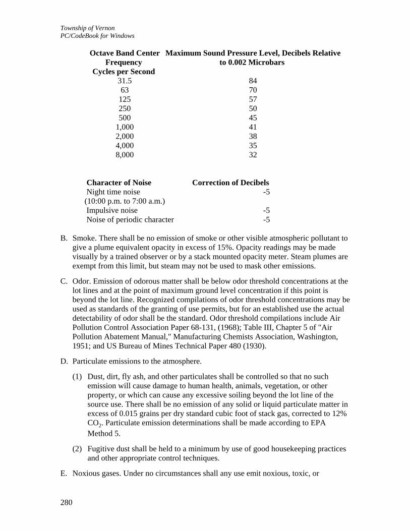
Township of Vernon PC/CodeBook for Windows
280
Octave Band Center Frequency
Cycles per Second
Maximum Sound Pressure Level, Decibels Relative to 0.002 Microbars
31.5 84 63 70 125 57 250 50 500 45 1,000 41 2,000 38 4,000 35 8,000 32
Character of Noise Correction of Decibels Night time noise
(10:00 p.m. to 7:00 a.m.) -5
Impulsive noise -5 Noise of periodic character -5 B. Smoke. There shall be no emission of smoke or other visible atmospheric pollutant to
give a plume equivalent opacity in excess of 15%. Opacity readings may be made visually by a trained observer or by a stack mounted opacity meter. Steam plumes are exempt from this limit, but steam may not be used to mask other emissions.
C. Odor. Emission of odorous matter shall be below odor threshold concentrations at the lot lines and at the point of maximum ground level concentration if this point is beyond the lot line. Recognized compilations of odor threshold concentrations may be used as standards of the granting of use permits, but for an established use the actual detectability of odor shall be the standard. Odor threshold compilations include Air Pollution Control Association Paper 68-131, (1968); Table III, Chapter 5 of "Air Pollution Abatement Manual," Manufacturing Chemists Association, Washington, 1951; and US Bureau of Mines Technical Paper 480 (1930).
D. Particulate emissions to the atmosphere.
(1) Dust, dirt, fly ash, and other particulates shall be controlled so that no such emission will cause damage to human health, animals, vegetation, or other property, or which can cause any excessive soiling beyond the lot line of the source use. There shall be no emission of any solid or liquid particulate matter in excess of 0.015 grains per dry standard cubic foot of stack gas, corrected to 12% CO2. Particulate emission determinations shall be made according to EPA Method 5.
(2) Fugitive dust shall be held to a minimum by use of good housekeeping practices and other appropriate control techniques.
E. Noxious gases. Under no circumstances shall any use emit noxious, toxic, or

Township of Vernon PC/CodeBook for Windows
281
corrosive fumes or gases. Reference shall be made to "Table I," Industrial Hygiene Standards, Maximum Allowable Concentrations, Chapter 5 of the Air Pollution Abatement Manual for determination of toxic pollutants to be prohibited.
F. Glare and heat. No industrial uses shall carry on an operation which will produce heat or direct or sky-reflected glare beyond the property line of the lot on which the use is located. Industrial and exterior lighting shall be used in such a manner that it produces no glare on public highways and neighboring property.
G. Fire and explosion hazards. All activities shall be carried on only in structures which conform to the standards of the Fire Prevention Code published by the American Insurance Association, 1965, or Borough Building Code or other applicable local ordinance, whichever is more restrictive. All operations shall be carried on and combustible raw materials, fuels, liquid, and finished products shall be stored in accordance with the standards of said American Insurance Association. The storage of more than 500 gallons of volatile or inflammable liquid above ground is prohibited.
H. Liquid and solid wastes. There shall be no discharge at any point of treated or untreated sewage or industrial waste into any stream, lake, reservoir, or into the ground of any material which may contaminate the water supply or endanger human health and welfare. No industrial waste shall be discharged into any system, nor shall any wastes be discharged in the public sewer system which are dangerous to the public health and safety.
(1) Maximum five-day biochemical oxygen demand: 5.0 ppm.
(2) Maximum quantity of effluent: 10% of minimum daily stream flow.
(3) Maximum five-day biochemical oxygen demand after dilution (BOD of effluent multiplied by quantity of effluent divided by quantity of stream flow): 0.25 ppm.
(4) Acidity or alkalinity shall be neutralized to a pH of 7.0 as a daily average on a volumetric basis, with a temporary variation of 6.0 to 8.5.
(5) Wastes shall not contain any insoluble substances in excess of 5,000 ppm, and no insoluble substances shall be noticeable in the water or deposited along the above or on the aquatic substrata in quantities detrimental to the natural biota.
(6) Wastes shall contain no cyanides and no halogens.
(7) Threshold odor number shall not exceed 24° to 60° C.
(8) Wastes shall not exceed the following maximums:
(a) Maximum hydrogen sulphide: 10 ppm.
(b) Maximum sulphur dioxide: 10 ppm.
(c) Maximum nitrous oxide: 10 ppm.
(d) Maximum chorine demand: 15 ppm.

Township of Vernon PC/CodeBook for Windows
282
(e) Maximum phenols: 0.0005 ppm.
(9) No effluent shall contain any acids, ores, dust, toxic metals, corrosive or other toxic substance in solution or suspension which may cause odors, discolor, poison or otherwise pollute streams and waterways in any way. There shall be no thermal discharges which detrimentally affect the natural aquatic biota, or reasonably anticipated reuse of the waters. There shall be no accumulation of solid wastes conducive to the breeding of rodents or insects.
(10) All methods of sewage and industrial waste treatment and disposal shall be approved by the New Jersey State Department of Environmental Protection and the Sussex County Department of Health, the Vernon Township Department of Health and Human Services and the Sussex County Municipal Utilities Authority.
I. Vibration. No activity shall cause or create a steady state or impact vibration at or beyond the lot line causing acceleration in excess of that indicated in the attached figure. The numbers on the ordinate are peak values of sinusoidal accelerations or 1.4 times the root mean square values of random vibrations measured in octave bands. These criteria are for vertical vibrations and are to be reduced by a factor of 1.4 for horizontal vibrations. The ordinate unit, g, is 9.81 m/sec2 (32.2 feet/sec2).
J. Radioactivity and electrical disturbance. Radioactivity shall not be emitted to exceed quantities established as safe by the US Bureau of Standards, as amended from time to time. No electrical disturbances (except from domestic household appliances) adversely affecting the operation at any point of any equipment other than that of the creator of such disturbance.
K. Conformance to state standards. Any operation shall also comply with any applicable state standards and requirements and particularly to the New Jersey Department of Environmental Protection, N.J.A.C. Title 7, Chapter 27, Subchapters 3, 4, 5, 6, 7, 11, 13 and 16.
ARTICLE XII, Stormwater and Flooding Controls
§ 330-206. Procedure and application.
A. Any application for development shall include a stormwater control plan containing sufficient information to effectuate the intent and purpose of these articles. Applications for the following shall be exempt from the requirements of this section:
(1) Additions or alterations to one- or two-family residences;
(2) A single-family residence to be constructed on a lot which is not contiguous to any other vacant buildable lot;
(3) A subdivision which results in only one vacant buildable lot for a single-family
Township of Vernon PC/CodeBook for Windows
283
residence;
(4) The use or reuse, or reoccupancy of any other land, building or structure without a change of use or substantial alteration or reconstruction thereof following an affirmative finding by the Board of compliance with the standards herein.
B. Whenever an applicant seeks approval from the Planning Board for a development to which this article is applicable, the applicant shall be required to demonstrate that his stormwater control plan and design of stormwater control facilities are based on sound planning, engineering and architectural techniques which adhere to the standards set forth in this article. Development includes all residential, governmental, commercial or industrial developments which adds impervious surface and/or pose a significant potential for pollution of surface or ground waters.
§ 330-207. Standards for stormwater runoff and control.
A. Stormwater control and runoff standards and requirements shall be as follows:
(1) Volumes and rates of stormwater runoff shall be controlled so that after development the developed site will have a negligible impact on the drainage basin; for the two-year, ten-year and twenty-five-year storms runoff shall be considered individually.
(2) The drainage of adjacent areas shall not be adversely affected.
(3) Soil erosion during or after development shall not increase over that which naturally occurs.
(4) The natural drainage pattern of the area shall not be significantly altered.
(5) All streets shall be provided with manholes, catch basins and pipes where the same may be necessary for proper surface drainage. Additionally, all work shall be in accordance with the established design standards of the Township.
(6) The system shall be adequate to convey and/or store the stormwater and natural drainage water which originates not only within the lot or tract boundaries, but also that which originates beyond the lot or tract boundaries. No stormwater runoff, natural drainage water or water discharged from any source shall be so diverted as to overload the existing drainage system or create flooding or the need for additional drainage structures on other private properties or public lands without proper and approved provision being made for taking care of these conditions. Over-the-sidewalk drains for the purpose of disposing of sump pump and/or roof leader runoff is prohibited. These facilities must outlet into an adequate watercourse or drainage system.
(7) Lots shall be graded to secure proper drainage away from buildings and into streets, where possible. Additionally, drainage shall be provided in a manner which will prevent the collection of stormwater in pools or other unauthorized concentrations of flow and, to the extent possible and unless specifically

Township of Vernon PC/CodeBook for Windows
284
approved in writing by the adjacent property owner and incorporated into appropriate resolution by the approving authority, water shall not flow across adjacent property lines.
(8) Approval for drainage structures shall be obtained from the appropriate municipal, county, state and federal agencies and offices where required. Each applicant shall make application to the New Jersey Department of Environmental Protection, Division of Water Resources, the Sussex County Engineering Department, the Planning Board or Township Engineer, and, if applicable, the United States Army Corps of Engineers. Letters of approval from the appropriate governmental authorities shall be furnished to the Planning Board, with copies to the approving authority, prior to the granting of final approval except for good cause shown or subject to appropriate condition and/or assurance.
(9) Where required by the Township and a lot or tract is traversed by a watercourse, surface or underground drainage or drainage system, channel or stream, there shall be provided and dedicated a drainage right-of-way easement to the Township conforming substantially with the lines of such watercourse, and such further width or construction or both as will be adequate to accommodate expected stormwater runoff in the future, based upon reasonable growth potential in the Township and, in any event, meeting any minimum widths and locations shown on any adopted Official Map or Master Plan. Such easement dedication shall be expressed on the plat.
(10) Where appropriate, seepage pits may be required in order to recharge aquifer.
(11) Surface water runoff shall not be transferred from one watershed to another without the approval of the Planning Board and the Township or Planning Board Engineer.
(12) The stormwater control plan shall be coordinated with all other applicable provisions of this chapter.
(13) Reestablishing vegetative cover shall be in accordance with "Standards and Specifications for Soil Erosion and Sediment Control in New Jersey," current edition.
(14) The stormwater control plan shall establish a time schedule for temporary and permanent surface water management measures prior to, during, and after construction or other disturbance, to include seeding and establishing sod in grass waterways.
(15) All outfalls are to be designed in a manner to retard velocities at the outfall, provide stream channel protection, and comply with "Standards and Specifications for Soil Erosion and Sediment Control in New Jersey," current edition.
(16) All structures and land treatment practices shall conform to "Standards and Specifications for Soil Erosion and Sediment Control in New Jersey," current edition.

Township of Vernon PC/CodeBook for Windows
285
(17) All water-carrying structures and/or retention areas shall be completed and stabilized prior to diversion of water to them.
(18) All development will be required to treat the runoff generated from the rainfall from the developed site for pollution abatement purposes. Treatment of this runoff may be achieved by filtration or other appropriate means prior to release from the site. Treatment may be accomplished by swale, pond or biofilter.
(19) Vacuum street sweeping may be substituted for the water quality requirement, in cases which continuity of the service can be assured, and where the pollution in question originates on the pavement.
(20) Detention areas may be depressions in parking areas, excavated basins, basins are elevated through use of curbs, stabilized earth berms or dikes, or any other form of grading which serves to temporarily impound and store water.
(21) Innovative surface water runoff control and recharge devices may be proposed, such as rooftop storage, dry wells, roof drains, infiltration trench, underground tank storage, gravel layers underneath paving, swale storage, front and back yard ponding oversized sewers, detention within pedestrian plazas and malls, parking lot detention including precast concrete turf grids, etc., providing they are accomplished by detailed engineering plans and performance capabilities.
(22) Nonstructural management practices, such as cluster development, stream encroachment and flood hazard controls, should be coordinated with detention requirements. Changes in land use can often reduce the scope and cost of detention provisions required by means of appropriate changes in runoff coefficients.
§ 330-208. Engineering review.
A. For engineering review by and on behalf of the Planning Board, each proposed project not exempted from the operation of this article shall provide a stormwater control plan that establishes runoff volumes and peak rates of discharge by current techniques. The following table shall be observed:
Design Frequency (minimum)
Facility Design Frequency Bridges,
culverts 100-year
Channels, ditches for drainage external to the development
25-year

Township of Vernon PC/CodeBook for Windows
286
Cross drains, storm sewers, collection system
25-year
Roadside swales for drainage internal to the development
25-year
Detention/retention basins or storage systems
25-year
B. Notwithstanding detention basin outlet designs herein, outlets shall be designed to
pass all storm events that flow through the basin.
§ 330-209. Methods for computing runoff volumes, rates and hydrographs.
A. Drainage basins or subbasins zero to five acres: Rational Method.
B. Drainage basins or subbasins zero to 25 years: Modified Rational Method.
C. Drainage basins or subbasins five to 300 acres: USDA Soil Conservation Service (SCS) TR55 Method with option of using SCS computer program TR20 method.
D. Drainage basins or subbasins 300 to 2,000 acres: SCS TR20 computer program method, or US Army Corps of Engineers HEC-1 computer program.
E. Drainage basins or subbasins over 2,000 acres: US Army Corps of Engineers HEC-1 computer program, and/or New Jersey Department of Environmental Protection Special Report 38.
F. Rainfall intensity shall be based on rainfall intensity curves developed by the State of New Jersey Department of Environmental Protection, 1976 and published in their Technical Manual for Stream Encroachment.
G. Time of concentration (TC) shall be derived from appropriate engineering techniques. TC shall consist of two components referred to as the "inlet time" and the "time of flow." The "inlet time" is the period of time consumed by the flow of water from the most distant point in the drainage area to the inlet. The "time of flow" is the period of time during which water flows through the drainage system from the inlet to any point being investigated below the inlet. The minimum inlet time to be used for design is six minutes.
§ 330-210. Design standards.

Township of Vernon PC/CodeBook for Windows
287
A. Stormwater line design shall be performed using technical procedures as outlined in American Society of Civil Engineers (ASCE) Manual and Report on Engineer Practice No. 37. For storm sewer lines in public rights-of-way, reinforced concrete culvert pipe (RCCP) of appropriate class shall be used. Corrugated metal pipe (CMP) may be used elsewhere.
B. The minimum inside diameter of pipe shall be 15 inches, and a minimum cover of two feet on top of all lines shall be required.
C. The maximum design velocity for conduits shall be 15 feet per second, and the minimum design velocity shall be three feet per second. Where discharge is made into a stream bed, adequate protection shall be provided and the allowable velocities shall be as shown in the Standards and Specifications for Soil Erosion and Sediment Control in New Jersey, Design of Roadside Channels, Hydraulic Design Series No. 4, Department of Transportation, Federal Highway Administration, or in Design Charts for Open Channel Flow, United States Department of Commerce, Bureau of Public Roads.
D. Ends of pipes starting or terminating in an open channel shall have reinforced concrete headwalls or flared end sections.
E. Storm sewer lines shall be true to line and grade.
F. Stormwater structures shall be placed where lines change alignment grade or size or are joined by other lines. In addition, storm sewer structures shall be placed not more than 300 feet apart. Inlets shall be located to prevent gutter flow from crossing street pavement and to prevent runoff accumulations above curbing at all intersections and low points along the roadway. Maximum inlet flow rate shall be based on the capacity of the type of inlet and shall not exceed six cubic feet per second. All hydraulic structures shall have sufficient depth to prevent overflow due to energy losses or changes in flow.
G. All bridges and culverts shall be designed in accordance with the following publications:
(1) New Jersey Department of Transportation Design Manual -- Bridges and Structures.
(2) US Department of Transportation -- Hydraulic Charts for the Selection of Highway Culverts.
H. All bridges and culverts shall meet the requirements and procedures set forth in the Manual.
I. When channels, swales or ditches are used as part of the storm drainage system, they shall be designed in accordance with the following publications:
(1) US Army Corps of Engineer -- Hydraulic Design of Flood Control Channels.
(2) US Department of Transportation -- Design of Roadside Channels, Hydraulic Design Series No. 4.

Township of Vernon PC/CodeBook for Windows
288
(3) New Jersey State Soil Conservation Committee -- Standards for Soil Erosion and Sediment Control in New Jersey.
J. All channels and ditches shall meet the requirements and procedures set forth in the Manual.
§ 330-211. Off-site and off-tract drainage facilities.
A. For purposes of this section, the definition of "off-site" shall also include "off-tract."
B. The decision regarding what, if any, off-site drainage improvements are to be required of a developer shall be made by the Board or Township Engineer. This decision shall be made upon analysis and review of the stormwater control plan submitted by the design engineer. The Board shall also, prior to the imposition of any conditions on an applicant for development, determine whether the off-site drainage improvements are to be constructed by the Township or the developer. Once the foregoing determination has been made, the Board shall estimate, with the aid of the Board or Township Engineer and other such persons having pertinent information or expertise:
(1) The cost of the improvement; and
(2) The amount by which all properties within a related or common drainage area will be specially benefitted therefrom.
C. The capacity and design of the drainage system required to control and convey stormwater runoff from the proposed development to a point of positive discharge shall be based on methods and standards consistent with other provisions of this article and chapter. Calculations, plans and cost estimates shall be provided by the applicant's engineer and approved by the Board or Township Engineer.
ARTICLE XIII, Property Maintenance lxiEN (RESERVED)
ARTICLE XIV, Affordable Housing
§ 330-212. Purpose.
This article regulates and provides for low- and moderate-income housing in and for the Township of Vernon, pursuant to the Fair Housing Act of 1985 and the provisions of N.J.A.C. 5:93 et seq., effective June 6, 1997.
§ 330-213. Development fees. [Added 5-22-2000 by Ord. No. 00-13]

Township of Vernon PC/CodeBook for Windows
289
A. Imposition of fees.
(1) Mandatory participation. Any developer of residential or nonresidential property shall have the responsibility to participate in the Township's efforts to provide its fair share of lower income housing. These fees will apply in all zones of the Township of Vernon. The level and type of mandatory participation shall be as follows:
(a) Residential. Residential development fees shall be 1/2 of 1% of the equalized assessed value for residential development. If a "d" variance is granted pursuant to N.J.S.A. 40:55D-70d(5), then the additional residential units realized (above what is permitted by right under the existing zoning) will incur a bonus development fee of 6% of the equalized assessed value rather than the development fee of 1/2 of 1%. However, if the zoning on a site has changed during the two-year period preceding the filing of the "d" variance application, the base density for purposes of calculating the bonus development fee shall be the highest density permitted by right during that two-year period preceding the filing of the "d" variance application. Residential development of single-family residences being developed by an owner for owner occupancy shall be exempt from the fees set forth herein unless said residential development shall be part of a major subdivision which received Planning Board approval on or after June 12, 2000. [Amended 3-28-2005 by Ord. No. 05-05lxiiEN]
(b) Nonresidential. Nonresidential development fees shall be 1% of the equalized value for nonresidential development. If a "d" variance is granted pursuant to N.J.S.A. 40:55D-70d(4), then the additional floor area realized (above what is permitted by right under the existing zoning) will incur a bonus development fee of 6% of the equalized assessed value rather than the development fee of 1%. However, if the zoning on a site has changed during the two-year period preceding the filing of the "d" variance application, the floor area for purposes of calculating the bonus development fee shall be the highest floor area permitted by right during that two-year period preceding the filing of the "d" variance application.
(2) Optional participation.
(a) Residential; developer's agreement. The Township of Vernon may collect fees exceeding those permitted in this section for residential developments; provided, however, that the Township of Vernon enters into a voluntary, written agreement with a residential developer, and provided further that such written agreement sets forth a financial incentive that shall include, but not be limited to, a tax abatement, reduction in the development design standards, waiver of off-tract improvement requirements and/or waiver of certain fees for the residential site of the developer. No agreement may provide for an increased voluntary residential developer fee without also providing for a comparable offsetting financial incentive. All such agreements are subject to COAH approval.

Township of Vernon PC/CodeBook for Windows
290
(b) Nonresidential; developer's agreement. The Township of Vernon may collect fees exceeding those permitted in this section for nonresidential developments; provided, however, that the Township of Vernon enters into a voluntary, written agreement with a nonresidential developer, and provided further that such written agreement sets forth a financial incentive for paying higher fees. The financial incentive may be in the form of a tax abatement, increased commercial/industrial square footage, increased commercial/industrial lot coverage, increased commercial/industrial impervious coverage and/or increased building height than permitted in the zoning ordinance for the reduction in the development design standards, waiver of off-tract improvement requirements and/or waiver of certain fees for the residential site of the developer. No agreement may provide for an increased voluntary residential developer fee without also providing for a comparable offsetting financial incentive. All such agreements are subject to COAH approval.
B. Collection of fees.
(1) The following procedures shall be followed with respect to the collection of development fees:
(a) When a cash development fee is to be made in a sum determined by applying a percentage figure against the equalized assessed value of the property, the following rule shall apply: The value of the property shall be the equalized assessed value of each dwelling unit at the time of project completion or, where feasible, completion of the unit in question.
(b) The developer shall pay 50% of the calculated development fee, which is nonrefundable, to the Township of Vernon at the issuance of building permits. The development fee shall be estimated by the Tax Assessor prior to the issuance of building permits based upon construction costs.
(c) The developer shall pay the remaining fee to the Township of Vernon at the issuance of certificate of occupancy. At the issuance of certificates of occupancy, the Tax Assessor shall calculate the equalized assessed value and the appropriate development fee. The developer shall be responsible for paying the difference between the fee calculated at the time of issuance of the certificate of occupancy and the amount paid at the time of issuance of the building permit.
(d) Payments shall be certified check or bank money order to the Township of Vernon and shall be deposited in a separate interest-bearing Housing Trust Fund account established by this section.
(2) Mandatory provisions relating to the application of funds payable to the Township of Vernon Fair Share Housing Trust Fund. The following mandatory provisions required by COAH regulations are hereby made applicable to the Vernon Township Fair Share Housing Trust Fund:

Township of Vernon PC/CodeBook for Windows
291
(a) The Township of Vernon shall establish a separate interest-bearing Housing Trust Fund account for the purpose of receiving development fees from residential and nonresidential developers with a financial interest otherwise qualified for the investment of public funds at the time the account is established. The Township shall provide the financial institution with the written authorization required by N.J.A.C. 5:93-8.15 permitting COAH to direct disbursement of development fees pursuant to N.J.A.C. 5:93-8.18 and 8.19. All development fees paid by developers pursuant to this section shall be deposited in this account. No money shall be expended from this Housing Trust Fund account unless the expenditure conforms to the municipal spending plan approved by COAH for the Township of Vernon.
(b) If COAH determines that the Township is not in conformance with COAH's development fee rules, COAH is authorized to direct the manner in which all development fees collected from developers shall be expended. Such authorization is pursuant to the Township of Vernon ordinance, COAH's rules on development fees and the written authorization from the Township Council to the financial institution in which the Housing Trust Fund is maintained.
C. Use of funds. The following mandatory provisions required by COAH regulations are hereby made applicable to that separate interest-bearing Housing Trust Fund account established in this section:
(1) Money deposited in the separate interest-bearing Housing Trust Fund account may be used for any activity approved by COAH for addressing the Township of Vernon's low- and moderate-income housing obligation. Such activities may include, but are not limited to, housing rehabilitation, new construction, regional contribution agreements, the purchase of land for low- and moderate-income housing, extension and/or improvements of roads and infrastructure to low- and moderate-income housing sites, assistance designed to render units to be more affordable to low- and moderate-income persons (such as the write-down/buy-down program) and administrative costs necessary to implement the Township of Vernon's housing element. The expenditures of all money from that separate interest-bearing Housing Trust Fund account shall conform to a spending plan approved by COAH as per its regulation. The expenditure of all money from that separate interest-bearing Housing Trust Fund account may be expended with the approval of and resolution of the Township Council in accordance with the regulations governing any expenditure of funds.
(2) At least 30% of the revenues collected shall be devoted to render units more affordable. Examples of such activities include, but are not limited to, down payment assistance, low interest loans and rental assistance. This requirement may be waived in whole or in part when the Township demonstrates the ability to address requirements of affordability assistance from another source.
(3) No more than 20% of the revenues shall be expended on administrative costs necessary to develop, revise or implement the housing element. Examples of

Township of Vernon PC/CodeBook for Windows
292
eligible administrative activities include personnel, consultant services, space costs, consumable supplies and rental or purchase of equipment.
(4) Development fee revenues shall not be expended to reimburse the Township for housing activities that preceded substantive certification.
D. Exemption and partial exemption from development fees.
(1) Developers of low- and moderate-income housing units shall be exempt from paying development fees.
(2) Developers that have received preliminary or final approval prior to the effective date of this section shall be exempt from paying a development fee unless the developer seeks a substantial change in the approval. Substantial changes may include, but are not limited to, a substantial alteration in the site layout, development density or types of uses within the development. The granting by the Planning Board of an approval of a general development plan for a planned development under the provisions of § 330-40, Planned developments, shall not constitute a preliminary or final approval as set forth in N.J.A.C. 5:93-8.12(d).
(3) Emergency services shall be exempt from paying development fees.
(4) Alterations/expansions to existing single-family residences, two-family residences, multifamily residences (including residences in mixed-use buildings) and/or permitted accessory structures shall be exempt from paying development fees.
(5) Alterations/expansions to existing retail buildings, office buildings, public utilities, financial institutions, eating establishments and/or industrial buildings under 5% of the total gross floor area of the existing building or 1,000 square feet, whichever is less, shall be exempt from paying development fees.
(6) Alterations/expansions to existing institutional uses under 5% of the total gross floor area of the existing building or 1,000 square feet, whichever is less, shall be exempt from paying development fees.
E. Continuing ability to collect and implement fees.
(1) Pursuant to N.J.A.C. 5:93-8.18, if any of the conditions set forth below occur, COAH shall be authorized to direct the manner in which development fees shall be dispersed:
(a) Failure to submit a plan pursuant to N.J.A.C. 5:93-5.1(c) within the time limits imposed by COAH.
(b) Failure to meet deadlines for information required by COAH in its review of a housing element, development fee ordinance, or plan for spending fees.
(c) Failure to proceed through COAH's administrative process toward substantive certification in a timely manner.

Township of Vernon PC/CodeBook for Windows
293
(d) Failure to address COAH's conditions for approval of a plan to spend development fees within the deadlines imposed by COAH.
(e) Failure to address COAH's conditions for substantive certification within the deadlines imposed by COAH.
(f) Failure to submit accurate monitoring reports within the time limits imposed by COAH.
(g) Failure to implement the plan to spend development fees within the time limits imposed by COAH, or within reasonable extensions granted by COAH.
(h) Revocation of certification.
(i) Other good cause demonstrating that the revenues are not being used for the intended purpose.
(j) Such revenues shall immediately become available for expenditure once COAH has notified the Township Clerk and Chief Financial Officer that such a condition has occurred. In furtherance of the foregoing, the Township shall, in establishing a bank account pursuant to N.J.A.C. 5:93-8.15, ensure that it has provided whatever express written authorization may be required by the bank to permit COAH to direct the disbursement of such revenues from the account following the delivery to the bank of the aforementioned written notification provided by COAH to the Township Clerk and Chief Financial Officer.
(k) COAH may, after a hearing pursuant to the Administrative Procedure Act, N.J.S.A. 52:14B-1 et seq., revoke development fee ordinance approval if the Township fails to comply with the requirements of N.J.A.C. 5:93-8.1 et seq.
(l) Neither loss of development fees, nor loss of the Township's ability to impose and collect development fees, shall alter its responsibilities pursuant to substantive certification.
(2) Monitoring. The Township of Vernon shall complete and return to COAH all monitoring forms relating to the collection of development fees, expenditures of revenues and implementation of the plan certified by COAH. Quarterly financial reports, annual program implementation reports, auditing reports and such other reports as required by COAH shall be on forms designed and designated by COAH.
F. Expiration. This § 330-213 shall expire if:
(1) COAH dismisses or denies the Township's petition for substantive certification;
(2) COAH revokes substantive certification or this section;
(3) The substantive certification expires prior to the Township's filing an adopted housing element with COAH, petitioning for substantive certification or

Township of Vernon PC/CodeBook for Windows
294
receiving COAH's approval of this section.
ARTICLE XV, Soil Movement lxiiiEN (RESERVED)
ARTICLE XVI, Administration and Enforcement
§ 330-214. Enforcement. lxivEN
The Township Council shall enforce this chapter and any regulation hereunder. A zoning permit, or other permit, certificate or authorization as provided in this chapter and as may be appropriate, shall be required as a condition precedent to the erection, construction, alteration, repair, remodeling, conversion, removal or destruction of any building or structure; the use or occupancy of any building; structure or land; and the subdivision or resubdivision or any land. The Zoning Officer, Code Enforcement Officer or such other administrative officer and office as shall be established by the Township Council shall be responsible for the issuance of such permits, certificates and authorizations upon the submission of such data, materials, plans, plats and information as is authorized under this chapter and upon the express approval of the appropriate state, county or Township agencies. The fees to cover administrative costs for the issuance of such permits, certificates and authorizations are provided in Chapter 250, Fees and Escrows, Article II. In case any building or structure is erected, constructed, altered, repaired, converted, or maintained, or any building, structure or land is used in violation of this chapter, any proper Township authority or any interested party, in addition to any other remedies, may institute an appropriate action or proceedings to prevent such unlawful erection, construction, reconstruction, alteration, repair, conversion, maintenance or use, to restrain, correct or abate such violation, to prevent the occupancy of said building, structure, or land, or to prevent any illegal act, conduct, business or use in or about such premises.lxvEN
§ 330-215. Violations and penalties.
A. Any person who shall violate any of the provisions of this chapter or fail to comply therewith, or with any of the requirements thereof, or who shall erect, structurally alter, enlarge, rebuild or move any building or buildings or any structure, or who shall put into use any lot or land in violation of any detailed statement or plan submitted hereunder, or who shall refuse reasonable opportunity to inspect any premises shall be liable for a fine of not more than $500 or to imprisonment for not more than 90 days, or both such fine and imprisonment. Each and every day such violation continues shall be deemed a separate and distinct violation.
B. The owner of any building or structure, lot or land, or part thereof, where anything in

Township of Vernon PC/CodeBook for Windows
295
violation of this chapter shall be placed or shall exist, and any architect, builder, contractor, agent, person or corporation employed in connection thereof and who assists in the commission of such violation shall each be guilty of a separate offense, and, upon conviction thereof, each shall be liable to the fine or imprisonment, or both, specified in Subsection A above.
ARTICLE XVII, Schedules, Appendixes, Checklists and Forms
§ 330-216. Schedules and appendices.
The schedules, appendixes, checklists and forms contained in this article shall be and are hereby made part of this chapter and are incorporated as provisions of the text to which they correspond.
§ 330-217. Checklists and other forms.
The maps, materials, documents, data, studies and other information described in the development checklists and forms contained herein are intended to provide the Board with sufficient information and data to assure compliance with this chapter and all specifications contained herein, and to insure that the proposed development meets the design and improvement standards contained in this chapter. The specification of documents to be submitted is based on the type of development and particular stage of development application. At the request of the applicant, one or more of the submission requirements may be waived, in which event the Board or its authorized committee shall grant or deny the request within 45 days. Nothing herein shall be construed as diminishing the applicant's obligation to prove in the application process that he is entitled to approval of the application.
ARTICLE XVIII, Lot Development Permit [Added 4-28-2003 by Ord. No. 03-12; amended 10-16-2003 by Ord. No. 03-33; 2-9-2004 by Ord. No. 04-05; 3-11-2004 by Ord. No. 04-09]
§ 330-218. Lot development permit; when required.
Prior to the issuance of a construction permit by the Construction Official for any new structure on any undeveloped residential lot or for an addition or accessory structure larger than 500 square feet on a developed residential lot or any commercial lot not subject to planning and zoning approval, a lot development permit (LDP) shall be applied for and issued by the Township Engineer.
§ 330-219. Definitions.

Township of Vernon PC/CodeBook for Windows
296
As used in this article, the following terms shall have the meanings indicated: LOT, UNDEVELOPED RESIDENTIAL -- Any lot, in a residential zone or lot where a residential structure will be built, upon which no principal structure is located or which a principal structure is located but is to be removed or abandoned as a condition or in furtherance of a plan for development of said lot.
§ 330-220. Scope and purposes.
The requirement for an LDP is to safeguard against adverse consequences of uncontrolled surface water drainage, degradation of freshwater wetlands and transition areas, pollution of streams, watercourses and water bodies and negative impact to surrounding properties by development on private and public lands; and to provide for safe and suitable location of driveways.
§ 330-221. Procedure for obtaining lot development permit; limitations.
A. Consideration of issuance of an LDP shall be made upon submittal of an application form and five copies of an LDP, which shall be subject to review by the Township Engineer.
B. Action on the application and LDP shall be taken within 20 business days of receipt of all plan elements.
C. If approved, the Township Engineer shall issue an LDP. If disapproved, the applicant shall be so notified and the Township Engineer shall furnish a written statement for the reasons of disapproval.
D. LDP's shall be good for one full year after the date of issuance, after which such permit shall expire, but may be extended for a period not to exceed one year by the Township Engineer for good cause.
E. A septic system permit shall not be issued until the Township Engineer issues an LDP permit.
§ 330-222. Plan details and requirements for new residential construction and commercial development.
The LDP shall be prepared by a professional engineer licensed in the State of New Jersey and drawn to a scale of not less than one inch equals 30 feet. The LDP shall be prepared in sufficient detail to show the following: A. Key map based on the Official Tax Map of the Township of Vernon.
B. A topographic map of the subject lot and adjoining street with two-foot contour intervals, based upon a field survey, and not USGS maps.
C. To the greatest extent possible, the applicant shall comply with § 330-83 of this chapter in regard to environmentally sensitive areas.

Township of Vernon PC/CodeBook for Windows
297
D. The location of any existing streams, watercourses, ponds, storm sewers, delineated wetlands, delineated wetland transition areas, stormwater management facilities, and extent of slopes greater than 15% and environmentally sensitive areas.
E. The location of all existing and proposed new structures, including, but not limited to, buildings, swimming pools, tennis courts, garages, sheds, retaining walls, decks, patios, walkways and stairs.
F. The location, alignment, dimensions and construction details for any existing or proposed driveways, parking and turnaround areas. Driveways shall be located a minimum of 125 feet from an intersecting street, be 12 feet wide, have a maximum slope of 15%, not exceed 5% within 25 feet of a roadway or dwelling, and contain vertical curves for smooth transitions. Driveways, which exceed 8% in grade, shall be paved with two inches FABC mix I-5 over a base course consisting of four inches of dense graded aggregate, thoroughly rolled and compacted, or an equivalent.
G. A driveway profile shall be submitted for each proposed driveway.
H. The elevation of the finished garage floor, first floor and lowest floor of the proposed structures.
I. Measures to mitigate the increase in runoff from impervious surfaces in accordance with the New Jersey Department of Environmental Protection Best Management Practices, such as swales, natural retention areas and dry wells. When used, dry wells shall be constructed of precast concrete and be sized to store three inches of rainfall over the area of the structure, shall be equipped with overflow piping, and shall be backfilled on all sides and bottom with 12 inches of 1 1/2 inches washed gravel, be surrounded with filter fabric and connected to the dwelling with six inches PVC.
J. The location of all roof leader drains, dry wells, water supply wells, overhead and underground utility lines, and any individual subsurface sewage disposal systems.
K. Proposed grading at two-foot contour intervals.
L. Required building setback lines showing the building envelope and required buffers from environmentally sensitive areas.
M. Proposed retaining walls shall be accompanied by top and bottom of wall elevations and construction details with a note stating that the maximum exposed wall height is four feet. Walls with heights exceeding four feet shall be accompanied by stability calculations performed by a New Jersey licensed engineer.
N. Proposed soil erosion and sediment control areas.
§ 330-223. Plan details and requirements for existing residential lots.
A. Submission and approval requirements for improvements on existing residential lots shall be dependent on the extent of the improvement and the physical characteristics of the residential lot. The Township Engineer shall review the initial documentation

Township of Vernon PC/CodeBook for Windows
298
submission prepared by the owner or architect and visit the site to determine the complexity of the proposal. If, in the sole discretion of the Township Engineer, the improvement and/or disturbance caused by the improvement cause minimal impact to the environment or neighboring properties, the Township Engineer can waive the requirement for the submission of a formal LDP application. Notwithstanding this provision and unless prohibited by site constraints in the sole opinion of the Township Engineer, the Township Engineer may require at least one standard dry well or other infiltration measure to be installed to mitigate the effects of increase in impervious area. The initial document submission under this section shall consist of the following:
(1) A survey of the property showing all improvements existing on the property, all proposed improvements and the location of water supply wells, dry wells and subsurface sewerage disposal facilities, to scale.
(2) Any and all documents required for the development of the property by the Construction Official and Department of Health and Human Services, including, but not limited to, the building plans and specifications of the architect or contractor who will construct the improvement.
B. Upon review of the submission as set forth in this provision, the Township Engineer, in his or her sole discretion, may issue the lot development permit or may require any, or all, of the plan details or requirements set forth in § 330-222.
§ 330-224. Inspections.
A. In order to assure compliance with the terms of the LDP, a total of three periodic inspections of the site development operations shall be made by the Township Engineer or his representative as required during the course of the work. In the event that additional site visits are necessary, the Township will bill the developer for additional fees directly in accordance with the Engineer's hourly rate schedule approved by the Township.
B. The failure of an owner of property to comply with an approved LDP for such property, including any temporary measures to be taken during the performance of lot development activity or construction work, shall constitute a violation of this chapter and property such owner will be subject to penalties as per § 330-215 of this chapter.
§ 330-225. Certificate of occupancy.
A. A final zoning approval shall not be issued by the Zoning Official for any property which is the subject of an LDP until the Township Engineer has inspected the property and has certified in writing that the property conforms to the LDP. The Township Engineer or his representative shall make a final inspection and issue a report within five days after notification from the Construction Official of an application for a certificate of occupancy. When field conditions require substantial deviations from the plan submitted, as-built drawings shall be furnished prior to

Township of Vernon PC/CodeBook for Windows
299
issuance of a certificate of occupancy.
B. In the event that the Township Engineer determines that current weather conditions do not permit the completion of the required work to effectuate full compliance with the LDP, the Township Engineer may authorize the Zoning Official to issue a final zoning approval upon the posting with the Township of a cash deposit in an amount equal to 120% of the estimated cost of the work remaining to be performed. The Township Engineer shall determine the cost of the remaining work to be performed. In the event the work is not completed in a timely fashion, the Township of Vernon has the right to have the work performed and the cost thereof paid from the cash deposit pursuant to the terms of the cash deposit agreement.
§ 330-226. Exemptions.
A. Notwithstanding any of the provisions of this chapter, the requirement for obtaining a lot development permit shall not apply to:
(1) An existing developed lot except as otherwise required in § 330-218 herein.
(2) Nonresidential lots which have already received site plan approval.
(3) Activities exempt under the Right to Farm Act.
(4) Property owned by the Township of Vernon.
B. The exemptions provided by this § 330-226 shall not be construed to preclude the obligation for compliance with any other municipal, county and/or state regulations as required by law.
§ 330-227. Appeals.
A. Whenever the Township Engineer disapproves an application for an LDP, the applicant may appeal such action to the Township Manager. All such appeals shall be filed with the Land Use Administrator in writing. No filing fee shall be required. Unless the appeal is filed within 20 days following the action by the Township Engineer, the disapproval shall be deemed final.
B. For good cause shown, the Township Manager may direct the issuance of an LDP in cases where the plan details do not conform to the standards established by §§ 330-222 and 330-223. As used in this section, the term "good cause" shall mean that the applicant has demonstrated that, by reason of the unique shape, shallowness or narrowness of the lot, or by reason of exceptional topographic conditions or physical features uniquely affecting the lot, the strict application of said plan detail standards would result in peculiar and exceptional practical difficulties to or exceptional and undue hardship upon the lot owner. The burden of establishing the existence of good cause shall be upon the applicant who shall also establish to the satisfaction of the Township Manager that the issuance of the LDP will not substantially impair the purposes set forth in § 330-220 and that the LDP may be issued without substantial

Township of Vernon PC/CodeBook for Windows
300
adverse impact upon the surrounding properties and neighborhood.
C. In the event that the Township Manager feels that the issues relating to an LDP appeal are beyond his or her ability to judge due to technical matters, the Manager may direct the appeal to the Zoning Board. In such cases, the appeal shall be scheduled for a Zoning Board agenda within 30 days, or as soon thereafter that it can be scheduled, at no cost to the applicant. The applicant is required to provide written notice to all property owners within 200 feet of the applicant's property by certified mail, stating when and why the hearing will be held.
D. In no case shall the Township Manager or Zoning Board direct the issuance of an LDP where the LDP is inconsistent with the terms of any prior subdivision or site plan approval with regard to protection of critical or environmentally sensitive areas, or in conflict with county, state or federal regulations.
§ 330-228. Fees.
Upon submission of a lot development plan to the Township of Vernon, the applicant shall furnish a review and inspection fee in the amount of $700 for new residential or commercial development or $250 for existing residential lots (unless an LDP is required under § 330-222, in which case an additional fee of $200 shall be required), payable to the Township of Vernon. In the event that more than three plan revisions or three site visits are required by the Engineer or his representative, the Township of Vernon shall bill the developer directly in accordance with the Engineer's hourly rate schedule approved by the Township. All outstanding fees shall be paid prior to issuance of a final zoning approval.
ARTICLE XIX, Stream Buffer Conservation Overlay Zone [Added 3-1-2004 by Ord. No. 04-04]
§ 330-229. Intent and purpose.
In recognition of the fact that values afforded by functional stream buffers contribute to the welfare of residents, the following regulations have been enacted to provide reasonable controls governing the conservation, disturbance, restoration and management of existing stream buffers for all perennial and intermittent streams and all lakes, ponds and reservoirs in the municipality by establishing a Stream Buffer Conservation Zone (SBCZ). The specific purposes and intent of this article are to: A. Regulate the land use, siting, and engineering of all development in SBCZ to be
consistent with the intent and objectives of this article and accepted conservation practices.
B. Reduce the potential for excessive nutrients, sediment, and organic matter, as well as biocides and other pollutants, from reaching surface waters by optimizing opportunities for filtration, deposition, absorption, adsorption, plant uptake,

Township of Vernon PC/CodeBook for Windows
301
biodegradation, and denitrification, which occur when stormwater runoff is conveyed through vegetated buffers as stable, distributed sheet flow prior to reaching receiving waters.
C. Provide for shading of the aquatic environment so as to moderate temperatures, retain more dissolved oxygen, and support a healthy assemblage of aquatic flora and fauna.
D. Provide natural organic matter (fallen leaves and twigs) and large woody debris (fallen trees and limbs) that provide food and habitat for small bottom-dwelling organisms (insects, amphibians, crustaceans, and small fish), which are essential to maintain the food chain.
E. Increase stream bank stability and maintain natural fluvial geomorphology of the stream system, thereby reducing streambank erosion and sedimentation and protecting habitat for aquatic organisms.
F. Conserve the natural features important to land and water resources, e.g., headwater areas, groundwater recharge zones, floodway, floodplain, springs, streams, wetlands, woodlands, prime wildlife habitats.
G. Work with state laws and other ordinances that regulate environmentally sensitive areas to minimize hazards to life, property, and stream features and assist in the implementation of pertinent state laws concerning erosion and sediment control practices.
§ 330-230. Definitions.
As used in this article, the following terms shall have the meanings indicated: CATEGORY ONE WATERS or C1 -- Those waters designated in the tables in N.J.A.C. 7:9B-1.15. CATEGORY TWO WATERS or C2 -- Those waters not designated as outstanding national resource waters or Category One at N.J.A.C. 7:9B-1.15. INTERMITTENT STREAM -- Surface water drainage channels with definite bed and banks in which there is not a permanent flow of water. Most intermittent streams are shown on Soil Conservation Service county soil surveys. These are portrayed as a dashed line on a USDA Soil Survey Map of the most recent edition, or as state open water identified in a letter of interpretation issued by the NJDEP Land Use Regulation Program, whichever is more inclusive. Stormwater swales that only carry water from a storm event and do not have flow at other times are not considered "intermittent streams." LAKE, POND or RESERVOIR -- Any impoundment, whether naturally occurring or created in whole or in part by the building of structures for the retention of surface water, excluding sedimentation control and stormwater retention/detention basins and ponds designed for treatment of wastewater. PAVED ROADWAY OR PARKING AREA -- Surfaces covered with asphalt, cement, paving stones, brick, compacted quarry process stone or similar materials. PERENNIAL STREAM -- A stream that appears as a blue line on USGS topographic quadrangle maps and flows continuously throughout the year in most years.

Township of Vernon PC/CodeBook for Windows
302
§ 330-231. Establishment of Stream Buffer Conservation Zone.
A. The SBCZ is defined as the designated area adjacent to surface water, including lakes, ponds and reservoirs, and intermittent or perennial streams. The SBCZ may or may not contain trees and other vegetation at the time of enactment of this article. The SBCZ shall be measured from each defined edge of an intermittent or perennial stream, or lake, pond or reservoir at bank-full flow or level. The SBCZ will consist of two distinct classifications. These classifications determine the width of the SBCZ, except where steep slopes (in excess of 25%) are located within the designated widths, in which case the SBCZ shall be extended to include the entire distance of this sloped area. When an existing paved roadway or parking area is located within the SBCZ, the SBCZ shall not extend past the near edge of the existing pavement. The land on the opposite side of the roadway or parking area from the stream shall not be considered in the SBCZ even if located less than the distance shown in Subsection A(1) and A(2) below. The two classes are designated as:
(1) Class 1 Stream Buffer Conservation Zones are adjacent to C1 waters and extend 150 feet from the top of each bank at bank-full flow or level or from the center line of intermittent streams.
(2) Class 2 Stream Buffer Conservation Zones are adjacent to C2 waters and extend 75 feet from the top of each bank at bank-full flow or level or from the center line of intermittent streams.
B. The SBCZ is an overlay to the existing zoning districts. The provisions of the underlying district shall remain in full force, except where the provisions of the SBCZ differ from the provisions of the underlying district, in which case the provision which is more restrictive, and less permissive, to a landowner or applicant shall apply.
C. These provisions are intended to modify the type of land use, siting of structures, and engineering of all proposed development on parcels located within the SBCZ. These provisions apply to land disturbances resulting from or related to any activity or use requiring application for any of the following permits or approvals:
(1) Building permit.
(2) Zoning variance or permit.
(3) Special exception.
(4) Conditional use.
(5) Subdivision/land development approval.
(6) Lot development permit.
§ 330-232. Stream Buffer Conservation Zone uses.
Stream Buffer Conservation Zones shall remain in a natural condition or, if in a disturbed condition, including agricultural activities, at the time of adoption of this article, may be

Township of Vernon PC/CodeBook for Windows
303
restored to a natural condition. There shall be no clearing or cutting of trees and brush, except for removal of dead vegetation and pruning for reasons of public safety or for the replacement of invasive species with indigenous species, altering of watercourses, dumping of trash, soil, dirt, fill, vegetative or other debris, regrading or construction. A. Open space uses that are primarily passive in character shall be permitted to extend
into the SBCZ, provided near stream vegetation is preserved, including:
(1) Wildlife sanctuaries, nature preserves, forest preserves, fishing areas, game farms, and fish hatcheries and fishing reserves, operated for the protection and propagation of wildlife, but excluding structures.
(2) Passive areas of public and private parklands, including unpaved hiking, bicycle and bridle trails, provided that said trails have been stabilized with pervious materials.
B. Streambank stabilization or riparian reforestation, which conform to the guidelines of the stream buffer management plan, or wetlands mitigation projects that have been approved by the Department of Environmental Protection, are permitted to extend into the SBCZ.
C. SBCZ crossings by recreational trails, roads, railroads, sewer and/or water lines, and public utility transmission lines are permitted, provided that any disturbance is offset by buffer improvements in compliance with the stream buffer management plan mitigation plan, and any applicable state permits are acquired.
§ 330-233. Performance standards for Stream Buffer Conservation Zones.
A. All new major and minor subdivisions and site plans shall be designed to provide sufficient areas outside of the SBCZ to accommodate primary structures, any normal accessory uses appurtenant thereto, as well as all planned lawn areas. Portions of lots within the SBCZ must be permanently restricted by deed or conservation easement to prevent clearing of vegetation within the SBCZ, such deed restrictions or easements to include a grant to the Township for access, repair and maintenance in such cases as the Township shall deem appropriate. Any lands proposed for development which include all or a portion of a SBCZ shall, as a condition of any major or minor subdivision or major site plan approval, provide for the vegetation or revegetation of any portions of the SBCZ which are not vegetated at the time of the application or which were disturbed by prior land uses, including for agricultural use. Said vegetation plan shall utilize native tree and plant species in accordance with the stream buffer management plan.
B. Minimum required front, side, and rear setbacks required for building lots which exist as of the date of adoption of this article, but have not obtained a building permit, may extend into the SBCZ, provided that a deed restriction and/or conservation easement is applied which prohibits clearing or construction in the SBCZ.
§ 330-234. Nonconforming structures and uses in Stream Buffer Conservation

Township of Vernon PC/CodeBook for Windows
304
Zone.
Nonconforming structures and uses of land within the SBCZ are subject to the following requirements: A. Existing nonconforming structures or uses may be continued but shall not have the
existing building footprint or uses expanded or enlarged.
B. Discontinued nonconforming uses may be resumed any time within one year from such discontinuance but not thereafter when showing clear indications of abandonment. No change or resumption shall be permitted that is more detrimental to the SBCZ, as measured against the intent and purpose under § 330-229, than the existing or former nonconforming use. This one-year time frame shall not apply to agricultural uses which are following prescribed best management practices for crop rotation. However, resumption of agricultural uses must be strictly confined to the extent of disturbance existing at the time of adoption of this article.
§ 330-235. Uses specifically prohibited in Stream Buffer Conservation Zone.
Any use or activity not specifically authorized within § 330-232 or 330-234 shall be prohibited within the SBCZ.
§ 330-236. Permitted activities in case of no reasonable or prudent alternative or extreme hardship.
A. Hardship variances may be granted by the Zoning Board in cases of a preexisting lot (existing at the time of adoption of this article) for a one-family dwelling or commercial structure, when there is insufficient room outside the SBCZ for uses permitted by the underlying zoning and there is no other reasonable or prudent alternative to placement in the SBCZ, including obtaining variances from setback or other requirements that would allow conformance with the SBCZ requirements, and provided the following demonstrations are made:
(1) An applicant shall be deemed to have established the existence of an extreme economic hardship, as distinguished from mere inconvenience, if the subject property is not capable of yielding a reasonable economic return if its present use is continued or if it is developed as authorized by provisions of this article and that this inability to yield a reasonable economic returns results from unique circumstances peculiar to the subject property which:
(a) Do not apply to or affect other property in the immediate vicinity;
(b) Relate to or arise out of the characteristics of the subject property because of the particular physical surroundings, shape or topographical conditions of the property involved, rather than the personal situations of the applicant; and
(c) Are not the result of any action or inaction by the applicant or the owner or his predecessors in title. The necessity of acquiring additional land to locate development outside the SBCZ shall not be considered an economic hardship

Township of Vernon PC/CodeBook for Windows
305
unless the applicant can demonstrate that there is no adjacent land that is reasonably available.
(2) An applicant shall be deemed to have established compelling public need if the applicant demonstrates, based on specific facts, that:
(a) The proposed project will serve as an essential public health or safety need;
(b) The proposed use is required to serve existing public health or safety need;
(c) There is no alternative available to meet the established public health or safety need.
(3) A variance may be granted if the applicant meets the standards for review for negative criteria as established by the Municipal Land Use LawlxviEN and case law interpreting same; and the variance or exception granted shall be the minimum relief necessary to relieve the hardship.
B. If the above demonstrations are made, then the following encroachments into the SBCZ may be permitted:
(1) Encroachment of impervious surfaces (structures or pavement) otherwise permitted by the underlying zoning is permitted to the extent required to obtain relief from the hardship. Said encroachment is not permitted closer than 100 feet from the top of the bank at bank-full flow or level of C1 waters or closer than 50 feet from the top of the bank at bank-full flow or level of C2 waters.
(2) Encroachment of lawn areas, but no closer than 100 feet from the edge of C1 water or 50 feet from the edge of C2 water.
C. If such an exception or variance is granted, the applicant shall comply with the approved stream buffer management plan.
§ 330-237. Boundary interpretation; appeals procedures; inspections.
A. When a landowner or applicant disputes the boundaries of the Stream Buffer Conservation Zone or the defined bank-full flow or level, the landowner or applicant shall submit evidence to the Vernon Township Engineer that describes the SBCZ, presents the landowner's or applicant's proposed SBCZ, and presents all justification for the proposed boundary change.
B. Within 45 days of a complete submission of Subsection A above, the Township Engineer, or appointed representative, shall evaluate all material submitted and shall make a written determination, a copy of which shall be submitted to the Vernon Township Planning and Zoning Department and landowner or applicant. Failure to act within the forty-five-day period shall not be interpreted to be an approval of the proposed boundary change.
C. Any party aggrieved by any such determination or other decision or determination under this section may appeal to the Vernon Township Zoning Board of Appeals

Township of Vernon PC/CodeBook for Windows
306
under the provisions of this article and the Municipal Land Use Law. The party contesting the location of the SBCZ boundary shall have the burden of proof in case of any such appeal.
D. Inspections.
(1) Lands within or adjacent to an identified SBCZ will be inspected by the municipal representative when:
(a) A subdivision or land development plan is submitted.
(b) A building permit is requested.
(c) A change or resumption of nonconforming use is proposed.
(d) Discontinued use for more than a year as described above. The party contesting the discontinued use shall have the burden of proof to demonstrate when use was discontinued.
(2) The Stream Buffer Conservation Zone may also be inspected periodically by the representatives from the Township if excessive or potentially problematic erosion is present, other problems are discovered, or at any time when the presence of an unauthorized activity or structure is brought to the attention of Township officials or when the downstream surface waters are indicating reduction in quality.
§ 330-238. Stream buffer management plan.
A. Within any Stream Buffer Conservation Zone, no construction, development, use, activity, or encroachment shall be permitted unless the effects of such development are accompanied by preparation, approval, and implementation of a stream buffer management plan.
B. The landowner, applicant, or developer shall submit to the Township Engineer, or its appointed representative, a stream buffer management plan prepared by an environmental professional, professional engineer or other qualified professional who fully evaluates the effects of any proposed uses on the SBCZ. The stream buffer management plan shall identify the existing conditions, including:
(1) Existing vegetation.
(2) Field delineated streams, wetlands, and one-hundred-year floodplain.
(3) Mapped soils.
(4) Existing subdrainage areas of site.
(5) Slopes in each subdrainage area segmented into sections of slopes less than or equal to 10%; 11% to 19%; and greater than or equal to 20%.
(6) All proposed activities.

Township of Vernon PC/CodeBook for Windows
307
(7) A mitigation plan which demonstrates how the loss of value afforded by the existing buffer will be compensated for.
C. The plan shall be reviewed and must be approved by the Township Engineer, in consultation with the Environmental Commission, as part of the subdivision and land development process.
D. The stream buffer management plan should include management provisions in narrative and/or graphic form specifying:
(1) The manner in which the SBCZ will be owned and by whom it will be managed and maintained.
(2) The conservation and/or land management techniques and practices which will be used to conserve and protect the SBCZ, as applicable.
(3) The professional and personnel resources that are expected to be necessary in order to maintain and manage the SBCZ.
(4) A revegetation plan, if applicable, that includes three layers of vegetation, including herbaceous plants that serve as ground cover, understory shrubs, and trees that form an overhead canopy. Vegetation selected must be native and consistent with the soil, slope and moisture conditions of the site. The revegetation plan shall be prepared by a qualified professional such as a landscape architect or engineer, shall comply with the following minimum requirements, and shall be subject to the approval of the Municipal Engineer, in consultation with the Environmental Commission.
E. A stream buffer management plan is not required where the SBCZ is not being disturbed and conservation easements/deed restrictions applied to ensure there will be no future clearing or disturbance of the SBCZ.
§ 330-239. Plan review fee.
The fee for stream buffer management plan review fee shall be $400.
TABLES PERTAINING TO SIGNS (See § 330-180)

Township of Vernon PC/CodeBook for Windows
308
TABLE A Signs for Single Commercial Uses [By sign type; see § 330-180D(1)]
Type of
Sign Maximum Area (square
feet)
Maximum Height
(feet)
Maximum Number Minimum Setback
(feet)
Permit Require
d
Illumination Permitted
Restrictions and Notes
Freestanding or ground sign
24 or 32 [See
§ 330-180D(1)]
16 1 15 Yes External only[See § 330-180F(2)]be
perpendicular to roadway
Wall sign 12 [See
§ 330-180H(1)(g
)]
1 Yes External only[See § 330-
180F(2)]additional wall sign of not more
than six square feet
may be installed if no window sign
is elected Window sign
6 square feet or 20% of window
area, whichever
is less
1 Yes sign may be substituted by an additional wall sign of
not more than six square feet
Awning sign [See § 330-
[See § 330-
Yes No

Township of Vernon PC/CodeBook for Windows
309
180B(19)] 180B(19)] Directional and informational signs
[See § 330-
180B(4)]
[See § 330-180B(4)] Noand in the
manner necessar
y or appropriatesite
and noncommercial
only [See
§ 330-180B(4)]

Township of Vernon PC/CodeBook for Windows
310
TABLE B

Township of Vernon PC/CodeBook for Windows
311
Signs for Single Office, Professional, Service or Industrial Uses [See § 330-180D(2)]
Type of Sign Maximum Size
(square feet) Maximum
Height (feet)
Maximum
Number
Minimum Setback
(feet)
Permit Require
d
Illumination Permitted
Restrictions and Notes
Ground sign 24 8 1 15 Yes External onlybe perpendicular
to roadway Wall sign 12
[See § 330-180H(1)(g)]
1 Yes External only [See § 330-180D(2)(b) and (c)]
Window sign square feet or 20% of window area, whichever is less
1 Yes [See § 330-180D(2)(b) and (c)]
Awning sign [See § 330-180B(19)]
[See § 330-180B(19)]
Yes No [See § 330-180B(19)]
Directional and informational signs
[See § 330-180B(4)]
[See § 330-180B(4)]
[See § 330-
180B(4)]
No

Township of Vernon PC/CodeBook for Windows
312
TABLE C
Signs on Sites of More Than One Commercial or Industrial Use, Unit or Enterprise [See § 330-180D(3)]
Type of Sign Maximum Size
(square feet) Maximum
Height (feet)
Maximum Number
Minimum Setback
(feet)
Permit Required
Illumination Permitted
Restrictions and Notes
Freestanding or ground sign
32 or 10% of facade
16 1 15 Yes External onlybe perpendicular
to roadway Wall sign 12
[See § 330-180H(1)(g)]
1 Yes External only [See § 330-180D(3)(b) and (c)]
Window sign square feet or 20% of window area, whichever is less
1 Yes [See § 330-180D(3)(b) and (c)]
Awning sign [See § 330-180B(19)]
[See § 330-180B(19)]
Yes No [See § 330-180B(19)]
Directional and informational signs
[See § 330-180B(4)]
[See § 330-180B(4)]
Noand in the manner necessary
or appropriate
site and noncommercial only
[See § 330-180B(4)]
Directory sign 42 8 1 Yes External only Projecting sign or suspended
6 10 1 per unit or use
Yes External onlymust be 8

Township of Vernon PC/CodeBook for Windows
313
sign feet above ground
Component sign 10 [See § 330-180D(3)(a)]
15 Yes [See § 330-180D(3)(a)]
[See § 330-180D(3)(a)]

Township of Vernon PC/CodeBook for Windows
314
TABLE D
Signs for Multiple Light Industrial Uses (Light Industrial Complex)
Type of Sign Maximum Size (square feet)
Maximum Height (feet)
Maximum
Number
Minimum Setback
(feet)
Permit Require
d
Illumination Permitted
Restrictions and Notes
Freestanding or ground sign
32 or 10% of facade
16 1 15 Yes External onlybe perpendicular
to roadway Wall sign 12
[See § 330-180H(1)(g)
1 Yes External only [See § 330-180D(4)(b) and (c)]
Window sign sq. ft. or 20% of window area, whichever is less
1 Yes [See § 330-180D(4)(b) and (c)]
Awning sign [See § 330-180B(19)]
[See § 330-180B(19)]
Yes No [See § 330-180B(19)]
Directional and informational signs
[See § 330-180B(4)]
[See § 330-
180B(4)]
No
Directory sign 42 8 1 Yes External only Projecting sign or suspended sign
6 10 1 per unit or use
Yes External onlymust be 8
feet above ground
Component sign 10 [See § 330-
180D(4)(a)]
15 Yes [See § 330-180D(4)(a)]
[See § 330-180D(4)(a)]

Township of Vernon PC/CodeBook for Windows
315
TABLE E
Signs for Residential and Home Professional Office Uses
Type of Sign Maximum Size (square feet)
Maximum Height (feet)
Maximum Number
Minimum
Setback(feet)
Permit Required
Illumination Permitted
Restrictions and Notes
Nameplate No [See § 330-180B(4) and D(5)]
Ground or wall 3 15 (ground
)
Yesonly [See § 330-180D(5)]
Directional and informational sign
[See § 330-180B(4) and D(5)]
[See § 330-180B(4)]
Noand in the manner necessary
or appropriate
site and noncommercial only;
only as needed for
home professiona
l office. [See § 330-180B(4)]
SCHEDULE A - Permitted, Conditional and Accessory Uses and Structures

Township of Vernon PC/CodeBook for Windows
316
[Amended 12-13-1999 by Ord. No. 99-27; 6-25-2001 by Ord. No. 01-13; 1-28-2002 by Ord. No. 02-04]
Legend: P = Permitted principal use A = Permitted accessory use C = Conditional use
Uses R-1 R-2 R-3 R-4 SR PLC C-1 C-2 C-3 CR AET LI C TC MTC P PLLCAccessory uses; customary A A A A A A A A A A A A A A A A A
Agriculture/farm P P P P P P P P P P A Antique shop P P P P P P Arts center C P C P
Auto service station C C Banks, savings and financial
offices P P P P
Bathhouse/rest rooms A A A A A A A A ABeaches A A A A A A A A A A
Bed-and-breakfast P P P P P P P P Boarding stable C P P
Bus shelter C C C C C Business services P P P P P
Campground, proprietary P Campground, public P C
Child care center P P P P P P Church - see “place of
worship”
Clubhouse P P P P P P P PCluster development P P P P
Community residences for the developmentally disabled
P P P P P P
Conference center C C P Conference room C C C C C C Convenience store P P A P
Country club P P P P

Township of Vernon PC/CodeBook for Windows
317
Docks A A A A A A A A A ADwelling, single-family P P P P P C P PFamily day-care home P P P P P P P P P P
Farmstand/produce A A A A P P P P A A1
Funeral home C P P P Galleries P P P P P P
Garage, repair C P Gardens, botanical P P P P Gardens, zoological P P P
Gazebo A A A A A A A A A A A A A AGeneral development plan14 P
Golf course P P C P Golf course, miniature A
Health care facility C C7
Health club P3 P P C P
Health services P P P P Home occupation P P P C C4 P C C4
Home professional office C C C C C4 C C4
Hotel P C Inn P P P P C
Institutional uses, excluding places of worship
C C C C C4 C P C C C4
Light industry P Lodge P C
Multifamily age-restricted housing
P
Nature preserve P P P P P P P P P P P Nursery P P P P Office P5 A P P A P P5
Office building P P P Outdoor recreation P P P P P P P P P P P
Personal service establishment
P P P P

Township of Vernon PC/CodeBook for Windows
318
Place of worship C C C C C4 C P P P P P C4
Planned adult community11,
12
P P P
PUD, PCD, PURD, PID11
Private lake community P PProfessional office P P P P
Public utilities Racquet sports facilities P C A9
Recreation facility, commercial
P C
Recreational facility, personal
P P P P P P
Recreation facility, active P Recreation facility, private P P P P P P P P PRecreation facility, public P P Recreational development P P P
Research labs P Residential, single-family P P P P P P
Resort P P Resort-oriented housing P C
Restaurant A6 P P P C P
Restaurant, fast-food P P P Restaurant, take-out P P P
Retail sales A6 P P P A P
Retail sales, outdoor A6 P P C
Retail services P Riding academy/stables C P P
School bus shelter C C C C C C C C Sheltered care facilities C
Shopping center C P P Shopping mall P P
Ski area P C Ski resort P
Specialty food store P P P A P

Township of Vernon PC/CodeBook for Windows
319
Specialty shopping center P P P10
Studio P P P P P Supermarket P P
Temporary outdoor activity C C C C C C6 C C C C C C C C C C C6
Theater A6 P C P
Theme park P Townhouse P
Veterinary hospital P P
NOTES: 1 Permitted only where accessory to a grocery store. 2 Subject to approved plan. 3 For use by members and their guests, per requirements of community association or club. 4 Subject to the charter, bylaws, rules, regulations and restrictions in favor of the community association or club. 5 As necessary or appropriate to the operations of the community association or club. 6 When incident to community association or club operations or activities. 7 Outpatient only. 8 PCD only. 9 Permitted only where accessory to a health club. 10 Permitted only where the required number of off-street parking spaces can be provided on-site. 11 See applicable sections. 12 Semiattached or attached dwelling units.
SCHEDULE B - Bulk and Yard Requirements
[Amended 12-13-2004 by Ord. No. 04-30; 9-26-2005 by Ord. No. 05-215]

Township of Vernon PC/CodeBook for Windows
320
Zoning District
Minimum Lot Area
(square feet or acre)
Minimum Lot Width
(feet)
Minimum Front Yard
Setback (feet)
Minimum Side Yard Setback
(feet)
Minimum Rear Yard
Setback (feet)
Maximum Building Height
(feet/stories)
Maximum Building Coverage (percent)
Maximum Lot
Coverage (percent)
R-1 5 ac. 250 75 35 100 35/2½ 10% 15% R-2 3 ac. 200 75 25 75 35/2½ 15% 25% R-3 30,000 sf 125 50 15 50 35/2½ 20% 30% R-4 10,000 sf 100 50 15 50 35/2½ 20% 30% PLC 10,000 sf 100 40 10 25 35/2½ 25% 35% C-1 20,000 sf 100 25 10 20 30/2 35% 75% C-2 30,000 sf 125 50 15 40 30/2 30% 60% C-3 40,000 sf 150 75 20 50 35/3 25% 50% CR 10 ac. 250 100 100 100 30/2 10% 25% SR 40 ac. 250 100 50 60 30/2 10% 25% LI 40,000 sf 150 75 25 50 30/2 30% 60%
AET 5 ac. 250 75 35 100 30/2 10% 15% CON 5 ac. 250 75 35 100 35/2½ 10% 15% TC 10,000/
4,000 sf1 50/40 15 or 202 10 + 0 or
0 + 03 20 30/2 35% 50%
NOTES: 1 Smaller requirement assumes sewer connection. 2 Fifteen feet from right-of-way line or 20 feet from lot line, whichever is less. 3 Zero side yard permissible if building has rear yard access. 4 No flat roofs permitted; minimum roof pitch: 9º. 5 Amended at time of adoption of Code (see Ch. 1, General Provisions, Art. I).

Township of Vernon PC/CodeBook for Windows
321
SCHEDULE C - Setback Requirements for Accessory Structures
December 1, 19971
Zone Accessory Structures
(other than pools and tennis courts)
Private Residential Swimming Pools
Private Tennis Courts
Rear Yard (feet)
Side Yard (feet)
Rear Yard (feet)
Side Yard (feet)
Rear Yard (feet)
Side Yard (feet)
R-1 15 15 35 25 35 25 R-2 15 15 30 20 30 20 R-3 10 10 25 15 25 15 R-4 5 5 15 10 10 10 PLC 5 5 15 10 10 10 C-1 5 5 C-2 5 5 C-3 5 5 CR 25 15 SR LI 10 10 AET 25 15 CON 25 15 TC 5 5 MTC
NOTES: 1 Amended at time of adoption of Code (see Ch. 1, General Provisions, Art. I).

Township of Vernon PC/CodeBook for Windows
322
SCHEDULE D - Minimum Parking Requirements1
(In spaces per gross square foot unless noted)
UsesSpaces Antique shop /200 square feet Arts center /2 seats performing Auto service station /employee + 3 no sundry sales Banks and financial /300 square feet Offices /300 square feet Bed-and-breakfast /sleeping room + 2 Boarding stable /2 boarded horses + 1/employee and loading area Bus shelter loading Business services /300 square feet Campground, proprietary /campsite + 1/employee Campground, public /campsite + 1/employee Child care center /150 square feet Church /3 seats (sixty-inch pew) or 1/30 square feet, whichever
greater Clubhouse /3 persons maximum occupancy Cluster development .2/unit + garage if any Community association /120 square feet Conference center /3 persons maximum occupancy Conference room /30 square feet or 1/3 persons of maximum occupancy,
whichever is greater Convenience store /120 square feetCountry club /3 seats + 1/barstool + 64/18 holesDwellings, single-family garage + 2Farmstand/produce /120 square feet building + 1/500 square feet outdoor Funeral home /30 square feet viewing + 1/200 building, areaGalleries /300 square feet

Township of Vernon PC/CodeBook for Windows
323
Garage, repair /employee + 3Gardens, botanical /500 square feet developed areaGardens, zoological /500 square feet developed area excluding animal pens Golf courses /18 holesGolf course, miniature .5/hole + 1/200 square feetHealth care facility /2,000 square feetHealth club /350 square feet + 0.8/exercise stationHealth services /200 square feetHome occupation /200 square feet office + 2 for residence (not counting
garage)Home professional office /200 square feet office + 2 for resident (not counting garage)Hotel /room + 1/200 square feet all other areasInn /room + 1/200 square feet all other areasInstitutional uses /300 square feetLight industry /1,000 square feet + 1/employee at maximum shift Lodge (fraternal) .1/3 maximum occupancyMultifamily age-restricted housing
.2/unit
Nature preserve /acre + 5Nursery (child care) /200 square feetOffice /300 square feetOffice building /300 square feetPersonal service establishment /300 square feetPlace of worship /30 square feet sanctuary or 1/300 square feet, whichever
greaterPlanned adult community .2/unitPrivate lake community /unit + garage if anyProfessional office /200 square feetRacquet sports facilities /court + 1/20 square feet of all other areasResearch labs /500 square feet + 1/person maximum shiftResidential, single family .2/dwelling + garage(s)
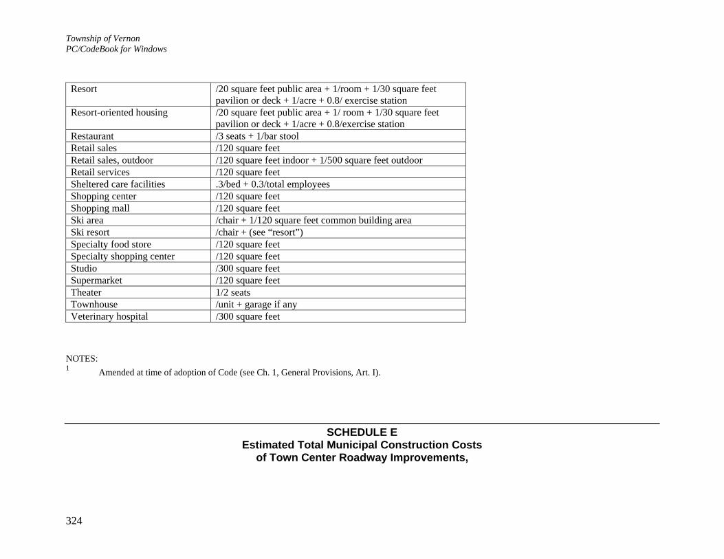
Township of Vernon PC/CodeBook for Windows
324
Resort /20 square feet public area + 1/room + 1/30 square feet pavilion or deck + 1/acre + 0.8/ exercise station
Resort-oriented housing /20 square feet public area + 1/ room + 1/30 square feet pavilion or deck + 1/acre + 0.8/exercise station
Restaurant /3 seats + 1/bar stoolRetail sales /120 square feetRetail sales, outdoor /120 square feet indoor + 1/500 square feet outdoor Retail services /120 square feetSheltered care facilities .3/bed + 0.3/total employees Shopping center /120 square feet Shopping mall /120 square feet Ski area /chair + 1/120 square feet common building area Ski resort /chair + (see “resort”) Specialty food store /120 square feet Specialty shopping center /120 square feet Studio /300 square feet Supermarket /120 square feet Theater 1/2 seats Townhouse /unit + garage if any Veterinary hospital /300 square feet
NOTES: 1 Amended at time of adoption of Code (see Ch. 1, General Provisions, Art. I).
SCHEDULE E Estimated Total Municipal Construction Costs
of Town Center Roadway Improvements,

Township of Vernon PC/CodeBook for Windows
325
and Estimated Total Increase in Future Traffic Volumes
[Added 8-26-2002 by Ord. No. 02-28] A. Construction costs. The total estimate of municipal costs for construction of Town Center roadway improvements consist of the following: Traffic signal at intersection of Route 94 and Church Street (new Town Center road signal)
$260,000
Town Center road connecting Route 515 at Guthrie Road to Route 94 at Church Street
$1,000,000
Access drive east of Route 515 connecting new Guthrie Road traffic signal to Route 515/Route 94 traffic signal
$725,000
Access drive west of Route 515 connecting new Guthrie Road traffic signal to Route 515
$485,000
Total $2,470,000
B. Increase in future traffic volumes. The following developments are anticipated to contribute additional traffic volumes to the traffic
improvement area: 1. Contributions of 60%: Mountain Creek Development, 1,027 trips x 0.60 = 616 trips 616 trips Legends Resort, 298 trips x 0.60 = 179 trips 179 trips The Spa at Vernon, 88 trips x 0.60 = 53 trips 53 trips Hidden Valley Estates, 29 trips x 0.60 = 18 trips 18 trips Total 866 trips 2. Contributions of 100% Retail and apartments 82 trips

Township of Vernon PC/CodeBook for Windows
326
Drugstore 80 trips Banquet hall 42 trips Tourist center 44 trips Bank 230 trips Total 478 trips 3. Projected background traffic volumes 600 trips 4. Total increase in future traffic volume 1,944 trips
i Editor's Note: Amended at time of adoption of Code (see Ch. 1, General Provisions, Art. I). ii Editor's Note: Amended at time of adoption of Code (see Ch. 1, General Provisions, Art. I). iii Editor's Note: Amended at time of adoption of Code (see Ch. 1, General Provisions, Art. I). iv Editor's Note: See N.J.S.A. 40:55D-1 et seq. v Editor's Note: Amended at time of adoption of Code (see Ch. 1, General Provisions, Art. I). vi Editor's Note: See also Ch. 275, Flood Damage Prevention. vii Editor's Note: See Ch. 452, Recycling. viii Editor's Note: Original Sec. 603e, Requirements for timing a development among the various types of uses and subgroups (which was a reserved subsection), which previously followed this subsection, was deleted at time of adoption of Code (see Ch. 1, General Provisions, Art. I). ix Editor's Note: Schedule A, Permitted, Conditional and Accessory Uses and Structures, is included at the end of this chapter. x Editor's Note: Amended at time of adoption of Code (see Ch. 1, General Provisions, Art. I). xi Editor's Note: Amended at time of adoption of Code (see Ch. 1, General Provisions, Art. I). xii Editor's Note: Schedule B, Bulk and Yard Requirements, is included at the end of this chapter. xiii Editor's Note: Schedule B, Bulk and Yard Requirements, is included at the end of this chapter. xiv Editor's Note: Schedule B, Bulk and Yard Requirements, is included at the end of this chapter. xv Editor's Note: Original Sec. 717e, Water body conservation buffer, which previously followed this section, was repealed 3-1-2004 by Ord. No. 04-04. xvi Editor's Note: Schedule B, Bulk and Yard Requirements, is included at the end of this chapter. xvii Editor's Note: Schedule B, Bulk and Yard Requirements, is included at the end of this chapter. xviii Editor's Note: The provisions of this article are mandatory pursuant to N.J.A.C. 5:21-1.1 et seq., effective June 3, 1997. All

Township of Vernon PC/CodeBook for Windows
327
options of the said rules which allow preservation of rural character at local discretion have been elected herein. xix Editor's Note: See N.J.S.A. 40A:11-18. xx Editor's Note: Schedule F is on file in the Township offices. xxi Editor's Note: Schedule E, Estimated Total Municipal Construction Costs of Town Center Roadway Improvements, and Estimated Total Increase in Future Traffic Volumes, is included at the end of this chapter. xxii Editor's Note: Amended at time of adoption of Code (see Ch. 1, General Provisions, Art. I). xxiii Editor's Note: Amended at time of adoption of Code (see Ch. 1, General Provisions, Art. I). xxiv Editor's Note: Former Sec. 1013, Project approval, denial or appeal, which previously followed this section, was repealed 7-10-2000 by Ord. No. 00-20. xxv Editor's Note: Schedule A, Permitted, Conditional and Accessory Uses, is included at the end of this chapter. xxvi Editor's Note: Schedule B, Bulk and Yard Requirements, is included at the end of this chapter. xxvii Editor's Note: Schedule C, Setback Requirements for Accessory Structures, is included at the end of this chapter. xxviii Editor's Note: Schedule B, Bulk and Yard Requirements, is included at the end of this chapter. xxix Editor's Note: Schedule C, Setback Requirements for Accessory Structures, is included at the end of this chapter. xxx Editor's Note: See also the Tables Pertaining to Signs, Tables A through E, located at the end of this chapter. xxxi Editor's Note: Amended at time of adoption of Code (see Ch. 1, General Provisions, Art. I). xxxii Editor's Note: Amended at time of adoption of Code (see Ch. 1, General Provisions, Art. I). xxxiii Editor's Note: Original Sec. 1132g7, which contained a penalty for violation of § 330-180G, which previously followed this subsection, was deleted at time of adoption of Code (see Ch. 1, General Provisions, Art. I). See now § 330-215, Violations and penalties. xxxiv Editor's Note: This section was repealed 1-6-2003 by Ord. No. 02-38 but was later reinstated in its entirety on 8-25-2003 by Ord. No. 03-24. xxxv Editor's Note: Schedules A and B are located at the end of this chapter. xxxvi Editor's Note: Amended at time of adoption of Code (see Ch. 1, General Provisions, Art. I). xxxvii Editor's Note: Amended at time of adoption of Code (see Ch. 1, General Provisions, Art. I). xxxviii Editor's Note: Schedule B, Bulk and Yard Requirements, is included at the end of this chapter. xxxix Editor's Note: Schedules A and B are located at the end of this chapter. xl Editor's Note: Amended at time of adoption of Code (see Ch. 1, General Provisions, Art. I). xli Editor's Note: Schedule A, Permitted, Conditional and Accessory Uses and Structures, is included at the end of this chapter. xlii Editor's Note: Amended at time of adoption of Code (see Ch. 1, General Provisions, Art. I).

Township of Vernon PC/CodeBook for Windows
328
xliii Editor's Note: Amended at time of adoption of Code (see Ch. 1, General Provisions, Art. I). xliv Editor's Note: Amended at time of adoption of Code (see Ch. 1, General Provisions, Art. I). xlv Editor's Note: Schedule B, Bulk and Yard Requirements, is included at the end of this chapter. xlvi Editor's Note: Amended at time of adoption of Code (see Ch. 1, General Provisions, Art. I). xlvii Editor's Note: Schedules A and B are located at the end of this chapter. xlviii Editor's Note: Schedule B, Bulk and Yard Requirements, is included at the end of this chapter. xlix Editor's Note: Amended at time of adoption of Code (see Ch. 1, General Provisions, Art. I). l Editor's Note: Amended at time of adoption of Code (see Ch. 1, General Provisions, Art. I). li Editor's Note: Original Sec. 1147b12, Health services, as amended 12-13-1999 by Ord. No. 99-27, which previously followed this subsection, was deleted at time of adoption of Code (see Ch. 1, General Provisions, Art. I). lii Editor's Note: Schedule B, Bulk and Yard Requirements, is included at the end of this chapter. liii Editor's Note: Schedule B, Bulk and Yard Requirements, is included at the end of this chapter. liv Editor's Note: Original Sec. 1147b20, Recreation facility in the LCR District, which previously followed this subsection, was repealed 12-13-1999 by Ord. No. 99-27. lv Editor's Note: Original Sec. 1147b22, Recreation development in the LCR District, and Sec. 1147b23, Resort in the LCR District, which previously followed this subsection, were repealed 12-13-1999 by Ord. No. 99-27. lvi Editor's Note: Amended at time of adoption of Code (see Ch. 1, General Provisions, Art. I). lvii Editor's Note: Amended at time of adoption of Code (see Ch. 1, General Provisions, Art. I). lviii Editor's Note: Amended at time of adoption of Code (see Ch. 1, General Provisions, Art. I). lix Editor's Note: See also Ch. 231, Emergency Housing. lx Editor's Note: Schedule A, Permitted, Conditional and Accessory Uses and Structures, is included at the end of this chapter. lxi Editor's Note: See Ch. 447, Property Maintenance. lxii Editor's Note: This ordinance also provided that it shall apply to all residential development as set forth in this section for which applications for building permits have been made within six months prior to the date this Ord. No. 05-05 takes effect. lxiii Editor's Note: See Ch. 478, Soil Erosion and Sediment Control; and Ch. 483, Soil Removal. lxiv Editor's Note: Amended at time of adoption of Code (see Ch. 1, General Provisions, Art. I). lxv Editor's Note: Original Sec. 1602, Selling before approval; penalty; suit by Township; Sec. 1603, Certificates showing approval; contents; and Sec. 1604, Right of owner of land covered by certificate, which previously followed this section, were deleted at time of adoption of Code (see Ch. 1, General Provisions, Art. I). See §§ 330-63, 330-64 and 330-65. lxvi Editor's Note: See N.J.S.A. 40:55D-1 et seq.