chapter 3 rural growth - deschutes county oregon · pdf file2 deschutes county comprehensive...
TRANSCRIPT

Chapter 3
Rural Growth
Management

2 DESCHUTES COUNTY COMPREHENSIVE PLAN – 2011 CHAPTER 3 RURAL GROWTH MANAGEMENT SECTION 3.1 INTRODUCTION
Background
People move to rural communities in Deschutes County for many different reasons, but the high quality of life was mentioned repeatedly in community meetings. Residents noted that rural living provides peace and quiet, room to breathe and a connection with the land, the natural world and a caring community. Retaining what people love about rural living while allowing growth can be challenging. This chapter looks at the functional and quality of life aspects of rural living and complements Chapter 2, Resource Management that discusses resource lands.
This chapter is divided into eight sections. Seven Statewide Planning Goals apply to this chapter, along with associated Oregon Administrative Rules (OARs) that provide more specific guidance on implementing the Goals. The first four sections are Rural Development, Rural Housing, Rural Economy and Natural Hazards.
State regulations for housing can be found in Statewide Planning Goal 10, Housing and OAR 660-008. Economic growth is considered in Statewide Goal 9, Economy of the State and OAR 660-009. Both Goal 10 and Goal 9 are intended to apply primarily inside Urban Growth Boundaries. Statewide Goal 2, Land Use and Goal 14, Urbanization, and OARs 660-004 and 660-014 address specific aspects of urban development on rural lands. Statewide Goal 7, Areas Subject to Natural Disasters and Hazards provides guidance on how to effectively protect development from natural hazards.
The next two sections are Public Facilities and Services and Transportation. These areas are addressed in Statewide Goal 11, Public Facilities and Services and Statewide Goal 12, Transportation and associated OAR 660-011 and 660-012. The next two sections of this chapter are Rural Recreation and Destination Resorts. Statewide Planning Goal 8, Recreational Needs and Oregon Revised Statue 197.435-467 regulate these chapters. The final section discusses plans or policies to address site specific rural development issues.
Purpose
The purpose of the Rural Growth Management chapter is to coordinate with other chapters of this Plan to maintain the quality of life enjoyed by rural residents. This chapter is organized as follows:
Rural Development (Section 3.2) Rural Housing (Section 3.3) Rural Economy (Section 3.4) Natural Hazards (Section 3.5) Public Facilities and Services (Section 3.6) Transportation System Plan (Section 3.7) Rural Recreation (Section 3.8) Destination Resorts (Section 3.9) Area specific Plans and Policies (Section 3.10)
Section 3.1 Introduction

DESCHUTES COUNTY COMPREHENSIVE PLAN – 2011 3 CHAPTER 3 RURAL GROWTH MANAGEMENT SECTION 3.2 RURAL DEVELOPMENT
Background
Oregon’s land use system primarily directs growth into urban growth boundaries, to preserve rural lands for farming and forestry. Recent growth in the unincorporated areas of the County consists predominantly of residential development on lots existing prior to the adoption in the 1970s of the statewide planning program and Deschutes County’s Comprehensive Plan. New commercial, industrial or residential uses on rural lands are regulated by Statewide Planning Goals for farms, forests, urbanization and public facilities. State law restricts most rural commercial and industrial uses, so no significant growth in those areas is anticipated.
Yet many people choose to live in rural areas. To understand demand, in 1979 the County noted that there were over 17,000 platted, but undeveloped lots and concluded that there was ample room for growth. In 2004 the County adopted Deschutes County Coordinated Population Forecast 2000-2025 (see Section 4.2). As part of the population forecast, the County used Geographic Information Systems (GIS) to analyze the potential for new development based on existing and potential dwellings. That analysis showed the County could serve anticipated rural population with existing lots. However, it was noted that the number of growth-dependent variables over potential new development made the analysis inexact.
Growth Potential
As of 2010, the strong population growth of the last decade in Deschutes County was thought to have leveled off due to the economic recession. Besides flatter growth patterns, changes to State regulations opened up additional opportunities for new rural development. The following list identifies general categories for creating new residential lots, all of which are subject to specific State regulations.
New lots can be created in destination resorts Some farm lands can be subdivided to permit one or two ‘non-farm’ parcels New lots can be created based on the property rights legislation known as Measure 37
and Measure 49 New lots can be created through the addition of sewer systems New lots can be created in Unincorporated Communities (see Chapter 4) 2009 legislation permits a new analysis of agricultural designated lands Existing large forest or rural residential lots can be subdivided Exceptions can be granted from the Statewide Planning Goals Some farm lands with poor soils that are adjacent to rural residential uses can be rezoned
as rural residential Some farm lands with poor soils can be rezoned into a new agricultural category with a
smaller acreage requirement
It is difficult to estimate how many additional lots could be created through these categories. Most of these possibilities are extremely site-specific requiring an analysis of each property. In community meetings for the 2008-2011 Plan update, the primary concerns raised over new growth were the impacts of destination resorts and non-farm dwellings.
Section 3.2 Rural Development

4 DESCHUTES COUNTY COMPREHENSIVE PLAN – 2011 CHAPTER 3 RURAL GROWTH MANAGEMENT SECTION 3.2 RURAL DEVELOPMENT
The wildcard in rural housing development is destination resorts (see Section 3.9). These developments are permitted on rural lands without taking a goal exception and are intended to attract tourists. State Statute on resorts allows them to have two houses for every overnight lodging unit, so the potential exists to add a considerable amount of new housing to rural Deschutes County. The challenge is that it is hard to analyze impacts from resort housing because it is not clear whether the housing is being used for full-time residences or second homes. Additionally, some of the second homes may become full-time residences when property owners retire.
Non-farm refers to allowing one or two new parcels of up to five acres to split off of farm parcels as long as the remaining farm parcel retains the required acreage. This provides flexibility by allowing the creation of new rural housing while retaining the basic agricultural character of the area.
Property rights Measure 37 could potentially have added a sizeable number of new lots, but as modified by Measure 49 the number is down considerably and at this point nearly impossible to track.
Increased growth potential could follow the addition of sewer systems in south Deschutes County or in existing unincorporated communities, which could lead to smaller lot sizes. New lots can also be created in Unincorporated Communities, but only Tumalo and Terrebonne have the potential to add a substantial number of new lots. However, residents in those communities have expressed an interest in keeping their rural character (see Sections 4.5 and 4.6).
Another opportunity for rural growth is found in Section 2.2 of this Plan, within a policy to initiate a study evaluating existing agricultural lands to determine which lands are unsuitable for farming and could be available for residential development.
Other potential categories for new residential lots are not anticipated to add substantial new development.
DESCHUTES COUNTY COMPREHENSIVE PLAN – 2011 5 CHAPTER 3 RURAL GROWTH MANAGEMENT SECTION 3.3 RURAL HOUSING
Background
Housing is a basic need that provides not just shelter, but connection to a wider community. A variety of housing types and price points ensures options for people at different life stages and needs. Oregon’s statewide planning program directs cities to retain an adequate amount of land to accommodate residential growth. Generally counties are directed to protect farms, forests and other rural resources like wildlife while limiting new rural development. This section of the Plan looks specifically at housing on existing and potential new parcels and how the County can support a diverse and affordable housing supply.
Housing inside urban growth boundaries is addressed in Statewide Planning Goal 10, Housing and OAR 660-008. Statewide Goal 2, Land Use and Goal 14, Urbanization both have sections that address rural housing, supplemented by OAR 660-004 and 660-014. These rules refine how new rural residential lots can be created. The Deschutes County housing policies provide the framework for residential development. The policies further delineate the role of the County in facilitating the availability of an affordable and quality housing stock within both urban and rural communities.
Rural Residential Exception Areas
In Deschutes County most rural lands are designated for farms, forests or other resources and protected as described in the Resource Management chapter of this Plan. The majority of the land not recognized as resource lands or Unincorporated Community is designated Rural Residential Exception Area. The County had to follow a process under Statewide Goal 2 to explain why these lands did not warrant farm or forest zoning. The major determinant was that many of these lands were platted for residential use before Statewide Planning was adopted.
In 1979 the County assessed that there were over 17,000 undeveloped Rural Residential Exception Area parcels, enough to meet anticipated demand for new rural housing. As of 2010 any new Rural Residential Exception Areas need to be justified through taking exceptions to farm, forest, public facilities and services and urbanization regulations, and follow guidelines set out in the OAR.
Rural Residential Exception Areas 2009
Source: County GIS data 71,000 acres of Rural Residential Exception Area (including right-of-way) 64,000 acres of Rural Residential Exception Area (excluding right-of-way) 24,750 Rural Residential Exception Area lots 18,100 Rural Residential Exception Area lots that are developed
Future of Rural Housing in Deschutes County
In looking at rural housing growth, it is important to find the balance between protecting rural values and protecting property rights. In community meetings some people expressed concern over the level of new development that has been allowed while others highlighted the restrictions on their property that do not permit it. Too much development can lead to the
Section 3.3 Rural Housing

6 DESCHUTES COUNTY COMPREHENSIVE PLAN – 2011 CHAPTER 3 RURAL GROWTH MANAGEMENT SECTION 3.3 RURAL HOUSING
destruction of the qualities that bring people to Deschutes County, while too many restrictions keep out people who would choose a rural lifestyle.
Housing Legality, Public Health and Safety
One issue meriting attention is the need to be sure housing is legally developed. A house built without proper land use permits may not meet required setbacks or other regulations, causing legal disputes between neighbors. A house built without proper building permits could be constructed shoddily, causing safety issues. Land use and building permit requirements therefore are intended to safeguard the rights of property owners and neighbors.
Historically, there have been problems in the County with substandard housing. Over the years substandard housing has become less of an issue. However, there are still areas where development has occurred without land use or building permits, leading to numerous code complaints. An area of south County, known as Section 36, has been identified as one place that the County could work closely with local residents to address health and safety issues.
Another health and safety issue that came up in public meetings is the need to regulate large animals on residential lots. The idea is to control odors and flies that can accumulate and impact neighbors. Research on how large animals are regulated in other counties would provide some direction on this issue.
Housing Diversity
A challenge for the County given rural housing restrictions is how to support a diversity of housing to meet the needs of the community, while retaining the rural character important to residents. Deschutes County requires a 10 acre minimum lot size for new rural residential lots in order to protect the rural quality of life and its resources. Yet, the 10 acre minimum raises the cost of rural housing and may limit the rural lifestyle to households at the upper end of the income spectrum. Additionally much of the new rural housing being built is located in high-end destination resorts. This slant towards high priced rural housing is mitigated somewhat by the thousands of small lots that were platted before land use laws were enacted. These smaller lots provide an opportunity for less expensive housing.
One way the County can address the need for housing options is to promote the idea of housing alternatives such as co-housing or accessory dwelling units. Currently these alternatives are not permitted by State regulations that protect rural lands. Co-housing involves creating a community through clustered housing. Accessory dwelling units, sometimes known as granny flats, are small units accessory to the main housing. Regulated correctly, housing alternatives could provide flexibility in rural housing. The first step in permitting housing variety is to initiate a discussion with the State on how and where these types of housing would be appropriate.
Another way to support a diversity of housing is to work closely with agencies and jurisdictions that promote it. The public corporation responsible for promoting affordable housing initiatives in Deschutes, Jefferson and Crook Counties is the Central Oregon Regional Housing Authority, also known as Housing Works. Organized under the Oregon Housing Authority Law (ORS 456), this agency provides affordable housing services to low income households. They also engage in public/private partnerships to provide and manage affordable housing. Cities are also involved in providing a diversity of housing. Promoting a variety of housing choices and mix of price points can be achieved through cooperating with Housing Works and local cities, the donation of County property, or other means.
DESCHUTES COUNTY COMPREHENSIVE PLAN – 2011 7 CHAPTER 3 RURAL GROWTH MANAGEMENT SECTION 3.3 RURAL HOUSING
Section 3.3 Rural Housing Policies
Goals and Policies
Goal 1 Maintain the rural character and safety of housing in unincorporated Deschutes County.
Policy 3.3.1 The minimum parcel size for new rural residential parcels shall be 10 acres.
Policy 3.3.2 Incorporate annual farm and forest housing reports into a wider system for tracking the cumulative impacts of rural housing development.
Policy 3.3.3 Address housing health and safety issues raised by the public, such as: a. The number of large animals that should be permitted on rural residential
parcels; or b. The properties south of La Pine, in Township 22S, Range 10E, Section 36,
many of which are not in compliance with planning and building codes.
Policy 3.3.4 Encourage new subdivisions to incorporate alternative development patterns, such as cluster development, that mitigate community and environmental impacts.
Policy 3.3.5 Maintain the rural character of the County while ensuring a diversity of housing opportunities, including initiating discussions to amend State Statute and/or Oregon Administrative Rules to permit accessory dwelling units in Exclusive Farm Use, Forest and Rural Residential zones.
Goal 2 Support agencies and non-profits that provide affordable housing.
Policy 3.3.6 Support Central Oregon Regional Housing Authority and other stakeholders to meet the housing needs of all Deschutes County residents. a. Assist as needed in coordinating and implementing housing assistance
programs. b. Support efforts to provide affordable and workforce housing in urban growth
boundaries and unincorporated communities.
Policy 3.3.7 Utilize block grants and other funding to assist in providing and maintaining low and moderate income housing.

8 DESCHUTES COUNTY COMPREHENSIVE PLAN – 2011 CHAPTER 3 RURAL GROWTH MANAGEMENT SECTION 3.4 RURAL ECONOMY
Background
Economic development is critically important to maintaining quality of life. When the Statewide Planning system was initiated, farming and forestry were strongly protected because they were the State’s primary economic drivers. Statewide Planning Goal 9, Economic Development and Oregon Administrative Rule (OAR) 660-009 apply to areas inside urban growth boundaries and are intended to ensure an adequate land supply for business and employment growth. The Rule defines the preparation of Economic Opportunity Analyses (EOA) to identify and promote a diverse economy.
Rural Economy 2008-2009
Source: Economic Development for Central Oregon website The top three economic sectors in 2009 were: retail trade, leisure and hospitality,
educational and health services Median income for a family of four in 2008 was $63,500 A 2009 list of top private employers shows Sunriver at #3 and Eagle Crest at # 12 and
Black Butte Ranch at #15 2009 unemployment ranged from approximately 13%-16% - up from 5.3% in 2000
Source: Fishing, Hunting, Wildlife Viewing and Shellfishing in Oregon, 2008, May 2009, Prepared for the Oregon Department of Fish and Wildlife by Dean Runyan Associates A total of $78 million was spent in Deschutes County in 2008 on fishing, hunting and
wildlife viewing
Source: Oregon State University Extension Oregon Agricultural Information Network, Deschutes County Agricultural Commodity Sales for 2008 and 2009 Over $26 million in crop and livestock sales in 2008 (revised estimate) Over $19 million in crop and livestock sales in 2009 (preliminary estimate)
Source: County GIS There are 5 developed Rural Commercial lots There are 3 developed Rural Industrial lots
Economic Trends
Deschutes County’s economy was initially built around farming and logging. As those sectors declined, recreation and tourism increased as people were drawn to the beauty and opportunities to recreate on public lands. The high quality of life became a draw for employers and employees alike. Until recently, the building sector boomed as new housing was built to meet both increased housing demand and the real estate speculation that followed. Housing prices rose so high that workforce housing became a limiting factor in economic growth. The period of strong growth ended with the national recession that began in late 2007, leading to falling housing prices and rising unemployment.
A partner for the County in promoting a healthy economy is Economic Development for Central Oregon (EDCO). This private non-profit organization is dedicated to diversifying the
Section 3.4 Rural Economy

DESCHUTES COUNTY COMPREHENSIVE PLAN – 2011 9 CHAPTER 3 RURAL GROWTH MANAGEMENT SECTION 3.4 RURAL ECONOMY
tri-county regional economy by attracting new investment and jobs. This organization also tracks the local economy. As noted above, statewide land use goals and rules direct growth primarily in urban areas. Still, there are economic opportunities that can be supported by the County.
Farming and forestry and related businesses Economic opportunities in these sectors are discussed in the Agriculture and Forest
sections of this Plan.
Recreation and tourism These sectors include revenue from hunting, fishing and wildlife viewing that are discussed
in the Wildlife section of this Plan. Also included here are Mt Bachelor ski resort and other area resorts. This sector is anticipated to continue growing.
Unincorporated Communities New commercial and industrial uses are permitted in unincorporated communities. These
uses are limited in size. See Chapter 4 for more information.
Home-based businesses Although not a major economic player, for many rural residents the opportunity to run a
small business out of their home provides extra income. Home businesses are regulated tightly on agricultural land by the state, and by the county through the home occupation code.
Green Employment New initiatives for green energy take advantage of the local abundance of resources. See
the Energy section of this Plan. Bend Airport The Bend Airport is owned and managed by the City of Bend as a municipal airport with
supporting aviation associated businesses. Aviation industries are also a major focus of EDCO. As of 2010 the City of Bend and Deschutes County are working to create a new master plan for the area that will promote future aviation related business while protecting the nearby rural residences from aviation-related impacts.
Coordination The County can support and coordinate with agencies, organizations and juridictions in
promoting economic development such as coordinating on the Regional Economic Opportunity Analysis for Un-Met Large-Lot Industrial Sites due to be completed in 2011.
The County can support farming as a contributor of the economy by promoting a diverse, sustainable, revenue-generating agricultural sector, including emerging agricultural conditions and markets.
Environment
Deschutes County’s quality of life is increasingly recognized as an important factor in economic development and can be viewed as a strategic resource to be managed for its long-term contributions as a tourist destination, to employee retention, and locational decisions for industrial recruitment.

10 DESCHUTES COUNTY COMPREHENSIVE PLAN – 2011 CHAPTER 3 RURAL GROWTH MANAGEMENT SECTION 3.4 RURAL ECONOMY
Rural Commercial and Rural Industrial
In Deschutes County there are a handful of properties zoned Rural Commercial and Rural Industrial. These designations recognize uses that predated State land use laws. New commercial or industrial sites are controlled by State regulation and additional development is anticipated to be minimal and only for specific sites, such as around the Bend Airport.
Rural Commercial
The Rural Commercial plan designation applies to specific exception areas located outside unincorporated communities and urban growth boundaries. The rural commercial uses and services in these areas are limited in size and scope to those that are less intensive than uses allowed in Unincorporated Communities. The uses and densities are limited by the zoning, thereby maintaining rural integrity.
The Rural Commercial designation applies to the following acknowledged exception areas: • Deschutes Junction • Deschutes River Woods Store • Pine Forest • Rosland • Spring River
As a part of State required Periodic Review, a Rural Commercial designation was applied to Deschutes Junction, Deschutes River Woods Store and Spring River. These areas had previously been designated Rural Service Centers, but a new Unincorporated Communities Rule (OAR 660-022) defined “rural service centers” in such a way that these areas no longer matched the criteria.
The Rural Commercial plan designation and zoning brings each of these three areas into compliance with state rules by adopting zoning to ensure that they remain rural and that the uses allowed are less intensive than those allowed in unincorporated communities as defined in OAR 660-022.
The County recently applied a new Rural Commercial plan designation to Rosland (2002) and Pine Forest (2007) commercial centers which historically were committed to commercial uses prior to the adoption of zoning regulations.
Rural Commercial Designated Areas
The Deschutes Junction Rural Commercial boundary includes 1.77 acres, bounded by Tumalo Road on the South, Highway 97 on the East, with the remainder surrounded by Agricultural (EFU) and Rural Residential (MUA-10) lands.
The Deschutes River Woods Store Rural Commercial boundary includes 4.99 acres bounded by Baker Road on the North, Highway 97 on the East, railroad tracks and Cheyenne Road on the West and Morningstar Christian School on the South. The surrounding land is zoned Rural Residential (RR-10). The Deschutes River Woods residential subdivision is adjacent to this property.

DESCHUTES COUNTY COMPREHENSIVE PLAN – 2011 11 CHAPTER 3 RURAL GROWTH MANAGEMENT SECTION 3.4 RURAL ECONOMY
The Pine Forest Rural Commercial boundary includes approximately 2.0 acres bounded by Pine Forest Drive and Burgess Road. The remainder is surrounded by exceptions land zoned RR-10.
The Rosland Rural Commercial boundary includes approximately 4.5 acres near the intersection of Burgess and River Pine Roads. The remainder is surrounded by exceptions land zoned RR-10.
The Spring River Rural Commercial boundary includes 9.16 acres bounded by Spring River Road on the North, Lunar Drive on the East and additional commercial and residential uses on the South and West. The surrounding land is zoned Rural Residential (RR-10).
Rural Industrial
The Rural Industrial plan designation applies to specific exception areas located outside unincorporated communities and urban growth boundaries. The Rural Industrial plan designation and zoning brings these areas into compliance with state rules by adopting zoning to ensure that they remain rural and that the uses allowed are less intensive than those allowed in unincorporated communities as defined in OAR 660-022.
The Rural Industrial designation applies to the following acknowledged exception areas. Redmond Military Deschutes Junction Bend Auto Recyclers
Rural Industrial Designated Areas
The Redmond Military site consists of tax lot 1513000000116 and is 35.42 acres, bounded by the Redmond Urban Growth Boundary to the west and agricultural lands (EFU) surrounding the remainder of the property.
The Deschutes Junction site consists of the following tax lots: 161226C000107 (9.05 acres), 16126C000106 (4.33 acres), 161226C000102 (1.41 acres), 161226C000114 (2.50 acres), portions 161226C000300 (12.9 acres). 161226C000301 (8.93 acres), 161226A000203 (1.5 acres) and those portions of 161226C000111 located west of the Burlington Northern-Santa Fe railroad tracks (16.45 acres). Generally, the Deschutes Junction site is bordered on the west by Highway 97, on the east by the Burlington Northern Railroad, on the north by Nichols Market Road (except for a portion of 1612226A000111), and on the south by EFU-zoned property owned by the City of Bend.
Bend Auto Recyclers consists of tax lot 1712030000111 and is 13.41 acres, bounded by Highway 97 to the west, and Rural Residential (MUA-10) lands to east, north and south.
Future of Deschutes County Economy
A key to economic growth in Deschutes County is to recognize and protect the natural resources that contribute to the quality of life that draws both employers and employees as well as tourists to the area. A 2010 report on Deschutes County’s economy by Headwaters Economics and Economic Development for Central Oregon outlined a number of recommendations to increase economic diversity and resiliency. Areas where the County can consider focusing its attention are: promoting housing diversity, local amenities, better transportation access and higher education. According to the report, public incentives are also helpful.

12 DESCHUTES COUNTY COMPREHENSIVE PLAN – 2011 CHAPTER 3 RURAL GROWTH MANAGEMENT SECTION 3.4 RURAL ECONOMY
Given the State emphasis on economic development inside cities, the County’s primary role is to cooperate with cities and EDCO. Coordinating with cities, agencies and organizations that are actively promoting economic development can be an effective use of resources. As an example of local partnering, in 2010 the County initiated a Regional Economic Opportunity Analysis to identify the need for large-lot industrial sites.
From a rural perspective, working with the agriculture and forest sectors to encourage new uses as discussed in those sections of this Plan is another option. Others are supporting sustainable recreation, tourism and commercial alternative energy projects. Finally, home based businesses that minimize impacts on rural neighbors can also be encouraged.
DESCHUTES COUNTY COMPREHENSIVE PLAN – 2011 13 CHAPTER 3 RURAL GROWTH MANAGEMENT SECTION 3.4 RURAL ECONOMY
Section 3.4 Rural Economy Policies
Goal and Policies
Goal 1 Maintain a stable and sustainable rural economy, compatible with rural lifestyles and a healthy environment.
Policy 3.4.1 Promote rural economic initiatives, including home-based businesses, that maintain the integrity of the rural character and natural environment. a. Review land use regulations to identify legal and appropriate rural economic
development opportunities.
Policy 3.4.2 Work with stakeholders to promote new recreational and tourist initiatives that maintain the integrity of the natural environment.
Policy 3.4.3 Support a regional approach to economic development in concert with Economic Development for Central Oregon or similar organizations.
Policy 3.4.4 Support regional educational facilities and workforce training programs.
Policy 3.4.5 Support renewable energy generation as an important economic development initiative.
Policy 3.4.6 Support and participate in master planning for airports in Deschutes County.
Policy 3.4.7 Within the parameters of State land use regulations, permit limited local-serving commercial uses in higher-density rural communities.
Lands Designated and Zoned Rural Commercial
Policy 3.4.8 Update the policies for lands designated Rural Commercial as needed.
Policy 3.4.9 Rural Commercial designated lands located outside of urban growth boundaries shall allow uses less intense than those allowed in unincorporated communities as defined by Oregon Administrative Rule 660-22 or its successor.
Policy 3.4.10 Rural Commercial zoning shall be applied to Deschutes Junction, Deschutes River Woods Store, Pine Forest, Rosland and Spring River.
Policy 3.4.11 In Spring River there shall be a Limited Use Combining Zone.
Policy 3.4.12 County Comprehensive Plan policies and land use regulations shall ensure that new uses authorized on Rural Commercial designated lands do not adversely affect agricultural and forest uses in the surrounding areas.
Policy 3.4.13 Zoning in the area shall ensure that the uses allowed are rural as required by Goal 14, Urbanization, and less intensive than those allowed for unincorporated communities as defined in OAR 660-22. New commercial uses shall be limited to those that are intended to serve the surrounding rural area or the travel needs of people passing through the area.
Policy 3.4.14 New commercial uses shall be limited in size to 2,500 square feet or if for an agricultural or forest-related use, 3,500 square feet.

14 DESCHUTES COUNTY COMPREHENSIVE PLAN – 2011 CHAPTER 3 RURAL GROWTH MANAGEMENT SECTION 3.4 RURAL ECONOMY
Policy 3.4.15 A lawful use existing on or before November 5, 2002 that is not otherwise allowed in a Rural Commercial zone, may continue to exist subject to the county’s nonconforming use regulations.
Policy 3.4.16 An existing lawful use may expand up to 25 percent of the total floor area existing on November 5, 2002.
Policy 3.4.17 The Rural Commercial zoning regulations shall allow a mixed use of residential or rural commercial uses.
Policy 3.4.18 Residential and commercial uses shall be served by DEQ approved on-site sewage disposal systems.
Policy 3.4.19 Residential and commercial uses shall be served by on-site wells or public water systems.
Policy 3.4.20 Community sewer systems, motels, hotels and industrial uses shall not be allowed.
Policy 3.4.21 Recreational vehicle or trailer parks and other uses catering to travelers shall be permitted.
Lands Designated and Zoned Rural Industrial
Policy 3.4.22 Update the policies for lands designated Rural Industrial as needed.
Policy 3.4.23 To assure that urban uses are not permitted on rural industrial lands, land use regulations in the Rural Industrial zones shall ensure that the uses allowed are less intensive than those allowed for unincorporated communities in OAR 660-22 or any successor.
Policy 3.4.24 Limited Use Combining zones shall be applied to the Redmond Military (Tax lot 1513000000116), Deschutes Junction (Tax lot 161226C000301, Tax lot 161226C000300, Tax lot 161226C000111 and Tax lot 161226A000203) to ensure permitted uses are compatible with surrounding farm and forest lands.
Policy 3.4.25 To ensure that the uses in Rural Industrial zone on tax lot 16-12-26C-301, as described in Exhibit “C” and depicted on Exhibit “D” attached to Ordinance 2009-007 and incorporated by reference herein, are limited in nature and scope, the Rural Industrial zoning on that site shall be subject to a Limited Use Combining Zone which will limit the uses to storage, crushing, processing, sale and distribution of minerals.
Policy 3.4.26 To ensure that the uses in the Rural Industrial Zone on Tax Lot 300 on Assessor’s Map 16-12-26C-300 and Tax Lot 203 on Assessor’s Map 16-12-26A-300 and portions of Tax Lot 111 on Assessor’s Map 16-12-26C-111 as described in Exhibit ‘D’ and depicted in Exhibit ‘E’ attached to Ordinance 2010-030 and incorporated by reference herein, are limited in nature and scope, the Rural Industrial zoning on the subject parcel shall be subject to a Limited Use Combining Zone, which will limit the uses to storage, crushing, processing, sale and distribution of minerals, subject to conditional use and site plan approval.

DESCHUTES COUNTY COMPREHENSIVE PLAN – 2011 15 CHAPTER 3 RURAL GROWTH MANAGEMENT SECTION 3.4 RURAL ECONOMY
Policy 3.4.27 Land use regulations shall ensure that new uses authorized within the Rural Industrial sites do not adversely affect agricultural and forest uses in the surrounding area.
Policy 3.4.28 New industrial uses shall be limited in size to a maximum floor area of 7,500 square feet per use within a building, except for the primary processing of raw materials produced in rural areas, for which there is no floor area per use limitation.
Policy 3.4.29 A lawfully established use that existed on or before February 2, 2003 not otherwise allowed in a Rural Industrial zone may continue to exist subject to the county’s non-conforming use regulations.
Policy 3.4.30 A lawfully established use that existed on or before February 2, 2003 may be expanded to occupy a maximum of 10,000 square feet of floor area or an additional 25 percent of the floor area currently occupied by the existing use, whichever is greater.
Policy 3.4.31 Residential and industrial uses shall be served by DEQ approved on-site sewage disposal systems.
Policy 3.4.32 Residential and industrial uses shall be served by on-site wells or public water systems.
Policy 3.4.33 Community sewer systems shall not be allowed in Rural Industrial zones.
Policy 3.4.34 A 2009 exception (Ordinance 2009-007) included an irrevocably committed exception to Goal 3 and a reasons exception to Goal 14 to allow rural industrial use with a Limited Use Combining Zone for storage, crushing, processing, sale and distribution of minerals.
Policy 3.4.35 A 2010 exception (Ordinance 2010-030) took a reasons exception to Goal 14 with a Limited Use Combing Zone for storage, crushing, processing, sale and distribution of minerals.

16 DESCHUTES COUNTY COMPREHENSIVE PLAN – 2011 CHAPTER 3 RURAL GROWTH MANAGEMENT SECTION 3.5 NATURAL HAZARDS
Background
The need to address natural hazards has been elevated due to the population growth in the region. The majority of Deschutes County lies within a large basin. While this location makes the county less vulnerable to certain natural disasters such as landslides and windstorms, it does not protect the area from wildland fires, severe winter storms and the low probability of earthquakes and volcano eruption. Recently, Deschutes County has experienced a high number of wildland fires. These fires have impacted environmental health and economic well-being as well as the safety of people and structures.
Natural hazards are addressed in Statewide Planning Goal 7, Areas Subject to Natural Hazards. Goal 7 lists potential natural hazards, such as wildfire or floods, and directs communities to enact comprehensive plan policies and implementing regulations to reduce the risk to people and property. Local governments are directed to respond to new information provided by federal or state agencies in cooperation with other local governments and in a defined timeframe.
Informed by an understanding of natural hazards, Deschutes County can reduce the risks to property, environmental quality, and human safety by planning for land use patterns and site-specific development. The policies in this section of the Plan provide the framework for evaluating land use actions for their exposure to potential harm from natural hazards. The policies guide the identification of areas subject to natural hazards, regulation and protection of citizens, property and the environment. The protection methods prescribed by these policies include prevention and preparedness, land use regulation, use of natural systems to mitigate hazards, public education, and collaboration with other organizations.
Deschutes County Hazard Mitigation Plans
The County maintains plans for natural hazards. In 2004 the County created a Forestry Specialist position to coordinate forest issues, including addressing fire prevention. The 2006 Deschutes County Natural Hazard Mitigation Plan was written collaboratively and adopted by the Deschutes Board of County Commissioners as the official assessment of potential natural hazards. It was the first pre-disaster plan, approved by the Federal Emergency Management Agency in Oregon.
Both the 2006 Natural Hazard Mitigation Plan and its update in 2010 were prepared in close collaboration with partners such as the U.S. Forest Service, Oregon Department of Forestry, local fire districts and municipalities. As Table 3.4.1 indicates, wildfire and severe winter storms are the natural hazards most likely to occur in Deschutes County. Each identified natural hazard is discussed below.
Section 3.5 Natural Hazards

DESCHUTES COUNTY COMPREHENSIVE PLAN – 2011 17 CHAPTER 3 RURAL GROWTH MANAGEMENT SECTION 3.5 NATURAL HAZARDS
TTaabbllee 33..55..11 -- NNaattuurraall HHaazzaarrdd IIddeennttiiffiiccaattiioonn ffoorr DDeesscchhuutteess CCoouunnttyy
Hazard Probability of Occurrence Vulnerability Assessment Priority Wildland Fire High High 1 Severe Winter
Storms Moderate High 2
Flooding Moderate Moderate 3 Volcanic Eruption
Low Low 4
Earthquake Low Low 4 Source: 2010 Deschutes County Natural Hazard Mitigation Plan
Wildfire
Wildland fire is historically a natural and necessary component of forest ecosystems. About 100 years ago these fires were halted to promote livestock grazing, logging and other activities. Forests and other wildlands are now significantly altered due to fire prevention and suppression efforts, resulting in overgrown forests with closed canopies and decaying fuels that burn more intensely than in the past.
In addition, the recent increase in population has led to increased development in the Wildland Urban Interface (WUI), the area where residential and commercial development is intermixed with forested lands. The demand for housing has pushed areas of high density residential development further into sites traditionally covered by wildland vegetation. Between fire controls and population growth, Deschutes County experienced a significant number of large, fast-moving destructive wildland-urban interface wildfires in the last quarter century.
Current land managers are working to restore the open ponderosa pine habitat and its resiliency to fire. Thinning stands to reduce the overall density makes it possible to reintroduce low-severity prescribed fire. These controlled surface fires open the forest floor and recycle nutrients, renewing the native diversity of grasses, shrubs and wildflowers. Additionally, a network of federal, state and local efforts are being directed to preventing wildfires.
Deschutes County Fire Hazard Zones

18 DESCHUTES COUNTY COMPREHENSIVE PLAN – 2011 CHAPTER 3 RURAL GROWTH MANAGEMENT SECTION 3.5 NATURAL HAZARDS
Federal Healthy Forests Restoration Act
The Healthy Forests Restoration Act directs federal agencies to collaborate with communities in developing a Community Wildfire Protection Plan (CWPP), which includes the identification and prioritization of areas needing hazardous fuels treatment. It further provides authority to expedite the National Environmental Policy Act process for fuels reduction projects on federal lands. The act also requires that 50% of funding allocated to fuels projects be used in the Wildland Urban Interface. For the first time communities have the opportunity to direct where federal agencies place their fuels reduction efforts. With a CWPP in place, community groups can apply for grants to treat hazardous fuels and address special concerns to reduce the risk of catastrophic loss as a result of wildland fire.
The Healthy Forests Restoration Act requires that the applicable local government, fire departments and state entities responsible for forest management agree to the Community Wildfire Protection Plans. These Plans outline the priorities, strategies and actions for fuels reduction treatments in a specific planning area. Additionally, CWPPs also address special areas of concern and make recommendations for reducing structural vulnerability and creating defensible spaces in sub-regions within the planning area. They are intended to be a living vehicle for fuels reduction, education, and other projects to decrease overall risks of loss from wildland fire. As of 2010 there are seven adopted CWPPs that cover all the land in Deschutes County.
Deschutes County Community Wildfire Protection Plans Greater Bend Greater La Pine Greater Redmond Greater Sisters Sunriver Upper Deschutes River Coalition Walker Range
Oregon Forestland-Urban Interface Fire Protection Act
The Oregon Forestland-Urban Interface Fire Protection Act, often referred to as Senate Bill 360, enlists the aid of property owners toward turning fire-vulnerable urban and suburban properties into less-volatile zones where firefighters may more safely and effectively defend homes from wildfires. Basically, the law requires property owners in identified forestland-urban interface areas to reduce excess vegetation which may fuel a fire, around structures and along driveways. In some cases, it is also necessary to create fuel breaks along property lines and roadsides.
Forestland-urban interface areas are identified in each county by a classification committee. A committee is composed of five members -- three appointed by the county, one by the state fire marshal and one by the state forester. The process of identifying forestland-urban interface areas is described in Oregon Administrative Rules 629-044-1005 through 629-044-0145 and includes:
Lands within the county and also inside an Oregon Department of Forestry protection district.
Lands that meet the state’s definition of “forestland.”

DESCHUTES COUNTY COMPREHENSIVE PLAN – 2011 19 CHAPTER 3 RURAL GROWTH MANAGEMENT SECTION 3.5 NATURAL HAZARDS
Lands that meet the definition of “suburban” or “urban”; in some cases, “rural” lands may be included within a forestland-urban interface area for the purpose of maintaining meaningful, contiguous boundaries.
Lots that are developed, that are 10 acres in size or smaller, and which are grouped with other lots with similar characteristics in a minimum density of four structures per 40 acres.
Once forestland-urban interface areas are identified, a committee applies fire-risk classifications. The classifications range from “low” to “extreme," and are used by a property owner to determine the size of a fuel break that needs to be established around a structure. Oregon Department of Forestry supplies information about the acts’ fuel-reduction standards and mails each property owner a certification card, which may be signed and returned to that agency after the fuel-reduction standards have been met.
Deschutes County is one of two counties in Oregon that has fully implemented the Act. Senate Bill 360 requirements have been applied county-wide. Residents can maintain their defensible space through incentive programs such as the spring and fall Fire Free Clean Up days. Local fire departments and the Fire Prevention Co-op provide education. Monitoring is conducted by visits to the area and ongoing educational campaigns for homeowners.
Firewise Communities
The national Firewise Communities program is a multi-agency effort designed to involve homeowners, community leaders, planners, developers, and others in the effort to protect people, property, and natural resources from the risk of wildland fire - before a fire starts. The Firewise Communities approach emphasizes community responsibility for planning in the design of a safe community as well as effective emergency response, and individual responsibility for safer home construction and design, landscaping, and maintenance. The Central Oregon District has eight Firewise Communities USA neighborhoods nationally recognized in the state of Oregon: Fall River in 2004, Caldera Springs and Wildriver in 2007, Cascade Meadows, Aspen Lakes, Awbrey Glen and River Meadow in 2009 and Crosswater in 2010. Working closely with communities is key in achieving defensible space.
Project Wildfire
Project Wildfire is the result of a Deschutes County collaborative effort to create long-term wildfire mitigation strategies and provide for a disaster-resistant community. Created through Deschutes County Code 8.24.010 and governed by a Steering Committee appointed by the Board of County Commissioners, Project Wildfire coordinates and implements strategies to mitigate the effects of losses due to natural disasters. This group reaches out to the community with FireFree, a fire education program. They also facilitate Community Wildfire Protection Plans. Finally Project Wildfire coordinates the implementation of fuel reduction programs and renewable uses for the materials that are removed.
Project Wildfire Duties To reduce potential loss of life and property through natural and human disasters by
enhancing public awareness, expanding community partnerships and prioritizing potential hazard mitigation projects, using stakeholder and citizen input.
Advise the Board of County Commissioners, Project Wildfire staff and the Deschutes County Office of Emergency Management and other agencies and programs on adoption

20 DESCHUTES COUNTY COMPREHENSIVE PLAN – 2011 CHAPTER 3 RURAL GROWTH MANAGEMENT SECTION 3.5 NATURAL HAZARDS
and implementation of wildfire mitigation and other natural hazard projects, including but not limited to Hazard Mitigation programs approved by the Federal Emergency Management Agency.
Project Wildfire Advisory Responsibilities To make suggestions to stakeholders concerning disaster response plans, needed changes
in state or local laws and provide assistance to implement such suggestions. To make recommendations on disaster planning as appropriate or as requested by the
Board of County Commissioners or other stakeholders.
Partnerships
Project Wildfire builds partnerships, sharing resources and eliminating redundancies that allow the community to succeed where other solo organizations or individuals cannot.
TTaabbllee 33..55..22 -- PPrroojjeecctt WWiillddffiirree PPaarrttnneerr OOrrggaanniizzaattiioonnss Deschutes County Oregon Office of State Fire Marshal Deschutes County Rural Fire Protection
District No. 2 Deschutes National Forest - USFS Redmond
Fire and Rescue Oregon Department of Forestry Jefferson County Fire District Bureau of Land Management La Pine Rural Fire Protection District Central Oregon Fire Prevention Cooperative Sunriver Fire Department Keep Oregon Green Sisters-Camp Sherman Fire District Bend Chamber of Commerce Southeast Bend Neighborhood Association Bend Radio Group Deschutes River Woods HOA Combined Communications Awbrey Butte Neighborhood Association Horizon Broadcasting City of Bend Fire Department Every Idea Ponderosa Pines HOA Redmond Chamber of Commerce Sunriver Awbrey Glen HOA Tillicum Village HOA Woodside Ranch HOA
2005-2010 Accomplishments Project Wildfire has had many accomplishments, such as those listed below. Successfully competed for approximately $8.3 million from a variety of grant funds Successfully treated over 2,000 acres of private and county owned lands utilizing National
Fire Plan Fuels Treatment grants Treated 63,805 acres of private lands for wildland fuels treatment Implemented a Low Income Fuels Treatment Assistance program Collected 238,562 cubic yards of FireFree woody debris Developed a partnership with a biomass company (T2) to grind woody debris from
FireFree defensible space efforts and the fuels treatment contracts that the county administers, to produce clean electricity
Conducted outreach and education seminars As liaison with federal and state partners, treated an average of 18,000 acres annually of
within the WUI as identified by the CWPPs In partnership with Oregon Department of Forestry implemented the Oregon Forestland-
Urban Interface Fire Protection Act of 1997

DESCHUTES COUNTY COMPREHENSIVE PLAN – 2011 21 CHAPTER 3 RURAL GROWTH MANAGEMENT SECTION 3.5 NATURAL HAZARDS
Upper Deschutes Basin Fire Learning Network
The Nature Conservancy, U.S. Forest Service, and the Department of Interior, together with state and local agencies, businesses, landowners, scientists, community groups and conversationalists, created a national Fire Learning Network to catalyze fuel reduction and restoration projects across the county. The Upper Deschutes Watershed, containing 2-million acres is one of the project sites in the first phase of this national network. The Upper Deschutes Fire Learning Network is developing new vegetation maps, forest condition maps and action maps prioritizing treatable areas.
The Upper Deschutes Fire Learning Network is developing a common vision for the landscape utilizing the best available science and incorporating values through collaborative partnerships. The team will also integrate community planning efforts like Community Wildfire Protection Plans with agency and government efforts to generate a vision for future land management. The landscape’s products are timed to complement Deschutes National Forest restoration strategy plans.
Winter Storms
Severe winter storms are the second priority in the Natural Hazard Mitigation Plan because of the risk to life and property by creating conditions that disrupt essential regional systems such as public utilities, telecommunications, and transportation routes. Severe winter storms can produce rain, freezing rain, ice, snow, cold temperatures, and wind. Severe winter storms involving heavy snow fall and cold temperatures occur more often than incidences of rain, freezing rain and ice storms. Increased population, including new residents less familiar with cold, snowy winters make Deschutes County more vulnerable to severe winter storms.
A severe winter storm is generally a prolonged event involving snow and cold temperatures. The characteristics of severe winter storms are determined by the amount and extent of snow, air temperature, and event duration. Severe storms have various impacts in different parts of the county. There may be a 20 degree temperature difference from Terrebonne in the north part of the county and La Pine in the south. The recurrence interval for severe winter storms throughout Oregon is about every 13 years, however, there can be many localized storms between these periods according to the Oregon Natural Hazard Assessment Plan.
Flooding
The third priority natural disaster is flooding. Generally, river flooding along the Deschutes River has not historically been a serious problem in Deschutes County. This is due to the porous nature of the geology, irrigation diversion canals and reservoir retention. Studies completed by the U.S. Army Corp of Engineers have resulted in designating a 100 year flood plain for the Little Deschutes River and Whychus Creek. Regular flooding events have occurred near the headwaters of Tumalo Creek and in the Tumalo community. Along Whychus Creek, the city of Sisters frequently experiences flooding, with the most significant event occurring in 1964.
A second area of concern focuses on the potential of flooding related to the failure of glacial moraine dams that impound high-altitude lakes around the three Sisters and Broken Top. Much of the Deschutes River Canyon is cut in basaltic lava flows, ash flows, or sedimentary rocks of the Deschutes formation. These rock types are generally stable, but in many places the canyon walls are steep to vertical. Mountain streams that begin in glacial lakes behind dams of ice or moraines can occasionally be emptied rapidly and result in flash floods with accompanying mud

22 DESCHUTES COUNTY COMPREHENSIVE PLAN – 2011 CHAPTER 3 RURAL GROWTH MANAGEMENT SECTION 3.5 NATURAL HAZARDS
flows. In the event of volcanic, earthquake or a large avalanche of rock or ice into the lakes, these dams could release floods of water and debris whose major impact would be restricted to the hazard zone but which could inundate areas adjacent to streams.
Carver Lake, which lies in the headwaters of the South Fork of Whychus Creek, and the lake on the east side of Broken Top that drains to Sparks Lake by way of Crater Creek and Soda Creek, are judged the most likely lakes to generate future floods or debris flows large enough to affect areas beyond the proximal hazard zone. Others of less hazard include several small lakes in the headwaters of Whychus Creek and the basin below Collier Glacier at the head of White Branch.
A third potential exists for sheet flooding occurring on frozen or impervious ground. These events are rare and generally found in localized areas and may occur during winter months and after significant rain. Flash flooding may occur in areas of moderate to steep slopes with sparse vegetation. With the occurrences of thunderstorms, these areas become susceptible to flooding and subsequent soil erosion. This situation would be typified by the eastern part of Deschutes County and areas without permanent streams.
U.S. Geological Survey scientists and U.S. Corp of Engineer studies indicate the county is at a low level of risk for catastrophic flooding. Studies of Carver Lake estimate the probability of a lake flash flood to be approximately 1-5% annually. Potentially, the Little Deschutes and Whychus Creek are most vulnerable, however greater risks are related to future volcanic eruptions which U.S. Geological Survey scientists place at a low level of risk.
Volcanic Eruption and Earthquakes
Volcanic eruption and earthquakes are tied for fourth priority. The complex geology of Deschutes County, with geologically recent eruptions, increases the potential for these types of natural disasters.
Volcanic Eruptions
Two long-lived volcanic centers, Three Sisters to the west and Newberry Volcano to the south, and many tens of smaller volcanoes have hosted numerous eruptions in geologically recent times that range widely in size and character. Some covered sizable, currently developed areas with lava flows or swiftly moving flows of searing ash and pumice. Others only managed to produce small volumes of ash that blew downwind and were barely detectable in the geologic record, or they produced lava flows in areas now protected as wilderness.
Large snow-covered volcanoes of the Three Sisters volcanic center dominate Central Oregon’s landscape between Santiam Pass in the north and Willamette Pass in the south. Rapidly developing areas in Deschutes County occupy the eastern border of the region. No eruptions have occurred in Deschutes County during the past 1,000 years, however the millennium before experienced numerous eruptions, including several at South Sister, many eruptions in the McKenzie Pass and Belknap Crater areas, and one eruption at Newberry Volcano.
Two types of volcanoes exist in the Three Sisters region and each pose distinct hazards to people and property. South Sister, Middle Sister, and Broken Top are major composite volcanoes clustered near the center of the region and have erupted repeatedly over tens of thousands of years. These volcanoes may erupt explosively in the future. In contrast, mafic volcanoes, which range from small cinder cones to large shield volcanoes like North Sister and

DESCHUTES COUNTY COMPREHENSIVE PLAN – 2011 23 CHAPTER 3 RURAL GROWTH MANAGEMENT SECTION 3.5 NATURAL HAZARDS
Belknap Crater, are typically short-lived (weeks to centuries) and erupt less explosively than do composite volcanoes. Hazardous events include eruption triggered events such as fallout of volcanic ash or lava flows as well as non-eruption events such as landslides from the steep flanks of large volcanoes or floods.
Earthquakes
Earthquakes are possible from four sources, though expert opinions vary regarding the degree of susceptibility from each. The four sources are:
the off-shore Cascadia Fault Zone, deep intraplate events within the subducting Juan de Fuca Plate, shallow crustal events within the North American Plate, and earthquakes associated with renewed volcanic activity.
All have some tie to the subducting (diving) of the dense, oceanic Juan de Fuca Plate under the lighter, continental North American Plate.
Volcanic earthquakes are commonly smaller than about magnitude 2.5, roughly the threshold for shaking felt by observers close to the event. Swarms of small earthquakes may persist for weeks to months before eruptions, but little or no damage would occur to buildings in surrounding communities. Some volcanic related swarms may include earthquakes as large as about magnitude 5. For the communities of Bend, La Pine, and Sunriver, shallow earthquakes in the magnitude 4-5 range that are located beneath Newberry volcano would cause walls to rattle or windows and dishes to vibrate.
Tectonic earthquakes occur periodically in south-central and southeast Oregon, and they are capable of exceeding the magnitude of volcanic earthquakes. Newberry Volcano lies in an area whose land forms result from earthquake activity. Tectonic earthquakes as large as magnitude 7 may strike areas south and east of Newberry. Statistically speaking, Central Oregon residents are far more likely to feel earthquake shaking than to witness an eruption in the area.
The Cascadia Subduction Zone located off the Oregon Coast generates an earthquake on average every 500-600 years. However, as with any natural processes the average time between events can be misleading. Some of the earthquakes may have been 150 years apart while some closer to 1,000 years apart. Establishing a probability for crustal earthquakes is difficult given the small number of historic events in the region.
The Deschutes County Sheriffs Office Emergency Services has been working closely with the Red Cross on earthquake preparedness in the event of a major quake on the Cascadia Subduction Zone. The focus is less on local earthquake damage, which is anticipated to be minimal, than on secondary impacts. An earthquake could damage the roads that are needed to supply Central Oregon and as the roads re-open could lead to an influx of refugees from west of the Cascade Mountains. Planning ahead allows the County to manage these impacts.

24 DESCHUTES COUNTY COMPREHENSIVE PLAN – 2011 CHAPTER 3 RURAL GROWTH MANAGEMENT SECTION 3.5 NATURAL HAZARDS
Section 3.5 Natural Hazards Policies
Goal and Policies
Goal 1 Protect people, property, infrastructure, the economy and the environment from natural hazards.
Policy 3.5.1 Adopt by reference the most recent Deschutes County Natural Hazards Mitigation Plan into this Plan. a. Review and evaluate this Section of the Comprehensive Plan every five years. b. Adopt by reference Community Wildfire Protection Plans and revisions into
this Plan.
Policy 3.5.2 Cooperate and coordinate with stakeholders to: a. Analyze and address natural hazards; b. Raise public awareness of natural hazards; c. Support research or studies on natural hazard issues and solutions.
Policy 3.5.3 Coordinate with emergency service providers when new development is proposed.
Policy 3.5.4 Provide incentives and if needed regulations, to manage development in areas prone to natural hazards.
Policy 3.5.5 Development should be designed to minimize alteration of the natural land form in areas subject to slope instability, drainage issues or erosion.
Policy 3.5.6 Critical facilities (schools, churches, hospitals and other facilities as defined by the Federal Emergency Management Agency) should be located outside high risk natural hazard areas, where possible.
Policy 3.5.7 Address wildfire danger particularly in the wildland urban interface. a. Survey and map wildfire hazard at risk areas using the Wildfire Hazard
Identification and Mitigation System. b. Survey and map all areas not protected by structural fire protection agencies.
Policy 3.5.8 Support forest management practices that reduce severe wildfire hazard areas, as identified by the Wildfire Hazard Identification and Mitigation System, to a low or moderate rating, particularly in areas with development.
Policy 3.5.9 Support local fire protection districts and departments in providing and improving fire protection services.
Policy 3.5.10 Regulate development in designated floodplains identified on the Deschutes County Zoning Map based on Federal Emergency Management Act regulations. a. Participate in and implement the Community Rating System as part of the
National Flood Insurance Program. b. Cooperate with other stakeholders to identify alternatives for acquiring
and/or relocating existing structures prone to flooding.

DESCHUTES COUNTY COMPREHENSIVE PLAN – 2011 25 CHAPTER 3 RURAL GROWTH MANAGEMENT SECTION 3.5 NATURAL HAZARDS
Policy 3.5.11 Review and revise County Code as needed to:
a. Ensure that land use activities do not aggravate, accelerate or increase the level of risk from natural hazards.
b. Address wildfire concerns to and from development, through consideration of site location, building construction and design, landscaping, defensible space, fuel management, access and water availability.
c. Require development proposals to include an impact evaluation that reviews the ability of the affected fire agency to maintain an appropriate level of service to existing development and the proposed development.
d. Minimize erosion from development and ensure disturbed or exposed areas are promptly restored to a stable, natural and/or vegetated condition using natural materials or native plants.
e. Ensure drainage from development or alterations to historic drainage patterns do not increase erosion on-site or on adjacent properties.
f. Make the Floodplain Zone a combining zone and explore ways to minimize and mitigate floodplain impacts.
g. Require new subdivisions and destination resorts to achieve FireWise Standards from the beginning of the projects and maintain those standards in perpetuity.

26 DESCHUTES COUNTY COMPREHENSIVE PLAN – 2011 CHAPTER 3 RURAL GROWTH MANAGEMENT SECTION 3.6 PUBLIC FACILITIES AND SERVICES
Background
Public facilities and services provide the basic infrastructure for urban and rural development. These systems include water and sewer systems, police and fire protection, health and social services, schools, and libraries. Transportation is also a public facility and is addressed separately (see Section 3.7).
Most people have an expectation that the public facilities and services that support our lives, from law enforcement to electricity, will be available. Generally, the provision of facilities and services is more efficient and cost-effective in compact urban areas than in scattered rural development. In some areas of the County, particularly east County, available services are limited due to the large properties and distance from urban centers. Many of the people who choose to reside there consider the limited availability of services and facilities as an acceptable trade off for the ranching lifestyle.
Statewide Planning Goal 11, Public Facilities and Services and the associated Oregon Administrative Rule 660-011 specify that facilities and services should be appropriate for, but limited to, the needs and requirements of rural areas to be served. Public facility plans are not required for rural areas as they are for urban development (except for certain Unincorporated Communities). In fact, Goal 11 and the associated rule define limits to the provision of sewers and water systems in rural areas, in order to limit rural growth.
There are several important issues relating to the provision of public facilities and services. Meeting the needs of county residents while supporting the protection of resource lands Maintaining health, safety, and security throughout the county Cooperating and collaborating among the various providers of public services
Although counties must ensure public facilities and services are planned for, the facilities and services need not be provided by county government. The discussion below highlights who provides the services listed and how the County can manage development impacts on existing facilities and services.
County Facilities and Services
Law Enforcement: The Deschutes County Sheriff’s Office is a full service organization providing patrol, traffic team, criminal investigations, corrections, civil and search and rescue. Special operations include a Marine Patrol, K-9 units, and Forest Patrol. The Sheriff is an elected public official who serves a four year term. A 2006 vote created two taxing districts to permanently fund Sheriff Office operations.
Solid Waste Disposal: The County manages Knott Landing landfill and four transfer stations, Negus, Northwest, Alfalfa and Southwest. Knott Landing landfill receives the transfer and recycling waste from the four transfer stations (see Section 2.9 for recycling). Knott Landfill is anticipated to last until 2029 at which time it is planned to be reclaimed as park land. A replacement site will be identified approximately 10 years prior to the proposed closure date.
Section 3.6 Public Facilities and Services

DESCHUTES COUNTY COMPREHENSIVE PLAN – 2011 27 CHAPTER 3 RURAL GROWTH MANAGEMENT SECTION 3.6 PUBLIC FACILITIES AND SERVICES
As of 2010 an issue that has been discussed is creating a landfill overlay zone to prevent conflicts between landfills and homeowners.
County Health Department: The County health department promotes and protects the health of the community through collaboration, education, prevention and the delivery of compassionate care through a variety of supportive programs.
Government Administration Buildings: The County provides government functions pertaining to the County Recorder and Licensing, Assessor and Finance departments.
Fairgrounds: The County maintains the County Fairgrounds and Expo Center. With panoramic views of the snow-capped Cascade range, the Deschutes County Fair and Expo Center is situated on the outskirts of Redmond just off of Hwy 97 and adjacent to the Redmond Municipal Airport. Due to its central location, the fairgrounds also serves as an emergency center. The fairgrounds hosts the annual County Fair and numerous other events throughout the year.
Other Agency Facilities and Services
Where other agencies provide facilities and services, the County role is to coordinate with these agencies and work cooperatively on projects and proposals that benefit County residents. Where there are gaps in the coverage for specific areas, the County can work with providers to fill them. For example, there are gaps in coverage by fire districts that leave some areas unprotected.
Central Oregon Intergovernmental Council: COIC began serving the residents and communities of Central Oregon in 1972 as a Council of Governments organized under ORS 190 by Crook, Deschutes and Jefferson Counties and Bend, Culver, Madras, Metolius, Prineville, Redmond and Sisters. COIC provides a wide variety of educational and economic development services such as workforce training, alternative high school education, business loans and public transportation. COIC continues to evolve to meet the needs of Central Oregon.
COIC is governed by a 15-member board made up of elected officials who are appointed by each of the member governments as well as appointed representatives of key economic sectors – business and industry, tourism and recreation, agribusiness and agriculture, timber and wood products, and the unemployed/underemployed. The respective county court or commission makes each appointment.
School Districts: There are three school districts in Deschutes County: Bend-La Pine (SD 1), Redmond (SD 2J) and Sisters (SD 6). Additionally, since the school in Brothers closed for lack of students, some residents in the eastern parts of the County attend schools in Crook County School District (SD 15). East County residents have expressed interest in additional, but limited, rural development, to facilitate the reopening of Brothers School. The High Desert Education Service District (ESD) partners with the districts to provide support services such as special education, school improvement, administrative and legal services.
Fire Districts: The following fire districts support rural residents: Bend Fire Department, Black Butte Ranch Rural Fire Protection District, Cloverdale Rural Fire Protection District, Crooked River Ranch Rural Fire Protection District, Deschutes County Rural Fire Protection District #1 and #2, La Pine Rural Fire Protection District, Sisters-Camp Sherman Rural Fire Protection District, and Sunriver Service District. Public lands are protected by federal agencies. There are

28 DESCHUTES COUNTY COMPREHENSIVE PLAN – 2011 CHAPTER 3 RURAL GROWTH MANAGEMENT SECTION 3.6 PUBLIC FACILITIES AND SERVICES
some areas in Deschutes County not covered by a fire district. (See Section 3.5 for more on fire protection.)
Irrigation Districts: Irrigation districts in Oregon are organized as Special Districts under ORS Chapter 545. They are thus public corporations under Oregon Law, with prescribed rules for purpose, boards, elections, staffing, charges, etc. The districts are created for the purpose of delivering water to their patrons. As such they are effectively non-profit water user associations. In addition to irrigation uses, these districts also supply a number of other uses, including municipal, industrial, and pond maintenance, warranting coordination with municipalities.
Libraries: Deschutes Public Library has branches in Bend, Redmond, Sisters, La Pine and Sunriver. They also operate a bookmobile program that focuses on children and parenting books and a program for supplying books to homebound residents.
Higher Education: Located in Bend, Central Oregon Community College and the Oregon State University Cascade Campus provide secondary educational opportunities. As of 2010 there is considerable discussion about the need for a full four-year university.
Deschutes County Extension and 4-H Service District: In Oregon, 4-H is part of the Oregon State University Extension Service. It is a youth education program with membership available to all Oregon youth in grades 4-12. The 4-H Program in Deschutes County involves approximately 300 volunteer leaders working with about 1,200 youth. Additionally, the Oregon State University Extension Service reaches over 400 youth through non-traditional programs on a continuing basis.
Soil and Water Conservation District: Soil and Water Conservation Districts are uniquely authorized by the State of Oregon to provide for the conservation of its soil and water resources. Working in cooperation with stakeholders, the districts address issues such as control and prevention of soil erosion, conservation and development of water resources, water quality and preserving wildlife. The Deschutes Soil and Water Conservation District is a legally defined subdivision of the state government, but, like all soil and conservation districts, functions as a local unity led by a locally elected board of directors who serve without pay.
Mixed Public and Private Facilities and Services
Water Districts: Water districts include both publically-owned and privately-owned Public Water Systems. Public Water Systems are defined as those that have more than three connections, supply water at least 60 days/year and are used by at least 10 persons/day. All water systems are regulated under the federal 1974 Safe Drinking Water Act and 1981Oregon Drinking Water Quality Act. Public Water Systems serving over 3,300 people are overseen by the Oregon Department of Human Services Drinking Water Program. The County acts as a contractor for the Department of Human Services to monitor approximately 180 Public Water Systems. Some privately owned systems are, for various reasons, regulated by the Public Utility Commission, which sets rates and rules for public utilities.
Privately Owned Facilities and Services
Utilities: Electricity is provided by Pacific Power around Bend and Redmond. Central Electric Cooperative and Midstate Electric provide service in the rest of the County.

DESCHUTES COUNTY COMPREHENSIVE PLAN – 2011 29 CHAPTER 3 RURAL GROWTH MANAGEMENT SECTION 3.6 PUBLIC FACILITIES AND SERVICES
Phone service is provided by Qwest and numerous cell phone providers. Cable is provided by Bend Cable and satellite providers. Internet is provided by a variety of servers.
Hospitals: Cascade Healthcare Community manages two hospitals: St. Charles Bend and St. Charles Redmond. Additionally there are numerous health providers and clinics.
Sewer Districts: Creating or expanding existing sewer systems outside an urban growth boundary or unincorporated community is governed by Statewide Goal 11 and OAR 660-011-0060. In order to protect rural areas from urban-style development, the rules regulate where and when rural sewers are appropriate. Some sewer districts, such as Oregon Water Wonderland Unit 2, have used the Statewide Goal 2 exception process to create or expand a sewer system.
Vector Control District: Four Rivers Vector Control District was formed in 1985 to combat seasonal infestations of mosquitoes. Using environmentally sensitive chemicals, the District fights approximately 22 different species of mosquitoes. The district is located between Sunriver and La Pine. They are the only district in Deschutes County that does aerial mosquito spraying.
Individual Facilities and Services
Private wells: Most rural properties are served by private wells that are approved and managed by the Oregon Water Resources Department. The County currently does not track the number of wells. 2009 legislation requires new well diggers to provide a map of the well location and pay $300 that will be used for monitoring groundwater. Wells existing as of the date of the legislation are not required to comply.
Individual septic systems: Most rural properties are served by septic systems that are approved by the County Environmental Soils Division.
Coordination on Facility and Service Planning
The County role in planning for facilities and services involves coordination, to assure that as new growth is approved, facilities and services are available. Some specific areas for coordination are listed below.
Schools: ORS 195.110 requires large school districts, cities, and counties to plan for the future and coordinate with one another to assist school districts with obtaining land. Districts are generally required to prepare a 10-year capital improvement plan for sites and facilities. Cities and counties are generally required to help the districts protect or obtain sites and through land use policies and development codes. In specific circumstances, cities and counties may deny applications for residential development if adequate school capacity is not available. The law includes mandates for each entity and delineates responsibilities.
Other Jurisdictions: There are instances where other jurisdictions facilities are located in unincorporated lands. For example, the City of Bend wastewater treatment plant and Airport are sited on lands regulated by the County. Close coordination with cities goes a long way in ensuring adequate operation and maintenance for those facilities.
Service Districts: Close coordination with service providers will assure that as new development is approved adequate facilities and services are available.
30 DESCHUTES COUNTY COMPREHENSIVE PLAN – 2011 CHAPTER 3 RURAL GROWTH MANAGEMENT SECTION 3.6 PUBLIC FACILITIES AND SERVICES
Facility Issues 2010
As of 2010 there is controversy over the siting of power facilities and cell towers. These facilities generally provide community-wide benefits with area-specific visual impacts. A review of County Code and how other jurisdictions regulate these uses can identify potential siting and design standards that can be adopted to minimize impacts.
DESCHUTES COUNTY COMPREHENSIVE PLAN – 2011 31 CHAPTER 3 RURAL GROWTH MANAGEMENT SECTION 3.6 PUBLIC FACILITIES AND SERVICES
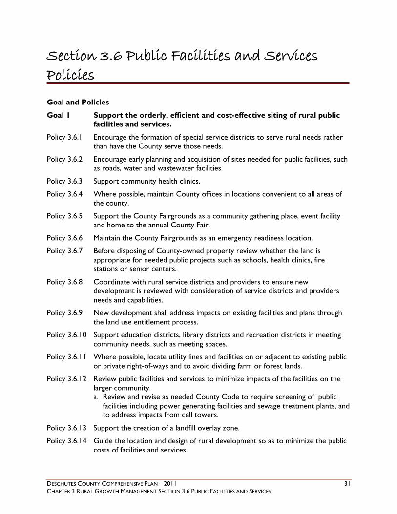
Section 3.6 Public Facilities and Services Policies
Goal and Policies
Goal 1 Support the orderly, efficient and cost-effective siting of rural public facilities and services.
Policy 3.6.1 Encourage the formation of special service districts to serve rural needs rather than have the County serve those needs.
Policy 3.6.2 Encourage early planning and acquisition of sites needed for public facilities, such as roads, water and wastewater facilities.
Policy 3.6.3 Support community health clinics.
Policy 3.6.4 Where possible, maintain County offices in locations convenient to all areas of the county.
Policy 3.6.5 Support the County Fairgrounds as a community gathering place, event facility and home to the annual County Fair.
Policy 3.6.6 Maintain the County Fairgrounds as an emergency readiness location.
Policy 3.6.7 Before disposing of County-owned property review whether the land is appropriate for needed public projects such as schools, health clinics, fire stations or senior centers.
Policy 3.6.8 Coordinate with rural service districts and providers to ensure new development is reviewed with consideration of service districts and providers needs and capabilities.
Policy 3.6.9 New development shall address impacts on existing facilities and plans through the land use entitlement process.
Policy 3.6.10 Support education districts, library districts and recreation districts in meeting community needs, such as meeting spaces.
Policy 3.6.11 Where possible, locate utility lines and facilities on or adjacent to existing public or private right-of-ways and to avoid dividing farm or forest lands.
Policy 3.6.12 Review public facilities and services to minimize impacts of the facilities on the larger community. a. Review and revise as needed County Code to require screening of public
facilities including power generating facilities and sewage treatment plants, and to address impacts from cell towers.
Policy 3.6.13 Support the creation of a landfill overlay zone.
Policy 3.6.14 Guide the location and design of rural development so as to minimize the public costs of facilities and services.

32 DESCHUTES COUNTY COMPREHENSIVE PLAN – 2011 CHAPTER 3 RURAL GROWTH MANAGEMENT SECTION 3.7 TRANSPORTATION
The Transportation System was adopted in Ordinance 2012-005 and is hereby incorporated into this Plan as Appendix C. The Deschutes County Transportation System Plan Map will be retained in official replica form as an electronic map layer within the County Geographic Information System and is adopted as part of this Comprehensive Plan.
Section 3.7 Transportation
DESCHUTES COUNTY COMPREHENSIVE PLAN – 2011 33 CHAPTER 3 RURAL GROWTH MANAGEMENT SECTION 3.8 RURAL RECREATION
Background
Recreation is an important quality of life issue for Deschutes County and recreational tourism is an important part of the economy (see Section 3.4). Both residents and visitors are drawn by the extensive public lands, seasonal climate and wide variety of activities and settings. Recreation opportunities include places set aside for specific activities such as campgrounds or sports fields as well as passive spaces such as natural areas. The primary focus of recreation in rural Deschutes County is outdoor recreation.
Outdoor activities promote healthy communities by encouraging people to enjoy an active lifestyle and by providing opportunities to reconnect with the natural world. The Central Oregon Visitor Association, a regional voice for the tourist industry, reported in their 2008 Annual Report that 2.5. million visitors came to Central Oregon in 2006, approximately 60% of whom were here for destination resort vacation travel. That report showed that in 2007 travel impacts for Deschutes County totaled over $470 million and supported over 5,400 jobs.
The Oregon Parks and Recreation Department is the agency responsible for overall coordination on park planning. That agency regularly produces a Statewide Comprehensive Outdoor Recreation Plan (SCORP) which helps in planning and ranking recreation needs.
Statewide Planning Goal 8, Recreation and Oregon Administrative Rule (OAR) 660-034 address recreation, but do not require local governments to provide park and recreation services. The County does not have a parks department. Instead it coordinates with the federal and state agencies, local park districts and private entities that provide park and recreational opportunities. Coordination assures that resources are used efficiently and duplication is avoided.
Federal Recreation
Recreation Opportunities on Federal Lands
The federal government, primarily the U.S. Forest Service and Bureau of Land Management, govern over 76% of the lands in the Deschutes County. Those lands are managed for a mix of uses, including recreation. They provide opportunities for a wide variety of outdoor activities such as hiking, hunting, off-road vehicle riding, rock climbing, kayaking or skiing.
Deschutes National Forest - Sustainable Recreation
The Deschutes National Forest is developing a strategy for sustainable recreation. A national team has been working on this concept and has drafted a framework. Recreational lands provide an opportunity to improve health through physical activity, contribute to local economies, provide needed environmental services such as clean water and preserve important national treasures.
At the same time, there are unprecedented challenges to providing quality recreation, including deteriorating recreation facilities, degraded natural areas, growth in demand for recreational spaces and facilities and inadequate funding.
Section 3.8 Rural Recreation

34 DESCHUTES COUNTY COMPREHENSIVE PLAN – 2011 CHAPTER 3 RURAL GROWTH MANAGEMENT SECTION 3.8 RURAL RECREATION
By focusing on the three spheres that frame sustainability - environmental, social and economic, and investing in a community’s ability to lead, a recreation program for the Deschutes National Forest has the potential to greatly contribute to the agency’s mission.
The majority of the National Forest lands are available for outdoor recreation including the defined areas listed below. Winter Recreation Areas – such as Crescent Lake Area, McKenzie Pass Area or Three
Creek Lake Area Resorts with Special Use Permits from the Deschutes National Forest such as Cultus Lake
Resort, Elk Lake Resort or Paulina Lake Resort Three Sisters Wilderness Area
Bureau of Land Management (BLM) The Upper Deschutes Resource Management Plan was completed by the Bureau of Land Management in 2005. The Plan directs management of approximately 400,000 acres of land in Central Oregon. It describes the overall vision and goals for the planning area and includes area-specific plans and objectives.
The majority of the Bureau of Land Management lands are available for outdoor recreation including the defined areas listed below. Recreation Areas – such as Cline Buttes Recreation Area, La Pine Recreation Area or
Millican Valley OHV Area Oregon Badlands Wilderness Area
Other Federal Recreation Sites The Newberry National Volcanic Monument Comprehensive Management Plan covers the Newberry National Volcanic and Newberry Crater National Monuments. The Upper Deschutes Wild and Scenic River and State Scenic Waterway Comprehensive Management Plan governs the federal and state wild and scenic rivers (Upper Deschutes River, Upper Whychus Creek).
State Recreation
Oregon Statewide Comprehensive Outdoor Recreation Plan (SCORP)
The SCORP, prepared by the Oregon Parks and Recreation Department (ORPD) was most recently competed and accepted by the National Park Service in 2008. The plan constitutes Oregon’s five-year plan for outdoor recreation (2008-2012). It also provides guidance for the Land and Water Conservation Fund (LWCF), a federal program that provides grants to state and local governments for land acquisition for outdoor recreation, and other ORPD grant programs. In most years, all states receive LWCF grant funds based on a national formula, with state population being the most influential factor. To qualify for statewide LWCF funding, each state must prepare a SCORP every five years. The primary purpose of the SCORP is to provide recommendations to the Oregon State Park System operations, administration, planning, development, and recreation programs. It also provides guidance for other OPRD-administered grant programs including the Local Grant, County Opportunity Grant, Recreational Trails and All-Terrain Vehicle Programs.
Oregon’s Scenic Waterways Act declares recreation, fish, and wildlife as the highest and best water uses in scenic waterways (ORS 390. 835 (1)). The Scenic Waterways Act and case law govern protection of these areas.

DESCHUTES COUNTY COMPREHENSIVE PLAN – 2011 35 CHAPTER 3 RURAL GROWTH MANAGEMENT SECTION 3.8 RURAL RECREATION
State Parks Cline Falls State Scenic Viewpoint La Pine State Park Pilot Butte State Scenic Viewpoint Smith Rock State Park (Internationally acclaimed rock climbing site) Tumalo State Park
Oregon Scenic Waterways Upper Deschutes River (segments) Middle Deschutes River (segments)
Oregon Scenic Byways Cascade Lakes Scenic Byway McKenzie Pass – Santiam Pass Scenic Byway
Local Recreation
There are four local park and recreation special service districts established in Deschutes County. Each is governed by an elected five member Board of Directors. Together they provide a variety of parks and recreational programs for their respective communities.
Bend Park and Recreation District
Bend Park and Recreation District maintains and operates more than 2,000 acres of developed and undeveloped parkland, that includes 74 parks and open spaces and 56 miles of trails. Over 770 recreation programs are offered and a number of special community events are held. In 2006, Bend Park and Recreation District received the National Gold Medal Award for excellence in Park and Recreation management. This award is given to the best park and recreation agency in the nation for its population category.
La Pine Park and Recreation District
The La Pine Park and Recreation District was established in 1990 and covers 85 square miles in south Deschutes County, including the City of La Pine. The first Board of Directors was elected at the time of formation, but a tax rate was not established or approved by voters until May, 2009. Before the tax was approved the district was managed by committed volunteers. The first director was hired in January, 2010 allowing the district to build a solid foundation for future growth.
Redmond Area Park and Recreation District
Redmond Area Park and Recreation District was established in 1975. The district's facilities include the Cascade Swim Center (CSC) and CSC Park, the RAPRD Activity Center, the High Desert Sports Complex, Borden Beck Park, and undeveloped parks at Majestic Ridge in Redmond and outside the city limits at Tetherow Crossing. The district sponsors a wide variety of recreation programs.
Sisters Park and Recreation District
The Sisters Park & Recreation District was established in 1998 under the name of an earlier non-profit called Sisters Organization of Activities and Recreation (SOAR). The district serves Sisters and the outlying areas of about 14,000 residents. In 2009 the name of the organization was changed from SOAR to Sisters Park & Recreation District.
36 DESCHUTES COUNTY COMPREHENSIVE PLAN – 2011 CHAPTER 3 RURAL GROWTH MANAGEMENT SECTION 3.8 RURAL RECREATION
County Parks
The only public parks the County maintains are a section of the County Fairgrounds and the Worrell Wayside in downtown Bend. However, although there is no County parks department, there are County-owned properties which are designated as park lands. Starting in 1994 the County began to designate certain sensitive properties along rivers, creeks or streams or with wildlife, wetlands or other values, as park lands. The intent was not to develop these lands for park use but rather to preserve lands with valuable resources. The park designation means that the lands would be retained in public ownership unless there was a public hearing and the Board of County Commissioners determined that selling was in the best interest of the public. ORS 275.330 governs the disposal of these lands, stating that if they are sold the proceeds must be dedicated to park or recreation purposes. As of 2009, there were approximately 70 properties designated as park lands. These lands were designated to protect resources such as water, wildlife or rivers (see Section 1.3).
Private Recreation
Private recreational sites are generally open to the public for a fee. They include destination resorts (see Section 3.9) and resort communities (see Section 4.7). Additionally there are 23 golf courses within an hour of Bend/Sunriver including award-winning layouts designed by Jack Nicklaus, Tom Fazio, David McLay Kidd, Peter Jacobsen and Tom Doak.
A different type of recreation is provided by the High Desert Museum. The nationally acclaimed High Desert Museum is dedicated to broadening the understanding of the High Desert's wildlife, culture, art and natural resources. In doing so, it strives to promote thoughtful decision making to sustain the region's natural and cultural heritage.
Notable Local Sites and Activities
The following are just a sample of the sites and activities available in Deschutes County.
Mt. Bachelor
Mt. Bachelor Ski Resort with a summit of over 9,000 feet, has over 3,700 acres of varied terrain for skiers, snowboarders and Nordic skiers. Mt. Bachelor also offers restaurants, ski shops and numerous activities, from snowshoeing in the winter to hiking in the summer.
Phil’s Trailhead System (Central Oregon Trail Alliance)
The Deschutes National Forest and Bureau of Land Management – Prineville District are recognized for having some of the best mountain biking in the nation. The Central Oregon Trail Alliance, in partnership with those agencies and other land managers build and maintain trails throughout Central Oregon. Central Oregon is a year-round destination for professional and amateur mountain bikers.
Cascade Cycling Classic
The Cascade Cycling Classic is the longest consecutively run elite stage race in the country and has attracted most of North America's top cyclists and teams over the years. The quality of the race courses, the beauty of Central Oregon and the fun atmosphere of the race has made it a perennial favorite and has the competitors returning year after year.

DESCHUTES COUNTY COMPREHENSIVE PLAN – 2011 37 CHAPTER 3 RURAL GROWTH MANAGEMENT SECTION 3.8 RURAL RECREATION
Fly Fishing
The Upper Deschutes River offers fly fishing opportunities for Brook, Brown and Rainbow trout. The Upper Deschutes River has easy access either by foot, boat or SUV. Fall River, a spring fed high mountain stream 25 miles southwest of Bend is a fly fishing only river in an attractive setting.
Off Highway Vehicles
The Deschutes National Forest and Bureau of Land Management offer numerous challenging off road vehicle trials.
Pole Peddle Paddle
The annual Pole, Pedal, Paddle event draws approximately 2,800 participants competing as teams, tandems and individuals in a race that includes both alpine and Nordic skiing, cycling, running, paddling and sprinting, from Mt. Bachelor Ski Resort to Bend’s Les Schwab Amphitheater.
Deschutes River Paddle Trail
The Deschutes Paddle Trail, sponsored by the Bend Paddle Trail Alliance includes the navigable sections of the Deschutes River and the Little Deschutes River in Deschutes County, along with nine of the largest Cascade lakes in the County.
Although the Deschutes Paddle Trail has sections that everyone can safely enjoy, the levels of difficulty include everything from placid easy sections (Class I) to very difficult (and dangerous) sections (Class V) that are for experts only.
Recreational Trends
As of 2009 there were two groups working on separate aspects of recreation planning.
Ad Hoc Committee on Recreational Assets: This committee was created in 2007 to promote economic development, local quality of life and health and wellness. County Commissioner Tammy Baney was co-chair of this committee. The committee identified and prioritized specific improvement projects that will enhance the County’s recreational assets based on the following principles: Restore healthy forests in the area bounded by the Deschutes River, Elk Lake and Skyline
Forest; Promote accessible, dispersed recreation to diverse activities and skill sets; Promote connectivity between towns; Leverage project investment with user group contributions; Coordinate with the Trust for Public Lands.
Deschutes County Greenprint: The non-profit Trust for Public Lands led a collaborative County-wide effort in 2007-2010 to identify lands with important natural resource, open space or recreational value. They also provided strategies for obtaining the funding needed to purchase and manage the lands recommended for preservation. Deschutes County was a partner in this effort (see Section 1.3).
38 DESCHUTES COUNTY COMPREHENSIVE PLAN – 2011 CHAPTER 3 RURAL GROWTH MANAGEMENT SECTION 3.8 RURAL RECREATION
Future Opportunities
With federal and state agencies as well as four local park and recreation districts, it is important to work cooperatively to assure wise use of scarce resources. The results of the Recreation Assets Committee and the Trust for Public lands will be useful in providing guidance on priority recreational projects and lands. One potential area for cooperation that came out of the public outreach for this Plan was working with federal and state agencies to ensure safe and convenient access to rivers and streams.
Trails are an element of park and recreation planning where the County has the potential for active involvement. Many of the initiatives identified by the Committee on Recreational Assets are related to trails. There are numerous trails throughout the County and region that have been created and are maintained by various agencies and organizations. The goal is to tie these trails together to make movement between areas possible. Besides connecting trails, there also needs to be work done to minimize the conflicts between hikers, equestrians and bicyclists. Each of these groups has different needs from a trail system.
Recreation planning always needs to address the concern that growth will lead to overuse and degradation of the assets that attract user groups. The demand for recreation can lead to crowds at wilderness areas, trails and mountain lakes, impacting the experience. Working cooperatively with all stakeholders will assure that recreation planning minimizes these potential conflicts and maximizes the available recreational opportunities.
DESCHUTES COUNTY COMPREHENSIVE PLAN – 2011 39 CHAPTER 3 RURAL GROWTH MANAGEMENT SECTION 3.8 RURAL RECREATION
Section 3.8 Rural Recreation Policies
Goal and Policies
Goal 1 Promote a variety of passive and active park and recreation opportunities through a regional system that includes federal and state parks and local park districts.
Policy 3.8.1 Cooperate with public agencies and local park districts to provide park and recreation lands, facilities and opportunities. a. The Statewide Comprehensive Outdoor Recreation Plan and State Park
Master Plans shall serve as a basis for coordination on County-wide park and recreation issues.
b. Support exceptions to Statewide Planning Goals for urban fringe areas owned or acquired and operated by park and recreation districts.
Policy 3.8.2 Work cooperatively with public agencies to promote standards for consolidation of public land access and to ensure recreational entry to those lands, especially along rivers and streams.
Policy 3.8.3 Encourage coordination between the U.S. Forest Service, the Bureau of Land Management and off-road vehicle organizations to regulate use of motorized vehicles, including motorbikes, ATVs and snowmobiles in order to minimize environmental degradation, agricultural fragmentation and user conflicts on private property.
Policy 3.8.4 Participate in federal recreation planning on federal lands and state park planning on State lands.
Policy 3.8.5 Support accessible park and recreation opportunities in compliance with the Americans with Disabilities Act.
Policy 3.8.6 Support efforts to coordinate recreation planning between park and recreation districts, school districts, irrigation districts and cities.
Policy 3.8.7 Work with Unincorporated Communities that express an interest in parks, open spaces and community centers.
Policy 3.8.8 Coordinate trail design and funding with transportation system plans and support efforts to provide and manage rural trail segments and bicycle routes.
Policy 3.8.9 Support the Committee on Recreational Assets in identifying priority recreational projects, including incorporating as appropriate, elements of the Committee on Recreational Assets into this Plan.
Policy 3.8.10 Update County Code as needed to define rural recreational uses such as private parks.
40 DESCHUTES COUNTY COMPREHENSIVE PLAN – 2011 CHAPTER 3 RURAL GROWTH MANAGEMENT SECTION 3.9 DESTINATION RESORTS
Background
Since 1979 destination resorts have increased in importance to the economy of Deschutes County In 1989, recognizing the importance of tourism to the economy of the State of Oregon, the state legislature and the Land Conservation and Development Commission (“LCDC”) took steps to make it easier to establish destination resorts on rural lands in the state. Statewide Planning Goal 8, the recreation goal, was amended to specify a process for locating destination resorts on rural land without taking an exception to Goals 3, 4, 11 and 14, which govern development in rural resource lands. This was followed by legislation incorporating Goal 8 into Oregon's land use statutes. By these actions, the State of Oregon recognized destination resorts as a legitimate rural land use. Under these changes, destination resorts may be sited in EFU zones where they weren't allowed before.
Following the changes to the state regulations, because implementation of destination resort siting under Goal 8 was optional and the county had not undertaken that implementation, the developers of Eagle Crest applied for legislative changes in the County's comprehensive plan and implementing land use ordinances. The Eagle Crest developers wished to expand their current destination resort onto adjacent lands and wished to do so without going through the exceptions process. They were able to do so when the County adopted a destination resort overlay map. In order, Pronghorn, Caldera Springs, and Tetherow resorts have been sited since that time. Resorts existing prior to the legislative change, such as Black Butte, Sunriver and the Inn of the Seventh Mountain have also expanded and been rezoned to Urban Unincorporated Community and Resort Community, respectively.
In March 1990, LCDC adopted the “forest rule.” This rule allows destination resorts to be sited on forest lands pursuant to Goal 8. The county adopted this rule for land zoned Forest Use-2. Additionally, the legislature, in 2003, amended the state statutes, adding new language allowing counties to remap eligible lands for destination resorts not more frequently than once every thirty (30) months. Remapping is now dependent on creating a process for collecting and processing all proposed map amendments submitted to the county within that thirty (30) month planning period.
In order to allow destination resorts within the county, Goal 8 requires that Deschutes County adopt a map showing which lands are available for destination resort development. The purpose of the map is to provide greater certainty concerning destination resort siting than is available under the exceptions process. To protect forest and farm resources, Goal 8 prescribes that certain classes of lands are off limits to destination resort development. The final map must reflect exclusion of such areas. However, although a property is mapped as eligible for a destination resort, a destination resort may not be permitted outright in that location. In order to be approved, a proposal for a resort must be processed as a conditional use and must comply with the specific standards and criteria established by the county for destination resorts.
Goal 8 and the state statute also recognize that destination resorts can have negative impacts on neighborhoods, transportation facilities and the rural quality of life. These impacts can, however, be substantially mitigated. The County recognizes the importance of balancing protection mechanisms for resource lands and rural land uses with the economic benefits destination
Section 3.9 Destination Resorts

DESCHUTES COUNTY COMPREHENSIVE PLAN – 2011 41 CHAPTER 3 RURAL GROWTH MANAGEMENT SECTION 3.9 DESTINATION RESORTS
resorts provide. The County further recognizes that this balance can be struck by the manner in which areas are designated as being available for destination resort development and by establishing thorough siting criteria. In establishing these thorough siting criteria, the County recognizes that it has the option to be more restrictive than state law in the areas it chooses to exclude from destination resort siting through the mapping process.

42 DESCHUTES COUNTY COMPREHENSIVE PLAN – 2011 CHAPTER 3 RURAL GROWTH MANAGEMENT SECTION 3.9 DESTINATION RESORTS
Section 3.9 Destination Resort Policies Goals and Policies
Goal 1 To provide for development of destination resorts in the County consistent with Statewide Planning Goal 8 in a manner that will be compatible with farm and forest uses, existing rural development, and in a manner that will maintain important natural features, such as habitat of threatened or endangered species, streams, rivers and significant wetlands.
Goal 2 To provide a process for the siting of destination resorts on rural lands that have been mapped by Deschutes County as eligible for this purpose.
Goal 3 To provide for the siting of destination resort facilities that enhances and diversifies the recreational opportunities and economy of Deschutes County.
Goal 4 To provide for development of destination resorts consistent with Statewide Planning Goal 12 in a manner that will ensure the resorts are supported by adequate transportation facilities.
Policy 3.9.1 Destination resorts shall only be allowed within areas shown on the “Deschutes County Destination Resort Map” and when the resort complies with the requirements of Goal 8, ORS 197.435 to 197.467, and Deschutes County Code 18.113.
Policy 3.9.2 Applications to amend the map will be collected and will be processed concurrently no sooner than 30 months from the date the map was previously adopted or amended.
Policy 3.9.3 Mapping for destination resort siting. a. To assure that resort development does not conflict with the objectives of
other Statewide Planning Goals, destination resorts shall pursuant to Goal 8 not be sited in Deschutes County in the following areas: 1. Within 24 air miles of an urban growth boundary with an existing
population of 100,000 or more unless residential uses are limited to those necessary for the staff and management of the resort;
2. On a site with 50 or more contiguous acres of unique or prime farm land identified and mapped by the Soil Conservation Service or within three miles of farm land within a High-Value Crop Area;
3. On predominantly Cubic Foot Site Class 1 or 2 forest lands which are not subject to an approved Goal exception;
4. On areas protected as Goal 5 resources in an acknowledged comprehensive plan where all conflicting uses have been prohibited to protect the Goal 5 resource;
5. Especially sensitive big game habitat, and as listed below, as generally mapped by the Oregon Department of Fish and Wildlife in July 1984 and

DESCHUTES COUNTY COMPREHENSIVE PLAN – 2011 43 CHAPTER 3 RURAL GROWTH MANAGEMENT SECTION 3.9 DESTINATION RESORTS
as further refined through development of comprehensive plan provisions implementing this requirement. i. Tumalo deer winter range; ii. Portion of the Metolius deer winter range; iii. Antelope winter range east of Bend near Horse Ridge and Millican;
6. Sites less than 160 acres.
b. To assure that resort development does not conflict with Oregon Revised Statute, destination resorts shall not be sited in Deschutes County in Areas of Critical State Concern.
c. To assure that resort development does not conflict with the objectives of Deschutes County, destination resorts shall also not be located in the following areas: 1. Sites listed below that are inventoried Goal 5 resources, shown on the
Wildlife Combining Zone, that the County has chosen to protect: i. Antelope Range near Horse Ridge and Millican; ii. Elk Habitat Area; and iii. Deer Winter Range;
2. Wildlife Priority Area, identified on the 1999 ODFW map submitted to the South County Regional Problem Solving Group;
3. Lands zoned Open Space and Conservation (OS&C); 4. Lands zoned Forest Use 1 (F-1); 5. Irrigated lands zoned Exclusive Farm Use (EFU) having 40 or greater
contiguous acres in irrigation; 6. Non-contiguous EFU acres in the same ownership having 60 or greater
irrigated acres; 7. Farm or forest land within one mile outside of urban growth boundaries; 8. Lands designated Urban Reserve Area under ORS 195.145; 9. Platted subdivisions;
d. For those lands not located in any of the areas designated in Policy 3.9.3(a) though (c), destination resorts may, pursuant to Goal 8, Oregon Revised Statute and Deschutes County zoning code, be sited in the following areas: 1. Forest Use 2 (F-2), Multiple Use Agriculture (MUA-10), and Rural
Residential (RR-10) zones; 2. Unirrigated Exclusive Farm Use (EFU) land; 3. Irrigated lands zoned EFU having less than 40 contiguous acres in
irrigation; 4. Non-contiguous irrigated EFU acres in the same ownership having less
than 60 irrigated acres; 5. All property within a subdivision for which cluster development approval
was obtained prior to 1990, for which the original cluster development approval designated at least 50 percent of the development as open space and which was within the destination resort zone prior to the effective date of Ordinance 2010-024 shall remain on the eligibility map;
6. Minimum site of 160 contiguous acres or greater under one or multiple ownerships;

44 DESCHUTES COUNTY COMPREHENSIVE PLAN – 2011 CHAPTER 3 RURAL GROWTH MANAGEMENT SECTION 3.9 DESTINATION RESORTS
e. The County shall adopt a map showing where destination resorts can be located in the County. Such map shall become part of the Comprehensive Plan and Zoning Ordinance and shall be an overlay zone designated Destination Resort (DR).
Policy 3.9.4 Ordinance provisions. a. The County shall ensure that destination resorts are compatible with the site
and adjacent land uses through enactment of land use regulations that, at a minimum, provide for the following: 1. Maintenance of important natural features, including habitat of threatened
or endangered species, streams, rivers, and significant wetlands; maintenance of riparian vegetation within 100 feet of streams, rivers and significant wetlands; and
2. Location and design of improvements and activities in a manner that will avoid or minimize adverse effects of the resort on uses on surrounding lands, particularly effects on intensive farming operations in the area and on the rural transportation system. In order to adequately assess the effect on the transportation system, notice and the opportunity for comment shall be provided to the relevant road authority.
3. Such regulations may allow for alterations to important natural features, including placement of structures, provided that the overall values of the feature are maintained.
b. Minimum measures to assure that design and placement of improvements and activities will avoid or minimize the adverse effects noted in Policy 3.9.4(a) shall include: 1. The establishment and maintenance of buffers between the resort and
adjacent land uses, including natural vegetation and where appropriate, fenced, berms, landscaped areas, and other similar types of buffers.
2. Setbacks of structures and other improvements from adjacent land uses.
c. The County may adopt additional land use restrictions to ensure that proposed destination resorts are compatible with the environmental capabilities of the site and surrounding land uses.
d. Uses in destination resorts shall be limited to visitor- oriented accommodations, overnight lodgings, developed recreational facilities, commercial uses limited to types and levels necessary to meet the needs of visitors to the resort, and uses consistent with preservation and maintenance of open space.
e. The zoning ordinance shall include measures that assure that developed recreational facilities, visitor-oriented accommodations and key facilities intended to serve the entire development are physically provided or are guaranteed through surety bonding or substantially equivalent financial assurances prior to closure of sale of individual lots or units. In phased developments, developed recreational facilities and other key facilitated intended to serve a particular phase shall be constructed prior to sales in that phase or guaranteed through surety bonding.

DESCHUTES COUNTY COMPREHENSIVE PLAN – 2011 45 CHAPTER 3 RURAL GROWTH MANAGEMENT SECTION 3.10 AREA SPECIFIC POLICIES
Background
There are rural areas around the County experiencing specific challenges that could benefit from a more detailed review. Using public outreach and in-depth analysis, the County can respond to the unique values and issues in defined areas. This can be done through community plans or simply adding specific policies.
Three areas have been identified for area specific plans or policies; South County, Deschutes Junction and the Oregon Military site. Deschutes County adopted a plan for South County in 2013 (see Section 3.11, Newberry Country: A Plan for Southern Deschutes County ). Other areas where community plans or policies might be initiated are Deschutes River Woods and east County. Deschutes County is committed to cooperating with residents on creating specific community plans or policies as requested and as resources permit.
Other Area Specific Policies
Oregon Military Site
The Oregon Military Department has real property interests in lands outside Redmond that is used for military training. Concerns were raised by that department that the noise of their operations could disturb neighboring properties and the use of the land could be questioned. Developing an overlay zone that requires the military be notified of new development and new development be notified of the military’s right to continue operations, would protect the interests of both parties.
Deschutes Junction
A community plan was initiated for the Deschutes Junction area, which includes lands designated Rural Industrial and Rural Commercial. There has been some discussion about whether this area should have been designated as a Rural Service Center during the unincorporated community evaluations. After considerable debate, policies for Deschutes Junction were adopted in Ordinance 2011-005 and incorporated into this Plan in Ordinance 2011-027.
Crooked River Ranch
Crooked River Ranch, a rural subdivision located between the Deschutes and Crooked Rivers, straddles Deschutes and Jefferson counties. It has the largest homeowner association in Oregon and contains approximately 4,000 people. Access to this development occurs in Deschutes County, underscoring the importance of coordinating regularly with its residents and Jefferson County to assure safe, convenient travel routes.
Section 3.10 Area Specific Plans and Policies

46 DESCHUTES COUNTY COMPREHENSIVE PLAN – 2011 CHAPTER 3 RURAL GROWTH MANAGEMENT SECTION 3.10 AREA SPECIFIC POLICIES
Section 3.10 Area Specific Policies Goals and Policies
Goal 1 Create area specific land use policies and/or regulations when requested by a community and only after an extensive public process.
Policy 3.10.1 Maintain a list of communities interested in area specific policies and as resources permit, initiate public processes to address local issues.
South Deschutes County
Policy 3.10.2 Develop a south county community plan and adopt it as a subsection of this Plan.
Oregon Military Site
Policy 3.10.3 Support an overlay zone for property owned and/or utilized by the Oregon Military Department to protect the military site and neighboring properties from noise and land use conflicts.
Regional Coordination
Policy 3.10.4 Coordinate with Jefferson County and Crooked River Ranch residents as needed.
Deschutes Junction
Policy 3.10.5 Maximize protection of the rural character of neighborhoods in the Deschutes Junction area while recognizing the intended development of properties designated for commercial, industrial and agricultural uses.
Policy 3.10.6 Review cumulative impacts of future development and future traffic improvements in the Deschutes Junction area in a manner consistent with Deschutes County traffic study requirements at 17.16.115, the Oregon Highway Plan, access management standards of OAR Chapter 734, Division 51, and OAR Chapter 660, Division 12, the Transportation Planning Rule (TPR).
Policy 3.10.7 Support safe and efficient travel around Deschutes Junction, including a frontage road extending north from Tumalo Road on the west side of Highway 97.
Policy 3.10.8 Review Policies 3.10.11 through 3.10.13 and initiate a Deschutes Junction Master Plan.

DESCHUTES COUNTY COMPREHENSIVE PLAN – 2011 47 CHAPTER 3 RURAL GROWTH MANAGEMENT SECTION 3.10 AREA SPECIFIC POLICIES
Section 3.11 Newberry Country: A Plan for Southern Deschutes County
Background
Newberry Country: A Plan for Southern Deschutes County was adopted in Ordinance 2013-007 and is hereby incorporated into this Plan as Appendix D.

48 DESCHUTES COUNTY COMPREHENSIVE PLAN – 2011 CHAPTER 3 RURAL GROWTH MANAGEMENT REFERENCES
Chapter 3 Primary References
References1
1. Oregon Department of Land Conservation and Development. Goal 7: Areas Subject to Natural Disasters and Hazards. Oregon’s Statewide Planning Goals and Guidelines.
2. Oregon Department of Land Conservation and Development. Goal 8: Recreation Needs. Oregon’s Statewide Planning Goals and Guidelines.
3. Oregon Department of Land Conservation and Development. Goal 9: Economic Development. Oregon’s Statewide Planning Goals and Guidelines.
4. Oregon Department of Land Conservation and Development. Goal 10: Housing. Oregon’s Statewide Planning Goals and Guidelines.
5. Oregon Department of Land Conservation and Development. Goal 11: Public Facilities and Services. Oregon’s Statewide Planning Goals and Guidelines.
6. Oregon Department of Land Conservation and Development. Goal 12: Transportation. Oregon’s Statewide Planning Goals and Guidelines.
7. Central Oregon Regional Housing Authority (Housing Works) website at http://www.oregonhousingworks.org
8. Economic Development for Central Oregon website at http://www.edcoinfo.com
9. Improving Deschutes County’s Competitiveness: Business Location and Retention Factors. A report by Headwaters Economics in partnership with Economic Development for Central Oregon. July 2010.
10. Oregon Department of Land Conservation and Development. Natural Hazards Program. 2003
11. Oregon Department of Land Conservation and Development. Planning for Natural Hazards: Oregon Technical Resource Guide. 2002
12. 2006 Deschutes County Natural Hazards Mitigation Plan
13. 2010 Deschutes County Natural Hazards Mitigation Plan
14. Deschutes County Community Wildfire Protection Plans
15. Upper Deschutes Fire Learning Network. Upper Deschutes Basin website at http://www.tncfire.org
16. D.R. Sherrod, L.G. Mastin, W.E Scott, S.P. Schilling. Volcano Hazards at Newberry Volcano, Oregon. U.S. Geological Survey Open-File Report 97-513
17. W.E. Scott, R.M. Iverson, S.P. Schilling, B.J. Fisher. Volcano Hazards in the Three Sisters Region, Oregon. UlSl Geological Survey Open-File Report 99-437
1 The references listed are provided for the convenience of the public and are not legally adopted into this Plan.

DESCHUTES COUNTY COMPREHENSIVE PLAN – 2011 49 CHAPTER 3 RURAL GROWTH MANAGEMENT REFERENCES
18. Oregon Revised Statute 197.435-197.467 Siting of Destination Resorts2
19. Oregon Administrative Rules Chapter 660 particularly: a. 660-008 Interpretation of Goal 10 Housing b. 660-009 Economic Development c. 660-011 Public Facilities d. 660-012 Transportation
2 The references listed are provided for the convenience of the public and are not legally adopted into this Plan.