chapter 3 – environment and...
TRANSCRIPT
Environment & Effects - 3
Chapter 3 – Environment and Effects
3.0 Environmental Effects Introduction 3-1
3.1 Fuels Management 3-3
3.2 Forest Vegetation Resource 3-29
3.3 Fisheries Resource 3-41
3.4 Water Resource 3-53
3.5 Soils Resource 3-65
3.6 Wildlife Resource 3-77
3.7 Access Management 3-119
3.8 Other Disclosures 3-125

3– Environment & Effects
Environment & Effects - 3
Chapter 3
3.0 Environmental Effects Introduction This chapter describes the physical, biological, and human aspects of the environment that may be affected by the alternatives presented in Chapter 2. It also describes the expected effects of the alternatives on those environmental aspects.
Chapter 3 is organized by resources and includes resources that are associated with issues and purpose and need elements in Chapter 1 that are key components of the environment or that must be analyzed due to law, regulation, or policy.
Each resource section includes the following information:
• Resource Title • Purpose & Need Statements and/or Issues • Forest Plan Direction • Scope of the Analysis • Environmental Effects
Each resource section is based on a specialist’s analysis. Additional information on the affected environment for each resource is included in the specialist’s reports. These analyses and reports are located within the Cuprum Fuels Reduction EA project record.
Forest Plan Direction This section describes Forest Plan direction for the resource.
Scope of Analysis This section describes the spatial (geographical) boundaries and timeframes used for analysis of each resource. The spatial scope of analysis may be the project area, watershed, big-game hunting zone, economic zone of influence, or west side of the Forest depending on the affected resource over temporary (less than 3 years), short (3-15 years), or long term (greater than 15 years) time frames.
Environmental Effects The environmental effects section forms the scientific and analytic basis for the comparison of alternatives presented in Chapter 2. NEPA (National Environmental Policy Act) regulations recognize three categories of effects:
Cuprum Fuels Reduction Project 3-1

3– Environment & Effects
• Direct effects are caused by an action and occur at the same time and place.
• Indirect effects are caused by an action, but occur at a later time or different place.
• Cumulative effects result from the incremental impact of an action when added to other past, present, and reasonably foreseeable actions, regardless of what agency or person undertakes the other actions (40 CFR 1508.7 and 8).
The no action/effects of failing to implement alternative provides the baseline, or current condition for the indicators used to evaluate the purpose and need and issues related to this project. It discloses the current condition and potential effects on the indicators in the event the project is not implemented as required by the Healthy Forest Restoration Act (USDA, The Healthy Forest Initiative and Health Forest Restoration Act Interim Field Guide - page 10, 2004).
3-2 Cuprum Fuels Reduction Project

Fuels Management - 3
3.1 Fuels Management
Purpose and Need Reduce understory fuel laddering and increase the crown spacing to lower the risk of uncharacteristic or undesirable wildland fires.
Measurements:
• Changes in predicted fire behavior (flame length, rate of spread, and potential fire type)
• Acres treated to restore more fire-resilient forest structure
Background for Measurements Three computer models, NEXUS 2.0 (NEXUS), Fire Management Analysis Plus (FMA), and First Order Fire Effects Model 5.21 (FOFEM), were used to analyze the potential fire behavior and fire effects of each alternative. FMA was used to determine vegetative changes resulting from mechanical and prescribed fire treatments. NEXUS, which links models of surface and crown fire behavior (Scott and Reinhardt 2001), was used to assess potential flame lengths, rates of spread, and crown fire. FOFEM (Reinhardt et al. 1997) was used to make additional predictions about coarse woody debris consumption as well as smoke production. Fuel loadings and vegetative characteristics were modeled using data from a current and similar fuels reduction project near this project location. These models do not predict whether a fire would occur, nor would they estimate the probability of a fire ignition. The models are only used to predict fire behavior as if a fire did occur. These models provide a means to compare alternatives and are the best science available for this analysis.
Forest Plan Direction The 2003 Payette National Forest Land and Resource Management Plan (Forest Plan) establishes goals, objectives, standards, and management direction for fire management and other Forest resources. A desired condition of Fire Management expressed in the Plan calls for the use of prescribed and wildland fire to achieve and maintain vegetative conditions and desired fuel levels. Goals, objectives, and standards related to the proposed fuels reduction adjacent to Cuprum relevant to reaching the desired condition include (Forest Plan pp. III-16, 30, 38-40):
FMG003- Use fire alone or with other management activities to restore or maintain desirable plant community attributes including fuel levels, as well as ecological processes.
Cuprum Fuels Reduction Project 3-3
3– Environment & Effects
FMG004- Use fire alone or other management activities to treat natural and activity fuels to a level that reduces the risk of uncharacteristic or undesirable wildland fires.
FMG005- Provide for protection of life, investments, and valuable resources through appropriate vegetation, fuel and wildland fire management.
FMG006- Encourage and participate in partnerships with citizens or community-centered approaches to manage fire risks and hazards in wildland/urban interface areas.
FMOB01- Reduce fire fighter and public injuries and loss of life, and damage to communities from severe, unplanned and unwanted, wildland fires by prioritizing fire fighter, public, and community safety above other concerns in fire management activities.
FMOB02- During project planning, identify appropriate areas where prescribed fire could be used to meet management objectives. These areas may include intermingled land ownership, and areas of concentrated investments, structures and other resource concerns.
FMOB04- Schedule and complete at least 100,000 acres of fuels management through prescribed fire and mechanical treatments in the next decade to achieve desired vegetation attributes and fuel reduction goals. Focus on wildland/urban interface and in Fire Regimes 1, 2, and 3 (non-lethal, mixed 1, mixed 2) in condition classes 2 and 3 (moderate to extreme hazard rating).
FMOB05- Continue to identify high fire hazard areas in the wildland urban interface area. Develop and prioritize vegetation treatments plans in coordination with local and tribal governments, agencies, and landowners to reduce the risk from wildfire.
FMOB07- Coordinate vegetation management activities and partnership opportunities with local land managers and owners for wildland fire suppression and use, and prescribed fire.
ASOB03- Use a variety of management tools, including prescribed fire and Wildland Fire Use (for Resource Benefits), to help manage vegetation to reduce potential smoke impacts from uncharacteristic wildfire.
ASGO02- Manage smoke, while achieving land management objectives, to provide for desirable air quality and visibility.
Scope of the Analysis The direct and indirect effects of the alternatives on fire and fuels management will be analyzed for National Forest System lands within the Cuprum Fuels Reduction Project area including portions of the Indian Creek Sub-watershed.
3-4 Cuprum Fuels Reduction Project
Fuels Management - 3
The cumulative effects of the alternatives in relation to fire and fuels management will be analyzed across all ownerships within the Cuprum Fuels Reduction Project area.
Environmental Effects Risk and hazard are important terms to understand in the context of fuels and fire management. Risk is a fire causative agent, such as lightning or human-caused ignition. Hazard is a rating assigned to a fuel complex (defined in this analysis by fuel models) that reflects its susceptibility to ignition, the fire behavior, including the intensity and severity it would support, and/or the suppression difficulty it represents. Hazard ratings are generally expressed in subjective terms ranging from low to extreme (Deeming 1990).
Alternative A—No Action/Effects of Failing to Implement
Acres of Changed Fuel Conditions and Associated Fire Behavior Hazard values within the project area are derived by examining the fuel complex, the responsiveness of the fuels to fire, and the difficulty of suppression of undesired wildfire. Pre-treatment conditions of fuels within the project area increase the overall hazard of uncharacteristic high severity/high intensity fires occurring near the community of Cuprum. Fires occurring in the existing fuels have the potential to move rapidly from the surface into the crowns of overstory trees. Such fires would exhibit rapid rates of spread and larger flame lengths making suppression difficult, if not impossible, in many of the dense stands adjacent to Cuprum.
Failing to implement the proposed project would result in none of the acres of surface fuels being treated. There would be no reduction in surface fuels and no subsequent decrease in potential flame lengths. Without treatment, ladder fuels would become more abundant, both vertically and horizontally; canopy base heights would continue to decrease. Ladder fuels are continuous vertical vegetation that connects surface fuels to the crown fuels of overstory trees, forming a ladder by which a fire can spread into tree and/or shrub crowns (DeBano et al. 1998). A lowering of base heights would increase the potential for surface fires to create enough energy to preheat and combust fuels well above the surface. This initial “torching” initiates the spread of fire into the crowns of the larger diameter overstory trees as smaller saplings and pole-sized trees catch fire. Without thinning, stand density would continue to increase and canopy bulk densities would rise to levels that would more easily sustain a crown fire. Historically, within the project area, these types of fires were rare and generally limited to smaller scale patches of less fire tolerant tree species (Barrett 1994).
Cuprum Fuels Reduction Project 3-5
3– Environment & Effects
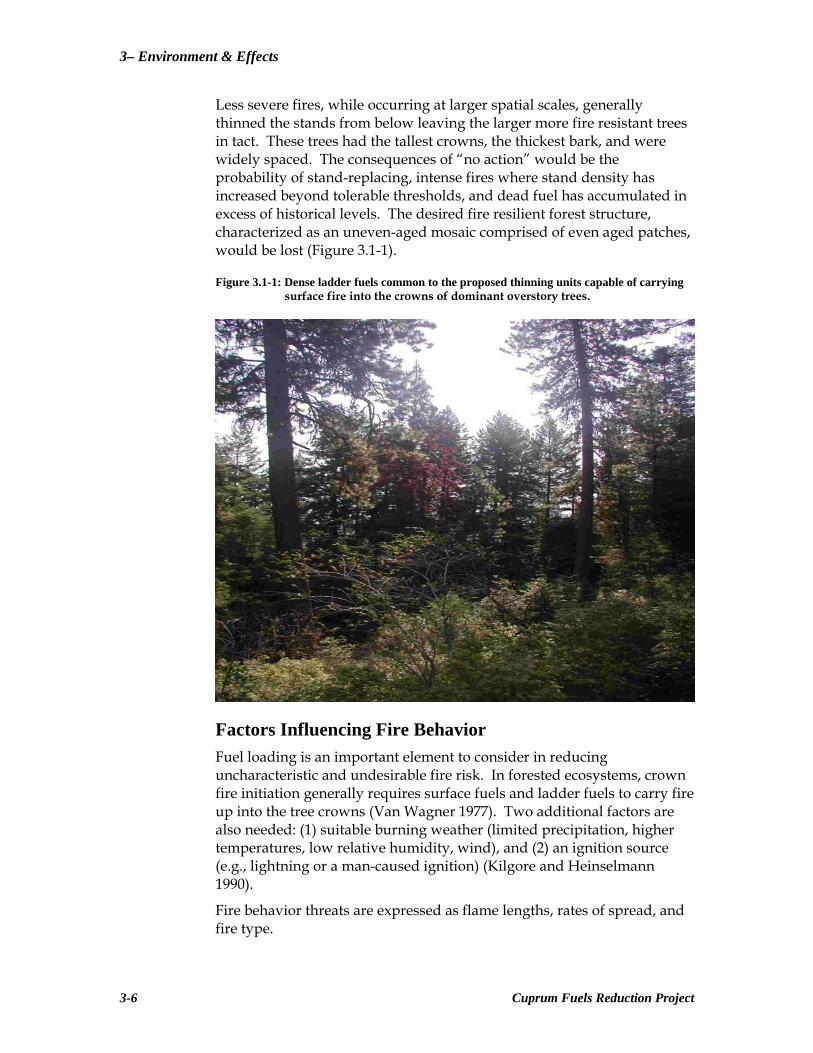
Less severe fires, while occurring at larger spatial scales, generally thinned the stands from below leaving the larger more fire resistant trees in tact. These trees had the tallest crowns, the thickest bark, and were widely spaced. The consequences of “no action” would be the probability of stand-replacing, intense fires where stand density has increased beyond tolerable thresholds, and dead fuel has accumulated in excess of historical levels. The desired fire resilient forest structure, characterized as an uneven-aged mosaic comprised of even aged patches, would be lost (Figure 3.1-1).
Figure 3.1-1: Dense ladder fuels common to the proposed thinning units capable of carrying surface fire into the crowns of dominant overstory trees.
Factors Influencing Fire Behavior Fuel loading is an important element to consider in reducing uncharacteristic and undesirable fire risk. In forested ecosystems, crown fire initiation generally requires surface fuels and ladder fuels to carry fire up into the tree crowns (Van Wagner 1977). Two additional factors are also needed: (1) suitable burning weather (limited precipitation, higher temperatures, low relative humidity, wind), and (2) an ignition source (e.g., lightning or a man-caused ignition) (Kilgore and Heinselmann 1990).
Fire behavior threats are expressed as flame lengths, rates of spread, and fire type.
3-6 Cuprum Fuels Reduction Project
Fuels Management - 3
Flame lengths are measured in feet from the base of the flame to the top of the flame, and are directly related to fireline intensity (Andrews 1986). The rate of spread is how fast the flaming front of the fire moves, and is generally expressed in chains/hr (Andrews 1986). One chain (ch) equals 66 ft. Fire type describes the potential fire, and is dependent on the fuel conditions. A ground fire is a fire that burns the organic material in the upper soil layer. A surface fire burns only surface fuels, and a crown fire is one that advances from top to top of trees and/or shrubs (DeBano et al. 1998).
Weather Conditions Weather conditions are critical to fire behavior outputs. For this project analysis weather data from the Snake River RAWS (Remote Automated Weather Station) located less than two and one half miles from the center of the project area was used. Weather data from 1985-2006 for the typical fire season months of May-October were generated using Fire Family Plus, a modeling program which links extensive weather data and fire danger predictions. For this analysis, the conditions typical of a very high fire danger rating were used. These types of weather conditions occur only 10% of the time and strongly correlate to days when fires could be expected to become larger more frequently, thus challenging fire managers tasked with fire protection.
Fuels
Existing fuel conditions are described using Anderson’s (1982) fuel models and canopy fuel conditions. Fuel models are a set of mathematical equations that describe physical fuel properties, including fuel loading by size and fuel bed depth (Anderson 1982). These fuel models are used to predict fire behavior according to surface fuel conditions. Fuel loading refers to the amount of fuel on the ground while fuel bed depth refers to the average depth of the fuel from ground level. The moisture of extinction is the fuel moisture at which fire will not spread.
Canopy bulk density, canopy base height, and canopy fuel load are used to describe canopy fuel conditions.
Canopy bulk density is the mass of available canopy fuel per unit canopy volume (Scott and Reinhardt 2005). Canopy base height is the distance from the ground surface to the base of the live crown (Scott and Reinhardt 2005). Canopy fuel load is the mass of available canopy fuel per unit ground area (Scott and Reinhardt 2005). Crowning Index is the open 20-ft windspeed at which an active crown fire is possible.
The threat of crown fire can be reduced by altering canopy bulk density, canopy base height, and canopy fuel load (Scott and Reinhardt 2001).
Cuprum Fuels Reduction Project 3-7
3– Environment & Effects
Fuel plot data were analyzed in Crown Mass™-Assessment of Potential Fire Behavior (Fire Program Solutions/Acacia Services 1999-2001) to determine canopy bulk density, canopy base height, and canopy fuel load of specific forested stands within the project area as well as areas adjacent to the forested areas proposed for treatment.
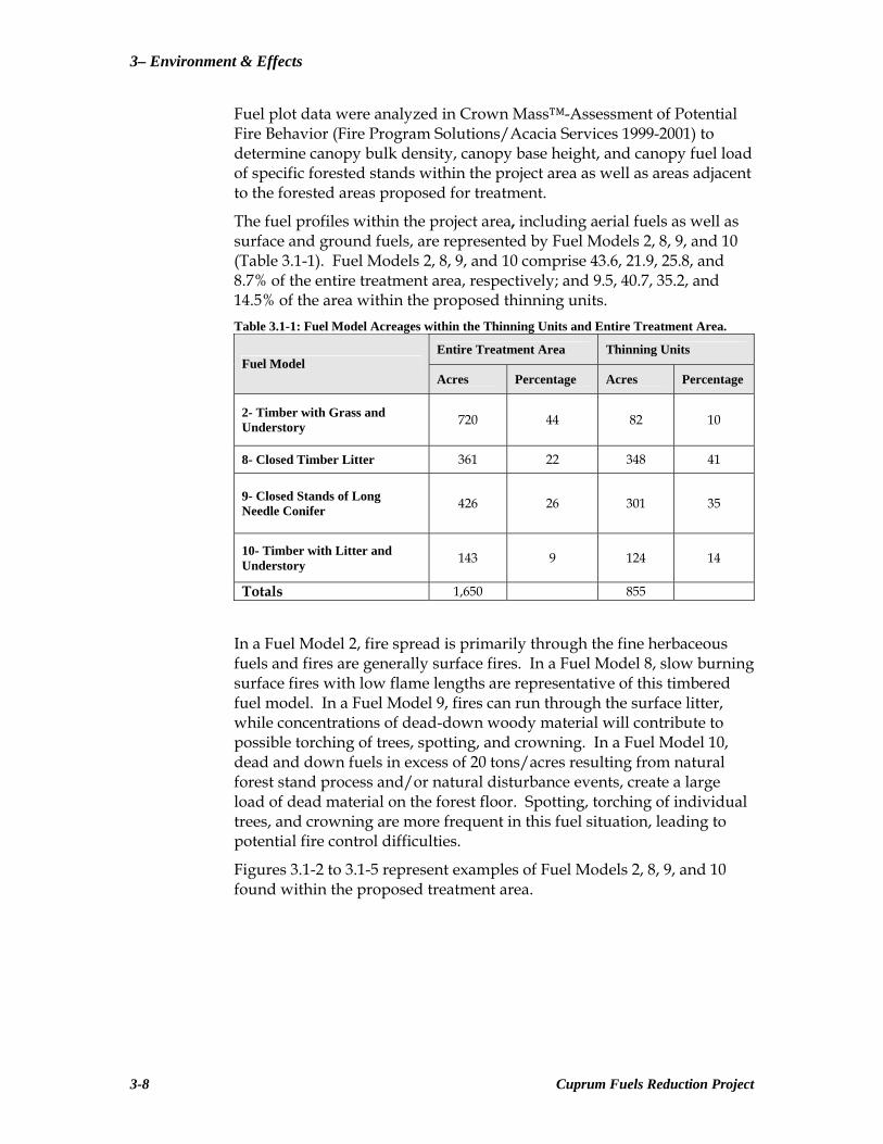
The fuel profiles within the project area, including aerial fuels as well as surface and ground fuels, are represented by Fuel Models 2, 8, 9, and 10 (Table 3.1-1). Fuel Models 2, 8, 9, and 10 comprise 43.6, 21.9, 25.8, and 8.7% of the entire treatment area, respectively; and 9.5, 40.7, 35.2, and 14.5% of the area within the proposed thinning units. Table 3.1-1: Fuel Model Acreages within the Thinning Units and Entire Treatment Area.
Entire Treatment Area Thinning Units Fuel Model
Acres Percentage Acres Percentage
2- Timber with Grass and Understory 720 44 82 10
8- Closed Timber Litter 361 22 348 41
9- Closed Stands of Long Needle Conifer 426 26 301 35
10- Timber with Litter and Understory 143 9 124 14
Totals 1,650 855
In a Fuel Model 2, fire spread is primarily through the fine herbaceous fuels and fires are generally surface fires. In a Fuel Model 8, slow burning surface fires with low flame lengths are representative of this timbered fuel model. In a Fuel Model 9, fires can run through the surface litter, while concentrations of dead-down woody material will contribute to possible torching of trees, spotting, and crowning. In a Fuel Model 10, dead and down fuels in excess of 20 tons/acres resulting from natural forest stand process and/or natural disturbance events, create a large load of dead material on the forest floor. Spotting, torching of individual trees, and crowning are more frequent in this fuel situation, leading to potential fire control difficulties.
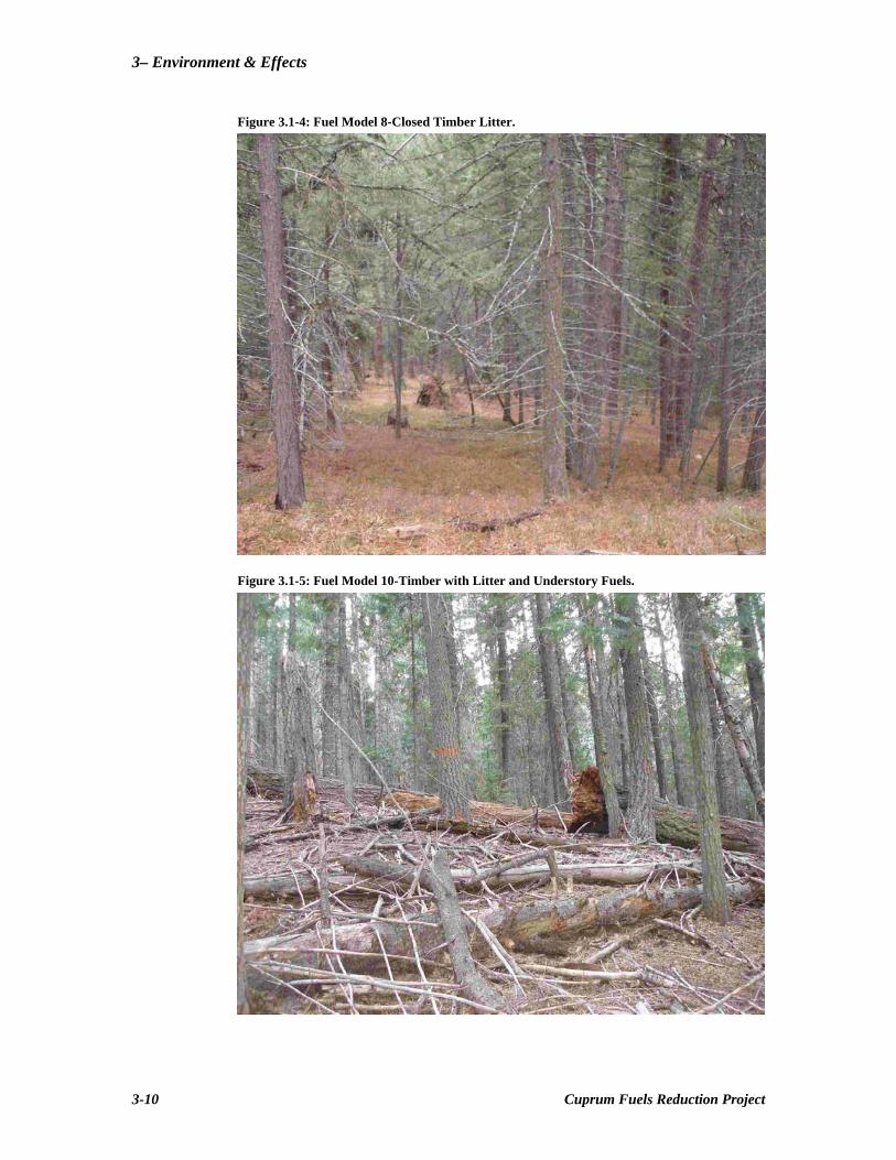
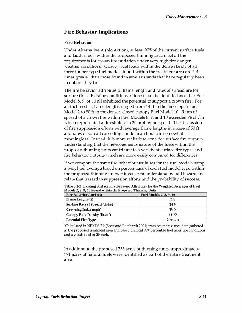
Figures 3.1-2 to 3.1-5 represent examples of Fuel Models 2, 8, 9, and 10 found within the proposed treatment area.
3-8 Cuprum Fuels Reduction Project
Fuels Management - 3
Figure 3.1-2: Fuel Model 2-Timber with Grass Understory.
Figure 3.1-3: Fuel Model 9-Closed Stands of Long Needle Conifer.
Cuprum Fuels Reduction Project 3-9
3– Environment & Effects
Figure 3.1-4: Fuel Model 8-Closed Timber Litter.
Figure 3.1-5: Fuel Model 10-Timber with Litter and Understory Fuels.
3-10 Cuprum Fuels Reduction Project
Fuels Management - 3
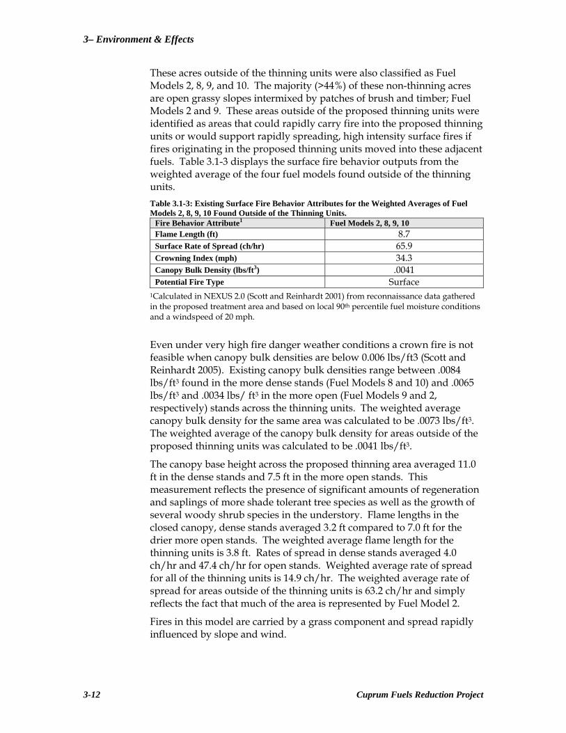
Fire Behavior Implications
Fire Behavior Under Alternative A (No Action), at least 90%of the current surface fuels and ladder fuels within the proposed thinning area meet all the requirements for crown fire initiation under very high fire danger weather conditions. Canopy fuel loads within the dense stands of all three timber-type fuel models found within the treatment area are 2-3 times greater than those found in similar stands that have regularly been maintained by fire.
The fire behavior attributes of flame length and rates of spread are for surface fires. Existing conditions of forest stands identified as either Fuel Model 8, 9, or 10 all exhibited the potential to support a crown fire. For all fuel models flame lengths ranged from 14 ft in the more open Fuel Model 2 to 80 ft in the denser, closed canopy Fuel Model 10. Rates of spread of a crown fire within Fuel Models 8, 9, and 10 exceeded 76 ch/hr, which represented a threshold of a 20 mph wind speed. The discussion of fire suppression efforts with average flame lengths in excess of 50 ft and rates of spread exceeding a mile in an hour are somewhat meaningless. Instead, it is more realistic to consider surface fire outputs understanding that the heterogeneous nature of the fuels within the proposed thinning units contribute to a variety of surface fire types and fire behavior outputs which are more easily compared for differences.
If we compare the same fire behavior attributes for the fuel models using a weighted average based on percentages of each fuel model type within the proposed thinning units, it is easier to understand overall hazard and relate that hazard to suppression efforts and the probability of success. Table 3.1-2: Existing Surface Fire Behavior Attributes for the Weighted Averages of Fuel Models 2, 8, 9, 10 Found within the Proposed Thinning Units.
Fire Behavior Attribute1 Fuel Models 2, 8, 9, 10 Flame Length (ft) 3.8 Surface Rate of Spread (ch/hr) 14.9 Crowning Index (mph) 19.7 Canopy Bulk Density (lbs/ft3) .0073 Potential Fire Type Crown
1Calculated in NEXUS 2.0 (Scott and Reinhardt 2001) from reconnaissance data gathered in the proposed treatment area and based on local 90th percentile fuel moisture conditions and a windspeed of 20 mph.
In addition to the proposed 733 acres of thinning units, approximately 771 acres of natural fuels were identified as part of the entire treatment area.
Cuprum Fuels Reduction Project 3-11
3– Environment & Effects
These acres outside of the thinning units were also classified as Fuel Models 2, 8, 9, and 10. The majority (>44%) of these non-thinning acres are open grassy slopes intermixed by patches of brush and timber; Fuel Models 2 and 9. These areas outside of the proposed thinning units were identified as areas that could rapidly carry fire into the proposed thinning units or would support rapidly spreading, high intensity surface fires if fires originating in the proposed thinning units moved into these adjacent fuels. Table 3.1-3 displays the surface fire behavior outputs from the weighted average of the four fuel models found outside of the thinning units. Table 3.1-3: Existing Surface Fire Behavior Attributes for the Weighted Averages of Fuel Models 2, 8, 9, 10 Found Outside of the Thinning Units.
Fire Behavior Attribute1 Fuel Models 2, 8, 9, 10 Flame Length (ft) 8.7 Surface Rate of Spread (ch/hr) 65.9 Crowning Index (mph) 34.3 Canopy Bulk Density (lbs/ft3) .0041 Potential Fire Type Surface
1Calculated in NEXUS 2.0 (Scott and Reinhardt 2001) from reconnaissance data gathered in the proposed treatment area and based on local 90th percentile fuel moisture conditions and a windspeed of 20 mph.
Even under very high fire danger weather conditions a crown fire is not feasible when canopy bulk densities are below 0.006 lbs/ft3 (Scott and Reinhardt 2005). Existing canopy bulk densities range between .0084 lbs/ft3 found in the more dense stands (Fuel Models 8 and 10) and .0065 lbs/ft3 and .0034 lbs/ ft3 in the more open (Fuel Models 9 and 2, respectively) stands across the thinning units. The weighted average canopy bulk density for the same area was calculated to be .0073 lbs/ft3. The weighted average of the canopy bulk density for areas outside of the proposed thinning units was calculated to be .0041 lbs/ft3.
The canopy base height across the proposed thinning area averaged 11.0 ft in the dense stands and 7.5 ft in the more open stands. This measurement reflects the presence of significant amounts of regeneration and saplings of more shade tolerant tree species as well as the growth of several woody shrub species in the understory. Flame lengths in the closed canopy, dense stands averaged 3.2 ft compared to 7.0 ft for the drier more open stands. The weighted average flame length for the thinning units is 3.8 ft. Rates of spread in dense stands averaged 4.0 ch/hr and 47.4 ch/hr for open stands. Weighted average rate of spread for all of the thinning units is 14.9 ch/hr. The weighted average rate of spread for areas outside of the thinning units is 63.2 ch/hr and simply reflects the fact that much of the area is represented by Fuel Model 2.
Fires in this model are carried by a grass component and spread rapidly influenced by slope and wind.
3-12 Cuprum Fuels Reduction Project
Fuels Management - 3
Firefighter Effectiveness Firefighter effectiveness is the ease with which firefighters are able to suppress a fire and is based on flame lengths and rates of spread, which are dependent on fuel loading and horizontal and vertical continuity of the fuels. Agee et al. (1999) define a “crown fire safe landscape” as one in which only limited tree torching would result under severe weather conditions. With flame lengths of zero to four feet (Andrews 1986) suppression resources with hand tools are generally successful and hand line is expected to hold fire. Four to eight foot flame lengths require mechanized equipment for successful suppression operations, and hand line cannot be relied on to hold fire (Andrews 1986). Fire may present serious control problems, such as torching, crowning, and spotting, and control efforts are ineffective with eight foot or greater flame lengths (Andrews 1986).
The fire behavior modeling suggests that flame lengths averaged for existing stands within the proposed thinning area would currently be at the 4-ft threshold for effective hand line. Similarly, areas of dense timber, both in the drier pine/fir type and the cooler/wetter fir type would exceed the 4-ft threshold. Mechanized equipment would be necessary to contain these fires. In the event of a fire that close to town, when life or property are threatened, the Forest Plan allows for the use of mechanized equipment including dozers. These stands are also adjacent to private property boundaries and closest to the community of Cuprum. Wildland fires that occur within Fuel Model 10 present resistance to control due to greater flame lengths, fires burn with greater fire intensity than the other timber litter models, and crowning, spotting, and torching are more frequent (Anderson 1982). The use of mechanized equipment in these areas would be limited due to poor access.
Fires occurring in the areas outside of the thinning units modeled 8.7 ft flame lengths. These open, grassy slopes would present challenges for both hand and mechanized containment efforts. However, these areas are primarily nearer ridge tops and are either upslope and down wind of private property, or both. Containment would rely on natural breaks, roads, ridge tops and the discontinuous nature of the fuels.
The fastest moving fires would occur on the slopes represented by Fuel Model 2 and could increase to a mile in an hour. However, these open fuel types are broken by timber stands that become progressively denser with increased fuel loads as they descend the north- and south-facing slopes of the Indian Creek drainage. Rates of spread decrease dramatically to an average of 15.0 ch/hr or less than 0.2 mph. The critical concern in these stands is not flame lengths and rates of spread. Due to the amount of surface and ladder fuels which can carry fire into the crowns of the overstory trees, a wind speed of 16.4 mph will initiate torching and crowning in these more dense timber types.
Cuprum Fuels Reduction Project 3-13

3– Environment & Effects
The less dense timber stands will experience torching and crowning with a 19.9 mph wind. The wind speed used to model very high fire danger conditions was 20 mph. Coupled with critical canopy bulk densities that exceed the .006 lbs/ft3 threshold by at least 8% in Fuel Model 9 and 30% in Fuel Models 8 and 10, all of the timbered stands could experience some form of crown fire. These fires would present the greatest challenges to firefighters and would increase the risk of fires spotting onto private property closest to Cuprum. Firefighter and public safety would be a critical concern.
Current fuel conditions on private property adjacent to the Forest boundary on the south side of Indian Creek have been altered, particularly within the dense Fuel Model 10-types common to RCAs. These stands have been thinned by hand, reducing the amount of regeneration and sapling/pole-sized ladder fuels. Small to medium diameter surface fuels have also been reduced decreasing surface fire intensity. These efforts have reduced flame lengths in this fuel type from above the 4-ft threshold to 1-2 ft and significantly increased the canopy base heights. This treatment has not reduced the canopy bulk density but has decreased the potential torching and crown fire initiation.
Failing to treat similar type stands adjacent to private property increases the potential of higher intensity surface fires on Forest property initiating some form of crown fire which could carry into, and be sustained by, the crowns of the dense stands found adjacent to Indian Creek.
Summary Current forest structure characterized by surface and canopy fuel conditions of Forest lands adjacent to the community of Cuprum predisposes these areas to uncharacteristic wildfires.
Fires occurring in these fuels under very high fire danger weather conditions have the potential to transition from surface fires to crown fires exhibiting rapid rates of spread and severe fire behavior. Failing to treat and restore these forested areas could result in fires that pose a threat to firefighters attempting to suppress these fires as well as a risk to private property. If left untreated, forest structure will continue to change to conditions favoring stand replacing, high severity fires further reducing the possibility of maintaining fire-resilient forests in the future.
Alternative B—Proposed Action
Changes in Fuel Conditions and Associated Fire Behavior This proposed action would treat 1,644 acres of fuels within the proposed project area (Figure 3.1-6). The treatments proposed under Alternative B are meant to decrease the probability that structures or natural resources in the immediate area of Cuprum would be threatened by uncharacteristic and undesirable fire or spotting.
3-14 Cuprum Fuels Reduction Project
Fuels Management - 3
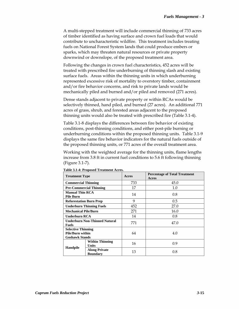
A multi-stepped treatment will include commercial thinning of 733 acres of timber identified as having surface and crown fuel loads that would contribute to uncharacteristic wildfire. This treatment includes treating fuels on National Forest System lands that could produce embers or sparks, which may threaten natural resources or private property downwind or downslope, of the proposed treatment area.
Following the changes in crown fuel characteristics, 452 acres will be treated with prescribed fire underburning of thinning slash and existing surface fuels. Areas within the thinning units in which underburning represented excessive risk of mortality to overstory timber, containment and/or fire behavior concerns, and risk to private lands would be mechanically piled and burned and/or piled and removed (271 acres).
Dense stands adjacent to private property or within RCAs would be selectively thinned, hand piled, and burned (27 acres). An additional 771 acres of grass, shrub, and forested areas adjacent to the proposed thinning units would also be treated with prescribed fire (Table 3.1-4).
Table 3.1-8 displays the differences between fire behavior of existing conditions, post-thinning conditions, and either post-pile burning or underburning conditions within the proposed thinning units. Table 3.1-9 displays the same fire behavior indicators for the natural fuels outside of the proposed thinning units, or 771 acres of the overall treatment area.
Working with the weighted average for the thinning units, flame lengths increase from 3.8 ft in current fuel conditions to 5.6 ft following thinning (Figure 3.1-7). Table 3.1-4: Proposed Treatment Acres.
Treatment Type Acres Percentage of Total Treatment Acres
Commercial Thinning 733 45.0 Pre-Commercial Thinning 17 1.0 Manual Thin RCA Pile Burn 14 0.8 Reforestation Burn Prep 9 0.5 Underburn Thinning Fuels 452 27.0 Mechanical Pile/Burn 271 16.0 Underburn RCA 14 0.8 Underburn Non-Thinned Natural Fuels 771 47.0 Selective Thinning Pile/Burn within Goshawk Stands
64 4.0
Within Thinning Units 16 0.9
Handpile Along Private Boundary 13 0.8
Cuprum Fuels Reduction Project 3-15

3– Environment & Effects
Figure 3.1-6: Cuprum Fuels Reduction Project Map.
3-16 Cuprum Fuels Reduction Project

Fuels Management - 3
Figure 3.1-7: Surface Fire Flame Lengths of the Weighted Average of the Four Fuel Models Within and Outside of the Proposed Thinning/Harvest Units.
Surface Flame Lengths
0123456789
10
ExistingConditions
Post HarvestConditions
Post RXConditions
Feet
Units
OutsideUnits
Threshold for direct attack
The largest increase in flame lengths occur in Fuel Model 8 in which a fairly benign 1.7 foot flame length increases to 2.9 ft, still below the 4 ft handline threshold. Within Fuel Model 9, the more open drier pine/fir type found on both north and south facing mid-slopes above Cuprum, flame lengths increased from 4.3 to 5.2 ft. Within the thinning units these two fuel models comprise 76% of the treated acres and exhibit flame lengths that would not severely challenge fire managers using mechanized equipment. Within Fuel Model 10, dense closed canopy and heavier concentrations of surface fuels, 4.6 ft flame lengths are predicted.
Following thinning flame lengths increase to 7.0 ft. These stands of Fuel Model 10 only comprise 14% of the thinning area and 12 of the 124 acres in this fuel model will be excluded from any treatment, both thinning and burning. These 12 acres of excessive surface and canopy fuels present treatment challenges, ranging from steep slopes to difficulty in burning. These areas were excluded to minimize treatment impacts and implementation risk.
Nexus modeling indicated that within Fuel Models 8 and 10, a 6.0 ft surface fire flame length could initiate a crown fire with canopy base heights of 11.0 ft under very high fire danger weather conditions. Within Fuel Model 9 in which the base heights are as low as 5.0 ft in these more open stands, the flame length required to initiate crown fires drops to 3.4 ft.
Cuprum Fuels Reduction Project 3-17

3– Environment & Effects
Post thinning fire behavior conditions will support isolated torching of mid-story pole-sized timber patches, but sustained crown fires in these timbered fuel models will not occur due to the open crowns of the overstory. However, thinning alone will not eliminate the risk of uncharacteristic fires within these fuels.
Rates of spread also increase following thinning. The largest increase can again be seen in Fuel Model 8 which more than triples from 2.3 ch/hr to 7.0 ch/hr. Fuel Model 10 increases from 5.6 ch/hr to 14.0 ch/hr while Fuel Model 9 increased from 16.0 to 20.0 ch/hr, or 0.25 mph. The weighted average for the fuel models following thinning essentially doubles, increasing from 14.9 to 27.4 ch/hr (Figure 3.1-8). Figure 3.1-8: Surface Fire Rates of Spread of the Weighted Average of the Four Fuel Models Within and Outside of the Proposed Thinning/Harvest Units.
Surface Rates of Spread
0
10
20
30
40
50
60
70
ExistingConditions
Post HarvestConditions
Post RXConditions
Chains per Hour
Units
OutsideUnits
The crowning index for all fuel models increases at least 1.5 times in the more open timber/grass type (FM 2) to more than doubling in the closed timber types, FM 8 and 10. The weighted average indicated that the 20-ft wind speed must increase from 20.0 mph to 38.0 mph under very high fire danger weather conditions to initiate a crown fire throughout the thinning units.
As would be expected, canopy bulk densities in all of the fuel models decreased with thinning, decreasing throughout the thinning units by an average of 40%, or .0073 to .0029 lbs/ft3, well below the .006 lbs/ft3 threshold (Figure 3.1-9, Figure 3.1-10).
3-18 Cuprum Fuels Reduction Project

Fuels Management - 3
Analysis of the thinning units’ fuels following burning, both underburning and pile burning, indicate that fire behavior is significantly altered by modifying the crown and understory structure followed by surface fuels treatment.
Within all fuel models the flame lengths decrease from a weighted average of 5.6 ft to 3.1 ft while the rate of spread drops to averages very similar to existing conditions; 27.4 ch/hr to 15.5 ch/hr (14.9 ch/hr for existing conditions). The crowning index and the canopy bulk densities continue to change favorably yet at a much lower rate. This is due to the fact that the initial thinning significantly altered the canopy fuel profiles and any further change to canopy fuels will be the result of mortality to remaining regeneration, saplings and pole-sized trees caused by either the piling and burning or underburning (Figures 3.1-2-3.1-5).
Modeling of the fuels outside of the thinning units indicated similar trends in fire behavior. These open, grass-dominated fuels which are primarily upslope of the proposed thinning units would severely challenge fire managers during the burning of the thinning units if left untreated. Following underburning, flame lengths drop from 8.7 ft to 4.6 ft while rates of spread were essentially cut in half, falling from 66.0 ch/hr to 33.0 ch/hr. Since these areas are open with limited timber overstory, any reduction in canopy fuel conditions comes from limited amounts of direct mortality associated with the burning.
These multi-stepped treatment entries alter the fire behavior in several critical ways. The current risk of potential active crown fire spread within the three timber fuel models common to the thinning area has been reduced by the reduction in canopy bulk densities. The reduction in torching potential within mid-story ladder fuels has occurred following the thinning of sub-merchantable trees. Linked directly to this torching is a critical surface fire flame length and canopy base heights. The sub-merchantable thinning will raise canopy base heights. The pile burning and/or underburning will alter surface fuels and reduce overall fire behavior and fire severity.
Examination of the post-thinning fire behavior effects, specifically potential crown fire behavior, underscored the need to thin these forested stands and then follow the thinning with a surface fuels treatment. Thinning stands to reduce canopy bulk densities reduces the moderating effects the canopy has on windspeed beneath the crowns. Once these stands are thinned, mid-flame windspeeds will increase. The exposure of surface fuels to increased winds and increased solar radiation and drying leads to lower dead fuel moistures during the fire season.
Cuprum Fuels Reduction Project 3-19

3– Environment & Effects
Figure 3.1-9: Crowning Index of the Weighted Average of the Four Fuel Models Within and Outside of the Proposed Thinning/Harvest Units.
Crowning Index
0
10
20
30
40
50
ExistingConditions
Post HarvestConditions
Post RXConditions
Winds Required to
Initiate Crown Fire
(mph)
Units
OutsideUnits
Figure 3.1-10: Canopy Bulk Density of the Weighted Average of the Four Fuel Models Within and Outside of the Proposed Thinning/Harvest Units.
Canopy Bulk Density
0.000
0.001
0.002
0.0030.004
0.005
0.006
0.007
0.008
ExistingConditions
Post HarvestConditions
Post RXConditions
Units
OutsideUnits
Threshold at which crown fire is possible
These factors, reflected in increased flame lengths and rates of spread, represent increases in surface fire behavior. However, the reduction in crown fire potential represents a tradeoff between this increased surface fire behavior and the dangerous intensities and increased rates of spread common to crown fires. In this project, the thinning will be followed by the sufficient treatment of surface fuels which outweighs any increases in fire weather factors (Scott and Reinhart 2001, Agee and Skinner 2005).
3-20 Cuprum Fuels Reduction Project

Fuels Management - 3
Riparian Conservation Areas No overstory thinning will occur within Riparian Conservation Area (RCA) buffers of 120 ft from intermittent streams and 240 ft of perennial streams. Most of these RCAs have a heavy fuel loading comparable to a Fuel Model 10, but were analyzed as isolated patches of heavy fuels. While no direct firing will occur in RCAs (except for hand piles) directly adjacent to private property, surface fires from the thinning units will be allowed to creep into those areas. Within RCAs adjacent to private property, limited amounts of ladder and surface fuel piling will occur on 14 acres, primarily along the south side of Indian Creek. These piles will be burned within RCAs under conditions that minimize potential scorch and mortality of overstory timber easily visible from Cuprum. An additional 13 acres of handpiling will occur along the Forest boundary in stands which are too steep to thin and mechanically pile, continuing a surface fuels reduction buffer along the south side of Cuprum. Fire behavior of surface fuels within the RCAs is expected to be reduced with flame lengths decreasing from 4.6 ft to 2.4 ft and rates of spread dropping from 5.6 ch/hr to 2.8 ch/hr.
By maintaining the closed canopy of these stands, the shaded conditions will contribute to continued low intensity fires resulting from decreased midflame wind speeds and increased dead fuel moistures.
Goshawk Management Units Two separate units totaling 64 acres have been identified for goshawk management (Figure 3.1-6). One unit contains a nest previously used for goshawk nesting while the second unit represents replacement nesting habitat. The unit with a goshawk nest is comprised of dense stands of Fuel Models 8 and 10, while the replacement stand also includes Fuel Model 9 and limited amounts of Fuel Model 2. The unit containing the nest site is surrounded on the south by thinning units scheduled to be mechanically piled and burned. Areas to the north are adjacent to private property and will be hand piled and burned. The replacement nest stand is surrounded by thinning/pile units and thinning/underburn units.
If upon completion of treatment of the proposed thinning and private boundary areas the goshawk units are found to pose significant fire behavior threats, they will have ladder and understory fuels reduced.
This thinning from below will not reduce the canopy closure and will not alter canopy bulk densities significantly, but could raise canopy base heights and will significantly reduce surface fuels. These shaded areas will display altered fire behaviors very similar to those predicted for the hand piled RCAs.
See Chapter 2, Table 2-4, Mitigation Measures; and Chapter 3, Section 3.6, Wildlife Resources for more detailed information on goshawk management guidelines.
Cuprum Fuels Reduction Project 3-21
3– Environment & Effects
Maintenance of Coarse Woody Debris While the reduction of hazardous fuels and wildfire intensity are the purpose and need of the proposed action, it is critically important for fire and fuels management to develop strategies that not only reduce fire risk but also maintain critical components of biodiversity. With that in mind, the thinning and post-thinning treatments proposed within the treatment area will address Coarse Woody Debris (CWD) with two slightly different strategies for meeting Forest Plan desired ranges of CWD.
The Forest Plan (Appendix A, p.9) lists desired ranges of coarse woody debris by PVG and the desired amounts in the larger (> 15”) size classes (See Fuels Specialist Report). The first strategy involves those areas adjacent to private lands. These forested areas are comprised of potential thinning stands and/or RCAs. This private property-Forest boundary will be treated using underburning and hand or mechanical pile burning. To reduce the risk of higher intensity surface fires along this boundary and increase firefighter effectiveness, the piling, removal, or underburning will seek to retain no more than 4-5 tons/acre of CWD.
This is at the low end of the Plan’s desired range, but still contributes to the overall reduction in hazardous fuel loads immediately adjacent to private lands. Assuming that the consumption of all fuels > 3’’ diameter by prescribed fire ranges from 30-60%, the more open stands (FM 2, FM 9) adjacent to private property will average between 1-5 tons/acre while the closed stands (FM 8, FM 10) will average between 2-12 tons/acre following removal or burning. At a minimum, eight 15” diameter logs will be retained per acre prior to removal/burning to meet Forest Plan direction for CWD retention.
On all other treatment area units it is recommended that CWD retention be increased to 25% above the upper end of the desired range for PVGs, or at a minimum of 17.5 tons/acre. Both of these strategies will require implementation prescriptions that favor 1000-hr fuel moistures (fuels in the 3-8” diameter size class) in excess of 23% to favor retention of these larger fuels.
Firefighter Effectiveness NEXUS modeling predicted that existing (pre-thinning and pre-pile burned or underburned) conditions under very high fire danger levels could result in a potential surface fire spread rate of approximately 14.9 ch/hr with an average flame length of 3.8 ft. With a 20 mph, 20-ft windspeed however, existing canopy fuel conditions would support some type of crown fire. Under these wildland fire conditions, direct attack may not be relied upon to successfully hold a wildland fire and firefighter safety would be a concern (Rothermel 1983).
3-22 Cuprum Fuels Reduction Project
Fuels Management - 3
Other suppression tactics (e.g., indirect attack, dozer line, aerial resources, etc.) would likely be employed to safeguard firefighters and values at risk within and adjacent to Cuprum, but at the price of increased suppression costs and potential natural resource damage.
Following the modification of the canopy fuels which were thinned enough to prevent a crown fire, the modeling predicted not only a change in fire type but an increase in the surface fire behavior. This increase is the direct effect of drier fuels exposed to higher speed fuel level winds. Flame lengths increase to 5.6 ft with rates of spread doubling to 27.4 ch/hr. Thinning results in canopy bulk densities decreasing by 60% to levels well below a sustained crown fire threshold as evidenced by a doubling of the 20-ft windspeed necessary to carry such a fire, or 37.9 mph.
However, the risk of a sustained crown fire is greatly reduced and longer range spotting threatening suppression efforts in or around Cuprum would be decreased. Lacking any selective thinning and pile burning of ladder and surface fuels within the RCAs or dense timber stands adjacent to Cuprum or private property boundaries, surface fires have the potential to rapidly spread from Forest lands to private lands where torching and spotting could initiate some form of crown fire.
The complete treatment proposal identified in Alternative B would limit the risk to firefighters, property, and life by controlling fuel loading, ladder and surface fuels, and subsequently crown fire risk and fire intensity. The combination of the proposed thinning and follow-up burning reduces flame lengths to 3.1 ft and rates of spread return to existing conditions. Under those conditions suppression strategies relying on hand tools alone would likely succeed and handline would generally hold the fire. The more open stands would afford firefighters increased maneuverability and increase their flexibility as to where firefighters can be placed to more effectively protect the wildland-urban interface.
The underburning of the fuels outside of the proposed thinning areas reduces the flame lengths from 8.8 ft to 4.6 ft and reduces the spread rates to 33.0 ch/hr, or half of the pre-treatment rate.
This treatment of these flashy fuels that are characteristically very receptive fuel beds, coupled with existing roads and other natural fuel breaks provide very reliable features for fire managers to use to minimize risk during the burning of the thinned units. The proposed action reduces the hazard of uncharacteristic wildfire entering adjacent areas by minimizing fire intensity and severity and by creating highly effective fuel breaks at the landscape level limiting potential fire spread under high fire danger conditions (Table 3.1-5).
Cuprum Fuels Reduction Project 3-23

3– Environment & Effects
Table 3.1-5: Summary of Direct and Indirect Effects for Each Alternative by Indicator for the Analysis Area.
Alt. A: No Action Alt. B: Proposed Action
Indicator Thinning Units
Outside of Thinning Units
Thinning Units
Outside of Thinning Units
Average Flame Length (ft) 3.8 8.7 3.1 4.6 Average Rate of Spread (ch/hr) 14.9 65.9 15.5 33.0 Predicted Fire Type Crown Surface Surface Surface
Summary To reduce the threat of uncharacteristic wildfire and restore the fire resiliency of forested stands within the treatment area, selected timber stands must first be thinned to reduce canopy fuel loads. This thinning will minimize the potential for high intensity, rapidly moving crown fires to threaten the community of Cuprum. Surface fuels must then be piled and burned, piled and removed, or underburned.
These successive treatments will effectively alter fuel conditions and help move toward the desired forest structure. Such a restoration strategy will allow future prescribed fire entries to maintain historical fire types.
Hazard and Risk Two assumptions must be made with respect to risk within the project area. First, both lightning and human-caused fires will occur in the same patterns as they have for the past 36 years. Over 77% of the fires on the Council Ranger District are lightning caused and it is unlikely that significant changes in the weather patterns will occur. It is also unlikely that patterns of human-caused fires will change unless significant changes in land use patterns occur. Secondly, if fire starts for the past 36 years occur at a particular frequency for a given area, they will occur at similar frequencies in that area in the future. Examination of fire records and Sanders’ (1998) analysis of the Upper and Middle Indian Creek subwatersheds, indicate that the risk of fire starts within the project area is high. Risk of fire starts in the project area is seasonal and parallels historical fire causes for the entire district. Current fuel conditions and subsequent treatment options do increase the overall risk within the project area.
The very nature of management-ignited fires increases the risk of fire starts over a limited period of time necessary to treat over 1,600 acres of altered fuels. Recovery and treatment could take between 1-2 years after which time risk decreases to pre-treatment levels.
Thinning and fuels treatments beginning in the fall on project units adjacent to private property reduces the overall hazard at a time of year in which fire risk is decreasing while fuel conditions and fire behavior can combine for a high hazard rating.
3-24 Cuprum Fuels Reduction Project

Fuels Management - 3
Continued treatments in the spring when risk is low and hazard is reduced, creates ongoing opportunity to increase the overall fuel discontinuity prior to entering a period of high hazard, high risk.
Based upon Condition Class of forest vegetation within the Upper and Middle Indian Creek subwatersheds, forest and non-forest lands within the project area are identified as having a low-moderate hazard rating. Fires within the timber types could be high intensity/high severity under hot and dry summer conditions. All three of the timber fuel models exhibited the potential to support moderate to high intensity surface fires as well as crown fires. The extent and resistance to suppression of those fires would be dependent upon fire type. The proposed action reduces the hazard of uncharacteristic wildfire entering areas immediately adjacent to Cuprum by minimizing fire intensity and severity and by creating highly effective fuel breaks at the landscape level limiting potential fire spread under those high fire danger conditions.
Cumulative effects
Past Actions Fire suppression, timber management, mining, grazing and development have all contributed to the overall changes in fuel conditions found within the Indian Creek subwatersheds. Between 1967 and 2005 there have been 10 timber sales which have altered 4,703 acres of natural fuels within the Indian Creek drainage. Within the project area 2,564 acres of forested fuels have been modified through harvesting, 751 acres on private lands. Organized fire suppression within the project area has been ongoing since 1930. Records indicate that since 1957 there have been 153 fires within a 5 mile radius of Cuprum for a total of 46,896 acres. The largest fires within the 5 mile radius include the 1960 Eckels Creek Fire (11,967 acres), the 1988 Eagle Bar Fire (16,326 acres), and the 1992 Windy Ridge Fire (17,500 acres). All three of these fires originated to the west of the project area in the Snake River Canyon breaks. These fires were terrain and wind driven moving rapidly from the southwest in Fuel Model 2. The northernmost advance of the Windy Ridge Fire burned into the southern end of the project area and included all four fuel models. No other large timber fires have burned within the Indian Creek drainage.
These numbers suggest that within non-lethal (FM 2, 9) and mixed severity (FM8,10) fire regimes found within the project area, a very small percentage of those fuels having historical fire return intervals ranging from 4-100 years have been affected by fire. Since the early 1900’s grazing has modified herbaceous fuels which have in turn increased fire return intervals. Currently, 53% of the forested lands within the Indian Creek subwatershed are in Condition Class 2 and 3, or have a moderately high departure from historic fire regimes.
Cuprum Fuels Reduction Project 3-25
3– Environment & Effects
Fuels within the entire project area are extremely discontinuous, evidenced by greater than 50% of the area being classified as non-forest. This fuels mosaic, both natural and the result of past management activities, has resulted in very few large fires within the analysis area and precipitated a slow drift of fuels toward increased fire susceptibility.
Current Actions Grazing and timber harvesting continues to alter fuels within the project area. Selective thinning of ladder fuels and hand piling/burning along 50 acres of the private-Forest boundary continues. This fuels modification on private lands within the project area will gradually convert critical interface acres classified as a dense Fuel Model 10 to a model having significantly reduced surface fuels and increased base heights. When coupled with the proposed action within the thinning and non-thinning units, these types of fuels conversion over the course of the treatment period reduces 1,237 acres of hazardous fuels within two subwatersheds classified as being moderately at risk of losing critical ecosystem components to uncharacteristic wildfire.
Fire protection continues to be over 98% effective at suppressing fires in the initial attack stages of wildland fire management. Modified response strategies specifically addressing the increased hazard and associated difficulty of suppressing wildfires within the existing fuel types will continue throughout the duration of the proposed action. An existing irrigation ditch immediately adjacent to Cuprum provides fire suppression water for private and agency use within the wildland urban interface. Current road systems provide access for suppression crews to control the spread and size of fires. These roads also provide effective fire line or burnout initiation areas for suppression activities and prescribe burning activities, depending on their location and adjacent fuel loading. The proposed action would decommission 8.8 miles of roads within the project area. Due to current road densities, the amount of road obliteration will not affect ground based suppression effects.
Reasonably Foreseeable Future Actions No large scale commercial or pre-commercial harvesting on Forest lands is proposed within the project area. However, limited amounts of thinning within timber stands showing signs of insect infestation or fire-related mortality may take place.
With continued management of the Northern Idaho Ground Squirrel and possible identification of additional habitat, limited amounts of thinning and underburning could occur. Continued piling and burning along the south side of Indian Creek on private property most likely will continue. The first maintenance entry for prescribed burning within the treatment area could be as early as 15 years depending on the response of the understory vegetation.
3-26 Cuprum Fuels Reduction Project

Fuels Management - 3
All of these activities which modify fuel profiles, both natural and managed fuels, effectively reduce the hazard of uncharacteristic wildfire throughout the project area. Grazing may continue to take place on both private and Forest lands. Increased recreational use, both motorized and non-motorized, within the project area is expected to take place which will increase the risk of fire starts. The increased awareness generated by the Cuprum Fuels Reduction Project could help create a working rural fire organization within the community of Cuprum in cooperation with Adams County. Fire-Wise mitigation efforts would have modified fire-prone fuels around private structures and reduced the susceptibility of these fuels to spotting from wildfires increasing firefighter and public safety.
Project Record This EA hereby incorporates by reference the Fuels Specialist Report (40 CFR 1502.21). The Fuels Specialist Report is located in the Project Record and contains the detailed data, analysis, and technical documentation that the Fuels Specialist relied upon to reach the conclusions in this EA.
Cuprum Fuels Reduction Project 3-27

3– Environment & Effects
3-28 Cuprum Fuels Reduction Project
Forest Vegetation Resource - 3
3.2 Forest Vegetation Resource
Purpose and Need Statement Promote fire resistant tree species in open stands that can be maintained in a low fire hazard condition by prescribed fire.
Measurements: • Acres of stands thinned to increase overstory tree crown
separation to 15 to 20 feet between crowns. • Acres of stands maintained in or moved toward fire resistant
tree species dominance. • Acres of stands treated to create an open understory condition
that can be maintained with low intensity prescribed fire.
Introduction The overall condition of forest stands in the Cuprum Project Area has changed since European settlement as a result of wildfire suppression and timber management practices implemented since the late 1800s. These changes include an increase in stand densities and a shift in species composition from fire resistant seral species to less fire resistant climax species. Dwarf mistletoe is present in the Douglas-fir and ponderosa pine. Douglas-fir beetles, western pine beetles, Ips pine engraver beetles, and fir engraver beetles are also present. Thinning or applying improvement cuts in these stands followed by underburning or piling and burning would improve stand health and promote the development of large tree structure. The severity of dwarf mistletoe infections and indicators of vigor would be used along with crown separation and species preference as guides to determine which trees to remove in these silvicultural treatments.
The proposed activities would alter vegetation structure, composition, and density to achieve the Purpose and Need of this project and move the area toward desired conditions. Implementation of this project would be through a timber sale, post harvest burning and mechanical fuel reduction operations, and prescribed burning operations outside the harvested areas. Approximately 733 acres would be harvested producing about 8.4 million board feet. After harvest, approximately 452 acres would be underburned. On about 271 of the harvested acres fuels would be excavator piled or removed through the timber sale contract. Where the timber sale contract is used to remove fuels, the contract would require removal of the understory trees as well as the tops and limbs of harvested trees. These areas may not require any further fuel reduction treatments.
Cuprum Fuels Reduction Project 3-29
3– Environment & Effects
On steep ground, about 20 harvested acres would be handpiled or the slash would be lopped and scattered. In addition to the harvested areas, another 771 acres of grass, brush, and scattered timber would be underburned to reduce fuels and improve the condition of the vegetation. Twenty-eight acres in riparian areas would be hand piled or underburned. And in goshawk management areas about 64 acres of understory trees would be thinned or the ground fuels would be hand piled. In areas adjacent to private land another 23 acres would be hand piled or piled with an excavator.
Forest Plan Direction The Management Prescription Category (MPC) for much of the project area is 5.1, Restoration and Maintenance Emphasis within Forested Landscapes. The remainder of the project area falls within MPC 5.2, Commodity Production Emphasis within Forested Landscapes. The Forest Plan guidelines for MPC 5.1 have been used to describe the desired condition in the Environmental Effects section. The rationale for using these guidelines for the entire project area is that the fuel reduction objective for the project and the desired condition of the project area fit better with MPC 5.1 guidelines than with the guidelines for MPC 5.2.
Forest Plan Goals VEGO01 through VEGO07 (p. III-30) provide direction to maintain or restore vegetative components including size classes, canopy closures, structure, and snags. These desired conditions are expected to provide for ecological processes, reduce uncharacteristic disturbances, maintain or enhance habitat for various species, facilitate regeneration of desirable plants, and maintain or restore spatial patterns important to other goals of the Forest Plan.
Forest Plan Standard W1ST01 (p. III-26) was developed to maintain wildlife diversity. This standard directs that vegetation management projects maintain at least 20% of the acres within each forested Potential Vegetation Group (PVG) in a watershed (5th field HU) in the large tree size class. Where analysis of available datasets indicates that the large tree size class for the PVG is less than 20% of the total PVG acres, management actions shall not decrease the current area occupied by large tree size class.
Forest Plan Standard SWST01 (p. III-21) was developed to maintain or restore water quality to fully support beneficial uses and native and non-native desired fish species and their habitat. Use of the MATRIX located in Appendix B is recommended to assist in determining compliance with this standard. In Appendix B (p. B-19) the MATRIX describes a riparian conservation area (RCA) that is functioning appropriately. Adequate shade, large woody debris recruitment, and sediment buffering are cited. Having all vegetative components within desired conditions identified in Appendix A of the Forest Plan is also cited.
3-30 Cuprum Fuels Reduction Project

Forest Vegetation Resource - 3
The understory fuels reduction treatments proposed for 28 acres (14 acres of ladder fuel thinning, 14 acres of backing fire) within RCAs are designed to maintain stream shade by not removing understory trees that provide shade for the stream.
Large woody debris recruitment and sediment buffering would not be degraded by underburning or by cutting, hand piling, and burning understory trees. Removing shade tolerant trees that are susceptible to fire induced mortality would move these areas towards the desired condition described in Appendix A. The forest stands in the RCAs proposed for treatment are in PVGs 5, and 6. These PVGs historically experienced fires that killed the understory trees and kept the ground fuel levels low. The treatments proposed would emulate this historic fire to some degree. Wildfire in these stands would generally have killed some of the overstory trees. This treatment would remove understory trees only. Removing these understory trees would make these RCAs less prone to damage by stand replacing crown fires.
There are no extraordinary circumstances associated with the other vegetation aspects of this proposal. The project is consistent with the Forest Plan goals, objectives, standards and guidelines that are pertinent to the vegetation aspects of this project.
Forest vegetation is described in this section using PVGs as indicators of environmental conditions. Forested stands in the same PVG share similar environmental characteristics, site productivity, and disturbance regimes. (Forest Plan, p. A-17) Table 3.2-1. Potential Vegetation Groups in the Indian-McGraw Watershed
Groups Percent of Forested Area in the Watershed
PVG 1 - Dry Ponderosa Pine/Xeric Douglas-fir 17% PVG 2 – Warm Dry Douglas-fir/Moist Ponderosa Pine
28%
PVG 5 – Dry Grand Fir 15% PVG 6 – Cool Moist Grand Fir 29% PVG 7 – Cool Dry Subalpine fir 10% PVGs 9/11 – Hydric and High Elevation Subalpine Fir
1%
The proposed harvest treatments would affect 295 acres in PVG 2, 128 acres in PVG 5, and 306 acres in PVG 6. The desired condition for these PVGs is presented in the following paragraphs.
Desired Condition Appendix A of the Forest Plan contains the desired condition tables, mapping criteria, and classification descriptions for vegetation outside of designated wilderness areas. Desired conditions do not represent a static state; they are dynamic because the ecosystems are constantly changing.
Cuprum Fuels Reduction Project 3-31
3– Environment & Effects
The desired conditions are not something that every acre of forest at every point in time will possess-there will always be spatial and temporal variability. Achievement of desired conditions well distributed across the planning unit is a long-term goal for forest management. (Forest Plan, p. A-1)
This analysis focuses on forest vegetation. Forest vegetation refers to land that contains at least 10% crown cover by forest trees of any size, or land that formerly had tree cover and is presently at an earlier seral stage. Forest vegetation will be described by PVG. The components of forest vegetation analyzed are tree size class, canopy closure, species composition, and snags.
Scope of the Analysis Forest vegetation components - tree size class, canopy closure, and species composition are analyzed on the 5th field hydrologic unit (HU), Indian-McGraw Watershed. This watershed encompasses about 28,245 forested acres. The 5th field HU is deemed an appropriate analysis unit for these components because the mid-scale data and other information are generally available or feasible to generate. The 5th field HU facilitates a good distribution of desired components across the Forest.
Snags are analyzed at the activity area level, which better reflects the scale at which to consider this element and to plan projects to provide for maintaining or improving trends in snag numbers. The activity area for snags is the specific site affected, which is the harvest unit or the prescribed burn area (Forest Plan, p. A-7).
The direct and indirect effects were analyzed for the National Forest System (NFS) lands in the Cuprum Project Area. Cumulative effects were analyzed for private and NFS lands for the 6th field HU, (Indian Creek Subwatershed).
Background: Separating the overstory tree crowns, reducing ground fuels, and eliminating fuel ladders will minimize the possibility of a stand replacing crown fire burning through the treatment areas. Fire resistant tree species in the project area include ponderosa pine, western larch, and Douglas-fir. These trees can generally withstand the effects of naturally caused ground fires and the prescribed underburns that will be used to maintain open understory conditions. Maintaining a more open forest condition by removing most of the non-fire resistant trees and understory trees will reduce the possibility of a ground fire moving into the crowns of the overstory trees.
Creating and maintaining this open forest condition would make fire suppression efforts more effective and economical. Firefighter and public safety are greatly enhanced by maintaining these open forest conditions.
3-32 Cuprum Fuels Reduction Project
Forest Vegetation Resource - 3
Environmental Effects
Alternative A – No Action - Effects of Failing to Implement Proposed Action The species composition, structure and density of forest stands would continue to move away from historical (desired) conditions if the proposed treatments are not implemented. Overstocked stands would continue to increase in density and fuel build up and develop increased understory ladder fuels. This would result in conditions more favorable for uncharacteristic (lethal) wildfire. When wildfire returns to these stands; it would most likely be a stand replacement fire and would also threaten the sustainability of the remaining large, mature remnant ponderosa pine, Douglas-fir, and western larch trees within the project area. High stand densities and high fuel loadings would preclude the use of prescribed burning as a tool to reduce the high fire hazards to homes, property and forest values in the Cuprum area.
Acres of stands thinned to increase overstory tree crown separation to 15 to 20 feet between crowns. Canopy closure is used here to address tree crown separation. Canopy closure, as used in the Forest Plan is calculated for stands in the large tree size class only. A stand is considered to be in the large tree size class if 10% or more of the overstory canopy is composed of crowns of trees that have a DBH of more than 20 inches. Percent canopy closure is the forest floor area in a stand of trees that is covered (or shaded) by the crowns of trees as viewed from the air.
Canopy closure classes are as follows:
Low = 10-39% canopy closure
Moderate = 40-69% canopy closure
High = 70% or more canopy closure
The desired condition described in the Forest Plan for the PVGs represented in this project is a low to moderate canopy closure with no high canopy closure stands. Table 3.2–2. Desired Percentages of Canopy Closure Classes by PVG PVG-2 PVG-5 PVG-6 Low 74-94 25-45 0-20 Moderate 6-26 55-75 80-100 High 0 0 0
All of the stands proposed for harvest have canopy closures of over 60%. About 75% of these stands have canopy closures of 70% or greater. Failing to implement the proposed action would leave these forested areas with closed canopies and minimal crown separation.
Cuprum Fuels Reduction Project 3-33

3– Environment & Effects
The proposed action would open the canopies of harvested stands to about 40% canopy closure. The crown separation in stands with a 40% canopy closure is generally 8 feet or greater. The crown separation in stands with a 60% canopy closure is generally less than 8 feet. With no action the forested areas proposed for harvest would remain in the current closed canopy condition. Crown separation would decrease over time until a disturbance such as wildfire or insect attack opens the canopies.
Acres of stands maintained in or moved toward fire resistant tree species dominance. The desired species composition would achieve the goal of having the landscape dominated by early seral species that are better adapted to site conditions and are more resilient to disturbances such as fire. Table 3.2-3. Desired Condition of Species Composition Percentages by PVG
Species PVG 2 5 6
Aspen - - - Lodgepole pine - - 1-5 Ponderosa pine 81-87 80-88 23-41 Western larch - 0-1 15-29 Whitebark pine - - - Douglas-fir 10-16 7-17 15-25 Engelmann spruce - - 0-2 Grand fir - 0-1 9-23 Subalpine fir - - 0-3
Species composition in the unmanaged stands in the project area is moving away from the desired condition of seral species dominance. These unmanaged stands are being encroached upon by shade tolerant climax tree species (grand fir on moist sites and Douglas-fir on dry sites), while seral tree species (ponderosa pine, western larch, and Douglas-fir on moist sites) are declining. This condition is typical of PVGs in non-lethal, Mixed 1 and Mixed 2 fire regimes when fire is excluded. The lack of disturbance from fire allows canopies to close and duff layers to build up. The heavy shade and thick duff conditions prevent the sun-loving seral species from regenerating. The shade tolerant climax species can penetrate the duff layer and become established. They then begin to take over the site and exclude the fire resistant seral species.
Failing to implement the proposed action would allow this uncharacteristic succession process to continue. The shade tolerant non-fire resistant tree species would eventually dominate these stands. This process would continue until wildfire, insects or some other disturbance displaces the shade tolerant species and allows fire resistant species to regenerate and reestablish dominance.
3-34 Cuprum Fuels Reduction Project

Forest Vegetation Resource - 3
Acres of stands treated to create an open understory condition that can be maintained with low intensity prescribed fire. Failing to implement the proposed action would leave the 735 acres of forest stands proposed for harvest in a condition where underburning to reduce the risk of ground fire climbing into and spreading through the crowns would not be possible without great risk to the community of Cuprum and adjacent lands.
The 28 acres in riparian areas proposed to be thinned and hand piled or underburned with a backing fire, the 64 acres of goshawk management understory treatments, and the areas adjacent to private land where 20 to 25 acres would have been hand piled or piled with an excavator would also be left in a condition that could not be maintained with periodic underburning.
The 770 acres of grass, brush, and scattered timber that would have been broadcast burned to reduce fuels and improve the condition of the vegetation would not be treated. This burning would not directly create open understory conditions. However, it would have provided a buffer area of low fuels adjacent to the timber stands. This buffer area would have made the use of prescribed fire in the adjacent forest stands safer and easier to control. It would also have made the risk of wildfire reaching the timber stands less likely.
Alternative B – Proposed Action
Direct and Indirect Effects The environmental consequences for the vegetation resource are directly related to Purpose/Objective #2: Promote fire resistant tree species in open stands that can be maintained in a low fire hazard condition by prescribed fire.
Acres of stands thinned to increase overstory tree crown separation to 15 to 20 feet between crowns. With the Proposed Action there would be about 735 acres of forest stands thinned to increase tree crown separation. This includes all of the harvest areas. This overstory thinning would not result in trees spaced with crowns evenly separated by 15 to 20 feet. A mosaic pattern of small openings, denser clumps, and evenly spaced trees would be created.
Acres of stands maintained in or moved toward fire resistant tree species dominance. As with the first indicator, the Proposed Action would thin 735 acres of mature forest. The understories in these areas would also be treated to remove the smaller trees and fuel ladders. These treatments would move those stands towards fire resistant tree species dominance.
Cuprum Fuels Reduction Project 3-35

3– Environment & Effects
A mosaic would result from removing /leaving trees based on species, vigor and dwarf mistletoe infection levels – not just spacing. The more open areas would allow much more sunlight to reach the forest floor. This increased sunlight would improve regeneration conditions for the shade intolerant, fire resistant tree species. The soil scarification that would occur during the logging operations, and the duff reduction associated with follow up prescribed burning or excavator piling would provide the exposed soil seed bed required by these fire resistant trees. Removing shade tolerant trees from the understory would provide even more sunlight and remove trees that would otherwise compete for resources with the newly established fire resistant seedlings. The ponderosa pine, Douglas-fir, and western larch that would regenerate become more fire resistant as they reach greater and greater diameters. The overstory thinning would also meet this objective by removing most of the shade tolerant, non-fire resistant tree species in the overstory.
The 17 acres of plantation thinning meets this objective by discriminating against (removing) shade tolerant tree species, and opening these stands up so that they are more vigorous and more fire resistant.
The 9 acres of planting meets this objective by reestablishing fire resistant trees in areas that have been taken over by brush, grass, and forb species.
Acres of stands treated to create an open understory condition that can be maintained with low intensity prescribed fire. All of the treatments except the 17 acres of plantation thinning and the 9 acres of planting meet this objective.
The 733 acres of overstory thinning followed by underburning or mechanical fuel reduction treatments would meet this objective. Those treatments provide the desired conditions needed to maintain these stands using prescribed fire by reducing the risk of ground fire climbing into and spreading through the crowns of the overstory trees.
The 28 acres in riparian areas that would be thinned and hand piled or underburned with a backing fire, the 64 acres of goshawk area understory treatments, and the areas adjacent to private land where 23 acres would be hand piled or piled with an excavator also meet this objective.
The 770 acres of grass, brush, and scattered timber that would be prescribed burned to reduce fuels and improve the condition of the vegetation meet this objective as well. This burning would provide a buffer area where fuel loads are low. This buffer area would make the use of prescribed fire in the adjacent forest stands safer and easier to control.
3-36 Cuprum Fuels Reduction Project
Forest Vegetation Resource - 3
Cumulative Effects The area under consideration for cumulative effects is the Indian Creek 6th level HU. This subwatershed encompasses 24,300 acres of which 16,300 acres are forested. About 90% of the forested acres in this subwatershed are in PVGs 1, 2, 5, and 6. The remaining 10% of the forested area is in PVGs 7, 9, and 11. Most of the past, current and future forest management in the Indian Creek drainage is in the more productive areas encompassed by PVGs 2, 5, and 6.
There are 2,170 acres of private land in the Indian Creek subwatershed of which about 1,600 acres are forested. Mining claims account for 872 acres of the private land. About 1,330 (83%) of those forested acres have been managed using various cutting methods. Activities in the past that affected forested privately owned land include cutting timber to develop mines, and building the townsite of Cuprum at the time that the mining began. Within the last 10 to 40 years land owners have logged much of the private land in the drainage. In 2004 the residents of Cuprum applied fuel reduction treatments in and around the townsite.
Past harvest activities on Forest Service land include the following number of acres by decade: 1960s - 389 acres, 1970s - 469 acres, 1980s - 2,089 acres, 1990s - 805 acres, and in 2005 - 200 acres for a total of 3,952 acres plus 751 acres of harvest on private land equals 4,703 acres.
These 4,703 acres of harvest represents 27% of the forested area in the Indian Creek subwatershed.
The silvicultural systems applied during these harvesting operations include 472 acres of shelterwood, 1,569 acres of selection, 71 acres of commercial thin, and 317 acres of salvage cutting for a total of 2,429 acres, or 54% of the treatments. Other silvicultural systems applied include 1,915 acres of clearcut, 86 acres of seedtree, and 34 acres of overstory removal cutting for a total of 2,035 acres or 46% of the treatments.
The reasonably foreseeable actions on private land in Indian Creek include additional harvest treatments in the easily accessible areas, and more fuel reduction treatments around the townsite. One activity planned on Forest Service lands in this drainage is precommercial thinning the areas that have been harvested in the past where the shelterwood, clearcut, seedtree, and overstory removal cutting methods were used. The School Section salvage sale is planned for implementation within the next five years on about 250 acres a mile south of the Cuprum project area.
The stands that would be treated with the proposed action would be treated again in the future using prescribed fire to maintain low fuel loads and commercial thinning to maintain crown separation in the overstory. Firewood harvest would be an ongoing activity in the area
Cuprum Fuels Reduction Project 3-37
3– Environment & Effects
Most of the past harvest operations (except the salvage cuts) on Forest Service and private lands moved the forest vegetation toward the desired condition of more open stands dominated by seral fire resistant tree species. The precommercial thinning planned on Forest Service lands would keep these stands moving in that desired direction. Firewood cutting would remove some fuels but would not have a marked affect in the subwatershed. The School Section salvage sale would move the targeted stands toward a more open fire resistant tree species dominated condition. This salvage operation would remove most of the Douglas-fir that has severe dwarf mistletoe infections, and the poor vigor saplings in the understory would be felled and burned. Most of the ponderosa pine would be left uncut resulting in open stands dominated by fire resistant ponderosa pine.
The overall cumulative effects of forest vegetation management in the Indian Creek subwatershed including the Cuprum Fuels Reduction Project have had and would continue to have the effect of moving forest vegetation toward the desired condition. This condition is open stands dominated by fire resistant tree species that can be maintained in that condition with prescribed fire and future mechanical treatments similar to those proposed with this project. Forest stands that are managed to create and maintain this desired condition would be more vigorous and more resilient to disturbance. These managed stands would be more resistant to wildfire, insect infestation, and infections by disease.
These managed stands would resemble and function similarly to the stands that existed in Indian Creek prior to European settlement.
Short– and Long-Term Effects of Implementing the Proposed Action. The primary short term effects of the proposed action are the beneficial impacts related to the reduction of wildfire risk. The planned vegetation treatments would move the project area to a condition of more historic components resembling fire condition class one. Stand densities would be significantly lower and species composition would be more historic with the promotion of early seral species that are fire resistant. This would reduce fire intensity and severity within the project area adjacent to the community, when a wildfire returns to the area. A reduction of fuel loads and the movement of the project area toward condition class one would reduce resistance to control and provide for safety of firefighters and the public. The risk of uncharacteristic wildfire to the adjacent community of Cuprum would be reduced.
The primary long term effects of the proposed action are an increase in stand vigor as a result of decreased competition for resources, and the removal of low vigor and insect and disease affected trees. These stands would be in a condition that would allow for the use of prescribed fire to maintain low fuel loads and prevent encroachment of climax tree species.
3-38 Cuprum Fuels Reduction Project

Forest Vegetation Resource - 3
Project Record This EA herby incorporates by reference the Vegetation Specialist Report in the Project Record (40 CFR 1502.21). The Vegetation Specialist Report is located in the Project Record and contains the detailed data, analysis, and technical documentation that the Vegetation Specialist relied upon to reach the conclusions in this EA.
Cuprum Fuels Reduction Project 3-39

3– Environment & Effects
3-40 Cuprum Fuels Reduction Project
Fisheries Resource - 3
3.3 Fisheries Resources
Issue Effects of proposed fuels reduction activities, and associated road construction and decommissioning, on fish habitat.
Indicators • Change in sediment and embeddedness
• Riparian conservation area function
Habitat data were compared with Forest Plan watershed condition indicators (WCIs) to assess if habitat parameters are functioning appropriately, functioning at risk, or functioning at unacceptable risk (Forest Plan B-12-21). Inventory data are on file at the Payette National Forest Supervisors Office and detailed information on current condition of each WCI can be referenced in Appendix 1 of the Fisheries Specialist Report (Project Record). WCIs provide a means for assessing how management actions may potentially influence the condition and trend of aquatic resources, including native and desired non-native fish (Forest Plan B-12-21).
Background for Indicators
Sediment and Embeddedness High levels of sediment can cause an overall loss of productivity within a stream. Excess sediment can degrade fish spawning gravels, reduce embryo survival and emergence, impair growth and survival of juveniles, fill pool habitat, and reduce the amount of aquatic insects and other prey items for fish (Bjornn et al. 1977, pgs 11-40; Suttle et al. 2004). The percentage of fine substrate on the surface of the streambed (i.e. surface fines) is used as an assumed relative index of sediment levels in the streambed. An estimate of substrate embeddedness is used in conjunction with estimated surface fines (refer to Fisheries Specialist Report in Project Record for more detail).
Riparian Conservation Areas Riparian conservation areas (RCA) help maintain aquatic ecosystem integrity by influencing the delivery of coarse sediment, organic matter, and woody debris to streams, providing root strength for channel stability, shading the stream, and influencing water quality (Naiman et al. 1992).
Cuprum Fuels Reduction Project 3-41