chapter 23c. geohydrologic summary of the north herat ...chapter 23c. geohydrologic summary of the...
TRANSCRIPT

Chapter 23C. Geohydrologic Summary of the North Herat Barium and Limestone Area of Interest
By Thomas J. Mack and Michael P. Chornack
23C.1 Introduction This chapter describes the geohydrology of the North Herat barium and limestone area of interest
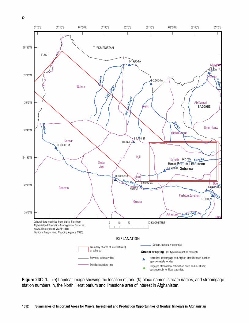
(AOI) in Afghanistan identified by Peters and others (2007) (fig. 23C–1a,b). The AOI is located in western Afghanistan in Gulran, Kushk, Kohsan, Zinda Jan, Injil, Hirat, Karukh, Kushi Kuhna, Obe, and Pashtun Zarghun Districts in Hirat (Herat) Province (fig. 23C–1a,b). The North Herat barium-limestone subarea occupies 2,630 km2 (square kilometers) of the 9,684-km2 area of the AOI.
Water is needed not only to process mineral resources in Afghanistan, but also to supply existing communities and the associated community growth that may accompany a developing mining economy. Information on the climate, vegetation, topography, and demographics of the AOI is summarized to provide information on the seasonal availability of, and seasonal demands for, water. The geohydrology of the AOI is described through the use of maps of streams and irrigated areas, generalized geohydrology and topography, and well locations. Where these data are available, the depth to water and height of static water in wells are documented. The results of lineament analyses are presented to identify areas where the rock may be more fractured than in other areas, which may be an indicator of high relative water yield and storage in bedrock aquifers.
Afghanistan’s recent turbulent history has left many of the traditional archival institutions in ruins, and most water-resource and meteorological data-collection activities had stopped by 1980. Recently (2011), nongovernmental organizations (NGOs), foreign government agencies, and the Afghan government have begun water-resource investigations; however, these activities and the amount of data collected are limited. This report summarizes the satellite imagery and climatic, topographic, geologic, surface-water, and groundwater data available. Geohydrologic inferences are made on the basis of an integrated analysis of these data and an understanding of conditions in other areas of Afghanistan.
23C.1.1 Climate and Vegetation Climate information for the North Herat barium and limestone AOI is based on data generated
for the Afghanistan agricultural-meteorological (Agromet) project. Agromet was initiated by the U.S. Agency for International Development and the United Nations Food and Agriculture Organization in 2003 to establish data-collection stations and develop country-wide agrometeorological services. Scientists with the Agromet project are assisting the Afghan Government to collect and analyze agricultural and meteorological data as they relate to crop production, irrigation, water supply, energy, and aviation. The U. S. Geological Survey (USGS) assumed responsibility for the operation of the project in 2005; by the end of August 2010, 87 Agromet stations were recording precipitation data and other parameters. Additionally, the Agromet project receives data from 18 Afghanistan Meteorological Authority (AMA) weather stations. The Agromet project has developed a database that includes data collected at the Agromet stations over the past 6 years (2005–2011), data collected at the AMA weather stations, and historical data collected at weather stations from 1942 to 1993. Data collected as part of the Agromet project are compiled annually by water year (September through August) and are reported in the Afghanistan Agrometeorological Seasonal Bulletin (Seasonal Bulletin) published by the Ministry of Agriculture, Irrigation, and Livestock. Unless otherwise specified, the Agromet data cited in this report are from the agricultural season that extends from 1 September, 2009, to 31 August, 2010.

Chapter 23C. Geohydrologic Summary of the North Herat Barium and Limestone Area of Interest 1611
a
1612 Summaries of Important Areas for Mineral Investment and Production Opportunities of Nonfuel Minerals in Afghanistan
b
Figure 23C–1. (a) Landsat image showing the location of, and (b) place names, stream names, and streamgage station numbers in, the North Herat barium and limestone area of interest in Afghanistan.
Chapter 23C. Geohydrologic Summary of the North Herat Barium and Limestone Area of Interest 1613
The Hirat Agromet station is located in Hirat Province approximately 45 km (kilometers) from the center of the AOI. This station is the Agromet station that is closest to the AOI for which 2009–2010 water year and long-term average (LTA) precipitation and temperature data are available. Precipitation and temperature data for the Hirat Agromet station (Ministry of Agriculture, Irrigation, and Livestock, 2010) are shown in table 23C–1. LTA precipitation at the Hirat Agromet station is less than 250 mm/yr (millimeters per year), and the AOI c
No snowfall was reported for the Hirat Agromet station for the 2009–2010 water year. The snow-depth map for January 17, 2010 (Ministry of Agriculture, Irrigation and Livestock, 2010, map 6), indicates that snow depth in the AOI ranged from less than 2 to 10 cm (centimeters) in January 2010.
an be classified as arid.
The “Potential Natural Vegetation” described in Breckle (2007) is the vegetation cover that would be present if it had not been modified by human activity. Today, as a result of continued exploitation such as grazing, farming, and deforestation, much of the original natural vegetation is found only in a few remote areas of Afghanistan. The destruction of the natural vegetation has resulted in the degradation and erosion of the soil cover in some areas. Many areas exhibit signs of long-lasting desertification caused by human activity.
The vegetation in the AOI as classified by Breckle (2007, p. 161) is ephemeral desert in the north near the Iranian and Turkmenistan borders. To the south this vegetation type transitions to Pistacia vera-woodlands, probably as a result of the increase in elevation. The elevation continues to increase to the south and the Juniperus-woodlands become the dominant vegetation type. Azonal riverine vegetation is present along the Hari Rud River just south of the AOI. Except along perennial and ephemeral streams, much of the AOI is sparsely vegetated. Much of the upland surface of the AOI is bedrock outcrop with thin alluvial cover. Most of the azonal riverine vegetation that was present in the stream valleys has probably been harvested for fuel and building materials. Most land suitable for farming has been plowed and planted, especially along major stream valleys and some of the ephemeral tributary stream valleys. Irrigated fields are present in many of the valleys in the AOI (fig. 23C–2).
Table 23C–1. Annual, long-term annual average, and long-term average minimum and maximum precipitation and temperature at the Hirat Agrometeorological (Agromet) station in the North Herat barium and limestone area of interest, Afghanistan. [Agromet, Agrometeorological; AOI, area of interest; km, kilometers; m, meters; mm, millimeters; °C, degrees Celsius]
Precipitation Temperature
Agromet station
Distance from AOI
center (km)
Elevation (m)
2009–2010
annual (mm)
Annual (mm)
1Long-term average Monthly Monthly minimum maximum and and month (mm) month (mm)
1Long-term average
Minimum and Monthly Maximum and month (°C) mean (°C) month (°C)
Hirat 45 920 198 224.7 0 2multiple months
49.9 March
3.1 January
13.8 29.6 July
1Long-term averages are based on data from 1942 to 1993 and 2005 to 2010 as reported in the Afghanistan Agrometeorological Seasonal Bulletin (Ministry of Agriculture, Irrigation, and Livestock, 2010). 2Long-term average precipitation in June, July, August, and September is 0 mm.
23C.1.2 Demographics The population density of the North Herat barium and limestone AOI is moderate, with much of
the area having from 6 to 50 inhabitants per square kilometer as mapped by LandScan (Oak Ridge National Laboratory, 2010) (fig. 23C–3). The population density around the city of Herat in the southwest corner of the AOI is greater than 5,000/km2. The population of the city of Herat is estimated to exceed 420,000 (Central Statistics Organization, 2010). In the area surrounding the city center, population density ranges from 501 to 5,000/km2 (fig. 23C–3). Some areas are estimated to be uninhabited as indicated by the gray shading in figure 23C–3. The population density shown in figure 23C–3 has a pixel resolution of about 1 km2 (Oak Ridge National Laboratory, 2010).

1614 Summaries of Important Areas for Mineral Investment and Production Opportunities of Nonfuel Minerals in Afghanistan
Figure 23C–2. Historical streamgage locations, digitally generated drainage network, and irrigated areas in the North Herat barium and limestone area of interest in Afghanistan.

Chapter 23C. Geohydrologic Summary of the North Herat Barium and Limestone Area of Interest 1615
Figure 23C–3. Population density of the North Herat barium and limestone area of interest in Afghanistan.
23C.1.3 Topography The topography of the North Herat barium and limestone AOI is low, hilly desert in the
northwest. A prominent ridge dominates the middle and eastern part of the AOI (Davis, 2006)

1616 Summaries of Important Areas for Mineral Investment and Production Opportunities of Nonfuel Minerals in Afghanistan
(fig. 23C-1a). The ridge is dissected by many ephemeral stream channels (fig. 23C–4). The elevations in the western AOI range from 600 m (meters) above sea level (asl) in the northern corner to 1,000 m asl at the Gulran River (Bohannon, 2005a) (fig. 23C–1b). The elevation of the central ridge increases from about 1,200 m asl at the western end to more than 2,500 m asl at the eastern border of the AOI (Bohannon, 2005b). The valley formed by the Hari Rud River is just outside the southern and southwestern borders of the AOI.
23C.2 Geohydrology The geohydrology of Afghanistan has been described in general terms by Abdullah and
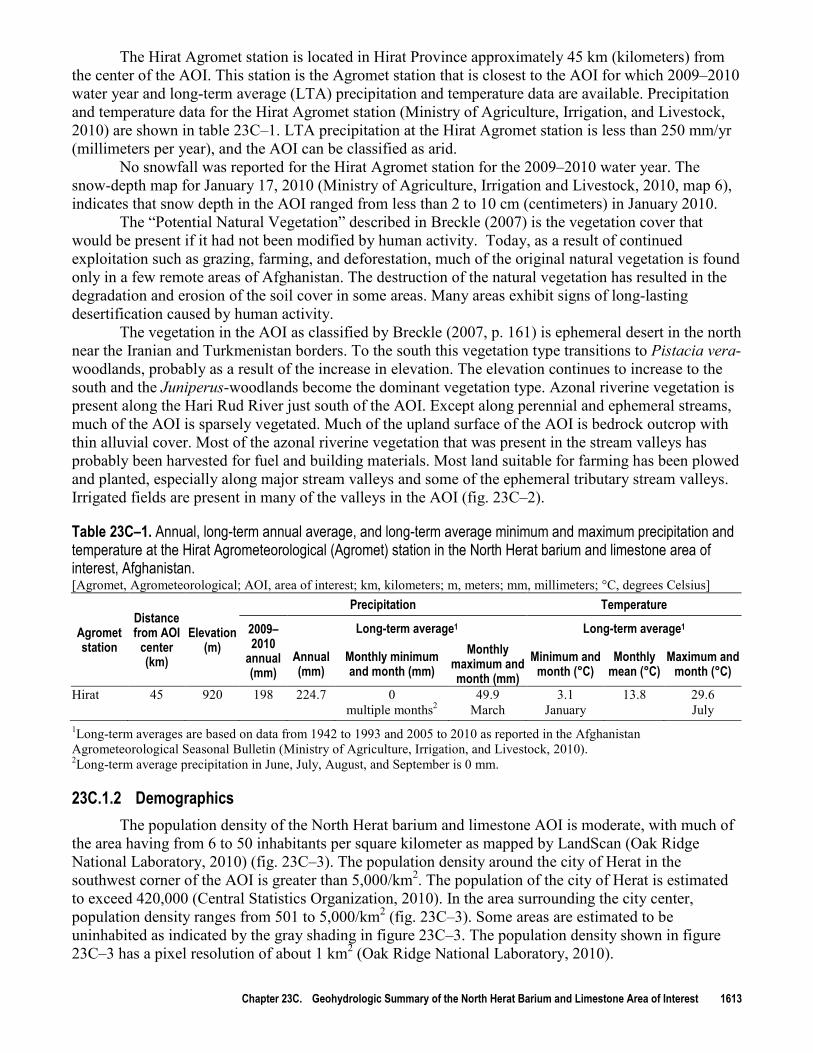
Chmyriov (1977, book 2). As defined in their “Geology and mineral resources of Afghanistan,” the North Herat barium and limestone AOI is in the “Southern Afghanistan Artesian Region.” The outcrops and near-surface rocks in the AOI can be grouped according to their physical and hydraulic properties. The generalized geohydrology of the AOI is shown in figure 23C–4 with the underlying topography to allow examination of the geohydrology in the context of relief. Figures 23C–5a and b show the generalized geohydrology without topography for a clearer depiction of the geohydrologic groups. Wells present in the map area (discussed in the Groundwater section) are shown in figures 23C–5a and b. Generalized geohydrologic groups were created from a country-wide geologic coverage (Doebrich and Wahl, 2006) by combining sediments and rocks into major sediment- or rock-type groups of similar hydrologic characteristics. The geohydrologic groups in the AOI, ranked from high to low relative hydraulic conductivity (Freeze and Cherry, 1979, table 2.3), are “river channel; sands, undifferentiated; conglomerate sediments and rocks; loess and fine sediments; limestones and dolostones; sedimentary rocks; metamorphic rocks; and intrusive rocks and lavas” (figs. 23C–4, 23C–5a and b
The conglomerate sediments and rocks geohydrologic group forms the largest outcrop area in the AOI. Much of the high ridge in the AOI is composed of the rocks and sediments of this geohydrologic group along with what appear to be alluvial fans on the southwest side of the ridge (fig. 23C–4). Many water-supply wells have been constructed in this geohydrologic group (figs. 23C–5
). Doebrich and Wahl (2006) used geologic maps at a scale of 1:250,000, modified from Russian and Afghan Geological Survey (AGS) mapping, to generate the country-wide geologic coverage. The 1:250,000-scale geologic maps that cover this AOI are provided by Bohannon and Lindsay (2005) and McKinney and Lidke (2005).
a and b
The sands, undifferentiated geohydrologic group is mapped in the river valleys, in some of the upland basins, and in some of the desert surfaces in the AOI (fig. 23C–4). Many shallow groundwater-supply wells have been constructed in this geohydrologic group. The shallow aquifer in this group is likely to be an important source of groundwater for local inhabitants. No information is available about the occurrence of deep groundwater supplies in this geohydrologic group. As discussed in the Groundwater section, passive seismic data collected during reconnaissance field investigations by the USGS indicate that the basin-fill sediments, consisting of sands and semi-consolidated conglomeratic sediments, could be as much as 500 m thick in some basins south of the AOI. The major component of the basin-fill sediments probably is the sands, undifferentiated geohydrologic group. This group
) or in small areas where unmapped alluvium overlies this group. The conglomerate sediments and rocks probably compose an aquifer capable of supplying sufficient water to meet local demands. No information is available on the thickness of this group. Figure 23C–4 shows outcrops of the sedimentary rocks geohydrologic group beneath the conglomerate sediments and rocks geohydrologic group. This information indicates that the conglomerate sediments and rocks group is likely to be thin where it overlies other geohydrologic groups in the AOI. If this group reaches appreciable thicknesses, such as in local depositional basins, however, it could contain considerable quantities of groundwater. The conglomerate sediments and rocks geohydrologic group is overlain by the sands, undifferentiated and the loess and fine sediments geohydrologic groups in parts of the AOI. The mapped outcrops of conglomerate sediments and rocks may not represent the entire subsurface extent of this group (fig. 23C–4).

Chapter 23C. Geohydrologic Summary of the North Herat Barium and Limestone Area of Interest 1617
potentially could be an untapped source of deep groundwater, especially near recharge areas, such as along rivers.
Figure 23C–4. Topography and generalized geohydrology of the North Herat barium and limestone area of interest in Afghanistan.

1618 Summaries of Important Areas for Mineral Investment and Production Opportunities of Nonfuel Minerals in Afghanistan
The consolidated rock geohydrologic groups have limited outcrop areas but are likely to be more extensive than is indicated by their mapped extents; this may be particularly true for the sedimentary rocks and the limestones and dolostones geohydrologic groups. Figures 23C–5a and b show some wells constructed in the sedimentary rocks geohydrologic group, but these wells likely tap unmapped alluvial sediments that overlie this group. There is no information about the thickness of either of these groups in the AOI. It is possible that rocks of both geohydrologic groups (sedimentary rocks and limestones and dolostones) underlie the conglomerate sediments and rocks group in the AOI. If so, one or both of these geohydrologic groups could be a potential groundwater resource in the AOI, especially where faults are mapped (figs. 23C–5a and b). The limited information available on the extent and thickness of some of the geohydrologic groups in the AOI indicates that field investigations are needed to characterize the groundwater potential of the area.
23C.2.1 Surface Water A network of major, mostly perennial streams, modified from AIMS (Afghanistan Information
Management Services, 1997) and VMAP1 (National Imagery and Mapping Agency, 1995), in the North Herat barium and limestone AOI is shown in figure 23C–2. A network representing likely ephemeral streams, generated with a digital elevation model (DEM), also is shown in figure 23C–2. Mapped springs, identified in the Vector Map (VMAP1) database (National Imagery and Mapping Agency, 1995), are shown in and adjacent to the AOI. Names of major streams and identification numbers for any streamgages and ungaged streamflow estimation sites in the AOI are shown in figure 23C–1b
The Hari Rud River is the largest source of surface water near the AOI. This river is just south of the AOI and flows from east to west (figs. 23C–1
.
b, 23C–2). The large extent of irrigated areas along the Hari Rud River indicates that this water resource is highly utilized by the local population (fig. 23C–2). The Hari Rud River at Pul-i-Pashtoon streamgage station (Afghan identification number 8–0.000–S3) is the closest station to the AOI on this river (figs. 23C–1b, 23C–2). This station is at an elevation of 940 m asl and has a drainage area of 26,130 km2 and a period of record that extends from 1 April, 1963, to 31 January, 1977 (Olson and Williams-Sether, 2010). The annual mean streamflow per unit area for this station is 0.0013 m3/s/km2 (cubic meter per second per square kilometer). The seasonal timing of maximum and minimum monthly streamflow is high flows in the spring and low flows in the mid summer through mid fall. A statistical summary of monthly and annual mean streamflows for this station is presented in table 23C–2. Statistical summaries of streamflow data for all available historical gages in Afghanistan can be accessed at http://afghanistan.cr.usgs.gov/water.php
There are two streamgage stations within the AOI. The Karukh River near Herat streamgage staion (Afghan identification number 8–2.R00–3A) is located in the southeastern part of the AOI (fig. 23C–1
.
b). The Karukh River begins outside the eastern border of the AOI and terminates in Hirat District before reaching the Hari Rud River. The flow volumes recorded at the streamgage are low (table 23C–3), and it is possible that diversion of water for irrigation causes the river to become dry (fig. 23C–2). This station is at an elevation of 1,145 m asl and has a drainage area of 1,390 km2 and a period of record that extends from 11 December, 1973, to 30 September, 1977 (Olson and Williams-Sether, 2010). The annual mean streamflow per unit area for this station is 0.0022 m3/s/km2
The second streamagage station within the AOI is the Senjab River at Khush Rabat station (Afghan identification number 8-1.R00-9T). This station is located approximately in the middle of the AOI (figs. 23C–1
. The seasonal timing of maximum and minimum monthly streamflow is high flows in the spring and low flows in the summer. A statistical summary of monthly and annual mean streamflows for this station is presented in table 23C–3.
b, 23C–2). The Senjab River begins on the high ridge located within the AOI. Several mapped springs are present in the vicinity of this streamgage station (fig. 23C–2). The mean flows for this station are very low, with no mean flow in the month of September during the period of record. This station is at an elevation of 1,320 m asl and has a drainage area of 65 km2 and a period of record that extends from 24 May, 1969, to 30 September, 1978 (Olson and Williams-Sether, 2010). The annual

Chapter 23C. Geohydrologic Summary of the North Herat Barium and Limestone Area of Interest 1619
mean streamflow per unit area for this station is 0.0049 m3/s/km2. The seasonal timing of maximum and minimum monthly streamflow is high flows in the early to mid spring and low flows in the summer through mid fall. A statistical summary of monthly and annual mean streamflows for this station is presented in table 23C–4.
a
1620 Summaries of Important Areas for Mineral Investment and Production Opportunities of Nonfuel Minerals in Afghanistan
b
Figure 23C–5. (a) Generalized geohydrology, mapped faults, well locations, and depth to water, and (b) geohydrology and height of static water in well casings in community supply wells in the North Herat barium and limestone area of interest in Afghanistan.

Chapter 23C. Geohydrologic Summary of the North Herat Barium and Limestone Area of Interest 1621
The Gulran River at Char Takhta streamgage station (Afghan identification number 9–1.000–1A) is located on a perennial stream that begins on the central ridge in the AOI and flows north (figs. 23C–1b, 23C–2). The mean flows for this station are very low. This station is at an elevation of 568 m asl and has a drainage area of 2,895 km2 and a period of record that extends from 20 June, 1977, to 30 September, 1978 (Olson and Williams-Sether, 2010). The annual mean streamflow per unit area for this station is 0.00008 m3/s/km2. The seasonal timing of maximum and minimum monthly streamflow is high flows in the late winter to mid spring and low flows in the late spring through early fall. A statistical summary of monthly and annual mean streamflows for this station is presented in table 23C–5.
23C.2.2 Groundwater Approximately 1,430 shallow community groundwater-supply wells have been installed in the
North Herat barium and limestone AOI by NGOs. Information about these wells can be found in a database maintained by DACAAR (Danish Committee for Aid to Afghan Refugees, 2011). Well-depth and static-water-level information is available for most of the wells in this database (fig. 23C–5a,b). About 91 percent of the supply wells are less than 30 m deep and the deepest well is 64 m deep. The median well depth is 14 m. The depth to water in 70 percent of the supply wells in the AOI is less than 15 m (fig. 23C–5a
Available well-construction information is limited; however, most wells are “tube” wells (driven wells with polyvinyl chloride (PVC) casing) or dug wells with concrete-ring casing. Wells are generally installed in unconsolidated sediments, completed a few meters below the depth at which water is first encountered, and equipped with a hand pump. Figure 23C–5
). The median depth to water is 10.6 m.
b
In some regional basins in Afghanistan there are hundreds to thousands of meters of basin-fill conglomerate sediments and rocks. Although no information about deep groundwater resources is available, deep groundwater likely is present in the Hari Rud River basin immediately south of the AOI. Passive seismic data collected during a USGS reconnaissance visit to the Hari Rud River basin about 10 km south of the AOI in August 2010 and analyzed following the methods of Lane and others (2008) indicate that basin-fill sediments are likely about 500 m thick. It is probable that substantial groundwater resources exist in the Hari Rud River basin; however, close monitoring and careful management of potential new groundwater withdrawals would be needed to protect the quantity and quality of the existing supply for current local water uses.
shows the height of static water in the casings of water-supply wells (well depth minus static depth to water). The median height of static water in well casings is 1.5 m. Less than 3 m of static water is present in 83 percent of wells in the AOI. Wells with so little static water were found to be vulnerable to seasonal water-level fluctuations and becoming dry for extended periods of time, or even permanently, in areas of the Kabul Basin where groundwater withdrawals are increasing (Mack and others, 2010). The maximum static water in a concrete-ring-cased well in the AOI was 5.5 m, and 99 percent of the concrete-ring-cased wells contained less than 3 m of static water; the wells that contained more than 3 m of static water were classified as tube or PVC-cased wells.
The 12 groundwater-monitoring wells (GWMs) in or near the AOI (fig. 23C–5a) are monitored by DACAAR for groundwater levels and specific conductance. Hydrographs of water levels in GWMs in the AOI, provided by DACAAR (Danish Committee for Aid to Afghan Refugees, 2011), are shown in appendix 3. These hydrographs are for GWMs 55, 60, 64, 68, 72, 165, 168, 191, 194, 195, 197, and 198 (app. 3). The hydrographs show the date in week number and year, groundwater specific conductance in microsiemens per centimeter at 25°C (µS/cm), and depth to water in meters below ground surface (bgs). The GWMs likely are constructed in alluvial sediments. Water levels in GWMs 55 and 64, in the eastern area of the AOI, showed relatively little seasonal fluctuation (about 1 m). Water levels in GWMs 68 and 72, in western areas of the AOI, fluctuated about 2 m seasonally. Minimum and maximum annual water levels generally occurred in the winter and spring, respectively. GWMs 191, 194, 195, 197, and 198 are in the south-central part of the AOI, in the city of Herat. Because only 1 year or less of data is available for these wells, no trends could be discerned.

1622 Summaries of Important Areas for Mineral Investment and Production Opportunities of Nonfuel Minerals in Afghanistan
Table 23C–2. Statistical summary of monthly and annual mean streamflows for the Hari Rud River at Pul-i-Pashtoon streamgage station (Olson and Williams-Sether, 2010).
3[m /s, cubic meters per second, ng, not given] 8–0.000–3S Hari Rud River at Pul-i-Pashtoon
Maximum Minimum Mean Water year Water year Standard Coefficient Percentage Month Streamflow Streamflow Streamflow of of deviation of of annual (m3/s) (m3/s) (m3/s) 3occurrence occurrence (m /s) variation streamflow October 1.03 1967 0.35 1975 0.57 0.20 0.35 0.14 November 9.59 1977 0.35 1975 1.83 2.68 1.47 0.45 December 8.65 1977 0.05 1965 2.29 3.15 1.37 0.56 January 12.3 1964 0.89 1967 5.69 3.62 0.64 1.40 February 29.6 1964 1.37 1975 12.9 9.03 0.70 3.16 March 128 1972 10.5 1967 50.7 34.2 0.67 12.5 April 266 1975 30.0 1963 133 82.4 0.62 32.6 May 398 1975 13.9 1974 168 112 0.67 41.3 June 79.5 1975 0.21 1974 31.6 30.3 0.96 7.75 July 1.40 1976 0.02 1968 0.42 0.40 0.95 0.10 August 0.52 1967 0.04 1968 0.28 0.17 0.62 0.07 September 0.78 1964 0.08 1968 0.34 0.18 0.53 0.08 Annual 66.0 1975 6.35 1966 35.0 18.7 0.53 100
Table 23C–3. Statistical summary of monthly and annual mean streamflows for the Karukh River near Herat streamgage station (Olson and Williams-Sether, 2010).
3[m /s, cubic meters per second] 8-2.R00-3A KARUKH RIVER NEAR HERAT
Maximum Minimum Mean Water year Water year Standard Coefficient Percentage Month Streamflow Streamflow Streamflow of of deviation of of annual (m3/s) (m3/s) (m3/s) 3occurrence occurrence (m /s) variation streamflow October 1.30 1974 0.99 1975 1.16 0.14 0.12 3.38 November 1.53 1977 1.19 1975 1.36 0.15 0.11 3.96 December 2.48 1977 1.31 1975 1.70 0.53 0.31 4.97 January 2.31 1973 0.78 1975 1.83 0.67 0.36 5.35 February 5.63 1976 2.13 1975 3.40 1.32 0.39 9.94 March 17.8 1976 4.37 1977 8.40 5.39 0.64 24.5 April 17.5 1976 3.31 1973 9.45 6.63 0.70 27.6 May 13.7 1976 0.96 1973 4.33 5.39 1.24 12.7 June 0.90 1976 0.40 1974 0.59 0.21 0.35 1.73 July 1.00 1976 0.46 1977 0.62 0.22 0.37 1.80 August 0.95 1976 0.41 1973 0.60 0.21 0.34 1.75 September 1.02 1973 0.61 1975 0.79 0.16 0.21 2.32 Annual 5.33 1976 1.92 1977 3.06 1.57 0.51 100

Chapter 23C. Geohydrologic Summary of the North Herat Barium and Limestone Area of Interest 1623
Table 23C–4. Statistical summary of monthly and annual mean streamflows for the Senjab River at Khush Rabat streamgage station (Olson and Williams-Sether, 2010).
3[m /s, cubic meters per second] 8–1.R00–9T SENJAB RIVER AT KHUSH RABAT
Maximum Minimum Mean Water year Water year Standard Coefficient Percentage Month Streamflow Streamflow Streamflow of of deviation of of annual (m3/s) (m3/s) (m3/s) 3occurrence occurrence (m /s) variation streamflow October 0.06 1975 0 1972 0.01 0.02 1.57 0.33 November 0.37 1972 0 1974 0.13 0.13 1.06 3.18 December 0.99 1978 0.01 1974 0.22 0.33 1.47 5.68 January 1.33 1972 0.06 1971 0.59 0.50 0.85 14.9 February 1.62 1972 0.06 1971 0.61 0.62 1.02 15.4 March 2.62 1972 0.20 1971 1.12 0.81 0.72 28.5 April 2.44 1975 0.24 1973 1.05 0.95 0.90 26.7 May 0.27 1976 0.04 1973 0.13 0.08 0.60 3.38 June 0.13 1969 0 1971 0.05 0.05 1.09 1.20 July 0.08 1972 0 1971 0.02 0.03 1.31 0.54 August 0.03 1972 0 1969 0.01 0.01 1.68 0.19 September 0.02 1976 0 1969 0 0.01 1.74 0.12 Annual 0.61 1972 0.06 1971 0.32 0.22 0.69 100
Table 23C–5. Statistical summary of monthly and annual mean streamflows for the Gulran River at Char Takhta streamgage station (Olson and Williams-Sether, 2010).
3[m /s, cubic meters per second; ng, not given] 9–1.000–1A GULRAN RIVER AT CHAR TAKHTA
Maximum Minimum Mean Water year Standard Coefficient Percentage Month Streamflow Water year of Streamflow Streamflow of deviation of of annual (m3/s) occurrence (m3/s) (m3/s) 3occurrence (m /s) variation streamflow
October 0.13 1978 0.13 1978 0.12 ng ng 3.95 November 0.57 1978 0.57 1978 0.57 ng ng 18.0 December 0.53 1978 0.53 1978 0.53 ng ng 16.8 January 0.03 1978 0.03 1978 0.03 ng ng 0.98 February 0.37 1978 0.37 1978 0.37 ng ng 11.7 March 0.78 1978 0.78 1978 0.78 ng ng 24.8 April 0.48 1978 0.48 1978 0.48 ng ng 15.3 May 0.06 1978 0.06 1978 0.06 ng ng 1.99 June 0.05 1978 0.05 1978 0.05 ng ng 1.61 July 0.04 1978 0.04 1977 0.04 0 0.05 1.25 August 0.06 1977 0.04 1978 0.05 0.02 0.33 1.64 September 0.09 1977 0.04 1978 0.07 0.04 0.55 2.12 Annual 0.26 1978 0.26 1978 0.26 ng ng 100

1624 Summaries of Important Areas for Mineral Investment and Production Opportunities of Nonfuel Minerals in Afghanistan
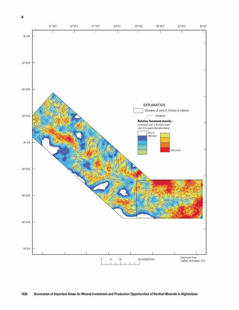
23C.2.3 Lineament Analyses Lineaments are photolinear features that could be the result of underlying zones of high-angle
bedrock fractures, fracture zones, faults, or bedding-plane weaknesses. Lineament analyses of the North Herat barium and limestone AOI (B.E. Hubbard, T.J. Mack, and A.L. Thompson, unpub. data, 2011) were conducted using DEM and natural-color satellite imagery (fig. 23C–6) and Advanced Spaceborne Thermal Emission and Reflection Radiometry (ASTER) satellite imagery (fig. 23C–7a,b). Lineament identification and analysis have long been used as a reconnaissance tool for identifying areas in carbonate bedrock environments where groundwater resources are likely to be found (Lattman and Parizek, 1964; Siddiqui and Parizek, 1971). Lineament analysis is increasingly used to identify areas of high relative well yields in other bedrock settings, including crystalline bedrock (Mabee, 1999; Moore and others, 2002). Many lineaments trend northeast, crossing the regional geologic trend. The lineaments shown in figure 23C–6 were delineated visually, whereas those in figure 23C–7 were delineated using an automated process and on the basis of the multispectral characteristics of the land surface (B.E. Hubbard, T.J. Mack, and A.L. Thompson, unpub. data, 2011). Water wells in bedrock aquifers generally are most productive where boreholes are located in areas of highly fractured bedrock. Areas where lineament density is high (figs. 23C–6, 23C–7a, 23C–7b) potentially are areas where bedrock fractures are more prevalent than in other areas of the AOI. Lineaments provide an indication of areas that warrant further investigation for optimal bedrock water-well placement. Lineaments may also indicate areas of preferential flow and storage of groundwater, and areas with a high density of lineaments may indicate high secondary porosity. Any lineament analyses, including those presented in this investigation, need to be corroborated by field investigations and additional data to confirm the nature of the lineaments and their relation to water-filled bedrock fracture zones.

Chapter 23C. Geohydrologic Summary of the North Herat Barium and Limestone Area of Interest 1625
Figure 23C–6. Lineaments and lineament density based on 30-meter digital-elevation-model data and natural-color Landsat imagery in the North Herat barium and limestone area of interest in Afghanistan.
1626 Summaries of Important Areas for Mineral Investment and Production Opportunities of Nonfuel Minerals in Afghanistan
a

Chapter 23C. Geohydrologic Summary of the North Herat Barium and Limestone Area of Interest 1627
b
Figure 23C–7. (a) Lineaments and lineament density based on 30-meter multispectral Landsat imagery and (b) lineaments and lineament density based on 15-meter multispectral Landsat imagery in the North Herat barium and limestone area of interest in Afghanistan.

1628 Summaries of Important Areas for Mineral Investment and Production Opportunities of Nonfuel Minerals in Afghanistan
23C.3 Summary and Conclusions The availability of water resources for mining and other uses is likely to be greater in the
North Herat barium and limestone area of interest (AOI) than in other areas of Afghanistan because of the relative availability of surface-water resources and conditions favorable for groundwater storage. Water resources in the AOI and surrounding area consist mainly of surface water, particularly the Hari Rud River, but untapped deep groundwater may be available. Shallow alluvial aquifers are present in the valley bottoms of the AOI and are a highly utilized groundwater resource. Most streams are also highly utilized by the local population and represent the primary source of water for irrigation. The diversion of water from the rivers to support mining activities would need to be closely monitored and carefully managed, particularly during low-flow periods, to ensure that the quantity and quality of surface-water flow remain sufficient to supply water for irrigation and to provide recharge to the aquifers that supply groundwater to the shallow wells used for domestic consumption.
No information is available about deep groundwater in the AOI or adjacent areas. Some areas of the AOI, as indicated by generalized geohydrologic maps and lineament analyses, are likely areas for further exploration for groundwater resources. Passive seismic investigations indicate that as much as 500 m of basin-fill material is present in some basins south of the AOI. The quality and sustainability of water resources in the AOI remain to be determined, however. Close monitoring and careful management of potential new surface-water or groundwater withdrawals would help to protect the quantity and quality of the existing supply for current local water uses. Field investigations including geologic mapping, geophysical surveys, and hydraulic well testing are needed to adequately characterize the extent and availability of groundwater resources in the AOI.
23C.4 References Cited Abdullah, Sh., and Chmyriov, V.M., eds. in chief, 1977, Geology and mineral resources of Afghanistan,
book 2: Afghanistan Ministry of Mines and Industries, Afghanistan Geological Survey, reprinted 2008, British Geological Survey Occasional Publications No. 15, 292 p.
Afghanistan Information Management Service, 1997, Irrigated areas, 1:250,000 scale: Afghanistan Information Management Service Afghanistan Shape Files, accessed October 15, 2010, at http://www.aims.org.af/.
Afghanistan Information Management Service, 2004, Settlements of Afghanistan, 1:100,000 scale: Afghanistan Information Management Service Afghanistan Shape Files, accessed October 15, 2010, at http://www.aims.org.af/.
Bohannon, R.G., 2005a, Topographic map of quadrangles 3560, 3562, and 3662, Sir Band (402), Khawja-Jir (403), Bala-Murghab (404), and Darah-i-Shor-i-Karmandi (122) quadrangles, Afghanistan: U.S. Geological Survey Open-File Report 2005–1098B.
Bohannon, R.G., 2005b, Topographic map of quadrangle 3462, Herat (409) and Chesht-Sharif (410) Quadrangles, Afghanistan: U.S. Geological Survey Open-File Report 2005–1104B.
Bohannon, R.G., and Lindsay, C.R., 2005, Geologic map of quadrangle 3462, Herat (409) and Chesht-Sharif (410) quadrangles, Afghanistan: U.S. Geological Survey Open-File Report 2005–1104A.
Breckle, S.W., 2007, Flora and vegetation of Afghanistan: Basic and Applied Dryland Research, v. 1, no. 2, p 155–194.
Central Statistics Organization, Islamic Republic of Afghanistan, 2010, Afghanistan Statistical Yearbook 2009–2010, issue no. 31, p. 247.
Danish Committee for Aid to Afghan Refugees, 2011, Update on “National groundwater monitoring wells network activities in Afghanistan” from July 2007 to December 2010: Kabul, Afghanistan, Danish Committee for Aid to Afghan Refugees (DACAAR), p. 23.
Davis, P.A., 2006, Calibrated Landsat ETM+ mosaics of Afghanistan: U.S. Geological Survey Open-File Report 2006-1345, 18 p., also at http://pubs.usgs.gov/of/2006/1345/.

Chapter 23C. Geohydrologic Summary of the North Herat Barium and Limestone Area of Interest 1629
Doebrich, J.L., and Wahl, R.R., comps., with contributions by Doebrich, J.L., Wahl, R.R., Ludington, S.D., Chirico, P.G., Wandrey, C.J., Bohannon, R.G., Orris, G.J., Bliss, J.D., Wasy, Abdul, and Younusi, M.O., 2006, Geologic and mineral resource map of Afghanistan: U.S. Geological Survey Open File Report 2006–1038, scale 1:850,000, available at
Freeze, R.A., and Cherry, J.A., 1979, Groundwater: Englewood Cliffs, N.J., Prentice-Hall, 604 p. http://pubs.usgs.gov/of/2006/1038/.
Lane, J.W., Jr., White, E.A., Steele, G.V., and Cannia, J.C., 2008, Estimation of bedrock depth using the horizontal-to-vertical (H/V) ambient-noise seismic method, in Proceedings of the Symposium on the Application of Geophysics to Engineering and Environmental Problems, April 6–10, 2008, Philadelphia, Pennsylvania: Denver, Colorado, Environmental and Engineering Geophysical Society, 13 p.
Lattman, L.H., and Parizek, R.R., 1964, Relationship between fracture traces and the occurrence of ground water in carbonate rocks: Journal of Hydrology, v. 2, p. 73–91.
Mabee, S.B., 1999, Factors influencing well productivity in glaciated metamorphic rocks: Groundwater, v. 37, no. 1, p. 88–97.
Mack, T.J., Akbari, M.A., Ashoor, M.H., Chornack, M.P., and others, 2010, Conceptual model of water resources in the Kabul Basin, Afghanistan: U.S. Geological Survey Scientific Investigations Report 2009-5262, 240 p.
McKinney, K.C., and Lidke, D.J., 2005, Geologic map of quadrangles 3560, 3562, and 3662, SirBand (402), Khawja-Jir (403), Bala-Murghab (404), and Darah-i-Shor-i-Karmandi (122) quadrangles, Afghanistan: U.S. Geological Survey Open-File Report 2005–1098A.
Ministry of Agriculture, Irrigation and Livestock and the Afghan Meteorological Authority of the Ministry of Transport, 2010,The Afghanistan Agrometeorological Seasonal Bulletin, issue no. 7, 2009–2010, 26 p., available at http://afghanistan.cr.usgs.gov/documents.php
Moore, R.B., Schwarz, G.E., Clark, S.F., Jr., Walsh, G.J., and Degnan, J.R., 2002, Factors related to well yield in the fractured-bedrock aquifer of New Hampshire: U.S. Geological Survey Professional Paper 1660, 51 p., 2 pl.
.
National Imagery and Mapping Agency, 1995, Vector map (VMAP1): National Imagery and Mapping Agency database, available at http://geoengine.nga.mil/geospatial/SW_TOOLS/NIMAMUSE/webinter/rast_roam.html
Oak Ridge National Laboratory, 2010, LandScan global population database 2009: Oak Ridge National Laboratory database, accessed February 1, 2011, at
.
http://www.ornl.gov/sci/landscan/Olson, S.A., and Williams-Sether, T., 2010, Streamflow characteristics of streamgages in northern
Afghanistan and selected locations: U.S. Geological Survey Data Series 529, 512 p.
.
Peters, S.G., Ludington, S.D., Orris, G.J., Sutphin, D.M., Bliss, J.D., and Rytuba, J.J., eds., and the U.S. Geological Survey-Afghanistan Ministry of Mines Joint Mineral Resource Assessment Team, 2007, Preliminary non-fuel mineral resource assessment of Afghanistan: U.S. Geological Survey Open-File Report 2007–1214, 810 p., 1 CD–ROM. (Also available at http://pubs.usgs.gov/of/2007/1214/.
Ruleman, C.A., Crone, A.J., Machette, M.N., Haller, K.M., and Rukstales, K.S., 2007, Map and database of probable and possible Quaternary faults in Afghanistan: U.S. Geological Survey Open-File Report 2007–1103, 39 p., 1 pl.
)
Siddiqui, S.H., and Parizek, R.R., 1971, Hydrogeologic factors influencing well yields in folded and faulted carbonate rocks in central Pennsylvania: Water Resources Research, v. 7, no. 5, p. 1295–1312.