chapter 2: beneficial uses
TRANSCRIPT

Water Quality Control Plan for the San Francisco Bay Basin
2‐1
CHAPTER 2: BENEFICIAL USES
State policy for water quality control in California is directed toward achieving the highest water quality consistent with maximum benefit to the people of the state. Aquatic ecosystems and underground aquifers provide many different benefits to the people of the state. The beneficial uses described in detail in this chapter define the resources, services, and qualities of these aquatic systems that are the ultimate goals of protecting and achieving high water quality. The Water Board is charged with protecting all these uses from pollution and nuisance that may occur as a result of waste discharges in the region. Beneficial uses of waters of the State presented here serve as a basis for establishing water quality objectives and discharge prohibitions to attain these goals.
Beneficial use designations for any given water body do not rule out the possibility that other beneficial uses exist or have the potential to exist. Existing beneficial uses that have not been formally designated in this Basin Plan are protected whether or not they are identified. While the tables in this Chapter list a large, representative portion of the water bodies in our region, it is not practical to list each and every water body.
2.1 DEFINITIONS OF BENEFICIAL USES
The following definitions (in italic) for beneficial uses are applicable throughout the entire state. A brief description of the most important water quality requirements for each beneficial use follows each definition (in alphabetical order by abbreviation).
2.1.1 AGRICULTURAL SUPPLY (AGR)
Uses of water for farming, horticulture, or ranching, including, but not limited to, irrigation, stock watering, or support of vegetation for range grazing.
The criteria discussed under municipal and domestic water supply (MUN) also effectively protect farmstead uses. To establish water quality criteria for livestock water supply, the Water Board must consider the relationship of water to the total diet, including water freely drunk, moisture content of feed, and interactions between irrigation water quality and feed quality. The University of California Cooperative Extension has developed threshold and limiting concentrations for livestock and irrigation water. Continued irrigation often leads to one or more of four types of hazards related to water quality and the nature of soils and crops. These hazards are (1) soluble salt accumulations, (2) chemical changes in the soil, (3) toxicity to crops, and (4) potential disease transmission to humans through reclaimed water use. Irrigation water classification systems, arable soil classification systems, and public health criteria related to reuse of wastewater have been developed with consideration given to these hazards.
2.1.2 AREAS OF SPECIAL BIOLOGICAL SIGNIFICANCE (ASBS)
Areas designated by the State Water Board.
These include marine life refuges, ecological reserves, and designated areas where the preservation and enhancement of natural resources requires special protection. In these areas,

Water Quality Control Plan for the San Francisco Bay Basin
2‐2
alteration of natural water quality is undesirable. The areas that have been designated as ASBS in this Region are Bird Rock, Point Reyes Headland Reserve and Extension, Double Point, Duxbury Reef Reserve and Extension, Farallon Islands, and James V. Fitzgerald Marine Reserve, depicted in Figure 2‐1. The California Ocean Plan prohibits waste discharges into, and requires wastes to be discharged at a sufficient distance from, these areas to assure maintenance of natural water quality conditions. These areas have been designated as a subset of State Water Quality Protection Areas as per the Public Resources Code.
2.1.3 COLD FRESHWATER HABITAT (COLD)
Uses of water that support cold water ecosystems, including, but not limited to, preservation or enhancement of aquatic habitats, vegetation, fish, or wildlife, including invertebrates.
Cold freshwater habitats generally support trout and may support anadromous salmon and steelhead fisheries as well. Cold water habitats are commonly well‐oxygenated. Life within these waters is relatively intolerant to environmental stresses. Often, soft waters feed cold water habitats. These waters render fish more susceptible to toxic metals, such as copper, because of their lower buffering capacity.
2.1.4 COMMERCIAL AND SPORT FISHING (COMM)
Uses of water for commercial or recreational collection of fish, shellfish, or other organisms, including, but not limited to, uses involving organisms intended for human consumption or bait purposes.
To maintain fishing, the aquatic life habitats where fish reproduce and seek their food must be protected. Habitat protection is under descriptions of other beneficial uses.
2.1.5 ESTUARINE HABITAT (EST)
Uses of water that support estuarine ecosystems, including, but not limited to, preservation or enhancement of estuarine habitats, vegetation, fish, shellfish, or wildlife (e.g., estuarine mammals, waterfowl, shorebirds), and the propagation, sustenance, and migration of estuarine organisms.
Estuarine habitat provides an essential and unique habitat that serves to acclimate anadromous fishes (e.g., salmon, striped bass) migrating into fresh or marine water conditions. The protection of estuarine habitat is contingent upon (1) the maintenance of adequate Delta outflow to provide mixing and salinity control; and (2) provisions to protect wildlife habitat associated with marshlands and the Bay periphery (i.e., prevention of fill activities). Estuarine habitat is generally associated with moderate seasonal fluctuations in dissolved oxygen, pH, and temperature and with a wide range in turbidity.
2.1.6 FRESHWATER REPLENISHMENT (FRESH)
Uses of water for natural or artificial maintenance of surface water quantity or quality.
Fresh water inputs are important for maintaining salinity balance, flow, and/or water quantity for such surface water bodies as marshes, wetlands, and lakes.

Water Quality Control Plan for the San Francisco Bay Basin
2‐3
2.1.7 GROUNDWATER RECHARGE (GWR)
Uses of water for natural or artificial recharge of groundwater for purposes of future extraction, maintenance of water quality, or halting saltwater intrusion into freshwater aquifers.
The requirements for groundwater recharge operations generally reflect the future use to be made of the water stored underground. In some cases, recharge operations may be conducted to prevent seawater intrusion. In these cases, the quality of recharged waters may not directly affect quality at the wellfield being protected. Recharge operations are often limited by excessive suspended sediment or turbidity that can clog the surface of recharge pits, basins, or wells.
Under the state Antidegradation Policy, the quality of some of the waters of the state is higher than established by adopted policies. It is the intent of this policy to maintain that existing higher water quality to the maximum extent possible.
Requirements for groundwater recharge, therefore, shall impose the Best Available Technology (BAT) or Best Management Practices (BMPs) for control of the discharge as necessary to assure the highest quality consistent with maximum benefit to the people of the state. Additionally, it must be recognized that groundwater recharge occurs naturally in many areas from streams and reservoirs. This recharge may have little impact on the quality of groundwaters under normal circumstances, but it may act to transport pollutants from the recharging water body to the groundwater. Therefore, groundwater recharge must be considered when requirements are established.
2.1.8 INDUSTRIAL SERVICE SUPPLY (IND)
Uses of water for industrial activities that do not depend primarily on water quality, including, but not limited to, mining, cooling water supply, hydraulic conveyance, gravel washing, fire protection, and oil well repressurization.
Most industrial service supplies have essentially no water quality limitations except for gross constraints, such as freedom from unusual debris.
2.1.9 MARINE HABITAT (MAR)
Uses of water that support marine ecosystems, including, but not limited to, preservation or enhancement of marine habitats, vegetation such as kelp, fish, shellfish, or wildlife (e.g., marine mammals, shorebirds).
In many cases, the protection of marine habitat will be accomplished by measures that protect wildlife habitat generally, but more stringent criteria may be necessary for waterfowl marshes and other habitats, such as those for shellfish and marine fishes. Some marine habitats, such as important intertidal zones and kelp beds, may require special protection.
2.1.10 FISH MIGRATION (MIGR)
Uses of water that support habitats necessary for migration, acclimatization between fresh water and salt water, and protection of aquatic organisms that are temporary inhabitants of waters within the region.

Water Quality Control Plan for the San Francisco Bay Basin
2‐4
The water quality provisions acceptable to cold water fish generally protect anadromous fish as well. However, particular attention must be paid to maintaining zones of passage. Any barrier to migration or free movement of migratory fish is harmful. Natural tidal movement in estuaries and unimpeded river flows are necessary to sustain migratory fish and their offspring. A water quality barrier, whether thermal, physical, or chemical, can destroy the integrity of the migration route and lead to the rapid decline of dependent fisheries.
Water quality may vary through a zone of passage as a result of natural or human‐ induced activities. Fresh water entering estuaries may float on the surface of the denser salt water or hug one shore as a result of density differences related to water temperature, salinity, or suspended matter.
2.1.11 MUNICIPAL AND DOMESTIC SUPPLY (MUN)
Uses of water for community, military, or individual water supply systems, including, but not limited to, drinking water supply.
The principal issues involving municipal water supply quality are (1) protection of public health; (2) aesthetic acceptability of the water; and (3) the economic impacts associated with treatment‐ or quality‐related damages.
The health aspects broadly relate to: direct disease transmission, such as the possibility of contracting typhoid fever or cholera from contaminated water; toxic effects, such as links between nitrate and methemoglobinemia (blue babies); and increased susceptibility to disease, such as links between halogenated organic compounds and cancer.
Aesthetic acceptance varies widely depending on the nature of the supply source to which people have become accustomed. However, the parameters of general concern are excessive hardness, unpleasant odor or taste, turbidity, and color. In each case, treatment can improve acceptability although its cost may not be economically justified when alternative water supply sources of suitable quality are available.
Published water quality objectives give limits for known health‐related constituents and most properties affecting public acceptance. These objectives for drinking water include the U.S. Environmental Protection Agency Drinking Water Standards and the California State Department of Health Services criteria.
2.1.12 NAVIGATION (NAV)
Uses of water for shipping, travel, or other transportation by private, military, or commercial vessels.
Navigation is a designated use where water is used for shipping, travel, or other transportation by private, military, or commercial vessels.
2.1.13 INDUSTRIAL PROCESS SUPPLY (PROC)
Uses of water for industrial activities that depend primarily on water quality.

Water Quality Control Plan for the San Francisco Bay Basin
2‐5
Water quality requirements differ widely for the many industrial processes in use today. So many specific industrial processes exist with differing water quality requirements that no meaningful criteria can be established generally for quality of raw water supplies. Fortunately, this is not a serious shortcoming, since current water treatment technology can create desired product waters tailored for specific uses.
2.1.14 PRESERVATION OF RARE AND ENDANGERED SPECIES (RARE)
Uses of waters that support habitats necessary for the survival and successful maintenance of plant or animal species established under state and/or federal law as rare, threatened, or endangered.
The water quality criteria to be achieved that would encourage development and protection of rare and endangered species should be the same as those for protection of fish and wildlife habitats generally. However, where rare or endangered species exist, special control requirements may be necessary to assure attainment and maintenance of particular quality criteria, which may vary slightly with the environmental needs of each particular species. Criteria for species using areas of special biological significance should likewise be derived from the general criteria for the habitat types involved, with special management diligence given where required.
2.1.15 WATER CONTACT RECREATION (REC1)
Uses of water for recreational activities involving body contact with water where ingestion of water is reasonably possible. These uses include, but are not limited to, swimming, wading, water‐skiing, skin and scuba diving, surfing, whitewater activities, fishing, and uses of natural hot springs.
Water contact implies a risk of waterborne disease transmission and involves human health; accordingly, criteria required to protect this use are more stringent than those for more casual water‐oriented recreation.
Excessive algal growth has reduced the value of shoreline recreation areas in some cases, particularly for swimming. Where algal growths exist in nuisance proportions, particularly bluegreen algae, all recreational water uses, including fishing, tend to suffer.
One criterion to protect the aesthetic quality of waters used for recreation from excessive algal growth is based on chlorophyll a.
Public access to drinking water reservoirs is limited or prohibited by reservoir owner/operators for purposes of protecting drinking water quality and public health. In some cases, access to reservoir tributaries is also prohibited. For these water bodies, REC‐1 is designated as E*, for the purpose of protecting water quality. No right to public access is intended by this designation.
2.1.16 NONCONTACT WATER RECREATION (REC2)
Uses of water for recreational activities involving proximity to water, but not normally involving contact with water where water ingestion is reasonably possible. These uses include, but are not limited to, picnicking, sunbathing, hiking, beachcombing, camping, boating, tide pool and marine life study, hunting, sightseeing, or aesthetic enjoyment in conjunction with the above activities.
Water Quality Control Plan for the San Francisco Bay Basin
2‐6
Water quality considerations relevant to noncontact water recreation, such as hiking, camping, or boating, and those activities related to tide pool or other nature studies require protection of habitats and aesthetic features. In some cases, preservation of a natural wilderness condition is justified, particularly when nature study is a major dedicated use.
One criterion to protect the aesthetic quality of waters used for recreation from excessive algal growth is based on chlorophyll a.
2.1.17 SHELLFISH HARVESTING (SHELL)
Uses of water that support habitats suitable for the collection of crustaceans and filter‐feeding shellfish (e.g., clams, oysters, and mussels) for human consumption, commercial, or sport purposes.
Shellfish harvesting areas require protection and management to preserve the resource and protect public health. The potential for disease transmission and direct poisoning of humans is of considerable concern in shellfish regulation. The bacteriological criteria for the open ocean, bays, and estuarine waters where shellfish cultivation and harvesting occur should conform with the standards described in the National Shellfish Sanitation Program, Manual of Operation.
Toxic metals can accumulate in shellfish. Mercury and cadmium are two metals known to have caused extremely disabling effects in humans who consumed shellfish that concentrated these elements from industrial waste discharges. Other elements, radioactive isotopes, and certain toxins produced by particular plankton species also concentrate in shellfish tissue. Documented cases of paralytic shellfish poisoning are not uncommon in California.
2.1.18 FISH SPAWNING (SPWN)
Uses of water that support high quality aquatic habitats suitable for reproduction and early development of fish.
Dissolved oxygen levels in spawning areas should ideally approach saturation levels. Free movement of water is essential to maintain well‐oxygenated conditions around eggs deposited in sediments. Water temperature, size distribution and organic content of sediments, water depth, and current velocity are also important determinants of spawning area adequacy.
2.1.19 WARM FRESHWATER HABITAT (WARM)
Uses of water that support warm water ecosystems including, but not limited to, preservation or enhancement of aquatic habitats, vegetation, fish, or wildlife, including invertebrates.
The warm freshwater habitats supporting bass, bluegill, perch, and other fish are generally lakes and reservoirs, although some minor streams will serve this purpose where stream flow is sufficient to sustain the fishery. The habitat is also important to a variety of nonfish species, such as frogs, crayfish, and insects, which provide food for fish and small mammals. This habitat is less sensitive to environmental changes, but more diverse than the cold freshwater habitat, and natural fluctuations in temperature, dissolved oxygen, pH, and turbidity are usually greater.

Water Quality Control Plan for the San Francisco Bay Basin
2‐7
2.1.20 WILDLIFE HABITAT (WILD)
Uses of waters that support wildlife habitats, including, but not limited to, the preservation and enhancement of vegetation and prey species used by wildlife, such as waterfowl.
The two most important types of wildlife habitat are riparian and wetland habitats. These habitats can be threatened by development, erosion, and sedimentation, as well as by poor water quality.
The water quality requirements of wildlife pertain to the water directly ingested, the aquatic habitat itself, and the effect of water quality on the production of food materials. Waterfowl habitat is particularly sensitive to changes in water quality. Dissolved oxygen, pH, alkalinity, salinity, turbidity, settleable matter, oil, toxicants, and specific disease organisms are water quality characteristics particularly important to waterfowl habitat. Dissolved oxygen is needed in waterfowl habitats to suppress development of botulism organisms; botulism has killed millions of waterfowl. It is particularly important to maintain adequate circulation and aerobic conditions in shallow fringe areas of ponds or reservoirs where botulism has caused problems.
2.2 EXISTING AND POTENTIAL BENEFICIAL USES
2.2.1 SURFACE WATERS
Surface waters in the Region consist of non‐tidal wetlands, rivers, streams, and lakes (collectively described as inland surface waters), estuarine wetlands known as baylands, estuarine waters, and coastal waters. In this Region, estuarine waters consist of the Bay system including intertidal, tidal, and subtidal habitats from the Golden Gate to the Region’s boundary near Pittsburg and the lower portions of streams that are affected by tidal hydrology, such as the Napa and Petaluma rivers in the north and Coyote and San Francisquito creeks in the south.
Inland surface waters support or could support most of the beneficial uses described above. The specific beneficial uses for inland streams include municipal and domestic supply (MUN), agricultural supply (AGR), commercial and sport fishing (COMM), freshwater replenishment (FRESH), industrial process supply (PRO), groundwater recharge (GWR), preservation of rare and endangered species (RARE), water contact recreation (REC1), noncontact water recreation (REC2), wildlife habitat (WILD), cold freshwater habitat (COLD), warm freshwater habitat (WARM), fish migration (MIGR), and fish spawning (SPWN).
The San Francisco Bay Estuary supports estuarine habitat (EST), industrial service supply (IND), and navigation (NAV) in addition to COMM, RARE, REC1, REC2, WILD, MIGR, and SPWN.
Coastal waters’ beneficial uses include water contact recreation (REC1); noncontact water recreation (REC2); industrial service supply (IND); navigation (NAV); marine habitat (MAR); shellfish harvesting (SHELL); commercial and sport fishing (COMM); wildlife habitat (WILD), fish migration (MIGR), fish spawning (SPWN), and preservation of rare and endangered species (RARE). In addition, the California coastline within the Region is endowed with exceptional scenic beauty.

Water Quality Control Plan for the San Francisco Bay Basin
2‐8
The beneficial uses of any specifically identified water body generally apply to all its tributaries. In some cases a beneficial use may not be applicable to the entire body of water, such as navigation in Richardson Bay or shellfish harvesting in the Pacific Ocean. In these cases, the Water Board’s judgment regarding water quality control measures necessary to protect beneficial uses will be applied.
Beneficial uses of streams that have intermittent flows, as is typical of many streams in the region, must be protected throughout the year and are designated as “existing.”
Beneficial uses of each significant water body have been identified and are organized according to the seven major Hydrologic Planning Areas within the Region (Figure 2‐2). The maps locating each water body (Figures 2‐3 through 2‐9b) were produced using a geographical information system (GIS) at the Water Board. The maps use the hydrologic basin information compiled by the California Interagency Watershed map, with supplemental information from the Oakland Museum of California Creek and Watershed Map series, the Contra Costa County Watershed Atlas, and the San Francisco Estuary Institute EcoAtlas. More detailed representations of each location can be created using this GIS version.
Table 2‐1 contains the beneficial uses for many surface water bodies in the Region, organized geographically by the Region’s seven Hydrologic Planning Areas. Within each Hydrologic Planning Area, water bodies are listed geographically, with tributaries indented below their receiving water body. In cases where a water body shares the same name with another water body (e.g., Redwood Creek), the location of the water body (county and/or other identifier) is given in parentheses. An alternative name for a water body, where known, is also shown in parentheses. In Table 2‐1, beneficial uses are indicated as follows:
E – indicates the beneficial use exists in the water body.
E* – indicates public access to the water body is limited or prohibited for purposes of protecting drinking water quality and public health. REC‐1 is designated as E* for the purpose of protecting water quality. No right to public access is intended by this designation.
P – indicates the water body could potentially support the beneficial use.
2.2.2 GROUNDWATER
Groundwater is defined as subsurface water that occurs beneath the water table in soils and geologic formations that are fully saturated. Where groundwater occurs in a saturated geologic unit that contains sufficient permeable thickness to yield significant quantities of water to wells and springs, it can be defined as an aquifer. A groundwater basin is defined as a hydrogeologic unit containing one large aquifer or several connected and interrelated aquifers.
Water‐bearing geologic units occur within groundwater basins in the Region that do not meet the definition of an aquifer. For instance, there are shallow, low permeability zones throughout the Region that have extremely low water yields. Groundwater may also occur outside of currently identified basins. Therefore, for basin planning purposes, the term “groundwater” includes all

Water Quality Control Plan for the San Francisco Bay Basin
2‐9
subsurface waters, whether or not these waters meet the classic definition of an aquifer or occur within identified groundwater basins.
The California Department of Water Resources (DWR) evaluated the characteristics of groundwater basins in the Region and throughout the state and summarized the results in California’s Groundwater, Bulletin 118 (2003). Of special importance to the Region are the 28 groundwater basins and seven sub‐basins classified by DWR that produce, or potentially could produce, significant amounts of groundwater (Figures 2‐10 and 2‐10A‐D). The Water Board maintains a GIS for all water bodies in the Region and has the capacity to present information on each basin at a much higher level of resolution than is depicted in Figures 2‐10A‐D.
Existing and potential beneficial uses applicable to groundwater in the Region include municipal and domestic water supply (MUN), industrial water supply (IND), industrial process supply (PRO), agricultural water supply (AGR), groundwater recharge (GWR), and freshwater replenishment to surface waters (FRESH). Table 2‐2 lists the 28 identified groundwater basins and seven sub‐basins located in the Region and their existing and potential beneficial uses.
Unless otherwise designated by the Water Board, all groundwater is considered suitable, or potentially suitable, for municipal or domestic water supply (MUN). In making any exceptions, the Water Board will consider the criteria referenced in State Water Board Resolution No. 88‐63 and Water Board Resolution No. 89‐39, “Sources of Drinking Water,” where:
• The total dissolved solids exceed 3,000 milligrams per liter (mg/L) (5,000 microSiemens per centimeter, μS/cm, electrical conductivity), and it is not reasonably expected by the Water Board that the groundwater could supply a public water system; or
• There is contamination, either by natural processes or by human activity (unrelated to a specific pollution incident), that cannot reasonably be treated for domestic use using either Best Management Practices (BMPs) or best economically achievable treatment practices; or
• The water source does not provide sufficient water to supply a single well capable of producing an average, sustained yield of 200 gallons per day; or
• The aquifer is regulated as a geothermal energy‐producing source or has been exempted administratively pursuant to 40 Code of Federal Regulations (CFR) Part 146.4 for the purpose of underground injection of fluids associated with the production of hydrocarbon or geothermal energy, provided that these fluids do not constitute a hazardous waste under 40 CFR Part 261.3.
2.2.3 WETLANDS
Federal administrative law (e.g., 40 CFR Part 122.2, revised December 22, 1993) defines wetlands as waters of the United States. National waters include waters of the State of California, defined by the Porter‐Cologne Act as “any water, surface or underground, including saline waters, within the boundaries of the State” (California Water Code §13050[e]). Wetland water quality control is therefore clearly within the jurisdiction of the State Water Board and Regional Water Boards.
Wetlands are further defined in 40 CFR 122.2 as “those areas that are inundated or saturated by surface or groundwater at a frequency and duration sufficient to support, and that under normal

Water Quality Control Plan for the San Francisco Bay Basin
2‐10
circumstances do support, a prevalence of vegetation typically adapted for life in saturated soil conditions. Wetlands generally include swamps, marshes, bogs, and similar areas.”
The Water Board recognizes that wetlands frequently include areas commonly referred to as saltwater marshes, freshwater marshes, open or closed brackish water marshes, mudflats, sandflats, unvegetated seasonally ponded areas, vegetated shallows, sloughs, wet meadows, playa lakes, natural ponds, vernal pools, diked baylands, seasonal wetlands, floodplains, and riparian woodlands.
Mudflats make up one of the largest and most important habitat types in the Estuary. Snails, clams, worms, and other animals convert the rich organic matter in the mud bottom to food for fish, crabs, and birds.
Mudflats generally support a variety of edible shellfish, and many species of fish rely heavily on the mudflats during at least a part of their life cycle. Additionally, San Francisco Bay mudflats are one of the most important habitats on the coast of California for millions of migrating shorebirds.
Another important characteristic of the Estuary is the fresh, brackish, and salt water marshes around the Bay’s margins. These highly complex communities are recognized as vital components of the Bay system’s ecology. Most marshes around the Bay have been destroyed through filling and development. The protection, preservation, and restoration of the remaining marsh communities are essential for maintaining the ecological integrity of the Estuary.
Identifying wetlands may be complicated by such factors as the seasonality of rainfall in the Region. Therefore, in identifying wetlands considered waters of the United States, the Water Board will consider such indicators as hydrology, hydrophytic plants, and/or hydric soils for the purpose of mapping and inventorying wetlands. The Water Board will, in general, rely on the federal manual for wetland delineation in the Region when issuing Clean Water Act Section 401 water quality certifications (U.S. Army Corps of Engineers (Corps) Wetlands Delineation Manual, 1987). In the rare cases where the U.S. EPA and Corps guidelines disagree on the boundaries for federal jurisdictional wetlands, the Water Board will rely on the wetlands delineation made by the U.S. EPA or the California Department of Fish and Game (CDFG). For the purpose of mapping and inventorying wetlands, the Water Board will rely on the protocols and naming conventions of the National Wetlands Inventory (NWI) prepared by the U.S. Fish and Wildlife Service (USFWS).
Many individual wetlands provide multiple benefits depending on the wetland type and location. There are many potential beneficial uses of wetlands, including Wildlife Habitat (WILD); Preservation of Rare and Endangered Species (RARE); Shellfish Harvesting (SHELL); Water Contact Recreation (REC1); Noncontact Water Recreation (REC2); Commercial, and Sport Fishing (COMM); Marine Habitat (MAR); Fish Migration (MIGR); Fish Spawning (SPAWN); and Estuarine Habitat (EST). Some of these general beneficial uses can be further described in terms of their component wetland function. For example, many wetlands that provide groundwater recharge (GWR) also provide flood control, pollution control, erosion control, and stream baseflow.

Water Quality Control Plan for the San Francisco Bay Basin
2‐11
Table 2‐3 shows how beneficial uses are associated with different wetland types. Table 2‐4 lists and specifies beneficial uses for 34 significant wetland areas within the Region; generalized locations of these wetlands are shown in Figure 2‐11. It should be noted that most of the wetlands listed in Table 2‐4 are saltwater marshes, and that the list is not comprehensive.
The Water Board has participated in completing the Baylands Ecosystem Habitat Goals Report (1999) and the Baylands Ecosystem Species and Community Profiles (2000), which were written by scientists and managers in the Region in order to recommend sound wetland restoration strategies. Other efforts around the Bay to locate wetland sites include San Francisco Estuary Institute’s (SFEI) EcoAtlas Baylands Maps (Baylands Maps) and Bay Area Wetlands Project Tracker (Wetlands Tracker), and the Wetland Tracker managed by the San Francisco Bay Joint Venture. Because of the large number of small and non‐contiguous wetlands, it is not practical to delineate and specify beneficial uses of every wetland area. Therefore, beneficial uses may be determined site specifically, as needed. Chapter 4 of this Plan contains additional information on the process used to determine beneficial uses for specific wetland sites.
FIGURES
Figure 2‐1: Areas of Special Biological Significance
Figure 2‐2: Hydrologic Planning Areas
Legend for Figures 2‐3 through 2‐9b
Figures 2‐3 through 2‐3b: Marin Coastal Basin
Figures 2‐4 through 2‐4b: San Mateo Coastal Basin
Figure 2‐5: Central Basin
Figures 2‐6 through 2‐6b: South Bay Basin
Figures 2‐7 through 2‐7b: Santa Clara Basin
Figures 2‐8 through 2‐8b: San Pablo Basin
Figures 2‐9 through 2‐9b: Suisun Basin
Figure 2‐10: Significant Groundwater Basins
Figure 2‐10A: Groundwater Basins: Marin / Sonoma / Napa
Figure 2‐10B: Groundwater Basins: Napa / Solano
Figure 2‐10C: Groundwater Basins: San Francisco
Figure 2‐10D: Groundwater Basins: East and South Bay

Water Quality Control Plan for the San Francisco Bay Basin
2‐12
Figure 2‐11: General Locations of Wetland Areas
TABLES
Table 2‐1: Existing and Potential Beneficial Uses of Water Bodies in the San Francisco Bay Region
Table 2‐2: Existing and Potential Beneficial Uses of Groundwater in Identified Basins
Table 2‐3: Examples of Existing and Potential Beneficial Uses of Selected Wetlands
Table 2‐4: Beneficial Uses of Wetland Areas

E: Existing beneficial use E*: Water quality objectives apply; water contact recreation is prohibited or limited to protect public health P: Potential beneficial use
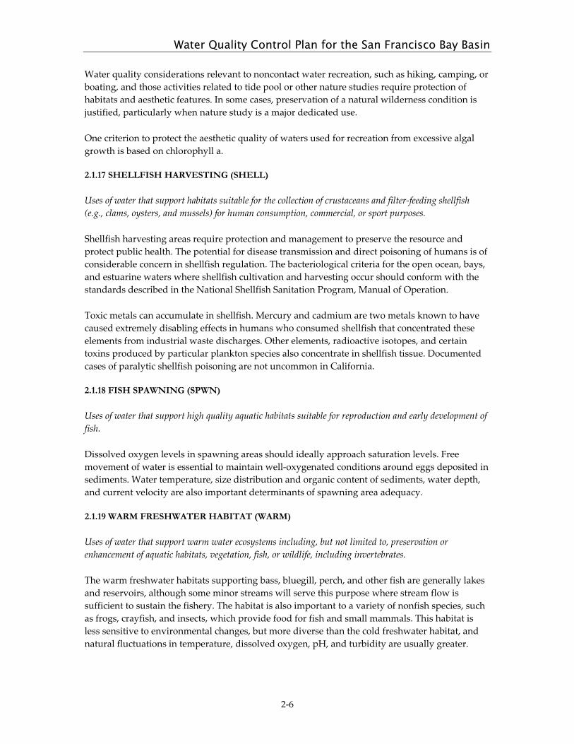
Table 2-1: Existing and Potential Beneficial Uses of Water Bodies in the San Francisco Bay Region
COUNTY Waterbody A
GR
MU
N
FRSH
GW
R
IND
PRO
C
CO
MM
SHEL
L
CO
LD
EST
MA
R
MIG
R
RA
RE
SPW
N
WA
RM
WIL
D
REC
-1
REC
-2
NA
V
MARIN COUNTY
Pacific Ocean (Marin) E E E E E E E E E E E Abbotts Lagoon E E E E Drakes Estero E E E E E E E E E East Schooner Creek E E E E E E E E E Home Ranch Creek E E E E E E E E Limantour Estero E E E E E E E E E Glenbrook Creek E E E E E E E Muddy Hollow Creek E E E E E E E E Santa Maria Creek (Marin) E E E E E E E E Coast Creek E E E E E E E E E Alamere Creek E E E E Wildcat Lake E E E E Crystal Lake E E E E E E Bass Lake E E E E E Pelican Lake E E E E Arroyo Hondo (Marin) E E E E E E Bolinas Lagoon E E E E E E E E E E Pine Gulch Creek E E E E E E E E E Copper Mine Gulch Creek E E E E E E E E Wilkins Gulch Creek E E E E E E E
MA
RIN
CO
AS
TA
L B
AS
IN
Human Consumptive Uses
Wildlife Use Recreational
Uses Aquatic Life Uses

E: Existing beneficial use E*: Water quality objectives apply; water contact recreation is prohibited or limited to protect public health P: Potential beneficial use
COUNTY Waterbody A
GR
MU
N
FRSH
GW
R
IND
PRO
C
CO
MM
SHEL
L
CO
LD
EST
MA
R
MIG
R
RA
RE
SPW
N
WA
RM
WIL
D
REC
-1
REC
-2
NA
V
MARIN COUNTY, continued
Pike County Gulch Creek E E E E E Morses Gulch Creek E E E E E E E E McKinnan Gulch Creek E E E E E E E E Stinson Gulch Creek E E E E E E E E E Easkoot Creek E E E E E E E E Webb Creek E E E E E E E Lone Tree Creek E E E E Redwood Creek (Marin) E E E E E E E E E E E E Green Gulch Creek E E E E E E E E Tennessee Valley Creek E E E E Rodeo Lagoon E E E E E E E Rodeo Creek E E E E E E E Tomales Bay E E E E E E E E E E Millerton Gulch E E E E E E Grand Canyon Creek E E E E Tomasini Canyon Creek E E E E E E E E Walker Creek E E E E E E E E E Chileno Creek E E E E E E E Laguna Lake E E E* E Frink Canyon Creek E E E E E E E Verde Canyon Creek E E E E E E E Salmon Creek (Marin) E E E E E E E Soulajule Reservoir E E E E E E* E Arroyo Sausal E E E E E E E
MA
RIN
CO
AS
TA
L B
AS
IN

E: Existing beneficial use E*: Water quality objectives apply; water contact recreation is prohibited or limited to protect public health P: Potential beneficial use
COUNTY Waterbody A
GR
MU
N
FRSH
GW
R
IND
PRO
C
CO
MM
SHEL
L
CO
LD
EST
MA
R
MIG
R
RA
RE
SPW
N
WA
RM
WIL
D
REC
-1
REC
-2
NA
V
MARIN COUNTY, continued Lagunitas Creek E E E E E E E E E E E Haggerty Gulch Creek E E E E E E E E E Bear Valley Creek E E E E E E E E E Olema Creek E E E E E E E E E Nicasio Creek E E E E E E E E E Nicasio Reservoir E E E P E E E E* E Halleck Creek E E E E E E Devils Gulch Creek E E E E E E E E San Geronimo Creek E E E E E E E E Woodacre Creek E E E E E E E Kent Lake E E E E E E E* E Big Carson Creek E E E E E Alpine Lake E E E E E E E* E Cataract Creek E E E E E Bon Tempe Lake E E E E E E* E Lake Lagunitas E E E E E E E* E

E: Existing beneficial use E*: Water quality objectives apply; water contact recreation is prohibited or limited to protect public health P: Potential beneficial use
COUNTY Waterbody A
GR
MU
N
FRSH
GW
R
IND
PRO
C
CO
MM
SHEL
L
CO
LD
EST
MA
R
MIG
R
RA
RE
SPW
N
WA
RM
WIL
D
REC
-1
REC
-2
NA
V
SAN FRANCISCO COUNTY Pacific Ocean (San Mateo, San Francisco
Counties) E E E E E E E E E1 E E
Lake Merced P E E E E E E E SAN MATEO COUNTY Milagra Creek E E E E E E Calera Creek (San Mateo) E E E E E San Pedro Creek E E E E E E E E E San Vicente Creek E E E E E E E E E E Denniston Creek E E E E E E E E E E Arroyo de en Medio E E E E E Frenchmans Creek E E E E E E E E E Pilarcitos Creek E E E E E E E E E E Arroyo Leon Creek E E E E E Mills Creek (San Mateo) E E E E E E Apanolio Creek E E E E E E E Corinda Los Trancos Creek E E E E E E Pilarcitos Reservoir E E E E E E E* E Purisima Creek E E E E E E E E Lobitos Creek E E E E E E E E Tunitas Creek E E E E E E E E E E San Gregorio Creek E E E E E E E E E Clear Creek E E E E E El Corte de Madera Creek E P E P E E E E Bogess Creek E E E E E E E E Harrington Creek E E E E E E E E La Honda Creek E E E E E E E E
1 REC-1 applies within a zone bounded by the shoreline and a distance of 1000 feet from the shoreline or the 30-foot depth contour, whichever is further from the shoreline. This distance is consistent with the applicability of water-contact standards in the Water Quality Plan for the Ocean Waters of California.
SA
N M
AT
EO
CO
AS
TA
L B
AS
IN
Human Consumptive
Uses Wildlife
Use Recreational Uses
Aquatic Life Uses

E: Existing beneficial use E*: Water quality objectives apply; water contact recreation is prohibited or limited to protect public health P: Potential beneficial use
COUNTY Waterbody A
GR
MU
N
FRSH
GW
R
IND
PRO
C
CO
MM
SHEL
L
CO
LD
EST
MA
R
MIG
R
RA
RE
SPW
N
WA
RM
WIL
D
REC
-1
REC
-2
NA
V
SAN MATEO COUNTY, continued Woodruff Creek E E E E E Woodhams Creek E E E E E Mindego Creek E E E E E E E Alpine Creek E E E E E E E E Pomponio Creek E E E E E E E E E Pomponio Reservoir E E E E E Pescadero Creek E E E E E E E E E E Honsinger Creek E E E E E E McCormick Creek E E E E E E E E Hoffman Creek E E E E E Jones Gulch Creek E E E E E Tarwater Creek E E E E E E E E Peters Creek E E E E E E E Lambert Creek E E E E E E E Fall Creek E E E E E Slate Creek E E E E E E E Oil Creek E E E E E E E E Little Boulder Creek E E E E E E Waterman Creek E E E E E E E Butano Creek E E E E E E E Little Butano Creek E E E E E E E
SA
N M
AT
EO
CO
AS
TA
L B
AS
IN

E: Existing beneficial use E*: Water quality objectives apply; water contact recreation is prohibited or limited to protect public health P: Potential beneficial use
COUNTY Waterbody A
GR
MU
N
FRSH
GW
R
IND
PRO
C
CO
MM
SHEL
L
CO
LD
EST
MA
R
MIG
R
RA
RE
SPW
N
WA
RM
WIL
D
REC
-1
REC
-2
NA
V
SAN FRANCISCO COUNTY Golden Gate Channel E E E E E E E E E San Francisco Bay Central E E E E E E E E E E E E Crissy Field Lagoon E E E E Golden Gate Park Lakes E E E Lobos Creek E E E E E E Mountain Lake E E E E MARIN COUNTY San Rafael Creek E E E E E E Corte Madera Creek E E E E E E E E E E Larkspur Creek E E E E E E E Tamalpais Creek E E E E E E E E Ross Creek (Marin) E E E E E E E E Phoenix Lake E E E E E E E E* E Phoenix Creek E E E E E E Bill Williams Creek E E E E E E E Sleepy Hollow Creek E E E E E E E E San Anselmo Creek E E E E E E E E Fairfax Creek E E E E E E Cascade Creek E E E E E E E Richardson Bay E E E E E E E E E E E Arroyo Corte Madera del Presidio E E E E E E E E E Warner Creek (Mill Valley, Marin) E E E E E E E E Old Mill Creek E E E E E E E E Willow Reed Creek E E E E E E E Coyote Creek (Marin) E E E E E Nyhan Creek E E E E E ALAMEDA COUNTY Berkeley Aquatic Park Lagoon E E P E E E Lake Temescal E E E E E E E
Human Consumptive
Uses
Wildlife Use Recreational
Uses C
EN
TR
AL
BA
SIN
Aquatic Life
Uses

E: Existing beneficial use E*: Water quality objectives apply; water contact recreation is prohibited or limited to protect public health P: Potential beneficial use
COUNTY Waterbody A
GR
MU
N
FRSH
GW
R
IND
PRO
C
CO
MM
SHEL
L
CO
LD
EST
MA
R
MIG
R
RA
RE
SPW
N
WA
RM
WIL
D
REC
-1
REC
-2
NA
V
ALAMEDA COUNTY, continued Temescal Creek E E E E E Claremont Creek E E E E Strawberry Creek E E E E Codornices Creek E E E E E E E E Village Creek E E E E Capistrano Creek E E E E CONTRA COSTA COUNTY Cerrito Creek E E E E Baxter Creek E E E E Richmond Inner Harbor E E E E E E
CE
NT
RA
L B
AS
IN

E: Existing beneficial use E*: Water quality objectives apply; water contact recreation is prohibited or limited to protect public health P: Potential beneficial use
COUNTY Waterbody A
GR
MU
N
FRSH
GW
R
IND
PRO
C
CO
MM
SHEL
L
CO
LD
EST
MA
R
MIG
R
RA
RE
SPW
N
WA
RM
WIL
D
REC
-1
REC
-2
NA
V
SAN FRANCISCO COUNTY San Francisco Bay Lower E E E E E E E E E E E Mission Creek (San Francisco) E E E E E E Central Basin E E E E E E Islais Creek, tidal E E E E E E India Basin E E E E E E South Basin E E E E E E Yosemite Creek E E E E E SAN MATEO COUNTY Brisbane Lagoon E E E E Guadalupe Canyon Creek E E E E Colma Creek E E E E San Bruno Creek E E E E Mills Creek E E E E Easton Creek E E E E Burlingame Lagoon E E E E Anza Lagoon E E E E Sanchez Creek E E E E Cherry Canyon Creek E E E E San Mateo Creek E E E E E E E E E Polhemus Creek E E E E E Lower Crystal Springs Reservoir E E E E E E E* E Upper Crystal Springs Reservoir E E E E E E E* E San Andreas Creek E E E E E E San Andreas Reservoir E E E E E E E* E Marina Lagoon E E E E Seal Slough E E E E E Leslie Creek E E E E Borel Creek E E E E
Human Consumptive
Uses Wildlife
Use Recreational Uses
SO
UT
H B
AY
BA
SIN
Aquatic Life
Uses
E: Existing beneficial use E*: Water quality objectives apply; water contact recreation is prohibited or limited to protect public health P: Potential beneficial use
COUNTY Waterbody A
GR
MU
N
FRSH
GW
R
IND
PRO
C
CO
MM
SHEL
L
CO
LD
EST
MA
R
MIG
R
RA
RE
SPW
N
WA
RM
WIL
D
REC
-1
REC
-2
NA
V
SAN MATEO COUNTY, continued O’Neill Slough E E E E Foster City Lagoon E E E E Belmont Slough E E E E E E Belmont Creek E E E E Laurel Creek (San Mateo) E E E E Bay Slough (San Mateo) E E E E E Steinberger Slough E E E E E Corkscrew Slough E E E E E Smith Slough (San Mateo) E E E E E Pulgas Creek E E E E Cordilleras Creek E E E E Redwood Slough E E E E E E Redwood Creek (San Mateo) E E E E Arroyo Ojo de Agua E E E E Westpoint Slough E E E E E Atherton Creek E E E E Ravenswood Slough E E E E E ALAMEDA COUNTY Oakland Inner Harbor E E E E E Merritt Channel E E E E E Lake Merritt E E E E E E E E Glen Echo Creek E E E E Sausal Creek (Alameda) E E E E E E E Peralta Creek E E E E Lion Creek E E E E E Arroyo Viejo E E E E E Rifle Range Creek E E E E San Leandro Bay E E E E E E E E Lower San Leandro Creek E E E E E E E E E Lake Chabot (Alameda) E E E E E E E* E Grass Valley Creek E E E E E E Upper San Leandro Creek E E P P E E E E
SO
UT
H B
AY
BA
SIN

E: Existing beneficial use E*: Water quality objectives apply; water contact recreation is prohibited or limited to protect public health P: Potential beneficial use
COUNTY Waterbody A
GR
MU
N
FRSH
GW
R
IND
PRO
C
CO
MM
SHEL
L
CO
LD
EST
MA
R
MIG
R
RA
RE
SPW
N
WA
RM
WIL
D
REC
-1
REC
-2
NA
V
ALAMEDA COUNTY, continued Upper San Leandro Reservoir E E E E E E* P Kaiser Creek E E E E E E E Buckhorn Creek E E E E E E E Redwood Creek (Alameda) E E E E E E E Moraga Creek (in Contra Costa Co.) E E E E E E E Estudillo Canal E E E E San Lorenzo Creek E E E E E E E E E E Don Castro Reservoir E E E E E E E Castro Valley Creek E E E E E E Crow Creek E E E E E E E E Cull Creek E E E E E E E Cull Canyon Reservoir E E E E E E E Bolinas Creek E E E E E Norris Creek E E E E E Palomares Creek E E E E E E E Eden Canyon Creek E E E E E Hollis Creek E E E E E E Sulphur Creek (west Alameda) E E E E Mount Eden Creek E E E E Old Alameda Creek E E E E Ward Creek E E E E Zeile Creek E E E E Alameda Creek Quarry Ponds E E E E E E E Coyote Hills Slough E E E E E E E Alameda Creek E E E E E E E E E E E Crandall Creek E E E E Dry Creek (Alameda, low in watershed) E E E E E Stonybrook Creek E E E E E E E E Sinbad Creek E E E E E E E E San Antonio Creek (Alameda) E E E E E E E* E San Antonio Reservoir E E E E E E E* E
SO
UT
H B
AY
BA
SIN

E: Existing beneficial use E*: Water quality objectives apply; water contact recreation is prohibited or limited to protect public health P: Potential beneficial use
COUNTY Waterbody A
GR
MU
N
FRSH
GW
R
IND
PRO
C
CO
MM
SHEL
L
CO
LD
EST
MA
R
MIG
R
RA
RE
SPW
N
WA
RM
WIL
D
REC
-1
REC
-2
NA
V
ALAMEDA COUNTY, continued Indian Creek (central Alameda) E E E E E E E* E La Costa Creek E E E E E E E E Arroyo de la Laguna E E E E E E E E Vallecitos Creek E E E E Happy Valley Creek E E E E Sycamore Creek E E E E Arroyo del Valle E E E P E E E E E E Shadow Cliffs Reservoir E E E E E E E E Del Valle Reservoir E E E E E E E E Arroyo Mocho E E E E E E E E Tassajara Creek E P E E E E E E E Arroyo las Positas E E E E E E E E E Cottonwood Creek E E E E E Collier Canyon Creek E E E E E Cayetano Creek E E E E E Arroyo Seco (Alameda) E E E E E E E E E Altamont Creek E E E E E E E Alamo Canal E P E E E E E E Alamo Creek E P E E E E E E E Dublin Creek E E E E Martin Canyon Creek E E E E South San Ramon Creek E E E E SANTA CLARA COUNTY Tributary to Alameda Creek: Calaveras Creek E E E E E E E E Calaveras Reservoir E E E E E E E* E Arroyo Hondo E E E E E E E E E Isabel Creek E E E E E E E E Smith Creek E E E E E E E E Sulphur Creek (Santa Clara) E E E E E E E E Colorado Creek Trib. to Arroyo del Val E E E E E E
SO
UT
H B
AY
BA
SIN
E: Existing beneficial use E*: Water quality objectives apply; water contact recreation is prohibited or limited to protect public health P: Potential beneficial use
COUNTY Waterbody A
GR
MU
N
FRSH
GW
R
IND
PRO
C
CO
MM
SHEL
L
CO
LD
EST
MA
R
MIG
R
RA
RE
SPW
N
WA
RM
WIL
D
REC
-1
REC
-2
NA
V
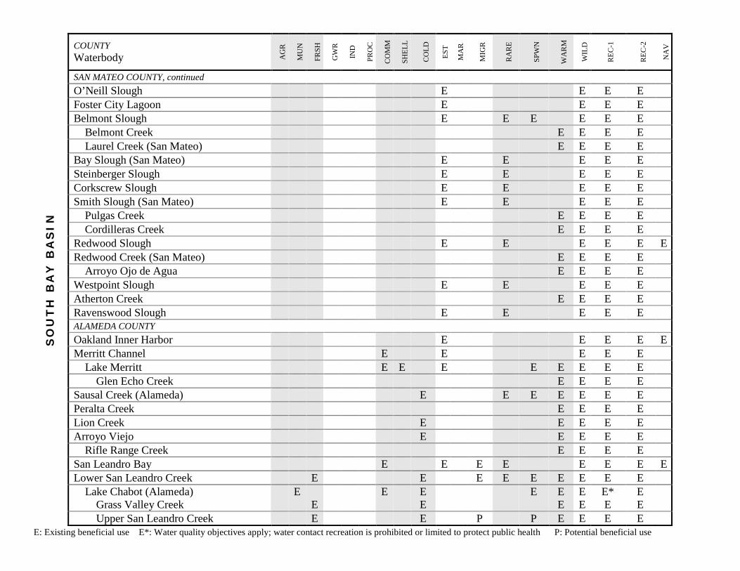
San Francisco Bay South E E E E E E E E E E E ALAMEDA & SANTA CLARA COUNTIES Newark Slough E E E E E Plummer Creek (Zone 5 Line F-1) E E E E E Mowry Slough E E E E E Coyote Slough E E E E E Mud Slough E E E E E Laguna Creek (Arroyo la Laguna, or
Zone 6 Line E) E E E E
Mission Creek (Zone 6 Line L) E E E E Lake Elizabeth E E E E E* E Sabrecat Creek (Zone 6 Line K) E E E E Canada del Aliso (Zone 6 Line J) E E E E Agua Caliente Creek (Alameda)
(Zone 6 Line F) E E E E
Agua Fria Creek (Zone 6 Line D) E E E E Stivers Lagoon (Fremont Lagoon) E E E E E Mallard (Artesian) Slough E E E E E Scott Creek (Zone 6 Line A) E E E E Toroges Creek (Zone 6 Line C) E E E E E SAN MATEO AND SANTA CLARA COUNTIES San Francisquito Creek E E E E E E E E Lake Lagunita E E E E E Los Trancos Creek E E E E E E E E Felt Lake E E E E E E Bear Creek (San Mateo) E E E E E E E E Bear Gulch Creek (San Mateo) E E E E E E E E E West Union Creek E E E E E E E E Searsville Lake E E E E E E E
Human Consumptive Uses
Wildlife Use Recreational
Uses S
AN
TA
CL
AR
A B
AS
IN
Aquatic Life Uses

E: Existing beneficial use E*: Water quality objectives apply; water contact recreation is prohibited or limited to protect public health P: Potential beneficial use
COUNTY Waterbody A
GR
MU
N
FRSH
GW
R
IND
PRO
C
CO
MM
SHEL
L
CO
LD
EST
MA
R
MIG
R
RA
RE
SPW
N
WA
RM
WIL
D
REC
-1
REC
-2
NA
V
SAN MATEO AND SANTA CLARA COUNTIES, continued Alambique Creek E E E E E Sausal Creek (San Mateo) E E E E E SANTA CLARA COUNTY ONLY Palo Alto Harbor & Baylands E E E E E E Mayfield Slough E E E E E E Matadero Creek E E E E E E E E Deer Creek (Santa Clara) E E E E E E Arastradero Creek E E E E E E Charleston Slough E E E E E E Barron Creek E E E E Adobe Creek (Santa Clara) E E E E E Mountain View Slough E E E E E Permanente Creek E E E E E E E E Hale Creek E E E E E Stevens Creek E E E E E E E E E E Stevens Creek Reservoir E E E E E E E E E E Swiss Creek E E E E E E Guadalupe Slough E E E E E Moffett Channel E E E E Calabazas Creek E E E E E E E San Tomas Aquino Creek E E E E E E Saratoga Creek E E E E E E E E Bonjetti Creek E E E E E McElroy Creek E E E E E Alviso Slough E E E E E E Guadalupe River E E E E E E E E E Los Gatos Creek E E E E P E P E E E P Campbell Percolation Pond E E E E E E E E Vasona Reservoir E E E E E E E E E Lexington Reservoir E E E E E E E E E Soda Springs Creek E E E E E E
SA
NT
A C
LA
RA
BA
SIN

E: Existing beneficial use E*: Water quality objectives apply; water contact recreation is prohibited or limited to protect public health P: Potential beneficial use
COUNTY Waterbody A
GR
MU
N
FRSH
GW
R
IND
PRO
C
CO
MM
SHEL
L
CO
LD
EST
MA
R
MIG
R
RA
RE
SPW
N
WA
RM
WIL
D
REC
-1
REC
-2
NA
V
SANTA CLARA COUNTY ONLY, continued Lake Elsman E E E E E* E Austrian Gulch Creek E E E E E E E Ross Creek E E E E E Canoas Creek E E E E Guadalupe Creek E E E E E E E E E E Los Capitancillos Percolation
Ponds E E E E E
Guadalupe Percolation Ponds E E E E E Pheasant Creek E E E E E E E Guadalupe Reservoir E E E E E E E E Los Capitancillos Creek E E E E E E E Rincon Creek E E E E E E E E E Alamitos Creek E E E E E E E E E E Arroyo Calero E E E E E E E E E Calero Reservoir E E E E E E* E Almaden Reservoir E E E E E E E E* E Herbert Creek E E E E E E Barrett Canyon Creek E E E E E E Coyote Creek (nontidal) E E E E E E E E E E Upper Penitencia Creek E E E E E E E E E E Arroyo Aguague Creek E E E E E E E E Halls Valley Lake (Grant Lake) E E E E E E Cherry Flat Reservoir E E E E E E* E Lower Silver Creek E E E E Babb Creek E E E E South Babb Creek E E E E Flint Creek E E E E Thompson Creek E E E E Quimby Creek E E E E Yerba Buena Creek E E E E Upper Silver Creek E E E E E
SA
NT
A C
LA
RA
BA
SIN
E: Existing beneficial use E*: Water quality objectives apply; water contact recreation is prohibited or limited to protect public health P: Potential beneficial use
COUNTY Waterbody A
GR
MU
N
FRSH
GW
R
IND
PRO
C
CO
MM
SHEL
L
CO
LD
EST
MA
R
MIG
R
RA
RE
SPW
N
WA
RM
WIL
D
REC
-1
REC
-2
NA
V
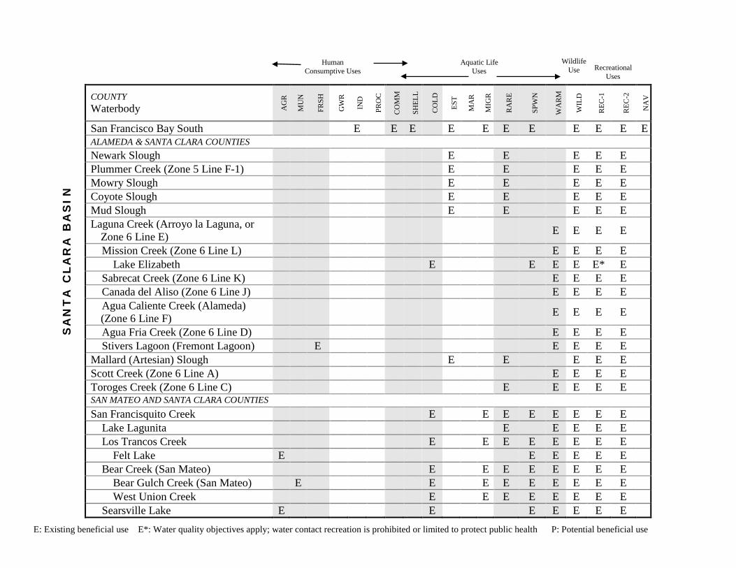
SANTA CLARA COUNTY ONLY, continued Cottonwood Lake E E E E E E E Fisher Creek E E E E Anderson Reservoir E E E E E E E E* E San Felipe Creek E E E E E E E Las Animas Creek E E E E E E Packwood Creek E E E E E E E Hoover Creek E E E E E E E Otis Canyon Creek E E E E E E Coyote Reservoir E E E E E E E E* E Canada de los Osos Creek E E E E E Soda Springs Canyon Creek E E E E E Lower Penitencia Creek E E E E Berryessa Creek E E E E Calera Creek (Santa Clara) E E E E Tularcitos Creek E E E E Arroyo de los Coches E E E E E Sandy Wool Lake E E E E E E* E
SA
NT
A C
LA
RA
BA
SIN

E: Existing beneficial use E*: Water quality objectives apply; water contact recreation is prohibited or limited to protect public health P: Potential beneficial use
COUNTY Waterbody A
GR
MU
N
FRSH
GW
R
IND
PRO
C
CO
MM
SHEL
L
CO
LD
EST
MA
R
MIG
R
RA
RE
SPW
N
WA
RM
WIL
D
REC
-1
REC
-2
NA
V
San Pablo Bay E E E E E E E E E E E SOLANO COUNTY Mare Island Strait E E E E E E E E White Slough E E E E E E E E South Slough E E E E E E E Dutchman Slough E E E E E E E Lake Chabot (Solano) E E E E E E E E Rindler Creek E E E E E Blue Rock Springs Creek E E E E E Lake Dalwigk E E E E CONTRA COSTA COUNTY Rodeo Creek E E E E E E Refugio Creek E E E E Pinole Creek E E E E E E E E Garrity Creek E E E E Rheem Creek E E E E San Pablo Creek E E E E E E E E* E San Pablo Reservoir E E E E E E E* E Lauterwasser Creek E E E E E Briones Reservoir E E E E E E* P Bear Creek (Contra Costa) E E E E E E Wildcat Creek E E E E E E E E E Jewel Lake E E E E E Lake Anza E E E E E E E MARIN COUNTY Black John Slough E E E E E E Rush Creek E E E E E Bahia Lagoon E E E E Novato Creek E E E E E E E E E E Stafford Lake E E E E E E E E
SA
N P
AB
LO
BA
SIN
Human Consumptive
Uses
Wildlife Use Recreational
Uses Aquatic Life
Uses

E: Existing beneficial use E*: Water quality objectives apply; water contact recreation is prohibited or limited to protect public health P: Potential beneficial use
COUNTY Waterbody A
GR
MU
N
FRSH
GW
R
IND
PRO
C
CO
MM
SHEL
L
CO
LD
EST
MA
R
MIG
R
RA
RE
SPW
N
WA
RM
WIL
D
REC
-1
REC
-2
NA
V
MARIN COUNTY, continued Bowman Canyon Creek E E E E E E E E Warner Creek (Novato) E E E E E E E Arroyo Avichi E E E E E E Pacheco Pond E E P E P E E E E Arroyo San Jose E E E E E E Miller Creek E E E E E E E E Gallinas Creek E E E E E E SONOMA COUNTY Petaluma River E E E E E E E E E E San Antonio Creek E P P E E E E Adobe Creek (Sonoma) E E E E E E E E Lynch Creek E E E E E E E E Willow Creek (Willow Canyon
Creek) E E E E E E E E
Lichau Creek E E E E E E E Tolay Creek E E E E E Second Napa Slough E E E E E E E Third Napa Slough E E E E E E Steamboat Slough E E E E E E Hudeman Slough E E E E E E E Rainbow Slough E E E E E E Sonoma Creek E E E E E E E E E Fowler Creek E E E E E E E Felder Creek E E E E E Carriger Creek E E E E E E E E Rodgers Creek E E E E E E E Schell Creek E E E E E E E Arroyo Seco Creek
(Sonoma) E E E E E E E E
Nathanson Creek E E E E E E E E Agua Caliente Creek (Sonoma) E E E E E E E E Hooker Creek E E E E E E E E
SA
N P
AB
LO
BA
SIN
E: Existing beneficial use E*: Water quality objectives apply; water contact recreation is prohibited or limited to protect public health P: Potential beneficial use
COUNTY Waterbody A
GR
MU
N
FRSH
GW
R
IND
PRO
C
CO
MM
SHEL
L
CO
LD
EST
MA
R
MIG
R
RA
RE
SPW
N
WA
RM
WIL
D
REC
-1
REC
-2
NA
V
SONOMA COUNTY, continued Mill Creek (Sonoma) E E E E E E E E Calabazas Creek (Sonoma) E E E E E E E E Stuart Creek E E E E E E E E Graham Creek E E E E E E E E Yulupa Creek E E E E E E E E Bear Creek (Sonoma) E E E E E E E E NAPA COUNTY Napa Slough E E E E E E E China Slough E E E E E E E Napa River – tidal E E E E E E E E American Canyon Creek E E E E Mud Slough (Napa) E E E E E E E Devils Slough E E E E E E E Huichica Creek E E E E E E E E Carneros Creek E E E E E E E E Fagan Creek E E E E Suscol Creek E E E E E E E E Bedford Slough (Napa) E E E E Lake Marie E E P E P E E E Tulucay Creek E E E E E E E E Spencer Creek E E E E E E E E Murphy Creek E E E E E E E E Napa River – nontidal E E E E E E E E E E E E E Napa Creek E E E E E E E E Browns Valley Creek E E E E E E E E Redwood Creek (Napa) E E E E E E E E Pickle Canyon Creek E E E E E E E E Milliken Creek E E E E E E E E E Milliken Reservoir E E E E E E* E Sarco Creek E E E E E E E E Salvador Creek E E E E E E E
SA
N P
AB
LO
BA
SIN

E: Existing beneficial use E*: Water quality objectives apply; water contact recreation is prohibited or limited to protect public health P: Potential beneficial use
COUNTY Waterbody A
GR
MU
N
FRSH
GW
R
IND
PRO
C
CO
MM
SHEL
L
CO
LD
EST
MA
R
MIG
R
RA
RE
SPW
N
WA
RM
WIL
D
REC
-1
REC
-2
NA
V
NAPA COUNTY, continued Soda Creek E E E E E E E E Dry Creek (Napa) E E E E E E E E E E Segassia Canyon Creek E E E E E E E E Montgomery Creek E E E E E E E E Hopper Creek E E E E E Conn Creek E E E E E E E E E E Rector Creek E E E E E E E E E Rector Reservoir E E E E E E* E Lake Hennessey E E E E E E E E Chiles Creek E E E E E E E E Moore Creek E E E E E E Sage Creek E E E E E E E E Angwin Lakes E E E E E Bale Slough E E E E E E E E Bear Canyon Creek E E E E E E Sulphur Creek (Napa) E E E E E E E E Heath Canyon Creek E E E E E E E E Iron Mine Creek E E E E E E E E York Creek E E E E E E E Bell Canyon Creek E E E E E E E E Bell Canyon Reservoir E E E E E Mill Creek (Napa) E E E E E E E E Ritchey Creek (Ritchie Creek) E E E E E E E E Selby Creek E E E E E E E E Dutch Henry Creek E E E E E E E E Diamond Mountain Creek E E E E E E Cyrus Creek E E E E E E E E Garnett Creek E E E E E E E E Jericho Canyon Creek E E E E E E E Kimball Canyon Creek E E E E E E E Kimball Reservoir E E E E E
SA
N P
AB
LO
BA
SIN

E: Existing beneficial use E*: Water quality objectives apply; water contact recreation is prohibited or limited to protect public health P: Potential beneficial use
COUNTY Waterbody A
GR
MU
N
FRSH
GW
R
IND
PRO
C
CO
MM
SHEL
L
CO
LD
EST
MA
R
MIG
R
RA
RE
SPW
N
WA
RM
WIL
D
REC
-1
REC
-2
NA
V
Carquinez Strait E E E E E E E E E E Suisun Bay E E E E E E E E E E E Sacramento-San Joaquin Delta E E E E E E E E E E E E E E SOLANO COUNTY Grizzly Bay E E E E E E E Honker Bay E E E E E E E Sulphur Springs Creek E E E E E Lake Herman E E E E E E E* E Goodyear Slough E E E E E E E Cordelia Slough E E E E E E E Green Valley Creek E E E E E E E E E Dan Wilson Creek E E E E E Wild Horse Creek E E E E E E Lake Frey E E E E E E* E Lake Madigan E E E E E E E* E Suisun Slough E E E E E E E E E E Suisun Creek E E E E E E E E E Suisun Reservoir E E E E E E Wooden Valley Creek E E E E E E E E Lake Curry E E E E E E Sheldrake Slough E E E E E E Boynton Slough E E E E E E Peytonia Slough E E E E E E Ledgewood Creek E E E E E E E E Gordon Valley Creek E E E E E Laurel Creek (Solano) E E E E E E E E Hill Slough E E E E E E Cutoff Slough E E E E E E E Spring Branch E E E E
SU
ISU
N B
AS
IN
Human Consumptive Uses Wildlife
Use Recreational Uses
Aquatic Life Uses

E: Existing beneficial use E*: Water quality objectives apply; water contact recreation is prohibited or limited to protect public health P: Potential beneficial use
COUNTY Waterbody A
GR
MU
N
FRSH
GW
R
IND
PRO
C
CO
MM
SHEL
L
CO
LD
EST
MA
R
MIG
R
RA
RE
SPW
N
WA
RM
WIL
D
REC
-1
REC
-2
NA
V
SOLANO COUNTY, continued Volanti Slough E E E E E E Montezuma Slough E E E E E E E E E E Nurse Slough E E E E E E E Denverton Slough E E E E E E E Denverton Creek E E E E E E CONTRA COSTA COUNTY Alhambra Creek E E E E E E E Franklin Creek E E E E E E E E Arroyo del Hambre E E E E E Peyton Slough E E E E E E E E Pacheco Creek E E E E Walnut Creek E E E E E E E E Grayson Creek E E E E E E E Pine Creek E E E E E E E E Galindo Creek E E E E E San Ramon Creek E E E E Bollinger Canyon Creek E E E E E E Las Trampas Creek E E E E E E Tice Creek E E E E E Lafayette Creek E E E E E Lafayette Reservoir E E E E E E E* E Hastings Slough E E E E E Mt. Diablo Creek E E E E E E E E Mitchell Creek E E E E E E E E Donner Creek E E E E E E Mallard Slough (Contra Costa) E E E E E E E Kirker Creek E E E E E New York Slough E E E E E E E E
SU
ISU
N B
AS
IN

Table 2-2: Existing and Potential Beneficial Uses in Groundwater in Identified Basins
County Groundwater Basin Name1
Groundwater
Sub-Basin1
Basin
Number1 M
UN
2
PR
OC
3
IND
4
AG
R5
FR
ES
H6
Alameda Castro Valley -- 2-8 P P P P --
Alameda Santa Clara Valley Niles Cone 2-9.01 E E E E --
Alameda and
Contra Costa Santa Clara Valley East Bay Plain 2-9.04 E E E E --
Alameda and
Contra Costa Livermore Valley -- 2-10 E E E E --
Alameda Sunol Valley -- 2-11 E E E E --
Contra Costa Pittsburg Plain -- 2-4 P P P P --
Contra Costa Clayton Valley -- 2-5 E P P P --
Contra Costa Ygnacio Valley -- 2-6 P P P P --
Contra Costa San Ramon Valley -- 2-7 E P P E --
Contra Costa Arroyo del Hambre Valley -- 2-31 P P P P --
Marin Sand Point Area -- 2-27 E P P P --
Marin Ross Valley -- 2-28 E P P E --
Marin San Rafael Valley -- 2-29 P P P P --
Marin Novato Valley -- 2-30 P P P P --
Napa Napa-Sonoma Valley Napa Valley 2-2.01 E E E E --
Napa and Solano Napa-Sonoma Valley Napa-Sonoma
Lowlands 2-2.03 E E E E --
San Francisco and
San Mateo Visitacion Valley -- 2-32 P E E P --
San Francisco and
San Mateo Islais Valley A
7-- 2-33A P E E P --
San Francisco Islais Valley B7
-- 2-33B P P P E --
San Francisco South San Francisco -- 2-37 P E E P --
San Francisco and
San Mateo Westside A
7-- 2-35A E P P E --
San Francisco Lobos -- 2-38 E P P E --
San Francisco Marina -- 2-39 E P P E --
San Francisco Downtown -- 2-40 E P P E --
San Francisco Westside B7
-- 2-35B P P P E --
San Mateo Westside C7
-- 2-35C E P P E --

County Groundwater Basin Name1
Groundwater
Sub-Basin1
Basin
Number1 M
UN
2
PR
OC
3
IND
4
AG
R5
FR
ES
H6
San Mateo Westside D7
-- 2-35D E E E P --
San Mateo Santa Clara Valley San Mateo
Plain 2-9.03 E E E P --
San Mateo and
Santa Clara Santa Clara Valley
8Santa Clara 2-9.02 E E E E --
San Mateo Half Moon Bay Terrace -- 2-22 E P P E --
San Mateo San Gregorio Valley -- 2-24 E P P E --
San Mateo Pescadero Valley -- 2-26 E P P E --
San Mateo San Pedro Valley -- 2-36 P P P P --
Solano Suisun-Fairfield Valley -- 2-3 E E E E --
Sonoma and
Marin Petaluma Valley -- 2-1 E P P E --
Sonoma Napa-Sonoma Valley Sonoma Valley 2-2.02 E P P E --
Sonoma and
Marin
Wilson Grove Formation
Highlands -- 1.59 E P P E --
Sonoma and
Marin
Wilson Grove Formation
Highlands -- 1.59 See RB1 Basin Plan
9
Sonoma Kenwood Valley -- 2-19 E P P E --
Sonoma Napa – Sonoma Volcanic
Highlands -- 2-23 X X X X X
Santa Clara Gilroy – Hollister Valley Llagas Area 3-3.01 See RB3 Basin Plan10
Notes:
1. Department of Water Resources (DWR) Bulletin 118 “California Groundwater”, 2003.
2. MUN = Municipal and domestic water supply.
3. PROC = Industrial process water supply.
4. IND = Industrial service water supply.
5. AGR = Agricultural water supply.
6. FRESH = Freshwater replenishment to surface water; designation will be determined at a later date; for the interim, a site-by-site
determination will be made.
7. The existing and potential beneficial uses for groundwater basins listed in the 1995 Basin Plan (Table 2-3) were assigned to the new
groundwater basins based on the geographic location of the old basins compared to the new basins. The basin names, such as Westside A,

Westside B, etc., are informal names assigned by the Water Board to preserve the beneficial use designations in the 1995 Basin Plan and do
not represent sub-basins identified by the Department of Water Resources.
8. The Santa Clara Valley groundwater basin/Santa Clara groundwater sub-basin is also known as Coyote Valley.
9. This groundwater basin is also located in the North Coast Region (RB1); beneficial uses of groundwater are specified in the Basin Plan for
RB1.
10. This groundwater basin is also located in the Central Coast Region (RB3); beneficial uses of groundwater are specified in the Basin Plan for
RB3.
E = Existing beneficial uses; based on best available information.
P = Potential beneficial uses; based on best available information.
X = This groundwater basin was not listed in the 1995 Basin Plan; designation will be determined at a later date; for the interim, a site-by-site
determination will be made.
See DWR Bulletin 118 (2003) for groundwater basin characteristics.

Table 2-3: Examples of Existing and Potential Beneficial Uses of Selected Wetlands
TYPE OF WETLAND
BENEFICIAL USE MARINE ESTUARINE RIVERINE LACUSTRINE PALUSTRINE
AGR � � � �
COLD � � �
COMM � �
EST �
FRESH � � �
GWR � � � � �
IND � � �
MAR �
MIGR � � � �
NAV � � � � �
PROC
REC-1 � � � � �
REC-2 � � � � �
SHELL � � �
SPWN � � � � �
WARM � � �
WILD � � � � �
RARE � � � � �
NOTE:
� Existing beneficial use
� Potential beneficial use
Table 2-4 Beneficial Uses of Wetland Areasa
BASIN/MARSH AREA
WETLAND TYPES BENEFICIAL USES
Fresh Brackish Salt
EST
MA
R
MIG
R
CO
MM
RA
RE
REC
1
REC
2
SPW
N
WIL
D
ALAMEDA COUNTY Arrowhead Coyote Hills Emeryville Crescent
Hayward (e.g., Cogswell, Hayward Area Recreation District, Oro Loma, & Triangle marshes)
Hayward Marsh CONTRA COSTA COUNTY North Contra Costa Point Edith San Pablo Creek Wildcat Creek MARIN COUNTY Abbotts Lagoon Bolinas Lagoon Corte Madera Drakes Estero Gallinas Creek Limantour Estero Corte Madera Ecological
Reserve
Novato Creek Richardson Bay Rodeo Lagoon San Pedro San Rafael Creek Tomales Bay NAPA COUNTY Mare Island Napa San Pablo Bay SAN MATEO COUNTY Bair Island Belmont Slough Pescadero Princeton Redwood City Area SANTA CLARA COUNTY South San Francisco Bay SOLANO COUNTY Southhampton Bay Suisun White Slough SONOMA COUNTY Petaluma NOTE:
a. General locations of wetlands areas are depicted in Figure 2‐11.