chapter 17 part g volume 2 hydrology · chapter 17: hydrology page 230 ... solutions. in summary,...
TRANSCRIPT
Chapter 17: Hydrology
Page 229
Chapter 17
Part G
VOLUME 2
Hydrology
Chapter 17: Hydrology
Page 230
Overview
The Project crosses five significant waterways and floodplains within the Ōtaki Coastal
Plain: the Waitohu stream and floodplain, the Mangapouri Stream, the Ōtaki River, the
Ōtaki River floodplain and the Mangaone Stream and floodplain. As an elevated transport
link, the Expressway interferes with the natural drainage function of these waterways and
adequate provision must therefore be made for water to pass, including in flood events.
This chapter describes the potential flood effects associated with these major waterways
and floodplains. Chapter 19 describes the Project's approach to stormwater generally.
The design approach of the Project has sought to achieve hydraulic neutrality (i.e. no
exacerbation of the existing flooding situation), taking into account both the barrier posed
by the Expressway to overland flow paths across floodplains and the loss of floodplain
storage under the footprint of the Expressway. For these waterways, the increased run-off
from the Expressway is negligible in comparison to the volume of flood flows. Detailed
hydrological and hydraulic modelling has been undertaken to inform the design and
environmental assessment process. As a result of this closely integrated process, the
majority of potential adverse hydrological effects have been avoided through design
solutions.
In summary, with the proposed design and mitigation, the effects of the proposed
Expressway crossing of the Waitohu, Mangapouri and Mangaone Streams and floodplains
are minimal and acceptable. In the case of the Mangaone Stream, proposed modifications
in School Road, in partnership with KCDC, will reduce an existing flood nuisance to a
number of residential properties. The effects of the proposed crossing of the Ōtaki River
will be minimal and limited in extent. The effects on the Ōtaki River floodplain will be
greater in areas to the east of the Expressway that are used for pasture, but the effects on
populated areas to the west of the Expressway will be no worse than in the existing
situation. The proposed design and flood mitigation measures to address potential
effects of the Expressway crossing the Ōtaki River floodplain include:
a 350m long, approximately 1.75m high secondary flood containment bund located
approximately 250m north of Chrystall’s Stopbank;
a 40m wide dry culvert through the Expressway embankment; and
a road overflow weir section along the Expressway embankment measuring
approximately 300m long with a minimum crest level of 15.3m (Mean Sea Level (MSL)
Wellington datum) and rising up to about 15.8m (MSL Wellington datum) to the north
of the line of the secondary flood containment bund and then falling again beyond this
high point.
17 Hydrology
17.1 Introduction
This Chapter summarises the potential for flood effects (hydraulic effects) on the
significant waterways and floodplains that the Project crosses. These are:
the Waitohu Stream and floodplain;
the Mangapouri Stream;
the Ōtaki River and the Ōtaki floodplain; and
the Mangaone Stream and floodplain.
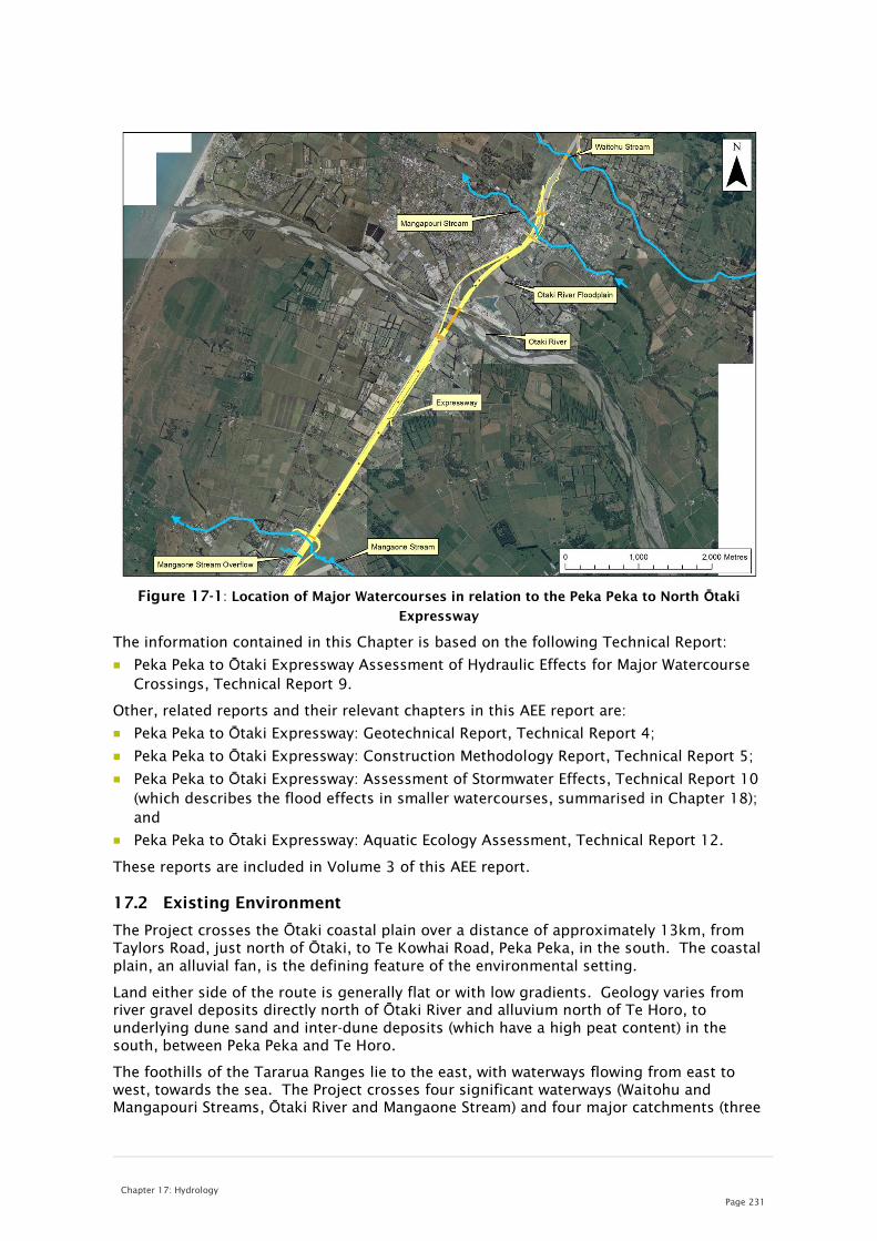
Figure 17-1 below shows the location of Major Watercourses in relation to the Project.
Chapter 17: Hydrology
Page 231
Figure 17-1: Location of Major Watercourses in relation to the Peka Peka to North Ōtaki
Expressway
The information contained in this Chapter is based on the following Technical Report:
Peka Peka to Ōtaki Expressway Assessment of Hydraulic Effects for Major Watercourse
Crossings, Technical Report 9.
Other, related reports and their relevant chapters in this AEE report are:
Peka Peka to Ōtaki Expressway: Geotechnical Report, Technical Report 4;
Peka Peka to Ōtaki Expressway: Construction Methodology Report, Technical Report 5;
Peka Peka to Ōtaki Expressway: Assessment of Stormwater Effects, Technical Report 10
(which describes the flood effects in smaller watercourses, summarised in Chapter 18);
and
Peka Peka to Ōtaki Expressway: Aquatic Ecology Assessment, Technical Report 12.
These reports are included in Volume 3 of this AEE report.
17.2 Existing Environment
The Project crosses the Ōtaki coastal plain over a distance of approximately 13km, from
Taylors Road, just north of Ōtaki, to Te Kowhai Road, Peka Peka, in the south. The coastal
plain, an alluvial fan, is the defining feature of the environmental setting.
Land either side of the route is generally flat or with low gradients. Geology varies from
river gravel deposits directly north of Ōtaki River and alluvium north of Te Horo, to
underlying dune sand and inter-dune deposits (which have a high peat content) in the
south, between Peka Peka and Te Horo.
The foothills of the Tararua Ranges lie to the east, with waterways flowing from east to
west, towards the sea. The Project crosses four significant waterways (Waitohu and
Mangapouri Streams, Ōtaki River and Mangaone Stream) and four major catchments (three

Chapter 17: Hydrology
Page 232
associated with the major waterways (the Waitohu, Ōtaki and Mangaone) plus the Awatea
catchment at the southern end of the Project area).
Historically, the drainage systems across the coastal plain will have continually evolved
over time. However development has interfered with existing drainage paths, with many
waterways re-routed or severed from the main stream channel. The existing SH1 and
NIMT embankments that traverse the alluvial fan surface further alter the natural drainage
patterns of the area, as does a stopbank on the northern bank of the Ōtaki River which
protects Ōtaki Township from being flooded.
Rainfall in the area is heavily influenced by the prevailing westerly winds and their
interaction with the Tararua Ranges, with the intensity of rainfall being greater to the east.
17.3 Design
An elevated transport link constructed across a floodplain or alluvial fan interferes with
the natural drainage functions of these topographic features. Adequate provision must
therefore be made to allow the safe passage of flood waters through the transport link or
over it.
A fundamental principle that has been applied consistently with respect to the treatment
of individual watercourse crossings on the Project is that of hydraulic neutrality. This
means that the impact of flood hazards from the proposed Project should in general be no
worse than in the current situation in specific locations. In specific locations where it has
not been possible to achieve this desired objective, while still maintaining the required
level of service for the Expressway, a fall-back position has been adopted whereby flood
hazards that have been made worse are kept away from residential dwellings and instead
redirected towards uninhabited rural areas.
To assess the hydraulic effects, calibrated hydraulic models of the waterways sourced
from GWRC were used, with the proposed Expressway alignment and geometry
superimposed into the models. River and stream flow data used in the modelling
incorporates the effects of potential increases in projected rainfall as a result of climate
change effects to 2090, based on guidelines established by the Ministry for the
Environment. In general, the design guidelines contained in the NZTA's Bridge Manual
were followed, with a design standard for the minimum level of service adopted being that
of the 1% annual exceedence probability (AEP) flood adjusted for possible future climate
change effects to 209035
(that is, the flood with a 1% AEP). This design standard is
referred to as the Serviceability Limit State flood.
Each of the significant waterway/floodplain crossings along the route of the proposed
Expressway has unique features requiring individual treatment and design. These are
described in the following sections.
17.4 Waitohu Stream and Floodplain
17.4.1 Catchment Description
The Waitohu Stream lies to the north of Ōtaki Township and the Ōtaki River. The Waitohu
Stream and its tributaries drain a 53 km2
catchment on the steeply-sloping western side of
the Tararua Ranges. After the stream flows out of the foothills, it meanders across the
coastal plain for a distance of about 7 km before exiting into the sea north of Ōtaki Beach
Village.
35 In this Chapter, this is referred to as 1% AEP (2090), where the bracket indicates that the flood flow
has been adjusted for possible future climate change effects to the year contained in the brackets.

Chapter 17: Hydrology
Page 233
The average channel slope of 13.3% makes the stream extremely steep hydraulically,
however the slope reduces significantly at about the location of the existing SH1 bridge
causing this location and downstream to be a zone of lateral channel instability and
sediment deposition. For river management purposes, GWRC has established a 75m
fairway width for the stream downstream of the existing SH1 bridge to allow for possible
changes during extreme flood events.
The Expressway crosses the Waitohu Stream about 260m downstream of the existing SH1
bridge, within this zone of instability and deposition. The Expressway bridge has been
designed with a span length of 75m to accommodate this zone and GWRC's design
alignment for the stream. The piers of the Expressway bridge will be located outside of
the existing main flow channel of the stream so as not to interfere with normal flows in
the stream. This means the bridge will require three spans of about 25m each.
Extensive flood inundation occurs on both the north and south sides of the stream
crossing. This is primarily due to flood breakout from the main stream channel upstream
of the existing SH1 bridge (a result of the limited flood capacity of that bridge) and, to a
lesser degree, the surface run-off from the adjacent Greenwood sub-catchment to the
north.
17.4.2 Design
The 1% AEP (2090) flood was adopted as the Serviceability Limit State flood for the
proposed bridge crossing of Waitohu Stream. A minimum design freeboard of 600mm
(from the design flood level to the underside of the proposed bridge) was adopted.
This flood standard is also appropriate for the Expressway crossing of Waitohu Stream.
Culverts through the proposed Expressway and bridge approach embankments providing
continuity for existing secondary overland flow paths across the floodplain require a
minimum design freeboard allowance of 500mm in accordance with design guidelines.
17.4.3 Assessment of Effects
The proposed Expressway bridge at the Waitohu Stream has been designed with a
minimum 75m span, comprised of three spans each of 25m. This span length has been
determined to provide for future channel migration. This span length allows the two piers
for the bridge to be located on either side of the existing active channel for the stream,
the area of known channel instability and sediment deposition during extreme flood
events. Pier head losses36
will be minimal under design and super-design flood conditions.
Upstream and downstream flood discharges are no worse than the existing situation.
In the case of the Waitohu Stream floodplain crossing, the Expressway must be
constructed as a raised embankment across the 0.9km wide floodplain. Dry culverts will
be incorporated into the embankment to accommodate existing overland flow paths. The
construction of the embankment will have the effect of elevating flood levels in the main
stream channel immediately upstream of the bridge compared to the existing situation but
this backwater effect will diminish to nothing over a very short distance upstream. The
relative effect on nearby residential properties on the floodplain is negligible.
Downstream flood discharges are no worse than in the existing situation.
36 Head losses are energy losses in a water flow induced by some structural element or some feature
of the channel geometry. In the case of a structural element such as a bridge pier, they are
manifested by a sharp difference in average water levels upstream and downstream of the element.

Chapter 17: Hydrology
Page 234
17.5 Mangapouri Stream and Floodplain
17.5.1 Catchment Description
The Mangapouri Stream is a tributary of the Waitohu Stream. It drains a small catchment
of 2.37km2
(at the Expressway) along the northern side of the Ōtaki River floodplain. The
catchment upstream is mixed rural and urban, and includes part of the Ōtaki Racecourse
for which the track has been built up and contoured to direct surface run-off into the
stream. This landscaping has completely altered natural drainage patterns in the area.
The flood capacity of the Mangapouri Stream downstream of the existing SH1 culvert
through Ōtaki Township is severely restricted. Consequently the culvert under the
existing NIMT has been deliberately restricted in size in order to throttle downstream
flood flows. This forces storm run-off to pond upstream of the railway culvert in a flood
storage basin that contains a number of houses that would have their floor levels
inundated by flood waters in the existing situation. Although not recognised as such, the
downstream area between the NIMT, SH1 and Rahui Road (including the Pare-o-Matangi
reserve) also functions as a flood storage basin in extreme floods, with the SH1 culvert
restricting downstream flood flows.
The Project will pass through the area of the secondary flood storage basin within the
Pare-o-Matangi reserve and incorporates the relocation of the NIMT westwards to
accommodate the Expressway to the east.
Two additional aspects further complicate this catchment. Rahui Road acts as a very wide
overflow flood relief path for catchment run-off stored in the primary flood storage basin
upstream of County Road. In the proposed situation, the eastern approach embankment
to the Rahui Road over bridge will block off this flood relief path.
To the north, a relatively small (0.316km2
) urban catchment, the Te Manuao Catchment on
a remnant river terrace, drains into the Mangapouri Stream via a wetland area to the west
of SH1. The stormwater network in this catchment is quite limited and when capacity is
exceeded, stormwater flows overland towards SH1. The Expressway cuts through the
existing wetland area to the west of SH1, resulting in the loss of about half of the wetland
area.
17.5.2 Design
It is proposed to retain the existing NIMT culvert so that the culvert continues to perform
its flood throttling function and thereby provide flood relief to downstream properties
through Ōtaki Township. The existing railway embankment which forms the flood
detention barrier for the primary flood storage basin on the Mangapouri Stream will also
be retained except in the vicinity of the existing railway crossing of Rahui Road, where
County Road will be realigned to loop around and connect to a new Rahui Road
overbridge. Here, the Expressway embankment would take over the flood containment
function from the removed section of railway embankment.
In this situation, the 1% AEP (2090) flood is an appropriate design standard for the primary
flood storage basin upstream of the existing railway embankment. The railway
embankment is sufficiently elevated above peak flood levels to meet this criterion and the
standard design freeboard of 500mm. In the area directly underneath the new Rahui Road
overbridge it would be acceptable to adopt a lower design freeboard standard of 300mm
as floodwaters stored in the primary flood storage basin will be relatively calm and
undisturbed.
Blockage of the Rahui Road flood relief path by the Rahui Road overbridge approach
embankment will require a range of mitigation measures that are detailed in Technical
Report 9 (Volume 3). These will result in the flood flows being collected by the unnamed
watercourse to the south where it will be directed towards the Racecourse Culvert under

Chapter 17: Hydrology
Page 235
the Expressway. This particular culvert will be limited in size to match the discharge
capacity of the existing railway culvert so that there is no increase in flow downstream.
The reduced area of the Pare-o-Matangi reserve would still be required as a secondary
flood storage basin for floodwaters conveyed through the new Expressway and NIMT
culverts. The available spaces between the dual lanes of the Expressway and between the
Expressway and the relocated NIMT are required for road run-off treatment purposes and
are not available for flood storage. The new culverts (downstream of the existing railway
culvert) will be constructed from standard precast concrete box culvert units, nearly as
wide as the existing stream channel, and deep enough to allow free surface flow under the
most extreme flood conditions considered. This construction will also allow better light
penetration under normal flow conditions, which will facilitate fish passage.
These practical design considerations negate the need for a design freeboard standard for
the new Expressway and railway culverts on the Mangapouri Stream. In summary, both
culverts will be designed to mimic as closely as possible the existing flow regime under
flood conditions along the reach of the Mangapouri Stream between the existing railway
and SH1 culverts.
The existing Ōtaki Railway Wetland area will be significantly reduced in area with the
construction of the Project. To compensate for this loss of wetland storage area, it is
proposed to construct a second wetland area in series utilising the vacant space between
the existing (to be abandoned) railway embankment and the Expressway embankment to
the north of the Mangapouri Stream. This second wetland area would be impounded at
the downstream end by a watertight bund and the two wetlands connected by a long pipe.
The primary outlet to the Mangapouri Stream would be piped, but an emergency spill weir
would also be required over the crest of the bund to discharge floodwaters in excess of
the design flood standard.
A minimum design freeboard standard of 300mm will be applied to the wetland storage
ponds on this system for the design 1% AEP (2090) flood. This is based on analysis that
the water surface in the wetlands would remain fairly calm even under flood conditions
due to the shallow flow depths, high flow resistance from aquatic vegetation and very slow
flow velocities.
17.5.3 Assessment of Effects
Under flood conditions, the behaviour of the Mangapouri Stream and its associated system
of interconnected flood detention ponds or storage basins will be the same as the current
situation because of the retention of the existing NIMT embankment and culvert.
However, construction of the Project will have a number of effects on the hydraulic
behaviour of this flood storage system including:
Blockage of the present Rahui Road overflow path by the eastern approach
embankment to the new Rahui Road overbridge;
Loss of storage volume in the secondary flood storage basin upstream of the SH1
culvert through the Pare-o-Matangi reserve; and
Loss of storage volume in the Ōtaki Railway Wetland area draining the Te Manuao
Catchment.
A number of mitigation measures are proposed to preserve as closely as possible the
delicate balance of the hydraulic response in the modified storage basin system along the
stream under flood conditions. These are detailed in Technical Report 9, and include
retaining the existing railway embankment, providing a culvert for flood storage pond
outflow through the eastern approach embankment to the Rahui Road overbridge,
providing a storage pond outflow culvert under Rahui Road, lowering the level of high
point along Rahui Road, and incorporating a low bund around the perimeter of the
remaining buildings on the corner of SH1 and Rahui Road adjacent to the Pare-o-Matangi
reserve. Refer to Figure 17-2 below.

Chapter 17: Hydrology
Page 236
Figure 17-2: Aerial Photograph of Mangapouri Stream in SH1 / Rahui Road / NIMT
Railway Line Triangle with Layout of Proposed Expressway and Realigned Railway
Line Superimposed
The slightly elevated road formation will allow floodwaters transferred from the primary
flood storage basin on the Mangapouri Stream to head up in front of the new Racecourse
Culvert, utilising the rough land area upstream along the margins of the unnamed
watercourse to the south of Rahui Road for flood storage purposes.
The loss of flood storage in the Railway Wetland will be rectified by making use of the
unused space between the old railway embankment and the new Expressway embankment
to form a second wetland area in series with the remnant Railway Wetland. The outlet
from this wetland has been sized to maximise the attenuation efficiency of the system,
and thereby reduce outflows to the Mangapouri Stream.
With the proposed mitigation measures in place, the effects of the proposed Expressway
crossing of the Mangapouri Stream would be as follows:
Flood levels in the primary storage basin on the Mangapouri Stream would be
marginally lower than those in the existing situation for all except the 0.5% AEP and
0.2% AEP floods adjusted for possible climate change effects to 2090.
– In the case of the former flood, the increased flood level would be only marginally
higher (0.04m).
– In the case of the latter flood, the increase in flood level relative to the existing
situation would be up to 0.12m.
However, it is important to note that in an extremely rare flood of this magnitude (0.2%
AEP) and even lesser floods, there would be widespread flood inundation through Ōtaki
Township due to flood breakout from natural stream channels and surface runoff
exceeding the capacity of the piped stormwater drainage system.

Chapter 17: Hydrology
Page 237
The flood levels in the primary flood storage basin currently affect a number of houses
within the area of the basin either by exceeding floor levels or being within 0.5m of
floor levels. The number of affected houses with the Expressway would be slightly
lower than in the existing situation for the smaller floods considered (six in the case of
the 1% AEP flood adjusted for possible future climate changes effects in the proposed
situation compared to eight in the existing situation). However the number of affected
houses would be the same (eight) for the 0.5% AEP flood and increased by one (ten) for
the 0.2% AEP flood (both floods also adjusted for possible future climate change
effects).
Flood levels within the Pare-o-Matangi reserve storage basin area (upstream of the SH1
culvert) would be marginally higher (0.03-0.07m) for some of the intermediate sized
floods considered (2% AEP flood up to the 1% AEP floods adjusted for possible climate
change effects to 2090). However this would only impact on the same number of
buildings as at present (excluding those houses that which need to be acquired for the
Expressway). The existing flood inundation risk for these floods will be mitigated by
landscaping the Pare-o-Matangi reserve to form a low bund around the perimeter of the
affected properties on the corner of the existing SH1 and Rahui Road. Flood levels
within the Pare-o-Matangi reserve storage basin area would be only 0.01-0.02m higher
for the 5% AEP flood and the two largest floods considered (0.5% and 0.2% AEP floods
adjusted for possible climate change effects to 2090).
Overall, the effects of the Expressway crossing of the Mangapouri Stream and its ancillary
features are minimal and acceptable. In very rare floods such as the 0.5% AEP and 0.2%
AEP floods the effects would be slightly greater than in the existing situation (but with the
same number of properties affected). However, in those situations there would be
widespread flood inundation elsewhere through Ōtaki Township.
17.6 Ōtaki River and Floodplain
17.6.1 Catchment Description
The Ōtaki River drains a 335km2
catchment (at the existing SH1 bridge) extending back to
the main divide of the Tararua Ranges. It is a major river that responds very rapidly to
weather systems impacting on the mountain range. The catchment includes extensive
forest cover so that there is a high likelihood of large volumes of woody debris being
flushed out of the catchment under extreme flood conditions. After exiting from the
foothills of the Tararua Ranges, the river flows westwards to the sea over a distance of
about 9 km.
A stopbank system along the true right (north) bank provides flood protection to the
township of Ōtaki, which lies north of the river. The stopbank upstream of the NIMT
railway bridge (known as the Chrystall's Bend extended stopbank) skirts around the
landward perimeter of an off-channel storage basin occupied by the Stresscrete concrete
facility. The stopbank system continues along the right bank downstream of the existing
SH1 bridge.
The northern (right bank) approach embankment to the NIMT railway bridge across the
river ties into the Chrystall's Bend stopbank and has been strengthened to form part of the
primary flood defence system. The floodplain incorporates known secondary flow paths
for residual flows from the river, those either overtopping the stopbank system or flowing
through a stopbank breach. Super-design floods (floods larger than the design standard)
would overtop the stopbank along the right bank upstream of the existing NIMT and SH1
bridge crossings after first backfilling the off-channel storage basin from the main river
channel.
Natural high ground (in the form of a river terrace) confines flood flows in the river along
the true left (south) bank.

Chapter 17: Hydrology
Page 238
17.6.2 Design
The proposed Expressway crosses the River (on twin bridges) to the north of the existing
road and rail crossings.
The existing SH1 bridge partially constricts the river channel and causes a slight
backwater effect (elevated upstream water levels) upstream. The NIMT bridge does not
appear to contribute to this backwater effect. To ensure adequate hydraulic performance,
the 330m total span of the Expressway bridges has therefore been designed to
approximately match that of the railway bridge, although the pier spacing will be much
larger. The pier to pier span length has been set at 30m, giving a total of 11 spans.
The wide spacing of the bridge piers will limit the size of any debris raft accumulating on a
pier during flood conditions. The piers of the two bridges will be aligned so that those on
the upstream bridge will shelter those of the downstream bridge. The design freeboard
allowance for the two Expressway bridges needs to allow for the effects of gradually
occurring bed aggradation in addition to the effects of potential debris raft formation on
the bridge piers. Based on the minimum freeboard requirements of the NZ Transport
Agency’s Bridge Manual (Transit NZ, 2003) for the latter factor and the recent
aggradational history of the Ōtaki River with an increasing bed level trend, it would be
appropriate to adopt a slightly higher freeboard standard for the two Expressway bridges
than the Bridge Manual value. A minimum freeboard standard of 1.7m is recommended,
derived from the 1.2m allowance from the Bridge Manual and the maximum mean bed
level increase between 1991 and 2011 of 0.5m.
The proposed Expressway will need to be elevated above the floodplain and tied into the
existing stopbank system. The design standard for the existing Chrystall's Bend stopbank
is the 1% AEP flood with freeboard based on current climate conditions. The stopbank
would therefore be overtopped by any super-design flood with an AEP of less than 1%.
Overtopping floodwaters could also induce a breach in the stopbank. In this scenario,
floodwaters will predominantly follow existing secondary flow paths across the floodplain
with lateral spread of floodwaters into residential parts of Ōtaki township.
The effect of elevating the Expressway above the floodplain will be, in the event of
stopbank overtopping by a flood larger than the stopbank design flood, to block off the
secondary flow paths along the landward side of the Chrystall's Bend stopbank and to
cause extensive ponding upstream of the Expressway embankment. A key design
objective for the Expressway was, therefore, to incorporate some means of providing
continuity for this main secondary flow path. Other additional design principles were to
reduce the impact of stopbank overtopping flows on Ōtaki township, particularly
residential areas, and contain the spread of stopbank overtopping flows into the
Mangapouri Stream.
It is not possible to pre-define a suitable design flood standard or design freeboard value
for the Expressway embankment. These parameters can only be determined by carrying
out a range of flow simulation trials exploring the effects of different embankment
geometries and complementary mitigation measures for a stopbank overtopping event. A
series of computational hydraulic model simulations were, therefore, undertaken to gauge
the effects of stopbank overtopping by the 0.2% AEP (2090) flood with various mitigation
measures in place to safely pass ponded floodwaters through the Expressway
embankment.
17.6.3 Assessment of Effects
The Expressway crossing of the Ōtaki River will comprise two parallel bridges with a total
span similar to that of the downstream railway bridge, although the pier spacing will be
much larger. This geometry means that the Expressway bridges will not constrict flood
flows in the main river. Pier head losses will also be minimal and the bridges will be

Chapter 17: Hydrology
Page 239
located sufficiently far upstream to not cause any significant hydraulic interference or
additional scour effects on the downstream rail bridge.
The northern approach embankment to the twin bridges across the Ōtaki River bisects the
off-channel flood storage in which the Stresscrete concrete factory is located. The effect
of this approach embankment is to shift the critical location for stopbank overtopping
from immediately upstream of the NIMT bridge in the existing situation, to immediately
upstream of the Expressway bridges in the proposed situation. The maximum depth of
stopbank overtopping will be unchanged.
The following mitigation measures are required to reduce the blocking effects of the
Expressway embankment on stopbank overtopping flows flowing across the Ōtaki River
floodplain (see Figure 17-3):
a secondary flood containment bund projecting upstream of the Expressway
embankment roughly parallel with the main river channel (secondary containment
bund);
a dry culvert through the Expressway embankment immediately to the north of the
Chrystall's Bend stopbank; and
re-shaping the vertical alignment of the Expressway embankment between the
Chrystall's Bend stopbank and the secondary flood containment bund to form a
preferential weir overflow path across the roadway for stopbank overtopping flows.
Figure 17-3: Aerial View of Ōtaki River and Floodplain in Vicinity of Existing and
Proposed River Crossings
In terms of peak flow depths and velocities, these mitigation measures mean that the
effects of stopbank over-topping sourced floodwaters on populated areas will be less than
those that occur in the current situation.
Upstream of the Expressway embankment, peak flood inundation depths would be
increased due to the partial damming effect of the embankment while peak flow velocities

Chapter 17: Hydrology
Page 240
would be reduced except in the localised area approaching and through the dry culvert.
These latter effects would only impact on land currently used for pastoral purposes.
The occurrence of these effects would be extremely rare given the very low AEP of Ōtaki
River floods (0.2% AEP and larger) which would overtop the stopbank system protecting
Ōtaki Township.
On balance the effects of the Expressway crossing of the Ōtaki River floodplain will be
minimal and acceptable with the proposed mitigation measures implemented.
17.7 Mangaone Stream and Floodplain
17.7.1 Catchment Description
The Mangaone Stream drains a 38.6km2
catchment extending from the foothills of the
Tararua Ranges to the sea at Te Horo Beach. After exiting from the foothills, the stream
crosses the coastal plain over a distance of about 7km before reaching the sea. SH1 and
the NIMT cross the stream at Te Horo, about 3.5km to the south of the Ōtaki River, with
the NIMT on the inland side.
The NIMT sits slightly elevated above the coastal plain on a ballasted embankment which
acts as a flood detention barrier. Two culverts under the railway embankment provide
passage for flood flows – one on the main stream and another approximately 250m to the
south acting as an overflow facility. The culverts under SH1 are aligned in series with
those under the NIMT.
The SH1 crossing of the Mangaone Stream and Mangaone overflow are known flooding
hotspots with the road having been overtopped by floodwaters on a number of occasions
in recent years. This is due to the limited capacity of the NIMT and SH1 culverts. Other
local flood inundation problems also exist. These include flooding along Te Horo Beach
Road downstream of the SH1 culvert on the main stream channel, caused by the limited
flow capacity of that channel, and flooding around the School Road / Gear Road
intersection caused by the limited flow capacity of the School Road Drain (this is linked to
the Mangaone Overflow).
The proposed Expressway crosses the Mangaone Stream and its left bank overflow path on
the upstream side of the existing transport links. The Expressway will therefore need to
be elevated on an embankment where it crosses the Mangaone Stream and overflow path
in order to achieve the required level of service and remain flood-free up to that level. The
ponding that currently occurs upstream of the NIMT will be transferred to upstream of the
new Expressway embankment.
The proposed Expressway is complicated by the presence of a local link road providing
east / west connectivity between School Road and Te Horo Beach Road via an overbridge.
This local link road will also cut through the overland flow path leading to the Mangaone
Overflow, cross the main channel of the Mangaone Stream east of the Expressway, cut
through the existing Lucinsky Overflow (along the right bank of the main stream channel
downstream of the SH1 culvert) and then cross over the Mangaone Stream again west of
the Expressway (see Figure 17-4 below).

Chapter 17: Hydrology
Page 241
Figure 17-4: Proposed Expressway and Local East / West Local Link Road Crossings of
Mangaone Stream Alluvial Fan and Floodplain System with Main Drainage Paths
Marked
17.7.2 Design
Construction of the Project represents an opportunity to rectify some of the existing
localised flooding issues, although the real issue remains the volume of storm run-off
(over which there is no control) that must safely pass through all three parallel transport
links. As with the crossing of the Ōtaki River floodplain, if the crossing of the Mangaone
Stream floodplain is constructed as an elevated embankment, it will function as a flood
detention barrier.
The 1% AEP (2090) flood was adopted as the Serviceability Limit State flood for the
proposed crossing. Culverts through the proposed embankment will provide continuity
for existing secondary flow paths across the floodplain and require a minimum design
freeboard allowance of 500mm.
The local link road providing east-west connectivity across the Expressway between School
Road and Te Horo Beach Road will also cross the Mangaone Stream floodplain within the
flood ponding area upstream of the Expressway. The level of service will be between a 4%
and a 2% AEP flood, reflecting the lower use level of the road.
17.7.3 Assessment of Effects
The Expressway crossing of the Mangaone Stream at Te Horo on a raised embankment
acts as a flood detention barrier, impounding floodwater upstream of the existing
transport links to the west and downstream residential properties.
To minimise the effects of flood ponding upstream of the Expressway, new culverts will be
required in the Expressway embankment (aligned with existing culverts), new culverts will
be required on local link roads, to convey overland flows, and works would be required in

Chapter 17: Hydrology
Page 242
the vicinity of the School Road drain to remove constrictions and provide flood
containment in this area. These works are described in detail in Technical Report 9.
With these improvements in place, the effects of flood ponding upstream of the
Expressway would not impact on any residential properties on the floodplain. The culvert
system would not make flood discharges (and hence flood levels) on the western
(downstream) side of SH1 any worse than in the existing situation. The culvert under the
western approach embankment to the east-west local link road overbridge will not impede
flood flows along the Lucinsky Overflow.