chapter 11 safety element - city of newport beach | home
TRANSCRIPT

CHAPTER 11 Safety Element

S a f e t y E l e m e n t
N e w p o r t B e a c h G e n e r a l P l a n 11-2
SAFETY A Safe and Healthy Community That Protects
Introduction
The primary goal of the Safety Element is to reduce the potential risk of death, injuries, property damage, and economic and social dislocation resulting from natural and human-induced hazards. This Safety Element recognizes and responds to public health and safety risks that could cause exposure to the residents of Newport Beach. Implementation of city, county, and state emergency response and mutual aid plans will enable the community to avert or minimize impacts to the extent practical and feasible, as well as allow restoration of the City in a timely manner after an event.
This element specifically addresses coastal hazards, geologic hazards, seismic hazards, flood hazards, wildland and urban fire hazards, hazardous materials, aviation hazards, and disaster planning. As discussed below, the type and location of hazards have been identified in this element, as well as policies and programs to minimize impacts.
Context
COASTAL HAZARDS Newport Beach is susceptible to low-probability but high-risk events such as tsunamis, and two, more common, isolated hazards such as storm surges and coastal erosion. Each of these has a potential to

S a f e t y E l e m e n t
N e w p o r t B e a c h G e n e r a l P l a n 11-3
significantly impact Newport Beach residents and the built environment. Figure S1 shows potential tsunami inundation areas, and areas subject to coastal erosion.
Tsunamis and Rogue Waves Newport Beach is generally protected from most distantly generated tsunamis by the Channel Islands and Point Arguello, except for those generated in the Aleutian Islands, off the coast of Chile, and possibly off the coast of Central America. Nevertheless, since the early 1800s, more than thirty tsunamis have been recorded in Southern California, and at least six of these caused damage in the area, although not necessarily in Newport Beach. Tsunamis generated in the Alaskan region take approximately six hours to arrive in the Southern California area, while tsunamis generated off the Chilean coast take 12 to 15 hours. Given those timeframes, coastal communities in Southern California can receive adequate warning, allowing them to implement evacuation procedures.
Alternatively, very little warning time, if any, can be expected from locally generated tsunamis. Locally generated tsunamis caused by offshore faulting or landsliding immediately offshore from Newport Beach are possible, and these tsunamis have the potential to be worst-case scenarios for the coastal communities in Orange County. Modeling off the Santa Barbara coast suggests that locally generated tsunamis can cause waves between 2 and 20 meters (6 to 60 feet) high, and that these could impact the coastline with almost no warning, within minutes of the causative earthquake or slump. Areas within Newport Beach that are most likely to be impacted by a tsunami include West Newport, Balboa Peninsula, Lido Isle, Balboa Island, and Upper Newport Bay.
Rogue waves are very high waves that arise unexpectedly in the open ocean. These waves are difficult to plan for as they are unpredictable. Rogue waves have historically impacted the Orange County coast and have the potential to impact Newport Beach in the future.
Storm Surges Unlike tsunamis, which can occur anytime, storm surges are associated with inclement weather. Given that during inclement weather a lot less people are expected to be at the beach, storm surges are more likely to impact residents than tourists, and the potential number of casualties can be expected to be significantly less. The most common problem associated with storm surges is flooding of low-lying areas, including structures. This is often compounded by intense rainfall and strong winds. If a storm surge occurs during high tide, the flooded area can be significant. Coastal flooding in Newport Beach occurred in the past when major storms, many of these El Niño Southern Oscillation events, impacted the area. Storm surging associated with a tropical storm has been reported only once in the history of Newport Beach, in 1939. This suggests that the hazard of cyclone-induced storm surges has a low probability of occurrence.
ELEMENT Its Residents and Visitors from Natural

S a f e t y E l e m e n t
N e w p o r t B e a c h G e n e r a l P l a n 11-4
Coastal Erosion Newport Beach has a variety of coastal features ranging from replenished beach sands in West Newport, to steep bluffs comprised of sandstone and siltstone to the south of Corona del Mar. Significant coastal bluff retreat, bluff-top erosion, gullying, and beach erosion are occurring along the eastern Newport shoreline, and the rates of erosion are dependent on the underlying geologic units and their different responses to the weathering effects of water (including rain and waves), gravity, and wind. Coastal erosion occurs as a result of natural processes such as long-shore drift, storm surge, and sea level rise. Sea bluff erosion occurs as a result of processes that impact both the bottom and top of the cliffs. Pounding of the waves during high tide and storm surges causes considerable damage to the bottom of the bluffs. If the sediments exposed in this zone are soft and highly erodible, eventual collapse of the bluff can occur as it is undercut by wave action. Uncontrolled surface runoff, if allowed to flow over the top of the bluffs, can cause extensive erosion in the form of rills and gullies. During wet years, large canyons can develop quickly, often as a result of a single storm. Unchecked foot and vehicular traffic and rodent burrowing can also cause significant damage at the top of the bluffs. Increased irrigation associated with agricultural and residential watering can lubricate fine-grained layers in the sediments or bedrock forming the cliffs, leading to failure as a result of landsliding.
The protection of the beaches from coastal erosion, through effective structural devices and sand replenishment, provides more than just a wider beach; it serves as a buffer zone that provides protection from tsunami run-up or storm surges, especially in areas where there are no dune deposits in front of residential or commercial development.
GEOLOGIC HAZARDS The geologic diversity of Newport Beach is strongly related to tectonic movement along the San Andreas Fault and its broad zone of subsidiary faults. This, along with sea level fluctuations related to changes in climate, has resulted in a landscape that is also diverse in geologic hazards. Geologic hazards are generally defined as surficial earth processes that have the potential to cause loss or harm to the community or the environment.
Coastal bluff erosion along the Newport Beach coastline

S a f e t y E l e m e n t
N e w p o r t B e a c h G e n e r a l P l a n 11-5
Figure S1 Coastal Hazards Pg 1—8.5x11 color

S a f e t y E l e m e n t
N e w p o r t B e a c h G e n e r a l P l a n 11-6
Pg 2—8.5x11 color
S a f e t y E l e m e n t
N e w p o r t B e a c h G e n e r a l P l a n 11-7
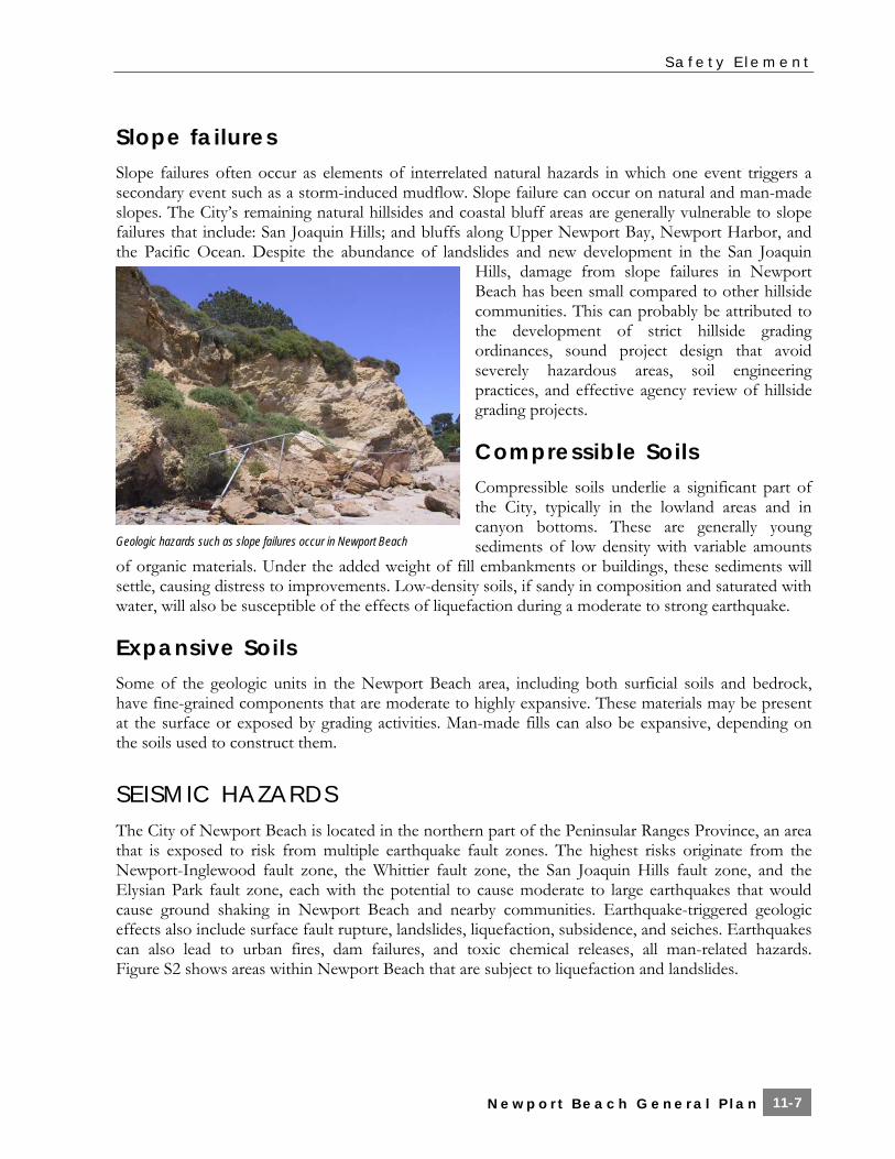
Slope failures Slope failures often occur as elements of interrelated natural hazards in which one event triggers a secondary event such as a storm-induced mudflow. Slope failure can occur on natural and man-made slopes. The City’s remaining natural hillsides and coastal bluff areas are generally vulnerable to slope failures that include: San Joaquin Hills; and bluffs along Upper Newport Bay, Newport Harbor, and the Pacific Ocean. Despite the abundance of landslides and new development in the San Joaquin
Hills, damage from slope failures in Newport Beach has been small compared to other hillside communities. This can probably be attributed to the development of strict hillside grading ordinances, sound project design that avoid severely hazardous areas, soil engineering practices, and effective agency review of hillside grading projects.
Compressible Soils Compressible soils underlie a significant part of the City, typically in the lowland areas and in canyon bottoms. These are generally young sediments of low density with variable amounts
of organic materials. Under the added weight of fill embankments or buildings, these sediments will settle, causing distress to improvements. Low-density soils, if sandy in composition and saturated with water, will also be susceptible of the effects of liquefaction during a moderate to strong earthquake.
Expansive Soils Some of the geologic units in the Newport Beach area, including both surficial soils and bedrock, have fine-grained components that are moderate to highly expansive. These materials may be present at the surface or exposed by grading activities. Man-made fills can also be expansive, depending on the soils used to construct them.
SEISMIC HAZARDS The City of Newport Beach is located in the northern part of the Peninsular Ranges Province, an area that is exposed to risk from multiple earthquake fault zones. The highest risks originate from the Newport-Inglewood fault zone, the Whittier fault zone, the San Joaquin Hills fault zone, and the Elysian Park fault zone, each with the potential to cause moderate to large earthquakes that would cause ground shaking in Newport Beach and nearby communities. Earthquake-triggered geologic effects also include surface fault rupture, landslides, liquefaction, subsidence, and seiches. Earthquakes can also lead to urban fires, dam failures, and toxic chemical releases, all man-related hazards. Figure S2 shows areas within Newport Beach that are subject to liquefaction and landslides.
Geologic hazards such as slope failures occur in Newport Beach

S a f e t y E l e m e n t
N e w p o r t B e a c h G e n e r a l P l a n 11-8
Liquefaction Strong ground shaking can result in liquefaction. Liquefaction, a geologic process that causes ground failure, typically occurs in loose, saturated sediments primarily of sandy composition. Areas of Newport susceptible to liquefaction and related ground failure (i.e. seismically induced settlement) include areas along the coastline that includes Balboa Peninsula, in and around the Newport Bay and Upper Newport Bay, in the lower reaches of major streams in Newport Beach, and in the floodplain of the Santa Ana River. It is likely that residential or commercial development will never occur in many of the other liquefiable areas, such as Upper Newport Bay, the Newport Coast beaches, and the bottoms of stream channels. However, other structures (such as bridges, roadways, major utility lines, and park improvements) that occupy these areas are vulnerable to damage from liquefaction if mitigation measures have not been included in their design.
Seismically Induced Slope Failure Strong ground motions can also worsen existing unstable slope conditions, particularly if coupled with saturated ground conditions. Seismically induced landslides can overrun structures, people or property, sever utility lines, and block roads, thereby hindering rescue operations after an earthquake. Much of the area in eastern Newport Beach has been identified as vulnerable to seismically induced slope failure. Approximately 90 percent of the land from Los Trancos Canyon to State Park boundary is mapped as susceptible to landsliding by the California Geologic Survey. Additionally, the sedimentary bedrock that crops out in the San Joaquin Hills is locally highly weathered. In steep areas, strong ground shaking can cause slides or rockfalls in this material. Rupture along the Newport-Inglewood Fault Zone and other faults in Southern California could reactivate existing landslides and cause new slope failures throughout the San Joaquin Hills. Slope failures can also be expected to occur along stream banks and coastal bluffs, such as Big Canyon, around San Joaquin Reservoir, Newport and Upper Newport Bays, and Corona del Mar.
FLOOD HAZARDS Flooding can be a destructive natural hazard, and is a recurring event. Flood hazards in Newport Beach can be classified into two general categories: flash flooding from small, natural channels; and more moderate and sustained flooding from the Santa Ana River and San Diego Creek.
The 100- and 500-year flood zones have been identified by the Federal Emergency Management Agency, and include the low-lying areas in West Newport at the base of the bluffs, the coastal areas which surround Newport Bay and all low-lying areas adjacent to Upper Newport Bay. 100- and 500-year flooding is also anticipated to occur along the lower reaches of Coyote Canyon, in the lower reaches of San Diego Creek and the Santa Ana Delhi Channel, and in a portion of Buck Gully. Most flooding along these second- and third-order streams is not expected to impact significant development. However, flooding in the coastal areas of the City will impact residential and commercial zones along West Newport, the Balboa Peninsula and Balboa Island and the seaward side of Pacific Coast Highway. Figure S3 shows the 100- and 500-year flood zones.

S a f e t y E l e m e n t
N e w p o r t B e a c h G e n e r a l P l a n 11-9
Figure S2 Seismic Hazards Pg 1—8.5x11 color

S a f e t y E l e m e n t
N e w p o r t B e a c h G e n e r a l P l a n 11-10
Pg 2—8.5x11 color

S a f e t y E l e m e n t
N e w p o r t B e a c h G e n e r a l P l a n 11-11
In addition, seismically induced inundation, which refers to flooding that results when water retention structures fail due to an earthquake, can also occur in the City. Portions of Newport Beach are threatened by flooding from Prado Dam, Santiago Creek Reservoir, Villa Park Reservoir, San Joaquin Reservoir, Big Canyon Reservoir, and Harbor View Reservoir. Seismically induced inundation can also occur if strong ground shaking causes structural damage to aboveground water tanks. Currently, there are no above-ground water tanks in the City.
Various flood control measures have helped mitigate flood damage in the City, including reservoirs in the San Joaquin Hills and Santa Ana Mountain foothills, and channel alterations for the Santa Ana River. These structures help regulate flow in the Santa Ana River, San Diego Creek, and smaller streams and hold back some of the flow during intense rainfall period that could otherwise overwhelm the storm drain system in Newport Beach.
FIRE HAZARDS
Wildland Fires The City of Newport Beach defines a wildland fire hazard area as any geographic area that contains the type and condition of vegetation, topography, weather, and structure density that potentially increases the possibility of wildland fires. The eastern portion of the City and portions of the Newport Beach region and surrounding areas to the north, east, and southeast include grass- and brush-covered hillsides with significant topographic relief that facilitate the rapid spread of fire, especially if fanned by coastal breezes or Santa Ana winds. Fire susceptibility in Newport Beach is shown in Figure S4.
In those areas identified as susceptible to wildland fire, the Fire Department enforces locally developed regulations which reduce the amount and continuity of fuel (vegetation) available, firewood storage, debris clearing, proximity of vegetation to structures and other measures aimed at “Hazard Reduction.”
New construction and development are further protected by local amendments to the Uniform Building Code. These amendments, which are designed to increase the fire resistance of a building, include: protection of exposed eaves,
noncombustible construction of exterior walls, protection of openings, and the requirement for Class “A” fireproof roofing throughout the City. Additionally, a “Fuel Modification” plan aimed at reducing fire encroachment into structures from adjacent vegetation must be developed and maintained.
Urban Fires Many factors contribute to an area being at risk of structural fires in terms of the local fire departments capabilities to control them, including the construction size and type, built-in protection, density of construction, street widths, and occupancy size. The City’s daytime population levels may also add to the congestion and difficulty of ingress and egress of emergency response vehicles.
Fire in the Back Bay in 2000

S a f e t y E l e m e n t
N e w p o r t B e a c h G e n e r a l P l a n 11-12
Many of the structures in the older portions of the City, some dating back to the 1930s, are susceptible to urban fires. These areas were built to older building standards and fire codes, made from non-fire-resistive construction materials, and built with no internal sprinklers and other fire safety systems in place. These areas include Balboa Peninsula, Balboa Island, and Corona del Mar. Newport Beach has over 30 high-rise buildings that were constructed since the 1960s, four of which are not sprinklered: 3121 West Coast Highway, 601 Lido Park Drive, 400 Newport Center Drive, and 611 Lido Park Drive.
Geography is also a factor to fire safety in the City. Upper and Lower Newport Bay essentially divide the City into two regions, with approximately one-third of the Fire Department assets located west of the bay, and the remaining assets east of the bay. Connection between these two sides is provided by only a limited number of roadways (Pacific Coast Highway in the south, Bristol Street and the 73 Freeway on the north), making it difficult for fire stations on both sides of the bay to support each other during multiple alarm emergencies. Failure of the bridge connectors on any of these roadways as a result of an earthquake, for example, would hinder emergency response from fire stations in east Newport Beach and Newport Coast into the densely populated areas of the City west and south of the bay.
Earthquake-induced fires have the potential to be the worst-case fire-suppression scenarios for a community because an earthquake can cause multiple ignitions distributed over a broad geographic area. There are some older sections in Newport Beach where due to ground failure, breaks in the gas mains and the water distribution system could lead to a significant fire-after-earthquake situation.
The City of Newport Beach has adopted the 2001 California Fire Code with City amendments and some exceptions. These provisions include construction standards in new structures and remodels, road widths and configurations designed to accommodate the passage of fire trucks and engines, and requirements for minimum fire flow rates for water mains.
HAZARDOUS MATERIALS The state of California defines hazardous materials as substances that are toxic, ignitable or flammable, reactive, and/or corrosive. The state also defines hazardous materials as substances that show high acute or chronic toxicity, is carcinogenic (causes cancer), has bioaccumulative properties (accumulates in the body’s tissues), is persistent in the environment, or is water reactive. The primary concern associated with a hazardous materials release is the short and/or long-term effect to the public from exposure to the hazardous material. The best way to reduce the liability for a hazardous material release is through regulation governing the storage, use, manufacturing and handling of hazardous materials. These regulations are typically issued by the United States Environmental Protection Agency (EPA), but various local agencies are tasked with the responsibility of monitoring those facilities that use, store, transport, and dispose hazardous materials for compliance with the federal guidelines, or if applicable, with more stringent state guidelines. Following is a summary of hazardous material found in Newport Beach.

S a f e t y E l e m e n t
N e w p o r t B e a c h G e n e r a l P l a n 11-13
Figure S3 Flood Hazards Pg 1—8.5x11 color

S a f e t y E l e m e n t
N e w p o r t B e a c h G e n e r a l P l a n 11-14
Pg 2—8.5x11 color

S a f e t y E l e m e n t
N e w p o r t B e a c h G e n e r a l P l a n 11-15
Figure S4 Wildfire Hazards Pg 1—8.5x11 color

S a f e t y E l e m e n t
N e w p o r t B e a c h G e n e r a l P l a n 11-16
Pg 2—8.5x11 color
S a f e t y E l e m e n t
N e w p o r t B e a c h G e n e r a l P l a n 11-17
Toxic Release Inventory According to the EPA records, there is one facility in the Newport Beach area that is listed in the most recently available Toxics Release Inventory (TRI). TRI sites are known to release toxic chemicals into the air. The EPA closely monitors the emissions from these facilities to ensure that their annual limits are not exceeded. The South Coast Air Quality Management District also issues permits to facilities that emit chemicals, both toxic and nontoxic, into the atmosphere. These facilities include restaurants, hotels, dry-cleaners, and other small businesses.
Hazardous Waste According to the most recent EPA and City data available, there are two large quantity generators and approximately 115 small quantity generators in the Newport Beach area. The number of small quantity generators is expected to increase with increasing development in the City, since this list includes businesses like gasoline stations, dry cleaners, and photo-processing shops.
Leaking Underground Storage Tanks According to data from the State Water Resources Control Board, 76 underground storage tank leaks have been reported in the Newport Beach area. Of these, 47 sites have been either cleaned up or deemed to be of no environmental consequence, leaving 29 cases that are still open and in various stages of the remediation process. None of the leaks that have been reported in the City have impacted a drinking source of ground water. The Orange County Environmental Health Department provides oversight and conducts inspections of all underground tank removals and installation of new tanks.
Oil Fields There is one oil field in the City of Newport Beach and one in its Sphere of Influence. Hazardous materials are often associated with these facilities, usually as a result of poor practices in the early days of exploration, when oil cuttings, brine water, and other by-products were dumped onto the ground. The development of oil fields for residential or commercial purposes typically involves a detailed study to identify any areas impacted by oil or other hazardous materials, and the remediation of the property prior to development.
Methane Gas Mitigation Districts Natural seepages of gas occur in the western and southwestern portions of the City. Methane gas associated with an abandoned landfill has also been reported near the City’s northwestern corner. The City has implemented a series of mitigation measures to reduce the hazard associated with methane gas.
Hazards Overlay Given the mixed-use character of Newport Beach, where residential and commercial uses reside relatively close to one another or often co-exist, facilities that generate, use, or store hazardous

S a f e t y E l e m e n t
N e w p o r t B e a c h G e n e r a l P l a n 11-18
materials are often located near residential areas or near critical facilities, with the potential to impact these areas if hazardous materials are released into the environment at concentrations of concern.
AVIATION HAZARDS John Wayne Airport (JWA) generates nearly all aviation traffic above the City of Newport Beach. On an average business day, 300 commercial and commuter flights (150 departures and 150 arrivals) arrive at and depart from JWA. Newport Beach borders the southeastern portion of JWA. More than 95 percent of all airplanes take off and ascend over the City. Accidents with one or more fatalities involving commercial aircraft are rare events. However, in the event of an aviation hazard, pilots are instructed to follow Newport Bay away from residential or developed area. Any potential impact will be significantly reduced by coordinated response operations of all available emergency services. The airport is protected by an on-site airport fire service as required by the Federal Aviation Administration (FAA) regulations. This service is provided by Orange County Fire Station No. 33. In addition, the Orange County Fire Services Area Plan Annex contains a Marine (Air/Sea) Disaster Response Plan that establishes protocols for marine disasters in the harbor or ocean from either aircraft or boating accidents. This plan, which includes a county-wide mutual aid response to a disaster, would be implemented by the Newport Beach Fire Department.
Three areas found to be of increased vulnerability to aviation hazards in the City are Balboa Peninsula, Balboa Island, and Upper Newport Bay. As previously discussed under Urban Fires, Balboa Island is susceptible to fire hazards due to the fact that structures were built prior to implementation of stringent fire codes. Additionally, access and egress is limited to a small bridge. In the event of a fire caused by an aviation accident, it could spread quickly.
An aviation accident in Upper Newport Bay could create a significant ecological and economic hazard to the environment. The recreational value of the City of Newport Beach with its more than 9,000 registered boats could be dramatically affected, and an aviation accident could significantly pollute the waterways.
DISASTER PLANNING Any potential hazard in the City resulting from a manmade or natural disaster may result in the need for evacuation of few or thousands of citizens of Newport Beach. Homeland Security has brought disaster awareness to the forefront of the minds of the community, safety officials, and City staff. The City of Newport Beach is currently using the Standardized Emergency Management System for emergency response in the City, where depending on the type of incident, several different agencies and disciplines may be called upon to assist with emergency response. Agencies and disciplines that can be expected to be part of an emergency response team include medical, health, fire and rescue, police, public works, and coroner. Additionally, policies and plans from the Orange County Operational Area Mutual Aid Plan, the state’s Mutual Aid Plan, and the state’s Fire and Rescue Mutual Aid System would be implemented.
Within the Newport Beach Fire Department (NBFD), the Disaster Preparedness Coordinator has updated the City’s Emergency Management Plan, including the development and implementation of disaster training for employees. The Emergency Management Plan describes the different levels of emergencies, the local emergency management organization, and the specific responsibilities of each

S a f e t y E l e m e n t
N e w p o r t B e a c h G e n e r a l P l a n 11-19
Figure S5 JWA Clear Zone/Runway Protection Zones and Accident Potential Zones Pg 1—8.5x11 color

S a f e t y E l e m e n t
N e w p o r t B e a c h G e n e r a l P l a n 11-20
Pg 2—8.5x11 color

S a f e t y E l e m e n t
N e w p o r t B e a c h G e n e r a l P l a n 11-21
participating agency, government office, and City staff. A Citywide drill, which involves implementation of the Plan, is conducted annually.
Currently, NBFD provides basic life support (BLS), advanced life support (ALS) and emergency transportation utilizing the fire engines and ladder trucks housed in the Department’s eight fire stations along with the paramedics housed in three of those stations. While the NBFD has the immediate capability of providing ALS service at three simultaneous incidents, there is an occasional need for additional ALS units. Additional ALS service is provided by nearby and adjoining public agencies by means of cooperative automatic aid agreements. Emergency transportation beyond the capability of the department is provided by private ambulance companies.
Mass casualty incidents, those incidents usually involving three or more critical patients require the implementation of the Orange County Fire Services Operational Plan Annex “Multi-Casualty Incident Response Plan.” This Plan is an organizational plan that aids in assigning treatment teams and quickly moving patients off scene to appropriate receiving centers in an expeditious and organized manner. The multi-casualty plan is intended to be implemented during any multi casualty incident, such as multiple vehicle accidents, aviation accidents, hazardous materials incidents, high-rise fires, and so forth. Although the system has been designed to be used with as few as three patients, it can be expanded to an infinite number as it becomes necessary.
Lastly, in the event of a disaster, the City’s Emergency Operations Center can be opened. The center has undergone a series of considerable upgrades and improvements. Training for the residents within the City continues through the Community Emergency Response Team program. The continued development of the community’s disaster preparedness efforts will aid the residents of Newport Beach in an areawide disaster by fostering a citywide culture of “preparedness.
LOCAL HAZARD MITIGATION PLAN The most current Local Hazards Mitigation Plan (LHMP) is, and as updated from time to time will continue to be, incorporated in the Safety Element. The Safety Element and the LHMP are complementary documents that work together to achieve the ultimate goal to reduce the impacts on the community from a disaster.
Goals and Policies
Coastal Hazards: Minimization of Tsunamis and Rogue Wave Hazards
Goal
S 1 Protection of people and property from the adverse effects of coastal hazards related to tsunamis and rogue waves.

S a f e t y E l e m e n t
N e w p o r t B e a c h G e n e r a l P l a n 11-22
Policies
S 1.1 Evacuation Routes
Review local and distant tsunami inundation maps for Newport Beach and adjacent coastal communities as they are developed to identify susceptible areas and plan evacuation routes. (Imp 28.2)
S 1.2 Evacuation Response Plans
Participate in any regional effort to develop and implement workable response plans that the City’s emergency services can adopt immediately for evacuation in the case of a tsunami warning. (Imp 14.1, 28.2)
S 1.3 Beach Replenishment
Maintain beach width, critical protection against tsunami run-up for structures along the oceanfront, through such projects as the Surfside-Sunset/West Newport Beach Replenishment Program. (Imp 22.1, 23.2)
S 1.4 Education Program
Develop and implement a tsunami educational program for residents, visitors, and people who work in the susceptible areas. (Imp 29.1)
S 1.5 Tsunami Research
Support tsunami research in the Newport Beach offshore and Newport Bay areas. (Imp 28.1)
Coastal Hazards: Minimization of Storm Surge and Seiche Hazards
Goal
S 2 Protection of people and property from the adverse effects of coastal hazards related to storm surges and seiches.
Policies
S 2.1 Wave Up-Rush and Impact Reports
Prepare and periodically update (every 5 years) comprehensive wave up-rush and impact reports for shoreline and coastal bluff areas subject to wave action that will be made available to applicants for new development on a beach or coastal bluff property. (Imp 28.1)

S a f e t y E l e m e n t
N e w p o r t B e a c h G e n e r a l P l a n 11-23
S 2.2 Shoreline Management Plans
Develop and implement shoreline management plans for shoreline areas subject to wave hazards and erosion. Shoreline management plans should provide for the protection of private property, public improvements, coastal access, public opportunities for coastal recreation, and coastal resources. (Imp 21.2)
S 2.3 Use of Temporary Shoreline Protection
Utilize temporary sand dunes in shoreline areas to protect buildings and infrastructure from wave up-rush, while minimizing significant impacts to coastal access and resources. (Imp 21.2)
S 2.4 Use of Existing Shoreline Protection
Encourage the use of existing sand dunes with native vegetation as a protective device in beach areas. (Imp 21.2)
S 2.5 Shoreline Protection Alternatives
Encourage the use of nonstructural methods, such as dune restoration and sand nourishment, as alternatives to shoreline protective structures. (Policy HB 13.4) (Imp 8.1, 21.2)
S 2.6 Maintenance of Storm Drains
Maintain and regularly clean out storm drains in low lying areas, as necessary, such that flood waters can be effectively conveyed away from structures. (Imp 18.1)
S 2.7 Residential Design
Require new or remodeled residential structures in areas susceptible to storm surge to raise floor elevations as required by building codes. (Imp 7.1)
Coastal Hazards: Minimization of Coastal Erosion Hazard
Goal
S 3 Protection of people and property from the adverse effects of coastal erosion.
Policies
S 3.1 Coastal Hazard Studies
Prepare and periodically update comprehensive studies of seasonal and long-term shoreline change, episodic and chronic bluff retreat, flooding, and local changes in sea levels, and other coastal hazard conditions. (Imp 28.1)

S a f e t y E l e m e n t
N e w p o r t B e a c h G e n e r a l P l a n 11-24
S 3.2 Beach Width Monitoring
Monitor beach width and elevations and analyze monitoring data to establish approximate thresholds for when beach erosion or deflation will reach a point that it could expose the backshore development to flooding or damage from storm waves. (Policy HB 13.6) (Imp 28.1)
S 3.3 Maintenance of Beach Width and Elevations
Develop and implement a comprehensive beach replenishment program to assist in maintaining beach width and elevations. Analyze monitoring data to determine nourishment priorities, and try to use nourishment as shore protection, in lieu of more permanent hard shoreline armoring options. (Policy HB 13.5) (Imp 8.1, 21.2)
S 3.4 Minimization of Shoreline Process Effects
Maintain existing groin fields and jetties and modify as necessary to eliminate or mitigate adverse effects on shoreline processes. (Imp 21.1)
S 3.5 Protection of Coastal-Dependent Uses
Permit revetments, breakwaters, groins, harbor channels, seawalls, cliff retaining walls and other structures altering natural shoreline processes or retaining walls when required to serve coastal-dependent uses or to protect existing structures or public beaches in danger from erosion and when designed to eliminate or mitigate adverse impacts on local shoreline sand supply. (Imp 21.1)
S 3.6 Siting of Shoreline Protective Devices
Design and site protective devices to minimize impacts to coastal resources, minimize alteration of natural shoreline processes, provide for coastal access, minimize visual impacts, and eliminate or mitigate adverse impacts on local shoreline sand supply. (Imp 21.1)
S 3.7 Shoreline Protective Devices on Public Land
Discourage shoreline protective devices on public land to protect private property/development. Site and design any such protective devices as far landward as possible. (Imp 21.1)
S 3.8 Shoreline Protective Device Use
Limit the use of protective devices to the minimum required to protect existing development and prohibit their use to enlarge or expand areas for new development or for new development. “Existing development” for purposes of this policy shall consist only of a principle structure, e.g. residential dwelling, required garage, or second residential unit, and shall not include accessory or ancillary structures such as decks, patios, pools, tennis courts, cabanas, stairs, landscaping etc. (Imp 2.1)
S a f e t y E l e m e n t
N e w p o r t B e a c h G e n e r a l P l a n 11-25
S 3.9 Shoreline Protection for New Development
Require property owners to record a waiver of future shoreline protection for new development during the economic life of the structure (75 years) as a condition of approval of a coastal development permit for new development on a beach or shoreline that is subject to wave action, erosion, flooding, landslides, or other hazards associated with development on a beach or bluff. Shoreline protection may be permitted to protect existing structures that were legally constructed prior to the certification of the LCP, unless a waiver of future shoreline protection was required by a previous coastal development permit. (Imp2.1
S 3.10 Bluff Stabilization
Site and design new structures to avoid the need for shoreline and bluff protective devices during the economic life of the structure (75 years), unless an environmentally acceptable design to stabilize the bluff and prevent bluff retreat is devised. (Imp 2.1)
S 3.11 New Development Impact on Coastal Erosion
Require that applications for new development with the potential to be impacted or impact coastal erosion include slope stability analyses and erosion rate estimates provided by a licensed Certified Engineering Geologist or Geotechnical Engineer. (Imp 7.1)
S 3.12 Minimization of Coastal Bluff Recession
Require new development adjacent to the edge of coastal bluffs to incorporate drainage improvements, irrigation systems, and/or native or drought-tolerant vegetation into the design to minimize coastal bluff recession. (Imp 7.1)
Seismic and Geologic Hazards: Minimization of Seismic and Geologic Hazards
Goal
S 4 Adverse effects caused by seismic and geologic hazards are minimized by reducing the known level of risk to loss of life, personal injury, public and private property damage, economic and social dislocation, and disruption of essential services.
Policies
S 4.1 Updating of Building and Fire Codes
Regularly update building and fire codes to provide for seismic safety design. (Imp 7.1)

S a f e t y E l e m e n t
N e w p o r t B e a c h G e n e r a l P l a n 11-26
S 4.2 Retrofitting of Essential Facilities
Support and encourage the seismic retrofitting and strengthening of essential facilities such as hospitals and schools to minimize damage in the event of seismic or geologic hazards. (Imp 27.1)
S 4.3 Unreinforced Masonry Buildings
Require the retrofitting of unreinforced masonry buildings during remodels to minimize damage in the event of seismic or geologic hazards. (Imp 7.1, 27.1)
S 4.4 New Essential Facility Siting
Regulate the location of new essential facilities within areas that would directly be affected by seismic or geologic hazards, in accordance with state law. (Imp 2.1)
S 4.5 New Essential Facility Siting
Regulate the location of new sensitive facilities such as schools, hospitals, and facilities for the elderly population, within 500 feet to active and potentially active faults, in accordance with state law. (Imp 2.1)
S 4.6 Maintenance of Existing Essential Facilities
Ensure that existing essential facilities that have been built in or on seismic and geological hazards are upgraded and maintained in order to prevent and reduce loss. (Imp 27.1)
S 4.7 New Development
Conduct further seismic studies for new development in areas where potentially active faults may occur. (Imp 2.1, 27.1)
Flood Hazards: Protection from Flooding Risks
Goal
S 5 Protection of human life and public and private property from the risks of flooding
Policies
S 5.1 New Development Design within 100-year Floodplains
Require that all new development within 100-year floodplains incorporate sufficient measures to mitigate flood hazards including the design of onsite drainage systems that are connected with the City’s storm drainage system, gradation of the site such that runoff does not impact adjacent properties, and buildings are elevated. (Imp 6.1)

S a f e t y E l e m e n t
N e w p o r t B e a c h G e n e r a l P l a n 11-27
S 5.2 Facility Use or Storage of Hazardous Materials Standards
Require that all new facilities storing, using, or otherwise involved with substantial quantities of onsite hazardous materials within flood zones comply with standards of elevation, anchoring, and flood proofing, and hazardous materials are stored in watertight containers. (Imp 7.1)
S 5.3 Minimization of Flood Hazard Risk
Require stormwater detention basins, where appropriate, to reduce the potential risk of flood hazards. (Imp 6.1)
Fire Hazards: Protection from Wildfire and Urban Fire Risk
Goal
S 6 Protection of human life and property from the risks of wildfires and urban fires.
Policies
S 6.1 Review Adequacy of Infrastructure
Review the adequacy of the water storage capacity and distribution network, in the event of a natural disaster, on a regular basis. (Imp 17.1, 28.2)
S 6.2 Development in Interface Areas
Apply hazard reduction, fuel modification, and other methods to reduce wildfire hazards to existing and new development in urban wildland interface areas. (Imp 8.1)
S 6.3 New Development Design
Site and design new development to avoid the need to extend fuel modification zones into sensitive habitats. (Imp 2.1, 6.1)
S 6.4 Use of City-Approved Plant List
Use fire-resistive, native plant species from the City-approved plant list in fuel modification zones abutting sensitive habitats. (Imp 2.1, 8.1)
S 6.5 Invasive Ornamental Plant Species
Prohibit invasive ornamental plant species in fuel modification zones abutting sensitive habitats. (Imp 2.1, 8.1)
S 6.6 Database Maintenance of Interface Areas
Maintain a database of parcels in urban wildland interface areas. (Imp 28.1)
S a f e t y E l e m e n t
N e w p o r t B e a c h G e n e r a l P l a n 11-28
S 6.7 Properties within Interface Areas
Conduct regular inspections of parcels in the urban wildland interface areas and direct property owners to bring their property into compliance with fire inspection standards. (Imp 28.2)
S 6.8 Update Building and Fire Codes
Regularly update building and fire codes to provide for fire safety design. (Imp 7.1)
S 6.9 Retrofitting of Nonsprinklered Buildings
Encourage owners of nonsprinklered properties, especially high- and mid-rise structures, to retrofit their buildings and include internal fire sprinklers. (Imp 8.1)
Hazardous Materials: Minimization of Hazardous Materials Exposure
Goal
S 7 Exposure of people and the environment to hazardous materials associated with methane gas extraction, oil operations, leaking underground storage tanks, and hazardous waste generators is minimized.
Policies
S 7.1 Known Areas of Contamination
Require proponents of projects in known areas of contamination from oil operations or other uses to perform comprehensive soil and groundwater contamination assessments in accordance with American Society for Testing and Materials standards, and if contamination exceeds regulatory action levels, require the proponent to undertake remediation procedures prior to grading and development under the supervision of the County Environmental Health Division, County Department of Toxic Substances Control, or Regional Water Quality Control Board (depending upon the nature of any identified contamination). (Imp 7.1, 8.1)
S 7.2 Development Design within Methane Gas Districts
Ensure that any development within identified methane gas districts be designed consistent with the requirements of the Newport Beach Municipal Code. (Imp 7.1)
S 7.3 Education
Educate residents and businesses about how to reduce or eliminate the use of hazardous materials, including using safer non-toxic equivalents. (Imp 29.1)

S a f e t y E l e m e n t
N e w p o r t B e a c h G e n e r a l P l a n 11-29
S 7.4 Implementation of Remediation Efforts
Minimize the potential risk of contamination to surface water and groundwater resources and implement remediation efforts to any resources adversely impacted by urban activities. (Imp 6.1, 17.1, 18.1, 19.1)
S 7.5 Siting of Sensitive Uses
Develop and implement strict land use controls, performance standards, and structure design standards including development setbacks from sensitive uses such as schools, hospitals, day care facilities, elder care facilities, residential uses, and other sensitive uses that generate or use hazardous materials. (Imp 2.1)
S 7.6 Regulation of Companies Involved with Hazardous Materials
Require all users, producers, and transporters of hazardous materials and wastes to clearly identify the materials that they store, use, or transport, and to notify the appropriate City, County, state, and federal agencies in the event of a violation. (Imp 28.1)
Aviation Hazards: Protection from Aviation-Related Hazards
Goal
S 8 Residents, property, and the environment are protected from aviation-related hazards.
Policies
S 8.1 Firefighter Training Program
Provide a formalized Aircraft Rescue Fire Fighting training program (including airport and aircraft familiarization, fuel fire extinguishment, hazards associated with airplanes and aircraft cargo, safety procedure, aviation communications, evacuation, and rescue operations) for all firefighters and Chief Fire Officers in Newport Beach. (Imp 28.2)
S 8.2 Emergency Personnel Awareness Training
Provide Aircraft Rescue Fire Fighting awareness training for all Newport Beach emergency personnel on a regular basis. (Imp 28.2)
S 8.3 Implementation of Interagency Policies
Implement policies outlined in the Orange County Fire Services Operational Area Mutual Aid Plan, and the California Fire Service and Rescue Emergency Mutual Aid Plan. (Imp 14.3, 28.2)

S a f e t y E l e m e n t
N e w p o r t B e a c h G e n e r a l P l a n 11-30
S 8.4 Mutual Aid Agreements
Develop clear mutual aid agreements and Memoranda of Understanding with the airport fire service, county emergency and law enforcement agencies, United States Coast Guard, private ferry providers, and other potential resources. (Imp 14.3, 28.2)
S 8.5 Limit John Wayne Airport Expansion
Oppose any facility expansions that would increase air operations at John Wayne Airport, except those described in the Settlement Agreement Extension. (Imp. 14.3)
S 8.6 John Wayne Airport Traffic Pattern Zone
Use the most currently available John Wayne Airport (JWA) Airport Environs Land Use Plan (AELUP) as a planning resource for evaluation of land use compatibility and land use intensity in areas affected by JWA operations. In particular, future land use decisions within the existing JWA Clear Zone/Runway Protection Zone (Figure S5) should be evaluated to minimize the risk to life and property associated with aircraft operations. (Imp. 14.3)
Disaster Planning: Adequate Disaster Planning
Goal
S 9 Effective emergency response to natural or human-induced disasters that minimizes the loss of life and damage to property, while also reducing disruptions in the delivery of vital public and private services during and following a disaster.
The Newport Beach Harbor Patrol is available to assist in the event of a disaster

S a f e t y E l e m e n t
N e w p o r t B e a c h G e n e r a l P l a n 11-31
Policies
S 9.1 Review and Update Emergency Plans
Review and update, as necessary, the City’s Emergency Management Plan on an annual basis. (Imp 28.2)
S 9.2 Emergency Management System Training
Conduct annual training sessions using adopted emergency management systems. Coordinate with other urban area jurisdictions to execute a variety of exercises to test operational and emergency plans. (Imp 28.2)
S 9.3 Participation in Mutual Aid Systems
Maintain participation in local, regional, state, and national mutual aid systems to ensure appropriate resources are available for response and recovery during and following a disaster. (Imp 14.3, 28.2)
S 9.4 Familiarity with National and State Response Plans
Ensure that all Newport Beach personnel are familiar with the National Incident Management System, the National Response Plan, the State of California Master Mutual Aid Agreement, the Orange County Operational Area Mutual Aid Plan, and any other relevant response plans consistent with their position in the City’s Emergency Management Plan. (Imp 28.2)
S 9.5 Emergency and Disaster Education Programs
Sponsor and support education programs pertaining to emergency/disaster preparedness and response protocols and procedures. Distribute information about emergency preparedness to community groups, schools, religious institutions, transient occupancy establishments, and business associations. (Imp 28.2, 29.1)
S 9.6 Hazard Mitigation Plan
Maintain and update as necessary the most current Local Hazards Mitigation Plan (LHMP) as part of the Safety Element. The LHMP advocates the use of programs and projects that, when implemented, will reduce the impacts on the community from a disaster.
S 9.7 Existing Development within 100-year Flood Zones
Implement flood warning systems and evacuation plans for areas that are already developed within 100-year flood zones. (Imp 28.2)
S 9.8 Emergency Use of Coastal Facilities
Establish procedures and public/private cooperation and communication for the emergency use of coastal facilities and equipment in advance of flood,

S a f e t y E l e m e n t
N e w p o r t B e a c h G e n e r a l P l a n 11-32
storm, pollution, dredging, vessel sinking, and other events, supplementing other safety and rescue bases and equipment. (Policy HB 13.7) (Imp 28.2)
S 9.9 Effective Emergency Evacuation Programs
Develop, implement, and maintain an effective evacuation program for Balboa Peninsula and other areas of risk in the event of a natural disaster. (Imp 14.3, 28.2)