chap2
DESCRIPTION
chaoTRANSCRIPT

2-1
2 – 01 Geology sets the stage
Environmentally Sensitive Maintenance For
Dirt and Gravel Roads
2 Chapter 2: Geology, Rocks and Soils 2.1 Introduction
The term “geology” is used to
describe the study of the planet earth, specifically the materials that make up the earth, the processes that affect these materials, the products formed, and the history of the planet. Geology, therefore, with its history, processes, and materials, becomes important in the operation and maintenance of our roads. Geology helps explain the physical setting in which roads are situated as well as the local road materials that are available for use in road building, for example, why limestone may be a prime road aggregate in one area and granite the prime material in another area.
As solid rock breaks down into smaller particles from geological processes,
natural forces, and weather, often mixing with decomposing plant and animal matter, it forms soil. Soils are also important in the operation and maintenance of our roads. As the type of soils varies from area to area due to the varying geology of the area, the influence on our road system will vary in different aspects. Roads are typically built directly on top of soils covering the underlying bedrock. The type of soil over which roads are built will influence the design, construction, and maintenance of the overlying portion of the road. In addition, the stability of roadside banks, both upslope and downslope, and the road drainage network are dependent upon the inherent behavior of the soils and vegetation that covers them. The vegetation is also directly dependent on the soil’s characteristics as to its type and growth.
In this module, our goal is to focus on geology, soils, and the natural forces that
shape the surface of our land and give us the rocks, soils, and vegetation that make up the environment in which our roads exists and, therefore, influence many aspects of design, operation, and maintenance of our total road system.
2.2 Geology and Natural Forces
As mentioned above, geology is important to the construction and maintenance of
roads because it defines the physical setting in which roads are situated and the road materials that are locally available. In other words, geology gives us what we have to work with.

2-2
2 – 02 Pennsylvania Ridge and Valley Province
once stood 2 ½ miles high over the ridge and valley province of Pennsylvania (Photo 2-02), is a good example of an erosion process that occurs over geologic time. The erosion of this mountain range, which continues today, is not likely to be noticed without careful observation and measurement over several decades. On the other hand, some geologic events happen relatively quickly. Volcanoes in Hawaii, the explosion of Mount St. Helens (Photo 2-03), or major landslides are geologic events that drastically change the landscape over a sufficiently short period of time, and humans are able to perceive the changes.
2.2.2 Types of Binding Forces. To
provide background information that will assist in understanding some of the geological processes discussed later in this
2 - 03 Mount St. Helens
The geologic history of the earth is complex and spans a period of approximately
4.5 billion years. This complex history has included processes that have drastically changed the characteristics of our planet. Different regions of the United States have very different geologic histories and consequently vary greatly in road conditions, materials, and construction and maintenance methods.
Geologists have divided the United States into different physiographic provinces.
These provinces are areas of different geologic history based on the way the different types of rocks and landscapes were formed. The significance of physiographic provinces will be discussed in Section 2.3.2.
2.2.1 Geologic Time. It is
important to note that many of the geological processes that shape the earth occur at an extremely slow rate. Because our frame of reference only covers an average of a 70-to 80-year life span, it is often extremely difficult to notice or even comprehend the changes that take place over thousands, millions, or even billions of years. This is geologic time. The gradual erosion of the Alleghanian Mountains, a grand mountain range that

2-3
chapter, we will introduce three types of binding forces that act to hold rock and soil particles together: chemical, physical, and electrical.
Elements are the basic building blocks with which everything is formed. There
are approximately 110 different known elements, including things such as oxygen, carbon, hydrogen, sulfur, iron, potassium, nitrogen, gold, silver, and uranium. While we can see many of these elements with the naked eye, they are made up of tiny, individual particles called atoms. For example, a gold ring is an element. It is, however, made up of many minute gold atoms. The atom, in turn, is made up of smaller particles. Although the names of these sub-atomic particles are not important for this discussion, it is important to note that these particles influence the way atoms interact with each other.
When different elements are joined together through a chemical reaction, they
form a separate and distinctly different compound composed of two or more elements. This type of bonding is referred to as chemical bonding. The joining of different elements in various proportions and combinations has produced an almost infinite number of compounds. For instance, compounds like our deicing rock salt, which is chemically referred to as sodium chloride, is formed via chemical bonds between sodium and chlorine atoms. The term “molecule” may be familiar to many, and it simply refers to the smallest unit of a compound that can exist. For example, a water molecule is made up of two parts of hydrogen and one part oxygen, H2O. A bucket of water contains millions of water molecules.
In a geological setting, particles of different compounds may be physically bound
together. When this physical bonding occurs, the identities of the original compounds are retained in the new bound material. Sandstone is an example of physical bonding, and you can see the individual grains of sand that are cemented together to form the rock.
The third type of bond, electrical bonding, occurs when particles of one kind
“stick” to the surface of another kind of particle. The static electricity that causes pet hair to stick to clothes is an example of electrical bonds. With electrical bonds, the sub-atomic particles act like magnets and cause different elements and compounds to be stuck together. Many of the interesting properties associated with clay are a result of the electrical bonds that hold clay particles together. Because of the electrical bonds, clay particles are strongly attracted to each other, making clay “sticky.” These bonds are somewhat flexible or elastic, which also allows for some stretching between the clay particles, causing some clays to be highly plastic and flexible, as well as able to absorb water and expand when wetted.
Electrical bonding also comes into play when other substances attach themselves
to sediment particles. These other substances can be toxic substances from chemicals or other materials that can substantially increase pollution when sediment washes into our streams.
2.2.3 Natural Physical Forces. At the same time binding forces are acting to hold
things together as elements or compounds, other forces are acting to move or even tear
2-4
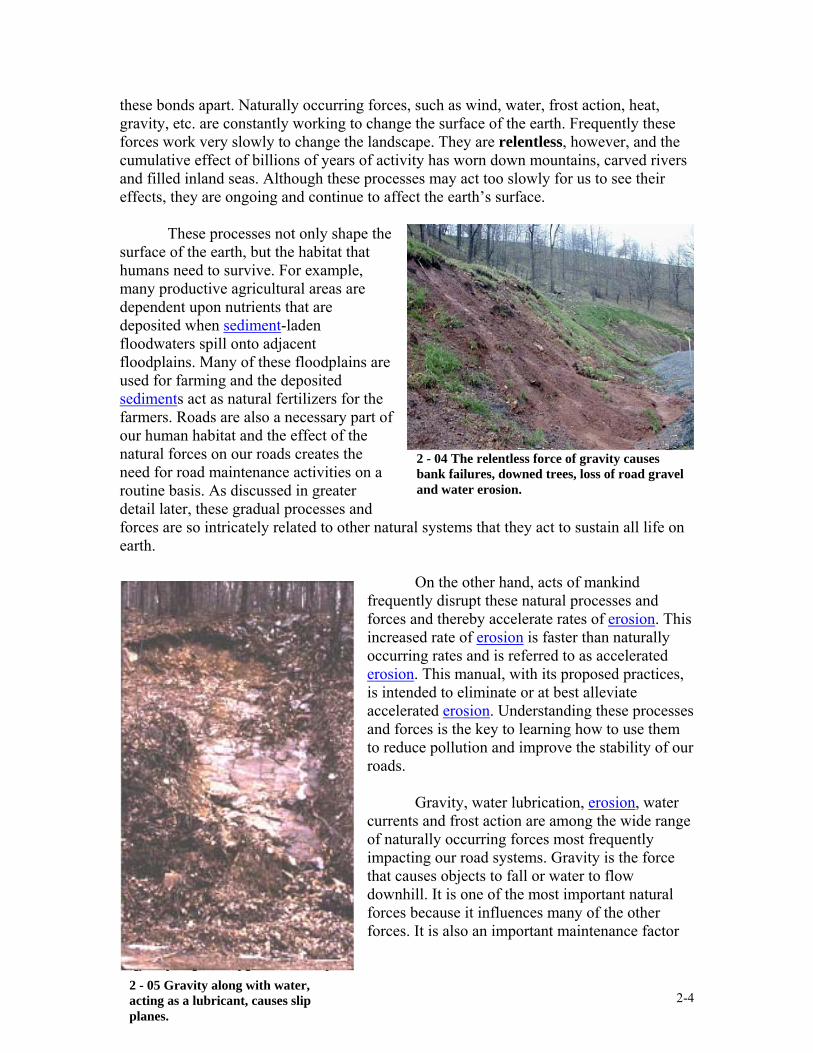
these bonds apart. Naturally occurring forces, such as wind, water, frost action, heat, gravity, etc. are constantly working to change the surface of the earth. Frequently these forces work very slowly to change the landscape. They are relentless, however, and the cumulative effect of billions of years of activity has worn down mountains, carved rivers and filled inland seas. Although these processes may act too slowly for us to see their effects, they are ongoing and continue to affect the earth’s surface.
These processes not only shape the
surface of the earth, but the habitat that humans need to survive. For example, many productive agricultural areas are dependent upon nutrients that are deposited when sediment-laden floodwaters spill onto adjacent floodplains. Many of these floodplains are used for farming and the deposited sediments act as natural fertilizers for the farmers. Roads are also a necessary part of our human habitat and the effect of the natural forces on our roads creates the need for road maintenance activities on a routine basis. As discussed in greater detail later, these gradual processes and forces are so intricately related to other natural systems that they act to sustain all life on earth.
On the other hand, acts of mankind frequently disrupt these natural processes and forces and thereby accelerate rates of erosion. This increased rate of erosion is faster than naturally occurring rates and is referred to as accelerated erosion. This manual, with its proposed practices, is intended to eliminate or at best alleviate accelerated erosion. Understanding these processes and forces is the key to learning how to use them to reduce pollution and improve the stability of our roads.
Gravity, water lubrication, erosion, water
currents and frost action are among the wide range of naturally occurring forces most frequently impacting our road systems. Gravity is the force that causes objects to fall or water to flow downhill. It is one of the most important natural forces because it influences many of the other forces. It is also an important maintenance factor
2 - 04 The relentless force of gravity causes bank failures, downed trees, loss of road gravel and water erosion.
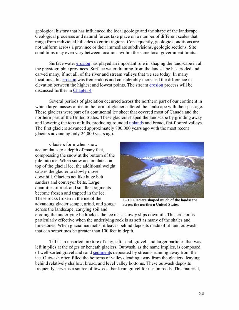
2 - 05 Gravity along with water, acting as a lubricant, causes slip
planes.

2-5
2 - 06 Impact of each raindrop on bare soil initiates the erosion process.
because it causes road bank failure, downed trees, loss of gravel from road surfaces and water erosion.
When water gets between rocks or soil particles, it acts as a lubricant to help
particles slide and roll about. When gravity enters into the picture, the slope of the material may be steep enough that the material may begin sliding along a slip plane. A slip plane is the movement of material in different directions along a plane of weakness, and is similar to the sliding that takes place between individual playing cards when stacked and slanted, (Photo 2-05). It is also common for hillside roads to contribute to their own failure by creating a dam to natural water flow, trapping and absorbing downhill flowing water, adding greatly to the weight of soil and causing the bank to slip or slump along a plane of weakness. Banks can fail slowly by creeping downhill (sloughing) or catastrophically, such as a landslide.
Erosion is defined as a wearing away and most often occurs with wind or water.
The effects of winds can be seen in the phenomenon of shifting sands. At Cape Cod, for instance, the sands thrown ashore by the sea are driven inland by the winds, advancing upon the cultivated lands, burying them and destroying their fertility. The sands from the beach on the Pacific coast near San Francisco are driven inland in a similar manner again encroaching upon the more fertile soils. In the fairly dry regions of the interior of our country, high winds, laden with sand and gravel, are a powerful agent in sculpting the rocks into the fantastic forms so often found there.
Erosion due to water ranges from the impact of raindrops to water currents
picking up particles and carrying them away from their original location. Erosion due to the movement of surface water is one of the major physical forces that have shaped our country’s landscape. Water, in the form of rain or other precipitation, falls to the earth’s surface and either soaks into or runs across that surface. Water, percolating through the earth, slowly disintegrates the hardest rocks initiating the work of soil-making, which we will address later in this chapter. A large portion of rainwater, however, never soaks into the earth, but runs off the surface.
Erosion is all about energy – soil
and rock particles do not move unless a force or process has enough energy to pick up and carry the particle away. The ability of water to erode soil and rock materials depends on four factors:
1. Force of the raindrop impact;
2. Soil resistance; 3. Volume of accumulated
water; and 4. Velocity (speed) of flow.

2-6
2 - 07 Flowing water picks up volume and velocity causing further erosion.
Vegetation plays a key role in erosion prevention. This will be discussed in detail in Chapter 4. Briefly, vegetation facilitates soil resistance by breaking the impact force ofraindrops, disrupting and slowing the flow of water across the soil surface, and reinforcing the soil with root structures to hold the soil in place.
While soil resistance helps prevent erosion, the remaining three factors lead to
erosion. A single raindrop falling from the sky on bare soil creates a mini-explosion to dislodge and scatter soil particles, initiating the erosion process. Once on the ground, water from these raindrops collects and starts to flow downhill, growing in volume and velocity, forming rills and rivulets and producing furrows and gullies. The accumulated water has lots of energy to erode particles. The rivulets join to form torrents, creating ravines and gorges, and further uniting to form rivers that in turn deposit their load partly in their course and partly into the sea. As the accumulated water flows downhill, steeper slopes cause greater speed, increasing the energy and erosive capacity of the flowing water.
While each of these factors can cause erosion, the impact from a combination of these factors can be great, causing everything from washouts and bank failures to flooding and complete roadbed failure. The width and depth of the Grand Canyon, which has been carved over millions of years by the Colorado River, is testament to the tremendous erosive power of water.
Our landscape is continuously being altered by water and erosion with material eroded from one location being transported and eventually deposited somewhere else. In this fashion, the landscape is altered in two locations, the point of original soil erosion and the location where the material is deposited as sediment.
Frost action, or the freeze-thaw process, has also helped to change the face of the earth. When water freezes, it expands and exerts pressure on anything that contains it – like the soda can that was
stuck in the freezer and “exploded” when it froze. When water gets into the small cracks in rocks, the expanding ice can split the rock. Bear in mind that a large part of our climate
2 - 08 Deposition of sediment alters the landscape.

2-7
2 - 09 Sedimentary limestone layers.
has drastically changed, swinging from temperate to near-arctic conditions during the advance and retreat of glaciers over several periods of time. As will be discussed in Chapter 3, this freeze-thaw process also causes rocks to move upward through the road base and surface; causes potholes to form; and causes posts, poles and structural foundations to shift or tilt. 2.3 Rocks
2.3.1 Rock Families. In their study of the earth’s history, geologists have
identified three basic rock families: igneous, sedimentary, and metamorphic. What family a rock belongs to is determined by the way in which the rock was formed.
Igneous rocks form when molten rock (magma) cools and hardens. Lava is a form of magma that erupts from volcanoes, and when it hardens, forms volcanic rock. Hawaii and Iceland, both volcanic islands, are primarily made of volcanic igneous rocks. Other types of igneous rocks also form beneath the surface of the earth when magma oozes and intrudes between layers of existing rock. Igneous rocks are usually our older rocks underlying the stratified sedimentary rocks forming the great mass of the earth’s interior
and forming the axes and peaks of our great mountain ranges, such as the Sierras and the various Colorado ranges. Examples of igneous rocks include granite and diabase.
Sedimentary rocks form when the elements (sun, wind, water temperature, etc.) wear away rock and soil and the eroded particles wash into low-lying depressions where they are deposited. Over time, these sediments may become fused together by natural cementing, compression, or other methods, forming sedimentary rocks. Common examples of sedimentary rocks include shale, sandstone, conglomerate, and limestone.
Metamorphic rocks make up the third family. These rocks have been changed
from their original form by heat, pressure, or chemically active fluids to produce new rocks with different minerals and texture. These heat, pressure, or chemical processes may act on any of the three families of rock to produce a new metamorphic rock. Examples of metamorphic rocks include slate, schist, gneiss, quartzite, and marble. Shale often serves as a parent material that is metamorphosed into slate, while sandstone may become quartzite and limestone may become marble.
2.3.2 Geological Provinces. As mentioned in Section 2.2, geologists have divided the United States into physiographic provinces. Each province has a vastly different
2-8
2 - 10 Glaciers shaped much of the landscape across the northern United States.
geological history that has influenced the local geology and the shape of the landscape. Geological processes and natural forces take place on a number of different scales that range from individual hillsides to entire regions. Consequently, geologic conditions are not uniform across a province or their immediate subdivisions, geologic sections. Site conditions may even vary between locations within the same local government limits.
Surface water erosion has played an important role in shaping the landscape in all the physiographic provinces. Surface water draining from the landscape has eroded and carved many, if not all, of the river and stream valleys that we see today. In many locations, this erosion was tremendous and considerably increased the difference in elevation between the highest and lowest points. The stream erosion process will be discussed further in Chapter 4.
Several periods of glaciation occurred across the northern part of our continent in which large masses of ice in the form of glaciers altered the landscape with their passage. These glaciers were part of a continental ice sheet that covered most of Canada and the northern part of the United States. These glaciers shaped the landscape by grinding away and lowering the tops of hills, producing rounded uplands and broad, flat-floored valleys. The first glaciers advanced approximately 800,000 years ago with the most recent glaciers advancing only 24,000 years ago.
Glaciers form when snow accumulates to a depth of many feet, compressing the snow at the bottom of the pile into ice. When snow accumulates on top of the glacial ice, the additional weight causes the glacier to slowly move downhill. Glaciers act like huge belt sanders and conveyor belts. Large quantities of rock and smaller fragments become frozen and trapped in the ice. These rocks frozen in the ice of the advancing glacier scrape, grind, and gouge across the landscape, carrying soil and eroding the underlying bedrock as the ice mass slowly slips downhill. This erosion is particularly effective when the underlying rock is as soft as many of the shales and limestones. When glacial ice melts, it leaves behind deposits made of till and outwash that can sometimes be greater than 100 feet in depth.
Till is an unsorted mixture of clay, silt, sand, gravel, and larger particles that was
left in piles at the edges or beneath glaciers. Outwash, as the name implies, is composed of well-sorted gravel and sand sediments deposited by streams running away from the ice. Outwash often filled the bottoms of valleys leading away from the glaciers, leaving behind relatively shallow, broad, and level valley bottoms. These outwash deposits frequently serve as a source of low-cost bank run gravel for use on roads. This material,

2-9
2 - 11 Los Angeles Abrasion Test Drum.
however, is usually not good road material and can be a major source of sediment and dust pollution.
Local government road managers should become familiar with their state and local geology in order to gain a better understanding of their site conditions and the driving forces shaping those conditions. Additionally, they should have a good working knowledge of the types of rocks and materials available for road maintenance. As we shall see in future chapters, the geological provinces not only define the local topography and the existing rocks and soils, but also relate to other natural systems such as ecoregions, vegetation, and forest types that impact the way we maintain our local road system. Many states have Web sites showing the physiographic provinces contained within their state with a description of the provinces and rock formations that are predominant for the region. Appendix 2 maps Pennsylvania’s physiographic provinces, showing the rock types and topography of each province. Other sources of information on local geology include local libraries, universities, agricultural extension offices, county farm service centers, and the U.S. Department of Agriculture (USDA), Natural Resources Conservation Service (formerly the Soil Conservation Service).
2.3.3 Rock as a Road Material. As previously discussed, the geological history
of an area determines the characteristics of an area’s underlying rock structure. Consequently, the characteristics of the locally available materials determine the suitability for road materials as well as the potential for creating environmental problems. Three important major material characteristics that often help determine the structural and environmental suitability for road use are hardness, durability, and the pH.
A gravel road surface material is directly subjected to vehicles traveling on the
road, unlike a base or subbase material under a paved asphalt or cement concrete pavement. In this respect, the hardness of the surface material becomes important to withstand the constant grinding by vehicle tires. A material’s hardness can be measured in comparison to a diamond. In roadwork, the Los Angeles Abrasion Test method can be used to measure the aggregate’s hardness or abrasion resistance. This test measures the percent weight of material loss or abraded away by tumbling a specific sample of sized material in a drum with steel ball bearings at a fixed speed and for a fixed time (Photo 2-11). Results are abbreviated as LA-xx where xx is the relative hardness. For example, a type of rock with a LA-22 is abrasion resistant since it has only lost 22% of its weight, while another rock with a LA-70 is softer and less resistant to abrasion because 70% was worn away from the sample.

2-10
The hardness of a material is an important factor when selecting road material because it determines how easily the material will be physically broken down and worn away. Road materials are broken down by both vehicle traffic and environmental conditions, resulting in successively finer particles. These fine particles are then removed from the road as sediment or dust, which can negatively impact the surrounding natural systems. The removal of fine particles as dust and sediment also means that road material is being lost.
Another measure of a rock’s performance as road material is durability, a term
used to express a rock’s resistance to frost action. Durability can be measured by repeated saturation in a salt (sulfate) solution. Crystallization of the salt in cracks in the rock causes the rock to split. When the test results of a sulfate test are received, remember it is really expressing the reaction to frost. Because this characteristic is critical when aggregates are bound in cement or asphalt, the levels for these applications are more stringent (e.g., durability factor of 10) than those used where the aggregates are not bound (e.g., durability of 20).
The third characteristic is the pH of the rock used as a road material. Chemical
tests for pH measures the acidity or alkalinity of a material, with the pH scale ranging from 0 to 14.0. values of less than 7.0 are acidic, while values greater than 7.0 are basic or alkaline, with a value of 7.0 being neutral. For the purposes of this manual, the pH measures the ability of a material to increase or decrease the acidity of soil and water. Fine particles worn from the road have chemical characteristics, and when this dust or sediment settle, the particles can change the pH of the surrounding soil or water. For instance, dust from crushed aggregate having a low pH can be washed into an adjacent trout stream. The acidic particles then mix with the water and increase the acidity of the stream. Because plants and animals can only tolerate a certain range of pH conditions, this increased acidity may decrease or eliminate the productivity of the trout stream. The health and productivity of terrestrial plants and animals can also be negatively impacted by changes in pH. Particles with a different pH may affect soils, thereby impacting plants, crops, and organisms utilizing these soils.
The harmful effects of acid rain is one of the major reasons why we must be
careful not to further alter the natural pH of our rivers, streams, wetlands, and soils with road materials. Acid rain is caused when moisture (raindrops, snow, fog, clouds) in the atmosphere is exposed to gaseous and particulate air pollutants that come from our vehicles, factories, and power plants. Normal rainwater is, by nature, slightly acidic, and exposure to these pollutants alters the chemistry of the moisture, causing it to become even more acidic. When the acidified moisture falls as precipitation, it brings the acid with it, where it can impact the natural pH of the soil and water. In many cases, acid rain is so harsh that numerous streams and lakes have become so acidic that they are devoid of almost all life. This form of environmental pollution is everywhere, but some areas are stressed more than others. Since many natural systems are already stressed by acid rain, the environmental impacts of even slight changes in pH caused by eroded road materials may be great.

2-11
Our ability to be environmentally conscious is based on attention to local conditions. The variety of both land and water communities necessitates choosing the right road material for each situation. There are roads in areas where rare, acid-loving plant species grow. Placing limestone on those roads could raise the pH of those areas, destroying the habitat that those species require for survival. Conversely, placing acidic shale on a road that is upslope from a clover field could drive the pH of the field’s soil down below tolerable levels. It is critical for us to be aware of the potential impacts that our road maintenance activities have on our natural environment.
Local government road personnel should also be aware of threatened and
endangered species living within their jurisdiction. These plant and animal species are not only protected by federal and state laws, but they also deserve every official’s and citizen’s protection so that they survive for their own benefit and for that of future generations. Just one thing such as changing the pH of their required habitat by not paying attention to discharges from road operations and maintenance activities, cannot be justified because both the liability and ethical concerns of such actions are tremendous.
The value of a good road aggregate along with other important road aggregate
characteristics and specifications will be further discussed in Chapter 3 with an appendix of example state specifications.
2.4 Soils
Soils play an important role in the construction, maintenance and operation of dirt and gravel roads because most of these roads are built directly on soil. Characteristics of these soils, such as particle size, type, and combinations, influence the properties of the soil. These soil properties, which can include things like drainage, erodability, suitability as a road subgrade material, and use as a growth medium, influence many of our necessary road maintenance activities discussed in this manual as well as those activities currently being performed.
2.4.1 Soil Formation. Soil formation is a component of the larger geologic cycle, and the rocks making up the local geology commonly serve as parent material for a region’s soils. Parent material is the raw, intact rock that eventually breaks down into finer and finer pieces which, when combined, are called soil. This process of soil formation can take from 10 to 10,000 years. Soil formation also includes the addition of decomposing plant and animal matter brought by organisms living within the soil, which adds fertility to the newly formed soil.
Chemical and physical weathering are two types of mechanisms that transform parent material into soil. Chemical weathering is the decomposition, or chemical breakdown, of geological materials. Rainwater acts as the most important agent of the chemical weathering process because it is, by nature, mildly acidic. Rainwater, however, also contains other acids obtained from gases in the atmosphere (i.e., acid rain), vegetation, and from microorganisms, which boost the rainwater’s ability to dissolve the chemical bonds that hold rocks and minerals together. As these bonds dissolve, fractures
2-12
form along zones of weakness. Limestone is dramatically impacted by chemical weathering, forming sinkholes and solution channels for underground streams.
Physical weathering can be thought of as the disintegration, or crumbling, of larger particles into smaller particles. Water also plays a large role in the disintegration process and the frost action discussed before is a common example of physical weathering.
These weathering processes often work hand in hand with one type of weathering occurring along zones of weakness created by the other type. Weathering typically occurs at or near the surface of the earth, with fractures in the rock allowing these weathering processes to penetrate to limited depths. The degree of weathering usually decreases with depth below the ground surface. The depth of weathering, however, may vary from area to area, and geological studies in the Piedmont physiographic province discovered weathered granite approximately 100 feet below the ground surface. Historical and recent climatic conditions also influence the degree of each type of weathering. During periods of glaciation, intense frost action near the glacial margins physically fractured many subsurface sedimentary rock formations. Currently, moderate chemical weathering with frost action is common.
Because of local geology’s history and characteristics, parent material varies from
one location to the next. This variation in parent materials, in conjunction with local weathering conditions, has resulted in the development of many different types of soils within a small area. The USDA Natural Resources Conservation Service has compiled county soil survey maps that contain information on the location and types of each county’s soils.
2.4.2 Soil Particles. As rocks weather, they break down into smaller particles,
forming sand, silt, and clay-sized particles. When physical weathering occurs, these particles are simply smaller-sized pieces of the parent material, while chemical weathering alters the nature of the parent material in the decomposition process. The following Table 2-1 contains information on the actual size of the different particles.
Table 2-1: Soil Particle Sizes
Particle Size Diameter (mm) Field Test Clay Less than 0.002 Feels sticky Silt 0.002 to 0.05 Feels like flour Sand 0.05 to 2.0 Feels gritty
The size difference between these particles is also significant for a number of
reasons that will be discussed later. To put the particle sizes into perspective, if a clay particle were considered to be the size of the head of a pin, then a silt particle would be the size of a kernel of corn, and a sand particle the size of a basketball.
Clay has unique properties that frequently cause it to impact road construction and
maintenance activities. Clay particles have a flat, plate-like structure that is unlike the irregular and more rounded structure of silt and sand, respectively. This flat shape gives
2-13
clay particles greater surface area for electrical bonding to take place between individual clay minerals. These electrical bonds give clay its tenacious, sticky properties. The shape and electrical bonds of clay are also responsible for many of clay’s other interesting properties, including its ability to absorb water and swell, sometimes to great extents; be flexible; be slippery; and hold more nutrients than other particles types.
The different particle sizes and the type of material that make up those particles
influence a number of important properties. The likelihood that a material will erode is affected by shape of the particles as well as the degree of bonding, or cohesion, between particles. For example, Table 2-2 below indicates that rounded sand particles are likely to erode, while sticky clay particles are not. Particle properties also influence how well it serves as a growth medium for vegetation. While clay holds nutrients, many of these nutrients are bound to the clay and not available for plants. Silt has the most nutrients available, and sand is relatively nutrient poor. Road managers are probably more familiar with the suitability of these types of materials for road stability and drainage purposes as shown in Table 2-2.
Table 2-2: Soil Type Properties Erodability Growth Medium Road Stability Drainage Clay Stable Holds nutrients Soft, slippery Holds water Silt Moderately stable Rich Soft Moderately drained Sand Unstable Poor Poor compaction Well drained
It is important to note that none of the individual particle sizes or types makes a
good, stable road material. Particle combinations are key! Soils are formed from combinations of these different particles, and the relative proportions of sand, silt, and clay-sized particles determines soil types. The combination of different particle sizes and types, and their properties, influence the overall characteristics of the soils they form. Knowledge of these combinations and properties can aid decisions regarding management of dirt and gravel roads, and especially the stability of banks and ditches.
Appendix 6A, Soil Identification in the Field, gives a guide that allows road
personnel to determine soil particle types in the field. 2.4.3 Soil Layers. Because soils are formed from parent material via weathering
processes, they typically develop from the surface downward. Soil development forms layers in the soil, which are called soil horizons, and may be observed when a trench cuts through soils that have not been disturbed by agriculture or construction. Figure 2-1, Soil Horizons, shows an example of these horizons, though not all of these horizons may be represented in every given soil profile.

2-14
2 - 12 Earthworms live in the A Horizon, the first layer of “dirt.”
A Horizon – rich in organic matter
R Horizon – unaltered parent material
O Horizon – humus/organic matter just below the surface
B Horizon – accumulated materials washed down from A horizon
C Horizon – partially weathered parent material
Topsoil
Subsoil
Bedrock
Figure 2-1: Generalized Soil Horizons in Undisturbed Soil Profile
Note: a. Not all horizons may be represented in a given soil profileb. The degree of weathering decreases with depth
A Horizon – rich in organic matter
R Horizon – unaltered parent material
O Horizon – humus/organic matter just below the surface
B Horizon – accumulated materials washed down from A horizon
C Horizon – partially weathered parent material
Topsoil
Subsoil
Bedrock
Figure 2-1: Generalized Soil Horizons in Undisturbed Soil Profile Figure 2-1: Generalized Soil Horizons in Undisturbed Soil Profile
Note: a. Not all horizons may be represented in a given soil profileb. The degree of weathering decreases with depth
Note: a. Not all horizons may be represented in a given soil profileb. The degree of weathering decreases with depth
The horizons develop hand in hand with the soils, frequently taking several
hundred to several thousand years to become well developed. Changes in environmental conditions can lead to changes in the development of both the soils and the horizons within those soils. For example, soils that develop under the saturated conditions found in wetlands produce unique soil conditions, as will be discussed in Chapter 4.
The upper layers of the soil are
commonly referred to as topsoil. Topsoil is made up of the O and A horizons (refer to Figure 2-1). The O horizon consists of a collection of organic materials resting on the surface, including seeds, leaves, branches, vegetation, bacteria, insects, animal wastes, and deteriorating plant and animal remains. This organic matter serves as a valuable source of nutrients for the underlying soils.
The A horizon is the first layer of “dirt” and is made up of varying proportions of
sand, silt, and clay mineral materials, along with a substantial amount of organic matter. Much of this matter has been washed down through the soil from the overlying O horizon. Plants utilize this layer for the germination of their seeds and the development of root networks for support and gathering food and water. Creatures such as insects, earthworms, fungi, and other microorganisms live within the A horizon and provide several vital functions. These insects, molds, fungi and bacteria help encourage the rotting of wood and leaves, thereby breaking down the organic matter into more usable forms. The insects and earthworms burrow through the ground, aerating the soil so that plant roots can breathe. The burrows of these creatures also help water to infiltrate the

2-15
soil. Infiltrating water can help plants grow, but it also helps recharge groundwater supplies.
The layer of soil beneath the topsoil is commonly referred to as subsoil. This layer
of soil can be broken into the B and C horizons, as shown in Figure 2-1. In the B horizon, the parent material has been completely weathered, so few rocks are present. The B horizon lacks the organic matter that the A horizon has, but does contain extra silt and clay particles that have washed out of the overlying horizons by water percolating down through the soil profile. The C horizon is typically very rocky and consists of partially weathered parent material. The R horizon is the bottommost horizon and consists of hard bedrock that underlies the soil. Because these subsoil layers do not have organic matter and biological organisms that the A horizon does, they are not as suitable a growth medium for plants. Some plants, however, do send roots down into the subsoil layers to gather water and nutrients that have accumulated in these deeper soils. It is critical to understand that bank and ditch stability is aided by the plants and their root structures. Plants are dependent on the soil and thrive best when a natural soil profile is maintained. Mechanical removal of even leaf litter decreases a plant’s chances of holding the bank or ditch together. The common practice of removing all topsoil materials and exposing subsoils is difficult to justify in light of the following valuable insights.
2.4.4 Topsoil Versus
Subsoil. Plants normally grow in topsoil, and because of this, topsoil can be used to help road maintenance projects in several ways. Topsoil contains many of the nutrients that plants require for healthy and quick growth. The organic content of the topsoil also helps to retain soil moisture as well as the vital nutrients, which is then
available for plant uptake. Many kinds of seeds lay dormant in the
topsoil, where they wait for an opportunity to sprout and grow. These dormant seeds often are the first to sprout when topsoil is disturbed by equipment. All of these things help new vegetation to become established quickly. As will be discussed in several other portions of this manual, established vegetation not only looks better, but also prevents erosion of both the road banks and ditches.
In addition, subsoil cannot develop overnight into a suitable growth medium for
bankside vegetation. It requires a geological time scale to develop into topsoil. For these reasons, it is important to retain topsoil when performing ditch and other road maintenance activities so that it can be reused to revegetate the site at the completion of the work. Chapter 6 will cover this concept in more detail.
2 - 13 Topsoil provides the nutrients needed for plant growth.

2-16
When we consider road construction and maintenance, however, subsoil for road subgrades becomes the material of choice. We do not need all the vital nutrients to support vegetation, but we do need a structurally sound material containing the proper combination of particles to properly drain water away from the road.
It all boils down to the fact that what makes a good garden makes a poor road
and what makes a good road makes a poor garden. 2.5 Summary of Geology, Rocks, and Soils
The construction and maintenance of roads is closely tied into the local geology. Each region’s geologic history has influenced the rocks and soils underlying and surrounding its roads. These underlying materials determine the road’s design and maintenance requirements, and the surrounding materials determine the roadside’s design and maintenance, affecting vegetation type and growth, bank and slope stability, and drainage. Geology also explains why some road materials are locally available and others are not.
Environmental and road problems stem primarily from several relentless, natural
physical forces acting to change the landscape. These forces include gravity, water lubrication, water currents, erosion, and frost action. Many human activities have greatly influenced the effects of these natural forces, often resulting in accelerated rates of erosion and sediment. By understanding and limiting our influence on these natural forces and processes, we can slow this accelerated erosion and minimize our impact on the natural environment.
Igneous, metamorphic, and sedimentary rocks are formed over long periods of time by a number of different geological processes. These processes produce varying conditions that geologists identify as physiographic provinces. Each province has its own unique combination of geologic materials, topography, drainage, and overall character. We have identified hardness, durability and pH as three important characteristics used to determine the suitability of rocks for use as road materials and their potential for environmental problems.
Rocks are subjected to physical and chemical weathering processes that break them down into finer sand, silt, and clay-sized particles. These three particle sizes combine to form soil. The various combinations of particles size and type influence the physical characteristics of soil, which then affects the soil’s erosion and drainage characteristics, as well as its suitability as a growth medium and road subgrade material. Topsoil contains decomposing vegetation and animal materials and other vitals for plant establishment and growth, while the “dead” subsoil is better suited to road subgrades.
Rocks and soils form over geological time scales of many thousands of years. Because our roads are situated within the context of the natural environment, they are not only subjected to the same physical and weathering forces, but also often act to accelerate and increase the effects of these forces. As such, it is important to be knowledgeable

2-17
2 – 14 Understanding geology helps to develop good road maintenance practices.
about, respect, and consider the interactions between roads and natural systems in order to minimize disturbances to both systems.
When road managers understand their local geology, rocks and soils, they can
develop appropriate maintenance techniques. The best maintenance techniques minimize disturbances while striving to retain the functions of the natural systems and facilitate the long-term stability of the road and its surrounding environment.