channel floodplain geomorphology along the solimões-amazon river, brazil
TRANSCRIPT

1089
ABSTRACT
Across the cratonic landscape of Brazil theSolimões-Amazon River transports to its deltaplain 1240 Mt of suspended sediment derivedfrom Andean erosion and reworks another3200 Mt of floodplain sediments. Distributionof these sediments has resulted in a variablealong-stream pattern of geomorphology. Theupstream reaches are characterized by sedi-ment erosion in the main channel and deposi-tion in floodplain channels that are an orderof magnitude smaller in discharge than themain channel. Sediment deposition in and mi-gration of the floodplain channels erases ox-bow lakes of the main channel and yields anintricate scroll-bar topography that forms theboundaries of hundreds of long, narrow lakes.In contrast, downstream reaches are charac-terized by channels restricted by stabilizing,long-term, levee building and floodplain con-struction dominated by overbank deposition.Overbank deposition buries the scroll-bartopography, resulting in a flat floodplain cov-ered by a patchwork of large, more equant,shallow lakes. On the basis of estimated ratesof recycling of floodplain sediments, the mod-ern floodplain of the Brazilian Amazon couldhave been recycled in <5000 yr, and is recycledmore rapidly in the upstream than the down-stream reaches. The cratonic interior is inter-rupted by structural arches that bound in-tracratonic basins. Four of these arches crossthe valley of the main river system at intervalsof several hundred kilometres and impart atectonic imprint on the channel-floodplain ge-omorphology at this spatial scale. Structuralarches appear to exert a primary influence bypromoting entrenchment of the river as itpasses through zones of deformation, thus re-stricting channel movement. For example, as
the river crosses the Purús arch, the valleynarrows to <20 km compared to an average of≈45 km, the water-surface gradient decreases,sediment is deposited, and yet the rate ofchannel migration is negligible. Hence, the ef-fect of the arches is to create a landscapewhere, on the spatial scale of hundreds of kilo-metres, the river is confined and entrenched inits valley, is straight, and is relatively immo-bile. Local valley tilting apparently unrelatedto the arch structures also imprints the geo-morphology. In particular, a tilted valley inthe upstream reaches appears to have causedavulsions which have left behind the onlylarge-scale, oxbow-type features on the Brazil-ian Amazon River floodplain.
INTRODUCTION
The continental-scale Solimões-Amazon Riverdrains the Andes and crosses a humid craton tothe Atlantic Ocean (Fig. 1) while traversing struc-tural arches. The structural arches impart a tec-tonic imprint on the riverine landscape at wave-lengths of hundreds of kilometres. Local valleytilting (Tricart, 1977) and apparent fracture pat-terns (Sternberg and Russell, 1952) also haveinfluenced the development of the channel-flood-plain system. Across the craton the river carries1240 Mt/yr of sediment and reworks ≈3200 Mt/yrof floodplain sediment (Dunne, Mertes, R. H.Meade, and J. E. Richey, unpub. data). Depositionand erosion of these sediments have resulted indifferent channel patterns and the construction ofa complex floodplain, the várzea, which is a mo-saic of deposits (Wolman and Leopold, 1957)from the main channel, anabranches, floodplainchannels that have discharges an order of magni-tude lower than the main channel (Mertes, 1985,1990), and nonchannelized overbank flows.
As the Amazon River enters Brazil it is known
as the Solimões River until downstream of theNegro River confluence (Fig. 1). The entire sys-tem will be referred to as the Amazon River. Overthe length of 3000 km of the Amazon River inBrazil we have compiled data on the geomorphiccharacteristics of the channel and floodplain fromremote sensing images and navigation charts.Analysis of navigation charts, aerial photographs,and travel diaries dating to the middle of the nine-teenth century indicates that different rates andstyles of channel behavior dominate in differentreaches of the river. The surface morphology ofthe floodplain as measured by the geometry andpercent cover of scroll bars, overbank deposits,lakes, lake deposits, and floodplain channels alsochanges in a downstream direction, reflectingvariation in the depositional and erosional historyof each reach. Interpretation of these geomorphicdata in the context of the tectonic setting allowsfor interpretation of the sediment budget in thecontext of basinwide hydrology and hydraulics(Dunne, Mertes, R. H. Meade, and J. E. Richey,unpub. data). In addition, we provide here aprocess-based interpretation of the current devel-opment of the channel-floodplain system and aframework for anticipating future patterns of de-velopment in the context of global-scale changesin climate, sea level, tectonics, and land use.
BACKGROUND
This study of processes currently active along3000 km of a continental-scale, tropical alluvialriver requires considering basin-wide processessuch as tributary effects and interactions betweenreaches and the long-term effects of climatechange, base-level change, and tectonics. For ex-ample, Potter (1978) pointed out that continental-scale tectonic deformation controls the physio-graphic setting of large rivers, in that most largerivers are located in structural lows or continental
Channel-floodplain geomorphology along the Solimões-Amazon River, Brazil
Leal A. K. Mertes Department of Geography and Institute for Computational Earth System Science, University of California,Santa Barbara, California 93106-4060
Thomas Dunne School of Environmental Science and Management and Institute for Computational Earth System Science,University of California, Santa Barbara, California 93106-5131
Luiz A. Martinelli Centro de Energia Nuclear na Agricultura, 13400 Piracicaba, SP, Brazil
GSA Bulletin; September 1996; v. 108; no. 9; p. 1089–1107; 19 figures; 1 table.
rifts, and flow into oceans off trailing edges ofcontinents. In addition, patterns of uplift and sub-sidence in drainage basins of the MississippiRiver watershed (Schumm, 1986; Schumm et al.,1982; Merritts and Hesterberg, 1994), in streamsof the Los Angeles basin (Bullard and Lettis,1993), along the Yangtze River (Lian-yuan,1982), and along the Rio Grande (Ouchi, 1985)correlate to changes in channel gradient andchannel pattern. Data from flume experimentsshowed that uplift and subsidence cause changesin channel pattern (Ouchi, 1985).
Potter (1978) not only drew attention to the di-rect influence of plate tectonics on the locations of
continental-scale rivers, but suggested that somebasinwide impacts could result from climatic andsea-level change. Schumm (1993) concluded thatbase-level or sea-level changes in a large alluvialriver would frequently have only local effects dueto the river’s ability to adjust slope, planform,width-depth ratios, or roughness, thus confirmingthe observations of Leopold and Bull (1979) andMerritts et al. (1994) concerning the limited extentof depositional wedges related to base-levelchanges in small river systems. Schumm (1993)also suggested that climatic changes or tectonic de-formation could affect an entire river system, de-pending on the scale and trend of the perturbation.
Amazon River Basin
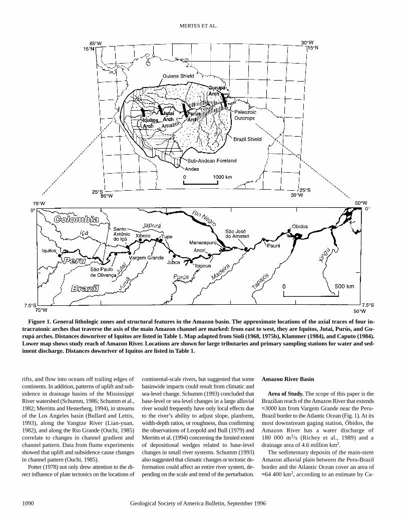
Area of Study. The scope of this paper is theBrazilian reach of the Amazon River that extends≈3000 km from Vargem Grande near the Peru-Brazil border to the Atlantic Ocean (Fig. 1). At itsmost downstream gaging station, Óbidos, theAmazon River has a water discharge of180 000 m3/s (Richey et al., 1989) and adrainage area of 4.6 million km2.
The sedimentary deposits of the main-stemAmazon alluvial plain between the Peru-Brazilborder and the Atlantic Ocean cover an area of≈64 400 km2, according to an estimate by Ca-
MERTES ET AL.
1090 Geological Society of America Bulletin, September 1996
Figure 1. General lithologic zones and structural features in the Amazon basin. The approximate locations of the axial traces of four in-tracratonic arches that traverse the axis of the main Amazon channel are marked: from east to west, they are Iquitos, Jutaí, Purús, and Gu-rupá arches. Distances downriver of Iquitos are listed in Table 1. Map adapted from Sioli (1968, 1975b), Klammer (1984), and Caputo (1984).Lower map shows study reach of Amazon River. Locations are shown for large tributaries and primary sampling stations for water and sed-iment discharge. Distances downriver of Iquitos are listed in Table 1.

CHANNEL-FLOODPLAIN GEOMORPHOLOGY, SOLIMÕES-AMAZON RIVER
Geological Society of America Bulletin, September 1996 1091
margo (1954; as described by Irion, 1976a).Sippel et al. (1992) calculated this area to be≈92 400 km2, on the basis of a planimetric mea-surement of the valley area between topograph-ically higher (10–15 m) terraces. The terracesparallel both sides of the river valley and arecomposed of unconsolidated fluvial and lacus-trine deposits and the Tertiary Barreiras For-mation, which consists of unconsolidated sands,silts, and clays, with scattered conglomeratelenses and crude stratification (Radambrasil,1974, 1977, 1978).
Irion (1976c), Tricart (1977), Iriondo (1982),and Klammer (1984) suggested that the main-stem floods do not inundate the entire alluvialplain. Using Iriondo’s (1982) interpretation oflandforms visible on radar images (Radambrasil,1972) and our estimates from remote sensing dataof the distance that sediment-rich main-stem wa-ters travel into the alluvial plain (Mertes et al.,1995), we estimate that between Vargem Grandeand Óbidos, ≈40 000 km2 of floodplain and4000 km2 of islands are inundated by direct flood-ing from the Amazon River water. The remainderof the alluvial plain between Vargem Grande andÓbidos (≈20 000 km2) comprises deposits thatmay remain dry or are flooded by small tributaries,ground-water seepage, or rainfall.
Structural Setting. The pattern of the drain-age network of the Amazon Basin has been in-fluenced by structural controls since the originof the basin (Caputo, 1984; Potter, 1978). On thebasis of stratigraphic evidence from deep cores, ithas been determined that from west to east inBrazil, the main Amazon valley is a 6000-m-deep sag in the crust between northern and south-ern crystalline shields (Guiana and Brazil shields,Fig. 1) that leads into a graben in the eastern halfof the basin (Caputo, 1984). The structural sagmay have first developed in response to Paleo-zoic rifting (Caputo, 1984) that was reactivatedduring the Triassic separation of South Americaand Africa (Potter, 1978). Although the Amazontrough has been present since at least the Paleo-zoic, significant eastward flow of water may havecommenced with the Miocene uplift of the Andes(Caputo, 1984).
This picture of mountains bordering a conti-nental-scale basin is interrupted by structuralfeatures that bound intracratonic basins. Räsä-nen et al. (1987), Dumont et al. (1991), Dumontand Garcia (1991), and Kalliola et al. (1993) re-viewed the structural character of the sub-Andean foreland in western Amazonia (Fig. 1)and considered the Peruvian Amazon basin to bean active zone of thin-skinned fold and thrustmovement related to Andean tectonics. Fromnear the Peruvian border to the Atlantic Ocean,four structural arches (Fig. 1) lie transverse tothe main Amazon trough; these are (from west to
east) the Iquitos, Jutaí (Carauari), Purús, and Gu-rupá arches (Fig. 1). Information on the Brazil-ian arches is scarce and is typically restricted tooil exploration documents that are not published.The presence of the arches in the central Ama-zon valley has been suggested to explain a dis-continuous stratigraphy along the main Amazontrough. The stratigraphy is based on data fromsediment cores and seismic surveys and showsthat the formations in each basin pinch out asthey approach the structural highs (Caputo,1984, 1991).
From the limited data it appears that the struc-tural arches represent intraplate tectonics (Big-arella, 1973; Caputo, 1984, 1991; Putzer, 1984).For example, Soares et al. (1978) concluded thatthe Brazilian intercratonic basins passed througha five-stage cycle, and varying rates of uplift andsubsidence controlled deposition and erosion.They described the Tertiary sequence as residualdeposits preserved in “Quaternary relict basinsof slight subsidence” (Soares et al., 1978,p. 190). The stratigraphy of deposits in interven-ing basins indicates that the Jutaí and Purúsarches have been areas of relief since the Paleo-zoic (Caputo, 1984), and the Iquitos and Gurupáarches first evolved during the Mesozoic (Putzer,1984; Dumont et al., 1991). The Iquitos archseems to mark the cratonic boundary and isprobably the result of lithospheric flexure due tothe loading of the Andes (Caputo, 1991). Du-mont et al. (1991) concurred with this view andalso concluded that, after alternate periods of up-lift and subsidence, the Iquitos arch has been up-lifted since the beginning of the Quaternary, re-sulting in terraces 30 m above present riverfloodplains. Caputo (1991) presented evidencefor substantial tectonic deformation for thebasins between the Iquitos and Purús arches andsouth of the Jutaí arch. Although no detailedanalysis was provided, Caputo (1991, p. 249)suggested that the “stresses that generated thestructures along the Solimões megashear [alsogenerated] other similar structures at distancesfar to the east in the Amazon basin.”
It is not known whether the Brazilian archesare currently deforming. However, Dunne,Mertes, R. H. Meade, and J. E. Richey (unpub.data) found a consistent pattern of steepeningchannel gradient (Fig. 2B) as the main stem ofthe Amazon River crosses the approximate po-sitions (Fig. 1 and Table 1) of the three easternarches. The water-surface gradient decreases asthe river passes into the intervening basins. Val-ley gradients could be steeper across the archesbecause of subsidence in the basins on eitherside in response to the sediment loading in thebasins, which is on the order of thousands of me-tres (Soares et al., 1978; Caputo, 1984). Recentuplift of these arches could also be the cause of
the steepening, as has been suggested for theMississippi River (Schumm, 1986), althoughsuch an effect would presumably require expo-sure of less-erodible material at the river bed.
Although not measured, the arches may be un-dergoing active deformation. For example, thestructures may have been active since the Mio-cene, because the Andean orogeny has altered thestructural character of the entire Amazon basin.The impact of this orogenic loading may extendeast of the Iquitos arch in the form of reactivationof structural features that originally developed inresponse to earlier plate movements and atten-dant stresses. Continental deformation on thescale of 1000 km from subduction zones (Mitro-vica et al., 1989) and first flexural nodes of thelithosphere on the scale of hundreds of kilome-tres from mountain belts (Karner and Watts,1983) have been predicted from models of sub-duction and isostatic adjustments to loading.Stratigraphic and structural data for the Sabineuplift, a structural arch in eastern Texas andnorthern Louisiana, show that it was reactivatedseveral times, resulting in ≈0.01 mm/yr of upliftsince the mid-Cretaceous (Nunn, 1990). Possiblemechanisms for reactivation and therefore con-tinued uplift of cratonic arch structures throughchanges in the continental lithosphere includethermal rejuvenation, new horizontal stresses,long-term viscous relaxation, or new extensionalfaulting (Nunn, 1990).
Local tilting and fracturing of the valley flooralong the Amazon main stem and floodplain inBrazil that are apparently not associated with the
TABLE 1. MEASURED DISTANCES ALONG THALWEG DOWNRIVER
FROM IQUITOS, PERU
Site Distancename (km)
Iquitos 0São Paulo de Olivença 740Vargem Grande 863Santo Antônio do Içá 891Xibeco 1051Tupé 1248Jutica 1528Itapeua 1704Anorí 1885Manacapurú 2031São José do Amatari 2228Madeira River confluence 2300Paurá 2474Parintins 2631Óbidos 2750
Iquitos Arch ≈–100*Jutaí Arch ≈700Purús Arch ≈2000Gurupá Arch ≈3200
Notes: Arch distances based onapproximate location of axial trace; archesextend tens of kilometres upstream anddownstream from trace. Locations shown in Figure 1.
*Upriver.

MERTES ET AL.
1092 Geological Society of America Bulletin, September 1996
Figure 2. (A) Schematic illustration of observed along-stream pattern of channel-floodplain geomorphology and valley width. Brackets with“tilt” indicate approximate extent of tilting deformation of valley. JA—Jutaí arch, PA—Purús arch, MR—Madeira River confluence, andGA—Gurupá arch. (B) Low-water channel gradient based on Seasat radar altimetric data reported by Guzkowska et al. (1990). Data col-lected between July 27 and August 9, 1978, with a reported precision of tens of centimetres. The orbit paths for the 15 elevation data with thehighest accuracy were replotted on the Radambrasil (1972) images and Operational Navigation charts for Peru. Corrected river distanceswere combined with the elevation data to compute water-surface gradients (Mertes, unpub. data). The data show the abrupt decrease of thewater-surface gradient as the river crosses from the sub-Andean foreland into Brazil and the irregular pattern as it crosses Brazil. (C) Netchannel storage of coarse and fine sediment based on sediment budget for channel reaches (Dunne, Mertes, R. H. Meade, and J. E. Richey,unpub. data). Positive values indicate deposition and negative values indicate erosion.

arches also affect the development of the channel-floodplain system. Tricart (1977), Iriondo (1982),and Iriondo and Sugio (1981) interpreted thepresence of tilted drainage networks, beheadedstreams, and patterns of undated alluvial depositsto be evidence for tectonic activity along theAmazon valley. In particular, Tricart (1977) sug-gested that the progressive development of ter-races between the Japurá River confluences andItapeua (Fig. 1) has been caused by the southwardtilting of the northern valley. The tilting hascaused the main stem of the river to lodge againsta scarp along the southern edge of the floodplain.Tricart also proposed that the presence of enor-mous lakes at the mouths of several Amazon trib-utaries (Negro, Tapajós, Xingu) is in part due tosubsidence along major faults. Drainage networksoriented in a northeast and northwest directionmay also reflect deep-seated basement fracturingthat has continued to disturb the overlying sedi-mentary rocks (Sternberg and Russell, 1952).
Inferences that structure and tectonic activityare influencing the channel-floodplain systems inthe Amazon basin have been based primarily onsparse stratigraphic and geomorphic evidence.Sternberg and Russell (1952) listed the dates ofseveral earthquakes that have been reported in thebasin since the seventeenth century. Without pre-cise geodetic or seismic measurements it is notyet possible to prove that there has been recenttectonic movement. However, our interpretationof tectonic influence is consistent with either pastor continuing deformation.
Recent Geologic History. The Amazon low-land is dominated by a vast alluvial plain sur-rounded by Quaternary and Tertiary terraces.The western Amazon basin in Peru was de-scribed in detail by Salo et al. (1986), Räsänen etal. (1987, 1990, 1991), Dumont and Garcia(1991), Dumont et al. (1990, 1991), Neller et al.(1992), and Kalliola et al. (1991, 1992, 1993),who discussed the relations among long-termpatterns of river migration, floodplain develop-ment, tectonics, and forest diversity. For theBrazilian Amazon region, Sternberg (1960,1975), Sioli (1951), Tricart (1977), Irion et al.(1983), and Johnsson and Meade (1990) de-scribed in some detail the construction of thefloodplain, island development, floodplain chan-nels, and channel migration.
Several reviews of hypotheses related to theQuaternary evolution of the eastern Amazonbasin are those of Sombroek (1966, 1984), Tri-cart (1977), Putzer (1984), Mertes (1985), Räsä-nen et al. (1990, 1991), Tuomisto et al. (1992),and Kalliola et al. (1993). In general, the hy-potheses concerning the evolution of the land-scape range from tectonic control (Iriondo andSugio, 1981; Iriondo, 1982) to a mix of climaticand tectonic control (Tricart, 1975, 1977, 1985),
or to dominance by glacio-eustatic fluctuationsduring the Tertiary and Quaternary (Sioli, 1957,1968, 1975a, 1975b, 1984; Irion, 1976a, 1976b,1976c, 1978, 1979, 1982, 1984; Klammer, 1984;Müller et al., 1995). Most of these hypotheses arebased on sparse data measured from the field,maps, and radar images (Radambrasil, 1972),and comparisons with apparently analogousglacio-eustatic effects around the world.
METHODS
Channel width, sinuosity, island area andperimeter, number of islands, and the radii ofcurvature of main-stem bends, floodplain chan-nel bends, and floodplain scroll bars were mea-sured on radar images (Radambrasil, 1972) for100-km-long reaches of channel. These imageshave a 1:250 000 scale, 16 m pixel resolution,and were recorded during low-water periods inthe years 1971 and 1972. Channels and islandsnarrower than 1 mm (250 m) on the images werenot included in the measurements. Channelwidth was computed as the average width of asingle channel in reaches where the river hasonly one channel. Sinuosity was computed asthe main channel thalweg length over the valleylength. Floodplain width is the average distanceacross the alluvial surface. The boundary of the
alluvial surface was defined as the innermostboundary of either Quaternary or Tertiary ter-races designated Apf, t, and Tb on Radambrasilsheets (Radambrasil, 1974, 1977, 1978). Thecircularity index for islands is the ratio of themeasured total island perimeter per section tothe calculated total island perimeter per sectionif all the islands were circles of the same area.The radius of curvature of a bend was measuredas the radius of the smallest circle containing thearc of the bend. On the modern channel, the arcwas measured at the center line of the channel;on the floodplain the arc was measured at thecenter line of the levee. Data on the lakes wereprovided by S. Sippel (1994, personal com-mun.), and the methods for their measurementwere described by Sippel et al. (1992).
The low-flow water depth was computed asthe average per reach of all of the depths on themost recent editions (1970, 1979, and 1980) ofBrazilian Navy navigation charts (Marina doBrasil, 1970–1980). These depths were origi-nally measured at different river stages from1967 to 1979 and were converted to low-waterdepths for the charts. The depths are well dis-tributed along the channel length, although insome reaches more measurements were taken inshallow sections, because the intent of the mapsis to help pilots avoid shoals during low water.
CHANNEL-FLOODPLAIN GEOMORPHOLOGY, SOLIMÕES-AMAZON RIVER
Geological Society of America Bulletin, September 1996 1093
Figure 3. Example of channel migration on the Amazon River, 1971–1972 to 1980. Migra-tion of this bend was documented from an overlay of 1972 Radambrasil image SA-19-ZBand 1980 Brazilian Navy navigation chart number 4112B (Marina do Brasil, 1974, 1977,1978). Maximum migration at the apex of this bend for this time period was ≈140 m/yr or3%/yr of the average channel width.

Because of this sampling bias the computed av-erage depth may underestimate the average low-water depth in some reaches.
Channel changes were measured from two setsof maps (see example in Fig. 3). For the section ofthe river from Vargem Grande to Manacapurú(Fig. 1), channel and bar margins were tracedfrom radar images recorded in the low-flow sea-son of 1971–1972 (Radambrasil, 1972). Theradar images were projected to a scale of1:100 000 to match the scale of the 1979–1980edition of 1:100 000 Brazilian Navy navigationcharts (Marina do Brasil, 1970–1980). Thesecharts are new editions based on the Radambrasilimages and ship surveys and include revisionsthrough 1979 and 1980. These two sets of datawere the most accurate available for this reach ofthe river. For the reaches of the river downstreamof Manacapurú, an overlay was constructed ofradar images from the Radambrasil project and ofrevised 1980 editions of 1970 and 1972 naviga-tion charts. The revised 1980 editions of the navi-gation charts include revisions for channel move-ments that were current as of 1980. The 1970seditions of the Brazilian Navy navigation charts(Marina do Brasil, 1970–1980) were originallybased on aerial photography and ship surveys, butnot on radar images. Therefore, measurements ofchannel change for the sections of the river down-stream of Manacapurú are considered less accu-rate than the data for the reaches upstream ofManacapurú, because there is a greater possibilitythat the measurements include apparent differ-ences in the channel that actually are due to dif-ferences in the mapping techniques. The channelchange values were computed as the total landarea eroded or deposited, divided by the totalchannel area between the low-water banks of themain river channel in 1971–1972, and divided bythe approximately 8 yr during which changeoccurred. It was not possible to assess errors as-sociated with paper shrinkage and other distor-tions for both sets of overlays. Therefore, to cor-roborate the quantitative analysis, a qualitativeanalysis of overlays of historical maps and morerecent remote sensing images was done.
To characterize bank geometry and the textureof floodplain sediments, field measurements weremade at 20 sites along the main channel fromVargem Grande to Óbidos during low water in1988 and 1991. Banks were classified as one ofthree types on the basis of the morphometric char-acteristics of the bank. Steep, nonvegetated, cutbanks were considered erosional. Steep, well-vegetated banks were considered stable. Low-gra-dient banks with grass cover were considered de-positional. Elevation measurements were madewith a tape and Abney level along a transect per-pendicular to the channel, using the water surfaceof the main channel as the reference elevation. The
accuracy of the surveying method was estimatedto be ±30 cm over 200 m with an elevation changeof several metres, based on one resurveyed tran-sect. At most survey points the soil beneath theduff layer was sampled with a 2-cm-diameter soilauger. The sample core was 29 cm long; the top4 cm and bottom 3 cm were discarded. Sampleswere air dried and returned to the laboratory forstandard particle-size analysis using sieve weightsfor sand fractions (see Mertes and Meade, 1985,for a detailed description of method) and hydrom-eter analysis for silt and clay (American Societyfor Testing and Materials [ASTM], 1984).
Most of the results are shown in figures wherethe reference distance is kilometres downstreamfrom Iquitos. Many of the data were measuredalong reaches of ≈100 km in length. We normal-ized these data by reach length to compare dif-ferent reaches.
ANALYSIS OF RESULTS
Channel Features
The Amazon River in Brazil is typically ananastomosing river (usage, Knighton and Nanson,1993). Over a length of 2500 km the averagedepth at low water increases from 10 to 20 m, andthe single-channel width increases from 2200 mto an average of 4500 m; the maximum is 6000 m(Fig. 4). The width-depth ratio (W/D) does notchange significantly downstream; the average is210, and the smallest values for the reaches are be-tween Jutica and Itapeua,≈1500 km (W/D = 180).The greatest values for the reaches are betweenAnorí and Manacapurú, ≈1900 km (W/D = 260).
To determine the relationships among river
depths, bank heights, and maximum flood heights,we used the height of the river banks from thebank surveys. The surveyed bank heights were ad-justed to a low-water surface reference in order tocompare the bank heights to each other and to themaximum flood height measured at nearby gagingstations. The maximum flood height was also ref-erenced to the low-water surface. Figure 5 showsthe results from these calculations, where typicalbank heights are 11 m in the upstream reaches,10–11 m in the middle reaches, and 7–8 m in thedownstream reaches. The maximum flood heightdecreases from 12 to 13 m in the upstream andmiddle reaches to 7.5 m at Óbidos (2750 km). Fig-ure 5 also shows the difference in height betweenthe top of the bank and the maximum measuredflood. This difference is 1.5 m in the reaches be-tween Tupé and Itapeua (1248–1704 km) and thereaches between São José do Amatari and Par-intins (2228–2631 km). In the other reaches thefreeboard is <1 m. These data on bank and maxi-mum flood heights indicate that the banks are rel-atively lower in the reaches between Jutica andItapeua (1248–1704 km) and between São José doAmatari and Parintins (2228–2631 km). There-fore, in these reaches, the maximum floods top thebanks with relatively deeper flows than in otherreaches.
The texture of the bank material was found tobe more variable along any one transect thanalong the entire study reach (Mertes, unpub.data). Figure 5 shows the downstream trend inthe percent sand of both the erosional and de-positional banks, based on averaging dataacross transects. The percent sand ranges from≈10% to nearly 20%. As the sand fraction var-ies, the clay fraction most consistently varies,
MERTES ET AL.
1094 Geological Society of America Bulletin, September 1996
Figure 4. Average depth and width of Amazon River main stem for low water stage. JA—Jutaí arch, PA—Purús arch, MR—Madeira River confluence, and GA—Gurupá arch.

and the silt fraction remains relatively constantat 65% for depositional banks and 70% for ero-sional banks. The most significant trend is an in-crease in the sand proportion downstream of theMadeira River confluence at ≈2300 km.
The along-channel consistent width to depthratio and homogeneous bank texture do not cor-relate with the variation in sinuosity of the river(Fig. 6). In contrast, based on Student’s t statistic(Zar, 1974) for a linear regression, there is a pos-itive correlation between floodplain width andsinuosity, which has probability P <0.001. The
maximum sinuosity of 1.7 at 1400 km was mea-sured in the reach that also has the maximumvalley width of nearly 80 km. Both upstream anddownstream of these maximum values the sinu-osity and valley widths decrease. The river isnearly straight for 350 km from Jutica to Anorí(1528–1885 km), but then increases in sinuositydownstream as the width of the alluvial valleyincreases downstream from Manacapurú(2031 km). The narrowest reach of the valley,averaging <20 km, is ≈100 km long in the vicin-ity of Manacapurú. The asymmetry of the flood-
plain, that is, the proportion of the floodplain oneither side of the river, also changes from up-stream to downstream (Fig. 6) without any clearcorrelation to floodplain width. In the reach be-tween Tupé and Itapeua (1248–1704 km) virtu-ally 100% of the floodplain is north of the river.
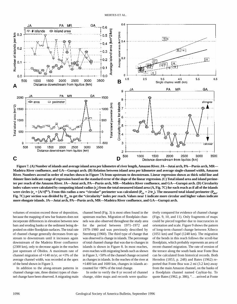
Figure 7A shows a general downstream de-crease in number of islands per kilometre perreach; there is some increase at 2700 km. As thenumber of islands decreases, the size of the islandsper kilometre increases somewhat less dramati-cally. The size of the islands is significantly (Stu-dent’s t statistic yields P <0.05) and positively cor-related with the channel width (Fig. 7B). Thevalues for sections 13 (2100 km), 14 (2200 km),15 (2300 km), and 20 (2900 km) are unusual inthat they contain islands of immense size. For ex-ample, Careiro Island in section 13 is nearly fourtimes larger (430 km2) than most of the otherislands in the entire study reach.
The total island area per each reach of≈100 km (Fig. 7C) gradually increases until thereach that contains Careiro Island (2100 km),decreases downstream of this reach, and then in-creases rapidly in the last few downstreamreaches. As the total island area increases, the to-tal perimeter of the islands remains near an aver-age of ≈240 km until downstream of theMadeira River confluence (2300 km), where thetotal perimeter increases simultaneously withthe dramatic increase in island area. The rela-tionship between total island area and islandperimeter is such that, as the islands increase insize, they also appear to become slightly morecircular in shape as shown by the pattern of cir-cularity values in Figure 7D. Values >>1, as seenin the reaches between Xibeco and Tupé(1051–1248 km), indicate that the islands aremore elongate than circular. Although the pat-tern is not entirely consistent, there seems to bean increase in circularity from the upper reachesto about Manacapurú (2100 km), and then thecircularity decreases again as indicated by an in-creasing value for the index. Downstream ofÓbidos (2750 km) the islands abruptly becomemore circular and become elongate again down-stream of 3000 km.
Historical Change
Figure 8 shows the magnitude of channelchange for the years between 1971–1972 and1979–1980 for the main channel between VargemGrande and Óbidos. The values were computedas the total land area eroded and deposited, di-vided by the total water surface area between thebanks of the main river channels, and divided bythe 8 yr over which the change occurred. In gen-eral, the percentage of erosion recorded is higherthan deposition. This pattern does not imply that
CHANNEL-FLOODPLAIN GEOMORPHOLOGY, SOLIMÕES-AMAZON RIVER
Geological Society of America Bulletin, September 1996 1095
Figure 5. Ovals indicate bank height with respect to low water, based on topographic surveysof banks, and rectangles indicate the maximum flood height based on the difference between thelowest and highest river stage at main-stem gaging stations (data from Departamento Nacionalde Aguas e Energia Elétrica—DNAEE) along the Amazon River. Triangles show average per-centage of sand across transects on erosional (ero) banks compared to those across depositional(depo) banks. JA—Jutaí arch, PA—Purús arch, and MR—Madeira River confluence.
Figure 6. Channel sinuosity, floodplain width, and location of floodplain relative to mainchannel of Amazon River. Sinuosity equals thalweg length/valley length for each section. Per-cent northern equals percentage of floodplain north of main channel. JA—Jutaí arch, PA—Purús arch, MR—Madeira River confluence, and GA—Gurupá arch.
MERTES ET AL.
1096 Geological Society of America Bulletin, September 1996
volumes of erosion exceed those of deposition,because the mapping of new bar features does notincorporate differences in elevation between newbars and eroding banks or the sediment being de-posited on older floodplain surfaces. The total rateof channel change generally decreases from up-stream to downstream until it increases againdownstream of the Madeira River confluence(2300 km), only to decrease again in the reachesjust upstream of Óbidos. A maximum rate ofchannel migration of ≈140 m/yr, or ≈3% of theaverage channel width, was recorded at the apexof the bend shown in Figure 3.
In addition to the along-stream patterns inchannel change rate, three distinct types of chan-nel change have been observed. A migrating main
channel bend (Fig. 3) is most often found in theupstream reaches. Migration of floodplain chan-nels was also observed throughout the study areafor the period between 1971–1972 and1979–1980 and was previously described bySternberg (1960). The third type of change thatwas observed is change in islands. The percentageof total channel change that was due to changes inislands is shown in Figure 8. In most reaches,even reaches with migrating bends such as shownin Figure 3, >50% of the channel change occurredas changes in islands. In the reaches of the river at≈1400 km and 1600 km, changes in islands ac-counted for >90% of the total change.
In order to verify the 8 yr record of channelchange, older maps and records were qualita-
tively compared for evidence of channel change(Figs. 9, 10, and 11). Only fragments of mapscould be pieced together due to inaccuracies inorientation and scale. Figure 9 shows the patternof long-term channel change between Xibeco(1051 km) and Tupé (1248 km). The migrationof the bends in this reach follows the scroll-barfloodplain, which probably represents an area ofrecent channel migration. The rate of erosion ofthe terrace along the south bank near Fonte Boacan be calculated from historical records. BothHerndon (1853, p. 248) and Bates (1962) re-ported that Fonte Boa was 2 mi (3.2 km) awayfrom the main Amazon channel, on the banks ofa floodplain channel named Cayhiar-hy. Toquote Bates (1962, p. 386), “. . . arrived at Fonte
Figure 7. (A) Number of islands and average island area per kilometre of river length, Amazon River. JA—Jutaí arch, PA—Purús arch, MR—Madeira River confluence, and GA—Gurupá arch. (B) Relation between island area per kilometre and average single-channel width, AmazonRiver. Numbers ascend in order of reaches shown in Figure 7A from upstream to downstream. Linear regression shown as thick solid line andthinner lines indicate range of regression based on the standard error of the slope of the linear regression. (C) Total island area and island perime-ter per reach of the Amazon River. JA—Jutaí arch, PA—Purús arch, MR—Madeira River confluence, and GA—Gurupá arch. (D) Circularityindex values were calculated by computing island radius (ra) from the total measured island area (A, Fig. 7C) for each reach as if all of the islandswere circles (ra = [A/π]0.5). From this radius a new “circular” perimeter was calculated (Pcir = 2πra). The measured total island perimeter (Pobs,Fig. 7C) per section was divided by Pcir to get the “circularity” index per reach. Values near 1 indicate more circular and higher values indicatemore elongate islands. JA—Jutaí arch, PA—Purús arch, MR—Madeira River confluence, and GA—Gurupá arch.
A
C
B
D

Boa; a wretched, muddy, and dilapidated village,situated two to three miles [from] . . . the mainAmazons.” As of 1984 the village church had tobe moved before it slid into the water (R. H.Meade, personal observation). The rate of mi-gration of the main channel would thereforehave been ≈3000 m divided by 120 yr, yielding25 m/yr or 1% of the channel width per year.These long-term rates are within the range of theshort-term rates measured in this reach. Recentlyacquired Landsat images (1988) and U.S. SpaceShuttle photographs (various dates, 1988– pre-sent) indicate that the observed migration esti-mated from both the long-term and short-termrecords is continuing.
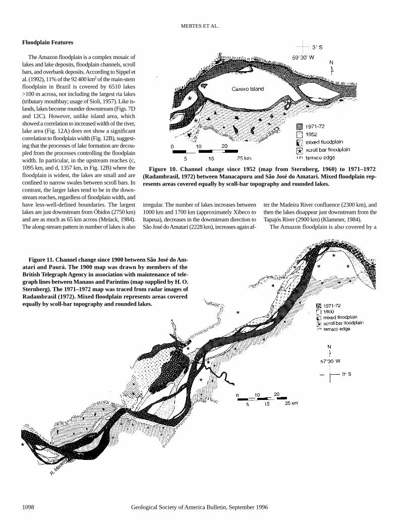
In contrast to Figure 9, Figure 10 shows mini-mal change between Manacapurú (2031 km) andSão José do Amatari (2228 km) over a 20 yrperiod. This corresponds to our lower, short-termrates, and also to the minimal rates of change es-timated by Sternberg (1960). The 14C dates oflevee deposits on Careiro Island suggest that theisland has been at its present location for hun-dreds of years (Sternberg, 1960), and that theonly significant change in this area since theearly 1900s has been the development of a flood-plain channel directly south of Careiro Island atits westernmost tip.
Figure 11 shows that the long-term rate ofchannel change is slightly greater in the reachesof the river downstream of the Madeira Riverconfluence (2300 km) compared to the ratesnear Careiro Island. This pattern of increasedchannel migration in the sections downstream ofthe Madeira River confluence was also mea-sured from the short-term record.
The high rates of channel change measuredfor the upstream reaches are comparable to ratesreported for other reaches of the Amazon Riverand for other large, alluvial rivers. Salo et al.(1986) reported rates of 12 m/yr for a 13 yrperiod on meander bends of the Manu River (atributary of the Amazon River) in Peru. On thebasis of an analysis of Landsat images datingfrom 1979 to 1983, Kalliola et al. (1992) re-ported rates of migration as high as 400 m/yr, or37% of the channel width, for the Amazon Riverin Peru. Drago (1990) reported rates rangingfrom <50 m to >200 m per year on sections ofthe Parana River in Argentina, based on recordsfrom the early 1900s to the present. The maxi-mum annual rate of lateral migration measuredin our study, 140 m or 3% of the channel width(Fig. 3), compares with the Kesel et al. (1974)report of 40.5 m/yr, or 4% of the channel width,of lateral migration for a bend on the MississippiRiver. Our average rates of channel change areeven within the range of 0.1%–5%/yr reportedby Lewin et al. (1977) for gravel-bedded streamsin England.
CHANNEL-FLOODPLAIN GEOMORPHOLOGY, SOLIMÕES-AMAZON RIVER
Geological Society of America Bulletin, September 1996 1097
Figure 8. Channel change in Amazon River during the years between 1971–1972 and1979–1980. The channel change is reported as the land area reworked per year over 8 yr, thatis, eroded, deposited, or total change, expressed as a percent of the total active channel areawhich was measured as the area between the main channel banks in each reach. Shaded boxesat top of graph show the percentage of the channel change that was due to island movement.JA—Jutaí arch, PA—Purús arch, and MR—Madeira River confluence.
Figure 9. Channel change since 1853 between Xibeco and Fonte Boa. The 1853 map wasdrawn by Herndon (1853) as he traveled the Amazon River by canoe, and should be regardedas very approximate. Even when standing in his canoe, Herndon would not have been able toperceive the true degree of curvature of the river. His horizon would have allowed him to seeonly a small segment of any given bend at any time, and his portrayal is likely to have under-estimated river curvature. The ca. 1940 map was drawn by a Brazilian Army detachmentsupposedly in 1934 as part of reconnaissance for the conflict of Leticia, according to the Insti-tuto Brasileiro de Geografia e Estatística (IBGE in Rio de Janeiro), and was supposedly basedon trimetrigon aerial photographs. However, in 1942–1943 the U.S. Army Air Corps also tooktrimetrigon aerial photographs of the Amazon River to draw maps for aerial reconnaissance(Natural Resources Unit, 1966). The 1942–1943 maps were printed by the U.S. Defense Map-ping Agency, St. Louis, Missouri, and they are almost exact replicas of the 1934 maps. It maybe that both sets of maps were based on the same set of photographs, hence the date ca. 1940has been applied to these maps. The 1971–1972 map was traced from radar images fromRadambrasil (1972).
Floodplain Features
The Amazon floodplain is a complex mosaic oflakes and lake deposits, floodplain channels, scrollbars, and overbank deposits. According to Sippel etal. (1992), 11% of the 92 400 km2 of the main-stemfloodplain in Brazil is covered by 6510 lakes>100 m across, not including the largest ria lakes(tributary mouthbay; usage of Sioli, 1957). Like is-lands, lakes become rounder downstream (Figs. 7Dand 12C). However, unlike island area, whichshowed a correlation to increased width of the river,lake area (Fig. 12A) does not show a significantcorrelation to floodplain width (Fig. 12B), suggest-ing that the processes of lake formation are decou-pled from the processes controlling the floodplainwidth. In particular, in the upstream reaches (c,1095 km, and d, 1357 km, in Fig. 12B) where thefloodplain is widest, the lakes are small and areconfined to narrow swales between scroll bars. Incontrast, the larger lakes tend to be in the down-stream reaches, regardless of floodplain width, andhave less-well-defined boundaries. The largestlakes are just downstream from Óbidos (2750 km)and are as much as 65 km across (Melack, 1984).The along-stream pattern in number of lakes is also
irregular. The number of lakes increases between1000 km and 1700 km (approximately Xibeco toItapeua), decreases in the downstream direction toSão José do Amatari (2228 km), increases again af-
ter the Madeira River confluence (2300 km), andthen the lakes disappear just downstream from theTapajós River (2900 km) (Klammer, 1984).
The Amazon floodplain is also covered by a
MERTES ET AL.
1098 Geological Society of America Bulletin, September 1996
Figure 10. Channel change since 1952 (map from Sternberg, 1960) to 1971–1972(Radambrasil, 1972) between Manacapuru and São José do Amatari. Mixed floodplain rep-resents areas covered equally by scoll-bar topography and rounded lakes.
Figure 11. Channel change since 1900 between São José do Am-atari and Paurá. The 1900 map was drawn by members of theBritish Telegraph Agency in association with maintenance of tele-graph lines between Manaus and Parintins (map supplied by H. O.Sternberg). The 1971–1972 map was traced from radar images ofRadambrasil (1972). Mixed floodplain represents areas coveredequally by scoll-bar topography and rounded lakes.

dense network of floodplain channels. In ourwork we have distinguished floodplain channelsfrom the main channel and its anabranches bydefining floodplain channels as channels thathave approximately an order of magnitudesmaller discharge than the main channel flowand are typically not active during low-water pe-riods. Figure 13 shows the width and depth dis-tributions for 105 of these channels measured onthe low-water 1980 navigation charts for reachesof ≈100 km. Generally, the width of the largestfloodplain channels increases in the downstreamdirection from 800 to 2000 m, although thesmallest floodplain channels (100 m wide) wereobserved in every reach. Depths were estimatedover tabular sills at the entrance to the floodplainchannels, on the assumption that these sills con-trol the flow entering the channel. The depthshowed no correlation to downstream distance.
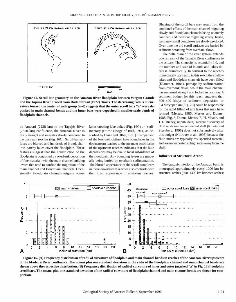
As the main channel, anabranches, and flood-plain channels migrate, scroll bars are left behindon the floodplain surface. Figure 14 shows typicalscroll-bar patterns found in the upstream reachesbetween Vargem Grande and the Japurá Riverconfluences. The radii of curvature of the scrollbars decrease toward the center of the scroll bar
complex (a–d in Fig. 14). In the downstreamreaches the scroll bars tend to be longer, fartherapart, and straighter than the upstream bars.
Empirical relationships between the width ofan alluvial channel and the radii of curvature ofbends in that channel have been documented byseveral authors (see Richards, 1982, for a review).We used the radii of curvature of channels andfloodplain features to help identify the placeswhere the floodplain scroll-bar features were de-posited. Downstream of the Madeira River con-fluence the scroll bars are less distinct and tend tobe straight along their preserved length, thusyielding infinite radii of curvature; they were notincluded in this analysis. Figure 15A is a fre-quency plot of the radii of curvature of all the ac-tive main channel bends and bends in floodplainchannels upstream of the Madeira River conflu-ence. The mean plus one standard deviation forthe main channel is 6.7 + 3.1 km, and for thefloodplain channels it is 1.9 + 0.7 km. Accordingto the Mann-Whitney test, a nonparametric statis-tical ranking test, these two populations are sig-nificantly different at a confidence level >99.9%.
The frequency distribution of radii of curva-ture for a representative sample of outer flood-
plain scroll bars (i.e., the features labeled “a” inFig. 14) and inner floodplain scroll bars has beenplotted (Fig. 15B). The mean plus one standarddeviation for the outer floodplain scroll bars is6.2 + 2.6 km, close to the values for the mainchannel bends. The mean value of the radii ofcurvature of the inner floodplain scroll bars is 3.2+ 2.6 km and appears to incorporate values thatscale with both the floodplain and main channels.The outer scroll bars were originally formed bythe main channel, but many of the inner scrollbars were deposited in the bends of floodplainchannels, which are significantly smaller than thebends of the main Amazon channels.
DISCUSSION
The Amazon River and floodplain in Brazildisplay an along-stream trend in channel-flood-plain geomorphology and channel behavior(Fig. 2A), largely controlled by transfer and stor-age of sediment from the Andes to the coast.Dunne, Mertes, R. H. Meade, and J. E. Richey(unpub. data) have developed a sediment budgetfor the Brazilian Amazon River that includes thefollowing inputs: bed load, suspended sediment
CHANNEL-FLOODPLAIN GEOMORPHOLOGY, SOLIMÕES-AMAZON RIVER
Geological Society of America Bulletin, September 1996 1099
Figure 12. (A) Number of floodplain lakes per kilometre of riverlength and average lake area (data reported by Sippel et al., 1993).JA—Jutaí arch, PA—Purús arch, MR—Madeira River confluence,and GA—Gurupá arch. (B) Floodplain lake area versus floodplainwidth. Reaches shown in Figure 12A are labeled alphabetically in or-der from upstream to downstream (lake data reported by Sippel etal., 1993). (C) Ratio of fetch (maximum length) to width of Amazon-ian floodplain lakes. Low values indicate more equant lakes and highvalues indicate longer, narrower lakes (calculation made from lakedata reported by Sippel et al., 1992). JA—Jutaí arch, PA—Purús arch,MR—Madeira River confluence, and GA—Gurupá arch.
AB
C

load, sediment from tributaries, and sedimentcontributed by erosion of bank material. Theoutputs include bed load, suspended sedimentload, loss to floodplain channels, overbank de-position, and sediment lost to new bar or islandformation. The summation of all of the input andoutput terms is presented in Figure 2C as the net
storage of sediment per kilometre. In addition, asdepicted in Figure 2A, the along-stream changein channel-floodplain geomorphology is notsmooth, because the basinwide pattern is over-laid by features produced by intracratonic tec-tonics, local patterns of deformation, and majortributary inputs.
General Along-Stream GeomorphicPatterns
In the upstream reaches (Figs. 2A and 16A),from 863 km to 1528 km (Vargem Grande to Ju-tica), the water-surface gradient increases slightly(Fig. 2B), promoting erosion of sand (Fig. 2C).The sand erosion also corresponds to high rates ofbank and island erosion (Figs. 8 and 9). Thesehigh rates probably promote or are the result ofthe high sinuosity of the river in the upstreamreaches (Fig. 6). As a result of rapid channel mi-gration, both lakes and islands are small andstreamlined. Lakes tend to be confined to swalesbetween scroll bars as in “meander scroll lakes”(usage, Blake and Ollier, 1971). Islands tend to beshortlived, and therefore rarely attain a large size,due to the rapid change in the channel position.
On the floodplain surface the upstream scrollbars appear fresh, and a large proportion of themare the same size as the bends of floodplain chan-nels rather than the larger main Amazon channel(Fig. 16B). Figure 17 depicts a schematic modelfor the development of the scroll-bar complexesthat cover the upstream floodplain (Fig. 14). As themain channel migrates, bar deposits are left as aseries of scroll bars on the scale of the main chan-nel (Fig. 17A). As time passes, the bend migratesfarther, and floodplain channels also migrate, re-working the deposits of the large bend and leavingbehind smaller-scale scroll bars (Fig. 17B). Even-tually the main channel bend is cut off by a moredirect channel, and the old channel begins fillingwith sediment. Subsequent to the cut off, watercontinues to flow through floodplain channels inthe bend area, and they rework the surface deposits(Fig. 17, C and D). If enough time passes, most ofthe surface features from the larger-scale bend canbe erased, and the smaller-scale floodplain chan-nel scroll bars will dominate the surface morphol-ogy of the floodplain (Fig. 17E). The resultingscroll-bar complexes show arcs of two distinctsizes, outer arcs on the scale of the main channeland inner arcs on the scale of the floodplain chan-nels (Figs. 14 and 16A). Scroll topography on theOrinoco floodplain (Colonnello, 1990) also com-prises scroll bars at different scales.
In the middle reaches of the river we observea transition from upstream to downstream fea-tures (Fig. 16B). In the reaches from 1528 to2228 km (Itapeua to São José do Amatari), theriver tends to be straighter in a narrower valley,migration rates are slower, scroll bars cover pro-portionally less of the floodplain, and, on aver-age, islands are slightly larger. Scroll lakes aremixed with rounder, larger lakes. There is fairlyconsistent deposition of sand (Fig. 2C) throughthis middle section as the river gradient de-creases (Fig. 2B).
In the downstream reaches from São José
MERTES ET AL.
1100 Geological Society of America Bulletin, September 1996
Figure 13. (A) Distribution of widths of 105 floodplain channels measured from 1980Brazilian Navy navigation charts. PA—Purús arch, MR—Madeira River confluence, SPO—São Paulo do Olivença, Ita—Itapeua, Man—Manacapurú, and Obi—Óbidos. (B) Distribu-tion of depths of 105 floodplain channels measured from 1980 Brazilian Navy navigationcharts. PA—Purús arch, MR—Madeira River confluence, SPO—São Paulo do Olivença,Ita—Itapeua, Man—Manacapurú, and Obi—Óbidos.
A
B
CHANNEL-FLOODPLAIN GEOMORPHOLOGY, SOLIMÕES-AMAZON RIVER
Geological Society of America Bulletin, September 1996 1101
do Amatari (2228 km) to the Tapajós River(2850 km) confluence, the Amazon River isfairly straight and migrates slowly compared tothe upstream reaches (Fig. 16C). Scroll-bar sur-faces are blurred and hundreds of broad, shal-low, patchy lakes cover the floodplain. Thesefeatures suggest that the construction of thefloodplain is controlled by overbank depositionof fine material, with the main channel buildinglevees that tend to confine the migration of themain channel and floodplain channels. Occa-sionally, floodplain channels migrate across
lakes creating lake deltas (Fig. 16C) or “sedi-mentary jetties” (usage of Bird, 1964, as de-scribed by Blake and Ollier, 1971). Comparisonof the less-well-defined lake boundaries in thedownstream reaches to the meander scroll lakesof the upstream reaches indicates that the lakedepressions may be due to local subsidence ofthe floodplain. Any bounding levees are gradu-ally being buried by overbank sedimentation.The blurred appearance of the scroll complexesin these downstream reaches also contrasts withtheir fresh appearance in upstream reaches.
Blurring of the scroll bars may result from thecombined effects of the main channel migratingslowly and floodplain channels being relativelyconfined, and therefore migrating slowly; hence,fresh new scroll complexes are slowly produced.Over time the old scroll surfaces are buried bysediment decanting from overbank flows.
The delta plain of the river system extendsdownstream of the Tapajós River confluence tothe estuary. The sinuosity is essentially 1.0, andthe number and size of islands and lakes de-crease dramatically. In contrast to the reachesimmediately upstream, in this reach the shallowlakes and floodplain channels have been filled(Klammer, 1984), perhaps by sedimentationfrom overbank flows, while the main channelhas remained straight and locked in position. Asediment budget for this reach suggests that300–400 Mt/yr of sediment deposition or0.4 Mt/yr per km (Fig. 2C) could be responsiblefor the rapid filling of any lakes that may haveformed (Mertes, 1985; Mertes and Dunne,1988, Fig. 3; Dunne, Mertes, R. H. Meade, andJ. E. Richey, unpub. data). Recent discovery offluid muds on the continental shelf (Kineke andSternberg, 1995) does not substantively alterthis budget (Nittrouer et al., 1995) because thefluid muds are typically resuspended materialand are not exported at high rates away from theshelf.
Influence of Structural Arches
The cratonic interior of the Amazon basin isinterrupted approximately every 1000 km bystructural arches (600–1300 km between arches;
Figure 14. Scroll-bar geometry on the Amazon River floodplain between Vargem Grandeand the Japurá River, traced from Radambrasil (1972) charts. The decreasing radius of cur-vature toward the center of each group (a–d) suggests that the outer scroll bars “a” were de-posited in main channel bends and the inner bars were deposited in smaller-scale bends offloodplain channels.
Figure 15. (A) Frequency distribution of radii of curvature of floodplain and main channel bends in reaches of the Amazon River upstreamof the Madeira River confluence. The means plus one standard deviation of the radii of the floodplain channel and main channel bends areshown above the respective distribution. (B) Frequency distribution of radii of curvature of inner and outer (marked “a” in Fig. 13) floodplainscroll bars. The means plus one standard deviation of the radii of curvature of floodplain channel and main channel bends are shown for com-parison.
A B

Table 1 and Fig. 1) that traverse the main axis ofthe river system and form the boundaries of ap-parently subsiding basins. The river hydraulics inthe form of the low-water surface slope appear tobe responding to the presence of the three archesin Brazil; these are low water-surface gradientsupstream of the arches, increasing water-surfacegradients as the river crosses the apex of the arch,and then a rapidly decreasing water-surface gra-dient on the downstream limb of the arch. Simi-lar patterns have been described for other alluvialand bedrock channels, where high uplift rateshave been estimated (Merritts and Vincent, 1989;Bullard and Lettis, 1993) or more resistant lithol-ogy (Hack, 1973) occurs.
Assuming that the water-surface slope is pro-portional to the boundary shear stress responsi-ble for transport of sediment, one can predicterosion in zones of increasing surface slope anddeposition in zones of decreasing surface slope.In a downstream direction, the river erodescoarse material as the slope increases in thereaches between Vargem Grande and Jutica(863–1248 km). Between Jutica and Itapeua theslope decreases and both coarse and fine sedi-ment are deposited (see next section regardinglocal deformation). The slope increases again asthe river crosses the Purús arch (2000 km), andthere is a corresponding increase in coarse sedi-ment erosion. As the river crosses the arch, theslope decreases, and deposition of coarse andfine material occurs.
As the river approaches the Gurupá arch inthe delta plain, the surface slope again increasesslightly. The estimated deposition rates of0.4 Mt/yr per km (Fig. 2C) could result from de-creasing surface slopes on the downstream limbof the Gurupá arch. This reach of the river is ap-proximately at sea level. The effect of the Holo-cene rise in sea level could have been to en-hance the influence of the arch and graben,because the increased base level would initiallyfurther reduce water-surface slopes.
In addition to influencing the patterns of hy-draulics and sediment transport, the arches areassociated with narrowing of the alluvial valley.The valley width is <30 km near the Jutaí arch,<20 km near the Purús arch, and <40 km ap-proaching the Gurupá arch. As described herein,a correlation exists between the narrowest sec-tions of the alluvial valley and the lowest chan-nel sinuosity. Aside from its upstream reaches,the river is also unusually straight along most ofits length, according to empirical relationshipsbetween width and bend amplitude for other al-luvial rivers as reported by Lewin and Brindle(1977) and Leopold and Wolman (1957). Fromthese empirical relationships based on channelwidth, predicted Amazon bend amplitudes
should range from 20 km upstream to 60 kmdownstream. Only two modern bends have am-plitudes >20 km. They are both upstream in thewidest part of the valley. Hence, the river is ap-parently freely meandering only in the upstreamreaches and elsewhere is confined. Whether thearches are restricting the migration of the chan-nel through influence on the valley width, or thevalley is narrower because of reduced channelmigration, is not clear. In either case, a combina-
tion of reduced vertical incision or lateral migra-tion relative to activity upstream and down-stream could produce the geomorphic patternsspatially associated with the arches.
Influence of Local Deformation
The clearest example of the influence of localdeformation not associated with the arches is in the reach between Jutica and Itapeua
MERTES ET AL.
1102 Geological Society of America Bulletin, September 1996
010
20 km
Figure 16. (A) Typical scroll-bar floodplain along upstream reaches of Amazon River nearXibeco (1051 km). (B) Typical transitional floodplain in middle reaches of Amazon River nearItapeua (1704 km).
A
B

(1528–1704 km, Fig. 2A), where the water-sur-face slope is high and then abruptly decreases(Fig. 2B). Nearly 100% of the floodplain is northof the main channel (Fig. 6), and the river runsnearly straight as it carves a path at the base ofthe terraces forming the south bank. Tricart(1977), Iriondo (1982), and Iriondo and Sugio(1981) described this as a southerly tilted basinextending at least as far north as the Japurá River.The impact of the tilted valley on channel behav-ior and geomorphology is significant: the river isstraighter, deeper, and narrower, and the water-surface slope is high. These patterns are observed
in part because flow is being forced to the southedge of the valley and the river cannot erode theterraces rapidly enough to form bends or even towiden the channel. As the river leaves this tiltedsection downstream of Itapeua, the water-surfaceslope decreases. As the river has carved its newposition on the south bank, it also has cut acrossseveral blocked valley lakes (Fig. 16B) and haschanged the position of the confluences of thesouthern tributaries.
In this tilted reach there is also evidence thatchannel migration has been achieved partiallythrough avulsions of the main channel. Fig-
ure 17 shows the proposed development of typ-ical scroll complexes on the Amazon floodplain.As the scroll complexes develop through re-working of the surface deposits by floodplainchannels, it is unlikely that oxbow lakes on thescale of the main channel would remain, in con-trast to many river systems where oxbow lakesare an important floodplain feature (e.g., theMississippi River; Fisk, 1944). However, if thechannel were to avulse to a distant location,then the floodplain channels would no longerreceive flood waters, and it would be possiblefor an oxbow to remain on the floodplain sur-face. The only large-scale, oxbow-type featureson the Brazilian Amazon floodplain are locatednorth of Xibeco (1051 km) and north of Itapeua(1704 km). The oxbow lake north of Xibeco(Fig. 18A) lies along an old channel belt (Tri-cart, 1977; Iriondo, 1982; Iriondo and Sugio,1981) and is the same size as the main channelbends. Between the northern channel belt con-taining the oxbow lake and the present channel,the floodplain surface is smooth, suggesting thatrecent channel migration was not continuousacross its surface. Both the relatively smooth in-tervening floodplain surface and the presence ofthe oxbow lake suggest that the channel avulsed≈40 km to its present location. Figure 18Bshows that the river has cut across the blockedvalley lake near Itapeua as it carved a tortuousbend south around older terrace deposits. Northof the terrace deposits are signs of older channeldeposits and some remnant oxbow-like lakes.All of this evidence suggests that the river mayhave avulsed to its southern position, perhapscaptured by the former drainage of the blockedtributary. Without the south-tilting deformation,which may be the cause of these avulsions, theoxbow-type lakes may not have been preservedon this upstream part of the floodplain. This ev-idence also suggests that the tilted reach extendsfrom Xibeco to Itapeua (1051–1704 km).
Influence of Major Tributaries
Local variability in channel behavior andfloodplain geomorphology could also be the re-sult of input from the major tributaries, as hasbeen suggested for much of the Orinoco Riverand floodplain (Hamilton and Lewis, 1990).However, unlike tributaries of the Orinoco, mostof the tributaries of the Amazon have muchsmaller flows and sediment loads than the mainchannel. Therefore, their individual influence onthe main channel behavior and floodplain mor-phology is difficult to assess, aside from the over-all effect of downstream dilution of the sedimentload and the dramatic appearance of their largemouthbays. However, we can discern the inde-
CHANNEL-FLOODPLAIN GEOMORPHOLOGY, SOLIMÕES-AMAZON RIVER
Geological Society of America Bulletin, September 1996 1103
Figure 16. (Continued) (C) Typical downstream floodplain of Amazon River near Óbidos(2750 km). (D) Typical “filled” delta-plain floodplain of Amazon River between Tapajós andXingu confluences (3000 km).
C
D

pendent influence of two of the major tributaries.The Japurá River confluence is in the middle ofthe tilted reach, and the location of the confluencemay be controlled by the deformation. In turn, asthe Japurá migrates to the south and builds itsfloodplain, it may be contributing to the overalltendency for the main Amazon to impinge alongthe southern edge of its alluvial plain.
The Madeira River, with its confluence at2300 km, can carry half of the sediment load ofthe main Amazon channel (Meade, 1985, 1994;Meade et al., 1985; Dunne, Mertes, R. H. Meade,and J. E. Richey, unpub. data). Downstream ofthe Madeira River confluence the banks of theAmazon tend to have a higher proportion of sand(Fig. 5), and the rate of channel migration (Fig. 8)and the number of islands (Fig. 7A) increase.These characteristics indicate that the MadeiraRiver may be imparting an “upstream” characterto the system as it provides a coarser sedimentload from the Andes that is available for morefrequent bar deposition and, therefore, morerapid rates of channel migration.
Floodplain Aggradation, Erosion, andRecycling Time
In considering the evolution of the BrazilianAmazon alluvial landscape it is instructive to esti-mate long-term rates of floodplain aggradation,erosion, and recycling based on the prevailing pat-terns of sediment transport along the main chan-nel. This discussion does not include the transportand deposition rates estimated for floodplainchannels, which were shown (Figs. 13, 14,and 15) to represent a distinct population of chan-nels at least an order of magnitude smaller thanthe main channel. In developing the sedimentbudget for the Brazilian Amazon River, Dunne,Mertes, R. H. Meade, and J. E. Richey (unpub.data) found that the rates of main channel erosionessentially equaled the rates of overbank deposi-tion plus the rates of deposition of new bar or is-land formation along the main channel. Over theentire study reach, the annual rates of exchange(erosion or deposition) between the main channeland floodplain each summed to ≈1600 Mt, for atotal of ≈3200 Mt of reworked floodplain sedi-
ment. The exchange rates slightly exceed the rateof suspended sediment transport at Óbidos, whichaverages 1240 Mt/yr (Dunne, Mertes, R. H.Meade, and J. E. Richey, unpub. data). Account-ing for the local recycling of old sediments, we es-timate that a large proportion of the suspendedsediment passing Óbidos has passed throughfloodplain storage and is not freshly eroded sedi-ment from the Andes or sub-Andean foreland.The likelihood that a high proportion of the sedi-ment spends time in floodplain storage and is inturn weathered was confirmed by Johnsson andMeade (1990), who reported that sediments inpoint-bar deposits near Xibeco (1051 km) showmorphological and chemical characteristics thatare likely the result of several thousands of yearsof in situ weathering. Hence, it is reasonable to es-timate that an individual particle may take thou-sands of years to travel the 3000 km length of theBrazilian Amazon.
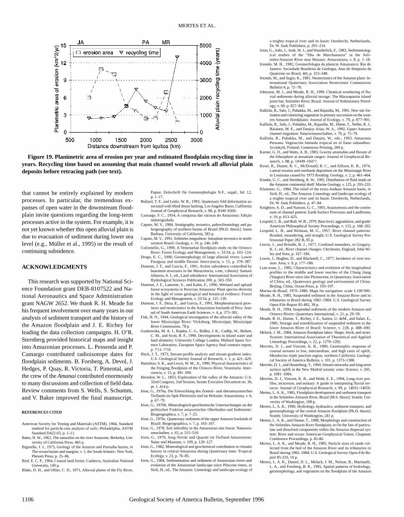
As the river exchanges material with its flood-plain, it is continuously recycling the sedimentsof the alluvial plain. Given the virtual balance be-tween the rate of destruction (erosion) and con-struction (overbank deposition and new bar for-mation) of the floodplain, it is reasonable to usethe rates of bank erosion to calculate the order ofmagnitude of time required to recycle the sedi-ments of the floodplain and alluvial plain. Fig-ure 19 shows the area of erosion calculated fromthe overlay of radar images and navigation chartsgrouped into reaches that correspond to the gen-eral pattern of along-stream variation in channelmigration rates. We divided the area of the allu-vial plain by the area of erosion per year to pre-dict the time period for recycling in years. Thenumber of years required to recycle the alluvialplain generally increases from 1000 yr in the up-stream reaches to 2000 yr in the downstreamreaches, with an increase to >4000 yr in thedownstream reaches near Óbidos (2750 km). Wedo not have channel change data for the reachesdownstream of Óbidos, but the geomorphic datasuggest that the channel is relatively immobile,hence we predict that the recycling time in thedelta plain is also >4000 yr.
For this calculation we did not include sedi-ment transport associated with floodplain chan-nels. As suggested by Figure 17, the floodplainchannels rework the surface deposits of the flood-plain and produce landforms at a smaller spatialscale than the main channel. The floodplain chan-nels do not penetrate deeply into the alluvium,and therefore reworking would account for only asmall proportion of the total recycling of flood-plain sediments. In addition, for the calculationwe included the entire area of the alluvial plain,and not just the modern, regularly inundatedfloodplain. By including the entire alluvial plainwe are not accounting for the fact that in some
MERTES ET AL.
1104 Geological Society of America Bulletin, September 1996
Figure 17. Schematic model for development of scroll-bar complexes. See text for a completedescription of the pattern development over the five stages. Compare to Figures 14 and 16A.

reaches channel migration and river-water incur-sion (Mertes et al., 1995) are restricted to narrowbands of the floodplain. The more distal reachesof the alluvial plain may not have been reworkedwithin the calculated time periods. For example,although we predict a turnover time for the allu-vial plain near Xibeco of ≈1000 yr, whichmatches radiocarbon dates of buried wood frag-ments showing ages of 1180 yr (L. Pessenda andP. Camargo, unpub. data), the channel belt on thenorthern part of the alluvial plain that contains thelarge oxbow lake (Fig. 18A) probably has notbeen recently reworked and may be older than1000 yr.
SUMMARY
The Solimões-Amazon River annually carries1240 Mt of suspended sediment as it crosses thecratonic landscape of Brazil, which has beenpunctuated by tectonic deformation in the formof structural arches and basin tilting. Variations inriver slope and transport of sediment across thislandscape result in upstream reaches character-ized by erosion of sand in the main channel anddeposition of sediment in floodplain channels,producing an intricate scroll-bar topographyforming the boundaries of hundreds of long, nar-row lakes. In contrast, downstream reaches arecharacterized by channels restricted by stabiliz-ing levee building, and floodplain constructiondominated by overbank deposition that graduallyburies scroll topography, resulting in a flat flood-plain characterized by a patchwork of large, moreequant, shallow lakes.
Imprinted on this along-stream geomorphictrend is the influence of basin structure and de-formation. Structural arches appear to exert a pri-mary influence on the channel-floodplain systemby promoting entrenchment of the river as itpasses through zones of deformation in Brazil,thus restricting channel movement. This pattern issimilar to observations made by Dumont et al.(1990) for the western, Peruvian Amazon basin.Our schematic model for the eastern Amazon(Fig. 2) illustrates the spatial correlation betweenthe narrowing of the alluvial valley as the rivercrosses the arches and the gradual widening of thevalley on the downstream limb of the arches. Thisimpact is clearest as the river crosses the Purúsarch, where the valley narrows to <20 km, the wa-ter surface gradient decreases dramatically, largeamounts of suspended sediment are deposited,and yet the rate of channel migration is negligible.Hence, the overall effect of intracratonic tectonicdeformation on the continental-scale Solimões-Amazon River is to create a landscape where, onthe spatial scale of hundreds of kilometres, theriver is confined and entrenched in its valley, isstraight, and is relatively immobile.
On the basis of estimated rates of recycling offloodplain sediments due to activity by the mainchannel, the modern floodplain of the BrazilianAmazon could have been recycled in <5000 yr,and is recycled more rapidly in the upstreamthan the downstream reaches. These results sug-gest that during the Holocene, fluvial transport
in the Amazon River in Brazil has reestablisheda channel-floodplain system that disposes of itssediment load in a manner controlled by tectonicfeatures and the modern hydrology and hy-draulics of the main channel, anabranches, andfloodplain channels. By contrast, the more dis-tal alluvial plain appears to be a remnant feature
CHANNEL-FLOODPLAIN GEOMORPHOLOGY, SOLIMÕES-AMAZON RIVER
Geological Society of America Bulletin, September 1996 1105
Figure 18. (A) Oxbow lake on Amazon alluvial plain north of Xibeco (1051 km) that is theonly oxbow lake of the same scale as main channel bend and has apparently not been re-worked since the channel avulsed to its present, more southern course. (B) Channel avulsionhas caused the Amazon River to carve tortuous bend around older terrace deposits and acrossthe blocked valley lake at Coari (Itapeua—1704 km). Open water areas northeast of terracemay be remnants of oxbow lakes left behind after channel avulsion.
A
B
that cannot be entirely explained by modernprocesses. In particular, the tremendous ex-panses of open water in the downstream flood-plain invite questions regarding the long-termprocesses active in the system. For example, it isnot yet known whether this open alluvial plain isdue to evacuation of sediment during lower sealevel (e.g., Müller et al., 1995) or the result ofcontinuing subsidence.
ACKNOWLEDGMENTS
This research was supported by National Sci-ence Foundation grant DEB-8107522 and Na-tional Aeronautics and Space Administrationgrant NAGW 2652. We thank R. H. Meade forhis frequent involvement over many years in ouranalysis of sediment transport and the history ofthe Amazon floodplain and J. E. Richey forleading the data collection campaigns. H. O’R.Sternberg provided historical maps and insightinto Amazonian processes. L. Pessenda and P.Camargo contributed radioisotope dates forfloodplain sediments. B. Forsberg, A. Devol, J.Hedges, P. Quay, R. Victoria, T. Pimental, andthe crew of the Amanai contributed enormouslyto many discussions and collection of field data.Review comments from S. Wells, S. Schumm,and V. Baker improved the final manuscript.
REFERENCES CITED
American Society for Testing and Materials (ASTM), 1984, Standardmethod for particle-size analysis of soils: Philadelphia, ASTMStandard D422-63, p. 1–11.
Bates, H. W., 1962, The naturalist on the river Amazons: Berkeley, Uni-versity of California Press, 465 p.
Bigarella, J. J., 1973, Geology of the Amazon and Parnaiba basins, inThe ocean basins and margins; v. 1, the South Atlantic: New York,Plenum Press, p. 25–86.
Bird, E. C. F., 1964, Coastal land forms: Canberra, Australian NationalUniversity, 140 p.
Blake, D. H., and Ollier, C. D., 1971, Alluvial plains of the Fly River,
Papua: Zeitschrift für Geomorphologie N.F., suppl., bd. 12,p. 1–17.
Bullard, T. F., and Lettis, W. R., 1993, Quaternary fold deformation as-sociated with blind thrust faulting, Los Angeles Basin, California:Journal of Geophysical Research, v. 98, p. 8349–8369.
Camargo, F. C., 1954, A conquista das várzeas do Amazonas: Ediçãomimeografada.
Caputo, M. V., 1984, Stratigraphy, tectonics, paleoclimatology and pa-leogeography of northern basins of Brazil [Ph.D. thesis]: SantaBarbara, University of California, 583 p.
Caputo, M. V., 1991, Solimões megashear: Intraplate tectonics in north-western Brazil: Geology, v. 19, p. 246–249.
Colonnello, G., 1990, A Venezuelan floodplain study on the OrinocoRiver: Forest Ecology and Management, v. 33/34, p. 103–124.
Drago, E. C., 1990, Geomorphology of large alluvial rivers: LowerParaguay and middle Paraná: Interciencia, v. 15, p. 378–387.
Dumont, J. F., and Garcia, F., 1991, Active subsidence controlled bybasement structures in the Maraciencia, v.ent, v.thesis]: SantainJohnson, A. I., ed., Land subsidence: International Association ofHydrological Sciences Publication 200, p. 343–350.
Dumont, J. F., Lamotte, S., and Kahn, F., 1990, Wetland and uplandforest ecosystems in Peruvian Amazonia: Plant species diversityin the light of some geological and botanical evidence: ForestEcology and Management, v. 33/34, p. 125–139.
Dumont, J. F., Deza, E., and Garcia, F., 1991, Morphostructural prov-inces and neotectonics in the Amazonian lowlands of Peru: Jour-nal of South American Earth Sciences, v. 4, p. 373–381.
Fisk, H. N., 1944, Geological investigation of the alluvial valley of thelower Mississippi River: Vicksburg, Mississippi, MississippiRiver Commission, 78 p.
Guzkowska, M. A. J., Rapley, C. G., Ridley, J. K., Cudlip, W., Birkett,C. M., and Scott, R. F., 1990, Developments in inland water andland altimetry: University College London, Mullard Space Sci-ence Laboratory, European Space Agency final contract report,p. 7/11–7/33.
Hack, J. T., 1973, Stream-profile analysis and stream-gradient index:U.S. Geological Survey Journal of Research, v. 1, p. 421–429.
Hamilton, S. K., and Lewis, W. M., Jr., 1990, Physical characteristics ofthe fringing floodplain of the Orinoco River, Venezuela: Inter-ciencia, v. 15, p. 491–500.
Herndon, W. L., 1853, Exploration of the valley of the Amazon: U.S.32nd Congress, 2nd Session, Senate Executive Document no. 36,pt. 1, 414 p.
Irion, G., 1976a, Die Entwicklung des Zentral– und oberamazonischenTieflands im Spät-Pleistozän und im Holozän: Amazoniana, v. 6,p. 67–79.
Irion, G., 1976b, Mineralogisch-geochemische Untersuchungen an derpelitischen Fraktion amazonischer Oberboden und Sedimente:Biogeographica, v. 7, p. 7–25.
Irion, G., 1976c, Quaternary sediment of the upper Amazon lowlands ofBrazil: Biogeographica, v. 7, p. 163–167.
Irion, G., 1978, Soil infertility in the Amazonian rain forest: Naturwis-senschaften, v. 65, p. 515–519.
Irion, G., 1979, Jung-Tertiär und Quartär im Tiefland Amazoniens:Natur und Museum, v. 109, p. 120–127.
Irion, G., 1982, Mineralogical and geochemical contribution to climatichistory in central Amazonia during Quaternary time: TropicalEcology, v. 23, p. 76–85.
Irion, G., 1984, Sedimentation and sediment of Amazonian rivers andevolution of the Amazonian landscape since Pliocene times, inSioli, H., ed., The Amazon: Limnology and landscape ecology of
a mighty tropical river and its basin: Dordrecht, Netherlands,Dr. W. Junk Publishers, p. 201–214.
Irion, G., Adis, J., Junk, W. J., and Wunderlich, F., 1983, Sedimentolog-ical studies of the “Ilha de Marchantaria” in the Soli-mões/Amazon River near Manaus: Amazoniana, v. 8, p. 1–18.
Iriondo, M. H., 1982, Geomorfologia da planicie Amazonica: Rio deJaneiro: Sociedade Brasileira de Geologia, Atas do Simposio doQuaternio no Brasil, 4th, p. 323–348.
Iriondo, M., and Sugio, K., 1981, Neotectonics of the Amazon plain: In-ternational Quaternary Association Neotectonic CommissionBulletin 4, p. 72–78.
Johnsson, M. J., and Meade, R. H., 1990, Chemical weathering of flu-vial sediments during alluvial storage: The Macuapanim Islandpoint bar, Solimões River, Brazil: Journal of Sedimentary Petrol-ogy, v. 60, p. 827–842.
Kalliola, R., Salo, J., Puhakka, M., and Rajasilta, M., 1991, New site for-mation and colonizing vegetation in primary succession on the west-ern Amazon floodplains: Journal of Ecology, v. 79, p. 877–901.
Kalliola, R., Salo, J., Puhakka, M., Rajasilta, M., Häme, T., Neller, R. J.,Räsänen, M. E., and Danjoy Arias, W. A., 1992, Upper Amazonchannel migration: Naturwissenschaften, v. 79, p. 75–79.
Kalliola, R., Puhakka, M., and Danjoy, W., eds., 1993, AmazoniaPeruana: Vegetación húmeda tropical en el llano subandino:Jyväskylä, Finland, Gummerus Printing, 260 p.
Karner, G. D., and Watts, A. B., 1983, Gravity anomalies and flexure ofthe lithosphere at mountain ranges: Journal of Geophysical Re-search, v. 88, p. 10449–10477.
Kesel, R., Dunne, K. C., McDonald, R. C., and Allison, K. R., 1974,Lateral erosion and overbank deposition on the Mississippi Riverin Louisiana caused by 1973 flooding: Geology, v. 2, p. 461–464.
Kineke, G. C., and Sternberg, R. W., 1995, Distribution of fluid muds onthe Amazon continental shelf: Marine Geology, v. 125, p. 193–233.
Klammer, G., 1984, The relief of the extra-Andean Amazon basin, inSioli, H., ed., The Amazon: Limnology and landscape ecology ofa mighty tropical river and its basin: Dordrecht, Netherlands,Dr. W. Junk Publishers, p. 47–84.
Knighton, A. D., and Nanson, G. C., 1993, Anastomosis and the contin-uum of channel pattern: Earth Surface Processes and Landforms,v. 19, p. 613–625.
Leopold, L. B., and Bull, W. B., 1979, Base level, aggradation, and grade:American Philosophical Society Proceedings, v. 123, p. 168–202.
Leopold, L. B., and Wolman, M. G., 1957, River channel patterns:Braided, meandering, and straight: U.S. Geological Survey Pro-fessional Paper 282-B, 85 p.
Lewin, J., and Brindle, B. J., 1977, Confined meanders, in Gregory,K. J., ed., River channel changes: Chichester, England, John Wi-ley and Sons, p. 167–184.
Lewin, J., Hughes, D., and Blacknell, C., 1977, Incidence of river ero-sion: Area, v. 9, p. 177–180.
Lian-yuan, L., 1982, Characteristics and evolution of the longitudinalprofiles in the middle and lower reaches of the Chang Jiang(Yangtze) River since late Pleistocene, in Quaternary Associationof China, ed., Quaternary geology and environment of China:Beijing, China, Ocean Press, p. 193–197.
Marina do Brasil, 1970–1980, Maps for navigation: scale 1:100 000.Meade, R. H., 1985, Suspended sediment in the Amazon River and its
tributaries in Brazil during 1982–1984: U.S. Geological SurveyOpen-File Report 85-492, 39 p.
Meade, R. H., 1994, Suspended sediments of the modern Amazon andOrinoco Rivers: Quaternary International, v. 21, p. 29–39.
Meade, R. H., Dunne, T., Richey, J. E., Santos, U. deM., and Salati, E.,1985, Storage and remobilization of suspended sediment in thelower Amazon River of Brazil: Science, v. 228, p. 488–490.
Melack, J. M., 1984, Amazon floodplain lakes: Shape, fetch, and strati-fication: International Association of Theoretical and AppliedLimnology Proceedings, v. 22, p. 1278–1282.
Merritts, D. J., and Vincent, K. R., 1989, Geomorphic response ofcoastal streams to low, intermediate, and high rates of uplift,Mendocino triple junction region, northern California: Geologi-cal Society of America Bulletin, v. 101, p. 1373–1388.
Merritts, D. J., and Hesterberg, T., 1994, Stream networks and long-termsurface uplift in the New Madrid seismic zone: Science, v. 265,p. 1081–1084.
Merritts, D. J., Vincent, K. R., and Wohl, E. E., 1994, Long river pro-files, tectonism, and eustasy: A guide to interpreting fluvial ter-races: Journal of Geophysical Research, v. 99, p. 14031–14050.
Mertes, L. A. K., 1985, Floodplain development and sediment transportin the Solimões-Amazon River, Brazil [M.S. thesis]: Seattle, Uni-versity of Washington, 108 p.
Mertes, L. A. K., 1990, Hydrology, hydraulics, sediment transport, andgeomorphology of the central Amazon floodplain [Ph.D. thesis]:Seattle, University of Washington, 241 p.
Mertes, L. A. K., and Dunne, T., 1988, Morphology and construction ofthe Solimões-Amazon River floodplain, in On the fate of particu-late and dissolved components within the Amazon dispersal sys-tem: River and ocean: American Geophysical Union, ChapmanConference Proceedings, p. 82-86.
Mertes, L. A. K., and Meade, R. H., 1985, Particle sizes of sands col-lected from the bed of the Amazon River and its tributaries inBrazil during 1982–1984: U.S. Geological Survey Open-File Re-port 85-333, 16 p.
Mertes, L. A. K., Daniel, D. L., Melack, J. M., Nelson, B., Martinelli,L. A., and Forsberg, B. R., 1995, Spatial patterns of hydrology,geomorphology, and vegetation on the floodplain of the Amazon
MERTES ET AL.
1106 Geological Society of America Bulletin, September 1996
Figure 19. Planimetric area of erosion per year and estimated floodplain recycling time inyears. Recycling time based on assuming that main channel would rework all alluvial plaindeposits before retracing path (see text).

River in Brazil from a remote sensing perspective: Geomorphol-ogy, v. 13, p. 215–232.
Mitrovica, J. X., Beaumont, C., and Jarvis, G. T., 1989, Tilting of conti-nental interiors by the dynamical effects of subduction: Tectonics,v. 8, p. 1079–1094.
Müller, J., Irion, G., Nunes de Mello, J., and Junk, W., 1995, Hydrolog-ical changes of the Amazon during the last glacial-interglacial cy-cle in central Amazonia (Brazil): Naturwissenschaften, v. 82,p. 232–235.
Natural Resources Unit, 1966, Annotated index of aerial photographiccoverage and mapping of topography and natural resources,Brazil: Washington, D.C., Pan American Union, 43 p.
Neller, R. J., Salo, J. S., and Räsänen, M. E., 1992, On the formation ofblocked valley lakes by channel avulsion in upper Amazon fore-land basins: Zeitschrift für Geomorphologie N.F., bd. 36,p. 401–411.
Nittrouer, C. A., Kuehl, S. A., Sternberg, R. W., Figueiredo, A. G., Jr.,and Faria, L. E. C., 1995, An introduction to the geological sig-nificance of sediment transport and accumulation on the Amazoncontinental shelf: Marine Geology, v. 125, p. 177–192.
Nunn, J. A., 1990, Relaxation of continental lithosphere: An explanationfor Late Cretaceous reactivation of the Sabine uplift of Louisiana-Texas: Tectonics, v. 9, p. 341–359.
Ouchi, S., 1985, Response of alluvial rivers to slow tectonic movement:Geological Society of America Bulletin, v. 96, p. 504–515.
Potter, P. E., 1978, Significance and origin of big rivers: Journal of Ge-ology, v. 86, p. 13–33.
Putzer, H., 1984, The geological evolution of the Amazon basin and itsmineral resources, in Sioli, H., ed., The Amazon: Limnology andlandscape ecology of a mighty tropical river and its basin: Dor-drecht, Netherlands, Dr. W. Junk Publishers, p. 15–46.
Radambrasil, 1972, Mosaico semi-controlado de radar: Rio de Janeiro,Ministério das Minas e Energia, Departamento Nacional de Pro-dução Mineral, scale 1:250 000.
Radambrasil, 1974, 1977, 1978, Mapa geomorphológico, SA 20–22:Rio de Janeiro, Ministério das Minas e Energia, DepartamentoNacional de Produção Mineral, scale 1:250n Americ 000 000.
Räsänen, M. E., Salo, J. S., and Kalliola, R. J., 1987, Fluvial perturbancein the western Amazon basin: Regulation by long-term sub-An-dean tectonics: Science, v. 238, p. 1398–1401.
Räsänen, M. E., Salo, J. S., Jungner, H., and Pittman, L. R., 1990, Evo-lution of the western Amazon lowland relief: Impact of Andean
foreland dynamics: Terra Nova, v. 2, p. 320–332.Räsänen, M. E., Salo, J. S., and Jungner, H., 1991, Holocene floodplain
lake sediments in the Amazon: 14C dating and palaeoecologicaluse: Quaternary Science Reviews, v. 10, p. 363–372.
Richards, K., 1982, Rivers: Form and process in alluvial channels: NewYork, Methuen, 358 p.
Richey, J. E., Mertes, L. A. K., Dunne, T., Victoria, R. L., Forsberg,B. R., Tancredi, A., and Oliveira, E., 1989, Sources and routing ofthe Amazon River flood wave: Global Biogeochemical Cycles,v. 3, p. 191–204.
Salo, J., Kalliola, R., Häkkinen, I., Mäkinen, Y., Niemalä, P., Puhakka,M., and Coley, P. D., 1986, River dynamics and the diversity ofAmazon lowland forest: Nature, v. 322, p. 254–258.
Schumm, S. A., 1986, Alluvial river response to active tectonics, in Ac-tive tectonics studies in geophysics: Washington, D.C., NationalAcademy Press, p. 80–94.
Schumm, S. A., 1993, River responses to baselevel change: Implicationsfor sequence stratigraphy: Journal of Geology, v. 101, p. 279–294.
Schumm, S. A., Watson, C. C., and Burnett, A. W., 1982, Phase 1: In-vestigation of neotectonic activity within the lower Mississippivalley: Vicksburg, Mississippi, U.S. Army Corps of EngineersPotamology Program (P-1) Report 2, 168 p.
Sioli, H., 1951, Sôbre a sedimentacão na várzea do baixo Amazonas:Belém, Brasil, Instituto Agronomico do Norte Boletim Técnico24, 65 p.
Sioli, H., 1957, Sedimentation im Amazonasgebiet: Geologische Rund-schau, v. 45, p. 608–633.
Sioli, H., 1968, Hydrochemistry and geology in the Brazilian Amazonregion: Amazoniana, v. 1, p. 267–277.
Sioli, H., 1975a, Amazon tributaries and drainage basins, in Hasler,A. D., ed., Coupling of land and water ecosystems: New York,Springer-Verlag, p. 199–213.
Sioli, H., 1975b, Tropical river: The Amazon, in Whitton, B. A., ed.,River ecology: Oxford, United Kingdom, Blackwell ScientificPublications, p. 461–488.
Sioli, H., ed., 1984, The Amazon: Limnology and landscape ecology ofa mighty tropical river and its basin: Dordrecht, Netherlands, Dr.W. Junk Publishers, 763 p.
Sippel, S. J., Hamilton, S. K., and Melack, J. M., 1992, Inundation areaand morphometry of lakes on the Amazon River floodplain,Brazil: Archiv für Hydrobiologie, v. 123, p. 385–400.
Soares, P. C., Landim, P. M. B., and Fultaro, V. J., 1978, Tectonic cycles
and sedimentary sequences in the Brazilian intracratonic basins:Geological Society of America Bulletin, v. 89, p. 181–191.
Sombroek, W. G., 1966, Amazon soils: Wageningen, Netherlands, Cen-tre for Agricultural Publications and Documentation, 292 p.
Sombroek, W. G., 1984, Soils of the Amazon region, in Sioli, H., ed.,The Amazon: Limnology and landscape ecology of a mightytropical river and its basin: Dordrecht, Netherlands, Dr. W. JunkPublishers, p. 521–535.
Sternberg, H. O’R., 1960, Radiocarbon dating as applied to a problemof Amazonian morphology: Washington, D.C., International Ge-ographical Union, Congrès International de Géographie, 18th,Proceedings, v. 2, p. 399–424.
Sternberg, H. O’R., 1975, The Amazon River of Brazil: GeographischeZeitschrift Beihefte, v. 40, 74 p.
Sternberg, H. O’R., and Russell, R. J., 1952, Fracture patterns in theAmazon and Mississippi valleys: Washington, D.C., InternationalGeographical Union, General Assembly, 8th, and InternationalCongress, 17th, Proceedings, p. 380–385.
Tricart, J., 1975, Influence des oscillations climatiques récentes sur lemodelé en Amazonie Orientale (Region de Santarém) d’après lesimages radar latéral: Zeitschrift für Geomophologie, v. 19,p. 140–163.
Tricart, J., 1977, Types de lits fluviaux en Amazonie brésilienne: An-nales de Géographie, v. 473, p. 1–54.
Tricart, J., 1985, Evidence of upper Pleistocene dry climates in northernSouth America, in Douglas, I., and Spencer, T., eds., Environ-mental change and tropical geomorphology: London, GeorgeAllen and Unwin, p. 197–217.
Tuomisto, H., Ruokalainen, K., and Salo, J., 1992, Lago Amazonas:Fact or fancy?: Acta Amazonica, v. 22, p. 353–361.
Wolman, M. G., and Leopold, L. B., 1957, River flood plains: Some ob-servations on their formation: U.S. Geological Survey Profes-sional Paper 282-C, p. 81–107.
Zar, J. H., 1974, Biostatistical analysis: Englewood Cliffs, New Jersey,Prentice-Hall, 620 p.
MANUSCRIPT RECEIVED BY THE SOCIETY APRIL 3, 1995REVISED MANUSCRIPT RECEIVED NOVEMBER 3, 1995MANUSCRIPT ACCEPTED JANUARY 3, 1996Carbon in the AMazon River EXperiment (CAMREX) contribution 79
CHANNEL-FLOODPLAIN GEOMORPHOLOGY, SOLIMÕES-AMAZON RIVER
Geological Society of America Bulletin, September 1996 1107
Printed in U.S.A.