challenges of integrated river basin management: a … · challenges of integrated river basin...
TRANSCRIPT

1
Challenges of Integrated River Basin Management: A Case of a Non-perennial River in Djibouti (East Africa)
Hervé Lévite and Tabarek Mohamed Ismaël
Ministry of Agriculture, Livestock and Sea, in charge of Water Resources B.P. 453 Djibouti Tel (253) 35 12 97 Fax : (253) 35 58 79
[email protected] ; [email protected] Abstract Many times in the past, unexpected floods have struck parts of the capital city of Djibouti. In 1994, floods killed more than 100 people and a decade later, floods had claimed over 300. Those worst affected were the inhabitants along the plains of the “Ambouli Oued”, who depend on vegetable gardening for sustenance. These floods generally occur with associated disease outbreaks such as cholera. Efforts to evacuate people from the flood-prone areas and provide them with alternative settlements have not been successful. It is a challenge for decision-makers due to numerous conflicting land and water interests in this area, namely: (i) protecting the capital against flooding, (ii) small-scale agriculture, (iii) protecting the fragile aquifer, iv) implementation of new projects (harbour, urbanisation), and (v) environment protection. Among the many constraints are lack of data and human resources, weak institutional arrangements, lack of collective memory, fatalism of decision makers, weakness of the land and water users, and most importantly, the overwhelming influence of development aid agencies that make decisions according to their own agenda. This paper discusses the complexity of the problem of managing this catchment sustainably and explores the need to adopt an integrated approach. Key words: Djibouti, Flood, Integrated river basin management, Non perennial river Introduction: the context
The Republic of Djibouti is a small country in the Horn of Africa, independent from France since 1977. It is classified as both a least developed and a low-income, food-deficit country. The UNDP Human Development Report for 2000 ranked Djibouti among the "low human development" countries (149th out of 174 countries). As it is located in a geo-strategic place in East Africa along a major oil route, the state receives large compensations for the presence of French Troops and more recently, since 2002 from the US Army. Traditional donors (European Union, African Development Bank, Arab countries, France, Japan) as well as private investors are relatively active. Djibouti has an arid to hyper-arid climate. Mean annual precipitation averages only 147 mm, and is very erratic, ranging
between 9.5 mm in 1980 and 693 mm in 1989. As a result, there are no permanent rivers in Djibouti. Watercourses in Djibouti are called “oued”, deriving from the Arab word “wadi”.
Figure 1: location of DjiboutEast Africa

2
Flash runoff is the way the oueds run, generally through few annual events during very short periods (FAO, 1995). The Ambouli Oued is one of the main non-perennial rivers of the country. Its 600-km2 catchment has an elongated shape and steep slopes in its upper watershed. It joins the Red Sea in Djibouti City where for the last five kilometres the slope is almost zero (0.3 %). Hydrological data are scarce, since the network established by a German research programme (Muller et al., 1982) in the 1980s have been completely destroyed. There is only one synoptic meteorological station for the whole country, at Ambouli International Airport. In this article the authors examine the challenges of developing infrastructure to protect the capital city of Djibouti from floods while providing for the sustainable exploitation of the oued since the flow is not permanent and the floods relatively rare. They stress the need to develop an integrated river basin approach. Mitigating the Ambouli oued flood effects Djibouti has always experienced problems of flooding, rated as the third biggest natural disaster risk problem affecting the country after drought and earthquake (IGAD, 2004). In March 2004, the President of the Republic asked the Ministry of Agriculture, Livestock and Sea, in charge of Water Resources, to reactivate a previous plan called “integrated watershed development of the Ambouli oued” with the aim of protecting the city of Djibouti against flooding and limiting silting in the new harbour under construction. A working group was established and meetings were started to define the terms of reference of the study. However, on the night of April 12th 2004, a catastrophic flash flood occurred, killing dozens of people and destroying goods and infrastructure. In the wake of this disaster, the European Union, which is a major donor in Djibouti, offered to partly finance the protection works and launched a pre-feasibility study. Method A lot of research has been carried out from 1974-2004. The main goal of the research is to obtain a good program of management for the Ambouli oued to handle the problem of the flood, and in the meantime to resolve the provision of potable water for the urban area, since Oued Ambouli is the main source of water of the aquifer. This paper is based on an analysis of existing documents and interviews with decision-makers and water users during the last flood, conducted in October 2004 by COWI-BCEOM experts as part of the pre-feasibility study. The donors’ points of view (World Bank, European Union, French Embassy, Japan) were also examined. [The institutional arrangements to conduct such a project, as well as the administrative complexity and problems of responsibility, are assessed.] Results The last flood: an obvious lack of information and organisation
3
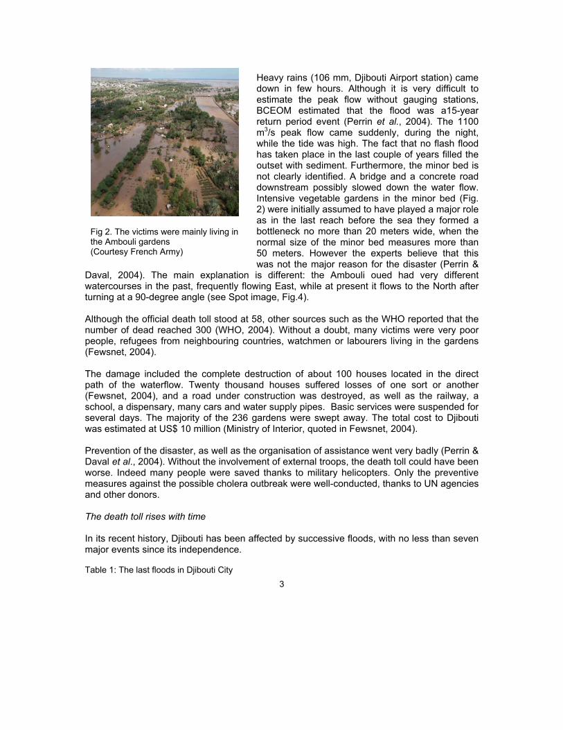
Heavy rains (106 mm, Djibouti Airport station) came down in few hours. Although it is very difficult to estimate the peak flow without gauging stations, BCEOM estimated that the flood was a15-year return period event (Perrin et al., 2004). The 1100 m3/s peak flow came suddenly, during the night, while the tide was high. The fact that no flash flood has taken place in the last couple of years filled the outset with sediment. Furthermore, the minor bed is not clearly identified. A bridge and a concrete road downstream possibly slowed down the water flow. Intensive vegetable gardens in the minor bed (Fig. 2) were initially assumed to have played a major role as in the last reach before the sea they formed a bottleneck no more than 20 meters wide, when the normal size of the minor bed measures more than 50 meters. However the experts believe that this was not the major reason for the disaster (Perrin &
Daval, 2004). The main explanation is different: the Ambouli oued had very different watercourses in the past, frequently flowing East, while at present it flows to the North after turning at a 90-degree angle (see Spot image, Fig.4). Although the official death toll stood at 58, other sources such as the WHO reported that the number of dead reached 300 (WHO, 2004). Without a doubt, many victims were very poor people, refugees from neighbouring countries, watchmen or labourers living in the gardens (Fewsnet, 2004). The damage included the complete destruction of about 100 houses located in the direct path of the waterflow. Twenty thousand houses suffered losses of one sort or another (Fewsnet, 2004), and a road under construction was destroyed, as well as the railway, a school, a dispensary, many cars and water supply pipes. Basic services were suspended for several days. The majority of the 236 gardens were swept away. The total cost to Djibouti was estimated at US$ 10 million (Ministry of Interior, quoted in Fewsnet, 2004). Prevention of the disaster, as well as the organisation of assistance went very badly (Perrin & Daval et al., 2004). Without the involvement of external troops, the death toll could have been worse. Indeed many people were saved thanks to military helicopters. Only the preventive measures against the possible cholera outbreak were well-conducted, thanks to UN agencies and other donors. The death toll rises with time In its recent history, Djibouti has been affected by successive floods, with no less than seven major events since its independence. Table 1: The last floods in Djibouti City
Fig 2. The victims were mainly living in the Ambouli gardens (Courtesy French Army)
4
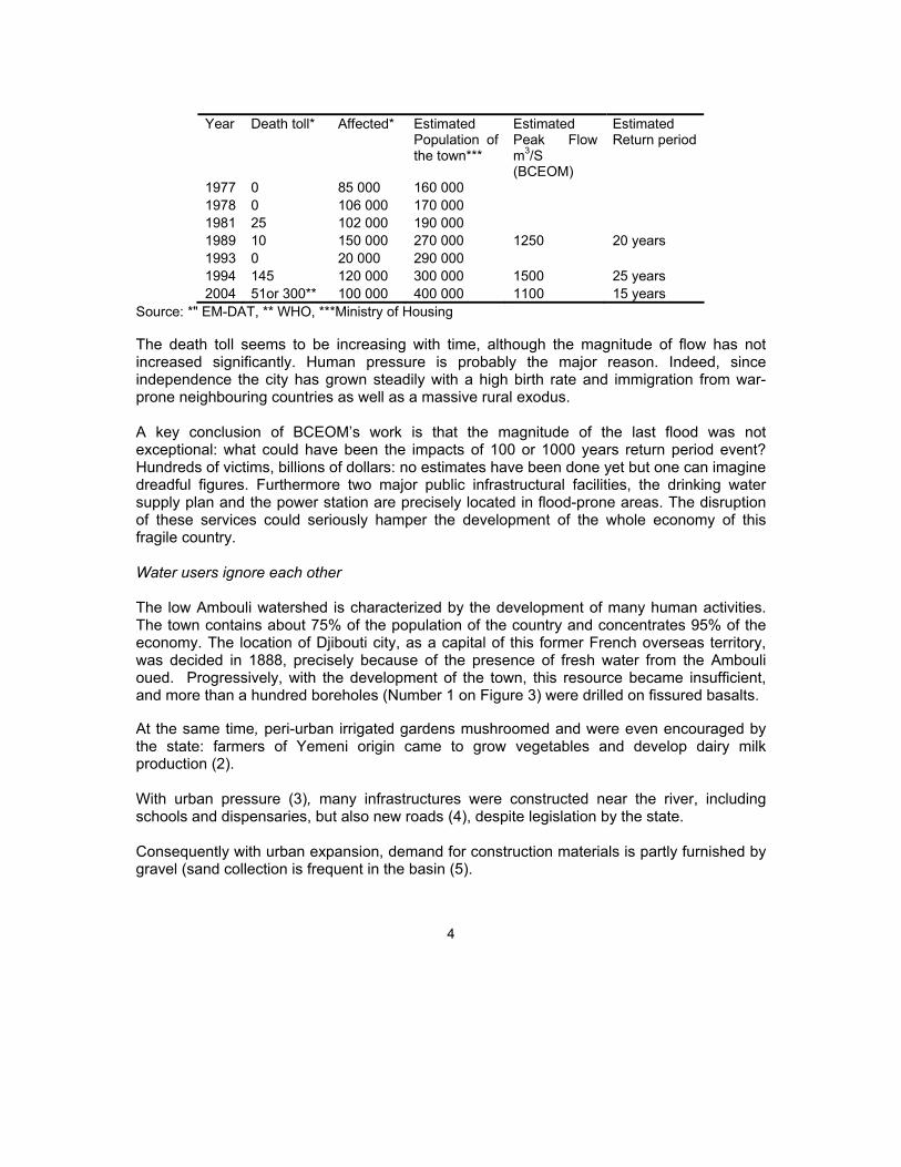
Year Death toll* Affected* Estimated
Population of the town***
Estimated Peak Flow m3/S (BCEOM)
Estimated Return period
1977 0 85 000 160 000 1978 0 106 000 170 000 1981 25 102 000 190 000 1989 10 150 000 270 000 1250 20 years 1993 0 20 000 290 000 1994 145 120 000 300 000 1500 25 years 2004 51or 300** 100 000 400 000 1100 15 years
Source: *" EM-DAT, ** WHO, ***Ministry of Housing The death toll seems to be increasing with time, although the magnitude of flow has not increased significantly. Human pressure is probably the major reason. Indeed, since independence the city has grown steadily with a high birth rate and immigration from war-prone neighbouring countries as well as a massive rural exodus. A key conclusion of BCEOM’s work is that the magnitude of the last flood was not exceptional: what could have been the impacts of 100 or 1000 years return period event? Hundreds of victims, billions of dollars: no estimates have been done yet but one can imagine dreadful figures. Furthermore two major public infrastructural facilities, the drinking water supply plan and the power station are precisely located in flood-prone areas. The disruption of these services could seriously hamper the development of the whole economy of this fragile country. Water users ignore each other The low Ambouli watershed is characterized by the development of many human activities. The town contains about 75% of the population of the country and concentrates 95% of the economy. The location of Djibouti city, as a capital of this former French overseas territory, was decided in 1888, precisely because of the presence of fresh water from the Ambouli oued. Progressively, with the development of the town, this resource became insufficient, and more than a hundred boreholes (Number 1 on Figure 3) were drilled on fissured basalts. At the same time, peri-urban irrigated gardens mushroomed and were even encouraged by the state: farmers of Yemeni origin came to grow vegetables and develop dairy milk production (2). With urban pressure (3), many infrastructures were constructed near the river, including schools and dispensaries, but also new roads (4), despite legislation by the state. Consequently with urban expansion, demand for construction materials is partly furnished by gravel (sand collection is frequent in the basin (5).

5
Upstream in rural areas, where around 10 000 persons are living, the land of the watershed provides firewood (6), and food for extensive livestock (mainly goats). There are already signs of over-grazing in this fragile acacia-based ecosystem. Upstream in rural areas, where around 10 000 persons are living, the land of the watershed provides firewood (6), and food for extensive livestock (mainly goats). There are already signs of over-grazing in this fragile acacia-based ecosystem. Downstream near the shores, three indirect users have been identified: the harbour (7), the environment (mangrove and coral reefs (8)), and fishing (9). Although these users are indirectly affected by floods, they should not be forgotten in the impact studies of future projects.
Fig 3. Identified water uses in the basin Table 2: Ambouli watershed users Users of the watershed Links with the floods Economic
importance Livelihoods
1 Aquifer, water supply Well destruction, pollution +++ 2 Agriculture, livestock
Human victims and destruction of gardens and animals
++ +++
3 Urban, troops Human victims of indirect water-related diseases
+++ +
4 Infrastructures: rail, roads, Destruction, slow down the flow ++

6
bridge 5 Gravel extraction Sand brought by floods + + 6 Wood collection and
pastoralism Acceleration of flow, erosion - ++
7 Future harbour Silting ++ - 8 Mangroves and coral
reefs Direct effects - -
9 Fishermen Pollution but also organic matter + ++ From discussions with users and experts, several observations can be made: Users pay no attention to the effects of their activities on other users downstream. Everyone thinks individually, although interactions are obvious. People have a limited memory of flooding, especially in the case of such non-perennial rivers. Even the French Army has installed troops and families in a very vulnerable part of the city. Most of the dead in 2004 were said to be Oromos, illegal migrants from Ethiopia, impossible to control as they hide in order to avoid deportation. They even ignore the risks of living there since there are often new immigrants in the country. The government is weak in stopping people from inhabiting this area, and inter-departmental cooperation is deficient. Thus in October 2004, only six months after the disastrous flood, people started to reconstruct many dwellings despite official warnings from the Ministry of Housing. The Ministry of the Interior is also unable to enforce the law. People have few job opportunities and this peri-urban agriculture is a promising source of employment and income. The authors met a gardener reconstructing his plot after he lost his five brothers and sisters. Similar activities such as extraction of gravels or wood collection were resumed after the flood, but again no police action was put in place. Furthermore, no responsibility has been assumed in the aftermath of the flood. Insurers have not paid any compensation. Nobody was accused of negligence, neither the state (in charge of protecting the citizens), nor the City Council (in charge of infrastructure development). Fatalism was the main explanation of the disaster. There are still no disaster mitigation plans. Even nine months after the drama, no early warning system has been put in place. A flood early warning system is absolutely necessary considering the speed of the phenomenon. For instance, during the 1994 flood no rain occurred in Djibouti city, only in the upstream basin. For a country hosting three powerful armies and with very sophisticated satellite imagery monitoring, efficient weather forecasting and an early warning system should be realistic (if not easy) objectives to achieve.

7
The new Project Proposal (expertise of BCEOM: Perrin et al, 2004) Three main stakes are considered: (i) protecting the city, (ii) expanding water resources for Djibouti city (iii) protecting the vegetable gardens from destruction. After investigation and visits to all possible dam sites, the following proposal was made: To build a multi-purpose dam that can divert the excess water flow into its natural and former course (see Fig 4). The design be made on the basis of a “1000 years return period”. This high level of safety is needed since people’s lives are threatened. The project will be designed on the basis of a 3000 m3/S peak flow and a volume of event of 34 million m3. s Since the topography is quite flat, a 15 meter high earth dam has proposed. It will store 3 to 5 Million m3 and
maintain controlled flooding for the gardens. Making the project a reality now As mentioned above, flooding has always been an issue here and many studies have been launched in the past, but no significant infrastructure has been completed yet. In the meantime urbanization has been pursued without consideration of flooding risks. After the 1989 floods, Terms of Reference for a masterplan for an Integrated Project were prepared, but the project was abandoned until the 1994 flood. Then a new version of the Terms of Reference was prepared, but no plan was drawn up until 2004, when a new disaster struck. In summary it seems that each time destructive floods occur, action is promised, but since nobody (neither the users nor the authorities) follows up the case, the project does not take off. It is now time for action, because today funding is available from the European Union. The project cost is huge (US$ 30 million, with $12 million for infrastructure development and $18
Fig 4: Spot image of Djibouti City, showing the project. A dam (1) will be constructed. In case of extreme flow the surplus will flow to the East in the Douda Oued through a spillway (2)

8
million for basin development), but it is no more than the total cost of two to three flooding events, and of course saving lives is an immeasurable gain. Preventing silting up of the future dam Considering the desertification under way in the basin, the high rain intensity and steep slopes, the consultants (Perrin, et al., 2004) think that erosion is the biggest problem. The lifetime of the dam could be limited to less than 20 years with the current level of sedimentation (Perrin, Daval et al., 2004). Therefore soil conservation measures are crucial. The budget proposed for the task is significantly more expensive than the infrastructures themselves. How can the objective of avoiding costly mistakes be achieved? A striking necessity for Integrated Water Resources Management The new project was prepared by a consultant with assistance from donors and government departments but still without users’ involvement. This lack of public participation in the debate is a mistake. There is a need to mobilise users and ensure their participation in the next phase: the feasibility study. Mobilisation of the population in the upper basin must start now and be carried on for 15 years. The ideal would be to get the assistance of NGOs to manage local participation. But NGOS are rare in Djibouti. The main funding agency (EU) is also worried about to who will manage such a project when public personnel are insufficiently trained and services often disorganized. The idea of creating a Catchment Management Agency (CMA) comprising all stakeholders is a probable solution. Finally, it is still necessary to look for supplemental funding for this ambitious project. Indeed the World Bank has promised emergency aid of US$ 5 million only to fix schools, dispensaries and a dyke destroyed during the 2004 flood. Japan could be involved in the funding of land conservation but wants to quantify the risks of investing in long-time involvement with communities. Only a strong mobilization of users will oblige donors to sit around the table. Conclusion Flooding is likely to persist in these flood-prone areas of Djibouti city. Drastic measures must be taken quickly, especially to build an early warning system. The government of Djibouti now has a workable project proposal, prepared by European Union. But much effort must be made for the project to become a reality: There is a need for political commitment to the project. The laws concerning housing must be enforced and nobody can be authorised to build in the minor bed of the Oued. Again, a flood early warning system is a must. It needs to integrate weather forecasts, recording rainfall and flood levels, communication (relay of information to flood response team), and decision to evacuate.

9
Sharing of information with all will make the scheme a common project for all water users of the Ambouli oued basin. Mobilisation of energies from the whole basin is essential to avoid silting up of the dam. Awareness of existing dangers should be a collective battle. It must also be understood as a real opportunity to fight poverty in these peri-urban areas. The government has to ensure that donor funding continues uninterrupted. But it has to demonstrate that it is able to make a contribution from the national budget in order to maintain the future infrastructures. The idea of creating a basin agency independent of government and representing all the users must be examined and pursued as a matter of urgency. References BCEOM-ISERST, 1981; Aménagemens possibles de l’oued Ambouli.Etude BCEOM. République de Djibouti. Ministère de l’Agriculture EM-DAT; The OFDA/CRED International Disaster Database www.em-dat.net - Université
Catholique de Louvain - Brussels – Belgium. http://www.em-dat.net/disasters/Visualisation/tmp/xls/6419.xls
Fewsnet (Famine Early Warning System Network), 2003; An Assessment of Food and Livelihood Security in Djibouti Ville USAID October 2003
Fewsnet, 2004; Djibouti Food Security Update. USAID June 2004.
http://www.fews.net/centers/innerSections.aspx?f=dj&pageID=monthlies FAO ; Irrigation in Africa in figures - L'irrigation en Afrique en chiffres. Food and Agriculture
Organization of the United Nations Rome, 1995 ISSN 1020-1203. From http://www.fao.org/docrep/V8260B/V8260B0o.htm IGAD, 2004; Regional Workshop to enhance the capability of IGAD member states.
Application of Space Technology in Disaster Risk Management. Country report of Djibouti 17-21 February 2004 [Nairobi]
Ministry of Habitat, Republic of Djibouti, 1998 ; Schéma directeur de Djibouti et identification
de projet prioritaires Müller W et al., 1982; Inventaire et mise en valeur des ressources en eau de la République
de Djibouti. Rapport préparé par pour le projet N° 78.2233.1, Coopération hydrogéologique allemande. Bundesanstalt für Geowissenschaften und Rohstoffe.Hanover, Germany (in French)
Perrin J., Daval. E., 2004 ; Etude de préfaisabilité d’un projet d’aménagement intégré de
l’Oued Ambouli. First version October 2004. BCEOM/COWI European Union -Delegation of Djibouti (in French)

10
World Health Organisation – Republic of Djibouti; Assessment Report on the April 2004 Floods. http://www.who.int/disasters/repo/13002.pdf