challenge 1: learning about the physical geography …...... learning about the physical geography...
TRANSCRIPT
G u i d e t o S t u d e n t H a n d o u t
© Teachers’ Curriculum Institute Canada and the united States 1
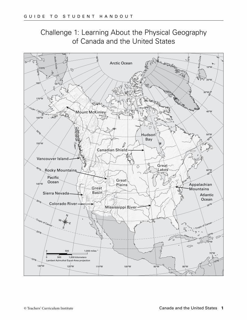
Challenge 1: Learning About the Physical Geography of Canada and the United States
GreatBasin
Rocky Mountains
Colorado River
Canadian Shield
HudsonBay
GreatLakes
GreatPlains
Mississippi River
Arctic Ocean
Great Basin
Great Plains
Sierra Nevada
Great Lakes
Hudson Bay
Mount McKinley
Vancouver Island
AppalachianMountains
30°N
40°N
50°N
20°N
Tropic of Cancer
50°W
40°W
60°W
70°W
30°W
20°W
10°W
10°N
60°N
Arc
tic
Cir
cle
70°N
80°W
70°W
90°W100°W110°W130°W 120°W
140°W
150°W
160°W
170°W
170°E
180°
10°N
Tropic of Cancer
30°N
20°N
40°N
50°N
60°N
Arctic C
ircle
70°N
80°N
80°N
N
S
EW
0 1,000 kilometers
0 1,000 miles
Lambert Azimuthal Equal-Area projection500
500
AtlanticOcean
PacificOcean
G u i d e t o S t u d e n t H a n d o u t
© Teachers’ Curriculum Institute Canada and the united States 2
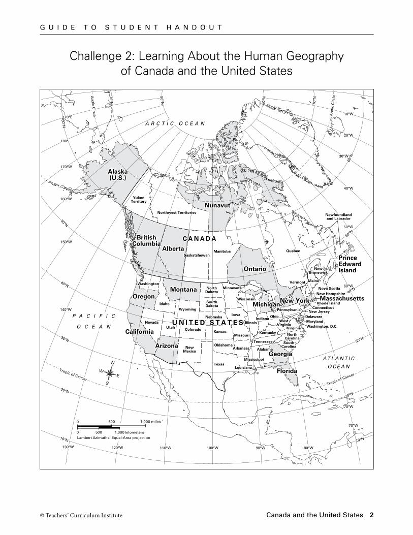
Alaska(U.S.)
Washington
YukonTerritory
Northwest Territories
Nunavut
BritishColumbia
AlbertaSaskatchewan
Manitoba
Ontario
Quebec
Newfoundlandand Labrador
PrinceEdwardIslandNew
Brunswick
Nova Scotia
Oregon
California
Nevada
Idaho
Montana NorthDakota
SouthDakota
Nebraska
Kansas
Oklahoma
Texas
Minnesota
Iowa
Wisconsin
Michigan
IllinoisIndiana Ohio
Pennsylvania
New York
Maine
New Hampshire
Vermont
MassachusettsConnecticut
Rhode Island
MarylandWashington, D.C.
DelawareNew Jersey
Kentucky
Tennessee
Mississippi
AlabamaGeorgia
SouthCarolina
NorthCarolina
Virginia
WestVirginia
Florida
Missouri
Arkansas
Louisiana
Wyoming
Utah Colorado
Arizona NewMexico
U N I T E D S T A T E S
C A N A D A
AT L A N T I C
O C E A N
AT L A N T I C
O C E A N
P A C I F I C
O C E A N
A R C T I C O C E A N
U N I T E D S T A T E S
C A N A D A
Alaska(U.S.)
Washington
YukonTerritory
Northwest Territories
Nunavut
BritishColumbia
AlbertaSaskatchewan
Manitoba
Ontario
Quebec
Newfoundlandand Labrador
PrinceEdwardIslandNew
Brunswick
Nova Scotia
Oregon
California
Nevada
Idaho
Montana NorthDakota
SouthDakota
Nebraska
Kansas
Oklahoma
Texas
Minnesota
Iowa
Wisconsin
Michigan
IllinoisIndiana Ohio
Pennsylvania
New York
Maine
New Hampshire
Vermont
MassachusettsConnecticut
Rhode Island
MarylandWashington, D.C.
DelawareNew Jersey
Kentucky
Tennessee
Mississippi
AlabamaGeorgia
SouthCarolina
NorthCarolina
Virginia
WestVirginia
Florida
Missouri
Arkansas
Louisiana
Wyoming
Utah Colorado
Arizona NewMexico
N
S
EW
0 1,000 kilometers
0 1,000 miles
Lambert Azimuthal Equal-Area projection500
500
30°N
40°N
50°N
20°N
Tropic of Cancer
50°W
40°W
60°W
70°W
30°W
20°W
10°W
10°N
60°N
Arc
tic
Cir
cle
70°N
140°W
150°W
160°W
170°W
170°E
180°
10°N
Tropic of Cancer
30°N
20°N
40°N
50°N
60°N
Arctic C
ircle
70°N
80°N
80°N
80°W
70°W
90°W100°W110°W130°W 120°W
TCI5 424GA_ML_LG_02-GCH-2.epsThird proof
Challenge 2: Learning About the Human Geography of Canada and the United States
G u i d e t o S t u d e n t H a n d o u t
© Teachers’ Curriculum Institute Canada and the united States 3
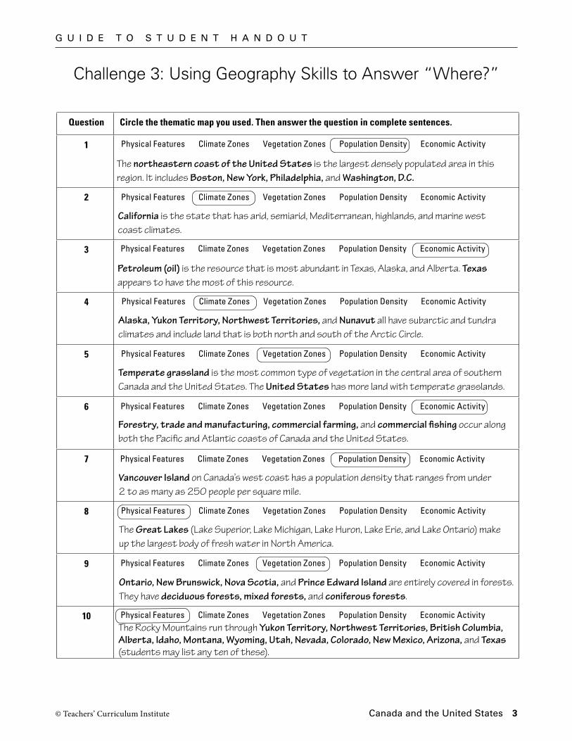
Challenge 3: Using Geography Skills to Answer “Where?”
Question Circle the thematic map you used. Then answer the question in complete sentences.
1
2
3
4
5
6
7
8
9
10
Physical Features Climate Zones Vegetation Zones Population Density Economic Activity
Physical Features Climate Zones Vegetation Zones Population Density Economic Activity
Physical Features Climate Zones Vegetation Zones Population Density Economic Activity
Physical Features Climate Zones Vegetation Zones Population Density Economic Activity
Physical Features Climate Zones Vegetation Zones Population Density Economic Activity
Physical Features Climate Zones Vegetation Zones Population Density Economic Activity
Physical Features Climate Zones Vegetation Zones Population Density Economic Activity
Physical Features Climate Zones Vegetation Zones Population Density Economic Activity
Physical Features Climate Zones Vegetation Zones Population Density Economic Activity
Physical Features Climate Zones Vegetation Zones Population Density Economic Activity
The northeastern coast of the United States is the largest densely populated area in this region. It includes Boston, New York, Philadelphia, and Washington, D.C.
California is the state that has arid, semiarid, Mediterranean, highlands, and marine west coast climates.
Petroleum (oil) is the resource that is most abundant in Texas, Alaska, and Alberta. Texas appears to have the most of this resource.
Alaska, Yukon Territory, Northwest Territories, and Nunavut all have subarctic and tundra climates and include land that is both north and south of the Arctic Circle.
Temperate grassland is the most common type of vegetation in the central area of southernCanada and the United States. The United States has more land with temperate grasslands.
Forestry, trade and manufacturing, commercial farming, and commercial fishing occur along both the Pacific and Atlantic coasts of Canada and the United States.
Vancouver Island on Canada’s west coast has a population density that ranges from under 2 to as many as 250 people per square mile.
The Great Lakes (Lake Superior, Lake Michigan, Lake Huron, Lake Erie, and Lake Ontario) make up the largest body of fresh water in North America.
Ontario, New Brunswick, Nova Scotia, and Prince Edward Island are entirely covered in forests. They have deciduous forests, mixed forests, and coniferous forests.
The Rocky Mountains run through Yukon Territory, Northwest Territories, British Columbia, Alberta, Idaho, Montana, Wyoming, Utah, Nevada, Colorado, New Mexico, Arizona, and Texas (students may list any ten of these).
G u i d e t o S t u d e n t H a n d o u t
© Teachers’ Curriculum Institute Canada and the united States 4
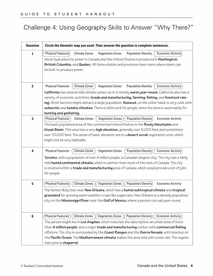
Challenge 4: Using Geography Skills to Answer “Why There?”
Question Circle the thematic map you used. Then answer the question in complete sentences.
1
2
3
4
5
6
Physical Features Climate Zones Vegetation Zones Population Density Economic Activity
Physical Features Climate Zones Vegetation Zones Population Density Economic Activity
Physical Features Climate Zones Vegetation Zones Population Density Economic Activity
Physical Features Climate Zones Vegetation Zones Population Density Economic Activity
Physical Features Climate Zones Vegetation Zones Population Density Economic Activity
Physical Features Climate Zones Vegetation Zones Population Density Economic Activity
The person might live in Los Angeles, which matches the description: an urban area of more than 4 million people, and a major trade and manufacturing center, with commercial fishing offshore. The city is surrounded by the Coast Ranges and the Sierra Nevada, with beaches on the Pacific Ocean. The Mediterranean climate makes the area mild with some rain. The vegeta-tion zone is chaparral.
The farmer likely lives near New Orleans, which has a humid subtropical climate and tropical grassland for growing warm-weather crops like sugarcane. New Orleans is a densely populated city on the Mississippi River, near the Gulf of Mexico, where a person can sail year-round.
Toronto, with a population of over 4 million people, is Canada’s largest city. The city has a fairly mild humid continental climate, which is warmer than much of the rest of Canada. The city is located within a trade and manufacturing area of Canada, which would provide a lot of jobs for people.
The least populated area of the continental United States is the Rocky Mountains and Great Basin. This area has a very high elevation, generally over 5,000 feet and sometimes over 10,000 feet. The areas of lower elevation are in a desert scrub vegetation zone, which might not be very habitable.
California has several mild climate zones, so it is mostly warm year-round. California also has a variety of economic activities (trade and manufacturing, farming, fishing, and livestock rais-ing). Both factors might attract a large population. Nunavut, on the other hand, is very cold, with subarctic and tundra climates. There is little work for people, since the land is used mainly for hunting and gathering.
Most hydroelectric power in Canada and the United States is produced in Washington, British Columbia, and Quebec. All three states and provinces have rivers where dams can be built to produce power.
G u i d e t o S t u d e n t H a n d o u t
© Teachers’ Curriculum Institute Canada and the united States 5
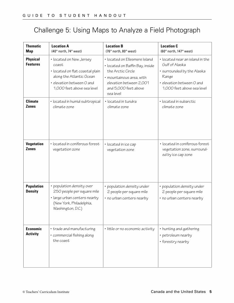
Challenge 5: Using Maps to Analyze a Field Photograph
Thematic Map
Location A(40° north, 74° west)
Location B(76° north, 80° west)
Location C(60° north, 147° west)
Physical Features
Climate Zones
Vegetation Zones
Population Density
Economic Activity
• located in humid subtropical climate zone
• located on Ellesmere Island
• located on Baffin Bay, inside the Arctic Circle
• mountainous area, with elevation between 2,001 and 5,000 feet above sea level
• located near an island in the Gulf of Alaska
• surrounded by the Alaska Range
• elevation between 0 and 1,000 feet above sea level
• located on New Jersey coast
• located on flat coastal plain along the Atlantic Ocean
• elevation between 0 and 1,000 feet above sea level
• located in tundra climate zone
• located in subarctic climate zone
• located in coniferous forest vegetation zone, surround-ed by ice cap zone
• located in ice cap vegetation zone
• located in coniferous forest vegetation zone
• population density over 250 people per square mile
• large urban centers nearby (New York, Philadelphia, Washington, D.C.)
• population density under 2 people per square mile
• no urban centers nearby
• population density under 2 people per square mile
• no urban centers nearby
• trade and manufacturing
• commercial fishing along the coast
• little or no economic activity • hunting and gathering
• petroleum nearby
• forestry nearby
G u i d e t o S t u d e n t H a n d o u t
© Teachers’ Curriculum Institute Canada and the united States 6
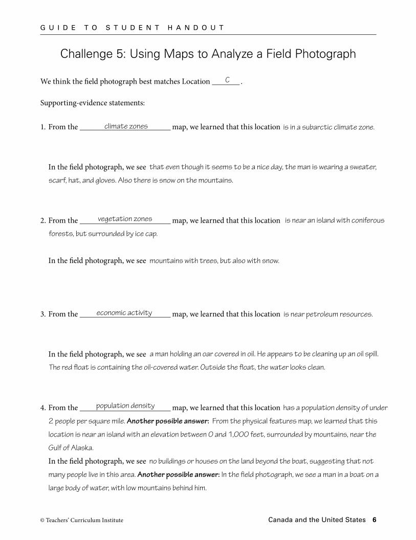
Challenge 5: Using Maps to Analyze a Field Photograph
We think the field photograph best matches Location _______ .
Supporting-evidence statements:
1. From the _______________________ map, we learned that this location
In the field photograph, we see
2. From the _______________________ map, we learned that this location
In the field photograph, we see
3. From the _______________________ map, we learned that this location
In the field photograph, we see
4. From the _______________________ map, we learned that this location
In the field photograph, we see
is in a subarctic climate zone.
vegetation zones
economic activity
population density
C
that even though it seems to be a nice day, the man is wearing a sweater,
scarf, hat, and gloves. Also there is snow on the mountains.
climate zones
is near an island with coniferous
forests, but surrounded by ice cap.
mountains with trees, but also with snow.
is near petroleum resources.
a man holding an oar covered in oil. He appears to be cleaning up an oil spill.
The red float is containing the oil-covered water. Outside the float, the water looks clean.
has a population density of under
2 people per square mile. Another possible answer: From the physical features map, we learned that this
location is near an island with an elevation between 0 and 1,000 feet, surrounded by mountains, near the
Gulf of Alaska.
no buildings or houses on the land beyond the boat, suggesting that not
many people live in this area. Another possible answer: In the field photograph, we see a man in a boat on a
large body of water, with low mountains behind him.