ch path - reigate-banstead.moderngov.co.uk
TRANSCRIPT
28
CO
NEYBER
RY
63.1m
1 to 6
31
22
Drain
51
Allotm
ent G
arden
s
New Pond Farm
44
FELLAND WAY
22
CR
29 to 34
34
59.7m36
to 4
6
25
2
New Pond Farm
10
17
7
41
Drain
Sewage
Path
Tank
40
73 to 78
Track
FELLAND WAY
Works
35
PC
5
Ward Bdy
56
45 to
50FELLAN
D
El Sub Sta
Track
WOODHATCH ROAD
7
Depot
Nurseries
13 to 23
1
Drain
Drain
72
CH
11 to 16
8
11
Drain
WAY
11
Earlswood Brook
58
64.00
63.50
63.00
62.5
0
62.0
0
61.5
0
61.0
0
60.5
0
60.0
0
59.5
0
59.00
58.5
0
58.0
0
57.50
57.00
56.5
0
56.50
57.00
57.50
58.00
58.50
59.00 59.50 60.00
60.5061.00
61.50
COAC
HES
& HE
ARSE
ONL
Y
57.5
0
58.0
0
58.5
0
59.0
0
59.5
0
Book
ofRe
mem
bran
ce
INSERTION END
FUTU
RE M
ACHI
NE
Bins
Frid
geSp
ace
DW
Spac
e
BinSpac
e
Min
ister
Foye
r
Lobb
y
Adm
in
Mee
ting
Vestr
ySt
ore
Wc
Staf
f Roo
m
Elec
Stor
e
IT
Wc
Wc
Show
er
Clea
ner's
Cup'd
.
Chair
St.
Crem
ulat
or /
Ash
Stor
eO
ffice
Coffi
n St
ore
(futu
re c
old
st)
Tran
sfer
Cha
mbe
r
Plan
t
Cata
falq
ue
Coffi
n St
ore
(futu
re)
Crem
ator
y
Wai
ting
Room
Wc
Wc
Chan
ging
Pla
ces
Chap
el
Cour
tyar
d G
arde
n
Audi
o
Port
Coch
re
Refle
ctio
n Po
ol
Blast Chiller
Serv
ice Y
ard
Mow
er S
tore
Wc
Wc
Fune
ral D
irect
ors
BICY
CLES
62.0
0
58.0
0IT
Wc
Wc
Show
er
Clea
ner's
Cup'
d.
Offi
ce
(futu
re c
old
st)
INSERTION END
FUTU
RE M
ACHI
NE
Crem
ulat
or /
Ash
Stor
e
Crem
ator
y
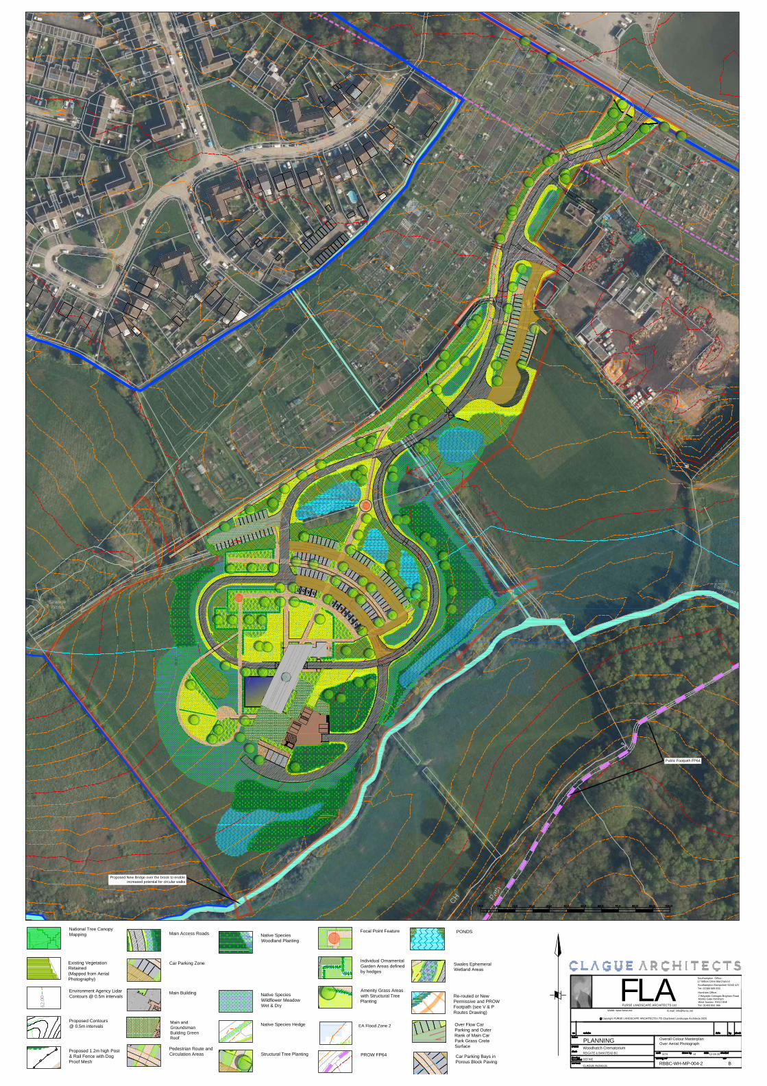
F 2 Wayside Cottages Brighton RoadMonks Gate Horsham West Sussex RH13 6NE
E.mail: [email protected]
c Copyright FURSE LANDSCAPE ARCHITECTS LTD Chartered Landscape Architects 2020
FURSE LANDSCAPE ARCHITECTS LtdLA
Webb: www.furse.net
Horsham Office:
17 Willow Drive MarchwoodSouthampton Hampshire SO40 4JY
Southampton Office:
Tel: 01403 891 966
Tel: 02380 669 833
Woodhatch Crematorium REIGATE & BANSTEAD BC
DEFINE
CLAGUE Architects
PLANNING Overall Colour MasterplanOver Aerial Photograph
NTS 12 09 20
RBBC-WH-MP-004-2
trf
B
Proposed New Bridge over the brook to enableincreased potential for circular walks
Public Footpath FP64
EA Flood Zone 2
National Tree CanopyMapping
Environment Agency LidarContours @ 0.5m intervals
Main Access Roads
Car Parking Zone
Main Building
Pedestrian Route andCirculation Areas
Focal Point Feature
Individual OrnamentalGarden Areas definedby hedges
Amenity Grass Areaswith Structural TreePlanting
Native SpeciesWoodland Planting
Car Parking Bays inPorous Block Paving
Native SpeciesWildflower MeadowWet & Dry
Native Species Hedge
Structural Tree Planting
Proposed Contours@ 0.5m intervals
Proposed 1.2m high Post& Rail Fence with DogProof Mesh
Re-routed or NewPermissive and PROWFootpath (see V & PRoutes Drawing)
PROW FP64
Existing VegetationRetained(Mapped from AerialPhotography)
Main andGroundsmanBuilding GreenRoof
Over Flow CarParking and OuterRank of Main CarPark Grass CreteSurface
PONDS
Swales EphemeralWetland Areas